
Sydney Road and Upfield Corridor Strategic Framework Plan DRAFT OCTOBER 2014
On behalf of Moreland City Council
David Lock Associates
October 2014
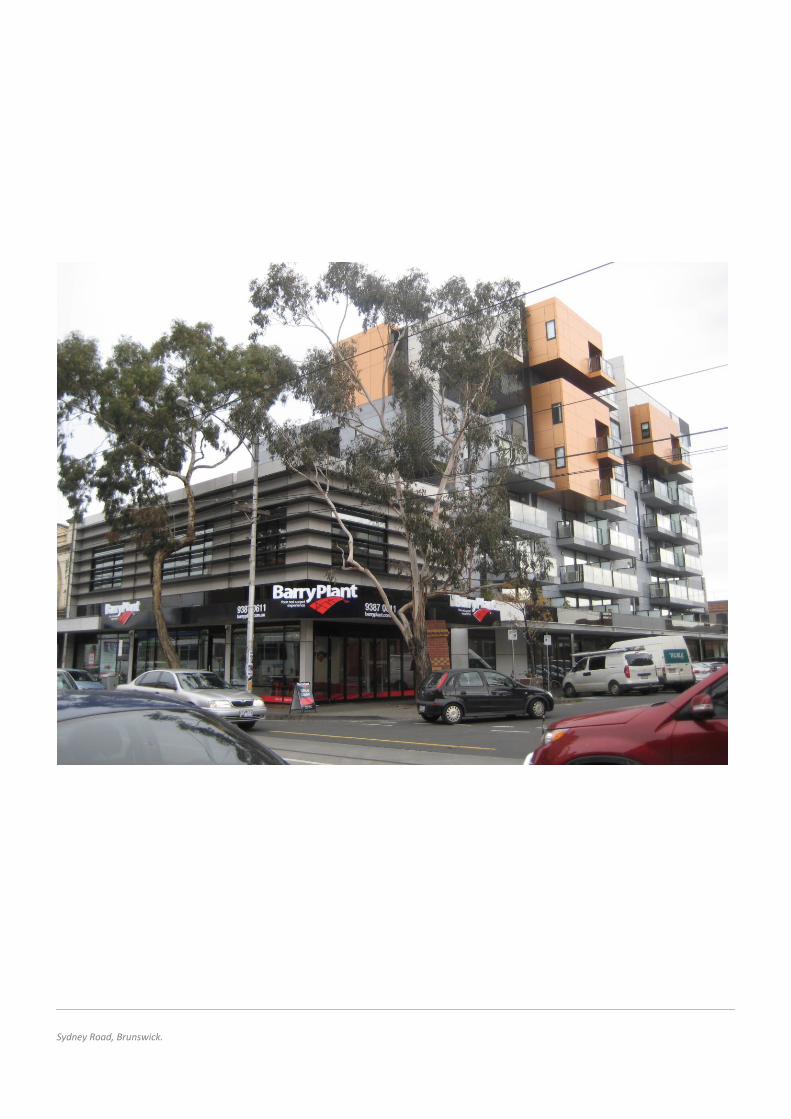
Sydney Road, Brunswick.
David Lock Associates Draft Sydney Road/Upfield Corridor Strategic Framework Plan
3
Contents 1.0 Introduction ............................................................................................................................................................................................................ 4
1.1 Purpose of the Report.................................................................................................................................................................................... 4
1.2 Background ..................................................................................................................................................................................................... 4
1.3 Methodology .................................................................................................................................................................................................. 5
2.0 Overview of the Framework Plan Area ................................................................................................................................................................. 7
2.1 Strategic Context ............................................................................................................................................................................................ 7
2.2 Planning Policy Context ................................................................................................................................................................................. 8
2.3 Land Use Pattern and Activity ..................................................................................................................................................................... 16
2.4 Existing Physical Context.............................................................................................................................................................................. 19
3.0 Urban Design Principles ....................................................................................................................................................................................... 36
3.1 Establish a new public realm character that balances spatial definition and openness. ................................................................................. 38
3.2 Complement valued built form character or, where appropriate, establish a cohesive new character—street wall. .................................. 40
3.3 Complement valued built form character and heritage values—upper levels. ................................................................................................ 44
3.4 Create an inviting and vibrant public realm. ....................................................................................................................................................... 48
3.5 Maintain solar access to streets and public open space. ................................................................................................................................... 50
3.6 Maintain reasonable amenity for residential properties alongside the activity centre. .................................................................................. 54
3.7 Reinforce the fine grain character of Sydney Road. ........................................................................................................................................... 57
3.8 Facilitate the provision of new and improved public open spaces. .................................................................................................................. 59
4.0 The Strategic Framework Plan ............................................................................................................................................................................. 62
4.1 Vision ............................................................................................................................................................................................................ 62
4.2 The Strategic Framework Plan..................................................................................................................................................................... 62
4.3 Land Use Directions ..................................................................................................................................................................................... 64
4.4 Movement Network ..................................................................................................................................................................................... 66
4.5 Open Space Network ................................................................................................................................................................................... 68
4.6 Built Form ..................................................................................................................................................................................................... 70
4.7 Building Envelopes ....................................................................................................................................................................................... 66
5.0 Implementation .................................................................................................................................................................................................... 68
5.1 Design and Development Overlay ............................................................................................................................................................... 68
5.2 Design Objectives ......................................................................................................................................................................................... 68
5.3 Permit Requirements ................................................................................................................................................................................... 68
Draft Sydney Road/Upfield Corridor Strategic Framework Plan David Lock Associates
4
1.1 Purpose of the Report
This report provides a robust strategic framework plan for the
Sydney Road and Upfield Corridor local area based on the strategic
context of the centre and urban design analysis of its existing
values.
The report builds on the built form requirements contained within
the Brunswick Structure Plan (August 2010) and Addendum Report
(June 2012). It provides the strategic justification to support the
implementation of permanent planning controls for the local area.
1.2 Background
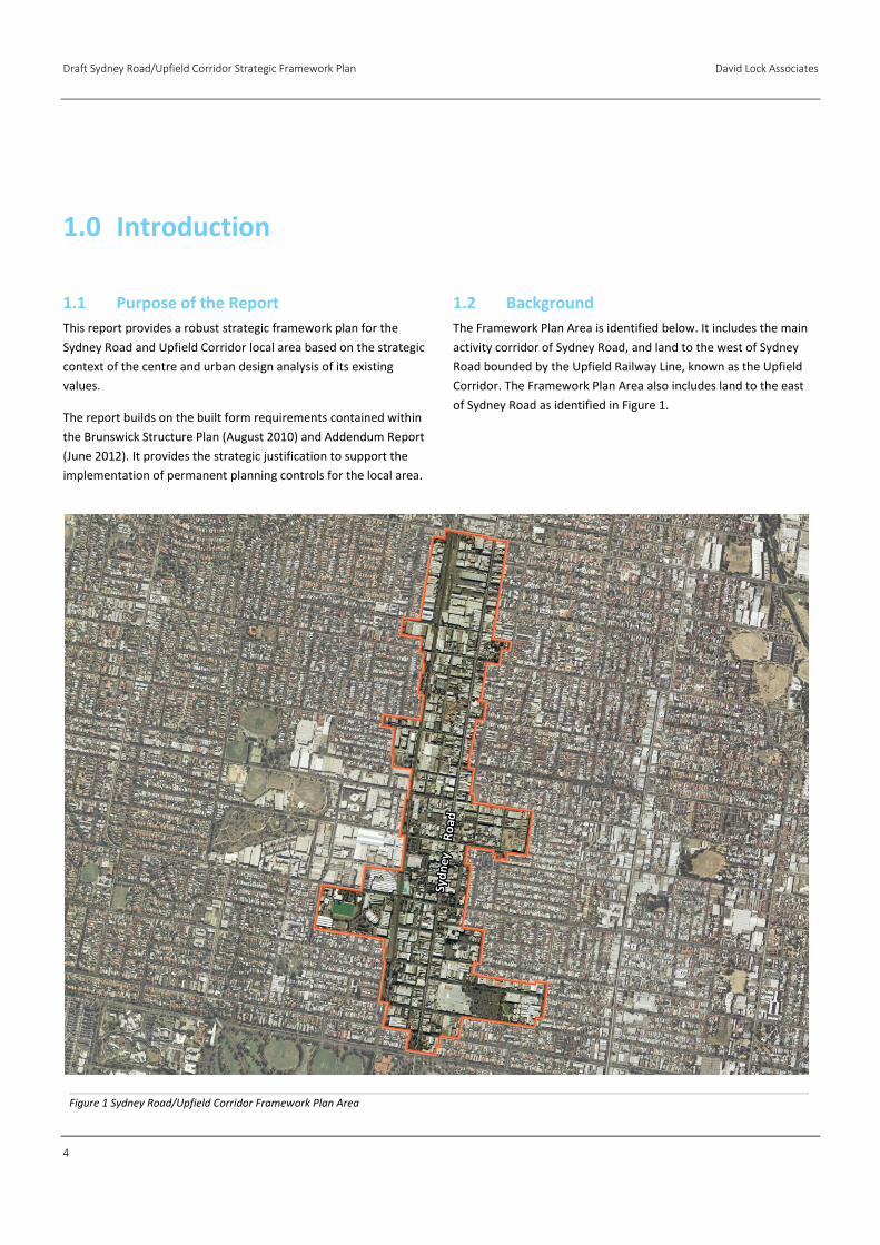
The Framework Plan Area is identified below. It includes the main
activity corridor of Sydney Road, and land to the west of Sydney
Road bounded by the Upfield Railway Line, known as the Upfield
Corridor. The Framework Plan Area also includes land to the east
of Sydney Road as identified in Figure 1.
1.0 Introduction
Figure 1 Sydney Road/Upfield Corridor Framework Plan Area
David Lock Associates Draft Sydney Road/Upfield Corridor Strategic Framework Plan
5
1.3 Methodology
The following methodology was adopted to develop a
well-founded strategic framework for the Sydney Road and
Upfield Corridor area.
Stage One: Background Research and Analysis
→ Review of existing and emerging State and local planning
policy context.
→ Detailed Framework Plan Area assessment.
→ Review of approved developments within the local area.
→ Desktop analysis of allotment patterns, overlays, vehicle
access and sensitive land uses.
Stage Two: Development and Testing of Urban Design
Principles
→ Preparation of preliminary urban design principles based
on background research and analysis.
→ Testing of preliminary built form principles to understand
their usability and assess the likely outcomes.
Stage Three: Strategic Framework Plan
→ Development of a coherent and legible Strategic
Framework Plan for the Framework Plan Area and clear
rationale.
A detailed overview of the methodology and summary of analysis
is outlined in Section 2.0.

Draft Sydney Road/Upfield Corridor Strategic Framework Plan David Lock Associates
6
David Lock Associates Draft Sydney Road/Upfield Corridor Strategic Framework Plan
7
The urban structure and environment of the Framework Plan Area
has been analysed in detail to inform the preparation of the
Structure Plan and other strategic documents. For the purpose of
this study, a review of all relevant background material has been
supplemented by an independent analysis of the area to identify
the existing and emerging conditions.
Key issues from the context analysis that have specific implications
for land use, built form and public realm are summarised below.
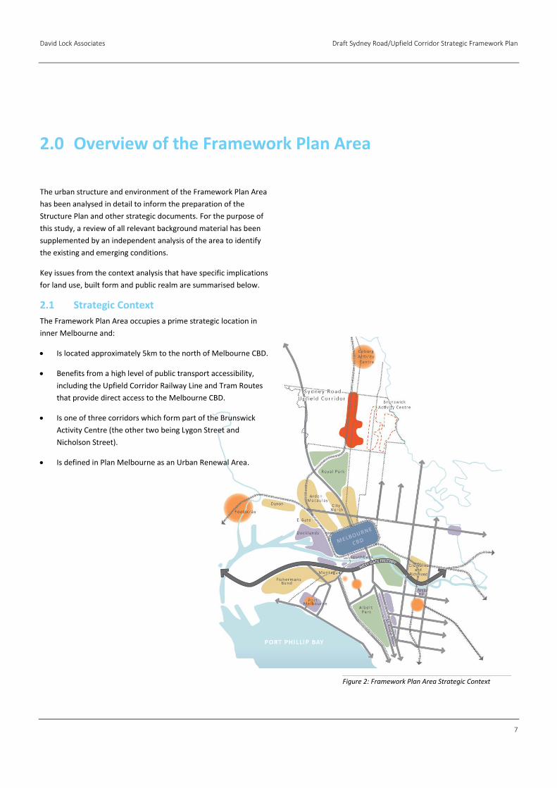
2.1 Strategic Context
The Framework Plan Area occupies a prime strategic location in
inner Melbourne and:
Is located approximately 5km to the north of Melbourne CBD.
Benefits from a high level of public transport accessibility,
including the Upfield Corridor Railway Line and Tram Routes
that provide direct access to the Melbourne CBD.
Is one of three corridors which form part of the Brunswick
Activity Centre (the other two being Lygon Street and
Nicholson Street).
Is defined in Plan Melbourne as an Urban Renewal Area.
2.0 Overview of the Framework Plan Area
Figure 2: Framework Plan Area Strategic Context
Draft Sydney Road/Upfield Corridor Strategic Framework Plan David Lock Associates
8
2.2 Planning Policy Context
State Planning Policy Framework
Relevant directions within the State Planning Policy Framework
(SPPF) that have informed the background research and analysis
include:
To build up activity centres as a focus for high-quality
development, activity and living for the whole community by
developing a network of activity centres (Clause 11.01-1);
To encourage the concentration of major retail, residential,
commercial, administrative, entertainment and cultural
developments into activity centres which provide a variety of
land uses and are highly accessible to the community (Clause
11.01-2);
To ensure a sufficient supply of land is available for
residential, commercial, retail, industrial, recreational,
institutional and other community uses (Clause 11.02);
To facilitate the orderly development of urban areas (Clause
11.02-3);
To create a city structure that drives productivity, supports
investment through certainty and creates more jobs.
Strategies seek to plan for jobs closer to where people live
and enable an investment pipeline for transit-oriented
development and urban renewal (Clause 11.04-1);
To provide a diversity of housing in defined locations that
cater for different households and are close to jobs and
services (11.04-2);
To create healthy and active neighbourhoods and maintain
Melbourne’s identity as one of the world’s most liveable cities
(11.04-4);
To create urban environments that are safe, functional and
provide good quality environments with a sense of place and
cultural identity (15.01);
To achieve architectural and urban design outcomes that
contribute positively to local urban character and enhance the
public realm while minimising detrimental impact on
neighbouring properties (15.01-2);
To encourage land use and development that is consistent
with the efficient use of energy and the minimisation of
greenhouse gas emissions (15.02);
To ensure the conservation of places of heritage significance
(15.03);
To locate new housing in or close to activity centres and
employment corridors and at other strategic redevelopment
sites that offer good access to services and transport (16.01-
3);
To provide for a range of housing types to meet increasingly
diverse needs (16.01-4);
To encourage development which meet the communities’
needs for retail, entertainment, office and other commercial
services and provides net community benefit in relation to
accessibility, efficient infrastructure use and the aggregation
and sustainability of commercial facilities (17.01);
To ensure availability of land for industry (17.02);
To create opportunities for innovation and the knowledge
economy within existing and emerging industries, research
and education (17.02-4); and
To create a safe and sustainable transport system by
integrating land-use and transport (18.01-1).
David Lock Associates Draft Sydney Road/Upfield Corridor Strategic Framework Plan
9
Plan Melbourne (May 2014)
A planning scheme amendment and an updated ministerial
direction have been introduced to give statutory effect to Plan
Melbourne in decision making.
Plan Melbourne (the Plan) is the metropolitan planning strategy for
Melbourne. The Plan is a long-term plan to accommodate
Melbourne’s future growth in population and employment. The
Plan estimates that by 2050 the City will need to accommodate
more than 6.5 million people and provide an additional 1.2 million
jobs. The Plan seeks to provide an integrated approach to planning
and development which responds to the pressures of population
growth without placing strain on the City’s infrastructure and
liveability.
The following outcomes, objectives and directions are particularly
relevant to the Framework Plan Area:
Delivery of Jobs and Investment – create a city structure that
drives productivity, supports investment through certainty and
create more jobs.
Direction 1.1 - Define a new city structure to deliver an
integrated land use and transport strategy for Melbourne’s
changing economy;
Direction 1.5 - Plan for jobs closer to where people live; and
Direction 1.6 – Enable an investment pipeline of transit-
oriented development and urban renewal.
Housing Choice and Affordability – provide a diversity of housing
in defined locations that cater for different households and are
close to jobs and services.
Direction 2.2 – reduce the cost of living by increasing housing
supply near services and public transport.
The Metropolitan Melbourne Structure Plan provides a new spatial
categorisation of commercial and industrial areas within
Melbourne. Elements include (amongst others):
An Expanded Central City;
National Employment Clusters;
Metropolitan Activity Centres;
Activity Centres;
Neighbourhood Centres; and
Urban Renewal Precincts.
The Plan identifies the Brunswick to Batman Station Corridor as a
potential urban renewal opportunity/investigation area. Jewel
Station is individually identified as an urban renewal opportunity
that includes significant parcels of government held land.
The strategic direction for these precincts is:
To take advantage of underutilised land close to jobs, services
and public transport infrastructure, to provide new housing,
jobs and services. Renewal projects in defined precincts and
sites will play an important role in accommodating future
housing and employment growth and making better use of
existing infrastructure.
Plan Melbourne advocates transit-oriented development as a
key way to achieve employment and population growth, as well
as achieve a broad range of economic, social and environmental
benefits from co-locating employment, population and public
transport.
The Brunswick to Batman Station Corridor is identified as a priority
urban renewal site where structure planning for underutilised
industrial land and precincts near railway stations is to commence
in the short-term.
Draft Sydney Road/Upfield Corridor Strategic Framework Plan David Lock Associates
10
Activity Centres
Principal and major activity centres are nominated as activity
centres in Plan Melbourne. Brunswick is referred to as an Activity
Centre. The Strategic Direction for activity centres seeks to:
Enable 20 minute neighbourhoods by providing access to a
wide range of goods and services in centres that are planned
and coordinated by local government. The centres will provide
employment and vibrant local economies. Some will serve
larger sub-regional catchments. Through the removal of retail
floor space and office caps, activity centres may grow
unrestricted.
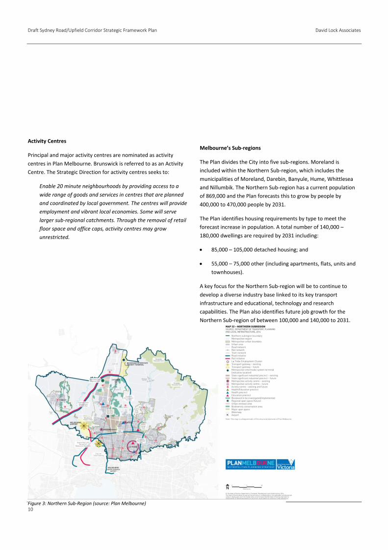
Melbourne’s Sub-regions
The Plan divides the City into five sub-regions. Moreland is
included within the Northern Sub-region, which includes the
municipalities of Moreland, Darebin, Banyule, Hume, Whittlesea
and Nillumbik. The Northern Sub-region has a current population
of 869,000 and the Plan forecasts this to grow by people by
400,000 to 470,000 people by 2031.
The Plan identifies housing requirements by type to meet the
forecast increase in population. A total number of 140,000 –
180,000 dwellings are required by 2031 including:
85,000 – 105,000 detached housing; and
55,000 – 75,000 other (including apartments, flats, units and
townhouses).
A key focus for the Northern Sub-region will be to continue to
develop a diverse industry base linked to its key transport
infrastructure and educational, technology and research
capabilities. The Plan also identifies future job growth for the
Northern Sub-region of between 100,000 and 140,000 to 2031.
Figure 3: Northern Sub-Region (source: Plan Melbourne)
David Lock Associates Draft Sydney Road/Upfield Corridor Strategic Framework Plan
11
Local Planning Policy Framework
Council has recently adopted a new LPPF (Amendment C152).
Relevant clauses of the new LPPF are set out below.
Vision (Clause 21.02)
The MSS vision is to create sustainable neighbourhoods with an
emphasis on the social, cultural, environmental and economic well
being of the population. Sustainable neighbourhoods in Moreland
should generally include a mix of the key elements listed below,
provided at the suburb scale:
Shops and services;
Community facilities such as schools, neighbourhood houses,
recreation, libraries, etc;
Housing choices;
Employment choices;
Public transport options; and
A network of different types of open spaces for leisure and
recreation.
Strategic Directions (Clause 21.02-3)
The key spatial directions are illustrated on the Strategic
Framework Plan (see Figure 4).
Relevant strategic directions include:
Strategic Direction 1: Activity Centres
Coburg, Brunswick and Glenroy Activity Centres are the larger
centres in the framework. These centres provide a broad mix
of retail uses, commercial and cultural activity, a diverse mix
of employment options and are generally well served by public
transport. These centres are preferred locations for
administrative and civic centre functions and should be
prioritised for government investment and regional facilities.
These three centres are identified to accommodate the most
significant change of all the activity centres. Change and
intensification should be consistent with the directions set out
in the relevant strategic plans - the Coburg Place Framework
2010 and Central Coburg 2020 Structure Plan 2006, the
Brunswick Structure Plan 2010 and Addendum 2012 and the
Glenroy Structure Plan 2008.
A series of smaller Neighbourhood and Local Activity Centres
are also identified in the Moreland Activity Centre Framework.
Strategic Direction 2: Land for Industry and Economic
Regeneration
The Moreland Industrial Land Use Strategy protects three Core
Industry and Employment Precincts in Brunswick, North
Coburg and Newlands, and a number of smaller Secondary
Industry and Employment Precincts scattered across the
municipality.
A select number of specific precincts of industrial zoned land
have been identified as Multi Use – Employment Precincts,
reflecting their suitability to transition to accommodate a
wider mix of commercial uses to contribute to economic
regeneration and more diverse employment opportunities.
A limited number of industrial areas – Multi Use – Residential
Precincts and Transition – Residential Precincts will also
contribute to housing supply in Moreland. Figure 4: Moreland Strategic Framework (South Moreland)
Draft Sydney Road/Upfield Corridor Strategic Framework Plan David Lock Associates
12
Strategic Direction 3: Housing
Council will facilitate housing development to meet the needs
of the growing and diverse population, with a focus on:
→ Providing a range of housing sizes and types to
accommodate a diversity of household sizes;
→ Housing affordability; and
→ Housing designed to be visitable by people with limited
mobility, and adaptable for residents with specific
accessibility requirements.
Strategic Direction 4: Good Design
In managing population growth and associated development,
Council is committed to improving the quality of design of the
built environment. Good design is intrinsically linked to safety,
health and well being and environmental sustainability.
The MSS includes specific directions to improve design quality
overall, with a particular emphasis on site responsive design,
passive design for energy efficiency, integration with the
public realm and integration with landscape design.
Strategic Direction 5: Environmentally Sustainable
Development
Council is committed to best practice environmentally
sustainable development (ESD). Development should
integrate the principles of sustainable design early in the
design process, at the planning stage.
Strategic Framework (Clause 21.03)
A key objective of Clause 21.03 is:
To support a network of activity centres across Moreland to
provide residents with walkable access to their daily and
weekly shopping and service needs.
Strategies seek to encourage the development of the Brunswick
Activity Centre to provide a broad mix of retail uses, commercial
and cultural activity, employment options, administrative and civic
centre functions, government investment and regional facilities, in
accordance with the approved Structure Plan.
Other objectives seek:
To facilitate change to the scale of the built form within
activity centres in accordance with their size and role in the
activity centre network (Clause 21.03-1 - Objective 2);
To support activity centres as important commercial and
employment clusters (Clause 2103-1 - Objective 3);
To reinforce and enhance Core and Secondary Industry and
Employment Precincts as places for industry and
complementary use (Clause 21.03-2 - Objective 4);
To manage the transition of Multi Use – Employment Precincts
and Multi Use – Residential Precincts from traditional
industrial areas to multi use precincts which prioritise
opportunities for new commercial uses (Clause 21.03-2 -
Objective 5);
To facilitate change in Transition – Residential Precincts from
traditional industrial uses to residential uses (Clause 21.03-2 -
Objective 6);
To provide housing diversity to meet community needs (Clause
21.03-3 - Objective 7);
To ensure development responds and contributes to its
context and any relevant heritage significance (Clause 21.03-4
- Objective 10); and
To ensure development maximises passive energy efficiency
and creates quality living and working environments (Clause
21.03-4 - Objective 11).
David Lock Associates Draft Sydney Road/Upfield Corridor Strategic Framework Plan
13
Neighbourhood Character (Clause 22.01)
A key policy objective relating to the Brunswick Activity Centre of
Clause 22.01 is:
To facilitate substantial change and create a new character of
increased density and scale of built form, as defined in the
relevant Structure Plan and/or Place Framework.
Heritage (Clause 22.07)
Policy objectives of Clause 22.07 seek:
To encourage the conservation and enhancement of all
heritage places;
To protect Moreland’s heritage places from inappropriate
demolition, development or subdivision; and
To ensure that buildings and works respect the significance of
the heritage place as identified in the Statement of
Significance.
Development of Four or More Storeys (Clause 22.08)
The key objective of Clause 22.08 is to encourage appropriately
designed higher density development that makes a positive
contribution to the public realm and preferred neighbourhood
character.1
1 (Note – this is an existing policy, proposed to be replaced with Moreland Apartment Design Code, Amendment C142 at a later stage.)

Draft Sydney Road/Upfield Corridor Strategic Framework Plan David Lock Associates
14
Relevant Strategic Reports
The inter-relationships of the relevant strategic reports are
outlined in Figure 5 below.
The Brunswick Structure Plan (2010) and Addendum (2012)
The Brunswick Structure Plan (BSP) has been adopted by Council
and will guide the evolution and growth of Brunswick over the next
10-15 years. It takes into account the views of the community and
various stakeholders, as well as the diversity, historical fabric and
special character of Brunswick.
It includes:
Building design and height guidelines;
Provision to create more housing;
More retail and commercial space thereby creating local job
opportunities;
People friendly streets and parks;
Better cycling, pedestrian and public transport links; and
Building on the character and uniqueness of Brunswick.
The Addendum to the BSP was adopted by Council on 13 June 2012
and supersedes a number of built form guidelines relating to
building height, street setbacks, upper storey setbacks and active
frontage types as well as redefining the boundary of the Activity
Centre to exclude areas not part of a Local Area Precinct
(Brunswick Core Industry and Employment Precinct, Holmes Street
and east-west streets).
The overall aim of the BSP (including the Addendum) is to facilitate
appropriate urban consolidation in close proximity to amenities
and public transport infrastructure. The Plan proposes a range of
maximum heights including:
Up to 5 storeys (18 metres) along the Sydney Road Activity
Corridor;
Up to 7 storeys on large strategic sites located within the
Upfield Corridor between Sydney Road and the Upfield
Railway Line; and
Between 3 and 4 storeys in transitional areas at the activity
centre edges and areas with heritage sensitivities.
Proposed building heights are identified in Figure 6 below. This
Sydney Road/Upfield Corridor Strategic Framework Plan builds on
the BSP and Addendum and supersedes those reports as they
apply to the corridor.
Figure 5: Moreland Strategic Background Reports Context
David Lock Associates Draft Sydney Road/Upfield Corridor Strategic Framework Plan
15
Moreland Industrial Land Use Strategy (MILUS) (2004)
The MILUS provides:
An understanding of the pressures affecting industrial zoned
land in the City of Moreland;
Insight into the future outlook for existing industries in
Moreland as well as for possible new employment related
uses; and
Clear direction to Council and the community about the long
term planning, zoning and redevelopment of land that is
presently included in Industrial 1 and 3, Business 3 and 4, and
Mixed Uses Zones throughout the municipality.
The Strategy identifies strategic categories that relate to areas in
the municipality in which different types of uses are considered
appropriate. These include:
Category A - Core Industry and Employment Areas - the
preferred locations for major manufacturing and associated
industries and industries that generate higher rates of
commercial vehicle traffic and activity. The intrusion of uses
that are incompatible with industrial activities is discouraged.
Category B - Secondary Industry and Employment Areas - the
preferred location for smaller manufacturers, service industry
and service business. Other employment generating uses such
as offices will be permitted in these areas provided they do
not prejudice the continued operation of existing businesses.
Category C - Multi Use - Employment Areas - areas that are
appropriate for a wider mix of employment opportunities,
including a mix of industry and offices or wholly offices.
Council should be open to consider the possibility of mixed
use developments that include a residential component on
sites where the commercial element has an equivalent floor
area to the previous industrial or business uses that existed on
the site.
Category D - Multi Use - Residential Areas - areas where the
opportunity exists for the mix of uses to change over time to
include offices and residential uses. Each new development
must be of a ‘mixed use’ nature. Wholly residential
developments are not supported unless in accordance with an
approved structure plan. The opportunity remains for
industrial and employment generating uses to continue or
establish. New employment generating uses must be of a type
compatible with residential uses.
Category E – Transitional Residential - This category applies
in situations where the existing industrial zone is poorly
located for continued industrial use, or for the conversion to
other non-industrial employment uses. Recommendations for
these locations seek to provide for the continued operation of
existing or new industries to establish which are compatible
with surrounding residential uses and to allow residential
developments to establish having regard to adjoining
industrial uses where they exist.
The strategic categories of MILUS precincts under pin the land use
directions of this Framework Plan.
Draft Sydney Road/Upfield Corridor Strategic Framework Plan David Lock Associates
16
2.3 Land Use Pattern and Activity
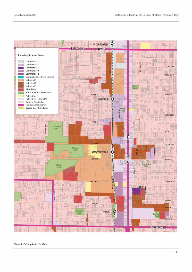
Existing Land Use Pattern and Activity
The Framework Plan Area encompasses a range of land uses
supporting a variety of activities. This includes strip shopping
primarily located along Sydney Road. In off-corridor locations there
is a range of land uses including manufacturing, service industry,
business and commercial spaces as well as some residential uses.
The mix and variety of uses is reflective of the current zoning
regime that includes land zoned for Commercial 1 and 2, Mixed
Use, Industrial 3 and General Residential.
Existing land use zones are identified in Figure 7 overleaf.
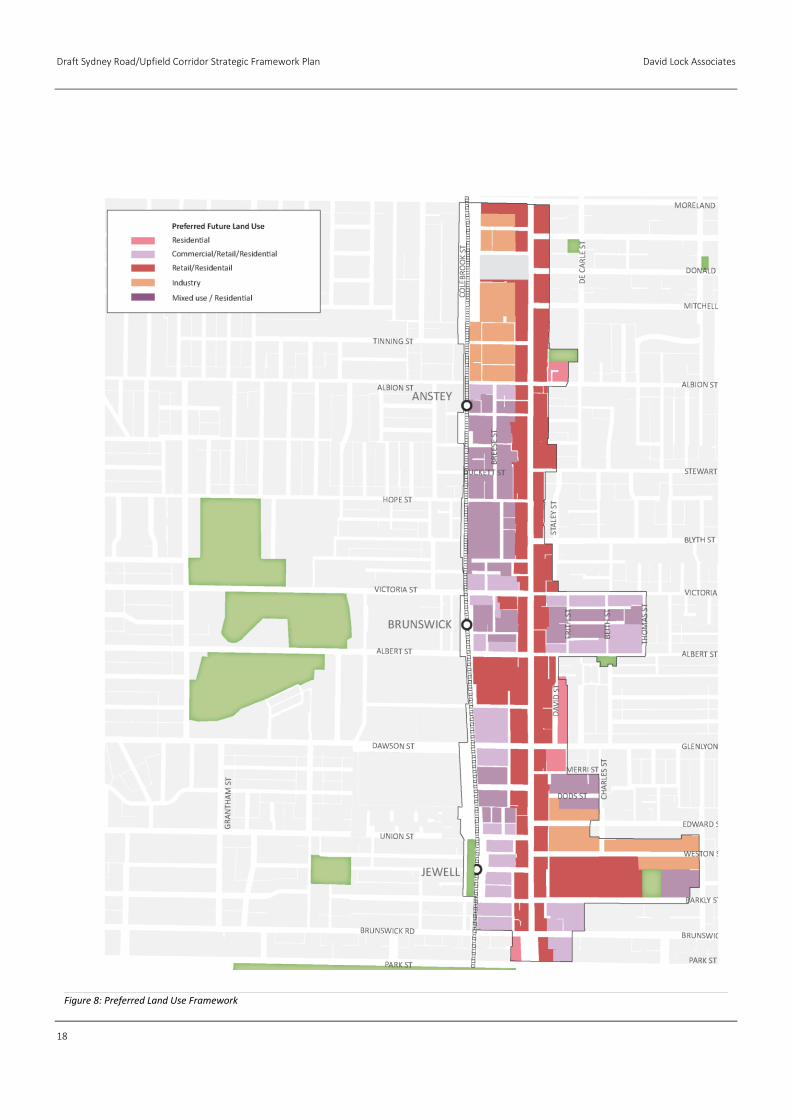
Preferred Land Use Pattern and Activity
The preferred land use pattern and directions for the Corridor
(based on the BSP and MILUS) seek to:
Encourage uses that identify the area as a major
concentration of activity and as a community and civic focal
point;
Promote the continuation of a high density mixed use centre
with a diversity of land uses;
Continue to build strong clusters of activity;
Facilitate appropriate mixed use developments including
residential and commercial uses in accordance with the MILUS
recommendations;
Promote a more efficient use of available land within the area
that responds to growth pressures;
Promote the local area as a desirable location for higher
density residential development;
Recognise the importance of ground level activity to enhance
the pedestrian environment; and
Ensure that land rezoning and development of the land takes
into consideration the current and future employment needs
of the area.
The preferred land use pattern and activity framework is identified
in Figure 8.
David Lock Associates Draft Sydney Road/Upfield Corridor Strategic Framework Plan
17
Figure 7: Existing Land Use Zones
Draft Sydney Road/Upfield Corridor Strategic Framework Plan David Lock Associates
18
Figure 8: Preferred Land Use Framework
David Lock Associates Draft Sydney Road/Upfield Corridor Strategic Framework Plan
19
2.4 Existing Physical Context
Sydney Road
Heritage
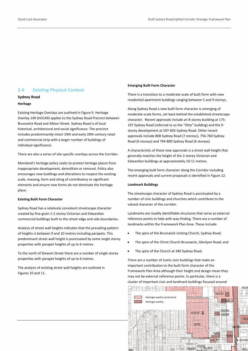
Existing Heritage Overlays are outlined in Figure 9. Heritage
Overlay 149 (HO149) applies to the Sydney Road Precinct between
Brunswick Road and Albion Street. Sydney Road is of local
historical, architectural and social significance. The precinct
includes predominantly intact 19th and early 20th century retail
and commercial strip with a larger number of buildings of
individual significance.
There are also a series of site specific overlays across the Corridor.
Moreland’s heritage policy seeks to protect heritage places from
inappropriate development, demolition or removal. Policy also
encourages new buildings and alterations to respect the existing
scale, massing, form and siting of contributory or significant
elements and ensure new forms do not dominate the heritage
place.
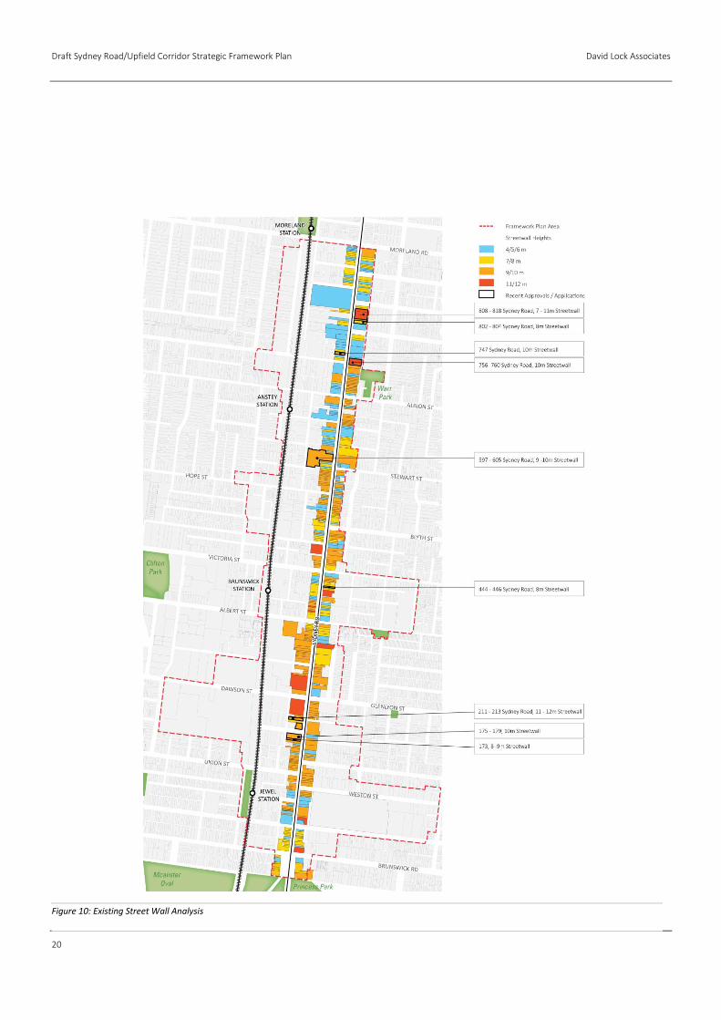
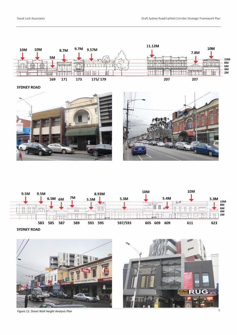
Existing Built Form Character
Sydney Road has a relatively consistent streetscape character
created by fine-grain 1-2 storey Victorian and Edwardian
commercial buildings built to the street edge and side boundaries.
Analysis of street wall heights indicates that the prevailing pattern
of heights is between 9 and 10 metres including parapets. This
predominant street wall height is punctuated by some single storey
properties with parapet heights of up to 6 metres.
To the north of Stewart Street there are a number of single storey
properties with parapet heights of up to 6 metres.
The analysis of existing street wall heights are outlined in
Figures 10 and 11.
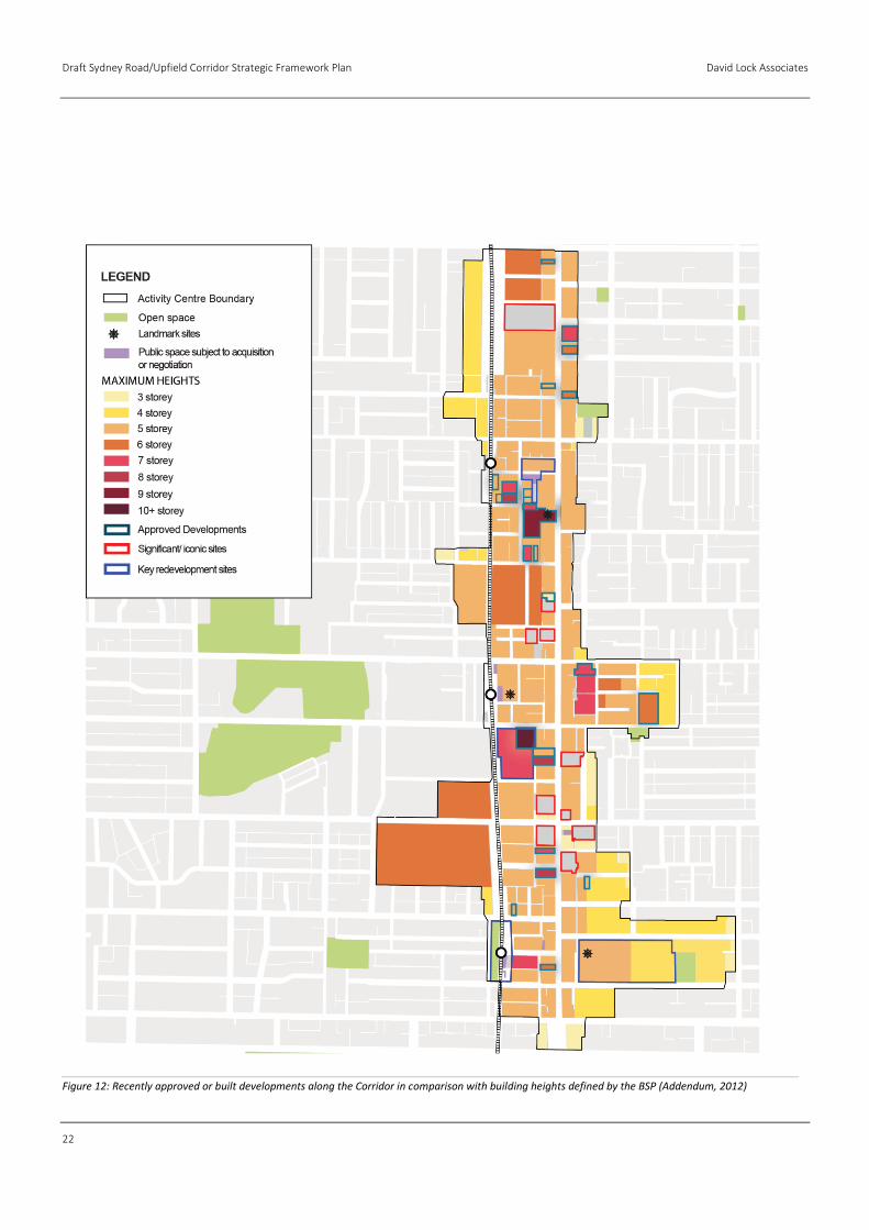
Emerging Built Form Character
There is a transition to a moderate scale of built form with new
residential apartment buildings ranging between 5 and 9 storeys.
Along Sydney Road a new built form character is emerging of
moderate-scale forms, set back behind the established streetscape
character. Recent approvals include an 8-storey building at 175-
197 Sydney Road (referred to as the “Otto” building) and the 9-
storey development at 597-605 Sydney Road. Other recent
approvals include 808 Sydney Road (7 storeys), 756-760 Sydney
Road (6 storeys) and 794-800 Sydney Road (6 storeys).
A characteristic of these new approvals is a street wall height that
generally matches the height of the 2-storey Victorian and
Edwardian buildings at approximately 10-11 metres.
The emerging built form character along the Corridor including
recent approvals and current proposals is identified in Figure 12.
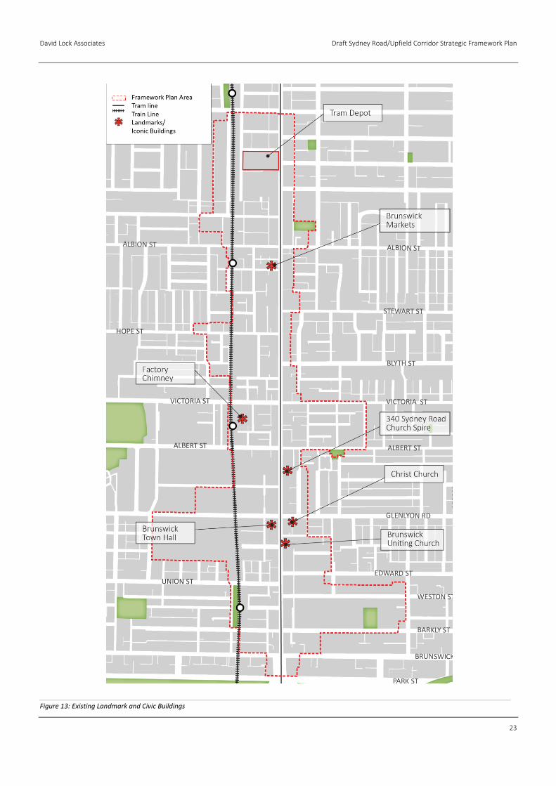
Landmark Buildings
The streetscape character of Sydney Road is punctuated by a
number of civic buildings and churches which contribute to the
valued character of the corridor.
Landmarks are readily identifiable structures that serve as external
reference points to help with way‐finding. There are a number of
landmarks within the Framework Plan Area. These include:
The spire of the Brunswick Uniting Church, Sydney Road;
The spire of the Christ Church Brunswick, Glenlyon Road; and
The spire of the Church at 340 Sydney Road.
There are a number of iconic civic buildings that make an
important contribution to the built form character of the
Framework Plan Area although their height and design mean they
may not be external reference points. In particular, there is a
cluster of important civic and landmark buildings focused around
the intersection of Sydney Road and Glenlyon Road (referred to as
the Civic Precinct).
Important landmark buildings are identified in Figure 13.
Draft Sydney Road/Upfield Corridor Strategic Framework Plan David Lock Associates
20
Figure 10: Existing Street Wall Analysis
David Lock Associates Draft Sydney Road/Upfield Corridor Strategic Framework Plan
21
Figure 11: Street Wall Height Analysis Plan
Draft Sydney Road/Upfield Corridor Strategic Framework Plan David Lock Associates
22
Figure 12: Recently approved or built developments along the Corridor in comparison with building heights defined by the BSP (Addendum, 2012)
David Lock Associates Draft Sydney Road/Upfield Corridor Strategic Framework Plan
23
Figure 13: Existing Landmark and Civic Buildings
Draft Sydney Road/Upfield Corridor Strategic Framework Plan David Lock Associates
24
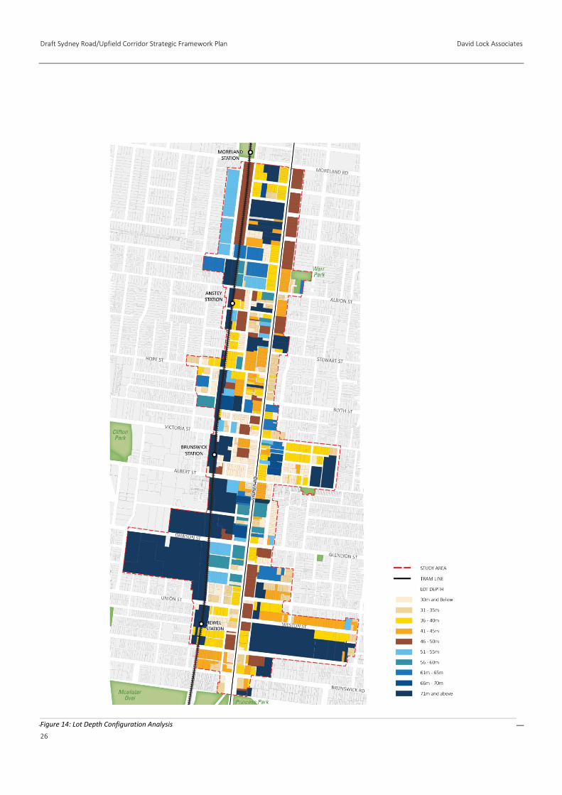
Lot Configuration
A desk-top analysis of lot configurations identifies a broad range of
lot depths along the Sydney Road corridor. Lots are generally
between 25 metres and 76 metres deep, oriented east-west.
The 25th, 50th and 75th percentile depths were identified in order
to understand the general range of lot depths along Sydney Road.
The 25th percentile (or the first quartile) of lot depths is 32 metres
deep. The 50th percentile (the median) of lot depths is
approximately 40 metres deep. The 75th percentile (the third
quartile) of lot depths is 46 metres deep.
Lot depth analysis for Sydney Road is identified in Figure 14.
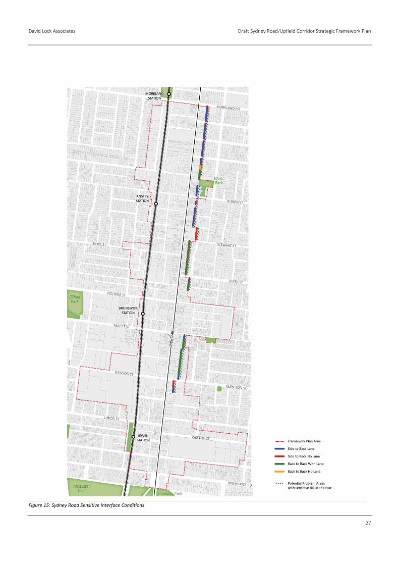
Interface Conditions
An analysis of the rear interface conditions was undertaken to
determine the location of sensitive residential interfaces
immediately abutting the Sydney Road Corridor. These are
identified in Figure 15.
The interfaces are categorised into four different conditions:
Side boundary of a residential lot abutting a laneway;
Side boundary of a residential lot abutting the Framework
Plan Area;
Rear boundary of a residential lot abutting a laneway; and
Rear boundary of a residential lot abutting the site.
The analysis identified that the sensitive residential interfaces are
located along the eastern boundary of the Sydney Road corridor.
Between Moreland Road and Stewart Street the predominant
interface is side boundaries of a residential lot separated by a
laneway.
South of Stewart Street, the predominant interface is back-to-back
boundaries separated by a laneway.
Public Realm
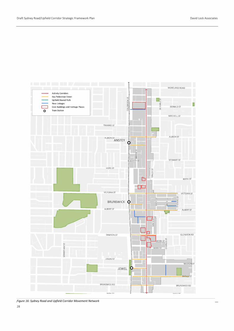
Activity Corridor and Key Pedestrian Streets
Sydney Road is the main north-south movement corridor. It carries
a tram route and forms the main activity spine with significant
concentrations of retail and business where pedestrians, shoppers
and visitors congregate.
There are a number of other Key Pedestrian Streets that run east-
west linking Sydney Road and the railway line. These have been
defined and include:
Wilson Avenue;
Dawson Street;
Wilkinson Street;
Albert Street;
Victoria Street;
Florence Street; and
Albion Street.
These streets offer important east-west connections between
Sydney Road and the Upfield Corridor, providing access to both
train stations and across the railway line. However, most of these
streets display a relatively poor quality pedestrian environment.
This is primarily as a result of the associated industrial and
commercial land uses along them and the general lack of activation
and interaction at street level.
Figure 16 shows Sydney Road as the Principal Activity Corridor and
connecting streets that require a high level of pedestrian amenity.
David Lock Associates Draft Sydney Road/Upfield Corridor Strategic Framework Plan
25
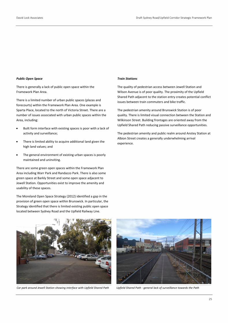
Public Open Space
There is generally a lack of public open space within the
Framework Plan Area.
There is a limited number of urban public spaces (plazas and
forecourts) within the Framework Plan Area. One example is
Sparta Place, located to the north of Victoria Street. There are a
number of issues associated with urban public spaces within the
Area, including:
Built form interface with existing spaces is poor with a lack of
activity and surveillance;
There is limited ability to acquire additional land given the
high land values; and
The general environment of existing urban spaces is poorly
maintained and uninviting.
There are some green open spaces within the Framework Plan
Area including Warr Park and Randazzo Park. There is also some
green space at Barkly Street and some open space adjacent to
Jewell Station. Opportunities exist to improve the amenity and
usability of these spaces.
The Moreland Open Space Strategy (2012) identified a gap in the
provision of green open space within Brunswick. In particular, the
Strategy identified that there is limited existing public open space
located between Sydney Road and the Upfield Railway Line.
Train Stations
The quality of pedestrian access between Jewell Station and
Wilson Avenue is of poor quality. The proximity of the Upfield
Shared Path adjacent to the station entry creates potential conflict
issues between train commuters and bike traffic.
The pedestrian amenity around Brunswick Station is of poor
quality. There is limited visual connection between the Station and
Wilkinson Street. Building frontages are oriented away from the
Upfield Shared Path reducing passive surveillance opportunities.
The pedestrian amenity and public realm around Anstey Station at
Albion Street creates a generally underwhelming arrival
experience.
Upfield Shared Path - general lack of surveillance towards the Path Car park around Jewell Station showing interface with Upfield Shared Path
Draft Sydney Road/Upfield Corridor Strategic Framework Plan David Lock Associates
26
Figure 14: Lot Depth Configuration Analysis
David Lock Associates Draft Sydney Road/Upfield Corridor Strategic Framework Plan
27
Figure 15: Sydney Road Sensitive Interface Conditions
Draft Sydney Road/Upfield Corridor Strategic Framework Plan David Lock Associates
28
Figure 16: Sydney Road and Upfield Corridor Movement Network
David Lock Associates Draft Sydney Road/Upfield Corridor Strategic Framework Plan
29
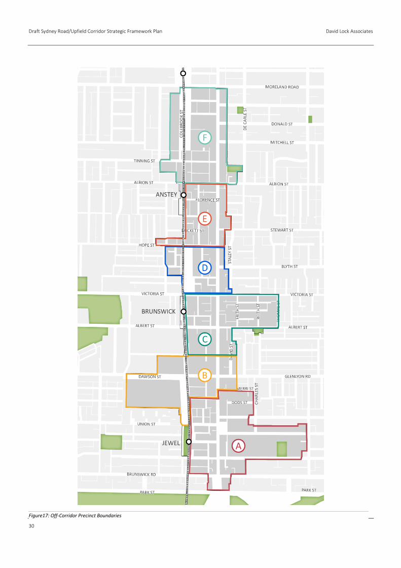
Off-Corridor Precincts
The areas located either side of Sydney Road comprise a diverse
set of discrete character precincts that vary in street, block and lot
patterns and support a wide variety of land uses. A summary of
these precincts is outlined below.
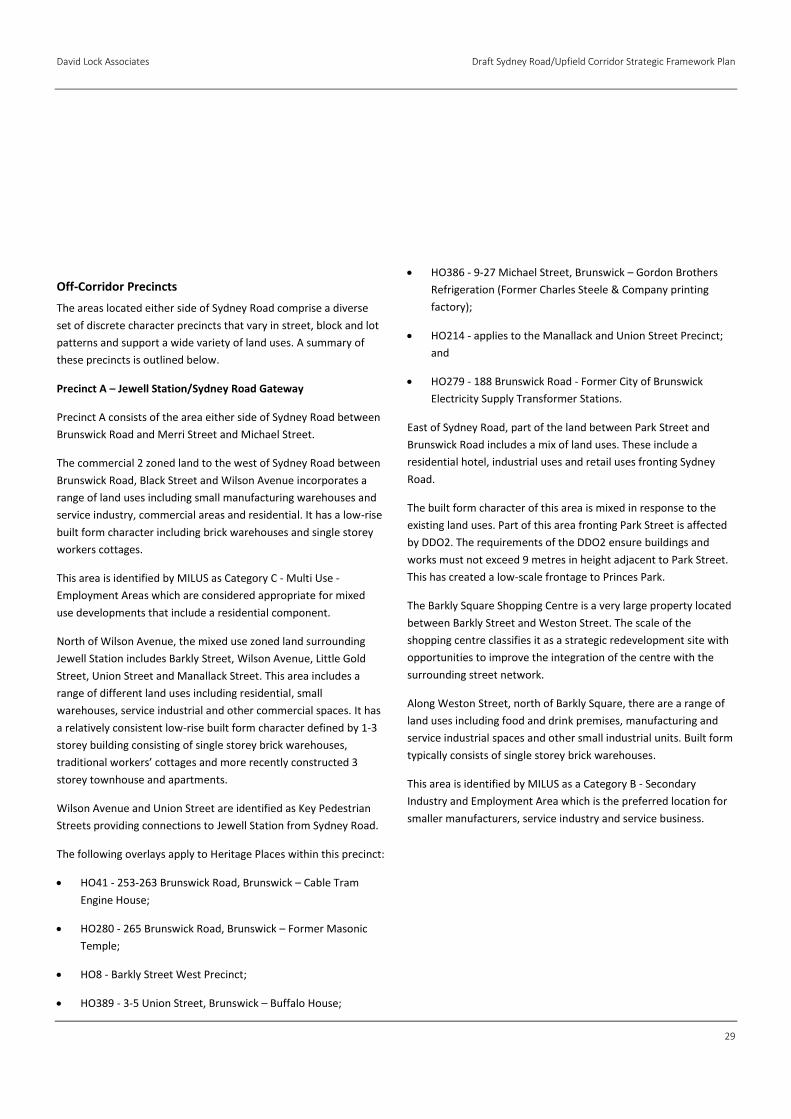
Precinct A – Jewell Station/Sydney Road Gateway
Precinct A consists of the area either side of Sydney Road between
Brunswick Road and Merri Street and Michael Street.
The commercial 2 zoned land to the west of Sydney Road between
Brunswick Road, Black Street and Wilson Avenue incorporates a
range of land uses including small manufacturing warehouses and
service industry, commercial areas and residential. It has a low-rise
built form character including brick warehouses and single storey
workers cottages.
This area is identified by MILUS as Category C - Multi Use -
Employment Areas which are considered appropriate for mixed
use developments that include a residential component.
North of Wilson Avenue, the mixed use zoned land surrounding
Jewell Station includes Barkly Street, Wilson Avenue, Little Gold
Street, Union Street and Manallack Street. This area includes a
range of different land uses including residential, small
warehouses, service industrial and other commercial spaces. It has
a relatively consistent low-rise built form character defined by 1-3
storey building consisting of single storey brick warehouses,
traditional workers’ cottages and more recently constructed 3
storey townhouse and apartments.
Wilson Avenue and Union Street are identified as Key Pedestrian
Streets providing connections to Jewell Station from Sydney Road.
The following overlays apply to Heritage Places within this precinct:
HO41 - 253-263 Brunswick Road, Brunswick – Cable Tram
Engine House;
HO280 - 265 Brunswick Road, Brunswick – Former Masonic
Temple;
HO8 - Barkly Street West Precinct;
HO389 - 3-5 Union Street, Brunswick – Buffalo House;
HO386 - 9-27 Michael Street, Brunswick – Gordon Brothers
Refrigeration (Former Charles Steele & Company printing
factory);
HO214 - applies to the Manallack and Union Street Precinct;
and
HO279 - 188 Brunswick Road - Former City of Brunswick
Electricity Supply Transformer Stations.
East of Sydney Road, part of the land between Park Street and
Brunswick Road includes a mix of land uses. These include a
residential hotel, industrial uses and retail uses fronting Sydney
Road.
The built form character of this area is mixed in response to the
existing land uses. Part of this area fronting Park Street is affected
by DDO2. The requirements of the DDO2 ensure buildings and
works must not exceed 9 metres in height adjacent to Park Street.
This has created a low-scale frontage to Princes Park.
The Barkly Square Shopping Centre is a very large property located
between Barkly Street and Weston Street. The scale of the
shopping centre classifies it as a strategic redevelopment site with
opportunities to improve the integration of the centre with the
surrounding street network.
Along Weston Street, north of Barkly Square, there are a range of
land uses including food and drink premises, manufacturing and
service industrial spaces and other small industrial units. Built form
typically consists of single storey brick warehouses.
This area is identified by MILUS as a Category B - Secondary
Industry and Employment Area which is the preferred location for
smaller manufacturers, service industry and service business.
Draft Sydney Road/Upfield Corridor Strategic Framework Plan David Lock Associates
30
Figure17: Off-Corridor Precinct Boundaries
David Lock Associates Draft Sydney Road/Upfield Corridor Strategic Framework Plan
31
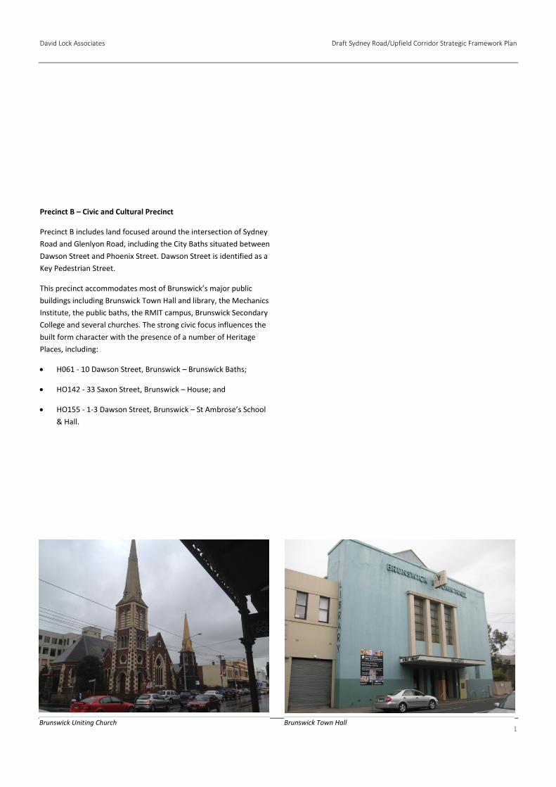
Precinct B – Civic and Cultural Precinct
Precinct B includes land focused around the intersection of Sydney
Road and Glenlyon Road, including the City Baths situated between
Dawson Street and Phoenix Street. Dawson Street is identified as a
Key Pedestrian Street.
This precinct accommodates most of Brunswick’s major public
buildings including Brunswick Town Hall and library, the Mechanics
Institute, the public baths, the RMIT campus, Brunswick Secondary
College and several churches. The strong civic focus influences the
built form character with the presence of a number of Heritage
Places, including:
H061 - 10 Dawson Street, Brunswick – Brunswick Baths;
HO142 - 33 Saxon Street, Brunswick – House; and
HO155 - 1-3 Dawson Street, Brunswick – St Ambrose’s School
& Hall.
Brunswick Uniting Church Brunswick Town Hall
Draft Sydney Road/Upfield Corridor Strategic Framework Plan David Lock Associates
32
Precinct C - Brunswick Station Precinct (Albert Street and Victoria Street)
This precinct consists of land either side of Sydney Road between
Phoenix Street and Victoria Street. There is a large supermarket
including surface car parking located west of Sydney Road,
between Phoenix Street and Albert Street.
The current industrial 3 Zoned land surrounding Brunswick Station
consists of a mixture of warehouses, industrial buildings and
residential uses. Built form varies including large brick warehouses
and single storey workers cottages.
This area is identified by MILUS as Category C - Multi Use -
Employment Areas which are appropriate for mixed use
developments that include a residential component.
The area to the east of Sydney Road between Victoria Street and
Albert Street consists of industrial 3 zoned land. The built form
character of this pocket consists of a mixture of 1 and 2 storey
industrial units, warehouses and traditional 1 storey workers
cottages. There is a recently constructed 6‐storey building located
at 201 Albert Street.
This area is identified by MILUS as a Category D - Multi Use -
Residential Areas - where the opportunity exists for the mix of uses
to change over time to include offices and residential uses.
Albert Street and Victoria Street are identified as Key Pedestrian
Streets within this Precinct. Wilkinson Street is identified as a Key
Pedestrian Street providing access to Brunswick Station.
There are a number of existing properties affected by heritage
overlay, including:
HO3 - 242-249 Albert Street, Brunswick;
HO4 - 291-293 Albert Street, Brunswick – Railway Hotel;
HO183 - 342-348 Victoria Street, Brunswick – Former
Australian Liquorice Factory Chimney and Fire Tunnel
Remains;
HO239 - 13 & 15 Rosser Street, Brunswick – Dwellings; and
HO240 - 14 & 18-24 Rosser Street, Brunswick – Dwellings.
HO299 - 3-5 Frith Street, Brunswick – Telephone Exchange.
HO301 - 14 Frith Street, Brunswick – Former Steel Company of
Australia Ltd; and
HO311 - Howarth Street (part of 14 Frith Street), Brunswick –
Former City of Brunswick Electricity Supply Transformer
Station.
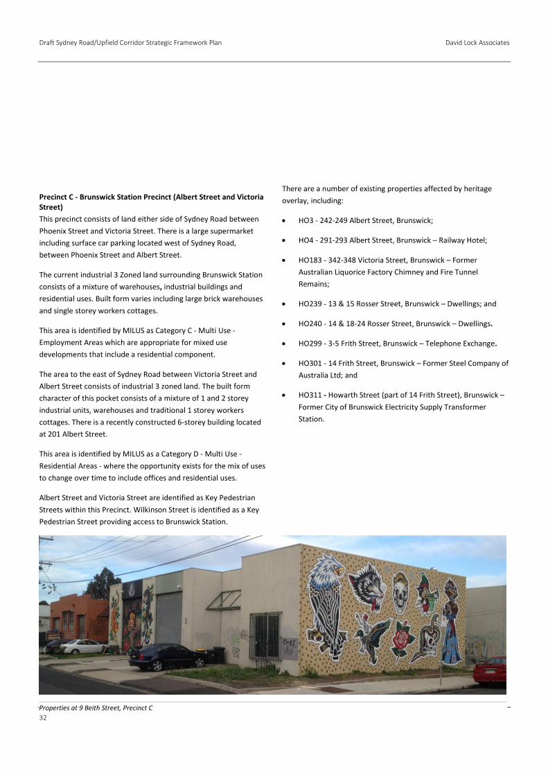
Properties at 9 Beith Street, Precinct C
David Lock Associates Draft Sydney Road/Upfield Corridor Strategic Framework Plan
33
Precinct D - Victoria Street to Hope Street
The character of this precinct is influenced by the existing
commercial and industrial zoning of the area. There is a mix of
single storey workers cottages located principally within an
industrial area.
Industrial buildings are approximately 4‐5 metres in height. Many
of these buildings are setback from the street to provide car
parking at the street interface.
There are a number of heritage properties principally fronting
Victoria Street. These include:
HO37 - 307 Victoria Street, Brunswick – Former United
Friendly Societies Dispensary; and
HO379 - 309-313 Victoria Street, Brunswick – Robert’s
Building.
The industrial 3 zoned land between Ballarat Street and Hope
Street is identified by MILUS as Category C - Multi Use -
Employment Areas, which are considered appropriate for mixed
use developments that include a residential component.
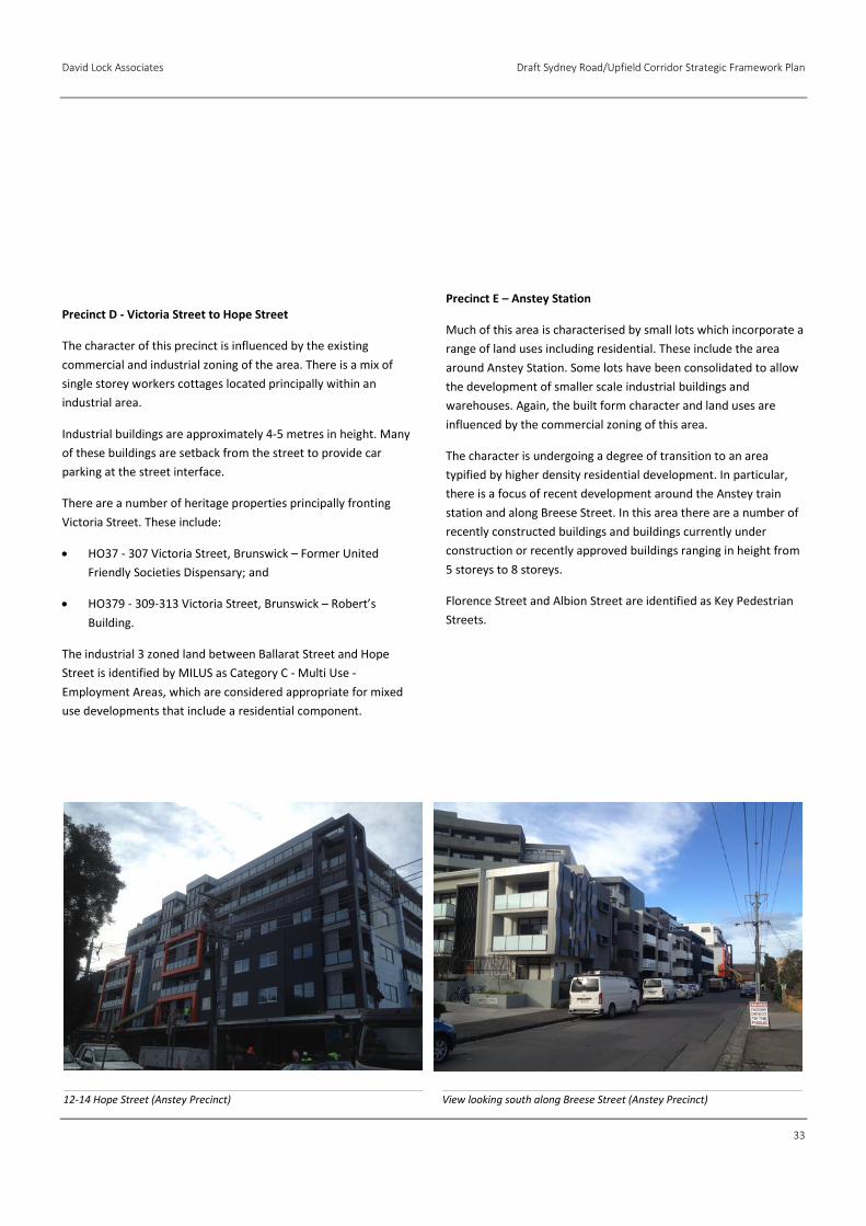
Precinct E – Anstey Station
Much of this area is characterised by small lots which incorporate a
range of land uses including residential. These include the area
around Anstey Station. Some lots have been consolidated to allow
the development of smaller scale industrial buildings and
warehouses. Again, the built form character and land uses are
influenced by the commercial zoning of this area.
The character is undergoing a degree of transition to an area
typified by higher density residential development. In particular,
there is a focus of recent development around the Anstey train
station and along Breese Street. In this area there are a number of
recently constructed buildings and buildings currently under
construction or recently approved buildings ranging in height from
5 storeys to 8 storeys.
Florence Street and Albion Street are identified as Key Pedestrian
Streets.
12-14 Hope Street (Anstey Precinct) View looking south along Breese Street (Anstey Precinct)
Draft Sydney Road/Upfield Corridor Strategic Framework Plan David Lock Associates
34
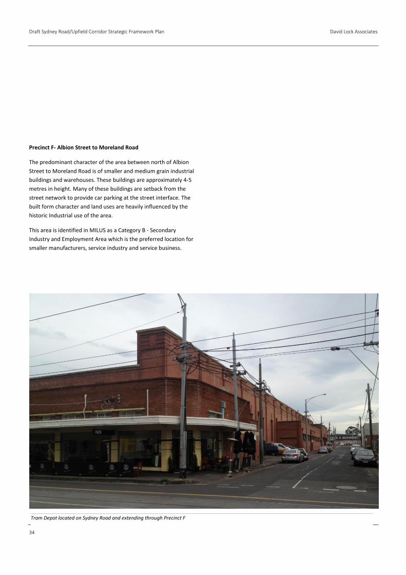
Precinct F- Albion Street to Moreland Road
The predominant character of the area between north of Albion
Street to Moreland Road is of smaller and medium grain industrial
buildings and warehouses. These buildings are approximately 4‐5
metres in height. Many of these buildings are setback from the
street network to provide car parking at the street interface. The
built form character and land uses are heavily influenced by the
historic Industrial use of the area.
This area is identified in MILUS as a Category B - Secondary
Industry and Employment Area which is the preferred location for
smaller manufacturers, service industry and service business.
Tram Depot located on Sydney Road and extending through Precinct F

David Lock Associates Draft Sydney Road/Upfield Corridor Strategic Framework Plan
35
Draft Sydney Road/Upfield Corridor Strategic Framework Plan David Lock Associates
36
This section outlines a series of design principles that are proposed
to guide the future built form and public realm outcomes for the
Framework Plan Area. Each of these principles includes design
requirements intended to meet that principle. A comprehensive
rationale is also provided.
The principles do not prescribe maximum building heights,
as appropriate height limits cannot be determined in isolation
of setbacks or context. The design requirements are formulated to
allow for a range of different building height and setback
combinations, providing flexibility for the design of each building to
respond to its individual program. The requirements allow for
greater heights on deeper properties because of their increased
ability to contain built form impacts.
The built form principles incorporate tenets underpinning
the Brunswick Structure Plan, which have been further developed
based on additional analysis of the existing character within the
Framework Plan Area, a review of approved development in this
and similar activity centres, workshops involving David Lock
Associates (DLA) and Council staff, and a review of other activity
centre built form policy.
The urban design principles are aimed at achieving a mid-rise scale
of development within the Framework Plan Area establishing a
clear contrast with the high-rise scale of central Melbourne and
with the low-rise scale of the residential hinterland, reinforcing the
legibility of the broader urban structure.
Urban Design Principles
Establish a new public realm character that balances spatial
definition and openness.
Complement valued built form character or, where
appropriate, establish a cohesive new character—street
wall.
Complement valued built form character and heritage
values—upper levels.
Create an inviting and vibrant public realm.
Maintain solar access to streets and public open space.
Maintain reasonable amenity for residential properties
alongside the activity centre.
Reinforce the fine grain character of Sydney Road.
Facilitate the provision of new public open spaces.
.
3.0 Urban Design Principles

David Lock Associates Draft Sydney Road/Upfield Corridor Strategic Framework Plan
37
Draft Sydney Road/Upfield Corridor Strategic Framework Plan David Lock Associates
38
Design Requirements
The height of each part of a building should not exceed its
horizontal distance from the opposite street boundary.
Rationale
Policy directs that the character of the Framework Plan Area will
evolve to accommodate urban consolidation. It will develop a more
urban feel. However, a character is sought that maintains a sense
of openness for pedestrians in the street. A key aspect of great
streets is good spatial definition, created by building heights that
complement the street width. This contributes to memorable
places.
A ratio of building height to building separation across the street of
approximately 1:1 strikes an appropriate balance between creating
good spatial definition and maintaining sky visibility. The
application of this design requirement leads to the creation of a
mid-rise built form character.
Because building height at the street frontage is determined by the
width of the street reserve, it will emphasise the street hierarchy
through taller buildings on the wider, main roads. The resulting
mid-rise scale will also establish a clear contrast with the high-rise
scale of central Melbourne and with the low-rise scale of the
residential hinterland, reinforcing the legibility of the broader
urban structure.
There is a range of street widths within the Framework Plan Area.
These include the 20 metre wide Activity Corridor of Sydney Road.
Other key east-west streets such as Brunswick Road, Barkley Street
(west of Sydney Road), Albert Street (west of Sydney Road) and
Michael Street also have 20 metre wide road reserves. Streets such
as Breese Street and Albion Street are 12 metres wide. Other
streets are approximately 9-10 metres wide. An example of this
is illustrated in Figure 18 overleaf.
The public realm character is only one driver of building form.
Building height may also be limited by the other built form
principles and design requirements outlined in this document.
For example, height at the street edge may be limited to
complement the existing built form character (see section 3.2).
The need to avoid unreasonable impacts on the amenity of
adjoining residential properties may also limit the maximum
allowable building height.
The building height design requirement defined above and
illustrated overleaf allows for greater height above that allowed at
the street boundary provided that it is set back the equivalent
distance. This will maintain the preferred balance between spatial
definition and openness.
The provision for setbacks to upper levels could encourage
‘wedding cake’ buildings with different setbacks at each level to
maximise yield. This form is generally considered to be inelegant.
Therefore, the design requirements in Section 3.3 also seek a
common setback for the majority of the upper form to ensure a
coherent composition. However, a small proportion of the upper
form may have a different setback to allow for the creation of a
distinct ‘top’ to the building or a ‘negative level’ separating the
podium and upper form.
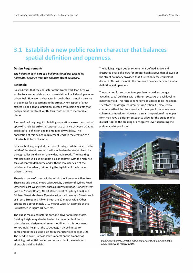
3.1 Establish a new public realm character that balances spatial definition and openness.
Buildings at Burnley Street in Richmond where the building height is equal to the road reserve width.

David Lock Associates Draft Sydney Road/Upfield Corridor Strategic Framework Plan
39
Figure 18 – The maximum allowable building height is in part determined by the width of the road reserve. Building height may also be limited by other built form principles and design requirements outlined in this document.
Draft Sydney Road/Upfield Corridor Strategic Framework Plan David Lock Associates
40
Design Requirements
All buildings within the commercial zone and mixed use zone
should have a zero street setback.
Building height on the street boundaries of the following streets
should be between 5-8 metres:
Barkly Street (west of Sydney Road);
Wilson Avenue;
Union Street;
Manallack Street;
Railway Place (north of Union Street);
Thomas Street; and
Charles Street
Building height on Sydney Road street boundaries and the street
boundaries of Dawson Street, Victoria Street and Albert Street
(east of Sydney Road) should be between 8 and 11 metres.
Building height on the street boundary of Albert Street (west of
Sydney Road) should be between 11 and 14 metres.
Street facades should extend to both side boundaries.
Rationale
Building Alignment
Front setbacks are an important contributor to the character of an
area. Further, new buildings within activity centres should
generally be built to the street edge in order to provide clear
definition between the public and private realms.
New buildings along Sydney Road and sections of the Upfield
Corridor that are zoned Commercial 1 should be built to the street
edge to reinforce the existing ‘hard‐edged’ character of this
Activity Corridor and Key Pedestrian Streets.
Where ground floor residential uses are proposed, buildings should
provide privacy by elevating the ground floor approximately 0.5
metres to 1 metre above the street level or through the provision
of appropriate landscaping.
Street Wall Height
The ‘street wall’ is created by the front façade of buildings built on
or close to the street boundary. Street walls of a relatively
consistent height help to unify otherwise disparate and
fragmented collections of buildings, creating a more visually
cohesive streetscape. Spatial definition is reinforced by a ‘hard’
and continuous edge to the street where buildings are built on the
front boundary for its full width.
The height and detailed design of a street wall can reinforce valued
streetscape character, including heritage fabric. Variations in the
street wall height may be required to reflect specific streetscape
conditions such as important street corners and adjoining heritage
places.
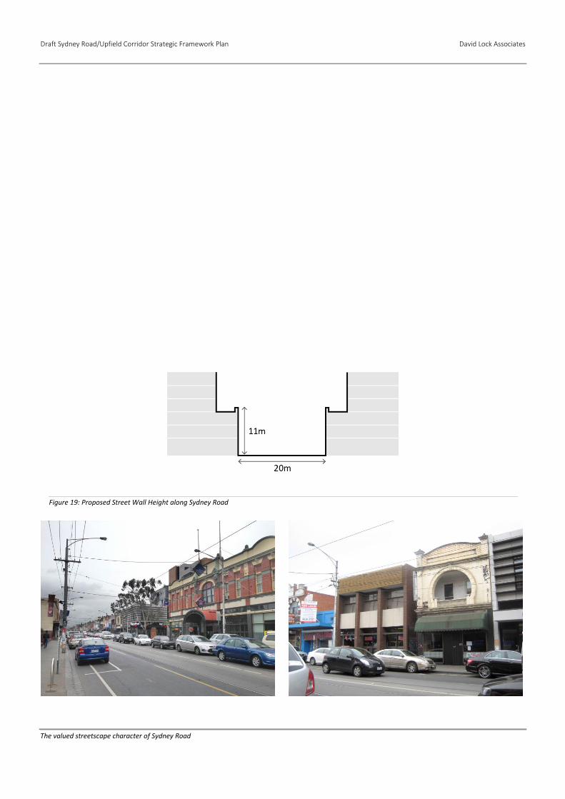
Along Sydney Road the character is typically defined by 1 ‐2 storey,
narrow‐fronted, Victorian, Edwardian or Inter‐war buildings built
on the street boundary. They generally reach a height of between
9‐10 metres. A typical contemporary 3‐storey (11 metres) street
wall fits comfortably within this traditional streetscape due to its
more modest floor‐to floor heights.
The section of Sydney Road, north of Albion Street, presents a
relatively consistent street wall character. Whilst these lots are not
included within the Sydney Road heritage precinct there is a
relatively consistent streetscape character of 1-2 storey buildings
built on the street boundary.
Continuous Facades
The prevailing character of the commercial and mixed‐use areas in
Sydney Road is of a continuous, ‘hard‐edged’ street wall. A break in
the continuity of the street wall lessens the spatial definition and
activation of the public realm.
3.2 Complement valued built form character or, where appropriate, establish a cohesive new character—street wall.
David Lock Associates Draft Sydney Road/Upfield Corridor Strategic Framework Plan
41
Off‐corridor Locations
The Mixed Use zoned land around Wilson Avenue, Little Gold
Street, Union Street and Manallack Street has a relatively
consistent low-rise built form character. It consists of traditional,
single storey workers’ cottages and more recently constructed 3
storey townhouses and apartments. Therefore, any built form
should respond to the prevailing character of this area.
Along Victoria Street, west of Sydney Road the character is
typically defined by 1-2 storey commercial buildings including a
row of Victorian heritage shop fronts. A typical contemporary 3-
storey (11m) street wall will create a sense of cohesion to the
streetscape.
To the east of Sydney Road, the character of Victoria Street is
defined by a mixture of 1 storey houses and 1 and 2 storey
warehouses and office buildings. A street wall height of 8-11
metres will sit comfortably within this streetscape. This also
reflects the approved 3 storey street wall of development at 300
Victoria Street.
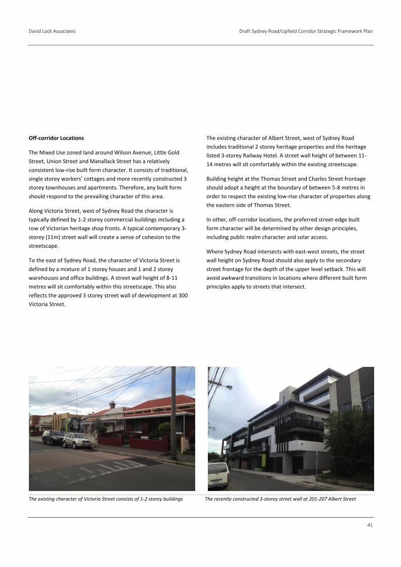
The existing character of Albert Street, west of Sydney Road
includes traditional 2 storey heritage properties and the heritage
listed 3-storey Railway Hotel. A street wall height of between 11-
14 metres will sit comfortably within the existing streetscape.
Building height at the Thomas Street and Charles Street frontage
should adopt a height at the boundary of between 5-8 metres in
order to respect the existing low-rise character of properties along
the eastern side of Thomas Street.
In other, off‐corridor locations, the preferred street‐edge built
form character will be determined by other design principles,
including public realm character and solar access.
Where Sydney Road intersects with east-west streets, the street
wall height on Sydney Road should also apply to the secondary
street frontage for the depth of the upper level setback. This will
avoid awkward transitions in locations where different built form
principles apply to streets that intersect.
The existing character of Victoria Street consists of 1-2 storey buildings The recently constructed 3-storey street wall at 201-207 Albert Street
Draft Sydney Road/Upfield Corridor Strategic Framework Plan David Lock Associates
42
Figure 19: Proposed Street Wall Height along Sydney Road
The valued streetscape character of Sydney Road

David Lock Associates Draft Sydney Road/Upfield Corridor Strategic Framework Plan
43
Draft Sydney Road/Upfield Corridor Strategic Framework Plan David Lock Associates
44
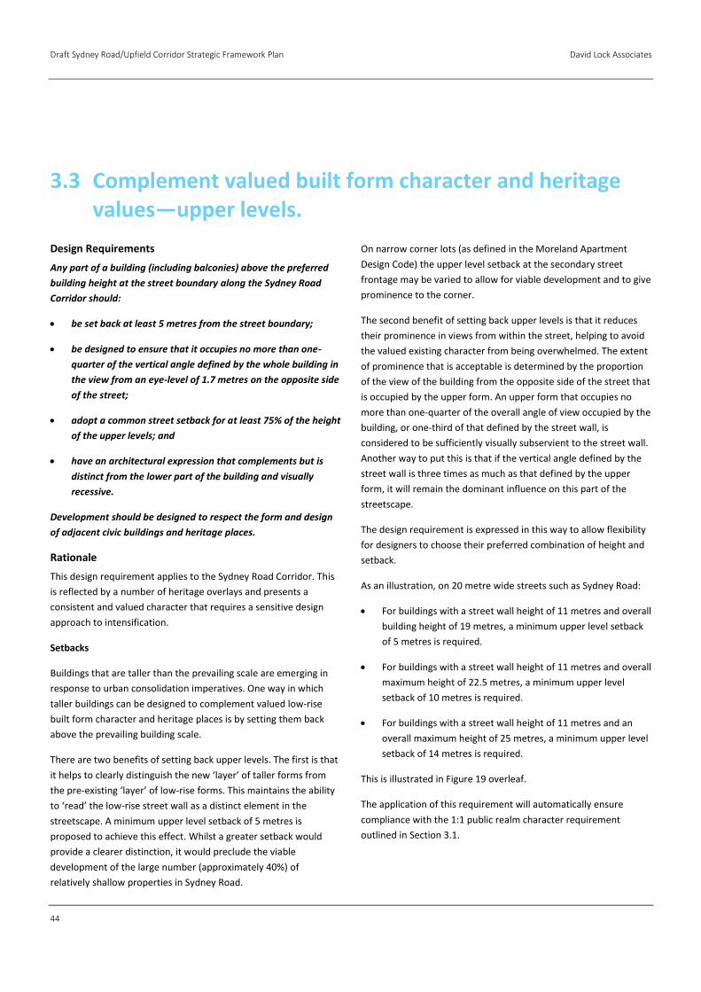
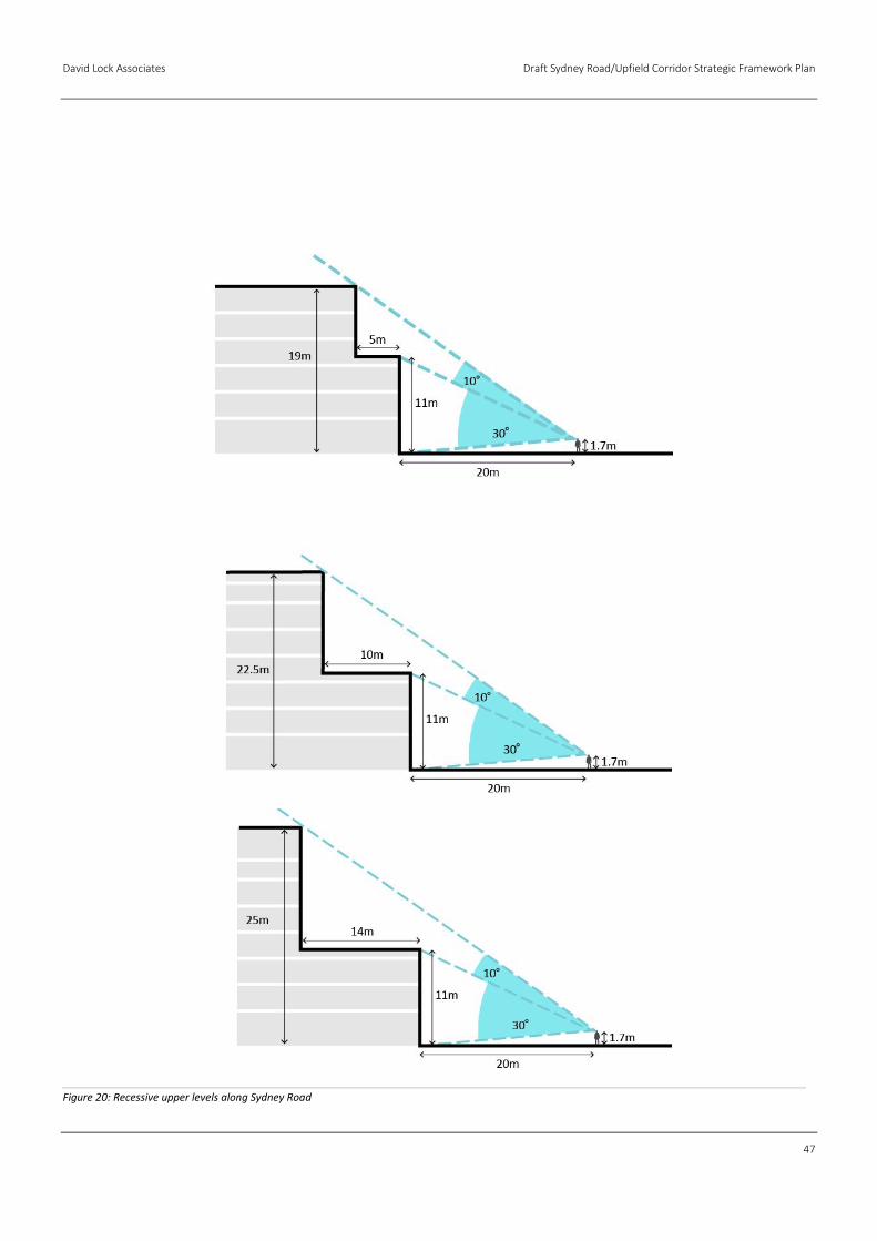
Design Requirements
Any part of a building (including balconies) above the preferred
building height at the street boundary along the Sydney Road
Corridor should:
be set back at least 5 metres from the street boundary;
be designed to ensure that it occupies no more than one-
quarter of the vertical angle defined by the whole building in
the view from an eye-level of 1.7 metres on the opposite side
of the street;
adopt a common street setback for at least 75% of the height
of the upper levels; and
have an architectural expression that complements but is
distinct from the lower part of the building and visually
recessive.
Development should be designed to respect the form and design
of adjacent civic buildings and heritage places.
Rationale
This design requirement applies to the Sydney Road Corridor. This
is reflected by a number of heritage overlays and presents a
consistent and valued character that requires a sensitive design
approach to intensification.
Setbacks
Buildings that are taller than the prevailing scale are emerging in
response to urban consolidation imperatives. One way in which
taller buildings can be designed to complement valued low‐rise
built form character and heritage places is by setting them back
above the prevailing building scale.
There are two benefits of setting back upper levels. The first is that
it helps to clearly distinguish the new ‘layer’ of taller forms from
the pre‐existing ‘layer’ of low‐rise forms. This maintains the ability
to ‘read’ the low‐rise street wall as a distinct element in the
streetscape. A minimum upper level setback of 5 metres is
proposed to achieve this effect. Whilst a greater setback would
provide a clearer distinction, it would preclude the viable
development of the large number (approximately 40%) of
relatively shallow properties in Sydney Road.
On narrow corner lots (as defined in the Moreland Apartment
Design Code) the upper level setback at the secondary street
frontage may be varied to allow for viable development and to give
prominence to the corner.
The second benefit of setting back upper levels is that it reduces
their prominence in views from within the street, helping to avoid
the valued existing character from being overwhelmed. The extent
of prominence that is acceptable is determined by the proportion
of the view of the building from the opposite side of the street that
is occupied by the upper form. An upper form that occupies no
more than one‐quarter of the overall angle of view occupied by the
building, or one‐third of that defined by the street wall, is
considered to be sufficiently visually subservient to the street wall.
Another way to put this is that if the vertical angle defined by the
street wall is three times as much as that defined by the upper
form, it will remain the dominant influence on this part of the
streetscape.
The design requirement is expressed in this way to allow flexibility
for designers to choose their preferred combination of height and
setback.
As an illustration, on 20 metre wide streets such as Sydney Road:
For buildings with a street wall height of 11 metres and overall
building height of 19 metres, a minimum upper level setback
of 5 metres is required.
For buildings with a street wall height of 11 metres and overall
maximum height of 22.5 metres, a minimum upper level
setback of 10 metres is required.
For buildings with a street wall height of 11 metres and an
overall maximum height of 25 metres, a minimum upper level
setback of 14 metres is required.
This is illustrated in Figure 19 overleaf.
The application of this requirement will automatically ensure
compliance with the 1:1 public realm character requirement
outlined in Section 3.1.
3.3 Complement valued built form character and heritage values—upper levels.
David Lock Associates Draft Sydney Road/Upfield Corridor Strategic Framework Plan
45
The application of the requirement explained above could
encourage ‘wedding cake’ buildings with different setbacks at each
level to maximise yield. This form is generally considered to be
inelegant. Therefore, the design requirements also seek a common
setback for the majority of the upper form to ensure a coherent
composition. However, a small proportion of the upper form is
allowed to have a different setback to allow for the creation of a
distinct ‘top’ to the building or a ‘negative level’ separating the
podium and upper form.
Architectural Expression
Another way in which upper levels can be distinguished from the
low‐rise street‐edge form is through a distinct architectural
expression. The prevailing architectural character of the low‐rise
street walls tends to be defined by relatively solid masonry forms
with ‘punched’ openings. If a contrasting, more lightweight
architectural expression is adopted for upper levels, this not only
helps to distinguish the two ‘layers’, but also contributes to the
visual recessiveness of the upper form.
Colour can also affect recessiveness. Both very light and very dark
colours tend to draw the eye, whereas mid‐toned colours, such as
grey, are less striking against the sky.
Civic Buildings
The Framework Plan Area incorporates a number of civic buildings
and heritage places that make an important contribution to the
character and legibility of the area. Therefore, development
adjacent to such buildings is proposed to be required to respect
their built form values.
260 Chapel Street, Windsor and 175 Sydney Road: Examples of new development setback from the 'layer' of lower rise forms

Draft Sydney Road/Upfield Corridor Strategic Framework Plan David Lock Associates
46
David Lock Associates Draft Sydney Road/Upfield Corridor Strategic Framework Plan
47
Figure 20: Recessive upper levels along Sydney Road
Draft Sydney Road/Upfield Corridor Strategic Framework Plan David Lock Associates
48
Design Requirements
Development should incorporate active edges at street level
fronting all streets (except rear access lanes), public open spaces
and the Upfield Shared Path (where appropriate). Active edges
should comply with the Commercial and Residential Frontage
standards specified in the Moreland Apartment Design Code.
Development should incorporate windows in all upper level
facades facing streets, public open spaces and the Upfield Shared
Path.
Development should minimise the impact of vehicle access and
car parking on the public realm by:
locating vehicle access at the rear of buildings wherever
possible, or the side of corner properties away from the front
façade where rear access is not available; and
locating car parking where it cannot be seen from the public
realm.
In commercial and mixed use zones, development should have a
ground floor ceiling height that allows for a range of appropriate
uses.
In commercial zones, development should incorporate awnings
over the footpath for the full width of the building frontage in
accordance with the Moreland Apartment Design Code.
Services cabinets should be located at the rear of buildings
wherever possible, or the side of corner buildings away from the
front façade where rear access is not available. Where they can
only be located in the front façade, the size of services cabinets
should be minimised and they should be integrated with the
overall façade design.
Rationale
Active edges
Active ground floor frontages, which provide for engagement
between those inside buildings and those in the street outside,
contribute to the appeal of the public realm for pedestrians, and
thus the success of an activity centre. Active frontages are
achieved by doors, windows and activities which ‘spill out’ into the
street such as footpath dining and trading.
Active frontages also contribute to passive surveillance, which
enhances actual and perceived safety by adding ‘eyes on the
street’.
Across the Framework Plan Area, there will be three different
degrees of ‘activeness’ depending on the ground floor uses i.e.
active retail edges, commercial edges and residential edges. These
are defined in the Moreland Apartment Design Code as:
Built Edge Condition A: Retail Frontage – A display window
and/or entrance, measuring at least 80% of the width of the
street frontage of each individual premise.
Built Edge Condition B: Other Commercial Frontage – A display
window and/or entrance, measuring at least 60% of the width
of the street frontage of each individual premise.
Built Edge Condition C: Residential Frontage – Individual entry
doors to ground floor dwellings. Privacy is to be provided by
elevating the ground floor approximately 0.5 to 1 metre above
the street level and/or provide a landscaped front setback.
Ground floor residential uses can achieve a balance between
contributing to street activation and privacy by being elevated
approximately 0.5-1 metre above the footpath level, or through
the provision of appropriate landscaping.
The ground floor of new development abutting the Upfield Shared
Path should be designed to avoid large areas of blank walls.
Upper levels can also contribute to the social experience and
passive surveillance of streets by orientating windows and
balconies towards them. This helps to create a safe and vibrant
place.
3.4 Create an inviting and vibrant public realm.
David Lock Associates Draft Sydney Road/Upfield Corridor Strategic Framework Plan
49
Vehicle Access, Car Parking & Services Cabinets
Vehicle access and services cabinets detract from the appearance
and ‘activeness’ of the public realm, and disrupt and reduce the
safety of pedestrian activity. Therefore, it is proposed that they be
located where they will cause the least disruption to an active
streetscape.
Car parking that is located at the public edges of buildings also
detracts from the appearance and ‘activeness’ of the public realm.
Therefore, it is proposed that it be located where it cannot be seen
from the public realm. This can be achieved by locating it at a
basement level or behind other, more ‘active’ accommodation at
ground floor or upper levels.
To increase the capacity of the existing laneway network to allow
it to provide for more intense development, the traditional narrow
lanes should be widened to 6 metres to allow for two-way
movement where possible.
Ground Floor Ceiling Heights
The specific use of ground floor commercial space in activity
centres tends to change more frequently than space in other
locations. There are a range of objectives to encourage
employment and commercial floor spaces within the Brunswick
Activity Centre.
Therefore, buildings in commercial and mixed use zoned land
should be designed to allow for changes in use at ground floor in
response to fluctuating market conditions. Given that many retail
and office uses require greater ceiling heights than residential uses
this translates to a more generous floor-to-floor dimension of
approximately 3 metres.
Awnings
Protection from the sun and rain is a key ingredient of an inviting
pedestrian environment. It is also characteristic of retail
environments. Design requirements for awnings are detailed in the
Moreland Apartment Design Code, including:
Provide continuous awnings along retail/commercial
frontages and Key Pedestrian Streets;
Respond to the prevailing pattern of awnings by
complementing the existing height, depth and form of
awnings;
Provide sufficient protection from sun and rain; and
Contribute to the legibility of the development and amenity of
the public domain by locating awnings over building entries.
Draft Sydney Road/Upfield Corridor Strategic Framework Plan David Lock Associates
50
Design Requirements
Development along Sydney Road and Key Pedestrian Streets
should avoid overshadowing the opposite footpath between
10:00am and 2:00pm at the equinox.
Development should avoid overshadowing more than 50% of any
existing or proposed public space, including parks and plazas,
between 10:00am and 2:00pm at the equinox.
Rationale
Access to sunlight is a critical ingredient of the amenity and appeal
of the public realm and, therefore, the success of an activity
centre. Therefore, the design requirements seek to avoid
unreasonable overshadowing of streets and public open spaces.
Some overshadowing is inevitable where buildings are tall and
relatively close together. Therefore, efforts to avoid
overshadowing are proposed to be focused on Sydney Road, Key
Pedestrian Streets and other public spaces where there is most
activity – both walking and outdoor dining.
Given the prevailing low-rise built form scale at least one footpath
in Sydney Road and the Key Pedestrian Streets currently receives
sunlight for a minimum of 5 hours during the Equinox. That is, at
least one side of the footpath receives sunlight.
As the primary pedestrian locations within the Framework Plan
Area it is important that reasonable solar access is maintained to
the footpaths of these streets.
Solar access for pedestrians is relevant for most parts of the day.
However, the desire for solar access must be balanced with the
need to provide for urban consolidation. For outdoor dining and
resting, solar access is most relevant during the middle part of the
day.
In order to encourage a vibrant street life and pedestrian activity,
it is proposed that sunlight access to the footpath on one side of
Sydney Road and Key Pedestrian Streets, and to a minimum of 50%
of any park or plaza, be maintained between 10:00am and 2:00pm
at the equinox.
Shadow analysis diagrams are outlined in Figures 21 and 22
overleaf.
3.5 Maintain solar access to streets and public open space.
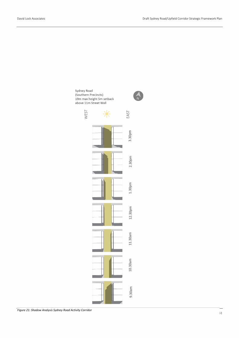
David Lock Associates Draft Sydney Road/Upfield Corridor Strategic Framework Plan
51
Figure 21: Shadow Analysis Sydney Road Activity Corridor
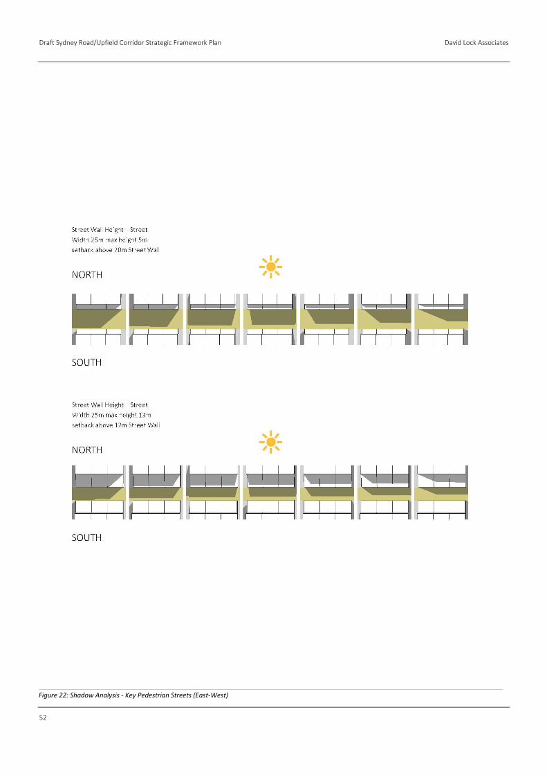
Draft Sydney Road/Upfield Corridor Strategic Framework Plan David Lock Associates
52
Figure 22: Shadow Analysis - Key Pedestrian Streets (East-West)

David Lock Associates Draft Sydney Road/Upfield Corridor Strategic Framework Plan
53
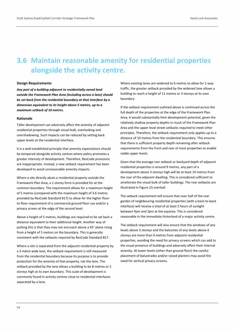
Draft Sydney Road/Upfield Corridor Strategic Framework Plan David Lock Associates
54
Design Requirements
Any part of a building adjacent to residentially-zoned land
outside the Framework Plan Area (including across a lane) should
be set back from the residential boundary at that interface by a
dimension equivalent to its height above 5 metres, up to a
maximum setback of 10 metres.
Rationale
Taller development can adversely affect the amenity of adjacent
residential properties through visual bulk, overlooking and
overshadowing. Such impacts can be reduced by setting back
upper levels at the residential interface.
It is a well-established principle that amenity expectations should
be tempered alongside activity centres where policy promotes a
greater intensity of development. Therefore, ResCode provisions
are inappropriate. Instead, a new setback requirement has been
developed to avoid unreasonable amenity impacts.
Where a site directly abuts a residential property outside the
Framework Plan Area, a 1-storey form is provided for at the
common boundary. The requirement allows for a maximum height
of 5 metres (compared with the maximum height of 3.6 metres
provided by ResCode Standard B17) to allow for the higher floor-
to-floor requirement of a commercial ground floor use and/or a
privacy screen at the edge of the second level.
Above a height of 5 metres, buildings are required to be set back a
distance equivalent to their additional height. Another way of
putting this is that they may not encroach above a 45° plane rising
from a height of 5 metres on the boundary. This is generally
consistent with the setbacks required by ResCode Standard B17.
Where a site is separated from the adjacent residential property by
a 3 metre wide lane, the setback requirement is still measured
from the residential boundary because its purpose is to provide
protection for the amenity of that property, not the lane. The
setback provided by the lane allows a building to be 8 metres or 2
storeys high at its own boundary. This scale of development is
commonly found in activity centres close to residential interfaces
separated by a lane.
Where existing lanes are widened to 6 metres to allow for 2-way
traffic, the greater setback provided by the widened lane allows a
building to reach a height of 11 metres or 3 storeys at its own
boundary.
If the setback requirement outlined above is continued across the
full depth of the properties at the edge of the Framework Plan
Area, it would substantially limit development potential, given the
relatively shallow property depths in much of the Framework Plan
Area and the upper level street setbacks required to meet other
principles. Therefore, the setback requirement only applies up to a
distance of 10 metres from the residential boundary. This ensures
that there is sufficient property depth remaining after setback
requirements from the front and rear of most properties to enable
viable upper levels.
Given that the average rear setback or backyard depth of adjacent
residential properties is around 9 metres, any part of a
development above 3 storeys high will be at least 19 metres from
the rear of the adjacent dwelling. This is considered sufficient to
ameliorate the visual bulk of taller buildings. The rear setbacks are
illustrated in Figure 23 overleaf.
The setback requirement will ensure that over half of the rear
garden of neighbouring residential properties (with a back-to-back
interface) will receive a total of at least 3 hours of sunlight
between 9am and 3pm at the equinox. This is considered
reasonable in the immediate hinterland of a major activity centre.
The setback requirement will also ensure that the windows of any
levels above 3 storeys and the balconies of any levels above 4
storeys are more than 9 metres from adjacent residential
properties, avoiding the need for privacy screens which can add to
the visual presence of buildings and adversely affect their internal
amenity. At lower levels (other than ground floor) the careful
placement of balustrades and/or raised planters may avoid the
need for vertical privacy screens.
3.6 Maintain reasonable amenity for residential properties alongside the activity centre.
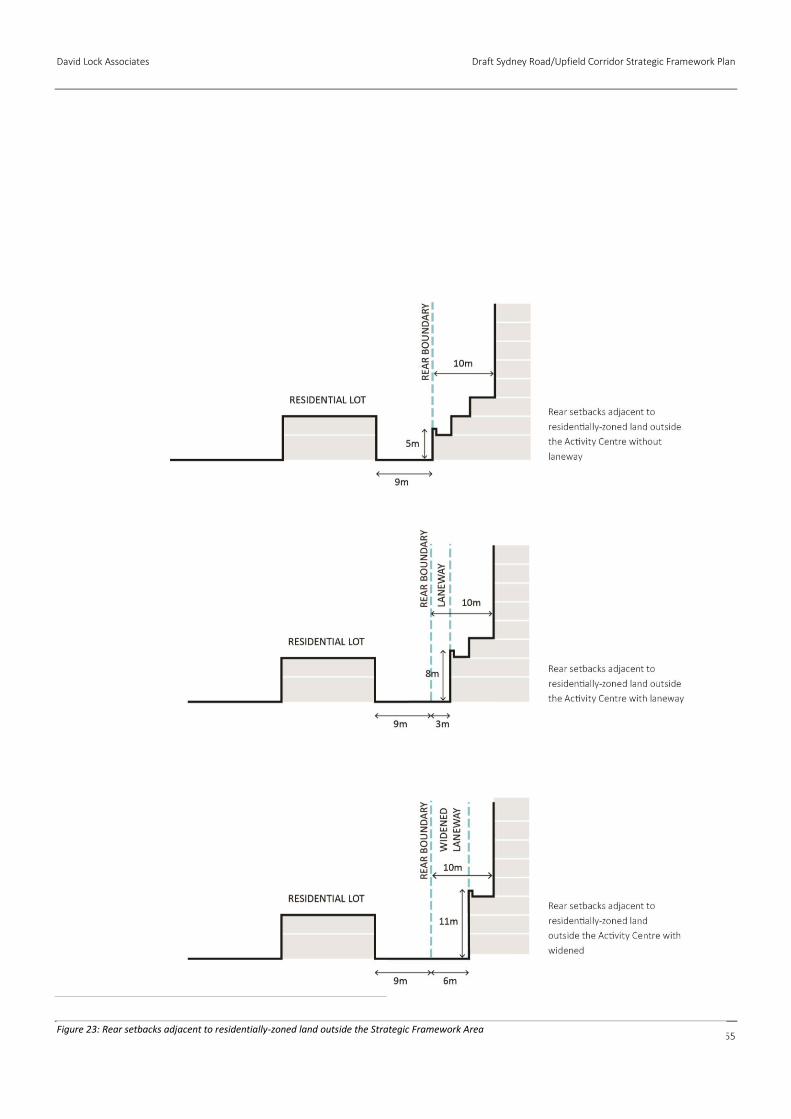
David Lock Associates Draft Sydney Road/Upfield Corridor Strategic Framework Plan
55
Figure 23: Rear setbacks adjacent to residentially-zoned land outside the Strategic Framework Area
Draft Sydney Road/Upfield Corridor Strategic Framework Plan David Lock Associates
56
Figure 24: Shadow testing of design requirements for rear setback to north-south street at the Equinox.
Figure 25: Shadow testing of design requirements for rear setbacks to north-south streets at winter solstice.
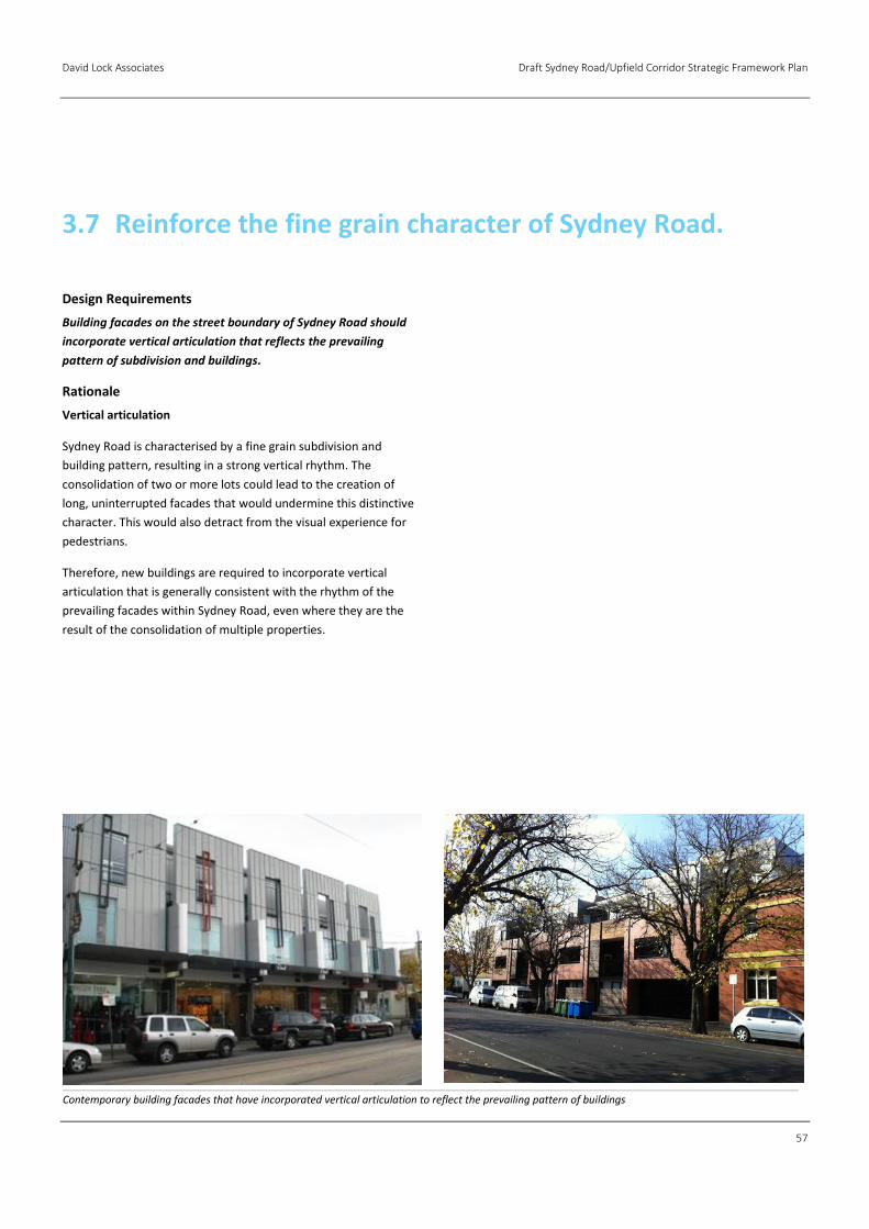
David Lock Associates Draft Sydney Road/Upfield Corridor Strategic Framework Plan
57
Design Requirements
Building facades on the street boundary of Sydney Road should
incorporate vertical articulation that reflects the prevailing
pattern of subdivision and buildings.
Rationale
Vertical articulation
Sydney Road is characterised by a fine grain subdivision and
building pattern, resulting in a strong vertical rhythm. The
consolidation of two or more lots could lead to the creation of
long, uninterrupted facades that would undermine this distinctive
character. This would also detract from the visual experience for
pedestrians.
Therefore, new buildings are required to incorporate vertical
articulation that is generally consistent with the rhythm of the
prevailing facades within Sydney Road, even where they are the
result of the consolidation of multiple properties.
3.7 Reinforce the fine grain character of Sydney Road.
Contemporary building facades that have incorporated vertical articulation to reflect the prevailing pattern of buildings

Draft Sydney Road/Upfield Corridor Strategic Framework Plan David Lock Associates
58
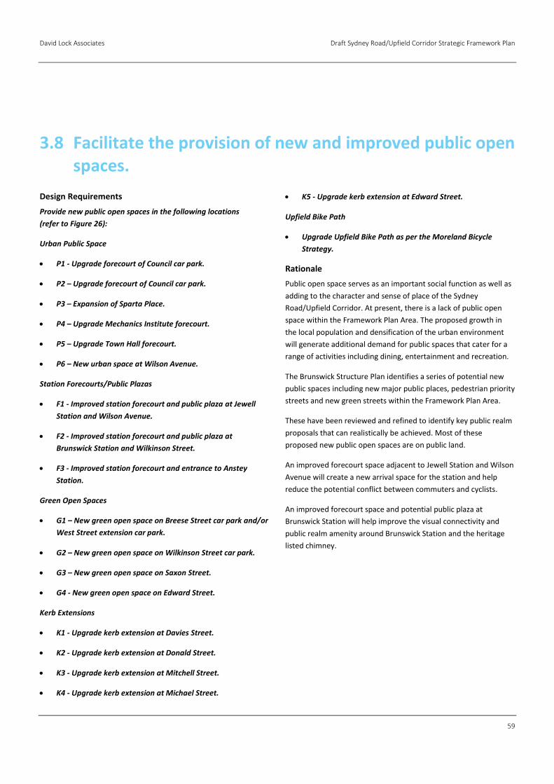
David Lock Associates Draft Sydney Road/Upfield Corridor Strategic Framework Plan
59
Design Requirements
Provide new public open spaces in the following locations
(refer to Figure 26):
Urban Public Space
P1 - Upgrade forecourt of Council car park.
P2 – Upgrade forecourt of Council car park.
P3 – Expansion of Sparta Place.
P4 – Upgrade Mechanics Institute forecourt.
P5 – Upgrade Town Hall forecourt.
P6 – New urban space at Wilson Avenue.
Station Forecourts/Public Plazas
F1 - Improved station forecourt and public plaza at Jewell
Station and Wilson Avenue.
F2 - Improved station forecourt and public plaza at
Brunswick Station and Wilkinson Street.
F3 - Improved station forecourt and entrance to Anstey
Station.
Green Open Spaces
G1 – New green open space on Breese Street car park and/or
West Street extension car park.
G2 – New green open space on Wilkinson Street car park.
G3 – New green open space on Saxon Street.
G4 - New green open space on Edward Street.
Kerb Extensions
K1 - Upgrade kerb extension at Davies Street.
K2 - Upgrade kerb extension at Donald Street.
K3 - Upgrade kerb extension at Mitchell Street.
K4 - Upgrade kerb extension at Michael Street.
K5 - Upgrade kerb extension at Edward Street.
Upfield Bike Path
Upgrade Upfield Bike Path as per the Moreland Bicycle
Strategy.
Rationale
Public open space serves as an important social function as well as
adding to the character and sense of place of the Sydney
Road/Upfield Corridor. At present, there is a lack of public open
space within the Framework Plan Area. The proposed growth in
the local population and densification of the urban environment
will generate additional demand for public spaces that cater for a
range of activities including dining, entertainment and recreation.
The Brunswick Structure Plan identifies a series of potential new
public spaces including new major public places, pedestrian priority
streets and new green streets within the Framework Plan Area.
These have been reviewed and refined to identify key public realm
proposals that can realistically be achieved. Most of these
proposed new public open spaces are on public land.
An improved forecourt space adjacent to Jewell Station and Wilson
Avenue will create a new arrival space for the station and help
reduce the potential conflict between commuters and cyclists.
An improved forecourt space and potential public plaza at
Brunswick Station will help improve the visual connectivity and
public realm amenity around Brunswick Station and the heritage
listed chimney.
3.8 Facilitate the provision of new and improved public open spaces.
Draft Sydney Road/Upfield Corridor Strategic Framework Plan David Lock Associates
60
Figure26: Proposed New Public Open Space

David Lock Associates Draft Sydney Road/Upfield Corridor Strategic Framework Plan
61
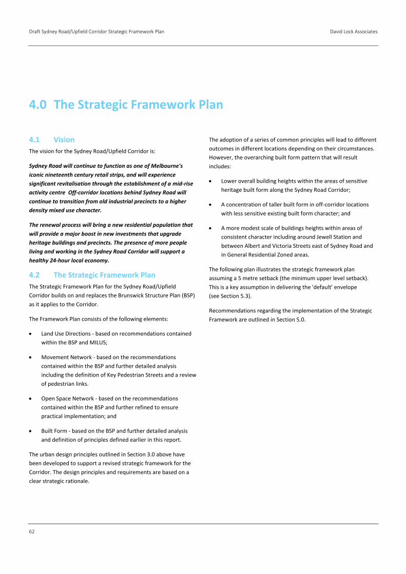
Draft Sydney Road/Upfield Corridor Strategic Framework Plan David Lock Associates
62
4.1 Vision
The vision for the Sydney Road/Upfield Corridor is:
Sydney Road will continue to function as one of Melbourne's
iconic nineteenth century retail strips, and will experience
significant revitalisation through the establishment of a mid-rise
activity centre Off-corridor locations behind Sydney Road will
continue to transition from old industrial precincts to a higher
density mixed use character.
The renewal process will bring a new residential population that
will provide a major boost in new investments that upgrade
heritage buildings and precincts. The presence of more people
living and working in the Sydney Road Corridor will support a
healthy 24-hour local economy.
4.2 The Strategic Framework Plan
The Strategic Framework Plan for the Sydney Road/Upfield
Corridor builds on and replaces the Brunswick Structure Plan (BSP)
as it applies to the Corridor.
The Framework Plan consists of the following elements:
Land Use Directions - based on recommendations contained
within the BSP and MILUS;
Movement Network - based on the recommendations
contained within the BSP and further detailed analysis
including the definition of Key Pedestrian Streets and a review
of pedestrian links.
Open Space Network - based on the recommendations
contained within the BSP and further refined to ensure
practical implementation; and
Built Form - based on the BSP and further detailed analysis
and definition of principles defined earlier in this report.
The urban design principles outlined in Section 3.0 above have
been developed to support a revised strategic framework for the
Corridor. The design principles and requirements are based on a
clear strategic rationale.
The adoption of a series of common principles will lead to different
outcomes in different locations depending on their circumstances.
However, the overarching built form pattern that will result
includes:
Lower overall building heights within the areas of sensitive
heritage built form along the Sydney Road Corridor;
A concentration of taller built form in off-corridor locations
with less sensitive existing built form character; and
A more modest scale of buildings heights within areas of
consistent character including around Jewell Station and
between Albert and Victoria Streets east of Sydney Road and
in General Residential Zoned areas.
The following plan illustrates the strategic framework plan
assuming a 5 metre setback (the minimum upper level setback).
This is a key assumption in delivering the 'default' envelope
(see Section 5.3).
Recommendations regarding the implementation of the Strategic
Framework are outlined in Section 5.0.
4.0 The Strategic Framework Plan
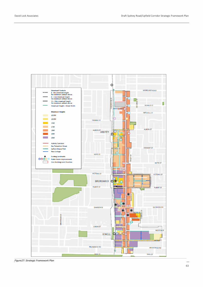
David Lock Associates Draft Sydney Road/Upfield Corridor Strategic Framework Plan
63
Figure27: Strategic Framework Plan
Draft Sydney Road/Upfield Corridor Strategic Framework Plan David Lock Associates
64
4.3 Land Use Directions
The preferred land use pattern and directions are based on the
Brunswick Structure Plan (BSP) and Moreland Industrial Land Use
Strategy (MILUS) (illustrated in Figure 28) and seek to:
Encourage uses that identify the area as a major
concentration of activity and as a community and civic focal
point.
Promote a high density mixed use centre with a diversity of
land uses.
Facilitate the concentration of retail uses along Sydney Road
with office and/or residential uses at upper levels.
Support the transition of designated industrial precincts to
mixed use precincts supporting a diversity of commercial and
residential uses, with the following emphasis:
→ Multi Use – Employment: Prioritise commercial uses and
encourage commercial uses at ground and first floors.
Support investment in office and new urban
manufacturing enterprises that can coexist with
residential uses. Facilitate residential uses at the upper
levels of mixed use buildings. Sites which are not located
on key pedestrian streets may be considered for wholly
residential uses but must be designed to ensure casual
surveillance of the public realm.
→ Multi Use – Residential: Encouraged mixed use buildings
with commercial uses at ground floor (e.g. office or retail)
and residential uses at upper levels. Sites which are not
located on key pedestrian streets may be considered for
wholly residential uses but must be designed to ensure
casual surveillance of the public realm.
Residential amenity expectations should be consistent with a
vibrant mixed use centre.
Implement the ‘agent of change’ principle whereby new
residential uses must incorporate noise attenuation and
layout measures to protect residents from noise sources such
as live music venues, loading and waste collection areas and
noise generated from traffic, trains and trams.
Retain the two designated Secondary Industry and
Employment Precincts for the continued operation of light
industry and complementary non-residential uses (the future
of these two precincts will be reviewed by Council as part of
the forthcoming MILUS Review).
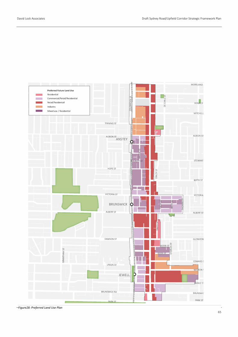
David Lock Associates Draft Sydney Road/Upfield Corridor Strategic Framework Plan
65
Figure28: Preferred Land Use Plan
Draft Sydney Road/Upfield Corridor Strategic Framework Plan David Lock Associates
66
4.4 Movement Network
The Corridor includes three train stations including Jewell,
Brunswick and Anstey which will become the focus for transit-
oriented development opportunities.
Sydney Road is the major Activity Corridor within the Framework
Plan Area.
Other Key Pedestrian Streets include Albion Street, Florence Street,
Victoria Street, Albert Street, Wilkinson Street, Dawson Street,
Wilson Avenue, Barkly Street and Brunswick Road. These key
pedestrian streets link Sydney Road to the Upfield Railway Line.
A new public link connecting Sydney Road with the Upfield Shared
Path is proposed to the south of the Tram Depot. The proposed
link could be located on a Council owned car park and will provide
an additional level of permeability for this section of the Corridor.
Other new public links are proposed to increase permeability
through large sites within the Framework Plan Area. These include:
An east-west public link from Lobb Street to Thomas Street;
An east-west public link from Beith Street to Thomas Street;
An east-west public link from Sydney Road to Albert Street;
A north-south public link from Phoenix Street to Albert Street;
and
A north-south public link through Barkly Square from Barkly
Street to Weston Street.
The Upfield Shared Path is also a key element of the movement
network. The ground floor of development immediately abutting
the Upfield Shared Path should be set back a minimum of 1 metre.
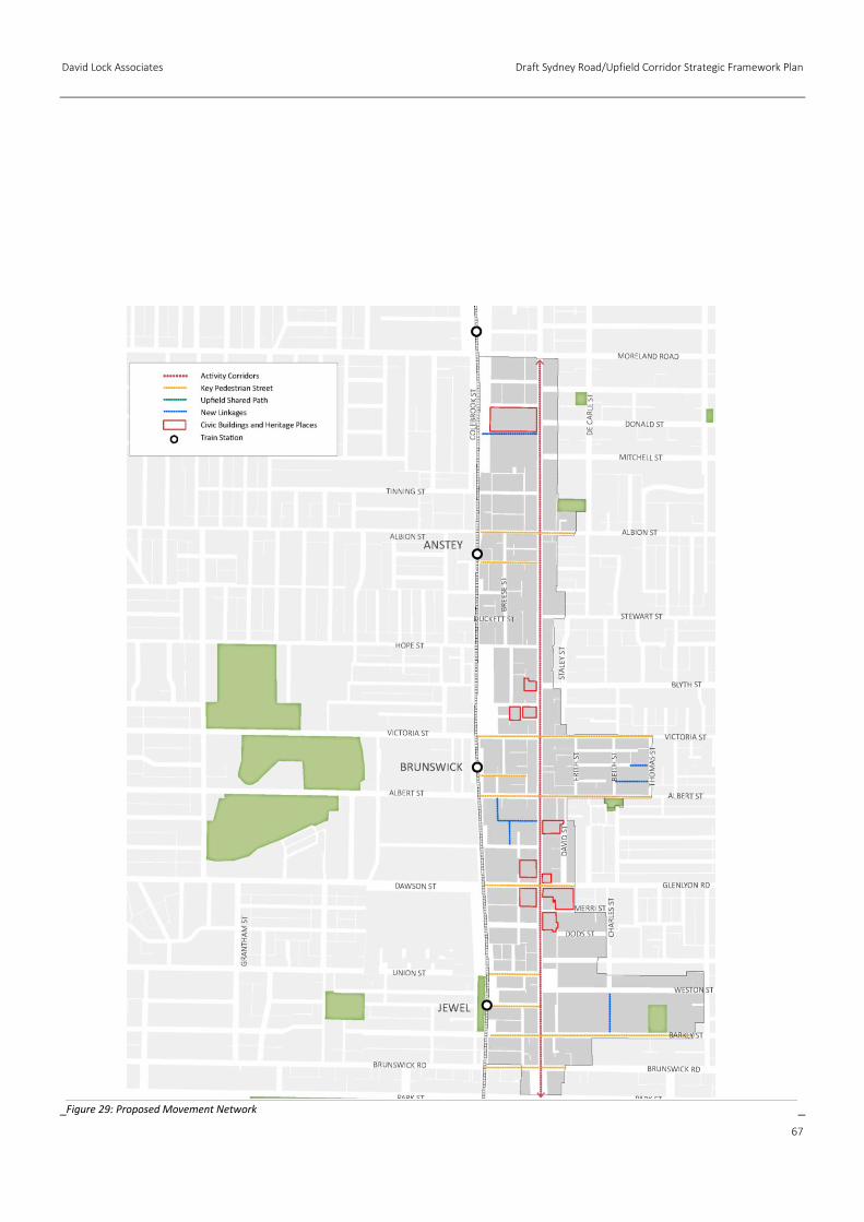
David Lock Associates Draft Sydney Road/Upfield Corridor Strategic Framework Plan
67
Figure 29: Proposed Movement Network
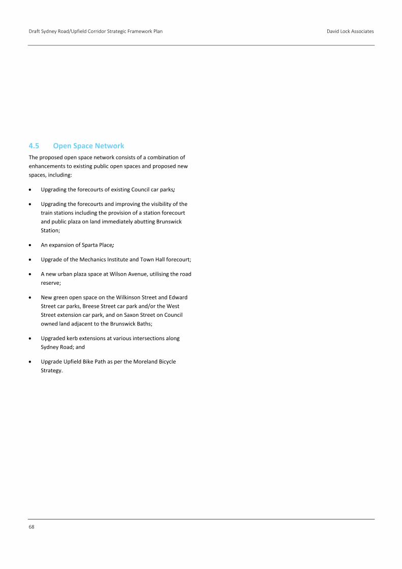
Draft Sydney Road/Upfield Corridor Strategic Framework Plan David Lock Associates
68
4.5 Open Space Network
The proposed open space network consists of a combination of
enhancements to existing public open spaces and proposed new
spaces, including:
Upgrading the forecourts of existing Council car parks;
Upgrading the forecourts and improving the visibility of the
train stations including the provision of a station forecourt
and public plaza on land immediately abutting Brunswick
Station;
An expansion of Sparta Place;
Upgrade of the Mechanics Institute and Town Hall forecourt;
A new urban plaza space at Wilson Avenue, utilising the road
reserve;
New green open space on the Wilkinson Street and Edward
Street car parks, Breese Street car park and/or the West
Street extension car park, and on Saxon Street on Council
owned land adjacent to the Brunswick Baths;
Upgraded kerb extensions at various intersections along
Sydney Road; and
Upgrade Upfield Bike Path as per the Moreland Bicycle
Strategy.
David Lock Associates Draft Sydney Road/Upfield Corridor Strategic Framework Plan
69
Figure 30: Proposed Public Open Space Network
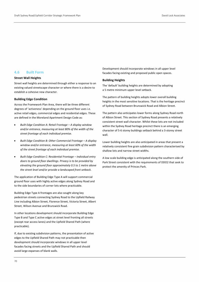
Draft Sydney Road/Upfield Corridor Strategic Framework Plan David Lock Associates
70
4.6 Built Form
Street Wall Heights
Street wall heights are determined through either a response to an
existing valued streetscape character or where there is a desire to
establish a cohesive new character.
Building Edge Condition
Across the Framework Plan Area, there will be three different
degrees of ‘activeness’ depending on the ground floor uses i.e.
active retail edges, commercial edges and residential edges. These
are defined in the Moreland Apartment Design Code as:
Built Edge Condition A: Retail Frontage – A display window
and/or entrance, measuring at least 80% of the width of the
street frontage of each individual premise.
Built Edge Condition B: Other Commercial Frontage – A display
window and/or entrance, measuring at least 60% of the width
of the street frontage of each individual premise.
Built Edge Condition C: Residential Frontage – Individual entry
doors to ground floor dwellings. Privacy is to be provided by
elevating the ground floor approximately 0.5 to 1 metre above
the street level and/or provide a landscaped front setback.
The application of Building Edge Type A will support commercial
ground floor uses with highly active edges along Sydney Road and
to the side boundaries of corner lots where practicable.
Building Edge Type A frontages are also sought along key
pedestrian streets connecting Sydney Road to the Upfield Railway
Line including Albion Street, Florence Street, Victoria Street, Albert
Street, Wilson Avenue and Brunswick Road.
In other locations development should incorporate Building Edge
Type B and Type C active edges at street level fronting all streets
(except rear access lanes) and the Upfield Shared Path (where
practicable).
If, due to existing subdivision patterns, the presentation of active
edges to the Upfield Shared Path may not practicable then
development should incorporate windows in all upper level
facades facing streets and the Upfield Shared Path and should
avoid large expanses of blank walls.
Development should incorporate windows in all upper level
facades facing existing and proposed public open spaces.
Building Heights
The 'default' building heights are determined by adopting
a 5 metre minimum upper level setback.
The pattern of building heights adopts lower overall building
heights in the most sensitive locations. That is the heritage precinct
of Sydney Road between Brunswick Road and Albion Street.
The pattern also anticipates lower forms along Sydney Road north
of Albion Street. This section of Sydney Road presents a relatively
consistent street wall character. Whilst these lots are not included
within the Sydney Road heritage precinct there is an emerging
character of 5-6 storey buildings setback behind a 3-storey street
wall.
Lower building heights are also anticipated in areas that present a
relatively consistent fine grain subdivision pattern characterised by
shallow lots and narrow street widths.
A low scale building edge is anticipated along the southern side of
Park Street consistent with the requirements of DDO2 that seek to
protect the amenity of Princes Park.

David Lock Associates Draft Sydney Road/Upfield Corridor Strategic Framework Plan
71

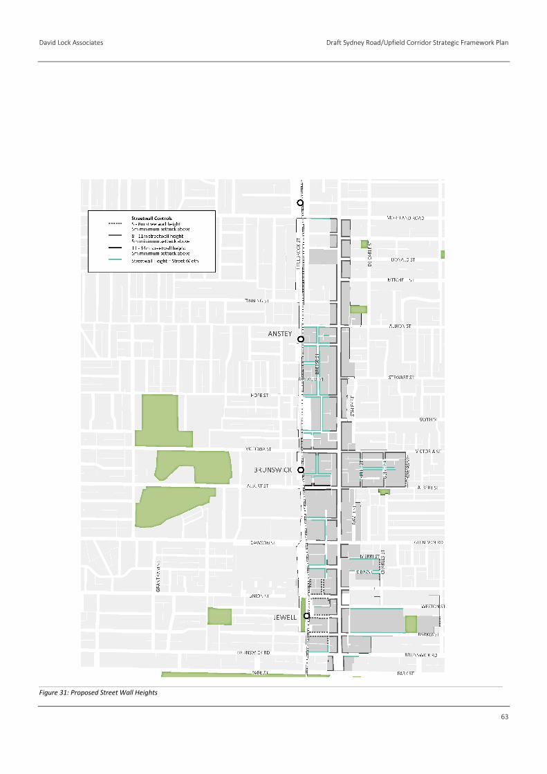
David Lock Associates Draft Sydney Road/Upfield Corridor Strategic Framework Plan
63
Figure 31: Proposed Street Wall Heights
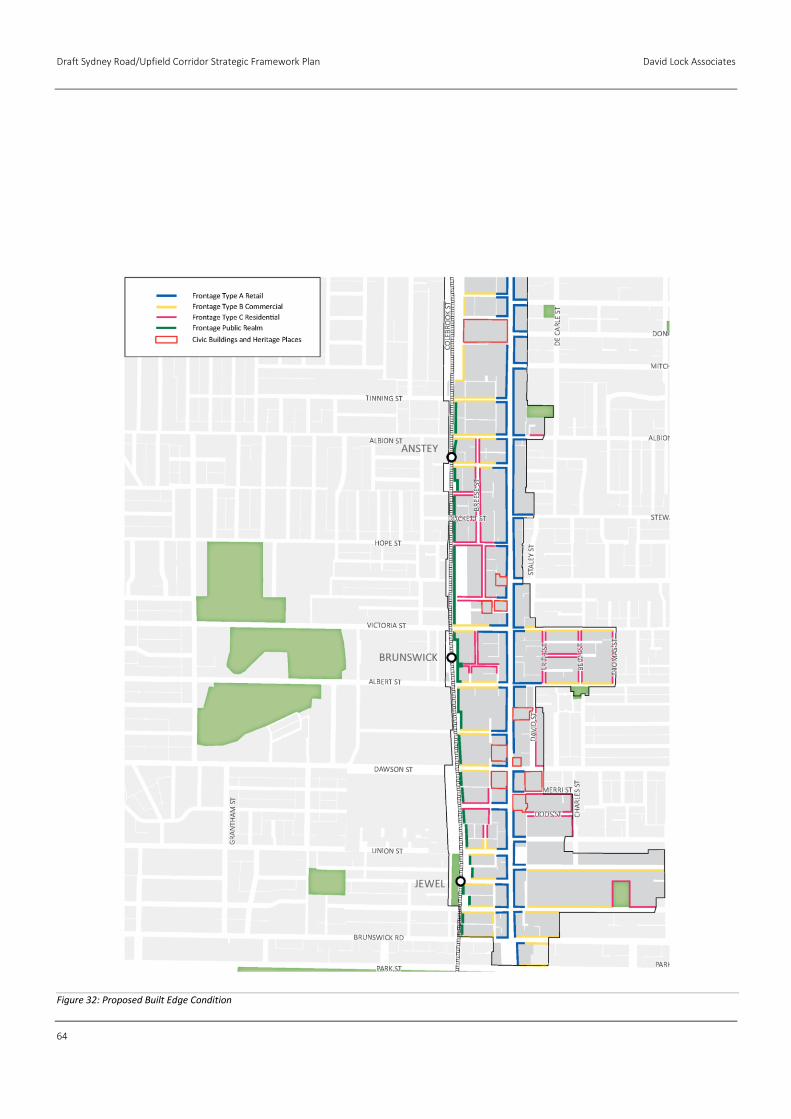
Draft Sydney Road/Upfield Corridor Strategic Framework Plan David Lock Associates
64
Figure 32: Proposed Built Edge Condition
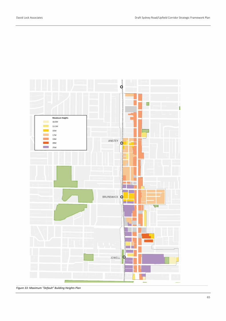
David Lock Associates Draft Sydney Road/Upfield Corridor Strategic Framework Plan
65
Figure 33: Maximum "Default" Building Heights Plan
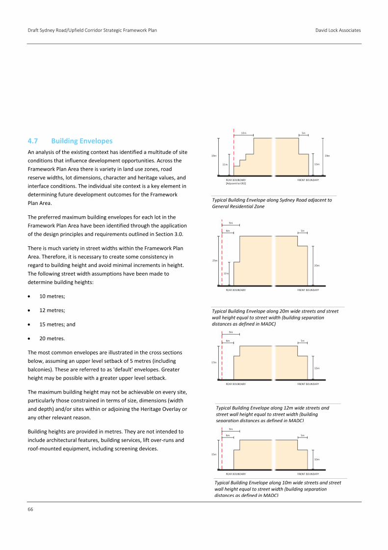
Draft Sydney Road/Upfield Corridor Strategic Framework Plan David Lock Associates
66
4.7 Building Envelopes
An analysis of the existing context has identified a multitude of site
conditions that influence development opportunities. Across the
Framework Plan Area there is variety in land use zones, road
reserve widths, lot dimensions, character and heritage values, and
interface conditions. The individual site context is a key element in
determining future development outcomes for the Framework
Plan Area.
The preferred maximum building envelopes for each lot in the
Framework Plan Area have been identified through the application
of the design principles and requirements outlined in Section 3.0.
There is much variety in street widths within the Framework Plan
Area. Therefore, it is necessary to create some consistency in
regard to building height and avoid minimal increments in height.
The following street width assumptions have been made to
determine building heights:
10 metres;
12 metres;
15 metres; and
20 metres.
The most common envelopes are illustrated in the cross sections
below, assuming an upper level setback of 5 metres (including
balconies). These are referred to as 'default' envelopes. Greater
height may be possible with a greater upper level setback.
The maximum building height may not be achievable on every site,
particularly those constrained in terms of size, dimensions (width
and depth) and/or sites within or adjoining the Heritage Overlay or
any other relevant reason.
Building heights are provided in metres. They are not intended to
include architectural features, building services, lift over-runs and
roof-mounted equipment, including screening devices.
Typical Building Envelope along Sydney Road adjacent to General Residential Zone
Typical Building Envelope along 20m wide streets and street wall height equal to street width (building separation distances as defined in MADC)
Typical Building Envelope along 12m wide streets and street wall height equal to street width (building separation distances as defined in MADC)
Typical Building Envelope along 10m wide streets and street wall height equal to street width (building separation distances as defined in MADC)

David Lock Associates Draft Sydney Road/Upfield Corridor Strategic Framework Plan
67
Draft Sydney Road/Upfield Corridor Strategic Framework Plan David Lock Associates
68
5.1 Design and Development Overlay
The Design and Development Overlay (DDO) is considered the
most appropriate tool to implement the desired strategic
framework plan. A DDO is principally applied to control built form
and the built environment. Application of the DDO is considered
appropriate for implementing built form controls to established
areas comprising a number of allotments under various
ownerships.
Given that most of the built form principles and requirements are
common across the Framework Plan Area, one schedule can be
adopted for the whole area, rather than separate schedules for
each precinct. The application of the requirements will lead to
outcomes that respond to the individual circumstances of each lot,
rather than standardised outcomes across whole precincts.
Prescriptive controls provide fixed directions for decision making.
These controls can establish maximum building heights and
setbacks amongst other things. Prescriptive controls can
sometimes be inflexible and may result in uniform outcomes
that diminish the diversity of places.
Performance-based controls increase the flexibility of decision-
making. They set standards that describe the envisaged end result
and acceptable limits of impact. These controls offer the decision-
maker the discretion to respond to the site and application on
its merits based on the site-specific context.
The design principles and requirements outlined above consist
of a mixture of both prescriptive and performance-based controls.
This defines minimum standards to be met while also allowing
some flexibility for potential developers to encourage innovative
design.
5.2 Design Objectives
It is recommended that the principles outlined in Section 3.0 of this
report are translated into design objectives applicable across the
Framework Plan Area. The Design Objectives will seek:
To establish a new public realm character that balances
spatial definition and openness.
To complement the valued built form heritage character of
Sydney Road, or establish a cohesive new built form character
within the Upfield Corridor between the rail line and rear of
Sydney Road and locations behind Sydney Road to the east.
To ensure development respects heritage values.
To create an inviting, safe and vibrant public realm.
To maintain solar access to key streets and public open space.
To maintain reasonable amenity for residential properties
alongside the activity centre.
To reinforce the fine grain character of Sydney Road.
5.3 Permit Requirements
It is recommended that the notice and review requirements for
buildings and works under the DDO do not apply if an application
complies with the 'default' building envelope. That is, it complies
with all the requirements below, and its height does not exceed
the maximum allowable with a 5 metre upper level setback. If an
applicant seeks to construct a building where any of the default
envelope parameters are varied then notice and review
requirements apply, and the application should be assessed
against the design requirements. These include:
Building Height
The height of each part of a building should not exceed its
horizontal distance from the opposite street boundary.
Development along Sydney Road and Key Pedestrian Streets
should avoid overshadowing the opposite footpath between
10:00am and 2:00pm at the equinox.
Development should avoid overshadowing more than 50% of
any existing and proposed public space, including parks and
plazas, between 10:00am and 2:00pm at the equinox.
5.0 Implementation
David Lock Associates Draft Sydney Road/Upfield Corridor Strategic Framework Plan
69
Street Wall
All buildings within the commercial zone should have a zero
street setback.
All buildings within the mixed use zone should be setback in
accordance with the emerging character or a maximum of 3
metres whichever is lesser.
Building height on the street boundaries of the following
streets should be between 5-8 metres:
→ Barkly Street (west of Sydney Road);
→ Wilson Avenue;
→ Union Street;
→ Manallack Street;
→ Railway Place (north of Union Street);
→ Thomas Street; and
→ Charles Street.
Building height on the street boundaries of Sydney Road,
Dawson Street, Victoria Street and Albert Street (east of
Sydney Road) should be between 8 and 11 metres.
Building height on the street boundary of Albert Street (west
of Sydney Road) should be between 11 and 14 metres.
Street facades should extend to both side boundaries.
Upper Levels
Sydney Road
Any part of a building (including balconies) above the
preferred building height at the street boundary along Sydney
Road should:
→ be designed to ensure that it occupies no more than one-
quarter of the vertical angle defined by the whole
building in the view from an eye-level of 1.7 metres on
the opposite side of the street;
→ be set back at least 5 metres from the street boundary;
→ adopt a common street setback for at least 75% of the
height of the upper levels; and
→ have an architectural expression that complements but is
distinct from the lower part of the building and visually
recessive.
Off-Corridor Locations (Streets other than Sydney Road)
Any part of a building (including balconies) above the
preferred building height at the street boundary should:
→ be set back at least 5 metres from the street boundary;
→ adopt a common street setback for at least 75% of the
height of the upper levels; and
→ have an architectural expression that complements but is
distinct from the lower part of the building and visually
recessive.
Development should be designed to respect the form and
design of adjacent civic buildings and heritage places.
Building Layout and Detailed Design
Development should incorporate active edges at street level
fronting all streets (except rear access lanes), public open
spaces and the Upfield Shared Path (where appropriate).
Active edges should comply with the Commercial and
Residential Frontage standards specified in the Moreland
Apartment Design Code.
Development should incorporate windows in all upper level
facades facing streets, public open spaces and the Upfield
Shared Path.
Development should minimise the impact of vehicle access
and car parking on the public realm by:
→ locating vehicle access at the rear of buildings wherever
possible, or the side of corner properties away from the
front façade where rear access is not available; and
→ locating car parking where it cannot be seen from the
public realm.
Draft Sydney Road/Upfield Corridor Strategic Framework Plan David Lock Associates
70
In commercial and mixed use zones, development should
have a ground floor ceiling height that allows for a range of
commercial uses.
In commercial zones, development should incorporate
awnings over the footpath for the full width of the building
frontage in accordance with the Moreland Apartment Design
Code.
Services cabinets should be located at the rear of buildings
wherever possible, or the side of corner buildings away from
the front façade where rear access is not available. Where
they can only be located in the front façade, the size of
services cabinets should be minimised and they should be
integrated with the overall façade design.
Building facades on the street boundaries of Sydney Road
should incorporate vertical articulation that reflects the
prevailing fine grain pattern of subdivision and buildings.
Rear Setbacks
Any part of a building adjacent to residentially-zoned land
outside the Framework Plan Area (including across a lane)
should be set back from the residential boundary at that
interface by a dimension equivalent to its height above 5
metres, up to a maximum setback of 10 metres.
Public Realm
Ensure development adjacent to Jewell, Brunswick and Anstey
Stations enhances the visibility of, and access to Station
Buildings.
Ensure that new development incorporates the proposed
public linkages to maximise permeability through the Activity
Centre and the accessibility to existing Upfield Corridor.

David Lock Associates Draft Sydney Road/Upfield Corridor Strategic Framework Plan
71

Draft Sydney Road/Upfield Corridor Strategic Framework Plan David Lock Associates
72


