Siddharth Narayan Michael W. Beck, Pelayo Menendez, Iñigo J. Losada & Borja G. Reguero
The Coastal Protection Services of Mangroves in the Philippines: Preliminary Workshop, July 2016: Day 1

Purpose: To support the Government of the Philippines in the use of mangroves for coastal resilience.
• G.o P’s National Greening Program includes the restoration of mangroves as part of its coastal protection strategy
• G.o.P’s Executive Order “Expanding the Coverage of the National Greening Program” (EO 193 s. 2015) identified the critical role of forests, including mangroves, as a coastal protection strategy
• Workshop in Manila, 2015 reconfirmed inclusion of mangrove CP services in Philippines national accounts (in addition to other values, including forest and non-forest mangrove products, waste assimilation services, carbon sequestration, ecotourism)
• G.o.P’s Risk Resiliency Program (RRP) and Risk Resiliency and Sustainability Program (RRSP) may implement a Pilot Program for Climate Resilience jointly with the World Bank, which would include the use of mangroves as a coastal protection strategy.
The Coastal Protection Services of Mangroves in the Philippines: Background
Contacts: Sid Narayan ([email protected]), Mike Beck ([email protected]), Maya G. Villaluz, Gem Castillo

The Coastal Protection Services of Mangroves in the Philippines: Project Objectives
1. Develop physical & monetary accounts for coastal protection services from mangroves in the Philippines• Under current and future sea level scenarios• At spatial scales appropriate for policy-making • Using the Expected Damage Function in the WB WAVES Guidelines and comparing to
other approaches
2. Recommendations and policy implications for Philippines climate resilience programs based on spatial variation in the natural defense value of mangroves
3. Pilot (& improve) the recommendations in the Guidelines

The Coastal Protection Services of Mangroves in the Philippines: Products and Timeline
PRODUCT DELIVERABLES TIMELINE FOR COMPLETION
PRELIMINARY WORKSHOP/ TRAINING
a) Introduce Evaluation Methods/Modelsb) Discuss, Identify, Collect Datac) Discuss, Identify appropriate sub-national Case-
Study Sites
July 2016
WORKSHOP Presentation of preliminary findings with PH stakeholders
October / November 2016
TECHNICAL REPORT Report on the CP services of mangroves in the Philippines, including:a) Mangrove Accountsb) Policy Implications and c) Documentation of data and methods
December 2016 – March 2017
Policy Note Summary version of Technical Report December 2016
Guidelines Assessment Report
Updates/Revisions to Guideline Recommendations based on Philippines case-study
December 2016 – March 2017

Goal:
To provide a general understanding of approaches and tools for assessing flood risk; and the current
knowledge on the coastal protection value of reefs and mangroves
Aim/Objectives:
1) To familiarize the audience with Approaches for Valuing Coastal Protection Benefits from
Mangroves and Coral Reefs with a focus on recommendations from recent World Bank Guidelines;
2) To discuss and identify existing data, data needs, and potential case-study sites (1 to 2) for
estimating mangrove protection values.
3) Assist similar future evaluation exercises in the Philippines by getting the conversation started
Audience: This training is meant for:
(a) biologists/ ecologists/GIS staff that are interested in valuing flood protection benefits, and
(b) risk managers/ engineers that are interested in understanding how ecosystems can be
considered in their 'standard' models and frameworks.
The Coastal Protection Services of Mangroves in the Philippines: Preliminary Workshop

OUTLINE:
• Introduction to Coastal Risk and Coastal Ecosystems (15 mins)
• WAVES: Managing Coasts with Natural Solutions (30 mins)
• Assessing Coastal Protection Value of Reefs and Mangroves: Review of Current
Understanding (15 min)
• Assessing Coastal Protection Value of Reefs and Mangroves: Models, Processes
and Methods (30 min)
The Coastal Protection Services of Mangroves in the Philippines: Preliminary Workshop
– Day 1, Session 1 (9:00 to 10.30)
INTRODUCTION TO COASTAL RISK AND COASTAL ECOSYSTEMS

Coastal Risk
• Risk = Consequence X Hazard
• High at present, likely to increase

Coastal Risk: Hazards
Intensity and frequency – surges, waves, sea-level rise, erosion

55
Coastal Risk: Consequences
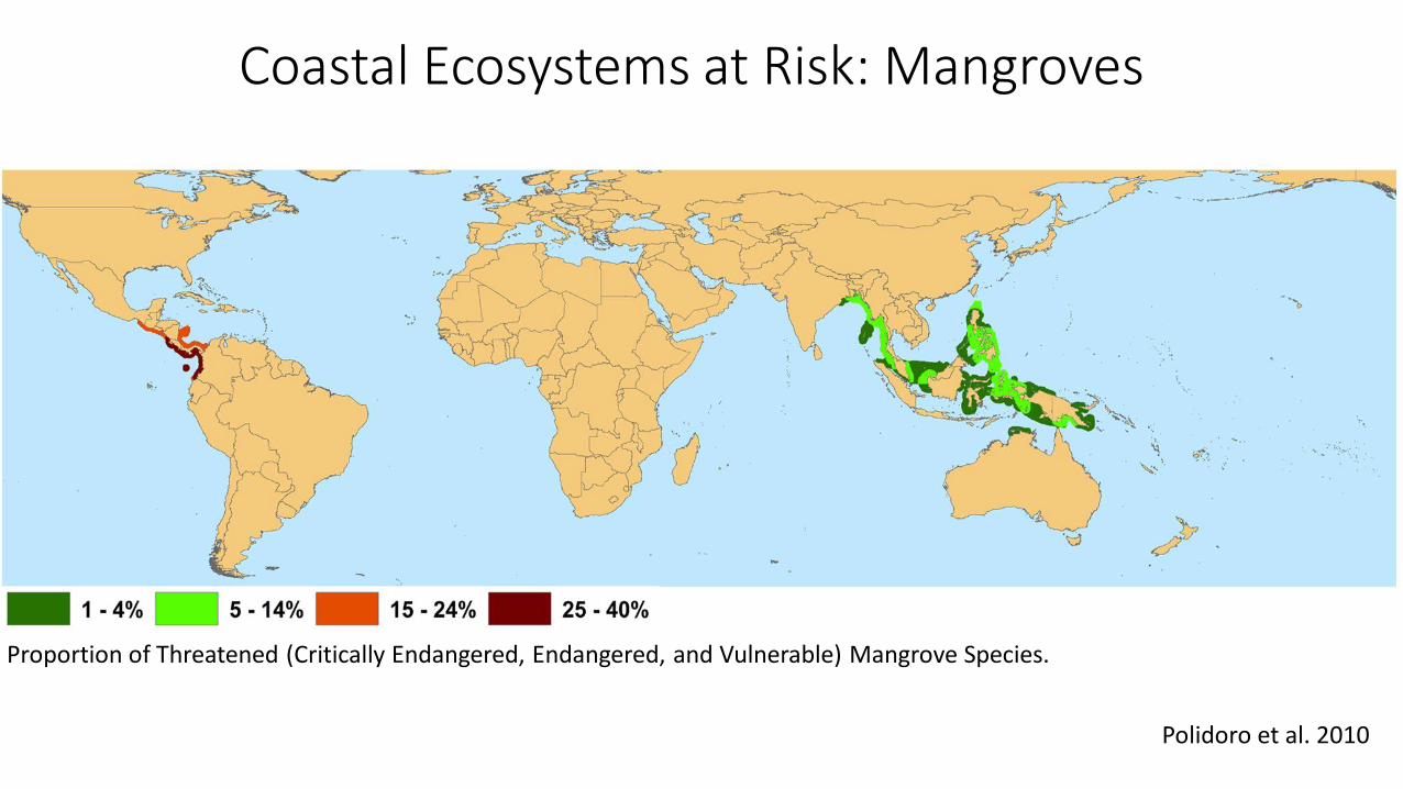
Coastal Ecosystems at Risk: Mangroves
Polidoro et al. 2010
Proportion of Threatened (Critically Endangered, Endangered, and Vulnerable) Mangrove Species.

Coastal Ecosystems at Risk: Coral Reefs
Taken from Reefs at Risk: Revisited Report, World Resources Institute, 2011.

• Seawalls• Sea dykes, levees• Beaches, dunes• Vegetated foreshores• Storm surge barriers• Offshore breakwaters, reefs• Land Claim
Coastal Risk: Management
Protect
Accommodate
Retreat
• Flood proofing• Flood hazard mapping and
awareness• Flood warning and evacuation• Flood zoning / habitat restoration
• Coastal setbacks• Managed retreat/realignment
Adapted from Nicholls et al. 2007

WAVES: MANAGING COASTS WITH NATURAL SOLUTIONS

Beck, MW, G-M Lange (eds)
https://www.wavespartnership.org/en/knowledge-center/managing-coasts-natural-solutions
Mike Beck, GM Lange Jim Sanchirico, Borja Reguero Juha Siikamaki, Sid Narayan
RequestforWorkingGroupProposals
Page 1
Science for Nature and People Partnership
Request for Proposals Due Date: 25 April 2016, 9:00 am PDT
Website: www.snap.is For inquiries email [email protected]
The Science for People and Nature Partnership (SNAPP) was founded by The Nature
Conservancy, the Wildlife Conservation Society, and the National Center for Ecological
Analysis and Synthesis (NCEAS) at the University of California, Santa Barbara. The SNAP
Partnership delivers evidence-based, scalable solutions for problems at the collective interface of
economic development, nature conservation, and human well-being. SNAPP funds and convenes
multidisciplinary and cross-sector collaborations to catalyze innovative solutions with a clear
pathway to implementation. We are pleased to announce the fourth annual Request for Proposals
(RFP) for working groups to fill important knowledge gaps and advance solutions for people and
nature. In this RFP, we are especially interested in receiving proposals from the development and
humanitarian sectors as well as academia, governmental agencies, and conservation
organizations.
In September 2015, the United Nations adopted a new sustainable development agenda to end
poverty, protect the environment, and provide prosperity for all people. To advance the
sustainable development agenda, professionals from conservation and development fields must
collaborate in inclusive, flexible, and innovative ways. With 23 SNAPP working groups that
collectively include over 400 participants, representing 200 institutions from more than 30
countries, SNAPP is providing an opportunity for such engagements. SNAPP is rapidly
converting research into action by generating the type of applied science that today’s complex
problems demand. The SNAP Partnership is inviting applicants to submit working group
proposals to help realize the achievement of the Sustainable Development Goals.
Interested applicants should carefully review the information in this RFP including AppendixA:
Proposal Table. Proposals most likely to succeed are developed in collaboration with a member
of the SNAP Partnership (see page 5). To apply, proposals should be uploaded as a PDF at
http://www.nceas.ucsb.edu/snap/rfpform by 9:00 am PDT on Monday, 25 April 2016.
Late or incomplete submissions will be returned without review.
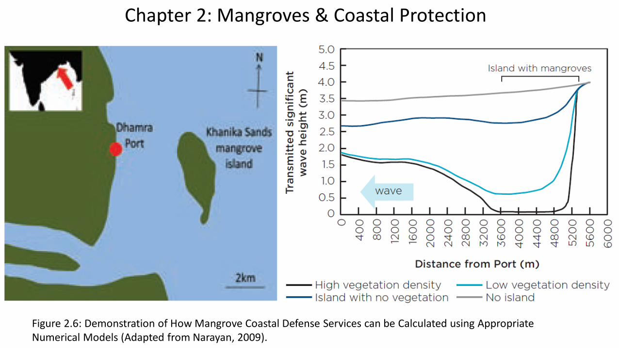
Chapter 2: Mangroves & Coastal Protection
Figure 2.6: Demonstration of How Mangrove Coastal Defense Services can be Calculated using AppropriateNumerical Models (Adapted from Narayan, 2009).

197 million people live in at-risk coastal areas (below 10m elevation) and within 50km of coral reefs
World Risk Report 2012 & Nature Communications 2014
Chapter 3: Reefs & Coastal Protection
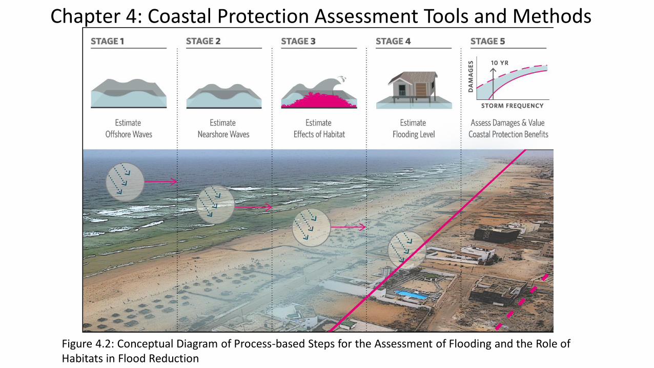
Figure 4.2: Conceptual Diagram of Process-based Steps for the Assessment of Flooding and the Role ofHabitats in Flood Reduction
Chapter 4: Coastal Protection Assessment Tools and Methods

Figure 5.2: Value Estimates for Protective Services, by Valuation Method
Chapter 5: Approaches for Valuing Coastal Protection Services by Ecosystems

Chapter 6: Nature-based Defenses Case Studies in Policy
LocationDecision
Target(s)
Type of
Information Key Factors & Lessons Learned
Philippines Senate Bill
2179, Coastal
Greenbelt Act
of 2014
Literature-
based Values
Act under consideration for protection of mangroves
for conservation & risk reduction.
Senator Aquino’s introduction letter includes values of
mangroves for reductions in waves and storm surge.
Act includes long-term program for community-based
restoration.
Belize Belize CZM
Plan
Scenario
Analysis
The CZMAI tasked with developing a CZM plan.
Assessed alternatives with InVEST.
Scenario analysis helped identify likely trade-offs.
Difficult to get stakeholder input on alternative
scenarios

Mangrove Restoration in Indonesia, Ecoshape Building with Nature Project
Oyster Reef Restoration in USA, TNC Living Shorelines project
Chapter 6: Nature-based Defenses Case Studies in Practice
Pontee et al., 2015
NATURE-BASED DEFENSES:REVIEW OF CURRENT UNDERSTANDING AND EVIDENCE

Ecosystems Are Effective at Reducing Wave Heights
Narayan et al. 2016
Salt Marshes
R2 = 0.8654 slope = 0.59
Wav
e R
edu
ctio
n E
xten
t (m
)0.6
0.4
0.2
0.0
Incoming Wave Height, Hi (m)
0.0 0.2 0.4 0.6
Reefs: 70%
Mangroves: 31%
Seagrass/Kelp: 36%

Restoration Projects Provide Coastal Protection
Narayan et al. 2016
REEF SALT MARSH MANGROVE
1
0
2
3
4
5
6
7Flood damage reduction
Erosion reduction
Reduction in cost of engineering structure
Pro
ject
Co
un
t

Restored Mangrove and Marsh Defenses are Cheaper than Breakwaters
Narayan et al. 2016

Narayan et al. 2016
Global Database of Measurements and Projectsa) Wave reduction field measurements
b) Benefits of restoration projects

ASSESSING COASTAL PROTECTION VALUE OF REEFS AND MANGROVES:
MODELS, PROCESSES AND METHODS
Framework for Estimating Coastal Protection Values
From WB WAVES 2016, Chapter 4

Framework for Estimating Coastal Protection Values
1. Define Coastal Profiles and Study Units (cross-shore profiles for every 2 km, grouped into 20 km study units)
2. Estimate Offshore Waves and Water Levels using global datasets
3. Estimatea) Nearshore Waves and Water Levels using best available datab) Effect of Ecosystem on Nearshore Waves and Water Levels
4. Define Extreme Waves and Water Levels along shoreline for 10, 25, 100 year storms
5. Identify land, people and built capital flooded using a global digital elevation model
6. Develop flooding scenario with and without ecosystem presence
Adapted from Beck et al. 2016 (In Review)

Rock Sand Coral reef Seagrass Mangroves
Deep
water
Framework for Estimating Coastal Protection Values
1. Offshore waves2,3. Near-shore waves and effects of habitat
4,5. Flooding Level;Damages and Coastal Protection Benefits
Depth variation
Bottom friction
Vegetation drag
Population; GDP
From WB WAVES 2016, Chapter 4

Rock Sand Coral reef Seagrass Mangroves
Removed
Deep
water
Framework for Estimating Coastal Protection Values
1. Offshore waves2,3. Near-shore waves and effects of habitat
4,5. Flooding Level;Damages and Coastal Protection Benefits
Depth variation
Bottom friction
Vegetation drag
Population; GDP
From WB WAVES 2016, Chapter 4
Ecosystem Loss
Waves
Surge
Tide
+
+Seawifs
Bathymetry
(1X1km)
Historical data
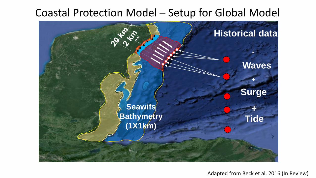
Coastal Protection Model – Setup for Global Model
Adapted from Beck et al. 2016 (In Review)

Model Step Parameters/ Indicators
Data Requirements(Other
Parameters??)
Example Data Sources (from WB WAVES Report, Table 4.1)
Data Extent Philippines Data Availability and
Sites
1. Offshore Waves and Water Levels
Sea surface/ Water LevelStormsWaves
Altimetry,Storm Tracks,Wave buoys
AVISO, NOAA;UNISYS, NHC, NOAA;Global Ocean Waves, WW3, ERA-20c
Global, 30-arc second (~ 1km)
Global, 30-arc second (~ 1km)
Coastal Protection Model – Data Requirements
Adapted From WB WAVES 2016, Chapter 4

Model Step Parameters/ Indicators
Data Requirements(Other Parameters??)
Example Data Sources Data Extent
2. Nearshore Waves and Water Levels
Surge PropagationWavePropagation
…+ Bathymetry,Shoreline
GEBCO, ETOPO, SEAWIFS;NGIA, GSHHG
Global, 1 degree to 30 arc second
3. Interaction with Ecosystems
Surge ReductionWave Reduction
…+ Ecosystem Properties:Presence (Extent/ Width)Depth/ HeightSpecies (as proxy for):Density, Diameters, Roughness, etc.
ReefBase, CIESIN (Mangroves), WCMC(Seagrass), WCMC (Wetlands)
Global, 1km
Coastal Protection Model – Data Requirements
Adapted From WB WAVES 2016, Chapter 4

Model Step Parameters/ Indicators Data Requirements(Other Parameters??)
Example Data Sources DataExtent
4. Shoreline and Inland Flooding
By SurgeBy Wave run-up/Overtopping
…+ TopographyShorelineCoastal FeaturesCoastal Defenses
NGIA, GSHHG, LOICZ;ETOPO, SRTM 90 m
Global, 90m
5. FloodDamage/Loss Estimation
Flood ExtentFlood HeightFlood Damage ($)
…+ PopulationLand Use/ Property DataSE Vulnerability Indices
World Bank, CIESIN-GPW, CIESIN-GRUMPDIVA
Global, 30 arc second (~ 1km)
6. Model Validation
Inundatioon ExtentMangrove EffectsHistorical Mangroves
Coastal Protection Model –Data Requirements
Adapted From WB WAVES 2016, Chapter 4

Coral reefs and analysis regions.Green dots correspond to coral reef locations globally
Global Coastal Protection Model – Reef Distribution
Beck et al. 2016 (In Review)

• Built Capital inferred using population data and ratio of Built Capital per Capita to GDP per capita
• % Built Capital Damaged, as function of flood depth
• Damages assessed for specific, with and without ecosystem presence
• Damages also annualized based on built capital versus return period curve
Global Coastal Protection Model – Estimating Damage
Beck et al. 2016 (In Review)

Playa del Carmen
Current FloodingFlooding With 1m Reef Loss
Flooding (25 - Year Event)
Global Coastal Protection Model – Outputs
Beck et al. 2016 (In Review)

v
v
1 m
v
1 m
Global Coastal Protection Model – Modelling Coral Reef Loss
Beck et al. 2016 (In Review)

The expected benefit of coral reefs for flood protection. The values are the damages to global built capital from flooding (in $US billions) at present and with 1 m loss of coral reefs by storm event return period.
Beck et al. 2016 (In Review)
Global Coastal Protection Model – Expected Benefits from Reefs
Beck et al. 2016 (In Review)

Annual expected benefits from reefs for flood protection in avoided flooding to
land, people, exposed infrastructure and damaged infrastructure US$ million/year.
Beck et al. 2016 (In Review)
Global Coastal Protection Model – Expected Benefits from Reefs
Beck et al. 2016 (In Review)

Global Coastal Protection Model – Expected Benefits from Reefs
Reef benefits for flood protection from 100-year event in terms of exposure of built capital to flooding with reef loss ($US billions) and relative to total national built capital.
Beck et al. 2016 (In Review)
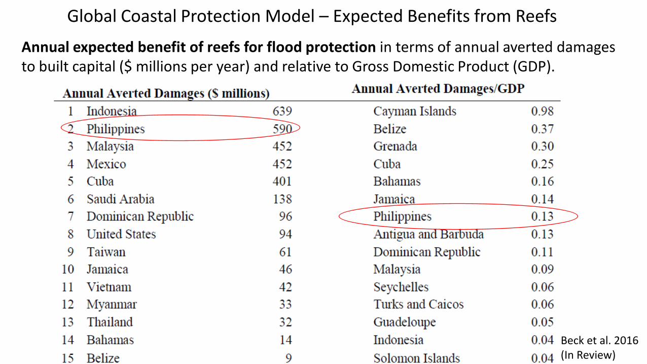
Annual expected benefit of reefs for flood protection in terms of annual averted damages to built capital ($ millions per year) and relative to Gross Domestic Product (GDP).
Beck et al. 2016 (In Review)
Global Coastal Protection Model – Expected Benefits from Reefs

Averted Damages over 20 years ($ Billions)
Other Examples: Parametric Model of Cost Effectiveness of Nature-based Defenses
Ben
efit
/Co
st
Reguero, Bresch, Beck et al. 2015. Coastal Eng. Proc.

Other Examples: Coastal Wetlands and Flood Damage Reduction
Narayan et al. 2016 (in preparation)
WHITE PAPER (IN REVIEW)
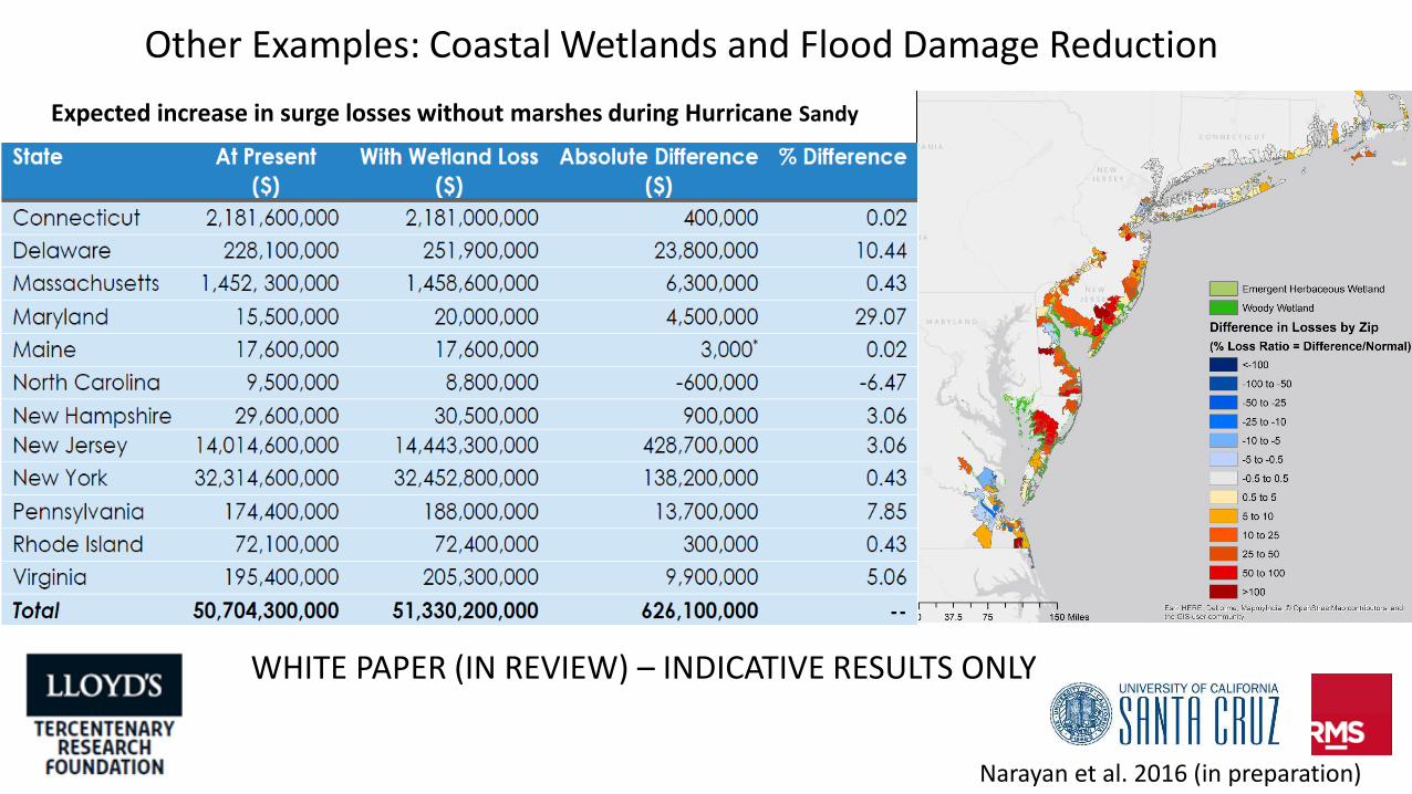
Expected increase in surge losses without marshes during Hurricane Sandy
Other Examples: Coastal Wetlands and Flood Damage Reduction
Narayan et al. 2016 (in preparation)
WHITE PAPER (IN REVIEW) – INDICATIVE RESULTS ONLY

On-line Apps and Tools – Brief Intro to Some Resources (30 min)
• Coastal Resilience
• Mapping Ocean Wealth (Country Snapshots)
• Grenada Coral Reef Restoration- presentation and video
• Philippines Country Snapshot - Examination of Philippines Country Stats and
Data from Global Analyses (e.g. MOW Atlas)
The Coastal Protection Services of Mangroves in the Philippines: Preliminary Workshop
– Day 1, Session 2 (11:00 to 12.00)

1. Grenada Coral Reef Restoration – 3.5 minutes
2. Building with Nature Indonesia (Dutch with Eng Subtitles) – 2.5 minutes
3. Coastal Resilience Videos
a.Coastal Defense App in Florida – 1 minute
b.Economics of Climate Adaptation Preview – 2.5 minutes
4.Ecosystem Model Parameters – IH Cantabria Flume Experiment – 1.5
minutes
Assessment and Use of Nature-based Defenses – Example Videos

maps.coastalresilience.org/global – “Natural Defense Projects”
https://tnc.app.box.com/s/qzjka3q1wm859a7ux221xulweipw3or9
SNAPP Natural Defense Projects Database

http://goo.gl/i3gXFJ - Coastal Resilience (maps.coastalresilience.org/global)
Coastal Resilience Mapping Tool

http://goo.gl/lo2m0A - Mapping Ocean Wealth (maps.oceanwealth.org/#)
Mapping Ocean Wealth – People Protected by Reefs

http://goo.gl/BhTuqs - Mapping Ocean Wealth (maps.oceanwealth.org/#)
Mapping Ocean Wealth – People Protected by Reefs


ONLINE COASTAL RESILIENCE TOOLS

1. Flooding and Sea Level Rise App – 15 minutes (Ventura County, CA) – Flood and Erosion Risk, with Impacted Infrastructure / Land-Use
2. Coastal Defense App – 12 minutes (SE Florida, assessing wave reduction by coral reef restoration in Miami)
3. Risk Explorer App – 10 minutes (SE Florida, exploring multiple layers) (NOTE: This is different from “Flood Risk Explorer” App on the same page)
Some Online Coastal Resilience Tools and Apps
To access on your laptop: 1. Go To http://coastalresilience.org/training/2. Click on Try Me! in the Menu on the left3. Scroll to find the App description and click on Get Started
DAY 1 PARTNER PRESENTATIONS

DAY 1 DISCUSSION

For Discussion
Philippines Data Availability for Model and Ecosystem Parametersa) Nearshore Waves and Surges – Nearshore Bathymetryb) Interaction with Ecosystems – Ecosystem Propertiesc) Coastal Protection Value – Inland Population, Assets and Vulnerabilityd) Model Validation – Historic Inundation, Damages, Other (??) Data

Model Step Parameters/ Indicators
Data Requirements(Other Parameters??)
Example Data Sources
DataExtent
Philippines Data Availability and Site
2. NearshoreWaves and Water Levels
Surge PropagationWavePropagation
…+ Bathymetry,Shoreline
GEBCO, ETOPO, SEAWIFS;NGIA, GSHHG
Global, 1 degree to 30 arc second
Higher Resolution?
NAMRIA Depth-Sounding Points Data
3. Interactionwith Ecosystems
SurgeReductionWave Reduction
…+ Ecosystem Properties:Presence (Extent/ Width)Depth/ HeightSpecies (as proxy for):Density, Diameters, Roughness, etc.
ReefBase, CIESIN (Mangroves), WCMC(Seagrass), WCMC (Wetlands)
Global,1km
Higher Resolution?
PSA Land Cover datadisaggregated by tidal inundation (to giveprimary species)??
Ecosystem Evaluation Model – National Data Requirements
Adapted From WB WAVES 2016, Chapter 4
Model Step Parameters/ Indicators
Data Requirements(Other Parameters??)
Example Data Sources
DataExtent
Philippines Data Availability and Site
4. Shoreline and Inland Flooding
By SurgeBy Wave run-up/Overtopping
…+ TopographyShorelineCoastal FeaturesCoastal Defenses
NGIA, GSHHG, LOICZ;ETOPO, SRTM 90 m
Global, 90 m
IFSAR 5 m resolution –NAMRIA Mapping Authority; PAGASA Inundation Maps; Philippines Hazard Maps (Erosion)
5. FloodDamage/Loss Estimation
Flood ExtentFlood HeightFlood Damage ($)
…+ PopulationLand Use/ Property DataSE Vulnerability Indices
World Bank, CIESIN-GPW, CIESIN-GRUMPDIVA
Global, 30 arc second (~ 1km)
Higher Resolution? PSA data from housing enumerations??
Ecosystem Evaluation Model – National Data Requirements
Adapted From WB WAVES 2016, Chapter 4

Bathymetry Mangrove Characteristics Topography Asset/Socio-Economic Data Validation Data
Data: Habitat MapsAgency: CoRVAExtent/ Resolution: Availability (Time):??
Agency: PHIL-LIDAR (UP C-Eng)Funding: CCCExtent: National (Samar, Leyte Completed)
Agency: PHIL_LIDAR (UP C-Eng)Extent: Samar/LeyteData: LiDAR (1 m)Availability: ??
Agency: Gem/ PHIL-LIDAR (UP C-Eng)/ Funding: CCCExtent: National (Samar, Leyte Completed)
Agency: MSIExtent: El NidaData: Bathymetry /Reef MapsAvailability: Now.
Data: Habitat MapsAgency: CoRVAExtent/ Resolution: Availability (Time):??
Agency: Dr. Samson(De LaSalle)/ Dr Rollon (UP)Extent: ?? (Haiyan –Samar/Leyte)Data: Mangrove Community Structure/Sedimentation RatesAvailability: ??
For Discussion: Ecosystem Evaluation Mode Study Sites and Requirements

Philippines Data Example: Depth Sounding Points from NAMRIA

Philippines Data Example: Depth Sounding Points from NAMRIA

DAY 1 WRAP-UP
(Information Requests for Day 2?)

THANK YOU!
• Links to some natural defense databases• http://www.maps.coastalresilience.org/global/# - SNAPP Coastal Defenses, USA• http://www.naturalcapitalproject.org/ - Natural Capital Project, USA• http://mycopri.org/ - Living shorelines Database, USA• http://el.erdc.usace.army.mil/ewn/ - Engineering with Nature, USA• http://www.ecoshape.nl/overview-bwn.html - Building with Nature,
Netherlands• http://www.omreg.net/ - Managed Realignment Database, UK


