
Kongsberg Simrad
WORLD CLASS – through people, technology and dedication
THE HUGIN 1000 AUV as sensor platform for seafloor mapping
Presented by Svein Otto Schjerven, Manager M & S

/ 2 /
Content
• The HUGIN 1000 AUV in brief
• SAS/SSS in operation
• Multibeam Echosounders
• Forward Looking Sonar
• Other sensors and system news
• Summary

/ 3 /
Kongsberg Maritime AS Site in Horten
Kongsberg Maritime AS
•World leading company within maritime electronics & hydroacoustics
•3300 employees in 25 countries
•Horten site 340.
•More than 1100 abroad.
KM about 7,7 billion NOK operating renevue in 2007
EBITA 10,8 %
•More than 70% of op.renevues earned outside Norway
•The growth has continued in 2009

/ 4 /
The Kongsberg GroupKongsberg Maritime – Subsea Division
Underwaterpositioning
Seabed mapping
AUV’s
Underwatersurveillance
Naval sonarsystems
Fisheries systems

/ 5 // 5 / 2-Dec-09
The HUGIN and REMUS AUV family
HUGIN 1000 HUGIN 3000
HUGIN 4500

/ 6 /
Royal Norwegian Navy - AUV OPEVAL program
• HUGIN I (2002-03) – development and demo
• Payload: Multibeam echo sounder, COTS SSS
• Endurance: 5-8 hours, charge time 6-8 hours
• MCM coverage rate: 0.2-0.6 km2/h, 20-40 cm resolution
HUGIN 1000 (2004-06) – reduced capability pilot system
– Payload: EdgeTech SAS or SSS, EM3000 MBE, CTD
– Endurance: 12-18 hours, charge time 5 hours
– MCM coverage rate: 0.8-1.6 km2/h, 10-30 cm resolution
HUGIN 1000-MR (2007-) – full-capability commercial delivery
– Payload: Kongsberg HISAS 1030, MBE, CTD
– Endurance: 18-24 hours, charge time 5 hours
– MCM coverage rate: 2-3 km2/h, <5 cm resolution

/ 7 /
HUGIN 1000 main components

/ 8 /
Main sensors on HUGIN 1000 AUV

/ 9 /
Basic Payload Suite
• HUGIN has an open architecture for easy integration of payload for specific applications
Payload Capability
Hydro carbon sniffer Leakage detection
Forward sonar Obstacle avoidance and leakage detection
Cameras Detailed visual inspection
Side scan sonar or synthetic aperture sonar
Imagery for inspection, mapping of debris and change detection
Multibeam echo sounder
Bathymetry for inspection and ice surveillance (if upward MBE)
CTDConductivity, temperature, depth
sound speed, density
Sea current profiler ADCP

/ 10 /
HUGIN 1000 MR - overview
RNoN testing HUGIN 1000MR outside Bergen
April/May 2008

/ 11 /
Payload sensors – MBES and HISAS 1030
EM 3002 transducer and processing
unit
HISAS 1030 transducers on HUGIN 1000
mid section

/ 12 /
Sensor: Imagenex DeltaT
• Frequency: 260 KHz
• Range: 100m (150m)
• Beam width: 120° x 20 °
• Number of beams: 120 (240,480)
• Power consumption: <5W

/ 13 /
HUGIN 1000 with under ice operation for Finnish Navy
Safe ice distance
Safe seabed distance
Critical distance
(water depth)
Seabed
Ice
• HUGIN 1000 for Finnish Navy will get under ice operation capability. First vehicle delivered 2009.
• Under ice operation is tightly integrated with the anti-collision system
• HUGIN 1000 under ice functionality also suitable for arctic operations

/ 14 /
HUGIN 1000 FLS
/ 15 /
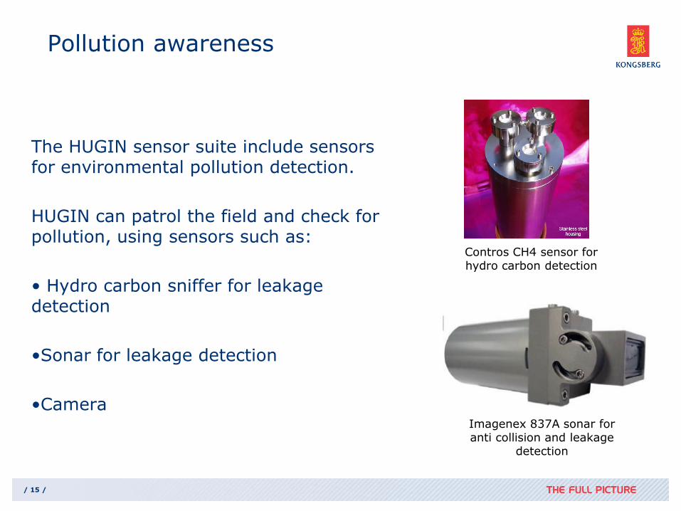
Pollution awareness
The HUGIN sensor suite include sensors for environmental pollution detection.
HUGIN can patrol the field and check for pollution, using sensors such as:
• Hydro carbon sniffer for leakage detection
•Sonar for leakage detection
•Camera
Contros CH4 sensor for hydro carbon detection
Imagenex 837A sonar foranti collision and leakage
detection

/ 16 /
Payload sensors
Forward Looking Sonar - Imagenex DeltaT
Falmouth Scientific Micro-CTD WetLabs FLNTU Turbidity and
Fluorescence sensor

/ 17 /
Proven and new Sub Bottom
Profiler

/ 18 /
HUGIN SBP
• Civillian SBP integrated on HUGIN vehicles for geophysical survey:
• EdgeTech 2200 SBP
• EdgeTech 4500 DF SBP
• Integrated on HUGIN 1000, HUGIN 3000 and HUGIN 4500
• Military SBP for 3-dimensional mapping of buried objects
• EdgeTech BOSS
• Integration design for HUGIN 1000 finnished

/ 19 /
3D multibeam sub bottom profiler
• Transducer wings required for multibeam sub bottom profiler
Bottom View
Projector 3-20 kHz
wings contain an 80 element receiver
EdgeTech BOSS with 4 m wing span mounted on HUGIN 1000

/ 20 /
Sequence of wing and projector deployment
Projector and Wings Stowed
Projector and Wings Fully Deployed
Projector Deployed, Wings at 45 degreesProjector Deployed, Wings at 67.5 degrees
Projector Deployed, Wings at 22.5 degrees

/ 21 /
An Image of a Buried Object is Generated
at Each Aspect as the Sonar Passes the
Target
R
xy target
3D matrix of pixels centered at focal
points
Length of
synthetic
aperture
40 element
hydrophone
array
History of hydrophone positions
that form synthetic aperture
Sonar is at
center of image
/ 22 /
Operations in Artic Environment

/ 23 /
Operational concept for mapping in artic areas
• AUV is operated from ice breaker
• Ice breaker brings AUV into area of interest
• Large under ice areas are effectively mapped by the combination of ice breaker and long range AUV equipped with high area coverage ratesensors
• Ice breaker provides capability to recover the AUV in case of an emergency situation (Picture of KV Svalbard. Shown for illustration
purposes.)

/ 24 /
Upward mulitbeam echo sounder
• Upward multibeam echo sounder is suited to measure
• Ice topography
• Ice thickness
• Ice thickness estimate requires integration with
• Pressure sensor
• CTD for water density
Kongsberg Maritime EM 3000 mounted on HUGIN 1000
Ice topography picture taken
from Marcel Nicolaus andSebastian Gerland, Norwegian Polar Institute.For illustration purposes.
0 1 2 3 4 5 6 7 8 9 10
-12
-10
-8
-6
-4
-2
0
2
-12
-10
-8
-6
-4
-2
0
2
Th
ickn
ess (
m)
Distance [km]

/ 25 /
Upward Doppler velocity log
• Upward Doppler velocity log (DVL) can be integrated to measure Doppler shift between AUV and ice directly.
• Upward DVL (in ADCP mode) can also measure current profiles above AUV.
Teledyne RDI DVL

/ 26 /
HiPAP navigation and tracking concept
AUV trajectory
Ice breaker trajectory
/ 27 /
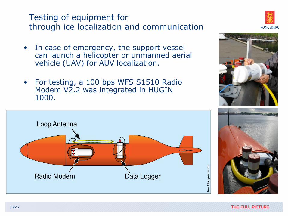
Testing of equipment forthrough ice localization and communication
• In case of emergency, the support vessel can launch a helicopter or unmanned aerial vehicle (UAV) for AUV localization.
• For testing, a 100 bps WFS S1510 Radio Modem V2.2 was integrated in HUGIN 1000.
/ 28 /
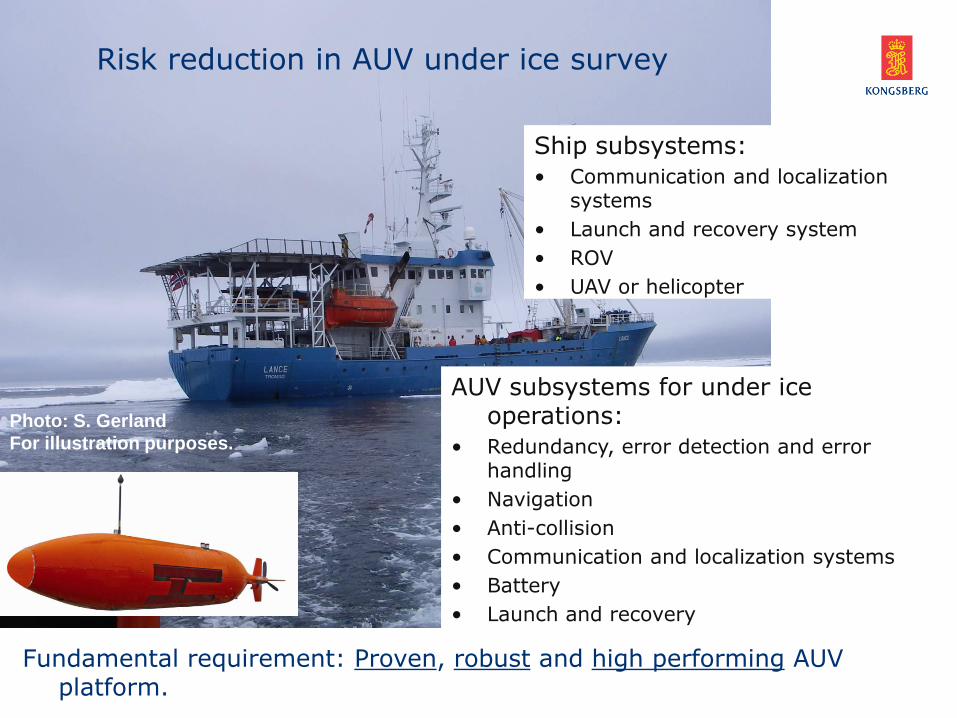
Fundamental requirement: Proven, robust and high performing AUV platform.
Risk reduction in AUV under ice survey
AUV subsystems for under ice operations:
• Redundancy, error detection and error handling
• Navigation
• Anti-collision
• Communication and localization systems
• Battery
• Launch and recovery
Ship subsystems:
• Communication and localization systems
• Launch and recovery system
• ROV
• UAV or helicopter
Photo: S. Gerland
For illustration purposes.

/ 29 /
New Camera
/ 30 /
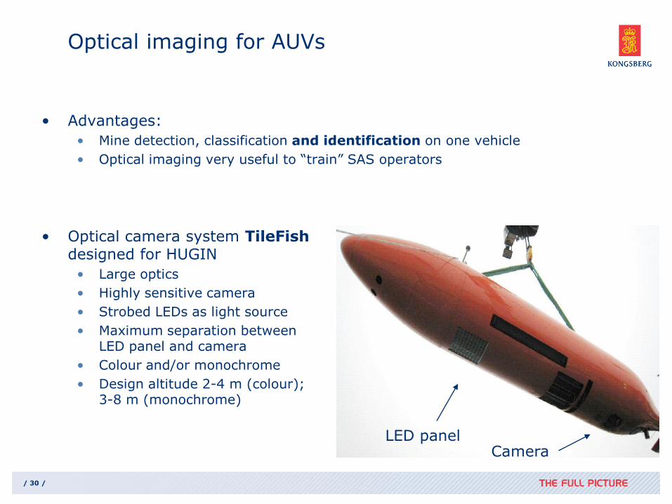
Optical imaging for AUVs
• Advantages:
• Mine detection, classification and identification on one vehicle
• Optical imaging very useful to “train” SAS operators
• Optical camera system TileFishdesigned for HUGIN
• Large optics
• Highly sensitive camera
• Strobed LEDs as light source
• Maximum separation betweenLED panel and camera
• Colour and/or monochrome
• Design altitude 2-4 m (colour);3-8 m (monochrome)
LED panelCamera

/ 31 /
Optical camera on HUGIN 1000-HUS (FFI)
• High quality LED strobe. 3 – 6 m altitude.
• Still picture camera
LED panel Camera
HUGIN 1000-HUS

/ 32 /
TileFish camera examples: Marine life
TileFish camera on HUGIN 1000 (single images, no mosaic) Altitude 4 m

/ 33 /
HUGIN AUV SYSTEM NEWS

/ 34 /
HAVOPS Introduction
• HUGIN AUV & Vessel Operations Simulator (HAVOPS) is a complete simulation system for education and procedure training for personnel involved in AUV operations
• Designed for operations with Kongsberg HUGIN 1000 AUV, survey vessel, and Kongsberg HiPAP system
• Operators can safely plan and carry out AUV survey procedures under different conditions
• Based on the existing HUGIN AUV simulator engine SimP, and Kongsberg’s renowned Ship Simulator technology
• HAVOPS includes the following five physical components:
• Bridge of the vessel
• AUV operations room
• AUV L&R station
• Instructor/Debrief stations

/ 35 /
• 20 ft and 10 ft container for both transportation and ship installation
• Small system footprint – high degree of modularity and flexibility
• Ship requirements: Voltage + deck space
HUGIN 1000 Portable System for Vessel of Opportunity

/ 36 /
HUGIN 1000 Portable System10 feet container with Top Side systemComplete Post Mission Analysis System

/ 37 /
SUMMARY
• AUV`s with mine hunting capacity is available
• Multi role capabilities
• Flexible payload solutions
• Portable system solution
• Platform independent
• HISAS 1030 fullfil the most important MCM requirments;
• Reliability, resolution and range
• SAS require stable vehicle motion


