
The Next Generation Air Transportation System (NGATS)
Bruce CarmichaelForecasting Team Co-lead
Weather IPT303-497-8406

What We Face
• 60-80% of traffic delays have a weather connection
• If traffic counts grow anywhere near projections (JPDO NGATS), ability of current system to accommodate growth is essentially impossible
• System breakdown unavoidable unless capacity grows by 2 to 3 times
• Caveat: we must plan for a future still full of unknowns, never-the-less (airline difficulties, terrorism, natural calamity, etc.)
• The system must have much more capacity and be safe
NGATS ORGANIZATIONS
• Department of Transportation• Federal Aviation Administration• National Aeronautics and Space Administration• Department of Commerce• Department of Defense• Department of Homeland Security• Office of Science and Technology Planning• The NGATS Institute

2025 NGATS Concept
• Net-Enabled Information Access
• Performance-Based Services
• Weather-Assimilated Decision Making
• Layered, Adaptive Security
• Broad-Area Precision Navigation
• Trajectory-Based Aircraft Operations
• “Equivalent Visual” Operations
• “Super Density” Operations
Key Capabilities
Operating Principles• “It’s about the users…”
• System-wide transformation
• Prognostic approach to safety assessment
• Globally harmonized
• Environmentally compatible to foster continued growth

Policy Change/CreationOrganizational Innovation
Culture Acceptance
System-Wide TransformationInnovation Across All Lines of Development
Technology Innovation
Policy Culture
Organization
Technology
Culture
Organization
Policy
Technology

Net-Enabled Information AccessGlobal secure access, information handled according to
“communities of interest”
• “Shared Situation Awareness”Real-time free-flow of info from private, commercial, & government
sources, integrated internationallyTailored, responsive and securePush/pull processesCommon awareness of day-to-day ops, events, crises
• Aircraft are integral “nodes” in network
• Integrated cooperative air traffic and non-cooperative national security surveillance
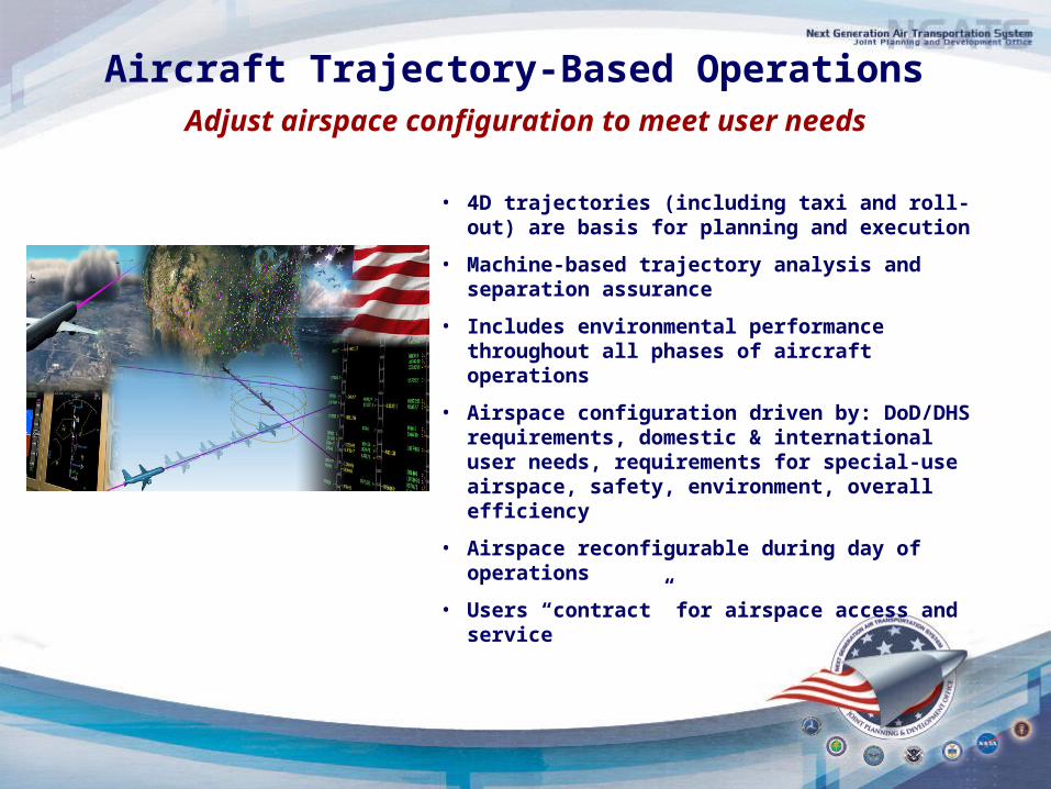
Aircraft Trajectory-Based Operations Adjust airspace configuration to meet user needs
• 4D trajectories (including taxi and roll-out) are basis for planning and execution
• Machine-based trajectory analysis and separation assurance
• Includes environmental performance throughout all phases of aircraft operations
• Airspace configuration driven by: DoD/DHS requirements, domestic & international user needs, requirements for special-use airspace, safety, environment, overall efficiency
• Airspace reconfigurable during day of operations
• Users “contract” for airspace access and service

Aircraft Trajectory-Based Operations:Management-by-Trajectory
Projected ProfilesPlanned Profiles
Weather, Aggregate Flow, Airport Configuration/Infrastructure
AgreementUser Requested
ProfileClearance
Separation Mgmt DomainTactical DomainStrategic Domain
Airspace Organization and Management
Airport Operations
Demand & EnvironmentalPerformance Balancing
ATM Service Delivery Management
Key Issues are functional allocation between:Automation and humansAircraft operators and service provider
Information Management
Airspace User Operations
Conformance Monitoring

Aircraft Trajectory-Based Operations:
“Evaluator”
• Integrates/communicates weather, security, defense, environmental, safety, international considerations, other information
• Users “post”/update desired 4D trajectories in common system that continuously evaluates mutual compatibility
• Predicts potential “over demand” situations, in multiple “capacity dimensions”—traffic density, environmental, security, etc.
• Works across all time horizons from days/weeks/months prior to flight up to separation management (20 minutes or less)
• Supports distributed decision-making environment where players have clear, agreed-upon roles and interactions

Equivalent Visual Operations Increasing capacity from today’s non-visual conditions
• Aircraft perform "equivalent visual" operations in non-visual conditions (achieve “VFR capacity” under these conditions)
• ATM provider delegates “maintain separation” responsibility to aircraft operators
Requires timely, high fidelity information on nearby aircraft, weather, etc
• System-wide availability at all air portals With appropriately capable “landside” (including security)
• Greater predictability of operations at busy airports, including ground operations

Weather Assimilated into DecisionsCommon weather picture across NGATS
• Fuse global weather observations and forecasts into single information system, dynamically update as needed Tens of 1000’s of sensors (airborne & ground)
feed 100’s of forecast models
• Learning automation accounts for weather and its uncertainties in managing aircraft trajectories
• Identify hazardous weather real-time
• Assimilated into NGATS “decision loops” Total integration via machine-to-machine Critical decision system time scales using both
probabilistic and deterministic weather info Optimized to maximize available weather-
favorable airspace Terminal weather impacts including
ground/ramp ops and adaptability due to wind shift changes

2025 NGATS Vision• The number and complexity of NGATS command and control
decisions at any given moment will require the total system to be largely automated
• This requires weather information to be passed digitally, rather than as text or graphic products
• The “system” will use smart pull technology to obtain required weather information for any given decision
• Traditional aviation weather products will be reduced or outright eliminated (e.g., Terminal Aerodrome Forecasts, Area Forecasts…)
As needed presentation of three-dimensional weather information, projected into the future, will allow the National
Airspace System’s operational systems to make weather-savvy decisions

Weather in the Future• Common weather picture – A “data cube” will ensure
NGATS users share consistent information • It’s not about looking at a lot of sensor data, its about
providing an accurate diagnosis and forecast of phenomena that are important to aviation
• Weather information fully integrated into all ground- and cockpit-based decision support systems/tools– 4DT based on current and forecast weather– Real time weather updates posted and pushed to all impacted
subscribers • Probabilistic forecasts enable prognostic, risk-based
decisions on allowing aircraft to tactically traverse certain weather phenomena– Enables capacity management– Opens more airspace to the system
DST algorithms are owned by the operators not weather.
Weather is just one input to the algorithm
NGATS/JPDO Aviation Weather IPT
• Observations (improved suite)• Forecasts (new science, automation, probability)• Dissemination (4D Weather Information System)• Integration (critical joining of weather with ATM)• Aircraft Mitigation (harden aircraft for weather)• Training (“just-in-time”)• Policy• Systems Engineering

Emphasis and Priorities:4–D Weather -- Official Product of the Future
•Convection
•Turbulence
•Icing
•Snowfall
•Ceiling
•Visibility
•Radiation from Space
•Wind Speed
•Wind Direction
•Temperature
•Humidity
•Noise Propagation Potential
•Airport Plume Concentration
•Atmospheric Sensitivity to Exhaust
•Volcanic Ash Concentration
•Wake/Vortex Dissipation Potential
•
•
•
•
•
Z
X
Y
X
X18
12
18:30
0
1
Probability Distribution Function of Magnitude

Production of aviation weather products – the JPDO vision
AutomatedIntelligentForecast Systems
4-DGlobal
Database
Automated DecisionSupportSystems
CustomGraphicsGenerator
s
CustomAlphanumeri
cGenerators
Statistical
SystemsNWPModels
Observations
HumanForecaster
Input
This plan includes many factorsin strategic and tactical airspacemanagement, such as:• Aircraft separation• Hazardous weather separation• Time en route• Fuel burn• Noise impact• Environmental impact
Constantly Refreshed
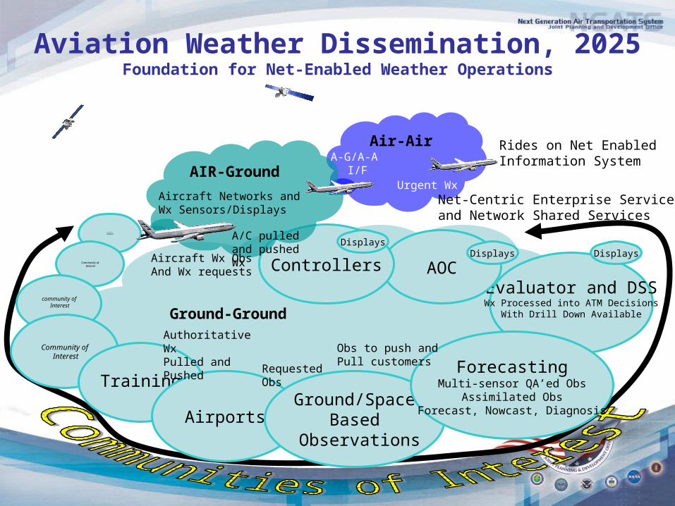
Ground-Ground
Air-Air
Aviation Weather Dissemination, 2025Foundation for Net-Enabled Weather Operations
A-G/A-A I/F
Community of
Interest
Community of Interest
community of Interest
Community of Interest
Training
AirportsGround/Space
Based Observations
Evaluator and DSSWx Processed into ATM Decisions
With Drill Down Available
Displays
AOCDisplays
Controllers
Displays
ForecastingMulti-sensor QA’ed Obs
Assimilated ObsForecast, Nowcast, Diagnosis
AIR-Ground
Authoritative WxPulled and Pushed
Aircraft Wx ObsAnd Wx requests
Aircraft Networks andWx Sensors/Displays
A/C pulled and pushed Wx
A-G/A-A I/F
Urgent Wx
Requested Obs
Obs to push andPull customers
Net-Centric Enterprise Servicesand Network Shared Services
Rides on Net Enabled Information System
• Plan to support to broad range of possible NGATS “futures”– Actual evolution to target curb-to-curb concept likely will
consider multiple alternate paths– Develop systems to support those alternatives– Transition from today’s system to future system
• Provide information that support common situational awareness– Intelligent fusion of data, models, and predictors into a single
authoritative data base– Common understanding of the definitions and limitations of
the information elements• Enable integration of weather information into DSS
– Develop reliable probabilistic information– Develop generic information products that can be customized
to meet the needs of service provider and customer systems– Develop new products jointly with DSS community
Summary


