
THE RECREATION POTENTIAL OF THE
LAS LENGUAS AREA, TEXAS
by
FRED W. WELDEN, B.S.
A THESIS
IN
PARK ADMINISTRATION
Submitted to the Graduate Faculty of Texas Tech University in
Partial Fulfillment of the Requirements for
the Degree of
MASTER OF SCIENCE
V^.ay, 1912

f. -^ ?05 rs
/p^; : .
f^O • -" ~ Gop,:
ACKNOWLEDGMENTS
I am particularly indebted to Dr. J.W. Kitchen for
his direction in preparation of this thesis. Special thanks
also go to Dr. James Mertes and Dr. George Tereshkovich for
their helpful comments.
11
TABLE OF CONTENTS
ACKNOWLEDGMENTS ii
LIST OF FIGURES vi
INTRODUCTION 1
Objectives 5 Justification for Study 5 Methodology 8
PART I. INVENTORY
Chapter
I. GEOLOGY 11
Permian Period 11 Triassic Period 12
Tecovas Formation 13 Trujillo Formation 14
Cenozoic Era 15 Ogallala Formation 16 Pleistocene Formation 19
II. PALEONTOLOGY 22
Permian Period 22 Triassic Period 23 Pliocene Epoch 25 Pleistocene Epoch 28
Terry Pluvial 31 Rich Lake Interpluvial 31 Tahoka Pluvial 31 Monahans Interpluvial 32 San Jon Pluvial 32
III. ARCHAEOLOGY 3 4
Early Game Hunter Stage 34 Archaic Stage 37 Neo-American Stage 38
I • •
111

IV. HISTORY 41
The Indian Period 41 The Comanchero Period 43 Quanah Parker 52 The Pastores Period 55 The Cattle Kingdom Period 56
V. BIOECOLOGY 59
High Plains Zone 63 Flora 65 Fauna 67
Caprock and Canyon Zone 70 Flora 71 Fauna 74
Riparian Zone 77 Flora 77 Fauna 7 9
Rolling Plains Zone 80 Flora 81 Fauna 83
Conclusion 85
VI. SCENERY 87
PART II. EVALUATION AND RECOMMENDATIONS
VII. ANALYSIS OF SIGNIFICANCE 91
National Level 91 National Recreation Areas 91 National Historic Areas 91 National Parks and National Monuments 92
State Level 93
VIII. ANALYSIS OF DEVELOPMENTAL CHARACTERISTICS 96
Proximity and Access 96 Competing and Complementing Facilities 97 Land Ownership 102 Utilities 104 Soils 104 Carrying Capacity 109
IV

IX. RECOMMENDATIONS AND CONCEPTUAL PLAN 114
Recommendations 114 The Conceptual Plan 119
BIBLIOGRAPHY 126

LIST OF FIGURES
Figure Page
1. Location Map 4
2. Las Lenguas Area 6
3. Geologic Sequence 17
4. Bioecological Zones 64
5. Traffic Map 98
6. Recreation Sites of the Texas Panhandle 99
7. Land Ownership Map 103
8. Topographic Map 105
9. Generalized Soil Map 106
10. Recreational Carrying Capacity 115
11. Conceptual Plan 123
12. Facility Plan: Intensive Use Zone 124
VI

INTRODUCTION
The demand for additional outdoor recreation oppor
tunities in the United States is paramount—and unques
tioned. This need is also quite evident in the State of
Texas. As more and more people congregate in metropolitan
centers, the demand for recreational lands in natural areas
increases correspondingly. The 1970 population of Texas
was 11,196,730. It has been estimated by the Bureau of
Business Research, the University of Texas, that the figure
should reach 19,900,000 by the year 2000, with a vast 2
majority of these people being urban dwellers.
The National Park Service has estimated that forty-
five acres of state park land per 1,000 population in Texas
would be adequate to meet future demands. Likewise, the
White House Regional Conference on Outdoor Recreation sug
gested forty-five acres per 1,000 population as a goal for
U.S., Department of Commerce, Bureau of Census, 1970 Census of Population—Texas (Washington, D.C: Govern-ment Printing Office, January, 1971), p. 3.
2 Texas Parks and Wildlife Department, State of
Texas Comprehensive Outdoor Recreation Plan (SCORP) (Austin, Texas: State of Texas, 1965) , 1.6. Hereinafter referred to as Texas Parks and Wildlife Department, Outdoor Recrea-tion Plan.

3 the year 2000. Analyzing these figures, it is observed
that Texas needs 503,853 acres of state park land now and
895,500 acres by the year 2000. As of 1969 a meager 63,310
acres of Texas land, approximately .04 percent of the state,
was in recreational use as state parks. This example is
only one of several that could be cited to exhibit the
magnitude of the deficit of recreational land in Texas.
The Comprehensive Planning Division of the Texas
Parks and Wildlife Department has partitioned the state into
seven planning regions. Region I consists of sixty-seven
counties, most of which are a part of either the High Plains
or the Rolling Plains of northwestern Texas. The region
contains 64,119 square miles of land, which is twenty-four
percent of the state, and sustains a population of 9 95,511
persons, which represents 8.9 percent of the Texas popula
tion. Yet it contains a mere 2.2 percent of the total
5 Texas outdoor recreation acreage. In 1969 Region I
included only five of the sixty-six State Parks and Sites.
3 Texas State Parks, E.J. Urbanovsky, project direc
tor (Lubbock, Texas: Texas Technological College Press, 1963), p. 13.
Texas Parks and Wildlife Department, Report of the Department, Annual Report 68-69 (Austin, Texas: State of Texas, 1969), p. 21.
5 Texas Parks and Wildlife Department, Outdoor
Recreation Plan, 2.1.2.

The citizens of Region I have most avidly voiced
their desire for additional outdoor recreation opportunity
through the publication. Goals for Texas—Phase Two. They
specifically express an ambition to fulfill their needs
through the acquisition of regional and state park sites,
and through promotion of the public use of privately owned
recreational land. They further wish to enhance public
interest in the environment of the region by acquiring, and
making available to the public, unique natural areas.
Las Lenguas Canyon is located six miles west of
Quitaque in Briscoe County near the center of Region I (see
Fig. 1). The area exhibits characteristics which will make
it an integral part of the future outdoor recreation program
of the region. The canyon locality is quite scenic with
its rugged terrain and panoramic vistas. A permanent stream
flows along the floor of Las Lenguas Canyon, and three
distinct vegetative zones may be encountered while descend
ing from the rim of the canyon to the stream below.
Legends tell of Indians and Comancheros who once
frequented the recesses of Las Lenguas Canyon. The canyon
offered protection to renegade Comanches who raided neigh
boring ranches for cattle and captives to trade with the
Office of the Governor, Goals for Texas--Phase Two (Austin, Texas: State of Texas, 1970), pp. 199-210.

•col* - 1 ' so miUt
I I I I I 0 IS 90
Figure 1
LOCATION MAP

Comancheros. It has even been said that Las Lenguas Canyon
was the place at which Cynthia Ann Parker, mother of the
famous Comanche chief Quannah Parker, grew to womanhood •7
after she had been captured by the Indians.
The attributes of the locale are worthy of further
investigation. Moreover, an objective evaluation of the
recreation potential of the Las Lenguas Canyon area should
be of considerable value to recreation planners in the
future. It is, therefore, the goal of the present research
to determine the recreational potential of a 22,400 acre
study area which includes Las Lenguas Canyon, Pole Canyon,
and adjacent broken land (see Fig. 2).
Objectives
I. To inventory and evaluate the geological,
paleontological, archaeological, historical, bioecological,
and scenic attributes of the Las Lenguas Canyon area.
II. To formulate recommendations concerning future
use and development of the locality for recreation.
Justification for Study
Several factors have been influential in determining
that the recreation potential of Las Lenguas Canyon merits
7 Donald C. Peattie, "The Ballad of Cynthia Ann,"
The Denver Post, November 26, 1961, pp. 16-17.

Figure 2
u .«4 0.«v.r • ? ! i ! i ! ; V K - V ^
LAS LENGUAS AREA IN Seal* - 1-1 4mil*s

evaluation. First, the canyon has been suggested as a
potential park of statewide significance in at least two
park and recreation publications. In Parks for America,
the "canyon area" which is classified as a potential 15,000 p
acre state park refers to Las Lenguas Canyon, while in
Texas State Parks, the canyon is specifically mentioned as
a unique area that could qualify as a future state scenic 9
park. Secondly, the Director of Park Services for the
Texas Parks and Wildlife Department indicated in 1971 that
the Texas Parks and Wildlife Department was interested in
further study of the canyon.
Third, it has been ascertained by the Texas Parks
and Wildlife Department that rather critical shortages of
available outdoor recreation land are particularly manifest
near metropolitan centers including Amarillo, Lubbock,
Odessa-Midland, and Wichita Falls. Included within a
seventy-five mile radius of Las Lenguas Canyon are both
Amarillo and Lubbock, while the urban areas of Wichita o U.S., Department of the Interior, National Park
Service, Parks for America (Washington, D.C: Government Printing Office, 1964), p. 195.
9 Texas State Parks, p. 17.
Mark Gosdin, Director of Park Services, State of Texas, a telephone conversation with Fred W. Welden and Dr. J.W. Kitchen, Associate Professor, Texas Tech University, 1971.
Texas Parks and Wildlife Department, Outdoor Recreation Plan, 0.2, p. i.

8
Falls, Abilene, and Big Spring fall inside a 160 mile
radius. The Odessa-Midland complex is only slightly farther
at about 18 0 miles. All of these population centers are
within reasonable driving distance of the canyon for a week
end excursion, while Amarillo and Lubbock could derive day-
use recreation from the area.
Fourth, and finally. Las Lenguas Canyon may exhibit
intrinsic values of such a quality as to merit preservation
of the area simply in order to protect these desirable
characteristics. In the composite, these reasons justify
a study which proposes to evaluate the recreation potential
of Las Lenguas Canyon and its environs.
Methodology
The method employed in the study of Las Lenguas
Canyon has been one of inventory, evaluation, and recommen
dation. The inventory has been mostly descriptive, with
emphasis being placed upon the bioecology, geology, scenery,
archaeology, paleontology, and history of the area. Per
sonal observation, interview, and literature review have
constituted the most applicable methods of inventory.
Sources such as professional organizations, non-professional
societies, university educators, pioneers in the region,
federal and state departmental officials, and various types
of literature have been utilized in this phase of the study.

Having completed the inventory, evaluation of the
canyon area's characteristics ensued. Many factors entered
the evaluation. During this process, a major concern became
delineation of the area's national, state, regional, or
local level of significance.• Criteria for determination of
the degree of significance have been established by the
National Park Service, Texas Parks and Wildlife Department,
and the National Conference on State Parks. The existing
conditions at the Las Lenguas Canyon locality have been
evaluated according to these criteria in order to determine
the canyon's level of significance.
From a detailed evaluation of the site, recommenda
tions were formulated. All of the attributes which were
delineated through the inventory have been considered in
the preparation of recommendations. Other factors such as
access, uniqueness, proximity to population, ownership,
land use patterns, use-quality relationships, and carrying
capacity were also considered. In the final analysis,
recommendations were based upon the relative significance
of these factors and the ability of the site to support
recreational development. The recommendations which have
been presented should function as guidelines for optimal
development of the recreational potential of the Las Lenguas
Canyon area.

PART I
INVENTORY

CHAPTER I
GEOLOGY
Permian Period
The 500 foot relief strikingly manifest in the Las
Lenguas Canyon area had its beginning in the distant geo
logic past of the Permian Period. Rocks of Permian age
underlie the entire study area, and where visible, are the
oldest outcrops. From the mouth of Las Lenguas Canyon to
the south and east, Permian rocks are mostly overlain by
12 sands of a recent age. This Permian rock-recent sands
complex constitutes what is commonly called the "breaks" or
rolling plains due to the consistently broken topography.
Permian rocks, known as red beds, consist of thin-
bedded fine-grained arkosic sandstone, silt, and shale with
some beds of gypsum and veins of satinspar. Most of the
sediments exhibit a characteristic orange-red color. How-
13 ever, pale green reduction halos are also abundant.
12 Glen L. Evans and John P. Brand, eds., Guidebook,
1956 Spring Field Trip (Lubbock, Texas: West Texas Geo-logical Society, 1956), p. 2.
T.S. Jones, "Permian System," in Guidebook, 1956 Spring Field Trip, ed. by Glen L. Evans and John P. Brand (Lubbock, Texas: West Texas Geological Society and Lubbock Geological Society, 1956) , p. 6.
11

12
Evidence suggests that during the Permian Period,
which ended the Paleozoic Era, some 280 million years ago,
a shallow sea occupied a wide area of Texas extending from
Mexico northwestward into Oklahoma and Kansas. The red beds
were deposited in a landlocked arm of the sea during the
latter part of the Permian Period. As evaporation ensued
and the sea water was reduced to approximately one-third of
its original volume, gypsum was precipitated. Periodic
influxes of silt- and mud-bearing waters must have entered
the ancient Permian sea, for layers of shale and mudstone
are interbedded with the gypsum.
At the close of the Permian Period and the Paleozoic
Era, the landmass of the Texas Panhandle Region was uplifted,
and a period of widespread erosion followed. Permian rocks
are the only remaining indications of seas in the Texas
Panhandle.
Triassic Period
A sharp ascent of approximately 500 feet marks the
northwestern limit of the visible rolling plains, or
"breaks." It is along this escarpment, known locally as
the "caprock," that gently dipping geologic formations
14 William H. Matthews, III, Guidebook Eight: The
Geologic Story of Palo Duro Canyon (Austin, Texas: The Bureau of Economic Geology, The University of Texas at Austin, 1969), p. 18.

13
ranging in age from Permian to Recent are best exposed.
Lying unconformably above the Permian bed along the escarp
ment are Triassic beds which are believed to be of Keuper
(Upper Triassic) age. The Middle and Lower Triassic are
not represented.
The lithology of the Triassic beds in the Las
Lenguas area is similar to that of the underlying Permian
red beds. The nature of clay lenses of the two periods is
identical; consequently, separation of the two rock systems
is extremely difficult.
The Dockum Group encompasses all Triassic exposures
in the Las Lenguas Canyon area. This group is subdivided
into a lower unit named the Tecovas formation and an upper
unit called the Trujillo formation.
Tecovas Formation
The Tecovas formation consists predominantly of clay
and shale. The sandy shales are often a maroon, lavender,
yellow, or white color while the more solid shales exhibit
a magenta or dark red color. Bedding features include
banded clay and thin, evenly bedded shale in the thick
sections and highly irregular bedding in the coarser grained
Francis E. Green, "The Triassic Deposits of Northwestern Texas" (unpublished Ph.D. dissertation, Texas Technological College, 1954), pp. 13-15. Hereinafter referred to as Green, "Triassic Deposits."

14
parts of the Tecovas. Also typically interspersed through
out the formation are unconsolidated and poorly cemented
sands which occur as massive deposits of fairly clean
sand, or more commonly as thin, flaggy layers of carbonate-
cemented sandstone separated by clay. Because of the lack
of resistant beds in the Tecovas formation, undercutting
and slumping are common where the clays and shales are cut
by streams or gullies. Huge quantities of these materials
are carried away during heavy rains. Many exposures of the
Tecovas are unvegetated because of the rapidity of erosion
of the clays preventing the accumulation of soils. After
precipitation and upon drying, the clay surface cracks and
becomes puffy, forming a powdery crust up to several inches
in thickness. All of this loose material is available for
transportation and may be removed by various erosional
agents.
Trujillo Formation
The contact between the Tecovas formation and the
overlying massive sandstone of the Trujillo formation is
seemingly conformable at most localities, but at others,
such as the area adjacent to Las Lenguas Falls where the
Trujillo rests directly on Permian beds, a distinct ero
sional unconformity exists. The sandstone of the Trujillo
Green, "Triassic Deposits," pp. 16, 21-22.

15
formation ranges from fine- to medium-grained, locally
conglomeratic beds which are mostly massive but may be
cross-bedded. They are cemented by carbonate, carbonate-
clay, and siliceous matrices. Although cement distribution
may be irregular, it is sufficiently continuous so that the
sandstone forms resistant ledges where it is exposed. This
Trujillo sandstone contrasts the unconsolidated Tecovas
sand which weathers and erodes with the same ease as does
the clay and shale. Within Las Lenguas Canyon, well defined
terraces have been developed on the resistant Trujillo unit.
In the Las Lenguas area the Trujillo formation
exhibits only one massive sandstone horizon. The most com
mon color of the sandstone is a light gray, but it may be
greenish-gray if the clay content is high, or light tan to
brownish-yellow where there is a large amount of iron oxide
present. At Las Lenguas Falls the base of the sandstone,
which rests on Permian clayey sand, is marked by large
boulders of clay and shale which, together with the Permian
sediments, weather away to leave overhanging ledges whose
17 under surface is covered with large pits and cavities.
Cenozoic Era
Following Triassic and Jurassic Periods, seas again
covered the Texas Panhandle, but all remains of these seas
17 Green, "Triassic Deposits," pp. 27, 29-32.

16
were eroded away during subsequent ages. This erosion in
the Panhandle seems to have continued through the Paleocene,
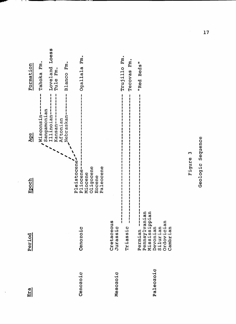
Eocene, Oligocene, and Miocene epochs of the Cenozoic Era
(see Fig. 3). Later epochs brought new deposition to the
Las Lenguas area.
Ogallala Formation
The name "Ogallala" has been used in a general man
ner since 1898 to designate the Pliocene aged formation
which unconformably overlies beds of the Dockum Group.
Considerable controversy has arisen more recently over the
exact geological nomenclature pertaining to this name. It
is agreed that the oldest Cenozoic deposits in the Texas
Panhandle are of early Pliocene age. These deposits were
derived from the eastern ranges of the Rocky Mountains and
19 laid down on an erosional surface of Triassic beds.
Evans categorizes the Pliocene Ogallala at the level
of a group and subdivides this group into the Couch and the
Birdwell formations. The Couch formation, the lower of the
two, is described as containing a basal member composed of
18 West Texas State University Geological Society,
Guidebook, Palo Duro Field Trip (Canyon, Texas: West Texas State University Geological Society), p. 23.
19 Glen L. Evans, "Cenozoic Geology," in Guidebook,
1956 Spring Field Trip, ed. by Glen L. Evans and John P. Brand (Lubbock, Texas: West Texas Geological Society and Lubbock Geological Society, 1956), p. 16.
17
0 •H •p fO
e U o h
•
g (d
^ o Xi to
EH
0) (Q 0) 0 K1
TJ • G g fU P4
rH 0) 0) > .H O 3 h J EH
•
[X4
o u c (d
rH CQ
•
I§ ro
r-i fO
i H i H
fO cn O
0)
Xi o o
1 3 O
• H }H
P4
• H
o
(0 • H
O
fO
c rd • H O
O D^-H CO
C fO
- H cn c fd o u
W C rH C 4J XJ •H (0 iH td 0) IS W H « < ^
Q) I U (U O G
<D
(U <U c c
0)0) 0) C O 0) u
CO U (U O G O •H O O tn 0) 0) 0) -H O -H U iH
iH iH -H rH O td PL, OJ S O W OJ
O •H
o N
o o
e 1^
0 rH I-i
-H •r-> :3 u tH
«
1 CO td > o u 0) EH
CO TJ (U m TJ 0 ffj E
(0
o o O CO (d CO
- P to (U }H >H :3
u • H CO CO to
•r<
>H
C G to to
•H -H G Ou
to a r H CO td > i CO - H
• H CQ - H CJ g G CO O JH G CO > Q) (I) - H (U CU 04 S Q
G td
G <d
G -H c: fd o td
•H -H -H >H > V 3 O XI
•H TJ 6 • H }H td
w o u
ro
0) }H 3 Di
•H CM
(U O G 0) :3 tr 0) w o •H Cn O
rH O Q) O
(0
O •H O N O G 0) U
O • H
O N O CO (U
s
o -H O N O 0) to

18
cross-bedded sands and gravels and an upper member consist
ing of well-sorted semi-consolidated calcareous and clayey
sands. The main body of the Birdwell formation is said to
consist of bedded unconsolidated sands and clays. Large
clay balls are usually present in the base, and colors range
20 from a characteristic reddish-brown to light gray.
The Ogallala is described as predominantly consist
ing of fine to medium sand usually exhibiting reddish to
pale pinkish-gray hues. The formation is marked by discon
tinuous and variable zones of weak cementation by calcium
carbonate, except in the uppermost part where cementation
is commonly dense and tough.
The stratigraphic top of the Ogallala formation
consists of an impure, irregular, resistant limestone. This
bed, known as the "caprock," is probably the most distinct
lithologic entity within the formation and is the only wide
spread resistant bed of the Ogallala. It has been generally
agreed that the caprock bed with its characteristic upper
zone of "pisolitic limestone" marks the top of the late
Pliocene depositional sequence and that this deposit formed
20 Evans, "Cenozoic Geology," pp. 17-21.

19
to approximately its present character before the beginning
21 of Pleistocene time.
Pleistocene Formation
A complete and distinctive sequence of Pleistocene
deposits, resting unconformably on the Ogallala formation
and underlying bedrock, is recognized in the Texas Panhandle
region. The Pleistocene is generally characterized by
episodes of progressively deeper erosional incision of the
Pliocene alluvial plain along with cyclic episodes of allu-
viation. Although sediments of this age in the Texas Pan
handle were deposited south of the glacial border, they have
22 been correlated to the glacial sequence. (See Fig. 3.)
The Blanco formation (Nebraskan) is the oldest
Pleistocene deposit and is characterized by stratified
white to light-gray bentonitic clay, sands, fresh-water
limestone, and local beds of distomaceous earth. The next
oldest Pleistocene formation is the Tule formation (Kansan),
which consists mainly of bentonitic clay with alternating
21 John C Frye and A. Byron Leonard, Studies of
Cenozoic Geology Along Eastern Margin of Texas High Plains, Armstrong to Howard Counties, Report of Investigations--Number 32, Bureau of Economic Geology, The University of Texas (Austin, Texas: The University of Texas, 1957), pp. 11-13, 17-18. Hereinafter referred to as Frye ancl Leonard, Studies in Cenozoic Geology.
22 Frye and Leonard, Studies in Cenozoic Geology,
D. 5.

20
sand beds. Fresh-water limestone, gravel, and unaltered
23 volcanic ash are also found within the Tule formation.
During Illinoian time the continental ice sheet was
smaller in the Great Plains region than were the earlier
Pleistocene ice sheets. No lacustrine sediments of Illi
noian age are known in the Texas Panhandle, but eolian
deposits called Loveland Loess are widespread. These sands
covered the Las Lenguas Canyon area during the Illinoian
. -, 24 period.
The next Pleistocene depositions took place during
the Early Wisconsin Age and is evidenced by the Tahoka
formation. The Tahoka, which is the most recently developed
formation, is characterized by stratified calcareous clays
and sands with thin beds of fresh-water limestone. Some
25 gravels also exist as lenses in the Tahoka formation.
All of the Pleistocene formations are seldom found
at one location in the Texas Panhandle. Usually only one
or two examples are visible.
The Pleistocene Epoch is typified by episodes of
progressively deeper incision of the Pliocene alluvial plain
23 Evans, "Cenozoic Geology," pp. 22-26.
24 C C Reeves, "Some Geomorphological, Structural,
and Stratigraphic Aspects of the Pliocene and Pleistocene Sediments of the Southern High Plains" (unpublished Ph.D. dissertation, Texas Tech University, 1970), pp. 62-64.
25 Evans, "Cenozoic Geology," p. 26.

21
along with cyclic periods of alluviation. The formation and
retreat of bounding escarpments (the "caprock") took place
during this time, as did the establishment of the Canadian
River and subsequent isolation of the Southern High Plains,
or "Llano Estacado," of eastern New Mexico and western
Texas. Deep reentrant canyons also formed along the caprock
during the Pleistocene Epoch. Thus were born Las Lenguas
and its neighboring canyons. These canyons' entire life
histories are told in the geologic formations evident within
the Las Lenguas study area.

CHAPTER II
PALEONTOLOGY
After obtaining a knowledge of geological nomencla
ture, it becomes much simpler to investigate the paleonto
logical reconstruction of life and forces which were active
in the Las Lenguas area during times past. The Permian and
Triassic Periods are only understood in a general manner,
but fairly detailed paleontological data is available for
the Pliocene and Pleistocene Epochs. Ecological conditions
can be reconstructed best from fossil remains found in the
formations which correspond to the continental glacial
sequence, but a generalized picture can also be drawn from
earlier strata.
Permian Period
As previously stated, at the beginning of Permian
time, the present area of the Southern High Plains was
almost entirely covered by seas. This fact is evidenced
by the predominance of marine fossils which have been found
in Permian deposits. Thirty-two species of pelecypods,
gastropods, bryzoa, serpulids, and braciopods have been
reported from Permian beds of the Texas Panhandle. It is
22

23
theorized that these animals lived in offshore bars where
26 supersaline water was diluted by influent streams.
The diversity in lithology of the Permian sediments
indicates varying conditions of deposition. Marine sedi
ments became less prevalent later in the Permian. The
deposition of evaporites and non-marine beds indicates an
intermittent but progressive withdrawal of the sea, in
general to the southwest. Uplift of the land probably
27 accompanied or followed this withdrawal.
Triassic Period
As the landmass was lifted, a period of erosion
and continental deposition was initiated. An age of
unstable conditions followed. During the Triassic Period
deposition was neither continuous nor generalized. Some
areas may have been receiving sediments while others were
being eroded, and these processes may have been reversed
numerous times at any given locality.
The Triassic-aged Dockum sediments represent deposi
tion in a continental environment. Probably the most
obvious evidence of this fact is the extensive faunal and
26 Jones, "Permian System," p. 7.
27 J.G. Cronin, A Summary of the Occurrence and
Development of Ground Water in the Southern High Plains of Texas, Texas Board of Water Engineers—Bulletin 6107 (Austin, Texas: Texas Board of Water Engineers, 1961), p. 12.
24
floral assemblages preserved in the sediments. The aquatic
forms are limited to fresh water types, probably the most
notable of which is the pelecypod Unio. Continental amphib
ians, most often represented by the genus Beuttneria, and
reptiles, most frequently of the family Phytosauridia, are
preserved throughout the Tecovas beds. Floral remains
include well-preserved fossilized wood, leaf imprints, and
small lignite beds.
Sedimentary characteristics of the Dockum beds
appear to represent deposition in what is best described as
a flat valley environment. The Tecovas formation consists
essentially of floodplain stream, lake, and swamp sediments,
while the overlying Trujillo beds exhibit all of the char
acteristics of stream channel deposits. These Triassic
streams flowed generally to the west and probably derived
their sediments from the Llano uplift region in central
Texas, the Wichita-Arbuckle Mountains in southern Oklahoma,
28 or the Bend Arch region of north central Texas.
The faunal and floral associations point toward an
environment in which streams emptied into lakes or ponds in
a habitat which was perhaps more suitable for aquatic or
semi-aquatic forms than for terrestrial animals. During
28 Howard W. Kiatta, "A Provenance Study of the
Triassic Deposits of Northwestern Texas" (unpublished M.S. thesis, Texas Technological College, 1960), pp. 45-52.

25
part of Dockum time, climatic conditions were unfavorable
for abundant vegetation and correspondingly abundant animal
life, but at other times, rainfall may have been sufficient
for the development of widespread forests and habitats
suitable for numerous aquatic and terrestrial forms of life.
In all probability, the prevailing climate during deposition
of the Triassic beds in the Las Lenguas area was one of
semi-aridity, becoming at times more humid and at other
times shifting in the opposite direction toward aridity.^^
Pliocene Epoch
After an extended erosional period which covered
most of the early Cenozoic epochs, a depositional environ
ment developed during the Pliocene, in which the Ogallala
formation was produced. The mechanism of Ogallala deposi
tion was one of valley alluviation. Reconstruction of the
Texas Panhandle Pliocene topography indicates broad
eastward-trending valleys arising in the mountainous areas
of New Mexico. The streams of these valleys meandered back
and forth creating a broad alluvial plain.
29 Green, "Triassic Deposits," pp. 92, 172.
30 John C Frye and A. Byron Leonard, Correlation of
the Ogallala Formation (Neogene) in Western Texas with Type Localities m Nebraska, Report of Investigations—Number 39, Bureau of Economic Geology, The University of Texas (Austin, Texas: The University of Texas, 1959), pp. 7-12. Hereinafter referred to as Frye and Leonard, Correlation of the Ogallala Formation.

26
The most useful paleontological materials for
studies of the Ogallala are the remains of plants. Frye
and Leonard distinguish three floral zones: the Kimball,
the Ash Hollow, and the Valentine, in the Pliocene of
Briscoe County and the Texas Panhandle. Prolithospermum
johnstoni, Berrichloa maxima, and Berrichloa minuta are
diagnostic of the Kimball floral zone, while the Ash Hollow
zone is characterized by Biorbia papillosa, Berrichloa
conica, Panicum eliasi, and Stipidium intermedium. Sti-
pidium commune is a grass which is diagnostic of the Valen
tine floral zone. Celtis willistoni, the hackberry, was
the only tree to be identified in the Ogallala floral zones
31 by Frye and Leonard. These authors also list several
mammal species which are said to be associated with the
Pliocene floral zones. Pliohippus pachyops, Neohipparion
sp., Nannippus sp., Procamelus sp., and Metoredon sp. are
found in deposits classed as being within the Valentine
zone, while the Ash Hollow zone contributes a species of
32 Astrohippus.
Research in the Texas and Oklahoma Panhandle by
Chaney and Elias has enhanced understanding of paleontology
Frye and Leonard, Studies of Cenozoic Geology, pp. 15-17.
32 Frye and Leonard, Correlation of the Ogallala Formation, p. 19.

27
of the Pliocene Epoch. They list Neohipparion and Nannippus
as representing the horses, and the beaver, Eucaster, as
characteristic of stream-side fauna during Pliocene time.
Wood of Fraxinus, palm seeds, and a seed of Arctostaphylos
have also been secured from the Ogallala of the Texas Pan
handle. The authors further denote the presence of Acer
(box-elder), Bumelia, Celtis, Diospuros, Gymnocladus, Popu-
lus (cottonwood), Salix, and Ulmus. This flora connotes a
floodplain assemblage which was more mesic than that now
found in the region. Chaney and Elias concluded that the
flora and fauna of the Ogallala point toward climatic con
ditions which favored the development of broad grasslands,
with forests restricted to valleys and stream borders. They
estimated an average annual rainfall of approximately 35
33 inches during Pliocene times.
Frye and Leonard expanded somewhat upon the picture
drawn by Chaney and Elias. They reconstructed a mild humid
climate for the early Pliocene Epoch. However, this mild
humid climate progressively gave way to a drier harsh
climate by the end of the Pliocene. Evidence supporting
this viewpoint is the disappearance of arboreal flora.
33 Ralph W. Chaney and Maxim K. Elias, "Late Ter
tiary Floras from the High Plains," in Contributions to Paleontology-Miocene and Pliocene Floras of Western North America (Washington, D.C: Carnegie Institution of Washington, 1938), pp. 4-7, 12, 26-28.

28
deterioration of the lush prairie flora, and a gradual loss
of branchiate and pulmonate gastropods as the epoch pro
gressed. By the end of Pliocene times, it is judged that
conditions were at least as dry and unfavorable to organic
life as are those of the present. The latter stages of the
Pliocene probably denote the most adverse conditions to
plant and animal life of any times during the Cenozoic
Era.34
Pleistocene Epoch
A distinct climatic reversal characterizes the
beginning of the Pleistocene. This fact is indicated by
the reappearance of branchiate snails and a marked increase
35
in the abundance and kinds of the total gastropod fauna.
Large collections of vertebrate fossils have also been
collected from beds of the Nebraskan-aged Blanco formation.
The fauna includes the characteristic early Pleistocene
genera, Borophagus, Gigantocamelus, Plesippus, and Stego-^ A 36 mastodon.
O A
John C Frye and A. Byron Leonard, "Ecological Interpretations of Pliocene and Pleistocene Stratigraphy in the Great Plains Region," American Journal of Science, Vol. 255 (January, 1957) , 1-9. Hereinafter referred to as Frye and Leonard, "Ecological Interpretations."
35 Frye and Leonard, "Ecological Interpretations,"
p. 9. 36 Evans, "Cenozoic Geology," p. 23.

29
The reversed climatic trend toward moist and toler
ant conditions continued and reached its climax during
Kansan time. The terrestrial gastropods of this age are
characteristic of prairies or forest borders and therefore
point to a dominant prairie vegetation associated with belts
37 of trees and shrubs along the valleys. Vertebrate fossils
also occur in the Kansan-aged Tule formation. The middle
Pleistocene horse, Equus scotti, Camelops, and the mammoth
38 are abundantly represented in Tule beds.
Following the Kansan, a strong, distinctive, but
oscillating, trend toward increasing aridity in the Southern
High Plains continued into recent time. Faunal changes
support the strong physical evidence of pronounced climatic
deterioration by Illinoian time. Ecologically speaking, the
Illinoian assemblages of fossils known from the Texas Pan
handle indicate a terrain of prairies with small amounts of
timber and woody understory vegetation. Water supplies must
have been rather meager and unstable. Local environments
were obviously less humid than those which prevailed during
39 Kansan time.
37 Frye and Leonard, "Ecological Interpretations,"
pp. 9-10. 38 Evans, "Cenozoic Geology," p. 26.
39 Frye and Leonard, Studies of Cenozoic Geology,
pp. 29-31.

30
The Early Wisconsinan Age, which produced the Tahoka
formation, signified a temporary halt in the trend toward an
arid climate. From all indications the Early Wisconsinan
time in the Texas Panhandle was characterized by a much more
stable, more humid, and cooler climate than exists in the
same region at present. From the nature of the faunal
assemblages, the general picture to be derived is that of
humid prairie on the plains, with tree- and shrub-bordered
streams flowing across the prairie and from the escarpment.
However, as the Wisconsinan Age continued, a return to the
trend toward an arid climate was reestablished. Thus, with
40 minor fluctuations, the present time was introduced.
A different approach than the one previously de
scribed for the paleontological study of the Pleistocene
has been taken by Fred Wendorf of the Museum of New Mexico.
By correlating the percentages of different types of pollen
trapped within the lake sediments with the present-day
pollen rain from various floral assemblages, a picture of
the Pleistocene vegetative structure can be drawn. Vegeta
tive character on the Southern High Plains has been shown
to be directly dependent upon the glacial cycles for which
the Pleistocene Epoch is well-known.
pp. 31, 38-39.
40 Frye and Leonard, Studies of Cenozoic Geology,

j-^j!ijuj»r»s»«
31
From his study of the Texas Panhandle, Wendorf has
named and characterized the major climatic-vegetative
changes which occurred during the Pleistocene. A summary
of his conclusions follows.
Terry Pluvial
Estimated dates.—More than 32,000 B.P.*
Characteristics.—Moderate percentages of pine and
spruce was coupled with considerable grass. Pollen assem
blages indicate that the climate was considerably cooler
and wetter than today.
Rich Lake Interpluvial
Estimated dates.—22,500 to 32,000 B.P.
Characteristics.--More grass and sage elements were
present than are found today. Pine pollen occurred in about
the same percentages as today. A prairie is indicated.
Tahoka Pluvial
Estimated dates.—15,000 to 22,500 B.P.
Characteristics.—The pollen spectra was dominated
by pine and spruce, with very minor representation from
grass, composites, or artemisia. An open boreal woodlands
•Before Present.

zsaiamt'tt.m
32
or forest is indicated to have covered 50 to 60 percent,
or more, of the area.
Monahans Interpluvial
Estimated dates.—13,000 to 15,000 B.P.
Characteristics.—During this period the regional
water table dropped approximately to its present level.
Numerous lakes which had existed during previous pluvial
episodes became dry.
San Jon Pluvial
Estimated dates.—6,000 to 13,000 B.P.
Characteristics.—The extensive, open boreal wood
lands or forests of the preceding Tahoka Pluvial had dis
appeared. Some pine and spruce survived in protected areas
along the escarpment and in stream valleys. Major elements
of the vegetation were grass, sage, and composites. This
period marked the most recent interval during which greater
41 moisture and colder temperature than today were manifest.
The paleontological information presented by Wendorf
is interesting, but it would be infinitely more valuable if
it were correlated to the Panhandle geological sequence.
The data is unquestionably relevant to the Las Lenguas area.
41 Fred Wendorf, Paleoecology of the Llano Estacado
(Santa Fe: The Museum of New Mexico Press, 1961), pp. 19-21, 129-132.

.juaanwrm
33
since much of the research was done near the canyon site.
To a person observing the semi-arid conditions manifest in
the major part of the Las Lenguas area today, paleontolog
ical indications of a boreal forest on the very same site
should be extremely exciting.

aCTTr^TH
CHAPTER I I I
ARCHAEOLOGY
The Tahoka Pluvial of the Pleistocene Epoch, during
which time a pine-spruce forest covered much of the Southern
High Plains, immediately preceded the first undoubted human
42 records from the region. From this early date, the Texas
Panhandle has been inhabited by men more or less continually
until the present. These people left traces of their habi
tation at many sites which have been found and studied in
more recent times. The archaeological sequences of the
Texas Panhandle may be divided into the early game hunter
stage, the archaic stage, and the neo-American stage.
Early Game Hunter Stage
The first people to inhabit the Texas Panhandle
depended strictly upon hunting for their livelihood. These
men hunted elephant, or mammoth, with spears which were
tipped with a distinctively fashioned flint point. The
name Clovis Fluted has been assigned to this spear point.
A O
Frank Oldfield and James Schoenwetter, "Late Quarternary Environments and Early Man on the Southern High Plains," Antiquity, 1964, p. 228.
34

:Txrrr~'^i
35
Clovis Fluted points vary somewhat in details, but all are
leaf-shaped in outline, fairly heavy in cross section, with
parallel or slightly convex edges and a concave base. On
one or both sides they exhibit a broad, shallow channel, or
flute, which runs from the base about half way to the tip.
Sites containing Clovis Fluted points are widespread,
especially in the southwestern United States. They have
been found associated with mammoth bones at Clovis, New
Mexico; Miami, Texas; and McLean, Texas; all of which are A O
considered to be near Las Lenguas Canyon.
With the disappearance of the mammoth from the
Southern High Plains, the early hunting peoples of the
region turned to bison. The species of bison which these
men hunted were much smaller than the mammoths but appre
ciably larger than the modern bison. Remains of these early
bison hunters are more plentiful and more widespread than
those of the mammoth hunters.
As did their earlier counterparts, the bison hunters
provided themselves with weapon heads of somewhat distinc
tive types. The Folsom complex with its Folsom Fluted point
is considered to be the oldest of the bison-hunting groups.
Folsom Fluted points are generally smaller and lighter than
43 Waldo R. Wedel, Prehistoric Man on the Great
Plains (Norman, Oklahoma: University of Oklahoma Press, 1961), pp. 54-58. Hereinafter referred to as Wedel, Prehistoric Man.
36
Clovis Fluted. Highly characteristic is a broad groove on
one or both faces. This groove runs from the base for two-
thirds or more of the distance toward the tip and gives the
point a biconcave appearance. Folsom Fluted points have
been found in intimate association with scrapers, knives,
hammerstones, paint pots, and awls, as well as with the now
extinct species of bison. Significant sites in the Las
Lenguas Canyon region are the Lipscomb site near Canadian,
Texas; the Lubbock, Texas locality; and the Clovis, New
Mexico site.
In contrast to the localities from which have come
the typically fluted Clovis and Folsom points, there exists
another group of early bison hunter sites characterized
instead by leaf-shaped, non-fluted points. This complex,
which is of a later date than the Folsom complex, has been
given the name Plainview after the location of the initial
type site. The Plainview point is described as being
lanceolate in outline with parallel or slightly convex
edges and a concave base. These, like the previously
described points, have been discovered at several sites, but
44 Wedel, Prehistoric Man, pp. 60-64.
aCTT^-Tl
37
the only notable one near the Las Lenguas Canyon area is
45 the Plainview locality.
Archaic Stage
Relatively little evidence has been reported con
cerning the nature of man's life in the Texas Panhandle
during the vast time between the hunting of now extinct
forms of big game and the much later activities of neo-
American aboriginal populations. These pre-pottery people
drew their sustenance from game animals of modern types
supplemented by the gathering of plant foods. Evidence for
this conclusion is exhibited by the abundance of dart
points, scrapers, and milling stones which have been recov-
46 ered from archaic sites. Two very significant archaic
localities near Las Lenguas Canyon have been reported.
These are the Twilla site, which is located five miles east
47 of Turkey in Hall County, Texas, and the Little Sunday
45 E.H. Sellards, Glen L. Evans, and Grayson E.
Meade, "Fossil Bison and Associated Artifacts from Plain-view, Texas," Bulletin of the Geological Society of America, October, 1947, pp. 927-954.
4 6 James M. Malone, Archeological Reconnaissance in
the Mackenzie Reservoir Area of Tule Canyon (Austin, Texas: Texas Historical Survey and Texas Water Development Board, 1970) , pp. 14-15. Hereinafter referred to as Malone, Archeological Reconnaissance.
47 Curtis D. Tunnell and Jack T. Hughes, "An Archaic
Bison Kill in the Texas Panhandle," Panhandle-Plains His-torical Review,- 1955, pp. 63-70.

ZSJCTT'^ 1
38
48 site in Randall County, Texas, near Palo Duro Canyon.
Both of these archaic sites have been discovered in terrain
which is almost identical to the Las Lenguas Canyon study
area.
Neo-American Stage
One of the more important and archaeologically
better-known cultures to encroach upon the archaic peoples
was the pottery-making, semi-horticultural village culture
known as the Antelope Creek Focus of the Panhandle Aspect.
These people seem to have entered the Texas Panhandle by
the twelfth century and retained their cultural integrity
for some two centuries. Their villages were concentrated
along the Canadian River where, in sharp contrast to the
previously mentioned cultures, they built permanent, multi-
roomed, pueblo-styled homes with walls of stone or adobe.
Subsistence of these people was based on maize agriculture,
hunting, and gathering. Although exhibiting similarities
in architecture to the more western Pueblo civilization,
the Antelope Creek Focus is believed to have developed
separately from the Pueblo with only influential trade con-
49 tact between the two.
48 Jack T. Hughes, "Little Sunday: An Archaic Site
in the Texas Panhandle," Bulletin of the Texas Archeological Society, 1955, pp. 63-70.
49 Wedel, Prehistoric Man, pp. 139-144.

• ^ ^ , M i l • ! ^ • .. • - • •• , - ^ .- ; i |
39
Remains of the Antelope Creek Focus are almost
entirely restricted to the Canadian River and its tribu
taries. However, sites with similar traits are known along
the caprock escarpment to the east and south, although
masonry structures of the north have yet to be reported.
The only possible exception is a site in Tule Canyon,
twenty-five miles northwest of Las Lenguas Canyon, in which
50 stone structures appear to have once existed. Alex D.
Krieger suggested that another focus of the Panhandle Aspect
may develop in the southeastern Texas Panhandle where the
major contrasting feature to the Antelope Creek Focus is a
51 lack of masonry. It seems that archaeological research
in the Las Lenguas area, none of which has been undertaken
to date, should be critical in determining the actual
archaeological relationships which have existed in the
Texas Panhandle.
In very late prehistoric times three new groups of
people entered the Texas Panhandle region. The first were
the Apaches, or as they were called by the early Spaniards,
Querchos, who entered the area shortly after 1500, probably
50 Malone, Archeological Reconnaissance, pp. 15, 25.
51 Alex D. Krieger, Culture Complexes and Chronology
in Northern Texas, The University of Texas Publication No. 4640 (Austin, Texas: The University of Texas, Oct. 22, 1946), pp. 74-75.

a(—T-",Ta
40
52 from the plains north of the Arkansas River. Shortly
after 17 00 the Comanches came upon the Texas Panhandle scene
from the Dismal River region and Nebraska, as did also the
Kiowas from their mountainous home along the Yellowstone
River in western Montana. The Comanches forced the Apaches
out of the Panhandle region, and after several years of
conflict the Comanches and Kiowas declared a lasting peace
covenant in the year 1790. The Kiowas and especially the
Comanches were truly "Lords of the South Plains" until their
strength was finally broken by the advance of the White
Man.^^
^^Wedel, Prehistoric Man, p. 289. C O
Ernest Wallace and E. Adamson Hoebel, The Comanches; Lords of the South Plains (Norman, Oklahoma: University of Oklahoma Press, 1958), pp. 279-285. Hereinafter referred to as .Wallace and Hoebel, The Comanches.

«OT
CHAPTER IV
HISTORY
The Indian Period
Much of the early history of the Las Lenguas Canyon
area is tied directly to the Indian inhabitants of the
region. The Comanches, who dominated the Southern High
Plains, were a short, heavy-set people with bright, copper-
colored complexions. Before Europeans arrived these Indians
best could be described as being dog nomads. Using their
dogs as beasts of burden, they travelled about on foot in
54 search of the bison which composed their total sustenance.
Because these pre-white Indians lacked the tech
nological advantages of the later European and American
invaders, their ways of life represented a closer response
to the opportunities and limitations of the land on which
they lived. In a region of limited precipitation and scanty
surface water, the Indians placed great importance upon
rivers, creeks, and springs. Besides supplying the elemen
tal need for water, the valleys also provided fuel and
54 Wallace and Hoebel, The Comanches, pp. 17, 34-35.
41

42
building materials, shelter from vigorous winters, and a
55 fairly sure food supply.
The Comanches of the Texas Panhandle preferred to
camp near a running stream in open country. Their villages
most often were found along meandering creek valleys toward
the headwaters of larger streams where adequate canyons
for protection, wood for campfires, and sweet water for
drinking were available. A large camp sometimes extended
several miles along a stream or forest edge. The Las
Lenguas Canyon area was one of the Comanches' most popular
campgrounds. In fact, it may be stated that the very
favorite retreat and stronghold for the group of Comanche
bands called the Middle Comanches was the breaks of the
Pease River country, of which the Las Lenguas Canyon area is
a most desirable locality.
After its introduction by early Spaniards, the
horse was quickly adopted by the Comanches as a beast of
burden. By many who saw them, these Indians were thought
to be among the greatest horsemen in the world. The artist
George Catlin wrote concerning the Comanches,
In their movements they are heavy and ungraceful; and on their feet one of the most unattractive and slovenly-looking races of Indians I have ever seen; but the moment they mount their horses, they seem at once
^^Wedel, Prehistoric Man, pp. 25-29.
Wallace and Hoebel, The Comanches, pp. 14-15, 26.

~'""~^"~"""^
43
metamorphosed, and surprise the spectator with the ease and grace of their movements.57
Many such glowing accounts of Comanche horsemanship have
followed the tribe through history.
The Comanche always had been a nomad, but it is
difficult to overestimate the value of the horse to his way
of life. With the horse he achieved incomparably greater
mobility; he mastered the buffalo; he had a new and valuable
trade asset; and most significant of all, he was changed
from an impotent infantryman into a fierce cavalryman--a
dangerous warrior and insatiable raider. When measured by
the number of horses, the Comanches were the richest of all
tribes. In warfare no one surpassed them. Due to the great
mobility of the horse. Las Lenguas and adjacent streams
which led southeastward became highways for Comanche parties
raiding the scattered and undefended Anglo-American settle-
.- £ m 58
ments of Texas.
The Comanchero Period
Probably the most interesting and colorful history
of the Las Lenguas area is based upon the friendly relation
ship which sprang up between the Comanches and their Mexican
neighbors in New Mexico. Before the coming of the cowboy.
57 George Catlin, North American Indians (Philadel
phia: Hubbard Brothers, 1891), pp. 74-75. 58 Wallace and Hoebel, The Comanches, pp. 14, 34-36.

g3wa«M
44
before the buffalo hunters arrived on the scene, and even
before the earliest Anglo-American explorers came, the Pan
handle of Texas was known to the Spaniard and the Mexican.
To the plains came the Spanish buffalo hunters called
Ciboleros from their little New Mexican villages. They took
their prey not with high-powered rifles, but with tasseled
59 lances. These colorful individuals were no doubt the
first of the European descendants to become familiar with
Las Lenguas Canyon. They were so impressed with the area
that they named the stream which headed in this canyon Rio
6 0 Cibolo, or Buffalo River. Thus the Spaniard was added to
the already intimate relationship which the Comanche and the
Las Lenguas area shared.
The Ciboleros hunted beside their Comanche friends.
Both were excellent horsemen and proud hunter-sportsmen.
The Ciboleros often carried hard-baked loaves of bread and
other small articles to trade with their Comanche compan
ions. As word of the trade opportunities was carried back
to the villages of New Mexico, a new group of Spaniards
began to travel to the Texas Panhandle. These were the
Indian traders, or Comancheros.
eg J. Evetts Haley, The XIT Ranch of Texas (Norman,
Oklahoma: University of Oklahoma Press, 1953), p. 18. 6 0 Edna Kahlbau, "The Comanchero Barter on the High
Plains, III," Amarillo Sunday News and Globe, November 2, 1941, p. 2.
^WH
45
The first Comancheros were poor but honest traders,
simply trying to secure a living from their meager business.
They carried to the plains by burro a small store of goods
which they traded to the Comanches mostly for buffalo robes.
The trade grew, but even as late as 1839 Josiah Gregg, a
noted frontier traveler, stated that:
These parties of Comancheros are usually composed of the indigent and rude classes of the frontier villages, who collect together, several times a year, and launch upon the plains with a few trinkets and trumperies of all kinds, and perhaps a bag of bread and maybe another of pinole, which they barter away to the savages for horses and mules. The entire stock of an individual trader very seldom exceeds the value of twenty dollars, with which he is content to wander about for several months, and glad to return home with a mule or two, as the proceeds of his traffic.^1
However, as time passed the Comanchero trade grew consider
ably in scope and developed into a contraband operation.
Wagons, or carretas, were employed to haul many more goods,
especially guns and whiskey, causing the term "Comanchero"
62 to take on the connotations of a "dirty word."
Soon the Indians learned that, not only for personal
use but also for purposes of barter, the stealing of horses
was a profitable business. Thus they began to plunder the
ranches of Texas and the haciendas of northern Mexico. As
Josiah Gregg, Commerce of the Prairies, ed. by Max L. Moorhead (Norman, Ok1ahoma: University of Oklahoma Press, 1954), p. 257.
62 H.H. Moncus, Prairie Schooner Pirates (Fort Worth,
Texas: Western Heritage Press, 1963), pp. 44-47.

MJ^3U.3MI
46
cattle were brought into the Texas Panhandle, they too
became a prime target for Indian raiders. As the trade in
stolen cattle and horses assumed greater proportions, defi
nite meeting places were established. When Colonel Charles
Goodnight, the first rancher to enter the Panhandle, arrived
in 1876, "the roads of the Mexican traders were almost as
63 big and plain as the roads of today" [1926],
Goodnight described these roads in detail. The most
southerly trail left the Pecos River near Bosque Redondo,
pointed east and south to the Yellow Houses and terminated
in the Canon del Rescate. Both of the latter locations lie
near the present city of Lubbock, Texas. The upper trail
left Las Vegas, New Mexico, and led northeast to the
Canadian River which it then followed east of Tucumcari
Mountain. The trail forked near the Texas line with the
northern section following the Canadian to Las Tecovas
trading grounds.
The southern fork branched in a southeasterly direc
tion from the Canadian River. It proceeded into the head of
Palo Duro Canyon and then to Tule Canyon. From there the
trail passed the head of Rock Creek and continued to the
foot of the High Plains in the Quitaque country. This
branch of the trail finally terminated at the Rio de las
Lenguas.
63 Haley, The XIT Ranch of Texas, pp. 24-26.

i^Mi'unt^
47
Between these two roads was another which also led
to Las Lenguas. Its travelers went by way of the government
road between Santa Fe and Fort Sumner to La Laguna, approxi
mately eight miles north of the fort. From there they pro
ceeded to the head of Tule Canyon, where they intersected
the northern trail and followed its course to the Quitaque
64
country or to Las Lenguas. Even today the old trail lead
ing off the caprock into Las Lenguas and the Quitaque
country can be distinguished from the surrounding country
side. A jeep road has been established over the old
Mexican-Indian trail, but there is no doubt that the road 6 S
marks the old Comanchero trail.
Contrary to popular belief, related Goodnight, few
Indians spoke Spanish. And yet Indians of various tribes
and dialects, renegade Anglo-Americans, and Mexican traders
all gathered in a common barter. Negotiations called for
the use of many languages, or lenguas—tongues. Hence the
name of the stream at which they most often met became Rio 6 6
de las Lenguas, or Las Lenguas. In the Texas Panhandle
J. Evetts Haley, "The Comanchero Trade," The Southwestern Historical Quarterly, XXXVIII (January, 1935) , 161-162.
Jim Stroup, lifelong Quitaque rancher whose birth was the second recorded in Briscoe County, private interview at his home within the Las Lenguas study area, August, 1971.
Haley, "The Comanchero Trade," p. 164.
SKZ£.tl\U
48
today, only the Americanized version, Los Lingos, is com
monly used. However, the origin and authencity of the
Spanish term. Las Lenguas, is unquestionable.
Just west of the Stroup ranch house and within the
Las Lenguas study area, is located another valley where
trading was often done. Scattered bands of raiding Indians
concentrated here and separated their captives to lessen the
danger of escape and to insure more rapid assimilation.
Here mothers and children, torn from their homes in Texas
and Mexico, were scattered with the splitting of tribal
bands. Even in such a wild region, this valley came to be
known as a spot of heartache, grief, and tragedy. The
Comancheros appropriately referred to it as Valle de las
67 Lagrimas—the Valley of Tears. It becomes obvious that
the Comanchero trading grounds at Las Lenguas, the Quitaque
country, and the Valley of Tears compose a single unit and
that this unit is contained within the boundaries of the
Las Lenguas study area.
During the years from 18 50 to 187 0 the Comanchero
trade reached and maintained its highest level. Las Tecovas
became a prominent market place, but it was a distant second
68 in importance to that at Quitaque and Las Lenguas.
Haley, "The Comanchero Trade," p. 164.
Haley, "The Comanchero Trade," p. 161, 164.

... ^„,^
49
The magnitude of the Comanchero trade during these
two decades was astounding. The Daily New Mexican reported
that the commerce engaged more than one thousand New Mexi
cans in 1871 and was "immensely profitable" to the success
ful trader. It further stated that:
. . . The people on the Pecos have almost entirely neglected their ranches for this more profitable traffic, and the consequences will be a scarcity of bread stuffs this year.
Additional awesome figures were released by the newspaper.
It reported one instance in 1868 in which 4,100 head of
cattle had been stolen by Indians—3,000 head within two
days and the other 1,000 having come from the same location
69 only a few days previously. Truly the Comancheros were
engaged in a major undertaking.
Direct evidence of the magnitude of Indian depreda
tions, as well as the prominence of the Quitaque-Las Lenguas
trading grounds, was obtained by Charles Goodnight in 18 93.
In an effort to receive repayment for earlier cattle losses,
he went to court and secured sworn testimony from three
Comancheros and a trader who dealt with them concerning
their previous activities. All of the men made repeated
references to the Las Lenguas Canyon area. One trader,
when asked why he nearly always went to the Las Lenguas-
Quitaque area to trade, replied that.
^^The Daily New Mexican, July 20, 18 68; July 18, 1870; May 24, 1871.

iSZuIt lkl l
50
It was a kind of headquarters for the Indians. There was plenty of water there, it was a hiding place, good shelter and plenty of grass.70
When asked how many cattle he had seen at Las Lenguas bear
ing Goodnight brands, another trader stated that he had
observed in the possession of Comancheros and Indians
together about 8,000 head. It must be emphasized that this
approximation, and another estimate of 5,000 head by a
different trader, were covering only a three year period and
71 only one rancher's brand. At least one authority, who
knew Goodnight well, estimates the total of this rancher's
72 losses at 300,000 head of cattle and 100,000 horses.
There were numerous attempts to eliminate this
lucrative Comanchero trade and its adjoining Indian depreda
tions. When the Superintendent of Indian Affairs, A.B.
Norton, reached New Mexico for the assumption of duty in
1886, he found the Territory "filled with Texas cattle."
He made an unsuccessful effort to control the trade through
a restricted permit system. Likewise in 1870, the governor
of the Territory of New Mexico issued a proclamation against
the trade and directed the judges to bring the guilty
70 Lowell H. Harrison, ed., "Three Comancheros and a
Trader," Panhandle-Plains Historical Review, XXXVIII (1965), 82.
71 Harrison, "Three Comancheros and a Trader." pp. 88-93.
72 Haley, "The Comanchero Trade," p. 169.

^Mnrnfiin
51
parties to justice. The Texas ranchers themselves even
entered New Mexico on one occasion in an attempt to recover
stolen stock by force. In 1872, it was decided that the
time for concerted military action had arrived. Colonel
Ronald S. Mackenzie was sent to the Texas Panhandle to
73 eliminate the Comanchero trade and Indian depredations.
Colonel Mackenzie was a brilliant soldier, but no
white man had any appreciable knowledge of the Texas Pan
handle. The caprock and plains were the home of the Coman
ches, while the Anglo army was an ill-informed, often lost,
intruder. With his vastly superior force, Mackenzie found
and followed the Comanchero trails which have since been
inappropriately labeled the Mackenzie Trail. His force
passed directly through the Las Lenguas area several times.
Finally in 1875, after several years of fighting, the
74 strength of the Comanches was broken. Notwithstanding all
of the earlier attempts, only the final pressing of the
Indians onto reservations brought an end to the infamous
75 but highly colorful Comanchero trade.
^"^Haley, "The Comanchero Trade," pp. 166, 170-174.
Ernest Wallace, Ronald S. Mackenzie on the Texas Frontier (Lubbock, Texas: West Texas Museum Association, 1964), pp. 178, 133-134, 146, 170.
Haley, "The Comanchero Trade," p. 161.

• t j g n . i ^ i i i
52
Quanah Parker
The last Comanche chief to lay down his arms was the
notorious Quanah Parker. The story of Quanah Parker and his
white mother Cynthia Ann is both interesting and pertinent
to a study of the Las Lenguas area.
On a spring day in 183 6, a band of raiding Comanches
attacked Fort Parker in East Texas. Among the captives to
be abducted from the site was a nine year old white girl
named Cynthia Ann Parker. At least one report states that
Cynthia Ann was taken directly to "the lost and inaccessible
valley where a stream comes down between war-paint canyon
walls through the break in the cap rock—the Rio de las
7 6 Lenguas." Although this report is highly speculative, the
great number of captives to enter the Las Lenguas area and
the Valley of Tears has already been documented. In any
event, she was taken to the Panhandle wildlands where she
became assimilated into the Comanche culture.
About four years after her capture, Cynthia Ann was
observed by a pair of Anglo traders to be with a Comanche
band along the Canadian River. Then again several years
later she was noticed by a group of white hunters. When
asked if they should try to free her, she replied.
^^Peattie, "The Ballad of Cynthia Ann," pp. 16-17.
53
I am happily wed. I love my husband who is good and kind and my little ones who, too, are his, and I cannot forsake them.77
What the traders did not realize was that the husband to
whom Cynthia Ann referred was the famous Peta Nocona, chief
of the Nocona (Wanderers) band.
On a May morning in 1845, a half-breed boy was born
to Cynthia Ann and Peta Nocona. The baby was named Quanah
which means "sweet-smelling" or "bed of flowers." Quanah,
later to be called Quanah Parker, was destined to become 78
one of the most outstanding Comanche chiefs of all time.
In the early autumn of 1860, Peta Nocona led his
band to their favorite retreat in the breaks of the Pease
River of which the Rio de las Lenguas forms the northern
headwaters. At a site in present Foard County, Texas,
Captain L. Sul Ross with a ranger and cavalry force was
successful in attacking and scattering the Comanches.
Cynthia Ann was recaptured in this battle, and there are
conflicting reports as to whether or not Peta Nocona was
killed. Cynthia Ann was returned to her East Texas home.
She tried to escape in order to return to her Comanche
" James T. DeShields, Cynthia Ann Parker (St. Louis: By the Author, 1886), pp. 28-32.
^^Clyde L. Jackson and Grace Jackson, Quanah Parker: Last Chief of the Comanches (New York: Exposition Press, 1963), p. 18. Hereinafter referred to as Jackson and Jackson, Quanah Parker.
•iiMTlfi-^^tXl
54
loved ones but was unsuccessful and died four years after
7 9 returning to the foreign East Texas environment.
Quanah rose to a position of authority quickly. At
a young age he became chief of the Kwahadi (Antelope) Coman
ches, the most fierce of the Comanche bands. The Kwahadies
were reported at the Quitaque-Las Lenguas locality several
times. In fact, it seems from all available information
that this was a major center for their activities.
The Kwahadi warriors under Quanah Parker's command
fought all invaders. During the first years of Mackenzie's
campaigns, the colonel was repeatedly outmaneuvered by the
crafty chief. The Kwahadies persisted in their insatiable
raiding and probably more importantly formed a nucleus about
which renegade Comanches from the reservation continued to
^u 80 gather.
In 1875 with all hope of victory gone, the first
of the Kwahadies surrendered to Colonel Mackenzie at Fort
Sill. Quanah and his warriors, however, remained free. At
this time the colonel sent two of his men to the High Plains
for the purpose of threatening and persuading the Kwahadies
79 J. Evetts Haley, Charles Goodnight: Cowman and
Plainsman (Norman, Oklahomal University of Oklahoma Press, 1949), pp. 55-59.
80 Rupert N. Richardson, The Comanche Barrier to
South Plains Settlement (Glendale, California: The Arthur H. Clark Company, 1933) , pp. 21, 346-347.

55
to come in peaceably. The white men located the Kwahadies
near Quitaque and delivered their message. Quanah took
charge of the negotiations and, knowing that the defeat of
his people was imminent, surprisingly promised to be respon
sible for the surrender of the entire Kwahadi band. This
was the greatest victory that Mackenzie had ever won. A
man whom he had been chasing for three years simply walked
in and surrendered. Mackenzie stood face to face with the
greatest of the Comanche chiefs, a half-breed who had com-
81 bined the attributes of both white man and Indian.
The Pastores Period
At some time preceding the final removal of the
Indians and simultaneous elimination of their contraband
trade, several of the old-time Comancheros began to revert
to their original pursuit of sheep raising. These men had
seen the fertile valleys of the Texas Panhandle and were
quick to bring their great sheep herds into the region.
Several of the pastores, as the shepherds were then called,
built permanent homes and settled down in the more choice
Panhandle localities. It is unknown when the earliest sheep
grazed the grassy valleys, but buffalo hunter and trail
driver Frank Collinson found old houses on the Canadian
81 Jackson and Jackson, Quanah Parker, pp. 110-111.

SdLtr^u.ii
56
River and at Las Lenguas in 187 3. Likewise, Henry Kimball
found the Canadian River valley fairly well populated when
he entered the region in 1874. As far as can be ascer
tained, nothing remains today of the old houses at Las
Lenguas. The houses, as did the pastores of this region,
passed into history when the great cattle kings arrived upon
8 2 the scene in the late 1870's.
The Cattle Kingdom Period
Despite the popular impression, there was little
animosity between pastores and cowmen in the Texas Panhan
dle. Trouble might have developed were it not for the fact
that when the cattle came, the sheepmen simply drifted back
83 into New Mexico. There was no open conflict.
It seems evident that the hostile Comanches repre
sented a more powerful force than did the pastores in pre
venting cattlemen from entering the High Plains. But by
187 6 the Indians were removed, and cattlemen began moving
into the country. In this year Charles Goodnight brought
from Colorado the first cattle herd to enter the Texas Pan-
die. He settled in Palo Duro Canyon and with his English
^ John L. McCarty, Maverick Town--The Story of Old Tascosa (Norman, Oklahoma: University of Oklahoma Press, 1968) , pp. 15-16, 21.
R3
Haley, The XIT Ranch of Texas, p. 34.

57
financier-partner, James Adair, began to build the vast JA
84 Ranch. Charles Goodnight soon became the acknowledged
leader and monarch of the cattle ranchers in the Texas Pan
handle. More importantly, he introduced cattle raising,
which was to become the first great commercial industry in
8 5 Texas, to the West Texas plains.
Shortly after Goodnight settled in Palo Duro Canyon,
several other ranchers advanced into the Texas Panhandle.
The most significant of these ranchers for the present
report were the Baker brothers, who brought 2,000 head of
cattle under the management of J. Wiren into the Quitaque
area in 1877; and Colonel McCoy, who likewise settled in
the Quitaque country. Wiren used the Lazy F brand, while
8 6 McCoy initiated the Hat brand.
In 188 2 Colonel Goodnight purchased the Quitaque
(F) Ranch from the Bakers for Mrs. Cornelia Adair. Twenty-
two cents per acre was paid for approximately 140,000 acres,
but the actual range was much larger than this figure due to
the grazing of leased land and alternating sections which
were in railroad ownership. The F Ranch was managed by
84 T.C Israel, "The History of Oldham County, Texas"
(unpublished M.S. thesis. The University of New Mexico, 1934) , pp. 33-34.
85 Holland Thompson, The Book of Texas (Dallas: The
Colonial Press, 1929), p. 91. 8 6 Haley, The XIT Ranch of Texas, pp. 43-44.

kjLi.^^...i1
58
Goodnight as a part of the JA holdings until 1887 when the
Adair-Goodnight partnership was dissolved. At that time
Mrs. Adair traded Goodnight the F Ranch and its cattle for
his one-third interest in the JA enterprise. In 1888
Goodnight sold half of his ranch to L.R. Moore of Kansas
City, and the next year he sold the remainder to the same
individual. In 18 95 Mr. Moore in turn sold the F Ranch to
Frank Howard of New Orleans, who dispensed of the land sec-
87 tion by section as buyers could be found.
Colonel Goodnight's original F Ranch covered most of
the Las Lenguas Canyon area. The ranch headquarters burned
several years ago, and as far as can be ascertained, the
only remaining vestiges of the old F Ranch are hand-split
cedar posts which were used by Goodnight to fence corrals.
These planks are presently incorporated into a corral on the
Stroup Ranch in the southeastern corner of the study area.
But even today almost all the land within the Las Lenguas
study area has retained the ranching tradition initiated by
88 Charles Goodnight and the F Ranch.
87 Harley T. Burton, A History of the JA Ranch (New
York: Argonaut Press, 1966), pp. 46-47, 56-57. 88 Jim Stroup, private interview, August, 1971.

CHAPTER V
BIOECOLOGY
Because of the location of the Texas Panhandle and
South Plains in the rain shadow of the Rocky Mountains, the
climate is continental. The whole region, which exhibits
a markedly uniform climate, is semi-arid with low and irreg
ularly distributed precipitation, high evaporation, and
pronounced daily and seasonal ranges in temperature. During
fifty years of weather records, there has existed a great
year to year variation in precipitation, the average being
approximately 20 inches annually.
Seasonal distribution of precipitation is also
highly variable with April-May and September-October being
the highest rainfall months. Normally there is a summer dry
period with high temperatures and high evaporation rates.
Throughout the year daily temperature ranges of 30 degrees
are not uncommon. These marked daily variations are due in
large part to the high degree of radiational cooling charac
teristic of the region.
Dry winds prevail during most of the year, and under
their influence the potential evaporation is much greater
than the total average precipitation. Prevailing winds are
59

til«i.-...iM
60
from the south-southwest with an annual average velocity of
12-15 miles per hour. Winds of 30-50 miles per hour are not
uncommon. The severity of climate is further augmented by
not infrequent tornados, blizzards, and long periods of 89 drouth.°^
Although climate contributes significantly to deter
mination of the gross biotic community types in the Lap
Lenguas area, topography and soil water are much more impor
tant factors in the explanation of local variation. The
elevation of the Las Lenguas area ranges from 2,7 00 feet to
3,100 feet above sea level. The broken topography provides
protected niches and a well defined drainage system.
Springs in the area have furnished a permanent water supply
to Las Lenguas Creek. Although the creek becomes intermit
tent farther downstream, within Las Lenguas Canyon it
exhibits a sustained flow.
The entire Las Lenguas study area is basically a
grassland type, even though brush cover is evident to some
degree over most of the area. As one enters Las Lenguas
Canyon from the top and progresses out past the mouth, he
is impressed by four distinct vegetative zones through which
he passes. In most places the changes of vegetative types
Chester M. Rowell, Jr., "Vascular Plants of the Texas Panhandle and South Plains" (unpublished Ph.D. dissertation, Oklahoma State University, 1967), pp. 7-8. Here- • inafter referred to as Rowell, "Vascular Plants."

61
are abrupt and evident even to a biological novice. Above
the caprock a grassland exists which has been invaded by
mesquite. Immediately upon entering the canyon, he observes
a change to predominantly juniper cover clinging to the
steep walls and a juniper-grassland savannah upon the open
canyon floor. Mesquite is totally absent in this community.
Proceeding across the canyon floor, he arrives at a small
canyon-within-the-canyon. This well protected lower terrace
follows the approximate center of Las Lenguas Canyon and
contains Las Lenguas Creek. A mesic community dominated by
deciduous trees, taller grasses, and reeds is strikingly
evident along the stream. The fourth vegetative zone to be
encountered is entered as the observer nears the mouth of
the canyon. At this point, and as he leaves the stream side,
he becomes emersed in a broken, rolling, fairly densely
covered mesquite-grassland.
The North American central grasslands, of which the
Las Lenguas area is a part, stand as a major barrier to the
east-west dispersal of forest species which occur to the
east and to the west of them. They also provide a north
ward avenue for dispersal of groups that are primarily
90 adapted to southern desert and semi-desert conditions.
90 W. Frank Blair, "Mammals of the Mesquite Plains
Biotic District in Texas and Oklahoma, and Speciation in the Central Grasslands," Texas Journal of Science, VI, No. 3 (September, 1954), 256. Hereinafter referred to as Blair, "Mammals of the Mesquite Plains."

t^KSffmf.v.'.{•,{ .JM-'~;
62
Likewise, the rock outcroppings of the escarpment furnish a
means of dispersal for southern saxicolous species. It is
also notable that various trees which are common in more
eastern provinces entered along the stream floodplains that
drain to the east from the caprock canyons. These forests
provide avenues for the westward extension of eastern forest
91 species of vertebrates. It is evident that the Las
Lenguas area is part of a major biological crossroads within
Texas and North America.
No less than twelve different schemes for the bio
logical classification of the Texas Panhandle have been
proposed by various authorities. Blair describes all of
the designated Las Lenguas area as a part of the Kansan
92 biotic province, while his predecessor, Lee Dice, splits
the region into the Kansan province above the escarpment
93
and the Comanchian below the caprock. Bray states that
the "red beds" below the escarpment are within the Lower
Sonoran zone as regards temperature correlation, but bear
a more common floristic relationship to the Upper Sonoran 91
^ W. Frank Blair, "The Biotic Provinces of Texas," Texas Journal of Science, II, No. 1 (March 31, 1950), 95, 111.
92 Blair, "The Biotic Provinces of Texas," p. 98.
93 Lee R. Dice, The Biotic Provinces of North America
(Ann Arbor, Michigan: University of Michigan Press, 1953), pp. 26-29. Hereinafter referred to as Dice, Biotic Prov-inces.

¥^effn
63
94 95 96 . .
zone above the caprock. Tharp and Gould, likewise,
split the region into two biotic zones.
Within a smaller locality, such as the Las Lenguas
study area, a slightly more detailed classification frame
work is advantageous. Such a scheme should logically be
based upon the vegetative zones which one encounters as he
traverses the area. Therefore, a framework which adheres
to these community types has been composed. The remainder
of this chapter shall be arranged so as to describe the
High Plains area above the escarpment, the caprock and
canyon proper, the riparian zone, and the Rolling Plains
below the escarpment (see Fig. 4). Most of the published
data pertaining to the Las Lenguas area can be adapted to
this scheme of classification.
High Plains Zone
The Panhandle High Plains, which is represented in
the Las Lenguas study area by the land above the caprock.
W.L. Bray, "Ecological Relationship of the Vegetation of West Texas," Botanical Gazette, XXXII (1901), 199-204.
^^Benjamin C Tharp, The Vegetation of Texas (Houston, Texas: The Anson Jones Press, 1939), pp. 27-30.
^ F. Gould, Texas Plants—A Checklist and Ecological Summary (College Station, Texas: The A & M College of Texas, 1969), pp. 12-13. Hereinafter referred to as Gould, Texas Plants.

F i g u r e 4 64
N
S e a l * - 1 " - 6000 Fl.
KEY
1 - High Plaint Z * n *
2 * Caprock and Canyon Zoni
3 ~ Riparian Zon*
4 - Rolling Plains Z *n*
BIOECOLOGICAL ZONES
IMMiii I 14W|
65
was most aptly described by Ernest Palmer: "Far as the eye
can see extend the unbroken, grassy stretches of level
surface, conveying an impression of boundless space compara-
97 ble only to the great sandy deserts or to the ocean."
Since that time, the High Plains landscape has changed con
siderably, but a few localities have retained their natural
character.
Flora
The expression "Short Grass Country," which has
become widely employed to specify the High Plains grass
lands, is an apt description of the major vegetative type.
Grasses of this semi-arid region are xerophytic with leaves
that are narrow and inclined to curl with excessive tran
spiration. Whereas in their native state the coarser
prairie grasses might have almost concealed grazing cattle,
the High Plains grasses scarcely ever exceeded two feet in
98 height. Grass dominants under virgin conditions were
probably blue and hairy grama (Bouteloua), with buffalo
97 Ernest J. Palmer, "The Ligneous Flora of the
Staked Plains of Texas," Journal of the Arnold Arboretum, II (1920), 92. Hereinafter referred to as Palmer, "Ligneous Flora."
98 William L. Bray, Distribution and Adaptation of
the Vegetation of Texas, Bulletin of the University of Texas—No. 82, Scientific Series No. 10 (Austin, Texas: The University of Texas, 1906), p. 91.

,.^^4
66
grass (Buchloe dactyloides) of secondary importance, but
great herds of buffalo had already so overgrazed the country
when the white man arrived as to have caused buffalo grass
to become the chief dominant, with the gramas reduced to
secondary rank. A dense stand of western wheat grass
(Agropyron smithii), which later succumbed to intensive
cattle grazing, also once stood waist high around High
99 Plains playa lakes. Additional plains grasses presently
of importance are sideoats grama (Bouteloua curtipendula),
black grama (Bouteloua eriopoda), little bluestem, (Andro-
pogon scoparius), Indiangrass (Sorghastrum nutans), and
switchgrass (Panicum virgatum).
Under native conditions the High Plains was free
from all trees and brush. Mesquite (Prosopis) has been the
most common woody invader of the grassland. This invasion
has taken place since the introduction of domestic livestock
and is a result of the decline in range condition. As the
taller grasses disappeared under heavy grazing, they were
replaced by short grasses and weeds which were unable to
prevent mesquite invasion. The High Plains zone within
99 Benjamin C Tharp, Texas Range Grasses (Austin,
Texas: University of Texas Press, 1952), pp. 60-62. Gould, Texas Plants, p. 13.
B.W. Allred, "Mixed Prairie in Texas," in Grasslands of the Great Plains, by J.E. Weaver and F.W. Albertson (Lincoln, Nebraska: Johnson Publishing Company, 1956), p. 274.

IM. u » ' mn wmm$T^""l
67
the Las Lenguas study area is currently characterized by a
mesquite-covered grassland.
Fauna
In general, only animals that can tolerate dry air
may survive in open grasslands. Especially large numbers of
reptiles and insects, most noticeably those exhibiting
incomplete metamorphosis such as termites and grasshoppers,
are well adapted to the rigorous environment. Among mam
mals, those forms relatively independent of water either
because of slight development of the cutaneous gland
(rodents), concentrated urine (pronghorn antelope), or dry
feces, are most likely to survive. Other adaptive mecha
nisms which are very pronounced in grassland species include
a burrowing habit and great speed, and endurance in move-
^ 102 ments.
Among High Plains mammals, the bison (Bison bison)
and the pronghorn antelope (Antilocapra americana) were at
one time the most visibly dominant species. The pronghorn
remains, but the bison has been exterminated except for
small, protected herds. The most significant mammals of the
High Plains currently include the kit fox (Vulpes velox),
pocket mouse (Perognathus flavescens), Kangaroo mouse
102 Richard Hesse, Ecological Animal Geography,
prepared by W.C Allee and Karl P. Schmidt (New York: John Wiley and Sons, Inc., 1937), pp. 444-448.

68
'(Dipodomys ordii), deer mouse (Peromyscus maniculetus),
skunk (Spilogale sp. and Mephitis sp.), badger (Taxidea
taxus), coyote (Canis latrans), ground squirrel (Citellus
spilosoma), prairie dog (Cynomis ludovicianus), plains wood-
rat (Neotoma micropus), jackrabbit (Lepus californicus), and
103 cottontail rabbit (Sylvilagus audubonii).
Referring especially to mammals. Dice notes that the
caprock escarpment marks a distinct divisional boundary
between related species of the High Plains and of the Roll
ing Plains. He states that the ground squirrels Citellus
tridecemlineatus and C. spilosoma are found on the High
Plains but are replaced by Citellus mexicanus in the lower
Rolling Plains. Likewise the kit fox (Vulpes velox) is
reported for the High Plains only while the gray fox
(Urocyon cinereargenteus) inhabits the Rolling Plains.
Blair adds the pocket gopher Cratogeomys castanops of the
High Plains whose counterpart from the Rolling Plains is the
105 pocket gopher Geomys to this list. It is evident that
the escarpment separating the High Plains and the Rolling
Plains also divides several closely related mammal species
•*• Wendorf, Paleoecology of the Llano Estacado, p. 17.
•'• Dice, Biotic Provinces, pp. 28-29.
" "" Blair, "Mammals of the Mesquite Plains," p. 246.

T T i T T r n r i
69
and has probably functioned as an important device in the
speciation process.
The avifauna of the High Plains is more abundant and
diversified than one might expect for a grassland. The most
conspicuous birds are the lark bunting, horned lark,
McCowan's longspur, chestnut collared longspur, lark spar
row, Sprague's pipit. Brewer's sparrow, grasshopper sparrow,
and the western meadowlark. The lesser prairie chicken was
also at one time locally abundant but is presently being
hunted for only one weekend per year. In general hawks and
owls are not numerous, but the burrowing owl and the red-
shouldered hawk are usually present. Among insects which
are frequently eaten by these birds, the most notable is the
High Plains grasshopper Dissosteira longipennis.
The reptiles which constitute principal elements of
the High Plains community include the plains garter snake,
the western rattlesnake, and the bullsnake, all of which
take a heavy toll of ground squirrels and mice. Also
included are horned toads (Phrynosoma cornutum), collared
107 lizards, fence lizards, and utas. Probably lesser known
reptiles from this habitat are Coluber constrictor, Elaphe
guttata, Heterodon platyrhinos, Kinosternon flavescens.
1 Ofi
Victor E. Shelford. The Ecology of North America (Urbana, Illinois: University of Illinois Press, 1964) , p. 346.
1 07 Shelford, The Ecology of North America, p. 346.

I mil —•iiiiiMiiimiMiiimin
70
Lampropeltis getulus, Pseudemys scripta, and Sceloporus
108 undulatus. Still another study reports that reptile
species which are more common in the High Plains association
than in any other include Phrynosoma cornutum, Phrynosoma
109 modestum, Cnemidophorus sacki, and Arizona elegans.
Caprock and Canyon Zone
The biotic community which occurs upon the caprock
canyon walls and floor is considered to represent an eco-
tonal type with species characteristic of the High Plains
and the Rolling Plains. Several mammals for which the
escarpment forms a distributional boundary have already been
discussed. It is also true that vegetational species from
both adjacent areas are found within the caprock and canyon
zone. The ecotonal plants growing in this habitat are often
depauperate in comparison with those of the same species
found in adjacent communities. However, it is to be noted
in addition that several species have been found to exist
108 Don Hunsaker, II, "The Distribution, Annotated
Checklist and Keys for the Reptiles of Northwest Texas" (unpublished M.S. thesis, Texas Technological College, 1957), p. 5. Hereinafter referred to as Hunsaker, "Distribution, Checklist and Keys."
109 M.J. Fouquette and H.L. Lindsay, Jr., "An Eco
logical Survey of Reptiles in Part of Northwestern Texas," The Texas Journal of Science, VII, No. 4 (December, 1955), 405. Hereinafter referred to as Fouquette and Lincisay, "Ecological Survey of Reptiles."

grnaul
71
only in the caprock and canyon community. Examples of these
are the plants, Hymenoxys acaulis and Eriogonum jamesii.
Flora
The vegetative complex of the caprock and canyon
zone is more closely allied to that of the Rolling Plains
than to the High Plains flora. This fact is due to the more
similar topographic features and soil water patterns. In
general the protection afforded in the canyons from the
almost constant force of dry winds in the summer and the
cold "northers" of winter that prevail upon the open plains,
together with the more abundant water supply and the diver
sity of surface and soil, are favorable to the development
of a richer and more varied flora than is possible in the
High Plains zone. It is in these protected, broken habitats
that most of the ligneous plants are to be found. To be
sure, many of the woody species are restricted to this type
of habitat.
The flora of the caprock and canyon zone is charac
terized by a variety of brush species on the canyon walls
and an almost open juniper-grassland upon the canyon floor.
Principal grasses include buffalo grass, hairy tridens
(Erioneuron pilosum), and fingergrass (Chloris cucullata).
• •'• Rowell, "Vascular Plants," p. 26.
• • Palmer, "Ligneous Flora," pp. 91-101.
id^i^^BSclXi lUI
72
Among the major forbs are Aplopappus spinulosus, Gutierrezia
sarothrae, Dolea enneandra. Verbena bipinnatifida, Oxytropis
lamberti, and Krameria secundiflora. Scattered cacti,
mostly Opuntia arborescens, and Echinocereus reichenbachii,
112 are also found within the community. It is interesting
to notice the climbing species which cling to the canyon
walls. Among these the grape (Vitis spp.), stretchberry
(Smilox bona-nox), Clematis, and Ampelopsis are fairly
113 common.
The most heterogeneous and remarkable vegetation of
the caprock and canyon zone is unmistakably the ligneous or
woody species. The junipers (Juniperus pinchotii and Juni-
perus monosperma) are the dominant and most striking woody
species to be found. They form part of the savannah upon
the canyon floor and range to the tops of the escarpment.
Other woody species which are mostly found upon the canyon
floor, although they often also range into the riparian
community and the lower canyon walls, include Rhus micro-
phylla, Zizyphus obtusifolius, and Atriplex canescens. Just
above these species on the lower canyon walls are found
Mahonia trifoliata. Mimosa borealis (cat's claw), Rhus
trilobata, and Forestiera neo-mexicana. Ribes aureum and
Barberis trifoliolata (algerita) may be observed upon either
112 Blair, "Mammals of the Mesquite Plains," p. 240.
113 Tharp, Texas Range Grasses, p. 60.

E^niiiii
73
the lower or upper canyon wall, while Ephedra torreyana,
Quercus mohriana, and Cercocarpus argenteus are the most
prominent woody species on the upper portion of the escarp-
114 ment. Mesquite. (Prosopis glandulosa) which is listed as
a member of most caprock escarpment and canyon communities
is conspicuous for its absence from this community in Las
Lenguas Canyon.
It appears that the woody species which are peculiar
to the caprock and canyon zone of the Texas Panhandle are
emigrants from various other sources. Most have doubtlessly
advanced gradually or been transported in from the Edwards
Plateau region to the south. Some, most notable of which is
the ephedra, have apparently come in from extreme southwest
ern Texas by way of the Pecos Valley, and another group
seems to have worked its way from the east along streams
such as Las Lenguas. Still others may have been introduced
from the west via the Canadian River Valley. Palmer empha
sizes the lack of completeness and balance of this caprock
and canyon flora. He suggests that the flora is geologically
and evolutionarily newly established and in a state of con-
115 stant transition. This proposition is complementary to
the ecotonal theory. Both phenomena illustrate the great
biological significance of the Las Lenguas Canyon area.
•'••'•' Palmer, "Ligneous Flora," pp. 96-100.
^^^Palmer, "Ligneous Flora," pp. 102-104.

aicni
74
Fauna
Probably the two principal agents in introducing new
plant species into the caprock canyons are wind and birds.
Many birds breed in the Las Lenguas area, and others doubt
lessly rest and feed in the canyon's protection during their
migratory flights. Among birds which are persistent seed
eaters are the mockingbird, quail, jay, and species of wood
pecker. Other birds reported for the caprock and canyon
zone are the canyon wren, horned lark, poor will, cliff
116 swallow, and western chipping sparrow. Residents also
state that a pair of golden eagles has also been nesting in
Las Lenguas Canyon for the past several years.
The caprock and canyon zone in the Las Lenguas area
also supports various species of saxicolous mammals. The
most characteristic and definitive mammals of this zone are
the brush mouse (Peromyscus boylii rowleyi), which is
restricted to the rocky cliff habitats of the escarpment
117 edge, the Palo Duro mouse (Peromyscus comanche), which
is endemic to the Texas Panhandle caprock canyons, and the
white-throated packrat (Neotoma albigula), which is also
•'• Palmer, "Ligneous Flora," p. 104.
•'•'Herschel W. Garner, "An Ecological Study of the Brush Mouse, Peromyscus boylii, in West Texas," The Texas Journal of Science, XIX (1967), 290. Hereinafter referred to as Garner, "Ecological Study of the Brush Mouse."

ZRI
75
limited to the rocky habitats. In one study of the cap
rock and canyon community, the dominant mammalian fauna in
order of abundance were the silky pocket mouse (Perognothus
flavus), deer mouse (Peromyscus maniculatus), Zacatecan deer
mouse (Peromyscus difficilis), wood mouse (Peromyscus
leucopus), coyote (Canis latrans), striped skunk (Mephitis
mephitis), gray fox (Urocyon cinereoargentens), pronghorn
antelope (Antilocapra americana), and the white-tailed deer
(Odocoileus virginianus). Tracks of raccoon (Procyon lotor)
119 and bobcat (Lynx rufus) were also observed. The mule
deer (Odocoileus hemionus crooki) is another important mam
mal of the Las Lenguas Canyon area.
Several mammalian species have been extirpated from
the caprock and canyon zone of the Las Lenguas area, and at
least one has been introduced. The black bear (Ursus ameri-
canus) and the mountain lion (Felis concolor) were reported
in the area as late as 19 05. The timber wolf (Canis lupus
nubilus) joins the black bear in having been eliminated from
the Las Lenguas area and the Texas Panhandle. The mountain
lion and the black-footed ferret (Mustela nigripes) are both
120 exceedingly rare or extirpated from the region.
118 Blair, "Mammals of the Mesquite Plains," pp. 240,
251-252, 261-262. 119
Garner, "Ecological Study of the Brush Mouse," p..286.
120 Blair, "Mammals of the Mesquite Plains," pp. 254-
256.

'•JTBramTTlilM
76
The aoudad sheep (Ammotragus lervia), a native of
the Atlas Mountains in North Africa, has been introduced
into the Las Lenguas Canyon area. This species has adapted
well to the environment which became so inhospitable to the
four species mentioned above. Forty-two aoudads were
released in Palo Duro Canyon in 1957. As of 1967 the herd
multiplied to number approximately 600 and had spread south
along the escarpment at least as far as Las Lenguas Canyon.
The buff colored, 180 pound aoudads inhabit the most rugged
canyon cliffs and therefore pose no threat to deer which
usually browse upon gentler slopes of the caprock and canyon
121 zone. The secretive aoudad is rarely seen and makes an
excellent game animal. In 1971 only forty-four sheep were
killed from the 147 permits that were issued.
Reptiles complete the faunal list for the caprock
and canyon zone. Several species are reported for the
sandier soils of the canyon floor nearest the riparian zone.
The racerunner Cnemidophorus sexlineatus is abundant in the
deep sand and rare in all other habitats. Additional spe
cies which are common in sand include Holbrookia maculata,
Phrynosoma cornutum, Heterodon nasicus, Arizona elegans,
Terrapene ornata, Sceloporus undulatus, Coluber constrictor,
and Masticophis flagellum.
121 Phil Evans, "Pursue the Aoudads," Texas Parks and
Wildlife, February, 1967, pp. 20-23.
nniti
77
The canyon walls exhibit their own reptilian assem
blage. The species which were almost entirely restricted to
the rocky slopes include Leptotyphlops myopica, Sonora
episcopa, and Hypsiglena torquata, while Crotaphytus colla-
ris and Tantilla nigriceps are more abundant here than in
other associations. Additional reptiles common to the rocky
habitats are Eumeces obaoletus, Diadophis punctatus, Hol-
122 brookia texana, and Cnemidophorus sacki. The rattlesnake
Crotalus atrox is also abundant upon the rocky ledges of the
caprock and canyon zone.
Riparian Zone
The riparian zone, which closely follows Las Lenguas
and Cottonwood Creeks, supports a mesic community which is
strikingly different from any other within the Las Lenguas
study area. The vegetation is extremely lush in comparison
to that of the surrounding semi-arid habitats.
Flora
A combination of water, sandy soils, and adequate
protection makes the riparian zone a good habitat for
grasses and woody shrubs. Here tall grasses similar to
those of the true prairie occur. Natively significant
Fouquette and Lindsay, "Ecological Survey of Reptiles," pp. 404-405.
i^miiii
78
species include Indiangrass, little bluestem, switchgrass,
sand bluestem (Andropogon hallii), sand lovegrass (Eragros-
tis trichodes), big sand reed (Calamovilfa gigantea), side
oats grama, and Canada wildrye (Elymus canadensis). These
species also cover the more favorable habitats of the Roll-
123 ing Plains zone.
Where permanent springs afford a considerable and
consistent water supply, herbaceous growth becomes quite
luxuriant. Dripping banks and undercuts are covered with
Venus' Hair fern (Adiantum capillus venesis). Also exhibit
ing an intimate relationship with the water are mossy ledges
and boggy beds of Equisetums, rushes, and the tall, plumy
grass, Phragmites communis.
In the riparian zone, deciduous woody plants replace
the evergreen junipers of the caprock and canyon zone. Upon
the banks of the creeks and in the most highly protected
canyon areas, cottonwoods (Populus texana) and (Populus
deltoides) are dominant species. They are joined by the
willow (Salix), hackberry (Celtis laevigata texana), plum
(Prunus spp.), Amorpha fruticosa, Cephalanthus occidentalis,
124 and the wild Chinaberry (Sapindus drummondii). The
variety and lushness of the riparian zone flora make it the
most interesting portion of the Las Lenguas study area.
• " Allred, "Mixed Prairie in Texas," p. 275.
^^^Palmer, "Ligneous Flora," pp. 97-100.

iirnnjii
79
Fauna
As previously stated, the forests of the riparian
zone constitute a major dispersal avenue for westward dis
tribution of forest-adapted mammals in the plains. The most
characteristic mammals of the cottonwood association are the
wood mouse (Peromyscus leucopus) and the fox squirrel
(Sciurus niger). The most important floodplain pond species
are the muskrat (Ondatra zibethica) and cotton rat (Sigmodon
hispidus). Among very small mammals, the desert shrew
(Notiosorex crawfordi crawfordi) is most often found among
cottonwood logs, while the eastern mole (Scalopus aguaticus
intermedius) is sharply limited to sandy soils. The opossum
(Didelphis marsapialis) and two bats, the big brown bat
(Eptesicus fuscus pallidus) and the red bat (Lasiurus
borealis borealis), are also reported for the riparian zone.
From a center of distribution in the eastern decid
uous forest, z.he eastern cottontail (Sylvilagus floridanus)
ranges across much of the Texas Panhandle, apparently fol
lowing the stream valleys. Its range geographically over
laps that of a western desert species, Sylvilagus auduboni.
There is a general ecological separation of the two species
in the Las Lenguas area, with auduboni occupying the uplands
:;jiiiM^^mmammm^amaaua
80
and floridanus generally restricted to the riparian zone.
125 However, the two species do occur together in some places.
Several reptilian species are also common to the
riparian zone. Reptiles which are the most characteristic
of this zone include Kinosternon flavescens, Chelydra ser
pentina, Pseudemys scripta, Natrix erythrogaster, and Tham-
nophis sauritus. Species that are more common in this asso
ciation than in others are Heterodon platyrhinos. Coluber
constrictor, Masticophis flagellum, Pituophis catenifer,
Thamnophis marcianus, and Thamnophis sirtalis. Terrapene
ornata, Sceloporus undulatus, Phsynosoma cornutum, Eumeces
obsoletus, Diadophis punctatus, Crotalus atrox, Holbrookia
texana, and Cnemidophorus sacki are also fairly common
126 within the riparian zone.
Rolling Plains Zone
That part of the Las Lenguas study area which is
below the caprock, outside of the canyons proper, and away
from the direct influence of the water is called the Rolling
Plains. The Rolling Plains zone corresponds closely to the
geologically defined Permian "red beds."
1 p c
• " Blair, "Mammals of the Mesquite Plains," pp. 241-243.
Fouquette and Lindsay, "Ecological Survey of Reptiles," pp. 403-405.

;^fieui
81
Flora
In general the Rolling Plains may be said to con
sist of a mixed-grass prairie-plains plant community. It
receives its biotic composition and much of its ecological
structure from the two adjacent associations: the tall
grass prairie to the east and the short grass plains above
the caprock escarpment to the west. As the caprock and
canyon zone constitutes a sharp ecotone between the High
Plains and the Rolling Plains zones, so the Rolling Plains
is a broader, more generalized ecotone between the tall
grass prairie and the short grass plains. However, the
mixed-grass community is an emergent type and as such
127 attains a certain degree of individuality and stability.
The original prairie-plains vegetation of the
Rolling Plains included tall and mid-grasses, such as little
bluestem, big bluestem (Andropogon gerardi), sand bluestem,
sideoats grama, Indiangrass, switchgrass, hairy grama, blue
grama, Canada wildrye, and western wheatgrass. Buffalo
grass, curly mesquite (Hilaria belangeri), tobosa (Hilaria
mutica), several species of three-awn (Aristida), sand drop-
seed, and hooded windmillgrass have tended to increase under
grazing. Shinnery oak and sand sage (Artemisia filifolia)
increase or invade on the sandy lands, while mesquite
127 J. Richard Carpenter, "The Grassland Biome,"
Ecological Monographs, X, No. 4 (October, 194 0), 645.

^^KI^TTUn
82
(Prosopis glandulosa) is a common invader on all soils.
Other brushy invaders include croton (Croton spp.) western
12 8 ragweed (Ambrosia psilostachya), and yucca.
Some authorities state that mesquite is a part of
the native flora of the Rolling Plains. The majority,
however, list this plant as an invader. Lifelong residents
of the Las Lenguas area concur with the view of the majority
and tell of the early days when mesquite was not prominent
upon the Rolling Plains. In either case, mesquite is
definitely the dominant woody species of the zone at the
present time.
The most extensive community of the Rolling Plains
today is a mesquite-grass association in which an open
stand of mesquite and a few other shrubs alternate with a
good grass cover. The grasses principally consist of
various species of grama (Bouteloua) and three-awn (Aris
tida) . The broomweed (Gutierrezia texana) and gaillardia
(Gaillardia puchella) are the most abundant and charac-
129 teristic forbs of this community.
Another association of lesser extent is that of
stabilized sand dunes which most often exhibit a cover of
sand sage (Artemisia) and the grasses Panicum, Chloris, and
Andropogon. A sage-mesquite-cedar association is also
128 Gould, Texas Plants, p. 12.
129 Blair, "The Biotic Provinces of Texas," p. 111.
tLTIIIl
83
found within the Rolling Plains zone. This community is
characterized by a dense cover of juniper, sand sage, and
mesquite. The most conspicuous forb of the community is
Gaillardia pulchella, while the most common grass is
- . ., 130 Aristida.
Fauna
The fauna of the Rolling Plains is similar in type
to that of the High Plains above the caprock. The same
grassland habitats are retained by a majority of the animals,
but various specific changes are notable. Several of these
distributional differences have already been discussed in
the presentation of the fauna of the High Plains zone and
will not be repeated here.
The broken, mesquite-grasslands of the Rolling
Plains zone is difficult to classify as to faunal relation
ships. The fauna is a mixture of eastern and western
species with the latter predominating. The zone, therefore,
constitutes a transition area in which no endemic vertebrate
fauna of any consequence has evolved. One exception to this
statement is found in the kangaroo rat, Dipodomys elator,
which is endemic to the Rolling Plains zone of the Texas
Panhandle. However, the center of distribution for this
130 Blair, "Mammals of the Mesquite Plains," p. 240.

L:LT:nTTi
84
mammal species is to the east of the Las Lenguas study
area."l
Three species comprise the bulk of the small mammal
population of the mesquite-grassland association within the
Rolling Plains zone. They are the plains pocket mouse
(Perognathus hispidus), Merriam's pocket mouse (Perognathus
merriami), and the jackrabbit (Lepus californicus). The
prairie dog (Cynomys ludovicianus) probably once had a
similar distribution, but it, like the once dominant bison,
has been extirpated from most of the area. Among carni
vores, the coyote (Canis latrans) and the striped skunk
(Mephitis mephitis) occur extensively throughout the Rolling
Plains. Characteristic mammals of the stabilized sand dune
areas include Dipodomys ordi, Perognathus flavescens,
Onychomys leucogaster, Geomys bursarius, and Scalopus
aquaticus, while the sage-mesquite-cedar association sup
ports mostly Geomys bursarius, Dipodomys ordi, Perognathus
merriami, Scalopus aquaticus, and Perognathus hispidus. In
addition, several species of ground squirrel (Citellus) and
the badger (Taxidiea taxus) range through the Rolling
T,-. • 132 Plains.
131 Blair, "The Biotic Provinces of Texas," pp. 110-
111. 132
Blair, "Mammals of the Mesquite Plains," pp. 239-255.

•' " • ' " - ' - ^ - '
85
Like the mammals, the avian population of the Roll
ing Plains is a combination of both eastern and western
species. Commonly encountered are the prairie and desert
horned lark, the eastern savannah sparrow, eastern red-
tailed hawk, Krider's hawk, and the western vesper sparrow.
Also reported are the Howell's nighthawk, longbilled curlew,
Sprague's pipit, western burrowing owl, and western lark
133 sparrow.
Probably least segregated of the Las Lenguas area
fauna is the reptiles. It is reported that very little
variation exists between the reptilian faunas of the High
Plains and those of the Rolling Plains. The reptiles most
common to the Rolling Plains include Arizona elegans,
Masticophis flagellum, Phrynosoma cornutum, and Pituophis
134 catenifer, none of which are restricted to the zone. The
only reptile species which is restricted to the Rolling
135 Plains zone is the snake Natrix barteri.
Conclusion
The climate and topography of the Las Lenguas area
have coupled to produce quite a varied and interesting
133 Carpenter, "The Grassland Biome," p. 67 0.
134 Hunsaker, "Distribution, Checklist and Keys," pp. 7-8.
135 Blair, "The Biotic Provinces of Texas," p. 112.

mm
86
biological community. The area is a crossroads at which
species from several other regions intersect. The grass
lands and the caprock escarpment form avenues for north-
south dispersal, while the streams contribute significantly
to east-west lines of distribution. The caprock and canyon
zone constitutes an ecotone between the High Plains and the
Rolling Plains, and the Rolling Plains itself functions as
a transition zone between the eastern short grass plains
and the western tall grass prairie. For these reasons, the
principles of speciation are constantly operating within the
Las Lenguas area. The possibilities for meaningful bio
logical research in this area are almost unlimited.

==^^Bm^^sianm^^^Km9m9mmamBBmm^i^K^K^tim9asfBM
CHAPTER VI
SCENERY
The geology and bioecology of the Las Lenguas area
function together to make it one of the most scenic local
ities in West Texas. The early Anglo explorers were
impressed with the caprock escarpment which, when first seen
from the southeast, appeared to be a chain of low mountains.
Upon negotiating the ledge along the old Comanchero trail,
they were even more awed that the mountains were in reality
a step up onto an almost limitlessly level plains grassland.
Not a single tree blocked their vision. Forward was a sea
of grass, and behind them lay the broken, inhospitable
badlands. The Anglos were exceedingly lucky if they stum
bled into the lush sanctuary which the Indians had fre
quented for so long--Las Lenguas Canyon.
The Las Lenguas area remains today much the same as
it was when seen by the early explorers. Whatever qualities
constitute a wilderness atmosphere abound in the area. As
one enters the broken lands and canyons, he immediately
feels a communion with nature which is rarely found in
today's man-dominated environment. Las Lenguas and the
surrounding breaks still function as a sanctuary, even
87

wws
88
though for different people with different problems than
those of old.
Upon approaching the canyon area from above the cap
rock or from the rolling land below, the explorer receives
the distinct feeling of entering into and becoming a part of
the landscape of the area. From the Stroup ranch house
which sits upon a small rise beside Las Lenguas Creek in the
southeastern corner of the study area, the observer can look
into Las Lenguas Canyon. In the late evening a haze often
hovers over the canyon and produces an engulfing calm. The
old Comanchero trail can still be seen in the distance wind
ing up the face of the caprock escarpment.
Another treat awaits the visitor who enters Las
Lenguas Canyon from the High Plains above the caprock. As
he descends the rugged canyon walls, he passes through
several plant communities which previously have been
deaoribed in detail; He arrives at a side canyon which
leads into the major canyon, but as he continues forward, he
finds himself approaching a narrow gully which has been cut
into the sandstone by runoff water from above. This gully
deepens sharply into what is locally called "the narrows."
The walls of "the narrows" swirl as did the water which
formed them. The crevice is about five feet wide and
reaches a depth of approximately 40 feet in the deepest
section.

89
At the_mouth of "the narrows" stands a tall cotton
wood tree. This tree introduces the lush, mesic vegetation
^ich is located just^outside "the narrows" along Las
Lenguas Creek. Following the creek past several quiet
springs, the explorer next comes upon a fifteen foot water
fall which tumbles into a natural pond. The pond is large
enough for limited swimming. The old-timers^ of the region
call this locality Linguish Falls.
Just below Linguish Falls, the footpath splits. t n -
—hrajieh" follows the creek toward stroup's ranch house, while
'the ^ther apecnds the canyon wall. If the visitor climbs
the latter., trail, he finds himself standing upon a point
which overlooks the entire Las Lenguas area. He can see
into the upper reaches of the canyon as well as onto the
vast Rolling Plains. The sensation is very much like sit
ting on top of a mountain surveying the countryside below.
A vast natural expanse is spread before the explorer.

PART I I
EVALUATION AND REC0MI4ENDATI0NS

u^racRi
CHAPTER V I I
ANALYSIS OF SIGNIFICANCE
Criteria for determining the level of significance
for potential park sites have been established at the
national and state levels.
National Level
The National Park System is composed of areas which
are categorized as National Recreation Areas, National
Historic Areas, National Parks, and National Monuments.
National Recreation Areas
One of the primary criteria for a National Recrea
tion Area is that the site should exhibit a high recreation
13 6 carrying capacity. The Las Lenguas area definitely does
not fulfill this requirement.
National Historic Areas
National Historic Areas must exhibit national
significance. They must be places which "outstandingly
13 6 U.S., Department of the Interior, National Park
Service, NPS Criteria for Parklands (Washington, D.C.: Government Printing Office, 1966), p. 17.
91

UUTXHSI
92
represent the broad cultural, political, economic, military,
or social history of the Nation, and from which an under
standing and appreciation of the larger patterns of the
American heritage may be gained." A National Historic Area
must possess integrity. Integrity requires original loca
tion and the intangible elements of feeling and association.
Structures are not essential, but they add appreciably to
137 the interpretive possibilities of a site. The Comanche
barrier to white civilization and the Comanchero trade in
the Las Lenguas area are of national significance.
National Parks and National Monuments
Natural areas within the National Parks System are
classified as National Parks or National Monuments. Nation
al Monuments usually encompass less acreage than do National
Parks and generally preserve resources exhibiting primary
scientific significance. Usually they are not of sufficient
size to support as broad a range of visitor-use programs as
National Parks, but National Monuments should embrace a
sufficiently comprehensive unit to permit public use and
enjoyment of the scientific area consistent with its pre-
138 servation. The crossroads character of the biological
137 U.S., Department of the Interior, National Park
Service, NPS Criteria for Parklands, pp. 13-14. 13 8
U.S.-, Department of the Interior, National Park Service, NPS Criteria for Parklands, p. 11.
iaL3;iRni
93
communities of the Las Lenguas area, as well as the oppor
tunity for isolation and speciation, is scientifically
significant. However, this significance is not considered
to be of a national character.
In conclusion, it may be stated that the Las Lenguas
area does not qualify as a National Recreation Area, Nation
al Park, or National Monument. The area does possess
historical significance at the National level. The area
also exhibits bountiful wilderness attributes. It is judged
that these two qualities are compatible. The historic and
wilderness values can be preserved and interpreted ade
quately within a single unit, whether it be at the National
or the State level.
State Level
Within the State of Texas the State Parks are
classified as either historical, scenic, or recreational.
State Historical Parks are established to preserve sites of
events which are of state-wide significance. Portrayal of
important historical sites, events, or persons from repre
sentative eras of Texas history is the goal of the State
Historical Park System. Likewise, State Scenic Parks are
to be developed to protect and preserve outstanding or
unique natural scenic values, provide public access, protect
public health, and provide adequate interpretive programs.

tinnn'rTi
94
The Las Lenguas area fulfills the criteria for State His
torical and State Scenic Parks.-^^^
There is no classification within the Texas State
Parks System for scientific or wilderness areas. The
character of the Las Lenguas area is such that it more
appropriately would fit into this latter category than any
other. Both the scientific and wilderness significance of
the locality have been emphasized throughout this study.
The precedent for designating wilderness areas and
preserves is well established. In 1924, the first official
wilderness at the National level was designated within the
Forest Service by administrative decree. Additional wilder- i i
ness areas were instituted in the same manner until the
Wilderness Act of 1964 established a new set of procedures
for designating and managing units of the National Wilder
ness Preservation System. Presently, only Congress has
authority to expand or modify the System.
Preservation of wilderness areas at the State level
is exemplified by areas such as the Porcupine Mountains
State Wilderness Park in Michigan. At this park, activities
and developments within appointed zones are governed by
guidelines which are specific for each zone.
l^^Texas State Parks Board, "Texas State Park Criteria," in Park Practice Guideline, a publication of the National Conference on State Parks, National Recreation and Park Association, and the National Park Service (v;ashington, D.C: Government Printing Office, 1961), pp. 107-108.
I I

i^inif:;?!!
95
An excellent example of wilderness preservation at
the local level is the Cook County Forest Preserve District
in Illinois. In 1913, the Illinois General Assembly autho
rized creation of the District and granted its commissioners
power to acquire and hold forest lands. Thus, with the
precedent for wilderness preserves being established at the
national, state, and local levels of government, the concept
of State Wilderness Parks in the State of Texas is deemed to
be practical.
Improper development would definitely destroy the
attributes for which the Las Lenguas area is significant.
Without the restraints which would be imposed by a wilder
ness classification, the excellence of the Las Lenguas area,
upon its development as a State Park, would rapidly deterio
rate. The quality of the visitor's wilderness experience
would decline proportionally.
The Texas Parks and Wildlife Department should
incorporate into the State Park System a State Wilderness
Park category. If this action is not feasible, stringent
guidelines for development of certain fragile localities as
State Scenic Parks should be formulated and implemented.
It is evident that various aspects of the Las Lenguas Canyon
area are significant at the State and National levels.

KiHTinni
CHAPTER VIII
ANALYSIS OF DEVELOPMENTAL CHARACTERISTICS
Several characteristics of the Las Lenguas Canyon
area should be analyzed to ascertain factors associated with
development of the park. Among these are proximity and
access, competing and complementing facilities, land owner
ship, utilities, soils, and carrying capacity.
Proximity and Access
The Las Lenguas area is strategically located near
the center of the Texas Panhandle. Included within a
seventy-five mile radius of the locality are Amarillo and
Lubbock, while the urban centers of Wichita Falls, Abilene,
and Big Spring fall inside a 160 mile radius. The Odessa-
Midland complex is only slightly farther at approximately
180 miles.
The Las Lenguas study area is accessible by county
roads from State Highway 86 and 207 and from Farm Road 1065.
These county roads are unimproved dirt roads but are kept
in good condition. Two of the county roads intersect at the
southeastern corner of the study area (see Fig. 2). Their
intersection marks the location of the Stroup ranch house
96

U I JMMI-V
97
and the most logical position for a park entrance. It is
also interesting to note that State Highways 70, ten miles
east of Las Lenguas, and 256, ten miles north of the Canyon,
are part of the Texas Plains Trail System.
An analysis of the traffic map of the Texas Panhan
dle (see Fig. 5) reveals that the Las Lenguas Canyon area
is located near the center of a high-traffic triangle formed
by Interstate Highway 27 and U.S. Highv/ays 287 and 82.
These highways connect Lubbock, Amarillo, and Wichita Falls.
Interstate Highway 4 0 which passes directly across the Texas
Panhandle is also heavily traveled. In contrast, the high
ways closely surrounding the Las Lenguas area are only
moderately used. If a park were developed at Las Lenguas
Canyon, the major regional traffic arteries for the area
would be Interstate Highways 27 and 40, and U.S. Highways
287 and 82.
Competing and Complementing Facilities
Several recreation facilities and attractions exist
within the Texas Panhandle and South Plains region (see
Fig. 6). There are vast national grasslands, several wild
life refuges, and scattered lakes. The only localities
which could possibly be in competition with the Las Lenguas
area are Palo Duro State Park and Tule Canyon. Mackenzie
Reservoir is planned for inclusion in the upper portion of

IJJR«;;l
^
.OKLAHOMA TWfAS
4270
AM^ei lLO
CUvis
2860
1390
> ^ 1 4290 1 ^^ « y ~*'
( ^ 160 - (
Tuliol
P la lnviow
2 n o ' A
S. 5630 f
L^Silvortdn
1 600 —\
1 2 4 0 ^ /
iOSO /
lURlOCK
5220
410-^
V 4060
490 ^ > L - - ^ ^ >
270 i LENGUAS
CANYON
" 270 J
1100 (Z9 J 1 ^^° L
2180
\
r^
3740
730
1470
3 3 4 0
3140
3060
AtlLENR
TRAFFIC MAP Avorag* Numb*r af V*hicl*s
Patting D*signat*d Point
P*r 24-M*Mr P*ri*d 1970
B I G SPRING
• c a U —1 - 50 mi la t
2 5 50
Figure 5
I

L'-' • . . 1.' - '1' J-'-M:/'-'*! • -~^vr L5?lnit1
99
a) V R e c r e a t i o n S i t e s
\ of the
Texas Panhandle
(K*y on n*xt P a g * )
Figure 6
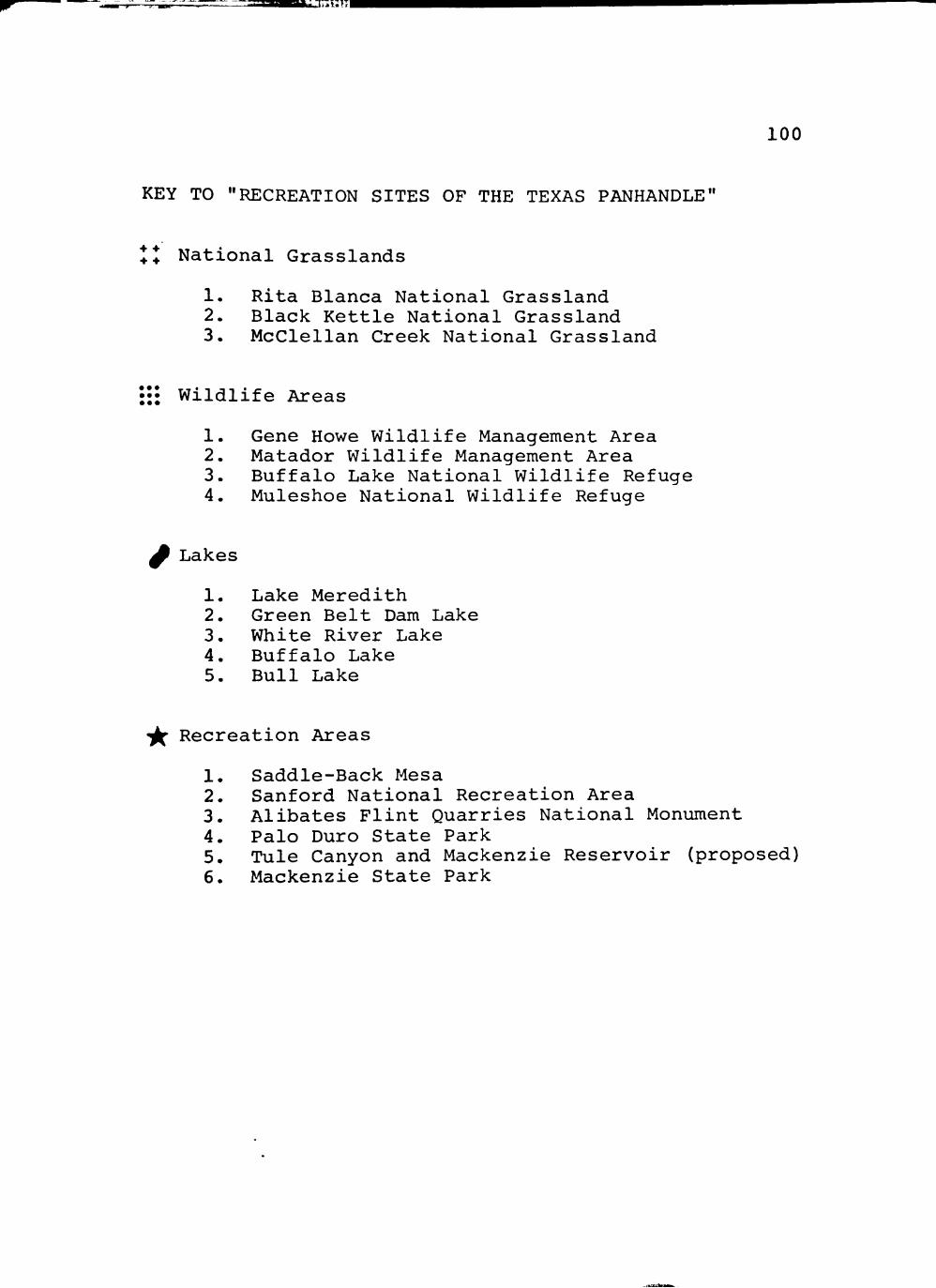
iTiniTi
1 0 0
KEY TO "RECREATION S I T E S OF THE TEXAS PANHANDLE"
•f + •f +
... • •.
National Grasslands
1. Rita Blanca National Grassland 2. Black Kettle National Grassland 3. McClellan Creek National Grassland
Wildlife Areas
1. Gene Howe Wildlife Management Area 2. Matador Wildlife Management Area 3. Buffalo Lake National Wildlife Refuge 4. Muleshoe National Wildlife Refuge
^ Lakes
1. Lake Meredith 2. Green Belt Dam Lake 3. White River Lake 4. Buffalo Lake 5. Bull Lake
•^ Recreation Areas
1. Saddle-Back Mesa 2. Sanford National Recreation Area 3. Alibates Flint Quarries National Monument 4. Palo Duro State Park 5. Tule Canyon and Mackenzie Reservoir (proposed) 6. Mackenzie State Park

101
Tule Canyon. This development should make the canyon-
reservoir complex a potential recreation park of the highest
quality.
Likewise, Palo Duro Canyon State Scenic Park has
become increasingly popular as a recreational attraction.
Between September 1, 1970 and August 3, 1971, Palo Duro
visitors niombered 156,161, and the park ranked fifteenth
140 among 71 Texas State Parks in attendance. The carrying
capacity of Palo Duro Canyon is greater than that of Las
Lenguas. The Las Lenguas area has retained much more of a
wilderness atmosphere than has Palo Duro Canyon, which has
been extensively developed. Development of the Las Lenguas
Canyon locality with an emphasis upon protection of its
wilderness character would assure a completely different
clientel for the two recreation attractions.
In effect, all three sites, Palo Duro Canyon, the
Las Lenguas area, and the Mackenzie-Tule complex, would
complement one another. Each facility would be able to
offer the visitor something different. Therefore, the
emphasis of their recreational attractiveness would be
unique. All types of interests would be accommodated, and
each individual could participate in a variety of activities
It is suggested that these three sites could function as a
140 Texas Parks and Wildlife Department, "State Park
Visitation" (unpublished departmental manuscript).
102
recreational unit of the finest quality. It is further
suggested that a Caprock Trail which could connect the three
components of this recreational unit would serve to solidify
the unit.
Land Ownership
Eighteen land owners possess parcels of land within
the Las Lenguas study area (see Fig. 7). Almost all of the
area is ranchland which is presently being used for the
grazing of cattle. Mr. Jim Stroup owns the only home
located within the study area. He has expressed his desire
that a State Park someday be developed at Las Lenguas.
Several of the other land owners do not share
Mr. Stroup's desire that the Las Lenguas area become a State
Park. They are ranchers who have worked hard to build their
ranches. A part of them is in the land, and they would be
reluctant to sell their property. These ranchers attempt
to regulate the people who enter the area, but vandals and
litter-bugs are slowly and persistently leaving their mark
upon the land. At some point the wilderness character and
quality will be diminished beyond an acceptable level.
However, it would unquestionably be better to leave the Las
Lenguas area in private ownership than to create a park on
141 Jim Stroup, private interview, August, 1971.

>." .',T » V -
103
F igure 7
1 0 0 F o o t C o n t o u r I n t *
Brisco* County
Floyd County S c a l e
1 " : 6 0 0 0 Ft.
N
L A N D O W N E R S H I P M A P
KEY
1 Cornel ius
2 Lomons
3 B r o n n o n
4 Brooks
5 S c o t t
6 B i r d w o l l
7 B i f f l o
8 S o u l
9 H o w a r d
10 W o M a c o
11 Cruse
12 S k a g g s
13 W e l c h
14
15
16
17
18
T a y l o r
R o g e r s
S m i t h
S t r o u p
Blair -Hughes

104
the site without adequate enforcement of strict quality
guidelines for its planning, development, and subsequent
use.
Utilities
Almost all of the necessary utilities for park
development are available within the Las Lenguas study area.
The Stroup ranch house is built on the site of one of the
finest views in the region. Electricity, gas, and well
water are present at the ranch house. Windmills provide
additional water and are located throughout the area.
Sewage is treated by means of a septic tank and solid waste
is burned. These procedures would not be desirable for
State Park usage. The nearest locality offering more
sophisticated utilities is Quitaque, six miles to the east.
Soils
Field research has been completed, but a soil survey
for Briscoe County has not been published. Pertinent data
are available from the Soil Conservation Service.
The topography and soils of the Las Lenguas area are
very closely related (see Figs. 8 and 9). Recreational
limitations which include various hazards for campsites,
paths, trails, picnic areas, and ponds on these soils range
from slight to severe. The most significant limiting

^rnFr^!^A'mJ.t-^ ^-^A Mnkvm \ *^f^'M
105
F igu re 8
N
S e a l * - 1 " ' «000 ' • C o n t o u r i n t o r v a l > 100 Ft.
T O P O G R A P H I C M A P

106
Seal* - r ' :6000 Ft.
4
4 - Pu11m a n 64 - R a n d a l l 54 - Tulia-Estacado 30 - Berda 94 - Q u i n l a n
80 - Rough Broken
45 - Springer-Miles
22 - Yahola
202 - Bukreek
GENERALIZED SOIL MAP
I
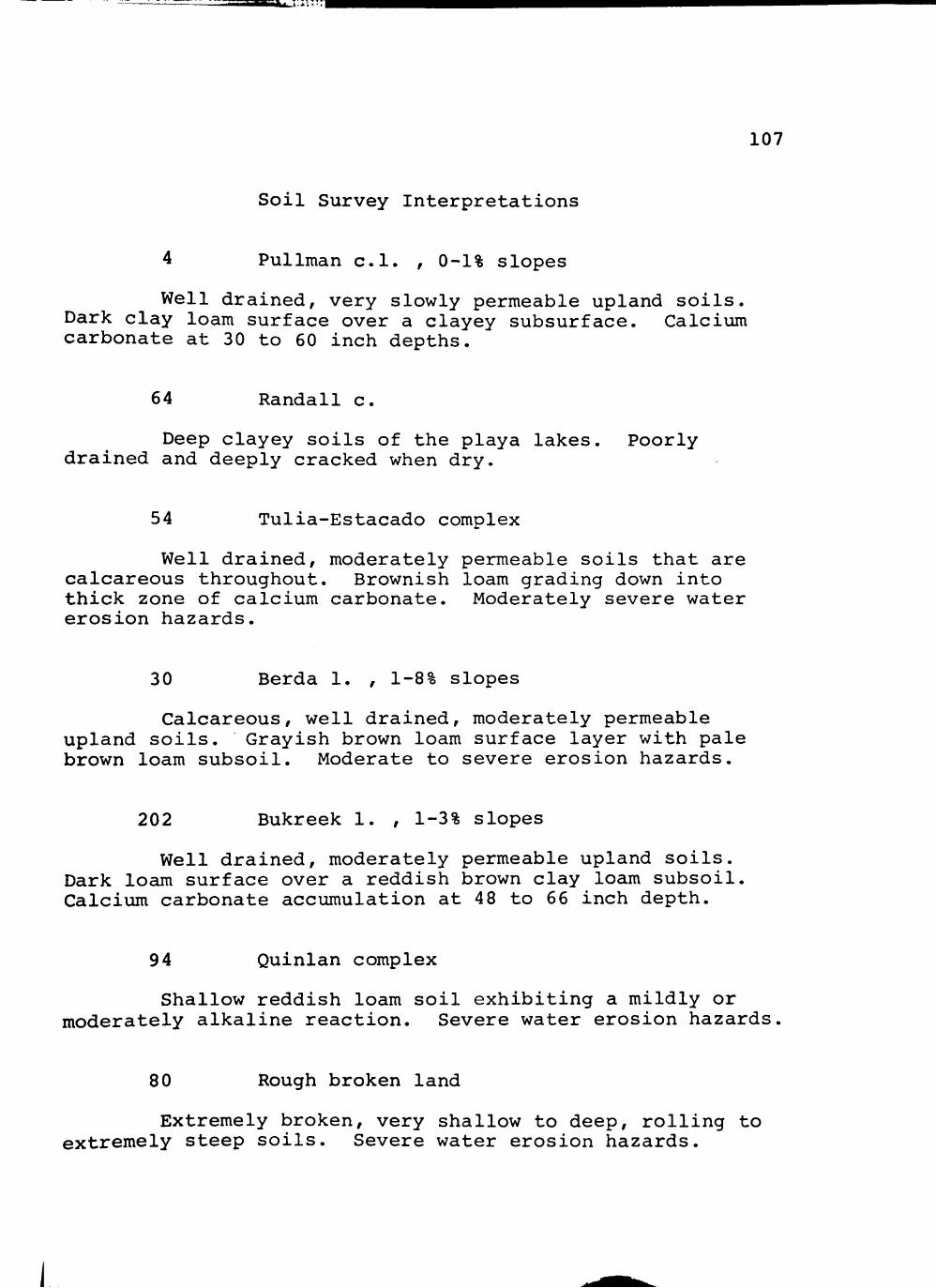
107
Soil Survey Interpretations
Pullman c.l. , 0-1% slopes
Well drained, very slowly permeable upland soils. Dark clay loam surface over a clayey subsurface. Calcium carbonate at 30 to 60 inch depths.
64 Randall c.
Deep clayey soils of the playa lakes. Poorly drained and deeply cracked when dry.
54 Tulia-Estacado complex
Well drained, moderately permeable soils that are calcareous throughout. Brownish loam grading down into thick zone of calcium carbonate. Moderately severe water erosion hazards.
30 Berda 1. , 1-8% slopes
Calcareous, well drained, moderately permeable upland soils. Grayish brown loam surface layer with pale brown loam subsoil. Moderate to severe erosion hazards.
202 Bukreek 1. , 1-3% slopes
Well drained, moderately permeable upland soils. Dark loam surface over a reddish brown clay loam subsoil Calcium carbonate accumulation at 48 to 66 inch depth.
94 Quinlan complex
Shallow reddish loam soil exhibiting a mildly or moderately alkaline reaction. Severe water erosion hazards
80 Rough broken land
Extremely broken, very shallow to deep, rolling to extremely steep soils. Severe water erosion hazards.

108
45 Springer-Miles l.f.s.
Deep, sandy soils with moderately rapid permeability. Severe wind erosion hazard.
22 Yahota f.s.l.
Deep, well drained, fine sandy loam floodplain soils. Moderately rapid to rapid permeability with moder ately alkaline reaction. Calcareous throughout.
Abbreviations:
c.l.—clay loam c.—clay 1.—loam f.s.l.—fine sandy loam l.f.s.—loamy fine sand

109
factors are slope and texture. Also locally important are
permeability, flooding, wetness, and depth of bed rock.
Almost all of the soils exhibit some type of erosion hazard,
with those in the canyon proper and closest to the caprock
escarpment presenting the most extreme problem."
Carrying Capacity
Recreational carrying capacity may be defined as the
character of use that can be supported over a specified time
by an area developed at a certain level without causing
excessive damage to either the physical environment or the
143 experience for the visitor. Thus, soil characteristics
are very important in the determination of carrying capacity
of land. There is no question that soil, as well as topo
graphic and ecological, factors severely limit the recrea
tional capacity of the Las Lenguas area. However, another
facet of recreational carrying capacity is the quality of
the mental response experienced by the person who is par
ticipating in an activity.
142 U.S., Department of Agriculture, Soil Conserva
tion Service, Silverton, Texas (unpublished Briscoe County soil survey materials, December, 1971).
143 David W. Lime and George H. Stankey, "Carrying
Capacity: Maintaining Outdoor Recreation Quality," in Recreation Symposium Proceedings, ed. by E. Larson, U.S.D.A., Forest Service (Upper Darby, Wisconsin, 1971), p. 175.

JU^L:i;-"l
110
Henry Hubbard and Theodora Kimball pursued the same
point when they spoke of the landscape effect of the prai
rie. They state that the vegetation of the prairie will be
preserved at least in small patches. But inevitably man
will break the openness of the prairie landscape, and its
essential character, its boundless extent, will no longer
exist. These authors pose the question as to whether the
owners will ever go so far as to sacrifice large tracts of
prairie land merely for the preservation of the landscape
effect. They conclude, "One thing is certain, at any rate,
not by preserving its flora alone, but only by preserving
144 Its expanse can the spirit of the prairie be preserved."
The spirit and expanse of the prairie are in the mind of the
beholder as well as in the structure of the landscape.
Thus, the human mind and the natural landscape are united
to sense a single spirit, or effect.
At one time Americans were almost totally production
oriented. After the production boom created by World War II
the American public began to seek new outlets and objectives.
A drive for more and better parks resulted. The trend has
continued, and today a significant portion of the public is
144 H.V. Hubbard and Theodora Kimball, An Introduc
tion to the Study of Landscape Design (Boston: Cuneo Press of New England, 1959), p. 65.

JM^nvir-'
111
seeking a wilderness experience in their recreation.
Today in Texas, more total days are spent in hiking, horse
back riding, and bicycling than in all types of hunting
combined. For these and other reasons, the Texas Parks and
Wildlife Department is examining the possibility of limiting
the use of areas which it administers to the physical carry
ing capacity of the land and the psychological carrying
capacity of the visitors.
The Las Lenguas area exhibits a dominant and force
ful wilderness effect. Las Lenguas and its environs should
be developed as a State Wilderness Park if, and only if,
very stringent ecologically based guidelines for development
and operation are formulated, implemented, and rigidly
enforced. Some skepticism has been voiced concerning the
ability of the Las Lenguas area to retain its integrity and
wilderness character under average State Park usage. Sev
eral authorities, such as Dr. Robert L. Packard, professor
of biology and director of research at the West Texas
Museum, Texas Tech University; Dr. B.L. Allen, professor of
agronomy at Texas Tech University; and Dr. Eric G. Bolen,
associate professor of range and wildlife management at
Texas Tech University, have stated that the Las Lenguas
145 Ron Jones, speech presented to the Sierra Club,
Lubbock, Texas, January, 1972. 146
Ron Jones, speech, January, 1972.

112
Canyon area would lose its scientific and wilderness attri-
butes if it were developed as a conventional State Park.
The Las Lenguas area should be developed with the
goal of preserving and enhancing its scientific and wilder
ness attributes. All other uses should be secondary and
entertained only when they do not detract from the primary
management objective. The park, assuming that this goal is
accepted and a wilderness status is conferred, should serve
the growing segment of the public which is seeking a wilder
ness experience.
For this reason, the area should be left in as
nearly natural condition as possible. Entrance should be
restricted to the southeastern corner of the area in the
Rolling Plains zone. This locality exhibits the greatest
carrying capacity to be found in the area. All necessary
control and operational facilities should be developed in
this same general locality. Trails and wilderness camp
sites should be the only developments within the interior
of the park.
It definitely would be in the public's best interest
to preserve the wilderness character of the Las Lenguas
Canyon area. But it must be emphasized that preservation of
the separate characteristics of the area would be much less
147 Dr. Robert L. Packard, Dr. B.L. Allen, and
Dr. Eric G. Bolen, separate private interviews at Texas Tech University, 1971.

113
than preservation of its wilderness spirit. Development of
the area in such a manner as to preserve its wilderness
effect must be the primary goal of the future planning of
Las Lenguas Canyon and its environs.
I I "

'r'HTlBi, l.^in"'''
CHAPTER IX
RECOMMENDATIONS AND CONCEPTUAL PLAN
Recommendations
I. The Las Lenguas Canyon area should be acquired and
developed by the Texas Parks and Wildlife Department
as a Texas State Park. Developmental guidelines
should include the following:
A. The goal of planning in the Las Lenguas area
should be to preserve and enhance the area's
wilderness and scientific attributes.
B. Las Lenguas should be developed as a wilderness
park, with major emphasis being placed upon pre
serving the wilderness spirit and effect of the
area.
C. Acquisition of 22,400 acres of land would be
necessary for preservation of the area's wilder
ness attributes and maintenance of its environ
mental integrity.
D. Use of the Las Lenguas area should be limited to
that which the carrying capacity of the land will
support and to the psychological carrying capacity
of the visitors (see Fig. 10).
114
ij

^^"^rT",'' •' ••A. ..'J'.' •'WtJ' ^g -J : ' iT -" |
1 1 5
KEY N
1 - S * v * r * l y L i m i t * d
2 - M a d * r a t * l y L im i t *d
3 - S l i g h t l y L in i i t *d
100 Foot Contours
S e a l * - r s 6 0 0 0 Ft.
R E C R E A T I O N A L CARRYING CAPACITY

ifff-S" ^ ^ u : " " l
116
E. Management policies should include utilization of
permits or reservations as the situation dictates.
F. The Las Lenguas area should be divided into a
wilderness zone and an intensive use zone.
1. Wilderness zone
Within the wilderness zone the following
developments, uses, and activities should be
prohibited:
a. Removal, cutting, or other alteration of
vegetation except as necessary for appro
priate public access.
b. Development of permanent facilities or any
type of roads.
c. Use of any motorized vehicle except in the
case of emergencies.
d. Granting of leases or easements of any
type.
Within the wilderness zone the following
management policies should be implemented:
a. Travel should be limited to hiking or
horseback riding.
b. Development should be restricted to trails
and wilderness camp sites. Camping should
be limited to designated camp sites.

118
II. The Las Lenguas area should be designed so as to
complement existing recreational attractions in the
Texas Panhandle. Palo Duro Canyon, the Mackenzie
Reservoir-Tule Canyon complex, and the Las Lenguas
area should be developed as a regional recreation-
tourism unit. Palo Duro Canyon currently provides a
scenic and recreational attraction, while the Macken
zie Reservoir-Tule Canyon complex could supply water-
based recreation, and the Las Lenguas area could
provide a unique wilderness experience.
The Texas Parks and Wildlife Department should
investigate the possibility of instituting a Caprock
Trail which would connect the three components of this
Panhandle recreational unit. Such a trail would serve
to solidify the unit and offer additional recreation
opportunities.
III. Alternative methods for preservation of the Las
Lenguas area in descending order of preference are
purchase of the entire area by one of the nation's
conservation organizations and incorporation of the
area into a university system as a scientific research
station. The paramount priority should be preserva
tion and enhancement of the wilderness spirit and
scientific attributes of Las Lenguas Canyon and its
environs.
[

119
IV. The Texas Parks and Wildlife Department should incor
porate a State Wilderness Park category into the
present State Park classification scheme. The Las
Lenguas area should be included within this category.
Recommendations presented in Section I above should
function as guidelines for an official policy state
ment concerning development and management of Texas
State Wilderness Parks.
The Conceptual Plan
The Las Lenguas Canyon area should be developed in
strict accordance with the guidelines previously presented.
Acquisition of 22,400 acres and limitation of the number of
visitors within the area would insure preservation of its
wilderness attributes.
The Stroup ranch house is strategically located upon
one of the most scenic viewpoints within the area. For this
reason, it is appropriate that the ranch house should be
redesigned to function as an interpretive center. Building
a new residence and remodeling the Stroup ranch house would
be more costly than constructing a new interpretive center,
but the value of the strategic viewpoint would be lost.
Imaginative interpretation could enhance signifi
cantly the visitor experience at Las Lenguas. Virtually
all of the interpretation should be restricted to the
[

iiV^IIILI'H
120
immediate vicinity of the interpretive center in order to
preserve the wilderness character of the area. Displays
within the center and a short interpretive trail system
could function effectively to bring the visitor to an under
standing of the park.
Most of the geologic outcroppings are located within
Las Lenguas Canyon and along the escarpment. These forma
tions are too far from the visitor center to allow their
inclusion in an interpretive trail. They would have to be
interpreted by display in and around the center. A scale
model of the park could be effective in presenting the
geologic formations of the area. A sequence of models could
depict the park as it is thought to have existed during
successive geologic periods. The changes of flora and
fauna should be emphasized.
The wilderness character of the area would do much
to aid in its historical interpretation. When the visitor
learns the archeological and historical background of the
park, the wilderness effect of the landscape brings him into
a union with the area's historical heritage. Effective
interpretation is related closely to the production of a
mood or atmosphere. At Las Lenguas the atmosphere of the
wild, nomadic Indian and Comanchero existence is present in
abundance.
[

i^OKSXv-LJi'r'i
121
The bioecology of the Las Lenguas area could be
interpreted in several ways. The crossroads nature of the
biotic community could be depicted in model and display
form. Nature trails would show living examples of the
phenomena presented in the displays. Pictoral presentation
of the flora and fauna of the area would also be effective.
If tastefully developed, a small zoo containing native
animals could be a great visitor attraction. All of the
interpretive devices should lead the visitor to desire a
more intimate understanding of the park. This he could
acquire by actually entering and experiencing the natural
qualities of the Las Lenguas area.
A stable complex is important to the design of the
Las Lenguas locality as a wilderness area. This facility
should provide the necessary horses and equipment to accom
modate all interested visitors. If possible, the stables
should be built by the State of Texas and leased to a con
cessionaire for a specified percentage of his net income
from the enterprise. This procedure would insure the
quality of the stable complex and also protect the conces
sionaire from major losses during the initial relatively
slow years.
A trail system is proposed to accommodate horseback
riders and hikers. The trails interlock and incorporate
wilderness camp sites and scenic attractions into the
":.;jiaU^-v._i:;::" I
122
system. Camp sites were selected on the basis of factors
such as proximity of water, protection from weather, topog
raphy, and wilderness atmosphere. It probably would be
necessary to periodically rotate the selected camp sites in
order to prevent degradation.
The maintenance building for the area need not be
extravagant. Limited upkeep would be necessary in this type
of park. The building should be located near the stables
because of the necessity of storage and transport of wood to
the wilderness camp sites. It would be essential for over
night visitors to camp at the designated wilderness camp
sites. Cutting of firewood should be prohibited.
Another important group of people who could be
expected to visit the Las Lenguas area in fairly large num
bers would be the camper-trailer travelers. It is proposed
that spaces be developed for parking campers and trailers
around Cottonwood Lake. Some of the necessary utilities are
present at the site, and two trailers now are located at the
lake. A small charge for the use of these facilities is
recommended.
For clarification of the preceding developmental
proposals consult Figures 11 and 12.
[

123
•* •. >K< Cottonwood Lake
» • • * *
- ^ C""^ V* ^ UnQ«i»h Foil*
\ U / N o r r o w * • , ^ . • • • > , O -
\ L/^ 7' ^ y ^ C e n t e r
I
I /
.^ ' -^ ^ — I • — -^ 1 irojl - " • . . ^ • • • -' - * » ^
^ n P * l * C a n y o n
/
S e a l * - I " : 6 0 0 0 Ft.
1 • T r a i l *
2 * l n t * r p r * t i V* C * n t * r
3 • S t a b U s
4 - C * t t * n w * o d L a k o
S - C h o c k - O a m l a k o s
6 * P l a y a L a k o t
7 - N o r r * w »
• - L i n g u i t h F a l l f l a k *
9 - C o m a n c h * r * T r a i l
0 / W i l d * r n * f t C o m p S i t * «
''I
CONCEPTUAL PLAN
I

^L ' - i ' " t j ^ v x <• - y ^ 1: -»»»
F i g u r e 12 124
C * t t * n w * * d l o k *
Camp*r-Trai l*r Camp Sit*>
l n t * r p r * t i v * C*nt* r (Ex is t ing R*s id *nc* )
N
N * S e a l *
FACILITY PLAN I N T E N S I V E USE ZONE

s s
BIBLIOGRAPHY

BIBLIOGRAPHY
Public Documents
Cronin, J.G. A Summary of the Occurrence and Development of Ground Water in the Southern High Plains of Texas. Texas Board of Water Engineers—Bulletin 6107. Austin, Texas: Texas Board of Water Engineers, 1961.
Lime, David W., and Stankey, George H. "Carrying Capacity: Maintaining Outdoor Recreation Quality." Recreation Symposium Proceedings. Edited by E. Larson, U.S.D.A., Forest Service. Upper Darby, Wisconsin, 1971.
Malone, James M. Archeological Recon.naissance in the Mackenzie Reservoir Area of Tule Canyon. Austin, Texas: Texas Historical Survey and Texas Water Development Board, 1970.
Office of the Governor. Goals for Texas--Phase Two. Austin, Texas: State of Texas, 1970.
Texas Parks and Wildlife Department. Report of the Department, Annual Report 68-69. Austin, Texas: State of Texas, 1969.
Texas Parks and Wildlife Department. State of Texas Comprehensive Outdoor Recreation Plan (SCORP). Austin, Texas: State of Texas, 1965.
Texas State Parks Board. "Texas State Park Criteria." Park Practice Guideline. A publication of the National Conference on State Parks, National Recreation and Park Association, and the National Park Service. Washington, D.C: Government Printing Office, 1961, pp^ 107-108.
U.S. Department of Commerce. Bureau of Census. 1970 Census of Population--Texas. Washington, D.C: Government Printing Office, January, 1971.
126
i

127
U.S. Department of the Interior. National Park Service. NPS Criteria for Parklands. Washington, D.C: Government Printing Office, 1966.
Parks for America. Washington, D.C: Government Printing Office, 1964.
Books
Allred, B.W. "Mixed Prairie in Texas." Grasslands of the Great Plains. By J.E. Weever and F.W. Albertson. Lincoln, Nebraska: Johnsen Publishing Company, 1956.
Bray, William L. Distribution and Adaptation of the Vegetation of Texas. Bulletin of The University of Texas—No. 82, Scientific Series No. 10. Austin, Texas: The University of Texas, 19 06.
Burton, Harley T. A History of the JA Ranch. New York: Argonaut Press, 1966.
Catlin, George. North American Indians. Philadelphia: Hubbard Brothers, 18 91.
Chaney, Ralph W., and Elias, Maxim K. "Late Tertiary Floras from the High Plains." Contributions to Paleontology-Miocene and Pliocene Floras of Western North America. Washington, D.C: Carnegie Institution of Washington, 1938.
DeShields, James T. Cynthia Ann Parker. St. Louis: By the Author, 188 6.
Dice, Lee R. The Biotic Provinces of North America. Ann Arbor, Michigan: University of Michigan Press, 1953.
Evans, Glen L. "Cenozoic Geology." Guidebook, 1956 Spring Field Trip. Edited by Glen L. Evans and John P. Brand. Lubbock, Texas: West Texas Geological Society and Lubbock Geological Society, 1956.
1

im^ iSdJur^
128
Frye, John C , and Leonard, A. Byron. Correlation of the Ogallala Formation (Neogene) in Western Texas with Type Localities in NebraskaT" Report of Investigations—Number 39, Bureau of Economic Geology, The University of Texas. Austin, Texas: The University of Texas, 1959.
Studies of Cenozoic along Eastern Marain of Texas High Plains, Armstrong to Howard Counties. Report of Investigations—Number 32, Bureau of Economic Geology, The University of Texas. Austin, Texas: The University of Texas, 1957.
Gould, F. Texas Plants—A Checklist and Ecological Summary. College Station, 1969.
Texas: The A & M College of Texas,
Gregg, Josiah. Commerce of the Prairies. Edited by Max L. Moorhead. Norman, Oklahoma: University of Oklahoma Press, 1954.
Haley, J. Evetts. Charles Goodnight: Cowman and Plainsman. Norman, Oklahoma: University of Oklahoma Press, 1949.
The XIT Ranch of Texas. Norman, Oklahoma: University of Oklahoma Press, 1953.
Hesse, Richard. Ecological Animal Geography. Prepared by W.C. Allee and Karl P. Schmidt. New York: John Wiley and Sons, Inc., 1937.
Hubbard, H.V., and Kimball, Theodora. An Introduction to the Study of Landscape Design. Boston: Cuneo Press of New England, 1959.
Jackson, Clyde L., and Jackson, Grace. Quanah Parker: Last Chief of the Comanches. New York: Exposition Press, 1963.
Jones, T.S. "Permian System." Guidebook, 1956 Spring Field Trip. Edited by Glen L. Evans and John P. Brand. Lubbock, Texas: West Texas Geological Society and Lubbock Geological Society, 1956.
Krieger, Alex D. Culture Complexes and Chronology in Northern Texas. The University of Texas Publication No. 4640. Austin, Texas: The University of Texas, October 22, 1946.

129
Kuckler, A.W. Potential Natural Vegetation of the Conterminous United States. New York: American Geo-graphical Society, 1964.
McCarty, John L. Maverick Town—The Story of Old Tascosa. Norman, Oklahoma: University of Oklahoma Press, 1968.
Matthews, William H., III. Guidebook Eight: The Geologic Story of Palo Duro Canyon. Austin, Texas: The Bureau of Economic Geology, The University of Texas at Austin, 1969.
Moncus, H.H. Prairie Schooner Pirates. Fort Worth, Texas: Western Heritage Press, 1963.
Richardson, Rupert N. The Comanche Barrier to South Plains Settlement. Glendale, California: The Arthur H. Clark Company, 1933.
Sellards, E.H. Early Man in America. Austin, Texas: The University of Texas Press, 1952.
Shelford, Victor E. The Ecology of North America. Urbana, Illinois: University of Illinois Press, 1964.
Texas State Parks, E.J. Urbanovsky, project director. Lubbock, Texas: Texas Technological College Press, 1963.
Tharp, Benjamin C Texas Range Grasses. Austin, Texas: University of Texas Press, 1952.
The Vegetation of Texas. Houston, Texas: The Anson Jones Press, 1939.
Thompson, Holland. The Book of Texas. Dallas, Texas: The Colonial Press, 1929.
Wallace, Ernest. Ronald S. Mackenzie on the Texas Frontier Lubbock, Texas: West Texas Museum Association, 1964.
, and Hoebel, E. Adamson. The Comanches--Lords of the South Plains. Norman, Oklahoma: University of Oklahoma Press, 1958.
Wedel, Waldo R. Prehistoric Man on the Great Plains. Norman, Oklahoma: University of Oklahoma Press, 1961.

130
Wendorf, Fred. Paleoecology of the Llano Estacado. Santa Fe, New Mexico: The Museum of New Mexico Press, 1961.
West Texas State University Geological Society. Guidebook Palo Duro Field Trip. Canyon, Texas: West Texas State University Geological Society.
Periodicals
Blair, W. Frank. "The Biotic Provinces of Texas." Texas Journal of Science, II, No. 1 (March 31, 1950) , 93-117.
. "Mammals of the Mesquite Plains Biotic District in Texas and Oklahoma, and Speciation in the Central Grasslands." Texas Journal of Science, VI, No. 3 (September, 1954), 235-264.
Bray, W.L. "Ecological Relationship of the Vegetation of West Texa: Botanical Gazette, XXXII (1901), 195-217, 262-291.
Carpenter, J. Richard. "The Grassland Biome." Ecological Monographs, X, No. 4 (October, 1940), 619-671.
Evans, Phil. "Pursue the Aoudads." Texas Parks and Wildlife, February, 1967, pp. 20-23.
Fouquette, M.J., and Lindsay, H.L., Jr. "An Ecological Survey of Reptiles in Part of Northwestern Texas." Texas Journal of Science, VII, No. 4 (December, 1955), 402-421.
Frye, John C , and Leonard, A. Byron. "Ecological Interpretations of Pliocene and Pleistocene Stratigraphy in the Great Plains Region." American Journal of Science, Vol. 255 (January, 1957), 1-9.
Garner, Herschel W. "An Ecological Study of the Brush Mouse, Peromyscus boylii, in West Texas." Texas Journal~Qf Science"~XIX (1967) , 285-291.
Haley, J. Evetts. "The Comanchero Trade." The Southv/estern Historical Quarterly, XXXVIII (January, 1935) , 158~17T:

EiJu-ia
131
Harrison, Lowell H., ed. "Three Comancheros and a Trader." Panhandle-Plains Historical Review, XXXVIII (1965), 73-93.
Hughes, Jack T. "Little Sunday: An Archaic Site in the Texas Panhandle." Bulletin of the Texas Archeological Society, 1955, pp. 63-70.
Oldfield, Frank, and Schoenwetter, James. "Late Quarternary Environments and Early Man on the Southern High Plains." Antiquity, 1964, pp. 226-229.
Palmer, Ernest J. "The Ligneous Flora of the Staked Plains of Texas." Journal of the Arnold Arboretum, II (1920), 90-IOT;^
Sellards, E.H.; Evans, Glen L.; and Meade, Grayson E. "Fossil Bison and Associated Artifacts from Plain-view, Texas." Bulletin of the Geological Society of America, October, 1947, pp. 927-954.
Tunnell, Curtis D., and Hughes, Jack T. "An Archaic Bison Kill in the Texas Panhandle." Panhandle-Plains Historical Review, 1955, pp. 63-70.
Newspapers
Brown, Luron. "Historic Valley of Tears Jogs Memory of Rancher." Lubbock Avalanche-Journal. Saturday Morning, July 24, 1971, sec. B, pp. 1, 10.
Daily New Mexican. July 20, 1868; July 18, 1870; May 24, 1871.
Kahlbau, Edna. "The Comanchero: Barter on the High Plains III." Amarillo Sunday News and Globe. November 2, 1941, p. 2.
Peattie, Donald Culross. "The Ballad of Cynthia Ann." Denver Post. November 26, 1961, pp. 16-17.
Unpublished Material and Other Sources
Allen, Dr. B.L. Professor of Agronomy at Texas Tech Univer' sity. Private interview at Texas Tech University, 1971.
i

"V'TniTKii L : : " ' I
132
Bolen, Dr. Eric G. Associate Professor of Range and Wildlife Management at Texas Tech University. Private interview at Texas Tech University, 1971.
Green, Francis E. "The Triassic Deposits of Northwestern Texas." Unpublished Ph.D. dissertation, Texas Technological College, 1954.
Hunsaker, Don, III. "The Distribution, Annotated Checklist and Keys for the Reptiles of Northwest Texas." Unpublished M.S. thesis, Texas Technological College, 1957.
Israel, T.C. "The History of Oldham County, Texas." Unpublished M.S. thesis. The University of New Mexico, 1934.
Jones, Ron. Speech presented to the Sierra Club, Lubbock, Texas, January, 1972.
Kiatta, Howard W. "A Provenance Study of the Triassic Deposits of Northwestern Texas." Unpublished M.S. thesis, Texas Technological College, 1960.
Packard, Dr. Robert L. Professor of Biology at Texas Tech University and Director of Research at the V7est Texas Museum. Private interview at Texas Tech University, 1971.
Reeves, C C "Some Geomorphological, Structural, and Stratigraphic Aspects of the Pliocene and Pleistocene Sediments of the Southern High Plains." Unpublished Ph.D. dissertation, Texas Tech University, 1970.
Rowell, Chester M., Jr. "Vascular Plants of the Texas Panhandle and South Plains." Unpublished Ph.D. dissertation, Oklahoma State University, 1967.
Stroup, Jim. Lifelong Quitaque rancher whose birth was the second recorded in Briscoe County. Private interview at his home within the Las Lenguas study area, August, 1971.
Texas Parks and Wildlife Department. "State Park Visitation." Unpublished departmental manuscript.
U.S. Department of Agriculture. Soil Conservation Service, Silverton, Texas. Unpublished Briscoe County soil survey materials, December, 1971.
1


