
TVS Udaya Bhaskar & DMG TeamRegional Training for Capacity Development in Multi-Hazard Early
Warning Systems22 September 2016
TVS Udaya Bhaskar & DMG TeamRegional Training for Capacity Development in Multi-Hazard Early
Warning Systems22 September 2016

Outline Brief about DMG, INCOIS. Types of data: In-situ. Remote sensing. Model outputs.
Availability periods and formats. Methods of dissemination Web sites, urls and offline methods.
Brief about DMG, INCOIS. Types of data: In-situ. Remote sensing. Model outputs.
Availability periods and formats. Methods of dissemination Web sites, urls and offline methods.
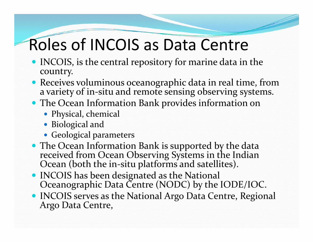
Roles of INCOIS as Data Centre INCOIS, is the central repository for marine data in the
country. Receives voluminous oceanographic data in real time, from
a variety of in-situ and remote sensing observing systems. The Ocean Information Bank provides information on Physical, chemical Biological and Geological parameters
The Ocean Information Bank is supported by the datareceived from Ocean Observing Systems in the IndianOcean (both the in-situ platforms and satellites). INCOIS has been designated as the National
Oceanographic Data Centre (NODC) by the IODE/IOC. INCOIS serves as the National Argo Data Centre, Regional
Argo Data Centre,
INCOIS, is the central repository for marine data in thecountry. Receives voluminous oceanographic data in real time, from
a variety of in-situ and remote sensing observing systems. The Ocean Information Bank provides information on Physical, chemical Biological and Geological parameters
The Ocean Information Bank is supported by the datareceived from Ocean Observing Systems in the IndianOcean (both the in-situ platforms and satellites). INCOIS has been designated as the National
Oceanographic Data Centre (NODC) by the IODE/IOC. INCOIS serves as the National Argo Data Centre, Regional
Argo Data Centre,

In-situ Data Flow : End-to-End System
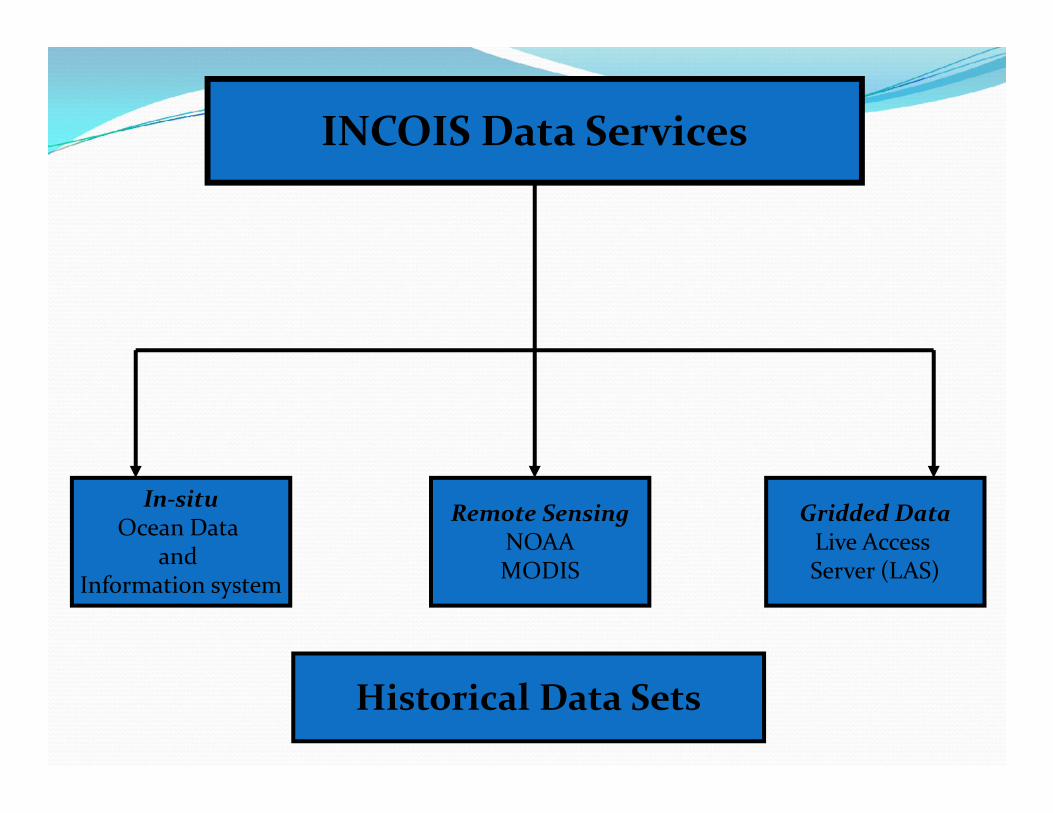
INCOIS Data Services
In-situOcean Data
andInformation system
Remote SensingNOAAMODIS
Gridded DataLive AccessServer (LAS)
Historical Data Sets
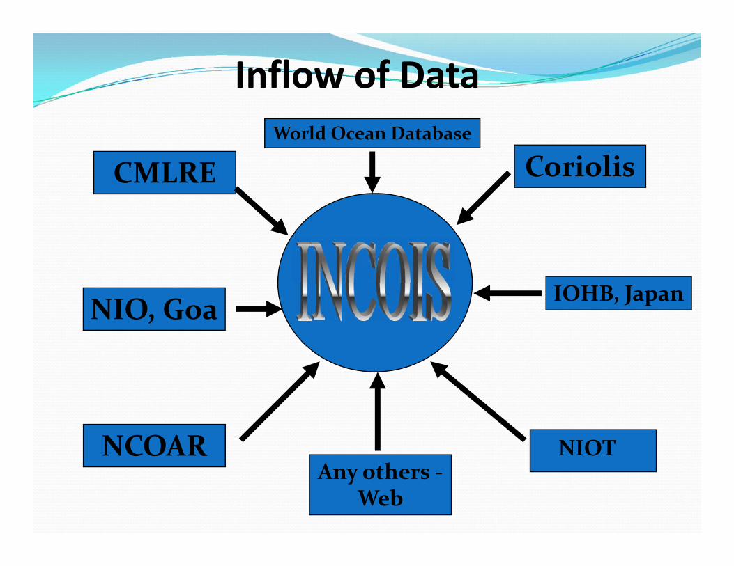
CMLRE
NIO, Goa
Coriolis
IOHB, Japan
Inflow of DataWorld Ocean Database
NIO, Goa
NCOAR
IOHB, Japan
NIOTAny others -
Web

In situ data sets in situ data sets include: Sub-surface observations Conductivity, Temperature and Depth (CTD) Expendable Bathy Thermographs (XBT) Expendable Conductivity, Temperature and Depth (XCTD)
Surface alone observations Sea Surface Temperature. Air Temperature. Sea Surface Salinity. Wind speed. Currents etc.
in situ data sets include: Sub-surface observations Conductivity, Temperature and Depth (CTD) Expendable Bathy Thermographs (XBT) Expendable Conductivity, Temperature and Depth (XCTD)
Surface alone observations Sea Surface Temperature. Air Temperature. Sea Surface Salinity. Wind speed. Currents etc.

XBT CTD Argo FloatXCTD
Tsunami Buoy
SATELLITE
NIOT/INCOIS
BPR
AcousticTransducers
Antenna
Tsunami Buoy
SATELLITE
NIOT/INCOIS
BPR
AcousticTransducers
Antenna
Sagar Kanya Sagar SampadaSagar Nidhi
Tsunami Buoy
SATELLITE
NIOT/INCOIS
BPR
AcousticTransducers
Antenna
Tsunami Buoy
SATELLITE
NIOT/INCOIS
BPR
AcousticTransducers
Antenna

Quality Control Procedures Every data is passed through prescribed Quality
Control procedures. At INCOIS two types of QC procedures are followed.
They are: Real Time Quality Control. Delayed Mode Quality control.
Apart from these OA based QC, Visual QC, Clusterbased QC and Polygon based QC is followed. GUI are developed for performing these QC
procedures.
Every data is passed through prescribed QualityControl procedures. At INCOIS two types of QC procedures are followed.
They are: Real Time Quality Control. Delayed Mode Quality control.
Apart from these OA based QC, Visual QC, Clusterbased QC and Polygon based QC is followed. GUI are developed for performing these QC
procedures.

Three way Quality Control of subsurface data atINCOIS
Automatic QC – passedthrough 18 QC checks
QC based onObjective Analysis
Visual Quality Control
Data Base

In situ database of INCOIS At INCOIS data from the following are archived: Argo (INCOIS operates the program) CTD (Project specific and funded by MoES is archived) XBT & XCTD (NIO operates and data is archived) OMNI buoys (NIOT operates and data is archived). Temperature and salinity profiles (0 – 2000+ meters)
Coastal ADCPs (NIO operates and data is archived). Equatorial Current Meter moorings (NIO operates and
data is archived). Sub-surface current profiles
Surface Drifter buoys (NIO operates and data isarchived). Surface currents combining all data.
At INCOIS data from the following are archived: Argo (INCOIS operates the program) CTD (Project specific and funded by MoES is archived) XBT & XCTD (NIO operates and data is archived) OMNI buoys (NIOT operates and data is archived). Temperature and salinity profiles (0 – 2000+ meters)
Coastal ADCPs (NIO operates and data is archived). Equatorial Current Meter moorings (NIO operates and
data is archived). Sub-surface current profiles
Surface Drifter buoys (NIO operates and data isarchived). Surface currents combining all data.

The following in situ data is archived at INCOISSNo Platform Availability Period / Data Access
1. Argo Jan 2001 – Till date / (Free)
2. Current meter Array 2000 – 2009 / (Free)
3. XBT Surveys 1990 – Till date / (Restricted)
4. Moored Buoys 1997 – Till date / (up on payment)
5. AWS 2009 – Till date / (Restricted)
6. Drifting Buoys 1990 – Till date / (Free)
7. RAMA Buoys 2010 – Till date / (Free)7. RAMA Buoys 2010 – Till date / (Free)
8. Wave Rider Buoys 2007 – Till date / (up on payment)
9. HF Radar (Coastal currents) 2009 – Till date / (Free. Registration required)
10. Tide Guage 1880 – 2007 / (Restricted)
11. BPR data 2006 – Till date / (Restricted)
12. XCTD 2009 – Till date / (Restricted)
13. Ship borne CTD 1976 – 2010 / Free. EEZ restriction applies.
14. Wave Height Meter 2010 – Till date / (Free)
15. COMAPS 1991 – Till date

Argo data base INCOIS Argo program started in 2002 and till now 396
floats are deployed. Total 133 floats are active. In total ~800 floats are active in the Indian Ocean. A total of ~2,50,000 temperature and salinty profile are
archived at INCOIS. All these are passed through RT and DM quality
control procedures. Valued added products are generated after that using
OA and Variational Analysis procedures.
INCOIS Argo program started in 2002 and till now 396floats are deployed. Total 133 floats are active. In total ~800 floats are active in the Indian Ocean. A total of ~2,50,000 temperature and salinty profile are
archived at INCOIS. All these are passed through RT and DM quality
control procedures. Valued added products are generated after that using
OA and Variational Analysis procedures.

Journey
Improved CTD type floats+ floats with DO sensors and NST sensors
Bio-Argo floats withChla, Backscattering
Now
In between
Future
Floats with additionalBio-sensors, Deep Argo
Indigenization efforts successful
2006
2013
2014
Basic CTD type floats
In between
2002
2006

Argo profile Data Products
Temperature, Salinity and GeostrophicCurrents (0, 75, 100, 200, 500, 100 Mdepths)
Heat Content up to 300 M Mixed Layer Depth, Isothermal Layer
Depth Depth of 20° and 26° Isotherms Dynamic Height Sea Surface Height Anomaly
Monthly Gridded Data Products
Temperature, Salinity and GeostrophicCurrents (0, 75, 100, 200, 500, 100 Mdepths)
Heat Content up to 300 M Mixed Layer Depth, Isothermal Layer
Depth Depth of 20° and 26° Isotherms Dynamic Height Sea Surface Height Anomaly
Water Plot of Temperature Water Plot of Salinity Temp Vs Sal Plot Time Series Surface Temperature Time Series Bottom Pressure Time Series Surface Salinity Time Series Surface Pressure Float Trajectory
Float-wise Plots
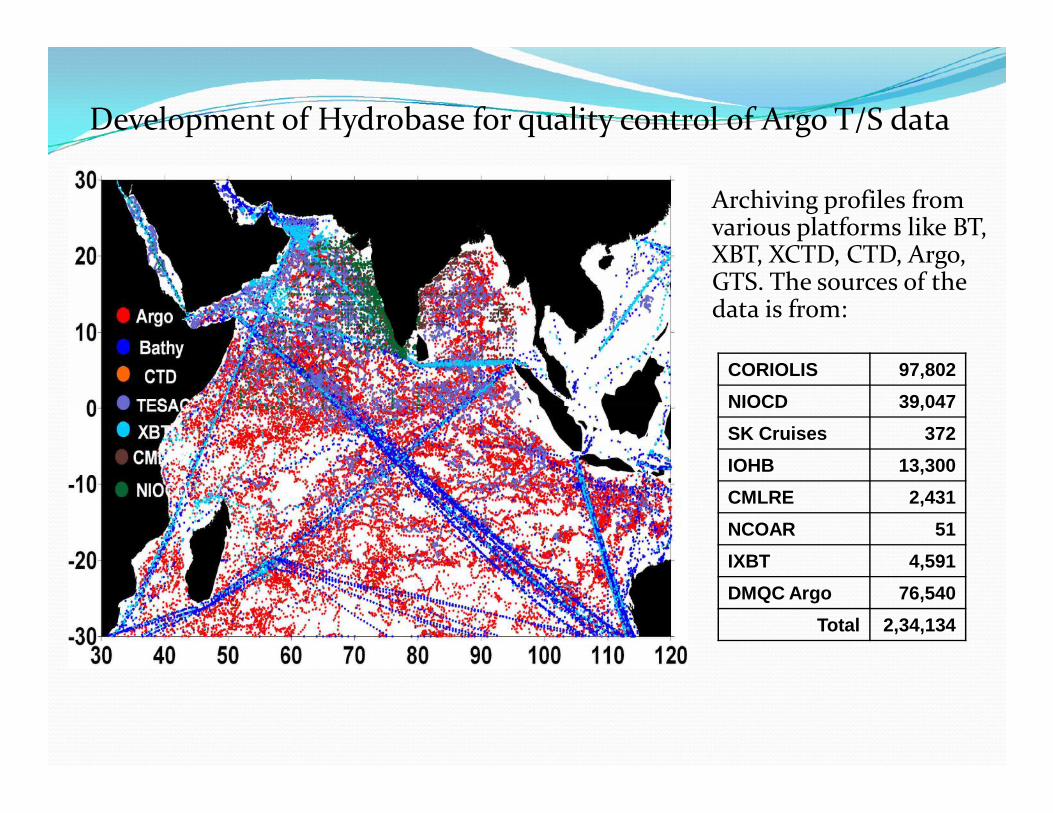
Archiving profiles fromvarious platforms like BT,XBT, XCTD, CTD, Argo,GTS. The sources of thedata is from:
Development of Hydrobase for quality control of Argo T/S data
CORIOLIS 97,802NIOCD 39,047NIOCD 39,047SK Cruises 372IOHB 13,300CMLRE 2,431NCOAR 51IXBT 4,591DMQC Argo 76,540
Total 2,34,134

XBT/XCTD Total 46158 profiles data is archived. CSIRO QC manual is used for
quality control.
AWS Data Data from 34 AWS installed on ships
is archived. LOCI algorithm is used for QC of all
parameters obtained.
Drifting Buoys
Data from 34 AWS installed on shipsis archived.
LOCI algorithm is used for QC of allparameters obtained.
Total 33 buoys reported data between(July 2010 – till date) of which 10 arecurrently actively giving data.
Hansen & Pauline technique is usedfor QC of data (Ref: NIO Tech Report)

Moored Buoys Currently 12 buoys are actively
giving data. Data is quality controlled in
RT and in Dealyed mode. COADS climatology is used for
Visual Quality Control inDelayed Mode quality.
Currently 12 buoys are activelygiving data. Data is quality controlled in
RT and in Dealyed mode. COADS climatology is used for
Visual Quality Control inDelayed Mode quality.

Tsunami Buoy NetworkTsunami Buoy Network Indian Tsunami Buoys Network Real-time Network of 7 Tsunami
Buoy systems Six systems are operational, (two
SAIC Tsunami Buoys and fourIndigenous Tsunami Buoys ofNIOT)
Procurement of Four additionalTsunami Buoy systems fromSAIC is in progress
Five tsunami buoys (STB01,STB02, ITB05 , ITB06, ITB12)data sharing to NDBC/NOAA
Indian Tsunami Buoys Network Real-time Network of 7 Tsunami
Buoy systems Six systems are operational, (two
SAIC Tsunami Buoys and fourIndigenous Tsunami Buoys ofNIOT)
Procurement of Four additionalTsunami Buoy systems fromSAIC is in progress
Five tsunami buoys (STB01,STB02, ITB05 , ITB06, ITB12)data sharing to NDBC/NOAA
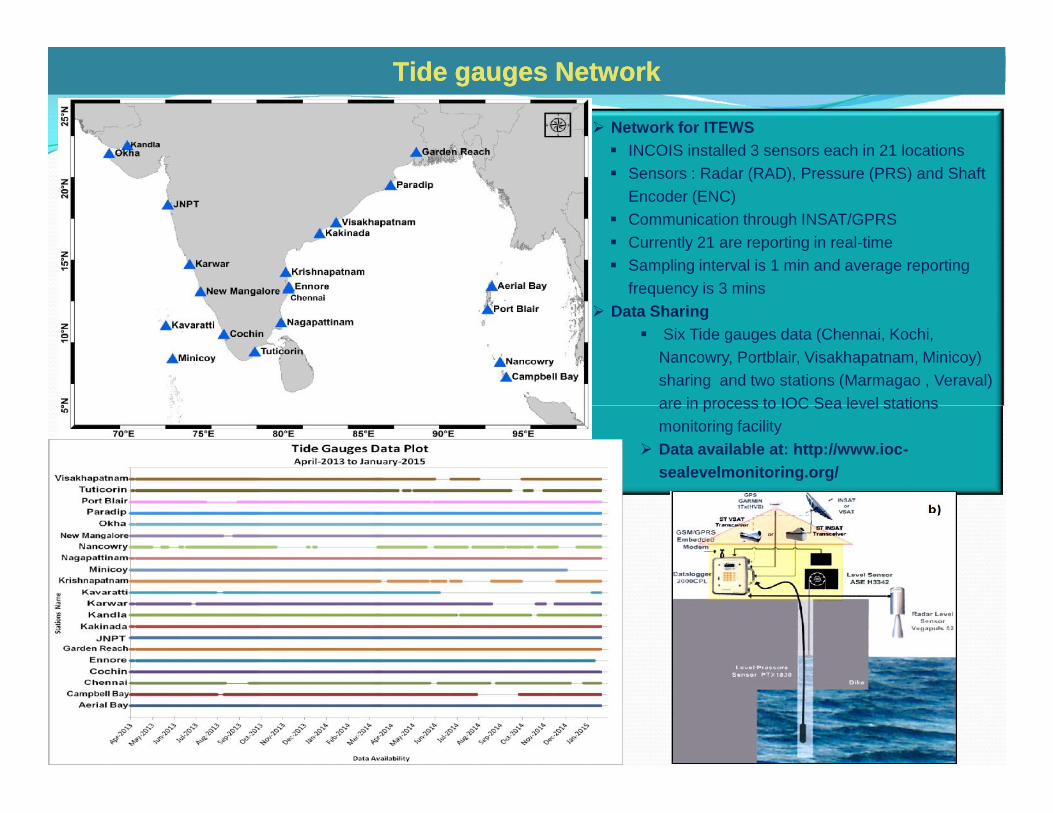
Network for ITEWS INCOIS installed 3 sensors each in 21 locations Sensors : Radar (RAD), Pressure (PRS) and Shaft
Encoder (ENC) Communication through INSAT/GPRS Currently 21 are reporting in real-time Sampling interval is 1 min and average reporting
frequency is 3 mins Data Sharing
Six Tide gauges data (Chennai, Kochi,Nancowry, Portblair, Visakhapatnam, Minicoy)sharing and two stations (Marmagao , Veraval)are in process to IOC Sea level stationsmonitoring facility
Data available at: http://www.ioc-sealevelmonitoring.org/
Tide gauges NetworkTide gauges Network
Network for ITEWS INCOIS installed 3 sensors each in 21 locations Sensors : Radar (RAD), Pressure (PRS) and Shaft
Encoder (ENC) Communication through INSAT/GPRS Currently 21 are reporting in real-time Sampling interval is 1 min and average reporting
frequency is 3 mins Data Sharing
Six Tide gauges data (Chennai, Kochi,Nancowry, Portblair, Visakhapatnam, Minicoy)sharing and two stations (Marmagao , Veraval)are in process to IOC Sea level stationsmonitoring facility
Data available at: http://www.ioc-sealevelmonitoring.org/
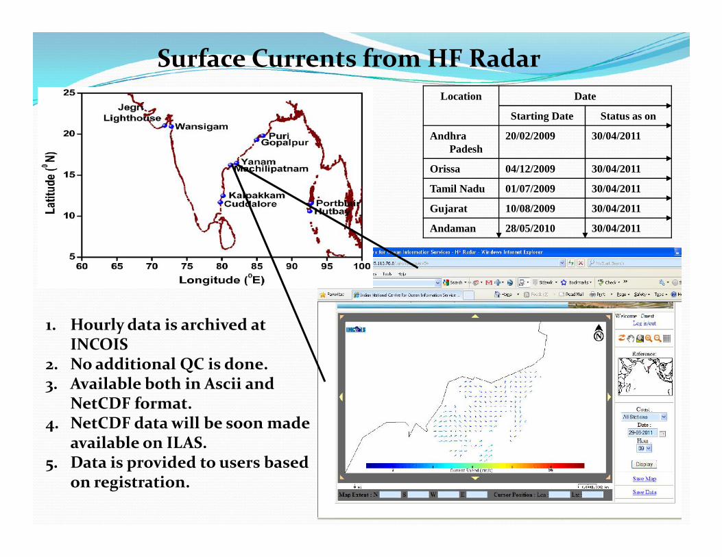
Location Date
Starting Date Status as on
AndhraPadesh
20/02/2009 30/04/2011
Orissa 04/12/2009 30/04/2011
Tamil Nadu 01/07/2009 30/04/2011
Gujarat 10/08/2009 30/04/2011
Andaman 28/05/2010 30/04/2011
Surface Currents from HF Radar
1. Hourly data is archived atINCOIS
2. No additional QC is done.3. Available both in Ascii and
NetCDF format.4. NetCDF data will be soon made
available on ILAS.5. Data is provided to users based
on registration.

INCOIS Ground Station•Chlorophyll, TSM(Oceansat-2)•SST(NOAA-18/19, MetOp-A/B)
JPL -PO.DAAC•SST(OSTIA GHRSST)
INCOIS-OSF Lab•Wind/Current Vectors•MLD, D20•High Wind-wave
INCOIS-PFZ Lab•Potential Fishing Zones•Bathymetry•Landing Centers•Coastal Districts•EEZ boundaries•Fishing-RestrictionZones
PFZ Maps
Indian Marine Fishery Advisory System
•Landing Center (LC)•Direction (withangle)•Distance from LC•Bathymetry•Position (Lat/Long)
PFZ Text
Inputs & Processing Products Information Dissemination
For T
una-
PFZ
Adv
isor
iesINCOIS-ChloroGIN
Chlorophyll, Kd490[Daily & 3d roll](MODIS-Aqua)
Direct
Fax
Phone
Web-GIS
Mass-comm.JPL -PO.DAAC•SST(OSTIA GHRSST)
INCOIS-OSF Lab•Wind/Current Vectors•MLD, D20•High Wind-wave
Web-textEDBs
DEALUniversity projects
SMS/Mobile-Apps
NGOs
IVRS/Helpline
Community Radio
TV/Radio
Newspapers
ENVI,ArcMap,ERDASImagine

New Smart Maps using Arc-GIS New PFZ text with multi-lingual
PFZ Map with Wind and PFZ TextPFZ Map with Wind and PFZ Text
Potential Fishing Zone (PFZ) Advisory Maps withinformation on
Potential Fishing Zones Surface Currents
Bathymetry Major Fishing Villages
Indian Coastline Coastal Districts
Restricted Zones forFishing
Indian EEZ
Developed an Arc GIS Model forautomatic generation of PFZ Textinformation

• Metadata of the ship observations taken fromWMO Pub 42
• Call sign of each record is searched in themetadata of current year, if not found thensearched in the following two years and thenfor the previous year
• Metadata regarding height and method ofmeasurement, type of ship, etc. are extracted
Marine Meteorological Atlas• Data from 1961 – 2012 available.• Number of records in IMD data are
59,80,775.• Number of unique records in IMD data
compared to ICOADS is 7,03,994• Percentage of unique data 11.8%.• No duplicates between NODPAC and IMD
data

Remote sensing data setsRemote sensing data sets

Real-time satellite data acquisition, processing & dissemination systemReal-time satellite data acquisition, processing & dissemination system
INCOIS established two ground stations to serve real-time Ocean advisory services.
NOAA/MeTop (AVHRR)&
TERRA/AQUA (MODiS)Data reception system
Oceansat-2 (Ocean colour monitor)Data Reception system
Data processing facility
Coverage area- 2800 Km radius
NOAA-18, NOAA-19, MetOp-A & MetOp-B
• AVHRR (Advanced Very High Resolution Radiometer) – imager
• ATOVS (Advanced TIROS Operational Vertical Sounder)
• ADCS (ARGOS Data Collection System)
TERRA/AQUA
•MODIS
Oceansat-2
•Ocean colour monitor (OCM)(360 m, 1 Km from NRSC)

Product Name Algorithm used Available Formats
FCC/RGBRed=b2
Green=b1Blue=b1
Jpg
Visible bands(Radiance/Reflectance) Band-1,2
Jpg, GeoTiff, NetCDF, HDF
Brightness temp’s Band-3,4,5Jpg, GeoTiff, NetCDF, HDF
1.MCSST (MClain etal, 1985)2.Bernstein, 1982 (Ch’s 3 & 4-Night)3.Tri-Window (Ch’s 3, 4 & 5)
NOAA-AVHRR Data products
SST’s
1.MCSST (MClain etal, 1985)2.Bernstein, 1982 (Ch’s 3 & 4-Night)3.Tri-Window (Ch’s 3, 4 & 5) Jpg, GeoTiff, NetCDF, HDF
FOGHunt, G.E (1973), Radiative Properties ofTerrestrial Clouds at Visible & InfraredThermal Window Wavelengths, Quart. J.Roy. Meteor. Soc. 99, 346-369.
Jpg, GeoTiff, NetCDF, HDF
Cloud classification (Clear,Sun_glint, Low, High &
Part)
An improved method for detecting clear skyand cloudy radiances from AVHRR data,“R.W.Saunders and K.T.Kriebel, Int.Journalof Remote Sensing, 1988, Vol.9, No.1,PP.123-150.
Jpg, GeoTiff, NetCDF, HDF
NDVI IR-R/IR+RJpg, GeoTiff, NetCDF, HDF

AVHRR Operational composite data products generated at INCOIS Ground Station
FCC Inverse TIR Cloud top Temp
Day/Night Fog Day/Night SST NDVI
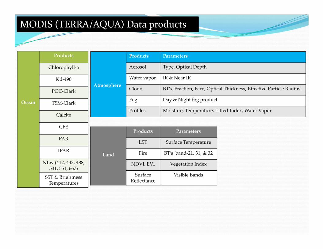
MODIS (TERRA/AQUA) Data products
Ocean
Products
Chlorophyll-a
Kd-490
POC-Clark
TSM-Clark
Calcite
CFE
Atmosphere
Products Parameters
Aerosol Type, Optical Depth
Water vapor IR & Near IR
Cloud BT’s, Fraction, Face, Optical Thickness, Effective Particle Radius
Fog Day & Night fog product
Profiles Moisture, Temperature, Lifted Index, Water Vapor
CFE
PAR
IPAR
NLw (412, 443, 488,531, 551, 667)
SST & BrightnessTemperatures
Land
Products Parameters
LST Surface Temperature
Fire BT’s band-21, 31, & 32
NDVI, EVI Vegetation Index
SurfaceReflectance
Visible Bands

MODIS Operational data products generated at INCOIS Ground Station
AOD Chlorophyll-a Kd-490
CFE IPAR EVI/NDVI

Oceansat-2, Ocean Colour Monitor (OCM)Oceansat-2, Ocean Colour Monitor (OCM)
Swath : 1420 kmIFOV : 360x236 mReceptivity : 2 daysNo. of Bands : 8
Band-1 : 402 – 422 nmBand-2 : 433 – 453 nmBand-3 : 480 – 500 nmBand-4 : 500 – 520 nmBand-5 : 545 – 565 nmBand-6 : 610 – 630 nmBand-7 : 725 – 755 nmBand-8 : 845 – 885 nm
Band-1 : 402 – 422 nmBand-2 : 433 – 453 nmBand-3 : 480 – 500 nmBand-4 : 500 – 520 nmBand-5 : 545 – 565 nmBand-6 : 610 – 630 nmBand-7 : 725 – 755 nmBand-8 : 845 – 885 nm
Quantization : 12SNR : > 512Data rate : 21.226 Mbps

PATH-11
PATH-9PATH-8
PATH-10
Oceansat-2 OCM path coverage's

Oceansat-2 Ocean ColourMonitor (OCM) data products
Aerosol Optical Depth Chlorophyll-a
Suspended matter Diffused attenuation coefficient

Model outputs Outputs from Ocean General Circulation Models
archived at INCOIS are: GODAS Modula Ocean Model outputs Regional Ocean Model outputs. HYCOM Wave models like: WWIII Mike SWAN
Outputs from Ocean General Circulation Modelsarchived at INCOIS are: GODAS Modula Ocean Model outputs Regional Ocean Model outputs. HYCOM Wave models like: WWIII Mike SWAN

Methods of dissemination INCOIS web portal www.incois.gov.in www.odis.incois.gov.in
INCOIS Live Access Server www.las.incois.gov.in
Off line productsDVDs with GIS capabilities
Service through FTP
INCOIS web portal www.incois.gov.in www.odis.incois.gov.in
INCOIS Live Access Server www.las.incois.gov.in
Off line productsDVDs with GIS capabilities
Service through FTP

IINCOIS web portal

ODIS web portal

INCOIS Live Access Server

Argo DVD Versions 1& 2.0
DVD Version 1.0, Feb’2009 DVD Version 2.0 – Apr’2010
Argo Data and Data Products for the IndianOcean (Version 1.0, Feb’2009, Version 2.0 – Jan2011) T-S Profiles (~1,40,000)
Period: 2002- Till date
Gridded Data Products (plots)
ASCII & netCDF Formats
GUI for easy navigation, browsing, dataextraction with user defined spatial andtemporal domains
Software for viewing the NetCDF files
DVD Version 1.0, Feb’2009 DVD Version 2.0 – Apr’2010


