UPDATES OF ISPRS ACTIVITIES FOR SDGSUN-GGIM, JOINT SIDE EVENT, NEW YORK, USA, AUGUST 5, 2019
Songnian Li
Ryerson University, Canada

2
• ISPRS is an international NGO with a focus on:• science and development
• in photogrammetry, remote sensing, spatial information
• cooperation between all relevant stakeholders• academia, private industry, government, end users
• truly global cooperation• education, technology transfer, capacity building
• Scientific Initiatives (SI)• Educational & Capacity Building Initiatives (ECBI)
ABOUT ISPRS

3
• … to advance the photogrammetry, remote sensing and spatial information sciences through international cooperation in research, development and education for the benefit of society and for environmental sustainability.
(from ISPRS Strategic Plan 2010)
ISPRS MISSION: WHY WE EXIST

4
• … to be the foremost scientific society in its field and for the Society at large,
• to speak for all people working in the field,• to provide the necessary resources to develop the field.
(from ISPRS Strategic Plan 2010)
ISPRS VISION: WHERE WE WANT TO GO

ISPRS MEMBERS
5
In addition to over 80 regional, associate and sustaining members, as well as individual members.

ISRPS STRUCTURE (2016 – 2020)
6

ISPRS COMMISSIONS, WGS AND GENERAL MEETING SCHEDULE
7
• ISPRS Congress for all in „Summer Olympic years” (2000 – 3000 participants)
• ISPRS Geospatial Week in odd years• approx. 500 - 700 participants
• One Symposium per Commission in “Soccer World Cup Years” (approx. 300 - 500 participants each)
•• Smaller Workshops, organized by WGs
• Each Commission is responsible for approx.
• 10 working groups (approx. 60 in total)
• WGs cover dedicated topics– “this is where the actual work is done”, e. g.
• benchmark tests• common theoretical and experimental
investigations• editing of special journal issues• organisation of focussed workshops, tutorials,
seminars
• Inter-commission WGs ensure collaboration
• New WG setup every 4 years
2016 2017 2018 2019 2020
Congress Prague GSW Wuhan Symposia GSW
EnschedeCongress
Nice

8
ISPRS Congress 2020Nice, France
Imaging today, foreseeing tomorrow
June 14 – 20, 2020www.isprs2020-nice.com

PAST ACTIVITIES
9
• 2017 Scientific Initiatives• An ISPRS contribution to Transforming our World:
Integration of GlobeLand30 with additional geospatial and socio-economic data for monitoring United Nation Sustainable Development Goals
• 2018 Educational and Capacity Building Initiatives
• Capacity Building for High-Resolution Land Cover Inter-comparison and Validation
• ISPRS encourages community participation on all projects, preferably with the involvement of multi-national investigators.
(Delivered two hands-on workshops)
globeland30 knowledge atlas

10
• Theme Section on UN Sustainable Development Goals (SDG) in ISPRS Journal for Photogrammetry and Remote Sensing• edited by John Trinder, Sisi Zlatanova and Jie Jiang; published in August 2018 (Vol. 142)
• Special Issue on "Measuring and Monitoring Progress towards SDGs by Integrating Geospatial and Statistical Information“ in ISPRS International Journal of Geo-Information
• edited by Jun Chen, Songnian Li, Yifang Ban; ongoing
• ISPRS Workshop on Collaborative and Dynamic Land Cover Information Services Supporting UN Sustainable Development Goals, Jinan, China, 16 September 2017
PAST ACTIVITIES CONT.
11
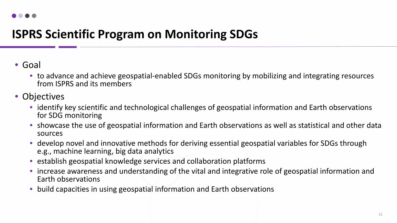
• Goal• to advance and achieve geospatial-enabled SDGs monitoring by mobilizing and integrating resources
from ISPRS and its members
• Objectives• identify key scientific and technological challenges of geospatial information and Earth observations
for SDG monitoring• showcase the use of geospatial information and Earth observations as well as statistical and other data
sources• develop novel and innovative methods for deriving essential geospatial variables for SDGs through
e.g., machine learning, big data analytics• establish geospatial knowledge services and collaboration platforms• increase awareness and understanding of the vital and integrative role of geospatial information and
Earth observations• build capacities in using geospatial information and Earth observations
ISPRS Scientific Program on Monitoring SDGs

ISPRS SCIENTIFIC PROGRAM ON MONITORING SDGS CONT.
12
Work closely with its members and partners
Areas its over 60 Working Groups can contribute

ISPRS SCIENTIFIC PROGRAM ON MONITORING SDGS CONT.
13
End hunger, achieve food security and improved nutrition and promote sustainable agriculture, e.g.: 2.3.1 Volume of production per labour unit by classes of
farming/pastoral/forestry enterprise size
2.4.1 Proportion of agricultural area under productive and sustainable agriculture
ISPRS WG III/10: Agriculture and Natural Ecosystems Modelling and Monitoring
Development of new methodologies and algorithms for improving the contribution of remote sensing towards knowledges related to agriculture and natural ecosystems
Apply remote sensing for supporting precision agriculture by spectral signature in crops for smart farm management
Support climate change studies through remote sensing applications for global and regional scales dynamics monitoring and modelling
Collaborate with related academia, researchers, industry and other stakeholders

ISPRS SCIENTIFIC PROGRAM ON MONITORING SDGS CONT.
14
Protect, restore and promote sustainable use of terrestrial ecosystems, sustainably manage forests, combat desertification, and halt and reverse land degradation and halt biodiversity loss, e.g.:
15.1.1 Forest area as a proportion of total land area
15.1.2 Proportion of important sites for terrestrial and freshwater biodiversity that are covered by protected areas, by ecosystem type
15.3.1 Proportion of land that is degraded over total land area
15.4.2 Mountain Green Cover Index
ISPRS WG III/7 – Land-use and Land-cover Change Detection
Develop algorithms and methodologies for land-use and land-cover change detection
Suggest advanced solutions for monitoring land –cover changes
Study the dynamics of land-use and land-cover change in different regions of the world
To further the research and investigations into predicting land-use changes
To study urban land-use development cycles and changes in rural land-cover and land-use (e.g., Agriculture, forestry, recreation), based on data and information fusion

ISPRS SCIENTIFIC PROGRAM ON MONITORING SDGS CONT.
15
• Opportunities and challenges of GI4SDGs• SDGs monitoring examples with geospatial perspective• Definition and modeling of geospatial essential variables
for SDGs monitoring• Innovative approaches for representing spatial
information in support to sustainable development• Algorithms and methods for deriving geospatial essential
variables, e.g. machine learning, big data analytics, cloud computing and other technologies
• Global mapping initiatives and progresses at national and international levels
• Integrating crowdsourced data and VGI with geospatial data
• Developments and applications of geospatial knowledge service and collaborative platforms to meet SDGs assessment and monitoring
• Other related topics(http://www.geoinfobar.com/gi4sdgs/)
MODELS/METHODS FOR GEOSPATIAL-ENABLED SDGS MONITORING
16
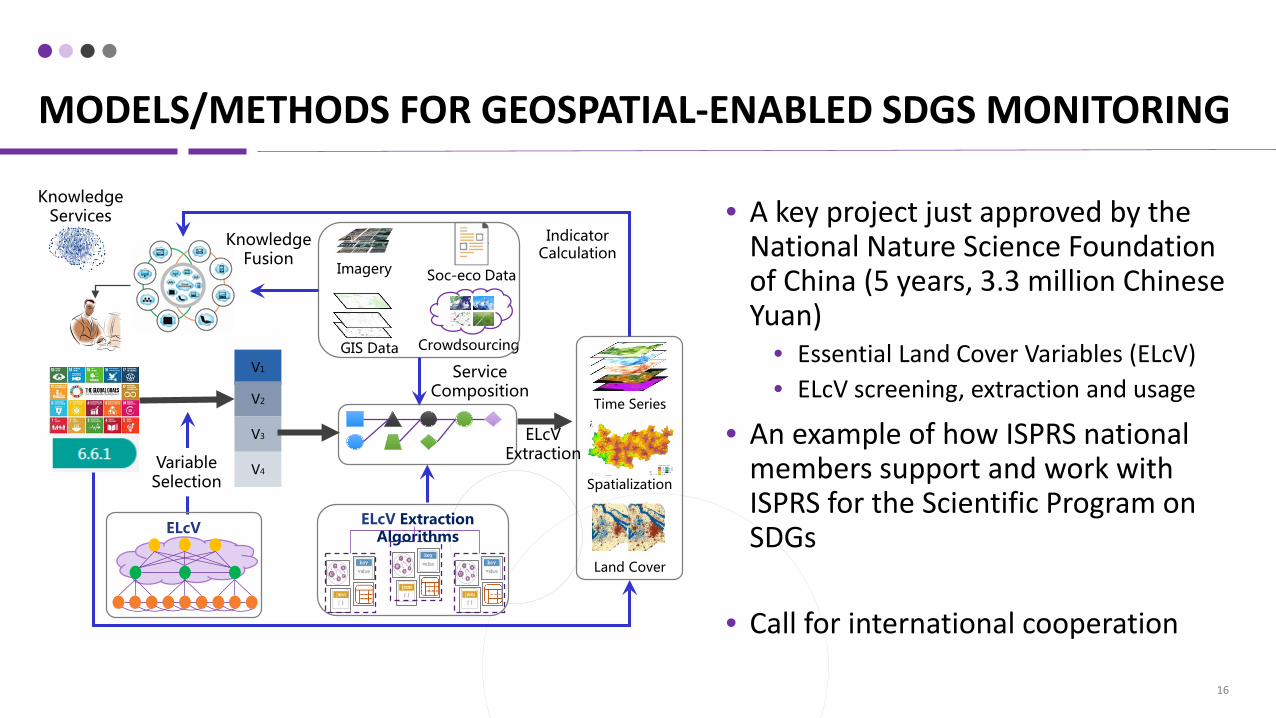
• A key project just approved by the National Nature Science Foundation of China (5 years, 3.3 million Chinese Yuan)
• Essential Land Cover Variables (ELcV)• ELcV screening, extraction and usage
• An example of how ISPRS national members support and work with ISPRS for the Scientific Program on SDGs
• Call for international cooperation
Soc-eco DataImagery
GIS Data CrowdsourcingV1
V2
V3
V4
ELcV
Variable Selection
ELcV Extraction Algorithms
Service Composition
Time Series
Spatialization
Land Cover
ELcVExtraction
Knowledge Fusion
Knowledge Services
Indicator Calculation

17
• A number of the SDGs can benefit from contributions from the photogrammetry, remote sensing and spatial information sciences technologies, which are the focus areas of ISPRS.
• There are challenges but also great opportunities for geospatial communities to work together on developing solid solutions to support the assessment and monitoring of SDGs.
To finish up …