
University of New Orleans
Lakeview Neighborhood
New Orleans, Louisiana
Caitlyn Verret
12/6/2014
Figure 1: Old Lighthouse, circa 1950. Retrieved from http://old-new-orleans.com/NO_NewBasinCanalLighthouse.html

i
Table of ContentsIntroduction................................................................................................................1
History........................................................................................................................ 2
Geography and the Environment................................................................................4
Demographics............................................................................................................5
Population...............................................................................................................5
Economy.................................................................................................................5
Neighborhood Plan.....................................................................................................6
Current Projects........................................................................................................11
Conclusion................................................................................................................12
References................................................................................................................14
List of Figures...........................................................................................................16
List of Tables.............................................................................................................17

1
IntroductionOnce swampland, Lakeview has now
become a beautiful suburban
neighborhood in New Orleans. With the
easy access to the interstate, it's easy to
take a trip downtown for a fun night out on
Bourbon or to see the New Orleans Saints
play a home football game. But like the
rest of New Orleans, Lakeview was not
spared. For many residents of this
neighborhood, this was a nightmare - they
came home to nothing. Their options were
to start over again, or to rebuild away from
their home. Many chose to start over and
rebuild their neighborhood. The residents
struggled to go back to what they once
had, but also struggled to continue to redevelop. To understand the struggle
the residents faced, one must know the history and location of Lakeview; this
will provide a foundation for demographics about the residents of this
neighborhood before finally discussing the neighborhood plan published by
the city of New Orleans.
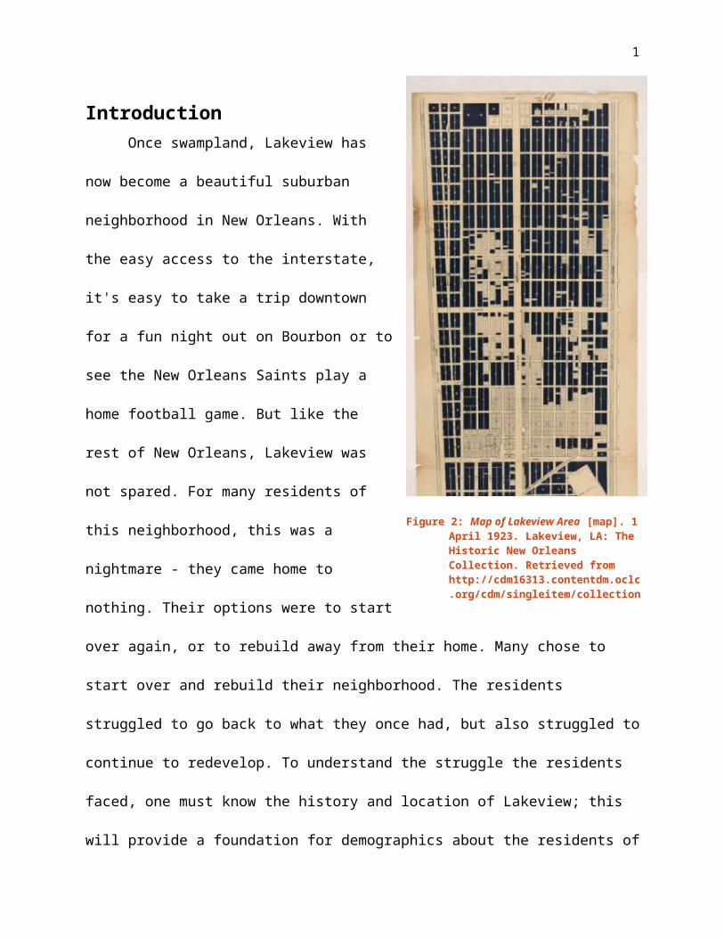
Figure 2: Map of Lakeview Area [map]. 1 April 1923. Lakeview, LA: The Historic New Orleans Collection. Retrieved from http://cdm16313.contentdm.oclc.org/cdm/singleitem/collection/p15140coll28/id/60/rec/1
2
HistoryThis area was originally owned by
an order of priests known as Capuchins
in the 1700s and was nothing but
swamp land. In nearby Bayou St. John,
French explorers had set up a trappers’
outpost and had no other real value.
The priests sold it to a Spanish civil
servant by the name of Don Andrés Almonester y Rojas, who is known for the
rebuilding of the St. Louis Cathedral. Alexander Milne acquired most of the
land after the Almonesters. It was during this time that the New Basin Canal
construction was to be built (New Orleans Official Guide, 2014). Over 8,000
Irish immigrants died from malaria, yellow fever, and cholera while digging
out the canal. In memory of the immigrants that died, a Celtic cross was built
on the Lakefront (Lagasse, 2013).
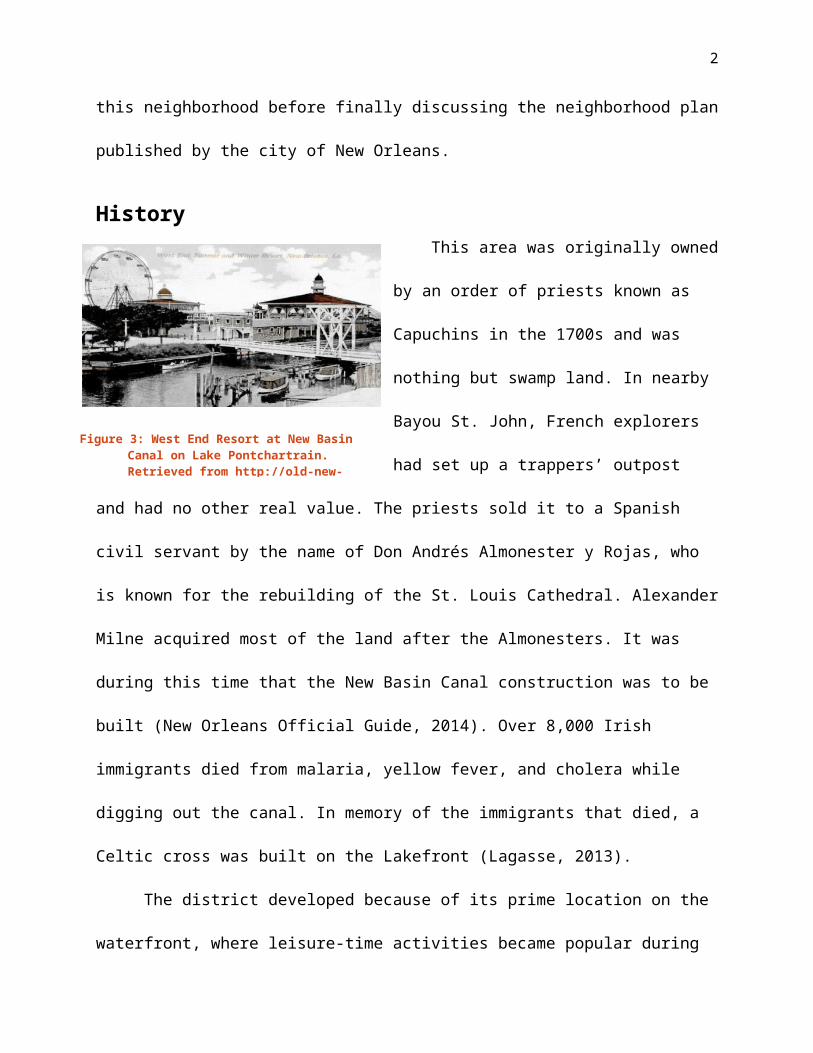
The district developed because of its prime location on the waterfront,
where leisure-time activities became popular during the late 1800s and early
1900s. Several yacht and country clubs rose to fame because of this, such
as the Southern Yacht Club, which still currently operates. A development of
New Lake End Resort, later named West End Resort, contributed to name the
sub-neighborhood in 1880. The land, previously swamp-land, was soon
drained and the construction of housing soon started up in the early 1900s
(NOLA Plans, 2006). The first house was built in 1905 on Julia Street -- now
Figure 3: West End Resort at New Basin Canal on Lake Pontchartrain. Retrieved from http://old-new-orleans.com/NO_West_End
3
called West End Boulevard. The land was drained in 1909 and the New
Orleans Land Company began dividing the land off to sell. However, land did
not sell as quickly as the developers had hoped and remained mostly rural in
the early 1900s. It wasn't until 1926 that Lakeview began to truly blossom.
After World War II, the area underwent renovations to be modernized. The
streetcar that was on West End Boulevard was paved over, being replaced by
buses. The New Basin Canal was filled in by 1949 and decreased industrial
use to this area. This did not stop any commercial growth within the area:
commercial districts boomed on Harrison Avenue and Robert E. Lee
Boulevard (New Orleans Official Guide, 2014).
Before Hurricane Katrina, there were many older residents due to the
high cost of homes in the area, but now a resurgence of younger residents is
prominent because of the location; being close to the city without being in
the city and the availability of
traveling around by I-10 (NOLA
Plans, 2006). Lakeview district was
damaged significantly because of
the flooding from Hurricane Katrina
after a breach from the Seventeenth
Street Canal floodwall and both
businesses and residents are
continuing to rebuild the area (New
Orleans Official Guide, 2014).
Figure 4: Charles L Franck (Photographer). 16 December, 1951. House under construction, Lakeview [Photograph]. Retrieved November 13, 2014 from http://cdm16313.contentdm.oclc.org/cdm/singleitem/collection/CLF/id/1768/rec/328

4
There is a mix of housing
architecture due to the rebuilding of the
neighborhood that is still currently
happening, and because of the flooding
from Katrina, the houses that survived
have been raised or elevated to help against future flooding in the area
(NOLA Plans, 2010). Lakeview has numerous landmarks: the New Basin Canal
Lighthouse and the City Park Carousel are only two. This report will be
focusing on the Lakeview sub-neighborhood instead of the entire joined
neighborhoods of all the sub-neighborhoods as a whole (NOLA Plans, 2010).
Geography and the EnvironmentLakeview District is located on the south shore of Lake Pontchartrain
and is on the northwest border of Orleans, touching the Jefferson Parish
border. Along the waterfront are many popular restaurants and parks, which
offers a wonderful afternoon of dinner or enjoyment by sailing or fishing. The
District of Lakeview contains multiple neighborhoods: Lakeshore/Lake Vista
to the North, City Park to the East, West End to the middle and upper-West,
Lakewood to the Southwest, Navarre to the South, and Lakeview in the
center. However, we will focus on the Lakeview neighborhood, rather than
the Lakeview district, for most of this document. The New Basin Canal serves
to divide the Lakeview neighborhood into east and west (NOLA Plans, 2006).
Figure 5: (Above, both) Houses in Lakeview Neighborhood. 2 October, 2014. Lakeview neighborhood. Caitlyn Verret.

5
Demographics
PopulationIn 2000, there were a total of 9,875 people living in the Lakeview
neighborhood. There was a decline in population because of Katrina, which is
shown in the 2010 Census with a population count of 6,394. There are more
females than males living in Lakeview: 51.6% to 48.4% based off the 2010
Census. The majority of residents in Lakeview are 18-34 years old and 35-49
years old, 29.5% and 20.7% respectively. At a high rate of 88.2%, residents
are mostly white (The Data Center, 2014).
EconomyThere are 3,399 total housing units in
2010, down from 4,805 in 2000. As of 2010,
78.6% of the housing units were occupied,
significantly lower than in 2000 – 94.2%.
General household income is wage or salary
income. Average household income (in 2012 dollars) averaged in 2008-2012
was $97,926. About 95% of people are living at or above poverty while 5%
are living in poverty based on a 2008-2012 American Community Survey. In
Lakeview, 70.4% of people have two or more vehicles available and 91.2% of
workers 16 years and older use a personal vehicle as a means of
transportation and the average travel time to work was 19 minutes. At least
39.7% of residents have a bachelor's degree. A large majority of residents
speak English very well at 99.6% (The Data Center).
Table 1: Housing Statistics for Lakeview, New Orleans for 2000 and 2010. (Source: The Data Center)
Years 2000 2010
Housing Units 4,805 3,399
Percent
Occupied
94.2% 78.6%

6
Most houses are single-family or
duplex in either Louisiana Victorian,
Louisiana Classical, or shotgun style
(Architectural Patterns). Much of the
commercial areas are located on
Harrison Avenue and Robert E. Lee
Boulevard. Buses are available for
residents of the neighborhood. The construction industry is booming in this
neighborhood because of the influx of new residents and upgrades to current
houses. The restaurant and bar sector of the hospitality industry is also very
popular. There are mostly private religious schools in this neighborhood such
as Mount Carmel Academy and St. Paul's Episcopal School.
Neighborhood PlanAfter Hurricane Katrina, the City of New Orleans instituted a recovery
plan with aid of the City Council to help the 49 flooded neighborhoods
throughout the city. The neighborhoods were then divided into 13 Planning
Districts. The plans were initiated city wide, but assigned on a more localized
level to help individualize the needs for each targeted area. The purpose of
this neighborhood plan is to address the planning issues of both pre-Katrina
and post-Katrina to improve on past and current issues.
Figure 6: J. R. St. Julien (Photographer). March 1961. Harrison Avenue from West End Boulevard [Photograph]. Retrieved November 13, 2014 from http://www.neworleanspubliclibrary.org/~nopl/photos/streets/harrison.htm
7
The goal of the neighborhood
plan is to rebuild the Lakeview
neighborhood to pre-Katrina levels,
expand on open spaces and parks, and
to redevelop commercial areas.
District 5 made the planning process a
multi-neighborhood initiative, and thus,
the District 5 Neighborhood Recovery
Steering Committee was formed. Their methodology to this planning process
was creating seven working groups that stemmed from and reported back to
the District 5 Recovery Steering Committee: Communications and
Community Engagement; Greenspace Recovery and Beautification;
Neighborhood Planning; Finances and Resources; Crime Prevention;
Neighborhood Associations; Infrastructures. The Steering Committee was
made up of then-current and/or past presidents of the Lakeview Civic
Improvement Association and other prominent figures of other neighborhood
associations from the district. Once the basic groups were established,
action-oriented committees and sub-committees were assigned to further
the District 5 recovery efforts by category. For instance, the Greenspace
Recovery and Beautification group had three subcommittees: neutral
grounds, playgrounds, and parks.
Both the University of New Orleans and professional planners under
contract with City Council provided support for this planning process. With
Figure 7: Charles L Franck (Photographer). 29 October, 1941. View down Harrison Avenue along the 800 block. [Photograph]. Retrieved November 23, 2014 from http://cdm16313.contentdm.oclc.org/cdm/singleitem/collection/CLF/id/8643/rec/382

8
the development of a planning committee that provided a wide view of the
area as a whole, it was easier for the public to be involved with the planning
of their neighborhood.
The district used pre-Katrina plans to address both district-wide and
neighborhood specific issues to find pre-existing areas of concern that
absolutely needed to be addressed for the new district plan. The Parks
Master Plan of 2002 found park deficiencies within the Lakeview
neighborhood, while the 2004 Transportation Master Plan also brought
concern about the pedestrian/bicycle safety on the intersection of Robert E.
Lee Boulevard at West End Boulevard and Pontchartrain Boulevard. Pre-
Katrina plans were evaluated and areas of concern were included within the
current planning efforts. This was to ensure that previous efforts were not
gone to waste and so that there was a continuous planning process for the
city.
They did not include large areas of land within this recovery plan such
as the cemeteries, the New Orleans Country Club, and the New Orleans City
Park. The New Orleans City Park received its own plan, the City Park Master
Plan 2005, which was set to be completed or underway by 2018.
Statistics of the Lakeview neighborhood were researched from the
2000 Census. There were a number of differences when Lakeview was
compared to the City of New Orleans, such as income, land ownership, and
age distribution. Lakeview reported an income 1.5 times greater than New
Orleans, a very high rate of owner occupied homes at about 70%, and a

9
higher rate of elderly residents. Each provided a different aspect of
redevelopment issues or opportunities.
Land Use and Zoning was reviewed, providing information about
residential and commercial areas. Multiple maps were created with this
information and even more were created to provide potential changes to
certain zoning areas.
Surveys of the neighborhood were conducted to provide insight on how
much damage was done by Hurricane Katrina. Both a map of flood depth and
a map of damage percentage to property were created with the data
gathered. Other damage assessments that were conducted were
commercial, infrastructure, street and sidewalk, signage, and drainage,
among others.
The descriptions of existing conditions were provided in two ways: Pre-
Katrina Neighborhood Existing Conditions and Hurricane Katrina
Neighborhood Impacts. Topics covered within these two sections were:
existing land use, zoning, utilities, housing, community facilities and
services, urban design features, general physical conditions, history, and
demography. Both provide plenty of information by forms of graphs, pictures,
maps, and narrative.
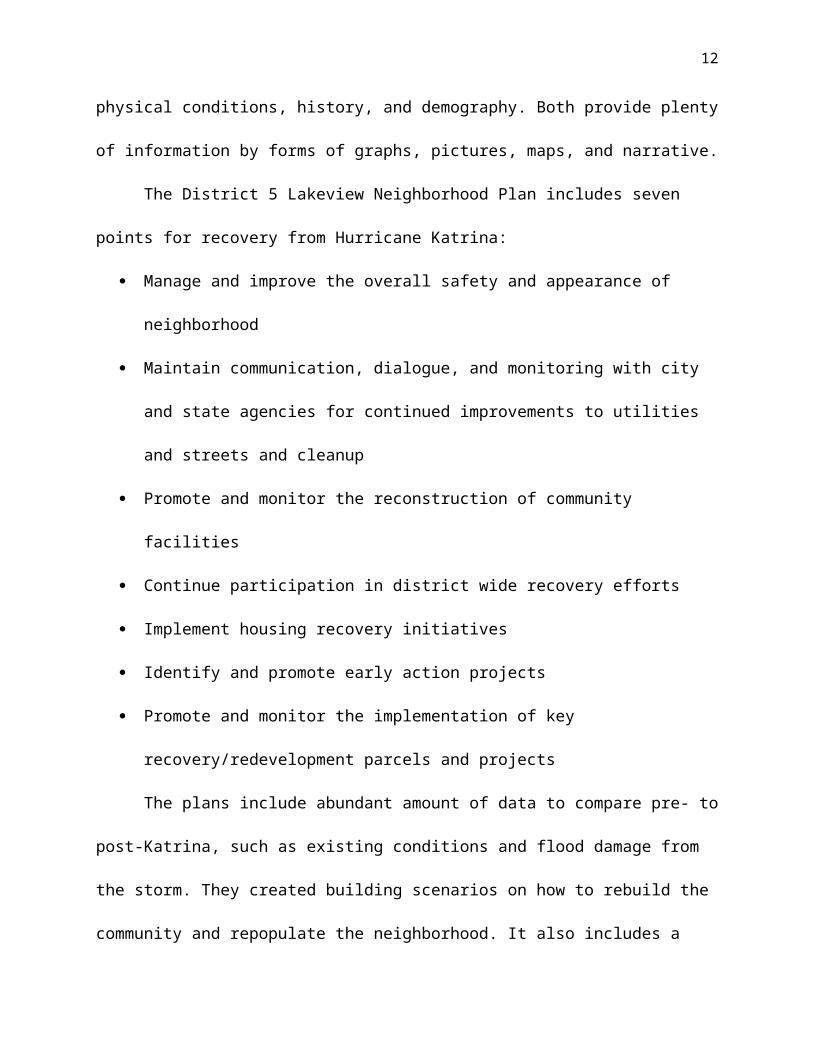
The District 5 Lakeview Neighborhood Plan includes seven points for
recovery from Hurricane Katrina:
Manage and improve the overall safety and appearance of neighbor-
hood

10
Maintain communication, dialogue, and monitoring with city and state
agencies for continued improvements to utilities and streets and
cleanup
Promote and monitor the reconstruction of community facilities
Continue participation in district wide recovery efforts
Implement housing recovery initiatives
Identify and promote early action projects
Promote and monitor the implementation of key recovery/redevelop-
ment parcels and projects
The plans include abundant amount of data to compare pre- to post-
Katrina, such as existing conditions and flood damage from the storm. They
created building scenarios on how to rebuild the community and repopulate
the neighborhood. It also includes a recovery plan to continue development
and improvement once the initial rebuilding from Hurricane Katrina’s damage
is almost or fully completed. Overall, the planning document flows together
very well from beginning to end and clearly defines the ideas that are
planned to be put into action. The District 5 Lakeview Neighborhood plan is
easily provided online and easy to access along with other city plans and
documents. The importance of the information covered in the neighborhood
plan is based off of Bernie Jones' Neighborhood Planning: A Guide for Citizens
and Planners, located in chapter 4.

11
Current ProjectsThere are a few current
projects going on in the Lakeview
neighborhood. One of the most
seemingly well known projects
throughout the city is the "Fix My
Streets" initiative, which was started
by a local Lakeview resident, Robert Lupo. He began the project in May 2014
by printing out 100 bright red yard signs that stated, "Fix My Streets, I Pay
My Taxes." It did not take long for the project to become a big hit. Within
months, the signs were all over Orleans Parish. While this campaign was not
truly in the official neighborhood plan, it stemmed from when the city
officially began to continuously pushing off improvements to the city streets
that were damaged from Hurricane Katrina (Fix My Streets NOLA.com). In the
Lakeview Civic Improvement Association meeting on November 15, 2014, a
speaker mentioned that this initiative was not a "sprint," but rather a
"marathon." The program was not meant to achieve a quick fix, but rather it
was suppose to be a long term program to continuously fight for
improvements throughout the parish.
The reconstruction of the West End
Boulevard Neutral Grounds, commonly
known as West End Park, has been a
proposed idea for redevelopment in the
Figure 8: "Fix My Streets" sign [image]. Retrieved from http://www.fixmystreetsnola.com/
Figure 9: Charles L Franck (Photographer). 29 October, 1941. Polk Avenue towards Catina at 5939 West End Boulevard [Photograph]. Retrieved November 23, 2014 from http://cdm16313.contentdm.oclc.org/cdm/singleitem/collection/CLF/id/9168/rec/359

12
official neighborhood plan for Lakeview. While many of the original ideas for
improvements have been either slightly changed or completely scrapped
out, there is still current development for West End Park as of November
2014. The Friends of Lakeview have been fundraising for lights on the neutral
ground on West End Park -- running from Veterans and Robert E. Lee. The
estimate cost of the project is $2 million, and the Friends of Lakeview have
managed to secure a grant that covers 80% of the project. To cover the final
costs of the project, the organization hosted a fundraising Gala at two houses
in the neighborhood and is very close to reaching their goal as of November
2014.
ConclusionWith this look into the Lakeview neighborhood, it's easy to see that the
residents want their community to become bigger than they ever hope to be.
Both government officials at the city, state, and federal level, and the
residents of the neighborhood have had to work together since the landing of
Hurricane Katrina and they continue to work together to improve the parish
as a whole. With multiple projects in the works, and more projects that have
yet to be started, it is easy to see that Lakeview will continue to stay a
thriving neighborhood for many more years to come.
13
ReferencesCrescent City Living.com. (n/d). Lakeview Neighborhood. Retrieved
September 3, 2014 from http://crescentcityliving.com/lakeview
Fix My Streets NOLA.com. (n.d.). Retrieved November 23, 2014, from
http://www.fixmystreetsnola.com/
Johnston, Patti (Editor). (2014, November/December.) Lakeviews. Lakeview
Civic Improvement Association Newsletter. 26 (6).
Jones, B. (1990). Chapter 4. In Neighborhood Planning: A Guide for Citizens
and Planners. Chicago, Ill.: Planners Press.
Lagasse, Mary. Irish Central. (2013, November 7). A Call To Remember 8,000
Irish Who Died While Building the New Orleans Canal. Retrieved
November 12, 2014 from http://www.irishcentral.com/news/8000-irish-
died-while-building-the-new-basin-canal-in-new-orleans-231020191-
237786681.html
New Orleans Official Guide. (2014). Lakeview. Retrieved November 12, 2014
from http://www.neworleansonline.com/tools/neighborhood
guide/lakeview.html
NOLA Plans. (2010, April 6). District 5 Final Report. Retrieved September 3,
2014 from
http://www.nolaplans.com/plans/Lambert%20Intermediate/District_5_Pl
an_FINAL%20PLAN%20Report%20Lakeview%2010-04-06.pdf

14
The Data Center. (2014, March 28). Lakeview. Retrieved September 3, 2014,
from http://www.datacenterresearch.org/data-resources/neighborhood-
data/district-5/Lakeview/

15
List of Figures
Figure 1: Old Lighthouse, circa 1950. Retrieved from
http://old-new-orleans.com/NO_NewBasinCanalLighthouse.html.....................i
Figure 2: Map of Lakeview Area [map]. 1 April 1923. Lakeview, LA: The Historic
New Orleans Collection. Retrieved from
http://cdm16313.contentdm.oclc.org/cdm/singleitem/collection/p15140coll28
/id/60/rec/1......................................................................................................1
Figure 3: West End Resort at New Basin Canal on Lake Pontchartrain. Retrieved
from http://old-new-orleans.com/NO_West_End...............................................2
Figure 4: Charles L Franck (Photographer). 16 December, 1951. House under
construction, Lakeview [Photograph]. Retrieved November 13, 2014 from
http://cdm16313.
contentdm.oclc.org/cdm/singleitem/collection/CLF/id/1768/rec/328...............3
Figure 5: (Above, both) Houses in Lakeview Neighborhood. 2 October, 2014.
Lakeview neighborhood. Caitlyn Verret...........................................................4
Figure 6: J. R. St. Julien (Photographer). March 1961. Harrison Avenue from West
End Boulevard [Photograph]. Retrieved November 13, 2014 from
http://www.neworleanspubliclibrary.org/~nopl/photos/streets/harrison.htm.. .6
Figure 7: Charles L Franck (Photographer). 29 October, 1941. View down Harrison
Avenue along the 800 block. [Photograph]. Retrieved November 23, 2014
from http://cdm16313.contentdm.oclc.org/cdm/singleitem/collection/CLF/id/
8643/rec/382...................................................................................................7

16
Figure 8: "Fix My Streets" sign [image]. Retrieved from
http://www.fixmystreetsnola.com/.................................................................11
Figure 9: Charles L Franck (Photographer). 29 October, 1941. Polk Avenue towards
Catina at 5939 West End Boulevard [Photograph]. Retrieved November 23,
2014 from
http://cdm16313.contentdm.oclc.org/cdm/singleitem/collection/CLF/id/9168/
rec/359...........................................................................................................12

17
List of Tables
Table 1: Percentage of Race in Lakeview District in 2012 (The Data Center, 2014)....5


