
Rapid Ecological Assessment for Yellowstone Lake & Blackhawk
Lake Managed Lands
A Rapid Ecological Assessment Focusing on Rare Plants, Selected Rare Animals, and
High-quality Natural Communities
Properties included in this report are:
Lafayette County Iowa County
Yellowstone Wildlife Area Blackhawk Lake Wildlife Area
Yellowstone Lake State Park
Yellowstone Savanna State Natural Area
Streambank Protection Fee Area Wisconsin’s Natural Heritage Inventory Program Bureau of Endangered Resources Department of Natural Resources P.O. Box 7921, Madison, WI 53707
June 2012 PUB-ER-834-2012
2 Rapid Ecological Assessment
Acknowledgments We extend our appreciation to the following for their support and assistance: the property managers
(Becky Roth and Bruce Folley); the Ecosystem Management Planning Team; and Kate Fitzgerald and
Rebecca Schroeder. Funding for this project was provided by the Bureaus of Wildlife Management,
Parks and Recreation, and the Endangered Resources Fund.
Primary Author: Amy Staffen
Contributors:
• Julie Bleser – data management
• Barb Duerksen – breeding bird surveys
• Dawn Hinebaugh – report maps and editing
• Terrell Hyde – data processing
• Christina Isenring – inventory coordination, ecology review
• Kathy Kirk – lepidoptera surveys
• Jeff Lorch – herptile surveys
• Ryan O’Connor – rare plant and natural community surveys, data processing
• Anna Rossler, Gary Emerson, Samantha Nagy – bat surveys
• Elizabeth Slivinski – report maps
• William A. Smith – zoology
• Amy Staffen – breeding bird and natural community surveys, data processing
• Rich Staffen – data processing, inventory coordination
• Roland Wang – report assistance
Cover Photos:
• Top left: View of Blackhawk Lake from Pine Relict to the north. Photo by Amy Staffen.
• Top right: View of Blackhawk Lake and Emergent Marsh. Photo by Jeff Lorch.
• Bottom: Scottish highland cattle at Yellowstone Lake State Park. Photo by Kelly Kearns.
Table of Contents
Acknowledgments......................................................................................................... 2
Table of Contents ............................................................................................................................. 3
List of Figures .................................................................................................................................. 4
List of Tables ................................................................................................................................... 4
Appendices ...................................................................................................................................... 5
Introduction ................................................................................................................... 6
Purpose and Objectives.................................................................................................................... 6
Overview of Methods ...................................................................................................................... 6
Background on Past Efforts ........................................................................................................... 10
Special Management Designations ................................................................................................ 10
Public Lands .................................................................................................................................. 11
Regional Ecological Context ...................................................................................... 12
“Southwest Savanna” and “Western Coulees & Ridges” Ecological Landscapes ........................ 12
Regional Biodiversity Needs and Opportunities ........................................................................... 13
Description of the Study Area .................................................................................... 16
Location and Size .......................................................................................................................... 16
Ecoregion ....................................................................................................................................... 16
Physical Environment .................................................................................................................... 18
Vegetation ...................................................................................................................................... 19
Rare Species and High Quality Natural Communities .................................................................. 28
Management Opportunities and Considerations for Biodiversity Conservation ... 30
Landscape Level Opportunities and Considerations ..................................................................... 30
Community Level Opportunities and Considerations ................................................................... 36
Species or Taxa Level Opportunities and Considerations ............................................................. 39
Primary Sites: Site-specific Opportunities for Biodiversity Conservation ............. 42
Future Needs ............................................................................................................... 44
Glossary ....................................................................................................................... 45
Species List ................................................................................................................. 46
Reference List ............................................................................................................. 50
Additional Resources ................................................................................................. 54
4 Rapid Ecological Assessment
List of Figures
Figure 1. Location of Yellowstone Wildlife Area, Yellowstone Lake State Park, Yellowstone Savanna
State Natural Area, Streambank Protection Fee Area, and Blackhawk Lake Wildlife Area ........................ 9
Figure 2. Ecological Landscapes of Wisconsin and the study area. ........................................................... 12
Figure 3. Landtype Associations for Yellowstone Wildlife Area, Yellowstone Lake State Park,
Yellowstone Savanna State Natural Area, Streambank Protection Fee Area, and Blackhawk Lake
Wildlife Area...............................................................................................................................................16
Figure 4. Vegetation for Yellowstone Wildlife Area, Yellowstone Lake State Park, Streambank
Protection Fee Area, and Blackhawk Lake Wildlife Area prior to Euro-American settlement..................19
Figure 5. Landcover for Yellowstone Wildlife Area, Yellowstone Lake State Park, Yellowstone Savanna
State Natural Area, Streambank Protection Fee Area, and Blackhawk Lake Wildlife Area......................20
Figure 6. Cover Types of Yellowstone Lake Managed Lands...................................................................21
Figure 7. Cover Types of Blackhawk Lake Wildlife Area.........................................................................21
Figure. 8. Good quality Sand Prairie at Blackhawk Lake....................... ...................................................23
Figure. 9. High-quality Southern Dry-mesic Forest at Yellowstone Lake Wildlife Area...........................24
Figure 10. Non-native invasive earthworms at Blackhawk Lake Wildlife Area.........................................32
Figure. 11. Spring-fed creek at Blackhawk Lake that supports frogs.........................................................39
Figure 12. Primary Sites of Yellowstone Wildlife Area, Yellowstone Lake State Park, Streambank
Protection Fee Area, and Blackhawk Lake Wildlife Area..........................................................................42
List of Tables
Table 1. Major Natural Communities Management Opportunities in the Southwest Savanna and Western
Coulees & Ridges Ecological Landscape ................................................................................................... 14
Table 2. Listing Status for rare species in the Southwest Savanna Ecological Landscape as of 2012. ..... 15
Table 3. Listing Status for rare species in the Western Coulee and Ridges Ecological Landscape as of
2012. ........................................................................................................................................................... 15
Table 4. Documented rare species and high-quality natural communities of the four townships within
which Yellowstone Wildlife Area, Yellowstone Lake State Park, Yellowstone Savanna State Natural
Area, and Blackhawk Lake Wildlife Area are located..... .......................................................................... 28
Table 5. Widespread non-native invasive species currently known at Blackhawk Lake Wildlife Area,
Yellowstone Lake State Park, Yellowstone Wildlife Area, and Yellowstone Savanna State Natural Area,
and Streambank Protection Fee Area..........................................................................................................31
Yellowstone Lake and Blackhawk Lake Wildlife Areas 5
Table 6. New or not-widespread non-native invasive species at Blackhawk Lake Wildlife Area,
Yellowstone Lake State Park, Yellowstone Wildlife Area, Yellowstone Savanna State Natural Area, and
Streambank Protection Fee Area.................................................................................................................32
Table 7. Statewide Forest Strategies pertinent to Blackhawk Lake Wildlife Area, Yellowstone Lake State
Park, Yellowstone Wildlife Area, Yellowstone Savanna State Natural Area, and Streambank Protection
Fee Area.......................................................................................................................................................34
Table 8. Major and Important Opportunities of Western Coulees & Ridges Ecological Landscape.........35
Table 9. Major and Important Opportunities of Southwest Savanna Ecological Landscape......................36
Table 10. Grassland and shrubland birds known from the Blackhawk Lake Wildlife Area and
Yellowstone Lake Managed Lands.............................................................................................................39
Appendices
A. Natural Heritage Inventory Methods Overview
B. Map of Conservation Opportunity Areas for the Southwest Savanna and Western Coulees & Ridges
Ecological Landscapes
C. Wisconsin Natural Heritage Working List Explanation
D. Primary Sites within Yellowstone Wildlife Area, Yellowstone Lake State Park, Yellowstone Savanna
State Natural Area, and Blackhawk Lake Wildlife Area
Introduction
Purpose and Objectives This report is intended to be used as a source of information for developing a new master plan for
Yellowstone Wildlife Area, Yellowstone Lake State Park, Yellowstone Savanna State Natural Area, the
Streambank Protection Fee Area at Yellowstone Lake, and Blackhawk Lake Wildlife Area (herein
“YLBL;” Figure 1). The 403 acres eased to the Cobb-Highland Recreation Commission at Blackhawk
Lake are not part of the study area for this report, nor are the developed areas at Yellowstone Lake
(campground, parking areas, visitor’s center, etc.). The regional ecological context for YLBL is also
provided to assist in developing the Regional and Property Analysis that is part of the master plan.
The primary objectives of this project were to collect biological inventory information relevant to the
development of a master plan for YLBL and to analyze, synthesize and interpret this information for use
by the master planning team. This effort focused on assessing areas of documented or potential habitat
for rare species and identifying natural community management opportunities.
Survey efforts for YLBL were limited to a “rapid ecological assessment” for 1) identifying and
evaluating ecologically important areas, 2) documenting rare species occurrences, and 3) documenting
occurrences of high quality natural communities. This report can serve as the “Biotic Inventory”
document used for master planning although inventory efforts were reduced compared to similar projects
conducted on much larger properties such as state forests. There will undoubtedly be gaps in our
knowledge of the biota of this property, especially for certain taxa groups; these groups have been
identified as representing either opportunities or needs for future work.
Overview of Methods The Wisconsin Natural Heritage Inventory (NHI) program is part of the Wisconsin DNR’s Bureau of
Endangered Resources and a member of an international network of natural heritage programs
representing all 50 states, as well as portions of Canada, Latin America, and the Caribbean. These
programs share certain standardized methods for collecting, processing, and managing data for rare
species and natural communities. NatureServe, an international non-profit organization (see
www.NatureServe.org for more information), coordinates the network.
Natural heritage programs track certain elements of biological diversity: rare plants, rare animals, high-
quality examples of natural communities, and other selected natural features. The NHI Working List
contains the elements tracked in Wisconsin. They include endangered, threatened, and special concern
plants and animals, as well as the natural community types recognized by NHI. The NHI Working List is
periodically updated to reflect new information about the rarity and distribution of the state’s plants,
animals, and natural communities. The most recent Working List is available from the Wisconsin DNR
website (Wisconsin Natural Heritage Working List).
The Wisconsin NHI program uses standard methods for biotic inventory to support master planning
(Appendix A). Our general approach involves collecting relevant background information, planning and
conducting surveys, compiling and analyzing data, mapping rare species and high quality natural
Yellowstone and Blackhawk Lakes Managed Lands at a Glance
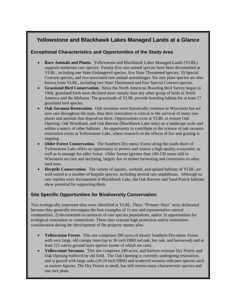
Exceptional Characteristics and Opportunities of the Study Area
• Rare Animals and Plants. Yellowstone and Blackhawk Lakes Managed Lands (YLBL)
supports numerous rare species. Twenty-five rare animal species have been documented at
YLBL, including one State Endangered species, five State Threatened species, 19 Special
Concern species, and two associated rare animal assemblages. Six rare plant species are also
known from YLBL, including two State Threatened and four Special Concern species.
• Grassland Bird Conservation. Since the North American Breeding Bird Survey began in
1966, grassland birds have declined more steeply than any other group of birds in North
America and the Midwest. The grasslands of YLBL provide breeding habitat for at least 17
grassland bird species.
• Oak Savanna Restoration. Oak savannas were historically common in Wisconsin but are
now rare throughout the state, thus their restoration is critical to the survival of many rare
plants and animals that depend on them. Opportunities exist at YLBL to restore Oak
Opening, Oak Woodland, and Oak Barrens (Blackhawk Lake only) on a landscape scale and
within a matrix of other habitats. An opportunity to contribute to the science of oak savanna
restoration exists at Yellowstone Lake, where research on the effects of fire and grazing is
ongoing.
• Older Forest Conservation. The Southern Dry-mesic Forest along the south shore of
Yellowstone Lake offers an opportunity to protect and restore a high-quality ecosystem, as
well as to manage for older forest. Older forests (greater than 100-120 years old) in
Wisconsin are rare and declining, largely due to timber harvesting and conversion to other
land uses.
• Herptile Conservation. The variety of aquatic, wetland, and upland habitats of YLBL are
well-suited to a number of herptile species, including several rare amphibians. Although no
rare reptiles were documented at Blackhawk Lake, the Oak Barrens and Sand Prairie habitats
show potential for supporting them.
Site Specific Opportunities for Biodiversity Conservation
Two ecologically important sites were identified at YLBL. These “Primary Sites” were delineated
because they generally encompass the best examples of 1) rare and representative natural
communities, 2) documented occurrences of rare species populations, and/or 3) opportunities for
ecological restoration or connections. These sites warrant high protection and/or restoration
consideration during the development of the property master plan.
• Yellowstone Forest. This site comprises 290 acres of mostly Southern Dry-mesic Forest
with very large, old canopy trees (up to 36 inch DBH red oak, bur oak, and basswood) and at
least 121 native ground layer species (some of which are rare).
• Yellowstone Savanna. This site comprises 240 acres, and harbors remnant Dry Prairie and
Oak Opening buffered by old field. The Oak Opening is currently undergoing restoration,
and is graced with large oaks (18-24 inch DBH) and scattered savanna indicator species such
as eastern figwort. The Dry Prairie is small, but still retains many characteristic species and
one rare plant.
Yellowstone Lake and Blackhawk Lake Wildlife Areas 7
Introduction
Purpose and Objectives This report is intended to be used as a source of information for developing a new master plan for
Yellowstone Wildlife Area, Yellowstone Lake State Park, Yellowstone Savanna State Natural Area, the
Streambank Protection Fee Area at Yellowstone Lake, and Blackhawk Lake Wildlife Area (herein
“YLBL;” Figure 1). The 403 acres eased to the Cobb-Highland Recreation Commission at Blackhawk
Lake are not part of the study area for this report, nor are the developed areas at Yellowstone Lake
(campground, parking areas, visitor’s center, etc.). The regional ecological context for YLBL is also
provided to assist in developing the Regional and Property Analysis that is part of the master plan.
The primary objectives of this project were to collect biological inventory information relevant to the
development of a master plan for YLBL and to analyze, synthesize and interpret this information for use
by the master planning team. This effort focused on assessing areas of documented or potential habitat
for rare species and identifying natural community management opportunities.
Survey efforts for YLBL were limited to a “rapid ecological assessment” for 1) identifying and
evaluating ecologically important areas, 2) documenting rare species occurrences, and 3) documenting
occurrences of high quality natural communities. This report can serve as the “Biotic Inventory”
document used for master planning although inventory efforts were reduced compared to similar projects
conducted on much larger properties such as state forests. There will undoubtedly be gaps in our
knowledge of the biota of this property, especially for certain taxa groups; these groups have been
identified as representing either opportunities or needs for future work.
Overview of Methods The Wisconsin Natural Heritage Inventory (NHI) program is part of the Wisconsin DNR’s Bureau of
Endangered Resources and a member of an international network of natural heritage programs
representing all 50 states, as well as portions of Canada, Latin America, and the Caribbean. These
programs share certain standardized methods for collecting, processing, and managing data for rare
species and natural communities. NatureServe, an international non-profit organization (see
www.NatureServe.org for more information), coordinates the network.
Natural heritage programs track certain elements of biological diversity: rare plants, rare animals, high-
quality examples of natural communities, and other selected natural features. The NHI Working List
contains the elements tracked in Wisconsin. They include endangered, threatened, and special concern
plants and animals, as well as the natural community types recognized by NHI. The NHI Working List is
periodically updated to reflect new information about the rarity and distribution of the state’s plants,
animals, and natural communities. The most recent Working List is available from the Wisconsin DNR
website (Wisconsin Natural Heritage Working List).
The Wisconsin NHI program uses standard methods for biotic inventory to support master planning
(Appendix A). Our general approach involves collecting relevant background information, planning and
conducting surveys, compiling and analyzing data, mapping rare species and high quality natural
community locations into the NHI database, identifying ecologically important areas, and providing
interpretation of the findings through reports and other means.
8 Rapid Ecological Assessment
Existing NHI data are often the starting point for conducting a biotic inventory to support master
planning. Prior to this project, NHI data for YLBL were limited to: 1) the Statewide Natural Area
Inventory, a county-by-county effort conducted by WDNR’s Bureaus of Research and Endangered
Resources between 1969 and 1984 that focused on natural communities but include some surveys for rare
plants and animals and 2) taxa specific surveys.
The most recent taxa-specific field surveys for the study area were conducted during 2010-11. Surveys
were limited in scope and focused on documenting high quality natural communities, rare plants,
breeding birds, herptiles, and terrestrial invertebrates. The collective results from all of these surveys
were used, along with other information, to identify ecologically important areas (Primary Sites) at
YLBL.
Survey locations were identified or guided by using recent aerial photos, USGS 7.5’ topographic maps,
various Geographic Information System (GIS) sources, information from past survey efforts, discussions
with property managers, and the expertise of several biologists familiar with the properties or with
similar habitats in the region. Based on the location and ecological setting of properties within YLBL,
key inventory considerations included the identification of high quality grasslands, oak savannas, pine
relicts, upland forests, and cliffs, as well as the location of habitats that had the potential to support rare
species. Private lands, including easements, surrounding Yellowstone and Blackhawk Lakes were not
surveyed.
Within this report scientific names have been used with first mention of species, thereafter the common
name has been used. A list of all scientific names mentioned in the text is included at the end of this
document.
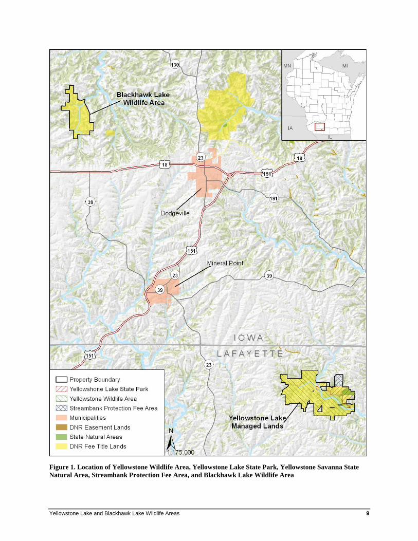
Yellowstone Lake and Blackhawk Lake Wildlife Areas 9
Figure 1. Location of Yellowstone Wildlife Area, Yellowstone Lake State Park, Yellowstone Savanna State
Natural Area, Streambank Protection Fee Area, and Blackhawk Lake Wildlife Area
10 Rapid Ecological Assessment
Background on Past Efforts A few large-scale research and planning efforts have identified YLBL as being ecologically significant.
The following are examples of such projects and the significant features identified.
Wisconsin Wildlife Action Plan: Conservation Opportunity Areas
The Wisconsin Wildlife Action Plan (WAP; WDNR 2006a) recognized one Conservation Opportunity
Area (COA) relating to the sites covered in this report (see Appendix B): Blackhawk Lake Wildlife Area
lies within the larger “Dodgeville and Wyoming Oak Woodland/Savanna” COA. Conservation
Opportunity Areas are places in Wisconsin that contain ecological features, natural communities, or
Species of Greatest Conservation Need (SGCN) habitat for which Wisconsin has a unique responsibility
for protection when viewed from the global, continental, upper Midwest, or state perspective.
Legacy Places
The Land Legacy Report (WDNR 2006b) was designed to identify Wisconsin’s most important
conservation and recreation needs for the next 50 years. Yellowstone Lake managed lands were
identified as a Legacy Place in acknowledgment of its having a large water body (impoundment), its
grassland, savanna, woodland, and marsh habitats, and in particular its recreational potential.
Priority Landscapes for Grassland Bird Management
In 1997, Sample and Mossman identified 26 “priority landscapes” in Wisconsin that represent unique
opportunities for landscape-scale grassland management for grassland birds. State-owned lands
surrounding Yellowstone Lake were identified as part of the “Yellowstone/Pecatonica River Grasslands
and Savanna” priority landscape. Yellowstone Lake managed lands have oak savanna, idle cool- and
warm-season grasslands, dry and wet old field habitats, dry and dry-mesic prairie, and upland shrub
habitat, all of which can benefit grassland bird species when considered as a whole and within the larger
landscape.
Special Management Designations
State Natural Areas
State Natural Areas (SNA) are places on the landscape that protect outstanding examples of native
natural communities, significant geological formations, and archaeological sites. Designation confers a
significant level of land protection through state statutes, administrative rules, and guidelines.
Yellowstone Savanna is a 220-acre SNA that lies within Yellowstone Lake State Park. There are no
SNAs within Blackhawk Lake Wildlife Area.
Forest Certification
All DNR-managed lands, including state parks, wildlife areas, and natural areas, are recognized by the
Forest Stewardship Council and the Sustainable Forestry Initiative as being responsibly managed
(WDNR 2009). This certification emphasizes the state’s commitment to responsibly managing and
conserving forestlands, supporting economic activities, protecting wildlife habitat, and providing
recreational opportunities.
Southwest Wisconsin Grassland and Stream Conservation Area
The Wisconsin Department of Natural Resources joined with a diverse group of conservation partners,
local governments, and landowners in southwestern wisconsin to establish the "Southwest Wisconsin
Grassland and Stream Conservation Area (SWGSCA)." Southwestern Wisconsin has been recognized
for many years as one of the best grassland conservation opportunities in the Upper Midwest. The area
Yellowstone Lake and Blackhawk Lake Wildlife Areas 11
stands out for its distinct combination of resources: exceptional populations of grassland birds, which are
in serious decline across their range; many scattered remnants of the area's original prairie and savanna
that once covered the region; concentrations of rare plants and animals, and spring-fed streams, all set
within this expansive rural farming region of open fields, croplands, oak groves, and pastures.
Yellowstone Lake managed lands fall within the boundaries of the SWGSCA.
Public Lands
All lands in the study area are owned by the Wisconsin Department of Natural Resources and are
managed by the Bureau of Parks and Recreation, Bureau of Wildlife Management, and Bureau of
Endangered Resources.
12 Rapid Ecological Assessment
Regional Ecological Context
Southwest Savanna and Western Coulees & Ridges
Ecological Landscapes This section is largely reproduced from the Ecological Landscapes of Wisconsin Handbook (WDNR In
Prep. a).
The WDNR has mapped the state into areas of similar ecological potential and geography called
Ecological Landscapes. The Ecological Landscapes are based on aggregations of smaller ecoregional
units (Subsections) from a national system of delineated ecoregions known as the National Hierarchical
Framework of Ecological Units (NHFEU) (Cleland et al. 1997). These ecoregional classification systems
delineate landscapes of similar ecological pattern and potential for use by resource administrators,
planners, and managers.
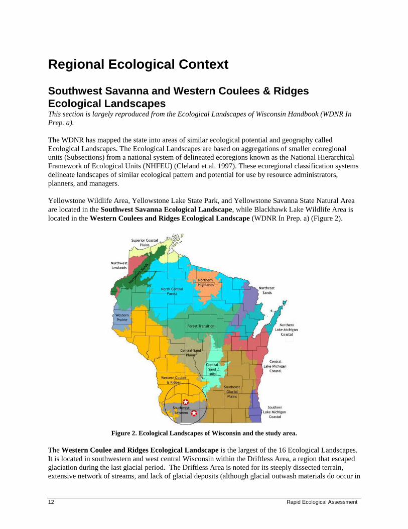
Yellowstone Wildlife Area, Yellowstone Lake State Park, and Yellowstone Savanna State Natural Area
are located in the Southwest Savanna Ecological Landscape, while Blackhawk Lake Wildlife Area is
located in the Western Coulees and Ridges Ecological Landscape (WDNR In Prep. a) (Figure 2).
Figure 2. Ecological Landscapes of Wisconsin and the study area.
The Western Coulee and Ridges Ecological Landscape is the largest of the 16 Ecological Landscapes.
It is located in southwestern and west central Wisconsin within the Driftless Area, a region that escaped
glaciation during the last glacial period. The Driftless Area is noted for its steeply dissected terrain,
extensive network of streams, and lack of glacial deposits (although glacial outwash materials do occur in
Yellowstone Lake and Blackhawk Lake Wildlife Areas 13
river valleys). Several large rivers including the Wisconsin, Mississippi, Chippewa, Kickapoo and Black
flow through or border this Ecological Landscape.
Historical vegetation consisted of southern hardwood forest, oak savanna, and prairie, along with
wetlands (forested and open) along rivers and streams. With Euro-American settlement, most of the level
land on ridgetops and in valley bottoms was cleared for agriculture. The untillable steep slopes between
valley bottom and ridgetop either remained in forest or grew up into oak-dominated forests when early
wildfire-suppression policies were instituted.
Current vegetation of the Western Coulee and Ridges Ecological Landscape is a mix of forest (40% of
total cover), agriculture, and grassland, with wetlands mostly restricted to the river valleys. The primary
forest cover is oak-hickory, while maple-basswood forests are common in cooler, moister areas.
Bottomland hardwoods occur in the valley bottoms of major rivers. Relict conifer stands are rare, and are
associated with steep-faced outcrops with cool microclimates. This Ecological Landscape has few natural
lakes, though oxbows and ponds may be found with large river floodplains. Impoundments have been
installed on a number of rivers to create man-made lakes.
The Southwest Savanna Ecological Landscape is also located within the Driftless Area of Wisconsin.
Although no natural lakes occur in this Ecological Landscape, several large rivers flow through,
including the Pecatonica, Galena, and Yellowstone Rivers. Historical vegetation of the Southwest
Savanna Ecological Landscape consisted primarily of prairie, oak savanna, and oak-dominated forests.
Only 11% of current land cover is classified as timberland in the Southwest Savanna Ecological
Landscape. Almost three-quarters of the land here is in agricultural crops, with lesser amounts of
grasslands, barrens, and urban areas. The major forest types are oak-hickory and maple-basswood. Prairie
and oak savanna remnants occur mostly on rocky hilltops and slopes that were untillable; many of these
sites are currently pastures. Relict stands of pine occur on bedrock outcroppings along some stream
systems.
Regional Biodiversity Needs and Opportunities Opportunities for sustaining natural communities in the Southwest Savanna and Western Coulees &
Ridges Ecological Landscapes were developed in 2005 by the Ecosystem Management Planning Team
(EMPT; not published until 2007) and later focused on wildlife Species of Greatest Conservation Need
and their habitat in the Wisconsin Wildlife Action Plan (WDNR 2006a). The goal of sustaining natural
communities is to manage for natural community types that 1) historically occurred in a given landscape
and 2) have a high potential to maintain their characteristic composition, structure, and ecological
function over a long period of time (e.g., 100 years). This list can help guide land and water management
activities so that they are compatible with the local ecology of the Ecological Landscape while
maintaining important components of ecological diversity and function. Based on the EMPT’s criteria,
these are the most appropriate community types that could be considered for management activities
within the Southwest Savanna and Western Coulees & Ridges Ecological Landscape.
There are management opportunities for 28 natural communities in the Southwest Savanna Ecological
Landscape. Of these, 6 are considered “major” opportunities (Table 1). Similarly, there are management
opportunities for 45 natural communities in the Western Coulees and Ridges Ecological Landscape, 24 of
which are considered “major.” A “major” opportunity indicates that the natural communities can be
sustained in the Ecological Landscape, either because many significant occurrences of the natural
community have been recorded in the landscape or major restoration activities are likely to be successful
in maintaining the community’s composition, structure, and ecological function over a longer period of

14 Rapid Ecological Assessment
time. An additional 10 natural communities are considered “important” in the Southwest Savanna
Ecological Landscape and 13 in the Western Coulees and Ridges. An “important” opportunity indicates
that although the natural community does not occur extensively or commonly in the Ecological
Landscape, one to several occurrences are present and are important in sustaining the community in the
state. In some cases, important opportunities may exist because the natural community may be restricted
to just one or a few Ecological Landscapes within the state and there may be a lack of opportunities
elsewhere.
Table 1. Major Natural Communities Management Opportunities in the Southwest Savanna and Western
Coulees & Ridges Ecological Landscape (EMPT 2007 and WDNR 2006a)
Southwest Savanna Western Coulees & Ridges
Algific Talus Slope X
Bedrock Glade X
Cedar Glade X
Coldwater streams X
Coolwater streams X
Dry Cliff X
Dry Prairie X X
Dry-mesic Prairie X X
Emergent Marsh X
Floodplain Forest X
Hemlock Relict X
Mesic Prairie X
Moist Cliff X
Oak Barrens X
Oak Opening X X
Oak Woodland X X
Pine Relict X
Sand Prairie X
Shrub Carr X
Southern Dry Forest X
Southern Dry-mesic Forest X
Southern Mesic Forest X
Submergent Marsh X
Surrogate Grasslands X X
Warmwater streams X X
Yellowstone Lake and Blackhawk Lake Wildlife Areas 15
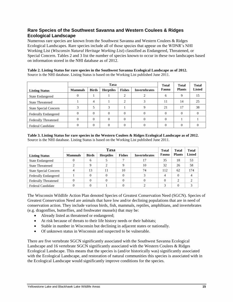
Rare Species of the Southwest Savanna and Western Coulees & Ridges
Ecological Landscape Numerous rare species are known from the Southwest Savanna and Western Coulees & Ridges
Ecological Landscapes. Rare species include all of those species that appear on the WDNR’s NHI
Working List (Wisconsin Natural Heritage Working List) classified as Endangered, Threatened, or
Special Concern. Tables 2 and 3 list the number of species known to occur in these two landscapes based
on information stored in the NHI database as of 2012.
Table 2. Listing Status for rare species in the Southwest Savanna Ecological Landscape as of 2012.
Source is the NHI database. Listing Status is based on the Working List published June 2011.
Listing Status
Taxa Total
Fauna
Total
Plants
Total
Listed Mammals Birds Herptiles Fishes Invertebrates
State Endangered 0 1 1 2 2 6 9 15
State Threatened 1 4 1 2 3 11 14 25
State Special Concern 3 5 3 1 9 21 17 38
Federally Endangered 0 0 0 0 0 0 0 0
Federally Threatened 0 0 0 0 0 0 1 1
Federal Candidate 0 0 0 0 0 0 0 0
Table 3. Listing Status for rare species in the Western Coulees & Ridges Ecological Landscape as of 2012.
Source is the NHI database. Listing Status is based on the Working List published June 2011.
Listing Status
Taxa Total
Fauna
Total
Plants
Total
Listed Mammals Birds Herptiles Fishes Invertebrates
State Endangered 0 6 5 7 17 35 18 53
State Threatened 2 9 2 9 10 32 26 58
State Special Concern 4 13 11 10 74 112 62 174
Federally Endangered 1 0 0 0 3 4 0 4
Federally Threatened 0 0 0 0 0 0 2 2
Federal Candidate 0 0 1 0 2 3 0 3
The Wisconsin Wildlife Action Plan denoted Species of Greatest Conservation Need (SGCN). Species of
Greatest Conservation Need are animals that have low and/or declining populations that are in need of
conservation action. They include various birds, fish, mammals, reptiles, amphibians, and invertebrates
(e.g. dragonflies, butterflies, and freshwater mussels) that may be:
• Already listed as threatened or endangered;
• At risk because of threats to their life history needs or their habitats;
• Stable in number in Wisconsin but declining in adjacent states or nationally.
• Of unknown status in Wisconsin and suspected to be vulnerable.
There are five vertebrate SGCN significantly associated with the Southwest Savanna Ecological
Landscape and 16 vertebrate SGCN significantly associated with the Western Coulees & Ridges
Ecological Landscape. This means that the species is (and/or historically was) significantly associated
with the Ecological Landscape, and restoration of natural communities this species is associated with in
the Ecological Landscape would significantly improve conditions for the species.
16 Rapid Ecological Assessment
Description of the Study Area
Location and Size Yellowstone Lake is a 455-acre man-made lake in Lafayette County surrounded by 5,220 acres of public
land, 4,215 of which is State Wildlife Area, 768 of which is State Park, and 237 of which is Streambank
Protection Fee Area. Yellowstone Savanna State Natural Area comprises 220 acres within Yellowstone
Lake State Park. Blackhawk Lake Wildlife Area is a 5,038 acre property located in Iowa County.
Blackhawk Lake is 455 acres and is also man-made. All acreages are based on Geographical Information
System (GIS) acreage derived from ArcSDE/Oracle WDNR Managed Lands (DML) shapefile as of
August 2011. See Figure 1 for a map of the study areas.
Ecoregion Landtype Associations Nested hierarchically within each Ecological Landscape are NHFEU Subsections which are further
divided into Landtype Associations (LTAs) (Cleland et al. 1997). These LTAs are finer scaled polygons
(areas of 10,000 – 300,000 acres) that make up each subsection, and are characterized by repeating
patterns of characteristic landforms, soil groups, regional climate, and potential vegetation; these are
most relevant to this study. Figure 3 shows the distribution of the following LTAs at YLBL:
• Platteville Savanna (222Le02). The characteristic landform pattern is sloping, with summits,
shoulders, and backslopes of ridges common. Soils are well-drained silty and loamy, with a silt loam
surface over calcareous and non-calcareous clayey, sandy, or loamy residuum, or over non-
calcareous silty loess. Most areas occur over dolostone, limestone, or sandstone bedrock. This LTA
comprises 80% of Yellowstone Lake managed lands (uplands only).
• Pecatonica Valley (222Le03). The characteristic landform pattern is sloping, with summits,
shoulders, and backslopes of ridges common. They are moderately well-drained, well-drained,
poorly drained, or somewhat poorly drained silty soils, with a silt loam surface over calcareous and
non-calcareous silty alluvium or loess. This LTA comprises approximately 20% of Yellowstone
Lake, and is mostly confined within the boundaries of the lake bed and impoundment.
• Hills and Valleys - Wisconsin River Drainage (222Lc18). Soils are well-drained to moderately
well-drained silty and loamy, with a silt loam or sandy loam surface over non-calcareous clayey or
loamy residuum or over silty loess. Most areas occur over limestone, sandstone, or shale bedrock.
This LTA comprises 100% of Blackhawk Lake managed lands.
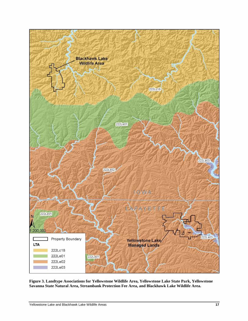
Yellowstone Lake and Blackhawk Lake Wildlife Areas 17
Figure 3. Landtype Associations for Yellowstone Wildlife Area, Yellowstone Lake State Park, Yellowstone
Savanna State Natural Area, Streambank Protection Fee Area, and Blackhawk Lake Wildlife Area.
18 Rapid Ecological Assessment
Physical Environment
Geology and Landforms Blackhawk and Yellowstone Lakes managed lands lie within the Driftless Area of Wisconsin on a vast
plateau with broad, rolling ridges and deeply dissected valleys (Watson 1960, Klingelhoets 1962).
Dolomitic limestone and sandstone form the main bedrock types underlying the study area, while shale is
also minimally influential. Saint Peter sandstone dominates the Yellowstone River valley and associated
ridges (approximately half of the site), while the remainder of the site is underlain by Galena limestone
(Murdrey et al. 1982). Saint Peter sandstone also underlies about 30% of Blackhawk Lake managed
lands, mostly in the southern half, while the remaining area is underlain mostly by limestone. A mantle of
loess covers all of the uplands as well as most of the valley slopes and terraces (Watson 1960,
Klingelhoets 1962). This loess was probably blown in from the Mississippi River during glacial periods.
The lack of direct, recent glacial influence on the region resulted in a marked absence of lakes. This
important aspect of geological history is tied directly to the creation of Blackhawk and Yellowstone
Lakes, artificial impoundments on streams installed to provide lakes in a landscape where they do not
occur naturally.
Soils Most soils in the study area are deep, well-drained silt loams (Watson 1960, Klingelhoets 1962).
Limestone and sometimes sandstone bedrock lie close to the surface in scattered locations throughout
both sites, however, resulting in shallow soils and exposed bedrock (sometimes in the form of cliffs or
outcrops). Alluvial deposits occur along stream and river bottoms, yielding poorly-drained soils.
Hydrology Yellowstone Lake (information from Piening and Threinen 1968a and WDNR 2011a)
Yellowstone Lake and its associated managed lands are within the Yellowstone River Watershed. This
watershed is dominated by agriculture (60%), forest (26%) and grassland (11%), and is ranked ‘high’ for
nonpoint source issues affecting streams and groundwater and ‘medium’ for nonpoint source issues
affecting lakes. The watershed can be divided into five subwatersheds: Cannon Creek, McClintock
Creek, Steiner Branch, Yellowstone River, and Yellowstone Lake.
In 1954, a 1,200-foot-long earthen dike and 100-foot concrete control structure were installed on the
Yellowstone River, creating the 455-acre Yellowstone Lake. The dam structure was designed to raise the
level of the Yellowstone River 23 feet behind nearly a quarter of a mile of dike to create an impoundment
1.9 miles wide. This is a shallow, irregular body with generally steep shores except for the gradual
slopes of its upstream end and the bay areas of the south shoreline. The original Yellowstone River
channel conforms closely with the configurations of the south shoreline.
Four water bodies contribute to Yellowstone Lake’s volume: the Yellowstone River, Steiner Branch, and
two small spring-fed streams. Steiner Branch is a cool-water Class II and III trout stream, about one-half
mile of which is in the Yellowstone Lake Wildlife Area; its mouth is located above Yellowstone Lake.
The Yellowstone River is a warm water drainage stream. At least 12 springs occur within Yellowstone
Lake managed lands.
Yellowstone Lake and Blackhawk Lake Wildlife Areas 19
Blackhawk Lake (information from Piening and Threinen, 1968b and WDNR 2011b)
Blackhawk Lake is within the Otter and Morrey Creeks Watershed. The streams in this watershed have a
high gradient, and most support trout (or did in the past).
Blackhawk Lake is 220 acres, has a maximum depth of 40 feet, and was created by impounding the
headwaters of Otter Creek in 1964 as part of a flood control project.
Otter Creek is a tributary to the Wisconsin River. It is a cool-water Class II trout stream for eight miles of
its length above Dickinson Creek (Blackhawk Lake not included) and is considered an impaired water.
Narveson Creek, a cold-water tributary to Otter Creek, is a spring fed Class II trout fishery, and courses
through the northwestern part of the study area. Cave Hollow Creek is a spring-fed, cool-water stream
that flows through the southwestern tip of the study area. It has a limestone bedrock bottom as well as
limestone bluffs along its banks. Several other unnamed creeks flow into Otter Creek within the study
area boundaries.
Vegetation Historical Vegetation Data from the original Public Land Surveys are often used to infer forest composition and tree species
dominance for large areas in Wisconsin prior to widespread Euro-American settlement. The purpose of
examining historical conditions is to identify ecosystem factors that formerly sustained species and
communities that are now altered in number, size, or extent, or which have been changed functionally
(for example, by constructing dams, or suppressing fires). Although data are limited to a specific
snapshot in time, they provide valuable insights into Wisconsin’s ecological capabilities. Maintaining or
restoring some lands to more closely resemble historic systems and including some structural or
compositional components of the historic landscape within actively managed lands can help conserve
important elements of biological diversity (WDNR In Prep. a). Public Land Surveys for the area
comprising YLBL were conducted between 1846 and 1850.
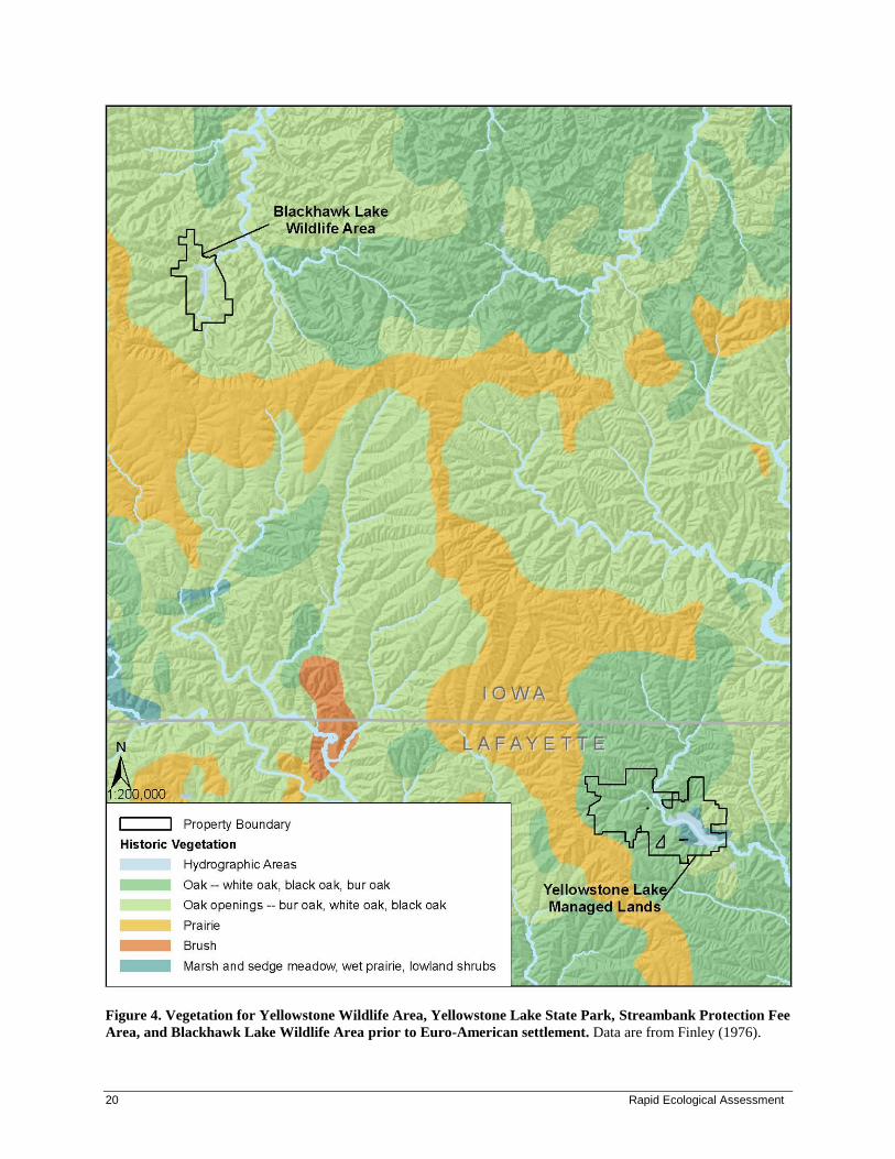
The early vegetation of Wisconsin was mapped by Robert Finley and published in 1976 (Fig. 4; Finley,
1976), and was based on notes and maps from the original Public Land Surveys. Finley’s map indicates
that Blackhawk Lake was dominated by Oak Opening, while Yellowstone Lake was about 70% oak-
dominated forest (white [Quercus alba], bur [Quercus macrocarpa], and/or black oak [Quercus
velutina]), 10% Oak Opening, and 10% wetland (marsh, sedge meadow, wet prairie, and/or lowland
shrub). Oaks that were noted in the surveyor’s notes (Wisconsin Board of Commissioners of Public
Lands 1832) at both sites were surprisingly small, ranging from 8-16 inch DBH, and included bur, white,
black and northern red [Quercus rubra]. Occasional bur oaks were noted at 30-33 inch DBH. Surveyors
described the terrain as uneven, rolling, and even “exceedingly hilly, “and described the vegetation as
thinly timbered. In the central-eastern part of Blackhawk Lake, they even made special note of the
absence of undergrowth and grassy areas. All of this information points towards prairie, oak savanna and
oak woodland as the dominant cover types.
The Land Economic Inventory of 1939 (Bordner 1939) shows commonalities between the two sites:
most areas were actively farmed, and were described as cleared cropland, pasture, or permanent pasture
(designated as non-tillable). Stump pastures were scattered throughout, along with occasional areas
labeled as “poor land previously cropped.” All wooded areas were described as oak-hickory, 6-12 inch
DBH, with “medium” to “poor” stand densities, and were mostly small, isolated, and often linear.
20 Rapid Ecological Assessment
Figure 4. Vegetation for Yellowstone Wildlife Area, Yellowstone Lake State Park, Streambank Protection Fee
Area, and Blackhawk Lake Wildlife Area prior to Euro-American settlement. Data are from Finley (1976).
Yellowstone Lake and Blackhawk Lake Wildlife Areas 21
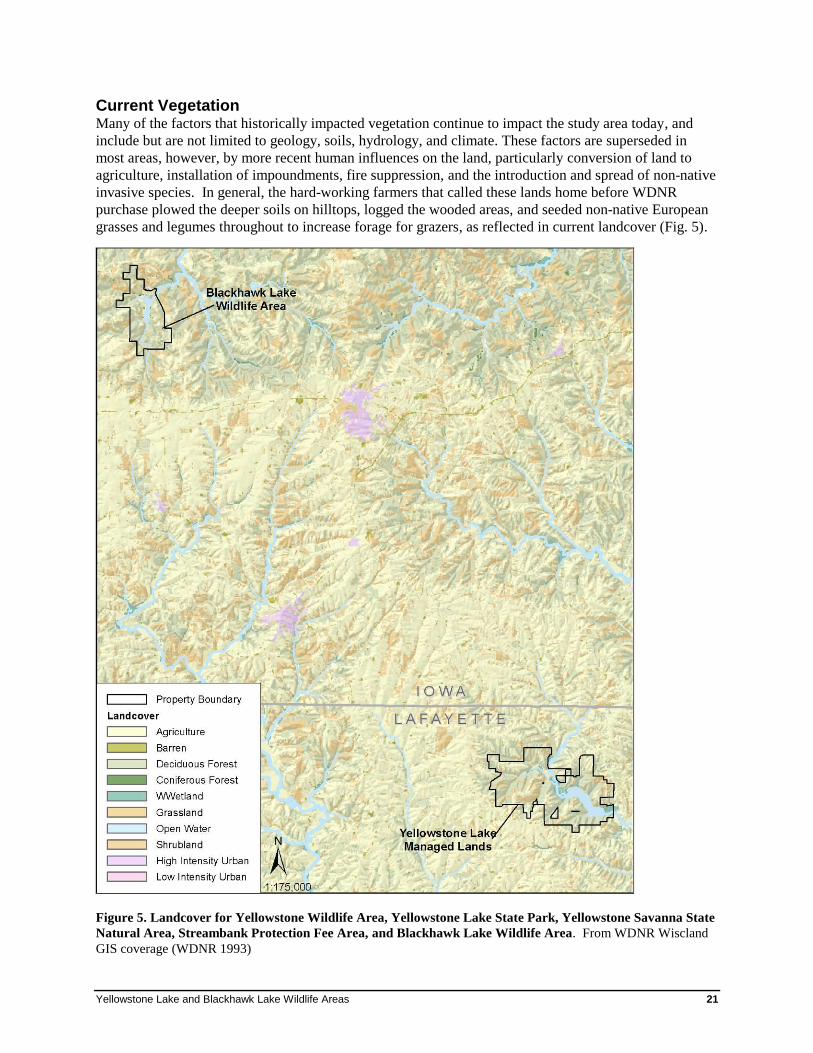
Current Vegetation Many of the factors that historically impacted vegetation continue to impact the study area today, and
include but are not limited to geology, soils, hydrology, and climate. These factors are superseded in
most areas, however, by more recent human influences on the land, particularly conversion of land to
agriculture, installation of impoundments, fire suppression, and the introduction and spread of non-native
invasive species. In general, the hard-working farmers that called these lands home before WDNR
purchase plowed the deeper soils on hilltops, logged the wooded areas, and seeded non-native European
grasses and legumes throughout to increase forage for grazers, as reflected in current landcover (Fig. 5).
Figure 5. Landcover for Yellowstone Wildlife Area, Yellowstone Lake State Park, Yellowstone Savanna State
Natural Area, Streambank Protection Fee Area, and Blackhawk Lake Wildlife Area. From WDNR Wiscland
GIS coverage (WDNR 1993)

22 Rapid Ecological Assessment
Today, four general land cover types dominate Yellowstone and Blackhawk Lakes: open upland, brushy
upland, wooded upland, and wetland. Details of these cover types vis-à-vis their relict native plant
communities and condition following such a rich agricultural past are discussed in below.
At Yellowstone Lake, wooded uplands comprise approximately 56% (3,000+ acres) of the area, grassy
uplands comprise approximately 30% (1,600+ acres), brushy uplands and old fields planted to trees
(400+ acres and 120+ acres, respectively) comprise approximately 10%, and wetlands comprise about
5% (250+ acres; Fig. 6). Wooded areas at Yellowstone Lake occur naturally in ravines and on north- and
east-facing slopes. They consist of mostly young second-growth southern dry-mesic forest and
overgrown oak savanna with depauperate ground layers and abundant non-native invasive species,
though some higher quality wooded blocks have remained relatively intact. Occasional tiny Pine Relicts
(0.5 acres or less) occur here as well, and 72 acres of pine plantation are scattered throughout the
property (WisFIRS). At Yellowstone Lake, about one-half of the area occupied by open uplands is
currently under cultivation, while the remaining half is mostly old field or is actively being hayed. In
places where soils were too shallow for plowing, remnant Dry Prairie occurs, albeit in a degraded state;
non-native weedy and invasive plants, and woody invaders often dominate. Low-quality wetlands
(Southern Sedge Meadow and Shrub-carr) occur naturally along narrow stream corridors at Yellowstone
Lake and in association with springs, and unnaturally in the form of emergent marsh at impoundments.
Figure 6. Cover Types of Yellowstone Lake Managed Lands (2010 NAIP and 2011 NHI field surveys)
Wooded Upland
Stream
Corridor
Wetland
Impoundment
Wetland
Brushy Upland and
Tree Planting
Open Upland
At Blackhawk Lake, wooded uplands comprise approximately 94% (over 4,000 acres) of the area, grassy
uplands comprise approximately 5% (over 250 acres), and wetlands comprise less than 1% (Fig. 7).
Figure 7. Cover Types of Blackhawk Lake Wildlife Area (WisFIRS, 2010 NAIP and 2010 NHI field surveys)
Wooded Upland
Stream
Corridor
Wetland Impoundment
WetlandOpen Upland
Yellowstone Lake and Blackhawk Lake Wildlife Areas 23
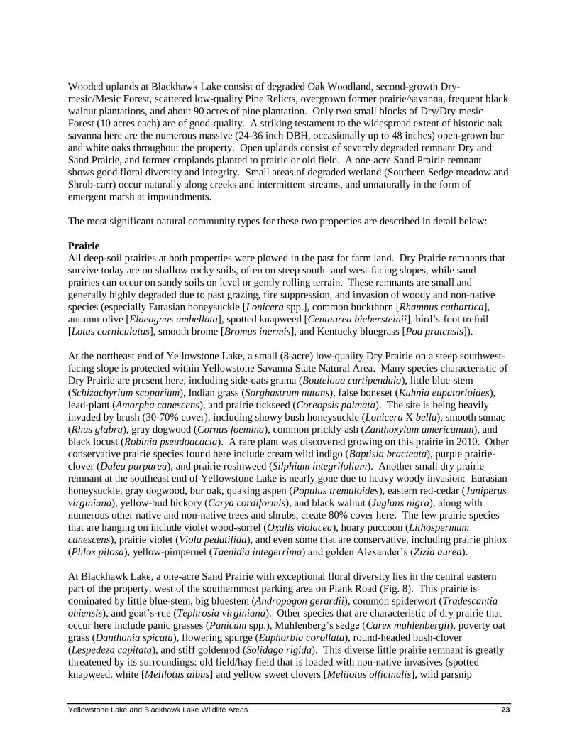
Wooded uplands at Blackhawk Lake consist of degraded Oak Woodland, second-growth Dry-
mesic/Mesic Forest, scattered low-quality Pine Relicts, overgrown former prairie/savanna, frequent black
walnut plantations, and about 90 acres of pine plantation. Only two small blocks of Dry/Dry-mesic
Forest (10 acres each) are of good-quality. A striking testament to the widespread extent of historic oak
savanna here are the numerous massive (24-36 inch DBH, occasionally up to 48 inches) open-grown bur
and white oaks throughout the property. Open uplands consist of severely degraded remnant Dry and
Sand Prairie, and former croplands planted to prairie or old field. A one-acre Sand Prairie remnant
shows good floral diversity and integrity. Small areas of degraded wetland (Southern Sedge meadow and
Shrub-carr) occur naturally along creeks and intermittent streams, and unnaturally in the form of
emergent marsh at impoundments.
The most significant natural community types for these two properties are described in detail below:
Prairie
All deep-soil prairies at both properties were plowed in the past for farm land. Dry Prairie remnants that
survive today are on shallow rocky soils, often on steep south- and west-facing slopes, while sand
prairies can occur on sandy soils on level or gently rolling terrain. These remnants are small and
generally highly degraded due to past grazing, fire suppression, and invasion of woody and non-native
species (especially Eurasian honeysuckle [Lonicera spp.], common buckthorn [Rhamnus cathartica],
autumn-olive [Elaeagnus umbellata], spotted knapweed [Centaurea biebersteinii], bird’s-foot trefoil
[Lotus corniculatus], smooth brome [Bromus inermis], and Kentucky bluegrass [Poa pratensis]).
At the northeast end of Yellowstone Lake, a small (8-acre) low-quality Dry Prairie on a steep southwest-
facing slope is protected within Yellowstone Savanna State Natural Area. Many species characteristic of
Dry Prairie are present here, including side-oats grama (Bouteloua curtipendula), little blue-stem
(Schizachyrium scoparium), Indian grass (Sorghastrum nutans), false boneset (Kuhnia eupatorioides),
lead-plant (Amorpha canescens), and prairie tickseed (Coreopsis palmata). The site is being heavily
invaded by brush (30-70% cover), including showy bush honeysuckle (Lonicera X bella), smooth sumac
(Rhus glabra), gray dogwood (Cornus foemina), common prickly-ash (Zanthoxylum americanum), and
black locust (Robinia pseudoacacia). A rare plant was discovered growing on this prairie in 2010. Other
conservative prairie species found here include cream wild indigo (Baptisia bracteata), purple prairie-
clover (Dalea purpurea), and prairie rosinweed (Silphium integrifolium). Another small dry prairie
remnant at the southeast end of Yellowstone Lake is nearly gone due to heavy woody invasion: Eurasian
honeysuckle, gray dogwood, bur oak, quaking aspen (Populus tremuloides), eastern red-cedar (Juniperus
virginiana), yellow-bud hickory (Carya cordiformis), and black walnut (Juglans nigra), along with
numerous other native and non-native trees and shrubs, create 80% cover here. The few prairie species
that are hanging on include violet wood-sorrel (Oxalis violacea), hoary puccoon (Lithospermum
canescens), prairie violet (Viola pedatifida), and even some that are conservative, including prairie phlox
(Phlox pilosa), yellow-pimpernel (Taenidia integerrima) and golden Alexander’s (Zizia aurea).
At Blackhawk Lake, a one-acre Sand Prairie with exceptional floral diversity lies in the central eastern
part of the property, west of the southernmost parking area on Plank Road (Fig. 8). This prairie is
dominated by little blue-stem, big bluestem (Andropogon gerardii), common spiderwort (Tradescantia
ohiensis), and goat’s-rue (Tephrosia virginiana). Other species that are characteristic of dry prairie that
occur here include panic grasses (Panicum spp.), Muhlenberg’s sedge (Carex muhlenbergii), poverty oat
grass (Danthonia spicata), flowering spurge (Euphorbia corollata), round-headed bush-clover
(Lespedeza capitata), and stiff goldenrod (Solidago rigida). This diverse little prairie remnant is greatly
threatened by its surroundings: old field/hay field that is loaded with non-native invasives (spotted
knapweed, white [Melilotus albus] and yellow sweet clovers [Melilotus officinalis], wild parsnip
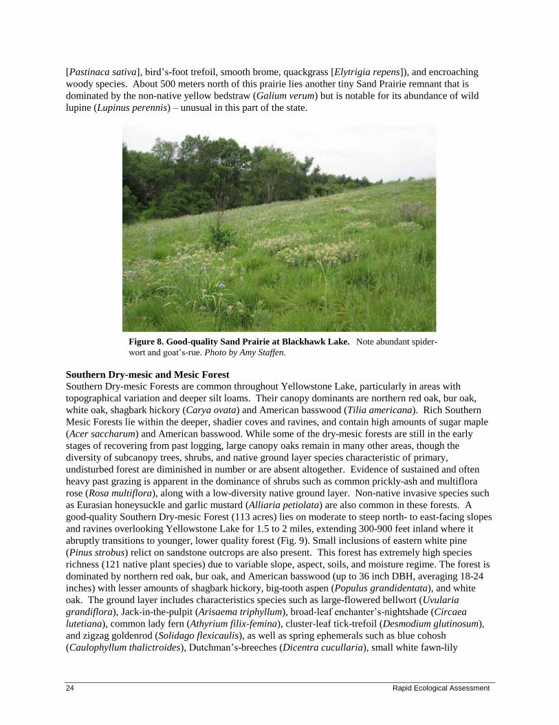
24 Rapid Ecological Assessment
[Pastinaca sativa], bird’s-foot trefoil, smooth brome, quackgrass [Elytrigia repens]), and encroaching
woody species. About 500 meters north of this prairie lies another tiny Sand Prairie remnant that is
dominated by the non-native yellow bedstraw (Galium verum) but is notable for its abundance of wild
lupine (Lupinus perennis) – unusual in this part of the state.
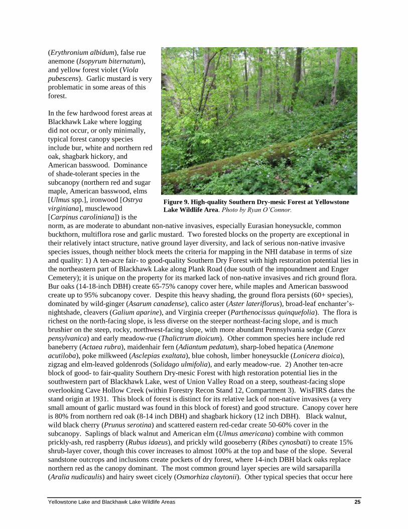
Southern Dry-mesic and Mesic Forest
Southern Dry-mesic Forests are common throughout Yellowstone Lake, particularly in areas with
topographical variation and deeper silt loams. Their canopy dominants are northern red oak, bur oak,
white oak, shagbark hickory (Carya ovata) and American basswood (Tilia americana). Rich Southern
Mesic Forests lie within the deeper, shadier coves and ravines, and contain high amounts of sugar maple
(Acer saccharum) and American basswood. While some of the dry-mesic forests are still in the early
stages of recovering from past logging, large canopy oaks remain in many other areas, though the
diversity of subcanopy trees, shrubs, and native ground layer species characteristic of primary,
undisturbed forest are diminished in number or are absent altogether. Evidence of sustained and often
heavy past grazing is apparent in the dominance of shrubs such as common prickly-ash and multiflora
rose (Rosa multiflora), along with a low-diversity native ground layer. Non-native invasive species such
as Eurasian honeysuckle and garlic mustard (Alliaria petiolata) are also common in these forests. A
good-quality Southern Dry-mesic Forest (113 acres) lies on moderate to steep north- to east-facing slopes
and ravines overlooking Yellowstone Lake for 1.5 to 2 miles, extending 300-900 feet inland where it
abruptly transitions to younger, lower quality forest (Fig. 9). Small inclusions of eastern white pine
(Pinus strobus) relict on sandstone outcrops are also present. This forest has extremely high species
richness (121 native plant species) due to variable slope, aspect, soils, and moisture regime. The forest is
dominated by northern red oak, bur oak, and American basswood (up to 36 inch DBH, averaging 18-24
inches) with lesser amounts of shagbark hickory, big-tooth aspen (Populus grandidentata), and white
oak. The ground layer includes characteristics species such as large-flowered bellwort (Uvularia
grandiflora), Jack-in-the-pulpit (Arisaema triphyllum), broad-leaf enchanter’s-nightshade (Circaea
lutetiana), common lady fern (Athyrium filix-femina), cluster-leaf tick-trefoil (Desmodium glutinosum),
and zigzag goldenrod (Solidago flexicaulis), as well as spring ephemerals such as blue cohosh
(Caulophyllum thalictroides), Dutchman’s-breeches (Dicentra cucullaria), small white fawn-lily
Figure 8. Good-quality Sand Prairie at Blackhawk Lake. Note abundant spider-
wort and goat’s-rue. Photo by Amy Staffen.
Yellowstone Lake and Blackhawk Lake Wildlife Areas 25
Figure 9. High-quality Southern Dry-mesic Forest at Yellowstone
Lake Wildlife Area. Photo by Ryan O’Connor.
(Erythronium albidum), false rue
anemone (Isopyrum biternatum),
and yellow forest violet (Viola
pubescens). Garlic mustard is very
problematic in some areas of this
forest.
In the few hardwood forest areas at
Blackhawk Lake where logging
did not occur, or only minimally,
typical forest canopy species
include bur, white and northern red
oak, shagbark hickory, and
American basswood. Dominance
of shade-tolerant species in the
subcanopy (northern red and sugar
maple, American basswood, elms
[Ulmus spp.], ironwood [Ostrya
virginiana], musclewood
[Carpinus caroliniana]) is the
norm, as are moderate to abundant non-native invasives, especially Eurasian honeysuckle, common
buckthorn, multiflora rose and garlic mustard. Two forested blocks on the property are exceptional in
their relatively intact structure, native ground layer diversity, and lack of serious non-native invasive
species issues, though neither block meets the criteria for mapping in the NHI database in terms of size
and quality: 1) A ten-acre fair- to good-quality Southern Dry Forest with high restoration potential lies in
the northeastern part of Blackhawk Lake along Plank Road (due south of the impoundment and Enger
Cemetery); it is unique on the property for its marked lack of non-native invasives and rich ground flora.
Bur oaks (14-18-inch DBH) create 65-75% canopy cover here, while maples and American basswood
create up to 95% subcanopy cover. Despite this heavy shading, the ground flora persists (60+ species),
dominated by wild-ginger (Asarum canadense), calico aster (Aster lateriflorus), broad-leaf enchanter’s-
nightshade, cleavers (Galium aparine), and Virginia creeper (Parthenocissus quinquefolia). The flora is
richest on the north-facing slope, is less diverse on the steeper northeast-facing slope, and is much
brushier on the steep, rocky, northwest-facing slope, with more abundant Pennsylvania sedge (Carex
pensylvanica) and early meadow-rue (Thalictrum dioicum). Other common species here include red
baneberry (Actaea rubra), maidenhair fern (Adiantum pedatum), sharp-lobed hepatica (Anemone
acutiloba), poke milkweed (Asclepias exaltata), blue cohosh, limber honeysuckle (Lonicera dioica),
zigzag and elm-leaved goldenrods (Solidago ulmifolia), and early meadow-rue. 2) Another ten-acre
block of good- to fair-quality Southern Dry-mesic Forest with high restoration potential lies in the
southwestern part of Blackhawk Lake, west of Union Valley Road on a steep, southeast-facing slope
overlooking Cave Hollow Creek (within Forestry Recon Stand 12, Compartment 3). WisFIRS dates the
stand origin at 1931. This block of forest is distinct for its relative lack of non-native invasives (a very
small amount of garlic mustard was found in this block of forest) and good structure. Canopy cover here
is 80% from northern red oak (8-14 inch DBH) and shagbark hickory (12 inch DBH). Black walnut,
wild black cherry (Prunus serotina) and scattered eastern red-cedar create 50-60% cover in the
subcanopy. Saplings of black walnut and American elm (Ulmus americana) combine with common
prickly-ash, red raspberry (Rubus idaeus), and prickly wild gooseberry (Ribes cynosbati) to create 15%
shrub-layer cover, though this cover increases to almost 100% at the top and base of the slope. Several
sandstone outcrops and inclusions create pockets of dry forest, where 14-inch DBH black oaks replace
northern red as the canopy dominant. The most common ground layer species are wild sarsaparilla
(Aralia nudicaulis) and hairy sweet cicely (Osmorhiza claytonii). Other typical species that occur here
26 Rapid Ecological Assessment
include Jack-in-the-pulpit, large-flowered bellwort, common lady fern, zigzag goldenrod, elm-leaved
goldenrod, tinker’s-weed (Triosteum perfoliatum), and rattlesnake fern (Botrychium virginianum). The
spring ephemeral Virginia spring-beauty (Claytonia virginica) was also noted here.
Oak Savanna (Oak Woodland, Oak Opening, Oak Barrens)
Yellowstone Savanna State Natural Area contains a fair- to good-quality remnant oak savanna that is
currently undergoing restoration (Fig. 14); it is situated along a southwest-northeast-trending ravine.
Although the understory has lost some native species due to past grazing, plowing, and lack of fire, the
oak structure remains relatively intact. Large bur oaks (18-24 inch DBH) are scattered throughout the
ravine, with northern red oak, white oak and shagbark hickory the dominant canopy species. Smaller (12
inch DBH) wild black cherry, American basswood, and American elm dominate the subcanopy. As one
moves upslope from the ravine, a transition is evident as the moderately closed canopy (typical of Oak
Woodland) slowly opens and provides a more park-like appearance (typical of Oak Opening) with large
oaks and other savanna indicator species (e.g., eastern figwort [Scrophularia marilandica]). The
groundcover is weedy with garlic mustard, white snakeroot (Eupatorium rugosum), bog clearweed (Pilea
fontana), and common blackberry (Rubus alleghaniensis).
A striking testament to the widespread extent of historic oak opening at Blackhawk Lake are the
numerous massive (24-36 inch DBH, occasionally up to 48 inches) open-grown bur and white oaks
throughout the property. As with the hardwood forests, however, native woody succession is in
advanced stages in former savanna sites, non-native invasive species are abundant, and the ground layers
are very low in native diversity. Where soils are sandy, black oak replaces bur and northern red oak, and
pressure from natural succession and non-native invasives is less pronounced, although Pennsylvania
sedge dominates the ground layer in these areas.
A 15-acre moderate-quality Oak Woodland lies in the northwest part of the Blackhawk Lake property on
a west- and southwest-facing slope (part of Forest Recon Compartment 1, Stand 33). Although not high
enough quality for entry into the NHI database, it merits mention here because it will be undergoing a
timber harvest in the near future and shows potential for Oak Opening/Oak Woodland restoration. The
stand originated in 1934 (WisFIRS) and is dominated by 11- to 15-inch DBH white, bur and northern red
oak that create a filtered canopy. Pole-sized oak, yellow-bud hickory and white birch (Betula papyrifera)
are densely stocked in the subcanopy, while beaked hazelnut (Corylus cornuta), common prickly-ash,
multiflora rose, common blackberry and prickly wild gooseberry create a moderate to dense shrub layer.
Some conservative species that are typical of Oak Woodland persist here, and include golden Alexanders,
poke milkweed, Virginia wild-rye (Elymus virginicus), and tinker’s-weed. In some places, especially to
the north, garlic mustard is common.
Yellowstone Lake and Blackhawk Lake Wildlife Areas 27
Pine Relict and Cliff Communities
At Yellowstone Lake, tiny Pine Relicts with eastern white pine are found in association with sandstone
outcrops south of the lake, within a matrix of Southern Dry-mesic Forest. Typical herbs here include
American starflower (Trientalis borealis), Canada mayflower (Maianthemum canadense), and bracken
fern (Pteridium aquilinum). Moist, mossy cliffs on sandstone outcrops occur at the southeast end of the
lake within a mesic forest matrix.
Three small Pine Relicts (0.5, 0.8 and 2 acres) were surveyed at Blackhawk Lake, all of which were
ranked as fair to poor quality. This low quality is a result of past grazing, abundance of shade-tolerant
species, and invasion by weed natives and non-native invasives (especially garlic mustard, spotted
knapweed, autumn-olive, and common blackberry). All of the Pine Relicts are associated with
picturesque sandstone outcrops and short, dry cliffs (5-20 feet high), and often afford lovely views of the
surrounding landscape. Interestingly, the dominant pine species are different at each of the three
subsites: red pine (Pinus resinosa) at one, eastern white pine at another, and jack pine (Pinus banksiana)
at the third. Both black and white oaks also figure prominently in the canopy of these pine relicts. Low
shrubs create the dominant ground cover, and are typified by huckleberry (Gaylussacia baccata), velvet-
leaf blueberry (Vaccinium myrtilloides), and northern bush-honeysuckle (Diervilla lonicera). Common
ground layer herbs include poverty oat grass, Pennsylvania sedge, and Canada mayflower.
Surrogate Grassland
At Yellowstone Lake, about one-half of the area occupied by open uplands is currently under cultivation,
while the remaining half is mostly old field or is actively being hayed, with small acreages that have been
converted to prairie.
More than 200 acres of former cropland have been converted to prairie, old field, and hay field at
Blackhawk Lake; 75 acres remain under sharecrop agreement. The prairie plantings are well-established,
have sufficient native grass cover to sustain regular and hot prescribed burns, and harbor a good diversity
of native prairie species, though some would not have occurred historically in this part of the state (most
notably prairie dock). These grassland sites are also relatively free of non-native invasives, though they
loom everywhere within their vicinity: along mowed field roads, in adjacent old fields/hay fields, and in
the shade of Colorado blue spruces planted in lines within the grasslands. Apart from the “usual
suspects” that typically invade grasslands in southwestern Wisconsin, another non-native plant was noted
as behaving extremely aggressively in a prairie planting west of Plank Road: perennial pea-vine
(Lathyrus latifolius); monitoring of the spread of this plant is recommended. The old fields at Blackhawk
Lake are dominated by smooth brome, timothy (Phleum pratense), quackgrass, Canadian goldenrod
(Solidago canadensis), wild parsnip, spotted knapweed, and bird’s-foot trefoil; their open character is
frequently threatened by woody invaders such as autumn-olive, Eurasian honeysuckle, common
buckthorn and multiflora rose.
28 Rapid Ecological Assessment
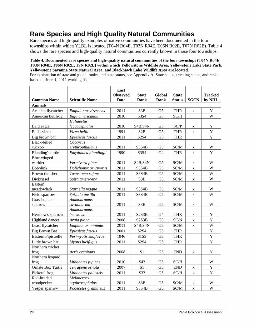
Rare Species and High Quality Natural Communities
Rare species and high-quality examples of native communities have been documented in the four
townships within which YLBL is located (T04N R04E, T03N R04E, T06N R02E, T07N R02E). Table 4
shows the rare species and high-quality natural communities currently known in those four townships.
Table 4. Documented rare species and high-quality natural communities of the four townships (T04N R04E,
T03N R04E, T06N R02E, T7N R02E) within which Yellowstone Wildlife Area, Yellowstone Lake State Park,
Yellowstone Savanna State Natural Area, and Blackhawk Lake Wildlife Area are located.
For explanation of state and global ranks, and state status, see Appendix A. State status, tracking status, and ranks
based on June 1, 2011 working list.
Common Name Scientific Name
Last
Observed
Date
State
Rank
Global
Rank
State
Status SGCN
Tracked
by NHI
Animals
Acadian flycatcher Empidonax virescens 2011 S3B G5 THR x Y
American bullfrog Bufo americanus 2010 S3S4 G5 SC/H W
Bald eagle
Haliaeetus
leucocephalus 2010 S4B,S4N G5 SC/P x Y
Bell's vireo Vireo bellii 1991 S2B G5 THR x Y
Big brown bat Eptesicus fuscus 2011 S2S4 G5 THR Y
Black-billed
cuckoo
Coccyzus
erythropthalmus 2011 S3S4B G5 SC/M x W
Blanding's turtle Emydoidea blandingii 1990 S3S4 G4 THR x Y
Blue-winged
warbler Vermivora pinus 2011 S4B,S4N G5 SC/M x W
Bobolink Dolichonyx oryzivorus 2011 S3S4B G5 SC/M x W
Brown thrasher Toxostoma rufum 2011 S3S4B G5 SC/M x W
Dickcissel Spiza americana 2011 S3B G5 SC/M x W
Eastern
meadowlark Sturnella magna 2011 S3S4B G5 SC/M x W
Field sparrow Spizella pusilla 2011 S3S4B G5 SC/M x W
Grasshopper
sparrow
Ammodramus
savannarum 2011 S3B G5 SC/M x W
Henslow's sparrow
Ammodramus
henslowii 2011 S2S3B G4 THR x Y
Highland dancer Argia plana 2008 S2S3B G5 SC/N x Y
Least flycatcher Empidonax minimus 2011 S4B,S4N G5 SC/M x W
Big Brown Bat Eptesicus fuscus 2001 S2S4 G5 THR Y
Eastern Pipistrelle Perimyotis subflavus 1946 S1S3 G5 THR Y
Little brown bat Myotis lucifugus 2011 S2S4 G5 THR Y
Northern cricket
frog Acris crepitans 2008 S1 G5 END x Y
Northern leopard
frog Lithobates pipiens 2010 S4? G5 SC/H W
Ornate Box Turtle Terrapene ornata 2007 S1 G5 END x Y
Pickerel frog Lithobates palustris 2011 S3? G5 SC/H x Y
Red-headed
woodpecker
Melanerpes
erythrocephalus 2011 S3B G5 SC/M x W
Vesper sparrow Pooecetes gramineus 2011 S3S4B G5 SC/M x W
Yellowstone Lake and Blackhawk Lake Wildlife Areas 29
Common Name Scientific Name
Last
Observed
Date
State
Rank
Global
Rank
State
Status SGCN
Tracked
by NHI
Western
meadowlark Sturnella neglecta 1997 S2B G5 SC/M x Y
Willow flycatcher Empidonax traillii 2011 S4B,S4N G5 SC/M x W
Wood thrush Hylocichla mustelina 2011 S4B,S4N G5 SC/M x W
Yellow-billed
cuckoo Coccyzus americanus 2011 S3B G5 SC/M x W
Yellow-breasted
chat Icteria virens 2010 S2B G5 SC/M x Y
Bird rookery Bird Rookery 2010 SU G5 SC Y
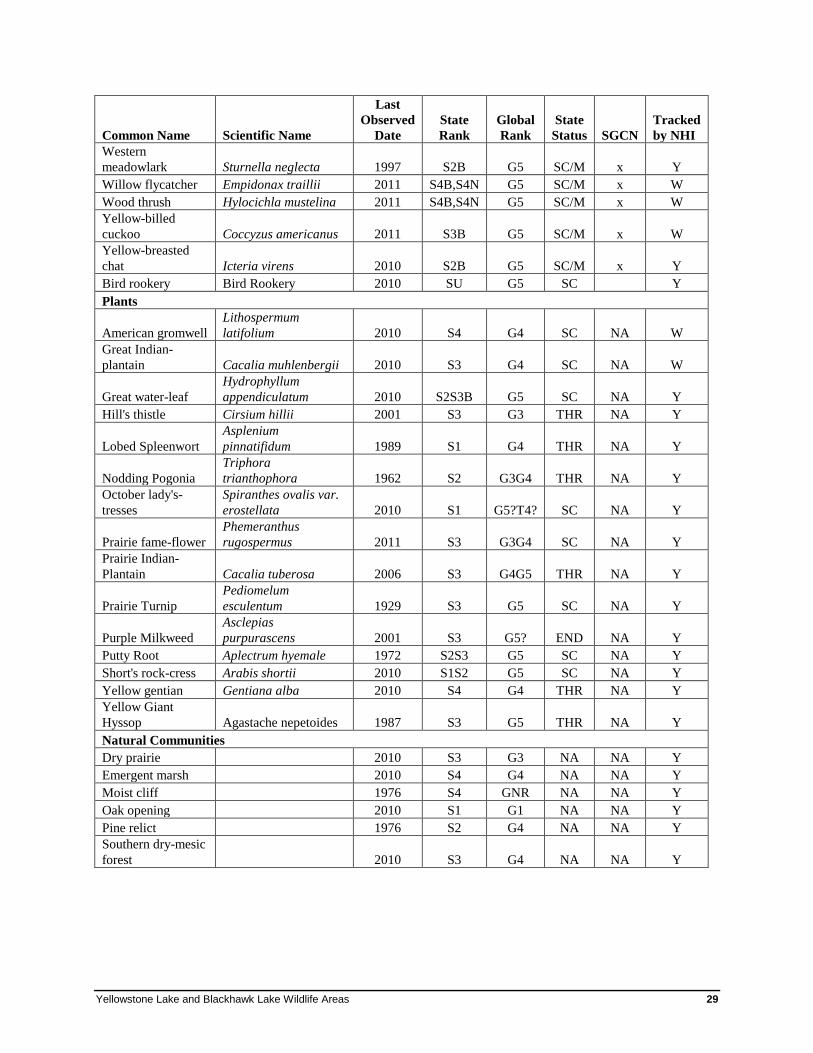
Plants
American gromwell
Lithospermum
latifolium 2010 S4 G4 SC NA W
Great Indian-
plantain Cacalia muhlenbergii 2010 S3 G4 SC NA W
Great water-leaf
Hydrophyllum
appendiculatum 2010 S2S3B G5 SC NA Y
Hill's thistle Cirsium hillii 2001 S3 G3 THR NA Y
Lobed Spleenwort
Asplenium
pinnatifidum 1989 S1 G4 THR NA Y
Nodding Pogonia
Triphora
trianthophora 1962 S2 G3G4 THR NA Y
October lady's-
tresses
Spiranthes ovalis var.
erostellata 2010 S1 G5?T4? SC NA Y
Prairie fame-flower
Phemeranthus
rugospermus 2011 S3 G3G4 SC NA Y
Prairie Indian-
Plantain Cacalia tuberosa 2006 S3 G4G5 THR NA Y
Prairie Turnip
Pediomelum
esculentum 1929 S3 G5 SC NA Y
Purple Milkweed
Asclepias
purpurascens 2001 S3 G5? END NA Y
Putty Root Aplectrum hyemale 1972 S2S3 G5 SC NA Y
Short's rock-cress Arabis shortii 2010 S1S2 G5 SC NA Y
Yellow gentian Gentiana alba 2010 S4 G4 THR NA Y
Yellow Giant
Hyssop Agastache nepetoides 1987 S3 G5 THR NA Y
Natural Communities
Dry prairie 2010 S3 G3 NA NA Y
Emergent marsh 2010 S4 G4 NA NA Y
Moist cliff 1976 S4 GNR NA NA Y
Oak opening 2010 S1 G1 NA NA Y
Pine relict 1976 S2 G4 NA NA Y
Southern dry-mesic
forest 2010 S3 G4 NA NA Y
30 Rapid Ecological Assessment
Management Opportunities and Considerations for Biodiversity Conservation
Landscape Level Opportunities and Considerations
Wildlife Action Plan Conservation Opportunity Area Conservation Opportunity Areas (COAs) are places in Wisconsin that contain ecological features, natural
communities, or Species of Greatest Conservation Need habitat for which Wisconsin has a unique
responsibility for protection when viewed from the global, continental, upper Midwest, or state
perspective. Blackhawk Lake Wildlife Area lies within the larger Dodgeville and Wyoming Oak
Woodland/Savanna COA, an opportunity identified as having continental significance.
Altered Ecological Processes The vegetation that historically occurred at YLBL developed within a complex environment comprised
of both elements that are relatively static over ecological time (e.g., soils, underlying landforms) and
dynamic ecological processes (e.g., hydrological cycles, nutrient cycles, wildfires). Many of the dynamic
ecological processes that shaped these landscapes have been altered by humans.
The hydrology of Otter Creek and the Yellowstone River was dramatically altered with the installation of
impoundments and creation of Blackhawk and Yellowstone Lakes. The negative impacts of
impoundments on animal communities are well-documented and should be mitigated to the extent
possible and practical. Dams affect aquatic species and habitats by fragmenting them into disjunct
segments, preventing the movements of some species between different stretches of the water bodies.
Water below impoundments is warmer and of diminished quality, negatively affecting the aquatic
macroinvertebrate communities, increasing the growth of periphyton, and diminishing the quality and
quantity of fish habitat. Impoundments typically have organically rich bottom sediments, resulting in
algal blooms and periods of dissolved oxygen depletion near the bottom. Surveys conducted by WDNR
in 1999 and 2000 at Blackhawk Lake revealed that the bottom discharge structure was ineffective, as
evidenced by significantly higher temperatures below the dam and lower dissolved oxygen levels at the
bottom (WDNR 2002). This study also documented that the macroinvertebrate community was “very
good” above the lake and “fair” below the lake.
Another ecological process that has been altered is how fire interacts with the natural communities and
rare species of Yellowstone and Blackhawk Lakes. For all of the natural communities (excluding cliffs,
aquatic communities, and Southern Mesic Forest in protected coves), fire was a critical process in their
development and the species that depend on them (Kozlowski and Ahlgren 1974). Without regular fire,
native woody species can invade and dominate these communities. Fire is also important for removing
excess thatch in prairies, which can limit the growth and reproduction of native plants (McDaniel 2000).
In woodlands, fire facilitates seedling establishment (Rouse 1986), controls tree species that are not
adapted to fire (Abrams 1992), and prevents smothering of short-statured plants through the removal of
leaf litter (Richard Henderson, personal communication). Re-introducing fire into an area should be done
with consideration of all of the species currently using the habitat and how the fire may impact the
amount and quality of habitat available.
Non-Native Invasive Species Many non-native invasive plants, animals and pathogens, both terrestrial and aquatic, are present at
YLBL and in the surrounding landscape. Non-native invasive species thrive in newly disturbed areas, but
Yellowstone Lake and Blackhawk Lake Wildlife Areas 31
also may invade and compromise high-quality natural areas. They establish quickly, tolerate a wide range
of conditions, are easily dispersed, and are free of the diseases, predators, and competitors that kept their
populations in check in their native range.
In terrestrial settings, non-native invasive plants out-compete and even kill native plants by monopolizing
light, water, and nutrients, by altering soil chemistry and, in the case of garlic mustard, by altering
mycorrhizal relationships. In situations where non-native invasive plants become dominant, they may
even alter ecological processes by limiting one’s ability to use prescribed fire (a striking example being
common buckthorn), by modifying hydrology (e.g., reed canary grass [Phalaris arundinacea] can alter
surface flow and clog culverts), and by limiting tree regeneration and ultimately forest composition
(WDNR In prep.b). In addition to the threats on native communities and native species diversity,
terrestrial non-native invasive species negatively impact forestry (by reducing tree regeneration, growth
and longevity), recreation (by degrading wildlife habitat and limiting access), agriculture, and human
health (plants that cause skin rashes or blisters).
Similar to terrestrial invasives, aquatic invasives are successful because they originate in other regions or
continents, thus lacking natural checks and balances. Early and abundant growth of aquatic plants not
only overwhelms native plants, it may disrupt aquatic predator-prey relationships by fencing out larger
fish and may limit important aquatic food plants for waterfowl. The die-off of non-native plants in
summer can cause oxygen depletion in water bodies, and decaying plants can contribute to nutrient
loading and algal blooms.
The high recreational usage of Blackhawk and Yellowstone Lakes has contributed to the introduction and
spread of non-native invasive species throughout the properties. Campgrounds, trails, the lakes, and other
high-use areas are typical entry points for non-native invasive species that are introduced by visitors’
footwear, clothing, vehicle tires, boats, and recreational equipment. Once established, these invasives
may continue to spread along natural corridors (e.g., waterways) and along human-made corridors (e.g.,
trails and roads). They even have the potential to invade remote high-quality natural areas via vectors
such as wind, water, and wildlife. Non-native invasive species may also be spread inadvertently through
management activities such as timber operations and roadside mowing, especially if Best Management
Practices aren’t followed.
Non-native invasive species that are widespread at YLBL and pose the greatest immediate threat to
native species diversity, rare species habitats, or high-quality natural communities are listed in Table 5.
Although resources for complete control of widespread invasives may be lacking, containment (i.e.,
limiting further spread) may be considered as an alternative action.

32 Rapid Ecological Assessment
Table 5. Widespread non-native invasive species currently known at Blackhawk Lake Wildlife Area,
Yellowstone Lake State Park, Yellowstone Wildlife Area, and Yellowstone Savanna State Natural Area, and
Streambank Protection Fee Area.
Common Name Latin Name Open Wooded Wetlands Aquatic Abundance Comments
Plants
Autumn-olive Eleagnus angustifolia X
Uncommon at Yellowstone Lake,
common at Blackhawk Lake.
Canada thistle Cirsium arvense X X X Common throughout.
Common buckthorn Rhamnus cathartica X Moderate to common.
Curly-leaf pondweed Potamogeton crispus X Present at both lakes.
Eurasian bush honeysuckles Lonicera spp. X X Common to abundant.
Eurasian water-milfoil Myriophyllum spicatum X Common at both lakes.
Garlic mustard Alliaria petiolata X Common to abundant.
Kentucky bluegrass Poa pratensis X X
Abundant in remnant dry prairies
and old fields.
Multiflora rose Rosa multiflora X X Common.
Narrow-leaved cattail Typha angustifolia X Abundant at impoundments.
Purple loosestrife Lythrum salicaria X
Common at Yellowstone Lake
impoundment.
Reed canary grass Phalarus arundinacea X
Abundant at impoundments &
stream corridor sedge meadows.
Russian-olive Eleagnus umbellata X
Noted in southwest part of
Yellowstone Lake WA & at State
Park campground.
Smooth brome Bromus inermis X
Abundant in remnant dry prairies
and old fields.
Spotted knapweed Centaurea biebersteinii X Moderate to common.
Watercress Nasturtium officinalis X
Abundant in unnamed creek,
northwest Blackhawk Lake
property.
Wild parsnip Pastinaca sativa X X Common.
Yellow and white sweet clover Melilotus officinalis & M. alba X Common to abundant.
Animals
Chinese mystery snail Cipangopaludina chinensis X Present at Blackhawk Lake.
Common carp Cyprinus carpio X Abundant at Yellowstone Lake.
European earthworms
Families of
Acanthodrilidae,
Lumbricidae, and
Megascloedidae X X
Comprehensive surveys not done.
Clear evidence of invasion at
Blackhawk Lake.
rusty crayfish Orconectes rusticus X Present at Yellowstone Lake.
Upland Habitats
Early detection and rapid control of new and/or small infestations, however, may be considered for
higher prioritization in an invasive species management strategy (Boos et al. 2010). A number of non-
native invasive species are, in fact, new or are not yet widespread at Yellowstone and Blackhawk Lakes,
or are known in the vicinity (Table 6); monitoring for these species and rapid response to small
infestations represent high-impact actions.
Yellowstone Lake and Blackhawk Lake Wildlife Areas 33
Table 6. New or not-widespread non-native invasive species at Blackhawk Lake Wildlife Area, Yellowstone
Lake State Park, Yellowstone Wildlife Area, Yellowstone Savanna State Natural Area, and Streambank
Protection Fee Area.
Common Name Latin Name Open Wooded Wetlands Aquatic Abundance Comments
Plants
Big-leaf lupine Lupinus polyphyllus X
Planted (?) in old field south of
Cave Hollow Rd at Blackhawk
Lake.
Japanese hedge parsley Torilis japonica X
Known in vicinity of Blackhawk
Lake.
Japanese knotweed Polygonum cuspidatum X X X X
Small patch being managed, T6N
R2E Section 5.
Perennial pea Lathyrus latifolius X
Behaving aggressively in old fields
at Blackhawk Lake.
Yellow bedstraw Galium verum X
Behaving aggressively on remnant
sand prairie at Blackhawk Lake.
Upland Habitats
For recommendations on controlling specific invasive species consult with DNR staff, refer to websites
on invasive species, such as that maintained by the DNR (http://dnr.wi.gov/invasives) and by the Invasive
Plants Association of Wisconsin (http://www.ipaw.org), and seek assistance from local invasive species
groups:
• Southwestern Wisconsin Weed Management Area (Grant, Crawford, Lafayette, Iowa, Richland,
Dane, Sauk Counties). Contact: Mark Horn, (608)836-0054, [email protected].
• Citizen-based lake monitoring groups coordinated through WDNR and UW-Extension.
Also refer to invasive species Best Management Practices (BMPs) for forestry, recreation, urban forestry,
and rights-of-way, which were developed by the Wisconsin Council on Forestry
(http://council.wisconsinforestry.org/).
Following are details on a few key species:
Oak Wilt
Oak wilt is caused by a fungus, Ceratocystis fagacearum, that effects water movement within oak trees,
often killing the trees. The fungus was thought to be native, but the most recent science suggests that it is
not (J. Cummings Carlson, WDNR, personal communication). It has been in the state for at least 100
years and is widespread throughout the southern part of the state. Oak wilt is often not a major concern
for woodland or barrens restoration areas where open canopy conditions are favored, and dead oak trees
can make long-lasting wildlife cavity trees. It can, however, have significant impacts to forested stands
with a heavy oak component.
European Earthworms
The invasion of forests by European earthworms of the families Acanthodrilidae, Lumbricidae, and
Megascloedidae is a concern throughout Wisconsin. While native earthworms were absent from much of
Wisconsin after the last glaciation, non-native invasive earthworms have been introduced since
widespread Euro-American settlement, primarily as discarded fishing bait (Hendrix and Bohlen 2002,
Hale et al. 2005). Non-native earthworms can have dramatic impacts on forest floor properties by greatly
reducing organic matter (Hale et al. 2005), microbial biomass (Groffman et al. 2004), nutrient availability
(Bohlen et al. 2004, Suarez et al. 2004), and fine-root biomass (Groffman et al. 2004). These physical
changes in the forest floor reduce densities of tree seedlings and rare herbs (Gundale 2002) and can favor
non-native invasive plants (Kourtev et al. 1999). In a study of 51 Northern Wisconsin forest stands,
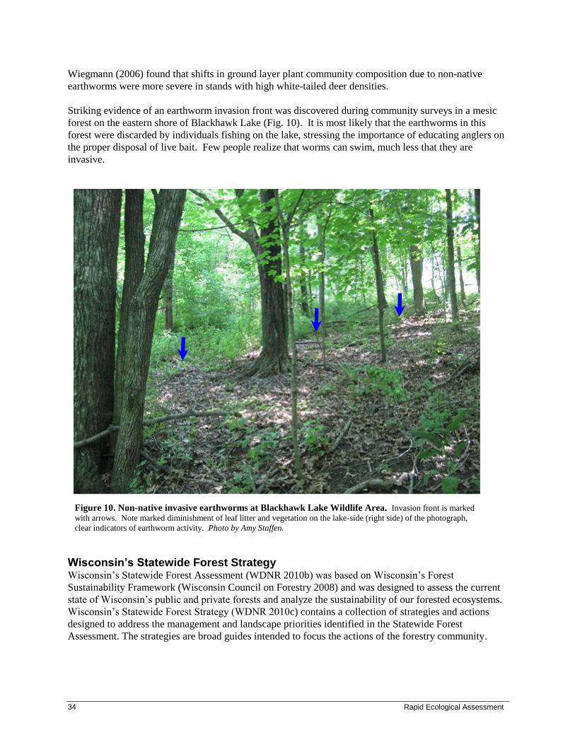
34 Rapid Ecological Assessment
Wiegmann (2006) found that shifts in ground layer plant community composition due to non-native
earthworms were more severe in stands with high white-tailed deer densities.
Striking evidence of an earthworm invasion front was discovered during community surveys in a mesic
forest on the eastern shore of Blackhawk Lake (Fig. 10). It is most likely that the earthworms in this
forest were discarded by individuals fishing on the lake, stressing the importance of educating anglers on
the proper disposal of live bait. Few people realize that worms can swim, much less that they are
invasive.
Wisconsin’s Statewide Forest Strategy Wisconsin’s Statewide Forest Assessment (WDNR 2010b) was based on Wisconsin’s Forest
Sustainability Framework (Wisconsin Council on Forestry 2008) and was designed to assess the current
state of Wisconsin’s public and private forests and analyze the sustainability of our forested ecosystems.
Wisconsin’s Statewide Forest Strategy (WDNR 2010c) contains a collection of strategies and actions
designed to address the management and landscape priorities identified in the Statewide Forest
Assessment. The strategies are broad guides intended to focus the actions of the forestry community.
Figure 10. Non-native invasive earthworms at Blackhawk Lake Wildlife Area. Invasion front is marked
with arrows. Note marked diminishment of leaf litter and vegetation on the lake-side (right side) of the photograph,
clear indicators of earthworm activity. Photo by Amy Staffen.
Yellowstone Lake and Blackhawk Lake Wildlife Areas 35
All three of these documents include topics related to biological diversity in Wisconsin’s forests, and
provide information useful for department master planning and management activities. The following
strategies (Table 7), organized using their number in the Statewide Forest Strategy document, are
particularly pertinent to the YLBL planning efforts in regard to opportunities to maintain or enhance
biological diversity (WDNR 2010c).
Table 7. Statewide Forest Strategies pertinent to Blackhawk Lake Wildlife Area, Yellowstone Lake State
Park, Yellowstone Wildlife Area, Yellowstone Savanna State Natural Area, and Streambank Protection Fee
Area.
Strategy
Number Strategy
11 Encourage the management of under-represented forest communities.
12 Improve all forested communities with a landscape management approach that
considers the representation of all successional stages.
13 Increase forest structure and diversity.
14 Encourage the use of disturbance mechanisms to maintain diverse forest communities.
15 Maintain the appropriate forest types for the ecological landscape while protecting
forest health and function.
18 Encourage the forestry community to be engaged in deer management issues with an
understanding of the long term significance of deer impacts on sustainable forestry.
19 Adapt forest management practices to sustainably manage forests with locally high
deer populations.
22 Strive to prevent infestations of invasive species before they arrive.
23 Work to detect new (invasive species) infestations early and respond rapidly to
minimize impacts to forests.
24 Control and manage existing (invasive species) infestations.
25 Rehabilitate, restore, or adapt native forest habitats and ecosystems.
29 Attempt to improve the defenses of the forest and increase the resilience of natural
systems to future climate change impacts.
30 Intentionally accommodate (climate) change and enable forest ecosystems to
adaptively respond.
High Conservation Value Forests The Wisconsin DNR manages 1.5 million acres that are certified by the Forest Stewardship Council
(FSC) (FSC 2009) and the Sustainable Forest Initiative (SFI). Forest certification requires forests to be
managed using specified criteria for ecological, social, and economic sustainability. Principle 9 of the
Draft 7 FSC-US Forest Management Standard concerns the maintenance of High Conservation Value
Forests (HCVF). High Conservation Value Forests are defined as possessing one or more of the
following:

36 Rapid Ecological Assessment
• Contain globally, regionally, or nationally significant concentrations of biodiversity values,
including rare, threatened, or endangered species and their habitats.
• Globally, regionally, or nationally significant large landscape level forests, contained within, or
containing the management unit, where viable populations of most if not all naturally occurring
species exist in natural patterns of distribution and abundance.
• Are in or contain rare, threatened, or endangered ecosystems.
• Provide basic services of nature in critical situations (e.g., watershed protection, erosion control).
• Are fundamental to meeting basic needs of local communities (e.g., subsistence, health).
• Are critical to local communities’ traditional cultural identity (areas of cultural, ecological,
economic, or religious significance identified in cooperation with such local communities).
Community Level Opportunities and Considerations
The Wisconsin Wildlife Action Plan (WAP) (WDNR 2006a) identifies 37 natural communities for which
there are Major or Important opportunities for protection, restoration, or management in the Western
Coulees & Ridges Ecological Landscapes. Thirteen of these natural communities are present on
Blackhawk Lake managed lands (Table 8).
Table 8. Major and Important Opportunities of Western Coulees & Ridges Ecological Landscape.
Major Opportunity Important Opportunity
Southern Dry Forest Southern Sedge Meadow
Southern Dry-Mesic Forest
Pine Relict
Oak Barrens
Shrub Carr
Dry Prairie
Sand Prairie
Surrogate Grasslands
Emergent Marsh
Dry Cliff
Coldwater Stream
Coolwater Stream

Yellowstone Lake and Blackhawk Lake Wildlife Areas 37
The Wisconsin Wildlife Action Plan (WAP) (WDNR 2006a) also identifies 17 natural communities for
which there are Major or Important opportunities for protection, restoration, or management in the
Southwest Savanna Ecological Landscapes. Eleven of these natural communities are present on
Yellowstone Lake managed lands (Table 9).
Table 9. Major and Important Opportunities of Southwest Savanna Ecological Landscape.
Major Opportunity Important Opportunity
Dry Prairie Coolwater streams
Oak Opening Moist Cliff
Oak Woodland Pine Relict
Surrogate Grasslands Southern Dry Forest
Warmwater streams Southern Dry-mesic Forest
Southern Mesic Forest
Although all of the above communities have been identified at YLBL, only some are high quality, or
have medium to high restoration potential. These include:
Dry Prairie and Sand Prairie Prairie once occupied approximately 2.1 million acres in Wisconsin. Now, approximately 2,000 acres
remain – less than 0.1% (Leach and Givnish 1999). Of these, only those prairies that occurred at the wet
and dry ends of the soil spectrum survived. Virtually all deep-soil Mesic Prairies were converted to
agricultural or residential uses. The surviving remnants are highly degraded due to fire suppression, over-
grazing, and invasion of native woody species and non-native invasive species. Wisconsin has more Dry
Prairies than any other state because of the many steep-sided bluffs in the extensive Driftless Area, the
rough terrain of the kettle interlobate moraine, and the north-south orientation of several major river
valleys such as the Mississippi, the Chippewa, and the St. Croix (WDNR 2006b). These topographic
attributes provide suitable sites for the development and persistence of this prairie type.
A small remnant Dry Prairie lies within Yellowstone Savanna State Natural Area, and supports a number
of conservative and rare plant species. At Blackhawk Lake, a one-acre Sand Prairie with exceptional
floral diversity lies in the central eastern part of the property, west of the southernmost parking area on
Plank Road. Degraded remnants of these types are found elsewhere on both of the properties. Woody
species control, non-native invasive species control, and prescribed fire are needed to restore and
maintain these small but diverse remnant grasslands.
A primary site with an opportunity to protect and manage Dry Prairie and associated flora and fauna is
Yellowstone Savanna (Figs. 13 and 14).
Oak Savanna (Oak Opening, Oak Woodland, Oak Barrens) Oak savannas were historically common in Wisconsin but are now rare throughout the state. Restoration
of these globally rare natural communities is critical to the survival of many rare plants and animals that
depend on them. Yellowstone and Blackhawk Lakes managed lands offer opportunities to restore
prairies, Oak Openings, Oak Woodlands, and Oak Barrens (Blackhawk Lake only) on a landscape scale
and within a matrix of other habitats.
38 Rapid Ecological Assessment
Historically, Oak Openings were abundant in Wisconsin, covering approximately 5.5 million acres
(Curtis 1959) south of the Tension Zone. Review of historical literature indicates that Oak Openings once
supported an exceptionally diverse flora, about 25% of the entire native flora of Wisconsin (Leach and
Givnish 1999). Of the about 75,000 acres (Hoffman 2009) of Oak Opening remaining in Wisconsin,
many of these are highly degraded or have succeeded to closed-canopy oak forests. The few extant
remnants are mostly on drier sites, with the mesic and wet-mesic Oak Openings almost totally destroyed
by conversion to agricultural or residential uses and by the encroachment of other woody plants due to
fire suppression. Oak Woodland once occupied approximately 1.4 million acres (Curtis 1959) in pre-
widespread Euro-American settlement Wisconsin; today, it is extraordinarily rare – only about 140,000
acres remain in the state (Hoffman 2009). Most of these remnants are highly degraded and have
converted to closed-canopy oak forest. Oak Barrens historically occupied approximately 1.8 million acres
in Pre-European Settlement Wisconsin (Richard Henderson, personal communication), but is now
reduced to approximately 95,000 acres (Hoffman 2009; includes both pine and oak barrens).
Opportunities exist at YLBL to restore Oak Openings, Oak Woodlands, and Oak Barrens (Blackhawk
Lake only), and to increase their connectivity. Such actions would also improve habitat for many plants
and animals that are specialists of grassland, savanna, woodland, and barrens. Typical oak savanna
restorations in Wisconsin require aggressive and intensive management for a period of 15 or more years.
This reflects the highly degraded state of most sites, and the time and effort required to effectively restore
system structure and function. Be aware that limited short-term efforts could result in merely a structural
restoration with no ecosystem functionality and may be considered wasteful. Also bear in mind that
many former Oak Woodlands are now closed-canopy forests that provide critical habitat for numerous
bird species. Ecological restoration that converts closed-canopy forests to Oak Woodland may benefit
some savanna specialist species at the expense of other species. As with all ecological restoration
opportunities, sufficient resources must be available to ensure success of the project before the difficult
decision of limiting habitat for some species in favor of other species is made. At Yellowstone Savanna
State Natural Area, reference to the “Oak Savanna Management Guide” in the WDNR State Natural Area
Handbook should be made.
An opportunity to contribute to the science of oak savanna restoration exists at Yellowstone Lake
Wildlife Area, where research on the effects of fire and grazing on woody species and native flora is
ongoing (Harrington and Kathol 2009, Hedtcke et al. 2009). Early findings suggest that rotational
grazing of Scottish highland cattle may add a new and useful tool to the ‘restoration toolbox’ for oak
savanna restoration. Most notably, the cattle were observed forcing themselves into dense shrub thickets
to forage, areas where fire simply cannot penetrate due to limited ground fuels (Harrington and Kathol
2008); impenetrable thickets such as these are typical in abandoned upland pastures in southwest
Wisconsin. Since the impacts of fire versus grazing were often assimilar (e.g., grazing was better at
controlling Rubus species than fire, but fire better controls Ribes species better), the researchers suggest
that the two be implemented as complimentary practices (Harrington and Kathol 2009). Scottish
highland cattle grazing is also feasible from an animal husbandry perspective, as the nutritional content
and digestibility of savanna shrubs at Yellowstone Lake was found to be satsifactory for supporting cattle
(as long as dry matter intake is not limited; Hedtcke et al. 2009). Given the promising results of these
two-year studies, continued long-term research is encouraged.
A primary site with an opportunity to protect and manage oak savanna and associated flora and fauna is
Yellowstone Savanna (Figure 13).
Yellowstone Lake and Blackhawk Lake Wildlife Areas 39
Southern Dry-mesic Forest: An Opportunity for Older Forest Management The Southern Dry-mesic Forest along the south shore of Yellowstone Lake offers an opportunity to
protect and restore a high-quality ecosystem, as well as to manage for older forest and, eventually, old-
growth forest. This forest has extremely high species richness (121 native plant species), including rare
species and spring ephemerals. WisFIRS reconnaissance data indicate that these stands are over 100
years old, as is evidenced by the large diameters of the dominant canopy species: the northern red oak,
bur oak, and American basswood here average 18-24 inches DBH, and many achieve girths of 36 inches.
This forest is described further as a primary site (“Yellowstone Forest”).
Older forests (greater than 100-120 years old) in Wisconsin are rare and declining, largely due to timber
harvesting and conversion to other land uses (WDNR 2010b). The WDNR has identified a need to
conserve, protect, and manage old-growth forests (WDNR 2004, WDNR 1995) and old-growth
management is a component of Forest Certification.
Old-growth stands are sometimes characterized by a multi-layered, uneven age and size class structure; a
high degree of compositional and structural patchiness and heterogeneity; and significant amounts of
coarse woody debris and tip-up mounds (WDNR In Prep. a). The structural diversity provided by old-
growth and older forests that support unique assemblages of plants, birds, and other animals. Old-growth
forest management is one important facet of providing the diverse range of habitats needed for
sustainable forest management (WDNR 2010b).
Older forests can provide habitat for many rare and declining species in the state, including a number of
rare bird species, and all of Wisconsin’s summer resident forest bats.
Species or Taxa Level Opportunities and Considerations
Wildlife Action Plan Priority Communities and Conservation Actions The Wisconsin Wildlife Action Plan identifies ecological priorities in each Ecological Landscape.
Ecological priorities are the natural communities in each Ecological Landscape that are most important to
the Species of Greatest Conservation Need. Note that these Ecological Priorities include all of the natural
communities that we have determined to provide the best opportunities for management at YLBL from
an ecological/biodiversity perspective.
The Wildlife Action Plan also describes Priority Conservation Actions that make effective use of limited
resources and address multiple species with each action. Implementing these actions and avoiding
activities that may preclude successful implementation of these actions in the future would greatly
benefit the SGCN at YLBL. Priority Conservation Actions identified in the Wisconsin Wildlife Action
Plan (WDNR 2006b) for the Southwest Savanna and Western Coulees & Ridges Ecological Landscapes
that apply to YLBL include:
• Sand prairie and oak barrens restoration and maintenance.
• Grassland bird and wildlife management.
• Restoration and protection of spring-fed cold water streams.
• Preservation of cliff communities, along with cave and bat hibernacula.
• Restoration of rare grassland and oak savanna communities.
• Rare prairie species restoration and management (e.g., Henslow's sparrow, loggerhead shrike,
Bell's vireo, prairie bush clover, regal fritillary butterfly, other rare invertebrates, and the
Blanchard's cricket frog).
• Protection of pine relicts.
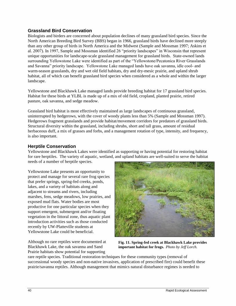
40 Rapid Ecological Assessment
Grassland Bird Conservation Biologists and birders are concerned about population declines of many grassland bird species. Since the
North American Breeding Bird Survey (BBS) began in 1966, grassland birds have declined more steeply
than any other group of birds in North America and the Midwest (Sample and Mossman 1997; Askins et
al. 2007). In 1997, Sample and Mossman identified 26 “priority landscapes” in Wisconsin that represent
unique opportunities for landscape-scale grassland management for grassland birds. State-owned lands
surrounding Yellowstone Lake were identified as part of the “Yellowstone/Pecatonica River Grasslands
and Savanna” priority landscape. Yellowstone Lake managed lands have oak savanna, idle cool- and
warm-season grasslands, dry and wet old field habitats, dry and dry-mesic prairie, and upland shrub
habitat, all of which can benefit grassland bird species when considered as a whole and within the larger
landscape.
Yellowstone and Blackhawk Lake managed lands provide breeding habitat for 17 grassland bird species.
Habitat for these birds at YLBL is made up of a mix of old field, cropland, planted prairie, retired
pasture, oak savanna, and sedge meadow.
Grassland bird habitat is most effectively maintained as large landscapes of continuous grassland,
uninterrupted by hedgerows, with the cover of woody plants less than 5% (Sample and Mossman 1997).
Hedgerows fragment grasslands and provide habitat/movement corridors for predators of grassland birds.
Structural diversity within the grassland, including shrubs, short and tall grass, amount of residual
herbaceous duff, a mix of grasses and forbs, and a management rotation of type, intensity, and frequency,
is also important.
Herptile Conservation Yellowstone and Blackhawk Lakes were identified as supporting or having potential for restoring habitat
for rare herptiles. The variety of aquatic, wetland, and upland habitats are well-suited to serve the habitat
needs of a number of herptile species.
Yellowstone Lake presents an opportunity to
protect and manage for several rare frog species
that prefer springs, spring-fed creeks, ponds,
lakes, and a variety of habitats along and
adjacent to streams and rivers, including
marshes, fens, sedge meadows, low prairies, and
exposed mud flats. Water bodies are most
productive for one particular species when they
support emergent, submergent and/or floating
vegetation in the littoral zone, thus aquatic plant
introduction activities such as those conducted
recently by UW-Platteville students at
Yellowstone Lake could be beneficial.
Although no rare reptiles were documented at
Blackhawk Lake, the oak savanna and Sand
Prairie habitats show potential for supporting
rare reptile species. Traditional restoration techniques for these community types (removal of
successional woody species and non-native invasives, application of prescribed fire) could benefit these
prairie/savanna reptiles. Although management that mimics natural disturbance regimes is needed to
Fig. 11. Spring-fed creek at Blackhawk Lake provides
important habitat for frogs. Photo by Jeff Lorch.
Yellowstone Lake and Blackhawk Lake Wildlife Areas 41
restore and maintain these fire-dependant habitats, the poor dispersal abilities of many herptiles needs to
be taken into account when planning habitat management and species recovery.
Although Blackhawk Lake provides excellent habitat for mudpuppies (Necturus maculosus), they may
not be present since it is not a natural lake and movement past the dam would be difficult. However,
Otter Creek is a fairly large creek and a tributary of the Wisconsin River, increasing its potential for
mudpuppies. It is possible that mudpuppies living upstream of the lake were able to colonize the
impoundment. The deep pool formed as the creek flows under Plank Road also provides good habitat that
might support a small population of mudpuppies.
Bat Conservation By feeding on insects, bats are an important component of healthy ecosystems. Opportunities to promote
bat habitat at YLBL include providing resources for roosting, foraging, and drinking.
The Driftless Area of Wisconsin, in which YLBL lie, is particularly rich in known and potential bat
hibernacula sites. At Yellowstone Lake State Park, there are roughly 30 bat houses installed in which
over 3,000 little brown bats roost. Bats may also roost under loose, peeling bark and in crevices and
cavities of trees. Often these attributes are found in older forests with snags of varying decay level, size,
and height. Artificial bat boxes such as those that have been erected at Yellowstone Lake State Park can
provide an important supplement to natural roost sites; the Wisconsin Bat Program has created a bat
house handbook which includes designs for multiple bat houses as well as information on mounting and
maintaining bat houses.
Foraging is done in small to medium forest openings or gaps, in other natural and artificial openings such
as ponds, and along roads or water courses (Taylor 2006). Maintaining diverse forest flora and reducing
non-native plant abundance is important for promoting invertebrate prey diversity and thus promoting
foraging opportunities for bats (WDNR 2006a).
Maintaining high-water quality and access to water is important for protecting bat populations. Wide
buffers (generally wider than those recommended in Best Management Practices for water quality
[WDNR 2010d]) around water, including rivers, streams, and wet meadows, are important for bats and
other wildlife species using these areas (Taylor 2006).
Hibernaculum disturbance, habitat degradation, and wind-turbine mortality are threats that affect all bat
species found in Wisconsin. An emerging threat to Wisconsin’s bats, White-Nose Syndrome (WNS) has
been called the “most precipitous wildlife decline in the past century in North America” by Bat
Conservation International and has devastated bat populations in the eastern United States since 2006
(White-nose Syndrome). It has recently been discovered that the fungus (Geomyces destructans) is the
causal agent of White-Nose Syndrome (Lorch et al. 2011). Due to the emerging threats that bat
populations face in Wisconsin, more information in the form of surveys (acoustic and roost) are needed
to more accurately describe the bats that use YLBL.
42 Rapid Ecological Assessment
Primary Sites: Site-specific Opportunities for Biodiversity Conservation
Two ecologically important sites were identified on Yellowstone Lake managed lands; none were
identified at Blackhawk Lake Wildlife Area (Figure 12). These Primary Sites were delineated because
they generally encompass the best examples of 1) rare and representative natural communities, 2)
documented occurrences of rare species populations, and/or 3) opportunities for ecological restoration or
connections. These sites warrant high protection and/or restoration consideration during the development
of the property master plan. This report is meant to be considered along with other information when
identifying opportunities for various management designations during the master planning process.
Descriptions for each of the Primary Sites can be found in Appendix D. Information provided in the
summary paragraphs includes location information, a site map, a brief summary of the natural features
present, the site’s ecological significance, and management considerations.
Yellowstone and Blackhawk Lakes Managed Lands Primary Sites
YLBL01 Yellowstone Forest
YLBL02 Yellowstone Savanna
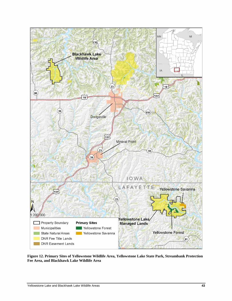
Yellowstone Lake and Blackhawk Lake Wildlife Areas 43
Figure 12. Primary Sites of Yellowstone Wildlife Area, Yellowstone Lake State Park, Streambank Protection
Fee Area, and Blackhawk Lake Wildlife Area
44 Rapid Ecological Assessment
Future Needs This project was designed to provide a rapid assessment of the biodiversity values for YLBL managed
lands. Although the report should be considered adequate for master planning purposes, additional efforts
could help to inform future adaptive management efforts, along with providing useful information
regarding the natural communities and rare species contained in YLBL managed lands.
• Continued non-native invasive species monitoring and control is needed. Public lands throughout
Wisconsin are facing major management problems because of serious infestations of highly invasive
non-native species. Some of these species are easily dispersed by humans and vehicles; others are
spread by birds, mammals, insects, water, or wind. In order to protect the important biodiversity
values of YLBL, a comprehensive non-native invasive species monitoring and control plan will be
needed for detecting and rapidly responding to new non-native invasive threats.
• Locations and likely habitats should be identified for conducting additional rare plant surveys during
appropriate seasons.
• Surveys for reptiles should be conducted in remnant prairie and oak savanna areas at Yellowstone
Lake managed lands.
• Surveys for small mammals should be conducted at all YLBL properties.
• Bat roost monitoring should be considered at all YLBL properties. Monitoring a colony of bats is
simple and counts can completed by volunteers in the evening. More information about bat roosts
and roost monitoring can be obtained by contacting the Wisconsin Bat Program in the Bureau of
Endangered Resources or by visiting the Wisconsin Bat Monitoring Program website
(http://wiatri.net/inventory/bats).

Yellowstone Lake and Blackhawk Lake Wildlife Areas 45
Glossary Ecological Landscape - landscape units developed by the WDNR to provide an ecological framework to
support natural resource management decisions. The boundaries of Wisconsin’s sixteen Ecological
Landscapes correspond to ecoregional boundaries from the National Hierarchical Framework of
Ecological Units, but sometimes combine subsections to produce a more manageable number of units.
element - the basic building blocks of the Natural Heritage Inventory. They include natural communities,
rare plants, rare animals, and other selected features such as colonial bird rookeries, bat hibernacula, and
mussel beds. In short, an element is any biological or ecological entity upon which we wish to gather
information for conservation purposes.
element occurrence - an Element Occurrence (EO) is an area of land and/or water in which a rare
species or natural community is, or was, present. An EO should have practical conservation value for the
Element as evidenced by potential continued (or historic) presence and/or regular recurrence at a given
location. For species, the EO often corresponds with the local population, but when appropriate may be a
portion of a population (e.g., a single nest territory or long distance dispersers) or a group of nearby
populations (e.g., metapopulation). For communities, the EO may represent a stand or patch of a natural
community or a cluster of stands or patches of a natural community. Because they are defined on the
basis of biological information, EOs may cross jurisdictional boundaries.
Landtype Association (LTA) - a level in the National Hierarchical Framework of Ecological Units (see
next entry) representing an area of 10,000 – 300,000 acres. Similarities of landform, soil, and vegetation
are the key factors in delineating LTAs.
natural community - an assemblage of plants and animals, in a particular place at a particular time,
interacting with one another, the abiotic environment around them, and subject to primarily natural
disturbance regimes. Those assemblages that are repeated across a landscape in an observable pattern
constitute a community type. No two assemblages, however, are exactly alike.
periphyton - algae, bacteria, other associated microorganisms, and non-living organic matter attached to
any submerged surface.
representative - native plant species that would be expected to occur in native plant communities
influenced primarily by natural disturbance regimes in a given landscape - e.g., see Curtis (1959).
SGCN (or “Species of Greatest Conservation Need”) – native wildlife species with low or declining
populations that are most at risk of no longer being a viable part of Wisconsin’s fauna (from the
“Wisconsin Wildlife Action Plan,” WDNR 2006).

46 Rapid Ecological Assessment
Species List The following is a list of species referred to by common name in the report text.
Common Name Scientific Name
Animals
emerald ash borer Agrilus planipennis
earthworm family Acanthodrilidae
earthworm family Lumbricidae
earthworm family Megascloedidae
mudpuppy Necturus maculosus
Plants
American basswood Tilia americana
American elm Ulmus americana
American starflower Trientalis borealis
ash Fraxinus spp.
autumn-olive Elaeagnus umbellata
beaked hazelnut Corylus cornuta
big blue-stem Andropogon gerardii
big-tooth aspen Populus grandidentata
bird's-foot trefoil Lotus corniculatus
black locust Robinia pseudoacacia
black oak Quercus velutina
black walnut Juglans nigra
blue cohosh Caulophyllum thalictroides
bog clearweed Pilea fontana
bracken fern Pteridium aquilinum
broad-leaf enchanter's-
nightshade Circaea lutetiana
bur oak Quercus macrocarpa
calico aster Aster lateriflorus
Canada mayflower Maianthemum canadense
Canadian goldenrod Solidago canadensis
cleavers Galium aparine
Yellowstone Lake and Blackhawk Lake Wildlife Areas 47
cluster-leaf tick-trefoil Desmodium glutinosum
common blackberry Rubus allegheniensis
common buckthorn Rhamnus cathartica
common lady fern Athyrium filix-femina
common prickly-ash Zanthoxylum americanum
common spiderwort Tradescantia ohiensis
cream wild indigo Baptisia bracteata
Dutchman's-breeches Dicentra cucullaria
early meadow-rue Thalictrum dioicum
eastern figwort Scrophularia marilandica
eastern red-cedar Juniperus virginiana
eastern white pine Pinus strobus
elm-leaved goldenrod Solidago ulmifolia
elms Ulmus spp.
Eurasian honeysuckles Lonicera spp.
false boneset Kuhnia eupatorioides
false rue anemone Isopyrum biternatum
flowering spurge Euphorbia corollata
garlic mustard Alliaria petiolata
goat's-rue Tephrosia virginiana
golden Alexander's Zizia aurea
gray dogwood Cornus foemina
great Indian-plantain Cacalia muhlenbergii
hairy sweet cicely Osmorhiza claytonii
hoary puccoon Lithospermum canescens
huckleberry Gaylussacia baccata
ironwood Ostrya virginiana
jack pine Pinus banksiana
Jack-in-the-pulpit Arisaema triphyllum
Kentucky bluegrass Poa pratensis
large-flowered bellwort Uvularia grandiflora
late figwort Scrophularia marilandica
lead-plant Amorpha canescens

48 Rapid Ecological Assessment
limber honeysuckle Lonicera dioica
little blue-stem Schizachyrium scoparium
maidenhair fern Adiantum pedatum
Muhlenberg's sedge Carex muhlenbergii
multiflora rose Rosa multiflora
musclewood Carpinus caroliniana
northern bush-honeysuckle Diervilla lonicera
northern red oak Quercus rubra
panic grasses Panicum spp.
Pennsylvania sedge Carex pensylvanica
perennial pea-vine Lathyrus latifolius
poke milkweed Asclepias exaltata
poverty oat grass Danthonia spicata
prairie phlox Phlox pilosa
prairie rosinweed Silphium integrifolium
prairie tickseed Coreopsis palmata
prairie violet Viola pedatifida
prickly wild gooseberry Ribes cynosbati
purple prairie-clover Dalea purpurea
quackgrass Elytrigia repens
quaking aspen Populus tremuloides
rattlesnake fern Botrychium virginianum
red baneberry Actaea rubra
red pine Pinus resinosa
red raspberry Rubus idaeus
reed canary grass Phalaris arundinacea
round-headed bush-clover Lespedeza capitata
shagbark hickory Carya ovata
sharp-lobed hepatica Anemone acutiloba
showy bush honeysuckle Lonicera X bella
side-oats grama Bouteloua curtipendula
small white fawn-lily Erythronium albidum
smooth brome Bromus inermis
Yellowstone Lake and Blackhawk Lake Wildlife Areas 49
smooth sumac Rhus glabra
spotted knapweed Centaurea biebersteinii
stiff goldenrod Solidago rigida
sugar maple Acer saccharum
timothy Phleum pratense
tinker's-weed Triosteum perfoliatum
velvet-leaf blueberry Vaccinium myrtilloides
violet wood-sorrel Oxalis violacea
Virginia creeper Parthenocissus quinquefolia
Virginia spring-beauty Claytonia virginica
Virginia wild-rye Elymus virginicus
white birch Betula papyrifera
white oak Quercus alba
white snakeroot Eupatorium rugosum
white sweet-clover Melilotus albus
wild black cherry Prunus serotina
wild lupine Lupinus perennis
wild parsnip Pastinaca sativa
wild sarsaparilla Aralia nudicaulis
wild-ginger Asarum canadense
yellow bedstraw Galium verum
yellow forest violet Viola pubescens
yellow Indian grass Sorghastrum nutans
yellow sweet-clover Melilotus officinalis
yellow-bud hickory Carya cordiformis
yellow-pimpernel Taenidia integerrima
zigzag goldenrod Solidago flexicaulis
50 Rapid Ecological Assessment
Reference List
Abrams, Marc D. 1992. Fire and the development of oak forests. BioScience 42(5): 346-353.
Askins, R.A., F. Chavez-Ramirez, B.C. Dale, C.A. Haas, J.R. Herkert, F.L. Knopf, and P.D. Vickery. 2007.
Conservation of grassland birds in North America: understanding ecological processes in different
regions. Ornithological Monograph No. 64. Washington D.C., American Ornithologists Union.
Bohlen, P.J., D.M. Pelletier, P.M. Groffman, T.J. Fahey and M.C. Fisk. 2004. Influence of earthworm
invasion on redistribution and retention of soil carbon and nitrogen in northern temperate forests.
Ecosystems 7:13–27.
Boos, T., K. Kearns, C. LeClair, B. Panke, B. Scriver, and B. Williams. 2010. A Field Guide to Terrestrial
Invasive Plants of Wisconsin. Wisconsin DNR, Madison, WI. 124 pp.
Bordner, J. 1939. Land Economic Inventory of Iowa and Lafayette Counties, WI. Map collection
accessible at http://digital.library.wisc.edu/1711.dl/EcoNatRes.WILandInv.
Cleland, D.T.; Avers, P.E.; McNab, W.H.; Jensen, M.E.; Bailey, R.G., King, T.; Russell, W.E. 1997.
National Hierarchical Framework of Ecological Units. Published in, Boyce, M. S.; Haney, A., ed.
1997. Ecosystem Management Applications for Sustainable Forest and Wildlife Resources. Yale
University Press, New Haven, CT. pp. 181-200.
Collins, S.L. and L.L. Wallace, eds. 1990. “Fire in North American tallgrass prairies.” University of
Oklahoma Press: Normal, OK. 175 pp.
Curtis, J. T. 1959. The Vegetation of Wisconsin. University of Wisconsin Press, Madison, WI. 657 pp.
Ecosystem Management Planning Team [EMPT]. 2007. Table of Opportunities for Sustaining Natural
Communities by Ecological Landscape. Available online:
http://dnr.wi.gov/landscapes/ecoloppstable.pdf
Finley, R.W. 1976. Original Vegetation Cover of Wisconsin. Map compiled from General Land Office
Forest Stewardship Council [FSC]. 2009. Draft 7 FSC-US Forest Management Standard. Minneapolis, MN.
Groffman, P.M, P.J. Bohlen, M.C. Fisk, and T.J. Fahey. 2004. Non-native earthworm invasion and
microbial biomass in temperate forest soils. Ecosystems 7:45-54.
Gundale, M.J. 2002. Influence of non-native earthworms on soil organic horizon and the rare fern
Botrychium mormo. Conservation Biology 16:1555–1561.
Hale, C.M., L.E. Frelich and P.B. Reich. 2005. Non-native European earthworm invasion dynamics in
northern hardwood forests of Minnesota, USA. Ecological Applications 15:848–860.
Harrington, J.A. and E. Kathol. 2009. Responses of shrub midstory and herbaceous layers to managed
grazing and fire in a North American savanna (Oak Woodland) and prairie landscape. Restoration
Ecology 17(2): 234-244.
Yellowstone Lake and Blackhawk Lake Wildlife Areas 51
Hedtcke, J., Posner, J., Rosemeyer, M. and K. Albrecht. 2009. Browsing for conservation: Springtime
forage value of midstory shrubs of degraded oak savannas in southern Wisconsin. Renewable
Agriculture and Food Systems: 24(4): 293–299.
Hendrix, P.F. and P.J. Bohlen. 2002. Non-native earthworm invasions in North America: ecological and
policy implications. Bioscience 52:801–811.
Hoffman, R. 2009. Wisconsin’s Game Species and SGCN Habitats. In “Wisconsin’s Favorite Bird
Haunts.” Daryl D. Tessen (Ed.). Wisconsin Society for Ornithology, Inc. [Acreage statistics based
on agricultural statistics, Forest Inventory and Assessment data, Wiscland satellite data, and Natural
Heritage Inventory data.]
Invasive Species Best Management Practices. Wisconsin Council on Forestry. Web.
<http://council.wisconsinforestry.org/invasives/>.
Klingelhoets, A.J. 1962. Soil Survey of Iowa County, Wisconsin. U.S.D.A. Soil Conservation Service
Series 1958, No. 22.
Kozlowski, T.T. and C.E. Ahlgren, eds. 1974. Fire and ecosystems. Academic Press, New York, NY. 542
pp.
Kourtev, P.S., W.Z. Huang and J.G. Ehrenfeld. 1999 Differences in earthworm densities and nitrogen
dynamics in soils under non-native and native plant species. Biological Invasions 1:237–245.
Leach, MK. and T.J. Givnish. 1999. Gradients in the composition, structure, and diversity of remnant oak
savannas in southern Wisconsin. Ecological Monographs 60(3): 353-374.
Lorch, J. 2011. Herpetile Assessment for Blackhawk Lake Recreation Area. A report to the Bureau of
Endangered Resources. August 2011.
Lorch, J. M., C.U. Meteyer, M.J. Behr, J.G. Boyles, P.M. Cryan, A.C. Hicks, A.E. Ballmann, J.T.H.
Coleman, D.N. Redell, D.M. Reeder, D.S. Blehert. 2011. Experimental infection of bats with
Geomyces destructans causes white-nose syndrome. Nature (2011) doi:10.1038/nature10590.
McDaniel, A.D. 2000. Mowing, burning and interseeding as management strategies for roadside prairie
plantings. Master of Science Thesis (Landscape Architecture), University of Wisconsin, Madison,
WI.
Murdrey, M.G., Jr., Brown, B.A. and J.K. Greenburg. 1982. Bedrock Geologic Map of Wisconsin.
University of Wisconsin Extension and Geological and Natural History Survey.
Piening, Ronald and Threinen, C.W., 1968a. Lake and Stream Classification Project. Surface Water
Resources of Lafayette County, Wisconsin Department of Natural Resources, Madison, WI.
Piening, Ronald and Threinen, C.W., 1968b. Lake and Stream Classification Project. Surface Water
Resources of Iowa County, Wisconsin Department of Natural Resources, Madison, WI.
Rouse, Cary. 1986. Fire effects in northeastern forests: Oak. General Technical Report NC-105, U.S.
Department of Agriculture, Forest Service, North Central Forest Experiment Station. St. Paul, MN.
52 Rapid Ecological Assessment
Sample, D.W. and Mossman, M.J. 1997. Managing Habitat for Grassland Birds: A Guide for Wisconsin.
Bureau of Integrated Science Services. Department of Natural Resources. P.O. Box 7921, Madison,
WI 53707. Available at http://www.npwrc.usgs.gov/resource/birds/wiscbird/index.htm
Suarez, E.R., D.M. Pelletier, T.J. Fahey, P.M. Groffman, P.J. Bohlen, and M.C. Fisk. 2004. Effects of non-
native earthworms on soil phosphorous cycling in two broadleaf temperate forests. Ecosystems
7:28-44.
Taylor, Daniel A.R. 2006. Forest Management and Bats. Bat Conservation International.
Watson, B.G. 1960. Soil Survey of Lafayette County, Wisconsin. U.S.D.A. Soil Conservation Service
Series1960, No. 27.
Wiegmann, S.M. 2006. Fifty years of change in northern forest understory plant communities of the upper
Great Lakes. Ph.D. Dissertation. University of Wisconsin, Madison. 206 pp.
Wisconsin Board of Commissioners of Public Lands. 1832. Wisconsin Public Land Survey Records:
Original Field Notes and Plat Maps. Available digitally at
http://digicoll.library.wisc.edu/SurveyNotes/ .
Wisconsin Council on Forestry. 2008. Wisconsin’s Forest Sustainability Framework (97 pp). Published by
Wisconsin Department of Natural Resources, Madison, Wisconsin (WDNR PUB FR-423-2008).
http://council.wisconsinforestry.org/framework/pdf/SustainabilityFramework.pdf
Wisconsin Department of Natural Resources [WDNR]. In Prep. a. DRAFT Ecological Landscapes of
Wisconsin. State of Wisconsin, Dept. of Nat. Resources, Handbook. 1805.1. Madison, WI
Wisconsin Department of Natural Resources [WDNR]. In Prep. b. Old-growth and Old Forests Handbook.
Madison, WI.
Wisconsin Department of Natural Resources [WDNR]. 1993. Wisconsin DNR Wiscland GIS coverage.
Wisconsin Department of Natural Resources [WDNR]. 1995. Wisconsin’s Biodiversity as a Management
Issue: A Report to Department of Natural Resources Managers. Madison, WI.
Wisconsin Department of Natural Resources [WDNR]. 2002. Otter and Morrey Creeks Watershed (LW11).
Available online: http://dnr.wi.gov/water/basin/lowerwis/watersheds/lw11.pdf .
Wisconsin Department of Natural Resources [WDNR]. 2004. Wisconsin’s Statewide Forest Plan: Ensuring
a Sustainable Future. Available on the WDNR Web site: dnr.wi.gov/forestry/assessment/.
Wisconsin Department of Natural Resources [WDNR]. 2006a. Wisconsin Wildlife Action Plan. Available
at http://dnr.wi.gov/org/land/er/wwap/plan/.
Wisconsin Department of Natural Resources (WDNR). 2006b. Wisconsin Land Legacy Report: an
inventory of places critical in meeting Wisconsin's future conservation and recreation needs.
Madison, WI.
Wisconsin Department of Natural Resources [WDNR]. 2009. DNR Land Certification. Available at:
http://dnr.wi.gov/forestry/certification/dnrland.html
Yellowstone Lake and Blackhawk Lake Wildlife Areas 53
Wisconsin Department of Natural Resources [WDNR]. 2010a. Emerald Ash Borer and Forest Management.
Available online: http://www.dnr.wi.gov/forestry/fh/PDF/EABWIManagementGuidelines.pdf.
Wisconsin Department of Natural Resources [WDNR]. 2010b. Wisconsin’s Statewide Forest Assessment.
Available online: http://dnr.wi.gov/forestry/assessment/strategy/assess.htm.
Wisconsin Department of Natural Resources [WDNR]. 2010c. Wisconsin’s Statewide Forest Strategy.
Available online: http://dnr.wi.gov/forestry/assessment/strategy/overview.htm.
Wisconsin Department of Natural Resources [WDNR]. 2010d. Wisconsin’s Forestry Best Management
Practices for Water Quality. Available online: http://dnr.wi.gov/forestry/publications/pdf/FR-
093.pdf .
Wisconsin Department of Natural Resources [WDNR]. 2011a. Sugar Pecatonica Watershed. Web.
http://dnr.wi.gov/water/basin/gpsp/index.htm. [Accessed September 30, 2011.]
Wisconsin Department of Natural Resources [WDNR]. 2011b. Otter and Morrey Creeks Watershed. Web.
http://dnr.wi.gov/water/watershedDetail.aspx?code=LW11&Name=Otter and Morrey Creeks.
[Accessed September 30, 2011.]
Wisconsin Forest Inventory and Reporting System [WisFIRS]. Release 7. Accessed October 2011.
Wisconsin Natural Heritage Working List. Wisconsin Department of Natural Resources. Web.
<http://dnr.wi.gov/org/land/er/wlist/>.
Wisconsin Wetlands Association [WWA]. 2010. Wetland Gems. Wisconsin Wetlands Association.
Madison, WI.
54 Rapid Ecological Assessment
Additional Resources Numerous online resources are available for learning more about the rare species, natural communities,
and ecological concepts contained within this report. These are just a few of the resources that we
recommend.
1. Bureau of Endangered Resources’ Animals, Plants, and Communities Web Pages
Information for plants, animals, and natural communities on the Wisconsin Working List, as well
as Species of Greatest Conservation Need from the Wisconsin Wildlife Action Plan. For reptiles
and amphibians, information for more common species is also provided here. At this time, the
level of detail available varies among species; some have detailed factsheets while others have
only a short paragraph or a map. These pages will continue to evolve as more information
becomes available and are the Bureau of Endangered Resources’ main source of information for
species and communities. dnr.wi.gov/org/land/er/biodiversity/
2. Wisconsin Natural Heritage Inventory Working List
The Wisconsin Natural Heritage Working List contains species known or suspected to be rare in
the state and natural communities native to Wisconsin. It includes species legally designated as
"Endangered" or "Threatened" as well as species in the advisory "Special Concern" category.
This Web page offers a printable pdf file and a key to the Working List for use in conjunction
with the information provided in #1 above. dnr.wi.gov/org/land/er/wlist/
3. Ecological Landscapes of Wisconsin Handbook
Wisconsin’s 16 Ecological Landscapes have unique combinations of physical and biological
characteristics such as climate, geology, soils, water, or vegetation. This handbook will contain a
chapter for each of these landscapes with detailed information about their ecology,
socioeconomics, and ecological management opportunities. An additional introductory chapter
will compare the 16 landscapes in numerous ways, discuss Wisconsin’s ecology on the statewide
scale, and introduce important concepts related to ecosystem management in the state. The full
handbook is in development as of this writing, and chapters will be made available online as they
are published. Currently, a set of Web pages provide brief Ecological Landscape descriptions,
numerous maps, and other useful information, including management opportunities for natural
communities and Species of Greatest Conservation Need. dnr.wi.gov/landscapes/
4. The Wisconsin Wildlife Action Plan
This plan is the result of a statewide effort to identify native Wisconsin animal species of
greatest conservation need. The plan also presents priority conservation actions to protect the
species and their habitats. The plan itself is available online, and there are several online tools to
explore the data within the plan. The Web pages are closely integrated with the pages provided in
items #1 and #3 above. The Wildlife Action Plan Web pages are quite numerous, so we
recommend the following links as good starting points for accessing the information.
• the plan itself: dnr.wi.gov/org/land/er/wwap/
• explore Wildlife Action Plan data: dnr.wi.gov/org/land/er/wwap/explore/
• Wildlife Action Plan Implementation: dnr.wi.gov/org/land/er/wwap/implementation/
Yellowstone Lake and Blackhawk Lake Wildlife Areas 55
5. Wisconsin's Biodiversity as a Management Issue - A Report to Department of Natural
Resources Managers
This now out-of-print report presents a department strategy for conserving biological diversity. It
provides department employees with an overview of the issues associated with biodiversity and
provides a common point of reference for incorporating the conservation of biodiversity into our
management framework. The concepts presented in the report are closely related to the material
provided in this report, as well as the other resources listed in this section.
dnr.wi.gov/org/es/science/publications/rs915_95.htm
6. Wisconsin’s Statewide Forest Strategy
Wisconsin’s Statewide Forest Strategy is a collection of many strategies and actions designed to
address major issues and priority topics over the next five to ten years. It provides a long-term,
comprehensive, coordinated approach for investing resources to address the management and
landscape priorities identified in the Statewide Forest Assessment. Several of the strategies
contain issues related to biodiversity and ecosystem management.
dnr.wi.gov/forestry/assessment/strategy/overview.htm
7. 2010 Wisconsin’s Statewide Forest Assessment
The goal of this project was to assess the “state of affairs” of Wisconsin’s public and private
forests and analyze the sustainability of our forested ecosystems. The Statewide Forest
Assessment helps to explain trends, identify issues, and present an updated view of the status of
forests in Wisconsin. The first chapter deals with biological diversity in Wisconsin’s forests, and
the major conclusions from this assessment were used to develop the strategies in # 6 above.
dnr.wi.gov/forestry/assessment/strategy/assess.htm
56 Rapid Ecological Assessment
Appendix A
Natural Heritage Inventory Overview and General Methodology
This biotic inventory and analysis was conducted by the Wisconsin Natural Heritage Inventory (NHI)
program. The Wisconsin NHI program is part of the Wisconsin DNR’s Bureau of Endangered Resources
and a member of an international network of Natural Heritage programs representing all 50 states, as well
as portions of Canada, Latin America, and the Caribbean. These programs share standardized methods
for collecting, processing, and managing data for rare species, natural communities, and certain other
natural features (e.g., bird rookeries). NatureServe, an international non-profit organization, coordinates
the network. This appendix provides a general overview of the methodology we use for these projects.
Please see the NatureServe Web site for more detailed information about standard methods used by the
Heritage Network (www.NatureServe.org ) for locating, documenting, and ranking rare species and
natural community occurrences.
General Process Used when Conducting Biotic Inventories for Master Planning The Wisconsin NHI Program typically uses a “coarse filter-fine filter” approach to conducting biotic
inventory projects for master planning. This approach begins with a broad assessment of the natural
communities and aquatic features present, along with their relative quality and condition. The area’s
landforms, soils, topography, hydrology, current land uses, and the surrounding matrix are also evaluated
using Geographic Information Systems (GIS) and other electronic and hardcopy data sources. Data that
describe conditions for the area prior to Euro-American settlement are often used during this step and at
other times to further understand the ecological capabilities of the area. Often, we consult with local
managers, biologists, or others familiar with the ecology of the area when preparing for an inventory
project. The goals for this step are to identify the important ecological attributes and biological
processes present, as well as to focus our inventory efforts.
The level of survey intensity varies based on the size and ecological complexity of the property or group
of properties, as well as the resources available. For larger properties such as state forests, biotic
inventory efforts typically take more than one year. Ideally, taxa surveys are conducted following a
coarse-filter analysis that sometimes include extensive natural community surveys. There is often time
for “mop-up work” during the year following the completion of the main survey effort, whereby
additional surveys are conducted for areas that could not be reached the first year or for which new
information has become available. For smaller properties, a “Rapid Ecological Assessment” often takes
the place of a full-scale biotic inventory. The level of effort for these projects varies based on the needs
of the study area, although surveys are almost always completed during one field season. Coarse filter
work for rapid assessments is often done based on GIS data, aerial photos, data acquired from previous
efforts, and information from property managers and others knowledgeable about the area.
Taxa-specific surveys can be costly and intensive and sometimes must be completed during a very
narrow period of time. For example, bird surveys must be completed within an approximately one-month
time window. For this and several other reasons, our surveys cannot locate every rare species
occurrence within a given area. Therefore, it is important to use resources as efficiently as possible,
making every effort to identify the major habitats present in the study area from the start. This approach
concentrates inventory efforts on those sites most likely to contain target species to maximize efficient
use of resources. Communication among biologists during the field season can help identify new areas
of interest or additional priorities for surveys. The goal is to locate species populations with the highest
conservation value whenever possible.
Yellowstone Lake and Blackhawk Lake Wildlife Areas 57
After all of the data are collected, occurrences of rare species, high-quality natural communities, and
certain other features are documented, synthesized, and incorporated into the NHI Database. The NHI
program refers to this process as “mapping” the data and uses a tabular and spatial database application
designed specifically for the Heritage Network. Other secondary databases are also used by the
Wisconsin NHI Program for storing additional species and community information such as species lists,
GPS waypoints, photos, and other site documentation.
Once the data mapping and syntheses are completed, the NHI Program evaluates data from the various
department biologists, contractors, and other surveyors. This information is examined along with many
other sources of spatial and tabular information including topographic maps, various types of aerial
photography, digital soil and wetland maps, hydrological data, forest reconnaissance data, and land cover
data. Typically, GPS waypoints and other spatial information from the various surveys are superimposed
onto these maps for evaluation by NHI biologists.
In addition to locating important rare species populations and high-quality natural community
occurrences, the major products culminating from all of this work are the “Primary Sites.” These areas
contain relatively undisturbed, high-quality, natural communities; provide important habitat for rare
species; offer opportunities for restoration; could provide important ecological connections; or some
combination of the above factors. The sites are meant to highlight, based on our evaluation, the best
areas for conserving biological diversity for the study area. They often include important rare species
populations, High Conservation Value Forests, or other ecologically important areas.
The final report describes the Primary Sites, as well as rare or otherwise notable species, and other
ecological opportunities for conserving or enhancing the biological diversity of the study area. The
report is intended for use by department master planning teams and others and strives to describe these
opportunities at different scales, including a broad, landscape context that can be used to facilitate
ecosystem management.
Select Tools Used for Conducting Inventory The following are descriptions of standard tools used by the NHI Program for conducting biotic inventories.
Some of these may be modified, dropped, or repeated as appropriate to the project.
File Compilation: Involves obtaining existing records of natural communities, rare plants and animals, and
aquatic features for the study area and surrounding lands and waters from the NHI Database. Other
databases with potentially useful information may also be queried, such as: forest reconnaissance data; the
DNR Surface Water Resources series for summaries of the physical, chemical, and biological characteristics
of lakes and streams (statewide, by county); the Milwaukee Public Museum's statewide Herp Atlas; the
Wisconsin Breeding Bird Atlas; other NHI “atlas” and site databases; museum/herbarium collections for
various target taxa; soil surveys; geological surveys; and the department’s fish distribution database.
Additional data sources are sought out as warranted by the location and character of the site, and the
purpose of the project. Manual files maintained within the Bureau of Endangered Resources, including the
State Natural Area files, often contain information on a variety of subjects relevant to the inventory of
natural features for an area.
Literature Review: Field biologists involved with a given project consult basic references on the natural
history and ecology of the area, as well as any documented rare species. This sometimes broadens and/or
sharpens the focus of the inventory efforts.
58 Rapid Ecological Assessment
Target Elements: Lists of target elements including natural communities, rare plants and animals, and
aquatic features are developed for the study area. Field inventory is then scheduled for the times when these
elements are most identifiable or active. Inventory methods follow accepted scientific standards for each
taxon.
Compilation of Maps and Other Spatial Data: USGS 7.5 minute topographic quadrangles, most often in
digital form, serve along with aerial photos as the base maps for field survey and often yield useful clues
regarding access, extent of area to be surveyed, developments, and the presence and location of special
features. These are used in conjunction with numerous GIS layers, which are now a basic resource tool for
the efficient and comprehensive planning of surveys and the analysis of their results.
WDNR wetland maps consist of aerial photographs upon which all wetlands down to a scale of 2 or 5 acres
have been delineated. Each wetland polygon is classified based on characteristics of vegetation, soils, and
water depth. These polygons have been digitized for most counties, and the resulting GIS layers can be
superimposed onto other maps.
Ecoregion GIS layers are useful for comprehensive projects covering large geographic areas such as
counties, national and state forests, and major watersheds. These maps integrate basic ecological
information on climate, landforms, geology, soils, and vegetation. Ecological Landscapes provide the broad
framework most often used in Wisconsin; however smaller units, including Landtype Associations, can be
very helpful for evaluating ecoregions at finer scales.
Aerial photographs: These provide information on a study area not available from maps, paper files, or
computer printouts. Examination of both current and historical photos, taken over a period of decades, can
be especially useful in revealing changes in the environment over time. The Wisconsin NHI Program uses
several different types of both color and black and white air photos. Typically, these are in digital format,
although paired photos in print format can be valuable for stereoscopic viewing. High-resolution satellite
imagery is often cost-prohibitive but is available for some portions of the state and is desirable for certain
applications.
Original Land Survey Records: The surveyors who laid out the rectilinear Town-Range-Section grid
across the state in the mid-nineteenth century recorded trees by species and size at all section corners and
along section lines. Their notes also included general impressions of vegetation, soil fertility, and
topography, and note aquatic features, wetlands, and recent disturbances such as windthrow and fire. As
these surveys typically occurred prior to extensive settlement of the state by Europeans, they constitute a
valuable record of conditions prior to extensive modification of the landscape by European technologies and
settlement patterns. The tree data are available in GIS format as raw points or interpreted polygons, and the
notes themselves can provide helpful clues regarding the study area’s potential ecological capabilities.
Interviews: Interviews with scientists, naturalists, land managers or others knowledgeable about the area to
be surveyed often yield invaluable information.
Global Positioning Systems (GPS): Small, portable GPS units are now a routine piece of field equipment
used for virtually all NHI survey work. Collecting coordinates (waypoints) facilitates mapping and makes it
easy to quickly communicate specific locations among biologists. Often waypoints are paired with photos
and/or other information and stored in a waypoint tracking database.

Yellowstone Lake and Blackhawk Lake Wildlife Areas 59
Aerial Reconnaissance: Fly-overs are desirable for large sites, and for small sites where contextual issues
are especially important. When possible, this should be done both before and after ground level work.
Flights are scheduled for those times when significant features of the study area are most easily identified
and differentiated. They are also useful for observing the general lay of the land, vegetation patterns and
patch sizes, aquatic features, infrastructure, and disturbances within and around the site.
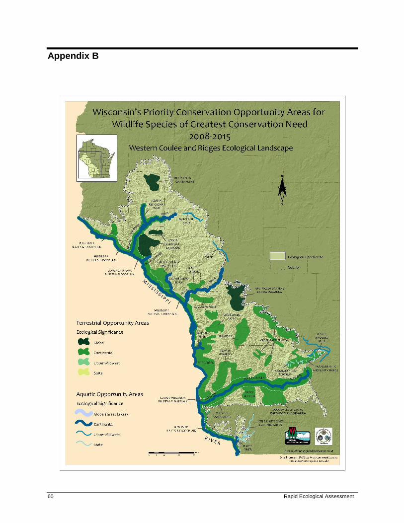
60 Rapid Ecological Assessment
Appendix B
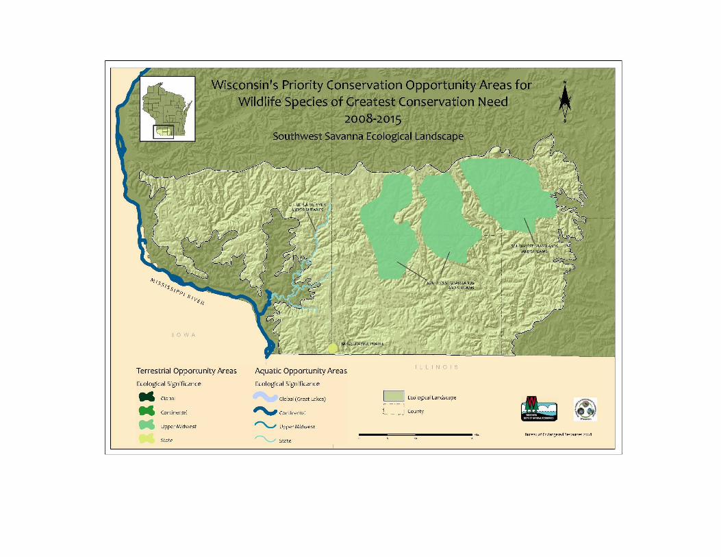

62 Rapid Ecological Assessment
Appendix C
Wisconsin Natural Heritage Working List Explanation
The Wisconsin Natural Heritage Working List contains species known or suspected to be rare in the state
and natural communities native to Wisconsin. It includes species legally designated as "Endangered" or
"Threatened" as well as species in the advisory "Special Concern" category. Most of the species and
natural communities on the list are actively tracked and we encourage data submissions on these species.
This list is meant to be dynamic - it is updated as often as new information regarding the biological status
of species becomes available. See the Endangered Resources Program web site for the most recent
Natural Heritage Inventory Working List (http://dnr.wi.gov/org/land/er/wlist/).
Key
Scientific Name: Scientific name used by the Wisconsin Natural Heritage Inventory Program.
Common Name: Standard, contrived, or agreed upon common names.
Global Rank: Global element rank. See the rank definitions below.
State Rank: State element rank. See the rank definitions below.
US Status: Federal protection status in Wisconsin, designated by the Office of Endangered
Species, U.S. Fish and Wildlife Service through the U.S. Endangered Species Act. LE = listed
endangered; LT = listed threatened; XN = non-essential experimental population(s); LT,PD =
listed threatened, proposed for de-listing; C = candidate for future listing.
WI Status: Protection category designated by the Wisconsin DNR. END = endangered; THR
= threatened; SC = Special Concern.
WDNR and federal regulations regarding Special Concern species range from full
protection to no protection. The current categories and their respective level of
protection are SC/P = fully protected; SC/N = no laws regulating use, possession, or
harvesting; SC/H = take regulated by establishment of open closed seasons; SC/FL =
federally protected as endangered or threatened, but not so designated by WDNR; SC/M
= fully protected by federal and state laws under the Migratory Bird Act.
Special Concern species are those species about which some problem of abundance or
distribution is suspected but not yet proved. The main purpose of this category is to focus
attention on certain species before they become threatened or endangered.
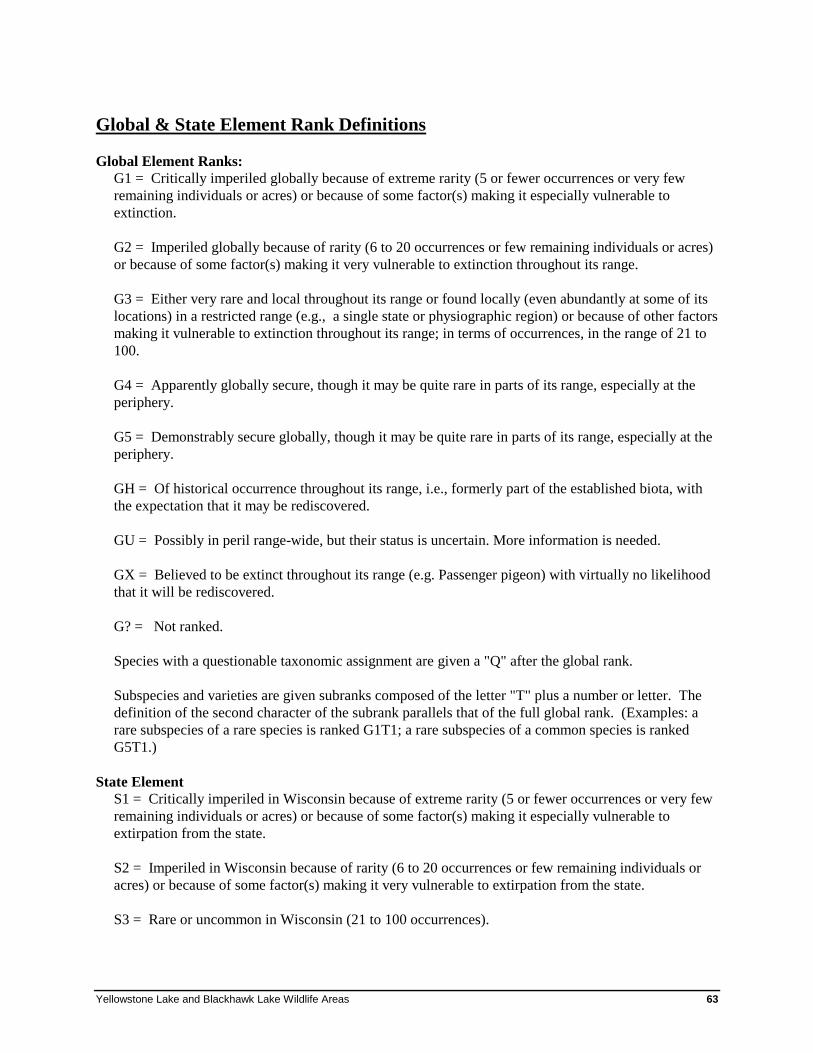
Yellowstone Lake and Blackhawk Lake Wildlife Areas 63
Global & State Element Rank Definitions
Global Element Ranks:
G1 = Critically imperiled globally because of extreme rarity (5 or fewer occurrences or very few
remaining individuals or acres) or because of some factor(s) making it especially vulnerable to
extinction.
G2 = Imperiled globally because of rarity (6 to 20 occurrences or few remaining individuals or acres)
or because of some factor(s) making it very vulnerable to extinction throughout its range.
G3 = Either very rare and local throughout its range or found locally (even abundantly at some of its
locations) in a restricted range (e.g., a single state or physiographic region) or because of other factors
making it vulnerable to extinction throughout its range; in terms of occurrences, in the range of 21 to
100.
G4 = Apparently globally secure, though it may be quite rare in parts of its range, especially at the
periphery.
G5 = Demonstrably secure globally, though it may be quite rare in parts of its range, especially at the
periphery.
GH = Of historical occurrence throughout its range, i.e., formerly part of the established biota, with
the expectation that it may be rediscovered.
GU = Possibly in peril range-wide, but their status is uncertain. More information is needed.
GX = Believed to be extinct throughout its range (e.g. Passenger pigeon) with virtually no likelihood
that it will be rediscovered.
G? = Not ranked.
Species with a questionable taxonomic assignment are given a "Q" after the global rank.
Subspecies and varieties are given subranks composed of the letter "T" plus a number or letter. The
definition of the second character of the subrank parallels that of the full global rank. (Examples: a
rare subspecies of a rare species is ranked G1T1; a rare subspecies of a common species is ranked
G5T1.)
State Element
S1 = Critically imperiled in Wisconsin because of extreme rarity (5 or fewer occurrences or very few
remaining individuals or acres) or because of some factor(s) making it especially vulnerable to
extirpation from the state.
S2 = Imperiled in Wisconsin because of rarity (6 to 20 occurrences or few remaining individuals or
acres) or because of some factor(s) making it very vulnerable to extirpation from the state.
S3 = Rare or uncommon in Wisconsin (21 to 100 occurrences).
64 Rapid Ecological Assessment
S4 = Apparently secure in Wisconsin, with many occurrences.
S5 = Demonstrably secure in Wisconsin and essentially ineradicable under present conditions.
SA = Accidental (occurring only once or a few times) or casual (occurring more regularly although
not every year); a few of these species (typically long-distance migrants such as some birds and
butterflies) may have even bred on one or more of the occasions when they were recorded.
SE = An exotic established in the state; may be native elsewhere in North America.
SH = Of historical occurrence in Wisconsin, perhaps having not been verified in the past 20 years,
and suspected to be still extant. Naturally, an element would become SH without such a 20-year delay
if the only known occurrence were destroyed or if it had been extensively and unsuccessfully looked
for.
SN = Regularly occurring, usually migratory and typically non-breeding species for which no
significant or effective habitat conservation measures can be taken in Wisconsin. This category
includes migratory birds and bats that pass through twice a year or, may remain in the winter (or, in a
few cases, the summer) along with certain lepidoptera which regularly migrate to Wisconsin where
they reproduce, but then completely die out every year with no return migration. Species in this
category are so widely and unreliably distributed during migration or in winter that no small set of
sites could be set aside with the hope of significantly furthering their conservation.
SZ = Not of significant conservation concern in Wisconsin, invariably because there are no definable
occurrences in the state, although the taxon is native and appears regularly in the state. An SZ rank
will generally be used for long-distance migrants whose occurrence during their migrations are too
irregular (in terms of repeated visitation to the same locations), transitory, and dispersed to be reliably
identified, mapped, and protected. Typically, the SZ rank applies to a non-breeding population.
SR = Reported from Wisconsin, but without persuasive documentation which would provide a basis
for either accepting or rejecting the report. Some of these are very recent discoveries for which the
program hasn't yet received first-hand information; others are old, obscure reports that are hard to
dismiss because the habitat is now destroyed.
SRF = Reported falsely (in error) from Wisconsin but this error is persisting in the literature.
SU = Possibly in peril in the state, but their status is uncertain. More information is needed.
SX = Apparently extirpated from the state.
State Ranking of Long-Distance Migrant Animals:
Ranking long distance aerial migrant animals presents special problems relating to the fact that their
non-breeding status (rank) may be quite different from their breeding status, if any, in Wisconsin. In
other words, the conservation needs of these taxa may vary between seasons. In order to present a less
ambiguous picture of a migrant's status, it is necessary to specify whether the rank refers to the
breeding (B) or non-breeding (N) status of the taxon in question. (e.g. S2B,S5N).
Yellowstone Lake and Blackhawk Lake Wildlife Areas 65
Appendix D
Primary Sites of Yellowstone Wildlife Area, Yellowstone Lake State
Park, Yellowstone Savanna State Natural Area, Streambank
Protection Fee Area, and Blackhawk Lake Wildlife Area
Two ecologically important sites were identified on Yellowstone Lake WDNR-managed lands; none
were identified at Blackhawk Lake Wildlife Area. These Primary Sites were delineated because they
generally encompass the best examples of 1) rare and representative natural communities, 2) documented
occurrences of rare species populations, and/or 3) opportunities for ecological restoration or connections.
These sites warrant high protection and/or restoration consideration during the development of the
property master plan. This report is meant to be considered along with other information when
identifying opportunities for various management designations during the master planning process.
Information provided in the summary paragraphs includes location information, a site map, a brief
summary of the natural features present, the site’s ecological significance, and management
considerations.1
1 A list of species referred to by common name is found at the end of this appendix.
66 Rapid Ecological Assessment
YLBL01. YELLOWSTONE FOREST
Location Property: Yellowstone Wildlife Area
County: Lafayette
Landtype Association: Platteville Savanna (222Le02)
Approximate Size (acres): 290
Description of Site Yellowstone Forest (Fig. 1) comprises approximately 290 acres of mostly Southern Dry-mesic Forest that
lies on the south shore of Yellowstone Lake within Yellowstone Wildlife Area. Small inclusions of
eastern white pine relict on sandstone outcrops are also present, as are pockets of rich Southern Mesic
Forest that lie within the deeper, shadier coves and ravines. The site lies on moderate to steep north- to
east-facing slopes and ravines overlooking Yellowstone Lake for 1.5 to 2 miles, extending 300-900 feet
inland where it abruptly transitions to younger, lower quality forest. This forest has extremely high
species diversity (121 native plant species) due to variable slope, aspect, soils, and moisture regime. The
forest is dominated by northern red oak (Quercus rubra), bur oak (Q. macrocarpa), and American
basswood (Tilia americana; up to 36 inch DBH, averaging 18-24 inches) with lesser amounts of shagbark
hickory (Carya ovata), big-tooth aspen (Populus grandidentata), and white oak (Quercus alba). The
ground layer includes characteristics species such as large-flowered bellwort (Uvularia grandiflora),
Jack-in-the-pulpit (Arisaema triphyllum), common lady fern (Athyrium filix-femina), zigzag goldenrod
(Solidago flexicaulis), blue cohosh (Caulophyllum thalictroides), Dutchman’s-breeches (Dicentra
cucullaria), and small white fawn-lily (Erythronium albidum).
Significance of Site An opportunity exists at Yellowstone Forest to manage for Older Forest and, eventually, Old-Growth
Forest. Older forests (greater than 100-120 years old) in Wisconsin are rare and declining, largely due to
timber harvesting, conversion to other land uses, pests, invasive species, herbivory, and the lack of seed
sources (WDNR 2010). These older forests offer unique habitat, including compositional, structural, and
functional attributes. Wisconsin's Statewide Forest Strategy (2010) identifies the need to improve all
forested communities with a landscape management approach that considers the representation of all
successional stages, which includes older forest and old-growth forest. WisFIRS reconnaissance data
indicate that stands in Yellowstone Forest (particularly those closest to the lake) are over 100 years old,
evidenced by the large diameters of the dominant canopy species, structural diversity, and abundant
coarse woody debris.
Management Considerations Long-term development and maintenance of older forest composition, structure and function within a
minimally manipulated environment should be a major consideration for this site (for further guidance,
see WDNR In prep). The core area of high-quality forest at Yellowstone Forest is relatively large in size,
but has a high degree of edge due to a somewhat linear shape. The boundaries of the Primary Site
include the contiguous younger, lower quality forest that lies further inland to create a buffer and reduce
edge. This buffer area should be managed to achieve the same structure and composition as those of the
core area, primarily by allowing natural succession to occur unimpeded.

Yellowstone Lake and Blackhawk Lake Wildlife Areas 67
Monitoring and control of garlic mustard (Alliaria petiolata) may represent the single most important
management need, as it can outcompete native ground layer species and also limit regeneration of canopy
trees. Exotic bush honeysuckle is also present. Caution should be used when applying prescribed fire to
this site to ensure that the flame height and temperature are kept low and that ravines and rich slopes are
excluded.
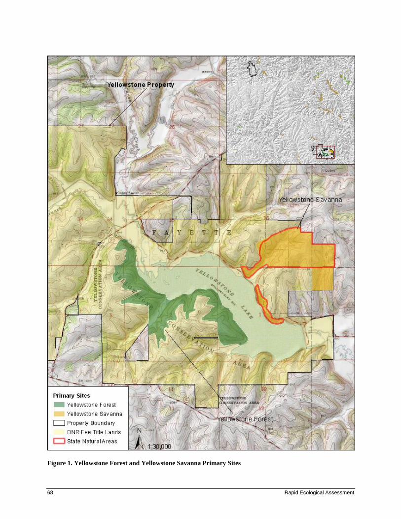
68 Rapid Ecological Assessment
Figure 1. Yellowstone Forest and Yellowstone Savanna Primary Sites

Yellowstone Lake and Blackhawk Lake Wildlife Areas 69
YLBL02. YELLOWSTONE SAVANNA Location Properties: Yellowstone State Park, Yellowstone Savanna State Natural Area
County: Lafayette
Landtype Association: Platteville Savanna (222Le02)
Approximate Size (acres): 240
Description of Site Yellowstone Savanna (Fig. 1) comprises approximately 240 acres east of Yellowstone Lake, and lies
within Yellowstone Savanna State Natural Area and Yellowstone State Park. The site harbors remnant
Dry Prairie and Oak Opening, which are buffered by old field. The fair- to good-quality remnant Oak
Opening is currently undergoing restoration. It is situated along a southwest-northeast-trending ravine,
and is about 10 acres in area. Although the understory has lost some native species due to past grazing,
plowing, and lack of fire, the oak structure remains relatively intact. Large bur oaks (18-24 inch DBH)
are scattered throughout the ravine, with northern red oak, white oak and shagbark hickory the dominant
canopy species. Smaller (12 inch DBH) wild black cherry (Prunus serotina), American basswood, and
American elm (Ulmus americana) dominate the subcanopy. As one moves upslope from the ravine, a
transition is evident as the moderately closed canopy (typical of Oak Woodland) slowly opens and
provides a more park-like appearance (typical of Oak Opening) with large oaks and other savanna
indicator species (e.g., eastern figwort [Scrophularia marilandica]). The groundcover is weedy with
garlic mustard, white snakeroot (Eupatorium rugosum), bog clearweed (Pilea fontana), and common
blackberry (Rubus alleghaniensis).
The remnant Dry Prairie is small (eight acres), and lies on a steep southwest-facing slope. Many species
characteristic of Dry Prairie are present here, including side-oats grama (Bouteloua curtipendula), little
bluestem (Schizachyrium scoparium), Indian grass (Sorghastrum nutans), false boneset (Kuhnia
eupatorioides), leadplant (Amorpha canescens), and prairie tickseed (Coreopsis palmata). Other
conservative prairie species found here include cream wild indigo (Baptisia bracteata), purple prairie
clover (Dalea purpurea), and rosinweed (Silphium integrifolium).
Significance of Site Historically, Oak Openings were abundant in Wisconsin, covering approximately 5.5 million acres
(Curtis 1959) south of the Tension Zone. Review of historical literature indicates that Oak Openings once
supported an exceptionally diverse flora, about 25% of the entire native flora of Wisconsin (Leach and
Givnish 1999). Of the about 75,000 acres (Hoffman 2009) of Oak Opening remaining in Wisconsin,
many of these are highly degraded or have succeeded to closed-canopy oak forests. Prairie once
occupied approximately 2.1 million acres in Wisconsin. Now, approximately 2,000 acres remain – less
than 0.1% (Leach and Givnish 1999). Of these, only those prairies that occurred at the wet and dry ends
of the soil spectrum survived. Both of these community types support specialist animal species that are
equally rare. Yellowstone Savanna State Natural was designated in 2002.
Management Considerations The remnant Dry Prairie is being heavily invaded by brush (30-70% cover), including Eurasian
honeysuckle (Lonicera X bella), smooth sumac (Rhus glabra), gray dogwood (Cornus foemina), common
prickly-ash (Zanthoxlyum americanum), and black locust (Robinia pseudoacacia). Removal of these
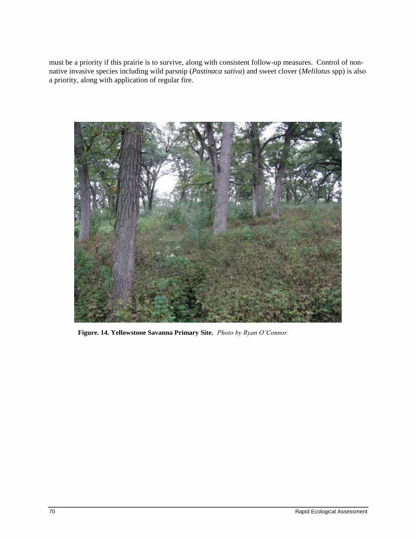
70 Rapid Ecological Assessment
must be a priority if this prairie is to survive, along with consistent follow-up measures. Control of non-
native invasive species including wild parsnip (Pastinaca sativa) and sweet clover (Melilotus spp) is also
a priority, along with application of regular fire.
Figure. 14. Yellowstone Savanna Primary Site. Photo by Ryan O’Connor.
Yellowstone Lake and Blackhawk Lake Wildlife Areas 71
Species List List of species referred to by common name in Appendix D.
Plants
Common Name Scientific Name
American basswood Tilia americana
American elm Ulmus americana
American gromwell Lithospermum latifolium
big-tooth aspen Populus grandidentata
black locust Robinia pseudoacacia
blue cohosh Caulophyllum thalictroides
bog clearweed Pilea fontana
broad-leaf enchanter's-
nightshade Circaea lutetiana
burr oak Quercus macrocarpa
cluster-leaf tick-trefoil Desmodium glutinosum
common blackberry Rubus allegheniensis
common lady fern Athyrium filix-femina
common prickly-ash Zanthoxylum americanum
cream wild indigo Baptisia bracteata
Dutchman's-breeches Dicentra cucullaria
eastern figwort Scrophularia marilandica
false boneset Kuhnia eupatorioides
false rue anemone Isopyrum biternatum
garlic mustard Alliaria petiolata
gray dogwood Cornus foemina
Jack-in-the-pulpit Arisaema triphyllum
large-flowered bellwort Uvularia grandiflora
lead-plant Amorpha canescens
little blue-stem Schizachyrium scoparium
Muhlenberg's cacalia Cacalia muhlenbergii
northern red oak Quercus rubra
prairie rosinweed Silphium integrifolium
72 Rapid Ecological Assessment
prairie tickseed Coreopsis palmata
purple prairie-clover Dalea purpurea
shagbark hickory Carya ovata
Short's rock-cress Arabis shortii
showy bush honeysuckle Lonicera X bella
side-oats grama Bouteloua curtipendula
small white fawn-lily Erythronium albidum
smooth sumac Rhus glabra
white oak Quercus alba
white snakeroot Eupatorium rugosum
wild black cherry Prunus serotina
yellow Indian grass Sorghastrum nutans
zigzag goldenrod Solidago flexicaulis
Yellowstone Lake and Blackhawk Lake Wildlife Areas 73
Reference List
Curtis, J. T. 1959. The Vegetation of Wisconsin. University of Wisconsin Press, Madison, WI. 657 pp.
Hoffman, R. 2009. Wisconsin’s Game Species and SGCN Habitats. In “Wisconsin’s Favorite Bird
Haunts.” Daryl D. Tessen (Ed.). Wisconsin Society for Ornithology, Inc. [Acreage statistics based
on agricultural statistics, Forest Inventory and Assessment data, Wiscland satellite data, and Natural
Heritage Inventory data.]
Leach, MK. and T.J. Givnish. 1999. Gradients in the composition, structure, and diversity of remnant oak
savannas in southern Wisconsin. Ecological Monographs 60(3): 353-374.
Wisconsin Department of Natural Resources [WDNR]. 1995. Wisconsin’s Biodiversity as a Management
Issue: A Report to Department of Natural Resources Managers. Madison, WI.
Wisconsin Department of Natural Resources [WDNR]. 2004. Wisconsin’s Statewide Forest Plan: Ensuring
a Sustainable Future. WDNR website.
Wisconsin Department of Natural Resources [WDNR]. 2010. Wisconsin’s Statewide Forest Assessment.
WDNR website.
Wisconsin Department of Natural Resources [WDNR]. In prep. Old-growth and Old Forests Handbook.
Handbook 2480.5.


