dr. rosa pacione e-geos, asi/cgs, italy dr. jonathan jones...
TRANSCRIPT

Dr. Rosa Pacione e-geos, ASI/CGS, Italy
Dr. Jonathan Jones
Met Office, UK


© Crown copyright Met Office
EIG EUMETNET Project coordinating the near real-time delivery of data from ~2400 GPS sites delivering > 14M ZTDs pcm
Focus is on GPS-only hourly processing, delivering only ZTD in 90mins
Operational assimilation at a few European National Met Services, many others under testing.
Use of E-GVAP ZTDs has proven positive impact on NWP forecast skill
Surface T and P used for conversion to Integrated precipitable Water Vapour (IWV)
Active Quality Control (AQC) in place MoUs in place with EUREF and EUPOS

© Crown copyright Met Office

© Crown copyright Met Office
ZTD only gives you integrated column total measurement from ‘cone of observation’
New hi-resolution NWP models require ZTD with improved timeliness and greater spatial and temporal resolutions than are currently available (e.g. Met Office UKV 1.5km)
Observations providing additional information concerning tropospheric water vapour are desired (i.e. vertical resolution and azimuthal anisotropy)
Sub-hourly processing greatly increases the usefulness of GNSS products for nowcasting and IWV displays
Climate community only now starting to use GNSS tropospheric products (e.g. Hadley Centre)
~5km
~25km
mapping function
e=10°

Long term model validation ◦ NCEP model - good seasonal and inter-annual variations but
underestimation of IWV of <40% in tropics and <25% in Antarctica Liner IWV trends ◦ Global trend: -1.65 to +2.32 kg/m2 per decade ◦ Global trend uncertainty: 0.21 to +1.52 kg/m2 per decade
Ning 2012, GPS Meteorology with focus on Climate Applications http://publications.lib.chalmers.se/records/fulltext/157389.pdf
© Crown copyright Met Office

© Crown copyright Met Office
Multi-GNSS constellations (GPS + GLONASS, Galileo etc…) = new SV geometries, new frequencies, increased number of observations
Continued R&D working towards more advanced tropospheric products (slants, gradients, tomography)
NTRIP real-time raw data streaming Real time PPP processing (from moving
platforms?) Single frequency processing Long-term, homogenised GPS products
available (EPN/IGS/CODE/others), valuable for climate analysis?
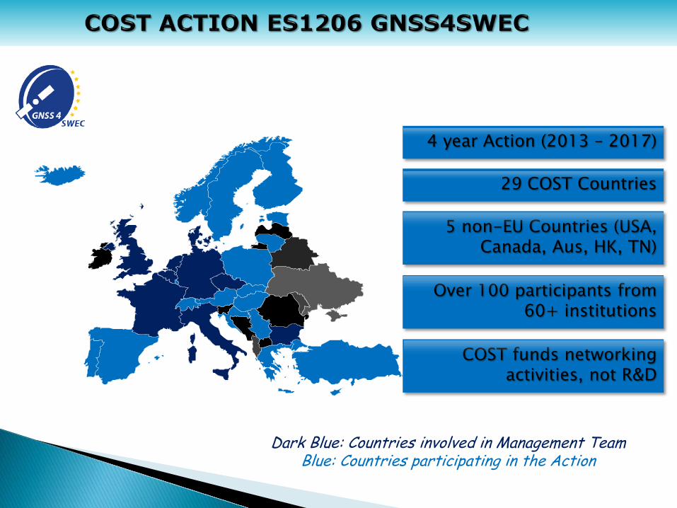
Over 100 participants from 60+ institutions
Dark Blue: Countries involved in Management Team Blue: Countries participating in the Action
29 COST Countries
4 year Action (2013 – 2017)
COST funds networking activities, not R&D
5 non-EU Countries (USA, Canada, Aus, HK, TN)

© Crown copyright Met Office
GNSS for climate monitoring (GNSS4C) WG3
WG2
WG1
GNSS for severe weather monitoring (GNSS4SW)
Advanced GNSS processing techniques (AGNSS)

© Crown copyright Met Office
Improve the understanding of short-term atmospheric processes. 2
Promote the use of, and determine the impact of, re-processed long-term GNSS tropospheric datasets for climate.
3
Link its activities to the IGS and EUREF, and work in support of E-GVAP. 4
Coordinate the development of new, multi-GNSS techniques and products. 1
Coordinate the exploitation of GNSS and meteorological data for mutual benefit. 5
Lead to a consolidation of collaborating groups. 6

Dr. Roeland Van Malderen Royal Meteorological Institute of Belgium
Dr. Olivier Bock
LAREG IGN France
Dr. Rosa Pacione e-geos, ASI/CGS Italy

IWV intercomparison studies w.r.t. GNSS in literature:
Instrument bias [mm] stdev [mm] slope offset [mm] RS -3.78 – 8.00 0.21 – 3.87 0.82 – 1.47 -25.95 – 11.66 MWR -1.66 – 0.50 1.02 – 4.18 0.82 – 1.21 -1.46 – 4.60 sun photometer
-3.58 – 5.90 0.80 – 2.90 0.63 – 1.03 -3.37 – 5.70
FTIR -0.09 – 0.61 0.73 – 1.02 0.95 – 1.06 -0.78 – 0.40 satellite -7.05 – 1.50 0.35 – 7.04 0.75 – 2.33 -2.92 – 8.89 models -8.70 – 5.30 0.64 – 8.08 0.66 – 2.00 -31.90 – 9.70
wide ranges! • different types of instruments are compared with GNSS (e.g. different RS types) • different data retrieval algorithms for a given instrument at different sites • inhomogeneous data records at many sites • different studies apply different methodologies (different co-location and coincidence
criteria, different definitions of statistical parameters, etc.)

GNSS IWV assessments & intercomparisons
objectives:
• evaluate the precision and accuracy of the GNSS IWV estimates sensitivity studies (impact of GNSS data processing procedure) intercomparisons with reference data (campaign data over short periods)
• assess homogeneity of long GNSS time series develop homogenisation methods taking beneif of the multiple parameters available from GPS data processings (ZTD, formal errors, positions...) compare GPS ZTD/IWV to ZTD/IWV data from other instruments that are homogeneous/homogenized on long term
work plan (2015-2016):
• apply uniform methodology on data of “supersites” (> 3 instruments measuring IWV)
• with consistency in data quality of similar instruments at different sites • with known data accuracy/precision and comprehensive metadata
◦ => seeking for cooperation with GRUAN and NDACC

□ : GRUAN sites □ : NDACC & other sites
Identified “supersites”

Proposed collaboration between GNSS4SWEC and GRUAN
GRUAN aims at providing ◦ High quality datasets of IWV and other meteo variables ◦ Validated metedata for instruments on GRUAN sites
GNSS4SWEC aims at providing ◦ High quality, screened, homogenized, GNSS data (in cooperation with EPN
Repro2) ◦ Validated metedata for instruments on GNSS sites
IWV intercomparison exercise ◦ Intercompare IWV data on a few sites and assess inter-system biases ◦ are absolute measurements feasible? ◦ Is a calibration transferable between instruments?
◦ Note: questions such as absolute accuracy of GNSS IWV (and of other
instruments) are central for GNSS4SWEC => special issue perspective

◦ In the framework of EPN Repro2, GNSS data collected at Sodankyla has been homogeneously reprocessed
◦ In the framework of
GNSS4SWEC WG3 Sodankyla ZTD data have been compared w.r.t. RS data
ZTD GPS vs RS
AS0 ASIC
Bias [cm] 0.052 0.292
STD [cm] 0.539 0.552
CC 0.9937 0.9931
Comparison Table for the period 2008-2013 AS0: Reprocessed Solution
ASIC: E-GVAP combined Solution
Contribution from E. Fionda Fondazione Bordoni, Rome


EPN-Repro2 is the second reprocessing campaign organized under the umbrella of EUREF (International Association of Geodesy Sub-commission 1.3 - Regional Reference Frames for Europe) Goals: Will be a continuation of the EPN-Repro1 campaign (but now IGS08) Response to the planned IGS repro2 campaign Generate consistent coordinates, velocities and troposphere parameters (ZTD+Grad) in one reference frame Support the densification of the ITRF2013
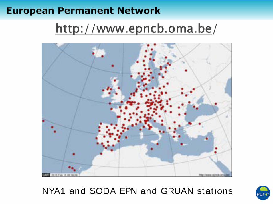
NYA1 and SODA EPN and GRUAN stations
European Permanent Network

Three LACs analysed the entire EPN back to 1996 ASI - Centro di Geodesia Spaziale (GIPSY 6.2) GOP – Geodetic Observatory Pecný (Bernese 5.2) MUT - Military University of Technology (GAMIT 10.50)
Analysis of sub-regional network of the EPN LPT – Swisstopo (Bernese 5.2) IGE – Instituto Geográfico Nacional España (Bernese 5.2)
Analysis strategy agrees with the „Guidelines for EPN Analysis Centres (released Nov. 2013) Status: • all individual solutions delivered • ZTD combination effort in progress • ZTD evaluation foreseen