dr. shelley kauffman albright college skauffman@alb immaculata - weather... · always have the same...
TRANSCRIPT
Dr Shelley Kauffman Albright College skauffmanalbedu
(note LiveWeb a free powerpoint download must be installed to run web pages )
httpwwwhpcncepnoaagovbasicwxday0-7loophtml
Humid air is moreless dense than dry air
At which red letter would you expect the fastest velocity winds
httpwwwyoutubecomwatchv=Q4EBOE4pJyw
Density
Change in air density with change in temperature
Calculating density of pepsi and diet pepsi
The molecular weights of O2 (in red) N2 (in blue) and H2O are about 32
28 and 18 atomic mass units respectively Substituting a water molecule
for either an oxygen or a nitrogen molecule then will decrease the total
mass of air in the container by 10 atomic units
Volume remains constant so the density of water-containing air must be
less than the density of dry air because the mass has decreased
How we lsquofeelrsquo temperature and humidity isnrsquot always how scientific
equipment lsquomeasuresrsquo them
(Same is true of temperaturehellip)
Summers in PA are lovely humid and hot and sometimes feel like pea soup Letrsquos think about the densities of humid vs dry air
ρ = mv
(Amadeo Avogadro discovered in the early 1800s that a fixed volume of gas at the same temperature and pressure would always have the same number of molecules no matter what gas is in the container)
Consider two containers each with 10 molecules of gas at identical T and P
Density = massvolume
Humidity Absolute and Relative What does this graph
show us about the relationship between humidity and temperature
1 At higher T more water vapor is required for saturation
(Warm air is able to
lsquoholdrsquo more water vapor than cold air)
ndash temperature and
absolute humidity are positively correlated
2 The line = dewpoints
Relative Humidity = ratio of water content to water content required for saturation (at given T amp P)
Gradient
Calculate the slopegradient
1 km
100m1000m = 01 100m1250m = 008
Variations in the amount of solar radiation due to earthrsquos tilt drive many of our weather patterns
What creates weather
n = number of moles R = universal gas constant = 83145 Jmol K P = pressure V = volume T = temperature
Ideal Gas Law
Pressure and volume are inversely proportional to temperature This law is demonstrated with soda bottlesballoonscompressed gas tankshellip
ρ = density R = universal gas constant = 83145 Jmol K P = pressure T = temperature
In meteorology we typically donrsquot think about a gas in terms of volume we tend to think about gases in terms of density (mass per unit volume) Using density instead of volume gives us the common form of the Ideal Gas Law in atmospheric science
Think about varying temperature in the atmosphere what accompanying changes happen to density
We instinctively lsquoknowrsquo that warm air rises This is directly related to the change in density with temperature We can also change the density of a gas by altering the pressure while T remains constant (compressed gases)
Think about climbers of Mt Everesthellipwhat variations in T and P must they contend with What would you expect the relationship between temperature and pressure to look like in the troposphere (the lowest part of the atmosphere)
The Upper Atmosphere
Increase in temperature with height means warmer air is located above cooler air This prevents convection as there is no upward vertical movement of the gases As such the location of the bottom of this layer is readily seen by the anvil-shaped tops of cumulonimbus clouds
In this region the temperature increases with height Heat is produced in the process of the formation of ozone and this heat is responsible for temperature increase with altitude
STRATOSPHERE
If youre wondering why these processes absorb UV light it is because they create exothermic reactions Essentially oxygen and ozone convert UV light to heat
The atmospheric pressure can be thought of as the weight of the air above you pushing down on some area
Weight of the air at sea level 147 pounds per square inch 1 kilogram per square centimeter 10132 millibar
Aneroid Barometer
Mercury Barometer
AT SEA LEVEL 101325 mb = 2992 inches of Hg
Letrsquos check current barometric pressure
httpw1weathergovobhistoryKPHLhtml
httpwwwlocalweathercomweathermapscurrentspressureushtml
What are some of the highest and lowest atmospheric pressures ever recorded
Contouring pressure gradients is identical to contouring land elevations Each isobar represents a line of equal pressure
Pressures are recorded and then isobars representing lines of equal pressure can be drawn
(intervals of 10 in this example)
Wind
bull Horizontal movement of air
ndash Out of areas of high pressure
ndash Into areas of low pressure
What is the ultimate driving force for winds
Wind
Controls on wind ndash Pressure gradient force (PGF)
bull Isobars ndash lines of equal air pressure bull Pressure gradient ndash pressure change over distance
ndash Coriolis force (CF)
bull Apparent deflection in the wind direction due to Earthrsquos rotation bull Deflection is to the right in the Northern Hemisphere and to the left in
the Southern Hemisphere
ndash Friction (F) bull Only important near the surface bull Acts to slow the airrsquos movement
(no Coriolis force acting)
The Coriolis effect
Veers trajectories to the right (Northern Hemisphere)
Friction is most important near the ground and less important higher in the atmosphere If we consider winds aloft an important wind is the geostrophic wind The geostrophic wind is a wind that parallels the isobars At first this may seems incorrect but lets think about it for a moment If the PGF forces winds from high to low pressure and the CF deflects the winds there may come a time when the winds are deflected 90deg from their initial direction If the PGF exactly balances the CF the the geostrophic winds will flow parallel to the isobars
The Coriolis effect increases in magnitude until it balances the pressure gradient force ndash resulting in wind moving parallel to the isobars Which force is not accounted for here Friction Geostrophic winds are upper-level winds and are not affected by friction
Summarize the relationship between Coriolis and latitudewind speed
1 As latitude increases so does the Coriolis effect The Coriolis affect is zero at the equator and is maximal at the poles this has to do with angular momentum
- Angular momentum acts perpendicular to the axis of rotation The plane is tangent at the equator therefore the Coriolis effect is zero
2 The greater the wind speed the greater the Coriolis effect
Coriolis effect stronger at higher latitudes
PGF and CF are balanced in upper level winds ndash the
geostrophic balance
Friction acts to weaken the CF CF no longer
balances PGF in surface winds ndash the
wind blows at an angle across isobars
Notice how the PGF vector always heads perpendicular to the isobars
Quick review for the Northern Hemisphere Around a HIGH pressure center winds move a clockwise b counterclockwise Around a LOW pressure center winds move a clockwise b counterclockwise
There is no need to lsquomemorizersquo this in fact it is more fun to prove it to yourself with practice Just remember two simple facts 1 Winds move from high to low pressure 2 Winds are deflected to the right in the Northern
Hemisphere
3 Target practice
H
L
Your arrow wants to cross the isobars perpendicularly ndash that is the steepest gradient But coriolis deflects to the righthellip
Remember things always move from high to low (like the ball rolling down the hill or into the bottom of a bowl) Coriolis deflects the air movement to the right Did your circulation systems result in these patterns
But if the air is converging on a low pressure area wouldnrsquot that lead to a high pressure area
-For a low pressure system to exist for very long compensation must occur aloft
Clouds -rising air cools
water vapor condenses
No clouds -sinking air warms no
condensation
Sinking of air Good Weather (H for Happy)
Lifting of air Bad Weather (L for Lousy)
This upper level activity is what creates the Jet Stream
Current cloud cover
httpwwwgoesnoaagovGSSLOOPSecvshtml
Fronts bull Boundary that separates air masses of different densities (like the lava lamp)
ndash Air masses retain their identities
ndash Warmer less dense air forced aloft
ndash Cooler more dense air acts as wedge
Why do we often see a warm front along the eastern half and a cold front along the western half of a low pressure system
Think about where these winds are coming fromhellip
Which way are the winds blowing at 1 2 3 See You CAN predict the weather
Letrsquos explore the change in winds a bit further
Because they need cold air to form cold fronts often originate from the northerly direction so the winds shift to northerly winds after the front passes
On Sunday Philadelphia set an ALL TIME record for rainfall in a 24-hr period at over 8 inches What was going on
Cold front
Cold air replaces warm air Shown on a map by a line with triangles Twice as steep (1100) as warm fronts Advances faster than a warm front Associated weather is more violent than a warm front
Intensity of precipitation is greater Duration of precipitation is shorter
Weather behind the front is dominated by
Cooler air mass Subsiding air Clearing conditions
httpwwwyoutubecomwatchv=huKYKykjcm0
Cumulus a pile
Behind the cold front is an area of cooler sinking air and HIGH PRESSURE
During
After
Blue skies httpwwwyoutubecomwatchv=kEc16BjfrvI
Warm front
Warm air replaces cooler air Shown on a map by a line with semicircles Small slope (1200) Clouds become lower as the front nears Slow rate of advance Light-to-moderate precipitation Covers larger geographic area
Stratum a layer Cirrus a curl
A warm front brings gentle rain or light snow followed by warmer milder weather
Behind the warm front is an area of warm rising air and LOW PRESSURE
During After
httpwwwyoutubecomwatchv=huKYKykjcm0
Weather Before During Passage After
Winds SSW gusty shifting WNW
Temperature warm sudden drop colder
Pressure falling steadily sharp rise rising steadily
Precipitation brief showers heavy showers
of rain or snow
decreasing
showers then
clearing
Thunder hail or
lightning
Dew point high remains
steady sharp drop lowering
COLD FRONT or WARM FRONT
I can name that front in 2 clues George
Weather Before During Passage After
Winds SSE variable SSW
Temperature cool cold steady rise warmer
Pressure usually falling leveling off slight rise
then a fall
Precipitation
light to
moderate rain
snow sleet or
drizzle
drizzle
usually none
could see
showers or
light rain
Dew point steady slow rise rising then
steady
COLD FRONT or WARM FRONT
After a cold front passes which of these does not usually occur A Wind direction shift B Marked temperature drop C Clearing skies D Decreased pressure
The passage of a cold front signals the edge of a mass of cooler and heavier air arriving over an area Since the air more dense then the pressure would rise not fall thus answer D
1
UGH
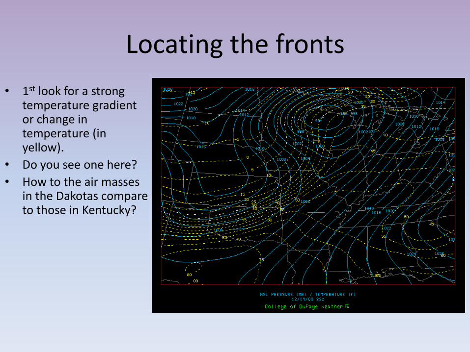
Locating the fronts
bull 1st look for a strong temperature gradient or change in temperature (in yellow)
bull Do you see one here
bull How to the air masses in the Dakotas compare to those in Kentucky
Locating the fronts
bull 2nd look for a strong dewpoint gradient or change
bull Do you see one here
bull How does it compare the temperature gradient in the last slide
Locating the fronts
bull 3rd look for a strong pressure gradient or change
bull 4th look for a strong wind shift (the yellow vectors)
bull Do you see these here
Note in this image the dashed blue lines represent pressure increases while the solid blue lines represent
pressure decreases The numbers represent millibars per three hours The yellow vectors point in the direction the
wind is blowing
Locating the fronts
bull Check cloud patterns
Locating the fronts
bull Every cyclone presents unique characteristics
bull While the satellite and radar didnrsquot show the front well the temperature wind and moisture analyses provided a clear cut picture of where this front should be
bull Often fronts are very subtle and only one rule might be useful
bull I donrsquot expect you to locate fronts this takes some level of expertise but understanding HOW they are determined is still helpful and if you are a weather junky fun
In general warm fronts are more difficult to discern than cold fronts Their transition zones are typically much larger and their effects much more widespread
What sort of weather and clouds might you expect at the labeled points
A ndash Cirrus clouds may extend 1000km ahead of front Pressure decreases as warm air moves in B ndash Light precip 12-24 hours after cirrus clouds Rising temps Change in wind direction to (SSW) C ndash Warm temps skies clear or partly cloudy D ndash Severe weather ensues winds change direction (NNW) E ndash Blue skies smiling on me Nothing but blue skies do I see
G-F often see worst of the weather greatest intensity often north of the storm center In winter heavy snow sleet possible
httpvortexplymouthedumakehtml
Letsrsquo make our own weather maps
httpvortexplymouthedumakehtml
httpwwwhpcncepnoaagovsfcsatsfcgif Putting it all togetherhellip
IN SUMMARY bullAt higher temperatures more water is required for saturation (Warm air is able to lsquoholdrsquo more water vapor than cold air)
bullTemperature decreases with altitude in the troposphere - as humid air rises and subsequently cools it will condense to form water droplets if the moisture content is above the point of saturation
bullCold air is more dense warm air is less dense
bullAfter a cold front passes we expect good weather (higher pressure from the cold dense air mass)
bull High pressure systems associated with good (happy) weather because cooler air from above is descending Blue skies smiling on mehellip bull Low pressure systems associated with bad (lousy) weather because the warm moist air is rising ndash and the water vapor condenses Raindrops keep falling on my headhellip
bull Coriolis deflects air parcels to the right as they cross the pressure gradient (in the North Hemisphere) This creates cyclonic (counterclockwise) movement around low pressure systems

(note LiveWeb a free powerpoint download must be installed to run web pages )
httpwwwhpcncepnoaagovbasicwxday0-7loophtml
Humid air is moreless dense than dry air
At which red letter would you expect the fastest velocity winds
httpwwwyoutubecomwatchv=Q4EBOE4pJyw
Density
Change in air density with change in temperature
Calculating density of pepsi and diet pepsi
The molecular weights of O2 (in red) N2 (in blue) and H2O are about 32
28 and 18 atomic mass units respectively Substituting a water molecule
for either an oxygen or a nitrogen molecule then will decrease the total
mass of air in the container by 10 atomic units
Volume remains constant so the density of water-containing air must be
less than the density of dry air because the mass has decreased
How we lsquofeelrsquo temperature and humidity isnrsquot always how scientific
equipment lsquomeasuresrsquo them
(Same is true of temperaturehellip)
Summers in PA are lovely humid and hot and sometimes feel like pea soup Letrsquos think about the densities of humid vs dry air
ρ = mv
(Amadeo Avogadro discovered in the early 1800s that a fixed volume of gas at the same temperature and pressure would always have the same number of molecules no matter what gas is in the container)
Consider two containers each with 10 molecules of gas at identical T and P
Density = massvolume
Humidity Absolute and Relative What does this graph
show us about the relationship between humidity and temperature
1 At higher T more water vapor is required for saturation
(Warm air is able to
lsquoholdrsquo more water vapor than cold air)
ndash temperature and
absolute humidity are positively correlated
2 The line = dewpoints
Relative Humidity = ratio of water content to water content required for saturation (at given T amp P)
Gradient
Calculate the slopegradient
1 km
100m1000m = 01 100m1250m = 008
Variations in the amount of solar radiation due to earthrsquos tilt drive many of our weather patterns
What creates weather
n = number of moles R = universal gas constant = 83145 Jmol K P = pressure V = volume T = temperature
Ideal Gas Law
Pressure and volume are inversely proportional to temperature This law is demonstrated with soda bottlesballoonscompressed gas tankshellip
ρ = density R = universal gas constant = 83145 Jmol K P = pressure T = temperature
In meteorology we typically donrsquot think about a gas in terms of volume we tend to think about gases in terms of density (mass per unit volume) Using density instead of volume gives us the common form of the Ideal Gas Law in atmospheric science
Think about varying temperature in the atmosphere what accompanying changes happen to density
We instinctively lsquoknowrsquo that warm air rises This is directly related to the change in density with temperature We can also change the density of a gas by altering the pressure while T remains constant (compressed gases)
Think about climbers of Mt Everesthellipwhat variations in T and P must they contend with What would you expect the relationship between temperature and pressure to look like in the troposphere (the lowest part of the atmosphere)
The Upper Atmosphere
Increase in temperature with height means warmer air is located above cooler air This prevents convection as there is no upward vertical movement of the gases As such the location of the bottom of this layer is readily seen by the anvil-shaped tops of cumulonimbus clouds
In this region the temperature increases with height Heat is produced in the process of the formation of ozone and this heat is responsible for temperature increase with altitude
STRATOSPHERE
If youre wondering why these processes absorb UV light it is because they create exothermic reactions Essentially oxygen and ozone convert UV light to heat
The atmospheric pressure can be thought of as the weight of the air above you pushing down on some area
Weight of the air at sea level 147 pounds per square inch 1 kilogram per square centimeter 10132 millibar
Aneroid Barometer
Mercury Barometer
AT SEA LEVEL 101325 mb = 2992 inches of Hg
Letrsquos check current barometric pressure
httpw1weathergovobhistoryKPHLhtml
httpwwwlocalweathercomweathermapscurrentspressureushtml
What are some of the highest and lowest atmospheric pressures ever recorded
Contouring pressure gradients is identical to contouring land elevations Each isobar represents a line of equal pressure
Pressures are recorded and then isobars representing lines of equal pressure can be drawn
(intervals of 10 in this example)
Wind
bull Horizontal movement of air
ndash Out of areas of high pressure
ndash Into areas of low pressure
What is the ultimate driving force for winds
Wind
Controls on wind ndash Pressure gradient force (PGF)
bull Isobars ndash lines of equal air pressure bull Pressure gradient ndash pressure change over distance
ndash Coriolis force (CF)
bull Apparent deflection in the wind direction due to Earthrsquos rotation bull Deflection is to the right in the Northern Hemisphere and to the left in
the Southern Hemisphere
ndash Friction (F) bull Only important near the surface bull Acts to slow the airrsquos movement
(no Coriolis force acting)
The Coriolis effect
Veers trajectories to the right (Northern Hemisphere)
Friction is most important near the ground and less important higher in the atmosphere If we consider winds aloft an important wind is the geostrophic wind The geostrophic wind is a wind that parallels the isobars At first this may seems incorrect but lets think about it for a moment If the PGF forces winds from high to low pressure and the CF deflects the winds there may come a time when the winds are deflected 90deg from their initial direction If the PGF exactly balances the CF the the geostrophic winds will flow parallel to the isobars
The Coriolis effect increases in magnitude until it balances the pressure gradient force ndash resulting in wind moving parallel to the isobars Which force is not accounted for here Friction Geostrophic winds are upper-level winds and are not affected by friction
Summarize the relationship between Coriolis and latitudewind speed
1 As latitude increases so does the Coriolis effect The Coriolis affect is zero at the equator and is maximal at the poles this has to do with angular momentum
- Angular momentum acts perpendicular to the axis of rotation The plane is tangent at the equator therefore the Coriolis effect is zero
2 The greater the wind speed the greater the Coriolis effect
Coriolis effect stronger at higher latitudes
PGF and CF are balanced in upper level winds ndash the
geostrophic balance
Friction acts to weaken the CF CF no longer
balances PGF in surface winds ndash the
wind blows at an angle across isobars
Notice how the PGF vector always heads perpendicular to the isobars
Quick review for the Northern Hemisphere Around a HIGH pressure center winds move a clockwise b counterclockwise Around a LOW pressure center winds move a clockwise b counterclockwise
There is no need to lsquomemorizersquo this in fact it is more fun to prove it to yourself with practice Just remember two simple facts 1 Winds move from high to low pressure 2 Winds are deflected to the right in the Northern
Hemisphere
3 Target practice
H
L
Your arrow wants to cross the isobars perpendicularly ndash that is the steepest gradient But coriolis deflects to the righthellip
Remember things always move from high to low (like the ball rolling down the hill or into the bottom of a bowl) Coriolis deflects the air movement to the right Did your circulation systems result in these patterns
But if the air is converging on a low pressure area wouldnrsquot that lead to a high pressure area
-For a low pressure system to exist for very long compensation must occur aloft
Clouds -rising air cools
water vapor condenses
No clouds -sinking air warms no
condensation
Sinking of air Good Weather (H for Happy)
Lifting of air Bad Weather (L for Lousy)
This upper level activity is what creates the Jet Stream
Current cloud cover
httpwwwgoesnoaagovGSSLOOPSecvshtml
Fronts bull Boundary that separates air masses of different densities (like the lava lamp)
ndash Air masses retain their identities
ndash Warmer less dense air forced aloft
ndash Cooler more dense air acts as wedge
Why do we often see a warm front along the eastern half and a cold front along the western half of a low pressure system
Think about where these winds are coming fromhellip
Which way are the winds blowing at 1 2 3 See You CAN predict the weather
Letrsquos explore the change in winds a bit further
Because they need cold air to form cold fronts often originate from the northerly direction so the winds shift to northerly winds after the front passes
On Sunday Philadelphia set an ALL TIME record for rainfall in a 24-hr period at over 8 inches What was going on
Cold front
Cold air replaces warm air Shown on a map by a line with triangles Twice as steep (1100) as warm fronts Advances faster than a warm front Associated weather is more violent than a warm front
Intensity of precipitation is greater Duration of precipitation is shorter
Weather behind the front is dominated by
Cooler air mass Subsiding air Clearing conditions
httpwwwyoutubecomwatchv=huKYKykjcm0
Cumulus a pile
Behind the cold front is an area of cooler sinking air and HIGH PRESSURE
During
After
Blue skies httpwwwyoutubecomwatchv=kEc16BjfrvI
Warm front
Warm air replaces cooler air Shown on a map by a line with semicircles Small slope (1200) Clouds become lower as the front nears Slow rate of advance Light-to-moderate precipitation Covers larger geographic area
Stratum a layer Cirrus a curl
A warm front brings gentle rain or light snow followed by warmer milder weather
Behind the warm front is an area of warm rising air and LOW PRESSURE
During After
httpwwwyoutubecomwatchv=huKYKykjcm0
Weather Before During Passage After
Winds SSW gusty shifting WNW
Temperature warm sudden drop colder
Pressure falling steadily sharp rise rising steadily
Precipitation brief showers heavy showers
of rain or snow
decreasing
showers then
clearing
Thunder hail or
lightning
Dew point high remains
steady sharp drop lowering
COLD FRONT or WARM FRONT
I can name that front in 2 clues George
Weather Before During Passage After
Winds SSE variable SSW
Temperature cool cold steady rise warmer
Pressure usually falling leveling off slight rise
then a fall
Precipitation
light to
moderate rain
snow sleet or
drizzle
drizzle
usually none
could see
showers or
light rain
Dew point steady slow rise rising then
steady
COLD FRONT or WARM FRONT
After a cold front passes which of these does not usually occur A Wind direction shift B Marked temperature drop C Clearing skies D Decreased pressure
The passage of a cold front signals the edge of a mass of cooler and heavier air arriving over an area Since the air more dense then the pressure would rise not fall thus answer D
1
UGH
Locating the fronts
bull 1st look for a strong temperature gradient or change in temperature (in yellow)
bull Do you see one here
bull How to the air masses in the Dakotas compare to those in Kentucky
Locating the fronts
bull 2nd look for a strong dewpoint gradient or change
bull Do you see one here
bull How does it compare the temperature gradient in the last slide
Locating the fronts
bull 3rd look for a strong pressure gradient or change
bull 4th look for a strong wind shift (the yellow vectors)
bull Do you see these here
Note in this image the dashed blue lines represent pressure increases while the solid blue lines represent
pressure decreases The numbers represent millibars per three hours The yellow vectors point in the direction the
wind is blowing
Locating the fronts
bull Check cloud patterns
Locating the fronts
bull Every cyclone presents unique characteristics
bull While the satellite and radar didnrsquot show the front well the temperature wind and moisture analyses provided a clear cut picture of where this front should be
bull Often fronts are very subtle and only one rule might be useful
bull I donrsquot expect you to locate fronts this takes some level of expertise but understanding HOW they are determined is still helpful and if you are a weather junky fun
In general warm fronts are more difficult to discern than cold fronts Their transition zones are typically much larger and their effects much more widespread
What sort of weather and clouds might you expect at the labeled points
A ndash Cirrus clouds may extend 1000km ahead of front Pressure decreases as warm air moves in B ndash Light precip 12-24 hours after cirrus clouds Rising temps Change in wind direction to (SSW) C ndash Warm temps skies clear or partly cloudy D ndash Severe weather ensues winds change direction (NNW) E ndash Blue skies smiling on me Nothing but blue skies do I see
G-F often see worst of the weather greatest intensity often north of the storm center In winter heavy snow sleet possible
httpvortexplymouthedumakehtml
Letsrsquo make our own weather maps
httpvortexplymouthedumakehtml
httpwwwhpcncepnoaagovsfcsatsfcgif Putting it all togetherhellip
IN SUMMARY bullAt higher temperatures more water is required for saturation (Warm air is able to lsquoholdrsquo more water vapor than cold air)
bullTemperature decreases with altitude in the troposphere - as humid air rises and subsequently cools it will condense to form water droplets if the moisture content is above the point of saturation
bullCold air is more dense warm air is less dense
bullAfter a cold front passes we expect good weather (higher pressure from the cold dense air mass)
bull High pressure systems associated with good (happy) weather because cooler air from above is descending Blue skies smiling on mehellip bull Low pressure systems associated with bad (lousy) weather because the warm moist air is rising ndash and the water vapor condenses Raindrops keep falling on my headhellip
bull Coriolis deflects air parcels to the right as they cross the pressure gradient (in the North Hemisphere) This creates cyclonic (counterclockwise) movement around low pressure systems
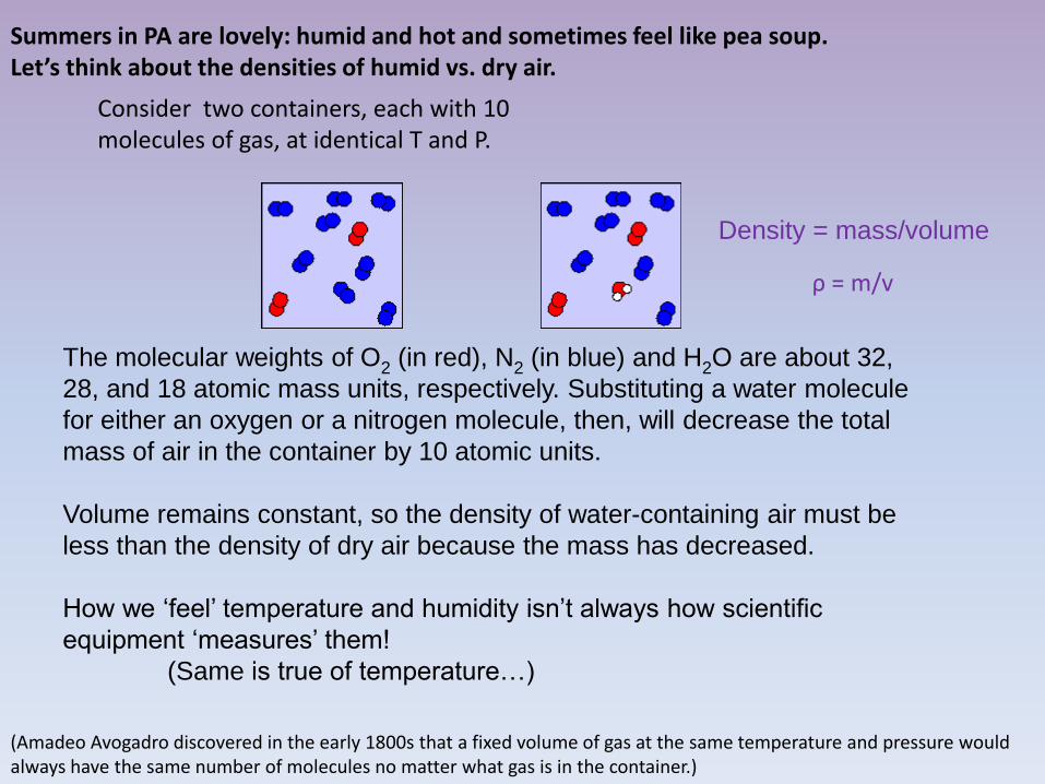
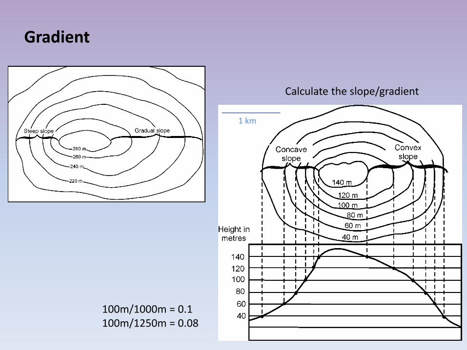
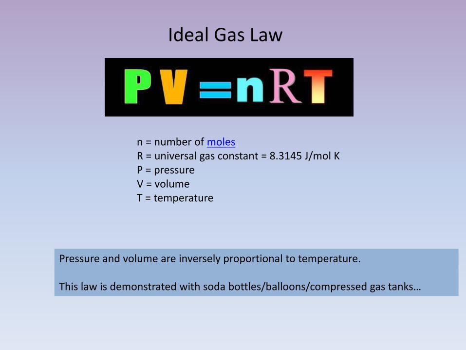
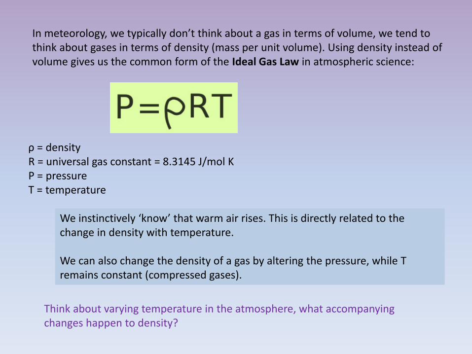
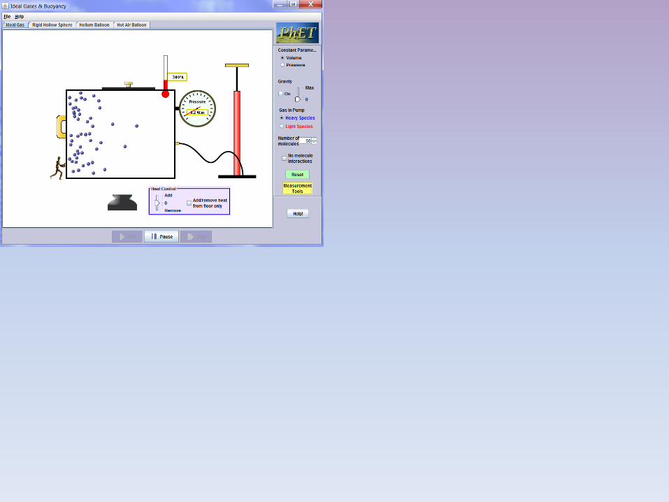
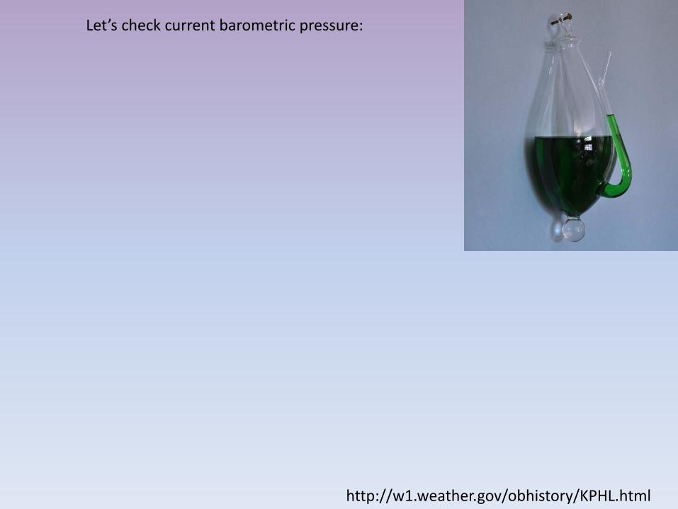

Wind
Controls on wind ndash Pressure gradient force (PGF)
bull Isobars ndash lines of equal air pressure bull Pressure gradient ndash pressure change over distance
ndash Coriolis force (CF)
bull Apparent deflection in the wind direction due to Earthrsquos rotation bull Deflection is to the right in the Northern Hemisphere and to the left in
the Southern Hemisphere
ndash Friction (F) bull Only important near the surface bull Acts to slow the airrsquos movement
(no Coriolis force acting)
The Coriolis effect
Veers trajectories to the right (Northern Hemisphere)
Friction is most important near the ground and less important higher in the atmosphere If we consider winds aloft an important wind is the geostrophic wind The geostrophic wind is a wind that parallels the isobars At first this may seems incorrect but lets think about it for a moment If the PGF forces winds from high to low pressure and the CF deflects the winds there may come a time when the winds are deflected 90deg from their initial direction If the PGF exactly balances the CF the the geostrophic winds will flow parallel to the isobars
The Coriolis effect increases in magnitude until it balances the pressure gradient force ndash resulting in wind moving parallel to the isobars Which force is not accounted for here Friction Geostrophic winds are upper-level winds and are not affected by friction
Summarize the relationship between Coriolis and latitudewind speed
1 As latitude increases so does the Coriolis effect The Coriolis affect is zero at the equator and is maximal at the poles this has to do with angular momentum
- Angular momentum acts perpendicular to the axis of rotation The plane is tangent at the equator therefore the Coriolis effect is zero
2 The greater the wind speed the greater the Coriolis effect
Coriolis effect stronger at higher latitudes
PGF and CF are balanced in upper level winds ndash the
geostrophic balance
Friction acts to weaken the CF CF no longer
balances PGF in surface winds ndash the
wind blows at an angle across isobars
Notice how the PGF vector always heads perpendicular to the isobars
Quick review for the Northern Hemisphere Around a HIGH pressure center winds move a clockwise b counterclockwise Around a LOW pressure center winds move a clockwise b counterclockwise
There is no need to lsquomemorizersquo this in fact it is more fun to prove it to yourself with practice Just remember two simple facts 1 Winds move from high to low pressure 2 Winds are deflected to the right in the Northern
Hemisphere
3 Target practice
H
L
Your arrow wants to cross the isobars perpendicularly ndash that is the steepest gradient But coriolis deflects to the righthellip
Remember things always move from high to low (like the ball rolling down the hill or into the bottom of a bowl) Coriolis deflects the air movement to the right Did your circulation systems result in these patterns
But if the air is converging on a low pressure area wouldnrsquot that lead to a high pressure area
-For a low pressure system to exist for very long compensation must occur aloft
Clouds -rising air cools
water vapor condenses
No clouds -sinking air warms no
condensation
Sinking of air Good Weather (H for Happy)
Lifting of air Bad Weather (L for Lousy)
This upper level activity is what creates the Jet Stream
Current cloud cover
httpwwwgoesnoaagovGSSLOOPSecvshtml
Fronts bull Boundary that separates air masses of different densities (like the lava lamp)
ndash Air masses retain their identities
ndash Warmer less dense air forced aloft
ndash Cooler more dense air acts as wedge
Why do we often see a warm front along the eastern half and a cold front along the western half of a low pressure system
Think about where these winds are coming fromhellip
Which way are the winds blowing at 1 2 3 See You CAN predict the weather
Letrsquos explore the change in winds a bit further
Because they need cold air to form cold fronts often originate from the northerly direction so the winds shift to northerly winds after the front passes
On Sunday Philadelphia set an ALL TIME record for rainfall in a 24-hr period at over 8 inches What was going on
Cold front
Cold air replaces warm air Shown on a map by a line with triangles Twice as steep (1100) as warm fronts Advances faster than a warm front Associated weather is more violent than a warm front
Intensity of precipitation is greater Duration of precipitation is shorter
Weather behind the front is dominated by
Cooler air mass Subsiding air Clearing conditions
httpwwwyoutubecomwatchv=huKYKykjcm0
Cumulus a pile
Behind the cold front is an area of cooler sinking air and HIGH PRESSURE
During
After
Blue skies httpwwwyoutubecomwatchv=kEc16BjfrvI
Warm front
Warm air replaces cooler air Shown on a map by a line with semicircles Small slope (1200) Clouds become lower as the front nears Slow rate of advance Light-to-moderate precipitation Covers larger geographic area
Stratum a layer Cirrus a curl
A warm front brings gentle rain or light snow followed by warmer milder weather
Behind the warm front is an area of warm rising air and LOW PRESSURE
During After
httpwwwyoutubecomwatchv=huKYKykjcm0
Weather Before During Passage After
Winds SSW gusty shifting WNW
Temperature warm sudden drop colder
Pressure falling steadily sharp rise rising steadily
Precipitation brief showers heavy showers
of rain or snow
decreasing
showers then
clearing
Thunder hail or
lightning
Dew point high remains
steady sharp drop lowering
COLD FRONT or WARM FRONT
I can name that front in 2 clues George
Weather Before During Passage After
Winds SSE variable SSW
Temperature cool cold steady rise warmer
Pressure usually falling leveling off slight rise
then a fall
Precipitation
light to
moderate rain
snow sleet or
drizzle
drizzle
usually none
could see
showers or
light rain
Dew point steady slow rise rising then
steady
COLD FRONT or WARM FRONT
After a cold front passes which of these does not usually occur A Wind direction shift B Marked temperature drop C Clearing skies D Decreased pressure
The passage of a cold front signals the edge of a mass of cooler and heavier air arriving over an area Since the air more dense then the pressure would rise not fall thus answer D
1
UGH
Locating the fronts
bull 1st look for a strong temperature gradient or change in temperature (in yellow)
bull Do you see one here
bull How to the air masses in the Dakotas compare to those in Kentucky
Locating the fronts
bull 2nd look for a strong dewpoint gradient or change
bull Do you see one here
bull How does it compare the temperature gradient in the last slide
Locating the fronts
bull 3rd look for a strong pressure gradient or change
bull 4th look for a strong wind shift (the yellow vectors)
bull Do you see these here
Note in this image the dashed blue lines represent pressure increases while the solid blue lines represent
pressure decreases The numbers represent millibars per three hours The yellow vectors point in the direction the
wind is blowing
Locating the fronts
bull Check cloud patterns
Locating the fronts
bull Every cyclone presents unique characteristics
bull While the satellite and radar didnrsquot show the front well the temperature wind and moisture analyses provided a clear cut picture of where this front should be
bull Often fronts are very subtle and only one rule might be useful
bull I donrsquot expect you to locate fronts this takes some level of expertise but understanding HOW they are determined is still helpful and if you are a weather junky fun
In general warm fronts are more difficult to discern than cold fronts Their transition zones are typically much larger and their effects much more widespread
What sort of weather and clouds might you expect at the labeled points
A ndash Cirrus clouds may extend 1000km ahead of front Pressure decreases as warm air moves in B ndash Light precip 12-24 hours after cirrus clouds Rising temps Change in wind direction to (SSW) C ndash Warm temps skies clear or partly cloudy D ndash Severe weather ensues winds change direction (NNW) E ndash Blue skies smiling on me Nothing but blue skies do I see
G-F often see worst of the weather greatest intensity often north of the storm center In winter heavy snow sleet possible
httpvortexplymouthedumakehtml
Letsrsquo make our own weather maps
httpvortexplymouthedumakehtml
httpwwwhpcncepnoaagovsfcsatsfcgif Putting it all togetherhellip
IN SUMMARY bullAt higher temperatures more water is required for saturation (Warm air is able to lsquoholdrsquo more water vapor than cold air)
bullTemperature decreases with altitude in the troposphere - as humid air rises and subsequently cools it will condense to form water droplets if the moisture content is above the point of saturation
bullCold air is more dense warm air is less dense
bullAfter a cold front passes we expect good weather (higher pressure from the cold dense air mass)
bull High pressure systems associated with good (happy) weather because cooler air from above is descending Blue skies smiling on mehellip bull Low pressure systems associated with bad (lousy) weather because the warm moist air is rising ndash and the water vapor condenses Raindrops keep falling on my headhellip
bull Coriolis deflects air parcels to the right as they cross the pressure gradient (in the North Hemisphere) This creates cyclonic (counterclockwise) movement around low pressure systems
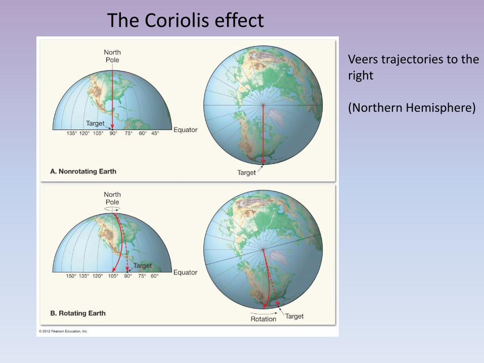
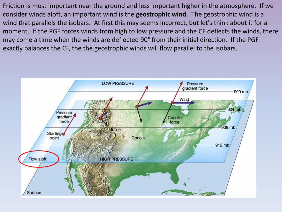
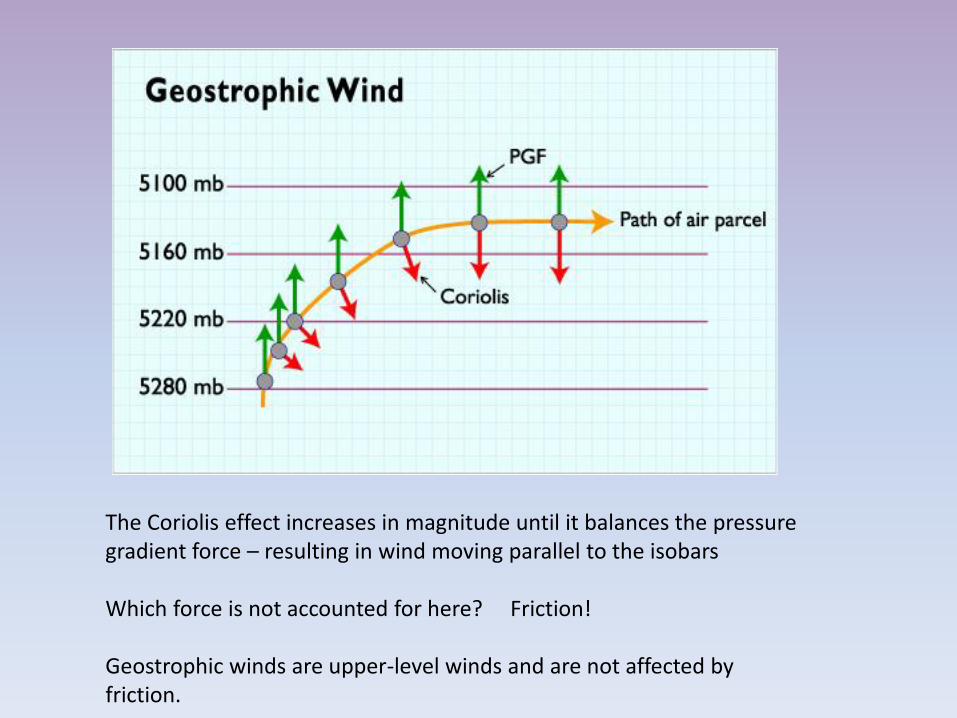
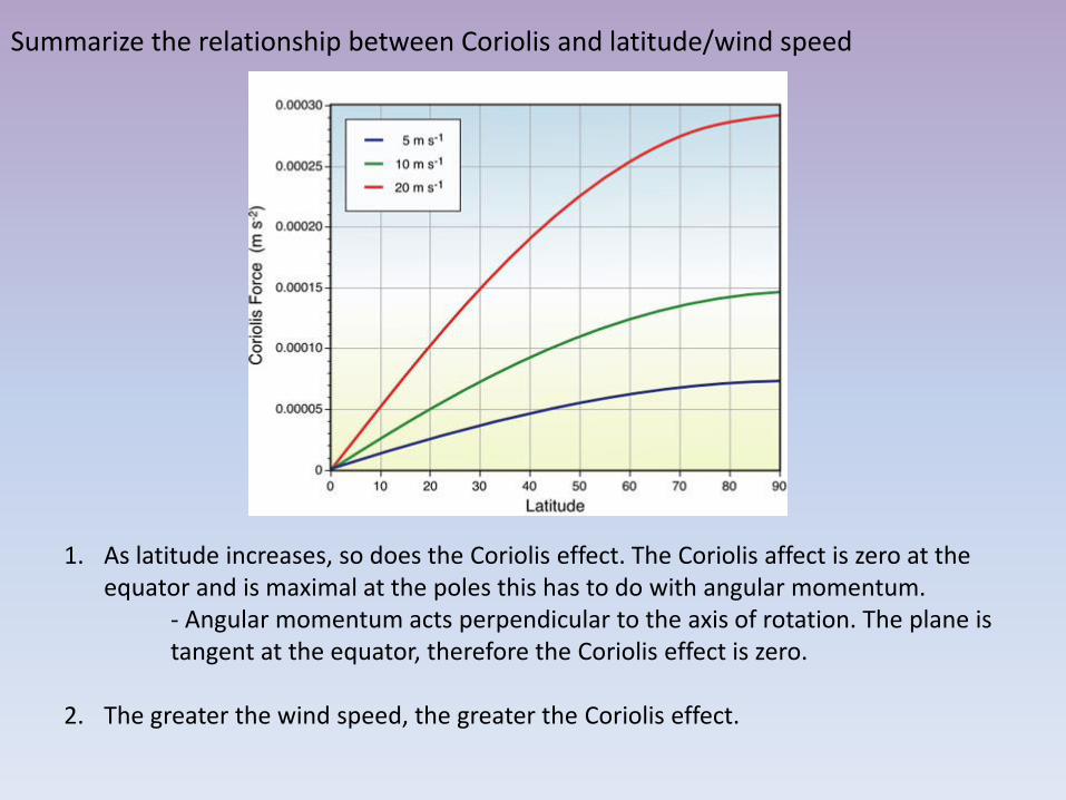
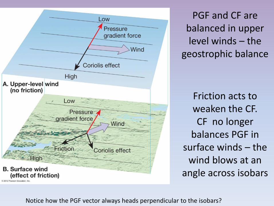
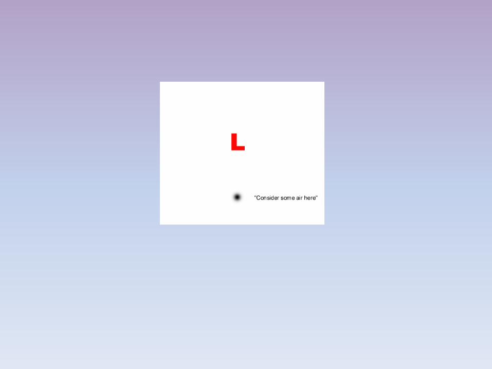
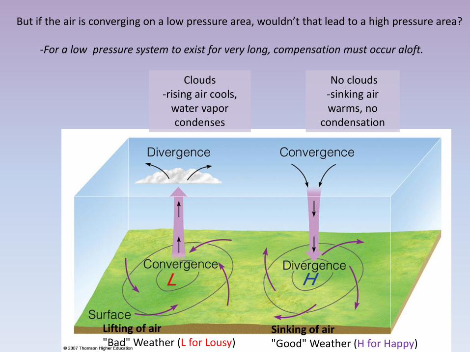
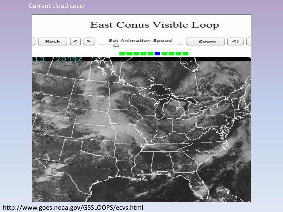
Weather Before During Passage After
Winds SSE variable SSW
Temperature cool cold steady rise warmer
Pressure usually falling leveling off slight rise
then a fall
Precipitation
light to
moderate rain
snow sleet or
drizzle
drizzle
usually none
could see
showers or
light rain
Dew point steady slow rise rising then
steady
COLD FRONT or WARM FRONT
After a cold front passes which of these does not usually occur A Wind direction shift B Marked temperature drop C Clearing skies D Decreased pressure
The passage of a cold front signals the edge of a mass of cooler and heavier air arriving over an area Since the air more dense then the pressure would rise not fall thus answer D
1
UGH
Locating the fronts
bull 1st look for a strong temperature gradient or change in temperature (in yellow)
bull Do you see one here
bull How to the air masses in the Dakotas compare to those in Kentucky
Locating the fronts
bull 2nd look for a strong dewpoint gradient or change
bull Do you see one here
bull How does it compare the temperature gradient in the last slide
Locating the fronts
bull 3rd look for a strong pressure gradient or change
bull 4th look for a strong wind shift (the yellow vectors)
bull Do you see these here
Note in this image the dashed blue lines represent pressure increases while the solid blue lines represent
pressure decreases The numbers represent millibars per three hours The yellow vectors point in the direction the
wind is blowing
Locating the fronts
bull Check cloud patterns
Locating the fronts
bull Every cyclone presents unique characteristics
bull While the satellite and radar didnrsquot show the front well the temperature wind and moisture analyses provided a clear cut picture of where this front should be
bull Often fronts are very subtle and only one rule might be useful
bull I donrsquot expect you to locate fronts this takes some level of expertise but understanding HOW they are determined is still helpful and if you are a weather junky fun
In general warm fronts are more difficult to discern than cold fronts Their transition zones are typically much larger and their effects much more widespread
What sort of weather and clouds might you expect at the labeled points
A ndash Cirrus clouds may extend 1000km ahead of front Pressure decreases as warm air moves in B ndash Light precip 12-24 hours after cirrus clouds Rising temps Change in wind direction to (SSW) C ndash Warm temps skies clear or partly cloudy D ndash Severe weather ensues winds change direction (NNW) E ndash Blue skies smiling on me Nothing but blue skies do I see
G-F often see worst of the weather greatest intensity often north of the storm center In winter heavy snow sleet possible
httpvortexplymouthedumakehtml
Letsrsquo make our own weather maps
httpvortexplymouthedumakehtml
httpwwwhpcncepnoaagovsfcsatsfcgif Putting it all togetherhellip
IN SUMMARY bullAt higher temperatures more water is required for saturation (Warm air is able to lsquoholdrsquo more water vapor than cold air)
bullTemperature decreases with altitude in the troposphere - as humid air rises and subsequently cools it will condense to form water droplets if the moisture content is above the point of saturation
bullCold air is more dense warm air is less dense
bullAfter a cold front passes we expect good weather (higher pressure from the cold dense air mass)
bull High pressure systems associated with good (happy) weather because cooler air from above is descending Blue skies smiling on mehellip bull Low pressure systems associated with bad (lousy) weather because the warm moist air is rising ndash and the water vapor condenses Raindrops keep falling on my headhellip
bull Coriolis deflects air parcels to the right as they cross the pressure gradient (in the North Hemisphere) This creates cyclonic (counterclockwise) movement around low pressure systems
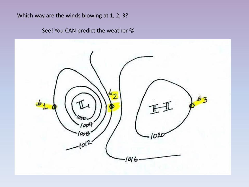
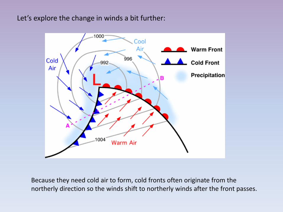
Locating the fronts
bull 2nd look for a strong dewpoint gradient or change
bull Do you see one here
bull How does it compare the temperature gradient in the last slide
Locating the fronts
bull 3rd look for a strong pressure gradient or change
bull 4th look for a strong wind shift (the yellow vectors)
bull Do you see these here
Note in this image the dashed blue lines represent pressure increases while the solid blue lines represent
pressure decreases The numbers represent millibars per three hours The yellow vectors point in the direction the
wind is blowing
Locating the fronts
bull Check cloud patterns
Locating the fronts
bull Every cyclone presents unique characteristics
bull While the satellite and radar didnrsquot show the front well the temperature wind and moisture analyses provided a clear cut picture of where this front should be
bull Often fronts are very subtle and only one rule might be useful
bull I donrsquot expect you to locate fronts this takes some level of expertise but understanding HOW they are determined is still helpful and if you are a weather junky fun
In general warm fronts are more difficult to discern than cold fronts Their transition zones are typically much larger and their effects much more widespread
What sort of weather and clouds might you expect at the labeled points
A ndash Cirrus clouds may extend 1000km ahead of front Pressure decreases as warm air moves in B ndash Light precip 12-24 hours after cirrus clouds Rising temps Change in wind direction to (SSW) C ndash Warm temps skies clear or partly cloudy D ndash Severe weather ensues winds change direction (NNW) E ndash Blue skies smiling on me Nothing but blue skies do I see
G-F often see worst of the weather greatest intensity often north of the storm center In winter heavy snow sleet possible
httpvortexplymouthedumakehtml
Letsrsquo make our own weather maps
httpvortexplymouthedumakehtml
httpwwwhpcncepnoaagovsfcsatsfcgif Putting it all togetherhellip
IN SUMMARY bullAt higher temperatures more water is required for saturation (Warm air is able to lsquoholdrsquo more water vapor than cold air)
bullTemperature decreases with altitude in the troposphere - as humid air rises and subsequently cools it will condense to form water droplets if the moisture content is above the point of saturation
bullCold air is more dense warm air is less dense
bullAfter a cold front passes we expect good weather (higher pressure from the cold dense air mass)
bull High pressure systems associated with good (happy) weather because cooler air from above is descending Blue skies smiling on mehellip bull Low pressure systems associated with bad (lousy) weather because the warm moist air is rising ndash and the water vapor condenses Raindrops keep falling on my headhellip
bull Coriolis deflects air parcels to the right as they cross the pressure gradient (in the North Hemisphere) This creates cyclonic (counterclockwise) movement around low pressure systems
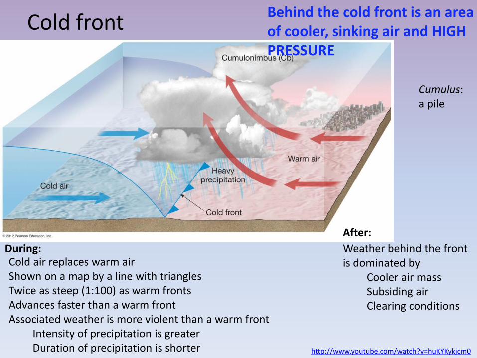
Locating the fronts
bull 3rd look for a strong pressure gradient or change
bull 4th look for a strong wind shift (the yellow vectors)
bull Do you see these here
Note in this image the dashed blue lines represent pressure increases while the solid blue lines represent
pressure decreases The numbers represent millibars per three hours The yellow vectors point in the direction the
wind is blowing
Locating the fronts
bull Check cloud patterns
Locating the fronts
bull Every cyclone presents unique characteristics
bull While the satellite and radar didnrsquot show the front well the temperature wind and moisture analyses provided a clear cut picture of where this front should be
bull Often fronts are very subtle and only one rule might be useful
bull I donrsquot expect you to locate fronts this takes some level of expertise but understanding HOW they are determined is still helpful and if you are a weather junky fun
In general warm fronts are more difficult to discern than cold fronts Their transition zones are typically much larger and their effects much more widespread
What sort of weather and clouds might you expect at the labeled points
A ndash Cirrus clouds may extend 1000km ahead of front Pressure decreases as warm air moves in B ndash Light precip 12-24 hours after cirrus clouds Rising temps Change in wind direction to (SSW) C ndash Warm temps skies clear or partly cloudy D ndash Severe weather ensues winds change direction (NNW) E ndash Blue skies smiling on me Nothing but blue skies do I see
G-F often see worst of the weather greatest intensity often north of the storm center In winter heavy snow sleet possible
httpvortexplymouthedumakehtml
Letsrsquo make our own weather maps
httpvortexplymouthedumakehtml
httpwwwhpcncepnoaagovsfcsatsfcgif Putting it all togetherhellip
IN SUMMARY bullAt higher temperatures more water is required for saturation (Warm air is able to lsquoholdrsquo more water vapor than cold air)
bullTemperature decreases with altitude in the troposphere - as humid air rises and subsequently cools it will condense to form water droplets if the moisture content is above the point of saturation
bullCold air is more dense warm air is less dense
bullAfter a cold front passes we expect good weather (higher pressure from the cold dense air mass)
bull High pressure systems associated with good (happy) weather because cooler air from above is descending Blue skies smiling on mehellip bull Low pressure systems associated with bad (lousy) weather because the warm moist air is rising ndash and the water vapor condenses Raindrops keep falling on my headhellip
bull Coriolis deflects air parcels to the right as they cross the pressure gradient (in the North Hemisphere) This creates cyclonic (counterclockwise) movement around low pressure systems
Locating the fronts
bull Check cloud patterns
Locating the fronts
bull Every cyclone presents unique characteristics
bull While the satellite and radar didnrsquot show the front well the temperature wind and moisture analyses provided a clear cut picture of where this front should be
bull Often fronts are very subtle and only one rule might be useful
bull I donrsquot expect you to locate fronts this takes some level of expertise but understanding HOW they are determined is still helpful and if you are a weather junky fun
In general warm fronts are more difficult to discern than cold fronts Their transition zones are typically much larger and their effects much more widespread
What sort of weather and clouds might you expect at the labeled points
A ndash Cirrus clouds may extend 1000km ahead of front Pressure decreases as warm air moves in B ndash Light precip 12-24 hours after cirrus clouds Rising temps Change in wind direction to (SSW) C ndash Warm temps skies clear or partly cloudy D ndash Severe weather ensues winds change direction (NNW) E ndash Blue skies smiling on me Nothing but blue skies do I see
G-F often see worst of the weather greatest intensity often north of the storm center In winter heavy snow sleet possible
httpvortexplymouthedumakehtml
Letsrsquo make our own weather maps
httpvortexplymouthedumakehtml
httpwwwhpcncepnoaagovsfcsatsfcgif Putting it all togetherhellip
IN SUMMARY bullAt higher temperatures more water is required for saturation (Warm air is able to lsquoholdrsquo more water vapor than cold air)
bullTemperature decreases with altitude in the troposphere - as humid air rises and subsequently cools it will condense to form water droplets if the moisture content is above the point of saturation
bullCold air is more dense warm air is less dense
bullAfter a cold front passes we expect good weather (higher pressure from the cold dense air mass)
bull High pressure systems associated with good (happy) weather because cooler air from above is descending Blue skies smiling on mehellip bull Low pressure systems associated with bad (lousy) weather because the warm moist air is rising ndash and the water vapor condenses Raindrops keep falling on my headhellip
bull Coriolis deflects air parcels to the right as they cross the pressure gradient (in the North Hemisphere) This creates cyclonic (counterclockwise) movement around low pressure systems
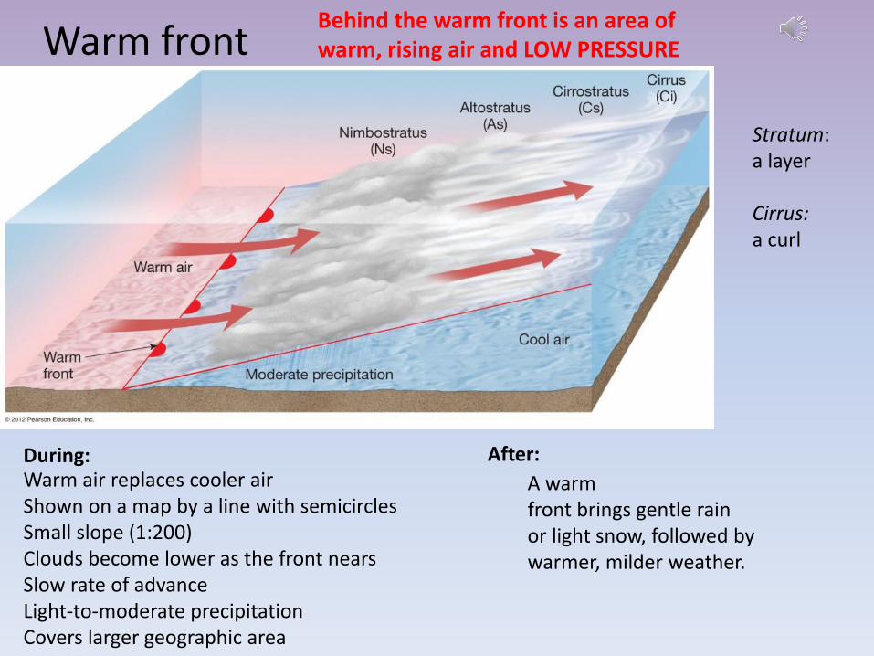
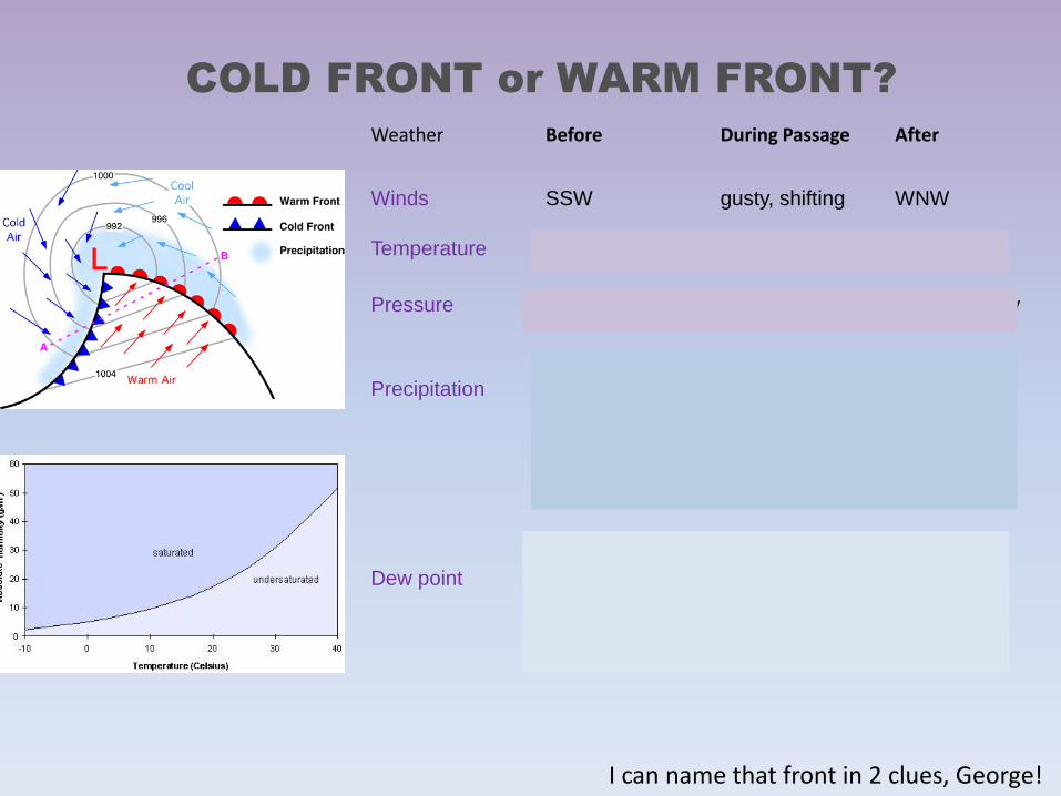
httpvortexplymouthedumakehtml
Letsrsquo make our own weather maps
httpvortexplymouthedumakehtml
httpwwwhpcncepnoaagovsfcsatsfcgif Putting it all togetherhellip
IN SUMMARY bullAt higher temperatures more water is required for saturation (Warm air is able to lsquoholdrsquo more water vapor than cold air)
bullTemperature decreases with altitude in the troposphere - as humid air rises and subsequently cools it will condense to form water droplets if the moisture content is above the point of saturation
bullCold air is more dense warm air is less dense
bullAfter a cold front passes we expect good weather (higher pressure from the cold dense air mass)
bull High pressure systems associated with good (happy) weather because cooler air from above is descending Blue skies smiling on mehellip bull Low pressure systems associated with bad (lousy) weather because the warm moist air is rising ndash and the water vapor condenses Raindrops keep falling on my headhellip
bull Coriolis deflects air parcels to the right as they cross the pressure gradient (in the North Hemisphere) This creates cyclonic (counterclockwise) movement around low pressure systems
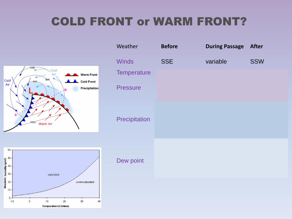
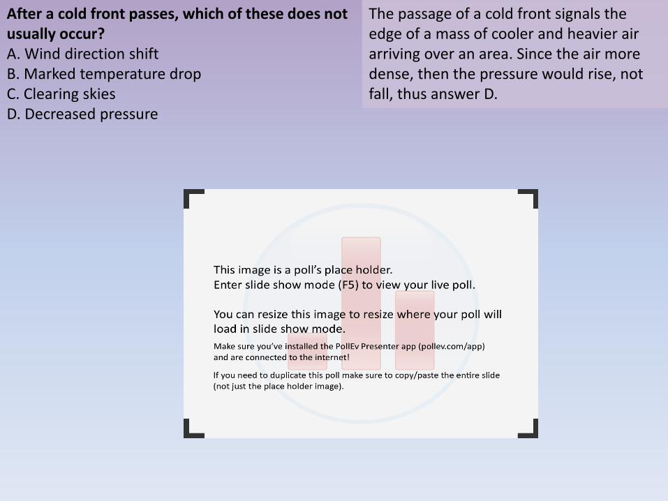
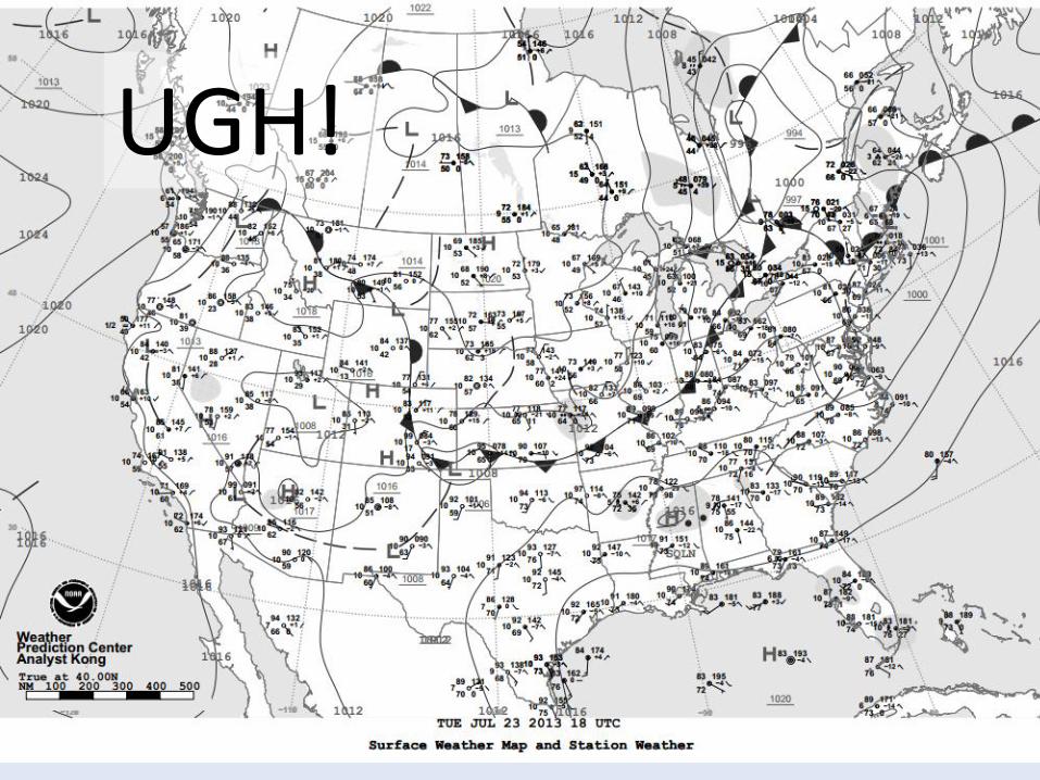