draft basic assessment report rezoning and subdivision … · 1st floor utilitas building 1 dorp...
TRANSCRIPT
DRAFT BASIC ASSESSMENT REPORT REZONING AND SUBDIVISION OF ERF 1894, DE DOORNS
Draft Basic Assessment Report in terms of the National Environmental
Management Act, 1998 (Act No. 107 of 1998), as amended, and the
amended Environmental Impact Assessment Regulations, 2009
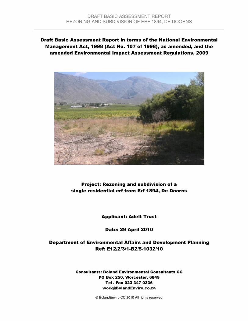
Project: Rezoning and subdivision of a
single residential erf from Erf 1894, De Doorns
Applicant: Adelt Trust
Date: 29 April 2010
Department of Environmental Affairs and Development Planning
Ref: E12/2/3/1-B2/5-1032/10
Consultants: Boland Environmental Consultants CC
PO Box 250, Worcester, 6849
Tel / Fax 023 347 0336
© BolandEnviro CC 2010 All rights reserved
DRAFT BASIC ASSESSMENT REPORT REZONING AND SUBDIVISION OF ERF 1894, DE DOORNS
DEADP Ref. E12/2/3/1-B2/5-1032/10 1
WESTERN CAPE DEPARTMENT OF ENVIRONMENTAL AFFAIRS AND DEVELOPMENT PLANNING
Basic Assessment Report in terms of the National Environmental
Management Act, 1998 (Act No. 107 of 1998), as amended, and the
Environmental Impact Assessment Regulations, 2006
JULY 2006 Kindly note that: 1. This Basic Assessment Report is the standard report required by DEA&DP in terms of the EIA Regulations, 2006 and must be
completed for all Basic Assessment applications and submitted together with the application form. 2. This report is current as of 1 July 2006. It is the responsibility of the Applicant / EAP to ascertain whether subsequent versions of the
report have been published or produced by the competent authority.
3. The required information must be typed within the spaces provided in the report. The sizes of the spaces provided are not necessarily indicative of the amount of information to be provided. It is in the form of a table that can extend itself as each space is filled with typing.
4. Incomplete reports may be rejected or returned to the applicant for amendment. 5. The use of “not applicable” in the report must be done with circumspection. Where it is used in respect of material information that is
required by the competent authority for assessing the application, this may result in the rejection of the report as provided for in the regulations.
6. No faxed or e-mailed reports will be accepted. 7. The report must be compiled by an independent environmental assessment practitioner. 8. Unless protected by law all information contained in, and attached to this report, will become public information on receipt by the
competent authority. Upon request, any interested and affected party should be provided with the information contained in and attached to this report. During any stage of the application process, the information contained in and attached to it must be provided by the applicant / EAP.
9. This report must be submitted to the Department at the postal address given below or by delivery thereof to the Registry Office of the
Department. Should the report and attached information not be submitted to the addresses given below it will be rejected.
DEPARTMENTAL DETAILS
CAPE TOWN OFFICE REGION A (Breede River/ Winelands, City of Cape Town: Tygerberg and Oostenberg Administrations)
CAPE TOWN OFFICE REGION B (West Coast, Overberg, City of Cape Town: Helderberg, South Peninsula, Cape Town and Blaauwberg Administrations
GEORGE OFFICE (Eden and Central Karoo)
Department of Environmental Affairs and Development Planning Attention: Directorate: Integrated Environmental Management (Region A2) Private Bag X 9086 Cape Town, 8000 Registry Office 1
st Floor Utilitas Building
1 Dorp Street, Cape Town Queries should be directed to the Directorate: Integrated Environmental Management (Region A2) at: Tel: (021) 483-4793 Fax (021) 483-3633
Department of Environmental Affairs and Development Planning Attention: Directorate: Integrated Environmental Management (Region B) Private Bag X 9086 Cape Town, 8000 Registry Office 1
st Floor Utilitas Building
1 Dorp Street, Cape Town Queries should be directed to the Directorate: Integrated Environmental Management (Region B) at: Tel: (021) 483-4094 Fax (021) 483-4372
Department of Environmental Affairs and Development Planning Attention: Directorate: Integrated Environmental Management (Region A1) Private Bag X 6509 George, 6530 Registry Office 4
th Floor, York Park Building
93 York Street George Queries should be directed to the Directorate: Integrated Environmental Management (Region A1) at: Tel: (044) 874-2160 Fax (021) 874-2423
View website the Department’s website on http://www.westerncape.gov.za/eadp for the latest version of the documents
DRAFT BASIC ASSESSMENT REPORT REZONING AND SUBDIVISION OF ERF 1894, DE DOORNS
DEADP Ref. E12/2/3/1-B2/5-1032/10 2
Contents SECTION A: ACTIVITY INFORMATION ................................................................................................ 3 1. ACTIVITY DESCRIPTION ............................................................................................................... 3 2. ACTIVITY NEED AND DESIRABILITY ........................................................................................... 4 3. ALTERNATIVES .............................................................................................................................. 4 4. ACTIVITY LOCATION ..................................................................................................................... 5 5. PHYSICAL SIZE OF THE ACTIVITY .............................................................................................. 6 6. SITE ACCESS .................................................................................................................................. 6 7. SITE PHOTOGRAPHS .................................................................................................................... 7 8. APPLICABLE LEGISLATION, POLICIES AND/OR GUIDELINES ............................................... 7 SECTION B: DESCRIPTION OF RECEIVING ENVIRONMENT ........................................................... 8 1. GRADIENT OF THE SITE ............................................................................................................... 8 2. LOCATION IN LANDSCAPE ........................................................................................................... 8 3. GROUNDWATER, SOIL AND GEOLOGICAL STABILITY OF THE SITE ..................................... 8 4. SURFACE WATER .......................................................................................................................... 9 5. VEGETATION / GROUNDCOVER ................................................................................................. 9 6. LAND USE CHARACTER OF SURROUNDING AREA ................................................................. 9 7. REGIONAL PLANNING CONTEXT .............................................................................................. 10 8. SOCIO-ECONOMIC CONTEXT .................................................................................................... 11 9. CULTURAL/HISTORICAL FEATURES ........................................................................................ 12 SECTION C: PUBLIC PARTICIPATION .............................................................................................. 13
SECTION D: IMPACT ASSESSMENT ................................................................................................. 15 1. WASTE, EFFLUENT AND EMISSION MANAGEMENT .............................................................. 15 2. WATER USE .................................................................................................................................. 16 3. POWER SUPPLY .......................................................................................................................... 16 4. ENERGY EFFICIENCY ................................................................................................................. 17 5. NOISE IMPACTS ........................................................................................................................... 17 6. VISUAL IMPACTS ......................................................................................................................... 17 7. SOCIO-ECONOMIC IMPLICATIONS OF THE ACTIVITY ........................................................... 17 8. IMPACTS THAT MAY RESULT FROM THE PLANNING, DESIGN AND CONSTRUCTION PHASE ................................................................................................................................................... 18 9. IMPACTS THAT MAY RESULT FROM THE OPERATIONAL PHASE ....................................... 20 10. IMPACTS THAT MAY RESULT FROM THE DECOMISSIONING AND CLOSURE PHASE ...... 22 11. CUMULATIVE IMPACTS .............................................................................................................. 22 12. IMPACT SUMMARY OF PREFERRED ALTERNATIVE .............................................................. 23 13. RECOMMENDATION OF ENVIRONMENTAL ASSESSMENT PRACTITIONER ....................... 23
APPENDICES ........................................................................................................................................ 25
DECLARATIONS .................................................................................................................................. 26
DRAFT BASIC ASSESSMENT REPORT REZONING AND SUBDIVISION OF ERF 1894, DE DOORNS
DEADP Ref. E12/2/3/1-B2/5-1032/10 3
SECTION A: ACTIVITY INFORMATION 1. ACTIVITY DESCRIPTION
(a) Is the project a new development or an upgrade of an existing development? YES� NO
(b) Clearly describe the activity and associated infrastructure for which you are applying.
The Applicant intends to subdivide a small portion of Erf 1894, De Doorns. The subdivided portion (proposed Portion A – also referred to as the Subject Land) consists of a small piece of open unused land on Rossouw Street, De Doorns. The Subject Land is separated from the remainder of Erf 1894 by a storm-water canal. Rossouw Street, De Doorns is typical middle income a residential area, and the proposed Portion A will be used in the future to construct either a single residential unit or 2-3 retirement units. No additional infrastructure is required as the residential area is fully serviced by the local municipality. Erf 1894, De Doorns covers an area of 45.2738 Ha, and the proposed Portion A will be 972 m
2 in size.
The proposed activity triggers GN R386 No. (18) “The subdivision of portions of land 9 hectares or larger into portions of 5 hectares or less.”
(c) Please provide details of all components of the proposed project and attach diagrams (e.g. architectural drawings or perspectives, engineering
drawings, process flow charts etc.).
Buildings YES� NO
Provide brief description:
The Developer intends to construct a single residential unit or 2-3 small cottages on the subject land in the future. No construction will however take place within the next 3-5 years. The current activity thus entails the subdivision, clearing and fencing of the proposed site. Infrastructure (e.g. roads, power and water supply/ storage) YES NO�
Provide brief description:
The subject land will be accessed from Rossouw Street, on which it is located. No additional infrastructure is required as the residential area is fully serviced by the local municipality. Processing activities (e.g. manufacturing, storage, distribution) YES NO�
Provide brief description:
Not Applicable
Storage facilities for raw materials and products (e.g. volume and substances to be stored)
Provide brief description YES NO�
Not Applicable
Storage and treatment facilities for solid waste and effluent generated by the project Yes No�
Provide brief description
Not Applicable
Other activities (e.g. water abstraction activities, crop planting activities) Yes No�
Provide brief description
Not Applicable
DRAFT BASIC ASSESSMENT REPORT REZONING AND SUBDIVISION OF ERF 1894, DE DOORNS
DEADP Ref. E12/2/3/1-B2/5-1032/10 4
2. ACTIVITY NEED AND DESIRABILITY (a) Describe the need and desirability of the activity:
Need: Erf 1894, with an area of 45.2738 Ha, consists of approximately 45 ha of cultivated, table grape vineyards, associated farm buildings, worker housing and a farm homestead. The area intended for subdivision and rezoning (Portion A) does not form an integral part of Erf 1894, as seen in Figure B1 and B2 (Appendix B – Site Plan). The proposed Portion A (0.0972ha or 972m
2 in extent) is for all practical purposes cut off from the
remainder of Erf 1894 by an existing storm water channel and it is surrounded by urban residential homes and serviced erven. As a result, this small portion of land has not been used for agricultural purposes for many years. Apart from the owners existing farm homestead, this is the only portion of the farm that is not utilised for cultivation due to the reasons mentioned above and is therefore derelict land. It is therefore logical that this portion, which is not an ideal area for cultivation and currently not of any use, be subdivided from Erf 1894 and incorporated into the urban component of De Doorns. Desirability: The proposed development is desirable as the Developer wish to construct a residential unit on the proposed site, which will be serviced by existing Municipal roads, water, sewerage and stormwater systems. The proposed portion of land is already nested within the urban component of De Doorns as it is bounded by residential units (Erf 740 and Erf 88), a public open space and is situated on Rossouw Street (Appendix B - Site Plan). The development requires no additional infrastructure, there will be no visual impact as the site is bordered by residential units and there is no indigenous vegetation on the proposed site. (b) Indicate the benefits that the activity will have for society in general and also indicate the benefits that the activity will have for the local
communities where the activity will be located:
There will be no significant benefits for society in general. Apart from temporary job creation for the local people should construction commence in the future, the proposed development will have no direct benefits for local communities. 3. ALTERNATIVES Describe alternatives that are considered in this application. Please Note: 1. This report only provides space for 3 alternatives. The required information must however be provided for all alternatives being
considered. Alternatives should include a consideration of all possible means by which the purpose and need of the proposed activity could be accomplished. The determination of whether the site or activity (including different processes etc.) or both is appropriate needs to be informed by the specific circumstances of the activity and its environment. The no-go option must in all cases be included in the assessment phase as the baseline against which the impacts of all alternatives are assessed.
2. After receipt of this report the competent authority may also request the applicant to assess additional alternatives that could possibly accomplish the purpose and need of the proposed activity if it is clear that realistic alternatives have not been considered to a reasonable extent.
3. Consult the Department’s Guideline on Alternatives prior to completing this section. 3(a) Site alternatives:
Please indicate the number of site alternatives assessed
Describe site alternative 1 (S1) (preferred or only site alternative), for the activity described above, or for any other activity alternative:
DRAFT BASIC ASSESSMENT REPORT REZONING AND SUBDIVISION OF ERF 1894, DE DOORNS
DEADP Ref. E12/2/3/1-B2/5-1032/10 5
The preferred and only site alterative is the proposed Portion A (972 m
2) of Erf 1894, De Doorns, situated on
Rossouw Street and separated from the remainder of Erf 1894 by a storm water channel. Exemption has been applied for the consideration of alternatives for the proposed development as there are no other possible alternatives to consider.
Describe site alternative 2 (S2), if any, for the activity described above, or for any other activity alternative:
Not Applicable
Describe site alternative 3 (S3), if any, for the activity described above, or for any other activity alternative:
Not Applicable 3(b) Activity alternatives:
Describe activity alternative 1 (A1), if any, for any or all of the site alternatives as appropriate:
The preferred and only alternative is the subdivision and rezoning of Portion A of Erf 1894, De Doorns, and the subsequent construction of a single residential unit on the proposed site. Exemption has been applied for the consideration of alternatives for the proposed development as there are no other possible alternatives to consider.
Describe activity alternative 2 (A2), if any, for any or all of the site alternatives as appropriate:
Not Applicable
Describe activity alternative 3 (A3), if any, for any or all of the site alternatives as appropriate:
Not Applicable 3(c) Other alternatives (e.g. layout, technological, timing, process etc):
Describe the alternative
Not Applicable 4. ACTIVITY LOCATION
Indicate the position of the activity using the latitude and longitude of the centre point of the site for each alternative site. The co-ordinates must be in degrees, minutes and seconds. The minutes should be given to at least three decimals to ensure adequate accuracy. The projection that must be used in all cases is the WGS84 spheroid in a national or local projection.
Alternative: Latitude (S): Longitude (E):
Alternative S1 (preferred or only site alternative) 33o 28‘ 20.94 “ 19o 39 ‘ 50.14“
Alternative S2 (if any) Not Applicable o ‘ “
o ‘ “
Alternative S3 (if any) Not Applicable o ‘ “
o ‘ “
DRAFT BASIC ASSESSMENT REPORT REZONING AND SUBDIVISION OF ERF 1894, DE DOORNS
DEADP Ref. E12/2/3/1-B2/5-1032/10 6
or, for linear activities:
Alternative: Not Applicable Latitude (S): Longitude (E):
Alternative S1 (preferred or only route alternative)
• Starting point of the activity o ‘ “
o ‘ “
• Middle point of the activity o ‘ “
o ‘ “
• End point of the activity o
‘ “ o
‘ “
Alternative S2 (if any)
• Starting point of the activity o
‘ “ o
‘ “
• Middle point of the activity o
‘ “ o
‘ “
• End point of the activity o
‘ “ o
‘ “
Alternative S3 (if any)
• Starting point of the activity o
‘ “ o
‘ “
• Middle point of the activity o
‘ “ o
‘ “
• End point of the activity o
‘ “ o
‘ “
Please Note: For route alternatives that are longer than 500m, please provide and addendum with co-ordinates taken every 100 meters along the route for each alternative.
5. PHYSICAL SIZE OF THE ACTIVITY
Indicate the physical size of the preferred activity as well as alternative activities and its associated infrastructure (footprints):
Alternative: Size of the activity:
Alternative A1 (preferred activity alternative) 972 m2
Alternative A2 (if any) m2
Alternative A3 (if any) m2
or, for linear activities:
Alternative: Length of the activity:
Alternative A1 (preferred activity alternative) m2
Alternative A2 (if any) m2
Alternative A3 (if any) m2
Indicate the size of the alternative sites or servitudes (within which the above footprints will occur):
Alternative: Size of the site/servitude:
Alternative A1 (preferred activity alternative) 452 738 m2
Alternative A2 (if any) m2
Alternative A3 (if any) m2
Associated Infrastructure: Indicate the size of the alternative sites or servitudes (within which the above associated infrastructure footprints will occur):
Alternative: Size of the site/servitude:
Alternative A1 (preferred activity alternative) Not Applicable 0 m2
Alternative A2 (if any) m2
Alternative A3 (if any) m2
6. SITE ACCESS
Is there an existing access road? YES� NO
If NO, what is the distance over which a new access road will be built? m
Describe the type of access road planned:
Not Applicable
Please Note: indicate the position of the proposed access road on the site plan (See Section 7 below)
DRAFT BASIC ASSESSMENT REPORT REZONING AND SUBDIVISION OF ERF 1894, DE DOORNS
DEADP Ref. E12/2/3/1-B2/5-1032/10 7
7. SITE PHOTOGRAPHS Colour photographs of the site and its surroundings (taken of the site and from the site) with a description of each photograph. The vantage points from which the photographs were taken must be indicated on the site plan, or locality plan as applicable. If available, please also provide a recent aerial photograph. Photographs must be attached under Appendix D to this form. It should be supplemented with additional photographs of relevant features on the site. Date of photographs must be included. Please note that the above requirements must be duplicated for all alternative sites.
8. APPLICABLE LEGISLATION, POLICIES AND/OR GUIDELINES Please list all legislation, policies and/or guidelines that have or will be considered in the preparation of this application.
LEGISLATION ADMINISTERING AUTHORITY TYPE
Permit/ license/ authorization/comment
DATE (if already obtained):
The National Environmental management Act (NEMA) – Act 107 of 1998, as amended
Department of Environmental Affairs and Development Planning
Considered legislation, this application
The Environmental Impact Assessment Regulations of 2006 (GN R. 385 and 386 – NEMA Regulations), as amended
Department of Environmental Affairs and Development Planning
Considered legislation, this application
Subdivision of Agricultural Land Act 70 of 1970
Department of Agriculture - Western Cape
Comment 08/03/2007
POLICY/ GUIDELINES ADMINISTERING AUTHORITY
Guidelines on Need and Desirability (May 2009) Department of Environmental Affairs and Development Planning
Guidelines on Public Participation (May 2009) Department of Environmental Affairs and Development Planning
Guidelines on the Interpretation of the Listed Activities (Nov 2006)
Department of Environmental Affairs and Development Planning
Western Cape Provincial Spatial Development Framework (2005)
Department of Environmental Affairs and Development Planning
Breede Valley Municipality Spatial Development Framework (2003)
Breede Valley Municipality
DRAFT BASIC ASSESSMENT REPORT REZONING AND SUBDIVISION OF ERF 1894, DE DOORNS
DEADP Ref. E12/2/3/1-B2/5-1032/10 8
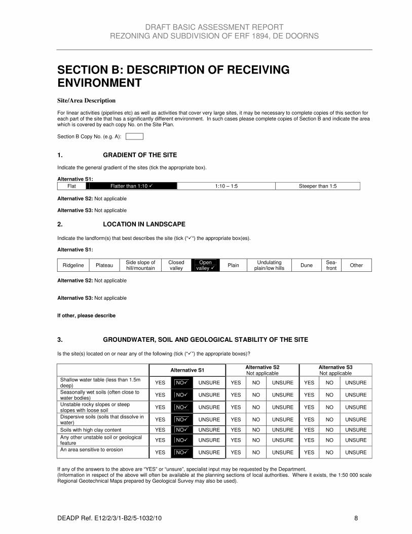
SECTION B: DESCRIPTION OF RECEIVING ENVIRONMENT Site/Area Description For linear activities (pipelines etc) as well as activities that cover very large sites, it may be necessary to complete copies of this section for each part of the site that has a significantly different environment. In such cases please complete copies of Section B and indicate the area which is covered by each copy No. on the Site Plan.
Section B Copy No. (e.g. A):
1. GRADIENT OF THE SITE Indicate the general gradient of the sites (tick the appropriate box). Alternative S1:
Flat Flatter than 1:10 � 1:10 – 1:5 Steeper than 1:5
Alternative S2: Not applicable Alternative S3: Not applicable
2. LOCATION IN LANDSCAPE Indicate the landform(s) that best describes the site (tick (“�“) the appropriate box(es). Alternative S1:
Ridgeline Plateau Side slope of hill/mountain
Closed valley
Open valley �
Plain Undulating
plain/low hills Dune
Sea-front
Other
Alternative S2: Not applicable Alternative S3: Not applicable If other, please describe
3. GROUNDWATER, SOIL AND GEOLOGICAL STABILITY OF THE SITE Is the site(s) located on or near any of the following (tick (“�”) the appropriate boxes)?
Alternative S1 Alternative S2 Not applicable
Alternative S3 Not applicable
Shallow water table (less than 1.5m deep)
YES NO� UNSURE YES NO UNSURE YES NO UNSURE
Seasonally wet soils (often close to water bodies)
YES NO� UNSURE YES NO UNSURE YES NO UNSURE
Unstable rocky slopes or steep slopes with loose soil
YES NO� UNSURE YES NO UNSURE YES NO UNSURE
Dispersive soils (soils that dissolve in water)
YES NO� UNSURE YES NO UNSURE YES NO UNSURE
Soils with high clay content YES NO� UNSURE YES NO UNSURE YES NO UNSURE
Any other unstable soil or geological feature
YES NO� UNSURE YES NO UNSURE YES NO UNSURE
An area sensitive to erosion
YES NO� UNSURE YES NO UNSURE YES NO UNSURE
If any of the answers to the above are “YES” or “unsure”, specialist input may be requested by the Department. (Information in respect of the above will often be available at the planning sections of local authorities. Where it exists, the 1:50 000 scale Regional Geotechnical Maps prepared by Geological Survey may also be used).
DRAFT BASIC ASSESSMENT REPORT REZONING AND SUBDIVISION OF ERF 1894, DE DOORNS
DEADP Ref. E12/2/3/1-B2/5-1032/10 9
4. SURFACE WATER Indicate the surface water present on and or adjacent to the site and alternative sites (tick (“�”) the appropriate boxes)?
Alternative S1 Alternative S2 Not applicable
Alternative S3 Not applicable
Perennial River YES NO� UNSURE YES NO UNSURE YES NO UNSURE
Non-Perennial River YES NO� UNSURE YES NO UNSURE YES NO UNSURE
Permanent Wetland YES NO� UNSURE YES NO UNSURE YES NO UNSURE
Seasonal Wetland YES NO� UNSURE YES NO UNSURE YES NO UNSURE
Artificial Wetland YES NO� UNSURE YES NO UNSURE YES NO UNSURE
Estuarine / Lagoonal wetland YES NO� UNSURE YES NO UNSURE YES NO UNSURE
5. VEGETATION / GROUNDCOVER Tick (“�”) and describe (where required) the vegetation types / groundcover present on the site. Alternative S1:
Indigenous Vegetation - good condition
Indigenous Vegetation with scattered aliens
Indigenous Vegetation with heavy alien infestation
Identify the vegetation type above:
Identify the vegetation type above: Identify the vegetation type above:
Provide ecosystem status for above:
Provide ecosystem status for above:
Provide Ecosystem status for above:
Indigenous Vegetation in an ecological corridor or along a soil boundary /
interface
Veld dominated by alien species
Distinctive soil conditions (e.g. Sand over shale, quartz patches, limestone, alluvial deposits,
termitaria etc.) – describe
Bare soil
Building or other structure
Sport field
Paved surface
Cultivated land
Other (Vacant land covered by kikuyu grass and weeds)
Alternative S2: Not applicable Alternative S3: Not applicable Please note: The Department may request specialist input/studies depending on the nature of the vegetation type / groundcover and potential impact(s) of the proposed activity/ies. To assist with the identification of the vegetation type and ecosystem status consult http://bgis.sanbi.org or [email protected]. Information is also available on compact disc (cd) from the Biodiversity-GIS Unit, Ph (021) 799 8698. This information may be updated from time to time and it is the applicant/ EAP’s responsibility to ensure that the latest version is used.
6. LAND USE CHARACTER OF SURROUNDING AREA
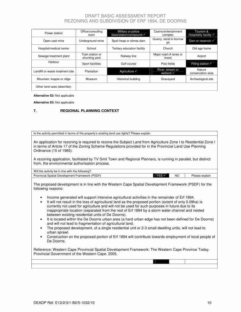
Tick (“�”) the current land uses and/or prominent features that occur within +/- 500m radius of the site and neighbouring properties if these are located beyond 500m of the site. Please note: The Department may request specialist input/studies depending on the nature of the land use character of the area and potential impact(s) of the proposed activity/ies. Alternative S1: (500 m radius)
Untransformed area Low density residential �
Medium density residential � High density residential Informal residential
Retail � Commercial & warehousing
Light industrial Medium industrial Heavy industrial
DRAFT BASIC ASSESSMENT REPORT REZONING AND SUBDIVISION OF ERF 1894, DE DOORNS
DEADP Ref. E12/2/3/1-B2/5-1032/10 10
Power station Office/consulting
room Military or police
base/station/compound � Casino/entertainment
complex Tourism &
Hospitality facility �
Open cast mine Underground mine Spoil heap or slimes dam Quarry, sand or borrow
pit Dam or reservoir �
Hospital/medical center School Tertiary education facility Church Old age home
Sewage treatment plant Train station or shunting yard
Railway line Major road (4 lanes or
more) Airport
Harbour
Sport facilities Golf course Polo fields Filling station �
Landfill or waste treatment site Plantation Agriculture � River, stream or
wetland � Nature
conservation area
Mountain, koppie or ridge Museum Historical building Graveyard Archeological site
Other land uses (describe):
Alternative S2: Not applicable Alternative S3: Not applicable
7. REGIONAL PLANNING CONTEXT
Is the activity permitted in terms of the property’s existing land use rights? Please explain
An application for rezoning is required to rezone the Subject Land from Agriculture Zone I to Residential Zone I in terms of Article 17 of the Zoning Scheme Regulations provided for in the Provincial Land Use Planning Ordinance (15 of 1985). A rezoning application, facilitated by TV Smit Town and Regional Planners, is running in parallel, but distinct from, the environmental authorisation process.
Will the activity be in line with the following?
Provincial Spatial Development Framework (PSDF) YES � NO Please explain
The proposed development is in line with the Western Cape Spatial Development Framework (PSDF) for the following reasons:
• Income generated will support intensive agricultural activities in the remainder of Erf 1894.
• It will not result in the loss of agricultural land as the proposed portion (extent of only 0.09ha) is currently not used for agriculture and will not be used for such purposes in future due to its inappropriate location (separated from the rest of Erf 1894 by a storm water channel and nested between existing residential units of De Doorns).
• It is located within the De Doorns urban area (a hard urban edge has not been defined for De Doorns) and will not lead to fragmentation of agricultural land.
• The proposed development, of a single residential unit or 2-3 small dwelling units, will not lead to urban sprawl.
• Construction on the proposed portion of Erf 1894 will contribute towards employment of local people of De Doorns.
Reference: Western Cape Provincial Spatial Development Framework: The Western Cape Province Today. Provincial Government of the Western Cape. 2005.
DRAFT BASIC ASSESSMENT REPORT REZONING AND SUBDIVISION OF ERF 1894, DE DOORNS
DEADP Ref. E12/2/3/1-B2/5-1032/10 11
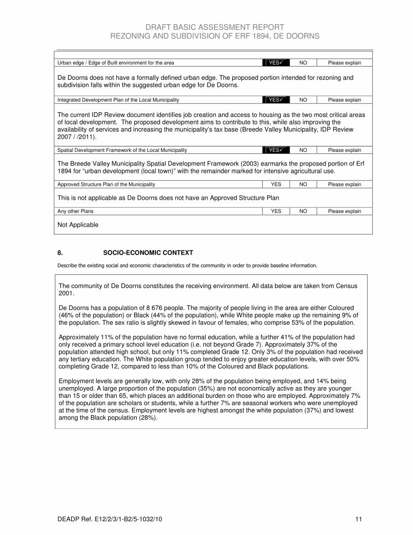
8. SOCIO-ECONOMIC CONTEXT
Describe the existing social and economic characteristics of the community in order to provide baseline information.
The community of De Doorns constitutes the receiving environment. All data below are taken from Census 2001. De Doorns has a population of 8 676 people. The majority of people living in the area are either Coloured (46% of the population) or Black (44% of the population), while White people make up the remaining 9% of the population. The sex ratio is slightly skewed in favour of females, who comprise 53% of the population. Approximately 11% of the population have no formal education, while a further 41% of the population had only received a primary school level education (i.e. not beyond Grade 7). Approximately 37% of the population attended high school, but only 11% completed Grade 12. Only 3% of the population had received any tertiary education. The White population group tended to enjoy greater education levels, with over 50% completing Grade 12, compared to less than 10% of the Coloured and Black populations. Employment levels are generally low, with only 28% of the population being employed, and 14% being unemployed. A large proportion of the population (35%) are not economically active as they are younger than 15 or older than 65, which places an additional burden on those who are employed. Approximately 7% of the population are scholars or students, while a further 7% are seasonal workers who were unemployed at the time of the census. Employment levels are highest amongst the white population (37%) and lowest among the Black population (28%).
Urban edge / Edge of Built environment for the area YES� NO Please explain
De Doorns does not have a formally defined urban edge. The proposed portion intended for rezoning and subdivision falls within the suggested urban edge for De Doorns. Integrated Development Plan of the Local Municipality YES� NO Please explain
The current IDP Review document identifies job creation and access to housing as the two most critical areas of local development. The proposed development aims to contribute to this, while also improving the availability of services and increasing the municipality’s tax base (Breede Valley Municipality, IDP Review 2007 / /2011).
Spatial Development Framework of the Local Municipality YES� NO Please explain
The Breede Valley Municipality Spatial Development Framework (2003) earmarks the proposed portion of Erf 1894 for “urban development (local town)” with the remainder marked for intensive agricultural use.
Approved Structure Plan of the Municipality YES NO Please explain
This is not applicable as De Doorns does not have an Approved Structure Plan
Any other Plans YES NO Please explain
Not Applicable
DRAFT BASIC ASSESSMENT REPORT REZONING AND SUBDIVISION OF ERF 1894, DE DOORNS
DEADP Ref. E12/2/3/1-B2/5-1032/10 12
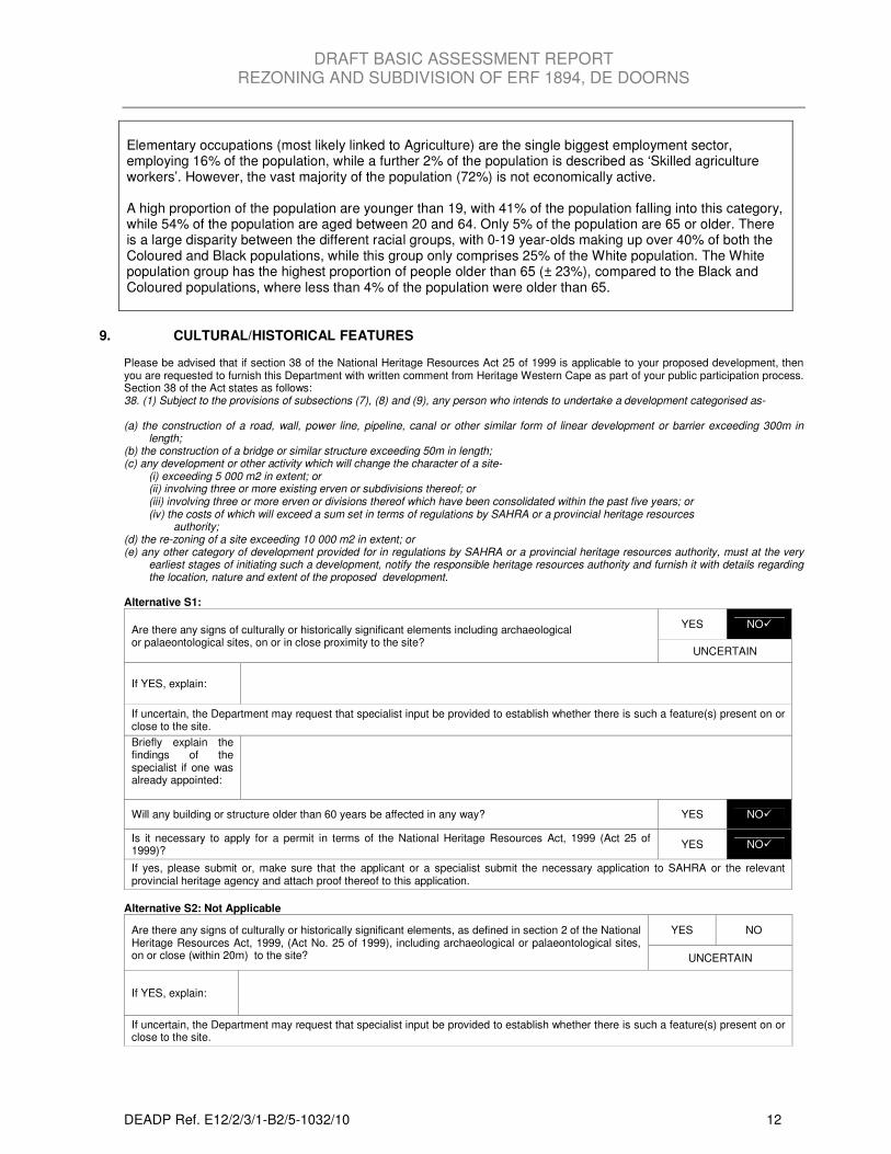
Elementary occupations (most likely linked to Agriculture) are the single biggest employment sector, employing 16% of the population, while a further 2% of the population is described as ‘Skilled agriculture workers’. However, the vast majority of the population (72%) is not economically active. A high proportion of the population are younger than 19, with 41% of the population falling into this category, while 54% of the population are aged between 20 and 64. Only 5% of the population are 65 or older. There is a large disparity between the different racial groups, with 0-19 year-olds making up over 40% of both the Coloured and Black populations, while this group only comprises 25% of the White population. The White population group has the highest proportion of people older than 65 (± 23%), compared to the Black and Coloured populations, where less than 4% of the population were older than 65.
9. CULTURAL/HISTORICAL FEATURES Please be advised that if section 38 of the National Heritage Resources Act 25 of 1999 is applicable to your proposed development, then you are requested to furnish this Department with written comment from Heritage Western Cape as part of your public participation process. Section 38 of the Act states as follows: 38. (1) Subject to the provisions of subsections (7), (8) and (9), any person who intends to undertake a development categorised as- (a) the construction of a road, wall, power line, pipeline, canal or other similar form of linear development or barrier exceeding 300m in
length; (b) the construction of a bridge or similar structure exceeding 50m in length; (c) any development or other activity which will change the character of a site- (i) exceeding 5 000 m2 in extent; or (ii) involving three or more existing erven or subdivisions thereof; or (iii) involving three or more erven or divisions thereof which have been consolidated within the past five years; or (iv) the costs of which will exceed a sum set in terms of regulations by SAHRA or a provincial heritage resources
authority; (d) the re-zoning of a site exceeding 10 000 m2 in extent; or (e) any other category of development provided for in regulations by SAHRA or a provincial heritage resources authority, must at the very
earliest stages of initiating such a development, notify the responsible heritage resources authority and furnish it with details regarding the location, nature and extent of the proposed development.
Alternative S1:
Are there any signs of culturally or historically significant elements including archaeological or palaeontological sites, on or in close proximity to the site?
YES NO�
UNCERTAIN
If YES, explain:
If uncertain, the Department may request that specialist input be provided to establish whether there is such a feature(s) present on or close to the site. Briefly explain the findings of the specialist if one was already appointed:
Will any building or structure older than 60 years be affected in any way? YES NO�
Is it necessary to apply for a permit in terms of the National Heritage Resources Act, 1999 (Act 25 of 1999)?
YES NO�
If yes, please submit or, make sure that the applicant or a specialist submit the necessary application to SAHRA or the relevant provincial heritage agency and attach proof thereof to this application.
Alternative S2: Not Applicable
Are there any signs of culturally or historically significant elements, as defined in section 2 of the National Heritage Resources Act, 1999, (Act No. 25 of 1999), including archaeological or palaeontological sites, on or close (within 20m) to the site?
YES NO
UNCERTAIN
If YES, explain:
If uncertain, the Department may request that specialist input be provided to establish whether there is such a feature(s) present on or close to the site.
DRAFT BASIC ASSESSMENT REPORT REZONING AND SUBDIVISION OF ERF 1894, DE DOORNS
DEADP Ref. E12/2/3/1-B2/5-1032/10 13
Briefly explain the findings of the specialist if one was already appointed:
Will any building or structure older than 60 years be affected in any way?
YES NO
Is it necessary to apply for a permit in terms of the National Heritage Resources Act, 1999 (Act 25 of 1999)?
YES NO
If yes, please submit or, make sure that the applicant or a specialist submit the necessary application to SAHRA or the relevant provincial heritage agency and attach proof thereof to this application.
Alternative S3: Not Applicable
Are there any signs of culturally or historically significant elements, as defined in section 2 of the National Heritage Resources Act, 1999, (Act No. 25 of 1999), including archaeological or palaeontological sites, on or close (within 20m) to the site?
YES NO
UNCERTAIN
If YES, explain:
If uncertain, the Department may request that specialist input be provided to establish whether there is such a feature(s) present on or close to the site.
Briefly explain the findings of the specialist if one was already appointed:
Will any building or structure older than 60 years be affected in any way?
YES NO
Is it necessary to apply for a permit in terms of the National Heritage Resources Act, 1999 (Act 25 of 1999)?
YES NO
If yes, please submit or, make sure that the applicant or a specialist submit the necessary application to SAHRA or the relevant provincial heritage agency and attach proof thereof to this application.
Please note: Heritage Western Cape / South African Heritage Resource Agency (which ever is the competent authority under the circumstance) comments needs to be submitted along with this Basic Assessment Report.
SECTION C: PUBLIC PARTICIPATION
The person conducting the public participation process must fulfil the requirements outlined in Regulation 56 and also take into account this
Department’s guideline on Public participation.
Please tick (“����”) the appropriate box to indicate whether the specific requirement was undertaken or whether exemption has been
applied for.
1. Were all potential interested and affected parties notified of the application by –
(a) having fixed a notice board at a place conspicuous to the public at the boundary or on the fence of -
(i) the site where the activity to which the application relates is or is to be undertaken and YES
� NO EXEMPTION
(ii) any alternative site mentioned in the application YES NO EXEMPTION�
(b) having given written notice to –
(i) the owners and occupiers of land adjacent to the site where the activity is or is to be
undertaken or to any alternative site
YES
� NO EXEMPTION
(ii) the owners and occupiers of land within 100 metres of the boundary of the site or alternative
site who are or may be directly affected by the activity
YES
� NO EXEMPTION
(iii) the municipal councillor of the ward in which the site or alternative site is situated and any
organisation of ratepayers that represents the community in the area
YES
� NO EXEMPTION
(iv) the municipality which has jurisdiction in the area; and YES
� NO EXEMPTION
(v) any organ of state having jurisdiction in respect of any aspect of the activity YES NO EXEMPTION

DRAFT BASIC ASSESSMENT REPORT REZONING AND SUBDIVISION OF ERF 1894, DE DOORNS
DEADP Ref. E12/2/3/1-B2/5-1032/10 14
�
(c) having placed an advertisement in –
(i) one local newspaper, or YES
� NO EXEMPTION
(ii) the official EIA Gazette – NOT APPLICABLE YES
NO
� EXEMPTION
(d) having placed an advertisement in at least one provincial newspaper or national newspaper, if
the activity has or may have an impact that extends beyond the boundaries of the metropolitan or
local municipality in which it is or will be undertaken. (This requirement need not be complied with
if an advertisement has been placed in the official EIA Gazette referred to in (c)(ii) above.
NOT APPLICABLE
YES NO
� EXEMPTION
2. Was a register of interested and affected parties opened, maintained and made available to any
person requesting access to the register in writing? (copy of register to be included in appendix E)
YES
� NO EXEMPTION
3. Were all registered interested and affected parties given access to this application form and basic
assessment report and any other report(s) compiled in relation to this application and was an
opportunity for interested and affected parties to comment on the report(s) in writing provided?
YES
� NO EXEMPTION
4. Were stakeholders that have direct interests in the site or property, such as servitude holders and
service providers, informed of the application at least 30 (thirty) calendar days before the
submission of this application and were they provided with the opportunity to comment.
(Comments to be included in the comments and response report as described below)
YES
� NO EXEMPTION
5. Were Municipalities and other organs of state notified and given an opportunity to comment?
(This information must also be included in the comments and response report)
YES
� NO EXEMPTION
Please note: Proof of all of the above must be submitted as part of the public participation information to be attached to this basic
assessment report as Appendix E. Should any of the responses be “No” and no application for exemption from that requirement was
applied for, the Department will not proceed with evaluating / processing the application until that specific requirement is undertaken. Any
exemption application must be brought to the attention of all interest and affected parties through the public participation process.
The practitioner must record all comments and respond to each comment of the public / interested and affected party before the application
is submitted. The comments and responses must be captured in a Comments and Responses Report as prescribed in the regulations
and must also include a description of the public participation process followed and this report must also be included in the public
participation information to be attached to this basic assessment report as Appendix E.
If an application is for a linear or ocean-based activity and strict compliance with the above requirements is inappropriate, the person
conducting the public participation process may deviate from the requirements to the extent and in the manner as may be agreed to by this
Department.
DRAFT BASIC ASSESSMENT REPORT REZONING AND SUBDIVISION OF ERF 1894, DE DOORNS
DEADP Ref. E12/2/3/1-B2/5-1032/10 15
SECTION D: IMPACT ASSESSMENT
Please note: The information in this section must be duplicated for all the alternatives (where relevant).
1. WASTE, EFFLUENT AND EMISSION MANAGEMENT (a) Solid waste management
Will the activity produce solid waste (including rubble) during the construction phase? YES� NO
If yes, what estimated quantity during the construction period? ± 5 m3
Where and how will the construction solid waste be treated / disposed of (describe)?
Solid waste, primarily building rubble generated by the construction activities, will be transported to the Municipal Regional Landfill Site in Worcester and disposed of there.
Will the activity produce solid waste during its operational phase? YES� NO
If Yes, what estimated quantity will be produced per month? ± 1.2 m3
Where and how will the solid waste be treated / disposed of (describe)?
Solid waste consisting of household and garden waste will be collected and disposed of weekly as per the normal municipal cleansing procedure. Has the municipality or relevant authority confirmed that sufficient capacity exist for treating / disposing of the solid waste to be generated by this activity(ies)? If yes, provide written confirmation from Municipality or relevant authority.
No services are currently required. Confirmation/supporting letters from the municipality will be supplied with the final Basic Assessment Report following this commenting period.
YES NO�
Will the activity produce solid waste that will be treated and/or disposed of at another facility other than into a municipal waste stream?
YES NO�
If yes, has this facility confirmed that sufficient capacity exist for treating / disposing of the solid waste to be generated by this activity(ies)? Provide written confirmation from the facility and provide the following particulars of the facility:
YES NO
Does the facility have an operating license? (If yes, please attach a copy of the license.) YES NO
Facility name:
Contact person:
Postal address:
Postal code:
Telephone: Cell:
E-mail: Fax:
(b) Effluent
Will the activity produce sewage and or any other effluent? YES� NO
The usual volumes of household sewerage will be produced during the operational phase of the development. What estimated quantity will be produced per month? ± 5 m
3
Will the effluent be treated and/or disposed of in a municipal system? YES� NO
If Yes, has the municipality or relevant authority confirmed that sufficient unallocated capacity exist for treating / disposing of the sewage or any other effluent to be generated by this activity(ies)? Provide written confirmation from the Municipality or relevant authority
Confirmation/supporting letters from the municipality will be supplied with the final Basic Assessment Report following this commenting period.
DRAFT BASIC ASSESSMENT REPORT REZONING AND SUBDIVISION OF ERF 1894, DE DOORNS
DEADP Ref. E12/2/3/1-B2/5-1032/10 16
Will any effluent produced be treated and/or disposed of on site? Yes NO�
If yes, briefly describe the nature of the effluent and how it will be disposed of:
Not applicable
Will the activity produce effluent that will be treated and/or disposed of at another facility? YES NO�
If yes, has this facility confirmed that sufficient capacity exist for treating / disposing of the liquid effluent to be generated by this activity(ies)? Provide written confirmation from the facility and provide the following particulars of the facility: Not applicable
YES NO
Does the facility have an operating license? (If yes, please attach a copy of the license.) YES NO
Facility name:
Contact person:
Postal address:
Postal code:
Telephone: Cell:
E-mail: Fax:
Describe the measures that will be taken to ensure the optimal reuse or recycling of waste water, if any:
Not applicable. The activities related to the proposed development will not generate significant amounts of waste water.
(c) Emissions into the atmosphere
Will the activity produce emissions that will be disposed of into the atmosphere? YES NO�
If yes, does it require approval in terms of relevant legislation? Not applicable YES NO
Describe the emissions in terms of type and concentration and how it will be treated/mitigated:
Not Applicable 2. WATER USE
Please indicate the source(s) of water for the activity by ticking (“a”) the appropriate box(es)
Municipal �
Water board Groundwater River, Stream, Dam or
Lake Other The activity will not use water
If water is to be extracted from a groundwater source, river, stream, dam, lake or any other natural feature, please indicate the volume that
will be extracted per month: 0 m3
Please provide proof of assurance of water supply eg. letter of confirmation from municipality / water user associations, yield of borehole
Does the activity require a water use permit / license from DWAF? YES NO�
If yes, please submit the necessary application to Department of Water Affairs and Forestry and attach proof thereof to this application.
3. POWER SUPPLY Please indicate the source of power supply eg. Municipality / Eskom / Renewable energy source
Municipality
If power supply is not available, where will power be sourced from?
Not Applicable
DRAFT BASIC ASSESSMENT REPORT REZONING AND SUBDIVISION OF ERF 1894, DE DOORNS
DEADP Ref. E12/2/3/1-B2/5-1032/10 17
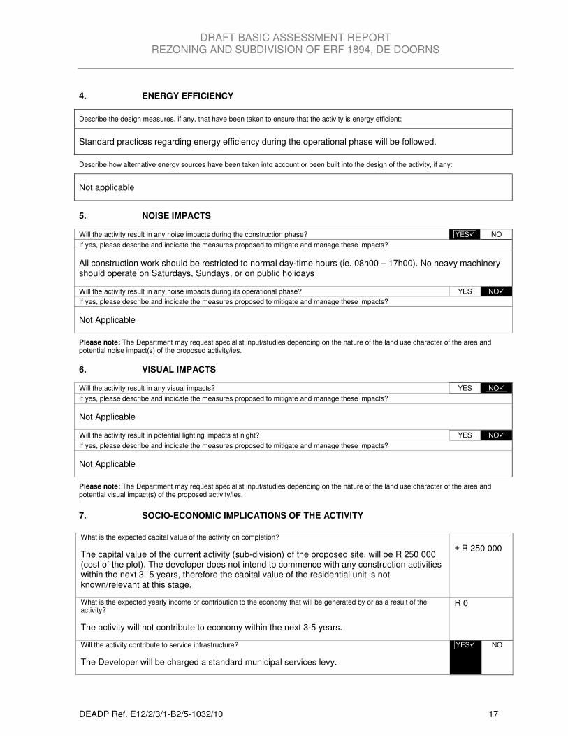
4. ENERGY EFFICIENCY
Describe the design measures, if any, that have been taken to ensure that the activity is energy efficient:
Standard practices regarding energy efficiency during the operational phase will be followed.
Describe how alternative energy sources have been taken into account or been built into the design of the activity, if any:
Not applicable
5. NOISE IMPACTS
Will the activity result in any noise impacts during the construction phase? YES� NO
If yes, please describe and indicate the measures proposed to mitigate and manage these impacts?
All construction work should be restricted to normal day-time hours (ie. 08h00 – 17h00). No heavy machinery should operate on Saturdays, Sundays, or on public holidays
Will the activity result in any noise impacts during its operational phase? YES NO�
If yes, please describe and indicate the measures proposed to mitigate and manage these impacts?
Not Applicable
Please note: The Department may request specialist input/studies depending on the nature of the land use character of the area and potential noise impact(s) of the proposed activity/ies.
6. VISUAL IMPACTS
Will the activity result in any visual impacts? YES NO�
If yes, please describe and indicate the measures proposed to mitigate and manage these impacts?
Not Applicable
Will the activity result in potential lighting impacts at night? YES NO�
If yes, please describe and indicate the measures proposed to mitigate and manage these impacts?
Not Applicable
Please note: The Department may request specialist input/studies depending on the nature of the land use character of the area and potential visual impact(s) of the proposed activity/ies.
7. SOCIO-ECONOMIC IMPLICATIONS OF THE ACTIVITY
What is the expected capital value of the activity on completion?
The capital value of the current activity (sub-division) of the proposed site, will be R 250 000 (cost of the plot). The developer does not intend to commence with any construction activities within the next 3 -5 years, therefore the capital value of the residential unit is not known/relevant at this stage.
± R 250 000
What is the expected yearly income or contribution to the economy that will be generated by or as a result of the activity?
The activity will not contribute to economy within the next 3-5 years.
R 0
Will the activity contribute to service infrastructure?
The Developer will be charged a standard municipal services levy.
YES� NO
DRAFT BASIC ASSESSMENT REPORT REZONING AND SUBDIVISION OF ERF 1894, DE DOORNS
DEADP Ref. E12/2/3/1-B2/5-1032/10 18
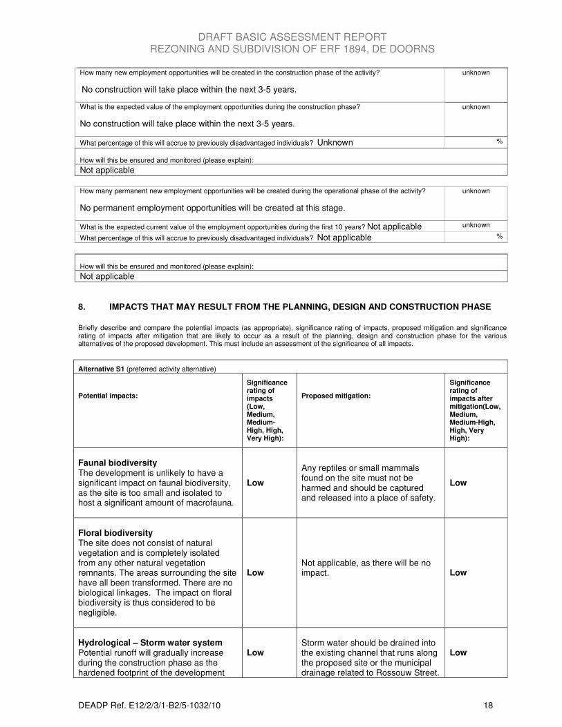
How many new employment opportunities will be created in the construction phase of the activity?
No construction will take place within the next 3-5 years.
unknown
What is the expected value of the employment opportunities during the construction phase?
No construction will take place within the next 3-5 years.
unknown
What percentage of this will accrue to previously disadvantaged individuals? Unknown %
How will this be ensured and monitored (please explain):
Not applicable
How many permanent new employment opportunities will be created during the operational phase of the activity?
No permanent employment opportunities will be created at this stage.
unknown
What is the expected current value of the employment opportunities during the first 10 years? Not applicable unknown
What percentage of this will accrue to previously disadvantaged individuals? Not applicable %
How will this be ensured and monitored (please explain):
Not applicable
8. IMPACTS THAT MAY RESULT FROM THE PLANNING, DESIGN AND CONSTRUCTION PHASE
Briefly describe and compare the potential impacts (as appropriate), significance rating of impacts, proposed mitigation and significance rating of impacts after mitigation that are likely to occur as a result of the planning, design and construction phase for the various alternatives of the proposed development. This must include an assessment of the significance of all impacts.
Alternative S1 (preferred activity alternative)
Potential impacts:
Significance rating of impacts (Low, Medium, Medium-High, High, Very High):
Proposed mitigation:
Significance rating of impacts after mitigation(Low, Medium, Medium-High, High, Very High):
Faunal biodiversity The development is unlikely to have a significant impact on faunal biodiversity, as the site is too small and isolated to host a significant amount of macrofauna.
Low
Any reptiles or small mammals found on the site must not be harmed and should be captured and released into a place of safety.
Low
Floral biodiversity The site does not consist of natural vegetation and is completely isolated from any other natural vegetation remnants. The areas surrounding the site have all been transformed. There are no biological linkages. The impact on floral biodiversity is thus considered to be negligible.
Low Not applicable, as there will be no impact.
Low
Hydrological – Storm water system Potential runoff will gradually increase during the construction phase as the hardened footprint of the development
Low
Storm water should be drained into the existing channel that runs along the proposed site or the municipal drainage related to Rossouw Street.
Low
DRAFT BASIC ASSESSMENT REPORT REZONING AND SUBDIVISION OF ERF 1894, DE DOORNS
DEADP Ref. E12/2/3/1-B2/5-1032/10 19
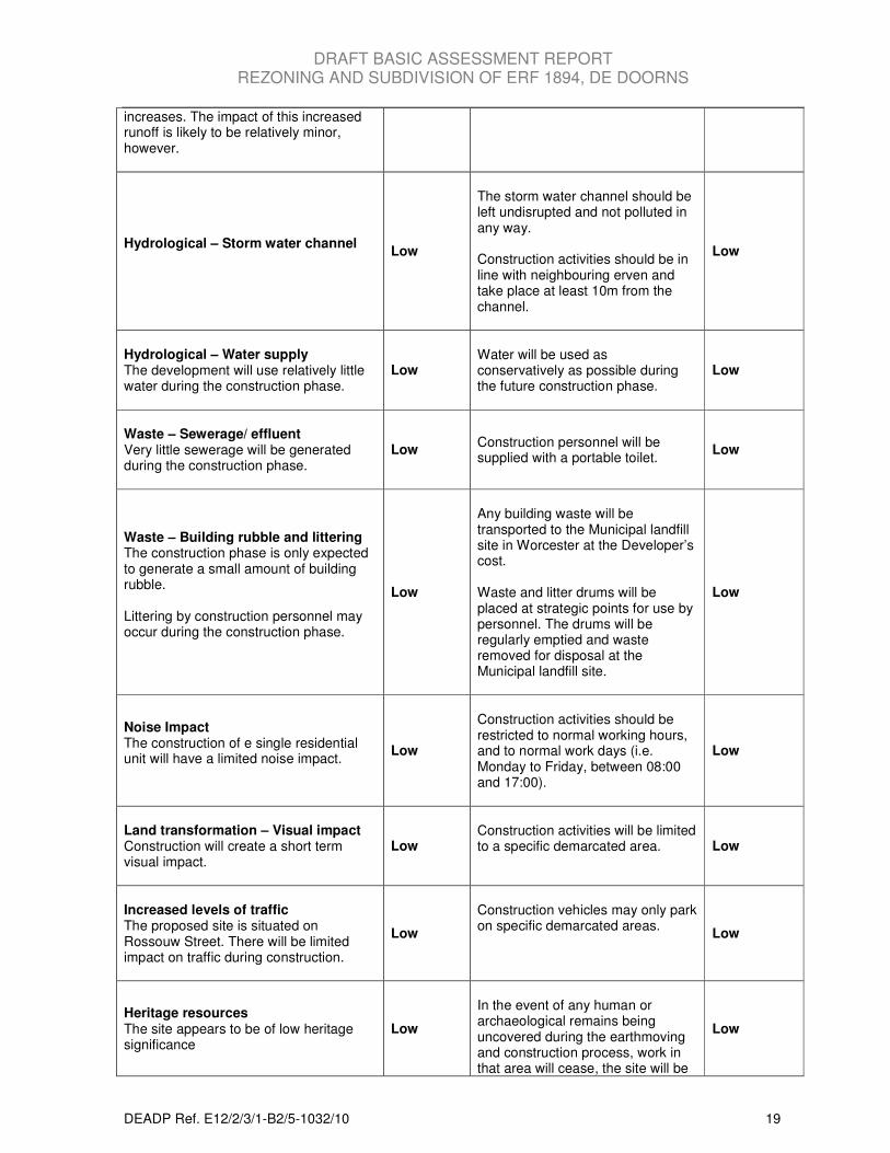
increases. The impact of this increased runoff is likely to be relatively minor, however.
Hydrological – Storm water channel
Low
The storm water channel should be left undisrupted and not polluted in any way. Construction activities should be in line with neighbouring erven and take place at least 10m from the channel.
Low
Hydrological – Water supply The development will use relatively little water during the construction phase.
Low Water will be used as conservatively as possible during the future construction phase.
Low
Waste – Sewerage/ effluent Very little sewerage will be generated during the construction phase.
Low Construction personnel will be supplied with a portable toilet.
Low
Waste – Building rubble and littering The construction phase is only expected to generate a small amount of building rubble. Littering by construction personnel may occur during the construction phase.
Low
Any building waste will be transported to the Municipal landfill site in Worcester at the Developer’s cost. Waste and litter drums will be placed at strategic points for use by personnel. The drums will be regularly emptied and waste removed for disposal at the Municipal landfill site.
Low
Noise Impact The construction of e single residential unit will have a limited noise impact.
Low
Construction activities should be restricted to normal working hours, and to normal work days (i.e. Monday to Friday, between 08:00 and 17:00).
Low
Land transformation – Visual impact Construction will create a short term visual impact.
Low Construction activities will be limited to a specific demarcated area.
Low
Increased levels of traffic The proposed site is situated on Rossouw Street. There will be limited impact on traffic during construction.
Low
Construction vehicles may only park on specific demarcated areas.
Low
Heritage resources The site appears to be of low heritage significance
Low
In the event of any human or archaeological remains being uncovered during the earthmoving and construction process, work in that area will cease, the site will be
Low
DRAFT BASIC ASSESSMENT REPORT REZONING AND SUBDIVISION OF ERF 1894, DE DOORNS
DEADP Ref. E12/2/3/1-B2/5-1032/10 20
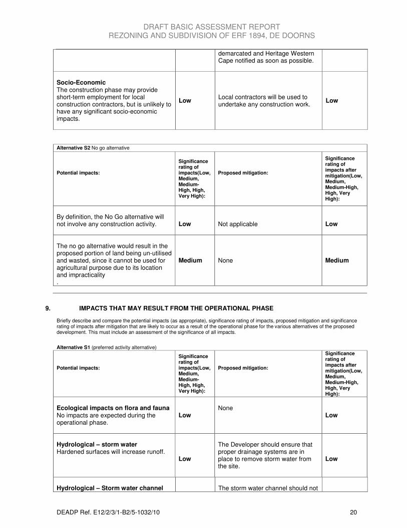
demarcated and Heritage Western Cape notified as soon as possible.
Socio-Economic The construction phase may provide short-term employment for local construction contractors, but is unlikely to have any significant socio-economic impacts.
Low
Local contractors will be used to undertake any construction work.
Low
Alternative S2 No go alternative
Potential impacts:
Significance rating of impacts(Low, Medium, Medium-High, High, Very High):
Proposed mitigation:
Significance rating of impacts after mitigation(Low, Medium, Medium-High, High, Very High):
By definition, the No Go alternative will not involve any construction activity.
Low
Not applicable
Low
The no go alternative would result in the proposed portion of land being un-utilised and wasted, since it cannot be used for agricultural purpose due to its location and impracticality .
Medium None Medium
9. IMPACTS THAT MAY RESULT FROM THE OPERATIONAL PHASE Briefly describe and compare the potential impacts (as appropriate), significance rating of impacts, proposed mitigation and significance rating of impacts after mitigation that are likely to occur as a result of the operational phase for the various alternatives of the proposed development. This must include an assessment of the significance of all impacts.
Alternative S1 (preferred activity alternative)
Potential impacts:
Significance rating of impacts(Low, Medium, Medium-High, High, Very High):
Proposed mitigation:
Significance rating of impacts after mitigation(Low, Medium, Medium-High, High, Very High):
Ecological impacts on flora and fauna No impacts are expected during the operational phase.
Low
None
Low
Hydrological – storm water Hardened surfaces will increase runoff.
Low
The Developer should ensure that proper drainage systems are in place to remove storm water from the site.
Low
Hydrological – Storm water channel
The storm water channel should not
DRAFT BASIC ASSESSMENT REPORT REZONING AND SUBDIVISION OF ERF 1894, DE DOORNS
DEADP Ref. E12/2/3/1-B2/5-1032/10 21
Low be polluted in any way.
Low
Hydrological – water supply Water will be required for normal household activities and will be supplied by the municipality.
Low
Water efficient systems, such as dual-flush toilets and water-efficient taps should be used.
Low
Electricity The development will require electricity for normal household activities and will be supplied by the municipality.
Low
Energy efficient practices should be encouraged.
Low
Waste – solid The only sources of waste will be normal household and garden waste. This will not have a significant impact and waste will be removed by the municipality on a weekly base.
Low
None
Low
Waste – liquid Sewerage and wastewater will feed into the municipal waste stream and will not have a significant impact.
Low
None
Low
Traffic impact The development is not expected to significantly increase traffic along Rossouw Street.
Low
None
Low
Alternative S2 No go alternative
Potential impacts:
Significance rating of impacts(Low, Medium, Medium-High, High, Very High):
Proposed mitigation:
Significance rating of impacts after mitigation(Low, Medium, Medium-High, High, Very High):
Biophysical impacts This would entail not constructing any sports field or community centre. This would not have any biophysical impacts on the preferred development site.
None
The land parcel should be fenced off and be kept clear of invasive plants.
None
Derelict land The no go alternative would result in the proposed portion of land being un-ultised and wasted, since it cannot be used for agricultural purpose due to its location and impracticality. The land parcel may become a target for vagrancy and/or informal settlement.
Medium The land parcel should be fenced off and be kept clear of invasive plants.
Medium
DRAFT BASIC ASSESSMENT REPORT REZONING AND SUBDIVISION OF ERF 1894, DE DOORNS
DEADP Ref. E12/2/3/1-B2/5-1032/10 22
10. IMPACTS THAT MAY RESULT FROM THE DECOMISSIONING AND CLOSURE PHASE Briefly describe and compare the potential impacts (as appropriate), significance rating of impacts, proposed mitigation and significance rating of impacts after mitigation that are likely to occur as a result of the decommissioning and closure phase for the various alternatives of the proposed development. This must include an assessment of the significance of all impacts.
Alternative S1 (preferred activity alternative)
Potential impacts:
Significance rating of impacts(Low, Medium, Medium-High, High, Very High):
Proposed mitigation:
Significance rating of impacts after mitigation(Low, Medium, Medium-High, High, Very High):
Waste removal Demolition of the building and foundation will generate rubble.
Low
Rubble to be properly disposed of in a municipal waste management facility, appropriate materials should be recycled. The land parcel should be fenced off and be kept clear of invasive plants.
Low
Alternative S2 No go alternative
Potential impacts:
Significance rating of impacts(Low, Medium, Medium-High, High, Very High):
Proposed mitigation:
Significance rating of impacts after mitigation(Low, Medium, Medium-High, High, Very High):
Not applicable, as no development will occur.
None
The land parcel should be fenced off and be kept clear of invasive plants.
None
11. CUMULATIVE IMPACTS Describe potential impacts that, on their own may not be significant, but will be significant when added to the impact of other activities or existing impacts in the environment and substantiate response (The information in this section must be provided for all the alternatives as well):
The cumulative impacts of the proposed development are minor to negligible, since no development is expected to take place within the next 3 - 5 years. Any future development will comprise the construction of a single residential unit or 2-3 small dwelling units. Since the plot falls within the De Doorns suggested urban area, all services will be provided by the municipality and no new infrastructure is required. Although minor, the following cumulative impacts will occur: Water and electricity consumption: Although only a small amount of services are required for the proposed single residential unit, it will nevertheless represent a further drain on water resources in the area. The same is also true of electricity consumption. Solid waste: The development will produce small quantities of solid waste, which will put additional pressure on existing landfill sites.
DRAFT BASIC ASSESSMENT REPORT REZONING AND SUBDIVISION OF ERF 1894, DE DOORNS
DEADP Ref. E12/2/3/1-B2/5-1032/10 23
12. IMPACT SUMMARY OF PREFERRED ALTERNATIVE
Having assessed the significance of impacts of the various alternatives, please provide an overall summary and reasons for selecting the preferred alternative.
This is, on the whole, a very low-impact development.
• The proposed Portion A of Erf 1894 is a small area (972m2 or 0.0942ha) of vacant land covered by
kikuyu grass and weeds. There is no indication of indigenous vegetation cover on the proposed site.
• There are no linkages with other vegetation types and no indigenous vegetation in the immediate surroundings. The area is bounded by two single residential units (Erf 740 and Erf 88) a public open space and is situated on Rossouw Street (Appendix B - Site Plan). On the northern side, the area is bordered by extensive vineyards. The development will therefore have no impact in indigenous vegetation.
• The site is nested within the urban component of De Doorns.
• All services (sewerage, power supply and water supply) will be provided by the Municipality.
• The development requires no additional infrastructure.
• Existing roads will be utilised to access the proposed site.
• There will be no visual impact as the site is bordered by residential units. The preferred alternative is selected for the following reasons:
• The proposed portion of land is cut off from Erf 1894/RE, and it is nested between existing residential units.
• There will be no significant impacts on the environment.
• Alternative sites will compromise good agricultural land and will lie outside the suggested urban area.
• The no go alternative will result in the un-utilisation of the proposed 972m2 Portion A, possibly
becoming a target for vagrancy, and or informal settlement. 13. RECOMMENDATION OF ENVIRONMENTAL ASSESSMENT PRACTITIONER
In my view (EAP), the information contained in this application form and the documentation attached hereto is sufficient to make a decision in respect of the activity applied for. YES� NO
If “NO”, list the aspects that should be further assessed through additional specialist input/assessment or whether this application must be subjected to a Scoping process before a decision can be made:
Not applicable
If “YES”, please list recommended conditions, including mitigation measures, that should in your view be considered for inclusion in an authorisation if the activity is authorised by the competent authority:
Due to the negligible impacts imposed by the proposed development there are no major mitigation measures to be implemented. The following are however proposed: Construction phase:
• Any reptiles/small mammals found on the site must not be harmed and should be captured and released into a place of safety.
• Construction work should be restricted to normal working hours and weekdays to reduce the noise and dust impacts.
• Portable toilets and litter bins should be made available to construction workers during the construction phase.
• All building rubble must be properly disposed of.
• The storm water channel adjacent to the proposed site should not be disrupted/polluted.
• A proper drainage system should be put in place by the developer for future construction.
DRAFT BASIC ASSESSMENT REPORT REZONING AND SUBDIVISION OF ERF 1894, DE DOORNS
DEADP Ref. E12/2/3/1-B2/5-1032/10 24
Operational phase:
• Water efficient systems, such as dual-flush toilets and water-efficient taps should be used to use water sparingly.
• All reasonable steps must be taken to minimize wastage of water.
• Energy-efficiency should be encouraged including roof insulation, solar hot water geyser, LED or fluorescent lighting.
• The storm water channel adjacent to the site should not be disturbed or polluted in any way.
Decommissioning and closure phase:
• Rubble is to be properly disposed of in a municipal waste management facility, appropriate materials should be recycled.
• The land parcel should be fenced off and be kept clear of invasive plants.
DRAFT BASIC ASSESSMENT REPORT REZONING AND SUBDIVISION OF ERF 1894, DE DOORNS
DEADP Ref. E12/2/3/1-B2/5-1032/10 25
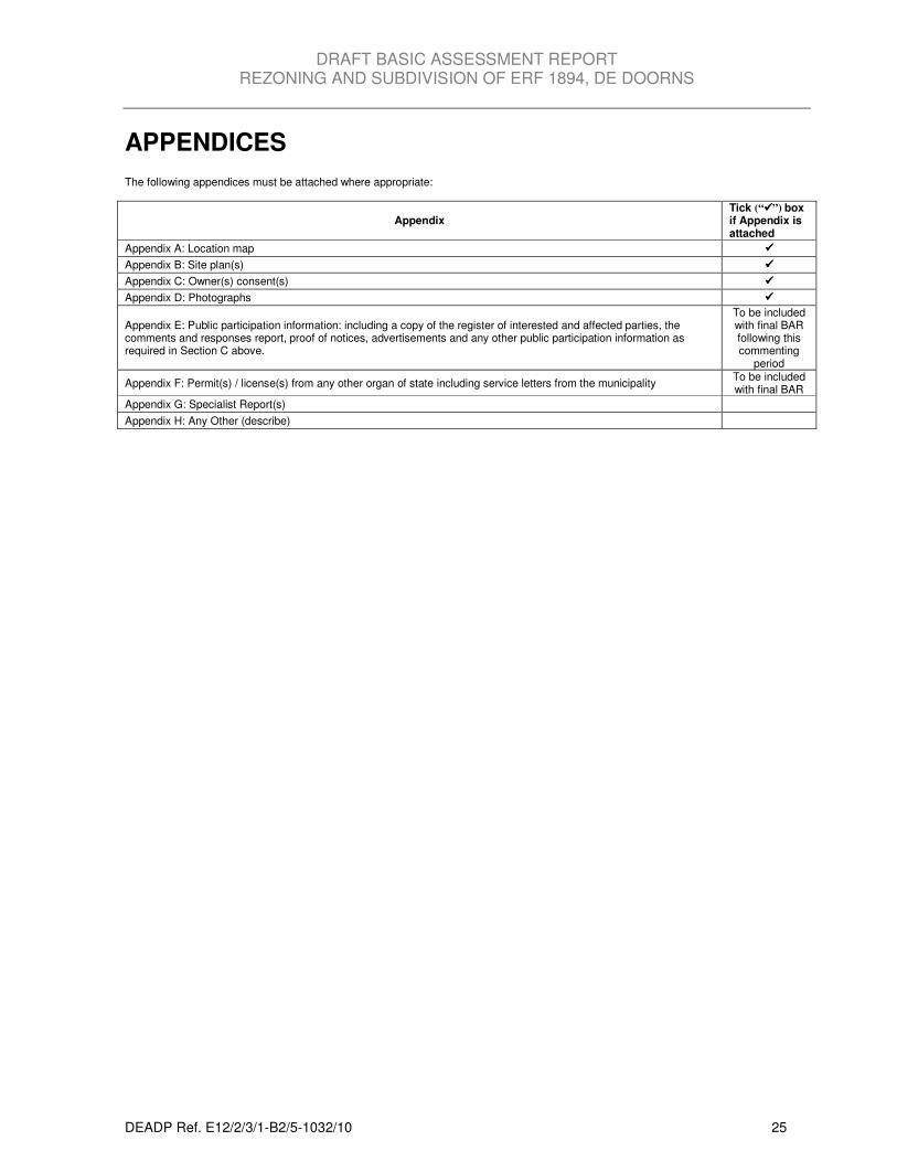
APPENDICES The following appendices must be attached where appropriate:
Appendix Tick (“����”) box if Appendix is attached
Appendix A: Location map ����
Appendix B: Site plan(s) ����
Appendix C: Owner(s) consent(s) ����
Appendix D: Photographs ����
Appendix E: Public participation information: including a copy of the register of interested and affected parties, the comments and responses report, proof of notices, advertisements and any other public participation information as required in Section C above.
To be included with final BAR following this commenting
period
Appendix F: Permit(s) / license(s) from any other organ of state including service letters from the municipality To be included with final BAR
Appendix G: Specialist Report(s)
Appendix H: Any Other (describe)

DRAFT BASIC ASSESSMENT REPORT REZONING AND SUBDIVISION OF ERF 1894, DE DOORNS
DEADP Ref. E12/2/3/1-B2/5-1032/10 26
DECLARATIONS
The Applicant I…………………………………., in my personal capacity or duly authorized thereto hereby declare that:
• The information contained in this application form is true and correct, and • I am fully aware of my responsibilities in terms of the National Environmental Management Act of
1989 (“NEMA”) (Act No. 107 of 1998) and the Environmental Impact Assessment Regulations (“EIA Regulations”) in terms of NEMA (Government Notice No. R. 385, R. 386, and R. 387 in the Government Gazette of 21 April 2006 refer), and that failure to comply with these requirements may constitute an offence in terms of NEMA and the EIA Regulations.
Note: If acting in a representative capacity, a certified copy of the resolution or power of attorney must be attached.
Signature of the applicant:
Name of company:
Date:
The independent Environmental Assessment Practitioner I ……………………………………, as the appointed independent environmental practitioner hereby declare that:
• The information contained in this application form is true and correct, and • I am fully aware of my responsibilities in terms of the National Environmental Management Act of
1989 (“NEMA”) (Act No. 107 of 1998) and the Environmental Impact Assessment Regulations (“EIA Regulations”) in terms of NEMA (Government Notice No. R. 385, R. 386, and R. 387 in the Government Gazette of 21 April 2006 refer), and that failure to comply with these requirements may constitute an offence in terms of NEMA and the EIA Regulations.
Note: The terms of reference must be attached.
Signature of the environmental practitioner:
Name of company:
Date: