draft cultural resources technical … cultural resources technical report weber hydroelectric...
TRANSCRIPT

DRAFT CULTURAL RESOURCES TECHNICAL REPORT
WEBER HYDROELECTRIC PROJECT RELICENSING
FERC PROJECT NO. 1744
Prepared for
PacifiCorp Hydro Resources
1407 West North Temple, Room 110 Salt Lake City, Utah 84116
Prepared by
Stephanie Lechert and Lisa Krussow
Under the direction of
Dave N. Schmitt, Ph.D.
SWCA Environmental Consultants 257 East 200 South, Suite 200
Salt Lake City, Utah 84111 (801) 322-4307 www.swca.com
Utah State Antiquities Project No. U-15-ST-0777fp
Public Lands Policy Coordination Office Permit No. 20 Public Lands Policy Coordination Office Permit No. 180
SWCA Project No. 35579
SWCA Cultural Resource Report No. 15-580
September 8, 2016

This page intentionally blank

DRAFT Cultural Resources Technical Report PacifiCorp’s Weber Hydroelectric Project Relicensing FERC Project No. 1744
i
ABSTRACT
Report Title. Cultural Resources Technical Report for PacifiCorp’s Weber Hydroelectric Project
Relicensing, Weber, Morgan, and Davis Counties, Utah, FERC Project No. 1744
Report Date. September 8, 2016
Agency Name. Federal Energy Regulatory Commission (FERC); Uinta-Wasatch-Cache National Forest
(U-W-CNF)
Permit Number. Public Lands Policy Coordination Office (PLPCO) Permit Nos. 20 and 180
Land Ownership Status. U-W-CNF; Private
Project Description. PacifiCorp plans to file a new application for relicense of a major project, the
Weber Hydroelectric Project, FERC Project No. 1744, on the Weber River in Weber, Morgan, and Davis
Counties in Utah. The current license will expire on May 31, 2020. In July 2015, PacifiCorp requested
SWCA Environmental Consultants (SWCA) to conduct a formal cultural resource inventory of the
Project Area to support the relicensing process.
Project Number. SWCA Project No. 35579; Utah State Antiquities Project No. U-15-ST-0777fp
Project Location. The Project Area is located in Sections 28–30, Township 5 North, Range 1 East,
Weber, Morgan, and Davis Counties, Utah, Salt Lake Meridian, on the Ogden (2001) U.S. Geological
Survey, Utah, 7.5-minute quadrangle.
Number of Acres Surveyed. SWCA inventoried a total of 59.97 acres (24.27 hectares [ha]). Of these,
17.05 acres (6.88 ha) were intensively surveyed, 34.45 acres (13.94 ha) were surveyed at a reconnaissance
level, and 8.46 acres (3.40 ha) were not surveyed because they are existing paved roads. Of the 59.97
acres (24.27 ha), 29.93 acres (12.11 ha) are on privately owned lands and 30.04 acres (12.16 ha) are on
lands administered by the U.S. Forest Service.
National Register of Historic Places– (NRHP–) Eligible Sites. Three sites:
42DV184/42WB344/42MO59, 42MO75/42WB523, and 42WB328.
NRHP-Ineligible Sites. None.
Recommendations. SWCA documented two sites during the inventory of the Project Area:
42DV184/42WB344/42MO59 (a segment of the Union Pacific Railroad) and 42MO75/42WB523 (a
previously unrecorded segment of historic U.S. Highway 30 South (U.S. 30S). The new segment of the
Union Pacific Railroad is considered a contributing segment of the site and is recommended eligible for
the NRHP under Criterion A. U.S. 30S is a historic highway through Weber Canyon that is now Interstate
84. SWCA recommends U.S. 30S eligible for the NRHP under Criterion A. The Devil’s Gate Weber
Hydroelectric Power Plant Historic District (42WB328) has been previously documented, and no updated
documentation is needed; the district was added to the NRHP in 1989.
With the exception of potential fish passage facilities, there are no proposed changes to the existing
Project facilities or infrastructure that could adversely affect these sites. Any impacts from fish passage
construction or continued operation of the Project would occur within the FERC Project Boundary.
PacifiCorp prepared and implemented a cultural resource management plan as part of their 1990 FERC
license to address potential adverse impacts from the Project. PacifiCorp will follow the standards and
procedures outlined in the plan (and modify the document as necessary) in coordination with the State

DRAFT Cultural Resources Technical Report PacifiCorp’s Weber Hydroelectric Project Relicensing FERC Project No. 1744
ii
Historic Preservation Office for proposed fish passage construction and continued operation and
maintenance, as well as any new proposed construction. No significant impacts to cultural resources are
expected from this re-licensing effort. Therefore, SWCA recommends no historic properties affected for
this project.
DRAFT Cultural Resources Technical Report PacifiCorp’s Weber Hydroelectric Project Relicensing FERC Project No. 1744
iii
CONTENTS
Abstract ......................................................................................................................................................... i
Introduction ................................................................................................................................................. 1
Project Area ................................................................................................................................................. 1
Environment ................................................................................................................................................ 5
Cultural Context ......................................................................................................................................... 5
Early Exploration and Settlement (A.D. 1776–1870) ............................................................................... 5
Railroads ................................................................................................................................................... 6
Highways .................................................................................................................................................. 6
Previous Research ....................................................................................................................................... 7
Methods ........................................................................................................................................................ 9
Inventory Results and Evaluations .......................................................................................................... 10
42DV184/42WB344/42MO59, Union Pacific Railroad ......................................................................... 11 NRHP Recommendation ..................................................................................................................... 12
42MO75/42WB523, Historic U.S. 30S................................................................................................... 13 NRHP Recommendation ..................................................................................................................... 15
Management Summary ............................................................................................................................ 15
References Cited ........................................................................................................................................ 17
APPENDICES
Appendix A. Literature Review Results Map (Detached)
Appendix B. Inventory Results Map (Detached)
Appendix C. Intermountain Antiquities Computer System (IMACS) Forms (Detached)
FIGURES
Figure 1. Location of the Weber Hydroelectric Project. .............................................................................. 3 Figure 2. The Union Pacific Railroad and modern modifications, view facing northwest. ....................... 12 Figure 3. View of U.S. 30S from its eastern end toward the oxbow, facing west. .................................... 14 Figure 4. Retainer walls of U.S. 30S along the Weber River, view facing east. ........................................... 14
TABLES
Table 1. Previous Projects Conducted within 1 Mile of the Project Area .................................................... 8 Table 2. Previously Documented Cultural Resources within 1 Mile of the Project Area ............................ 8

DRAFT Cultural Resources Technical Report PacifiCorp’s Weber Hydroelectric Project Relicensing FERC Project No. 1744
iv
This page intentionally blank

DRAFT Cultural Resources Technical Report PacifiCorp’s Weber Hydroelectric Project Relicensing FERC Project No. 1744
1
INTRODUCTION
PacifiCorp, a subsidiary of Berkshire Hathaway Energy, plans to file a new application for relicense of a
major project, the Weber Hydroelectric Project (Project), Federal Energy Regulatory Commission (FERC
or the Commission) Project No. 1744, on the Weber River in Weber, Morgan, and Davis Counties in
Utah. The current license will expire on May 31, 2020. The Project has a generation capacity of 3.85
megawatts (MW) and is located partially on federal lands managed by the Uinta-Wasatch-Cache National
Forest (U-W-CNF) and partially on private lands owned by the Union Pacific Railroad Company.
PacifiCorp filed a Notice of Intent to File Application for New License (NOI) and a Pre-Application
Document (PAD) to initiate the FERC’s Alternative Licensing Process (ALP) for the Project on May 29,
2015.
During preparation of the PAD (PacifiCorp 2015), PacifiCorp conducted a desktop-level assessment to
evaluate existing information on potential cultural resources in the Project Area and to assess potential
Project impacts on these resources. In summary, the desktop assessment identified two cultural resource
sites located in the Project Area (the Union Pacific Railroad and the Devil’s Gate Weber Hydroelectric
Power Plant Historic District [the Weber Plant’s historic name]) and one potential historic resource (a
historic road feature depicted on an 1891 General Land Office [GLO] map). The assessment determined
that it is unlikely that cultural resource surveys within the Project Area would have identified additional
cultural resources because of the existing development along the narrow canyon floor (e.g., multiple
pipelines, railroads, Interstate (I) 84, and the Project). The assessment further determined that it is
unlikely that any subsurface deposits containing important information on regional prehistory or history
are present. No significant impacts to cultural resources are expected from continued operation of the
Project because no new ground-disturbing activities are proposed in any previously undisturbed areas.
PacifiCorp prepared and implemented a cultural resource management plan (PacifiCorp 1991) as part of
their previous FERC license to address potential impacts to the existing historical district. PacifiCorp will
follow the standards and procedures outlined in this plan, in coordination with the State Historic
Preservation Office (SHPO), for continued operation and maintenance and new proposed construction.
Based on information in the PAD, PacifiCorp prepared a cultural resource study plan (PacifiCorp 2016).
In August 2015, PacifiCorp requested that SWCA Environmental Consultants (SWCA) implement the
cultural resources study plan by conducting a formal cultural resource inventory of the Project Area to
verify the results of the PAD assessment.
All cultural resource work for the Project was conducted under authority of Utah State Antiquities Project
No. U-15-ST-0777fp and Public Lands Policy Coordination Office Principal Investigator Permit Nos. 20
(issued to Lisa Krussow) and 180 (issued to Dave N. Schmitt). All photographs, field notes, and
geographical information system (GIS) data are archived at the SWCA office in Salt Lake City, Utah,
under project number 35579.
PROJECT AREA
For the purposes of this document, the FERC Project Boundary (or Project Boundary) is defined as all
lands and waters within the existing FERC Project Boundary for the Weber Hydroelectric Project No.
1744. The Project Area includes all Project features (encompassing the FERC Project Boundary as
defined above), and which extends out for the purposes of characterization and analysis from the furthest
edge of the Project Boundary, and across the river to the far riverbank (including the river regardless of
which side of the river the Project features are found), as shown in Figure 1.

DRAFT Cultural Resources Technical Report PacifiCorp’s Weber Hydroelectric Project Relicensing FERC Project No. 1744
2
The existing Project consists of
a 27-foot-high, 79-foot-long concrete diversion dam on the Weber River with two radial gates
that are approximately 29 feet wide and a 35-foot-wide intake structure, for a total width of 114
feet;
a 9,107-foot-long, 5.0-foot to 6.3-foot-diameter steel pipeline partially encased in concrete
beginning at the intake and terminating at the powerhouse on the Weber River;
a 3 18-foot, non-operative fish passage structure that will also serve to pass the minimum flow
through the calibrated slide gate opening;
a powerhouse containing a generating unit with a rated capacity of 3,850 kilowatts (kW)
operating under a head of 185 feet producing a 30-year average annual energy output of 16,932
megawatt-hours (MWh);
a discharging pipe returning turbine flows into the Weber River at the powerhouse; and
a 77-foot-long, 46-kilovolt (kV) transmission line that connects to the Weber substation.
SWCA inventoried a total of 59.97 acres (24.27 hectares [ha]). Of these, 17.05 acres (6.88 ha) were
intensively surveyed, 34.45 acres (13.94 ha) were surveyed at a reconnaissance level, and 8.46 acres (3.40
ha) were not surveyed because they are existing paved roads. Of the 59.97 acres (24.27 ha), 29.93 acres
(12.11 ha) are on privately owned lands and 30.04 acres (12.16 ha) are on lands administered by the U.S.
Forest Service (USFS). The Project Area is located in Sections 28–30, Township 5 North, Range 1 East.

DRAFT Cultural Resources Technical Report PacifiCorp’s Weber Hydroelectric Project Relicensing FERC Project No. 1744
3
Figure 1. Location of the Weber Hydroelectric Project.
DRAFT Cultural Resources Technical Report PacifiCorp’s Weber Hydroelectric Project Relicensing FERC Project No. 1744
4
This page intentionally blank

DRAFT Cultural Resources Technical Report PacifiCorp’s Weber Hydroelectric Project Relicensing FERC Project No. 1744
5
ENVIRONMENT
The Project Area is located along the bottom of Weber Canyon. The Weber River flows through the
center of the canyon. Vegetation in the canyon consists of Gambel oak (Quercus gambelii), mountain
mahogany (Cercocarpus ssp.), rabbitbrush (Chrysothamnus ssp.), big sagebrush (Artemisia tridentate),
willows (Salicaceae), Russian olive (Elaeagnus angustifolia), and various riparian grasses and forbs. Soils
are the result of colluvial and alluvial deposition. The Weber River, which begins in the Uinta Mountains,
runs through Weber Canyon and empties into the Great Salt Lake.
CULTURAL CONTEXT
The following sections provide a general context in which to evaluate the resources that have been newly
identified in the Project Area. Only those periods where known or suspected cultural resources are present
in the Project Area are discussed here.
Early Exploration and Settlement (A.D. 1776–1870)
The first documented occurrence of non-native peoples to visit northern Utah happened in 1776, when an
expedition led by Spanish friars Francisco Atanasio Dominguez and Silvestre Velez de Escalante entered
the Utah Valley (May 1987:24). The Spanish expedition never made it as far north as the Salt Lake
Valley, and no permanent Spanish presence was established along the Wasatch Front as a result of their
explorations (Sillitoe 1996:17). Other Euro-American explorers soon followed the Spaniards, and by the
1820s trappers Louis Vasquez, Etienne Provost, and Jim Bridger had all been separately credited with
“discovering” the Great Salt Lake (Sillitoe 1996:17). Famed fur trader Jedediah Strong Smith was also
reported to have explored the northern portion of the Salt Lake Valley in 1826 and 1827 on behalf of the
Smith, Jackson, and Sublette Fur Company (DeLafosse 1998; May 1987:35–36).
In the following decades, trappers and traders frequented the streams and lakes of the area in search of
beaver and other fur-bearing mammals. Numerous trading posts and rendezvous locales were soon
established across the entire Great Basin where pelts could be traded or sold for money or goods. Many
Native Americans in the region benefited from the fur trade, trading pelts and other goods for weapons,
iron utensils, and other items of use; however, in the process of interacting with Euro-American trappers,
many Native Americans were also exposed to new diseases for which they had no immunity and which
reduced their overall health and ultimately their population (Alexander 1996:65; Sillitoe 1996:18). The
availability of liquor also introduced alcoholism, a Euro-American vice, to the tribes, thus further
undermining native cultures (Alexander 1996:65; Sillitoe 1996:18). Declining beaver populations,
shifting fashions, and falling fur prices eventually led to a nation-wide collapse of the fur trade by the
early 1840s (Alexander 1996:62; May 1987:37; Sillitoe 1996:18). By 1844, the majority of regional
trading posts had been abandoned, effectively ending the fur business in Utah.
In the early 1840s, the federal government took a more concerted interest in the area, sending several
surveyors to develop more accurate and comprehensive maps of the western U.S. Among these surveyors
was John C. Frémont who, in 1843 and 1845, issued reports on the Salt Lake Valley and Wasatch
Mountain Range. Frémont’s reports would later serve as a reference for Brigham Young during the
Mormon migration westward (Leonard 1999:8; May 1987:52).
In 1841, an immigrant party led by John Bidwell and John Bartleson traveled along the northern boundary
of the Great Salt Lake while in search of an alternate route to California (May 1987:50). The

DRAFT Cultural Resources Technical Report PacifiCorp’s Weber Hydroelectric Project Relicensing FERC Project No. 1744
6
establishment of this route to California through the Great Basin increased the number of travelers
through northern Utah. Within a few years, five wagon-parties had followed the alternate route through
what would later become Davis County. Among these groups was the ill-fated Donner-Reed party who
passed through the area in 1846. The Donner-Reed party deviated from the well-known immigrant route
through Weber Canyon, opting instead to travel a route proposed by Lansford Hastings through
Emigration Canyon, the route that would be followed later by the Mormon pioneers (Carlstrom and Furse
2003:23–26; Leonard 1999:2).
Railroads
Following the passage of the Pacific Railway Act of 1862, Union Pacific was organized on October 29,
1863. The railroad officially arrived in Utah by way of Echo Summit the last week of December in 1868.
Construction was completed to the mouth of Weber Canyon by February 28, 1869. The first Union
Pacific train arrived in Ogden on March 8, 1869 (Strack 1997). While the Union Pacific line was being
constructed, the Central Pacific line originating in Sacramento was moving eastward and was making
considerable progress. Both railroad companies were operating with grants under the Pacific Railway Act,
and right-of-way was being granted according to how much construction was completed. Central Pacific
had design plans for track extending into Weber Canyon. It came to the attention of Congress that both
railroad designs were parallel and were very close to overlapping in many places, and the government
quickly mandated that a meeting point would have to be established by the two companies or else it
would be decided for them. As a result, the meeting at Promontory Point was fixed. On May 9, 1869, an
official telegraph was sent stating that the road to Promontory Point was completed. It was also
established in the agreement that a permanent junction between the two lines would be located within 8
miles of Ogden (Strack 1997). This junction eventually came to be known as Hot Springs, but as a result
of the mediocre response by the public to purchasing lots there a new location was chosen near present-
day Harrisville and was named “Junction City.” The first locally generated freight shipped on this line
was ore from mining operations in the Wasatch and the Oquirrh Mountains (Strack 1997).
Within a week of the golden spike ceremony held to commemorate the junction of the Union Pacific and
Central Pacific lines at Promontory Point, ground-breaking for a railway connecting Ogden with Salt
Lake City had begun. Brigham Young began construction of the Utah Central line in late May 1869 when
he realized that the Union Pacific and Central Pacific lines were to be routed north of the Great Salt Lake,
not through Salt Lake City and south around the Great Salt Lake. Union Pacific provided the equipment
and track to construct the line. Young also collected on the debts owed to him by Union Pacific to assist
in constructing grades for the line heading to Promontory. The Utah Central line was completed in early
January 1870, connecting the largest city between Denver and San Francisco to the trans-continental line
and to Ogden.
Highways
Road construction during the early history of Utah was funded by tolls, poll taxes, private funds, and,
occasionally, the Territorial Government of Utah. Wagon roads were in demand to help transport goods
and people across the state, especially before the completion of the railroad in 1869. It was not until 1909
that the Utah State Road Commission was created to address the issue of state highways (Knowlton
1963:135). “By 1920, the commission had inventoried 1,200 miles of roads” and “almost all roads were
constructed or maintained by federal money” (Haymond 2008). With the passage of the Federal Highway
Act of 1921, “which provided money to improve seven percent of states' road systems,” Utah began
building even more roads (Haymond 2008). A consistent, national method of numbering highways was
recommended by the American Association of State Highway Officials to the federal government in
1924, and this method was officially adopted in 1925 (Weingroff 2013). This would lead to Utah’s efforts

DRAFT Cultural Resources Technical Report PacifiCorp’s Weber Hydroelectric Project Relicensing FERC Project No. 1744
7
to get one of their roads officially designated U.S. Highway 30 (U.S. 30). Eventually, the numbering
committee decided to split the number into U.S. 30 North (N) and U.S. 30 South (S), with Utah being
given the U.S. 30S designation in 1926 (Weingroff 2013). With the creation of the national system of
interstate and defense highways in the 1950s, Utah found itself with several interstate highways: 15, 70,
80, and 80N (U.S. Department of Transportation 1976:474). Eventually, I-80N through Weber Canyon
would be renumbered I-84 in 1977 to reduce confusion over the I-80 and I-80N designations (Utah
Department of Transportation 2008).
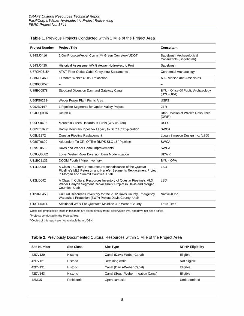
PREVIOUS RESEARCH
A search of project, site, and preservation files was conducted using the Utah Division of State History’s
(UDSH) Preservation Pro on February 23, 2015, and updated on July 16, 2015. In addition, a file search
was conducted by the U-W-CNF on July 21, 2015. In all, 20 archaeological projects have been conducted
within 1 mile of the Project Area (Table 1). Of the 20 projects, three have been conducted within the
Project Area. In the course of the 20 projects, 12 sites were documented with two of these sites
(42WB328, the Devil’s Gate Weber Hydroelectric Power Plant Historic District and 42MO59 the Union
Pacific Railroad) occurring within the immediate Project Area (Table 2). Although the Devil’s Gate Plant
was formally renamed the Weber Plant in 1917, the National Register of Historic Places (NRHP)
registration form retains both names. The Weber Historic District was added to the NRHP in 1989. While
several historic canal sites were identified within 1 mile of the Project Area during the file search, none of
the canals cross the Project Area. One historic architectural locality (Union Pacific Gateway Bridge
Record No. 112955) was identified in the UDSH historic files, but it is not located within the Project
Area.
In addition, GLO plat maps and several GIS layers were examined for potential cultural resources. These
layers, available from state and federal agencies, include the NRHP properties, Utah historic trails, Utah
historic districts, historic topographic maps, and other historic aerial imagery. Two NRHP properties were
identified within 1 mile of the Project Area: the previously mentioned Devil's Gate Weber Hydroelectric
Power Plant Historic District (42WB328) and Farmington Main Street Historic District. The Farmington
Main Street Historic District is not located in the Project Area.
Several potential historic resources were identified within 1 mile of the Project Area on GLO maps
(Salamon 1891 T 5N R 1E; Ferron 1871 T 5N R 1E; Ferron 1871 T 5N R 1W): three unnamed roads, two
unnamed buildings, two unnamed bridges, a flag station, a section house, a field, and the Union Pacific
Railroad. Only two of these resources are located in the Project Area: the Union Pacific Railroad and one
of the unnamed roads. This portion of the railroad has not been previously documented but is part of the
historic alignment of the Union Pacific Railroad. The unnamed road is historic highway U.S. 30S. In
addition, the flag station, the section house, and one of the unnamed bridges are related to the Union
Pacific Railroad, but they do not fall within the Project Area.
The previous cultural inventory projects conducted within 1 mile of the Project Area have covered only a
small portion of the Project Area (Appendix A). It is unlikely that additional survey within the Project
Area would identify new cultural resources due to the heavy disturbances from I-84 and various Union
Pacific Railroad and pipeline rights-of-way, as well as the construction of the hydroelectric project. Given
the number and extent of these undertakings, it is unlikely that any subsurface deposits containing
important information about the prehistory or history of the region remain intact.
DRAFT Cultural Resources Technical Report PacifiCorp’s Weber Hydroelectric Project Relicensing FERC Project No. 1744
8
Table 1. Previous Projects Conducted within 1 Mile of the Project Area
Project Number Project Title Consultant
U84SJ0416 2 GrvlProspts/Weber Cyn nr Mt Green Cemetery/UDOT Sagebrush Archaeological Consultants (Sagebrush)
U84SJ0425 Historical Assessment/W Gateway Hydroelectric Proj Sagebrush
U87CN0615* AT&T Fiber Optics Cable Cheyenne-Sacramento Centennial Archaeology
U88NP0463 El Monte-Weber 46 KV Relocation A.K. Nielson and Associates
U89BC0057† – –
U89BC0578 Stoddard Diversion Dam and Gateway Canal BYU - Office Of Public Archaeology (BYU-OPA)
U90FS0228* Weber Power Plant Picnic Area USFS
U96JB0167 3 Pipeline Segments for Ogden Valley Project JBR
U04UQ0416 Uintah U Utah Division of Wildlife Resources (DWR)
U05FS0495 Mountain Green Hazardous Fuels (WS-05-730) USFS
U06ST1822* Rocky Mountain Pipeline- Legacy to SLC 16" Exploration SWCA
U08LI1172 Questar Pipeline Replacement Logan Simpson Design Inc. (LSD)
U08ST0600 Addendum To CRI Of The RMPS SLC 16" Pipeline SWCA
U09ST0590 Davis and Weber Canal Improvements SWCA
U09UQ0582 Lower Weber River Diversion Dam Modernization UDWR
U11BC1133 DOGM Foothill Mine Inventory BYU - OPA
U11LI0050 A Class II Cultural Resources Reconnaissance of the Questar Pipeline's ML3 Peterson and Henefer Segments Replacement Project in Morgan and Summit Counties, Utah
LSD
U12LI0642 A Class III Cultural Resources Inventory of Questar Pipeline's ML3 Weber Canyon Segment Replacement Project in Davis and Morgan Counties, Utah
LSD
U12XN0453 Cultural Resources Inventory for the 2012 Davis County Emergency Watershed Protection (EWP) Project Davis County, Utah
Native-X Inc
U13TD0314 Additional Work For Questar's Mainline 3 In Weber County Tetra Tech
Note: The project titles listed in this table are taken directly from Preservation Pro, and have not been edited.
*Projects conducted in the Project Area.
†Copies of this report are not available from UDSH.
Table 2. Previously Documented Cultural Resources within 1 Mile of the Project Area
Site Number Site Class Site Type NRHP Eligibility
42DV120 Historic Canal (Davis-Weber Canal) Eligible
42DV121 Historic Retaining walls Not eligible
42DV131 Historic Canal (Davis-Weber Canal) Eligible
42DV143 Historic Canal (South Weber Irrigation Canal) Eligible
42MO5 Prehistoric Open campsite Undetermined

DRAFT Cultural Resources Technical Report PacifiCorp’s Weber Hydroelectric Project Relicensing FERC Project No. 1744
9
Table 2. Previously Documented Cultural Resources within 1 Mile of the Project Area
Site Number Site Class Site Type NRHP Eligibility
42MO7 Prehistoric Lithic scatter Undetermined
42MO16* – – –
42MO59† Historic Railroad (Union Pacific Railroad) Eligible
42MO68 Historic Historic hard rock mine (Strawberry Mine) Not eligible
42WB142 Prehistoric Open campsite Undetermined
42WB328† Historic Devil's Gate/Weber Hydroelectric Power Plant Historic District
NRHP-listed
42WB465 Historic Canal (Uintah Central Canal) Eligible
*Copies of these site forms are not available from UDSH.
† Sites located in the Project Area.
METHODS
Prior to conducting field surveys, SWCA obtained a permit and notice to proceed for archaeological
investigations on U-W-CNF land from the U-W-CNF Heritage archaeologist. SWCA executed an
intensive pedestrian survey using parallel transects spaced 15 meters (m) (50 feet) apart across the Project
Area to identify any cultural resources. The archaeologist visually inspected the ground on each side to an
approximate distance of 7.5 m (25 feet). The survey line was abandoned only when necessary to evaluate
a particular feature or area. After inspection of such a feature or area, the survey line was resumed. Data
gathered during the file search were loaded onto the global positioning system (GPS) units and plotted on
field maps carried by the crew, which enabled known archaeological sites or potential cultural resources
such as GLO features to be located while surveying.
Portions of the Project Area were not intensively surveyed but were visually inspected for cultural
resources from the closest safe distance (i.e., reconnaissance-level survey) due to safety reasons and/or
lack of access (Appendix B). These areas included the fenced-off portions of the Weber River banks and a
small area of slope exclusion at the western extent of the Project Area. Areas not surveyed include the I-
84 pavement. These areas are noted on the survey results map in Appendix B. This reconnaissance-level
survey consisted of careful visual investigation from the nearest accessible point to identify features that
are common with steep terrain and exposed river cut-banks (e.g., mining features, granaries, and rock art)
or along river banks (e.g., artifact deposits). See Appendix B for the Class III results map showing areas
of intensive survey versus reconnaissance survey.
The field crew used a Trimble GeoExplorer XT GPS unit with the SWCA-created data dictionary to
collect Project Area data and to map and document encountered cultural resources while surveying.
Trimble's Pathfinder Office software was used to process the GPS data in the office. The GPS data
were differentially corrected and exported in Esri's ArcView shapefile format using the Universal
Transverse Mercator (UTM) Zone 12 North, North American Datum (NAD) 83 datum coordinate
system. A Project-specific geodatabase was generated in Esri's ArcGIS 10.3. The shapefiles were
loaded into the Project-specific geodatabase and cleaned, and the attribute table of the cultural
resources database was then populated with the appropriate values. All maps for this report were
generated using ArcGIS 10.3.

DRAFT Cultural Resources Technical Report PacifiCorp’s Weber Hydroelectric Project Relicensing FERC Project No. 1744
10
When cultural resources were identified during the survey, SWCA archaeologists applied the Bureau of
Land Management guidelines to determine if the resources constituted a site or isolate. All resources were
documented to the standards of the Utah SHPO and USFS on Intermountain Antiquities Computer
System (IMACS) forms. Site and isolated occurrence (IO) definitions given by Bureau of Land
Management guidelines were followed throughout the survey (Bureau of Land Management 2002:6). In
general, a site is defined as a location of purposeful prehistoric or historic human activity. An activity is
considered to have been purposeful if it resulted in a deposit of cultural materials beyond the level of one
or a few artifacts. BLM definitions are as follows:
Sites should contain remains of past human activity that are at least 50 years old and should consist of one
or more of the following:
1. At least 10 artifacts of a single class (e.g., 10 sherds) within a 10-m diameter, except when all pieces appear to originate from a single source (e.g., one ceramic pot, one glass bottle).
2. At least 15 artifacts that include at least two classes of artifact types (e.g., sherds, nail, glass) within a 10-m-diameter area.
3. One or more archaeological features in temporal association with any number of artifacts.
4. Two or more temporally associated archaeological features without artifacts.
All linear cultural resources were documented as per the Utah Professional Archaeological Council linear
sites guidelines (Utah Professional Archaeological Council 2008). Sites were delineated based on Project
Area and land ownership boundaries. If a site extended into an area that was not accessible, this was
clearly indicated on the site record. In addition, SWCA revisited all previously documented sites in the
Project Area and documented them on an IMACS form. SWCA documented digital datums and did not
place physical datums for this project.
Site recording included a written description of a site's general location and setting, as well as a
description of the observed artifacts and features. Recording also included creating a site sketch map;
photographing the site, features, and artifacts; and mapping the site boundaries, datum, features, and
diagnostic artifacts by GPS. All photographs were taken using a high-resolution digital camera. Sites were
documented on a combination of IMACS paper forms and tablet computers. All data from the tablet
computers were collected in an application that incorporates all of the information required on the
IMACS forms. Tablet data were uploaded to SWCA’s in-house IMACS generator when the survey was
complete. The IMACS forms for all recorded sites are presented in Appendix C. No artifacts were
collected during this inventory.
INVENTORY RESULTS AND EVALUATIONS
The intensive- and reconnaissance-level inventory was conducted by an SWCA archaeologist on October
5, 2015. SWCA documented a new segment of the previously recorded Union Pacific Railroad
42DV184/42WB344/42MO59 and one newly recorded site, a previously unrecorded segment of U.S. 30S
(42MO75/42WB523). The original documentation of the Devil’s Gate Weber Hydroelectric Power Plant
Historic District (42WB328), prepared for the previous license, was reviewed by the SHPO and found to
be adequate; therefore, no updated documentation was needed (email correspondence between Lindsey
Kester, SWCA, and Chris Hansen, SHPO, on July 2, 2015). Complete IMACS site forms are provided in
Appendix C.
DRAFT Cultural Resources Technical Report PacifiCorp’s Weber Hydroelectric Project Relicensing FERC Project No. 1744
11
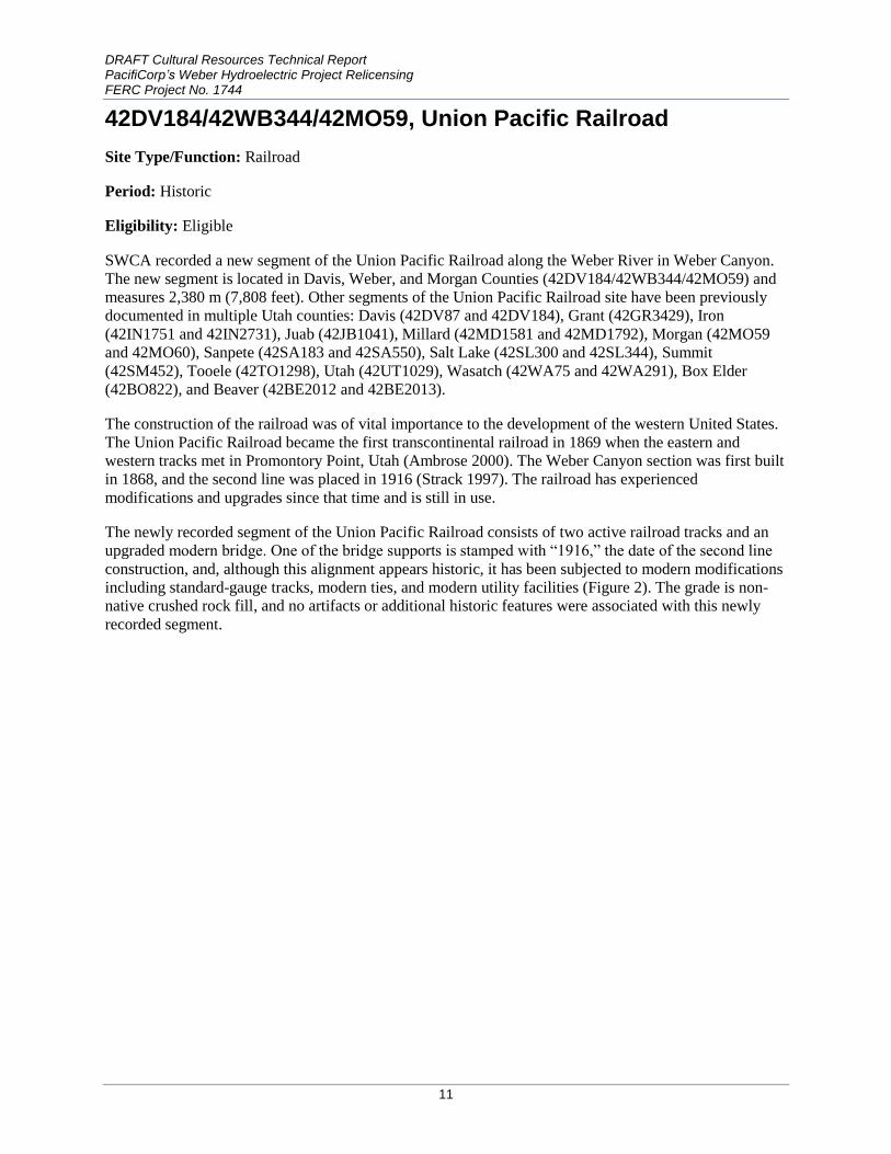
42DV184/42WB344/42MO59, Union Pacific Railroad
Site Type/Function: Railroad
Period: Historic
Eligibility: Eligible
SWCA recorded a new segment of the Union Pacific Railroad along the Weber River in Weber Canyon.
The new segment is located in Davis, Weber, and Morgan Counties (42DV184/42WB344/42MO59) and
measures 2,380 m (7,808 feet). Other segments of the Union Pacific Railroad site have been previously
documented in multiple Utah counties: Davis (42DV87 and 42DV184), Grant (42GR3429), Iron
(42IN1751 and 42IN2731), Juab (42JB1041), Millard (42MD1581 and 42MD1792), Morgan (42MO59
and 42MO60), Sanpete (42SA183 and 42SA550), Salt Lake (42SL300 and 42SL344), Summit
(42SM452), Tooele (42TO1298), Utah (42UT1029), Wasatch (42WA75 and 42WA291), Box Elder
(42BO822), and Beaver (42BE2012 and 42BE2013).
The construction of the railroad was of vital importance to the development of the western United States.
The Union Pacific Railroad became the first transcontinental railroad in 1869 when the eastern and
western tracks met in Promontory Point, Utah (Ambrose 2000). The Weber Canyon section was first built
in 1868, and the second line was placed in 1916 (Strack 1997). The railroad has experienced
modifications and upgrades since that time and is still in use.
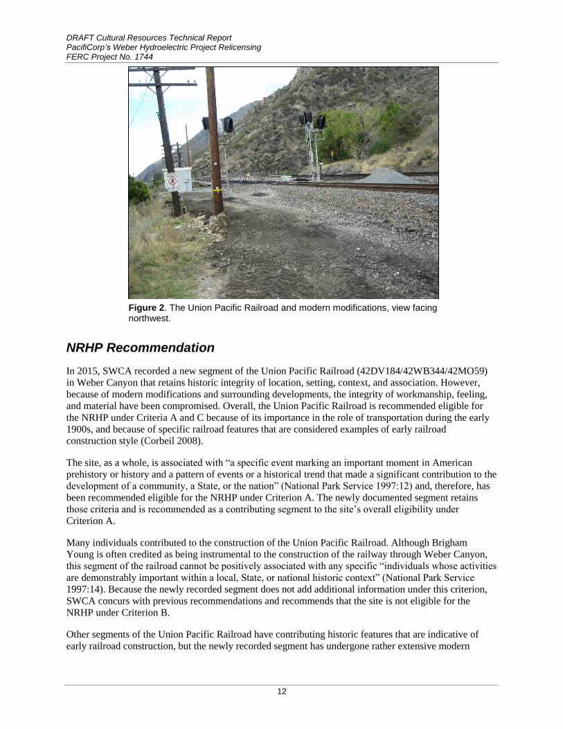
The newly recorded segment of the Union Pacific Railroad consists of two active railroad tracks and an
upgraded modern bridge. One of the bridge supports is stamped with “1916,” the date of the second line
construction, and, although this alignment appears historic, it has been subjected to modern modifications
including standard-gauge tracks, modern ties, and modern utility facilities (Figure 2). The grade is non-
native crushed rock fill, and no artifacts or additional historic features were associated with this newly
recorded segment.
DRAFT Cultural Resources Technical Report PacifiCorp’s Weber Hydroelectric Project Relicensing FERC Project No. 1744
12
Figure 2. The Union Pacific Railroad and modern modifications, view facing northwest.
NRHP Recommendation
In 2015, SWCA recorded a new segment of the Union Pacific Railroad (42DV184/42WB344/42MO59)
in Weber Canyon that retains historic integrity of location, setting, context, and association. However,
because of modern modifications and surrounding developments, the integrity of workmanship, feeling,
and material have been compromised. Overall, the Union Pacific Railroad is recommended eligible for
the NRHP under Criteria A and C because of its importance in the role of transportation during the early
1900s, and because of specific railroad features that are considered examples of early railroad
construction style (Corbeil 2008).
The site, as a whole, is associated with “a specific event marking an important moment in American
prehistory or history and a pattern of events or a historical trend that made a significant contribution to the
development of a community, a State, or the nation” (National Park Service 1997:12) and, therefore, has
been recommended eligible for the NRHP under Criterion A. The newly documented segment retains
those criteria and is recommended as a contributing segment to the site’s overall eligibility under
Criterion A.
Many individuals contributed to the construction of the Union Pacific Railroad. Although Brigham
Young is often credited as being instrumental to the construction of the railway through Weber Canyon,
this segment of the railroad cannot be positively associated with any specific “individuals whose activities
are demonstrably important within a local, State, or national historic context” (National Park Service
1997:14). Because the newly recorded segment does not add additional information under this criterion,
SWCA concurs with previous recommendations and recommends that the site is not eligible for the
NRHP under Criterion B.
Other segments of the Union Pacific Railroad have contributing historic features that are indicative of
early railroad construction, but the newly recorded segment has undergone rather extensive modern

DRAFT Cultural Resources Technical Report PacifiCorp’s Weber Hydroelectric Project Relicensing FERC Project No. 1744
13
construction and upkeep and does not include any of these features. Moreover, this segment does not
show distinctive architectural or engineering characteristics, patterns, types, or styles, nor does it
“embody the distinctive characteristics of a type, period, or method of construction; represent the work of
a master; possess high artistic values; or represent a significant and distinguishable entity whose
components may lack individual distinction” (National Park Service 1997:21). Therefore, this segment of
the Union Pacific Railroad is considered a noncontributing portion of the site’s overall eligibility under
Criterion C, and is recommended as not eligible under this criterion.
The Union Pacific Railroad is still active and has had many modern modifications. The railroad grade is
composed of non-native gravels on the ground surface. Although excavation must have occurred to build
the bridge supports, there is little (if any) potential for subsurface cultural features or artifacts because of
the general methods used in railroad construction (i.e., placing crushed gravel on the ground surface and
laying down steel ties). Because of these reasons, the Union Pacific Railroad as a whole has been
recommended as not eligible for the NRHP under Criterion D. No historic artifacts or additional features
were observed in the newly recorded segment, and, as with the overall Union Pacific Railroad site, it is
unlikely to “have, or have had, information to contribute to our understanding of human history or
prehistory” that is “considered important” (National Park Service 1997:21). Consequentially, SWCA
concurs with previous recommendations and recommends that the Union Pacific Railroad be considered
not eligible under Criterion D.
In summary, SWCA recommends that the newly recorded segment contributes to the Union Pacific
Railroad’s eligibility for the NRHP under Criterion A.
42MO75/42WB523, Historic U.S. 30S
Site Type/Function: Historic feature
Period: Historic
Eligibility: Eligible
In October 2015, SWCA recorded a segment of the U.S. 30S alignment in Weber Canyon. The road
segments follow the northern bank of the Weber River and the Union Pacific Railroad through the bottom
of Weber Canyon. Surrounding sediments consist of light brown gray loam with some gravels.
Vegetation consists of various riparian grasses and forbs growing up through the remaining asphalt road.
The depositional context consists of primarily colluvium with some alluvial deposits.
The segment of U.S. 30S is approximately 13 feet wide with an asphalt and dirt surface. Approximately
650 feet of the east end of the segment is dirt, and the portion from the edge of I-84 to the start of a major
oxbow in the western portion of the segment (Figure 3) is also dirt. The portion along the oxbow has an
asphalt surface and concrete retaining walls (Figure 4) on the river side. The retaining walls were built
with two different construction methods, but the walls extend only 5–12 inches above the roadbed. One
section was built using formed concrete and has a footer along the bottom portion where the wall meets a
layer of riprap. The other section is built of mortared rock using shaped stones and a formed concrete cap.
The formed concrete portion is in poor condition, and the rock wall is in fair to good condition. The
roadbed is approximately 3 inches thick and is visible in areas where the roadbed is damaged. Overall, the
road is in poor condition, and although it is suspected that the road continued east and west along Weber
Canyon, no evidence of the historic alignment was observed.

DRAFT Cultural Resources Technical Report PacifiCorp’s Weber Hydroelectric Project Relicensing FERC Project No. 1744
14
Figure 3. View of U.S. 30S from its eastern end toward the oxbow, facing west.
Figure 4. Retainer walls of U.S. 30S along the Weber River, view facing east.
The old road alignment ran between Granger, Wyoming, and Burley, Idaho, via Ogden, Utah (U.S.
Geological Survey 1956 [1955]; Weingroff 2013; Workers of the Writers' Program of the Works Projects
Adminstration for the State of Utah 1941:353–354). The road was likely constructed over the original
paths used by settlers and pioneers who traveled through Weber Canyon, and was used between 1926 and
1972 (Droz 2010; Weingroff 2013). It was designated I-80N as part of the development of the interstate

DRAFT Cultural Resources Technical Report PacifiCorp’s Weber Hydroelectric Project Relicensing FERC Project No. 1744
15
system (Droz 2008, 2010) and was re-designated I-84 in 1977 by the Utah Department of Transportation,
and conditionally approved by the American Association of State Highway and Transportation Officials
(Utah Department of Transportation 2008).
The road has also been affected by the construction and subsequent updates to the Union Pacific Railroad
and the construction of I-80N/I-84. The portion of the road within the FERC Project Area is located
partially within the historic district and partially within the Utah Department of Transportation right-of-
way, where it has been disturbed by road construction activities and the installation of a buried pipeline
through the area. The current Project will not adversely affect the site.
NRHP Recommendation
Site 42MO75/42WB523 is a newly recorded segment of historic U.S. 30S and represents a portion of one
of the early federal aid roads in Utah. It is associated with the beginnings of what would become the
national system of interstate and defense highways. The system allowed improved travel between states
and provided maintained routes for commercial interstate commerce. U.S. 30S was considered an
important road to the state of Utah when it was numbered in 1926, and, therefore, the site can be
positively associated with “a specific event marking an important moment in American prehistory or
history and a pattern of events or a historic trend that made a significant contribution to the development
of a community, a State, or the nation” (National Park Service 1997:12). Therefore, 42MO75/42WB523
is recommended eligible for the NRHP under Criterion A.
Site 42MO75/42WB523 cannot be associated with “individuals whose activities are demonstrably
important within a local, State, or national historic context” (National Park Service 1997:14). Therefore,
42MO75/42WB523 is recommended not eligible for the NRHP under Criterion B.
Although different retaining wall construction styles were observed at the site, they do not demonstrate
distinctive architectural or engineering characteristics, patterns, types, or styles. Moreover, the site does
not “embody the distinctive characteristics of a type, period, or method of construction; represent the
work of a master; possess high artistic values; or represent a significant and distinguishable entity whose
components may lack individual distinction” (National Park Service 1997:17). Therefore,
42MO75/42WB523 is recommended not eligible for the NRHP under Criterion C.
Given that 42MO75/42WB523 is a road, it is a surface manifestation that lacks deposition and the
potential to provide any subsurface deposits. Also, since the road has been upgraded several times to
accommodate improvements, construction has disturbed any subsurface deposits in the area surrounding
it. Finally, no artifacts were observed in association with the road. Site 42MO75/42WB523 is not likely to
“have, or have had, information to contribute to our understanding of human history or prehistory” that is
“considered important” (National Park Service 1997:21). Therefore, 42MO75/42WB523 is recommended
not eligible for the NRHP under Criterion D.
In summary, 42MO75/42WB523 is recommended eligible for the NRHP under Criterion A.
MANAGEMENT SUMMARY
In July 2015, PacifiCorp requested SWCA to conduct a formal cultural resource inventory of the Project
Area to verify the results of the 2015 desktop-level assessment (PacifiCorp 2015) and fulfill the cultural
resources study plan (PacifiCorp 2016). In all, SWCA inventoried a total of 59.97 acres (24.27 ha). Of
these, 17.05 acres (6.88 ha) were intensively surveyed, 34.45 acres (13.94 ha) were surveyed at a
reconnaissance level, and 8.46 acres (3.4 ha) were not surveyed because they are existing paved roads. Of
DRAFT Cultural Resources Technical Report PacifiCorp’s Weber Hydroelectric Project Relicensing FERC Project No. 1744
16
the 59.97 acres (24.27 ha), 29.93 (12.11 ha) are on privately owned lands and 30.04 acres (12.16 ha) are
on USFS-administrated lands. The Project Area is located in Sections 28–30, Township 5 North, Range 1
East on U-W-CNF managed-land and private land in Weber, Morgan, and Davis Counties in Utah.
SWCA documented a previously unrecorded segment of U.S. 30S (42MO75/42WB523) and a new
segment of the Union Pacific Railroad (42DV184/42WB344/42MO59) during the inventory. Chris
Hansen, the Deputy Utah SHPO Officer, reviewed the original documentation of the Devil’s Gate Weber
Hydroelectric Power Plant Historic District (42WB328) that was prepared for the previous license and
found it to be adequate, with no updated documentation needed (email correspondence between Lindsey
Kester, SWCA, and Chris Hansen, SHPO, on July 2, 2015). Therefore SWCA did not update the existing
site record for this inventory.
SWCA recommends 42DV184/42WB344/42MO59 and 42MO75/42WB523 eligible for the NRHP under
Criterion A. The previously documented historic district (42WB328) was added to the NRHP in 1989.
Site 42DV184/42WB344/42MO59 is also located in the Project Area, but only a small portion of the
railroad—the location where the Project pipeline was bored under the active railroad—is intersected by
the FERC Project Boundary. The pipeline is associated with the Weber Hydroelectric Plant and crosses
the railroad near the eastern end of the Project Area. Based on aerial imagery from Google Earth, the pipe
appears to have been bored under the active Union Pacific Railroad line; PacifiCorp records also indicate
this. Because this is a previous disturbance that does not impact the site, no further impacts are anticipated
by the actions of the Project. Site 42MO75/42WB523 is located in the Project Area, but the portions that
intersect with the FERC Project Boundary have been heavily impacted by modern roads and utility and
railroad construction, and they do not retain integrity to contribute to the overall eligibility of the site.
Therefore, potential Project effects will not further impact the site.
With the exception of potential fish passage facilities, there are no proposed changes to the existing
Project facilities or infrastructure that could adversely affect these sites. Any impacts from fish passage
construction or continued operation of the Project would occur within the FERC Project Boundary.
PacifiCorp prepared and implemented a cultural resource management (PacifiCorp 1991) plan as part of
their 1990 FERC license to address potential from the Project. Chris Hansen, the Deputy Utah SHPO
Officer, reviewed the plan and found it to be adequate for continued use and consultation with SHPO
(email correspondence between Lindsey Kester, SWCA, and Chris Hansen, SHPO, on July 2, 2015).
PacifiCorp will follow the standards and procedures outlined in the plan (and modify the document as
necessary) in coordination with SHPO for proposed fish passage construction, continued operation and
maintenance, and any new proposed construction. No significant impacts to cultural resources are
expected from this re-licensing effort. Therefore, SWCA recommends no historic properties affected for
this project.

DRAFT Cultural Resources Technical Report PacifiCorp’s Weber Hydroelectric Project Relicensing FERC Project No. 1744
17
REFERENCES CITED
Alexander, Thomas G.
1996 Utah, the Right Place: The Official Centennial History. Gibbs-Smith Publisher, Salt Lake
City, Utah.
Ambrose, Stephen E.
2000 Nothing Like It in the World: The Men Who Built the Transcontinental Railroad 1863-1869.
Simon and Shuster, New York City, New York.
Bureau of Land Management
2002 Bureau of Land Management Guidelines for Identifying Cultural Resources, Handbook H-
8110. Bureau of Land Management, Salt Lake City, Utah.
Carlstrom, Jeffrey and Cynthia Furse
2003 The History of Emigration Canyon: Gateway to Salt Lake Valley. Utah State University
Press, Logan, Utah.
Corbeil, Marcel
2008 IMACS Form for 42MO000059 (Union Pacific Railroad). U-08-ST-0600. Prepared by
SWCA, Inc., Salt Lake City, Utah. Copies available from Utah Division of State History,
Salt Lake City.
DeLafosse, Peter H.
1998 Utah Historical Trails. Utah State Historical Society, Salt Lake City.
Droz, Robert V.
2008 U.S. Highways: Divided (Split) Routes. Available at: http://www.us-
highways.com/usdiv.htm. Accessed October 14, 2015.
2010 East - West US Highways With Daughter Routes From US 2 to US 98 (with US 400).
Available at: http://www.us-highways.com/us2.htm. Accessed October 14, 2015.
Haymond, Jay M.
2008 Transportation. Available at:
http://www.uen.org/utah_history_encyclopedia/t/TRANSPORTATION.html. Accessed
October 15, 2015.
Knowlton, Ezra C.
1963 History of Utah Highway Development in Utah. Utah State Department of Highways, Salt
Lake City, Utah.
Leonard, Glen M.
1999 A History of Davis County. Utah Centennial County History Series. Utah State Historical
Society, Salt Lake City.

DRAFT Cultural Resources Technical Report PacifiCorp’s Weber Hydroelectric Project Relicensing FERC Project No. 1744
18
May, Dean L.
1987 Utah: A People's History. University of Utah Press, Salt Lake City.
National Park Service
1997 How to Apply the National Register Criteria for Evaluation. Revised ed. National Register
Bulletin 15. National Park Service Interagency Resources Division, National Register
Branch, Washington, D.C.
PacifiCorp
1991 Weber Hydroelectric Project Cultural Resources Management Plan. FERC Project No.
1744. Prepared by PacifiCorp, Salt Lake City, Utah.
2015 Weber Hydroelectric Project Pre-Application Document, FERC No. 1744. Prepared by
PacifiCorp Hydro Resources, Salt Lake City, Utah.
2016 Weber Hydroelectric Project Final Study Plan Cultural Resources. FERC Project No. 1744.
Prepared by PacifiCorp Hydro Resources, Salt Lake City, Utah.
Sillitoe, Linda
1996 A History of Salt Lake County. Utah Centennial County History Series. Utah State Historical
Society, Salt Lake City.
Strack, Donald
1997 Ogden Rails: A History of Railroads in Ogden, Utah from 1869 to Today. Withers
Publishing, Pennsylvania.
U.S. Department of Transportation
1976 America's Highways 1776-1976: A History of the Federal-Aid Program. U.S. Government
Printing Office, Washington, D.C.
U.S. Geological Survey
1956 [1955] Ogden, UT, U.S. Geological Survey Historical Topographic Map Collection,
scale 1:24,000, Available online at http://ngmdb.usgs.gov/maps/Topoview/viewer/.
Utah Department of Transportation
2008 Route 84. Available at: http://www.dot.utah.gov/main/uconowner.gf?n=200609181109591.
Accessed October 15, 2015.
Utah Professional Archaeological Council
2008 Linear Sites: Guidance for Identifying and Recording under Section 106 of the National
Historic Preservation Act. Utah Professional Archaeological Council, Salt Lake City.
Weingroff, Richard F.
2013 From Names to Numbers: The Origins of the U.S. Numbered Highway System. Available
at: http://www.fhwa.dot.gov/infrastructure/numbers.cfm. Accessed April 21, 2015.
Workers of the Writers' Program of the Works Projects Adminstration for the State of Utah
1941 Utah: A Guide to the State. Hastings House, New York.