draft environmental assessment for ... - travis air force …
TRANSCRIPT

DRAFT
ENVIRONMENTAL ASSESSMENT
For
DEVELOPMENT OF THE P205 ALERT FORCE COMPLEX PROJECT
At
TRAVIS AIR FORCE BASE, CALIFORNIA
JULY 2019

This page is intentionally left blank.

Page 1 of 12
DEPARTMENT OF DEFENSE DEPARTMENT OF THE NAVY DEPARTMENT OF THE AIR FORCE FINDING OF NO SIGNIFICANT IMPACT (FONSI) AND FINDING OF NO PRACTICABLE ALTERNATIVE (FONPA) FOR THE ENVIRONMENTAL ASSESSMENT FOR THE DEVELOPMENT OF THE P205 ALERT FORCE COMPLEX PROJECT AT TRAVIS AIR FORCE BASE, CALIFORNIA
Pursuant to the Council on Environmental Quality regulations (40 Code of Federal Regulations [CFR] Parts 1500-1508) implementing the National Environmental Policy Act (NEPA), Department of the Navy (Navy) NEPA regulations (32 CFR Part 775), Chief of Naval Operations Manual-5090.1, and the Department of the Air Force Environmental Impact Analysis Program (32 CFR Part 651), the Navy and Air Force give notice that an Environmental Assessment(EA)has been prepared for the demolition of the existing Fleet Air Reconnaissance Squadron Three Detachment Travis (VQ-3 Det Travis) Alert Force Complex (Complex) and the construction of a new Alert Force Complex (Complex) at Travis Air Force Base (AFB) in Fairfield, California. An Environmental Impact Statement is not required.
Proposed Action: The Navy proposes to replace the existing Complex and locate a replacement Complex outside the runway safety clear zone at Travis AFB in Fairfield, California. The Proposed Action includes the demolition of existing facilities near the southern boundary of Travis AFB (Buildings 1162, 1165, 1167, 1168, 1171, 1174, 1175, 1176, 1178, 1180, 1181, 1191, 1193, and 1894) and construction of a new Complex north of the Travis AFB runways.
The Proposed Action would also include a real estate agreement between the Navy and the Air Force for the construction and operation of the proposed new facilities. Two existing aircraft parking spaces would be made available to the Navy for E-6B Mercury aircraft parking near the new facilities. Occasionally, a third E-6B Mercury aircraft may be present at Travis AFB, and the Navy would be allowed to park it in any existing airplane parking space on base.
The need for the Proposed Action is to:

FINDING OF NO SIGNIFICANT IMPACT (FONSI) AND FINDING OF NO PRACTICABLE ALTERNATIVE (FONPA) FOR THE ENVIRONMENTAL ASSESSMENT FOR DEVELOPMENT OF THE P205 ALERT FORCE COMPLEX PROJECT AT TRAVIS AIR FORCE BASE, CALIFORNIA
Page 2 of 12
• Address Anti-Terrorism/Force Protection (AT/FP) concerns pertaining to potential threats along the installation boundary fence line;
• Address inadequate facility size. Personnel are currently operating within a 37,500-square-foot (sf) Complex; however, 61,000-sf is needed to adequately support VQ-3 Det Travis operations;
• Meet runway safety clear zone requirements. The majority of the existing facilities are currently within Travis AFB’s runway clear zone. The United States Department of the Air Force (Air Force) standards for airfield clear zones are 3,000 by 3,000 linear feet, which encompasses the existing Complex;
• Address flooding hazards. Site conditions at Building 1175 direct drainage toward the building. Mold remediation in the sleeping quarters, due to flooding, is a constant concern at the existing facility; and,
• Address wildfire hazards. The risk of wildfire is increased by the proximity of nonnative grasslands to Travis AFB’s exterior fence line. Recent wildfires breached the outer perimeter and encroached upon the Complex.
Public Participation: The Navy and Air Force solicited advance public comment on the proposed project in accordance with Executive Order 11990, Protection of Wetlands, as approximately 0.0046 acre of wetlands would be directly impacted by the proposed project. The public notice was published in the Vacaville Reporter, the Daily Republic (Fairfield/Suisun), and Travis AFB Tailwind starting June 8, 2018 through June 10, 2018, and public comments were accepted between June 18, 2018 and July 19, 2018. Comments received during the advance public notice period were considered in preparing the Draft EA.
In addition, the public participation process included the publication of a Notice of Availability (NOA) of the Draft EA in local newspapers: the Vacaville Reporter, the Daily Republic (Fairfield/Suisum) and Travis AFB Tailwind starting (Date) through (Date).
The Draft EA is also available in hardcopy review at the following locations:
• Fairfield Civic Center Library, 1150 Kentucky Street, Fairfield, CA 94533
• Suisun City Library, 601 Pintail Drive, Suisun City, CA 94585
FINDING OF NO SIGNIFICANT IMPACT (FONSI) AND FINDING OF NO PRACTICABLE ALTERNATIVE (FONPA) FOR THE ENVIRONMENTAL ASSESSMENT FOR DEVELOPMENT OF THE P205 ALERT FORCE COMPLEX PROJECT AT TRAVIS AIR FORCE BASE, CALIFORNIA
Page 3 of 12
• Vacaville Public Library Cultural Center, 1020 Ulatis Drive, Vacaville, CA 95688
• Mitchell Memorial Library, 510 Travis Boulevard, Travis AFB, CA 94535
The Draft EA has been made available for public review on the Nave Region Southwest website (XXX).
The public comment period will run from September 13, 2019 through October 12, 2019. Comments received during the public review period, will be considered in the Final EA. A NOA of the Final EA and any proposed final Finding of No Significant Impact will be published in the Vacaville Reporter, the Daily Republic (Fairfield/Suisum) and Travis AFB Tailwind newspapers. Copies of the final documents will also be placed at the libraries listed above and on the Navy Region Southwest website.
Alternatives Analyzed: Under the No Action Alternative, the Proposed Action, as described above, would not occur and personnel would continue to work in deteriorated, undersized, and unsecure facilities.
Alternative 1: Under Alternative 1 a complete Alert Force Complex relocation would occur. Alternative 1 includes the following:
• Demolishing fourteen existing facilities: Buildings 1162, 1165, 1167, 1168, 1171, 1174, 1175, 1176, 1178, 1180, 1181, 1191, 1193, and 1894;
• Returning buildings 1164, 1177, and 1179 to the Air Force;
• Execution of a real estate agreement between the Navy and Air Force to allow a new Complex to be constructed and operated outside of the runway safety clear zone, located north of the Travis AFB runways on vacant land east of Building 350;
• Constructing an Alert Force/Security Facility, an Entry Control Point/Gatehouse (ECP), Satellite Communication (SATCOM) Facility and aircraft ground equipment (AGE) maintenance repair and aircraft storage facilities;
• Providing approximately 154 parking spaces throughout the new Complex;
• AT/FP features including security fencing, vehicle barriers, security gates, intrusion detection system,

FINDING OF NO SIGNIFICANT IMPACT (FONSI) AND FINDING OF NO PRACTICABLE ALTERNATIVE (FONPA) FOR THE ENVIRONMENTAL ASSESSMENT FOR DEVELOPMENT OF THE P205 ALERT FORCE COMPLEX PROJECT AT TRAVIS AIR FORCE BASE, CALIFORNIA
Page 4 of 12
closed-circuit television, and pedestrian turnstiles in accordance with the DoD Minimum Anti-Terrorism Standards for Buildings;
• New Complex preparations including site clearing, trenching for utilities, and preparation for construction;
• Paving and site improvements including grading, parking, roadways, curbs, sidewalks, landscaping, and pedestrian features; and,
• Relocating and reusing current VQ-3 Det Travis operations five existing generators to support the new Complex.
If approved, the project would break ground in June 2020, taking approximately 30 months to complete the construction of the new Complex and demolition of the existing Complex. Because there cannot be any interruption in the VQ-3 Det Travis operation, demolition of the existing Complex would not occur until the construction of the new Complex and relocation of VQ-3 Det Travis is complete.
Alternative 2: Under Alternative 2 there would be a Partial Alert Force Complex Relocation. The same actions outlined in Alternative 1 would be included in Alternative 2, except the Navy would continue to utilize Buildings 1164, 1177 and 1179. These Buildings are outside of the runway safety clear zone.
Under this alternative, an additional 800 sf would need to be provided on the proposed Complex site to support “ready for use” GSE that is currently maintained at Building 1179.
Alternative 2 would require a total of six generators.
Alternative 2 would also require trenching, approximately 3 feet in depth, to connect proposed utilities to existing utility connections adjacent to the proposed site. There would also be a need for redundant or backup utilities to support the proposed Complex.
Deficiencies associated with Alternative 2 include duplicating some required functions associated with Buildings 1177 and 1179 at the new complex to adequately support the mission and E-6B Mercury aircraft. Additionally, Buildings 1164, 1177, and 1179 would remain within an area subject to wildfire due to proximity of private land. Security response times for Buildings 1164, 1177, and 1179 would unacceptably increase due to Navy Security Force moving to the north side
FINDING OF NO SIGNIFICANT IMPACT (FONSI) AND FINDING OF NO PRACTICABLE ALTERNATIVE (FONPA) FOR THE ENVIRONMENTAL ASSESSMENT FOR DEVELOPMENT OF THE P205 ALERT FORCE COMPLEX PROJECT AT TRAVIS AIR FORCE BASE, CALIFORNIA
Page 5 of 12
of the Travis AFB runways. This would result in increased security force resources to provide requisite protection.
Alternative to Be Implemented: The Proposed Action/Alternative 1 is the selected alternative for implementation as it best meets the purpose and need for the project and would not result in significant impacts to the human and natural environment.
Existing Conditions: Travis AFB is located approximately 7 miles north of the City of Fairfield, in Solano County, California. The Base occupies approximately 6,383 acres near Interstate 80, between the cities of Sacramento and San Francisco. The existing Complex is located in the southeast portion of the Base, north of Perimeter Road. The site of the proposed new Complex is in the northeast portion of the Base at the airfield. The site is bordered by Vandenberg Drive on the south and east, Napa Street on the north, and Airlift Drive on the west. The proposed new Complex would be constructed within a vacant portion of the property.
Environmental Effects:
Air Quality: Implementation of Alternative 1 would result in emissions of air pollutants during demolition and construction. Demolition and construction emissions would be below de minimis levels. Therefore, implementation of Alternative 1 would not result in a significant impact related to air quality.
Water Resources: Best management practices required by the Construction Site Storm Water National Pollutant Discharge Elimination System (NPDES) permit and Storm Water Pollution Prevention Plan (SWPPP) would be implemented during project demolition and construction to further reduce the less-than-significant impacts.
Compensatory mitigation for direct and indirect impacts to a total of 1.0146 acres of jurisdictional waters of the U.S. may be required. Clean Water Act (CWA) Section 401 and Section 404 permit applications would be submitted to the California Regional Water Quality Control Board (RWQCB), San Francisco Bay Region, and the USACE, Sacramento District, respectively, for their review and approval. Approval of the CWA Section 401 and Section 404 permit applications would be obtained prior to commencement of any demolition or construction activities that could impact regulated resources. Once acquired, the Navy/Air Force would comply with all conditions outlined in the CWA

FINDING OF NO SIGNIFICANT IMPACT (FONSI) AND FINDING OF NO PRACTICABLE ALTERNATIVE (FONPA) FOR THE ENVIRONMENTAL ASSESSMENT FOR DEVELOPMENT OF THE P205 ALERT FORCE COMPLEX PROJECT AT TRAVIS AIR FORCE BASE, CALIFORNIA
Page 6 of 12
Section 404 and Section 401 Clean Water Act permits. Therefore, no significant impacts to water resources would occur.
Geologic Resources: Implementation of management practices required by the Construction Site Storm Water NPDES permit and SWPPP would be implemented during demolition and construction activities, that would further reduce the anticipated less-than significant impacts.
Cultural Resources: Implementation of Alternative 1 is not anticipated to result in significant impacts to cultural resources. However, if cultural or archaeological resources should inadvertently be disturbed during demolition or construction, action would be taken in accordance with the following contingency plan:
• All activities are performed in compliance with the Integrated Cultural Resources Management Plan.
• Work would cease, and the Air Force Cultural Resources Manager would be contacted.
• If any new information or cultural items are found, Travis AFB would notify local Native American tribes.
The Air Force received a concurrence that a finding of no adverse effect to historic properties pursuant to 36 CFR Part 800.5(d)(1) is appropriate, per the California State Historic Preservation Office (SHPO), on September 7, 2018.
Biological Resources: Formal Section 7 consultation has been completed with the U.S. Fish and Wildlife Service (USFWS) and a Biological Opinion (BO) was written on April 08, 2019, for California tiger salamander (CTS), Delta green ground beetle (DGGB), vernal pool fairy shrimp (VPFS), and vernal pool tadpole shrimp (VPTS), regarding proposed project approval.
The USFWS Biological Opinion states that this project, as proposed, is not likely to jeopardize the continued existence of the CTS, VPFS, and VPTS. The conclusion was based on the project-related effects to the species, when added to the environmental baseline and analyzed in consideration of all potential cumulative effects. USFWS determined that the project would not rise to the level of precluding recovery or reducing the likelihood of survival of the species.
Alternative 1 would result in permanent and temporary loss of suitable habitat for CTS, VPFS, and VPTS. To avoid or minimize

FINDING OF NO SIGNIFICANT IMPACT (FONSI) AND FINDING OF NO PRACTICABLE ALTERNATIVE (FONPA) FOR THE ENVIRONMENTAL ASSESSMENT FOR DEVELOPMENT OF THE P205 ALERT FORCE COMPLEX PROJECT AT TRAVIS AIR FORCE BASE, CALIFORNIA
Page 7 of 12
effects on the CTS, VPFS, VPTS, and DGGB, Travis AFB would fully implement the conservation measures outlined in Table 1 of the Biological Assessment (BA) (Navy 2019). This would include all the relevant conservation measures outlined in the Programmatic Formal and Informal Consultation on the Proposed Effects of Activities Conducted at Travis Air Force Base on Six Federally Threatened and Endangered Species, Solana County, California (USFWS 2018).
To offset the permanent loss of CTS upland habitat, Travis AFB has proposed to purchase 16.74 CTS credits from a USFWS-approved conservation bank. To offset temporary losses of CTS upland habitat, Travis AFB has proposed to purchase an additional 0.37 CTS credits from a USFWS-approved conservation bank.
Because the proposed project activities are expected to result in hydrological modifications to vernal pools within 250 feet of all parts of the proposed project action area, Travis AFB has proposed to offset the loss due to the hydrological effects by purchasing 1.02 vernal pool conservation credits from a USFWS-approved conservation bank.
Implementation of Mitigation Measures would provide compensation for these losses sufficient to offset potential adverse impacts to those species. Additionally, Travis AFB personnel would continue to manage habitats according to the Integrated Natural Resources Management Plan (INRMP), which is designed to protect and benefit threatened and endangered species.
Alternative 1 is located within 1 mile of known locations of DGGB, off of the main base at Travis AFB., which is presumed absent from the main base at Travis AFB. After reviewing all available information, the USFWS concurred with the Air Force with the determination that the proposed project may affect, but is not likely to adversely affect the DGGB. The proposed project reached the “may affect” level, and the subsequent requirement for a biological assessment, due to the fact that the proposed project occurs where potentially suitable lands for the DGGB exist. However, due to the fact that the DGGB to date has not been identified on Travis AFB, the USFWS believes that adverse effects to the DGGB are unlikely to occur, and are therefore discountable for the purposes of the USFWS consultation (USFWS 2019).
Wildlife on Travis AFB is currently exposed to high levels of ambient noise from ongoing air operations, and Alternative 1

FINDING OF NO SIGNIFICANT IMPACT (FONSI) AND FINDING OF NO PRACTICABLE ALTERNATIVE (FONPA) FOR THE ENVIRONMENTAL ASSESSMENT FOR DEVELOPMENT OF THE P205 ALERT FORCE COMPLEX PROJECT AT TRAVIS AIR FORCE BASE, CALIFORNIA
Page 8 of 12
would not result in any temporal or spatial change to noise levels from existing conditions except during demolition and construction (which would be short-term and temporary). Noise impacts from demolition and construction of Alternative 1 would be localized, and potential for adverse impacts to nesting birds would be reduced by implementation of Mitigation Measures BIO-07, BIO-08, and BIO-09. Operation of Alternative 1 would result in no change to existing noise impacts on nesting birds on Travis AFB.
To protect birds under the Migratory Bird Treaty Act, a pre-construction survey must be performed by a qualified biologist no more than 14 calendar days before construction to determine whether any protected species are present on or near the site. If protected birds are present or nesting on or near the site, construction may be temporarily postponed until the nesting season is over. The Navy will contact the Air Force’s 60th Civil Engineering Squadron/ Installation Management Flight/Environmental (60 CES/CEIE) at least 30 calendar days in advance to arrange the pre-construction site survey.
Other measures which may be necessary if protected species are found on or near the site during the pre-construction survey include: (1) the construction crew may be prohibited from disturbing areas within a specified distance of owl burrows or bird nests according to guidelines for burrowing owl (California Department of Fish and Wildlife [CDFW] 2012); (2) the construction crew may be required to shut down or restrict activities during breeding and nesting seasons; and (3) construction may be temporarily delayed while birds are encouraged to relocate away from the construction area. The construction crew should be advised of these possibilities in contract documents.
With implementation of Mitigation Measures BIO-01 through BIO-09, impacts from Alternative 1 would not be significant.
Biological Avoidance/ Minimization Measures:
Mitigation Measure BIO-01: Alternative 1 would implement avoidance and minimization measures MM-1 through MM-18, as presented in Section 4.2 of the Biological Assessment (BA) (Navy 2019).

FINDING OF NO SIGNIFICANT IMPACT (FONSI) AND FINDING OF NO PRACTICABLE ALTERNATIVE (FONPA) FOR THE ENVIRONMENTAL ASSESSMENT FOR DEVELOPMENT OF THE P205 ALERT FORCE COMPLEX PROJECT AT TRAVIS AIR FORCE BASE, CALIFORNIA
Page 9 of 12
Mitigation Measure BIO-02: Alternative 1 would implement species-specific conservation measures CTS-1 through CTS-19, as presented in Section 4.2.4 of the BA (Navy 2019).
Mitigation Measure BIO-03: Alternative 1 would compensate for permanent impacts to 8.37 acres of upland CTS habitats in the proposed area through preservation of upland CTS habitat at a 2:1 ratio for a total of 16.74 acres of upland preservation. Alternative 1 would compensate for temporary effects to 1.48 acre of upland CTS habitats in the existing Complex through a combination of reestablishing on-site 0.74 acre of suitable CTS habitat to offset both permanent and temporary proposed project effects and through the purchase of 0.37 acres of CTS upland habitat at a USFWS-approved mitigation bank. Mitigation Measure BIO-04: Alternative 1 would implement species-specific conservation measures VP-1 through VP-8, as presented in Section 4.2.4 of the BA (Navy 2019).
Mitigation Measure BIO-05: Alternative 1 would compensate for indirect effects to 1.01 acre of potential VPFS and VPTS habitat and 0.0046 acres of direct impacts through the purchase of 1.02 acres of vernal pool conservation credits at a Service-approved conservation bank. Mitigation Measure BIO-06: During project activities in the existing Complex, Alternative 1 would implement species-specific conservation measures DGGB-1 through DGGB-8, as presented in Section 4.2.6 of the BA (Navy 2019).
Mitigation Measure BIO-07: To protect birds under the Migratory Bird Treaty Act, a pre-construction survey must be performed by a qualified biologist no more than 14 calendar days before construction to determine whether any protected species are present on or near the site. If protected birds are present or nesting on or near the site, construction may be temporarily postponed until the nesting season is over. The Navy will contact the Air Force’s 60th Civil Engineering Squadron/ Installation Management Flight/Environmental (60 CES/CEIE) at least 30 calendar days in advance to arrange the pre-construction site survey.
Mitigation Measure BIO-08: Other measures which may be necessary if protected species are found on or near the site during the pre-construction survey include: (1) the construction crew may be prohibited from disturbing areas within a specified distance

FINDING OF NO SIGNIFICANT IMPACT (FONSI) AND FINDING OF NO PRACTICABLE ALTERNATIVE (FONPA) FOR THE ENVIRONMENTAL ASSESSMENT FOR DEVELOPMENT OF THE P205 ALERT FORCE COMPLEX PROJECT AT TRAVIS AIR FORCE BASE, CALIFORNIA
Page 10 of 12
of owl burrows or bird nests according to guidelines for burrowing owl (California Department of Fish and Wildlife [CDFW] 2012) or consultation with CDFW; (2) the construction crew may be required to shut down or restrict activities during breeding and nesting seasons; (3) construction would be temporarily delayed while birds are encouraged to relocate away from the construction area. The construction crew should be advised of these possibilities in contract documents.
Mitigation Measure BIO-09: If the project includes removal of any trees, the construction crew is advised to remove the trees or tree limbs between September and January, outside of the bird nesting season. Trees may not be removed or limbed during nesting season unless a qualified biologist determines there are no active bird nests present.
Land Use: Implementation of Alternative 1 would remedy the incompatible land use of the existing operations and would not result in significant impacts to land use.
Infrastructure: Adherence to a dig permit issued by the Air Force’s 60 CES/Asset Management (CEA) would ensure project impacts to infrastructure would not be significant. Therefore, implementation of Alternative 1 would have no significant impact to infrastructure.
Finding of No Practicable Alternative: In accordance with 32 CFR 989.14(g), a FONPA will be required because of the permanent and temporary impacts on jurisdictional wetlands.
Pursuant to Executive Order (EO) 11990, Protection of Wetlands, if a federal agency proposes to conduct an activity in a wetland, it will consider alternatives to the action and modify its actions, to the extent feasible, to avoid adverse effects or potential harm.
There is no practicable alternative to avoid all wetland areas that would meet the purpose and need of this project. Alternatives considered but not carried forward for detailed analysis in the EA—since they did not meet the elements of the purpose and need for the project and/or did not satisfy the reasonable alternative screening factors presented in Section 2.2 of the EA are listed below:
• Relocation to Alternate West Coast Base - Other bases considered do not meet all of the physical and/or operational requirements needed for the mission, as

FINDING OF NO SIGNIFICANT IMPACT (FONSI) AND FINDING OF NO PRACTICABLE ALTERNATIVE (FONPA) FOR THE ENVIRONMENTAL ASSESSMENT FOR DEVELOPMENT OF THE P205 ALERT FORCE COMPLEX PROJECT AT TRAVIS AIR FORCE BASE, CALIFORNIA
Page 11 of 12
described in Section 1.4 of the EA. Other bases do not provide adequate runways to support the three E-6B aircrafts, 24/7 operational capacity, support facilities and aircraft parking that met security requirements for the VQ-3 mission; and/or siting of support facilities and aircraft parking at other bases would not allow for Navy personnel to meet “on alert” time constraints.
• Reconstruct the Alert Force Complex in Existing Location - This alternative was considered but is not being carried forward for detailed analysis in the EA because there cannot be any lapse in mission operation, and the construction of new buildings within the runway safety clear zone of Travis AFB is prohibited.
The attached EA identifies two action alternatives and a No Action Alternative to meet the purpose and need. Due to logistical factors associated with constructing a new Alert Force Complex, it was determined that the only reasonable and practicable alternative that meets the purpose and need is the proposed action (Alternative 1).
The proposed Complex site has a small jurisdictional seasonal wetland that flows from the northeast portion of the site towards the center. The seasonal wetland would be graded, filled and paved over, with additional contouring to allow for proper drainage. Construction of the proposed Complex would directly impact 0.0046 acre of seasonal wetland and indirectly impact 1.01 acre of vernal pools.
The project will provide compensatory mitigation for permanent impacts to 8.37 acres of upland CTS habitats in the proposed area through preservation of upland CTS habitat at a 2:1 ratio for a total of 16.74 acres of upland preservation. In addition, the project would compensate for indirect effects to 1.01 acre of potential VPFS and VPTS habitat and 0.0046 acres of direct impacts through the purchase of 1.02 acres of vernal pool conservation credits at a Service-approved conservation bank. Based on the attached EA for the P205 Alert Force Complex Project at Travis Air Force Base, California, no significant impacts would be anticipated with the implementation of the proposed action. Additionally, there is no practicable alternative to implementing the proposed action of constructing a new Alert Force Complex.

FINDING OF NO SIGNIFICANT IMPACT (FONSI) AND FINDING OF NO PRACTICABLE ALTERNATIVE (FONPA) FOR THE ENVIRONMENTAL ASSESSMENT FOR DEVELOPMENT OF THE P205 ALERT FORCE COMPLEX PROJECT AT TRAVIS AIR FORCE BASE, CALIFORNIA
Page 12 of 12
Finding of No Significant Impact: Based on the analysis presented in the EA and coordination with SHPO, USFWS, United States Army Corps of Engineers (USACE) and the San Francisco Bay Regional Water Quality Control Board (RWQCB), the Navy finds that implementation of the Proposed Action/Alternative 1 would not significantly impact the quality of the human or natural environment or generate significant controversy on Travis AFB.
The EA prepared by the Navy addressing this action is on file and interested parties may obtain a copy from Ms. Wanda Green, Project Manager, Naval Facilities Engineering Command Southwest,
Attn: Environmental (Code EV25.WG), 937 N. Harbor Blvd., Bldg 1, 3rd Floor, San Diego, CA 92132, or via email at [email protected].
______________ __________________________ Date Rear Admiral John Korka, CEC, USN
Commander, Navy Region Southwest ______________ _______________________________ Date Randy L. Boswell, Colonel, USAF

P205 Alert Force Complex Project Draft Environmental Assessment July 2019
Abstract-i Abstract
Abstract
Designation: Assessment
Title of Proposed Action:
Project Location:
Lead Agency for the EA:
Co-lead Agency:
Affected Region:
Action Proponent:
Point of Contact:
Date:
Environmental AssessmentEnvironmental AssessmentEnvironmental
P205 Alert Force Complex Project
Travis Air Force Base, Fairfield, California
Department of the Navy
Department of the Air Force
Solano County, California
Naval Facilities Engineering Command - Southwest
Wanda Green Naval Facilities Engineering Command - Southwest 1200 Pacific Highway, Building 131 San Diego, CA 92132 [email protected]
July 2019
The Naval Facilities Engineering Command – Southwest, a Command of the U.S. Navy (hereinafter, jointly referred to as the Navy), along with the U.S. Air Force as a co-lead agency, has prepared this Environmental Assessment (EA) in accordance with the National Environmental Policy Act (NEPA), as implemented by the Council on Environmental Quality (CEQ) Regulations, Navy regulations for implementing NEPA, and Air Force regulations articulated in 32 C.F.R. 989 Environmental Impact Analysis Process (EIAP). The Proposed Action would demolish the existing Fleet Air Reconnaissance Squadron Three Detachment Travis (VQ-3 Det Travis) Alert Force Complex (Complex) located within the Travis Air Force Base (Travis AFB or Base) runway clear zone and construct a new Complex north of the Base runways. Project implementation would begin June 2020 and occur over a 30-month period. This Environmental Assessment evaluates the potential environmental impacts associated with the two action alternatives, Alternative 1 – Complete Alert Force Complex Relocation and Alternative 2 – Partial Alert Force Complex Relocation, and the No Action Alternative to the following resource areas: Air Quality, Water Resources, Geological Resources, Cultural Resources, Biological Resources, Land Use, and Infrastructure.

P205 Alert Force Complex Project Draft Environmental Assessment July 2019
Abstract-ii Abstract
This page is intentionally left blank.

P205 Alert Force Complex Project Draft Environmental Assessment July 2019
ES-1 Executive Summary
EXECUTIVE SUMMARY 1
ES.1 Proposed Action 2
The United States Department of the Navy (Navy) proposes to replace and locate the existing Alert Force 3 Complex (Complex) outside the runway safety clear zone at Travis Air Force Base (AFB) in Fairfield, 4 California. The Proposed Action includes the demolition of existing facilities near the southern boundary 5 of Travis AFB and construction of a new Complex north of the Travis AFB runways. 6
ES.2 Purpose of and Need for the Proposed Action 7
The purpose of the Proposed Action is to provide a secure Alert Force Complex for the VQ-3 Det Travis. 8 The Proposed Action is needed because the majority of the existing facilities are currently within the 9 Travis AFB runway safety clear zone, and new building construction within the clear zone is prohibited. 10 Travis AFB has requested relocation and may eliminate the existing clear zone waiver that the 11 operations are currently operating under. Recent studies conducted by the Air Force have identified 12 significant Anti-Terrorism/Force Protection (AT/FP) concerns regarding the existing complex boundary 13 fence. In addition, analyses have identified a lack of appropriate high-altitude electromagnetic pulse 14 hardened power for critical command, control, and alerting circuits. 15
ES.3 Alternatives Considered 16
Alternatives were developed for analysis based upon the following reasonable alternative screening 17 factors: (1) correct critical capacity, condition, and configuration issues that currently degrade mission 18 capability and threaten continuity of communication capabilities; (2) meet the around-the-clock (i.e., 19 “24/7”) operational requirements; (3) location of support facilities and aircraft parking must meet the 20 security requirements; and, (4) siting of support facilities and aircraft parking must allow Navy personnel 21 to meet national security “on alert” time constraints. 22
Under the No Action Alternative, the Proposed Action would not occur, and Navy personnel would 23 continue to work in the current facilities. 24
The Navy is considering two action alternatives that meet the purpose of and need for the Proposed 25 Action, as well as a No Action Alternative. Alternative 1 – Complete Alert Force Complex Relocation 26 (Preferred Alternative or Alternative 1) would construct a new Complex outside of the runway safety 27 clear zone at Travis AFB. Alternative 1 includes the demolition of fourteen existing facilities (Buildings 28 1162, 1165, 1167,1168, 1171, 1174, 1175, 1176, 1178, 1180, 1181, 1191, 1193, and 1894) near the 29 southern boundary of Travis AFB. Buildings 1164, 1177, and 1179 would not be demolished as part of 30 Alternative 1 and would revert to the Air Force for their use. 31
Alternative 2 – Partial Alert Force Complex Relocation (Alternative 2) would be similar to Alternative 1; 32 however, under Alternative 2, the Navy would continue to utilize Buildings 1164, 1177, and 1179 (which 33 are outside the runway safety clear zone) and construct new facilities at the proposed Complex site 34 described in Alternative 1. 35
ES.4 Summary of Environmental Resources Evaluated in the EA 36
The following resource areas have been addressed in this EA: Air Quality, Water Resources, Geological 37 Resources, Cultural Resources, Biological Resources, Land Use, and Infrastructure. Because potential 38 impacts were considered to be negligible or nonexistent, the following resources were not evaluated in 39

P205 Alert Force Complex Project Draft Environmental Assessment July 2019
ES-2 Executive Summary
this EA: Agricultural Land, Airspace, Noise, Hazardous Materials and Wastes, Visual Resources, 1 Transportation, Public Health and Safety, Socioeconomics, and Environmental Justice. 2
ES.5 Summary of Potential Environmental Consequences of the Action Alternatives and 3 Major Mitigating Actions 4
Table ES-1 provides a tabular summary of the potential impacts to the resources associated with each of 5 the alternative actions analyzed. Both action alternatives would result in direct impacts to 0.0046 acre and 6 indirect impacts to 1.01 acre of jurisdictional waters of the U.S. Project impacts to waters of the U.S. 7 would be mitigated, and no significant impact would occur. The No Action Alternative would result in 8 adverse impacts to land use as the VQ-3 Det Travis mission and Navy personnel would continue to 9 operate within the Travis AFB runway clear zone. 10
ES.6 Public Involvement 11
The Navy and Air Force solicited advance public comment on the proposed project in accordance with 12 Executive Order 11990, Protection of Wetlands, because approximately 0.0046 acre of wetlands would be 13 directly impacted by the proposed project. The public notice was published in the Vacaville Reporter, 14 The Daily Republic (Fairfield/Suisun), and Travis AFB Tailwind starting XXXX, 2018 through XXXX, 2018, 15 and public comments were accepted between XXXX, 2018 and XXXX, 2018. Comments received during 16 the advance public notice period were considered in preparing the Draft EA. 17
ES.7 Real Estate Agreement 18
A real estate agreement and associated environmental baseline study between the Navy and Air Force 19 would also be part of the Proposed Action for the construction and operation of the proposed Complex. 20 This real estate agreement would allow the Navy to operate the Alert Force Complex for the VQ-3 Det 21 Travis on Travis AFB for a yet-to-be-determined period of time.22

P205 Alert Force Complex Project Draft Environmental Assessment July 2019
ES-3 Executive Summary
Table ES-1 Summary of Potential Impacts and Avoidance/Minimization Measures Resource Area No Action Alternative Alternative 1 - Complete Alert Force Complex Relocation Alternative 2 – Partial Alert
Force Complex Relocation 3.1 Air Quality Impact Summary No Impact
Under the No Action Alternative, no demolition or new development would occur, and there would be no change to baseline air quality. Therefore, no impacts to air quality or air resources would occur.
No Significant Impact Implementation of Alternative 1 would result in emissions of air pollutants during demolition and construction. Demolition and construction emissions would be below de minimis levels. Therefore, implementation of Alternative 1 would not result in a significant impact related to air quality.
No Significant Impact Alternative 2 would have similar or less impacts as those described under Alternative 1. Therefore, implementation of this action alternative would not result in significant impacts to air quality.
Avoidance/Minimization Measures
No measures identified. No measures identified. No measures identified.
3.2 Water Resources Impact Summary No Impact
No ground disturbing activities would occur, and there would be no change to baseline water resources. Therefore, no impacts would occur.
No Significant Impact Best management practices required by the Construction Site Storm Water National Pollutant Discharge Elimination System (NPDES) permit and Storm Water Pollution Prevention Plan (SWPPP) would be implemented during project demolition and construction to further reduce the less-than-significant impacts.
Compensatory mitigation for fill of a total of 0.0046 acres of jurisdictional waters of the U.S. may be required. Section 401 and 404 permit applications would be submitted to the California Regional Water Quality Control Board (RWQCB), San Francisco Bay Region, and the USACE, Sacramento District, for their review and approval. Approval of the Section 401 and 404 permit applications would be obtained prior to commencement of any demolition or construction activities. Once acquired, the applicant would comply with all conditions outlined in the Section 404 and 401 Clean Water Act permits. Therefore, no significant impacts to water resources would occur.
No Significant Impact Impacts would be similar to or less than those described under Alternative 1 and would not result in significant impacts to water resources.

P205 Alert Force Complex Project Draft Environmental Assessment July 2019
ES-4 Executive Summary
Table ES-1 Summary of Potential Impacts and Avoidance/Minimization Measures Resource Area No Action Alternative Alternative 1 - Complete Alert Force Complex Relocation Alternative 2 – Partial Alert
Force Complex Relocation Avoidance/Minimization Measures
No measures identified. No measures identified. No measures identified.
3.3 Geological Resources Impact Summary No Impact
Under the No Action Alternative, there would be no demolition or new developments, and there would be no change to baseline geology, topography, or soils. Therefore, no impacts to geological resources would occur.
No Significant Impact Because management practices required by the Construction Site Storm Water NPDES permit and SWPPP would be implemented during demolition and construction activities, no significant impacts to soils are anticipated.
No Significant Impact Impacts would be similar to or less than those described under Alternative 1 and would not result in significant impacts to geology or soils.
Avoidance/Minimization Measures
No measures identified. No measures identified. No measures identified.
3.4 Cultural Resources Impact Summary No Impact
Under the No Action Alternative, no ground disturbing activities would occur. Therefore, there would be no impact to cultural resources.
No Significant Impact Implementation of Alternative 1 is not anticipated to result in significant impacts to cultural resources. However, if cultural or archaeological resources should inadvertently be disturbed during demolition or construction, action would be taken in accordance with the following contingency plan: • All activities are performed in compliance with the
Integrated Cultural Resources Management Plan (TravisAFB, 2016a).
• If human remains or archaeological or cultural artifactsare discovered during demolition or construction, workwould cease, and the Air Force cultural resourcesmanager would be contacted.
• If any new information or cultural items were to befound, Travis AFB would notify local Native Americantribes.
No Significant Impact Impacts would be similar to or less than those described under Alternative 1 and would not result in significant impacts to cultural resources.

P205 Alert Force Complex Project Draft Environmental Assessment July 2019
ES-5 Executive Summary
Table ES-1 Summary of Potential Impacts and Avoidance/Minimization Measures Resource Area No Action Alternative Alternative 1 - Complete Alert Force Complex Relocation Alternative 2 – Partial Alert
Force Complex Relocation Avoidance/Minimization Measures
No measures identified. No measures identified. No measures identified.
3.5 Biological Resources Impact Summary No Impact
Under the No Action Alternative, no demolition or new development would occur, and there would be no change to biological resources. Therefore, no impacts to biological resources would occur.
No Significant Impact Formal Section 7 consultation has been initiated for California tiger salamander (CTS), vernal pool fairy shrimp (VPFS), and vernal pool tadpole shrimp (VPTS), and consultation would be completed prior to any decision regarding project approval. The Air Force and Navy are proposing that informal consultation be utilized for Delta green ground beetle (DGGB).
Suitable habitat exists within the Alternative 1 action area for CTS (upland habitat), VPFS, and VPTS. Implementation of Mitigation Measures BIO-01, BIO-02, and BIO-04 would reduce the potential for Alternative 1 to adversely affect CTS, VPFS, and VPTS.
Alternative 1 would result in permanent and temporary loss of suitable habitat for CTS, VPFS, and VPTS. Implementation of Mitigation Measures BIO-03 and BIO-05 would provide compensation for these losses sufficient to offset potential adverse impacts to those species. Additionally, Base personnel would continue to manage habitats according to the Integrated Natural Resources Management Plan (INRMP), which is designed to protect and benefit threatened and endangered species.
Alternative 1 is within 1 mile of known locations of DGGB, which is presumed absent from the main base at Travis AFB. Because of proximity to known locations of DGGB and the possibility of unknown populations of DGGB occurring in vernal pool habitat, Alternative 1 has potential to affect DGGB in the absence of avoidance and minimization
No Significant Impact Impacts would be similar to or less than those described under Alternative 1 and, with the implementation of Mitigation Measures BIO-01 through BIO-09, would not result in significant impacts to biological resources.

P205 Alert Force Complex Project Draft Environmental Assessment July 2019
ES-6 Executive Summary
Table ES-1 Summary of Potential Impacts and Avoidance/Minimization Measures Resource Area No Action Alternative Alternative 1 - Complete Alert Force Complex Relocation Alternative 2 – Partial Alert
Force Complex Relocation measures. Implementation of Mitigation Measure BIO-6 would reduce the potential for Alternative 1 to adversely affect DGGB.
Wildlife on Travis AFB is currently exposed to high levels of ambient noise from ongoing air operations, and Alternative 1 would not result in any temporal or spatial change to noise levels from existing conditions except during demolition and construction which would be short-term and temporary. Noise impacts from demolition and construction of Alternative 1 would be localized, and potential for adverse impacts to nesting birds would be reduced by implementation of Mitigation Measures BIO-07, BIO-08, and BIO-09. Operation of Alternative 1 would result in no change to existing noise impacts on nesting birds on Travis AFB.
With implementation of Mitigation Measures BIO-01 through BIO-09, impacts from Alternative 1 would not be significant.
Avoidance/Minimization Measures
No measures identified. Mitigation Measure BIO-01: Alternative 1 would implement avoidance and minimization measures MM-1 through MM-18, as presented in Section 4.2 of the Biological Assessment (BA) (Navy 2019).
Mitigation Measure BIO-02: Alternative 1 would implement species-specific conservation measures CTS-1 through CTS-19, as presented in Section 4.2.4 of the BA (Navy 2019).
Mitigation Measure BIO-03: Alternative 1 would compensate for permanent impacts to 8.37 acres of upland CTS habitats in the proposed area through preservation of upland CTS habitat at a 2:1 ratio for a total of 16.74 acres of upland preservation. Alternative 1 would compensate for
Alternative 2 would apply all avoidance/minimization measures identified for Alternative 1.

P205 Alert Force Complex Project Draft Environmental Assessment July 2019
ES-7 Executive Summary
Table ES-1 Summary of Potential Impacts and Avoidance/Minimization Measures Resource Area No Action Alternative Alternative 1 - Complete Alert Force Complex Relocation Alternative 2 – Partial Alert
Force Complex Relocation temporary effects to 1.48 acre of upland CTS habitats in the existing Complex through a combination of reestablishing on-site 0.74 acre of suitable CTS habitat to offset both permanent and temporary proposed project effects and through the purchase of 0.37 acres of CTS upland habitat at a USFWS-approved mitigation bank.
Mitigation Measure BIO-04: Alternative 1 would implement species-specific conservation measures VP-1 through VP-8, as presented in Section 4.2.4 of the BA (Navy 2019).
Mitigation Measure BIO-05: Alternative 1 would compensate for indirect effects to 1.01 acre of potential VPFS and VPTS habitat and 0.0046 acres of direct impacts through the purchase of 1.02 acres of vernal pool conservation credits at a Service-approved conservation bank.
Mitigation Measure BIO-06: During project activities in the existing Complex, Alternative 1 would implement species-specific conservation measures DGGB-1 through DGGB-8, as presented in Section 4.2.6 of the BA (Navy 2019).
Mitigation Measure BIO-07: To protect birds under the MBTA, a pre-construction survey must be performed by a qualified biologist no more than 14 calendar days before construction to determine whether any protected species are present on or near the site. If protected birds are present or nesting on or near the site, construction may be

P205 Alert Force Complex Project Draft Environmental Assessment July 2019
ES-8 Executive Summary
Table ES-1 Summary of Potential Impacts and Avoidance/Minimization Measures Resource Area No Action Alternative Alternative 1 - Complete Alert Force Complex Relocation Alternative 2 – Partial Alert
Force Complex Relocation temporarily postponed until the nesting season is over. Contact 60th Civil Engineering Squadron/Installation Management Flight/Environmental (60 CES/CEIE) at least 30 calendar days in advance to arrange the pre-construction site survey.
Mitigation Measure BIO-08: Other measures which may be necessary if protected species are found on or near the site during the pre-construction survey include: (1) the construction crew may be prohibited from disturbing areas within a specified distance of owl burrows or bird nests according to guidelines for burrowing owl (California Department of Fish and Wildlife [CDFW] 2012) or consultation with CDFW; (2) the construction crew may be required to shut down or restrict activities during breeding and nesting seasons; (3) construction may be temporarily delayed while birds are encouraged to relocate away from the construction area. The construction crew should be advised of these possibilities in contract documents.
Mitigation Measure BIO-09: If the project includes removal of any trees, the construction crew is advised to remove the trees or tree limbs between September and January, outside of the bird nesting season. Trees may not be removed or limbed during nesting season unless a qualified biologist determines there are no active bird nests present.
3.6 Land Use Impact Summary Significant Impact
Under the No Action Alternative, no demolition or new development would occur, and VQ-3 Det Travis
No Significant Impact Implementation of Alternative 1 would remedy the incompatible land use of the existing operations and would not result in significant impacts to land use.
No Significant Impact Under Alternative 2, most project impacts would be similar as those described under Alternative 1. In contrast to

P205 Alert Force Complex Project Draft Environmental Assessment July 2019
ES-9 Executive Summary
Table ES-1 Summary of Potential Impacts and Avoidance/Minimization Measures Resource Area No Action Alternative Alternative 1 - Complete Alert Force Complex Relocation Alternative 2 – Partial Alert
Force Complex Relocation operations would continue at the existing Complex within the Travis AFB runway clear zone. However, the VQ-3 Det Travis operations are an incompatible land use, and Travis AFB has requested relocation and may eliminate the existing clear zone waiver that the VQ-3 Det Travis are currently operating under. Therefore, the No Action Alternative would result in a significant adverse impact to land use.
Alternative 1, risk of wildfire from continued use of Buildings 1164, 1177, and 1179 near private agricultural land would continue to be a concern for Navy personnel. However, implementation of Alternative 2 would relocate the existing facilities outside of the runway clear zone and would not result in significant impacts to land use.
Avoidance/Minimization Measures
No measures identified. No measures identified. No measures identified.

P205 Alert Force Complex Project Draft Environmental Assessment July 2019
ES-10 Executive Summary
Table ES-1 Summary of Potential Impacts and Avoidance/Minimization Measures Resource Area No Action Alternative Alternative 1 - Complete Alert Force Complex Relocation Alternative 2 – Partial Alert
Force Complex Relocation 3.7 Infrastructure Impact Summary No Significant Impact
Under the No Action Alternative, no demolition or new development would occur, and there would be no change to the infrastructure at the existing Complex. The electrical and communication systems at the existing Complex are in poor condition and would require upgrades. Temporary, short-term disruption of the electrical and communication system would be expected from system upgrades at the existing Complex. Therefore, the No Action Alternative would have minor impacts to infrastructure. No significant impacts to infrastructure are anticipated.
No Significant Impact Adherence to dig permit issued by 60 CES/Asset Management (CEA) would ensure project impacts to infrastructure would not be significant. Therefore, implementation of Alternative 1 would have no significant impact to infrastructure.
No Significant Impact Alternative 2 would have similar or less impacts as those described under Alternative 1. Therefore, implementation of Alternative 2 would have no significant impact to infrastructure.
Avoidance/Minimization Measures
No measures identified. No measures identified. No measures identified.
1

P205 Alert Force Complex Project Draft Environmental Assessment July 2019
i Table of Contents
Environmental Assessment P205 Alert Force Complex
Travis Air Force Base, California
TABLE OF CONTENTS ES.1 Proposed Action ..................................................................................................................... 1
ES.2 Purpose of and Need for the Proposed Action ...................................................................... 1
ES.3 Alternatives Considered ......................................................................................................... 1
ES.4 Summary of Environmental Resources Evaluated in the EA.................................................. 1
ES.5 Summary of Potential Environmental Consequences of the Action Alternatives and Major Mitigating Actions .................................................................................................................. 2
ES.6 Public Involvement................................................................................................................. 2
ES.7 Real Estate Agreement........................................................................................................... 2
1 PURPOSE OF AND NEED FOR THE PROPOSED ACTION .................................................1-1
1.1 Introduction ........................................................................................................................ 1-1
1.2 Background ......................................................................................................................... 1-1
1.3 Location ............................................................................................................................... 1-2
1.4 Purpose of and Need for the Proposed Action ................................................................... 1-2
1.5 Scope of Environmental Analysis ........................................................................................ 1-7
1.6 Key Documents ................................................................................................................... 1-7
1.7 Relevant Laws and Regulations ........................................................................................... 1-9
1.8 Public and Agency Participation and Intergovernmental Coordination ............................. 1-9
2 PROPOSED ACTION AND ALTERNATIVES .....................................................................2-1
2.1 Proposed Action .................................................................................................................. 2-1
2.2 Screening Factors ................................................................................................................ 2-1
2.3 Alternatives Carried Forward for Analysis .......................................................................... 2-1
2.3.1 No Action Alternative .............................................................................................. 2-1
2.3.2 Alternative 1 – Complete Alert Force Complex Relocation ..................................... 2-2
2.3.3 Alternative 2 – Partial Alert Force Complex Relocation .......................................... 2-5
2.4 Alternatives Considered but not Carried Forward for Detailed Analysis ............................ 2-6
2.4.1 Relocation to Alternate West Coast Base ................................................................ 2-6
2.4.2 Reconstruct the Alert Force Complex in Existing Location ...................................... 2-6
2.4.3 Best Management Practices Included in Proposed Action ...................................... 2-6
3 AFFECTED ENVIRONMENT AND ENVIRONMENTAL CONSEQUENCES ............................3-1
3.1 Air Quality ........................................................................................................................... 3-3
3.1.1 Regulatory Setting ................................................................................................... 3-3

P205 Alert Force Complex Project Draft Environmental Assessment July 2019
ii Table of Contents
3.1.2 Affected Environment.............................................................................................. 3-6
3.1.3 Environmental Consequences ................................................................................. 3-7
3.2 Water Resources ................................................................................................................. 3-8
3.2.1 Regulatory Setting ................................................................................................... 3-9
3.2.2 Affected Environment............................................................................................ 3-10
3.2.3 Environmental Consequences ............................................................................... 3-12
3.3 Geological Resources ........................................................................................................ 3-20
3.3.1 Regulatory Setting ................................................................................................. 3-20
3.3.2 Affected Environment............................................................................................ 3-20
3.3.3 Environmental Consequences ............................................................................... 3-22
3.4 Cultural Resources ............................................................................................................ 3-25
3.4.1 Regulatory Setting ................................................................................................. 3-26
3.4.2 Affected Environment............................................................................................ 3-26
3.4.3 Environmental Consequences ............................................................................... 3-30
3.5 Biological Resources .......................................................................................................... 3-34
3.5.1 Regulatory Setting ................................................................................................. 3-34
3.5.2 Affected Environment............................................................................................ 3-35
3.5.3 Environmental Consequences ............................................................................... 3-42
3.6 Land Use ............................................................................................................................ 3-47
3.6.1 Regulatory Setting ................................................................................................. 3-48
3.6.2 Affected Environment............................................................................................ 3-48
3.6.3 Environmental Consequences ............................................................................... 3-50
3.7 Infrastructure .................................................................................................................... 3-51
3.7.1 Regulatory Setting ................................................................................................. 3-51
3.7.2 Affected Environment............................................................................................ 3-51
3.7.3 Environmental Consequences ............................................................................... 3-54
4 CUMULATIVE IMPACTS ..............................................................................................4-1
4.1 Definition of Cumulative Impacts ....................................................................................... 4-1
4.2 Scope of Cumulative Impacts Analysis ................................................................................ 4-2
4.3 Past, Present, and Reasonably Foreseeable Actions .......................................................... 4-2
4.3.1 Past Actions ............................................................................................................. 4-2
4.3.2 Present and Reasonably Foreseeable Actions ......................................................... 4-3
4.4 Cumulative Impact Analysis ................................................................................................ 4-4
4.4.1 Air Quality ................................................................................................................ 4-4
4.4.2 Water Resources ...................................................................................................... 4-5
4.4.3 Geological Resources ............................................................................................... 4-6

P205 Alert Force Complex Project Draft Environmental Assessment July 2019
iii Table of Contents
4.4.4 Cultural Resources ................................................................................................... 4-7
4.4.5 Biological Resources ................................................................................................ 4-7
4.4.6 Land Use .................................................................................................................. 4-9
4.4.7 Infrastructure ......................................................................................................... 4-10
5 OTHER CONSIDERATIONS REQUIRED BY NEPA ............................................................5-1
5.1 Consistency with Other Federal, State, and Local Laws, Plans, Policies, and Regulations . 5-1
5.2 Irreversible or Irretrievable Commitments of Resources ................................................... 5-3
5.3 Unavoidable Adverse Impacts ............................................................................................ 5-4
5.4 Relationship between Short-Term Use of the Environment and Long-Term Productivity . 5-4
6 REFERENCES ..............................................................................................................6-1
7 LIST OF PREPARERS ....................................................................................................7-1
List of Figures Figure 1-1 Regional Location Map ............................................................................................................. 1-3
Figure 1-2 Existing Complex ....................................................................................................................... 1-5
Figure 2-1 Alternative 1 – Complete Relocation ........................................................................................ 2-3
Figure 2-2 Alternative 2 – Partial Relocation ............................................................................................. 2-7
Figure 3-2 Aquatic Features within 250 ft of the Proposed Complex ...................................................... 3-15
Figure 3-3 Aquatic Features within 250 ft of the Existing Complex ......................................................... 3-17
Figure 3-4 Soils Map ................................................................................................................................. 3-23
Figure 3-5 Area of Potential Effect ........................................................................................................... 3-27
Figure 3-6 Geoarchaeological Buried Site Potential ................................................................................ 3-31
Figure 3-7 Special Status Species Map ..................................................................................................... 3-39
List of Tables Table ES-1 Summary of Potential Impacts and Avoidance/Minimization Measures ........................... 3
Table 2-1 Best Management Practices ............................................................................................ 2-9
Table 3-1 General Conformity de minimis levels ............................................................................. 3-5
Table 3-2 Solano County Air Emissions Inventory (2012) ................................................................ 3-6
Table 3-3 Estimated Emissions (tons) at Travis AFB and Comparison to General Conformity Under Alternative 1 .................................................................................................................... 3-7
Table 3-4 Threatened and Endangered Species Known to Occur or Potentially Occurring in the Proposed Complex or Existing Complex ........................................................................ 3-38
Table 5-1 Principal Federal and State Laws Applicable to the Proposed Action ............................. 5-1

P205 Alert Force Complex Project Draft Environmental Assessment July 2019
iv Table of Contents
Appendices Appendix A Air Quality Methodology and Calculations Appendix B National Historic Preservation Act Section 106 and Tribal Government-to-Government
Documentation Appendix C Biological Assessment for the Development of the P205 Alert Force Complex Project

P205 Alert Force Complex Project Draft Environmental Assessment July 2019
v Abbreviations and Acronyms
Abbreviations and Acronyms
ACM
AFB AGL AICUZ
Asbestos-Containing Materials Air Force Base Above Ground Level Air Installation Compatible Use Zone
Air Force
APE
United States Department of the Air Force Area of Potential Effect
APZ Accident Potential Zone AT/FP Antiterrorism Force
Protection BASH
BMP
Bird/Wildlife Aircraft Strike Hazard Best Management Practices
CAA Clean Air Act CEA Asset Management CEI Installation Management
Flight CEIE Environmental Management
Element CES Civil Engineering Squadron CARB
CEQ
California Air Resources Board Council on Environmental Quality
CFR Code of Federal Regulations CO Carbon Monoxide CO2 Carbon Dioxide CO2e Complex CTS CWA
Carbon dioxide equivalent Alert Force Complex California tiger salamander Clean Water Act
DERP Defense Environmental Restoration Program
DoD United States Department of Defense
DWR
EA
Department of Water Resources Environmental Assessment
ECP Entry Control Point
EFH Essential Fish Habitat EO Executive Order ESA FAA
Endangered Species Act Federal Aviation Administration
FAR FEMA
Federal Aviation Regulations Federal Emergency Management Agency
FONSI Finding of No Significant Impact
FPPA
FR FY G2G GHG
Farmland Protection Policy Act Federal Register Fiscal Year Government-to-Government Greenhouse Gas
gpm GSE GSU
Gallons Per Minute Ground Support Equipment Geographically Separated Units
Hz ICRMP
INRMP
Hertz Integrated Cultural Resources Management Program Integrated Natural Resources Management Program
ITN km kV LBP
Information Transfer Node Kilometer Kilovolt Lead-Based Paint
MBTA Migratory Bird Treaty Act mgd MILCON MM
Millions of Gallons/Day Military Construction Mitigation Measure
NAAQS National Ambient Air Quality Standards
NAVFAC
Navy NEPA
Naval Facilities Engineering Command United States Navy National Environmental Policy Act
NGA National Geospatial-Intelligence Agency

P205 Alert Force Complex Project Draft Environmental Assessment July 2019
vi Abbreviations and Acronyms
NHPA National Historic Preservation Act
NIOSH
NIPTS
NMFS
National Institute for Occupational Safety and Health Noise Induced Permanent Threshold Shift National Marine Fisheries Service
NO2 Nitrogen Dioxide NOAA National Oceanic and
Atmospheric Administration NOS NPDES
Nitrous Oxide System National Pollutant Discharge Elimination System
NRHP National Register of Historic Places
OPNAV Office of the Chief of Naval Operations
OPNAVINST Office of the Chief of Naval Operations Instruction
OSHA
Pb PBA
PCB
Occupational Safety and Health Administration Lead Programmatic Biological Assessment Polychlorinated Biphenyl
PM10 Fine Particulate Matter PM2.5 Very Fine Particulate Matter RCRA Resource Conservation and
Recovery Act ROI Region of Influence
RWQCB Regional Water Quality Control Board
SATCOM Satellite Communications sf SHPO
Square Feet State Historic Preservation Officer
SIP State Implementation Plan SO2 sulfur Dioxide SWPPP
TCP
THPO
TMDL tpy Travis AFB TSCA
Storm Water Pollution Prevention Plan Traditional Cultural Properties Tribal Historic Preservation Office Total Maximum Daily Load Tons per Year Travis Air Force Base Toxic Substances Control Act
US USC
United States United States Code
USACE U.S. Army Corps of Engineers USCG USEPA
U.S. Coastal Guard U.S. Environmental Protection Agency
USFWS U.S. Fish and Wildlife Service VOC VPFS
Volatile Organic Compound Vernal Pool Fairy Shrimp
VPTS Vernal Pool Tadpole Shrimp VQ-3 Det Travis
Fleet Air Reconnaissance Squadron Three

P205 Alert Force Complex Project Draft Environmental Assessment July 2019
1-1
Purpose of and Need for the Proposed Action
1 Purpose of and Need for the Proposed Action 1
1.1 Introduction 2
The Naval Facilities Engineering Command (NAVFAC) Southwest, a Command of the United States (U.S.) 3 Navy (hereinafter, jointly referred to as the Navy), proposes to construct a new Alert Force Complex 4 (Complex) and locate the VQ-3 Det Travis operations outside of the runway clear zone on Travis Air 5 Force Base (Travis AFB or Base) in Fairfield, California. The Proposed Action includes the demolition of 6 fourteen existing facilities (Buildings 1162, 1165, 1167, 1168, 1171, 1174, 1175, 1176, 1178, 1180, 1181, 7 1191, 1193, and 1894) and construction of a new Complex north of the Travis AFB runways. The 8 Proposed Action would also include a real estate agreement between the Navy and the Air Force for the 9 construction and operation of the proposed new facilities. Two existing aircraft parking spaces would be 10 made available to the Navy for E-6B Mercury aircraft parking near the new facilities. Occasionally, a third 11 E-6B Mercury aircraft may be present at Travis AFB, and it can be parked in any existing airplane parking12 space on base. 13
The Navy has prepared this Environmental Assessment (EA) in accordance with Navy Regulation 32 Code 14 of Federal Regulations (CFR) Part 775, Procedures for Implementing the National Environmental Policy 15 Act (NEPA), as implemented by the Council on Environmental Quality (CEQ) Regulations. The United 16 States Department of the Air Force (Air Force) is a co-lead agency in the preparation of this document 17 and has participated to ensure this document meets the requirements of Air Force Regulation 32 CFR 18 989, Environmental Impact Analysis Process. 19
1.2 Background 20
The existing Complex includes a fenced inner compound that houses the main alert facility, fitness room, 21 maintenance facility, security entry control point, MILSTAR antenna, and aircraft parking ramp. The 22 outer compound includes privately owned vehicle parking, security facility, ground support equipment 23 (GSE) rework shop, and aircraft spares storage. The VQ-3 Det Travis has been operating from this facility 24 since 1988. 25
The VQ-3 Det Travis operation provides around-the-clock base operating support and requires an 26 airfield, back shop maintenance, and refueling, deicing, and liquid oxygen utilization capabilities. The 27 operation supports up to three E-6B Mercury aircrafts which are on alert “24/7” to ensure survivable, 28 endurable, and reliable communications from the President of the United States and the Secretary of 29 Defense to the nation’s nuclear force. The existing Complex provides 24 hour/365 day support to alert 30 aircraft and aircrew and include: a Command Center and Communications Center to provide hardened 31 aircrew alerting; berthing and shower facilities for alert aircrew and maintenance personnel; food 32 preparation and dining area; physical security for alert aircrafts and aircrew; maintenance support, 33 including servicing, spare parts and support equipment; lounge, fitness, briefing and mission planning 34 space; alert vehicles; and spare parts storage, aircraft and individual material readiness list maintenance 35 spaces, training spaces, and offices for detachment personnel. 36
The VQ-3 Det Travis’s mission serves two primary roles: (1) to provide a U.S. Strategic Command 37 Airborne Command Post and (2) to relay emergency action messages to the nuclear powered, ballistic 38 missile carrying submarines, bombers and inter-continental ballistic missiles. The airborne command 39 post ensures that there is an aircraft “on alert” and ready to communicate emergency action messages 40 to the nation’s nuclear force from the air should ground-based command centers become inoperable. As 41

P205 Alert Force Complex Project Draft Environmental Assessment July 2019
1-2
Purpose of and Need for the Proposed Action
of 1991, “on alert” means ready in the air or on the ground. For national security purposes, the support 1 facilities must be located where the Navy personnel can meet time constraints to have at least one E-6B 2 Mercury “on alert.” The Navy’s personnel must be able to reach the E-6B Mercury aircraft from the 3 barracks in a matter of minutes, by foot. 4
Due to the size of the aircrafts used for their missions, the Navy’s VQ-3 tends to populate Air Force bases 5 instead of Navy bases. The E-6B Mercury aircraft is a modified Boeing 707, and there are sixteen of 6 these aircrafts nationwide. 7
1.3 Location 8
Travis AFB is located approximately 7 miles north of the City of Fairfield, in Solano County, California. 9 The Base occupies approximately 6,383 acres near Interstate 80, between the cities of Sacramento and 10 San Francisco (Figure 1-1). The existing Complex is located in the southeast portion of the Base, north of 11 Perimeter Road (Figure 1-2). The site of the proposed new Complex is in the northeast portion of the 12 Base at the airfield. The site is bordered by Vandenberg Drive on the south and east, Napa Street on the 13 north, and Airlift Drive on the west. The proposed new Complex would be constructed within the vacant 14 portion of the property. 15
1.4 Purpose of and Need for the Proposed Action 16
The purpose of the Proposed Action is to provide a secure Alert Force Complex for the VQ-3 Det Travis. 17 The Proposed Action is needed because the existing facilities have reached the end of their serviceable 18 life, can no longer support the operational requirements, and require waivers for multiple safety and 19 security requirements that have been established since the compound was given to VQ-3 Det Travis for 20 their use. 21
Recent studies, including a Balanced Survivability Assessment, Critical Infrastructure Protection 22 assessment, and Integrated Nuclear Survivability and Endurability Report analysis indicate significant 23 Anti-Terrorism/Force Protection (AT/FP) concerns resulting from the proximity to Travis AFB’s 24 installation boundary fence line. The Integrated Nuclear Survivability and Endurability Report analysis 25 documents the lack of appropriate high-altitude electromagnetic pulse hardened power for critical 26 command, control, and alerting circuits. The existing facilities are not sized or configured adequately to 27 accommodate operations requirements as documented in the Basic Facility Requirements. The Navy 28 personnel are currently operating within a 37,500-square-foot (sf) Complex, however, 61,000-sf is 29 needed to adequately support VQ-3 Det Travis operations. 30
The main alert facility has not been improved to accommodate the VQ-3 Det Travis’ operational 31 requirements and larger personnel requirements. The main alert facility is undersized and does not 32 provide appropriate configuration. Personnel support areas most impacted include the inadequate male 33 and female head/shower areas and insufficient space for Alert Force personnel sleeping quarters. Meals 34 and other activities must be conducted in shifts due to the limited dining space and general use areas, 35 which impacts personnel rest and mission efficiency. Operations Control and Communication Center 36 space is constrained and limits watch crews and equipment. 37
The other existing facilities present significant space shortfalls as the lack of space for security functions 38 impacts training operations and proper storage of security force equipment. Weapons are stored at the 39 Travis AFB armory, which causes a 45-minute transition between personnel shifts. 40

Creed Rd
Collins Dr
E St
A St
Hickam Ave
1st S
t
Merid
ian R
d
Petersen Rd
Denverton Rd
Ragsdal
e St
Burg
an B
lvd
Inner Perimeter Rd
Olive
Ave
Hangar Ave
Huntington Dr
Solan
o Rd
Broa
dway
St
Cannon Dr
Bran
scom
be R
d
Outer P
erimete
r Rd
Dixo
n Ave
Illinois
St
Arms
trong
St
Vermont St
Meadowlark Dr
Parker Rd
Bodin Cir
Atlantic Ave
Potrero Cir
Hospital Dr
Mayfie
l dCi
r
Vandenberg Dr
Pep
pertree Dr Kansas St
Bel Air Cir
Shasta St
Virg
inia
StNe
bras
ka S
t
Maxwell
Ln
Delaw
are
St
Pintail Dr
Tabor AveWa
lters
Rd
Cement Hill RdVanden Rd
Suns
et Av
e
Peab
ody R
d
Clay Bank Rd
Railroad Ave
Gate
Rd
Tolen
as Rd
Gulf D r
Meadowlark Dr
Quail Dr
Canvasback Dr
Law ler Ranch P k wy
Dickson Hill Rd
Peppertree Dr
Nightingale Dr
Prosperity Ln
Longspur Dr
|ÿ12
Figure 1-1Regional Location Map
S:\PR
OJECTS
\N\N
AV-03
.12\G
IS\MX
D\NAV
_Figu
re_1-1
_Proj
ectLoc
ation
.mxd
NAV
-3.12
4/12
/2018
- chlo
eh
Source: ESRI 2017, USGS
K0 0.75 Miles
Travis Air Force Base
Existing Complex Site
Proposed Complex Site
Construction Laydown Area
!
!
!
!
!
STOCKTON
VACAVILLE
FAIRFIELD
SACRAMENTO
SAN FRANCISCO
NAPA
YOLO
SOLANO
SONOMA
MARIN
SAN JOAQUIN
SACRAMENTO
CONTRA COSTA
ALAMEDA
LAKE PLACERSUTTER
SAN MATEO
SAN FRANCISCO
EL DORADO
STANISLAUS
Project Location!
§̈¦5§̈¦Travis Air Force Base AlertForceComplex§̈¦5
§̈¦80
|ÿ4
|ÿ12
Travis Air Force Base Alert Force Complex

P205 Alert Force Complex Project Draft Environmental Assessment July 2019
1-4
Purpose of and Need for the Proposed Action
1
This page is intentionally left blank. 2

!
!
!
!!!!!!!!!!!!!!!!!!!!!!!!
!
!!
!!
!!
!!!!!!!!
!!
!!
!!
!!
!!!!!!!!!!!!!!!
!!
!!
!!
!
!!!!!!!!!!!!!!!
! ! ! ! ! ! ! ! ! ! ! ! !!
!
!!
!!
!!
!
!
!!
!!
!!
!!!
!
!
!!!!
!
!
!
!
!
!
!
!
!
!
!
!
!
!
!!
!
! ! ! ! ! ! ! ! ! ! ! ! !
!
!
!!
!
!
!
!
!
!
!
!
!
!
!
!
!
!
!
!
!
!
!
!
!
!
!
!
!
!
!
!
!
!
!
!
!
!
!
!
!
!
!! ! ! ! ! ! ! ! ! ! ! ! ! ! ! ! ! ! ! ! ! ! ! ! ! ! ! ! ! ! ! ! !
!
!
!
!
!
!
!
!
!
!
!
!
!
!
!
!
!
!
!
!
!
!
!
!
!
!!
!
1197
OVERHEAD COVER
CONEX
1198
1196
1195CONEX
STORAGE BOX
1175
1193
1177
1179
1894
1171
1174
1176
1164
1191
1162
11651178
1180
11811168
1167
Figure 1-2Existing Complex
S:\PR
OJECTS
\N\N
AV-03
.12\GI
S\MXD
\NAV
_Figu
re_1-2
_Existi
ngFac
ilities
.mxd
NAV
-3.12
4/16
/2018
- lesl
eys
Source: Travis AFB, Esri 2017
K
Travis Air Force Base Alert Force Complex
0 250 Feet
Travis Air Force Base
Existing TACAMO Complex
Airfield
Buildings to remain
Buildings to be demolished
Generators to be relocated
! ! Fence
PRIVATE LAND
TRAVIS AIR FORCE BASE
OUTER PERIMETER RD
OUTER PERIMETER RD

P205 Alert Force Complex Project Draft Environmental Assessment July 2019
1-6
Purpose of and Need for the Proposed Action
1
This page is intentionally left blank. 2

P205 Alert Force Complex Project Draft Environmental Assessment July 2019
1-7
Purpose of and Need for the Proposed Action
Construction of the new Complex at the proposed site location would reduce the transition time to 1 approximately 10 minutes. 2
Under existing conditions, response times are significantly impeded by the substantial travel distance. 3 Limited maintenance space provides insufficient space for tools, equipment, offices, and storage for 4 maintainers to support alert aircraft. The existing Complex site poses multiple constraints including 5 runway safety clear zone requirements, flooding, and danger of wildfire. The majority of the existing 6 facilities are currently within Travis AFB’s runway clear zone, and new building construction within the 7 clear zone is prohibited to reduce exposure to safety hazards. The Travis AFB runway clear zone is 8 defined as an obstruction-free surface (except for features essential for aircraft operations) on the 9 ground symmetrically centered on the extended runway centerline beginning at the end of the runway 10 and extending outward 3,000 feet. When Travis AFB was originally constructed in 1943, it was the 11 Fairfield-Suisun Army Air Base, and the facilities were constructed outside the Army airfield clear zones 12 of 1,000 by 1,000 linear feet. In comparison, Air Force standards for airfield clear zones are 3,000 by 13 3,000 linear feet, which encompasses the existing Complex. The Travis AFB runway clear zone was 14 developed from analysis of over 830 major Air Force accidents that occurred within 10 miles of an Air 15 Force installation between 1968 and 1995 (Travis AFB, 2009), and the existing Complex was constructed 16 before the Travis AFB safety clear zones were established. Travis AFB has requested relocation and may 17 eliminate the existing clear zone waiver that VQ-3 Det Travis is currently operating under. 18
Site conditions at Building 1175 direct drainage toward the building, leading to flooding and persistent 19 moisture issues in the Alert Force personnel’s sleeping quarters. Therefore, mold remediation due to 20 flooding is a constant concern at the existing facility. The risk of wildfire is increased by the proximity of 21 nonnative grasslands to Travis AFB’s exterior fence line. In the recent past, aircraft, aircrew, and 22 detachment personnel have had to evacuate the existing Complex due to wildfires that breached the 23 outer perimeter of the base and entered the Complex. 24
The Proposed Action would benefit Travis AFB airfield operations because it would provide a secure 25 Alert Force Complex for VQ-3 Det Travis outside of the Travis AFB runway safety clear zone. 26
1.5 Scope of Environmental Analysis 27
This EA includes an analysis of potential environmental impacts associated with the two action 28 alternatives and the No Action Alternative. The environmental resource areas analyzed in detail in this 29 EA include: air quality; water resources; geological resources; cultural resources; biological resources; 30 land use; and infrastructure. 31
Nine additional resource areas were considered but were not carried forward for detailed analysis in this 32 EA because there would be no impacts (or only negligible impacts) on these resources from 33 implementation of the alternatives. The introduction to Chapter 3 contains brief descriptions of these 34 resource areas, their relationship to the action alternatives, and the basis for eliminating them from 35 detailed analysis. 36
1.6 Key Documents 37
Key documents are sources of information incorporated into this EA. Documents are considered to be 38 key because of similar actions, analyses, or impacts that may apply to this Proposed Action. CEQ 39

P205 Alert Force Complex Project Draft Environmental Assessment July 2019
1-8
Purpose of and Need for the Proposed Action
guidance encourages incorporating documents by reference. Documents incorporated by reference in 1 part or in whole include: 2
• Air Installation Compatibility Use Zone Study for Travis Air Force Base; December 2009. This study3 is an update of the 1995 Travis AFB Air Installation Compatibility Use Zone (AICUZ) Study. The4 update presents and documents changes to the AICUZ amendment for the period 1995-2009.5 Specifically, the report documents changes in aircraft operations since the last study and6 provides noise contours and compatible use guidelines for land areas neighboring Travis AFB7 based on April 2009 operations.8
• Geoarchaeological Overview and Site Sensitivity Assessment for Travis Air Force Base, Solano9 County, California; April 2017. This study was prepared in an effort to provide a10 geoarchaeological overview for use in ongoing Native American consultation. Far Western11 Anthropological Research Group, Inc., under contract to Travis AFB, developed site sensitivity12 models for both surface and subsurface archaeological deposits on the base and outlying13 facilities managed by the base.14
• Biological Assessment for the P205 Alert Force Complex Project at Travis Air Force Base. June15 2018. This study was prepared to assess potential project impacts to federally listed species with16 the potential to occur near the project impact areas.17
• Travis Air Force Base Integrated Cultural Resources Management Plan (ICRMP); January 2016.18 This ICRMP Revision is a five-year plan and covers fiscal years (FY) 2015 through 2020. The19 revised plan is divided into sections that provide the information and processes for managing20 cultural resources on Travis AFB and interacting with the State Historic Preservation Officer21 (SHPO), and Tribal Historic Preservation Officers (THPO) for tribes with an interest in activities at22 Travis AFB.23
• Travis Air Force Base Integrated Natural Resources Management Plan (INRMP); July 2016. This24 INRMP was developed to provide interdisciplinary strategic guidance for natural resources25 management at Travis AFB for a period of five years (2015-2020). This INRMP complies with Air26 Force Instruction 32-7064 and Department of Defense (DoD) Instruction 4715.13, Natural27 Resources Conservation Program, to set forth the specific activities that would be implemented28 to manage natural resources at Travis AFB, while ensuring that the base’s DoD primary mission29 requirements are met.30
• Travis Air Force Base Installation Development Plan; March 2016. The Installation Development31 Plan is the result of a comprehensive planning process that describes the installation’s past,32 present, and future physical state and guides future facility programming decisions. The33 Installation Development Plan plans development for the next 15 to 20 years, but it is a living34 document that will be periodically updated to reflect the ongoing strategic vision of the base.35
• Travis Air Force Base Jurisdictional Determination; July 2016. The preliminary jurisdictional36 determination was signed by Holly Costa, Acting Chief of the U.S. Army Corps of Engineers, San37 Francisco District. The determination was transmitted to Mr. Brian Sassaman, Flight Chief, at38 Travis Air Force Base on July 19, 2016.39
• Travis Air Force Base Wetlands and Waters of the United States Final Data; June 2016. This40 wetland delineation map set was developed by URS in 2014 to depict the locations of wetlands41 and waters of the U.S. within the Travis AFB boundary. The wetland delineation map set was42 updated by Travis AFB staff in May 2016.43

P205 Alert Force Complex Project Draft Environmental Assessment July 2019
1-9
Purpose of and Need for the Proposed Action
Documents incorporated herein by reference are available upon request during the public review period 1 by contacting the Navy via the information provided above in the Abstract. 2
1.7 Relevant Laws and Regulations 3
The Navy has prepared this EA based upon federal and state laws, statutes, regulations, and policies 4 pertinent to the implementation of the Proposed Action, including the following: 5
• National Environmental Policy Act (NEPA) (42 United States Code [USC] sections 4321–4370h),6 which requires an environmental analysis for major federal actions that have the potential to7 significantly impact the quality of the human environment8
• Council on Environmental Quality Regulations for Implementing the Procedural Provisions of9 NEPA (40 Code of Federal Regulations parts 1500–1508)10
• Navy regulations for implementing NEPA (32 Code of Federal Regulations part 775), which11 provides Navy policy for implementing Council on Environmental Quality regulations and NEPA12
• Clean Air Act (42 U.S.C. section 7401 et seq.)13
• Clean Water Act (33 U.S.C. section 1251 et seq.)14
• National Historic Preservation Act (54 U.S.C. section 306108 et seq.)15
• Endangered Species Act (16 U.S.C. section 1531 et seq.)16
• Migratory Bird Treaty Act (16 U.S.C. section 703–712)17
• Comprehensive Environmental Response, Compensation, and Liability Act (42 U.S.C. section18 9601 et seq.)19
• Resource Conservation and Recovery Act (42 U.S.C. section 6901 et seq.)20
• Toxic Substances Control Act (15 U.S.C. sections 2601–2629)21
• Executive Order (EO) 11988, Floodplain Management22
• EO 12088, Federal Compliance with Pollution Control Standards23
• EO 12898, Federal Actions to Address Environmental Justice in Minority Populations and Low-24 income Populations25
• EO 13045, Protection of Children from Environmental Health Risks and Safety Risks26
• EO 13175, Consultation and Coordination with Indian Tribal Governments27
• 32 CFR 989, Environmental Impact Analysis Process28 A description of the Proposed Action’s consistency with these laws, policies and regulations, as well as 29 the names of regulatory agencies responsible for their implementation, is presented in Chapter 5 (Table 30 5-1).31
1.8 Public and Agency Participation and Intergovernmental Coordination 32
Regulations from the CEQ direct agencies to involve the public in the development of their 33 environmental impact analyses under NEPA. 34
The Navy has prepared this Draft EA with cooperation from the Air Force to inform the public of the 35 Proposed Action and to provide an opportunity for public review and comment. The Draft EA review 36 period began with a public notice published in the Vacaville Reporter, The Daily Republic (Fairfield/ 37 Suisun), and Travis AFB Tailwind indicating the availability of the Draft EA and the locations where public 38

P205 Alert Force Complex Project Draft Environmental Assessment July 2019
1-10
Purpose of and Need for the Proposed Action
review copies are available. The Draft EA has also been made available on the Navy Region Southwest 1 website (http://www.navy.mil/local/cnrsw/) and the Travis AFB Environmental Compliance website 2 (http://www.travis.af.mil/Environment/Compliance/). 3
The Navy published a Notice of Availability of the Draft EA for three consecutive days in the Vacaville 4 Reporter, The Daily Republic (Fairfield/Suisun), and Travis AFB Tailwind on the dates of Month, dd–dd, 5 yyyy. The notice described the Proposed Action, solicited public comments on the Draft EA, provided 6 dates of the public comment period, and announced that a hard copy and CD of the Draft EA would be 7 available for review at the following locations: 8
1. Fairfield Civic Center Library, 1150 Kentucky Street, Fairfield, CA 945339
2. Suisun City Library, 601 Pintail Drive, Suisun City, CA 9458510
3. Vacaville Public Library Cultural Center, 1020 Ulatis Drive, Vacaville, CA 9568811
4. Mitchell Memorial Library, 510 Travis Boulevard, Travis AFB, CA 9453512
The Intergovernmental Coordination Act and Executive Order (EO) 12372, Intergovernmental Review of 13 Federal Programs, require federal agencies to consider state and local views in implementing a federal 14 proposal. Air Force Instruction 32-7062, Comprehensive Planning, requires federal agencies to consider 15 state and local views in implementing a federal proposal. Accordingly, Travis AFB implements an 16 Interagency and Intergovernmental Coordination for Environmental Planning process for the purpose of 17 agency coordination. Through the Interagency and Intergovernmental Coordination for Environmental 18 Planning process Travis AFB notifies relevant federal, state, and local agencies and the surrounding 19 communities of the action proposed and provides them sufficient time to make known their 20 environmental concerns specific to the action. 21
In accordance with DoD Instruction 4710.02, DoD Interactions with Federally Recognized Tribes, EO 22 13175, Consultation and Coordination with Indian Tribal Governments, and Section 106 of the National 23 Historic Preservation Act (NHPA) and its implementing regulation at 36 CFR Part 800, federal agencies 24 are required to consult with interested federally recognized tribes. The Air Force installation commander 25 would initiate government-to-government (G2G) consultation with tribes when proposing an action that 26 may have the potential to impact protected tribal resources, tribal rights, or tribal lands significantly. 27 Government-to-government relationships must be established to identify concerns and ensure impacts 28 to areas of sacred or spiritual significance are fully considered for those tribes for which an impact could 29 occur. Consultation with two federally recognized tribes, the Cortina Band of Indians and the Yocha 30 Dehe Wintun Nation, and the State Historic Preservation Office (SHPO) is being initiated for the 31 Proposed Action as part of the NEPA and Section 106 processes. 32
Formal consultation with the United States Fish and Wildlife Service (USFWS) under Section 7 of the 33 Endangered Species Act (ESA) is being initiated for potential impacts CTS and VPFS. Informal 34 consultation with USFWS is being initiated for potential impacts to DGGB. 35

P205 Alert Force Complex Project Draft Environmental Assessment July 2019
2-1
Proposed Action and Alternatives
2 Proposed Action and Alternatives 1
2.1 Proposed Action 2
The Proposed Action would include the construction of a new Alert Force Complex (Complex) for the 3 Navy’s VQ-3 Det Travis outside the runway safety clear zone at Travis AFB. The new Complex would 4 occupy approximately 8.4 acres, north of the Travis AFB runways. A real estate agreement and 5 associated environmental baseline survey between the Navy and Air Force for the construction and 6 operation of the proposed new facilities is also part of the Proposed Action. The Proposed Action would 7 also include the demolition of fourteen buildings within the existing Complex (Buildings 1162, 1165, 8 1167, 1168, 1171, 1174, 1175, 1176, 1178, 1180, 1181, 1191, 1193, and 1894). Buildings 1164, 1177, and 9 1179 would not be demolished. 10
2.2 Screening Factors 11
NEPA’s implementing regulations provide guidance on the consideration of alternatives to a federally 12 proposed action and require rigorous exploration and objective evaluation of reasonable alternatives. 13 Only those alternatives determined to be reasonable and to meet the purpose and need require 14 detailed analysis. 15
Potential alternatives that meet the purpose and need were evaluated against the following screening 16 factors: 17
• Corrects critical capacity, condition, and configuration issues that currently degrade mission18 capability and threaten continuity of communication capabilities.19
• Must meet the around-the-clock (i.e., “24/7”) operational requirements.20
• Location of support facilities and aircraft parking must meet the security requirements.21
• Siting of support facilities and aircraft parking must allow Navy personnel to meet national22 security “on alert” time constraints.23
• Avoids the Travis AFB runway safety clear zone.24
Various alternatives were evaluated against the screening factors. The alternatives considered include: 25
• No Action Alternative26 • Alternative 1 – Complete Alert Force Complex Relocation27
• Alternative 2 – Partial Alert Force Complex Relocation28
2.3 Alternatives Carried Forward for Analysis 29
Based on the reasonable alternative screening factors and on meeting the purpose and need for the 30 Proposed Action, two action alternatives were identified and will be analyzed within this EA. 31
2.3.1 No Action Alternative 32 Under the No Action Alternative, the Proposed Action would not occur. The VQ-3 Det Travis mission at 33 Travis AFB would be put in jeopardy, as it cannot be sustained without appropriate recapitalization of 34 existing facilities. If new facilities are not provided, the E-6B aircrew and Navy personnel would continue 35 to work in the current facilities located within the Travis AFB runway safety clear zone. The No Action 36

P205 Alert Force Complex Project Draft Environmental Assessment July 2019
2-2
Proposed Action and Alternatives
Alternative would not meet the purpose and need for the Proposed Action; however, as required by 1 NEPA, the No Action Alternative is carried forward for analysis in this EA. The No Action Alternative will 2 be used to analyze the consequences of not undertaking the Proposed Action and will serve to establish 3 a comparative baseline for analysis. 4
2.3.2 Alternative 1 – Complete Alert Force Complex Relocation 5 Under Alternative 1 – Complete Alert Force Complex Relocation (Alternative 1), the following existing 6 facilities near the southern boundary of Travis AFB would be demolished: Buildings 1162, 1165, 1167, 7 1168, 1171, 1174, 1175, 1176, 1178, 1180, 1181, 1191, 1193, and 1894. Buildings 1164, 1177, and 1179 8 would remain and be returned to the Air Force. The demolition plan is to remove the buildings and 9 structures, building pads, foundations, utilities, and fencing for buildings and structures within the 10 current fenced in area. Existing utilities would be capped approximately five feet from the existing 11 building slated for demolition, and the depth of existing utilities is typically three feet below ground 12 surface. The site would be left vacant, with no future plans to redevelop as it is within the Travis AFB 13 runway clear zone, and construction within the clear zone is prohibited. 14
As part of Alternative 1, a real estate agreement between the Navy and Air Force would be signed to 15 allow a new Complex to be constructed and operated outside of the runway safety clear zone, located 16 north of the Travis AFB runways on vacant land east of Building 350. The proposed Complex would 17 include an Alert Force/Security Facility, an Entry Control Point/Gatehouse (ECP), Satellite 18 Communication (SATCOM) Facility and aircraft ground equipment (AGE) maintenance repair and aircraft 19 storage facilities. The Alert Force/Security and SATCOM facilities would be fenced within a secure inner 20 compound supported by the ECP/Gatehouse, and all facilities within the proposed Complex would be 21 constructed in areas where the proposed development would be compliant with Travis AFB’s Installation 22 Development Plan. 23
Alternative 1 includes the construction of an approximately 17,500-sf, two-story Alert Force building. 24 The Alert Force building would be located within the proposed Complex and include a controlled access 25 operations control center and communication center, personnel sleeping quarters, galley, recreational 26 areas, administrative spaces and security spaces (Figure 2-1). West of the Alert Force building, a 27 SATCOM facility would be constructed and reinforced concrete pad for the SATCOM antenna with 28 dome. An aircraft maintenance repair complex is proposed near the southern boundary of the site and 29 would include a maintenance facility, aircraft spare parts and GSE maintenance and repair facility, 30 loading dock, and outdoor washrack. Construction of an ECP/Gatehouse is proposed near the western 31 boundary of the proposed site and would include a single-story physical inspection building. A total of 32 approximately 154 parking spaces would be provided throughout the new Complex. 33
The Complex would provide AT/FP features and comply with AT/FP regulations, and physical security 34 mitigation in accordance with DoD Minimum Anti-Terrorism Standards for Buildings. AT/FP features 35 would include security fencing, vehicle barriers, security gates, intrusion detection system, closed-circuit 36 television and pedestrian turnstiles. 37
The proposed new site location would allow for two access routes to the new aircraft parking, north of 38 the flight line, while meeting the Navy’s time requirements. The proposed Complex site would utilize 39 existing Travis AFB aircraft parking spaces for at least two E-6B Mercury aircrafts to be parked near the 40 new facility at all times. If a third aircraft is located at Travis AFB, it may be parked in any existing 41 airplane parking space on base. A range of potential parking spaces is analyzed in this EA; however, no 42 new construction is required for the aircraft parking. 43

Figure 2-1Alternative 1 - Complete Relocation
S:\PR
OJECTS
\N\N
AV-03
.12\G
IS\MX
D\NAV
_Figu
re_2-1
_Prop
osedA
ctionP
lan.m
xd N
AV-3.
12 6/
19/20
18 - c
hloeh
Source: Travis AFB, Esri 2017
K
Travis Air Force Base Alert Force Complex
0 150 Feet
Proposed Complex Site[ [ Fence
Proposed Buildings & Facilities
Concrete Paving
Vehicle Pavement
ECP
PARKING
WASHRACK
SPARES & GSEFACILITY
ALERT FACILITY
SATCOMFACILITY
MIL-STAR
VANDENBERG DRIVE
AIRLIFTDRIVE
LOADING RAMP
MAINTENANCEFACILITY

P205 Alert Force Complex Project Draft Environmental Assessment July 2019
2-4
Proposed Action and Alternatives
1
This page is intentionally left blank. 2

P205 Alert Force Complex Project Draft Environmental Assessment July 2019
2-5
Proposed Action and Alternatives
Site preparation for the new Complex would include site clearing, trenching for utilities, and preparation 1 for construction. Paving and site improvements include grading, parking, roadways, curbs, sidewalks, 2 landscaping and pedestrian features. Improvements also include the GSE washrack. The construction 3 laydown area designated for the proposed project is a one-acre plot of land on the southeast corner of 4 Vandenberg Drive and Baker Drive, approximately 250 feet east of the Alternative 1 area. 5
Electrical utilities would include primary and secondary distribution systems, high altitude 6 electromagnetic pulse protected emergency generators and uninterrupted power suppliers, lighting, 7 transformers, and telecommunications infrastructure. Mechanical utilities would include water lines, gas 8 lines, sanitary sewer lines, fire protection systems, and supply lines. Current VQ-3 Det Travis operations 9 are supported by five existing generators that would be relocated and reused to support the new 10 Complex north of the Travis AFB runways. The relocation of the facilities as proposed would be more 11 cost effective by avoiding the installation of substantial utility connections under the runways. 12
If approved, the project would break ground in June 2020, taking approximately 30 months to complete 13 the construction of the new Complex and demolition of the existing Complex. Because there cannot be 14 any interruption in the VQ-3 Det Travis operation, demolition of the existing Complex would not occur 15 until the construction of the new Complex and relocation of VQ-3 Det Travis is complete. 16
2.3.3 Alternative 2 – Partial Alert Force Complex Relocation 17 Under Alternative 2 – Partial Alert Force Complex Relocation (Alternative 2), the Navy would continue to 18 utilize Buildings 1164, 1177 and 1179, which are outside the runway safety clear zone, and relocate all 19 other facilities to the proposed site for the new Complex described in Alternative 1. Building 1177 would 20 continue to be used to store spare parts and tires for the E-6B Mercury aircrafts, and Building 1179 21 would continue to be used for GSE repair and to store spare parts for the aircraft. Additionally, the 22 existing wash rack would remain, as would the CONEX box (military shipping container box) between the 23 two buildings (See Figure 2-2). 24
This alternative would alleviate construction of the Basic Facility Requirements of 8,750 sf of aircraft-25 related storage space and 3,356 sf of GSE rework shop at the new Complex site north of the runways. 26 However, under this alternative, an additional 800 sf would need to be provided on the proposed 27 Complex site to support “ready for use” GSE that is currently maintained at Building 1179. The additional 28 square footage is necessary at the proposed Complex location because the “ready for use” GSE must be 29 located close to the aircrafts which would be relocated north of the runways. Because this alternative 30 would eliminate the need to construct the aircraft-related storage space and GSE rework shop, the 31 proposed new Complex would be approximately 526 sf short of warehouse and GSE space under 32 Alternative 2, as determined by Basic Facility Requirements. 33
Alternative 2 would require a total of six generators. Up to five existing generators that currently 34 support the VQ-3 Det Travis operations would be relocated and reused to support the new Complex. 35 The generator that supports Buildings 1177 and 1179 may remain in place, but an additional generator 36 would be necessary at the proposed site to support the “ready for use” GSE that is currently maintained 37 at Building 1179. Similar to Alternative 1, this alternative would include the demolition of fourteen 38 existing facilities (Buildings 1162, 1165, 1167,1168, 1171, 1174, 1175, 1176, 1178, 1180, 1181, 1191, 39 1193, and 1894). Additionally, at least two aircraft parking spaces for the E-6B Mercury aircrafts would 40 be provided near the new Complex, as described under Alternative 1. 41

P205 Alert Force Complex Project Draft Environmental Assessment July 2019
2-6
Proposed Action and Alternatives
Alternative 2 would also require trenching, approximately 3 feet in depth, to connect proposed utilities 1 to existing utility connections adjacent to the proposed site. There would also be a need for redundant 2 or backup utilities to support the proposed Complex. 3
Some deficiencies with Alternative 2 are that this alternative would require some of the functions of 4 Buildings 1177 and 1179 to be duplicated at the new Complex site to adequately support the mission 5 and E-6B Mercury aircrafts, and Buildings 1164, 1177, and 1179 would remain within an area subject to 6 wildfire due to proximity to private land off Base. Security response times for Buildings 1164, 1177, and 7 1179 would drastically increase due to Navy Security Force moving to the north side of the Travis AFB 8 runways. This would result in increased security force manning to provide requisite protection. 9
2.4 Alternatives Considered but not Carried Forward for Detailed Analysis 10
The following alternatives were considered, but not carried forward for detailed analysis in this EA as 11 they did not meet the purpose and need for the project and satisfy the reasonable alternative screening 12 factors presented in Section 2.2. 13
2.4.1 Relocation to Alternate West Coast Base 14 Under this alternative, the existing Complex on Travis AFB would be decommissioned, and the VQ-3 15 would relocate to another base on the west coast. Other bases considered did not provide adequate 16 runways to support the three E-6B aircrafts, 24/7 operational capacity, support facilities and aircraft 17 parking that met security requirements for the VQ-3 mission, and/or siting of support facilities and 18 aircraft parking would not allow for Navy personnel to meet “on alert” time constraints. This alternative 19 was considered but is not being carried forward for detailed analysis in the EA because none of the 20 military bases on the west coast could meet all of the physical and/or operational requirements needed 21 for the mission described above in Section 1.4. 22
2.4.2 Reconstruct the Alert Force Complex in Existing Location 23 Under this alternative, most of the existing Complex would be demolished and reconstructed in place. 24 Demolition and reconstruction of the facilities without having other facilities to sustain the mission 25 would not meet the purpose and need of the project. This alternative was considered but is not being 26 carried forward for detailed analysis in the EA because there cannot be any lapse in mission operation, 27 and the construction of new buildings within the runway safety clear zone of Travis AFB is prohibited. 28
2.4.3 Best Management Practices Included in Proposed Action 29 This section presents an overview of the best management practices (BMPs) that are incorporated into 30 the Proposed Action in this document. BMPs are existing policies, practices, and measures that the Navy 31 would adopt to reduce the environmental impacts of designated activities, functions, or processes. 32 Although BMPs mitigate potential impacts by avoiding, minimizing or reducing/eliminating impacts, 33 BMPs are distinguished from potential mitigation measures because BMPs are (1) existing requirements 34 for the Proposed Action, (2) ongoing, regularly occurring practices, or (3) not unique to this Proposed 35 Action. In other words, the BMPs identified in this document are inherently part of the Proposed Action 36 and are not potential mitigation measures proposed as a function of the NEPA environmental review 37 process for the Proposed Action. Table 2-1 includes a list of BMPs. Mitigation measures are discussed 38 separately in Chapter 3. 39

Travis A ir Fo rc
e Ba s
e
Collin
s Dr
Burgan
Blvd
Hickam Ave
Meridian
Rd
Outer Perimeter Rd
Hospital
Dr
Figure 2-2Alternative 2 - Partial Relocation
S:\PR
OJECTS
\N\N
AV-03
.12\G
IS\MX
D\NAV
_Figu
re_2-2
_Part
ialRelo
cation
.mxd
Upp
er lef
t 6/20
/2018
- chlo
eh
Source: Travis AFB, Esri 2017
K
Travis Air Force Base Alert Force Complex
0 1,000 Feet
Travis Air Force Base
Existing Complex Site
Airfield
Proposed Complex Site
! ! Fence
Proposed Buildings & Facilities
Vehicle Pavement
[
[
[[[[
[[
[[
[ [ [ [
[[
[[[[[
[[
[[
[
[ [ [ [ [[
[
[
[[
[[[[
[[
[
[
[[
[[
[ [ [ [ [
[
[ [
[
[[
[[
[
[
[
[
[[[[[[[[[[[[[[[[[[[[[[[[[[[[[[[[[[[
[[[[[[
[[
[[
[[[[[[[[[
[
[
[
[
[
[[
[
[
[
[
[
[
[
[
[
[
[[[[[[
[[
[
[
[
[
[
[
[
[
[
[
[
[
[
[
[
[
[
[
[
[
[
[
[
[
[[
[[
[[
[ [ [ [ [ [ [ [ [ [ [ [ [ [ [ [ [ [ [ [ [
[[
[
[
[[
[
[
[
[
[
[
[
[
[
[
[
[
[
[
[
[
[
[
[
[
[
[
[
[
[
[
[
[
[
[
[
[
[
[
[
[
[
[
[ [ [ [ [ [ [ [ [ [ [ [ [ [ [
[
[
1164
1177
1179
PARKING
MAINTENANCEFACILITY
SPARES & GSE
FACILITY
LOADINGRAMP
ALERTFACILITYSATCOM
FACILITY
MILSTAR
ECP
PERIMETER RD
VANDERBERG DRIVE
WASHRACK

P205 Alert Force Complex Project Draft Environmental Assessment July 2019
2-8
Proposed Action and Alternatives
1
This page is intentionally left blank. 2

P205 Alert Force Complex Project Draft Environmental Assessment July 2019
2-9
Proposed Action and Alternatives
Table 2-1 Best Management Practices BMP Description Impacts Reduced/Avoided
Asbestos-containing material abatement in demolition projects
Demolition projects need to include a comprehensive assessment of asbestos-containing material. If asbestos information is lacking or incomplete, an asbestos survey will be conducted by a qualified contractor. The survey shall include: • Review of available data on asbestos-
containing material for planned workarea.
• Review of as-builts and recorddrawings for the building. Review ofrenovation and alteration plans toidentify affected areas and locationand extent of demolition andalteration/modification work.
• Intrusive testing of concealed materials behind permanent walls or abovepermanent ceilings which would bedisturbed during the work.
• A report inventorying asbestos-containing material that will bedisturbed, abatement and safetyrequirements, and a cost estimate forabating the asbestos-containingmaterial. The report will follow theguidelines included in Appendix A ofthe Travis Air Force Base AsbestosManagement Plan (Travis AFB, 2004).
All abatement associated with demolition work shall be conducted by a qualified asbestos abatement contractor.
Reduces potential hazards associated with the removal of asbestos-containing materials during demolition activities.
Lead abatement and demolition projects
Lead-based paint demolition projects at Travis AFB need to include the following as a minimum: • Identification of qualified testing and
abatement contractors.• Development of an appropriate lead
testing plan.• Lead coating inspection survey and
sample reports.• Lead sampling laboratory results.• Development of applicable lead
abatement action details (scope ofwork and itemization of actualmaterials to be abated).
• Lead containing material abatementmethods (type of abatement).
Reduces potential hazards associated with the removal of lead-based paint during demolition activities.

P205 Alert Force Complex Project Draft Environmental Assessment July 2019
2-10
Proposed Action and Alternatives
BMP Description Impacts Reduced/Avoided • Project location, start, and completion
dates.• Contractor’s names, addresses, and
points of contact.• Contractor registrations and California
Department of Public Healthcertifications.
• Occupant protection procedures.• Worker protection procedures.• Work site containment preparation
procedures.• Controlling offsite contamination
procedure.• Daily cleanup procedures.• Final cleanup and clearance procedure.• Abatement worker blood lead level
testing results.• Perimeter and worker exposure
monitoring results.• Visual inspection and clearance wipe
testing results by pre-approved third,independent consultant.
• Photographs before and after leadabatement work areas.
• Abatement of Lead HazardsNotification From, most currentCalifornia Department of Public HealthForm 8551.
• Cal-OSHA Lead-Work Pre-JobNotification Form.
• Lead waste disposal informationincluding copies of manifests andidentification of pre-approved wastetransporter(s) and disposal facility(s).
• Name of inspectors, testing laboratory, and other key individuals involved inthe project.
• Itemization of actual materials abatedand actual methods used inabatement.
• Summary of problems if any and howthey were resolved.
Management of Polychlorinated Biphenyls (PCBs)
The contractor is responsible for properly managing PCBs and waste generated from PCB-contaminated materials including light ballasts. Proper management includes but is not limited to handling, marking, labeling, packaging, transporting, and disposing of PCBs. When managing PCBs, the contractor must follow Federal, state, and local
Reduces potential PCB-related impacts.

P205 Alert Force Complex Project Draft Environmental Assessment July 2019
2-11
Proposed Action and Alternatives
BMP Description Impacts Reduced/Avoided procedures for handing PCBs above 50 parts per million. California regulates PCBs as hazardous waste above five parts per million.
Because of the danger PCBs pose to human health, the contractor shall ensure measures are in-place to prevent injury to personnel, accidental releases, and environmental contamination. Spilled material must be cleaned-up promptly and reported to the contracting officer. If any amount of spilled material contacts, or has the potential to contact water, soil, or drain (sanitary or storm), the contractor shall call (707) 424-911 (if utilizing a telephone onbase) immediately. Waste PCB materialcannot remain on-site for more than 90days. While in storage, the contractor shallcomply with all applicable requirementsthat govern PCB hazardous wastemanagement. A representative from 60CES/CEIE must sign all manifests for PCBsdestined for disposal. The contractor mustprovide laboratory analysis for allmanifested PCBs.
Erosion and sediment controls
Erosion and sediment controls would be in place during demolition and construction to reduce and control siltation or erosion impacts on areas outside the proposed construction sites. Best management practices to be implemented during demolition and construction include, but are not limited to, the following: • Keep dust and particles damp, only
enough water for dust control. Do notcreate runoff.o Spray water on structures being
demolished.o Spray water on debris piles being
moved or loaded for hauling offBase.
o Spray water on areas being graded or excavated as well as accessroads and parking areas beingtraveled by equipment.
o Use covered roll-off dumpsters tominimize handling and exposureto wind; cover at the end of everyshift.
• Covers
Reduces potential dust and stormwater runoff-related impacts.

P205 Alert Force Complex Project Draft Environmental Assessment July 2019
2-12
Proposed Action and Alternatives
BMP Description Impacts Reduced/Avoided o Keep debris piles covered when
windy or until site removal hasoccurred by using a secured tarpwith ropes, weighted sand bagsand/or securely fasten with stakes.
o Prevent rain from washing awaysoil.
o Prevent soil from becomingsaturated and sliding.
• Vegetationo Preserve existing vegetation.o Maintain 50-foot vegetated buffer
strip to all waterways.o Divert flow away from exposed
soil.o Slow flow to reduce velocity and
erosion.o Filter flow to remove sediment.o Retain flow to allow percolation
and reduce runoff.Limit work in poor weather conditions
Avoid working in the rainy season or during high wind events.
Reduces potential stormwater runoff-related impacts.
Location of washrack Concrete washouts and other cleaning areas would be located where they cannot reach surface waters.
Reduces potential stormwater runoff-related impacts.
Maintenance of stormwater catchments
Catch basins and grates would be cleaned of dirt and debris to prevent blocking pipes.
Reduces potential stormwater runoff-related impacts.
Maintenance of construction stockpiles
Material and stockpiles would be properly covered to prevent rain from washing away soils.
Reduces potential stormwater runoff-related impacts.
On-site drainage Stormwater runoff generated from within the facility would be diverted away from all stockpiled materials.
Reduces potential stormwater runoff-related impacts.
Protective covering of soil Use of protective cover, such as mulch, straw, plastic netting, or a combination of these protective coverings.
Reduces potential erosion impacts.
Limit soil exposure
Implementation of site grading procedures to limit the time soils are exposed prior to being covered by impermeable surfaces or vegetation.
Reduces potential erosion impacts.
Stormwater diversions during construction
Implementation of stormwater diversions to reduce water flow through exposed sites.
Reduces potential erosion impacts.
Vegetation buffer for water quality Maintenance of a buffer strip of vegetation around a pond or drainage, where possible, to filter sediments.
Reduces potential erosion impacts.
Preservation of vegetation Retention of as many trees and shrubs as possible adjacent to exposed ground areas for use as natural windbreaks.
Reduces potential erosion impacts.

P205 Alert Force Complex Project Draft Environmental Assessment July 2019
3-1
Affected Environment and Environmental Consequences
3 Affected Environment and Environmental Consequences 1
This chapter presents a description of the environmental resources and baseline conditions that could 2 be affected from implementing any of the alternatives and an analysis of the potential direct and 3 indirect effects of each alternative. 4
All potentially relevant environmental resource areas were initially considered for analysis in this EA. In 5 compliance with NEPA, the CEQ, and Department of Navy guidelines; the discussion of the affected 6 environment (i.e., existing conditions) focuses only on those resource areas potentially subject to more 7 than negligible impacts. Additionally, the level of detail used in describing a resource is commensurate 8 with the anticipated level of potential environmental impact. 9
“Significantly,” as used in NEPA, requires considerations of both context and intensity. Context means 10 that the significance of an action must be analyzed in several contexts such as society as a whole 11 (e.g., human, national), the affected region, the affected interests, and the locality. Significance varies 12 with the setting of a proposed action. For instance, in the case of a site-specific action, significance 13 would usually depend on the effects in the locale rather than in the world as a whole. Both short- and 14 long-term effects are relevant. Intensity refers to the severity or extent of the potential environmental 15 impact, which can be thought of in terms of the potential amount of the likely change. In general, the 16 more sensitive the context, the less intense a potential impact needs to be in order to be considered 17 significant. Likewise, the less sensitive the context, the more intense a potential impact needs to be in 18 order to be considered significant. 19
This section includes air quality, water resources, geological resources, cultural resources, biological 20 resources, land use, and infrastructure. 21
The potential impacts to the following resource areas are considered to be negligible or non-existent so 22 they were not analyzed in detail in this EA: 23
Agricultural Land: According to the California Department of Conservation’s California Important 24 Farmland Finder mapping application, the land within the Travis AFB boundary is classified as urban and 25 built-up land or other land (CDC, 2018). Therefore, implementation of the action alternatives would 26 have no impact on prime or unique farmland or land protected under the Farmland Protection Policy 27 Act. 28
Airspace: No change in VQ-3 Det Travis personnel or mission operations would occur with 29 implementation of the Proposed Action. Therefore, there would be no project impacts to Travis AFB 30 airspace operations. 31
Noise: The existing and proposed Complex sites are located near the airfield, where noise levels 32 currently exceed 80 dBA1 day-night average sound level (DNL)2. Demolition and construction activities 33 would be temporary and limited to regular working hours. Additionally, no sensitive noise receptors 34
1 The dB is a logarithmic unit that is used to measure sound level; “A” designates a weighting scheme for frequency that approximates human perception, or an expression of the relative loudness of sounds in air as perceived by the human ear. 2 The DNL is the average noise level over a 24-hour period. Noise between the hours of 10 p.m. and 7 a.m. is artificially increased by 10 decibels.

P205 Alert Force Complex Project Draft Environmental Assessment July 2019
3-2
Affected Environment and Environmental Consequences
(e.g., housing, schools, or hospitals) are located within 0.5 mile of the existing Complex or the proposed 1 Complex. Therefore, any potential adverse noise impacts from project demolition and construction 2 would be short-term and considered negligible. VQ-3 Det Travis operations would remain the same, 3 therefore having no change in noise contours or ambient noise levels at Travis AFB due to aircraft 4 operations. 5
Hazardous Materials and Wastes: Hazardous materials or wastes encountered or generated during the 6 Proposed Action would be managed in accordance with Air Force Instruction 32-7086, Hazardous 7 Materials Management (Air Force, 2004); Air Force Instruction 32-7042, Solid and Hazardous Waste 8 Compliance (Air Force, 2010); and the Travis AFB Integrated Solid Waste Management Plan (Travis AFB, 9 2007). The proposed Complex site is located over 1,000 feet from the nearest Environmental 10 Restoration Program (ERP) site (LF006) and is outside its associated groundwater containment plume 11 and does not pose any adverse impacts during project construction or operation. There are no ERP sites 12 within the direct vicinity of the existing Complex site. 13
Asbestos, lead-based paints, and polychlorinated biphenyls are not evaluated in detail because these 14 substances are not considered hazardous wastes under Resource Conservation and Recovery Act and 15 installation management plans have been developed for handling and disposing of these materials 16 (Travis AFB, 2004; 2013a; 2014; 2016b). Therefore, project impacts related to hazardous materials and 17 wastes would be negligible. 18
Visual Resources: The proposed Complex would be constructed on a vacant piece of land within a 19 developed portion of Travis AFB and would be situated between multiple buildings including a 193,080-20 sf Base Personnel Office, 15,388-sf Air Force Office, and 6,000-sf and 3,822-sf storage facilities. Both 21 action alternatives include the demolition of the existing facilities near the southern boundary of Travis 22 AFB. The buildings to be demolished are in poor condition and have reached the end of their serviceable 23 life. Impacts from construction of the new Complex and demolition of the existing Complex would be 24 negligible. 25
Transportation: Demolition of the existing Complex and construction of the proposed Complex would 26 temporarily increase traffic in the project action areas, but impacts would be short-term and negligible. 27 Operation of a new Complex north of the Travis AFB runways would have no demonstrable long-term 28 impacts on traffic or transportation as there would be no change to the mission operations or Navy 29 personnel. Additionally, to access the existing Complex south of the Travis AFB runways, Navy personnel 30 must drive the perimeter of the Travis AFB airfield. Implementation of the action alternatives would 31 significantly reduce Navy personnel’s travel and response times because the new Complex would be 32 located on the main side of Travis AFB, north of the Travis AFB runways. 33
Public Health and Safety: No change in VQ-3 Det Travis personnel or mission operations would occur 34 with implementation of the Proposed Action. Therefore, there would be no project impacts to Travis 35 AFB public health and safety. 36
Socioeconomics: Demolition of the existing Complex and construction and operation of a new Complex 37 within Travis AFB would have no demonstrable long-term socioeconomic impact on the surrounding 38 community. It would not attract a long-term worker population to the project vicinity nor affect the 39 need for housing in the area. It is expected that the construction personnel required for proposed 40 construction activities would be comprised of local contractors in the surrounding area. Implementation 41 of the proposed action alternatives would have short-term beneficial effects to the economy, as 42

P205 Alert Force Complex Project Draft Environmental Assessment July 2019
3-3
Affected Environment and Environmental Consequences
temporary construction jobs would be created. The overall effects on the local and regional economy 1 and socioeconomic environment would be negligible. 2
Environmental Justice: EO 12898 – Federal Actions to Address Environmental Justice in Minority 3 Populations and Low-Income Populations – directs federal agencies to identify and address 4 disproportionately high and adverse human health or environmental effects of their actions on minority 5 and low-income populations, to the greatest extent practicable and permitted by law. The EO is also 6 intended to promote nondiscrimination in federal programs that affect humans and the environment, as 7 well as provide minority and low-income communities access to public information and public 8 participation. 9
The demolition and construction activities associated with the proposed action alternatives would be 10 contained within the Travis AFB boundaries and would not impact on- or off-base communities. 11 Therefore, no populations (minority, low-income, or otherwise) would be disproportionately or 12 adversely impacted, and no significant adverse impact with regard to environmental justice would 13 occur. Implementation of the proposed action alternatives would not result in increased exposure of 14 children to environmental health risks or safety risks such as those associated with the generation, use, 15 or storage of hazardous materials. Standard demolition and construction site safety precautions (e.g., 16 fencing and other security measures) would reduce potential risks to minimal levels and any potential 17 impacts to children would be negligible and short-term. 18
3.1 Air Quality 19
This discussion of air quality includes criteria pollutants, standards, sources, permitting, and greenhouse 20 gases. Air quality in a given location is defined by the concentration of various pollutants in the 21 atmosphere. A region’s air quality is influenced by many factors, including the type and amount of 22 pollutants emitted into the atmosphere, the size and topography of the air basin, and the prevailing 23 meteorological conditions. 24
Most air pollutants originate from human-made sources, including mobile sources (e.g., cars, trucks, 25 buses) and stationary sources (e.g., factories, refineries, power plants), as well as indoor sources (e.g., 26 some building materials and cleaning solvents). Air pollutants are also released from natural sources 27 such as volcanic eruptions and forest fires. 28
3.1.1 Regulatory Setting 29
3.1.1.1 Criteria Pollutants and National Ambient Air Quality Standards 30 The principal pollutants defining the air quality, called “criteria pollutants,” include carbon monoxide 31 (CO), sulfur dioxide (SO2), nitrogen dioxide (NO2), ozone, suspended particulate matter less than or 32 equal to 10 microns in diameter (PM10), fine particulate matter less than or equal to 2.5 microns in 33 diameter (PM2.5), and lead (Pb). CO, SO2, Pb, and some particulates are emitted directly into the 34 atmosphere from emissions sources. Ozone, NO2, and some particulates are formed through 35 atmospheric chemical reactions that are influenced by weather, ultraviolet light, and other atmospheric 36 processes. 37
Under the Clean Air Act (CAA), the U.S. Environmental Protection Agency (USEPA) has established 38 National Ambient Air Quality Standards (NAAQS) (40 CFR part 50) for these pollutants. NAAQS are 39 classified as primary or secondary. Primary standards protect against adverse health effects; secondary 40

P205 Alert Force Complex Project Draft Environmental Assessment July 2019
3-4
Affected Environment and Environmental Consequences
standards protect against welfare effects, such as damage to farm crops and vegetation and damage to 1 buildings. Some pollutants have long-term and short-term standards. Short-term standards are designed 2 to protect against acute, or short-term, health effects, while long-term standards were established to 3 protect against chronic health effects. 4
Areas that are and have historically been in compliance with the NAAQS are designated as attainment 5 areas. Areas that violate a federal air quality standard are designated as nonattainment areas. Areas 6 that have transitioned from nonattainment to attainment are designated as maintenance areas and are 7 required to adhere to maintenance plans to ensure continued attainment. 8
The CAA requires states to develop a general plan to attain and maintain the NAAQS in all areas of the 9 country and a specific plan to attain the standards for each area designated nonattainment for a NAAQS. 10 These plans, known as State Implementation Plans (SIP), are developed by state and local air quality 11 management agencies and submitted to USEPA for approval. 12
3.1.1.2 General Conformity 13 The USEPA General Conformity Rule applies to federal actions occurring in nonattainment or 14 maintenance areas when the total direct and indirect emissions of nonattainment pollutants (or their 15 precursors) exceed specified thresholds. The emissions thresholds that trigger requirements for a 16 conformity analysis are called de minimis levels. De minimis levels (in tons per year [tpy]) vary by 17 pollutant and also depend on the severity of the nonattainment status for the air quality management 18 area in question. 19
A conformity applicability analysis is the first step of a conformity evaluation and assesses if a federal 20 action must be supported by a conformity determination. This is typically done by quantifying applicable 21 direct and indirect emissions that are projected to result due to implementation of the federal action. 22 Indirect emissions are those emissions caused by the federal action and originating in the region of 23 interest, but which can occur at a later time or in a different location from the action itself and are 24 reasonably foreseeable. The federal agency can control and will maintain control over the indirect action 25 due to a continuing program responsibility of the federal agency. Reasonably foreseeable emissions are 26 projected future direct and indirect emissions that are identified at the time the conformity evaluation is 27 performed. The location of such emissions is known and the emissions are quantifiable, as described and 28 documented by the federal agency based on its own information and after reviewing any information 29 presented to the federal agency. If the results of the applicability analysis indicate that the total 30 emissions would not exceed the de minimis emissions thresholds, then the conformity evaluation 31 process is completed. De minimis threshold emissions are presented in Table 3-1. 32
3.1.1.3 Permitting 33
3.1.1.4 Greenhouse Gases (GHG) 34 GHGs are gas emissions that trap heat in the atmosphere. These emissions occur from natural processes 35 and human activities. Scientific evidence indicates a trend of increasing global temperature over the 36 past century due to an increase in GHG emissions from human activities. The climate change associated 37 with this global warming is predicted to produce negative economic and social consequences across the 38 globe. 39

P205 Alert Force Complex Project Draft Environmental Assessment July 2019
3-5
Affected Environment and Environmental Consequences
Table 3-1 General Conformity de minimis levels
USEPA issued the Final Mandatory Reporting of Greenhouse Gases Rule on September 22, 2009. GHGs 1 covered under the Final Mandatory Reporting of Greenhouse Gases Rule are carbon dioxide (CO2), 2 methane, nitrogen oxide (NOx), hydrofluorocarbons, perfluorocarbons, sulfur hexafluoride, and other 3 fluorinated gases including nitrogen trifluoride and hydrofluorinated ethers. Each GHG is assigned a 4 global warming potential. The global warming potential is the ability of a gas or aerosol to trap heat in 5 the atmosphere. The global warming potential rating system is standardized to CO2, which has a value of 6 one. The equivalent CO2 rate is calculated by multiplying the emissions of each GHG by its global 7 warming potential and adding the results together to produce a single, combined emissions rate 8 representing all GHGs. Under the rule, suppliers of fossil fuels or industrial GHGs, manufacturers of 9 mobile sources and engines, and facilities that emit 25,000 metric tons or more per year of GHG 10 emissions as CO2e are required to submit annual reports to USEPA. 11
In an effort to reduce energy consumption, reduce GHGs, reduce dependence on petroleum, and 12 increase the use of renewable energy resources the Navy has implemented a number of renewable 13 energy projects. The Navy has established Fiscal Year 2020 GHG emissions reduction targets of 34 14 percent from a FY 2008 baseline for direct GHG emissions and 13.5 percent for indirect emissions. 15
Pollutant Area Type tpy
Ozone (VOC or NOx)
Serious nonattainment 50 Severe nonattainment 25 Extreme nonattainment 10
Other areas outside an ozone transport region 100
Ozone (NOx)
Marginal and moderate nonattainment inside an ozone transport region
100
Maintenance 100
Ozone (VOC)
Marginal and moderate nonattainment inside an ozone transport region
50
Maintenance within an ozone transport region 50
Maintenance outside an ozone transport region 100
Carbon monoxide, SO2 and NO2 All nonattainment & maintenance 100
Fine Particulate Matter (PM10) Serious nonattainment 70 Moderate nonattainment and maintenance 100
Very Fine Particulate Matter (PM2.5) Direct emissions, SO2, NOx (unless determined not to be a significant precursor), Volatile Organic Compounds, or ammonia (if determined to be significant precursors)
All nonattainment & maintenance 100
Lead (Pb) All nonattainment & maintenance 25
VOC = Volatile Organic Compound

P205 Alert Force Complex Project Draft Environmental Assessment July 2019
3-6
Affected Environment and Environmental Consequences
Examples of Navy-wide GHG reduction projects include energy efficient construction, thermal and 1 photovoltaic solar systems, geothermal power plants, and the generation of electricity with wind 2 energy. The Navy continues to promote and install new renewable energy projects. 3
3.1.2 Affected Environment 4 Travis AFB is located in central Solano County, which is at the eastern edge of the San Francisco Bay Area 5 Air Basin (Basin). The Basin is under the jurisdiction of the Bay Area Air Quality Management District as 6 mandated by the California Air Resources Board (CARB). Only the golf course at Travis AFB extends into 7 a neighboring jurisdiction, the Yolo-Solano Air Pollution Control District. The Basin has been assessed for 8 compliance with California Ambient Air Quality Standards (CAAQS) and National Ambient Air Quality 9 Standards (NAAQS). Three air quality designations can be given to an area for a particular pollutant: 10
• Nonattainment: Ambient air quality monitoring data indicate that standards have not been11 consistently achieved.12
• Attainment: Air quality standards are not being violated.13 • Unclassified: There is not enough monitoring data to determine whether the area is in14
nonattainment or attainment.15
Maintenance areas are the former nonattainment areas that are now consistently meeting the NAAQS 16 and have been reclassified by the EPA from “nonattainment” to “attainment with a maintenance plan.” 17 For federal standards, Solano County is designated nonattainment for 8-hour ozone and PM2.5 and is in 18 maintenance for carbon monoxide (CO). On 16 February 2018, the U.S. Court of Appeals for the D.C. 19 Circuit partially vacated the EPA’s 2008 Ozone NAAQS implementation rule (Case No. 15-1115, South 20 Coast Air Quality Management District v. EPA). In light of this ruling, attainment status under General 21 Conformity may be reinstated for areas that were attainment for the more stringent 2008 Ozone NAAQS 22 but were designated nonattainment for the 1997 Ozone NAAQS before 6 April 2015 (and are not 23 nonattainment and/or maintenance for any other criteria pollutant). Due to wording in the Court’s 24 decision, it is not completely clear if General Conformity will be reinstated for areas that were 25 designated in attainment for the more stringent 2008 Ozone NAAQS but were designated maintenance 26 for the 1997 Ozone NAAQS before 6 April 2015 (and are not nonattainment and/or maintenance for any 27 other criteria pollutant). The EPA is currently reviewing the ruling and considering options. At this time, 28 EPA guidance has not been issued. All other criteria pollutants are designated attainment or are 29 unclassified. 30
The most recent emissions inventory for Solano County is shown in Table 3-2. VOC and NOx emissions 31 are used to represent ozone generation because they are precursors of ozone. 32
Table 3-2 Solano County Air Emissions Inventory (2012) Location NOx
(tpy) VOC (tpy)
CO (tpy)
SO2 (tpy)
PM10 (tpy)
PM2.5 (tpy)
Solano County 26.38 22.16 74.86 0.70 12.59 4.15 Source: CARB 2016 Key: tpy = tons per year.
Emission sources associated with the existing use of Travis AFB include civilian and military personal 33 vehicles and commercial and military vehicles. Travis AFB operates under a Synthetic Minor Operating 34 Permit from the Bay Area Air Quality Management District (Site #A0770). 35

P205 Alert Force Complex Project Draft Environmental Assessment July 2019
3-7
Affected Environment and Environmental Consequences
3.1.3 Environmental Consequences 1 Effects on air quality are based on estimated direct and indirect emissions associated with the action 2 alternatives. The region of influence (ROI) for assessing air quality impacts is the air basin in which the 3 project would be located, the San Francisco Bay Area Air Basin. 4
Estimated emissions from a proposed federal action are typically compared with the relevant national 5 and state standards to assess the potential for increases in pollutant concentrations. 6
3.1.3.1 No Action Alternative 7 Under the No Action Alternative, neither action alternative would occur, and there would be no change 8 to baseline air quality. Therefore, no significant impacts to air quality or air resources would occur with 9 implementation of the No Action Alternative. 10
3.1.3.2 Alternative 1 – Complete Alert Force Complex Relocation Potential Impacts 11 Implementation of Alternative 1 would include the construction of a new Complex for the Navy’s VQ-3 12 Det Travis outside the runway safety clear zone at Travis AFB. The new Complex would occupy 13 approximately 8.4 acres north of the Travis AFB runways. Alternative 1 would include the demolition of 14 fourteen existing facilities (Buildings 1162, 1165, 1167, 1168, 1171, 1174, 1175, 1176, 1178, 1180, 1181, 15 1191, 1193, and 1894). Buildings 1164, 1177, and 1179, which are outside of the runway safety clear 16 zone, would not be demolished as part of Alternative 1 but would be returned to the Air Force for their 17 reuse. Demolition and construction activity would begin as early as June 2020 and take up to 18 approximately 30 months to complete. 19
General Conformity 20
Demolition and construction emissions would include emissions associated with off-road and on-road 21 construction equipment and worker vehicles. Demolition and construction is assumed to begin in 2020 22 and last approximately 30 months. Once completed, there would be no change in personnel or mission 23 operations. Therefore, no long-term significant impacts on air quality are expected. 24
Table 3-3 shows the estimated demolition and construction emissions generated under Alternative 1. 25 Emissions of pollutants subject to General Conformity are below their respective de minimis values. 26 Detailed construction assumptions and emissions calculations are provided in Appendix A. 27
Table 3-3 Estimated Emissions (tons) at Travis AFB and Comparison to General Conformity Under Alternative 1
Year VOC CO NOX SO2 PM10 PM2.5 2020 0.23 1.40 1.46 0.00 7.04 0.07 2021 0.32 1.96 1.98 0.01 0.10 0.09 2022 0.60 1.31 1.30 0.00 0.22 0.06 General Conformity de minimis Threshold 100 N/A 100 N/A N/A 100 Emissions calculations provided in Appendix A
Implementation of Alternative 1 would result in emissions of air pollutants during demolition and 28 construction only. As shown in Table 3-3, emissions would be below de minimis levels. Therefore, 29 implementation of Alternative 1 would not result in a significant adverse impact related to air quality. 30

P205 Alert Force Complex Project Draft Environmental Assessment July 2019
3-8
Affected Environment and Environmental Consequences
Greenhouse Gases 1
Implementation of Alternative 1 would contribute directly to emissions of GHGs from the combustion of 2 fossil fuels. Demolition, construction, and clearing activities would generate approximately 1,041 tons 3 (945 metric tons) of CO2e if the proposed activities occurred beginning 2020, as detailed in Appendix A. 4 Once completed, there would be no change in personnel or mission operations. Therefore, no long-term 5 significant impacts on GHGs would occur. This limited amount of emissions would not contribute to 6 global warming to any discernible extent. 7
Alternative 1 would result in emissions of air pollutants during demolition and construction only. BMPs 8 for dust and particulate control apply mostly to building demolition and grading. During construction 9 activities, which may include demolition, grading, or excavating, disturbed soil and soil piles would be 10 protected to prevent wind and rain erosion. Exposed soil surfaces would be stabilized as soon as 11 possible through suitable vegetation, mulch, geotextile blankets, or other suitable material to support 12 vegetation (Travis AFB, 2015a). The erosion and sediment control BMPs listed in Table 2-1 would be 13 implemented to reduce potential impacts from fugitive dust emissions during project demolition and 14 construction. 15
Therefore, implementation of Alternative 1 would not result in significant impacts to air quality. 16
3.1.3.3 Alternative 2 – Partial Alert Force Complex Relocation Potential Impacts 17 Alternative 2 would have similar or less impacts as those described under Alternative 1. Therefore, 18 implementation of this action alternative would not result in significant impacts to air quality. 19
3.2 Water Resources 20
This discussion of water resources includes groundwater, surface water, wetlands, and floodplains. This 21 section also discusses the physical characteristics of wetlands; wildlife and vegetation are addressed in 22 Section 3.5, Biological Resources. 23
Groundwater is water that flows or seeps downward and saturates soil or rock, supplying springs and 24 wells. Groundwater is used for water consumption, agricultural irrigation, and industrial applications. 25 Groundwater properties are often described in terms of depth to aquifer, aquifer or well capacity, water 26 quality, and surrounding geologic composition. Sole source aquifer designation provides limited 27 protection of groundwater resources which serve as drinking water supplies. 28
Surface water resources generally consist of wetlands, vernal pools, lakes, rivers, and streams. Surface 29 water is important for its contributions to the economic, ecological, recreational, and human health of a 30 community or locale. 31
Wetlands are jointly defined by USEPA and United States Army Corps of Engineers (USACE) as “those 32 areas that are inundated or saturated by surface or ground water at a frequency and duration sufficient 33 to support, and that under normal circumstances do support, a prevalence of vegetation typically 34 adapted for life in saturated soil conditions.” Wetlands generally include “swamps, marshes, bogs and 35 similar areas.” 36
Floodplains are areas of low-level ground present along rivers, stream channels, large wetlands, or 37 coastal waters. Floodplain ecosystem functions include natural moderation of floods, flood storage and 38 conveyance, groundwater recharge, and nutrient cycling. Floodplains also help to maintain water quality 39 and are often home to a diverse array of plants and animals. In their natural vegetated state, floodplains 40

P205 Alert Force Complex Project Draft Environmental Assessment July 2019
3-9
Affected Environment and Environmental Consequences
slow the rate at which the incoming overland flow reaches the main water body. Floodplain boundaries 1 are most often defined in terms of frequency of inundation, that is, the 100-year and 500-year flood. 2 Floodplain delineation maps are produced by the Federal Emergency Management Agency and provide 3 a basis for comparing the locale of the Proposed Action to the floodplains. 4
3.2.1 Regulatory Setting 5 The Safe Drinking Water Act is the federal law that protects public drinking water supplies throughout 6 the nation. Under the Safe Drinking Water Act, The USEPA sets standards for drinking water quality. 7 Groundwater quality and quantity are regulated under several statutes and regulations, including the 8 Safe Drinking Water Act. 9
Through the National Pollutant Discharge System (NPDES) program, the Clean Water Act (CWA) 10 establishes federal limits on the amounts of specific pollutants that can be discharged into surface 11 waters in order to restore and maintain the chemical, physical, and biological integrity of the water. The 12 NPDES program regulates the discharge of point (i.e., end of pipe) and nonpoint sources 13 (i.e., stormwater) of water pollution. 14
The California NPDES stormwater program requires construction site operators engaged in clearing, 15 grading, and excavating activities that disturb one acre or more to obtain coverage under an NPDES 16 Construction General Permit for stormwater discharges. Construction or demolition that necessitates an 17 individual permit also requires preparation of a Notice of Intent to discharge stormwater and a 18 Stormwater Pollution Prevention Plan that is implemented during construction. As part of the 2010 Final 19 Rule for the CWA, titled Effluent Limitations Guidelines and Standards for the Construction and 20 Development Point Source Category, activities covered by this permit must implement non-numeric 21 erosion and sediment controls and pollution prevention measures. 22
Wetlands are currently regulated by the USACE under Section 404 of the CWA as a subset of all “Waters 23 of the United States.” Waters of the United States are defined as (1) traditional navigable waters, 24 (2) wetlands adjacent to navigable waters, (3) nonnavigable tributaries of traditional navigable waters25 that are relatively permanent where the tributaries typically flow perennially or have continuous flow at 26 least seasonally (e.g., typically 3 months), and (4) wetlands that directly abut such tributaries under 27 Section 404 of the CWA, as amended, and are regulated by USEPA and the USACE. The CWA requires 28 that California establish a Section 303(d) list to identify impaired waters and establish TMDLs for the 29 sources causing the impairment. 30
Section 404 of the CWA authorizes the Secretary of the Army, acting through the Chief of Engineers, to 31 issue permits for the discharge of dredge or fill into wetlands and other Waters of the United States. Any 32 discharge of dredge or fill into Waters of the United States requires a permit from the USACE. 33
Section 438 of the Energy Independence and Security Act establishes storm water design requirements 34 for development and redevelopment projects. Under these requirements, federal facility projects larger 35 than 5,000 ft2 must “maintain or restore, to the maximum extent technically feasible, the 36 predevelopment hydrology of the property with regard to the temperature, rate, volume, and duration 37 of flow.” 38
Section 10 of the Rivers and Harbors Act provides for USACE permit requirements for any in-water 39 construction. USACE and some states require a permit for any in-water construction. Permits are 40 required for construction of piers, wharfs, bulkheads, pilings, marinas, docks, ramps, floats, moorings, 41 and like structures; construction of wires and cables over the water, and pipes, cables, or tunnels under 42

P205 Alert Force Complex Project Draft Environmental Assessment July 2019
3-10
Affected Environment and Environmental Consequences
the water; dredging and excavation; any obstruction or alteration of navigable waters; depositing fill and 1 dredged material; filling of wetlands adjacent or contiguous to waters of the U.S.; construction of riprap, 2 revetments, groins, breakwaters, and levees; and transportation of dredged material for dumping into 3 ocean waters. 4
Executive Order 11990, Protection of Wetlands, requires that federal agencies adopt a policy to avoid, to 5 the extent possible, long- and short-term adverse impacts associated with destruction and modification 6 of wetlands and to avoid the direct and indirect support of new construction in wetlands whenever 7 there is a practicable alternative. 8
Executive Order 11988, Floodplain Management, requires federal agencies to avoid to the extent 9 possible the long- and short-term adverse impacts associated with the occupancy and modification of 10 floodplains and to avoid direct and indirect support of floodplain development unless it is the only 11 practicable alternative. Flood potential of a site is usually determined by the 100-year floodplain, which 12 is defined as the area that has a one percent chance of inundation by a flood event in a given year. 13
3.2.2 Affected Environment 14 The following discussions provide a description of the existing conditions for each of the categories 15 under water quality resources at Travis AFB. 16
3.2.2.1 Groundwater 17 On Travis AFB, the depth to unconfined groundwater aquifers varies seasonally from approximately 12 18 to 30 feet below ground surface. Intensive extraction of groundwater does not occur at Travis AFB 19 because of the poor water-bearing subsurface geology. Intensive extraction occurs west of Travis AFB 20 and Fairfield, where the alluvium is thicker and contains a greater abundance of coarse-grain sediment. 21 Groundwater wells in the surrounding area of Travis AFB are limited to domestic, stock-watering, and 22 irrigation wells, with typical screened depths within 100 feet of the ground surface (Travis AFB, 2002). 23 Domestic wells, several of which are downgradient from Travis AFB, are typically used to provide water 24 to households for domestic use (Travis AFB, 2002). 25
The groundwater gradient indicates the direction of groundwater flow. The general direction of the 26 groundwater gradient beneath Travis AFB flows south of the base into the Suisun Marsh, to Suisun Bay, 27 and ultimately into the San Francisco Bay, generally following the surface topography. Recharge to the 28 shallow groundwater table is from the foothills of Cement Hill to the north, in channel infiltration from 29 the draining area of nearby creeks (Union Creek, Denverton Creek, and smaller unnamed creeks 30 northwest of the base), and through direct precipitation. The maximum horizontal hydraulic gradient in 31 the upper portion of the aquifer at Travis AFB is approximately 0.02 vertical foot per horizontal foot. The 32 minimum horizontal gradient in the upper portion of the aquifer is approximately 0.002 near the 33 southern border of Travis AFB (Travis AFB, 1997). 34
3.2.2.2 Surface Water 35 Travis AFB is located in the northeastern portion of the Fairfield-Suisun Hydrologic Basin. Within this 36 basin, water generally flows south to southeast toward Suisun Marsh, which comprises approximately 37 85,000 acres of tidal marsh, managed wetlands, and waterways, and is the largest remaining wetland 38 around San Francisco Bay. Suisun Marsh drains into Grizzly Bay and Suisun Bay. Water from these bays 39 flows through the Carquinez Strait to San Pablo Bay and San Francisco Bay, and ultimately discharges 40 into the Pacific Ocean near the City of San Francisco. 41

P205 Alert Force Complex Project Draft Environmental Assessment July 2019
3-11
Affected Environment and Environmental Consequences
Travis AFB is in the southern portion of the Union Creek watershed. The headwaters of Union Creek are 1 located approximately 1 mile north of Travis AFB, near the Vaca Mountains. As shown on Figure 3-1, 2 Union Creek splits into two branches north of the Base. On base, the main (eastern) branch is 3 impounded to create a recreational pond designated as the Duck Pond. At the exit from the Duck Pond, 4 the creek is routed through an underground storm drainage system to the southeastern Base boundary, 5 where it empties into an open creek channel. 6
Union Creek is the primary surface water drainage for runoff at Travis AFB (see Figure 3-1). Stormwater 7 runoff flows into the creek through a network of pipes, culverts, and open drainage ditches. Local 8 drainage patterns have been substantially altered by rerouting Union Creek, constructing the aircraft 9 runway and apron, installing storm sewers and ditches, and general development (e.g., construction of 10 buildings, roads, and parking lots). The action area for Alternative 1 is approximately 0.25-mile east of an 11 underground section of Union Creek. In the southern portion of the action area, an ephemeral drainage 12 feature connects a watercourse line to Union Creek. Ephemeral drainages are recognized by the USACE 13 as drainages fed primarily by stormwater. They convey flows during and immediately after storm events, 14 but they might stop flowing or begin to dry if the interval between storms is long enough. Within the 15 area proposed for demolition, a perennial stream connects to Union Creek, approximately 1,500 feet 16 west from the nearest buildings. 17
The surface water collection system divides the Base into eight independent drainage areas (six of which 18 discharge through a series of underground piping and open ditches to stormwater outfalls to Union 19 Creek, Hill Slough and ultimately Suisun and SF bays - see Figure 3-1). Drainage Areas I through VI drain 20 into Union Creek. The action area for Alternative 1 is located within Drainage Area IV which drains to 21 Outfall D while the existing facilities to be demolished are immediately south of Drainage Area IV, 22 outside of the surface water collection system area. 23
3.2.2.3 Wetlands and Jurisdictional Waters of the United States 24 A wetland delineation of the main Base was conducted in Spring 2014 with additional work completed in 25 Winter 2015 (Auxilio, 2015). The wetland delineation identified over 895 wetlands and other waters of 26 the U.S., with over 600 sites supporting vernal pools indicator species. These were either single pools or 27 hydrologically associated pool clusters of varying size. 28
The proposed Complex site contains a small seasonal wetland, approximately 0.0046 acres. Four other29 Four other vernal pools were identified within 250 feet of the proposed Complex site (see Figure 3-2)30 Numerous vernal pools and a drainage ditch are located directly within the vicinity of the existing31 Complex (See Figure 3-3). 32
3.2.2.4 Floodplains 33 A floodplain is a nearly flat plain along the course of a stream or river that is naturally subject to 34 flooding. A 100-year flood has a 1 percent probability of occurring in any given year. According to the 35 Federal Emergency Management Agency (FEMA), Flood Insurance Rate Map, Travis AFB is located in 36 Other Areas, Zone D (an area of possible but undetermined flood hazard) (FEMA, 2014 and 2016). The 37 California Department of Water Resources (DWR) Best Available Map Web Viewer showing 100-year 38 floodplains in Solano County does not indicate that a 100-year floodplain is located within the 39 boundaries of Travis AFB (DWR, 2014). 40
A constructed ephemeral drainage passes through the southern portion of the proposed Complex site; 41 however, this area is not identified as being within a 100-year floodplain. As indicated on available FEMA 42

P205 Alert Force Complex Project Draft Environmental Assessment July 2019
3-12
Affected Environment and Environmental Consequences
and DWR maps, and according to the INRMP, no 100-year floodplains are located on Travis AFB; 1 therefore, no 100-year floodplains are located at or near the proposed Complex site (FEMA, 2016; Travis 2 AFB, 2016c; DWR, 2014). 3
Mapping of FEMA flood zones (FEMA, 2016) shows that the majority of Travis AFB, including the 4 Alternative 1 action area, is located within Zone D (an area of undetermined but possible flood hazard) 5 (see Figure 3-1). Two areas in the northern portion of Travis AFB are shown to be within Zone X (areas 6 determined to be outside the 1 percent and 0.2 percent annual chance floodplains). A 100-year 7 floodplain is shown to occur nearby in various locations outside of the Base boundary. 8
3.2.3 Environmental Consequences 9 In this EA, the analysis of water resources looks at the potential impacts on groundwater, surface water, 10 wetlands, and floodplains. Groundwater analysis focuses on the potential for impacts to the quality, 11 quantity, and accessibility of the water. The analysis of surface water quality considers the potential for 12 impacts that may change the water quality, including both improvements and/or degradation of current 13 water quality. The impact assessment of wetlands considers the potential for impacts that may change 14 the local hydrology, soils, or vegetation that support a wetland. The analysis of floodplains considers if 15 any new construction is proposed within a floodplain or may impede the functions of floodplains in 16 conveying floodwaters. 17
3.2.3.1 No Action Alternative 18 Under the No Action Alternative, no ground disturbing activities would occur, and there would be no 19 change to baseline water resources. Therefore, no impacts to water resources would occur with 20 implementation of the No Action Alternative. 21
3.2.3.2 Alternative 1 – Complete Alert Force Complex Relocation Potential Impacts 22 The action area for the analysis of impacts to water resources associated with Alternative 1 includes two 23 areas: the construction of the new Complex located north of the Travis AFB runways on approximately 24 8.4 acres of undeveloped land, and demolition of existing facilities located near the southern boundary 25 of the Base. 26
Groundwater 27
Alternative 1 would have no significant impact on groundwater within the existing and proposed 28 Complex areas. Demolition of the existing Complex would remove approximately 4 acres of impervious 29 surfaces, and the site would be restored to its condition prior to development. The removal of 30 impervious surfaces from project demolition would have a beneficial effect on groundwater recharge. 31 Construction of the proposed Complex would introduce approximately 5.3 acres of new impervious 32 surfaces to the site. The creation of large, impervious surfaces at the proposed Complex site can affect 33 groundwater recharge by limiting precipitation or surface water infiltration; however, due to the 34 relatively small size (approximately 8.4 acres) of the proposed Complex, these impacts would be minor, 35 resulting in no significant impacts to groundwater.36

Area II
Area IV
Area IArea VI
Area III
Area V
Figure 3-1Stormwater Drainage Areas and Floodplains
S:\PR
OJECTS
\N\N
AV-03
.12\G
IS\MX
D\NAV
_Figu
re_3_X
_Wate
r.mxd
NAV
-3.12
6/19
/2018
- chlo
eh
Source: ESRI 2018, USGS, FEMA 2018
K0 0.75 Miles
§̈¦5Travis Air Force Base Alert Force Complex
TRAVIS AIR FORCE BASE
PROPOSED COMPLEX
LAYDOWN AREA
EXISTING COMPLEX
STORMWATER DRAINAGEAREA I
AREA II
AREA III
AREA IV
AREA V
AREA VI
FLOOD ZONEZONE A: AN AREA INUNDATED BY 1%ANNUAL CHANCE FLOODING, FOR WHICHNO BASE FLOOD ELEVATIONS HAVE BEENDETERMINEDZONE AE: AN AREA INUNDATED BY 15ANNUAL CHANCE FLOODING, FOR WHICHBASE FLOOD ELEVATIONS HAVE BEENDETERMINEDZONE D: AN AREA OF UNDETERMINED BUTPOSSIBLE FLOOD HAZARD
UNION
CREE
K
!(
!(
!(
!(
!(
!(
OUTFALL D AREA IV
OUTFALL CAREA IIIOUTFALL E
AREA IV
OUTFALL BAREA II
OUTFALL AAREA I
OUTFALL FAREA VI
WEST BRANCH OF UNION CREEK
(DRAINAGE CHANNEL)
NORTH GATE PARK PONDOR DUCK POND
EAST BRANCHOF UNION CREEK
WEST BRANCHOF UNION CREEK

P205 Alert Force Complex Project Draft Environmental Assessment July 2019
3-14
Affected Environment and Environmental Consequences
1
This page is intentionally left blank. 2

!
!
!
!
!
!
!
!
!
!!
VP.CA.358
VP.CA.366
WS.CA.721
VP.CA.356
VP.CA.068
VP.CA.372
VP.CA.863
VP.CA.670
WS.CA.720
VP.CA.364
VP.CA.671SW.CA.1040
VP.CA.184
WS.CA.722VP.CA.030
WS.CA.792
VP.CA.345
VP.CA.371
CP.CA.183
WS.CA.719
SW.CA.845
VP.CA.377
WS.CA.867
VP.CA.376
VP.CA.350
VP.CA.378
VP.CA.375
Figure 3-2Aquatic Features within 250 ft of the Proposed Complex
S:\PR
OJECT
S\N\NA
V-03.1
2\GIS\
MXD\N
AV_Fi
gure_3
_Wetl
ands_
A_201
90613.
mxd
NAV-3
.12 6/
13/201
9 - Le
sleyO
Source: Travis AFB, Esri 2017
K
Travis Air Force Base Alert Force Complex
0 250 Feet
Proposed Complex250-ft Buffer
Aquatic FeatureSeasonal WetlandVernal PoolWetland Swale
Special Status Species! Vernal Pool Fairy Shrimp
VANDENBERG DR
AIRLIFT DR
BAKE RST
ProposedPaved
StagingArea
(1.00-acre)N
N 75 FEET
N
N 185 FE
ET
N
N 255 FEET
N
N105 FEET
115 FEETN
N
N
N130 FEETN
N
120 FE
ET
52 FEETN
N
ECP
PARKING
WASHRACK SPARES
& GSEFACILITY
ALERT FACILITYSATCOM
FACILITYMIL-
STAR
LOADING RAMPMA
INTE
NANC
EFA
CILIT
Y

P205 Alert Force Complex Project Draft Environmental Assessment July 2019
3-16
Affected Environment and Environmental Consequences
1
This page is intentionally left blank. 2

vp.ca.496
75 FEET
N
N
60 FEE
T
30 FEET
220 FEET
170 FEET
N NN
N
N N
N
N
95 FEET
N
N
N
N
245 FEET N N55 FEET
1180
vp.ca.788
ps.ca.744
vp.ca.505
vp.ca.503vp.ca.497vp.ca.498
vp.ca.593vp.ca.593
VP.SU015
VP.SU.520
VP.FL.598
PS.SU.757
VP.FL.796
VP.FL.797
D.FL.805
VP.FL.814
VP.FL.804
VP.FL.803VP.FL.802VP.FL.798
PS.FL.758
VP.FL.610
VP.FL.602VP.FL.601VP.FL.600
VP.FL.599
VP.FL.597
VP.FL.596VP.FL.959
VP.FL.594
WS.FL.593
VP.SU.522
VP.SU.519 VP.SU.518
VP.FL.513
VP.FL.512 VP.FL.511VP.FL.506
VP.FL.505
VP.FL.504
VP.SU.095
VP.SU.013
1175
1178
1191
11931894
116711681181
1162
1174
1176
1165
1171
1179
1177
1164
Figure 3-3Aquatic Features within 250 ft of the Action Area-Existing Facilities
S:\PR
OJECT
S\N\NA
V-03.1
2\GIS\
MXD\N
AV_Fi
gure_4
_Wetl
ands_
B_v2.
mxd
NAV-3
.12 1/
10/20
19 - L
esleyO
Source: Travis AFB, Esri 2017
K
Travis Air Force Base Alert Force Complex
0 300 Feet
AIRLIFT DRIVE
OUTER PERIMETER RD
INNER PERIMETER RD
250-foot BufferProposed Action AreaBuildings to be DemolishedBuildings Not to be Demolished
Aquatic FeatureDitchPerennial StreamVernal PoolWetland Swale
Special Status Species! Vernal Pool Fairy Shrimp! California tiger salamander! Contra Costa goldfields! CTS Active Breeding Pond
CONEX
CONEXSTORAGE BOX

P205 Alert Force Complex Project Draft Environmental Assessment July 2019
3-18
Affected Environment and Environmental Consequences
1
This page is intentionally left blank. 2

P205 Alert Force Complex Project Draft Environmental Assessment July 2019
3-19
Affected Environment and Environmental Consequences
Surface Waters 1
Alternative 1 could potentially have a localized and temporary impact on surface water hydrology. 2 Ground disturbance during demolition and construction has the potential to increase soil erosion that 3 could degrade water quality. Erosion control techniques would be incorporated to minimize erosion 4 during demolition and construction. 5
Demolition, construction, and operations activities would comply with an existing Construction Site 6 Storm Water NPDES permit (WDID #2-481000808) and Storm Water Pollution Prevention Plan (SWPPP) 7 to prevent stormwater runoff (Travis AFB, 2015a and 2017). The NPDES permit and SWPPP are effective 8 until June 30, 2020 (and would be appropriately modified to remain in effect beyond that date) and 9 outline strict construction site management practices designed to protect the quality of the surface 10 water, groundwater, and natural environment through which they flow. Therefore, significant impacts 11 to surface waters would not be expected as a result of Alternative 1. 12
BMPs and applicable codes and ordinances would be implemented/adhered to in order to ensure 13 potential stormwater runoff-related impacts do not rise above a level of insignificance. The following 14 BMPs would be implemented prior to and during demolition and construction activities: 15
• Erosion and sediment controls would be in place during demolition and construction to reduce16 and control siltation or erosion impacts on areas outside the proposed demolition and17 construction sites.18
• Avoid working in the rainy season or during high wind events.19
• Concrete washouts and other cleaning areas would be located where they cannot reach surface20 waters.21
• Catch basins and grates would be cleaned of dirt and debris to prevent blocking pipes.22
• Material and stockpiles would be properly covered to prevent rain from washing away soils.23
• Run-on and stormwater generated from within the facilities would be diverted away from all24 stockpiled materials.25
• All other applicable BMPs described in the SWPPP for land disturbing and related activities26 (Travis AFB, 2015a).27
Wetlands and Jurisdictional Waters of the United States 28
The existing Complex has multiple vernal pools, a seasonal wetland, and a ditch within 250 feet of the 29 facilities slated to be demolished. A vernal pool is adjacent to a structure planned for demolition 30 (VP.FL.798 in Figure 3-3), and demolition of the existing facility has the potential to indirectly impact 31 0.01 acre of vernal pools. 32
The proposed Complex site has a small jurisdictional seasonal wetland 0.0046 acre. The seasonal 33 wetland would be graded, filled and paved over, with additional contouring to allow for proper34 drainage. Construction of the proposed Complex would fill 0.0046 acre of seasonal wetland.35
36
Compensatory mitigation for direct and indirect impacts to a total of 1.0146 acres of jurisdictional waters 37 of the U.S. may be required. Section 401 and 404 permit applications would be submitted to the 38 California Regional Water Quality Control Board (RWQCB), San Francisco Bay Region, and the USACE, 39

P205 Alert Force Complex Project Draft Environmental Assessment July 2019
3-20
Affected Environment and Environmental Consequences
San Fransisco District, for their review and approval. Approval of the Section 401 and 404 permit 1 applications would be obtained prior to commencement of any construction activities. Once acquired, 2 the applicant would comply with all conditions outlined in the Section 404 and 401 Clean Water Act 3 permits. 4
No other jurisdictional wetlands or waters of the U.S. would be impacted from demolition or 5 construction activities under Alternative 1. 6
Floodplains 7
The proposed and existing Complex sites are not located within a 100-year floodplain. Demolition and 8 construction activities associated with Alternative 1 would have no impact on floodplains. 9
Because management practices required by the Construction Site Storm Water NPDES permit and 10 SWPPP would be implemented, no significant impacts to water resources would occur. 11
3.2.3.3 Alternative 2 – Partial Alert Force Complex Relocation Potential Impacts 12 Under Alternative 2, the Navy would continue to use Buildings 1164, 1177, and 1179 located outside the 13 runway safety clear zone and relocate all other facilities. The need for constructing an 8,750-sf aircraft-14 related storage and 3,356-sf GSE rework shop would be eliminated, however an additional 800 sf area 15 would need to be provided at the proposed Complex site. Impacts would be similar to or less than those 16 described under Alternative 1 and would not result in significant impacts to water resources. 17
3.3 Geological Resources 18
This discussion of geological resources includes topography, geology, and soils of a given area. 19 Topography is typically described with respect to the elevation, slope, and surface features found within 20 a given area. The geology of an area may include bedrock materials, mineral deposits, and fossil 21 remains. The principal geological factors influencing the stability of structures are soil stability and 22 seismic properties. Soil refers to unconsolidated earthen materials overlying bedrock or other parent 23 material. Soil structure, elasticity, strength, shrink-swell potential, and erodibility determine the ability 24 for the ground to support structures and facilities. Soils are typically described in terms of their type, 25 slope, physical characteristics, and relative compatibility or limitations with regard to particular 26 construction activities and types of land use. 27
3.3.1 Regulatory Setting 28 Consideration of geologic resources extends to prime or unique farmlands. The Farmland Protection 29 Policy Act (FPPA) was enacted in 1981 in order to minimize the loss of prime farmland and unique 30 farmlands as a result of federal actions. The implementing procedures of the FPPA require federal 31 agencies to evaluate the adverse effects of their activities on farmland, which includes prime and unique 32 farmland and farmland of statewide and local importance, and to consider alternative actions that could 33 avoid adverse effects. 34
3.3.2 Affected Environment 35 The following discussions provide a description of the existing conditions for each of the categories 36 under geological resources at Travis AFB. 37

P205 Alert Force Complex Project Draft Environmental Assessment July 2019
3-21
Affected Environment and Environmental Consequences
3.3.2.1 Topography 1 Physiographically, the area includes part of the interior lowland of California known as the Sacramento 2 Valley and the eastern terminus of the Coast Ranges, which bound the valley to the west. The Coast 3 Range in the Travis AFB area is mostly composed of low hills that extend from the Vaca Mountains 4 southeastward to connect with the Montezuma Hills southeast of the base. An isolated group of hills 5 surrounded by a very low plain comprises the Potrero Hills. These may be considered part of the chain 6 of low hills stretching from the Vaca Mountains to the Montezuma Hills. The geologic structure of the 7 Vaca Mountains is entirely different from that of the Montezuma Hills. 8
The topography of the base slopes gently to the south. Elevations range from about 15 feet above mean 9 sea level in the southwest corner to about 140 feet above mean sea level along the northern boundary. 10 The main surface drainage for the base is Union Creek, a stream that flows in two branches to the 11 southwest. Storm drains on Base generally flow south in underground pipes and concrete vaults with 12 outfalls to Union Creek near the southern boundary of the base (Travis AFB, 2016c). 13
3.3.2.2 Geology 14 Travis AFB is situated on Quaternary bay sediments to the north of Suisun Bay. The generalized geology 15 at the Base shows unconsolidated silty clays at the surface yielding to silts and fine sands at depths of 15 16 to 20 feet. The average water table at the Base is 10 feet below grade. 17
Part of the north portion of the Base is underlain by alluvium of recent origin, consisting of sand, gravel, 18 silt, and clays, in irregular lenticular and inter-fingering patterns. Their thickness varies from 5 feet to 60 19 feet. The majority of the Base is underlain by older alluvium of Pleistocene age, consisting of inter-20 fingering lenses of sands, gravel, silts, and clays. The thickness of these deposits reaches depths up to 21 200 feet southwest of Fairfield. However, at Travis AFB, these deposits are quite shallow, overlying the 22 basement rocks that are part of the outcropping evident at Potrero Hills to the south. The older alluvium 23 constitutes the major water bearing units in the Base vicinity to the east and west and sustains wells 24 averaging about 200 gallons per minute. The permeability of this unit is moderate. Underlying the 25 alluvium, but in places cropping out at the surface through the unconsolidated sediments, are Tertiary 26 consolidated sediments with some interbedded volca debris, the Tehama Formation, Pleistocene 27 Pliocene non-marine sediments, the Markley Formation, and Eocene marine sediments. The total 28 thickness of these deposits reaches 7,500 feet in the Fairfield Suisun area. In some places, the Tehama 29 Formation yields more than 500 gallons per minute (gpm) to wells, whereas the Markley Formation 30 generally yields little water to wells. 31
The San Francisco Bay Area is an area of historical and recent seismic activity, primarily due to the 32 presence of the San Andreas, the Hayward, and the Calaveras fault zones. These faults are all more than 33 20 miles from the Base. A smaller, potentially active fault, the Green Valley fault, is about 10 miles west 34 of the Base. The Vaca Fault System, consisting of a number of separate lineaments, has been inferred 35 from photo lineaments, but no surface evidence has been identified in the field. This system is generally 36 east and northeast of Travis AFB, although the Vaca Fault probably traverses the Base to the east (Travis 37 AFB, 2016c). 38
3.3.2.3 Soils 39 Travis AFB lies along the western margin of the part of the Central Valley drained by the Sacramento 40 River. The soils have weathered under a distinctive climatic cycle characteristic of the Pacific coast soil 41 region. The lower layers of most of the soils are dense and compact. They are comparatively impervious 42

P205 Alert Force Complex Project Draft Environmental Assessment July 2019
3-22
Affected Environment and Environmental Consequences
to air and retard the penetration of roots or water. Consequently, there is little drainage through the 1 soil. Under the prevailing climate, the natural vegetation growing on these soils consists largely of 2 annual grasses and herbaceous annual forbs. Tules, sedges, and water-loving or alkali resistant grasses 3 cover drainages and areas with irrigation run off. Aside from some summer-growing forb species, most 4 of the vegetation senesces and is dry in the summer months, and the fall rains help promote 5 decomposition. The organic matter that accumulates is largely oxidized and decomposes during late 6 spring and summer. Soils on base have been considerably altered by historic agricultural practices, 7 heavy construction and by imported fill. 8
There are 14 soil types present at Travis AFB. Figure 3-4 is a soil map that shows the distribution of soil 9 types on Travis AFB as mapped by the USDA NRCS in the 1977 Soil Survey of Solano County, California. 10 Some of these soil types require special management considerations and may cause limitations to 11 management actions. Soils throughout the base support northern claypan vernal pools that harbor rare 12 and listed species. The soil types in the proposed and existing Complex areas are Antioch-San Ysidro 13 complex (AoA), Dibble-Los Osos clay loams, 2 to 9 percent slopes (DlC), and San Ysidro sandy loam, 0 to 14 2 percent slopes (SeA). 15
3.3.3 Environmental Consequences 16 Geological resources are analyzed in terms of drainage, erosion, prime farmland, land subsidence, beach 17 stability and erosion, and seismic activity. The analysis of topography and soils focuses on the area of 18 soils that would be disturbed, the potential for erosion of soils from construction areas, and the 19 potential for eroded soils to become pollutants in downstream surface water during storm events. The 20 analysis also examines potential impacts related to seismic events. Best Management Practices (BMP) 21 are identified to minimize soil impacts and prevent or control pollutant releases into stormwater. The 22 potentially affected environment for geological resources is limited to lands that would be disturbed by 23 any proposed facility development or demolition. 24
3.3.3.1 No Action Alternative 25 Under the No Action Alternative, neither action alternative would occur, and there would be no change 26 to baseline geology, topography, or soils. Therefore, no impacts to geological resources would occur 27 with implementation of the No Action Alternative. 28
3.3.3.2 Alternative 1 – Complete Alert Force Complex Relocation Potential Impacts 29 The action area encompasses the proposed construction and demolition areas related to Alternative 1. 30 Demolition of the existing Complex and construction of a new Complex on approximately 8.4 acres of 31 relatively flat terrain within a developed portion of the Base would not significantly alter the underlying 32 geology or surrounding topography. Therefore, no significant impacts to geological resources would 33 occur. 34
There are no important soils within the Alternative 1 action area. Minimal impacts are expected, 35 primarily resulting from ground disturbance associated with the demolition of existing structures and 36 construction of the new Complex. Grading would be required for both activities, potentially altering 37 localized soil profiles. Under an existing Construction Site Storm Water NPDES permit (WDID #2-38 481000808), Travis AFB has prepared a SWPPP effective through June 30, 2020 (Travis AFB, 2015a; 39 2017). 40

AsA
AoA
AoA
SeA
AlC
ShDlC
AsA
AoADlC
CvD2
MkA
DbE
M-W
MkA
BP
Figure 3-4Soils Map
S:\PR
OJECTS
\N\N
AV-03
.12\G
IS\MX
D\NAV
_Figu
re_3_X
_Soils.
mxd
NAV-3
.12 6/
19/20
18 - c
hloeh
Source: ESRI 2018, USGS
K0 0.75 Miles
§̈¦5Travis Air Force Base Alert Force Complex
TRAVIS AIR FORCE BASE
PROPOSED COMPLEX
LAYDOWN AREA
EXISTING COMPLEX
SOIL TYPESAlC: Altamont-San Ysidro-San Benito complex, 2 to 9 percent slopes
AoA: Antioch-San Ysidro complex, 0 to 2 percent slopes
AsA: Antioch-San Ysidro complex, thick surface, 0 to 2 perce nt slopes
BP: Borrow pit
Ca: Capay silty clay loam
CeA: Clear Lake clay, 0 to 2 percent slopes
CvD2: Corning gravelly loam, 2 to 15 percent slopes, eroded
DbE: Dibble-Los Osos loams, 9 to 30 percent slopes
DlC: Dibble-Los Osos clay loams, 2 to 9 percent slopes
M-W: Miscellaneous water
MkA: Millsap sandy loam, 0 to 2 percent slopes
MmE: Millsholm loam, 15 to 30 percent slopes
Om: Omni clay loam
Pc: Pescadero clay loam
SeA: San Ysidro sandy loam, 0 to 2 percent slopes
Sh: Solano loam

P205 Alert Force Complex Project Draft Environmental Assessment July 2019
3-24
Affected Environment and Environmental Consequences
1
This page is intentionally left blank. 2

P205 Alert Force Complex Project Draft Environmental Assessment July 2019
3-25
Affected Environment and Environmental Consequences
The Construction Site Storm Water NPDES permit, together with the required SWPPP, outlines 1 construction site management practices designed to protect the quality of the surface water, 2 groundwater, and natural environment through which they flow. The SWPPP identifies specific areas of 3 existing and potential soil erosion, location of structural measures for sediment control, and 4 management practices and controls. Use of these management practices and controls would further 5 reduce the potential for erosion of disturbed soils. 6
Ground-disturbing activities, such as demolition of existing facilities, removal of vegetative cover, or 7 grading, could result in short-term, temporary, and minor erosion impacts. Potential impacts would be 8 further minimized through proper management practices defined within the approved SWPPP. Standard 9 construction practices that could be implemented to minimize soil erosion include: 10
• Use of protective cover, such as mulch, straw, plastic netting, or a combination of these11 protective coverings.12
• Implementation of site grading procedures to limit the time soils are exposed prior to being13 covered by impermeable surfaces or vegetation.14
• Implementation of stormwater diversions to reduce water flow through exposed sites.15
• Maintenance of a buffer strip of vegetation around a pond or drainage, where possible, to filter16 sediments.17
• Retention of as many trees and shrubs as possible adjacent to exposed ground areas for use as18 natural windbreaks.19
Once disturbed areas have been covered with pavement, buildings, or vegetation, their susceptibility to 20 erosion would be significantly reduced. Upon completion of the demolition and construction phases, 21 maintenance of a vegetative cover or covering undeveloped areas with gravel would serve as effective, 22 long-term erosion control strategies for areas not covered with impervious surfaces. Soils underlying 23 facilities and pavements are not subject to erosion. 24
Soil impacts from implementation of Alternative 1 would be short-term, temporary, and minor, and no 25 significant impact would occur. Additionally, management practices required by the Construction Site 26 Storm Water NPDES permit and SWPPP would be implemented during demolition and construction 27 activities to further minimize impacts. 28
3.3.3.3 Alternative 2 – Partial Alert Force Complex Relocation Potential Impacts 29 Under Alternative 2, the Navy would continue to use Buildings 1164, 1177, and 1179 located outside the 30 runway safety clear zone and replace all other facilities outside the runway safety clear zone. The need 31 for constructing an 8,750-sf aircraft-related storage and 3,356-sf GSE rework shop would be eliminated, 32 however an additional 800-sf area would need to be provided at the proposed Complex site. Impacts 33 would be similar to or less than those described under Alternative 1 and would not result in significant 34 impacts to geology or soils. 35
3.4 Cultural Resources 36
This discussion of cultural resources includes prehistoric and historic archaeological sites; historic 37 buildings, structures, and districts; and physical entities and human-made or natural features important 38 to a culture, a subculture, or a community for traditional, religious, or other reasons. Cultural resources 39 can be divided into three major categories: 40

P205 Alert Force Complex Project Draft Environmental Assessment July 2019
3-26
Affected Environment and Environmental Consequences
• Archaeological resources (prehistoric and historic) are locations where human activity 1 measurably altered the earth or left deposits of physical remains.2
• Architectural resources include standing buildings, structures, landscapes, and other built-3 environment resources of historic or aesthetic significance.4
• Traditional cultural properties may include archaeological resources, structures, neighborhoods,5 prominent topographic features, habitat, plants, animals, and minerals that Native Americans or6 other groups consider essential for the preservation of traditional culture.7
3.4.1 Regulatory Setting 8 Cultural resources are governed by other federal laws and regulations, including the National Historic 9 Preservation Act (NHPA), Archeological and Historic Preservation Act, American Indian Religious 10 Freedom Act, Archaeological Resources Protection Act of 1979, and the Native American Graves 11 Protection and Repatriation Act of 1990 (NAGPRA). Federal agencies’ responsibility for protecting 12 historic properties is defined primarily by sections 106 and 110 of the NHPA. Section 106 requires 13 federal agencies to take into account the effects of their undertakings on historic properties. Section 110 14 of the NHPA requires federal agencies to establish—in conjunction with the Secretary of the Interior—15 historic preservation programs for the identification, evaluation, and protection of historic properties. 16 Cultural resources also may be covered by state, local, and territorial laws. 17
In accordance with DoD Instruction 4710.02, DoD Interactions with Federally Recognized Tribes, Air 18 Force Instruction 90-2002, Air Force Interactions with Federally Recognized Tribes, Executive Order 19 13175, Consultation and Coordination with Indian Tribal Governments, and Section 106 of the NHPA and 20 its implementing regulation at 36 CFR Part 800, the Air Force installation commander would establish 21 G2G consultations with tribes whenever proposing an action that may have the potential to significantly 22 affect the protected tribal resources, tribal right, or Indian lands. 23
3.4.2 Affected Environment 24 Cultural resources listed in the National Register of Historic Places (NRHP) or eligible for listing in the 25 NRHP are “historic properties” as defined by the NHPA. The list was established under the NHPA and is 26 administered by the National Park Service on behalf of the Secretary of the Interior. The NRHP includes 27 properties on public and private land. Properties can be determined eligible for listing in the NRHP by 28 the Secretary of the Interior or by a federal agency official with concurrence from the applicable State 29 Historic Preservation Office (SHPO). A NRHP-eligible property has the same protections as a property 30 listed in the NRHP. The historical properties include archaeological and architectural resources (See 31 Appendix B for NHPA Section 106 Documentation). 32
The area of potential effect (APE) for cultural resources is the geographic area or areas within which an 33 undertaking (project, activity, program or practice) may cause changes in the character or use of any 34 historic properties present. The APE is influenced by the scale and nature of the undertaking and may be 35 different for various kinds of effects caused by the undertaking. For Alternative 1, the Navy determined 36 that the APE includes approximately 46 acres and includes the proposed new Complex site, construction 37 laydown area, and existing Complex as depicted on Figure 3-5. 38

Figure 3-5Area of Potential Effect
S:\PR
OJECTS
\N\N
AV-03
.12\G
IS\MX
D\NAV
_Figu
re_3-5
_APE_
v2.mx
d Ins
et 6/
19/20
18 - c
hloeh
Source: Base Map Layers (SanGIS, 2016)
Travis Air Force Base Alert Force Complex
0 200 Feet 0 400 Feet
Proposed Complex Site
Existing Complex SiteLaydown Area
KK

P205 Alert Force Complex Project Draft Environmental Assessment July 2019
3-28
Affected Environment and Environmental Consequences
1
This page is intentionally left blank. 2

P205 Alert Force Complex Project Draft Environmental Assessment July 2019
3-29
Affected Environment and Environmental Consequences
3.4.2.1 Archaeological Resources 1 Travis AFB has undergone a complete archaeological survey (Travis AFB, 2016a). Previous surveys 2 identified ten archaeological resources on the main Base, consisting of two prehistoric sites and eight 3 historic sites. One prehistoric site was mitigated by data recovery per an agreement with SHPO, while 4 the other had been disturbed prior to its discovery. Both prehistoric sites have since been destroyed. 5 Seven of the eight historic archaeological sites were determined not eligible for NRHP listing, in 6 consultation with the SHPO, on July 29, 1996. The eighth site is a segment of the Leisure Town Road that 7 has been recommended not eligible for NRHP listing. 8
A site sensitivity assessment was prepared for Travis AFB in 2017 that models surface and buried site 9 sensitivity based on landform age, distance to water, and surface slope (Meyer, 2017). The model 10 defines sensitivity levels from “lowest” to “highest” for lands on Travis AFB. Most areas of the 11 installation, including proposed construction and demolition areas, were modeled as having low to high 12 sensitivity for surface sites; however, this was the potential of discovering sites in a pristine environment 13 before the modern Air Force base existed. The report notes that the likelihood of finding surface sites 14 today is low due to extensive development at the base, and a recent geotechnical study has shown that 15 the original ground surface within the proposed new Complex location is currently buried under up to 16 20 feet of fill and construction debris (AGS, 2018). As noted above, these areas have been previously 17 surveyed, and no archaeological sites were identified. Most of the Base, including all proposed 18 construction and demolition areas, is classified as having “lowest” sensitivity for buried archaeological 19 sites (see Figure 3-6). The low potential primarily reflects the age of the surface landforms, which are 20 mostly Pleistocene in age or older and therefore were deposited prior to human occupation of the 21 region. 22
3.4.2.2 Architectural Resources 23 The Air Force has conducted inventories of cultural resources at Travis AFB to identify architectural 24 resources that are listed or potentially eligible for listing in the NRHP (Smith et al., 2013; Sproul, 2018; 25 Travis AFB, 2016a). 26
Although no historic properties (or other buildings or structures of any kind) are located within the 27 footprint of the new Complex, the proposed ADC Alert and Readiness Area Historic District is located 28 approximately 350 meters to the southwest. The ADC Alert and Readiness Area was recommended for 29 NRHP eligibility as an historic district under Criterion C and Criteria Consideration G as “an excellent 30 example of the programmatic ADC readiness area, built in a standardized configuration throughout the 31 U.S., and at selected installations including TAFB, of high tactical role in USAF air defense during the32 1950s” (Weitze, 1996:78). The ADC Alert and Readiness Area was a cluster of six buildings and structures 33 (buildings 369, 370, 1204, 1205, 1206 and 1212) that had experienced little exterior modification and 34 site infill at the time the evaluation was made. In accordance with a Memorandum of Agreement (MOA) 35 implemented in 2000 and intended to mitigate future effects to the historic properties evaluated by 36 Weitze (1996), Historic American Buildings Survey (HABS) documentation was completed for buildings 37 1204, 1205, 1206, and 1212. Buildings 369, 370, 1204, and 1206 have since been demolished, and one 38 new building, 1211, has been constructed within the proposed district’s boundaries. 39
Both project action alternatives would require the demolition of fourteen buildings within the existing 40 Complex. The existing facilities to be demolished include Buildings 1162, 1165, 1167, 1168, 1171, 1174, 41 1175, 1176, 1178, 1180, 1181, 1191, 1193, and 1894 (See Figure 1-2). The most recent architectural 42 inventory (Sproul, 2018), which focused specifically on these 14 buildings, recommended that none 43

P205 Alert Force Complex Project Draft Environmental Assessment July 2019
3-30
Affected Environment and Environmental Consequences
appeared to be eligible for listing in the NRHP. Buildings 1180 and 1181, both built in the 1990s, were 1 not recommended eligible for listing on the NRHP under Criteria Consideration G because they do not 2 possess exceptional significance for structures less than 50 years of age and are not associated with any 3 known historic themes or contexts for the period after 1991. 4
The remaining 12 buildings to be demolished possess integrity to their date of construction, but they do 5 not meet the criteria for listing in the NRHP within the context of the Cold War because they have no 6 direct or important associations with significant events or trends of that era (NRHP Criterion A) or an 7 historically significant individual of that era (NRHP Criterion B). Moreover, these buildings and structures 8 do not exemplify an important type, period, or method of construction of the Cold War era (NRHP 9 Criterion C) nor are they likely to reveal important historical information about that period (NRHP 10 Criterion D). These buildings and structures played a utilitarian role in storing, maintaining, and 11 transiting the technologically sophisticated aircraft that were the focus of the VQ-3 Det Travis program; 12 however, the buildings’ uses were not historically significant to the research, design, testing and 13 evaluation of such aircraft or to the VQ-3 Det Travis program – functions that might have qualified the 14 buildings for listing on the NRHP (Sproul, 2018). 15
3.4.2.3 Traditional Cultural Properties 16 No known Traditional Cultural Properties (TCP) or sacred sites have been identified at Travis AFB (Travis 17 AFB, 2016a). 18
Travis AFB regularly consults with two federally recognized tribes, the Cortina Band of Indians and the 19 Yocha Dehe Wintun Nation, as part of the NEPA and Section 106 processes (See Appendix B for Tribal 20 Government-to-Government Documentation). These tribes have not identified any sacred sites or 21 properties of traditional religious or cultural importance on Travis AFB. 22
3.4.3 Environmental Consequences 23 Analysis of potential impacts to cultural resources considers both direct and indirect impacts. Direct 24 impacts may be the result of physically altering, damaging, or destroying all or part of a resource, 25 altering characteristics of the surrounding environment that contribute to the importance of the 26 resource, introducing visual, atmospheric, or audible elements that are out of character for the period 27 the resource represents (thereby altering the setting), or neglecting the resource to the extent that it 28 deteriorates or is destroyed. 29
3.4.3.1 No Action Alternative 30 Under the No Action Alternative, no ground disturbing activities or new construction would occur. 31 Therefore, no impact to cultural resources would occur with implementation of the No Action 32 Alternative. 33
3.4.3.2 Alternative 1 – Complete Alert Force Complex Relocation Potential Impacts 34
Alternative 1 would construct a new Complex on vacant land near the Travis AFB airfield, north of the 35 runways. It would also include the demolition of fourteen buildings/structures within the existing 36 Complex, near the southern boundary of Travis AFB. Research and surveys have shown that this area 37 contains no archaeological sites, buildings, or structures that would be directly affected by the proposed 38 undertaking. 39

Middle RunwayMarker
Water Well 1
Travis AirForce BaseBoundary
Project Area
Buried SensitivityLowestLowModerateHighHighest
0 1 2Kilometers
0 0.5 1Miles
OBasemap: ESRI, NAIP 2014
Figure 7. Potential for Buried Sites within the Main Part of Travis Air Force Base.
A Geoarchaeological Overview and Site Sensitivity Assessment for Travis Air Force Base, Solano County, California
Far Western14
Proposed Complex SiteConstruction Laydown AreaExisting Complex Site

P205 Alert Force Complex Project Draft Environmental Assessment July 2019
3-32
Affected Environment and Environmental Consequences
1
This page is intentionally left blank. 2

P205 Alert Force Complex Project Draft Environmental Assessment July 2019
3-33
Affected Environment and Environmental Consequences
However, the proposed ADC Alert and Readiness Area Historic District is located approximately 350 1 meters southwest of the new Complex site, and this analysis considered whether visual impacts on the 2 district may result from the proposed action. It should be noted that the district has suffered some loss 3 of integrity since its establishment was first recommended by Weitze in 1996. Only two buildings (1205 4 and 1212) remain of the six original contributing elements, and in 2004 a new building (1211) was 5 constructed between buildings 1205 and 1212, within the district’s boundaries. The district’s strong 6 qualities of historic time and place as noted by Weitze have already been affected by demolition and 7 infill construction within the district’s boundaries. 8
While the new Complex would be within the district’s viewshed, its design would be consistent with the 9 rest of Travis AFB’s built environment. The new Complex’s location and style would not result in visual 10 intrusions that would change the physical features of the district’s setting or diminish the integrity of the 11 district’s significant historic features. Visual, atmospheric, and audible intrusions would be consistent 12 with the existing, continuing operations of Travis AFB. 13
No historic properties would be impacted by demolition of the existing Complex, because none of the 14 facilities proposed for removal meet the criteria for listing on the NRHP, either individually or as 15 contributing elements of a historic district. Because the existing Complex forms a discrete cluster of 16 buildings and structures to the south of Travis AFB’s runways, with no other buildings in the vicinity, 17 impacts to historic properties located elsewhere on the base are not anticipated. 18
Surveys and geoarchaeological analysis have shown that no archaeological resources are extant at Travis 19 AFB, and the potential for encountering surficial or buried archaeological resources during 20 implementation of the proposed action is low. Nevertheless, prior to demolition and/or construction, a 21 dig permit (60 Air Mobility Wing Form 55) would be acquired from 60th Civil Engineering Squadron/ 22 Asset Management (60 CES/CEA). If cultural or archaeological resources are inadvertently disturbed 23 during demolition or construction, action would be taken in accordance with the following contingency 24 plan: 25
• All activities are performed in compliance with the Integrated Cultural Resources Management26 Plan (Travis AFB, 2016a).27
• If human remains or archaeological or cultural artifacts are discovered during construction, work28 would temporarily cease, and the Air Force cultural resources manager would be contacted.29
• If any new information or cultural items were to be found, Travis AFB would notify local Native30 American tribes.31
Therefore, implementation of Alternative 1 would not result in significant impacts to cultural resources. 32
3.4.3.3 Alternative 2 – Partial Alert Force Complex Relocation Potential Impacts 33 The project APE and impacts would be same as those described under Alternative 1. Under Alternative 2 34 the Navy would continue to utilize Buildings 1164, 1177 and 1179, which are outside the runway safety 35 clear zone, and relocate all other facilities to the proposed site for the new Complex described in 36 Alternative 1. The existing wash rack would remain, as would the CONEX box between the two buildings. 37 As with Alternative 1, no known historic properties would be impacted by changes to the existing 38 Complex, and the potential for encountering surficial or buried archaeological resources during 39 implementation of the proposed action is low. 40

P205 Alert Force Complex Project Draft Environmental Assessment July 2019
3-34
Affected Environment and Environmental Consequences
Alternative 2 would alleviate construction of 8,750 sf of aircraft-related storage space and 3,356 sf of 1 GSE rework shop at the proposed new Complex site north of the runways, although an additional 800 sf 2 would need to be provided at the new Complex site to support “ready for use” GSE that is currently 3 maintained at Building 1179. Research and surveys have shown that the new Complex site contains no 4 archaeological sites, buildings, or structures that would be directly affected by the proposed 5 undertaking. As with Alternative 1, facilities proposed for the new Complex under Alternative 2 would 6 not result in visual intrusions that would change the physical features of the proposed ADC Alert and 7 Readiness Area Historic District’s setting or diminish the integrity of the district’s significant historic 8 features. 9
Therefore, implementation of this Alternative 2 would not result in significant impacts to cultural 10 resources. 11
3.5 Biological Resources 12
Biological resources include living, native, or naturalized plant and animal species and the habitats 13 within which they occur. Plant associations are referred to generally as vegetation, and animal species 14 are referred to generally as wildlife. Habitat can be defined as the resources and conditions present in 15 an area that support a plant or animal. 16
Within this EA, biological resources are divided into two major categories: (1) terrestrial vegetation and 17 (2) terrestrial wildlife. Threatened, endangered, and other special status species are discussed in Section18 3.5.2.3. 19
3.5.1 Regulatory Setting 20 Special-status species, for the purposes of this assessment, are those species listed as threatened or 21 endangered under the Endangered Species Act (ESA) and species afforded federal protection under the 22 Migratory Bird Treaty Act (MBTA). 23
The purpose of the ESA is to conserve the ecosystems upon which threatened and endangered species 24 depend and to conserve and recover listed species. Section 7 of the ESA requires action proponents to 25 consult with the U.S. Fish and Wildlife Service (USFWS) or National Oceanic and Atmospheric 26 Administration (NOAA) Fisheries to ensure that their actions are not likely to jeopardize the continued 27 existence of federally listed threatened and endangered species, or result in the destruction or adverse 28 modification of designated critical habitat. Critical habitat cannot be designated on any areas owned, 29 controlled, or designated for use by the DoD where an Integrated Natural Resources Management Plan 30 has been developed that, as determined by the Department of Interior or Department of Commerce 31 Secretary, provides a benefit to the species subject to critical habitat designation. 32
Birds, both migratory and most native-resident bird species, are protected under the MBTA, and their 33 conservation by federal agencies is mandated by EO 13186 (Migratory Bird Conservation). Under the 34 MBTA it is unlawful by any means or in any manner, to pursue, hunt, take, capture, kill, attempt to take, 35 capture, or kill, [or] possess migratory birds or their nests or eggs at any time, unless permitted by 36 regulation. The 2003 National Defense Authorization Act gave the Secretary of the Interior authority to 37 prescribe regulations to exempt the Armed Forces from the incidental taking of migratory birds during 38 authorized military readiness activities. The final rule authorizing the DoD to take migratory birds in such 39 cases includes a requirement that the Armed Forces must confer with the USFWS to develop and 40 implement appropriate conservation measures to minimize or mitigate adverse effects of the proposed 41

P205 Alert Force Complex Project Draft Environmental Assessment July 2019
3-35
Affected Environment and Environmental Consequences
action if the action will have a significant negative effect on the sustainability of a population of a 1 migratory bird species. 2
3.5.2 Affected Environment 3 The following discussions provide a description of the existing conditions for each of the categories 4 under biological resources at Travis AFB. Information in this section is drawn primarily from the Biological 5 Assessment (BA) (Navy 2019), BA Technical Memorandum, and the USFWS Biological Opinion (BO) 6 for the proposed action which references the Travis AFB Integrated Natural which references the7 Integrated Natural Resources Management Plan (Travis AFB, 2016c) and the Programmatic Biological 8 Assessment for six federally threatened and endangered species (Travis AFB, 2018). Threatened and endangered 9 species are discussed in 3.5.2.3 with a composite list applicable to Alternative 1 provided in Table 3-4. 10
3.5.2.1 Habitat 11 Vegetation includes terrestrial plant as well as freshwater aquatic communities and constituent plant 12 species. Base-wide characterization of the terrestrial habitat types found in the undeveloped areas of 13 Travis AFB was completed in 1994 by Weston, Inc. (Navy, 2019). Terrestrial habitats include 14 undeveloped areas on Travis AFB that support natural vegetation communities. Terrestrial habitats 15 present in the action area for Alternative 1 include annual grassland, vernal pools, and seasonal 16 wetlands and swales. 17
Annual Grassland 18
This community is predominantly composed of introduced annual grasses, often in association with 19 native and non-native wildflowers and weedy forbs. The annual grasses germinate with the onset of fall 20 rains, and they continue to grow throughout the winter. Flowering occurs throughout the spring 21 months. By summer, the annual grasses have set seed and died (Navy, 2019). The dominant vegetation 22 in these areas includes non-native grasses such as soft chess (Bromus hordeaceus), Italian ryegrass 23 (Festuca perennis), rat-tail fescue (Festuca myuros var. myuros), wild oats (Avena spp.), ripgut brome 24 (Bromus diandrus), and harding grass (Phalaris aquatica). Weedy forbs include filaree (Erodium spp.), 25 yellow starthistle (Centurea solstitialis), rose clover (Trifolium hirtum), cranesbill (Geranium dissectum), 26 and vetch (Vicia spp.). Common native wildflower species include California poppy (Eschscholzia 27 californica), white brodiaea (Triteleia hyacinthina), butter and eggs (Triphysaria eriantha ssp. eriantha), 28 and blue-eyed grass (Sisyrinchium bellum). Shrub species occasionally found in annual grassland on the 29 base include coyote brush (Baccharis pilularis), Peruvian pepper tree (Schinus molle), and black locust 30 (Robinia pseudoacacia) (Travis AFB, 2016c). This plant community supports a variety of birds, reptiles, 31 and mammals (Travis AFB, 2016c). 32
Annual grassland is the predominant land cover in the proposed Complex site, which is designated as 33 “Semi-improved” for mowing and fire management and scheduled for mowing 1 to 3 times per year 34 (Navy, 2019). 35
Annual grassland also covers portions of the existing Complex site around the existing buildings; 36 however, the existing Complex site is adjacent to the flight line, and the Bird/Wildlife Aircraft Strike 37 Hazard Reduction Program (BASH Plan) calls for maintaining an effective grass height of 7 to 14 inches 38 around the flight line (Travis AFB, 2015b). Most of the existing Complex site is designated as an 39 “Improved” area for mowing and fire management and scheduled for mowing 1 time per week; the 40 eastern portion is designated “BASH” and scheduled for mowing 1 to 3 times per year (Navy, 2019). The 41

P205 Alert Force Complex Project Draft Environmental Assessment July 2019
3-36
Affected Environment and Environmental Consequences
result of this management approach is that annual grassland habitat in the existing Complex site is 1 highly disturbed and functions only minimally as natural habitat. 2
Vernal Pools 3
Vernal pools are found within grassland habitat. Vernal pools are shallow depressions or small, shallow 4 ponds that fill with water during the rainy season and then dry out during the spring, becoming 5 completely dry by late spring or early summer. Central to the formation of vernal pools is a climate of 6 mild winters with moderate rainfall, and hot, dry summers; this unusual regime is found only in 7 Mediterranean climate regions (Marty, 2005). This hydrologic regime supports the unique plant and 8 animal communities characteristic of vernal pools (Travis AFB, 2016c). The vernal pools on Travis AFB 9 are classified as northern claypan vernal pools which occur on soils derived from alluvium that have a 10 layer of accumulated clay and minerals forming claypan a few feet below surface soils (Navy, 2019). The 11 claypan forms a restrictive layer resulting in a perched water table, which often forms large complexes 12 of associated vernal pools. 13
Vegetation varies among pools in both cover and species composition, but the majority of pools support 14 several characteristic species. Characteristic vernal pool plant species on Travis AFB include goldfields 15 (Lasthenia spp.), slender popcorn-flower (Plagiobothrys stipitatus), downingia (Downingia spp.), woolly 16 marbles (Psilocarphus brevissimus ssp. brevissimus), and coyote thistle (Eryngium vaseyi) (Navy, 2019). 17 Federally listed species identified in vernal pools at Travis AFB include vernal pool fairy shrimp (VPFS) 18 (Branchinecta lynchi), California tiger salamander (CTS) (Ambystoma californiense), and Contra Costa 19 goldfields (Lasthenia conjugens) (Travis AFB, 2016c). None of these species has been identified in vernal 20 pool habitat within the Alternative 1 action area (Navy, 2019; Marty, 2017a); however, presence is 21 assumed in vernal pool habitat on Travis AFB. 22
The proposed Complex site includes five vernal pools that are adjacent to the action area for the 23 proposed Complex and woud be directly affected by ground disturbance in the action area:24 VP.CA.184, VP.CA.350, VP.CA.358, VP.CA.364, and VP.CA.030 (Figure 3-2 in Section 3.2, Water 25 Resources). There are 10 other mapped vernal pools adjacent to the existing Complex site (USACE, 26 2016) that would not be affected by demolition activities: VP.FL.796, VP.FL.597, VP.FL.797, VP.FL.798,27 VP.FL.594, VP.FL.802, VP.FL.803, VP.FL.598, VP.FL.595, VP.FL.804, and VP.FL 596 (Figure 3-3 in Section 28 3.2, Water Resources).29
30
Seasonal Wetlands and Swales 31
Seasonal wetlands are typically inundated or saturated during the wet season and dry during the 32 summer. Rainfall, high groundwater tables, and runoff contribute to wetland hydrology during the 33 winter and the spring periods. Seasonal wetlands share a similar hydrologic regime with vernal pool 34 wetlands, but they lack some of the distinctive floristic components that are characteristic of a vernal 35 pool system. Seasonal wetlands on Travis AFB are associated with low gradient swales, shallow 36 depressions, and drainage features that capture surface runoff and remain saturated or inundated for 37 several months of the year. Plant species typical of seasonal wetlands on Travis AFB include curly dock 38 (Rumex crispus), Italian ryegrass, meadow barley (Hordeum brachyantherum), broadleaf peppergrass 39 (Lepidium latifolium), and narrow-leaved plantain (Plantago lanceolata) (Navy, 2019). 40
The proposed Complex site includes a 0.0046 seasonal wetland (SW.CA.1040) that will be permanently41 removed (filled) (Figure 3-3 in Section 3.2, Water Resources).42
43

P205 Alert Force Complex Project Draft Environmental Assessment July 2019
3-37
Affected Environment and Environmental Consequences
1 2
3.5.2.2 Wildlife Species 3 A diversity of wildlife species occur on Travis AFB, including mammals, birds, reptiles, fish, amphibians, 4 and aquatic invertebrates. A base-wide survey conducted by Weston in 1995 found 28 mammal species, 5 61 bird species including 16 species confirmed as nesting on the base, 7 species of reptiles, 1 amphibian 6 species, and 9 fish species (Travis AFB, 2016c). All fish species identified on the base are confined to the 7 North Gate Park Pond and Union Creek, which are outside the existing and proposed Complex sites. 8
3.5.2.3 Special Status Species 9 Threatened and Endangered Plants 10
Three federally listed as threatened or endangered plant species occur or have potential to occur on 11 Travis AFB: Contra Costa goldfields, Crampton’s tuctoria (Tuctoria mucronata), and Colusa grass 12 (Neostapfia colusana) (Travis AFB, 2016c). All of these species require vernal pool, freshwater wetland, 13 seasonally wet grassland, or other wet or seasonally wet habitat and the most suitable habitat for these 14 species exists in the northwestern and western parts of the base. Of the three threatened or 15 endangered species, only Contra Costa goldfields has been identified on Travis AFB (Travis AFB, 2016c). 16 Populations of Contra Costa goldfields occur primarily in the Aero Club Preserve, west and south of 17 David Grant Medical Center, with small populations in the southwest corner of the base near the 18 western end of the flight line and in Castle Terrace near the northern boundary (Marty, 2017a; Figure 19 3-7). As of early 2017, a total of 22 studies have been conducted on Travis AFB that included surveys for20 Contra Costa goldfields (Marty, 2017a); none have recorded occurrences of Contra Costa goldfields in 21 the existing or proposed Complex areas. 22
Threatened and Endangered Wildlife 23
Two federally listed as threatened wildlife species are known to occur on the main base of Travis AFB: 24 vernal pool fairy shrimp (VPFS; Branchinecta lynchi), and California tiger salamander (CTS; Ambystoma 25 californiense). The VPFS and CTS are not known to occur in the existing or proposed Complex areas; 26 however, both areas include potentially suitable habitat for these species. Vernal pool tadpole shrimp 27 (VPTS; Lepidurus packardi), federally listed as endangered, has similar habitat affinities to those of VPFS 28 but is not known to occur on the main base of Travis AFB. Suitable habitat for VPFS and VPTS on Travis 29 AFB is assumed to be occupied. 30
The proposed Complex site includes seasonal wetland and vernal pool habitat suitable for VPFS and 31 VPTS, and grassland habitat suitable for CTS. There is an active CTS breeding pond off-base within 1 km 32 of the proposed Complex site (risk assessment for CTS in the 2018 PBA is based in part on distance to 33 CTS breeding ponds expressed in kilometers). The existing Complex site includes grassland habitat 34 suitable for CTS and is within 1 km of an off-base active CTS breeding pond. Grassland habitat in both 35 the existing and proposed Complex sites supports abundant small mammal burrows which provide 36 refugia and aestivation sites for CTS. The existing and proposed Complex sites are considered high risk 37 areas for CTS as described in Appendix A of the Programmatic BA for six federally threatened and 38 endangered species (Navy, 2019). Formal Section 7 consultation has been initiated with USFWS for 39 VPFS, VPTS, and CTS. 40

P205 Alert Force Complex Project Draft Environmental Assessment July 2019
3-38
Affected Environment and Environmental Consequences
The existing Complex site is within 1 mile of an off-base location for Delta green ground beetle (DGGB; 1 Elaphrus viridis), which is federally listed as threatened. Travis AFB is believed to lack suitable habitat for 2 DGGB; however, the BA specifies that informal consultation would be proposed for projects within a 3 1-mile buffer around known locations of DGGB (Navy, 2019).4
Vernal Pool Fairy Shrimp 5
Vernal pool fairy shrimp was listed as threatened under the ESA on September 19, 1994 (59 CFR 48136). 6 A final designation of critical habitat for VPFS was published by USFWS on August 11, 2005 (70 FR 7 46924), with revisions on February 10, 2006 (71 FR 7118). 8
Vernal pool fairy shrimp are restricted to vernal pools and vernal pool-like habitats; the species has 9 never been found in riverine, marine, or other permanent water bodies (USFWS, 2007). VPFS occurs in a 10 variety of vernal pool types ranging from small rock pools to large, turbid grassland pools. 11 Characteristics of typical VPFS habitat include water temperatures between 40 and 73 degrees 12 Fahrenheit, low to moderate salinity, elevations between 33 and 4,000 feet (rarely up to 5,600 feet), and 13 area less than 2,200 square feet (±2,100 square feet; rarely up to several acres). Vernal pools are usually 14 nutrient-poor and experience dramatic daily fluctuations in pH, dissolved oxygen, and carbon dioxide 15 (Keeley and Zedler, 1998). VPFS feed primarily on detritus and microscopic algae (USFWS, 2007). 16
Vernal pool fairy shrimp are widely distributed on Travis AFB north of the flight line and occur in natural 17 vernal pools and artificial seasonal wetland features (Navy, 2019). Designated Critical Habitat for VPFS 18 occurs in 13 acres near the south gate, as well as on the Potrero Hills GSU. As of 2017, there are 45 19 documented occurrences of VPFS on Travis AFB, including a cluster of occurrences between E Street and 20 Collins Drive, approximately 0.25-mile east of the proposed Complex site (Navy, 2019; Figure 3-7). There 21 are no documented occurrences of VPFS in the vernal pool or seasonal wetland habitats in the proposed 22 Complex site, or within 1 mile of the existing Complex site; however, Travis AFB assumes presence in all 23 suitable vernal pool habitat. 24
California Tiger Salamander 25
The Central Valley Population of the Central California Distinct Population Segment of CTS, which 26 includes CTS populations in Solano County, was listed as threatened under the ESA on August 4, 2004 27 (69 CFR 47212). A final designation of critical habitat for CTS was published by USFWS on August 23, 28 2005 (70 CFR 49380). The California Fish and Game Commission listed CTS as threatened under the 29 California Endangered Species Act on August 19, 2010. 30
Table 3-4 Threatened and Endangered Species Known to Occur or Potentially Occurring in the Proposed Complex or Existing Complex
Common Name Scientific Name Federal Listing Status
State Listing Status
Critical Habitat
Present? Vernal pool fairy shrimp Branchinecta lynchi FT NL No California tiger salamander Ambystoma californiense FT ST No Vernal pool tadpole shrimp Lepidurus packardi FE NL No Delta green ground beetle Elaphrus viridis FT -- No Selections for Listing Status Column include: FE = federal endangered, FT = federal threatened, NL = not listed, ST = State threatened

Figure 3-7Special Status Species Map
S:\PR
OJECTS
\N\N
AV-03
.12\G
IS\MX
D\NAV
_Figu
re_3_X
_Bio.m
xd N
AV-3.
12 6/
19/20
18 - c
hloeh
Source: ESRI 2018, USGS
K0 0.75 Miles
§̈¦5Travis Air Force Base Alert Force Complex
TRAVIS AIR FORCE BASE
PROPOSED COMPLEX
LAYDOWN AREA
EXISTING COMPLEX
Special Status Species! Vernal Pool Fairy Shrimp
! California tiger salamander
! Contra Costa goldfields
Ponds with CTS
!
!
!
!!
!
!
!
!!
!
PONDS WITH CALIFORNIA TIGER SALAMANDER

P205 Alert Force Complex Project Draft Environmental Assessment July 2019
3-40
Affected Environment and Environmental Consequences
1
This page is intentionally left blank. 2

P205 Alert Force Complex Project Draft Environmental Assessment July 2019
3-41
Affected Environment and Environmental Consequences
The larvae develop in vernal pools and ponds; however, the species is otherwise terrestrial and spends 1 most of its post-metamorphic life in widely dispersed underground retreats. 2
Metamorphosis occurs in May through July. Individuals can accelerate development in early drying 3 ponds, or delay metamorphosis in ponds that hold water longer; however, the USFWS minimum 4 requirement for critical habitat is 12 weeks in a typical rainfall year (USFWS, 2005a). Subadult and adult 5 CTS typically spend the dry summer and fall months in the burrows of small mammals, such as California 6 ground squirrel (Otospermophilus beecheyi) and Botta's pocket gopher (Thomomys bottae) (Loredo and 7 Van Vuren, 1996). Adults emerge from underground retreats to breed during the November – February 8 rainy season (Loredo and Van Vuren, 1996). Adults may travel more than 2 km between upland 9 aestivation sites and aquatic breeding sites (Orloff, 2011); however, the typical distance traveled is less 10 than 1 km (Searcy and Shaffer, 2008). 11
The CTS is known to breed in ponds on the north side of the Travis AFB runways, and much of the 12 grassland habitat on the Base provides suitable upland aestivation habitat. Active breeding ponds for 13 CTS north of the Base runways are located in the Castle Terrace Preserve. Most of the northern, 14 southern, and eastern portions of Travis AFB are within 1.5 km of on- or off-base active CTS breeding 15 ponds, and the undeveloped lands in those areas are considered high-risk areas for CTS based on 16 proximity to breeding ponds, habitat suitability, and accessibility of the landscape to CTS (landscape 17 resistance; Navy, 2019). The easternmost 4 km of the Northern Railroad Right-of-Way GSU is designated 18 critical habitat for CTS (Navy, 2019). During runway surveys and relocation efforts that began in May 19 2017, a total of 154 juvenile CTS were relocated off the runway and placed in suitable burrow sites along 20 the eastern boundary of the Base. During pitfall trapping in June 2017, an additional 666 juvenile CTS 21 were trapped and relocated. Total CTS numbers detected in the 2017 season included 820 live 22 individuals (Marty, 2017b). 23
The proposed Complex site is within 1 km of an active CTS breeding pond immediately east of the Travis 24 AFB perimeter fence and Fire Station #3, has low landscape resistance, and includes grassland habitat 25 suitable for CTS aestivation. Consequently, the entire proposed Complex site is considered a high-risk 26 area for CTS (Navy, 2019; Figure 3-7). The vernal pool and seasonal wetland habitat in the proposed 27 Complex site are not suitable for CTS breeding, as they do not hold water long enough to allow CTS 28 larvae to mature. 29
The existing Complex site is within 1 km of an active CTS breeding pond off-base near the Meridian Gate 30 and is considered a high-risk area for CTS due to proximity, habitat suitability, and low landscape 31 resistance (Navy, 2019). The vernal pools and seasonal wetland in the existing Complex site are not suitable 32 for CTS breeding, as they do not hold water long enough to allow CTS larvae to mature. 33
Vernal Pool Tadpole Shrimp 34
The vernal pool tadpole shrimp was listed as endangered by the USFWS in 1994 (FR 59 No. 180). Critical 35 habitat was designated in 2003 (FR 68 No. 151) and revised in 2006 (FR 71 No. 28). The USFWS 36 published a recovery plan that included this species entitled Recovery Plan for Vernal Pool Ecosystems 37 of California and Southern Oregon (USFWS, 2005b). 38
The species occurs in a wide variety of vernal pool habitats but is relatively long-lived compared to other 39 vernal pool crustaceans (USFWS, 2005b). VPTS generally take between 3 and 4 weeks to mature (Ahl, 40 1991; Helm, 1998) and reproduce repeatedly during the season, as long as pools remain inundated (Ahl, 41 1991; Simovich et al., 1992). VPTS can be found in pools that are likely too small to remain inundated for 42 the entire life cycle of the species and may be able to tolerate temporary drying (Helm, 1998). 43

P205 Alert Force Complex Project Draft Environmental Assessment July 2019
3-42
Affected Environment and Environmental Consequences
Despite numerous protocol-level and non-protocol-level sampling efforts over the past two decades, the 1 VPTS has not been found to occur on the main base of Travis AFB. It has been found on one of the 2 geographically separated units (GSU), the Northern Railroad Right-of-Way, and just off-base in a pool 40 3 feet from the perimeter fence near the Meridian Gate on the eastern base boundary (Travis AFB, 2018). 4 This location is approximately 0.75-mile northeast of the existing Complex. Critical Habitat is designated 5 for VPTS on the Travis AFB main base at the South Gate, a triangular parcel south of Runway 03R/21L (not 6 within the fenced boundary of the Base), the western railroad right-of-way, and the Potrero Hills Landfill 7 GSU (Travis AFB, 2018). 8
Delta Green Ground Beetle 9
The DGGB was listed as threatened and a final designation of critical habitat made under the ESA on 10 August 8, 1980 (45 CFR 62807). A recovery plan was published in 1985; however, DGGB was included in 11 a recovery plan for vernal pool ecosystems in California and southern Oregon in 2005. 12
The DGGB is a beetle in the Carabidae (ground beetles) family and is associated with large playa lakes in 13 the Jepson Prairie region east of Travis AFB. Adults are active February through April in areas of sparse 14 cover of low-growing vernal pool plant species (Navy, 2019). In a study of habitat features associated 15 with DGGB presence, the species was least likely to be found in areas of annual grass cover (Navy, 2019). 16
Habitat assessments of Travis AFB in 2012 and 2016 found no suitable habitat for DGGB on the main 17 base (Navy, 2019). Because the ecology and dispersal of DGGB is poorly understood, Travis AFB has 18 established a 1-mile buffer around known and potential locations off-base within which DGGB would be 19 considered in project consultation (Navy, 2019). The project action areas do not include suitable habitat 20 for DGGB; however, the existing Complex site is inside a 1-mile buffer around an off-site location for 21 DGGB. 22
Wildlife Protected by the MBTA 23
Annual grassland habitats on Travis AFB support a wide variety of bird species, the most dominant 24 including western meadowlark (Sturnella neglecta), red-winged blackbird (Agelaius phoeniceus), killdeer 25 (Charadrius vociferous), and song sparrow (Melospiza melodia) (Navy, 2019). Adult birds foraging in 26 grassland habitat or inhabiting grasslands outside of the breeding season are not likely to be taken by 27 project-related activities, as they can freely escape harm. Eggs, chicks, and adults of species that nest in 28 grassland habitats are susceptible to take by vegetation clearing, ground disturbance noise, human 29 presence, and other project-related activities because they are not able to move to avoid disturbance. 30 Non-native species common in grassland habitats and urbanized areas such as ring-necked pheasant 31 (Phasianus colchicus), rock pigeon (Columba livia), European starling (Sturnus vulgaris), and house 32 sparrow (Passer domesticus) are not protected by the MBTA. 33
Several bird species not listed under the federal ESA but protected by the California ESA or special 34 protocols occur in grassland habitats on Travis AFB. These include Swainson’s hawk (Buteo swainsoni), 35 western burrowing owl (Athene cunicularia), and tricolored blackbird (Agelaius tricolor). There are no 36 documented occurrences of these species in the existing or proposed Complex sites (Marty, 2017c). 37 However, Tricolored blackbird nesting habitat is located on Base south of the existing Complex site 38 approximately 2,500 feet away. The MBTA prohibits unpermitted direct take of these species; however, there is no federal protection afforded to habitat for these species.
39
3.5.3 Environmental Consequences 40 This section presents analysis of potential impacts to vegetation and wildlife, with a focus on special 41 status species. 42

P205 Alert Force Complex Project Draft Environmental Assessment July 2019
3-43
Affected Environment and Environmental Consequences
3.5.3.1 No Action Alternative 1 Under the No Action Alternative, no demolition or new development would occur, and there would be 2 no change to biological resources. Therefore, no impacts to biological resources would occur with 3 implementation of the No Action Alternative. 4
3.5.3.2 Alternative 1 – Complete Alert Force Complex Relocation Potential Impacts 5 The action area for the analysis of impacts to biological resources associated with Alternative 1 includes 6 three areas: (1) the construction of the proposed Complex located north of the Travis AFB runways on 7 approximately 8.4 acres of developed and undeveloped land, (2) a 1.0-acre staging area for that 8 construction, and (3) demolition of existing facilities in the existing Complex located along the southern 9 boundary of the Base as shown on Figure 1-1, Regional Location Map. 10
Habitat 11
Construction of the proposed Complex would result in direct impacts to approximately 8.4 acres of 12 currently undeveloped land consisting of 8.35 acres of annual grassland, and 0.0046 acre of seasonal 13 wetland. Additional indirect effects would occur to 1.01 acre of vernal pool habitat adjacent to the14 proposed Complex through hydrologic modification caused by grading and excavation. The 15 approximately 1.0-acre proposed staging area is currently hardscaped and supports no vegetation; no 16 impacts to vegetation would result from use of the proposed staging area. 17
Nearby wetlands and vernal pools will be avoided and protected.
18 19
Additional impacts to vegetation could occur outside of the proposed Complex as a result of trenching 20 for underground utilities. If utilities were situated in existing streets or other developed areas, no 21 additional impacts to vegetation would occur. 22
Demolition of the existing Complex would result in minor impacts to heavily disturbed annual grassland 23 vegetation immediately surrounding existing buildings. Proposed building demolition in the existing 24 Complex would use existing paved surfaces for the majority of all equipment access and staging. 25
26 27 28
The vegetation communities that would be affected by Alternative 1 are not considered sensitive 29 biological resources. No compensatory mitigation would be required for impacts to vegetation. Wetland 30 swales and vernal pools are considered waters of the U.S. protected by the CWA. Impacts to waters of 31 the U.S. are regulated by the USACE pursuant to Section 404 of the CWA. Impacts to waters of the U.S. 32 resulting from Alternative 1, including avoidance and mitigation measures, are discussed in Section 3.2, 33 Water Resources. 34
Threatened and Endangered Plant Species 35
Threatened or endangered plant species are not known to occur in the existing or proposed sites; Alternative 36 1 would not result in impacts to threatened or endangered plant species. Extensive botanical surveys of 37 Travis AFB conducted over several decades have identified only one threatened or endangered plant 38 species north of the Base runways: Contra Costa goldfields (Navy, 2019). Populations of Contra Costa 39 goldfields are known from three general locations north of the Base runways: the Aero Club Preserve, 40 the Castle Terrace Preserve, and a single location in the southwest corner of the Base. 41

P205 Alert Force Complex Project Draft Environmental Assessment July 2019
3-44
Affected Environment and Environmental Consequences
Section 4.2.5 of the BA (Navy, 2019) includes general vernal pool avoidance and mitigation measures as 1 species-specific conservation measures for VPFS. These measures would also provide protection for 2 known or potential habitat for Contra Costa goldfields. The vernal pool and seasonal wetland habitats in 3 the existing and proposed Complex areas are not likely to support Contra Costa goldfields due to their 4 low quality and distance from all known occurrences of the species; however, the vernal pool mitigation 5 measures listed in Section 4.2.5 of the BA would be implemented by Alternative 1 because of potential 6 for impacts to VPFS, as discussed in the next section, and would thus also serve as conservation 7 measures for Contra Costa goldfields. No consultation under Section 7 of the ESA would be required for 8 Contra Costa goldfields. 9
Terrestrial Wildlife 10
Alternative 1 would result in potential impacts to terrestrial wildlife species, including potential impacts 11 to species protected under the ESA and the MBTA. Alternative 1 would result in direct, permanent 12 impacts to approximately 8.35 acres of upland habitat suitable for the threatened CTS in the proposed 13 Complex, and temporary impact up to 1.48 acre of upland habitat suitable for the threatened CTS in the 14 existing Complex. Alternative 1 would also result in indirect impacts to 1.01 acre of vernal pool habitat 15 suitable for the threatened VPFS and the endangered VPTS. Alternative 1 is partially within a 1-mile 16 for the threatened DGGB and no primary biological factors of critical habitat for DGGB in the form 17 of vernal pools adjacent to the existing Complex will be impacted. Section 4.2 of the BA 18 includes general avoidance and minimization measures designed to protect natural resources.19 These measures apply to Alternative 1 and would be implemented according to Mitigation Measure20 (MM) BIO-01.21
BIO-01: General Avoidance and Minimization. Alternative 1 would implement avoidance and 22 minimization measures MM-1 through MM-18, as presented in Section 4.2 of the BA (Navy 23 2018). 24
California Tiger Salamander 25
The existing and proposed Complex sites are designated as high-risk areas for CTS, and Alternative 1 is 26 therefore considered may affect, and is likely to adversely affect, CTS (Navy, 2019). Development of the 27 proposed Complex would result in loss of upland habitat used for dispersal, refugia, and foraging. 28 Formal consultation under Section 7 of the ESA has been initiated for CTS and will be completed prior to 29 any decision with respect to whether to implement the proposed action. 30
CTS that may be using small mammal burrows or cracks in the soil within the construction footprint of 31 Alternative 1 are likely to be destroyed during grading and ground compaction activities as burrows are 32 crushed or as inhabitants of burrows are entombed. CTS may be killed or injured from inadvertent 33 trampling by workers from foot traffic and operation of construction equipment during construction 34 activities. Construction activities may result in harassment from noise, vibration, and night-lighting and 35 may disturb CTS causing them to leave their upland refugia and increase their exposure to desiccation 36 and predation. CTS may also become trapped in open excavations or construction trenches, making 37 them vulnerable to desiccation, starvation, and predation. However, with full implementation of 38 conservation measures required by Mitigation Measure BIO-02, these incidences would be avoided. 39
CTS could be exposed to contaminants though inhalation, dermal contact and absorption, direct 40 ingestion of contaminated soil or plants, or consumption of contaminated prey. Exposure to 41 contaminants may cause short- or long-term morbidity. Contaminants may also have a negative impact 42 on CTS prey diversity and abundance and diminish the local carrying capacity for the species. 43

P205 Alert Force Complex Project Draft Environmental Assessment July 2019
3-45
Affected Environment and Environmental Consequences
Implementation of conservation measures required by Mitigation Measure BIO-02, these incidences 1 would be avoided. 2
Under Alternative 1, the Navy proposes to implement species-specific conservation measures listed in 3 Section 4.2.4 of the BA (Navy, 2019), according to Mitigation Measure BIO-02 listed below. 4 Compensatory mitigation for loss of upland CTS habitat would be provided according to Mitigation 5 Measure BIO-03 listed below. 6
BIO-02: Conservation Measures for CTS. Alternative 1 would implement species-specific conservation 7 measures CTS-1 through CTS-19, as presented in Section 4.2.4 of the BA (Navy 2019). 8
BIO-03: CTS Habitat Compensation. Alternative 1 would compensate for permanent impacts to 8.35 9 acres of upland CTS habitats in the proposed Complex through preservation of upland CTS 10 habitat at a 2:1 ratio for a total of 16.7 acres of upland preservation. Alternative 1 would 11 compensate for temporary effects to up to 1.48 acre of upland CTS habitats in the existing 12 Complex through preservation of upland CTS habitat at a 0.5:1 ratio, for a total of up to 0.74-acre 13 of upland preservation. Compensation would be provided through purchase and permanent 14 preservation of habitat off-base, including purchase of credits at a USFWS-approved mitigation 15 bank. 16
Vernal Pool Fairy Shrimp and Vernal Pool Tadpole Shrimp 17
The Proposed Action is expected to adversely affect suitable habitat directly through grading and 18 indirectly through hydrological modification. Construction of the proposed Complex would result in fill 19 of 0.0046 acre of seasonal wetland habitat (SW.CA.1040), and ground disturbance by construction in the 20 proposed Complex may alter local surface and/or subsurface hydrology in 1.01 acre of vernal21 pool habitat (VP.CA.184, VP.CA.030, VP.CA.358, VP.CA.350 and VP.CA.364) either through22 topographic modification or disruption of water tables. Direct impact to vernal pool habitat 23 SW.CA.1040 will occur, however, all disturbed areas would be protected against sediment 24 transport to surrounding habitat. Travis AFB assumes suitable habitat is occupied by VPFS and VPTS; 25 therefore, the Proposed Action is likely to result in take of individual VPFS and VPTS. Furthermore, 26 projects that directly or indirectly affect wetlands are Level 3 category projects as defined in Table 1 of 27 the Final PBA (Travis AFB, 2018). As a Level 3 project, the Proposed Action is considered may affect, and 28 is likely to adversely affect, VPFS and VPTS. Formal consultation under Section 7 of the ESA has been 29 completed for VPFS.30
31
Under Alternative 1, the Navy proposes to implement species-specific conservation measures listed in 32 Section 4.2.5 of the BA (Navy, 2019), according to Mitigation Measure BIO-04. 33
Alternative 1 would directly and indirectly affect 1.0146 acre of wetland habitat. Projects that directly or 34 indirectly affect wetlands on Travis AFB are considered may affect, and likely to adversely affect, VPFS 35 and VPTS. Compensatory mitigation for loss of suitable VPFS habitat would be provided according to 36 Mitigation Measure BIO-05. 37
BIO-04: Conservation Measures for VPFS. Alternative 1 would implement species-specific conservation 38 measures VP-1 through VP-8, as presented in Section 4.2.4 of the BA (Navy, 2019). 39
BIO-05: VPFS Habitat Compensation. Alternative 1 would compensate for indirect effects to 1.01 acre of 40 41 potential VPFS habitat 1.02 at a 1:1 ratio, and for direct effects to 0.0046 acres of potential
VPFS habitat at a ratio of 3:1,for a total of 1.02 acre. Compensation would be provided through 42
P205 Alert Force Complex Project Draft Environmental Assessment July 2019
3-46
Affected Environment and Environmental Consequences
1 2
purchase of vernal pool conservation credits at a USFWS-approved conservation bank.
3
Delta Green Ground Beetle 4
Alternative 1 would not affect suitable habitat for DGGB, and the species is considered absent from 5 most of the main base; however, projects within the 1-mile buffer for off-base habitat may have 6 potential to affect the species. The existing Complex site is within a 1-mile buffer for off-base habitat. 7 The BA proposes that informal consultation would be conducted for projects proposed within the 1-mile 8 buffer for DGGB habitat, and that projects would implement species-specific conservation measures 9 (Navy, 2019). With implementation of Mitigation Measure BIO-06, Alternative 1 may affect but is not 10 likely to adversely affect DGGB. Compensatory mitigation for impacts to habitat potentially suitable11 for DGGB would be provided according to Mitigation Measure BIO-06.12
13 14 15
BIO-06: Conservation Measures for DGGB. During project activities in the existing Complex, Alternative 1 16 would implement species-specific conservation measures DGGB-1 through DGGB-8, as presented in 17 Section 4.2.6 of the BA (Navy, 2019). 18
Native Birds 19
Native birds may nest in the natural habitats and built environments in the action area of Alternative 1. 20 If project activities begin during the avian breeding season (February 15 – August 31), direct and indirect 21 disturbance from project demolition and construction could lead to physical destruction of eggs, nests, 22 or chicks, or displacement of adults leading to nest failure. Implementation of Mitigation Measures 23 BIO-07, BIO-08, and BIO-09 would reduce the potential for Alternative 1 to adversely impact wildlife 24 species protected by the MBTA. 25
Wildlife on Travis AFB is currently exposed to high levels of ambient noise from ongoing air operations, 26 and Alternative 1 would not result in any temporal or spatial change to noise levels from existing 27 conditions except during demolition and construction activities. Noise effects from demolition and 28 construction of Alternative 1 would be localized and potential for adverse impacts to nesting birds 29 would be reduced by implementation of Mitigation Measures BIO-07, BIO-08, and BIO-09. Operation of 30 the Alternative 1 would result in no change to existing noise impacts on nesting birds on Travis AFB. 31
Alternative 1 has potential to affect nesting birds that use grassland and urban habitats for nest 32 substrates. Many native bird species nest on the ground or in tall grass vegetation, and many nest on 33 buildings and human-built structures. Ground disturbance in the existing and proposed Complex areas 34 and building demolition in the existing Complex during the avian nesting season would have the 35 potential to result in the destruction of active nests, eggs, and chicks, or cause nest abandonment 36 through localized noise and other disturbance. Project activities that lead directly or indirectly to the 37 take of adults, nests, eggs, or chicks of native birds would be a violation of the MBTA and considered an 38 adverse impact on special-status species as defined in Section 3.5.1 – Regulatory Setting. Adverse 39 impacts to native nesting birds would be minimized through implementation of Mitigation Measures 40 BIO-07, BIO-08, and BIO-09. 41

P205 Alert Force Complex Project Draft Environmental Assessment July 2019
3-47
Affected Environment and Environmental Consequences
BIO-07: To protect birds under the MBTA, a pre-construction survey must be performed by a qualified 1 biologist no more than 14 calendar days before construction to determine whether any 2 protected species are present on or near the site. If protected birds are present or nesting on or 3 near the site, construction may be temporarily postponed until the nesting season is over. 4 Contact 60 CES/CEIE at least 30 calendar days in advance to arrange the pre-construction site 5 survey. 6
BIO-08: Other measures which may be necessary if protected species are found on or near the site 7 during the pre-construction survey include: (1) the construction crew may be prohibited from 8 disturbing areas within a specified distance of owl burrows or bird nests according to guidelines 9 for burrowing owl (CDFW, 2012) or consultation with CDFW; (2) the construction crew may be 10 required to shut down or restrict activities during breeding and nesting seasons; (3) construction 11 may be temporarily delayed while birds are encouraged to relocate away from the construction 12 area. The construction crew should be advised of these possibilities in contract documents. 13
BIO-09: If the project includes removal of any trees, the construction crew is advised to remove the 14 trees or tree limbs between September and January, outside of the bird nesting season. Trees 15 may not be removed or limbed during nesting season unless a qualified biologist determines 16 there are no active bird nests present. 17
Air operations under Alternative 1 would not change from existing conditions; the types of aircraft 18 operated, and the number of sorties flown would remain unchanged. Threatened and endangered 19 terrestrial species in or near the existing Complex are already exposed to the ongoing air operations on 20 Travis AFB. 21
3.5.3.3 Alternative 2 – Partial Alert Force Complex Relocation Potential Impacts 22 The action area for the analysis of effects to biological resources associated with Alternative 2 is 23 identical to the action area for Alternative 1. 24
Vegetation 25
Impacts to terrestrial vegetation resulting from the Alternative 2 would be the same as Alternative 1. No 26 additional analysis is necessary. 27
Terrestrial Wildlife 28
Impacts to terrestrial wildlife resulting from Alternative 2 would be the same as Alternative 1. No 29 additional analysis is necessary. 30
Threatened and Endangered Species 31
Impacts to threatened and endangered species resulting from Alternative 2 would be the same as 32 Alternative 1, as would the required mitigation. No additional analysis is necessary. 33
3.6 Land Use 34
This discussion of land use includes current and planned uses and the regulations, policies, or zoning 35 that may control the proposed land use. The term land use refers to real property classifications that 36 indicate either natural conditions or the types of human activity occurring on a parcel. Two main 37 objectives of land use planning are to ensure orderly growth and compatible uses among adjacent 38

P205 Alert Force Complex Project Draft Environmental Assessment July 2019
3-48
Affected Environment and Environmental Consequences
property parcels or areas. However, there is no nationally recognized convention or uniform 1 terminology for describing land use categories. As a result, the meanings of various land use 2 descriptions, labels, and definitions vary among jurisdictions. Natural conditions of property can be 3 described or categorized as unimproved, undeveloped, conservation or preservation area, and natural 4 or scenic area. There is a wide variety of land use categories resulting from human activity. Descriptive 5 terms often used include residential, commercial, industrial, agricultural, institutional, and recreational. 6
3.6.1 Regulatory Setting 7 In many cases, land use descriptions are codified in installation master planning and local zoning laws. 8 Office of the Chief of Naval Operations Instruction (OPNAVINST) 11010.40 establishes an encroachment 9 management program to ensure operational sustainment that has direct bearing on land use planning 10 on installations. Additionally, the joint instruction OPNAVINST 11010.36C and Marine Corps Order 11 11010.16 provides guidance administering the Air Installation Compatible Use Zone (AICUZ) program, 12 which recommends land uses that are compatible with noise levels, accident potential, and obstruction 13 clearance criteria for military airfield operations. OPNAVINST 3550.1A and Marine Corps Order 3550.11 14 provide guidance for a similar program, Range AICUZ. This program includes range safety and noise 15 analyses and provides land use recommendations which will be compatible with Range Compatibility 16 Zones and noise levels associated with military range operations. Travis AFB has an installation-specific 17 AICUZ study that was updated in December 2009 to document changes in the aircraft operations, noise 18 contours, and compatible land uses for neighboring land areas since the previous study from 1995 19 (Travis AFB, 2009). This study also provides a detailed discussion on the origination and location of the 20 accident potential zones and clear zones at Travis AFB which are intended to increase runway safety. 21
In October 2003, the Department of Defense (DoD) issued Instruction number 2000.16, “DoD 22 Antiterrorism Standards,” requiring all DoD Components to adopt and adhere to common criteria and 23 minimum construction standards to mitigate antiterrorism vulnerabilities and terrorist threats. The 24 intent of these building standards is to integrate greater resistance to a terrorist attack into all inhabited 25 buildings. That philosophy affects the general practice of designing inhabited buildings. Because a part 26 of the redevelopment project would be occupied by Navy personnel, the applicability of Anti-Terrorist/ 27 Force Protection (AT/FP) requirements is evaluated in Section 3.1, Land Use and Applicable Plans, of this 28 EA. AT/FP standards consist of restrictions for onsite planning, including standoff distances, building 29 separation, unobstructed space, drive-up and drop-off areas, access roads, and parking; structural 30 design; structural isolation; and electrical and mechanical design. AT/FP standards will be incorporated 31 into the design of the new Navy administrative space, where applicable. 32
The Farmland Protection Policy Act (FPPA) is intended to minimize the impact Federal programs have on 33 the unnecessary and irreversible conversion of farmland to nonagricultural uses. For the purpose of 34 FPPA, farmland includes prime farmland, unique farmland, and land of statewide or local importance. 35 Farmland subject to FPPA requirements does not have to be currently used for cropland. It can be forest 36 land, pastureland, cropland, or other land, but not water or urban built-up land. 37
3.6.2 Affected Environment 38 Travis AFB is located in central Solano County, in northern California. The installation occupies 6,383 39 acres and is approximately 40 miles southwest of the City of Sacramento and 50 miles northeast of the 40 City of San Francisco. The installation lies within the corporate boundary of the City of Fairfield but has 41 common boundaries with the Suisun City and unincorporated areas of Solano County. 42

P205 Alert Force Complex Project Draft Environmental Assessment July 2019
3-49
Affected Environment and Environmental Consequences
Land uses and activities are represented by 10 different functional categories at Travis AFB. The land use 1 categories for Travis AFB include: 2
• Administration3 • Aircraft operations and maintenance4 • Airfield5 • Community service6 • Housing accompanied7 • Housing unaccompanied8 • Industrial9 • Medical10 • Open space11 • Outdoor recreation12
The airfield is the predominant land use at Travis AFB, with aircraft operations and maintenance and 13 industrial areas adjacent to the airfield on the northwest side and open space on the southwest side. 14 North of the industrial areas and south and west of the open space areas are a mix of residential, 15 community, and administrative areas. Open space surrounds much of the developed portions of the 16 installation on the southeast, north, and east side of the runways (Travis AFB, 2016d). 17
Unincorporated Solano County land bordering Travis AFB, largely on its eastern side, is primarily 18 agricultural or open space and undeveloped. From a land use perspective, Solano County developed a 19 Travis Air Force Base Land Use Compatibility Plan in 2015 which provides policies to ensure that future 20 land uses in the areas surrounding Travis AFB would remain compatible with the realistically 21 foreseeable, ultimate potential aircraft activity at the installation (Solano County, 2015). The Solano 22 County General Plan also focuses on preserving agricultural and rural areas and open space and growing 23 existing communities (Solano County, 2008). Lands adjacent to the south and southwest of the 24 installation are within Suisun City’s sphere of influence. Most of the unincorporated land immediately 25 adjacent to the installation is used for agriculture or is vacant. 26
The existing Complex is along the southern boundary of Travis AFB and is designated as airfield/aircraft 27 operations and maintenance land (Travis AFB, 2016d). Private land used for agriculture and grazing is 28 immediately south of the existing Complex and is subject to recurrent wildfires that have breached the 29 existing Complex in recent history. The proposed site for the new Complex is vacant land designated as 30 open space, which is defined as undeveloped land in the Travis Installation Development Plan (Travis 31 AFB, 2016d). Adjacent lands to the north and east are designated as administration; a small lot of land 32 adjacent to the west is designated as industrial; and land immediately south of the proposed site is 33 designated for aircraft operations and maintenance. 34
3.6.2.1 Land Use Compatibility 35 The majority of the existing facilities are currently within the Travis AFB runway clear zone, and new 36 building construction within the clear zone is prohibited. The Travis AFB runway clear zone is defined as 37 an obstruction-free surface (except for features essential for aircraft operations) on the ground 38 symmetrically centered on the extended runway centerline beginning at the end of the runway and 39 extending outward 3,000 feet. Travis AFB has requested relocation and may eliminate the existing clear 40 zone waiver that the VQ-3 Det Travis is currently operating under. The operations at the existing 41 Complex are an incompatible land use. 42

P205 Alert Force Complex Project Draft Environmental Assessment July 2019
3-50
Affected Environment and Environmental Consequences
The proposed Complex site would be outside the runway safety clear zone. Because the new Complex 1 would be occupied by Navy personnel, the applicability of AT/FP requirements is evaluated in this EA. 2 AT/FP standards consist of restrictions on site planning, including standoff distances, building 3 separation, unobstructed space, drive-up and drop-off areas, access roads, and parking; structural 4 design; structural isolation; and electrical and mechanical design. 5
3.6.3 Environmental Consequences 6 The location and extent of a proposed action needs to be evaluated for its potential effects on a project 7 site and adjacent land uses. Factors affecting a proposed action in terms of land use include its 8 compatibility with on-site and adjacent land uses, restrictions on public access to land, or change in an 9 existing land use that is valued by the community. Other considerations are given to proximity to a 10 proposed action, the duration of a proposed activity, and its permanence. 11
3.6.3.1 No Action Alternative 12 Under the No Action Alternative, no demolition, new development, or change in land use would occur, 13 and VQ-3 Det Travis operations would continue at the existing Complex within the Travis AFB runway 14 clear zone. However, the operations are an incompatible land use, and Travis AFB has requested 15 relocation and may eliminate the existing clear zone waiver that the VQ-3 Det Travis is currently 16 operating under. Therefore, the No Action Alternative would result in an adverse impact to land use. 17
3.6.3.2 Alternative 1 – Complete Alert Force Complex Relocation Potential Impacts 18 The existing and proposed Complex sites, and adjacent lands, define the action area for the land use 19 analysis. 20
The majority of the existing Complex is located at the airfield within the Travis AFB runway clear zone. 21 The runway clear zones were established after the existing Complex was developed; however, with the 22 establishment of the clear zone, the current land use is incompatible. Implementation of Alternative 1 23 would result in the demolition of fourteen facilities within the existing Complex and runway clear zone. 24 After project demolition, the site would be revegetated with a native seed mix, and no future 25 development would be permitted on the site. Project demolition would revert the land use of the site 26 from an aircraft operations and maintenance land use to open space. 27
Construction of Alternative 1 would relocate the Complex north of the Base runways, outside of the 28 clear zone. The proposed Complex site would be constructed on a vacant piece of land designated as 29 open space near the airfield and within a developed area of Travis AFB. The land use of Alternative 1 30 would be compatible with the surrounding land uses. Relocation of the existing facilities north of the 31 Travis AFB runways would also alleviate the risk of wildfire breaching the Complex from adjacent private 32 agricultural land. The AT/FP standards would be incorporated into the design of the new Complex, 33 where applicable. 34
Therefore, implementation of Alternative 1 would remedy the incompatible land use of the existing 35 operations and would not result in significant impacts to land use. 36
3.6.3.3 Alternative 2 – Partial Alert Force Complex Relocation Potential Impacts 37 Under Alternative 2, most project impacts would have similar impacts as those described under 38 Alternative 1. However, risk of wildfire from continued use of Buildings 1164, 1177, and 1179 near 39

P205 Alert Force Complex Project Draft Environmental Assessment July 2019
3-51
Affected Environment and Environmental Consequences
private agricultural land would continue to be a concern for Navy personnel. Implementation of this 1 action alternative would largely relocate the existing facilities outside of the runway clear zone and 2 would not result in significant impacts to land use. 3
3.7 Infrastructure 4
This section discusses infrastructure such as utilities (including drinking water production, storage, and 5 distribution; wastewater collection treatment and disposal; storm water management, solid waste 6 management, energy production, transmission, and distribution; and communications), and facilities 7 (including airfields, buildings, ranges, training and testing areas, wharves, piers, housing, etc.) 8 Transportation systems and traffic are addressed separately in Section 3.11. 9
3.7.1 Regulatory Setting 10 EO 13693, Planning for Federal Sustainability in the Next Decade, requires federal departments and 11 agencies to enact specific actions and operations outlined within the EO to reduce agency direct 12 greenhouse gas emissions by at least 40 percent over the next decade. Improved environmental 13 performance and federal sustainability will be achieved by reducing energy use and cost. Pursuing clean 14 sources of energy will improve energy and water security. 15
Chief of Naval Operation Instruction 4100.5E outlines the Secretary of the Navy’s vision for shore energy 16 management. The focus of this instruction is establishing the energy goals and implementing strategy to 17 achieve energy efficiency. 18
Antiterrorism Force Protection Standards have been adopted by the Department of Defense (DoD) 19 through Instruction number 2000.16 of October 2006. The standards require all DoD Components to 20 adopt and adhere to common criteria and minimum construction standards to mitigate antiterrorism 21 vulnerabilities and terrorist threats. 22
3.7.2 Affected Environment 23 The following discussions provide a description of the existing conditions for each of the categories 24 under infrastructure at Travis AFB. 25
3.7.2.1 Utilities 26 Potable Water 27
The water supply system at Travis AFB is currently undergoing a major conversion. Historically, Travis 28 AFB has received water from the City of Vallejo water system. However, because of recent water quality 29 problems in the area, the installation plans to fully convert to a privatized well water system. The 30 installation has enough water capacity to meet existing and future water demands. The current 31 estimated water supply capacity at Travis AFB is 7.5 millions of gallons per day (mgd) with a normal day 32 headroom of 4.5 mgd in the summer and 6.3 mgd in the winter (Travis AFB, 2016d). The water 33 distribution system at Travis AFB has been privatized under California Water Service. 34
Travis AFB has three permitted, active groundwater wells designated 2029, 2037, and 2038, and two 35 unpermitted, inactive wells designated 2040 and 2041. The three active wells deliver approximately 36 2,800 gallons per minute and the inactive wells could deliver approximately 1,000 gallons per minute if 37 they are permitted and operating (Travis AFB, 2016d). 38

P205 Alert Force Complex Project Draft Environmental Assessment July 2019
3-52
Affected Environment and Environmental Consequences
Water utilities for the proposed Complex would connect to the water main along Vandenberg Drive, 1 immediately south of the project site. 2
Wastewater 3
The sanitary sewer system serves approximately 2,006 acres within Travis AFB. Wastewater is 4 discharged to the Fairfield-Suisun Wastewater Treatment Plant, located off base and operated by the 5 Fairfield-Suisun Sewer District. Travis AFB also utilizes a sewage overflow facility at the former 6 wastewater treatment plant in the southwestern corner of the installation. Travis AFB has a discharge 7 capacity of 584 million gallons of wastewater and discharged approximately 407 million gallon in 2016 8 (Travis AFB, 2007; 2016d) 9
The sewer lines for the proposed Complex would connect to the sewer line at the corner of Vandenberg 10 Drive and Baker Drive, approximately 260 feet east of the project site. 11
Stormwater 12
Stormwater runoff flows south across Travis AFB from approximately 2,900 acres of up-gradient land to 13 the north. Some of this runoff is from agricultural sources, which can be problematic in terms of 14 stormwater quality. Within the installation, runoff is collected in a series of open ditches and 15 underground pipelines. Runoff from these channels joins with up-gradient runoff and discharges into 16 the main branch of Union Creek and ultimately flows into Suisun Marsh. 17
The stormwater system capacity is adequate during minor storm events, but often becomes 18 overwhelmed during major storms. Flooding that occurs during storms can occasionally impede the use 19 of the south end of the runway. Site conditions at the existing Complex direct drainage toward Building 20 1175, causing recurrent flooding and persistent moisture issues in the Navy personnel’s existing sleeping 21 quarters. Therefore, mold remediation due to flooding is a constant concern at the existing facility. 22
Solid Waste Management 23
Solid waste on Travis AFB is managed through the installation’s Integrated Solid Waste Management 24 Plan which establishes policies and procedures governing the collection and disposal of refuse at Travis 25 AFB. The installation’s goal is to divert approximately 60 percent of the non-hazardous solid waste 26 generated away from landfills. Solid waste is collected by Solano Garbage and taken to the Potrero Hills 27 Landfill (Facility Number 48-AA-075), located approximately 8 miles south of Travis AFB. The Potrero 28 Hills Landfill is permitted to receive 4,330 tons of solid waste per day and has a remaining capacity of 29 13,872,000 cubic yards with an estimated closure date of 2048. (CAL Recycle, 2018). 30
Energy 31
Electric 32
The Western Area Power Administration provides 93 percent of electricity at Travis AFB, with the 33 remaining seven percent coming from Pacific Gas & Electric. Within the installation, the distribution 34 system is managed by a private contractor, City Light and Power. City Light and Power owns and 35 maintains the three substations and all of the electrical lines, of which approximately 80 percent are 36 underground. The installation is in year two of its 50-year contract with the provider. One concern is the 37 lack of redundancy in the system, as the single source of power to the Base represents a vulnerability 38 (The existing Complex has five on-site generators in case Base-wide power is lost). 39

P205 Alert Force Complex Project Draft Environmental Assessment July 2019
3-53
Affected Environment and Environmental Consequences
Travis AFB has enough capacity to meet the existing demand for electricity. With some upgrades, the 1 installation could accommodate additional demand. Substation C has capacity for expansion, and 2 Substations A and B will have excess capacity following their upgrade to 12 kilovolt (kV) power. The 3 electrical capacity at Travis AFB is 22.5 million watts with a total demand of 12.1 million watts. 4
Overall, the electrical distribution system at Travis AFB is in very good condition. However, systems vary 5 across the installation and need standardization and more efficient equipment. Some systems, such as 6 those at the existing Complex, including the older dormitories, are in poor condition and require 7 upgrades (Travis AFB, 2016d). 8
Electrical utilities for the proposed Complex would connect to MH141-2 along Vandenberg Drive, east of 9 the project site. 10
Natural Gas 11
Travis AFB receives approximately 90 percent of its gas supply from Shell Energy and 10 percent from 12 Pacific Gas & Electric. Natural gas is supplied to the installation via a 6-inch gas line at the South Gate 13 and 4- and 12-inch gas lines at the Main Gate. There is an extensive distribution system on the 14 installation. In 2014, Travis AFB had a total natural gas capacity of 103 million cubic feet and only used 15 approximately 0.2 million cubic feet. (Travis AFB 2007, Travis AFB 2016d). 16
Communications 17
Communication infrastructure is critical to Travis AFB’s mission. Because the installation is one of the 18 secure alert sites for first response units in the event of a natural disaster, communication systems must 19 be functional at all times. The Air Force owns all the outside plant copper and fiber optic cables 20 designated for official use on the installation. Cable maintenance is provided through an operations and 21 maintenance Base Telecommunications System contract and is managed by the base contracting office. 22 Commercial cables are leased from AT&T. The copper and fiber optic cable plant supports the following 23 requirements: administrative telephones, C2 telephones, fire and crash systems, security alarm systems, 24 radio systems, Energy Monitoring and Control Systems, and low-speed point-to-point data systems. In 25 addition, the primary base area network backbone consists of 36 strands single mode fiber and 26 interconnects the base information transfer nodes (ITN) located in several facilities. Each ITN is 27 interconnected with a minimum of three other ITNs. The base operates and maintains approximately 28 83.5 miles of copper and 242 miles of fiber cable. 29
Communication systems can accommodate current demand. These systems could support another 30 3,000 to 5,000 users with additional fiber backbone and bandwidth. Additional users of secure internet 31 protocol router networks and non-secure internet protocol router networks could be accommodated 32 with some limitations. Upcoming military construction (MILCON) projects may require additional outside 33 plant cable and manhole duct system capacity (Travis AFB, 2016d). 34
Although communications are generally in adequate condition at Travis AFB, the existing 35 communications buildings are old, with deficiencies and fragmented functionality. Most communication 36 infrastructure is adequate, but upgrades are needed to ensure continued operability. 37
3.7.2.2 Facilities 38 The facilities at the existing Complex include Buildings 1162, 1164, 1165, 1167, 1168, 1171, 1174, 1175, 39 1176, 1177, 1178, 1179, 1180, 1181, 1191, 1193, and 1894 (See Figure 1-2). 40

P205 Alert Force Complex Project Draft Environmental Assessment July 2019
3-54
Affected Environment and Environmental Consequences
There are no existing facilities on the proposed Complex site. 1
3.7.3 Environmental Consequences 2 This section analyzes the magnitude of anticipated increases or decreases in public works infrastructure 3 demands considering historic levels, existing management practices, and storage capacity, and evaluates 4 potential impacts to public works infrastructure associated with implementation of the alternatives. 5 Impacts are evaluated by whether they would result in the use of a substantial proportion of the 6 remaining system capacity, reach or exceed the current capacity of the system, or require development 7 of facilities and sources beyond those existing or currently planned. 8
3.7.3.1 No Action Alternative 9 Under the No Action Alternative, no demolition or new development would occur, and there would be 10 no change to the infrastructure at the existing Complex. 11
The electrical and communication systems at the existing Complex are in poor condition and would 12 require maintenance and repairs until they can be upgraded or repaired. Temporary, short-term 13 disruption of the electrical and communication system would be expected from system upgrades at the 14 existing Complex. Therefore, the No Action Alternative would have minor impacts to infrastructure, but 15 no significant impacts to infrastructure are anticipated. 16
3.7.3.2 Alternative 1 – Complete Alert Force Complex Relocation Potential Impacts 17 The utility and communications infrastructure in the immediate area of the construction site would 18 support the proposed Complex. The proposed Complex site is undeveloped and would require trenching 19 to a depth of approximately three feet for the installation of new utilities. Utilities at the existing 20 Complex would be capped five feet from the existing buildings slated for demolition, and depth of 21 existing utilities is typically three feet below ground surface. The following provides an impact analysis 22 for each of the categories under infrastructure at Travis AFB. 23
Potable Water 24
Temporary impacts on the potable water supply would be expected from demolition and construction 25 activities as existing water lines are connected to the proposed Complex or capped as appropriate. 26 However, there is no change in personnel or mission operations. Therefore, no long-term significant 27 impacts on potable water would occur. 28
Wastewater 29
Short-term impacts on the wastewater and sanitary sewer system would be expected during demolition 30 and construction from short disruptions in service as the new facilities are connected to the existing 31 system. However, because there would be no change in personnel or mission operations, a significant 32 increase in wastewater generation is not anticipated. No long-term or significant impacts on the 33 wastewater system would occur. 34
Stormwater 35
All contractors would be required to comply with applicable statutes, standards, regulations, and 36 procedures regarding stormwater management during the demolition and construction period. During 37 the design phase, a variety of stormwater controls or BMPs would be incorporated into demolition and 38 construction plans, including the construction of a stormwater retention basin within the proposed 39

P205 Alert Force Complex Project Draft Environmental Assessment July 2019
3-55
Affected Environment and Environmental Consequences
Complex site. The additional impervious surfaces could increase runoff and sedimentation but would be 1 minimized by implementing BMPs and following the Travis AFB SWPPP. 2
The requirements of the Energy Independence Security Act and the California Municipal Separate Storm 3 Sewer Systems Phase II permit would be followed to maintain or restore, to the maximum extent 4 practical, the predevelopment hydrology of the project areas with respect to rate, volume and duration 5 of flow. In addition to use of BMPs, guidance for maintaining and restoring areas of development 6 provided in the Travis AFB SWPPP would be followed to avoid or minimize impacts. Therefore, no 7 significant impacts on the stormwater system would occur. 8
Solid Waste Management 9
All solid waste would be collected and transported off site for disposal. Contractors completing any 10 demolition or construction projects at Travis AFB would be responsible for disposing of waste generated 11 by these activities. The demolition of the existing Complex and construction of the proposed Complex at 12 Travis AFB would result in approximately 85 tons of demolition and construction debris. 13
Disposal of the debris would be through an integrated demolition and construction debris diversion 14 approach, which includes reuse, recycling, volume reduction/energy recovery, and similar diversion 15 actions. Contractors would be required to comply with applicable federal, state and local regulations for 16 the collection and disposal of municipal solid waste from the installation. Much of the debris would be 17 recycled, reused, or otherwise diverted from landfills to the extent practicable. The Travis AFB 18 Installation Stormwater Management Plan requires that up to 60 percent of construction and 19 demolition debris be diverted (Travis AFB, 2013b). Applying the Travis AFB diversion goal rate to the 20 potential amount of demolition and construction debris would result in approximately 51 tons of 21 demolition and construction debris being diverted for reuse or recycling and approximately 34 tons 22 being placed in the Potrero Hills Landfill. The solid waste disposed would represent less than 1 percent 23 of the total remaining capacity for the Potrero Hills Landfill; therefore, no significant impacts on solid 24 waste would occur. 25
Energy 26
Electrical 27
Short-term electrical disruptions would be anticipated while buildings are taken off-line and put on-line 28 during demolition and construction activities. However, there is no change in personnel or mission 29 operations and a significant increase in electricity demand is not anticipated. Therefore, no long-term 30 significant impacts on the electrical system would occur. 31
Natural Gas 32
Short-term impacts on the natural gas distribution system would be expected during construction and 33 demolition from short disruptions in service as the new facilities are connected to the existing system. 34 No long-term or significant impacts on the natural gas system would occur. 35
Facilities 36
The new proposed Complex would provide AT/FP features which include security fencing, vehicle 37 barriers, security gates, intrusion detection system, closed-circuit television and pedestrian turnstiles. 38 West of the Alert Force building, a SATCOM facility would be constructed and include a reinforced 39 concrete pad for the SATCOM antenna with dome. Project design and construction would comply with 40

P205 Alert Force Complex Project Draft Environmental Assessment July 2019
3-56
Affected Environment and Environmental Consequences
AT/FP regulations, and physical security mitigation in accordance with DoD Minimum Anti-Terrorism 1 Standards for Buildings. 2
Demolition of the existing facilities/utilities and construction of the proposed facilities/utilities would 3 require grading, excavation, and trenching. Prior to demolition or construction activities, a dig permit 4 (60 Air Mobility Wing Form 55) would be acquired from 60 CES/CEA. 5
Compliance with the dig permit issued by 60 CES/CEA would ensure the project would have no 6 significant impacts to infrastructure. Therefore, implementation of Alternative 1 would not result in a 7 significant impact. 8
3.7.3.3 Alternative 2 – Partial Alert Force Complex Relocation Potential Impacts 9 Alternative 2 would have similar or less impacts as those described under Alternative 1. Therefore, 10 implementation of this action alternative would not result in significant impacts to infrastructure.11

P205 Alert Force Complex Project Draft Environmental Assessment July 2019
4-1
Cumulative Impacts
4 Cumulative Impacts 1
This section (1) defines cumulative impacts, (2) describes past, present, and reasonably foreseeable 2 future actions relevant to cumulative impacts, (3) analyzes the incremental interaction the proposed 3 action may have with other actions, and ( 4) evaluates cumulative impacts potentially resulting from 4 these interactions. 5
4.1 Definition of Cumulative Impacts 6
The approach taken in the analysis of cumulative impacts follows the objectives of the National 7 Environmental Policy Act (NEPA), Council on Environmental Quality (CEQ) regulations, and CEQ 8 guidance. Cumulative impacts are defined in 40 CFR section 1508.7 as “the impact on the environment 9 that results from the incremental impact of the action when added to the other past, present, and 10 reasonably foreseeable future actions regardless of what agency (federal or non-federal) or person 11 undertakes such other actions. Cumulative impacts can result from individually minor but collectively 12 significant actions taking place over a period of time.” 13
To determine the scope of environmental impact analyses, agencies shall consider cumulative actions, 14 which when viewed with other proposed actions have cumulatively significant impacts and should 15 therefore be discussed in the same impact analysis document. 16
In addition, CEQ and USEPA have published guidance addressing implementation of cumulative 17 impact analyses—Guidance on the Consideration of Past Actions in Cumulative Effects Analysis 18 (CEQ 2005) and Consideration of Cumulative Impacts in EPA Review of NEPA Documents (USEPA 19 1999). CEQ guidance entitled Considering Cumulative Impacts Under NEPA (1997) states that 20 cumulative impact analyses should 21
“…determine the magnitude and significance of the environmental consequences of the proposed 22 action in the context of the cumulative impacts of other past, present, and future actions...identify 23 significant cumulative impacts…[and]…focus on truly meaningful impacts.” 24
Cumulative impacts are most likely to arise when a relationship or synergism exists between a proposed 25 action and other actions expected to occur in a similar location or during a similar time period. Actions 26 overlapping with or in close proximity to the proposed action would be expected to have more potential 27 for a relationship than those more geographically separated. Similarly, relatively concurrent actions 28 would tend to offer a higher potential for cumulative impacts. To identify cumulative impacts, the 29 analysis needs to address the following three fundamental questions. 30
• Does a relationship exist such that affected resource areas of the proposed action might interact31 with the affected resource areas of past, present, or reasonably foreseeable actions?32
• If one or more of the affected resource areas of the proposed action and another action could33 be expected to interact, would the proposed action affect or be affected by impacts of the other34 action?35
• If such a relationship exists, then does an assessment reveal any potentially significant impacts36 not identified when the proposed action is considered alone?37

P205 Alert Force Complex Project Draft Environmental Assessment July 2019
4-2
Cumulative Impacts
4.2 Scope of Cumulative Impacts Analysis 1
The scope of the cumulative impacts analysis involves both the geographic extent of the effects and the 2 time frame in which the effects could be expected to occur. For this EA, the study area delimits the 3 geographic extent of the cumulative impacts analysis. In general, the study area will include those areas 4 previously identified in Chapter 3 for the respective resource areas. The time frame for cumulative 5 impacts centers on the timing of the proposed action. 6
Another factor influencing the scope of cumulative impacts analysis involves identifying other actions to 7 consider. Beyond determining that the geographic scope and time frame for the actions interrelate to 8 the proposed action, the analysis employs the measure of “reasonably foreseeable” to include or 9 exclude other actions. For the purposes of this analysis, public documents prepared by federal, state, 10 and local government agencies form the primary sources of information regarding reasonably 11 foreseeable actions. Documents used to identify other actions include notices of intent for EISs and EAs, 12 management plans, land use plans, and other planning related studies. 13
4.3 Past, Present, and Reasonably Foreseeable Actions 14
This section will focus on past, present, and reasonably foreseeable future projects at and near the 15 Proposed Action locale. In determining which projects to include in the cumulative impacts analysis, a 16 preliminary determination was made regarding the past, present, or reasonably foreseeable action. 17 Specifically, using the first fundamental question included in Section 4.1, it was determined if a 18 relationship exists such that the affected resource areas of the Proposed Action (included in this EA) 19 might interact with the affected resource area of a past, present, or reasonably foreseeable action. If no 20 such potential relationship exists, the project was not carried forward into the cumulative impacts 21 analysis. In accordance with CEQ guidance (CEQ 2005), these actions considered but excluded from 22 further cumulative effects analysis are not catalogued here as the intent is to focus the analysis on the 23 meaningful actions relevant to informed decision-making. Projects included in this cumulative impacts 24 analysis are listed and briefly described in the following subsections. 25
4.3.1 Past Actions 26 The following list describes past actions within Travis AFB (Travis AFB, 2016d). 27
FY 2010: 28
• Repair of Airfield Pavements, Runway 03R-21L: Replacement of pavements at Runway 03R-21L.29 FY 2011: 30
• Taxiway M Bypass: Construction of a bypass road around Taxiway M.31 FY 2015: 32
• Repair Taxiway Lights and Shoulders: Reconstruct concrete panels and asphalt shoulders on all33 taxiways on the northern side of Runway 03L-21R and Taxiway M, replacing the lighting system34 within the reconstructed taxiway shoulders, and grading unpaved shoulders.35
FY 2016: 36
• Repair 400 Ramp: Repairs at the 400 Ramp located at the Travis AFB airfield. Construct new37 drainage.38

P205 Alert Force Complex Project Draft Environmental Assessment July 2019
4-3
Cumulative Impacts
• Repair Gas Mains and Laterals and Installation of Lighting in the Alert Force Complex Area:1 Repairs and lighting installation would occur at the Travis AFB airfield and within the Alert Force2 Complex area.3
• Wheel and Tire Shop: Construct new addition for storage.4
• Building 971: Construct covered addition and repair paddock.5 FY 2017: 6
• Repair and Upgrade the Alert Force Complex Culvert and Drainage: Reconstruct a culvert,7 headwall, and security grate at the existing culvert at Perimeter Road and construct a drainage8 system at the vehicle inspection security entrance to the Alert Force Complex area.9
• Repair 24-inch Water Main: Replace an existing degraded 24-inch 2015 water main in the Valley10 View area in the northern portion of Travis AFB.11
• Repair 200 Ramp: Repairs at the 200 Ramp at the Travis AFB airfield and install new lighting.12
• Repair Runway 21R/03L: Repairs include threshold lights and edge lighting and installation of an13 Approach Lighting System with Sequenced Flashing Lights System.14
• Repair or replace asphalt between COMBS yard and 200 Ramp.15
• Airfield Painting at 500 and 800 Ramps: Repaint all airfield markings along 500 and 800 ramps.16
• Repair 600 Ramp Shoulder: Repair deteriorating asphalt shoulder pavement at the 600 Ramp17 from 604 to 607.18
• Repair Natural Gas Lines for Multiple Facilities: Replace the existing steel pipe with HDPE.19
• Repair Roofs of B Bunkers 956, 958, 966, 968, 976, and 978: Remove the existing grass/turf20 covering and re-establish the turf/grass to stabilize the earth over the entire bunker.21
• Repair Soccer Field: Remove existing grass and irrigation systems and install a synthetic play22 surface.23
4.3.2 Present and Reasonably Foreseeable Actions 24 The following list describes present and reasonably foreseeable future actions within Travis AFB. 25
FY 2018 and beyond: 26
• Base Comprehensive Asset Management Plan: Implement various projects to repair and27 upgrade existing facilities, roadways, utilities, the airfield, and security features.28
• Transportation Working Capital Fund: Repair parking ramp PH-2-PH-11; construct new weigh-in29 motion scale system; renovate room 107 for hydraulic text equipment in Hanger 16; construct30 catwalks for fuel tanks in Building 564; replace 7.5-ton overhead crane in Building 818; renovate31 first floor restroom in Building 977; repair heating, ventilation, and air conditioning units and32 exhaust system in Building 803; repair hangar doors in Buildings 837 and 810; repair broken33 windows in Building 810; repair insufficient interior lighting in Building 812; and design fire34 suppression systems in Building 800 area.35
• Miscellaneous projects: Construct youth center base civil engineering complex, twin peaks36 soccer field, and permanent batch plant. Replace hydrant fuel area G and hot cargo pad.37 Construct C-5 memorial display Contingency Response Wing campus, war reserve material38

P205 Alert Force Complex Project Draft Environmental Assessment July 2019
4-4
Cumulative Impacts
patient and staff parking, and Veterans Affairs dental clinic. Expand taxiway A and B and add 1 update taxiway lights and shoulders. Remediate lead contamination in skeet range vernal pool. 2
FY 2019: 3
• Construct Batch Plant Location: Construct a batch plant location in the western portion of Travis4 AFB, north of Ellis Street.5
• Demolish Building 927: Demolish dilapidated building and abandon all utilities in place. Retain6 landscaping and parking lot.7
4.4 Cumulative Impact Analysis 8
Where feasible, the cumulative impacts were assessed using quantifiable data; however, for many of the 9 resources included for analysis, quantifiable data is not available and a qualitative analysis was 10 undertaken. In addition, where an analysis of potential environmental impacts for future actions has not 11 been completed, assumptions were made regarding cumulative impacts related to this EA where 12 possible. The analytical methodology presented in Chapter 3, which was used to determine potential 13 impacts to the various resources analyzed in this document, was also used to determine cumulative 14 impacts. 15
4.4.1 Air Quality 16
4.4.1.1 Description of Geographic Study Area 17 The geographic extent for cumulative effects on air quality is defined as the San Francisco Bay Area Air 18 Basin. For purposes of air quality, the cumulative impact analysis looks beyond cumulative projects per 19 se and instead focuses on the average cumulative air quality conditions within the San Francisco Bay 20 Area Air Basin from day to day. The potential impacts of proposed GHG emissions are by nature global 21 and cumulative impacts, as individual sources of GHG emissions are typically not large enough to have 22 an appreciable impact on climate change. Therefore, an appreciable impact to global climate change 23 would only occur when proposed GHG emissions combine with other human-generated GHG emissions 24 in such a way to appreciably and discernably affect climate change on a global scale. 25
4.4.1.2 Relevant Past, Present, and Future Actions 26 Emissions from the action alternatives and the cumulative projects identified above in Section 4.3, Past, 27 Present, and Reasonably Foreseeable Actions, would comply with Bay Area Air Quality Management 28 District rules and regulations, which would minimize the impact of project cumulative air quality 29 impacts. 30
4.4.1.3 Cumulative Impact Analysis 31
As described in Section 3.1, Air Quality, construction, demolition and operational activities associated 32 with the action alternatives would produce emissions that would remain below all emission significance 33 thresholds. Implementation of either action alternative would not exceed designated de minimis levels 34 for criteria pollutants (40 CFR Part 51.853[b]). Therefore, this Federal Action is exempt from conformity 35 determinations. Because emissions would not exceed de minimis levels, neither action alternative would 36

P205 Alert Force Complex Project Draft Environmental Assessment July 2019
4-5
Cumulative Impacts
have the potential to contribute meaningfully to the degradation of regional air quality or otherwise 1 contribute to a significant cumulative impact on air quality. 2
The potential impacts of proposed GHG emissions are by nature global and cumulative impacts, as 3 individual sources of GHG emissions are typically not large enough to have an appreciable effect on 4 climate change. The GHG emissions contribute, on a cumulative basis, to the significant adverse 5 environmental impacts of global climate change. Climate change impacts may include an increase in 6 extreme heat days, higher concentrations of air pollutants, sea level rise, impacts to water supply and 7 water quality, public health impacts, impacts to ecosystems, impacts to agriculture, and other 8 environmental impacts. No single project could generate enough GHG emissions to noticeably change 9 the global average temperature. The combination of GHG emissions from past, present, and future 10 human activities contribute substantially to the phenomenon of global climate change and its associated 11 environmental impacts. Demolition, construction, and clearing activities would generate approximately 12 1,041 tons (945 metric tons) of CO2e if the proposed activities occurred beginning 2020, as detailed in 13 Appendix A. Once completed, there would be no change in personnel or mission operations. Therefore, 14 no long-term significant impacts on GHGs are expected, and based on the analysis in Section 3.1, neither 15 action alternative would have the potential to contribute to any appreciable extent to any cumulatively 16 considerable impact. 17
4.4.2 Water Resources 18
4.4.2.1 Description of Geographic Study Area 19 The action area includes the construction of the new Complex located north of the Travis AFB runways 20 on approximately 8.4 acres of undeveloped land, and demolition of existing facilities located near the 21 southern boundary of the base. Surface waters throughout Travis AFB, including Union Creek, have 22 previously been modified to control water supply, flooding, and to accommodate base operations. 23 Neither action alternative would significantly alter or contribute to the modification of surface waters. 24
4.4.2.2 Relevant Past, Present, and Future Actions 25 Previous Base activities including development and landscape modifications have resulted in Base-wide 26 hydromodification, stream channelization, and the elimination or alteration to other aquatic resources 27 including seasonal wetlands and vernal pools. The action alternatives could result in impacts to water 28 resources during construction. Earth-moving activities associated with multiple construction projects 29 occurring simultaneously could affect water resources by decreasing the quality of surface water runoff 30 during storm events. Future actions with related activities could result in additional impacts; however, 31 the action alternatives and future projects are subject to regulations including the CWA that limit and 32 reduce impacts to aquatic resources. 33
4.4.2.3 Cumulative Impact Analysis 34 The action alternatives and all of the cumulative projects listed in Section 4.3.2 would cause minor 35 impacts on surface water quality during project construction or demolition. Minor cumulative impacts 36 on groundwater from the addition of impervious surfaces would be possible, and potential cumulative 37 impacts would include contaminated runoff from equipment and sedimentation from cleared land, 38 which could slightly increase sediment load of groundwater. However, Travis AFB currently has a Base-39 wide stormwater permit for industrial activity and a Base-wide SWPPP. Adhering to the Base-wide 40

P205 Alert Force Complex Project Draft Environmental Assessment July 2019
4-6
Cumulative Impacts
permits and programs that are currently in place or would be implemented under the action alternatives 1 would minimize impacts from multiple concurrent projects. The project would fill 0.0046 acre of 2 seasonal wetland from the construction of the proposed Complex. Future projects with similar3 project activities could result in additional impacts; however, compensatory mitigation would be 4 required for impacts to jurisdictional waters of the U.S.5
6
Therefore, neither action alternative, when combined with other future proposed projects on the Base, 7 would have to potential to contribute to any appreciable extent to any cumulatively significant impact to 8 water resources. 9
4.4.3 Geological Resources 10
4.4.3.1 Description of Geographic Study Area 11 The action area includes the construction of a new Complex located north of the Travis AFB runways on 12 approximately 8.4 acres of undeveloped land, and demolition of the majority of the existing facilities 13 located near the southern boundary of the base. The underlying geology and soils within the study area 14 have been subjected to previous disturbance and development, specifically at the existing Complex site 15 where buildings and a runway have permanently altered the surrounding soils and topography. To a 16 lesser extent, the proposed Complex site has also been subject to land modifications and disturbance 17 and is generally surrounded by development. 18
4.4.3.2 Relevant Past, Present, and Future Actions 19 Past Travis AFB development activity has resulted in soil disturbance and conversion of soils into areas 20 of permanent development. The action alternatives would result in grading, excavating, and 21 recontouring of the soil and would result in short-term, minor to moderate, adverse effects; however, 22 implementation of BMPs and a SWPPP would minimize long-term effects. Future activities at Travis AFB 23 including new development, construction, renovations and demolition would require grading, 24 excavating, and recontouring of the soil and would result in further soil disturbance. 25
4.4.3.3 Cumulative Impact Analysis 26
No impacts on geology or soils are anticipated from either action alternative because no important soil 27 resources are present in the demolition and construction action areas, and it would not alter the 28 geology of the area. The various projects planned within the Travis AFB Base Comprehensive Asset 29 Management Plan and Transportation Working Capital Fund are small-scale construction, repair, 30 renovation, and upgrade projects to be implemented throughout the Base, and impacts to geology and 31 soils would be localized and limited within the footprint of the project. The action alternatives and 32 future projects implemented on Travis AFB would comply with the overall objectives of the Pollution 33 Prevention Program at Travis AFB and would meet the pollution prevention goals in the Travis AFB 34 Integrated Solid Waste Management Plan (Travis AFB, 2007). Because the action alternatives would 35 have little to no impacts to geology or soils, implementation of the project would not have the potential 36 to contribute to a cumulatively significant impact to geological resources. 37

P205 Alert Force Complex Project Draft Environmental Assessment July 2019
4-7
Cumulative Impacts
4.4.4 Cultural Resources 1
4.4.4.1 Description of Geographic Study Area 2 The action area includes the construction of a new Complex located north of the Travis AFB runways on 3 approximately 8.4 acres of undeveloped land, and demolition of the majority of the existing facilities 4 located near the southern boundary of the base. The existing Complex is developed and has been 5 subjected to previous heavy ground disturbance. The new Complex site would be developed on a vacant 6 lot that is capped with a layer of imported fill and construction debris up to 20 feet thick, but otherwise 7 is undeveloped. 8
4.4.4.2 Relevant Past, Present, and Future Actions 9 Past Travis AFB development activity has resulted in ground disturbance and permanent development. 10 The action alternatives would result in the grading and excavation of non-native soil; however, prior to 11 construction, a dig permit (60 Air Mobility Wing Form 55) would be acquired from 60 CES/CEA, and the 12 dig permit includes measures to address inadvertent impacts to cultural resources. Future activities at 13 Travis AFB including new development, construction, renovations and demolition would also require a 14 dig permit from 60 CES/CEA. 15
4.4.4.3 Cumulative Impact Analysis 16
There are no known historic or cultural resources within the project APE; therefore, neither action 17 alternative is anticipated to affect known historic or cultural resources. Most of the projects planned 18 within the Travis AFB Base Comprehensive Asset Management Plan and Transportation Working Capital 19 Fund are small-scale construction, repair, renovation, and upgrade projects that would not impact the 20 existing or proposed Complex sites. Both action alternatives, and other reasonably foreseeable future 21 projects on Travis AFB, would comply with the requirements of the dig permit from 60 CES/CEA, the 22 cultural resources contingency plan, and federal laws protecting cultural resources. Therefore, neither 23 action alternative, when combined with other future projects on Travis AFB, would have the potential to 24 contribute to a cumulatively significant cultural resources impact. 25
4.4.5 Biological Resources 26
4.4.5.1 Description of Geographic Study Area 27 The action area includes the construction of a new Complex located north of the Travis AFB runways on 28 approximately 8.4 acres of undeveloped land, and demolition of existing facilities located near the 29 southern boundary of the base. Biological resources in the action area have been modified by past 30 ground disturbing activities, including construction of the existing buildings and flight line infrastructure 31 in the existing Complex area, and placement of fill for a graded pad in the northern half of the proposed 32 Complex site. These activities have altered the topography by grading and filling and have changed the 33 land cover in the action area by introducing impermeable surfaces and structures. Ongoing mowing for 34 fire management in the action area alters the vegetation structure and suitability as habitat for 35 terrestrial plants and wildlife. Future actions in the existing Complex would be limited to mowing and 36 activities prescribed in the BASH Plan, as the existing Complex is inside the primary surface surrounding 37 runway 3R, where development is prohibited. 38

P205 Alert Force Complex Project Draft Environmental Assessment July 2019
4-8
Cumulative Impacts
4.4.5.2 Relevant Past, Present, and Future Actions 1 The 2018 Programmatic Biological Assessment of effects on six federally threatened and endangered 2 species at Travis AFB (PBA; Travis AFB, 2018) describes four categories of projects expected to occur on 3 Travis AFB: mission operations, infrastructure support, infrastructure development, and environmental 4 management programs. Activities in each of these categories that are likely to be relevant to the action 5 alternatives are discussed in the following sections. 6
Mission Operations 7
Mission operations include airfield and flight operations and security and antiterrorism operations. Both 8 of these types of activities have occurred in the existing Complex and are expected to occur in and 9 around the proposed Complex and the existing facilities during operation of either action alternative 10 and following demolition of the existing facilities. According to Table 6 in the PBA, airfield and flight 11 operations are considered likely to adversely affect CTS and have no effect on other biological resources, 12 while security and antiterrorism activities are likely to adversely impact VPFS and not likely to adversely 13 impact CTS (Travis AFB, 2018). 14
Infrastructure Support 15
Infrastructure support activities that have occurred within the existing Complex site and are likely to 16 occur in and around the proposed Complex site include runway/taxiway/ramp repair, facility 17 maintenance and upgrade, mowing, and fencing installation and maintenance. Facility maintenance and 18 fencing maintenance are considered likely to adversely affect CTS and VPFS; runway/taxiway/ramp 19 repair is considered likely to adversely affect CTS. Mowing is expected to have a beneficial effect on both 20 VPFS and CTS (Travis AFB, 2018). 21
Infrastructure Development 22
Infrastructure development activities include minor construction projects and facility maintenance and 23 upgrade. Both of these activities have occurred in the existing Complex and are likely to occur in and 24 around the proposed Complex during operation of either action alternative. Both of these activities are 25 considered likely to adversely affect CTS and VPFS (Travis AFB, 2018). 26
Environmental Management Programs 27
Environmental management activities have not occurred within the demolition and construction areas 28 for the action alternatives in the past. The demolition and construction areas do not include any 29 Environmental Restoration Program sites, nor are they in an existing or proposed grazing area. 30 Environmental Management activities that may occur in the existing facilities following demolition 31 include grassland restoration, wetland restoration, fire suppression, invasive and pest species removal, 32 and CTS burrow inspection and relocation. Fire suppression, invasive and pest species removal, and CTS 33 burrow inspection and relocation activities may occur in the proposed Complex during operation. 34 Grassland and wetland restoration are considered not likely to adversely affect CTS; the remaining 35 activities are considered likely to adversely affect CTS (Travis AFB, 2018). Fire suppression and wetland 36 restoration activities are considered likely to adversely affect VPFS; invasive and pest species removal 37 and grassland restoration are considered not likely to adversely affect VPFS. CTS burrow inspection and 38 relocation is not expected to affect VPFS (Travis AFB, 2018). 39

P205 Alert Force Complex Project Draft Environmental Assessment July 2019
4-9
Cumulative Impacts
4.4.5.3 Cumulative Impact Analysis 1 Each project activity described in the PBA would be analyzed for the level of effect it may have to listed 2 species according to the Effects Analysis Framework described in Section 1.4.2 of the PBA (Travis AFB, 3 2018). Projects evaluated at any level higher than Level 1 (No Effect) or Level 1b (No Effect with 4 Conservation Measures) would implement appropriate general avoidance and minimization measures 5 and species-specific conservation measures laid out in Section 1.5 and Tabs A through F of the PBA 6 (Travis AFB, 2018). Implementation of these measures, along with the compensation measures in Table 7 3 of the PBA, would reduce the likelihood of project-level and cumulative adverse impacts to VPFS, 8 VPTS, CTS, and other biological resources. 9
Implementation of either action alternative would be considered a Level 3 activity and would implement 10 general avoidance and minimization measures, compensation measures, and species-specific 11 conservation measures, as required by mitigation measures BIO-01 through BIO-08 in Section 3.5, 12 Biological Resources. With implementation of mitigation measures BIO-01 through BIO-08, Alternative 1 13 would not have the potential to contribute to any appreciable extent to any cumulative significant 14 impact to VPFS, VPTS, CTS, or other biological resources. 15
4.4.6 Land Use 16
4.4.6.1 Description of Geographic Study Area 17 The action area includes the construction of a new Complex located north of the Travis AFB runways on 18 approximately 8.4 acres of undeveloped land, and demolition of existing facilities located near the 19 southern boundary of the base. 20
4.4.6.2 Relevant Past, Present, and Future Actions 21 Past Travis AFB development activity has resulted in previous ground disturbance and repair projects at 22 the existing Complex. There are no future projects planned for the existing Complex site as it is located 23 within the Travis AFB safety clear zone, and this project proposes to demolish fourteen facilities within 24 existing Complex. There are no recent past or future projects that have impacted or would impact the 25 proposed Complex site. 26
4.4.6.3 Cumulative Impact Analysis 27 The demolition and construction areas for the action alternatives would be in areas that are designated 28 for future open space as identified in the Travis AFB Installation Development Plan that was approved in 29 2016. The site proposed for the new Complex would be available for the development of either action 30 alternative. Most of the projects planned within the Travis AFB Base Comprehensive Asset Management 31 Plan and Transportation Working Capital Fund are small-scale construction, repair, renovation, and 32 upgrade projects that would not impact the existing or proposed Complex sites. Land use impacts from 33 implementation of either action alternative would be limited to the project footprint and would not 34 have the potential to contribute to a cumulatively significant impact to land use. 35

P205 Alert Force Complex Project Draft Environmental Assessment July 2019
4-10
Cumulative Impacts
4.4.7 Infrastructure 1
4.4.7.1 Description of Geographic Study Area 2 The action area includes the proposed site for the new Complex located north of the Travis AFB 3 runways, and the existing Complex located near the southern boundary of the Base. The proposed 4 utilities at the new Complex site would connect to existing utilities located along Vandenberg Drive. The 5 existing utilities at the existing Complex would be removed in the immediately affected area or capped 6 in place. 7
4.4.7.2 Relevant Past, Present, and Future Actions 8 Recent past infrastructure and utilities projects at the existing Complex include repairs of gas mains and 9 laterals, installation of lighting, and repair and upgrade of the culvert and drainage system. Other 10 projects within Travis AFB include replacing a degraded 24-inch water main in the northern portion of 11 Travis AFB and replacing existing steel pipe natural gas lines with High-Density Polyethylene pipes. 12 Future projects within Travis AFB (2018 and beyond) primarily include repairing existing infrastructure, 13 with the exception of the proposed construction of a parking lot near Building 924. 14
4.4.7.3 Cumulative Impact Analysis 15 Implementation of either action alternative would require the installation of new utilities at the 16 proposed Complex site; however, the project would have no change in personnel or mission operations. 17 Because the project would not increase the demand of utilities or generate capacity issues, 18 implementation of either action alternative, combined with the various project identified in Section 19 4.3.2, would not have the potential to contribute to a cumulatively significant impact. 20

P205 Alert Force Complex Project Draft Environmental Assessment July 2019
5-1Other Considerations Required by NEPA
5 Other Considerations Required by NEPA 1
5.1 Consistency with Other Federal, State, and Local Laws, Plans, Policies, and Regulations 2
In accordance with 40 Code of Federal Regulations (CFR) section 1502.16(c), analysis of environmental 3 consequences shall include discussion of possible conflicts between the Proposed Action and the 4 objectives of federal, regional, state and local land use plans, policies, and controls. Table 5-1 identifies 5 the principal federal and state laws and regulations that are applicable to the Proposed Action and 6 describes briefly how compliance with these laws and regulations would be accomplished. 7
Table 5-1 Principal Federal and State Laws Applicable to the Proposed Action
Federal, State, Local, and Regional Land Use Plans, Policies, and Controls
Responsible Agency Status of Compliance EA Section
National Environmental Policy Act (NEPA); CEQ NEPA implementing regulations; Navy procedures for Implementing NEPA
Navy and Air Force
This EA has been prepared in accordance with NEPA, CEQ regulations implementing NEPA, and Navy NEPA procedures.
Entire EA
Clean Air Act (CAA)
USEPA and CARB
The air quality analysis in this EA concludes that proposed emissions under the action alternatives would not exceed de minimis levels and would comply with all applicable state and regional air agency rules and regulations.
3.1
Clean Water Act (CWA) USEPA, USACE, California SWRCB
The Proposed Action would be implemented in compliance with the Travis AFB Construction Site Storm Water NPDES and SWPPP to limit potential erosion and runoff. Implementation of the Proposed Action would require the Navy and Air Force to obtain a USACE 404 Nationwide Permit and RWCQB 401 Water Quality Certification.
3.2, 3.3
National Historic Preservation Act (NHPA)
SHPO No known historic properties would be adversely affected by the Proposed Action. Concurrence from SHPO with Air Force finding of No Adverse Effect is pending.
3.4, 4.4.4
Endangered Species Act (ESA)
USFWS No threatened or endangered plant species occur in the proposed Complex or the existing Complex; the Proposed Action would not result in impacts to threatened or endangered plant species. The Proposed Action would result in potential impacts to terrestrial wildlife species, including potential impacts to species protected under the ESA. Section 1.5 of the 2018 PBA includes general avoidance and minimization measures designed to
3.5

P205 Alert Force Complex Project Draft Environmental Assessment July 2019
5-2Other Considerations Required by NEPA
Table 5-1 Principal Federal and State Laws Applicable to the Proposed Action
Federal, State, Local, and Regional Land Use Plans, Policies, and Controls
Responsible Agency Status of Compliance EA Section
protect natural and biological resources. These mitigation measures (or others developed during ESA Section 7 consultation) apply to the Proposed Action and would be implemented accordingly.
Migratory Bird Treaty Act (MBTA)
USFWS The Proposed Action would result in potential impacts to terrestrial wildlife species, including potential impacts to species protected under the MBTA. Section 1.5 of the 2018 PBA includes general avoidance and minimization measures designed to protect natural and biological resources. These mitigation measures apply to the Proposed Action and would be implemented accordingly.
3.5
Comprehensive Environmental Response and Liability Act
USEPA The Proposed Action is located over 1,000 feet from the nearest DERP site (LF006) and is outside its associated groundwater containment plume and does not pose any adverse effects to workers or during operation of the facility.
3.11
Resource Conservation and Recovery Act (RCRA)
USEPA Hazardous materials or wastes encountered or generated during the Proposed Action would be managed in accordance with Air Force Instruction 32-7086, Hazardous MaterialsManagement (Air Force, 2004); Air Force Instruction 32-7042, Solid and Hazardous Waste Compliance (Air Force, 2010); and the Travis AFB Integrated Solid Waste Management Plan (Travis AFB, 2007).
3.11
Toxic Substances Control Act (TSCA)
USEPA Hazardous materials or wastes encountered or generated during the Proposed Action would be managed in accordance with Air Force Instruction 32-7086, Hazardous MaterialsManagement (Air Force, 2004); Air Force Instruction 32-7042, Solid and Hazardous Waste Compliance (Air Force, 2010); and the Travis AFB Integrated Solid Waste Management Plan (Travis AFB, 2007).
3.11

P205 Alert Force Complex Project Draft Environmental Assessment July 2019
5-3Other Considerations Required by NEPA
Table 5-1 Principal Federal and State Laws Applicable to the Proposed Action
Federal, State, Local, and Regional Land Use Plans, Policies, and Controls
Responsible Agency Status of Compliance EA Section
Executive Order 11988, Floodplain Management
FEMA The proposed Complex and demolition area is not located within a 100-year floodplain. None of the activities associated with the Proposed Action would impact floodplains.
3.2
Executive Order 12088, Federal Compliance with Pollution Control Standards
USEPA The air quality analysis in this EA concludes that proposed emissions under the action alternatives would not exceed de minimis levels and would comply with all applicable state and regional air agency rules and regulations.
3.1
Executive Order 12898, Federal Actions to Address Environmental Justice in Minority Populations and Low-income Populations
Navy and Air Force
The Proposed Action would take place within Travis AFB property boundaries, and there would be no disproportionately high environmental or health impacts on low-income or minority populations.
Ch. 3 Introduction
Executive Order 13045, Protection of Children from Environmental Health Risks and Safety Risks
Navy and Air Force
There are no environmental health and safety risks associated with the Proposed Action that would disproportionately affect children.
3.10
Executive Order 13175, Consultation and Coordination with Indian Tribal Governments
Navy and Air Force
Travis AFB regularly consults with two federally recognized tribes, the Cortina Band of Indians and the Yocha Dehe Wintun Nation, as part of the NEPA and Section 106 processes. These tribes have not identified any sacred sites or properties of traditional religious or cultural importance on Travis AFB.
3.4
5.2 Irreversible or Irretrievable Commitments of Resources 1
Resources that are irreversibly or irretrievably committed to a project are those that are used on a long-2 term or permanent basis. This includes the use of non-renewable resources such as metal and fuel, and 3 natural or cultural resources. These resources are irretrievable in that they would be used for this 4 project when they could have been used for other purposes. Human labor is also considered an 5 irretrievable resource. Another impact that falls under this category is the unavoidable destruction of 6 natural resources that could limit the range of potential uses of that particular environment. 7
Implementation of the action alternatives would require the irreversible or irretrievable commitments 8 of human labor; the consumption of fuel, oil, and lubricants for construction vehicles; and permanent 9 loss of 0.0046 acres of seasonal wetland and potential habitat for VPFS/VPTS and the permanent loss of 8.37 acres of CTS upland habitat. Implementing the Proposed Action would not result in significant
10
irreversible or irretrievable commitment of resources.11

P205 Alert Force Complex Project Draft Environmental Assessment July 2019
5-4Other Considerations Required by NEPA
5.3 Unavoidable Adverse Impacts 1
This EA has determined that the action alternatives considered would not result in any unavoidable 2 adverse impacts. Table ES-1 presents the identified resource area avoidance/minimization measures for 3 the alternatives considered. 4
Under the No Action Alternative, relocation of the existing Complex would not occur, and the VQ-3 Det 5 Travis mission and personnel would continue to operate within the clear zone of the Travis AFB 6 runways. However, Travis AFB has requested relocation and may eliminate the existing clear zone 7 waiver that the VQ-3 Det Travis is currently operating under. Therefore, the No Action Alternative would 8 result in unavoidable adverse impacts to land use. 9
5.4 Relationship between Short-Term Use of the Environment and Long-Term Productivity 10
NEPA requires an analysis of the relationship between a project’s short-term impacts on the 11 environment and the effects that these impacts may have on the maintenance and enhancement of the 12 long-term productivity of the affected environment. Impacts that narrow the range of beneficial uses of 13 the environment are of particular concern. This refers to the possibility that choosing one development 14 site reduces future flexibility in pursuing other options, or that using a parcel of land or other resources 15 often eliminates the possibility of other uses at that site. 16
In the short-term, impacts to the human environment with implementation of the Proposed Action 17 would primarily relate to construction activity. Project-related construction activities would temporarily 18 increase air pollution emissions and ambient noise levels in the immediate vicinity of the affected areas. 19 Short-term service disruptions of the existing utilities near the proposed Complex site and existing 20 Complex would be anticipated while buildings are taken off-line and put on-line during demolition and 21 construction activities. 22
Implementation of the Proposed Action would require grading and filling of a seasonal wetland located at 23 the proposed Complex site. Therefore, the Proposed Action would fill 0.0046 acres of jurisdictional waters 24 of the United States. The filling or rerouting of seasonal wetland requires the United States Army Corp 25 of Engineers (USACE) to mandated restoration of similar wetlands for compensation on a 1:1 ratio. The 26 Air Force would need to acquire Section 401 and 404 permits from the USACE, San Fransisco District, and 27 the California RWQCB, San Francisco Bay Region, for approval to fill 0.0046 acres 28 of jurisdictional waters of the United States. Approval of the Section 401 and 404 permit 29 applications would be obtained prior to commencement of construction activities. However, the 30 demolition of the existing Complex and construction and operation of the new Complex would not 31 significantly impact the long-term natural resource productivity of the area. The Proposed Action would 32 not result in any impacts that would significantly reduce environmental productivity or permanently 33 narrow the range of beneficial uses of the environment. 34

P205 Alert Force Complex Project Draft Environmental Assessment July 2019
6-1References
6 References 1
AGS, Inc. (AGS). 2018. Geotechnical Study Report: P-205 Alert Force Complex, Travis Air Force Base, 2 Fairfield, California. Prepared by AGS, Inc. and Aetypic. 3
Ahl, J.S.B. 1991. Factors affecting contributions of the tadpole shrimp, Lepidurus packardi, to its 4 oversummering egg reserves. Hydrobiologia 212:137-143. 5
American National Standards Institute. (1988). American National Standard Quantities and Procedures 6 for Description and Measurement of Environmental Sound, ANSI S12-9-1988. New York: 7 Acoustical Society of America. 8
Auxilio Management Services. 2015. Wetland Delineation of Travis Air Force Base, Solano County, CA. 9 April. 10
Cal Recycle. 2018. Facility/Site Summary Details: Potrero Hills Landfill (48-AA-0075). Accessed February 11 5, 2018. Available at: http://www.calrecycle.ca.gov/SWFacilities/Directory/48-aa-0075/Detail/. 12
California Air Resource Board (CARB). 2018. State Area Designations. Accessed February 12, 2018. 13 Available at: https://www.arb.ca.gov/desig/adm/adm.htm. 14
2016. 2016 SIP Emission Projection Data: 2012 Estimated Annual Average Emissions, Solano 15 County. Accessed February 12, 2018. Available at: 16 https://www.arb.ca.gov/app/emsinv/2017/emssumcat_query.php?F_DIV=-17 4&F_DD=Y&F_YR=2012&F_SEASON=A&SP=SIP105ADJ&F_AREA=CO&F_CO=48 18
California Department of Conservation (CDC). 2018. California Important Farmland Finder. Accessed 19 April 5, 2018 and available at https://maps.conservation.ca.gov/DLRP/CIFF/. 20
California Department of Fish and Wildlife (CDFW). 2012. Staff Report on Burrowing Owl Mitigation. 21 March 7. 22
California Department of Water Resources. 2014. Best Available Map (BAM) Web Viewer Floodplain 23 Information for Solano County. Available at http://gis.bam.water.ca.gov/bam/. Accessed July 24 2014. 25
Council on Environmental Quality. (1997). Considering Cumulative Effects Under the National 26 Environmental Policy Act. Washington, DC. 27
Cowan, J. P. (1994). Handbook of Environmental Acoustics. New York: John Wiley & Sons. 28
Department of the Air Force (Air Force). 2017. Revised Section 4.4.5 of INRMP 500 Year Floodplain, 29 Memorandum for Record. 60 CES/CEI Installation Management Flight. Received May 2017. 30
2010. AFI 32-7042, Solid and Hazardous Waste Compliance. March. 31
2004. AFI 32-7086, Hazardous Materials Management. November. 32
Department of Defense. (2009, June 16). Memorandum from the Under Secretary of Defense. 33 Methodology for Assessing Hearing Loss Risk and Impacts in DoD Environmental Impact Analysis. 34 Washington, DC. 35
DoD Noise Working Group. (2009). Improving Aviation Noise Planning, Analysis and Public 36 Communication with Supplemental Metrics - Guide to Using Supplemental Metrics. 37

P205 Alert Force Complex Project Draft Environmental Assessment July 2019
6-2References
Federal Emergency Management Agency (FEMA). 2016. FEMA Flood Map Service Center. Available at 1 http://msc.fema.gov/portal/availabilitySearch?addcommunity=060631&communityName=SOLA2 NO%20COUNTY%20UNINCORPORATED%20AREAS#searchresultsanchor. Accessed May and 3 August 2016. 4
2014. National Flood Insurance Program, Flood Insurance Rate Map (FIRM), Map Number 5 06095C0295E. Effective Date May 4, 2009. Available at https://msc.fema.gov/portal. Accessed 6 January 2018. 7
Federal Interagency Committee on Aviation Noise. (1997). Effects of Aviation Noise on Awakenings from 8 Sleep. 9
Federal Interagency Committee on Noise. (1992). Federal Review of Selected Airport Noise Analysis 10 Issues. 11
Federal Interagency Committee on Urban Noise. (1980). Guidelines for Considering Noise in Land Use 12 Planning and Control. Washington, DC. 13
Harris, C. (1979). Handbook of Noise Control. New York: McGraw-Hill. 14
Helm, B.P. 1998. Biogeography of eight large branchiopods endemic to California. Pages 124-139 in: C.W. 15 Witham, E.T. Bauder, D. Belk, W.R. Ferren Jr. and R. Ornduff, editors. Ecology, conservation, and 16 management of vernal pool ecosystems--Proceedings from a 1996 Conference. California Native 17 Plant Society, Sacramento, California. 18
Keeley, J.E. and P.H. Zedler. 1998. Characterization and global distribution of vernal pools. In C.W. 19 Witham, E.T. Bauder, D. Belk, W.R. Ferren, Jr., and R. Ornduff, editors. Ecology, conservation, 20 and management of vernal pool ecosystems. Pages 1-14. California Native Plant Society, 21 Sacramento. 22
Levy, J. I. (2013). Residential Exposure to Aircraft Noise and Hospital Admissions for Cardiovascular 23 Diseases; Multi-Airport Retrospective Study. BMJ, 347:f5561. 24
Loredo, I., and D. Van Vuren. 1996. Reproductive ecology of a population of the Central California tiger 25 salamander. Copeia 1996(4):895-901. 26
Ludlow, B., & Sixsmith, K. (1999). Long-term Effects of Military Jet Aircraft Noise Exposure during 27 Childhood on Hearing Threshold Levels. Noise and Health, 33-39. 28
Marty, J. 2017a. 2016 Contra Costa Goldfields (Lasthenia conjugens) Monitoring Report – Travis AFB, CA. 29 Prepared for the Center for Environmental Management of Military Lands, and Travis Installation 30 Support Team. April 10. 31
2017b. Status Report for the period 15 July - 21 July 2017: California Tiger Salamander (CTS) 32 Relocation Effort on Travis Air Force Base (AFB), CA. July 21. 33
2017c. 2016 Rare Bird Species Monitoring Report – Travis AFB, CA. Prepared for the Center for 34 Environmental Management of Military Lands, and Travis Installation Support Team. April 3. 35
2005. Effects of cattle grazing on diversity in ephemeral wetlands. Conservation Biology 19: 36 1626–1632. 37

P205 Alert Force Complex Project Draft Environmental Assessment July 2019
6-3References
Meyer, Jack. 2017. A Geoarchaeological Overview and Site Sensitivity Assessment for Travis Air Force 1 Base, Solano County, California. Prepared by Jack Meyer at Far Western Anthropological 2 Research Group, Inc. April 2017. 3
National Institute for Occupational Health and Safety. (1998). Criteria for a Recommended Standart 4 Occupational Noise Exposure, Revised Criteria. Cincinnati: U.S. Department of Health and Human 5 Services, Centers for Disease Control and Prevention. 6
Navy 2019. Biological Assessment for the P205 Alert Force Complex Project at Travis Air Force Base. 7 January. 8
Orloff, S.G. 2011. Movement patterns and migration distances in an upland population of California tiger 9 salamander (Ambystoma californiense). Herpetological Conservation and Biology 6(2):266-276. 10
Searcy, C.A. and H.B. Shaffer. 2008. Calculating biologically accurate mitigation credits: insights from the 11 California tiger salamander. Conservation Biology 22:997-1005. 12
Simovich, M., J. King, and R. Brusca. 1992. Invertebrate survey 1991-1993 PGT-PGE/Bechtel Pipeline 13 Expansion Project. University of San Diego, California. 14
Smith, Adam D., Susan I. Enscore, and Sunny E. Adams. 2013. Travis Air Force Base Architectural 15 Inventory. Prepared by the CERL, US Army Engineer Research and Development Center. 16
Solano County. 2015. Travis Air Force Base Land Use Compatibility Plan. Prepared by ESA. October 2015. 17
2008. Solano County General Plan. Adopted August 2008. 18
Sproul, David. 2018. Cultural Resources Survey Report: Cultural Resources Inventory and Evaluation for 19 Various Buildings and Structures at Travis Air Force Base, TACAMO Facility, Fairfield, California. 20 NAVFAC SW, Cultural Resources ENV CORE (Code EV23). 21
Travis Air Force Base (Travis AFB). 2018. Programmatic Biological Assessment: Effects of Activities 22 Conducted at Travis Airforce Base, California, on Six Federally Threatened and Endangered 23 Species. 60th Civil Engineer Squadron, Environmental Element. March. 24
2017. Storm Water Pollution Prevention Plan (Amended), Travis Air Force Base, California. 25 January. 26
2016a. Integrated Cultural Resources Management Plan, Travis Air Force Base. Updated January 27 2016. 28
2016b. Travis Air Force Base Hazardous Waste Management Plan. 29
2016c. Integrated Natural Resources Management Plan, Travis Air Force Base. July. 30
2016d. Installation Development Plan, Travis Air Force Base, California. Prepared by Jacobs 31 Engineering Group. March 2016. 32
2015a. Storm Water Pollution Prevention Plan, Travis Air Force Base, California. June. 33
2015b. Travis Air Force Base Instruction 91-212 – The Bird/Wildlife Aircraft Strike Hazard (BASH) 34 Reduction Program. September 1. 35

P205 Alert Force Complex Project Draft Environmental Assessment July 2019
6-4References
2014. 60 AMW Integrated Contingency Plan for Oil and Hazardous Substance Spill Prevention 1 and Response (ICP). September. Department of the Air Force, Headquarters 60th Air Mobility 2 Wing (AMW), Travis Air Force Base, CA. 3
2013a. Lead Based Management Plan. July. 4
2013b. Integrated Storm Water Management Plan, Travis Air Force Base. February. 5
2009. Air Installation Compatible Use Zone Study, Travis Air Force Base, California. December 6 2009. 7
2007. Travis AFB Integrated Solid Waste Management Plan. March. 8
2006. General Plan for Travis Air Force Base, California. 9
2004. Travis Air Force Base Asbestos Management Plan. 10
2002. Final Soil Record of Decision for the WABOU. Installation Restoration Program. Travis Air 11 Force Base, California. December. 12
1997. Groundwater Interim Record of Decision North, East, and West Industrial Operable Unit. 13 December 3. 14
United States Army Corps of Engineers (USACE). 2016. Preliminary Jurisdictional Determination SPN-15 2015-00191S Travis Air Force Base, Solano County, California. July 5. 16
United States Department of Agriculture (USDA). 1977. Soil Survey of Solano County, California. Soil 17 Conservation Service. Issued May 1977. 18
United States Environmental Protection Agency. (1974). Information on Levels of Environmental Noise 19 Requisite to Protect Public Health and Welfare with and Adequate Margin of Safety. EPA 550/9-20 74-004. Washington, DC: Office of Noise Abatement and Control. 21
United States Environmental Protection Agency. (1982). Guidelines for Noise Impact Analysis. EPA 22 550/9-82-105. Washington, DC: Office of Noise Abatement and Control. 23
United States Fish and Wildlife Service (USFWS). 2007. Vernal pool fairy shrimp (Branchinecta lynchi) 5-24 year review: summary and evaluation. U.S. Fish and Wildlife Service, Sacramento, CA. 25
2005a. Designation of Critical Habitat for the California Tiger Salamander, Central Population. 70 26 FR 49380. 27
2005b. Recovery Plan for Vernal Pool Ecosystems of California and Southern Oregon. 28
Weitze, Karen J. 1996. Travis Air Force Base, Fairfield, California: Inventory of Cold War Properties. Geo-29 Marine, Inc., Plano, Texas 30
31

P205 Alert Force Complex Project Draft Environmental Assessment July 2019
7-1List of Preparers
7 List of Preparers This EA was prepared collaboratively between the Navy, Air Force, and contractor preparers.
U.S. Department of the Navy Document Reviewers
• Wanda Green (Naval Facilities Engineering Command – Southwest; Project Manager)• Hiphil Clemente (Naval Facilities Engineering Command – Southwest; Alternate Project Manager)• Mike Waters, Navy Attorney• Matthew Barr, Biologist• Kevin Kreutz, Lieutenant Commander• Sara Goodwin• Mark Herkert• Ken Cline• Jeff Delano
U.S. Department of the Air Force Document Reviewers
• A.J. Koudelka, Primary JACE Attorney• Debra Felder, JACE Attorney• John Smith, JACE Attorney• David Martin, NEPA Specialist• Austin Naranjo, Air Quality Specialist• Victoria Hernandez, NEPA Specialist• Derek Stadther, Noise Specialist• Wendy Arjo, Wildlife Biologist• Helen Kellogg, NEPA Specialist• Grace Keesling, NEPA Specialist• Peter Magaro, NEPA Specialist• Megan Ruiz, NEPA Specialist• Violetta Kaufman, Air Force Project Manager• Luann Tetirick, Water Quality Program Manager• Xuyen Lieu, Air Quality Specialist• Carmen Chan• Seth Merdler• Paul Hughes• Deanne Weber• Matthew Blazek• Brian Sassaman
Contractors
Robert Edgerton, AICP CEP (HELIX Environmental Planning, Inc.) M.S. Environmental SciencesB.S. Natural Resource ManagementYears of Experience: 20+Responsible for: Quality Assurance/Quality Control, Project Management

P205 Alert Force Complex Project Draft Environmental Assessment July 2019
7-2List of Preparers
Michael Schwerin, CEO (HELIX Environmental Planning, Inc.) M.A. GeographyB.A. EngineeringYears of Experience: 20+Responsible for: Quality Assurance/Quality Control, Principal-in-charge
Lesley Scheuber (HELIX Environmental Planning, Inc.) B.S. Environmental Economics and Policy Years of Experience: 6 Responsible for: Executive Summary, Description of Project Action Alternatives, Land Use, Air Space, Noise, Infrastructure, Summary of Potential Impacts to Resources, Other Considerations Required by NEPA, References, and List of Preparers.
Jameson Honeycutt (HELIX Environmental Planning, Inc.) B.S. Ecology and Natural Resources B.A. Environmental Economics Years of Experience: 7 Responsible for: Water Resources, Geological Resources, Public Health and Safety, and Hazardous Materials and Wastes.
George Aldridge, Ph.D. (HELIX Environmental Planning, Inc.) Ph.D. Biology B.S. Botany B.A. Political Science Years of Experience: 13 Responsible for: Biological Resources
Victor Ortiz (HELIX Environmental Planning, Inc.) B.S. Earth and Environmental Sciences Years of Experience: 11 Responsible for: Air Quality
Clarus Backes (HELIX Environmental Planning, Inc.) M.A. AnthropologyB.A. AnthropologyYears of Experience: 19Responsible for: Cultural Resources

Appendix AAir Quality Methodology and Calculations

RECORD OF NON-APPLICABILITY (RONA) FOR CLEAN AIR ACT CONFORMITY
DEVELOPMENT OF THE P205 ALERT FORCE COMPLEX AT TRAVIS AIR FORCE BASE
The Proposed Action falls under the Record of Non-Applicability (RONA) category pursuant to 40 Code of Federal Regulations (CFR) Parts 52 and 93, and the basis for exemption from conformity requirements is documented with this RONA.
The United States (US) Environmental Protection Agency (USEPA) published Determining Conformity of General Federal Actions to State or Federal Implementation Plans; Final Rule, in the Federal Register (40 CFR Parts 6, 51, and 93) on November 30, 1993. The U.S. Navy published Clean Air Act General Conformity Guidance in Chief of Naval Operations Instruction (OPNAVINST) 5090.1C CH-1 (18 July 2011). These publications provide guidance to document Clean Air Act Conformity requirements.
Federal regulations state that no department, agency, or instrumentality of the federal government shall engage in, support in any way, or provide financial assistance for, license or permit, or approve any activity that does not conform to an applicable implementation plan. The federal agency that is the action proponent is responsible for determining whether a federal action conforms to the applicable implementation plan before the Proposed Action is taken (40 CFR Part 1, Section 51.850[a]).
Federal actions may be exempt from conformity determinations if they do not exceed designated de minimis levels for criteria pollutants as set forth in 40 CFR § 93.153(c) (Table 1). These standards are reflected in Appendix F of OPNAVINST 5090.1C CH-1.
The Proposed Action would be implemented in Solano County, California, under the jurisdiction of the California Air Resources Board (ARB), the Bay Area Air Quality Management District, and EPA Region 9. Solano County is designated nonattainment for state ozone (O3) standards, particulate matter less than 10 micrometers in aerodynamic diameter (PM10) and particulate matter less than 2.5 micrometers in aerodynamic diameter (PM2.5) (CARB, 2018). For federal standards, Solano County is designated nonattainment for 8-hour O3 and PM2.5 and is in maintenance for carbon monoxide (CO). All other criteria pollutants are designated attainment or are unclassified.
The EPA Final Conformity Rule requires that total direct and indirect emissions of nonattainment and maintenance criteria pollutants, including O3 precursors (volatile organic compounds [VOC] and nitrogen oxides [NOx]), be considered in determining conformity. The rule does not apply to actions where total direct and indirect emissions of nonattainment and maintenance criteria pollutants do not exceed the thresholds established in 40 CFR 93.153(b). De minimis levels (in tons/year) for the air basin potentially affected by the Proposed Action are listed in Table 1.
Table 1. De minimis Levels for Criteria Pollutants for the Proposed Action Criteria Pollutant De minimis Level (tons/year) Exceedance (Yes or No)
VOC 100 No NOx 100 No CO N/A N/A
PM10 N/A N/A PM2.5 100 No
Note: If a federal action meets de minimis requirements, detailed conformity analyses are not required, pursuant to 40 CFR 93.153(c).

PROPOSED ACTION
Action Proponent: U.S. Navy Location: Travis Air Force Base, Fairfield, California Proposed Action Name: P205 Alert Force Complex Proposed Action and Emissions Summary: The Proposed Action would involve the construction of a new Alert Force Complex on an approximately 8.4-acre parcel, north of the Travis AFB runways. The new Complex would include the construction of utility infrastructure to support the Complex, and site preparation would include site clearing, excavation, and preparation for construction. Additional site preparation features include excavation of undocumented fill. Paving and site improvements include grading, parking, roadways, curbs, sidewalks, landscaping and pedestrian features.
With the exception of the spares storage and maintenance facilities outside the compound (buildings 1164, 1177, and 1179), fourteen existing facilities near the southern boundary of Travis AFB would be demolished, and the remaining three buildings would be returned to the Air Force for their reuse. Existing utility infrastructure would either be abandoned in place or remain in place where appropriate.
The proposed site location would allow for two access routes to the new aircraft parking, north of the flight line, while meeting the Navy’s time requirements. The proposed Complex site would utilize existing Travis AFB aircraft parking spaces for at least two E-6B Mercury aircrafts to be parked near the new facility at all times. If a third aircraft is located at Travis AFB, it may be parked anywhere on base. However, no new construction is required for the aircraft parking.
Air Emissions Summary: The Proposed Action would result in air emissions from construction and demolition activities. Implementation of the Proposed Action would require the demolition of fourteen facilities within the existing Alert Force Complex, construction of the proposed Alert Force Complex north of the Travis AFB runways, site preparation activities, and paving. Emissions associated with these activities are calculated based on assumptions regarding the amount of demolition required, estimated timeframe for construction, and estimated equipment and workforce requirements. Because mission operations would be unchanged, operational emissions from project implementation would be zero.
Based on the air quality analysis for the Proposed Action, the maximum estimated emissions would be below conformity de minimis levels (Table 2).
Table 2. Estimated Emissions (Tons) at Travis AFB and Comparison to General Conformity under Proposed Action
Year Pollutant VOC NOx CO PM10 PM2.5
2020 0.204 1.333 1.270 7.185 0.060 2021 0.316 1.981 1.959 0.096 0.094 2022 0.633 1.457 1.443 0.072 0.071
General Conformity De minimis Thresholds (Tons per year)
100 100 N/A N/A 100
Exceed Threshold? No No No No No

EMISSIONS EVALUATION AND CONCLUSION
Total combined direct and indirect emissions associated with the action were estimated through the Air Force’s Air Conformity Applicability Model on a calendar-year basis for the “worst-case” and “steady state” (net gain/loss upon action fully implemented) emissions. Operational emissions from the Proposed Action would be zero as there is no change in mission or personnel. General Conformity under the Clean Air Act, Section 1.76 has been evaluated for the action described above according to the requirements of 40 CFR 93, Subpart B.
Based on the analysis, the requirements of this rule are:
_____ applicable
__X__ not applicable
The Navy concludes that de minimis thresholds for applicable criteria pollutants would not be exceeded nor would the projected emissions be regionally significant (i.e., greater than 10 percent of the air basin’s emission budgets) as a result of implementation of the Proposed Action. The emissions data supporting that conclusion is shown in Table 2 above, which is a summary of the calculations, methodology, data, and references included in the attachment to the RONA. The Navy concludes that further formal Conformity Determination procedures are not required, resulting in this Record of Non-Applicability.
RONA APPROVAL
Date:______________________________
Signature:______________________________________________ Victor Ortiz, Senior Air Quality Specialist

AIR CONFORMITY APPLICABILITY MODEL REPORT RECORD OF CONFORMITY ANALYSIS (ROCA)
1. General Information: The Air Force’s Air Conformity Applicability Model (ACAM) was used to performan analysis to assess the potential air quality impact/s associated with the action in accordance with the Air ForceInstruction 32-7040, Air Quality Compliance And Resource Management; the Environmental Impact AnalysisProcess (EIAP, 32 CFR 989); and the General Conformity Rule (GCR, 40 CFR 93 Subpart B). This report providesa summary of the ACAM analysis.
a. Action Location:Base: TRAVIS AFBCounty(s): Solano Regulatory Area(s): San Francisco Bay Area, CA; San Francisco-Oakland-San Jose, CA
b. Action Title: ALERT FORCE COMPLEX PROJECT
c. Project Number/s (if applicable): P205
d. Projected Action Start Date: 6 / 2020
e. Action Description:
The Proposed Action would include the construction of a new Alert Force Complex (Complex) for the Navy’sFleet Air Reconnaissance Squadron Three Detachment Travis (VQ-3 Det Travis) outside the runway safety clear zone at Travis AFB. The new Complex would occupy approximately 8.4 acres north of the Travis AFB runways. The Proposed Action includes the demolition of most facilities within the existing Complex along the southern boundary of Travis AFB. Buildings 1164, 1177, and 1179 would not be demolished as part of the Proposed Action and would be returned to the Air Force for their reuse.
f. Point of Contact:Name: Victor Ortiz Title: Senior Air Quality Specialist Organization: HELIX Environmental Planning Inc. Email: [email protected] Phone Number: 619.462.1515
2. Analysis: Total combined direct and indirect emissions associated with the action were estimated throughACAM on a calendar-year basis for the “worst-case” and “steady state” (net gain/loss upon action fullyimplemented) emissions. General Conformity under the Clean Air Act, Section 1.76 has been evaluated for theaction described above according to the requirements of 40 CFR 93, Subpart B.
Based on the analysis, the requirements of this rule are: _____ applicable __X__ not applicable
Conformity Analysis Summary:
2020 Pollutant Action Emissions (ton/yr) GENERAL CONFORMITY
Threshold (ton/yr) Exceedance (Yes or No) San Francisco Bay Area, CA VOC 0.230 100 No NOx 1.461 100 No CO 1.404 SOx 0.003 100 No PM 10 7.036 PM 2.5 0.066 100 No

AIR CONFORMITY APPLICABILITY MODEL REPORT RECORD OF CONFORMITY ANALYSIS (ROCA)
Pb 0.000 NH3 0.001 100 No CO2e 327.4 San Francisco-Oakland-San Jose, CA VOC 0.230 NOx 1.461 CO 1.404 100 No SOx 0.003 PM 10 7.036 PM 2.5 0.066 Pb 0.000 NH3 0.001 CO2e 327.4
2021 Pollutant Action Emissions (ton/yr) GENERAL CONFORMITY
Threshold (ton/yr) Exceedance (Yes or No) San Francisco Bay Area, CA VOC 0.316 100 No NOx 1.981 100 No CO 1.959 SOx 0.005 100 No PM 10 0.096 PM 2.5 0.094 100 No Pb 0.000 NH3 0.002 100 No CO2e 428.0 San Francisco-Oakland-San Jose, CA VOC 0.316 NOx 1.981 CO 1.959 100 No SOx 0.005 PM 10 0.096 PM 2.5 0.094 Pb 0.000 NH3 0.002 CO2e 428.0
2022 Pollutant Action Emissions (ton/yr) GENERAL CONFORMITY
Threshold (ton/yr) Exceedance (Yes or No) San Francisco Bay Area, CA VOC 0.604 100 No NOx 1.304 100 No CO 1.307 SOx 0.003 100 No PM 10 0.220 PM 2.5 0.062 100 No Pb 0.000 NH3 0.001 100 No CO2e 285.8 San Francisco-Oakland-San Jose, CA VOC 0.604

AIR CONFORMITY APPLICABILITY MODEL REPORT RECORD OF CONFORMITY ANALYSIS (ROCA)
NOx 1.304 CO 1.307 100 No SOx 0.003 PM 10 0.220 PM 2.5 0.062 Pb 0.000 NH3 0.001 CO2e 285.8
2023 - (Steady State) Pollutant Action Emissions (ton/yr) GENERAL CONFORMITY
Threshold (ton/yr) Exceedance (Yes or No) San Francisco Bay Area, CA VOC 0.000 100 No NOx 0.000 100 No CO 0.000 SOx 0.000 100 No PM 10 0.000 PM 2.5 0.000 100 No Pb 0.000 NH3 0.000 100 No CO2e 0.0 San Francisco-Oakland-San Jose, CA VOC 0.000 NOx 0.000 CO 0.000 100 No SOx 0.000 PM 10 0.000 PM 2.5 0.000 Pb 0.000 NH3 0.000 CO2e 0.0
None of estimated emissions associated with this action are above the conformity threshold values established at 40 CFR 93.153 (b); Therefore, the requirements of the General Conformity Rule are not applicable.
___________________________________________________________ __________________ Victor Ortiz, Senior Air Quality Specialist DATE

DETAIL AIR CONFORMITY APPLICABILITY MODEL REPORT
1. General Information
- Action LocationBase: TRAVIS AFB County(s): Solano Regulatory Area(s): San Francisco Bay Area, CA; San Francisco-Oakland-San Jose, CA
- Action Title: ALERT FORCE COMPLEX PROJECT
- Project Number/s (if applicable): P205
- Projected Action Start Date: 6 / 2020
- Action Purpose and Need:The Purpose of the Proposed Action is to provide adequate and efficiently configured facilities to provide a secure Alert Force Complex (Complex) for the Fleet Air Reconnaissance Squadron Three Detachment Travis (VQ-3 Det Travis). The project is needed because the facilities within the existing Complex have reached the end of their serviceable life and the current facilities have physical security concerns. Constructing a new Complex north of the flight line and outside of the runway clear zone corrects critical capacity, condition, and configuration issues that degrade mission capability and threaten the ability to maintain continuity of communication capabilities.
- Action Description:The Proposed Action would include the construction of a new Complex for the Navy’s VQ-3 Det Travis outside the runway safety clear zone at Travis AFB. The new Complex would occupy approximately 8.4 acres north of the Travis AFB runways. The Proposed Action includes the demolition of most existing facilities along the southern boundary of Travis AFB. Buildings 1164, 1177, and 1179 would not be demolished as part of the Proposed Action and would be returned to the Air Force for their reuse.
- Point of ContactName: Victor Ortiz Title: Senior Air Quality Specialist Organization: HELIX Environmental Planning Inc. Email: [email protected] Phone Number: 619.462.1515
- Activity List:Activity Type Activity Title
2. Construction / Demolition Construction
2. Construction / Demolition
2.1 General Information & Timeline Assumptions
- Activity LocationCounty: Solano Regulatory Area(s): San Francisco Bay Area, CA; San Francisco-Oakland-San Jose, CA
- Activity Title: Construction
- Activity Description:Construction of a new Complex. Demolition of facilities within existing Complex.

DETAIL AIR CONFORMITY APPLICABILITY MODEL REPORT
- Activity Start DateStart Month: 6 Start Month: 2020
- Activity End DateIndefinite: False End Month: 11 End Month: 2022
- Activity Emissions:Pollutant Total Emissions (TONs) Pollutant Total Emissions (TONs)
VOC 1.149866 PM 2.5 0.222614 SOx 0.010955 Pb 0.000000 NOx 4.746257 NH3 0.003541 CO 4.669174 CO2e 1041.3 PM 10 7.351976
2.1 Demolition Phase
2.1.1 Demolition Phase Timeline Assumptions
- Phase Start DateStart Month: 10 Start Quarter: 1 Start Year: 2022
- Phase DurationNumber of Month: 2 Number of Days: 0
2.1.2 Demolition Phase Assumptions
- General Demolition InformationArea of Building to be demolished (ft2): 37138 Height of Building to be demolished (ft): 20
- Default Settings Used: Yes
- Average Day(s) worked per week: 5 (default)
- Construction Exhaust (default)Equipment Name Number Of
Equipment Hours Per Day
Concrete/Industrial Saws Composite 1 8 Rubber Tired Dozers Composite 1 1 Tractors/Loaders/Backhoes Composite 2 6
- Vehicle ExhaustAverage Hauling Truck Capacity (yd3): 20 (default) Average Hauling Truck Round Trip Commute (mile): 20 (default)
- Vehicle Exhaust Vehicle Mixture (%)LDGV LDGT HDGV LDDV LDDT HDDV MC
POVs 0 0 0 0 0 100.00 0

DETAIL AIR CONFORMITY APPLICABILITY MODEL REPORT
- Worker TripsAverage Worker Round Trip Commute (mile): 20 (default)
- Worker Trips Vehicle Mixture (%)LDGV LDGT HDGV LDDV LDDT HDDV MC
POVs 50.00 50.00 0 0 0 0 0
2.1.3 Demolition Phase Emission Factor(s)
- Construction Exhaust Emission Factors (lb/hour) (default)Concrete/Industrial Saws Composite
VOC SOx NOx CO PM 10 PM 2.5 CH4 CO2e Emission Factors 0.0410 0.0006 0.2961 0.3743 0.0148 0.0148 0.0037 58.556 Rubber Tired Dozers Composite
VOC SOx NOx CO PM 10 PM 2.5 CH4 CO2e Emission Factors 0.1919 0.0024 1.3611 0.7352 0.0536 0.0536 0.0173 239.51 Tractors/Loaders/Backhoes Composite
VOC SOx NOx CO PM 10 PM 2.5 CH4 CO2e Emission Factors 0.0383 0.0007 0.2301 0.3598 0.0095 0.0095 0.0034 66.884
- Vehicle Exhaust & Worker Trips Emission Factors (grams/mile)VOC SOx NOx CO PM 10 PM 2.5 Pb NH3 CO2e
LDGV 000.114 000.003 000.084 000.992 000.047 000.020 000.023 00298.845 LDGT 000.288 000.004 000.178 001.871 000.048 000.021 000.024 00379.038 HDGV 000.600 000.011 001.339 008.875 000.183 000.078 000.045 01128.468 LDDV 000.026 000.003 000.125 000.281 000.060 000.032 000.008 00271.718 LDDT 000.094 000.003 000.533 000.594 000.112 000.082 000.008 00364.857 HDDV 000.194 000.014 004.796 001.133 000.211 000.117 000.028 01514.699 MC 004.452 000.002 001.252 023.791 000.019 000.009 000.054 00187.891
2.1.4 Demolition Phase Formula(s)
- Fugitive Dust Emissions per PhasePM10FD = (0.00042 * BA * BH) / 2000
PM10FD: Fugitive Dust PM 10 Emissions (TONs) 0.00042: Emission Factor (lb/ft3) BA: Area of Building to be demolished (ft2) BH: Height of Building to be demolished (ft) 2000: Conversion Factor pounds to tons
- Construction Exhaust Emissions per PhaseCEEPOL = (NE * WD * H * EFPOL) / 2000
CEEPOL: Construction Exhaust Emissions (TONs) NE: Number of Equipment WD: Number of Total Work Days (days) H: Hours Worked per Day (hours) EFPOL: Emission Factor for Pollutant (lb/hour) 2000: Conversion Factor pounds to tons
- Vehicle Exhaust Emissions per PhaseVMTVE = BA * BH * (1 / 27) * 0.25 * (1 / HC) * HT
VMTVE: Vehicle Exhaust Vehicle Miles Travel (miles)

DETAIL AIR CONFORMITY APPLICABILITY MODEL REPORT
BA: Area of Building being demolish (ft2) BH: Height of Building being demolish (ft) (1 / 27): Conversion Factor cubic feet to cubic yards ( 1 yd3 / 27 ft3) 0.25: Volume reduction factor (material reduced by 75% to account for air space) HC: Average Hauling Truck Capacity (yd3) (1 / HC): Conversion Factor cubic yards to trips (1 trip / HC yd3) HT: Average Hauling Truck Round Trip Commute (mile/trip)
VPOL = (VMTVE * 0.002205 * EFPOL * VM) / 2000
VPOL: Vehicle Emissions (TONs) VMTVE: Vehicle Exhaust Vehicle Miles Travel (miles) 0.002205: Conversion Factor grams to pounds EFPOL: Emission Factor for Pollutant (grams/mile) VM: Vehicle Exhaust On Road Vehicle Mixture (%) 2000: Conversion Factor pounds to tons
- Worker Trips Emissions per PhaseVMTWT = WD * WT * 1.25 * NE
VMTWT: Worker Trips Vehicle Miles Travel (miles) WD: Number of Total Work Days (days) WT: Average Worker Round Trip Commute (mile) 1.25: Conversion Factor Number of Construction Equipment to Number of Works NE: Number of Construction Equipment
VPOL = (VMTWT * 0.002205 * EFPOL * VM) / 2000
VPOL: Vehicle Emissions (TONs) VMTWT: Worker Trips Vehicle Miles Travel (miles) 0.002205: Conversion Factor grams to pounds EFPOL: Emission Factor for Pollutant (grams/mile) VM: Worker Trips On Road Vehicle Mixture (%) 2000: Conversion Factor pounds to tons
2.2 Site Grading Phase
2.2.1 Site Grading Phase Timeline Assumptions
- Phase Start DateStart Month: 6 Start Quarter: 1 Start Year: 2020
- Phase DurationNumber of Month: 2 Number of Days: 0
2.2.2 Site Grading Phase Assumptions
- General Site Grading InformationArea of Site to be Graded (ft2): 348480 Amount of Material to be Hauled On-Site (yd3): 0 Amount of Material to be Hauled Off-Site (yd3): 0

DETAIL AIR CONFORMITY APPLICABILITY MODEL REPORT
- Site Grading Default SettingsDefault Settings Used: Yes Average Day(s) worked per week: 5 (default)
- Construction Exhaust (default)Equipment Name Number Of
Equipment Hours Per Day
Excavators Composite 1 8 Graders Composite 1 8 Other Construction Equipment Composite 1 8 Rubber Tired Dozers Composite 1 8 Tractors/Loaders/Backhoes Composite 3 8
- Vehicle ExhaustAverage Hauling Truck Capacity (yd3): 20 (default) Average Hauling Truck Round Trip Commute (mile): 20 (default)
- Vehicle Exhaust Vehicle Mixture (%)LDGV LDGT HDGV LDDV LDDT HDDV MC
POVs 0 0 0 0 0 100.00 0
- Worker TripsAverage Worker Round Trip Commute (mile): 20 (default)
- Worker Trips Vehicle Mixture (%)LDGV LDGT HDGV LDDV LDDT HDDV MC
POVs 50.00 50.00 0 0 0 0 0
2.2.3 Site Grading Phase Emission Factor(s)
- Construction Exhaust Emission Factors (lb/hour) (default)Excavators Composite
VOC SOx NOx CO PM 10 PM 2.5 CH4 CO2e Emission Factors 0.0732 0.0013 0.4042 0.5124 0.0183 0.0183 0.0066 119.74 Graders Composite
VOC SOx NOx CO PM 10 PM 2.5 CH4 CO2e Emission Factors 0.0919 0.0014 0.5823 0.5765 0.0280 0.0280 0.0082 132.95 Other Construction Equipment Composite
VOC SOx NOx CO PM 10 PM 2.5 CH4 CO2e Emission Factors 0.0562 0.0012 0.3519 0.3508 0.0138 0.0138 0.0050 122.62 Rubber Tired Dozers Composite
VOC SOx NOx CO PM 10 PM 2.5 CH4 CO2e Emission Factors 0.2117 0.0024 1.5772 0.8005 0.0630 0.0630 0.0191 239.56 Tractors/Loaders/Backhoes Composite
VOC SOx NOx CO PM 10 PM 2.5 CH4 CO2e Emission Factors 0.0436 0.0007 0.2744 0.3616 0.0134 0.0134 0.0039 66.897
- Vehicle Exhaust & Worker Trips Emission Factors (grams/mile)VOC SOx NOx CO PM 10 PM 2.5 Pb NH3 CO2e
LDGV 000.114 000.003 000.084 000.992 000.047 000.020 000.023 00298.845 LDGT 000.288 000.004 000.178 001.871 000.048 000.021 000.024 00379.038 HDGV 000.600 000.011 001.339 008.875 000.183 000.078 000.045 01128.468 LDDV 000.026 000.003 000.125 000.281 000.060 000.032 000.008 00271.718 LDDT 000.094 000.003 000.533 000.594 000.112 000.082 000.008 00364.857

DETAIL AIR CONFORMITY APPLICABILITY MODEL REPORT
HDDV 000.194 000.014 004.796 001.133 000.211 000.117 000.028 01514.699 MC 004.452 000.002 001.252 023.791 000.019 000.009 000.054 00187.891
2.2.4 Site Grading Phase Formula(s)
- Fugitive Dust Emissions per PhasePM10FD = (20 * ACRE * WD) / 2000
PM10FD: Fugitive Dust PM 10 Emissions (TONs) 20: Conversion Factor Acre Day to pounds (20 lb / 1 Acre Day) ACRE: Total acres (acres) WD: Number of Total Work Days (days) 2000: Conversion Factor pounds to tons
- Construction Exhaust Emissions per PhaseCEEPOL = (NE * WD * H * EFPOL) / 2000
CEEPOL: Construction Exhaust Emissions (TONs) NE: Number of Equipment WD: Number of Total Work Days (days) H: Hours Worked per Day (hours) EFPOL: Emission Factor for Pollutant (lb/hour) 2000: Conversion Factor pounds to tons
- Vehicle Exhaust Emissions per PhaseVMTVE = (HAOnSite + HAOffSite) * (1 / HC) * HT
VMTVE: Vehicle Exhaust Vehicle Miles Travel (miles) HAOnSite: Amount of Material to be Hauled On-Site (yd3) HAOffSite: Amount of Material to be Hauled Off-Site (yd3) HC: Average Hauling Truck Capacity (yd3) (1 / HC): Conversion Factor cubic yards to trips (1 trip / HC yd3) HT: Average Hauling Truck Round Trip Commute (mile/trip)
VPOL = (VMTVE * 0.002205 * EFPOL * VM) / 2000
VPOL: Vehicle Emissions (TONs) VMTVE: Vehicle Exhaust Vehicle Miles Travel (miles) 0.002205: Conversion Factor grams to pounds EFPOL: Emission Factor for Pollutant (grams/mile) VM: Vehicle Exhaust On Road Vehicle Mixture (%) 2000: Conversion Factor pounds to tons
- Worker Trips Emissions per PhaseVMTWT = WD * WT * 1.25 * NE
VMTWT: Worker Trips Vehicle Miles Travel (miles) WD: Number of Total Work Days (days) WT: Average Worker Round Trip Commute (mile) 1.25: Conversion Factor Number of Construction Equipment to Number of Works NE: Number of Construction Equipment
VPOL = (VMTWT * 0.002205 * EFPOL * VM) / 2000
VPOL: Vehicle Emissions (TONs)

DETAIL AIR CONFORMITY APPLICABILITY MODEL REPORT
VMTWT: Worker Trips Vehicle Miles Travel (miles) 0.002205: Conversion Factor grams to pounds EFPOL: Emission Factor for Pollutant (grams/mile) VM: Worker Trips On Road Vehicle Mixture (%) 2000: Conversion Factor pounds to tons
2.3 Trenching/Excavating Phase
2.3.1 Trenching / Excavating Phase Timeline Assumptions
- Phase Start DateStart Month: 8 Start Quarter: 1 Start Year: 2020
- Phase DurationNumber of Month: 1 Number of Days: 0
2.3.2 Trenching / Excavating Phase Assumptions
- General Trenching/Excavating InformationArea of Site to be Trenched/Excavated (ft2): 3485 Amount of Material to be Hauled On-Site (yd3): 0 Amount of Material to be Hauled Off-Site (yd3): 0
- Trenching Default SettingsDefault Settings Used: Yes Average Day(s) worked per week: 5 (default)
- Construction Exhaust (default)Equipment Name Number Of
Equipment Hours Per Day
Excavators Composite 2 8 Other General Industrial Equipmen Composite 1 8 Tractors/Loaders/Backhoes Composite 1 8
- Vehicle ExhaustAverage Hauling Truck Capacity (yd3): 20 (default) Average Hauling Truck Round Trip Commute (mile): 20 (default)
- Vehicle Exhaust Vehicle Mixture (%)LDGV LDGT HDGV LDDV LDDT HDDV MC
POVs 0 0 0 0 0 100.00 0
- Worker TripsAverage Worker Round Trip Commute (mile): 20 (default)
- Worker Trips Vehicle Mixture (%)LDGV LDGT HDGV LDDV LDDT HDDV MC
POVs 50.00 50.00 0 0 0 0 0
2.3.3 Trenching / Excavating Phase Emission Factor(s)
- Construction Exhaust Emission Factors (lb/hour) (default)

DETAIL AIR CONFORMITY APPLICABILITY MODEL REPORT
Excavators Composite VOC SOx NOx CO PM 10 PM 2.5 CH4 CO2e
Emission Factors 0.0732 0.0013 0.4042 0.5124 0.0183 0.0183 0.0066 119.74 Graders Composite
VOC SOx NOx CO PM 10 PM 2.5 CH4 CO2e Emission Factors 0.0919 0.0014 0.5823 0.5765 0.0280 0.0280 0.0082 132.95 Other Construction Equipment Composite
VOC SOx NOx CO PM 10 PM 2.5 CH4 CO2e Emission Factors 0.0562 0.0012 0.3519 0.3508 0.0138 0.0138 0.0050 122.62 Rubber Tired Dozers Composite
VOC SOx NOx CO PM 10 PM 2.5 CH4 CO2e Emission Factors 0.2117 0.0024 1.5772 0.8005 0.0630 0.0630 0.0191 239.56 Tractors/Loaders/Backhoes Composite
VOC SOx NOx CO PM 10 PM 2.5 CH4 CO2e Emission Factors 0.0436 0.0007 0.2744 0.3616 0.0134 0.0134 0.0039 66.897
- Vehicle Exhaust & Worker Trips Emission Factors (grams/mile)VOC SOx NOx CO PM 10 PM 2.5 Pb NH3 CO2e
LDGV 000.114 000.003 000.084 000.992 000.047 000.020 000.023 00298.845 LDGT 000.288 000.004 000.178 001.871 000.048 000.021 000.024 00379.038 HDGV 000.600 000.011 001.339 008.875 000.183 000.078 000.045 01128.468 LDDV 000.026 000.003 000.125 000.281 000.060 000.032 000.008 00271.718 LDDT 000.094 000.003 000.533 000.594 000.112 000.082 000.008 00364.857 HDDV 000.194 000.014 004.796 001.133 000.211 000.117 000.028 01514.699 MC 004.452 000.002 001.252 023.791 000.019 000.009 000.054 00187.891
2.3.4 Trenching / Excavating Phase Formula(s)
- Fugitive Dust Emissions per PhasePM10FD = (20 * ACRE * WD) / 2000
PM10FD: Fugitive Dust PM 10 Emissions (TONs) 20: Conversion Factor Acre Day to pounds (20 lb / 1 Acre Day) ACRE: Total acres (acres) WD: Number of Total Work Days (days) 2000: Conversion Factor pounds to tons
- Construction Exhaust Emissions per PhaseCEEPOL = (NE * WD * H * EFPOL) / 2000
CEEPOL: Construction Exhaust Emissions (TONs) NE: Number of Equipment WD: Number of Total Work Days (days) H: Hours Worked per Day (hours) EFPOL: Emission Factor for Pollutant (lb/hour) 2000: Conversion Factor pounds to tons
- Vehicle Exhaust Emissions per PhaseVMTVE = (HAOnSite + HAOffSite) * (1 / HC) * HT
VMTVE: Vehicle Exhaust Vehicle Miles Travel (miles) HAOnSite: Amount of Material to be Hauled On-Site (yd3) HAOffSite: Amount of Material to be Hauled Off-Site (yd3) HC: Average Hauling Truck Capacity (yd3) (1 / HC): Conversion Factor cubic yards to trips (1 trip / HC yd3)

DETAIL AIR CONFORMITY APPLICABILITY MODEL REPORT
HT: Average Hauling Truck Round Trip Commute (mile/trip)
VPOL = (VMTVE * 0.002205 * EFPOL * VM) / 2000
VPOL: Vehicle Emissions (TONs) VMTVE: Vehicle Exhaust Vehicle Miles Travel (miles) 0.002205: Conversion Factor grams to pounds EFPOL: Emission Factor for Pollutant (grams/mile) VM: Vehicle Exhaust On Road Vehicle Mixture (%) 2000: Conversion Factor pounds to tons
- Worker Trips Emissions per PhaseVMTWT = WD * WT * 1.25 * NE
VMTWT: Worker Trips Vehicle Miles Travel (miles) WD: Number of Total Work Days (days) WT: Average Worker Round Trip Commute (mile) 1.25: Conversion Factor Number of Construction Equipment to Number of Works NE: Number of Construction Equipment
VPOL = (VMTWT * 0.002205 * EFPOL * VM) / 2000
VPOL: Vehicle Emissions (TONs) VMTVE: Worker Trips Vehicle Miles Travel (miles) 0.002205: Conversion Factor grams to pounds EFPOL: Emission Factor for Pollutant (grams/mile) VM: Worker Trips On Road Vehicle Mixture (%) 2000: Conversion Factor pounds to tons
2.4 Building Construction Phase
2.4.1 Building Construction Phase Timeline Assumptions
- Phase Start DateStart Month: 9 Start Quarter: 1 Start Year: 2020
- Phase DurationNumber of Month: 22 Number of Days: 0
2.4.2 Building Construction Phase Assumptions
- General Building Construction InformationBuilding Category: Office or Industrial Area of Building (ft2): 34040 Height of Building (ft): 20 Number of Units: N/A
- Building Construction Default SettingsDefault Settings Used: Yes Average Day(s) worked per week: 5 (default)
- Construction Exhaust (default)

DETAIL AIR CONFORMITY APPLICABILITY MODEL REPORT
Equipment Name Number Of Equipment
Hours Per Day
Cranes Composite 1 6 Forklifts Composite 2 6 Generator Sets Composite 1 8 Tractors/Loaders/Backhoes Composite 1 8 Welders Composite 3 8
- Vehicle ExhaustAverage Hauling Truck Round Trip Commute (mile): 20 (default)
- Vehicle Exhaust Vehicle Mixture (%)LDGV LDGT HDGV LDDV LDDT HDDV MC
POVs 0 0 0 0 0 100.00 0
- Worker TripsAverage Worker Round Trip Commute (mile): 20 (default)
- Worker Trips Vehicle Mixture (%)LDGV LDGT HDGV LDDV LDDT HDDV MC
POVs 50.00 50.00 0 0 0 0 0
- Vendor TripsAverage Vendor Round Trip Commute (mile): 40 (default)
- Vendor Trips Vehicle Mixture (%)LDGV LDGT HDGV LDDV LDDT HDDV MC
POVs 0 0 0 0 0 100.00 0
2.4.3 Building Construction Phase Emission Factor(s)
- Construction Exhaust Emission Factors (lb/hour) (default)Cranes Composite
VOC SOx NOx CO PM 10 PM 2.5 CH4 CO2e Emission Factors 0.0898 0.0013 0.6610 0.3917 0.0256 0.0256 0.0081 128.83 Forklifts Composite
VOC SOx NOx CO PM 10 PM 2.5 CH4 CO2e Emission Factors 0.0320 0.0006 0.1690 0.2160 0.0070 0.0070 0.0028 54.467 Generator Sets Composite
VOC SOx NOx CO PM 10 PM 2.5 CH4 CO2e Emission Factors 0.0395 0.0006 0.3232 0.2731 0.0149 0.0149 0.0035 61.081 Tractors/Loaders/Backhoes Composite
VOC SOx NOx CO PM 10 PM 2.5 CH4 CO2e Emission Factors 0.0436 0.0007 0.2744 0.3616 0.0134 0.0134 0.0039 66.897 Welders Composite
VOC SOx NOx CO PM 10 PM 2.5 CH4 CO2e Emission Factors 0.0310 0.0003 0.1734 0.1816 0.0102 0.0102 0.0027 25.672
- Vehicle Exhaust & Worker Trips Emission Factors (grams/mile)VOC SOx NOx CO PM 10 PM 2.5 Pb NH3 CO2e
LDGV 000.114 000.003 000.084 000.992 000.047 000.020 000.023 00298.845 LDGT 000.288 000.004 000.178 001.871 000.048 000.021 000.024 00379.038 HDGV 000.600 000.011 001.339 008.875 000.183 000.078 000.045 01128.468 LDDV 000.026 000.003 000.125 000.281 000.060 000.032 000.008 00271.718
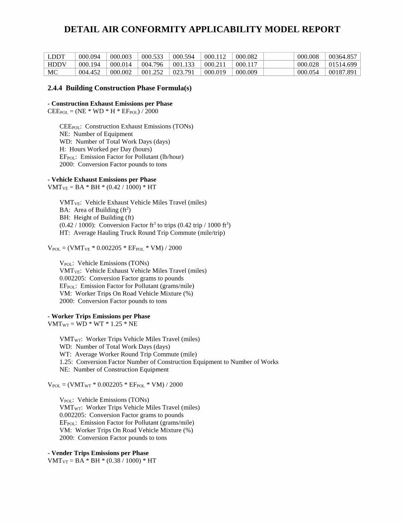
DETAIL AIR CONFORMITY APPLICABILITY MODEL REPORT
LDDT 000.094 000.003 000.533 000.594 000.112 000.082 000.008 00364.857 HDDV 000.194 000.014 004.796 001.133 000.211 000.117 000.028 01514.699 MC 004.452 000.002 001.252 023.791 000.019 000.009 000.054 00187.891
2.4.4 Building Construction Phase Formula(s)
- Construction Exhaust Emissions per PhaseCEEPOL = (NE * WD * H * EFPOL) / 2000
CEEPOL: Construction Exhaust Emissions (TONs) NE: Number of Equipment WD: Number of Total Work Days (days) H: Hours Worked per Day (hours) EFPOL: Emission Factor for Pollutant (lb/hour) 2000: Conversion Factor pounds to tons
- Vehicle Exhaust Emissions per PhaseVMTVE = BA * BH * (0.42 / 1000) * HT
VMTVE: Vehicle Exhaust Vehicle Miles Travel (miles) BA: Area of Building (ft2) BH: Height of Building (ft) (0.42 / 1000): Conversion Factor ft3 to trips (0.42 trip / 1000 ft3) HT: Average Hauling Truck Round Trip Commute (mile/trip)
VPOL = (VMTVE * 0.002205 * EFPOL * VM) / 2000
VPOL: Vehicle Emissions (TONs) VMTVE: Vehicle Exhaust Vehicle Miles Travel (miles) 0.002205: Conversion Factor grams to pounds EFPOL: Emission Factor for Pollutant (grams/mile) VM: Worker Trips On Road Vehicle Mixture (%) 2000: Conversion Factor pounds to tons
- Worker Trips Emissions per PhaseVMTWT = WD * WT * 1.25 * NE
VMTWT: Worker Trips Vehicle Miles Travel (miles) WD: Number of Total Work Days (days) WT: Average Worker Round Trip Commute (mile) 1.25: Conversion Factor Number of Construction Equipment to Number of Works NE: Number of Construction Equipment
VPOL = (VMTWT * 0.002205 * EFPOL * VM) / 2000
VPOL: Vehicle Emissions (TONs) VMTWT: Worker Trips Vehicle Miles Travel (miles) 0.002205: Conversion Factor grams to pounds EFPOL: Emission Factor for Pollutant (grams/mile) VM: Worker Trips On Road Vehicle Mixture (%) 2000: Conversion Factor pounds to tons
- Vender Trips Emissions per PhaseVMTVT = BA * BH * (0.38 / 1000) * HT

DETAIL AIR CONFORMITY APPLICABILITY MODEL REPORT
VMTVT: Vender Trips Vehicle Miles Travel (miles) BA: Area of Building (ft2) BH: Height of Building (ft) (0.38 / 1000): Conversion Factor ft3 to trips (0.38 trip / 1000 ft3) HT: Average Hauling Truck Round Trip Commute (mile/trip)
VPOL = (VMTVT * 0.002205 * EFPOL * VM) / 2000
VPOL: Vehicle Emissions (TONs) VMTVT: Vender Trips Vehicle Miles Travel (miles) 0.002205: Conversion Factor grams to pounds EFPOL: Emission Factor for Pollutant (grams/mile) VM: Worker Trips On Road Vehicle Mixture (%) 2000: Conversion Factor pounds to tons
2.5 Architectural Coatings Phase
2.5.1 Architectural Coatings Phase Timeline Assumptions
- Phase Start DateStart Month: 7 Start Quarter: 1 Start Year: 2022
- Phase DurationNumber of Month: 2 Number of Days: 0
2.5.2 Architectural Coatings Phase Assumptions
- General Architectural Coatings InformationBuilding Category: Total Square Footage (ft2): 34040 Number of Units: N/A
- Architectural Coatings Default SettingsDefault Settings Used: Yes Average Day(s) worked per week: 5 (default)
- Worker TripsAverage Worker Round Trip Commute (mile): 20 (default)
- Worker Trips Vehicle Mixture (%)LDGV LDGT HDGV LDDV LDDT HDDV MC
POVs 50.00 50.00 0 0 0 0 0
2.5.3 Architectural Coatings Phase Emission Factor(s)
- Worker Trips Emission Factors (grams/mile)VOC SOx NOx CO PM 10 PM 2.5 Pb NH3 CO2e
LDGV 000.114 000.003 000.084 000.992 000.047 000.020 000.023 00298.845 LDGT 000.288 000.004 000.178 001.871 000.048 000.021 000.024 00379.038 HDGV 000.600 000.011 001.339 008.875 000.183 000.078 000.045 01128.468 LDDV 000.026 000.003 000.125 000.281 000.060 000.032 000.008 00271.718 LDDT 000.094 000.003 000.533 000.594 000.112 000.082 000.008 00364.857

DETAIL AIR CONFORMITY APPLICABILITY MODEL REPORT
HDDV 000.194 000.014 004.796 001.133 000.211 000.117 000.028 01514.699 MC 004.452 000.002 001.252 023.791 000.019 000.009 000.054 00187.891
2.5.4 Architectural Coatings Phase Formula(s)
- Worker Trips Emissions per PhaseVMTWT = (1 * WT * PA) / 800
VMTWT: Worker Trips Vehicle Miles Travel (miles) 1: Conversion Factor man days to trips ( 1 trip / 1 man * day) WT: Average Worker Round Trip Commute (mile) PA: Paint Area (ft2) 800: Conversion Factor square feet to man days ( 1 ft2 / 1 man * day)
VPOL = (VMTWT * 0.002205 * EFPOL * VM) / 2000
VPOL: Vehicle Emissions (TONs) VMTWT: Worker Trips Vehicle Miles Travel (miles) 0.002205: Conversion Factor grams to pounds EFPOL: Emission Factor for Pollutant (grams/mile) VM: Worker Trips On Road Vehicle Mixture (%) 2000: Conversion Factor pounds to tons
- Off-Gassing Emissions per PhaseVOCAC = (AB * 2.0 * 0.0116) / 2000.0
VOCAC: Architectural Coating VOC Emissions (TONs) BA: Area of Building (ft2) 2.0: Conversion Factor total area to coated area (2.0 ft2 coated area / total area) 0.0116: Emission Factor (lb/ft2) 2000: Conversion Factor pounds to tons
2.6 Paving Phase
2.6.1 Paving Phase Timeline Assumptions
- Phase Start DateStart Month: 9 Start Quarter: 1 Start Year: 2022
- Phase DurationNumber of Month: 1 Number of Days: 0
2.6.2 Paving Phase Assumptions
- General Paving InformationPaving Area (ft2): 160000
- Paving Default SettingsDefault Settings Used: Yes Average Day(s) worked per week: 5 (default)
- Construction Exhaust (default)

DETAIL AIR CONFORMITY APPLICABILITY MODEL REPORT
Equipment Name Number Of Equipment
Hours Per Day
Cement and Mortar Mixers Composite 4 6 Pavers Composite 1 7 Paving Equipment Composite 2 6 Rollers Composite 1 7
- Vehicle ExhaustAverage Hauling Truck Round Trip Commute (mile): 20 (default)
- Vehicle Exhaust Vehicle Mixture (%)LDGV LDGT HDGV LDDV LDDT HDDV MC
POVs 0 0 0 0 0 100.00 0
- Worker TripsAverage Worker Round Trip Commute (mile): 20 (default)
- Worker Trips Vehicle Mixture (%)LDGV LDGT HDGV LDDV LDDT HDDV MC
POVs 50.00 50.00 0 0 0 0 0
2.6.3 Paving Phase Emission Factor(s)
- Construction Exhaust Emission Factors (lb/hour) (default)Excavators Composite
VOC SOx NOx CO PM 10 PM 2.5 CH4 CO2e Emission Factors 0.0732 0.0013 0.4042 0.5124 0.0183 0.0183 0.0066 119.74 Graders Composite
VOC SOx NOx CO PM 10 PM 2.5 CH4 CO2e Emission Factors 0.0919 0.0014 0.5823 0.5765 0.0280 0.0280 0.0082 132.95 Other Construction Equipment Composite
VOC SOx NOx CO PM 10 PM 2.5 CH4 CO2e Emission Factors 0.0562 0.0012 0.3519 0.3508 0.0138 0.0138 0.0050 122.62 Rubber Tired Dozers Composite
VOC SOx NOx CO PM 10 PM 2.5 CH4 CO2e Emission Factors 0.2117 0.0024 1.5772 0.8005 0.0630 0.0630 0.0191 239.56 Tractors/Loaders/Backhoes Composite
VOC SOx NOx CO PM 10 PM 2.5 CH4 CO2e Emission Factors 0.0436 0.0007 0.2744 0.3616 0.0134 0.0134 0.0039 66.897
- Vehicle Exhaust & Worker Trips Emission Factors (grams/mile)VOC SOx NOx CO PM 10 PM 2.5 Pb NH3 CO2e
LDGV 000.114 000.003 000.084 000.992 000.047 000.020 000.023 00298.845 LDGT 000.288 000.004 000.178 001.871 000.048 000.021 000.024 00379.038 HDGV 000.600 000.011 001.339 008.875 000.183 000.078 000.045 01128.468 LDDV 000.026 000.003 000.125 000.281 000.060 000.032 000.008 00271.718 LDDT 000.094 000.003 000.533 000.594 000.112 000.082 000.008 00364.857 HDDV 000.194 000.014 004.796 001.133 000.211 000.117 000.028 01514.699 MC 004.452 000.002 001.252 023.791 000.019 000.009 000.054 00187.891
2.6.4 Paving Phase Formula(s)
- Construction Exhaust Emissions per PhaseCEEPOL = (NE * WD * H * EFPOL) / 2000

DETAIL AIR CONFORMITY APPLICABILITY MODEL REPORT
CEEPOL: Construction Exhaust Emissions (TONs) NE: Number of Equipment WD: Number of Total Work Days (days) H: Hours Worked per Day (hours) EFPOL: Emission Factor for Pollutant (lb/hour) 2000: Conversion Factor pounds to tons
- Vehicle Exhaust Emissions per PhaseVMTVE = PA * 0.25 * (1 / 27) * (1 / HC) * HT
VMTVE: Vehicle Exhaust Vehicle Miles Travel (miles) PA: Paving Area (ft2) 0.25: Thickness of Paving Area (ft) (1 / 27): Conversion Factor cubic feet to cubic yards ( 1 yd3 / 27 ft3) HC: Average Hauling Truck Capacity (yd3) (1 / HC): Conversion Factor cubic yards to trips (1 trip / HC yd3) HT: Average Hauling Truck Round Trip Commute (mile/trip)
VPOL = (VMTVE * 0.002205 * EFPOL * VM) / 2000
VPOL: Vehicle Emissions (TONs) VMTVE: Vehicle Exhaust Vehicle Miles Travel (miles) 0.002205: Conversion Factor grams to pounds EFPOL: Emission Factor for Pollutant (grams/mile) VM: Vehicle Exhaust On Road Vehicle Mixture (%) 2000: Conversion Factor pounds to tons
- Worker Trips Emissions per PhaseVMTWT = WD * WT * 1.25 * NE
VMTWT: Worker Trips Vehicle Miles Travel (miles) WD: Number of Total Work Days (days) WT: Average Worker Round Trip Commute (mile) 1.25: Conversion Factor Number of Construction Equipment to Number of Works NE: Number of Construction Equipment
VPOL = (VMTWT * 0.002205 * EFPOL * VM) / 2000
VPOL: Vehicle Emissions (TONs) VMTVE: Worker Trips Vehicle Miles Travel (miles) 0.002205: Conversion Factor grams to pounds EFPOL: Emission Factor for Pollutant (grams/mile) VM: Worker Trips On Road Vehicle Mixture (%) 2000: Conversion Factor pounds to tons
- Off-Gassing Emissions per PhaseVOCP = (2.62 * PA) / 43560
VOCP: Paving VOC Emissions (TONs) 2.62: Emission Factor (lb/acre) PA: Paving Area (ft2) 43560: Conversion Factor square feet to acre (43560 ft2 / acre)2 / acre)

Appendix BNational Historic Preservation Act Section 106 and
Tribal Government-to-Government Documentation

Appendix C
Biological Assessment for the Development of the P205 Alert Force Complex Project