draft environmental impact assessment - adb.org · draft environmental impact assessment project...
TRANSCRIPT
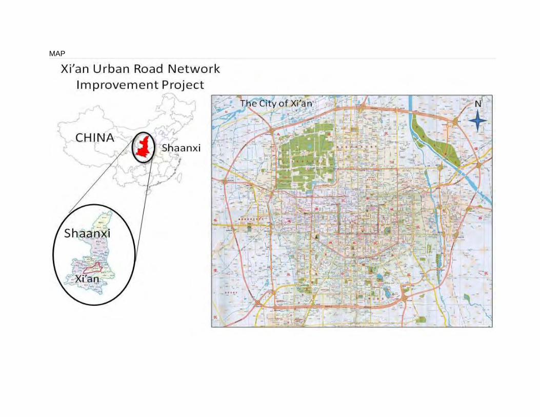
Draft Environmental Impact Assessment Project Number: 43032 May 2011
People’s Republic of China: Xi’an Urban Road Network Improvement Project Prepared by the Xi’an Municipal Government for the Asian Development Bank (ADB). The environmental impact assessment is a document of the borrower. The views expressed herein do not necessarily represent those of ADB’s Board of Directors, Management, or staff, and may be preliminary in nature. Your attention is directed to the “Terms of Use” section of this website.
ABBREVIATIONS
ADB - Asian Development Bank
AP - Affected Person
CNY - China Yuan
DMF - Design and Monitoring Framework
EA - Executing Agency
EHS - Environmental Health and Safety
EIA - Environmental Impact Assessment
EMP - Environmental Management Plan
EPB - Environmental Protection Bureau
FSR - Feasibility Study Report
O&M - Operation and Maintenance
PLG - Project Leading Group
PMO - Project Management Office
PPTA - Project Preparatory Technical Assistance
PRC - People's Republic of China
RP - Resettlement Plan
TA - Technical Assistance
TOR - Terms of Reference
XMG - Xi’an Municipal Government
CURRENCY EQUIVALENTS (Assumed)
Currency Unit – Yuan (CNY)
CNY1 = $.1515
$1 = CNY6.6
WEIGHTS AND MEASURES
km2 – square kilometer
m2 – square meter
m3/day – cubic meter per day
ha hectare

NOTES
(i) The fiscal year (FY) of the Government of the People’s Republic of China ends on 31
December. (ii) In this report, "$" refers to US dollars.
TABLE OF CONTENTS
I. EXECUTIVE SUMMARY ....................................................................................................................... 1
A. Background…………………………………………………………………………………………. 1 B. Project Outputs…………………………………………………………………………………….. 1 C. PRC Approval Status………………………………………………………………………………1 D. Current State of Environment…………………………………………………………………… 2 E. Alternatives……………………………………………………………….…………………………. 2 F. Impacts and Mitigation Measures……………………………………………………………… 3 G. Grievance Redress Mechanism………………………………………………………………… 7 H. Conclusion………………………………………………………………………………………….. 7
I. EXECUTIVE SUMMARY 1 .................................................................................................................... 3
II. POLICY, LEGAL, AND ADMINISTRATIVE FRAMEWORK .................................................................... 8
A. Overview .................................................................................................................... 8 B. Laws, Regulations, Guidelines and Standards ........................................................... 8 1. Laws ........................................................................................................................... 8 2. Regulations and Proclamations .................................................................................. 9 3. Guidelines and Standards ........................................................................................ 10 C. International Agreements ......................................................................................... 10 D. PRC Institutional Framework .................................................................................... 11 E. Asian Development Bank Environmental Requirements .......................................... 11 F. Area of Influence and Evaluation Standards for Output Sectors .............................. 13 1. Assessment Scope ................................................................................................... 13 2. Sensitive Receptor Areas ......................................................................................... 13 G. Xi’an 4th City Master Plan 2008-2020 ....................................................................... 16 H. Environmental Health and Safety (EHS) Guidelines ................................................ 19 I. Cultural Heritage ...................................................................................................... 20 J. Assessment Period .................................................................................................. 20
III. DESCRIPTION OF THE PROJECT ...................................................................................................... 21
A. Justification and Rationale for the Project ................................................................ 21 1. The Need for the Project .......................................................................................... 21 2. A Multilayered and Integrated Approach to Transport Management ........................ 21 3. Climate Change ........................................................................................................ 25 B. Project Output Specifications and Descriptions ........................................................ 25 1. Road Network Improvements ................................................................................... 25 2. Multimodal Interchange Facilities ............................................................................. 28 3. Xi’an Pedestrian Crossing and Safety Improvements .............................................. 35 4. Intelligent Transport System and Road User Safety Program .................................. 36 5. Environmental Protection Enhancement .................................................................. 37 6. Associated Developments ........................................................................................ 38
IV. DESCRIPTION OF THE ENVIRONMENT - BASELINE ....................................................................... 40
A. Environmental Setting .............................................................................................. 40 1. Landform .................................................................................................................. 40 2. Hydrogeology ........................................................................................................... 40 3. Formation Lithology .................................................................................................. 40 4. Climate ..................................................................................................................... 41 B. Social Setting ........................................................................................................... 53 C. History, Culture and Tourism .................................................................................... 55
V. ENVIRONMENTAL IMPACTS AND MITIGATION MEASURES ...................................................... 60
A. Positive Impacts and Environmental Benefits .......................................................... 60 1. Direct Positive Impacts ............................................................................................. 60 2. Beneficiaries ............................................................................................................. 61 B. Impacts Associated with Project Location, Planning, and Design ............................ 61 1. Direct Losses from the Project’s Footprint ................................................................ 61 2. Economic Impacts and Economic Displacement ...................................................... 65 3. Impact on Physical Cultural Heritage Resources ..................................................... 65 C. Impacts and Mitigation Measures during the Construction Phase ........................... 68 D. Impacts and Mitigation Measures during the Operational Phase ............................. 78 1. Operation of Roads, Interchanges and MIF Hubs .................................................... 78 E. Health and Safety (Construction and Operational Phases) .................................... 100 F. Cumulative Impacts ................................................................................................ 101 G. Unanticipated environmental impacts..................................................................... 101
VI. CONSIDERATION OF ALTERNATIVES ............................................................................................ 102
A. Scope of Alternatives ............................................................................................. 102 B. No-Project Alternative ............................................................................................ 102 C. Roads and Interchange Alternatives ...................................................................... 102 D. Multimodal Interchange Facilities – Transport Hubs Alternatives ........................... 103 1. Bus Terminals ........................................................................................................ 103 2. Integrated Transfer Stations ................................................................................... 103 3. Multi-level Parking Lots .......................................................................................... 104 4. Gasoline/Gas Filling Stations ................................................................................. 104
VII. PUBLIC CONSULTATION AND INFORMATION DISCLOSURE ..................................................... 105
A. Legislative Framework for Public Consultation....................................................... 105 B. The First Round of Public Consultation Activities ................................................... 105 1. Information Dissemination ...................................................................................... 105 2. Questionnaire and Responses ............................................................................... 105 C. The Second Round of Public Consultation Activities .............................................. 108 D. Future public consultation ...................................................................................... 109
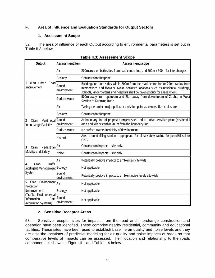
VIII. GRIEVANCE REDRESS MECHANISM ............................................................................................ 110
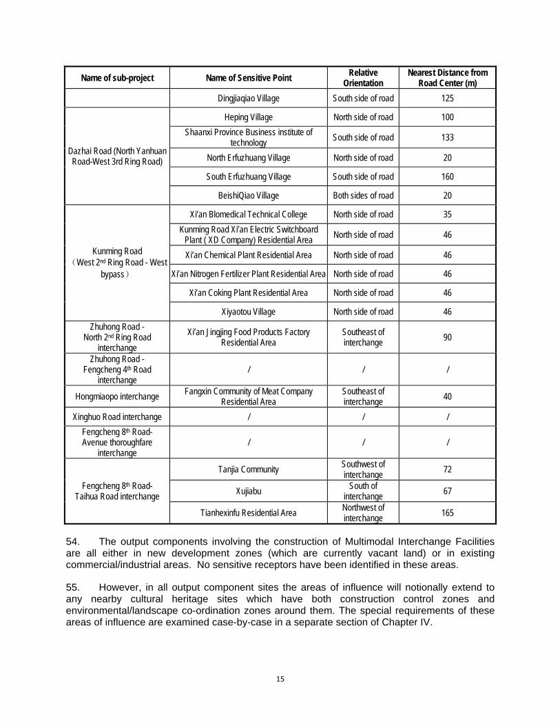
A. The Current System ............................................................................................... 110 B. Proposed Mechanism ............................................................................................. 111
IX. ENVIRONMENTAL MANAGEMENT PLAN ....................................................................................... 114
A. Introduction ............................................................................................................. 114 B. Performance Indicators .......................................................................................... 114 C. Project Implementation Organizations–Roles and Responsibilities ....................... 115 D. EMP Implementation–Roles and Responsibilities .................................................. 116 E. Summary of Potential Impacts and Mitigation Measures ....................................... 118 F. Environmental Monitoring ....................................................................................... 124 1. Monitoring Program ................................................................................................ 124 2. Monitoring Management ......................................................................................... 124 3. Monitoring Costs .................................................................................................... 124 G. Reporting and Supervision ..................................................................................... 127 1. Internal Monitoring Reports .................................................................................... 127 2. External (Compliance) Monitoring Reports............................................................. 127 3. Reports to ADB ...................................................................................................... 127 H. Public Consultation ................................................................................................. 128 1. Public Consultation during Project Preparation ...................................................... 128 2. Future Public Consultation Plan ............................................................................. 128
I. Institutional Strengthening and Training ................................................................. 129 J. Reporting and Supervision ..................................................................................... 130 1. Internal Monitoring Reports .................................................................................... 130 2. External (Compliance) Monitoring Reports............................................................. 131
3. Reports to ADB ................................................................................................................................ 131
K. Cost Estimates ....................................................................................................... 132 L. Cultural Relics Protection ....................................................................................... 133 M. Major Activity Milestones ........................................................................................ 135
X. CONCLUSIONS AND RECOMMENDATIONS................................................................................... 137
A. Benefits .................................................................................................................. 137 B. Impacts ................................................................................................................... 137 C. Environmental Health and Safety ........................................................................... 138 D. Resettlement and Economic Displacement ............................................................ 138 E. Climate Change ...................................................................................................... 138 F. Risks ....................................................................................................................... 139 G. Assurances ............................................................................................................. 139 H. Follow-Up Monitoring and Environmental Management Requirements ................. 140 I. Conclusion .............................................................................................................. 140
APPENDIX 1: REFERENCES .................................................................................................................. 141
A. Documents and Reports ......................................................................................... 141 B. National Laws, Regulations, and Policy Guidelines ............................................... 142 C. Standards and Technical Guidelines ...................................................................... 142
APPENDIX 3: NOISE ANALYSIS OF INTERCHANGES ........................................................................ 149
APPENDIX 4: ANALYSIS OF ALTERNATIVES...................................................................................... 169
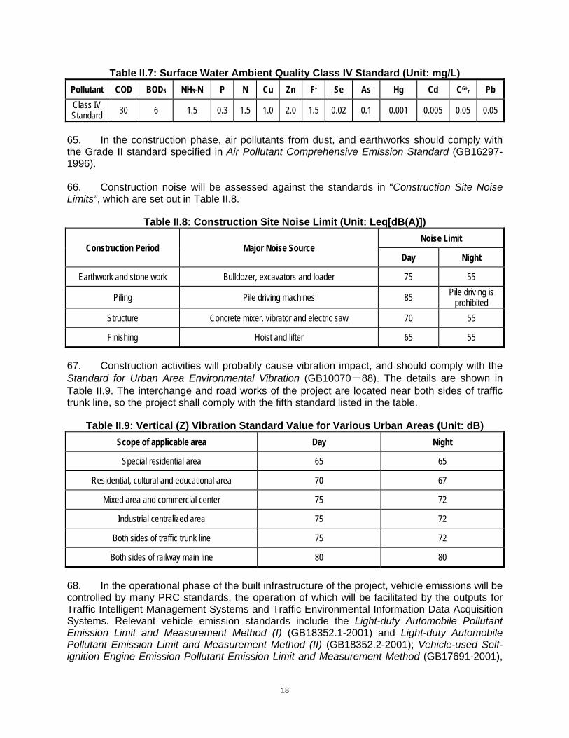
Improved Engineering of Xi’an Urban Road Network.................................................... 169 West Section of Keji 2nd Road (West bypass- North Zhangba Road) .......................... 169
Dazhai Road (North Yanhuan Road-West 3rd Ring Road) ............................................. 171
Kunming Road (West 2nd Ring Road- West Surrounding City Expressway) ............... 173
Intersection at Zhuhong Road-North 2nd Ring Road ....................................................... 176
Interchange at the road from Zhuhong Road to Fengcheng 4th Road .......................... 178
The interchange at Hongmiaopo .......................................................................................... 181
Interchange at Xinghuo Road ............................................................................................... 185
Interchange at Fengcheng 8th Road and Beichen Thoroughfare .................................. 190
Interchange at the road from Fengcheng 8th Road to Taihua Road .............................. 193
APPENDIX 5: CHECKLIST OF EHS REQUIREMENTS AND PROJECT MEASURES ......................... 197
APPENDIX 6: TERMS OF REFERENCE FOR THE INDEPENDENT ENVIRONMENTAL SUPERVISOR 201
MAP

1
I. EXECUTIVE SUMMARY A. Background 1. The environmental impact assessment (EIA) for the Project is prepared by the PPTA consultants on behalf of the Xian Municipal Government (XMG) on the basis of the following documents: (i) feasibility study reports of five project sub-components, (ii) the government project environmental impact assessment report (the government EIA), and (iii) cultural relic survey report. The PPTA team has prepared an English language EIA based on these documents, and which comply with the requirements of ADB’s Environmental Assessment Guidelines (2003) and ADB’s Safeguard Policy Statement (2009). An outline of the main findings of the EIA is presented here. 2. ADB categorized the Project as environmental categorization A. The PPTA consultants have carried out an environmental due diligence review and provided revisions and additional measures for the Project to meet the ADB’s Safeguard Policy Statement. ADB has disclosed the EIA after Shaanxi Provincial Environmental Protection Bureau approved the project EIA. The Project Agreement will request the Government to observe and implement the EIA and EMP. The ADB’s Board will be able to approve the Project 120 days after the EIA disclosure. B. Project Outputs 3. The project consists of five Outputs:
Output 1. Roads Component. Construction of three (3) road projects, one (flyover) and six (6) urban interchanges; Output 2. Pedestrian Crossing and Safety Program. Pedestrian crossing safety improvements to 110 urban intersections and 15 mid-block crossing facilities; Output 3. Multimodal Interchange Facilities (MIF). Implementation of four (4) transport/transit hubs; construction of five (5) multi-level parking facilities to promote mass use of public transit system; and construction of five (5) new CNG stations next to the transport hubs to facilitate the efficient fueling access of buses and taxis; Output 4. ITS Component. Expansion of existing ADB-financed ITS to the 3rd Ring Road and implementation of public road safety education programs; and, Output 5. Environmental Protection Enhancement. Completion of the existing vehicle emissions monitoring program on data collection, analysis and dissemination; expansion of emission enforcement capabilities, and the addition of mobile monitoring vehicles.
C. PRC Approval Status 4. XMG submitted the government EIA to the Shaanxi Environmental Protection Bureau (EPB) by mid March 2011 and EPB approved on 1 April 2011. This is following an extensive revision of the PRC EIA to include the requirements of ADB’s Safeguard Policy Statement (2009) and the PPTA team’s requirements for increased emphasis on cultural heritage protection and traffic management during construction.
2
D. Current State of Environment 5. Elements of the environmental setting of the project with major bearing on the environmental impact assessment are air quality, noise levels and cultural relics. 6. Air Quality. Currently, the average concentrations of vehicular pollutants (NO2 and CO) at sensitive receptor sites are comfortably within ambient air quality standards and EHS guidelines. 7. Noise. To provide baseline noise values for the construction elements of the Project, a total of 50 monitoring points are set to monitor at least 20 min continual equivalent grade A sound level in the day and night in the area of influence. The roadside noise source is mainly residential activity and traffic noise. Noise in most of the areas already subject to existing traffic noise exceeds the Class 4a standard of “Acoustic Environmental Quality” (GB3096-2008). Other areas not currently affected by traffic noise can meet the Class 2 standard. Most areas also already exceed the World Bank Group EHS noise guidelines for residential areas (55 dBA (day) and 45 dBA (night)). 8. Cultural Relics. Xi’an is a world-famous historic and cultural city. There are 314 key historical and cultural sites in the city, among which, 16 are under state protection and 88 under provincial protection. In addition, there are 4 national natural reserves in Qinling Mountains, and more than 20 newly developed scenic tourist areas. 9. The Project’s area of influence has been surveyed by the Northwest University Cultural Relics Conservation Center and Shaanxi Provincial Bureau of Cultural Relics. The findings of this survey have been submitted to the PPTA Team as a report entitled: “Assessment of Xi’an Urban Road Network Improvement Project’s Impact on Cultural Relics”. This report surveys the area of influence of all Project outputs and concludes that there are potential effects on three areas of cultural heritage significance in Xi’an; the Chang’an City Site; and the Duling Mausoleum Site. E. Alternatives 10. It is known from the feasibility studies that non-construction of the project would allow the continuation of traffic jams and slow movement of vehicles leading to the increase of oil consumption and pollutant emission while increasing passengers’ trip time, not only wasting fuel but polluting environment. By contrast, construction of the project will relieve current traffic congestion, increase cars’ moving speed, reduce pollutant emission, and facilitate pedestrians’ trip while also promoting energy conservation and emission reduction. On the whole, the project is beneficial to livelihoods with far greater positive environmental effects than negative results. Therefore, the no-project alternative is not a valid option. 11. Site selection and route selection for road construction, flyovers and intersections is on the basis of the Xian City Master Plan and its road network plan. Similarly, the MIF output elements are a fit with existing and planned transport infrastructure and services for which the analysis of alternatives occurred during concept planning and on a holistic basis. The remaining outputs (for pedestrian mobility and safety, traffic intelligent management system, and urban road environment protection enhancement) have minimal construction elements and will result in significant environmental improvements without environmental impacts. No analysis of alternatives of these items was undertaken.
3
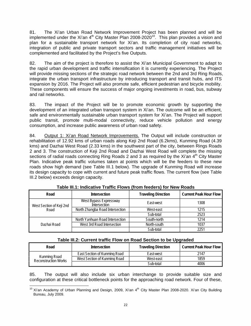
F. Impacts and Mitigation Measures 12. Construction Impacts. A range of potential construction impacts have been identified for the Project outputs with built or engineered infrastructure components. This will include earthworks, with potential for sediment runoff and dust, and machinery operating on site with consequent noise, vibration and air emissions. These impacts are mostly confined to short construction periods and as long as proper clean-up and site rehabilitation measures are implemented can be classed as temporary impacts. They are covered by site management and procedural provisions in the EMP to ensure that impacts during the construction period are minimized and mitigated and that proper site restoration occurs at the completion of construction. 13. Constructions focusing on roads and intersections will also generate traffic problems which will require good traffic management planning to ameliorate. Traffic management planning for the construction phase will involve the preparation of detailed phased construction plans which plan traffic flow during each stage of construction, in order to keep traffic flowing. 14. Earthworks and machinery operation have also been identified as potential impacts to cultural heritage relics and sites. Strict observance of the procedures of the Cultural Relics Bureau will be built into the design and construction management of the components. In particular, components within the Construction Control Zone of cultural heritage sites will have a Construction Control Plan which provides safeguards for heritage values, and procedures for chance finds. 15. Loss of Land. A breakdown of land and people affected by the project shows that (based upon a survey undertaken in October 2010) the total land-take will be about 114.33 ha, of which 58.67 ha is already state-owned, and the amount of dwelling space lost will be 73,350 m2. This will affect 307 and 277 households respectively. These figures will be progressively confirmed and refined as appropriate by the Resettlement Team during its final assets inventories. 16. Landholders affected by land loss will be compensated or mitigated based on local regulations. Compensation for standing crops, and other assets will also be paid directly to the affected persons. People losing housing will receive cash compensation at replacement costs. Economic rehabilitation measures include (i) jobs during the construction and operation of the project; (ii) support for high-value crop production; (iii) technical training for affected persons; and (iv) special support to vulnerable groups. The Resettlement Plan (RP) will address the relocation needs of the affected households and have identified resettlement site options. 17. The draft Resettlement Plan (RP) will address the relocation needs of the affected households and have identified resettlement site options. Detailed information will be collected for each site and the Xi’an government will revise the draft RP based on the physical indices survey and include details of the resettlement sites, location, number of affected households, and number of affected persons, land areas, and infrastructure plans. The RP will be implemented in accordance with all applicable PRC laws and regulations, and ADB’s Safeguard Policy Statement 2009. 18. Dust. Frequent sand storms originating on the loess plain outside Xi’an often coat the city with dust and contribute to its almost permanent haze. Adding to this is the enormous amount of building projects underway concurrently in the city. Dust is therefore a major environmental problem.
4
19. Dust pollution mainly occurs during subgrade excavation at the early stage of construction, as well as dust arising from vehicle transport on construction roads and in the construction area account for the major proportion. The nature of spoil materials in stockyards are also closely related to the amount of dust emission. The dust emission of stockyard includes the wind-blown dust emission of stock heap, dust emission caused by loading and unloading process, pavement dust accumulation and secondary dust emission caused by passing vehicles. The contractor will be required to control dust in all these phases of construction, employing regular water spraying, covering of haulage loads and stockpiles, and temporary dust barriers for loading/unloading operations and excavations. 20. Construction Noise and Vibration. Construction activities will involve bulldozers, graders, excavators, rollers, and other heavy machinery. Foundation construction is considered as the highest stage of noise impact. It is planned to build flyover crossings in this project, and bridge piling operations are likely to cause serious impacts to the acoustic environment along the line. Construction equipment noise can be basically considered as a point source noise. Low noise construction machinery will be used for this construction and detailed requirements will be indicated in the civil works contract’s technical specifications. 21. Each site will have a detailed construction plan to specify the machinery layout to minimize noise impact on sensitive receptors, and temporary noise barriers will be installed where required. The operating times of strong noise generators will be arranged for daytime (06:00~22:00) use, and appropriate adjustments will be made with respect to the operating time of other construction machinery. 22. Vibration can be expected during construction due to machinery operation, transport activities, piling foundation works, foundation improvement works, and land compaction operation. The vibration impact standard for residential and cultural areas is met at a distance of >10m from the vibration source. No sensitive receptor site is closer than 20m from a construction area, although a number of residential areas are between 20 and 100m of construction areas. 23. At construction sites where machinery which causes high levels of vibration will be used, before construction commences the contractors will carry out a survey of vibration-sensitive objects and buildings (focusing on multi-storey houses built by villagers which may not meet architectural requirements for stability) and (i) notify the IA for appropriate preventative action and (ii) modify and manage construction machinery use accordingly. Monitoring of vibration-sensitive sites and remediation work as required will continue throughout the construction period. 24. For cultural relic sites, it is a requirement of environmental management of the two flyovers bordering the Chang'an City site (Zhuhong Road - Fengcheng 4th Road flyover and Zhuhong Road – North 2nd Ring Road flyover) and the transport hub near the Dulong Mausoleum Complex (Aerospace Base Transport Hub) that monitoring equipment will be installed at the relic sites to monitor vibration during construction. 25. Impacts in the Operational Period. The major potential impacts of the operational period are air pollution and noise. These have been extensively analyzed in the EIA. It was found that at the vast majority of sensitive receptor sites, air pollution will not exceed the applicable PRC standard or EHS guideline when added to baseline levels. Moreover, complementary Project Outputs addressing traffic flow and vehicle exhaust control will act to dampen the rises in emission levels with increasing vehicle numbers. Traffic noise impacts in the operational phase of roads and interchanges are a different story. The analysis in the EIA

5
has revealed that many sensitive receptor sites will be potentially adversely affected by traffic noise in the future. Specially designed and built noise barriers and sound-proofing for windows and ventilators are proposed for sensitive receptor sites (mainly residential and dormitory buildings) along portions of the new roads and interchanges. 26. Air Quality in Operation. As for new road sections, with the increase in traffic volume in the operational period, vehicle emissions will impact the air quality along the roads. Using traffic volume projections and model computations, vehicle exhaust pollutant volumes at average traffic volumes during the operation period for sensitive zones are quantified. Based on the predicted peak hour traffic volumes, CO and NO2 concentrations in 2015, 2022 and 2011 are predicted for sensitive receptor sites. 27. For most road sites, pollutant concentrations will meet the standard in 2015. However in 2022 and 2029, NO2 concentrations will exceed standards in several places. This result suggests a need for background concentration reduction, which will be achieved by the current EPB’s effort for total emission reduction activities. The project’s Environmental Protection Enhancement component will significantly help the EPB’s efforts in this direction. For the other subcomponents, the incremental pollutant emission is smaller than the new road construction sites. EIA has carried out impacts assessment for them and concluded that the impacts will be minor. 28. Traffic Noise Impacts in Operation. For all road component sites, future noise levels have been predicted for the years 2016, 2020, and 2030. The result is mixed. In most sites noise levels are in standard in 2016. In 2020, night time standard exceeds in several sites. Additional mitigation of traffic noise will be gained by sound planning decisions by local authorities. This should include good land use planning along new roads. Schools, hospitals, apartments for the elderly, and hotels should not be built within 50 m of the centre lines of new roads. Set-backs from the roadside should be enforced and used as greening belts and pavements. 29. Ambient noise monitoring will be mandated to determine whether mitigation measures will be required for sites where noise levels are predicted to exceed less than 3 decibels in audible scale or where noise levels are expected to be exceeded by more than 3 decibels in audible scale in the medium and long term. Monitoring will be conducted twice annually, for 2 days on each occasion. Additional mitigation measures will be implemented if infringement of PRC standards is observed. 30. The significance of potential impacts to cultural heritage sites has been assessed in a report by the Northwest University Cultural Relics Conservation Center and Shaanxi Provincial Bureau of Cultural Relics entitled “Assessment of Xi’an Urban Road Network Improvement Project’s Impact on Cultural Relics”. 31. Two proposed intersections on Zhuhong Road are located outside the Protection Zone of the Ruins of Chang’an City but are within its Construction Control Zone. The planned 2nd Ring Road-Zhuhong Road flyover is 490m from the nearest significant relic, the Ba City Gate site, which is northwest of the intersection on the far side of a reconstructed moat. The planned 4th Fengcheng Road - Zhuhong Road flyover is 200m from the nearest significant relic, the Qingming Gate site, which is directly west of the intersection and separated from it by a busy road and small commercial premises. The implementation of these components therefore requires (i) approval by the appropriate Cultural Relics Bureau; and (ii) the preparation and implementation of a Construction Control plan for cultural relics protection which includes

6
measures to ensure that construction has no effect on identified cultural relic sites in the vicinity, and procedures to be followed in the event of the discovery of chance finds during construction. 32. The Xi’an Aerospace Base Transport Hub is located within the Environmental Coordination Zone of the Dulong Mausoleum complex. This is the lowest level of the protection zones. The planned development is 540m distant from the Prince Jian Mausoleum and 345m from that site’s Construction Control Zone. It is also 700m from the Prince Qin Mausoleum and 240m from that site’s Construction Control Zone. From its western boundary, the development site is 250m from the Construction Control Zone of the main Duling Mausoleum complex. Within the Environmental Coordination Zone, no approval for construction is necessary but the design of the component must not detract from the landscape amenity and environmental context of the Dulong Mausoleum complex. 33. Part of the Kunming Road construction is in the vicinity of the Afang Palace complex, but outside any legislative protection or control zone. The section of Kunming Road planned for reconstruction under the Project is separated from the boundary of the Construction Control Zone of the site by a distance of 400 meters. The area between the Kunming Road section and the Construction Control Zone boundary is densely built up with a mixture of light industrial, commercial and residential developments. Accordingly, the only requirement for cultural relics protection is the management and organization of the construction site to prevent waste water, exhaust gas and solid waste damaging the ecological environment and landscape around the Afanggong Relics. 34. A cultural relics expert recommended by the Shaanxi Cultural Relics Bureau will be engaged by the IA to provide training in awareness and recognition of archaeological deposits for the IA’s construction team, focusing on the Independant Environmental Supervisor (person or firm), the Construction Supervising Engineers and the Construction Chief Engineer 35. Health and Safety. This consideration combines occupational health and safety of construction workers, staff/workers at the Project facilities and community health and safety of people living nearby or potentially affected by failures or poor operation of facilities. The considerations of environmental health and safety in the EIA include (i) an assessment of traffic accident hazards, including spillages of transported substances and emergency response planning; (ii) risk analysis of petrol and CNG filling stations; (iii) hazards training for filling station workers; (iv) provisions for pedestrian and non-vehicular traffic during construction periods; and (vii) training and awareness programs for community in road safety (especially in schools). 36. Climate Change. The Project addresses climate change issues primarily through the net reduction of greenhouse gases from the emissions control program, augmented by promotion of public transport through the integration of road and parking facilities with rail and subway services at the MIF sites, the wider availability of cleaner burning CNG fuel and better road and intersection design.
37. In many instances the gross greenhouse gas emissions can be estimated and quantified. The gross CO2 emissions from the upgraded and redesigned roads and the new intersections have been calculated using the projected traffic volume to estimate total vehicle-kilometers, to which a fuel efficiency (l/km) was applied together with a CO2 conversion factor for petrol and diesel vehicles to derive the total CO2 emissions. It is estimated that 43,448 tCO2e will be emitted by the project in 2015, rising to 80,823 tCO2e by 2030. It is concluded that the project will not produce CO2 in excess of 100,000 t/a and therefore will not require special monitoring and reporting under that provision of the ADB Safeguards Policy Statement.
7
G. Grievance Redress Mechanism 38. Affected people are encouraged to participate in the preparation and implementation of the Project. However, problems of varying impact will occur in the course of construction and project operation. In order to solve the problems in a timely fashion and to ensure that the project construction will be carried out smoothly, the IA will establish a Project Public Complaints Centre (PPCC) prior to construction to deal with complaints from affected people during implementation of the Project. H. Conclusion 39. It is concluded that the Project, through the integration of its five Outputs which combine built works, systemic transport planning, computerized traffic management and emissions control and enforcement, will provide an integrated and sustainable solution to many of Xi’an’s urban transport needs. It is also concluded that these benefits far outweigh potential adverse impacts and that recommended safeguards and mitigation measures will minimize these impacts. It is further concluded that the design features, operational regimes and construction management safeguards, which will address the range of potential environmental impacts, will be actioned through loan assurances and the implementation of the Project EMP and continuously checked in the environmental monitoring program.

8
II. POLICY, LEGAL, AND ADMINISTRATIVE FRAMEWORK A. Overview 40. The Xi’an Urban Road Network Improvement Project has been planned and will be implemented under the Xi’an 4th City Master Plan 2008-20201. This plan provides a vision and plan for a sustainable transport network for Xi’an. Its completion of city road networks, integration of public and private transport sectors and traffic management initiatives will be complemented and facilitated by the Project. 41. The environmental assessment document upon which this consolidated EIA is based has been prepared under the provisions of the Law of the People’s Republic of China on Environmental Impact assessment, promulgated on September 1, 2003, and relevant regulations and guidelines for the implementation of this law to construction projects (see below). The Xi’an Infrastructure Investment Group (Implementing Agency, IA) submitted the government’s EIA document2 to the Shaanxi Environmental Protection Bureau on 10 March 2011 for its consideration and approval processes. 42. The PRC legislative framework for environmental assessment lists the actions required to undertake effective environmental impact assessment. These comprise the following activities: (i) Collect and monitor environmental quality conditions of the project’s location and its neighboring regions; (ii) Analyze and evaluate the project to assess pollution sources and discharge of pollutants; (iii) Predict beneficial and adverse effects on surface water, ground water, atmosphere, ecological environment, acoustic environment, environmental hygiene of the affected areas during periods of construction, and operation of the project; (iv) Present pollution prevention measures that reduce the adverse effects, and estimate the costs of mitigation and environmental management of the project; (v) Analyze the existing environmental risk during the period of construction and operation of the project; (vi) Collect public views and comments on the construction of the project; (vii) Analyze environmental economic impacts, especially related to auxiliary projects and cumulative pollution loads; and, (viii) Draw up a program for environment control, supervision and training. 43. The Environmental Impact Assessment under PRC law is supported and guided by the following legislative provisions. B. Laws, Regulations, Guidelines and Standards
1. Laws 44. The following laws of the People’s Republic of China govern the way in which the environmental management of the project must be implemented, in order to proceed. This suite of laws includes:
i. Environmental Protection Law of the People’s Republic of China, December 26, 1989; ii. Law of the People’s Republic of China on Environmental Impact Assessment,
September 1, 2003;
1 Xi’an Academy of Urban Planning and Design, 2009, Xi’an 4th City Master Plan 2008-2020. Xi’an City Building
Bureau, July 2009. 2 Shaanxi Research Institute of Environmental Sciences, 2011, Environmental Impact Assessment Report. Xi'an
Urban Road Network Improvement Project’s (Bank of Asia, Second Phase). Report prepared for the Xi’an Infrastructure Investment Group, March, 2011.
9
iii. Land Administration Law of the PRC, June 29th, 1991; iv. Land Administration Law of PRC (2004) v. Water and Soil Conservation Law of the PRC, Aug. 29th, 1991; vi. Law of the People’s Republic of China on the Prevention and Control of Atmospheric
Pollution, September 1, 2000; vii. Law of the People’s Republic of China on the Prevention and Control of Environmental
Noise Pollution, March 1, 1997; viii. Law of the People’s Republic of China on the Prevention and Control of Water Pollution,
June 1st, 2008, and Implementing Rules on the Law on the Prevention and Control of Water Pollution, March 2000;
ix. Law of the People’s Republic of China the Prevention and Control of Environmental Pollution by Solid Waste, April 1, 2005;
x. Water Law of the People’s Republic of China, October 1, 2002; xi. Law of the People’s Republic of China on Water and Soil Conservation, June 29, 1991; xii. Law of the Cultural Relic Protection, Dec. 29th. 2007 xiii. Law of the PRC on Urban and Rural Planning, Oct. 28th, 2004. xiv. City Planning Law of the People's Republic of China, April 1, 1990; xv. The Law of Promotion of Clean Production of the People’s Republic of China, January 1,
2003; xvi. Rules of Environmental Protection Management for Construction Projects, November
29th, 1998
2. Regulations and Proclamations 45. The following regulations of the People’s Republic of China support the environmental laws, particularly as they relate to, and are administered by the government of Shanxi Province:
i. Regulations on the Administration of Construction Project Environmental Protection, Order 253 of the State Council, November 29, 1998;
ii. Regulations on Administration of Dangerous Chemical Safety, No.344 Decree of the State Council, January 2002;
iii. PRC Provision of Public Consultations for Environmental Impact Assessment (SEPA, 2006);
iv. List of National Dangerous Wastes, No.1 Decree of the Ministry of Environmental Protection and National Development & Reform Commission, 2008
v. Notification on Strengthening Environmental Impact Assessment Management for Construction Project with Loan of International Financial Institution, Environmental Monitoring [1993] No.324 issued by the Ministry of Environmental Protection, 1993;
vi. Notification on Environmental Impact Assessment for Construction Project such as Highway and Railway (including light rail), Environmental Development [2003] No. 94 issued by the Ministry of Environmental Protection, 2003;
vii. Procedures on the Administration of Traffic Construction Project Environmental Protection, No.5 Decree of the Ministry of Communications in 2003;
viii. Regulations on the Administration of Urban Building Wastes, No. 139 Document issued by the Ministry of Construction in 2005.
ix. Regulation for Public Participation in the Environmental Impact Assessment, Environmental Development 2006 (28), February 14, 2006;
x. Xi’an Urban Planning Management Rules, September 2005; xi. Xi’an Ambient Air Pollution Prevention Regulations, March 30, 2005; xii. Regulations on the Expropriation of Houses on State-owned Land and Compensation
(2011)

10
3. Guidelines and Standards 46. The following guidelines and national standards of the People’s Republic of China support the implementation of environmental laws and set the levels of environmental performance required for relevant activities:
i. Industrial Standard for Environmental Protection of the People’s Republic of China, Technical Guidelines for Environmental Impact Assessment (general principles and surface water environment) (HJ/T2.1 - 93, HJ/T2.3~93), September 1993;
ii. Industrial Standard for Environmental Protection of the People’s Republic of China, Technical Guidelines for Environmental Impact Assessment (atmosphere environment) (HJ2.2-2008), April 2009;
iii. Industrial Standard for Environmental Protection of the People’s Republic of China, Technical Guidelines for Environmental Impact Assessment (sound environment), (HJ2.4-2009), April 1995;
iv. Industrial Standard for Environmental Protection of the People’s Republic of China, Technical Guidelines for Environmental Impact Assessment---Non-pollution Ecological Impact (HJ/T19-1997);
v. Specifications for Highway Construction Project Environmental Impact Assessment (JTG-B03-2006) issued by the Ministry of Communications;
vi. Industrial Standard for Environmental Protection of the People’s Republic of China, Principle and Technical Methods for Regionalizing Ambient Air Quality Function (HJ14-1996);
vii. Code for Design and Construction of Automobile Gasoline and Gas Filling Station (GB50156 -2002);
viii. Method for Estimation of Air Pollution from Vehicular Emission in Urban Area (HJ/T180-2005), State Environmental Protection Administration of PRC;
ix. Technical Code for Environmental Monitoring, State Environmental Protection Administration of PRC.
x. List of National Dangerous Wastes, No.1 Decree of the Ministry of Environmental Protection and National Development & Reform Commission on Jun. 2008;
xi. Dangerous Chemical Significant Hazard Identification (GB18218-2009), December 1, 2009.
C. International Agreements 47. PRC is a signatory of a large number of international agreements relevant to environment protection. Those with direct application to the project, along with the date of signing by PRC, include:
i. Convention on Biological Diversity, 29 December 1993. To develop national strategies for the conservation and sustainable use of biological diversity;
ii. Ramsar Convention on Wetlands of International Importance Especially as Waterfowl Habitat, 21 December 1975. To stem the progressive encroachment on and loss of wetlands now and in the future, recognizing the fundamental ecological functions of wetlands and their economic, cultural, scientific, and recreational value;
iii. Kyoto Protocol to the United Nations Framework Convention on Climate Change, 23 February 2005. To further reduce greenhouse gas emissions by enhancing the national programs of developed countries aimed at this goal and by establishing percentage reduction targets for the developed countries;
iv. Montreal Protocol on Substances That Deplete the Ozone Layer, 1 January 1989. To protect the ozone layer by controlling emissions of substances that deplete it;

11
v. United Nations Convention to Combat Desertification in Those Countries Experiencing Serious Drought and/or Desertification, 26 December 1996. To combat desertification and mitigate the effects of drought through national action programs that incorporate long-term strategies supported by international cooperation and partnership arrangements;
vi. United Nations Framework Convention on Climate Change, 21 March 1994. To achieve stabilization of greenhouse gas concentrations in the atmosphere at a low enough level to prevent dangerous anthropogenic interference with the climate system.
vii. UNESCO Convention Concerning the Protection of the World Cultural and Natural Heritage, 1985. To integrate the practice of heritage conservation in PRC with that being done around the world.
D. PRC Institutional Framework 48. The institutional framework for the EIA approval process in the PRC is summarized in the matrix below.
Table II.1: Institutional Framework of Environmental Management Responsible Departments Scope of work
Shaanxi Provincial EPB (i) EIA evaluation, including compliance with appropriate laws, regulations and standards. (ii) Final EIA Approval
Xi’an City EPB Environmental management and supervision during project cycle, including the management and supervision of the implementation and fulfillment of the environmental protection/mitigation measures and environmental monitoring.
Source: PMO. E. Asian Development Bank Environmental Requirements 49. Until recently, the ADB’s requirements for environmental assessment and management of projects were set out in the Environmental Assessment Guidelines (2003). The project underwent initial appraisal using these guidelines and was classified as Category A on the basis of ADB’s Rapid Environmental Assessment. This is the highest category, requiring a full EIA document. Subsequently, ADB produced its safeguard policy document (Safeguard Policy Statement [2009]) which requires a number of additional considerations, including: (i) project risks and respective mitigation measures and project assurances; (ii) project level Grievance Redress Mechanism including documentation in the EMP; (iii) definition of the project area of influence; (iv) physical cultural resources damage prevention analysis; (v) climate change mitigation and adaptation; (vi) occupational and community health and safety requirements (including emergency preparedness and response); (vii) economic displacement that is not part of land acquisition; (viii) biodiversity conservation and natural resources management requirements; (ix) provision of extensive sufficient justification if local standards are used; (x) ensuring adequate consultation and participation; and (xi) ensuring that EMP includes implementation schedule and (measurable) performance indicators. 50. In line with these requirements the PPTA consultants, in conjunction with the Design Institute and EIA Institute3, have included sections and analyses in the EIA which are additional
3 Shaanxi Research Institute of Environmental Sciences.

12
to those in the PRC EIA. Major new content areas are set out in Table II.2 below. Since the PRC EIA has already been submitted for approval, these additional assessment areas will be included in the Project Administrative Manual (PAM).
Table II.2: Major Additional EIA Contents Additional Consideration New Content Interchanges technical alternative analysis These alternative analyses are now included as part of the EIA
consideration of alternatives, with details included in an appendix.
Traffic management during construction Construction phase diagrams are now included in the EIA for road sections and interchanges with high traffic counts. The phasing will allow continuous functioning of the maximum amount of existing lanes during construction.
Spoil sites assessment Long term spoil disposal sites are already operating around the periphery of Xi’an city, servicing the city’s multiple construction projects and these have been located on a map in the PRC EIA. Although quantities have not yet been surveyed for the Project’s construction sites, the Design Institute has advised that spoil disposal will be minimal. The EIA will require construction sites covered by the ADB project to balance spoil and fill requirements.
Cultural Relics Protection The potential for Project construction activities to impact upon cultural relic sites has been carefully examined. The requirements for Construction Control Plans (focusing on cultural relics) and “chance finds” procedures have been added to construction management.
Environmental Management Plan Full EMP, suitable for inclusion of significant measures and management items in contract documents, included in EIA.
Grievance Redress Mechanism A grievance redress mechanism compatible with PRC practice and the requirements of the ADB safeguards policy has been added in the EIA
EHS considerations World Bank Group guidelines for air and noise quality now included analysis of impacts in parallel with PRC standards. Occupational and community health and safety
51. The ADB will publicly disclose the EIA (on its web site) after Shaanxi Provincial Environmental Protection Bureau approves the IA’s Project EIA. The Project Agreement will request the Government to observe and implement the EIA and EMP. The ADB’s Board will be able to approve the Project 120 days after the EIA disclosure.
13
F. Area of Influence and Evaluation Standards for Output Sectors
1. Assessment Scope 52. The area of influence of each Output according to environmental parameters is set out in Table II.3 below.
Table II.3: Assessment Scope
Output Assessment Item Assessment scope
1 Xi’an Urban Road Improvement
Air 200m area on both sides from road centre line, and 500m x 500m for interchanges.
Ecology Construction “footprint”.
Sound environment
Buildings on both sides within 200m from the road centre line or 200m radius from intersections and flyovers. Noise sensitive locations such as residential buildings, schools, kindergartens and hospitals shall be given priority for assessment.
Surface water 500m away from upstream and 2km away from downstream of Zaohe, in West Section of Kunming Road
2 Xi’an Multimodal Interchange Facilities
Air Taking the project major pollutant emission point as centre, 1km-radius area
Ecology Construction “footprint”.
Sound environment
At boundary line of proposed project site, and at noise sensitive point (residential area and village) within 200m from the boundary line.
Surface water No surface waters in vicinity of development
Hazard Area around filling stations appropriate for blast safety radius for petrol/diesel or CNG
3 Xi’an Pedestrian Mobility and Safety
Air Construction impacts – site only.
Noise Construction impacts – site only.
4 Xi’an Traffic Intelligent Management System
Air Potentially positive impacts to ambient air city-wide
Ecology Not applicable
Sound environment
Potentially positive impacts to ambient noise levels city-wide
5 Xi’an Environment Protection Enhancement (Traffic Environmental Information Data Acquisition Systems)
Air Not applicable
Ecology Not applicable
Sound environment
Not applicable
2. Sensitive Receptor Areas
53. Sensitive receptor sites for impacts from the road and interchange construction and operation have been identified. These comprise nearby residential, community and educational facilities. These sites have been used to establish baseline air quality and noise levels and they are also the locations of predictive modeling for air quality and noise impacts of roads so that comparative levels of impacts can be assessed. Their location and relationship to the roads components is shown in Figure II.1 and Table II.4 below.

14
Figure II.1: Location of Sensitive Receptor Sites in Relation to Project Road Components
Table II.4: Xi’an Project Sensitive Receptors
Name of sub-project Name of Sensitive Point Relative
Orientation Nearest Distance from
Road Center (m)
Keji 2nd Road west section (West bypass - North Zhangba
Road
Xicao Village Both sides of road 30
Dongcao Village Both sides of road 30
Wangjiazhai Village North side of road 57
Yanjiazhuang Village South side of road 106
Xi an College of Career and Technology North side of road 183
Yingfazhai Village North side of road 30
Xi’an No.52 Middle School South side of road 70
Bodi School Both sides of road 35
Kejiazhuang Village South side of road 120
Hujiang Zhuang Village Both sides of road 30
Xi'an International University Both sides of road 30
15
Name of sub-project Name of Sensitive Point Relative
Orientation Nearest Distance from
Road Center (m)
Dingjiaqiao Village South side of road 125
Dazhai Road (North Yanhuan Road-West 3rd Ring Road)
Heping Village North side of road 100
Shaanxi Province Business institute of technology
South side of road 133
North Erfuzhuang Village North side of road 20
South Erfuzhuang Village South side of road 160
BeishiQiao Village Both sides of road 20
Kunming Road (West 2nd Ring Road - West
bypass)
Xi’an Blomedical Technical College North side of road 35
Kunming Road Xi’an Electric Switchboard Plant ( XD Company) Residential Area North side of road 46
Xi’an Chemical Plant Residential Area North side of road 46
Xi’an Nitrogen Fertilizer Plant Residential Area North side of road 46
Xi’an Coking Plant Residential Area North side of road 46
Xiyaotou Village North side of road 46
Zhuhong Road - North 2nd Ring Road
interchange
Xi’an Jingjing Food Products Factory Residential Area
Southeast of interchange 90
Zhuhong Road - Fengcheng 4th Road
interchange / / /
Hongmiaopo interchange Fangxin Community of Meat Company Residential Area
Southeast of interchange
40
Xinghuo Road interchange / / /
Fengcheng 8th Road- Avenue thoroughfare
interchange / / /
Fengcheng 8th Road- Taihua Road interchange
Tanjia Community Southwest of interchange
72
Xujiabu South of
interchange 67
Tianhexinfu Residential Area Northwest of interchange
165
54. The output components involving the construction of Multimodal Interchange Facilities are all either in new development zones (which are currently vacant land) or in existing commercial/industrial areas. No sensitive receptors have been identified in these areas. 55. However, in all output component sites the areas of influence will notionally extend to any nearby cultural heritage sites which have both construction control zones and environmental/landscape co-ordination zones around them. The special requirements of these areas of influence are examined case-by-case in a separate section of Chapter IV.
16
G. Xi’an 4th City Master Plan 2008-2020 56. The City Master Plan4 includes an environmental management section which sets the overall principle of adherence to sustainable environmental development. Major features of the plan are the protection of ecologically sensitive areas, and the protection of the southern mountainous scenic and habitat areas and prime agricultural lands. 57. The Plan also provides a set of environmental targets for air, water, noise and solid waste. The lifetime of this plan will cover (i) the completion of the conversion of power and heating boilers to natural gas and the universal installation of desulfurisation equipment to more than 75% efficiency; (ii) the city-wide reduction of NO2 to Class II ambient air standard; (iii) control of construction related airborne particulate matter in the outer “construction belt” (outside the 2nd Ring Road); (iv) the construction of sewage treatment projects to achieve a, sewage treatment rate of 95%; and (v) the designation and protection of “drinking water source” areas. 58. Of particular relevance to the Project is the Plan’s target for noise control: Planning measures involve the gradual movement of government agencies, public institutions and population centres out of the Old City area to the Second Ring Road to ease traffic flow, and reduce traffic noise impact. Engineering measures include the progressive installation of noise-dampening road pavement material, construction of noise barriers on both sides of roads, and enhancement of all noise supervision and management of noise sources to ensure that regional ambient environmental noise in less than 60 dB. 59. The City Master Plan and the Circular of Xi’an Municipal People's Government on the Approval and Transmission of the Ambient Air Function Zoning (70-1998), assigns the ambient air function of the project area to category II area in accordance with the Ambient Air Quality Standards, GB3095- 1996. This standard is described in Table II.5 below. 60. The Circular of Xi’an Municipal People's Government on Applicable Regionalization of the Standard of Environmental Noise of Urban Area (SZF 2000-60), assigns the ambient noise function of the project area to Class 1, 2 and 3 areas in accordance with the Standard of Environmental Noise of Urban Area, GB3096-2008. 61. The Gaoqiao and Chanhe Rivers belong to category III water area in terms of surface water environment, and have water quality standards as defined by the Environmental Quality Standards for Surface Water, GB3838-2002. The monitoring sections of Zaohe River belong to Class III water quality in terms of surface water environment. 62. In PRC EIA requirements, ambient levels of air, noise and water quality in the proposed works area determine the appropriate category for point source or impacting emissions and effluent standards for the construction and operational phases of built infrastructure. However, the World Bank Group EHS guidelines5 (see below) are based on best practice construction and operational procedures. Both the PRC standards and EHS guidelines will be used in the assessments. 4 Xi’an Academy of Urban Planning and Design, 2009, Xi’an 4th City Master Plan 2008-2020. Xi’an City Building
Bureau, July 2009. 5 World Bank Group 2007, Environmental, Health and Safety Guidelines General EHS Guidelines, World Bank,
Washington.

17
Table II.5: Ambient Air Quality Grade II Standard
Pollutant Time Standard (mg/m3) EHS6 (mg/m3)
SO2
Annual average 0.06
Daily average 0.15 0.125-0.05 (0.02 guideline)
Unit hour average 0.50
PM10 Annual average 0.10 0.07-0.03 (0.02 guideline)
Daily average 0.15 0.075-0.15 (0.05 guideline)
NO2
Annual average 0.08 0.04 guideline
Daily average 0.12
Unit hour average 0.24 0.20 guideline
CO Daily average 4.0 n/a
Unit hour average 10.0 n/a
63. According to the Technical Specifications for Urban Area Ambient Noise Applicable Area Classification (GBT 15190-94), the area within 200m on both sides of road or road junction should comply with the corresponding provisions in Acoustic Ambient Quality Standard (GB3096-2008) according to the classification of the area. The area mainly serving for residence, cultural and educational institutions shall comply with Class 1 standard, and the residential, commercial and industrial mixed area shall comply with Class 2 standard. Lower standards apply for industrial areas and major roads. Standards are listed in Table II.6.
Table II.6: Acoustic Ambient Quality Standards (Equivalent Sound Level: LAeq: dB) PRC Standard
Class Applicable Area Day Night EHS7
0 Areas needing extreme quiet, such as convalescence areas 50 40
55 45 1 Area mainly for residence, cultural and educational institutions 55 45
2 Residential, commercial and industrial mixed area 60 50
3 Industrial area 65 55 70 70
4 Area on both sides of urban road traffic trunk line 70 55
64. For water quality assessment, the determining standard will be Surface Water Ambient Quality Standard (GB3838-2002) Class IV standard which is the classification of the nearest waterbody. This standard is set out in Table II.7. The class IV standard is the minimum required runoff standard for road construction and operation in an urban environment. The mitigation measures provided in this EIA/EMP will strive for much higher quality runoff. 6 World Bank Group 2007, Environmental, Health and Safety Guidelines General EHS Guidelines, World Bank,
Washington. 7 World Bank Group 2007, ibid.
18
Table II.7: Surface Water Ambient Quality Class IV Standard (Unit: mg/L)
Pollutant COD BOD5 NH3-N P N Cu Zn F- Se As Hg Cd C6+r Pb
Class IV Standard 30 6 1.5 0.3 1.5 1.0 2.0 1.5 0.02 0.1 0.001 0.005 0.05 0.05
65. In the construction phase, air pollutants from dust, and earthworks should comply with the Grade II standard specified in Air Pollutant Comprehensive Emission Standard (GB16297-1996). 66. Construction noise will be assessed against the standards in “Construction Site Noise Limits”, which are set out in Table II.8.
Table II.8: Construction Site Noise Limit (Unit: Leq[dB(A)])
Construction Period Major Noise Source Noise Limit
Day Night
Earthwork and stone work Bulldozer, excavators and loader 75 55
Piling Pile driving machines 85 Pile driving is
prohibited
Structure Concrete mixer, vibrator and electric saw 70 55
Finishing Hoist and lifter 65 55
67. Construction activities will probably cause vibration impact, and should comply with the Standard for Urban Area Environmental Vibration (GB10070-88). The details are shown in Table II.9. The interchange and road works of the project are located near both sides of traffic trunk line, so the project shall comply with the fifth standard listed in the table.
Table II.9: Vertical (Z) Vibration Standard Value for Various Urban Areas (Unit: dB)
Scope of applicable area Day Night
Special residential area 65 65
Residential, cultural and educational area 70 67
Mixed area and commercial center 75 72
Industrial centralized area 75 72
Both sides of traffic trunk line 75 72
Both sides of railway main line 80 80
68. In the operational phase of the built infrastructure of the project, vehicle emissions will be controlled by many PRC standards, the operation of which will be facilitated by the outputs for Traffic Intelligent Management Systems and Traffic Environmental Information Data Acquisition Systems. Relevant vehicle emission standards include the Light-duty Automobile Pollutant Emission Limit and Measurement Method (I) (GB18352.1-2001) and Light-duty Automobile Pollutant Emission Limit and Measurement Method (II) (GB18352.2-2001); Vehicle-used Self-ignition Engine Emission Pollutant Emission Limit and Measurement Method (GB17691-2001),

19
Limits and Measurement Methods for Exhaust Pollutants from Positive Ignition (P.I.) Engines of Vehicles and Vehicles equipped with P.I. Engines (GB14762-2002), Motorcycle and Light Motorcycle Exhaust Pollutant Emission Limit and Measurement Method (idle condition) (GB14621-2002), Motorcycle Exhaust Pollutant Emission Limit and Measurement Method (operation condition) (GB14622-2002) and Light Motorcycle Exhaust Pollutant Emission Limit and Measurement Method (operation condition) (GB18176-2002). 69. The roads, intersections and transport hubs of the Project will be assessed during the operational phase in the context of the Class 2 standard specified in the Industrial Enterprise Site Noise Standard GB12348-2008. These are set out in Table II.10.
Table II.10: Industrial Enterprise Site Noise Standard/ Social Life Ambient Noise Emission
Standard (Unit: Leq[dB(A)])
Classification Day Night
2 60 50
3 65 55
4 70 55
EHS8 70 70
70. Boilers installed in the transport hub buildings for heating during the operational phase will need to comply with the “Boiler Air Pollutant Emission Standard- Gas-fired Boiler Standard” (GB13271-2002), which is set out in Table II.11.
Table II.11: Boiler Air Pollutant Emission Standard- Gas-fired Boiler Standard
Classification of Pollutant
Smoke emission concentration (mg/m3)
SO2 emission concentration (mg/m3)
Ringelman Darkness (Grade)
Chimney Height (m)
Standard 50 100 I Not less than 8m
EHS9 50-150 2000 n/a n/a
71. The CNG filling station pollutant emissions shall comply with the relevant provisions in the Standard for Gas Filling Station Air Pollutant Emission GB20952-2007. H. Environmental Health and Safety (EHS) Guidelines 72. The principles and standards of the World Bank Group Environmental, Health and Safety Guidelines (2007) are used by the ADB’s Safeguards Policy. The General Guidelines will provide the context of international best practice and will contribute to establishing targets for environmental performance. There are no sector guidelines for urban road works or car parks. The air, noise and water quality standards in the EHS guidelines will also provide justification for the use throughout of PRC standards.
8 World Bank Group 2007, Environmental, Health and Safety Guidelines General EHS Guidelines, World Bank,
Washington. 9 World Bank Group 2007, ibid.

20
73. Occupational and community health and safety, as laid out in the EHS guidelines, will be a cross-cutting assessment element for all outputs. I. Cultural Heritage 74. Cultural heritage protection is an important consideration in the assessment of construction activity in Xi’an. Cultural heritage and management is a specialized area with a specific legislative framework. The main protection processes are in the following laws and regulations:
i. Law of the People’s Republic of China on the Protection of Cultural Relics, October 28, 2002;
ii. Enforcement Regulation for Cultural Relics Preservation Law of the P.R.C. iii. Approval Methods for Preservation Planning Preparation for National Key Cultural Relics iv. Preparation Requirements for Preservation Planning Preparation for National Key
Cultural Relics v. PRC’s Codes for Cultural Relics and Ancient Ruins Preservation vi. Management Methods for Cultural Relics Preservation Projects vii. Shaanxi Cultural Relics Preservation Regulations viii. Preservation Regulations for Famous Historical and Cultural City – Xi’an ix. Master Plan for the City of Xi’an x. Master Plan for Han Dynasty Chang’an City Ruins xi. Preservation Plan for Cultural Relics of Du Mausoleum xii. “Notice on Announcement of the Fourth Lot of Shaanxi Cultural Relics under Provincial
Preservation” issued by Shaanxi People’s Government (Shanzhengfa[2003]No 38, September 24, 2003)
xiii. “Preservation Scope of Shaanxi Key Cultural Relics under Provincial or Higher Level Preservation” issued by Shaanxi People’s Government (Shanzhengfa[1992] Appendix No.35)
J. Assessment Period 75. The duration of impacts assessed in this EIA cover the construction and operational phases of the project. The construction period will be from late 2011 until 2014. The operational period will span three periods: (i) short term (to 2015); (ii) medium term (to 2020); and (iii) long term (to 2030).

21
III. DESCRIPTION OF THE PROJECT A. Justification and Rationale for the Project
1. The Need for the Project 76. Xi’an has been an important line of communications since ancient times and the start of the famous Silk Road. With expansion of railway, road, and aviation, it has now become the most important central city in the western part of PRC, the biggest city on the Lianyungang-Lanzhou-Xinjiang Line of China Section of the New Asian-Europe Continental Bridge, and the gateway between the eastern and central regions to the northwestern part. With developed urban infrastructure, Xi’an inherited the square grid pattern of Tang Chang’an City for its urban road network, continuing with a pattern of grid and ring and radiating links. Thus, Xi’an has a trunk and ring system with two axes, three rings, and eight radiations. 77. Traffic problems such as congestion, slow speed, limited parking and the reliance on road transport have restricted the further social and economic development of Xi’an. This is most evident in the downtown area where problems have affected development severely and become the urban residents’ major concern. These problems will worsen as traffic volumes increase in the future. The traffic volume forecast of the Project roads is shown in Chapter V, Section D. The years of prediction are 2015, 2022 and 2029. 78. The vehicle population has increased from 413,400 in 2005 to 900,000 by the end of 2008 with an annual increase rate of 13.3%. At present, the vehicle population has reached 1.04 million with an annual increase rate of 15.5% since 2008. With the continuous rise of automobile numbers, vehicle emissions have increased. Roadside CO and NO2 concentrations are 2.59 and 1.02 times the limits set in Grade II air quality standard. Additionally, traffic noise is becoming increasingly serious, disturbing people’s work, sleeping, entertainment, and even their psychological and physical health. The deterioration of the urban traffic environment has greatly affected the social image of Xi’an and become one of the key constraints to its social and economic development. 79. Xi'an is one of the most popular tourist destinations in PRC with the world-renowned Qin Terracotta Army, Han and Tang Dynasty tombs and other cultural relics. Research has shown that air pollution is one of the key factors causing damage cultural relics, especially acid rain, SO2 and NO2. Nitrogen dioxide is one of the major pollutants of vehicle emission. Implementation of the project as a key part of Xi’an’s traffic improvement program will assist in cultural relic preservation. In 2008, there were 32.3 million tourists to Xi’an, with an increase of 3.6% compared to the previous year. Tourist development requires good environmental amenity, including air quality, to be successful.
2. A Multilayered and Integrated Approach to Transport Management 80. The Project will have five major Outputs: Output 1: Xi’an Road Network Improvements; Output 2: Xi’an Pedestrian Crossing and Safety Improvements; Output 3: Xi’an Multimodal Interchange Facilities; Output 4: Xi’an ITS Expansion and Road User Safety Program; and Output 5: Xi’an Environmental Protection Enhancement.
22
81. The Xi’an Urban Road Network Improvement Project has been planned and will be implemented under the Xi’an 4th City Master Plan 2008-202010. This plan provides a vision and plan for a sustainable transport network for Xi’an. Its completion of city road networks, integration of public and private transport sectors and traffic management initiatives will be complemented and facilitated by the Project’s five Outputs. 82. The aim of the project is therefore to assist the Xi’an Municipal Government to adapt to the rapid urban development and traffic intensification it is currently experiencing. The Project will provide missing sections of the strategic road network between the 2nd and 3rd Ring Roads, integrate the urban transport infrastructure by introducing transport and transit hubs, and ITS expansion by 2016. The Project will also promote safe, efficient pedestrian and bicycle mobility. These components will ensure the success of major ongoing investments in road, bus, subway and rail networks. 83. The impact of the Project will be to promote economic growth by supporting the development of an integrated urban transport system in Xi’an. The outcome will be an efficient, safe and environmentally sustainable urban transport system for Xi’an. The Project will support public transit, promote multi-modal connectivity, reduce vehicle pollution and energy consumption, and increase public awareness of urban road safety. 84. Output 1: Xi’an Road Network Improvements. The Output will include construction or rehabilitation of 12.92 kms of urban roads along Keji 2nd Road (6.2kms), Kunming Road (4.39 kms) and Dazhai West Road (2.33 kms) in the southwest part of the city, between Rings Roads 2 and 3. The construction of Keji 2nd Road and Dazhai West Road will complete the missing sections of radial roads connecting Ring Roads 2 and 3 as required by the Xi’an 4th City Master Plan. Indicative peak traffic volumes taken at points which will be the feeders to these new roads show high demand (see Table III.1 below). The upgrade of Kunming Road will increase its design capacity to cope with current and future peak traffic flows. The current flow (see Table III.2 below) exceeds design capacity.
Table III.1: Indicative Traffic Flows (from feeders) for New Roads
Road Intersection Traveling Direction Current Peak Hour Flow
West Section of Keji 2nd Road
West Bypass Expressway Intersection East-west 1308
North Zhangba Road Intersection West-east 1215 Sub-total 2523
Dazhai Road North Yanhuan Road Intersection South-north 1214
West 3rd Road Intersection North-south 1037 Sub-total 2251
Table III.2: Current traffic Flow on Road Section to be Upgraded
Road Intersection Traveling Direction Current Peak Hour Flow
Kunming Road Reconstruction Works
East Section of Kunming Road East-west 2147 West Section of Kunming Road West-east 1859
Sub-total 4006 85. The output will also include six urban interchange to provide suitable size and configuration at these critical bottleneck points for the approaching road network. Four of these, 10 Xi’an Academy of Urban Planning and Design, 2009, Xi’an 4th City Master Plan 2008-2020. Xi’an City Building
Bureau, July 2009.
23
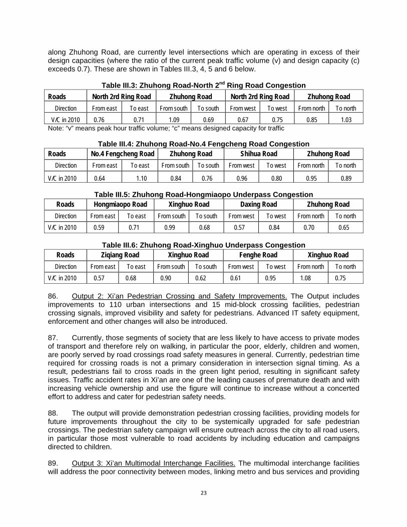
along Zhuhong Road, are currently level intersections which are operating in excess of their design capacities (where the ratio of the current peak traffic volume (v) and design capacity (c) exceeds 0.7). These are shown in Tables III.3, 4, 5 and 6 below.
Table III.3: Zhuhong Road-North 2nd Ring Road Congestion
Roads North 2rd Ring Road Zhuhong Road North 2rd Ring Road Zhuhong Road
Direction From east To east From south To south From west To west From north To north
V/C in 2010 0.76 0.71 1.09 0.69 0.67 0.75 0.85 1.03 Note: “v” means peak hour traffic volume; “c” means designed capacity for traffic
Table III.4: Zhuhong Road-No.4 Fengcheng Road Congestion
Roads No.4 Fengcheng Road Zhuhong Road Shihua Road Zhuhong Road
Direction From east To east From south To south From west To west From north To north
V/C in 2010 0.64 1.10 0.84 0.76 0.96 0.80 0.95 0.89
Table III.5: Zhuhong Road-Hongmiaopo Underpass Congestion Roads Hongmiaopo Road Xinghuo Road Daxing Road Zhuhong Road
Direction From east To east From south To south From west To west From north To north
V/C in 2010 0.59 0.71 0.99 0.68 0.57 0.84 0.70 0.65
Table III.6: Zhuhong Road-Xinghuo Underpass Congestion
Roads Ziqiang Road Xinghuo Road Fenghe Road Xinghuo Road
Direction From east To east From south To south From west To west From north To north
V/C in 2010 0.57 0.68 0.90 0.62 0.61 0.95 1.08 0.75
86. Output 2: Xi’an Pedestrian Crossing and Safety Improvements. The Output includes improvements to 110 urban intersections and 15 mid-block crossing facilities, pedestrian crossing signals, improved visibility and safety for pedestrians. Advanced IT safety equipment, enforcement and other changes will also be introduced. 87. Currently, those segments of society that are less likely to have access to private modes of transport and therefore rely on walking, in particular the poor, elderly, children and women, are poorly served by road crossings road safety measures in general. Currently, pedestrian time required for crossing roads is not a primary consideration in intersection signal timing. As a result, pedestrians fail to cross roads in the green light period, resulting in significant safety issues. Traffic accident rates in Xi’an are one of the leading causes of premature death and with increasing vehicle ownership and use the figure will continue to increase without a concerted effort to address and cater for pedestrian safety needs. 88. The output will provide demonstration pedestrian crossing facilities, providing models for future improvements throughout the city to be systemically upgraded for safe pedestrian crossings. The pedestrian safety campaign will ensure outreach across the city to all road users, in particular those most vulnerable to road accidents by including education and campaigns directed to children. 89. Output 3: Xi’an Multimodal Interchange Facilities. The multimodal interchange facilities will address the poor connectivity between modes, linking metro and bus services and providing

24
for taxi or car drop-off, park and ride, and bicycle access to the public transport network, thus avoiding the need for private motorized trips. Similarly, the multi-level parking stations on the edge of the city wall will support shift to public transport and non-motorized transport modes by providing parking spaces outside the congested central city, linked with good access on foot to avoid the need for cars or motorcycles to travel into the walled city. 90. The total private vehicle parking capacity of the interchange facilities and the carparks total is 2,756 vehicles. When the carparks are operating at capacity, these parking spaces will be full all day; therefore representing 2,756 vehicles which are off the roads of central Xi’an each day. 91. Output 4: Xi’an ITS Expansion and Road User Safety Program. ITS improvements in both coverage area and operational use will create enhanced network performance, improved information dissemination and enforcement of violations such as running red-lights. The growth poles between ring roads 2 and 3 are currently poorly served by the city’s ITS system and extending the coverage area will allow the traffic police to better manage the traffic system and vehicle flows across the city, in particular on the strategic road network which carries the majority of trips. 92. Output 5: Xi’an Environmental Protection Enhancement. Xi’an Environmental Protection Bureau (XEPB) is the leading government agency in the control of vehicle emission. The Vehicle Emissions Monitoring Center is one of the four major divisions of the XEPB. This is the focus of Output 5 of the Xi’an Urban Road Network Improvement Project. The vehicle fleet of Xi’an is currently approximately 1,200,000 vehicles. Of these, about 240,000 belong to agencies whose mandate excludes them from the regulations requiring yearly inspections. Of the balance, about 650,000 because of their age require yearly or twice yearly inspections. Presently, the EPB estimates that only about 70% of these vehicles present themselves for inspection. Vehicles not presenting for inspection, totaling about 200,000 each year, include the worst polluters making the largest contribution to vehicular pollution loads entering the Xi’an airshed. 93. In quantifying the potential environmental benefit of the VEMS the XEPB has assumed that a polluting vehicle will emit an average of 0.0708 tons per year (of combined CO, NO2 and hydrocarbons) over the standard, which is 2 times of a normal one. With 116,200 vehicles per year being “caught” by the mobile monitoring equipment and subsequently forced to comply or be taken off the roads, an estimated total of 8,227 tons of pollutants per year (116,200 x 0.0708) will be prevented from entering the airshed. Additionally, the presence of the mobile monitoring equipment and the growing number of vehicles tested will result in a higher level of voluntary compliance with the requirement to attend a yearly vehicle inspection. The XEPB has predicted that the level of voluntary attendance at yearly inspections will rise from the current level of 70% to 80%. This 10% increase, or 65,000 vehicles, when brought into compliance will result in additional vehicular pollution prevention in the order of 4,600 per year. 94. In this way, the VEMS will make a direct contribution to the XMG’s overall air quality target for Xi’an of increasing the number of days per year when the air quality achieves Class II standard of PRC Ambient Air Standard (GB3095-1996) from 304 days to 311 days by 2015.

25
3. Climate Change 95. The nationwide annual mean air temperature is predicted to increase by 1.3-2.1°C in 2020 and 2.3-3.3°C in 2050 (over 2000 levels) 11. The warming will mainly occur in the north and central regions of PRC where significant temperature rise is projected. Recent trends show a significant decrease in annual precipitation in most of north and central PRC, averaging 20-40 mm per 10 year period. In the next 50-100 years, the mean annual runoff is likely to decrease in the northern arid provinces. Xi’an will be affected by all these changes. 96. The Project addresses climate change issues primarily through the net reduction of greenhouse gases which will be achieved both individually by the Project Outputs and by the integration of all transport components. 97. The five Project outputs will approach the traffic problems in different but complementary ways: (i) the application of new road designs and more efficient intersections will result in fuel savings and consequent CO2 savings; (ii) the multimodal transport hubs will facilitate reductions in individual car journeys; (iii) facilitation of smooth traffic flow and higher cruising speeds on arterial roads and intersections through computerized traffic management will reduce travel time and consequently reduce fuel usage and net greenhouse gas emissions; and (iv) the enhanced control of vehicular pollution will also directly target reductions in greenhouse gas emissions. 98. In many instances the gross greenhouse gas emissions can be estimated and quantified. The gross CO2 emissions from the upgraded and redesigned roads and the new intersections have been calculated using the projected traffic volume to estimate total vehicle-kilometers, to which a fuel efficiency (l/km) was applied together with a CO2 conversion factor for petrol and diesel vehicles to derive the total CO2 emissions. The results are presented in Table III.7 and detailed calculations provided in Appendix 2. There will be some production of greenhouse gases during construction, but these will be short term and in any case much smaller than a single year’s CO2 emissions. It is concluded that the project will not produce CO2
in excess of 100,000 t/a and therefore will not require special monitoring and reporting under that provision of the ADB Safeguards Policy Statement.
Table III.7: CO2 Emissions Projected year Estimated CO2 Emissions 2015 43,448 tons CO2/year 2020 60,072 tons CO2/year 2030 80,823 tons CO2/year
B. Project Output Specifications and Descriptions
1. Road Network Improvements 99. The urban road components constructed with ADB loan comprises road works, flyovers, grade separation, bridge works, stormwater and drainage works, lighting, traffic control works and landscaping. The project locations are shown in Figure III.1 and the components to be constructed in this Output are listed in Table III.8.
11 National Development and Reform Commission 2007, China’s National Climate Change Programme, Beijing June
2007.

26
Figure III.1: Road Network Improvements Location

27
Table III.8: Construction Components for the Road Network Improvements
Name of component Location Length (m) Planning width (m) Nature of project
West Section of Keji 2nd Road (West bypass- North Zhangba
Road)
Xi’an west suburb connecting Fengwei New District
6197.505 60 New construction
Dazhai Road (North Yanhuan Road-West 3rd Ring Road)
Xi’an west suburb Connecting Xi’an High -Tech
Development Zone 2333.734 40 New construction
Kunming Road East Section (West 2nd Ring Road - West 3rd Ring
Road)
Xi’an west suburb Expressway 3755.075 70-74 Reconstruction
Kunming Road West Section (West Bypass Expressway-Xi’an-
Baoji Expressway relief road)
Xi’an west suburb Expressway 635.661 70 Reconstruction
Zhuhong Road - North 2nd Ring Road Interchange
Xi’an north suburb Significant node /
Zhuhong Road 80 North 2nd Ring Road 80 New construction
Zhuhong Road - Fengcheng 4th Road Interchange
Xi’an north suburb Significant node
/ Zhuhong Road 80 Fengcheng 4th Road 40
New construction
Hongmiaopo Interchange Xi’an north suburb Significant node /
Zhuhong Road 50 Daxing Road 70 New construction
Xinghuo Road Interchange Xi’an north suburb Significant node
/ Xinghuo Road 40 New construction
Fengcheng 8th Road - Beichen Avenue Interchange
Xi’an north suburb Significant node /
Fengcheng 8th Road 60 Beichen Avenue 100 New construction
Fengcheng 8th Road-Taihua Road Interchange
Xi’an north suburb Significant node
/ Fengcheng 8th Road 60 Taihua Road 80
New construction
100. The proposed output includes a total of 6 interchanges, three main trunk roads and one secondary trunk road. The overall construction scale is shown in Table III.9.
Table III.9: Road Network Improvements Major Works Scale
Name of projects Road class Width of boundary line (m)
Length (m)
Asphalt pavement area (m2)
Sidewalk area (m2)
Bridge area (m2)
Lighting (m)
West Section of Keji 2nd Road (South
bypass- North Zhangba Road)
Main trunk road 60 6197.505 265360 62000 7036 6197.505
Dazhai Road (North Yanhuan Road-West
3rd Ring Road) Secondary trunk road 40 2333.734 69090 20880 9692 2333.734
Kunming Road East Section (West 2nd Ring Road - West 3rd Ring
Road)
Main trunk road 70-74 3755.075 163952 39486 93134 3755.075
Kunming Road West Section (West Bypass
Expressway-Xi’an-Baoji Expressway relief road)
Main trunk road 70 635.661 27051 5085 0 635.661
Zhuhong Road - North 2nd Ring Road
Interchange Main trunk road Fast road 80 80 / 47148 8634 21460 /
Zhuhong Road - Fengcheng 4th Road
Main trunk road Secondary trunk road
80 40 / 49381 7801 15135 /
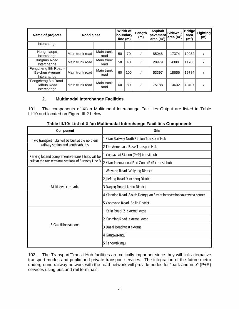
28
Name of projects Road class Width of boundary line (m)
Length (m)
Asphalt pavement area (m2)
Sidewalk area (m2)
Bridge area (m2)
Lighting (m)
Interchange
Hongmiaopo Interchange
Main trunk road Main trunk
road 50 70 / 85046 17374 19932 /
Xinghuo Road Interchange
Main trunk road Main trunk
road 50 40 / 20979 4380 11706 /
Fengcheng 8th Road - Beichen Avenue
Interchange Main trunk road
Main trunk road
60 100 / 53397 18656 19734 /
Fengcheng 8th Road-Taihua Road Interchange
Main trunk road Main trunk
road 60 80 / 75188 13602 40407 /
2. Multimodal Interchange Facilities
101. The components of Xi’an Multimodal Interchange Facilities Output are listed in Table III.10 and located on Figure III.2 below.
Table III.10: List of Xi’an Multimodal Interchange Facilities Components
Component Site
Two transport hubs will be built at the northern railway station and south suburbs
1 Xi’an Railway North Station Transport Hub
2 The Aerospace Base Transport Hub
Parking lot and comprehensive transit hubs will be built at the two terminus stations of Subway Line 3
1 Yuhuazhai Station (P+P) transit hub
2 Xi’an International Port Zone (P+R) transit hub
Multi-level car parks
1 Weiyang Road, Weiyang District
2 Jiefang Road, Xincheng District
3 Daqing Road,Lianhu District
4 Xianning Road -South Dongguan Street intersection southwest corner
5 Yongsong Road, Beilin District
5 Gas filling stations
1 Kejin Road 2 external west
2 Kunming Road external west
3 Dazai Road west external
4 Gangwuxinqu
5 Fengweixinqu
102. The Transport/Transit Hub facilities are critically important since they will link alternative transport modes and public and private transport services. The integration of the future metro underground railway network with the road network will provide nodes for “park and ride” (P+R) services using bus and rail terminals.

29
Figure III.2: Location of MIF Components
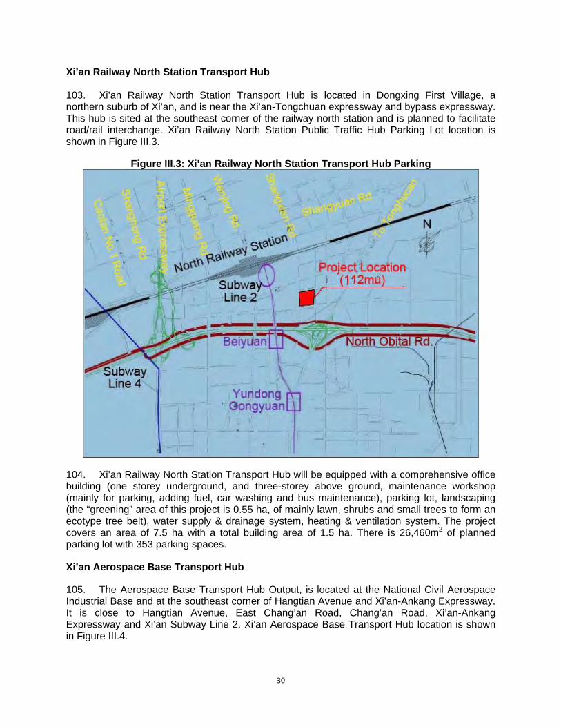
30
Xi’an Railway North Station Transport Hub 103. Xi’an Railway North Station Transport Hub is located in Dongxing First Village, a northern suburb of Xi’an, and is near the Xi’an-Tongchuan expressway and bypass expressway. This hub is sited at the southeast corner of the railway north station and is planned to facilitate road/rail interchange. Xi’an Railway North Station Public Traffic Hub Parking Lot location is shown in Figure III.3.
Figure III.3: Xi’an Railway North Station Transport Hub Parking
104. Xi’an Railway North Station Transport Hub will be equipped with a comprehensive office building (one storey underground, and three-storey above ground, maintenance workshop (mainly for parking, adding fuel, car washing and bus maintenance), parking lot, landscaping (the “greening” area of this project is 0.55 ha, of mainly lawn, shrubs and small trees to form an ecotype tree belt), water supply & drainage system, heating & ventilation system. The project covers an area of 7.5 ha with a total building area of 1.5 ha. There is 26,460m2 of planned parking lot with 353 parking spaces. Xi’an Aerospace Base Transport Hub 105. The Aerospace Base Transport Hub Output, is located at the National Civil Aerospace Industrial Base and at the southeast corner of Hangtian Avenue and Xi’an-Ankang Expressway. It is close to Hangtian Avenue, East Chang’an Road, Chang’an Road, Xi’an-Ankang Expressway and Xi’an Subway Line 2. Xi’an Aerospace Base Transport Hub location is shown in Figure III.4.
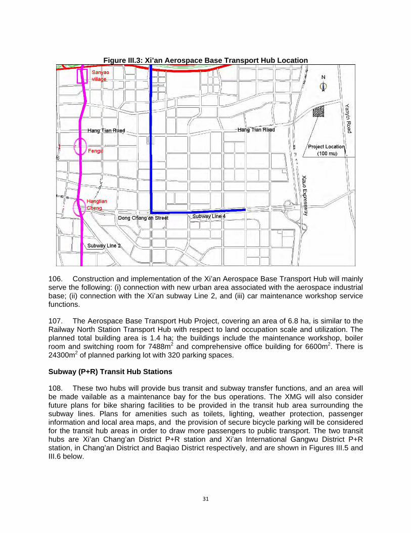
31
Figure III.3: Xi’an Aerospace Base Transport Hub Location
106. Construction and implementation of the Xi’an Aerospace Base Transport Hub will mainly serve the following: (i) connection with new urban area associated with the aerospace industrial base; (ii) connection with the Xi’an subway Line 2, and (iii) car maintenance workshop service functions. 107. The Aerospace Base Transport Hub Project, covering an area of 6.8 ha, is similar to the Railway North Station Transport Hub with respect to land occupation scale and utilization. The planned total building area is 1.4 ha; the buildings include the maintenance workshop, boiler room and switching room for 7488m2 and comprehensive office building for 6600m2. There is 24300m2 of planned parking lot with 320 parking spaces. Subway (P+R) Transit Hub Stations 108. These two hubs will provide bus transit and subway transfer functions, and an area will be made vailable as a maintenance bay for the bus operations. The XMG will also consider future plans for bike sharing facilities to be provided in the transit hub area surrounding the subway lines. Plans for amenities such as toilets, lighting, weather protection, passenger information and local area maps, and the provision of secure bicycle parking will be considered for the transit hub areas in order to draw more passengers to public transport. The two transit hubs are Xi’an Chang’an District P+R station and Xi’an International Gangwu District P+R station, in Chang’an District and Baqiao District respectively, and are shown in Figures III.5 and III.6 below.
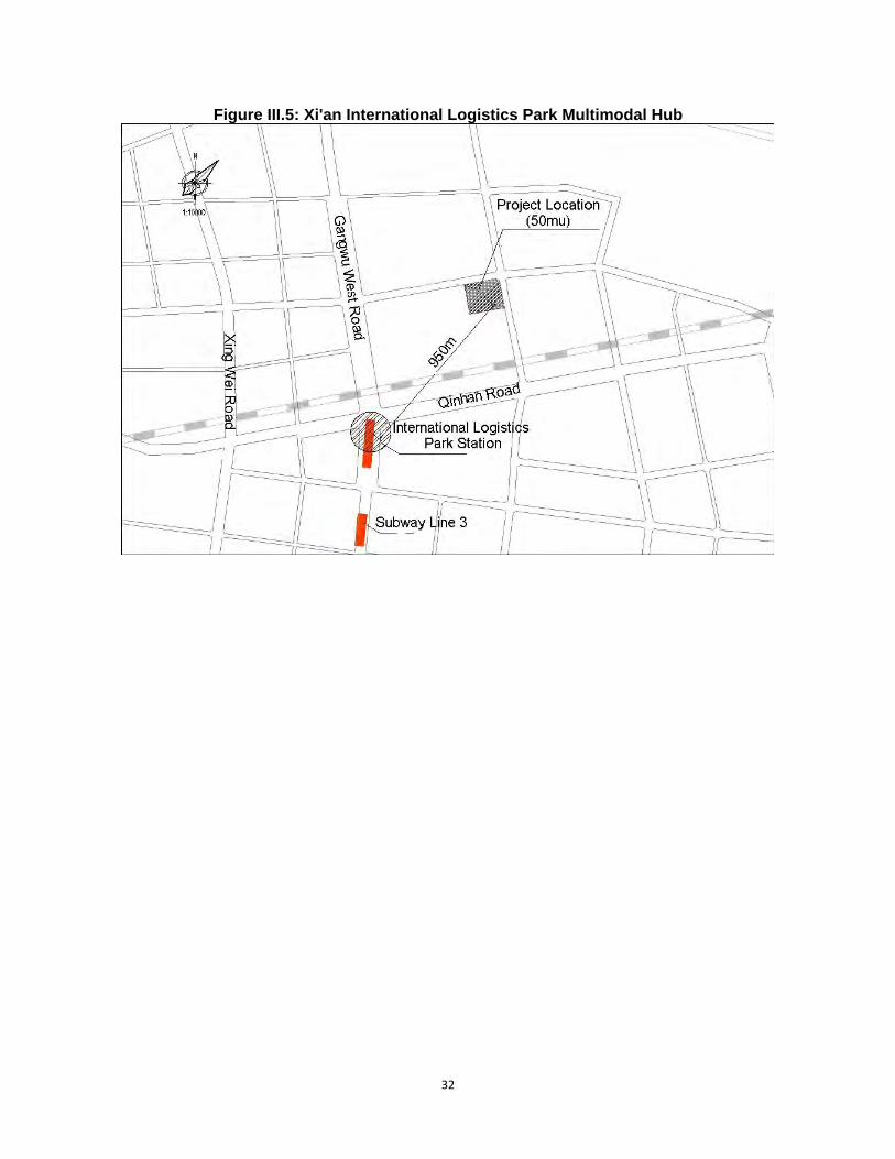
32
Figure III.5: Xi'an International Logistics Park Multimodal Hub
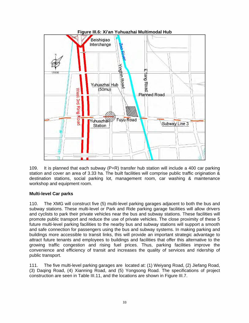
33
Figure III.6: Xi'an Yuhuazhai Multimodal Hub
109. It is planned that each subway (P+R) transfer hub station will include a 400 car parking station and cover an area of 3.33 ha. The built facilities will comprise public traffic origination & destination stations, social parking lot, management room, car washing & maintenance workshop and equipment room. Multi-level Car parks 110. The XMG will construct five (5) multi-level parking garages adjacent to both the bus and subway stations. These multi-level or Park and Ride parking garage facilities will allow drivers and cyclists to park their private vehicles near the bus and subway stations. These facilities will promote public transport and reduce the use of private vehicles. The close proximity of these 5 future multi-level parking facilities to the nearby bus and subway stations will support a smooth and safe connection for passengers using the bus and subway systems. In making parking and buildings more accessible to transit links, this will provide an important strategic advantage to attract future tenants and employees to buildings and facilities that offer this alternative to the growing traffic congestion and rising fuel prices. Thus, parking facilities improve the convenience and efficiency of transit and increases the quality of services and ridership of public transport. 111. The five multi-level parking garages are located at: (1) Weiyang Road, (2) Jiefang Road, (3) Daqing Road, (4) Xianning Road, and (5) Yongsong Road. The specifications of project construction are seen in Table III.11, and the locations are shown in Figure III.7.
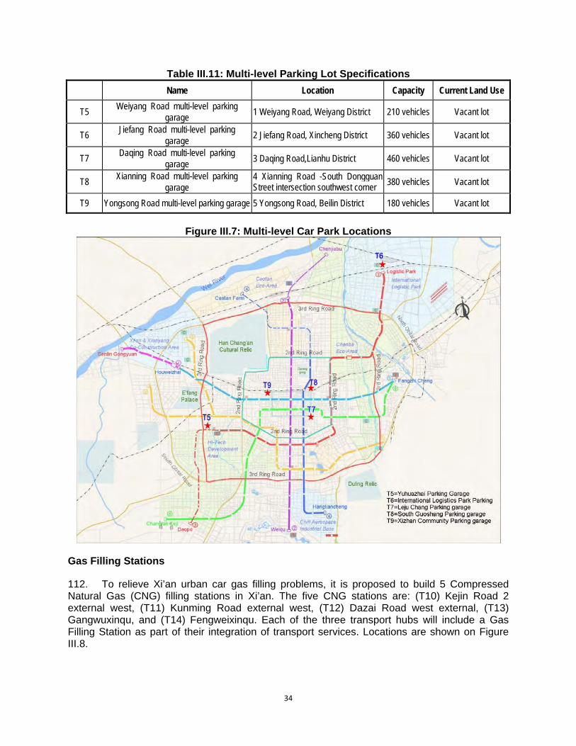
34
Table III.11: Multi-level Parking Lot Specifications
Name Location Capacity Current Land Use
T5 Weiyang Road multi-level parking
garage 1 Weiyang Road, Weiyang District 210 vehicles Vacant lot
T6 Jiefang Road multi-level parking
garage 2 Jiefang Road, Xincheng District 360 vehicles Vacant lot
T7 Daqing Road multi-level parking
garage 3 Daqing Road,Lianhu District 460 vehicles Vacant lot
T8 Xianning Road multi-level parking
garage 4 Xianning Road -South Dongguan Street intersection southwest corner
380 vehicles Vacant lot
T9 Yongsong Road multi-level parking garage 5 Yongsong Road, Beilin District 180 vehicles Vacant lot
Figure III.7: Multi-level Car Park Locations
Gas Filling Stations 112. To relieve Xi’an urban car gas filling problems, it is proposed to build 5 Compressed Natural Gas (CNG) filling stations in Xi’an. The five CNG stations are: (T10) Kejin Road 2 external west, (T11) Kunming Road external west, (T12) Dazai Road west external, (T13) Gangwuxinqu, and (T14) Fengweixinqu. Each of the three transport hubs will include a Gas Filling Station as part of their integration of transport services. Locations are shown on Figure III.8.
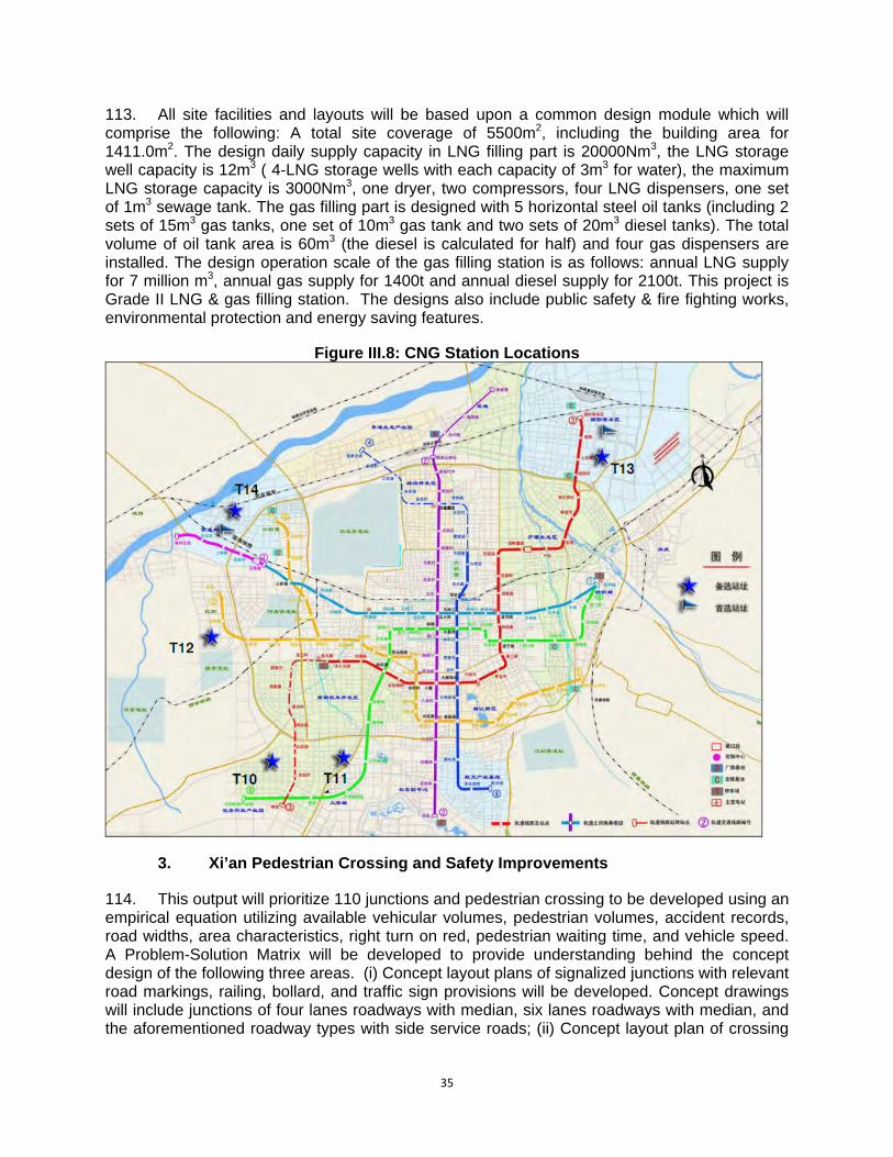
35
113. All site facilities and layouts will be based upon a common design module which will comprise the following: A total site coverage of 5500m2, including the building area for 1411.0m2. The design daily supply capacity in LNG filling part is 20000Nm3, the LNG storage well capacity is 12m3 ( 4-LNG storage wells with each capacity of 3m3 for water), the maximum LNG storage capacity is 3000Nm3, one dryer, two compressors, four LNG dispensers, one set of 1m3 sewage tank. The gas filling part is designed with 5 horizontal steel oil tanks (including 2 sets of 15m3 gas tanks, one set of 10m3 gas tank and two sets of 20m3 diesel tanks). The total volume of oil tank area is 60m3 (the diesel is calculated for half) and four gas dispensers are installed. The design operation scale of the gas filling station is as follows: annual LNG supply for 7 million m3, annual gas supply for 1400t and annual diesel supply for 2100t. This project is Grade II LNG & gas filling station. The designs also include public safety & fire fighting works, environmental protection and energy saving features.
Figure III.8: CNG Station Locations
3. Xi’an Pedestrian Crossing and Safety Improvements 114. This output will prioritize 110 junctions and pedestrian crossing to be developed using an empirical equation utilizing available vehicular volumes, pedestrian volumes, accident records, road widths, area characteristics, right turn on red, pedestrian waiting time, and vehicle speed. A Problem-Solution Matrix will be developed to provide understanding behind the concept design of the following three areas. (i) Concept layout plans of signalized junctions with relevant road markings, railing, bollard, and traffic sign provisions will be developed. Concept drawings will include junctions of four lanes roadways with median, six lanes roadways with median, and the aforementioned roadway types with side service roads; (ii) Concept layout plan of crossing

36
locations with relevant road markings, railing, bollard, traffic signals (if applicable), light provision, pavement treatment and traffic signs provisions will be developed. Standard drawings will include zebra crossing, signalized crossing, and signalized crossing; and (iii) Sample designs of junction and crossing locations that has high accident/injury, high pedestrian volume, high tourist volumes, adjacent to pedestrian street, or school in vicinity will also be developed.
4. Intelligent Transport System and Road User Safety Program 115. The focus of this output is Xi’an 3rd Ring Roadside and three link roads (Zhuhong Road, Guang’an Road and Beichen Avenue), shown on Figure III.9 below.
Figure III.9: Traffic Management System Project Study Locations
116. Development of recommendations for the traveller information system will be undertaken in close collaboration with the relevant line agencies, notably the Public Security Bureau. This component will include: 20 Variable Message Signs on the 3rd Ring Road and associated link

37
roads. 140 vehicle detectors, principally on the 3rd Ring Road and associated link roads. 20 Closed Circuit Television Cameras on the 3rd Ring Road and associated link roads. 31 red light running electronic police cameras at junctions along the 3rd Ring Road. 10 speeding electronic police cameras, and associated warning signs, at junctions along the 3rd Ring Road. 117. Other components of this output will include: (i) Development of an ITS architecture which will provide a road map for the future development of ITS within Xi’an and ensure minimal redundancy of the systems employed for this project in any future expansion/upgrade; (ii) Recommendation of a Traveller Information System for Xi’an, covering private and public modes of transport to enhance the ITS effectiveness to the city; (iii) A review of international best practice in the area of policy, regulation and standards, related to asset and operational management, which can be applied to the Xi’an situation to enhance the level of traffic management in the city; and, (iv) A public education program will be developed during project implementation stage which will maximise the effectiveness of the implemented systems and increase safety within the network.
5. Environmental Protection Enhancement 118. The Xi’an Vehicle Emission Monitoring Centre (within the Xi’an EPB) is responsible for overall vehicle emission control. This output will enhance the capacity of the Centre to collect, analyze, and disseminate emissions and air quality data to policy makers and the public by establishing a vehicle emissions information system, expanding the emissions testing and monitoring efforts to buses, trucks and other large fleet vehicles, expanding the transport pollution monitoring system, and enhancing the ability of the XMG to enforce emissions standards through the procurement and utilization of mobile testing vehicles. 119. Through the implementation of the project, the following objectives will be achieved:
i. Emission reduction: CO, NOx, PM and fine carbon in particular ii. Noise level meets national standard iii. Air Quality meets Class II of PRC Ambient Air Standard (GB3095-1996)
120. Xi’an Environmental Protection Bureau (XEPB) has comprehensive and ambitious plans to reduce vehicular emissions and thus improve air quality. One of the plans is to develop a comprehensive vehicle emission management system (VEMS) aimed at scientific decision-making and emission control. The VEMS consists of three major systems of Data Collection, Data Analysis and Decision Support. These are further divided into 17 sub-systems, six of which have been completed through implementation of other projects including the World Bank financed Xi’an Sustainable Urban Transport Project. Under this ADB financed project, XEPB proposes to develop the remaining 11 sub-systems illustrated in Figure III.7.
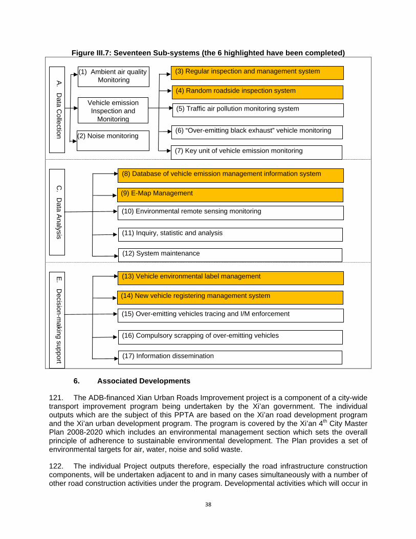
38
Figure III.7: Seventeen Sub-systems (the 6 highlighted have been completed)
6. Associated Developments
121. The ADB-financed Xian Urban Roads Improvement project is a component of a city-wide transport improvement program being undertaken by the Xi’an government. The individual outputs which are the subject of this PPTA are based on the Xi’an road development program and the Xi’an urban development program. The program is covered by the Xi’an 4th City Master Plan 2008-2020 which includes an environmental management section which sets the overall principle of adherence to sustainable environmental development. The Plan provides a set of environmental targets for air, water, noise and solid waste. 122. The individual Project outputs therefore, especially the road infrastructure construction components, will be undertaken adjacent to and in many cases simultaneously with a number of other road construction activities under the program. Developmental activities which will occur in
E.
Decision-m
aking support
(13) Vehicle environmental label management
(14) New vehicle registering management system
(15) Over-emitting vehicles tracing and I/M enforcement
(16) Compulsory scrapping of over-emitting vehicles
(17) Information dissemination C
. D
ata Analysis
(8) Database of vehicle emission management information system
(9) E-Map Management
(10) Environmental remote sensing monitoring
(11) Inquiry, statistic and analysis
(12) System maintenance
A.
Data C
ollection
(1) Ambient air quality Monitoring
Vehicle emission Inspection and
Monitoring
(2) Noise monitoring
(3) Regular inspection and management system
(4) Random roadside inspection system
(5) Traffic air pollution monitoring system
(6) “Over-emitting black exhaust” vehicle monitoring
(7) Key unit of vehicle emission monitoring

39
conjunction with the implementation of Project outputs, or as complements to them are theoretically “associated developments” and the consideration of their environmental due diligence requires that there is an assurance that all developments are subject to a comparable level of environmental impact assessment and approvals procedures under PRC law. Since all these other complementary construction projects will be undertaken in compliance with the City Master Plan, they will therefore be subject to the environmental performance provisions of the plan as well as its environmental targets for air, water, noise and solid waste.

40
IV. DESCRIPTION OF THE ENVIRONMENT - BASELINE 123. The description of the pre-project environment (biophysical and socio-economic) establishes (i) the environmental setting within which the project will be implemented, and therefore needs to be designed to suit, and (ii) the environmental values which will be changed (either negatively or positively) by the project. Both these roles are encompassed by the concept of the “baseline” environment. 124. The baseline environmental surveys undertaken for outputs were determined by the kinds of subcomponent sectors proposed and the environmental parameters which were relevant to their impact assessment. All baseline surveys were carried out in 2009. A. Environmental Setting
1. Landform 125. Xi’an is situated in the “Guanzhong plain” (known as the “800 mile basin”) which is the alluvial plain of the Weihe, Jinghe and Luohe Rivers with deep, fertile soil and rich agricultural production. Bordering the plain are the Qinling Mountain range in the south and Weibei Terrace region in the north, both of which contain abundant coal, metal and other non-metal mineral resources and various natural resources. 126. Xi’an City is located at the south edge of the central part of the Weihe graben basin between Qinling Mountains in the south and Weihe River in the north on thick Tertiary and Quaternary unconsolidated deposits. The terrain is higher in the southeast and lower in the northwest, presenting a stepped decline along this gradient. Xi’an City has a flat relief at an altitude of about 400 m.
2. Hydrogeology
127. There are many rivers within the Xian region. An old saying, “Eight rivers surround Xi’an”, describes this feature. Most of them merge into the Weihe River, the largest branch of the Yellow River. These include the Zaohe, Fenghe, Chanhe, and Bahe rivers. Major man-made drainage channels are Caoyun, Dahuan, Fenghui, Xingfu and Liuyiba channels. 128. Groundwater in the Xi’an region is divided into phreatic water and artesian water. Phreatic water is largely distributed in the flood land and the first terrace of the Weihe River as well as in the frontal edges of the second terraces of the Weihe, Fenghe and Bahe rivers with a depth of 5 – 10 m; thickness of water-bearing stratum, 20 – 60 m; and well yield, 1000 – 5000 m3/d, which is mainly replenished by rivers and rainfall. 129. Artesian water is buried at a depth of 70 m below ground level, mainly belonging to shallow confined groundwater with a thickness of water-bearing stratum, 10 – 40 m; and well yield, 500 – 3000 m3/d, which is mainly replenished by the undercurrents in southern mountain area and the river water from the upstream.
3. Formation Lithology 130. The geologic structure in the Xi’an region crosses two geologic elements – the Qinling �eolian�inals folded zone and the North China platform. The major dislocation at the north foot of the Qinling Mountains that stretches across the territory was formed by the Yanshan movement about 130 million years ago. Since the late Tertiary period, the extremely active
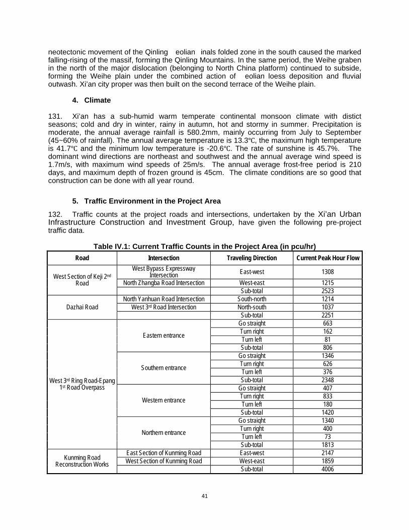
41
neotectonic movement of the Qinling �eolian�inals folded zone in the south caused the marked falling-rising of the massif, forming the Qinling Mountains. In the same period, the Weihe graben in the north of the major dislocation (belonging to North China platform) continued to subside, forming the Weihe plain under the combined action of �eolian loess deposition and fluvial outwash. Xi’an city proper was then built on the second terrace of the Weihe plain.
4. Climate 131. Xi’an has a sub-humid warm temperate continental monsoon climate with distict seasons; cold and dry in winter, rainy in autumn, hot and stormy in summer. Precipitation is moderate, the annual average rainfall is 580.2mm, mainly occurring from July to September (45~60% of rainfall). The annual average temperature is 13.3 , the maximum high temperature is 41.7 and the minimum low temperature is -20.6 . The rate of sunshine is 45.7%. The dominant wind directions are northeast and southwest and the annual average wind speed is 1.7m/s, with maximum wind speeds of 25m/s. The annual average frost-free period is 210 days, and maximum depth of frozen ground is 45cm. The climate conditions are so good that construction can be done with all year round.
5. Traffic Environment in the Project Area
132. Traffic counts at the project roads and intersections, undertaken by the Xi’an Urban Infrastructure Construction and Investment Group, have given the following pre-project traffic data.
Table IV.1: Current Traffic Counts in the Project Area (in pcu/hr)
Road Intersection Traveling Direction Current Peak Hour Flow
West Section of Keji 2nd Road
West Bypass Expressway Intersection East-west 1308
North Zhangba Road Intersection West-east 1215 Sub-total 2523
Dazhai Road North Yanhuan Road Intersection South-north 1214
West 3rd Road Intersection North-south 1037 Sub-total 2251
West 3rd Ring Road-Epang 1st Road Overpass
Eastern entrance
Go straight 663 Turn right 162 Turn left 81 Sub-total 806
Southern entrance
Go straight 1346 Turn right 626 Turn left 376 Sub-total 2348
Western entrance
Go straight 407 Turn right 833 Turn left 180 Sub-total 1420
Northern entrance
Go straight 1340 Turn right 400 Turn left 73 Sub-total 1813
Kunming Road Reconstruction Works
East Section of Kunming Road East-west 2147 West Section of Kunming Road West-east 1859
Sub-total 4006

42
Road Intersection Traveling Direction Current Peak Hour Flow
Zhuhong Road – North 2nd Ring Road Interchange
Eastern entrance
Turn left 198 Go straight 2364 Turn right 312 Sub-total 2874
Southern entrance
Turn left 284 Go straight 2604 Turn right 409 Sub-total 3297
Western entrance
Turn left 221 Go straight 2041 Turn right 289 Sub-total 2551
Northern entrance
Turn left 236 Go straight 2152 Turn right 204 Sub-total 2592
Zhuhong Road – Fengcheng 4th Road
Interchange
Eastern entrance
Turn left 0 Go straight 1133 Turn right 385 Sub-total 1519
Southern entrance
Turn left 0 Go straight 0 Turn right 0 Sub-total 0
Western entrance
Turn left 359 Go straight 2135 Turn right 0 Sub-total 2494
Northern entrance
Turn left 578 Go straight 65 Turn right 853 Sub-total 1496
Hongmiaopo Interchange
Eastern entrance
Turn left 169 Go straight 437 Turn right 110 Sub-total 759
Southern entrance
Turn left 580 Go straight 1632 Turn right 170 Sub-total 2382
Western entrance
Turn left 239 Go straight 665 Turn right 122 Sub-total 1146
Northern entrance
Turn left 82 Go straight 1344 Turn right 690 Sub-total 2116
Xinghuo Road Interchange Eastern entrance Turn left 221
Go straight 459 Turn right 578
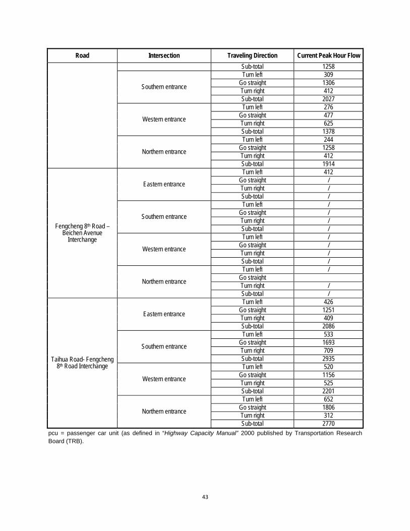
43
Road Intersection Traveling Direction Current Peak Hour Flow
Sub-total 1258
Southern entrance
Turn left 309 Go straight 1306 Turn right 412 Sub-total 2027
Western entrance
Turn left 276 Go straight 477 Turn right 625 Sub-total 1378
Northern entrance
Turn left 244 Go straight 1258 Turn right 412 Sub-total 1914
Fengcheng 8th Road – Beichen Avenue
Interchange
Eastern entrance
Turn left 412 Go straight / Turn right / Sub-total /
Southern entrance
Turn left / Go straight / Turn right / Sub-total /
Western entrance
Turn left / Go straight / Turn right / Sub-total /
Northern entrance
Turn left / Go straight Turn right / Sub-total /
Taihua Road- Fengcheng 8th Road Interchange
Eastern entrance
Turn left 426 Go straight 1251 Turn right 409 Sub-total 2086
Southern entrance
Turn left 533 Go straight 1693 Turn right 709 Sub-total 2935
Western entrance
Turn left 520 Go straight 1156 Turn right 525 Sub-total 2201
Northern entrance
Turn left 652 Go straight 1806 Turn right 312 Sub-total 2770
pcu = passenger car unit (as defined in “Highway Capacity Manual” 2000 published by Transportation Research Board (TRB).
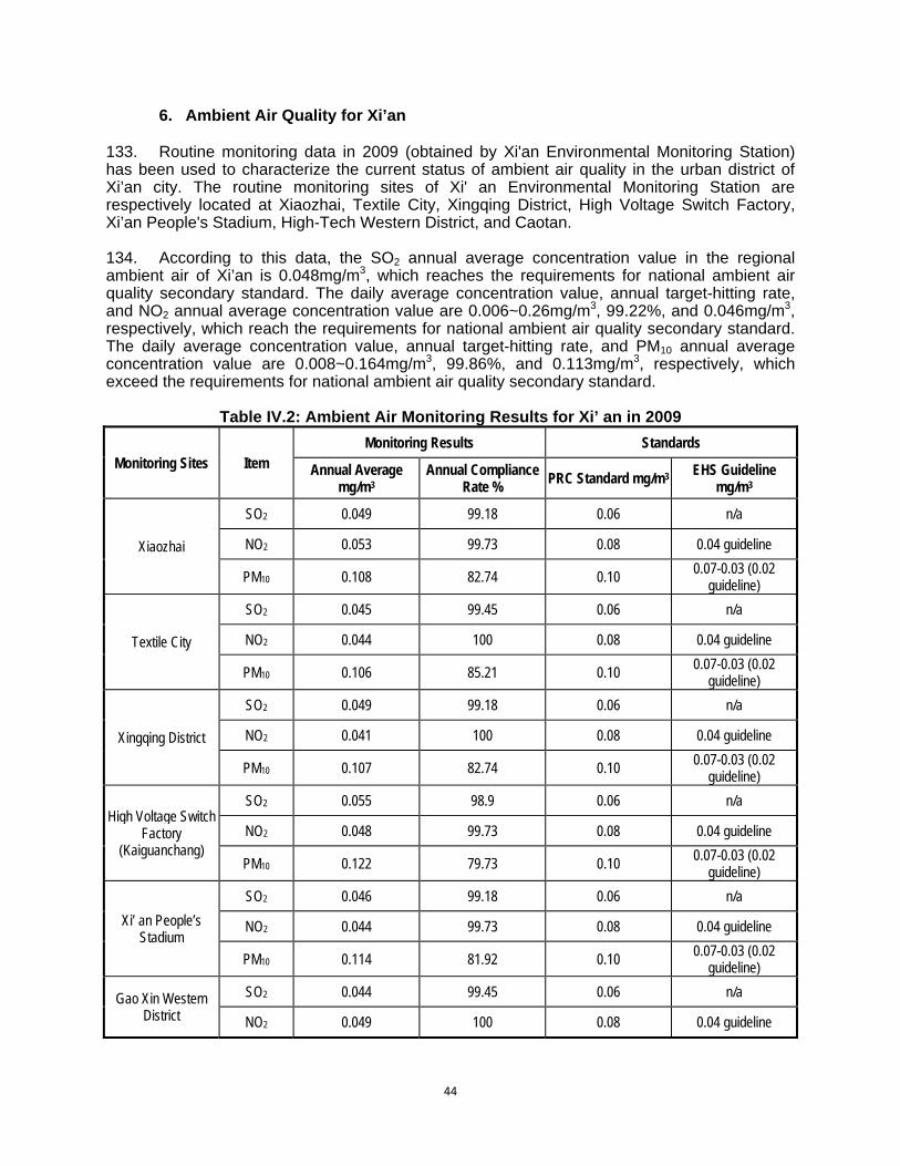
44
6. Ambient Air Quality for Xi’an 133. Routine monitoring data in 2009 (obtained by Xi'an Environmental Monitoring Station) has been used to characterize the current status of ambient air quality in the urban district of Xi’an city. The routine monitoring sites of Xi' an Environmental Monitoring Station are respectively located at Xiaozhai, Textile City, Xingqing District, High Voltage Switch Factory, Xi’an People's Stadium, High-Tech Western District, and Caotan. 134. According to this data, the SO2 annual average concentration value in the regional ambient air of Xi’an is 0.048mg/m3, which reaches the requirements for national ambient air quality secondary standard. The daily average concentration value, annual target-hitting rate, and NO2 annual average concentration value are 0.006~0.26mg/m3, 99.22%, and 0.046mg/m3, respectively, which reach the requirements for national ambient air quality secondary standard. The daily average concentration value, annual target-hitting rate, and PM10 annual average concentration value are 0.008~0.164mg/m3, 99.86%, and 0.113mg/m3, respectively, which exceed the requirements for national ambient air quality secondary standard.
Table IV.2: Ambient Air Monitoring Results for Xi’ an in 2009
Monitoring Sites Item Monitoring Results Standards
Annual Average mg/m3
Annual Compliance Rate %
PRC Standard mg/m3 EHS Guideline
mg/m3
Xiaozhai
SO2 0.049 99.18 0.06 n/a
NO2 0.053 99.73 0.08 0.04 guideline
PM10 0.108 82.74 0.10 0.07-0.03 (0.02
guideline)
Textile City
SO2 0.045 99.45 0.06 n/a
NO2 0.044 100 0.08 0.04 guideline
PM10 0.106 85.21 0.10 0.07-0.03 (0.02
guideline)
Xingqing District
SO2 0.049 99.18 0.06 n/a
NO2 0.041 100 0.08 0.04 guideline
PM10 0.107 82.74 0.10 0.07-0.03 (0.02 guideline)
High Voltage Switch Factory
(Kaiguanchang)
SO2 0.055 98.9 0.06 n/a
NO2 0.048 99.73 0.08 0.04 guideline
PM10 0.122 79.73 0.10 0.07-0.03 (0.02
guideline)
Xi’ an People’s Stadium
SO2 0.046 99.18 0.06 n/a
NO2 0.044 99.73 0.08 0.04 guideline
PM10 0.114 81.92 0.10 0.07-0.03 (0.02
guideline)
Gao Xin Western District
SO2 0.044 99.45 0.06 n/a
NO2 0.049 100 0.08 0.04 guideline
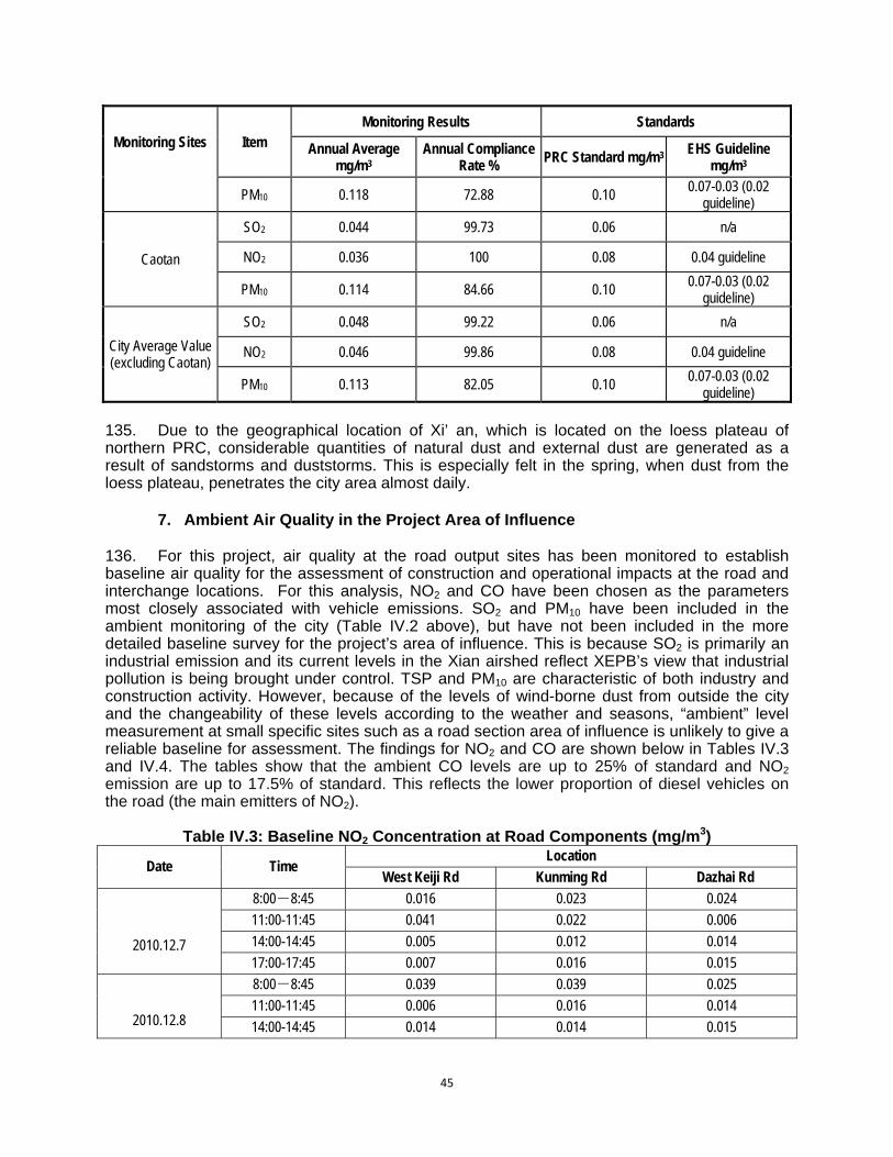
45
Monitoring Sites Item Monitoring Results Standards
Annual Average mg/m3
Annual Compliance Rate %
PRC Standard mg/m3 EHS Guideline mg/m3
PM10 0.118 72.88 0.10 0.07-0.03 (0.02
guideline)
Caotan
SO2 0.044 99.73 0.06 n/a
NO2 0.036 100 0.08 0.04 guideline
PM10 0.114 84.66 0.10 0.07-0.03 (0.02 guideline)
City Average Value (excluding Caotan)
SO2 0.048 99.22 0.06 n/a
NO2 0.046 99.86 0.08 0.04 guideline
PM10 0.113 82.05 0.10 0.07-0.03 (0.02
guideline) 135. Due to the geographical location of Xi’ an, which is located on the loess plateau of northern PRC, considerable quantities of natural dust and external dust are generated as a result of sandstorms and duststorms. This is especially felt in the spring, when dust from the loess plateau, penetrates the city area almost daily.
7. Ambient Air Quality in the Project Area of Influence 136. For this project, air quality at the road output sites has been monitored to establish baseline air quality for the assessment of construction and operational impacts at the road and interchange locations. For this analysis, NO2 and CO have been chosen as the parameters most closely associated with vehicle emissions. SO2 and PM10 have been included in the ambient monitoring of the city (Table IV.2 above), but have not been included in the more detailed baseline survey for the project’s area of influence. This is because SO2 is primarily an industrial emission and its current levels in the Xian airshed reflect XEPB’s view that industrial pollution is being brought under control. TSP and PM10 are characteristic of both industry and construction activity. However, because of the levels of wind-borne dust from outside the city and the changeability of these levels according to the weather and seasons, “ambient” level measurement at small specific sites such as a road section area of influence is unlikely to give a reliable baseline for assessment. The findings for NO2 and CO are shown below in Tables IV.3 and IV.4. The tables show that the ambient CO levels are up to 25% of standard and NO2 emission are up to 17.5% of standard. This reflects the lower proportion of diesel vehicles on the road (the main emitters of NO2).
Table IV.3: Baseline NO2 Concentration at Road Components (mg/m3)
Date Time Location
West Keiji Rd Kunming Rd Dazhai Rd
2010.12.7
8:00-8:45 0.016 0.023 0.024
11:00-11:45 0.041 0.022 0.006
14:00-14:45 0.005 0.012 0.014
17:00-17:45 0.007 0.016 0.015
2010.12.8
8:00-8:45 0.039 0.039 0.025
11:00-11:45 0.006 0.016 0.014
14:00-14:45 0.014 0.014 0.015
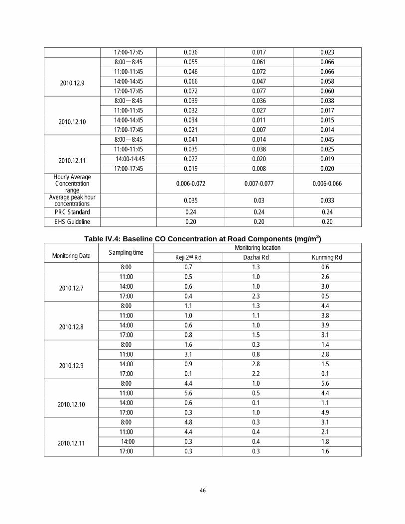
46
17:00-17:45 0.036 0.017 0.023
2010.12.9
8:00-8:45 0.055 0.061 0.066
11:00-11:45 0.046 0.072 0.066
14:00-14:45 0.066 0.047 0.058
17:00-17:45 0.072 0.077 0.060
2010.12.10
8:00-8:45 0.039 0.036 0.038
11:00-11:45 0.032 0.027 0.017
14:00-14:45 0.034 0.011 0.015
17:00-17:45 0.021 0.007 0.014
2010.12.11
8:00-8:45 0.041 0.014 0.045
11:00-11:45 0.035 0.038 0.025
14:00-14:45 0.022 0.020 0.019
17:00-17:45 0.019 0.008 0.020 Hourly Average Concentration
range 0.006-0.072 0.007-0.077 0.006-0.066
Average peak hour concentrations 0.035 0.03 0.033
PRC Standard 0.24 0.24 0.24
EHS Guideline 0.20 0.20 0.20
Table IV.4: Baseline CO Concentration at Road Components (mg/m3)
Monitoring Date Sampling time Monitoring location
Keji 2nd Rd Dazhai Rd Kunming Rd
2010.12.7
8:00 0.7 1.3 0.6
11:00 0.5 1.0 2.6
14:00 0.6 1.0 3.0
17:00 0.4 2.3 0.5
2010.12.8
8:00 1.1 1.3 4.4
11:00 1.0 1.1 3.8
14:00 0.6 1.0 3.9
17:00 0.8 1.5 3.1
2010.12.9
8:00 1.6 0.3 1.4
11:00 3.1 0.8 2.8
14:00 0.9 2.8 1.5
17:00 0.1 2.2 0.1
2010.12.10
8:00 4.4 1.0 5.6
11:00 5.6 0.5 4.4
14:00 0.6 0.1 1.1
17:00 0.3 1.0 4.9
2010.12.11
8:00 4.8 0.3 3.1
11:00 4.4 0.4 2.1
14:00 0.3 0.4 1.8
17:00 0.3 0.3 1.6

47
Monitoring Date Sampling time
Monitoring location
Keji 2nd Rd Dazhai Rd Kunming Rd Hourly Average Concentration
range 0.1-5.6 0.1-2.8 0.1-5.6
Average peak hour concentrations 1.45 1.15 2.53
PRC Standard 10 10 10
EHS Guideline No guideline No guideline No guideline 137. The baseline concentrations of CO and NO2 at the identified sensitive receptors for road and intersection air quality impacts have been estimated based upon the roadside concentrations from monitoring (Tables IV.3 and IV.4 above) and the distance to the sensitive receptor.
Table IV.5: Baseline Air Quality Parameters at Sensitive Receptors
Name of Component
Average Peak Hour Concentration at Roadside
(mg/m3) Name of Sensitive Receptor
Nearest Distance
from Road Center (m)
Estimated Peak Hour Concentration at
Sensitive Receptor (mg/m3)*
NO2 CO NO2 CO
Keji 2nd Road west section
(West bypass – North Zhangba
Road
0.035 1.45
Xicao Village 30 0.023 0.92
Dongcao Village 30 0.023 0.92
Wangjiazhai Village 57 0.016 0.62
Yanjiazhuang Village 106 0.011 0.42
Xi an College of Career and Technology 183 0.006 0.25
Yingfazhai Village 30 0.23 0.92
Xi’an No.52 Middle School 70 0.014 0.55
Bodi School 35 0.022 0.86
Kejiazhuang Village 120 0.009 0.36
Hujiang Zhuang Village 30 0.023 0.92
Xi’an International University 30 0.023 0.92
Dingjiaqiao Village 125 0.009 0.35
Dazhai Road (North Yanhuan Road-West 3rd
Ring Road)
0.033 1.15
Heping Village 100 0.010 0.73
Shaanxi Province Business institute of technology 133 0.008 0.59
North Erfuzhuang Village 20 0.025 1.84
South Erfuzhuang Village 160 0.007 0.49
BeishiQiao Village 20 0.025 1.84
Kunming Road 0.03 2.53 Xi’an Blomedical Technical College 35 0.018 0.68

48
Name of Component
Average Peak Hour Concentration at Roadside
(mg/m3) Name of Sensitive Receptor
Nearest Distance
from Road Center (m)
Estimated Peak Hour Concentration at
Sensitive Receptor (mg/m3)*
NO2 CO NO2 CO
(West 2nd Ring Road-
West bypass)
Kunming Road Xi’an Electric Switchboard Plant ( XD Company)
Residential Area 46 0.017 0.59
Xi’an Chemical Plant Residential Area 46 0.017 0.59
Xi’an Nitrogen Fertilizer Plant Residential Area
46 0.017 0.59
Xi’an Coking Plant Residential Area 46 0.017 0.59
Xiyaotou Villege 46 0.017 0.59
PRC Standard 0.24 10 0.24 10
EHS Guideline 0.20 No guideline 0.20 No
guideline * The concentration estimates have been made using the peakhour concentrations at the roadside and the concentration attenuation equation with increasing distance from the road in “Assessment Criterion on Environmental Impact of Road Construction Project” JTG B03-2006 (using the distances of identified sensitive receptors from the road and neutral wind conditions). 138. Currently, the average concentrations of vehicular pollutants (NO2 and CO) at sensitive receptor sites are comfortably within ambient air quality standards and EHS guidelines. As previously noted (Section A.6 above) the ambient particulate levels in the air throughout Xi’an are elevated, primarily from wind-borne dust from the loess plain.
8. Acoustic Environment of the Project Area of Influence 139. To provide baseline noise values for the construction elements of the Project, a total of 50 monitoring points are set to monitor at least 20 min continual equivalent grade A sound level in the day and night in the surrounding area according to the provisions in the “Technical Guidelines for Environmental Impact Assessment, Acoustic Environment” HJ 2.4-2009. The monitoring period was Oct. 14-24, 2010. 140. The monitoring used the calibrated model AWA6218B integrating sound level meter, with performance compliance with GB3785-83. The monitoring method followed the guidelines in “Acoustic Environmental Quality Standard” (GB 3096-2008). The monitoring point arrangement and monitoring results are listed in Table IV.6.
Table IV.6: Baseline Noise Levels at Sensitive Receptors (dB(A))
Name of Component Monitoring Point Monitoring Result
Day Night
Keji 2nd Road west section (West bypass- North Zhangba Road
Xicao Village 57.6 50.2
Dongcao Village 54.2 43.6
Wangjiazhai Village 52.3 40.9
Yanjiazhuang Village 52.1 41.5
Xi an College of Career and Technology 64.2 54.7
Yingfazhai Village 53.2 41.3
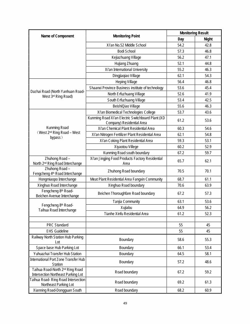
49
Name of Component Monitoring Point Monitoring Result
Day Night
Xi’an No.52 Middle School 54.2 42.8
Bodi School 57.3 46.8
Kejiazhuang Village 56.2 47.1
Hujiang Zhuang 52.1 44.8
Xi’an International University 55.2 46.3
Dingjiaqiao Village 62.1 54.3
Dazhai Road (North Yanhuan Road-West 3rd Ring Road)
Heping Village 56.4 46.8
Shaanxi Province Business institute of technology 53.6 45.4
North Erfuzhuang Village 52.6 41.9
South Erfuzhuang Village 53.4 42.5
BeishiQiao Village 55.6 46.3
Kunming Road (West 2nd Ring Road – West
bypass)
Xi’an Biomedical Technologies College 53.7 43.6 Kunming Road Xi’an Electric Switchboard Plant (XD
Company) Residential Area 61.2 53.6
Xi’an Chemical Plant Residential Area 60.3 54.6
Xi’an Nitrogen Fertilizer Plant Residential Area 62.1 54.8
Xi’an Coking Plant Residential Area 59.3 53.1
Xiyaotou Villege 60.2 52.9
Kunming Road south boundary 67.2 59.7 Zhuhong Road –
North 2nd Ring Road Interchange Xi’an Jingjing Food Products Factory Residential
Area 65.7 62.1
Zhuhong Road – Fengcheng 4th Road Interchange
Zhuhong Road boundary 70.5 70.1
Hongmiaopo Interchange Meat Plant Residential Area Fangxin Community 68.7 61.1
Xinghuo Road Interchange Xinghuo Road boundary 70.6 63.9 Fengcheng 8th Road-
Beichen Avenue Interchange Beichen Thoroughfare Road boundary 67.2 57.3
Fengcheng 8th Road- Taihua Road Interchange
Tanjia Community 63.1 53.6
Xujiabu 64.9 56.2
Tianhe Xinfu Residential Area 61.2 52.3
PRC Standard 55 45
EHS Guideline 55 45
Railway North Station Hub Parking Lot
Boundary 58.6 55.3
Space base Hub Parking Lot Boundary 66.1 53.4
Yuhuazhai Transfer Hub Station Boundary 64.5 58.1 International Port Zone Transfer Hub
Station Boundary 57.2 48.6
Taihua Road-North 2nd Ring Road Intersection Northeast Parking Lot
Road boundary 67.2 59.2
Taihua Road- Ring Road Intersection Northeast Parking Lot
Road boundary 69.2 61.3
Xianning Road-Dongguan South Road boundary 68.2 60.9
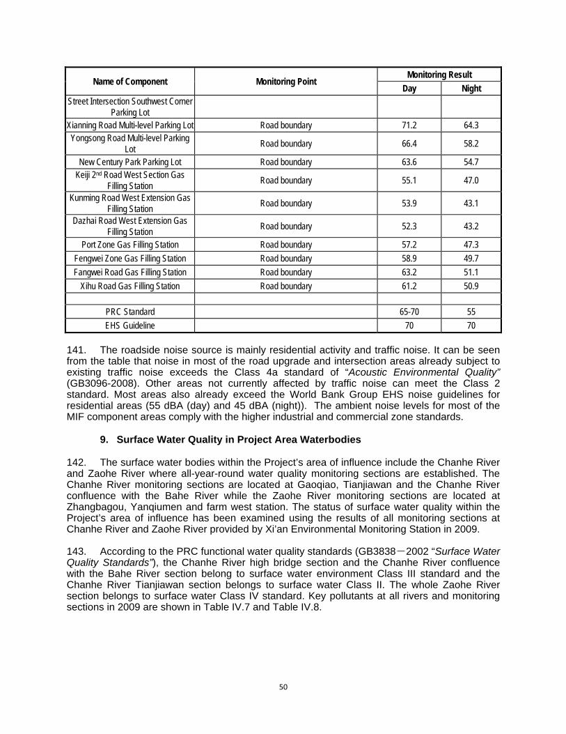
50
Name of Component Monitoring Point Monitoring Result
Day Night Street Intersection Southwest Corner
Parking Lot Xianning Road Multi-level Parking Lot Road boundary 71.2 64.3 Yongsong Road Multi-level Parking
Lot Road boundary 66.4 58.2
New Century Park Parking Lot Road boundary 63.6 54.7 Keiji 2nd Road West Section Gas
Filling Station Road boundary 55.1 47.0
Kunming Road West Extension Gas Filling Station
Road boundary 53.9 43.1
Dazhai Road West Extension Gas Filling Station
Road boundary 52.3 43.2
Port Zone Gas Filling Station Road boundary 57.2 47.3
Fengwei Zone Gas Filling Station Road boundary 58.9 49.7
Fangwei Road Gas Filling Station Road boundary 63.2 51.1
Xihu Road Gas Filling Station Road boundary 61.2 50.9
PRC Standard 65-70 55
EHS Guideline 70 70
141. The roadside noise source is mainly residential activity and traffic noise. It can be seen from the table that noise in most of the road upgrade and intersection areas already subject to existing traffic noise exceeds the Class 4a standard of “Acoustic Environmental Quality” (GB3096-2008). Other areas not currently affected by traffic noise can meet the Class 2 standard. Most areas also already exceed the World Bank Group EHS noise guidelines for residential areas (55 dBA (day) and 45 dBA (night)). The ambient noise levels for most of the MIF component areas comply with the higher industrial and commercial zone standards.
9. Surface Water Quality in Project Area Waterbodies 142. The surface water bodies within the Project’s area of influence include the Chanhe River and Zaohe River where all-year-round water quality monitoring sections are established. The Chanhe River monitoring sections are located at Gaoqiao, Tianjiawan and the Chanhe River confluence with the Bahe River while the Zaohe River monitoring sections are located at Zhangbagou, Yanqiumen and farm west station. The status of surface water quality within the Project’s area of influence has been examined using the results of all monitoring sections at Chanhe River and Zaohe River provided by Xi’an Environmental Monitoring Station in 2009. 143. According to the PRC functional water quality standards (GB3838-2002 “Surface Water Quality Standards”), the Chanhe River high bridge section and the Chanhe River confluence with the Bahe River section belong to surface water environment Class III standard and the Chanhe River Tianjiawan section belongs to surface water Class II. The whole Zaohe River section belongs to surface water Class IV standard. Key pollutants at all rivers and monitoring sections in 2009 are shown in Table IV.7 and Table IV.8.
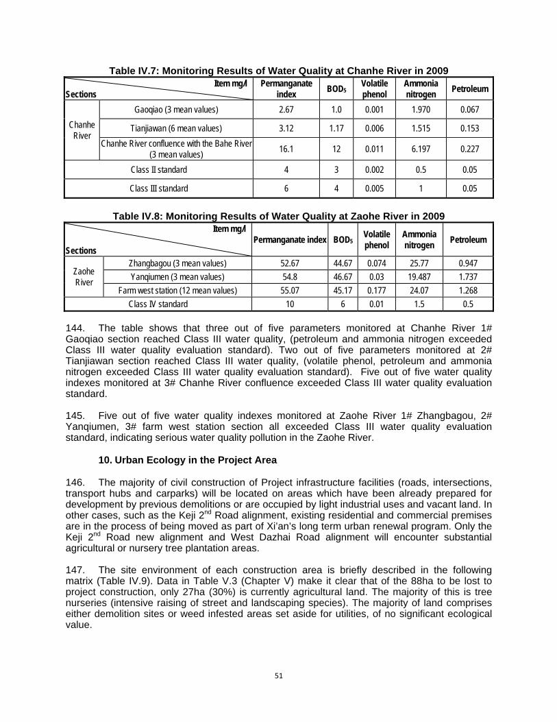
51
Table IV.7: Monitoring Results of Water Quality at Chanhe River in 2009 Item mg/l
Sections Permanganate
index BOD5
Volatile phenol
Ammonia nitrogen
Petroleum
Chanhe River
Gaoqiao (3 mean values) 2.67 1.0 0.001 1.970 0.067
Tianjiawan (6 mean values) 3.12 1.17 0.006 1.515 0.153
Chanhe River confluence with the Bahe River (3 mean values)
16.1 12 0.011 6.197 0.227
Class II standard 4 3 0.002 0.5 0.05
Class III standard 6 4 0.005 1 0.05
Table IV.8: Monitoring Results of Water Quality at Zaohe River in 2009
Item mg/l
Sections Permanganate index BOD5
Volatile phenol
Ammonia nitrogen
Petroleum
Zaohe River
Zhangbagou (3 mean values) 52.67 44.67 0.074 25.77 0.947
Yanqiumen (3 mean values) 54.8 46.67 0.03 19.487 1.737
Farm west station (12 mean values) 55.07 45.17 0.177 24.07 1.268
Class IV standard 10 6 0.01 1.5 0.5
144. The table shows that three out of five parameters monitored at Chanhe River 1# Gaoqiao section reached Class III water quality, (petroleum and ammonia nitrogen exceeded Class III water quality evaluation standard). Two out of five parameters monitored at 2# Tianjiawan section reached Class III water quality, (volatile phenol, petroleum and ammonia nitrogen exceeded Class III water quality evaluation standard). Five out of five water quality indexes monitored at 3# Chanhe River confluence exceeded Class III water quality evaluation standard. 145. Five out of five water quality indexes monitored at Zaohe River 1# Zhangbagou, 2# Yanqiumen, 3# farm west station section all exceeded Class III water quality evaluation standard, indicating serious water quality pollution in the Zaohe River.
10. Urban Ecology in the Project Area
146. The majority of civil construction of Project infrastructure facilities (roads, intersections, transport hubs and carparks) will be located on areas which have been already prepared for development by previous demolitions or are occupied by light industrial uses and vacant land. In other cases, such as the Keji 2nd Road alignment, existing residential and commercial premises are in the process of being moved as part of Xi’an’s long term urban renewal program. Only the Keji 2nd Road new alignment and West Dazhai Road alignment will encounter substantial agricultural or nursery tree plantation areas. 147. The site environment of each construction area is briefly described in the following matrix (Table IV.9). Data in Table V.3 (Chapter V) make it clear that of the 88ha to be lost to project construction, only 27ha (30%) is currently agricultural land. The majority of this is tree nurseries (intensive raising of street and landscaping species). The majority of land comprises either demolition sites or weed infested areas set aside for utilities, of no significant ecological value.

52
Table IV.9: Site Environment of Construction Components Name of Component Location Site Environment
West Section of Keji 2nd Road (West bypass- North Zhangba
Road)
Xi’an west suburb connecting Fengwei New District
The eastern portions of this road pass through urban areas which are currently subject to Xi’an’s urban renewal program. The alignment passes through Xi’an International University and a secondary school. Limited grain cropping is also carried on along both sides of the western portions of Keji 2nd Road alignment. The majority of the agricultural area is given over to nursery gardens and tree nursery plantations.
Dazhai Road (North Yanhuan Road-West 3rd Ring Road)
Xi’an west suburb Connecting Xi’an High –Tech
Development Zone
The vegetation conditions at West Dazhai Road alignment include some grain crops with the main area given over to nursery gardens and orchards.
Kunming Road East Section (West 2nd Ring Road – West 3rd Ring
Road)
Xi’an west suburb Expressway
The full easement for the road upgrading already exists. Paving work only here.
Kunming Road West Section (West Bypass Expressway-Xi’an-
Baoji Expressway relief road)
Xi’an west suburb Expressway
The buildings along both sides of this section are low level commercial and residential. The vegetation comprises trees and shrubs along the roads (weeping willow, heather, poplar, and holly).
Zhuhong Road – North 2nd Ring Road Interchange
Xi’an north suburb Significant node
Light industrial and commercial premises surround intersection
Zhuhong Road – Fengcheng 4th Road Interchange
Xi’an north suburb Significant node
Mainly vacant land where light industrial and commercial premises have recently been demolished. Weed infested.
Hongmiaopo Interchange Xi’an north suburb Significant node
Existing intersection flanked by low level commercial and residential premised.
Xinghuo Road Interchange Xi’an north suburb Significant node
Existing intersection flanked by low level commercial and residential premised.
Fengcheng 8th Road – Beichen Avenue Interchange
Xi’an north suburb Significant node
Existing intersection flanked by low level commercial and residential premised.
Fengcheng 8th Road-Taihua Road Interchange
Xi’an north suburb Significant node
Existing intersection flanked by low level commercial and residential premised.
Two transport hubs will be built at the northern railway station and
south suburbs
1 Xi’an Railway North Station Transport Hub
Totally cleared site. No on-site vegetation or buildings. Scraped soil surface.
2 The Aerospace Base Transport Hub
Light industrial and warehouse area with fringing peri urban cropping areas.
Parking lot and comprehensive transit hubs will be built at the two terminus stations of Subway Line
3
1 Yuhuazhai Station (P+P) transit hub
Part of site totally cleared with scraped soil surface. Some light industrial and warehouse area with fringing peri urban cropping areas.
2 Xi’an International Port Zone (P+R) transit hub
Mainly vacant land where residential and commercial premises have previously been demolished. Weed infested, brick rubble areas.
Multi-level car parks
1 Weiyang Road, Weiyang District
Vacant lot. Weed infested, brick rubble areas.
2 Jiefang Road, Xincheng District
Vacant lot. Weed infested, brick rubble areas.
3 Daqing Road,Lianhu District
Vacant lot. Weed infested, brick rubble areas.
4 Xianning Road –South Dongguan Street intersection southwest corner
Vacant lot. Weed infested, brick rubble areas.
5 Yongsong Road, Beilin District
Vacant lot. Weed infested, brick rubble areas.
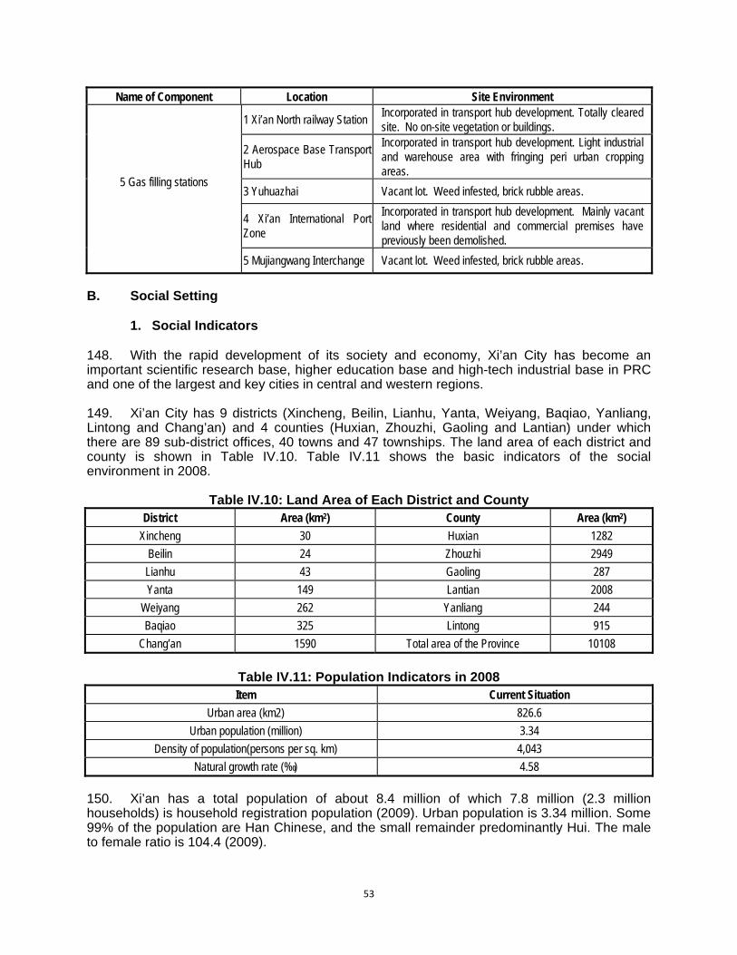
53
Name of Component Location Site Environment
5 Gas filling stations
1 Xi’an North railway Station Incorporated in transport hub development. Totally cleared site. No on-site vegetation or buildings.
2 Aerospace Base Transport Hub
Incorporated in transport hub development. Light industrial and warehouse area with fringing peri urban cropping areas.
3 Yuhuazhai Vacant lot. Weed infested, brick rubble areas.
4 Xi’an International Port Zone
Incorporated in transport hub development. Mainly vacant land where residential and commercial premises have previously been demolished.
5 Mujiangwang Interchange Vacant lot. Weed infested, brick rubble areas.
B. Social Setting
1. Social Indicators
148. With the rapid development of its society and economy, Xi’an City has become an important scientific research base, higher education base and high-tech industrial base in PRC and one of the largest and key cities in central and western regions. 149. Xi’an City has 9 districts (Xincheng, Beilin, Lianhu, Yanta, Weiyang, Baqiao, Yanliang, Lintong and Chang’an) and 4 counties (Huxian, Zhouzhi, Gaoling and Lantian) under which there are 89 sub-district offices, 40 towns and 47 townships. The land area of each district and county is shown in Table IV.10. Table IV.11 shows the basic indicators of the social environment in 2008.
Table IV.10: Land Area of Each District and County District Area (km2) County Area (km2)
Xincheng 30 Huxian 1282
Beilin 24 Zhouzhi 2949
Lianhu 43 Gaoling 287
Yanta 149 Lantian 2008
Weiyang 262 Yanliang 244
Baqiao 325 Lintong 915
Chang’an 1590 Total area of the Province 10108
Table IV.11: Population Indicators in 2008 Item Current Situation
Urban area (km2) 826.6
Urban population (million) 3.34
Density of population(persons per sq. km) 4,043
Natural growth rate (‰) 4.58
150. Xi’an has a total population of about 8.4 million of which 7.8 million (2.3 million households) is household registration population (2009). Urban population is 3.34 million. Some 99% of the population are Han Chinese, and the small remainder predominantly Hui. The male to female ratio is 104.4 (2009).

54
151. In 2009, the per capita disposable income of urban households in Shaanxi Province was CYN18,693, less than the PRC average PRC (CNY17,175), and just over half of the equivalent figure for Beijing (CNY26,738). On this indicator, the Province ranked 18th among 31 regions in the PRC. Urban Xi’an households’ per capita disposable income was CNY18,963 in 2009 – 70.9% of that of Beijing.
2. Sensitive Receptors in the Project Area of Influence
152. To assess the ambient air quality, acoustic ambient quality, historical relic environment, people health and environmental safety in the Project’s area of influence the location of all road network improvement project roadside sensitive receptors have been identified (see Table IV.12).
Table IV.12: Xi’an Urban Road Network Improvement Sensitive Receptors Road Network Improvement Component
No Name of Sensitive Point Relative
Orientation Nearest Distance From Center (m)
Number of Affected
Household
Number of Affected People
Keji 2nd Road west section (West bypass
- North Zhangba Road)
1 Xicao Village Both sides of road
30 120 460
2 Dongcao Village Both sides of road
30 180 600
3 Wangjiazhai Village North side of road
57 120 450
4 Yanjiazhuang Village South side of road
106 60 200
5 Xi an College of Career and Technology
North side of road
183 / 500
6 Yingfazhai Village North side of road
30 140 600
7 Xi’an No.52 Middle School South side of road
70 / 800
8 Bodi School Both sides of road
35 / 300
9 Kejiazhuang Village South side of road
120 50 200
10 Hujiang Zhuang Village Both sides of road
30 90 350
11 Xi'an International University Both sides of road
30 / 1000
12 Dingjiaqiao Village South side of road
125 300 1100
Dazhai Road (North Yanhuan Road-West
3rd Ring Road)
13 Heping Village North side of road
100 20 60
14 Shaanxi Province Business institute of technology
South side of road
133 / 100
15 North Erfuzhuang Village North side of road
20 50 230
16 South Erfuzhuang Village South side of road
160 50 240
17 BeishiQiao Village Both sides of road
20 500 1200
Kunming Road West 2nd Ring Road -
18 Xi’an Blomedical Technical College
North side of road
35 / 200
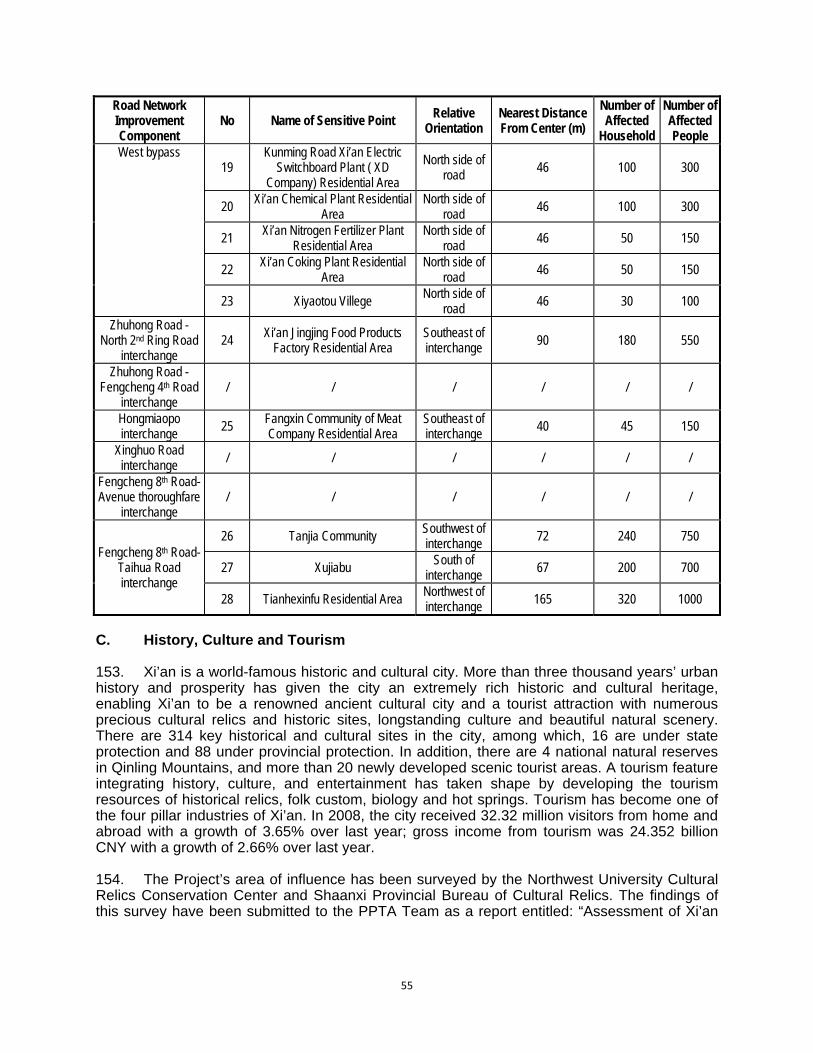
55
Road Network Improvement Component
No Name of Sensitive Point Relative Orientation
Nearest Distance From Center (m)
Number of Affected
Household
Number of Affected People
West bypass 19
Kunming Road Xi’an Electric Switchboard Plant ( XD
Company) Residential Area
North side of road
46 100 300
20 Xi’an Chemical Plant Residential
Area North side of
road 46 100 300
21 Xi’an Nitrogen Fertilizer Plant
Residential Area North side of
road 46 50 150
22 Xi’an Coking Plant Residential
Area North side of
road 46 50 150
23 Xiyaotou Villege North side of
road 46 30 100
Zhuhong Road - North 2nd Ring Road
interchange 24
Xi’an Jingjing Food Products Factory Residential Area
Southeast of interchange 90 180 550
Zhuhong Road - Fengcheng 4th Road
interchange / / / / / /
Hongmiaopo interchange
25 Fangxin Community of Meat Company Residential Area
Southeast of interchange
40 45 150
Xinghuo Road interchange
/ / / / / /
Fengcheng 8th Road- Avenue thoroughfare
interchange / / / / / /
Fengcheng 8th Road- Taihua Road interchange
26 Tanjia Community Southwest of interchange 72 240 750
27 Xujiabu South of
interchange 67 200 700
28 Tianhexinfu Residential Area Northwest of interchange 165 320 1000
C. History, Culture and Tourism 153. Xi’an is a world-famous historic and cultural city. More than three thousand years’ urban history and prosperity has given the city an extremely rich historic and cultural heritage, enabling Xi’an to be a renowned ancient cultural city and a tourist attraction with numerous precious cultural relics and historic sites, longstanding culture and beautiful natural scenery. There are 314 key historical and cultural sites in the city, among which, 16 are under state protection and 88 under provincial protection. In addition, there are 4 national natural reserves in Qinling Mountains, and more than 20 newly developed scenic tourist areas. A tourism feature integrating history, culture, and entertainment has taken shape by developing the tourism resources of historical relics, folk custom, biology and hot springs. Tourism has become one of the four pillar industries of Xi’an. In 2008, the city received 32.32 million visitors from home and abroad with a growth of 3.65% over last year; gross income from tourism was 24.352 billion CNY with a growth of 2.66% over last year. 154. The Project’s area of influence has been surveyed by the Northwest University Cultural Relics Conservation Center and Shaanxi Provincial Bureau of Cultural Relics. The findings of this survey have been submitted to the PPTA Team as a report entitled: “Assessment of Xi’an
56
Urban Road Network Improvement Project’s Impact on Cultural Relics”12. This report surveys the area of influence of all Project outputs and concludes that there are potential effects on three major areas of cultural heritage significance in Xi’an: the Afang Palace Site; the Chang’an City Site; and the Duling Mausoleum Site. 155. The key legislative provision for the consideration of environmental impacts in relation to these cultural heritage sites is the 1992 “Preservation Scope of Key Cultural Relics under Provincial or Higher Level of Preservation in Shaanxi Province (Shanzhengfa, 1992). Appendix 35 of this decree provides for heritage sites under state protection to be surrounded by three roughly concentric protection zones. These comprise: (i) a General Protection Zone; (ii) a Construction Control Zone; and (iii) an Environmental Co-ordination Zone. 156. The General Protection Zone generally prohibits development except with special consent. In cases were construction, blasting, drilling, excavation, etc. are specially required for essential infrastructure, application must be submitted to National Bureau of Cultural Relics and Shaanxi People’s Government for approval. Such approval will only be granted if conditions ensuring the safety of cultural heritage relics can be implemented. Any approved activity must meet the requirements of cultural relics preservation and earth disturbance must not exceed the depth determined by archeological authorities. 157. The Construction Control Zone is a non-construction area according to the requirements of protecting the surroundings of the cultural heritage site. Vegetation, basic pipeline network and road construction are allowed in this area but no permanent buildings. Where other activities or blasting, drilling, excavation, etc. are specially required, application must be submitted to the National Bureau of Cultural Relics and Shaanxi People’s Government for approval in order that the safety of Cultural heritage relics is ensured. 158. The Environmental Control Zone in this area places constraints on developments in order to protect the landscape character and surroundings of the cultural heritage site. There are restrictions on building height, style, size and color – which must conform to the requirements of landscape planning for the site. 159. The Afang Palace Site (also called the Epang Palace), located in the Afang Village area in the north-west quarter of Xi’an City, is a key historical and cultural site under state protection. The grand Afang Palace, built in 212 B.C., was the most famous ancient palace complex in Chinese history. In 1994, UNESCO recognized that the Afang Palace Site was pre-eminent among world’s historic buildings in terms of construction scale and preservation intactness. As one of the wonders of the world, it was acknowledged as “the No.1 palace in the world”. Archaeological investigation has revealed that the front hall site of the Afang Palace has a rammed earth platform of 1270 m in length from east to west, 426 m in width from south to north, 12 m in existing maximum height, and 541020m2 in area. It is the largest rammed earth base documented, in PRC and internationally. Figure IV.1 shows the location of the site in relation to the road components. 160. The section of Kunming Road planned for reconstruction under the Project is separated from the boundary of the Construction Control Zone of the site by a distance of 400 meters. The area between the Kunming Road section and the Construction Control Zone boundary is densely built up with a mixture of light industrial, commercial and residential developments.
12 Northwest University Cultural relics Conservation and Planning Center under Shaanxi Provincial Bureau of Cultural
Relics, 2010, Assessment Report of Xi’an Urban Road Network Improvement Project’s Impact on Cultural Relics. Report prepared for the Xi’an Investment Group of Urban Infrastructure Construction.

57
Figure IV.1: A’fang (Epang) Palace Sites and Kunming Road Component
161. The Chang’an City of the Han Dynasty is one of the first historical and cultural relics under state protection. Chang'an City was the capital of the Western Han Dynasty for 204 years. Following this, it was the capital for the Xinmong Period, Eastern Han Dynasty, Western Jin Dynasty, Zao Dynasty, Qin Dynasty, late Qin Dynasty, Western Wei Dynasty, Northern Zhou Dynasty and the first part of the Sui Dynasty. It was finally superseded and abandoned after Daxing City was built by the Sui Dynasty. In 1961, the Ruins of Chang'an City was promulgated by the State Council as one of the first group of the historical and cultural relics under state protection. It is preserved as the ancient capital of the unified empire and is characterized by its large dimensions, abundant relics and formal layout. An “Overall Program for Protection of Ruins of Chang'an City of Han Dynasty” was promulgated in 2010. Figure IV.2 shows the location of the site in relation to the road components.
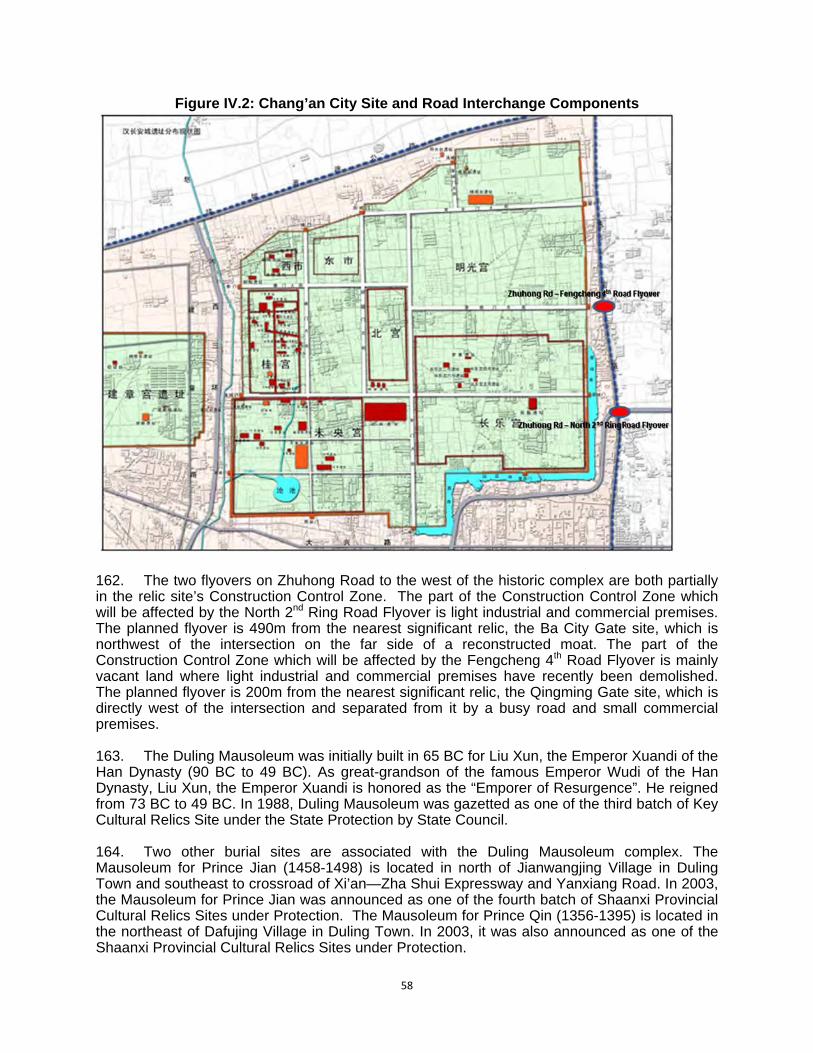
58
Figure IV.2: Chang’an City Site and Road Interchange Components
162. The two flyovers on Zhuhong Road to the west of the historic complex are both partially in the relic site’s Construction Control Zone. The part of the Construction Control Zone which will be affected by the North 2nd Ring Road Flyover is light industrial and commercial premises. The planned flyover is 490m from the nearest significant relic, the Ba City Gate site, which is northwest of the intersection on the far side of a reconstructed moat. The part of the Construction Control Zone which will be affected by the Fengcheng 4th Road Flyover is mainly vacant land where light industrial and commercial premises have recently been demolished. The planned flyover is 200m from the nearest significant relic, the Qingming Gate site, which is directly west of the intersection and separated from it by a busy road and small commercial premises. 163. The Duling Mausoleum was initially built in 65 BC for Liu Xun, the Emperor Xuandi of the Han Dynasty (90 BC to 49 BC). As great-grandson of the famous Emperor Wudi of the Han Dynasty, Liu Xun, the Emperor Xuandi is honored as the “Emporer of Resurgence”. He reigned from 73 BC to 49 BC. In 1988, Duling Mausoleum was gazetted as one of the third batch of Key Cultural Relics Site under the State Protection by State Council. 164. Two other burial sites are associated with the Duling Mausoleum complex. The Mausoleum for Prince Jian (1458-1498) is located in north of Jianwangjing Village in Duling Town and southeast to crossroad of Xi’an—Zha Shui Expressway and Yanxiang Road. In 2003, the Mausoleum for Prince Jian was announced as one of the fourth batch of Shaanxi Provincial Cultural Relics Sites under Protection. The Mausoleum for Prince Qin (1356-1395) is located in the northeast of Dafujing Village in Duling Town. In 2003, it was also announced as one of the Shaanxi Provincial Cultural Relics Sites under Protection.
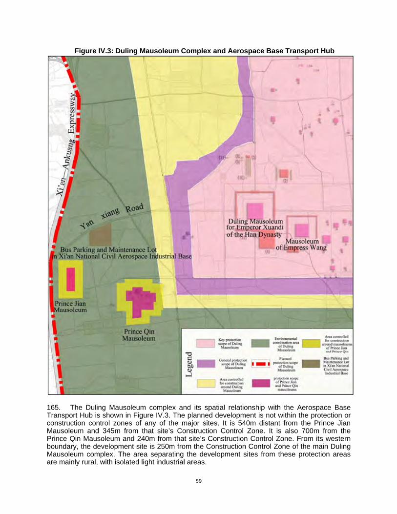
59
Figure IV.3: Duling Mausoleum Complex and Aerospace Base Transport Hub
165. The Duling Mausoleum complex and its spatial relationship with the Aerospace Base Transport Hub is shown in Figure IV.3. The planned development is not within the protection or construction control zones of any of the major sites. It is 540m distant from the Prince Jian Mausoleum and 345m from that site’s Construction Control Zone. It is also 700m from the Prince Qin Mausoleum and 240m from that site’s Construction Control Zone. From its western boundary, the development site is 250m from the Construction Control Zone of the main Duling Mausoleum complex. The area separating the development sites from these protection areas are mainly rural, with isolated light industrial areas.
60
V. ENVIRONMENTAL IMPACTS AND MITIGATION MEASURES A. Positive Impacts and Environmental Benefits
1. Direct Positive Impacts 166. The Project will support Xi’an’s large investments in public transportation infrastructure and prevent the increasing volume of vehicles from overwhelming the road network. Non-motorized transport such as walking and cycling will be the key to coordinating urban transport modes and connectivity in Xi’an. The MIF output and the provision of traveler information can bridge the gap between various modes and promote an efficient multi-modal transport network and systems operation. 167. The Project will provide missing sections of the strategic road network between the 2nd and 3rd Ring Roads, integrate the urban transport infrastructure with travel modes by introducing transport and transit hubs, and ITS expansion by 2016. The Project will also promote safe, efficient pedestrian and bicycle mobility. These components will ensure the success of major ongoing investments in road, bus, subway and rail networks. 168. Environmental benefits will mainly accrue from reductions in air pollution achieved by the Project outputs both singly and in combination. Reductions in air pollution will result from more efficient traffic movements and smoother travelling conditions on the new road links and intersections. The replacement of car journeys with mass public transport modes promoted by the MIF output will result in reductions in air pollution and savings in GHG emissions. More effective traffic management will increase energy efficiency of the urban transport sector, and sustainable reductions in vehicular pollution will be achieved through detection, control and correction of over-emitters. The XEPB estimates that the control of detection, control and correction of over-emitters alone will result in the prevention of an estimated 12,827 tons of vehicular pollutants (combined CO, NO2 and hydrocarbons) per year entering the Xi’an airshed.
Table V.1: Benefits Summary
Project Output Main Activities Benefits
Xi’an urban road network
improvement
Construction of three (3) road projects, one (flyover) and six (6) urban interchanges
To increase urban traffic capacity and reduce traffic congestion. Reductions in air pollution through more efficient traffic movements and smoother travelling conditions.
Multimodal Interchange Facilities.
Implementation of four (4) transport hubs; construction of five (5) multi-level parking facilities to promote mass use of public transit system; and construction of five (5) new CNG stations next to the transport hubs to facilitate the efficient fueling access of buses and taxis
To facilitate parking in the city, to provide transport mode interchanges, to expand urban development space and to improve the local environment Combine railway and road to provide a more efficient urban transport structure. To provide parking and facilitate oil and gas filling Reductions in air pollution and savings in GHG emissions through the replacement of car journeys with mass public transport modes.
Pedestrian Crossing Safety
Component
Pedestrian crossing safety improvements to 120 urban intersections and mid-block crossing facilities
To increase pedestrian safety and raise service level on public traffic
61
Project Output Main Activities Benefits
ITS Expansion of existing ADB-financed ITS to the 3rd Ring Road and implementation of public road safety education programs
To fully develop the potential of urban road network with computerized traffic management and advanced technology to improve traffic conditions. Reductions in air pollution and increases in energy efficiency through effective traffic management.
Environment Protection
Enhancement
Expansion and refinement of the existing vehicle emissions monitoring program on data collection, analysis and dissemination; expansion of emission enforcement capabilities, and the addition of mobile monitoring vehicles
To enhance the capacity of the government to collect, analyse, and disseminate emissions and air quality data to policy makers and the public. Sustainable reductions in vehicular pollution through detection, control and correction of over-emitters.
2. Beneficiaries
169. The Project will contribute directly and indirectly to poverty reduction in Xi’an. The Project’s direct benefits include reduced health expenditures on care associated with vehicle exhausts and pedestrian accidents and less work days lost; and greater productivity arising from travel time savings. The Project’s indirect contributions to poverty reduction include increased investment, greater tourism, and local economic development. 170. The Additional benefits include temporary and permanent jobs created directly by the Project, especially unskilled Xi’an residents. Construction contractors will be required to employ women, local unskilled labour, etc. on Project works. The implementing agency will work with women’s federations and communities to assist contractors to meet these targets. Consideration will also be given to the possibility of giving poor households – especially poor women – priority with respect to benefiting from any new long-term income-generating opportunities that may arise, such as employment in a new parking facility. B. Impacts Associated with Project Location, Planning, and Design
1. Direct Losses from the Project’s Footprint 171. New road alignments and, to a lesser extent, the construction of interchanges will involve the loss of farmland, villages, residential and commercial structures and enterprises. State-own land will be transferred by the municipal government; however other land-take will ultimately result in the loss of productive land, loss of structures and assets and the need for resettlement of affected households. 172. Output 2 (Multimodal Interchange Facilities (MIF)) will occupy land already transferred to the government and will involve no resettlement or displacement of affected persons or businesses. The remaining three Project outputs (including pedestrian traffic and safety; Intelligence Traffic Systems (ITS) and the vehicular environmental monitoring and pollution control, will not need land acquisition. 173. Loss of Land: Most of the land within the scope of new road construction at Keji 2nd Road and West Dazhai Road are suburban land. Much of this land is already in the process of expropriation as part of Xi’an’s urban renewal program, so compensation and resettlement responsibilities for these areas will need to be confirmed by the PMO and Resettlement Team.

62
The districts to be affected are listed in Table V.2. The total amount of land requisition, based on preliminary surveys and estimations, is shown in Table V.3 below.
Table V.2: Areas Impacted from Land-Take and Resettlement of Project Implementation of Second Stage
Project Output Area impacted from project
Impact from land-take and
resettlement
Sub-district office referred
to Villages impacted
Urban Road Network Improvement
(West section of Keji 2nd Road and Dazhai Road)
Xincheng District, Weiyang District, Lianhu District,
Chang’an District and Goose Pagoda District
Weiyang District, Chang’an District,
Goose Pagoda District
Zhang Ba Dingjia Qiao
Yuhuazhai
Hujiazhuang, Yingfazhai, Xinfeng, Zhousong,
Beishiqiao, Erfuzhuang, Minqizhai
Doumen Bayi
Multimodal Interchange Facilities
Xincheng District, Weiyang District, Chang’an District,
Goose Pagoda District, Baqiao District
With land transferred by the government, it will not be impacted from land-take and resettlement
174. In the list of affected villages in Table V.2, Bayi Village is currently subject to relocation and resettlement under the existing and ongoing Xi’an’s Urban Renewal Program. The land, households and people to be affected by the alignment of Keiji 2nd Road West Section in this village are therefore already subject to resettlement. The Resettlement Plan will undertake due diligence on the areas subject to Urban Renewal Program to ensure compensation and conditions for this and the Project’s resettlement will be consistent.
Table V.3a: Loss of Land to Road Construction at Keji 2nd Road and West Dazhai Road
Sub-project Width of land
requisition Road length
Land requisition area
Land Uses
Keji 2nd Road 60m 6197.5m 37.185ha
Residential land totaling 13.56 ha, accounting for 36.5% of project land requisition
Roads and waterways: 1.562ha, accounting for 4.2% of project land requisition.
Agricultural lands: 22.063 ha, accounting for 59.3% of project land requisition.
West Dazhai Road
40m 2333.7m 9.335ha
Residential land: 39.3hm2, accounting for 42.1% of project land requisition
Roads and waterways: 4.48hm2, accounting for 4.8% of project land requisition.
Agricultural lands: 49.57 hm2, accounting for 53.1% of project land requisition.
Table V.3b: Loss of Land to Interchanges and MIF Outputs
Component Width (m)
Length (m)
Area (ha)
Land type
Kunming road east section 70-74 3755.075 20.34
Land set aside for utilities
Kunming road west section 70 635.661 3.21 Zhuhong-North 2nd ring road interchange
80 80 5.5782
Zhuhong-Fengcheng No.4 road interchange
80 40 5.7182
Hongmiaopo interchange 50 70 10.242

63
Component Width (m)
Length (m)
Area (ha)
Land type
Xinghuo interchange 50 40 2.5359
Fengcheng No.8-Beichen road interchange
60 100 7.2053
Fengcheng No.8-Taihua road interchange 60 80 8.879
North railway transport terminal
7.33 Previously marginal agricultural land but now allocated as land for construction
Areo-base transport hub 6.87 Previously marginal agricultural land but now allocated as land for construction
Yuhuazhai transport hub 6.67 Previously marginal agricultural land but now allocated as land for construction
West station parking 0.60 Residential area
Taihua parking 0.53 Land set aside for utilities, currently waste land
Lejuchang parking 0.53 Land set aside for utilities, currently waste land
Xian international hub parking garage
0.53 Previously marginal agricultural land but now allocated as land for construction
Yuhuazhai parking 0.53
Gas stations 0.55 Previously marginal agricultural land but now allocated as land for construction
175. All roads and interchanges will have vegetated medium strips and drainage structures (see cross sections and long sections in Appendix 4). Roadside and medium strip planting and landscaping of car parks and transport nodes are a major item of investment in the EMP (costed at 2,065,000 CNY for establishment and 20,000 CNY/year for maintenance). This expenditure will provide vegetated areas exceeding the pre-project level, contribute to the greening of Xi’an, increase its rain infiltration areas and mitigate local urban heat island effects. 176. A breakdown of land and people affected by the project is given in Table V.4. It shows that (based upon a survey undertaken in October 2010) the total land-take will be about 88.33 ha, of which 58.67 ha is already state-owned, and the amount of dwelling space lost will be 73,350 m2. This will affect 307 and 277 households respectively. These figures will be progressively confirmed and refined as appropriate by the Resettlement Team during its final assets inventories.
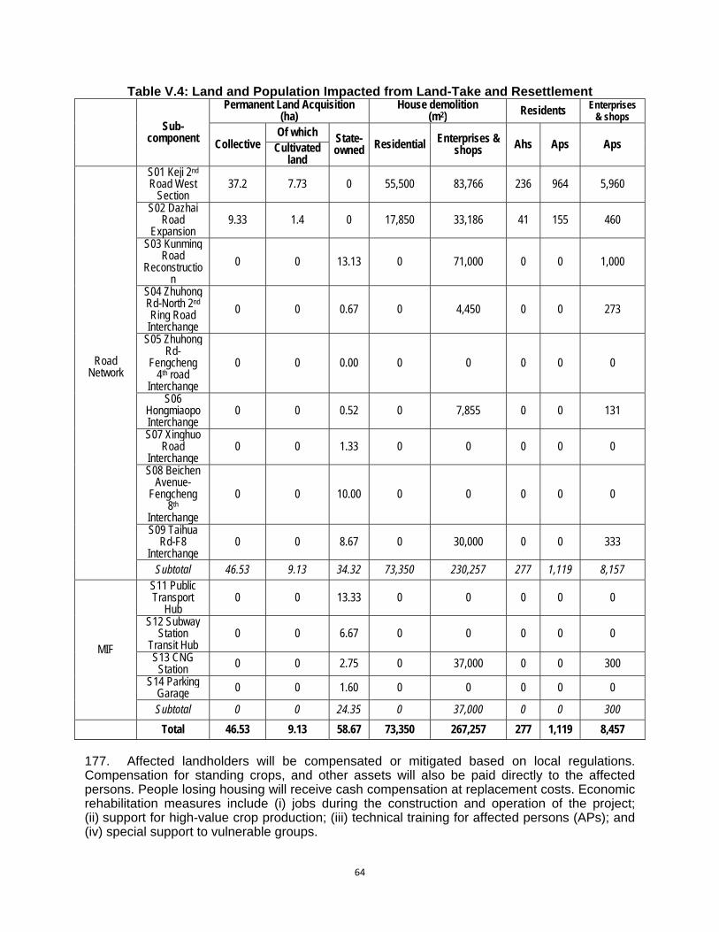
64
Table V.4: Land and Population Impacted from Land-Take and Resettlement
Sub-component
Permanent Land Acquisition (ha)
House demolition (m2) Residents Enterprises
& shops
Collective Of which State-
owned Residential Enterprises & shops Ahs Aps Aps Cultivated
land
Road Network
S01 Keji 2nd Road West
Section 37.2 7.73 0 55,500 83,766 236 964 5,960
S02 Dazhai Road
Expansion 9.33 1.4 0 17,850 33,186 41 155 460
S03 Kunming Road
Reconstruction
0 0 13.13 0 71,000 0 0 1,000
S04 Zhuhong Rd-North 2nd Ring Road
Interchange
0 0 0.67 0 4,450 0 0 273
S05 Zhuhong Rd-
Fengcheng 4th road
Interchange
0 0 0.00 0 0 0 0 0
S06 Hongmiaopo Interchange
0 0 0.52 0 7,855 0 0 131
S07 Xinghuo Road
Interchange 0 0 1.33 0 0 0 0 0
S08 Beichen Avenue-
Fengcheng 8th
Interchange
0 0 10.00 0 0 0 0 0
S09 Taihua Rd-F8
Interchange 0 0 8.67 0 30,000 0 0 333
Subtotal 46.53 9.13 34.32 73,350 230,257 277 1,119 8,157
MIF
S11 Public Transport
Hub 0 0 13.33 0 0 0 0 0
S12 Subway Station
Transit Hub 0 0 6.67 0 0 0 0 0
S13 CNG Station 0 0 2.75 0 37,000 0 0 300
S14 Parking Garage 0 0 1.60 0 0 0 0 0
Subtotal 0 0 24.35 0 37,000 0 0 300
Total 46.53 9.13 58.67 73,350 267,257 277 1,119 8,457
177. Affected landholders will be compensated or mitigated based on local regulations. Compensation for standing crops, and other assets will also be paid directly to the affected persons. People losing housing will receive cash compensation at replacement costs. Economic rehabilitation measures include (i) jobs during the construction and operation of the project; (ii) support for high-value crop production; (iii) technical training for affected persons (APs); and (iv) special support to vulnerable groups.

65
178. The draft Resettlement Plan (RP) will address the relocation needs of the affected households and have identified resettlement site options. Detailed information will be collected for each site and the Xi’an government will revise the draft RP based on the physical indices survey and include details of the resettlement sites, location, number of affected households, and number of affected persons, land areas, and infrastructure plans. The RP will be implemented in accordance with all applicable PRC laws and regulations, and ADB’s Safeguard Policy Statement 2009.
2. Economic Impacts and Economic Displacement 179. The impacts on business and economic activities in the Project’s area of influence have been examined during EIA preparation. Both commercial enterprises and village cooperative activities were looked at. The results are listed in Table V.5.
Table V.5: Enterprises and Institutions Impacted from Land-Take (as at October 2010)
Project
Economic Impact (ten thousand yuan) Impact from project implementation to
enterprises
Enterprises title Annual
production value
Annual sales
income
Annual interest
Annual wage sum
Value of fixed assets
Land-take(ha)
Housing area loss (M²)
Keji 2nd Road
Xi’an Moulded Casting Nylon
Works 900 870 60 210 720 1.2 11200
Bodi School Residential and classroom accommodation of teachers and students will be impacted. 2.7 20000
Xian International University
Classroom accommodation of about 800 teachers and students will be impacted. 2.2 23682
Dingjiaqiao Farmer Market
Collective enterprises of Dingjiaqiao village is about 60 (x ten thousand yuan) annually. 0.4 2000
Shannxi Sirui Industrial Co., Ltd. 18000 18000 2500 1700 5400 1.8 23405
Guanzhong Vocational Skills Training School
5000 1500 350 3000 2.1 3479
Subtotal 10.2 83766
West section of Dazhai Road
Shaanxi Delong Trade and
Industry Co.,Ltd 1870 1870 400 40 300 0.8 2358
Xi’an Jianxin Windows and Doors Factory
2200 2200 500 120 800 0.7 3428
Xi’an Gemeile Furniture Co., Ltd 1800 1800 360 360 320 0.9 15000
Shaanxi Aoke Chemical Industry
Co.Ltd 11000 10000 2000 900 6400 2.0 12400
Subtotal 4.4 33186
Hongmiaopu Interchange
Xi’an Fangxin Food Co. , Ltd.
Some of the houses facing the street have been calculated as 1469 M², with annual rent generation of 158 ten thousand
yuan. 0.5 7855.24
Total 15.1 124807.24
3. Impact on Physical Cultural Heritage Resources
180. The significance of potential impacts to cultural heritage sites has been assessed in a report by the Northwest University Cultural Relics Conservation Center and Shaanxi Provincial

66
Bureau of Cultural Relics entitled “Assessment of Xi’an Urban Road Network Improvement Project’s Impact on Cultural Relics”. The assessment is summarised in Table V.6 below. In the impact ranking used by the report “A” represents potential for significant impact; “B” represents potential for some impact; “C” minor potential impact; and “D” negligible impact. There are no “A” level impacts in the Project. 181. This assessment is based upon the location of the construction site in relation to known cultural heritage elements. Additionally, in these regions of Xi’an City all sites have the potential to affect as yet undiscovered sites and archaeological deposits which may be revealed during construction. The legislation has provisions for unexpected finds and these will be included in the EMP and conditions of contractor contracts.
Table V.6: Impact Categories for Cultural and Historical Sites
Impact category Output component Construction type Relevant cultural and
historical relics
Relation between project and cultural and historical relic
locations
B
The 2nd Ring Road-Zhuhong Road Flyover
Flyover of the urban arterial road
The Ruins of Chang’an City of Han Dynasty
Construction site is in the Construction Control Zone
The 4th Fengcheng Road – Zhuhong Road Flyover
Flyover of the urban arterial road
The Ruins of Chang’an City of Han Dynasty
Construction site is in the Construction Control Zone
C
Bus parking area in the Base of Aerospace
Land for urban public transport
Duling (including tombs of Jian and Qing Kings)
Construction site is in the Environmental Coordination Zone
Kunming Road Reconstruction Project
Reconstrction of urban arterial road
The Ruins of A’fang Palace
Construction site is about 400m south of the Construction Control Zone
D
Parking Lot in Xi’an North Railway Station
Land for urban public transport No impact
Multi-level Parking Lot in Xinghuo Road
Land for roads and squares No impact
Multi-level Parking Lot in Taihua Road
Land for roads and squares No impact
Multi-level Parking Lot in Dongguan South Street
Land for roads and squares No impact
Integrated Transfer Station in Port Zone
Land for urban public transport No impact
Integrated Transfer Station in Yuhua Villiage
Land for urban public transport
The ruins of Yangshao culture in Yuhua Villiage
No impact
182. Impact Grade “B”: Zhuhong Road - 2nd Ring Road Flyover. This component is located in the Construction Control Zone of the Chang'an City of Han Dynasty site. The Cultural Heritage report concludes that the construction of this component will not cause damage or destruction to any known Han Chang’an City relics. The part of the Construction Control Zone which will be affected by the flyover is currently covered by light industrial and commercial land uses. The flyover site is 490m from the nearest significant relic, the Ba City Gate site, which is northwest of the intersection on the far side of a reconstructed moat. 183. The following measures will be undertaken: A Construction Control Plan will be prepared after an initial appraisal 13 of the potential for undiscovered cultural relics at the project
13 This appraisal shall be based upon historical data, the topographical relationship between the construction site and
known cultural relics, and landscape features. It should include expert review of the topography, interviews with locals, review of local oral history, analysis of fragments discovered in the past and other possible indicator of a cultural site. It will not entail exploratory excavation.
67
construction area for before construction. The Construction Control Plan, along with project design and other relevant reports, will be submitted to the Shaanxi Provincial Cultural Relics Bureau for approval before commencement of construction. The construction plan will schedule inspections of archaeological potential at each major construction stage involving earthworks. Any discovery of buried relics will be referred to the Shaanxi Provincial Bureau for Cultural Relics for advice and assessment. Construction work will be interrupted during this process. Chance finds procedures are included in the EMP (Chapter IX, section N). 184. Other mitigation measures should include the following: (i) The flyover height should be below 12 m and; (ii) monitoring equipment to measure vibration should be installed at the nearest cultural relics to monitor any impacts caused by construction activities; and (iii) a shelter forest belt 980m long and 15m wide is to be established at the side closest to the Han Chang’an City site to protect the visual environment. 185. Impact Grade “B”: Zhuhong Rd and Fengcheng Rd 4 Interchange. This component is located in the Construction Control Zone of the Chang'an City of Han Dynasty site. The Cultural Heritage report concludes that the construction of this component will not cause damage or destruction to known Han Chang’an City relics. The part of the Construction Control Zone which will be affected by the Fengcheng 4th Road Flyover is mainly vacant land where light industrial and commercial buildings have recently been demolished. The planned flyover is 200m from the nearest significant relic, the Qingming Gate site, which is directly west of the intersection and separated from it by a busy road and small commercial premises. 186. The following measures will be undertaken: A Construction Control Plan will be prepared after an initial appraisal of the potential for undiscovered cultural relics at the project construction area for before construction. The Construction Control Plan, along with project design and other relevant reports, will be submitted to the Shaanxi Provincial Cultural Relics Bureau for approval before commencement of construction. The construction plan will schedule inspections of archaeological potential at each major construction stage involving earthworks. Any discovery of buried relics will be referred to the Shaanxi Provincial Bureau for Cultural Relics for advice and assessment. Construction work will be interrupted during this process. 187. Other mitigation measures include the following: (i) monitoring equipment to measure vibration should be installed at the nearest cultural relics to monitor any impacts caused by construction activities; and (ii) a shelter forest belt 980m long and 15m wide is to be established at the side closest to Han Chang’an City remains to protect its visual environment. 188. In summary, potential visual or air pollution impacts on the Chang An City site from the construction and operation of these intersections are not significant because (i) the cultural heritage sites of the Chang An City are not standing structures or vulnerable building fabric. They are excavated archaeological sites exposing, at depth, rammed earth foundations, drains and paving; (ii) the interchange construction sites are 490 and 200m from the nearest sites (foundations of gates). These sites are outliers of the main Chang An site which is over 1 km away from the construction. Additionally, the Cultural Relics Bureau and community will be consulted on visual impacts using the results of the detailed design. In the consultation, the IA will prepare easy to understand material to explain visual impacts including computer generated images. 189. Impact Grade “C”: Xi’an Aerospace Base Transport Hub. This component is located within the Environmental Coordination Zone of the Dulong Mausoleum complex. The Cultural Heritage report concludes that the construction of this component will not cause direct damage or destruction to known mausoleum relics. The planned parking lot is 540m distant from the Prince Jian Mausoleum and 345m from that site’s Construction Control Zone. It is also 700m
68
from the Prince Qin Mausoleum and 240m from that site’s Construction Control Zone. From its western boundary, the development site is 250m from the Construction Control Zone of the main Duling Mausoleum complex. The area separating the development sites from these protection areas are mainly rural, with isolated light industrial areas. On the other hand it may have impacts on the landscape amenity and environmental context of the mausoleum complex. 190. The following safeguard measures will be undertaken: A Construction Control Plan will be prepared after an initial appraisal of the potential for undiscovered cultural relics at the project construction area for before construction. The Construction Control Plan, along with project design and other relevant reports, will be submitted to the Shaanxi Provincial Cultural Relics Bureau for approval before commencement of construction. The construction plan will schedule inspections of archaeological potential at each major construction stage involving earthworks. Any discovery of buried relics will be referred to the Shaanxi Provincial Bureau for Cultural Relics for advice and assessment. Construction work will be interrupted during this process. 191. Other mitigation measures include the following: (i) The building scale, height and design should be in conformity with that of the relic sites; (ii) construction should avoid the use of machines or techniques which generate high levels of vibration to avoid potential damage to tombs; and (iii) construction site drainage and effluent, as well as stormwater drainage from the hub during operation, must be directed away from the Prince Jian and Prince Qin Mausoleum sites. 192. Impact Grade “C”: Kunming Road Construction. This component is located in the vicinity the Afang Palace complex, but outside any legally protected area. The Cultural Heritage report concludes that the construction of this component will not cause direct damage or destruction to known Afang Palace relics and is unlikely to damage unknown underground cultural relics. The construction area is separated from the boundary of the Construction Control Zone of the site by a distance of 400 metres. The area between the Kunming Road section and the Construction Control Zone boundary is an area of light industrial, commercial and residential developments. On the other hand it may have impact on the landscape near the place. 193. Proper environmental management of the construction site as required by the project’s EMP will be sufficient to safeguard the cultural relic sites in the neighbourhood, and no additional specific prescriptions are required. 194. All the above procedural and mitigation measures are included in the Project Environmental Management Plan, including duty statements for inspections of construction excavations and procedures for chance finds (Chapter IX). C. Impacts and Mitigation Measures during the Construction Phase 195. The Project Outputs for Pedestrian Crossing and Safety Improvements, ITS Expansion and Road User Safety Program and Environmental Protection Enhancement have no, or minimal, construction component and therefore will have no significant construction impacts. In this section, the major construction activities related to roads and interchange construction and the development of transport hubs incorporating access ways, filling stations (petrol, diesel and CNG) and multi-level car parks will be assessed for their environmental impacts and appropriate mitigation measures. Occupational and community health and safety issues are discussed separately in Section D below. 196. Impact on Urban Traffic. The project involves a lot of road sections, among which the current vehicle flows on West 2nd Ring Road, North 2nd Ring Road and West 3rd Ring Road
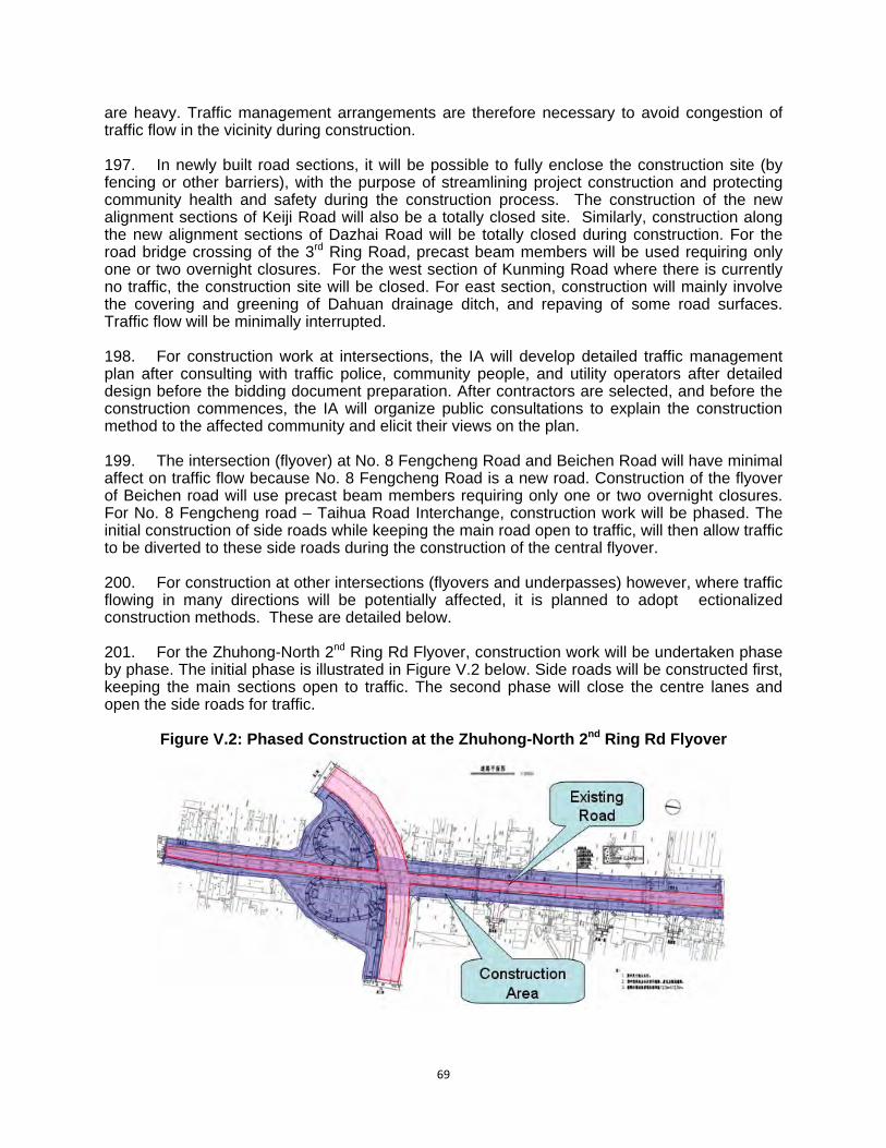
69
are heavy. Traffic management arrangements are therefore necessary to avoid congestion of traffic flow in the vicinity during construction. 197. In newly built road sections, it will be possible to fully enclose the construction site (by fencing or other barriers), with the purpose of streamlining project construction and protecting community health and safety during the construction process. The construction of the new alignment sections of Keiji Road will also be a totally closed site. Similarly, construction along the new alignment sections of Dazhai Road will be totally closed during construction. For the road bridge crossing of the 3rd Ring Road, precast beam members will be used requiring only one or two overnight closures. For the west section of Kunming Road where there is currently no traffic, the construction site will be closed. For east section, construction will mainly involve the covering and greening of Dahuan drainage ditch, and repaving of some road surfaces. Traffic flow will be minimally interrupted. 198. For construction work at intersections, the IA will develop detailed traffic management plan after consulting with traffic police, community people, and utility operators after detailed design before the bidding document preparation. After contractors are selected, and before the construction commences, the IA will organize public consultations to explain the construction method to the affected community and elicit their views on the plan. 199. The intersection (flyover) at No. 8 Fengcheng Road and Beichen Road will have minimal affect on traffic flow because No. 8 Fengcheng Road is a new road. Construction of the flyover of Beichen road will use precast beam members requiring only one or two overnight closures. For No. 8 Fengcheng road – Taihua Road Interchange, construction work will be phased. The initial construction of side roads while keeping the main road open to traffic, will then allow traffic to be diverted to these side roads during the construction of the central flyover. 200. For construction at other intersections (flyovers and underpasses) however, where traffic flowing in many directions will be potentially affected, it is planned to adopt �ectionalized construction methods. These are detailed below. 201. For the Zhuhong-North 2nd Ring Rd Flyover, construction work will be undertaken phase by phase. The initial phase is illustrated in Figure V.2 below. Side roads will be constructed first, keeping the main sections open to traffic. The second phase will close the centre lanes and open the side roads for traffic.
Figure V.2: Phased Construction at the Zhuhong-North 2nd Ring Rd Flyover
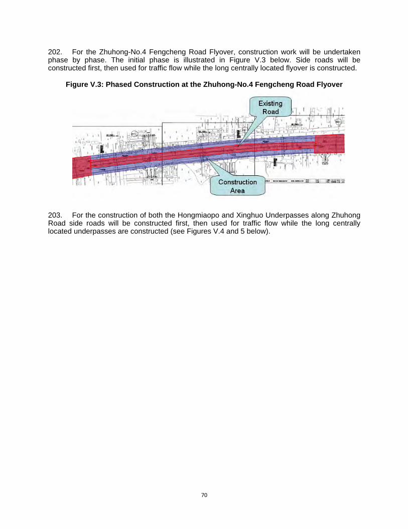
70
202. For the Zhuhong-No.4 Fengcheng Road Flyover, construction work will be undertaken phase by phase. The initial phase is illustrated in Figure V.3 below. Side roads will be constructed first, then used for traffic flow while the long centrally located flyover is constructed.
Figure V.3: Phased Construction at the Zhuhong-No.4 Fengcheng Road Flyover
203. For the construction of both the Hongmiaopo and Xinghuo Underpasses along Zhuhong Road side roads will be constructed first, then used for traffic flow while the long centrally located underpasses are constructed (see Figures V.4 and 5 below).

71
Figure V.4: Phased Construction at the Hongmiaopo Underpass
Figure V.5: Phased Construction at the Xinghuo Underpass
204. Spoil Disposal. Long term spoil disposal sites are already operating around the periphery of Xi’an city, servicing the city’s multiple construction projects. Although quantities
72
have not yet been surveyed for the Project’s construction sites, spoil disposal will be minimal, since only two construction sites (underpasses) have significant excavation, and fill is continuously required for other (non-Project) construction sites in Xi’an. The EMP will require construction sites covered by the ADB project to balance spoil and fill requirements. These measures have been incorporated into the EMP. Where existing spoil disposal sites are used by project construction activities, the sites will be managed according to the relevant PRC regulations. No borrow pits will be opened for the Project. 205. Erosion of disturbed surfaces. This is a city construction Project dealing mainly with paved and covered surfaces in commercial, industrial and residential locations. Soil surfaces exposed to erosion will be minimal. In this situation a Soil Erosion Prevention Plan is not required under PRC legislation. 206. The small potential soil loss generating from the construction period of this project will mainly occur at sites where subgrade works are to be carried out, and surface erosion will constituted the main potential type of erosion. The PRC EIA has used the US Universal Soil Loss Equation (USLE) over the planned construction areas. Calculations have revealed that the maximum intensity of soil erosion in the Project’s area of influence is 2.5×200t/km2/a, (500 t/km2 /a). The total disturbed area of this project is 4.7km2, and the maximum amount of soil erosion is estimated at 2350t. It can be concluded from the above calculation that the soil erosion intensity of this project is slight, and the impacts can be further reduced by appropriate site management. 207. Soil erosion can also occur after completion of construction in areas where site restoration has been inadequate. The areas most vulnerable to erosion include spoil sites, temporary construction sites, and other areas where surface soil will be disturbed. During the construction process, the stacking of such building materials as earth, aggregate, cement, and clay, together with waste spoil and materials have the potential to impact on surrounding areas. In particular, improper spoil stockpiling may easily cause blockages in road drainage pipelines, and affect both the traffic and city appearance during periods of high rainfall. 208. The most effective erosion control will be interception drainage to protect disturbed surfaces from surface flows. Construction plans will also include erosion control prescriptions for construction work areas. Prescriptions will include: (i) preservation of existing surface where no construction activity is planned or temporarily to preserve the stable surface where activity is planned for a later date; and (ii) permanent soil stabilization measures, such as landscaping and planting of medium strips, verges and temporary access roads. These prescriptions have also been incorporated into the EMP. 209. Construction Wastewater. Construction wastewater is produced from the maintenance and cleaning of mechanical equipment and vehicles, maintenance water for mixing and curing concrete, cooling water, and lost water and soil during the construction period which is discharged as pollutants. The effluent, comprised mainly of inorganic wastewater, commonly contains no poisonous and harmful substance, except suspended solid, but, if discharged in an improper manner, has the potential to impact on the city’s drainage system. Some oil-containing wastewater can arise from machinery repairs. 210. Construction wastewater should only be discharged to city stormwater or sewerage systems after appropriate on-site treatment. Sedimentation tanks will be built, and after settling out of solids the upper clear liquid will be recycled for spraying the construction site (dust control) or discharged to city drains. Oil-containing wastewater will require the installation of oil-water separators. The effluent SS, COD and concentration of oil should comply with the requirements specified in the Grade II standard of GB8978-1996 “Integrated Wastewater Discharge Standard” before discharge. The prescriptions have also been incorporated into the EMP.

73
211. Dust. Frequent sand storms originating on the loess plain outside Xi’an often coat the city with dust and contribute to its almost permanent haze. Adding to this is the enormous amount of building projects underway concurrently in the city. Dust is therefore a major environmental problem. Dust pollution mainly occurs during surface scraping and subgrade excavation at the early stage of construction, as well as dust arising from vehicle transport on construction roads and in the construction area. 212. The nature of spoil materials in stockyards are also closely related to the amount of dust emission. The materials with less specific gravity are prone to be disturbed and generate dust, and the larger proportion of small particles in materials corresponds with greater amount of dust emission. The dust emission of stockyard includes the wind-blown dust emission of stock heap, dust emission caused by loading and unloading process, pavement dust accumulation and secondary dust emission caused by passing vehicles. All these will produce greater dust pollution, and bring about impact on the surrounding environment. 213. According to the monitoring of vehicle dust emission during the construction period of the Beijing-Tianjin-Tanggu Expressway (as shown in Table V.7), the TSP concentration reaches 5.093mg/m3 at 150m downwind location exceeds the secondary standard in “National Ambient Air Quality Standards” (GB3095-1996), and the scope of pollution will increase when the wind speed increases. The table shows that dust concentration decreases rapidly as the distance from the source increases. Table V.7: Vehicle Dust Monitoring Results of the Construction Period of Beijing-Tianjin-
Tanggu Expressway
Monitoring Site Dust Pollution Source Distance of Sampling Site (m) Monitoring Results
(mg/m3)
Roadside of the construction at
Wuqingyang Village
Dust emission arising from the transport vehicles at the time when the cement stabilized road top base course is laid.
50 11.652
100 19.694
150 5.093
214. Road dust emission mainly comes from the transportation of construction materials on construction road. There are many factors which can cause the road dust emission, and most of them are related to vehicle speed, wind speed, amount of dust accumulation on pavement, and the humidity of dust accumulation on pavement. Moreover, wind speed also has a direct impact on dust transmission distance. Since high winds exist in the project area, the pollution of dust emission during construction period is relatively severe. 215. Regular water spraying can effectively suppress dust emission. Table V.8 shows the test results of water spray dust suppression conducted by the former Xi'an Highway University during the construction period of Xi'an-Lintong Expressway.
Table V.8: Test Results of Water Spray Dust Suppression during Construction Period
Distance away from the roadside 0m 20m 50m 100m 200m
TSP (mg/Nm3) No water spray 11.03 2.89 1.15 0.86 0.56
Water spray 2.11 1.40 0.68 0.60 0.29
Dust suppression rate (%) 81 52 41 30 48

74
216. It can be seen that water spray can reduce dust emission by more than 30%. Water spray dust suppression will therefore be �racticed intensively during the subgrade construction period. 217. Dust barriers should be arranged at construction sites and water spraying will be arranged. Construction activities will be stopped during gale weather. Construction waste will be regularly removed, water spraying should be undertaken during earth loading and unloading and tarpaulins should cover the loads of transport vehicles. 218. A relevant target of the 4th City Master Plan is for the reduction of “construction related airborne particulate matter”. The target is not quantified. The project outputs which require civil construction (roads, interchanges and car parks) will take account of this target. Construction will require no concrete batching on site or drilling, and specific dust minimization and suppression measures are included in the EMP. 219. Noise. Noise can be expected during construction due to construction machinery operation and transport activities. Construction activities will involve bulldozers, graders, excavators, rollers, and other heavy machinery. Foundation construction is considered as the highest stage of noise impact. It is planned to build flyover crossings in this project, and bridge piling operations are likely to cause serious impacts to the acoustic environment along the line. In addition, during the foundation construction process, radiated noises may be caused by transport vehicles loaded with building materials. 220. Currently-used machinery and equipment in domestic road construction mainly include bulldozers, excavators, road graders, concrete mixers, pavement rollers and pavers. Their noise pressure levels range from 81 to 98 dB(A), and the noise levels of asphalt mixing plants are in the range 84-90 dB(A). 221. Construction equipment noise can be basically considered as a point source noise. In view of the complexity of construction noise and the locations and stages of construction noise, this assessment is based upon the “Noise Limits for Construction Site” (GB12523-90). This approach calculates the ranges of noise effects of different construction equipment according to different construction stages so that construction units can take appropriate noise pollution control measures at appropriate times during the construction process. The prediction results are listed in the Table V.9.
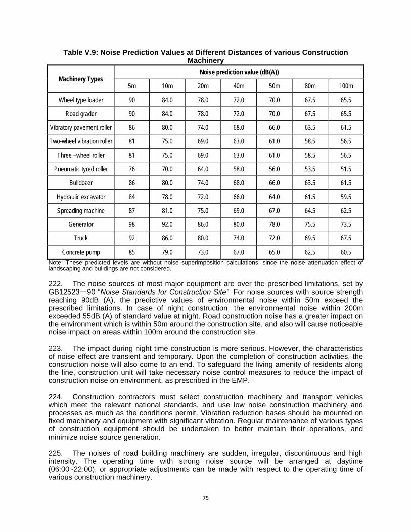
75
Table V.9: Noise Prediction Values at Different Distances of various Construction Machinery
Machinery Types Noise prediction value (dB(A))
5m 10m 20m 40m 50m 80m 100m
Wheel type loader 90 84.0 78.0 72.0 70.0 67.5 65.5
Road grader 90 84.0 78.0 72.0 70.0 67.5 65.5
Vibratory pavement roller 86 80.0 74.0 68.0 66.0 63.5 61.5
Two-wheel vibration roller 81 75.0 69.0 63.0 61.0 58.5 56.5
Three –wheel roller 81 75.0 69.0 63.0 61.0 58.5 56.5
Pneumatic tyred roller 76 70.0 64.0 58.0 56.0 53.5 51.5
Bulldozer 86 80.0 74.0 68.0 66.0 63.5 61.5
Hydraulic excavator 84 78.0 72.0 66.0 64.0 61.5 59.5
Spreading machine 87 81.0 75.0 69.0 67.0 64.5 62.5
Generator 98 92.0 86.0 80.0 78.0 75.5 73.5
Truck 92 86.0 80.0 74.0 72.0 69.5 67.5
Concrete pump 85 79.0 73.0 67.0 65.0 62.5 60.5
Note: These predicted levels are without noise superimposition calculations, since the noise attenuation effect of landscaping and buildings are not considered. 222. The noise sources of most major equipment are over the prescribed limitations, set by GB12523-90 “Noise Standards for Construction Site”. For noise sources with source strength reaching 90dB (A), the predictive values of environmental noise within 50m exceed the prescribed limitations. In case of night construction, the environmental noise within 200m exceeded 55dB (A) of standard value at night. Road construction noise has a greater impact on the environment which is within 50m around the construction site, and also will cause noticeable noise impact on areas within 100m around the construction site. 223. The impact during night time construction is more serious. However, the characteristics of noise effect are transient and temporary. Upon the completion of construction activities, the construction noise will also come to an end. To safeguard the living amenity of residents along the line, construction unit will take necessary noise control measures to reduce the impact of construction noise on environment, as prescribed in the EMP. 224. Construction contractors must select construction machinery and transport vehicles which meet the relevant national standards, and use low noise construction machinery and processes as much as the conditions permit. Vibration reduction bases should be mounted on fixed machinery and equipment with significant vibration. Regular maintenance of various types of construction equipment should be undertaken to better maintain their operations, and minimize noise source generation. 225. The noises of road building machinery are sudden, irregular, discontinuous and high intensity. The operating time with strong noise source will be arranged at daytime (06:00~22:00), or appropriate adjustments can be made with respect to the operating time of various construction machinery.
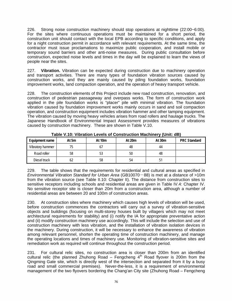
76
226. Strong noise construction machinery should stop operations at nighttime (22:00~6:00). For the sites where continuous operations must be maintained for a short period, the construction unit should contact with the local EPB according to specific conditions, and apply for a night construction permit in accordance with relevant requirements. At the same time, the contractor must issue proclamations to maximize public cooperation, and install mobile or temporary sound barriers and other anti-noise measures. During public consultation before construction, expected noise levels and times in the day will be explained to learn the views of people near the sites. 227. Vibration. Vibration can be expected during construction due to machinery operation and transport activities. There are many types of foundation vibration sources caused by construction works, and they are mainly caused by piling foundation works, foundation improvement works, land compaction operation, and the operation of heavy transport vehicle. 228. The construction elements of this Project include new road construction, renovation, and construction of pedestrian passageway and overpass works. The form of construction work applied in the pile foundation works is “placer” pile with minimal vibration. The foundation vibration caused by foundation improvement works mainly occurs in sand and soil compaction operation, and construction equipment includes vibration hammer and other tamping equipment. The vibration caused by moving heavy vehicles arises from road rollers and haulage trucks. The Japanese Handbook of Environmental Impact Assessment provides measures of vibrations caused by construction machinery. These are shown in Table V.10.
Table V.10: Vibration Levels of Construction Machinery (Unit: dB)
Equipment name At 5m At 10m At 20m At 30m PRC Standard
Vibratory hammer 75 67 48 44
Road roller 58 53 50 48
Diesel truck 62 58 54 51
229. The table shows that the requirements for residential and cultural areas as specified in Environmental Vibration Standard for Urban Area (GB10070-88) is met at a distance of >10m from the vibration source (see Table II.10: Chapter II). The distance from construction sites to sensitive receptors including schools and residential areas are given in Table IV.4: Chapter IV. No sensitive receptor site is closer than 20m from a construction area, although a number of residential areas are between 20 and 100m of construction areas. 230. At construction sites where machinery which causes high levels of vibration will be used, before construction commences the contractors will carry out a survey of vibration-sensitive objects and buildings (focusing on multi-storey houses built by villagers which may not meet architectural requirements for stability) and (i) notify the IA for appropriate preventative action and (ii) modify construction machinery use accordingly. This will include the selection and use of construction machinery with less vibration, and the installation of vibration isolation devices in the machinery. During construction, it will be necessary to enhance the awareness of vibration among relevant personnel, shorten the operating time of construction machinery, and manage the operating locations and times of machinery use. Monitoring of vibration-sensitive sites and remediation work as required will continue throughout the construction period. 231. For cultural relic sites, no construction area is closer than 200m from an identified cultural relic (the planned Zhuhong Road – Fengcheng 4th Road flyover is 200m from the Qingming Gate site, which is directly west of the intersection and separated from it by a busy road and small commercial premises). Never-the-less, it is a requirement of environmental management of the two flyovers bordering the Chang’an City site (Zhuhong Road – Fengcheng
77
4th Road flyover and Zhuhong Road – North 2nd Ring Road flyover) and the transport hub near the Dulong Mausoleum Complex (Aerospace Base Transport Hub) that monitoring equipment will be installed at the relic sites to monitor vibration during construction (see EMP). 232. Construction Camps Solid Waste. The construction workforce will generate garbage (food wastes, kitchen wastes, paper, and other solid waste including food-laden wash water). Proper disposal of this waste will be essential. It will be the responsibility of the construction contractors to provide sufficient garbage bins at strategic locations and ensure that they are (i) protected from birds and vermin, (ii) emptied regularly (using the county seat solid waste system and landfill), and (iii) do not overflow. This contractor responsibility is included in the EMP. 233. Hazardous and Polluting Materials. A construction material handling and disposal protocol that includes spill responses will be prepared and implemented as part of each site’s environmental supervision manual. The following measures will be taken to prevent pollution of soil and surface water/groundwater: (i) storage facilities for fuels, oil, asphalt material, and chemicals will be within secured areas on impermeable surfaces, provided with bunds and cleanup installations; (ii) vehicles and equipment will be properly staged in designated areas to prevent contamination of soil and surface water; (iii) vehicle, machinery, and equipment maintenance and refueling will be carried out in such a way that spilled materials do not seep into the soil; (iv) oil traps will be provided for service areas and parking areas; (v) fuel storage and refilling areas will be located at least 300 m from drainage structures and important water bodies. The prescriptions have also been incorporated into the EMP. 234. The contractors’ fuel suppliers will be properly licensed, follow proper protocol for transferring fuel, and be in compliance with Transportation, Loading and Unloading of Dangerous or Harmful Goods (JT 3145-88). 235. Construction Waste. The handling and disposal of construction wastes could have adverse impacts on the surroundings. Solid waste that cannot be used will be collected on site and not be discarded in a way that will damage the environment or the surrounding landscape. This requirement is especially important for those construction sites in the vicinity of cultural relics. Solid waste will be regularly transported off-site by the contractor for disposal at designated landfill sites in compliance with the Law on the Prevention and Control of Environmental Pollution by Solid Waste of PRC (2004) and scrap material and demolition waste disposal standards promulgated by the Ministry of Housing and Urban-Rural Development. 236. Contractor Performance. To ensure that construction contractors are able to implement the mitigation measures, the IAs will put in place the following arrangements: (i) environmental specifications will be included in the bidding documents to contractors; (ii) an appropriate environment section describing standards and responsibilities will be included in the terms of reference for bidders; (iii) approved spoil disposal sites, material haulage routes, borrow pit locations and waste disposal arrangements will be defined in the construction tender documents as appropriate; and (iv) clauses referencing the EMP mitigation provisions and monitoring plans will be written into the construction contracts. Following the award of construction contracts, the successful head contractor will prepare a Site Environmental Management and Supervision Manual, including an emergency preparedness and response plan, for approval by the IA. 237. Construction Site Management and Supervision. Before construction, a detailed plan including measures for site environmental protection will be by the contractor and approved by the IA. The plan must be executed strictly. During construction, the assigned environmental protection team should be strengthened to enhance site supervision, management and appraisal, so as to identify problems and solve the problems in time. Environmental training,
78
especially related to environmental management, is included in the EMP. The contractor will take reasonable measures to minimize the impact of construction on the environment. D. Impacts and Mitigation Measures during the Operational Phase
1. Operation of Roads, Interchanges and MIF Hubs 238. One of the most significant operational impacts will arise from the increases in traffic volumes on the project roads and interchanges. Traffic volumes have been predicted for the years 2015, 2020 and 2030 using the �odeling set out in “Highway Capacity Manual” 2000 published by Transportation Research Board (TRB), subsequently amended by the PPTA team to take account of the specific traffic growth pressures pertaining to Xi’an City. The results of these predictions are shown in Table V.11 below.
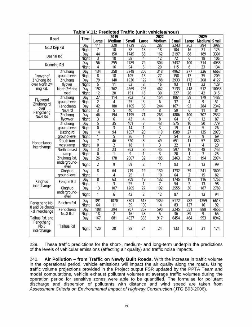
79
Table V.11: Predicted Traffic (unit: vehicles/hour)
Road Time 2015 2022 2029 Large Medium Small Large Medium Small Large Medium Small
No.2 Keji Rd Day 111 220 1729 205 287 3243 262 294 3987 Night 7 10 58 13 18 104 16 21 125
Dazhai Rd Day 44 150 1745 58 162 2197 88 189 3301 Night 3 10 58 4 12 72 6 18 106
Kunming Rd Day 56 255 2789 79 304 3437 100 314 4038 Night 4 16 94 5 20 115 6 23 134
Flyover of Zhuhong Rd
over North 2nd ring Rd.
Zhuhong ground-level
Day 134 250 3248 206 318 4962 277 336 6663 Night 8 18 105 13 27 158 17 35 209
Zhuhong flyover
Day 79 148 1920 122 188 2933 172 208 4127 Night 5 11 62 8 16 93 11 23 129
North 2nd ring road
Day 192 362 4669 296 462 7133 418 512 10038 Night 12 20 151 18 30 227 26 42 315
Flyoverof Zhuhong rd
over Fengcheng
No.4 Rd
Zhuhong ground-level
Day 27 114 702 42 154 1061 59 179 1487 Night 2 4 25 3 6 37 4 9 51
Fengcheng No.4 rd
Day 42 180 1105 66 244 1671 92 284 2342 Night 3 5 40 4 8 59 6 11 81
Zhuhong flyowver
Day 46 194 1195 71 263 1806 100 307 2532 Night 3 6 43 4 8 64 6 12 87
Hongmiaopo interchange
Zhuhong ground-level
Day 5 35 401 7 43 575 10 50 779 Night 0 3 14 1 3 19 1 5 26
Daxing rd ground-level
Day 14 94 1057 20 119 1589 27 135 2073 Night 1 5 36 1 7 54 2 9 69
South turn west ramp
Day 7 46 520 8 49 651 11 57 880 Night 0 2 18 1 3 22 1 4 29
North to east ramp
Day 3 23 263 8 45 597 10 48 743 Night 0 1 9 1 3 20 1 3 25
Zhuhong Rd. underground-
level
Day 26 178 2007 32 185 2463 39 194 2974
Night 2 9 69 2 11 83 2 13 99
Xinghuo interchange
Xinghuo ground-level
Day 8 64 719 19 130 1732 39 241 3609 Night 1 4 25 1 10 64 2 15 82
Fenghe Rd Day 8 63 709 19 132 1745 19 116 1755 Night 1 3 25 1 7 54 2 13 98
Xinghuo underground-
level
Day 13 107 1205 27 192 2555 30 187 2789
Night 1 6 42 2 12 87 2 13 94
Fengcheng No. 8 and Beicheng Rd interchange
Beichen Rd Day 391 1070 3301 615 1359 5172 782 1259 6613 Night 64 11 59 100 14 83 127 16 92
Fengcheng No.8 Rd
Day 108 294 907 267 590 2245 551 888 4656 Night 18 2 16 43 5 36 89 9 65
Taihua Rd. and Fengcheng
No.8 interchange
Taihua Rd
Day 167 681 4027 335 917 6454 464 953 8942
Night 120 20 88 74 24 133 103 31 174
239. These traffic predictions for the short-, medium- and long-term underpin the predictions of the levels of vehicular emissions (affecting air quality) and traffic noise impacts. 240. Air Pollution – from Traffic on Newly Built Roads. With the increase in traffic volume in the operational period, vehicle emissions will impact the air quality along the roads. Using traffic volume projections provided in the Project output FSR updated by the PPTA Team and model computations, vehicle exhaust pollutant volumes at average traffic volumes during the operation period for sensitive zones were able to be quantified. The formulae for pollutant discharge and dispersion of pollutants with distance and wind speed are taken from Assessment Criteria on Environmental Impact of Highway Construction (JTG B03-2006).
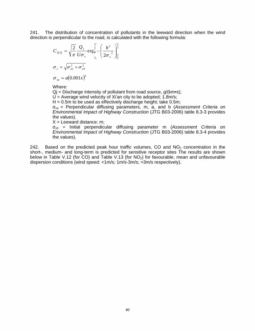
80
241. The distribution of concentration of pollutants in the leeward direction when the wind direction is perpendicular to the road, is calculated with the following formula:
2
2
2exp
2
zz
j h
U
QC
垂直
20
2zzaz
bza xa 001.0 Where: Qj = Discharge intensity of pollutant from road source, g/(km•s); U = Average wind velocity of Xi’an city to be adopted; 1.8m/s; H = 0.5m to be used as effectively discharge height; take 0.5m; σza = Perpendicular diffusing parameters, m, a, and b (Assessment Criteria on Environmental Impact of Highway Construction (JTG B03-2006) table 8.3-3 provides the values). X = Leeward distance: m; σz0 = Initial perpendicular diffusing parameter m (Assessment Criteria on Environmental Impact of Highway Construction (JTG B03-2006) table 8.3-4 provides the values).
242. Based on the predicted peak hour traffic volumes, CO and NO2 concentration in the short-, medium- and long-term is predicted for sensitive receptor sites The results are shown below in Table V.12 (for CO) and Table V.13 (for NO2) for favourable, mean and unfavourable dispersion conditions (wind speed: <1m/s; 1m/s-3m/s; >3m/s respectively).
v
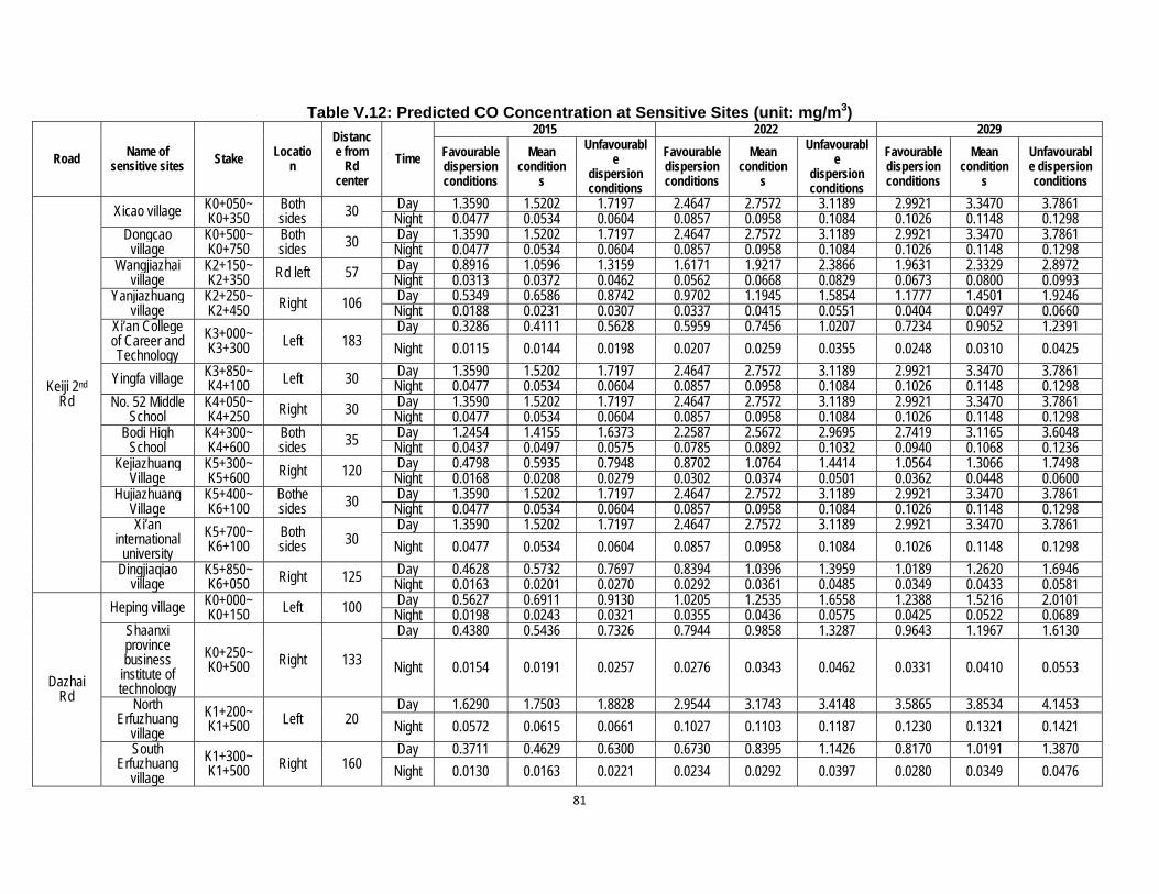
81
Table V.12: Predicted CO Concentration at Sensitive Sites (unit: mg/m3)
Road Name of sensitive sites Stake Locatio
n
Distance from
Rd center
Time
2015 2022 2029
Favourable dispersion conditions
Mean condition
s
Unfavourable
dispersion conditions
Favourable dispersion conditions
Mean condition
s
Unfavourable
dispersion conditions
Favourable dispersion conditions
Mean condition
s
Unfavourable dispersion conditions
Keiji 2nd Rd
Xicao village K0+050~ K0+350
Both sides 30 Day 1.3590 1.5202 1.7197 2.4647 2.7572 3.1189 2.9921 3.3470 3.7861
Night 0.0477 0.0534 0.0604 0.0857 0.0958 0.1084 0.1026 0.1148 0.1298 Dongcao
village K0+500~ K0+750
Both sides 30 Day 1.3590 1.5202 1.7197 2.4647 2.7572 3.1189 2.9921 3.3470 3.7861
Night 0.0477 0.0534 0.0604 0.0857 0.0958 0.1084 0.1026 0.1148 0.1298 Wangjiazhai
village K2+150~ K2+350 Rd left 57 Day 0.8916 1.0596 1.3159 1.6171 1.9217 2.3866 1.9631 2.3329 2.8972
Night 0.0313 0.0372 0.0462 0.0562 0.0668 0.0829 0.0673 0.0800 0.0993 Yanjiazhuang
village K2+250~ K2+450 Right 106 Day 0.5349 0.6586 0.8742 0.9702 1.1945 1.5854 1.1777 1.4501 1.9246
Night 0.0188 0.0231 0.0307 0.0337 0.0415 0.0551 0.0404 0.0497 0.0660 Xi’an College of Career and Technology
K3+000~ K3+300 Left 183
Day 0.3286 0.4111 0.5628 0.5959 0.7456 1.0207 0.7234 0.9052 1.2391
Night 0.0115 0.0144 0.0198 0.0207 0.0259 0.0355 0.0248 0.0310 0.0425
Yingfa village K3+850~ K4+100 Left 30 Day 1.3590 1.5202 1.7197 2.4647 2.7572 3.1189 2.9921 3.3470 3.7861
Night 0.0477 0.0534 0.0604 0.0857 0.0958 0.1084 0.1026 0.1148 0.1298 No. 52 Middle
School K4+050~ K4+250 Right 30 Day 1.3590 1.5202 1.7197 2.4647 2.7572 3.1189 2.9921 3.3470 3.7861
Night 0.0477 0.0534 0.0604 0.0857 0.0958 0.1084 0.1026 0.1148 0.1298 Bodi High
School K4+300~ K4+600
Both sides 35 Day 1.2454 1.4155 1.6373 2.2587 2.5672 2.9695 2.7419 3.1165 3.6048
Night 0.0437 0.0497 0.0575 0.0785 0.0892 0.1032 0.0940 0.1068 0.1236 Kejiazhuang
Village K5+300~ K5+600 Right 120 Day 0.4798 0.5935 0.7948 0.8702 1.0764 1.4414 1.0564 1.3066 1.7498
Night 0.0168 0.0208 0.0279 0.0302 0.0374 0.0501 0.0362 0.0448 0.0600 Hujiazhuang
Village K5+400~ K6+100
Bothe sides 30 Day 1.3590 1.5202 1.7197 2.4647 2.7572 3.1189 2.9921 3.3470 3.7861
Night 0.0477 0.0534 0.0604 0.0857 0.0958 0.1084 0.1026 0.1148 0.1298 Xi’an
international university
K5+700~ K6+100
Both sides 30
Day 1.3590 1.5202 1.7197 2.4647 2.7572 3.1189 2.9921 3.3470 3.7861
Night 0.0477 0.0534 0.0604 0.0857 0.0958 0.1084 0.1026 0.1148 0.1298
Dingjiaqiao village
K5+850~ K6+050 Right 125 Day 0.4628 0.5732 0.7697 0.8394 1.0396 1.3959 1.0189 1.2620 1.6946
Night 0.0163 0.0201 0.0270 0.0292 0.0361 0.0485 0.0349 0.0433 0.0581
Dazhai Rd
Heping village K0+000~ K0+150 Left 100 Day 0.5627 0.6911 0.9130 1.0205 1.2535 1.6558 1.2388 1.5216 2.0101
Night 0.0198 0.0243 0.0321 0.0355 0.0436 0.0575 0.0425 0.0522 0.0689 Shaanxi province business
institute of technology
K0+250~ K0+500 Right 133
Day 0.4380 0.5436 0.7326 0.7944 0.9858 1.3287 0.9643 1.1967 1.6130
Night 0.0154 0.0191 0.0257 0.0276 0.0343 0.0462 0.0331 0.0410 0.0553
North Erfuzhuang
village
K1+200~ K1+500 Left 20
Day 1.6290 1.7503 1.8828 2.9544 3.1743 3.4148 3.5865 3.8534 4.1453
Night 0.0572 0.0615 0.0661 0.1027 0.1103 0.1187 0.1230 0.1321 0.1421
South Erfuzhuang
village
K1+300~ K1+500 Right 160
Day 0.3711 0.4629 0.6300 0.6730 0.8395 1.1426 0.8170 1.0191 1.3870
Night 0.0130 0.0163 0.0221 0.0234 0.0292 0.0397 0.0280 0.0349 0.0476

82
Kunming Rd
Xi’an Biomedical Chemical College
K0+300~ K0+635 Left 35
Day 1.2454 1.4155 1.6373 2.2587 2.5672 2.9695 2.7419 3.1165 3.6048
Night 0.0437 0.0497 0.0575 0.0785 0.0892 0.1032 0.0940 0.1068 0.1236
PRC Standard 10 10 10 10 10 10 10 10 10
EHS Guideline No
guideline No
guideline No
guideline No
guideline No
guideline No
guideline No
guideline No
guideline No guideline
Table V.13: Estimated NO2 Concentration at Sensitive Sites (unit: mg/m3)
Road Name of sensitive
sites Stake Locatio
n
Distance from
Rd center
Time
2015 2022 2029
Favourable dispersion conditions
Mean condition
s
Unfavourable dispersion conditions
Favourable dispersion conditions
Mean condition
s
Unfavourable dispersion conditions
Favourable
dispersion conditions
Mean condition
s
Unfavourable dispersion conditions
Keji 2nd Rd
Xicao village K0+050~ K0+350
Both sides 30 Day 0.1197 0.1339 0.1514 0.2087 0.2335 0.2641 0.2518 0.2817 0.3187
Night 0.0051 0.0057 0.0064 0.0092 0.0103 0.0117 0.0111 0.0124 0.0140 Dongcao
village K0+500~ K0+750
Both sides 30 Day 0.1197 0.1339 0.1514 0.2087 0.2335 0.2641 0.2518 0.2817 0.3187
Night 0.0051 0.0057 0.0064 0.0092 0.0103 0.0117 0.0111 0.0124 0.0140 Wangjiazhai
village K2+150~ K2+350 Rd left 57 Day 0.0785 0.0933 0.1159 0.1369 0.1627 0.2021 0.1652 0.1964 0.2439
Night 0.0033 0.0040 0.0049 0.0061 0.0072 0.0089 0.0073 0.0087 0.0108 Yanjiazhuang
village K2+250~ K2+450 Right 106 Day 0.0471 0.0580 0.0770 0.0821 0.1011 0.1342 0.0991 0.1221 0.1620
Night 0.0020 0.0025 0.0033 0.0036 0.0045 0.0059 0.0044 0.0054 0.0071 Xi’an College of Career and Technology
K3+000~ K3+300 Left 183
Day 0.0289 0.0362 0.0496 0.0505 0.0631 0.0864 0.0609 0.0762 0.1043
Night 0.0012 0.0015 0.0021 0.0022 0.0028 0.0038 0.0027 0.0034 0.0046
Yingfa village K3+850~ K4+100 Left 30 Day 0.1197 0.1339 0.1514 0.2087 0.2335 0.2641 0.2518 0.2817 0.3187
Night 0.0051 0.0057 0.0064 0.0092 0.0103 0.0117 0.0111 0.0124 0.0140 No. 52 Middle
School K4+050~ K4+250 Right 30 Day 0.1197 0.1339 0.1514 0.2087 0.2335 0.2641 0.2518 0.2817 0.3187
Night 0.0051 0.0057 0.0064 0.0092 0.0103 0.0117 0.0111 0.0124 0.0140 Bodi High
School K4+300~ K4+600
Both sides 35 Day 0.1097 0.1246 0.1442 0.1912 0.2174 0.2514 0.2308 0.2623 0.3034
Night 0.0047 0.0053 0.0061 0.0085 0.0096 0.0111 0.0102 0.0116 0.0134 Kejiazhuang
Village K5+300~ K5+600 Right 120 Day 0.0422 0.0523 0.0700 0.0737 0.0911 0.1220 0.0889 0.1100 0.1473
Night 0.0018 0.0022 0.0030 0.0033 0.0040 0.0054 0.0039 0.0048 0.0065 Hujiazhuang
Village K5+400~ K6+100
Bothe sides 30 Day 0.1197 0.1339 0.1514 0.2087 0.2335 0.2641 0.2518 0.2817 0.3187
Night 0.0051 0.0057 0.0064 0.0092 0.0103 0.0117 0.0111 0.0124 0.0140 Xi’an
international university
K5+700~ K6+100
Both sides 30
Day 0.1197 0.1339 0.1514 0.2087 0.2335 0.2641 0.2518 0.2817 0.3187
Night 0.0051 0.0057 0.0064 0.0092 0.0103 0.0117 0.0111 0.0124 0.0140
Dingjiaqiao village
K5+850~ K6+050 Right 125 Day 0.0408 0.0505 0.0678 0.0711 0.0880 0.1182 0.0858 0.1062 0.1426
Night 0.0017 0.0021 0.0029 0.0031 0.0039 0.0052 0.0038 0.0047 0.0063
Dazhai Rd
Heping village K0+000~ K0+150 Left 100 Day 0.0495 0.0609 0.0804 0.0864 0.1061 0.1402 0.1043 0.1281 0.1692
Night 0.0021 0.0026 0.0034 0.0038 0.0047 0.0062 0.0046 0.0056 0.0075 Shaanxi K0+250~ Right 133 Day 0.0386 0.0479 0.0645 0.0673 0.0835 0.1125 0.0812 0.1007 0.1358

83
Province Business
Institute of Technology
K0+500
Night 0.0016 0.0020 0.0027 0.0030 0.0037 0.0050 0.0036 0.0044 0.0060
North Erfuzhuang
village
K1+200~ K1+500 Left 20
Day 0.1434 0.1541 0.1658 0.2502 0.2688 0.2891 0.3019 0.3243 0.3489
Night 0.0061 0.0065 0.0070 0.0111 0.0119 0.0128 0.0133 0.0143 0.0154
South Erfuzhuang
village
K1+300~ K1+500 Right 160
Day 0.0327 0.0408 0.0555 0.0570 0.0711 0.0967 0.0688 0.0858 0.1167
Night 0.0014 0.0017 0.0024 0.0025 0.0031 0.0043 0.0030 0.0038 0.0051
Kunming Rd
Xi’an Biomedical Chemical College
K0+300~ K0+635 Left 35
Day 0.1097 0.1246 0.1442 0.1912 0.2174 0.2514 0.2308 0.2623 0.3034
Night 0.0047 0.0053 0.0061 0.0085 0.0096 0.0111 0.0102 0.0116 0.0134
PRC Standard 0.24 0.24 0.24 0.24 0.24 0.24 0.24 0.24 0.24
EHS Guideline 0.20 0.20 0.20 0.20 0.20 0.20 0.20 0.20 0.20
84
243. The impact of day time CO and NO2 on sensitive sites will be �nalysed using the concentration under least favourable dispersion condition and adding it to the maximum baseline monitoring result. 244. Results for CO Levels at Sensitive Sites. It can be seen from Table V.12 that under the least favourable metrological dispersion conditions, traffic of Keji 2nd road will increase the CO concentration from the maximum baseline of 5.6mg/m3 to a maximum level at any sensitive receptor site of 7.3 mg/m3 in 2015 , 8.7 mg/m3 in 2022, and 9.4 mg/m3 in 2029. These estimated CO concentration are still within the limit of Class II (unit hour average) of the PRC Ambient Air Quality standard, accounting for 73%, 87% and 94% of the standard level in 2015, 2022 and 2029 respectively. Traffic on Dazhai Road will increase the CO concentration from the baseline of 2.8 mg/m3 to a maximum at any sensitive receptor site of 4.7mg/m3 in 2015, 6.2 mg/m3 in 2022, and 6.9mg/m3 in 2029. These estimated CO concentration are still within the Class II standard, accounting for 47%, 62% and 69% of the standard level in 2015, 2022 and 2029 respectively. Traffic on Kunming Road will increase the CO concentration from the baseline 5.6 mg/m3 to a maximum level at any sensitive receptor site of 7.2 mg/m3 in 2015, 8.6 mg/m3 in 2022, and 9.2mg/m3 in 2029. These estimated CO concentration for 72%, 86% and 92% of the standard level in 2015, 2022 and 2029 respectively 245. Results for NO2 Levels at Sensitive Sites. It can be seen from Table V.13 that NO2 concentration in the areas of influence of all roads will not exceed the PRC Class II (unit hour average) standard or the EHS guideline for unit hour average of NO2 levels in the initial operating period (2015). For sensitive sites located within 35m of the roads, both PRC and EHS guidelines will be marginally exceeded in unfavourable dispersion conditions in the medium term (2022). In the long term, these same sites will significantly exceed the standards – the maximum being a unit hour average of 0.3489 mg/m3 at a receptor site 20m from Dazhai Rd (exceeding the PRC standard by 1.45 times and the EHS guideline by 1.7 times). However, it is likely that changes in vehicle fleet and/or fuel sources will impact future results. Such changes to vehicle fleets and/or fuel sources have not been factored into the modeling due to impracticality of estimating the impact of technological advances over the long term. As such, and as common in traffic forecasting, baseline and forecasts are baased on best available data and information, even though in all likelihood these are overestimation of the emissions due to anticipated technological advances. The predicted NO2 levels at all other sensitive sites are within standard and guideline. 246. The main reasons for the exceedance of both PRC standards and EHS guidelines for a few sites in the long term are the significant increases in traffic in the long term and the proximity of these sensitive sites to the road. This will apply to only 6 of the combined total of 17 sensitive sites in the area of influence of all project road construction. 247. Impact Mitigation. To offset and mitigate these impacts, the proposed project will greatly improve traffic congestion, and reverse the city-wide trend of decreasing commuter vehicle speeds. On a city-wide scale it is therefore likely that the total volume of pollutants discharged from the vehicle exhausts will be a net reduction. The Xi’an urban traffic program, in its entirety, will also change the distribution of vehicle exhaust emissions over the urban area. 248. The control of vehicle exhaust pollutants on the road under this project is closely related with the policies and measures for emission control of Xi’an and Shaanxi Province. Therefore, the control measures for emission of vehicle exhaust pollutants on the transport infrastructure of this project should be considered in the context of local and national policies and measures for control of vehicle exhaust. The construction unit and management unit of this project will implement all the policies and measures for emission control of vehicle exhaust pollutants formulated by the state and local authorities in action and awareness, and take the
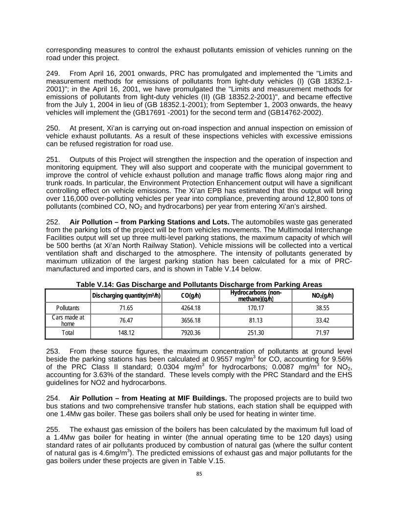
85
corresponding measures to control the exhaust pollutants emission of vehicles running on the road under this project. 249. From April 16, 2001 onwards, PRC has promulgated and implemented the "Limits and measurement methods for emissions of pollutants from light-duty vehicles (I) (GB 18352.1-2001)"; in the April 16, 2001, we have promulgated the "Limits and measurement methods for emissions of pollutants from light-duty vehicles (II) (GB 18352.2-2001)", and became effective from the July 1, 2004 in lieu of (GB 18352.1-2001); from September 1, 2003 onwards, the heavy vehicles will implement the (GB17691 -2001) for the second term and (GB14762-2002). 250. At present, Xi’an is carrying out on-road inspection and annual inspection on emission of vehicle exhaust pollutants. As a result of these inspections vehicles with excessive emissions can be refused registration for road use. 251. Outputs of this Project will strengthen the inspection and the operation of inspection and monitoring equipment. They will also support and cooperate with the municipal government to improve the control of vehicle exhaust pollution and manage traffic flows along major ring and trunk roads. In particular, the Environment Protection Enhancement output will have a significant controlling effect on vehicle emissions. The Xi’an EPB has estimated that this output will bring over 116,000 over-polluting vehicles per year into compliance, preventing around 12,800 tons of pollutants (combined CO, NO2 and hydrocarbons) per year from entering Xi’an’s airshed. 252. Air Pollution – from Parking Stations and Lots. The automobiles waste gas generated from the parking lots of the project will be from vehicles movements. The Multimodal Interchange Facilities output will set up three multi-level parking stations, the maximum capacity of which will be 500 berths (at Xi’an North Railway Station). Vehicle missions will be collected into a vertical ventilation shaft and discharged to the atmosphere. The intensity of pollutants generated by maximum utilization of the largest parking station has been calculated for a mix of PRC-manufactured and imported cars, and is shown in Table V.14 below.
Table V.14: Gas Discharge and Pollutants Discharge from Parking Areas
Discharging quantity(m3/h) CO(g/h) Hydrocarbons (non-methane)(g/h) NO2(g/h)
Pollutants 71.65 4264.18 170.17 38.55 Cars made at
home 76.47 3656.18 81.13 33.42
Total 148.12 7920.36 251.30 71.97
253. From these source figures, the maximum concentration of pollutants at ground level beside the parking stations has been calculated at 0.9557 mg/m3 for CO, accounting for 9.56% of the PRC Class II standard; 0.0304 mg/m3 for hydrocarbons; 0.0087 mg/m3 for NO2, accounting for 3.63% of the standard. These levels comply with the PRC Standard and the EHS guidelines for NO2 and hydrocarbons. 254. Air Pollution – from Heating at MIF Buildings. The proposed projects are to build two bus stations and two comprehensive transfer hub stations, each station shall be equipped with one 1.4Mw gas boiler. These gas boilers shall only be used for heating in winter time. 255. The exhaust gas emission of the boilers has been calculated by the maximum full load of a 1.4Mw gas boiler for heating in winter (the annual operating time to be 120 days) using standard rates of air pollutants produced by combustion of natural gas (where the sulfur content of natural gas is 4.6mg/m3). The predicted emissions of exhaust gas and major pollutants for the gas boilers under these projects are given in Table V.15.

86
Table V.15: Summary for Emissions of Boiler Exhausts gas and Pollutants Pollutants SO2 NOX (as NO2) Smoke dust
Concentration of emission (mg/m3) 0.74 148 22.0
Aggregate Emission volume (from all sources) t/a 0.02 4.216 0.628
256. The annual smoke/dust emissions of the gas boilers under the construction projects shall be 628kg/a, SO2 20kg/a and NOX 4216kg/a, and the daily emission converted thereby (by heating in 120 days) shall be: daily soot emission of 5.23kg/d, SO2 0.17kg/d and NOX 35.13kg/d, the soot, SO2 and NOX discharged by the gas boilers can meet the requirements for the limits of gas boiler emission standard as given in the "Emission standard of air pollutants for coal-burning oil-burning gas-fired boiler" (GB13271-2001), the NOX emission concentration is 148mg/m3 (the standard is 400mg/m3), the SO2 emission concentration is 0.74mg/m3 (the standard is 100mg/m3), and the smoke/dust emission concentration is 22mg/m3 (the standard is 50mg/m3), so they have little impact on the air and environment. 257. Traffic Noise Impacts – from New Roads. This assessment has adopted the highway noise prediction model as recommended in Appendix A.2 of HJ 2.4-2009 Technical Guidelines for Assessment of Environmental Impact -- Acoustical Environment. It has also used the horizontal noise generation of vehicles at speed from Annex C of Assessment Criterion on Environmental Impact in Highway Construction Project (JTG B03-2006) and the attenuation effects of building groups in GB/T 17247.2. 258. Using average running velocity of various vehicles type and the calculation of noise at source, the distance at which compliance with PRC ambient noise standards (Class 2 and 4) are reached have been calculated. These are shown below in Table V.16.
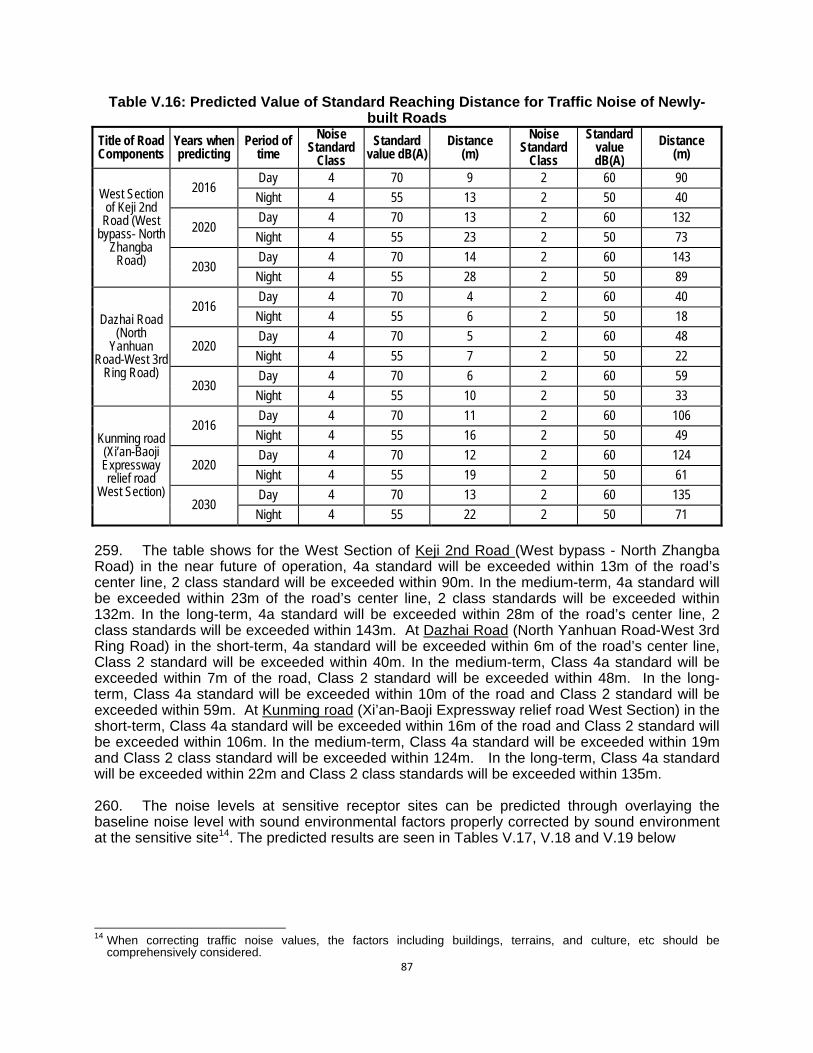
87
Table V.16: Predicted Value of Standard Reaching Distance for Traffic Noise of Newly-built Roads
Title of Road Components
Years when predicting
Period of time
Noise Standard
Class
Standard value dB(A)
Distance (m)
Noise Standard
Class
Standard value dB(A)
Distance (m)
West Section of Keji 2nd
Road (West bypass- North
Zhangba Road)
2016 Day 4 70 9 2 60 90
Night 4 55 13 2 50 40
2020 Day 4 70 13 2 60 132
Night 4 55 23 2 50 73
2030 Day 4 70 14 2 60 143
Night 4 55 28 2 50 89
Dazhai Road (North
Yanhuan Road-West 3rd
Ring Road)
2016 Day 4 70 4 2 60 40
Night 4 55 6 2 50 18
2020 Day 4 70 5 2 60 48
Night 4 55 7 2 50 22
2030 Day 4 70 6 2 60 59
Night 4 55 10 2 50 33
Kunming road (Xi’an-Baoji Expressway relief road
West Section)
2016 Day 4 70 11 2 60 106
Night 4 55 16 2 50 49
2020 Day 4 70 12 2 60 124
Night 4 55 19 2 50 61
2030 Day 4 70 13 2 60 135
Night 4 55 22 2 50 71
259. The table shows for the West Section of Keji 2nd Road (West bypass - North Zhangba Road) in the near future of operation, 4a standard will be exceeded within 13m of the road’s center line, 2 class standard will be exceeded within 90m. In the medium-term, 4a standard will be exceeded within 23m of the road’s center line, 2 class standards will be exceeded within 132m. In the long-term, 4a standard will be exceeded within 28m of the road’s center line, 2 class standards will be exceeded within 143m. At Dazhai Road (North Yanhuan Road-West 3rd Ring Road) in the short-term, 4a standard will be exceeded within 6m of the road’s center line, Class 2 standard will be exceeded within 40m. In the medium-term, Class 4a standard will be exceeded within 7m of the road, Class 2 standard will be exceeded within 48m. In the long-term, Class 4a standard will be exceeded within 10m of the road and Class 2 standard will be exceeded within 59m. At Kunming road (Xi’an-Baoji Expressway relief road West Section) in the short-term, Class 4a standard will be exceeded within 16m of the road and Class 2 standard will be exceeded within 106m. In the medium-term, Class 4a standard will be exceeded within 19m and Class 2 class standard will be exceeded within 124m. In the long-term, Class 4a standard will be exceeded within 22m and Class 2 class standards will be exceeded within 135m. 260. The noise levels at sensitive receptor sites can be predicted through overlaying the baseline noise level with sound environmental factors properly corrected by sound environment at the sensitive site14. The predicted results are seen in Tables V.17, V.18 and V.19 below
14 When correcting traffic noise values, the factors including buildings, terrains, and culture, etc should be
comprehensively considered.
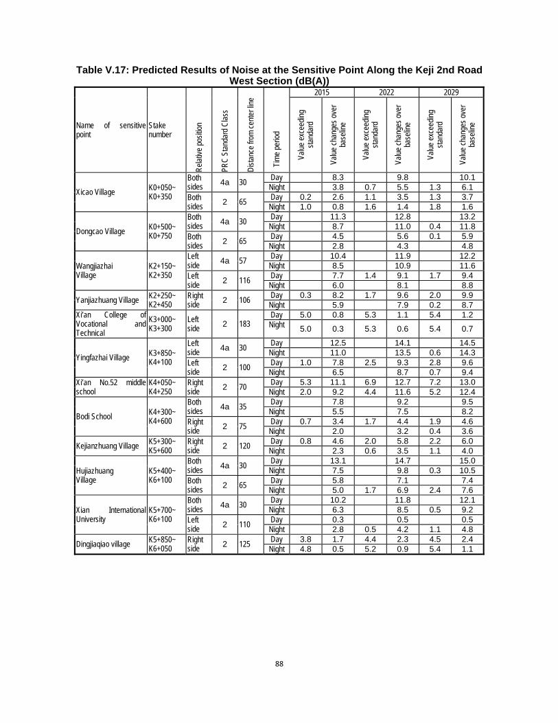
88
Table V.17: Predicted Results of Noise at the Sensitive Point Along the Keji 2nd Road West Section (dB(A))
Name of sensitive point
Stake number
Rel
ativ
e po
sitio
n
PRC
Sta
ndar
d C
lass
Dis
tanc
e fro
m c
ente
r lin
e
Tim
e pe
riod
2015 2022 2029
Valu
e ex
ceed
ing
stan
dard
Valu
e ch
ange
s ov
er
base
line
Valu
e ex
ceed
ing
stan
dard
Valu
e ch
ange
s ov
er
base
line
Valu
e ex
ceed
ing
stan
dard
Valu
e ch
ange
s ov
er
base
line
Xicao Village K0+050~ K0+350
Both sides 4a 30
Day 8.3 9.8 10.1Night 3.8 0.7 5.5 1.3 6.1
Both sides 2 65
Day 0.2 2.6 1.1 3.5 1.3 3.7Night 1.0 0.8 1.6 1.4 1.8 1.6
Dongcao Village K0+500~ K0+750
Both sides 4a 30
Day 11.3 12.8 13.2Night 8.7 11.0 0.4 11.8
Both sides 2 65
Day 4.5 5.6 0.1 5.9Night 2.8 4.3 4.8
Wangjiazhai Village
K2+150~ K2+350
Left side 4a 57
Day 10.4 11.9 12.2Night 8.5 10.9 11.6
Left side 2 116
Day 7.7 1.4 9.1 1.7 9.4Night 6.0 8.1 8.8
Yanjiazhuang Village K2+250~ K2+450
Right side 2 106
Day 0.3 8.2 1.7 9.6 2.0 9.9Night 5.9 7.9 0.2 8.7
Xi’an College of Vocational and Technical
K3+000~ K3+300
Left side 2 183
Day 5.0 0.8 5.3 1.1 5.4 1.2Night 5.0 0.3 5.3 0.6 5.4 0.7
Yingfazhai Village K3+850~ K4+100
Left side 4a 30
Day 12.5 14.1 14.5Night 11.0 13.5 0.6 14.3
Left side 2 100
Day 1.0 7.8 2.5 9.3 2.8 9.6Night 6.5 8.7 0.7 9.4
Xi’an No.52 middle school
K4+050~ K4+250
Right side 2 70
Day 5.3 11.1 6.9 12.7 7.2 13.0Night 2.0 9.2 4.4 11.6 5.2 12.4
Bodi School K4+300~ K4+600
Both sides 4a 35
Day 7.8 9.2 9.5Night 5.5 7.5 8.2
Right side 2 75
Day 0.7 3.4 1.7 4.4 1.9 4.6Night 2.0 3.2 0.4 3.6
Kejianzhuang Village K5+300~ K5+600
Right side 2 120
Day 0.8 4.6 2.0 5.8 2.2 6.0Night 2.3 0.6 3.5 1.1 4.0
Hujiazhuang Village
K5+400~ K6+100
Both sides 4a 30
Day 13.1 14.7 15.0Night 7.5 9.8 0.3 10.5
Both sides 2 65
Day 5.8 7.1 7.4Night 5.0 1.7 6.9 2.4 7.6
Xian International University
K5+700~ K6+100
Both sides 4a 30
Day 10.2 11.8 12.1Night 6.3 8.5 0.5 9.2
Left side 2 110
Day 0.3 0.5 0.5Night 2.8 0.5 4.2 1.1 4.8
Dingjiaqiao village K5+850~ K6+050
Right side 2 125
Day 3.8 1.7 4.4 2.3 4.5 2.4Night 4.8 0.5 5.2 0.9 5.4 1.1
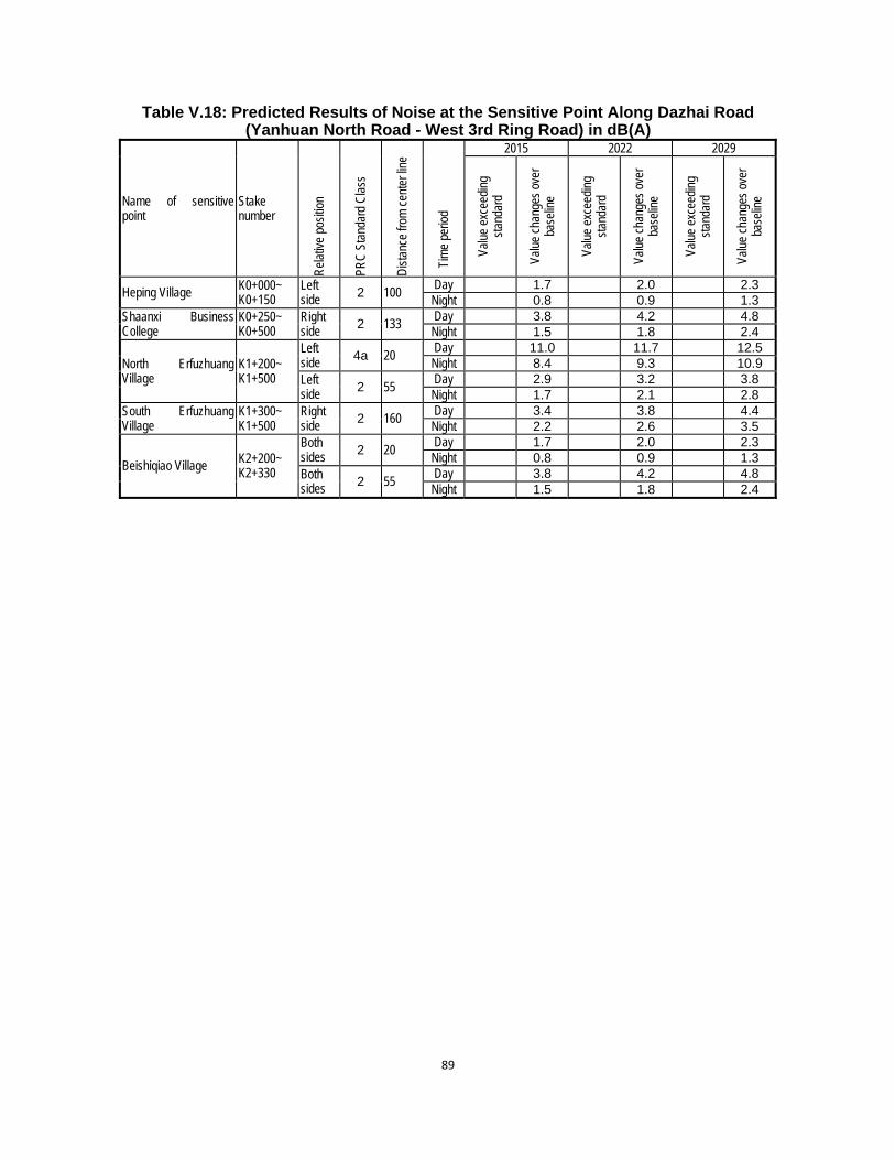
89
Table V.18: Predicted Results of Noise at the Sensitive Point Along Dazhai Road (Yanhuan North Road - West 3rd Ring Road) in dB(A)
Name of sensitive point
Stake number
Rel
ativ
e po
sitio
n
PRC
Sta
ndar
d C
lass
Dis
tanc
e fro
m c
ente
r lin
e
Tim
e pe
riod
2015 2022 2029
Valu
e ex
ceed
ing
stan
dard
Valu
e ch
ange
s ov
er
base
line
Valu
e ex
ceed
ing
stan
dard
Valu
e ch
ange
s ov
er
base
line
Valu
e ex
ceed
ing
stan
dard
Valu
e ch
ange
s ov
er
base
line
Heping Village K0+000~ K0+150
Left side 2 100
Day 1.7 2.0 2.3Night 0.8 0.9 1.3
Shaanxi Business College
K0+250~ K0+500
Right side 2 133
Day 3.8 4.2 4.8Night 1.5 1.8 2.4
North Erfuzhuang Village
K1+200~ K1+500
Left side 4a 20
Day 11.0 11.7 12.5Night 8.4 9.3 10.9
Left side 2 55
Day 2.9 3.2 3.8Night 1.7 2.1 2.8
South Erfuzhuang Village
K1+300~ K1+500
Right side 2 160
Day 3.4 3.8 4.4Night 2.2 2.6 3.5
Beishiqiao Village K2+200~ K2+330
Both sides 2 20
Day 1.7 2.0 2.3Night 0.8 0.9 1.3
Both sides 2 55
Day 3.8 4.2 4.8Night 1.5 1.8 2.4

90
Table V.19: Table for the Predicted Parameters and Predicted Results of Noise at the Sensitive Point Along Kunming Road (Xi’an-Baoji divergence line) in dB(A)
Name of sensitive point
Stake number
Rel
ativ
e po
sitio
n
Dis
tanc
e fro
m c
ente
r lin
e
PRC
Sta
ndar
d C
lass
Tim
e pe
riod
2015 2022 2029
Valu
e ex
ceed
ing
stan
dard
Valu
e ch
ange
s ov
er
base
line
Valu
e ex
ceed
ing
stan
dard
Valu
e ch
ange
s ov
er
base
line
Valu
e ex
ceed
ing
stan
dard
Valu
e ch
ange
s ov
er
base
line
Xi’an Biomedical technology institute
K0+300~ K0+635
Left side 35 4a
Day 11.6 12.2 12.6Night 8.7 9.5 10.1
Left side 80 2
Day 2.4 2.7 2.9Night 1.3 1.6 1.8
261. The analysis shows that West Section of Keji 2nd Road (West bypass- North Zhangba Road) has the potential to impact on its surroundings, with predicted noise levels at many sensitive receptor sites exceeding standard levels in the short, medium and long-term. This is especially the case in the section K3+800~K4+800. For this section, the traffic noise contours for day and night in the medium term have been mapped in Figures V.6 and V.7 to show the attenuating effects of building groups. 262. It was noted in Chapter IV that ambient noise levels at most sensitive receptors already exceed the World Bank Group EHS noise guidelines for residential areas (55 dBA (day) and 45 dBA (night)). The predicted operational noise levels, on top of baseline levels, will also therefore exceed the guidelines. 263. Where ambient noise standards and guidelines are exceeded by the predicted noise levels on top of baseline noise, appropriate mitigation measures will be implemented. These are listed for different sensitive receptors in Table V.20 below. The mitigation measures in Table V.20 are included in EMP at Table IX.6, Item 3.2.
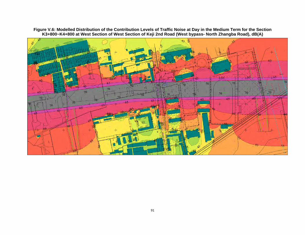
91
Figure V.6: Modelled Distribution of the Contribution Levels of Traffic Noise at Day in the Medium Term for the Section K3+800~K4+800 at West Section of West Section of Keji 2nd Road (West bypass- North Zhangba Road), dB(A)
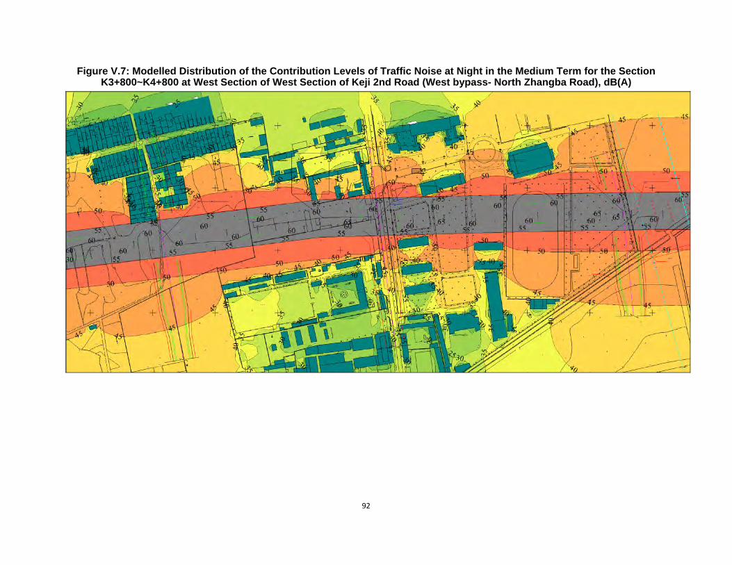
92
Figure V.7: Modelled Distribution of the Contribution Levels of Traffic Noise at Night in the Medium Term for the Section K3+800~K4+800 at West Section of West Section of Keji 2nd Road (West bypass- North Zhangba Road), dB(A)
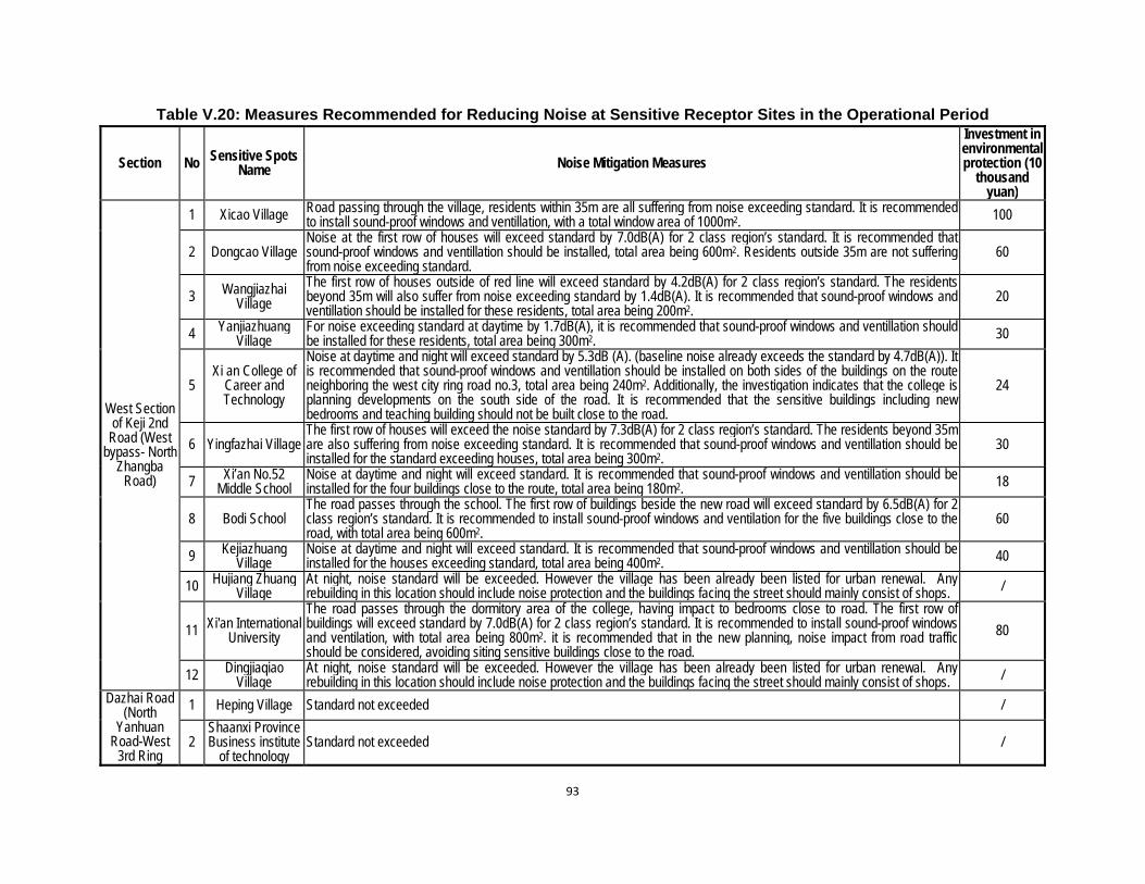
93
Table V.20: Measures Recommended for Reducing Noise at Sensitive Receptor Sites in the Operational Period
Section No Sensitive Spots Name Noise Mitigation Measures
Investment in environmental protection (10
thousand yuan)
West Section of Keji 2nd
Road (West bypass- North
Zhangba Road)
1 Xicao Village Road passing through the village, residents within 35m are all suffering from noise exceeding standard. It is recommended to install sound-proof windows and ventillation, with a total window area of 1000m2. 100
2 Dongcao Village Noise at the first row of houses will exceed standard by 7.0dB(A) for 2 class region’s standard. It is recommended that sound-proof windows and ventillation should be installed, total area being 600m2. Residents outside 35m are not suffering from noise exceeding standard.
60
3 Wangjiazhai Village
The first row of houses outside of red line will exceed standard by 4.2dB(A) for 2 class region’s standard. The residents beyond 35m will also suffer from noise exceeding standard by 1.4dB(A). It is recommended that sound-proof windows and ventillation should be installed for these residents, total area being 200m2.
20
4 Yanjiazhuang Village
For noise exceeding standard at daytime by 1.7dB(A), it is recommended that sound-proof windows and ventillation should be installed for these residents, total area being 300m2. 30
5 Xi an College of
Career and Technology
Noise at daytime and night will exceed standard by 5.3dB (A). (baseline noise already exceeds the standard by 4.7dB(A)). It is recommended that sound-proof windows and ventillation should be installed on both sides of the buildings on the route neighboring the west city ring road no.3, total area being 240m2. Additionally, the investigation indicates that the college is planning developments on the south side of the road. It is recommended that the sensitive buildings including new bedrooms and teaching building should not be built close to the road.
24
6 Yingfazhai Village The first row of houses will exceed the noise standard by 7.3dB(A) for 2 class region’s standard. The residents beyond 35m are also suffering from noise exceeding standard. It is recommended that sound-proof windows and ventillation should be installed for the standard exceeding houses, total area being 300m2.
30
7 Xi’an No.52 Middle School
Noise at daytime and night will exceed standard. It is recommended that sound-proof windows and ventillation should be installed for the four buildings close to the route, total area being 180m2. 18
8 Bodi School The road passes through the school. The first row of buildings beside the new road will exceed standard by 6.5dB(A) for 2 class region’s standard. It is recommended to install sound-proof windows and ventilation for the five buildings close to the road, with total area being 600m2.
60
9 Kejiazhuang Village
Noise at daytime and night will exceed standard. It is recommended that sound-proof windows and ventillation should be installed for the houses exceeding standard, total area being 400m2. 40
10 Hujiang Zhuang Village
At night, noise standard will be exceeded. However the village has been already been listed for urban renewal. Any rebuilding in this location should include noise protection and the buildings facing the street should mainly consist of shops. /
11 Xi'an International University
The road passes through the dormitory area of the college, having impact to bedrooms close to road. The first row of buildings will exceed standard by 7.0dB(A) for 2 class region’s standard. It is recommended to install sound-proof windows and ventilation, with total area being 800m2. it is recommended that in the new planning, noise impact from road traffic should be considered, avoiding siting sensitive buildings close to the road.
80
12 Dingjiaqiao Village
At night, noise standard will be exceeded. However the village has been already been listed for urban renewal. Any rebuilding in this location should include noise protection and the buildings facing the street should mainly consist of shops. /
Dazhai Road (North
Yanhuan Road-West
3rd Ring
1 Heping Village Standard not exceeded /
2 Shaanxi Province Business institute
of technology Standard not exceeded /

94
Section No Sensitive Spots Name Noise Mitigation Measures
Investment in environmental protection (10
thousand yuan)
Road) 3 North Erfuzhuang Village
The first row of houses will exceed standard by 4.3dB(A) for 2 class noise standard. It is recommended that sound-proof windows and ventillation should be installed for these houses, total area being200m2. 20
4 South Erfuzhuang Village Standard not exceeded /
Kunming road (Xi’an-Baoji Expressway relief road
West Section)
1 Xi’an Blomedical Technical College
Noise at this teaching facility will exceed standard by 5.9dB(A). It is recommended to install sound-proof windows and ventillation for the three buildings closest to the road, with total area being 700m2. 70

95
264. Traffic Noise Impact – from Upgrade of Kunming Road East. The noise levels for the newly built portion of Kunming Road have been considered in the previous section. For the upgrade portion, the sensitive receptors include the areas of Xidian Company, Xi’an Chemical Plant, Xi’an nitrogenous fertilizer plant, coke plant, and west Yaotou village. Based on the predicted traffic volumes on Kunming Road the noise impact on the edge of the upgraded section may be predicted. Table V.21: Predicted Result on Road Edge Noise of East (Upgraded) Section of Kunming
Road, dB(A)
Title of Road Component Period Time interval
The spot apart from the road center line by 24.5m (road
edge at south side)
The spot apart from the road center line by 45.5m (road
edge at north side)
East Section of Kunming Road
(West 3rd Ring Road - West 2nd Ring Road)
2015 Day 66.4 63.7
Night 53.0 50.4
2022 Day 67.0 64.3
Night 53.9 51.3
2029 Day 67.4 64.7
Night 54.6 51.9
265. It may be seen that the predicted noise on the south side is not elevated significantly above baseline. The daytime noise on the north side will increase, but can still meet 4a class standard. The north side is also landscaping above the covered Dahuanhe River, which will act to attenuate the noise levels. 266. Traffic Noise Impact – from New Interchanges. These components consist of West 3rd Ring Road-1st Epang Road Overpass, Zhuhong Road-North 2nd Ring Road Interchange, Zhuhong Road-4th Fengcheng Road Interchange, Hongmiaopo Interchange, Xinghuo Road Interchange, 8th Fengcheng Road-Beichen Avenue Interchange and 8th Fengcheng Road-Taihua Road Interchange. 267. They are to be implemented at existing intersections, so the prevailing analog and qualitative analysis, together with auxiliary prediction method from previous sections can be used for analyzing the environmental impact of noise, and predicting the traffic noise impact variation on surrounding sensitive points before and after project operation. 268. The analysis uses traffic volume calculations at the seven interchanges, average running speed of various vehicles, strength of noise source at 7.5 m, and the noise change over baseline at sensitive receptors. The details of this analysis for each of the seven interchanges are included in Appendix 3. 269. The predictions show that:
(1) West 3rd Ring Road-1st Afang (Epang Road) Overpass The surrounding area is mainly occupied by the enterprises and shops without environmental sensitive points. The noise level at night is similar before and after construction, with the day level increasing by only 0.6dB(A). The construction of this component will not bring about large changes in the surrounding acoustic environment, and the environmental impact is relatively small due to the absence of sensitive receptors around the project. (2) Zhuhong Road-North 2nd Ring Road Interchange The sensitive points at both sides of Zhuhong Road are mainly Xi’an Jingjing Food Product Factory residential area on southern side of existing interchange, plus
96
enterprises and shops. This residential area will be demolished for the project and the affected households will be resettled. The current noise level at both sides of Zhuhong Road at day and night is 65.7dB (A) and 62.1dB (A) respectively. The predicted results show that the noise level at day after construction of this interchange will be 70.0dB(A). Both baseline and predicted operational noise levels exceed class 2 standard in this location, however the absence of sensitive receptors reduces the potential significance of this impact. (3) Zhuhong Road -4th Fengcheng Road Interchange The surrounding area is mainly occupied by shops and open space without noise sensitive receptors such as residential areas. The current noise level at both sides of Zhuhong Road at day and night is 70.5dB(A) and 70.1dB(A) respectively. The higher noise level occurs at night due to trucks operating in many construction sites in the surrounding area. The predicted results show the noise level changes slightly before and after construction of this interchange, and the increase value is 1dB(A). The predicted noise level at day and night is lower than the current ambient monitoring level, which indicates that construction of interchange will not deteriorate the acoustic environmental quality of this area significantly. (4) Hongmiaopo Interchange The surrounding area is the Meat Product Factory Fangxin residential area on the southeast side, and other developments under construction. The current monitoring shows that the noise level at day and night outside Fangxin residential area is 68.7dB(A) and 61.1dB(A) respectively. The values exceed the standard. The predicted noise levels at day after construction will be 64.0dB(A), 4dB(A) lower than the existing level. These figures indicate that the sunken interchange layout adopted in this project will contribute to reduction of traffic noise on both sides of Xinghuo Road, and improvement of existing traffic noise in the area. (5) Xinghuo Road Interchange Both sides of Xinghuo Road are occupied by commercial premises and shops. The current noise level at this road is high - its level at day and night is 70.6dB (A) and 63.9dB (A) respectively, both exceeding the standard. Predicted noise level at day in the operational phasewill be 62.3dB (A), 8.3dB (A) lower than the existing level. This indicates that the sunken interchange adopted in this component will contribute to reduction of traffic noise on both sides of existing Xinghuo Road, and improvement of acoustic environment. (6) 8th Fengcheng Road-Beichen Avenue Interchange Both sides of Beichen Avenue are occupied by commercial premises and shops without noise sensitive receptor sites. The current noise level at this road at day and night is 67.2dB(A) and 57.3dB(A) respectively. The predicted results show that the noise level will not increase significantly over the baseline noise level, and it will be only approximately 2.5dB(A) higher than that before construction of this project. These figures indicate that construction of this component and 8th Fengcheng Road will marginally increase the noise level at this area, but there are no sensitive receptors nearby to be impacted. (7) 8th Fengcheng Road-Taihua Road Interchange The southwestern side of the proposed interchange is occupied by Tanjia Residential Area, the eastern side is Xujiabao Village, northern side is Tianhexinfu Residential Area and southeastern side is high-rise residential area under construction. Construction of

97
this component will result in the moving of Xujiabao Village, and have an impact on Tanjia as well as Xinfu Residential Areas, leading to higher traffic noise at this area. The current monitoring shows that the noise level at day and night at Tanjia Residential Area is 63.1dB(A) and 53.6dB(A) respectively. It is predicted that the noise level after completion of Tanjia Residential Area will be 5dB(A) higher than existing level at night. The current noise level at day and night at Tianhexinfu Residential Area is 61.2dB(A) and 52.3dB(A) respectively, and the predicted result show that the noise level will be about 4.6dB(A) higher than existing level at night after completion of this component. In addition, it is predicted that the night noise level at the high-rise buildings (now under construction) on the southeastern side will be 6.2dB(A) higher than that before construction. Therefore, a substantial noise barrier should be designed and built at the interchange near Tanjia and Tianhexinfu Residential Areas and other new residential area under construction at southeastern side of latter residential area to reduce the noise impact on the residential area.
270. Traffic Noise Mitigation. Specially designed and built noise barriers and sound-proofing for windows and ventilators are proposed for sensitive receptor sites (mainly residential and dormitory buildings) along much of Keiji 2nd Road new construction, small portions of Daichi and Kunming Roads (see Table V.20) and the 8th Fengcheng Rd – Beichen Avenue interchange. 271. Additional mitigation of traffic noise will be gained by sound planning decisions by local authorities. This should include good land use planning along new roads. Schools, hospitals, apartments for the elderly, and hotels should not be built within 50 m of the centre lines of new roads. Set-backs from the roadside should be enforced and used as greening belts and pavements. 272. Ambient noise monitoring will be mandated to determine whether mitigation measures will be required for sites where noise levels are predicted to exceed less than 3 decibels in audible scale or where noise levels are expected to be exceeded by more than 3 decibels in audible scale in the medium and long term. Monitoring will be conducted twice annually, for 2 days on each occasion. Additional mitigation measures will be implemented if infringement of PRC standards is observed. 273. Hazardous Goods Haulage. The haulage of hazardous goods on the new and upgraded roads raises the possibility of destructive pollution to adjacent urban areas caused by traffic accidents, especially when hazardous goods are transported. Hazardous goods for road transport in the project’s areas of influence include petrol, industrial chemicals and industrial and domestic waste. In order to reduce the risk of pollution by spillage of dangerous goods, an emergency preparedness and response mechanism has been defined and will be implemented by all counties with road subcomponents. 274. Dangerous goods in road transport must adher to the provisions of ‘Standard for Hazardous Substances’, ‘Major Hazard Installations Discrimination’ (GBl8218, 2000), ‘Classification of Health Hazard Levels from Occupational Exposure to Toxic Substances’ (GB50844-85) and ‘Rules of Transportation of Dangerous Goods by Automobile’ (JT 3130-88). These cover packaging and logos, vehicles and equipment, consignment and documentation, consignment acceptance and hand-over, transport, loading and unloading, storage and fire control, labour protection and medical emergency treatment, supervision and management 275. Environmental Risk, Emergency Preparedness and Response Planning. The environmental risk relating to this project mainly involves the five gas filling stations in the Multimodal Interchange Facilities. The feasibility study shows that four gas storage wells with total maximum volume of 12000Nm3, and five horizontal steel oil tank with total volume of 80m3
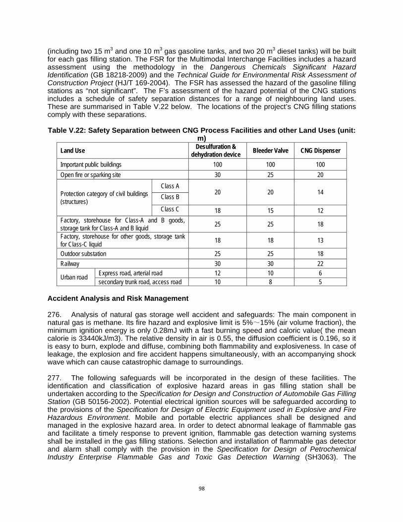
98
(including two 15 m3 and one 10 m3 gas gasoline tanks, and two 20 m3 diesel tanks) will be built for each gas filling station. The FSR for the Multimodal Interchange Facilities includes a hazard assessment using the methodology in the Dangerous Chemicals Significant Hazard Identification (GB 18218-2009) and the Technical Guide for Environmental Risk Assessment of Construction Project (HJ/T 169-2004). The FSR has assessed the hazard of the gasoline filling stations as “not significant”. The F’s assessment of the hazard potential of the CNG stations includes a schedule of safety separation distances for a range of neighbouring land uses. These are summarised in Table V.22 below. The locations of the project’s CNG filling stations comply with these separations. Table V.22: Safety Separation between CNG Process Facilities and other Land Uses (unit:
m)
Land Use Desulfuration &
dehydration device Bleeder Valve CNG Dispenser
Important public buildings 100 100 100
Open fire or sparking site 30 25 20
Protection category of civil buildings (structures)
Class A 20 20 14
Class B
Class C 18 15 12
Factory, storehouse for Class-A and B goods, storage tank for Class-A and B liquid
25 25 18
Factory, storehouse for other goods, storage tank for Class-C liquid
18 18 13
Outdoor substation 25 25 18
Railway 30 30 22
Urban road Express road, arterial road 12 10 6 secondary trunk road, access road 10 8 5
Accident Analysis and Risk Management 276. Analysis of natural gas storage well accident and safeguards: The main component in natural gas is methane. Its fire hazard and explosive limit is 5%~15% (air volume fraction), the minimum ignition energy is only 0.28mJ with a fast burning speed and caloric value( the mean calorie is 33440kJ/m3). The relative density in air is 0.55, the diffusion coefficient is 0.196, so it is easy to burn, explode and diffuse, combining both flammability and explosiveness. In case of leakage, the explosion and fire accident happens simultaneously, with an accompanying shock wave which can cause catastrophic damage to surroundings. 277. The following safeguards will be incorporated in the design of these facilities. The identification and classification of explosive hazard areas in gas filling station shall be undertaken according to the Specification for Design and Construction of Automobile Gas Filling Station (GB 50156-2002). Potential electrical ignition sources will be safeguarded according to the provisions of the Specification for Design of Electric Equipment used in Explosive and Fire Hazardous Environment. Mobile and portable electric appliances shall be designed and managed in the explosive hazard area. In order to detect abnormal leakage of flammable gas and facilitate a timely response to prevent ignition, flammable gas detection warning systems shall be installed in the gas filling stations. Selection and installation of flammable gas detector and alarm shall comply with the provision in the Specification for Design of Petrochemical Industry Enterprise Flammable Gas and Toxic Gas Detection Warning (SH3063). The

99
calibration level of flammable gas detector warning (upper limit) shall be lower than or equal to 25% of lower limit concentration of flammable gas explosion. 278. The CNG facilities use underground storage wells. Storage wells can reduce the spread and strength of ground shock wave in the event of accident, and thus reduce hazard compared with gas tanks and gas cylinders. However, underground gas storage well is emerging, including the wells can have problems with cementation, well sleeving movements, and unreliable and imperfect sewage disposal. In addition, leak detection in underground gas storage wells is less straightforward, and internal cracks are a potential problem. Therefore, inspection of gas storage wells will be undertaken frequently to check on cracks or loosening on the cementation, and well sleeving movements, so as to reduce the possibility of accident. 279. Petroleum Tank Accident Analysis and Safeguards. Both gasoline and diesel are flammable and explosive liquids. In case of leakage during their storage and transport, poor electrostatic grounding, or leakage at pipeline and joint during unloading due to carelessness during filling, the flammable gas evaporated can form an explosive combination with air. Since petroleum vapours are heavier than air, they can spread widely and collect in low area resulting in backflash and fire explosions. 280. The consequence of a petrol/diesel burning or explosion accident is very serious, including casualties and property losses. Leakage of bulk oil products without subsequent fire will also pollute the atmospheric environment, surface water and soil seriously, especially the impact of surface water and soil will last considerably long period, animals and plants in the polluted water and soil will die. 281. Gasoline is also a toxin - a concentration in air of 30-40mg/L is a toxic level. It has an anesthesia action on the central nervous system, causing dizziness, headache, nausea, sickness, unstable gait and lack of coordination in mild intoxication, and unconsciousness and diastaltic respiratory arrest for high concentration inhalation. Inhalation of gasoline into the respiratory track may cause internal dermatitis. Splashing into eyes may cause corneal ulcer, even perforation and loss of sight. Skin contact may cause the acute contact dermatitis and oily acne, and inhalation of it will cause the aspiration pneumonia, so as to contract the fetal blood through the placenta. The diesel exhaust may irritate the eyes and nose, and make people feel dizzy and headache. 282. Sound management systems and operational procedures, and well maintained fire protection equipment will be established in each gas filling station. Safety systems codified under PRC safety standards include Fire Protection Safety Regular Meeting System, Fire Protection Education and Training System, Fire Protection Watch System, Fire Protection Inspection, Potential Fire Hazard Treatment System, Lightning Protection, Anti-static, Electric Equipment and Line Inspection and Management System, Fire and Electricity Safety Management System, Extinguishing Equipment Maintenance and Management System, Volunteer Fire Organization Management System, Post Fire Protection Responsibility System, Post Fire Protection Safety Operation Procedure, Extinguishing and Emergency Evacuation Response Plan. The workers in gas filling stations shall take part in training and in fire protection technical specification, fire protection knowledge, hazard and prevention of static electricity discharge. New workers will not take up their duties until taking part in the training, and knowing the regulations, systems, operation procedure and skills. 283. The Extinguishing and Emergency Evacuation Response Plan shall be practiced periodically, and problems in it corrected and revised. Routine fire protection inspection shall be regularly undertaken. Electrical equipment, lighting, oil tank port at tank area, gauge hatch, oil unloading hatch, valve, manhole related oil tank accessories, oil unloading and transmission pipeline, lightning and static-protection earthing shall be inspected at least twice a day, and

100
records maintained. In case of leakage of product oil, the worker shall report immediately and deal with the problem. Any building or maintenance especially involving electric or gas welding in gas filling station area shall have prior approval, and reported to the local public fire protection authority. E. Health and Safety (Construction and Operational Phases) 284. The objective of environmental health and safety is to provide workers with safe and healthy working conditions and prevent accidents, injuries, and disease. It also covers the establishment of preventive and emergency preparedness and response measures to avoid, and where avoidance is not possible, to minimize, adverse impacts and risks to the health and safety of local communities. It is therefore a combination of occupational health and safety of staff/workers at the subcomponent facilities and community health and safety of people living nearby or potentially affected by failures or poor operation of facilities. 285. Safety risks are mainly related to the construction phase. Residents, particularly children, are at risk during project construction. In linear construction activities such as road construction which typically occur in areas frequented by the public, physical and educational measures to protect residents from risks are needed. Safety measures for construction staff and public will include the following responsibilities of the contractor: (i) providing safe and convenient passages for the public; (ii) providing construction workers sufficient personal protection equipment such as hard hats, earpiece, safety shoes, and dust masks and breathing protection when working with asphalt; (iii) providing seminars on safety issues to local public, particularly school students; (iv) installing warning signs where potential dangers are present; (v) ensuring construction staff are on duty on or near heavy movement of construction vehicles, or heavy construction vehicle traffic through the villages to ensure safety; and (vi) setting up traffic signs at and near construction sites. 286. Through a number of its outputs, the Project will improve road safety. The improved road and intersections, road system and ITS Expansion and Road User Safety Program will reduce the number of vehicular accidents, and the Pedestrian Crossing and Safety Improvements will address pedestrian and non-vehicular safety. 287. Additional environmental health and safety measures to be applied, especially relating to community environmental health in the construction phase, will include:
i. At the time of construction, it is necessary to arrange safety duty posts at the intersections, sites with higher population concentration, and the residential areas by which transport vehicles pass.
ii. At the time of selecting the sites for construction yards, asphalt mixing plants, precast plants and other construction sites, it is necessary to pay attention to keep these sites away from the residential areas.
iii. To minimize the impacts of construction on the lives of urban inhabitants and urban traffic, it is necessary to work out a unified diversion plan for the routes of urban highway traffic vehicle to avoid causing traffic congestion, cooperate, when necessary, with the public security traffic management departments to ensure the smooth flow and normal operation of urban traffic, and distribute the notice in advance to reassure the public by utilizing such media as radio, television, and newspapers.
iv. Placement of bulletin boards at construction site, indicating the main contents of project, construction time, asking the public acceptance for the inconvenience arising from the construction, and marking the contact person, claim hotline and other information on the bulletin board.
101
v. When the construction will be carried out in the vicinity of schools, kindergartens, villages, and residential areas, i.e. the alteration works construction site at Zhuhong Road and so on, it is necessary to arrange the make-shift bridge at the places where there is an incoming and outgoing flow of students and inhabitants. Moreover, fine mesh safety vertical nets must be applied outside the scaffolds to ensure the safety of incoming and outgoing pedestrians.
288. The Design Institute has provided a matrix of EHS requirements and Project performance as a checklist. This is included at Appendix
F. Cumulative Impacts 289. Cumulative effects are defined as the impacts on the environment that result from the incremental impact of an action when added to other past, present, and reasonably foreseeable future actions, regardless of the agency (central or non-central) or person undertaking such other actions. 290. The active construction of a number of sub-projects close to each other within the urban area will cause a magnification of environmental and social impact in the project areas in terms of traffic on the existing road network, civil works, air-borne dust, waste generation, community disturbance and safety etc. These construction impacts might be increased as a result of other infrastructure projects which might be implemented in a near future. These construction related cumulative impacts could be effectively minimized by adopting proper mitigation measures, including: (i) coordination between all project sub-components and other projects in the area of influence in terms of construction schedule, possible access road and borrow/disposal sites sharing; (ii) contractors will develop material transport plan with consultation of local road management authority and local community; (iii) enforcement of good construction management to minimize dust, noise and waste generation; (iv) education of construction workers to minimize social disturbance and cultural conflict; (vi) provision of temporary access to local traffic; (vii) proper maintenance of the access roads and timely restoration/strengthening upon completion. With effective implementation of good construction management measures, these common construction-related cumulative impacts can be adequately mitigated to acceptable level. During operations, in the short term, the improvement in roads and intersections together with planned development of mass rapid transport (MRT) system integrated with surface transport, is likely to reduce air and noise impacts. In the long run though it will be necessary for Xi’an city to practice sustainable land use planning and adopt policy measures to encourage cleaner modes of transport to sustain the benefits of the project. G. Unanticipated environmental impacts 291. Where unanticipated environmental impacts become apparent during project implementation, the executing agency, with the support of the municipal government, will update the environmental assessment and EMP or prepare a new environmental assessment and EMP to assess the potential impacts, evaluate the alternatives, outline mitigation measures and resources to address those impacts.
102
VI. CONSIDERATION OF ALTERNATIVES A. Scope of Alternatives 292. The ADB-financed Xian Urban Roads Improvement project is a small component of a city-wide transport improvement program being undertaken by the Xi’an government under the City Master Plan15. Since the individual outputs are therefore part of a very large whole, the main consideration of alternatives, with implications for environmental impact, have taken place on a city scale during program planning. The individual Project outputs which are the subject of this PPTA are based on the Xi’an road development program and the Xi’an urban development program. They therefore fulfill programmed requirements, and a construction plan which has also been worked out on the basis of thorough investigation. Consideration of site selection and route selection for road construction, flyovers and intersections is on the basis of the above program, and comparisons in site and route alternatives at the EIA stage are not significant. The remaining outputs (for pedestrian mobility and safety, traffic intelligent management system, and environment protection enhancement) have minimal construction elements and will result in significant environmental improvements without environmental impacts. No analysis of alternatives of these Project outputs was undertaken. 293. The MIF Project output provides a major transport alternative to private vehicle use by the establishment of transport hubs linking car, bus and train modalities on the outskirts of the city. While other Project outputs focus of increasing the efficiency of traffic flow and vehicle operations on and outside the second ring road, the MIF output promotes the use of alternative transport to private vehicles. The MIF transport hubs link with the planned cross-city subway lines and provide park-and-ride facilities. Additionally, parking stations within the second ring road are a part of a municipal government push to keep cars out of the city centre. The MIF Output elements are a fit with existing and planned transport infrastructure and services, set out in the Xi’an 4th City Master Plan 2008-2020 for which the analysis of alternatives occurred during concept planning and on a holistic basis. B. No-Project Alternative 294. The no-project alternative compares the effect of the continuation of the current situation on the environment with that of project construction. It is known from the feasibility studies that non-construction of the project would allow the occurrences of traffic jams and slow movement of vehicles leading to the increase of oil consumption and pollutant emission while increasing foot passengers’ trip time, not only wasting fuel but polluting environment. The no-project alternative has a significant impact on environment. 295. By contrast, construction of the project will relieve current traffic congestion, increase cars’ moving speed, reduce pollutant emission, and facilitate pedestrians’ trip while also promoting energy conservation and emission reduction. On the whole, the project is beneficial to the people’s livelihood with far greater positive environmental effects than negative results. Its environmental impact is significantly less than that from zero-alternative. C. Roads and Interchange Alternatives 296. For new or upgraded roads only minor alternative of lane configurations and width were undertaken, since the alignment and design capacities have already been determined by the part they will play in the future Xi’an road network. For intersections, many alternative
15 Xi’an Academy of Urban Planning and Design, 2009, Xi’an 4th City Master Plan 2008-2020. Xi’an City Building
Bureau, July 2009.

103
engineering specifications and internal layouts of slip lanes, connections, grade separations and flyovers/underpasses were considered in the FSR. The finally selected configuration however was based primarily upon a combination of engineering factors, traffic optimisation and cost. None of the engineering alternatives provided significant differential environmental implications, and since all alternatives include vegetated medium strips, landscaping and provision for non-motorised transport, there are no differential implications for environmental amenity in the schemes. A description of the analysis of engineering alternatives is provided in Appendix 3. A summary of these comparisons is shown below in Table VI.1.
Table VI.1: Interchange Alternative Comparison Summary Land taken (ha) Construction difficulty Resettlement (m2) Cost (10,000 CNY)
Zhuhong-North 2rd Ring Rd
interchange
Recommended 4.3 Straightforward 25050 13731.33
Alternative 12.5 Complex 46920 24532.05
Zhuhong-Fengcheng
No.4 Rd interchange
Recommended 0 Straightforward 0 9462.55
Alternative 1.4 Complex 0 15507.49
Hongmiaopo interchange
Recommended 3.5 Complex 27155 15070.35
Alternative 2.5 Straightforward 24978 6099.08
Xinghuo underpass
Recommended 0 Straightforward 0 8265.49
Alternative 0 Complex 0 8667.76 No.8
Fengcheng Rd-Beicheng
Rd
Recommended 17.9 Straightforward 40139 17211.08
Alternative I 11.1 Complex 24083 20944.16
Alternative II 17.0 Straightforward 40139 18116.12 No.8
Fengcheng Rd-Taihua
Rd
Recommended 12.9 Complex 72483 26908.04
Alternative 11.8 Straightforward 68675 15661.4
D. Multimodal Interchange Facilities – Transport Hubs Alternatives
1. Bus Terminals 297. Bus terminals are planned at North Railway Station Bus Park and Aerospace Base Bus Park. Due to their unique characteristics in site selection, i.e. close to existing railway, subway line and development centres, no alternative sites are presented for either in the feasibility study.
2. Integrated Transfer Stations 298. Scheme I: A comprehensive consideration was made by combining subway stations with public parking areas and bus terminals and depots in respect of spatial and functional distribution and architectural scheme to achieve zero distance transfer. Scheme II: The construction of public parking areas and bus terminals and depots shall take into full account the change between them and subway stations to fit the need for easy transfer. In consideration of the operability of project operation management during and after construction, Scheme II is recommended by this study.
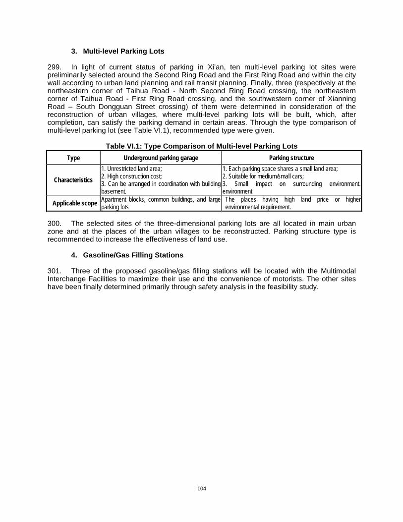
104
3. Multi-level Parking Lots 299. In light of current status of parking in Xi’an, ten multi-level parking lot sites were preliminarily selected around the Second Ring Road and the First Ring Road and within the city wall according to urban land planning and rail transit planning. Finally, three (respectively at the northeastern corner of Taihua Road - North Second Ring Road crossing, the northeastern corner of Taihua Road - First Ring Road crossing, and the southwestern corner of Xianning Road – South Dongguan Street crossing) of them were determined in consideration of the reconstruction of urban villages, where multi-level parking lots will be built, which, after completion, can satisfy the parking demand in certain areas. Through the type comparison of multi-level parking lot (see Table VI.1), recommended type were given.
Table VI.1: Type Comparison of Multi-level Parking Lots
Type Underground parking garage Parking structure
Characteristics
1. Unrestricted land area; 2. High construction cost; 3. Can be arranged in coordination with building basement.
1. Each parking space shares a small land area; 2. Suitable for medium/small cars; 3. Small impact on surrounding environment. environment
Applicable scope Apartment blocks, common buildings, and large parking lots
The places having high land price or higher environmental requirement.
300. The selected sites of the three-dimensional parking lots are all located in main urban zone and at the places of the urban villages to be reconstructed. Parking structure type is recommended to increase the effectiveness of land use.
4. Gasoline/Gas Filling Stations 301. Three of the proposed gasoline/gas filling stations will be located with the Multimodal Interchange Facilities to maximize their use and the convenience of motorists. The other sites have been finally determined primarily through safety analysis in the feasibility study.

105
VII. PUBLIC CONSULTATION AND INFORMATION DISCLOSURE A. Legislative Framework for Public Consultation 302. Public participation and consultation in the evaluation of project design, planning and implementation is an important part of environmental impact assessment; it can directly reflect the public’s perceptions on environmental quality in the project’s area of influence. Relevant provisions in the Environmental Protection Law of PRC and the Regulations on the Administration of Construction Project Environmental Protection (Order of the State Council, No. 253) require that “Environmental Impact Report formulated by construction unit shall be in accordance with relevant laws to solicit the opinions of units concerned and inhabitants of project construction site". ADB’s environmental guidelines also have detailed and strict requirements on public participation and consultation. The public consultation processes for this Project therefore follow both the PRC requirements and the ADB requirements (most recently amended in the ADB Safeguards Policy Statement of 2009). 303. The consultations were conducted by the local EIA institutes and PPTA consultants through web sites for information disclosure, questionnaires, interviews, and public meetings in the communities, townships, village committee and affected villagers’ homes during preparation of the EIA and Resettlement Action Plan. Concerns expressed by the public have been taken into account and have been incorporated either in the project design or in the environmental management plan or resettlement plan. B. The First Round of Public Consultation Activities
1. Information Dissemination 304. In accordance with the requirements of PRC Provision of Public Consultations for Environmental Impact Assessment (SEPA, 2006), public notices were issued. The public notices were posted in prominent government offices of the EA. The first round of public consultation was conducted at an early stage of the EIA field work from September 21 to October 2010 through questionnaire distribution and consultation meetings. A brief summary of the Project including project name, location, construction scale and construction implementation schedule and expected environmental impacts and project maps were provided and explained to the attendees. 305. The major purpose of the first round consultation was to conduct information disclosure and seek the public attitude toward the Project.
2. Questionnaire and Responses 306. During the exhibition period of the Public Notices, the EAs and Institute randomly distributed questionnaires among the residents and the public within the area of influence. The breakdown of respondents (gender, occupation and education) is at Table VII.1 below, and the comments and responses to the questionnaires is summarized in Table VII.2. In general, the respondents in the first round of public consultation supported the construction of the new projects. They believed that the projects would improve the existing environmental quality and living amenity, and they would support their implementation on condition that their reasonable requirements and recommendations were satisfied.

106
Table VII.1: Breakdown of Respondents to Questionnaire Sub-project title
Investigation item Xi’an Urban Road Network
Improvement Output Xi’an Multimodal Interchange Facilities
Output
Investigation time 2010-9-12 2010-9-21
Place where investigation to be going Adjacent region of
construction project Adjacent region of construction project
Investigation form Issuing questionnaire Issuing questionnaire
Circulation of questionnaires issuance 100 200
Recovery copy number of questionnaires 100 185
Occupational composition
Civil servant 25% 24.3%
Teacher 23% 18.9%
Worker 31% 29.1%
Peasant 15% 20.5%
Other 6% 7.2%
Sex Male 57% 53%
Female 43% 47%
Educational attainments
College or higher 45% 48%
Senior middle school and technical secondary school
38% 35%
Junior middle school and below
19% 17%
Table VII.2: Breakdown of Responses to Questionnaire
Sub-project title
Investigation content Answer
Betterment project of Xi’an
urban road network
Relationship between you and the construction project
Living at the first row of neighboring street 15%
Frequently passing along the road 64%
Other 21%
What attitude you have to construction of the project
Support 96% Against 0% 4% of not being fussed
about it Satisfying degree on road
status of the habitation or the current work place
Satisfied 5% Neither satisfied or
unsatisfied 5% Not satisfied 90%
Waste gas impact from automobiles on existing road
to you Serious 9% Not serious 11% Commonly 80%
Noise impact from existing road to you
Serious 12% Not serious 10% Commonly 78%
Your comprehension to the project
High 26% Medium 44% Low 30%
Your attitude to resettlement Obeying arrangement
30% Expect reasonable compensation 60%
Other 10%
Project construction significance to trip
Significant help 90% Some help 6% No help 4%

107
Sub-project title
Investigation content Answer
Your attitude to impact
caused from project
construction
Noise Accepting 41% Understanding but
dependent upon mitigation measures 59%
Complain 0%
Flying dust Accepting 38% Understanding but
dependent upon mitigation measures 62%
Complain 0%
Sewage and slurry
Accepting 40% Understanding but
dependent upon mitigation measures 60%
Complain 0%
Pedestrian inconvenience
Accepting 47% Understanding but
dependent upon mitigation measures 53%
Complain 0%
Your attitude to impact
caused from operation
period of the project
Waste gas from
automobiles Serious 5% Not serious 15% Acceptable 80%
Noise Serious 4% Not serious 14% Acceptable 82%
Vibration Serious 1% Not serious 14% Acceptable 85%
Other Serious 1% Not serious 13% Acceptable 87%
Economical benefit from completion of the project to
regional economy
Whether or not other industry development is
boosted up Yes 100% No 0%
Whether or not popularity of the region can be
raised Yes 95% No 5%
Demand project of Xi’an
traffic management
Your comprehension case to the project
Comprehension up to 57.8%
Not comprehending 17.8% A little 24.4%
Your attitude to project construction
Support 77.8% 22.2% of not being fussed
about it Against 0%
By your consideration the project construction will bring about to you and your families
living what impact.
Favorable 91.1% Disadvantage 0% Neither 8.9%
What benefit will be brought about to Xi’an city by the
project construction?
Improvement of environment quality
41.3%
Development of tourism 6.5%
Economical development
30.4%
Not large in significance
4.3% 307. In summary, 96% of people consulted support the Xi’an urban Road Network Improvement output and 77.8% support Xi’an Multimodal Interchange Facilities output. The main reasons given are as follows: (i) Currently, infrastructure facilities of Xi’an city cannot satisfy traffic demand, resulting in low vehicle speed and the discharge of more pollutants. The construction of the project may improve current traffic conditions and increase traveller convenience; (ii) after implementation of the project the environmental quality of the city will be improved and tourism development boosted. This will benefit the investment environment and boost economic development of Xi’an city; (iii) impact from noise, flying dust and ecological damage of construction period to the surrounding environment and to cultural relics is a major concern. The prevailing view is that the construction unit should follow strict environmental management in construction and future operation, carrying out cultural relic protection of each relic site and safeguarding local environmental quality; (iv) in the construction of interchanges
108
the needs of pedestrians should be taken into consideration; and (v) the Government should ensure an adequate solution for resettlement of affected residents, providing land-use compensation in good time and guaranteeing the interest and rights of resettled and affected residents. 308. Resettlement issues have been referred to and covered by the parallel public consultation and participation program for social action planning and resettlement. All of the affected households and villages/communities, village leaders and town/township and county governments have been involved in the social impact and social-economic survey. On various occasions during meetings, interviews, focus group discussions, public consultation workshops, and community consultation meetings, local representatives have participated in the planning and their concerns have been integrated into the five Resettlement Plans for the project. C. The Second Round of Public Consultation Activities 309. The second round of publication was conducted in January 2011, including meetings with village committees, affected people and relevant government agencies. The predicted environmental impacts and proposed environmental management plan were provided for discussion. The EIA team and the consultants visited the project committee and affected villages to solicit comments and advice on the Project. Local people, including staff from local government agencies including water resource bureau, EPB, Cultural Relic Bureau, Construction Bureau, Land Administration Bureaus, Communication Bureaus attended the meetings. 310. In this round, with more detailed information of the outputs, their scale and locations – people were able to comment of specific components. These are listed below:
1) Most of the affected people are concerned about resettlement plan and compensation rate. The resettlement plan should be made available to the public and the compensation rate should be transparent.
2) Villages of Dongcao, Xicao and north Er’fuzhuang are concerned about the drinking water tower that might be relocated. They requested that the water supply system including a well, water tower and pipe network should be provided before resettlement commences.
3) Villagers in Dongcao and Xicao also expressed concern about the irrigation system that will be affected by the Keji 2nd road. A temporary irrigation system should be installed during construction and a permanent system should be reinstated before operation.
4) Bodi High School staff is concerned about the relocation of the teaching building. They request that a temporary teaching building should be provided before demolition of the existing one and compensation should be at an appropriate level.
5) Since the new Kieji Road road will divide the Xi’an International University into north and south campuses, the university is concerned about the student safety and convenience during both construction period and operation phase. They requested that an overpass should be constructed to connect the north and south part of the university. Heavy transportation vehicles should not pass directly through the north part of the university where the central teaching activities exist. Noise barriers should be installed during construction.
6) The Youyi district committee, and Huagongfang district committee expressed their concern about the public disturbance during construction. They proposed several temporary road crossing should be placed at densely populated areas. They also asked that special people should be designated to protect primary school students’ safety when arriving at and leaving school.
7) The committee of Xi’an electricity company residential area expressed their concerns about road crossing during construction and their desire for a roadside toilet

109
construction after construction for the local residents’ convenience.
311. A brief edition of the EIA summary for this project was made accessible on the websites of the EIA institute to continue to collect opinions, suggestions and concerns from communities in the project area. Telephone, fax and email address were provided. In February 2, 2011, brief project information, environmental impacts and EIA conclusion were publicized in the local newspaper (Figure VII.1 below). Figure VII.1: Newspaper Notice Advertising Project Plans and EIA
D. Future public consultation 312. Comments and responses from the public have been used in finalizing the EIA documents. Future public consultation will include involvement in monitoring impacts and mitigation measures during the construction and operation stages; evaluating environmental and economic benefits and social impacts; and interviewing the public after the Project is completed. In particular, households living along new road alignments will be targeted. 313. The future public involvement in monitoring impacts and mitigation measures during the construction and operation stages is detailed in the Environmental Management Plan (Chapter IX) and includes a Public Consultation Plan.

110
VIII. GRIEVANCE REDRESS MECHANISM 314. Public participation, consultation and information disclosure undertaken as part of the local EIA process, assessment and development of resettlement plans, and consultations undertaken by the project consultants have discussed and addressed major community environmental concerns. Continued public participation and consultation has been emphasised as a key component of successful project implementation. As a result of this public participation and safeguard assessment during the initial stages of the project, major issues of grievance are not expected. However, unforeseen issues may occur. In order to settle such issues effectively, an effective and transparent channel for lodging complaints and grievances has been established, in parallel with the mechanism developed under the resettlement planning process (refer to output resettlement plans). 315. The IA will establish a mechanism to receive and facilitate resolution of affected peoples’ concerns, complaints, and grievances about the Project’s environmental performance. The grievance mechanism should be scaled to the risks and adverse impacts of the project. It should address affected people’s concerns and complaints promptly, using an understandable and transparent process. It should also be readily accessible to all sections of the community at no cost and without retribution. A. The Current System 316. The 2005 PRC Decree No. 431 entitled Regulations on Letters and Visits codifies complaints receival mechanism at all levels of government, and safeguards the complainants from any retaliation. In 2007, the national regulation was adapted to environmental matters in Decree No. 34 of SEPA on Environmental Letters and Visits System. 317. In the current system, when people are adversely affected by a project, they can appeal to contractors, local government, Xi’an EPB or court. Among the agencies involved, Xi’an EPB takes the leading coordination role in dealing with environmental complaints.
Figure VIII.1: Current Complaints Pathways 318. In case of problems during the construction, affected persons usually complain to the contractors first if they believe the construction is the source of issues. If the contractors' responses are unsatisfactory, they then go to local government. If they refer their complaint to the Xi’an EPB, the XEPB will need to consult with the EA or environmental supervision engineer to develop project understanding. Therefore, it is usual for the EA, who is familiar with the project, to take the lead role in complaint investigation.
Affected People
Contractors XEPB Local Government
Court
111
B. Proposed Mechanism 319. The following proposed mechanism for grievance redress of environmental matters in construction and operation of the project’s infrastructure components uses existing village administrative structures (affected persons/ village committees/ village groups), any of which can be complainants. It may use diverse complaint media that are culturally appropriate, including self-identified, confidential, or anonymous procedures such as professional letter writers, suggestion boxes, mail-in forms, hotlines, and electronic submission through a website. 320. This system also mirrors the approach of the grievance redress mechanism for the Project’s resettlement and asset compensation. The mechanism will be accessible to diverse members of the community, including more vulnerable groups such as women and youth. Multiple points of entry, including face-to-face meetings, written complaints, telephone conversations, or e-mail, should be available. Opportunities for confidentiality and privacy for complainants should be honored where this is seen as important. 321. The IA will establish a Project Public Complaints Centre (PPCC) prior to construction to deal with complaints from affected people during implementation of the Project. Experience in China has shown that contractors are responsive to directions from “above” (the Centre) and not necessarily to complaints directly to them, which rarely reach the right person. Additionally, the Centre will act as a clearing house for complaints, compiling records which are included in project monitoring reports. 322. People will be encouraged, should any issue occur, to contact the PPCC with confidence that it will handle the problem until a solution is found and implemented. For this purpose, the PPCC’s phone number, fax, address, email address will be publicized through notice boards at the project sites and within nearby communities. The Terms of Reference for the PPCC also cover mechanisms for the referral of complaints made through other government agencies and the statutory time limits which these actions entail. 323. The PPCC will investigate the complaint, identify appropriate corrective measures and instruct the Contractor to implement corrective actions. The PPCC will review the Contractors response and undertake additional monitoring and verification to ensure that the cause for any complaint does not recur. During the complaint investigation work, the PPCC will work in close consultation with the Contractors, Construction Chief Engineer, and the Construction Environmental Supervisor.

112
Figure VIII.2: Proposed Environmental Grievance Redress Mechanism
324. Finally the PPCC will report the investigation results and subsequent actions to the complainant, and record the complaint, investigation, and subsequent actions and results in the monthly EMP reports. The activities and responsibilities of the PPCC are set out below, in procedural order:
(i) The PPCC will be within the Investment and Development Department under the Xi’an Urban Infrastructure Investment Group (IA). At least 2 persons from the department should be designated to deal with public complaints and directly report to the department director.
(ii) PPCC’s phone number, fax, address, email address will be publicised through notice boards at the project sites and within nearby communities. People will be encouraged, should any issue occur to contact the PPCC with confidence that it will handle the problem until a solution is found and implemented.
(iii) The PPCC will instruct contractors and construction supervisors to refer any complaints which they have received directly to the PPCC. Similarly, the PPCC will coordinate with local government or XEPB to “capture” complaints made directly to them.
(iv) The PPCC will log complaint and date of receipt onto the complaint database and inform the Construction Chief Engineer and Construction Environmental Supervisor.
(v) The PPCC will investigate the complaint to determine its validity, and to assess whether the source of the problem is due to project activities, identify appropriate corrective measures and advise the Contractor for implementation.
(vi) The PPCC will review the Contractors response on the identified mitigation measures, and the updated situation.
(vii) If complaint is transferred from government agencies such as XEPB or Xi’an Municipal Public Complaint Centre (XMPCC), the PPCC will submit interim report to the XEPB or XMPCC on status of the complaint investigation and follow-up action within the time frame assigned by the above agencies
(viii) The PPCC will undertake additional monitoring and verify the situation if necessary as well as review that any valid reason for complaint does not recur.
Affected People
Local
Contractor Supervisor
Community/ Village Committees
Public Complaints Center (PCC) of the IA
Xi’an Government Public Complaints
C t
Complaints Stage
Corrective Action Stage

113
(ix) The PPCC will report the investigation results and subsequent actions to the source of complaint for responding to complainant.
(x) The PPCC will record the complaint, investigation, and subsequent actions and results in the monthly EMP reports.
(xi) During the complaint investigation work, the PPCC should work together with the Contractors, Construction Chief Engineer, and the Construction Environmental Supervisor. If mitigation measures are identified in the investigation, the Contractors will promptly carry out the mitigation. The Construction Chief Engineer will ensure that the measures have been carried out by the Contractors.
325. In the construction period and the initial operational period covered by loan covenants the PMO will be reporting progress to the ADB, and this will include reporting complaints and their resolution. 326. The tracking and documenting of grievance resolutions within the county PMOs will include the following elements: (i) tracking forms and procedures for gathering information from project personnel and complainant(s); (ii) dedicated staff to update the database routinely; (iii) systems with the capacity to analyze information so as to recognize grievance patterns, identify any systemic causes of grievances, promote transparency, publicize how complaints are being handled, and periodically evaluate the overall functioning of the mechanism; (iv) processes for informing stakeholders about the status of a case; and (v) procedures to retrieve data for reporting purposes, including the periodic reports to the PMO and the PMO’s report to the ADB.

114
IX. ENVIRONMENTAL MANAGEMENT PLAN A. Introduction 327. The environmental management plan (EMP) covers all phases of implementation from preparation through commissioning and operation, and it aims to ensure the monitoring of environmental impacts and activation of environmental mitigation measures. Relevant parts of the EMP will be incorporated into the construction, operation, and management of each output. 328. Environmental protection measures will (i) mitigate environmental impacts, (ii) achieve compliance with national environmental regulations, (iii) provide compensation for lost environmental resources, and (iv) enhance environmental resources. 329. Environmental monitoring programs will be carried out and the results will be used to evaluate the extent and severity of actual environmental impacts against the predicted impacts and the performance of the environmental protection measures or compliance with related rules and regulations. B. Performance Indicators 330. Before the construction, performance indicators, targets, or acceptance criteria will be specified for the EMP to describe the desired outcomes as measurable events. These indicators will flag the successful (or unsuccessful) pre-construction positioning of the IA which show that environmental commitments are being carried through and environmental systems and pre-requisites are in place before construction commences. The following performance indicators listed in the Table IX.1 will show how well the EMP is being implemented. Table IX.1: Performance Indicators of Environmental Management prior to Construction Indicator Measurement Methods Measurement Public involvement effectiveness The completion and agreements to Resettlement plans
before the construction. Appropriate rounds of public consultation completed. Grievance Redress Mechanism established with contact
points.
Yes No Yes No Yes No
Environmental Supervision Arrangements in place
Independent Environmental Supervisor (individual or firm) engaged by IA
Yes No
Bidding documents and contracts with environmental safeguards
Bidding documents and contracts incorporating the environmental activities and safeguards listed as loan assurances
Yes No
Bidding documents and contracts incorporating the impact mitigation and environmental management provisions of the EMP
Yes No
Cultural heritage values covered Construction Control Plans prepared, submitted and approved by Shaanxi Provincial Bureau of Cultural Relics
Trained Environmental Supervisor and site supervisors
Yes No Yes No
EMP financial support The fund from ADB has been used to support the EMP measurement according to the financial plan.
The fund from Xi’an government has been used to support the EMP measurement according to the financial plan
Yes No Yes No
Contract documents Environmental requirements of EMP included in contract documents for construction contractors.
Yes No
Sources: PPTA Team and PMO. Note: ADB = Asian Development Bank, EMP = environmental management plan.
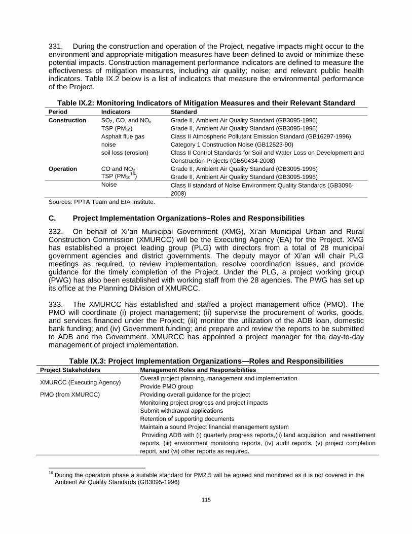
115
331. During the construction and operation of the Project, negative impacts might occur to the environment and appropriate mitigation measures have been defined to avoid or minimize these potential impacts. Construction management performance indicators are defined to measure the effectiveness of mitigation measures, including air quality; noise; and relevant public health indicators. Table IX.2 below is a list of indicators that measure the environmental performance of the Project.
Table IX.2: Monitoring Indicators of Mitigation Measures and their Relevant Standard
Period Indicators Standard Construction SO2, CO, and NOx Grade II, Ambient Air Quality Standard (GB3095-1996) TSP (PM10) Grade II, Ambient Air Quality Standard (GB3095-1996) Asphalt flue gas Class II Atmospheric Pollutant Emission Standard (GB16297-1996). noise Category 1 Construction Noise (GB12523-90) soil loss (erosion) Class II Control Standards for Soil and Water Loss on Development and
Construction Projects (GB50434-2008) Operation CO and NO2 Grade II, Ambient Air Quality Standard (GB3095-1996) TSP (PM10
16) Grade II, Ambient Air Quality Standard (GB3095-1996) Noise Class II standard of Noise Environment Quality Standards (GB3096-
2008) Sources: PPTA Team and EIA Institute. C. Project Implementation Organizations–Roles and Responsibilities
332. On behalf of Xi’an Municipal Government (XMG), Xi’an Municipal Urban and Rural Construction Commission (XMURCC) will be the Executing Agency (EA) for the Project. XMG has established a project leading group (PLG) with directors from a total of 28 municipal government agencies and district governments. The deputy mayor of Xi’an will chair PLG meetings as required, to review implementation, resolve coordination issues, and provide guidance for the timely completion of the Project. Under the PLG, a project working group (PWG) has also been established with working staff from the 28 agencies. The PWG has set up its office at the Planning Division of XMURCC. 333. The XMURCC has established and staffed a project management office (PMO). The PMO will coordinate (i) project management; (ii) supervise the procurement of works, goods, and services financed under the Project; (iii) monitor the utilization of the ADB loan, domestic bank funding; and (iv) Government funding; and prepare and review the reports to be submitted to ADB and the Government. XMURCC has appointed a project manager for the day-to-day management of project implementation.
Table IX.3: Project Implementation Organizations—Roles and Responsibilities
Project Stakeholders Management Roles and Responsibilities
XMURCC (Executing Agency) Overall project planning, management and implementation Provide PMO group
PMO (from XMURCC) Providing overall guidance for the project Monitoring project progress and project impacts Submit withdrawal applications Retention of supporting documents Maintain a sound Project financial management system Providing ADB with (i) quarterly progress reports,(ii) land acquisition and resettlement reports, (iii) environment monitoring reports, (iv) audit reports, (v) project completion report, and (vi) other reports as required.
16 During the operation phase a suitable standard for PM2.5 will be agreed and monitored as it is not covered in the
Ambient Air Quality Standards (GB3095-1996)

116
Project Stakeholders Management Roles and Responsibilities Xi’an Infrastructure Investment Group (Implementing Agency)
Procurement Contract Management Works Management Investment Audit and Reimbursement Environmental Management Resettlement Management Social Impact Issues
D. EMP Implementation–Roles and Responsibilities 334. The implementation of the EMP will be primarily the responsibility of the IA and contractors. However, during project preparation and implementation, various organizations with different environmental management responsibilities have been involved and will continue to be involved in the EMP. Major organizations are Shaanxi Provincial Environmental Protection Bureau (EPB), the PMO, EIA Team, and Design Institute. The table and figure below shows their environmental responsibilities in different stages of the Project. The figure shows the relationship between the EA and IA, and the areas of the IA which are responsible for the environmental and social management of the Project (in orange).
Table IX.4: Environmental Responsibilities Phase Responsible Agencies Environmental Responsibilities
Preparation IA (EIA Team) Preparation of EIA for components.
PMO, Shaanxi EPB Review and approval of the EIA
Design IA (Design Institutes) Incorporation of mitigation measures into engineering designs and contracts
PMO, IA Review and approval of environmental measures
Tendering Contractors, IA Incorporation of EMP clauses into the bids
Construction IA Advise on implementation of mitigation measures
Contractors Implementation of mitigation measures and internal monitoring
Shaanxi EPB, IA Implementation of compliance monitoring
Shaanxi EPB, IA Supervise implementation of mitigation measures and monitoring
Operation Shaanxi EPB Advise on compliance monitoring and internal monitoring requirements
IA Implementation of mitigation measures and internal monitoring
Shaanxi EPB, IA Implementation of compliance monitoring
IA, Shaanxi EPB Supervise implementation of mitigation measures and monitoring EIA = environmental impact assessment; EMP = environmental management plan, EPB = Environment Protection Bureau; IA = implementing agency, PMO = project management office.

117
Figure IX.1: Project Management Organizational Chart
335. The IA and contractors will nominate full-time trained and qualified environmental specialists to undertake a range of environmental management activities for effective implementation of the EMP. EMP Implementation– Environmental Supervision and Monitoring 336. To implement the Project, the IA will engage civil works contractors. Each construction contractor will have a designated environmental representative to co-ordinate with the IA’s environmental team. 337. The Environment group within the IA has only two (2) officers. In order to implement the many EMP activities the IA will additionally engage the following extra entities:

118
a. IA’s Environmental Supervisors b. Independent Environmental Supervisor c. Environmental Monitoring Center
338. The IA’s environmental supervisors are hired by IA as part of construction supervision consultancy contract. They will supervise daily construction activities to ensure the environmental measures implementation on sites. The Independent Environmental Supervisor will be an independent position which is not part of the IA’s in-house environmental team, or part of the construction supervising engineer’s team. The general role of the position will be to ensure the high environmental performance of the IA (through its environmental team) and the construction supervising engineers. Terms of Reference for the Independent Environmental Supervisor are at Appendix 5. The Independent Environmental Supervisor will also be responsible for implementing procedures for chance finds of cultural relics during construction. The Independent Environmental Supervisor will be trained by the Shaanxi Cultural Relics Bureau (or their nominee) for this purpose. The semi-annual environmental monitoring report to ADB will be verified by the Independent Environmental Supervisor. Terms of Reference for the procedures for chance finds of cultural relics are at Attachment. 339. A qualified Environmental Monitoring Centre with certification from the EPB will be engaged by the IA to conduct environmental quality monitoring based on the monitoring plan listed in the EMP. 340. Each construction contractor will have a designated environmental representative who will be responsible for coordinating with the Independent Environmental Supervisor.
Table IX.5: Mitigation Measures and Monitoring Supervision Organizations Responsibilities Civil Works Contractors Implementing construction contracts
Implementing environmental mitigation and management measures as part of construction contracts
Independent Environmental Supervisor
Ensure environmental performance (on behalf of IA) Assist IA and PMO to prepare semi-annual reports Implement procedures for cultural relics protection and chance finds Verify the PMO’s environmental monitoring report to ADB
Environmental Monitoring Center (EMC)
Conduct environmental quality monitoring during construction and operation Prepare environmental monitoring report to ADB on behalf of PMO.
E. Summary of Potential Impacts and Mitigation Measures 341. The EMP table at Table I.6 (below) summarizes the potential impacts of the outputs during construction and operation as identified by the environmental impact assessment, as well as corresponding mitigation measures designated to minimize those impacts. The mitigation measures will be incorporated into tender documents, construction contracts, and the contractors’ site management plans. Contractors and the project implementing agency (IA) will implement these measures. The effectiveness of these measures will be carefully watched via the environmental monitoring to determine whether to continue them or to make improvements. Costs have been identified for each mitigation measure. Total environmental management costs are estimated at CNY630,000 for the pre-construction phase, CNY680,000 over the construction period and CNY 2,737,000 in the initial operation phase. 342. Resettlement plans have been prepared to ensure proper resettlement of any affected persons and avoid deteriorating their quality of life. Details of required actions are in the resettlement plans.
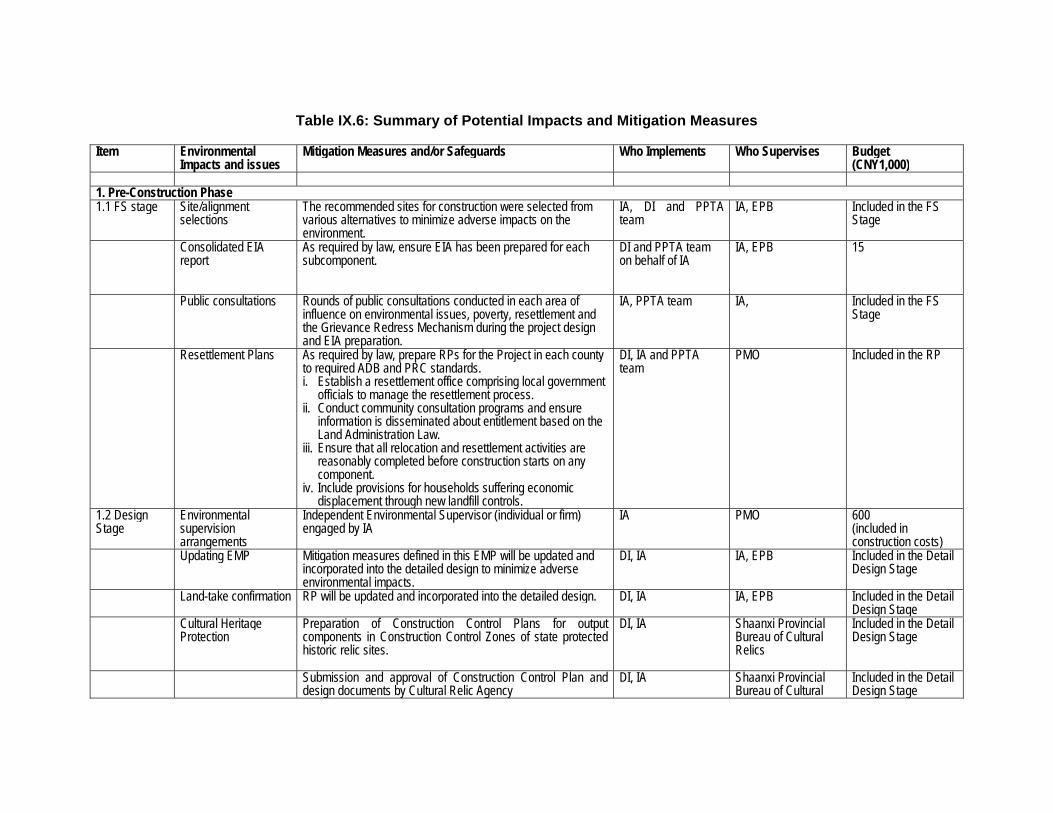
Table IX.6: Summary of Potential Impacts and Mitigation Measures
Item Environmental
Impacts and issues Mitigation Measures and/or Safeguards Who Implements Who Supervises Budget
(CNY1,000) 1. Pre-Construction Phase 1.1 FS stage Site/alignment
selections
The recommended sites for construction were selected from various alternatives to minimize adverse impacts on the environment.
IA, DI and PPTA team
IA, EPB Included in the FS Stage
Consolidated EIA report
As required by law, ensure EIA has been prepared for each subcomponent.
DI and PPTA team on behalf of IA
IA, EPB 15
Public consultations
Rounds of public consultations conducted in each area of influence on environmental issues, poverty, resettlement and the Grievance Redress Mechanism during the project design and EIA preparation.
IA, PPTA team IA, Included in the FS Stage
Resettlement Plans
As required by law, prepare RPs for the Project in each county to required ADB and PRC standards. i. Establish a resettlement office comprising local government
officials to manage the resettlement process. ii. Conduct community consultation programs and ensure
information is disseminated about entitlement based on the Land Administration Law.
iii. Ensure that all relocation and resettlement activities are reasonably completed before construction starts on any component.
iv. Include provisions for households suffering economic displacement through new landfill controls.
DI, IA and PPTA team
PMO Included in the RP
1.2 Design Stage
Environmental supervision arrangements
Independent Environmental Supervisor (individual or firm) engaged by IA
IA PMO 600 (included in construction costs)
Updating EMP
Mitigation measures defined in this EMP will be updated and incorporated into the detailed design to minimize adverse environmental impacts.
DI, IA IA, EPB Included in the Detail Design Stage
Land-take confirmation RP will be updated and incorporated into the detailed design. DI, IA IA, EPB Included in the Detail Design Stage
Cultural Heritage Protection
Preparation of Construction Control Plans for output components in Construction Control Zones of state protected historic relic sites.
DI, IA Shaanxi Provincial Bureau of Cultural Relics
Included in the Detail Design Stage
Submission and approval of Construction Control Plan and design documents by Cultural Relic Agency
DI, IA Shaanxi Provincial Bureau of Cultural
Included in the Detail Design Stage
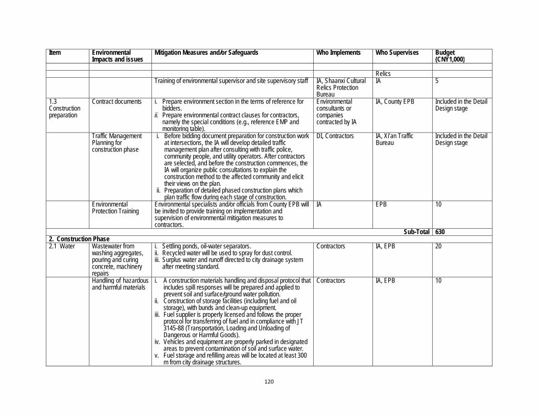
120
Item Environmental Impacts and issues
Mitigation Measures and/or Safeguards Who Implements Who Supervises Budget (CNY1,000)
Relics
Training of environmental supervisor and site supervisory staff IA, Shaanxi Cultural Relics Protection Bureau
IA 5
1.3 Construction preparation
Contract documents
i. Prepare environment section in the terms of reference for bidders.
ii. Prepare environmental contract clauses for contractors, namely the special conditions (e.g., reference EMP and monitoring table).
Environmental consultants or companies contracted by IA
IA, County EPB Included in the Detail Design stage
Traffic Management Planning for construction phase
i. Before bidding document preparation for construction work at intersections, the IA will develop detailed traffic management plan after consulting with traffic police, community people, and utility operators. After contractors are selected, and before the construction commences, the IA will organize public consultations to explain the construction method to the affected community and elicit their views on the plan.
ii. Preparation of detailed phased construction plans which plan traffic flow during each stage of construction.
DI, Contractors IA, Xi’an Traffic Bureau
Included in the Detail Design stage
Environmental Protection Training
Environmental specialists and/or officials from County EPB will be invited to provide training on implementation and supervision of environmental mitigation measures to contractors.
IA EPB 10
Sub-Total 630 2. Construction Phase 2.1 Water Wastewater from
washing aggregates, pouring and curing concrete, machinery repairs
i. Settling ponds, oil-water separators. ii. Recycled water will be used to spray for dust control. iii. Surplus water and runoff directed to city drainage system
after meeting standard.
Contractors IA, EPB 20
Handling of hazardous and harmful materials
i. A construction materials handling and disposal protocol that includes spill responses will be prepared and applied to prevent soil and surface/ground water pollution.
ii. Construction of storage facilities (including fuel and oil storage), with bunds and clean-up equipment.
iii. Fuel supplier is properly licensed and follows the proper protocol for transferring of fuel and in compliance with JT 3145-88 (Transportation, Loading and Unloading of Dangerous or Harmful Goods).
iv. Vehicles and equipment are properly parked in designated areas to prevent contamination of soil and surface water.
v. Fuel storage and refilling areas will be located at least 300 m from city drainage structures.
Contractors IA, EPB 10
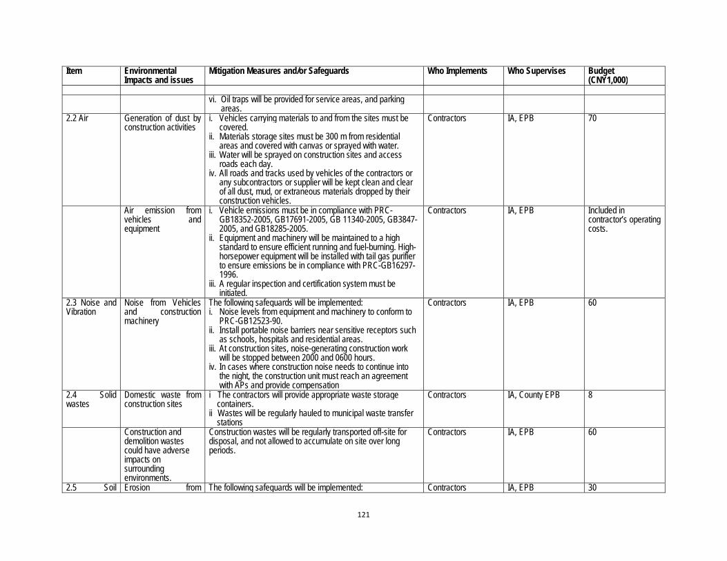
121
Item Environmental Impacts and issues
Mitigation Measures and/or Safeguards Who Implements Who Supervises Budget (CNY1,000)
vi. Oil traps will be provided for service areas, and parking
areas. 2.2 Air Generation of dust by
construction activities
i. Vehicles carrying materials to and from the sites must be covered.
ii. Materials storage sites must be 300 m from residential areas and covered with canvas or sprayed with water.
iii. Water will be sprayed on construction sites and access roads each day.
iv. All roads and tracks used by vehicles of the contractors or any subcontractors or supplier will be kept clean and clear of all dust, mud, or extraneous materials dropped by their construction vehicles.
Contractors IA, EPB 70
Air emission from vehicles and equipment
i. Vehicle emissions must be in compliance with PRC-GB18352-2005, GB17691-2005, GB 11340-2005, GB3847-2005, and GB18285-2005.
ii. Equipment and machinery will be maintained to a high standard to ensure efficient running and fuel-burning. High-horsepower equipment will be installed with tail gas purifier to ensure emissions be in compliance with PRC-GB16297-1996.
iii. A regular inspection and certification system must be initiated.
Contractors IA, EPB Included in contractor’s operating costs.
2.3 Noise and Vibration
Noise from Vehicles and construction machinery
The following safeguards will be implemented: i. Noise levels from equipment and machinery to conform to
PRC-GB12523-90. ii. Install portable noise barriers near sensitive receptors such
as schools, hospitals and residential areas. iii. At construction sites, noise-generating construction work
will be stopped between 2000 and 0600 hours. iv. In cases where construction noise needs to continue into
the night, the construction unit must reach an agreement with APs and provide compensation
Contractors IA, EPB 60
2.4 Solid wastes
Domestic waste from construction sites
i The contractors will provide appropriate waste storage containers.
ii Wastes will be regularly hauled to municipal waste transfer stations
Contractors IA, County EPB 8
Construction and demolition wastes could have adverse impacts on surrounding environments.
Construction wastes will be regularly transported off-site for disposal, and not allowed to accumulate on site over long periods.
Contractors IA, EPB 60
2.5 Soil Erosion from The following safeguards will be implemented: Contractors IA, EPB 30

122
Item Environmental Impacts and issues
Mitigation Measures and/or Safeguards Who Implements Who Supervises Budget (CNY1,000)
erosion and ecology
construction sites
i. Construct intercepting ditches and drains to prevent outside runoff entering construction sites, and divert runoff from sites to existing drainage system or ponds.
ii. Stabilise disturbed areas at completion of construction (paving or landscaping).
2.6 Social Resettlement of affected persons
All affected persons will be resettled in a timely and adequate manner, in accordance with the Resettlement Plan.
IA IA, PMO, communities
Included in the RP
Compensation of lost assets
All affected persons will be compensated in a timely and adequate manner, in accordance with the Resettlement Plan.
IA IA, PMO, communities
Included in the RP
Traffic management
The following safeguards will be implemented: i. Implementation of phased construction plan and traffic
management. ii. Selecting haulage routes to reduce disturbance to regular
traffic (where possible). iii. Diverting or limiting construction traffic at peak traffic hours. iv. Blocking and reinstating interim tracks to original condition
on completion of construction. v. Maintain pedestrian and non-vehicle access
Contractors, IA IA, Traffic authorities 110
Work camp health and hygiene
i. Contractors will be required to safeguard environmental hygiene in the construction camps, including the quality of water supplies.
ii. All construction sites must provide the necessary personal protective equipment and other resources to create a safe working environment.
iii. Construction site operations must comply with PRC’s State Administration of Worker Safety Laws and Regulations.
Contractors, IA IA, Local and/or Provincial Health Bureau
12
Cultural heritage protection
i. Inspections at all stages of excavations ii. Cultural heritage values will be preserved where identified.
In accordance with PRC regulations, no person shall destroy, damage, deface, conceal, or otherwise interfere with a relic.
iii. In case an important site is unearthed, work should be stopped immediately and the matter promptly referred to the county, city, autonomous region, or state level agencies for evaluation and decision on appropriate actions.
IES, Contractors IA, Provincial Cultural Relics Protection Bureau
Included in construction costs
2.7 Unexpected environmental impacts
If unexpected environmental impacts occur during project construction phase, the IAs will update the EMP, and environmental protection measures will be designed and resources will be utilized to cope with these impacts
IA, PMO PMO Included in construction costs and contingency
Subtotal 380 3. Operational Phase 3.1 Air Exhaust emissions i. Roadside air pollution monitoring IA and Operators EPB Included in other

123
Item Environmental Impacts and issues
Mitigation Measures and/or Safeguards Who Implements Who Supervises Budget (CNY1,000)
from predicted traffic volumes on roads and intersections
ii. Vehicle inspections, compliance stickers, maintenance and scrapping programs
Project components
3.2 Noise Noise from increasing traffic volumes on Project roads
Noise monitoring at regular intervals to check compliance IA and Operators EPB Included in operational costs
Noise impact from traffic on sensitive receptors
Implementation of mitigation measures, including noise barriers and noise-proofing of buildings, where levels exceed PRC standard
IA and Operators EPB 552
3.3 Emergency preparedness and response
Spills of hazardous materials in road accidents
i. Establishment of a road accident emergency command organization;
ii. Emergency response plan prepared and put in place; iii. Preparation of emergency equipment and training.
IA and Operators, local Security Bureau
100
Fire and explosion hazard at filling stations
Regular inspection of storage tanks and record-keeping; Control of ignition sources; Emergency response plan prepared and put in place; Preparation of emergency equipment and awareness training.
Operators Office of Public Security
Operating costs
3.4 Ecology Roadside and medium strip planting
Planting and maintenance of trees and shrubs along roads and around interchanges, especially where screening is required.
IA and Operators EPB, PMO 2065
3.5 Environmental capacity
Insufficient environmental management capacity
Conduct training for environmental management and develop facility and staff setup.
IA and Operators, EPB
EPB, PMO 20
3.6 Unexpected environmental impacts
If unexpected environmental impacts occur during project operation phase, the IA will update the EMP, and environmental protection measures will be designed and resources will be utilized to cope with these impacts
IA and Operators, PMO
PMO Included in operational costs
Total 2737 ADB = Asian Development Bank, APMO = Altay Prefecture Project Management Office, EIA = Environmental Impact Assessment, EPB = Environment Protection Bureau, FB = Forestry Bureau, IA = Implementing Agency, DI = Design Institute, PMO = Project Management Office, RP = Resettlement Plan. Sources: PPTA Team; EIA Institute.

F. Environmental Monitoring
1. Monitoring Program
343. The Project monitoring program will focus on the environment within the project’s area of influence. A detailed consolidated environmental monitoring program is summarized in Table IX.7. The program considers the scope of monitoring, monitoring parameters and frequency, data processing, and quality control requirements. 344. Internal monitoring. The IA will, at the outset of sub-component implementation, prepare detailed internal monitoring programs to be implemented by the contractors and Environmental Supervisors (under IA) during construction and operation phases. These will be carried out more frequently than the (external) compliance monitoring programs. These monitoring programs and budgets will be included in the Project tendering documents and budgets, as well as in the construction and operation contracts. 345. External (compliance) monitoring. Licensed Environmental Monitoring Centers (EMCs) will carry out external monitoring on behalf of the Environmental Protection Bureau (EPB) during construction and operation. The external monitoring program is to ensure that the IA and its contractors and operators are in compliance with PRC environmental standards and regulations. The Independent Environmental Supervisor (IES) has an important role in coordinating these activities. The LIEC will also assist in interpreting and clarifying the application of mitigation measures, the monitoring of their outcomes and reporting environmental performance. 346. Project Design and Monitoring Framework. At the outset of each sub-component’s implementation, the IAs will develop (i) a Project Design and Monitoring Framework (PDMF) to systematically generate data on inputs and outputs of the Project components, and (ii) detailed environmental and related socioeconomic indicators to measure impacts. 347. Under the PDMF, the IA will report baseline and progress data at the requisite time intervals. The IA will be responsible for analyzing and consolidating the data through its management information system. The PDMF will be designed to permit adequate flexibility to adapt remedial action regarding design, schedules, activities, and development impacts.
2. Monitoring Management
348. Internal monitoring during the construction and initial operational period will be conducted by the contractors and the IA, and will be reflected in the periodic construction reports. The IA will employ or contract environmental supervisors for the task. External monitoring during construction and initial operational period will be conducted by Environmental Monitoring Centers (EMCs). EMCs will be authorized to carry out compliance monitoring on behalf of the EPB during construction and operation. The contractors, operators and IA will pay for their services as appropriate.
3. Monitoring Costs
349. Environmental monitoring costs are included in Table IX.7 below. These are to be included in the construction contracts and counterpart budgets. Before implementing the monitoring plans, responsible parties will need to refine and confirm a detailed breakdown of the estimated budget. It should be noted that the IA will pay for external, or compliance, monitoring although carried out on behalf of the EPB. During implementation, the cost required can be adjusted based on actual requirements. If there are unpredictable environmental impacts found during the implementation of the environmental monitoring, EIA and EMP should be updated in timely manner and mitigation measures will be put forward to reduce the impacts to the environment.

Table IX.7: Environmental Monitoring Program
Item Parameters Location Implementing Agency
Supervise Agency Time and Frequency Budget
(CNY1,000)
1. Construction Phase 1.1 Work camp domestic wastewater quality
pH, SS, DO, NH3-N, TP, BOD5, CODCr, Total coliform, oil
Internal monitoring will be conducted at all construction sites and domestic wastewater discharge areas. External monitoring will be conducted at selected camp sites.
Internal monitoring: Contractors, IA / ES
IA Random spot check of the domestic wastewater effluent sites (at least monthly)
2
External monitoring: Licensed EMC
EPB Twice per year 2
1.2 Construction wastewater and wastewater pollution mitigation measures
pH, SS, Oil Internal monitoring will be conducted at all construction sites. External monitoring will be conducted at selected sites
Internal monitoring: Contractors, IA / ES
IA Random spot check of the wastewater effluent sites
4
External monitoring: Licensed EMC
EPB Twice per year 4
1.3 Air Air pollution prevention measures
Use of dust shrouds, water spraying. Maintenance and condition of vehicles and equipment. TSP, SOx, NOx, PM10
Internal monitoring will be conducted at all of the construction sites and sensitive receivers External monitoring will be conducted at work sites and sensitive receivers
Internal monitoring: Contractors, IA / ES
IA Spot check the construction sites
15
External monitoring: Licensed EMC
EPB Sensitive receptor closest to construction site 6 times a year
45
1.4 Noise Noise pollution control measures
Leq (dB[A)) Same locations as air quality monitoring
Internal monitoring: Contractors, IA / ES
IA Sensitive receptor closest to construction site 6 times a year
External monitoring: Licensed EMC
EPB Random, but at least twice per year, a day each time and two samples each day: Once during daytime, once during night time
4
1.5 Soil Erosion control measures
Topsoil stockpile, detention ponds construction, intercepting ditches, rehabilitate construction sites
All spoil disposal sites and construction sites
Internal monitoring: Contractors, IA / ES
IA Random spot check, in rainy season and at least four times a year
6
External monitoring: Licensed soil erosion monitoring unit
County EPB Quarterly 6
1.8 Hygiene and disease
Health status Hygiene status Availability of clean
Construction sites and work camps and resettlement areas
Internal monitoring: Contractors, IA
IA Random spot check 2

126
BOD5 = 5-day biological oxygen demand, CCl4 = carbon tetrachloride, CODCr = chemical oxygen demand, DO = dissolved oxygen, EMC = Environmental Monitoring Center, EPB = Environment Protection Bureau, ES =Environmental Supervisor, FB = Forestry Bureau, IA = Implementing Agency, Leq = noise unit, NOx = nitrogen oxides, PM = particulate matter, SOx = sulfur oxides, TSP = total suspended particles. Sources: PPTA Team; EIA Institute.
17 During the operation phase a suitable standard for PM2.5 will be agreed and monitored as it is not covered in the Ambient Air Quality Standards (GB3095-1996) 18 Noice observations should be undertaken over a 3 day period, with at least 2 days on a weekday. Noice observations should be undertaken along the project
road, with a sensitive respector on a major road.
water, and medical advice HIV/AIDS awareness
External monitoring: County Epidemic Prevention Departments
County EPB Once a year 2
Subtotal per year 94 2. Operational Phase 2.1 Air and noise TSP ( PM1017), CO, SO2,
NO2, External monitoring:
Licensed EMC County EPB Establish one ambient
air quality station for continuous monitoring
1500
Leq dB(A) External monitoring: Licensed EMC
County EPB Four times a year18 100
2.2 Soil and vegetation
Inspect vegetation survival and coverage rate.
Re-forestation sites (spoil disposal sites and construction sites)
Internal monitoring: Contractors, IA
County EPB Spot check, once a year
10
External monitoring: Licensed EMC
County EPB/FB Spot check, every second year
10
2.3 Traffic flow Vehicle numbers – road use (against predictions)
roads IA, Township governments Operator, TB Road traffic monitoring program
Operational cost
Subtotal per year 1620

127
G. Reporting and Supervision
1. Internal Monitoring Reports 350. During the construction period, results from the internal monitoring conducted by the contractors and the IA will be reflected in the periodic construction reports. The reports will summarize (i) environmental issues during construction; (ii) mitigation measures taken, if any; and (iii) consequences of the impacts on the environment and/or surrounding communities. 351. The contractors will be trained and mandated to take immediate actions to remedy unexpected adverse impacts or ineffective or inefficient mitigation measures. The IA will also respond to these reports in order to ensure that contractors have taken appropriate and timely action. Additional measures may be taken, if needed, to ensure that all issues raised by the reports are appropriately addressed. 352. Results from the detailed internal environmental monitoring program and mitigation actions for the construction phase will be submitted weekly to IA, monthly to the EPB, and two times a year to the PMO. The EPB may request that further environmental mitigation actions be taken, as they deem necessary, and may determine further mitigation measures for different stages, if necessary. 353. During the operational phase, internal monitoring of the functioning or performance of the Project outputs by the IA and contractors will be an integral part of responsible operational management. Monitoring of environmental parameters will be part of this and internal monitoring reports during operations will be used to adjust operations and will be forwarded to the EPB.
2. External (Compliance) Monitoring Reports 354. Environmental Monitoring Centers (EMCs) will be authorized to carry out compliance monitoring on behalf of the EPB during construction and operation. The contractors, operators and IA will pay for their services as appropriate. The compliance monitoring reports will include (i) project background, (ii) construction and operation activities, (iii) environmental conditions, (iv) measurement or sampling locations, (v) analytical results, (vi) interpretation and implication of the monitoring results, (vii) determination of the compliance status with regard to applicable regulations and standards, and (viii) recommendations for improvement. These reports will be submitted 4 times per year to the EPB with a copy to the PMO.
3. Reports to ADB 355. The PMO will submit to ADB the EMP progress reports and information on Project implementation and the environmental performance of the contractors, operators and IA. These reports will include (i) semi-annual environmental reports on EMP implementation, and (ii) environmental compliance monitoring and audit report of the completion of each major component. ADB may request that further environmental mitigation actions be taken, as they deem necessary, and may determine further mitigation measures for different stages, if necessary. 356. The Independent Environmental Supervisor (IES) will have an important role in the reporting process. The IES will (i) assist the PMO to prepare semi-annual progress reports to the ADB during construction; (ii) assist the PMO to prepare semi-annual progress reports to the ADB during the first 3 years of operation; and (iii) verify the environmental monitoring reports prepared by the PMO for ADB. Additionally, the IES will assess the IA’s progress against project EMP Performance Indicators and provide a checklist of performance progress in the reports.
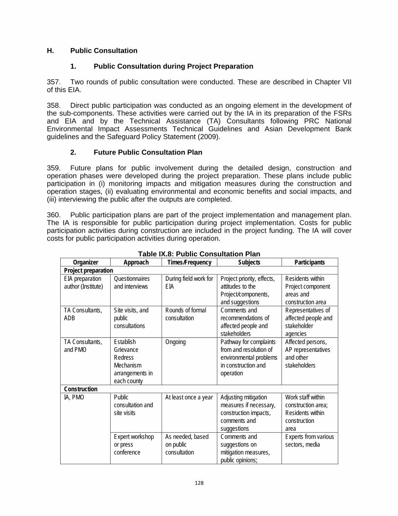
128
H. Public Consultation
1. Public Consultation during Project Preparation 357. Two rounds of public consultation were conducted. These are described in Chapter VII of this EIA. 358. Direct public participation was conducted as an ongoing element in the development of the sub-components. These activities were carried out by the IA in its preparation of the FSRs and EIA and by the Technical Assistance (TA) Consultants following PRC National Environmental Impact Assessments Technical Guidelines and Asian Development Bank guidelines and the Safeguard Policy Statement (2009).
2. Future Public Consultation Plan 359. Future plans for public involvement during the detailed design, construction and operation phases were developed during the project preparation. These plans include public participation in (i) monitoring impacts and mitigation measures during the construction and operation stages, (ii) evaluating environmental and economic benefits and social impacts, and (iii) interviewing the public after the outputs are completed. 360. Public participation plans are part of the project implementation and management plan. The IA is responsible for public participation during project implementation. Costs for public participation activities during construction are included in the project funding. The IA will cover costs for public participation activities during operation.
Table IX.8: Public Consultation Plan Organizer Approach Times/Frequency Subjects Participants
Project preparation EIA preparation author (Institute)
Questionnaires and interviews
During field work for EIA
Project priority, effects, attitudes to the Project/components, and suggestions
Residents within Project component areas and construction area
TA Consultants, ADB
Site visits, and public consultations
Rounds of formal consultation
Comments and recommendations of affected people and stakeholders
Representatives of affected people and stakeholder agencies
TA Consultants, and PMO
Establish Grievance Redress Mechanism arrangements in each county
Ongoing Pathway for complaints from and resolution of environmental problems in construction and operation
Affected persons, AP representatives and other stakeholders
Construction IA, PMO Public
consultation and site visits
At least once a year Adjusting mitigation measures if necessary, construction impacts, comments and suggestions
Work staff within construction area; Residents within construction area
Expert workshop or press conference
As needed, based on public consultation
Comments and suggestions on mitigation measures, public opinions;
Experts from various sectors, media
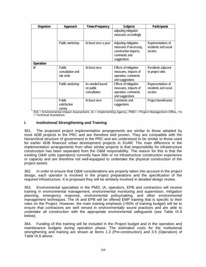
129
Organizer Approach Times/Frequency Subjects Participants adjusting mitigation measures accordingly
Public workshop At least once a year Adjusting mitigation measures if necessary, construction impacts, comments and suggestions
Representatives of residents and social sectors
Operation IA Public
consultation and site visits
At least once Effects of mitigation measures, impacts of operation, comments and suggestions
Residents adjacent to project sites
Public workshop As needed based on public consultation
Effects of mitigation measures, impacts of operation, comments and suggestions
Representatives of residents and social sectors
Public satisfaction survey
At least once Comments and suggestions
Project beneficiaries
EIA = Environmental Impact Assessment, IA = Implementing Agency, PMO = Project Management Office, TA = Technical Assistance.
I. Institutional Strengthening and Training 361. The proposed project implementation arrangements are similar to those adopted by most ADB projects in the PRC and are therefore well proven. They are compatible with the hierarchical structure of government in the PRC and are understood to be similar to those used for earlier ADB financed urban development projects in XUAR. The main difference in the implementation arrangements from other similar projects is that responsibility for infrastructure construction has been separated from the O&M responsibility. The reason for this is that the existing O&M units (operators) currently have little or no infrastructure construction experience or capacity and are therefore not well-equipped to undertake the physical construction of the project assets. 362. In order to ensure that O&M considerations are properly taken into account in the project design, each operator is involved in the project preparations and the specification of the required infrastructure. It is proposed they will be similarly involved in detailed design review. 363. Environmental specialists in the PMO, IA, operators, EPB and contractors will receive training in environmental management, environmental monitoring and supervision, mitigation planning, emergency response, environmental policymaking, and other environmental management techniques. The IA and EPB will be offered EMP training that is specific to their roles on the Project. However, the main training emphasis (>50% of training budget) will be to ensure that contractors are well versed in environmentally sound practices and are able to undertake all construction with the appropriate environmental safeguards (see Table IX.9 below). 364. Funding of this training will be included in the Project budget and in the operation and maintenance budgets during operation phase. The estimated costs for the institutional strengthening and training are shown at Items 1.3 (Pre-construction) and 3.5 (Operation) of Table IX.6 above.

130
Table IX.9: Institutional Strengthening and Training Training Attendees Contents Timing Environmental laws, regulations and policies
PMO, IA/Operators, Contractors
(i) Environmental laws and regulations (ii) Environmental policies and plans (iii) Basic environmental management (iv) Emergency preparedness and response
Prior to Project implementation
EMP implementation IA, Contractors (i) Responsibility and duties for the project construction, management and environmental protection (ii) Task of environmental protection in the project construction (iii) Key environmental protection contents etc. in project construction (iv) Various environmental reporting (v) EMP improvement and corrective actions
Prior and during Project implementation
Crisis handling IA/Operators, contractors
(i) Crisis handling methods Prior to Project implementation
Sub-total CNY 150,000 (see Item 1.3 in Table IX.6) Environmental monitoring, inspection and reporting
IA/operators, contractors, County EPB
(i) Monitoring and inspection methods, data collection and processing, interpretation of data, reporting system (ii) Environmental reporting requirements
Prior to Project implementation
Sub-total CNY 200,000 (see Item 3.4 in Table IX.6) Total CNY 350,000 EPB = Environment Protection Bureau, IA = Implementing Agency, PMO = Project Management Office. Source: county PMOs. J. Reporting and Supervision
1. Internal Monitoring Reports 365. During the construction period, results from the internal monitoring conducted by the contractors and the IA will be reflected in the periodic construction reports (see Table IX.10). The reports will summarize (i) environmental issues during construction; (ii) mitigation measures taken, if any; and (iii) consequences of the impacts on the environment and/or surrounding communities. 366. The contractors will be trained and mandated to take immediate actions to remedy unexpected adverse impacts or ineffective or inefficient mitigation measures. The IA will also respond to these reports in order to ensure that contractors have taken appropriate and timely action. Additional measures may be taken, if needed, to ensure that all issues raised by the reports are appropriately addressed.
131
367. Results from the detailed internal environmental monitoring program and mitigation actions for the construction phase will be submitted weekly to IA, monthly to the EPB, and two times a year to the PMO. The EPB may request that further environmental mitigation actions be taken, as they deem necessary, and may determine further mitigation measures for different stages, if necessary. 368. During the operational phase, internal monitoring of the functioning or performance of the outputs will be an integral part of responsible operational management. Monitoring of environmental parameters will be part of this and internal monitoring reports during operations will be used to adjust operations and will be forwarded to the EPB.
2. External (Compliance) Monitoring Reports 369. Environmental Monitoring Centers (EMCs) will be authorized to carry out compliance monitoring on behalf of the EPB during construction and operation. The contractors, operators and IA will pay for their services as appropriate. The compliance monitoring reports will include (i) project background, (ii) construction and operation activities, (iii) environmental conditions, (iv) measurement or sampling locations, (v) analytical results, (vi) interpretation and implication of the monitoring results, (vii) determination of the compliance status with regard to applicable regulations and standards, and (viii) recommendations for improvement. These reports will be submitted 4 times per year to the EPB with a copy to the PMO.
3. Reports to ADB
370. The PMO will submit to ADB the EMP progress reports and information on Project implementation and the environmental performance of the contractors, operators and IA. These reports will include (i) semi-annual environmental reports on EMP implementation, and (ii) environmental compliance monitoring and audit report of the completion of each major component. ADB may request that further environmental mitigation actions be taken, as they deem necessary, and may determine further mitigation measures for different stages, if necessary.

132
Table IX.10: Reporting Plan Reports From To Frequency Construction Phase Internal monitoring and inspection
Weekly internal monitoring reports by construction contractors
Contractors IA Weekly
Monthly internal monitoring reports by IA (or through environmental supervision consultants contracted by IA)
IA EPB Monthly
Semi-annual internal and external environmental monitoring and inspection reports based on the monthly reports
EPB PMO Twice a year
External monitoring and inspection
Semi-annual external environmental monitoring and inspection reports based on the monthly reports
EPB PMO Twice a year
Reports to ADB
Semi-annual progress reports based on all the internal and external reports
PMO in conjuction with IES
ADB Twice a year
Operation Internal monitoring
Routine environmental monitoring reports IA/Operators EPB and PMO
Monthly
External monitoring and inspection
Environmental compliance reports EMCs on behalf of EPB
PMO Quarterly
Reports to ADB
Semi-annual reports based on all the internal and external monitoring inspection reports during operations
PMO in conjunction with LIEC
ADB Yearly (for 3 years following commencement of operation)
ADB = Asian Development Bank, EMC = Environmental Monitoring Centers, EPB = Environment Protection Bureau, IA = Implementing Agency, IES = Independent Environmental Supervisor, PMO = Project Management Office.
K. Cost Estimates 371. Cost estimates for mitigation measures and monitoring plans are summarized in Table IX.6 and Table IX.7. The IA will bear all compliance monitoring costs and will ensure the necessary budgets are available for the PMO and the EMC. Internal monitoring costs will be borne by the IA and contractors during construction and by the IA during operation. Before implementing a monitoring plan, responsible agencies will present a more detailed breakdown of the estimated budget. During implementation, the budgets will be adjusted based on actual requirements. 372. Contractors will bear the costs for all mitigation measures during construction, which will be included in the tender and contract documents. The IA will bear the costs related to mitigation measures during operation and the costs related to environmental supervision during construction and operation. The Project as a whole will bear the costs for training and the Loan Implementation Environment Consultant. Training programs budget will be included in the construction and operation contracts. During the operation phase the training budget will be included in the operation and maintenance budget.
133
L. Cultural Relics Protection 373. The significance of potential impacts to cultural heritage sites has been assessed in a report by the Northwest University Cultural Relics Conservation Center and Shaanxi Provincial Bureau of Cultural Relics entitled “Assessment of Xi’an Urban Road Network Improvement Project’s Impact on Cultural Relics”. The assessment method followed was a qualitative assessment of the degree to which Project components physically impinged upon the protection and management zones of the cultural site. The impact categories assigned in the report were: A - potential for significant impact; B - potential for some impact; C - minor potential impact; and D - negligible impact. 374. No Project components were ranked as A - potential for significant impact. However, four components are ranked B or C.

134
Table IX.11: Impact Categories for Cultural and Historical Sites
Impact category
Output component Construction type Relevant cultural and historical relics
Relation between project and cultural and historical relic locations
B
The 2nd Ring Road-Zhuhong Road Flyover
Flyover of the urban arterial road
The Ruins of Chang'an City of Han Dynasty
Construction site is in the Construction Control Zone
The 4th Fengcheng Road - Zhuhong Road Flyover
Flyover of the urban arterial road
The Ruins of Chang'an City of Han Dynasty
Construction site is in the Construction Control Zone
C
Bus parking area in the Base of Aerospace
Land for urban public transport and parking
Duling (including tombs of Jian and Qing Kings)
Construction site is in the Environmental Coordination Zone
Kunming Road Reconstruction Project
Reconstruction of urban arterial road
The Ruins of A’fang Palace
Construction site is about 50m away from the Construction Control Zone
375. Two proposed intersections on Zhuhong Road are located outside the Protection Zone of the Ruins of Chang’an City but are within its Construction Control Zone. The planned 2nd Ring Road-Zhuhong Road flyover is 490m from the nearest significant relic, the Ba City Gate site, which is northwest of the intersection on the far side of a reconstructed moat. The planned 4th Fengcheng Road – Zhuhong Road flyover is 200m from the nearest significant relic, the Qingming Gate site, which is directly west of the intersection and separated from it by a busy road and small commercial premises. The implementation of these components therefore requires (i) approval by the appropriate Cultural Relics Bureau; and (ii) the preparation and implementation of a Construction Control plan for cultural relics protection which includes measures to ensure that construction has no effect on identified cultural relic sites in the vicinity, and procedures to be followed in the event of the discovery of chance finds during construction. 376. The Xi’an Aerospace Base Transport Hub is located within the Environmental Coordination Zone of the Dulong Mausoleum complex. This is the lowest level of the protection zones. The planned development is 540m distant from the Prince Jian Mausoleum and 345m from that site’s Construction Control Zone. It is also 700m from the Prince Qin Mausoleum and 240m from that site’s Construction Control Zone. From its western boundary, the development site is 250m from the Construction Control Zone of the main Duling Mausoleum complex. Within the Environmental Coordination Zone, no approval for construction is necessary but the design of the component must not detract from the landscape amenity and environmental context of the Dulong Mausoleum complex. To maximize safeguards, construction at this site should also be in line with a Construction Control Plan which addresses the landscape amenity and environmental setting. 377. Part of the Kunming Road construction is in the vicinity of the Afang Palace complex, but outside any legislative protection or control zone. The section of Kunming Road planned for reconstruction under the Project is separated from the boundary of the Construction Control Zone of the site by a distance of 400 metres. The area between the Kunming Road section and the Construction Control Zone boundary is densely built up with a mixture of light industrial, commercial and residential developments. Accordingly, the only requirement for cultural relics protection is the management and organization of the construction site to prevent waste water, exhaust gas and solid waste damaging the ecological environment and landscape around the relics.
135
378. A cultural relics expert recommended by the Shaanxi Cultural Relics Bureau will be engaged by the IA to provide training in awareness and recognition of archaeological deposits for the IA’s construction team, focusing on the Independent Environmental Supervisor (person or firm), the Construction Supervising Engineers and the Construction Chief Engineer. 379. The procedures to be followed in the event of chance finds of cultural relics will apply to all civil construction activities in the Project regardless of their location in relation to known heritage sites. These procedures are as follows:
(i) All site workers will be made aware of the importance of cultural heritage values in
Xi’an and their responsibilities under the PRC and Shaanxi provincial legislation on cultural relics protection.
(ii) In particular, workers should be made aware of the potential for chance discoveries during construction work and the need for care and observance of procedures.
380. The role of the Independent Environmental Supervisor in relation to cultural relics protection will comprise the following:
(i) Arrange for the initial and ongoing training of construction workers and site supervisors in cultural relics awareness and protection measures.
(ii) Carry out inspections of exposed soil and subsoil surfaces and cut surfaces (excavation sides) at key stages of construction excavation. These will include:
a. at removal of topsoil; and, b. regularly during excavation at 1m, 2m, 3m depths.
(iii) Arrange for temporary stop-work around area of interest and reporting of finds to the Shaanxi Provincial Cultural Resources Bureau in the event of:
a. physical relic finds; b. noticeable soil texture change; c. noticeable soil colour change; or, d. other indicators as advised by the Shaanxi Provincial Cultural Resources
Bureau (iv) Ensure fencing of area of interest and covering of exposed soil surface for
protection. (v) Obtain and implement directions from the Cultural Relics Bureau (vi) Take lead role in all liaison between contractor, IA and Cultural Relics Bureau
during stop-work, reporting, inspections and any required site treatment work. M. Major Activity Milestones 381. The following are the major activities of the Design and Pre-construction Phase of the Project in the implementation of environmental safeguards and management:
Detailed design including environmental impact mitigation and management measures;
Construction contracts incorporating environmental responsibilities; Training of stakeholders in environmental management; Training of stakeholders in cultural relics protection and chance finds procedures; Appointment of Independent Environmental Supervisor (firm or individual); Appointment of Environmental Monitoring Center; Preparation of Construction Control Plans for cultural relics protection.
136
382. The following are the major activities of the Construction Phase of the Project in the implementation of environmental safeguards and management:
Establishment and publicizing of the Grievance Redress Mechanism and Project Public Complaints Center contacts;
Implementation of environmental impact mitigation measures as per Civil Construction Contracts;
Implementation of construction site management and “housekeeping” including public awareness measures;
Implementation of traffic management measures; Inspections by the Independent Environmental Supervisor; Monitoring of air, noise and water quality by EMC.

137
X. CONCLUSIONS AND RECOMMENDATIONS A. Benefits 383. The Project will help the Xi’an Municipal Government adapt to its rapid urban development and traffic intensification; solve new traffic problems due to the concentration of traffic in central areas; promote the image of the city; improve the investment environment; introduce international advanced urban traffic managerial technology, expertise and funds; and meet the urban residents’ increasing demands on road use. 384. The Project, through the integration of its five outputs which combine built works, systemic transport planning, computerised traffic management and emissions control and enforcement, will provide an integrated and sustainable solution to many of Xi’an’s urban transport needs. It will promote more convenient, safer and comfortable public traffic service; ease the urban traffic pressure and improve the traffic environment; reduce traffic pollution; implement the urban traffic policies of giving priority to public traffic development, and establish the rational urban traffic structure, solve the current traffic congestion and future traffic problems, and form the fast and convenient urban modern traffic network system. 385. The Project will focus on providing missing sections of the strategic road network between the 2nd and 3rd Ring Roads, combine the urban transport infrastructure with travel modes by introducing transport and transit hubs, and ITS expansion by 2016. The Project will also promote safe, efficient pedestrian and bicycle mobility. These components will ensure the success of major ongoing investments in road, bus, subway and rail networks. B. Impacts 386. Construction. A range of potential construction impacts have been identified for the Project outputs with built or engineered infrastructure components. This will include earthworks, with potential for sediment runoff and erosion, and machinery operating on site with consequent noise, vibration and air emissions. Constructions will also generate construction wastewater and solid wastes. These impacts are mostly confined to short construction periods and as long as proper clean-up and site rehabilitation measures are implemented can be classed as temporary impacts. They are covered by stringent site management and procedural provisions in the EMP to ensure that impacts during the construction period are minimized and mitigated and that proper site restoration occurs at the completion of construction. 387. Construction focusing on roads and intersections will generate traffic problems which will require good traffic management planning to ameliorate. Traffic management planning for the construction phase will involve the preparation of detailed phased construction plans which plan traffic flow during each stage of construction, in order to keep traffic flowing. 388. Earthworks and vibration from machinery operation have also been identified as potential impacts to cultural heritage relics and sites. Strict observance of the procedures of the Shaanxi Provincial Cultural Relics Bureau will be built into the design and construction management. In particular, components within the Construction Control Zone of cultural heritage sites will have a Construction Control Plan which safeguards heritage values. 389. At construction sites where machinery which causes high levels of vibration will be used, before construction commences the contractors will carry out a survey of vibration-sensitive objects and buildings (focusing on multi-storey houses built by villagers which may not meet architectural requirements for stability) and (i) notify the IA for appropriate preventative action and (ii) modify and manage construction machinery use accordingly. Monitoring of vibration-

138
sensitive sites and remediation work as required will continue throughout the construction period. 390. For cultural relic sites, it is a requirement of environmental management of the two flyovers bordering the Chang’an City site (Zhuhong Road – Fengcheng 4th Road flyover and Zhuhong Road – North 2nd Ring Road flyover) and the transport hub near the Dulong Mausoleum Complex (Aerospace Base Transport Hub) that monitoring equipment will be installed at the relic sites to monitor vibration during construction. 391. Operation. The major potential impacts of the operational period are air pollution and noise. These have been extensively analysed in the EIA. It was found that at the vast majority of sensitive receptor sites, air pollution will not exceed the applicable PRC standard or EHS guideline when added to baseline levels. Moreover, complementary Project outputs addressing traffic flow and vehicle exhaust control will act to counter the rises in emission levels. Traffic noise impacts in the operational phase of roads and interchanges are a different story. The analysis in the EIA has revealed that many sensitive receptor sites will be potentially adversely affected by traffic noise in the future. Specially designed and built noise barriers and sound-proofing for windows and ventilators are proposed for sensitive receptor sites (mainly residential and dormitory buildings) along portions of the new roads and interchanges. C. Environmental Health and Safety 392. This consideration combined occupational health and safety of staff/workers at the subcomponent facilities and community health and safety of people living nearby or potentially affected by failures or poor operation of facilities. The considerations of environmental health and safety in this EIA include (i) an assessment of traffic accident hazards, including spillages of transported substances into waterways and emergency response planning; (ii) provisions for pedestrian and non-vehicular traffic during construction periods; (iii) hazards training for filling station workers; and (vii) training and awareness programs for community in road safety (especially in schools). D. Resettlement and Economic Displacement 393. The Resettlement Plan addresses the relocation and compensation needs of the 307 affected households. Detailed information collected for each community and data from the municipal government will revise the draft RP based on the physical indices survey and include details of the resettlement sites, location, number of affected households, and number of affected persons, land areas, and infrastructure plans. The RP will be implemented in accordance with all applicable PRC laws and regulations, and ADB’s Safeguard Policy Statement 2009. 394. There is potential economic displacement of co-operative enterprises, both formal and informal, in villages which will be impacted by the construction of Keiji 2nd Road West. This economic impact will be covered by the assets and livelihood inventories of the resettlement planning. E. Climate Change 395. The Project addresses climate change issues primarily through the net reduction of greenhouse gases from the emissions control program, augmented by promotion of public transport through the integration of road and parking facilities with rail and subway services at the MIF sites, the wider availability of cleaner burning CNG fuel and better road and intersection design.

139
396. In many instances the gross greenhouse gas emissions can be estimated and quantified. The gross CO2 emissions from the upgraded and redesigned roads and the new intersections have been calculated using the projected traffic volume to estimate total vehicle-kilometers, to which a fuel efficiency (l/km) was applied together with a CO2 conversion factor for petrol and diesel vehicles to derive the total CO2 emissions. It is estimated that 43,448 tCO2e will be emitted by the project in 2015, rising to 80,823 tCO2e by 2030. It is concluded that the project will not produce CO2 in excess of 100,000 t/a and therefore will not require special monitoring and reporting under that provision of the ADB Safeguards Policy Statement. F. Risks 397. The following risks have been identified in the assessment of impacts for the pre-construction, construction and operational phases: (i) Vehicular and pedestrian traffic during road and interchange construction will be
severely disrupted, resulting in impacts to emergency services, livelihoods, commerce, and urban amenity.
(ii) Construction activities will result in unreasonable levels of dust and noise impacting upon surrounding neighborhoods and adding to the ambient air pollution load.
(iii) Construction activities will commence and proceed without proper regard to known cultural heritage values or provision for the protection of undiscovered sites.
(iv) Contractors will ignore or only partially implement the provisions of their Construction Control Plans with respect to cultural heritage relics in the face of pressures to meet construction deadlines.
(v) Sensitive receptor sites which will be subject to increased noise levels from traffic on new roads and interchanges will not be appropriately protected.
(vi) Poor design and operation will result in fire and explosion hazards from petrol/diesel and CNG filling stations.
G. Assurances 398. The following assurances, addressing the risks identified above, should be incorporated into the loan documentation as loan covenants to ensure that the measures are implemented in a timely and complete fashion:
(i) A commitment from XMG that contractors will implement traffic management to minimize disruption to all road users. This will include (i) the implementation of phased construction plans whereby traffic lanes are always kept open and (ii) dedicated pedestrian ways.
(ii) A commitment from XMG that contractors will implement site management during construction to minimize dust and noise generation.
(iii) A commitment from XMG that the EA will prepare Construction Control Plans (CCP) for construction sites that fall within the construction control zone of state protected cultural relic sites and submit them to the Shaanxi Provincial Cultural relics Bureau for approval before commencing construction work on these components.
(iv) A commitment from XMG that contractors will be supervised and managed so that the CCP pertaining to the site will be strictly implemented and that the unexpected discovery of cultural heritage relics or archaeological potential will be scrupulously reported and acted upon.
(v) A commitment from XMG that the EA will follow through on the noise barriers and sound proofing of ventilators and windows of residential buildings in the locations identified in this EIA.

140
(vi) A commitment from XMG that the full range of PRC hazard control guidelines and standards will be implemented and observed by operators of petrol/diesel and CNG filling stations.
399. An additional assurance required is that the Xi’an Municipal Government will undertake the full range of effective measures set out in the EIAs and EMPs to guarantee that the environmental management requirements and the environmental monitoring plan will be implemented effectively during project implementation, and that the implementation reports of the environmental management and monitoring plan in accordance with ADB requirements will be submitted in a timely fashion. Part of this monitoring and management commitment will be a commitment to implement and maintain appropriate Grievance Redress mechanisms and covering the construction and operation of all project components. H. Follow-Up Monitoring and Environmental Management Requirements 400. An EMP has been developed for the design, construction, and operation phases of the Project. The plan is appropriate for the environmental safeguarding of the planned works and forms part of a comprehensive set of environmental management documents. The EMP includes institutional responsibilities and costs for implementing the mitigation measures and the monitoring requirements. I. Conclusion 401. It is concluded that the Project, through the integration of its five Outputs which combine built works, systemic transport planning, computerised traffic management and emissions control and enforcement, will provide an integrated and sustainable solution to many of Xi’an’s urban transport needs. It is also concluded that these benefits far outweigh potential adverse impacts and that recommended safeguards and mitigation measures will minimize these impacts. It is further concluded that the design features, operational regimes and construction management safeguards, which will address the range of potential environmental impacts, will be actioned through loan assurances and the implementation of the Project EMP and continuously checked in the environmental monitoring program.

141
APPENDIX 1: REFERENCES
A. Documents and Reports
1. ADB. 2002. Environment Policy of the Asian Development Bank. Manila. 2. ADB. 2003. Environmental Assessment Guidelines. Manila. 3. ADB. 2003. Environmental Considerations in ADB Operations. Operations Manual,
Section F1. Manila. 4. ADB. 2003. Report and Recommendation of the President to the Board of Directors:
Proposed Loan to the People’s Republic of China for the Xi’an Urban Transport Project. Manila.
5. ADB. 2006. Environmental Assessment Guidelines in ADB Operations. 1-175, Asian Development Bank.
6. ADB 2008, Strategy 2020, The Long-Term Strategic Framework of the Asian Development Bank 2008-2020. Manila
7. ADB 2008, Country Partnership Strategy, People’s Republic of China 2008-2010. Manila
8. ADB 2008, Climate Change Fund: Implementation Guidelines, 5 9. ADB. 2008. Strategy 2020: The Long-Term Strategic Framework of the Asian
Development Bank 2008–2020. Manila. 10. ADB 2008, Climate Change Fund: Implementation Guidelines, 5. 11. ADB. 2009. Safeguard Policy Statement. Manila. 12. ADB. 2010. Sustainable Transport Initiative Operational Plan. Manila. 13. IFC/World Bank Group 2007, Environmental, Health, and Safety (EHS) Guidelines,
Washington April 30, 2007 14. National Development and Reform Commission 2007, China’s National Climate Change
Programme, Beijing June 2007 15. National Development and Reform Commission 2007, China’s National Climate Change
Programme, Beijing June 2007. 16. National Development and Reform Commission 2010, China's Policies and Actions for
Addressing Climate Change, Beijing, August 2010. 17. Northwest University Cultural relics Conservation and Planning Center under Shaanxi
Provincial Bureau of Cultural Relics, 2010, Assessment Report of Xi’an Urban Road Network Improvement Project’s Impact on Cultural Relics. Report prepared for the Xi’an Investment Group of Urban Infrastructure Construction.
18. UNFCCC, 2009. Draft Bellagio Discussion Paper – Strategies for bringing land transport into the climate change negotiations.
19. US Evironment Protection Agency, 1997, Annual Emissions and Fuel Consumptions for an “Average” Passenger Car. National Vehicle and Fuel Emissions Laboratory, EPA420-F-97-037
20. World Bank, 2003. Environmental Flows: Concepts and Methods, Water Resources and Environment Technical Note C.1
21. World Bank Group 2007, Environmental, Health and Safety Guidelines General EHS Guidelines, World Bank, Washington.
22. World Bank. 2008. Project Appraisal Document: Xi’an Sustainable Urban Transport Project. Washington, USA.
23. World Wildlife Fund for Nature (WWF), 1996, Edited by Carey, Geoff ‘A Biodiversity Review of China’, World Wildlife Fund for Nature International China Programme.
24. Xi’an Statistical Yearbook (2003–2009). 25. Xi’an Academy of Urban Planning and Design, 2009, Xi’an 4th CityMaster Plan 2008-
2020. Xi’an City Building Bureau, July 2009.
142
B. National Laws, Regulations, and Policy Guidelines
1. Environmental Protection Law of the People’s Republic of China (PRC) (26 December 1989)
2. Water and Soil Conservation Law of the PRC (29 June 1991) 3. Environmental Protection Management Regulations for Construction Projects, issued by
the State Council of the PRC (December, 1998) 4. Environmental Protection Management Directories for Construction Projects (No.9,
[1999]), issued by SEPA 5. Notice to Strengthen the Environmental Impact Assessment and Management of
Construction Projects Financed by Loans from International Financial Organizations, jointly issued by SEPA, the State Planning Commission, the Ministry of Finance, and the People’s Bank of China (21 June 1993)
6. Law of the People’s Republic of China on Environmental Impact Assessment, September 1, 2003;
7. Land Administration Law of PRC (2004) 8. Water and Soil Conservation Law of the PRC, Aug. 29th, 1991; 9. Law of the People’s Republic of China on the Prevention and Control of Atmospheric
Pollution, September 1, 2000; 10. Law of the People’s Republic of China on the Prevention and Control of Environmental
Noise Pollution, March 1, 1997; 11. Law of the People’s Republic of China on the Prevention and Control of Water Pollution,
June 1st, 2008, and Implementing Rules on the Law on the Prevention and Control of Water Pollution, March 2000;
12. Law of the People’s Republic of China the Prevention and Control of Environmental Pollution by Solid Waste, April 1, 2005;
13. Water Law of the People’s Republic of China, October 1, 2002; 14. Law of the Cultural Relic Protection, Dec. 29th. 2007 15. Law of the PRC on Urban and Rural Planning, Oct. 28th, 2004. 16. City Planning Law of the People's Republic of China, April 1, 1990; 17. The Law of Promotion of Clean Production of the People’s Republic of China, January 1,
2003; 18. Rules of Environmental Protection Management for Construction Projects, November
29th, 1998 C. Standards and Technical Guidelines
1. PRC Provision of Public Consultations for Environmental Impact Assessment (SEPA, 2006)
2. Environmental Quality Standards for Surface Water of the PRC (GH3838-2002) 3. Integrated Emission Standards of Air Pollutants (GB16297-1996) 4. Ambient Air Quality Standards of the PRC (GB3095-1996) 5. Standards for Construction Noise Limits (GB12523-90) 6. Technical Standard of Highway Engineering (JTJB01-2003) 7. Code for Seismic Design of Buildings (GB 50011-2001) 8. Code for Seismic Design of Highways (JTJ044-89) 9. Atmospheric Pollutant Discharge Standard for Boilers (GB13271-2001) 10. Industrial Standard for Environmental Protection of the People’s Republic of China,
Technical Guidelines for Environmental Impact Assessment (general principles and surface water environment) (HJ/T2.1 - 93, HJ/T2.3~93), September 1993;
11. Industrial Standard for Environmental Protection of the People’s Republic of China, Technical Guidelines for Environmental Impact Assessment (atmosphere environment) (HJ2.2-2008), April 2009;
143
12. Industrial Standard for Environmental Protection of the People’s Republic of China, Technical Guidelines for Environmental Impact Assessment (sound environment), (HJ2.4-2009), April 1995;
13. Industrial Standard for Environmental Protection of the People’s Republic of China, Technical Guidelines for Environmental Impact Assessment---Non-pollution Ecological Impact (HJ/T19-1997);
14. Specifications for Highway Construction Project Environmental Impact Assessment (JTG-B03-2006) issued by the Ministry of Communications;
15. Industrial Standard for Environmental Protection of the People’s Republic of China, Principle and Technical Methods for Regionalizing Ambient Air Quality Function (HJ14-1996);
16. Code for Design and Construction of Automobile Gasoline and Gas Filling Station (GB50156 -2002);
17. Method for Estimation of Air Pollution from Vehicular Emission in Urban Area (HJ/T180-2005), State Environmental Protection Administration of PRC;
18. Technical Code for Environmental Monitoring, State Environmental Protection Administration of PRC.
19. List of National Dangerous Wastes, No.1 Decree of the Ministry of Environmental Protection and National Development & Reform Commission on Jun. 2008;
20. Dangerous Chemical Significant Hazard Identification (GB18218-2009), December 1, 2009.
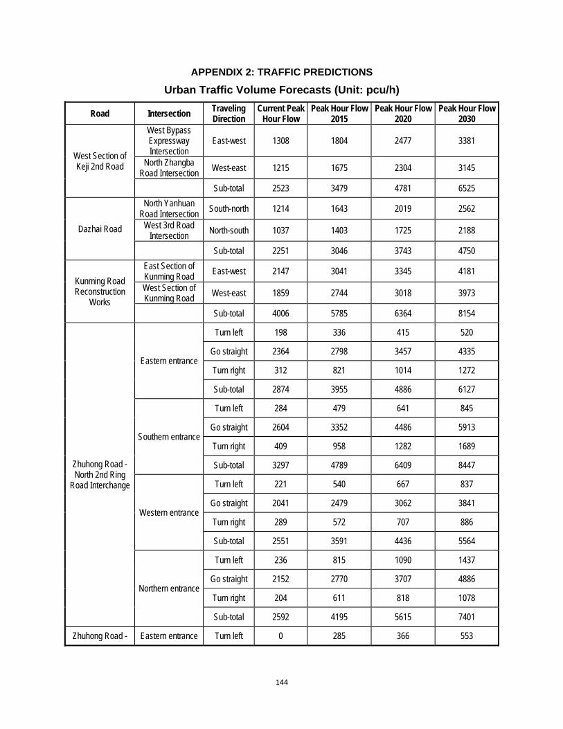
144
APPENDIX 2: TRAFFIC PREDICTIONS
Urban Traffic Volume Forecasts (Unit: pcu/h)
Road Intersection Traveling Direction
Current Peak Hour Flow
Peak Hour Flow 2015
Peak Hour Flow 2020
Peak Hour Flow 2030
West Section of Keji 2nd Road
West Bypass Expressway Intersection
East-west 1308 1804 2477 3381
North Zhangba Road Intersection West-east 1215 1675 2304 3145
Sub-total 2523 3479 4781 6525
Dazhai Road
North Yanhuan Road Intersection
South-north 1214 1643 2019 2562
West 3rd Road Intersection
North-south 1037 1403 1725 2188
Sub-total 2251 3046 3743 4750
Kunming Road Reconstruction
Works
East Section of Kunming Road
East-west 2147 3041 3345 4181
West Section of Kunming Road
West-east 1859 2744 3018 3973
Sub-total 4006 5785 6364 8154
Zhuhong Road - North 2nd Ring
Road Interchange
Eastern entrance
Turn left 198 336 415 520
Go straight 2364 2798 3457 4335
Turn right 312 821 1014 1272
Sub-total 2874 3955 4886 6127
Southern entrance
Turn left 284 479 641 845
Go straight 2604 3352 4486 5913
Turn right 409 958 1282 1689
Sub-total 3297 4789 6409 8447
Western entrance
Turn left 221 540 667 837
Go straight 2041 2479 3062 3841
Turn right 289 572 707 886
Sub-total 2551 3591 4436 5564
Northern entrance
Turn left 236 815 1090 1437
Go straight 2152 2770 3707 4886
Turn right 204 611 818 1078
Sub-total 2592 4195 5615 7401
Zhuhong Road - Eastern entrance Turn left 0 285 366 553
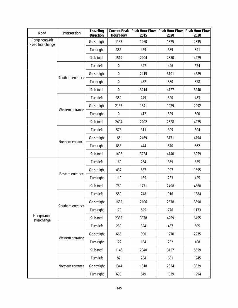
145
Road Intersection Traveling Direction
Current Peak Hour Flow
Peak Hour Flow 2015
Peak Hour Flow 2020
Peak Hour Flow 2030
Fengcheng 4th Road Interchange
Go straight 1133 1460 1875 2835
Turn right 385 459 589 891
Sub-total 1519 2204 2830 4279
Southern entrance
Turn left 0 347 446 674
Go straight 0 2415 3101 4689
Turn right 0 452 580 878
Sub-total 0 3214 4127 6240
Western entrance
Turn left 359 249 320 483
Go straight 2135 1541 1979 2992
Turn right 0 412 529 800
Sub-total 2494 2202 2828 4275
Northern entrance
Turn left 578 311 399 604
Go straight 65 2469 3171 4794
Turn right 853 444 570 862
Sub-total 1496 3224 4140 6259
Hongmiaopo Interchange
Eastern entrance
Turn left 169 254 359 655
Go straight 437 657 927 1695
Turn right 110 165 233 425
Sub-total 759 1771 2498 4568
Southern entrance
Turn left 580 748 916 1384
Go straight 1632 2106 2578 3898
Turn right 170 525 776 1173
Sub-total 2382 3378 4269 6455
Western entrance
Turn left 239 324 457 805
Go straight 665 900 1270 2235
Turn right 122 164 232 408
Sub-total 1146 2040 3157 5559
Northern entrance
Turn left 82 284 681 1245
Go straight 1344 1818 2334 3529
Turn right 690 849 1039 1294

146
Road Intersection Traveling Direction
Current Peak Hour Flow
Peak Hour Flow 2015
Peak Hour Flow 2020
Peak Hour Flow 2030
Sub-total 2116 2950 4054 6069
Xinghuo Road Interchange
Eastern entrance
Turn left 221 284 385 526
Go straight 459 590 799 1092
Turn right 578 743 1006 1375
Sub-total 1258 1618 2190 2992
Southern entrance
Turn left 309 397 538 735
Go straight 1306 1680 2273 3106
Turn right 412 530 717 980
Sub-total 2027 2607 3528 4820
Western entrance
Turn left 276 355 480 656
Go straight 477 613 830 1134
Turn right 625 804 1088 1486
Sub-total 1378 1772 2399 3277
Northern entrance
Turn left 244 314 425 580
Go straight 1258 1618 2190 2992
Turn right 412 530 717 980
Sub-total 1914 2461 3331 4552
Fengcheng 8th Road - Beichen
Avenue Interchange
Eastern entrance
Turn left 412 564 849
Go straight / 1470 2012 3027
Turn right / 435 596 896
Sub-total / 2317 3171 4772
Southern entrance
Turn left / 436 597 899
Go straight / 1661 2274 3421
Turn right / 431 590 888
Sub-total / 2528 3461 5207
Western entrance
Turn left / 557 762 1147
Go straight / 1712 2343 3525
Turn right / 446 611 919
Sub-total / 2714 3716 5590
Northern entrance Turn left / 549 751 1130

147
Road Intersection Traveling Direction
Current Peak Hour Flow
Peak Hour Flow 2015
Peak Hour Flow 2020
Peak Hour Flow 2030
Go straight 1721 2356 3545
Turn right / 588 805 1212
Sub-total / 2858 3912 5886
Taihua Road- Fengcheng 8th
Road Interchange
Eastern entrance
Turn left 426 555 754 1042
Go straight 1251 1630 2214 3060
Turn right 409 532 723 999
Sub-total 2086 2717 3691 5102
Southern entrance
Turn left 533 694 943 1303
Go straight 1693 2206 2997 4142
Turn right 709 924 1255 1735
Sub-total 2935 3824 5195 7180
Western entrance
Turn left 520 678 921 1272
Go straight 1156 1505 2045 2827
Turn right 525 684 929 1284
Sub-total 2201 2867 3895 5383
Northern entrance
Turn left 652 850 1154 1595
Go straight 1806 2353 3196 4418
Turn right 312 406 552 763
Sub-total 2770 3608 4902 6776
Note: “pcu” refers to the passenger car unit, it means the traffic volume when converting all kinds of motor-vehicle into the passenger car theoretically (generally the standard car refers to the car). Reference: “Highway Capacity Manual” 2000 published by Transportation Research Board (TRB).

148
To calculate the CO2 emission the following method was used:
Total traffic volume (peak hour, 2-way) – values taken from table above Annualize traffic volume by applying peak-to-day factor (10) and day to year factor (330) Total vehicle-kilometers – volume multiplied by distance (it was assumed due to short
length of roads and intersections that all vehicles travelled the full length) Break down total vehicle-kms by vehcle type (petrol and diesel at 2/3:1/3 ratio) Apply fuel efficiency (l/km) for petrol and diesel (0.1 and 0.08 respectively) Apply CO2 conversion factor (2.3 and 2.7 respectively) Divide by 1000 to convert to tons
2015 annual kms fuel eff (l/km) l fuel CO2 conversion kg CO2 tCO2e
2/3 petrol 128,545,463 0.1 12,854,546 2.3 29,565,457 29,565
1/3 diesel 64,272,732 0.08 5,141,819 2.7 13,882,910 13,883
192,818,195 17,996,365 43,448
2020 annual kms fuel eff (l/km) l fuel CO2 conversion kg CO2 tCO2e
2/3 petrol 177,727,211 0.1 17,772,721 2.3 40,877,259 40,877
1/3 diesel 88,863,606 0.08 7,109,088 2.7 19,194,539 19,195
266,590,817 24,881,810 60,072
2030 annual kms fuel eff (l/km) l fuel CO2 conversion kg CO2 tCO2e
2/3 petrol 239,121,179 0.1 23,912,118 2.3 54,997,871 54,998
1/3 diesel 119,560,590 0.08 9,564,847 2.7 25,825,087 25,825
358,681,769 33,476,965 80,823 Note: assumptions represent general values to provide indicative CO2 emisisons levels
29977000 litres saved 2030
2/3 petrol 19984467 l petrol 15188195 kg petrol 13669375 kg C 50576688.63 kg CO2
multiplied by 3.7
1/3 diesel 9992233.4 l diesel 8593321 kg diesel 7390256 27343946.57 kg CO2
Total Savings 77920635.2 kg CO2
77,921 t CO2/a

149
APPENDIX 3: NOISE ANALYSIS OF INTERCHANGES 1. These comprise Zhuhong Road-North 2nd Ring Road Interchange, Zhuhong Road-4th Fengcheng Road Interchange, Hongmiaopo Interchange, Xinghuo Road Interchange, 8th Fengcheng Road-Beichen Avenue Interchange and 8th Fengcheng Road-Taihua Road Interchange. 2. The feasibility study shows the traffic volume calculation results in 7-interchanges, average running speed of various vehicles, and strength of noise source. The noise change at sensitive points or monitoring points at interchanges has been calculated in accordance with the strength of noise source (before and after construction of interchanges). The details are shown in Tables A3.1 to A3.18.
Table A3.1: Traffic Volume (various types of vehicles) at Zhuhong Road-North 2nd Ring Road Interchange in Recent Operation Period (set/h)
Before and after construction
Time interval
Road name Small vehicles Medium vehicles Large vehicles
Before construction
Day
Zhuhong Road ground 5256 405 217
Zhuhong elevated bridge / / /
North 2nd Ring Road 4672 363 193
Night
Zhuhong Road ground 169 29 13
Zhuhong elevated bridge / / /
North 2nd Ring Road 151 20 12
After construction
Day
Zhuhong Road ground 3248 250 134
Zhuhong elevated bridge 1920 148 79
North 2nd Ring Road 4669 362 192
Night
Zhuhong Road ground 105 18 8
Zhuhong elevated bridge 62 11 5
North 2nd Ring Road 151 20 12

150
Table A3.2: Average Running Speed and Strength of Noise Source of Various Types of Vehicles at Zhuhong Road-North 2nd Ring Road Interchange in Recent Operation Period
Before and after construction
Time interval
Road name Average Running Speed, km/h Strength of Noise Source, dB(A)
Small vehicles
Medium vehicles
Large vehicles
Small vehicles
Medium vehicles
Large vehicles
Before construction
Day
Zhuhong Road ground
27 27 29 62.5 66.6 74.9
Zhuhong elevated bridge
/ / / / / /
North 2nd Ring Road 41 36 36 68.5 71.7 78.7
Night
Zhuhong Road ground
42 29 29 69.1 68.2 75.3
Zhuhong elevated bridge
/ / / / / /
North 2nd Ring Road 51 35 35 71.9 71.3 78.1
After construction
Day
Zhuhong Road ground
35 30 31 66.1 68.7 75.9
Zhuhong elevated bridge
39 31 31 67.8 69.2 76.1
North 2nd Ring Road 41 36 36 68.5 71.7 78.7
Night
Zhuhong Road ground
42 29 29 69.1 68.1 75.3
Zhuhong elevated bridge
42 29 29 69.1 68.0 75.2
North 2nd Ring Road 51 35 35 71.9 71.3 78.1
Note: The Zhuhong Road ground shall be of dual six-lane with running speed of 50km/h, Zhuhong elevated bridge shall be of dual six -lane with running speed of 50km/h, and North 2nd Ring Road shall be of dual six -lane with running speed of 60km/h.
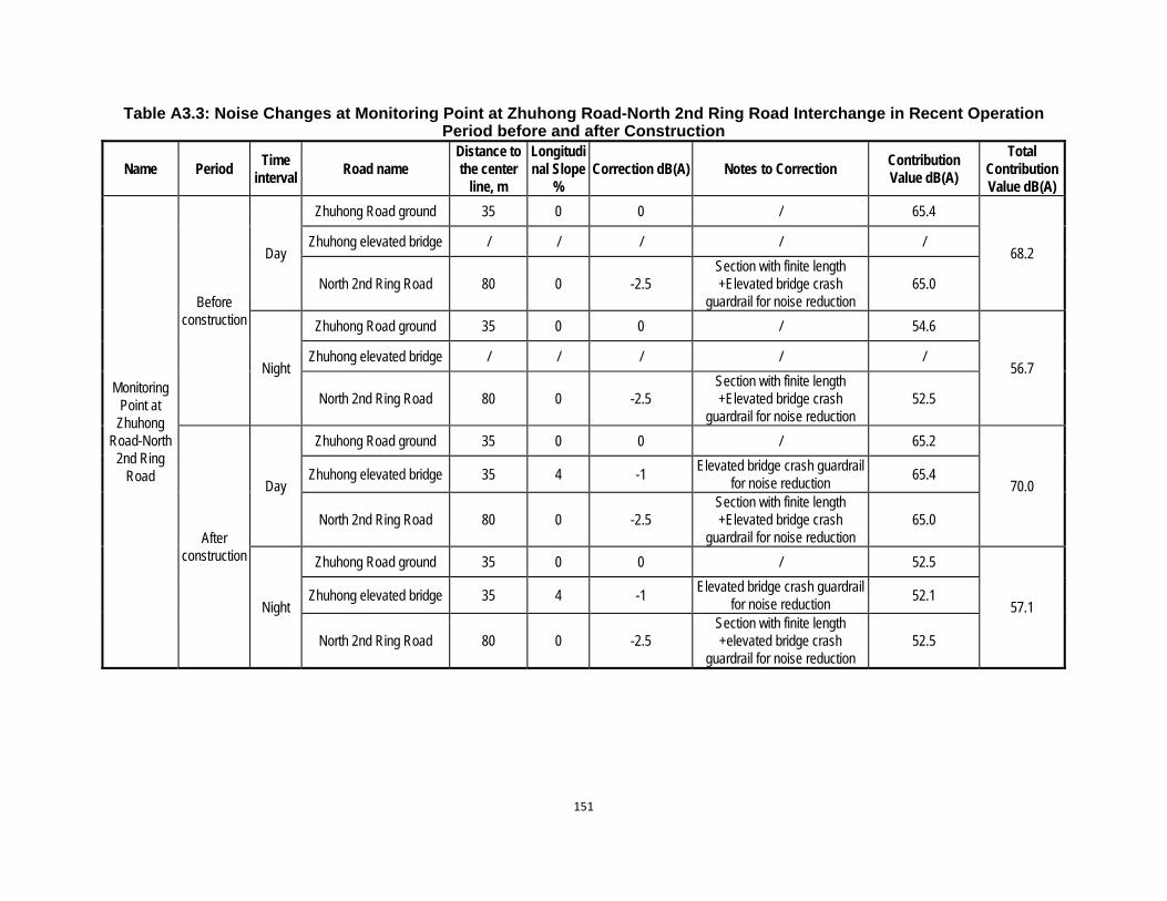
151
Table A3.3: Noise Changes at Monitoring Point at Zhuhong Road-North 2nd Ring Road Interchange in Recent Operation Period before and after Construction
Name Period Time
interval Road name
Distance to the center
line, m
Longitudinal Slope
% Correction dB(A) Notes to Correction
Contribution Value dB(A)
Total Contribution Value dB(A)
Monitoring Point at
Zhuhong Road-North
2nd Ring Road
Before construction
Day
Zhuhong Road ground 35 0 0 / 65.4
68.2 Zhuhong elevated bridge / / / / /
North 2nd Ring Road 80 0 -2.5 Section with finite length +Elevated bridge crash
guardrail for noise reduction 65.0
Night
Zhuhong Road ground 35 0 0 / 54.6
56.7 Zhuhong elevated bridge / / / / /
North 2nd Ring Road 80 0 -2.5 Section with finite length +Elevated bridge crash
guardrail for noise reduction 52.5
After construction
Day
Zhuhong Road ground 35 0 0 / 65.2
70.0 Zhuhong elevated bridge 35 4 -1
Elevated bridge crash guardrail for noise reduction
65.4
North 2nd Ring Road 80 0 -2.5 Section with finite length +Elevated bridge crash
guardrail for noise reduction 65.0
Night
Zhuhong Road ground 35 0 0 / 52.5
57.1 Zhuhong elevated bridge 35 4 -1
Elevated bridge crash guardrail for noise reduction
52.1
North 2nd Ring Road 80 0 -2.5 Section with finite length +elevated bridge crash
guardrail for noise reduction 52.5
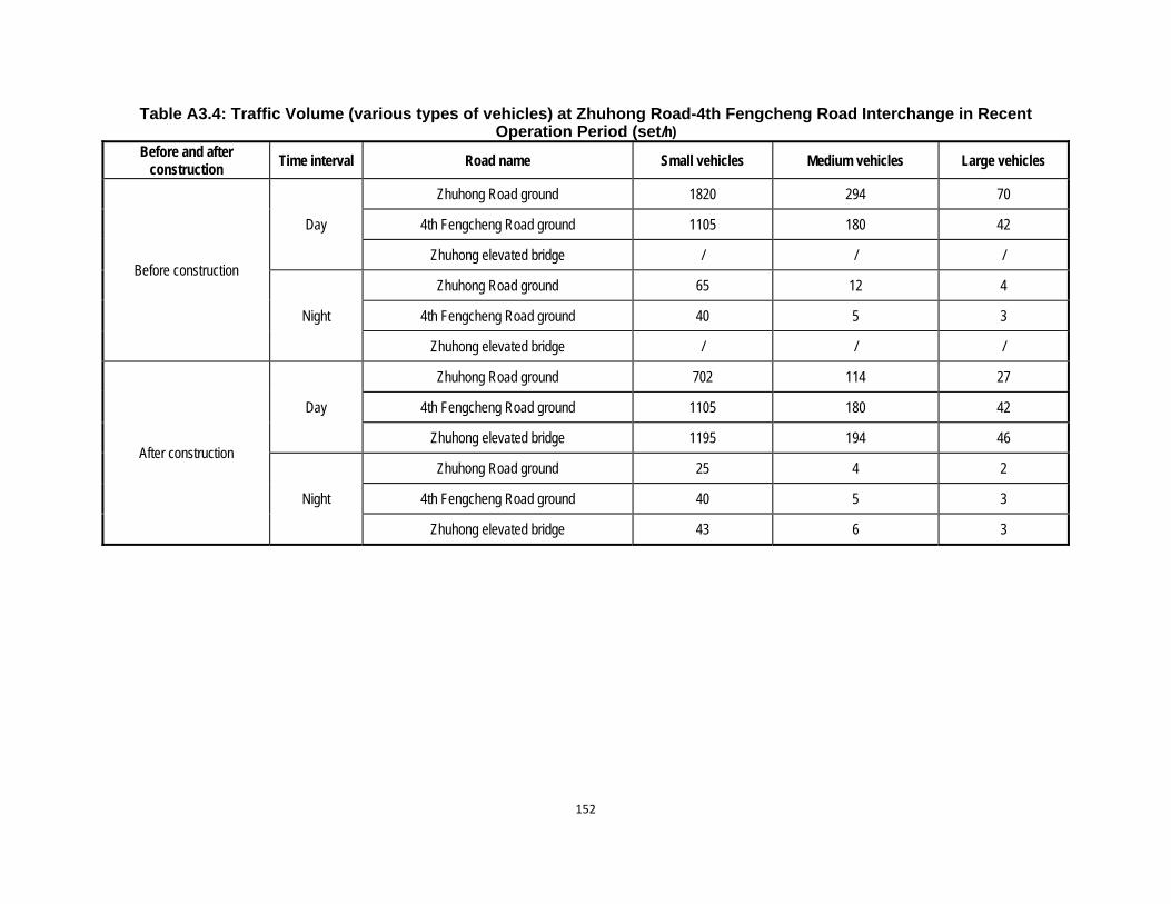
152
Table A3.4: Traffic Volume (various types of vehicles) at Zhuhong Road-4th Fengcheng Road Interchange in Recent Operation Period (set/h)
Before and after construction
Time interval Road name Small vehicles Medium vehicles Large vehicles
Before construction
Day
Zhuhong Road ground 1820 294 70
4th Fengcheng Road ground 1105 180 42
Zhuhong elevated bridge / / /
Night
Zhuhong Road ground 65 12 4
4th Fengcheng Road ground 40 5 3
Zhuhong elevated bridge / / /
After construction
Day
Zhuhong Road ground 702 114 27
4th Fengcheng Road ground 1105 180 42
Zhuhong elevated bridge 1195 194 46
Night
Zhuhong Road ground 25 4 2
4th Fengcheng Road ground 40 5 3
Zhuhong elevated bridge 43 6 3

153
Table A3.5: Average Running Speed and Strength of Noise Source of Various Types of Vehicles at Zhuhong Road-4th Fengcheng Road Interchange in Recent Operation Period
Before and after construction Ti
me
inte
rval
Road name Average Running Speed, km/h Strength of Noise Source, dB(A)
Small vehicles Medium vehicles
Large vehicles Small vehicles Medium vehicles
Large vehicles
Before construction
Day
Zhuhong Road ground 39 31 31 67.8 69.2 76.1
4th Fengcheng Road ground 31 25 25 64.6 65.3 72.6
Zhuhong elevated bridge / / / / / /
Night
Zhuhong Road ground 42 29 29 69.1 68.0 75.2
4th Fengcheng Road ground 34 23 23 65.8 64.1 71.7
Zhuhong elevated bridge / / / / / /
After construction
Day
Zhuhong Road ground 42 30 30 68.8 68.8 75.8
4th Fengcheng Road ground 31 25 25 64.6 65.3 72.6
Zhuhong elevated bridge 40 31 31 68.4 69.1 76.0
Night
Zhuhong Road ground 42 29 29 69.1 67.9 75.2
4th Fengcheng Road ground 34 23 23 65.8 64.1 71.7
Zhuhong elevated bridge 42 29 29 69.1 67.9 75.2
Note: The Zhuhong Road ground shall be of dual six-lane with running speed of 50km/h, Zhuhong elevated bridge shall be of dual six -lane with running speed of 50km/h, and 4th Fengcheng Road shall be of dual four -lane with running speed of 40km/h.

154
Table A3.6: Noise Changes at Monitoring Point at Zhuhong Road-4th Fengcheng Road Interchange in Recent Operation Period before and after Construction
Name Period Time interv
al Road name
Distance to the center line, m
Longitudinal
Slope %
Correction dB(A)
Notes to Correction Contribution Value dB(A)
Total Contribution Value dB(A)
Monitoring Point at
Zhuhong Road-4th
Fengcheng Road
Interchange
Before construction
Day
Zhuhong Road ground
65 0 0 / 61.2
64.4 4th Fengcheng Road
ground 20 0 0 / 61.7
Zhuhong elevated bridge
/ / / / /
Night
Zhuhong Road ground
65 0 0 / 47.6
50.9 4th Fengcheng Road
ground 20 0 0 / 48.1
Zhuhong elevated bridge
/ / / / /
After construction
Day
Zhuhong Road ground
65 0 0 / 57.4
65.1 4th Fengcheng Road
ground 20 0 0 / 61.7
Zhuhong elevated bridge
65 3.6 -1 Elevated bridge crash
guardrail for noise reduction 60.9
Night
Zhuhong Road ground
65 0 0 / 43.6
51.5 4th Fengcheng Road
ground 20 0 0 / 48.1
Zhuhong elevated bridge
65 3.6 -1 Elevated bridge crash
guardrail for noise reduction 47.2
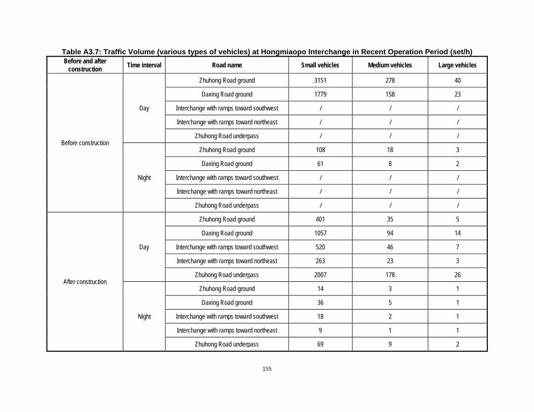
155
Table A3.7: Traffic Volume (various types of vehicles) at Hongmiaopo Interchange in Recent Operation Period (set/h) Before and after
construction Time interval Road name Small vehicles Medium vehicles Large vehicles
Before construction
Day
Zhuhong Road ground 3151 278 40
Daxing Road ground 1779 158 23
Interchange with ramps toward southwest / / /
Interchange with ramps toward northeast / / /
Zhuhong Road underpass / / /
Night
Zhuhong Road ground 108 18 3
Daxing Road ground 61 8 2
Interchange with ramps toward southwest / / /
Interchange with ramps toward northeast / / /
Zhuhong Road underpass / / /
After construction
Day
Zhuhong Road ground 401 35 5
Daxing Road ground 1057 94 14
Interchange with ramps toward southwest 520 46 7
Interchange with ramps toward northeast 263 23 3
Zhuhong Road underpass 2007 178 26
Night
Zhuhong Road ground 14 3 1
Daxing Road ground 36 5 1
Interchange with ramps toward southwest 18 2 1
Interchange with ramps toward northeast 9 1 1
Zhuhong Road underpass 69 9 2

156
Table A3.8: Average Running Speed and Strength of Noise Source of Various Types of Vehicles at Hongmiaopo Interchange in Recent Operation Period
Before and after construction
Time interval Road name Average Running Speed, km/h Strength of Noise Source, dB(A)
Small vehicles Medium vehicles
Large vehicles Small vehicles Medium vehicles
Large vehicles
Before construction
Day
Zhuhong Road ground 30 28 29 63.7 67.3 75.3
Daxing Road ground 40 31 31 68.4 69.1 76.0
Interchange with ramps toward southwest
/ / / / / /
Interchange with ramps toward northeast
/ / / / / /
Zhuhong Road underpass / / / / / /
Night
Zhuhong Road ground 42 29 29 69.1 68.2 75.3
Daxing Road ground 42 29 29 69.1 67.9 75.2
Interchange with ramps toward southwest
/ / / / / /
Interchange with ramps toward northeast
/ / / / / /
Zhuhong Road underpass / / / / / /
After construction
Day
Zhuhong Road ground 42 30 30 68.9 68.7 75.7
Daxing Road ground 42 30 30 68.8 68.9 75.8
Interchange with ramps toward southwest
24 19 19 60.5 60.2 68.0
Interchange with ramps toward northeast
25 18 18 61.1 59.9 67.7
Zhuhong Road underpass 39 31 31 67.8 69.2 76.1
Night
Zhuhong Road ground 42 29 29 69.1 67.9 75.2
Daxing Road ground 42 29 29 69.1 67.9 75.2
Interchange with ramps 25 17 17 61.4 59.0 67.1

157
toward southwest
Interchange with ramps toward northeast
25 17 17 61.4 58.9 67.1
Zhuhong Road underpass 42 29 29 69.1 68.0 75.2
Note: The ramp shall be of dual two-lane with running speed of 30km/h, and other section with speed of 50km/h. Zhuhong Road ground shall be of dual four-lane , Daxing Road ground shall be of dual eight-lane and Zhuhong Road underpass shall be of dual six-lane.
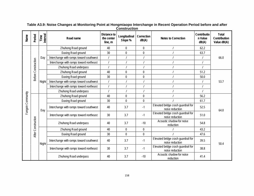
158
Table A3.9: Noise Changes at Monitoring Point at Hongmiaopo Interchange in Recent Operation Period before and after Construction
Nam
e
Perio
d
Tim
e in
terv
al
Road name Distance to the center
line, m
Longitudinal Slope %
Correction dB(A)
Notes to Correction Contributio
n Value dB(A)
Total Contribution Value dB(A)
Fang
xin
Com
mun
ity
Befo
re C
onst
ruct
ion Day
Zhuhong Road ground 40 0 0 / 62.2
66.0
Daxing Road ground 30 0 0 / 63.7
Interchange with ramps toward southwest / / / / /
Interchange with ramps toward northeast / / / / /
Zhuhong Road underpass / / / / /
Night
Zhuhong Road ground 40 0 0 / 51.2
53.7
Daxing Road ground 30 0 0 / 50.0
Interchange with ramps toward southwest / / / / /
Interchange with ramps toward northeast / / / / /
Zhuhong Road underpass / / / / /
Afte
r Con
stru
ctio
n
Day
Zhuhong Road ground 40 0 0 / 56.2
64.0
Daxing Road ground 30 0 0 / 61.7
Interchange with ramps toward southwest 40 3.7 -1 Elevated bridge crash guardrail for
noise reduction 52.5
Interchange with ramps toward northeast 30 3.7 -1 Elevated bridge crash guardrail for
noise reduction 51.0
Zhuhong Road underpass 40 3.7 -10 Acoustic shadow for noise
reduction 54.8
Night
Zhuhong Road ground 40 0 0 / 43.2
50.4
Daxing Road ground 30 0 0 / 47.6
Interchange with ramps toward southwest 40 3.7 -1 Elevated bridge crash guardrail for
noise reduction 39.5
Interchange with ramps toward northeast 30 3.7 -1 Elevated bridge crash guardrail for
noise reduction 38.8
Zhuhong Road underpass 40 3.7 -10 Acoustic shadow for noise
reduction 41.4
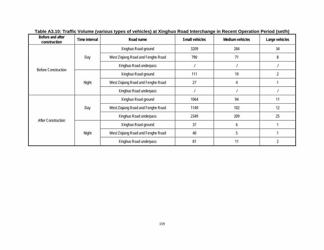
159
Table A3.10: Traffic Volume (various types of vehicles) at Xinghuo Road Interchange in Recent Operation Period (set/h) Before and after
construction Time interval Road name Small vehicles Medium vehicles Large vehicles
Before Construction
Day
Xinghuo Road ground 3209 284 34
West Ziqiang Road and Fenghe Road 790 71 8
Xinghuo Road underpass / / /
Night
Xinghuo Road ground 111 19 2
West Ziqiang Road and Fenghe Road 27 4 1
Xinghuo Road underpass / / /
After Construction
Day
Xinghuo Road ground 1064 94 11
West Ziqiang Road and Fenghe Road 1149 102 12
Xinghuo Road underpass 2349 209 25
Night
Xinghuo Road ground 37 6 1
West Ziqiang Road and Fenghe Road 40 5 1
Xinghuo Road underpass 81 11 2
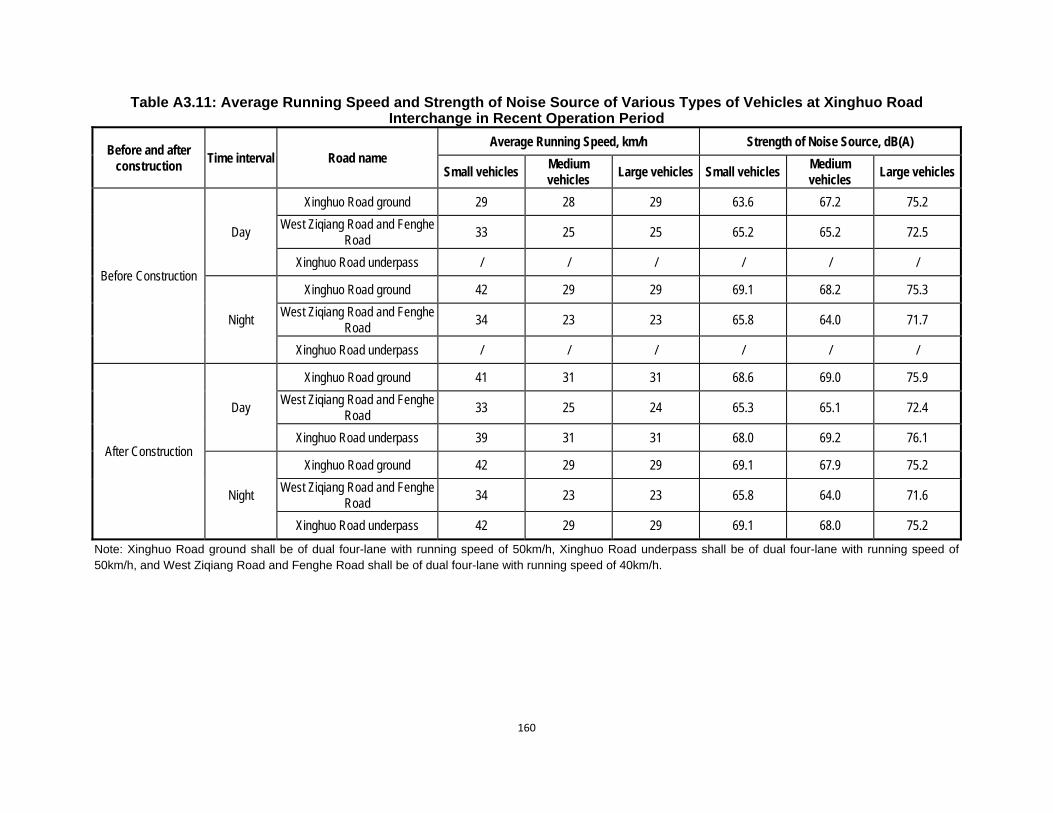
160
Table A3.11: Average Running Speed and Strength of Noise Source of Various Types of Vehicles at Xinghuo Road Interchange in Recent Operation Period
Before and after construction
Time interval Road name Average Running Speed, km/h Strength of Noise Source, dB(A)
Small vehicles Medium vehicles
Large vehicles Small vehicles Medium vehicles
Large vehicles
Before Construction
Day
Xinghuo Road ground 29 28 29 63.6 67.2 75.2
West Ziqiang Road and Fenghe Road
33 25 25 65.2 65.2 72.5
Xinghuo Road underpass / / / / / /
Night
Xinghuo Road ground 42 29 29 69.1 68.2 75.3
West Ziqiang Road and Fenghe Road
34 23 23 65.8 64.0 71.7
Xinghuo Road underpass / / / / / /
After Construction
Day
Xinghuo Road ground 41 31 31 68.6 69.0 75.9
West Ziqiang Road and Fenghe Road
33 25 24 65.3 65.1 72.4
Xinghuo Road underpass 39 31 31 68.0 69.2 76.1
Night
Xinghuo Road ground 42 29 29 69.1 67.9 75.2
West Ziqiang Road and Fenghe Road
34 23 23 65.8 64.0 71.6
Xinghuo Road underpass 42 29 29 69.1 68.0 75.2
Note: Xinghuo Road ground shall be of dual four-lane with running speed of 50km/h, Xinghuo Road underpass shall be of dual four-lane with running speed of 50km/h, and West Ziqiang Road and Fenghe Road shall be of dual four-lane with running speed of 40km/h.
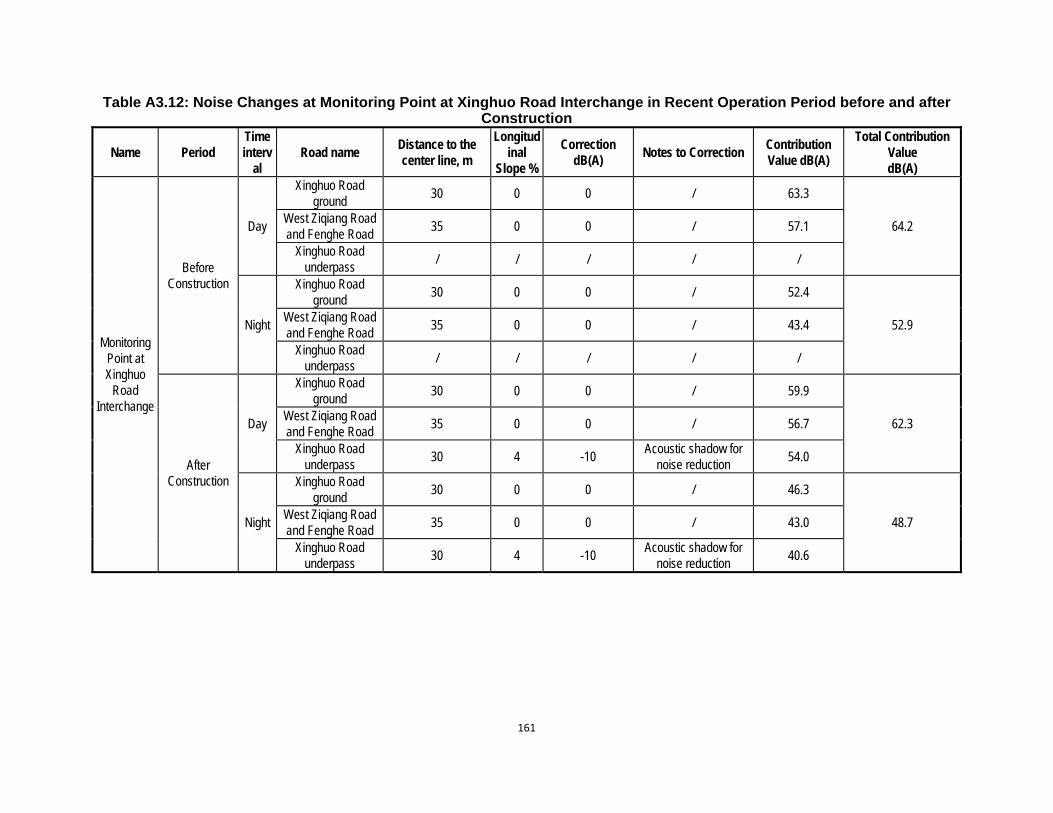
161
Table A3.12: Noise Changes at Monitoring Point at Xinghuo Road Interchange in Recent Operation Period before and after Construction
Name Period Time interv
al Road name
Distance to the center line, m
Longitudinal
Slope %
Correction dB(A)
Notes to Correction Contribution Value dB(A)
Total Contribution Value dB(A)
Monitoring Point at Xinghuo
Road Interchange
Before Construction
Day
Xinghuo Road ground
30 0 0 / 63.3
64.2 West Ziqiang Road and Fenghe Road
35 0 0 / 57.1
Xinghuo Road underpass
/ / / / /
Night
Xinghuo Road ground
30 0 0 / 52.4
52.9 West Ziqiang Road and Fenghe Road
35 0 0 / 43.4
Xinghuo Road underpass
/ / / / /
After Construction
Day
Xinghuo Road ground
30 0 0 / 59.9
62.3 West Ziqiang Road and Fenghe Road
35 0 0 / 56.7
Xinghuo Road underpass
30 4 -10 Acoustic shadow for
noise reduction 54.0
Night
Xinghuo Road ground
30 0 0 / 46.3
48.7 West Ziqiang Road and Fenghe Road
35 0 0 / 43.0
Xinghuo Road underpass
30 4 -10 Acoustic shadow for
noise reduction 40.6

162
Table A3.13: Traffic Volume (various types of vehicles) at 8th Fengcheng Road-Beichen Avenue Interchange in Recent Operation Period (set/h)
Before and after construction
Time interval Road name Small vehicles Medium vehicles Large vehicles
Before Construction
Day Beichen Avenue 2845 922 337
8th Fengcheng Road / / /
Night Beichen Avenue 51 9 55
8th Fengcheng Road / / /
After Construction
Day Beichen Avenue 3301 1070 391
8th Fengcheng Road 907 294 108
Night Beichen Avenue 59 11 64
8th Fengcheng Road 16 2 18
Table A3.14: Average Running Speed and Strength of Noise Source of Various Types of Vehicles at 8th Fengcheng Road-
Beichen Avenue Interchange in Recent Operation Period
Before and after construction
Time interval Road name Average Running Speed, km/h Strength of Noise Source, dB(A)
Small vehicles Medium vehicles
Large vehicles Small vehicles Medium vehicles
Large vehicles
Before Construction
Day Beichen Avenue 33 29 30 65.2 68.2 75.8
8th Fengcheng Road / / / / / /
Night Beichen Avenue 42 29 29 69.1 68.0 75.3
8th Fengcheng Road / / / / / /
After Construction
Day Beichen Avenue 30 28 30 64.1 67.6 75.5
8th Fengcheng Road 41 31 30 68.7 69.0 75.9
Night Beichen Avenue 42 29 29 69.1 68.1 75.3
8th Fengcheng Road 42 29 29 69.1 67.9 75.2
Note: The effect of Beichen Avenue will be taken into consideration before construction since this interchange at 8th Fengcheng Road has not commenced construction. Beichen Avenue shall be of dual six-lane with running speed of 50km/h, and 8th Fengcheng Road shall be of dual eight-lane with running speed of 50km/h.
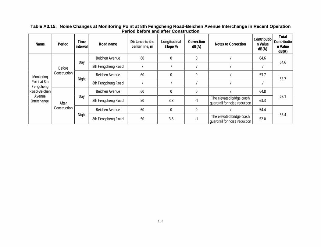
163
Table A3.15: Noise Changes at Monitoring Point at 8th Fengcheng Road-Beichen Avenue Interchange in Recent Operation Period before and after Construction
Name Period Time
interval Road name
Distance to the center line, m
Longitudinal Slope %
Correction dB(A)
Notes to Correction Contributio
n Value dB(A)
Total Contributio
n Value dB(A)
Monitoring Point at 8th Fengcheng
Road-Beichen Avenue
Interchange
Before Construction
Day Beichen Avenue 60 0 0 / 64.6
64.6 8th Fengcheng Road / / / / /
Night Beichen Avenue 60 0 0 / 53.7
53.7 8th Fengcheng Road / / / / /
After Construction
Day Beichen Avenue 60 0 0 / 64.8
67.1 8th Fengcheng Road 50 3.8 -1
The elevated bridge crash guardrail for noise reduction
63.3
Night Beichen Avenue 60 0 0 / 54.4
56.4 8th Fengcheng Road 50 3.8 -1
The elevated bridge crash guardrail for noise reduction
52.0
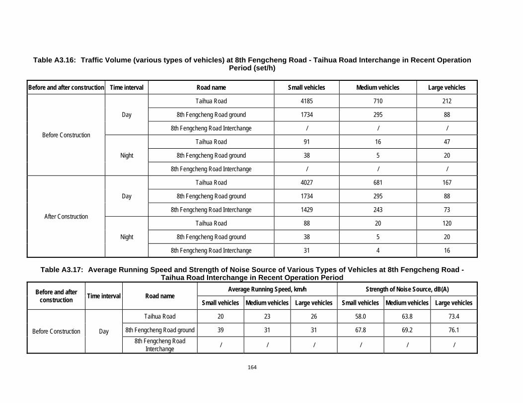
164
Table A3.16: Traffic Volume (various types of vehicles) at 8th Fengcheng Road - Taihua Road Interchange in Recent Operation Period (set/h)
Before and after construction Time interval Road name Small vehicles Medium vehicles Large vehicles
Before Construction
Day
Taihua Road 4185 710 212
8th Fengcheng Road ground 1734 295 88
8th Fengcheng Road Interchange / / /
Night
Taihua Road 91 16 47
8th Fengcheng Road ground 38 5 20
8th Fengcheng Road Interchange / / /
After Construction
Day
Taihua Road 4027 681 167
8th Fengcheng Road ground 1734 295 88
8th Fengcheng Road Interchange 1429 243 73
Night
Taihua Road 88 20 120
8th Fengcheng Road ground 38 5 20
8th Fengcheng Road Interchange 31 4 16
Table A3.17: Average Running Speed and Strength of Noise Source of Various Types of Vehicles at 8th Fengcheng Road -
Taihua Road Interchange in Recent Operation Period
Before and after construction
Time interval Road name Average Running Speed, km/h Strength of Noise Source, dB(A)
Small vehicles Medium vehicles Large vehicles Small vehicles Medium vehicles Large vehicles
Before Construction Day
Taihua Road 20 23 26 58.0 63.8 73.4
8th Fengcheng Road ground 39 31 31 67.8 69.2 76.1
8th Fengcheng Road Interchange
/ / / / / /
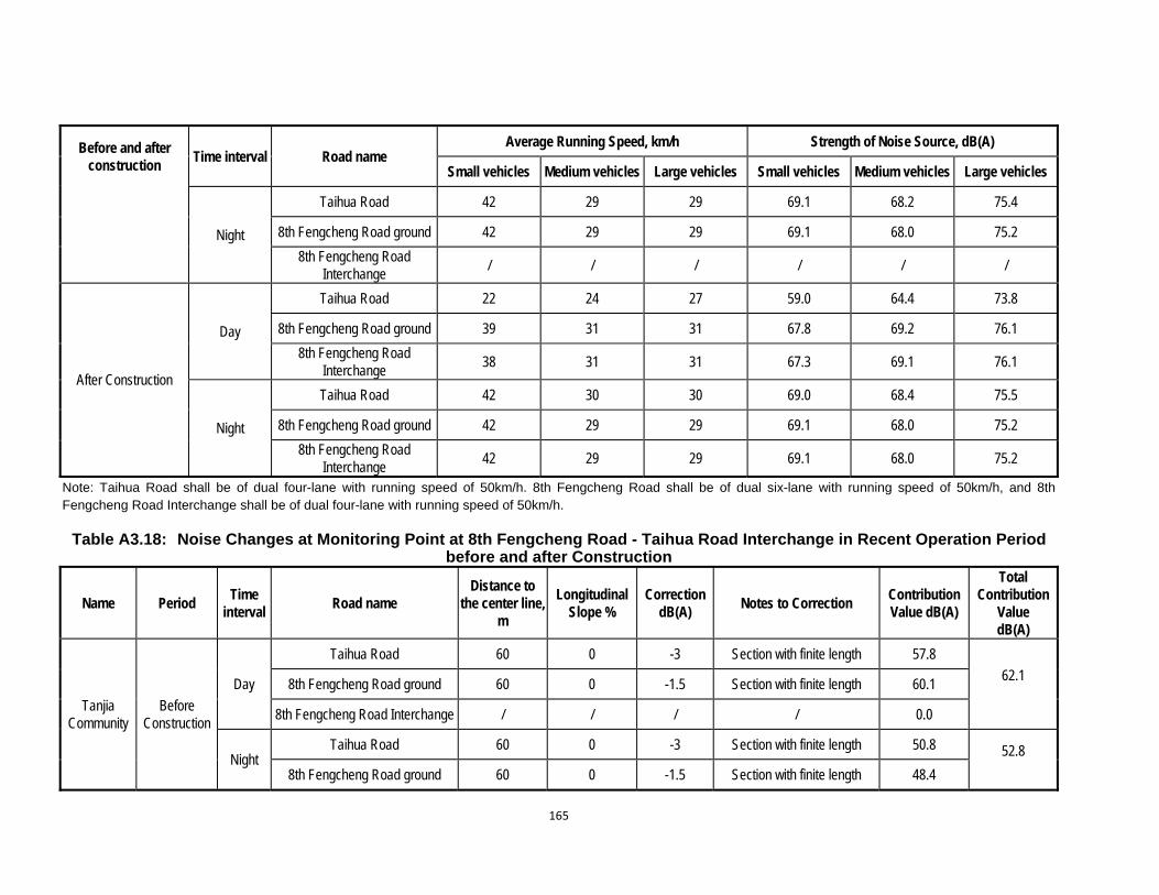
165
Before and after construction
Time interval Road name Average Running Speed, km/h Strength of Noise Source, dB(A)
Small vehicles Medium vehicles Large vehicles Small vehicles Medium vehicles Large vehicles
Night
Taihua Road 42 29 29 69.1 68.2 75.4
8th Fengcheng Road ground 42 29 29 69.1 68.0 75.2
8th Fengcheng Road Interchange
/ / / / / /
After Construction
Day
Taihua Road 22 24 27 59.0 64.4 73.8
8th Fengcheng Road ground 39 31 31 67.8 69.2 76.1
8th Fengcheng Road Interchange
38 31 31 67.3 69.1 76.1
Night
Taihua Road 42 30 30 69.0 68.4 75.5
8th Fengcheng Road ground 42 29 29 69.1 68.0 75.2
8th Fengcheng Road Interchange
42 29 29 69.1 68.0 75.2
Note: Taihua Road shall be of dual four-lane with running speed of 50km/h. 8th Fengcheng Road shall be of dual six-lane with running speed of 50km/h, and 8th Fengcheng Road Interchange shall be of dual four-lane with running speed of 50km/h.
Table A3.18: Noise Changes at Monitoring Point at 8th Fengcheng Road - Taihua Road Interchange in Recent Operation Period before and after Construction
Name Period Time
interval Road name
Distance to the center line,
m
Longitudinal Slope %
Correction dB(A)
Notes to Correction Contribution Value dB(A)
Total Contribution
Value dB(A)
Tanjia Community
Before Construction
Day
Taihua Road 60 0 -3 Section with finite length 57.8
62.1
8th Fengcheng Road ground 60 0 -1.5 Section with finite length 60.1
8th Fengcheng Road Interchange / / / / 0.0
Night Taihua Road 60 0 -3 Section with finite length 50.8 52.8
8th Fengcheng Road ground 60 0 -1.5 Section with finite length 48.4
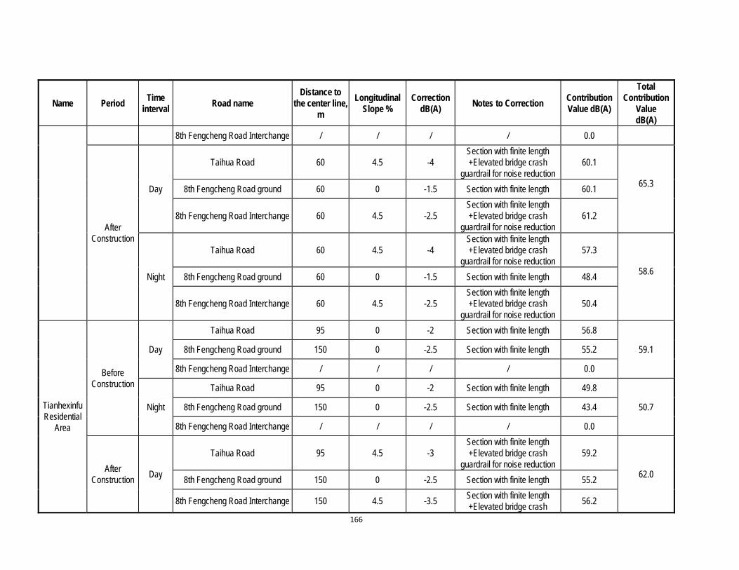
166
Name Period Time
interval Road name
Distance to the center line,
m
Longitudinal Slope %
Correction dB(A)
Notes to Correction Contribution Value dB(A)
Total Contribution
Value dB(A)
8th Fengcheng Road Interchange / / / / 0.0
After Construction
Day
Taihua Road 60 4.5 -4 Section with finite length +Elevated bridge crash
guardrail for noise reduction 60.1
65.3
8th Fengcheng Road ground 60 0 -1.5 Section with finite length 60.1
8th Fengcheng Road Interchange 60 4.5 -2.5 Section with finite length +Elevated bridge crash
guardrail for noise reduction 61.2
Night
Taihua Road 60 4.5 -4 Section with finite length +Elevated bridge crash
guardrail for noise reduction 57.3
58.6
8th Fengcheng Road ground 60 0 -1.5 Section with finite length 48.4
8th Fengcheng Road Interchange 60 4.5 -2.5 Section with finite length +Elevated bridge crash
guardrail for noise reduction 50.4
Tianhexinfu Residential
Area
Before Construction
Day
Taihua Road 95 0 -2 Section with finite length 56.8
59.1 8th Fengcheng Road ground 150 0 -2.5 Section with finite length 55.2
8th Fengcheng Road Interchange / / / / 0.0
Night
Taihua Road 95 0 -2 Section with finite length 49.8
50.7 8th Fengcheng Road ground 150 0 -2.5 Section with finite length 43.4
8th Fengcheng Road Interchange / / / / 0.0
After Construction
Day
Taihua Road 95 4.5 -3 Section with finite length +Elevated bridge crash
guardrail for noise reduction 59.2
62.0 8th Fengcheng Road ground 150 0 -2.5 Section with finite length 55.2
8th Fengcheng Road Interchange 150 4.5 -3.5 Section with finite length +Elevated bridge crash
56.2
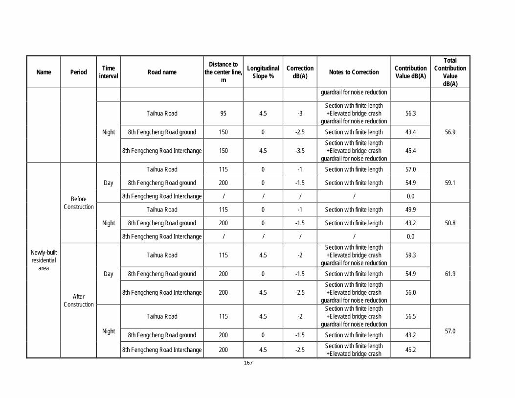
167
Name Period Time
interval Road name
Distance to the center line,
m
Longitudinal Slope %
Correction dB(A)
Notes to Correction Contribution Value dB(A)
Total Contribution
Value dB(A)
guardrail for noise reduction
Night
Taihua Road 95 4.5 -3 Section with finite length +Elevated bridge crash
guardrail for noise reduction 56.3
56.9 8th Fengcheng Road ground 150 0 -2.5 Section with finite length 43.4
8th Fengcheng Road Interchange 150 4.5 -3.5 Section with finite length +Elevated bridge crash
guardrail for noise reduction 45.4
Newly-built residential
area
Before Construction
Day
Taihua Road 115 0 -1 Section with finite length 57.0
59.1 8th Fengcheng Road ground 200 0 -1.5 Section with finite length 54.9
8th Fengcheng Road Interchange / / / / 0.0
Night
Taihua Road 115 0 -1 Section with finite length 49.9
50.8 8th Fengcheng Road ground 200 0 -1.5 Section with finite length 43.2
8th Fengcheng Road Interchange / / / / 0.0
After Construction
Day
Taihua Road 115 4.5 -2 Section with finite length +Elevated bridge crash
guardrail for noise reduction 59.3
61.9 8th Fengcheng Road ground 200 0 -1.5 Section with finite length 54.9
8th Fengcheng Road Interchange 200 4.5 -2.5 Section with finite length +Elevated bridge crash
guardrail for noise reduction 56.0
Night
Taihua Road 115 4.5 -2 Section with finite length +Elevated bridge crash
guardrail for noise reduction 56.5
57.0 8th Fengcheng Road ground 200 0 -1.5 Section with finite length 43.2
8th Fengcheng Road Interchange 200 4.5 -2.5 Section with finite length +Elevated bridge crash
45.2
168
Name Period Time
interval Road name
Distance to the center line,
m
Longitudinal Slope %
Correction dB(A)
Notes to Correction Contribution Value dB(A)
Total Contribution
Value dB(A)
guardrail for noise reduction
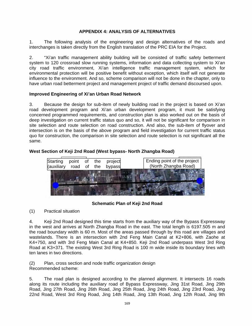
169
APPENDIX 4: ANALYSIS OF ALTERNATIVES 1. The following analysis of the engineering and design alternatives of the roads and interchanges is taken directly from the English translation of the PRC EIA for the Project. 2. “Xi’an traffic management ability building will be consisted of traffic safety betterment system to 120 crossroad slow running systems, information and data collecting system to Xi’an city road traffic environment, Xi’an intelligence traffic management system, which for environmental protection will be positive benefit without exception, which itself will not generate influence to the environment. And so, scheme comparison will not be done in the chapter, only to have urban road betterment project and management project of traffic demand discoursed upon. Improved Engineering of Xi’an Urban Road Network 3. Because the design for sub-item of newly building road in the project is based on Xi’an road development program and Xi’an urban development program, it must be satisfying concerned programmed requirements, and construction plan is also worked out on the basis of deep investigation on current traffic status quo and so, it will not be significant for comparison in site selection and route selection on road construction. And also, the sub-item of flyover and intersection is on the basis of the above program and field investigation for current traffic status quo for construction, the comparison in site selection and route selection is not significant all the same. West Section of Keji 2nd Road (West bypass- North Zhangba Road)
Schematic Plan of Keji 2nd Road
(1) Practical situation 4. Keji 2nd Road designed this time starts from the auxiliary way of the Bypass Expressway in the west and arrives at North Zhangba Road in the east. The total length is 6197.505 m and the road boundary width is 60 m. Most of the areas passed through by this road are villages and wastelands. There is an intersection with 2nd Feng Main Canal at K2+806, with Zaohe at K4+750, and with 3rd Feng Main Canal at K4+850. Keji 2nd Road underpass West 3rd Ring Road at K3+371. The existing West 3rd Ring Road is 100 m wide inside its boundary lines with ten lanes in two directions. (2) Plan, cross section and node traffic organization design Recommended scheme: 5. The road plan is designed according to the planned alignment. It intersects 16 roads along its route including the auxiliary road of Bypass Expressway, Jing 31st Road, Jing 29th Road, Jing 27th Road, Jing 26th Road, Jing 25th Road, Jing 24th Road, Jing 23rd Road, Jing 22nd Road, West 3rd Ring Road, Jing 14th Road, Jing 13th Road, Jing 12th Road, Jing 9th
Starting point of the project(auxiliary road of the bypass
)
Ending point of the project (North Zhangba Road)
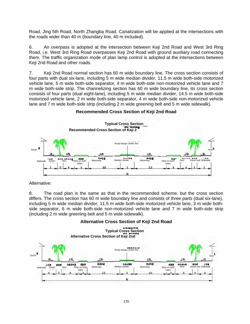
170
Road, Jing 5th Road, North Zhangba Road. Canalization will be applied at the intersections with the roads wider than 40 m (boundary line, 40 m included). 6. An overpass is adopted at the intersection between Keji 2nd Road and West 3rd Ring Road, i.e. West 3rd Ring Road overpasses Keji 2nd Road with ground auxiliary road connecting them. The traffic organization mode of plan lamp control is adopted at the intersections between Keji 2nd Road and other roads. 7. Keji 2nd Road normal section has 60 m wide boundary line. The cross section consists of four parts with dual six-lane, including 5 m wide median divider, 11.5 m wide both-side motorized vehicle lane, 5 m wide both-side separator, 4 m wide both-side non-motorized vehicle lane and 7 m wide both-side strip. The channelizing section has 60 m wide boundary line, its cross section consists of four parts (dual eight-lane), including 5 m wide median divider, 14.5 m wide both-side motorized vehicle lane, 2 m wide both-side separator, 4 m wide both-side non-motorized vehicle lane and 7 m wide both-side strip (including 2 m wide greening belt and 5 m wide sidewalk).
Recommended Cross Section of Keji 2nd Road
Alternative:
8. The road plan is the same as that in the recommended scheme, but the cross section differs. The cross section has 60 m wide boundary line and consists of three parts (dual six-lane), including 5 m wide median divider, 11.5 m wide both-side motorized vehicle lane, 3 m wide both-side separator, 6 m wide both-side non-motorized vehicle lane and 7 m wide both-side strip (including 2 m wide greening belt and 5 m wide sidewalk).
Alternative Cross Section of Keji 2nd Road
Typical Cross Section
Sidewalk Non-motorway
Green belt
South North
SidewalkStrip on both sides
MotorwayGreen belt
Median divider
Recommended Cross Section of Keji 2
Road design center line
Motorway Non-motorway
Strip on both sides
Typical Cross Section
Sidewalk Non-motorway
Green belt
South North
SidewalkStrip on both sides
MotorwayGreen belt
Median divider
Alternative Cross Section of Keji 2nd
Road design center line
Motorway Non-motorway
Strip on both sides

171
Result on scheme comparison
9. The non-motor way in the comparative cross section scheme is wider, and the motor way runs and parks on it, affecting the safety of non-motorized vehicle seriously. After channelizing the comparative cross section, the motorized vehicle lane is much wider and has no advantage on the pedestrian’s safe crossing. Therefore, it is suggested to adopt the recommended scheme.
(4) Profile design
10. During the Profile design, the elevations of the existing North Zhangba Road, West 3rd Ring Road, the top of 2nd Feng Canal and 3rd Feng Canal and the top of Zaohe are adopted as the control elevations. The clearance under the span of the overpass bridge of 3rd West Ring Road is controlled more than 5m. With the most consideration of the existing topography along both sides of the road, the maximum longitudinal gradient is 1% and the minimum longitudinal gradient is 0.3%.
Dazhai Road (North Yanhuan Road-West 3rd Ring Road)
Schematic Plan of Dazhai Road
1. Practical situation
11. Dazhai Road in the design this time starts from North Yanhuan Road in the west and ends at West 3rd Ring Road in the east, with a design total length of 2,333.734 m. The existing areas along the road are mostly farmlands and there are also some domestic houses in part of these areas. The road intersects with Fenghui Canal at K1+583 and with West 3rd Ring Road at K1+839. The existing West 3rd Ring Road is 100 m wide inside the red line with 10 lanes in two directions.
2. Plan, cross section and node traffic organization design
Recommended scheme:
12. The road plan is designed according to the planning alignment. The starting point is at Yanhuan Road and the ending point is connected to the East Section of Dazhai Road in construction after overpassing West 3rd Ring Road. The total length is 2333.734. The road intersects with Yanhuang Road, 6th Jing Road, 7th Jing Road, 8th Jing Road, West 3rd Ring Road, a 20 m planning road and a 30 m planning road. Canalization will be carried out at the intersections with the roads which are wider than 30 m (30 m included) inside the red line.
13. A viaduct and the traffic organization mode of right-in-right-out are adopted at the intersection between Dazhai Road and West 3rd Ring Road. Dazhai Road overpasses West 3rd
Ending point of project Overpassing West 3rd Ring Road
Starting point of project (Yanhuan Road)

172
Ring Road and connects to it with ground auxiliary road. And a pedestrian overpass is also provided at the same time for pedestrian and non-motor vehicles passing across West 3rd Ring Road. The traffic organization mode of plan lamp control is adopted at the intersections between Dazhai Road and other roads.
14. The width of the normal sections of Dazhai Road is 40 m inside the planning red line. The cross section mode: three carriageways with 6 lanes in two directions. The motorway is 21 m wide, the lane separator on each side is 1.5 m wide, the non-motor way on each side is 4 m wide and the curb side strip on each side is 4 m wide. The canalization section is 50 m wide inside the planning red line. The cross section mode: three carriageways with 8 lanes in two directions. The motorway is 27 m wide, the lane separator on each side is 1.5 m wide, the non-motorway on each side is 4 m wide and the curb side strip on each side is 6 m wide. The section of Dazhai Road overpassing West 3rd Ring Road is 50 m wide inside the red line. Its approach bridge is 18.5 m wide, the lane separator on each side is 0.75 m wide, auxiliary road on each side is 11 m and the curb side strip on each side is 4 m wide.
Typical Cross Section of Dazhai Road
Alternative:
15. The design of plan and cross section is the same with the recommended scheme. But the traffic organization at the intersection with West 3rd Ring Road is not the same with the recommended scheme. The traffic organization mode of right-in-right-out grade crossing is adopted. A pedestrian bridge is provided at the same time for pedestrian and non-motor vehicles passing West 3rd Ring Road.
Comparison result:
16. No viaduct is necessary in the alternative scheme, which resulted in lower cost. But the latitude traffic flow needs to detour from the south or north. Dazhai Road is about 800 m away from Kunming Road on the north and about 800 m away from Keji Road on the south. The 1,600 m detour distance is too long. Therefore, it is proposed to adopt the recommended scheme.
(4) Profile design
17. In the design of Profile design, the elevations of the top of existing Yanhuang Road, West 3rd Ring Road and Fenghui Canal and the elevations of the designed east section of Dazhai Road are adopted as the control elevations. The clearance under span of the viaduct of West 3rd Ring Road is controlled more than 5 m. The existing topography along both sides of the roads is
Cross Section of Dazhai Road (I)
Normal Section
Road design center li
Curb side strip Non-motorway Non-motorway
Dividing Strip on
both sides
Dividing Strip on
both sides Curb side stripMotor way
North South
Motorway

173
considered as much as possible. The maximum and minimum longitudinal gradient of the road are 4% and 0.3% respectively.
Kunming Road (West 2nd Ring Road- West Surrounding City Expressway)
(1) Practical situation
18. Located at west suburb of Xi’an city Kunming road is of east and west strike, being urban trunk road. The design is divided into two parts: the east section of Kunming road (from West 2nd Ring Road to West 3rd Ring Road) and Kunming road west section (from west surrounding city expressway to Xi-Bao Divergence Line). Between west surrounding city expressway to Xi-Bao Divergence Line is the road not existed. The road width of the existing road from Xi-Bao Divergence Line to the West 3rd Ring Road is 70 m, being double direction with eight lanes, median separator being 6m, motor vehicles to be respectively 14 m, the separator at both side to be 8 m and non-motorized vehicle lane at both sides and road side belt to be respectively 5 m. The total width of the existing road from West 3rd Ring Road to Hancheng road is 70 m, including lane width for motor vehicle to be 23 m, the separator at south side to be 1.5 m in width, non-motor vehicle lane at south side to be 5 m, the road side belt width at south side to be 6 m, the separator at north side to be 25.5 m in width; within the separator is Dahuanhe river course with mouth width being 16 m, the riverbank width at south side of river course to be 1 m, the outside pedestrian path to be 3.5 m in width, the width of riverbank at north side to be 2.5 m, the outside pedestrian path to be 2.5 m in width, the non-motor vehicle lane at the north to the separator to be 6 m wide and 3 m wide road side belt. The total width of the road from Hancheng road to Chuangxin road section is 74 m and the road section of south half breadth is the same with that of west section; the separator at north side to be 25.5 m, the auxiliary road at north side of the separator to be 7 m in width, the road side belt width at north side to be 3 m, the existing road from Chuangxin road to West 2nd Ring Road to be 71 m in width, and the road section of south half breadth to be the same with that of the section to the west of Hancheng road, the separator and auxiliary road to be all the same with that from Hancheng road to Chuangxin road, road side belt at north side to be 3 m in width. The whole existing section is of asphalt pavement with better road condition.
Orientation sketch map of Kunming Road
(2) Traffic organizational design for node, cross section and plane
19. The design for the east section (from West 2nd Ring Road to West 3rd Ring Road) of Kunming road will configure cover board for the existing Dahuanhe river, with the bridge over the existing Dahuanhe River at several junctions (Epang Road and Hancheng Road) widened in design (for cover board to be configured for Dahuanhe River refer to bridge engineering design in detail) and the road to be widened. The project of the road will be 3,755.075 in total length with road plane line location and red line width maintained not changing. Because based on the existing road traffic status quo the traffic from the east to west is relatively large, the road south half breadth in the cross section design will be maintained not changing, the motor vehicle lane at north half breadth to be widened up to 14.5 m, total width of motor vehicle to be 26 m with double
Project t ti
West 3rd Ring Road West 2nd RingR d
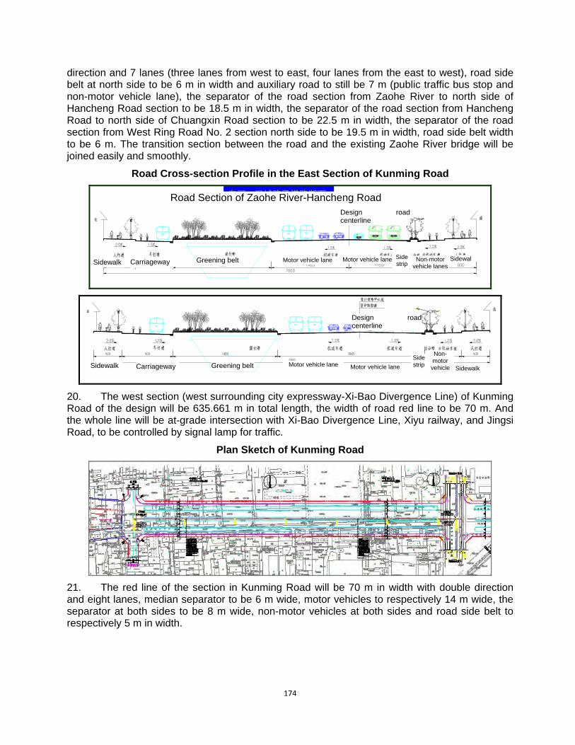
174
direction and 7 lanes (three lanes from west to east, four lanes from the east to west), road side belt at north side to be 6 m in width and auxiliary road to still be 7 m (public traffic bus stop and non-motor vehicle lane), the separator of the road section from Zaohe River to north side of Hancheng Road section to be 18.5 m in width, the separator of the road section from Hancheng Road to north side of Chuangxin Road section to be 22.5 m in width, the separator of the road section from West Ring Road No. 2 section north side to be 19.5 m in width, road side belt width to be 6 m. The transition section between the road and the existing Zaohe River bridge will be joined easily and smoothly.
Road Cross-section Profile in the East Section of Kunming Road
皂河—汉城路段道路断面皂河—汉城路段道路断面
20. The west section (west surrounding city expressway-Xi-Bao Divergence Line) of Kunming Road of the design will be 635.661 m in total length, the width of road red line to be 70 m. And the whole line will be at-grade intersection with Xi-Bao Divergence Line, Xiyu railway, and Jingsi Road, to be controlled by signal lamp for traffic.
Plan Sketch of Kunming Road
21. The red line of the section in Kunming Road will be 70 m in width with double direction and eight lanes, median separator to be 6 m wide, motor vehicles to respectively 14 m wide, the separator at both sides to be 8 m wide, non-motor vehicles at both sides and road side belt to respectively 5 m in width.
Road Section of Zaohe River-Hancheng Road Design roadcenterline
Design roadcenterline
Sidewalk Carriageway Greening belt SidewalNon-motor vehicle lanes
Side strip
Motor vehicle laneMotor vehicle lane
Sidewalk Carriageway Greening belt Sidewalk
Non-motor
vehicle
Side strip Motor vehicle laneMotor vehicle lane

175
Standard Cross Section of Kunming Road
Alternative:
22. At the junction between Kunming Road and Xiyu railway is the grade separation without ramps to be adopted and Kunming Road to up span Xiyu railway and Xi-Bao Divergence Line, with the auxiliary road of Kunming Road to be at-grade intersection with Xiyu railway and Xi-Bao Divergence Line.
Profile chart of comparison scheme
(3) Result on comparison
23. The recommended scheme will adopt at-grade intersection among Kunming Road, Xiyu railway and Xi’an-Baoji channeling line, with strongpoint in lower cost, disadvantage in road traffic capacity being poorer. The comparison scheme for Kunming Road, Xiyu railway and Xi’an-Baoji channeling line will adopt grade separation without ramps, the strongpoint of which is relatively high in road traffic capacity and safer in vehicle running, the disadvantage of which is large in engineering cost. The recommended scheme is suggested using; and at a specified future date the space for grade separation without lamps should be reserved in advance.
Standard Cross
Kunming
Kunming
Road side belt
Non-motor vehicle lane
Non-motor vehicle lane
Road side belt
Both sides belt
Both sides belt
Motorway MotorwayMedian
Bridge starting Bridge ending
Xiyu Railway
Xi’an-Baoji channeling off line

176
(4) Profile design
24. The east section of Kunming Road is of transforming engineering and on the basis of the original road it will be designed in widening and so, the existing gradient of the road will be maintained not changing.
25. The profile design of the road in west section of Kunming Road will take as elevation control point the existing west surrounding city expressway tolling station and Xi-Bao Divergence Line , with the maximum longitudinal gradient to be 0.315% and the minimum to be 0.3%.
Intersection at Zhuhong Road-North 2nd Ring Road
(1) Practical situation
26. Zhuhong Road is located in the Northwest corner of Xi'an City; it is one of eight radiating roads in the overall planning for urban road network of Xi'an City. The length red line width of the existing road is 80 m in four-carriageway road design. In which the median separator is 4 m wide, driveway is 12 m wide each, the separation strip on both sides is 4 m wide each, the auxiliary road on both sides is 11 m wide each, sidewalk is 3 m wide each and the outmost green belt is 8 m wide each. The existing Zhuhong Road and North 2nd Ring Road is adopting grade separation without ramps; the North 2nd Ring Road will up span Zhuhong Road.
(2) Plan, cross section and traffic organization design at nodes
Recommended scheme
27. The semi-interchange design will be used for the node between Zhuhong Road and North 2nd Ring Road and the main line of Zhuhong Road will be connected with the existing road after spanning North 2nd Ring Road from south to north, with two ramps designed for realizing part of traffic transferring function between North 2nd Ring Road and viaduct of Zhuhong Road. Apart from the ramps real line may be used for traffic transferring of Zhuhong Road making a turn to left from north to east and of North 2nd Ring Road making a turn to left from west to north, the traffic flow to other directions may realize traffic transferring via ground auxiliary road. And the ground traffic may be controlled by signal lamp.
Plane of Recommended Scheme for Intersection at Road from Zhuhong Road to North 2nd Ring Road
Planning Road
Note: 1. The dimensions in this drawing are
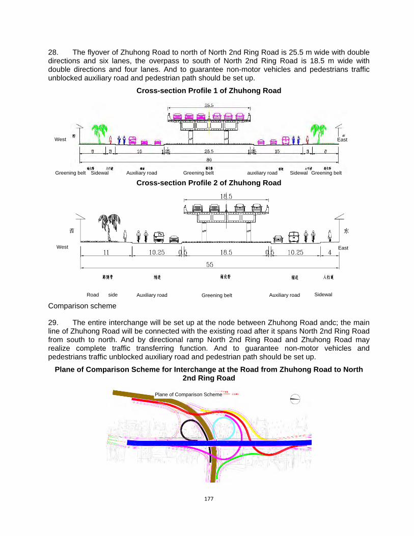
177
28. The flyover of Zhuhong Road to north of North 2nd Ring Road is 25.5 m wide with double directions and six lanes, the overpass to south of North 2nd Ring Road is 18.5 m wide with double directions and four lanes. And to guarantee non-motor vehicles and pedestrians traffic unblocked auxiliary road and pedestrian path should be set up.
Cross-section Profile 1 of Zhuhong Road
Cross-section Profile 2 of Zhuhong Road
Comparison scheme
29. The entire interchange will be set up at the node between Zhuhong Road andc; the main line of Zhuhong Road will be connected with the existing road after it spans North 2nd Ring Road from south to north. And by directional ramp North 2nd Ring Road and Zhuhong Road may realize complete traffic transferring function. And to guarantee non-motor vehicles and pedestrians traffic unblocked auxiliary road and pedestrian path should be set up.
Plane of Comparison Scheme for Interchange at the Road from Zhuhong Road to North 2nd Ring Road
Plane of Comparison Scheme
Greening belt Sidewal Auxiliary road auxiliary roadGreening belt Greening belt Sidewal
West
East West
Auxiliary road Auxiliary road SidewalGreening belt Road side
East
178
(3) Comparison results
30. The strongpoint of recommended scheme is less in land occupation and low in cost and, based on predicted result of traffic flow volume and direction the traffic issue of the main traffic flow direction will be resolved with unblocked traffic ensured. But, the disadvantage is the part of traffic flow direction will be needed to realize traffic transferring via ground facility.
31. The strongpoint of comparison scheme is to realize traffic transferring of all traffic flow directions by the ramps with complete functions, the disadvantage to be more in land occupation and high in cost.
(4) Profile design
32. In designing of road profile the elevation of existing interchange between North 2nd Ring Road and Zhuhong Road will be taken as elevation in controlling. The clearance under span of Zhuhong Road viaduct will be controlled more than 5m and the maximum longitudinal gradient of viaduct to be 4% and the minimum to be 0.3%.
Interchange at the road from Zhuhong Road to Fengcheng 4th Road
(1) Practical situation
33. The interchange is located at the junction between Zhuhong Road and Shihua thoroughfare to Fengcheng Road No. 4. The Shihua thoroughfare is the important traffic trunk line in north suburb of Xi’an which is started from Zhuhong Road in the east and connected with west 3rd Ring Road in west and then, continuing in west and after going through Fengwei new district and arriving at the boundary between Xi’an and Xianyang, it will be joined with a layout road of Xianyang city. Starting from Zhuhong Road in west Fengcheng 4th Road will connected with Chanba thoroughfare after it goes in east to pass across the economical development zone, continuing extending through to the harbor affairs zone in north part. The main trunk road passing across east and west in north suburb of Xi’an city is consisted of Shihua thoroughfare and Fengcheng 4th Road. Layout red line width of Shihua thoroughfare is 40 m, channeling section to be 50 m wide, the existing road to be 14 m wide and being highway form without existed pipeline it has better pavement with comparatively larger traffic volume. Layout red line of Fengcheng 4th Road is 30 m wide, channeling sectional width to be 40 m. And it is double breadth form with common highway condition and complete pipeline arrangement. Fengcheng 5th Road is of urban main trunk road with layout red line width of the existing road to be 60m, road building width to be 40 m with 10 m green belt respectively at both sides; it is crossed with Zhuhong Road in ‘T’ shape and traffic to be controlled by signal lamp. The central distance between Fengcheng 4th Road and Fengcheng 5th Road is 320 m.
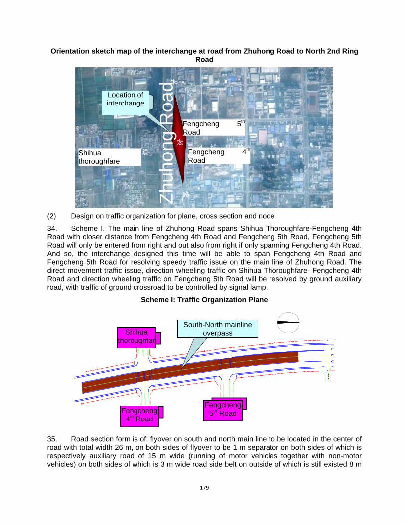
179
Orientation sketch map of the interchange at road from Zhuhong Road to North 2nd Ring Road
石 化 大 道凤 城 四 路
朱
宏
路
凤 城 五 路
立交位置
石 化 大 道凤 城 四 路
朱
宏
路
凤 城 五 路
立交位置
(2) Design on traffic organization for plane, cross section and node
34. Scheme I. The main line of Zhuhong Road spans Shihua Thoroughfare-Fengcheng 4th Road with closer distance from Fengcheng 4th Road and Fengcheng 5th Road, Fengcheng 5th Road will only be entered from right and out also from right if only spanning Fengcheng 4th Road. And so, the interchange designed this time will be able to span Fengcheng 4th Road and Fengcheng 5th Road for resolving speedy traffic issue on the main line of Zhuhong Road. The direct movement traffic issue, direction wheeling traffic on Shihua Thoroughfare- Fengcheng 4th Road and direction wheeling traffic on Fengcheng 5th Road will be resolved by ground auxiliary road, with traffic of ground crossroad to be controlled by signal lamp.
Scheme I: Traffic Organization Plane
石化大道
凤城四路
凤城五路
南北主线上跨
石化大道
凤城四路
凤城五路
南北主线上跨
35. Road section form is of: flyover on south and north main line to be located in the center of road with total width 26 m, on both sides of flyover to be 1 m separator on both sides of which is respectively auxiliary road of 15 m wide (running of motor vehicles together with non-motor vehicles) on both sides of which is 3 m wide road side belt on outside of which is still existed 8 m
Fengcheng 4th
Road
Fengcheng 5th
Road
Shihua thoroughfare
Location of interchange
Zhu
hong
Roa
d
Shihua thoroughfar
e
Fengcheng 4th Road
Fengcheng 5th Road
South-North mainline overpass
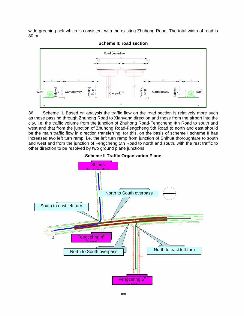
180
wide greening belt which is consistent with the existing Zhuhong Road. The total width of road is 80 m.
Scheme II: road section
36. Scheme II. Based on analysis the traffic flow on the road section is relatively more such as those passing through Zhuhong Road to Xianyang direction and those from the airport into the city, i.e. the traffic volume from the junction of Zhuhong Road-Fengcheng 4th Road to south and west and that from the junction of Zhuhong Road-Fengcheng 5th Road to north and east should be the main traffic flow in direction transferring; for this, on the basis of scheme I scheme II has increased two left turn ramp, i.e. the left turn ramp from junction of Shihua thoroughfare to south and west and from the junction of Fengcheng 5th Road to north and south, with the rest traffic to other direction to be resolved by two ground plane junctions.
Scheme II Traffic Organization Plane
石化大道
凤城四路
凤城五路
自北向南上跨
自北向南上跨 北向东左转
南向东左转
石化大道
凤城四路
凤城五路
自北向南上跨
自北向南上跨 北向东左转
南向东左转
Shihua thoroughfare
Fengcehng 4th Raod
Fengcehng 5th Raod
South to east left turn
North to east left turn
North to South overpass
North to South overpass
Road centerline S
ide
wa
lkWest East Car park.
Div
idin
g S
trip
Div
idin
g S
trip
Carriageway Carriageway
Sid
ew
al
k

181
37. The section form of Zhuhong Road is of: flyover on south and north main line to be divided into two breadths respectively to be 12.5 m wide; in the middle of two bridges is median separator of 11 m wide and on both sides of main line bridge is separator of 2.5 m wide at outside of which is 11 m wide auxiliary road (motor vehicle running with non-motor vehicle) at outside of which is respectively 3 m wide pedestrian path and 5.5 m wide (influenced by the curve some sections will not be guaranteed 5.5 m wide) greening belt. The road will be 80 m in total width. Within the median separator to south of Shihua Thoroughfare and to north of Fengcheng 5th Road is left turn ramp of 8 m wide to be configured.
(3) Comparison result:
38. The strongpoint of scheme I is less in investment with short construction time limit, no needing to newly confiscate land and to occupy greening belt on both sides of road, having better combined with layout of elevated road on whole line of Zhuhong Road at a specified future date; and with building height of interchange lower influence to the buildings inside Hancheng will be small and favorable in cultural relic protection. The disadvantage is that only has main flow traffic to south and north resolved with traffic to other direction to still need resolving on ground, having many traffic conflicting points in incomplete traffic function.
39. The strongpoint of scheme II is that it will effectively resolve left turn to two main directions for the main line traffic of Zhuhong Road with large traffic capacity of the interchange and the disadvantage is that it will need newly confiscating land with fixed quantity of pipeline to be moved for construction and relatively higher in building height, having some influence to the buildings and integrity landscape inside Hancheng site.
40. By comprehensively comparing scheme 1 has more strongpoint and better in implementation on the stage. So, it has been taken as the recommended scheme.
(4) Profile design
41. The road profile will be controlled by the existing crossing elevation, and the existing elevation of several roads including Zhuhong Road, Shihua Thoroughfare, Fengcheng 4th Road and Fengcheng 5th Road; under precondition of guaranteeing clearance under span the profile design will be carried out with clearance under span to be controlled not less than 5.0 m without exception. The maximum longitudinal gradient of scheme 1 will be 3.595%, minimum to be 0.3% and scheme 2 to be 3.709% for maximum and 0.3% for minimum.
The interchange at Hongmiaopo
(1) Practical situation
42. The project is located at northwest suburb of Xi’an city with junction formed by Zhuhong Road, Xinghuo Road to south and north direction, and Daxing Road and Hongmiaopo Road to west and east direction. The four roads are urban trunk roads and those to east and west are layout line location of speedy road of Xi’an city. Apart from Hongmiaopo Road, the rest three roads have already been completed and put into use. The status quo of the three roads is: the median separator of normal section, four breadth road and Zhuhong Road is 4 m wide with motor vehicle lane on both sides to be respectively 11 m wide. The separator on both sides will be respectively 1.5 m wide, non-motor vehicle lane on both sides to be respectively 4 m wide, road side belt on both sides to be 6.5 m wide, total width of road to be 50 m wide, Zhuhong Road at the junction will be channeling up to 60 m wide, still to be four breadth road, including median separator to be 4 m wide, motor lane on both sides to be respectively 14.5 m wide, separator on both sides to be respectively 1.5 m wide, non-motor vehicle lane on both sides to be respectively 8m wide, road side belt on both sides to be respectively 4 m wide. The existing Xinghuo Road is of three breadth road form, including motor vehicle lane to be 16 m wide, separator on both sides
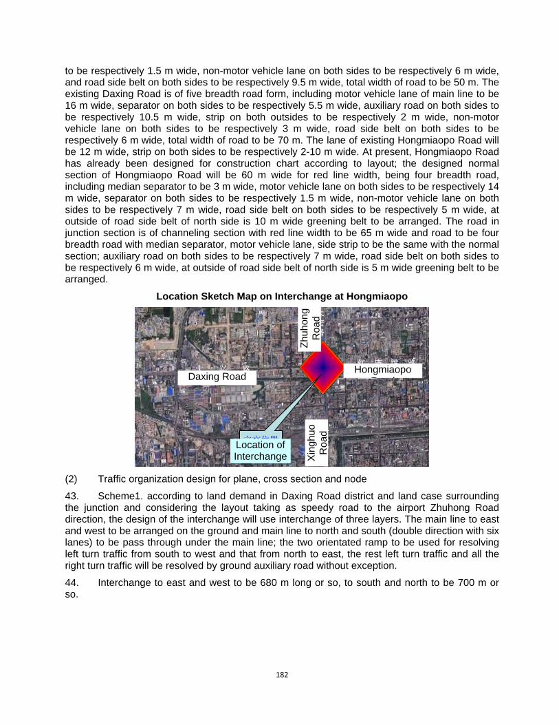
182
to be respectively 1.5 m wide, non-motor vehicle lane on both sides to be respectively 6 m wide, and road side belt on both sides to be respectively 9.5 m wide, total width of road to be 50 m. The existing Daxing Road is of five breadth road form, including motor vehicle lane of main line to be 16 m wide, separator on both sides to be respectively 5.5 m wide, auxiliary road on both sides to be respectively 10.5 m wide, strip on both outsides to be respectively 2 m wide, non-motor vehicle lane on both sides to be respectively 3 m wide, road side belt on both sides to be respectively 6 m wide, total width of road to be 70 m. The lane of existing Hongmiaopo Road will be 12 m wide, strip on both sides to be respectively 2-10 m wide. At present, Hongmiaopo Road has already been designed for construction chart according to layout; the designed normal section of Hongmiaopo Road will be 60 m wide for red line width, being four breadth road, including median separator to be 3 m wide, motor vehicle lane on both sides to be respectively 14 m wide, separator on both sides to be respectively 1.5 m wide, non-motor vehicle lane on both sides to be respectively 7 m wide, road side belt on both sides to be respectively 5 m wide, at outside of road side belt of north side is 10 m wide greening belt to be arranged. The road in junction section is of channeling section with red line width to be 65 m wide and road to be four breadth road with median separator, motor vehicle lane, side strip to be the same with the normal section; auxiliary road on both sides to be respectively 7 m wide, road side belt on both sides to be respectively 6 m wide, at outside of road side belt of north side is 5 m wide greening belt to be arranged.
Location Sketch Map on Interchange at Hongmiaopo
大 兴 路红 庙 坡 路
朱宏路
星火路
立交位置
大 兴 路红 庙 坡 路
朱宏路
星火路
立交位置
(2) Traffic organization design for plane, cross section and node
43. Scheme1. according to land demand in Daxing Road district and land case surrounding the junction and considering the layout taking as speedy road to the airport Zhuhong Road direction, the design of the interchange will use interchange of three layers. The main line to east and west to be arranged on the ground and main line to north and south (double direction with six lanes) to be pass through under the main line; the two orientated ramp to be used for resolving left turn traffic from south to west and that from north to east, the rest left turn traffic and all the right turn traffic will be resolved by ground auxiliary road without exception.
44. Interchange to east and west to be 680 m long or so, to south and north to be 700 m or so.
Zhu
hong
R
oad
Xin
ghuo
R
oad
Daxing Road Hongmiaopo
R d
Location of Interchange
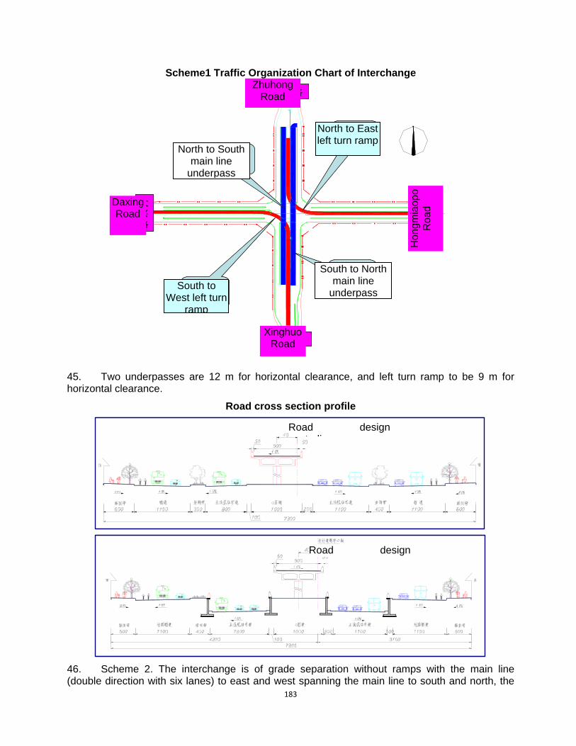
183
Scheme1 Traffic Organization Chart of Interchange
朱宏路
星火路
大兴路
红庙坡路
北向东左转砸道
南向西左转砸道
南向北主线下穿
北向南主线下穿
朱宏路
星火路
大兴路
红庙坡路
北向东左转砸道
南向西左转砸道
南向北主线下穿
北向南主线下穿
45. Two underpasses are 12 m for horizontal clearance, and left turn ramp to be 9 m for horizontal clearance.
Road cross section profile
46. Scheme 2. The interchange is of grade separation without ramps with the main line (double direction with six lanes) to east and west spanning the main line to south and north, the
Zhuhong Road
Daxing Road
Hon
gmia
opo
Roa
d
Xinghuo Road
North to South main line
underpass
South to West left turn
ramp
North to East left turn ramp
South to North main line
underpass
Road designt li
Road design

184
rest wheeling traffic to be resolved by ground auxiliary road and traffic to be controlled by signal lamp.
47. The section to west of junction is: the flyover to be located in the center of road, total width to be 26 m, on both sides is 3 m separator outside of which is 8 m ground auxiliary road outside of which is respectively 2 m separator, 3 m non-motor vehicle lane and 6 m road side belt. The total width of the road section is 70 m. The section to east of junction is: the flyover to be located in the center of road, total width to be 26 m, on both sides is 1 m separator, ground auxiliary road on both sides to be respectively10 m wide (motor vehicle running with non-motor vehicle), on both sides is road side belt to be respectively 6 m wide, at outside of road side belt of north side is 6 m wide greening belt to be arranged.
Scheme II. Organization Chart on Interchange Traffic
红 庙 坡 路
朱宏路
星火路东西主线上跨
红 庙 坡 路
朱宏路
星火路东西主线上跨
Scheme II. Road cross-section profile
48. The strongpoint of scheme I is better in combining with the case of land use surrounding the junction, less in land occupation; corresponding to plane junction it only has small quantity of newly increased land with traffic to main direction to be resolved by special ramp and interchange function being relatively complete, lesser destroy to landscape surrounding the junction; the
Zhuhong Road
Xinghuo RoadEast-west main line
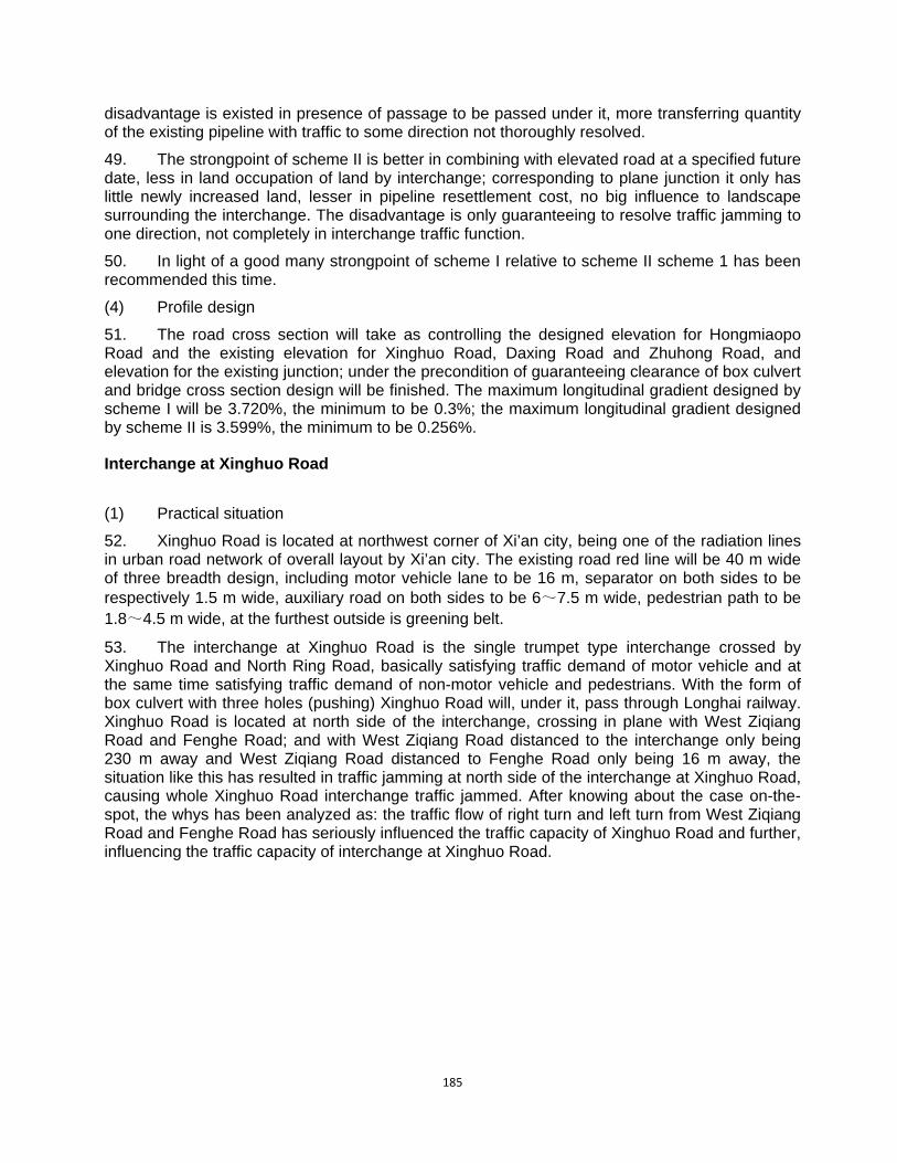
185
disadvantage is existed in presence of passage to be passed under it, more transferring quantity of the existing pipeline with traffic to some direction not thoroughly resolved.
49. The strongpoint of scheme II is better in combining with elevated road at a specified future date, less in land occupation of land by interchange; corresponding to plane junction it only has little newly increased land, lesser in pipeline resettlement cost, no big influence to landscape surrounding the interchange. The disadvantage is only guaranteeing to resolve traffic jamming to one direction, not completely in interchange traffic function.
50. In light of a good many strongpoint of scheme I relative to scheme II scheme 1 has been recommended this time.
(4) Profile design
51. The road cross section will take as controlling the designed elevation for Hongmiaopo Road and the existing elevation for Xinghuo Road, Daxing Road and Zhuhong Road, and elevation for the existing junction; under the precondition of guaranteeing clearance of box culvert and bridge cross section design will be finished. The maximum longitudinal gradient designed by scheme I will be 3.720%, the minimum to be 0.3%; the maximum longitudinal gradient designed by scheme II is 3.599%, the minimum to be 0.256%.
Interchange at Xinghuo Road
(1) Practical situation
52. Xinghuo Road is located at northwest corner of Xi’an city, being one of the radiation lines in urban road network of overall layout by Xi’an city. The existing road red line will be 40 m wide of three breadth design, including motor vehicle lane to be 16 m, separator on both sides to be respectively 1.5 m wide, auxiliary road on both sides to be 6~7.5 m wide, pedestrian path to be 1.8~4.5 m wide, at the furthest outside is greening belt.
53. The interchange at Xinghuo Road is the single trumpet type interchange crossed by Xinghuo Road and North Ring Road, basically satisfying traffic demand of motor vehicle and at the same time satisfying traffic demand of non-motor vehicle and pedestrians. With the form of box culvert with three holes (pushing) Xinghuo Road will, under it, pass through Longhai railway. Xinghuo Road is located at north side of the interchange, crossing in plane with West Ziqiang Road and Fenghe Road; and with West Ziqiang Road distanced to the interchange only being 230 m away and West Ziqiang Road distanced to Fenghe Road only being 16 m away, the situation like this has resulted in traffic jamming at north side of the interchange at Xinghuo Road, causing whole Xinghuo Road interchange traffic jammed. After knowing about the case on-the-spot, the whys has been analyzed as: the traffic flow of right turn and left turn from West Ziqiang Road and Fenghe Road has seriously influenced the traffic capacity of Xinghuo Road and further, influencing the traffic capacity of interchange at Xinghuo Road.
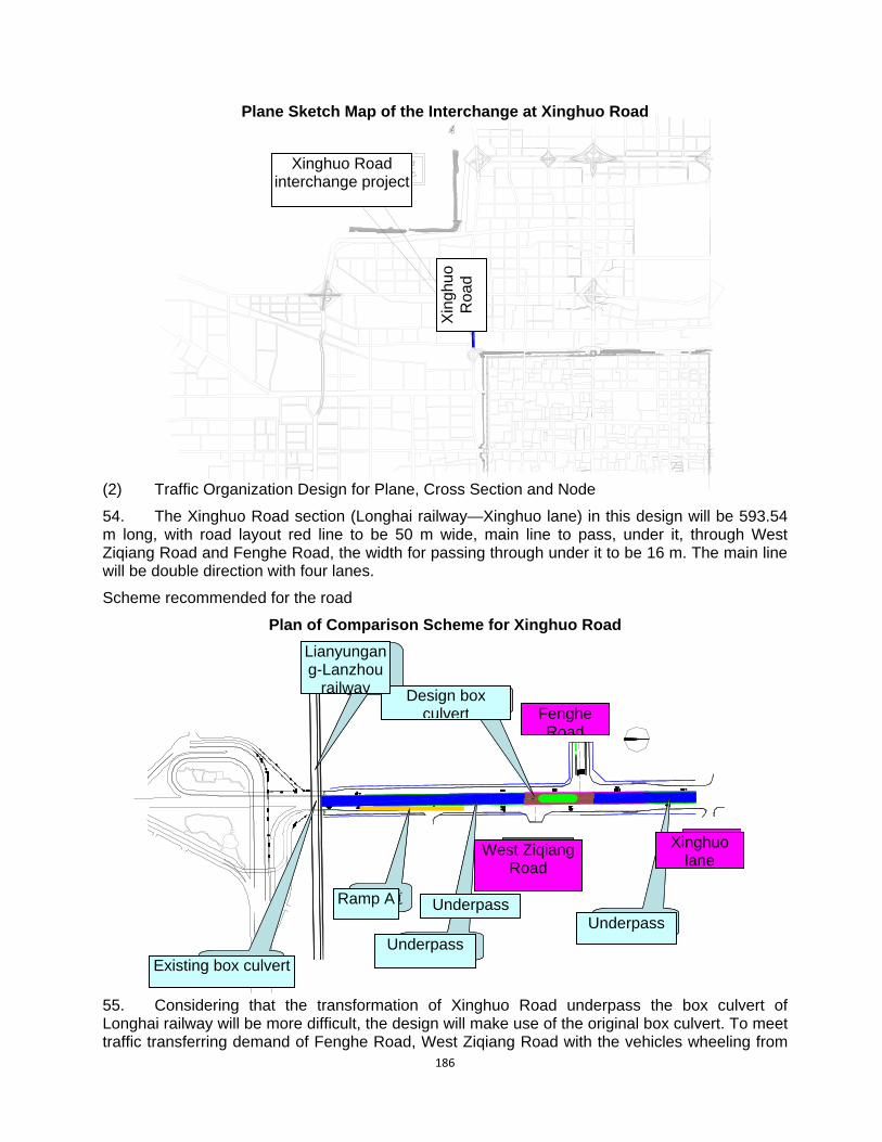
186
Plane Sketch Map of the Interchange at Xinghuo Road
(2) Traffic Organization Design for Plane, Cross Section and Node
54. The Xinghuo Road section (Longhai railway—Xinghuo lane) in this design will be 593.54 m long, with road layout red line to be 50 m wide, main line to pass, under it, through West Ziqiang Road and Fenghe Road, the width for passing through under it to be 16 m. The main line will be double direction with four lanes.
Scheme recommended for the road
Plan of Comparison Scheme for Xinghuo Road
6.7
6
下穿通道
设计箱涵丰禾路
自强西路
陇海铁路
下穿通道现状箱涵
星火巷
A匝道
6.7
6
下穿通道
设计箱涵丰禾路
自强西路
陇海铁路
下穿通道现状箱涵
星火巷
A匝道
55. Considering that the transformation of Xinghuo Road underpass the box culvert of Longhai railway will be more difficult, the design will make use of the original box culvert. To meet traffic transferring demand of Fenghe Road, West Ziqiang Road with the vehicles wheeling from
Xinghuo Road interchange project
Xin
ghuo
R
oad
Ramp A
Xinghuo lane
Fenghe Road
Design box culvert
Underpass
Underpass Underpass
Lianyungang-Lanzhou
railway
Existing box culvert
West Ziqiang Road

187
Xinghuo Road interchange to north, a ramp A (7 m wide and 250 m long) will be designed for the traffic after passing through the box culvert of Longhai railway box culvert from Xinghuo Road. By the form of box culvert to pass, under it, through West Ziqiang Road and Fenghe Road the main line of Xinghuo Road has guaranteed the vehicle running on the main line of Xinghuo Road from interference and at the same time, guaranteeing that the vehicles may be freely wheeling among West Ziqiang Road, Fenghe Road and auxiliary road to Xinghuo Road. The auxiliary road to south of Fenghe Road will be 6.5~7.5 m wide, auxiliary road to north of Fenghe Road to be 8.5 m wide, pedestrian path to south of Fenghe Road to be 1.8~2.5 m wide, together with original pedestrian path transformed (not widening). Pedestrian path to north of Fenghe Road will be 7.5 m wide.
Standard cross section profile of Xinghuo Road (K0+095~K0+319)
1.5% 1.5%
1.5%
西侧
2.0%
1.5%
匝道 A
6.70 7.50
1.00
8.00 2.508.00
0.50
7.00
0.50
6.501.80
50.00
Standard Cross Section Profile of Xinghuo Road(K0+319~K0+420)
8 .000.90
13.009.006.80 11.50 7.00
50.00
7.10
0.70
5.70
0.70
0.70
8 .00 0. 90
17.8
2.70
Standard Cross Section Profile of Xinghuo Road (K0+420~K0+570)
West side East
side
West side
East side
Current situation
Greening
Guardrail Guardrail
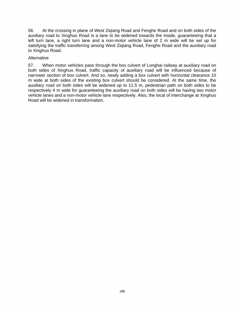
188
56. At the crossing in plane of West Ziqiang Road and Fenghe Road and on both sides of the auxiliary road to Xinghuo Road is a lane to be widened towards the inside, guaranteeing that a left turn lane, a right turn lane and a non-motor vehicle lane of 2 m wide will be set up for satisfying the traffic transferring among West Ziqiang Road, Fenghe Road and the auxiliary road to Xinghuo Road.
Alternative
57. When motor vehicles pass through the box culvert of Longhai railway at auxiliary road on both sides of Xinghuo Road, traffic capacity of auxiliary road will be influenced because of narrower section of box culvert. And so, newly adding a box culvert with horizontal clearance 10 m wide at both sides of the existing box culvert should be considered. At the same time, the auxiliary road on both sides will be widened up to 11.5 m, pedestrian path on both sides to be respectively 4 m wide for guaranteeing the auxiliary road on both sides will be having two motor vehicle lanes and a non-motor vehicle lane respectively. Also, the local of interchange at Xinghuo Road will be widened in transformation.
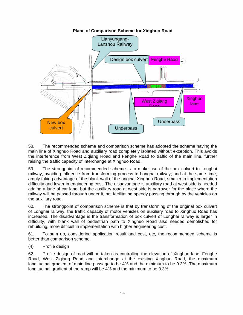
189
Plane of Comparison Scheme for Xinghuo Road
58. The recommended scheme and comparison scheme has adopted the scheme having the main line of Xinghuo Road and auxiliary road completely isolated without exception. This avoids the interference from West Ziqiang Road and Fenghe Road to traffic of the main line, further raising the traffic capacity of interchange at Xinghuo Road.
59. The strongpoint of recommended scheme is to make use of the box culvert to Longhai railway, avoiding influence from transforming process to Longhai railway; and at the same time, amply taking advantage of the blank wall of the original Xinghuo Road, smaller in implementation difficulty and lower in engineering cost. The disadvantage is auxiliary road at west side is needed adding a lane of car lane, but the auxiliary road at west side is narrower for the place where the railway will be passed through under it, not facilitating speedy passing through by the vehicles on the auxiliary road.
60. The strongpoint of comparison scheme is that by transforming of the original box culvert of Longhai railway, the traffic capacity of motor vehicles on auxiliary road to Xinghuo Road has increased. The disadvantage is the transformation of box culvert of Longhai railway is larger in difficulty, with blank wall of pedestrian path to Xinghuo Road also needed demolished for rebuilding, more difficult in implementation with higher engineering cost.
61. To sum up, considering application result and cost, etc, the recommended scheme is better than comparison scheme.
(4) Profile design
62. Profile design of road will be taken as controlling the elevation of Xinghuo lane, Fenghe Road, West Ziqiang Road and interchange at the existing Xinghuo Road, the maximum longitudinal gradient of main line passage to be 4% and the minimum to be 0.3%. The maximum longitudinal gradient of the ramp will be 4% and the minimum to be 0.3%.
丰禾路
R20R25
环城北路
7.57.5 1
0
3514.510.54.5 5.5
19. 5
811.5
30.5
1. 5
30.517
.58
Underpass
Design box culvert Fenghe Raod
West Ziqiang Raod
Lianyungang-Lanzhou Railway
Underpass New box culvert
Xinghuo lane

190
Interchange at Fengcheng 8th Road and Beichen Thoroughfare
(1) Existing road
63. Beichen Thoroughfare is of the existing road, with red line width to be 100 m wide, including median separator to be 4 m wide, the main line motor vehicle lane on both sides to be respectively 12 m of double direction with six lanes, greening belt on both sides to be respectively 15 m wide, auxiliary road on both sides to be respectively 12 m wide, including motor vehicle lane to be double direction with four lanes, non-motor vehicle lane with double direction to respectively has a lane. Pedestrian path will be respectively 9 m wide.
64. Fengcheng 8th Road is of layout road, with red line width to be 60 m wide of double direction with eight lanes including median separator to be 8 m wide, motor vehicle to be respectively 14 m wide, and separator on both sides to respectively be 3.5 m, non-motor vehicle lane to respectively be 4.5 m wide and pedestrian path to respectively be 4 m wide.
(2) Traffic organization design for interchange plane, cross section and node
Interchange Scheme for Beichen Thoroughfare: Plane Sketch Map
65. The scheme 1 for interchange is of interchange in clover leaf type of two layers, including the completed Beichen Thoroughfare to be located on first layer, viaduct to Fengcheng 8th Road to be located on secondary layer; the whole length of interchange to south and north to be 790 m, whole length to east and west to be 850 m. The motor vehicles to all directions will do traffic transferring via the clover ramp of left turn and via directional ramp of right turn. On both sides spanning Beichen Thoroughfare bridge of Fengcheng 8th Road are two over-bridges to be set up for facilitating non-motor vehicles to east and west and pedestrians to cross over Beichen Thoroughfare and for non-motor vehicles to south and north and pedestrians to cross over Fengcheng 8th Road though the overpass. And the crossing traffic of non-motor vehicles and pedestrians will be resolved by ramp bridge hole or by setting up a passage. And the crossing with right turn ramp will be resolved by adopting plane crossing form.
66. Interchange scheme I: the viaduct at Fengcheng 8th Road is of separation of left and right line, bridge width to be 12.5 m wide without exception, double direction with six lanes; and left turn ramp to be 8 m wide and right turn ramp to be 10 m wide. The auxiliary road on ground will
Design Beichen thoroughfare
Design t ti
Design ending
Design ending
Flyover
Flyover
Fengchen 8th
Ramp A
Ramp A
Ramp B
Ramp C Ramp D
Ramp E
Ramp F
Ramp G Ramp H
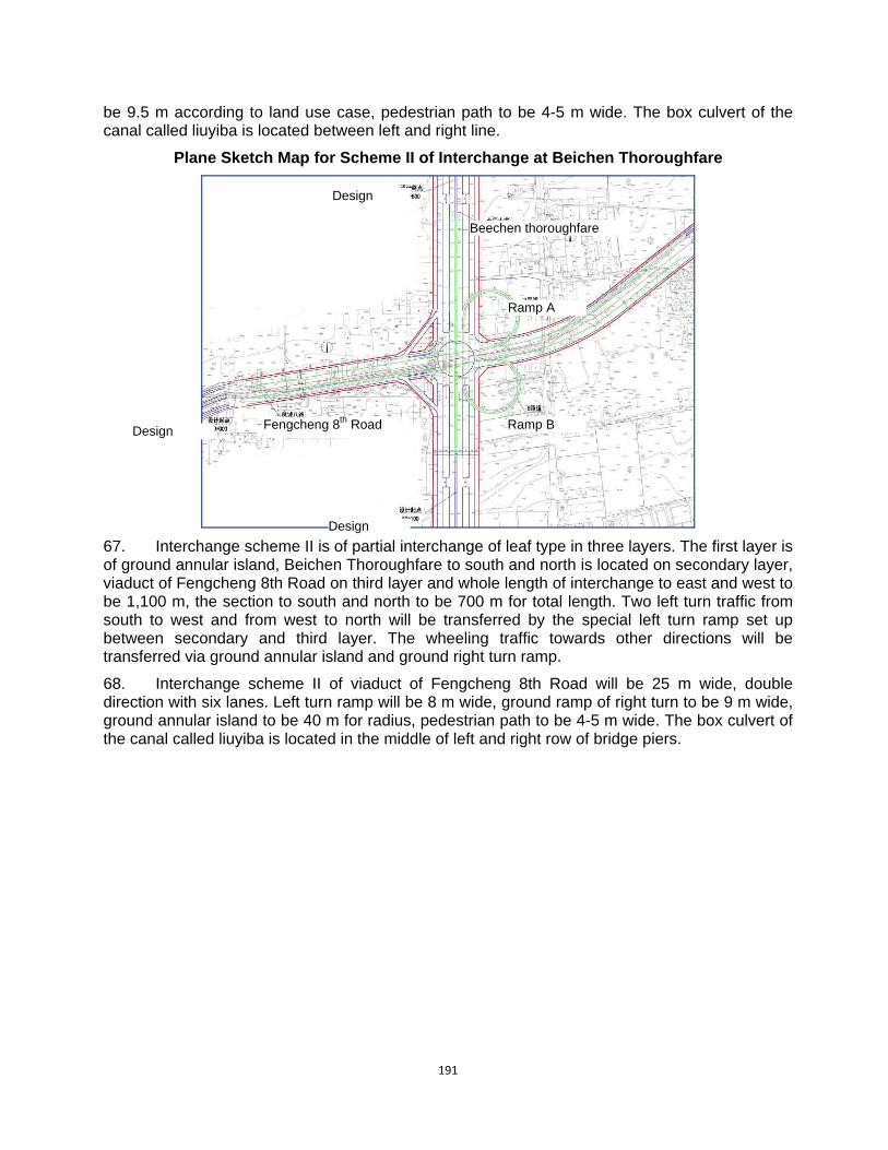
191
be 9.5 m according to land use case, pedestrian path to be 4-5 m wide. The box culvert of the canal called liuyiba is located between left and right line.
Plane Sketch Map for Scheme II of Interchange at Beichen Thoroughfare
67. Interchange scheme II is of partial interchange of leaf type in three layers. The first layer is of ground annular island, Beichen Thoroughfare to south and north is located on secondary layer, viaduct of Fengcheng 8th Road on third layer and whole length of interchange to east and west to be 1,100 m, the section to south and north to be 700 m for total length. Two left turn traffic from south to west and from west to north will be transferred by the special left turn ramp set up between secondary and third layer. The wheeling traffic towards other directions will be transferred via ground annular island and ground right turn ramp.
68. Interchange scheme II of viaduct of Fengcheng 8th Road will be 25 m wide, double direction with six lanes. Left turn ramp will be 8 m wide, ground ramp of right turn to be 9 m wide, ground annular island to be 40 m for radius, pedestrian path to be 4-5 m wide. The box culvert of the canal called liuyiba is located in the middle of left and right row of bridge piers.
Design
Design
Design Fengcheng 8th Road
Ramp A
Ramp B
Beechen thoroughfare
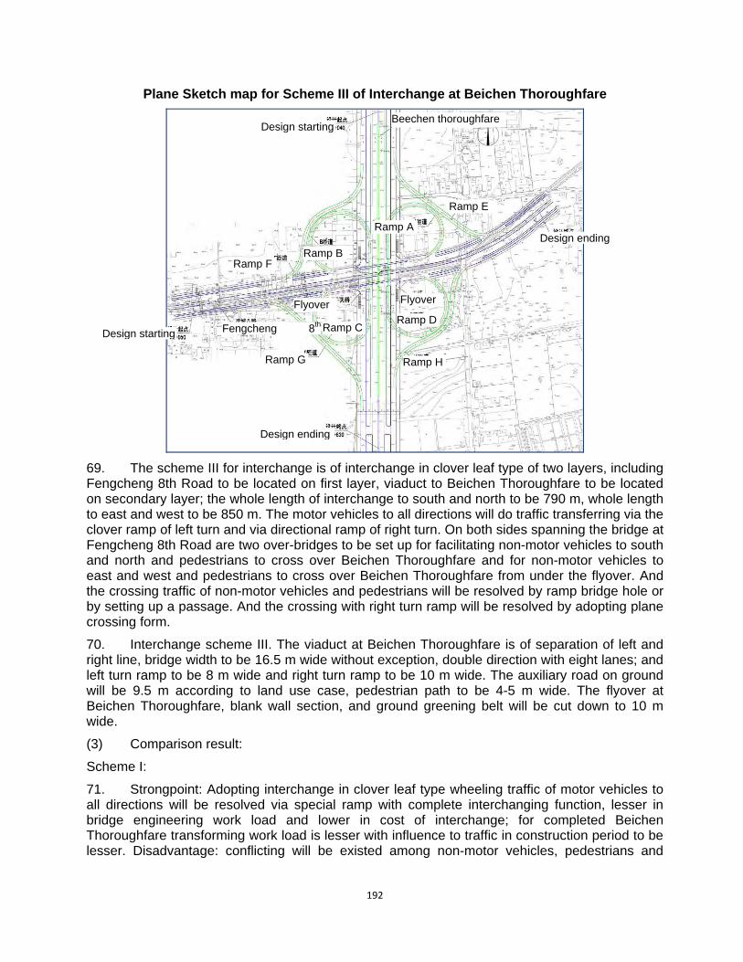
192
Plane Sketch map for Scheme III of Interchange at Beichen Thoroughfare
69. The scheme III for interchange is of interchange in clover leaf type of two layers, including Fengcheng 8th Road to be located on first layer, viaduct to Beichen Thoroughfare to be located on secondary layer; the whole length of interchange to south and north to be 790 m, whole length to east and west to be 850 m. The motor vehicles to all directions will do traffic transferring via the clover ramp of left turn and via directional ramp of right turn. On both sides spanning the bridge at Fengcheng 8th Road are two over-bridges to be set up for facilitating non-motor vehicles to south and north and pedestrians to cross over Beichen Thoroughfare and for non-motor vehicles to east and west and pedestrians to cross over Beichen Thoroughfare from under the flyover. And the crossing traffic of non-motor vehicles and pedestrians will be resolved by ramp bridge hole or by setting up a passage. And the crossing with right turn ramp will be resolved by adopting plane crossing form.
70. Interchange scheme III. The viaduct at Beichen Thoroughfare is of separation of left and right line, bridge width to be 16.5 m wide without exception, double direction with eight lanes; and left turn ramp to be 8 m wide and right turn ramp to be 10 m wide. The auxiliary road on ground will be 9.5 m according to land use case, pedestrian path to be 4-5 m wide. The flyover at Beichen Thoroughfare, blank wall section, and ground greening belt will be cut down to 10 m wide.
(3) Comparison result:
Scheme I:
71. Strongpoint: Adopting interchange in clover leaf type wheeling traffic of motor vehicles to all directions will be resolved via special ramp with complete interchanging function, lesser in bridge engineering work load and lower in cost of interchange; for completed Beichen Thoroughfare transforming work load is lesser with influence to traffic in construction period to be lesser. Disadvantage: conflicting will be existed among non-motor vehicles, pedestrians and
Design startingBeechen thoroughfare
Design starting
Design ending
Design ending
Fengcheng 8th
Ramp A
Ramp B
Ramp CRamp D
Ramp E
Ramp F
Ramp G Ramp H
Flyover Flyover
193
some of wheeling ramp and interchange will be larger in land occupation and resettlement work load.
Scheme II:
72. Strongpoint: Mainstream traffic to various directions (direct movement traffic on Beichen Thoroughfare and Fengcheng 8th Road, wheeling traffic flowing in and out from west of Fengcheng 8th Road) will be resolved by viaduct or special ramp, with lesser interchange occupation of land and lesser in resettlement work load. Disadvantage: apart from direct movement traffic on Beichen Thoroughfare and Fengcheng 8th Road, wheeling traffic flowing in and out from west of Fengcheng 8th Road, the left turn traffic volume to the rest directions will be resolved by ground annular island the traffic capacity of which is low. The work load of Fengcheng 8th Road and Beichen Thoroughfare is larger for the Main Line Bridge.
Scheme III:
73. Strongpoint: Adopting interchange in clover leaf type wheeling traffic of motor vehicles to all directions will be resolved via special ramp with complete interchanging function, lesser in bridge engineering work load. Disadvantage: interchange is larger in land occupation, needing to transform larger area for completed Beichen Thoroughfare. In construction period influence to traffic is also larger, causing interchange cost increased.
74. Through comprehensive comparison the scheme I will be recommended for the design to do this time.
(4) Profile design
75. The road cross section will take as controlling the elevation of existing Beichen Thoroughfare, Fengcheng 8th Road and ground annular island, the clearance under span will be controlled according to 5 m or more than 5 m. The minimum longitudinal gradient to be 0.3%; the maximum longitudinal gradient to be 3.8%. Interchange at the road from Fengcheng 8th Road to Taihua Road (1) Existing road
76. The red line width of the existing Taihua Road will be 40 m with three breadth road of double directions with four lanes, including motor vehicle lane of double directions to respectively be 7.5 m, the separator on both sides to be 1.5 m wide, the non-motor vehicle lane on both sides to be 6 m wide, the pedestrian path to respectively be 5 m wide. The red line width of north section of Taihua Road will be 80 m with four breadth road of double directions with eight lanes, including median separator to be 4 m, motor vehicle lane to respectively be 14 m, the separator on both sides to be 4.5 m wide, the non-motor vehicle lane on both sides to be 9 m wide, the pedestrian path to respectively be 10 m wide.
77. The red line width of layout Fengcheng 8th Road will be 50 m with three breadth road of double directions with six lanes, including motor vehicle lane of double directions to respectively be 10.5 m, the separator on both sides to be 5.5 m wide, the non-motor vehicle lane on both sides to be 5 m wide, the pedestrian path to respectively be 4 m wide. The red line width of Fengcheng 8th Road will be 60 m with four breadth road of double directions with eight lanes, including median separator to be 8 m, motor vehicle lane to respectively be 12 m, the separator on both sides to be 1.5 m wide, the non-motor vehicle lane on both sides to be 8.5 m wide, the pedestrian path to respectively be 4 m wide.
78. At the center line of middle section to Fengcheng 8th Road is a drainage buried culvert located inside the median separator.
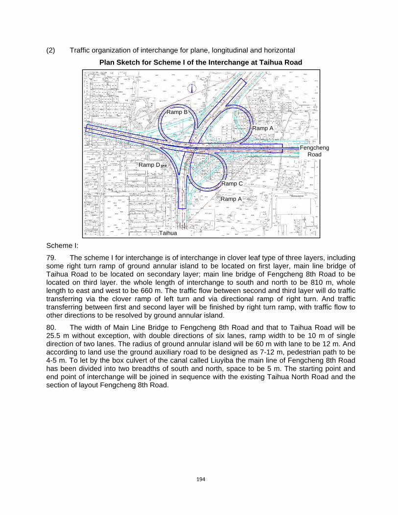
194
(2) Traffic organization of interchange for plane, longitudinal and horizontal
Plan Sketch for Scheme I of the Interchange at Taihua Road
Scheme I:
79. The scheme I for interchange is of interchange in clover leaf type of three layers, including some right turn ramp of ground annular island to be located on first layer, main line bridge of Taihua Road to be located on secondary layer; main line bridge of Fengcheng 8th Road to be located on third layer. the whole length of interchange to south and north to be 810 m, whole length to east and west to be 660 m. The traffic flow between second and third layer will do traffic transferring via the clover ramp of left turn and via directional ramp of right turn. And traffic transferring between first and second layer will be finished by right turn ramp, with traffic flow to other directions to be resolved by ground annular island.
80. The width of Main Line Bridge to Fengcheng 8th Road and that to Taihua Road will be 25.5 m without exception, with double directions of six lanes, ramp width to be 10 m of single direction of two lanes. The radius of ground annular island will be 60 m with lane to be 12 m. And according to land use the ground auxiliary road to be designed as 7-12 m, pedestrian path to be 4-5 m. To let by the box culvert of the canal called Liuyiba the main line of Fengcheng 8th Road has been divided into two breadths of south and north, space to be 5 m. The starting point and end point of interchange will be joined in sequence with the existing Taihua North Road and the section of layout Fengcheng 8th Road.
Taihua
Fengcheng Road
Ramp A
Ramp A
Ramp B
Ramp D
Ramp C

195
Plan Sketch for Scheme II of Interchange at Taihua Road
Scheme II:
81. The scheme II for interchange is of interchange in clover leaf type of two layers, including Taihua Road to south and north to be located on first layer, Fengcheng 8th Road to east and west to be located on secondary layer, the whole length of interchange from east to west to be 908 m, whole length from south to north to be 872 m. The traffic flow between second and third layer will do traffic transferring via the clover ramp of left turn and via right turn. And other regional traffic will be wheeled by the crossroad and ground right turn ramp.
82. The width of viaduct to Fengcheng 8th Road in interchange scheme II will be 25.5 m, with double directions of six lanes, left turn ramp to be 10 m wide, the width of right turn ramp to be controlled as 7 m. According to land use the ground auxiliary road to be designed as 7-12 m, pedestrian path to be 4-5 m wide. The starting point and end point of interchange will be joined in sequence with the existing Taihua North Road and the section of layout Fengcheng 8th Road.
(3) Comparison result:
Scheme I:
83. Strongpoint: Through viaduct the mainstream traffic to east and west and that to south and north has been guaranteed without interference. And by setting up ground annular island the traffic transferring has been resolved for motor vehicle to north, non-motor vehicle and pedestrians, guaranteeing that the ground traffic to be unblocked. The interchange is beautiful in appearance, in good taste and good in linear index. Disadvantage: because the interchange adopts viaduct type of three layers, the cost will be relatively higher. At the diverting spot motor vehicle and non-motor vehicle will be interlaced on ground right transferring ramp.
Scheme II:
84. Strongpoint: to make use of existing Taihua Road and layout Fengcheng 8th Road for adopting viaduct form will be lesser in engineering investment. Disadvantage: because the motor vehicle’s traffic transferring of interchange from north to east and that of non-motor vehicle transferring of traffic and pedestrians will be finished by ground crossroads, traffic light has to be
Taihua Road
Fengcheng 8th
Fengcheng 8th
Taihua Road
Ramp A
Ramp B
Ramp CRamp D
Ramp E
Ramp F
Ramp G
196
set up which will make the mainstream traffic to north and south not unblocked enough; because of using variation clover leaf type for structuring the interchange, linear index will be poorer for scheme I.
85. Through comprehensive comparison the scheme I will be recommended for the design to do this time.
(4) Profile design
86. The profile design of the road will take as elevation control point the existing elevation of Taihua Road, Fengcheng 8th Road and ground annular island. The clearance under span of Taihua Road viaduct and that of Fengcheng 8th Road will be controlled as 5 m or higher than 5 m. The maximum longitudinal gradient to be 4.5% and the minimum to be 0.3%.”

197
APPENDIX 5: CHECKLIST OF EHS REQUIREMENTS AND PROJECT MEASURES 1. The project involves several sub-components and many of them will be constructed in parallel. The number of workers at peak construction time will be about 300. The design documents and EIA include measures using the EHS guidelines. The measures are consistent with the World Bank Group’s EHS guidelines. Details are shown in the following table.
No. Item Measures proposed in FSR and EIA Assessment
1 General Facility Design and Operation
1.1 Integrity of Workplace Structures
Surface, structures is designed easily to clean and maintain. Buildings are designed structurally safe, providing appropriate protection against the climate, fire, and vibration.
Complies with EHS requirements
1.2 Severe Weather and Facility Shutdown
Work place structures were designed and constructed to withstand the expected elements for the region. Standard Operating Procedures will be developed for project or process shut-down, including an evacuation plan. Drills to practice the procedure and plan will also be undertaken annually.
Complies with EHS requirements
1.2.1 Workspace and Exit
The number and capacity of emergency exits is sufficient for safe and orderly evacuation of the greatest number of people present at any time, and there are more than two exits from any work area. Facilities were also designed taking into account the needs of disabled persons
Complies with EHS requirements
1.2.2 Fire Precautions
The project site will provide fire detectors, alarm systems, and fire-fighting equipment. Provision of manual firefighting equipment that is easily accessible and simple to use. Fire and emergency alarm systems that are both audible and visible.
Complies with EHS requirements
1.2.3 Lavatories and Showers Lavatories will be provided at the management office. But showers will not provided at some of the offices.
Complies with EHS requirements
1.2.4 Potable Water Supply
Adequate supplies of potable drinking water will be provided with a sanitary means of collecting the water for the purposes of drinking. Kitchen water will meet drinking water quality standards.
Complies with EHS requirements
1.2.5 Clean Eating Area Some of the management office will provide eating area. It will be kept clean
Complies with EHS requirements
1.2.6 Lighting
Workplaces will receive natural light and be supplemented with sufficient artificial illumination Emergency lighting of adequate intensity will be installed
Complies with EHS requirements
1.2.7 Safe Access Passageways for pedestrians and vehicles within and outside buildings will be segregated and
Complies with EHS
198
No. Item Measures proposed in FSR and EIA Assessment
provide for easy, safe, and appropriate access requirements
1.2.8 First Aid
According to current PRC standards, it is not required to provide first aid stations. Instead, emergency plan is required to deal with serious illness.
Does not comply but alternative solution provided
1.2.9 Air Supply Included in the design Complies with EHS requirements
1.2.10 Work Environment Temperature
The project areas are mainly located outdoors. Ventilation system will be installed for indoor areas.
Complies with EHS requirements
2 Communication and Training
2.1 OHS Training New staff will be required to be trained Complies with EHS requirements
2.2 Visitor Orientation
If visitors to the site can gain access to areas where hazardous conditions or substances may be present, a visitor orientation and control program should be established to ensure visitors do not enter hazard areas unescorted
Complies with EHS requirements
2.3 New Task Employee and Contractor Training
Training will be provided to workers and contractors
Complies with EHS requirements
2.4 Basic OHS Training
The EIA requested to occupational training to be provided during construction and operation of the project to ensure the workers and understand the risks of their assignment. Training on emergency procedures will also be provided.
Complies with EHS requirements
2.5 Area Signage
Signage will be set in accordance with international standards and be well known to, and easily understood by workers, visitors and the general public as appropriate
Complies with EHS requirements
2.6 Labeling of Equipment All vessels that may contain hazardous substances will be labeled
Complies with EHS requirements
2.7 Communicate Hazard Codes
Copies of the hazard coding system will be posted outside the facility at emergency entrance doors and fire emergency connection systems
Complies with EHS requirements
3 Physical Hazards
3.1 Rotating and Moving Equipment
Selecting equipment with safety protective cover. Designing and installing equipment, where feasible, to enable routine service, such as lubrication, without removal of the guarding devices
Complies with EHS requirements
3.2 Noise The workers will not work over 8 hours at the places that the equivalent sound level reaches 85 dB(A)
Complies with EHS requirements
3.3 Vibration It is required to protect the construction workers. Complies with EHS requirements

199
No. Item Measures proposed in FSR and EIA Assessment
3.4 Electrical Anti-creeping design was conducted. During operation, inspection will be conducted to reduce the possibility of injury.
Complies with EHS requirements
3.5 Eye Hazards Necessary protection measures will be taken Complies with EHS requirements
3.6 Welding / Hot Work Necessary protection measures will be taken Complies with EHS requirements
3.7 Industrial Vehicle Driving and Site Traffic
Training and licensing industrial vehicle operators in the safe operation of specialized vehicles; will ensure drivers undergo medical surveillance. It is hard to achieve that all moving equipment is outfitted with audible back-up alarms.
Complies with EHS requirements
3.8 Working Environment Temperature
Adjust work and rest periods when extreme temperatures occur.
Complies with EHS requirements
3.9 Ergonomics, Repetitive Motion, Manual Handling
Selecting and designing tools that reduce force requirements
Complies with EHS requirements
3.10 Working at Heights Fall prevention and protection measures will be implemented. Staff will be trained
Complies with EHS requirements
3.11 Illumination Light intensity will be adequate according to standards
Complies with EHS requirements
4 Chemical Hazards
4.1 Fire and Explosions
The related risk of the project is the gas station components. The gas stations was designed based on guidelines and the HC concentration can meet PRC Air Pollutants Emission Standard with a HC concentration limited lower than that AGGIH suggested.
Complies with EHS requirements
4.2 Corrosive, oxidizing, and reactive chemicals
The Gas Filling Station is designed according to the standards. Requirement of the standards will be applied.
Complies with EHS requirements
4.3 Asbestos Containing Materials (ACM)
The project is not related to ACM Not related
5 Biological Hazards The project is not related to biological hazards Not related
6 Radiological Hazards The project is not related to radiological hazards Not related
7 Personal Protective Equipment
PPE will be provided Complies with EHS requirements
8 Special Hazard Environments
8.1 Confined Space The overfly construction might cause traffic jam. The EIA required diverting traffic and setting guardrail to prevent falling.
Complies with EHS requirements
8.2 Lone and Isolated Workers
It is unlikely happen. But Standard Operating Procedures(SOPs) will be developed and implemented to ensure all PPE and safety measures are in place before the worker starts
Complies with EHS requirements

200
No. Item Measures proposed in FSR and EIA Assessment
work.
9 Monitoring Regular inspection and testing of all safety features and hazard control measures.
Complies with EHS requirements
9.1 Accidents and Diseases monitoring
The employer will establish procedures and systems for reporting and recording
Complies with EHS requirements
201
APPENDIX 6: TERMS OF REFERENCE FOR THE INDEPENDENT ENVIRONMENTAL SUPERVISOR
General Requirements This position could be either a firm or an individual engaged by the IA. This is an independent position which is not part of the IA’s in-house environmental team,
nor part of the construction supervising engineers team. The general role of the position is to ensure the high environmental performance of the IA
(through its environmental team) and the construction supervising engineers. This position should combine familiarity with ADB project management requirements with
sound knowledge of PRC environmental management procedures.
Role of the Independent Environmental Supervisor
Before construction commences, arrange and undertake training of construction contractors and site supervisors in:
- Environmental laws and regulations - Environmental policies and plans - Basic environmental management - Responsibility and duties for the project construction, management and environmental
protection - Task of environmental protection in the project construction - Key environmental protection contents etc. in project construction - EMP improvement and corrective actions - Crisis handling methods
Assess IA progress against project EMP Performance Indicators. Provide checklist of
performance progress. In collaboration with the IA’s design team, update mitigation measures defined in the EMP
and incorporate them into detailed design documents. Assist in interpreting and clarifying the application of mitigation measures and the
monitoring of their outcomes. Facilitate the implementation of internal and external environmental monitoring activities. Assist the PMO to prepare semi-annual progress reports to the ADB during construction. Assist the PMO to prepare semi-annual progress reports to the ADB during the first 3 years
of operation. Verify the investigation of results of any non-compliance issues. Verify the environmental monitoring report prepared by PMO for ADB.