draft environmental impact statement general management … · draft environmental impact statement...
TRANSCRIPT
i
Draft Environmental Impact Statement
General Management Plan
CHIRICAHUA National Monument · Arizona

i
Draft Environmental Impact Statement
General Management Plan
CHIRICAHUA National Monument • Arizona
SUMMARY:
The general management plan would guide the management of the Chiricahua National Monument for the next 12 to 15 years. Three alternatives were considered—a no-action and two action alternatives. The proposed general management plan would retain most existing visitor experiences and would construct a new headquarters/visitor orientation facility/administrative area just outside park boundaries. Impacts to the visitor experience, cultural resources, long-term health of natural ecosystems, economic contribution to gateway communities, adjacent landowners, and operational efficiency are assessed. No cumulative effects were identified.
Direct questions and send comments to:
Superintendent
Chiricahua NM
Dos Cabezas Route, Box 6500
Willcox, Arizona 85643-9737
United States Department of the Interior • National Park Service • Chiricahua National Monument
i
TABLE OF CONTENTS
PURPOSE OF AND NEED FOR THE PLAN .................................................................. 1 INTRODUCTION ....................................................................................................................................... 1 PURPOSE OF THE PLAN ........................................................................................................................ 1 NEED FOR THE PLAN ............................................................................................................................. 1
Park Purpose ......................................................................................................................................... 2 Park Significance ................................................................................................................................... 2 Special Mandates .................................................................................................................................. 3 Description of the National Monument................................................................................................... 4 Planning Process ................................................................................................................................... 5
ISSUES.................................................................................................................................................... 10 Visitor Use and Interpretation .............................................................................................................. 10 Cultural Resources .............................................................................................................................. 11 Natural Resources ............................................................................................................................... 12 Operational Efficiency .......................................................................................................................... 14
ALTERNATIVES ........................................................................................................... 20 INTRODUCTION ..................................................................................................................................... 20 MANAGEMENT PRESCIPTIONS ........................................................................................................... 20
Primitive ............................................................................................................................................... 20 Motorized Rural .................................................................................................................................... 21 Developed ............................................................................................................................................ 22 Resource Preservation ........................................................................................................................ 23
ALTERNATIVE A—NPS PROPOSAL ..................................................................................................... 24 ALTERNATIVE B ..................................................................................................................................... 30 NO-ACTION ALTERNATIVE ................................................................................................................... 33 ALTERNATIVES CONSIDERED BUT REJECTED ................................................................................ 34
Visitor Center ....................................................................................................................................... 34 Campground ........................................................................................................................................ 35 Widen Road and Increase Parking ...................................................................................................... 35
ENVIRONMENTAL CONSEQUENCES .............................. Error! Bookmark not defined. VISITOR EXPERIENCE ............................................................................ Error! Bookmark not defined.
Affected Environment............................................................................. Error! Bookmark not defined. Impacts of Proposed GMP—Alternative A............................................. Error! Bookmark not defined. Impacts of Alternative B ......................................................................... Error! Bookmark not defined. Impacts of the No-Action Alternative ..................................................... Error! Bookmark not defined.
ARCHEOLOGICAL RESOURCES ............................................................ Error! Bookmark not defined. Affected Environment............................................................................. Error! Bookmark not defined. Impacts of Proposed GMP—Alternative A............................................. Error! Bookmark not defined. Impacts of Alternative B ......................................................................... Error! Bookmark not defined. Impacts of No-Action Alternative ........................................................... Error! Bookmark not defined.
CULTURAL LANDSCAPES AND HISTORIC RESOURCES ................... Error! Bookmark not defined. Affected Environment............................................................................. Error! Bookmark not defined. Impacts of Proposed GMP—Alternative A............................................. Error! Bookmark not defined. Impacts of Alternative B ......................................................................... Error! Bookmark not defined. Impacts of the No-Action Alternative ..................................................... Error! Bookmark not defined.
LONG-TERM HEALTH OF NATURAL ECOSYSTEMS ............................ Error! Bookmark not defined. Affected Environment—Physiography/Geology/Soils/Climate .............. Error! Bookmark not defined. Affected Environment—Vegetation ........................................................ Error! Bookmark not defined. Affected Environment—Wildlife ............................................................. Error! Bookmark not defined. Affected Environment—Threatened and Endangered Species ............. Error! Bookmark not defined. Affected Environment—Floodplains ...................................................... Error! Bookmark not defined. Affected Environment—Air Quality and Night Sky ................................. Error! Bookmark not defined. Affected Environment—Scenic Vistas from Within and Outside ........... Error! Bookmark not defined.
ii
Affected Environment—Wilderness Values ........................................... Error! Bookmark not defined. Affected Environment—Ability to Hear Natural Sounds ........................ Error! Bookmark not defined. Impacts of Proposed GMP—Alternative A............................................. Error! Bookmark not defined. Impacts of Alternative B ......................................................................... Error! Bookmark not defined. Impacts of No-Action Alternative ........................................................... Error! Bookmark not defined.
ECONOMIC CONTRIBUTION TO GATEWAY COMMUNITIES .............. Error! Bookmark not defined. Affected Environment............................................................................. Error! Bookmark not defined. Impacts of Proposed GMP—Alternative A............................................. Error! Bookmark not defined. Impacts of Alternative B ......................................................................... Error! Bookmark not defined. Impacts of the No-Action Alternative ..................................................... Error! Bookmark not defined.
ADJACENT LANDOWNERS ..................................................................... Error! Bookmark not defined. Affected Environment............................................................................. Error! Bookmark not defined. Impacts of Proposed GMP—Alternative A............................................. Error! Bookmark not defined. Impacts of Alternative B ......................................................................... Error! Bookmark not defined. Impacts of the No-Action Alternative ..................................................... Error! Bookmark not defined.
OPERATIONAL EFFICIENCIES ............................................................... Error! Bookmark not defined. Affected Environment............................................................................. Error! Bookmark not defined. Impacts of Proposed GMP—Alternative A............................................. Error! Bookmark not defined. Impacts of Alternative B ......................................................................... Error! Bookmark not defined. Impacts of the No-Action Alternative ..................................................... Error! Bookmark not defined.
SHORT-TERM AND LONG-TERM EFFECTS OF THE PROPOSAL ...... Error! Bookmark not defined. IRREVERSIBLE AND IRRETRIEVABLE COMMITMENTS OF RESOURCES RELATED TO THE PROPOSAL ............................................................................................... Error! Bookmark not defined. CUMULATIVE EFFECTS OF THE PROPOSAL ....................................... Error! Bookmark not defined.
CONSULTATION/COORDINATION ................................... Error! Bookmark not defined. HISTORY OF PUBLIC INVOLVEMENT/AGENCIES CONSULTED ........ Error! Bookmark not defined. PLANNING TEAM ..................................................................................... Error! Bookmark not defined.
National Park Service ............................................................................ Error! Bookmark not defined. Volunteers in Parks ................................................................................ Error! Bookmark not defined.
CONTRIBUTORS ...................................................................................... Error! Bookmark not defined. LIST OF RECIPIENTS .............................................................................. Error! Bookmark not defined.
REFERENCES CITED ........................................................ Error! Bookmark not defined.
APPENDIX 1: LEGISLATION ............................................. Error! Bookmark not defined.
APPENDIX 2: FUTURE PLANS AND STUDIES NEEDED Error! Bookmark not defined.
APPENDIX 3: DRAFT STATEMENT OF FINDINGS ......... Error! Bookmark not defined. INTRODUCTION ....................................................................................... Error! Bookmark not defined. USE OF THE FLOODPLAIN ..................................................................... Error! Bookmark not defined. FLOOD RISK ............................................................................................. Error! Bookmark not defined. PROPOSED ACTION ................................................................................ Error! Bookmark not defined. SUMMARY ................................................................................................ Error! Bookmark not defined. REFERENCES .......................................................................................... Error! Bookmark not defined.
National Park Service ............................................................................ Error! Bookmark not defined.
1
PURPOSE OF AND NEED FOR THE PLAN
INTRODUCTION
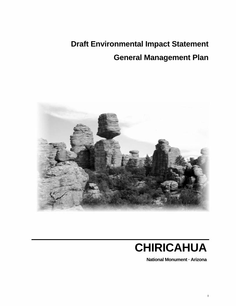
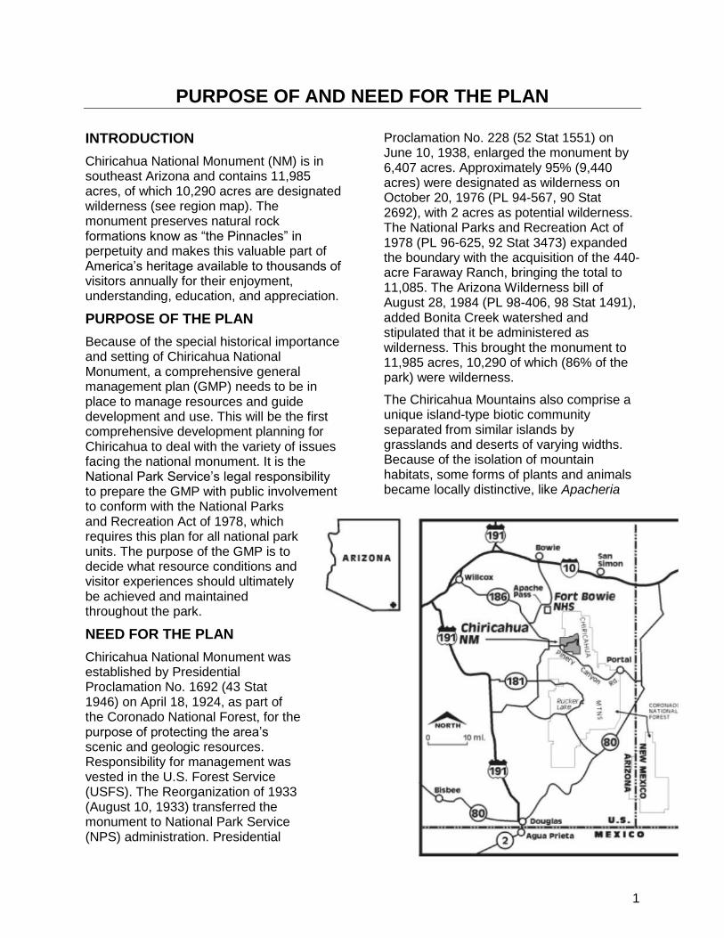
Chiricahua National Monument (NM) is in southeast Arizona and contains 11,985 acres, of which 10,290 acres are designated wilderness (see region map). The monument preserves natural rock formations know as ―the Pinnacles‖ in perpetuity and makes this valuable part of America‘s heritage available to thousands of visitors annually for their enjoyment, understanding, education, and appreciation.
PURPOSE OF THE PLAN
Because of the special historical importance and setting of Chiricahua National Monument, a comprehensive general management plan (GMP) needs to be in place to manage resources and guide development and use. This will be the first comprehensive development planning for Chiricahua to deal with the variety of issues facing the national monument. It is the National Park Service‘s legal responsibility to prepare the GMP with public involvement to conform with the National Parks and Recreation Act of 1978, which requires this plan for all national park units. The purpose of the GMP is to decide what resource conditions and visitor experiences should ultimately be achieved and maintained throughout the park.
NEED FOR THE PLAN
Chiricahua National Monument was established by Presidential Proclamation No. 1692 (43 Stat 1946) on April 18, 1924, as part of the Coronado National Forest, for the purpose of protecting the area‘s scenic and geologic resources. Responsibility for management was vested in the U.S. Forest Service (USFS). The Reorganization of 1933 (August 10, 1933) transferred the monument to National Park Service (NPS) administration. Presidential
Proclamation No. 228 (52 Stat 1551) on June 10, 1938, enlarged the monument by 6,407 acres. Approximately 95% (9,440 acres) were designated as wilderness on October 20, 1976 (PL 94-567, 90 Stat 2692), with 2 acres as potential wilderness. The National Parks and Recreation Act of 1978 (PL 96-625, 92 Stat 3473) expanded the boundary with the acquisition of the 440-acre Faraway Ranch, bringing the total to 11,085. The Arizona Wilderness bill of August 28, 1984 (PL 98-406, 98 Stat 1491), added Bonita Creek watershed and stipulated that it be administered as wilderness. This brought the monument to 11,985 acres, 10,290 of which (86% of the park) were wilderness.
The Chiricahua Mountains also comprise a unique island-type biotic community separated from similar islands by grasslands and deserts of varying widths. Because of the isolation of mountain habitats, some forms of plants and animals became locally distinctive, like Apacheria

2
cochisensis, Apache Fox Squirrel, Arizona Cypress, Apache Pine, and Chihuahuan Pine. Other species are of interest because of their threatened or peripheral status, like jaguar, jaguarundi, peregrine falcon, elegant trogon, violet-crowned humming bird, and blue-throated hummingbird.
Cultural resources are richly diverse, including evidence of occupation by prehistoric people of the Cochise and Athabascan cultures, use of the area by Apaches, occupation by the U.S. Army during the Geronimo Campaign, settlement of the west at the close of the ―Indian Wars‖ as depicted by the Faraway Ranch, and classic structures built by the Civilian Conservation Corps.THE NATIONAL PARK SYSTEM
The national park system represents a collection of our national heritage and includes many of the nation‘s most outstanding and significant natural, cultural, historic, and recreational resources. Each unit contains resources and values that make it something special—even nationally significant. The ―niche‖ filled by each park is defined by its park purpose.
The National Park Service‘s purpose of conserving resources—whether they be natural, cultural, historic, or recreational—recognizes the importance of preservation as an active management tool. This preservation principal respects both natural and human relationships and emphasizes the value of maintaining land for the purpose of preserving natural ecosystems, historic significance, and outstanding recreational opportunities.
Balanced against the protection and preservation of these resources is the value of public enjoyment by present and future generations. Human use often can threaten the very resources that the National Park Service is tasked to protect. Many public debates have revolved around the balancing of these two National Park Service purposes. Whether it is telling a story or distributing use carefully to protect
resources, the Service uses the principles of human and natural management to accomplish its mission. But at the very least, ―these areas derive increased national dignity and recognition of their superb environmental quality through their inclusion jointly with each other in one national park system managed for the benefit and inspiration of all people.‖ (16 USC 1a-1;1970)
Park Purpose
The reason or reasons for which Chiricahua National Monument (CHIR) was set aside as a part of the national park system is called its park purpose. Purpose statements are based upon legislation, legislative history, and historic trends.
Purpose
Chiricahua National Monument was established for the protection of ―certain natural formations, known as ―the Pinnacles,‖ which were of such scientific value that their protection was required by the public interest (NPS 1998). Its purposes are:
preserve and protect all natural and cultural resources and values
provide recreational opportunities that are compatible with the protection and appreciation of park resources for diverse groups
provide educational opportunities to foster understanding and appreciation of the natural and human history of the area
Park Significance
Significance is summarized in statements that capture the essence Chiricahua National Monument‗s importance to our natural and cultural heritage. Significance statements are not an inventory of significant resources but rather describe the importance or distinctiveness of the aggregate of resources in the park. The following are the significance statements developed for the park staff with public input through the planning process.
3
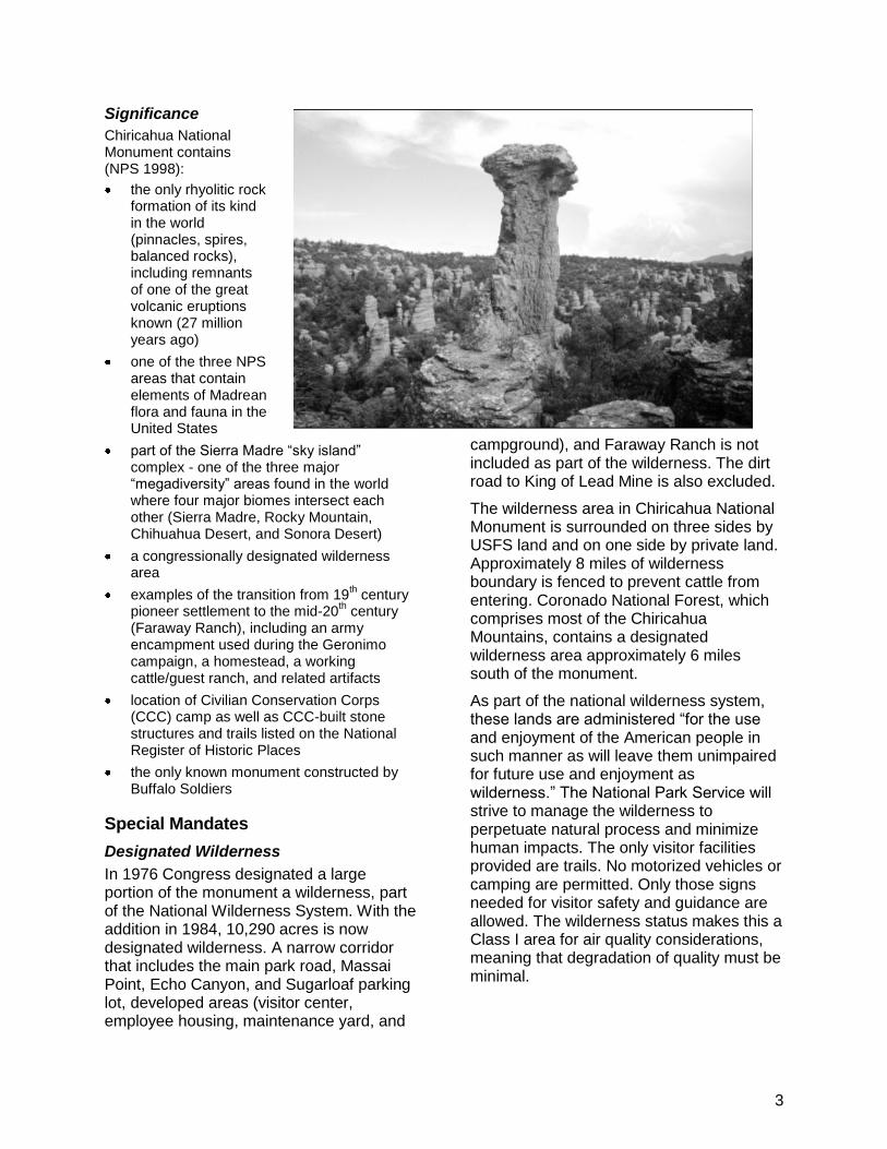
Significance
Chiricahua National Monument contains (NPS 1998):
the only rhyolitic rock formation of its kind in the world (pinnacles, spires, balanced rocks), including remnants of one of the great volcanic eruptions known (27 million years ago)
one of the three NPS areas that contain elements of Madrean flora and fauna in the United States
part of the Sierra Madre ―sky island‖ complex - one of the three major ―megadiversity‖ areas found in the world where four major biomes intersect each other (Sierra Madre, Rocky Mountain, Chihuahua Desert, and Sonora Desert)
a congressionally designated wilderness area
examples of the transition from 19th century
pioneer settlement to the mid-20th century
(Faraway Ranch), including an army encampment used during the Geronimo campaign, a homestead, a working cattle/guest ranch, and related artifacts
location of Civilian Conservation Corps (CCC) camp as well as CCC-built stone structures and trails listed on the National Register of Historic Places
the only known monument constructed by Buffalo Soldiers
Special Mandates
Designated Wilderness
In 1976 Congress designated a large portion of the monument a wilderness, part of the National Wilderness System. With the addition in 1984, 10,290 acres is now designated wilderness. A narrow corridor that includes the main park road, Massai Point, Echo Canyon, and Sugarloaf parking lot, developed areas (visitor center, employee housing, maintenance yard, and
campground), and Faraway Ranch is not included as part of the wilderness. The dirt road to King of Lead Mine is also excluded.
The wilderness area in Chiricahua National Monument is surrounded on three sides by USFS land and on one side by private land. Approximately 8 miles of wilderness boundary is fenced to prevent cattle from entering. Coronado National Forest, which comprises most of the Chiricahua Mountains, contains a designated wilderness area approximately 6 miles south of the monument.
As part of the national wilderness system, these lands are administered ―for the use and enjoyment of the American people in such manner as will leave them unimpaired for future use and enjoyment as wilderness.‖ The National Park Service will strive to manage the wilderness to perpetuate natural process and minimize human impacts. The only visitor facilities provided are trails. No motorized vehicles or camping are permitted. Only those signs needed for visitor safety and guidance are allowed. The wilderness status makes this a Class I area for air quality considerations, meaning that degradation of quality must be minimal.
4
Historic District
The Faraway Ranch and the Stafford Cabin are listed on the National Register of Historic Places as a historic district. The entire district includes eight ranch buildings and a cemetery. The National Historic Preservation Act requires NPS to ensure that any federally funded or licensed undertaking is implemented only after careful consideration of its possible impacts on properties listed on the National Register.
Master Agreement with Mexico
In 1996 a letter of agreement was made between Reserva Forestal Nacional y Refugio de Fuana Silvestre Sierra de los Ajos, Buenos Aires y La Purica – Bavispe, Chiricahua National Monument, and Coronado National Memorial for the purpose of initiating a partnering project to promote the sharing of staff and resources. The primary goal among the three areas is conservation of natural and cultural resources across borders.
Staffs from the three areas developed goals of the agreement and a two-year work plan. Goals were to:
1) provide orientation to all areas with an exchange of personnel,
2) develop a staff and research station at Sierras de los Ajos to deter illicit activities,
3) expand scientific knowledge among the three conservation areas through cooperative research projects and information sharing,
4) cross train staff in resource protection and investigation, and
5) develop environmental education and training programs for local communities.
Projects include
1) loaning equipment and a trailer to Sierras de los Ajos,
2) conducting a strategic planning course on Mexican laws and conservation workshop,
3) cross training from NPS for sign making, fauna and fire effects monitoring protocols, and
4) jointly participating in developing environmental education, research, and resource protection activities.
Servicewide Law and Policies
Management and operations within NPS units are guided by many laws, policies, and guidelines. The following are those that apply to this planning effort:
National Park Service Organic Act
National Environmental Policy Act
National Historic Preservation Act
Archeological Resources Protection Act
American Indian Religious Freedom Act
Native American Graves Protection and Repatriation Act
Endangered Species Act
E.O. 11988: Floodplain Management
E.O. 11990: Wetlands Protection
Federal Water Pollution Control Act
Clean Air Act
Architectural Barriers Act
Rehabilitation Act
Americans with Disabilities Act
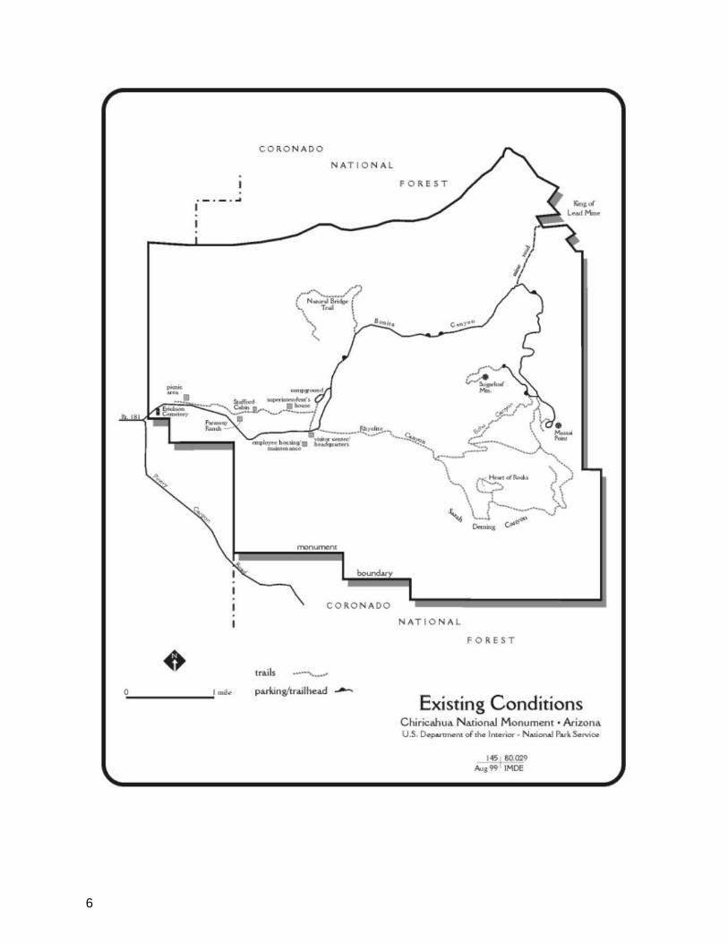
Description of the National Monument
The monument was relatively small when it was established for the singular purpose of protecting geologic features known as ―the Pinnacles,‖ which are towers and balanced rocks in a forested mountain setting. The basic rock type, rhyolite tuff, has been exposed to extensive fracturing, faulting, and erosion, resulting in the formation of pinnacles, spires, balanced rock, and isolated mesas (NPS 1980). Two major canyons, Bonita and Rhyolite, drain into the lower section of the park from the mountainous backcountry.
The Chiricahua Mountains are in the Basin and Range Biogeographical Province and
5
are often referred to as ―sky islands‖ because they, and the flora associated with them, are separated from similar ―islands‖ by expansive valleys of grassland and desert scrub averaging 10 to 40 miles wide (NPS 1980). The slopes are covered with oak woodlands, pine stands, and manzanita fields and rise from lush riparian canyons or desert scrub and grasslands.
A more recent addition was Faraway Ranch, a historic area consisting of the furnished Erickson-Riggs ranch house, several outbuildings, fences, pens, and corrals. It was the home of the Ericksons, who were among the first settlers in these mountains, and later of their daughter Lillian Riggs and her husband, Ed. The Riggses made the Faraway Ranch into a pioneer guest ranch and were the primary promoters of establishing the national monument.
A short distance west of the ranch and close to the present parking lot is the 1885-1886 encampment of the Buffalo Soldiers, a troop of black soldiers of the 10th Cavalry that spent many years in the ―Indian Wars‖ of the Southwest. They were sent to Bonita Canyon to prevent the Chiricahua Apaches from using local water sources, to guard the mail, and to protect settlers and their livestock. After Apache leader Geronimo surrendered in September 1886, the Buffalo Soldiers departed. While in Bonita Canyon, the troopers built a stone monument to the late President James Garfield. Today only the base remains; the upper stones, many with inscriptions by the soldiers, were removed by Ed Riggs and used to build the fireplace in the ranch house in the 1920s.
Today the park contains 11,985 acres of ruggedly beautiful mountain and canyon landscape. Trails lead to outstanding formations and viewpoints. There is no camping or other overnight use in the backcountry.
The main road enters the monument at the mouth of Bonita Canyon and runs through
the canyon and high slopes to Massai Point, which provides an astounding view over the Chiricahua Mountains and lowland deserts to the east and west. There is a succession of superlative vistas of lush riparian zones, rhyolite pinnacles, Cochise Head, and broad desert valleys with more sky islands in the distance.
The road, which was built by the CCC in the 1930s, is very narrow with many curves. All of the monument‘s development and most of its visitor activity occur along this road: Faraway Ranch, picnic areas, maintenance yard, employee housing, visitor center, campground, and a small exhibit structure atop Massai Point (see park map). Along the road are trailheads leading into the wilderness area. Other than short administrative roads and a dirt road to a mine, there are no other roads in the monument. Three residences and four maintenance buildings were constructed by the CCC. Three other residences were constructed during NPS‘s Mission 66 program, and the rest are more recent. The CCC also constructed the original visitor center, campground caretaker‘s house and rest room, fire tower on Sugarloaf Mountain small exhibit structure on Massai Point, and most of the trails. The CCC-built structures are eligible for listing on the National Register of Historic Places.
Planning Process
Prior to this current general management planning effort, a similar process began in 1992. Scoping sessions by the park staff, a public open house, a press release, and a letter to 392 people on the mailing list for both Chiricahua NM and Fort Bowie National Historic Site (NHS) raised a series of issues. After a national reorganization in the National Park Service, the general management planning process was restarted in 1996 with a different planning team. The first step in the second process was a review of the work
6

7
8
previously done and the incorporation of the 1992 public comments.
For the current project, a newsletter was mailed in early May 1998 to all interested parties and those on the park mailing list informing them of GMP projects for both Chiricahua NM and Fort Bowie NHS. The newsletter invited the public to attend meetings to discuss both plans. Notices of the public meetings were also sent to nearby newspapers. Four meetings were held the week of May 18th in the towns of Portal, Willcox, and Bowie, and at a school just outside of Chiricahua NM. A total of 19 people attended the meetings. The GMP process was described at each meeting, as were the two parks. There was general appreciation expressed for the parks, and recommendations were made not to change them.
All suggestions were discussed and notes were taken. Another 24 mailed responses were received from newspaper readers. Letters were also sent to six Apache tribes
and one nation in Arizona, New Mexico, and Oklahoma, and to two interested individual American Indians. No responses were received.
A Notice of Intent to publish an Environmental Impact Statement was published in the Federal Register in June of 1999. A 30 day public comment period followed ending on July 15, 1999. A website (http://www.nps.gov/planning/chir) was established to facilitate making information about the planning process available to the public. A total of 5 responses were received requesting information on the planning process. Groups included one organization interested in land issues, one interested in handicapped accessibility, and two unaffiliated individuals.
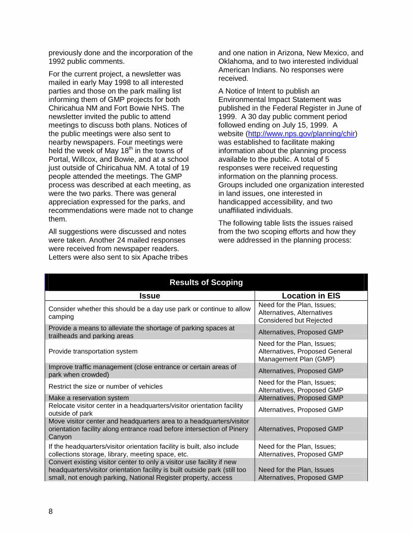
The following table lists the issues raised from the two scoping efforts and how they were addressed in the planning process:
Results of Scoping
Issue Location in EIS
Consider whether this should be a day use park or continue to allow camping
Need for the Plan, Issues; Alternatives, Alternatives Considered but Rejected
Provide a means to alleviate the shortage of parking spaces at trailheads and parking areas
Alternatives, Proposed GMP
Provide transportation system
Need for the Plan, Issues; Alternatives, Proposed General Management Plan (GMP)
Improve traffic management (close entrance or certain areas of park when crowded)
Alternatives, Proposed GMP
Restrict the size or number of vehicles Need for the Plan, Issues; Alternatives, Proposed GMP
Make a reservation system Alternatives, Proposed GMP Relocate visitor center in a headquarters/visitor orientation facility outside of park
Alternatives, Proposed GMP
Move visitor center and headquarters area to a headquarters/visitor orientation facility along entrance road before intersection of Pinery Canyon
Alternatives, Proposed GMP
If the headquarters/visitor orientation facility is built, also include collections storage, library, meeting space, etc.
Need for the Plan, Issues; Alternatives, Proposed GMP
Convert existing visitor center to only a visitor use facility if new headquarters/visitor orientation facility is built outside park (still too small, not enough parking, National Register property, access
Need for the Plan, Issues Alternatives, Proposed GMP
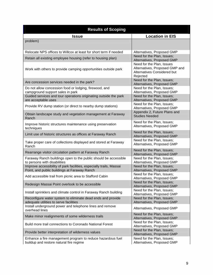
9
Results of Scoping
Issue Location in EIS problem)
Relocate NPS offices to Willcox at least for short term if needed Alternatives, Proposed GMP
Retain all existing employee housing (refer to housing plan) Need for the Plan, Issues; Alternatives, Proposed GMP
Work with others to provide camping opportunities outside park
Need for the Plan, Issues Alternatives, Proposed GMP and Alternatives Considered but Rejected
Are concession services needed in the park? Need for the Plan, Issues; Alternatives, Proposed GMP
Do not allow concession food or lodging, firewood, and campground support sales in park
Need for the Plan, Issues; Alternatives, Proposed GMP
Guided services and tour operations originating outside the park are acceptable uses
Need for the Plan, Issues; Alternatives, Proposed GMP
Provide RV dump station (or direct to nearby dump stations) Need for the Plan, Issues; Alternatives, Proposed GMP
Obtain landscape study and vegetation management at Faraway Ranch
Appendix 2, Future Plans and Studies Needed
Improve historic structures maintenance using preservation techniques
Need for the Plan, Issues; Alternatives, Proposed GMP
Limit use of historic structures as offices at Faraway Ranch Need for the Plan, Issues; Alternatives, Proposed GMP
Take proper care of collections displayed and stored at Faraway Ranch
Need for the Plan, Issues; Alternatives, Proposed GMP
Rearrange visitor circulation pattern at Faraway Ranch Need for the Plan, Issues; Alternatives, Proposed GMP
Faraway Ranch buildings open to the public should be accessible to persons with disabilities
Need for the Plan, Issues; Alternatives, Proposed GMP
Improve accessibility of park facilities, especially trails, Massai Point, and public buildings at Faraway Ranch
Need for the Plan, Issues; Alternatives, Proposed GMP
Add accessible trail from picnic area to Stafford Cabin Need for the Plan, Issues; Alternatives, Proposed GMP
Redesign Massai Point overlook to be accessible Need for the Plan, Issues; Alternatives, Proposed GMP
Install sprinklers and climate control in Faraway Ranch building Need for the Plan, Issues; Alternatives, Proposed GMP
Reconfigure water system to eliminate dead ends and provide adequate utilities to serve facilities
Need for the Plan, Issues; Alternatives, Proposed GMP
Install underground power and telephone lines and remove overhead lines
Alternatives, Proposed GMP
Make minor realignments of some wilderness trails Need for the Plan, Issues; Alternatives, Proposed GMP
Build more trail connections to Coronado National Forest Need for the Plan, Issues; Alternatives, Proposed GMP
Provide better interpretation of wilderness values Need for the Plan, Issues; Alternatives, Proposed GMP
Enhance a fire management program to reduce hazardous fuel buildup and restore natural fire regime
Need for the Plan, Issues; Alternatives, Proposed GMP
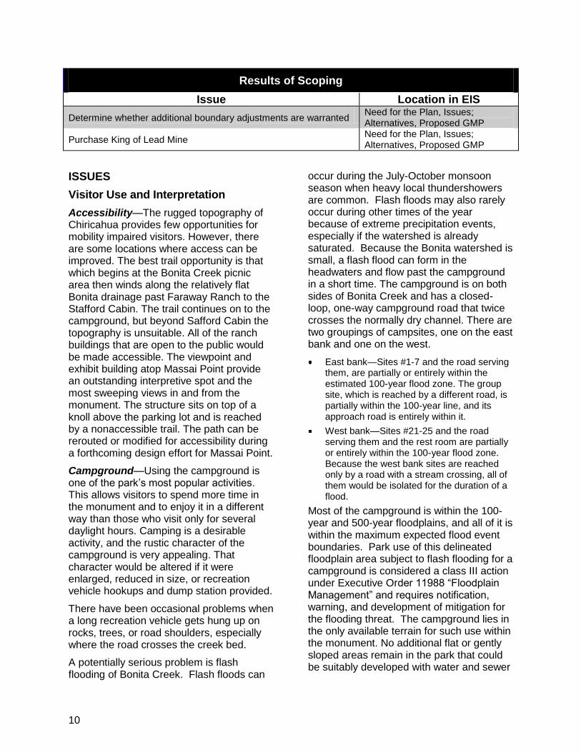
10
Results of Scoping
Issue Location in EIS
Determine whether additional boundary adjustments are warranted Need for the Plan, Issues; Alternatives, Proposed GMP
Purchase King of Lead Mine Need for the Plan, Issues; Alternatives, Proposed GMP
ISSUES
Visitor Use and Interpretation
Accessibility—The rugged topography of Chiricahua provides few opportunities for mobility impaired visitors. However, there are some locations where access can be improved. The best trail opportunity is that which begins at the Bonita Creek picnic area then winds along the relatively flat Bonita drainage past Faraway Ranch to the Stafford Cabin. The trail continues on to the campground, but beyond Safford Cabin the topography is unsuitable. All of the ranch buildings that are open to the public would be made accessible. The viewpoint and exhibit building atop Massai Point provide an outstanding interpretive spot and the most sweeping views in and from the monument. The structure sits on top of a knoll above the parking lot and is reached by a nonaccessible trail. The path can be rerouted or modified for accessibility during a forthcoming design effort for Massai Point.
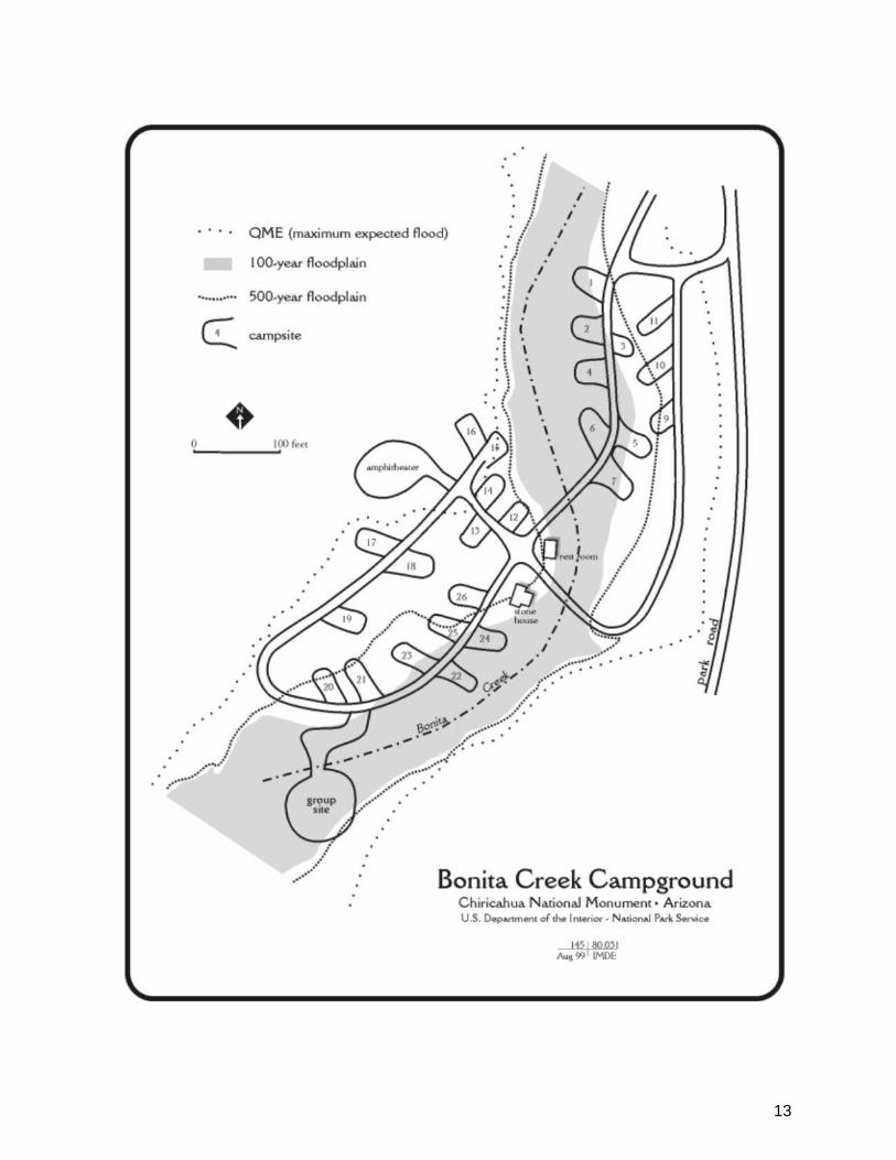
Campground—Using the campground is one of the park‘s most popular activities. This allows visitors to spend more time in the monument and to enjoy it in a different way than those who visit only for several daylight hours. Camping is a desirable activity, and the rustic character of the campground is very appealing. That character would be altered if it were enlarged, reduced in size, or recreation vehicle hookups and dump station provided.
There have been occasional problems when a long recreation vehicle gets hung up on rocks, trees, or road shoulders, especially where the road crosses the creek bed.
A potentially serious problem is flash flooding of Bonita Creek. Flash floods can
occur during the July-October monsoon season when heavy local thundershowers are common. Flash floods may also rarely occur during other times of the year because of extreme precipitation events, especially if the watershed is already saturated. Because the Bonita watershed is small, a flash flood can form in the headwaters and flow past the campground in a short time. The campground is on both sides of Bonita Creek and has a closed-loop, one-way campground road that twice crosses the normally dry channel. There are two groupings of campsites, one on the east bank and one on the west.
East bank—Sites #1-7 and the road serving them, are partially or entirely within the estimated 100-year flood zone. The group site, which is reached by a different road, is partially within the 100-year line, and its approach road is entirely within it.
West bank—Sites #21-25 and the road serving them and the rest room are partially or entirely within the 100-year flood zone. Because the west bank sites are reached only by a road with a stream crossing, all of them would be isolated for the duration of a flood.
Most of the campground is within the 100-year and 500-year floodplains, and all of it is within the maximum expected flood event boundaries. Park use of this delineated floodplain area subject to flash flooding for a campground is considered a class III action under Executive Order 11988 ―Floodplain Management‖ and requires notification, warning, and development of mitigation for the flooding threat. The campground lies in the only available terrain for such use within the monument. No additional flat or gently sloped areas remain in the park that could be suitably developed with water and sewer
11
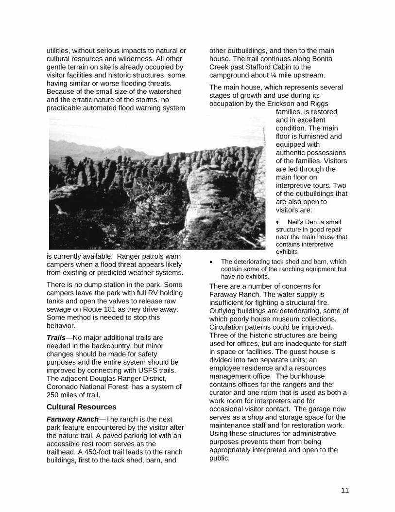
utilities, without serious impacts to natural or cultural resources and wilderness. All other gentle terrain on site is already occupied by visitor facilities and historic structures, some having similar or worse flooding threats. Because of the small size of the watershed and the erratic nature of the storms, no practicable automated flood warning system
is currently available. Ranger patrols warn campers when a flood threat appears likely from existing or predicted weather systems.
There is no dump station in the park. Some campers leave the park with full RV holding tanks and open the valves to release raw sewage on Route 181 as they drive away. Some method is needed to stop this behavior.
Trails—No major additional trails are needed in the backcountry, but minor changes should be made for safety purposes and the entire system should be improved by connecting with USFS trails. The adjacent Douglas Ranger District, Coronado National Forest, has a system of 250 miles of trail.
Cultural Resources
Faraway Ranch—The ranch is the next park feature encountered by the visitor after the nature trail. A paved parking lot with an accessible rest room serves as the trailhead. A 450-foot trail leads to the ranch buildings, first to the tack shed, barn, and
other outbuildings, and then to the main house. The trail continues along Bonita Creek past Stafford Cabin to the campground about ¼ mile upstream.
The main house, which represents several stages of growth and use during its occupation by the Erickson and Riggs
families, is restored and in excellent condition. The main floor is furnished and equipped with authentic possessions of the families. Visitors are led through the main floor on interpretive tours. Two of the outbuildings that are also open to visitors are:
Neil‘s Den, a small structure in good repair near the main house that contains interpretive exhibits
The deteriorating tack shed and barn, which contain some of the ranching equipment but have no exhibits.
There are a number of concerns for Faraway Ranch. The water supply is insufficient for fighting a structural fire. Outlying buildings are deteriorating, some of which poorly house museum collections. Circulation patterns could be improved. Three of the historic structures are being used for offices, but are inadequate for staff in space or facilities. The guest house is divided into two separate units; an employee residence and a resources management office. The bunkhouse contains offices for the rangers and the curator and one room that is used as both a work room for interpreters and for occasional visitor contact. The garage now serves as a shop and storage space for the maintenance staff and for restoration work. Using these structures for administrative purposes prevents them from being appropriately interpreted and open to the public.
12
The visual impression received by the visitor approaching the ranch buildings on the trail from the parking lot is mixed, because the first things encountered are fences and corrals in a state of disrepair. Further on, the other buildings are in better repair and provide a better visual impression.
Historic District Landscape—The ranch land has undergone continual change since the Ericksons first occupied it. Suppression of wildland fires and cessation of grazing has allowed trees to invade the old pastures east and west of the house. The orchard has not been tended for many years and is in a poor state, with most of the trees missing or obscured by other vegetation. Four ranch-era trash dumps exist on the property, but they have not been surveyed to learn what artifacts they contain. The fences to the west of the tack shed are in a state of disrepair and in some places are destroyed. They do not convey to the observer a coherent picture of the role they played in the ranch. Additional human developments, for example, picnic area, parking lot, have been constructed in the viewshed.
Current vegetation is a fire hazard, and there is less open area than previously maintained through historic fires or farming. A cultural landscape inventory has been completed, but a cultural landscape report is needed to provide specific and detailed management recommendations for landscape management goals. The year being used to interpret the outbuildings at Faraway Ranch is 1950, the year of Ed Riggs‘s death. Up to that point the ranch landscape and buildings reflected the efforts and personality of Ed Riggs, with his ability to creatively locate and recycle needed materials. Following his death, the ranch was maintained by hired help, a departure from the earlier style. This time frame is used to interpret all but the ranch house interior.
Interpretation of the landscape presents additional problems and opportunities. Because living landscapes do not remain
static, but grow and change with time and outside influences, interpretation of the Faraway historic district landscape attempts to present what remains of the earlier periods, but also accepts what it has come to be. Older trees die. Exotic plants invade. Species shift. The one major attempt that park staff makes to reflect the landscape of an earlier time is to reduce the number of young juniper and oak trees that have invaded the former meadow and orchard area between the ranch house and the Stafford cabin. Nine fruit trees were planted just east of the ranch house to serve as a representation of the earlier fruit orchard. Currently the corrals around the tack barn that have fallen to the effects of weathering and a lack of maintenance are being repaired and replaced.
Natural Resources
Fire Program—Wildland fires were suppressed for over 80 years under the mistaken notion that fire was bad, which caused serious problems in the ecosystem. Large amounts of fallen limbs, needles, and trunks (that otherwise would have been removed by periodic fires) piled up on the forest floor could serve as fuel for a major fire. Species that need the clearing effect of fire and the fertilizing ashes they produce have difficulty reproducing. Trees and shrubs encroached into open areas. All of the ecological effects of fire suppression are not known, but suppression is clearly detrimental to the land and contradictory to NPS purposes.
To deal with this problem, Chiricahua had one of NPS‘s earliest fire plans and was doing prescribed burns in the 1970s. The current
13

14
plan calls for igniting fires to emulate the natural fires that were excluded for 80 years and for taking advantage of lightning-caused wildland fires to reduce fuels and rejuvenate habitat. The amount of acreage treated needs to be increased. The plan would be followed in close cooperation with USFS and nearby ranchers. This program is of major public interest and would be accompanied by information and explanation. There have been fire history studies done, but more information is needed about vegetation composition and structure as well as response of individual species to direct and indirect fire effects.
Wilderness and Backcountry—There are no signs of crowding in the backcountry, so right now no limits are needed on the number of hiking visitors allowed at one time. The ability of the 10,290 acres of wilderness to absorb and distribute hikers would keep a low density of hikers to ensure a rewarding wilderness experience. Connecting with USFS trails would enhance the experience and further disperse hikers.
Most park visitors, including those who hike the wilderness trails, do not understand the purpose or significance of wilderness designation, or that most of Chiricahua has been so designated.
An existing boneyard and park firearms training range now encroaches on the wilderness and would be moved.
Operational Efficiency
Visitor Center and Headquarters—The visitor center building (VC) serves as both a visitor interpretation/information/orientation center and as the main administrative office. The VC is not large enough for these two functions, as evidenced by the need to house the resources management, interpretation, and ranger staffs in a Faraway Ranch building. Also, there is no appropriate space for a library, archives, collection storage, and herbarium. Not only is it an inconvenience to have the staff in separate locations, but also the building might better serve as an exhibit. Because
the VC and Faraway Ranch are historic structures, they do not lend themselves to the full adaptations needed to modernize offices.
The interpretive exhibits are more than 30 years old and need updating and replacing. The exhibits and book sales area are in a cramped space.
Another major drawback is the small visitor center parking lot; there are only 20 spaces at the monument‘s main point of visitor concentration. At busy times the lot is filled to capacity, and this is exacerbated by tour buses and large recreation vehicles. Physically, the parking lot could be enlarged only by expanding it across Rhyolite Creek and removing many trees. Even if the existing building could be enlarged to provide the necessary space, the parking area cannot be, which is the main obstacle to solving the visitor center and headquarters problem at this location.
The park is currently authorized 23 permanent, full-time employees. Additional staff includes two cooperating association employees, an average of five VIPs at any given time, and multiple researchers and Student Conservation Association interns. The park has office space with climatic control to accommodate only eight employees. The headquarters facility only accommodates the superintendent, administrative officer, one clerical worker, and one visitor center employee. No other office space with climatic controls exists. Many offices are in dilapidated historic structures that lack climatic control and are infested with rodents, thus presenting a serious health concern to the employees. The park has no space to accommodate group meetings of more than five people.
A new facility would enhance operational efficiencies by consolidating staff within an area that is safe and meets minimum space requirements.
Road and Parking—The road was built in the 1930s. Because of its narrow width, lack of shoulders, and tight turning radii, the road

15
is inadequate for the large recreation vehicles and buses that use it today, and such traffic is increasing. There are no legal passing zones and few places where a slow or large vehicle can pull over to allow others to pass. As a result, large recreation vehicles, which tend to move slowly on the winding road, hold back other vehicles. The problem becomes acute when two such vehicles pass in opposite directions, filling the entire road. Clearly, being caught behind such a slow-moving, view-blocking vehicle is frustrating and could become a potentially dangerous introduction to the park should the following vehicle attempt to pass.
The major parking locations are at Faraway Ranch, the visitor center, Sugarloaf Mountain, Echo Canyon, and Massai Point. The parking problem is serious, but not yet acute. The dead end road, with its very limited parking at major points of interest, imposes a definite limit on the number of vehicles that the entire park can accommodate at one time. Driving back and forth, fruitlessly looking for a parking spot and perhaps finding one at a place where the visitor did not want to stop reduces a visitor‘s pleasure, as does waiting behind an idling vehicle. With only an estimated 190 spaces parkwide, parking is often inadequate during the high visitation months of March, April, and May. The visitor center parking area, which also serves as a trailhead for the entire system of trails in Rhyolite Canyon and its tributary creeks, is so small (approximately 20 spaces) that it causes the major parking problem in the park. Some trailheads have only a few or no parking spaces. When large recreation vehicles and trailers park, they commonly occupy two or more spaces, compounding the shortage.
During the peak visitation hours, heavy use of Massai Point and Echo Canyon parking lots occurs, up to 238% of capacity at Echo Canyon and 146% of capacity at Massai Point (NPS 1999). There is substantial illegal parking at
both of these lots. The Sugarloaf parking lot is underused and is not a problem. The parking problem at the monument is caused by two different types of visitors: sightseers and hikers. The typical sightseer wants to visit both Massai Point and Echo Canyon and will stay less than 30 minutes at Massai Point and less than 60 minutes at Echo Canyon if there is an available legal parking spot. The typical hikers‘ main destination is Echo Canyon, followed by Massai Point. When hikers drive themselves up to the mountain vista parking lots, they park for approximately 3 to 5 hours on weekdays and approximately 3 to 4 hours on the weekends.
To alleviate the parking problem, the monument operates a visitor transportation system in the form of a seasonal hiker shuttle that takes hikers from the visitor center, campground, or Faraway Ranch areas to their trailhead destinations.
Water and Septic Systems—There are three separate water and septic systems:
Visitor Center, Campground, and Employee Housing—The water system has a well and pump in the campground, three storage tanks totaling 80,000 gallons, and gravity flow to points of use. Because of the spread out pattern of the distribution lines, there are three ―dead ends‖ in the system that could be public health and maintenance problems. The water supply (in contrast to its distribution) is adequate to meet current demand.
The VC and housing have two septic systems, and the campground has a third. The septic systems are old and operating at or near capacity. The drain lines in the campground system are in need of major upgrading.
Superintendent’s House—The system is adequate and self-contained (well and septic). The swimming pool is kept full and is available for fire suppression in the house and the surrounding grounds.
16
Faraway Ranch—There is a well east of the main house and a 10,000-gallon tank on the hill. Gravity flow through buried pipes supplies the guest house (currently used as employee quarters and office space), public rest room, and three outdoor hydrants. There is one septic system for the guest house and another for the rest room. One deficiency is the lack of a fire-fighting hydrant or standpipe near the parking area.
The water systems do not need to be replaced in the near future, but the ―dead ends‖ of the main water system are problems. Because of the lack of a circulating flow, water can get ―stale‖ at the dead ends, which means purifying chemicals can lose their effectiveness. Also, it is not now possible to isolate specific sections of the system, so if there is a problem in one section, the entire system must be closed down.
The septic systems have little or no excess capacity to absorb additional loads.
Employee Residences—There is sufficient housing for the current and anticipated level of employees who would live in the park. Additional housing is available in the surrounding area and communities, where several employees reside. There are two groups of housing units close to the visitor center, all of which were constructed at various times as employee housing, plus three houses away from the primary residential area. There are four units east of the maintenance yard, consisting of three built by the CCC in the 1930s and a fourth built during Mission 66. All four units are currently occupied by permanent employees.
To the west of the maintenance yard are six more units. Two are Mission 66 houses currently occupied by permanent employees. The others are recently constructed buildings used by researchers, volunteers, seasonal employees, and visiting NPS employees.
Of the three separate houses, one is a modern house on an inholding added to the park that has traditionally been occupied by
the superintendent. It is close to Bonita Creek just upstream from the Stafford Cabin in the creek floodplain. On one occasion the house was isolated by floodwater flowing on both sides. Another is a small CCC-built house in the campground meant for a caretaker. It is usually occupied by a seasonal employee. The third is the guest house of the Faraway Ranch, half of which is used as an employee residence and half as an administrative office.
Commercial Services—All general management plans are required to analyze the need for commercial visitor services. Some commercial visitor services are provided by gateway communities and on occasion by neighbors who open convenience stores. With a short length of stay and the relative isolation of the park, visitors would need some food and lodging services. However, because nearby communities already provide these services and the park land base is very small, there is no need for concessioner-provided food and lodging inside the park. There are 13 restaurants, 15 motels, 10 trailer parks, 3 RV parks, and 4 bed and breakfast units in nearby communities. Additional visitor in-park services or facilities would require more development of park land, and the park water and sewage systems are approaching their capacity and would be strained by additional demand.
Other commercial visitor services currently being provided include sale of visitor convenience items and horseback, hiking, and bus tours. Other activities could be added if they enhance the visitor experience, are appropriate for the park, and are consistent with resource protection prescriptions. Some of these activities might include bicycle tours and shuttle services to alleviate crowding and prevent traffic jams.
Boundary—The water quality of Bonita Creek is potentially threatened by polluted drainage from the King of Lead Mine. The park is working with the state to ascertain

17
how serious the pollution is within the mine, what the likelihood is of it draining into the

18

19
watershed, and who is responsible for mitigating the problem. Because of this concern, a boundary adjustment and acquisition of the mine would be considered. In the most recent boundary expansion legislation the King of Lead Mine was excluded because the owner of the patented claim was unwilling to sell. He is now interested in selling. Low levels of cadmium and lead have been detected in the soils at the King of Lead Mine. Pursuant to USDI policy, the NPS could not purchase the property until it has been certified as safe for the uses proposed.
The King of Lead Mine haul road, which runs from the northernmost curve of the park road to the mine, provides legally guaranteed access to the mine owner. The unimproved and unmaintained road also serves as a foot trail through the mine property to the park boundary, and to Coronado National Forest including, Cochise Head. The haul road, which is used infrequently by the mine owner, is occasionally used by backpackers to camp along the national forest trails, because there is no backcountry camping in the park. The mine owner permits hikers to cross his property, but this passage is not guaranteed and could be revoked at any time. At present, the park has no control or authority over the part of the trail on the mine property. There are also concerns over the safety of hikers passing near an unsealed, unsigned mine shaft.
If a new headquarters/visitor orientation facility is built, it could be located outside the park on State Route 181. If the selected location is adjacent to or near the existing boundary, it could be accommodated by a
minor boundary extension, land purchase from a willing seller, or a lease option.
Most of the park is surrounded by Coronado National Forest, where management is complementary and cross boundary trails provide an extended recreation opportunity. There are no resources on the adjacent parts of the forest that should be included in the park. The only justification for boundary adjustments would be to move from the rectangular coordinates that are the basis for the present boundary to a more practical boundary aligned with topographic features like ridges. Because of the close cooperation between the monument and the national forest and the similarity of land use along the boundary, there is no need to make a change.
On the southwest, along Pinery Canyon road, USFS has transferred some national forest land that abuts the boundary to a private owner in exchange for land acquired from the same owner elsewhere in the forest. Depending on the uses to which the new owner puts his land, this area could cause visual problems for the park in the future.
The western park boundary abuts private land. Except for the possible extension mentioned above for a headquarters/visitor orientation facility, there is no current reason to expand the boundary there. The boundary at the park entrance at the mouth of Bonita Canyon, makes a clear demarcation between the park and the broad valley to the west. All private land use in the area (mainly ranching and scattered private homes) is compatible with the park entrance.
20
ALTERNATIVES
INTRODUCTION
Two alternatives, the no-action alternative and the NPS proposal, are presented in this chapter. The proposal is the proposed general management plan (GMP) for Chiricahua NM and if adopted will serve as the park‘s GMP. The plan will guide the management and development of Chiricahua for the next 12 to 15 years.
MANAGEMENT PRESCIPTIONS
Management prescriptions detail desired visitor experiences and resource conditions for various areas of the park. Specific guidance for each area is described using the following six categories: visitor experience, access, natural resource management, cultural resource management, facilities, and maintenance. There are four prescriptions for management—primitive, motorized rural, developed, and resource preservation.
The following are the prescriptions for Chiricahua.
Primitive
Management provides wilderness experiences. Challenge and adventure for visitors are high and are in an environment free of human influence and alteration. Natural processes and conditions would be perpetuated. The setting is composed of an unaltered natural landscape. Encounters with other people are infrequent, and there are no facilities present unless essential to protect resources or provide for visitor safety and well-being. There is no motorized access to the primitive area.
Visitor Experience—The primitive area provides abundant opportunities to experience the backcountry wilderness in solitude. It is reserved for hiking and nature observation. Off-site interpretation and education are stressed.
Generally visitors are isolated from human sights and sounds. Visitors can experience
a feeling of closeness with nature and have the opportunity to experience solitude, tranquillity, and quiet because encounters with others are few. A moderate degree of challenge, self-reliance, and risk is prevalent for visitors to this area, and knowledge and use of outdoor survival and wilderness skills are recommended.
Evidence of recreational use is generally not readily apparent except along trails and access routes. Resource manipulation is kept to a minimum, but some resource management actions might be required to reduce the impacts of visitor use. A limited number of interpretive exhibits or signs could be needed to meet objectives of protecting the resource. Rules and regulations are explained to visitors before they enter the wilderness.
Management helps to ensure an experience in an untrammeled, primeval environment. Evidence of other visitors is also minimal, and there is a sense of being immersed in a natural landscape, without comforts and conveniences. Visitors to this area commit to a moderate level of time and energy.
Access—Access to the primitive area is challenging. The area within designated wilderness has no roads, and visitors may travel cross country or on low-standard trails that provide connections over ridge lines. Discovery and adventure are the order of the day.
Public access is by foot, except for trails also designated for horseback use. Within the wilderness, aircraft use is only permitted for emergencies and necessary administrative functions.
Natural Resource Management—The natural environment is preserved to the maximum extent possible while accommodating low-density backcountry use. Naturally occurring species are maintained or reestablished, and populations of sensitive species are
21
protected and augmented. The introduction of nonnative species is prevented to the extent possible, and attempts are made to eliminate introduced species before they become established. The NPS maintains close control over resource-damaging activities.
Monitoring is carried out regularly, and mitigating measures (revegetation, species augmentation, and reintroduction of extirpated species) are done as needed. Uses are controlled or dispersed if necessary to protect resources. A backcountry permit system could be implemented if resources or solitude are threatened.
Cultural Resource Management—Cultural resources selected to illustrate interpretive themes and those listed on or eligible for listing on the National Register of Historic Places would receive stabilization. A cultural resource management plan guides management decisions and addresses the treatment of individual sites. Coordination and consultation with the state historic preservation officer (SHPO) is a part of the process.
Facilities—No developments are allowed, and there are only minimal modifications to the natural environment. Rustic signs, cairns, and primitive trails could be present. No facilities are present. Additional facilities are provided only if they are essential to protect resources.
Maintenance—Maintenance activities serve to protect resources and restore areas disturbed by human activities. There is no recurring maintenance in the primitive area. Power tools are not allowed unless the superintendent determines that such tools are necessary to respond to a life- or resource-threatening emergency.
Motorized Rural
Management provides for vehicle access along one paved road, which gives a sense of remoteness. Although the area is predominantly natural, sights and sounds of human activity are occasionally
encountered. The types of visitor activities to be accommodated in the motorized rural area include but are not limited to camping opportunities, wayside interpretive exhibits, interpretation along trails, and access to hiking trails. Opportunities for more solitude than experienced in the developed areas could be expected in this area, except on peak season weekends. Human interaction and contacts with NPS staff could be moderately frequent during these times and infrequent during the off season. Visitor challenge would be low owing to the presence of roads and motorized vehicles. A moderate amount of resource manipulation would be required to mitigate impacts associated with moderate human-use levels. Natural conditions would be maintained as much as possible, however, some human intervention and alteration would be evident along roads, at trailheads, and in the campground. Support facilities such as picnic tables, fire grates, and vault toilets could be provided.
Visitor Experience—There would be a sense of remoteness and seclusion, but not of isolation from human activity. Visitors would be able to reach undeveloped areas of the park from the main paved road via trailheads. For those who are unable to access the more semiprimitive areas of the park, this area would provide an alternative and allow a rural experience without the degree of difficulty found in the primitive area.
A limited amount of interpretation and education is provided. It is designed to supplement the low-profile signs and interpretive exhibit panels placed in selected locations to provide information, offer limited interpretation of park themes, ensure protection of park resources, and provide for visitor safety.
Access—Access to the motorized rural area is easy. Only one paved road is provided, and all access originates from this road. Trails for hiking could originate from this area. Short interpretive trails could allow visitors to discover areas of special
22
interest. Access for visitors who are physically challenged could be provided in selected areas to allow these visitors to experience representative park settings.
Natural Resource Management—The natural character of lands is preserved to the extent possible while accommodating moderate visitor-use levels. Any apparent effects of visitor use would be mitigated, and disturbed areas that caused significant visual impairment would be restored. The cumulative effects associated with unacceptable levels of visitor use at campsites or in other areas of visitor concentration could be mitigated or prevented by ensuring appropriate levels of visitor use.
Cultural Resource Management—Cultural resources identified to illustrate interpretive themes and those nominated, listed, or eligible for listing on the National Register of Historic Places could receive moderate stabilization. A cultural resource management plan (CRMP) has been prepared and addresses treatment of individual sites. Coordination and consultation with the state historic preservation officer is part of the process.
Facilities—Only limited development would be provided, and few major structures or facilities would be present. A paved road, a rustic campground, interpretive panels and information signs, and trailheads are examples of appropriate facilities for this prescription area.
Fire grates, picnic tables, vault toilets, and water could be provided, but no electricity or sewer connections would be available. Size restrictions could be placed on RVs and trailer-campers.
Maintenance—Activities could include maintaining roads and facilities (cleaning, painting, repair, pump-out, etc.), hardening sites, providing for visitor convenience and comfort, protecting resources, and restoring areas disturbed by human activity.
Developed
This management prescription includes all major park development required to serve visitors and meet the needs of management. It encompasses areas where park development and/or intensive use substantially alter the natural environment or the setting of historically significant resources. This is an area where major visitor facilities provide an experience that is facility dependent (e.g., visitor center/admin building). The sights and sounds of vehicles and people predominate as does the experience that is tied to traffic along the major road corridor of the park.
This area would accommodate the highest levels of use in the park. Visitor activities would be fairly structured and directed and involve little challenge. Support services and facilities could be moderate. Visitor contacts and contacts with NPS personnel could be frequent in this area, especially during peak visitor periods. Contacts could be less frequent during the off-peak season but might still be common compared with other management areas within the park. There could be little or no opportunity for solitude. Relatively intensive resource management activity could be required to mitigate impacts associated with high levels of visitor use and development. Although natural processes would be perpetuated wherever possible, a high degree of perturbation and human intrusion to the natural environment could continue to be evident.
Visitor Experience—This area provides for the primary experience of most visitors, introducing them to many of the park‘s significant resources and presenting the primary park interpretive themes. Exhibits, films, and live presentations and publications distributed at the visitor center would be used to convey an understanding of the park and its natural and cultural resources. Interpretive trails and guided ranger tours would also be used in this area. Other orientation information would

23
assist visitors in planning their stay in the park or region.
Access—Access to the developed area would be easy. This area could contain surfaced roads, and all roads could be accessed by two-wheel-drive vehicles. Pedestrian access along low- to high-standard trails could allow for visitor access to a variety of environments. Hardened trails could be provided in areas around the visitor center and in other areas of high use identified to give visitors an overview and better familiarity with park resources. Barrier-free design is provided in selected areas to permit visitors with physical impairments to experience representative park settings.
Natural Resource Management—The natural character of lands within this area is maintained to the greatest extent possible while accommodating high levels of use.
Vista site modifications could be used to improve views in this area. Visitors would be confined or directed to hardened sites, overlooks, and trails to limit resource impacts. Significant soil and vegetation impacts occurring near high-use sites could be mitigated through periodic closures, the use of natural materials to more clearly define use corridors, and increased enforcement techniques. Only native species would be used for revegetation. Landscaping with native species and natural materials, mowing (where appropriate), and selective removal and/or pruning of trees could also be done where appropriate or to enhance visitor safety.
Cultural Resource Management—Resources or sites designated as significant cultural features or cultural landscapes, or that have been nominated to the National Register of Historic Places will be preserved or restored depending on the degree of importance to the visitor‘s understanding of the purpose of the park or settlement and use of the region. All archeological sites would be protected from degradation.
Facilities—Major developments are confined to the developed area. Existing and potential modifications might include surfaced parking lots, transportation systems, maintenance facilities, administrative facilities, residential areas, water storage and sewage treatment facilities, as well as various other support facilities.
Maintenance—Maintenance activities could involve maintaining existing facilities (cleaning, painting, crack sealing, chip and sealing, striping, etc.), hardening sites, landscaping, providing for visitor convenience and comfort, protecting resources, irrigating, and restoring areas disturbed by human activities. Roads, buildings, signs, walks, interpretive displays, landscaping, and other facilities would be maintained on a regular basis. Power tools could be used for routine maintenance activities, and heavy equipment could be used for road and utility system repairs, development, and maintenance.
Resource Preservation
This management prescription includes the culturally significant Faraway Ranch and its associated infrastructure, which protects resources and serves visitors. Management accommodates visitors wishing to experience the park‘s superlative cultural resources on foot. Inter-party and NPS contacts are less frequent than those in developed or rural motorized prescriptions, and opportunities for solitude are less limited in this area than in others. Contacts are less frequent during midweek and off-season periods, when opportunities for solitude and seclusion would be greater.
The landscape setting appears predominantly natural, although evidence of facilities that blend with surroundings could be present. Encounters with other people are occasional, and there is considerable evidence of human use. Other than the main road through the area, there is no motorized access.
24
Challenge to visitors in the prescription area is low. Moderate to extensive resource management activity is required to mitigate impacts associated with visitor-use levels. Naturalness is emphasized, but some human alterations and intrusions could be evident.
Visitor Experience—This area brings the visitor in direct contact with the park‘s cultural resources. The natural character of the area is maintained while providing interpretation and trail access for a small numbers of visitors. This area provides a sense of being immersed in a natural landscape and feels somewhat distant from most comforts and conveniences. The only facilities present are those of the Faraway Ranch.
A variety of on-site interpretive media is used to present the primary park themes and provide orientation and information. Rangers provide interpretation and information.
Access—Access range is easy. This area has one main road through it. Public access is restricted to low- to high-standard trails and limited to foot traffic. No bicycles or motorized vehicles are permitted. Aircraft use is allowed only in emergency situations.
Natural Resource Management—The natural environment along and away from the trail corridor is maintained to the extent possible with resource manipulation kept to a minimum. Emphasis is placed on minimizing human impacts on sensitive environments, cultural resources, habitats, and species. Management would reduce or minimize the impacts of nonrecreational uses. Resources and uses would be carefully monitored, and if impairment occurred, mitigating actions such as temporary closures, revegetation, or restrictions on uses would be implemented as required.
Cultural Resource Management—Resources or sites that are designated as outstanding cultural features might be restored. Sites could be stabilized or
restored to protect the integrity of the resource. Other features designated as outstanding cultural features or listed or eligible for listing on the National Register of Historic Places could be stabilized or restored. A cultural resource management plan (CRMP) has been prepared to address treatment of individual sites. Coordination with appropriate NPS staff and the state historic preservation officer is a part of the process.
Facilities—Only limited development is provided—major facilities would not be allowed.
Maintenance—Activities include protecting cultural resources from visitor use, maintaining/stabilizing cultural sites, and providing resource protection. Hardening of sites could occur as well as the restoration of areas disturbed by human activity. Facilities to provide for the convenience of visitors and their safety would be maintained to lesser standards than those found in the developed area of the park.
ALTERNATIVE A—NPS PROPOSAL
With the exceptions described below, the current level of development and interpretation and the pattern of visitor use is appropriate for Chiricahua and would be maintained.
Park Road—The historic significance and character of the road are its greatest values and would be protected under the proposal. With possible minor exceptions for safety, the existing width and alignment of the road would be permanently retained. Any road work (drainage, replacement of base, etc.) would be done in such a way as to preserve the road‘s special character. Along the road margins, vegetation and trees would be cleared and/or removed in order to restore views of park and distant features from the road. In order to protect the roadside environment, pullouts, trailheads, and parking areas along the road would not be enlarged.

25
Bonita Picnic Area—In addition to a resting and sitting area, this place, which is the first encountered by the entering visitor, serves as the beginning of a foot trail that goes almost to the visitor center. The section from the picnic area to the Stafford Cabin would be made accessible to visitors with mobility impairments.
Faraway Ranch—After the cultural landscape report of the ranch grounds has been completed, NPS would select appropriate landscape restoration treatment for the main part of the ranch, including the appropriate vegetation and selected fences, corrals, and other structures. The Faraway historic vernacular landscape and CCC historic designed landscape areas would continue to be managed as historic landscape resources, and modifications for visitor safety and accessibility would be made so as to not reduce the integrity of these areas. The integrity of all landscape areas and features (historic vegetation, structures such as the Faraway pool, etc.) would be maintained, as would the integrity of the CCC area‘s design principles and use of materials. Overhead power and telephone lines would be removed and installed underground from the park entrance through the historic district and on to the visitor center, housing, and campground.
All ranch buildings open to the public and the trail along Bonita Creek from the picnic area to Stafford Cabin would be made accessible for visitors with mobility impairments.
Most administrative functions that now occupy historic Faraway Ranch structures, and the collections, would move to the proposed headquarters and administrative facility, and most of the vacated space would be available for visitor use and interpretation. The upper floor of the house would remain available to the interpreters as a work and storage space, and the garage would continue to be used as a maintenance facility. When administrative functions are removed from the guest
house, the entire structure would be used as an employee residence in order to provide an on-site employee presence.
Under the proposal, the ranch house would be provided with climate control to protect the historic furnishings and with a fire suppression system to protect the house and its contents.
The current 10,000-gallon water tank is insufficient for fire control on the ranch. The ranch would be connected to the main visitor center/housing area water system. A standpipe would be installed near the parking lot for wildfire suppression.
When the water system is extended to the ranch parking area, consideration would be given to providing hollow conduits for the future installation of electric service, if needed.
The current two-way trail from the ranch parking area to the ranch house and Stafford Cabin would be enlarged to a loop trail, starting and ending at the parking area and representing the historic circulation more accurately.
Headquarters and Visitor Orientation Facility —Under the proposal, a new combined headquarters/visitor orientation facility would be built outside the park. One park goal is for no further development to take place within the park. For the visitors to be properly oriented to the park‘s attractions, they should reach the headquarters/visitor orientation facility before entering the park, but not so far away from the boundary that the connection to the park is lost. The headquarters/visitor orientation facility should also be located to intercept travelers coming from the other side of the Chiricahua Mountains on Pinery Canyon Road. Therefore, the recommended location is on route 181 as close to the park entrance as possible.
The new facility would house a complete visitor orientation function as well as the park administrative offices (including those now in the Faraway Ranch), sales, artifact collection space, library, archives, and
26
herbarium. There would be parking, including adequate space for parking for an eventual shuttle terminus, should one be necessary, and an RV dump station. The structure would have approximately 9,000 square feet of space for visitor use, 4,000 square feet of office and administrative space, and 2,000 square feet for maintenance shops, equipment, and storage, for an approximate total of 15,000 square feet of indoor space. There would be parking for approximately 200 visitors‘ vehicles and 4,000 square feet of outdoor maintenance storage. The facility could include joint support function with the USFS. Also, the NPS would invite USFS to use the facility to introduce visitors to the Coronado National Forest and its recreational opportunities.
As an interim step, a short-term solution to the shortage of administrative space might be to lease or rent space in Willcox. Although not an ideal solution (it was rejected as a permanent solution), this would serve temporarily to allow removing the offices from their scattered locations in the park, consolidating most of them in one location, and making the Faraway Ranch space available for visitor use and interpretation.
Visitor Transportation System—The following discussion about a transportation system involves assumptions not yet finalized. A transportation study under contract with Parsons Brinckerhoff will provide information for implementation. Final actions are dependent on the outcome of the study.
Two solutions to alleviate the parking problems would be implemented. In the short term, during the spring peak visitation season, a limited hiker shuttle would be implemented to take hikers to either Massai Point or Echo Canyon. At approximately 400 average daily visitors, the reconstructed Echo Canyon parking lot would reach capacity during the peak visitation periods. The limited hiker shuttle would be designed to keep long-term parking confined to the
base of the monument, allowing more visitors to use the limited parking spaces at Massai Point and Echo Canyon. Hikers typically park at Massai Point or Echo Canyon for between three and five hours, and if the hiker were to take the shuttle instead, approximately four to eight additional sightseers would be able to park legally. Service would be similar to the existing hikers‘ shuttle, except for an established schedule. Service would run every two hours or other times as needed, allowing enough time for a ranger or a driver to operate the shuttle and pursue other activities. The shuttle system would need to have a capacity of approximately 50 people per day. This would eliminate 22 cars being parked long term at Massai Point and Echo Canyon. The cost of the transportation service could be paid for by a small surcharge to all visitors; volunteer enticements to hikers could be provided by waiving the entrance fee for those hikers who leave their cars at the base of the monument. Bicycle racks would be fitted onto the shuttle vehicles so that bicyclists could also be transported. To solve congestion problems for the long term, the hiker shuttle system would be doubled in size and capacity. The system would be based outside park boundaries, ideally near the new headquarters/visitor orientation facility. The enhanced hiker shuttle system would transport between 50 and 100 people per day, reducing parking demand at Massai Point and Echo Canyon by up to 44 long-term parked cars. This action would free up spaces and allow the Massai Point parking lot to operate just below maximum capacity during peak visitation hours. Service would become hourly, meaning that one full-time person would be responsible for driving a shuttle during its hours of operation. The enhanced hiker shuttle system would need significant additional capacity, new types of transit vehicles, and a more stable base of operations outside the park. This system could be operated by a monument concessioner.
27
Housing/Maintenance Area—All maintenance functions and fuel supplies would be removed to the new headquarters/visitor orientation facility complex, and the vacated space would be used for fire equipment and emergency medical supplies and as a rescue cache and warehouse.
Because of the monument‘s distance from the nearest town (37 miles to Willcox), it is necessary to have certain park employees live in the park to provide resource protection, emergency repairs, and law enforcement. All but two of the housing units are in the residential area just above the visitor center. These include permanent and seasonal housing. Another unit occupies one-half of the ―guest house‖ on the Faraway Ranch (the other half is used for office space). The ―superintendent‘s house,‖ which was acquired as part of an inholding property, is near Bonita Creek a short distance downstream from the visitor center.
All of the units are in good condition, and would be retained in their present uses. Because of the potential of flooding, when the ―superintendent‘s house‖ has served its useful life, or is seriously damaged, it would be removed and the site returned to a natural condition.
There is at present no need for additional housing. As new housing authorities become available to the NPS, the need for in-park housing and the potential for providing housing outside would be reconsidered.
Boneyard—The boneyard and firearms training range impinges on the wilderness area. These inappropriate uses would be ended, and the areas would be restored to a natural appearance.
Campground—The flash flood risk of Bonita Creek affects campground users. The park would continue to operate the Bonita Creek campground in a safe and prudent manner by selective closures and flood threat awareness training for staff and visitors to Chiricahua. The selective closures of the campground would derive from use of the campground operation plan and be based upon seasonal and predicted weather conditions at the monument. Closures would occur on a day-by-day basis according to immediate observations by monument staff and weather forecasts of particular intensity and would be modified by any presaturation of the watershed and the season of the year. The campground operation plan would be developed by NPS as committed to in the draft floodplain management statement of findings accompanying this GMP (see appendix 3).
Because of the unsatisfied demand for camping (the campground is often full), NPS would cooperate with USFS, landowners, and businesses to provide additional camping opportunities outside the park. No NPS camping reservation system is anticipated because the park would work with neighbors to provide additional camping.
The campground septic system is often used to its capacity and would be replaced under the proposal.
There would be no recreation vehicle hookups or dump station added to the campground. The park would consider installing a dump station at the proposed headquarters/visitor orientation facility. For the interim a sign would be erected just inside the park entrance telling departing
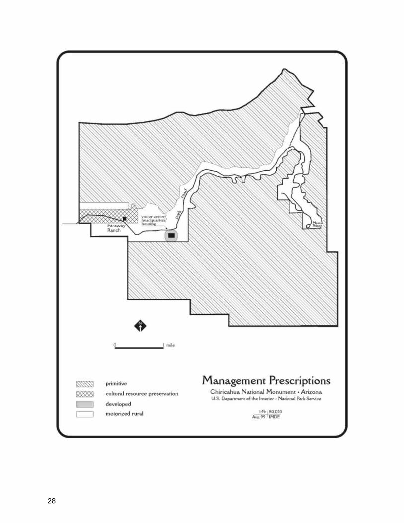
28

29
campers to empty their holding tanks only at approved and legal dump stations, and directing them to the nearest ones.
Trails—Staff of the monument and national forest would jointly examine opportunities for connecting trails in order to provide hikers a better and more extensive choice of routes. This would also further disperse hikers in the backcountry. The dirt road to the King of Lead Mine would be converted to a trail if and when the property is added to the monument.
King of Lead Mine—The King of Lead Mine would be acquired, and the park boundary extended to include it. In the meantime, a sign would be installed at the mine property boundary warning hikers of the open mine, abandoned equipment, and so on. When the mine is acquired, it will be evaluated for historic significance. To protect visitors, the haul road would be closed to vehicular use, returned to a natural condition (except for a foot trail), and it would be administratively added to the surrounding wilderness area.
Sugarloaf—The parking area would be configured to add day-use amenities such as more picnic tables, group ramadas, and benches. These facilities would be provided in an attempt to shift some visitor use from the Echo Canyon and Massai Point parking areas. Limited vista clearing would also occur. The Sugarloaf road, overlook, trail, and fire tower would remain unchanged.
Echo Canyon Parking and Trailhead—Under the proposal, the parking lot would be reconfigured to alleviate peak parking problems. Limited vista clearing would also occur.
Massai Point—Under existing plans, the capacity of the summit parking area would be increased, but not its area, and vehicular flow would be improved. Trailheads would be made safer, and a new rest room would be installed. Vegetation around the parking area would be thinned and pruned to restore the views. Directional and informative signs would be installed. All
improvements would be done in such a way as to be compatible with the significant CCC landscape elements (to be determined by the cultural landscape inventory).
The small exhibit building, which occupies one of the best viewpoints in the monument, would continue to be used as an exhibit and interpretation facility. The exhibits would be modernized and would conform to an interpretive plan that is to be written for the summit area. A small outdoor sitting area and interpretive space would be built close to the building, and the summit would be made handicapped accessible from the parking area.
Wilderness—Except for the previously mentioned King of Lead haul road, the rehabilitation of the existing boneyard and firearms training range, and very minor trail realignments, no changes would be made to the wilderness area. A theme of the park interpretation program would be to inform people about what wilderness is, what its values are, and what is considered appropriate use for wilderness.
Potential Boundary Changes—The proposed headquarters/visitor orientation facility would be located at a place along route 181 yet to be selected. If a location contiguous with the park is selected, the park boundary could be extended to enclose it. If it is not contiguous, or very nearly so, the land could be leased or purchased by GSA but not included within the park boundary.
Fire Program—The fire program is growing, with more acreage being treated by prescribed burning in 1998 than ever in the past. The park has established a fire management officer position that will be filled in 1999, and it has begun a joint planning process with USFS for mutual burning and suppression activities on each other‘s lands. Implementing the proposed GMP would improve staff‘s ability to operate the program mainly by reducing development, structures, operations, and traffic inside the boundaries. A new headquarters/visitor orientation facility

30
located outside the park would put much of the staff, their vehicles, park files and exhibits, maintenance equipment, and so on in a safer place, for wildland fire considerations. The new facility would be built in an area with grassy fuels, which is in sharp contrast to the dense shrub and tree cover now surrounding the visitor center, administrative site, and housing.
The dead end road is a concern because the park has very few fire safety zones. Clearing roadsides and improving the park road would reduce travel time for fire fighters and would aid in using fire-fighting equipment as well as moving visitors and employees away from fire danger. Parking lots can be used as fire safety zones if absolutely necessary, so work to clear brush and improve traffic flow is critical. The campground, with its location and access on a narrow one-way, dead end road, is another fire danger concern. Because the campground would not be enlarged, staff could work with the current setup and continue to improve the situation by creating fire safety zones, reducing fuels, and clearing roadsides.
Upgrading the water system would improve fire suppression capabilities for structures, especially historic buildings. Improving accessibility would also help in evacuating visitors from buildings, if necessary.
An ongoing vegetation investigation is showing historically less dense vegetation with more varied composition and structure. Fire would be used to restore historic vegetation conditions. Cultural landscape studies could include prescribed fire as a tool. Because most cultural landscapes in the park would include historic structures, fuel treatment would reduce hazards and enhance suppression efforts.
The joint planning with USFS would support using fire in the wilderness. Additionally, focusing park interpretation on wilderness, including natural processes such as fire and flooding, would lead to better public understanding and acceptance.
Commercial Services—Commercial horseback, hiking, and tour bus services originating outside the park would continue. The park would encourage others, including private business and USFS, to provide recreation vehicle and tent campground and camping supply stores outside the park.
Other activities could be added if they enhance the visitor experience, are appropriate for the park, and are consistent with resource protection prescriptions. Some of these activities might include bicycle tours and shuttle services to alleviate crowding and prevent traffic jams.
Activities would be evaluated primarily on the need for protection of resources, goals established for the visitor experience, and the need to reduce crowding and visitor conflicts. When problems are identified, the park would conduct feasibility studies to determine if proposed activities are necessary and practical and then determine the best way to provide the services.
Water System—The three separate water systems that serve the visitor center, employee housing, and campground do not meet public health standards. They would be replaced or modified as needed.
Operational Costs—Operational costs total $233,500 and are broken down in Table 1.
Development Costs—Development costs total $5,881,000 and are broken down in Table 2.
ALTERNATIVE B
This alternative provides for a traditional park experience with increased personal services and a small number of facility enhancements. With the exceptions described below, the
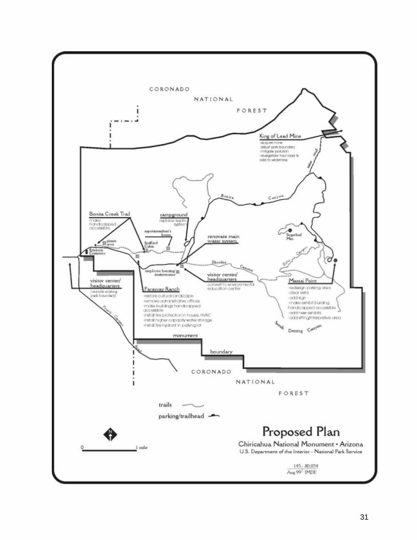
31
32
current level of development and interpretation and the pattern of visitor use is appropriate for Chiricahua and would be maintained. The application of management prescriptions would be exactly the same as under the proposal.
Park Road—Under this alternative, the historic significance and character of the road would be protected, but alignment could be selectively altered. Most of the road‘s special character would be maintained, but more alterations of the vegetation would be likely. Some minor enlargements and realignments could occur.
Bonita Picnic Area—This area would be treated the same as it would be under the Proposal.
Faraway Ranch—Treatments would be the same as under the proposal except that the focus of efforts would be centered on the historic structures. There would be little to no modification of the landscape.
Overhead power and telephone lines would be removed and installed underground in the immediate vicinity of the structures.
The trail along Bonita Creek, from the picnic area to Stafford Cabin, would be accessible for visitors with mobility impairments.
There would be limited access to selected buildings by the public. Some administrative functions would continue in the area. Climate control would be used to protect the historic furnishings. A fire suppression system would be used to protect the house and contents.
The water system would connect to the main visitor center/housing area. A standpipe would be installed near the parking lot for wildfire suppression, and the water system would extended to the ranch parking area. The two-way trail would be enlarged into a loop trail.
Headquarters and Visitor Orientation Facility—Under this alternative, administrative facilities would only be built outside the park and no new visitor
orientation facility would be constructed. There would be no further development in the park and no additional services for RVs.
Short-term lease or rent space for administrative services would be explored in Willcox, and a joint support function would be considered with the U.S. Forest Service.
Visitor Transportation System—Options under this alternative are the same as for the proposal.
Housing/Maintenance Area—Under this alternative there would be no changes in current operation except that
1) all housing units would be retained in present use;
2) the superintendent‘s house eventually would be removed and the site returned to a natural condition and
3) the need for in-park housing and potential for providing housing outside the park would both be considered.
Boneyard—The boneyard and firearms training range impinges on the wilderness area. These inappropriate uses would be ended, and the areas would be restored to a natural appearance.
Campground—Treatment for this area would be the same as described under the proposal.
Trails—Treatment of trails would be the same as described for the proposal.
King of Lead Mine—Treatment of the mine would be the same as it would be under the proposal.
Sugarloaf—Under this alternative there would be no change.
Echo Canyon Parking and Trailhead—Under this alternative there would be no change.
Massai Point—Treatment of the area would be the same as described under the proposal.
33
Wilderness— Treatment of wilderness would be the same as described for the proposal.
Potential Boundary Changes—Under this alternative there would be no changes to park boundaries.
Fire Program—The fire program would be the same as described under the proposal, except that no improvements through reductions of development would take place. Facilities outside the park would be confined to administrative functions with little or no support to the fire program.
Commercial Services—Commercial services would be the same as for the proposal.
Water System—Water systems would be upgraded to meet public health standards.
Operational Costs—Operational costs total $186,500 and are broken down in Table 1.
Development Costs—Development costs total $3,681,000 and are broken down in Table 2.
NO-ACTION ALTERNATIVE
All environmental documents are required to analyze at least two alternatives, a proposal and a no-action alternative. Under the no-action alternative, existing conditions as described below would continue at Chiricahua NM.
Park Road—With possible minor exceptions for safety, the existing width and alignment of the road would be permanently retained. Pullouts, trailheads, and parking areas along the road would not be enlarged.
Bonita Picnic Area—Existing development would be retained.
Faraway Ranch—The only landscape treatment would be continued maintenance and fire protection. The fences, corrals, and outbuildings would not be restored to their historic appearance, and buildings would not be made accessible. In the absence of a new headquarters/visitor orientation facility,
administrative functions would remain in the ranch buildings. Lacking the proposed connection of the ranch to the main park water system, the ranch house and its contents would remain at risk of fire. The collections in the house would remain unprotected by a climate control system. Visitors would continue to approach and leave the main buildings by the existing two-way trail.
Visitor Center—In the absence of a new headquarters/visitor orientation facility, the existing conditions of crowded working conditions, inadequate parking, and inadequate interpretive space would continue.
Housing/Maintenance Area—Maintenance activities would remain in the present location, so that space would not be available for other uses. The housing area would be the same as described under the proposal.
Boneyard—This inconsistent use of the wilderness area would remain.
Campground—The existing campground would be retained, and the septic system would not be replaced.
Trails—Existing trails would be retained in the no-action alternative.
King of Lead Mine—No further steps would be taken with the state and the mine owner to mitigate the mine pollution and to acquire the property. The haul road would not be added to the surrounding wilderness. A warning sign would be erected.
Sugarloaf—The Sugarloaf road, overlook area, trail, and fire tower would remain unchanged.
Echo Canyon Parking and Trailhead—The overlook, parking, and trailhead area would remain unchanged.
Massai Point—Under existing plans, the capacity (but not the area) of the summit parking area would be increased and vehicular flow would be improved. Trailheads would be made safer, and a new
34
rest room would be installed. Vegetation around the parking area would be thinned and pruned to restore the views. Directional and informative signs would be installed.
The small exhibit building, which occupies one of the best viewpoints in the monument, would continue to be used as an exhibit and interpretation facility. The exhibits would be modernized to conform to an interpretive plan to be written for the summit area. A small outdoor sitting area and interpretive space would be built close to the building, and the summit would be made handicapped accessible from the parking area.
Wilderness Area—There would be no changes in the wilderness area.
Potential Boundary Changes—There would be no changes in the park‘s boundary.
Fire Program—Some of the fire program would be the same in this alternative as with the proposal. The fire management officer position would be filled, and the park would continue joint planning with USFS. Acreage burned would increase to reduce fuels and to restore fire as an ecosystem process.
The difference is that fire hazards and safety risks would be higher for people and structures despite fire planning for suppression. Facilities, housing, campgrounds, traffic flows, and so on would remain in the current state, which hinders fire management operations. Roads and parking lots would not be cleared or improved, which increases the risk of entrapment and delays response time for fire fighters and equipment. Inadequate water systems do not provide for suppression capabilities for historic structures or other facilities. Cultural landscape information would not be available for restoring historic scenes. Lack of interpretation focus on wilderness would affect public understanding and appreciation of natural forces, such as fire and flooding, as well as of land-use ethics.
Commercial Services—Commercial horseback, hiking, and tour bus services originating outside the park would continue.
Water System—The three separate water systems that serve the visitor center, employee housing, and campground do not meet public health standards. They would be replaced or modified as needed.
Operational Costs—Costs are already reflected in the park‘s annual operating budget.
Development Costs— There are no development costs associated with this alternative.
ALTERNATIVES CONSIDERED BUT REJECTED
Visitor Center
Enlarge Existing Structure—The building could possibly be enlarged to provide the necessary space, but the parking area—whose small size is one of the major problems already—cannot be enlarged without great damage to Rhyolite Canyon Creek and the surrounding natural area. Therefore, the existing location cannot serve the increasing need for visitor center and headquarters space.
Joint NPS-FS Visitor Center—Consideration was given to a visitor center jointly built and run by the NPS and USFS. Because the primary Coronado National Forest activity would remain on the east side of the mountains, the needs of the USFS could be met by having some space in the NPS facility to present Coronado NF information.
Coronado National Forest Location—A location on the national forest for the visitor center was considered, but potential sites in Pinery Canyon were poorly located for arriving visitors.
Camping at the New Visitor Center—Consideration was given to the idea of additional development at the proposed visitor center, such as camping. Although
35
camping at the monument is an attractive and desirable experience for visitors, the development and management of additional camping outside the current monument boundary by NPS is not a part of the legislative purpose of the monument. Therefore, the only function that NPS would have outside the park is the headquarters/ visitor orientation facility itself. It was felt that private business could better provide any camping opportunities.
Retain Administrative Use of Existing Structure—Thought was given to keeping some of the administrative offices in the existing visitor center, but the primary goal is to end the inefficient separation of the staff in more than one location.
Willcox Location—Another consideration was to move most administrative offices and staff to rented offices in Willcox, but, except for a possible short-term emergency need, this alternative was discarded on the basis of impracticality and inefficiency.
Build New Visitor Center Inside Park—A guiding principle for this GMP is that no additional park land would be used for development. Even if this weren‘t the case, because of the extent of the Faraway historic district, the sensitive and scenic character of the lower Bonita Creek, and the extent of the 100-year floodplain, there is no practical location between the park entrance and the existing visitor center for a new visitor center.
Campground
Enlarge Campground—Two of the campground‘s most popular qualities are its small size and its rustic, natural surroundings. Both of these qualities would be sacrificed if the facility were to be enlarged.
Convert to Picnic Area—The idea of converting the campground to a picnic area was rejected because camping is accepted
as an important part of many visitors‘ experience in the park.
Close the Campground—The team considered closing the campground because of the recognized flood potential. Flooding in Bonita Canyon is likely only under two conditions: after a series of storms has thoroughly saturated the watershed and another storm then triggers a flood; or during a prolonged storm that does the same thing. In either case the park would be forewarned and be able to take protective action. The park plans to continue operating the existing 25-site campground in the floodplain with selective closure options described in an operational plan that significantly lowers the threat to human life and property within the campground area. A campground operating plan would be prepared by NPS to keep park staff and visitors aware of the flooding risk and potential.
Campground in Pinery Canyon—It was suggested that land be acquired in Pinery Canyon for an NPS campground. If it is determined that there is a need for a campground outside the park, either the national forest or a private business would be better able to provide it.
Widen Road and Increase Parking
The road is a historic structure (built by the CCC) and also has a special esthetic appeal to visitors. Any redesign of the road, or the construction of more parking spaces along it, would not only change its character but would cause considerable physical damage to the adjacent roadsides. Rather than alter one of the most distinctive features of the park, transportation and parking problems should be solved by other means, such as limiting the size and/or number of vehicles and establishing a shuttle system.
Table 1—Operating Expenses
Staffing 7 day/wk coverage of headquarters/visitor orientation
facility or administrative facility

36
Description Alternative A Alternative B
2 FTE GS-9 ranger interpretive emphasis
0 $96,000
1 FTE GS-9 ranger $48,000 0
2 FTE GS-5 visitor use assistant
$70,000 0
1 FTE WG-5 custodian $35,000 0
.5 FTE WG-5 custodian $17,500 $17,500
Other Expenses
Utilities $12,000 $6,000
Vehicle $ 6,000 $12,000
Interpretive material $10,000 $20,000
Supplies and materials $15,000 $15,000
Travel and training $ 5,000 $ 5,000
Equipment $15,000 $15,000
Total Annual $233,500 $186,500
Table 2—Development Cost Estimates
Description Alternative A Alternative B
Headquarters/visitor orientation facility
$3,510,000
Administrative Facility $1, 750,000
Climate control (HVAC) Faraway Ranch house
$140,000 $140,000
Replace campground septic system
$65,000 $65,000
Close King of Lead Mine road
$20,000 $20,000
Replace main water system
$910,000 $910,000
Connect ranch to main water system
$60,000 $60,000
Subtotal gross construction cost
$4,705,000 $2,945,000
Project planning & advanced planning
$1,176,000 $736,000
Total Costs $5,881,000 $3,681,000

37