draft for 4/04/2011 wyoming game and fish …
TRANSCRIPT
2-1
DRAFT FOR 4/04/2011 WYOMING GAME AND FISH COMMISSION
CHAPTER 2
GENERAL HUNTING REGULATION
Section 1. Authority. This regulation is promulgated by authority of W.S. §23-1-103, §23-1-302, §23-1-703, §23-2-101, §23-3-104, §23-3-111, §23-3-304, §23-3-305, §23-3-306 and §23-3-308. Section 2. Definitions. For the purpose of this regulation, definitions shall be as set forth in Title 23, Wyoming Statutes, and the Commission also adopts the following definitions: (a) “Antlered” means a deer, elk, or moose that has visible antler growth plainly protruding from the skull. Where a minimum number of antler points are specified, points shall be counted on the side with the greater number of points. (b) “Antlerless” means a deer, elk, or moose that has no antler growth plainly protruding from the skull. Females and young-of-the-year without visible antlers are antlerless big game animals. (c) “Approved lLandfill” means a municipal or county landfill permitted by the State of Wyoming Department of Environmental Quality Solid Waste Rules and Regulations, Chapter 2 revised as of October 15, 1998, which does not include any later amendments or additions of the incorporated matter. (d) “Artificial Light” means any man-made light or lighting device which projects a light visible to the unaided eye outside of the device, or any battery-powered device that provides an enhanced ability to see in the dark. (e) “Bag Limit” means the maximum number of big game or trophy game animals that may be taken by an individual possessing a proper license. (f) “Bow and aArrow” means a longbow, recurve bow, compound bow or crossbow. (g) “Buck Antelope” means male antelope with visible horns and a dark cheek patch at the base of the ear. (h) “Calf” means young-of-the-year elk or young-of-the-year moose. (i) “Cow” means an adult female elk or an adult female moose.
2-2
(j) “Doe” means an adult female antelope or adult female deer. (k) “Drainage” means all lands within the watershed of a named river or stream, including all tributaries and standing waters, which drain into that river or stream. (l) “Edible portion of big game animal” means the meat of the front quarters as far down as the knees, meat of the hindquarters as far down as the hocks, and the meat along the backbone between the neck and hindquarters including the loins and tenderloins, excluding meat on the ribs and neck. (m) “Ewe” means an adult female bighorn sheep. (n) “Fawn” means young-of-the-year antelope or young-of-the-year deer. (o) “Hunt Area” means the geographic boundaries within which a license shall be valid. (p) “Irrigated land” means agricultural lands that are supplied with supplemental water by ditches, pipes, flooding or spraying. (q) “Lamb” means a young-of-the-year bighorn sheep. (r) “Motorized vehicle” means any vehicle powered by an internal combustion or electric engine. (s) “Muzzle-loading firearm” means a muzzle-loading rifle having a barrel bore diameter of at least 40/100 of an inch and a charge of at least fifty (50) grains of black powder or equivalent; or a muzzle-loading specialty single shot handgun which has a barrel length of not less than ten (10) inches, a bore diameter of at least 45/100 of an inch and which propels a projectile of two hundred forty (240) grains at not less than five hundred (500) foot pounds at one hundred (100) yards. (t) “National Elk Refuge Permit” means a permit that allows a properly licensed elk hunter to access the National Elk Refuge to take an elk. (u) “Off National Forest” means lands other than those administered by the U.S. Forest Service. (v) “On National Forest” means lands administered by the U.S. Forest Service. (w) “Park Permit” means a permit issued by Grand Teton National Park that allows a properly licensed elk hunter to take an elk within Grand Teton National Park.
2-3
(x) “Point” means any protrusion from an antler one (1) inch or more in length. (y) “Private Land” means all fee title/deeded lands owned by a private individual, partnership, or corporation. (z) “Processor” means a custom meat processor licensed by the Wyoming Department of Agriculture. (aa) “Public Road or Highway” means any roadway that is open to vehicular travel by the public. The road surface, the area between the fences on a fenced public road or highway, and an area thirty (30) feet perpendicular to the edge of the road surface on an unfenced public road or highway shall be considered the public road or highway. Two-track trails on public lands are not public roads. (bb) “Ram” means a male bighorn sheep that is one (1) year or older. (cc) “Regular Hunting Seasons” mean seasons which delineate the dates and hunt areas for the taking of big game or trophy game animals with legal weapons in accordance with the license types and limitations as set forth in Section 3 of Chapters 5 (Antelope), 6 (Deer), 7 (Elk), 8 (Moose), 9 (Bighorn Sheep), 24 (Mountain Goat), Section 10 of Chapter 3 (Black Bear) and Section 4 of Chapter 42 (Mountain Lion) of the Commission Regulations. (dd) “Site of the Kill” means the location where the harvested animal died. (ee) “Special Archery Seasons” mean seasons that delineate the dates and hunt areas for the taking of big game or trophy game animals with legal archery equipment, in which a hunter with the proper hunting license and an archery license may hunt in addition to the regular hunting seasons in accordance with the limitations as set forth in Section 4 of Chapters 5 (Antelope), 6 (Deer), 7 (Elk), 8 (Moose), 9 (Bighorn Sheep) and 24 (Mountain Goat) and Section 11 of Chapter 3 (Black Bear). (ff) “Spike Elk” means an elk with antlers consisting of a single unbranched beam on both sides. (gg) “State Trust land” means lands administered by the Office of State Land and Investments. (hh) “Type” means a limitation on a license in a particular hunt area for the sex of animal, the species of animal, the length of the season, the type of weapon or a portion of the hunt area in which the license shall be valid.
2-4
(ii) “Waste” means to leave, abandon, or allow to spoil any edible portion of meat from a big game animal, game bird, game fish or small game animal. Section 3. Bag Limits and Numbers of Licenses. No person shall apply for or receive more than one (1) license for each big game species during any one (1) calendar year, except as otherwise provided in Commission Regulations. The maximum bag limit for big game animals and trophy game animals for any person with the proper licenses and permits shall not exceed the following number of animals: one (1) elk per license; one (1) moose per license; one (1) bighorn sheep per license; one (1) mountain goat per license; one (1) antelope per license; one (1) deer per license; one (1) black bear per license; one (1) mountain lion per license. Section 4 of this Chapter and Chapter 34, Depredation Prevention Hunting Seasons and other Commission regulations may provide for taking additional game animals with the proper licenses. Section 4. Issuance of Deer and Antelope Limited Quota Licenses, Reduced Price Doe/Fawn Licenses, Elk Limited Quota Licenses, and Reduced Price Cow/Calf Licenses. (a) For deer, no person shall apply for and receive more than one (1) full price deer license through the initial drawing. After the initial drawing is completed, any person may apply for and receive up to two (2) full priced deer licenses provided that at least one (1) license is a Limited Quota Type 3 any white-tailed deer license valid for Hhunt Aareas 10-16, 18, 22-24, 26, 34, 51, 55, 57, 59, 60, 62-66, 74-81, 88, 138-140, 142, 143 or 161. However, no person shall apply for and receive more than a total of two (2) deer licenses valid for the taking of antlered or any deer, of which not more than one (1) shall be valid for antlered or any mule deer. (b) For deer, any person may apply for and receive a maximum of two (2) limited quota reduced price doe/fawn deer licenses through the initial drawing. After the initial drawing is completed, any person may purchase up to four (4) limited quota reduced price doe/fawn deer licenses valid for hunt areas 1-6, 8-15, 17-24, 26, 27, 29, 30, 32, 33, 37, 39-42, 44, 45, 47, 49, 51, 65, 66, 88, 89, 120, 124, 127 or 164. However, no person shall apply for and receive more than a total of four (4) limited quota reduced price doe/fawn deer licenses. (b) For deer, any person may apply for and receive a maximum of two (2) limited quota reduced price doe/fawn deer licenses through the initial drawing. In Hunt Areas 1-6, 8-15, 17-23, 26, 32, 34, 37, 39-42, 44, 45, 47, 49, 51, 65, 66, 88, 92, 97, 109, 111, 112, 116, 118, 120-122, 124, 125, 127, 157, 164, 165, 170 or 171, after the initial drawing is completed, any person may purchase up to four (4) limited quota reduced price doe/fawn deer licenses. However, no person shall apply for and receive more than a total of four (4) limited quota reduced price doe/fawn deer licenses in these Hunt Areas. In Hunt Areas 24, 27, 29, 30 or 33 after the initial
2-5
drawing is completed, any person may purchase an unlimited number of limited quota reduced price doe/fawn deer licenses. (c) For antelope, no person shall apply for and receive more than one (1) full price antelope license through the initial drawing. After the initial drawing is completed, any person may apply for and receive up to two (2) full price antelope licenses. However, no person shall apply for and receive more than a total of two (2) full price antelope licenses. (d) For antelope, any person may apply for and receive a maximum of two (2) limited quota reduced price doe/fawn antelope licenses through the initial drawing. After the initial drawing is completed, any person may purchase up to four (4) limited quota reduced price doe/fawn antelope licenses. However, no person shall apply for and receive more than a total of four (4) limited quota reduced price doe/fawn antelope licenses. (e) For elk, no person shall receive more than a total of two (2) elk licenses in any one (1) calendar year. Any person may apply for and receive a maximum of one (1) general or limited quota full price elk license in a calendar year. Through the initial drawing period, any person may apply for and receive a maximum of one (1) reduced price cow/calf elk license. After the initial drawing period is completed, any person may receive up to two (2) reduced price cow/calf elk licenses. (f) For bighorn sheep, any person may apply for and receive a maximum of one (1) limited quota full price bighorn sheep license and one (1) limited quota reduced price ewe/lamb license. (g) It is a violation to apply for and receive more than the specified number of licenses allowed by Commission regulations. Section 5. Open Hours for Taking Big Game and Trophy Game Animals. Big game and trophy game animals may only be taken from one-half (1/2) hour before sunrise to one-half (1/2) hour after sunset. Section 6. Retention of Evidence to Identify Sex, Species and Horn or Antler Development of Big Game Animal Harvested. Any person who takes any big game animal in a hunt area where the taking of either sex, species, or antler or horn development is controlled or prohibited by regulation shall comply with this section while said animal is in transportation from the site of the kill to the residence of the person taking the animal, or delivered to a processor for processing. (a) In hunt areas where the taking of any big game animal is restricted to antler point or horn size by regulation, the antlers or horns shall accompany the animal as a whole, or edible portion thereof.
2-6
(b) In hunt areas where the taking of any big game animal is restricted to a specific sex of animal by regulation, either the visible external sex organs, head or antlers shall accompany the animal as a whole, or edible portion thereof. (c) In hunt areas where the taking of a species of deer is controlled or prohibited by regulation, either the head or the tail of the deer shall accompany the animal, or edible portion thereof as evidence of the species taken. Section 7. Dating and Display of Game Animal/Wild Turkey/Sandhill Crane Carcass Coupons. (a) When dating a carcass coupon, the entire day and month of the kill shall be completely cut out and removed. (b) The carcass coupon shall be attached to the carcass of any big game or wild turkey or the carcass or hide of any trophy game animal in such a manner as to be plainly visible. The carcass coupon shall be attached to the carcass of any sandhill crane taken in limited quota areas in such a manner as to be plainly visible. When the animal is in transportation, the carcass coupon may be carried by the person accompanying the carcass so that the coupon shall not be lost. While quarters or pieces of an animal are being packed from the field, the carcass coupon shall remain with the person transporting the animal. (c) Subsections 7 (a) and (b) shall be in addition to the requirements in W.S. §23-3-104. Section 8. Emergency Closure. Big game hunting seasons may be closed because of an emergency upon forty-eight (48) hours notice. Trophy game hunting seasons may be closed upon immediate notice. Section 9. Established Check Stations, Mandatory Reporting. Every hunter, angler, or trapper of furbearing animals shall stop and report at every check station on route to or from the hunting, fishing or trapping area regardless if the person has wildlife in possession. Upon request of any authorized Department representative, anyone who has been hunting, fishing, or trapping shall produce a valid license and conservation stamp, if required, and special management permit, if required, for game animals, game birds, furbearing animals or fish. Even if the game meat or fish in possession has been cut and wrapped or processed, the person transporting shall stop and report at the check station. Any person transporting wildlife harvested in another state or country shall stop at check stations on their route. (a) Check stations shall be signed and established at a point on a highway or road clearly visible at a distance of not less than two hundred (200) yards in either direction.
2-7
(b) Check stations shall be at a point where flashing warning lights shall be visible to oncoming traffic for a distance of not less than two hundred (200) yards. The emergency warning lights on a marked law enforcement vehicle or a yellow flashing light on a marked Department non-enforcement vehicle shall be in operation. (c) At least one (1) person working the check station shall be in Department uniform. Section 10. Placement of Name of Outfitter and Outfitter’s License Number on Back of License. Any big or trophy game hunter utilizing the services of an outfitter shall legibly print the name of the outfitter, the outfitter’s license number and the type of outfitter license on the back of the licensee’s big or trophy game license. Section 11. Archery Hunting. No person shall hunt big game or trophy game animals with bow and arrow during a special archery hunting season without first obtaining an archery license and the applicable hunting license. An archery license shall not be required in addition to a limited quota license to participate in a limited quota archery only season. Legal archery equipment and firearms may be used to hunt big game or trophy game animals during the regular hunting seasons as set forth in Commission regulations. Section 12. Use of Aircraft to Spot or Locate Wildlife. No person shall use any aircraft to aid in the taking of any Wyoming wildlife, except predatory animals, whether by spotting or locating the wildlife, communicating with any person attempting to take the wildlife, or by providing other aid to any person taking the wildlife within twenty-four (24) hours of being airborne. Nothing in this Section shall apply to commercial, commuter or other aircraft used for the sole purpose of passenger transport. Section 13. Retrieval of Edible Portions of Game Meat from the Field. The Department may require substantive proof from any person who fails to retrieve from the site of kill all edible portions of a big game animal as to why the edible portions were not removed from the field. Section 14. Baiting of Big Game Animals Prohibited except by Qualified Persons. Any legally blind person, person confined to a wheelchair or any person hunting with a license issued pursuant to W. S. §23-1-705 (j) may place a bait for big game or take a big game animal by the use of bait. Section 15. Transportation and Disposal of Deer, Elk and Moose Taken From Chronic Wasting Disease (CWD) Hunt Areas Within Wyoming. It shall be the purpose of this section to regulate the transportation and disposal of potentially CWD infected deer, elk and moose carcasses to areas outside of the hunt areas with CWD and potentially reduce the spread of the disease to other areas in and outside of Wyoming.
2-8
Hunters may obtain current CWD information on the Department’s website at http://gf.state.wy.us. (a) No deer, elk or moose taken or possessed from any hunt area shall be transported to any other hunt area within Wyoming or to any other state, province or country except as provided in this section. (b) Deer, elk and moose carcasses harvested from any hunt area in Wyoming may be transported within Wyoming to a camp, a private residence for processing, a taxidermist, a processor, or a CWD sample collection site in Wyoming, provided the head and all portions of the spinal column remain at the site of the kill or such parts are disposed of in any approved landfill in Wyoming. (c) Except as provided in subsection (b) of this section, only the following parts of any deer, elk or moose harvested from any hunt area in Wyoming may be transported to any other hunt area in Wyoming: edible portions with no part of the spinal column or head attached; cleaned hide without the head; skull plate or antlers that have been cleaned of all meat and brain tissue; teeth; or finished taxidermy mounts. (d) Only the following parts of any deer, elk or moose harvested from any hunt areas in Wyoming may be transported to other states, provinces or countries: edible portions with no part of the spinal column or head attached; cleaned hide without the head; skull plate or antlers that have been cleaned of all meat and brain tissue; teeth; or finished taxidermy mounts. Whole deer, elk and moose carcasses harvested from any area shall not be transported out of Wyoming. (e) Nothing in this section shall allow for the removal of evidence of sex or species required by Section 6 of this regulation. (f) Nothing in this section shall apply to the transportation or disposal of deer, elk and moose carcasses by any governmental agency or educational institution. Section 16. Importation or Transportation of Deer, Elk or Moose Taken From Identified CWD Areas Outside of Wyoming. (a) No deer, elk or moose taken from within any other state, province or country within areas designated by the appropriate jurisdictional agency as positive for CWD in either deer, elk or moose shall be imported into Wyoming except harvested deer, elk or moose carcasses may be imported or transported into Wyoming to a private residence for processing, to a taxidermist, to a processor or to a CWD sample collection site in Wyoming provided the head and all portions of the spinal column are disposed of in an approved landfill.
2-9
(b) Except as provided in subsection (a) of this Section, only the following parts of any deer, elk or moose harvested may be imported: edible portions with no part of the spinal column or head attached; cleaned hide without the head; skull plate or antlers cleaned of all meat and brain tissue; teeth; or finished taxidermy mounts that have been cleaned of all meat and brain tissue. Section 17. Savings Clause. If any provision of this regulation shall be held to be illegal or unconstitutional, such a ruling shall not affect other provisions of this regulation which can be given effect without the illegal or unconstitutional provision; and, to this end, the provisions of this regulation shall be severable. WYOMING GAME AND FISH COMMISSION By: Fred Lindzey, Ed Mignery, President Dated: April 27, 2011 April 22, 2010
5-1
DRAFT 04/21/2011 WYOMING GAME AND FISH COMMISSION
CHAPTER 5
ANTELOPE HUNTING SEASONS
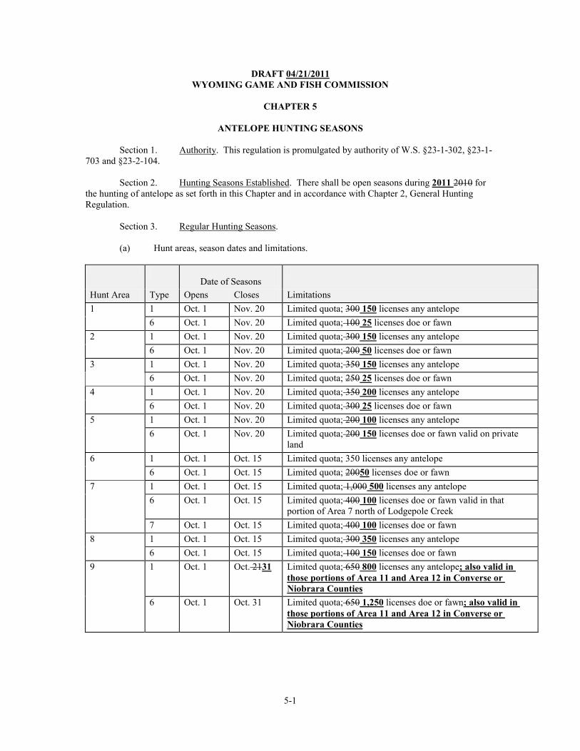
Section 1. Authority. This regulation is promulgated by authority of W.S. §23-1-302, §23-1-703 and §23-2-104. Section 2. Hunting Seasons Established. There shall be open seasons during 2011 2010 for the hunting of antelope as set forth in this Chapter and in accordance with Chapter 2, General Hunting Regulation. Section 3. Regular Hunting Seasons. (a) Hunt areas, season dates and limitations.
Date of Seasons
Hunt Area Type Opens Closes Limitations 1 1 Oct. 1 Nov. 20 Limited quota; 300 150 licenses any antelope 6 Oct. 1 Nov. 20 Limited quota; 100 25 licenses doe or fawn 2 1 Oct. 1 Nov. 20 Limited quota; 300 150 licenses any antelope 6 Oct. 1 Nov. 20 Limited quota; 200 50 licenses doe or fawn 3 1 Oct. 1 Nov. 20 Limited quota; 350 150 licenses any antelope 6 Oct. 1 Nov. 20 Limited quota; 250 25 licenses doe or fawn 4 1 Oct. 1 Nov. 20 Limited quota; 350 200 licenses any antelope 6 Oct. 1 Nov. 20 Limited quota; 300 25 licenses doe or fawn 5 1 Oct. 1 Nov. 20 Limited quota; 200 100 licenses any antelope 6 Oct. 1 Nov. 20 Limited quota; 200 150 licenses doe or fawn valid on private
land 6 1 Oct. 1 Oct. 15 Limited quota; 350 licenses any antelope 6 Oct. 1 Oct. 15 Limited quota; 20050 licenses doe or fawn 7 1 Oct. 1 Oct. 15 Limited quota; 1,000 500 licenses any antelope 6 Oct. 1 Oct. 15 Limited quota; 400 100 licenses doe or fawn valid in that
portion of Area 7 north of Lodgepole Creek 7 Oct. 1 Oct. 15 Limited quota; 400 100 licenses doe or fawn 8 1 Oct. 1 Oct. 15 Limited quota; 300 350 licenses any antelope 6 Oct. 1 Oct. 15 Limited quota; 100 150 licenses doe or fawn 9 1 Oct. 1 Oct. 2131 Limited quota; 650 800 licenses any antelope; also valid in
those portions of Area 11 and Area 12 in Converse or Niobrara Counties
6 Oct. 1 Oct. 31 Limited quota; 650 1,250 licenses doe or fawn; also valid in those portions of Area 11 and Area 12 in Converse or Niobrara Counties
5-2
Date of Seasons
Hunt Area Type Opens Closes Limitations 9, 11, 12 7 Oct. 1 Oct. 31 Limited quota; 400 licenses doe or fawn valid in Area 9 and
those portions of Area 11 and Area 12 in Converse or Niobrara counties
10 1 Oct. 1 Oct. 14 Limited quota; 350 licenses any antelope 6 Oct. 1 Nov. 30 Limited quota; 500 licenses doe or fawn 11 1 Oct. 1 Oct. 15 Limited quota; 200 licenses any antelope Oct. 16 Oct. 2131 Unused Area 11 Type 1 licenses valid in that portion of Area 11
in Niobrara County 6 Oct. 1 Oct. 15 Limited quota; 200 150 licenses doe or fawn Oct. 16 Oct. 31 Unused Area 11 Type 6 licenses valid in that portion of Area 11
in Niobrara County. 12 1 Oct. 1 Oct. 15 Limited quota; 200 licenses any antelope Oct. 16 Oct. 2131 Unused Area 12 Type 1 licenses valid in that portion of Area 12
in Converse or Niobrara counties 6 Oct. 1 Oct. 15 Limited quota; 150 100 licenses doe or fawn Oct. 16 Oct. 31 Unused Area 12 Type 6 licenses valid in that portion of Area 12
in Converse or Niobrara counties 15 1 Oct. 1 Oct. 14 Limited quota; 800 licenses any antelope 6 Oct. 1 Oct. 31 Limited quota; 800 licenses doe or fawn 16 1 Oct. 1 Oct. 14 Limited quota; 500 licenses any antelope 6 Oct. 1 Oct. 31 Limited quota; 400 licenses doe or fawn 17 1 Oct. 1 Oct. 31 Limited quota; 1,400 1,200 licenses any antelope 6 Oct. 1 Oct. 31 Limited quota; 600 400 licenses doe or fawn 18 1 Oct. 1 Oct. 20 Limited quota; 350 200 licenses any antelope 19 1 Oct. 1 Oct. 20 Limited quota; 500 300 licenses any antelope 18, 19 6 Oct. 1 Oct. 31 Limited quota; 300 150 licenses doe or fawn valid on private
land 20 1 Oct. 15 Nov. 15 Limited quota; 800 licenses any antelope 6 Oct. 15 Nov. 15 Limited quota; 700 licenses doe or fawn 21 1 Oct. 15 Oct. 31 Limited quota; 650 700 licenses any antelope 6 Oct. 15 Oct. 31 Limited quota; 600 650 licenses doe or fawn Nov. 1 Nov. 15 Unused Area 21 Type 6 licenses valid on private land 22 1 Oct. 1 Oct. 31 Limited quota; 800 licenses any antelope 6 Sept. 1 Sept. 30 Limited quota; 600 700 licenses doe or fawn valid on private
land in that portion of Area 22 in the Bull Creek drainage north of Crazy Woman Creek
Oct. 1 Oct. 31 Unused Area 22 Type 6 licenses valid in the entire area 23 1 Oct. 1 Oct. 31 Limited quota; 2,000 licenses any antelope 6 Oct. 1 Oct. 31 Limited quota; 1,500 licenses doe or fawn
5-3
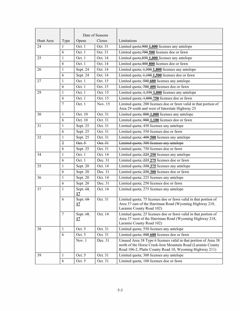
Date of Seasons
Hunt Area Type Opens Closes Limitations 24 1 Oct. 1 Oct. 31 Limited quota;900 1,000 licenses any antelope 6 Oct. 1 Oct. 31 Limited quota;700 500 licenses doe or fawn 25 1 Oct. 1 Oct. 14 Limited quota;850 1,000 licenses any antelope 6 Oct. 1 Oct. 14 Limited quota;400 800 licenses doe or fawn 26 1 Sept. 24 Oct. 14 Limited quota; 1,500 1,800 licenses any antelope 6 Sept. 24 Oct. 14 Limited quota; 1,100 1,500 licenses doe or fawn 27 1 Oct. 1 Oct. 15 Limited quota; 500 600 licenses any antelope 6 Oct. 1 Oct. 15 Limited quota; 700 400 licenses doe or fawn 29 1 Oct. 1 Oct. 15 Limited quota; 1,350 1,000 licenses any antelope 6 Oct. 1 Oct. 15 Limited quota; 1,000 750 licenses doe or fawn 7 Oct. 1 Nov. 15 Limited quota; 200 licenses doe or fawn valid in that portion of
Area 29 south and west of Interstate Highway 25 30 1 Oct. 10 Oct. 31 Limited quota; 800 1,000 licenses any antelope 6 Oct. 10 Oct. 31 Limited quota; 900 1,100 licenses doe or fawn 31 1 Sept. 25 Oct. 31 Limited quota; 450 licenses any antelope 6 Sept. 25 Oct. 31 Limited quota; 550 licenses doe or fawn 32 1 Sept. 25 Oct. 31 Limited quota; 400 500 licenses any antelope 2 Oct. 5 Oct. 31 Limited quota; 300 licenses any antelope 6 Sept. 25 Oct. 31 Limited quota; 750 licenses doe or fawn 34 1 Oct. 1 Oct. 14 Limited quota; 225 250 licenses any antelope 6 Oct. 1 Dec. 31 Limited quota; 225 275 licenses doe or fawn 35 1 Sept. 20 Oct. 14 Limited quota; 350 375 licenses any antelope 6 Sept. 20 Dec. 31 Limited quota; 250 300 licenses doe or fawn 36 1 Sept. 20 Oct. 14 Limited quota; 225 licenses any antelope 6 Sept. 20 Dec. 31 Limited quota; 250 licenses doe or fawn 37 1 Sept. 18
17 Oct. 14 Limited quota; 275 licenses any antelope
6 Sept. 18 17
Oct. 31 Limited quota; 75 licenses doe or fawn valid in that portion of Area 37 east of the Harriman Road (Wyoming Highway 218, Laramie County Road 102)
7 Sept. 18 17
Oct. 14 Limited quota; 25 licenses doe or fawn valid in that portion of Area 37 west of the Harriman Road (Wyoming Highway 218, Laramie County Road 102)
38 1 Oct. 5 Oct. 31 Limited quota; 550 licenses any antelope 6 Oct. 5 Oct. 31 Limited quota; 500 600 licenses doe or fawn Nov. 1 Dec. 31 Unused Area 38 Type 6 licenses valid in that portion of Area 38
north of the Horse Creek-Iron Mountain Road (Laramie County Road 106-2, Platte County Road 10, Wyoming Highway 211)
39 1 Oct. 5 Oct. 31 Limited quota; 300 licenses any antelope 6 Oct. 5 Oct. 31 Limited quota; 100 licenses doe or fawn
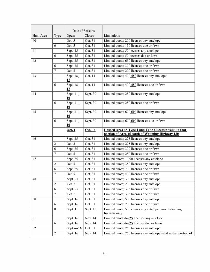
5-4
Date of Seasons
Hunt Area Type Opens Closes Limitations 40 1 Oct. 5 Oct. 31 Limited quota; 200 licenses any antelope 6 Oct. 5 Oct. 31 Limited quota; 150 licenses doe or fawn 41 1 Sept. 25 Oct. 31 Limited quota; 50 licenses any antelope 6 Sept. 25 Oct. 31 Limited quota; 50 licenses doe or fawn 42 1 Sept. 25 Oct. 31 Limited quota; 650 licenses any antelope 6 Sept. 25 Oct. 31 Limited quota; 300 licenses doe or fawn 7 Oct. 5 Oct. 31 Limited quota; 200 licenses doe or fawn 43 1 Sept. 18
17 Oct. 14 Limited quota; 400 450 licenses any antelope
6 Sept. 18 17
Oct. 14 Limited quota; 400 450 licenses doe or fawn
44 1 Sept. 11 10
Sept. 30 Limited quota; 250 licenses any antelope
6 Sept. 11 10
Sept. 30 Limited quota; 250 licenses doe or fawn
45 1 Sept..11 10
Sept. 30 Limited quota; 600 500 licenses any antelope
6 Sept. 11 10
Sept. 30 Limited quota; 600 500 licenses doe or fawn
Oct. 1 Oct. 14 Unused Area 45 Type 1 and Type 6 licenses valid in that portion of Area 45 south of Wyoming Highway 130
46 1 Sept. 25 Oct. 31 Limited quota; 225 licenses any antelope 2 Oct. 5 Oct. 31 Limited quota; 225 licenses any antelope 6 Sept. 25 Oct. 31 Limited quota; 300 licenses doe or fawn 7 Oct. 5 Oct. 31 Limited quota; 250 licenses doe or fawn 47 1 Sept. 25 Oct. 31 Limited quota; 1,000 licenses any antelope 2 Oct. 5 Oct. 31 Limited quota; 350 licenses any antelope 6 Sept. 25 Oct. 31 Limited quota; 700 licenses doe or fawn 7 Oct. 5 Oct. 31 Limited quota; 400 licenses doe or fawn 48 1 Sept. 25 Oct. 31 Limited quota; 300 licenses any antelope 2 Oct. 5 Oct. 31 Limited quota; 200 licenses any antelope 6 Sept. 25 Oct. 31 Limited quota; 375 licenses doe or fawn 7 Oct. 5 Oct. 31 Limited quota; 375 licenses doe or fawn 50 1 Sept. 16 Oct. 31 Limited quota; 500 licenses any antelope 6 Sept. 16 Oct. 31 Limited quota; 700 licenses doe or fawn 0 Sept. 1 Sept. 15 Limited quota; 50 licenses any antelope, muzzle-loading
firearms only 51 1 Sept. 16 Nov. 14 Limited quota; 50 25 licenses any antelope 6 Sept. 16 Nov. 14 Limited quota; 50 25 licenses doe or fawn 52 1 Sept. 2516 Oct. 31 Limited quota; 250 licenses any antelope 2 Sept. 16 Nov. 14 Limited quota; 250 licenses any antelope valid in that portion of
5-5
Area 52 south of North Spring Creek
Date of Seasons
Hunt Area Type Opens Closes Limitations 6 Sept.25 16 Oct. 31 Limited quota; 200 licenses doe or fawn 7 Sept. 16 Nov. 14 Limited quota; 300 licenses doe or fawn valid in that portion of
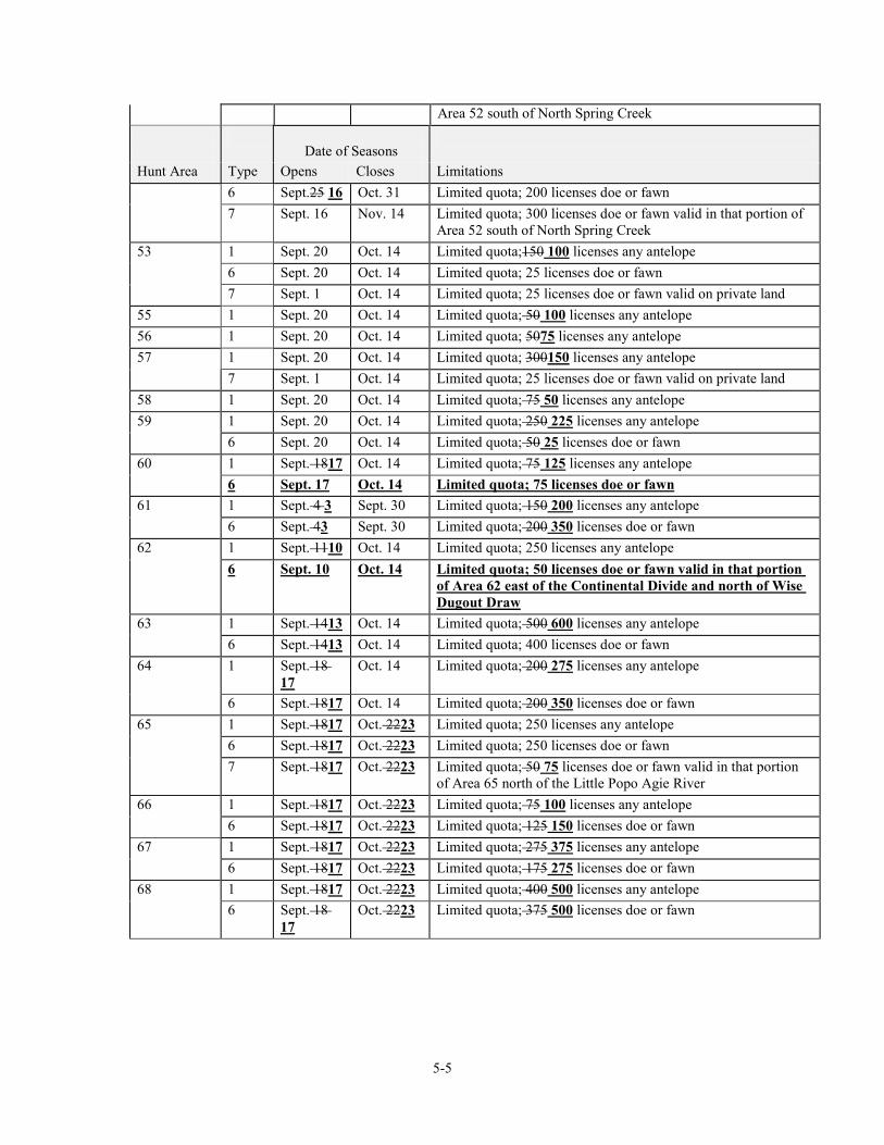
Area 52 south of North Spring Creek 53 1 Sept. 20 Oct. 14 Limited quota;150 100 licenses any antelope 6 Sept. 20 Oct. 14 Limited quota; 25 licenses doe or fawn 7 Sept. 1 Oct. 14 Limited quota; 25 licenses doe or fawn valid on private land 55 1 Sept. 20 Oct. 14 Limited quota; 50 100 licenses any antelope 56 1 Sept. 20 Oct. 14 Limited quota; 5075 licenses any antelope 57 1 Sept. 20 Oct. 14 Limited quota; 300150 licenses any antelope 7 Sept. 1 Oct. 14 Limited quota; 25 licenses doe or fawn valid on private land 58 1 Sept. 20 Oct. 14 Limited quota; 75 50 licenses any antelope 59 1 Sept. 20 Oct. 14 Limited quota; 250 225 licenses any antelope 6 Sept. 20 Oct. 14 Limited quota; 50 25 licenses doe or fawn 60 1 Sept. 1817 Oct. 14 Limited quota; 75 125 licenses any antelope 6 Sept. 17 Oct. 14 Limited quota; 75 licenses doe or fawn 61 1 Sept. 4 3 Sept. 30 Limited quota; 150 200 licenses any antelope 6 Sept. 43 Sept. 30 Limited quota; 200 350 licenses doe or fawn 62 1 Sept. 1110 Oct. 14 Limited quota; 250 licenses any antelope 6 Sept. 10 Oct. 14 Limited quota; 50 licenses doe or fawn valid in that portion
of Area 62 east of the Continental Divide and north of Wise Dugout Draw
63 1 Sept. 1413 Oct. 14 Limited quota; 500 600 licenses any antelope 6 Sept. 1413 Oct. 14 Limited quota; 400 licenses doe or fawn 64 1 Sept. 18
17 Oct. 14 Limited quota; 200 275 licenses any antelope
6 Sept. 1817 Oct. 14 Limited quota; 200 350 licenses doe or fawn 65 1 Sept. 1817 Oct. 2223 Limited quota; 250 licenses any antelope 6 Sept. 1817 Oct. 2223 Limited quota; 250 licenses doe or fawn 7 Sept. 1817 Oct. 2223 Limited quota; 50 75 licenses doe or fawn valid in that portion
of Area 65 north of the Little Popo Agie River 66 1 Sept. 1817 Oct. 2223 Limited quota; 75 100 licenses any antelope 6 Sept. 1817 Oct. 2223 Limited quota; 125 150 licenses doe or fawn 67 1 Sept. 1817 Oct. 2223 Limited quota; 275 375 licenses any antelope 6 Sept. 1817 Oct. 2223 Limited quota; 175 275 licenses doe or fawn 68 1 Sept. 1817 Oct. 2223 Limited quota; 400 500 licenses any antelope 6 Sept. 18
17 Oct. 2223 Limited quota; 375 500 licenses doe or fawn
5-6
Date of Seasons
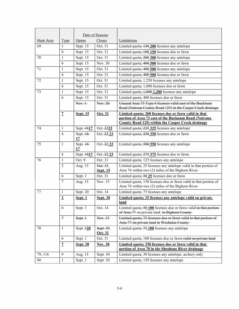
Hunt Area Type Opens Closes Limitations 69 1 Sept. 15 Oct. 31 Limited quota; 150 200 licenses any antelope 6 Sept. 15 Oct. 31 Limited quota; 100 150 licenses doe or fawn 70 1 Sept. 15 Oct. 31 Limited quota; 200 300 licenses any antelope 6 Sept. 15 Nov. 30 Limited quota; 400 500 licenses doe or fawn 71 1 Sept. 15 Oct. 31 Limited quota; 400 500 licenses any antelope 6 Sept. 15 Oct. 31 Limited quota; 400 500 licenses doe or fawn 72 1 Sept. 15 Oct. 31 Limited quota; 1,250 licenses any antelope 6 Sept. 15 Oct. 31 Limited quota; 1,000 licenses doe or fawn 73 1 Sept. 15 Oct. 31 Limited quota; 1,000 1,200 licenses any antelope 6 Sept. 15 Oct. 31 Limited quota; 400 licenses doe or fawn Nov. 1 Nov. 20 Unused Area 73 Type 6 licenses valid east of the Bucknum
Road (Natrona County Road 125) in the Casper Creek drainage 7 Sept. 15 Oct. 31 Limited quota; 200 licenses doe or fawn valid in that
portion of Area 73 east of the Bucknum Road (Natrona County Road 125) within the Casper Creek drainage
74 1 Sept. 1817 Oct. 2223 Limited quota; 225 325 licenses any antelope 6 Sept. 18
17 Oct. 22 23 Limited quota; 250 350 licenses doe or fawn
75 1 Sept. 18 17
Oct. 22 23 Limited quota; 500 550 licenses any antelope
6 Sept. 1817 Oct. 22 23 Limited quota; 275 375 licenses doe or fawn 76 1 Oct. 9 Oct. 31 Limited quota; 125 licenses any antelope 2 Aug. 15 Oct. 15
Sept. 15 Limited quota; 25 licenses any antelope valid in that portion of Area 76 within two (2) miles of the Bighorn River
6 Sept. 1 Oct. 31 Limited quota; 50 25 licenses doe or fawn 7 Aug. 15 Nov. 15 Limited quota; 150 licenses doe or fawn valid in that portion of
Area 76 within two (2) miles of the Bighorn River 77 1 Sept. 20 Oct. 14 Limited quota; 75 licenses any antelope 2 Sept. 1 Sept. 30 Limited quota; 25 licenses any antelope valid on private
land 6 Sept. 1 Oct. 14 Limited quota; 50 100 licenses doe or fawn valid in that portion
of Area 77 on private land in Bighorn County 7 Sept. 1 Nov. 15 Limited quota; 75 licenses doe or fawn valid in that portion of
Area 77 on private land in Washakie County 78 1 Sept. 120 Sept. 30
Oct. 31 Limited quota; 75 100 licenses any antelope
6 Sept. 1 Oct. 31 Limited quota; 100 licenses doe or fawn valid on private land 7 Sept. 20 Nov. 30 Limited quota; 250 licenses doe or fawn valid in that
portion of Area 78 in the Shoshone River drainage 79, 116 9 Aug. 15 Sept. 30 Limited quota; 30 licenses any antelope, archery only 80 1 Sept. 1 Sept. 30 Limited quota; 150 licenses any antelope
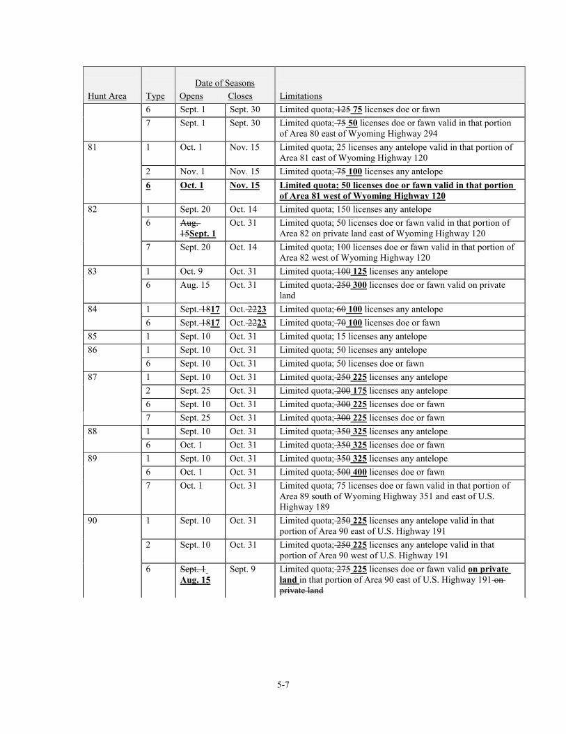
5-7
Date of Seasons
Hunt Area Type Opens Closes Limitations 6 Sept. 1 Sept. 30 Limited quota; 125 75 licenses doe or fawn 7 Sept. 1 Sept. 30 Limited quota; 75 50 licenses doe or fawn valid in that portion
of Area 80 east of Wyoming Highway 294 81 1 Oct. 1 Nov. 15 Limited quota; 25 licenses any antelope valid in that portion of
Area 81 east of Wyoming Highway 120 2 Nov. 1 Nov. 15 Limited quota; 75 100 licenses any antelope 6 Oct. 1 Nov. 15 Limited quota; 50 licenses doe or fawn valid in that portion
of Area 81 west of Wyoming Highway 120 82 1 Sept. 20 Oct. 14 Limited quota; 150 licenses any antelope 6 Aug.
15Sept. 1 Oct. 31 Limited quota; 50 licenses doe or fawn valid in that portion of
Area 82 on private land east of Wyoming Highway 120 7 Sept. 20 Oct. 14 Limited quota; 100 licenses doe or fawn valid in that portion of
Area 82 west of Wyoming Highway 120 83 1 Oct. 9 Oct. 31 Limited quota; 100 125 licenses any antelope 6 Aug. 15 Oct. 31 Limited quota; 250 300 licenses doe or fawn valid on private
land 84 1 Sept. 1817 Oct. 2223 Limited quota; 60 100 licenses any antelope 6 Sept. 1817 Oct. 2223 Limited quota; 70 100 licenses doe or fawn 85 1 Sept. 10 Oct. 31 Limited quota; 15 licenses any antelope 86 1 Sept. 10 Oct. 31 Limited quota; 50 licenses any antelope 6 Sept. 10 Oct. 31 Limited quota; 50 licenses doe or fawn 87 1 Sept. 10 Oct. 31 Limited quota; 250 225 licenses any antelope 2 Sept. 25 Oct. 31 Limited quota; 200 175 licenses any antelope 6 Sept. 10 Oct. 31 Limited quota; 300 225 licenses doe or fawn 7 Sept. 25 Oct. 31 Limited quota; 300 225 licenses doe or fawn 88 1 Sept. 10 Oct. 31 Limited quota; 350 325 licenses any antelope 6 Oct. 1 Oct. 31 Limited quota; 350 325 licenses doe or fawn 89 1 Sept. 10 Oct. 31 Limited quota; 350 325 licenses any antelope 6 Oct. 1 Oct. 31 Limited quota; 500 400 licenses doe or fawn 7 Oct. 1 Oct. 31 Limited quota; 75 licenses doe or fawn valid in that portion of
Area 89 south of Wyoming Highway 351 and east of U.S. Highway 189
90 1 Sept. 10 Oct. 31 Limited quota; 250 225 licenses any antelope valid in that portion of Area 90 east of U.S. Highway 191
2 Sept. 10 Oct. 31 Limited quota; 250 225 licenses any antelope valid in that portion of Area 90 west of U.S. Highway 191
6 Sept. 1 Aug. 15
Sept. 9 Limited quota; 275 225 licenses doe or fawn valid on private land in that portion of Area 90 east of U.S. Highway 191 on private land
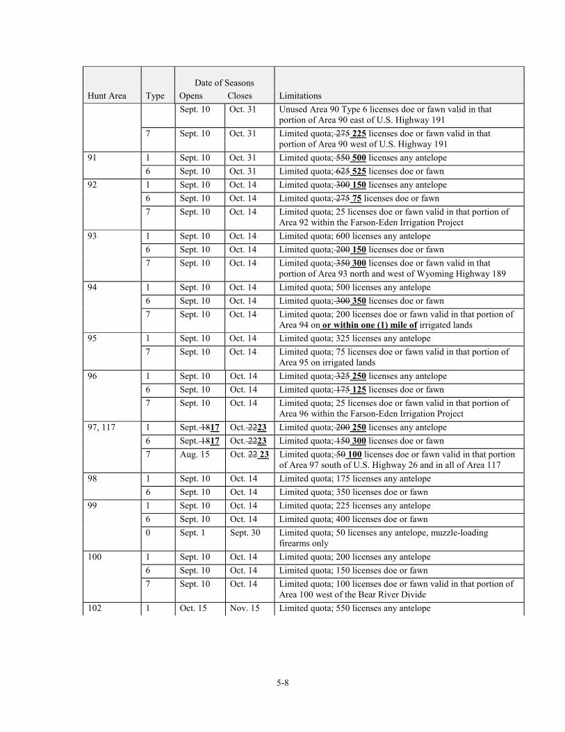
5-8
Date of Seasons
Hunt Area Type Opens Closes Limitations Sept. 10 Oct. 31 Unused Area 90 Type 6 licenses doe or fawn valid in that
portion of Area 90 east of U.S. Highway 191 7 Sept. 10 Oct. 31 Limited quota; 275 225 licenses doe or fawn valid in that
portion of Area 90 west of U.S. Highway 191 91 1 Sept. 10 Oct. 31 Limited quota; 550 500 licenses any antelope 6 Sept. 10 Oct. 31 Limited quota; 625 525 licenses doe or fawn 92 1 Sept. 10 Oct. 14 Limited quota; 300 150 licenses any antelope 6 Sept. 10 Oct. 14 Limited quota; 275 75 licenses doe or fawn 7 Sept. 10 Oct. 14 Limited quota; 25 licenses doe or fawn valid in that portion of
Area 92 within the Farson-Eden Irrigation Project 93 1 Sept. 10 Oct. 14 Limited quota; 600 licenses any antelope 6 Sept. 10 Oct. 14 Limited quota; 200 150 licenses doe or fawn 7 Sept. 10 Oct. 14 Limited quota; 350 300 licenses doe or fawn valid in that
portion of Area 93 north and west of Wyoming Highway 189 94 1 Sept. 10 Oct. 14 Limited quota; 500 licenses any antelope 6 Sept. 10 Oct. 14 Limited quota; 300 350 licenses doe or fawn 7 Sept. 10 Oct. 14 Limited quota; 200 licenses doe or fawn valid in that portion of
Area 94 on or within one (1) mile of irrigated lands 95 1 Sept. 10 Oct. 14 Limited quota; 325 licenses any antelope 7 Sept. 10 Oct. 14 Limited quota; 75 licenses doe or fawn valid in that portion of
Area 95 on irrigated lands 96 1 Sept. 10 Oct. 14 Limited quota; 325 250 licenses any antelope 6 Sept. 10 Oct. 14 Limited quota; 175 125 licenses doe or fawn 7 Sept. 10 Oct. 14 Limited quota; 25 licenses doe or fawn valid in that portion of
Area 96 within the Farson-Eden Irrigation Project 97, 117 1 Sept. 1817 Oct. 2223 Limited quota; 200 250 licenses any antelope 6 Sept. 1817 Oct. 2223 Limited quota; 150 300 licenses doe or fawn 7 Aug. 15 Oct. 22 23 Limited quota; 50 100 licenses doe or fawn valid in that portion
of Area 97 south of U.S. Highway 26 and in all of Area 117 98 1 Sept. 10 Oct. 14 Limited quota; 175 licenses any antelope 6 Sept. 10 Oct. 14 Limited quota; 350 licenses doe or fawn 99 1 Sept. 10 Oct. 14 Limited quota; 225 licenses any antelope 6 Sept. 10 Oct. 14 Limited quota; 400 licenses doe or fawn 0 Sept. 1 Sept. 30 Limited quota; 50 licenses any antelope, muzzle-loading
firearms only 100 1 Sept. 10 Oct. 14 Limited quota; 200 licenses any antelope 6 Sept. 10 Oct. 14 Limited quota; 150 licenses doe or fawn 7 Sept. 10 Oct. 14 Limited quota; 100 licenses doe or fawn valid in that portion of
Area 100 west of the Bear River Divide 102 1 Oct. 15 Nov. 15 Limited quota; 550 licenses any antelope
5-9
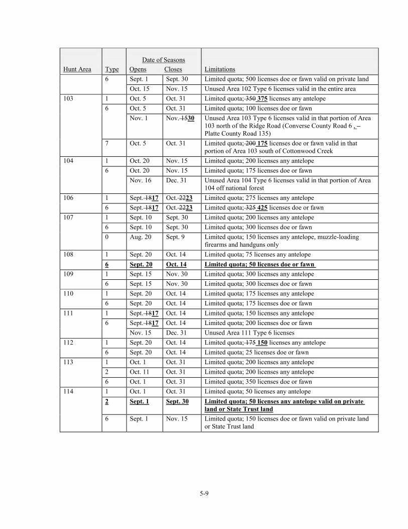
Date of Seasons
Hunt Area Type Opens Closes Limitations 6 Sept. 1 Sept. 30 Limited quota; 500 licenses doe or fawn valid on private land Oct. 15 Nov. 15 Unused Area 102 Type 6 licenses valid in the entire area 103 1 Oct. 5 Oct. 31 Limited quota; 350 375 licenses any antelope 6 Oct. 5 Oct. 31 Limited quota; 100 licenses doe or fawn Nov. 1 Nov. 1530 Unused Area 103 Type 6 licenses valid in that portion of Area
103 north of the Ridge Road (Converse County Road 6 , – Platte County Road 135)
7 Oct. 5 Oct. 31 Limited quota; 200 175 licenses doe or fawn valid in that portion of Area 103 south of Cottonwood Creek
104 1 Oct. 20 Nov. 15 Limited quota; 200 licenses any antelope 6 Oct. 20 Nov. 15 Limited quota; 175 licenses doe or fawn Nov. 16 Dec. 31 Unused Area 104 Type 6 licenses valid in that portion of Area
104 off national forest 106 1 Sept. 1817 Oct. 2223 Limited quota; 275 licenses any antelope 6 Sept. 1817 Oct. 2223 Limited quota; 325 425 licenses doe or fawn 107 1 Sept. 10 Sept. 30 Limited quota; 200 licenses any antelope 6 Sept. 10 Sept. 30 Limited quota; 300 licenses doe or fawn 0 Aug. 20 Sept. 9 Limited quota; 150 licenses any antelope, muzzle-loading
firearms and handguns only 108 1 Sept. 20 Oct. 14 Limited quota; 75 licenses any antelope 6 Sept. 20 Oct. 14 Limited quota; 50 licenses doe or fawn 109 1 Sept. 15 Nov. 30 Limited quota; 300 licenses any antelope 6 Sept. 15 Nov. 30 Limited quota; 300 licenses doe or fawn 110 1 Sept. 20 Oct. 14 Limited quota; 175 licenses any antelope 6 Sept. 20 Oct. 14 Limited quota; 175 licenses doe or fawn 111 1 Sept. 1817 Oct. 14 Limited quota; 150 licenses any antelope 6 Sept. 1817 Oct. 14 Limited quota; 200 licenses doe or fawn Nov. 15 Dec. 31 Unused Area 111 Type 6 licenses 112 1 Sept. 20 Oct. 14 Limited quota; 175 150 licenses any antelope 6 Sept. 20 Oct. 14 Limited quota; 25 licenses doe or fawn 113 1 Oct. 1 Oct. 31 Limited quota; 200 licenses any antelope 2 Oct. 11 Oct. 31 Limited quota; 200 licenses any antelope 6 Oct. 1 Oct. 31 Limited quota; 350 licenses doe or fawn 114 1 Oct. 1 Oct. 31 Limited quota; 50 licenses any antelope 2 Sept. 1 Sept. 30 Limited quota; 50 licenses any antelope valid on private
land or State Trust land 6 Sept. 1 Nov. 15 Limited quota; 150 licenses doe or fawn valid on private land
or State Trust land
5-10
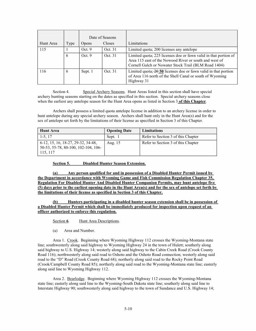
Date of Seasons
Hunt Area Type Opens Closes Limitations 115 1 Oct. 9 Oct. 31 Limited quota; 200 licenses any antelope 6 Oct. 9 Oct. 31 Limited quota; 225 licenses doe or fawn valid in that portion of
Area 115 east of the Nowood River or south and west of Cornell Gulch or Nowater Stock Trail (BLM Road 1404)
116 6 Sept. 1 Oct. 31 Limited quota; 20 50 licenses doe or fawn valid in that portion of Area 116 north of the Shell Canal or south of Wyoming Highway 31
Section 4. Special Archery Seasons. Hunt Areas listed in this section shall have special archery hunting seasons starting on the dates as specified in this section. Special archery seasons close when the earliest any antelope season for the Hunt Area opens as listed in Section 3 of this Chapter. Archers shall possess a limited quota antelope license in addition to an archery license in order to hunt antelope during any special archery season. Archers shall hunt only in the Hunt Area(s) and for the sex of antelope set forth by the limitations of their license as specified in Section 3 of this Chapter.
Hunt Area Opening Date Limitations 1-5, 17 Sept. 1 Refer to Section 3 of this Chapter 6-12, 15, 16, 18-27, 29-32, 34-48, 50-53, 55-78, 80-100, 102-104, 106-115, 117
Aug. 15 Refer to Section 3 of this Chapter
Section 5. Disabled Hunter Season Extension. (a) Any person qualified for and in possession of a Disabled Hunter Permit issued by the Department in accordance with Wyoming Game and Fish Commission Regulation Chapter 35, Regulation For Disabled Hunter And Disabled Hunter Companion Permits, may hunt antelope five (5) days prior to the earliest opening date in the Hunt Area(s) and for the sex of antelope set forth by the limitations of their license as specified in Section 3 of this Chapter. (b) Hunters participating in a disabled hunter season extension shall be in possession of a Disabled Hunter Permit which shall be immediately produced for inspection upon request of an officer authorized to enforce this regulation. Section 6. Hunt Area Descriptions. (a) Area and Number. Area 1. Crook. Beginning where Wyoming Highway 112 crosses the Wyoming-Montana state line; southwesterly along said highway to Wyoming Highway 24 in the town of Hulett; southerly along said highway to U.S. Highway 14; westerly along said highway to the Cabin Creek Road (Crook County Road 116); northwesterly along said road to Oshoto and the Oshoto Road connection; westerly along said road to the “D” Road (Crook County Road 68); northerly along said road to the Rocky Point Road (Crook/Campbell County Road 85); northerly along said road to the Wyoming-Montana state line; easterly along said line to Wyoming Highway 112. Area 2. Bearlodge. Beginning where Wyoming Highway 112 crosses the Wyoming-Montana state line; easterly along said line to the Wyoming-South Dakota state line; southerly along said line to Interstate Highway 90; southwesterly along said highway to the town of Sundance and U.S. Highway 14;
5-11
westerly and northerly along said highway to Wyoming Highway 24; northerly along said highway to Wyoming Highway 112 in the town of Hulett; northeasterly along said highway to the Wyoming-Montana state line. Area 3. Keyhole. Beginning where Interstate Highway 90 intersects U.S. Highway 14 in the town of Sundance; southerly and westerly along Interstate Highway 90 to its intersection with the "D" Road; northerly along said road to the Oshoto Road; easterly along said road to Oshoto and the Cabin Creek Road; southerly and easterly along the Cabin Creek Road to U.S. Highway 14; easterly and southerly along said highway to Interstate Highway 90 in the town of Sundance. Area 4. Arch Creek. Beginning in the town of Upton where U.S. Highway 16 intersects Wyoming Highway 116; westerly and northerly along U.S. Highway 16 to Interstate Highway 90 in the town of Moorcroft; easterly and northerly along said highway to U.S. Highway 14; easterly along said highway to Wyoming Highway 116; southerly and westerly along said highway to its junction with U.S. Highway 16 in the town of Upton. Area 5. Inyan Kara. Beginning where Interstate Highway 90 intersects the Wyoming-South Dakota state line; southerly along said line to U.S. Highway 16; northerly and westerly along said highway to Wyoming Highway 116 in the town of Upton; northerly and easterly along said highway to U.S. Highway 14; westerly along said highway to Interstate Highway 90; northerly and easterly along said highway to the Wyoming-South Dakota state line. Area 6. South Newcastle. Beginning where U.S. Highway 16 intersects the Wyoming-South Dakota state line; southerly along said line to the Dewey Road (Weston County Road 2); northwesterly along said road to U.S. Highway 85; southerly along said highway to Cheyenne River Road N. (Weston County Road 54); westerly along said road to the Lynch Road (Weston County Road 7A); northerly along said road to Wyoming Highway 450; northeasterly along said highway to U.S. Highway 16; southeasterly along said highway to the Wyoming-South Dakota state line. Area 7. South Upton. Beginning where Wyoming Highway 450 intersects U.S. Highway 16; southwesterly along Wyoming Highway 450 to the Keeline Road (USFS Road 930); northwesterly along said road to Black Thunder Creek; easterly down said creek to Bacon Creek; northerly up said creek to Newel Prong; northerly up said prong to the divide between the Cheyenne River and Belle Fourche River; northeasterly along said divide to the divide between Four Horse Creek and Raven Creek; northwesterly along said divide to the Belle Fourche River; northeasterly down said river to Interstate Highway 90; easterly along said highway to U.S. Highway 16; southeasterly along said highway to Wyoming Highway 450. Area 8. Niobrara. Beginning where the Boner Road (Niobrara County Road 18) crosses the Wyoming-South Dakota state line; westerly along said road to U.S. Highway 85; southerly along said highway to Wyoming Highway 270; westerly along said highway to Wyoming Highway 272; northerly along said highway to the North Lance Creek Road (Niobrara County Road 14); northerly and westerly along said road to the Niobrara-Converse county line and the Dull Center Road (Converse County Road 38); westerly along said road to the Clareton Road (Converse County Road 39); northerly along said road to the Niobrara-Weston county line and the Lynch Road (Weston County Road 7A); northerly along said road to the Cheyenne River Road (Weston County Road 54); easterly along said road to U.S. Highway 85; northerly along said highway to the Dewey Road (Weston County Road 2); easterly along said road to the Wyoming-South Dakota state line; southerly along said line to the Boner Road (Niobrara County Road 18). Area 9. Lance Creek. Beginning where U.S. Highway 20 crosses the Wyoming-Nebraska state line; westerly along said highway to the Twenty Mile Creek Road (Converse County Road 46) at Lost Springs; northerly along said road to the Manning Road (Converse County Road 53); easterly along said road to the Converse-Niobrara county line and the Twenty Mile Road (Niobrara County Road 23); easterly along said road to Wyoming Highway 271; easterly along said highway to the town of Lance Creek and
5-12
Wyoming Highway 270; northerly and easterly along said highway to U.S. Highway 85; northerly along said highway to the Boner Road (Niobrara County Road 18); easterly along said road to the Wyoming-South Dakota state line; southerly along said line to the Wyoming-Nebraska state line; southerly along said line to U.S. Highway 20. Area 10. Lake De Smet. Beginning at the junction of U.S. Highways 14 and 16 at Ucross; southerly along U.S. Highway 16 to Interstate Highway 90; northwesterly along said highway to U.S. Highway 14; southeasterly along said highway to U.S. Highway 16 at Ucross. Area 11. Rawhide Butte. Beginning where U.S. Highway 20 intersects the Wyoming-Nebraska state line; southerly along said line to the North Platte River; northwesterly up said river to U.S. Highway 26 at the town of Guernsey; easterly along said highway to Wyoming Highway 270; northerly along said highway to U.S. Highway 20; easterly along said highway to the Wyoming-Nebraska state line. Area 12. Meadowdale. Beginning where U.S. Highway 20 intersects Wyoming Highway 270; southerly along Wyoming Highway 270 to U.S. Highway 26; westerly along said highway to the North Platte River; northwesterly up said river to Glendo Dam; northerly along the eastern shore of Glendo Reservoir to the North Platte River; northwesterly up said river to Interstate Highway 25; northerly along said highway to U.S. Highway 20 at Orin Junction; easterly along said highway to Wyoming Highway 270. Area 15. Clearmont. Beginning where the Powder River crosses the Wyoming-Montana state line; southerly up said river to U.S. Highway 14; westerly along said highway to Interstate Highway 90; northwesterly along said highway to the Wyoming-Montana state line; easterly along said line to the Powder River. Area 16. Ucross. Beginning where U.S. Highway 14 crosses the Powder River; southerly up said river to Interstate Highway 90; northwesterly along said highway to U.S. Highway 16; northeasterly along said highway to U.S. Highway 14; easterly along said highway to the Powder River. Area 17. Gillette. Beginning where Wyoming Highway 59 crosses the Wyoming-Montana state line; southerly along said highway to U.S. Highway 14-16; southerly along said highway to Interstate Highway 90 west of the town of Gillette; westerly along said highway to the Powder River; northerly down said river to the Wyoming-Montana state line; easterly along said line to Wyoming Highway 59. Area 18. Rockypoint. Beginning where the Rocky Point Road crosses the Wyoming-Montana state line; southerly along said road to the “D” Road; southerly along said road to Cabin Creek; westerly up said creek to the Cabin-Mitchell Creek hydrographic divide; westerly along said divide to Mitchell Creek; westerly down said creek to the Spring Creek Road north of Adon; southerly and westerly along said road to the Cow Creek Road; westerly along said road to Wyoming Highway 59; northerly along said highway to the Wyoming-Montana state line; easterly along said line to the Rocky Point Road. Area 19. Rozet. Beginning where the "D" Road crosses Cabin Creek; southerly along said road to Interstate Highway 90; westerly along said highway to U.S. Highway 14-16 west of the city of Gillette; northerly along said highway to Wyoming Highway 59; northerly along said highway to the Cow Creek Road; easterly along said road to the Spring Creek Road north of Adon; northeasterly along said road to Mitchell Creek; easterly up said creek to the Mitchell Creek-Cabin Creek hydrographic divide; easterly along said divide to Cabin Creek; easterly down said creek to the "D" Road. Area 20. Upper Powder River. Beginning at the junction of the Trabing Road (Johnson County Road 13) and Interstate Highway 25; southerly along said highway to Wyoming Highway 191; westerly along said highway to Wyoming Highway 190; southerly along said highway to the town of Barnum and the Barnum Mountain Road; westerly along said road to the Hazelton Road (Washakie County Road 81-Johnson County Road 3); northerly along said road to the Gold Mine Road (USFS Road 452); northerly along said road to the Canyon Creek Road (USFS Road 25); northerly along said road to U.S. Highway 16;
5-13
easterly along said highway to the Crazy Woman Canyon Road (Johnson County Road 14); easterly along said road to Wyoming Highway 196; northerly along said highway to the Trabing Road (Johnson County Road 13); easterly along said road to Interstate Highway 25. Area 21. Middle Fork. Beginning at the town of Kaycee and Interstate Highway 25; southeasterly along said highway to the Midwest interchange and the Smoky Gap Road (Natrona County Road 115); westerly along said road to the Dead Horse Road (Natrona County Road 114); southwesterly along said road to the Wild Horse Trail (Natrona County Road 113); westerly along said road to the 33 Mile Road (Natrona County Road 110); northwesterly along said road to the Hazelton Road (Washakie County Road 81); northerly along said road to the Barnum Mountain Road; easterly along said road to the town of Barnum and Wyoming Highway 190; northeasterly along said highway to Wyoming Highway 191; easterly along said highway to Interstate Highway 25. Area 22. Crazy Woman. Beginning where Interstate Highway 90 crosses the Powder River; southerly up said river to Wyoming Highway 192; westerly along said highway to Interstate Highway 25; northerly along said highway to Interstate Highway 90; southeasterly along said highway to the Powder River. Area 23. Pumpkin Buttes. Beginning at the junction of U.S. Highway 14-16 and Wyoming Highway 59 at the city of Gillette; southerly along Wyoming Highway 59 to Wyoming Highway 387 at Reno Junction; southwesterly along Wyoming Highway 387 to Wyoming Highway 192; northwesterly along said highway to the Powder River at Sussex; northerly down said river to Interstate Highway 90; easterly along said highway to U.S. Highway 14-16 at the city of Gillette; easterly along said highway to Wyoming Highway 59. Area 24. Thunder Basin. Beginning where Interstate Highway 90 crosses the Belle Fourche River; southwesterly up said river to the divide between Four Horse Creek and Raven Creek; southeasterly along said divide to the divide between the Cheyenne River and Belle Fourche River Divide; southwesterly along said divide to Newel Prong; southerly down said prong to Bacon Creek; southerly down said creek to Black Thunder Creek; westerly up said creek to the Keeline Road (USFS Road 930); southeasterly along said road to Wyoming Highway 450; westerly along said highway to Wyoming Highway 59; northerly along said highway to Interstate Highway 90; easterly along said highway to the Belle Fourche River. Area 25. Ormsby. Beginning where Wyoming Highway 259 intersects Wyoming Highway 387 at the town of Midwest; northeasterly along Wyoming Highway 387 to the top of Pine Ridge; southerly along the top of Pine Ridge to Blue Hill and the head of the West Fork of Sand Creek; southeasterly down said creek to Sand Creek; southeasterly along said creek to the 55 Ranch Road (Converse County Road 23); southerly along said road to Wyoming Highway 95; southwesterly along said highway to the North Platte River; westerly up said river to Interstate Highway 25 in the city of Casper; northerly along said highway to Wyoming Highway 259; easterly along said highway to Wyoming Highway 387 at the town of Midwest. Area 26. Bear Creek. Beginning where Wyoming Highway 387 intersects Wyoming Highway 59 at Reno Junction; southerly along Wyoming Highway 59 to the North Platte River at the town of Douglas; westerly up said river to Wyoming Highway 95; northeasterly along said highway to the 55 Ranch Road (Converse County Road 23); northerly up said road to Sand Creek; northwesterly up said creek to the West Fork of Sand Creek; northwesterly up said creek to the top of Pine Ridge at Blue Hill; northerly along the top of Pine Ridge to Wyoming Highway 387; northeasterly along said highway to Wyoming Highway 59 at Reno Junction. Area 27. Bill. Beginning at the junction of Wyoming Highways 59 and 450; easterly along Wyoming Highway 450 to the Lynch Road (Weston County Road 7A); southerly along said road to the Weston-Converse county line and the Clareton Road (Converse County Road 39); southerly along said road to the Dull Center Road (Converse County Road 38); westerly along said road to the Rochelle Hills Road (U.S.F.S. Road 933); northerly along said road to the Cheyenne River; westerly up said river to its
5-14
confluence with Antelope Creek and the Dry Fork of the Cheyenne River; southwesterly up the Dry Fork of the Cheyenne River to Wyoming Highway 59; northerly along said highway to the junction of Wyoming Highways 59 and 450. Area 29. Shawnee. Beginning where Interstate Highway 25 crosses the North Platte River immediately south of Orin Junction; westerly and northerly up said river to Wyoming Highway 59 at the town of Douglas; northerly along said highway to the Dry Fork of the Cheyenne River; northeasterly down said fork to its confluence with Antelope Creek and the Cheyenne River; easterly down the Cheyenne River to the Rochelle Hills Road (USFS Road 933); southerly along said road to the Dull Center Road (Converse County Road 38); easterly along said road to the Converse-Niobrara county line and the North Lance Creek Road (Niobrara County Road 14); easterly and southerly along said road to Wyoming Highway 272; southerly along said highway to Wyoming Highway 270; southwesterly along said highway to the town of Lance Creek and Wyoming Highway 271; westerly along said highway to the Twenty Mile Road (Niobrara County Road 23); westerly along said road to the Converse-Niobrara County line and the Manning Road (Converse County Road 53); westerly along said road to the Twenty Mile Creek Road (Converse County Road 46); southerly along said road to U.S. Highway 18-20 at the town of Lost Springs; westerly along said highway to Interstate Highway 25 at Orin Junction; southerly along said highway to the North Platte River. Area 30. LaPrele. Beginning where Wyoming Highway 95 crosses the North Platte River at the town of Glenrock; easterly and southerly down said river to the Jackalope Warm Springs and the Esterbrook Highway (Wyoming Highway 94); southerly along said highway to the Esterbrook Road (Converse County Road 5); southerly along said road to the town of Esterbrook and USFS Road 633; easterly and southerly along said road to the divide between Soldier Creek and Horseshoe Creek; southerly along said divide to the divide between Horseshoe Creek and the North Laramie River; westerly and northerly along said divide to Blacktail Peak and the head of South Fork Creek tributary to LaBonte Creek; northerly down said creek to U.S.F.S. Road 658; westerly along said road to the Old Fort Fetterman Road (Converse County Road 16); northerly along said road to the divide between Corduroy Creek and Rocky Ford Creek; westerly along said divide to the divide between LaPrele Creek and the Little Medicine Bow River; westerly along said divide to the Converse-Albany county line; westerly along said line to the Little Medicine Road (Albany County Road 62); southwesterly along said road to USFS Road 660; northwesterly along said road to Curry Creek; northwesterly down said creek to Deer Creek; northerly down said creek to the Stephens Road (Converse County Road 20); northerly along said road to the Deer Creek Road (Converse County Road 19); northerly along said road to Wyoming Highway 95; northerly along said highway to the North Platte River. Area 31. Hat Six. Beginning where the Casper city limits intersect Wyoming Highway 251 (Casper Mountain Road); easterly and northerly along said city limits to the North Platte River; easterly down said river to Wyoming Highway 95 at the town of Glenrock; southerly along said highway to the Deer Creek Road (Converse County Road 19); southerly along said road to the Stephens Road (Converse County Road 20); southerly along said road to Deer Creek; southerly up said creek to Sawmill Creek; southerly and westerly up said creek to the top of Reno Hill and the divide between Soldier Creek and the West Fork of Deer Creek; westerly along said divide to the divide between the East Fork of Bates Creek and the West Fork of Deer Creek; westerly along said divide to the divide between Kerfoot Creek and the West Fork of Deer Creek; westerly along said divide to the divide between the West Fork of Deer Creek, Kerfoot Creek and Smith Creek; northerly and westerly along said divide to the head of Smith Creek; northerly across Muddy Mountain along the divide of Corral Creek and Otter Creek to the divide between Red Creek and the Clear Fork of Muddy Creek; northerly along said divide to the Circle Drive Road (Natrona County Road 505); northerly along said road to Wyoming Highway 251; northerly along said highway to the Casper city limits. Area 32. Bates Creek. Beginning where the Pathfinder Dam crosses the North Platte River; easterly and northerly down said river to the Casper city limits; southerly and easterly along said limits to Wyoming Highway 251 (Casper Mountain Road); southerly along said road to the Circle Drive Road
5-15
(Natrona County Road 505); southerly along said road to the divide between Red Creek and the Clear Fork of Muddy Creek; southerly along said divide to the divide between Corral Creek and Otter Creek; southerly across Muddy Mountain along said divide to the head of Smith Creek; southerly and easterly to the divide between Smith Creek, Kerfoot Creek and the West Fork of Deer Creek; easterly along said divide to the divide between Kerfoot Creek and the West Fork of Deer Creek; easterly along said divide to the divide between Spruce Creek and the West Fork of Deer Creek; easterly along said divide to the divide between the East Fork of Bates Creek and West Fork of Deer Creek; easterly along said divide to the divide between Soldier Creek and the West Fork of Deer Creek; easterly along said divide to Reno Hill and the head of Sawmill Creek; easterly and northerly down said creek to Deer Creek; southerly up said creek to Curry Creek; southeasterly up said creek to U.S.F.S. Road 660; westerly along said road to its termination at the Squaw Springs Trail Road; southwesterly along said road to the Bates Creek Road (Natrona County Road 402); southwesterly along said road to the Spring Creek Road; westerly along said road to the Lone Tree Road (BLM Road 3141); southerly along said road to the Shirley Ridge Road (Carbon County Road 2); southwesterly along said road to Wyoming Highway 77; southerly along said highway to the Chalk Mountain Road (BLM Road 3129); westerly and northerly along said road to the Dry Creek Road (Carbon County Road 103); northwesterly along said road to the south fork of Canyon Creek; westerly and northerly down said fork to Canyon Creek; westerly down said creek to the east shore of Pathfinder Reservoir; northeasterly along said east shore to the Pathfinder Dam and the North Platte River. Area 34. Rock Eagle. Beginning where Wyoming Highway 151 crosses the Wyoming-Nebraska state line; westerly along said highway to U.S. Highway 85 at Bear Mountain Station; northerly along said highway to Wyoming Highway 313; westerly along said highway to Interstate Highway 25; northerly along said highway to the Laramie River; northeasterly down said river to the North Platte River; southeasterly down said river to the Wyoming-Nebraska state line; south along said line to Wyoming Highway 151. Area 35. Horse Creek. Beginning at the town of Chugwater and Wyoming Highway 313; easterly along said highway to U.S. Highway 85; southwesterly along said highway to Interstate Highway 25; north along said highway to Wyoming Highway 313. Area 36. Burns. Beginning at the junction of Wyoming Highway 151 and the Wyoming-Nebraska state line; southerly along said line to Interstate Highway 80; westerly along said highway to Interstate Highway 25; northeasterly along said highway to U.S. Highway 85; easterly and northerly along said highway to Wyoming Highway 151; easterly along said highway to the Wyoming-Nebraska state line. Area 37. Harriman. Beginning at the city of Laramie and Interstate Highway 80; southeasterly along said highway to Interstate Highway 25 at the city of Cheyenne; southerly along said highway to the Wyoming-Colorado state line; west along said line to U.S. Highway 287; northerly along said highway to Interstate Highway 80. Area 38. Little Bear Creek. Beginning at the junction of Wyoming Highway 34 and Interstate Highway 25, near the city of Wheatland; southerly along said Interstate to Wyoming Highway 211, near the city of Cheyenne; northwesterly along said highway to the McLees Road (Laramie County Road 103-1); northwesterly along said road to the Bell Ranch Road; northwesterly along said road to the Sybille Road (Albany County Road 12); northeasterly along said road to Wyoming Highway 34; northeasterly along said highway to Interstate Highway 25. Area 39. Bluegrass. Beginning where U.S. Highway 30 crosses the Laramie River; south of the town of Bosler; northeasterly down said river to Interstate Highway 25; north of the city of Wheatland; southerly along said highway to Wyoming Highway 34; southwesterly along said highway to the Sybille Road (Albany County Road 12); southerly and westerly along said road to Wyoming Highway 34; southwesterly along said highway to U.S. Highway 30; northerly along said highway to the Laramie River.
5-16
Area 40. East Laramie. Beginning in the city of Laramie and U.S. Highway 30; northerly along said highway to Wyoming Highway 34; northeasterly along said highway to the Sybille Road (Albany County Road 12); easterly along said road to the Bell Ranch Road; easterly along said road to the McLees Road (Laramie County Road 103); southeasterly along said road to Wyoming Highway 211; southerly along said highway to the Fisher Canyon-Rogers Canyon Road (Laramie County Road 228-Albany County Road 17); westerly along said road to U.S. Highway 30. Area 41. Laramie Peak. Beginning where the Big Laramie River crosses the Dodge Ranch Road; northerly along said road to the Garrett Road (Albany County Road 713); northerly and westerly along said road to the Fetterman Road (Albany County Road 61); southerly along said road to the Mule Creek Road (Albany County Road 64); northwesterly along said road to Albany County Road 610; northerly along said road to Sheep Creek; northerly up said creek to the southern boundary of the Laramie Peak Division of the Medicine Bow National Forest; northwesterly along said boundary to the Albany-Converse county line; east along said line to LaPrele Creek; southerly up said creek to the divide between LaPrele Creek and the Little Medicine Bow River; easterly along said divide to the divide between Corduroy Creek and Rocky Ford Creek; easterly along said divide to the Fetterman Road (Albany County Road 61); southerly along said road to U.S.F.S. Road 658; easterly along said road to South Fork Creek, tributary to LaBonte Creek; southerly up said creek to the divide between Horseshoe Creek and the North Laramie River; southeasterly along said divide to the head of Friend Creek; southerly down said creek to Bear Creek; easterly down said creek to the North Laramie River; easterly down said river to the Cottonwood Park Road (Albany County Road 71); southerly down said road to its junction with the Palmer Canyon Road (Albany County Road 721); easterly along said road to Ashley Creek; southerly down said creek to Duck Creek; easterly down said creek to the Big Laramie River; southerly and westerly up said river to the Dodge Ranch Road. Area 42. Laramie Plains. Beginning at the junction of the Marshall Road (Albany County Road 610) and U.S. Highway 30 north of the town of Rock River; northeasterly along said road to the Mule Creek Road (Albany County Road 64); southerly along said road to the Fetterman Road (Albany County Road 61); northerly along said road to the Garrett Road (Albany County Road 713); southeasterly along said road to the Dodge Ranch Road; southerly along said road to the Big Laramie River; southwesterly up said river to U.S. Highway 30; northwesterly along said highway to the Marshall Road (Albany County Road 610). Area 43. Cooper Lake. Beginning at the junction of Wyoming Highway 13 and U.S. Highway 30 north of the town of Rock River; southeasterly along U.S. Highway 30 to Interstate Highway 80; northwesterly along said highway to Rock Creek; northeasterly down said creek to Wyoming Highway 13 west of the town of McFadden; northeasterly along said highway to U.S. Highway 30. Area 44. South Laramie. Beginning at the city of Laramie and U.S. Highway 287; southerly along said highway to the Wyoming-Colorado state line; west along said line to Wyoming Highway 230; northeasterly along said highway to U.S. Highway 287. Area 45. West Laramie. Beginning at the city of Laramie and Wyoming Highway 230; southwesterly along said highway to the divide between the Laramie River and the North Platte River; northerly along said divide to the divide between the Medicine Bow River and the Laramie River at Medicine Bow Peak; northeasterly along said divide to Deep Creek; northeasterly down said creek to Rock Creek; northeasterly down said creek to Interstate Highway 80 at Arlington; southeasterly along said highway to Wyoming Highway 230. Area 46. Kyle. Beginning where U. S. Highway 30 intersects Wyoming Highway 72; easterly along U.S. Highway 30 to Wyoming Highway 13; southwesterly along said highway to Rock Creek west of the town of McFadden; southwesterly up said creek to Interstate Highway 80; northwesterly along said highway to Wyoming Highway 72; northerly along said highway to U.S. Highway 30.
5-17
Area 47. Shirley Basin. Beginning at U.S. Highway 30 in the town of Medicine Bow; westerly along said highway to Wyoming Highway 72; northerly along said highway to the Hanna-Leo Road (Carbon County Road 291); northerly along said road to Troublesome Creek; northerly up said creek to the Troublesome Spring Road on Shirley Mountain; northerly along said road to the BLM Fire Camp Road (BLM Road 3115); northwesterly along said road to the Leo-Shirley Basin Road (Carbon County Road 102) at Pryor Flat; northeasterly along said road to the Dry Creek Road (Carbon County Road 103); northerly along said road to the Chalk Mountain Road (BLM Road 3129); easterly along said road to Wyoming Highway 77; northerly along said highway to the Shirley Ridge Road (Carbon County Road 2), northeasterly along said road to the Lone Tree Road (BLM Road 3141); northerly along said road to the Spring Creek Road; easterly along said road to the Bates Creek Road (Natrona County Road 402); northeasterly along said road to the Squaw Springs Trail Road; northerly along said road to U.S.F.S. Road 660; southeasterly along said road to the Little Medicine Road (Albany County Road 62); northeasterly along said road to the south boundary of the Laramie Peak Division of the Medicine Bow Forest; southerly and easterly along said boundary to Sheep Creek; southerly along said creek to its second crossing with the Marshall Road (Albany County Road 610); southerly along said road to U.S. Highway 30; westerly along said highway to the town of Medicine Bow. Area 48. Leo-Hanna. Beginning at the junction of Wyoming Highway 72 and Interstate Highway 80; westerly along Interstate Highway 80 to the North Platte River; northerly down said river to Canyon Creek; easterly up said creek to the south fork of Canyon Creek; southerly and easterly up said fork to the Dry Creek Road (Carbon County Road 103); southerly along said road to the Leo-Shirley Basin Road (Carbon County Road 102); southwesterly along said road to Pryor Flat and the BLM Fire Camp Road (BLM Road 3115); southeasterly along said road to the Troublesome Spring Road; southerly along said road to Troublesome Creek; southerly along said creek to the Hanna-Leo Road (Carbon County Road 291); southerly along said road to the town of Hanna and Wyoming Highway 72; southerly along said highway to Interstate Highway 80. Area 50. Elk Mountain. Beginning where Interstate Highway 80 crosses the North Platte River; easterly along said highway to Rock Creek at Arlington; southerly up said creek to Deep Creek; southwesterly up said creek to the divide between the Laramie River and the North Platte River; southerly along said divide to Wyoming Highway 230; southwesterly along said highway to the Wyoming-Colorado state line; west along said line to the North Platte River; northerly down said river to Interstate Highway 80. Area 51. Big Creek. Beginning where the North Platte River crosses the Wyoming-Colorado state line; west along said line to the Encampment River; northeasterly down said river to the North Platte River; southerly up said river to the Wyoming-Colorado state line. Area 52. Spring Creek. Beginning where the Continental Divide crosses the Wyoming-Colorado state line; northerly along said divide to the Sage Creek Road (Carbon County Road 401); northerly along said road to Sage Creek; northeasterly down said creek to the North Platte River; southerly up said river to the Encampment River; southwesterly up said river to the Wyoming-Colorado state line; westerly along said line to the Continental Divide. Area 53. Baggs. Beginning at the junction of Wyoming Highway 789 and the Wyoming-Colorado state line; northerly along said highway to Muddy Creek north of the town of Dad; easterly up said creek to the Muddy Creek Road (BLM Road 3306); easterly along said road to the Miller Hill Road (BLM Road 3328); southeasterly along said road to the McCarty Canyon Road (Carbon County Road 503); northeasterly along said road to the Rawlins City Water Works Road; northerly along said road to Sage Creek below Sage Creek Reservoir; northeasterly down said creek to the Sage Creek Road (Carbon County Road 401); southerly along said road to the Continental Divide at Middlewood Hill; southerly along said divide to the Wyoming-Colorado state line; westerly west along said line to Wyoming Highway 789.
5-18
Area 55. Red Rim. Beginning where Wyoming Highway 71 crosses Interstate Highway 80 at the city of Rawlins; southerly along said highway to the divide along Five Mile Ridge; southwesterly along the divide on Five Mile Ridge and Atlantic Rim to the crossing of the Sulphur Springs Ranch Road over Muddy Creek; westerly down said creek to Wyoming Highway 789; northerly along said highway to Interstate Highway 80; easterly along said Interstate to Wyoming Highway 71. Area 56. Iron Springs. Beginning where Wyoming Highway 71 crosses Interstate Highway 80 at the city of Rawlins; easterly along said Interstate to the North Platte River; southerly up said river to Sage Creek; southwesterly up said creek to the Sage Creek Road (Carbon County Road 401); northerly along said road to Wyoming Highway 71; northerly along said highway to Interstate Highway 80. Area 57. South Wamsutter. Beginning at the junction of Wyoming Highway 789 and the Wyoming-Colorado state line; westerly along said line to the Cow Creek-Powder Wash Road north of Powder Wash, Colorado; northwesterly along said road to the Bitter Creek Road (Sweetwater County Road 19); northwesterly along said road to Interstate Highway 80; easterly along said highway to Creston Junction and Wyoming Highway 789; southerly along said highway to the Wyoming-Colorado state line. Area 58. Black Butte-Kenny Rim. Beginning at the junction of Wyoming Highway 430 and the Wyoming-Colorado state line; northwesterly along said highway to Interstate Highway 80 in the town of Rock Springs; easterly along said highway to the Bitter Creek Road (Sweetwater County Road 19); southeasterly along said road to the Carson Springs Junction and the Cow Creek-Powder Wash Road; southeasterly along said road to the Wyoming-Colorado state line; westerly along said line to Wyoming Highway 430. Area 59. Aspen Mountain. Beginning where Interstate Highway 80 crosses the Green River; easterly along said highway to the town of Rock Springs and Wyoming Highway 430; southeasterly along said highway to the Mud Springs Road (Sweetwater County Road 32); westerly along said road to the Aspen Mountain Road (Sweetwater County Road 27); southerly along said road to the Clay Basin Pipeline Road (Sweetwater County Road 71); southwesterly along said road to the Ramsey Ranch Road (Sweetwater County Road 34); westerly along said road to U.S. Highway 191; westerly along said highway to the Ramsey Ranch Road (Sweetwater County Road 34); northerly along said road to the Sage Creek Road (Sweetwater County Road 36); westerly along said road to Sage Creek; westerly down said creek to Flaming Gorge Reservoir; northerly along the east shore of said reservoir to the Green River; northeasterly then northwesterly up said river to Interstate Highway 80. Area 60. Table Rock. Beginning at the junction of Wamsutter-Crooks Gap Road (Sweetwater County Road 23) and Interstate Highway 80 at the town of Wamsutter; westerly along said highway to Wyoming Highway 377 at Point of Rocks; northerly along said highway to the Nine Mile Road (Sweetwater County Road 15); northerly along said road to the Bar X Road (Sweetwater County Road 21) at the Bar X Ranch; northwesterly along said road to the Oregon Buttes Road (Sweetwater County Road 74); northerly along said road to the Continental Divide Road; northeasterly along said road to the Sand Creek Road; southeasterly easterly along said road to the Red Creek Road (BLM Road 3219); southeasterly along said road to the Cyclone Rim Ridge Road (BLM Road 3216); easterly along said road to the Bison Basin Road (BLM Road 3221); southerly along said road to the Hadsell Road (BLM Road 3217); easterly along said road to the Osborne Road (BLM Road 3212); easterly along said road to the Wamsutter-Crooks Gap Road (Sweetwater County Road 23); southerly along said road to Interstate Highway 80. Area 61. Chain Lakes. Beginning at the junction of U.S. Highway 287 and Interstate Highway 80 at the city of Rawlins; westerly along said Interstate to the Wamsutter-Crooks Gap Road (Sweetwater County Road 23); northerly along said road to Crooks Gap and the divide along Green Mountain; southeasterly along said divide to Whiskey Peak and the head of Coal Creek; northeasterly down said creek to U.S. Highway 287; southerly along said highway to Interstate Highway 80.
5-19
Area 62. South Ferris. Beginning at the junction of U.S. Highway 287 and Interstate Highway 80 at the city of Rawlins; northerly along said highway to Muddy Gap Junction and the divide along the Ferris Mountains; southeasterly along said divide to Ferris Peak and the northeast branch of the Continental Divide; southeasterly along said branch to Bradley Peak and the divide along the Seminoe Mountains; easterly along said divide to Seminoe Dam and the North Platte River; southerly up said river to Interstate Highway 80; westerly along said Interstate to U. S. Highway 287. Area 63. North Ferris. Beginning at Muddy Gap Junction; northeasterly along Wyoming Highway 220 to the Kortes Road (Natrona County Road 407); southerly along said road to the North Platte River; southerly up said river to Seminoe Dam and the divide along the Seminoe Mountains; westerly along said divide to Bradley Peak and the northeast branch of the Continental Divide; northwesterly along said divide to Ferris Peak and the divide along the Ferris Mountains; northwesterly along said divide to Muddy Gap Junction. Area 64. Bison Basin. Beginning at the confluence of the Sweetwater River and Alkali Creek southwest of Sweetwater Station; southeasterly along the divide between Alkali Creek and the Sweetwater River to the northeast branch of the Continental Divide; northeasterly along said divide to the Crooks Mountain Road (BLM Road 2409); Happy Springs Oil Field Road; southeasterly along said road to the Wamsutter-Crooks Gap Road (Fremont County Road 318 and Sweetwater County Road 23); southerly along said road to the Osborne Road (BLM Road 3212); westerly along said road to the Hadsell Road (BLM Road 3217); westerly along said road to the Bison Basin Road (BLM Road 3221); northerly along said road to the Cyclone Rim Ridge Road (BLM Road 3216); westerly along said road to the Red Creek Road (BLM Road 3219); northwesterly along said road to the Sand Creek Road; westerly along said road to the Continental Divide Road; northeasterly northwesterly along said road to the Harris Slough Road; northerly along said road to the Three Forks-Atlantic City Road (BLM Road 2317); northwesterly along said road to the Sweetwater River at Phelps-Dodge Bridge; northeasterly down said river to Alkali Creek. Area 65. South Pass. Beginning at the southwest corner of the Wind River Indian Reservation boundary; easterly along said boundary to U.S. Highway 287; southerly and southeasterly along said highway to the Sweetwater River at Sweetwater Station; westerly up said river to Rock Creek; northwesterly up said creek to Granite Peak and the divide between the Sweetwater River and Wind River drainages; northwesterly along said divide to the Continental Divide; northwesterly along said divide to the southwest corner of the Wind River Indian Reservation boundary. Beginning where U.S. Highway 287 crosses the south boundary of the Wind River Reservation; southeasterly along said highway to the Sweetwater River; westerly up said river to Rock Creek; northwesterly up said creek to Granite Peak and the divide between the Sweetwater River and Popo Agie River drainages; northwesterly along said divide to the Continental Divide; northwesterly along said divide to the southern boundary of the Wind River Reservation; easterly along said boundary to U.S. Highway 287. Area 66. Lander. Beginning where U.S. Highway 287 crosses the south boundary of the Wind River Indian Reservation at the North Popo Agie River; easterly along said boundary to Wyoming Highway 135; (Sand Draw Road); southerly along said highway to U.S. Highway 287; northwesterly and northerly along said highway to the south boundary of the Wind River Indian Reservation. Area 67. Sand Draw. Beginning where U.S. Highway 20-26 crosses the east boundary of the Wind River Indian Reservation; easterly along said highway to the Castle Gardens Road (Fremont County Road 507); southerly along said road to Wyoming Highway 136 (Gas Hills Road); southeasterly along said road to the Ore Road (Fremont County Road 5); southerly along said road to Beaver Rim; westerly and southerly along said rim to Wyoming Highway 135; (Sand Draw Road); northerly along said highway to the Wind River Indian Reservation boundary; easterly and northerly along said boundary to U.S. Highway 20-26. Area 68. Split Rock. Beginning at the town of Jeffrey City; northerly along junction of U.S. Highway 287 and the Ore Road (Fremont County Road 5); northerly along said road to Beaver Rim;
5-20
northeasterly along said rim to the divide between Deer Creek and Dry Creek; northeasterly along said divide to the Dry Creek Road (Natrona County Road 321); southeasterly along said road to Wyoming Highway 220; southwesterly along said highway to U.S. Highway 287; southerly along said highway to Coal Creek; southwesterly up said creek to Whiskey Peak and the divide along Green Mountain; northwesterly along said divide to Crooks Gap and the Wamsutter- Crooks Gap Road (Fremont County Road 318); (Sweetwater County Road 23); northerly along said road to U.S. Highway 287. the town of Jeffrey City. Area 69. South Rattlesnake. Beginning where the Dry Creek Road (Natrona County Road 321) intersects Wyoming Highway 220; northwesterly along said road to the Gas Hills Road (Natrona County Road 212); northeasterly along said road to the divide along the Rattlesnake Mountain range; easterly and southerly along said divide to Wyoming Highway 220 at the top of Alcova Hill; westerly along said highway to the Dry Creek Road (Natrona County Road 321). Area 70. Kendrick. Beginning at the crossing of the North Platte River by U.S. Highway 20-26 in the city of Casper; southwesterly up said river to the Kortes Road (Natrona County Road 407) below Alcova Dam; northerly along said road to Wyoming Highway 220; westerly along said highway to the divide along the Rattlesnake Mountain range at the top of Alcova Hill; northerly along said divide to the Oregon Trail (Natrona County Road 319) at the top of Ryan Hill; northeasterly along said trail to the Kendrick Canal at the Iron Creek Oil Field; northerly along said canal to U.S. Highway 20-26; easterly along said highway to the North Platte River. Area 71. East Poison Spider. Beginning where U.S. Highway 20-26 crosses the Kendrick Canal; southerly along said canal to the Poison Spider Road (Natrona County Road 201); westerly along said road to the Oil Camp Road (Natrona County Road 210); northwesterly along said road to U.S. Highway 20-26 at the town of Powder River; southeasterly along said highway to the Kendrick Canal. Area 72. West Poison Spider. Beginning at the intersection of the Gas Hills Road (Natrona County Road 212) and U.S. Highway 20-26 at the town of Waltman; easterly along said highway to the Oil Camp Road (Natrona County Road 210) at the town of Powder River; southeasterly along said road to the Poison Spider Road (Natrona County Road 201); easterly along said road to the Kendrick Canal; southerly along said canal to the Iron Creek Oil Field and the Oregon Trail (Natrona County Road 319); southwesterly along said trail to the divide along the Rattlesnake Mountain range at the top of Ryan Hill; northerly and westerly along said divide to the Gas Hills Road (Natrona County Road 212); northeasterly along said road to the town of Waltman and U.S. Highway 20-26. Area 73. North Natrona. Beginning where Interstate Highway 25 intersects U.S. Highway 20-26 in the city of Casper; westerly along U.S. Highway 20-26 to the town of Waltman and the Waltman-Arminto Road (Natrona County Road 104); northerly along said road to the town of Arminto and the Buffalo Creek Road (Natrona County Road 105); northerly along said road to the E-K Trail; northerly along said trail to the Bighorn Trail; northerly along said trail to the divide between the Middle Fork of the Powder River and North Buffalo Creek; easterly and northerly along said divide to the Big Horn Mountain Road (Natrona County Road 109); northwesterly along said road to the 33 Mile Road (Natrona County Road 110); southeasterly along said road to the Wild Horse Trail (Natrona County Road 113); easterly along said trail to the Dead Horse Road (Natrona County Road 114); northeasterly along said road to the Smoky Gap Road (Natrona County Road 115); easterly along said road to U.S. Highway 387; easterly along said highway to Wyoming Highway 259 at the town of Midwest; southerly along said highway to Interstate Highway 25; southerly along said highway to U.S. Highway 20-26 in the city of Casper. Area 74. Deer Creek. Beginning where the Castle Gardens Road (Fremont County Road 507) intersects U.S. Highway 20-26; easterly along said highway to the town of Waltman and the Gas Hills Road (Natrona County Road 212); southwesterly along said road to the Dry Creek Road (Natrona County Road 321); southeasterly along said road to the divide between Deer Creek and Dry Creek; southwesterly along said divide to Beaver Rim; southwesterly along said rim to the Ore Road; northerly along said road to
5-21
Wyoming Highway 136 (Gas Hills Road); westerly along said road to the Castle Gardens Road (Fremont County Road 507); northerly along said road to U.S. Highway 20-26. Area 75. Badwater. Beginning at the town of Shoshoni and U.S. Highway 20-26; westerly along said highway to the east shoreline of Boysen Reservoir; northerly along said shoreline to Boysen Dam and the Wind River; northerly down said river to Gold Creek (excluding Indian tribal trust lands immediately north of U.S. Highway 20-26 near Boysen Reservoir and northeast of Boysen Dam); easterly up Gold Creek to the divide between Buffalo Creek and Badwater Creek on Copper Mountain; easterly along said divide to the divide between Badwater Creek and the Kirby-Nowater-Nowood Creek drainages; northeasterly then southeasterly along said divide to Cottonwood Pass and the divide between Nowood Creek and Badwater Creek; easterly along said divide to the Devil's Slide Road; easterly along said road to Sioux Pass and the Oakie Trail (Natrona County Road 101); easterly along said trail to the Big Horn Trail; easterly along said trail to the E-K Trail; southerly along said trail to the Buffalo Creek Road (Natrona County Road 105); southerly along said road to the town of Arminto and the Arminto Road (Natrona County Road 104); southerly along said road to the town of Waltman and U.S. Highway 20-26; westerly along said highway to the town of Shoshoni. Area 76. Copper Mountain. Beginning where Gold Creek intersects the east boundary of the Wind River Indian Reservation; northerly and westerly along said boundary to the Big Horn River; northerly down said river to Walters Draw; easterly up said draw to the divide between Nowater Creek and Kirby Creek; easterly along said divide to the Murphy Dome-Mud Creek Road (BLM Road 1409); northeasterly along said road to the Nowater Stock Drive Road (BLM Road 1404); easterly along said road to the divide between the Nowood River and Nowater Creek; southerly along said divide to Hawks Butte and the divide between the Nowood River/Nowater Creek/Kirby Creek and Badwater Creek; westerly along said divide to the divide between Badwater Creek and Buffalo Creek on Copper Mountain; westerly along said divide to the head of Gold Creek; westerly down said creek to the east boundary of the Wind River Indian Reservation. Area 77. Fifteen Mile Creek. Beginning at the town of Meeteetse; easterly down the Greybull River to the Big Horn River; southerly up said river to Wyoming Highway 432; westerly along said highway to its junction with Wyoming Highway 431 and U.S. Highway 20; westerly along Wyoming Highway 431 to U.S. Highway 120; northwesterly along U.S. Highway 120 to the town of Meeteetse. Area 78. McCullough Peaks. Beginning at the junction of U.S. Highway 120 and U.S. Highway 14-16-20 in the town of Cody; northerly along U.S. Highway 120 to the Shoshone River; easterly down said river to the Bighorn River; southerly up said river to the Greybull River; westerly up said river to Bighorn County Road 8; northerly up said road to Wyoming Highway 30; northerly up said highway to U.S. Highway 14-16-20; westerly along said highway to U.S. Highway 120. Area 79. Crystal Creek. Beginning where U.S. Highway 14 crosses the Big Horn River at the town of Greybull; northerly down said river to the Wyoming-Montana state line; easterly along said line to the Bighorn National Forest boundary; southerly along said boundary to U.S. Highway 14; westerly along said highway to the Big Horn River. Area 80. Badger Basin. Beginning where the Big Horn River crosses the Wyoming-Montana state line; southerly up said river to the Shoshone River; westerly up said river to the North Fork of the Shoshone River; westerly up said river to the Shoshone National Forest boundary; easterly then northerly along said boundary to Wyoming Highway 296 (Sunlight Road); northerly along said highway to U.S. Highway 212; easterly along said highway to the Wyoming-Montana state line; east along said line to the Big Horn River. Area 81. South Fork. Beginning where the South Fork of Dry Creek crosses Wyoming Highway 120 at the Halfway House historical marker; southwesterly up said creek to the divide between Meeteetse Creek and Sage Creek; westerly along said divide to the divide between the Greybull River and the South
5-22
Fork of the Shoshone River; westerly then southwesterly along said divide to the divide between Boulder Creek and Needle Creek; westerly along said divide to the divide between Boulder Creek and the South Fork of the Shoshone River; northerly along said divide to the head of Aspen Creek; northwesterly down said creek to the South Fork of the Shoshone River; northeasterly down said river to the Shoshone National Forest boundary; northerly along said boundary to the North Fork of the Shoshone River; easterly down said river to the Shoshone River; easterly along said river to Wyoming Highway 120; southerly along said highway to U.S. Highway 14-16-20; easterly along said highway to Dry Creek; southwesterly up said creek to the South Fork of Dry Creek; southwesterly up said creek to Wyoming Highway 120 and the Halfway House historical marker. Area 82. North Greybull River. Beginning where the South Fork of Dry Creek crosses Wyoming Highway 120 at the Halfway House historical marker; northeasterly down said creek to Dry Creek; northeasterly down said creek to U.S. Highway 14-16-20; easterly along said highway to the Wyoming Highway 30 (Burlington Road); southerly along said road to Big Horn County Road 8; southerly along said road to the Greybull River; westerly then southerly along said river to the divide between the Greybull River and the Wind River; northwesterly along said divide to the divide between the Greybull River and the South Fork of the Shoshone River; northerly then easterly along said divide to the divide between Meeteetse Creek and Sage Creek; easterly along said divide to the South Fork of Dry Creek; northeasterly down said creek to Wyoming Highway 120 at the Halfway House historical marker. Area 83. Owl Creek. Beginning at the junction of Wyoming Highway 120 and Wyoming Highway 431, easterly along Wyoming Highway 431 to the junction with Wyoming Highway 432; easterly along said highway to the Big Horn River; southerly up said river to the Wind River Indian Reservation boundary, westerly, then northerly, then westerly along said boundary to the divide between Owl Creek and the South Fork of the Wood River; northeasterly along said divide to the divide between Cottonwood Creek and Gooseberry Creek; northeasterly along said divide to the divide between Gooseberry Creek and Grass Creek; easterly along said divide to Wyoming Highway 120, southeasterly along said highway to the junction of Wyoming Highway 120 and Wyoming Highway 431; in addition, all non-Indian fee title lands in that portion of Hot Springs County within the exterior boundaries of the Wind River Indian Reservation are included. Area 84. Wind River. All of the drainage of the Wind River west of the western boundary of the Wind River Indian Reservation including areas of the Spence and Moriarity Wildlife Management Area east of the East Fork of the Wind River. Area 85. Gros Ventre. Beginning where Flat Creek crosses the National Elk Refuge boundary; northerly along said boundary to the Grand Teton National Park boundary; northerly along said boundary to U.S. Highway 26-287; easterly along said highway to the Continental Divide at Togwotee Pass; southerly along said divide to the Union Pass Road (USFS Road 600); southwesterly along said road to the Darwin Ranch Road (USFS Road 620); westerly along said road to the divide between the Green River and the Gros Ventre River; southwesterly along said divide to the divide between the Gros Ventre River and the Hoback River at Hodges Peak; westerly along said divide to the divide between Flat Creek and the Hoback River; westerly along said divide to Flat Creek; northerly down said creek to the National Elk Refuge boundary. Area 86. Hoback. All of the drainage of the Hoback River. Area 87. Pinedale. Beginning where the East Green River Road (Sublette County Road 23-110) intersects Wyoming Highway 351; northerly along said road to U.S. Highway 191 at Cora Junction; westerly then northerly along said highway to the divide between the Hoback River and the Green River (Hoback Rim); northerly along said divide to the divide between the Hoback River and the Gros Ventre River at Hodges Peak; northeasterly along said divide to the Darwin Ranch Road (USFS Road 620); easterly along said road to the Union Pass Road (USFS Road 600); northeasterly along said road to the Continental Divide at Union Pass; southerly along said divide to the Middle Fork of Boulder Creek;
5-23
southwesterly down said creek to Boulder Creek; westerly down said creek to the New Fork River; southwesterly down said river to Wyoming Highway 351; westerly along said highway to the East Green River Road (Sublette County Road 23-110). Area 88. Beaver. Beginning where the East Green River Road (Sublette County Road 23-110) intersects Wyoming Highway 351; westerly along said highway to the Green River; northerly up said river to Cottonwood Creek; westerly up said creek to South Cottonwood Creek; westerly up said creek to the South Fork of South Cottonwood Creek; westerly up said creek to the divide between the Green River and the Greys River; northerly along said divide to the Hoback Rim; easterly along said rim to U.S. Highway 191; southerly along said highway to the East Green River Road (Sublette County Road 23-110) at the Cora Junction; southerly along said road to Wyoming Highway 351. Area 89. Piney. Beginning where LaBarge Creek enters the Green River; westerly up said creek to the Greys River Road; northerly up said road to the divide between the Green River and the Greys River; northerly along said divide to the South Fork of South Cottonwood Creek; easterly down said creek to the South Fork of Cottonwood Creek; easterly down said creek to Cottonwood Creek; easterly down said creek to the Green River; southerly down said river to LaBarge Creek. Area 90. Yellow Point. Beginning where the County Line Road (Sweetwater County Road 52) crosses the Green River; northerly up said river to Wyoming Highway 351; easterly along said highway to the New Fork River; northeasterly up said river to Boulder Creek; easterly up said creek to the Middle Fork of Boulder Creek; northeasterly up said creek to the Continental Divide; southerly along said divide to the Big Sandy River; southerly down said river to the Big Sandy Reservoir Road (Sweetwater County Road 28); westerly along said road to U.S. Highway 191; southerly along said highway to the Eighteen Mile Road (Sweetwater County Road 49); westerly then southerly along said road to the County Line Road (Sweetwater County Road 52); southerly along said road to the Green River. Area 91. Dry Sandy. Beginning at the town of Farson and U.S. Highway 191; northerly along said highway to the Big Sandy Reservoir Road (Sweetwater County Road 28); easterly along said road to the Big Sandy River at the Big Sandy Reservoir Dam; northerly up said river to the Continental Divide; southeasterly along said divide to Mt. Nystrom; easterly from Mt. Nystrom to Sweetwater Gap and the headwaters of the Sweetwater River; southerly down said river to Wyoming Highway 28; southwesterly along said highway to the town of Farson. Area 92. Steamboat. Beginning at the junction of Interstate Highway 80 and U.S. Highway 191 in the city of Rock Springs; northerly along U.S. Highway 191 to U.S. Highway 28; northeasterly along U.S. Highway 28 to the Oregon Buttes Road (Sweetwater County Road 74); southerly along said road to the Bar X Road (Sweetwater County Road 21); easterly along said road to the Nine Mile Road (Sweetwater County Road 15) at the Bar X Ranch; southerly along said road to Wyoming Highway 377; southerly along said highway to Point of Rocks and Interstate Highway 80; westerly along said highway to U.S. Highway 191. Area 93. West Green River. Beginning where the Green River crosses Interstate Highway 80; westerly along said highway to U.S. Highway 30; northwesterly along said highway to the town of Kemmerer and Ham's Fork Creek; northerly up said creek to Commissary Ridge; northerly along said ridge to the head of LaBarge Creek; southeasterly down said creek to the Green River; southeasterly down said river to Interstate Highway 80. Area 94. Carter Lease. Beginning at the junction of Interstate Highway 80 and U.S. Highway 189; northerly along U.S. Highway 189 to U.S. Highway 30; easterly then southerly along said highway to Interstate Highway 80; westerly along said highway to U.S. Highway 189. Area 95. Cedar Mountain. Beginning where the Flaming Gorge Reservoir crosses the Wyoming-Utah state line; west along said line to the Hoop Lake-Hole-in-the-Rock Road (Uinta County
5-24
Road 295); northerly along said road to Wyoming Highway 414 at the town of Lone Tree; northerly along said highway to Interstate Highway 80; easterly along said highway to the Green River; southerly down said river to Flaming Gorge Reservoir; southerly along the east shore of Flaming Gorge Reservoir to the Wyoming-Utah state line. Area 96. West Farson. Beginning where the Green River crosses Interstate Highway 80; northerly up said river to the CCC Bridge and the County Line Road (Sweetwater County Road 52); northerly along said road to the Eighteen Mile Road (Sweetwater County Road 49); northerly then easterly along said road to U.S. Highway 191; southerly along said highway to Interstate Highway 80; westerly along said highway to the Green River. Area 97. Boysen. All lands within the Bureau of Reclamation's Riverton and Boysen Unit boundaries and those lands within Boysen State Park south of Cottonwood Creek and west of Boysen Reservoir and those lands within Boysen State Park south of U.S. Highway 20-26. Area 98. Sage. Beginning at the town of Kemmerer and U.S. Highway 30; westerly along said highway to Wyoming Highway 89 at Sage Junction; southwesterly along said highway to the Wyoming-Utah state line; northerly along said line to the Wyoming-Idaho state line; northerly along said line to the divide between the Salt River and Bear River; easterly along said divide to the divide between the Salt River and Smith's Fork; northeasterly along said divide to the divide between the Smith's Fork and Greys River; southeasterly along said divide to Commissary Ridge; southerly along said ridge to the head of the Ham's Fork Creek; southerly down said creek to U.S. Highway 30. Area 99. Uinta. Beginning where Interstate Highway 80 crosses the Wyoming-Utah state line; easterly along said highway to Wyoming Highway 414; southerly along said highway through the town of Lone Tree to the Hoop Lake-Hole-in-the-Rock Road (Uinta County Road 295); southerly along said road to the Wyoming-Utah state line; westerly then northerly along said line to Interstate Highway 80. Area 100. Bear River Divide. Beginning where Interstate Highway 80 crosses the Wyoming-Utah state line; northerly along said line to Wyoming Highway 89 west of Sage Junction; easterly along said highway to U.S. Highway 30; easterly along said highway to U.S. Highway 189; southerly along said highway to Interstate Highway 80; westerly along said highway to the Wyoming-Utah state line. Area 102. Buffalo. Beginning where Interstate Highway 90 crosses Piney Creek; southerly along said highway to Interstate Highway 25; southerly along said highway to the Trabing Road (Johnson County Road 13); westerly along said road to Wyoming Highway 196; southerly along said highway to the Crazy Woman Canyon Road (Johnson County Road 14); westerly along said road to U.S. Highway 16; westerly along said highway to the divide along the Big Horn Mountain range at Powder River Pass; northerly along said divide to South Piney Creek; northeasterly down said creek to Piney Creek; southeasterly down said creek to Interstate Highway 90. Area 103. Dwyer. Beginning at the confluence of the North Platte River and the Laramie River southwest of Ft. Laramie; westerly up the Laramie River to Duck Creek; westerly up said creek to Ashley Creek; northerly up said creek to the Palmer Canyon Road (Albany County Road 721); westerly along said road to its junction with the Cottonwood Park Road (Albany County Road 71); northerly along said road to the North Laramie River; westerly up said river to Bear Creek; northerly up said creek to Friend Creek; northerly up said creek to the divide between Horseshoe Creek and the North Laramie River; northerly along said divide to the divide between Horseshoe Creek and Soldier Creek; northerly along said divide to USFS Road 633; northerly and westerly along said road to the town of Esterbrook and the Esterbrook Road (Converse County Road 5); northerly along said road to the Esterbrook Highway (Wyoming Highway 94); northerly along said highway to the North Platte River at Jackalope Warm Springs; easterly and southerly down said river to the Laramie River.
5-25
Area 104. Crow Creek. Beginning in the city of Laramie and the Rogers Canyon-Fisher Canyon Road (Albany County Road 17-Laramie County Road 228); northeasterly along said road to Wyoming Highway 211 (Horse Creek-Chugwater Road); southeasterly along said highway to Interstate Highway 25; southerly along said highway to Interstate Highway 80; westerly along said highway to the city of Laramie. Area 106. Long Creek. Beginning at the town of Jeffrey City; junction of U.S. Highway 287 and the southerly along the Crooks Gap Road (Fremont County Road 318); southerly along said road to the Crooks Mountain Road (BLM Road 2409); to the Happy Springs Oil Field Road; northwesterly along said road to the northeast branch of the Continental Divide; southwesterly along said divide to the divide between Alkali Creek and the Sweetwater River; northwesterly along said divide to the confluence of Alkali Creek and the Sweetwater River; northeasterly down said river to U.S. Highway 287; northwesterly along said highway to Wyoming Highway 135; (Sand Draw Road); northerly along said highway to Beaver Rim; easterly along said rim to the Ore Road (Fremont County Road 5); southerly along said road to U.S. Highway 287. the town of Jeffrey City. Area 107. Upper Sweetwater. Beginning where at the intersection of Wyoming Highway 28 and crosses the Sweetwater River; northwesterly up said river to the divide between the Sweetwater River and the Popo Agie Wind River drainages; southeasterly along said divide to Granite Peak and the head of Rock Creek; southeasterly down said creek to the Sweetwater River; westerly up said river to the Phelps-Dodge Bridge and the Three Forks-Atlantic City Road (BLM Road 2317); southerly along said road to the Harris Slough Road; southerly along said road to the Continental Divide Road; northeast of Continental Peak; westerly along said road to the Oregon Buttes Road (Fremont County Road 445); northerly along said road to Wyoming Highway 28; northeasterly along said highway to the Sweetwater River. Area 108. Bridger Pass. Beginning where Wyoming Highway 71 crosses Five Mile Ridge south of the city of Rawlins; southerly along said highway to the Sage Creek Road (Carbon County Road 401); southerly along said road to Sage Creek; southwesterly up said creek to the Rawlins City Water Works Road below Sage Creek Reservoir; southerly along said road to the McCarty Canyon Road (Carbon County Road 503); southwesterly along said road to the Miller Hill Road (BLM Road 3328); northwesterly along said road to the Muddy Creek Road (BLM Road 3306); westerly along said road to Muddy Creek; westerly down said creek to the Sulphur Springs Ranch Road crossing; northeasterly from said crossing along the divide on Atlantic Rim and Five Mile Ridge to Wyoming Highway 71. Area 109. Beckton. Beginning where Interstate Highway 90 crosses the Wyoming-Montana state line; southerly along said highway to Piney Creek; northwesterly up said creek to South Piney Creek; westerly up said creek to the Bighorn National Forest boundary; northwesterly along said boundary to the Wyoming-Montana state line; easterly along said line to Interstate Highway 90. Area 110. South Greybull River. All of the drainage of the Greybull River south of the Greybull River and west of Wyoming Highway 120; all of the drainage of Gooseberry Creek west of Wyoming Highway 120. Area 111. Chalk Bluffs. Beginning at the junction of Interstate Highway 80 and the Wyoming-Nebraska state line; southerly along said line to where the Wyoming-Nebraska-Colorado state lines intersect; westerly along the Wyoming-Colorado state line to Interstate Highway 25; northerly along said highway to Interstate Highway 80; easterly along said highway to the Wyoming-Nebraska state line. Area 112. Pine Mountain. Beginning where Wyoming Highway 430 crosses the Wyoming-Colorado state line; west along said line to Flaming Gorge Reservoir; northerly along the east shore of said reservoir to Sage Creek; easterly up said creek to Sage Creek Road (Sweetwater County Road 36); easterly along said road to Ramsey Ranch Road (Sweetwater County Road 34); southerly along said road to U.S. Highway 191; easterly along said highway to Ramsey Ranch Road (Sweetwater County Road 34); easterly along said road to Clay Basin Pipeline Road (Sweetwater County Road 71); northeasterly
5-26
along said road to Aspen Mountain Road (Sweetwater County Road 27); northerly along said road to Mud Springs Road (Sweetwater County Road 32); northeasterly along said road to Wyoming Highway 430; southerly along said highway to the Wyoming-Colorado state line. Area 113. Salt Creek. Beginning at the junction of Wyoming Highway 192 and Wyoming Highway 387; southwesterly along Wyoming Highway 387 to Interstate Highway 25; northwesterly along said highway to Wyoming Highway 192; easterly and southerly along said highway to Wyoming Highway 387. Area 114. Nowater. Beginning at the confluence of Walters Draw and the Bighorn River; northerly down said river to the Nowood River; southeasterly up said river to U.S. Highway 16; westerly along said highway to the Blue Bank Road (BLM Road 1411); southerly along said road to the Nowater Stock Drive Road (BLM Road 1404); westerly along said road to the Murphy Dome-Mud Creek Road (BLM Road 1409); southwesterly along said road to the divide between Nowater Creek and Kirby Creek; westerly along said divide to the head of Walters Draw; westerly down said draw to the Bighorn River. Area 115. Upper Nowood. Beginning at the junction of the Blue Bank Road and U.S. Highway 16; easterly along said highway to the Canyon Creek Road (USFS Road 25); southerly along said road to the Gold Mine Road (USFS Road 452); southerly along said road to the Hazelton Road (Johnson County Road 3); southerly along said road to the Big Horn Mountain Road (Natrona County Road 109); southerly along said road to the Big Horn Trail; westerly along said trail to the Oakie Road (Natrona County Road 101); westerly along said road to Sioux Pass and the divide between the Nowood River and Badwater Creek; westerly then northerly along said divide to Hawks Butte and the divide between the Nowood River and Nowater Creek; northerly along said divide to the Nowater Stock Drive Road (BLM Road 1404); northeasterly along said road to the Blue Bank Road (BLM Road 1411); northerly along said road to U.S. Highway 16. Area 116. Manderson. Beginning at the junction of the Nowood River and the Big Horn River; northerly down said river to U.S. Highway 14 at the town of Greybull; easterly along said highway to the Bighorn National Forest boundary; easterly and southerly along said boundary to U.S. Highway 16; southwesterly along said highway to the Nowood River; northwesterly down said river to the Big Horn River at the town of Manderson. Area 117. Crowheart Butte. All non-Indian owned fee title lands within the exterior boundaries of the Wind River Indian Reservation; excluding Antelope Hunt Area 97, those areas of the Spence and Moriarity Wildlife Management Area that lie east of the East Fork of the Wind River, and those lands within Hot Springs County. Section 7. 6. Savings Clause. If any provision of this regulation shall be held to be illegal or unconstitutional, such a ruling shall not affect other provisions of this regulation which can be given effect without the illegal or unconstitutional provision; and, to this end, the provisions of this regulation shall be severable. WYOMING GAME AND FISH COMMISSION By: Fred Lindzey, Ed Mignery, President Dated: April 27, 2011 April 22, 2010
6-1
DRAFT 04/21/2011 WYOMING GAME AND FISH COMMISSION
CHAPTER 6
DEER HUNTING SEASONS
Section 1. Authority. This regulation is promulgated by authority of W.S. §23-1-302, §23-1-703 and §23-2-104. Section 2. Hunting Seasons Established. There shall be open seasons during 2011 2010 for the hunting of deer as set forth in this Chapter and in accordance with Chapter 2, General Hunting Regulation. Section 3. Regular Hunting Seasons. (a) Hunt areas, season dates and limitations. Date of Seasons Hunt Area Type Opens Closes Limitations 1, *2, *3 Nov. 1 Nov. 2524 General license; antlered deer off private land; any deer on
private land 1, *2, *3 6 Nov. 1 Nov. 2524 Limited quota; 1,000300 licenses doe or fawn valid on
private land 1, *2 8 Nov. 1 Nov. 24 Limited quota; 1,000 licenses doe or fawn white-tailed
deer valid on private land *4, 5, *6 Nov. 1 Nov. 20 General license; antlered deer off private land; any deer on
private land except the lands of the State of Wyoming’s Ranch A property shall be closed
*4 6 Nov. 1 Nov. 20 Limited quota; 350150 licenses doe or fawn valid on private land
5 6 Nov. 1 Nov. 20 Limited quota; 20050 licenses doe or fawn *6, *9
6 Nov. 1 Nov. 20 Limited quota; 15025 licenses doe or fawn valid in those portions of Area 6 and Area 9 east of U.S. Highway 85
7, *8, *9 Oct. 1 Oct. 15 General license; any deer *8 6 Oct. 1 Oct. 15 Limited quota; 25 licenses doe or fawn valid in that
portion of Area 8 north of Lodgepole Creek *10 Oct. 1 Oct. 87 General license; antlered deer 6 Oct. 1 Oct. 15 Limited quota; 25 licenses doe or fawn valid on private
land *11 Oct. 1 Oct. 15 General license; any deer 6 Oct. 1 Nov. 30 Limited quota; 10025 licenses doe or fawn *12, *13, *14 Oct. 1 Oct. 15 General license; any deer Oct. 16 Nov. 30 General license; any white-tailed deer 6 Oct. 1 Oct. 31 Limited quota; 5025 licenses doe or fawn *12 7 Oct. 1 Nov. 30 Limited quota; 50 licenses doe or fawn valid east of
U.S. Highway 85 *13, *14 7 Oct. 1 Oct. 31 Limited quota; 20025 licenses doe or fawn valid on
private land in that portion of Area 13 west of Wyoming Highway 270 and in Area 14
*10, *11, *12, *13, *14, *15
3 Oct. 1 Nov. 30 Limited quota; 500 licenses any white-tailed deer
8 Oct. 1 Nov. 30 Limited quota; 500 licenses doe or fawn white-tailed deer
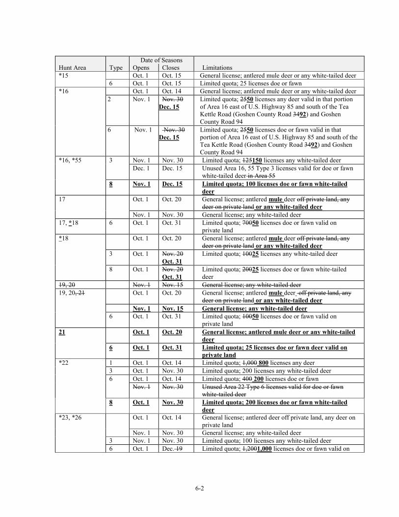
6-2
Date of Seasons Hunt Area Type Opens Closes Limitations
*15 Oct. 1 Oct. 15 General license; antlered mule deer or any white-tailed deer 6 Oct. 1 Oct. 15 Limited quota; 25 licenses doe or fawn *16 Oct. 1 Oct. 14 General license; antlered mule deer or any white-tailed deer 2 Nov. 1 Nov. 30
Dec. 15 Limited quota; 2550 licenses any deer valid in that portion of Area 16 east of U.S. Highway 85 and south of the Tea Kettle Road (Goshen County Road 3492) and Goshen County Road 94
6 Nov. 1 Nov. 30 Dec. 15
Limited quota; 2550 licenses doe or fawn valid in that portion of Area 16 east of U.S. Highway 85 and south of the Tea Kettle Road (Goshen County Road 3492) and Goshen County Road 94
*16, *55 3 Nov. 1 Nov. 30 Limited quota; 125150 licenses any white-tailed deer Dec. 1 Dec. 15 Unused Area 16, 55 Type 3 licenses valid for doe or fawn
white-tailed deer in Area 55 8 Nov. 1 Dec. 15 Limited quota; 100 licenses doe or fawn white-tailed
deer 17 Oct. 1 Oct. 20 General license; antlered mule deer off private land, any
deer on private land or any white-tailed deer Nov. 1 Nov. 30 General license; any white-tailed deer 17, *18 6 Oct. 1 Oct. 31 Limited quota; 70050 licenses doe or fawn valid on
private land *18 Oct. 1 Oct. 20 General license; antlered mule deer off private land, any
deer on private land or any white-tailed deer 3 Oct. 1 Nov. 20
Oct. 31 Limited quota; 10025 licenses any white-tailed deer
8 Oct. 1 Nov. 20 Oct. 31
Limited quota; 20025 licenses doe or fawn white-tailed deer
19, 20 Nov. 1 Nov. 15 General license; any white-tailed deer 19, 20, 21 Oct. 1 Oct. 20 General license; antlered mule deer off private land, any
deer on private land or any white-tailed deer Nov. 1 Nov. 15 General license; any white-tailed deer 6 Oct. 1 Oct. 31 Limited quota; 10050 licenses doe or fawn valid on
private land 21 Oct. 1 Oct. 20 General license; antlered mule deer or any white-tailed
deer 6 Oct. 1 Oct. 31 Limited quota; 25 licenses doe or fawn deer valid on
private land *22 1 Oct. 1 Oct. 14 Limited quota; 1,000 800 licenses any deer 3 Oct. 1 Nov. 30 Limited quota; 200 licenses any white-tailed deer 6 Oct. 1 Oct. 14 Limited quota; 400 200 licenses doe or fawn Nov. 1 Nov. 30 Unused Area 22 Type 6 licenses valid for doe or fawn
white-tailed deer 8 Oct. 1 Nov. 30 Limited quota; 200 licenses doe or fawn white-tailed
deer *23, *26 Oct. 1 Oct. 14 General license; antlered deer off private land, any deer on
private land Nov. 1 Nov. 30 General license; any white-tailed deer 3 Nov. 1 Nov. 30 Limited quota; 100 licenses any white-tailed deer 6 Oct. 1 Dec. 19 Limited quota; 1,2001,000 licenses doe or fawn valid on
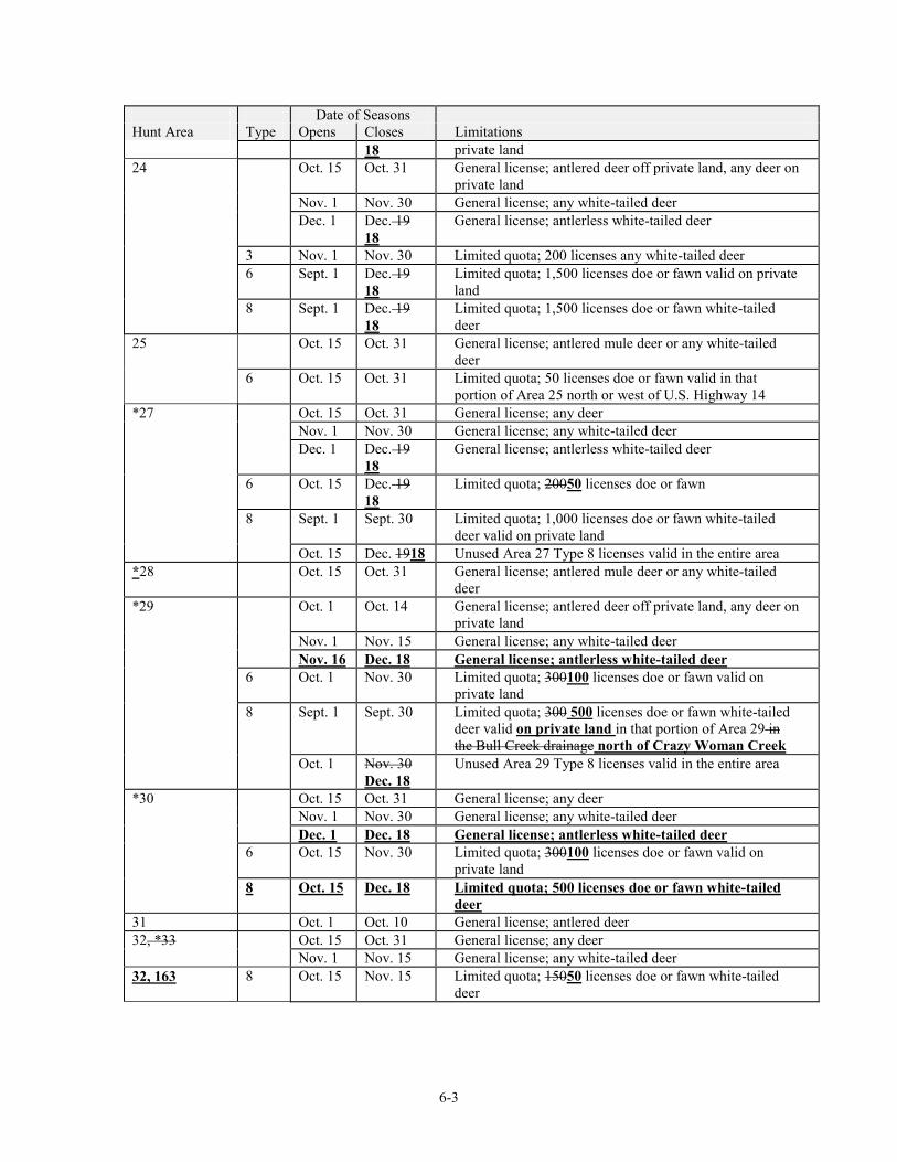
6-3
Date of Seasons Hunt Area Type Opens Closes Limitations
18 private land 24 Oct. 15 Oct. 31 General license; antlered deer off private land, any deer on
private land Nov. 1 Nov. 30 General license; any white-tailed deer Dec. 1 Dec. 19
18 General license; antlerless white-tailed deer
3 Nov. 1 Nov. 30 Limited quota; 200 licenses any white-tailed deer 6 Sept. 1 Dec. 19
18 Limited quota; 1,500 licenses doe or fawn valid on private land
8 Sept. 1 Dec. 19 18
Limited quota; 1,500 licenses doe or fawn white-tailed deer
25 Oct. 15 Oct. 31 General license; antlered mule deer or any white-tailed deer
6 Oct. 15 Oct. 31 Limited quota; 50 licenses doe or fawn valid in that portion of Area 25 north or west of U.S. Highway 14
*27 Oct. 15 Oct. 31 General license; any deer Nov. 1 Nov. 30 General license; any white-tailed deer Dec. 1 Dec. 19
18 General license; antlerless white-tailed deer
6 Oct. 15 Dec. 19 18
Limited quota; 20050 licenses doe or fawn
8 Sept. 1 Sept. 30 Limited quota; 1,000 licenses doe or fawn white-tailed deer valid on private land
Oct. 15 Dec. 1918 Unused Area 27 Type 8 licenses valid in the entire area *28 Oct. 15 Oct. 31 General license; antlered mule deer or any white-tailed
deer *29 Oct. 1 Oct. 14 General license; antlered deer off private land, any deer on
private land Nov. 1 Nov. 15 General license; any white-tailed deer Nov. 16 Dec. 18 General license; antlerless white-tailed deer 6 Oct. 1 Nov. 30 Limited quota; 300100 licenses doe or fawn valid on
private land 8 Sept. 1 Sept. 30 Limited quota; 300 500 licenses doe or fawn white-tailed
deer valid on private land in that portion of Area 29 in the Bull Creek drainage north of Crazy Woman Creek
Oct. 1 Nov. 30 Dec. 18
Unused Area 29 Type 8 licenses valid in the entire area
*30 Oct. 15 Oct. 31 General license; any deer Nov. 1 Nov. 30 General license; any white-tailed deer Dec. 1 Dec. 18 General license; antlerless white-tailed deer 6 Oct. 15 Nov. 30 Limited quota; 300100 licenses doe or fawn valid on
private land 8 Oct. 15 Dec. 18 Limited quota; 500 licenses doe or fawn white-tailed
deer 31 Oct. 1 Oct. 10 General license; antlered deer 32, *33 Oct. 15 Oct. 31 General license; any deer Nov. 1 Nov. 15 General license; any white-tailed deer 32, 163 8 Oct. 15 Nov. 15 Limited quota; 15050 licenses doe or fawn white-tailed
deer
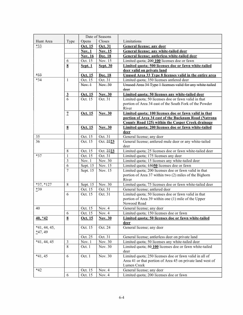
6-4
Date of Seasons Hunt Area Type Opens Closes Limitations *33 Oct. 15 Oct. 31 General license; any deer Nov. 1 Nov. 15 General license; any white-tailed deer Nov. 16 Dec. 18 General license; antlerless white-tailed deer 6 Oct. 15 Nov. 15 Limited quota; 200 100 licenses doe or fawn 8 Sept. 1 Sept. 30 Limited quota; 500 licenses doe or fawn white-tailed
deer valid on private land *33 Oct. 15 Dec. 18 Unused Area 33 Type 8 licenses valid in the entire area *34 1 Oct. 15 Oct. 31 Limited quota; 350 licenses antlered deer Nov. 1 Nov. 30 Unused Area 34 Type 1 licenses valid for any white-tailed
deer 3 Oct. 15 Nov. 30 Limited quota; 50 licenses any white-tailed deer 6 Oct. 15 Oct. 31 Limited quota; 50 licenses doe or fawn valid in that
portion of Area 34 east of the South Fork of the Powder River
7 Oct. 15 Nov. 30 Limited quota; 100 licenses doe or fawn valid in that portion of Area 34 east of the Bucknum Road (Natrona County Road 125) within the Casper Creek drainage
8 Oct. 15 Nov. 30 Limited quota; 200 licenses doe or fawn white-tailed deer
35 Oct. 15 Oct. 31 General license; any deer 36 Oct. 15 Oct. 2223 General license; antlered mule deer or any white-tailed
deer 8 Oct. 15 Oct. 2223 Limited quota; 25 licenses doe or fawn white-tailed deer *37 1 Oct. 15 Oct. 31 Limited quota; 175 licenses any deer 3 Nov. 1 Nov. 30 Limited quota; 15 licenses any white-tailed deer 6 Sept. 15 Nov. 15 Limited quota; 15050 licenses doe or fawn 7 Sept. 15 Nov. 15 Limited quota; 200 licenses doe or fawn valid in that
portion of Area 37 within two (2) miles of the Bighorn River
*37, *127 8 Sept. 15 Nov. 30 Limited quota; 75 licenses doe or fawn white-tailed deer *39 Oct. 15 Oct. 31 General license; antlered deer 6 Oct. 15 Oct. 31 Limited quota; 50 licenses doe or fawn valid in that
portion of Area 39 within one (1) mile of the Upper Nowood Road
40 Oct. 15 Nov. 4 General license; any deer 6 Oct. 15 Nov. 4 Limited quota; 150 licenses doe or fawn 40, *42 8 Oct. 15 Nov. 30 Limited quota; 50 licenses doe or fawn white-tailed
deer *41, 44, 45, *47, 49
Oct. 15 Oct. 24 General license; any deer
Oct. 25 Oct. 31 General license; antlerless deer on private land *41, 44, 45 3 Nov. 1 Nov. 30 Limited quota; 50 licenses any white-tailed deer 8 Oct. 1 Nov. 30 Limited quota; 50 100 licenses doe or fawn white-tailed
deer *41, 45 6 Oct. 1 Nov. 30
Limited quota; 250 licenses doe or fawn valid in all of Area 41 or that portion of Area 45 on private land west of Lumen Creek
*42 Oct. 15 Nov. 4 General license; any deer 6 Oct. 15 Nov. 4 Limited quota; 200 licenses doe or fawn
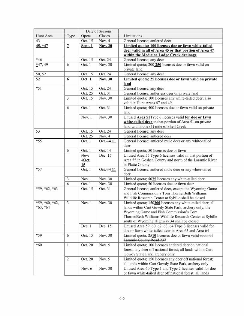
6-5
Date of Seasons Hunt Area Type Opens Closes Limitations 43 Oct. 15 Nov. 4 General license; antlered deer 45, *47 7 Sept. 1 Nov. 30 Limited quota; 100 licenses doe or fawn white-tailed
deer valid in all of Area 45 or that portion of Area 47 within the Medicine Lodge Creek drainage
*46 Oct. 15 Oct. 24 General license; any deer *47, 49 6 Oct. 1 Nov. 30 Limited quota; 200 250 licenses doe or fawn valid on
private land 50, 52 Oct. 15 Oct. 24 General license; any deer 52 6 Oct. 1 Nov. 30 Limited quota; 25 licenses doe or fawn valid on private
land *51 Oct. 15 Oct. 24 General license; any deer Oct. 25 Oct. 31 General license; antlerless deer on private land 3 Oct. 15 Nov. 30 Limited quota; 100 licenses any white-tailed deer; also
valid in Hunt Areas 47 and 49 6 Oct. 1 Oct. 31 Limited quota; 400 licenses doe or fawn valid on private
land Nov. 1 Nov. 30 Unused Area 51Type 6 licenses valid for doe or fawn
white-tailed deer in that portion of Area 51 on private land within one (1) mile of Shell Creek
53 Oct. 15 Oct. 24 General license; any deer Oct. 25 Nov. 4 General license; antlered deer *55 Oct. 1 Oct. 14 11 General license; antlered mule deer or any white-tailed
deer 6 Oct. 1 Oct. 14 Limited quota; 50 licenses doe or fawn Nov.
1Oct. 15
Dec. 15 Unused Area 55 Type 6 licenses valid in that portion of Area 55 in Goshen County and north of the Laramie River in Platte County
*57 Oct. 1 Oct. 14 11 General license; antlered mule deer or any white-tailed deer
3 Nov. 1 Nov. 30 Limited quota; 5075 licenses any white-tailed deer 6 Oct. 1 Nov. 30 Limited quota; 50 licenses doe or fawn deer *59, *62, *63 Oct. 15 Oct. 31 General license; antlered deer, except the Wyoming Game
and Fish Commission’s Tom Thorne/Beth Williams Wildlife Research Center at Sybille shall be closed
*59, *60, *62, *63, *64
3 Nov. 1 Nov. 30 Limited quota; 150200 licenses any white-tailed deer, all lands within Curt Gowdy State Park, archery only; the Wyoming Game and Fish Commission’s Tom Thorne/Beth Williams Wildlife Research Center at Sybille south of Wyoming Highway 34 shall be closed
Dec. 1 Dec. 15 Unused Area 59, 60, 62, 63, 64 Type 3 licenses valid for doe or fawn white-tailed deer in Area 63 and Area 64
*59 6 Oct. 15 Nov. 30 Limited quota; 2510 licenses doe or fawn valid south of Laramie County Road 237
*60 1 Oct. 20 Nov. 5 Limited quota; 100 licenses antlered deer on national forest, any deer off national forest; all lands within Curt Gowdy State Park, archery only
2 Oct. 20 Nov. 5 Limited quota; 150 licenses any deer off national forest; all lands within Curt Gowdy State Park, archery only
Nov. 6 Nov. 30 Unused Area 60 Type 1 and Type 2 licenses valid for doe or fawn white-tailed deer off national forest; all lands
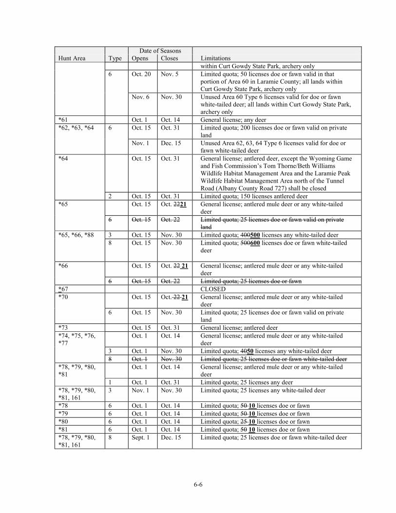
6-6
Date of Seasons Hunt Area Type Opens Closes Limitations
within Curt Gowdy State Park, archery only 6 Oct. 20 Nov. 5 Limited quota; 50 licenses doe or fawn valid in that
portion of Area 60 in Laramie County; all lands within Curt Gowdy State Park, archery only
Nov. 6 Nov. 30 Unused Area 60 Type 6 licenses valid for doe or fawn white-tailed deer; all lands within Curt Gowdy State Park, archery only
*61 Oct. 1 Oct. 14 General license; any deer *62, *63, *64 6 Oct. 15 Oct. 31 Limited quota; 200 licenses doe or fawn valid on private
land Nov. 1 Dec. 15 Unused Area 62, 63, 64 Type 6 licenses valid for doe or
fawn white-tailed deer *64 Oct. 15 Oct. 31 General license; antlered deer, except the Wyoming Game
and Fish Commission’s Tom Thorne/Beth Williams Wildlife Habitat Management Area and the Laramie Peak Wildlife Habitat Management Area north of the Tunnel Road (Albany County Road 727) shall be closed
2 Oct. 15 Oct. 31 Limited quota; 150 licenses antlered deer *65 Oct. 15 Oct. 2221 General license; antlered mule deer or any white-tailed
deer 6 Oct. 15 Oct. 22 Limited quota; 25 licenses doe or fawn valid on private
land *65, *66, *88 3 Oct. 15 Nov. 30 Limited quota; 400500 licenses any white-tailed deer 8 Oct. 15 Nov. 30 Limited quota; 500600 licenses doe or fawn white-tailed
deer
*66 Oct. 15 Oct. 22 21 General license; antlered mule deer or any white-tailed deer
6 Oct. 15 Oct. 22 Limited quota; 25 licenses doe or fawn *67 CLOSED *70 Oct. 15 Oct. 22 21 General license; antlered mule deer or any white-tailed
deer 6 Oct. 15 Nov. 30 Limited quota; 25 licenses doe or fawn valid on private
land *73 Oct. 15 Oct. 31 General license; antlered deer *74, *75, *76, *77
Oct. 1 Oct. 14 General license; antlered mule deer or any white-tailed deer
3 Oct. 1 Nov. 30 Limited quota; 4050 licenses any white-tailed deer 8 Oct. 1 Nov. 30 Limited quota; 25 licenses doe or fawn white-tailed deer *78, *79, *80, *81
Oct. 1 Oct. 14 General license; antlered mule deer or any white-tailed deer
1 Oct. 1 Oct. 31 Limited quota; 25 licenses any deer *78, *79, *80, *81, 161
3 Nov. 1 Nov. 30 Limited quota; 25 licenses any white-tailed deer
*78 6 Oct. 1 Oct. 14 Limited quota; 50 10 licenses doe or fawn *79 6 Oct. 1 Oct. 14 Limited quota; 50 10 licenses doe or fawn *80 6 Oct. 1 Oct. 14 Limited quota; 25 10 licenses doe or fawn *81 6 Oct. 1 Oct. 14 Limited quota; 50 10 licenses doe or fawn *78, *79, *80, *81, 161
8 Sept. 1 Dec. 15 Limited quota; 25 licenses doe or fawn white-tailed deer
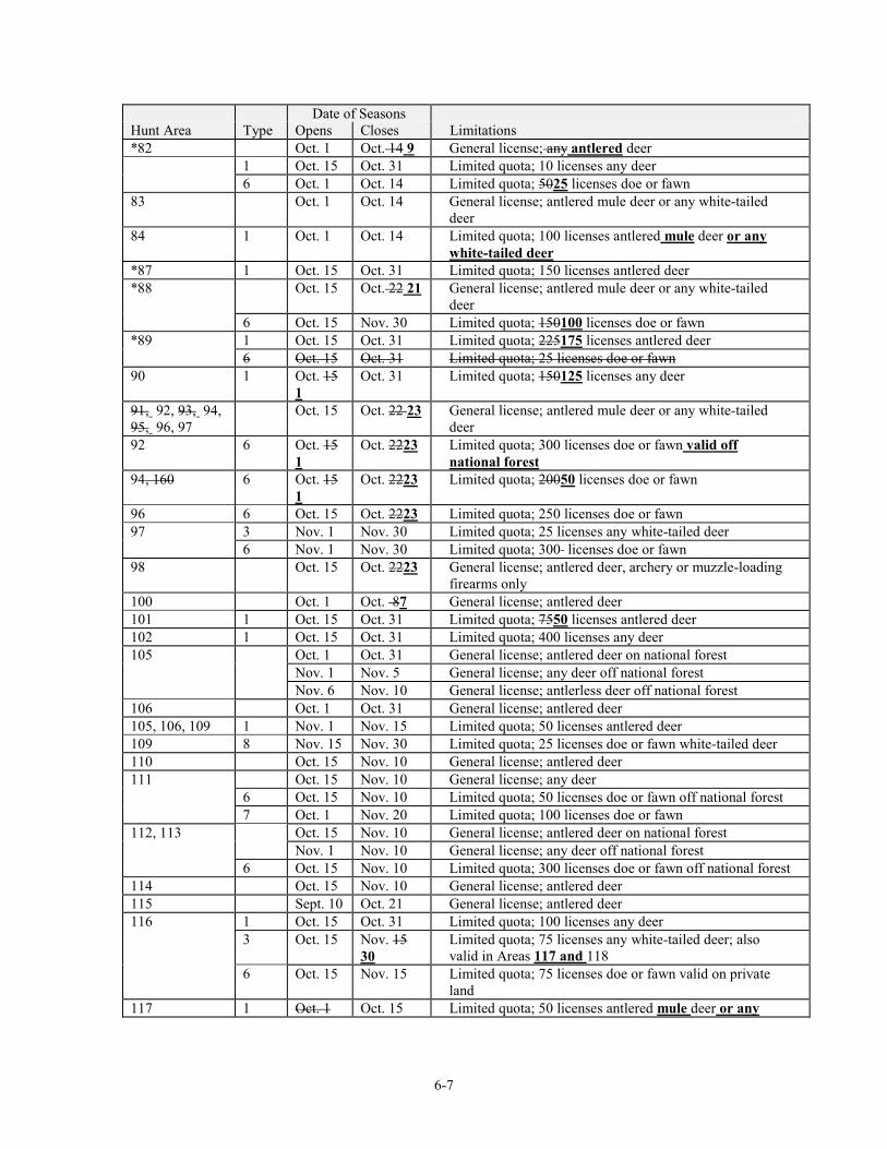
6-7
Date of Seasons Hunt Area Type Opens Closes Limitations *82 Oct. 1 Oct. 14 9 General license; any antlered deer 1 Oct. 15 Oct. 31 Limited quota; 10 licenses any deer 6 Oct. 1 Oct. 14 Limited quota; 5025 licenses doe or fawn 83 Oct. 1 Oct. 14 General license; antlered mule deer or any white-tailed
deer 84 1 Oct. 1 Oct. 14 Limited quota; 100 licenses antlered mule deer or any
white-tailed deer *87 1 Oct. 15 Oct. 31 Limited quota; 150 licenses antlered deer *88 Oct. 15 Oct. 22 21 General license; antlered mule deer or any white-tailed
deer 6 Oct. 15 Nov. 30 Limited quota; 150100 licenses doe or fawn *89 1 Oct. 15 Oct. 31 Limited quota; 225175 licenses antlered deer 6 Oct. 15 Oct. 31 Limited quota; 25 licenses doe or fawn 90 1 Oct. 15
1 Oct. 31 Limited quota; 150125 licenses any deer
91, 92, 93, 94, 95, 96, 97
Oct. 15 Oct. 22 23 General license; antlered mule deer or any white-tailed deer
92 6 Oct. 15 1
Oct. 2223 Limited quota; 300 licenses doe or fawn valid off national forest
94, 160 6 Oct. 15 1
Oct. 2223 Limited quota; 20050 licenses doe or fawn
96 6 Oct. 15 Oct. 2223 Limited quota; 250 licenses doe or fawn 97 3 Nov. 1 Nov. 30 Limited quota; 25 licenses any white-tailed deer 6 Nov. 1 Nov. 30 Limited quota; 300 licenses doe or fawn 98 Oct. 15 Oct. 2223 General license; antlered deer, archery or muzzle-loading
firearms only 100 Oct. 1 Oct. 87 General license; antlered deer 101 1 Oct. 15 Oct. 31 Limited quota; 7550 licenses antlered deer 102 1 Oct. 15 Oct. 31 Limited quota; 400 licenses any deer 105 Oct. 1 Oct. 31 General license; antlered deer on national forest Nov. 1 Nov. 5 General license; any deer off national forest Nov. 6 Nov. 10 General license; antlerless deer off national forest 106 Oct. 1 Oct. 31 General license; antlered deer 105, 106, 109 1 Nov. 1 Nov. 15 Limited quota; 50 licenses antlered deer 109 8 Nov. 15 Nov. 30 Limited quota; 25 licenses doe or fawn white-tailed deer 110 Oct. 15 Nov. 10 General license; antlered deer 111 Oct. 15 Nov. 10 General license; any deer 6 Oct. 15 Nov. 10 Limited quota; 50 licenses doe or fawn off national forest 7 Oct. 1 Nov. 20 Limited quota; 100 licenses doe or fawn 112, 113 Oct. 15 Nov. 10 General license; antlered deer on national forest Nov. 1 Nov. 10 General license; any deer off national forest 6 Oct. 15 Nov. 10 Limited quota; 300 licenses doe or fawn off national forest 114 Oct. 15 Nov. 10 General license; antlered deer 115 Sept. 10 Oct. 21 General license; antlered deer 116 1 Oct. 15 Oct. 31 Limited quota; 100 licenses any deer 3 Oct. 15 Nov. 15
30 Limited quota; 75 licenses any white-tailed deer; also valid in Areas 117 and 118
6 Oct. 15 Nov. 15 Limited quota; 75 licenses doe or fawn valid on private land
117 1 Oct. 1 Oct. 15 Limited quota; 50 licenses antlered mule deer or any
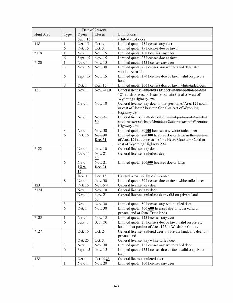
6-8
Date of Seasons Hunt Area Type Opens Closes Limitations
Sept. 15 white-tailed deer 118 1 Oct. 15 Oct. 31 Limited quota; 75 licenses any deer 6 Oct. 15 Oct. 31 Limited quota; 35 licenses doe or fawn *119 1 Nov. 1 Nov. 15 Limited quota; 100 licenses any deer 6 Sept. 15 Nov. 15 Limited quota; 25 licenses doe or fawn *120 1 Nov. 1 Nov. 15 Limited quota; 125 licenses any deer 3 Nov. 15 Nov. 30 Limited quota; 25 licenses any white-tailed deer; also
valid in Area 119 6 Sept. 15 Nov. 15 Limited quota; 150 licenses doe or fawn valid on private
land 8 Oct. 1 Dec. 15 Limited quota; 200 licenses doe or fawn white-tailed deer 121 Nov. 1 Nov. 7 10 General license; antlered any deer in that portion of Area
121 north or west of Heart Mountain Canal or west of Wyoming Highway 294
Nov. 1 Nov. 10 General license; any deer in that portion of Area 121 south or east of Heart Mountain Canal or east of Wyoming Highway 294
Nov. 11 Nov. 21 30
General license; antlerless deer in that portion of Area 121 south or east of Heart Mountain Canal or east of Wyoming Highway 294
3 Nov. 1 Nov. 30 Limited quota; 50100 licenses any white-tailed deer 6 Oct. 15 Nov. 30
Dec. 31 Limited quota; 200300 licenses doe or fawn in that portion of Area 121 south or east of the Heart Mountain Canal or east of Wyoming Highway 294
*122 Nov. 1 Nov. 10 General license; any deer Nov. 11 Nov. 21
30 General license; antlerless deer
6 Nov. 1Oct. 15
Nov. 21 Dec. 31
Limited quota; 200500 licenses doe or fawn
Dec. 1 Dec. 15 Unused Area 122 Type 6 licenses 8 Nov. 1 Nov. 30 Limited quota; 50 licenses doe or fawn white-tailed deer 123 Oct. 15 Nov. 5 4 General license; any deer *124 Nov. 1 Nov. 10 General license; any deer Nov. 11 Nov. 21
30 General license; antlerless deer valid on private land
3 Nov. 1 Nov. 30 Limited quota; 50 licenses any white-tailed deer 6 Oct. 1 Nov. 30 Limited quota; 400 600 licenses doe or fawn valid on
private land or State Trust lands *125 1 Nov. 1 Nov. 15 Limited quota; 125 licenses any deer 6 Sept. 1 Sept. 30 Limited quota; 25 licenses doe or fawn valid on private
land in that portion of Area 125 in Washakie County *127 Oct. 15 Oct. 24 General license; antlered deer off private land, any deer on
private land Oct. 25 Oct. 31 General license; any white-tailed deer 3 Nov. 1 Nov. 30 Limited quota; 15 licenses any white-tailed deer 6 Sept. 15 Nov. 15 Limited quota; 125 licenses doe or fawn valid on private
land 128 Oct. 1 Oct. 2223 General license; antlered deer 1 Nov. 1 Nov. 20 Limited quota; 100 licenses any deer
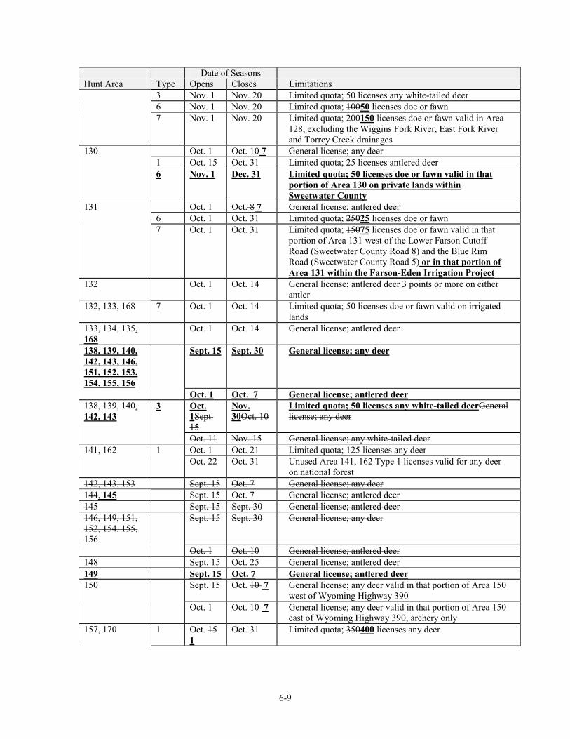
6-9
Date of Seasons Hunt Area Type Opens Closes Limitations 3 Nov. 1 Nov. 20 Limited quota; 50 licenses any white-tailed deer 6 Nov. 1 Nov. 20 Limited quota; 10050 licenses doe or fawn 7 Nov. 1 Nov. 20 Limited quota; 200150 licenses doe or fawn valid in Area
128, excluding the Wiggins Fork River, East Fork River and Torrey Creek drainages
130 Oct. 1 Oct. 10 7 General license; any deer 1 Oct. 15 Oct. 31 Limited quota; 25 licenses antlered deer 6 Nov. 1 Dec. 31 Limited quota; 50 licenses doe or fawn valid in that
portion of Area 130 on private lands within Sweetwater County
131 Oct. 1 Oct. 8 7 General license; antlered deer 6 Oct. 1 Oct. 31 Limited quota; 25025 licenses doe or fawn 7 Oct. 1 Oct. 31 Limited quota; 15075 licenses doe or fawn valid in that
portion of Area 131 west of the Lower Farson Cutoff Road (Sweetwater County Road 8) and the Blue Rim Road (Sweetwater County Road 5) or in that portion of Area 131 within the Farson-Eden Irrigation Project
132 Oct. 1 Oct. 14 General license; antlered deer 3 points or more on either antler
132, 133, 168 7 Oct. 1 Oct. 14 Limited quota; 50 licenses doe or fawn valid on irrigated lands
133, 134, 135, 168
Oct. 1 Oct. 14 General license; antlered deer
138, 139, 140, 142, 143, 146, 151, 152, 153, 154, 155, 156
Sept. 15 Sept. 30 General license; any deer
Oct. 1 Oct. 7 General license; antlered deer 138, 139, 140, 142, 143
3 Oct. 1Sept. 15
Nov. 30Oct. 10
Limited quota; 50 licenses any white-tailed deerGeneral license; any deer
Oct. 11 Nov. 15 General license; any white-tailed deer 141, 162 1 Oct. 1 Oct. 21 Limited quota; 125 licenses any deer Oct. 22 Oct. 31 Unused Area 141, 162 Type 1 licenses valid for any deer
on national forest 142, 143, 153 Sept. 15 Oct. 7 General license; any deer 144, 145 Sept. 15 Oct. 7 General license; antlered deer 145 Sept. 15 Sept. 30 General license; antlered deer 146, 149, 151, 152, 154, 155, 156
Sept. 15 Sept. 30 General license; any deer
Oct. 1 Oct. 10 General license; antlered deer 148 Sept. 15 Oct. 25 General license; antlered deer 149 Sept. 15 Oct. 7 General license; antlered deer 150 Sept. 15 Oct. 10 7 General license; any deer valid in that portion of Area 150
west of Wyoming Highway 390 Oct. 1 Oct. 10 7 General license; any deer valid in that portion of Area 150
east of Wyoming Highway 390, archery only 157, 170 1 Oct. 15
1 Oct. 31 Limited quota; 350400 licenses any deer
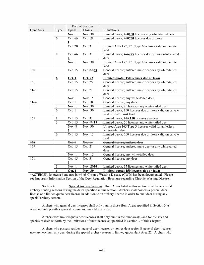
6-10
Date of Seasons Hunt Area Type Opens Closes Limitations 3 Nov. 1 Nov. 30 Limited quota; 100150 licenses any white-tailed deer 6 Oct. 15
1 Oct. 19 Limited quota; 450750 licenses doe or fawn
Oct. 20 Oct. 31 Unused Area 157, 170 Type 6 licenses valid on private land
8 Oct. 15 1
Oct. 31 Limited quota; 175275 licenses doe or fawn white-tailed deer
Nov. 1 Nov. 30 Unused Area 157, 170 Type 8 licenses valid on private land
160 Oct. 15 Oct. 22 23 General license; antlered mule deer or any white-tailed deer
6 Oct. 1 Oct. 23 Limited quota; 150 licenses doe or fawn 161 Oct. 15 Oct. 25 General license; antlered mule deer or any white-tailed
deer *163 Oct. 15 Oct. 21 General license; antlered mule deer or any white-tailed
deer Nov. 1 Nov. 15 General license; any white-tailed deer *164 Oct. 1 Oct. 10 General license; any deer 3 Nov. 1 Nov. 30 Limited quota; 25 licenses any white-tailed deer 6 Oct. 1 Nov. 30 Limited quota; 150 licenses doe or fawn valid on private
land or State Trust land 165 1 Oct. 15 Oct. 31 Limited quota; 125 150 licenses any deer 3 Oct. 15 Nov. 7 15 Limited quota; 50 licenses any white-tailed deer Nov. 8
1 Nov. 30 Unused Area 165 Type 3 licenses valid for antlerless
white-tailed deer 6 Oct. 15 Nov. 15 Limited quota; 200 licenses doe or fawn valid on private
land 168 Oct. 1 Oct. 14 General license; antlered deer 169 Oct. 15 Oct. 21 General license; antlered mule deer or any white-tailed
deer Nov. 1 Nov. 15 General license; any white-tailed deer 171 Oct. 15
1 Oct. 31 General license; any deer
3 Nov. 1 Nov. 2030 Limited quota; 35 licenses any white-tailed deer 6 Oct. 1 Nov. 30 Limited quota; 150 licenses doe or fawn *ASTERISK denotes a hunt area in which Chronic Wasting Disease (CWD) has been documented. Please see Important Information Section of the Deer Regulation Brochure regarding Chronic Wasting Disease. Section 4. Special Archery Seasons. Hunt Areas listed in this section shall have special archery hunting seasons during the dates specified in this section. Archers shall possess a general deer license or a limited quota deer license in addition to an archery license in order to hunt deer during any special archery season.
Archers with general deer licenses shall only hunt in those Hunt Areas specified in Section 3 as open to hunting with a general license and may take any deer.
Archers with limited quota deer licenses shall only hunt in the hunt area(s) and for the sex and
species of deer set forth by the limitations of their license as specified in Section 3 of this Chapter. Archers who possess resident general deer licenses or nonresident region B general deer licenses
may archery hunt any deer during the special archery season in limited quota Hunt Area 22. Archers who
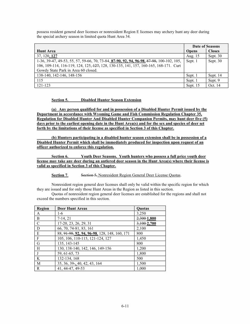
6-11
possess resident general deer licenses or nonresident Region E licenses may archery hunt any deer during the special archery season in limited quota Hunt Area 34. Date of Seasons Hunt Area Opens Closes 37, 120, 127 Aug. 15 Sept. 30 1-36, 39-47, 49-53, 55, 57, 59-66, 70, 73-84, 87-90, 92, 94, 96-98, 87-98, 100-102, 105, 106, 109-114, 116-119, 124, 125, 127, 128, 130-135, 141, 157, 160-165, 168-171. Curt Gowdy State Park in Area 60 closed.
Sept. 1 Sept. 30
138-140, 142-146, 148-156 Sept. 1 Sept. 14 115 Sept. 1 Sept. 9 121-123 Sept. 15 Oct. 14
Section 5. Disabled Hunter Season Extension
(a) Any person qualified for and in possession of a Disabled Hunter Permit issued by the Department in accordance with Wyoming Game and Fish Commission Regulation Chapter 35, Regulation for Disabled Hunter And Disabled Hunter Companion Permits, may hunt deer five (5) days prior to the earliest opening date in the Hunt Area(s) and for the sex and species of deer set forth by the limitations of their license as specified in Section 3 of this Chapter. (b) Hunters participating in a disabled hunter season extension shall be in possession of a Disabled Hunter Permit which shall be immediately produced for inspection upon request of an officer authorized to enforce this regulation. Section 6. Youth Deer Seasons. Youth hunters who possess a full price youth deer license may take any deer during an antlered deer season in the Hunt Area(s) where their license is valid as specified in Section 3 of this Chapter.
Section 7. Section 5. Nonresident Region General Deer License Quotas. Nonresident region general deer licenses shall only be valid within the specific region for which they are issued and for only those Hunt Areas in the Region as listed in this section. Quotas of nonresident region general deer licenses are established for the regions and shall not exceed the numbers specified in this section. Region Deer Hunt Areas Quotas A 1-6 3,250 B 7-14, 21 2,300 1,800 C 17-20, 23, 26, 29, 31 3,100 2,700 D 66, 70, 74-81, 83, 161 2,100 E 88, 91-98, 92, 94, 96-98, 128, 148, 160, 171 800 F 105, 106, 110-115, 121-124, 127 1,450 G 135, 143-145 800 H 130, 138-140, 142, 146, 149-156 1,200 J 59, 61-65, 73 1,800 K 132-134, 168 500 M 35, 36, 39-, 40, 42, 43, 164 1,500 R 41, 44-47, 49-53 1,000
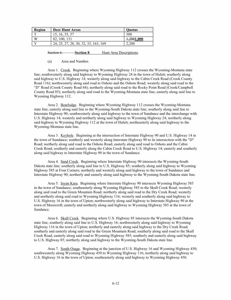
6-12
Region Deer Hunt Areas Quotas T 15, 16, 55, 57 500 W 82, 100, 131 1,2001,000 Y 24, 25, 27, 28, 30, 32, 33, 163, 169 2,200 Section 6. Section 8. Hunt Area Descriptions. (a) Area and Number. Area 1. Crook. Beginning where Wyoming Highway 112 crosses the Wyoming-Montana state line; southwesterly along said highway to Wyoming Highway 24 in the town of Hulett; southerly along said highway to U.S. Highway 14; westerly along said highway to the Cabin Creek Road (Crook County Road 116); northwesterly along said road to Oshoto and the Oshoto Road; westerly along said road to the “D” Road (Crook County Road 68); northerly along said road to the Rocky Point Road (Crook/Campbell County Road 85); northerly along said road to the Wyoming-Montana state line; easterly along said line to Wyoming Highway 112. Area 2. Bearlodge. Beginning where Wyoming Highway 112 crosses the Wyoming-Montana state line; easterly along said line to the Wyoming-South Dakota state line; southerly along said line to Interstate Highway 90; southwesterly along said highway to the town of Sundance and the interchange with U.S. Highway 14; westerly and northerly along said highway to Wyoming Highway 24; northerly along said highway to Wyoming Highway 112 at the town of Hulett; northeasterly along said highway to the Wyoming-Montana state line. Area 3. Keyhole. Beginning at the intersection of Interstate Highway 90 and U.S. Highway 14 in the town of Sundance; southerly and westerly along Interstate Highway 90 to its intersection with the "D" Road; northerly along said road to the Oshoto Road; easterly along said road to Oshoto and the Cabin Creek Road; southerly and easterly along the Cabin Creek Road to U.S. Highway 14; easterly and southerly along said highway to Interstate Highway 90 in the town of Sundance. Area 4. Sand Creek. Beginning where Interstate Highway 90 intersects the Wyoming-South Dakota state line; southerly along said line to U.S. Highway 85; southerly along said highway to Wyoming Highway 585 at Four Corners; northerly and westerly along said highway to the town of Sundance and Interstate Highway 90; northerly and easterly along said highway to the Wyoming-South Dakota state line. Area 5. Inyan Kara. Beginning where Interstate Highway 90 intersects Wyoming Highway 585 in the town of Sundance; southeasterly along Wyoming Highway 585 to the Skull Creek Road; westerly along said road to the Green Mountain Road; northerly along said road to the Dry Creek Road; westerly and northerly along said road to Wyoming Highway 116; westerly and southerly along said highway to U.S. Highway 16 in the town of Upton; northwesterly along said highway to Interstate Highway 90 at the town of Moorcroft; easterly and northerly along said highway to Wyoming Highway 585 at the town of Sundance. Area 6. Skull Creek. Beginning where U.S. Highway 85 intersects the Wyoming-South Dakota state line; southerly along said line to U.S. Highway 16; northwesterly along said highway to Wyoming Highway 116 in the town of Upton; northerly and easterly along said highway to the Dry Creek Road; southerly and easterly along said road to the Green Mountain Road; southerly along said road to the Skull Creek Road; easterly along said road to Wyoming Highway 585; southerly and easterly along said highway to U.S. Highway 85; northerly along said highway to the Wyoming-South Dakota state line. Area 7. South Osage. Beginning at the junction of U.S. Highway 16 and Wyoming Highway 450; southwesterly along Wyoming Highway 450 to Wyoming Highway 116; northerly along said highway to U.S. Highway 16 in the town of Upton; southeasterly along said highway to Wyoming Highway 450.
6-13
Area 8. Upton-Four Horse. Beginning at the junction of Wyoming Highway 116 and Wyoming Highway 450; westerly along Wyoming Highway 450 to the Keeline Road (USFS Road 930); northwesterly along said road to Black Thunder Creek; easterly down said creek to Bacon Creek; northerly up said creek to Newel Prong; northerly up said prong to the Cheyenne River/Belle Fourche River Divide; northeasterly along said divide to the divide between Four Horse Creek and Raven Creek; northwesterly along said divide to the Belle Fourche River; northeasterly down said river to Interstate Highway 90; easterly along said highway to U.S. Highway 16; southeasterly along said highway to Wyoming Highway 116 at the town of Upton; southerly along said highway to Wyoming Highway 450. Area 9. Blacktail Creek. Beginning where U.S. Highway 16 crosses the Wyoming-South Dakota state line; southerly along said line to the Dewey Road; northwesterly along said road to U.S. Highway 85; southerly along said highway to the Cheyenne River Road N. (Weston County); westerly along said road to the Lynch Road; northerly along said road to Wyoming Highway 450; northeasterly along said highway to U.S. Highway 16; southeasterly along said highway to the Wyoming-South Dakota state line. Area 10. Rochelle Hills. Beginning at the junction of Wyoming Highway 59 and Wyoming Highway 450; easterly along Wyoming Highway 450 to the Lynch Road (Weston County Road 7A); southerly along said road to the Weston-Converse County line and the Clareton Road (Converse County Road 39); southerly along said road to the Dull Center Road (Converse County Road 38); easterly along said road to the Converse-Niobrara County line and the North Lance Creek Road (Niobrara County Road 14); easterly and southerly along said road to the Slagle Road (Niobrara County Road 4); southerly along said road to the Cow Creek Road (Niobrara County Road 3); westerly along said road to the Converse-Niobrara County line and the Cow Creek Road (Converse County Road 45); southerly along said road to the Converse-Niobrara County line and the K-Field Road (Niobrara County Road 50); southerly along said road to the Converse-Niobrara County line and the Walker Creek Road (Converse County Road 43); westerly along said road to Dry Creek; westerly up said creek to the Iberlin Ranch Road; northerly along said road to the Thunder Basin National Grassland boundary and USFS Road 958C; northwesterly along said road to the East Bill Road (USFS Road 958); westerly along said road to the Dull Center Road (Converse County Road 38); westerly along said road to Wyoming Highway 59; northerly along said highway to the junction of Wyoming Highway 59 and Wyoming Highway 450. Area 11. Mule Creek. Beginning where the Dewey Road (Weston County Road 2) crosses the Wyoming-South Dakota state line; southerly along said line to U.S. Highway 18; westerly along said highway to the Old Highway 85 Road (Niobrara County Road 9); southwesterly along said road to U.S. Highway 85; southerly along said highway to the Wasserburger Road (Niobrara County Road 13); westerly along said road to the North Lance Creek Road (Niobrara County Road 14); northwesterly along said road to the Niobrara-Converse county line and the Dull Center Road (Converse County Road 38); westerly along said road to the Clareton Road (Converse County Road 39); northeasterly along said road to the Converse-Weston county line and the Lynch Road (Weston County Road 7a); northerly along said road to the Cheyenne River Road N. (Weston County Road 54); easterly along said road to U.S. Highway 85; northerly along said highway to the Dewey Road Weston County Road 2); southeasterly along said road to the Wyoming-South Dakota state line. Area 12. Hat Creek. Beginning where U.S. Highway 18 intersects the Wyoming-South Dakota state line; southerly along said line to the Wyoming-Nebraska state line; southerly along said line to the Hat Creek Road (Niobrara County Road 64); westerly along said road to U.S. Highway 85; northerly along said highway to Wyoming Highway 270; westerly along said highway to Wyoming Highway 272; northerly along said highway to the North Lance Creek Road (Niobrara County Road 14); northerly along said road to the Wasserburger Road (Niobrara County Road 13); easterly along said road to U.S. Highway 85; northerly along said highway to the Old Highway 85 Road (Niobrara County Road 9); northeasterly along said road to U.S. Highway 18; easterly along said highway to the Wyoming-South Dakota state line. Area 13. Lusk. Beginning where the Hat Creek Road (Niobrara County Road 64) intersects the Wyoming-Nebraska state line; southerly along said line to U.S. Highway 20; westerly along said highway
6-14
to the Twenty Mile Creek Road (Converse County Road 46) at the town of Lost Springs; northerly along said road to the Manning Road (Converse County Road 53); easterly along said road to the Twenty Mile Road (Niobrara County Road 23) at the Converse-Niobrara county line; easterly along said road to Wyoming Highway 271; easterly along said highway to Wyoming Highway 270 at the town of Lance Creek; northerly and easterly along said highway to U.S. Highway 85; southerly along said highway to the Hat Creek Road (Niobrara County Road 64); easterly along said road to the Wyoming-Nebraska state line. Area 14. Twenty Mile. Beginning at the junction of Wyoming Highway 59 and the Dull Center Road (Converse County Road 38); easterly along said road to the East Bill Road (U.S.F.S. Road 958); easterly along said road to USFS Road 958C; southeasterly along said road to the Iberlin Ranch Road; southerly along said road to Dry Creek; easterly down said creek to the Walker Creek Road (Converse County Road 43); easterly along said road to the Converse-Niobrara county line and the K-field Road (Niobrara County Road 50); northerly along said road to the Converse-Niobrara county line and the Cow Creek Road (Converse County Road 45); northerly along said road to the Converse-Niobrara county line and the Cow Creek Road (Niobrara County Road 3); easterly along said road to the Slagle Road (Niobrara County Road 4); northerly along said road to the North Lance Creek Road (Niobrara County Road 14); easterly and southerly along said road to Wyoming Highway 272; southerly along said highway to Wyoming Highway 270; southwesterly along said highway to the town of Lance Creek and Wyoming Highway 271; westerly along said highway to the Twenty Mile Road (Niobrara County Road 23); westerly along said road to the Converse-Niobrara county line and the Manning Road (Converse County Road 53); southwesterly along said road to the Twenty Mile Creek Road (Converse County Road 46); southerly along said road to U.S. Highway 20 at the town of Lost Springs; southwesterly along said highway to Interstate Highway 25; southerly along said highway to the North Platte River; westerly and northerly up said river to Wyoming Highway 59 at the town of Douglas; northerly along said highway to the Dull Center Road (Converse County Road 38). Area 15. South Keeline. Beginning where U.S. Highway 20 intersects the Wyoming-Nebraska state line; southerly along said line to the Niobrara-Goshen county line trail and road (Goshen County Road 197); westerly along said trail and road to the Cundall Ranch Road (Goshen County Road 235); southwesterly along said road to U.S. Highway 85; northerly along said highway to the Niobrara-Goshen county line; westerly along said line to the radar tower and the Radar Tower Road (Goshen County Road 238); westerly along said road to Wyoming Highway 270; southerly along said highway to the Jireh Road (Platte County Road 201); westerly along said road to the Flat Top Road (Platte County Road 121); westerly along said road to the Cedar Top Road (Platte County Road 175); northerly along said road to Spanish Creek; westerly down said creek to Muddy Creek; southerly down said creek to Glendo Reservoir and the North Platte River; northwesterly up said river to Interstate Highway 25; northerly along said highway to U.S. Highway 20 at Orin Junction; easterly along said highway to the Wyoming-Nebraska state line. Area 16. Meadowdale/Jay Em. Beginning where U.S. Highway 26 crosses the Wyoming-Nebraska state line; westerly along said highway to the North Platte River; up said river to Muddy Creek; northerly up said creek to Spanish Creek; easterly up said creek to the Cedar Top Road (Platte County Road 175); southerly along said road to the Flat Top Road (Platte County Road 121); easterly along said road to the Jireh Road (Platte County Road 201); easterly along said road to Wyoming Highway 270; northerly along said highway to the Radar Tower Road (Goshen County Road 238); easterly along said road to the radar tower and the Niobrara-Goshen county line; easterly along said line to U.S. Highway 85; southerly along said highway to the Cundall Ranch Road (Goshen County Road 235); northeasterly along said road to the Niobrara-Goshen county line trail and road (Goshen County Road 197); east along said trail and road to the Wyoming-Nebraska state line; south along said line to U.S. Highway 26. Area 17. Northwest Gillette. Beginning where the Buffalo Creek Road intersects the Wyoming-Montana state line; southerly along said road to the Beason Road; southerly along said road to the Recluse Road; southerly along said road to U.S. Highway 14-16; southeasterly along said highway to
6-15
Interstate Highway 90; westerly along said highway to the Powder River; northerly down said river to the Wyoming-Montana state line; easterly along said line to the Buffalo Creek Road. Area 18. Campbell. Beginning where the Rocky Point Road crosses the Wyoming-Montana state line; southerly along said road to the “D” Road; southerly along said road to Interstate Highway 90; westerly along said highway to U.S. Highway 14-16; northerly along said highway to the Recluse Road; northerly along said road to the Beason Road; northerly along said road to the Buffalo Creek Road; northerly along said road to the Wyoming-Montana state line; easterly along said line to the Rocky Point Road. Area 19. Pumpkin Buttes. Beginning at the intersection of Interstate Highway 90 and the 4-J Road at the city of Gillette; southerly along said road to Wyoming Highway 50; southwesterly along said highway to Wyoming Highway 387; southwesterly along said highway to Wyoming Highway 192; northwesterly along said highway to the Streeter Road (Johnson County Road 135); northerly along said road to the Powder River; northerly down said river to Interstate Highway 90; easterly along said highway to the intersection of Interstate Highway 90 and the 4-J Road at the city of Gillette. Area 20. Clarkelen. Beginning at the intersection of Interstate Highway 90 and Wyoming Highway 59 at the city of Gillette; southerly along said highway to Wyoming Highway 387; southwesterly along said highway to Wyoming Highway 50; northeasterly along said highway to the 4-J Road; northeasterly along said road to Interstate Highway 90; easterly along said highway to Wyoming Highway 59. Area 21. Thunder Basin. Beginning where Interstate Highway 90 crosses the Belle Fourche River; southwesterly up said river to the divide between Four Horse Creek and Raven Creek; southerly along said divide to the divide between the Cheyenne River and Belle Fourche River; southwesterly along said divide to Newel Prong; southerly down said prong to Bacon Creek; southerly down said creek to Black Thunder Creek; westerly up said creek to the Keeline Road (USFS Road 930); southeasterly along said road to Wyoming Highway 450; westerly along said highway to Wyoming Highway 59; northerly along said highway to Interstate Highway 90 at the city of Gillette; easterly along said highway to the Belle Fourche River. Area 22. Douglas. Beginning where Interstate Highway 25 crosses the North Platte River in the city of Casper; northerly along said highway to Wyoming Highway 259; northerly along said highway to the town of Midwest and Wyoming Highway 387; northeasterly along said highway to Wyoming Highway 59 at Reno Junction; southerly along said highway to the North Platte River at the town of Douglas; westerly up said river to Interstate Highway 25 in the city of Casper. Area 23. Clearmont. Beginning where the Powder River crosses the Wyoming-Montana state line; southerly up said river to U.S. Highway 14; westerly along said highway to Interstate Highway 90; northwesterly along said highway to the Wyoming-Montana state line; easterly along said line to the Powder River. Area 24. Sheridan. Beginning where Interstate Highway 90 crosses the Wyoming-Montana state line; southerly along said highway to the Piney Creek interchange and U.S. Highway 87; northwesterly along said highway to Wyoming Highway 193; northwesterly along said highway to South Piney Creek; westerly up said creek to the Bighorn National Forest boundary; northwesterly along said boundary to the Wyoming-Montana state line; easterly along said line to Interstate Highway 90. Area 25. Tongue-Goose. Beginning where the Wyoming-Montana state line and the east boundary of the Bighorn National Forest intersect; southeasterly along said boundary to South Piney Creek; southwesterly up said creek to the divide along the Big Horn Mountain range; northwesterly along said divide to U.S. Highway 14 at Granite Pass; northerly along said highway to the Hunt Mountain Road (USFS Road 10); northwesterly along said road to U.S. Highway 14A; northwesterly along said highway to
6-16
the Devils Canyon Road (USFS Road 14); northerly along said road to the Sheep Mountain Road (USFS Road 11); northerly along said road to the Wyoming-Montana state line; easterly along said line to the east boundary of the Bighorn National Forest. Area 26. Ucross. Beginning where U.S. Highway 14 crosses the Powder River; southerly up said river to Interstate Highway 90; northwesterly along said highway to U. S. Highway 14; easterly along said highway to the Powder River. Area 27. Buffalo. Beginning where Wyoming Highway 193 crosses South Piney Creek; southeasterly along said highway to U.S. Highway 87; southeasterly along said highway to Interstate Highway 90; southerly along said highway to Interstate Highway 25; southerly along said highway to the Trabing Road (Johnson County Road 13); westerly along said road to Wyoming Highway 196; southerly along said highway to the Crazy Woman Canyon Road (Johnson County Road 14); westerly along said road to the Bighorn National Forest boundary; northerly along said boundary to South Piney Creek; easterly down said creek to Wyoming Highway 193. Area 28. Hunter Mesa. Beginning where South Piney Creek crosses the east boundary of the Bighorn National Forest; southerly and westerly along said boundary to the Gold Mine Road (USFS Road 452); northerly along said road to the Canyon Creek Road (USFS Road 25); northerly along said road to U.S. Highway 16 and the divide along the Big Horn Mountain range at Powder River Pass; northerly along said divide to the head of South Piney Creek; northeasterly down said creek to the east boundary of the Bighorn National Forest. Area 29. Johnson. Beginning where Interstate Highway 90 crosses the Powder River; southerly up said river to the Streeter Road (Johnson County Road 135); southerly along said road to Wyoming Highway 192; southeasterly along said highway to the West Sussex Oil Field Road at the town of Linch; westerly along said road to old U.S. Highway 87; west from the junction of the West Sussex Oil Field Road and old U.S. Highway 87 to Interstate Highway 25; northerly along said highway to Interstate Highway 90; southeasterly along said highway to the Powder River. Area 30. Upper Powder River. Beginning at the junction of the Trabing Road (Johnson County Road 13) and Interstate Highway 25; southerly along Interstate Highway 25 to the point east of the U.S. Highway 196-Mesa Road (Johnson County Road 115) junction; west to the U.S. Highway 196-Mesa Road junction; southwesterly along the Mesa Road to the Mayoworth Road (Johnson County Road 266) at the town of Mayoworth; westerly along said road to the Slip Road (Johnson County Road 67); westerly along said road to the Hazelton Road (Johnson County Road 3); northerly along said road to the Gold Mine Road (USFS Road 452); northwesterly along said road to the Bighorn National Forest boundary; easterly and northerly along said boundary to the Crazy Woman Canyon Road (Johnson County Road 14); easterly along said road to Wyoming Highway 196; northerly along said highway to the Trabing Road; easterly along said road to Interstate Highway 25. Area 31. Salt Creek. Beginning at the junction of the West Sussex Oil Field Road and Wyoming Highway 192 at the town of Linch; southeasterly along said highway to Wyoming Highway 387; southwesterly along said highway to Interstate Highway 25; northwesterly along said highway to the point on Interstate Highway 25 due west of the junction of old U.S. Highway 87 and the West Sussex Oil Field Road; east from Interstate Highway 25 to the junction of old U.S. Highway 87 and the West Sussex Oil Field Road; easterly along said road to Wyoming Highway 192 at the town of Linch. Area 32. Beartrap Creek. Beginning where the Slip Road (Johnson County Road 67) crosses Arch Creek west of the town of Mayoworth; southerly down said creek to Beartrap Creek; southerly down said creek to the North Fork of the Red Fork of the Powder River; southeasterly down said river to the Ken Graves Ranch Road; southerly down said road to the Barnum Road (Johnson County Road 78); southerly along said road to the Barnum Mountain Road; westerly along said road to the Hazelton Road (Washakie

6-17
County Road 81-Johnson County Road 3); northerly along said road to the Slip Road; southeasterly along said road to Arch Creek. Area 33. Red Fork. Beginning at the town of Kaycee and Interstate Highway 25; southeasterly along said highway to the South Fork of the Powder River; southerly up said river to Willow Creek; southwesterly up said creek to the Lone Bear Road (Natrona County Road 112); northerly along said road to the Willow Creek Road (Natrona County Road 111); southwesterly along said road to the 33 Mile Road (Natrona County Road 110); northwesterly along said road to Buffalo Creek; northerly down said creek to the Middle Fork of the Powder River; westerly up said river to the Outlaw Cave Access Road; northerly along said road to the Barnum Road (Johnson County Road 78) at the town of Barnum; northerly along said road to the Ken Graves Ranch Road; northerly along said road to the North Fork of the Red Fork of the Powder River at the Ken Graves Ranch; northwesterly up said river to Beartrap Creek; northwesterly up said creek to Arch Creek; northerly up said creek to the Slip Road (Johnson County Road 67); easterly along said road to the Mayoworth Road (Johnson County Road 266); easterly along said road to the Mesa Road (Johnson County Road 115) at Mayoworth; northeasterly along said road to Wyoming Highway 196; due east from the junction of the Mesa Road and Wyoming Highway 196 to the Interstate Highway 25; southerly along said highway to the town of Kaycee. Area 34. Natrona. Beginning at the intersection of Interstate Highway 25 and U.S. Highway 20-26 in the city of Casper; westerly along U.S. Highway 20-26 to the Waltman-Arminto Road (Natrona County Road 104); northerly along said road to Natrona County Road 105; northerly along said road to the E-K Stock Trail; northerly along said trail to the Bighorn Trail Road; northerly along said road to the divide between the Middle Fork of the Powder River and North Buffalo Creek; easterly and northerly along said divide to the Big Horn Mountain Road (Natrona County Road 109); northeasterly along said road to the 33 Mile Road (Natrona County Road 110); southeasterly along said road to the Wild Horse Trail Road (Natrona County Road 113); easterly along said road to the Dead Horse Road (Natrona County Road 114); northeasterly along said road to the Smoky Gap Road (Natrona County Road 115); easterly along said road to U.S. Highway 387; easterly along said highway to Wyoming Highway 259 at the town of Midwest; southerly along said highway to Interstate Highway 25; southerly along said highway to U.S. Highway 20-26 in the city of Casper. Area 35. Upper Nowood. Beginning at Cottonwood Pass and the Nowood Road; northeasterly along said road to Deep Creek; up said creek to Lost Creek; up said creek to the Cherry Creek Hill Stock Drive Road; northeasterly along said road to the Hazelton Road (Big Horn Mountain Road); southerly along said road to the divide between the Middle Fork of the Powder River and the north fork of Buffalo Creek; southwesterly along said divide to the Big Horn Trail; southerly and westerly along said trail to the Oakie Road (Natrona County Road 101); westerly along said road to Sioux Pass and the Devil's Slide Road; westerly along said road to the divide between Nowood Creek and Badwater Creek; southwesterly then northwesterly along said divide to the Nowood Road at Cottonwood Pass. Area 36. Badwater. Beginning at the town of Shoshoni and U.S. Highway 20-26; westerly along said highway to the east shoreline of Boysen Reservoir; northerly along said shoreline to Boysen Dam and the Wind River; northerly down said river to Gold Creek (excluding Indian tribal trust lands immediately north of U.S. Highway 20-26 near Boysen Reservoir and northeast of Boysen Dam); easterly up Gold Creek to the divide between Buffalo Creek and Badwater Creek on Copper Mountain; easterly along said divide to West Bridger Creek; easterly down said creek to the Kirby Creek Road (Hot Springs County Road 7); northerly along said road to Little V-H Draw; northeasterly up said draw to the Packsaddle Road; southerly along said road to the Bridger Creek Road; northeasterly along said road to the Pine Creek Road at the Gardner Summer Ranch; easterly up said road to the Seaman Ranch Road; easterly, southerly, then easterly along said road to the divide between Nowood Creek and Badwater Creek at Cottonwood Pass; southeasterly then northeasterly along said divide to the Devil's Slide Road; easterly along said road to Sioux Pass and the Oakie Trail (Natrona County Road 101); easterly along said trail to the Big Horn Trail; easterly along said trail to the E-K Stock Trail; southerly along said trail to the Buffalo Creek Road (Natrona County Road 105); southerly along said road to the Arminto Road (Natrona County Road 104);
6-18
southerly along said road to Waltman and U.S. Highway 20-26; westerly along said highway to the town of Shoshoni. Area 37. Copper Mountain. Beginning at the confluence of the Big Horn River and Walter's Draw; easterly up said draw to the divide between Nowater Creek and Kirby Creek; easterly along said divide to the Murphy Dome-Mud Creek Road (BLM Road 1409); southerly along said road to Wyoming Highway 172 (Black Mountain Road); westerly along said highway to Kirby Creek Road (Hot Springs County Road 7); southeasterly along said road to West Bridger Creek; westerly up said creek to the divide between Buffalo Creek and Badwater Creek; westerly along said divide to the head of Gold Creek; westerly down said creek to the east boundary of the Wind River Indian Reservation; north and west along said boundary to the Big Horn River; northerly down said river to Walter's Draw. Area 39. Bates Creek. Beginning at the intersection of the Kirby Creek Road (Hot Springs County Road 7) and Wyoming Highway 172 (Black Mountain Road); easterly along said highway to Murphy Dome-Mud Creek Road (BLM Road 1409); northeasterly along said road to the Nowater Stock Drive Road (BLM Road 1404); easterly along said road to the Hampton Stock Drive Road; easterly along said road to the Hampton Ranch and the Upper Nowood Road; southerly along said road to the Seaman Ranch Road (Lysite Mountain Road) at Cottonwood Pass; westerly then northerly along said road to the Pine Creek Road; westerly along said road to the Bridger Creek Road at the Gardner Summer Ranch; southwesterly along said road to the Packsaddle Road; northerly along said road to the head of Little V-H draw; southwesterly down said draw to the Kirby Creek Road (Hot Springs County Road 7); northerly along said road to Wyoming Highway 172. Area 40. Buffalo Creek. Beginning at the junction of the Upper Nowood Road and the Dry Farm Road (Big Trails Stock Drive Road); easterly along said road to the Hazelton Road (Big Horn Divide Road); southerly along said road to the Cherry Creek Hill Stock Drive Road; westerly along said road to Lost Creek; northwesterly down said creek to Deep Creek; northerly down said creek to the Upper Nowood Road; northeasterly along said road to the Hampton Stock Drive Road (SV Draw); westerly along said road to the Nowater Stock Drive Road (BLM Road 1404); northwesterly along said road to Buffalo Creek; northeasterly down said creek to the Nowood River; southerly up said river to Crooked Creek; southeasterly up said creek to the Upper Nowood Road; southerly along said road to Dry Farm Road (Big Trails Stock Drive Road). Area 41. Sand Creek. Beginning at the town of Hyattville; southerly along the Hyattville-Ten Sleep Road (Washakie County Road 54) to U.S. Highway 16; westerly along said highway to U.S. Highway 20-Wyoming Highway 789; southerly along said highway to its junction with the Big Horn Canal three quarter mile south of the town of Worland; northerly along said canal to U.S. Highway 16-20; easterly along said highway to Wyoming Highway 31; easterly along said highway to the town of Hyattville. Area 42. Otter Creek. Beginning at the intersection of U.S. Highway 16 and the Bighorn National Forest western boundary; southerly then easterly along said boundary to the Hazelton Road (Big Horn Mountain Divide Road); southerly along said road to the Dry Farm Road (Big Trails Road Stock Drive Road); westerly along said road to the Upper Nowood Road; northerly along said road to Crooked Creek; northwesterly down said creek to the Nowood River; northerly down said river to Buffalo Creek; southwesterly up said creek to the Nowater Stock Drive Road (BLM Road 1404); northwesterly along said road to the Bluebank Road (BLM Road 1411); northerly along said road to U.S. Highway 16; easterly along said highway to the Bighorn National Forest boundary. Area 43. Leigh Creek. Beginning at the intersection of U.S. Highway 16 and the Gold Mine Road (USFS Road 25 and 452); southerly along said road to the Bighorn National Forest boundary; westerly along said boundary to U.S. Highway 16; northeasterly then easterly along said highway to the Gold Mine Road (USFS Road 25 and 452).
6-19
Area 44. Brokenback Creek. Beginning at Washakie County Road 54 in the town of Ten Sleep; northerly along said road to the Hyattville Logging Road (BLM Road 1117); southeasterly along said road to the Bighorn National Forest boundary; southerly along said boundary to U.S. Highway 16; southwesterly along said highway to the town of Ten Sleep. Area 45. Paint Rock Creek. Beginning at the intersection of Wyoming Highway 31 and the Cold Springs Road (becomes BLM/USFS Road 344 at forest boundary) near the town of Hyattville; northeasterly along said road to the Bighorn National Forest boundary; southeasterly along said boundary to the Hyattville Logging Road (becomes USFS Road 408 at forest boundary) (BLM Road 1117); westerly along said road to Washakie County Road 54; northerly along said road to the town of Hyattville. Area 46. Cloud Peak. Beginning at Granite Pass on U.S. Highway 14 and the divide along the Bighorn Mountain range; southeasterly along said divide to the U.S. Highway 16 at Powder River Pass; westerly along said highway to the Bighorn National Forest Boundary; northerly along said boundary to the Alkali Road (USFS Road 338); easterly along said road to the Shell Ranger Station-Paint Rock Lakes Road (USFS Road 17); northwesterly along said road to U.S. Highway 14; northerly along said highway to Granite Pass. Area 47. Manderson. Beginning at the junction of U.S. Highway 16-20 and U.S. Highway 14 in the town of Greybull; easterly along U.S. Highway 14 to the Red Gulch Road (BLM Road 1109); southeasterly along said road to the Alkali Road (BLM Road 1111); northeasterly along said road to the Bighorn National Forest boundary; southeasterly along said boundary to the Cold Springs Road (BLM/USFS Road 344); southwesterly along said road to Wyoming Highway 31; westerly along said highway to U.S. Highway 16-20; northerly along said highway to U.S. Highway 14 in the town of Greybull. Area 49. Trapper Creek. Beginning at the town of Shell on U.S. Highway 14; easterly along said highway to the Shell Ranger Station-Paint Rock Lakes Road (USFS Road 17); southeasterly along said road to the Alkali Road (USFS Road 338); southwesterly along said road to the Red Gulch Road (BLM Road 1109); westerly then northwesterly along said road to U.S. Highway 14; easterly along said highway to the town of Shell. Area 50. Upper Shell-Beaver Creek. Beginning at the Bighorn National Forest boundary and U.S. Highway 14A; easterly along said highway to the Hunt Mountain Road (USFS Road 10); southwesterly along said road to U.S. Highway 14; southerly then westerly along said highway to the Bighorn National Forest boundary; northwesterly along said boundary to U.S. Highway 14A. Area 51. Beaver Creek. Beginning at the Big Horn River in the town of Greybull; northerly down said river to Bear Creek; northeasterly up said creek to the Bighorn National Forest boundary; southeasterly along said boundary to U.S. Highway 14; westerly along said highway to the Big Horn River. Area 52. Crystal Creek. Beginning at the Big Horn River and U.S. Highway 14A nine (9) miles east of the town of Lovell; easterly along said highway to the Bighorn National Forest boundary; southeasterly along said boundary to Bear Creek; southwesterly down said creek to the Big Horn River; northerly down said river to U.S. Highway 14A. Area 53. Devils Canyon. Beginning where U.S. Highway 14A crosses the Big Horn River; northerly down said river to the Wyoming-Montana state line; easterly along said line to the Sheep Mountain Road (USFS Road 11); southerly along said road to the Devils Canyon Road (USFS Road 14); southerly along said road to U.S. Highway 14A; westerly along said highway to the Big Horn River. Area 55. Rock Eagle. Beginning where U.S. Highway 26 crosses the Wyoming-Nebraska state line; south along said line to Wyoming Highway 151; westerly along said highway to U.S. Highway 85; northerly along said highway to Wyoming Highway 313; westerly along said highway to the town of
6-20
Chugwater and Interstate Highway 25; northerly along said highway to U. S. Highway 26; easterly along said highway to the Wyoming-Nebraska state line. Area 57. Southeast. Beginning at the junction of Wyoming Highway 151 and the Wyoming-Nebraska state line; south along said line to the Wyoming-Colorado state line; west along said line to Interstate Highway 25; northerly along said highway to the town of Chugwater and Wyoming Highway 313; easterly along said highway to U.S. Highway 85; southeasterly along said highway to Wyoming Highway 151; easterly along said highway to the Wyoming-Nebraska state line. Area 59. Little Bear. Beginning at the junction of Wyoming Highway 211 and Interstate Highway 25 near the town of Chugwater; southerly along Interstate Highway 25 to Wyoming Highway 211 near the city of Cheyenne; northwesterly along said highway to the Horse Creek-Iron Mountain Road (Laramie County Road 106-2-Platte County Road 10); northeasterly along said road to Wyoming Highway 211; northeasterly along said road to Interstate Highway 25. Area 60. Pole Mountain. Beginning in the city of Laramie and the Rogers Canyon-Ninth Street Road (Albany County Road 17-Laramie County Road 228); northeasterly along said road to Wyoming Highway 211 (Horse Creek-Chugwater Road); southeasterly along said highway to Interstate Highway 25; southerly along said highway to Interstate Highway 80; westerly along said highway to the city of Laramie. Area 61. Harriman. Beginning at the city of Laramie and Interstate Highway 80; southeasterly along said highway to Interstate Highway 25 near the city of Cheyenne; southerly along said highway to the Wyoming-Colorado state line; west along said line to U.S. Highway 287; northerly along said highway to Interstate Highway 80. Area 62. Iron Mountain. Beginning at the junction of U.S. Highway 30 and Wyoming Highway 34; northeasterly along Wyoming Highway 34 to the Sybille Canyon Road (Albany County Road 12); easterly along said road to the Bell Ranch Road; southeasterly along said road to the McLees Road (Laramie County Road 103-1); southeasterly along said road to Wyoming Highway 211; southerly along said highway to the Fisher Canyon-Rogers Canyon Road (Laramie County Road 228-1-Albany County Road 17) at Horse Creek Station; westerly along said road to U.S. Highway 30; northerly along said highway to Wyoming Highway 34. Area 63. Richeau. Beginning at the junction of Wyoming Highway 34 and the Sybille Canyon Road (Albany County Road 12); northeasterly along said highway to Interstate Highway 25; southerly along said highway to Wyoming Highway 211; southwesterly along said highway to Platte County Road 210-Laramie County Road 103; southwesterly along said road to the McLees Road (Laramie County Road 103); westerly along said road to the Bell Ranch Road; northwesterly along said road to the Sybille Canyon Road (Albany County Road 12); southerly and westerly along said road to Wyoming Highway 34. Area 64. Laramie Peak. Beginning at the junction of Interstate Highway 25 and Wyoming Highway 34; southwesterly along Highway 34 to the Flat Top-Round Top Road west of Morton Pass; northwesterly along said road to the Big Laramie River (at the steel bridge); northerly down said river to the Dodge Ranch Road; northerly along said road to the Garrett Road (Albany County Road 713); northwesterly along said road to the Bear Creek Road (Albany County Road 77); northerly along said road to USFS Road 671; northerly and westerly along said road to the Esterbrook Road (Albany County Road 710-Converse County Road 5 and 7-USFS Road 653); northeasterly along said road to the Glendo-Esterbrook Road (Ridge Road; Converse County Road 6-Platte County Road 135); easterly along said road to the Glendo Park Road (Platte County Road 17) at the town of Glendo; easterly along said road to the North Platte River; southeasterly down said river to U.S. Highway 26; westerly along said highway to Interstate Highway 25; southerly along said highway to Wyoming Highway 34. Area 65. South Converse. Beginning where Wyoming Highway 95 crosses the North Platte River at the town of Glenrock; easterly and southerly down said river to the Glendo Reservoir Dam and the
6-21
Glendo Park Road (Platte County Road 17); westerly along said road to the town of Glendo and the Glendo-Esterbrook Road (Ridge Road; Platte County Road 135-Converse County Road 6); westerly along said road to the Esterbrook Road (Converse County Road 5 and 7-USFS Road 653-Albany County Road 710); southwesterly along said road to the divide between Horseshoe Creek and the North Laramie River; westerly and northerly along said divide to the head of South Fork Creek, a tributary of LaBonte Creek; northeasterly along said creek to USFS Road 658; westerly along said road to the Fetterman Road (Albany County Road 61); northerly along said road to the divide between Corduroy Creek and Rocky Ford Creek; westerly along said divide to the divide between LaPrele Creek and the Little Medicine Bow River; westerly along said divide to the Cold Springs Road (Converse County Road 24); southwesterly along said road to USFS Road 660; northwesterly along said road to Curry Creek; northwesterly down said creek to Deer Creek; northerly down said creek to the Stephens Road (Converse County Road 20); northerly along said road to the Deer Creek Road (Converse County Road 19); northerly along said road to Wyoming Highway 95; northerly along said highway to the North Platte River at the town of Glenrock. Area 66. Bates Hole-Hat Six. Beginning where Wyoming Highway 95 crosses the North Platte River at the town of Glenrock; southerly along said highway to the Deer Creek Road (Converse County Road 19); southerly along said road to the Stephens Road (Converse County Road 20); southerly along said road to Deer Creek; southerly up said creek to Curry Creek; southeasterly up said creek to USFS Road 660; northwesterly along said road to its termination at the Squaw Springs Trail Road; southwesterly along said road to the Bates Creek Road (Natrona County Road 402); southwesterly along said road to the Spring Creek Road; westerly along said road to the Lone Tree Road (BLM Road 3141); southerly along said road to the Shirley Ridge Road (Carbon County Road 2); southwesterly along said road to Wyoming Highway 77; southerly along said highway to the Chalk Mountain Road (BLM Road 3129); westerly and northerly along said road to the Dry Creek Road (Carbon County Road 103); northwesterly along said road to the south fork of Canyon Creek; westerly and northerly down said fork to Canyon Creek; westerly down said creek to Pathfinder Reservoir and the North Platte River; northerly and easterly down said river to Wolf Creek; southerly up said creek to its head; southerly one and one-eighth (1 1/8) miles to the Casper Mountain area boundary marker; due east two and one-quarter (2 1/4) miles to the west boundary of Star Wallow; southerly along said boundary one and one-half (1 1/2) miles to the switchback of the Circle Drive Road (Natrona County Road 505); southerly along said road to the head of the Clear Fork of Muddy Creek; easterly down said fork to the Casper Mountain area boundary marker; north two (2) miles to the southeast corner of Crimson Dawn Park; northerly and westerly along the east and north boundary of said park to the north entrance road; northerly along said road to the East End Road (Natrona County Road 506); northeasterly along said road to the head of the East Fork of Elkhorn Creek; northerly down said creek to the lower timberline on Casper Mountain; westerly along said timberline to the Casper Mountain Road (Wyoming Highway 251); northerly along said road to the Casper city limits; easterly and northerly along said city limits to Interstate Highway 25; easterly along said highway to the Cole Creek Road (Wyoming Highway 256); northerly along said highway to the North Platte River; easterly down said river to Wyoming Highway 95 at the town of Glenrock. Area 67. Casper Mountain. Beginning where Wolf Creek enters the North Platte River; easterly down said river to Cole Creek Road (Wyoming Highway 256); southerly along said highway to Interstate Highway 25; westerly along said highway to the Casper city limits; southerly and westerly along said city limits to Casper Mountain Road (Wyoming Highway 251); southerly along said road to the lower timberline on Casper Mountain; easterly along said timberline to the East Fork of Elkhorn Creek; southerly up said creek to the East End Road (Natrona County Road 506); southwesterly along said road to the north entrance road to Crimson Dawn Park; southerly along said road to the Crimson Dawn Park boundary; easterly and southerly along said boundary to the southeast corner of the park; southerly to the Clear Fork of Muddy Creek and the Casper Mountain area boundary marker; southwesterly up said creek to the Circle Drive Road (Natrona County Road 505); northerly along said road to the switchback; northerly one and one-half (1 ½) miles along the west boundary of Star Wallow; west two and one-fourth (2 ¼) miles to the Casper Mountain area boundary marker; northerly to the head of Wolf Creek; northerly down said creek to the North Platte River.
6-22
Area 70. Shirley Mountain. Beginning where Wyoming Highway 487 intersects U.S. Highway 30 at the town of Medicine Bow; westerly along U.S. Highway 30 to Wyoming Highway 72; northerly along said highway to the town of Hanna and the Hanna-Leo Road (Carbon County Road 291); northerly along said road to the Medicine Bow River; westerly down said river to Seminoe Reservoir and the North Platte River; northerly down said river to where Canyon Creek enters Pathfinder Reservoir; easterly up said creek to the south fork of Canyon Creek; easterly and southerly up said fork to the Dry Creek Road (Carbon County Road 103); southeasterly along said road to the Chalk Mountain Road (BLM Road 3129); easterly and southerly along said road to Wyoming Highway 77; northerly along said highway to the Shirley Ridge Road (Carbon County Road 2); northeasterly along said road to Wyoming Highway 487; southerly along said highway to the intersection with U.S. Highway 30 at the town of Medicine Bow. Area 73. Boswell. Beginning at the junction of the Marshall Road (Albany County Road 610) and U.S. Highway 30 north of the town of Rock River; northwesterly along said highway to the junction with Wyoming Highway 487 at the town of Medicine Bow; northerly along said highway to the Lone Tree Road (BLM Road 3141); northerly along said road to the Spring Creek Road; easterly along said road to the Bates Creek Road (Natrona County Road 402); northeasterly along said road to the Squaw Springs Trail Road; northeasterly along said road to USFS Road 660; southeasterly along said road to the Cold Springs Road (Converse County Road 24); easterly along said road to the divide between the Little Medicine Bow River and LaPrele Creek; easterly along said divide to the divide between Corduroy Creek and Rocky Ford Creek; easterly along said divide to the Fetterman Road (Albany County Road 61); southerly along said road to USFS Road 658; easterly along said road to South Fork Creek, a tributary to LaBonte Creek; southerly up said creek to the divide between Horseshoe Creek and the North Laramie River; southerly and easterly along said divide to the Esterbrook Road (Albany County Road 710); northeasterly along said road to USFS Road 671; easterly and southerly along said road to the Bear Creek Road (Albany County Road 77); southwesterly along said road to the Garrett Road (Albany County Road 713); southeasterly along said road to the Dodge Ranch Road; southerly along said road to the Big Laramie River; southerly up said river to the Round Top-Flat Top Road at the steel bridge; southeasterly along said road to Wyoming Highway 34; southwesterly along said highway to U.S. Highway 30; northwesterly along said highway to the Marshall Road (Albany County Road 610). Area 74. Kyle. Beginning where U.S. Highway 30 intersects Wyoming Highway 72; southeasterly along said highway to the city of Laramie and Interstate Highway 80; northwesterly along said highway to Wyoming Highway 72; northerly along said highway to U.S. Highway 30. Area 75. Four Mile. Beginning at the city of Laramie and Wyoming Highway 130; westerly along said highway to the divide between the Laramie River and the North Platte River; northerly along said divide to Medicine Bow Peak and the divide between the Medicine Bow River and Brush Creek; northeasterly along said divide to the North Brush Creek Road (USFS Road 100); northerly along said road to the Sand Lake Road (USFS Road 101); northwesterly along said road to the Cedar Pass Road (USFS Road 261); southwesterly along said road to U.S.F.S. Road 115; northerly along said road to the Pass Creek Basin Road; northerly along said road to the Pass Creek Road (Carbon County Road 404); northerly along said road to Wyoming Highway 72; northwesterly along said highway to Interstate Highway 80 to the west Elk Mountain interchange; southeasterly along said highway to Wyoming Highway 130. Area 76. Sheep Mountain. Beginning at the city of Laramie and Wyoming Highway 230; southwesterly along said highway to Wyoming Highway 10 at Woods Landing; southerly along said highway to the Wyoming-Colorado state line; west along said line to Wyoming Highway 230; northeasterly along said highway to USFS Road 512; northwesterly along said road to USFS Road 543; northerly along said road to Douglas Creek at Keystone; northerly up said creek to the divide between the Laramie River and the North Platte River; northerly along said divide to Wyoming Highway 130; easterly along said highway to Wyoming Highway 230. Area 77. Boulder Ridge. Beginning at the city of Laramie and U.S. Highway 287; southerly along said highway to the Wyoming-Colorado state line; westerly along said line to Wyoming Highway 10;
6-23
northerly along said highway to Wyoming Highway 230 at Woods Landing; northeasterly along said highway to U.S. Highway 287. Area 78. French Creek. Beginning where Wyoming Highway 130 crosses the divide between the Laramie River and the North Platte River; southerly along said divide to Douglas Creek; southerly down said creek to USFS Road 543 at Keystone; southerly along said road to USFS Road 512; southeasterly along said road to Wyoming Highway 230; southwesterly along said highway to the Wyoming-Colorado state line; westerly along said line to Wyoming Highway 230; northwesterly along said highway to Wyoming Highway 130; easterly along said highway to the divide between the Laramie River and the North Platte River. Area 79. Kennaday Peak. Beginning where Interstate Highway 80 crosses the North Platte River; easterly along said highway to U.S. Highway 30; easterly along said highway to Wyoming Highway 72; southerly along said highway to the Pass Creek Road (Carbon County Road 404); southerly along said road to the Pass Creek Basin Road; southerly along said road to USFS Road 115; southerly along said road to the Cedar Pass Road (USFS Road 261); northeasterly along said road to the Sand Lake Road (USFS Road 101); southeasterly along said road to the North Brush Creek Road (USFS Road 100); southerly along said road to the divide between Brush Creek and the Medicine Bow River; southeasterly along said divide to Medicine Bow Peak and the divide between the Laramie River and the North Platte River; southerly along said divide to Wyoming Highway 130; westerly and northerly along said highway to the North Platte River in the town of Saratoga; northerly down said river to Interstate Highway 80. Area 80. Spring Creek. Beginning at the Continental Divide on Wyoming Highway 70; northerly along said divide to the Rawlins-Sandstone Road; northerly along said road to Sage Creek; northeasterly down said creek to the North Platte River; southerly up said river to the town of Saratoga and Wyoming Highway 130; southerly along said highway to Wyoming Highway 230; southerly along said highway to Wyoming Highway 70 at the town of Riverside; southwesterly along said highway to the Continental Divide. Area 81. Blackhall. Beginning at the Wyoming-Colorado state line and Wyoming Highway 230; westerly along said line to the Continental Divide; northerly along said divide to Wyoming Highway 70; northeasterly along said highway to Wyoming Highway 230 at the town of Riverside; easterly and southeasterly along said highway to the Wyoming-Colorado state line. Area 82. Baggs. Beginning at the junction of Wyoming Highway 789 and the Wyoming-Colorado state line; northerly along said highway to Muddy Creek north of Dad; easterly up said creek to the Muddy Creek Road (BLM Road 3306); easterly along said road to Miller Hill Road (BLM Road 3328); southeasterly along said road to McCarty Canyon Road (Carbon County Road 503); northeasterly along said road to Rawlins City Water Works Road; northerly along said road to Sage Creek below Sage Creek Reservoir; northeasterly down said creek to Sage Creek Road (Carbon County Road 401); southerly along said road to the Continental Divide at Middlewood Hill; southerly along said divide to the Wyoming-Colorado state line; westerly along said line to Wyoming Highway 789. Area 83. Bolten Rim. Beginning where Wyoming Highway 71 crosses Interstate Highway 80 at the city of Rawlins; easterly along said Interstate to the North Platte River; southerly up said river to Sage Creek; southwesterly up said creek to the Sage Creek Road (Carbon County Road 401); northerly along said road to Wyoming Highway 71; northerly along said highway to Interstate Highway 80. Area 84. Atlantic Rim. Beginning where Wyoming Highway 71 crosses Interstate Highway 80 at the city of Rawlins; southerly along said highway to the Sage Creek Road (Carbon County Road 401); southerly along said road to Sage Creek; southwesterly up said creek to the Rawlins City Water Works Road below Sage Creek Reservoir; southerly along said road to the McCarty Canyon Road (Carbon County Road 503); southwesterly along said road to the Miller Hill Road (BLM Road 3328); northwesterly along said road to the Muddy Creek Road (BLM Road 3306); westerly along said road to Muddy Creek; westerly
6-24
down said creek to Wyoming Highway 789; northerly along said highway to Interstate Highway 80; easterly along said highway Interstate to Wyoming Highway 71. Area 87. Ferris. Beginning at the junction of U.S. Highway 287 and Interstate Highway 80 at the city of Rawlins; northerly along said highway to Muddy Gap Junction and Wyoming Highway 220; northeasterly along said highway to the Pathfinder Road (Natrona County Road 409); southerly along said road to the Pathfinder Dam service road; southerly along said road to the North Platte River at Pathfinder Dam; southerly up said river to Interstate Highway 80; westerly along said Interstate to U.S. Highway 287. Area 88. Kendrick. Beginning where U.S. Highway 20-26 crosses the North Platte River in the city of Casper; southwesterly up said river to the Pathfinder Dam; northerly along the Pathfinder Dam service road to Wyoming Highway 220; westerly along said highway to the Rattlesnake Divide between Eagle Creek and Fish Creek; northerly along said divide to the Oregon Trail (Natrona County Road 319) at the top of Ryan Hill; northeasterly along said trail to the Kendrick Canal at the Iron Creek Oil Field; northerly along said canal to U.S. Highway 20-26; easterly along said highway to the North Platte River. Area 89. Rattlesnake. Beginning where the Gas Hills Road (Natrona County Road 212) intersects U.S. Highway 20-26 at the town of Waltman; easterly along said highway to the Kendrick Canal; southerly along said canal to the Oregon Trail (Natrona County Road 319) at the Iron Creek Oil Field; southwesterly along said road to the Rattlesnake Divide at Ryan Hill; southerly along said divide between Eagle Creek and Fish Creek to Wyoming Highway 220; westerly along said highway to the Dry Creek Road (Natrona County Road 321); northwesterly along said road to the Gas Hills Road (Natrona County Road 212); northeasterly along said road to U.S. Highway 20-26 at the town of Waltman. Area 90. Muskrat. Beginning where U.S. Highway 26 intersects the Wind River Indian Reservation boundary; easterly along said highway to the town of Waltman and the Gas Hills Road (Natrona County Road 212); southwesterly along said road to the Dry Creek Road (Natrona County Road 321); southeasterly along said road to the divide between Deer Creek and Dry Creek; southwesterly along said divide to Beaver Rim; southwesterly along said rim to the Ore Road; southerly along said road to the Beaver Rim Road (BLM Road 2401); westerly along said road to the Cedar Rim Draw Road (BLM Road 2301); southwesterly along said road to Wyoming Highway 135 (Sand Draw Road); northerly along said highway to the south boundary of the Wind River Indian Reservation; easterly and northerly along said boundary to its intersection with U.S. Highway 26. Area 91. Popo Agie. Beginning where Wyoming Highway 28 crosses Willow Creek; northwesterly up said creek to the divide between the Sweetwater River and the Wind River at Granite Peak; northwesterly along said divide to the Continental Divide; northwesterly along said divide to the Wind River Indian Reservation boundary; easterly along said boundary to the Shoshone National Forest boundary; southeasterly along said boundary to Wyoming Highway 28; southwesterly along said highway to Willow Creek. Area 92. South Wind River. Table Mountain. Beginning where U.S. Highway 287 intersects crosses the south boundary of the Wind River Indian Reservation; boundary; southeasterly along said highway to Wyoming Highway 28; southerly southwesterly along said highway to the Sweetwater River; northwesterly along said river to the divide between the Sweetwater River and Popo Agie River drainages at Sweetwater Gap; westerly along said divide to the Continental Divide on Mt. Nystrom; northwesterly along said divide to the south boundary of the Wind River Reservation; easterly along said boundary to U.S. Highway 287. Shoshone National Forest boundary; northwesterly along said boundary to the Wind River Indian Reservation boundary; easterly along said boundary to U.S. Highway 287. Area 93. Upper Sweetwater. Beginning where Wyoming Highway 28 crosses the Sweetwater River; northwesterly and northerly up said river to the divide between the Sweetwater River and the Wind River at Sweetwater Gap; southeasterly along said divide to Granite Peak and the head of Willow Creek;
6-25
southeasterly down said creek to Wyoming Highway 28; southwesterly along said highway to the Sweetwater River. Area 94. Twin Creek. Beginning where Wyoming Highway 28 intersects U.S. Highway 287 south of the city of Lander; southeasterly along U.S. Highway 287 to the Bison Basin Road (Fremont County Road 281 and BLM Road 3221); southerly along said road to the Cyclone Rim Road (BLM Road 3216); westerly along said road to the Red Creek Road (BLM Road 3219); northwesterly along said road to the Sand Creek Road; northwesterly along said road to the Continental Divide Road; westerly along said road to the Oregon Buttes Road (Fremont County Road 445); northerly along said road to Wyoming Highway 28; northeasterly along said highway to U.S. Highway 287. the Hudson-Atlantic City Road (BLM Road 2302); westerly along said road to the Fort Stambaugh Loop Road (BLM Road 2324); westerly along said road to the Atlantic City Road (Fremont County Road 237); northerly along said road to old Wyoming Highway 28 at the Wyoming Department of Transportation’s South Pass Maintenance Shop; northerly along said old highway to Wyoming Highway 28; northerly along said highway to U.S. Highway 287. Area 95. South Pass. Beginning where the Bison Basin Road (Fremont County Road 281 and BLM Road 3221) intersects U.S. Highway 287; southerly along said road to the Cyclone Rim Road (BLM Road 3216); westerly along said road to the Red Creek Road (BLM Road 3219); northwesterly along said road to the Sand Creek Road; westerly along said road to the Continental Divide Road north of Continental Peak; westerly along said road to the Oregon Buttes Road (Fremont County Road 445); northerly along said road to Wyoming Highway 28; northeasterly along said highway to the eastern junction with old Wyoming Highway 28; southerly along said old highway to the Atlantic City Road (Fremont County Road 237) at the Wyoming Department of Transportation’s South Pass Maintenance Shop; southerly along said road to the Fort Stambaugh Loop Road (BLM Road 2324) at Atlantic City; easterly along said road to the Hudson-Atlantic City Road (BLM Road 2302); easterly along said road to U.S. Highway 287; southeasterly along said highway to the Bison Basin Road (Fremont County Road 281 and BLM Road 3221). Area 96. Green Mountain. Beginning at the junction of U.S. Highway 287 and town of Lamont; westerly along Wyoming Highway 73; westerly along said highway to the Bairoil Road (Sweetwater County Road 22); westerly along said road to the Wamsutter-Crooks Gap Road (Sweetwater County Road 23); southerly along said road to the Osborne Road (BLM Road 3212); westerly along said road to the Hadsell Road (BLM Road 3217); westerly along said road to the Bison Basin Road (Fremont County Road 281 and BLM Road 3221); northerly along said road to U.S. Highway 287; southeasterly along said highway to Wyoming Highway 73. the town of Lamont. Area 97. Sweetwater Rocks. Beginning at the junction of Wyoming Highway 220 and Muddy Gap Junction; northwesterly along U.S. Highway 287; westerly along said highway to Wyoming Highway 135; (Sand Draw Road); northerly along said highway to the Cedar Rim Draw Road (BLM Road 2301); northeasterly along said road to the Beaver Rim Road (BLM Road 2401); easterly along said road to the Ore Road (Fremont County Road 5) at Beaver Rim; northerly along said road to Beaver Rim; northeasterly along said rim to the divide between Deer Creek and Dry Creek; northeasterly along said divide to the Dry Creek Road (Natrona County Road 321); southeasterly along said road to Wyoming Highway 220; southwesterly along said highway to U.S. Highway 287. Muddy Gap Junction. Area 98. Chain Lakes. Beginning at the junction of U.S. Highway 287 and Interstate Highway 80 at the city of Rawlins; westerly along said Interstate to the Wamsutter-Crooks Gap Road (Sweetwater County Road 23); northerly along said road to the Bairoil Road (Sweetwater County Road 22); easterly along said road to Wyoming Highway 73; easterly along said highway to U.S. Highway 287; southerly along said highway to Interstate Highway 80. Area 100. South Wamsutter. Beginning where Wyoming Highway 789 crosses the Wyoming-Colorado state line; west along said line to the Cow Creek-Powder Wash Road north of Powder
6-26
Wash, Colorado; northwesterly along said road to the Bitter Creek Road (Sweetwater County Road 19); northwesterly along said road to Interstate Highway 80; easterly along said highway to Wyoming Highway 789 at Creston Junction; southerly along said highway to the Wyoming-Colorado state line. Area 101. Black Butte. Beginning at the junction of Wyoming Highway 430 and the Wyoming-Colorado state line; northwesterly along said highway to Interstate Highway 80 in the town of Rock Springs; easterly along said interstate to the Bitter Creek Road (Sweetwater County Road 19); southeasterly along said road to Carson Springs Junction and the Cow Creek-Powder Wash Road; southeasterly along said road to the Wyoming-Colorado state line; westerly along said line to Wyoming Highway 430. Area 102. Aspen Mountain. Beginning where Interstate Highway 80 crosses the Green River; easterly along said highway to the town of Rock Springs and Wyoming Highway 430; southeasterly along said highway to the Wyoming-Colorado state line; westerly along said line to the Flaming Gorge Reservoir; northerly along the east shore of said reservoir to the Green River; up the east bank of said river to Interstate Highway 80. Area 105. Beartooth. All of the area within Wyoming north of Clark's Fork River and west of Wyoming Highway 120. Area 106. Crandall-Sunlight. All of the drainage of Soda Butte Creek outside of Yellowstone National Park; all of the south drainage of Clark's Fork River down to and including Dead Indian Creek drainage. Area 109. Bald Ridge. All of the drainage of Pat O'Hara Creek, Paint Creek, Trail Creek, Cottonwood Creek, Dry Creek, Newmeyer Creek and Dead Indian Gulch north of the North Fork of the Shoshone River and west of Wyoming Highway 120. Area 110. Grinnell. All of the north and west drainage of the North Fork of the Shoshone River down to and including the drainage of Clearwater Creek; all of the south drainage of the North Fork of the Shoshone River down to the drainage of Elk Fork Creek. Area 111. Elk Fork. All of the north drainage of the North Fork of the Shoshone River below the drainage of Clearwater Creek; all of the south drainage of the North Fork of the Shoshone River below and including Elk Fork Creek. Area 112. Ishawooa. All of the north and west drainage of the South Fork of the Shoshone River up to the drainage of Fall Creek. Area 113. Boulder. All of the east and south drainage of the South Fork of the Shoshone River up to the drainage of Needle Creek; all of the drainage of Sage Creek and Dry Creek west of Wyoming Highway 120; all of the drainage of Sulphur Creek. Area 114. Wall Mountain. All of the drainage of the South Fork of the Shoshone River above and including the drainage of Fall Creek on the west side of the South Fork of the Shoshone River, and above and including the drainage of Needle Creek on the east side of the South Fork of the Shoshone River. Area 115. Thorofare. All of the drainage of the Yellowstone River upstream from Yellowstone Lake and outside of Yellowstone National Park. Area 116. Meeteetse. All of the Greybull and Wood River drainages off national forest west of Wyoming Highway 120. Area 117. Franc's Peak. All of the Greybull and Wood River drainages on national forest.
6-27
Area 118. Upper Gooseberry Creek. All of the drainages of Gooseberry Creek and Little Buffalo Creek located west of Wyoming Highway 120. Area 119. Anchor. Beginning where the divide between Gooseberry Creek and Grass Creek crosses Wyoming Highway 120; southerly along said highway to the Upper Cottonwood Creek Road (Hot Springs County Road 10); westerly then southerly along said road to the Lake Creek Road; southerly along said road to the Anchor Dam Road at Anchor Reservoir (Owl Creek Road, Hot Springs County Road 1); southerly along said road to the Wind River Indian Reservation boundary; westerly along said boundary to the divide between Owl Creek and the South Fork of the Wood River; easterly along said divide to the divide between Cottonwood Creek and Gooseberry Creek; northeasterly along said divide to the divide between Gooseberry Creek and Grass Creek; easterly along said divide to Wyoming Highway 120. Area 120. Hamilton Dome. Beginning at the junction of the Upper Cottonwood Creek Road (Hot Springs County Road 10) and Wyoming Highway 120; southerly along said highway to the town of Thermopolis and the Broadway Street bridge over the Bighorn River; southerly up said river to the Wind River Indian Reservation boundary; westerly, northerly, then westerly along said boundary to the Anchor Dam Road at Anchor Reservoir (Owl Creek Road-Hot Springs County Road 1); northerly and easterly along said road to the Lake Creek Road; northeasterly along said road to the Upper Cottonwood Creek Road (Hot Springs County Road 10); easterly along said road to Wyoming Highway 120; in addition, all non-Indian fee title lands in that portion of Hot Springs County within the exterior boundaries of the Wind River Indian Reservation. Area 121. Heart Mountain. All of the north drainage of the Shoshone River east of Wyoming Highway 120 and west of Wyoming Highway 295; all of the drainage of the Clark's Fork River east of Wyoming Highway 120 and west of Wyoming Highway 295 and Elk Basin Road. Area 122. Shoshone River. Beginning where the Elk Basin Road (Wyoming Highway 295) crosses the Wyoming-Montana state line; easterly along said line to the Bighorn River; southerly up said river to Horseshoe Bend boat ramp; westerly along the Horseshoe Bend Road to Wyoming Highway 37; southerly along said highway to U.S. Highway 14A; easterly along said highway to the Bighorn River; southerly up said river to Stucco (WyoBen Bentonite Plant); from Stucco south to BLM Road 1138; northwesterly along said road to U.S. Highway 310; northerly along said highway to the divide between the Shoshone River and Dry Creek; southwesterly along said divide to the Park-Big Horn county line; southerly along said line to U.S. Highway 14-16-20; westerly along said highway to the town of Cody and the Shoshone River; northeasterly down said river to the Willwood Road (Wyoming Highway 295); northerly along said highway to the Wyoming-Montana state line. Area 123. Yellowtail. Beginning at the Horseshoe Bend boat ramp on the Bighorn River; southerly up said river to U.S. Highway 14A; westerly along said highway to Wyoming Highway 37; northerly along said highway to the Horseshoe Bend Road; easterly along said road to the Horseshoe Bend boat ramp. Area 124. Emblem. Beginning in the town of Greybull; southerly along U.S. Highway 16-20 to the divide between Antelope Creek and Elk Creek; westerly along said divide to the divide between Elk Creek and Dorsey Creek; westerly along said divide to the divide between Fifteen Mile Creek and the Greybull River; westerly along said divide to Fenton Pass and the Fenton Pass Road (BLM Road 1222); northerly along said road to Bighorn County Lane 40 1/2; southwesterly along said road to Park county Road 3XQ; northerly and westerly along said road to the Lower Greybull Road (Park County Road 3LE); northeasterly along said road to the Park-Bighorn county line; northerly along said line to the divide between Dry Creek and the Shoshone River; northeasterly along said divide to U.S. Highway 310 (Wyoming Highway 789); southerly along said highway to BLM Road 1138; southeasterly along said road to Stucco (WyoBen Bentonite Plant) and the Big Horn River; southerly up said river to the town of Greybull.
6-28
Area 125. Fifteen Mile. Beginning where Wyoming Highway 120 crosses the divide between the Greybull River and Fifteen Mile Creek; northerly and easterly along said divide to the divide between Dorsey Creek and Elk Creek; easterly along said divide to the divide between Elk Creek and Antelope Creek; easterly along said divide to U.S. Highway 16-20; southerly then easterly along said highway to its junction with the Big Horn Canal three (3) miles west of Manderson; southerly along said canal to its junction with Wyoming Highway 20-U.S. Highway 789 three quarters of a mile south of Worland; southwesterly along said highway to Tie Down Gulch; westerly along said gulch to the divide between Cottonwood Creek and Gooseberry Creek; westerly along said divide to the divide between Gooseberry Creek and Grass Creek; westerly along said divide to Wyoming Highway 120; northwesterly along said highway to the divide between the Greybull River and Fifteen Mile Creek. Area 127. Cottonwood. Beginning where Wyoming Highway 120 crosses the divide between Gooseberry Creek and Grass Creek; easterly along said divide to the divide between Gooseberry Creek and Cottonwood Creek; easterly along said divide to Tie Down Gulch; easterly down said gulch to the Big Horn River; southerly up said river to the Broadway Street bridge at the town of Thermopolis; westerly along said street to Wyoming Highway 120; northwesterly along said highway to the divide between Gooseberry Creek and Cottonwood Creek. Area 128. Wind River. All of the drainage of the Wind River west of the west boundary of the Wind River Indian Reservation and those areas of the Spence and Moriarty Wildlife Habitat Management Area that lie east of the East Fork of the Wind River. Area 130. Big Sandy. Beginning at the town of Farson and U.S. Highway 191; northerly along said highway to the Big Sandy Reservoir Road (Sweetwater County Road 28); easterly along said road to the Big Sandy River at the Big Sandy Reservoir dam; northerly up said river to the Continental Divide; southeasterly along said divide to Mt. Nystrom; easterly from Mt. Nystrom to Sweetwater Gap and the headwaters of the Sweetwater River; southerly down said river to Wyoming Highway 28; southwesterly along said highway to U.S. Highway 191 at the town of Farson. Area 131. Steamboat. Beginning at the junction of Interstate Highway 80 and Wyoming Highway 372; northwesterly along Wyoming Highway 372 to the Fontenelle Dam Road (Lincoln County Road 313); northerly then easterly along said road to the County Line Road (Sweetwater County Road 52); southerly along said road to the Eighteen Mile Road (Sweetwater County Road 49); northeasterly along said road to U.S. Highway 191; southerly along said highway to U.S. Highway 28; northeasterly along said highway to the Oregon Buttes Road (Sweetwater County Road 74); southerly along said road to the Continental Divide Road; northerly along said road to the Sand Creek Road; easterly along said road to the Red Creek Road (BLM Road 3219); southeasterly along said road to the Cyclone Ridge Road (BLM Road 3216); easterly along said road to the Bison Basin Road (BLM Road 3221); southerly along said road to the Hadsell Road (BLM Road 3217); easterly along said road to the Osborne Road (BLM Road 3212); easterly along said road to the Wamsutter-Crooks Gap Road (Sweetwater County Road 23); southerly along said road to Interstate Highway 80; westerly along said highway to Wyoming Highway 372. Area 132. Cedar Mountain. Beginning where the Flaming Gorge Reservoir crosses the Wyoming-Utah state line; westerly along said line to the Meeks Cabin Dam Road (Uinta County Road 271); northerly along said road to Uinta County Road 204; westerly along said road to Uinta County Road 207; northerly along said road to Uinta County Road 202; northeasterly along said road to Interstate Highway 80; easterly along said highway to the Green River; southerly down the east bank of said river to Flaming Gorge Reservoir; southerly along the east shore of said reservoir to the Wyoming-Utah state line. Area 133. Uinta. Beginning where Interstate Highway 80 crosses the Wyoming-Utah state line; easterly along said highway to Uinta County Road 202; southwesterly along said road to Uinta County Road 207; southerly along said road to the Uinta County Road 204; easterly along said road to the Meeks
6-29
Cabin Dam Road (Uinta County Road 271); southerly along said road to the Wyoming-Utah state line; westerly then northerly along said line to Interstate Highway 80. Area 134. Bear River Divide. Beginning where Wyoming Highway 89 crosses the Wyoming-Utah state line west of Sage Junction; northeasterly along said highway to Wyoming U.S. Highway 30; easterly then southerly along said highway to Interstate Highway 80; westerly along said highway to Wyoming Highway 412; northwesterly along said highway to U.S. Highway 189; southerly along said highway to Muddy Creek; westerly along said creek to the Amoco Sulfur Haul Road; southerly then westerly along said road to the Whitney Canyon Road; westerly along said road to Uinta County Road 103; southerly along said road to Wyoming Highway 89; northerly along said highway to the Wyoming-Utah state line; northerly along said line to Wyoming Highway 89. Area 135. West Green River. Beginning at the junction of Wyoming Highway 372 and Interstate Highway 80; westerly along said interstate highway to U.S. Highway 30; northwesterly along said highway to Sage Junction and Wyoming Highway 89; southwesterly along said highway to the Wyoming-Utah state line; northerly along said line to the Wyoming-Idaho state line; northerly along said line to the divide between the Salt River and Bear River; easterly along said divide to the divide between the Salt River and Smith's Fork; northeasterly along said divide to Commissary Ridge; southeasterly along said ridge to the head of LaBarge Creek; southeasterly down said creek to the Green River; southeasterly along said river to Fontenelle Dam and the Fontenelle Dam Road (Lincoln County Road 313); westerly along said road to Lincoln County Road 316; southerly along said road to Wyoming Highway 372; southeasterly along said highway to Interstate Highway 80. Area 138. Boulder. Beginning at the Fontenelle Dam on the Green River; northerly up said river to Wyoming Highway 351; easterly along said highway to the New Fork River; northerly up said river to Boulder Creek; easterly up said creek to the middle fork of Boulder Creek; easterly up said creek to the Continental Divide; southerly along said divide to the Big Sandy River; southerly down said river to the Big Sandy Reservoir Road (Sweetwater County Road 28); westerly along said road to U.S. Highway 191; southerly along said highway to the 18 Mile Road (Sweetwater County Road 49); southwesterly along said road to the County Line Road (Sweetwater County Road 52); northerly along said road to the Fontenelle Dam Road (Lincoln County Road 313); westerly along said road to Fontenelle Dam and the Green River. Area 139. Pinedale. Beginning where the East Green River Road (Sublette County Road 23-110) intersects Wyoming Highway 351; northerly along said highway to Cora Junction and U.S. Highway 191; easterly along said highway to Pine Creek; northerly up said creek to Summit Lake; easterly to Mt. Helen and the Continental Divide; southerly along said divide to the Middle Fork of Boulder Creek; westerly down said creek to Boulder Creek; westerly down said creek to the New Fork River; southerly down said river to Wyoming Highway 351; westerly along said highway to the East Green River Road (Sublette County Road 23-110). Area 140. New Fork. Beginning where U.S. Highway 191 crosses Pine Creek in the town of Pinedale; westerly and northerly along said highway to the Green River at Warren Bridge; northerly up said river to Jim Creek; easterly up said creek to the divide between the New Fork River and the Green River; southerly along said divide to the divide between the Green River and Pine Creek; southeasterly along said divide to Summit Lake and the head of Pine Creek; southerly down said creek to U.S. Highway 191. Area 141. Green River. Beginning where Tosi Creek enters the Green River; westerly up said creek to the Union Pass Road (USFS Road 600); northerly and easterly along said road to the Continental Divide; southerly along said divide to Mt. Helen; westerly to Summit Lake and the divide between the Green River and Pine Creek; northwesterly along said divide to the divide between the Green River and the New Fork River; northerly along said divide to the head of Jim Creek; westerly down said creek to the Green River; northerly up said river to Tosi Creek.
6-30
Area 142. Piney-Horse Creek. Beginning where the East Green River Road (Sublette County Road 23-110) intersects Wyoming Highway 351; westerly along said road to the Green River; northerly up said river to Cottonwood Creek; westerly up said creek to South Cottonwood Creek; westerly up said creek to the South Fork of South Cottonwood Creek; westerly up said creek to the divide between the Green River and the Greys River; northerly along said divide to the divide between the Hoback River and the Green River; easterly along said divide to U.S. Highway 191 at Hoback Rim; southerly along said highway to the East Green River Road (Sublette County Road 23-110) at Cora Junction; southerly along said road to Wyoming Highway 351. Area 143. South Piney. Beginning where LaBarge Creek enters the Green River; westerly up said creek to the divide between the Green River and Greys River; northerly along said divide to the head of the South Fork of South Cottonwood Creek; easterly down said creek to South Cottonwood Creek; easterly down said creek to Cottonwood Creek; easterly down said creek to the Green River; southerly down said river to LaBarge Creek. Area 144. Greys River. Beginning at the confluence of Greys River and the Snake River; easterly up the Snake River to Bailey Creek; southerly up said creek to Dry Wash Draw; easterly up said draw to the top of the Greyback Ridge; southerly along said ridge to the divide between the Greys River and the Green River; southerly, westerly and northerly along said divide to the divide between the Greys River and Smith Fork Creek; northerly and westerly along said divide to the divide between the Greys River and Salt River; northerly along said divide to the ridge between Squaw Creek and the Greys River; northeasterly along said ridge to the confluence of Squaw Creek and the Greys River; westerly down said river to the Snake River. Area 145. Salt River. Beginning at the Wyoming-Idaho state line on the Snake River; easterly up said river to the Greys River; easterly up said river to the confluence of the Greys River and Squaw Creek; southwesterly from said confluence to the ridge between Squaw Creek and the Greys River; southerly up said ridge to the divide between the Greys River and the Salt River; southerly along said divide to the divide between the Bear River and the Salt River; westerly along said divide to the Wyoming-Idaho state line; northerly along said line to the Snake River. Area 146. Fish Creek. Beginning where Kinky Creek enters the Gros Ventre River; northerly down said river to Fish Creek; northerly up said creek to the North Fork of Fish Creek; northerly up said creek to the Moccasin Basin Road (USFS Road 30750) at Calf Creek; northerly up said road to the Continental Divide; southerly along said divide to the Union Pass Road (USFS Road 600); southerly along said road to the Darwin Ranch Road (USFS Road 620); westerly along said road to Kinky Creek; westerly down said creek to the Gros Ventre River. Area 148. Teton. Beginning where U.S. Highway 26-287 crosses the Grand Teton National Park boundary east of Moran; northerly along said boundary to the Targhee National Forest boundary at the northwest corner of the park; northerly along said boundary to the Yellowstone National Park boundary; easterly along said boundary to the Continental Divide; southerly and easterly along said divide to Togwotee Pass and U.S. Highway 26-287; westerly along said highway to the Grand Teton National Park boundary. Area 149. Targhee. Beginning where Wyoming Highway 22 crosses the Wyoming-Idaho state line; northerly along said line to the southern boundary of Yellowstone National Park; easterly along said boundary to the Caribou-Targhee National Forest boundary; southerly along said boundary to Teton Pass and Wyoming Highway 22; westerly along said highway to the Wyoming-Idaho state line. Area 150. Wilson. Beginning where the Caribou-Targhee National Forest boundary crosses Wyoming Highway 22 at Teton Pass; northerly along said boundary to the Grand Teton National Park boundary; northerly and southerly along said boundary to U.S. Highway 191; southerly along said highway to its junction with Wyoming Highway 22; westerly along said highway to Teton Pass.
6-31
Area 151. Fall Creek. Beginning where Wyoming Highway 22 crosses the Snake River; southerly and westerly down said river to the Wyoming-Idaho state line; northerly along said line to Wyoming Highway 22; easterly along said highway to the Snake River. Area 152. Lower Hoback. Beginning where U.S. Highway 191 crosses Flat Creek at the north edge of the town of Jackson; due east to the National Elk Refuge boundary; easterly along said boundary to the Bridger-Teton National Forest boundary and the ridge between Twin Creeks and Cache Creek; easterly along said ridge to Jackson Peak; southerly along the divide between Flat Creek and Cache Creek to Cache Peak southeasterly along said ridge and the divide between Flat Creek and Cache Creek to Cache Peak; easterly along the divide between Flat Creek and Granite Creek to Pyramid Peak; southerly along the divide between the Gros Ventre River and the Hoback River to Steamboat Peak; southerly and westerly along the divide between Shoal Creek and Dell Creek to the Riling Draw road; southerly along said road to the Dell Creek Road; westerly along said road to the Hoback River; westerly down said river to Cliff Creek; southerly up Cliff Creek to the divide between the Greys River and the Hoback River; northwesterly along said divide to the divide between the Greys River and Willow Creek; northerly along said divide to the divide between Willow Creek and Bailey Creek (Greyback Ridge); northerly along said divide to Dry Wash Draw; westerly down said draw to Bailey Creek; northwesterly down said creek to the Snake River; northerly up said river to Wyoming Highway 22; easterly along said highway to U.S. Highway 191; easterly along said highway to Flat Creek at the north edge of the town of Jackson. Area 153. Monument Ridge. Beginning at the head of Cliff Creek; northerly down said creek to the Hoback River; southerly up said river to the South Fork of the Hoback River; easterly to the Hoback Rim and the divide between the Hoback River and the Green River; southwesterly along said divide to the divide between the Hoback River and the Greys River; northerly along said divide to the head of Cliff Creek. Area 154. Raspberry Ridge. Beginning where U.S. Highway 191 crosses the divide between the Green River and the Hoback River on the Hoback Rim; southwesterly along said divide to a point due east of the confluence of the South Fork of the Hoback River and the Hoback River; due west to the Hoback River; northerly down said river to the Dell Creek road; easterly along said road to the Riling Draw Road; northerly along said road to the divide between Shoal Creek and Dell Creek; northeasterly along said divide to the divide between the Gros Ventre River and the Hoback River at Steamboat Peak; southeasterly along said divide to the divide between the Green River and the Hoback River at Hodges Peak; southerly along said divide to U.S. Highway 191. Area 155. Crystal Peak. Beginning at the National Elk Refuge boundary at the north edge of the town of Jackson; northeasterly along said boundary to the Gros Ventre River; easterly up said river to Kinky Creek; easterly up said creek to the Darwin Ranch Road (U.S.F.S. Road 620); easterly along said road to the divide between the Gros Ventre River and the Green River; southwesterly along said divide to the divide between the Gros Ventre River and the Hoback River at Hodges Peak; westerly along said divide to the divide between Granite Creek and Flat Creek at Pyramid Peak; westerly along said divide to the divide between Flat Creek and Cache Creek at Cache Peak; northerly along said divide to the divide between Twin Creeks and Cache Creek at Jackson Peak; westerly along said divide to the National Elk Refuge boundary; westerly along said boundary to the town of Jackson. Area 156. Spread Creek. Beginning where the Grand Teton National Park boundary crosses the Gros Ventre River; northerly along said boundary to U.S. Highway 26-287; easterly along said highway to Togwotee Pass and the Continental Divide; southerly along said divide to the Moccasin Basin Road (USFS Road 30750); southerly down said road to the North Fork of Fish Creek at Calf Creek; southerly down said creek to Fish Creek; southwesterly down said creek to the Gros Ventre River; westerly down said river to the Grand Teton National Park boundary.
6-32
Area 157. Boysen. All lands within the Bureau of Reclamation's Riverton and Boysen Unit boundaries and those lands within Boysen State Park south of Cottonwood Creek and west of Boysen Reservoir and those lands within Boysen State Park south of U.S. Highway 20-26. Area 160. Beaver Creek. Beginning where U.S. Highway 287 intersects the south boundary of the Wind River Indian Reservation; easterly along said boundary to Wyoming Highway 135; (Sand Draw Road); southerly along said highway to U.S. Highway 287; northwesterly along said highway to the south boundary of the Wind River Indian Reservation. Area 161. St. Mary's Creek. Beginning on Wyoming Highway 72 at the town of Hanna on Wyoming Highway 72; southerly along said highway to U.S. Highway 30; westerly along said highway to Interstate Highway 80 at Walcott; westerly along said highway to the North Platte River; northerly down said river to the Medicine Bow River; easterly up said river to the Hanna-Leo Road (Carbon County Road 291); southerly along said road to Wyoming Highway 72 at the town of Hanna. Area 162. Water Dog Lakes. Beginning where U.S. Highway 191 crosses the Green River at Warren Bridge; northwesterly along said highway to the divide between the Hoback River and the Green River (Hoback Rim); northerly along said divide to the divide between the Green River and the Gros Ventre River at Hodges Peak; northeasterly along said divide to the Darwin Ranch Road (USFS Road 620); easterly along said road to the Union Pass Road (USFS Road 600); southerly and easterly along said road to Tosi Creek; easterly down said creek to the Green River; southerly down said river to U.S. Highway 191. Area 163. Middle Fork. Beginning at the junction of the Barnum Mountain Road and the Outlaw Cave Access Road west of the town of Barnum; southerly along the Outlaw Cave Access Road to the Middle Fork of the Powder River; easterly down said river to Buffalo Creek; southerly down said creek to the 33 Mile Road (Natrona County Road 110); northwesterly along said road to the Hazelton Road (Washakie County Road 81); northerly along said road to the Barnum Mountain Road; easterly along said road to the Outlaw Cave Access Road. Area 164. Nowater. Beginning at the junction of U.S. Highway 16 and Bluebank Road (BLM Road 1411); southerly along said road to the Nowater Stock Drive Road; westerly along said road to the Mud Creek Road; southerly along said road to the divide between Nowater Creek and Kirby Creek; westerly along said divide to the head of Walter's Draw; westerly down said draw to the Big Horn River; northerly down said river to Tie Down Gulch; northwesterly up said gulch to U.S. Highway 20; northeasterly along said highway to U.S. Highway 16; easterly along said highway to the Bluebank Road. Area 165. YU Bench. Beginning at the junction of Wyoming Highway 120 and U.S. Highway 14-16-20; easterly along said highway to the Park-Bighorn County line; southerly along said line to the Lower Greybull Road (Park County Road 3LE); southwesterly along said road to Park County Road 3XQ; southerly and easterly along said road to big Horn County Lane 40 ½; northeasterly along said road to the Fenton Pass Road (BLM Road 1222); southerly along said road to the divide between the Greybull River and Fifteen Mile Creek; southwesterly along said divide to Wyoming Highway 120; northwesterly along said highway to U. S. Highway 14-16-20. Area 168. Medicine Butte. Beginning where Interstate Highway 80 crosses the Wyoming-Utah state line; northerly along said line to Wyoming Highway 89; southeasterly along said highway to its junction with Uinta County Road 103; northerly along said road to the Whitney Canyon Road; easterly along said road to the Amoco Sulfur Haul Road; easterly then northerly along said road to Muddy Creek; easterly down said creek to U.S. Highway 189; northerly along said highway to Wyoming Highway 412; southeasterly along said highway to Interstate Highway 80; westerly along said highway to the Wyoming-Utah state line. Area 169. Tisdale Mountain. Beginning where Interstate Highway 25 crosses the South Fork of the Powder River; southeasterly along said highway to the Midwest interchange and the Smoky Gap Road
6-33
(Natrona County Road 115); westerly along said road to the Dead Horse Road (Natrona County Road 114); southwesterly along said road to the Wild Horse Trail Road (Natrona County Road 113); westerly along said road to the 33 Mile Road (Natrona County Road 110); northwesterly along said road to the Willow Creek Road (Natrona County Road 111); northeasterly along said road to the Lone Bear Road (Natrona County Road 112); southerly along said road to Willow Creek; northwesterly down said creek to the South Fork of the Powder River; northerly down said river to Interstate 25. Area 170. Riverview. All non-Indian owned fee title lands within the following described area: Beginning where Wyoming Highway 789 crosses the Big Wind River near the City of Riverton; northwesterly up said river to Diversion Dam and the southern Riverton Reclamation Unit boundary; easterly, southerly, and northeasterly along said boundary to the Boysen State Park boundary south of Wyoming Highway 789; southerly, easterly, then northerly along said boundary to the eastern boundary of the Wind River Indian Reservation; southerly, then westerly along said boundary to Wyoming Highway 135; northwesterly along said highway to Wyoming Highway 136; northwesterly along said highway to Wyoming Highway 789; northwesterly along said highway to the Big Wind River near the City of Riverton. Area 171. Crowheart Butte. All non-Indian owned fee title lands within the exterior boundaries of the Wind River Indian Reservation; excluding Deer Hunt Areas 157 and 170, those areas of the Spence and Moriarity Wildlife Management Area that lie east of the East Fork of the Wind River, and those lands within Hot Springs County. Section 9.7. Savings Clause. If any provision of this regulation shall be held to be illegal or unconstitutional, such a ruling shall not affect other provisions of this regulation which can be given effect without the illegal or unconstitutional provision; and, to this end, the provisions of this regulation shall be severable. WYOMING GAME AND FISH COMMISSION By: Fred Lindzey, Ed Mignery, President Dated: April 27, 2011 April 22, 2010
7-1
DRAFT FOR 04/21/2011 WYOMING GAME AND FISH COMMISSION
CHAPTER 7
ELK HUNTING SEASONS
EMERGENCY RULE
(For the 120 days the emergency rules are in effect, the following rules shall apply. Emergency rules
are no longer in effect 120 days after filing with the Secretary of State.) Section 1. Authority. This regulation is promulgated by authority of W.S. §23-1-302, §23-1-703 and §23-2-104. Section 2. Hunting Seasons Established. There shall be open seasons during 2011 2010 and January, 2012 2011 for the hunting of elk as set forth in this Chapter and in accordance with Chapter 2, General Hunting Regulation. Section 3. Regular Hunting Seasons. (a) Hunt areas, season dates and limitations.
Date of Seasons Hunt Area Type Opens Closes Limitations 1 1 Oct. 15 Nov. 30 Limited quota; 150 licenses any elk 4 Oct. 15 Nov. 30 Limited quota; 100 licenses antlerless elk 2 1 Oct. 21 Oct. 31 Limited quota; 40 60 licenses any elk 4 Oct. 21 Oct. 31 Limited quota; 40 30 licenses antlerless elk *3 Sept. 15 Jan. 31 General license; any elk valid in that portion of Area 3 south of
U.S. Highway 26 3 1 Sept. 15 Oct. 14 Limited quota; 75 licenses any elk 4 Sept. 15 Oct. 14 Limited quota; 50 licenses antlerless elk 6 Sept. 15 Oct. 14 Limited quota; 75 licenses cow or calf Nov. 1 Dec. 15
31 Unused Area 3 Type 1, Type 4 and Type 6 licenses valid for antlerless elk
*5 1 Oct. 1 Nov. 20 Limited quota; 350 400 licenses any elk Nov. 21 Dec. 15
Jan. 31 Unused Area 5 Type 1 licenses valid for antlerless elk
6 Sept. 1 Aug. 15
Sept. 14 Jan. 31
Limited quota; 350 400 licenses cow or calf
Oct. 1 Dec. 15 Unused Area 5 Type 6 licenses valid for cow or calf *6 1 Oct. 20
Oct. 1 Nov. 15 Oct. 19
Limited quota; 200 licenses any elk off national forest
Oct. 20 Nov. 15 Unused Area 6 Type 1 licenses valid in the entire area Nov. 16 Jan. 31 Unused Area 6 Type 1 licenses valid for antlerless elk off national
forest 4 Oct. 1
Aug. 15 Jan. 31 Limited quota; 100 licenses antlerless elk off national forest
6 Oct. 1 Jan. 31 Limited quota; 125 300 licenses cow or calf off national forest
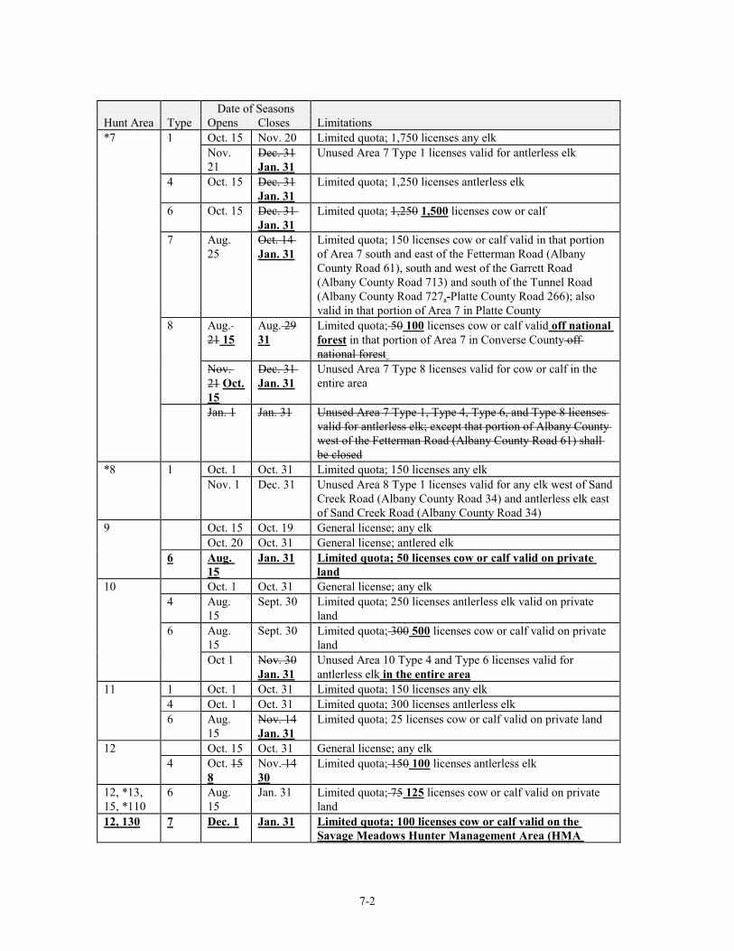
7-2
Date of Seasons Hunt Area Type Opens Closes Limitations *7 1 Oct. 15 Nov. 20 Limited quota; 1,750 licenses any elk Nov.
21 Dec. 31 Jan. 31
Unused Area 7 Type 1 licenses valid for antlerless elk
4 Oct. 15 Dec. 31 Jan. 31
Limited quota; 1,250 licenses antlerless elk
6 Oct. 15 Dec. 31 Jan. 31
Limited quota; 1,250 1,500 licenses cow or calf
7 Aug. 25
Oct. 14 Jan. 31
Limited quota; 150 licenses cow or calf valid in that portion of Area 7 south and east of the Fetterman Road (Albany County Road 61), south and west of the Garrett Road (Albany County Road 713) and south of the Tunnel Road (Albany County Road 727,-Platte County Road 266); also valid in that portion of Area 7 in Platte County
8 Aug. 21 15
Aug. 29 31
Limited quota; 50 100 licenses cow or calf valid off national forest in that portion of Area 7 in Converse County off national forest
Nov. 21 Oct. 15
Dec. 31 Jan. 31
Unused Area 7 Type 8 licenses valid for cow or calf in the entire area
Jan. 1 Jan. 31 Unused Area 7 Type 1, Type 4, Type 6, and Type 8 licenses valid for antlerless elk; except that portion of Albany County west of the Fetterman Road (Albany County Road 61) shall be closed
*8 1 Oct. 1 Oct. 31 Limited quota; 150 licenses any elk Nov. 1 Dec. 31 Unused Area 8 Type 1 licenses valid for any elk west of Sand
Creek Road (Albany County Road 34) and antlerless elk east of Sand Creek Road (Albany County Road 34)
9 Oct. 15 Oct. 19 General license; any elk Oct. 20 Oct. 31 General license; antlered elk 6 Aug.
15 Jan. 31 Limited quota; 50 licenses cow or calf valid on private
land 10 Oct. 1 Oct. 31 General license; any elk 4 Aug.
15 Sept. 30 Limited quota; 250 licenses antlerless elk valid on private
land 6 Aug.
15 Sept. 30 Limited quota; 300 500 licenses cow or calf valid on private
land Oct 1 Nov. 30
Jan. 31 Unused Area 10 Type 4 and Type 6 licenses valid for antlerless elk in the entire area
11 1 Oct. 1 Oct. 31 Limited quota; 150 licenses any elk 4 Oct. 1 Oct. 31 Limited quota; 300 licenses antlerless elk 6 Aug.
15 Nov. 14 Jan. 31
Limited quota; 25 licenses cow or calf valid on private land
12 Oct. 15 Oct. 31 General license; any elk 4 Oct. 15
8 Nov. 14 30
Limited quota; 150 100 licenses antlerless elk
12, *13, 15, *110
6 Aug. 15
Jan. 31 Limited quota; 75 125 licenses cow or calf valid on private land
12, 130 7 Dec. 1 Jan. 31 Limited quota; 100 licenses cow or calf valid on the Savage Meadows Hunter Management Area (HMA

7-3
Date of Seasons Hunt Area Type Opens Closes Limitations
permission slip required) *13 Oct. 15 Oct. 31 General license; any elk 4 Oct. 15
8 Nov. 14 30
Limited quota; 150 100 licenses antlerless elk
15 Oct. 15 Oct. 24 General license; any elk Oct. 25 Nov. 14
30 General license; antlerless elk
7 Oct. 15 Nov. 14 30
Limited quota; 100 150 licenses cow or calf
*16 1 Oct. 1 Oct. 20 31
Limited quota; 200 licenses any elk
Nov. 1 Nov. 20 15
Unused Area 16 Type 1 licenses valid on the Beer Mug Mountain Hunter Management Area (HMA permission slip required)
Jan. 1 Jan. 15 Unused Area 16 Type 1 license valid on the Beer Mug Hunter Management Area (HMA permission slip required)
4 Oct. 1 Nov. 20 30
Limited quota; 275 300 licenses antlerless elk
6 Oct. 1 Nov. 20 30
Limited quota; 125 100 licenses cow or calf
7 Aug. 15
Sept. 30 Limited quota; 50 licenses cow or calf valid on private land
Oct. 1 Nov. 20 30
Unused Area 16 Type 7 licenses for cow or calf valid in the entire area
Dec. 1 Dec. 15 Unused Area 16 Type 1, Type 4, Type 6 and Type 7 licenses valid on the Beer Mug Hunter Management Area (HMA permission slip required)
Jan. 1 Jan. 15 31
Unused Area 16 Type 1, Type 4, Type 6 and Type 7 licenses valid for antlerless elk
*19 1 Oct. 1 Oct. 14 Limited quota; 150 licenses any elk 2 Nov. 1 Nov. 20 Limited quota; 150 licenses any elk 4 Oct. 1 Oct. 14 Limited quota; 125 licenses antlerless elk 5 Nov. 1 Dec. 19
31 Limited quota; 125 licenses antlerless elk
6 Oct. 1 Oct. 14 Limited quota; 150 200 licenses cow or calf Nov. 1 Dec. 19
31 Unused Area 19 Type 6 licenses cow or calf
Nov. 21
Dec. 19 31
Unused Area 19 Type 1, Type 2 and Type 4 licenses antlerless elk
*21 Oct. 15 Oct. 24 23
General license; any antlered elk
Oct. 25 Nov. 1
Nov. 14 30
General license; antlerless elk
4 Oct. 25 Nov. 21 Limited quota; 25 licenses antlerless elk 6 Oct. 25
24 Nov. 21 30
Limited quota; 350 licenses cow or calf
Dec. 1 Jan. 31 Unused Area 21 Type 6 licenses valid for cow or calf elk in that portion of Area 108 west of the Twentymile Road (Carbon County Road 605) and north of the Continental
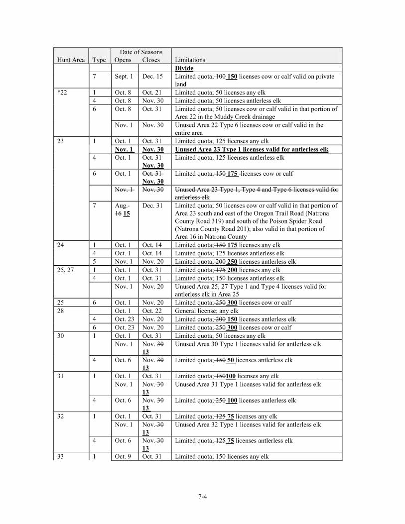
7-4
Date of Seasons Hunt Area Type Opens Closes Limitations
Divide 7 Sept. 1 Dec. 15 Limited quota; 100 150 licenses cow or calf valid on private
land *22 1 Oct. 8 Oct. 21 Limited quota; 50 licenses any elk 4 Oct. 8 Nov. 30 Limited quota; 50 licenses antlerless elk 6 Oct. 8 Oct. 31 Limited quota; 50 licenses cow or calf valid in that portion of
Area 22 in the Muddy Creek drainage Nov. 1 Nov. 30 Unused Area 22 Type 6 licenses cow or calf valid in the
entire area 23 1 Oct. 1 Oct. 31 Limited quota; 125 licenses any elk Nov. 1 Nov. 30 Unused Area 23 Type 1 licenses valid for antlerless elk 4 Oct. 1 Oct. 31
Nov. 30 Limited quota; 125 licenses antlerless elk
6 Oct. 1 Oct. 31 Nov. 30
Limited quota; 150 175 licenses cow or calf
Nov. 1 Nov. 30 Unused Area 23 Type 1, Type 4 and Type 6 licenses valid for antlerless elk
7 Aug. 16 15
Dec. 31 Limited quota; 50 licenses cow or calf valid in that portion of Area 23 south and east of the Oregon Trail Road (Natrona County Road 319) and south of the Poison Spider Road (Natrona County Road 201); also valid in that portion of Area 16 in Natrona County
24 1 Oct. 1 Oct. 14 Limited quota; 150 175 licenses any elk 4 Oct. 1 Oct. 14 Limited quota; 125 licenses antlerless elk 5 Nov. 1 Nov. 20 Limited quota; 200 250 licenses antlerless elk 25, 27 1 Oct. 1 Oct. 31 Limited quota; 175 200 licenses any elk 4 Oct. 1 Oct. 31 Limited quota; 150 licenses antlerless elk Nov. 1 Nov. 20 Unused Area 25, 27 Type 1 and Type 4 licenses valid for
antlerless elk in Area 25 25 6 Oct. 1 Nov. 20 Limited quota; 250 300 licenses cow or calf 28 Oct. 1 Oct. 22 General license; any elk 4 Oct. 23 Nov. 20 Limited quota; 200 150 licenses antlerless elk 6 Oct. 23 Nov. 20 Limited quota; 250 300 licenses cow or calf 30 1 Oct. 1 Oct. 31 Limited quota; 50 licenses any elk Nov. 1 Nov. 30
13 Unused Area 30 Type 1 licenses valid for antlerless elk
4 Oct. 6 Nov. 30 13
Limited quota; 150 50 licenses antlerless elk
31 1 Oct. 1 Oct. 31 Limited quota; 150100 licenses any elk Nov. 1 Nov. 30
13 Unused Area 31 Type 1 licenses valid for antlerless elk
4 Oct. 6 Nov. 30 13
Limited quota; 250 100 licenses antlerless elk
32 1 Oct. 1 Oct. 31 Limited quota; 125 75 licenses any elk Nov. 1 Nov. 30
13 Unused Area 32 Type 1 licenses valid for antlerless elk
4 Oct. 6 Nov. 30 13
Limited quota; 125 75 licenses antlerless elk
33 1 Oct. 9 Oct. 31 Limited quota; 150 licenses any elk
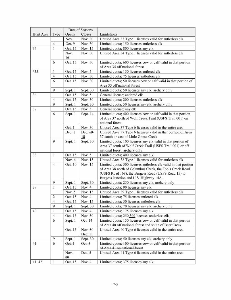
7-5
Date of Seasons Hunt Area Type Opens Closes Limitations Nov. 1 Nov. 30 Unused Area 33 Type 1 licenses valid for antlerless elk 4 Oct. 9 Nov. 30 Limited quota; 150 licenses antlerless elk 34 1 Oct. 15 Nov. 15 Limited quota; 800 licenses any elk Nov.
16 Nov. 30 Unused Area 34 Type 1 licenses valid for antlerless elk
6 Oct. 15 Nov. 30 Limited quota; 600 licenses cow or calf valid in that portion of Area 34 off national forest
*35 1 Oct. 15 Nov. 5 Limited quota; 150 licenses antlered elk 4 Oct. 15 Nov. 30 Limited quota; 75 licenses antlerless elk 6 Oct. 15 Nov. 30 Limited quota; 50 licenses cow or calf valid in that portion of
Area 35 off national forest 9 Sept. 1 Sept. 30 Limited quota; 50 licenses any elk, archery only 36 Oct. 15 Nov. 5 General license; antlered elk 4 Oct. 15 Nov. 30 Limited quota; 200 licenses antlerless elk 9 Sept. 1 Sept. 30 Limited quota; 50 licenses any elk, archery only 37 Oct. 15 Nov. 5 General license; any elk 6 Sept. 1 Sept. 14 Limited quota; 400 licenses cow or calf valid in that portion
of Area 37 north of Wolf Creek Trail (USFS Trail 001) on national forest
Oct. 1 Nov. 30 Unused Area 37 Type 6 licenses valid in the entire area Dec. 1 Dec. 19
18 Unused Area 37 Type 6 licenses valid in that portion of Area 37 south or east of Little Goose Creek
9 Sept. 1 Sept. 30 Limited quota; 100 licenses any elk valid in that portion of Area 37 south of Wolf Creek Trail (USFS Trail 001) or off national forest, archery only
38 1 Oct. 15 Nov. 5 Limited quota; 400 licenses any elk Nov. 6 Nov. 15 Unused Area 38 Type 1 licenses valid for antlerless elk 4 Oct. 10 Nov. 15 Limited quota; 500 licenses antlerless elk valid in that portion
of Area 38 north of Columbus Creek, the Fools Creek Road (USFS Road 168), the Burgess Road (USFS Road 15) to Burgess Junction and U.S. Highway 14A
9 Sept. 1 Sept. 30 Limited quota; 250 licenses any elk, archery only 39 1 Oct. 15 Nov. 4 Limited quota; 90 licenses any elk Nov. 5 Nov. 15 Unused Area 39 Type 1 licenses valid for antlerless elk 2 Oct. 15 Nov. 4 Limited quota; 75 licenses antlered elk 4 Oct. 15 Nov. 15 Limited quota; 50 licenses antlerless elk 9 Sept. 1 Sept. 30 Limited quota; 70 licenses any elk, archery only 40 1 Oct. 15 Nov. 4 Limited quota; 175 licenses any elk 4 Oct. 15 Nov. 30 Limited quota; 250 300 licenses antlerless elk 6 Sept. 1 Oct. 14 Limited quota; 150 licenses cow or calf valid in that portion
of Area 40 off national forest and south of Bear Creek Oct. 15 Nov. 30
Dec. 11 Unused Area 40 Type 6 licenses valid in the entire area
9 Sept. 1 Sept. 30 Limited quota; 50 licenses any elk, archery only 41 6 Oct. 1 Oct. 3 Limited quota; 100 licenses cow or calf valid in that portion
of Area 41 on national forest Nov.
20 Dec. 5 Unused Area 41 Type 6 licenses valid in the entire area
41, 42 1 Oct. 15 Nov. 4 Limited quota; 375 licenses any elk
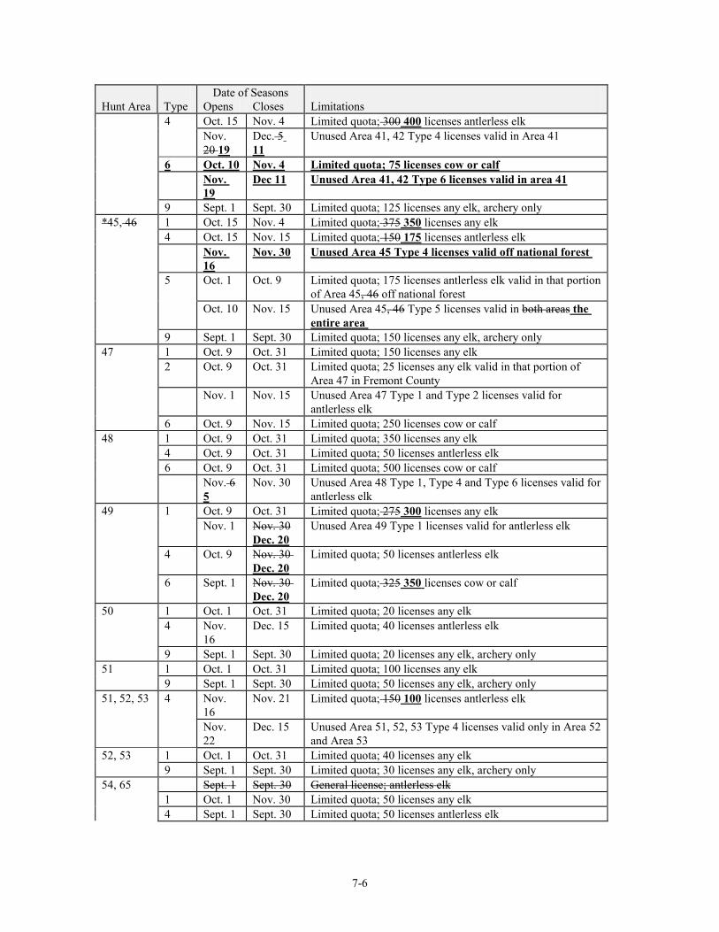
7-6
Date of Seasons Hunt Area Type Opens Closes Limitations 4 Oct. 15 Nov. 4 Limited quota; 300 400 licenses antlerless elk Nov.
20 19 Dec. 5 11
Unused Area 41, 42 Type 4 licenses valid in Area 41
6 Oct. 10 Nov. 4 Limited quota; 75 licenses cow or calf Nov.
19 Dec 11 Unused Area 41, 42 Type 6 licenses valid in area 41
9 Sept. 1 Sept. 30 Limited quota; 125 licenses any elk, archery only *45, 46 1 Oct. 15 Nov. 4 Limited quota; 375 350 licenses any elk 4 Oct. 15 Nov. 15 Limited quota; 150 175 licenses antlerless elk Nov.
16 Nov. 30 Unused Area 45 Type 4 licenses valid off national forest
5 Oct. 1 Oct. 9 Limited quota; 175 licenses antlerless elk valid in that portion of Area 45, 46 off national forest
Oct. 10 Nov. 15 Unused Area 45, 46 Type 5 licenses valid in both areas the entire area
9 Sept. 1 Sept. 30 Limited quota; 150 licenses any elk, archery only 47 1 Oct. 9 Oct. 31 Limited quota; 150 licenses any elk 2 Oct. 9 Oct. 31 Limited quota; 25 licenses any elk valid in that portion of
Area 47 in Fremont County Nov. 1 Nov. 15 Unused Area 47 Type 1 and Type 2 licenses valid for
antlerless elk 6 Oct. 9 Nov. 15 Limited quota; 250 licenses cow or calf 48 1 Oct. 9 Oct. 31 Limited quota; 350 licenses any elk 4 Oct. 9 Oct. 31 Limited quota; 50 licenses antlerless elk 6 Oct. 9 Oct. 31 Limited quota; 500 licenses cow or calf Nov. 6
5 Nov. 30 Unused Area 48 Type 1, Type 4 and Type 6 licenses valid for
antlerless elk 49 1 Oct. 9 Oct. 31 Limited quota; 275 300 licenses any elk Nov. 1 Nov. 30
Dec. 20 Unused Area 49 Type 1 licenses valid for antlerless elk
4 Oct. 9 Nov. 30 Dec. 20
Limited quota; 50 licenses antlerless elk
6 Sept. 1 Nov. 30 Dec. 20
Limited quota; 325 350 licenses cow or calf
50 1 Oct. 1 Oct. 31 Limited quota; 20 licenses any elk 4 Nov.
16 Dec. 15 Limited quota; 40 licenses antlerless elk
9 Sept. 1 Sept. 30 Limited quota; 20 licenses any elk, archery only 51 1 Oct. 1 Oct. 31 Limited quota; 100 licenses any elk 9 Sept. 1 Sept. 30 Limited quota; 50 licenses any elk, archery only 51, 52, 53 4 Nov.
16 Nov. 21 Limited quota; 150 100 licenses antlerless elk
Nov. 22
Dec. 15 Unused Area 51, 52, 53 Type 4 licenses valid only in Area 52 and Area 53
52, 53 1 Oct. 1 Oct. 31 Limited quota; 40 licenses any elk 9 Sept. 1 Sept. 30 Limited quota; 30 licenses any elk, archery only 54, 65 Sept. 1 Sept. 30 General license; antlerless elk 1 Oct. 1 Nov. 30 Limited quota; 50 licenses any elk 4 Sept. 1 Sept. 30 Limited quota; 50 licenses antlerless elk
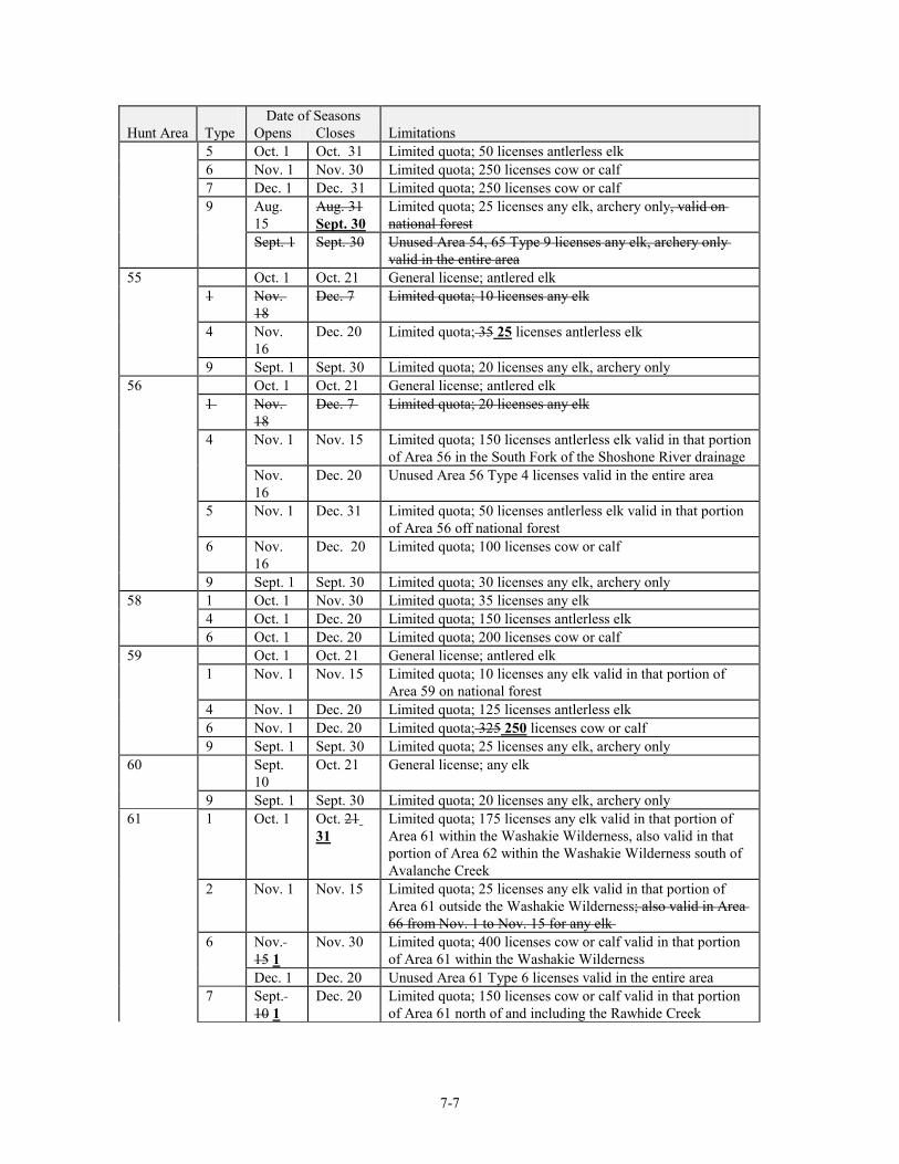
7-7
Date of Seasons Hunt Area Type Opens Closes Limitations 5 Oct. 1 Oct. 31 Limited quota; 50 licenses antlerless elk 6 Nov. 1 Nov. 30 Limited quota; 250 licenses cow or calf 7 Dec. 1 Dec. 31 Limited quota; 250 licenses cow or calf 9 Aug.
15 Aug. 31 Sept. 30
Limited quota; 25 licenses any elk, archery only, valid on national forest
Sept. 1 Sept. 30 Unused Area 54, 65 Type 9 licenses any elk, archery only valid in the entire area
55 Oct. 1 Oct. 21 General license; antlered elk 1 Nov.
18 Dec. 7 Limited quota; 10 licenses any elk
4 Nov. 16
Dec. 20 Limited quota; 35 25 licenses antlerless elk
9 Sept. 1 Sept. 30 Limited quota; 20 licenses any elk, archery only 56 Oct. 1 Oct. 21 General license; antlered elk 1 Nov.
18 Dec. 7 Limited quota; 20 licenses any elk
4 Nov. 1 Nov. 15 Limited quota; 150 licenses antlerless elk valid in that portion of Area 56 in the South Fork of the Shoshone River drainage
Nov. 16
Dec. 20 Unused Area 56 Type 4 licenses valid in the entire area
5 Nov. 1 Dec. 31 Limited quota; 50 licenses antlerless elk valid in that portion of Area 56 off national forest
6 Nov. 16
Dec. 20 Limited quota; 100 licenses cow or calf
9 Sept. 1 Sept. 30 Limited quota; 30 licenses any elk, archery only 58 1 Oct. 1 Nov. 30 Limited quota; 35 licenses any elk 4 Oct. 1 Dec. 20 Limited quota; 150 licenses antlerless elk 6 Oct. 1 Dec. 20 Limited quota; 200 licenses cow or calf 59 Oct. 1 Oct. 21 General license; antlered elk 1 Nov. 1 Nov. 15 Limited quota; 10 licenses any elk valid in that portion of
Area 59 on national forest 4 Nov. 1 Dec. 20 Limited quota; 125 licenses antlerless elk 6 Nov. 1 Dec. 20 Limited quota; 325 250 licenses cow or calf 9 Sept. 1 Sept. 30 Limited quota; 25 licenses any elk, archery only 60 Sept.
10 Oct. 21 General license; any elk
9 Sept. 1 Sept. 30 Limited quota; 20 licenses any elk, archery only 61 1 Oct. 1 Oct. 21
31 Limited quota; 175 licenses any elk valid in that portion of Area 61 within the Washakie Wilderness, also valid in that portion of Area 62 within the Washakie Wilderness south of Avalanche Creek
2 Nov. 1 Nov. 15 Limited quota; 25 licenses any elk valid in that portion of Area 61 outside the Washakie Wilderness; also valid in Area 66 from Nov. 1 to Nov. 15 for any elk
6 Nov. 15 1
Nov. 30 Limited quota; 400 licenses cow or calf valid in that portion of Area 61 within the Washakie Wilderness
Dec. 1 Dec. 20 Unused Area 61 Type 6 licenses valid in the entire area 7 Sept.
10 1 Dec. 20 Limited quota; 150 licenses cow or calf valid in that portion
of Area 61 north of and including the Rawhide Creek
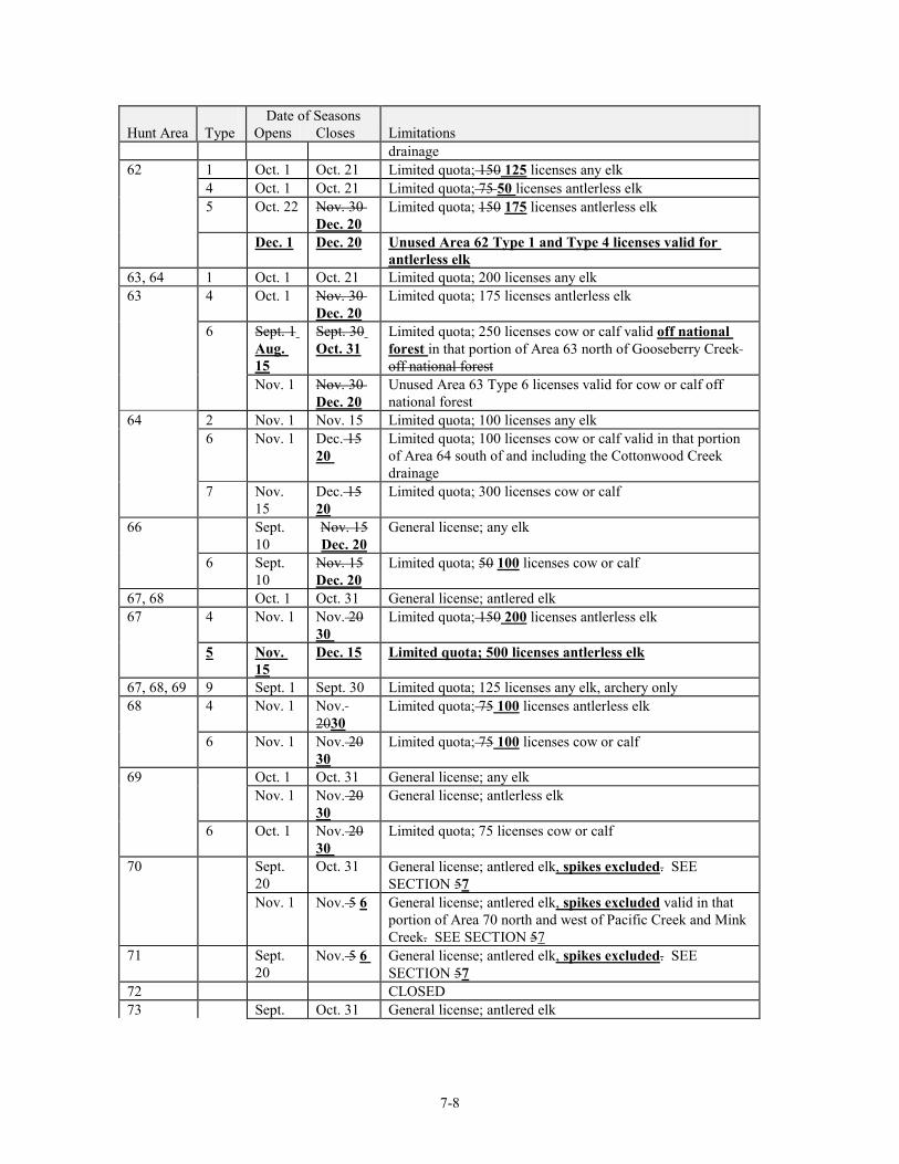
7-8
Date of Seasons Hunt Area Type Opens Closes Limitations
drainage 62 1 Oct. 1 Oct. 21 Limited quota; 150 125 licenses any elk 4 Oct. 1 Oct. 21 Limited quota; 75 50 licenses antlerless elk 5 Oct. 22 Nov. 30
Dec. 20 Limited quota; 150 175 licenses antlerless elk
Dec. 1 Dec. 20 Unused Area 62 Type 1 and Type 4 licenses valid for antlerless elk
63, 64 1 Oct. 1 Oct. 21 Limited quota; 200 licenses any elk 63 4 Oct. 1 Nov. 30
Dec. 20 Limited quota; 175 licenses antlerless elk
6 Sept. 1 Aug. 15
Sept. 30 Oct. 31
Limited quota; 250 licenses cow or calf valid off national forest in that portion of Area 63 north of Gooseberry Creek off national forest
Nov. 1 Nov. 30 Dec. 20
Unused Area 63 Type 6 licenses valid for cow or calf off national forest
64 2 Nov. 1 Nov. 15 Limited quota; 100 licenses any elk 6 Nov. 1 Dec. 15
20 Limited quota; 100 licenses cow or calf valid in that portion of Area 64 south of and including the Cottonwood Creek drainage
7 Nov. 15
Dec. 15 20
Limited quota; 300 licenses cow or calf
66 Sept. 10
Nov. 15 Dec. 20
General license; any elk
6 Sept. 10
Nov. 15 Dec. 20
Limited quota; 50 100 licenses cow or calf
67, 68 Oct. 1 Oct. 31 General license; antlered elk 67 4 Nov. 1 Nov. 20
30 Limited quota; 150 200 licenses antlerless elk
5 Nov. 15
Dec. 15 Limited quota; 500 licenses antlerless elk
67, 68, 69 9 Sept. 1 Sept. 30 Limited quota; 125 licenses any elk, archery only 68 4 Nov. 1 Nov.
2030 Limited quota; 75 100 licenses antlerless elk
6 Nov. 1 Nov. 20 30
Limited quota; 75 100 licenses cow or calf
69 Oct. 1 Oct. 31 General license; any elk Nov. 1 Nov. 20
30 General license; antlerless elk
6 Oct. 1 Nov. 20 30
Limited quota; 75 licenses cow or calf
70 Sept. 20
Oct. 31 General license; antlered elk, spikes excluded. SEE SECTION 57
Nov. 1 Nov. 5 6 General license; antlered elk, spikes excluded valid in that portion of Area 70 north and west of Pacific Creek and Mink Creek. SEE SECTION 57
71 Sept. 20
Nov. 5 6 General license; antlered elk, spikes excluded. SEE SECTION 57
72 CLOSED 73 Sept. Oct. 31 General license; antlered elk
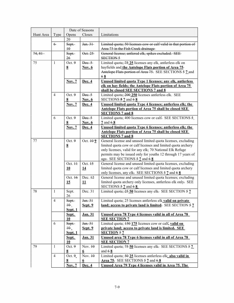
7-9
Date of Seasons Hunt Area Type Opens Closes Limitations
20 6 Sept.
10 Jan. 31 Limited quota; 50 licenses cow or calf valid in that portion of
Area 73 in the Fish Creek drainage 74, 81 Sept.
26 Oct. 25 General license; antlered elk, spikes excluded. SEE
SECTION 5 75 1 Oct. 9
8 Dec. 5 Nov. 6
Limited quota; 75 25 licenses any elk, antlerless elk on hayfields and the Antelope Flats portion of Area 75 Antelope Flats portion of Area 75. SEE SECTIONS 5 7 and 6 8
Nov. 7 Dec. 4 Unused limited quota Type 1 licenses; any elk, antlerless elk on hay fields; the Antelope Flats portion of Area 75 shall be closed SEE SECTIONS 7 and 8
4 Oct. 9 8
Dec. 5 Nov. 6
Limited quota; 200 250 licenses antlerless elk. SEE SECTIONS 5 7 and 6 8
Nov. 7 Dec. 4 Unused limited quota Type 4 licenses; antlerless elk; the Antelope Flats portion of Area 75 shall be closed SEE SECTIONS 7 and 8
6 Oct. 9 8
Dec. 5 Nov. 6
Limited quota; 400 licenses cow or calf. SEE SECTIONS 5 7 and 6 8
Nov. 7 Dec. 4 Unused limited quota Type 6 licenses; antlerless elk; the Antelope Flats portion of Area 75 shall be closed SEE SECTIONS 7 and 8
77 Oct. 9 8
Oct. 10 9 General license and unused limited quota licenses, excluding limited quota cow or calf licenses and limited quota archery only licenses, valid for any elk; 70 National Elk Refuge permits may be issued only for youths 12 through 17 years of age. SEE SECTIONS 5 7 and 6 8
Oct. 11 10
Oct. 15 14
General license and unused limited quota licenses, excluding limited quota cow or calf licenses and limited quota archery only licenses, any elk. SEE SECTIONS 5 7 and 6 8
Oct. 16 15
Dec. 12 11
General license and unused limited quota licenses; excluding limited quota archery only licenses, antlerless elk only. SEE SECTIONS 5 7 and 6 8
78 1 Sept. 26
Dec. 31 Limited quota; 25 50 licenses any elk. SEE SECTION 5 7
4 Sept. 10 Sept. 1
Jan. 31 Sept. 9
Limited quota; 25 licenses antlerless elk valid on private land; access to private land is limited. SEE SECTION 5 7
Sept. 10
Jan. 31 Unused area 78 Type 4 licenses valid in all of Area 78 SEE SECTION 7
6 Sept. 10 Sept. 1
Jan. 31 Sept. 9
Limited quota; 150 175 licenses cow or calf, valid on private land; access to private land is limited. SEE SECTION 5 7
Sept. 10
Jan. 31 Unused area 78 Type 6 licenses valid in all of Area 78 SEE SECTION 7
79 1 Oct. 9 8
Nov. 10 6
Limited quota; 75 50 licenses any elk. SEE SECTIONS 5 7 and 6 8
4 Oct. 9 8
Nov. 10 6
Limited quota; 50 25 licenses antlerless elk; also valid in Area 75. SEE SECTIONS 5 7 and 6 8
Nov. 7 Dec. 4 Unused Area 79 Type 4 licenses valid in Area 75. The
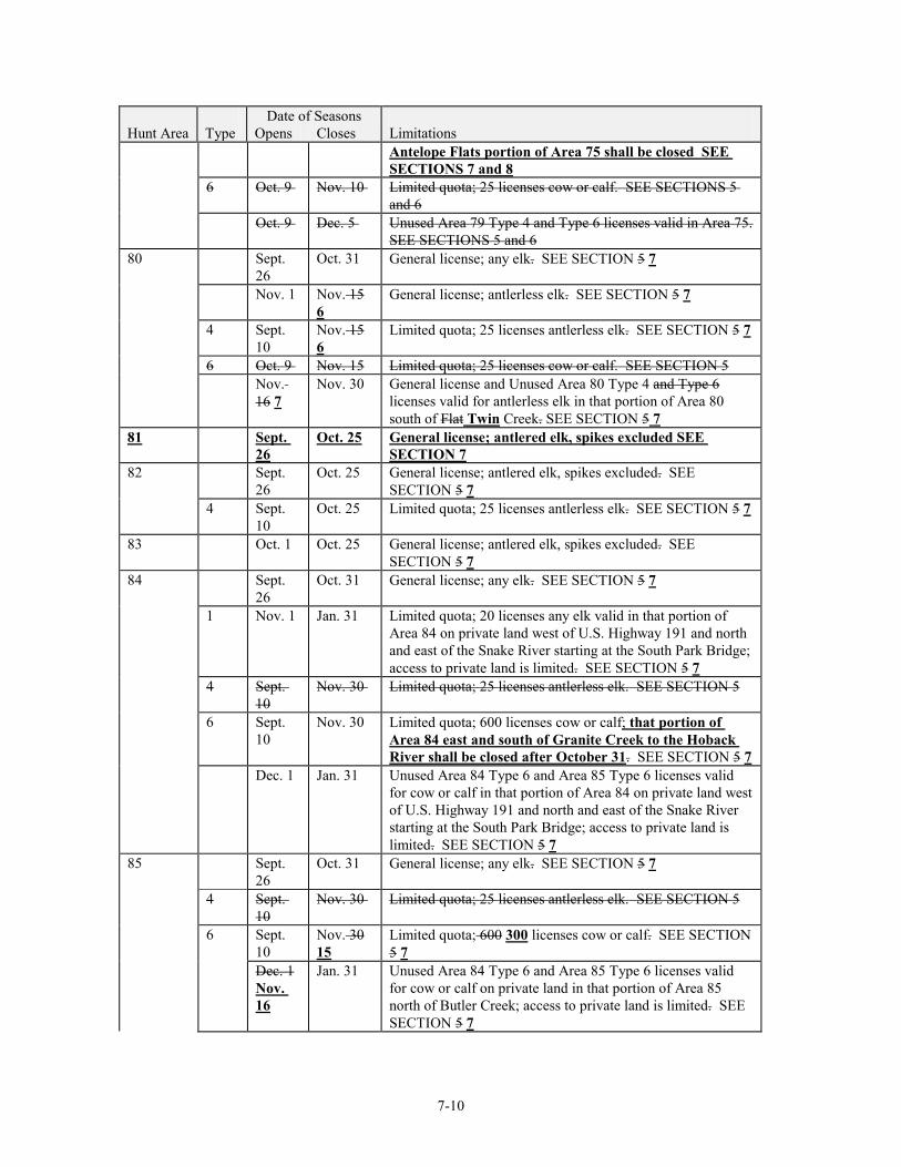
7-10
Date of Seasons Hunt Area Type Opens Closes Limitations
Antelope Flats portion of Area 75 shall be closed SEE SECTIONS 7 and 8
6 Oct. 9 Nov. 10 Limited quota; 25 licenses cow or calf. SEE SECTIONS 5 and 6
Oct. 9 Dec. 5 Unused Area 79 Type 4 and Type 6 licenses valid in Area 75. SEE SECTIONS 5 and 6
80 Sept. 26
Oct. 31 General license; any elk. SEE SECTION 5 7
Nov. 1 Nov. 15 6
General license; antlerless elk. SEE SECTION 5 7
4 Sept. 10
Nov. 15 6
Limited quota; 25 licenses antlerless elk. SEE SECTION 5 7
6 Oct. 9 Nov. 15 Limited quota; 25 licenses cow or calf. SEE SECTION 5 Nov.
16 7 Nov. 30 General license and Unused Area 80 Type 4 and Type 6
licenses valid for antlerless elk in that portion of Area 80 south of Flat Twin Creek. SEE SECTION 5 7
81 Sept. 26
Oct. 25 General license; antlered elk, spikes excluded SEE SECTION 7
82 Sept. 26
Oct. 25 General license; antlered elk, spikes excluded. SEE SECTION 5 7
4 Sept. 10
Oct. 25 Limited quota; 25 licenses antlerless elk. SEE SECTION 5 7
83 Oct. 1 Oct. 25 General license; antlered elk, spikes excluded. SEE SECTION 5 7
84 Sept. 26
Oct. 31 General license; any elk. SEE SECTION 5 7
1 Nov. 1 Jan. 31 Limited quota; 20 licenses any elk valid in that portion of Area 84 on private land west of U.S. Highway 191 and north and east of the Snake River starting at the South Park Bridge; access to private land is limited. SEE SECTION 5 7
4 Sept. 10
Nov. 30 Limited quota; 25 licenses antlerless elk. SEE SECTION 5
6 Sept. 10
Nov. 30 Limited quota; 600 licenses cow or calf; that portion of Area 84 east and south of Granite Creek to the Hoback River shall be closed after October 31. SEE SECTION 5 7
Dec. 1 Jan. 31 Unused Area 84 Type 6 and Area 85 Type 6 licenses valid for cow or calf in that portion of Area 84 on private land west of U.S. Highway 191 and north and east of the Snake River starting at the South Park Bridge; access to private land is limited. SEE SECTION 5 7
85 Sept. 26
Oct. 31 General license; any elk. SEE SECTION 5 7
4 Sept. 10
Nov. 30 Limited quota; 25 licenses antlerless elk. SEE SECTION 5
6 Sept. 10
Nov. 30 15
Limited quota; 600 300 licenses cow or calf. SEE SECTION 5 7
Dec. 1 Nov. 16
Jan. 31 Unused Area 84 Type 6 and Area 85 Type 6 licenses valid for cow or calf on private land in that portion of Area 85 north of Butler Creek; access to private land is limited. SEE SECTION 5 7
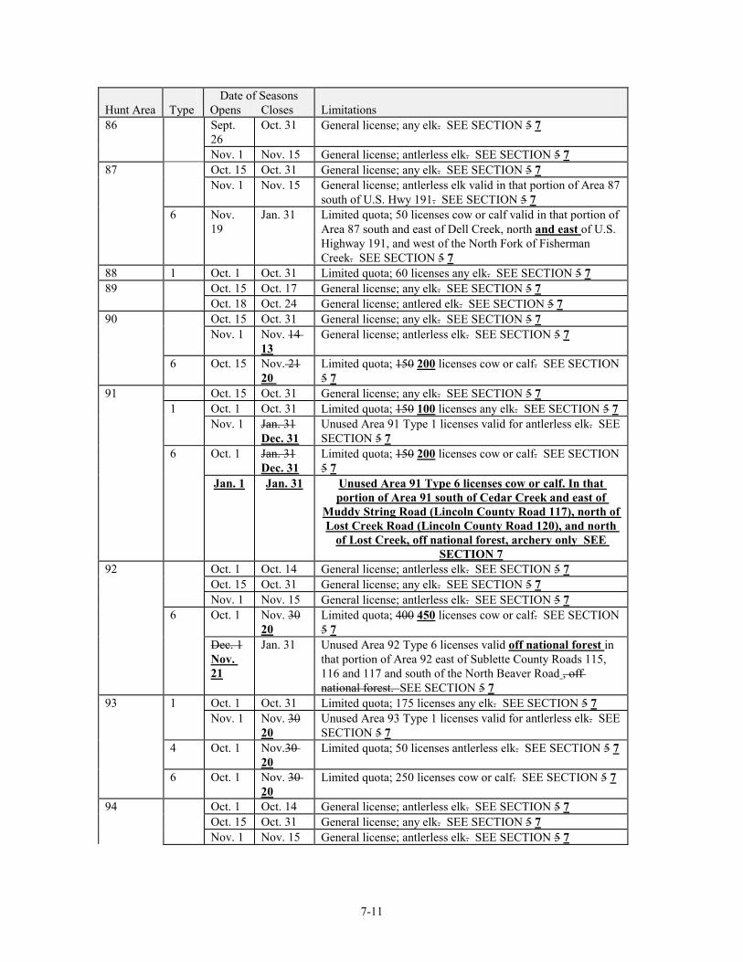
7-11
Date of Seasons Hunt Area Type Opens Closes Limitations 86 Sept.
26 Oct. 31 General license; any elk. SEE SECTION 5 7
Nov. 1 Nov. 15 General license; antlerless elk. SEE SECTION 5 7 87 Oct. 15 Oct. 31 General license; any elk. SEE SECTION 5 7 Nov. 1 Nov. 15 General license; antlerless elk valid in that portion of Area 87
south of U.S. Hwy 191. SEE SECTION 5 7 6 Nov.
19 Jan. 31 Limited quota; 50 licenses cow or calf valid in that portion of
Area 87 south and east of Dell Creek, north and east of U.S. Highway 191, and west of the North Fork of Fisherman Creek. SEE SECTION 5 7
88 1 Oct. 1 Oct. 31 Limited quota; 60 licenses any elk. SEE SECTION 5 7 89 Oct. 15 Oct. 17 General license; any elk. SEE SECTION 5 7 Oct. 18 Oct. 24 General license; antlered elk. SEE SECTION 5 7 90 Oct. 15 Oct. 31 General license; any elk. SEE SECTION 5 7 Nov. 1 Nov. 14
13 General license; antlerless elk. SEE SECTION 5 7
6 Oct. 15 Nov. 21 20
Limited quota; 150 200 licenses cow or calf. SEE SECTION 5 7
91 Oct. 15 Oct. 31 General license; any elk. SEE SECTION 5 7 1 Oct. 1 Oct. 31 Limited quota; 150 100 licenses any elk. SEE SECTION 5 7 Nov. 1 Jan. 31
Dec. 31 Unused Area 91 Type 1 licenses valid for antlerless elk. SEE SECTION 5 7
6 Oct. 1 Jan. 31 Dec. 31
Limited quota; 150 200 licenses cow or calf. SEE SECTION 5 7
Jan. 1 Jan. 31 Unused Area 91 Type 6 licenses cow or calf. In that portion of Area 91 south of Cedar Creek and east of
Muddy String Road (Lincoln County Road 117), north of Lost Creek Road (Lincoln County Road 120), and north
of Lost Creek, off national forest, archery only SEE SECTION 7
92 Oct. 1 Oct. 14 General license; antlerless elk. SEE SECTION 5 7 Oct. 15 Oct. 31 General license; any elk. SEE SECTION 5 7 Nov. 1 Nov. 15 General license; antlerless elk. SEE SECTION 5 7 6 Oct. 1 Nov. 30
20 Limited quota; 400 450 licenses cow or calf. SEE SECTION 5 7
Dec. 1 Nov. 21
Jan. 31 Unused Area 92 Type 6 licenses valid off national forest in that portion of Area 92 east of Sublette County Roads 115, 116 and 117 and south of the North Beaver Road , off national forest. SEE SECTION 5 7
93 1 Oct. 1 Oct. 31 Limited quota; 175 licenses any elk. SEE SECTION 5 7 Nov. 1 Nov. 30
20 Unused Area 93 Type 1 licenses valid for antlerless elk. SEE SECTION 5 7
4 Oct. 1 Nov.30 20
Limited quota; 50 licenses antlerless elk. SEE SECTION 5 7
6 Oct. 1 Nov. 30 20
Limited quota; 250 licenses cow or calf. SEE SECTION 5 7
94 Oct. 1 Oct. 14 General license; antlerless elk. SEE SECTION 5 7 Oct. 15 Oct. 31 General license; any elk. SEE SECTION 5 7 Nov. 1 Nov. 15 General license; antlerless elk. SEE SECTION 5 7
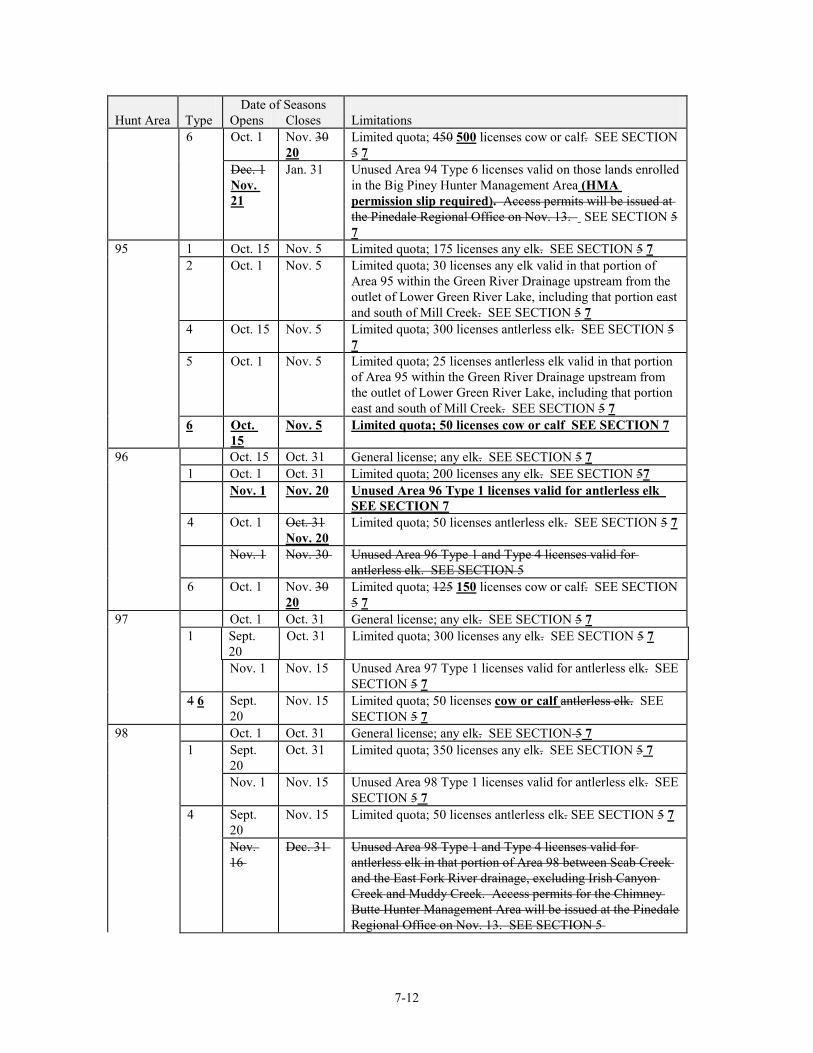
7-12
Date of Seasons Hunt Area Type Opens Closes Limitations 6 Oct. 1 Nov. 30
20 Limited quota; 450 500 licenses cow or calf. SEE SECTION 5 7
Dec. 1 Nov. 21
Jan. 31 Unused Area 94 Type 6 licenses valid on those lands enrolled in the Big Piney Hunter Management Area (HMA permission slip required). Access permits will be issued at the Pinedale Regional Office on Nov. 13. SEE SECTION 5 7
95 1 Oct. 15 Nov. 5 Limited quota; 175 licenses any elk. SEE SECTION 5 7 2 Oct. 1 Nov. 5 Limited quota; 30 licenses any elk valid in that portion of
Area 95 within the Green River Drainage upstream from the outlet of Lower Green River Lake, including that portion east and south of Mill Creek. SEE SECTION 5 7
4 Oct. 15 Nov. 5 Limited quota; 300 licenses antlerless elk. SEE SECTION 5 7
5 Oct. 1 Nov. 5 Limited quota; 25 licenses antlerless elk valid in that portion of Area 95 within the Green River Drainage upstream from the outlet of Lower Green River Lake, including that portion east and south of Mill Creek. SEE SECTION 5 7
6 Oct. 15
Nov. 5 Limited quota; 50 licenses cow or calf SEE SECTION 7
96 Oct. 15 Oct. 31 General license; any elk. SEE SECTION 5 7 1 Oct. 1 Oct. 31 Limited quota; 200 licenses any elk. SEE SECTION 57 Nov. 1 Nov. 20 Unused Area 96 Type 1 licenses valid for antlerless elk
SEE SECTION 7 4 Oct. 1 Oct. 31
Nov. 20 Limited quota; 50 licenses antlerless elk. SEE SECTION 5 7
Nov. 1 Nov. 30 Unused Area 96 Type 1 and Type 4 licenses valid for antlerless elk. SEE SECTION 5
6 Oct. 1 Nov. 30 20
Limited quota; 125 150 licenses cow or calf. SEE SECTION 5 7
97 Oct. 1 Oct. 31 General license; any elk. SEE SECTION 5 7 1 Sept.
20 Oct. 31 Limited quota; 300 licenses any elk. SEE SECTION 5 7
Nov. 1 Nov. 15 Unused Area 97 Type 1 licenses valid for antlerless elk. SEE SECTION 5 7
4 6 Sept. 20
Nov. 15 Limited quota; 50 licenses cow or calf antlerless elk. SEE SECTION 5 7
98 Oct. 1 Oct. 31 General license; any elk. SEE SECTION 5 7 1 Sept.
20 Oct. 31 Limited quota; 350 licenses any elk. SEE SECTION 5 7
Nov. 1 Nov. 15 Unused Area 98 Type 1 licenses valid for antlerless elk. SEE SECTION 5 7
4 Sept. 20
Nov. 15 Limited quota; 50 licenses antlerless elk. SEE SECTION 5 7
Nov. 16
Dec. 31 Unused Area 98 Type 1 and Type 4 licenses valid for antlerless elk in that portion of Area 98 between Scab Creek and the East Fork River drainage, excluding Irish Canyon Creek and Muddy Creek. Access permits for the Chimney Butte Hunter Management Area will be issued at the Pinedale Regional Office on Nov. 13. SEE SECTION 5
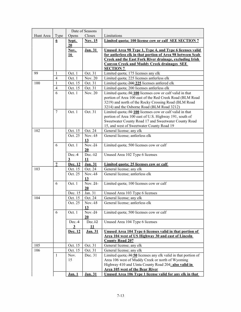
7-13
Date of Seasons Hunt Area Type Opens Closes Limitations 6 Sept.
20 Nov. 15 Limited quota; 100 license cow or calf SEE SECTION 7
Nov. 16
Jan. 31 Unused Area 98 Type 1, Type 4, and Type 6 licenses valid for antlerless elk in that portion of Area 98 between Scab Creek and the East Fork River drainage, excluding Irish Canyon Creek and Muddy Creek drainages SEE SECTION 7
99 1 Oct. 1 Oct. 31 Limited quota; 175 licenses any elk 4 Oct. 1 Nov. 20 Limited quota; 225 licenses antlerless elk 100 1 Oct. 15 Oct. 31 Limited quota; 200 225 licenses antlered elk 4 Oct. 15 Oct. 31 Limited quota; 200 licenses antlerless elk 6 Oct. 1 Nov. 20 Limited quota; 50 100 licenses cow or calf valid in that
portion of Area 100 east of the Red Creek Road (BLM Road 3219) and north of the Rocky Crossing Road (BLM Road 3214) and the Osborne Road (BLM Road 3212)
7 Oct. 1 Oct. 31 Limited quota; 50 100 licenses cow or calf valid in that portion of Area 100 east of U.S. Highway 191, south of Sweetwater County Road 17 and Sweetwater County Road 15, and west of Sweetwater County Road 19
102 Oct. 15 Oct. 24 General license; any elk Oct. 25 Nov. 15
13 General license; antlerless elk
6 Oct. 1 Nov. 21 20
Limited quota; 500 licenses cow or calf
Dec. 4 3
Dec. 12 11
Unused Area 102 Type 6 licenses
7 Dec. 12 Jan. 31 Limited quota; 25 licenses cow or calf 103 Oct. 15 Oct. 24 General license; any elk Oct. 25 Nov. 15
13 General license; antlerless elk
6 Oct. 1 Nov. 21 20
Limited quota; 100 licenses cow or calf
Dec. 15 Jan. 31 Unused Area 103 Type 6 licenses 104 Oct. 15 Oct. 24 General license; any elk Oct. 25 Nov. 15
13 General license; antlerless elk
6 Oct. 1 Nov. 21 20
Limited quota; 500 licenses cow or calf
Dec. 4 3
Dec.12 11
Unused Area 104 Type 6 licenses
Dec. 12 Jan. 31 Unused Area 104 Type 6 licenses valid in that portion of Area 104 west of US Highway 30 and east of Lincoln County Road 207
105 Oct. 15 Oct. 31 General license; any elk 106 Oct. 15 Oct. 31 General license; any elk 1 Nov.
15 Dec. 31 Limited quota; 30 50 licenses any elk valid in that portion of
Area 106 west of Muddy Creek or north of Wyoming Highway 410 and Uinta County Road 204; also valid in Area 105 west of the Bear River
Jan. 1 Jan. 31 Unused Area 106 Type 1 license valid for any elk in that
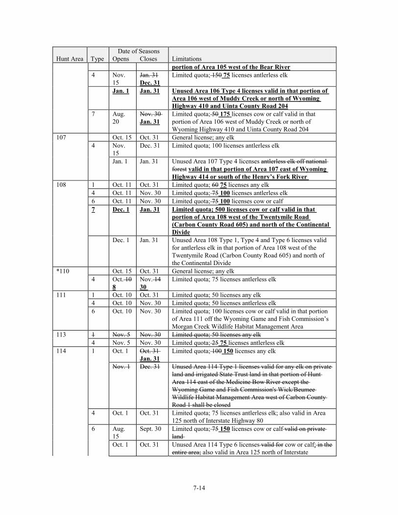
7-14
Date of Seasons Hunt Area Type Opens Closes Limitations
portion of Area 105 west of the Bear River 4 Nov.
15 Jan. 31 Dec. 31
Limited quota; 150 75 licenses antlerless elk
Jan. 1 Jan. 31 Unused Area 106 Type 4 licenses valid in that portion of Area 106 west of Muddy Creek or north of Wyoming Highway 410 and Uinta County Road 204
7 Aug. 20
Nov. 30 Jan. 31
Limited quota; 50 175 licenses cow or calf valid in that portion of Area 106 west of Muddy Creek or north of Wyoming Highway 410 and Uinta County Road 204
107 Oct. 15 Oct. 31 General license; any elk 4 Nov.
15 Dec. 31 Limited quota; 100 licenses antlerless elk
Jan. 1 Jan. 31 Unused Area 107 Type 4 licenses antlerless elk off national forest valid in that portion of Area 107 east of Wyoming Highway 414 or south of the Henry’s Fork River
108 1 Oct. 11 Oct. 31 Limited quota; 60 75 licenses any elk 4 Oct. 11 Nov. 30 Limited quota; 75 100 licenses antlerless elk 6 Oct. 11 Nov. 30 Limited quota; 75 100 licenses cow or calf 7 Dec. 1 Jan. 31 Limited quota; 500 licenses cow or calf valid in that
portion of Area 108 west of the Twentymile Road (Carbon County Road 605) and north of the Continental Divide
Dec. 1 Jan. 31 Unused Area 108 Type 1, Type 4 and Type 6 licenses valid for antlerless elk in that portion of Area 108 west of the Twentymile Road (Carbon County Road 605) and north of the Continental Divide
*110 Oct. 15 Oct. 31 General license; any elk 4 Oct. 10
8 Nov. 14 30
Limited quota; 75 licenses antlerless elk
111 1 Oct. 10 Oct. 31 Limited quota; 50 licenses any elk 4 Oct. 10 Nov. 30 Limited quota; 50 licenses antlerless elk 6 Oct. 10 Nov. 30 Limited quota; 100 licenses cow or calf valid in that portion
of Area 111 off the Wyoming Game and Fish Commission’s Morgan Creek Wildlife Habitat Management Area
113 1 Nov. 5 Nov. 30 Limited quota; 50 licenses any elk 4 Nov. 5 Nov. 30 Limited quota; 25 75 licenses antlerless elk 114 1 Oct. 1 Oct. 31
Jan. 31 Limited quota; 100 150 licenses any elk
Nov. 1 Dec. 31 Unused Area 114 Type 1 licenses valid for any elk on private land and irrigated State Trust land in that portion of Hunt Area 114 east of the Medicine Bow River except the Wyoming Game and Fish Commission's Wick/Beumee Wildlife Habitat Management Area west of Carbon County Road 1 shall be closed
4 Oct. 1 Oct. 31 Limited quota; 75 licenses antlerless elk; also valid in Area 125 north of Interstate Highway 80
6 Aug. 15
Sept. 30 Limited quota; 75 150 licenses cow or calf valid on private land
Oct. 1 Oct. 31 Unused Area 114 Type 6 licenses valid for cow or calf; in the entire area; also valid in Area 125 north of Interstate
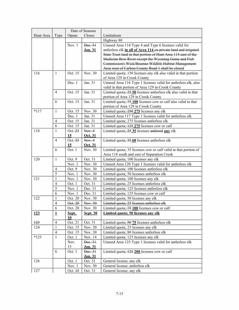
7-15
Date of Seasons Hunt Area Type Opens Closes Limitations
Highway 80 Nov. 1 Dec. 31
Jan. 31 Unused Area 114 Type 4 and Type 6 licenses valid for antlerless elk in all of Area 114 on private land and irrigated State Trust land in that portion of Hunt Area 114 east of the Medicine Bow River except the Wyoming Game and Fish Commission's Wick/Beumee Wildlife Habitat Management Area west of Carbon County Road 1 shall be closed
116 1 Oct. 15 Nov. 30 Limited quota; 150 licenses any elk also valid in that portion of Area 129 in Crook County
Dec. 1 Jan. 31 Unused Area 116 Type 1 licenses valid for antlerless elk, also valid in that portion of Area 129 in Crook County
4 Oct. 15 Jan. 31 Limited quota; 25 50 licenses antlerless elk also valid in that portion of Area 129 in Crook County
6 Oct. 15 Jan. 31 Limited quota; 75 100 licenses cow or calf also valid in that portion of Area 129 in Crook County
*117 1 Oct. 15 Nov. 30 Limited quota; 250 275 licenses any elk Dec. 1 Jan. 31 Unused Area 117 Type 1 licenses valid for antlerless elk 4 Oct. 15 Jan. 31 Limited quota; 275 licenses antlerless elk 6 Oct. 15 Jan. 31 Limited quota; 125 275 licenses cow or calf 118 1 Oct. 23
15 Nov. 4 Oct. 31
Limited quota; 25 35 licenses antlered any elk
4 Oct. 23 15
Nov. 4 Oct. 31
Limited quota; 35 60 licenses antlerless elk
6 Oct. 1 Nov. 30 Limited quota; 35 licenses cow or calf valid in that portion of Area 118 south and east of Separation Creek
120 1 Oct. 9 Oct. 31 Limited quota; 100 licenses any elk Nov. 1 Nov. 30 Unused Area 120 Type 1 licenses valid for antlerless elk 4 Oct. 9 Nov. 30 Limited quota; 100 licenses antlerless elk 5 Nov. 1 Nov. 30 Limited quota; 50 licenses antlerless elk 121 1 Nov. 1 Nov. 30 Limited quota; 100 licenses any elk 4 Oct. 1 Oct. 31 Limited quota; 25 licenses antlerless elk 5 Nov. 1 Dec. 31 Limited quota; 125 licenses antlerless elk 6 Nov. 1 Dec. 31 Limited quota; 125 licenses cow or calf 122 1 Oct. 20 Nov. 30 Limited quota; 50 licenses any elk 4 Oct. 20 Nov. 30 Limited quota; 25 licenses antlerless elk 6 Oct. 20 Nov. 30 Limited quota; 75 100 licenses cow or calf 123 1 Sept.
10 Sept. 30 Limited quota; 50 licenses any elk
123 4 Oct. 21 Oct. 31 Limited quota; 50 75 licenses antlerless elk 124 1 Oct. 15 Nov. 30 Limited quota; 25 licenses any elk 4 Oct. 15 Nov. 30 Limited quota; 80 licenses antlerless elk *125 1 Oct. 1 Nov. 14 Limited quota; 125 licenses any elk Nov.
15 Dec. 31 Jan. 31
Unused Area 125 Type 1 licenses valid for antlerless elk
6 Oct. 1 Dec. 31 Jan. 31
Limited quota; 125 200 licenses cow or calf
126 Oct. 1 Oct. 31 General license; any elk Nov. 1 Nov. 30 General license; antlerless elk 127 Oct. 15 Oct. 31 General license; any elk
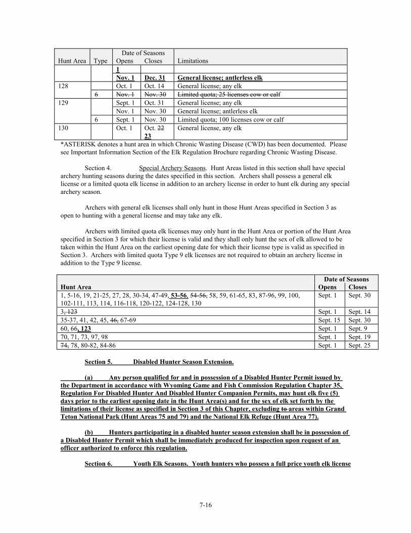
7-16
Date of Seasons Hunt Area Type Opens Closes Limitations
1 Nov. 1 Dec. 31 General license; antlerless elk 128 Oct. 1 Oct. 14 General license; any elk 6 Nov. 1 Nov. 30 Limited quota; 25 licenses cow or calf 129 Sept. 1 Oct. 31 General license; any elk Nov. 1 Nov. 30 General license; antlerless elk 6 Sept. 1 Nov. 30 Limited quota; 100 licenses cow or calf 130 Oct. 1 Oct. 22
23 General license, any elk
*ASTERISK denotes a hunt area in which Chronic Wasting Disease (CWD) has been documented. Please see Important Information Section of the Elk Regulation Brochure regarding Chronic Wasting Disease. Section 4. Special Archery Seasons. Hunt Areas listed in this section shall have special archery hunting seasons during the dates specified in this section. Archers shall possess a general elk license or a limited quota elk license in addition to an archery license in order to hunt elk during any special archery season.
Archers with general elk licenses shall only hunt in those Hunt Areas specified in Section 3 as open to hunting with a general license and may take any elk. Archers with limited quota elk licenses may only hunt in the Hunt Area or portion of the Hunt Area specified in Section 3 for which their license is valid and they shall only hunt the sex of elk allowed to be taken within the Hunt Area on the earliest opening date for which their license type is valid as specified in Section 3. Archers with limited quota Type 9 elk licenses are not required to obtain an archery license in addition to the Type 9 license. Date of Seasons Hunt Area Opens Closes 1, 5-16, 19, 21-25, 27, 28, 30-34, 47-49, 53-56, 54-56, 58, 59, 61-65, 83, 87-96, 99, 100, 102-111, 113, 114, 116-118, 120-122, 124-128, 130
Sept. 1 Sept. 30
3, 123 Sept. 1 Sept. 14 35-37, 41, 42, 45, 46, 67-69 Sept. 15 Sept. 30 60, 66, 123 Sept. 1 Sept. 9 70, 71, 73, 97, 98 Sept. 1 Sept. 19 74, 78, 80-82, 84-86 Sept. 1 Sept. 25 Section 5. Disabled Hunter Season Extension. (a) Any person qualified for and in possession of a Disabled Hunter Permit issued by the Department in accordance with Wyoming Game and Fish Commission Regulation Chapter 35, Regulation For Disabled Hunter And Disabled Hunter Companion Permits, may hunt elk five (5) days prior to the earliest opening date in the Hunt Area(s) and for the sex of elk set forth by the limitations of their license as specified in Section 3 of this Chapter, excluding to areas within Grand Teton National Park (Hunt Areas 75 and 79) and the National Elk Refuge (Hunt Area 77). (b) Hunters participating in a disabled hunter season extension shall be in possession of a Disabled Hunter Permit which shall be immediately produced for inspection upon request of an officer authorized to enforce this regulation.
Section 6. Youth Elk Seasons. Youth hunters who possess a full price youth elk license
7-17
may take any elk during an antlered elk season in the Hunt Area(s) where their license is valid as specified in Section 3 of this Chapter, excluding areas within Grand Teton National Park (Hunt Areas 75 and 79) and the National Elk Refuge (Hunt Area 77).
Section 7.Section 5. Elk Feedground Special Management Permit. The Department’s elk
feedground program is a special management program that requires additional expenditures for the feeding of wildlife. An elk feedground special management permit shall be required of any person who hunts elk in the hunt areas identified in subsection (a) of this section. The elk feedground special management permit shall be in possession of any person while hunting elk in those hunt areas and shall be immediately produced upon request from an authorized Department representative. Any person who purchases an elk feedground special management permit for the purpose set forth in this section shall sign his name in ink across the face of the permit. Hunters who acquire an elk feedground management stamp through the ELS shall not be required to meet the signature provision of this section. The permit shall be available at Cheyenne Headquarters, Department Regional Offices, and at designated license selling agents. (a) Elk Hunt Areas 70, 71, 74, 75, 77, 78, 79, 80, 81, 82, 83, 84, 85, 86, 87, 88, 89, 90, 91, 92, 93, 94, 95, 96, 97, and 98. Section 8.Section 6. Regulations Governing Elk Hunting in Grand Teton National Park (Hunt Areas 75 and 79) and the National Elk Refuge (Hunt Area 77). (a) NO HUNTER MAY HARVEST MORE THAN ONE (1) ELK IN GRAND TETON NATIONAL PARK. (b) Successful completion of a hunter safety course is required, regardless of a hunter’s age, prior to hunting in Grand Teton National Park and a hunter safety certificate shall be in possession when hunting elk. (c) A Park or National Elk Refuge Permit is required prior to hunting elk and shall be in possession while hunting elk in Grand Teton National Park or the National Elk Refuge.
(d) That portion of Hunt Area 75 beginning at the Lost Creek Road (U.S.F.S. Road 30340) at
U.S. Highway 26-89-191; easterly along said road to the Grand Teton National Park boundary; southerly along said boundary to the intersection with the Shadow Mountain-Kelly Road (U.S.F.S. Road 30340) at Carpenter Draw; southwesterly along said road to the junction of the Mormon Row Road; northerly along said road to the Antelope Flats Road; westerly along said road to U.S. Highway 26-89-191; northeasterly along said highway to the Lost Creek Road (U.S.F.S. Road 30340), described as the Antelope Flats and the hayfields areas shall be open only to antlerless elk hunting. (e) An area one-quarter (1/4) mile wide along either side of U.S. Highway 26-89-191 shall be closed to all elk hunting within Grand Teton National Park. (f) An area within one-half (1/2) mile of any building shall be closed to elk hunting within Grand Teton National Park. (g) A portion of Hunt Area 75 in the SW 1/4 of Section 22, T43N, R115W, S1/2, S1/2 of Sections 3 and 4, T42N, R115W shall be closed to elk hunting, as posted in the field. (h) Legal firearms include rifles with a barrel bore diameter of at least .23 caliber that fire a cartridge that is two (2) inches or more in length. The use of handguns and archery equipment for hunting are prohibited in Grand Teton National Park.. The use of handguns is prohibited on the National Elk Refuge. Archery equipment is permitted in specific portions of the National Elk Refuge.
7-18
Section 9.Section 7. Hunt Area Descriptions. (a) Area and Number. Area 1. Black Hills. Beginning where the north boundary of the Black Hills National Forest crosses the Wyoming-South Dakota state line; southerly along said line to U.S.F.S. Road 807; northwesterly along said road to Moskee; northerly along the Moskee Road to its junction with U.S.F.S. Road 863; northerly along said road to the Black Hills National Forest boundary marker and one-quarter mile south of Ranch A; easterly along said boundary to the Wyoming-South Dakota state line. Area 2. Fortification. Beginning where the Wild Horse Road (Sheridan County Road 38) crosses the Powder River at Arvada; easterly along said road to the Echeta Road (Sheridan County Road 293); southeasterly along said road to the Montgomery Road; westerly along said road to the Kingsbury Road; southerly along said road to Interstate Highway 90; westerly along said highway to the Powder River; northerly down said river to the Wild Horse Road (Sheridan County Road 38). Area 3. Rawhide. Beginning at the intersection of U.S. Highway 20 and U.S. Highway 85 in the town of Lusk; easterly along U.S. Highway 20 to the Wyoming-Nebraska state line; southerly along said line to Wyoming State Highway 151; westerly along said highway to U.S. Highway 85; northerly along said highway to Wyoming State Highway 313; westerly along said highway to the town of Chugwater and Interstate Highway 25; northerly along said highway to U.S. Highway 26; easterly along said highway to the North Platte River; northerly and westerly up said river to Interstate Highway 25; northerly along said Interstate to U.S. Highway 20; easterly along said highway to the intersection of U.S. Highway 20 and U.S. Highway 85 in the town of Lusk. Area 5. Iron Mountain. Beginning at the city of Laramie and U.S. Highway 30-287; northerly along said highway to Wyoming Highway 34; northerly and easterly along said highway to Interstate Highway 25; southerly along said highway to Wyoming Highway 313; easterly along said highway to U.S. Highway 85; southwesterly along said highway to Interstate Highway 25; southerly along said highway to Wyoming Highway 211; northwesterly along said highway to the Fisher Canyon-Rogers Canyon Road (Laramie County Road 228-Albany County Road 17); westerly and southerly along said road to U.S. Highway 30-287. Area 6. Pole Mountain. Beginning where Interstate Highway 25 crosses the Wyoming-Colorado state line; westerly along said line to U.S. Highway 287; northerly along said highway to the Rogers Canyon-Fisher Canyon Road (Albany County Road 17-Laramie County Road 228); northeasterly along said road to Wyoming Highway 211; southeasterly along said highway to Interstate Highway 25; southerly along said highway to the Wyoming-Colorado state line. Area 7. Laramie Peak. Beginning at the confluence of Deer Creek and the North Platte River in the town of Glenrock; easterly and southerly down said river to the town of Guernsey and U.S. Highway 26; westerly along said highway to Interstate Highway 25; southerly along said highway to Wyoming Highway 34; southwesterly along said highway to U.S. Highway 30-287; northerly northwesterly along said highway to Wyoming Highway 487 at the town of Medicine Bow; northerly along said highway to Carbon County Road 262-Albany County Road 620; northeasterly along said road to the Marshall Road (Albany County Road 610); northeasterly along said road to the Holiday Road (Albany County Road 619); northwesterly northerly along said road to Albany-Carbon County Road 62; southwesterly along said road to the Little Medicine Road (Carbon County Road 99); southwesterly along said road to the Shirley Ridge Road (Carbon County Road 2E); northeasterly northwesterly along said road to Wyoming Highway 487; northerly along said highway to Wyoming Highway 487 at the town of Medicine Bow; northerly along said highway to the Little Medicine Bow River; northerly up said river to the Little Medicine Road (Carbon County Road 99); northeasterly along said road to the Shirley Ridge Road (Carbon County Road 2); northerly and easterly along said road to Wyoming Highway 487; northwesterly along said highway to the
7-19
divide between Spring Creek and Bates Creek; easterly along said divide to the Bates Creek Road (Natrona County Road 402); easterly along said road to the Squaw Springs Trail Road; northeasterly along said road to USFS Road 660; easterly along said road to Curry Creek; northwesterly down said creek to Deer Creek; northerly down said creek to the Stephens Road (Converse County Road 20); northerly along said road to the Deer Creek Road (Converse County Road 19); northerly along said road to Wyoming Highway 20-26 in the town of Glenrock; easterly along said highway to Deer Creek; northerly down said creek to the North Platte River. Area 8. Boulder Ridge. Beginning at the city of Laramie and U.S. Highway 287; southerly along said highway to the Wyoming-Colorado state line; westerly along said line to Wyoming Highway 10; northerly along said highway to Wyoming Highway 230 at Woods Landing; northeasterly along said highway to U.S. Highway 287 at the city of Laramie. Area 9. South Snowy Range. Beginning at the city of Laramie and Wyoming Highway 230; southwesterly along said highway to Woods Landing and Wyoming Highway 10; southerly along said highway to the Wyoming-Colorado state line; westerly along said line to Wyoming Highway 230; northeasterly along said highway to USFS Road 512; northwesterly along said road to USFS Road 543; northerly along said road to Douglas Creek at Keystone; northerly up said creek to the divide between the Laramie River and the North Platte River; northerly along said divide to Wyoming Highway 130; easterly along said highway to Wyoming Highway 230. Area 10. Rock Creek. Beginning at the city of Laramie and Wyoming Highway 130; westerly along said highway to the divide between the Laramie River and the North Platte River; northerly along said divide to the divide between the Medicine Bow River and the Laramie River at Medicine Bow Peak; northeasterly along said divide to Sheep Lake Trail 389; northwesterly along said trail to Deep Creek; northeasterly down said creek to Rock Creek; northeasterly down said creek to Interstate Highway 80 at Arlington; southeasterly along said highway to Wyoming Highway 130. Area 11. Medicine Bow River. Beginning where Interstate Highway 80 crosses Rock Creek at Arlington; southwesterly up said creek to Deep Creek; southwesterly up said creek to Sheep Lake Trail 389; southeasterly along said trail to the divide between the Laramie River and the Medicine Bow River; southwesterly along said divide to Medicine Bow Peak and the divide between the Medicine Bow River and Brush Creek; northwesterly along said divide to U.S.F.S. Road 103; northwesterly along said road to the North Brush Creek Road (USFS Road 100); northerly along said road to the Sand Lake Road (U.S.F.S. Road 101); northwesterly along said road to the Cedar Pass Road (USFS Road 261); southwesterly along said road to USFS Road 115; northerly along said road to the Pass Creek Basin Road; northerly along said road to the Pass Creek Road (Carbon County Road 404); northerly along said road to Wyoming Highway 72; northwesterly along said highway to Interstate Highway 80 at the west Elk Mountain interchange; southeasterly along said highway to Rock Creek. Area 12. Kennaday Peak. Beginning at the junction of the North Platte River and Interstate Highway 80 at Fort Steele Bridge; easterly along said highway to Wyoming Highway 130 at the Saratoga interchange; southerly along said highway to the Pass Creek Road (Carbon County Road 404); easterly along said road to the Pass Creek Basin Road; southerly along said road to USFS Road 115; southerly along said road to the Cedar Pass Road (USFS Road 261); northeasterly along said road to the Sand Lake Road (USFS Road 101); southeasterly along said road to the North Brush Creek Road (U.S.F.S. Road 100); southerly along said road to USFS Road 103; southeasterly along said road to the divide between Brush Creek and the Medicine Bow River; southeasterly along said divide to Medicine Bow Peak and the Laramie River-North Platte River divide; southerly along said divide to Wyoming Highway 130; westerly and northerly along said highway to the North Platte River at Saratoga; northwesterly down said river to Interstate Highway 80.
7-20
Area 13. Encampment River. Beginning where the Continental Divide crosses the Wyoming-Colorado state line; northerly along said divide to Wyoming Highway 70; easterly along said highway to Wyoming Highway 230; southeasterly along said highway to the Wyoming-Colorado state line; westerly along said line to the Continental Divide. Area 15. Spring Creek. Beginning where Wyoming Highway 71 (Rawlins-Sandstone Road) crosses the Continental Divide; northerly along said highway to Sage Creek; easterly down said creek to the North Platte River; southerly up said river to Wyoming Highway 130; southerly along said highway to Wyoming Highway 230; southeasterly along said highway to Wyoming Highway 70; westerly along said highway to the Continental Divide; northerly along said divide to Wyoming Highway 71. Area 16. Shirley Mountain. Beginning at the junction of Interstate Highway 80 and the North Platte River; northeasterly down said river to Wyoming Highway 220 at Government Bridge; northeasterly along said highway to the Bolton Creek Road (Natrona County Road 404); southeasterly along said road to the Bates Hole Stock Trail (Natrona County Road 403); southeasterly along said road to Wyoming Highway 487; southerly along said highway to the Shirley Ridge Road (Carbon County Road 2E); easterly and southerly along said road to the Little Medicine Road (Carbon County Road 99); northeasterly along said road to Carbon Albany County Road 62; northeasterly along said road to the Holiday Road (Albany County Road 619); southeasterly along said road to the Marshall Road (Albany County rRoad 610); southwesterly along said road to Albany County Road 620-Carbon County Road 262; southwesterly along said road to Wyoming Highway 487; southerly along said highway to U.S. Highway 30-287 at the town of Medicine Bow; southwesterly along said highway to Interstate Highway 80; westerly along said interstate to the North Platte River. Area 19. Muddy Mountain. Beginning where Wyoming Highway 95 crosses the North Platte River; easterly down said river to Deer Creek; southerly up said creek to Wyoming Highway 20-26 in the town of Glenrock; westerly along said highway to the Deer Creek road (Converse County Road 19); southerly along said road to the Stephens Road (Converse County Road 20); southerly along said road to Deer Creek; southerly up said creek to Curry Creek; southeasterly up said creek to USFS Road 660; westerly along said road to the Squaw Springs Trail Road; southwesterly along said road to the Bates Creek Road (Natrona County Road 402); southwesterly along said road to the divide between Spring Creek and the Bates Creek drainage; westerly along said divide to Wyoming Highway 487; northwesterly along said highway to the Bates Hole Stock Trail (Natrona County Road 403); northwesterly along said road to the Bolton Creek Road (Natrona County Road 404); northwesterly along said road to Wyoming Highway 220; southwesterly along said highway to the North Platte River at Government Bridge; easterly down said river to Wyoming Highway 95. Area 21. Baggs. Beginning at the junction of Wyoming Highway 789 and the Wyoming-Colorado state line; northerly along said highway to Muddy Creek north of Dad; easterly up said creek to the Muddy Creek Road (BLM Road 3306); easterly along said road to Miller Hill Road (BLM Road 3328); southeasterly along said road to the McCarty Canyon Road (Carbon County Road 503); northeasterly along said road to the Rawlins City Water Works Road; northerly along said road to Sage Creek below Sage Creek Reservoir; northeasterly down said creek to the Sage Creek Road (Carbon County Road 401); southerly along said road to the Continental Divide at Middlewood Hill; southerly along said divide to the Wyoming-Colorado state line; westerly along said line to Wyoming Highway 789. Area 22. Ferris. Beginning where Wyoming Highway 287 intersects Wyoming Highway 220 at Muddy Gap Junction; northeasterly along Wyoming Highway 220 to the Buzzard Road (Natrona County Road 410-Carbon County Road 497); southerly along said road to the South Ferris Road (Carbon County Road 100); westerly along said road to U.S. Highway 287; northerly along said highway to Muddy Gap Junction.
7-21
Area 23. Rattlesnake. Beginning where Wyoming Highway 220 intersects the Dry Creek Road (Natrona County Road 321); northwesterly along said road to the Gas Hills Road (Natrona County Road 212); northeasterly along said road to U.S. Highway 20-26 at the town of Waltman; easterly along said highway to the North Platte River at the city of Casper; southwesterly up said river to the Kortes Road (Natrona County Road 407); northerly along said road to Wyoming Highway 220; westerly along said highway to the Dry Creek Road (Natrona County Road 321). Area 24. Green Mountain. Beginning where at the junction of Wyoming U.S. Highway 287 intersects and Wyoming Highway 220; at Muddy Gap Junction; southerly along U.S. Highway 287 to Wyoming Highway 73; the town of Lamont; westerly along said highway Wyoming Highway 73 to the Bairoil Road (Sweetwater County Road 22); westerly along said road to the Wamsutter-Crooks Gap Road (Fremont County Road 318 and Sweetwater County Road 23); northerly along said road to the Three Forks-Atlantic City Road (BLM Road 2317); westerly along said road to the Bison Basin Road (Fremont County Road 281 and BLM Road 3221); northerly along said road to U.S. Highway 287; easterly along said highway to Wyoming Highway 220. Muddy Gap Junction. Area 25. South Pass. Beginning where U.S. Highway 287 crosses the south boundary of the Wind River Indian Reservation; at the North Popo Agie River; easterly along said boundary to Wyoming Highway 135; (Sand Draw Road); southerly along said highway to U.S. Highway 287 at Sweetwater Station; easterly along said highway to the Bison Basin Road (Fremont County Road 281 and BLM Road 3221); southerly along said road to the Atlantic City/ Three Forks Road-Atlantic City Road (BLM Road 2317); westerly along said road to the Sweetwater River at Phelps-Dodge Bridge; southwesterly up said river to Wyoming Highway 28; northeasterly up said highway to its junction with U.S. Highway 287; northerly along said highway to the south boundary of the Wind River Indian Reservation. Area 27. Upper Sweetwater. Beginning where Wyoming Highway 28 crosses the Sweetwater River; northwesterly and northerly up said river to the divide between the Sweetwater River and the Wind Popo Agie River drainages at Sweetwater Gap; southeasterly along said divide to Granite Peak and the head of Willow Creek; southeasterly down said creek to Wyoming Highway 28; southwesterly along said highway to the Sweetwater River. Area 28. Cony Mountain. Beginning where U.S. Highway 287 crosses intersects the south southern boundary of the Wind River Indian Reservation; boundary; southeasterly along said highway to Wyoming Highway 28; southwesterly along said highway to Willow Creek; northwesterly up said creek to the divide between the Sweetwater River and Wind Popo Agie River drainages at Granite Peak; northwesterly along said divide to the Continental Divide; northwesterly along said divide to the south southern boundary of the Wind River Indian Reservation; easterly along said boundary to U.S. Highway 287. Area 30. Aspen Mountain. Beginning where Interstate Highway 80 crosses the Green River; easterly along said highway to the town of Rock Springs and Wyoming Highway 430; southeasterly along said highway to the Mud Springs Road (Sweetwater County Road 32); southwesterly along said road to Aspen Mountain Road (Sweetwater County Road 27); southerly along said road to Clay Basin Pipeline Road (Sweetwater County Road 71); southwesterly along said road to the Ramsey Ranch Road (Sweetwater County Road 34); westerly along said road to U.S. Highway 191; westerly along said highway to the Ramsey Ranch Road (Sweetwater County Road 34); northerly along said road to Sage Creek Road (Sweetwater County Road 36); westerly along said road to Sage Creek; westerly down said creek to Flaming Gorge Reservoir; northerly along the east shore of said reservoir to the Green River; northeasterly then northwesterly up said river to Interstate Highway 80. Area 31. Little Mountain. Beginning where the east shore of Flaming Gorge Reservoir crosses the Wyoming-Utah state line; northerly along the east shore of Flaming Gorge Reservoir to its confluence with Sage Creek; easterly up said creek to the Sage Creek Road (Sweetwater County Road 36); easterly along
7-22
said road to the Ramsey Ranch Road (Sweetwater County Road 34); southerly along said road to U.S. Highway 191; southerly along said highway to the Wyoming-Utah state line; westerly along said line to the east shore of Flaming Gorge Reservoir. Area 32. Pine Mountain. Beginning where Wyoming Highway 430 crosses the Wyoming-Colorado state line; westerly along said line to the Wyoming-Utah state line; westerly along said line to U.S. Highway 191; northerly along said highway to the Ramsey Ranch Road (Sweetwater County Road 34); easterly along said road to the Clay Basin Pipeline Road (Sweetwater County Road 71); northeasterly along said road to the Aspen Mountain Road (Sweetwater County Road 27); northerly along said road to the Mud Springs Road (Sweetwater County Road 32); northeasterly long said road to Wyoming Highway 430; southerly along said highway to the Wyoming-Colorado state line. Area 33. Middle Fork. Beginning at the Kaycee interchange on Interstate Highway 25; southeasterly along said highway to the Midwest interchange and the Smoky Gap Road (Natrona County Road 115); westerly along said road to the Dead Horse Road (Natrona County Road 114); southwesterly along said road to the Wild Horse Trail Road (Natrona County Road 113); westerly along said road to the 33 Mile Road (Natrona County Road 110); northwesterly along said road to the Hazelton Road (Washakie County Road 81); northerly along said road to the Barnum Mountain Road; easterly along said road to the Barnum Road (Johnson County Road 78) at the town of Barnum; easterly along said road to Wyoming Highway 190; northeasterly along said road to Wyoming Highway 191; easterly along said highway to Interstate Highway 25. Area 34. Upper Powder River. Beginning at the junction of Wyoming Highway 196 and the Crazy Woman Canyon Road (Johnson County Road 14); southerly along said highway to Wyoming Highway 191 at the town of Kaycee; westerly along said highway to Wyoming Highway 190; westerly along said highway to the town of Barnum and the Barnum Mountain Road; westerly along said road to the Hazelton Road (Washakie County Road 81-Johnson County Road 3); northerly along said road to the Gold Mine Road (USFS Road 452); northerly along said road to the Canyon Creek Road (USFS Road 25); northerly along said road to U.S. Highway 16; easterly along said highway to the Crazy Woman Canyon Road; easterly along said road to Wyoming Highway 196. Area 35. Hunter Mesa. Beginning where U.S. Highway 87 business loop crosses French Creek; southerly along said highway to Wyoming Highway 196; southerly along said highway to the Crazy Woman Canyon Road (Johnson County Road 14); westerly along said road to U.S. Highway 16; westerly along said highway to the divide along the Big Horn Mountain range at Powder River Pass; northwesterly along said divide to North Clear Creek; easterly down said creek to the North Fork Ditch; easterly down said ditch to French Creek; easterly down said creek to the U.S. Highway 87 business loop. Area 36. Rock Creek. Beginning where Interstate Highway 90 crosses Piney Creek; southeasterly along said highway to Interstate Highway 25; southerly along said highway to French Creek east of the town of Buffalo; westerly up said creek to the North Fork Ditch; westerly up said ditch to the North Fork of Clear Creek; westerly up said creek to the divide along the Big Horn Mountain range; northerly along said divide to South Piney Creek; northeasterly down said creek to Piney Creek; easterly down said creek to Interstate Highway 90. Area 37. Goose. Beginning at the junction of U.S. Highway 14 and Interstate Highway 90 east of the town of Ranchester; southerly along said highway to Piney Creek; westerly up said creek to South Piney Creek; southwesterly up said creek to the divide along the Big Horn Mountain range; northwesterly along said divide to the Woodchuck Pass Road (USFS Road 226); northerly along said road to the Goose (Red Grade) Road (USFS Road 26); northwesterly along said road to the Black Mountain Road (USFS Road 16); northeasterly along said road to U.S. Highway 14; easterly along said road to Interstate Highway 90.
7-23
Area 38. Tongue. Beginning where Interstate Highway 90 crosses the Wyoming-Montana state line; southeasterly along said highway to U.S. Highway 14; westerly along said highway to the Black Mountain Road (USFS Road 16); southerly along said road to the Goose (Red Grade) Road (USFS Road 26); southerly along said road to the Woodchuck Pass Road (U.S.F.S. Road 226); southerly along said road to Woodchuck Pass and the divide along the Big Horn Mountain range; northwesterly along said divide to U. S. Highway 14 at Granite Pass; northerly along said highway to the Hunt Mountain Road (USFS Road 10); northwesterly along said road to U. S. Highway 14A; westerly along said highway to the Devils Canyon Road (USFS Road 14); northerly along said road to the Sheep Mountain Road (USFS Road 11); northerly along said road to the Wyoming-Montana state line; easterly along said line to Interstate Highway 90. Area 39. Deer Creek. Beginning where U.S. Highway 14A crosses the Big Horn River; northerly down said river to the Wyoming-Montana state line; easterly along said line to the Sheep Mountain Road (USFS Road 11); southerly along said road to the Devils Canyon Road (USFS Road 14); southerly along said road to U.S. Highway 14A; westerly along said highway to the Big Horn River. Area 40. Horse Creek. Beginning on the Big Horn River in the town of Greybull; northerly down said river to U.S. Highway 14A; easterly along said highway to the Hunt Mountain Road (USFS Road 10); southeasterly along said road to U.S. Highway 14 at Granite Pass; southwesterly along said highway to the Big Horn River at the town of Greybull. Area 41. North Medicine Lodge. Beginning where U.S. Highway 14 crosses the Bighorn River in the town of Greybull; easterly along said highway to Granite Pass and the divide along the Bighorn Mountain range; southeasterly along said divide to the divide between Shell Creek and Medicine Lodge Creek; westerly along said divide to USFS Road 341; westerly along said road to the Shell Ranger Station-Paint Rock Lakes Road (USFS Road 17); southeasterly along said road to the Alkali Road (USFS Road 338-BLM Road 1111); southwesterly along said road to Wyoming Highway 31; westerly along said highway to the Bighorn River at the town of Manderson; northerly down said river to U.S. Highway 14 in the town of Greybull. Area 42. Medicine Lodge. Beginning at the junction of the Cold Springs Road and the Alkali Road near the town of Hyattville; northerly along the Alkali Road (becomes USFS Road 338) to the Paint Rock Lakes Road (USFS Road 17); northerly along said road to USFS Road 341; easterly along said road to the divide between Shell Creek and Medicine Lodge Creek; easterly along said divide to the divide between Medicine Lodge Creek and Paint Rock Creek; southwesterly along said divide to the Cold Springs Road (USFS Road 344) at Upper Medicine Lodge Lake; southwesterly along said road to its junction with the Alkali Road. Area 45. Paint Rock Creek. Beginning where U.S. Highway 16 crosses the Big Horn River in the town of Worland; northerly down said river to Wyoming Highway 31 at the town of Manderson; easterly along said highway to the Cold Springs Road (BLM/USFS Road 344); northeasterly along said road to the divide between Medicine Lodge Creek and Paint Rock Creek at Upper Medicine Lodge Lake; easterly along said divide to the divide along the Big Horn Mountain range; southeasterly along said divide to U.S. Highway 16 at Powder River Pass; westerly along said highway to the Big Horn River. to the Canyon Creek Road (USFS Road 25); southerly along said road to the Bighorn National Forest boundary; westerly along said boundary to U.S. Highway 16; westerly along said highway to the Bighorn River in the town of Worland. Area 46. Leigh Creek. Beginning at the junction of Wyoming Highway 436 (Rome Hill Road) and U.S. Highway 16 approximately four (4) miles east of the town of Ten Sleep; northeasterly along U.S. Highway 16 to the Canyon Creek Road (USFS Road 25); southerly along said road to the Gold Mine Road (USFS Road 452); southerly along said road to the Hazelton Road (Big Horn Divide Road-Johnson County
7-24
Road 3); southerly along said road to the Rome Hill Road (Wyoming Highway 436); northwesterly along said road to U.S. Highway 16. Area 47. Copper Mountain. Beginning where the Big Horn River intersects Wyoming Highway 172 (Black Mountain Road); easterly along said highway to the Kirby Creek Road (Hot Springs County Road 7); southerly along said road to the Bridger Creek Road (Fremont County Road 259); southerly along said road to the Badwater Road (Fremont County Road 117); southeasterly along said road to the Lysite-Moneta Road (Fremont County Road 176); southerly along said road to U.S. Highway 20-26; westerly along said highway to the town of Shoshoni; northerly along U.S. Highway 20 to the Wind River Indian Reservation boundary; north and west along said boundary to the Big Horn River; northerly down said river to Wyoming Highway 172. Area 48. Upper Nowood. Beginning at the town of Moneta and U.S. Highway 20-26; northerly along the Lysite-Moneta Road (Fremont County Road 176) to the Badwater Road (Fremont County Road 117) at the town of Lysite; westerly along said road to the Bridger Creek Road (Fremont County Road 259); northerly along the Bridger Creek Road to the Kirby Creek Road (Hot Springs County Road 7); northerly along said road to Wyoming Highway 172 (Black Mountain Road); easterly along said road to the Murphy Dome-Mud Creek Road (BLM Road 1409); northeasterly along said road to the Nowater Stock Drive Road (BLM Road 1404); easterly along said road to the Upper Nowood Road; northeasterly along said road to Deep Creek; southerly up said creek to Lost Creek; southerly up said creek to the Cherry Creek Hill Stock Drive Road; northeasterly along said road to the Hazelton Road (Big Horn Divide Road); southerly along said road to the divide between the Middle Fork of the Powder River and Buffalo Creek; westerly along said divide to the divide between Sawmill Creek and Little Lost Creek; westerly along said divide to Deep Creek; southerly up said creek to the divide with Badwater Creek; southerly down said creek to the Badwater Road (Natrona County Road 102); southerly along said road to the Lost Cabin-Arminto Road (Natrona County Road 103); southeasterly along said road to the Buffalo Creek Road (Natrona County Road 105); southerly along said road to the Arminto-Waltman Road (Natrona County Road 104); southerly along said road to U.S. Highway 20-26; westerly along said highway to the town of Moneta. Area 49. Otter Creek. Beginning at the junction of U.S. Highway 16 and the Bighorn National Forest BoundaryWyoming Highway 436 (Rome Hill Road) approximately four nine (4 9) miles east of the town of Ten Sleep; easterly along said boundary to the Canyon Creek Road (USFS Road 25); southerly along said road to the Gold Mine Road (USFS Road 452); southerly along said road Wyoming Highway 436 to the Hazelton Road (Big Horn Divide Road-Johnson County Road 3); southerly along said road to the Cherry Creek Hill Stock Drive Road; southwesterly down said road to Lost Creek; northwesterly down said creek to Deep Creek; northwesterly down said creek to the Upper Nowood Road; southwesterly along said road to the Nowater Stock Drive (BLM Road 1404); westerly along said road to the Murphy Dome-Mud Creek Road (BLM Road 1409); southerly along said road to Wyoming Highway 172 (Black Mountain Road); westerly along said highway to the Big Horn River; northerly along said river to U.S. Highway 16; easterly along said highway to Wyoming Highway 436 (Rome Hill Road) the Bighorn National Forest boundary. Area 50. Beartooth. All of the area north of the Clark's Fork River and west of Wyoming Highway 120. Area 51. Crandall. All of the drainage of Soda Butte Creek outside of Yellowstone National Park; all of the south drainage of the Clark's Fork River down to and excluding the drainage of Russell Creek. Area 52. Sunlight. All of the drainage of Sunlight Creek and Russell Creek. Area 53. Dead Indian. All of the drainage of the Dead Indian Creek.
7-25
Area 54. Bald Ridge. All of the drainage of Pat O'Hara Creek, Paint Creek, Newmeyer Creek and Dead Indian Gulch west of Wyoming Highway 120. Area 55. Grinnell. All of the north and west drainage of the North Fork of the Shoshone River down to but excluding the drainage of Sweetwater Creek; all of the south drainage of the North Fork of the Shoshone River down to but excluding the drainage of Elk Fork Creek. Area 56. Wapiti Ridge. All of the drainage of the North Fork of the Shoshone River below and including the drainage of Sweetwater Creek and above the drainage of Jim Creek; all of the south drainage of the North Fork of the Shoshone River below and including the drainage of Elk Fork Creek; all of the north and west drainage of the South Fork of the Shoshone River below and including the drainage of Ishawooa Creek. Area 58. Sage Creek. Beginning where Wyoming Highway 120 leaves the town of Cody; southerly along said highway to Meeteetse Rim; westerly along said rim to the divide between the Greybull River and the South Fork of the Shoshone River; westerly along said divide to the west fork of Belknap Creek; northwesterly down said creek to the South Fork of the Shoshone River; northeasterly down said river to the town of Cody. Area 59. Boulder Basin. All of the south and east drainage of the South Fork of the Shoshone River, west of the west fork and mainstream of Belknap Creek; down to the South Fork of the Shoshone River; all of the north and west drainage of the South Fork of the Shoshone River, above the drainage of Ishawooa Creek. Area 60. Thorofare. All of the drainage of the Yellowstone River upstream from Yellowstone Lake outside of Yellowstone National Park. Area 61. North Greybull River. All of the north and west drainage of the Greybull River west of Wyoming Highway 120. Area 62. South Greybull River. All of the south and east drainage of the Greybull River located west of the mouth of the Wood River; all of the north and west drainage of the Wood River. Area 63. Wood River-Gooseberry Creek. All of the south and east drainage of the Wood River; all of the south and east drainage of the Greybull River located east of the mouth of the Wood River; all of the drainage of Gooseberry Creek located west of Wyoming Highway 120. Area 64. Owl Creek. Beginning where the divide between Gooseberry Creek and Grass Creek crosses Wyoming Highway 120; southeasterly along said highway to the Big Horn River; southerly up said river to the Wind River Indian Reservation boundary; westerly, then northerly, then westerly along said boundary to the divide between Owl Creek and the South Fork of the Wood River; northeasterly along said divide to the divide between Cottonwood Creek and Gooseberry Creek; northeasterly along said divide to the divide between Gooseberry Creek and Grass Creek; easterly along said divide to Wyoming Highway 120; in addition, all non-Indian fee title lands in that portion of Hot Springs County within the exterior boundaries of the Wind River Indian Reservation. Area 65. McCullough Peaks. All of the area west of the Big Horn River that lies north of U.S. Highway 14-16-20 and east of Wyoming Highway 120. Area 66. Basin. All of the area west of the Big Horn River; south of U.S. Highway 14-16-20 and U.S. Highway 14, east of Wyoming Highway 120 and north of Broadway Street in the town of Thermopolis.
7-26
Area 67. Wiggins Fork. All of the drainage of the Wind River that lies north of U.S. Highway 287 and west of the Wind River Indian Reservation and those areas of the Spence and Moriarity Wildlife Management Area east of the East Fork of the Wind River. Area 68. Warm Springs. Beginning where U.S. Highway 287 crosses Jakey's Fork Creek; southwesterly up said creek to the Continental Divide; northwesterly along said divide to U.S. Highway 287 at Togwotee Pass; southeasterly along said highway to Jakey's Fork Creek. Area 69. Whiskey Mountain. Beginning where U.S. Highway 287 crosses the west boundary of the Wind River Indian Reservation; southerly along said boundary to the Continental Divide; northwesterly along said divide to Jakey's Fork Creek; northeasterly down said creek to U.S. Highway 287; southeasterly along said highway to the Wind River Indian Reservation boundary. Area 70. Buffalo Fork. Beginning where U.S. Highway 26-287 intersects the easternmost Grand Teton National Park boundary; northerly and westerly along said boundary to Pacific Creek; northeasterly up said creek to Gravel Creek; northerly up said creek to the Snake River Trail; northerly along said trail to the south boundary of Yellowstone National Park; easterly along said boundary to the Continental Divide; southerly and easterly along said divide to U.S. Highway 26-287 at Togwotee Pass; westerly along said highway to the east boundary of Grand Teton National Park. Area 71. Pacific Creek. Beginning where Pacific Creek crosses the Grand Teton National Park boundary; northerly along said boundary to the Targhee National Forest boundary; northerly along said boundary to the southern boundary of Yellowstone National Park; easterly along said boundary to the Snake River Trail at Fox Park; southwesterly along said trail over Big Game Ridge to Gravel Creek; southerly down said creek to Pacific Creek; southerly down said creek to the Grand Teton National Park boundary. Area 72. Berry Creek. All of the drainages of Berry Creek, Owl Creek and Webb Canyon Creek and that area north of Berry Creek to the Grand Teton National Park boundary. Area 73. Targhee-Alta. Beginning where Wyoming Highway 22 crosses the Wyoming-Idaho state line; northerly along said line to the south boundary of Yellowstone National Park; easterly along said boundary to the Targhee National Forest boundary; southerly along said boundary to the Grand Teton National Park boundary; southerly along said boundary to Wyoming Highway 390; southerly along said highway to Wyoming Highway 22; westerly along said highway to the Wyoming-Idaho state line. Beginning where Wyoming Highway 22 crosses the Wyoming-Idaho state line; northerly along said line to the southern boundary of Yellowstone National Park; easterly along said boundary to the Caribou-Targhee National Forest boundary; southerly along said boundary to Teton Pass and Wyoming Highway 22; westerly along said highway to the Wyoming-Idaho state line. Area 74. Ditch Creek. Beginning where Ditch Creek crosses the Grand Teton National Park boundary; northeasterly along said boundary to Brush Creek; southerly up said creek to the divide between Brush Creek and Ditch Creek; southerly along a posted boundary to Ditch Creek; southerly down said creek to the Grand Teton National Park boundary. Area 75. Snake River. Beginning at the junction of the Gros Ventre-Kelly Road and U.S. Highway 26-89-191; northerly along said highway to Ditch Creek; westerly along said creek to the Snake River proper; northerly along the easternmost bank of the main channel of the Snake River to the northernmost channel of Spread Creek; easterly along said creek to U.S. Highway 26-89-191; southwesterly along said highway to USFS Road 30310 at the Cunningham Cabin; southerly along said road to the Grand Teton National Park boundary; southerly along said boundary to the southernmost intersection with the Shadow Mountain-Kelly Road (USFS Road 30340); southwesterly along said road to the junction of the Teton Science School road; northeasterly along said road one and one-quarter (1¼) miles to a marked boundary; easterly one (1) mile to the Grand Teton National Park boundary; southerly along the Grand
7-27
Teton National Park boundary to the Gros Ventre-Kelly Road; southwesterly along said road to U.S. Highway 26-89-191. Area 77. National Elk Refuge. Beginning where U.S. Highway 26 crosses the Gros Ventre River; easterly up said river to the Bridger-Teton National Forest and National Elk Refuge boundary; southerly along said boundary to the town of Jackson and the National Elk Refuge boundary; westerly along said boundary to U.S. Highway 26; northerly along said highway to the Gros Ventre River. Area 78. Wilson. Beginning at the junction of Wyoming Highway 22 and Wyoming Highway 390; northerly along Wyoming Highway 390 to the Grand Teton National Park boundary; northerly, easterly and southerly along said boundary to U.S. Highway 26-89-191; southerly along said highway to its junction with Wyoming Highway 22; westerly along said highway to its junction with Wyoming Highway 390. Beginning where the Caribou-Targhee National Forest boundary crosses Wyoming Highway 22 at Teton Pass; northerly along said boundary to the Grand Teton National Park boundary; northerly and southerly along said boundary to U.S. Highway 191; southerly along said highway to its junction with Wyoming Highway 22; westerly along said highway to Teton Pass. Area 79. Teton Park. Beginning where the U.S. Forest Service access road (USFS Road 30310) near Cunningham Cabin intersects U.S. Highway 26-89-191; northerly along said highway to the junction of U.S. Highway 89-287 at Moran; northwesterly along said highway to the Grand Teton National Park boundary easterly and southerly along said boundary to the U.S. Forest Service access road (USFS Road 30310) near Cunningham Cabin; westerly along said road to U.S. Highway 26-89-191. Area 80. Sheep Creek. All of the drainages of Flat Creek, Sheep Creek and Nowlin Creek east of the National Elk Refuge. Area 81. Spread Creek. Beginning where the Grand Teton National Park boundary crosses the Gros Ventre River east of the town of Kelly; northerly along said boundary to Ditch Creek; northeasterly up said creek to a posted boundary; straight north along the posted boundary to the divide between Brush Creek and Ditch Creek; northerly down Brush Creek to the Grand Teton National Park boundary; northerly along said boundary to U.S. Highway 26-287; easterly along said highway to Togwotee Pass and the Continental Divide; southerly along said divide to the Moccasin Basin Road (USFS Road 30750); southerly down said road to the North Fork of Fish Creek at Calf Creek; southerly down said creek to Fish Creek; southeasterly down said creek to the Gros Ventre River; westerly down said river to the Grand Teton National Park boundary. Area 82. Crystal Peak. Beginning where the Gros Ventre River crosses the National Elk Refuge boundary near the town of Kelly; easterly up said river to Kinky Creek; easterly up said creek to the Darwin Ranch Road (USFS Road 620); easterly along said road to the divide between the Green River and Gros Ventre River; southwesterly along said divide to the divide between the Green River and Hoback River at Hodges Peak; westerly along the divide between Flat Creek and the Gros Ventre River; northerly along said divide to the National Elk Refuge boundary; northerly along said boundary to the Gros Ventre River. Area 83. Fish Creek. Beginning where Kinky Creek enters the Gros Ventre River; northerly down said river to Fish Creek; northeasterly up said creek to the North Fork of Fish Creek; northerly up said creek to the Moccasin Basin Road (USFS Road 30750) at Calf Creek; northerly up said road to the Continental Divide; southerly along said divide to the Union Pass Road (USFS Road 600); southwesterly along said road to the Darwin Ranch Road (USFS Road 620); westerly along said road to Kinky Creek; westerly down said creek to the Gros Ventre River. Area 84. Lower Hoback. Beginning where U.S. Highway 191 crosses Flat Creek at the north edge of the town of Jackson; due east to the National Elk Refuge boundary; easterly along said boundary to the Bridger-Teton National Forest boundary and the ridge between Twin Creeks and Cache Creek; easterly
7-28
along said ridge to Jackson Peak; southerly along the divide between Flat Creek and Cache Creek to Cache Peak southeasterly along said ridge and the divide between Flat Creek and Cache Creek to Cache Peak; easterly along the divide between Flat Creek and Granite Creek to Pyramid Peak; southerly along the divide between the Gros Ventre River and the Hoback River to Steamboat Peak; southerly and westerly along the divide between Shoal Creek and Dell Creek to the Riling Draw Road; southerly along said road to the Dell Creek Road; westerly along said road to the Hoback River; westerly down said river to Cliff Creek; southerly up Cliff Creek to the divide between the Greys River and the Hoback River; northwesterly along said divide to the divide between the Greys River and Willow Creek; northerly along said divide to the divide between the Bailey Creek and Willow Creek (Greyback Ridge); northerly along said divide to Dry Wash Draw; westerly down said draw to Baily Creek; northwesterly down said creek to the Snake River; northerly up said river to Wyoming Highway 22; easterly along said highway to U.S. Highway 191; easterly along said highway to Flat Creek at the north edge of the town of Jackson. Area 85. Fall Creek. Beginning where Wyoming Highway 22 crosses the Snake River; southerly and westerly down the Snake River to the Wyoming-Idaho state line; northerly along said line to Wyoming Highway 22; easterly along said highway to the Snake River. Area 86. Monument Ridge. Beginning at the head of Cliff Creek; northerly down said creek to the Hoback River; southerly up said river to the South Fork of the Hoback River; due east to the Hoback Rim and the divide between the Hoback River and the Green River; southwesterly along said divide to the divide between the Greys River and the Hoback River; northerly along said divide to the head of Cliff Creek. Area 87. Raspberry Ridge. Beginning where U.S. Highway 191 crosses the divide between the Green River and the Hoback River on the Hoback Rim; southwesterly along said divide to a point east of the confluence of the South Fork of the Hoback River and the Hoback River; due west to the Hoback River; northerly down said river to the Dell Creek Road; easterly along said road to the Riling Draw Road; northerly along said road to the divide between Shoal Creek and Dell Creek; northeasterly along said divide to the divide between the Gros Ventre River and the Hoback River at Steamboat Peak; southeasterly along said divide to the divide between the Green River and the Hoback River at Hodges Peak; southerly along said divide to U.S. Highway 191. Area 88. Greys Feedground. Beginning at the Wyoming-Idaho state line on the Snake River; easterly up said river to the Greys River; easterly up said river to the confluence of the Greys River and Squaw Creek; southwesterly from said confluence to the ridge between the Squaw Creek drainage and the Greys River; southerly up said ridge to the divide between the Greys River and the Salt River; southerly along said divide to the Stewart Sheep Trail; westerly along said trail to the Stewart Creek Road; westerly and southerly along said road to U.S. Highway 89; northerly along said highway to the McCoy Creek Road; westerly and northerly along said road to the Wyoming-Idaho state line; north along said line to the Snake River. Area 89. Lower Greys River. Beginning at the confluence of Greys River and the Snake River near Alpine; easterly up the Snake River to Bailey Creek; southeasterly up said creek to Dry Wash Draw; easterly up said draw to the divide between Bailey Creek and Willow Creek (Greyback Ridge); southerly along said divide to the divide between Willow Creek and the Greys River; southerly along said divide to the divide between the Greys River and the Hoback River; southerly and easterly along said divide between the Greys River and the Green River; southerly along said divide to the head of Blind Bull Creek; westerly down said creek to Greys River; southerly up said river to Meadow Creek; westerly up said creek to the divide between the Greys River and the Salt River; northerly along said divide to the ridge between the Squaw Creek drainage and the Greys River; northeasterly along said ridge to the confluence of Squaw Creek and the Greys River; westerly down said river to the Snake River. Area 90. Upper Greys River. Beginning at the point where Blind Bull Creek runs into the Greys River; easterly up said creek to the divide between the Greys River and the Green River; southerly and
7-29
westerly along said divide to the divide between the Greys River and the Smith Fork Creek; northerly along said divide to the divide between the Greys River and Salt River; northerly along said divide to the head of Meadow Creek; easterly down said creek to Greys River; northerly down said river to Blind Bull Creek. Area 91. Salt River. Beginning at the point where the McCoy Creek Road crosses the Wyoming-Idaho state line; easterly and southerly along said road to U.S. Highway 89; southerly along said highway to the Stewart Creek Road; northerly and easterly along said road to the Stewart Driveway Trail; easterly along said trail to the divide between the Salt River and the Greys River; southerly along said divide to the divide between the Bear River and the Salt River; westerly along said divide to the Wyoming-Idaho state line; north along said line to the McCoy Creek Road. Area 92. Piney-Horse Creek. Beginning where the East Green River Road (Sublette County Road 23-110) intersects Wyoming Highway 351; westerly along said highway to the Green River; northerly up said river to Cottonwood Creek; westerly up said creek to the South Cottonwood Creek; westerly up said creek to the South Fork of the South Fork of Cottonwood Creek; westerly up said creek to the divide between the Greys River and the Green River; northerly along said divide to the divide between the Green River and the Hoback River; northwesterly along said divide (Hoback Rim) to U.S. Highway 191; southerly along said highway to the East Green River Road (Sublette County Road 23-110) at Cora Junction; southerly along said road to Wyoming Highway 351. Area 93. Waterdog Lakes. Beginning where U.S. Highway 191 intersects with Wyoming Highway 352; northwesterly along U.S Highway 191 to the divide between the Hoback River and the Green River (Hoback Rim); northerly along said divide to the divide between the Green River and the Gros Ventre River at Hodges Peak; northeasterly along said divide to the Darwin Ranch Road (USFS Road 620); easterly along said road to the Union Pass Road (USFS Road 600); southerly and easterly along said road to Wyoming Highway 352; southerly along said highway to U.S. Highway 191. Area 94. South Piney. Beginning where LaBarge Creek enters the Green River; westerly up said river to the divide between the Green River and the Greys River; northerly along said divide to the head of the South Fork of South Cottonwood Creek; easterly down said creek to South Cottonwood Creek; easterly down said creek to Cottonwood Creek; easterly down said creek to the Green River; southerly down said river to LaBarge Creek. Area 95. Green River. Beginning where Wyoming Highway 352 meets the Union Pass Road (USFS Road 600); northerly and easterly along said road to the Continental Divide; southerly along said divide to Mt. Helen; westerly to Summit Lake and the divide between the Green River and Pine Creek; northwesterly along said divide to the divide between the Green River and the New Fork River; northerly along said divide to the head of Jim Creek; westerly down said creek to Wyoming Highway 352; northerly up said highway to the Union Pass Road (USFS Road 600). Area 96. New Fork. Beginning where U.S. Highway 191 crosses Pine Creek in the town of Pinedale; westerly along said highway to Wyoming Highway 352; northerly up said highway to Jim Creek; easterly up said creek to the divide between the New Fork River and the Green River; southerly along said divide to the divide between the Green River and Pine Creek; southeasterly along said divide to Summit Lake and Pine Creek; southerly down said creek to U.S. Highway 191. Area 97. Pinedale. Beginning where the East Green River Road (Sublette County Road 23-110) intersects Wyoming Highway 351; northerly along said highway to Cora Junction and U.S. Highway 191; easterly along said highway to Pine Creek; northerly up said creek to Summit Lake; easterly to Mt. Helen and the Continental Divide; southerly along said divide to the Middle Fork of Boulder Creek; westerly down said creek to Boulder Creek; westerly down said creek to the New Fork River; southerly down said river to Wyoming Highway 351; westerly along said highway to the East Green River Road (Sublette County Road 23-110).
7-30
Area 98. Boulder. Beginning where U.S. Highway 28 crosses the Big Sandy River enters the Green River; northerly up said river the Green River to Wyoming Highway 351; easterly along said highway to the New Fork River; northerly up said river to Boulder Creek; easterly up said creek to the Middle Fork of Boulder Creek; easterly up said creek to the Continental Divide; southerly along said divide to the Big Sandy River; southerly down along said river to the Big Sandy Reservoir Road (Sweetwater County Road 28); westerly along said road to U.S. Highway 191; southerly along said highway to U.S. Highway 28; southwesterly along said highway the Big Sandy River; southwesterly down said river to the Green River. Area 99. Big Sandy. Beginning at the junction of Wyoming Highway 28 town of Farson and U.S. Highway 191; northerly along said highway to the Big Sandy Reservoir Road (Sweetwater County Road 28); easterly along said road to the Big Sandy River at the dam; northerly up said river to the Continental Divide; southeasterly along said divide to Mt. Nystrom; easterly from Mt. Nystrom to Sweetwater Gap and the headwaters of the Sweetwater River; southerly down said river to Wyoming Highway 28; southwesterly along said highway to U.S. Highway 191. at the town of Farson. Area 100. Steamboat. Beginning at the junction of where Interstate Highway 80 and Wyoming Highway 372; northwesterly along Wyoming Highway 372 crosses the Green River; northerly up said river to the Big Sandy River; northeasterly along said river to U.S. Highway 28; northeasterly along said highway to the Sweetwater River; easterly down said river to the Three Forks-Atlantic City Road (BLM Road 2317) at Phelps-Dodge Bridge; easterly along said road to the Wamsutter-Crooks Gap Road (Sweetwater County Road 23); southerly along said road to Interstate Highway 80; westerly along said highway to Wyoming Highway 372. the Green River. Area 102. West Green River. Beginning at the junction of where Interstate Highway 80 and Wyoming Highway 372; crosses the Green River; westerly along Interstate Highway 80 said highway to U.S. Highway 30; northwesterly along said highway to the town of Kemmerer and Ham’s Fork River; Creek; northerly up said river creek to Commissary Ridge; northerly along said ridge to the head of LaBarge Creek; southeasterly down said creek to the Green River; southerly southeasterly down said river to U.S. Highway 28; southwesterly along said highway to Wyoming Highway 372; southerly along said highway to Interstate Highway 80. Area 103. Raymond Mountain. Beginning where the Bear River crosses the Wyoming-Idaho state line; northerly along said line to the divide between the Salt River and Bear River; easterly along said divide to the divide between the Salt River and Smiths Fork; northeasterly along said divide to the head of Smiths Fork Creek; southerly down said creek to the Bear River at the town of Cokeville; northwesterly down said river to the Wyoming-Idaho state line. Area 104. Lincoln. Beginning where U.S. Highway 30 crosses the Ham's Fork River; at the town of Kemmerer and U.S. Highway 30; westerly along said highway to Sage Junction and Wyoming Highway 89; southwesterly along said highway to the Wyoming-Utah state line; northerly along said line to the Wyoming-Idaho state line; northerly along said line to the Bear River; southeasterly up said river to the town of Cokeville and Smith’s Fork Creek; northerly up said creek to the divide between the Smith’s Fork and Greys River; southeasterly along said divide to Commissary Ridge; southerly along said ridge to the head of Ham’s Fork River; Creek; southerly down said river creek to U.S. Highway 30. Area 105. Carter Lease. Beginning where Interstate Highway 80 crosses the Wyoming-Utah state line; northerly along said line to Wyoming Highway 89 west of Sage Junction; easterly along said highway to U.S. Highway 30; easterly then southerly along said highway to Interstate Highway 80; westerly along said highway to the Wyoming-Utah state line.
7-31
Area 106. Uinta. Beginning where Interstate Highway 80 crosses the Wyoming-Utah state line; easterly along said highway to Wyoming Highway 414; southerly along said highway to Wyoming Highway 410 at the town of Mountain View; southerly along said highway to the Stateline Dam Road (USFS Road 072, Uinta County Road 283); southerly along said road to the Wyoming-Utah state line; west then north along said line to Interstate Highway 80. Area 107. Hickey Mountain. Beginning where the Flaming Gorge Reservoir crosses the Wyoming-Utah state line; west along said line to the Stateline Dam Road (USFS Road 072, Uinta County Road 283); northerly along said road to Wyoming Highway 410; northerly along said highway to Interstate Highway 80; easterly along said highway to the Green River; southerly down said river to Flaming Gorge Reservoir; southerly along the east shore of said reservoir to the Wyoming-Utah state line. Area 108. South Rawlins. Beginning where Wyoming Highway 71 crosses Interstate Highway 80 at the city of Rawlins; southerly along said highway to the Sage Creek Road (Carbon County Road 401); southerly along said road to Sage Creek; southwesterly up said creek to the Rawlins City Water Works Road below Sage Creek Reservoir; southerly along said road to the McCarty Canyon Road (Carbon County Road 503); southwesterly along said road to the Miller Hill Road (BLM Road 3328); northwesterly along said road to the Muddy Creek Road (BLM Road 3306); westerly along said road to Muddy Creek; westerly down said creek to Wyoming Highway 789; northerly along said highway to Interstate Highway 80; easterly along said highway Interstate to Wyoming Highway 71. Area 110. Upper Platte River. Beginning where Wyoming Highway 130 crosses the Laramie River-North Platte River Divide; southerly along said divide to Douglas Creek; southerly down said creek to USFS Road 543 at Keystone; southerly along said road to USFS Road 512; southeasterly along said road to Wyoming Highway 230; southwesterly along said highway to the Wyoming-Colorado state line; westerly along said line to Wyoming Highway 230; northwesterly along said highway to Wyoming Highway 130; easterly along said highway to the divide between the Laramie River and the North Platte River. Area 111. Seminoe. Beginning at the junction of U.S. Highway 287 and Interstate Highway 80 at the city of Rawlins; northerly along said highway to the South Ferris Road (Carbon County Road 100); easterly along said road to the Buzzard Road (Carbon County Road 497-Natrona County Road 410); northerly along said road to Wyoming Highway 220; northeasterly along said highway to the Kortes Road (Natrona County Road 407); southerly along said road to the North Platte River; southerly up said river to Interstate Highway 80; westerly along said Interstate to U.S. Highway 287. Area 113. Rochelle Hills. Beginning at the junction of Wyoming Highway 59 and Wyoming Highway 450; easterly along Wyoming Highway 450 to the Lynch Road (Weston County Road 7A); southerly along said road to the Weston-Converse County line and the Clareton Road (Converse County Road 39); southerly along said road to the Dull Center Road (Converse County Road 38); easterly along said road to the Converse-Niobrara County line and the North Lance Creek Road (Niobrara County Road 14); easterly and southerly along said road to the Slagle Road (Niobrara County Road 4); southerly along said road to the Cow Creek Road (Niobrara County Road 3); westerly along said road to the Converse-Niobrara County line and the Cow Creek Road (Converse County Road 45); southerly along said road to the Converse-Niobrara County line and the K-Field Road (Niobrara County Road 50); southerly along said road to the Converse-Niobrara County line and the Walker Creek Road (Converse County Road 43); westerly along said road to Dry Creek; westerly up said creek to the Iberlin Ranch Road; northerly along said road to the Thunder Basin National Grassland boundary and USFS Road 958C; northwesterly along said road to the East Bill Road (USFS Road 958); westerly along said road to the Dull Center Road (Converse County Road 38); westerly along said road to Wyoming Highway 59; northerly along said highway to the junction of Wyoming Highway 59 and Wyoming Highway 450.
7-32
Area 114. Kyle. Beginning in the city of Laramie at the junction of Interstate Highway 80 and U.S. Highway 30-287; westerly along Interstate Highway 80 to Wyoming Highway 72; northerly along said highway to U.S. Highway 30-287; southeasterly along said highway to Interstate Highway 80. Area 116. Bear Lodge. Beginning at the junction of Wyoming Highway 111 and Interstate Highway 90; westerly along Interstate Highway 90 to U. S. Highway 14 at the town of Sundance; northwesterly along said highway to Wyoming Highway 24; northerly and easterly along said highway to Wyoming Highway 111; southerly along said highway to Interstate Highway 90. Area 117. South Black Hills. Beginning where Interstate Highway 90 crosses the Wyoming-South Dakota state line; southerly along said line to the Black Hills National Forest boundary; westerly along said boundary to the Sand Creek Road (USFS Road 863) at the State of Wyoming’s Ranch A property; southerly along said road to the Moskee Road; southeasterly along said road to the Deer Creek Road (USFS Road 807); southeasterly along said road to the Wyoming-South Dakota state line; southerly along said line to the Dewey Road (Weston County); northwesterly along said road to U.S. Highway 85; northerly along said highway to U.S. Highway 16; northwesterly along said highway to Wyoming Highway 116; easterly and northerly along said highway to Interstate Highway 90; northeasterly along said highway to the Wyoming-South Dakota state line. Area 118. Shamrock Hills. Beginning at the junction of U.S. Highway 287 and Interstate Highway 80 at the city of Rawlins; westerly along said Interstate to the Wamsutter-Crooks Gap Road (Sweetwater County Road 23); northerly along said road to the Bairoil Road (Sweetwater County Road 22); easterly along said road to Wyoming Highway 73; easterly along said highway to U.S. Highway 287; southerly along said highway to Interstate Highway 80. Area 120. Buffalo Creek. Beginning at the intersection of the 33 Mile Road (Natrona County Road 110) and the Buffalo Creek Road (Natrona County Road 105); northwesterly along the 33 Mile Road (Natrona County Road 110) to the Big Horn Mountain Road (Natrona County Road 109); southwesterly along said road to the divide between the Middle Fork of the Powder River and Buffalo Creek; westerly along said divide to the divide between Sawmill Creek and Little Lost Creek; westerly along said divide to Deep Creek; southerly up said creek to the divide between Deep Creek and Badwater Creek; southerly down Badwater Creek to the Badwater Road (Natrona County Road 102); southeasterly along said road to the Arminto-Lost Cabin Road (Natrona County Road 103); southeasterly along said road to the Waltman-Arminto Road (Natrona County Road 104); southerly along said road to Wyoming Highway 20-26 at Waltman; easterly along said highway to Interstate Highway 25 in the city of Casper; northerly along said highway to Wyoming Highway 259; northerly along said highway to U.S. Highway 387 at the town of Midwest; westerly along said highway to the Smoky Gap Road (Natrona County Road 115); westerly along said road to the Dead Horse Road (Natrona County Road 114); southwesterly along said road to the Wild Horse Trail Road (Natrona County Road 113); westerly along said road to the 33 Mile Road (Natrona County Road 110); northwesterly along said road to the Buffalo Creek Road intersection (Natrona County Road 105). Area 121. Trout Creek-Rattlesnake Mountain. All of the drainage of Jim Creek, Trout Creek and Rattlesnake Creek north of the North Fork of the Shoshone River; all of the drainage of Cottonwood Creek, Dry Creek and Trail Creek west of Wyoming Highway 120. Area 122. Pine Ridge. Beginning at the intersection of Interstate Highway 25 and Wyoming Highway 259; northerly along Wyoming Highway 259 to U.S. Highway 387 at the town of Midwest; northeasterly along U.S. Highway 387 to the Ross Road (County Road 31 in Converse County); southeasterly along said road to Wyoming Highway 95; southwesterly along said highway to the North Platte River at the town of Glenrock; westerly up said river to Interstate Highway 25 in the city of Casper; northerly along said highway to Wyoming Highway 259.
7-33
Area 123. Black Thunder. Beginning where Wyoming Highway 59 crosses the Belle Fourche River; northeasterly down said river to the mouth of Raven Creek; southeasterly up said creek to the Raven Creek Road; southerly along said road to Wyoming Highway 116; southerly along said highway to Wyoming Highway 450; westerly along said highway to Wyoming Highway 59; northerly along said highway to the Belle Fourche River. Area 124. Powder Rim. Beginning at the junction of Wyoming Highway 789 and the Wyoming-Colorado state line; westerly along said line to Wyoming Highway 430; northerly along said highway to Interstate Highway 80; easterly along said highway to Wyoming Highway 789; southerly along said highway to the Wyoming-Colorado state line. Area 125. Elk Mountain. Beginning at the junction of Interstate Highway 80 and U.S. Highway 30 at the Saratoga interchange; northeasterly along U.S. Highway 30 to Wyoming Highway 72 at the Hanna interchange; southeasterly along Wyoming Highway 72 to the Pass Creek Road (Carbon County Road 404) west of the town of Elk Mountain; southerly and westerly along said road to Wyoming Highway 130; northerly along said highway to Interstate Highway 80. Area 126. Lost Springs. All of Converse and Niobrara Counties, excluding lands within other described and numbered elk hunt areas. Area 127. Crowheart Butte. All non-Indian owned fee title lands within the exterior boundaries of the Wind River Indian Reservation, and all lands within the Bureau of Reclamation’s Riverton and Boysen Unit boundaries, and those lands within Boysen State Park south of Cottonwood Creek, west of Boysen Reservoir, and south of U.S. Highway 20-26; excluding those areas of the Spence and Moriarity Wildlife Management Area that lie east of the East Fork of the Wind River, and excluding those lands within Hot Springs County. Area 128. Muskrat. Beginning where U.S. Highway 20-26 intersects crosses the east boundary of the Wind River Indian Reservation; boundary; easterly along said highway to the town of Waltman and the Gas Hills Road (Natrona County Road 212); southwesterly along said road to the Dry Creek Road (Natrona County Road 321); southeasterly along said road to Wyoming Highway 220; southwesterly along said highway to U.S. Highway 287; westerly along said highway to Wyoming Highway 135; (Sand Draw Road); northerly along said highway to the south boundary of the Wind River Indian Reservation; easterly and northerly along said boundary to U.S. Highway 20-26. Area 129. Non-Herd Unit. All of Campbell, Crook, Johnson, Natrona, Sheridan, and Weston Counties, excluding lands within other described and numbered elk hunt areas.
Area 130. Bolten Rim. Beginning where Wyoming Highway 71 crosses Interstate Highway 80 at the city of Rawlins; easterly along said Interstate to the North Platte River; southerly up said river to Sage Creek; southwesterly up said creek to the Sage Creek Road (Carbon County Road 401); northerly along said road to Wyoming Highway 71; northerly along said highway to Interstate Highway 80. Section 10.8. Savings Clause. If any provision of this regulation shall be held to be illegal or unconstitutional, such a ruling shall not affect other provisions of this regulation which can be given effect without the illegal or unconstitutional provision; and, to this end, the provisions of this regulation shall be severable. WYOMING GAME AND FISH COMMISSION By:

7-34
Fred Lindzey, Ed Mignery, President Dated: April 27, 2011 April 22, 2010
8-1
DRAFT FOR 2011 04/05/2011 WYOMING GAME AND FISH COMMISSION
CHAPTER 8
MOOSE HUNTING SEASONS
Section 1. Authority. This regulation is promulgated by authority of W.S. §23-1-302, §23-1-703 and §23-2-104. Section 2. Hunting Seasons Established. There shall be open seasons during 2011 2010 for the hunting of moose as set forth in this Chapter and in accordance with Chapter 2, General Hunting Regulation. Section 3. Regular Hunting Seasons. (a) Hunt areas, season dates and limitations. Date of Season Hunt Area Type Opens Closes Limitations 1 1 Oct. 1 Oct. 31 Limited quota; 20 licenses any moose, except cow
moose with calf at side 4 Oct. 1 Oct. 31 Limited quota; 20 licenses antlerless moose,
except cow moose with calf at side 2 1 Oct. 1 Nov. 20 Limited quota; 5 10 licenses antlered moose 3 1 Sept. 20 Oct. 31 Limited quota; 5 licenses antlered moose 4 1 Sept. 20 Oct. 31 Limited quota; 10 licenses antlered moose 4 Sept. 20 Oct. 31 Limited quota; 5 licenses antlerless moose, except
cow moose with calf at side 5 1 Oct. 1 Oct. 31 Limited quota; 30 licenses antlered moose 4 Oct. 1 Oct. 31 Limited quota; 15 licenses antlerless moose,
except cow moose with calf at side 6 1 Oct. 1 Nov. 20 Limited quota; 5 licenses antlered moose 7, 14, 15, 32 1 Sept. 10 Oct. 31 Limited quota; 5 licenses antlered moose
CLOSED 8 CLOSED 9 1 Oct. 1 Oct. 31 Limited quota; 5 licenses antlered moose 10 1 Sept. 10 Oct. 31 Limited quota; 15 licenses antlered moose 4 Sept. 10 Oct. 31 Limited quota; 5 licenses antlerless moose, except
cow moose with calf at side 11 1 Sept. 10 Nov. 10 Limited quota; 5 licenses antlered moose 16, 37 1 Sept. 10 Nov. 15 Limited quota; 5 licenses antlered moose 17 1 Sept. 10 Oct. 31 Limited quota; 5 licenses antlered moose 18 1 Oct. 1 Oct. 31 Limited quota; 10 licenses antlered moose 19 CLOSED 20 1 Sept. 10 Oct. 31 Limited quota; 30 licenses antlered moose 4 Sept. 10 Oct. 31 Limited quota; 5 licenses antlerless moose, except
cow moose with calf at side 21 1 Sept. 10 Oct. 31 Limited quota; 10 licenses antlered moose 4 Sept. 10 Oct. 31 Limited quota; 5 licenses antlerless moose, except
cow moose with calf at side 22 1 Oct. 1 Oct. 31 Limited quota; 15 licenses antlered moose
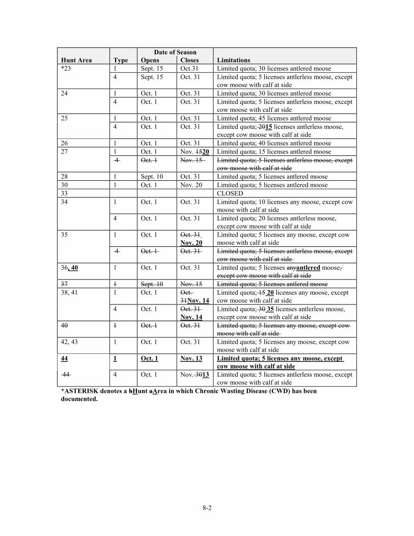
8-2
Date of Season Hunt Area Type Opens Closes Limitations *23 1 Sept. 15 Oct.31 Limited quota; 30 licenses antlered moose 4 Sept. 15 Oct. 31 Limited quota; 5 licenses antlerless moose, except
cow moose with calf at side 24 1 Oct. 1 Oct. 31 Limited quota; 30 licenses antlered moose 4 Oct. 1 Oct. 31 Limited quota; 5 licenses antlerless moose, except
cow moose with calf at side 25 1 Oct. 1 Oct. 31 Limited quota; 45 licenses antlered moose 4 Oct. 1 Oct. 31 Limited quota; 2015 licenses antlerless moose,
except cow moose with calf at side 26 1 Oct. 1 Oct. 31 Limited quota; 40 licenses antlered moose 27 1 Oct. 1 Nov. 1520 Limited quota; 15 licenses antlered moose 4 Oct. 1 Nov. 15 Limited quota; 5 licenses antlerless moose, except
cow moose with calf at side 28 1 Sept. 10 Oct. 31 Limited quota; 5 licenses antlered moose 30 1 Oct. 1 Nov. 20 Limited quota; 5 licenses antlered moose 33 CLOSED 34 1 Oct. 1 Oct. 31 Limited quota; 10 licenses any moose, except cow
moose with calf at side 4 Oct. 1 Oct. 31 Limited quota; 20 licenses antlerless moose,
except cow moose with calf at side 35 1 Oct. 1 Oct. 31
Nov. 20 Limited quota; 5 licenses any moose, except cow moose with calf at side
4 Oct. 1 Oct. 31 Limited quota; 5 licenses antlerless moose, except cow moose with calf at side
36, 40 1 Oct. 1 Oct. 31 Limited quota; 5 licenses anyantlered moose, except cow moose with calf at side
37 1 Sept. 10 Nov. 15 Limited quota; 5 licenses antlered moose 38, 41 1 Oct. 1 Oct.
31Nov. 14 Limited quota; 15 20 licenses any moose, except cow moose with calf at side
4 Oct. 1 Oct. 31 Nov. 14
Limited quota; 30 35 licenses antlerless moose, except cow moose with calf at side
40 1 Oct. 1 Oct. 31 Limited quota; 5 licenses any moose, except cow moose with calf at side
42, 43 1 Oct. 1 Oct. 31 Limited quota; 5 licenses any moose, except cow moose with calf at side
44 1 Oct. 1 Nov. 13 Limited quota; 5 licenses any moose, except cow moose with calf at side
44 4 Oct. 1 Nov. 3013 Limited quota; 5 licenses antlerless moose, except cow moose with calf at side
*ASTERISK denotes a hHunt aArea in which Chronic Wasting Disease (CWD) has been documented.
8-3
Section 4. Special Archery Seasons. Hunt areas listed in this section shall have special archery hunting seasons during the dates and with limitations specified in this section. Archers shall possess a limited quota moose license in addition to an archery license in order to hunt moose during any special archery season. Archers shall hunt only in the hunt area and for the type of moose set forth by the limitations of their license as specified in Section 3 of this Chapter. Dates of Seasons Hunt Area(s) Opens Closes Limitations 1, 6, 34, 42, 43 Sept. 15 Sept. 30 Refer to Section 3 of this Chapter 2, 5, 6, 9, 18, 22, 24-27, 30, 35, 36, 38, 40, 41, 44
Sept. 1 Sept. 30 Refer to Section 3 of this Chapter
3, 4 Sept. 1 Sept. 19 Refer to Section 3 of this Chapter 7, 10, 11, 14-16,17, 20, 21, 28, 32, 37
Sept. 1 Sept. 9 Refer to Section 3 of this Chapter
23 Sept. 1 Sept. 14 Refer to Section 3 of this Chapter Section 5. Hunt Area Descriptions. (a) Area and Number Area 1. Goose Creek. Beginning where Interstate Highway 90 crosses the Wyoming-Montana state line; southeasterly along said highway to Piney Creek; northwesterly up said creek to South Piney Creek; southwesterly up said creek to the divide along the Big Horn Mountain range; northwesterly along said divide to the Wyoming-Montana state line; easterly along said line to Interstate Highway 90. Area 2. Lander Area. Beginning where U.S. Highway 287 intersects the south boundary of the Wind River Indian Reservation; easterly along said boundary to Wyoming Highway 135 (Sand Draw Road); southerly along said highway to U.S. Highway 287; easterly along said highway to the Bison Basin Road (BLM Road 3221); southerly along said road to the Cyclone Ridge Road (BLM Road 3216); westerly along said road to the Red Creek Road (BLM Road 3219); northwesterly along said road to the Sand Creek Road; westerly along said road to the Continental Divide Road north of Continental Peak; westerly along said road to the Oregon Buttes Road; northerly along said road to Wyoming Highway 28; northeasterly along said highway to Willow Creek; northwesterly up said creek to the divide between the Sweetwater River and the Wind River at Granite Peak; northwesterly along said divide to the Continental Divide; northwesterly along said divide to the Wind River Indian Reservation boundary; easterly along said boundary to U.S. Highway 287. Area 3. Pinedale-Sandy. Beginning where Pine Creek crosses the Bridger-Teton National Forest boundary below Fremont Lake; northerly up said creek to Summit Lake; easterly to Mt. Helen and the Continental Divide; southerly along said divide to the head of the Big Sandy River; southwesterly down said river to the Bridger-Teton National Forest boundary; northerly along said boundary to Pine Creek. Area 4. Pinedale-Off National Forest. Beginning where the Big Sandy River crosses the Bridger-Teton National Forest boundary; southwesterly down said river to the Erramouspe Ranch Road; westerly along said road to U.S. Highway 191; northerly along said highway to Wyoming Highway 351; westerly along said highway to the East Green River Road (Sublette County Road 23-110); northerly along said road to U.S. Highway 191; northwesterly along said highway to the Green River; northeasterly up said river to Jim Creek; easterly up said creek to the Bridger-Teton National Forest boundary; southeasterly along said boundary to the Big Sandy River. Area 5. Upper Green River. Beginning where U.S. Highway 191 crosses the Green River at Warren Bridge; northwesterly along said highway to the divide between the Hoback River and the Green River (Hoback Rim); northerly along said divide to the divide between the Green River and the Gro Ventre River at Hodges Peak; northeasterly along said divide to the Darwin Ranch Road (USFS Road 620);
8-4
easterly along said road to the Union Pass Road (USFS Road 600); northeasterly along said road to the Continental Divide; southerly along said divide to Mt. Helen; west to Summit Lake and Pine Creek; southerly down said creek to the Bridger-Teton National Forest boundary; northwesterly along said boundary to Jim Creek; westerly down said creek to the Green River; southerly down said river to U.S. Highway 191. Area 6. Wind River. All of the drainage of the Wind River west of the west boundary of the Wind River Indian Reservation and those areas of the Spence and Moriarity Wildlife Management Area east of the East Fork of the Wind River. Area 7. Buffalo River. Beginning at the confluence of the South Fork and the North Fork of the Buffalo River; northerly up the North Fork to the Trail Creek Trail; northerly along said trail to Pacific Creek; easterly along said creek to the Continental Divide; easterly and southerly along said divide to the Teton Wilderness boundary and the divide between Blackrock Creek and the South Fork of the Buffalo River; westerly along said divide to Togwotee Lodge; northerly along the South Fork of the Buffalo River-Togwotee Lodge Trail to the South Fork of the Buffalo River; westerly down said river to the North Fork of the Buffalo River. Area 8. Thorofare-Yellowstone. All of the drainages of Mountain Creek, the Thorofare River and the Yellowstone River upstream from the Yellowstone National Park boundary. Area 9. Greybull-Owl Creek. Beginning where Wyoming Highway 120 crosses the divide between Dry Creek and the Greybull River drainage (Meeteetse Rim); southeasterly along said highway to the Bighorn River; southerly up said river to the Wind River Indian Reservation boundary; westerly along said boundary to the divide between the Wood River and the Wind River; northwesterly along said divide to the divide between the Greybull River and the Wind River; northwesterly along said divide to the divide between the Greybull River and the South Fork of the Shoshone River; northeasterly along said divide to the divide between Meeteetse Creek and Sage Creek; easterly along said divide to the divide between Dry Creek and the Greybull River; easterly along said divide to Wyoming Highway 120; in addition, all non-Indian fee title lands in that portion of Hot Springs County within the exterior boundaries of the Wind River Indian Reservation. Area 10. South Hoback. Beginning at the confluence of the Hoback and Snake rivers; southeasterly up the Hoback River to the South Fork of the Hoback River; east to Hoback Rim and the divide between the Green River and Hoback River; southwesterly along said divide to the divide between the Greys River and the Hoback River; northerly along said divide to the divide between the Greys River and Willow Creek; northerly along said divide to the divide between Bailey Creek and Willow Creek; northerly along said divide to Drywash Draw; westerly down said draw to Bailey Creek; northwesterly down said creek to the Snake River; northerly up said river to the confluence of the Hoback and Snake rivers. Area 11. Absaroka. All of the drainage of the Clark’s Fork River west of Wyoming Highway 120; all of the drainage of the Shoshone River west of Wyoming Highway 120 and outside of Yellowstone National Park; the Dry Creek drainages west of Wyoming Highway 120; and the drainage of Soda Butte Creek outside of Yellowstone National Park. Area 14. Fox Park. Beginning at the head of the Pacific Creek at the Continental Divide; westerly down Pacific Creek to the Whetstone Creek-Wildcat Peak Trail (#3034); northerly and westerly along said trail to Wildcat Ridge and the West Pilgrim Creek Trail; northerly along said trail to Brown Meadows and the Arizona Creek-Sheffield Creek Trail (#3026); northerly along said trail to Huckleberry Ridge and the divide between Sheffield Creek and Rodent Creek; northerly along said divide to the Yellowstone National Park boundary; easterly along said boundary to the Continental Divide; southerly along said divide to the head of Pacific Creek.
8-5
Area 15. Glade Creek-Pilgrim Creek. Beginning where Pacific Creek crosses the Grand Teton National Park boundary; northerly and westerly along said boundary to the Targhee National Forest boundary; northerly along said boundary to the Yellowstone National Park boundary; easterly along said boundary to Huckleberry Ridge; southerly along said ridge to the Sheffield Creek-Arizona Creek Trail (#3026); southerly along said trail to Brown Meadows and the West Pilgrim Creek Trail; southerly along said trail to Wildcat Ridge and the Wildcat Peak-Whetstone Creek Trail (#3034); southerly and easterly along said trail to Pacific Creek; southwesterly down said creek to the Grand Teton National Park boundary. Area 16. Alta. Beginning at the intersection of Wyoming Highway 22 and the Wyoming-Idaho state line; northerly along said line to the South Fork of Badger Creek; easterly up said creek to the Caribou-Targhee National Forest-Grand Teton National Park boundary; southerly along said boundary to the Targhee/Bridger-Teton interforest boundary; southerly along said boundary to Wyoming Highway 22; westerly along said highway to the Wyoming-Idaho state line. Area 17. Lower Gros Ventre-Spread Creek. Beginning where the Gros Ventre River crosses the Grand Teton National Park boundary; northerly along said boundary to U.S. Highway 26-287; easterly along said highway to Togwotee Lodge and the divide between the Buffalo River and Blackrock Creek; easterly along said divide and the Teton Wilderness boundary to the Continental Divide; southerly along said divide to the Moccasin Basin Road (USFS Road 30750); southerly along said road to the North Fork of Fish Creek at Calf Creek; southerly down said creek to Fish Creek; westerly down said creek to the Gros Ventre River; westerly down said river to the Grand Teton National Park boundary.
Area 18. Fish Creek. Beginning at the confluence of the Gros Ventre River and Fish Creek; northeasterly up said creek to North Fork of Fish Creek; northerly up said creek to the Moccasin Basin Road (USFS Road 30750) at Calf Creek; northerly up said road to the Continental Divide; southeasterly along said divide to the Union Pass Road (USFS Road 600); southwesterly along said road to the Darwin Ranch Road (USFS Road 620); westerly along said road to Kinky Creek; northwesterly down said creek to the Gros Ventre River; northwesterly down said river to Fish Creek. Area 19. Wilson. Beginning at the junction of Wyoming Highway 22 and Wyoming Highway 390 west of the Snake River; northerly along Wyoming Highway 390 to the Grand Teton National Park boundary; northerly, easterly and southerly along said boundary to U.S. Highway 191; southerly along said highway to Wyoming Highway 22; westerly along said highway to Wyoming Highway 390. Area 20. Fall Creek-Targhee. Beginning at the junction of Wyoming Highway 22 and Wyoming Highway 390 west of the Snake River; easterly along Wyoming Highway 22 to the Snake River; southerly and westerly down said river to the Wyoming-Idaho state line; northerly along said line to Wyoming Highway 22; easterly along said highway to the Caribou-Targhee/Bridger-Teton interforest boundary at Teton Pass; northerly along said boundary to the Grand Teton National Park boundary; northeasterly along said boundary to Wyoming Highway 390; southerly along said highway to Wyoming Highway 22. Area 21. North Hoback. Beginning where U.S. Highway 191 crosses Flat Creek at the north edge of the town of Jackson; due east to the National Elk Refuge boundary; easterly and northerly along said boundary to Flat Creek; easterly and southerly up Flat Creek to Cache Peak; southeasterly along the divide between Flat Creek and Granite Creek to Pyramid Peak; southeasterly along the divide between the Gros Ventre River and the Hoback River to Steamboat Peak; southerly and westerly along the divide between Shoal Creek and Dell Creek to the Riling Draw Road; southerly along said road to the Dell Creek Road; westerly along said road to the Hoback River; westerly down said river to the Snake River; northerly up said river to Wyoming Highway 22; easterly along said highway to U.S. Highway 191; easterly and northerly along said highway to Flat Creek at the north edge of the town of Jackson. Area 22. Raspberry Ridge. Beginning where U.S. Highway 191 crosses the divide between the Green River and the Hoback River on Hoback Rim; southwesterly along said divide to a point east of the
8-6
confluence of the South Fork of the Hoback River and the Hoback River; due west to the Hoback River; northerly along said river to the Dell Creek Road; easterly along said road to the Riling Draw Road; northerly along said road to the divide between Shoal Creek and Dell Creek; easterly and northerly along said divide to the divide between the Gros Ventre River and the Hoback River at Steamboat Peak; southeasterly along the divide between the Gros Ventre River and the Hoback River to the divide between the Green River and the Hoback River at Hodges Peak; southerly along the divide between the Green River and the Hoback River to U.S. Highway 191. Area 23. Greys River-Salt River. Beginning at the confluence of the Greys River and the Snake River; easterly up the Snake River to Bailey Creek; southerly up said creek to Dry Wash Draw; easterly up said draw to Greyback Ridge; southerly along said ridge to the divide between the Little Grays River and the Hoback River; southerly and easterly along said divide to the divide between the Greys River and the Green River; southerly, westerly, and northerly along said divide to the divide between the Greys River and the Smiths Fork River; northerly and westerly along said divide to the divide between the Bear River and the Salt River; westerly along said divide to the Wyoming-Idaho state line; northerly along said line to the Snake River; easterly up said river to the Greys River. Area 24. Big Piney-On National Forest. Beginning at Deadman Peak and the divide between the Green River and the Hoback River; northeasterly along said divide to the Bridger-Teton National Forest boundary; southerly along said boundary to LaBarge Creek Road (USFS Road 10-138); northwesterly along said road to the Smiths Fork Road (USFS Road 10-072); northerly along said road to the divide between the Green River and the Greys River; northerly along said divide to Deadman Peak. Area 25. Big Piney-Off National Forest. Beginning where U.S. Highway 191 crosses the divide between the Green River and the Hoback River (Hoback Rim); southeasterly along said highway to the East Green River Road (Sublette County Road 23-110) at Cora Junction; southerly along said road to Wyoming Highway 351; easterly along said highway to the Burma Road (BLM Road 5406); southerly along said road to the Yellow Point Road (BLM Road 5409); westerly along said road to Colorado Point and the CCC Road (BLM Road 5402); southerly along said road to the Fontenelle Reservoir Dam Road; westerly along said road to the Fontenelle Reservoir Dam (Lincoln County Road 313) on the Green River; northerly up said river to LaBarge Creek; westerly up said creek to U.S. Highway 189; northerly along said highway to the LaBarge Creek Road (Lincoln County Road 315) northwesterly along said road to the forest boundary; northerly up said boundary to the divide between the Green River and the Hoback River; northeasterly along said divide to U.S. Highway 191. Area 26. Lincoln. Beginning at the town of Kemmerer and U.S. Highway 30; westerly along said highway to Wyoming Highway 89 at Sage Junction; southwesterly along said highway to the Wyoming-Utah state line; northerly along said line to the Wyoming-Idaho state line; northerly along said line to the divide between the Salt River and the Bear River; easterly along said divide to the divide between the Salt River and the Smiths Fork; northeasterly along said divide to the divide between the Greys River and the Smiths Fork; southeasterly along said divide to the divide between the Greys River and LaBarge Creek; southeasterly along said divide to the LaBarge Creek Road (USFS Road 10-138 and Lincoln County Road 315); southeasterly along said road to U.S. Highway 189; southerly along said highway to LaBarge Creek; easterly down said creek to the Green River; southeasterly down said river to the Fontenelle Reservoir Dam Road (Lincoln County Road 313); westerly along said road to Wyoming Highway 189; southwesterly along said road to the town of Kemmerer. Area 27. Uinta. Beginning where Interstate Highway 80 crosses the Wyoming-Utah state line; easterly along said highway to Wyoming Highway 410; southerly along said highway to the Stateline Dam Road (USFS Road 072); southerly along said road to the Wyoming-Utah state line; west then north along said line to Interstate Highway 80. Area 28. Crystal Creek-Flat Creek. Beginning where the Gros Ventre River crosses the Bridger-Teton National Forest boundary; easterly and southerly up said river to Kinky Creek; southeasterly up said

8-7
creek to the Darwin Ranch Road (USFS Road 620); easterly along said road to the divide between the Green River and the Gros Ventre River; southwesterly along said divide to the divide between the Green River and the Hoback River at Hodges Peak; westerly along said divide to the divide between the Granite Creek-Cache Creek-Flat Creek and the head of Flat Creek; northwesterly down Flat Creek to the Bridger-Teton National Forest boundary; northerly along said boundary to the Gros Ventre River. Area 30. Sweetwater. Beginning where Wyoming Highway 28 crosses Willow Creek; southwesterly along said highway to U.S. Highway 191 at the town of Farson; northerly along said highway to the Big Sandy Reservoir Road (Sweetwater County Road 28); easterly along said road to the Big Sandy River at the dam; northerly up said river to the Continental Divide; southeasterly along said divide to Mt. Nystrom and the divide between the Sweetwater River and the Wind River; southeasterly along said divide to Granite Peak and the headwaters of Willow Creek; southeasterly down said creek to Wyoming Highway 28. Area 32. Enos Lake. Beginning where Pacific Creek crosses the Grand Teton National Park boundary; easterly and northerly up said creek to Trail Creek and the Trail Creek trail; southerly along said trail to the North Fork of the Buffalo River; southerly down said river to the South Fork of the Buffalo River; easterly up the South Fork to the South Fork of the Buffalo-Togwotee Lodge Trail; southerly along said trail to Togwotee Lodge and U.S. Highway 26-287; westerly along said highway to the Grand Teton National Park boundary; westerly and northerly along said boundary to Pacific Creek. Area 33. Lower Green River. Beginning at the junction of Interstate Highway 80 and Wyoming Highway 372; northwesterly along Wyoming Highway 372 to Lincoln County Road 316 at the Fontenelle Junction; northerly along said road to the Fontenelle Reservoir Dam Road (Lincoln County Road 313); easterly along said road to the County Line Road (Sweetwater County Road 52); southerly along said road to the Lower Farson Cutoff Road (Sweetwater County Road 8); easterly along said road to Wyoming Highway 28; easterly along said highway to the continuation of the Lower Farson Cutoff Road (Sweetwater County Road 8); southerly along said road to the Blue Rim Road (Sweetwater County Road 5); southerly along said road to Interstate Highway 80; westerly along said highway to Wyoming Highway 372. Area 34. Hunter Mesa. Beginning at the junction of Piney Creek and Interstate Highway 90; southerly along said highway to Interstate Highway 25; southerly along said highway to the North Fork of the Powder River; northwesterly up said river to Pass Creek; westerly up said creek to the Hazelton Road (Johnson County Road 3); northerly along said road to the Gold Mine Road (USFS Road 452); northerly along said road to the Canyon Creek Road (USFS Road 25); northerly along said road to U.S. Highway 16; easterly along said highway to the divide along the Big Horn Mountain range at Powder River Pass; northerly along said divide to South Piney Creek; northeasterly down said creek to Piney Creek; southeasterly down said creek to Interstate Highway 90. Area 35. Henry's Fork. Beginning where Interstate Highway 80 crosses the Green River; southerly along the east bank of said river to Flaming Gorge Reservoir; southerly along the east shore of said reservoir to the Wyoming-Utah state line; westerly along said line to the Stateline Dam Road (USFS Road 072); northerly along said road to Wyoming Highway 410; northerly along said highway to Interstate Highway 80; easterly along said highway to the Green River. Area 36. Bear River Divide. Beginning where Interstate Highway 80 crosses the Wyoming-Utah state line; northerly along said line to Wyoming Highway 89 west of Sage Junction; easterly along said highway to U.S. Highway 189; southerly along said highway to Interstate Highway 80; westerly along said highway to the Wyoming-Utah state line. Area 37. Grassy Lake. Beginning where the South Fork of Badger Creek crosses the Wyoming-Idaho state line; northerly along said line to the south boundary of Yellowstone National Park; easterly along said boundary to the Targhee National Forest boundary; southerly along said boundary to the
8-8
Caribou-Targhee National Forest-Grand Teton National Park boundary; southerly along said boundary to the South Fork of Badger Creek; westerly down said creek to the Wyoming-Idaho state line. Area 38. Snowy Range. Beginning where Interstate Highway 25 crosses the Wyoming-Colorado state line; westerly along said line to Wyoming Highway 230 west of the North Platte River; northwesterly along said highway to Wyoming Highway 130; northerly along said highway to U.S. Highway 30 at Walcott Junction; easterly and southerly along said highway to the town of Laramie and the Rogers Canyon-Fisher Canyon Road (Albany County Road 17-Laramie County Road 228); easterly along said road to Wyoming Highway 211; southeasterly along said highway to Interstate Highway 25; southerly along said highway to the Wyoming-Colorado state line. Area 40. Lower Hams Fork. Beginning at the town of Kemmerer and U.S. Highway 189; northerly then northeasterly along said highway to Wyoming Highway 372; easterly then southeasterly along said highway to Interstate Highway 80; westerly along said highway to U.S. Highway 189; northerly along said highway to the town of Kemmerer.
Area 41. Sierra Madres. Beginning where Wyoming Highway 230 west of the North Platte River crosses the Wyoming-Colorado state line; westerly along said line to Wyoming Highway 789; northerly along said highway to Interstate Highway 80; easterly along said highway to Wyoming Highway 130; southerly along said highway to Wyoming Highway 230; southeasterly along said highway to the Wyoming-Colorado state line. Area 42. Shell. Beginning where the Big Horn River crosses the Wyoming-Montana state line; easterly along said line to the divide along the Big Horn Mountain range; southeasterly along said divide to the divide between Medicine Lodge Creek and Paint Rock Creek; southwesterly along said divide to the Cold Springs Road (USFS Road 344, becomes BLM Road 268A); southwesterly along said road to the Alkali Road (BLM Road 1111); southerly along said road to Wyoming Highway 31; westerly along said highway to U.S. Highway 16-20; westerly along said highway to the Big Horn River; northerly down said river to the Wyoming-Montana state line. Area 43. Ten Sleep. Beginning at the intersection of Wyoming Highway 31 and the Alkali Road (BLM Road 1111) just north of Hyattville; northerly along said road to the Cold Springs Road (BLM Road 268A-USFS Road 344); northeasterly along said road to the divide between Medicine Lodge Creek and Paint Rock Creek; northeasterly along said divide to the divide along the Bighorn Mountain range; southerly along said divide to U.S. Highway 16 at the Powder River Pass; westerly along highway to the Canyon Creek Road (USFS Road 25); southerly along said road to the Gold Mine Road (USFS Road 452); southerly along said road to the Hazelton Road (Big Horn Divide Road-Johnson County Road 3); southerly along said road to the Rome Hill Road (Wyoming Highway 436); northwesterly along said road to U.S. Highway 16; westerly along said highway to the Nowood River; northwesterly down said river to Wyoming Highway 31; northeasterly along said highway to the Alkali Road (BLM Road 1111). Area 44. East Flaming Gorge. Beginning where Interstate Highway 80 crosses the Green River; easterly along said highway to the Bitter Creek Road (Sweetwater County Road 19); southerly along said road to Carson Springs Junction and the Cow Creek-Powder Wash Road; southerly along said road to the Wyoming-Colorado state line; westerly along said line to the Wyoming-Utah state line; westerly along said line to Flaming Gorge Reservoir; northerly along the east shore of said reservoir to the Green River; northerly up the east bank of said river to Interstate Highway 80.
Section 6. Savings Clause. If any provision of this regulation shall be held to be illegal or unconstitutional, such a ruling shall not affect other provisions of this regulation which can be given effect without the illegal or unconstitutional provision; and, to this end, the provisions of this regulation shall be severable.

8-9
WYOMING GAME AND FISH COMMISSION By: Fred Lindzey,Ed Mignery, President Dated: April 27, 2011 April 22, 2010
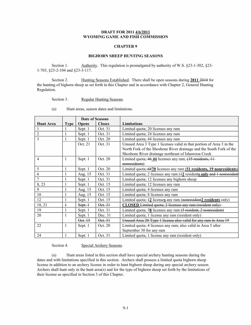
9-1
DRAFT FOR 2011 4/6/2011 WYOMING GAME AND FISH COMMISSION
CHAPTER 9
BIGHORN SHEEP HUNTING SEASONS
Section 1. Authority. This regulation is promulgated by authority of W.S. §23-1-302, §23-1-703, §23-2-104 and §23-3-117. Section 2. Hunting Seasons Established. There shall be open seasons during 2011 2010 for the hunting of bighorn sheep as set forth in this Chapter and in accordance with Chapter 2, General Hunting Regulation. Section 3. Regular Hunting Seasons. (a) Hunt areas, season dates and limitations. Date of Seasons Hunt Area Type Opens Closes Limitations 1 1 Sept. 1 Oct. 31 Limited quota; 20 licenses any ram 2 1 Sept. 1 Oct. 31 Limited quota; 24 licenses any ram 3 1 Sept. 1 Oct. 20 Limited quota; 44 licenses any ram Oct. 21 Oct. 31 Unused Area 3 Type 1 licenses valid in that portion of Area 3 in the
North Fork of the Shoshone River drainage and the South Fork of the Shoshone River drainage northeast of Ishawooa Creek
4 1 Sept. 1 Oct. 20 Limited quota; 46 44 licenses any ram (35 residents, 11 nonresidents)
5 1 Sept. 1 Oct. 20 Limited quota; 6870 licenses any ram (51 residents, 19 nonresidents) 6 1 Aug. 15 Oct. 31 Limited quota; 2 licenses any ram (12 residents only and 1 nonresident 7 1 Sept. 1 Oct. 31 Limited quota; 12 licenses any bighorn sheep 8, 23 1 Sept. 1 Oct. 15 Limited quota; 12 licenses any ram 9 1 Aug. 15 Oct. 15 Limited quota; 4 licenses any ram 10 1 Aug. 15 Oct. 15 Limited quota; 8 licenses any ram 12 1 Sept. 1 Oct. 15 Limited quota; 12 licenses any ram (nonresident2 residents only) 18, 21 1 Sept. 1 Oct. 31 CLOSED Limited quota; 2 licenses any ram (resident only) 19 1 Sept. 1 Oct. 31 Limited quota; 78 licenses any ram (5 resident, 2 nonresident) 20 1 Sept. 1 Dec. 31 Limited quota; 1 license any ram (resident only) Oct. 15 Oct. 31 Unused Area 20 Type 1 license also valid for any ram in Area 19 22 1 Sept. 1 Oct. 20 Limited quota; 4 licenses any ram; also valid in Area 5 after
September 30 for any ram 24 1 Sept. 1 Oct. 31 Limited quota; 1 license any ram (resident only) Section 4. Special Archery Seasons.
(a) Hunt areas listed in this section shall have special archery hunting seasons during the dates and with limitations specified in this section. Archers shall possess a limited quota bighorn sheep license in addition to an archery license in order to hunt bighorn sheep during any special archery season. Archers shall hunt only in the hunt area(s) and for the type of bighorn sheep set forth by the limitations of their license as specified in Section 3 of this Chapter.
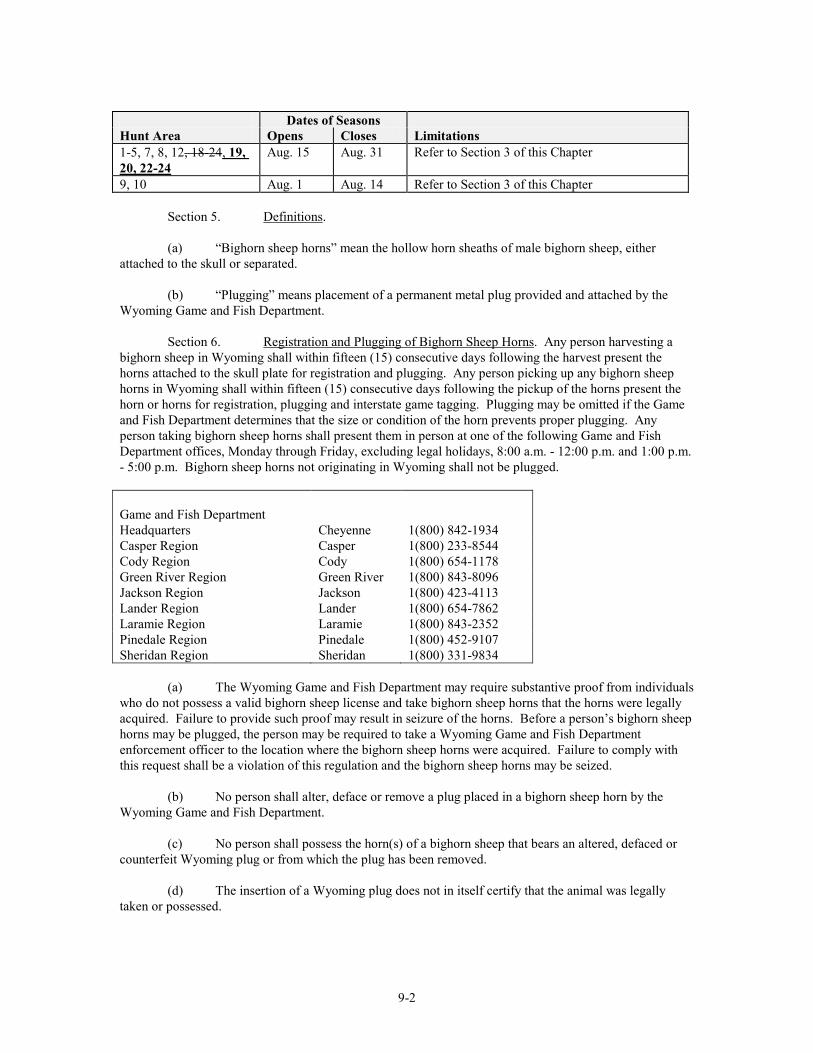
9-2
Dates of Seasons Hunt Area Opens Closes Limitations 1-5, 7, 8, 12, 18-24, 19, 20, 22-24
Aug. 15 Aug. 31 Refer to Section 3 of this Chapter
9, 10 Aug. 1 Aug. 14 Refer to Section 3 of this Chapter Section 5. Definitions. (a) “Bighorn sheep horns” mean the hollow horn sheaths of male bighorn sheep, either attached to the skull or separated. (b) “Plugging” means placement of a permanent metal plug provided and attached by the Wyoming Game and Fish Department. Section 6. Registration and Plugging of Bighorn Sheep Horns. Any person harvesting a bighorn sheep in Wyoming shall within fifteen (15) consecutive days following the harvest present the horns attached to the skull plate for registration and plugging. Any person picking up any bighorn sheep horns in Wyoming shall within fifteen (15) consecutive days following the pickup of the horns present the horn or horns for registration, plugging and interstate game tagging. Plugging may be omitted if the Game and Fish Department determines that the size or condition of the horn prevents proper plugging. Any person taking bighorn sheep horns shall present them in person at one of the following Game and Fish Department offices, Monday through Friday, excluding legal holidays, 8:00 a.m. - 12:00 p.m. and 1:00 p.m. - 5:00 p.m. Bighorn sheep horns not originating in Wyoming shall not be plugged. Game and Fish Department Headquarters
Cheyenne
1(800) 842-1934
Casper Region Casper 1(800) 233-8544 Cody Region Cody 1(800) 654-1178 Green River Region Jackson Region
Green River Jackson
1(800) 843-8096 1(800) 423-4113
Lander Region Lander 1(800) 654-7862 Laramie Region Laramie 1(800) 843-2352 Pinedale Region Pinedale 1(800) 452-9107 Sheridan Region Sheridan 1(800) 331-9834 (a) The Wyoming Game and Fish Department may require substantive proof from individuals who do not possess a valid bighorn sheep license and take bighorn sheep horns that the horns were legally acquired. Failure to provide such proof may result in seizure of the horns. Before a person’s bighorn sheep horns may be plugged, the person may be required to take a Wyoming Game and Fish Department enforcement officer to the location where the bighorn sheep horns were acquired. Failure to comply with this request shall be a violation of this regulation and the bighorn sheep horns may be seized. (b) No person shall alter, deface or remove a plug placed in a bighorn sheep horn by the Wyoming Game and Fish Department. (c) No person shall possess the horn(s) of a bighorn sheep that bears an altered, defaced or counterfeit Wyoming plug or from which the plug has been removed. (d) The insertion of a Wyoming plug does not in itself certify that the animal was legally taken or possessed.
9-3
(e) Any person who makes a false statement on the registration form regarding the date the bighorn sheep was taken or the hunt area in which it was taken shall be in violation of this regulation. Such violation shall be punishable as provided by Title 23, Wyoming Statutes for violation of Commission regulations.
Section 7. Hunt Area Descriptions. (a) Area and Number Area 1. Clark's Fork. All of the drainage of the Clark's Fork River north of Sunlight Creek and north of the Clark's Fork River below its confluence with Sunlight Creek; and the drainage of Soda Butte Creek outside of Yellowstone National Park. Area 2. Trout Peak. All of the north drainage of the North Fork of the Shoshone River and north of U.S. Highway 14-16-20 between Pahaska Teepee and the east boundary of Yellowstone National Park; all of the south drainage of the Clark's Fork River south and east of Sunlight Creek and west of Wyoming Highway 120; all of the north drainage of the Shoshone River west of Wyoming Highway 120. Area 3. Wapiti Ridge. Beginning where U.S. Highway 14-16-20 intersects the east boundary of Yellowstone National Park; easterly down said highway to the North Fork of the Shoshone River; easterly down said river to the South Fork of the Shoshone River at the Buffalo Bill Reservoir; southwesterly up said river to Deer Creek; westerly up said creek to the head of Butte Creek; westerly down said creek to the Thorofare River; westerly down said river to the Yellowstone National Park boundary; easterly then northerly along said boundary to U.S. Highway 14-16-20. Area 4. Yount's Peak. Beginning where Deer Creek enters the South Fork of the Shoshone River; southerly up said river to Needle Creek; southerly up said creek to the head of Emerald Creek; southerly down said creek to Wiggins Fork Creek; southerly down said creek to the Wiggins Fork Road (Shoshone National Forest Road 285); southerly down said road to the Shoshone National Forest boundary; westerly then southerly along said boundary to U.S. Highway 287; northwesterly along said highway to the east boundary of Grand Teton National Park; northerly and westerly along said boundary to U.S. Highway 287; northerly along said highway to the south boundary of Yellowstone National Park; easterly along said boundary to the Thorofare River; easterly up said river to Butte Creek; northeasterly up said creek to the head of Deer Creek; easterly down said creek to the South Fork of the Shoshone River. Area 5. Franc's Peak. Beginning where Needle Creek enters the South Fork of the Shoshone River; northeasterly down said river to the Shoshone River; easterly down said river to Wyoming Highway 120; southeasterly along said highway to the Bighorn River; southerly up said river to the Wind River Indian Reservation boundary; westerly along said boundary to the Shoshone National Forest boundary; northwesterly, southwesterly, then westerly along said boundary to the Wiggins Fork Road (Shoshone National Forest Road 285); northerly along said road to Wiggins Fork Creek; northerly up said creek to Emerald Creek; northerly up said creek to Needle Creek; northerly down said creek to the South Fork of the Shoshone River; in addition, all non-Indian fee title lands in that portion of Hot Springs County within the exterior boundaries of the Wind River Indian Reservation. Area 6. Targhee. Beginning where the Snake River crosses the Wyoming-Idaho state line; northerly along said line to the Yellowstone National Park boundary; easterly along said boundary to the Targhee-John D. Rockefeller Jr. Memorial Parkway boundary; southerly along said boundary to the Targhee Forest-Grand Teton National Park boundary; southerly along said boundary to the Bridger-Teton National Forest-Grand Teton National Park boundary; northerly, easterly and southerly along said boundary to Wyoming Highway 390 west of the Snake River; southerly along said highway to Wyoming Highway 22; easterly along said highway to the Snake River; southerly along said river to the Wyoming-Idaho state line.
9-4
Area 7. Jackson. Beginning at Togwotee Pass on the Continental Divide; southerly along said divide to the Union Pass Road (USFS Road 600); westerly along said road to Wagon Creek; southerly down said creek to the Green River; southerly down said river to the Bridger-Teton National Forest boundary; westerly along said boundary to the divide between the Green River and the Hoback River at the Hoback Rim where U.S. Highway 191 crosses the Rim; westerly along said divide to the divide between the Greys River and the Hoback River; northerly along said divide to the divide between the Greys River and Willow Creek; northerly along said divide to the divide between Bailey Creek and Willow Creek (Greyback Ridge); northerly along said divide to the Dry Wash Draw; westerly down said draw to Bailey Creek; northwesterly down said creek to the Snake River; northerly along said river to Wyoming Highway 22; easterly along said highway to U.S. Highway 191; easterly along said highway to the National Elk Refuge boundary at the north end of the town of Jackson; southerly, easterly and northerly along said boundary to the Grand Teton National Park boundary; northerly along said boundary to U.S. Highway 26-287; easterly along said highway to Togwotee Pass. Area 8. Sheep Mountain. Beginning where Pine Creek crosses U.S. Highway 191 in the town of Pinedale; northwesterly along said highway to the Green River at Warren Bridge; northerly, easterly and southerly up said river to Trail Creek; southerly up said creek to Summit Lake and the head of Pine Creek; southerly down said creek to U.S. Highway 191. Area 9. Dinwoody. Beginning where U.S. Highway 287 crosses Torrey Creek; southerly along said highway to the Wind River Indian Reservation boundary; southerly along said boundary to the Continental Divide; northwesterly along said divide to the head of Bomber Creek (East Fork of Torrey Creek); northeasterly down said creek to Torrey Creek; northerly down said creek to U.S. Highway 287. Area 10. Jakey's Fork. Beginning where Torrey Creek crosses U.S. Highway 287; southwesterly up said creek to Bomber Creek (East Fork of Torrey Creek); southwesterly up said creek to the Continental Divide; northerly along said divide to the head of Roaring Fork Creek; southerly down said creek to the Green River; westerly and southerly down said river to Wagon Creek; northwesterly up said creek to the Union Pass Road (USFS Road 600); northerly along said road to the Continental Divide; northwesterly along said divide to U.S. Highway 287; southeasterly along said highway to Torrey Creek. Area 12. Porcupine. Beginning where U.S. Highway 14A crosses the Big Horn River; northerly down said river to the Wyoming-Montana state line; east along said line to the Sheep Mountain Road (USFS Road 11); southerly along said road to the Devils Canyon Road (USFS Road 14);(USFS Road 123102 and 123101); southerly along said road to U.S. Highway 14A; westerly along said highway to the Big Horn River. Area 18. Douglas Creek. Beginning where Wyoming Highway 230 crosses the Wyoming-Colorado state line near Mountain Home; westerly along said line to Wyoming Highway 230; northwesterly along said highway to Wyoming Highway 130; easterly along said highway to Wyoming Highway 230; southwesterly along said highway to the Wyoming-Colorado state line. Area 19. Laramie Peak. Beginning at the junction of Interstate Highway 25 and Wyoming Highway 211 at the town of Chugwater; southwesterly along Wyoming Highway 211 to the Iron Mountain-Jordan Road (Platte County Road 10-Laramie County Road 106-2), southwesterly along said road to Wyoming Highway 211; southerly along said road to the Fisher Canyon-Rogers Canyon Road (Laramie County Road 228-1 - Albany County Road 17) at Horse Creek Station; southwesterly along said road to U.S. Highway 30 at the town of Laramie; northwesterly along said highway to Wyoming Highway 487; northerly along said highway to Wyoming Highway 220; northeasterly along said highway to Interstate Highway 25; southeasterly along said interstate to Wyoming Highway 211.
9-5
Area 20. Kouba Canyon. Beginning where U.S. Highway 85 crosses the Wyoming – South Dakota state line; southerly along said line to the Dewey Road (Weston County Rd. #2); northwesterly along said road to U.S. Highway 85; northerly along said highway to the Wyoming-South Dakota state line. Area 21. Encampment River. Beginning where Wyoming Highway 130 crosses the North Platte River in the town of Saratoga; southerly along said highway to Wyoming Highway 230; southeasterly along said highway to the Wyoming-Colorado state line; westerly along said line to the Medicine Bow National Forest boundary near the confluence of Spring Creek and the Little Snake River; westerly and northerly along said boundary to Wyoming Highway 70; northeasterly along said highway to the Sage Creek Road (USFS Road 801-Carbon County Road 401); northerly along said road to Sage Creek; easterly down said creek to the North Platte River; southerly up said river to Wyoming Highway 130 in the town of Saratoga.
Area 22. Dubois Badlands. Beginning where U.S. Highway 287 crosses the Wind River Indian Reservation boundary; westerly along said highway to the Wiggins Fork Road (Fremont County Road 285); northerly along said road to the Shoshone National Forest boundary; easterly along said boundary to the Wind River Indian Reservation boundary; southerly along said boundary to U.S. Highway 287. This includes those areas of the Spence-Moriarity Wildlife Habitat Area east of the East Fork of the Wind River. Area 23. Desolation Peak. Beginning where Roaring Fork Creek enters the Green River; easterly up said creek to the Continental Divide; southwesterly along said divide to Hay Pass and the head of the North Fork of Boulder Creek; southwesterly down said creek to the Bridger-Teton National Forest boundary; northwesterly along said boundary to Pine Creek; northerly up said creek to Summit Lake and the head of Trail Creek; northerly down said creek to the Green River; northerly down said river to Roaring Fork Creek. Area 24. Big Piney. Beginning at a point where the Bridger-Teton National Forest boundary crosses LaBarge Creek; westerly up said creek to the head of the Greys River; northerly down said river to Deadman Creek; easterly up said creek to the divide between the Greys River and the Hoback River, southerly along said divide to the divide between the Hoback River and the Green River; easterly along said divide to the Bridger-Teton National Forest boundary on Hoback Rim; southerly along said boundary to LaBarge Creek.
Section 8. Savings Clause. If any provision of this regulation shall be held to be illegal or unconstitutional, such a ruling shall not affect other provisions of this regulation which can be given effect without the illegal or unconstitutional provision; and, to this end, the provisions of this regulation shall be severable.
WYOMING GAME AND FISH COMMISSION By: Fred Lindzey,Ed Mignery, President Dated: April 27, 2011 April 22, 2010

11-1
DRAFT FOR 2011 04/06/11 WYOMING GAME AND FISH COMMISSION
CHAPTER 11
SAGE GROUSE HUNTING SEASONS
Section 1. Authority. This regulation is promulgated by authority of W.S. §23-1-302 and §23-2-105(d). Section 2. Hunting Seasons Established. There shall be open seasons for the hunting of sage grouse as set forth in this Chapter, and in accordance with Chapter 2, General Hunting Regulation. This regulation shall remain in effect until modified or repealed by the Commission. Section 3. Definitions. For the purpose of this regulation, definitions shall be as set forth in Title 23, Wyoming Statutes, and the Commission also adopts the following definitions: (a) “Daily bag limit” means the maximum number of sage grouse that may be legally taken in a single day. (b) “Nontoxic shot” means steel or any other federally-approved nontoxic shot. (c) “Possession limit” means the maximum number of sage grouse that may be legally in possession. Sage grouse in transit or storage shall be considered in possession. Section 4. Hunting Regulations. (a) Shooting Hours. Shooting hours for the hunting of sage grouse shall be one-half (1/2) hour before sunrise to sunset. (b) Nontoxic shot shall be required for hunting sage grouse on all national wildlife refuges open for hunting. No person shall possess shot shells loaded with shot other than nontoxic shot while hunting sage grouse on national wildlife refuges. (c) Hunt Areas, Season Dates, Bag Limit and Limitations.
Date of Seasons Bag Limit Hunt Area Opens Closes Daily Possession Limitations 1 Sept. 18
17 Sept. 30 2 4 Any sage grouse
2, 3 CLOSED 4 Sept. 18
17 Sept. 20 19 2 4 Any sage grouse
Section 5. Archery Regulations. (a) Sage grouse may be taken with archery equipment in accordance with Section 4 of this Chapter.
11-2
Section 6. Falconry Seasons. (a) Sage grouse may be taken with falcons in accordance with Section 4 of this Chapter. (b) The falconry season shall open September 1 and close March 1 in those hunt areas listed in Section 4 of this Chapter. (c) The daily bag limit shall be one (1) sage grouse and the possession limit shall be two (2) sage grouse. (d) Persons taking sage grouse with falcons shall respond to Wyoming Game and Fish Department surveys requesting harvest information. Section 7. Hunt Area Descriptions. (a) Area and Number. Area 1. The entire State of Wyoming, excluding the lands described in Areas 2-4. Area 2. Beginning where the Wyoming-Nebraska-Colorado state lines intersect; westerly along the Wyoming-Colorado state line to the divide between the North Platte and Laramie Rivers; northerly along said divide to the head of Rock Creek; northerly down said creek to Interstate Highway 80; westerly along said interstate to Wyoming Highway 13; northeasterly along said highway to U.S. Highway 30-287; northerly along said highway to the Fetterman Road (Albany County Road 61); easterly then northerly along said road to the Albany-Converse County line; westerly along said line to the Balsh Road (U.S.F.S. Road 660); westerly and northerly along said road to the Converse-Natrona County line; northerly along said line to Interstate Highway 25; northerly along said highway to the Natrona-Johnson-Converse-Campbell-Weston-Niobrara County lines; easterly along said county lines to U.S Highway 85; northerly along said highway to U.S. Highway 16 at Newcastle; northwesterly along said highway to Interstate Highway 90 at Moorcroft; westerly along said highway to the “D” Road; northerly along said road to the Rocky Point Road; northerly along said road to the Wyoming-Montana state line; easterly along said state line to the Wyoming-South Dakota state line; southerly along said state line to the Wyoming-Nebraska state line; southerly along said state line to the Wyoming-Colorado state line. Area 2 also includes that portion of Natrona County south of Interstate Highway 25 in the Muddy Creek drainage. Area 3. All lands in the Snake River drainage within Lincoln, Sublette and Teton Counties. Area 4. Beginning at the intersection of the Sheridan-Big Horn County line with the Wyoming-Montana state line; easterly along said state line to the Rocky Point Road in Crook County; southerly along said road to the “D” Road; southerly along said road to Interstate Highway 90; easterly along said highway to U.S. Highway 16 at Moorcroft; southeasterly along said highway to U.S. Highway 85 at Newcastle; southerly along said highway to the Weston-Niobrara-Campbell-Converse-Natrona-Johnson County lines; westerly along said county lines to the Washakie-Johnson-Big Horn-Sheridan County lines; northerly then northwesterly along said county lines to the Wyoming-Montana state line.
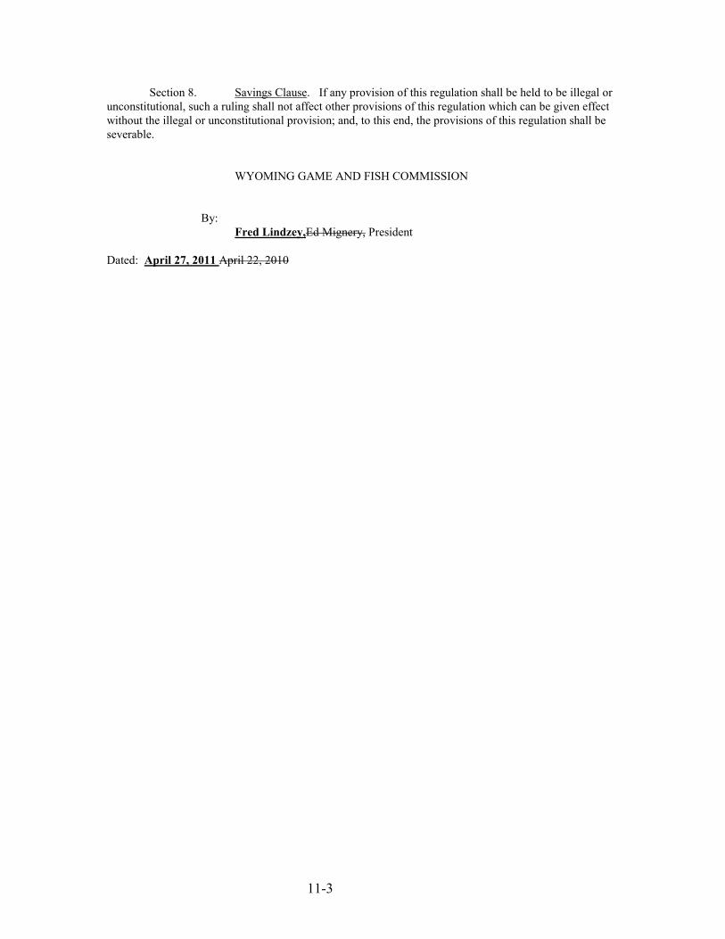
11-3
Section 8. Savings Clause. If any provision of this regulation shall be held to be illegal or unconstitutional, such a ruling shall not affect other provisions of this regulation which can be given effect without the illegal or unconstitutional provision; and, to this end, the provisions of this regulation shall be severable. WYOMING GAME AND FISH COMMISSION By: Fred Lindzey,Ed Mignery, President Dated: April 27, 2011 April 22, 2010
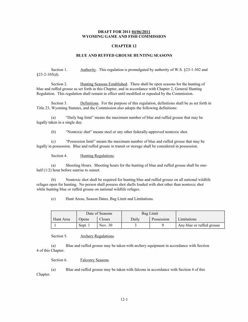
12-1
DRAFT FOR 2011 04/06/2011 WYOMING GAME AND FISH COMMISSION
CHAPTER 12
BLUE AND RUFFED GROUSE HUNTING SEASONS
Section 1. Authority. This regulation is promulgated by authority of W.S. §23-1-302 and §23-2-105(d). Section 2. Hunting Seasons Established. There shall be open seasons for the hunting of blue and ruffed grouse as set forth in this Chapter, and in accordance with Chapter 2, General Hunting Regulation. This regulation shall remain in effect until modified or repealed by the Commission. Section 3. Definitions. For the purpose of this regulation, definitions shall be as set forth in Title 23, Wyoming Statutes, and the Commission also adopts the following definitions: (a) “Daily bag limit” means the maximum number of blue and ruffed grouse that may be legally taken in a single day. (b) “Nontoxic shot” means steel or any other federally-approved nontoxic shot. (c) “Possession limit” means the maximum number of blue and ruffed grouse that may be legally in possession. Blue and ruffed grouse in transit or storage shall be considered in possession. Section 4. Hunting Regulations. (a) Shooting Hours. Shooting hours for the hunting of blue and ruffed grouse shall be one-half (1/2) hour before sunrise to sunset. (b) Nontoxic shot shall be required for hunting blue and ruffed grouse on all national wildlife refuges open for hunting. No person shall possess shot shells loaded with shot other than nontoxic shot while hunting blue or ruffed grouse on national wildlife refuges. (c) Hunt Areas, Season Dates, Bag Limit and Limitations.
Date of Seasons Bag Limit
Hunt Area Opens Closes Daily Possession Limitations 1 Sept. 1 Nov. 30 3 9 Any blue or ruffed grouse
Section 5. Archery Regulations. (a) Blue and ruffed grouse may be taken with archery equipment in accordance with Section 4 of this Chapter. Section 6. Falconry Seasons. (a) Blue and ruffed grouse may be taken with falcons in accordance with Section 4 of this Chapter.
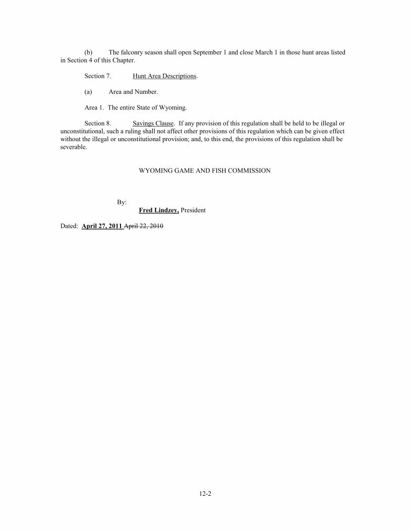
12-2
(b) The falconry season shall open September 1 and close March 1 in those hunt areas listed in Section 4 of this Chapter. Section 7. Hunt Area Descriptions. (a) Area and Number. Area 1. The entire State of Wyoming. Section 8. Savings Clause. If any provision of this regulation shall be held to be illegal or unconstitutional, such a ruling shall not affect other provisions of this regulation which can be given effect without the illegal or unconstitutional provision; and, to this end, the provisions of this regulation shall be severable. WYOMING GAME AND FISH COMMISSION By: Fred Lindzey, President Dated: April 27, 2011 April 22, 2010
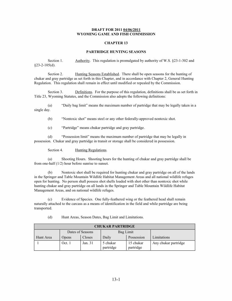
13-1
DRAFT FOR 2011 04/06/2011 WYOMING GAME AND FISH COMMISSION
CHAPTER 13
PARTRIDGE HUNTING SEASONS
Section 1. Authority. This regulation is promulgated by authority of W.S. §23-1-302 and §23-2-105(d). Section 2. Hunting Seasons Established. There shall be open seasons for the hunting of chukar and gray partridge as set forth in this Chapter, and in accordance with Chapter 2, General Hunting Regulation. This regulation shall remain in effect until modified or repealed by the Commission. Section 3. Definitions. For the purpose of this regulation, definitions shall be as set forth in Title 23, Wyoming Statutes, and the Commission also adopts the following definitions: (a) “Daily bag limit” means the maximum number of partridge that may be legally taken in a single day. (b) “Nontoxic shot” means steel or any other federally-approved nontoxic shot. (c) “Partridge” means chukar partridge and gray partridge. (d) “Possession limit” means the maximum number of partridge that may be legally in possession. Chukar and gray partridge in transit or storage shall be considered in possession. Section 4. Hunting Regulations. (a) Shooting Hours. Shooting hours for the hunting of chukar and gray partridge shall be from one-half (1/2) hour before sunrise to sunset. (b) Nontoxic shot shall be required for hunting chukar and gray partridge on all of the lands in the Springer and Table Mountain Wildlife Habitat Management Areas and all national wildlife refuges open for hunting. No person shall possess shot shells loaded with shot other than nontoxic shot while hunting chukar and gray partridge on all lands in the Springer and Table Mountain Wildlife Habitat Management Areas, and on national wildlife refuges. (c) Evidence of Species. One fully-feathered wing or the feathered head shall remain naturally attached to the carcass as a means of identification in the field and while partridge are being transported. (d) Hunt Areas, Season Dates, Bag Limit and Limitations.
CHUKAR PARTRIDGE Dates of Seasons Bag Limit Hunt Area Opens Closes Daily Possession Limitations 1 Oct. 1 Jan. 31 5 chukar
partridge 15 chukar partridge
Any chukar partridge
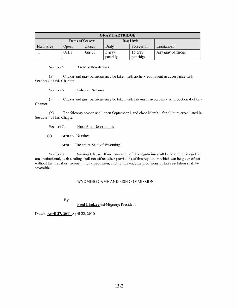
13-2
GRAY PARTRIDGE
Dates of Seasons Bag Limit Hunt Area Opens Closes Daily Possession Limitations 1 Oct. 1 Jan. 31 5 gray
partridge 15 gray partridge
Any gray partridge
Section 5. Archery Regulations. (a) Chukar and gray partridge may be taken with archery equipment in accordance with Section 4 of this Chapter. Section 6. Falconry Seasons. (a) Chukar and gray partridge may be taken with falcons in accordance with Section 4 of this Chapter. (b) The falconry season shall open September 1 and close March 1 for all hunt areas listed in Section 4 of this Chapter. Section 7. Hunt Area Descriptions. (a) Area and Number. Area 1. The entire State of Wyoming. Section 8. Savings Clause. If any provision of this regulation shall be held to be illegal or unconstitutional, such a ruling shall not affect other provisions of this regulation which can be given effect without the illegal or unconstitutional provision; and, to this end, the provisions of this regulation shall be severable. WYOMING GAME AND FISH COMMISSION By: Fred Lindzey,Ed Mignery, President Dated: April 27, 2011 April 22, 2010
15-1
DRAFT FOR 2011 04/06/2011 WYOMING GAME AND FISH COMMISSION
CHAPTER 15
WILD BISON RECREATIONAL HUNTING SEASON
Section 1. Authority. This regulation is promulgated by authority of W.S. §23-1-101, §23-1-302 and §23-2-107. Section 2. Regulation. The Wyoming Game and Fish Commission hereby adopts the following regulation governing wild bison recreational hunting seasons. This regulation shall remain in effect until modified or repealed by the Commission. Section 3. Definitions. For the purpose of this regulation, definitions shall be as set forth in Title 23, Wyoming Statutes, and the Commission also adopts the following definitions: (a) “Archery Equipment” means a bow of at least fifty (50) pounds draw weight or possessing the ability to cast a hunting arrow of five hundred (500) grain weight at least one hundred sixty (160) yards. The crossbow hunter must be equipped with a crossbow of not less than ninety (90) pounds draw weight which has a minimum draw length of fourteen (14) inches (from front of bow to back of string in the cocked position) and a positive safety mechanism. Crossbow bolts must be at least sixteen (16) inches long. The broadhead of arrows or bolts shall be of sharp steel with a minimum cutting width of one (1) inch. (b) “Bull” means an adult male bison. (cb) “Calf” means young of the year bison. (d) “Cow” means an adult female bison. (ec) “Edible portions” means the meat of the front quarters as far down as the knees, the meat of the hindquarters as far down as the hocks, and the meat along the backbone between the neck and hindquarters including the loins and tenderloins, excluding meat on the ribs and neck. (fd) “Firearm” means any firearm which has a barrel bore diameter of at least twenty-seven hundredths (27/100) of an inch and is chambered to fire a center-fire cartridge not less than two (2) inches in overall length, including a soft or expanding point bullet of a minimum of one hundred fifty (150) grains, seated to a normal depth. (ge) “Hunter Information Card” means a survey form used by the Department to collect wild bison hunting and harvest information. (hf) “Muzzle-loading Firearm” means a muzzle-loading rifle having a barrel bore diameter of at least 50/100 of an inch and a charge of at least one hundred (100) grains of black powder or equivalent.
15-2
(ig) “National Elk Refuge Permit” means a permit that allows a properly licensed wild bison hunter to access the National Elk Refuge to take a bison. (jh) “Site of kill” means the location where the harvested animal died. (ki) “Type” means a limitation on a bison license in a particular hunt area for the sex of animal, the length of season, the type of weapon or a portion of a hunt area in which the license shall be valid. (lj) “Wild Bison Priority List” means random lists generated from all bison applicants for the current harvest year. Section 4. Recreational Hunting Season Established and Effective Date. When the Department determines a wild bison recreational hunting opportunity exists, there shall be a wild bison recreational hunting season as established in accordance with Section 5 through Section 19 of this regulation. Section 5. Supervision of Licensees. Wild bison recreational hunting may be done under the supervision or direction of Department personnel. Section 6. Notification. (a) Applicants shall be notified by mail of their placement on the wild bison priority list by the Department. (b) Applicants on the wild bison priority list shall be notified by mail or by telephone, in order of their priority ranking, when the Department determines a wild bison recreational hunting opportunity may exist. The notification shall be mailed a minimum of five (5) days immediately prior to the scheduled wild bison hunting season. (c) At the Department’s discretion, additional notifications may be made by mail or by telephone. If telephone calls are made, the calls shall be done by the Department during the evening hours between 4:00 p.m. and 10:00 p.m. Mountain Time. If telephone calls are made, a minimum of three (3) attempts by telephone shall be made that evening and the subsequent evening to contact and notify any individual applicant. Notification attempts shall be spaced at a minimum of one-half (½) hour intervals. Department personnel must speak directly to the applicant during the notification call. If an individual cannot be contacted, the next individual on the list shall be notified and those who could not be contacted shall retain their positions on the wild bison priority list. Section 7. Selection of Bison to be Harvested. (a) Hunters may be directed by Department personnel to take a specific age class of wild bison in a specific geographic portion of a hunt area, during a specific time period or by a specific method of take in order to meet the Department’s management objectives. Numbers and age classes of wild bison available when the applicant arrives may differ from those available at the time of the notification call or letter. Issuance of a wild bison license provides the licensee an opportunity to hunt a wild bison; it does not guarantee that a licensee shall harvest a wild bison.
15-3
Section 8. Wild Bison Hunting Orientation Information. (a) Applicants selected to participate in the wild bison recreational hunting season shall be provided wild bison hunting orientation information in a manner determined by the Department.
Section 9. Legal Methods of Take. Wild bison shall be taken by the use of legal firearms, archery equipment and muzzle-loading firearms.; except as provided in this section. Wild bison shall only be taken by the use of legal firearms on the National Elk Refuge. Section 10. Licensing. Licenses shall be issued upon payment by the applicant of the proper license fee at the Department Regional Office administering the wild bison recreational hunt. A license must be purchased prior to participating in the wild bison recreational hunt. A conservation stamp shall be in possession of the licensee while exercising the privileges under the wild bison license. Section 11. National Elk Refuge Permits. A National Elk Refuge permit is required prior to hunting wild bison on the National Elk Refuge and shall be in possession of the hunter while hunting wild bison on the National Elk Refuge. A limited number of permits shall be available to hunt wild bison on the National Elk Refuge. Permits shall be issued by the Department to licensed wild bison hunters in the order of their placement on the wild bison priority list and shall be valid only for specified dates. Alternate permits may become available throughout the hunting season depending upon harvest and management objectives. Section 12. Tagging Requirements. When any wild bison is killed under a license, the licensee shall detach, sign and date the carcass coupon and attach the coupon to the carcass before leaving the site of the kill. The coupon shall remain on the wild bison carcass at all times until the meat undergoes processing, except that during transportation of the carcass the coupon may be removed to prevent its loss. If the coupon is removed for transportation of the carcass, it shall be in the possession of the person accompanying the carcass at all times. Section 13. Retrieval of Edible Portions. No person shall take and leave, abandon, or allow any wild bison, or edible portion to intentionally or needlessly go to waste. The failure of any person to properly dress and care for any wild bison killed by that person and if the carcass is reasonably accessible, within forty-eight (48) hours to take or transport the carcass to the camp of that person, and to properly care for the carcass is prima facie evidence of a violation of this section. The Department may require substantive proof from any person who fails to retrieve from the site of kill all edible portions of a wild bison as to why the edible portions were not removed from the field. Section 14. Wearing of Fluorescent Orange Clothing. No person shall hunt any wild bison without wearing in a visible manner one (1) or more exterior garments, which shall include a hat, shirt, jacket, coat, vest or sweater of a fluorescent orange color. Section 15. Retention of Evidence To Identify Sex of Wild Bison Harvested. Any person who takes any wild bison in a hunt area where the taking of either sex is controlled or prohibited shall comply with this section while said animal is in
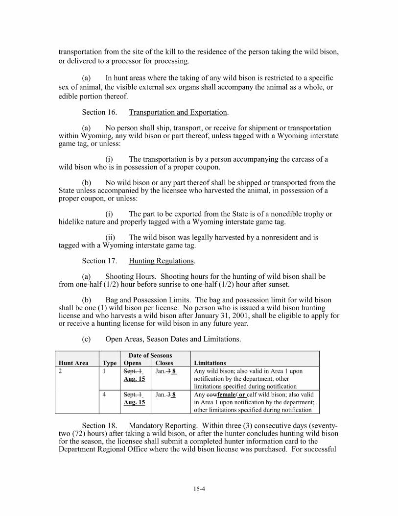
15-4
transportation from the site of the kill to the residence of the person taking the wild bison, or delivered to a processor for processing. (a) In hunt areas where the taking of any wild bison is restricted to a specific sex of animal, the visible external sex organs shall accompany the animal as a whole, or edible portion thereof. Section 16. Transportation and Exportation. (a) No person shall ship, transport, or receive for shipment or transportation within Wyoming, any wild bison or part thereof, unless tagged with a Wyoming interstate game tag, or unless: (i) The transportation is by a person accompanying the carcass of a wild bison who is in possession of a proper coupon. (b) No wild bison or any part thereof shall be shipped or transported from the State unless accompanied by the licensee who harvested the animal, in possession of a proper coupon, or unless: (i) The part to be exported from the State is of a nonedible trophy or hidelike nature and properly tagged with a Wyoming interstate game tag. (ii) The wild bison was legally harvested by a nonresident and is tagged with a Wyoming interstate game tag. Section 17. Hunting Regulations. (a) Shooting Hours. Shooting hours for the hunting of wild bison shall be from one-half (1/2) hour before sunrise to one-half (1/2) hour after sunset. (b) Bag and Possession Limits. The bag and possession limit for wild bison shall be one (1) wild bison per license. No person who is issued a wild bison hunting license and who harvests a wild bison after January 31, 2001, shall be eligible to apply for or receive a hunting license for wild bison in any future year. (c) Open Areas, Season Dates and Limitations. Date of Seasons Hunt Area Type Opens Closes Limitations 2 1 Sept. 1
Aug. 15 Jan. 3 8 Any wild bison; also valid in Area 1 upon
notification by the department; other limitations specified during notification
4 Sept. 1 Aug. 15
Jan. 3 8 Any cowfemale/ or calf wild bison; also valid in Area 1 upon notification by the department; other limitations specified during notification
Section 18. Mandatory Reporting. Within three (3) consecutive days (seventy-two (72) hours) after taking a wild bison, or after the hunter concludes hunting wild bison for the season, the licensee shall submit a completed hunter information card to the Department Regional Office where the wild bison license was purchased. For successful
15-5
hunters, the hunter information card shall include the licensee’s name, license number, date of harvest, total number of days hunted, the sex and age class (adult, yearling, calf) of the wild bison harvested, the drainage and the legal description of where the bison was harvested to include section, range and township or UTM coordinates. Successful hunters shall also supply biological samples as required by the Department. For unsuccessful hunters, the hunter information card shall include licensee’s name, license number and total number of days hunted. Section 19. Hunt Area Descriptions. (a) Area and Number. Area 1. Absaroka. All lands within Park, Hot Springs and Fremont counties and Teton County east of the Continental Divide, excluding lands administered by the Wind River Indian Reservation and Yellowstone National Park. Area 2. Jackson. All lands within Lincoln and Sublette counties and Teton County west of the Continental Divide, excluding Grand Teton National Park, John D. Rockefeller Jr. Memorial Parkway and Yellowstone National Park. Section 20. Violation of Commission Regulations. Failure to abide by the provisions of this regulation shall be punishable as provided by Wyoming statutes for violation of Commission regulations. Section 21. Savings Clause. If any provision of this regulation shall be held to be illegal or unconstitutional, such a ruling shall not affect other provisions of this regulation which can be given effect without the illegal or unconstitutional provision; and, to this end, the provisions of this regulation shall be severable. WYOMING GAME AND FISH COMMISSION By: Fred Lindzey,Ed Mignery, President Date: April 27, 2011 April 22, 2010
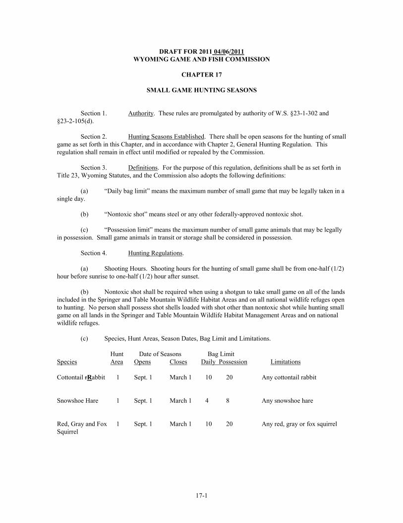
17-1
DRAFT FOR 2011 04/06/2011 WYOMING GAME AND FISH COMMISSION
CHAPTER 17
SMALL GAME HUNTING SEASONS
Section 1. Authority. These rules are promulgated by authority of W.S. §23-1-302 and §23-2-105(d). Section 2. Hunting Seasons Established. There shall be open seasons for the hunting of small game as set forth in this Chapter, and in accordance with Chapter 2, General Hunting Regulation. This regulation shall remain in effect until modified or repealed by the Commission. Section 3. Definitions. For the purpose of this regulation, definitions shall be as set forth in Title 23, Wyoming Statutes, and the Commission also adopts the following definitions: (a) “Daily bag limit” means the maximum number of small game that may be legally taken in a single day. (b) “Nontoxic shot” means steel or any other federally-approved nontoxic shot. (c) “Possession limit” means the maximum number of small game animals that may be legally in possession. Small game animals in transit or storage shall be considered in possession. Section 4. Hunting Regulations. (a) Shooting Hours. Shooting hours for the hunting of small game shall be from one-half (1/2) hour before sunrise to one-half (1/2) hour after sunset. (b) Nontoxic shot shall be required when using a shotgun to take small game on all of the lands included in the Springer and Table Mountain Wildlife Habitat Areas and on all national wildlife refuges open to hunting. No person shall possess shot shells loaded with shot other than nontoxic shot while hunting small game on all lands in the Springer and Table Mountain Wildlife Habitat Management Areas and on national wildlife refuges. (c) Species, Hunt Areas, Season Dates, Bag Limit and Limitations. Hunt Date of Seasons Bag Limit Species Area Opens Closes Daily Possession Limitations Cottontail rRabbit 1 Sept. 1 March 1 10 20 Any cottontail rabbit Snowshoe Hare 1 Sept. 1 March 1 4 8 Any snowshoe hare Red, Gray and Fox 1 Sept. 1 March 1 10 20 Any red, gray or fox squirrel Squirrel
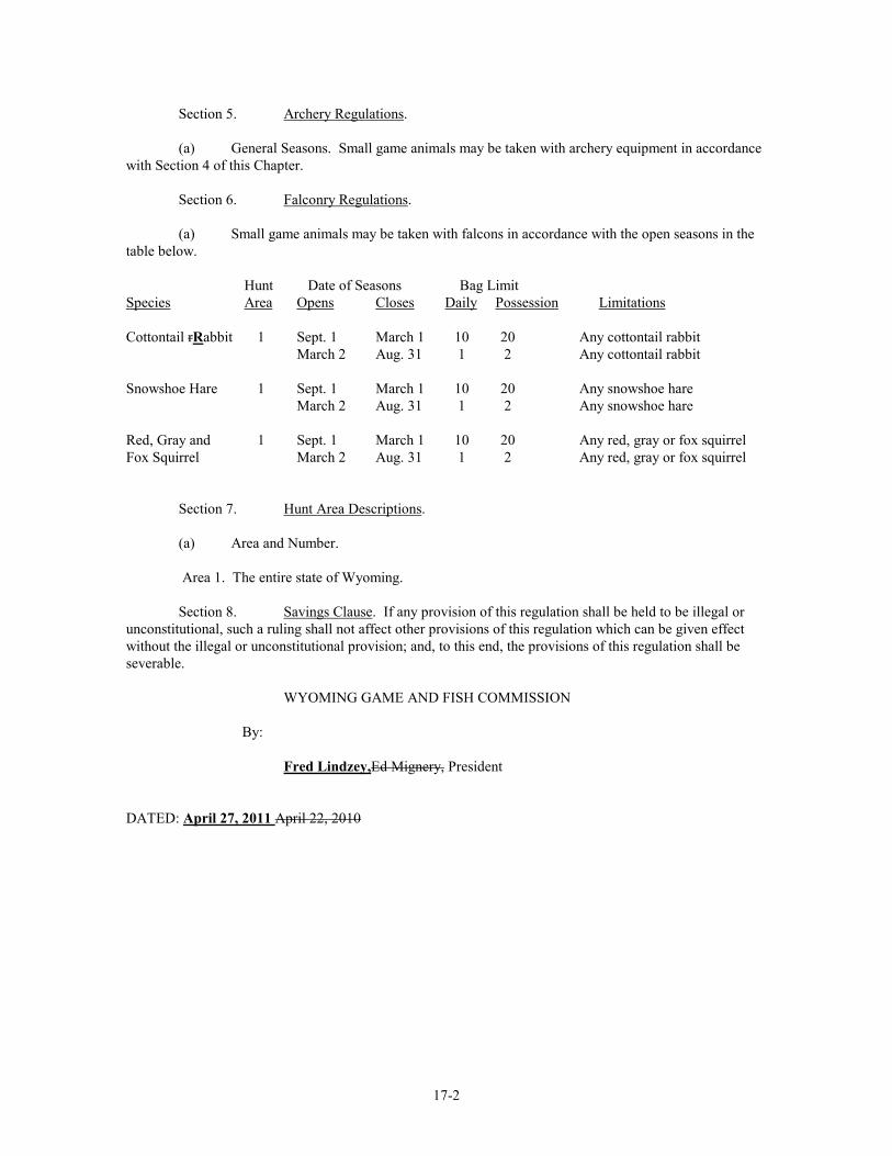
17-2
Section 5. Archery Regulations. (a) General Seasons. Small game animals may be taken with archery equipment in accordance with Section 4 of this Chapter. Section 6. Falconry Regulations. (a) Small game animals may be taken with falcons in accordance with the open seasons in the table below. Hunt Date of Seasons Bag Limit Species Area Opens Closes Daily Possession Limitations Cottontail rRabbit 1 Sept. 1 March 1 10 20 Any cottontail rabbit March 2 Aug. 31 1 2 Any cottontail rabbit Snowshoe Hare 1 Sept. 1 March 1 10 20 Any snowshoe hare March 2 Aug. 31 1 2 Any snowshoe hare Red, Gray and 1 Sept. 1 March 1 10 20 Any red, gray or fox squirrel Fox Squirrel March 2 Aug. 31 1 2 Any red, gray or fox squirrel Section 7. Hunt Area Descriptions. (a) Area and Number. Area 1. The entire state of Wyoming.
Section 8. Savings Clause. If any provision of this regulation shall be held to be illegal or unconstitutional, such a ruling shall not affect other provisions of this regulation which can be given effect without the illegal or unconstitutional provision; and, to this end, the provisions of this regulation shall be severable. WYOMING GAME AND FISH COMMISSION By: Fred Lindzey,Ed Mignery, President DATED: April 27, 2011 April 22, 2010
18-1
DRAFT FOR 2011 04/06/2011 WYOMING GAME AND FISH COMMISSION
CHAPTER 18
PHEASANT HUNTING SEASONS
Section 1. Authority. This regulation is promulgated by authority of W.S. §23-1-302 and §23-2-105(d). Section 2. Hunting Seasons Established. There shall be open seasons for the hunting of pheasants as set forth in this Chapter, and in accordance with Chapter 2, General Hunting Regulation. This regulation shall remain in effect until modified or repealed by the Commission. Section 3. Definitions. For the purpose of this regulation, definitions shall be as set forth in Title 23, Wyoming Statutes, and the Commission also adopts the following definitions: (a) “Adult” means a person eighteen (18) years of age or older. (b) “Daily bag limit” means the maximum number of pheasants that may be legally taken in a single day. (c) “Nontoxic shot” means steel or any other federally-approved nontoxic shot. (d) “Possession limit” means the maximum number of pheasants that may be legally in possession. Pheasants in transit or storage shall be considered in possession. (e) “Season bag limit” means the total number of pheasants that may be legally taken from a particular hunt area during an entire season. (f) “Youth” means any person who has not attained the age of eighteen (18) on or before October 1 of the application year. Section 4. Hunting Regulations. (a) Bag and Possession Limit. Only one (1) daily bag limit may be taken per day regardless of the number of hunt areas hunted in a single day. When hunting more than one (1) hunt area, a person’s daily and possession limits shall be equal to, but shall not exceed, the largest daily and possession limits prescribed for any one (1) of the specified hunt areas in which the hunting and possession occurs. (b) Evidence of Sex and Species. Evidence of sex and species shall be retained on each pheasant harvested. The feathered head, feathered wing, or foot shall remain naturally attached to the carcass of the pheasant in the field and during transportation. (c) Nontoxic Shot. Nontoxic shot shall be required for hunting pheasants on all of the lands in the Springer and Table Mountain Wildlife Habitat Management Areas and on all national wildlife refuges open for hunting. No person shall possess shot shells loaded with shot other than nontoxic shot while hunting pheasants on all lands in the Springer and Table Mountain Wildlife Habitat Management Areas, and on national wildlife refuges. (d) Required Clothing. Any person hunting pheasants within the boundaries of any Wyoming Game and Fish Commission Wildlife Habitat Management Area, or on Bureau of Reclamation Withdrawal
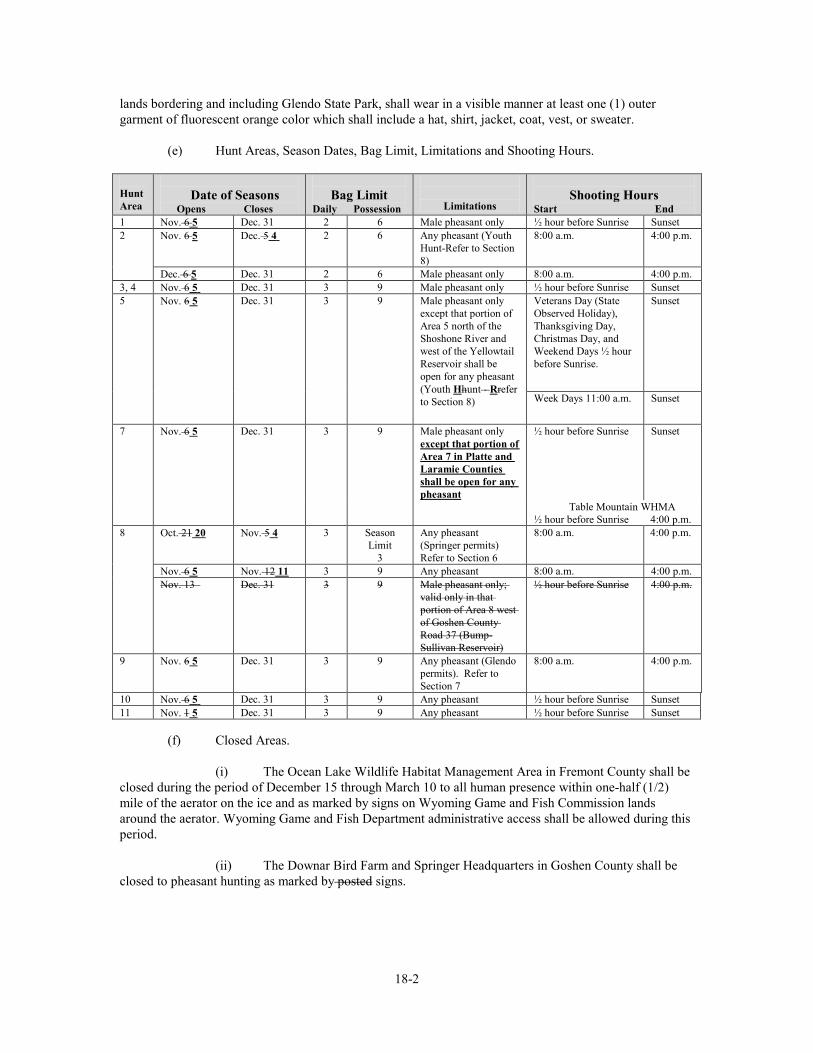
18-2
lands bordering and including Glendo State Park, shall wear in a visible manner at least one (1) outer garment of fluorescent orange color which shall include a hat, shirt, jacket, coat, vest, or sweater. (e) Hunt Areas, Season Dates, Bag Limit, Limitations and Shooting Hours. Hunt Area
Date of Seasons Opens Closes
Bag Limit
Daily Possession
Limitations
Shooting Hours
Start End 1 Nov. 6 5 Dec. 31 2 6 Male pheasant only ½ hour before Sunrise Sunset 2 Nov. 6 5 Dec. 5 4 2 6 Any pheasant (Youth
Hunt-Refer to Section 8)
8:00 a.m. 4:00 p.m.
Dec. 6 5 Dec. 31 2 6 Male pheasant only 8:00 a.m. 4:00 p.m. 3, 4 Nov. 6 5 Dec. 31 3 9 Male pheasant only ½ hour before Sunrise Sunset 5 Nov. 6 5 Dec. 31 3 9 Male pheasant only
except that portion of Area 5 north of the Shoshone River and west of the Yellowtail Reservoir shall be open for any pheasant (Youth Hhunt - Rrefer to Section 8)
Veterans Day (State Observed Holiday), Thanksgiving Day, Christmas Day, and Weekend Days ½ hour before Sunrise.
Sunset
Week Days 11:00 a.m. Sunset
7 Nov. 6 5 Dec. 31 3 9 Male pheasant only except that portion of Area 7 in Platte and Laramie Counties shall be open for any pheasant
½ hour before Sunrise
Sunset
Table Mountain WHMA ½ hour before Sunrise 4:00 p.m.
8 Oct. 21 20 Nov. 5 4 3 Season Limit
3
Any pheasant (Springer permits) Refer to Section 6
8:00 a.m. 4:00 p.m.
Nov. 6 5 Nov. 12 11 3 9 Any pheasant 8:00 a.m. 4:00 p.m. Nov. 13 Dec. 31 3 9 Male pheasant only;
valid only in that portion of Area 8 west of Goshen County Road 37 (Bump-Sullivan Reservoir)
½ hour before Sunrise 4:00 p.m.
9 Nov. 6 5 Dec. 31 3 9 Any pheasant (Glendo permits). Refer to Section 7
8:00 a.m. 4:00 p.m.
10 Nov. 6 5 Dec. 31 3 9 Any pheasant ½ hour before Sunrise Sunset 11 Nov. 1 5 Dec. 31 3 9 Any pheasant ½ hour before Sunrise Sunset (f) Closed Areas. (i) The Ocean Lake Wildlife Habitat Management Area in Fremont County shall be closed during the period of December 15 through March 10 to all human presence within one-half (1/2) mile of the aerator on the ice and as marked by signs on Wyoming Game and Fish Commission lands around the aerator. Wyoming Game and Fish Department administrative access shall be allowed during this period.
(ii) The Downar Bird Farm and Springer Headquarters in Goshen County shall be closed to pheasant hunting as marked by posted signs.
18-3
(iii) Pond Number 1 and adjacent lands on the Table Mountain Wildlife Habitat Management Area in Goshen County, as marked by colored signs and posts, shall be closed to pheasant hunting beginning November 1312. (iv) The Sheridan Bird Farm in Sheridan County shall be closed to pheasant hunting, except during hunts sponsored and supervised by the Wyoming Game and Fish Department. Section 5. Pheasant Special Management Permit. A pheasant special management permit shall be required of any person, except those exempted in this section, who participates in the hunting of pheasants in those areas listed in subsection (a) of this section. Owners of lands enrolled in the Private Lands/Public Wildlife Walk-In Access program, and members of their immediate families (landowner’s spouse, parents, grandparents, or lineal descendants and their spouses) are exempt from the requirement to obtain a pheasant special management permit when they are hunting pheasants on the deeded land of the landowner. The pheasant special management permit shall be in possession of any person while hunting pheasants, and shall be immediately produced for inspection upon request from any authorized Department representative. Any person purchasing a pheasant special management permit for the purpose set forth in this section shall validate the permit by signing that person’s name in ink across the face of the permit. Hunters who acquire a pheasant special management permit through the ELS shall not be required to meet the signature provision of this section. The permit shall be available at Headquarters, Department Regional Offices and designated license selling agents. (a) Special Management Permit Areas. A pheasant special management permit shall be required to hunt pheasants in the areas listed in this subsection: (i) Bud Love Wildlife Habitat Management Area in Johnson County. (ii) Glendo State Park, including all Bureau of Reclamation Withdrawal lands bordering the Park and the adjoining Department Private Lands/Public Wildlife Walk-in Area in Platte County. (iii) Ocean Lake Wildlife Habitat Management Area in Fremont County. (iv) Springer Wildlife Habitat Management Area, including all the lands administered by the Wyoming Game and Fish Commission surrounding Bump-Sullivan and Springer reservoirs in Goshen County. (v) Table Mountain Wildlife Habitat Management Area in Goshen County. (vi) Yellowtail Wildlife Habitat Management Area, excluding any private lands included within the Yellowtail Wildlife Habitat Management Habitat Area, in Bighorn County. (vii) All lands in the Sand Mesa Wildlife Habitat Management Area east of the Bass Lake Road in Fremont County. (viii) All lands opened to the hunting of pheasants that are enrolled in the Department’s Private Lands/Public Wildlife Walk-in Access Program, excluding Walk-In Access Areas in Big Horn, Fremont, Hot Springs, Park and Washakie Counties on which pheasants are not released by the Department. (ix) All State lands in Johnson and Sheridan Counties. Section 6. Springer Permit Pheasant Season. In order to participate in this season, a person shall possess and present upon request a valid Springer permit, a valid bird license and conservation stamp
18-4
(unless otherwise exempted by state statute) and a pheasant special management permit. Persons born on or after January 1, 1966, shall possess and present upon request a hunter safety certificate. The Springer permit shall only be valid for the day printed on the permit by the Department. There shall be a Springer permit pheasant season in Hunt Area 8 beginning October 2120 through November 54. (a) Application for Springer permits. Completed applications shall be submitted to the Cheyenne Office of the Department on proper application forms beginning August 15. Applications shall be accepted until 5:00 p.m. September 15. A drawing shall be utilized to determine successful applicants. Only youths may apply for Springer permits for youth only hunt days as set forth in Section 6 (c) of this Chapter. A drawing shall be utilized to determine successful applicants. A person shall only submit a single application. Successful applicants shall be notified by mail of their hunting date and furnished a set of special instructions. (b) Issuance of Springer permits. A maximum of one hundred twenty (120) permits shall be issued to successful applicants in the drawing for each day of the Springer permit pheasant season. A maximum of one hundred twenty (120) hunters shall be allowed to hunt at any one time during the Springer permit pheasant season. When a hunter checks out of the Springer Check Station, the Department may issue a permit to another person at the check station. If all one hundred twenty (120) permits for a single day have not been issued by the Department, or if the check station attendants are advised that a permitted hunter will not participate, the Department may issue a permit to another person at the check station on a first-come, first-served basis, not to exceed a maximum of one hundred twenty (120) permitted hunters. Permitted hunters may begin hunting at 8 a.m. Hunters who are issued permits through the drawing must check in at the check station by 9:00 a.m. on the date their permit is valid. Permits that are unclaimed after 9:00 a.m. shall be issued to other hunters on a first-come, first-served basis.
(c) Youth Only Hunt Days. Only youths shall be allowed to take pheasants on the youth hunt days. Youths under the age of fourteen (14) shall be accompanied by an adult. No adult shall take any pheasant during the youth only hunt days. The youth only hunt days are October 2322 and October 3130. (d) Springer Check Station. The Springer Check Station is located one and one-quarter (1 1/4) miles west of U. S. Highway 85 on the south boundary of the Springer Wildlife Habitat Management Area. The hours of operation of the check station shall be from 7:00 a.m. to 4:30 p.m. daily during the Springer permit pheasant season. Persons participating in the Springer permit pheasant season shall check in at the check station prior to hunting. Prior to leaving the Springer permit pheasant area, each hunter shall check out at the check station by 4:30 p.m. on the same day that the hunter registered and shall accurately report all harvested pheasants and return all special hunt materials to the check station. (e) Parking assignment. Parking lot assignments and tags shall be issued by the Department tofor each vehicle utilized by hunters. Parking lot tags shall be displayed in a visible manner in each vehicle. All vehicles shall be parked in assigned parking lots. Section 7. Glendo Permit Pheasant Season. Glendo permits shall be required to hunt pheasants in Hunt Area 9 on each Friday, Saturday, and Monday during the open season in November and on December 32, December 4,3, December 5 4 and December 6 5. Glendo permits are not required to hunt pheasants in Hunt Area 9 on other days during the open season. A person shall possess and present upon request a valid Glendo permit (on those days required), a valid bird license and conservation stamp (unless otherwise exempted by state statute), a pheasant special management permit and for hunters born on or after January 1, 1966, a hunter safety certificate. (a) Youth only hunt days. Youth only hunt days shall be November 76, 1413, 2120, and 2827. Only youths shall be allowed to take pheasants on youth hunt days. Youths under the age of fourteen (14) shall be accompanied by an adult. No adult shall take any pheasant during the youth only hunt days. No Glendo permit is required for youths to hunt on youth only hunt days.
18-5
(b) Application for Glendo permits. Completed applications shall be submitted to the Cheyenne Office of the Department on proper application forms beginning August 15. Applications shall be accepted until 5:00 p.m. September 15. A drawing shall be utilized to determine successful applicants. A person shall only submit a single application. No person shall apply for and receive more than one (1) Glendo permit in a calendar year. Successful applicants shall be notified by mail of their hunting date and furnished a set of special instructions. (c) Issuance of Glendo permits. A maximum of sixty (60) permits shall be issued in the drawing for each day a permit is required. The Glendo permit shall only be valid for the day printed on the permit by the Department. Section 8. Sand Mesa and Yellowtail Wildlife Habitat Areas Youth Hunt. The youth only hunt day is November 2019. Only youths shall be allowed to take pheasants on this date. Youths under the age of fourteen (14) shall be accompanied by an adult. No adults shall take any pheasant during the youth only hunt day, except as provided in this section. The youth hunt shall take place on all lands included in the Sand Mesa Wildlife Habitat Area east of the Bass Lake Road, and all lands included in the Yellowtail Wildlife Habitat Area north of the Shoshone River. Section 9. Archery Regulations. (a) General Seasons. Pheasants may be taken with archery equipment in accordance with Section 4 of this Chapter. Section 10. Falconry Seasons. (a) Pheasants may be taken with falcons in accordance with Section 4 of this Chapter. Persons hunting with falcons may take any pheasant. (b) The falconry season shall open September 1 and close March 1 in those hunt areas listed in Section 4 of this Chapter, except as otherwise provided in subsection 4(f) and subsection 10(c) of this Chapter. (c) Closed Areas.
Hunt Area Limitations 8, 9 Closed to falconry hunting
Section 11. Hunt Area Descriptions. (a) Area and Number. Area 1. All of Fremont County, excluding the Ocean Lake Wildlife Habitat Management Area surrounding Ocean Lake and excluding the Sand Mesa Wildlife Habitat Management Area east of the Bass Lake Road. Area 2. All lands included in the Ocean Lake Wildlife Habitat Management Area surrounding Ocean Lake and all lands included in the Sand Mesa Wildlife Habitat Management Area east of the Bass Lake Road. Area 3. All of Sheridan and Johnson Counties.
18-6
Area 4. All of Park, Washakie and Hot Springs Counties, and all of Big Horn County excluding all lands in the Yellowtail Wildlife Habitat Management Area north of U.S. Highway 14A. Area 5. All of the lands included in the Yellowtail Wildlife Habitat Management Area north of U.S. Highway 14A. Area 7. All of Goshen and Platte Counties and that portion of Laramie County east of U.S. Highway 85, excluding Hunt Areas 8 and 9. Area 8. All of the lands included in the Springer Wildlife Habitat Management Area. Area 9. All Bureau of Reclamation Withdrawal lands bordering and including Glendo State Park and the adjoining Department Private Lands/Public Wildlife Walk-in Area. Area 10. All of Campbell County. Area 11. The entire State of Wyoming excluding the lands described in Areas 1-10.
Section 12. Savings Clause. If any provision of this regulation shall be held to be illegal or unconstitutional, such a ruling shall not affect other provisions of this regulation which can be given effect without the illegal or unconstitutional provision; and, to this end, the provisions of this regulation shall be severable. WYOMING GAME AND FISH COMMISSION By: Fred Lindzey,Ed Mignery, President Dated: April 27, 2011 April 22, 2010
19-1
DRAFT FOR 2011 04/06/2011 WYOMING GAME AND FISH COMMISSION
CHAPTER 19
SHARP-TAILED GROUSE HUNTING SEASONS
Section 1. Authority. This regulation is promulgated by authority of W.S. §23-1-302 and §23-2-105(d). Section 2. Hunting Seasons Established. There shall be open seasons for the hunting of sharp-tailed grouse as set forth in this Chapter, and in accordance with Chapter 2, General Hunting Regulation. This regulation shall remain in effect until modified or repealed by the Commission. Section 3. Definitions. For the purpose of this regulation, definitions shall be as set forth in Title 23, Wyoming Statutes, and the Commission also adopts the following definitions: (a) “Daily bag limit” means the maximum number of sharp-tailed grouse that may be legally taken in a single day. (b) “Nontoxic shot” means steel or any other federally-approved nontoxic shot. (c) “Possession limit” means the maximum number of sharp-tailed grouse that may be legally in possession. Sharp-tailed grouse in transit or storage shall be considered in possession. Section 4. Hunting Regulations. (a) Shooting Hours. Shooting hours for the hunting of sharp-tailed grouse shall be one-half (1/2) hour before sunrise to sunset. (b) Evidence of Species. One fully-feathered wing or the feathered head shall remain naturally attached to the carcass as a means of identification in the field and while sharp-tailed grouse are being transported. (c) Nontoxic Shot. Nontoxic shot shall be required for hunting sharp-tailed grouse on all of the lands in the Springer and Table Mountain Wildlife Habitat Management Areas and on all national wildlife refuges open to hunting. No person shall possess shot shells loaded with shot other than nontoxic shot while hunting sharp-tailed grouse on all lands in the Springer and Table Mountain Wildlife Habitat Management Areas, and on national wildlife refuges. (d) Open Areas, Season Dates, Bag Limit and Limitations.
Date of Seasons Bag Limit
Hunt Area Opens Closes Daily Possession Limitations 1 Sept. 18
17 Dec. 31 3 9 Any sharp-tailed grouse

19-2
Section 5. Archery Regulations. (a) Sharp-tailed grouse may be taken with archery equipment in accordance with Section 4 of this Chapter. Section 6. Falconry Seasons. (a) Sharp-tailed grouse may be taken with falcons in accordance with Section 4 of this Chapter. (b) The falconry season shall open September 1 and close March 1 in those hunt areas listed in Section 4 of this Chapter. Section 7. Hunt Area Descriptions. (a) Area and Number. Area 1. That portion of Wyoming east of the Continental Divide. Section 8. Savings Clause. If any provision of this regulation shall be held to be illegal or unconstitutional, such a ruling shall not affect other provisions of this regulation which can be given effect without the illegal or unconstitutional provision; and, to this end, the provisions of this regulation shall be severable. WYOMING GAME AND FISH COMMISSION By: Fred Lindzey,Ed Mignery, President Dated: April 27, 2011 April 22, 2010
20-1
DRAFT FOR 2011 04/06/2011 WYOMING GAME AND FISH COMMISSION
CHAPTER 20
WILD TURKEY FALL AND SPRING HUNTING SEASONS
Section 1. Authority. This regulation is promulgated by authority of W.S. §23-1-302. Section 2. Hunting Seasons Established. There shall be open seasons for the hunting of wild turkey for fall, 2011 2010 and spring, 2012, 2011, as set forth in this Chapter, and in accordance with Chapter 2, General Hunting Regulation. This regulation shall remain in effect until modified or repealed by the Commission. Section 3. Definitions. For the purpose of this regulation, definitions shall be as set forth in Title 23, Wyoming Statutes, and the Commission also adopts the following definitions: (a) “General Wild Turkey Licenses” mean wild turkey licenses that are unlimited in number and valid in any hunt area with a general license hunting season for a specified sex of wild turkey during specified season dates. (b) “Limited Quota Wild Turkey Licenses” mean wild turkey licenses that are limited in number and valid only in a specified hunt area or portion of a hunt area for a specified sex of wild turkey during specified season dates. (c) “Nontoxic shot” means steel or any other federally-approved nontoxic shot. Section 4. Hunting Regulations. (a) No person shall apply for or receive more than one (1) license for a wild turkey during any one (1) season, except as otherwise provided in this regulation. The maximum bag limit for wild turkey for any person with the proper license shall not exceed one (1) wild turkey per license. (b) Issuance of Licenses. No person shall apply for or receive more than one (1) fall wild turkey license and one (1) spring wild turkey license in any calendar year. After the initial drawing is completed, a person may apply for and receive up to two (2) wild turkey licenses valid for each season, provided that at least one of those licenses is a Limited Quota Type 3 license. However, no person shall apply for and receive more than a total of two (2) wild turkey licenses valid for the fall season and no more than a total of two (2) wild turkey licenses valid for the spring season. (c) Shooting Hours. Shooting hours for the hunting of wild turkey shall be one-half (1/2) hour before sunrise to sunset. (d) Nontoxic Shot. Nontoxic shot shall be required for hunting wild turkeys on all of the lands in the Springer and Table Mountain Wildlife Habitat Management Areas and on all national wildlife refuges open for hunting. No person shall possess shot shells loaded with shot other than nontoxic shot while hunting wild turkey on all lands in the Springer and Table Mountain Wildlife Habitat Management Areas, and on national wildlife refuges. (e) Evidence of Sex. During the spring season in those hunt areas limited to the taking of male wild turkeys or any wild turkey with a visible beard, a visible beard shall remain naturally attached to the carcass as a means of identification in the field and while the wild turkey is being transported.
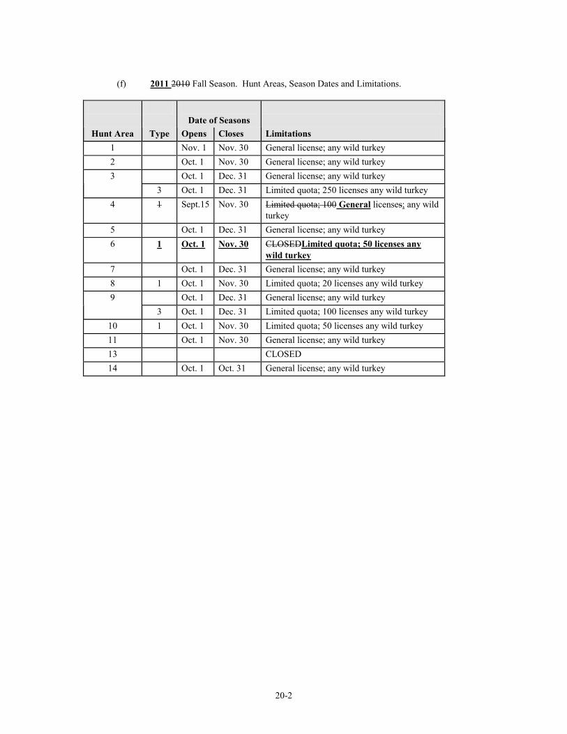
20-2
(f) 2011 2010 Fall Season. Hunt Areas, Season Dates and Limitations.
Date of Seasons
Hunt Area Type Opens Closes Limitations 1 Nov. 1 Nov. 30 General license; any wild turkey 2 Oct. 1 Nov. 30 General license; any wild turkey 3 Oct. 1 Dec. 31 General license; any wild turkey 3 Oct. 1 Dec. 31 Limited quota; 250 licenses any wild turkey
4 1 Sept.15 Nov. 30 Limited quota; 100 General licenses; any wild turkey
5 Oct. 1 Dec. 31 General license; any wild turkey 6 1 Oct. 1 Nov. 30 CLOSEDLimited quota; 50 licenses any
wild turkey 7 Oct. 1 Dec. 31 General license; any wild turkey 8 1 Oct. 1 Nov. 30 Limited quota; 20 licenses any wild turkey 9 Oct. 1 Dec. 31 General license; any wild turkey 3 Oct. 1 Dec. 31 Limited quota; 100 licenses any wild turkey
10 1 Oct. 1 Nov. 30 Limited quota; 50 licenses any wild turkey 11 Oct. 1 Nov. 30 General license; any wild turkey 13 CLOSED 14 Oct. 1 Oct. 31 General license; any wild turkey
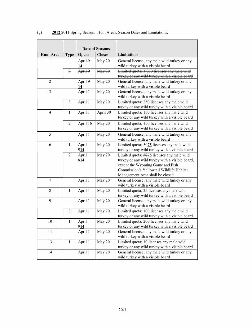
20-3
(g) 2012 2011 Spring Season. Hunt Areas, Season Dates and Limitations.
Date of Seasons
Hunt Area Type Opens Closes Limitations 1 April 9
14 May 20 General license; any male wild turkey or any
wild turkey with a visible beard 3 April 9 May 20 Limited quota; 3,000 licenses any male wild
turkey or any wild turkey with a visible beard 2 April 9
14 May 20 General license; any male wild turkey or any
wild turkey with a visible beard 3 April 1 May 20 General license; any male wild turkey or any
wild turkey with a visible beard 3 April 1 May 20 Limited quota; 250 licenses any male wild
turkey or any wild turkey with a visible beard 4 1 April 1
April 30 Limited quota; 150 licenses any male wild
turkey or any wild turkey with a visible beard 2
April 16 May 20 Limited quota; 150 licenses any male wild
turkey or any wild turkey with a visible beard 5 April 1 May 20 General license; any male wild turkey or any
wild turkey with a visible beard 6 1 April
914 May 20 Limited quota; 5075 licenses any male wild
turkey or any wild turkey with a visible beard 2 April
914 May 20 Limited quota; 5075 licenses any male wild
turkey or any wild turkey with a visible beard, except the Wyoming Game and Fish Commission’s Yellowtail Wildlife Habitat Management Area shall be closed
7 April 1 May 20 General license; any male wild turkey or any wild turkey with a visible beard
8 1 April 1 May 20 Limited quota; 25 licenses any male wild turkey or any wild turkey with a visible beard
9 April 1 May 20 General license; any male wild turkey or any wild turkey with a visible beard
3 April 1 May 20 Limited quota; 100 licenses any male wild turkey or any wild turkey with a visible beard
10 1 April 914
May 20 Limited quota; 200 licenses any male wild turkey or any wild turkey with a visible beard
11 April 1 May 20 General license; any male wild turkey or any wild turkey with a visible beard
13 1 April 1 May 20 Limited quota; 10 licenses any male wild turkey or any wild turkey with a visible beard
14 April 1 May 20 General license; any male wild turkey or any wild turkey with a visible beard
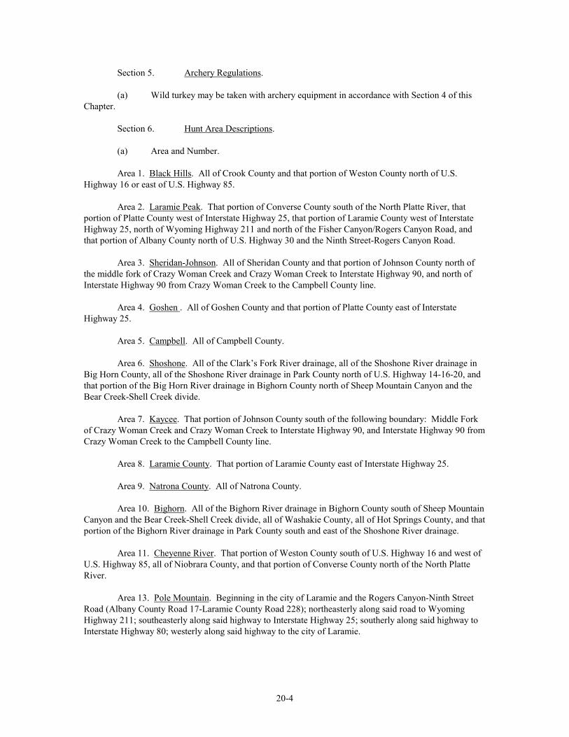
20-4
Section 5. Archery Regulations. (a) Wild turkey may be taken with archery equipment in accordance with Section 4 of this Chapter. Section 6. Hunt Area Descriptions. (a) Area and Number. Area 1. Black Hills. All of Crook County and that portion of Weston County north of U.S. Highway 16 or east of U.S. Highway 85. Area 2. Laramie Peak. That portion of Converse County south of the North Platte River, that portion of Platte County west of Interstate Highway 25, that portion of Laramie County west of Interstate Highway 25, north of Wyoming Highway 211 and north of the Fisher Canyon/Rogers Canyon Road, and that portion of Albany County north of U.S. Highway 30 and the Ninth Street-Rogers Canyon Road. Area 3. Sheridan-Johnson. All of Sheridan County and that portion of Johnson County north of the middle fork of Crazy Woman Creek and Crazy Woman Creek to Interstate Highway 90, and north of Interstate Highway 90 from Crazy Woman Creek to the Campbell County line. Area 4. Goshen . All of Goshen County and that portion of Platte County east of Interstate Highway 25. Area 5. Campbell. All of Campbell County. Area 6. Shoshone. All of the Clark’s Fork River drainage, all of the Shoshone River drainage in Big Horn County, all of the Shoshone River drainage in Park County north of U.S. Highway 14-16-20, and that portion of the Big Horn River drainage in Bighorn County north of Sheep Mountain Canyon and the Bear Creek-Shell Creek divide. Area 7. Kaycee. That portion of Johnson County south of the following boundary: Middle Fork of Crazy Woman Creek and Crazy Woman Creek to Interstate Highway 90, and Interstate Highway 90 from Crazy Woman Creek to the Campbell County line. Area 8. Laramie County. That portion of Laramie County east of Interstate Highway 25. Area 9. Natrona County. All of Natrona County. Area 10. Bighorn. All of the Bighorn River drainage in Bighorn County south of Sheep Mountain Canyon and the Bear Creek-Shell Creek divide, all of Washakie County, all of Hot Springs County, and that portion of the Bighorn River drainage in Park County south and east of the Shoshone River drainage. Area 11. Cheyenne River. That portion of Weston County south of U.S. Highway 16 and west of U.S. Highway 85, all of Niobrara County, and that portion of Converse County north of the North Platte River. Area 13. Pole Mountain. Beginning in the city of Laramie and the Rogers Canyon-Ninth Street Road (Albany County Road 17-Laramie County Road 228); northeasterly along said road to Wyoming Highway 211; southeasterly along said highway to Interstate Highway 25; southerly along said highway to Interstate Highway 80; westerly along said highway to the city of Laramie.
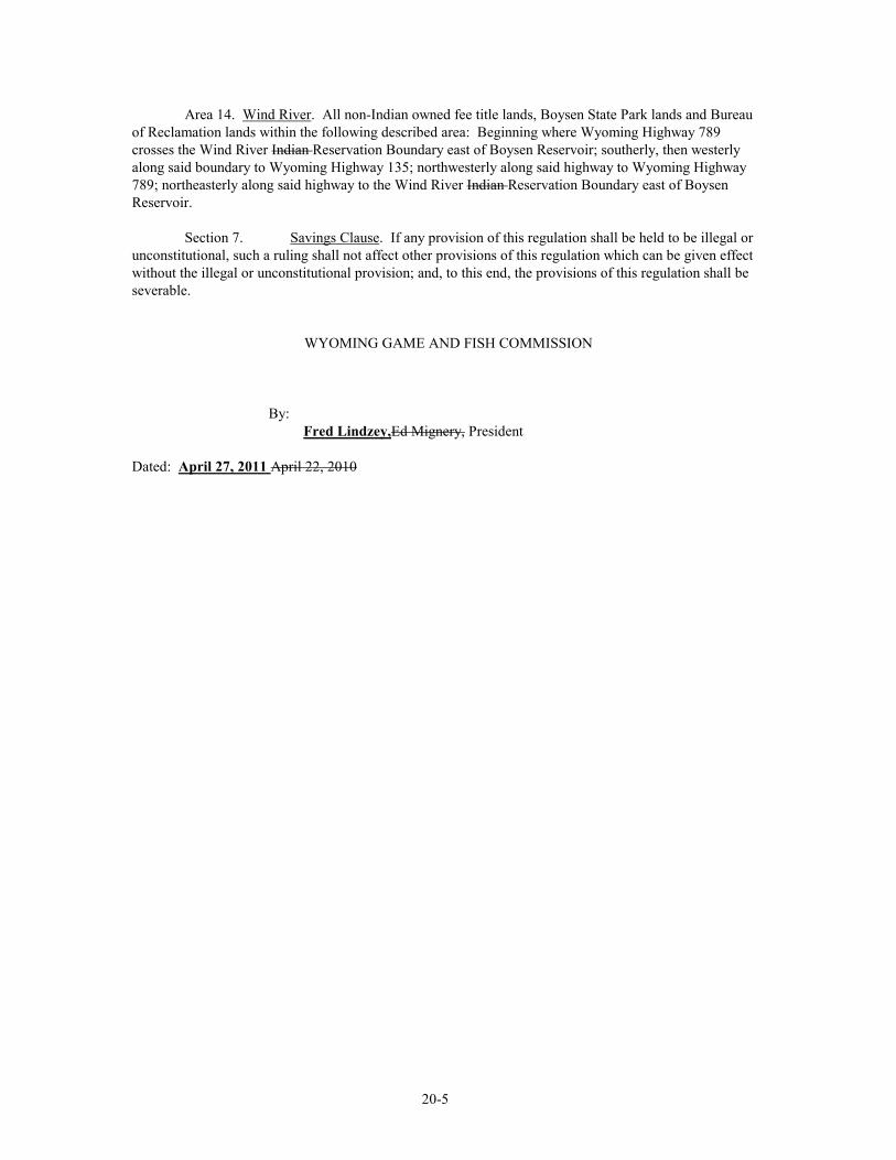
20-5
Area 14. Wind River. All non-Indian owned fee title lands, Boysen State Park lands and Bureau of Reclamation lands within the following described area: Beginning where Wyoming Highway 789 crosses the Wind River Indian Reservation Boundary east of Boysen Reservoir; southerly, then westerly along said boundary to Wyoming Highway 135; northwesterly along said highway to Wyoming Highway 789; northeasterly along said highway to the Wind River Indian Reservation Boundary east of Boysen Reservoir.
Section 7. Savings Clause. If any provision of this regulation shall be held to be illegal or unconstitutional, such a ruling shall not affect other provisions of this regulation which can be given effect without the illegal or unconstitutional provision; and, to this end, the provisions of this regulation shall be severable.
WYOMING GAME AND FISH COMMISSION By: Fred Lindzey,Ed Mignery, President Dated: April 27, 2011 April 22, 2010
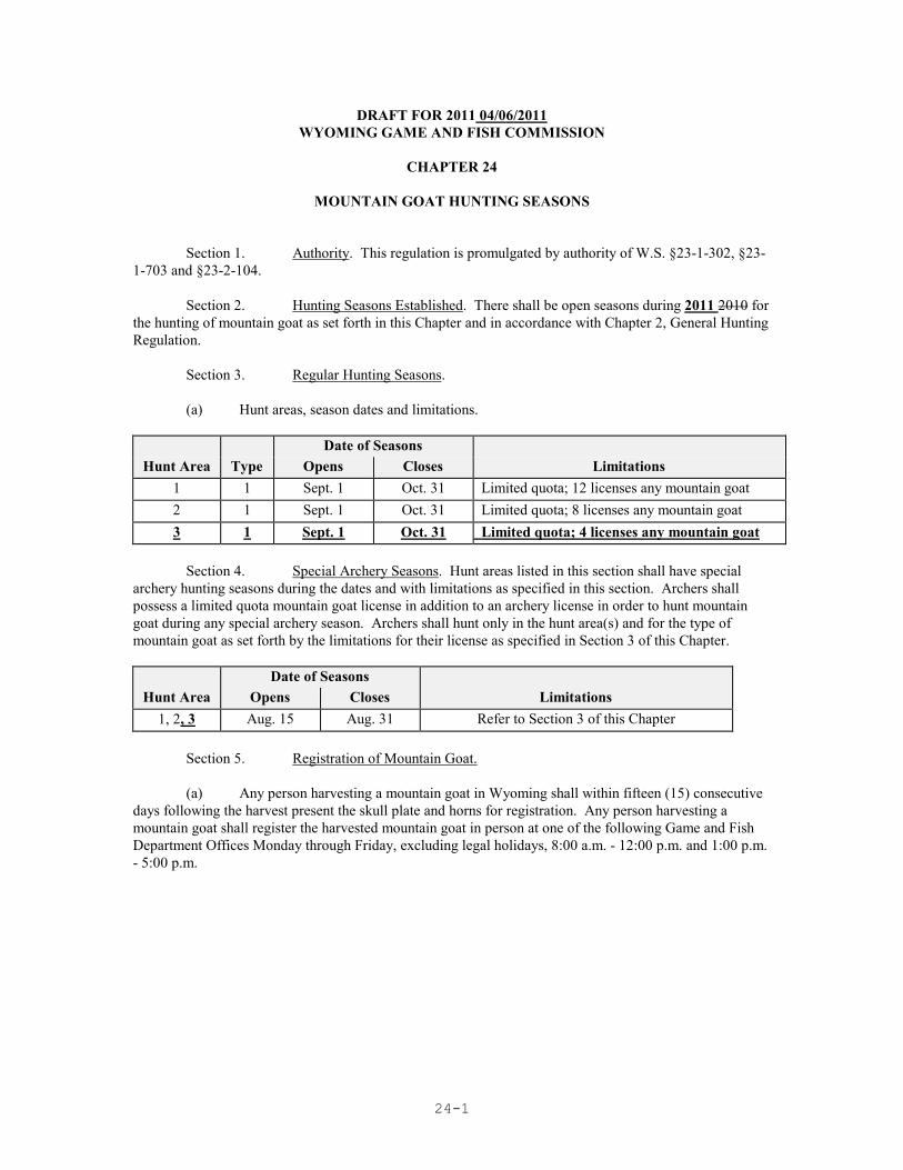
24-1
DRAFT FOR 2011 04/06/2011 WYOMING GAME AND FISH COMMISSION
CHAPTER 24
MOUNTAIN GOAT HUNTING SEASONS
Section 1. Authority. This regulation is promulgated by authority of W.S. §23-1-302, §23-1-703 and §23-2-104. Section 2. Hunting Seasons Established. There shall be open seasons during 2011 2010 for the hunting of mountain goat as set forth in this Chapter and in accordance with Chapter 2, General Hunting Regulation. Section 3. Regular Hunting Seasons. (a) Hunt areas, season dates and limitations. Date of Seasons
Hunt Area Type Opens Closes Limitations 1 1 Sept. 1 Oct. 31 Limited quota; 12 licenses any mountain goat 2 1 Sept. 1 Oct. 31 Limited quota; 8 licenses any mountain goat 3 1 Sept. 1 Oct. 31 Limited quota; 4 licenses any mountain goat
Section 4. Special Archery Seasons. Hunt areas listed in this section shall have special archery hunting seasons during the dates and with limitations as specified in this section. Archers shall possess a limited quota mountain goat license in addition to an archery license in order to hunt mountain goat during any special archery season. Archers shall hunt only in the hunt area(s) and for the type of mountain goat as set forth by the limitations for their license as specified in Section 3 of this Chapter. Date of Seasons
Hunt Area Opens Closes Limitations 1, 2, 3 Aug. 15 Aug. 31 Refer to Section 3 of this Chapter
Section 5. Registration of Mountain Goat. (a) Any person harvesting a mountain goat in Wyoming shall within fifteen (15) consecutive days following the harvest present the skull plate and horns for registration. Any person harvesting a mountain goat shall register the harvested mountain goat in person at one of the following Game and Fish Department Offices Monday through Friday, excluding legal holidays, 8:00 a.m. - 12:00 p.m. and 1:00 p.m. - 5:00 p.m.
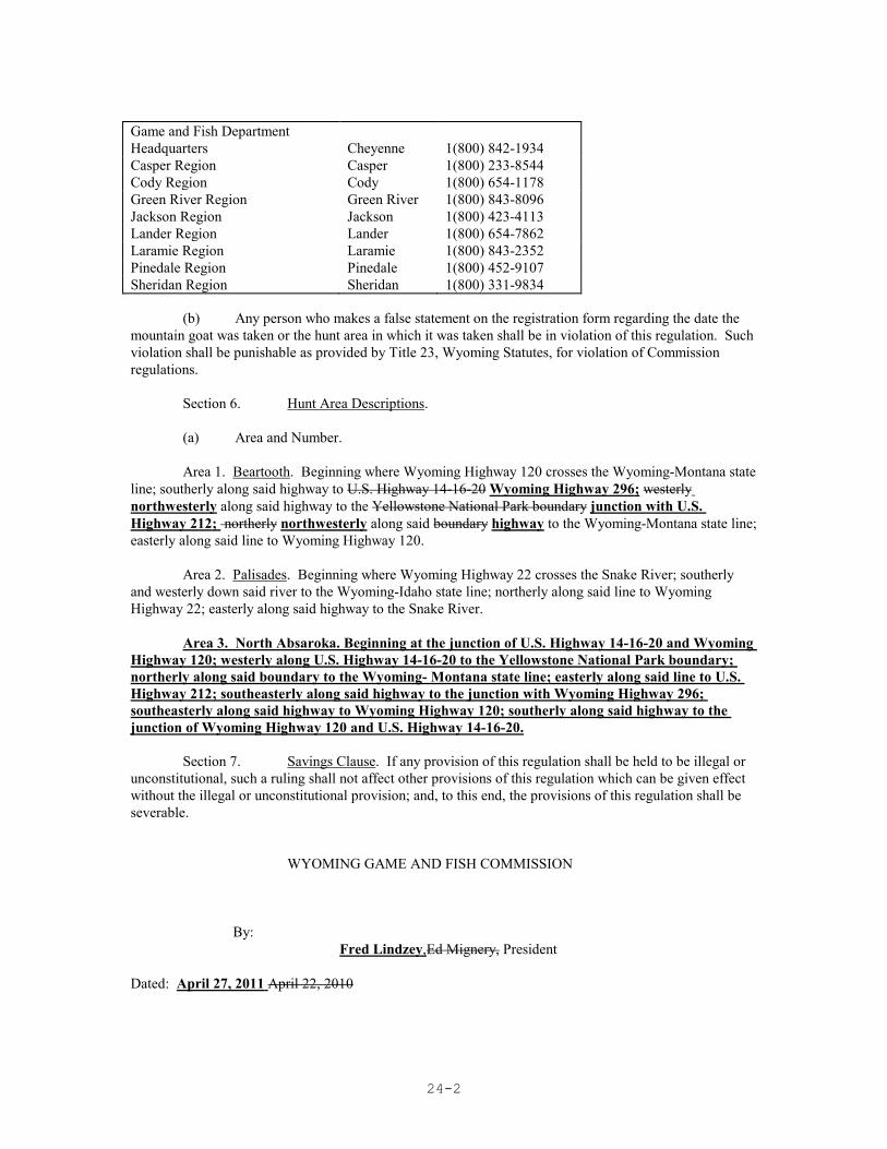
24-2
Game and Fish Department Headquarters
Cheyenne
1(800) 842-1934
Casper Region Casper 1(800) 233-8544 Cody Region Cody 1(800) 654-1178 Green River Region Jackson Region
Green River Jackson
1(800) 843-8096 1(800) 423-4113
Lander Region Lander 1(800) 654-7862 Laramie Region Laramie 1(800) 843-2352 Pinedale Region Pinedale 1(800) 452-9107 Sheridan Region Sheridan 1(800) 331-9834 (b) Any person who makes a false statement on the registration form regarding the date the mountain goat was taken or the hunt area in which it was taken shall be in violation of this regulation. Such violation shall be punishable as provided by Title 23, Wyoming Statutes, for violation of Commission regulations. Section 6. Hunt Area Descriptions. (a) Area and Number. Area 1. Beartooth. Beginning where Wyoming Highway 120 crosses the Wyoming-Montana state line; southerly along said highway to U.S. Highway 14-16-20 Wyoming Highway 296; westerly northwesterly along said highway to the Yellowstone National Park boundary junction with U.S. Highway 212; northerly northwesterly along said boundary highway to the Wyoming-Montana state line; easterly along said line to Wyoming Highway 120. Area 2. Palisades. Beginning where Wyoming Highway 22 crosses the Snake River; southerly and westerly down said river to the Wyoming-Idaho state line; northerly along said line to Wyoming Highway 22; easterly along said highway to the Snake River. Area 3. North Absaroka. Beginning at the junction of U.S. Highway 14-16-20 and Wyoming Highway 120; westerly along U.S. Highway 14-16-20 to the Yellowstone National Park boundary; northerly along said boundary to the Wyoming- Montana state line; easterly along said line to U.S. Highway 212; southeasterly along said highway to the junction with Wyoming Highway 296; southeasterly along said highway to Wyoming Highway 120; southerly along said highway to the junction of Wyoming Highway 120 and U.S. Highway 14-16-20. Section 7. Savings Clause. If any provision of this regulation shall be held to be illegal or unconstitutional, such a ruling shall not affect other provisions of this regulation which can be given effect without the illegal or unconstitutional provision; and, to this end, the provisions of this regulation shall be severable. WYOMING GAME AND FISH COMMISSION By: Fred Lindzey,Ed Mignery, President Dated: April 27, 2011 April 22, 2010
39-1
DRAFT FOR 2011 04/06/2011 WYOMING GAME AND FISH COMMISSION
CHAPTER 39
EARLY MIGRATORY GAME BIRD HUNTING SEASONS
Section 1. Authority. This regulation is promulgated by authority of W.S. §23-1-302 and §23-2-105(d). Section 2. Hunting Seasons Established. There shall be open seasons for the hunting of migratory game birds as set forth in this Chapter, and in accordance with Chapter 2, General Hunting Regulation. This regulation shall remain in effect until modified or repealed by the Commission. Section 3. Definitions. For the purpose of this regulation, definitions shall be as set forth in Title 23, Wyoming Statutes and the Commission also adopts the following definitions: (a) “Central Flyway” means that portion of Wyoming east of the Continental Divide, excluding the Great Divide Basin. (b) “Daily bag limit” means the maximum number of migratory game birds or waterfowl that may be legally taken in a single day. (c) “Federal Duck Stamp” means Federal Migratory Bird Hunting and Conservation Stamp. (d) “Migratory game bird” means all migratory game birds defined under federal law. (e) “Nontoxic shot” means steel or any other federally-approved nontoxic shot. (f) “Pacific Flyway” means that portion of Wyoming west of the Continental Divide, including the Great Divide Basin. (g) “Possession limit” means the maximum number of migratory game birds or waterfowl that may be legally in possession. Migratory game birds in transit or storage shall be considered in possession. When a person hunts in more than one (1) state or flyway, the person’s total possession limit shall not exceed the largest possession limit prescribed for any one of the states or flyways in which the hunting takes place. (h) “Season limit” means the maximum number of migratory game birds or waterfowl that may be legally taken during the entire season. (i) “Waterfowl” means ducks, geese, coots and mergansers.
39-2
(j) “Webless migratory game bird” means mourning dove, rail, snipe, and sandhill crane. Section 4. Hunting Regulations. (a) Wounding and Retrieving. No person shall wound or kill any migratory game bird without making a reasonable effort to retrieve it and reduce it to possession. (b) Federal Regulations. 16 USC 703-711 and 718a; 50 CFR 10, 50 CFR 20 revised as of October 1, 200910, which do not include any later amendments or editions of the incorporated matter, governing the hunting, taking and possession of migratory birds and migratory game birds, the requirement for a valid migratory bird hunting and conservation stamp and the requirement for state participation in the National Harvest Information Program are adopted as regulations of the Wyoming Game and Fish Commission. Violations of these federal statutes and regulations shall be violations of the Commission regulations. A copy of Title 50 of the Code of Federal Regulations can be viewed at Department Regional Offices. (i) Automatic loading, pump, or repeating shotguns shall be plugged to admit no more than one (1) shell in the chamber and two (2) shells in the magazine. (ii) Federal Migratory Bird Hunting and Conservation Stamp. A federal duck stamp is required for persons sixteen (16) years of age and older to hunt ducks, geese and mergansers, but a federal duck stamp is not required to hunt coots, sandhill cranes, crows, mourning doves, rail or snipe. (iii) National Migratory Bird Harvest Information Program. Each licensed hunter who hunts migratory game birds shall complete a current Wyoming validation for the National Harvest Information Program (HIP) and shall obtain a Wyoming HIP permit. This requirement also applies to holders of pioneer and lifetime hunting licenses. Each licensed hunter engaged in the act of hunting doves, ducks, geese, mergansers, coots, rails, cranes or snipe shall be in possession of a Wyoming HIP permit. Each person obtaining a HIP permit for the purpose set forth in this section shall validate the permit by signing the person’s name in ink across the face of the permit. Hunters who acquire a HIP permit through the Electronic Licensing System shall not be required to meet the signature provision of this Section. HIP permits expire on June 30 each year. HIP permits are not transferrable to other states. A separate validation is required from each state in which you hunt. (c) Evidence of Species. One fully-feathered wing or the feathered head shall remain naturally attached to the carcass as a means of identification of migratory game birds, except mourning doves, in the field and while the birds are being transported.
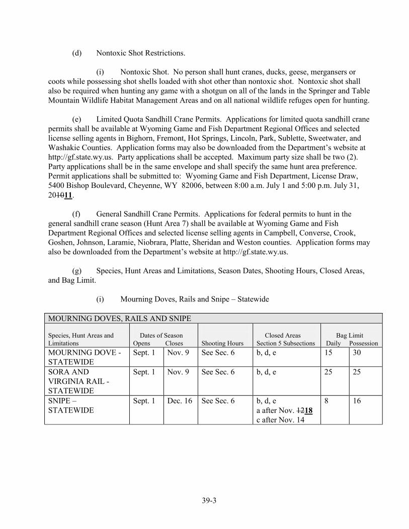
39-3
(d) Nontoxic Shot Restrictions. (i) Nontoxic Shot. No person shall hunt cranes, ducks, geese, mergansers or coots while possessing shot shells loaded with shot other than nontoxic shot. Nontoxic shot shall also be required when hunting any game with a shotgun on all of the lands in the Springer and Table Mountain Wildlife Habitat Management Areas and on all national wildlife refuges open for hunting. (e) Limited Quota Sandhill Crane Permits. Applications for limited quota sandhill crane permits shall be available at Wyoming Game and Fish Department Regional Offices and selected license selling agents in Bighorn, Fremont, Hot Springs, Lincoln, Park, Sublette, Sweetwater, and Washakie Counties. Application forms may also be downloaded from the Department’s website at http://gf.state.wy.us. Party applications shall be accepted. Maximum party size shall be two (2). Party applications shall be in the same envelope and shall specify the same hunt area preference. Permit applications shall be submitted to: Wyoming Game and Fish Department, License Draw, 5400 Bishop Boulevard, Cheyenne, WY 82006, between 8:00 a.m. July 1 and 5:00 p.m. July 31, 201011. (f) General Sandhill Crane Permits. Applications for federal permits to hunt in the general sandhill crane season (Hunt Area 7) shall be available at Wyoming Game and Fish Department Regional Offices and selected license selling agents in Campbell, Converse, Crook, Goshen, Johnson, Laramie, Niobrara, Platte, Sheridan and Weston counties. Application forms may also be downloaded from the Department’s website at http://gf.state.wy.us. (g) Species, Hunt Areas and Limitations, Season Dates, Shooting Hours, Closed Areas, and Bag Limit. (i) Mourning Doves, Rails and Snipe – Statewide MOURNING DOVES, RAILS AND SNIPE Species, Hunt Areas and Limitations
Dates of Season Opens Closes
Shooting Hours
Closed Areas Section 5 Subsections
Bag Limit Daily Possession
MOURNING DOVE - STATEWIDE
Sept. 1 Nov. 9 See Sec. 6 b, d, e 15 30
SORA AND VIRGINIA RAIL - STATEWIDE
Sept. 1 Nov. 9 See Sec. 6 b, d, e
25
25
SNIPE – STATEWIDE
Sept. 1 Dec. 16 See Sec. 6 b, d, e a after Nov. 1218 c after Nov. 14
8
16
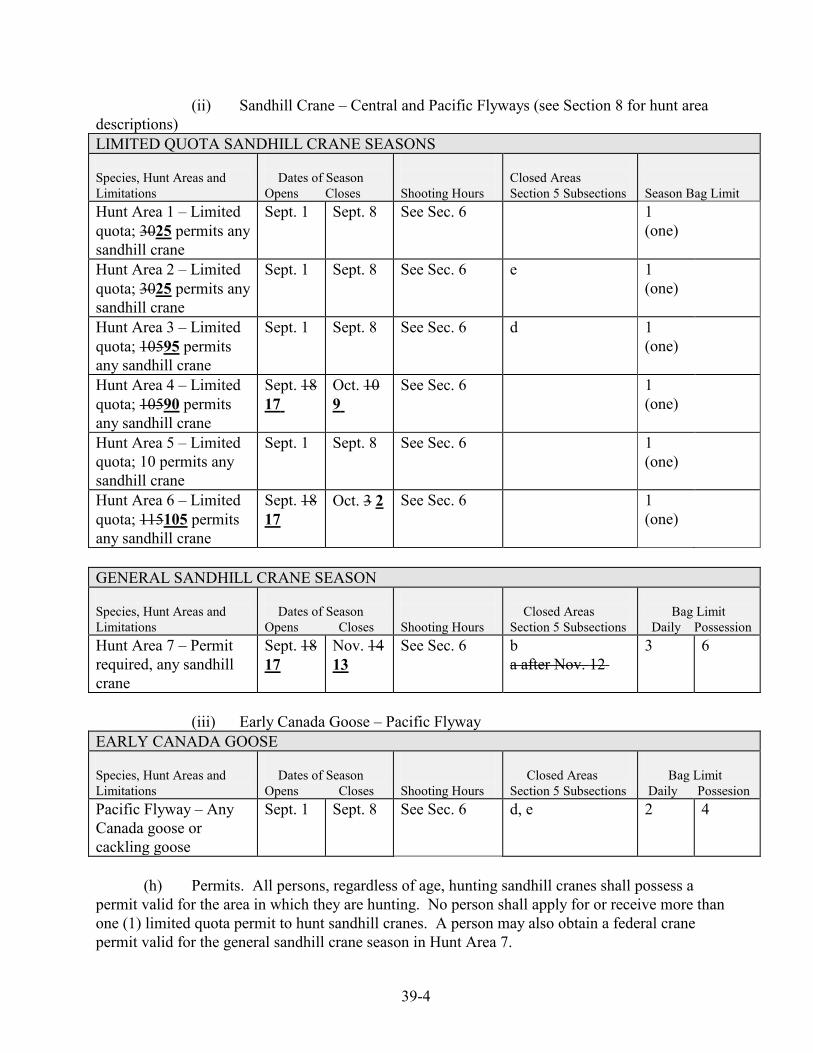
39-4
(ii) Sandhill Crane – Central and Pacific Flyways (see Section 8 for hunt area descriptions) LIMITED QUOTA SANDHILL CRANE SEASONS Species, Hunt Areas and Limitations
Dates of Season Opens Closes
Shooting Hours
Closed Areas Section 5 Subsections
Season Bag Limit
Hunt Area 1 – Limited quota; 3025 permits any sandhill crane
Sept. 1 Sept. 8 See Sec. 6 1 (one)
Hunt Area 2 – Limited quota; 3025 permits any sandhill crane
Sept. 1
Sept. 8 See Sec. 6 e 1 (one)
Hunt Area 3 – Limited quota; 10595 permits any sandhill crane
Sept. 1 Sept. 8 See Sec. 6 d 1 (one)
Hunt Area 4 – Limited quota; 10590 permits any sandhill crane
Sept. 18 17
Oct. 10 9
See Sec. 6 1 (one)
Hunt Area 5 – Limited quota; 10 permits any sandhill crane
Sept. 1 Sept. 8 See Sec. 6 1 (one)
Hunt Area 6 – Limited quota; 115105 permits any sandhill crane
Sept. 18 17
Oct. 3 2 See Sec. 6 1 (one)
GENERAL SANDHILL CRANE SEASON Species, Hunt Areas and Limitations
Dates of Season Opens Closes
Shooting Hours
Closed Areas Section 5 Subsections
Bag Limit Daily Possession
Hunt Area 7 – Permit required, any sandhill crane
Sept. 18 17
Nov. 14 13
See Sec. 6 b a after Nov. 12
3 6
(iii) Early Canada Goose – Pacific Flyway EARLY CANADA GOOSE Species, Hunt Areas and Limitations
Dates of Season Opens Closes
Shooting Hours
Closed Areas Section 5 Subsections
Bag Limit Daily Possesion
Pacific Flyway – Any Canada goose or cackling goose
Sept. 1 Sept. 8 See Sec. 6 d, e
2
4
(h) Permits. All persons, regardless of age, hunting sandhill cranes shall possess a permit valid for the area in which they are hunting. No person shall apply for or receive more than one (1) limited quota permit to hunt sandhill cranes. A person may also obtain a federal crane permit valid for the general sandhill crane season in Hunt Area 7.
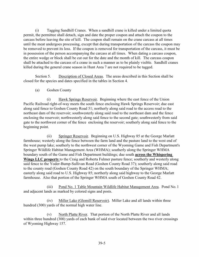
39-5
(i) Tagging Sandhill Cranes. When a sandhill crane is killed under a limited quota permit, the permittee shall detach, sign and date the proper coupon and attach the coupon to the carcass before leaving the site of kill. The coupon shall remain on the crane carcass at all times until the meat undergoes processing, except that during transportation of the carcass the coupon may be removed to prevent its loss. If the coupon is removed for transportation of the carcass, it must be in possession of the person accompanying the carcass at all times. When dating a carcass coupon, the entire wedge or block shall be cut out for the date and the month of kill. The carcass coupon shall be attached to the carcass of a crane in such a manner as to be plainly visible. Sandhill cranes killed during the general crane season in Hunt Area 7 are not required to be tagged. Section 5. Description of Closed Areas. The areas described in this Section shall be closed for the species and dates specified in the tables in Section 4. (a) Goshen County (i) Hawk Springs Reservoir. Beginning where the east fence of the Union Pacific Railroad right-of-way meets the south fence enclosing Hawk Springs Reservoir; due east along said fence to Goshen County Road 51; northerly along said road to the access road to the northeast dam of the reservoir; southwesterly along said road to the northeast dam and the fence enclosing the reservoir; northwesterly along said fence to the second gate; southwesterly from said gate to the northwest corner of the fence enclosing the reservoir; southerly along said fence to the beginning point. (ii) Springer Reservoir. Beginning on U.S. Highway 85 at the George Marlatt farmhouse; westerly along the fence between the farm land and the pasture land to the west end of the west pump lake; southerly to the northwest corner of the Wyoming Game and Fish Department's Springer Wildlife Habitat Management Area (WHMA); southerly along the Springer WHMA boundary south of the Game and Fish Department buildings; due south across the Whispering Wings LLC property to the Craig and Roberta Fulmer pasture fence; southerly and westerly along said fence to the Yoder-Bump-Sullivan Road (Goshen County Road 37); southerly along said road to the county road (Goshen County Road 42) on the south boundary of the Springer WHMA; easterly along said road to U.S. Highway 85; northerly along said highway to the George Marlatt farmhouse. Also that portion of the Springer WHMA south of Goshen County Road 42. (iii) Pond No. 1 Table Mountain Wildlife Habitat Management Area. Pond No. l and adjacent lands as marked by colored signs and posts. (iv) Miller Lake (Glomill Reservoir). Miller Lake and all lands within three hundred (300) yards of the normal high water line. (v) North Platte River. That portion of the North Platte River and all lands within three hundred (300) yards of each bank of said river located between the two river crossings of Wyoming Highway 157.
39-6
(vi) Bump-Sullivan Managed Goose Hunt. From November 19, 2011 through February 15, 2012 no access shall be allowed to Bump-Sullivan Reservoir and lands within the Bump-Sullivan Managed Goose Hunt during dark goose shooting hours without a Bump-Sullivan Managed Goose Hunt Registration (see Chapter 14, Sections 8 and 9). (b) Platte County (i) Festo Lake. Festo Lake and all lands within three hundred (300) yards of the normal high water line shall be closed to all migratory game bird hunting. (ii) Wheatland Reservoir No. 1. Wheatland Reservoir No. 1 and all lands within three hundred (300) yards of the normal high water line and all Wheatland Irrigation District lands adjacent to the reservoir, in addition to those included in the three hundred (300) yard closure, shall be closed to hunting. (c) Fremont County (i) Ocean Lake. The waters of Ocean Lake and the Wyoming Game and Fish Commission lands within approximately one-half (1/2) mile of the aeration system on the north side of the lake shall be closed to migratory game bird hunting beginning November 15 through December 31 and January 1 through March 10 of each year. Beginning December 15 through March 10, the area shall be closed to all human presence, except for Wyoming Game and Fish Department administrative access, within one-half (1/2) mile of the aerator on the ice and as marked by signs on Wyoming Game and Fish Commisson lands around the aerator. (d) Sweetwater County (i) Eden Reservoir. Eden Reservoir and all lands within three hundred (300) yards of the normal high water line shall be closed to all migratory game bird hunting. (ii) Seedskadee National Wildlife Refuge. All lands within Seedskadee National Wildlife Refuge shall be closed to goose hunting during the early Canada goose season. (e) Lincoln County (i) Palisades Reservoir. Beginning at the junction of the McCoy Creek Road and U.S. Highway 89; northerly on U.S. Highway 89 for 1.6 miles to the Palisades Reservoir high water line; westerly along said high water line to the Wyoming-Idaho state line; southerly along said state line to the McCoy Creek Road; southeasterly along the McCoy Creek Road to U.S. Highway 89 shall be closed to all migratory game bird hunting. Section 6. Shooting Hours. Shooting hours for the hunting of all migratory game birds shall be from one-half (1/2) hour before sunrise to sunset as determined from the shooting hours table in this section.
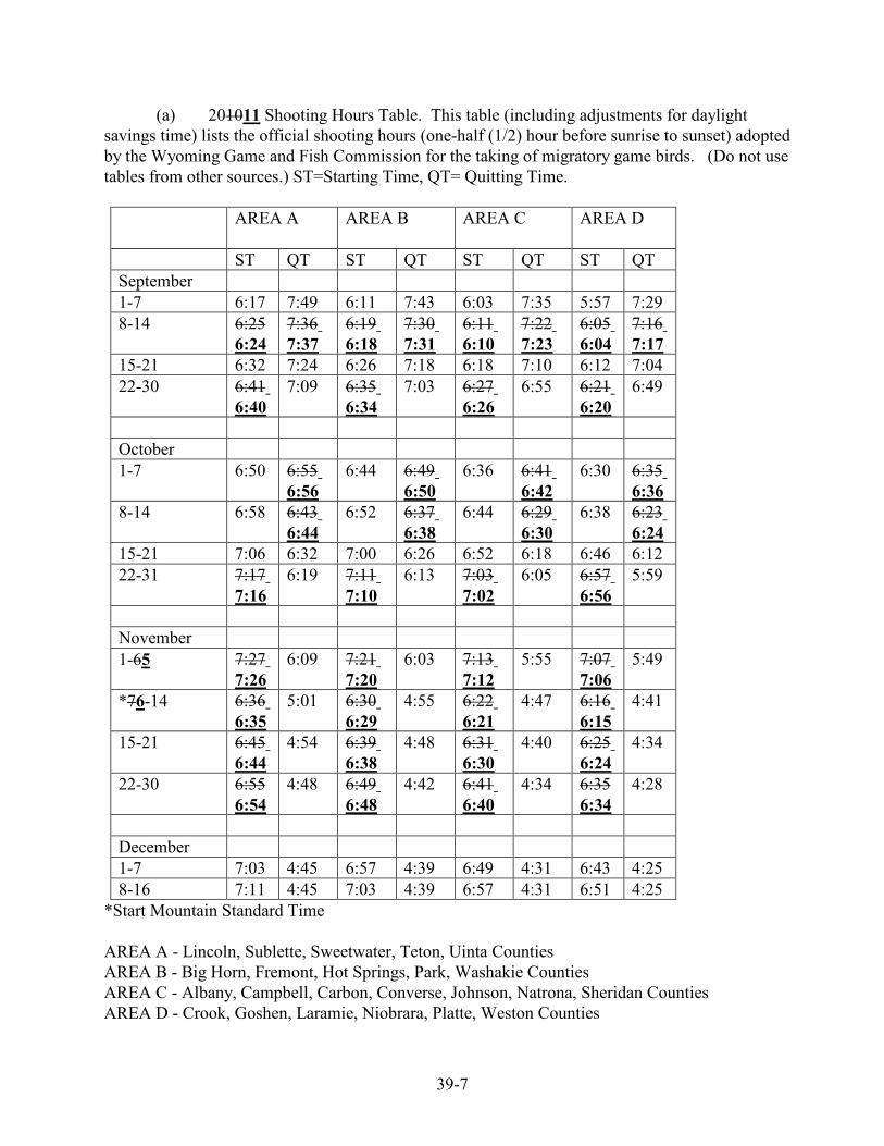
39-7
(a) 201011 Shooting Hours Table. This table (including adjustments for daylight savings time) lists the official shooting hours (one-half (1/2) hour before sunrise to sunset) adopted by the Wyoming Game and Fish Commission for the taking of migratory game birds. (Do not use tables from other sources.) ST=Starting Time, QT= Quitting Time.
AREA A AREA B AREA C AREA D
ST QT ST QT ST QT ST QT September 1-7 6:17 7:49 6:11 7:43 6:03 7:35 5:57 7:29 8-14 6:25
6:24 7:36 7:37
6:19 6:18
7:30 7:31
6:11 6:10
7:22 7:23
6:05 6:04
7:16 7:17
15-21 6:32 7:24 6:26 7:18 6:18 7:10 6:12 7:04 22-30 6:41
6:40 7:09 6:35
6:34 7:03 6:27
6:26 6:55 6:21
6:20 6:49
October 1-7 6:50 6:55
6:56 6:44 6:49
6:50 6:36 6:41
6:42 6:30 6:35
6:36 8-14 6:58 6:43
6:44 6:52 6:37
6:38 6:44 6:29
6:30 6:38 6:23
6:24 15-21 7:06 6:32 7:00 6:26 6:52 6:18 6:46 6:12 22-31 7:17
7:16 6:19 7:11
7:10 6:13 7:03
7:02 6:05 6:57
6:56 5:59
November 1-65 7:27
7:26 6:09 7:21
7:20 6:03 7:13
7:12 5:55 7:07
7:06 5:49
*76-14 6:36 6:35
5:01 6:30 6:29
4:55 6:22 6:21
4:47 6:16 6:15
4:41
15-21 6:45 6:44
4:54 6:39 6:38
4:48 6:31 6:30
4:40 6:25 6:24
4:34
22-30 6:556:54
4:48 6:49 6:48
4:42 6:41 6:40
4:34 6:356:34
4:28
December 1-7 7:03 4:45 6:57 4:39 6:49 4:31 6:43 4:25 8-16 7:11 4:45 7:03 4:39 6:57 4:31 6:51 4:25
*Start Mountain Standard Time AREA A - Lincoln, Sublette, Sweetwater, Teton, Uinta Counties AREA B - Big Horn, Fremont, Hot Springs, Park, Washakie Counties AREA C - Albany, Campbell, Carbon, Converse, Johnson, Natrona, Sheridan Counties AREA D - Crook, Goshen, Laramie, Niobrara, Platte, Weston Counties
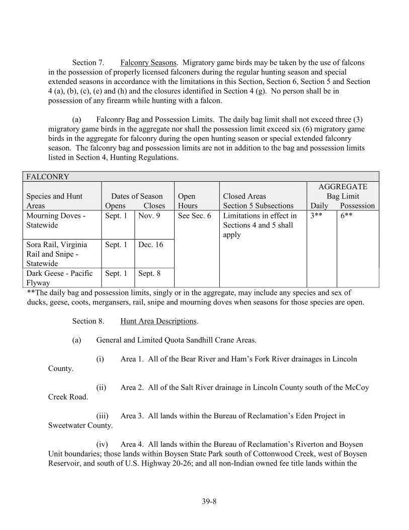
39-8
Section 7. Falconry Seasons. Migratory game birds may be taken by the use of falcons in the possession of properly licensed falconers during the regular hunting season and special extended seasons in accordance with the limitations in this Section, Section 6, Section 5 and Section 4 (a), (b), (c), (e) and (h) and the closures identified in Section 4 (g). No person shall be in possession of any firearm while hunting with a falcon. (a) Falconry Bag and Possession Limits. The daily bag limit shall not exceed three (3) migratory game birds in the aggregate nor shall the possession limit exceed six (6) migratory game birds in the aggregate for falconry during the open hunting season or special extended falconry season. The falconry bag and possession limits are not in addition to the bag and possession limits listed in Section 4, Hunting Regulations.
FALCONRY Species and Hunt Areas
Dates of Season Opens Closes
Open Hours
Closed Areas Section 5 Subsections
AGGREGATE Bag Limit
Daily Possession Mourning Doves - Statewide
Sept. 1 Nov. 9 See Sec. 6 Limitations in effect in Sections 4 and 5 shall apply
3** 6**
Sora Rail, Virginia Rail and Snipe - Statewide
Sept. 1 Dec. 16
Dark Geese - Pacific Flyway
Sept. 1 Sept. 8
**The daily bag and possession limits, singly or in the aggregate, may include any species and sex of ducks, geese, coots, mergansers, rail, snipe and mourning doves when seasons for those species are open.
Section 8. Hunt Area Descriptions. (a) General and Limited Quota Sandhill Crane Areas. (i) Area 1. All of the Bear River and Ham’s Fork River drainages in Lincoln County. (ii) Area 2. All of the Salt River drainage in Lincoln County south of the McCoy Creek Road. (iii) Area 3. All lands within the Bureau of Reclamation’s Eden Project in Sweetwater County. (iv) Area 4. All lands within the Bureau of Reclamation’s Riverton and Boysen Unit boundaries; those lands within Boysen State Park south of Cottonwood Creek, west of Boysen Reservoir, and south of U.S. Highway 20-26; and all non-Indian owned fee title lands within the
39-9
exterior boundaries of the Wind River Indian Reservation, excluding those lands within Hot Springs County. (v) Area 5. All of Uinta County. (vi) Area 6. All of Big Horn, Hot Springs, Park and Washakie counties. (vii) Area 7. All of Campbell, Converse, Crook, Goshen, Laramie, Niobrara, Platte and Weston counties; that portion of Johnson County east of Interstate Highway 25 from the Natrona County line north to Interstate Highway 90 and east of Interstate Highway 90 from the intersection with Interstate Highway 25 to the Sheridan County line; and that portion of Sheridan County east of Interstate Highway 90. Section 9. Savings Clause. If any provision of this regulation shall be held to be illegal or unconstitutional, such a ruling shall not affect other provisions of this regulation which can be given effect without the illegal or unconstitutional provision; and, to this end, the provisions of this regulation shall be severable. WYOMING GAME AND FISH COMMISSION By: Fred Lindzey,Ed Mignery, President Dated: April 27, 2011 April 22, 2010
48-1
DRAFT FOR 2012 04/06/2011 WYOMING GAME AND FISH COMMISSION
CHAPTER 48
LIGHT GOOSE CONSERVATION ORDER
Section 1. Authority. This regulation is promulgated by authority of W.S. §23-1-302(xxii).
Section 2. Hunting Seasons Established. There shall be an open season for the take of light
geese as set forth in this Chapter, and in accordance with Chapter 2, General Hunting Regulation. This regulation shall remain in effect until modified or repealed by the Commission.
Section 3. Definitions. For the purpose of this regulation, definitions shall be as set forth in
Title 23, Wyoming Statutes, and the Commission also adopts the following definitions:
(a) “Adult” means a person eighteen (18) years of age or older. (b) “Central Flyway” means that portion of Wyoming east of the Continental Divide, excluding the Great Divide Basin.
(c) “Conservation Order” means an action to reduce the mid-continent population of light geese, which is promulgated in accordance with 50 CFR 20.21 and 50 CFR 21.60, revised as of October 1, 200910, which does not include any later amendments or editions of the incorporated matter. A copy of Title 50 of the Code of Federal Regulations can be viewed at Department Regional Offices. (d) “Daily bag limit” means the maximum number of migratory game birds or waterfowl that may be legally taken in a single day. (e) “Dark geese” means Canada goose, cackling goose, white-fronted goose and brant. (f) “Federal Duck Stamp” means Federal Migratory Bird Hunting and Conservation Stamp. (g) “Light geese” means snow goose, blue goose and Ross' goose. (h) “Migratory game bird” means all migratory game birds defined under federal law. (i) “Nontoxic shot” means steel or any other federally-approved nontoxic shot. (j) “Pacific Flyway” means that portion of Wyoming west of the Continental Divide, including the Great Divide Basin. (k) “Possession limit” means the maximum number of migratory game birds or waterfowl that may be legally in possession. Migratory birds in transit or storage shall be considered in possession. When a person hunts in more than one (1) state or flyway, the person’s total possession limit shall not exceed the largest possession limit prescribed for any one of the states or flyways in which the hunting takes place. (l) “Waterfowl” means ducks, geese, coots and mergansers. (m) “Webless migratory game bird” means mourning dove, rail, snipe and sandhill crane.
48-2
Section 4. Licensing, Permitting and Reporting Requirements. (a) Wyoming Game Bird License and Conservation Stamp Requirements. Each person who
takes or attempts to take any light geese under the authority of this regulation shall have in possession a valid Wyoming game bird license and a valid Wyoming conservation stamp (except as otherwise exempted by State statute).
(b) Conservation Order Special Management Permit. A conservation order special management permit shall be in possession of any person participating in the light goose conservation order and shall be immediately produced for inspection upon request of any authorized Department representative. The conservation order special management permit shall be validated by signing the person’s name in ink across the face of the permit. Conservation order special management permits shall be available from the Laramie and Casper Regional Offices, the Department’s Headquarters Office in Cheyenne and at designated license selling agents, or they may be obtained by submitting a completed application form to:
License Section Attn: Conservation Order Special Management Permit
Wyoming Game and Fish Department 5400 Bishop Blvd.
Cheyenne, Wyoming 82006-0001 The application form can be requested by calling 1-800-842-1934 from in-state, 1-307-777-4600 from out-of-state, or the application form may be downloaded from the Department’s website at http://gf.state.wy.us.
(c) Reporting Requirements. Any person who obtains a conservation order special management permit shall accurately complete the survey card provided with the permit and return the survey card to the Headquarters Office in Cheyenne no later than April 2220, 201112. The survey card shall be completed and returned whether the person participated in the conservation order or not.
(d) Persons are not required to possess a Federal Migratory Bird Hunting and Conservation Stamp (duck stamp) and or Harvest Information Program (HIP) Permit in order to participate in the light goose conservation order. . Persons are not required to possess a federal duck stamp or HIP permit in order to participate in the light goose conservation order.
Section 5. Conservation Order Regulations.
(a) Wounding and Retrieving. No person shall wound or kill any migratory game bird without making a reasonable effort to retrieve it and reduce it to possession.
(b) Federal Regulations. 16 U.S.C. 703-712; 16 U.C. 742 a-j; Pub. L. 106-108; Pub. L. 95-616; 92 Stat. 3112 (16 U.S.C. 712(2)); and 50 CFR 20 and 21, revised as of October 1, 200810, which do not include any later amendments or editions of the incorporated matter, governing the taking and possession of migratory birds and migratory game birds, and the conservation order for mid-continent light geese, are adopted as regulations of the Wyoming Game and Fish Commission; except, those portions of 50 CFR 20 and 21, revised as of October 1, 200910, which allow the use of unplugged shotguns during the conservation order are not adopted as regulations of the Commission. Violations of these federal statutes and regulations shall be violations of the Commission regulations. A copy of Title 50 of the Code of Federal Regulations can be viewed at Department Regional Offices.
(i) Shotguns shall be the only weapons that can be used to take light geese. Shotguns larger than ten (10) gauge shall not be legal for the take of light geese in Wyoming during the
48-3
conservation order for mid-continent light geese. Automatic loading, pump, or repeating shotguns shall be plugged to admit no more than one (1) shell in the chamber and two (2) shells in the magazine.
(ii) Recorded or electrically amplified bird calls or sounds, or imitations thereof may be used to take light geese during the dates of the light goose conservation order.
(c) Evidence of Species. One fully feathered wing or the feathered head shall remain
naturally attached to the carcass as a means of identification of all light geese in the field and while the birds are being transported.
(d) Nontoxic Shot Restrictions.
(i) Nontoxic Shot. No person shall take light geese while possessing shot shells loaded with shot other than nontoxic shot. Nontoxic shot shall also be required when hunting any game with a shotgun on all of the lands in the Springer and Table Mountain Wildlife Habitat Management Areas and on all national wildlife refuges open for hunting. (e) Species and Hunt Areas, Conservation Order Dates, Shooting Hours, Closed Areas, Bag Limit.
(i) The Central Flyway portion of Wyoming, excluding the closed areas listed in Section 6, is open during the conservation order for mid-continent light geese. The Central Flyway is that portion of Wyoming east of the Continental Divide, excluding the Great Divide Basin. Please refer to the Wyoming Waterfowl Flyway Areas Map in Chapter 14, Late Migratory Game Bird Hunting Seasons.
LIGHT GOOSE CONSERVATION ORDER, CENTRAL FLYWAY Species and Hunt
Areas Dates of Conservation Order Opens Closes
Shooting Hours
Closed Areas Section 6 Subsections
Bag Limit Daily Possession
LIGHT GEESE Central Flyway
Feb. 21 20
April 10 8
See Sec. 7
a(i), a(ii), b, c, d a(iii) after March 20
20
Unrestricted
(ii) Those areas within the boundaries of the Bump-Sullivan and Springer mManaged gGoose hHunts, including Bump-Sullivan Reservoir, shall be open to the taking of light geese during the light goose conservation order. Pits/blinds and staked hunting locations shall be occupied on a first-come, first-served basis and shall not be claimed or reserved by leaving personal belongings, including decoys, unattended at the pit/blind or staked hunting location at any time. Conservation order participants are not required to possess a Bump-Sullivan managed goose hunt permit or a goose special management permit registration nor are they required to hunt from a pit/blind or staked hunting location during the light goose conservation order. Section 6. Description of Closed Areas. Except as otherwise noted, the areas described in this Section shall be closed for the species and dates specified in the table in Section 5. (a) GOSHEN COUNTY (i) Springer Reservoir. Beginning on U.S. Highway 85 at the George Marlatt farmhouse; westerly along the fence between the farm land and the pasture land to the west end of the west pump lake; southerly to the northwest corner of the Wyoming Game and Fish Department’s Springer Wildlife Habitat Management Area (WHMA); southerly along the Springer WHMA boundary south of the Game and Fish Department buildings; due south across the Whispering Wings LLC property to the Craig and Roberta Fulmer pasture fence; southerly and westerly along said fence to the Yoder-Bump-Sullivan Road (Goshen County Road 37); southerly along said road to the county road (Goshen County Road 42) on the south boundary of the Springer WHMA; easterly along said road to U.S. Highway 85; northerly along said highway to the George Marlatt farmhouse.
48-4
(ii) Pond No. 1 Table Mountain Wildlife Habitat Management Area. Pond No. 1 and adjacent lands as marked by colored signs and posts. (iii) Table Mountain Wildlife Habitat Management Area. All of Table Mountain Wildlife Habitat Management Area shall be closed to the taking of light geese after March 20. (b) PLATTE COUNTY
(i) Festo Lake. Festo Lake and all lands within three hundred (300) yards of the normal high water line shall be closed to all migratory game bird hunting. (ii) Wheatland Reservoir No. 1. Wheatland Reservoir No. 1 and all lands within three hundred (300) yards of the normal high water line. All Wheatland Irrigation District lands adjacent to the reservoir, in addition to those included in the three hundred (300) yard closure, shall be closed to hunting. (c) FREMONT COUNTY
(i) Ocean Lake. The waters of Ocean Lake and the Wyoming Game and Fish Department lands within approximately one-half (1/2) mile of the aeration system on the north side of the lake shall be closed to migratory game bird hunting beginning November 15 through December 31 and January 1 through March 10 of each year. Beginning December 15 through March 10, the area shall be closed to all human presence, except for Wyoming Game and Fish Department administrative access, within one-half (1/2) mile of the aerator on the ice and as marked by signs on Wyoming Game and Fish Commission lands around the aerator. (d) PACIFIC FLYWAY (i) The entire Pacific Flyway portion of Wyoming shall be closed to the taking of light geese during the conservation order for light geese. The Pacific Flyway is that portion of Wyoming west of the Continental Divide, including the Great Divide Basin. Please refer to the Wyoming Waterfowl Flyway Areas Map in Chapter 14, Late Migratory Game Bird Hunting Seasons. Section 7. Conservation Order Shooting Hours. Shooting hours for taking light geese during the light goose conservation order shall be from one-half (1/2) hour before sunrise to one-half (1/2) hour after sunset as determined from the shooting hours table in this section.
48-5
201112 Conservation Order Shooting Hours Table. This table (including adjustments for daylight savings time) lists the official shooting hours adopted by the Wyoming Game and Fish Commission for taking light geese during the light goose conservation order. (Do not use tables from other sources.) ST=Starting Time, QT=Quitting Time.
AREA B AREA C AREA D ST QT ST QT ST QT February 21-28 20-29 6:27 6:27 6:19 6:19 6:13 6:13 March 1-7 6:14 6:13 6:36 6:37 6:06 6:05 6:28 6:29 6:00 5:59 6:22 6:23 8-12 10 6:04 6:05 6:43 5:56 5:57 6:35 5:50 5:51 6:29 *13 11-21 6:52 6:53 7:52 6:44 6:45 7:44 6:38 6:39 7:38 22-31 6:35 6:34 8:03 8:04 6:27 6:26 7:55 7:56 6:21 6:20 7:49 7:50 April 1-7 8 6:21 6:19 8:13 8:14 6:13 6:11 8:05 8:06 6:07 6:05 7:59 8:00 8-10 6:12 8:18 6:04 8:10 5:58 8:04 *Start Daylight Saving Time AREA B – Big Horn, Fremont, Hot Springs, Park, Washakie Counties AREA C – Albany, Campbell, Carbon, Converse, Johnson, Natrona, Sheridan Counties AREA D – Crook, Goshen, Laramie, Niobrara, Platte, Weston Counties
Section 8. Savings Clause. If any provision of this regulation shall be held to be illegal or unconstitutional, such a ruling shall not affect other provisions of this regulation which can be given effect without the illegal or unconstitutional provision; and, to this end, the provisions of this regulation shall be severable. WYOMING GAME AND FISH COMMISSION By: Fred Lindzey, Ed Mignery, President Dated: April 27, 2011 April 22, 2010