draft inventory & analysis report inventory & analysis report for the rockin’ river ranch...
TRANSCRIPT

SUBMITTED BY:
L O G A N S I M P S O N51 W EST T H I R D ST R E E T , SU I T E 4 5 0
T EMP E , A R I Z ONA 8 5 2 81
JULY 5, 2017
DRAFT INVENTORY & ANALYSIS REPORT F OR T H E
ROCKIN’ RIVER RANCH STATE PARK MASTER PLAN

THIS PAGE INTENTIONALLY LEFT BLANK.
ROCKIN' RIVER RANCH MASTER PLAN | i
TABLE OF CONTENTS
CONTENTSACKNOWLEDGMENTS .......................................................................... I
Arizona State Parks and Trails ..................................................................... i
Technical Advisory Committee ..................................................................... i
Consultant Team ........................................................................................... i
DOCUMENT SUMMARY .......................................................................1
Background .................................................................................................1
Purpose of this Report ................................................................................1
INVENTORY AND ANALYSIS .................................................................2
SITE SURVEY ................................................................................................2
LAND USE RESOURCES AND REGIONAL RECREATION ............................2
LAND JURISDICTION AND OWNERSHIP ......................................................2
SURROUNDING LAND USE ..........................................................................2
PLANNED LAND USE ..................................................................................2
DEMOGRAPHIC DATA ..................................................................................3
REGIONAL RECREATION SYSTEMS .............................................................3
VISUAL RESOURCES ....................................................................................4
SLOPES .........................................................................................................4
SOILS ...........................................................................................................4
BIOLOGICAL RESOURCES ...........................................................................5
FEDERAL EMERGENCY MANAGEMENT AGENCY FLOODWAY AND FLOODPLAIN ...............................................................................................6
DELIVERY DITCHES AND DITCH WATER .....................................................7
POTABLE WATER AND WELLS .....................................................................7
EXISTING BUILDINGS AND STRUCTURES ...................................................7
REGULATED/HAZARDOUS MATERIALS/ASBESTOS .................................10
ARCHAEOLOGICAL RESOURCES ...............................................................10
PARK ENTRANCE .......................................................................................10
DRIVES AND ON-SITE ROADS ....................................................................10
TRAILS ........................................................................................................11
UTILITIES ....................................................................................................11
VISITOR DATA AND POTENTIAL USES/ACTIVITIES ....................................11
PUBLIC/STAKEHOLDER PARTICIPATION ...................................................14
JURISDICTIONAL DATA ..............................................................................16
APPENDIX ..........................................................................................19
FIGURES
Figure A-1, Adjacent Landownership ....................................................... 20
Figure A-2, Existing Land Use ...................................................................21
Figure A-3, Zoning ..................................................................................... 22
Figure A-4, Regional Recreation Systems ............................................... 23
Figure A-5, Existing Visual Landscape Characteristics ...........................24
Figure A-6, Slope Analysis ........................................................................ 25
Figure A-7, Federally Listed Threatened and Endangered Species ...... 26
Figure A-8, Existing Wildlife Habitat Characteristics ...............................27
Figure A-9, Water Rights and Well Locations .......................................... 28
Figure A-10, Rockin' River Ranch Structures .......................................... 29
Figure A-11, Public Comments ................................................................ 30
TABLES
Table A-1,US Census Bureau 2013 Demographic Comparisons .............3
Table A-2, Federally-Listed Threatened and Endangered Species Potentially Occurring Within RRRSP ...........................................................6
Table A-3, Building Adaptability ..................................................................8
Table A-4, Building Eligibility .......................................................................9

THIS PAGE INTENTIONALLY LEFT BLANK.

ROCKIN' RIVER RANCH MASTER PLAN | ii
ACKNOWLEDGEMENTS
Individuals and organizations who generously donated their time to guide the development of the Rockin' River Ranch Master Plan include:
ARIZONA STATE PARKS AND TRAILSSue Black, Executive Director
Skip Varney, Deputy Director
Jim Keegan, Administrative Services Deputy Director
Russell Moore, Development Chief
Keith Ayotte, Northern Region Manager
Dustin Humphreys, Verde River Greenway Unit Manager/Park Manager
TECHNICAL ADVISORY COMMITTEETom Bagley, Arizona Game and Fish Department
Jody Norris, The Nature Conservancy
Kim Schonek, The Nature Conservancy
Laura Jones, Friends of Verde River Greenway
Anna Schrenk, Friends of Verde River Greenway
Steve Ayers, Town of Camp Verde
Tom Palmer, USDA National Forest Service (Prescott National Forest)
Elaine Theriault, Camp Verde Ranch, LLC
Brent Hallock, South Salt Mine Road Community
Teresa Ottensen Binder, South Salt Mine Road Community
Keith Ayotte, Arizona State Parks
Dustin Humphreys, Arizona State Parks
Wayne Colebank, Logan Simpson
CONSULTANT TEAMLogan Simpson
Wood Patel and Associates, Inc.
Ryden Architects, Inc.
Weddle Gilmore
Ballard King & Associates, Ltd.
Law Offi ces of Michele Van Quathem, PLLC
Southwest Groundwater Consultants
Terracon Consultants, Inc.
Wilson Engineers, LLC

THIS PAGE INTENTIONALLY LEFT BLANK.

ROCKIN' RIVER RANCH MASTER PLAN | 1
DOCUMENT SUMMARY
BACKGROUND Arizona Parks and Trails (ASPT) bought the 209-acre Rockin’ River Ranch (RRRSP or Park) in 2008 from The Nature Conservancy. Variously used as a cattle or horse ranch and a musician's retreat, the property is located is approximately seven miles south of Camp Verde along the Verde River in the heart of central Arizona. The site currently operates as a horse boarding and breeding facility. A number of older ranch-related structures, including residences, barns, corrals, outbuildings, fences, and canals, are located on the property.
RRRSP will join two other state parks in the Verde Valley. North of the Park site is Fort Verde State Historic Park and Dead Horse Ranch State Park. Fort Verde is the site of a US Army military base established in 1870 during the Central Arizona Indian Wars. Its predecessor, Camp Lincoln, was established in 1864 across the Verde River just northeast of the RRRSP site.
RRRSP and the surrounding area are rich in natural resources. The Verde River is the one of the last perennial-fl owing river systems in Arizona; its riparian ecosystem is home to a number of federal threatened and endan-gered species. Much of RRRSP’s cultural and historic context is tied to Native American peoples and the state’s ranching history. The Park includes stun-ning views of the Verde Valley and the Black Hills Mountain range. In addition, the Park has direct access to the Verde River.
Rockin’ River Ranch State Park will become Arizona’s 33rd state park—the fi rst since Kartchner Caverns in 1999. ASPT initiated the master planning process in 2017; it is expected to be complete in October 2017. ASPT expects a soft opening for the park in September 2017, with a grand opening to follow in fall 2018.
PURPOSE OF THIS REPORTThis report documents the results of the Inventory and Analysis phases of the RRRSP master planning process. The information has been collected from a variety of data sources and is subject to changes or clarifi cations as more information becomes available and/or as the consultant team is additionally informed by the Technical Advisory Committee (TAC) or input from the public participation process.

2 | ROCKIN' RIVER RANCH MASTER PLAN
INVENTORY AND ANALYSIS
SITE SURVEYTopographic mapping for the Park site was completed by Cooper Aerial Surveys Co. on May 5, 2017. The ALTA survey was provided by ASPT to Logan Simpson on May 17, 2017. These documents are believed to accurately represent the boundaries and site conditions of RRRSP.
LAND USE RESOURCES AND REGIONAL RECREATION The purpose of the land use and regional recreation analysis of the RRRSP Master Plan is to identify existing and planned land uses adjacent to the park. A regional inventory of existing and proposed recreational trail corridors and open space of the surrounding area was also identifi ed as part of the planning process. The land-use resources inventory includes a review of existing planning documentation, aerial photography, and fi eld verifi cations that were conducted in April and May 2017. Existing and planned land uses were identifi ed within one mile of the Park's boundary, and regional trails, public parks, and open space were identifi ed within fi ve miles of the RRRSP boundary. In addition Yavapai County and the Town of Camp Verde planners (Melinda Lee and David Williams, respectively) were contacted for any new and updated information.
The discussion of land-use resources includes a description of land jurisdic-tion, ownership, and existing and planned land uses. In addition to regional recreation facilities, demographic and visitation data are also provided. These components document land use, legislative designations, and land manage-ment that occur within the vicinity of RRRSP.
LAND JURISDICTION AND OWNERSHIPRRSP is located within the jurisdictions of the Town of Camp Verde and Yavapai County. Adjacent lands are privately and publicly owned (Figure A-1 Adjacent Landownership). Land jurisdiction was identifi ed from the Yavapai County digital database. The landownership next to the Park site is split equally between private and National Forest (each approximately 36 percent of the land adjacent to the site). The Nature Conservancy property abuts the northern border of RRRSP (28 percent of the land adjacent to the site).
SURROUNDING LAND USEThe following categories of existing land use were identifi ed within the one-mile planning infl uences area (Figure A-2, Existing Land Use).
• Residential: The majority of the adjacent land use is low-density residential communities characteristic of dispersed rural residences.
• Vacant/Undeveloped: This category includes undeveloped subdivi-sions, vacant lots, abandoned fi elds, and fallow land. Large areas of undeveloped land are located northeast and northwest of the Park.
• Commercial: Commercial land uses include a large plant nursery to the south and west of the Park’s boundary.
• Public Lands and Open Space: As noted above, the boundary of RRRSP touches both the Coconino National Forest Red Rock and the Prescott National Forest Verde Ranger Districts. Parcel 404-14-004A along the Park’s northeastern boundary is owned by The Nature Conservancy and is approximately 304 acres.
PLANNED LAND USE Portions of RRRSP are located within the incorporated limits of the Town of Camp Verde and unincorporated portions of Yavapai County. The relevant goals and planning objectives of the Town and County’s general land-use plans are summarized below.
Town of Camp Verde 2016 General Plan (adopted September 14, 2016).1 The portion of the RRRSP within the Town of Camp Verde is in the Quarterhorse/Rancho Rio Verde Character Area. According to the Town’s plan, this character area represents Town’s agricultural history, being one of the fi rst settled plac-es in the late 1860s. This area personifi es the rural character of Camp Verde, and reminders of old farms and ranches can still be seen. Active agriculture continues with corn, alfalfa, hay, pecans, and other crops. This is coupled with pasturing cattle, horses, sheep, and other animals. Primarily a residential neighborhood, many of the residences in this area are irrigated by the historic ditches and bordered by the Verde River and West Clear Creek. The Verde River curves along the west border of Quarterhorse/Rancho Rio Verde. At the lower end, Clear Creek joins the Verde River.
There are three goals that have been identifi ed specifi cally for the Quarterhorse/Rancho Rio Verde Character Area:
• Preserve the valuable natural resources of the hillsides, and protect their aesthetic and habitat amenities to enhance the rural character of the area.
• Maintain the rural residential and agricultural character of the area.
• Encourage the implementation of a Verde River Recreation Management Plan as defi ned by the citizens.
According to the Town’s General Plan, the growth areas are located north-west of Interstate 17 (I-17) along State Route 260 (SR 260) to the Town’s northwest boundary and southeast of I-17, on the south side of SR 260, and continue southeast to Finnie Flat Road. The 2016 Plan also notes that it intends to conserve signifi cant natural resources and open space areas in the growth area and coordinate their location to similar areas outside the growth area's boundaries. This open space areas include the parcels within RRRSP within the Town of Camp Verde.
Within the one-mile planning area, the Town’s zoning refl ects the existing and planned land use and consists of single family (R1L and RI) and rural (R-R) residential. These zoning categories allow for agriculture, educational, and government facilities; parks; religious institutions; and fl ood control facilities (refer to Figure A-3, Zoning) (Camp Verde 2016).
Yavapai County 2012 Comprehensive Plan (adopted September 17, 2012). The entire area of Yavapai County, with the exception of incorporated cities/towns, is divided into four land-use categories, based on each area’s existing or foreseeable infrastructure, character, and capacity for growth. The Park site lies within the rural areas (RA) land-use category, which includes the outlying rural areas between cities and unincorporated communities. It is characterized by a low rate of growth; unimproved roads; low density, agricul-tural production; and large tracts of undeveloped private and public lands. Projected development is geared toward providing local services, tourism, or uses that are not considered appropriate in more of the densely populated parts of the County, such as power plants. These rural lands also have the potential for future master-planned communities.
1. The Verde River Recreation Management Plan was adopted by Camp Verde Town Council on February 3rd, 2016. For additional information please visit http://www.cvaz.org.

ROCKIN' RIVER RANCH MASTER PLAN | 3
One of the County’s fi ve land-use goals includes sustaining the County’s attractive image. The objectives to achieve this goal are:
Objective a: Mitigate fragmentation of landscapes to preserve the County’s natural character.
Objective b: Identify sites of scenic interest and recreational opportunities.
Objective c: Discourage undesirable and incompatible land uses along scenic corridors.
Objective d: Encourage site design of mixed uses that enhance and protect the aesthetic quality of the local region and scenic routes.
The County’s 2012 Plan defi nes open space as “dedicated, reserved, or conserved lands, generally held in the public domain for specifi c purposes, such as for recreational uses, and for unique historic, environmental or scenic quality protection.” Almost 74 percent of the County’s area is man-aged by federal agencies or owned by state agencies. Public lands include the Prescott and Coconino National Forests and four national monuments (Tuzigoot, Montezuma’s Castle, Montezuma’s Well, and Agua Fria). In addition to RRRSP, there are four other state parks totaling more than 600 acres are located within the County; these include Dead Horse, Red Rock, Jerome, and Fort Verde. In addition to the thousands of acres of federal and state recreation lands, the County has 13 parks totally 498 acres. Some park properties are provided by subdivision developers or by the Bureau of Land Management (BLM), and often partial funding of park construction comes from ASPT Department grants. The County’s open space goals are:
GOAL 1: ENHANCE OPEN SPACE AND RECREATIONAL OPPORTUNITIESObjective a: Continue participating in sustainable recreation planning
in conjunction with the Prescott National Forest to reserve desirable public lands for recreation, open space protection of wildlife habitats and buffering of residential areas.
Objective b: Use open-space buffers to separate communities and pre-serve their identities.
Objective c: Encourage the preservation and connectivity of existing trails in new developments for multiuse and motorized trails.
Objective d: Promote wildlife corridor connectivity between open spaces in new and existing developments, in support of the 2011 Yavapai County Wildlife Connectivity Assessment and 2006 Arizona Wildlife Linkages Assessment.
GOAL 2: PRESERVE THE OPEN-SPACE CHARACTER OF THE COUNTYObjective a: Protect scenic views and mountain vistas by encouraging
new development to adapt sensitively to natural areas and by protecting wildlife corridors.
Objective b: Encourage the protection of riparian areas, watercourses, and associated fl oodplains in new developments.
Objective c: Support and encourage the retention of agricultural operation (e.g., ranches, farms, vineyards, and wineries).
Objective d: Encourage property owners to maintain and protect historic access to public lands through their property.
Zoning in the unincorporated County for the planning area is rural, single-fam-ily residential (RCU). This zoning classifi cation is used for all areas of the County not presently characterized by urban uses. Notwithstanding any other provision of the County’s zoning ordinances, including any density designa-tion, no lot or parcel zoned RCU should have a density less than two acres (Yavapai County 2017).
DEMOGRAPHIC DATA General population demographic data was pulled from the US Census Bureau and provides an overall characterization of the population in Camp Verde and Yavapai County as compared to Arizona (see Table A-1, US Census Bureau 2013 Demographic Comparisons).
REGIONAL RECREATION SYSTEMSThe following categories of regional recreation systems were identifi ed within the fi ve-mile regional planning area of infl uences of RRRSP (Figure A-4, Regional Recreation Systems).
Trails. The number-one recreational activity from the survey taken during the preparation of the 2016 Verde River Recreation Management Plan was to expand opportunities for trail-related recreational activities. The Verde Valley has an existing network that consists of hiking, biking, and equestrian trails as well as motorized trails. The 2011 Verde Valley Regional Trails Concept Plan was developed to create a valley-wide, shared use, non-motorized trail system that was a collaboration among the Valley’s jurisdictions. Existing designated trails within fi ve miles of RRRSP are shown in Figure A-4. Notable trails within the fi ve-mile area include the Can-Can, General Crook, and the Squaw Peak trails in the Prescott National Forest.
Parks. Within the fi ve-mile planning area, the Town of Camp Verde has one existing park and one planned community park. Rezzonico Park is located at Montezuma Castle Highway and the Black Bridge and contains a picnic area, restrooms, and public river access. Fort Verde State Historic Park is also locat-ed less than fi ve miles from RRRSP and is signifi cant as the best surviving assemblage of Indian Wars-era military architecture in the state. This historic park was established in recognition of the importance of the historic site and the need to preserve the remaining structures of old Fort Verde. The primary resource of the Park consists of the site of the 1870-1891 US Army Post in the Verde Valley. Fort Verde State Historic Park was offi cially dedicated by Governor Jack Williams on October 10, 1970, during Fort Verde Days.
Social Characteristic Camp Verde Yavapai County Arizona
High School Graduates/Equivalent, 25 Years Of Age Or Older 85.4% 88.9% 85.4%
Bachelor’s Degree or Higher, 25 Years Of Age Or Older 13.5% 22.8% 26.7%
Home Ownership Rate (2010) 76.4% 70.8% 66.0%
Persons Per Household 2.52 2.34 2.68
Median Household Income $38,871 $42,987 $49,774
Persons Below Poverty 24.5% 15.8% 17.9%
Persons Under 19 Years Old 20.6% 20.7% 27.9%
Persons 20 – 64 Years Old 58.4% 54.0% 57.7%
Persons 65 Years Old and Over 21.0% 25.3% 14.4%
Source: 2016 Camp Verde General Plan. Data in this table have been provided by the U.S. Census Bureau (http://www.census.gov)
TABLE A-1, US CENSUS BUREAU 2013 DEMOGRAPHIC CHARACTERISTICS
4 | ROCKIN' RIVER RANCH MASTER PLAN
Verde River. Within the fi ve-mile planning area from RRRSP, the Verde River has been designated a National Scenic River through the Arizona Wilderness Act of 1984 (P.L. 98-406). In 2004, the US Forest Service (USFS) completed a comprehensive river management plan designed fi rst to protect and enhance the values that caused the river to be designated, and second to allow other uses that do not substantially interfere with public use and enjoyment of the river’s values. The 2004 plan also provides the direction, management standards, and monitoring efforts that will be applied to protect and enhance river values. The national scenic river area is generally a half-mile wide, a quarter-mile each side of, and parallel to, the Verde River.
Four segments of the Verde River Paddle Trail, including the Black Bridge, White Bridge, Clear Creek Confl uence and Beasley Flat River Access Points, are within the fi ve-mile planning area. Paddle trail guides are available on ASPT website (https://azstateparks.com/verde-river/explore/maps) and are intended to help inform canoers, kayakers, and other riverpaddlers about what to expect along this portion of the 200-mile Verde River.
VISUAL RESOURCESThe RRRSP property is characterized visually by various elements and conditions that contribute to or detract from the visual resources within and adjacent to the property. The term “visual resources” refers to the composite of basic terrain, geologic and hydrologic features, vegetative patterns, and built features that infl uence the visual appeal of a landscape. The character of the existing visual resources within the RRRSP site varies because of the different natural and man-made features or elements in the landscape and the diverse patterns that these elements, when combined, create. The existing visual character and condition of the site are described by landscape character areas in terms of the site’s general landforms, vegetation, distinct built and natural features, and the type of views provided within RRRSP. The landscape character areas are illustrated in Figure A-5, Existing Visual Landscape Characteristics, and were defi ned as mesquite woodlands; pond; escarpment; river/riparian; ranch development; fallow fi elds; and pasture.
Areas within the eastern and northern portions of the property that are associated with mesquite woodland; river/riparian; and escarpment cate-gories tend to have limited views outside of the property due to the density of mature mesquite trees, continuous riparian vegetation, and tall, wall-like cliffs and have minimal visual intrusions from man-made or built features. Naturally occurring landscape elements direct and focus views and viewing opportunities inward within the property creating “rooms” or pockets of enclosure and private gathering spaces. The Verde River which fl ows along the northern and eastern edges of the property enhances the overall visual quality by introducing bold colors of green vegetation along with fl owing water, creating a unique and distinctive visual element associated with the property.
Man-made features and development are more prevalent within the central and western portions of the property. Many of these features, such as the original home site, barns, corrals, work shop, and rodeo arena located centrally on the property, all contribute to a sense of place and iconic south-western ranch setting. These elements and features add favorably to the overall visual quality and setting of the property and should be maintained and preserved. Certain modern built features (entrance house, two-story house with outdoor patio, and offi ce building next to barns) do not correspond well or contribute to the iconic ranch setting and begin to detract visually due to contrasts in color, construction materials, and scale. Views of prominent landforms that are adjacent to the property that are visible from this area (for example Squaw Peak) enhance the overall visual setting. Opportunities to preserve and enhance these viewing opportunities should be considered.
Agricultural fi elds that have gone fallow on the property provide opportunities for modifi cation, re-use and enhancement. This area of the property has little visual quality internally due to minimal vegetation variety and extensive ground disturbance from previous land-use activities. This area does have broad, expansive views of mountain ranges and landforms adjacent to the property, which greatly enhance the overall visual quality of this area.
The pasture and pond area located in the western portion of the property provide for some of the most expansive views of adjacent scenery located within property boundary. The visual quality of this area is increased by panoramic views of light-colored escarpments associated with the edge of Wingfi eld Mesa to the east and views of Black Mountain, Cedar Mountain, Cactus Mountain, and Squaw Peak to the south and west. Developed land uses adjacent to the property to the south detract from the visual setting and character of the ranch due to contrasting colors and forms of built elements. Opportunities to screen or direct views from this area should be considered to preserve the viewshed from this area. Figure A-5 graphically summarizes the site’s visual resources opportunities and areas for enhancements.
SLOPESThe site drains from west to east. As shown on Figure A-6, Slope Analysis, the majority of the site, particularly where the primary development and/or uses are anticipated, is less than a three percent grade. This condition will present no signifi cant impediments for Park improvements. Only the banks of the Verde River have steeper slopes, such as those parallel to the current entry road prior to reaching the main house, and on the bluffs east of the Verde River, where the slopes are greater than 45 percent. Moderately steep slopes occur on a terrace immediately west of the bluffs on the west side of the river. The moderately steep slopes are not prohibitive for development and rec-reation uses, based solely on topography. Other factors such as threatened and endangered (T&E) species and a fl ood-prone location will have a greater impact on possible use of this portion of the Park.
The site topography will present minimal limitations for development of the primary areas of the site. The Verde River banks along the north side of the property will make it diffi cult to provide access points to the River, particularly if American with Disabilities Act (ADA)-compliant access is desired in this portion of RRRSP.
SOILS Records and information were reviewed from the US Geological Survey, Natural Resources Conservation Service, and USFS. The information reviewed suggests that the surfi cial geologic conditions mapped at the site consist of Holocene river alluvium. The alluvium material on the site is described as unconsolidated to weakly consolidated sand, silt, and clay deposited during comparatively recent geologic time by a river or other body of running water, such as Verde River located on site.
The site soils are identifi ed as:
• Sandy Lean Clay (stiff) (0 – 3 foot depth)
• Silty Clayey Gravel with Sand (medium dense) (3 – 8 feet)
• Silty Sand with Gravel (medium dense to dense) (8 – 13 feet)
• Sandy Lean Clay (very stiff) (13 – 15 feet)
Based upon available mapping, these soils have a low infi ltration rate when thoroughly wetted and impede downward movement of water. Based upon the available mapping, the soils have no carbonate rock, indicating a low likeli-hood for karst development in bedrock. Documents indicate that frost heave potential in the project area a low risk. Based upon the available mapping, the soils located on the site pose a moderate risk for the corrosion of uncoat-ed steel and a low risk for the corrosion of concrete.
New buildings should be designed with shallow spread footing foundation systems. Some shallow removal and recompaction should be anticipated beneath foundations. The information collected indicates that the near surface soils are most likely expansive. Therefore, subgrade soils may require complete removal below fl oor slabs and replacement with non-expansive material to the depth of 12 to 24 inches.
Repetitive construction traffi c over the on-site surfi cial soils will likely lead to softening and disturbance of the native subgrade, especially after signifi cant rain events. Site preparation and construction activities in general should be scheduled for the warmer and dryer time of the year. Site preparation during seasonally cool and wet times of the year may result in the need for addi-tional undercut and replacement of the clays. Alternatively, lime treatment may be necessary to achieve stable subgrade conditions and provide more reliable construction access conditions.

ROCKIN' RIVER RANCH MASTER PLAN | 5
Based upon the anticipated conditions noted above, a geotechnical explo-ration plan must be developed after the conceptual master plan has been completed.
BIOLOGICAL RESOURCES In project planning and development, ASPT must be aware of the potential ecological issues within the project area. Ultimately, this knowledge can help avoid delays, reduce unforeseen costs, and ensure compliance with regulations in the project planning and implementation phases. Potential ecological issues that can affect project planning and implementation include the presence of and suitable habitat for threatened, endangered, and/or sensitive species; the extent of areas of undisturbed natural habitat; the existence of water sources; and the degree of invasion by undesirable spe-cies. Documenting habitat types, vegetative communities, water sources, and areas of invasive species can indicate the potential for protected species to occupy the area; help identify areas native wildlife might use for food, cover, or movement; and highlight those areas that need to be conserved or reme-diated. Often, obtaining certain types of environmental permits (e.g., Clean Water Act Section 404 permits) are required for ground-disturbing projects in order to avoid or minimize impacts to natural resources.
This biological overview documents existing conditions at RRRSP and makes wildlife-management recommendations. In addition, lists of potentially occurring plants, mammals, birds, reptiles, and amphibians were collated from the existing literature using distribution maps and habitat requirements of various Arizona fl ora and fauna.
GENERAL VEGETATION AND WILDLIFE
RRRSP is situated adjacent the Verde River in the Verde Valley, an area with a high diversity of plant and wildlife species due to its elevation (approximately 3,000 feet above sea level); complex geology; and the presence of surface water in the Verde River. The Park site is located within the Apache Highlands Ecoregion (Marshall et al. 2004), which is characterized by mountain ranges covered in pine-oak woodland and mixed conifer forests rising abruptly from surrounding basins comprised of grassland and desertscrub. It lies between the Black Hills to the southwest and Wingfi eld Mesa to the northeast. RRRSP is situated at the convergence of four biotic communities, providing for a di-versity of vegetation and wildlife within a relatively small geographic area. The Sonoran Desertscrub, Semidesert Grassland, Great Basin Conifer Woodland, and Interior Chaparral biotic communities are all represented within a short distance of the Park. RRRSP includes aquatic habitats and riparian decidu-ous woodlands associated with the Verde River and contains an ecological importance that is disproportionate compared to the relatively small area of the Park.
The Verde River is free-fl owing upstream of the Park, though there are various agricultural diversions that reduce the amount of surface water fl owing through downstream areas. The River is the source of the richness of the Verde Valley. In fact, its Fremont cottonwood and Gooding willow riparian gallery forest is one of fi ve remaining stands in Arizona and one of 20 such stands in the world. West Clear Creek joins the Verde River immediately up-stream of the RRRSP. A pond and the Verde Ditch are situated in the western portion of the site. Table A-2, Federally Listed Threatened and Endangered Species, lists potential wildlife species that may be found within the Park boundaries.
The pastoral setting of RRRSP provides for a juxtaposition of undeveloped natural areas that provide habitats for native wildlife with rural residential and agricultural settings that attract species that are more tolerant of human activity and disturbance. A range of wildlife species occur within this “edge” area, from those that are more adapted to developed areas and human disturbance to larger, more secretive animals that may only pass through the area on occasion. Figure A-8, Existing Wildlife Habitat Characteristics, pro-vides an overview of the existing wildlife habitat characteristics of the RRRSP site.
FEDERALLY-LISTED THREATENED AND ENDANGERED SPECIES
The free-fl owing Verde Rives provides aquatic and riparian habitats for native fi sh, frogs, snakes, and birds, including a number of federally-listed T&E species that are protected under the Endangered Species Act (ESA). The Verde River and portions of the adjacent fl oodplain have also been designat-ed as critical habitat for several of those species, and there are additional critical habitat designations that have been proposed and are currently under consideration.
The US Fish and Wildlife Service's (USFWS) Information for Planning and Conservation decision support system was accessed to obtain a species list for RRRSP; the species in Table A-2 were identifi ed as potentially occurring at the site. Also, the Arizona Game and Fish Department’s (AGFD’s) Heritage Data Management System, which includes sensitive species that are known to occur within fi ve miles of the Park boundary, was queried. AGFD lists species whose occurrence in Arizona is or may be in jeopardy. Of the 13 sen-sitive species considered to be present or which have suitable habitat within RRRSP, four are listed as threatened2, two are proposed threatened, seven are listed as endangered, and one is listed as an experimental, non-essential population. The Verde River and its fl oodplain within RRRSP are designated critical habitat3 for the southwestern willow fl ycatcher, razorback sucker, and spikedace. Critical habitat has been proposed for the narrow-headed garter-snake, northern Mexican gartersnake, and yellow-billed cuckoo within RRRSP. Figure A-8 shows the location of the designated and proposed critical habitat for the federally listed species within and immediately adjacent to the Park site.
The ESA makes it unlawful for a person (agency) to “take” a listed animal without a permit. Take is defi ned as “to harass, harm, pursue, hunt, shoot, wound, kill, trap, capture, or collect or attempt to engage in any such conduct.” Through regulations, the term “harm” is defi ned as “an act which actually kills or injures wildlife. Such an act may include signifi cant habitat modifi cation or degradation where it actually kills or injures wildlife by signifi -cantly impairing essential behavioral patterns, including breeding, feeding, or sheltering.” An important consideration during development of RRRSP is that T&E species that occur (or could occur) on the property will necessitate coordination, and potentially permitting, with the USFWS if the proposed ac-tivities/uses during construction, maintenance, and ongoing operations could result in take of T&E species or impacts to areas of designated critical habitat or occupation. Coordination with the USFWS will be critical to ensure that ASPT accounts for the requirements of the ESA and any potential mitigation.
If ASPT uses any federal funds (in whole or in part) or if a permit from a federal agency is required for the development of RRRSP, the effects of the Park’s activities on federally-listed species and/or critical habitats that have been designated or proposed for federally-listed species must be considered in compliance with Section 7 of the ESA. Section 7 of the ESA requires federal agencies to use their legal authorities to promote the conservation purposes of the ESA and to consult with the USFWS, as appropriate, to ensure that effects of actions they authorize, fund, or carry out are not likely to jeop-ardize the continued existence of listed species. At the completion of the consultation, the USFWS renders a “biological opinion” or concurrence letter addressing the proposed activities. Federal agencies are required to avoid “destruction” or “adverse modifi cation” of designated critical habitat. Critical habitat may include areas that are not occupied by the species at the time of listing but are essential to its conservation.
Even without using federal funds or permitting, proposed activities/uses during construction; maintenance (e.g., removal or trimming of cottonwood trees for visitor safety); and ongoing operations could result in take of T&E species or impacts to areas of designated critical habitat or occupation. To avoid the risk of any legal actions, Section 10 of the ESA may be used by ASPT to develop property inhabited by listed species. The agency can receive a permit for the take of such species that is incidental to otherwise legal activities, provided ASPT has developed an approved habitat conservation plan. A habitat conservation plan could be developed in coordination with other Verde River conservation entities to achieve similar results and objec-tives, as well as establishing common approaches to resource management in the Verde Valley. However, this process can take some time to complete, particularly if there are multiple permittees involved in the process.
ASPT could also consider entering into a Safe Harbor Agreement with the USFWS to facilitate anticipated vegetation management activities within the Park, including the use of herbicides to remove noxious weeds or maintenance activities such as addressing potential fl ood damage that may
2. Under the ESA, species may be listed as either endangered or threatened. “Endangered” means a species is in danger of extinction throughout all or a signifi cant portion of its range. “Threatened” means a species is likely to become endangered within the foreseeable future. All species of plants and animals, except pest insects, are eligible for listing as endangered or threatened (USFWS January 2013).3. When a species is proposed for listing as endangered or threatened under the ESA, the USFWS must consider whether there are areas of habitat that are believed to be essential to the species' conservation and that may require special management and protection. Those areas may be proposed for designation as critical habitat. Federal agencies are required to consult with the USFWS on actions they carry out, fund, or authorize to ensure that their actions will not destroy or adversely modify critical habitat.

6 | ROCKIN' RIVER RANCH MASTER PLAN
adversely affect individuals or habitat for these federally listed species. However, one requirement of a Safe Harbor Agreement is that the actions taken by ASPT would need also to produce a net conservation benefi t that contributes to the recovery of the covered T&E species (e.g., incorporating habitat restoration/augmentation). The Safe Harbor Agreement would give protection and increased fl exibility to ASPT for its maintenance and opera-tions activities (i.e., repairs of canoe put in/take out locations) and to permit the take of T&E species.
An initial informal consultation with the USFWS should occur once a draft master plan has been developed. Early coordination with the USFWS will be critical to ensure that the master plan accounts for the requirements of the ESA and any potential mitigation from effects to federally-listed species and their respective habitat within RRRSP. In addition, because of the variety of terrestrial and aquatic species and habitat types within the Park and the associated regulatory setting, it is recommended that an overall natural resources (wildlife and vegetation) management guideline be peared for RRRSP that considers regulatory requirements, maintains the ranch char-acter, guides staff activities, and coordinates with other Verde River corridor resource planning efforts.
FEDERAL EMERGENCY MANAGEMENT AGENCY FLOODWAY AND FLOODPLAIN The following is a breakdown of guidelines and requirements for new construction and the rehabilitation of existing structures as provided by the Yavapai County Flood Control District (YCFCD).
NEW CONSTRUCTION
A. WITHIN FLOODWAY FRINGE (AREA OUTSIDE OF THE FLOODWAY BOUNDARY, BUT WITHIN THE FLOODPLAIN)
Residential (Or Any Other Type of Structure That Will Have Living Space) Guidelines apply to building foundation. Finish fl oor elevation must be at or above the Regulatory Flood Elevation (RFE), which is one foot above the Base Flood Elevation (BFE), and address fl ow blockage and mitigation. Flood-proofi ng is not an acceptable measure for residential construction. Therefore, electrical, plumbing, heating, ventilation, and air conditioning must also be above the RFE.
TABLE A-2. FEDERALLY-LISTED THREATENED AND ENDANGERED SPECIES POTENTIALLY OCCURRING WITHIN RRRSP
Species Status1 Habitat Requirements
PLANTS
Arizona cliffrose(Purshia [=Cowania] subintegra)
ESA LE White soils of tertiary limestone lakebed deposits below 4,000 feet. This species occurs in four widely separat-ed areas in central Arizona: near Bylas (Graham County); the Horseshoe Lake vicinity (Maricopa County); near Burro Creek (Mohave County); and near Cottonwood in the Verde Valley (Yavapai County).
FISHES
Colorado pikeminnow(Ptychocheilus lucius)
ESA LEXN
Rivers below 4,000 feet with high silt content, warm water, turbulence, and variable fl ow by season. Historic populations in Arizona, California, Nevada, and New Mexico are extirpated and the only extant population is a nonessential, experimental population in the Salt and Verde Rivers, which continues to be stocked. Experimental nonessential populations established in the Salt and Verde Rivers in 1985.
Headwater chub(Gila nigra)
ESA PT Middle to headwater reaches of medium-sized streams of the Gila River basin from 4,347 to 6,651 feet.
Loach minnow(Tiaroga cobitis)
ESA LE Small to large perennial creeks and rivers below 8,000 feet, typically in shallow turbulent riffl es with cobble substrate, swift currents, and fi lamentous algae.
Razorback sucker(Xyrauchen texanus)
ESA LE Riverine and lacustrine areas of the Colorado River and its tributaries below 6,000 feet. Found in backwaters, fl ooded bottomlands, pools, side channels, and other slower-moving habitats.
Roundtail chub(Gila robusta)
ESA PT Cool to warm waters of rivers and streams from 1,000 to 7,500 feet, often occupying the deepest pools and eddies.
Spikedace(Meda fulgida)
ESA LE Medium to large perennial streams with moderate to swift currents over sand and gravel substrates below 6,000 feet.
Woundfi n(Plagopterus argentissimus)
ESA LEXN
Inhabits shallow, warm, turbid, fast-fl owing water below 4,500 feet. Tolerates high salinity.
REPTILES
Chiricahua leopard frog(Rana chiricahensis)
ESA LT Streams, rivers, backwaters, ponds, or stock tanks in oak or pine woodlands, chaparral, or grasslands in montane regions of central and southeastern Arizona from 3,281 to 8,890 feet.
Narrow-headed gartersnake(Thamnophis rufi punctatus)
ESA LT Highly aquatic species occurring in clear, cool, rocky streams in the mountains of central and eastern Arizona along the Mogollon Rim from 3,000 to 8,000 feet.
Northern Mexican gartersnake(Thamnophis eques megalops)
ESA LT Cienegas, stock tanks, large-river riparian woodlands and forests, and streamside gallery forests from 130 to 8,500 feet. Strongly associated with the presence of a native prey base including leopard frogs and native fi sh.
BIRDS
Southwestern willow fl ycatcher(Empidonax traillii extimus)
ESA LE Dense riparian vegetation near a permanent or nearly permanent source of water or saturated soil from sea level to 8,500 feet.
Yellow-billed cuckoo(Coccyzus americanus)
ESA LT Large blocks of riparian woodlands (cottonwood, willow, or tamarisk) below 6,500 feet.
1 Table Notes: 1 Status Defi nitions: T = Threatened, E = Endangered, XN = Experimental, Nonessential Population, PT = Proposed Threatened
ROCKIN' RIVER RANCH MASTER PLAN | 7
Nonresidential StructuresThese structures can be built under the same guidelines as residential structures
or
They can be fl ood-proofed and have a fi nish fl oor elevation below the BFE. Guidelines apply to building foundation and address fl ow blockage and mit-igation. Flood-proofi ng will be required for the structure as well as electrical, plumbing, heating, ventilation, air conditioning.
B. WITHIN FLOODWAY (AREA WITHIN FLOODWAY BOUNDARIES)
Residential Structures (Or Any Other Type of Structure That Will Have Living Space) These types of structures are discouraged within the fl oodway by the Federal Emergency Management Agency (FEMA). However, it can be done but would be extremely expensive to build and would have signifi cant restrictive guidelines.
Nonresidential StructuresTemporary recreation tents and recreation gathering places, including cookout, rodeo, picnic areas, ramadas, benches, etc., can be built with the approval of YCFCD. Roadways, golf courses, parking areas, play fi elds, and rest rooms can also be built. This approach will require a no-rise hydraulic analysis and certifi cation. A CLOMR/LOMR may also be required.
REHABILITATION AND OCCUPANCY OF EXISTING STRUCTURES
REHABILITATION OF EXISTING STRUCTURES
A. Within Floodway Fringe (Area Outside of Floodway Boundary, But Within Floodplain)If the structure is not in compliance with FEMA guidelines, substantial improvements are prohibited, but minor improvements may be permitted sub-ject to YCFCD approval. If the minor improvement causes any blockage to the fl ood fl ow, proper mitigation will be required. The cost of minor improvements should be 50 percent or less of the value of existing structure.
B. Within Floodway (Area Within fl oodway Boundary)If the structure is not in compliance with FEMA guidelines, substantial improvements are prohibited, but minor improvements may be permitted sub-ject to YCFCD approval. If the minor improvement causes any blockage to the fl ood fl ow, proper mitigation will be required. The cost of minor improvements should be 50 percent or less of the value of existing structure.
OCCUPANCY OF EXISTING STRUCTURES
A. Within Floodway Fringe (Area Outside of Floodway Boundary, But Within Floodplain)Occupancy is permitted subject to the zoning-, health-, fi re-, and fl ood-related approvals from the County.
B. Within Floodway (Area Within fl oodway Boundary)Occupancy is permitted subject to the zoning-, health-, fi re-, and fl ood-related approvals from the County.
DELIVERY DITCHES AND DITCH WATERUnder the 1889 Water Rights Agreement, RRRSP currently fl ood-irrigates 55 acres of pasture from 222 acre-feet of water adjudicated to the Park property. Water is delivered to the site via the Verde Ditch, which traverses the southwest corner of the property. The Verde River water is delivered to the on-site pond through leveling pipes from the Verde Ditch that maintain the water level in the pond. Water use is measured by ASPT equipment. On-site distribution is currently handled by the site tenant, Camp Verde Ranch LLC, through portals in the sides of the irrigation channels. Watering the pastures requires substantial maintenance and attention; we understand that one watering cycle takes 5 – 6 days. Watering needs to happen every 7 – 10 days, making the watering nearly a full-time job.
The site’s system of concrete-lined channels and dirt irrigation ditches are approximately 2 – 3 feet in width and 2 – 3 feet deep. These ditches delivery pond water to the pastures and connect with dirt-lined ditches for carrying excess water away from the fi elds. The ditches are integral to the ranch operations, although many of the ditches and fl ow control mechanisms are in a deteriorated condition due to concrete breakage and their end of life condition.
No water testing was done during the inventory and analysis phases of the master plan. Regardless of what this water will be used for, it should be tested for a variety of constituents and for applicability for human contact.
POTABLE WATER AND WELLSThere are four water wells on the Park site registered with the Arizona Department of Water Resources (ADWR). Based on information supplied by ASPT, the wells and submersible pumps were originally drilled in the late 1970s and early 1980s. Two wells are exempt (pumping capacity of less than 35 gallons per minute) and two are non-exempt (capacity greater than 35 gallons per minute) as defi ned in the Arizona Groundwater Management
Code (A.R.S. 45-402). The pump capacities range from 30 to 270 gallons per minute. The well depths range from 35 feet to 65 feet. A large storage tank (total capacity of approximately 13,000 gallons) and an associated pressure tank make up the remainder of the water supply system.
The well water levels are at approximately 20 feet below the ground elevation. While no data is available, communication with ASPT staff indicated that two of the wells (the specifi c wells were not identifi ed) are not functioning. Other information suggests that the exempt wells are connected to the underground irrigation system on the property that could cover 30 acres of grassed area if properly functioning. Refer to Figure A-9, Water Rights and Well Locations, for the wells’ approximate locations.
The delineation of what wells are operating and the capacity and perfor-mance of the wells and overall system is unknown. The wells were not tested or evaluated as part of this analysis. To determine the wells’ functionality, it is recommended that ASPT undertake an evaluation of the well pumps (including associated electrical panels) and well casings, plus conduct aquifer testing and water-quality analyses. These tests will provide suffi cient informa-tion to allow a determination to be made on the suffi ciency and usability of the wells for the Park development.
EXISTING BUILDINGS AND STRUCTURES
BUILDING ADAPTABILITY
BUILDING CONDITIONS FINDINGS
The condition of repair of the ranch buildings varies from ruinous (foreman’s house), through poor (horse barn) to very good (main house). Deferred maintenance, improper repairs or remodeling, and fl ooding are the primary causes of deterioration.
REHABILITATION OPPORTUNITIES
The ranch buildings present a variety of opportunities for rehabilitation that can enhance the ranch for adaptive use as a retreat and recreation park. Where existing buildings are no longer serviceable, they should be replaced with new compatible designs for needed uses. If non-eligible buildings are serviceable but visually incompatible, they may be altered in a sensitive manner to blend with the setting and the ranch architecture.

8 | ROCKIN' RIVER RANCH MASTER PLAN
PRELIMINARY OPINION OF ADAPTABILITY
See Table A-3, Building Adaptability, for the preliminary opinion for each build-ing―”must preserve,” “should preserve,” and “may preserve.” The master plan will suggest appropriate uses for the existing buildings that minimized change and for new buildings to provide uses not otherwise afforded by existing buildings. For example, a structurally unstable non-eligible building such as the horse barn may be carefully recorded and replaced with a new building of similar massing and materials for a new use.
NATIONAL REGISTER ELIGIBILITY
AGE OF BUILDINGS AND SITE FEATURES
The actual construction and remodeling dates of each building have not been determined. However, they appear to have originated after World War II. It will be important to ascertain the dates from public records or oral interviews.
HISTORIC SIGNIFICANCE
The ranch buildings all relate most strongly to the tax shelter real estate development of restaurateur/music promoter Bob Sikora during the 1960s and 1970s. His Rockin’ River Ranch became the retreat for famous rock n’ roll and country western musicians who performed at his Mr. Lucky’s night-club in Phoenix. Of special note were The Highwaymen (Willie Nelson, Waylon Jennings, Kris Kristofferson, Johnny Cash) and Glen Campbell.
HISTORIC INTEGRITY
Most of the ranch buildings and site features retain suffi cient integrity (au-thenticity of design, materials, and workmanship) to associate them with the Rockin’ River Ranch of Bob Sikora and music industry celebrities.
PRELIMINARY OPINION OF ELIGIBILITY
The age, signifi cance, and integrity of the ranch buildings and setting do not initially appear to allow Rockin’ River Ranch structures to be listed on the National Register of Historic Places (NRHP) as a historic homestead or ranch. It does not seem to convey the context of “ranching in the Verde Valley from 1884 to 1945.” Rather, it may convey the context of “real estate tax shelter properties in Arizona from 1935 to 1975” as a historic district of State signifi cance. That seems unusual, but Arizona contains numerous properties previously owned by celebrities, movie stars, musicians, and promoters such as John Wayne (Springerville); Jimmy Stewart (Tubac); Orson Welles (Flagstaff); and Bob Sikora (at RRR). Although not well publicized, Arizona tax laws encouraged such purchases and property development. Hollywood stars tired of the glamor of Palm Springs getaways moved eastward to Arizona for rustic hideouts where they could invest their considerable fortunes in historic ranches. See Table A-4, Building Eligibility, for the preliminary opinion for each building—it identifi es a determineation of whether each building is considered
TABLE A-3. BUILDING ADAPTABILITY
ROCKIN RIVER RANCH STATE PARK
BUILDING ADAPTABILITY
Ro
of
/ D
rain
Do
or
/ W
indo
w
Ext
erio
r W
alls
Str
uctu
re
Bui
ldin
g S
yste
ms
BU
ILD
ING
CO
ND
ITIO
N
Ae
sth
etic
Ap
peal
Upg
rade
Eas
e
Flex
ibil
ity
Po
tent
ial F
loo
d R
esi
stan
ce
His
tori
c P
rese
rvat
ion
Pri
ori
ty
RE
HA
B O
PP
OR
TUN
ITIE
S
BU
ILD
ING
AD
AP
TAB
ILIT
Y
SURVEY NO.1
CONST. DATE
HISTORIC NAME / USE0-3 0-3 0-2 0-2 0-1 0-10 0-3 0-1 0-3 0-1 0-2 0-10 ABC2
1 1970s? Foreman's House 1 0 0 1 0 2 1 0 0 2 0 3 C
2 1970s? Horse Stable 2 1 1 2 2 8 2 2 2 2 0 8 A
3 1970s? Horse Shed 1 1 1 2 2 7 1 2 1 2 0 6 B
4 1970s? West Corral Ramada 2 2 2 2 0 8 0 2 2 2 0 6 A
5 1970s? Main House 2 2 1 2 3 10 2 2 1 2 1 8 A
6 1994 Smokehouse 2 2 1 1 1 7 2 2 0 2 2 8 A
7 1940s? Bunkhouse 1 1 1 1 0 4 2 0 1 1 2 6 B
8 1940s? Horse Barn 1 0 0 1 0 2 1 0 2 1 0 4 C
9 1970s? Tackhouse 2 2 1 2 2 9 2 2 1 2 2 9 A
10 2000s Offi ce/Restroom 2 1 1 1 1 6 2 1 1 2 0 6 B
11 2000s Corral Ramada 2 2 2 2 0 8 1 1 1 2 1 6 A
12 1960s? Hen House 1 1 1 2 0 5 1 1 1 2 0 5 B
13 1960s? Guest House 1 1 1 2 1 6 1 1 1 1 1 5 B
14 ? Shed? 0 0
15 1950s Vehicle Shed/Workshop 1 1 1 2 2 7 2 1 2 2 1 8 A
16 1960s? Hay Shed 2 1 1 2 1 7 2 1 2 2 1 8 A
17 1960s? Arena Booth 2 1 1 1 1 6 2 2 0 2 2 8 A18 1960s? Skeet Ramada 1 0 0 1 0 2 0 1 0 0 0 1 C
1Refer to Figure A-102Table Notes: A= MUST, B=SHOULD, C=MAY

ROCKIN' RIVER RANCH MASTER PLAN | 9
TABLE A-4. BUILDING ADAPTABILITY
ROCKIN RIVER RANCH STATE PARK
BUILDING PRESERVATION PRIORITY & NRHP ELIGIBILITY
Form
Do
or/
Win
dow
Ext
erio
r W
alls
Ext
erio
r Fe
atur
es
Inte
rio
r
INTE
GR
ITY
His
tori
c P
atte
rns
A
Impo
rtan
t P
erso
n B
De
sign
/Co
nstr
ucti
on
C
May
Yie
ld In
form
atio
n D
Age
, Per
iod
, Or
Rar
ity
SIG
NIF
ICA
NC
E
PR
ES
ER
VA
TIO
N P
RIO
RIT
Y
SURVEY NO.1
CONST. DATE
HISTORIC NAME / USE0-3 0-3 0-2 0-2 0-1 0-10 0-3 0-1 0-3 0-1 0-2 0-10 ABC2
1 1970s? Foreman's House 2 0 0 0 0 2 1 0 1 1 0 3 C
2 1970s? Horse Stable 3 2 1 1 1 8 2 0 1 1 0 4 B
3 1970s? Horse Shed 3 2 1 1 0 7 1 0 1 0 0 2 B
4 1970s? West Corral Ramada 3 2 1 2 0 8 1 0 1 0 0 2 B
5 1970s? Main House 3 2 1 2 0 8 3 0 3 1 1 8 A
6 1994 Smokehouse 3 3 1 1 1 9 2 0 3 0 0 5 B
7 1940s? Bunkhouse 3 2 1 2 0 8 2 0 2 1 2 7 A
8 1940s? Horse Barn 1 0 1 1 0 3 1 0 1 0 1 3 C
9 1970s? Tackhouse 3 3 1 2 1 10 2 0 2 0 0 4 A
10 2000s Offi ce/Restroom 3 1 1 0 0 5 1 0 0 0 0 1 C
11 2000s Corral Ramada 3 2 1 2 0 8 1 0 1 0 0 2 B
12 1960s? Hen House 3 1 1 1 0 6 2 0 1 0 0 3 B
13 1960s? Guest House 2 2 1 1 0 6 2 0 1 0 0 3 B
14 ? Shed? 0 0 ---
15 1950s Vehicle Shed/Workshop 3 1 1 1 1 7 3 0 2 0 2 7 A
16 1960s? Hay Shed 1 1 1 1 1 5 2 0 1 0 1 4 B
17 1960s? Arena Booth 3 3 1 1 1 9 2 0 2 0 1 5 A18 1960s? Skeet Ramada 2 1 1 0 0 4 1 0 0 0 1 2 B
1Refer to Figure A-102Table Notes: A= MUST, B=SHOULD, C=MAY
a must preserve, should preserve, or may preserve. It is recommended that ASPT consult with the State Historic Preservation Offi ce (SHPO) to make a fi nal determination on the eligibility of the on-site structures for listing on the Arizona or National Registers of Historic Places.
HISTORIC LANDSCAPE CHARACTERISTICS
RRRSP conveys its signifi cance as a horse ranch and a rural riverside retreat of the 1960s and 1970s through the following characteristics of a historic ag-ricultural landscape in a riparian and grassland context. These characteristics (as defi ned by the National Park Service) must be retained and respectfully enhanced to preserve the atmosphere that inspired ASPT to purchase the property.
LAND USE AND ACTIVITIES RRRSP is a riverside horse ranch that is characterized by rustic fi elds, pastures, abandoned fi elds, irrigated terraces, lawns, farmstead, barnyard, corrals, and riparian zone with white cliffs.
PATTERNS OF SPATIAL ORGANIZATIONRectilinear patterns of irrigation ditches and fi elds, dirt road network, agricul-tural fi elds and pastures, and clusters of buildings defi ne the land-use zones of the ranch.
RESPONSE TO THE NATURAL ENVIRONMENTTraditional or vernacular design of buildings, indigenous and industrial con-struction materials, poor avoidance of fl ood-prone areas in building locations, and levy constructed at edge of river bank as main road.
Traditional land-use practices are evident in the forming of land and clusters of buildings. Horse boarding ranches keep agricultural traditions alive. No pre-WWII-period buildings of Roadrunner Ranch (former name of the Park property) appear to have survive. Most buildings have been modifi ed or constructed to serve primarily use as a retreat rather than as a ranch.
The placement of post-WWII-period buildings appears to have ignored the threat of inundation within the fl ood way and the fl ood plain. The stucco-and-frame foreman’s house at the main entrance gate was rendered uninhabit-able by fl ooding from the overfl owing wash and irrigation ditch to the east. The two-foot-high stone wall built to protect the house was not effective. A similar stone wall around the main horse barn did not work well either. All existing buildings on site are threatened by fl ood waters.
10 | ROCKIN' RIVER RANCH MASTER PLAN
CIRCULATION NETWORKS Unpaved gravel roads characterize the ranch character. Only the entrance road and barnyard area have been compacted with gravel for wet-weather use. Depending upon localized soil conditions, other roads turn to sticky mush or quicksand when soaked.
BOUNDARY DEMARCATIONS The ranch boundaries are defi ned by wire and pole fences often paralleled by concrete-lined irrigation ditches. The boundary within the riparian zone is generally unmarked due to annual wash-outs.
VEGETATION RELATED TO LAND USE Vegetation at the ranch is characterized by ornamental landscaping of lawns and trees, by pastures lined with trees, by a dense mesquite bosque, and by the riparian zone fi lled with native trees and plants.
BUILDINGS, STRUCTURES, AND OBJECTSThe ranch barnyard (agricultural) and farmstead (residential) are defi ned by post-WWII-period buildings, structures, and objects. Flood-resisting earthworks and terraces appear much older. The buildings display forms and materials that are either traditional or modern giving the ranch a mixed ar-chitectural character. Odd “dragon’s-teeth” built of earth-anchored telephone poles by the US Army Corps of Engineers try to protect the edge of the river-bank from erosion. Remnants of a zip-line structure (concrete foundations and steel pipes) are found at the eastern cliff and western riverbed.
CLUSTERS The clusters of ranch buildings and structures help defi ne land-use areas of agriculture and residential character.
ARCHAEOLOGICAL SITESUndoubtedly, this prime agricultural site has been occupied for centuries by Native Americans, pioneers, homesteaders, and ranchers. However, few clues of pre-WWII-period buildings, outhouses, and trash dumps are readily evident on the ground.
SMALL-SCALE ELEMENTS The ranch-related features of fences, ditches, and paths work together to create a rural historic landscape character that spreads out from the heart of the buiding complex. These are very important features.
REGULATED/HAZARDOUS MATERIALS/ASBESTOSPast uses on the site would suggest that regulated materials are not a con-cern. However, it is possible that chemicals such as pesticides, herbicides, fertilizers, oils, and fuels could be present or have been spilled in the struc-tures or on the grounds in previous years. Older concrete can also sometimes contain asbestos. No data has been reported to confi rm whether ASPT completed testing for these materials as part of the due diligence when the Park site was purchased.
Since it is not known what, if any, materials testing ASPT might have done as part of the purchase of the Park site, it is recommended that testing be initiated to ascertain the presence or absence of these materials. Whether any buildings are to be left in place, repurposed, or removed, this is requisite information to be made known to potential contractors who will be doing the work and so that any remediation work is accurately refl ected in the cost estimates.
ARCHAEOLOGICAL RESOURCESA Class III pedestrian survey was conducted during the week of June 19, 2017. Based on the fi eld review, only the irrigation ditch system associated with the historic occupation of the Park site was found and documented. The ditch system is not considered elegible for the Arizona or National Register of Historic Places.
Because there was only one archaeological resource found in the onsite survey, it is expected that there are no further legal requirements for develop-ment of the site as related to this resource. A fi nal decision on this matter will be known when SHPO provides a concurrence letter to ASPT that the survey was adequately conducted, and the results are acceptable.
PARK ENTRANCEThe existing Park entrance is a 15 feet wide gravel driveway that is located on the east side of South Salt Mine Road on the outside of a horizontal curve of the public roadway. Salt Mine Road has an existing public right-of-way width of 66 feet, according to Yavapai County Assessor’s Map. The centerline of the existing roadway does not necessarily follow the center of the dedicated right-of-way. The Park entrance drive intersects Salt Mine Road at an approximately 60 degree angle.
During an onsite June 19, 2017 meeting with Yavapai County Public Works (YCPW), the existing Park entrance location along South Salt Mine Road was stated as conceptually acceptable to YCPW pending the results of a proj-ect-specifi c traffi c impact analysis (TIA). At a minimum, the YCPW will require an upgraded Park entrance to be realigned to a 90 degree intersection for sight visibility improvements. The TIA will evaluate the impact of the proposed development on South Salt Mine Road traffi c. Based on the information pro-vided for the project, the TIA will recommend improvements to or determine the adequacy of the existing roadway confi guration of South Salt Mine Road. The TIA will also provide recommendations on the storage length for the turn-ing lanes exiting the Park. YCPW will need to approve the TIA and expects the report to accompany the construction documents for the Park. However, to accurately plan the project improvements a TIA during the master plan phase is recommended. The recommendations should include taper lengths and storage lengths for possible turning lanes into and out of the Park. Required turning lanes may include one or more of the following conditions:
• South-bound Salt Mine Road left turn lane into the Park
• North-bound Salt Mine Road right turn lane into the Park
• Left-turn lane out of the Park onto south-bound Salt Mine Road
• Right-turn lane out of the Park onto north-bound Salt Mine Road
DRIVES AND ON-SITE ROADS
The Park site has dirt roads and drives typical of a ranch property. The prima-ry access road from South Salt Mine Road is a dirt road that enters the site in the northwest corner of the property. The main access drive is a 15- foot-wide gravel driveway. There is one location on Prescott National Forest lands where the main access drive crosses over both the Verde Ditch irrigation ditch and storm water wash storm drain pipe. At this location the main drive narrows to a width of approximately 10 – 12 feet.
The existing onsite roads are a combination of gravel/dirt two-track surfaces that average 14 feet in width. Many areas of the existing roads have a wash boarding effect on the drivable surface due to lack of routine maintenance and lack of adequate drainage.
Access drives and roads types can vary depending on expected traffi c counts, vehicle characteristics, and owner preference. A geotechnical engineer should be consulted to determine the minimum pavement and base course thicknesses required to provide protection of the existing subgrade soils and provide an acceptable service life for the roads and drives. Possible pavement types could include asphalt and concrete surfaces, gravel, and vehicular paver surfaces.

ROCKIN' RIVER RANCH MASTER PLAN | 11
DRIVE/ROAD RECOMMENDATIONS
• Minimum drive/road width for two-way traffi c is 24 feet
• Minimum drive/road width for one-way traffi c is 20 feet, as required by the International Fire Code for emergency vehicle access
• Minimum access drive radius
• 35 feet inside radius, as required by the International Fire Code for emergency vehicle access
• 55 feet outside radius, as required by the International Fire Code for emergency vehicle access
TRAILSA general (pedestrian) trail connects the maintenance area to the southern property boundary; it runs on a lower elevation parallel to the western bank of Verde River.
UTILITIES
EASEMENTS
Ten utility easements occur on the site. Three of the easements are for power lines. Three of them are for ingress/egress, and four are for telephone facili-ties. In general, these easements are found in the western portion of the Park property.
Additionally, ASPT does not have an easement for the entry road from South Salt Mine Road to the western boundary of the Park (on Prescott National Forest lands). ASPT is currently seeking a right-of-way easement for the road from the Forest.
Additional easements are not anticipated, nor should the existing easements prohibit improvements to RRRSP.
ELECTRICITYElectricity is provided to RRRSP by Arizona Public Service. Based on utility maps, one set of overhead lines originate at South Salt Mine Road and ends up southwest of the pond. The line travels along the southern property line (along the plant nursery), terminating south of the main house. From that location, the electrical lies run underground along the two-track until ending at the maintenance building. A second overhead line enters the site from
the northeast (The Nature Conservancy property), ending near the main house. The purpose of this line is unknown. Inspections of the system were not completed. The capacity and performance of the system for future use is unknown.
COMMUNICATIONAccording to information on the utility maps, CenturyLink provides telephone service, and Internet service is provided by Commspeed. Inspections of the systems were not conducted. Their capacity and performance ability for RRRSP is unknown. These utilities will need to be reevaluated for upgrades once the fi nal master plan is completed.
SANITATIONSewer service for RRRSP is handled by multiple on-site wastewater treatment facilities (septic systems). Inspections of the system were not completed, other than visual observations of their general locations, because it is anticpated that future improvements will necessitate either abandonment of these facilities or full upgrades to meet the demands of the Park.
New restrooms will be serviced by new sanitary facilities. In general, the options for Park improvements include vault storage, an on-site collection system and package plant, or use of temporary restrooms.
NATURAL GASPropane gas is the primary fuel for heating and other uses. It is provided via multiple propane tanks throughout the property and is delivered by private companies. Inspections of the propane tanks and gas systems were not completed. Capacity and existing performance of the system is unknown.
VISITOR DATA AND POTENTIAL USES/ACTIVITIES
CURRENT ASPT VISITOR CHARACTERISTICSThe following information examines basic ASPT visitor characteristics as a whole as well as for specifi c parks that are in close proximity to RRRSP. Visitation at the nearest parks offers insights into the region’s current recre-ation demand and potential future visitors.
GENERAL STATE PARK USERS
Information for this section is taken from the 2013 – 2014 Survey of ASPT’s Visitors Final Report.
Visits (2016): 2,681,704
Residence
• 53.3% Arizona
• 39.4% Out of state
• 7.0% International
Visitor Demographics
• Middle-aged and older—average age is 50.4
• More females than males (female 50.4%)
• 85.0% are married or have a long-term relationship
• 53.0% are employed; 38% are retired
• Ethnicity is predominately white
• Average income is $86,993
• Most are family groups (59.5%)
• 24% of visitor parties had children
• 58% of visitor parties consisted of two adults
The majority of park visitors are day use only (100 percent of conservation and historic; 45 percent of recreation park users), and the average visit is 3.4 hours. Fifty percent of recreation park users camp overnight; the average duration of their visits is four days.
The information below for Dead Horse Ranch and Fort Verde State Parks was derived from ASPT Survey results for 2014.
DEAD HORSE RANCH STATE PARK
There are 423 acres along the Verde River with hiking, equestrian trails, fi shing, canoeing, kayaking, picnicking, 109 full-service campsites, and 38 dry camp sites.
Visits (2016): 162,370
Residence
• 73.0% Arizona (full-time)
• 30% Arizona (part-time)
• 19.0% Out of state
• 5.0% International

12 | ROCKIN' RIVER RANCH MASTER PLAN
Reason for Visit
• 61.3% Park was the primary destination
• 25.5% Park was one of several destinations
• 13.2% Park was not a planned destination
Length of Visit
• 33.0% Visit the park for the day―average stay 4.26 hours
• 66.2% Stay overnight in the park―average number of nights 3.29
• 4.0% Stay overnight outside of the park―average number of nights is 4.74
Number of People
• 3.9 persons is the average group size
• 53.7% With family only
• 18.4% With family and friends
• 12.1% With friends only
Visitor Demographics
• Average age is 51.6
• 84.0% are married or have a long-term relationship
• 46.8% are employed; 42.8% are retired
• Ethnicity is predominately white
• 81.5% have income levels below $110,000 and 54% are less than $70,000
Reason for Visit (Top 5)
• 48.1% RV camping
• 46.7% Trail hiking
• 43.3% Walking for exercise
• 39.4% Viewing wildlife
• 36.0% Fishing
Reasons for Future Visit (Top 5)
• 39.6% Trail hiking
• 33.4% RV camping
• 31.8% Fishing
• 31.8 Viewing wildlife
• 27.4% Walking for exercise
Services and Activities Visitors “Would Defi nitely Participate in or use in the Future” (Top 5)
• 61.6% Hiking trails
• 54.6% Wireless internet
• 45.0% Ramadas for shade
• 41.0% Shaded picnic areas
• 32.8% Regional parks annual pass
FORT VERDE STATE HISTORIC PARK
11 acres in the Town of Camp Verde. Has historical buildings, picnic areas and restrooms. The park offers living history programs.
Visits (2016): 10,828
Residence
• 34.0% Arizona (full-time)
• 6.3% Arizona (part-time)
• 54.5% Out of state
• 5.2% International
Reason for Visit
• 9.4% Park was the primary destination
• 50.6% Park was one of several destinations
• 40.0% Park was not a planned destination
Length of Visit
• 73.1% Visit the park for the day―average stay 2.12 hours
• 0% Stay overnight in the park
• 22.1% Stay overnight outside of the park―average number of nights is 4.88
Number of People
• 2.74 is average group size
• 70.3% With family only
• 10.3% With family and friends
• 13.0% With friends only
Visitor Demographics
• Average age 55.2
• 87.1% are married or have a long-term relationship
• 38.3% are employed; 54.6% are retired
• Ethnicity is predominately white
• 78.4% have income levels below $110,000, and 47.2% are less than $70,000
Reason for Visit (Top 5)
• 74.3% Learn about history
• 59.6% Visit visitor center
• 36.9% Visit gift shop
• 27.5% Photography
• 14.9% Walking for exercise
Reasons for Future Visit (Top 5)
• 24.5% Learn about history
• 18.1% Visit visitor center
• 13.7% Photography
• 13.7 Walking for exercise
• 12.7% Visit gift shop
Services and Activities Visitors “Would Defi nitely Participate in or use in the Future” (Top 5)
• 50.0% Hiking trails
• 43.3% Wireless internet
• 39.7% Interactive exhibits
• 37.8% Living history activities
• 30.3% Gift shops
RECREATION ACTIVITY PURSUITS
The Arizona 2018 Statewide Comprehensive Outdoor Recreation Plan (SCORP) (draft document) provides some important insights into priorities for outdoor recreation in the state.

ROCKIN' RIVER RANCH MASTER PLAN | 13
PRIORITY ISSUES
• Preservation and Conservation
• Accessibility and Inclusion
• Engagement
• Collaboration and Partnerships
• Marketing, Communication and Education Opportunities
• Funding
Each of these issues will have a direct impact on the types of amenities and services that ultimately can and will be available at RRRSP.
EMERGENT THEMES
In addition to the priority issues there are three emergent themes that should drive the planning efforts for RRRSP. These include:
• Technology in providing outdoor recreation
• Including today’s youth in outdoor recreation
• Connectivity―in the physical world, as well as in social and ecological systems
OUTDOOR RECREATION ACTIVITIES WITH THE HIGHEST NET POTENTIAL FOR FUTURE GROWTH
The top fi ve outdoor recreation activities with the highest net potential for future growth in Arizona include:
• Technology-enabled outdoor recreation
• Nature study or environmental education activities
• Visiting wilderness areas or nature preserves
• Non-motorized activities such as paddle sports
• Visiting developed natural and/or cultural features
RECREATION MARKET CONCLUSION
It is important to realize that the use information identifi ed above is for existing state park users and does not refl ect the needs or desires of other members of the Arizona population. These underserved segments of the population are noted below.
WHO IS ASPT’S EXISTING CLIENTELE?
• Mostly middle aged and older
• Married
• Large number of retirees
• Arizona residents
• Couples and families
• Mostly white
• Medium to high income
• Have a limited stay unless camping is available
• Participate in more traditional state park activities
○ Walking/hiking
○ Photography
○ Camping
○ Learning about history
○ Learning about nature/wildlife viewing
○ Fishing
○ Picnicking
WHO IS NOT AN ASPT USER?
• Younger ages
• Individuals
• Ethnic groups
• Non-traditional park users
OPPORTUNITIES
• RRRSP is located in an area where there are already a number of state parks and other outdoor recreation opportunities. The area is well known for history as well.
• RRRSP has the ability to attract users from the three different categories:
○ Historic: The site is near the location for the original Fort Verde; there is also the ranching heritage
○ Conservation: There are opportunities for a variety of conser-vation efforts from wildlife/fi sh to unique physical features and landscapes
○ Recreation: From camping, to hiking, water sports, equestrian and other activities―there are many recreation opportunities
• There are also opportunities for public/public and public/private partnerships that may enhance RRRSP’s amenities and offerings
CHALLENGES
• There are already a signifi cant number of ASPT parks in the region and other local parks and natural areas being developed
• There is limited infrastructure at RRRSP to support most types of uses
○ Roads
○ Parking
○ Restrooms
○ Camping (organized and RV)
• There is limited capital and operations and maintenance funding available to develop RRRSP
• Attracting a broader segment of users
• Concerns from local residents related to RRRSP uses
• Potential impacts to natural areas and habitat
POSSIBLE AMENITIES AND ACTIVITIES
As a result of the market analysis completed for this phase of the RRRSP Master Plan, the following general facilities and amenities could be consid-ered for inclusion in RRRSP. It is realized that not all of these concepts will be viable or appropriate, but are included to offer the array pf possible amenities and activities.
Historic
• Celebrate the ranching heritage of RRRSP through the existing ranch facilities. Continue to have this be a working ranch.
• Provide access to and a visual history of the original Fort Verde site.

14 | ROCKIN' RIVER RANCH MASTER PLAN
Conservation
• Provide opportunities for wildlife viewing.
• Promote eco/geo/tourism/education in conjunction with the Nature Conservancy and other organizations. Possibly utilize RRRSP facilities as a base for education and research studies.
Recreation
• Camping: Both RV and tent are needed to support other activities and events at RRRSP. This should include a group area and space for horse trailers. Cabins: ncluded in conjunction with education, conservation and other recreation activities.
• Equestrian: Utilize RRRSP’s amenities, and camping/cabins. This use could continue to be for boarding, breeding, and training.
• Fishing: Provide fi shing platforms, in lakes and along the Verde River.
• Water Activities: Floating, canoeing, and kayaking. There are locations north, south, and within RRSP to access the Verde River.
• Outdoor Fitness: Fitness/yoga classes/events/celebrations in conjunc-tion with ranch amenities and the cabins.
• Picnic Sites: Several locations for individual covered areas (ramadas) and one area for larger groups should be provided.
• Trails: Improved, natural and equestrian, that connect RRRSP as much as possible to the Verde River, roads, and other recreation opportuni-ties in the region.
• Events: Small retreats, weddings, and reunions, using RRRSP facilities and an open “green” area for photography.
• Non-Traditional/Challenge Sports, Such As:
○ Stand-up paddle boarding
○ Pump track
○ Zip line
○ Warrior course
• Other:
○ Wi-Fi
○ Technology ―GPS-guided trails that can access videos and mul-timedia educational aspects about the natural environment and history of the area. This interactive nature exploration could be integrated into the unique experiences of RRRSP.
PRIVATE DEVELOPMENT/OPERATION OPTIONS There are a number of possible private development/operations options that may be possible at RRRSP. These could include:
• Horseback riding/horse boarding
• Water craft/tube rental
• Bike rental
• Bed and breakfast (utilizing the ranch facilities)
• Small retreat/conference center
• Conservation/outdoor education center
• Pads for food trucks
• Lease of offi ce space to private complimentary organizations (such as conservation and outdoor recreation agencies).
RRRSP has a wide variety of potential recreation, historic, and conserva-tion-themed uses and activities. While there is limited infrastructure at RRRSP and limited capital and operations funding available, the Park also has opportunities for public/public and public/private partnerships that may enhance RRRSP’s amenities and offerings and attract a broader visitor group.
PUBLIC/STAKEHOLDER PARTICIPATION
PUBLIC PARTICIPATION PROGRAM
TECHNICAL ADVISORY COMMITTEE
A TAC was formed by ASPT to help guide the RRRSP planning process. The 13-member TAC includes representatives from the Town of Camp Verde, Prescott National Forest, Friends of the Verde River Greenway, AGFD, The Nature Conservancy, and residents of the Verde Valley. Four TAC meetings will take place during the planning process.
PUBLIC MEETING #1 (OPEN HOUSE)
Providing opportunities for the community to actively participate in the plan-ning process of RRRSP is important to the development of the Park. A public open house was held to gather the community’s diverse interests, issues, and needs in an effort to provide a comprehensive foundation for the devel-opment of RRRSP. On June 1, 2017 from 4:00 pm to 7:00 pm, an open house was held at the Camp Verde Middle School Cafeteria. No formal presentation was made; participants were directed to review and comment on the pre-liminary inventory and analysis information, the planning process, and the master plan concept diagram. One hundred three (103) individuals signed
in at the meeting. Representatives from ASPT and Logan Simpson attended the open house to answer questions and provide information. From those participating in the open house, 27 comment sheets were completed (these were previously provided to ASPT) and an additional 14 comments were received subsequent to the open house. These comments sheet are included as Figure A-10, Comment Sheets, and are summarized below. The number in parenthesis indicates the number of times the comment was made.
Existing Facilities to Keep
• Leave the Park horse related (2)
• Keep pastures (4)
• Protect river and natural areas (6)
• Preserve ranch buildings (2)
Opportunities
• Connect to Forest Service on Salt Mine Road
• Provide trail connectivity
• Sever water rights and transfer to in-stream fl ow in the Verde River
• Provide for fi shing (3), camping (2); and bird watching
• Provide casual visitor access to river
• Add pullouts and turnarounds that are needed on Salt Mine Road (2)
• Provide yearly passes for residents
• Move river tour companies to RRRSP
• Provide day use only
• Provide for RV with full hookups
• Hold small parades
• Provide boat-out camping
• Need trailer accessible parking
• Use unpaved permeable surface for roads
• Incorporate low water uses (3)
• Provide for education programs
• Put group RVs close together
• Locate tent camping near river (4)

ROCKIN' RIVER RANCH MASTER PLAN | 15
• Provide public river access (2)
• Provide camping in pasture area and wildlife viewing in mesquite bosque
• Watercraft launch area needs parking area by contact station with a drop off area similar to Beasley Flats
• Use semi-permeable surface treatment for parking areas
• Limit uses to day use and tent camping only
• Provide an adventure course
• Provide for a banquet area/building; camping pads
• Modernize barn for staff
• Provide for a wedding venue
• Provide equestrian facility with a polo fi eld and arena
• Add public restrooms
• Provide suffi cient parking for trailers
• Provide archaeology education, training and conferences center
• Will there be a designated dog park?
• The Verde Valley is becoming a national and international destination for bird watchers and eco-tourists
• Provide suffi cient parking for trailers
• Has anyone been selected to provide equestrian aspect of the park? I would appreciate the opportunity to speak with an ASPT representative
• Provide archaeology education, training and conferences center
• Reach out to the historical society to fi nd out about any restrictions for building across the River
• Want to see a portion of the $4 million allocated to Salt Mine Road improvements
• County and state should assist with Salt Mine Road
Do Not Consider Or If Use Is Present, It Should Be Limited
• Get rid of pastures (3)
• Horse use should not be primary focus (2)
• Limit access of motorized vehicles
• Limit number of cabins
• Limit parking
• No ATV rentals
• No ATVs
• No bar-b-que grills and limited picnicking area in mesquite bosque
• No fi rearms
• No ORV trails
• No RVs (2)
• Horse trailers should be limited
Issues and Challenges
• Park development will increase traffi c (8)
• Park should not be improved until Salt Mine Road is fi xed
• Bicycles are dangerous on Salt Mine Road. Need pulloffs so traffi c can pass, otherwise it will back up
• Trash will accumulate along Salt Mine Road and in the Park, polluting the Verde River. Trash is a major issue
• Did I miss proposals for the ranch house, barns, etc.?
• Water contamination due to non-restroom use
• Garbage problem on river
• Concerned about medical emergency coverage (4)
• Concerned about the safety of the horses – fences are low enough and wide enough for any person to go through. Having signs around is never enough. There are almost always foals and yearlings at the ranch which are irresistable. Horse safety is a necessity
• Mixing horse pasture and camping presents many problems. Keep horse activities to west end of property
• Concerned over not having enough water to fi ght a fi re
• Only one exit out of area. If fi res happen from campers it is a death trap for those of us beyond the park
• Enforcement to keep area pristine (2)
• Parking containment (2)
• Perimeter fence (3)
• The RRR is a special place
• Future of the horse use on the ranch? I hope the ranch continues to provide a great place to be for horse lovers
• Limit river rafting companies because they take over the river and public parking areas
• Too much traffi c on the river chases wildlife away (2)
• Snakes at remote camping area
• Damage to fl oodplain
• Waste and sewage disposal
• Access to park
• Some infrastructure planning should be addressed before the park opens
• Mixing public with equestrian boarding – folks not familiar with large animals (3)
• Salt Mine Road not safe for large RVs (3)
• Limit tonnage on Salt Mine Road
• No increase of horse trailer traffi c on Salt Mine Road
• Provide suffi cient parking for trailers
• No local neighbor representatives on TAC
• No TAC meeting notes available to public
• Overnight camping disturbs neighbors; improve ingress and egress
• Concerned that location si somewhere where insurance companies for RVs may not cover damage. Park is considered a Class 10 unprotected area
• Pass my comments about the Road to the Governor’s offi ce
Comments on Master Plan Concept Diagram
• Concerned about safety of traffi c on Salt Mine Road (3)
• More traffi c on Salt Mine Road (2)
• Proposed master plan allows for a signifi cant overdevelopment of the site. Very little natural area is being left (2)

16 | ROCKIN' RIVER RANCH MASTER PLAN
• Support equestrian and camping facilities but not to the extent that they completely overrun what little natural landscape is left
• That is a large area for pasture
• Flood irrigation is not effi cient; low water use if preferred
• Are you going to plant trees?
• How many cabins
• Will equestrian center be open for use by private horse owners and trailer parking?
• Horse camping?
• Can you bring your own horses?
• What is this pasture area for?
• The 100-year fl ood area plan is great, no buildings, just trail, picnic, and access
• Eliminate the proposed picnic areas adjacent to the riparian corridor. Relocate to a more suitable area
• Leave the pedestrian trail along the riparian corridor and enhance it with interpretive signs
• Only tent camping and small campers should be allowed
• How many tent sites?
• Where are the parking lots/areas?
• What about sewage disposal/waste in a fl oodplain?
• Huge snakes in remote camping area―very weedy
• Will there be a state park sign?
• Will there be fencing around perimeter?
• Will there be a road to tube take out?
• Will there be shade trees in the tent camping area?
• What is the difference between tent camping and remote camping?
• What is an equestrian center?
• Where are the bathrooms?
• Connect horse trails to Forest Service
• Need signage about “No River Access” and “No Turnaround”
• Entry way needs to be a loop? What about parking?
• Restore some of pasture area to natural vegetation
• How about some walking trails? One mile or so for day use
• Will commercial boating/kayaking companies have access to the tube take out in this park on a regular basis?
• We suspect funding will go to engineering and architectural design. We want the majority of funding to go to the park
• I strongly urge that the remote camping in the mesquite bosque and picnic tables in the riparian corridor be moved to a more suitable location (2)
• Try to leave more of the natural mesquite habitat undisturbed (2)
• The unique riparian corridor and the mesquite bosque will be damaged;
• Are you going to incorporate solar or wind energy?
• More interconnected trails throughout park
• I recommend slow, well thought out, phased development beginning in areas that have already been highly impacted
• What about a yearly pass for all residents with an 86322 zip code? So they can use it as they like.
Overall, comments on the proposed improvements were favorable. Thre were specifi c questions and issues of concern such as the ability of South Salt Mine Road to handle the future traffi c. However, the majority of attendees were supportive of the Park and wanted to make sure that their comments were heard and considered.
JURISDICTIONAL DATA Several outside jurisdictions could/will have purview of resources and actions that occur on the Park site. They include:
US ARMY CORPS OF ENGINEERS The US Army Corps of Engineers (Corps) is responsible for “waters of the US” (Waters) and has jurisdiction over all Clean Water Act compliance for activities that occur with the Verde River Waters and its dendritic tributaries. Within the master planning area, based on fi eld reviews of the site and Logan Simpson’s experience on the Verde River and on hundreds of project sites, the natural wash that crosses under the entry road and Verde Ditch near the
western property boundary would be considered a Waters. Even though it is located on Prescott National Forest land, repairs and improvements to the drainage features there would necessitate Corps involvement for that work. Improvements within the jurisdictional limits of the Verde River (i.e., river access features) and/or other watercourses deemed as jurisdictional (i.e., ditches) would defi nitely require coordination and a potential Section 404 permit from the Corps. Any Corps involvement will, by statute, automatically require a Water Quality Certifi cation from ADEQ and necessitate the engage-ment of the SHPO andUSFWS.
To determine the presence of Waters on the Park site and to determine the limits of Verde River Waters, it is recommended that an evaluation be under-taken so that it can be determined whether any proposed features or uses within Waters will require a permit from the Corps of Engineers.
USFWS T&E species that occur (or could occur) on the property will necessitate coordination and, potentially permitting, with the USFWS. AGFD has purview over state species of concern and will be involved in any decision about those species. Refer to the Biological Resources subsection for more information on this matter.
SHPOSHPO will be involved as noted in the Architecture/Existing Structures and Cultural Resources subsections.
ARIZONA DEPARTMENT OF ADMINISTRATION The Arizona Department of Administration (ADoA) provides compliance reviews for the building and fi re safety, post occupancy, ADA, and similar regulations.
ARIZONA DEPARTMENT OF ENVIRONMENTAL QUALITYADEQ will be responsible for administering the Arizona Pollutant Discharge Elimination System (AZPDES) Construction Gneral Permit for ground distur-bance greater than 1 acre.
ARIZONA DEPARTMENT OF WATER RESOURCES (ADWR)ADWR will be responsible for approving any new well permits and/or aban-donment of existing wells.
ROCKIN' RIVER RANCH MASTER PLAN | 17
ARIZONA DEPARTMENT OF AGRICULTURE (ADOAG)The Arizona Native Plant Law (A.R.S. 3-901 and Arizona Administrative Code, Title 3, Chapter 3) will apply to the Park construction, maintenance, and operations. Typically, a public agency is required to provide the ADoA a Notice of Intent (NOI) 60 days prior to the destruction of protected native plants. On-site plants that would fall within these regulations would include the native mesquite trees in the southweatern portion of the site.
FLOOD CONTROL DISTRICT OF YAVAPAI COUNTY (FCDYC)/FEMAFCDYC and FEMA will be involved in the project as noted above in the Infrastructure Overview and in the Hydrologic Analysis discussion.
YAVAPAI COUNTY PUBLIC WORKS/ROADWAYImprovements to the South Salt Mine Road/Park entry road intersection (on Prescott National Forest lands) must be approved by Yavapai County Public Works. This includes any relocation of the intersection, installation of median turn lanes, or vegetative clearing as needed within the existing roadway right-of-way. Yavapai County has committed to provide its latest traffi c counts for South Salt Mine Road, and to conduct current counts. The results of the current counts should be available within a month. In addition to the counts, Yavapai County has indicated that they will require a separate traffi c impact study which involves not only counting vehicles, but identifying the mix of vehicle types and traffi c speeds through the intersection area. It is recommended that traffi c impact study be undertaken as soon as the draft master plan is developed so that the limits of the entry road easement can be specifi cally identifi ed and provided to the Prescott National Forest, thereby allowing the permit process to proceed.
It is likely that right-of-way permits will be needed from Yavapai County Public Works for improvements at the intersection with Salt Mine Road.
PARK LANDS WITHIN THE CITY OF CAMP VERDEAny improvements that occur on Park property within the jurisdication of the Town of Camp Verde should meet the standard requirements and planning objectives of the Town’s General Plan.

18 | ROCKIN' RIVER RANCH MASTER PLAN
THIS PAGE INTENTIONALLY LEFT BLANK.

ROCKIN' RIVER RANCH MASTER PLAN | 19
APPENDIX

20 | ROCKIN' RIVER RANCH MASTER PLAN
ROCKIN’ RIVER RANCH STATE PARK
Adjacent Land Ownership
Wic
West C
lear C
reek
Verde River
West Clear Creek
Salt Mine Rd
Winchester Trl
Cemetery Rd
River Bend Rd
F.S. 178e Lakes D
r
Lazar Rd
Zachary Ln
White Cap Dr
Clinton Ln
Vista Dr
Lamarcia Dr
COCONINONATIONALFOREST
PRESCOTTNATIONALFOREST
KeyRockin' River Ranch State Park BoundaryArizona State ParksCoconino National ForestPrescott National ForestPrivate LandThe Nature Conservancy
0 1Mile
FIGURE A-1, ADJACENT LAND OWNERSHIP
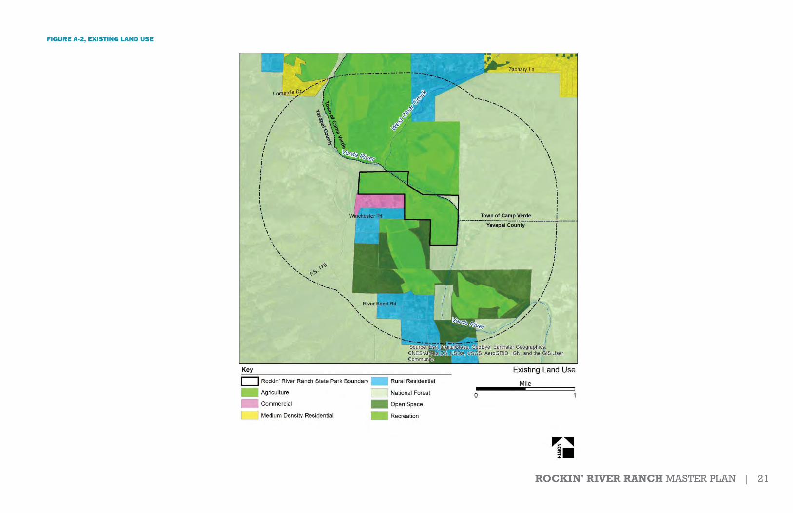
ROCKIN' RIVER RANCH MASTER PLAN | 21
FIGURE A-2, EXISTING LAND USE

22 | ROCKIN' RIVER RANCH MASTER PLAN
FIGURE A-3, ZONING

ROCKIN' RIVER RANCH MASTER PLAN | 23
FIGURE A-4, REGIONAL RECREATIONAL SYSTEMS

24 | ROCKIN' RIVER RANCH MASTER PLAN
FIGURE A-5, EXISTING VISUAL LANDSCAPE CHARACTERISTICS
ROCKIN’ RIVER RANCH STATE PARK
Existing Visual Landscape Characteristics
Landform: benched terraceVegetation: variety of heights and speciesDistinct Built Features: pond; unpaved road; overhead electrical linesDistinct Natural Features: mature mesquite and cottonwood treesViews: semi-enclosed by vegetation; open views to the north
Pond
Landform: relatively flat terrainVegetation: low, predominately grassesDistinct Built Features: unpaved roads; irrigation ditches; and fencesDistinct Natural Features: noneViews: open, expansive
Pasture
Landform: relatively flat terrainVegetation: variety of heights, with scattered mature treesDistinct Built Features: ranch buildings and associated structures; unpaved roads; fencesDistinct Natural Features: noneViews: semi-enclosed by buildings/structures and mature trees
Ranch Development
Landform: relatively flatVegetation: low, predominately seasonal grassesDistinct Built Features: noneDistinct Natural Features: noneViews: open, expansive
Fallow Fields
Landform: escarpmentVegetation: sparse low shrubsDistinct Built Features: noneDistinct Natural Features: escarpment, white limestone soilsViews: open, expansive
Escarpment
Landform: linear river corridorVegetation: tall, predominately cottonwoodsDistinct Built Features: noneDistinct Natural Features: Verde River; riparian vegetation; rock outcropsViews: enclosed by vegetation; limited to river corridor
River/Riparian
Landform: relatively flat to gently rollingVegetation: variety of heights; predominately mesquite trees and seasonal grassesDistinct Built Features: noneDistinct Natural Features: mesquite treesViews: enclosed by vegetation
Mesquite Woodland
PASTURE
RIVER/RIPARIAN
POND
RANCHDEVELOPMENT
FALLOW FIELDS
MESQUITE WOODLAND
RIVER/ RIPARIAN
RIVER/RIPARIAN
ESCARPMENT
RANCHDEVELOPMENT

ROCKIN' RIVER RANCH MASTER PLAN | 25
FIGURE A-6, SLOPE ANALYSIS
LEGENDSITE BOUNDARY
Slope Analysis
ROCKIN’ RIVER RANCH STATE PARK
PERCENT SLOPE0-3.03.01-8.08.01-15.015.01-45.045.01-75.8
NDNDNNDNDNDNDNDNDNDNDNDNNDNDNDNN ARARARARARARARARARARARAARARARARARARARARARYYYYYYYYYYYYYYYYYY
EEEEEEEEEEEEEE
000000000000000000454545454545454545.0.0.0.0.0.0.0.0.0.0.0.0.075757575757575757575.8.8.8.8.8.8.8.8.8.8.8.8.8.8.8.8.8.8.8.8
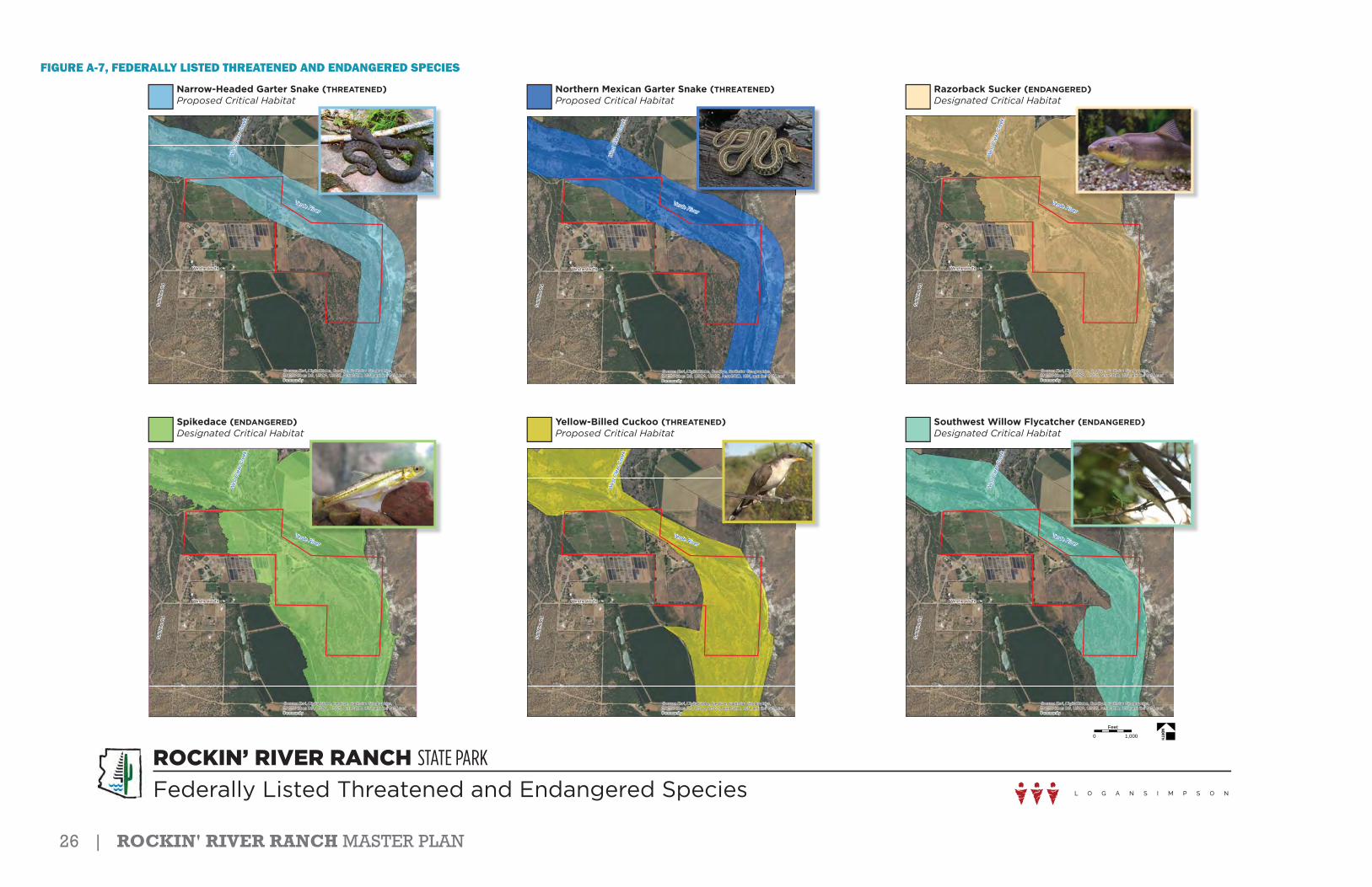
26 | ROCKIN' RIVER RANCH MASTER PLAN
FIGURE A-7, FEDERALLY LISTED THREATENED AND ENDANGERED SPECIES
ROCKIN’ RIVER RANCH STATE PARK
Federally Listed Threatened and Endangered Species
0 1,000Feet
Verde River
Wes
t Cle
ar C
reek
Winchester Trl
Salt
Min
e Rd
Source: Esri, DigitalGlobe, GeoEye, Earthstar Geographics,CNES/Airbus DS, USDA, USGS, AeroGRID, IGN, and the GIS UserCommunity
Northern Mexican Garter Snake (THREATENED)Proposed Critical Habitat
Verde River
Wes
t Cle
ar C
reek
Winchester Trl
Salt
Min
e Rd
Source: Esri, DigitalGlobe, GeoEye, Earthstar Geographics,CNES/Airbus DS, USDA, USGS, AeroGRID, IGN, and the GIS UserCommunity
Narrow-Headed Garter Snake (THREATENED)Proposed Critical Habitat
Verde River
Wes
t Cle
ar C
reek
Winchester Trl
Salt
Min
e Rd
Source: Esri, DigitalGlobe, GeoEye, Earthstar Geographics,CNES/Airbus DS, USDA, USGS, AeroGRID, IGN, and the GIS UserCommunity
Razorback Sucker (ENDANGERED)Designated Critical Habitat
Verde River
Wes
t Cle
ar C
reek
Winchester Trl
Salt
Min
e Rd
Source: Esri, DigitalGlobe, GeoEye, Earthstar Geographics,CNES/Airbus DS, USDA, USGS, AeroGRID, IGN, and the GIS UserCommunity
Yellow-Billed Cuckoo (THREATENED)Proposed Critical Habitat
Verde River
Wes
t Cle
ar C
reek
Winchester Trl
Salt
Min
e Rd
Source: Esri, DigitalGlobe, GeoEye, Earthstar Geographics,CNES/Airbus DS, USDA, USGS, AeroGRID, IGN, and the GIS UserCommunity
Southwest Willow Flycatcher (ENDANGERED)Designated Critical Habitat
Verde River
Wes
t Cle
ar C
reek
Winchester Trl
Salt
Min
e Rd
Source: Esri, DigitalGlobe, GeoEye, Earthstar Geographics,CNES/Airbus DS, USDA, USGS, AeroGRID, IGN, and the GIS UserCommunity
Spikedace (ENDANGERED)Designated Critical Habitat

ROCKIN' RIVER RANCH MASTER PLAN | 27
FIGURE A-8, EXISTING WILDLIFE HABITAT CHARACTERISTICS
ROCKIN’ RIVER RANCH STATE PARK
Existing Wildlife Habitat Characteristics
Irrigated Pastures
Common Vegetation: grasses, annualsCommon Wildlife: sparrows, finches, lizards, grasshoppers, butterfliesNotable Habitat Elements: “edge” habitat used by wildlife from adjacent areas
Disturbed / Fallow/
Aquatic River
Common Vegetation: mesquite trees, grassesCommon Wildlife: javelina, burrowing mammals, cicadas, pocket gopherNotable Habitat Elements: bird foraging habitat, high insect population, floodplain
Mesquite Woodland
Common Vegetation: cottonwood-willowCommon Wildlife: hawks, yellow-billed cuckoo, bats, summer tanger, Lucy’s warblerNotable Habitat Elements: nesting migratory birds, shaded river banks, cobble bars, tall
perches, threatened and endangered species (snakes & birds)/critical habitat
Riparian
Common Vegetation: desertscrub (crucifixion thorn), grassesCommon Wildlife: squirrels, burrowing mammals, lizard, canyon towhee, rock wrenNotable Habitat Elements: white limestone soils, rock outcrops
Cliff / Hillside
Developed
Disturbed Fallow
Mesquite Woodland
Riparian
Developed
Riparian
Riparian
Riparian
Mesquite Woodland
Riparian
Aquatic River
Cliff/Hillside
Aquatic River
Common Vegetation : grasses, cottonwoodsCommon Wildlife: waterfowl, raccoon, bullfrog, turtles, salamanders, non-native fishNotable Habitat Elements: open, still water with grassy tree-lined banks
Aquatic Pond
Common Vegetation: grassesCommon Wildlife: flycatchers, pocket gophers, say’s phoebe, brown-headed cowbirdNotable Habitat Elements: fencline provides perches for foraging birds
Irrigated Pasture
Common Vegetation: large deciduous shade trees (cottonwood, walnut, mulberry, sycamore)
Common Wildlife: robins, sparrows, great-tailed grackle, bats, geckosNotable Habitat Elements: building structures provide perches for foraging birds as
well as nesting areas
Developed
Common Vegetation: cattails, bullrushCommon Wildlife: beaver, otter, osprey, heron, bald eagle, toads, bats, garter-
snakes, native and no-native fishNotable Habitat Elements: active river channel with perennial flows; threatened and
endangered species (fish)/critical habitat
Aquatic River

28 | ROCKIN' RIVER RANCH MASTER PLAN
FIGURE A-9, WATER RIGHTS AND WELL LOCATIONS
Water Rights and Well LocationsROCKIN’ RIVER RANCH STATE PARK
ID XXX
LEGEND1.6 ACRE STOCKPOND54 ACRES OF PASTURE WITH WATER RIGHTSPASTURE LAND WITHOUT WATER RIGHTSWELLSITE BOUNDARY
ID XXXID XXX
ID XXX

ROCKIN' RIVER RANCH MASTER PLAN | 29
FIGURE A-10, ROCKIN' RIVER RANCH STRUCTURES
21
0 500 1,000 1,500 2,000250Feet
3
5
46
7 89
11
1312
14 1516
18
10
³Structures
State Park Boundary
184
17
21
3
5
67
8
9
11
10
13
12
14
1516
17
Structure 1 Lat: 34.5032°N Long: -111.8329°W Elev:3024Structure 2 Lat: 34.5031°N Long: -111.8322°W Elev:3023Structure 3 Lat: 34.5030°N Long: -111.8320°W Elev:3022Structure 4 Lat: 34.5009°N Long: -111.8311°W Elev:3024Structure 5 Lat: 34.5013°N Long: -111.8257°W Elev:3012Structure 6 Lat: 34.5010°N Long: -111.8259°W Elev:3012Structure 7 Lat: 34.5009°N Long: -111.8257°W Elev:3012Structure 8 Lat: 34.5010°N Long: -111.8247°W Elev:3009Structure 9 Lat: 34.5008°N Long: -111.8250°W Elev:3009Structure 10 Lat: 34.5004°N Long: -111.8246°W Elev:3009Structure 11 Lat: 34.5002°N Long: -111.8246°W Elev:3008Structure 12 Lat: 34.4987°N Long: -111.8238°W Elev:3007Structure 13 Lat: 34.4989°N Long: -111.8235°W Elev:3008Structure 14 Lat: 34.4993°N Long: -111.8232°W Elev:3009Structure 15 Lat: 34.4994°N Long: -111.8231°W Elev:3008Structure 16 Lat: 34.4996°N Long: -111.8225°W Elev:3007Structure 17 Lat: 34.4997°N Long: -111.8234°W Elev:3008Structure 18 Lat: 34.4961°N Long: -111.8181°W Elev:3001
The structure's lat, long and elevation are based off the northeastern point of the structure. Structure polygon placement were created from LIDAR collected data and may be off from the ESRI imagery basemap.
Rockin' River Ranch Structures

30 | ROCKIN' RIVER RANCH MASTER PLAN
FIGURE A-11, PUBLIC COMMENTS

ROCKIN' RIVER RANCH MASTER PLAN | 31

32 | ROCKIN' RIVER RANCH MASTER PLAN

ROCKIN' RIVER RANCH MASTER PLAN | 33

34 | ROCKIN' RIVER RANCH MASTER PLAN
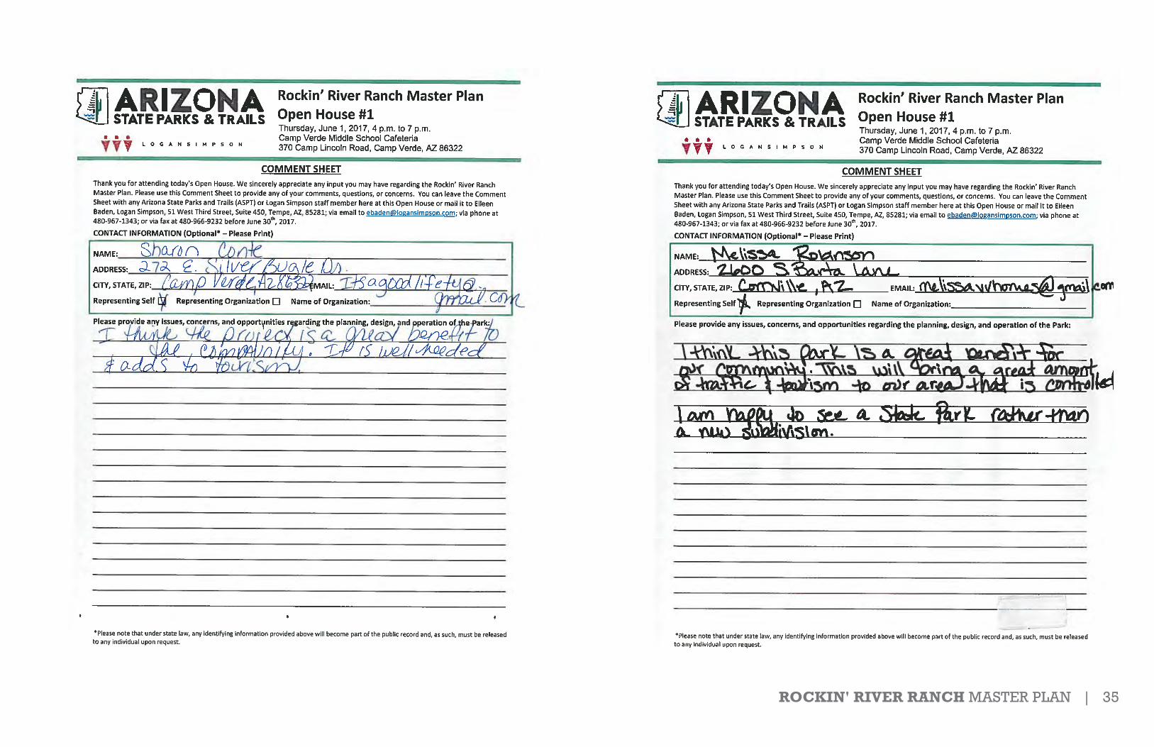
ROCKIN' RIVER RANCH MASTER PLAN | 35

36 | ROCKIN' RIVER RANCH MASTER PLAN

ROCKIN' RIVER RANCH MASTER PLAN | 37

38 | ROCKIN' RIVER RANCH MASTER PLAN
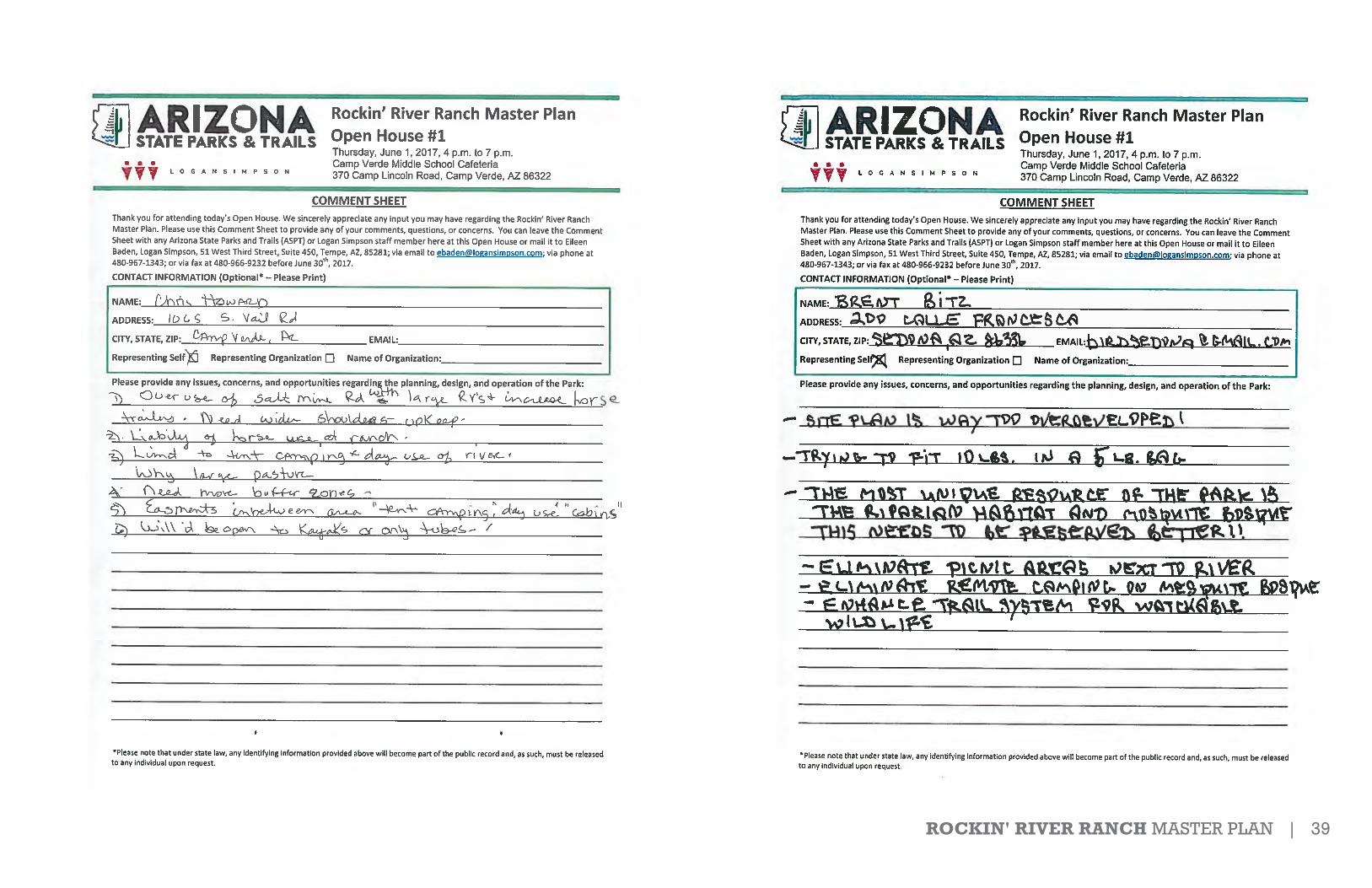
ROCKIN' RIVER RANCH MASTER PLAN | 39
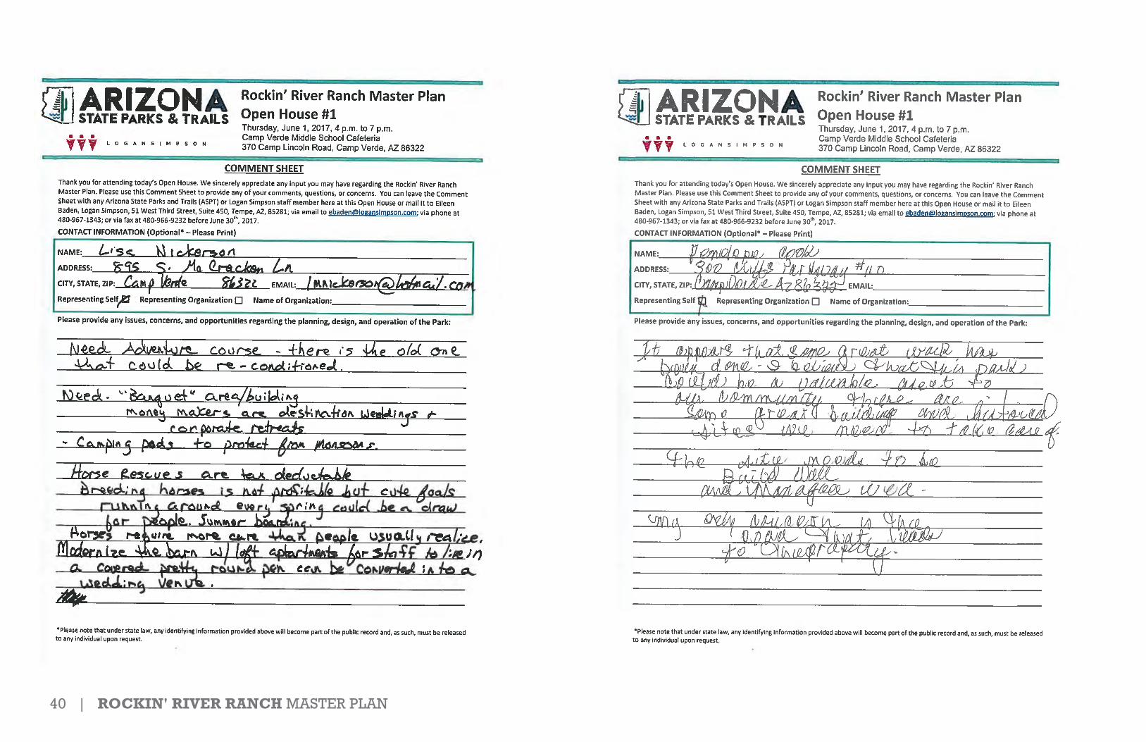
40 | ROCKIN' RIVER RANCH MASTER PLAN
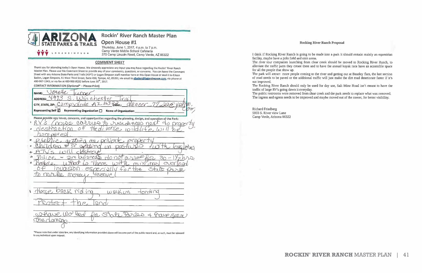
ROCKIN' RIVER RANCH MASTER PLAN | 41

42 | ROCKIN' RIVER RANCH MASTER PLAN

ROCKIN' RIVER RANCH MASTER PLAN | 43
1
Eileen Baden
From: Eileen BadenSent: Wednesday, June 07, 2017 9:14 AMTo: '[email protected]'Subject: RE: Rockin' River state park
Good morning,
Unfortunately, we do not have an online form at this time. However, please feel free to send your comments as an emailor letter and I can get them sent to the project manager at Arizona State Parks.
Thank you.
Eileen Baden, AICPEnvironmental Planner
Logan Simpson51 W. 3rd St., Ste. 450Tempe, AZ 85281P (480) 967-1343F (480) 966-9232 [email protected]
From: [email protected] [mailto:[email protected]]Sent: Wednesday, June 07, 2017 9:11 AM To: Eileen Baden Subject: Re: Rockin' River state park
Is there a form you can fill out on line?
-----Original Message----- From: Eileen Baden <[email protected]>To: otterlimits7 <[email protected]>Sent: Mon, Jun 5, 2017 10:05 am Subject: RE: Rockin' River state park
Good morning Gene,
Please see the attached comment sheet for the Rockin’ River Ranch Master Plan. Comments are due by June 30th, 2017.Directions for submitting the form are listed on there.
Thank you.
Eileen Baden, AICPEnvironmental Planner
Logan Simpson
44 | ROCKIN' RIVER RANCH MASTER PLAN
2
51 W. 3rd St., Ste. 450Tempe, AZ 85281P (480) 967-1343F (480) 966-9232 [email protected]
From: [email protected] [mailto:[email protected]]Sent: Monday, June 05, 2017 9:57 AM To: Eileen Baden Subject: Rockin' River state park
My name is Gene Giordano and I have been trying to find your Comment Sheet for Rockin' River. I am part of the Verde Acres property owners. We have some public safety concerns with the increased traffic the Park will bring. We feel that some infrastructure planning should be addressed before the Park opens. My phone # is 928-821-0514.
1
Eileen Baden
From: Brad RemmeSent: Tuesday, June 13, 2017 7:41 AMTo: Russell Moore; Wayne Colebank; Eileen BadenSubject: RE: General Comment - Arizona State Parks
Good morning Russell –
Thank you for forwarding the comments below from Maria Wilson and Alana Neary; regarding their concerns associatedwith RRR SP.
Brad RemmeLogan Simpson[C] 480 435 0742
From: Russell Moore [mailto:[email protected]] Sent: Monday, June 12, 2017 5:48 PM To: Wayne Colebank; Brad Remme; Eileen Baden Subject: FW: General Comment - Arizona State Parks
_______
Russell G. Moore, ASLA, AICPChief of Planning and DevelopmentArizona State Parks
Phone: (602) 542 6944Cell: (480) 338 [email protected]://azstateparks.govArizona State Parks23751 N. 23rd Ave, Ste 190Phoenix, AZ 85085
From: Sarah Steele <[email protected]>Date:Monday, June 12, 2017 at 8:16 AMTo: "[email protected]" <[email protected]>Cc: Russell Moore <[email protected]>Subject: Re: General Comment Arizona State Parks
Good morning,
We appreciate you taking the time to comment on the proposed park at Rockin’ River Ranch. We are currently workingon a master plan for the property and public input is very important to help guide the process. Below is a link to theproject page where you can review updates. I will pass your comments along with the information you have provided tothe appropriate individuals to be documented.

ROCKIN' RIVER RANCH MASTER PLAN | 45
2
https://azstateparks.com/projects/#RockinRiverRanch
Please let us know if you have any other concerns or questions.
Thank you,
Sarah SteeleChief of OperationsArizona State Parks & Trails 23751 N 23rd Ave, #190 Phoenix AZ 85085 (602) 542-7150 [email protected] | AZStateParks.com
From: "[email protected]" <[email protected]>Date: Sunday, June 11, 2017 at 3:55 PMTo: Sarah Steele <[email protected]>Subject: General Comment Arizona State Parks
Name: maria wilson & alana neary
Email: [email protected]
Phone: 928 5679128
Park: Arizona State Parks
Zip: 86322
Message: I am writing to comment on the proposed park at the Rockin River Ranch. I am a resident of Camp Verde, live on South Salt Mine Road and am very concerned about the amount of traffic that the proposed park will generate. Salt Mine Road is a hilly, winding two lane road that is a dead end and not designed to accommodate the numerous and large vehicles that this park will attract. I am also concerned about the trash that will accumulate along the road and at the Ranch as well, polluting the Verde River - the last fee flowing river in Arizona. Trash is a major issue,( I am reminded of the problems at Fossil Creek). Since my granddaughter and I have taken on the responsibility of cleaning a portion of Salt Mine Road for the last 7 years and have had to clean up the enormous amount of garbage left by the people who visit the salt mine for a few hours, I can state for a fact that the issue of trash is a very important one. Another possible issue will be the safety of the horses, as the fences are low enough and wide enough for any person to go through or over and simply having signs around is never enough to keep people out and stop them from feeding the horses whatever food they have on hand. This is especially problematic as there are almost always foals and yearlings at the ranch which are irresistible to any normal tourist. And as these horses are privately owned their safety is a necessity, whether it be issues such as the feeding, or trespassing, or simply trash that will be left by the tourist that could pose as dangerous (anything sharp that can get wedged in a hoof, or something interesting that a
3
horse or especially a foal might eat/bite out of curiosity). There is also the matter of expensive tack (saddles, bridles, etc.) that the owners leave at the ranch and could be stolen.

46 | ROCKIN' RIVER RANCH MASTER PLAN

ROCKIN' RIVER RANCH MASTER PLAN | 47
R o c k i n ’ R i v e r R a n c h M a s t e r P l a n P u b l i c c o m m e n t
1
R e : P u b l i c C o m m e n t f r o m B o b R u g l o s k i C o m m e n t N o . : 0 1
P h o n e C a l l D a t e : J u n e 1 3 , 2 0 1 7
A d d r e s s : 5 3 7 E G a i l L a n e , C a m p V e r d e 8 6 3 2 2 T i m e : 3 : 1 5 p m
E m a i l : b k r u g l o s k i @ g m a i l . c o m o r b k r u g l o s k i @ l i v e . c o m P h o n e : 9 2 8 - 2 0 2 - 0 2 1 8
C O M M E N T S R E C E I V E D :
He lives south of Camp Verde in Yavapai County Major concern regarding Salt Mine Road and safety of passengers using the road as well as during emergencies. Ranch is on a dead-end road. Concerned there is only one egress point especially due to the increased number of people in the area due to the users in the park. If something major should happen, there is only one-way in and one-way out. Recent fire in Prescott National Forest (PNF) brought in 6 different fire stations including firefighters from Jerome, AZ. Concern over not having enough water to fight the fire. Fire started when something exploded and there were at least 100 people putting out the fire which covered about 2 acres in 15 minutes. They were evacuating one side of Salt Mine Road; fire was on the west side of the road. Salt Mine Road has not been maintained, especially within Camp Verde. The road needs to be improved considerably and add shoulders. Yavapai County has done a good job maintaining the road in their part. Park would bring considerable traffic. Accident could block road and several hundred people would be stranded. People moved to a rural area; don’t want too much increased traffic. Big motorhomes have a big impact on the road. The large motorhomes that sometimes have trailers attached are too large for Salt Mine Road. Semi-trucks on the road are taking a toll on the road too. There should be a sign that limits the tonnage on the road. Would like to see portion of the $4 million allocated for the park put towards the road. Would like to see $2-$3 million go towards improving Salt Mine Road. County should help with road improvements and the state too. Would like to see a bridge added to provide a route to get out of the area. Back in the 1930’s and 1940s, people could cross through where the river was wide and get to Strawberry (6 inches or less shallow but 300 feet wide). Road was rough. Concerned about proposal showing 70-100 RV parcels, there shouldn’t be any. Only tent camping and small campers should be allowed.
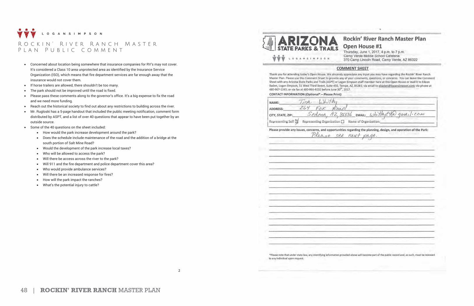
48 | ROCKIN' RIVER RANCH MASTER PLAN
R o c k i n ’ R i v e r R a n c h M a s t e r P l a n P u b l i c c o m m e n t
2
Concerned about location being somewhere that insurance companies for RV’s may not cover. It’s considered a Class 10 area unprotected area as identified by the Insurance Service Organization (ISO), which means that fire department services are far enough away that the insurance would not cover them. If horse trailers are allowed, there shouldn’t be too many. The park should not be improved until the road is fixed. Please pass these comments along to the governor’s office. It’s a big expense to fix the road and we need more funding. Reach out the historical society to find out about any restrictions to building across the river. Mr. Rugloski has a 5-page handout that included the public meeting notification, comment form distributed by ASPT, and a list of over 40 questions that appear to have been put together by an outside source. Some of the 40 questions on the sheet included:
How would the park increase development around the park? Does the schedule include maintenance of the road and the addition of a bridge at the south portion of Salt Mine Road? Would the development of the park increase local taxes? Who will be allowed to access the park? Will there be access across the river to the park? Will 911 and the fire department and police department cover this area? Who would provide ambulance services? Will there be an increased response for fires? How will the park impact the ranches? What’s the potential injury to cattle?

ROCKIN' RIVER RANCH MASTER PLAN | 49
1
Eileen Baden
From: T Whitley <[email protected]>Sent: Tuesday, June 13, 2017 4:15 AMTo: Eileen BadenCc: [email protected]: Rockin' River State Park Master PlanAttachments: Rockin'RiverStatePark.pdf
Please see attached PDF for my comments.
Kind regards,Tina Whitley
Northern Arizona Audubon Society-Education Chair [email protected]

50 | ROCKIN' RIVER RANCH MASTER PLAN
1
Eileen Baden
From: [email protected]: Tuesday, June 27, 2017 8:15 AMTo: Eileen BadenSubject: RE: Rockin' River Ranch State Park Master Plan- MacDonalds Ranch
Thank you so much for the information Eileen! We appreciate it!
Sincerely,
Kelcie D. BinnionOffice Manager and Event Coordinator
MacDonald’s Ranch26540 N. Scottsdale Rd.Scottsdale, AZ 85255P: 480 585 0239F: 480 585 1519www.macdonaldsranch.com
From: Eileen Baden [mailto:[email protected]]Sent:Wednesday, June 21, 2017 1:08 PMTo:[email protected]: Rockin' River Ranch State Park Master Plan MacDonalds Ranch
Good afternoon Mr. Richardson,
We appreciate you taking the time to comment on the proposed Arizona State Park Rockin’ River Ranch and theinformation on MacDonald’s Ranch. Arizona State Parks and Trails (ASPT) is currently working on a master plan for theproperty and public input is very important to help guide the process. As we are still in the planning process, ASPT is notyet soliciting vendor applications for assistance with equestrian services. Below is a link to the project page where youcan review updates.
https://azstateparks.com/projects/#RockinRiverRanch
I will pass along your comments and the information you have provided to the appropriate individuals at ASPT to bedocumented and incorporated into our plan development. To find out more about working for the state, please visit thiswebsite: https://spo.az.gov/contractor resources/procureaz resources for vendors. There is more information on thatwebsite about a webinar training next Wednesday, June 28th at 10 a.m. to assist vendors who are responding tosolicitations.
Please let us know if you have any additional comments or questions.
Thank you.
Eileen Baden, AICPEnvironmental Planner
2
Logan Simpson51 W. 3rd St., Ste. 450Tempe, AZ 85281P (480) 967-1343F (480) 966-9232 [email protected]
From: "[email protected]" <[email protected]>Date: Thursday, June 15, 2017 at 11:16 AMTo: Sarah Steele <[email protected]>Subject: General Comment Arizona State Parks
Name: Robert Richardson
Email: [email protected]
Phone: 6027405628
Park: Arizona State Parks
Zip: 85255
Message: To whom it may concern: My name is Robert Richardson and I am the owner and operator of MacDonald's Ranch in North Scottsdale. At our location we offer guided tours on horseback, onsite cookouts, wagon rides, a petting zoo, and pony rides, for the public. A true taste of Arizona and western experience for tourists and locals. We have been in operation since 1970 and are very proud of how we have grown with our community for nearly 5 decades. I understand that Rockin' River Ranch is now a State Park and will be offering outdoor activities in the future. I am familiar with this ranch and have even provided horses to this ranch in the past. I wanted to reach out and inquire about the equestrian aspect of the park that will be offered to the community and see if anyone has been selected to provide these services yet? Would the ASPT be open to discussing this opportunity further? I appreciate the opportunity to speak with a representative of the ASPT at your convenience. Please feel free to call or email with my information listed below. Thank you. Sincerely, Robert Richardson Owner and Operator MacDonald's Ranch 602-740-5628 [email protected]

ROCKIN' RIVER RANCH MASTER PLAN | 51

52 | ROCKIN' RIVER RANCH MASTER PLAN
1
Eileen Baden
From: Vargas, Michael (Flake) <[email protected]>Sent: Friday, June 16, 2017 12:04 PMTo: Eileen BadenCc: [email protected]; [email protected]; [email protected];
[email protected]; Wayne Colebank; Diane Simpson-Colebank; Brad RemmeSubject: RE: Rockin' River Ranch State Park-Senator Jeff Flake
Thank you for sending our way, Eileen.
Michael
From: Eileen Baden [mailto:[email protected]]Sent: Friday, June 16, 2017 12:01 PMTo: Vargas, Michael (Flake) <[email protected]>Cc: [email protected]; [email protected]; [email protected]; [email protected];Wayne Colebank <[email protected]>; Diane Simpson Colebank <[email protected]>;Brad Remme <[email protected]>Subject: Rockin' River Ranch State Park Senator Jeff Flake
Dear Senator Flake,
On behalf of the Arizona State Parks and Trails, I want to inform you that we are currently preparing the Master Plan forRockin’ River Ranch State Park located 5 miles south of Camp Verde, Arizona. We held a successful public meeting onJune 1, 2017. The open house was attended by about 80 Verde Valley citizens who provided us with important insightson the Park site and about the Lower Verde Valley. Their input was very comprehensive and included many items thatwe will consider during the Master Plan preparation. The received comments will be very valuable as we move forwardfrom the Inventory and Analysis Phase to the Site Plan Alternatives Phase of the Master Plan.
We have received requests from a variety of interests to be participants in the Park planning process. Therefore, we willbe adding additional members to our Technical Advisory Committee and are evaluating the specific issues identified bycitizens who live near the Park. We will be developing the Park site plan concepts over the next several weeks, and wewill be hosting a second public meeting on Monday, July 17th to share our conceptual alternatives with the public. Youroffice will receive an invitation to that meeting.
Please contact me if you have any questions about the Master Plan, the process, or schedule.
Thank you.
Eileen Baden, AICPEnvironmental Planner
Logan Simpson51 W. 3rd St., Ste. 450Tempe, AZ 85281P (480) 967-1343F (480) 966-9232 [email protected]
1
Eileen Baden
From: Flanagan, Steven <[email protected]>Sent: Friday, June 16, 2017 12:09 PMTo: Eileen BadenSubject: RE: Rockin' River Ranch State Park- Representative Tom O'Halleran
Eileen,
Thanks for the update. I will plan on attending the meeting in July. Have a great weekend.
Steven Flanagan | Veteran Outreach and CaseworkerOffice of Congressman Tom O’Halleran (AZ 01)405 N. Beaver St., Flagstaff, AZ 86001 | 928 286 5338https://ohalleran.house.gov/
From: Eileen Baden [mailto:[email protected]]Sent: Friday, June 16, 2017 12:00 PMTo: Flanagan, Steven <[email protected]>Cc: [email protected]; [email protected]; [email protected]; [email protected];Wayne Colebank <[email protected]>; Diane Simpson Colebank <[email protected]>;Brad Remme <[email protected]>Subject: Rockin' River Ranch State Park Representative Tom O'Halleran
Dear Representative O'Halleran,
On behalf of the Arizona State Parks and Trails, I want to inform you that we are currently preparing the Master Plan forRockin’ River Ranch State Park located 5 miles south of Camp Verde, Arizona. We held a successful public meeting onJune 1, 2017. The open house was attended by about 80 Verde Valley citizens who provided us with important insightson the Park site and about the Lower Verde Valley. Their input was very comprehensive and included many items thatwe will consider during the Master Plan preparation. The received comments will be very valuable as we move forwardfrom the Inventory and Analysis Phase to the Site Plan Alternatives Phase of the Master Plan.
We have received requests from a variety of interests to be participants in the Park planning process. Therefore, we willbe adding additional members to our Technical Advisory Committee and are evaluating the specific issues identified bycitizens who live near the Park. We will be developing the Park site plan concepts over the next several weeks, and wewill be hosting a second public meeting on Monday, July 17th to share our conceptual alternatives with the public. Youroffice will receive an invitation to that meeting.
Please contact me if you have any questions about the Master Plan, the process, or schedule.
Thank you.
Eileen Baden, AICPEnvironmental Planner
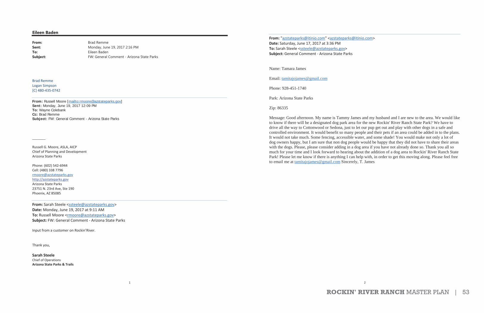
ROCKIN' RIVER RANCH MASTER PLAN | 53
1
Eileen Baden
From: Brad RemmeSent: Monday, June 19, 2017 2:16 PMTo: Eileen BadenSubject: FW: General Comment - Arizona State Parks
Brad RemmeLogan Simpson[C] 480 435 0742
From: Russell Moore [mailto:[email protected]]Sent: Monday, June 19, 2017 12:09 PM To: Wayne Colebank Cc: Brad Remme Subject: FW: General Comment - Arizona State Parks
_______
Russell G. Moore, ASLA, AICPChief of Planning and DevelopmentArizona State Parks
Phone: (602) 542 6944Cell: (480) 338 [email protected]://azstateparks.govArizona State Parks23751 N. 23rd Ave, Ste 190Phoenix, AZ 85085
From: Sarah Steele <[email protected]>Date:Monday, June 19, 2017 at 9:11 AMTo: Russell Moore <[email protected]>Subject: FW: General Comment Arizona State Parks
Input from a customer on Rockin’River.
Thank you,
Sarah SteeleChief of OperationsArizona State Parks & Trails
2
From: "[email protected]" <[email protected]>Date: Saturday, June 17, 2017 at 3:36 PMTo: Sarah Steele <[email protected]>Subject: General Comment Arizona State Parks
Name: Tamara James
Email: [email protected]
Phone: 928-451-1740
Park: Arizona State Parks
Zip: 86335
Message: Good afternoon. My name is Tammy James and my husband and I are new to the area. We would like to know if there will be a designated dog park area for the new Rockin' River Ranch State Park? We have to drive all the way to Cottonwood or Sedona, just to let our pup get out and play with other dogs in a safe and controlled environment. It would benefit so many people and their pets if an area could be added in to the plans. It would not take much. Some fencing, accessible water, and some shade! You would make not only a lot of dog owners happy, but I am sure that non dog people would be happy that they did not have to share their areas with the dogs. Please, please consider adding in a dog area if you have not already done so. Thank you all so much for your time and I look forward to hearing about the addition of a dog area to Rockin' River Ranch State Park! Please let me know if there is anything I can help with, in order to get this moving along. Please feel free to email me at [email protected] Sincerely, T. James
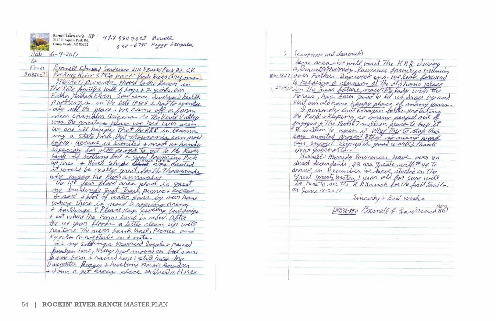
54 | ROCKIN' RIVER RANCH MASTER PLAN

ROCKIN' RIVER RANCH MASTER PLAN | 55
1
Eileen Baden
From: Steve Ayers <[email protected]>Sent: Monday, June 19, 2017 10:35 AMTo: [email protected]; Wayne Colebank; Eileen Baden; [email protected];
[email protected]; Brad Remme; Dusty Humphreys ([email protected]); [email protected]
Subject: Rockin River previous owner letterAttachments: Bernell and Merridy Lawrence comments.pdf
Dear Sue,
The attached letter was dropped off at the Camp Verde Town Clerk’s office on Friday. It comes from Camp Verderesident Bernell Lawrence whose family owned the Rockin’ River Ranch property from the 1940 to the late 50’s. Pleaseinclude his comments as you consider how to develop the property.
Thanks,Steve
Steve AyersEconomic Development DirectorTown of Camp Verde928 554 [email protected]
Hours of operations for all Town offices are Monday - Thursday 7 am to 5 pm and Friday 7 am to 11 am.
All messages created in this system belong to the Town of Camp Verde and should be considered a public record subject to disclosure under the Arizona Public Records Law (A.R.S. § 39-121 et seq.) Town employees, Town public officials, and those who generate email to them, should have no expectation of privacy related to the use of this technology. The content of this message may contain the private views and opinions of the sender and does not constitute a formal view and/or opinion of the Town unless specifically stated. The contents of this email and any attachments may contain confidential and/or proprietary information, and is intended only for the person/entity to whom it was originally addressed. Any dissemination, distribution or copying of this communication is strictly prohibited. If you have received this email in error please notify the sender immediately by return e-mail and delete this message and any attachments from your system.
Furthermore, to ensure compliance with the Open Meeting Law, Council or Board/ Commission / Committee members who are recipients of this message should not forward it to other members of the Council or Board / Commission / Committee of the Town of Camp Verde. Council Members or Board / Commission / Committee members may reply to a staff member regarding this message, but they should not send a copy of a reply to other Council or Board / Commission / Committee members.
Please consider our environment before printing this email.

56 | ROCKIN' RIVER RANCH MASTER PLAN
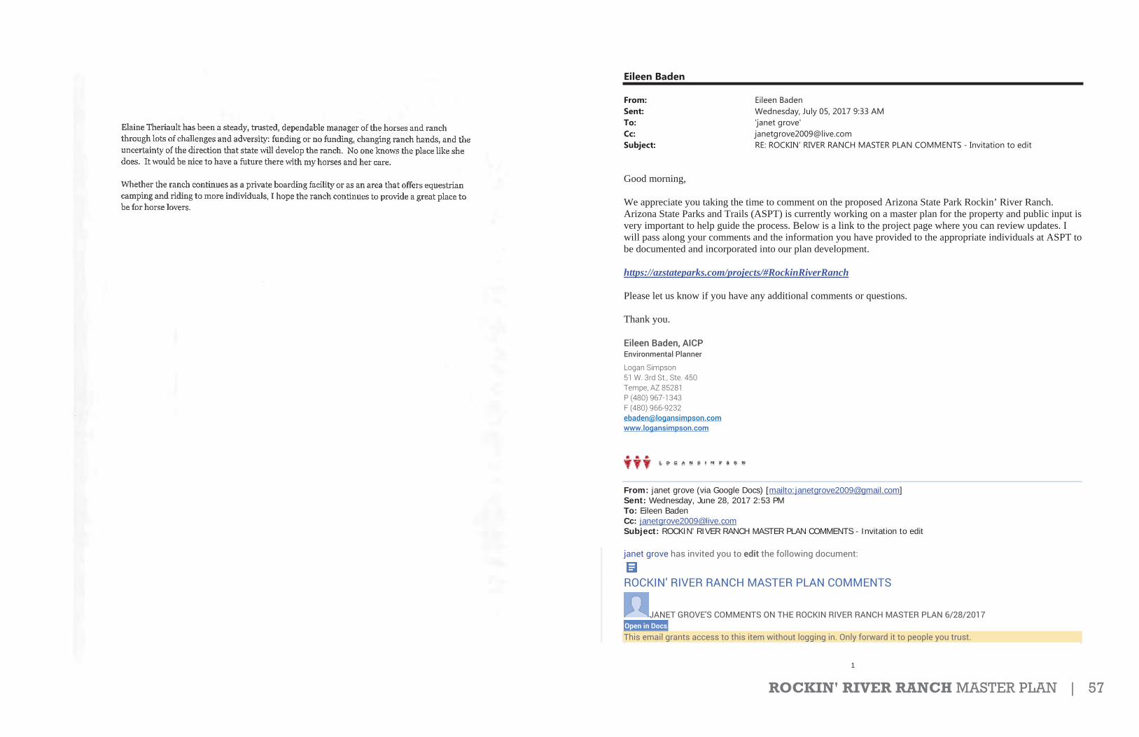
ROCKIN' RIVER RANCH MASTER PLAN | 57
1
Eileen Baden
From: Eileen BadenSent: Wednesday, July 05, 2017 9:33 AMTo: 'janet grove'Cc: [email protected]: RE: ROCKIN’ RIVER RANCH MASTER PLAN COMMENTS - Invitation to edit
Good morning,
We appreciate you taking the time to comment on the proposed Arizona State Park Rockin’ River Ranch. Arizona State Parks and Trails (ASPT) is currently working on a master plan for the property and public input is very important to help guide the process. Below is a link to the project page where you can review updates. I will pass along your comments and the information you have provided to the appropriate individuals at ASPT to be documented and incorporated into our plan development.
https://azstateparks.com/projects/#RockinRiverRanch
Please let us know if you have any additional comments or questions.
Thank you.
Eileen Baden, AICPEnvironmental Planner
Logan Simpson51 W. 3rd St., Ste. 450Tempe, AZ 85281P (480) 967-1343F (480) 966-9232 [email protected]
From: janet grove (via Google Docs) [mailto:[email protected]]Sent: Wednesday, June 28, 2017 2:53 PM To: Eileen Baden Cc: [email protected]: ROCKIN’ RIVER RANCH MASTER PLAN COMMENTS - Invitation to edit
janet grove has invited you to edit the following document:
ROCKIN’ RIVER RANCH MASTER PLAN COMMENTS
JANET GROVE'S COMMENTS ON THE ROCKIN RIVER RANCH MASTER PLAN 6/28/2017 Open in Docs This email grants access to this item without logging in. Only forward it to people you trust.

58 | ROCKIN' RIVER RANCH MASTER PLAN
