draft- january 2020
TRANSCRIPT
2019
REGIONAL PLAN
DRAFT- JANUARY 2020

Moloka ‘ i Regional Plan 2019
i
Executive Summary
Regional plans build a sense of community and capacity, they stimulate partnerships for
development and improvements, and put homestead lessees in the “driver’s seat.” The Hawaiian
Homes Commission’s approval of 22 Regional Plans across the State means that all homestead
communities have the same opportunity. The 22 regional plans provide a platform for beneficiaries
to talk as neighbors and ‘ohana about their common issues and concerns. The regional plans
empower beneficiaries with a recurring opportunity, to convene as neighbors and friends in order to
identify and solve their own problems. Regional plans tap the ingenuity and ensure that homestead
lessees are an integral part of the solution. Working with the Department of Hawaiian Home Lands
(DHHL) Planning Office staff and consultants, the plan identifies priority projects to respond to issues
and areas of concern within existing and planned homestead areas. The plan may focus on a
particular homestead community or several homestead communities in the region. At a minimum,
the regional plan documents current conditions and trends and identifies a prioritized list of projects
important to the community and the department.
Vision. The vision provides a unified direction for homesteads, Departmental and Commission
actions on Moloka‘i and is as follows:
“Moloka‘i beneficiaries are thriving on the land where the way of life and sense of community
continue to hold strong. Acknowledging the diversity of each homestead on Moloka‘i, we
envision a unified community grounded in Hawaiian values and cultural traditions passed to
us from our kūpuna. Core values are preserved while embracing modern pathways to a
sustainable future.”
This vision is supported by the following values:
• Our Cultural Traditions Give Us Knowledge and Strength- The legacy of our ancestors is
honored through our daily practices in order to help us connect with our rights and kuleana.
Standing tall on a solid foundation of Hawaiian values and cultural traditions for future
generations, we know who we are, we excel in what we do, and we can see far.
• Water Flow Invigorates Waiwai- Water is essential to life, and for us to thrive on our ʻāina.
Water enables us to grow food, provide sustenance for our families, and ensure self-
sufficiency. Access to an efficient and reliable water system is critical to preserving our
lifestyle.
• Sense of Community and Lifestyle- There is a genuine sense of aloha and strong sense of
‘ohana on our island. Everyone looks after one another and cares for each other. The rural
way of life remains an integral part of our community.

ii
• We Practice and Teach Aloha ʻĀina and Mālama ʻĀina- It is our kuleana to care for our
ʻāina and kai because they nourish our families, both physically and spiritually. We take pride
in stewardship of our subsistence resources to provide for current and future generations, a
kuleana passed to us from our kūpuna.
Planning Area. DHHL lands on Moloka‘i consist of approximately 25,900 acres and are situated in
five geographic areas: Kalama‘ula; Ho‘olehua-Pālā‘au; Kapa‘akea, Kamiloloa, and Makakupa‘ia;
Kalaupapa and Pālā‘au; and ‘Ualapu‘e. The Moloka‘i Island Plan (2005) land use designations include:
Residential, Supplemental Agricultural, Subsistence Agricultural, Pastoral, General Agriculture,
Community Use, Special District, Conservation, Commercial, and Industrial.
Since the adoption of the Moloka‘i Island Plan, changes to the DHHL land inventory have resulted in
the following land use designation totals as shown in the table below.
Moloka‘i Land Use Designations Acreage
Moloka‘i Land Use Designations Acres Percent of total
Residential Homestead 742 2.87 Subsistence Agriculture 2,338 9.04
Supplemental Agriculture 5,862 22.64 Pastoral 1,927 7.45 General Agriculture 6,415 24.80 Special District 7,758 29.99 Community Use 93 0.36 Conservation 655 2.53 Commercial 58 0.22 Industrial 16 0.06
Total Acres 25,864 100
Planning Process. This Plan updates the 2010 Moloka‘i Regional Plan. An initial meeting with
leaders from the homestead associations was held in September 2018 to gather input on the planning
process and schedule for this update. Between November 2018 and June 2019, five community
meetings were held to understand community issues, concerns, values and vision for their
community, to identify potential projects to address issues and concerns, and to select the top five
priority projects. The Planning Team then worked with the community to synthesize and compile the
priority projects. The ideas were compiled into a draft plan for review by the community at a meeting
held in October 2019.
Priority Projects. Of the 24 potential projects identified by the community, the top five priority
projects are listed below in order of priority. Three of the top five priority projects were listed as
potential projects in the 2010 Regional Plan. These priority projects reflect the projects that the
community identified as priorities for DHHL and their community. The action steps and required
resources in order for these projects to be implemented are also listed below. Note that this regional

Moloka ‘ i Regional Plan 2019
iii
plan is a planning document. Information contained within is based on the best available information
to date and is subject to change at any time. Typically, DHHL Regional Plans are reported on annually
at the on-island meeting of the Hawaiian Homes Commission. Plan updates or adjustments made are
identified at that time.
Priority Project Action Steps Required Resources
ʻUalapuʻe Kuleana
Homestead Project and
Cultural Resource
Management Plan
Major action steps in the planning phases are:
• Since this project is a beneficiary-
driven initiative, clarify and further
refine the project description,
including project outcomes, and
clarify roles between DHHL and
community.
• Ahonui Homestead Association has
indicated that they will pursue a
Limited Right-of-Entry (30-day
permit) from DHHL to visit the
proposed project area.
• Ahonui Homestead Association has
indicated that they will meet with
Hawaiian Homestead Association
representatives from Kahikinui to
learn about their experiences with the
kuleana homestead program and
vision for their homestead
association.
• Determine if DHHL Land Use
designation needs to be amended in
the Molokaʻi Island Plan.*
• Prepare Special Area Plan*, including
a Cultural Resource Management Plan.
• Prepare “Kuleana Homestead”
Settlement Plan* specific to ʻUalapuʻe
location, including determine lot
scenarios, options and configuration.
• Prepare State of Hawai‘i HRS Chapter
343 Environmental Assessment.*
• Prepare a resource development
plan/strategy for future phases –
Design, Construction, Community
Development.
• Technical Assistance
• Funding (planning,
design, construction)
• HHC Approval

iv
Priority Project Action Steps Required Resources
Hoʻolehua Hale
Improvements
• Amend the Molokaʻi Island Plan to re-
designate the parcel from residential to
community use.
• Obtain a long-term license for the parcel, which will require Beneficiary Consultation
and HHC approval.
• Develop a financial plan that outlines
resources needed to complete the priority
project in phases given funding limitations.
• Consult with State and County agencies for
necessary permits and approvals.
• Hire an Architect to develop preliminary
design plans for the hale improvements.
• Hire a Contractor to complete hale
improvements.
• Technical Assistance
• Funding (design and
construction)
• HHC Approval
Water Rate Assessment and
Legal Analysis of
Beneficiary Rights
Regarding Potable Water
Rate Disparities*
• DHHL to proceed with the Cost of Service
Analysis and Water Rate Study. Community
to provide input and participate in the
beneficiary consultation process.
• Establish a taskforce of DHHL staff,
homesteaders, and interested parties to
collaborate on this project.
• DHHL to procure a legal firm to conduct
analysis of beneficiary rights regarding the
water rate disparities.
• Develop final report and recommendations
for the legal analysis regarding the water
rate disparities.
• Pending findings, community to initiate
discussions with the County to get
homestead areas that currently pay County
water rates to make appropriate
adjustments to align with the rates for the
DHHL water system.
• Partner with OHA to develop a financial
assistance program to assist beneficiaries
with financial hardship situations.
• Technical Assistance
• Funding
• HHC Approval
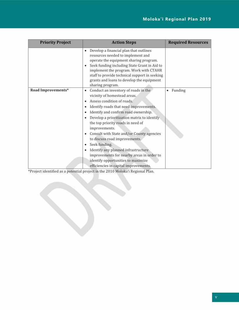
Shared Farm Equipment for
Agricultural Lessees*
• Work with existing lessees and homestead associations to determine level of interest
for specific tools and equipment, and to
prioritize needs.
• Conduct an inventory of existing potential
equipment available for equipment sharing
program.
• Design an equipment sharing program that
is applicable to the needs of homesteads.
• Funding
Moloka ‘ i Regional Plan 2019
v
Priority Project Action Steps Required Resources
• Develop a financial plan that outlines
resources needed to implement and
operate the equipment sharing program.
• Seek funding including State Grant in Aid to implement the program. Work with CTAHR
staff to provide technical support in seeking
grants and loans to develop the equipment
sharing program.
Road Improvements* • Conduct an inventory of roads in the
vicinity of homestead areas.
• Assess condition of roads.
• Identify roads that need improvements.
• Identify and confirm road ownership.
• Develop a prioritization matrix to identify
the top priority roads in need of
improvements.
• Consult with State and/or County agencies
to discuss road improvements.
• Seek funding.
• Identify any planned infrastructure
improvements for nearby areas in order to
identify opportunities to maximize
efficiencies in capital improvements.
• Funding
*Project identified as a potential project in the 2010 Molokaʻi Regional Plan.

vi
[This page left blank intentionally]

Moloka ‘ i Regional Plan 2019
vii
Table of Contents
Executive Summary .................................................................................................................................................................. i
1 Introduction ..................................................................................................................................................................... 1
Purpose of a Regional Plan ............................................................................................................................... 1
Planning System ................................................................................................................................................... 1
Regional Planning Process ............................................................................................................................... 2
Stakeholders and Partners ............................................................................................................................... 3
DHHL Master Planning Process and Community Development Goals ........................................... 3
2 Vision and Values ......................................................................................................................................................... 11
Values ...................................................................................................................................................................... 11
Previous Planning Efforts ............................................................................................................................... 12
Methods & Approach ........................................................................................................................................ 12
3 Planning Area ................................................................................................................................................................ 15
Location .................................................................................................................................................................. 15
Regional History ................................................................................................................................................. 20
4 Existing Land Uses....................................................................................................................................................... 21
Homestead Uses .................................................................................................................................................. 21
General Agriculture ........................................................................................................................................... 21
Special District ..................................................................................................................................................... 21
Community Uses ................................................................................................................................................. 22
Conservation ........................................................................................................................................................ 22
Commercial and Industrial ............................................................................................................................. 22
State and County Land Use Designations ................................................................................................. 22
4.7.1 State Land Use Districts ......................................................................................................................... 22
4.7.2 County Land Use Designations............................................................................................................ 25
Surrounding Land Ownership and Uses ................................................................................................... 26
Climate Change and Disaster Preparedness ........................................................................................... 28
5 Infrastructure ................................................................................................................................................................ 31
Water System ....................................................................................................................................................... 31
5.1.1 DHHL Ho‘olehua Water System .......................................................................................................... 31
5.1.2 Maui County DWS ..................................................................................................................................... 33
5.1.3 Molokai Irrigation System..................................................................................................................... 33
Wastewater ........................................................................................................................................................... 34
Roads ....................................................................................................................................................................... 35
Planned and Proposed Infrastructure Facilities.................................................................................... 37
6 Priority Projects ........................................................................................................................................................... 39
Priority Project #1 - ‘Ualapu‘e Kuleana Homestead Project and Cultural Resources
Management Plan .................................................................................................................................................. 40
Priority Project #2 - Hoʻolehua Hale Improvements ............................................................................... 44

viii
Priority Project #3 - Water Rate Assessment and Legal Analysis of Beneficiary Rights
regarding Potable Water Rate Disparities ............................................................................................... 46
Priority Project #4 - Shared Farm Equipment for Agricultural Lessees ..................................... 50
Priority Project #5 - Road Improvements ............................................................................................... 52
Appendices
Appendix A Vision Statement from the County’s Moloka‘i Island Community Plan
Appendix B List of Projects Completed, Funded, or In Progress
Appendix C Summary of Priority Project Selection
Appendix D Hawai‘i Administrative Rules on Kuleana Homesteads
Appendix E Additional Information provided by the Ahonui Homestead Association
Appendix F Beneficiary Comments relating to Priority Project #3
Appendix G Comments received on the Draft Plan
Figures
Figure 1: DHHL's Planning System ................................................................................................................................... 1
Figure 2: The Regional Plan Development and Update Process .......................................................................... 3
Figure 3: Community Organization & Development ................................................................................................. 7
Figure 4: Master Planning and Land Development Process on Hawaiian Home Lands ............................ 9
Figure 5. Planning Area ....................................................................................................................................................... 16
Figure 6. Moloka‘i Island Plan Land Use Designations .......................................................................................... 18
Figure 7. Moloka‘i Island Plan Land Use Designations (continued) ................................................................. 19
Figure 8: State Land Use Districts ................................................................................................................................... 24
Figure 9: County Land Use Map (Central Area) from the Molokaʻi Island Community Plan .................. 25
Figure 10: County Land Use Map (East) from the Molokaʻi Island Community Plan ................................ 26
Figure 11. Surrounding Large Landowners ................................................................................................................ 27
Figure 12. Sea Level Rise Exposure Area ..................................................................................................................... 29
Figure 13. Flood Hazard Areas ......................................................................................................................................... 30
Figure 14. DHHL Water Infrastructure ......................................................................................................................... 32
Figure 15. Moloka‘i Irrigation System ........................................................................................................................... 34
Figure 16. Wastewater Infrastructure .......................................................................................................................... 36

Moloka ‘ i Regional Plan 2019
1
Tier 1
Tier 2
Tier 3
1 Introduction
Purpose of a Regional Plan
The mission of the Department of Hawaiian Home Lands (DHHL) is to build vibrant homestead
communities. Towards this end, DHHL works in partnerships with government agencies, private
landowners, non-profit organizations, homestead associations, and other community groups.
Regional plans provide the means to work closely with existing lessees and native Hawaiian
beneficiaries to clarify visions and build partnerships.
This regional plan is one of 22 regional plans that DHHL is updating statewide. These regional plans
assess land use development factors, identify issues and opportunities, and identify the region’s top
priority projects slated for implementation within the next five years.
Planning System
Regional Plans are part of DHHL’s three-tiered Planning System. At tier one is the General Plan which
articulates long-range goals and objectives for the Department. At the second tier, there are Program
Plans that are statewide in focus, covering specific topic areas such as the Native Hawaiian Housing
Plan and a Native Hawaiian Development Program Plan. Also, at this second tier are the Department’s
Island Plans that identify the Department’s land use designations per island which function similar
to the counties’ land use zones. The Regional Plans are located at the third tier in the Department’s
Planning System which focuses at the community/regional level.
General Plan Statewide, 20-year
timeframe
Strategic Program
Plans Statewide, 3-6 year
Island Plans Regional, 20-year
timeframe
Regional Plans 1-3 year timeframe
Development
Plans 10 year timeframe
Figure 1: DHHL's Planning System
1 Introduction
2
The role of the Regional Plans within the planning system includes:
• Apply the goals, policies, and land use designations of the General Plan, program plans, and
applicable island plan to specific geographic regions;
• Directly involve the community in planning their region;
• Compile comprehensive information about the region to provide a factual basis to identify
needs and opportunities;
• Evaluate changes needed, if any, to the Island Plan as it applies to the region;
• Identify potential resources (e.g., partners, funding sources) to facilitate implementation;
• Identify priority projects that are important to the community and implementation steps to
move these projects forward.
Regional Planning Process
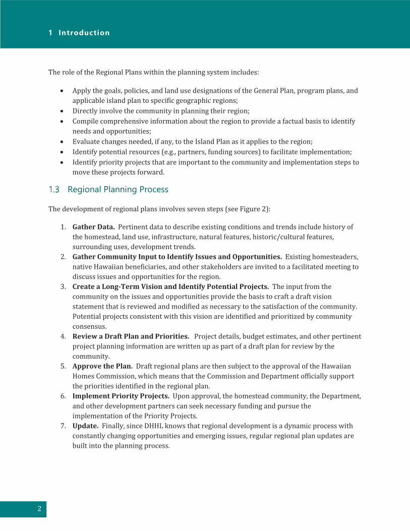
The development of regional plans involves seven steps (see Figure 2):
1. Gather Data. Pertinent data to describe existing conditions and trends include history of
the homestead, land use, infrastructure, natural features, historic/cultural features,
surrounding uses, development trends.
2. Gather Community Input to Identify Issues and Opportunities. Existing homesteaders,
native Hawaiian beneficiaries, and other stakeholders are invited to a facilitated meeting to
discuss issues and opportunities for the region.
3. Create a Long-Term Vision and Identify Potential Projects. The input from the
community on the issues and opportunities provide the basis to craft a draft vision
statement that is reviewed and modified as necessary to the satisfaction of the community.
Potential projects consistent with this vision are identified and prioritized by community
consensus.
4. Review a Draft Plan and Priorities. Project details, budget estimates, and other pertinent
project planning information are written up as part of a draft plan for review by the
community.
5. Approve the Plan. Draft regional plans are then subject to the approval of the Hawaiian
Homes Commission, which means that the Commission and Department officially support
the priorities identified in the regional plan.
6. Implement Priority Projects. Upon approval, the homestead community, the Department,
and other development partners can seek necessary funding and pursue the
implementation of the Priority Projects.
7. Update. Finally, since DHHL knows that regional development is a dynamic process with
constantly changing opportunities and emerging issues, regular regional plan updates are
built into the planning process.

Moloka ‘ i Regional Plan 2019
3
Stakeholders and Partners
DHHL is working in partnership with other government agencies, the private sector and community
organizations to develop its lands and improve community life. DHHL believes that partnerships are
an effective way to leverage resources and capital investments, mitigate undesirable impacts of
development, coordinate area growth, reduce risks in large scale community projects, and create
broad community benefits.
These partnerships allow for better prioritization and coordination of infrastructure improvements
and the development of regional and public residential facilities. This coordination helps individual
organizations achieve their goals while bringing long-term benefits to the community and region.
DHHL Master Planning Process and Community Development Goals
Often times homestead associations are interested in developing capital improvement projects
within their communities in order to provide needed social services and enrichment opportunities
for their community. The need for these desired projects is often captured in DHHL Regional Plans.
While the characteristics of projects proposed in each region are as diverse and unique as the DHHL
communities in each region across the state, the overall planning and development process for these
projects in most instances is the same.
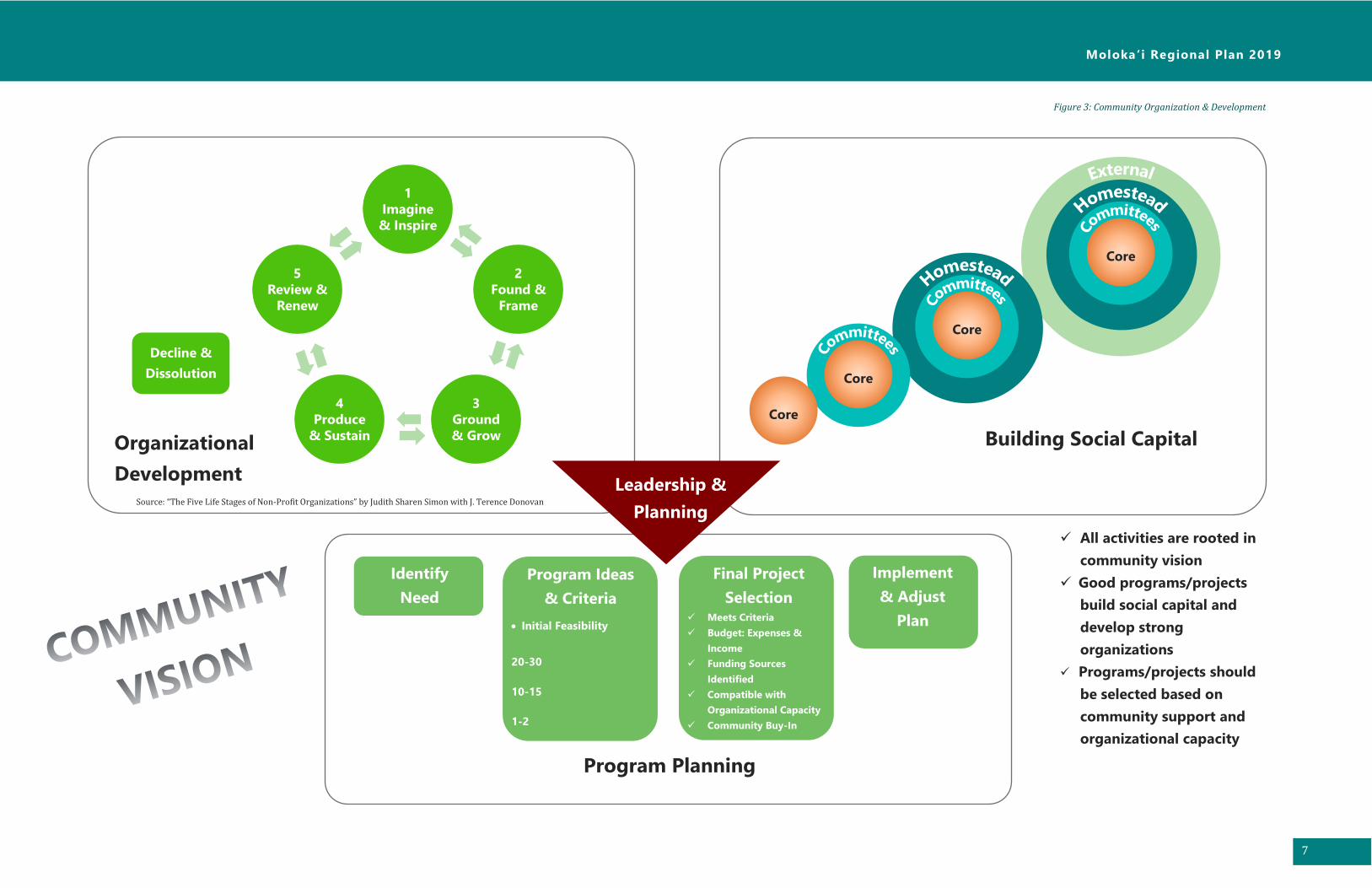
Successfully implementing any type of land development project requires several basic foundational
elements prior to beginning. This includes a strong organization that works well together and has
high levels of participation in regular association business, ensuring that projects are selected based
upon agreed criteria rather than individual preferences, creating a project plan and building large
amounts of social capital within and outside of the community. Figure 3 briefly describes these
Gather Data Community
Input
Vision &
Potential
Projects
Draft Plan &
Priorities
Plan Approval Implement
Projects Update
Figure 2: The Regional Plan Development and Update Process

1 Introduction
4
elements of organizational capacity and project planning in more detail. The top level represents the
steps that the homestead association (project proponent) should complete.
Most organizations go through five main stages of an organization's developmental lifecycle (from
“The Five Life Stages of Non-Profit Organizations” by Judith Sharen Simon with J. Terence Donovan):
1. Stage One: Imagine and Inspire. The organization is not yet formalized, but individuals
are inspired and united by a common vision or idea.
2. Stage Two: Found and Frame. The organization becomes formalized. Governing
documents have been drafted and adopted by its members. The organization receives its
non-profit status.
3. Stage Three: Ground and Grow. Organizations in this stage focus on establishing systems
of accountability to its members as well as growing its internal capacity to provide more
services or a higher quality of service to its members.
4. Stage Four: Produce and Sustain. This is the stage in which the organization is at its peak
and is primarily concerned with how it can sustain its level of service over time.
5. Stage Five: Review and Renew. The organization re-invents itself in order to adapt to new
existing conditions. The primary question the organization is concerned with at this stage
is: "How can we do it better?" The organization revisits its mission, vision, services, and
management structure.
Social capital can be defined as the networks of relationships among people who live and work in a
particular society, enabling that society to function effectively. A homestead association from time to
time should assess its social capital both internally among its members as well as among external
stakeholders and potential partners in order to determine the level of potential support and/or
opposition about a proposed land development project. Figure 3 illustrates the various social circles
that should be supportive of a land development project. Often times, a development idea starts with
a core group of individuals on an association board and gradually that idea should be shared with
and incorporate the ideas of others in larger social circles of people in order to grow social capital
and build support for a development project.
Lastly, Figure 3 illustrates that the association's assessment of its life cycle and existing social capital
should be incorporated into a program plan. A program plan clearly articulates a community vision
or need, identifies criteria for selecting programs or projects to fulfill that vision or need, and selects
appropriate projects and programs based on that criteria. Programs/projects should be selected
based on strong community support for the initiatives and the association's organizational capacity.
Once an association has outreached with its community to identify its vision and goals, established
criteria for selecting projects that help them accomplish their vision and goals, and selected
project(s) that have strong community support, then the association can begin with the actual
physical master planning and development of the project(s). Figure 4 illustrates the process of master
planning and land development on Hawaiian Home Lands. This applies to projects that are land-
based and for construction.

Moloka ‘ i Regional Plan 2019
5
The top level represents the steps that the homestead association (project proponent) should
complete.
• The project proponent should focus their time and attention to ensure that the community’s
vision and needs are integrated into the project.
• The project proponent should conduct a site and infrastructure assessment of the location
in which they would like to implement the project in order to ensure that the location is
appropriate for what they would like to do.
• A master plan should integrate and synthesize the community's vision and needs with the
site and infrastructure assessment. A master plan should also include a financial plan that
forecasts initial development costs, long-term operational costs, and how those costs will be
financed over time.
• An Environmental Assessment (EA) or Environmental Impact Statement (EIS) needs to be
prepared in accordance with Hawaiʻi Revised Statutes (HRS) Chapter 343 on the Master
Plan. If federal funds are used for the project, then a federal EA or EIS may need to be
completed in accordance with the rules and standards of the federal funding agency.
• Once Chapter 343 and federal environmental regulations are complied with, then the
project proponent can proceed with obtaining the necessary permits, approvals, and
proceed with construction.
The next two levels below the top level, include various DHHL staff reviews and HHC approvals the
Project Proponent will need at each step.

1 Introduction
6
[This page left blank intentionally]
Moloka ‘ i Regional Plan 2019
7
Program Planning
✓ All activities are rooted in
community vision
✓ Good programs/projects
build social capital and
develop strong
organizations
✓ Programs/projects should
be selected based on
community support and
organizational capacity
Core
Core
Core
1
Imagine
& Inspire
2
Found &
Frame
3
Ground
& Grow
4
Produce
& Sustain
5
Review &
Renew
Figure 3: Community Organization & Development
Decline &
Dissolution
Organizational
Development
Core
Building Social Capital
Leadership &
Planning
Identify
Need
Program Ideas
& Criteria
• Initial Feasibility
20-30
10-15
1-2
Final Project
Selection ✓ Meets Criteria
✓ Budget: Expenses &
Income
✓ Funding Sources
Identified
✓ Compatible with
Organizational Capacity
✓ Community Buy-In
Implement
& Adjust
Plan
Source: “The Five Life Stages of Non-Profit Organizations” by Judith Sharen Simon with J. Terence Donovan

[This page left blank intentionally]

Moloka ‘ i Regional Plan 2019
9
RESEARCH, PLANNING & ANALYSIS SYNTHESIS IMPLEMENTATION
DHHL
Planning
Process
Vision and
Need
PEOPLE
Site
Assessment
LAND
Infrastructure
Needs
Project
Master Plan
PEOPLE &
LAND
Environmental
Assessment
Chapter 343,
HRS EA or EIS
Permitting &
Other
Entitlements
Site
Preparation
&
Construction
Operations &
Maintenance
1. Community Site
2. Land Use Designation
3. Regional Plan Priority Project
Project
Proposal and
Request for
Temporary
Right of Entry
Regional Plan
Approved
Right of Entry
Approved
Project Master
Plan and Land
Use Request for
Land
Disposition
EA/EIS
Published
Conditional
Land
Disposition
Approved
Pending EA/EIS
FONSI Approved
or EIS Accepted
Terms of Land
Disposition
Approved
DHHL
Review
HHC
Approval
Figure 4: Master Planning and Land Development Process on Hawaiian Home Lands

[This page left blank intentionally]

Moloka ‘ i Regional Plan 2019
11
2 Vision and Values
“Moloka‘i beneficiaries are thriving on the land where the way of life and sense of
community continue to hold strong. Acknowledging the diversity of each homestead
on Moloka‘i, we envision a unified community grounded in Hawaiian values and
cultural traditions passed to us from our kūpuna. Core values are preserved while
embracing modern pathways to a sustainable future.”
This vision statement captures a desired end-state for the beneficiaries on Moloka‘i. It articulates
beneficiaries’ vision of a successful homestead community. This vision provides a unified direction
for homestead, Departmental and Commission actions on Moloka‘i and provides important context
for the Regional Plan Priority Projects that follow.
In addition to the vision statement above, the vision statement from the County’s Moloka‘i Island
Community Plan also articulates beneficiaries’ belief in who and what it is that the community would
like to become. A copy of this vision statement is included in Appendix A.
Values
The vision statement was developed based on the following values:
• Our Cultural Traditions Give Us Knowledge and Strength- The legacy of our ancestors is
honored through our daily practices in order to help us connect with our rights and kuleana.
Standing tall on a solid foundation of Hawaiian values and cultural traditions for future
generations, we know who we are, we excel in what we do, and we can see far.
• Water Flow Invigorates Waiwai- Water is essential to life, and for us to thrive on our ʻāina.
Water enables us to grow food, provide sustenance for our families, and ensure self-
sufficiency. Access to an efficient and reliable water system is critical to preserving our
lifestyle.
• Sense of Community and Lifestyle- There is a genuine sense of aloha and strong sense of
‘ohana on our island. Everyone looks after one another and cares for each other. The rural
way of life remains an integral part of our community.
• We Practice and Teach Aloha ʻĀina and Mālama ʻĀina- It is our kuleana to care for our
ʻāina and kai because they nourish our families, both physically and spiritually. We take pride

2 Vision and Values
12
in stewardship of our subsistence resources to provide for current and future generations, a
kuleana passed to us from our kūpuna.
Previous Planning Efforts
DHHL first developed a regional plan for Moloka‘i in 2007 and then updated it in 2010. The 2010
Moloka‘i Regional Plan included a list of 32 potential projects, with five of those selected as priority.
The status of the top five priority projects from the 2010 Moloka‘i Regional Plan are summarized
below:
Project Description Status
Alternative Energy Initiative A photovoltaic project for the DHHL Ho‘olehua drinking
water system and Kūlana ʻŌiwi office complex are
planned. A photovoltaic system for Lanikeha Center is
under construction. Some beneficiaries are pursuing the
idea of an electric cooperative or decoupled micro-grid
for energy independence.
Conduct Beneficiary Consultation on
Large Scale Renewable Energy
Development
Beneficiary Consultation completed. Land Use
Designation changed to “Special District.” Next step is for
DHHL to contract a consultant to prepare the Special Area
Management Plan for Moʻomomi.
Conduct Water Pressure Testing in
Kalama‘ula
Completed.
Modify Septic Tank at Kiowea Park Completed.
Support Moloka‘i Sustainment
Farming Project, Ho‘olehua
Homestead Agriculture Association
and Kukui Helepō
Homesteaders are growing Kukui, but the biodiesel part
needs more work and coordination with DHHL.
Appendix B provides a comprehensive list of projects and work that have been completed, funded,
or in progress.
Methods & Approach
The approach for this planning process included broad publicity for community meetings through
mail-outs of meeting notices and e-mails to the leadership of the homestead associations, postings
on community bulletin boards, sharing of ideas through a series of meetings with beneficiaries,
working with community members to develop priority project descriptions and providing adequate
time to develop and review the draft plan recommendations.
Moloka ‘ i Regional Plan 2019
13
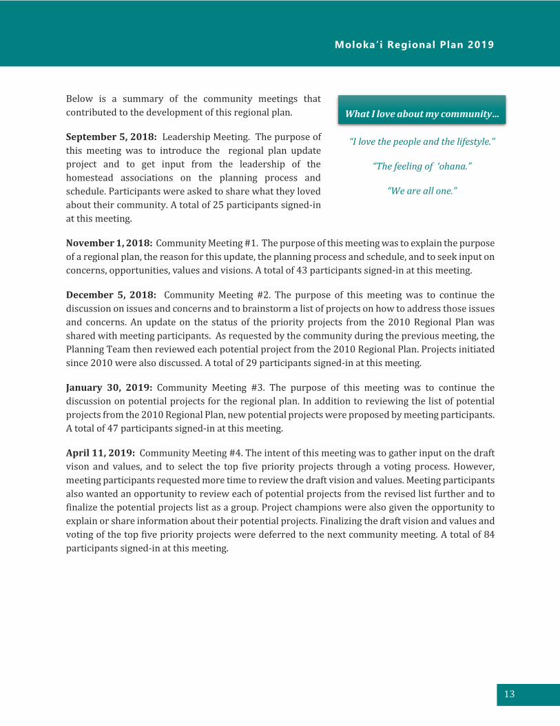
Below is a summary of the community meetings that
contributed to the development of this regional plan.
September 5, 2018: Leadership Meeting. The purpose of
this meeting was to introduce the regional plan update
project and to get input from the leadership of the
homestead associations on the planning process and
schedule. Participants were asked to share what they loved
about their community. A total of 25 participants signed-in
at this meeting.
November 1, 2018: Community Meeting #1. The purpose of this meeting was to explain the purpose
of a regional plan, the reason for this update, the planning process and schedule, and to seek input on
concerns, opportunities, values and visions. A total of 43 participants signed-in at this meeting.
December 5, 2018: Community Meeting #2. The purpose of this meeting was to continue the
discussion on issues and concerns and to brainstorm a list of projects on how to address those issues
and concerns. An update on the status of the priority projects from the 2010 Regional Plan was
shared with meeting participants. As requested by the community during the previous meeting, the
Planning Team then reviewed each potential project from the 2010 Regional Plan. Projects initiated
since 2010 were also discussed. A total of 29 participants signed-in at this meeting.
January 30, 2019: Community Meeting #3. The purpose of this meeting was to continue the
discussion on potential projects for the regional plan. In addition to reviewing the list of potential
projects from the 2010 Regional Plan, new potential projects were proposed by meeting participants.
A total of 47 participants signed-in at this meeting.
April 11, 2019: Community Meeting #4. The intent of this meeting was to gather input on the draft
vison and values, and to select the top five priority projects through a voting process. However,
meeting participants requested more time to review the draft vision and values. Meeting participants
also wanted an opportunity to review each of potential projects from the revised list further and to
finalize the potential projects list as a group. Project champions were also given the opportunity to
explain or share information about their potential projects. Finalizing the draft vision and values and
voting of the top five priority projects were deferred to the next community meeting. A total of 84
participants signed-in at this meeting.
What I love about my community…
“I love the people and the lifestyle.”
“The feeling of ‘ohana.”
“We are all one.”

2 Vision and Values
14
June 26, 2019: Community Meeting
#5. The purpose of this meeting was to
gather input on the draft vision and
values, and to select the top five priority
projects through a voting process.
Participants were given five sticker dots
and asked to select their top priorities
from a total of 24 potential projects.
Small groups were then formed to work
with the Planning Team over the next
several months to further refine the
priority projects. A total of 70
participants signed-in at this meeting.
October 24, 2019: Community
Meeting #6. The purpose of this
meeting was to review the draft
regional plan, including priority project
descriptions developed with
community working group members. A
total of 41 participants signed-in at this
meeting.
Meeting attendees participate in the voting process to select the
top five priority projects for the regional plan.

Moloka ‘ i Regional Plan 2019
15
3 Planning Area
Location
DHHL lands on Moloka‘i comprise of approximately 25,900 acres and make up approximately 15
percent of the land area on Moloka‘i (Figure 5). These DHHL lands are situated in five geographic
areas that include:
• Kalama‘ula - Kalama‘ula, located west of Kaunakakai, makes up 20 percent of the DHHL
lands on Moloka‘i. This parcel is mauka of Kamehameha V Highway, gently sloping upland to
Pu‘u Luahine (372 feet elevation) transected with the declining slopes of Kuhuaawi Gulch and
Kaluaohe Gulch. The elevation ranges from sea level to 1,800 feet above sea level. Kalama‘ula
consists of multiple uses with a residential community in the lowlands and coastal regions,
wetlands to the southwestern corridor, pastoral use, Kapuāiwa Grove, Church Row, and
Kūlana ‘Ōiwi. The first DHHL homestead in the State of Hawai‘i was established in Kalama‘ula
on the island of Moloka‘i.
• Ho‘olehua-Pālā‘au - Ho‘olehua-Pālā‘au, within the northern central plateau and southern
coastal corridor of Moloka‘i, respectively, make up 53 percent of the DHHL lands on Moloka‘i
Ho‘olehua is a rural agricultural community fronted by Maunaloa Highway. The lands of
Ho‘olehua vary in topography, ranging from level plains to rolling hills and sea cliffs at the
northern coastal boundary. Kāluape‘elua and Mane‘opapa Gulches bisect the eastern section
of Ho‘olehua, and Anahaki Gulch bisects the northwest.
• Kapa‘akea, Kamiloloa, and Makakupa‘ia - Kapa‘akea, Kamiloloa, and Makakupa‘ia make up
20 percent of the DHHL lands on Moloka‘i. These DHHL lands are located along the southern
section of Moloka‘i, approximately one mile east of Kaunakakai town. Most of these DHHL
lands are situated mauka of Kamehameha V Highway, highlighted by variable slope and major
drainage channels that help form the wetlands near the shoreline. The elevation ranges from
sea level to its mauka boundary at 2,000 feet above sea level. Kapa‘akea is a coastal
community.
• Kalaupapa and Pālā‘au – Kalaupapa and Pālā‘au, located on the northern plateau and
peninsula of the island, make up approximately 6 percent of the DHHL lands on Moloka‘i. The
area of Pālā‘au is mostly ironwood forest under license to the State Parks Division until 2032.
Kalaupapa peninsula is separated from the rest of the island by a 1,600-foot cliff.
Approximately 1,247 acres of land in Kalaupapa is under license to the National Park Service
until 2041.
• ‘Ualapu‘e - ‘Ualapu‘e, located on the eastern end of the island, make up less than two percent
of the DHHL lands on Moloka‘i. The parcel is mauka of Kamehameha V Highway and is
highlighted by its sloped terrain from its mountainous regions interspersed by deep ravines
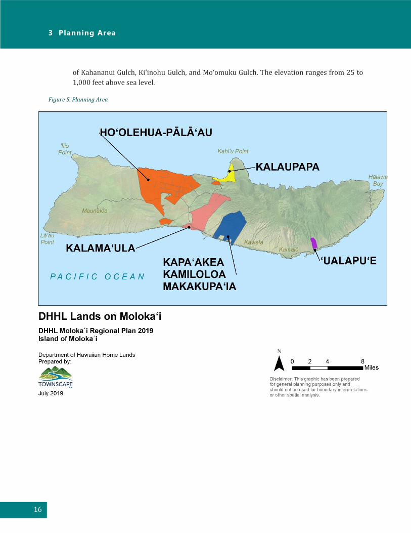
3 Planning Area
16
of Kahananui Gulch, Ki‘inohu Gulch, and Mo‘omuku Gulch. The elevation ranges from 25 to
1,000 feet above sea level.
Figure 5. Planning Area
Moloka ‘ i Regional Plan 2019
17
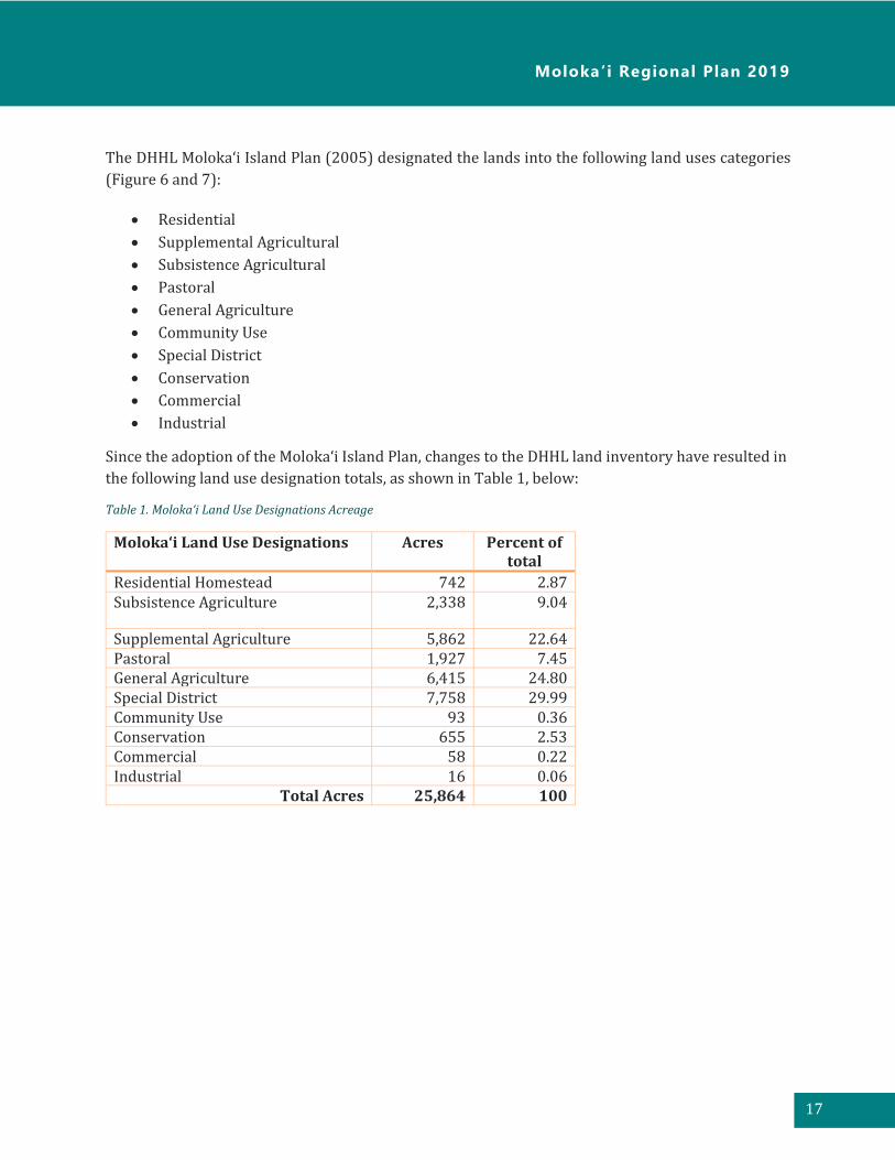
The DHHL Moloka‘i Island Plan (2005) designated the lands into the following land uses categories
(Figure 6 and 7):
• Residential
• Supplemental Agricultural
• Subsistence Agricultural
• Pastoral
• General Agriculture
• Community Use
• Special District
• Conservation
• Commercial
• Industrial
Since the adoption of the Moloka‘i Island Plan, changes to the DHHL land inventory have resulted in
the following land use designation totals, as shown in Table 1, below:
Table 1. Moloka‘i Land Use Designations Acreage
Moloka‘i Land Use Designations Acres Percent of total
Residential Homestead 742 2.87 Subsistence Agriculture 2,338 9.04
Supplemental Agriculture 5,862 22.64 Pastoral 1,927 7.45 General Agriculture 6,415 24.80 Special District 7,758 29.99 Community Use 93 0.36 Conservation 655 2.53 Commercial 58 0.22 Industrial 16 0.06
Total Acres 25,864 100

3 Planning Area
18
Figure 6. Moloka‘i Island Plan Land Use Designations

Moloka ‘ i Regional Plan 2019
19
Figure 7. Moloka‘i Island Plan Land Use Designations (continued)

3 Planning Area
20
Regional History
The Island of Moloka‘i has long been known as a place where time’s effects are a little less evident,
where the pace is a little slower, and where an abundance of aloha can be found in the faces of the
residents of the “Friendly Isle.” The fifth-largest island in the archipelago, Moloka‘i seems to have
avoided the impacts of modernization and foreign influences creating an untouched atmosphere
highly reminiscent of the “Old Hawai‘i” of decades ago. It is also traditionally held as the birthplace
of hula, the quintessence of Hawaiian Culture.
Predominantly an aqua- and agricultural-based economy, many of the industries continue in the
same vein as established by the early kānaka maoli (original people, or Native Hawaiians). The use
of fishponds, traditional Hawaiian aquaculture began on the shores of Moloka‘i and spread to the
other islands where chiefs requested assistance in developing their own “fish farms.” Many fishponds
can still be seen along the southern coast of the island, and some fishponds are still in use today.
Ancient sacred sites are plentiful on the island, including Ka-ule-o-Nānāhoa where Hawaiians
believed in its powers of fertility.
Prior to western contact, as well as immediately after, Moloka‘i remained relatively free from
European foreign disease due to its continued legacy of relative isolation. The island’s remoteness
prompted Kamehameha V to banish those with leprosy, otherwise known as Hansen’s disease, to the
remote Kalaupapa peninsula in an effort to contain the spread of the disease. The banishment of
individuals to Kalaupapa split family units apart, with many never having the opportunity to see their
kin again.
The mission of Blessed Father Damien to the sick of Kalaupapa is renowned, such that Pope John Paul
II beatified him in 1995. Father Damien was not the first missionary to go to the remote settlement.
However, he was the first to stay. In addition to building 300 homes, tending the sick, and burying
the dead, Damien brought hope to the residents of the Kalaupapa settlement. Father Damien
eventually contracted Hansen’s disease and succumbed to the same disease inflicting those to whom
he ministered. On October 11, 2009, Father Damien was canonized and is considered the patron Saint
of Hansen’s disease, HIV, Aids and outcasts. Father Damien Day is celebrated statewide on April 15th.
In 1921, the United States Congress passed the Hawaiian Homes Commission Act, which set aside
43,000 acres of land for those with at least 50 percent Hawaiian blood. This Act was the direct result
of efforts made by Prince Kūhiō Kalaniana‘ole who had been concerned with the rapid decline of the
Hawaiian population throughout the islands. One year later, the first Hawaiian homesteader moved
into the Kalaniana‘ole settlement on Moloka‘i. By 1924, the flourishing fields of the settlement had
been dubbed the “Moloka‘i Miracle.” The Hawaiian Homestead Project represented the climax in a
long controversy of the fate of the Hawaiians. It served as irrefutable evidence that the Hawaiian’s
link to the land is both indivisible and essential.

Moloka ‘ i Regional Plan 2019
21
4 Existing Land Uses
Homestead Uses
Homesteads on Moloka‘i include residential, subsistence agriculture, supplemental agriculture, and pastoral. As of November 2018, DHHL had 841 active leases on Moloka‘i: 394 residential, 420 agricultural, and 27 pastoral.
• Residential Homesteads. Residential homesteads make up 742 acres of DHHL lands on
Moloka‘i. Existing residential homesteads are located in Kalama‘ula, Kapa‘akea, Kamiloloa,
and Makakupa‘ia. Lands in ‘Ualapu‘e are planned for residential homesteads. A small area in
Ho‘olehua-Pālā‘au is also designated for residential use.
• Subsistence Agriculture Homesteads. Subsistence agriculture homesteads make up 2,338
acres of DHHL lands on Moloka‘i. Lands designated for subsistence agriculture are located in
either Ho‘olehua-Pālā‘au or Kalama‘ula, with the majority in Ho‘olehua-Pālā‘au.
• Supplemental Agriculture Homesteads. Supplemental agriculture homesteads make up
5,826 acres of the DHHL lands on Moloka‘i. Lands designated for supplemental agriculture
are located in Ho‘olehua-Pālā‘au.
• Pastoral Homesteads. Pastoral homesteads make up 1,927 acres of the DHHL lands on
Moloka‘i. Lands designated for pastoral use are located in Ho‘olehua-Pālā‘au, Kalama‘ula,
Kapa‘akea, Kamiloloa, and Makakupa‘ia.
• Waitlist. The wait list for a homestead on the island of Moloka‘i includes a total of 2,099
applicants: 822 residential, 1,075 agricultural, and 202 pastoral.
General Agriculture
General agriculture lands total 6,415 acres in Ho‘olehua-Pālā‘au, Kalamaula, Kapa‘akea, Kamiloloa,
and Makakupa‘ia, and ‘Ualapu‘e.
Special District
Lands designated as Special District consist of 7,758 acres and are located in ‘Ualapu‘e, Kapa‘akea,
Kamiloloa, and Makakupa‘ia, Kalaupapa, Kalama‘ula, and Ho‘olehua-Pālā‘au. In 2010, 1,000 acres of
General Agriculture and 50 acres of Community Use lands in Mo‘omomi-Anahaki were re-designated
as Special District following beneficiary consultation. In 2011, a total of 4.6 acres at Malama Park
were transferred by the Board of Land and Natural Resources to DHHL, and was later designated as
Special District after consultation with beneficiaries.
4 Existing Land Uses
22
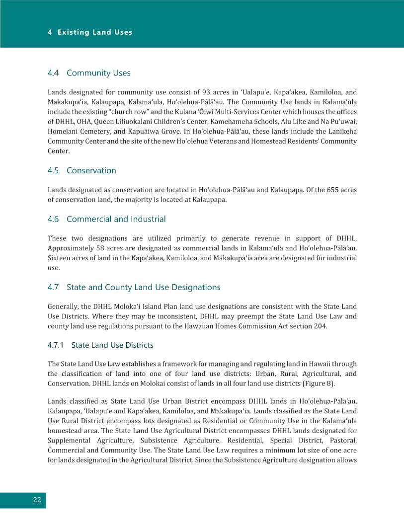
Community Uses
Lands designated for community use consist of 93 acres in ‘Ualapu‘e, Kapa‘akea, Kamiloloa, and
Makakupa‘ia, Kalaupapa, Kalama‘ula, Ho‘olehua-Pālā‘au. The Community Use lands in Kalama‘ula
include the existing “church row” and the Kulana ̒ Ōiwi Multi-Services Center which houses the offices
of DHHL, OHA, Queen Liliuokalani Children’s Center, Kamehameha Schools, Alu Like and Na Puʻuwai,
Homelani Cemetery, and Kapuāiwa Grove. In Ho‘olehua-Pālā‘au, these lands include the Lanikeha
Community Center and the site of the new Hoʻolehua Veterans and Homestead Residents’ Community
Center.
Conservation
Lands designated as conservation are located in Ho‘olehua-Pālā‘au and Kalaupapa. Of the 655 acres
of conservation land, the majority is located at Kalaupapa.
Commercial and Industrial
These two designations are utilized primarily to generate revenue in support of DHHL.
Approximately 58 acres are designated as commercial lands in Kalama‘ula and Ho‘olehua-Pālā‘au.
Sixteen acres of land in the Kapa‘akea, Kamiloloa, and Makakupa‘ia area are designated for industrial
use.
State and County Land Use Designations
Generally, the DHHL Moloka‘i Island Plan land use designations are consistent with the State Land
Use Districts. Where they may be inconsistent, DHHL may preempt the State Land Use Law and
county land use regulations pursuant to the Hawaiian Homes Commission Act section 204.
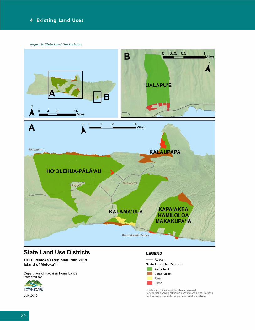
4.7.1 State Land Use Districts
The State Land Use Law establishes a framework for managing and regulating land in Hawaii through
the classification of land into one of four land use districts: Urban, Rural, Agricultural, and
Conservation. DHHL lands on Molokai consist of lands in all four land use districts (Figure 8).
Lands classified as State Land Use Urban District encompass DHHL lands in Ho‘olehua-Pālā‘au,
Kalaupapa, ‘Ualapu‘e and Kapa‘akea, Kamiloloa, and Makakupa‘ia. Lands classified as the State Land
Use Rural District encompass lots designated as Residential or Community Use in the Kalama‘ula
homestead area. The State Land Use Agricultural District encompasses DHHL lands designated for
Supplemental Agriculture, Subsistence Agriculture, Residential, Special District, Pastoral,
Commercial and Community Use. The State Land Use Law requires a minimum lot size of one acre
for lands designated in the Agricultural District. Since the Subsistence Agriculture designation allows

Moloka ‘ i Regional Plan 2019
23
a minimum lot size of one-half acre, DHHL’s preemption applies to the Subsistence Agriculture lots
within the State Land Use Agricultural District.
The State Land Use Conservation District encompasses the lands along the coastline in Ho‘olehua-
Pālā‘au, Kalama‘ula, Kalaupapa, Kapa‘akea, Kamiloloa, and Makakupa‘ia, and forested areas of
Kalama‘ula, Kalaupapa, Kapa‘akea, Kamiloloa, and Makakupa‘ia. The majority of these lands in the
State Land Use Conservation District are also designated as Conservation under the DHHL land use
designations. However, some areas are designated as Special District, Community Use, General
Agricultural, Pastoral, or Rural.
4 Existing Land Uses
24
Figure 8: State Land Use Districts
Moloka ‘ i Regional Plan 2019
25
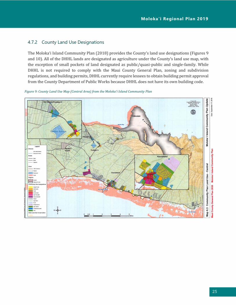
4.7.2 County Land Use Designations
The Moloka‘i Island Community Plan (2018) provides the County’s land use designations (Figures 9
and 10). All of the DHHL lands are designated as agriculture under the County’s land use map, with
the exception of small pockets of land designated as public/quasi-public and single-family. While
DHHL is not required to comply with the Maui County General Plan, zoning and subdivision
regulations, and building permits, DHHL currently require lessees to obtain building permit approval
from the County Department of Public Works because DHHL does not have its own building code.
Figure 9: County Land Use Map (Central Area) from the Molokaʻi Island Community Plan
4 Existing Land Uses
26
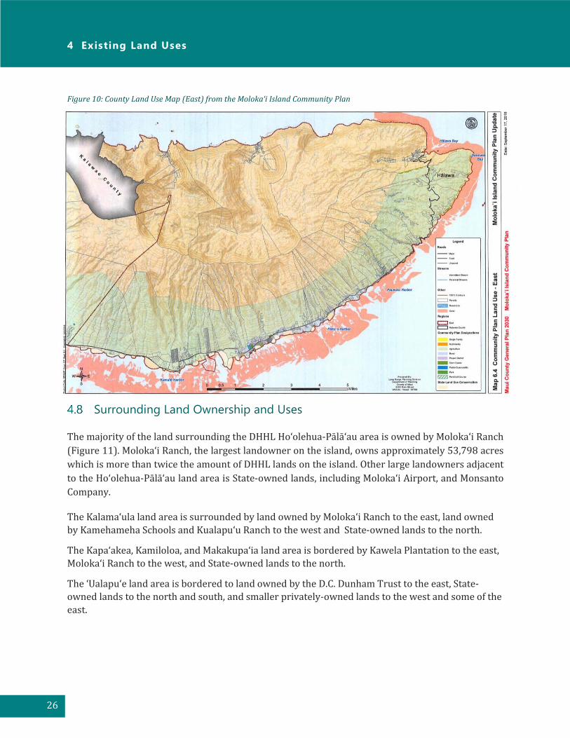
Surrounding Land Ownership and Uses
The majority of the land surrounding the DHHL Ho‘olehua-Pālā‘au area is owned by Moloka‘i Ranch
(Figure 11). Moloka‘i Ranch, the largest landowner on the island, owns approximately 53,798 acres
which is more than twice the amount of DHHL lands on the island. Other large landowners adjacent
to the Ho‘olehua-Pālā‘au land area is State-owned lands, including Moloka‘i Airport, and Monsanto
Company.
The Kalama‘ula land area is surrounded by land owned by Moloka‘i Ranch to the east, land owned
by Kamehameha Schools and Kualapu‘u Ranch to the west and State-owned lands to the north.
The Kapa‘akea, Kamiloloa, and Makakupa‘ia land area is bordered by Kawela Plantation to the east,
Moloka‘i Ranch to the west, and State-owned lands to the north.
The ‘Ualapu‘e land area is bordered to land owned by the D.C. Dunham Trust to the east, State-
owned lands to the north and south, and smaller privately-owned lands to the west and some of the
east.
Figure 10: County Land Use Map (East) from the Molokaʻi Island Community Plan

Moloka ‘ i Regional Plan 2019
27
Figure 11. Surrounding Large Landowners

4 Existing Land Uses
28
Climate Change and Disaster Preparedness
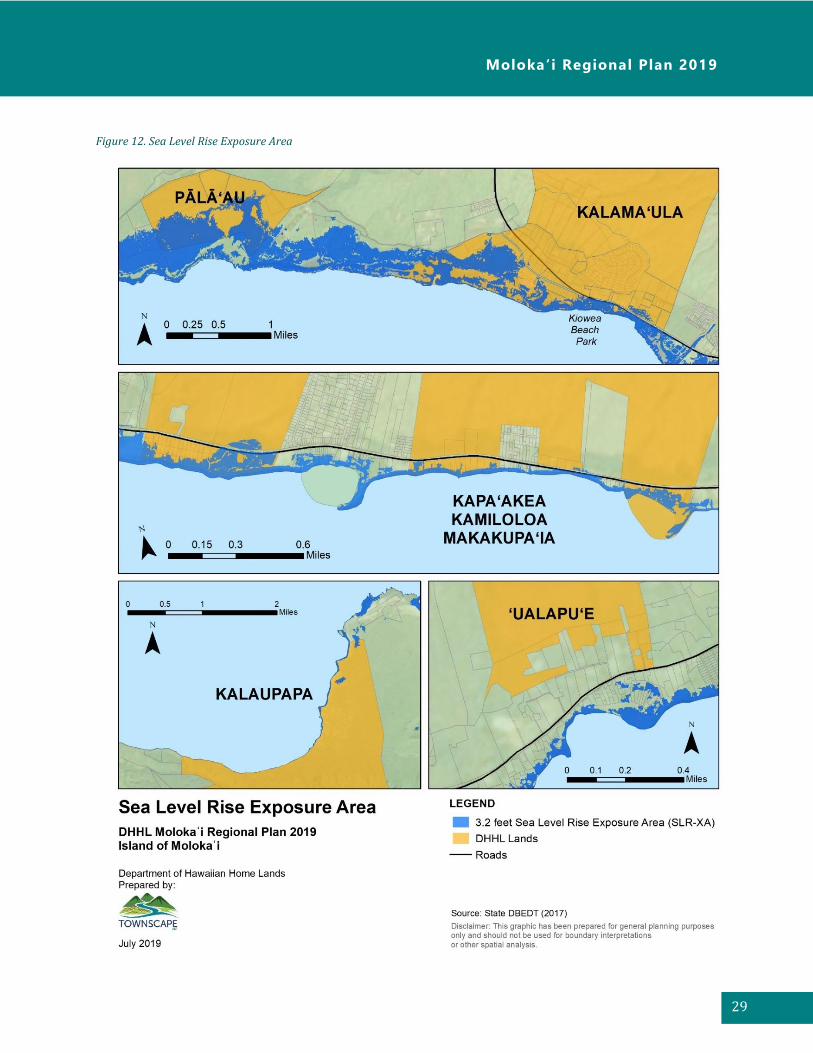
In 2018, the Hawai‘i Climate Change Mitigation and Adaptation Commission adopted the Hawai‘i Sea
Level Rise Vulnerability and Adaptation Report1, which is the first statewide assessment of Hawai‘i’s
vulnerability to sea level rise. The Report also provides general recommendations to reduce exposure
and sensitivity to sea level rise. As a priority to adaptation to sea level rise, the Climate Change
Commission passed five recommendations including urging counties to incorporate 3.2 ft of sea level
rise exposure area (SLR-XA) into their general and development plans.
With 3.2 feet of sea level rise, approximately 2,590 acres of land on Moloka‘i are estimated to be in
the SLR-XA. It would also result in approximately 780 structures and more than two miles of major
roads flooded. Potential economic losses are estimated at approximately $280 million from all
structures and land, which consists of 65 percent residential structures and land.
Figure 12 presents the 3.2 feet of SLA-XA for DHHL communities that will be impacted with sea level
rise, which includes residential homesteads at Kapa‘akea and Kamiloloa. Other DHHL lands that will
be impacted with 3.2 feet of sea level rise include Kalama‘ula, Pālā‘au and Kalaupapa. Sections of
Kamehameha V Highway (Route 450) and Maunaloa Highway (Route 460) which provide access to
homestead communities are also vulnerable to flooding with sea level rise.
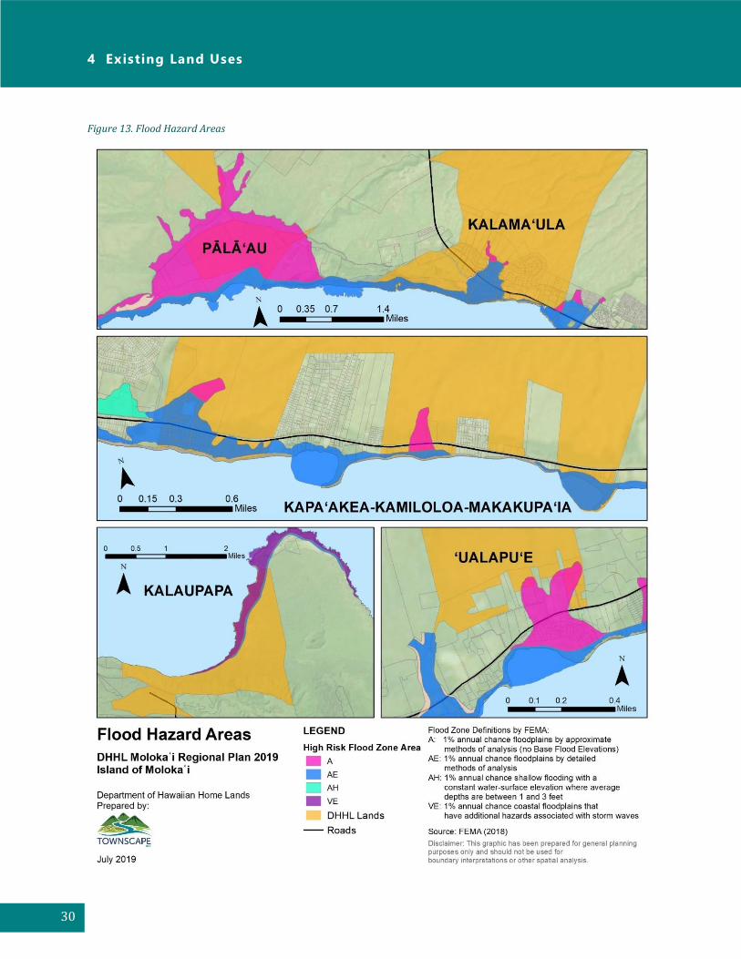
Figure 13 shows the special flood hazard areas for DHHL lands on Moloka‘i based on the Federal
Emergency Management Agency (FEMA) flood insurance rate maps. Flood zones are classified based
on varying levels of flood risk. All of the DHHL land areas with the exception of Ho‘olehua has high
risk flood areas consisting of Zones A, AE, AH or VE. These flood zones are defined by FEMA as areas
subject to flooding by the 1-percent annual chance flood event. A 1-percent annual chance flood
means that there is a one percent chance that level flood will occur in any given year. A 1-percent
annual chance flood could occur two or three years consecutively; this designation does not mean
that this level flood only occurs once in every hundred years.
A hazard and vulnerability assessment report (2015) of DHHL communities prepared by the
University of Hawai‘i at Mānoa Department of Urban and Regional Planning Practicum identified
Kapa‘akea, Kamiloloa, and Makakupaia as having the largest population potentially affected by
hazards, with a total of 72 residential leases. In addition to being in the high-risk flood zone, these
DHHL lands are in the tsunami evacuation zone and 3.2 feet sea level rise exposure area.
To increase community preparedness and resiliency to climate change and sea level rise, DHHL is
developing a coastal erosion management plan, South Molokaʻi Shoreline Erosion Management Plan,
for the coastal homestead communities of Kapaʻakea and Kamiloloa-One Aliʻi. A similar erosion
management plan for the shoreline areas along the coast in Kalamaʻula is also planned.
1 The Report adopts modeling by the Intergovernmental Plan on Climate Change Assessment Report 5 (2013) which projected sea level rise by one foot by mid-21st century and 3.2 feet by year 2100.
Moloka ‘ i Regional Plan 2019
29
Figure 12. Sea Level Rise Exposure Area
4 Existing Land Uses
30
Figure 13. Flood Hazard Areas

Moloka ‘ i Regional Plan 2019
31
5 Infrastructure
Water System
The water systems servicing DHHL lands on Moloka‘i consist of the DHHL Ho‘olehua Water System,
the Maui County Department of Water Supply Water System, and the State Moloka‘i Irrigation
System. Potable water is provided by both the DHHL and the County’s water system while non-
potable water is provided by the Moloka‘i Irrigation System.
5.1.1 DHHL Ho‘olehua Water System
The DHHL Ho‘olehua Water System, Public Water System No. 230 (PWS No. 230) is owned and
operated by the DHHL, and is more than 80 years old. It provides potable water service to the DHHL
agricultural, pastoral, and residential homesteads in Ho‘olehua and Kalama‘ula. It also provides
water service to essential community facilities including the Ho‘olehua Airport, U.S. Post Office,
schools, churches, and Lanikeha Center. According to the State Department of Health, PWS No. 230
services an area with a population of 2,400. There are approximately 600 meters and 460 fire
hydrants connected to the water system. It also serves three otherwater systems (PWS 229
Kualapu‘u, PWS 235 Kala‘e and PWS 245 Kipu). The Kualapu‘u Aquifer is the sole source for the
DHHL’s water system. DHHL’s current water allocation from the Kualapu‘u Aquifer is 0.367 million
gallons per day (MGD). DHHL has a 2.905 MGD reservation that has not yet been allocated.
The Ho‘olehua Water System consists of two ground water wells (State Well No. 0801-01 and No.
0801-02), a chlorination disinfection system, two booster pumps, five storage tanks with a total
storage capacity of 8.3 million gallons (MG), and a 19,500-gallon pressure breaker tank. The water
distribution system comprises of 50 miles of pipes ranging from 6-, 8-, and 12-inches.
Water is pumped from the two ground water wells at Kala‘e to a 100,000 gallon (0.1MG) well site
tank. Water is then pumped to a 1.0 MG Kauluwai reinforced concrete tank at an elevation of 1,432
feet via an 8-inch cast iron main. From the 1.0 MG Kauluwai tank, a 6-inch pipe directs water
westward to two 3.5 MG concrete storage tanks in Ho‘olehua. Numerous water lines from the storage
tanks branch out in a westerly direction towards Ho‘olehua to service the Ho‘olehua homestead area.
In addition to the Ho‘olehua homestead area, the water system services the Kalama‘ula homestead
area. A 12-inch line transports water via gravity from the 100,000 gallon well site tank at Kala‘e to a
200,000 gallon (0.2 MG) Kalama‘ula concrete tank, which services the Kalama‘ula homestead area.

5 Infrastructure
32
Figure 14. DHHL Water Infrastructure
Moloka ‘ i Regional Plan 2019
33
5.1.2 Maui County DWS
The Maui County Department of Water Supply Water (DWS) System provides potable water
conveyed from Maui County’s Kualapu‘u well to the lands at Kapa‘akea, Kamiloloa, and Makakupa‘ia.
The waterline running along Kamehameha V Highway ranges from 6 inches to 12 inches. In the
vicinity of the Kapa‘akea homesteads, an 8-inch waterline along Kamehameha V Highway connects
to an 8-inch waterline running along Kapa‘akea Loop. An existing 12-inch water line is located along
Kamehameha V Highway in the vicinity of the DHHL lands at ‘Ualapu‘e.
5.1.3 Molokai Irrigation System
The Moloka‘i Irrigation System (MIS) has been operated and managed by the State Department of
Agriculture (DOA) since 1989. It is the largest state-owned system in Hawai‘i. The MIS serves
approximately 235 customers on 3,102 acres including Ho‘olehua homesteads for agricultural use
(State DOA, 2004).
The MIS is supplied by four surface water diversions and five wells in the Waikolu watershed and
aquifer system area. Fifty-four percent of the MIS surface water comes from surface water diversion
dams in Waikolu Valley, 28% from ground water intercepted by the Waikolu Tunnel and 18%
pumped from wells. There are three intakes that divert stream flows at the 1,000 feet elevation into
the Moloka‘i Tunnel, a five-mile long tunnel. The fourth intake with a pump station at the 800 feet
elevation lifts stream flows to the Moloka‘i Tunnel inlet portal. Water is conveyed by gravity via a the
Moloka‘i Tunnel, a concrete flume, and then a 30-inch steel pipeline to the 1,400 MG Kualapu‘u
Reservoir. From the reservoir, water is distributed via 22 miles of pipeline ranging from 8- to 24-
inches in diameter to customers (Figure 15).
The State Agricultural Water Use and Development Plan (2004) notes that intakes for the MIS system
become clogged and require frequent maintenance. Also, electrical power for the pumps, controls,
etc. is provided by a high voltage line installed on the tunnel roof. The power line is plagued with
outages, shorts, and electrical leaks due to high humidity and dampness. The pumps and motors also
experience frequent problems from short circuits and motor failures. The Kualapu‘u Reservoir has
high evaporation losses, seepage losses, and water quality program related to sediments, algae,
animals and organic matter. In recent years, average rainfall totals in Waikolu Valley have diminished
substantially thus making it difficult to sustain water user demands during extended dry periods2. If
2 §168-4 states “to the extent that the same may be necessary from time to time for the satisfaction of their water needs, domestic and agricultural, the Hawaiian homes commission and lessees of the Hawaiian homes commission shall at all times, upon actual need therefor being shown to the board of agriculture, have a prior right to two-thirds of the water developed for the Molokai irrigation and water utilization project by the tunnel development extending to Waikolu valley and ground water developed west of Waikolu valley, which was planned by the board of land and natural resources as the first stage of the Molokai irrigation project.”

5 Infrastructure
34
HDOA determines that a need for conservation exists, conservation measures as outlined in §4-157-
7 (HAR) will be implemented.
Wastewater
Wastewater on Moloka‘i is managed using public and private wastewater systems, individual septic
systems and cesspools. The County of Maui Department of Environmental Management, Wastewater
Divisions, provides wastewater service in Kaunakakai and the Kualapu‘u subdivision. Wastewater
collected from the Kaunakakai system is conveyed to the County’s Kaunakakai Wastewater
Reclamation Facility. Wastewater collected from the Kualapu‘u system is conveyed to a private
wastewater treatment facility owned and operated by Moloka‘i Properties Limited.
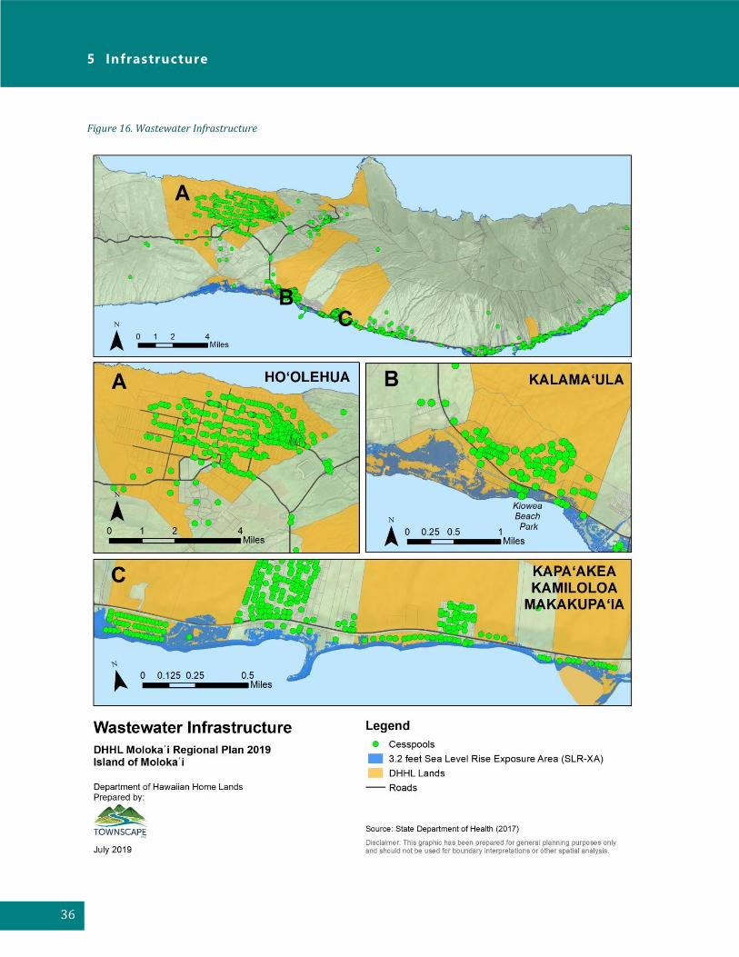
The majority of DHHL homesteads on Moloka‘i are serviced by individual cesspools on-site with the
exception of several parcels where the effluent is subjected to soil treatment. Cesspools are
considered substandard systems because they do not treat wastewater, but merely dispose of it in
Figure 15. Moloka‘i Irrigation System

Moloka ‘ i Regional Plan 2019
35
the ground. Of the 1,442 cesspools on Moloka‘i, approximately 31 percent are located on DHHL lands
(Figure 16). Some of these cesspools are also located within the coastal zone and may be at risk of
failure due to ground water table rise from sea level rise and flooding.
In 2016, Act 125 was passed into law which prohibits the creation of new cesspools and states that
“prior to January 1, 2050, every cesspool in the State, excluding cesspools granted exemptions by the
director of health, shall be: (1) upgraded or converted to a septic system or aerobic treatment unit
system; or (2) connected to a sewage system.”
Roads
Several State highways provide access to the Moloka‘i homesteads. These roads include
Kamehameha V Highway (Route 450), Maunaloa Highway (Route 460), and Kala‘e Highway (Route
470). Kamehameha V Highway provides access to ‘Ualapu‘e, Kapa‘akea, Kamiloloa, and Makakupa‘ia.
Maunaloa Highway provides access to the homesteads at Kalama‘ula and Ho‘olehua. Kala‘e Highway
provides access to Kalaupapa and Pālā‘au.
5 Infrastructure
36
Figure 16. Wastewater Infrastructure
Moloka ‘ i Regional Plan 2019
37
Planned and Proposed Infrastructure Facilities
Significant improvements are planned for the 80+ year old DHHL Ho‘olehua Water System. DHHL
was awarded approximately $20 million in federal funds for improvements. These improvements
will address fire protection, improve system reliability, security, health and sanitation and decrease
long-term energy costs associated with operating the water system. Improvements will include:
• Installation of an additional 0.2 MG tank located at the 1,010-foot elevation near the existing
0.1 MG tank to ensure uninterrupted supply of water to Kalama‘ula residents
• Installation of an all-weather roadway to improve accessibility to the existing 0.2 MG
Kalama‘ula tank for health officials and water system operators
• Installation of an above-ground fuel storage tank to provide extended power to increase
operational time of the emergency generator during emergency situations
• Redesign of some of the distribution piping for the 1.0 MG Kauluwai tank to eliminate the
potential for stagnant water as the existing pipe is four to eight feet higher than the floor of
the tank
• Storage of critical components to provide operators with immediate access to materials and
equipment needed to maintain the system to local regulations and to minimize system down
times
• Construction of fencing around the two 3.5 MG tanks in Ho‘olehua and the new one-megawatt
photovoltaic energy production farm and water storage components to secure the facilities
from unauthorized access
• Replacement of approximately 19,000 linear feet of decaying pipeline to mitigate asbestos
contamination, reduce water losses associated with aging infrastructure, and to provide
adequate water pressure for fire protection
• Replacement of valves, ladders and other appurtenant structures for two 3.5 MG Ho‘olehua
storage tanks
• Connection of water system to the Supervisory Control and Data Acquisition (SCADA) system
to improve overall site security and operation by providing remote monitoring and
automation of system components

5 Infrastructure
38
[This page left blank intentionally]

Moloka ‘ i Regional Plan 2019
39
6 Priority Projects
Beneficiaries that attended the Regional Planning meetings discussed regional issues and
opportunities with DHHL. The various issues and opportunities identified by beneficiaries were
consolidated into a list of potential projects. A total of 24 potential projects were identified and
grouped into the following categories: Resources Management, Community, Water/Infrastructure,
Agriculture, Housing, and Government/Other.
Appendix C includes a list of all of the potential projects and identifies those elevated to priority
projects by community consensus. It also describes the methodology used to select the priority
projects. The details of the five priority projects presented on the following pages were evaluated
and expanded upon by the Planning Team in consultation with beneficiaries. Of the five priority
projects selected, three were previously identified as potential projects in the 2010 Molokaʻi Regional
Plan.
The five priority projects selected by the community shown in order of priority are:
Priority Project #1: ‘Ualapu‘e Kuleana Homestead Project and Cultural Resources
Management Plan
Priority Project #2: Ho‘olehua Hale Improvements
Priority Project #3: Water Rate Assessment and Legal Analysis of Beneficiary Rights
regarding Potable Water Rate Disparities
Priority Project #4: Shared Farm Equipment for Agricultural Lessees
Priority Project #5: Road Improvements
Note that two other projects that also received high priority included:
• Supplies and Material for Cross-Fencing and Deer Fencing
• Deer Management Plan
While these two projects were not distinguished as the top five priority projects for this regional plan,
this does not mean that these projects cannot happen. These projects along with other potential
projects not elevated as the top five priority projects may be championed by any member of the
community at any time. Identification of the priority projects is intended to help DHHL to recognize
which projects to focus their time and effort in the near future pending available funding and
resources.
6 Priority Projects
40
Priority Project #1 - ‘Ualapu‘e Kuleana Homestead Project and Cultural
Resources Management Plan
Background Information
DHHL owns approximately 412 acres in ʻUalapuʻe, which is an undeveloped area nestled along the
southeastern end of the island approximately fifteen miles east of Kaunakakai town. The parcel lies
mauka of Kamehameha V Highway and is highlighted by its sloped terrain (11-20%) from its
mountainous regions interspersed by the deep ravines of Kahananui Gulch, Kiʻinohu Gulch, and
Moʻomuku Gulch. The steep isolated plateaus and valleys that predominate ʻUalapuʻe make
development challenging and increase costs. However, there is limited area of the parcel between the
20- to 80-foot elevation (just mauka of Kamehameha Highway) with a gentle slope that could be
appropriate for residential development.
Land use designations in the DHHL 2005 Molokaʻi Island Plan for ʻUalapuʻe parcel consist of 25 acres
for residential homesteads and approximately 3 acres for community uses in the lower mauka area,
85 acres of the upper mauka areas as Special District, and approximately 300 acres in the middle
mauka areas as General Agriculture.
The 2005 Molokaʻi Island Plan proposed development of the residential homesteads in two phases,
consisting a total of seventy-four 10,000-square foot lots on 25 acres. Development of residential
homesteads has not occurred because it is pending an increase in water allocation from the County
of Maui by the State Commission of Water Resources Management.
As of November 2018, the wait list for a homestead on the island of Moloka‘i includes a total of 2,099
applicants: 822 residential, 1,075 agricultural, and 202 pastoral.
Since 2019, the beneficiaries have moved from the concept of traditional homestead developments
and have expressed interest in the development of kuleana homesteads for ʻUalapuʻe to provide
beneficiaries access to the land immediately. Through the Kuleana Homestead Program, beneficiaries
are given a chance to lease unimproved, off-grid homesteads. Unlike a standard residential
community concept, the Kuleana Homestead Program places responsibility for development of
infrastructure in the hands of beneficiaries in return for availability and early access to unimproved
land (refer to Appendix D for the Hawaiʻi Administrative Rules relating to kuleana homestead leases).
In February 2019, Ahonui Homestead Association proposed the kuleana homestead project for
ʻUalapuʻe, including seeking minimum (roads and water spigots) infrastructure from DHHL, to the
Hawaiian Homes Commission.

Moloka ‘ i Regional Plan 2019
41
Past Actions
• 1994. ʻUalapuʻe was awarded to DHHL as part of a 1994 settlement that awarded DHHL
approximately 16,500 acres statewide.
• 1995. DHHL initiated its pilot Kuleana Homestead program at Kahikinui on Maui.
• 1999. A total of 75 Maui Pastoral Waitlist Applicants were awarded lots at Kahikinui. About
13 families currently reside on the property full time living entirely off-grid and 20 or so
homes have been constructed.
• 1999. Land transfer of ʻUalapuʻe lands to DHHL completed.
• 2005. DHHL in consultation with its beneficiaries identified ʻUalapuʻe as a first priority area
for residential development in the Molokaʻi Island Plan. The Plan identified developing 74
residential homestead lots on 25 acres. Project has been on hold until the County of Maui
water allocation from the State Commission on Water Resources Management is increased
and/or additional water source identified and developed.
• 2018. DHHL started to explore the Kuleana Homestead program for Puʻu ʻOpae and
Anahola, Kauai and is in the Planning Phase. No kuleana homestead lots have been awarded
to date.
• 2019. Ahonui Homestead Association established on February 8th and registered as a State
nonprofit organization. The Hawaiian word “Ahonui” means waiting patiently in line. The
Association proposed the project to the Commission in February 2019 and since then have
been holding meetings to discuss the proposed kuleana homestead project for ʻUalapu’e.
Project Description
Ahonui Homestead Association envisions two-acre kuleana homesteads at ʻUalapuʻe to be awarded
to 175 beneficiaries; however, actual acreages and number of lots would be subject to technical
studies to be completed for the area. The Association envisions a cultural resource management plan
to be explored for the cultural sites within the DHHL boundaries of ʻUalapuʻe. They would like DHHL
to preserve and protect these cultural sites via fencing or other protective barrier methods. The
community would help to mālama the identified sites. The Association would also like to secure
minimum infrastructure such as roads and water spigots for the project area. They are interested in
exploring Subsistence and Sustainable ʻOhana Halau startup kits for future kuleana homestead
lessees and for community use. Actual infrastructure would also be subject to technical studies to be
completed for the area.
In order to generate community interest for the proposed project, Ahonui Homestead Association
has held numerous community meetings to discuss issues relating to the proposed kuleana
homestead project for ʻUalapuʻe. Ahonui Homestead Association reached out to beneficiaries on the
DHHL “Wait-list” via radio station, local newspaper, online media, and postings on bulletin boards
throughout the community. Refer to Appendix E for additional information prepared by the Ahonui
Homestead Association which includes a list of meetings held, some preliminary concerns expressed
by the meeting participants, project objectives and action steps.

6 Priority Projects
42
The DHHL ʻUalapuʻe lands consist of seven tax map keys (TMKs). Ahonui Homestead Association is
proposing that kuleana homesteads be considered for at least two of the TMKs: a 376.562-acre parcel
(TMK 56006017) and a 13.560-acre parcel (TMK 56002026). The 376+ acre parcel is zoned as
Agriculture by the County and is designated as General Agriculture, Special District, and Community
Use by DHHL. The 13+ acre parcel is zoned as Residential by the County and is designated as
Residential and General Agriculture use by DHHL.
Community Champions and Partners
Anonui Homestead Association (see Appendix E for a description of the Association)
Project Objectives
The objectives for this project include:
• Long-term Kuleana Homestead Leases. Restore and rehabilitate native Hawaiian
beneficiaries to their land and expedite awarding of homestead leases on unimproved land
through the Kuleana Homestead Program.
• Cultural Resource Management Plan. Ahonui will collaborate with DHHL and the
‘Ualapu‘e/Mana‘e community to develop a cultural resource management plan within the
perimeter of DHHL boundary in order to protect and preserve resources for future
generations.
Implementation Action Steps
The action steps to accomplish the above objectives are organized in the following four phases:
planning, design, construction, and community development.
1) Planning
• Timeframe: 5-year estimate
• Budget: DHHL and community to work together to raise the funds and secure other
resources for the Planning Phase.
• DHHL roles:
o Seek various approvals from the Hawaiian Homes Commission
o Prepare budget request and obtain HHC approval for planning funds
o Procure and contract for planning services
o Facilitate planning processes
o Maintain communication with community
• Community roles:
o Participate and comment throughout Planning Phase and as reports and studies are
available for comment
o Participate in community meetings and beneficiary consultations
o Provide testimony and attend HHC meetings

Moloka ‘ i Regional Plan 2019
43
o Provide testimony and support DHHL CIP funding proposals to State Legislature
o Support community capacity to engage/participate in the Planning process
• Major action items in the planning phase are:
o Since this project is a beneficiary-driven initiative, clarify and further refine the
project description, including project outcomes, and clarify roles between DHHL and
community.
o Ahonui Homestead Association has indicated to pursue a Limited Right-of-Entry (30-
day permit) from DHHL to visit the proposed project area.
o Ahonui Homestead Association has indicated to pursue meeting with Hawaiian
Homestead Association representatives from Kahikinui to learn about their
experiences with the kuleana homestead program and vision for their homestead
association.
o Determine if DHHL Land Use designation needs to be amended in the Molokaʻi Island
Plan.*
o Prepare Special Area Plan*, including a Cultural Resource Management Plan.
o Prepare “Kuleana Homestead” Settlement Plan* specific to ʻUalapuʻe location,
including determine lot scenarios, options and configuration.
o Prepare State of Hawai‘i HRS Chapter 343 Environmental Assessment.*
o Prepare a resource development plan/strategy for future phases – Design,
Construction, Community Development.
Items with an “*” indicate approval required by the Hawaiian Homes Commission.
2) Design
• Timeframe: TBD. It is too early in the process to estimate Design costs.
• Budget: Communication between DHHL and community will be necessary to work together
to raise the funds and secure other resources for the Design Phase.
• Major action item in the design phase is to:
o Prepare preliminary engineering report, including options and cost estimates for
each option.
3) Construction
• Timeframe: Depends on level of infrastructure mutually agreed upon by applicants and
DHHL in Planning Phase. And, until all approvals (state, county, other) and funding are
secured, then construction may be scheduled.
• Budget: TBD. It is too early in the process to estimate Construction costs.
• Action items in the Construction phase are to be determined.
4) Community Development
• Timeframe: Ongoing.
• Budget: DHHL and community to work together to raise the funds and secure other
resources for community development.
• DHHL roles:

6 Priority Projects
44
o Prepare budget request and seek HHC approval for community development phase
funds.
o Prepare educational materials and conduct outreach to applicants (e.g., Kuleana
Homestead Program FAQs, Lease Award Process, Is “living off-grid” for you?).
o Train on-island beneficiaries to help conduct outreach.
• Community roles:
o Participate and comment throughout all Phases and as reports and studies are
completed.
• Major action items in the Community Development phase are:
o Build homestead community organization capacity to plan , develop, implement and
evaluate this proposed kuleana homestead project.
o Develop the Kuleana Homestead Vision specific to ʻUalapuʻe, including building,
health and safety codes, permit process, community governing rules, guiding
principles, management of common areas, cultural & natural resources, etc.
o Prepare applicants with information including:
▪ Kuleana Homestead 101 — Is this for you? Your role and responsibilities in
this alternative lifestyle, off-grid living
▪ Preparing yourself and your ‘ohana financially
▪ What is “The Lease Award process” and what you need to do to prepare
yourself and your ‘ohana
▪ Follow up with lessees at post-move in
o Seek and obtain various approvals from HHC.
o Community to secure a licensed architect and other professional services, as needed
(i.e., legal, accounting, planner, engineer).
Priority Project #2 - Hoʻolehua Hale Improvements
Background Information
Ahupuaʻa o Molokaʻi (AOM), a 501c (3) nonprofit organization made up of Board members
representing six Hawaiian Homestead Associations, has a Right of Entry for use of an 0.489-acre
parcel as a homestead community organization office and meeting room. The parcel is located in the
Hoʻolehua area near the Hoʻolehua Fire Station and the Lanikeha Community Center. The structure
was originally constructed in 1935 and used as a preschool. In addition to serving as the AOM’s office,
it also serves as the Native Hawaiian library, Sustainable Molokaʻi Office, and ʻOhana Learning
Academy Home School Program. AOM is in negotiations with DHHL to license the property for up to
65 years.

Moloka ‘ i Regional Plan 2019
45
Past Actions
• 2003. Hawaiian Homes Commission (HHC) approved issuance of a revocable permit to Ahupuaʻa o Molokaʻi (AOM), a 501c(3) nonprofit, for use of 0.489 acre of Hawaiian Home lands (TMK 2-5-2-030: 007) for a homestead community organization office and meeting room.
• 2013. HHC issued month-to-month Right of Entry (No. 507) to AOM for same parcel.
• 2017. Received $33,310 DHHL Trust grant for capacity building, including strategic planning for AOM itself and homestead associations.
• 2018. AOM applied for $1 million Grant-in-Aid (GIA) from the State Legislature to renovate the building. Funding from the GIA request was not awarded to AOM.
• 2019. AOM applied for $500,000 but received $100,000 GIA from the State Legislature to renovate the hale.
Project Description
The structure is in disrepair and needs to be
upgraded. The walkway and building are impacted by
termites and need to be upgraded.
The priority project consists of two phases: • Phase 1
o Upgrade bathrooms o Install new windows o Upgrade electrical system o Install a handicap accessible ramp,
steps, and railings • Phase 2
o Install new walls and floors o Install new roof o Install a septic system o Install alternative energy technology
A Project Manager will be needed to oversee the planning, design, and construction of this project. An assistant to the Project Manager will also be needed; however, this position may be on a volunteer basis until additional funds are secured.
Community Champions and Partners
Ahupuaʻa o Molokaʻi
Existing Hoʻolehua hale

6 Priority Projects
46
Project Objective
The objective of this project is to facilitate the space for homesteaders to perpetuate cultural
traditions through education and practice. This project will provide a venue for homesteaders to
enhance their social, cultural, economic, and educational needs, and to build a strong sense of
community.
Implementation Action Steps
The action steps to accomplish the above objective include:
1) Amend the Molokaʻi Island Plan. The hale is located on TMK parcel 2-5-2-030: 007, which is designated as residential use in the 2005 Molokaʻi Island Plan. HHC will need to amend the Molokaʻi Island Plan to re-designate the parcel as community use.
2) Long-Term License. AOM to obtain a long-term license for TMK parcel 2-5-2-030: 007. Beneficiary Consultation and HHC approval will be required before issuance of the long-term license to AOM.
3) Financial Plan. Develop a financial plan that outlines resources needed to complete the priority project in phases given funding limitations.
4) Planning and Permitting. AOM to consult with State and County agencies for necessary
permits and approvals including consultation with the Department of Land and Natural Resources State Historic Preservation Division. DHHL will need to determine if an Environmental Assessment is required for the project. HHC approval is required for either an EA exemption or a full EA.
5) Preliminary Design Plans. AOM to hire an Architect to develop preliminary design plans
for the hale improvements. AOM and Architect will need to work with State and County agencies to make sure that improvements meet State and County regulations.
6) Secure Contractor. AOM to hire a Contractor to complete hale improvements.
Priority Project #3 - Water Rate Assessment and Legal Analysis of
Beneficiary Rights regarding Potable Water Rate Disparities
Background Information
Potable drinking water for the homesteads on Moloka‘i is provided by the DHHL Ho‘olehua Water
System (PWS 230) and the Maui County Department of Water Supply.
The DHHL Ho‘olehua Water System is owned and operated by DHHL. The Water System services
Kalama‘ula, Ho‘olehua, Nā ‘iwa, and Pālā ‘au homesteads. There are also 38 community facilities and
businesses that are connected to the system including the Ho‘olehua Airport, U.S. Post Office, schools,
churches, and Lanikeha Center. The Ho‘olehua Water System serves approximately 2,400 customers,

Moloka ‘ i Regional Plan 2019
47
which includes both beneficiaries and non-beneficiaries. The Water System also provides drinking
water to three other water systems (PWS 229 Kuaupu‘u, PWS 235 Kala‘e and PWS 245).
While Kalama‘ula, Ho‘olehua, Nā ‘iwa, and Pālā ‘au homesteads are serviced by DHHL’s Water System,
Kapa‘akea, Kamiloloa, and One Al‘ii homesteads are serviced by the County’s Water System. Water
users on the DHHL’s Water System have been paying DHHL’s water rates, while users on the County’s
Water System have been paying the County’s water rate. While the County rates have increased over
time, DHHL rates have not. Before 2018, DHHL’s last water rate increase for the Ho‘olehua Water
System was in 2004.
As a result, the Ho‘olehua Water System has been operating at a significant loss. The total operating
costs for the Ho‘olehua Water System for Fiscal Year (FY) 2016 was approximately $800,000 which
did not include any amount for “reserves.” There was a deficit of about $400,000 and losses have
been paid out of Trust funds. In order to balance the budget, DHHL has been working on decreasing
costs through improving operational system efficiencies. DHHL has completed a cost of service
analysis that reviewed the water system budget, expenses and revenues. New water rates for the
Ho‘olehua Water System were approved and became effective on July 1, 2018.
However, beneficiaries served by the County’s Water System continue to pay a higher rate than those
on the DHHL’s Water System. For example, for FY 2020, the County’s service fee for a 5/8-inch meter
is $19.80 per month with the following water rates:
Gallons Dollars per 1,000 gallons
0 – 5,000 $2.05 5,001 – 15,000 $3.90 15,001 – 35,000 $5.85 Over 35,000 $6.55
On the other hand, the DHHL’s service fee for a 5/8-inch meter is $6.82 (bi-monthly) with the
following water rates:
Gallons Dollars per 1,000 gallons
0 – 10,000 $1.65 10,001 – 25,000 $2.22 Over 25,000 $2.61
Note that the Hawaiian Homes Commission approved a water rate increase to the DHHL-owned
Ho‘olehua Water System, which serves the Ho‘olehua and Kalamaula homestead areas. New rates
became effective July 2018 and will be incrementally increased each year for the next 10 years. It is
expected that the DHHL water rates may exceed the County water rates. Generally, water rates
charged to customers are based on several factors including the cost incurred by the purveyor to
deliver clean, safe water to customers.

6 Priority Projects
48
Past Actions
• DHHL HAR, Section 10-3-76(i) states that “water from department systems shall be sold at
rates established by the commission. The department shall establish the frequency of billing
and may determine a minimum monthly charge.”
• 2004. Water rate increase for the Ho‘olehua Water System
• 2012. HHC approved Enterprise Accounting Policy. DHHL will budget for the Water System
utilizing an enterprise account accounting structure
• 2014. HHC approved Water Policy Plan which identifies mission, priority policies, and
goals. Goal #17 is to “secure revenue and reduce operation costs so DHHL water systems
break even financially over the long term.”
• August 2016. Received notice of a funding award of $15.9 million in federal grant funds from
the U.S. Department of Agriculture Rural Development for major capital improvements to the
DHHL drinking water systems. $10 million was allocated to the Ho‘olehua Water System.
DHHL contributes over $12 million to the Ho‘olehua Water System.
• June 2017. Cost of Service Analysis completed. The purpose of the study was to identify the
nature and amount of the costs of operating the four DHHL’s water systems.
• March 2018. Interim Water Rate Study completed. The purpose of the study was to
establish interim water rates for each of the DHHL four water systems.
• March 2018. Beneficiary Consultation of Proposed Increase in Water Rates for DHHL
Ho‘olehua Water System.
• July 2018. New water rates for the Ho‘olehua Water System become effective.
Project Description
This project consists of the following:
1) Establish a task force of DHHL Staff, Moloka‘i Commissioner, and Moloka‘i homesteaders to
collaborate on this project.
2) Continue to proceed with the DHHL Cost of Service Analysis and DHHL Water Rate Study to:
o Gather data on current users of the DHHL’s water system, monthly water usage and
cost (including rates paid by non-homesteaders)
o Analyze DHHL cost for water system and operations
o Reassess current DHHL water fees and adjust according to HHCA keeping our
homesteaders in mind first to provide affordable water rates and non-homesteaders
to pick up the bulk of overage
3) Partner with OHA to develop a financial assistance program to assist beneficiaries with
financial hardship situations.
4) Conduct a legal analysis of beneficiary rights regarding water rate disparities experienced by
homesteaders residing in different homestead areas and serviced by different water systems.
Moloka ‘ i Regional Plan 2019
49
5) Pending findings from the legal analysis of beneficiary rights regarding water right
disparities, work with the County to get homestead areas that currently pay County water
rates to make appropriate adjustments to align with the rates for the DHHL water system.
Project Champions and Partners
To be determined.
Project Objective
The objective of this project is to examine and assess the legal analysis of beneficiary rights regarding
the water rate disparities between homestead areas serviced by the County’s Water System and
DHHL’s Water System.
Implementation Action Steps
The action steps to accomplish the above objective include:
1) DHHL to proceed with the Cost of Service Analysis and Water Rate Study. Community to
provide input and participate in the beneficiary consultation process.
2) Establish a taskforce of DHHL staff, homesteaders, and interested parties to collaborate on
this project.
3) DHHL to procure a legal firm to conduct analysis of beneficiary rights regarding the water
rate disparities.
4) Develop final report and recommendations for the legal analysis regarding the water rate
disparities.
6) Pending findings, community to initiate discussions with the County to get homestead areas
that currently pay County water rates to make appropriate adjustments to align with the
rates for the DHHL water system.
7) Partner with OHA to develop a financial assistance program to assist beneficiaries with
financial hardship situations.
6 Priority Projects
50
Priority Project #4 - Shared Farm Equipment for Agricultural Lessees
Background Information
As of November 2018, DHHL had 420 agricultural homestead leases on Molokaʻi, which makes up
approximately 50 percent of the active homestead leases on the island. Farm equipment such as
tractors with implements (tiller, ripper, mat layer, seeder, etc.) are needed to support agricultural
lessees. However, farm equipment often requires a capital investment that may be cost prohibitive
for farmers, particularly for farmers who are just starting out, or those who are farming on a smaller
scale that may only require the use of equipment once or twice a year.
A farm equipment sharing program was offered more than 10 years ago that provided shared use of
a tractor. The program was under the Hoʻolehua Homestead Association purview. Funding to
purchase the equipment came from the Molokaʻi Community Service Council (MCSC). However,
equipment purchased for the program had numerous problems. Costs to repair were too large for
the association to maintain. Some implements may be still at the DHHL Molokai base yard. Since then,
Hoʻolehua Homestead Association has purchased a new tractor with implements that is available to
homestead farmers in the area at fair rates.
Makakuoha Cooperative also has a backhoe/loader that is currently being rented out to members at
a discounted rate and non-members at regular rates. It was purchased in 2014/2015. Currently
there are 20 members who have access to this equipment on a regular basis and it is also available to
non-members.
Past Actions
• A tractor sharing program was offered by the Hoʻolehua Homestead Association in the past. Equipment was purchased from funding from the Molokai Community Service Council.
• 2014. Makakuoha Cooperative purchased a backhoe/loader that is available to members at a discounted rate.
Project Description
This project would develop an equipment sharing program that would be feasible to implement for
homesteaders on Molokaʻi. The equipment sharing program would provide agricultural lessees with
the opportunity to utilize farm equipment in order to reduce capital investment. It could also assist
farmers by providing equipment needed to install fencing to combat the uncontrolled deer
population. The project would include researching other comparable existing programs, types of
equipment sharing models, documenting best practices and lessons learned; determining the
community interest level for specific tools and equipment (such as a backhoe tractor, tractor with
farming attachments, or a dump truck); identifying possible storage location of tools and equipment;
developing budget for the equipment sharing program; developing a fee structure and schedule for
Moloka ‘ i Regional Plan 2019
51
equipment use; and setting up the equipment sharing program. An inventory of existing available
farm equipment for homesteaders to use on Molokaʻi will be conducted. The farm sharing program
could consist of (1) utilizing existing equipment that farmers may be willing to lease to others and
(2) fundraising and purchasing equipment specifically for this equipment sharing program. This
project will require a collaborative effort from all homestead associations who have equipment or
have farmers that need equipment.
Community Champions and Partners
Ahupuaʻa o Molokaʻi
Project Objective
The objective of this project is to support agricultural lessees by providing options to reduce capital
investment through the shared use of farm equipment.
Implementation Action Steps
The action steps to accomplish the above objective include:
1) Design Equipment Sharing Program. Design an equipment sharing program that is appropriate for the needs of homesteads. The program should include:
a. Researching other comparable existing programs
b. Documenting best practices and lessons learned c. Comparing equipment sharing models d. Identifying possible storage location of tools and equipment
e. Identifying the local entity that will be responsible for managing this program, including storing of the equipment, reservation process, implementing fee structure, fundraising, repairs/maintenance of equipment, etc.
2) Consult with Lessees. Work with existing lessees to determine level of interest for specific tools and equipment, and to prioritize needs.
3) Financial Feasibility and Planning. Develop a financial plan that outlines resources need to implement and operate the equipment sharing program. The financial plan should include a fee structure that is acceptable and affordable to homesteaders while adequately covering anticipated costs.
4) Budget Development. Seek funding including State Grant in Aid to implement the program.
Work with CTAHR staff to provide technical support in seeking grants and loans to develop the equipment sharing program.

6 Priority Projects
52
Priority Project #5 - Road Improvements
Background Information
Several State highways provide access to the Moloka‘i homesteads. These roads include
Kamehameha V Highway (Route 450), Maunaloa Highway (Route 460), and Kala‘e Highway (Route
470). Kamehameha V Highway provides access to ‘Ualapu‘e, Kapa‘akea, Kamiloloa, and Makakupa‘ia.
Maunaloa Highway provides access to the homesteads at Kalama‘ula and Ho‘olehua. Kala‘e Highway
provides access to Kalaupapa and Pālā‘au. These roads are under the jurisdiction of the State
Department of Transportation Highways Division.
The majority of the roads within the homestead areas are owned by DHHL, but responsibility to
maintain the roads lies with the County. Based on consultation with beneficiaries, road
improvements are needed to improve safety and accessibility to homesteads. Beneficiaries noted that
roads are narrow and do not provide enough space for children that walk and/or ride their bikes to
school. They also noted that heavy farm equipment and trucks have contributed to the current road
conditions. Existing unpaved roads have led to excessive wear and tear on vehicles and have created
undesirable conditions for nearby homesteads. Beneficiaries would like to install speed control
systems (i.e. speed bumps, stop signs, etc.) for some of the roads. Specific road improvements
identified by beneficiaries for homestead areas include:
• Ho‘olehua
o Replacing all the dirt roads between Mo‘omomi Avenue and Maunaloa Highway
o Improving Mo‘omomi Avenue to the west of Anahaki Street, Keonelele Avenue,
Hauakea Avenue, Pine Avenue, Kolea Avenue, Puu Kapele Avenue/Lihi Pali Avenue
with a paved road and speed bumps
o Resurfacing and widening of Lihi Pali Avenue, Puu Kapele Avenue, and Puupeelua
Avenue (between Puu Kapele Avenue and Farrington Avenue).
• Kalamaula
o Improving Likelike Avenue, Kalanianaole Avenue, Ena Street and Kahanu Street to
meet County of Maui standards for roads (i.e., curbs, drains)
o Removing the guardrail on the west dead end of Likelike Avenue and connecting it
to Ena Street
Constructing a ‘ford bridge” to connect Lehua Avenue to Ena Street, on the west side between Lot 16
and 17, and to connect Likelike Avenue to Ena Street.
Past Actions
None taken.

Moloka ‘ i Regional Plan 2019
53
Project Description
This project consists of conducting an inventory of all roads in the vicinity of homestead areas and
assessing the condition of the roads. Roads would then be prioritized based on a number of factors
including level of service, current condition, and improvements needed. Coordinate with any State
and County CIP efforts and with DHHL planned improvements to the DHHL water system in order to
maximize efficiencies in capital improvements.
Community Project Champions and Partners
To be determined.
Project Objective
The objective of this project is to improve roadway capacity and safety, and to improve vehicular
mobility into and throughout the homestead areas.
Implementation Action Steps
The action steps to accomplish the above objective include:
1) Background Research
a. Conduct an inventory of roads in the vicinity of homestead areas
b. Assess condition of roads
c. Identify roads that need improvements
d. Identify and confirm road ownership
e. Identify any planned infrastructure improvements for nearby areas in order to
identify opportunities to maximize efficiencies in capital improvements
2) Develop a prioritization matrix to identify the top priority roads in need of improvements.
3) Consult with State and/or County agencies to discuss road improvements.
4) Seek funding.
Appendix A Vision Statement from the County’s Molokaʻi Island Community
Plan

MolokaM Island Community Plan
2.1 MOLOKA'I'S VISION STATEMENT
Vision statement
Moloka'i is the last Hawaiian Island. We who live here choose not to be
strangers in our own land. The values of aloha *aina and medama 'aina (love
and care for the land) guide our stewardship of Moloka*i*s natural resources,
which nourish our families both physically and spiritually. We live by our
kupuna's (elders) historic legacy of pule oh (powerful prayer).
We honor our island's Hawaiian cultural heritage, no matter what our
ethnicity, and that culture is practiced in our everyday lives. Our true wealth
is measured by the extent of our generosity. We envision strong hhana
(families) who steadfastly preserve, protect, and perpetuate these core
Hawaiian values. We are a wise and caring community that takes pride in its
resourcefulness, self-sufficiency and resiliency, and is firmly in chcirge of
Moloka'i's resources and destiny.
We envision a Moloka-i that leaves for its children a visible legacy: sm island
momona (abundant) with natural and cultured resources, people who kokua
(help) and look after one another, and a community that strives to build an
even better future on the pah (firm) foundation left to us by those whose iwi
(bones) guard our land.
Chapter 2 Moloka^i's Future16

Appendix B List of Projects Completed, Funded, or In Progress
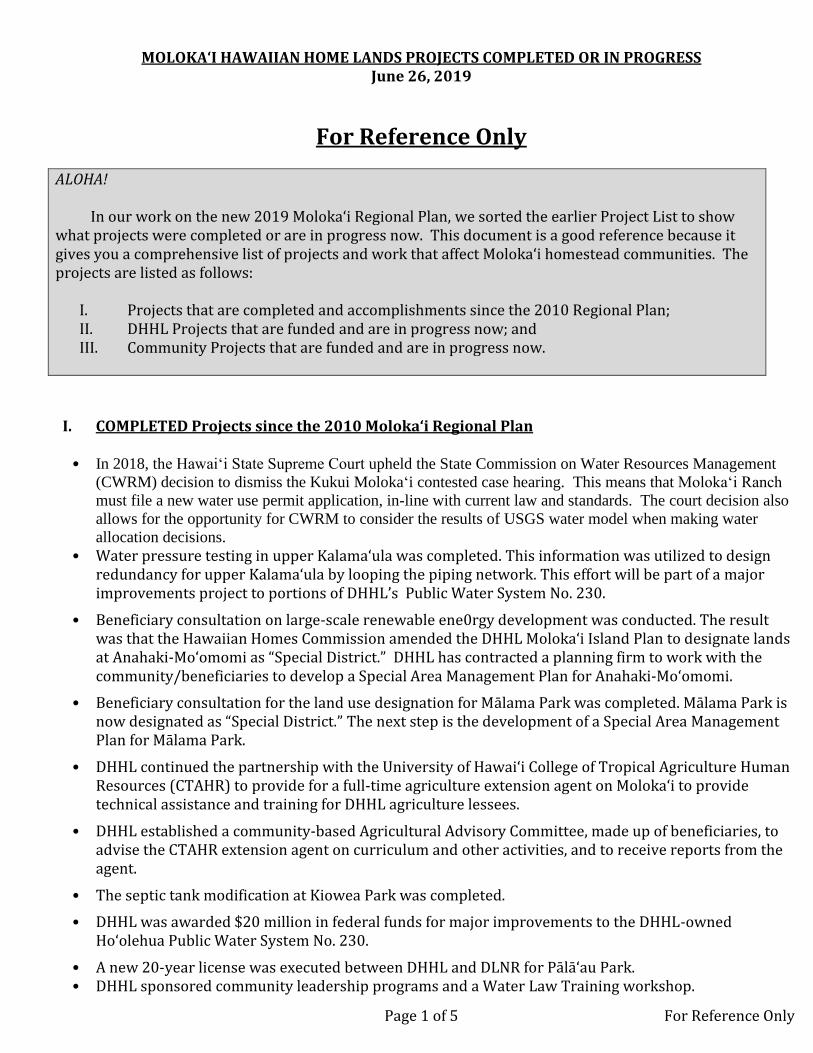
MOLOKA‘I HAWAIIAN HOME LANDS PROJECTS COMPLETED OR IN PROGRESS June 26, 2019
Page 1 of 5 For Reference Only
For Reference Only
ALOHA! In our work on the new 2019 Moloka‘i Regional Plan, we sorted the earlier Project List to show what projects were completed or are in progress now. This document is a good reference because it gives you a comprehensive list of projects and work that affect Moloka‘i homestead communities. The projects are listed as follows:
I. Projects that are completed and accomplishments since the 2010 Regional Plan; II. DHHL Projects that are funded and are in progress now; and III. Community Projects that are funded and are in progress now.
I. COMPLETED Projects since the 2010 Moloka‘i Regional Plan
• In 2018, the Hawai‘i State Supreme Court upheld the State Commission on Water Resources Management
(CWRM) decision to dismiss the Kukui Moloka‘i contested case hearing. This means that Moloka‘i Ranch
must file a new water use permit application, in-line with current law and standards. The court decision also
allows for the opportunity for CWRM to consider the results of USGS water model when making water
allocation decisions.
• Water pressure testing in upper Kalama‘ula was completed. This information was utilized to design redundancy for upper Kalama‘ula by looping the piping network. This effort will be part of a major improvements project to portions of DHHL’s Public Water System No. 230.
• Beneficiary consultation on large-scale renewable ene0rgy development was conducted. The result was that the Hawaiian Homes Commission amended the DHHL Moloka‘i Island Plan to designate lands at Anahaki-Mo‘omomi as “Special District.” DHHL has contracted a planning firm to work with the community/beneficiaries to develop a Special Area Management Plan for Anahaki-Mo‘omomi.
• Beneficiary consultation for the land use designation for Mālama Park was completed. Mālama Park is now designated as “Special District.” The next step is the development of a Special Area Management Plan for Mālama Park.
• DHHL continued the partnership with the University of Hawai‘i College of Tropical Agriculture Human Resources (CTAHR) to provide for a full-time agriculture extension agent on Moloka‘i to provide technical assistance and training for DHHL agriculture lessees.
• DHHL established a community-based Agricultural Advisory Committee, made up of beneficiaries, to advise the CTAHR extension agent on curriculum and other activities, and to receive reports from the agent.
• The septic tank modification at Kiowea Park was completed.
• DHHL was awarded $20 million in federal funds for major improvements to the DHHL-owned Ho‘olehua Public Water System No. 230.
• A new 20-year license was executed between DHHL and DLNR for Pālā‘au Park. • DHHL sponsored community leadership programs and a Water Law Training workshop.
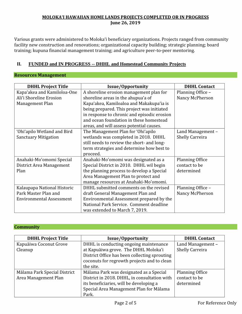
MOLOKA‘I HAWAIIAN HOME LANDS PROJECTS COMPLETED OR IN PROGRESS June 26, 2019
Page 2 of 5 For Reference Only
Various grants were administered to Moloka‘i beneficiary organizations. Projects ranged from community facility new construction and renovations; organizational capacity building; strategic planning; board training; kupuna financial management training; and agriculture peer-to-peer mentoring.
II. FUNDED and IN PROGRESS -- DHHL and Homestead Community Projects Resources Management
DHHL Project Title Issue/Opportunity DHHL Contact Kapa‘akea and Kamiloloa-One Ali‘i Shoreline Erosion Management Plan
A shoreline erosion management plan for shoreline areas in the ahupua‘a of Kapa‘akea, Kamiloaloa and Makakupa‘ia is being prepared. This project was initiated in response to chronic and episodic erosion and ocean foundation in these homestead areas, and will assess potential causes.
Planning Office – Nancy McPherson
‘Ohi‘apilo Wetland and Bird Sanctuary Mitigation
The Management Plan for ‘Ohi‘apilo wetlands was completed in 2018. DHHL still needs to review the short- and long-term strategies and determine how best to proceed.
Land Management – Shelly Carreira
Anahaki-Mo‘omomi Special District Area Management Plan
Anahaki-Mo‘omomi was designated as a Special District in 2010. DHHL wil begin the planning process to develop a Special Area Management Plan to protect and manage resources at Anahaki-Mo‘omomi.
Planning Office contact to be determined
Kalaupapa National Historic Park Master Plan and Environmental Assessment
DHHL submitted comments on the revised draft General Management Plan and Environmental Assessment prepared by the National Park Service. Comment deadline was extended to March 7, 2019.
Planning Office – Nancy McPherson
Community
DHHL Project Title Issue/Opportunity DHHL Contact Kapuāiwa Coconut Grove Cleanup
DHHL is conducting ongoing maintenance at Kapuāiwa grove. The DHHL Moloka‘i District Office has been collecting sprouting coconuts for regrowth projects and to clean the site.
Land Management – Shelly Carreira
Mālama Park Special District Area Management Plan
Mālama Park was designated as a Special District in 2018. DHHL, in consultation with its beneficiaries, will be developing a Special Area Management Plan for Mālama Park.
Planning Office contact to be determined

MOLOKA‘I HAWAIIAN HOME LANDS PROJECTS COMPLETED OR IN PROGRESS June 26, 2019
Page 3 of 5 For Reference Only
Homestead Community
Project Title Issue/Opportunity Project Lead
Lanikeha Center improvements
Comprehensive improvements are almost complete at the Lanikeha Center. Improvements include roof repair, new flooring, and new kitchen equipment,
Moloka‘i Homestead Farmers Alliance
Improvements to Kiowea Park A new facility is under construction at Kiowea Park, including banquet hall and kitchen.
Kalama‘ula Homesteaders Association
Infrastructure / Water
DHHL Project Title Issue/Opportunity DHHL Contact Alternative energy initiatives Develop a photovoltaic system for the
Kūlana ‘Ōiwi office complex in Kaunakakai. Land Management Division – Allen Yanos
Support the creation of a new division to address energy issues within DHHL
Energy issues brought to the attention of the department often go unanswered due to the lack of a point of contact for energy.
Land Management Division – Allen Yanos
Assess and repair leaks in potable water delivery and storage system
Repairs to the aging water infrastructure are needed to ensure system integrity is maintained. DHHL obtained $20 million in federal funds for major improvements to the DHHL-owned Ho‘olehua Public Water System No. 230. Improvements will include construction of a photovoltaic system to reduce electricity costs to operate the water system.
Land Development Division – Jeffrey Fujimoto
Kanakaloloa Cemetary DHHL is working on infrastructure repairs and improvements to Kanakaloloa Cemetery. Planned repairs and improvements include construction of a new paved roadway, a perimeter wall, and an open hale for ceremonial use.
Land Development Division – Stewart Matsunaga
Moloka‘i Irrigation System (MIS) Assessment
The MIS is an aging system that supplies water to many agricultural lessees in Ho‘olehua. DHHL will conduct a cost of service study to analyze the financial health of the MIS, as part of a broader assessment of whether it would be prudent to take ownership of the system.
Planning Office – Halealoha Ayau

MOLOKA‘I HAWAIIAN HOME LANDS PROJECTS COMPLETED OR IN PROGRESS June 26, 2019
Page 4 of 5 For Reference Only
Homestead Community Project Title
Issue/Opportunity Project Lead
Alternative energy initiatives A photovoltaic system for the Lanikeha Center is planned. Construction is expected to be completed in 2019.
Moloka‘i Homestead Farmers Alliance
Agriculture
DHHL Project Title Issue/Opportunity DHHL Contact Ho‘olehua scattered agriculture lots
Plan and design to convert 5 agriculture lots into at least 20 smaller agriculture lots.
Land Development Division – Mitchell Kawamura
Nā‘iwa agriculture subdivision Plan, design, survey and subdivide lots. Identify and design necessary infrastructure.
Land Development Division – Mitchell Kawamura
Homestead Community
Project Title Issue/Opportunity Project Lead
Support production of crops with local markets
Production of crops that can be utilized on-island can reduce over-head costs and improve profitability of farming. Development of an open market would provide a local venue for homesteaders to sell food products within the homestead community. A local market is currently being implemented at Lanikeha Center
Moloka‘i Homestead Farmers Alliance
Multi-pronged agriculture training program
Ahupua‘a o Moloka‘i is assisting homesteaders to: get certifications in farming, food production, food safety and marketing so they can mentor other farmers; start a seed saving training program; provide training in raising potted plants; and advise farmers ready to move from subsistence gardens to production farming.
Ahupua‘a o Moloka‘i
Natural Farming Systems Makakuoha Cooperative is conducting natural farming systems training and demonstration projects on agricultural homestead lots in Ho‘olehua and Kalama‘ula.
Makakuoha Cooperative
Training to develop ag lots into commercial farm businesses
Sons of Ho‘olehua Cooperative is currently conducting this training.
Sons of Ho‘olehua Cooperative

MOLOKA‘I HAWAIIAN HOME LANDS PROJECTS COMPLETED OR IN PROGRESS June 26, 2019
Page 5 of 5 For Reference Only
Government / Other
DHHL Project Title Issue/Opportunity DHHL Contact Support the modification of lease/permit options available to native Hawaiians
Land dispositions currently available do not provide the flexibility some beneficiaries desire. Month-to-month revocable permits (RP) limit the capability of permit holders to acquire loans/grants.
Land Management – Kahana Albinio
Moloka‘i Veterans and Homestead Center
DHHL is planning, designing, and constructing a new facility near the Lanikeha Center in Ho‘olehua. The facility will be a dual-use center to serve beneficiaries and to provide services to veterans.
Land Development Division – Jeffrey Fujimoto

Appendix C Summary of Priority Project Selection

Appendix C: Summary of Priority Project Selection C-1
Below is the list of potential projects identified by the community. Brief descriptions of the potential project are provided on the following pages. The list of potential projects and brief descriptions were included in the mail-out to beneficiaries to attend Community Meeting #5 on June 26, 2019 where the top five priority projects will be selected. The same information was provided to all meeting attendees. Projects that were identified as potential projects in the 2010 Moloka‘i Regional Plan are marked with an asterisk (*).
RESOURCES MANAGEMENT 1 Supplies and Materials for Cross-Fencing and Deer Fencing 2 Deer Management Plan 3 Kalama‘ula Shoreline Erosion Management Plan 4 Climate Change Preparedness and Resiliency
COMMUNITY 5 Community Hālau* 6 Recreational Facilities at Lanikeha Center* 7 Kalama‘ula Mauka Passive Park 8 Ho‘olehua Hale Improvements
INFRASTRUCTURE/WATER 9 Non-potable Water Sources for Agriculture and Other Uses
10 Road Improvements* 11 Water Rate Assessment and Legal Analysis of Beneficiary Rights Regarding Potable
Water Rate Disparities
12 Action Plan to Convert Cesspools to Septic Tanks or Connect to Sewer System AGRICULTURE
13 ‘Ualapu‘e Cultural Resources Management Plan and Kuleana Settlement Plan 14 Community Garden Plots* 15 Soil Testing for Contaminants 16 Shared Farm Equipment for Agricultural Lessees
HOUSING 17 Tiny Homes 18 Emergency Shelter for Lessees Impacted by Flooding 19 Resources to Renovate Kūpuna Homes in the Flood Zone
GOVERNMENT/OTHER 20 Self-Governance Task Force 21 Green Trades Training Program* 22 Land for Homesteaders to Pursue Light Industrial Activities* 23 Coordinated and Comprehensive Hawaiian Trust Services 24 Moloka‘i as its Own County
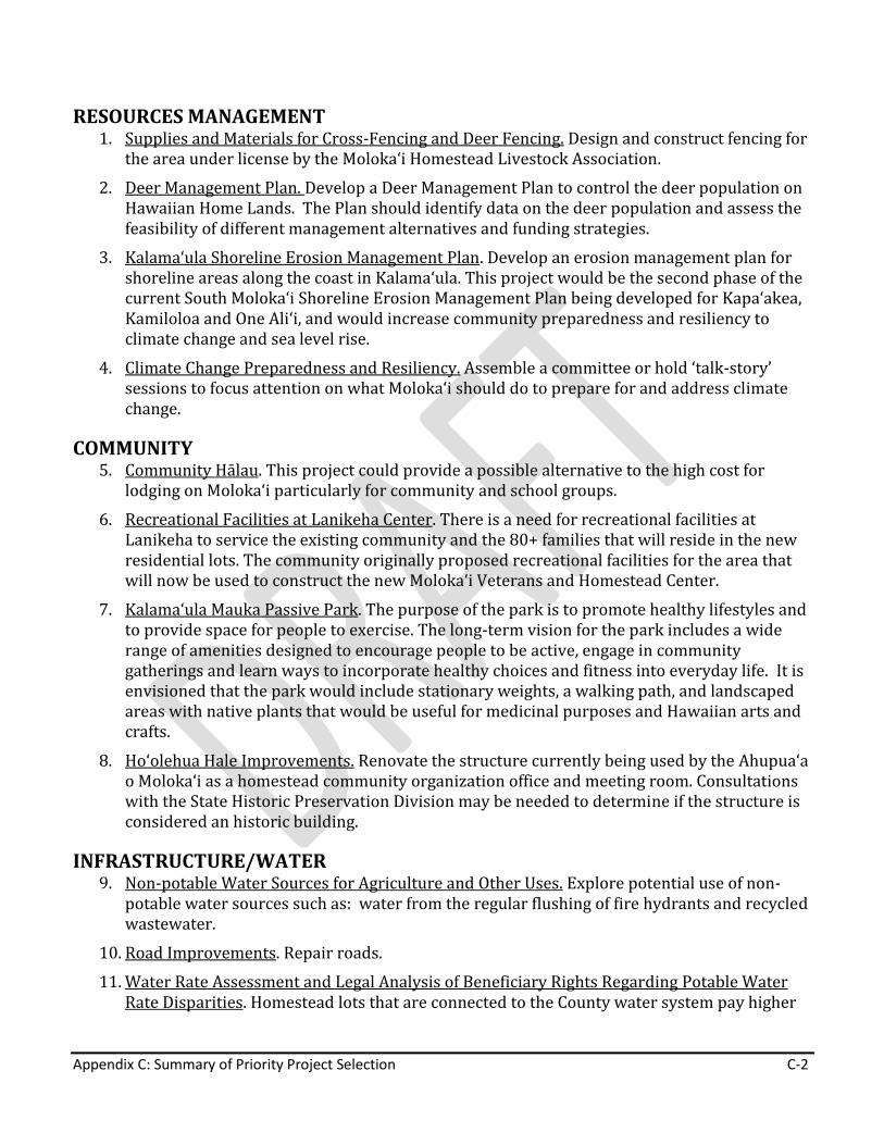
Appendix C: Summary of Priority Project Selection C-2
RESOURCES MANAGEMENT 1. Supplies and Materials for Cross-Fencing and Deer Fencing. Design and construct fencing for
the area under license by the Moloka‘i Homestead Livestock Association.
2. Deer Management Plan. Develop a Deer Management Plan to control the deer population on Hawaiian Home Lands. The Plan should identify data on the deer population and assess the feasibility of different management alternatives and funding strategies.
3. Kalama‘ula Shoreline Erosion Management Plan. Develop an erosion management plan for shoreline areas along the coast in Kalama‘ula. This project would be the second phase of the current South Moloka‘i Shoreline Erosion Management Plan being developed for Kapa‘akea, Kamiloloa and One Ali‘i, and would increase community preparedness and resiliency to climate change and sea level rise.
4. Climate Change Preparedness and Resiliency. Assemble a committee or hold ‘talk-story’ sessions to focus attention on what Moloka‘i should do to prepare for and address climate change.
COMMUNITY 5. Community Hālau. This project could provide a possible alternative to the high cost for
lodging on Moloka‘i particularly for community and school groups.
6. Recreational Facilities at Lanikeha Center. There is a need for recreational facilities at Lanikeha to service the existing community and the 80+ families that will reside in the new residential lots. The community originally proposed recreational facilities for the area that will now be used to construct the new Moloka‘i Veterans and Homestead Center.
7. Kalama‘ula Mauka Passive Park. The purpose of the park is to promote healthy lifestyles and to provide space for people to exercise. The long-term vision for the park includes a wide range of amenities designed to encourage people to be active, engage in community gatherings and learn ways to incorporate healthy choices and fitness into everyday life. It is envisioned that the park would include stationary weights, a walking path, and landscaped areas with native plants that would be useful for medicinal purposes and Hawaiian arts and crafts.
8. Ho‘olehua Hale Improvements. Renovate the structure currently being used by the Ahupua‘a o Moloka‘i as a homestead community organization office and meeting room. Consultations with the State Historic Preservation Division may be needed to determine if the structure is considered an historic building.
INFRASTRUCTURE/WATER 9. Non-potable Water Sources for Agriculture and Other Uses. Explore potential use of non-
potable water sources such as: water from the regular flushing of fire hydrants and recycled wastewater.
10. Road Improvements. Repair roads.
11. Water Rate Assessment and Legal Analysis of Beneficiary Rights Regarding Potable Water Rate Disparities. Homestead lots that are connected to the County water system pay higher

Appendix C: Summary of Priority Project Selection C-3
water rates than the homestead lots connected to DHHL’s water system. The Water Rate Assessment would document differences in potable water rates for lessees and include a legal analysis of beneficiary rights regarding water rate disparities.
12. Action Plan to Convert Cesspools to Septic Tanks or Connect to Sewer System. The State Department of Health Administrative Rules require all cesspools in Hawai‘i to be converted to septic tanks or connected to a sewer system by the year 2050. DHHL and beneficiaries would work together to develop an action plan and raise funds for this undertaking.
AGRICULTURE 13. ‘Ualapu‘e Cultural Resources Management Plan and Kuleana Settlement Plan. Work with the
Mana‘e community and the Ma‘ana nonprofit organization to develop a cultural resources management plan. Develop a Kuleana Settlement Plan for the ‘Ualapu‘e lands. Expedite award of 175 homestead leases through the Kuleana Homestead Program and promote settlement on the 376-acre parcel at ‘Ualapu‘e.
14. Community Garden Plots. Develop community garden plots near residential homesteads in order to encourage lessees to grow food for their families.
15. Soil Testing for Contaminants. Assist homesteaders to obtain assistance from UH CTAHR or Department of Agriculture for soil testing on former pineapple production lands.
16. Shared Farm Equipment for Agricultural Lessees. Explore options for the shared use of farm equipment among agricultural lessees.
HOUSING 17. Tiny Homes. Develop a pilot demonstration project that features “tiny homes” as an
alternate housing option.
18. Emergency Shelter for Lessees Impacted by Flooding. Construct an emergency shelter to assist lessees that may be impacted by flooding during rain events and/or coastal inundation. This project would increase community preparedness, mitigation, and resiliency to climate change and sea level rise.
19. Resources to Renovate Kūpuna Homes in the Flood Zone. Identify and secure resources to renovate kūpuna homes that are located in the flood zone.
GOVERNMENT/OTHER 20. Self-Governance Task Force. Establish a community-based self-governance task force that
promotes the intent of the original Hawaiian Homes Commission Act.
21. Green Trades Training Program. Green Trades support sustainability, renewable energy, and environmental industries. The development of an on-island training program in green-trades would address one facet of sustainability.
22. Land for Homesteaders to Pursue Light Industrial Activities. Unencumbered lands suitable for industrial uses in Ho‘olehua should be identified and the Island Plan amended to accommodate proposed industrial uses by homesteaders. An alternative would be to pursue

Appendix C: Summary of Priority Project Selection C-4
a land transfer with DLNR for lands near the airport where industrial uses would be more appropriate.
23. Coordinated and Comprehensive Hawaiian Trust Services. Bring all the Hawaiian trust agencies back to Moloka‘i to work together to improve services to Native Hawaiians. Encourage Ali‘i trusts to become partners.
24. Moloka‘i as its Own County. Conduct a feasibility study to explore the pros and cons, and legal means for Moloka‘i to be its own county.
Meeting attendees were given five sticker dots to represent their selection for top priority projects. Participants were given fifteen minutes to vote by placing the sticker dots on the projects they would like to see as priority projects (e.g., all dots on one project, one dot on five different projects, etc.). Below is a summary of the votes for all the projects. The top five priority projects are highlighted in yellow.

Appendix C: Summary of Priority Project Selection C-5
RESOURCES MANAGEMENT 1 Supplies and Materials for Cross-Fencing and Deer Fencing 18 2 Deer Management Plan 21 3 Kalama‘ula Shoreline Erosion Management Plan
Note: The project was announced at the 6/26/19 meeting that it will be removed from voting because HHC recently approved the budget for this Plan at the June 2019 HHC meeting.
--
4 Climate Change Preparedness and Resiliency 12 COMMUNITY
5 Community Hālau* 0 6 Recreational Facilities at Lanikeha Center* 6 7 Kalama‘ula Mauka Passive Park 14 8 Ho‘olehua Hale Improvements 33
INFRASTRUCTURE/WATER 9 Non-potable Water Sources for Agriculture and Other Uses 11
10 Road Improvements* 25 11 Water Rate Assessment and Legal Analysis of Beneficiary Rights Regarding Potable
Water Rate Disparities 30
12 Action Plan to Convert Cesspools to Septic Tanks or Connect to Sewer System 5 AGRICULTURE 13 ‘Ualapu‘e Cultural Resources Management Plan and Kuleana Settlement Plan 66 14 Community Garden Plots* 1 15 Soil Testing for Contaminants 6 16 Shared Farm Equipment for Agricultural Lessees 26 HOUSING 17 Tiny Homes 7 18 Emergency Shelter for Lessees Impacted by Flooding 8 19 Resources to Renovate Kūpuna Homes in the Flood Zone 17 GOVERNMENT/OTHER 20 Self-Governance Task Force 0 21 Green Trades Training Program* 0 22 Land for Homesteaders to Pursue Light Industrial Activities* 10 23 Coordinated and Comprehensive Hawaiian Trust Services 1 24 Moloka‘i as its Own County 6
Appendix D Hawai ʻi Administrative Rules on Kuleana Homesteads

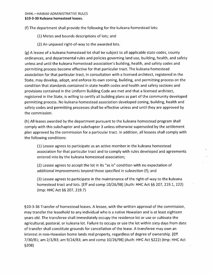

Appendix E Additional Information provided by the Ahonui Homestead
Association

Appendix E- Additional Information provided by Ahonui Homestead Association E-1
Description of Ahonui Homestead Association The Ahonui Homestead Association was established in February 2019 to address the frustration with the history and false promises made by DHHL in the development of ʻUalapuʻe. The Ahonui Homestead Association members include supporters of successors and lessees and DHHL agriculture applicants that have been placed on a long wait list for a homestead as of 1950. This Association will use the Kuleana Homestead Program for ‘Ualapu’e as a homesteading alternative for immediate access to unimproved land (i.e., minimal infrastructure to include roads, etc.). Our Vision is to have the beneficiaries return to their lands and to prevent homelessness and hardship due to the high cost of rent; to build and strengthen Native Hawaiian beneficiaries/skills in the areas of budgeting, fishing, farming, repairs, maintenance, trading, bartering, gathering rights, accountability and responsibility as stewards of the land from mauka (mountain) to makai (ocean); and to increase beneficiaries self-determination through self-governance by participating in discussions on issues, concerns and resolutions as indicated by Prince Jonah Kuhio, Hawaiian Homes Commission Act, 1920 (Section 213 as amended) and Hawaii Organic Act. The Association seek to further serve, protect and preserve the interest of Native Hawaiian beneficiaries of the Hawaiian Home Lands Trust and address the community’s needs in health, education, housing, social services, kupuna care, keiki care, business, employment, and culture.
Ahonui Homestead Association Meetings Ahonui initiated and hosted community meetings at the Office of Hawaiian Affairs (OHA) Conference room and Kilohana Recreational Center. Notice of Meetings were advertised in newspaper, radio station, community bulletin boards. The Association solicitated applicants’ interest in the ‘Ualapu‘e Project. The Association also introduced the project at the DHHL beneficiaries meeting at Kulana Oiwi. The following meetings were held:
• February 13, 2019 & February 23, 2019 Community Meeting by Ahonui at OHA Office: Discussion on the ʻUalapuʻe Project and to generate interest
• March 4, 2019 Community Meeting by Ahonui at OHA Office: Discussion on the
ʻUalapuʻe Project and to generate interest
• March 29, 2019 Ahonui/Community Meeting at OHA: Discussions on DHHL’s 27
potential projects for the regional plan, ʻUalapuʻe project
• April 9, 2019 Ahonui/ Community Meeting at OHA; Discussion on ʻUalapuʻe
Project
• February 13 through July 30, 2019 Ahonui Homestead Association (AHA)
Solicitated Community Interest regarding DHHL agriculture waitlisted
applicants for ʻUalapuʻe Project

Appendix E- Additional Information provided by Ahonui Homestead Association E-2
• May 14, 2019 Manaʻe Community Meeting by Ahonui held at Kilohana
Recreation Center, Maui County: Discussion on Project and Concerns
• May 25, 2019 Ahonui/Community Homestead Association meeting; Review
ʻUalapuʻe Concerns & Project
• June 10, 2019 Mana’e Community Follow-up Meeting by Ahonui at Kilohana
Recreation Center, Maui County: Review project, Concerns, and Interest
• July 13, 2019 Ahonui/Community Meeting; Initiated Working Committees
• February to September 30, 2019, by 6pm Ahonui Homestead Association,
Solicitation Deadline Advertised.
• August 5, 2019 Ahonui/Community Meeting; Self-Determination/Governance;
Introduction on 2 Day Workshop on August 19-20, 2019.
Summary of Discussion from Ahonui Homestead Association Meetings Community Concerns Upon the introduction of the ʻUalapuʻe Kuleana Homestead Project by Ahonui Homestead Association, the community and the beneficiaries (DHHL waitlisted) were frustrated by the past and false promises made by DHHL in the development of ʻUalapuʻe. Some of the concerns shared at meetings held by the Association included:
• When significant sites are identified; to be fenced and maintained
• Only specific animals
• Run-off
• Keep the Mauka to Makai healthy for future generation
• Work with the Manaʻe community to develop cultural and resource management
plan
• Allowances should be made for subsistence hunting in the upland regions
• Malama the cemetery
• Explore alternative (spigot) water source for ʻUalapuʻe
• Control number of vehicles
The 2005 Molokaʻi Island Plan also documented concerns for ʻUalapuʻe. Concerns listed in the 2005 Island Plan included:
• The east end of Molokaʻi is becoming highly visible as a potential area for high-end
development. If development were to occur in ʻUalapuʻe, assurances need to be
made that the land is not sold to non-Hawaiians.
• This area has many cultural sites of great importance.
• The mauka areas of the DHHL parcel in ʻUalapuʻe and its flora, fauna, and
historical/cultural resources need to preserve for future generations.
• Allowances should be made for subsistence hunting in the upland regions.
• The area needs an additional park or recreational space.

Appendix E- Additional Information provided by Ahonui Homestead Association E-3
• No commercial use is desired.
• Lands should be reserved for a cemetery.
• First choice for awards should go to the East Molokaʻi people on the DHHL waiting
list
Project Objectives The objectives for this project include:
1. To secure long-term Kuleana Homestead Leases. Restore and rehabilitate native Hawaiian beneficiaries to their land and expedite awarding of 175 or as confirmed by engineers for homestead on unimproved land through the Kuleana Homestead Program.
2. Project; generate interest and (DHHL) applicant recruitment
3. Secure minimum infra-structure for roads and water spigot. Obtaining the (land imagery) blue print/mapping of lots etc.
4. Cultural Resource Management Plan. Work with the 'Ualapu'e/Mana'e community in developing a cultural resource management plan for 'Ualapu'e in order to protect and preserve resources for future generations.
5. Exploring Sustainable Ohana Halau startup kits for lessees (applicants) and community park/halau.
Implementation Action Steps Phase 1: Planning: Time frame estimated to be 1-3 years The following outlines the Implementation Action Steps based on the objectives stated above for Ahonui Homestead Association:
1. Secure and obtain long-term agriculture TMK#556006017 and TMK#56002026 parcels.
a. Conducted research with DHHL staff, Cindy confirmed the zoning and availability of the above tract (above TMK parcels)
b. Ahonui Homestead Association submitted Project proposal to DHHL identifying available parcels.
c. 'Ualapu'e Project was elected as number 1 priority
d. DHHL provide consultation via drafts
2. Project: generate interest and (DHHL) applicant recruitment
a. Announced via radio station, in local newspaper, online media, on bulletin boards and posting throughout the communities.
b. Held scheduled Community meetings; generated Project interest, shared concerns, and applicant recruitment.
c. On-going: Project introduction, Q&A's, on-going meetings, and applicant recruitment.

Appendix E- Additional Information provided by Ahonui Homestead Association E-4
d. Notice and recruitment, deadlines, and on-going community meetings
e. Increase knowledge and awareness on self-governance and self-determination through two-day workshop with the Department of Interior, Hawaiian Relations
f. Ahonui Homestead Association to utilized DHHL Applicant waiting list dated June 30, 2016 and December 30, 2017 (Agriculture) to solicit and recruit applicants interested in the 'Ualapu'e project and a projection of 175 applicants through a voluntary participation selective process.
3. Secure minimum infra-structure for roads and water spit-kits
a. Department's responsibilities:
i. Seek various approvals from the Hawaiian Homes Commission for long-term lease for the 'Ualapu'e Project, agriculture TMK#556006017 and TMK#56002026 parcels.
ii. Provide EIS (environmental impact study; roads and water spigots for beneficiaries from nearest water source)
iii. Prepare budget request and obtain HHC approval for planning funds
iv. Contract for planning services
v. Facilitate planning processes
vi. Maintain communication with community
vii. Obtain the (land imagery) blue print/mapping of lots
4. Cultural Resource Management Plan.
i. Work with the 'Ualapu'e /Mana'e·community
ii. Develop a cultural resource management plan for 'Ualapu'e in order to protect and preserve resources for future generations.
iii. Identify plants that are grown at the different elevation
iv. Conduct research on native plants and vegetation
v. Crops for sustainability
vi. Establish a nursery to collect plants
vii. Planting; upon obtaining rights of entry
viii. Identify cultural sites:
1. EIS by DHHL (roads)
2. DHHL will preserve and protect the cultural site by fencing
3. Malama the identified sites and cemetery by Community
ix. Identify Community Educator and Partnership

Appendix E- Additional Information provided by Ahonui Homestead Association E-5
1. UH Extension
2. Invasive Species
3. The Nature Conservancy
4. Molokai Land Trust
5. Maunaloa Garden
6. Ma'ana
7. Hui Na'auao
8. Department of Interior, Hawaiian Relation (DOI)
9. Hawaiian Studies and Language Kumu
x. Increase beneficiaries’ knowledge on invasive plants, wind breakers, what plants could be used to hold erosion, farming techniques, landscaping, fishpond restoration and preservation, self-determination and self-governance, and Hawaiian language.
5. Explore Sustainable Ohana Halau startup kits and community parks/halau
a. Committees research
b. Collaboration with community
Phase 2 To discuss and establish DHHL role:
• Seek various approvals from the Hawaiian Homes Commission
• Prepare budget request and obtain HHC approval for planning funds
• Contract for planning services
• Facilitate planning processes
• Maintain communication with community
Ahonui/Community roles:
• Participate and comment throughout Planning process and as reports and studies are available for comment
• Participate in community meetings and beneficiary consultations
• Provide testimony and attend HHC meetings
• Provide testimony and support DHHL CIP funding proposals to State Legislature
• Support community capacity to engage/participate in the Planning process
Ahonui will schedule on-going meetings with committees during the development of the project and process.

Appendix E- Additional Information provided by Ahonui Homestead Association E-6
a. Committees to collaborate and develop a list; networks of individuals
b. Initiate and engage on a Kuleana Community Plan
c. Identify /suggestions operational logistics
d. Identify/suggestions emergencies pathways
e. Identify an action plan
f. Develop a draft for a Community Plan
g. Plan approval & Implement plan
Appendix F Beneficiary Comments relating to Priority Project #3

1
Water Rate Assessment and Legal Analysis of Beneficiary Rights Regarding Water Rate
Disparities
Background Information
Congress enacted the Hawaiian Homes Commission Act in 1920 to “rehabilitate” native
Hawaiians by placing them back on the land to farm and ranch. In setting aside lands for these
purposes, the federal government additionally intended that an adequate water supply be
accessible to homesteaders under the program to ensure that their lands were sustainable and
productive. In Section 221(d) of the original Act, two areas in the state are identified as having
first rights to water:
…..”The commission is authorized, for the purpose of adequately irrigating any tract, to use, free
of all charge, Government-owned water upon the island of Molokai and Government-owned
surplus water tributary to the Waimea River upon the island of Kauai….”
Sections 220 and 221 of the Act were amended by Congress in 1955 deleting the reference to
government owned water, free of charge, and added a new paragraph which stated that any
federal funds given as grant-in-aid for the construction and utilization project on Molokai
designed to serve Hawaiian Home Lands would be considered advanced payment by Hawaiian
Homes Commission of charges to be made to them for the construction of the system and shall
be credited against such charges when made. The State legislature in the same year amended the
Revised Laws of Hawaii 1945 giving the Commission and lessees prior right to two thirds of the
water developed for irrigation by the system constructed as the MIS upon actual need.
Over the 40 plus years there has been a lot of controversy over the management of the system in
relation to the state’s obligation to the homesteaders. Some examples include the following:
• In mid-1980’s, DLNR increases water rates when users were paying 159% of the cost of
operation prior to the increase.
• Manager of the Molokai Irrigation System, under DLNR management, admits to giving
Kaluako’i resort and development free water after their pumps breakdown.
• DOA’s lack of enforcement of Molokai Properties Limited and its predecessor Kukui
Molokai, Inc. lease agreement which was repeatedly violated by their periodic failing to
pump water into the MIS before extracting water from its Mahana pumping station
without regard for its obligations;
• DOA forgiving Kukui Molokai (Molokai Ranch water system) over $330,000 owed
toward their water transmission fees to transport water through the MIS when they were
in arrears;

2
• DOA forgiving Coffees of Hawaii $150,000 owed toward their water bill.
• DOA mandating homestead farmers to cut back on water use by 40% when their ⅔’s
allotment of water had not been exhausted which resulted in crop loss, violating the
Hawaiian Homes Act. This is while domestic users in Kualapuu, Maunaloa, and Kaluakoi
were not asked to conserve water (2004).
• DOA increasing water rates for MIS users even though the system generates a significant
profit annually, ranging over $150,000 through the years, using the excess to support
other irrigation systems.
• MIS overcharged farmers for cost of water. MIS generates over 60% of all revenues
generated from water sales of 5 state irrigation systems, including Waimea, Hamakua,
Waimanalo, and Kahuku. Funds are deposited in the Irrigation Special to be used for all
systems. At the beginning of each year, MIS starts off with a zero balance.
• DOA has not been able to control tilapia in the reservoir which has caused clogging of
farmers irrigation system and has been ongoing for decades.
• Homesteaders lobby State Legislature, calling for an audit of the Molokai Irrigation
System managed by DOA (2007). The audit cited multiple counts of negligence in
regards to DOA’s management, maintenance, and financial handling of the MIS. The
reports also cited DOA for failing in its obligation to protect the rights of Hawaiian
Homestead farmers. Financial concerns within the audit cited a lack of sustainability,
unjust appropriations practices, and a lack of skilled accounting personnel. DOA couldn’t
produce 3 years of financial records. The audit acknowledged that the MIS is the only
system that generates more funds than it uses.
• Although homesteaders have two-thirds rights to the water from the Waikolu Valley
source, only one of six seats on the MIS Users Advisory is dedicated to homesteaders.
• MIS rules state that you must have at least 2 acres of homestead land to gain access to the
MIS. This practice prevents subsistence homesteaders with less than 2 acres access to
water.
Past Actions
● Establishment of Hikiola Cooperative in 1976 by homesteaders, and creation of Molokai
Cooling Cooperative and Molokai Livestock Cooperative over the years to encourage and
advocate for farming efforts on Molokai homestead lands.

3
• Homesteaders filed suit against the State challenging the agreement with Louisiana Land
Company to transport domestic water through the MIS for resort development; lost suit
but court decision included requirement of an EIS
● Homestead farmers consistently provided testimony against the increase in water rates of
the MIS since DOA proposed them to basically help cover costs of other irrigation
systems under its management
● Homestead farmers attended various water workshops to be educated on the system, the
users, and management of MIS (Molokai Water Resources Study 9/16-17/1996,
Informational Water Forum 1/8/2005, Molokai Irrigation System Road Map Meeting
10/27/2007)
● Homestead farmers participated in the Molokai Water Working Group, advisory to the
State’s Commission on Water Resource Management 1993-1996
Project Description
Our ancestors equated water -wai, to wealth - waiwai, knowing their dependency on the limited
resources of a fragile island environment. Our vision is affordable water for all agricultural
lessees serviced by the MIS, and to honor the intent of the original HHC Act prior to being
amended.
Objectives
1. Document a historical and legal analysis of beneficiary rights to water from the MIS
2. Develop rationale, arguments, and strategies to work towards transfer of management of
MIS from DOA to DHHL
3. In the interim, actively protects and advocates for rightful access to MIS by lessees
needing agricultural water to farm.
Action Steps
1. Establish a taskforce of DHHL staff, homesteaders, and interested parties to collaborate
on this project.
2. Engage with potential sources of information for the research needed, e.g. private, state,
federal entities.
3. Draft a position statement documenting in detail the history, the legal rights of Molokai
homesteaders to water from the MIS system, and the obligations of the State to the
beneficiaries of the HHC Act.
4
4. Task force examines potential transfer of management of MIS to DHHL, enters into
discussions with DOA, legislators, and State administration.
5. Task force comes up with a plan for the transfer of management to DHHL.
6. Task force seek support for plan from DOA, legislators, and State administration.
7. Task force keeps abreast of MIS management to assure protection and advocacy for
homestead farmers entitlements to the water.

Appendix G Comments received on the Draft Plan

1
From: Zachary Helm <[email protected]> Sent: Tuesday, November 19, 2019 6:43 PM To: DHHL.Planning <[email protected]> Subject: Comments for Molokai Regional Plan Top five Proposals
1. Ualapu'e Kuleana
Temporary ROE permit for 60 days rather 30 days. Propose funding for road access into Ualapu'e Homestead? Do a cost assessment on construction and installation to bring COM water to Ualapu'e Homesteaders. Bring in Hawaiian Homestead Association representative from Kahikinui and Keokea Maui to speak and share their experiences and vision/mission.
2. Water Rate Assessment regarding water disparities and beneficiary rights?
My thoughts would be to find funding to pay for their delinquent water bills for those beneficiaries (Kupuna) on fix income.Have OHA pay for Hoolehua Water System and Anahola Water system improvements cost. Point out to OHA water is a beneficiary right and the funding from OHA is to improve and rehabilitate Native Hawaiians living conditions. It's an idea. Then I would definitely request for the DHHL to re visit the new water rate increases for beneficiaries that are affected to reduce their water rates.
3. Road Improvements
Improve unpaved roads regularly that is highly used by Hoolehua Homesteaders. Have DHHL and COM work out some kind of an agreement for the maintenance of the these unpaved roads in Hoolehua. Propose funding to standardize streets with proper side walks, drainages, lighting, etc., in lower and upper Kalamaula.
4. Hoolehua Hale - no comment
5. Shared Farm Equipment
Appropriate necessary funding for a Backhoe tractor (front loader 4 in 1 and backhoe), Tractor with farming attachments (Bush cutter, Tiller, plow, Auger, and forklift), and a dump truck. To assist farmers in Hoolehua and Kalamaula. Also to assist farmers with equipment to install fencing/post to combat the uncontrolled deer population. Provide a schedule for the use of these equipment and rental cost. Have a sight location in Hoolehua and Kalamaula to park equipment and alternate the use of these equipment on a month to month basis.
Direct Homestead farmers to apply for funding (grants, low interest loans, etc.) and provide affordable cost for fencing and post supplies.
comments by Zachary Helm Kalamaula Homestead Farmer


November 14, 2019 Planning Department Department of Hawaiian Home Lands PO Box 1879 Honolulu, HI 96805 Email: [email protected] To Ms. Gigi Cairel and the DHHL Planning Office, Aloha. On behalf of the Board of Ka Hale Pomaika`i, I thank you for receiving public comments on the 2019 Moloka`i Regional Plan. My name is Pualani Akaka, Chair of the Board of Ka Hale Pomaika`i, a recovery community organization, that provides services, support and education to restore people suffering from alcohol and drug abuse to a state of being pono (in balance). We have provided treatment and recovery services to over 200 Hawaiians, with over half being beneficiaries or from homes where parents are beneficiaries. Ka Hale Pomaika`i, located at the 13.5-miles East of Kaunakakai, began in 1996 through the vision and hard work of Varna Nakihei and Shari Lynn. DHHL granted Ka Hale License No. 667 in August 14, 2006, to utilize the Hawaiian homelands parcel in Ualapu`e, Molokai. It is identified as Tax Map Key No. (2) 5-6-002:001. The Department reviewed and evaluated Ka Hale Pomaika’i’s use and operation and found we have observed and performed all the terms and conditions expected. The Department granted an extension to Ka Hale Pomaika`i until September 30, 2021. The purpose of my public comment is to acknowledge and comment on the Moloka`i Regional Plan 2019, Priority Project #1, namely, `Ualapu`e Kuleana Homestead Project and Cultural Resources Management Plan. In February 2019, Ahonui Homestead Association proposed the Kuleana Homestead project for two parcels TMK 5-6-002-026 about 13 + acres and TMK 5-6-006-017 about 276+ acres. The Kuleana Homestead approach places the responsibility for development largely in the hands of the beneficiary, rather than in the Department. One example is the Kahikinui Kuleana Homestead Program, which created 104 lots, between 2,000–4,000 feet on the slopes of Haleakala. I believe the replication of this type of development is the goal of the Ahonui Homestead Association for the two parcels in `Ualapu`e.

Ka Hale Pomaika`i shares a northern, mauka border with one of the named parcels, TMK5-6-006-0017. We are concerned that because we are not a direct beneficiary, we could lose our license in 2021 in order that the `Ualapu`e Kuleana Homestead project goal to expedite awarding of homesteads supersedes the vital outreach and support Ka Hale Pomaika`i provides. We seek to continue, and we hope to be considered for a DHHL lease renewal for at least another 15 years. We seek to be an important neighbor and resource to the community of `Ualapu`e and to Moloka`i as a whole, now and in the future. Ka Hale Pomaika`i uses state Certified Substance Abuse Counselors (CSAC), Certified Prevention Specialists (CPS), Certified Criminal Justice Addictions Professionals (CCJAP) and Peer- Recovery Partners with long-term recovery who have “been there” to provide addiction treatment, recovery advocacy, transportation and peer mentoring. Our Hale collaborates with many local community agencies by offering Substance Use related assessments, treatment, a sober living home and support programs for referred clientele. It offers a site for supervised workers to fulfill community service obligations. Classes for court ordered Impaired Drivers are available as well. Ka Hale Pomaika`i also offers a variety of customized Employee Assistance Programs (EAP) for Molokai’s businesses. The programs we offer are designed to reduce recidivism and relapse in recovering adults who may have chemical dependency issues. Ka Hale Pomaika`i, therefore, submits this public comment to speak to the important and necessary resource we are for the Moloka`i community. We have been grateful to the Department for granting of license #667 for 13 years, which has provided us the opportunity to help native Hawaiians (both beneficiaries and non-beneficiaries) and the community of Molokai as a whole. Thank you for this opportunity to comment, and if you have any concerns regarding this public comment, please do not hesitate to contact me. Me ka ha`aha`a, Pualani S. Akaka PO Box 31 Kualapu`u, Molokai 96757 (808) 567-6510 [email protected]

“The Blessed House”…Where Recovery Lives on Moloka’i!
7533 Kamehameha V Hwy, ‘Ualapu’e
PO Box 1895 Kaunakakai, Hawai’i 96748
www.kahalepomaikai.org November 18, 2019
Department of Hawaiian Home Lands - Planning Department, PO Box 1879 Honolulu, HI 96805
Attn: Ms. Gigi Cairel
Aloha!
Mahalo for coming to Moloka’i and hosting the lively meeting we recently had to discuss our 2019 Moloka’i Regional Plan. You did a wonderful job of making sure the many voices were given time to be heard and respected. I serve as the Executive Director of Ka Hale Pomaika’i (KHP), a Hawaiian values based outpatient substance abuse treatment and recovery center which has a 3rd party lease with the Department in ‘Ualapu’e. We are writing this testimony so that those who do not know about us, become familiarized with who we are, what we do, and why we hope to continue our work in ‘Ualapu’e.
In 2003, we were given a temporary lease by the Department as a trial in the local
community. We held community meetings and were given very positive feedback and approval. Following this 3-year trial, the Department granted us a 10-year lease (License #667) from 2006 to 2016. In 2016, we were given a 5-year extension until 2021. In total we will have been blessed to be where we are thriving for 18 years. When we first opened our doors, we were an all-volunteer agency. Today, we employ 16 people and all but 3 are Hawaiian/Part Hawaiian additionally, we are the only substance abuse treatment center on Moloka’i.
During this time, we have transformed the dilapidated structure and grounds into a beautiful safe and confidential Hale and organic garden area. This is where nearly 300 Hawaiians, many of whom are either Beneficiaries or have ‘ohana who are Beneficiaries, have passed through the doors for help with addiction issues. On our first day in 2003 at the property, (formerly the residence of Mrs. Anna King who willed it to the Department), we found drugs hidden in the attic and immediately alerted local law enforcement who came and removed them for us.

From there we rebuilt, repainted, tented, farmed, and repaired at no cost to the Department. From that first day and every day since we have prayed and worked for the healing of our community.
During the course of each week, our haumana come to the Hale on at least 3 days. While enrolled, they are surrounded with licensed counselors and support staff who are walking the path of recovery themselves. They participate in Hawaiian Cultural addiction treatment groups and have individual counseling. They are able to learn lessons in the farm area and take home food for their ohana each week. They are offered family counseling and couples counseling. Mothers have had special groups where they can bring their children. On 2 nights a week we hold open 12-step meetings for the entire recovery community on Moloka’i. On the first Saturday of the month we open the Hale to the recovery community for an Ohana Potluck with a 12-step meeting to follow. Once a week our certified substance abuse counselors provide services for the Opio from the High and Middle schools who may be experimenting with drugs and alcohol.
On other days, our counselors provide substance use disorder evaluations for those individuals who may seek treatment or are referred by the courts. Support staff assists with pre-employment, Child Welfare Services or other referral sourced drug testing, daily transportation to recovery programs, and manages an off property sober living environment for adults in early recovery.
Each month, Ka Hale Pomaika’i serves 35-48 families comprising over 190 individuals with food bank and our own homegrown produce at no charge. In fact, at KHP, no one is ever turned away because of lack of funds. No person in 18 years has ever been charged for the treatment they have received at KHP!!!
It is with deep gratitude and respect for the Department and the community at large, that I write this letter. Personally I cannot express how much this life-work and place to do it has meant for me and my ohana. As a person who comes from 5 generations of family that die from the disease of addiction, I know first-hand what it means to finally be given a chance at a new life and freedom. It has been my honor to be able to bury my father and raise my children and mo’opuna in sobriety. I know it has been the same for others who have come into our center as well. Through Ka Hale Pomaika’i, this powerful journey is one that I have been proud to share with many others on Moloka’i.
As part of the ’Ualapu’e Kuleana Homestead Project and Cultural Resources Management Plan, Priority Project #1 of the Moloka’i 2019 Regional Plan, we would like to acknowledge the inclusion of this vital community resource, Ka Hale Pomaika’i, as both a protective factor (providing the only Hawaiian culturally focused outpatient addiction treatment on Moloka’i) for our people and a culturally infused sustainable (farm to table) blessing for Moloka’i. To this end, we hope that we will be able to renew our lease as the project moves forward and continue to be respected as good stewards of the ‘aina by remaining the helpful neighbors we have always been.
Mahalo for your time and consideration in reviewing this testimony.
Shari R. Lynn
Shari Lynn, MEd, CSAC, CCS, CPS, CCJP, NCAC-II, SAP, CSAPA, ICADC Executive Director

Ka Hale Pomaika'i
7533 Kamehameha V Hwy
‘Ualapu'e, Molokai 96748
To: Ms. Gigi O. Cairel, Grants Specialist Planning Office Department of Hawaiian Home Lands
Re: Public comment on DHHL land use for Moloka'i's #1 Priority Plan
November 20, 2019
Aloha Ms. Cairel,
How are you? I hope you are doing well. My name is Sterling David Kanoa Beair. I serve as the
Clinical supervisor and Cultural Director of Ka Hale Pomaika’I (KHP), Molokai’s only substance abuse
treatment center. I am a decorated combat veteran, having served in the Iraq War as a combat medic. I
am also a native Hawaiian with a lineage that dates back to ancient Hawaii. It has always been my life’s
passion to serve those in need whether serving as a combat medic, a therapist, or a substance abuse
counselor. Understanding the dire requisite of tending to the Hawaiian peoples’ struggle with substance
abuse, I found myself being called to serve the general public of Molokai. The need as well as the bright
opportunity to accomplish the complex task of inter-generational healing has never been more vital, and
also more probable than here on this beautiful island. So I chose to move my family from Oahu, to join
the efforts of KHP’s skilled and knowledgeable staff in effort to bring healing to all families affected by
substance use.
I have worked at other treatment centers on Oahu, and have been amazed by KHP for the
effort, time and resourcefulness that the clinicians here have poured into this facility since its inception
in 1996. Throughout the past 18 years, at our current location, this facility has blossomed into a mecca
of healing for those, who like myself, have struggled within the thralls of their addiction and found hope,
and a life undreamt of.
This community resource is the only of its kind for our people and the through countless volunteer
efforts in its development, its location has become a source of light to all who grace its premises.
Throughout each day dozens of grateful haumana (students) and neighbors honk their horns, smiling
and throwing out “shakas” as a salute of aloha to the Hale as they pass by this facility. I noticed this from
the first day I visited this place, and immediately recognized that this place was very special to so many.
Throughout our work week our skilled clinicians apply numerous modalities of drug treatment
whilst always integrating cultural values and curriculum. These efforts have only bolstered the
knowledge, pride, healing, culture and a booming sense of identity to the haumana, their families, and
community as a whole.

The crux of treatment includes a deeper awareness of self, connection, understanding of addiction
and balance, thereby generating a more productive society. It is my greatest hope that we will be able to
renew our DHHL lease of the land we are on in ‘Ualapu’e as a valued part of the priority projectgoing
forward and continue to build Molokai and its people. And as new energy comes in to reinforce the
efforts of those who have built this Hale, we shall see an even greater beacon of hope rise in ‘Ualapu’e!
Mahalo for your time and consideration in reviewing this testimony. O ka maluhia ia’ oe, malama pono.
-Sterling David Kanoa Beair, BS, MA
Clinical Specialist, Ka Hale Pomaika’i
(808) 558.8480. / [email protected]

Received after 11/25/2019 comment deadline
To: Homesteaders of Ho’olehua Re: Road Improvements Priority Project For the Regional Plan Below are questions that we need your input on:
Project Description
1. List areas where road improvements are needed. Be as specific as possible.
Highway resurfacing and widening are major improvements that are needed on all of Lihipali Ave., Puupeelua (between Intersection of Farrington Hwy/Intersection of Puukapele Hwy). Puukapele Hwy to Lihipali Ave. (Kanakaloloa Cemetery road). ____________________________________________________________________________
____________________________________________________________________________
2. What are priority areas based on the places listed above?
Due to the increase in residents in the past 50 years since moving to our homestead in 1969, vehicular traffic has risen on both of these areas and highways. Safety is a major concern for many of our neighbors. There has been an increase in children that walk and ride their bikes to school, are waiting on the shoulder of the roads to be pickup in the morning for school and are dropped off in the afternoon when school is completed. They need a safe area off the highway for such activities. The roads are very narrow and there are areas where one vehicle has to pull to the side of the shoulder to allow the other vehicle driving in the opposite direction to past safely. Hoolehua is an Aquiculture community. Farm equipment, Heavy trucks traveling up and down these roads have done a lot of damage over the years.
Over the past years, our 30 plus year old domestic water infrastructure system on Lihipali Ave., has also been showing signs of needed repairs or replacement. Our water infrastructure to our homesteaders has to also be considered before any resurfacing, widening, etc,. can take place.
Completing a new highway surface and then having old water lines leading to homes begin breaking down under the road after the installation of a new highway just doesn’t make sense. Our Ag water system and infrastructures was also installed in the early 70’s. A survey of both of our water systems and infrastructures needs to be addressed prior to any resurfacing or widening of the highways. __________________________________________________________________________
____________________________________________________________________________
3. What type of road improvements do you envision?
Resurfacing, widening, shoulder, restriping, new signs and guardrails as needed. ____________________________________________________________________________
____________________________________________________________________________
4. How will this project benefit you or other homesteaders?
_It will save lives, allow better and safer traffic flow.___________________________________________________________________________
____________________________________________________________________________
Past Actions: 1. Has there been any past efforts/attempts from the community or DHHL to improve the
roads? If so, provide a timeline with year and what action was taken. If no timeline please write none.
Not to my knowledge..____________________________________________________________________________
_Frank Keoho
P.O. Box 522
2370 Lihipali Ave.
Hoolehua, Hi. 96729
(808)3361920___________________________________________________________________________
____________________________________________________________________________
____________________________________________________________________________ Please Print Name, Address, and Phone Number. Mahalo Nui Loa

To: Homesteaders of Kalamaula
Re: Road Improvements Priority Project
For the Regional Plan
Below are questions that we need your input on:
Project Description
1. List areas where road improvements are needed. Be as specific as possible.
On Likelike Avenue beginning south at highway 460, Maunaloa Highway heading east pass
Kalanianaole Avenue pass Kahanu Street, and turning on to Likelike Street and ending south on highway 460, Maunaloa Highway. ____________________________________________________________________________
2. What are priority areas based on the places listed above?
First priority is the construction of Likelike avenue road, installation of curbs and drain extending the length of Likelike Avenue and all side roads of Kalanianaole Avenue, Kahanu Street and ending at Likelike Street.
____________________________________________________________________________
3. What type of road improvements do you envision?
Road improvements as required by the County of Maui code for Infrastructures and drains in community or housing developments
____________________________________________________________________________
4. How will this project benefit you or other homesteaders?
It will help to improve the current nonexistence street for the homesteaders to walk and drive their vehicles on.
____________________________________________________________________________
Past Actions:
1. Has there been any past efforts/attempts from the community or DHHL to improve the
roads? If so, provide a timeline with year and what action was taken. If no timeline please
write none.
The last improvement to portions of Likelike Avenue was in 2019 when the County of Maui placed a surrey on the road to help cover the pot holes that were there.
Lawrence K. Lasua 975 Likelike Avenue
(808) 553-3468 (808) 646-1570 ____________________________________________________________________________
Please Print Name, Address, and Phone Number. Mahalo Nui Loa
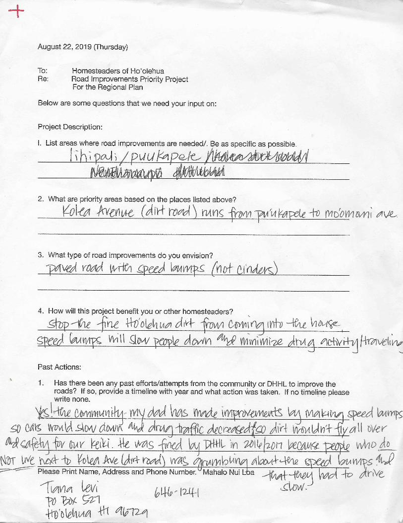
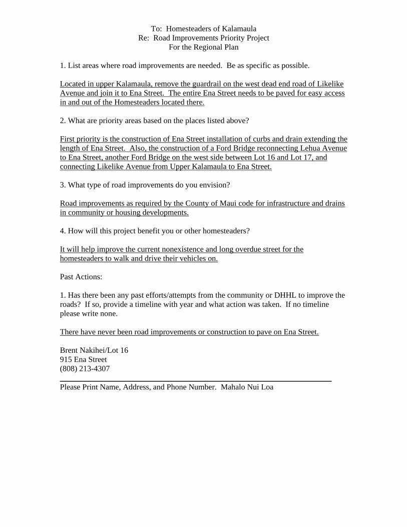
To: Homesteaders of Kalamaula
Re: Road Improvements Priority Project
For the Regional Plan
1. List areas where road improvements are needed. Be as specific as possible.
Located in upper Kalamaula, remove the guardrail on the west dead end road of Likelike
Avenue and join it to Ena Street. The entire Ena Street needs to be paved for easy access
in and out of the Homesteaders located there.
2. What are priority areas based on the places listed above?
First priority is the construction of Ena Street installation of curbs and drain extending the
length of Ena Street. Also, the construction of a Ford Bridge reconnecting Lehua Avenue
to Ena Street, another Ford Bridge on the west side between Lot 16 and Lot 17, and
connecting Likelike Avenue from Upper Kalamaula to Ena Street.
3. What type of road improvements do you envision?
Road improvements as required by the County of Maui code for infrastructure and drains
in community or housing developments.
4. How will this project benefit you or other homesteaders?
It will help improve the current nonexistence and long overdue street for the
homesteaders to walk and drive their vehicles on.
Past Actions:
1. Has there been any past efforts/attempts from the community or DHHL to improve the
roads? If so, provide a timeline with year and what action was taken. If no timeline
please write none.
There have never been road improvements or construction to pave on Ena Street.
Brent Nakihei/Lot 16
915 Ena Street
(808) 213-4307
____________________________________________________________________
Please Print Name, Address, and Phone Number. Mahalo Nui Loa
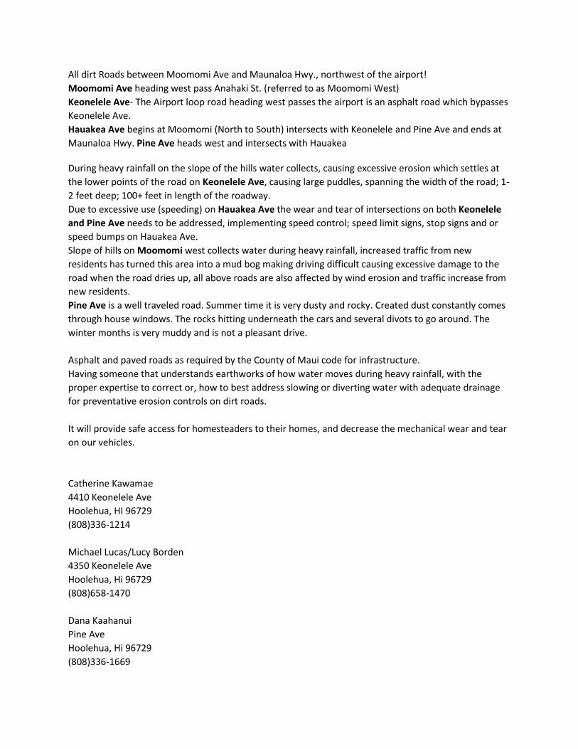
All dirt Roads between Moomomi Ave and Maunaloa Hwy., northwest of the airport!
Moomomi Ave heading west pass Anahaki St. (referred to as Moomomi West)
Keonelele Ave- The Airport loop road heading west passes the airport is an asphalt road which bypasses
Keonelele Ave.
Hauakea Ave begins at Moomomi (North to South) intersects with Keonelele and Pine Ave and ends at
Maunaloa Hwy. Pine Ave heads west and intersects with Hauakea
During heavy rainfall on the slope of the hills water collects, causing excessive erosion which settles at
the lower points of the road on Keonelele Ave, causing large puddles, spanning the width of the road; 1-
2 feet deep; 100+ feet in length of the roadway.
Due to excessive use (speeding) on Hauakea Ave the wear and tear of intersections on both Keonelele
and Pine Ave needs to be addressed, implementing speed control; speed limit signs, stop signs and or
speed bumps on Hauakea Ave.
Slope of hills on Moomomi west collects water during heavy rainfall, increased traffic from new
residents has turned this area into a mud bog making driving difficult causing excessive damage to the
road when the road dries up, all above roads are also affected by wind erosion and traffic increase from
new residents.
Pine Ave is a well traveled road. Summer time it is very dusty and rocky. Created dust constantly comes
through house windows. The rocks hitting underneath the cars and several divots to go around. The
winter months is very muddy and is not a pleasant drive.
Asphalt and paved roads as required by the County of Maui code for infrastructure.
Having someone that understands earthworks of how water moves during heavy rainfall, with the
proper expertise to correct or, how to best address slowing or diverting water with adequate drainage
for preventative erosion controls on dirt roads.
It will provide safe access for homesteaders to their homes, and decrease the mechanical wear and tear
on our vehicles.
Catherine Kawamae
4410 Keonelele Ave
Hoolehua, HI 96729
(808)336-1214
Michael Lucas/Lucy Borden
4350 Keonelele Ave
Hoolehua, Hi 96729
(808)658-1470
Dana Kaahanui
Pine Ave
Hoolehua, Hi 96729
(808)336-1669