draft report: scattered tree assessment at 110 smiths lane, … · head office: 292 mt alexander...
TRANSCRIPT

HEAD OFFICE: 292 Mt Alexander Road VIC 3056; GEELONG: PO Box 8048 Newtown VIC 3220; BRISBANE: Level 7, 140 Ann Street, Brisbane QLD 4000
1
DRAFT REPORT:
Scattered Tree Assessment at 110 Smiths Lane, Clyde
North, Victoria.
PREPARED FOR:
Mirvac December 2012
Ecology and Heritage Partners Pty Ltd

Scattered Tree Assessment, 110 Smiths Lane, Clyde North 2
Table of Contents
Executive Summary ...................................................................................................4
1 Introduction .....................................................................................................5
1.1 Background .......................................................................................................5
1.2 Objectives .........................................................................................................5
1.3 Study Area ........................................................................................................5
2 Methods ...........................................................................................................7
2.1 Nomenclature ....................................................................................................7
2.2 Literature and Database Review .......................................................................7
2.3 Field Surveys ....................................................................................................7
2.3.1 Tree Assessment .................................................................................................................. 7
3 Results .............................................................................................................9
3.1 Tree assessment ...............................................................................................9
3.1.1 Scattered trees ..................................................................................................................... 9
3.1.2 Trees in patches ................................................................................................................. 10
3.2 Net Gain Analysis ............................................................................................10
3.2.1 Scattered trees ................................................................................................................... 10
3.2.2 Trees within Patches .......................................................................................................... 11
3.2.3 Net Gain .............................................................................................................................. 11
4 Legislation and Regulations ........................................................................14
References ...............................................................................................................16
FIGURES ...................................................................................................................18
Tables
Table 1. Indigenous scattered trees within the 110 Smiths Lane study area ........................... 9
Table 2. Trees within patches in the 110 Smiths Lane study area ........................................ 10
Table 3. Offset requirements for scattered trees and trees within patches within the study
area .............................................................................................................................. 12

Scattered Tree Assessment, 110 Smiths Lane, Clyde North 3
Acknowledgments
We thank the following people for their contribution in the project.
Tom Faulkner (Mirvac) for project information and resources.
The Department of Sustainability and Environment for the use of the Victorian
Biodiversity Atlas.
Landholders for providing access and information on their properties.
Document Control
Project Name Scattered Tree Assessment at 110 Smiths Lane, Clyde North, Victoria.
Project Number 4384
Project Manager Shannon LeBel - Botanist
Report Author(s) Shannon LeBel – Botanist, James Garden - Botanist
Report Reviewer Amanda Smith – Consultant Zoologist
Other EHP Staff
Mapping Monique Elsley
File Name 4384_SmithsLane_ScatteredTrees_Draft_14122012
Report Version Comments Comments Updated by:
Date Submitted
Draft V1 Preparation of draft report NA 14/12/12
Copyright © Ecology and Heritage Partners Pty Ltd
This document is subject to copyright and may only be used for the purposes for which it
was commissioned. The use or copying of this document in whole or part without the
permission of Ecology and Heritage Partners Pty Ltd is an infringement of copyright.
Disclaimer
Although Ecology and Heritage Partners Pty Ltd have taken all the necessary steps to
ensure that an accurate document has been prepared, the company accepts no liability for
any damages or loss incurred as a result of reliance placed upon the report and its content.
Scattered Tree Assessment, 110 Smiths Lane, Clyde North 4
EXECUTIVE SUMMARY
Ecology and Heritage Partners Pty Ltd was commissioned by Mirvac Victoria Pty Ltd to
undertake a Scattered Tree assessment for the property at 110 Smiths Lane, Clyde, Victoria.
This property is part of Precinct Structure Plan (PSP) 1055 ‘Clyde East’.
Methodology
A site assessment was undertaken on 27 November 2012 to identify scattered tree values
within the study area. All scattered indigenous trees were mapped and the species, size class
and the conservation significance of each tree was determined according to the relevant EVC
benchmark. The health (i.e. percentage die-back) and fauna habitat values of the trees were
also recorded.
Results
Fourteen scattered trees, including three LOTs, four MOTs and Seven STs, were recorded
within the study area. These trees are likely remnants of the Swampy Riparian Woodland
(EVC83) that would have occurred along Cardinia Creek prior to modification of the
landscape for agricultural purposes.
In addition, two LOTs were identified in a small patch of remnant vegetation within the study
area.
Implications
Given all trees are located within or near the easement associated with Cardinia Creek, their
retention would be unlikely to significantly impact on the proposed development. It is
therefore recommended that design of the proposed precinct provide adequate consideration
of scattered trees and patches, to ensure these are not removed or adversely impacted.
However, assuming all indigenous trees within the study area were to be removed for the
purposes of informing offset requirements, the following offsets would need to be secured:
Protect 20 Large Old Trees, 8 MOTs and recruit 308 new plants from within the same
EVC, within the Gippsland Plain bioregion, or a Very High conservation significance
EVC within the Gippsland Plain bioregion;
OR
Recruit 968 new plants from within the same EVC, within the Gippsland Plain
bioregion, or a Very High conservation significance EVC within the Gippsland Plain
bioregion.
If not previously undertaken, a Habitat Hectare assessment will be required for the remnant
vegetation patch to further inform the NVPP for Precinct 1055.

Scattered Tree Assessment, 110 Smiths Lane, Clyde North 5
1 INTRODUCTION
1.1 Background
Ecology and Heritage Partners Pty Ltd was commissioned by Mirvac Victoria Pty Ltd to
undertake a Scattered Tress assessment at 110 Smiths Lane, Clyde North, Victoria (the study
area) as part of the biodiversity assessments for Precinct Structure Plan (PSP) 1055 (Clyde
East) on the urban fringe of south-east Melbourne (Figure 1). The purpose of this report is to
identify scattered tree values within the property and to inform the Native Vegetation Precinct
Plan (NVPP) as part of the PSP planning process.
1.2 Objectives
The objectives of the project were to:
Identify, assess and map all scattered trees within the study area, including:
o the level of conservation significance for each tree;
o the size class;
o percentage of dieback; and,
o indicators of fauna habitat.
Determine whether trees require offsetting, and calculate the offset score;
Record incidental observations of threatened flora and/or fauna,
Collect data at a sufficient detail and standard to inform the development of a Precinct
Structure Plan (PSP) and Biodiversity Plan;
1.3 Study Area
The study area comprises a private property located at 110 Smiths Lane, Clyde North,
Victoria, approximately 50 kilometres south-east of Melbourne CBD (Figure 1).
The area occurs within an agricultural landscape, with surrounding land-uses including
livestock grazing. The majority of the area is cleared farming land dominated by introduced
pasture grasses, and during the current assessment was grazed by cattle.
The property is approximately 200 hectares in area, bound to the east by Lower Cardinia
Creek and to the west by Smiths Lane (Figure 1). A dwelling with a house and associated
outbuildings is situated in the south-western corner of the property.
The study area lies within the boundaries of the Port Phillip and Westernport Catchment
Management Authority (CMA). Under the City of Casey planning scheme the majority of the
study area is Urban Growth Zone (UGZ), with areas of Farming Zone – Schedule 2 (FZ2),
Rural Conservation Zone (RCZ) and Urban Floodway Zone (UFZ). The majority of the study
area is subject to a Land Subject to Inundation Overlay (LSIO), while the area adjacent to

Scattered Tree Assessment, 110 Smiths Lane, Clyde North 6
Cardinia Creek is subject to an Environmental Significance Overlay - Schedule 6 (ESO6).
The study area lies within the Urban Growth Boundary (UGB) (DSE 2012a).
The study area lies within the Gippsland Plain bioregion (DSE 2012a). The Gippsland Plain
bioregion extends from Port Phillip Bay in the west, to Bairnsdale in the east, between the
southern slopes of the Great Dividing Range and Wilsons Promontory, excluding the
Strzelecki Ranges.
Scattered Tree Assessment, 110 Smiths Lane, Clyde North 7
2 METHODS
2.1 Nomenclature
Common and scientific names of vascular plants follow the Victorian Biodiversity Atlas (DSE
2011a) and the Census of Vascular Plants of Victoria (Walsh and Stajsic 2007). Vegetation
community names follow DSE’s EVC Benchmarks (DSE 2012b).
2.2 Literature and Database Review
A desktop assessment was undertaken prior to field surveys. The following resources and
databases were reviewed over the duration of the project:
The Victorian Biodiversity Atlas (DSE 2011a), and Flora Information System
(Viridans 2011a) databases;
The DSE’s Biodiversity Interactive Maps showing historic and current EVCs (DSE
2012a);
Sites of Biological Significance (BioSites) (DSE 2012a).
Department of Sustainability, Environment, Water, Population and Communities
(DSEWPC) Protected Matters Search Tool which identifies matters of National
Environmental Significance (NES) (e.g. listed flora and fauna species and ecological
communities, Ramsar wetlands) protected under the EPBC Act (SEWPaC 2012).
Planning Schemes Online providing the current zone and overlays (DPCD 2012);
Aerial photography of the study area, and,
Relevant legislation and policies.
2.3 Field Surveys
All vegetation assessments were undertaken by experienced personnel who had a current
Vegetation Quality Assessment Check Certificate (Habitat Hectares).
A site assessment was undertaken on 27 November 2012 to identify scattered tree values
within the study area. All scattered indigenous trees (i.e. those not located within a remnant
patch of vegetation) were mapped onto aerial photography and as a point file in the required
software. The species, size class and the conservation significance of each tree was
determined according to the relevant EVC benchmark. All incidental records of significant
flora and fauna were noted.
2.3.1 Tree Assessment
The Framework recognises that old trees are important environmental assets and these can be
found in habitat zones, or as relicts of vegetation that formerly occupied the site (scattered
trees). The Framework includes minimum protection/replacement ratios for trees that are to
Scattered Tree Assessment, 110 Smiths Lane, Clyde North 8
be removed as part of permitted clearing, based on the Diameter at Breast Height (DBH).
Ratios apply to large old trees in ‘habitat zones’, and to scattered old trees where the
indigenous understorey cover is less than 25% of the total understorey cover. Small scattered
trees (i.e. not old trees) are also considered to be environmental assets, and any permitted
clearance would require offset ratios for the loss of these trees.
As such, all scattered indigenous trees (i.e. those not located within a remnant patch of
vegetation) were mapped and the species, size class (compared with the relevant EVC
benchmark) and conservation significance of each tree was determined.
Scattered Trees
In relation to scattered old trees in parcels of land the Framework states:
For each medium or large old tree removed as part of permitted clearing an appropriate number of new
trees must be recruited. The number of new trees that must be recruited will be specified in regional
Native Vegetation Plans and may be graded according to conservation significance. However, where it
better suits their circumstances, landholders may use the ‘protect other trees and ensure supplementary
recruitment’ approach to meet this criteria (DNRE 2002, p. 55).
The Port Philip and Westernport Native Vegetation Plan (PPWCMA 2006) currently contains
offset ratios for losses of scattered trees in patches of native vegetation. These offset ratios
include:
Protect and recruit options for Very Large, and Large Old Trees; or
Recruit only options for Very Large, Large, Medium Old Trees and Small Trees.

Scattered Tree Assessment, 110 Smiths Lane, Clyde North 9
3 RESULTS
3.1 Tree assessment
3.1.1 Scattered trees
The majority of the study area was highly modified as a result of agricultural practices and
contained predominantly planted trees and shrubs in windrows. Common species included the
exotic Cypress Cupressus spp., and planted natives Southern Blue Gum Eucalyptus bicostata,
Gippsland Mallee Eucalyptus kitsoniana, and Corymbia sp.. Many of the windrows also
included indigenous planted shrubs such as Silver Wattle Acacia dealbata, Giant Honey-
myrtle Melaleuca armillaris, Totem-poles Melaleuca decussata, Prickly-leaved Paperbark
Melaleuca styphelioides and Saw-Toothed Banksia Banksia serrata.
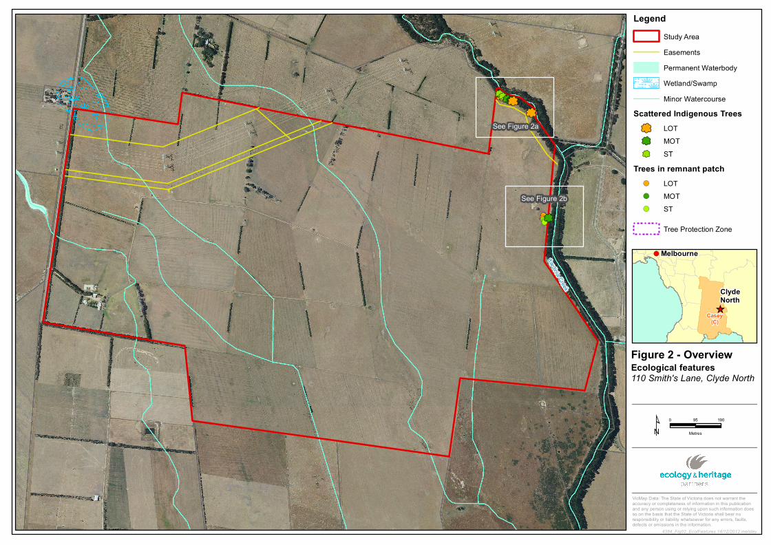
The only indigenous remnant trees found within the study area occurred in the north-eastern
corner adjacent to Cardinia Creek (Figure 2). A total of 14 indigenous trees were identified
within the property boundary (Table 1). All trees were Manna Gums Eucalyptus viminalis,
representing remnants of the Swampy Riparian Woodland Ecological Vegetation Class (EVC
83; Gippsland Plain bioregion) that is still present along the margins of the creek.
The majority (11) of these trees are still relatively young, being classified as either a Small
Tree (ST) or Medium Old Tree (MOT). These provided limited value as fauna habitat due to
their lack of structural complexity, particularly with regard to hollows. Three large old trees
were identified however these too showed few indicators of containing unique fauna habitat
values.
The trees were all in moderate to good health. Whilst dieback was a common feature of all
trees, it was not considered to be indicative of poor health. This is a common adaptation
within Eucalyptus species to shed branches and limbs, as a way to mitigate the impacts
associated with varied climatic conditions (particularly drought).
Table 1. Indigenous scattered trees within the 110 Smiths Lane study area
Tree
No.
Latitude Longitude Species DBH Size
class1
%
dieback
Fauna
habitat
Incidental obs. of
threatened species
1 -38.09943 145.39629 E. viminalis 51 ST 90
2 -38.09948 145.39635 E. viminalis 45 ST 70
3 -38.09952 145.39642 E. viminalis 87 LOT 85
4 -38.09946 145.39634 E. viminalis 20 ST 70
5 -38.09944 145.39632 E. viminalis 31 ST 80
6 -38.09943 145.39632 E. viminalis 12 ST 80
7 -38.09952 145.39646 E. viminalis 48 ST 75
11 -38.09962 145.39665 E. viminalis 59 MOT 85
12 -38.09967 145.3968 E. viminalis 65 MOT 60
13 -38.09967 145.39684 E. viminalis 58 MOT 60
14 -38.09969 145.39689 E. viminalis 76 LOT 70
15 -38.10009 145.39766 E. viminalis 74 LOT 85
16 -38.10364 145.39832 E. viminalis 27 ST 70
17 -38.10364 145.39832 E. viminalis 62 MOT 70

Scattered Tree Assessment, 110 Smiths Lane, Clyde North 10
1 Based on the Large Old Tree benchmark for the Swampy Riparian Woodland EVC (83).
Scattered trees numbered 1 to 15 were located in a Melbourne Water Easement which runs
adjacent to the north-eastern boundary of the study area, approximately 50 metres from the
top of bank of Cardinia Creek. Scattered trees 16 and 17 were located on the outside edge of
the property boundary. However, as more than 10% of the Tree Protection Zones (Section
3.2.3) encroach, they have been included in the assessment (Figure 2).
3.1.2 Trees in patches
In addition to the 14 scattered trees recorded in the north-east of the study area, a further eight
indigenous trees were identified forming a small patch approximately 300 metres south along
Cardinia Creek (Figure 2). The patch contained five STs, one MOT and three LOTs (Table
2). Whilst highly degraded the patch is considered to be representative of the Swampy
Riparian Woodland (EVC 83).
One of the LOTs, a River Red Gum Eucalyptus camaldulensis, contained a small hollow
providing potential habitat for small arboreal mammals and birds.
Table 2. Trees within patches in the 110 Smiths Lane study area
Tree
No.
Latitude Longitude Species DBH Size
class1
%
dieback
Fauna
habitat
Incidental obs. of
threatened species
18 -38.10357 145.39814 E. viminalis 64 MOT 85
19 -38.10355 145.39811 E. viminalis 73 LOT 70
20 -38.10364 145.39808 E. camaldulensis 86 LOT 70 Small hollow
21 -38.10369 145.39809 E. viminalis 40 ST 75
22 -38.10369 145.3981 E. viminalis 45 ST 75
23 -38.10373 145.39813 E. viminalis 35 ST 70
24 -38.10375 145.39815 E. camaldulensis 50 ST 50
25 -38.10379 145.39815 E. camaldulensis 25 ST 50
1 Based on the Large Old Tree benchmark for the Swampy Riparian Woodland EVC (83).
A habitat hectare assessment was not undertaken on this patch as it was outside the scope of
this assessment. However, this area will require further assessment if not previously
undertaken, to inform the preparation of the NVPP for the PSP, irrespective of its likely
retention or removal for future development.
3.2 Net Gain Analysis
3.2.1 Scattered trees
Fourteen scattered indigenous trees were recorded within the study area (Table 1; Figure 2).
These include:
Seven STs;

Scattered Tree Assessment, 110 Smiths Lane, Clyde North 11
Four MOTs; and,
Three LOTs.
3.2.2 Trees within Patches
Two LOTs were identified in patches within the study area that qualify for consideration
under the Framework (STs and MOTs are not considered to be significant within a patch and
therefore no special considerations are made under the Framework) (Table 2; Figure 2).
3.2.3 Net Gain
The three-step approach to applying Net Gain for applications to clear native vegetation
involves demonstration of avoidance and minimisation measures as the first two steps, and
only after these first two steps have been addressed should offsets be considered (DNRE
2002).
Avoidance (Step 1)
‘The Framework’ requires avoidance as the first step in considering the impacts of
development on native vegetation. In light of this requirement, any proposed construction
within the study area needs to demonstrate how native vegetation avoidance has been
achieved in the design process. Avoidance may generally be interpreted as avoiding adverse
impacts on trees or habitat patches, particularly through vegetation clearance, with the
vegetation being retained post construction (DNRE 2002).
Given all scattered trees are located within the easement associated with Cardinia Creek, their
retention would be unlikely to significantly impact on the proposed development. It is
therefore recommended that design of the proposed precinct provide adequate consideration
of scattered trees and patches to ensure these are not removed or adversely impacted.
Minimisation (Step 2)
This step is generally interpreted as minimising impacts on trees or remnant vegetation
through appropriate consideration in planning processes and expert input to project design or
management (DNRE 2002).
For all trees and patches being retained, precinct design and construction plans should ensure
adequate protection measures are in place to mitigate any short and long term impacts to the
vegetation retained. This should include consideration of Tree Protection Zones (TPZs),
installing temporary fencing and informing contractors of values and sensitivities associated
with the vegetation to be retained.
Tree Protection Zones (TPZs) should be implemented to prevent indirect losses of
native vegetation during construction activities (DSE 2010), and at a minimum
standard of a TPZ should include:

Scattered Tree Assessment, 110 Smiths Lane, Clyde North 12
a TPZ applies to a tree and is a specific area above and below the ground, with
a radius 12 x the DBH;
A TPZ of trees should be no less than 2 metres or greater than 15 metres;
Construction, construction related activities and encroachment (i.e. earthworks
such as trenching that disturb the root zone) should be excluded from the TPZ;
Where encroachment exceeds 10% of the total area of the TPZ, the tree should
be considered as lost and offset accordingly; and,
Subject to qualified arborist confirming that it is appropriate for the specific
works, directional drilling may be used for works within the TPZ without being
considered encroachment. The directional bore should be at least 600
millimetres deep. An arborist should also confirm that the radius of the bore
will not significantly damage the tree causing it to be lost in the future.
Where the minimum standard for a TPZ has not been met an offset may be
required (DSE 2010).
Offset Calculations (Step 3)
Once steps 1 and 2 have been considered, then offsets or Net Gain targets can be calculated
for any permitted vegetation clearance (DNRE 2002).
‘The Framework’ sets out responses, including like for like criteria and Net Gain ratios, to
proposals to clear and offset native vegetation, based on the conservation significance of the
vegetation.
The responsible authority’s responses to applications to clear native vegetation follow the
guidelines in the Framework (DNRE 2002) and are dependent on the vegetation’s
conservation significance and the Port Phillip and Western Port CMA Native Vegetation Plan
(PPWCMA 2006). In general, clearing is not permitted for vegetation of very high, high or
medium conservation significance.
For the purposes of informing offset requirements should they be required, the following
presents the Net Gain targets for the removal of all scattered trees and Large Old Treess in
patches within the study area (Table 3).
Table 3. Offset requirements for scattered trees and trees within patches within the study area
Tree size class Conservation significance
Number of trees
Protect and Recruit1 Recruit Only
Multiplier1 2
Net Gain targets
Protect multiplier
Recruit multiplier
VLOT (>105cm) High 0 5 30 180 0
LOT (70 - 104 cm) High 5 4 20 120 Protect 20 LOTs & Recruit 100
Or
Recruit 600

Scattered Tree Assessment, 110 Smiths Lane, Clyde North 13
Tree size class Conservation significance
Number of trees
Protect and Recruit1 Recruit Only
Multiplier1 2
Net Gain targets
Protect multiplier
Recruit multiplier
MOT (52 - 69cm) High 4 2 20 60 Protect 8 MOTs & Recruit 80
Or
Recruit 240
ST (11 – 20cm) Low 1 NA NA 2 Recruit 2
ST (21 – 30cm) Low 2 NA NA 8 Recruit 16
ST (31 – 40cm) Low 1 NA NA 20 Recruit 20
ST (41 – 52.5cm) Low 3 NA NA 30 Recruit 90
1 Protect and recruit multipliers based on the Port Phillip and Western Port Native Vegetation Plan (2006).
2 Recruitment multipliers for small trees (where the total to be removed does not exceed 50) are calculated for
each tree specifically – see Figure 7 Port Phillip and Western Port Native Vegetation Plan (2006).
Therefore, assuming all indigenous trees within the study area were to be removed, the
following offsets would need to be secured:
Protect 20 Large Old Trees, 8 MOTs and recruit 308 new plants from within the same
EVC within the Gippsland Plain bioregion, or a Very High conservation significance
EVC within the Gippsland Plain bioregion;
OR
Recruit 968 new plants from within the same EVC within the Gippsland Plain
bioregion, or a Very High conservation significance EVC within the Gippsland Plain
bioregion.
Offset calculations for the remnant patch of indigenous vegetation noted within the study area
has not been provided.

Scattered Tree Assessment, 110 Smiths Lane, Clyde North 14
4 LEGISLATION AND REGULATIONS
The following section provides a brief outline of the implications of the assessments findings
under the major environmental legislation relevant to the study area and proposed
development.
Environment Protection and Biodiversity Conservation Act 1999
No Environment Protection and Biodiversity Conservation Act 1999 (EPBC Act) listed
species were recorded during the tree assessment. Targeted surveys for Matters of National
Environmental Significance (MNES) were outside the scope of the current assessment.
Flora and Fauna Guarantee Act 1988
No Flora and Fauna Guarantee Act 1988 (FFG Act) listed species were recorded during the
tree assessment. Targeted surveys for species listed under the FFG Act was outside the scope
of the current assessment.
Planning and Environment Act 1987
A planning permit from the City of Casey is required to remove or disturb any native
vegetation within the study area.
Victoria’s Native Vegetation Management - A Framework for Action (DNRE 2002)
Fourteen scattered trees and two LOTs within a remnant patch were recorded within the study
area. If lost, these trees will likely require offsetting as per Victoria’s Native Vegetation
Management - A Framework for Action (the ‘Framework’) (DNRE 2002). A Net Gain
analysis is presented in Section 3.2.
Biodiversity Conservation Strategy for Melbourne’s Growth Areas
The draft Biodiversity Conservation Strategy (BCS) (DSE 2011) for Melbourne’s Growth
Areas has been prepared in response to obligations arising from a review of the Strategic
Impact Assessment Report (SIAR) (DSE 2009) conducted under the Commonwealth
Environmental Protection and Biodiversity Act 1999 (EPBC Act). The BCS covers
Melbourne’s four growth areas within the expanded 2010 Urban Growth Boundary, as well as
the previous 28 precincts, except where a planning scheme amendment to introduce a Precinct
Structure Plan has been approved prior to 1st March 2012.
Implications
This proposed PSP 1055 (Clyde East) is part of the Urban Growth Zone and thus will be
subject to the requirements of the BCS once it is approved. A Habitat Hectare assessment will
need to be conducted on the patch of remnant vegetation identified on-site, unless the study
area has previously been ‘time-stamped’. Table 3 lists all scattered trees and their Net Gain
targets identified within the study area. The NVPP will be prepared from the combined
‘Time-stamped’ native vegetation and scattered tree information presented in this report.

Scattered Tree Assessment, 110 Smiths Lane, Clyde North 15
Conclusion
Fourteen scattered trees, including three LOTs, four MOTs and Seven STs, were recorded
within the study area. These trees are likely remnants of the Swampy Riparian Woodland
(EVC83) that would have occurred along Cardinia Creek prior to modification of the
landscape for agricultural purposes.
In addition, two LOTs were identified in a small patch of remnant vegetation within the study
area.
Given the majority of scattered trees are located within the easement associated with Cardinia
Creek, their retention would be unlikely to significantly impact on the proposed development.
It is therefore recommended that design of the proposed precinct provide adequate
consideration of scattered trees and patches to ensure these are not removed or adversely
impacted.
However, assuming all indigenous trees within the study area were to be removed for the
purposes of informing offset requirements, the following offsets would need to be secured:
Protect 20 Large Old Trees, 8 MOTs and recruit 308 new plants from within the same
EVC within the Gippsland Plain bioregion, or a Very High conservation significance
EVC within the Gippsland Plain bioregion;
OR
Recruit 968 new plants from within the same EVC within the Gippsland Plain
bioregion, or a Very High conservation significance EVC within the Gippsland Plain
bioregion.
If not previously undertaken, a Habitat Hectare assessment will be required for the remnant
vegetation patch to further inform the NVPP for Precinct 1055.

Scattered Tree Assessment, 110 Smiths Lane, Clyde North 16
REFERENCES

Scattered Tree Assessment, 110 Smiths Lane, Clyde North 17
References
DPCD 2012. Planning Schemes Online. Department of Planning and Community
Development: http://www.dse.vic.gov.au/planningschemes/
DSE 2009. Delivering Melbourne’s Newest Sustainable Communities – Strategic Impact
Assessment Report. For The Environmental Protection and Biodiversity Conservation Act
1999. The Department of Sustainability and Environment, Melbourne, Victoria.
DSE 2010. Native Vegetation – Technical Information Sheet August 2010. Department of
Sustainability and Environment, Victoria.
DSE 2011. Biodiversity Conservation Strategy for Melbourne’s Growth Areas - Draft for
Public Consultation. The Department of Sustainability and Environment, Melbourne,
Victoria.
DSE 2012a. Biodiversity Interactive Mapping. Available at URL: www.dse.vic.gov.au
Department of Sustainability and Environment, East Melbourne, Victoria.
DSE 2012b. Victorian Biodiversity Atlas. Department of Sustainability and Environment,
Victoria, East Melbourne, Victoria.
DSE 2012c. EVC Benchmarks, Gippsland Plain Bioregion. Available at URL:
www.dse.vic.gov.au. Department of Sustainability and Environment, East Melbourne,
Victoria.
DNRE 2002. Victoria's Native Vegetation Management: A Framework for Action. Natural
Resources & Environment, Victoria.
PPWCMA 2006. Port Phillip and Westernport Native Vegetation Plan. Port Phillip and
Westernport Catchment Management Authority, Victoria.
SEWPaC 2012. Environment Protection and Biodiversity Act 1999 Protected Matters Search
Tool. Available at URL: http://www.environment.gov.au/erin/ert/epbc/index.html. The
Department of Sustainability, Environment, Water, Population and Communities, Canberra
Viridans 2011a. Flora Information System (FIS). Maintained by the Department of
Sustainability and Environment, , East Melbourne, Victoria. Published by Viridans Pty
Ltd, East Bentleigh, Victoria.
Walsh, N.G. & Stajsic, V. 2007. A Census of the Vascular Plants of Victoria 8th
Edition.
Royal Botanic Gardens, Melbourne.

Scattered Tree Assessment, 110 Smiths Lane, Clyde North 18
FIGURES

Clyde
Officer
Cardinia Creek
Princes Fwy
Clyd
e - Fi
ve W
ays R
d
Card
inia R
d
Ballarto Rd
Clyd
e Rd
Princes Hwy
Thompsons Rd
Berw
ick - C
ranbo
urne
Rd
Princes Hwy
South Gippsland Hwy
Twyford Rd
Starlin
g Rd
Mcgre
gor R
dTo
omuc
Valley
Rd
Dalm
ore R
d
Oshea Rd
Berw
ickSp
rings
Prom
Beme
rsyde
Dr
Cardi
nia R
d
Moon
darra Dr
Ballarto Rd
Homestead Rd
Toora
din St
ation
Rd
Ridgemo nt Dr Viewgra
nd Dr
Pound Rd
Shearwater Dr
Duncan DrHenry Rd
Soldi
ers R
d
Greaves Rd
Wenn
Rd
Offic
er So
uth R
d
Patterson Rd
Lecky Rd
4384_Fig01_StudyArea 14/12/2012 melsley
¹ 0 1,100550
Metres
Figure 1Location of the study area110 Smith's Lane, Clyde North
VicMap Data: The State of Victoria does not warrant theaccuracy or completeness of information in this publicationand any person using or relying upon such information doesso on the basis that the State of Victoria shall bear noresponsibility or liability whatsoever for any errors, faults,defects or omissions in the information.
!(
_̂
Melbourne
ClydeNorth
Casey(C)
LegendStudy AreaRailwayFreewayMajor RoadCollector RoadMinor RoadProposed RoadWalking TrackMinor WatercoursePermanent WaterbodyLand Subject to InundationWetland/SwampParks and Reserves
Crown Land
!(!(!(!(!(!(!(!(
nmnmnmnmnmnmnmnmnmnmnm
nm
nmnm
See Figure 2a
See Figure 2b
Cardinia Creek
4384_Fig02_EcolFeatures 14/12/2012 melsley
¹ 0 19095
Metres
Figure 2 - OverviewEcological features110 Smith's Lane, Clyde North
VicMap Data: The State of Victoria does not warrant theaccuracy or completeness of information in this publicationand any person using or relying upon such information doesso on the basis that the State of Victoria shall bear noresponsibility or liability whatsoever for any errors, faults,defects or omissions in the information.
!(
_̂
Melbourne
ClydeNorth
Casey(C)
LegendStudy AreaEasementsPermanent WaterbodyWetland/SwampMinor Watercourse
Scattered Indigenous Treesnm LOTnm MOTnm ST
Trees in remnant patch!( LOT!( MOT!( ST
Tree Protection Zone

nm
nm
nm
nmnmnm
nm
nm
nmnmnm
nm
Cardinia Creek
001002
003
005006
007
011
012
013
014
015
4384_Fig02_EcolFeatures_MB 14/12/2012 melsley
¹ 0 105
Metres
Figure 2aEcological features110 Smith's Lane, Clyde North
VicMap Data: The State of Victoria does not warrant theaccuracy or completeness of information in this publicationand any person using or relying upon such information doesso on the basis that the State of Victoria shall bear noresponsibility or liability whatsoever for any errors, faults,defects or omissions in the information.
!(
_̂
Melbourne
ClydeNorth
Casey(C)
LegendStudy AreaEasements
Minor WatercourseScattered Indigenous Treesnm LOTnm MOTnm ST
Trees in remnant patch!( LOT!( MOT!( ST
Tree Protection Zone

!(!(
!(
!(!(
!(!(
!(
nmnm
Cardi
nia C
reek018
019
020021 022
023024 025
016
017
4384_Fig02_EcolFeatures_MB 14/12/2012 melsley
¹ 0 105
Metres
Figure 2bEcological features110 Smith's Lane, Clyde North
VicMap Data: The State of Victoria does not warrant theaccuracy or completeness of information in this publicationand any person using or relying upon such information doesso on the basis that the State of Victoria shall bear noresponsibility or liability whatsoever for any errors, faults,defects or omissions in the information.
!(
_̂
Melbourne
ClydeNorth
Casey(C)
LegendStudy AreaEasements
Minor WatercourseScattered Indigenous Treesnm LOTnm MOTnm ST
Trees in remnant patch!( LOT!( MOT!( ST
Tree Protection Zone