draft thesis book_80% submission_prital shukla
TRANSCRIPT

THE NOMADIC EDGE
_Knowledge that changes with time......
Prital Shukla Pratt Institute School of Architecture
Thesis project booklet submission Professors_Elliot Maltby and Jason V. Beane
Course Number_ Date_01/18/2010
THE NOMADIC EDGE
_Knowledge that changes with time......
Prital Shukla Pratt Institute School of Architecture
Received and approved_ Thesis Advisor_ Date_
1
Table of contents
Acknowledgements 2
List of Illustrations and Credits 3
1 Thesis Manifesto 4 _Responsive Towards the Ghost Cities of Future
_Critic to Green Wall Sahara
_Introduction to Sahara, lost in the dunes
2 Shifting Desert Edge 8
_Aerial Matrix Desert town / settlements
_Closer Eye on one of the desert city
3 Timeless Timbuktu_A Mystical City 15
_ Empires and Kings, Trans Sahara Trade,
_ Hidden Treasures, Manuscripts
_ Timbuktu libraries vs. Muslim World
_ Touareg Nomads, day to day life
4 Concrete Poetry for Non-Concrete Landscape 25
_ Art Inspiration - Maya Lin’s Art Philosophy
_ Programmatic interventions
5 Strategies to Deal with Sand 37
_ Existing measures to stop the SAND
_ Operative Theme, Analog Study Models
6 Conceptual Design Approach 39
_ Wind Analysis
_ Orientation Iterations, Obligatory Speculations
7 Design Development 47
_ Conditional models with sand
_ Sectional Explorations
_ The New Growing Edge
_ Presentation Boards
Bibliography 61

2
Acknowledgements
Text coming soon…currently formatting it……

3
List of Illustrations and Credits
Text coming soon…currently formatting it……
4
1_Thesis Manifesto_Responsive
1. SHIFTING sand_Dry areas cover more than 1/3rd of Earth’s land surfaces. It
seriously threatens the livelihood of millions of people especially in Africa and China.
The Sahara is most closely associated with the phenomenon of desertification and has
been moving southwards at a rate of almost one square kilometer a year, consuming
villages and wiping out agricultural lands.
In our exhilarated media culture, desertification is simply to slow to hit the headlines.
Yet it remains a major threat to all continents, affecting 110 countries and about 70% of
world’s agricultural dry lands. The Desert as a whole may or may not be expanding, but
no one doubts that localized areas of desertification do exist, almost all human-induced,
especially along the Sahara's southern fringes. In fact, the United Nations has recently
encouraged changing the definition of desertification from "spreading of a desert" to "arid
land degradation," to take account of new thinking. As vegetation is stripped from the
land, the surface dries out and reflects more of the sun's heat. This condition in turn
alters the thermal dynamics of the atmosphere in ways that suppress rainfall. Increased
dust (itself a product of desertification) or other atmospheric pollutants are causing
changes in the climate.
However, skeptics about desertification do exist. A 1998 study reported in the journal
Science disputed what it called "the popular belief" that the Sahara was growing
southward. The study did acknowledge that "land degradation proves to be a problem in
this area, reflecting the more localized effects of grazing and foraging for fuel," but it claimed
to have established that, overall, the shifting desert boundaries were not, in fact, human-
induced but were caused by the natural ups and downs of rainfall. The study also
maintained that while the natural climate has shifted the desert's edge, there was no
change in the total amount of vegetation.
5
2. Threat as an ANCHOR towards solution_My approach is to utilize this problematic
stand in a favorable manner such that the cause itself becomes the anchor in addressing
the threat. The aim is to address this with an acceptance with the problem and then
work with it rather than running away from it or stopping it in some way.
3. CHANCE to CHANGE_Attempt to alter and deviate the phenomenon in a
tactful way by reducing the negativity of destructive expansion over the period. The
intent is to establish a very subtle architectural inter-phase between the ever expanding
cities & moving sand dunes such that the architecture interlopes within the sand
envelope, controlling the shifting borders / edges both ways.
4. FORM (nature) follows architecture vs. ARCHITECTURE flows form
(nature)_Material world is in constant flux due to change in the behavioral patterns
observed in nature. Change in movement of ecological system in turn should change the
moment of architecture on Earth i.e. to use concrete in such a way that it takes the
form as per the action / movement of blowing sand.
5. ANTI-GREEN WALL_ In an effort to subdue the advancing Sahara Desert and
lessen drought in Africa, the Great Green Wall will consist of a band of trees over 4,000
miles long and nine miles wide. From Dakar to Djibouti, the luscious living wall will
sprout through 11 countries in the Sahel-Saharan region of Africa. It suffers from climate
change, which results in severe drought and desertification. The wall of 37
recommended drought-tolerant native plant species aims to slow soil erosion; slow
wind speeds and enables more rainwater to be absorbed by the ground. Desertification
along with mono cropping and overgrazing has led to a tremendous degradation of
agricultural lands in northern Africa. As crops fail, rural villages are forced to move their
families to urban areas in order to survive. Recognizing the need for preventative action
to ward off these recurring issues, the African Union has backed the Great Green Wall
initiative. Plans for the wall initially began five years ago, but due to financial
shortcomings and concern about the trees’ maintenance and longevity, the project has
been on hold since. However, with recent financial support from the Global
6
Environment Facility who has committed to $119 million, the plan is closer to becoming
a reality.
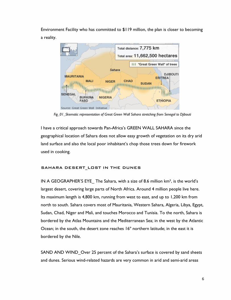
Fig_01_Skematic representation of Great Green Wall Sahara stretching from Senegal to Djibouti
I have a critical approach towards Pan-Africa’s GREEN WALL SAHARA since the
geographical location of Sahara does not allow easy growth of vegetation on its dry arid
land surface and also the local poor inhabitant’s chop those trees down for firework
used in cooking.
SAHARA DESERT_LOST IN THE DUNES
IN A GEOGRAPHER’S EYE_ The Sahara, with a size of 8.6 million km², is the world’s
largest desert, covering large parts of North Africa. Around 4 million people live here.
Its maximum length is 4,800 km, running from west to east, and up to 1,200 km from
north to south. Sahara covers most of Mauritania, Western Sahara, Algeria, Libya, Egypt,
Sudan, Chad, Niger and Mali, and touches Morocco and Tunisia. To the north, Sahara is
bordered by the Atlas Mountains and the Mediterranean Sea; in the west by the Atlantic
Ocean; in the south, the desert zone reaches 16º northern latitude; in the east it is
bordered by the Nile.
SAND AND WIND_Over 25 percent of the Sahara’s surface is covered by sand sheets
and dunes. Serious wind-related hazards are very common in arid and semi-arid areas

7
like Sahara. Dust storms, migrating dunes and blowing sand have resulted into blurring
the city edges and vanishing them over the period of time.
Building fences provide solution to some degree but eventually these too get trapped
with sand. The flattening of moving dunes is a temporary solution, but the flat surface
soon becomes unstable and dunes redevelop. The most effective and permanent
method of stabilization is to plant vegetation. However, in areas where water is scare,
vegetation cover is very difficult to sustain.
Fig_02_Eclectic Town settlements within the range of Sahara Desert
8
2_Shifting Desert Edge
Moving sand dunes are an example of granular flow, a poorly understood branch of
physics. Physicists have long had neat mathematical equations that fully describe the
behavior of solids like bricks, liquids like water, and gases like air. But granular materials
like sand dunes don’t quite fit in any of those categories. Due to such complex behavior
of sand, there has not been any correct answer till date to deal with the shifting sand
dunes during sand storms. This has led to forced migration for millions of people
especially in northern Africa. At the same time, the cities are expanding and encroaching
over these dunes in order to overcome the need of growth and extension over the
period of time......
By 2099 the world is expected to be on average between 1.8 and 4ºc hotter than it is
now. Large areas are expected to become drier—the proportion of land in constant
drought expected to increase from 2 percent to 10 percent by 2050. Meanwhile, the
proportion of land suffering extreme drought is predicted to increase from 1 percent at
present to 30 percent by the end of the 21st century. Rainfall patterns will change as the
hydrological cycle becomes more intense. Changed rainfall patterns and a more intense
hydrological cycle mean that extreme weather events such as droughts, storms and
floods are expected to become increasingly frequent and severe. Less rain would have
particularly serious impacts for sub-Saharan African agriculture which is largely rain-fed.
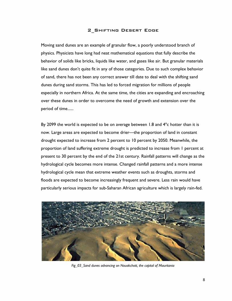
Fig_03_Sand dunes advancing on Nouakchott, the capital of Mauritania
9
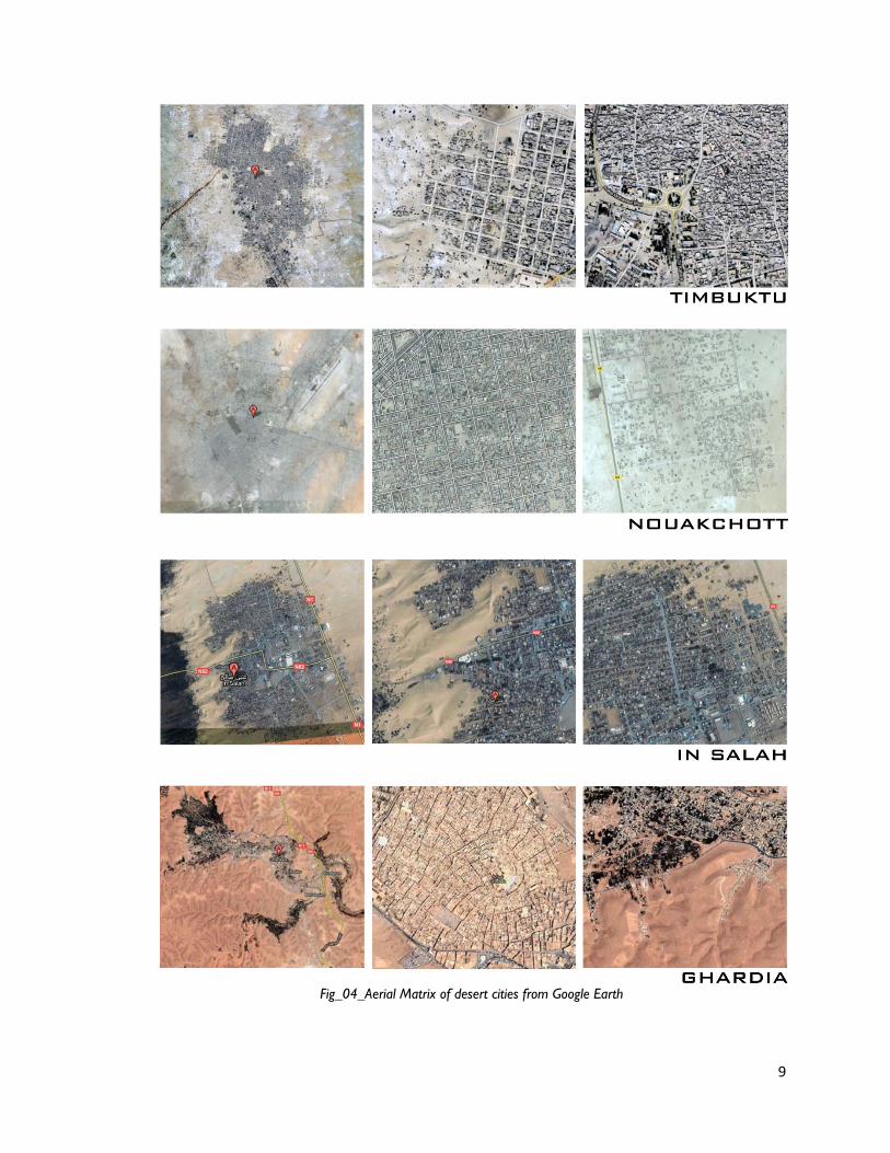
Fig_04_Aerial Matrix of desert cities from Google Earth

10
Fig_05_Aerial Matrix of desert cities from Google Earth

11
Closer Eye on Desert City_Timbuktu
Timbuktu (French, Tombouctou) was established as a market town in about the 11th
century. Its location was admirably suited to serve the needs of the fishing and
agricultural communities on the middle Niger as well as caravans from across the
Sahara. The town increased in importance during the 14th century, when it was part of
the ancient kingdom of Mali. Mansa Musa, emperor of Mali, enlarged its mosques,
encouraged the establishment of an Islamic school, and enhanced Timbuktu's stature as
a repository of Muslim culture. The town reached its peak of prosperity during the peak
of the Songhai Empire (15th–16th centuries). A major caravan center, it was a market
for gold, slaves, and salt. Chroniclers and religious divines mingled in its bazaar with
merchants from North Africa and the sub-Saharan regions of modern Ghana and
Nigeria.
The West African city of Timbuktu flourished as a center for Islamic scholarship from
the fourteenth through the sixteenth centuries. The social structure of the city was
based on wealth, with further stratification by degree of literacy and expertise in
interpreting Islamic legal texts. As a consequence, books and libraries evolved into
blessed symbols of scholarship, wealth, and power. This essay explores the history of
books and libraries during the Golden Age of Timbuktu (1493-1591), followed by a
discussion of the divergence of library practices in Timbuktu from those in the greater
Islamic world of the time.
In Timbuktu, literacy and books transcended scholarly value and symbolized wealth,
power, and baraka (blessings) as well as an efficient means of transmitting information.
The creation and importation of books was a predominant concern for the literature of
Timbuktu. Strangers from distant lands were feted like royalty in the hopes that scholars
could gain access to the visitors’ books and copy them. Furthermore, the pious,
scholarly society in Timbuktu acknowledged few outlets for displaying wealth, most
notably, expanding one’s business, building or refurbishing mosques, patronizing
12
scholars, furnishing one’s home and purchasing as well as collecting books. In the
historical chronicles of Timbuktu, the acquisition of books is mentioned more often than
any other display of wealth, including the building and refurbishment of mosques. While
the number of mosques was finite, the number of books was not, leaving books as a
continual means for spending wealth. Moreover, the scholars were avid bibliophiles,
searching for and clamoring to possess or compose great scholarly works.
The importation of books into Timbuktu was brisk and highly regarded. Leo Africans, a
sixteenth-century traveler to Timbuktu, observed: “Here are great stores of doctors,
judges, priests, and other learned men, that are bountifully maintained at the king’s cost and
charges. And hither are brought the manuscripts or written books out of Barbarie, which are
sold for more money than any other merchandize.” On any list of principal trade items,
paper and books are usually noted. Books from the general body of Islamic knowledge
were common, but as in all Muslim societies the Qur’an was the most common and most
revered book available.
The wealth of the city of Timbuktu, the piety of its rulers, its position at the centre of
Africa's trade routes: these factors encouraged scholars to settle in Timbuktu, bringing
their books with them, and then to draw in more books from North Africa and Egypt.
With such a ready market for books, Timbuktu became not only an importer of books,
but also a place where books were written and copied: texts on theology and law,
studies of the Arabic language, learned Qur’an study and pious poetry in praise of the
prophet were not only written in huge numbers but also, astonishingly, survive.
The main material of construction in Timbuktu is mud brick, although stone is used for
strengthening the walls and in important places such as doorways. The houses of
Timbuktu are either single-storey or two-storey courtyard houses. From the outside
the houses are generally quite plain with shallow square buttresses dividing the wall into
panels. The doorways are fairly simple with wooden doors decorated with Moroccan
brass motifs.

13
AREA_ 1,240,192 km² / POPULATION_ 11,351,000 (2007)
TOWNS_Bamako_1,016,167, Sikasso_1,780,042, Segou_1,679,201,
Koulikoro_1,565,838, Mopti_1,475,274, Kayes_1,372,019, Timbuktu_461,956,
Gao_397,516, Kidal_42,479
CAPITAL_ Bamako
INDUSTRIES_Agriculture, Fishing, Mining, Electric Energy generation
TRANSPORTATION_Railway, Roadway, Airway
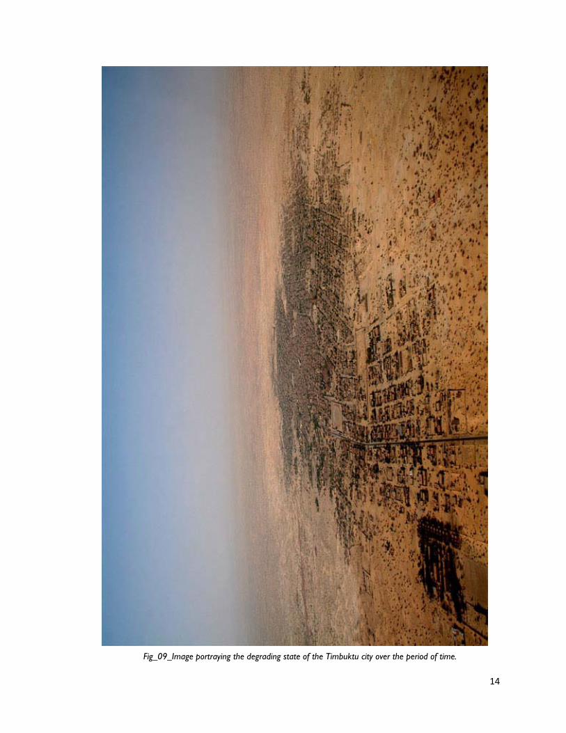
Fig_06_Google Earth Images showing part of uneven Timbuktu City edge.
Fig_08_Detailed View of City block fabric_Timbuktu
14
Fig_09_Image portraying the degrading state of the Timbuktu city over the period of time.

15
3_Timeless Timbuktu-A Mystical City
Salt comes from the north, gold from the south, and silver from the country of the white men,
but the word of God and the treasures of wisdom are only to be found in Timbuctoo.
_Sudanese proverb
To many Western minds the name Timbuktu connotes a far-flung, perhaps imaginary
locale of indeterminate origin, employable in poetry and colorful expressions.
Established on the rim of the Sahara Desert, it was bounded by several great West
African empires. Timbuktu flourished as an autonomous center of trade, commerce, and
scholarship and was ruled by Islamic judges and scholars who wielded the book and the
pen as instruments of supreme power. Only the most learned could rule, and books and
libraries were the source of the requisite erudition the scholars clamored to attain. In
this environment books and book collections became invaluable tools that defined the
lives and aspirations of Timbuktu’s elite.
GHANA_7th to 11th century
The Empire of Ghana is the earliest known empire in the Western Sudan. It is believed
that they had large armies, sophisticated systems of governance, and systems of taxation.
Decline_ The King of Ghana lost his trade monopoly as gold trade routes began to
change and other kingdoms began to mine gold in places not readily accessible to Ghana.
Fig_10_Map showing the most important Trans Saharan trade routes till 14th century
16
MALI_12th to 15th century
The Empire of Mali came into power as the Empire of Ghana was declining. Like Ghana,
it controlled the gold trade, but it also controlled the salt trade. The city of Timbuktu
was a central spot on the trade routes and one of the most important places in medieval
Africa.
SONGHAI_16th to 17th century
The people who made up the Songhai Empire in the 15th century A.D. actually started
as fishermen and canoeists in the 9th century, and formed a kingdom in the 11th
century. They lived in an area claimed by the Mali Empire during Mali’s reign, but Mali
never managed to have control over them.
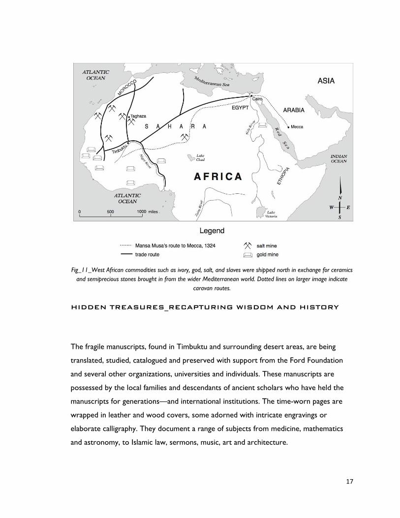
TRANS SAHARA TRADE
The Saharan trade extended from the Sub-Saharan West African kingdoms across the
Sahara desert to Europe. The Saharan Trade linked such African empires as Ghana, Mali,
and Songhai to the European world. Traveling from well to well, merchants transported
the products of West Africa--gold, ivory, salt, and slaves--to the northern reaches of the
continent, where they would exchange them for glass, ceramics, and precious stones
brought to North Africa from the wider Mediterranean world. It was the control of this
trans-Saharan trade that fueled medieval West Africa’s greatest empires. The rise of the
Ghana Empire, centered on what is now southern Mauritania, paralleled the increase in
trans-Saharan trade. Mediterranean economies were short of gold but could supply salt,
taken by places like the African salt mine of Taghaza, whereas West African countries
like Angara had plenty of gold but needed salt. The trans-Saharan slave trade was also
important because large numbers of Africans were sent north, generally to serve as
domestic servants or slave concubines. The West African states imported highly trained
slave soldiers. It has been estimated that from the 10th to the 19th century some 6,000
to 7,000 slaves were transported north each year.
17
Fig_11_West African commodities such as ivory, god, salt, and slaves were shipped north in exchange for ceramics and semiprecious stones brought in from the wider Mediterranean world. Dotted lines on larger image indicate
caravan routes.
HIDDEN TREASURES_RECAPTURING WISDOM AND HISTORY
The fragile manuscripts, found in Timbuktu and surrounding desert areas, are being
translated, studied, catalogued and preserved with support from the Ford Foundation
and several other organizations, universities and individuals. These manuscripts are
possessed by the local families and descendants of ancient scholars who have held the
manuscripts for generations—and international institutions. The time-worn pages are
wrapped in leather and wood covers, some adorned with intricate engravings or
elaborate calligraphy. They document a range of subjects from medicine, mathematics
and astronomy, to Islamic law, sermons, music, art and architecture.

18
NOMADIC PEOPLE
The Tuareg, Fulani, Arabs and Songhai are the main groups that shaped the history of
Timbuktu. These groups intermarried and worked together as one united Islamic family.
The Tuaregs are nomadic people and desert dwellers. They, however, lived among the
Berbers before crossing the Sahara and settling in West Africa. They are the founders of
the city of Timbuktu. They contributed scholarly and commercially to the legacy of
Timbuktu. The Fulani are nomadic people.
Fig_12_More than 700,000 ancient manuscripts have been rescued from deterioration in Timbuktu, Mali, and surrounding desert areas.
Fig_13_Abdel Kader Haïdara, one of Timbuktu’s leading manuscript experts, spent long hours at his father’s side, reading the family’s manuscripts and learning how to care for them. Abdel Kader opened the city’s first private
archive, the Mamma Haïdara Memorial Library, in 1998.
The Fulani, the Tuareg and Arabs have been instrumental in spreading Islam in West
Africa. The Songhai people are sedentary people unlike the Tuareg, Fulani and Arabs.
They are farmers and fishermen. They are the founders of the Songhai Empire and have
brought a lot of prosperity, prestige and reputation to the black people. They are good
Muslims and have spread Islam in West Africa. They are generous, noble, hardworking,
19
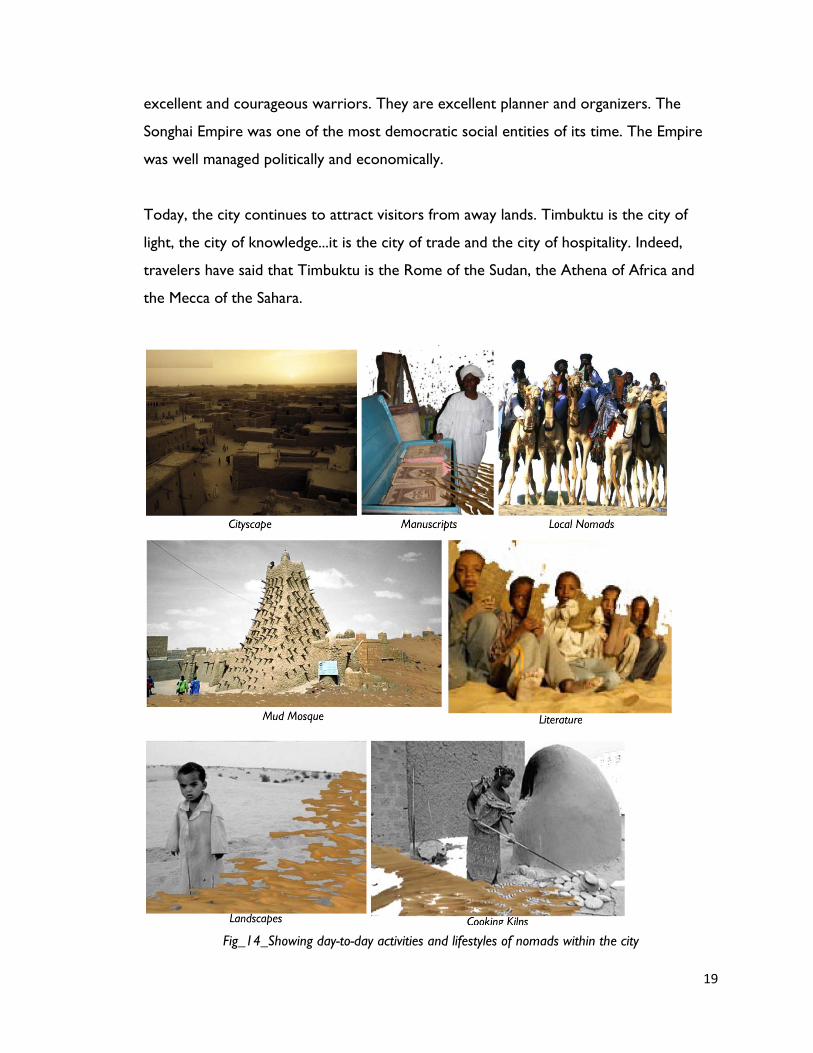
excellent and courageous warriors. They are excellent planner and organizers. The
Songhai Empire was one of the most democratic social entities of its time. The Empire
was well managed politically and economically.
Today, the city continues to attract visitors from away lands. Timbuktu is the city of
light, the city of knowledge...it is the city of trade and the city of hospitality. Indeed,
travelers have said that Timbuktu is the Rome of the Sudan, the Athena of Africa and
the Mecca of the Sahara.
Fig_14_Showing day-to-day activities and lifestyles of nomads within the city

20
Fig_15_Timbuktu City with uneven fractured edges due to frequent sand storms
21
Libraries in Timbuktu Vs Greater Muslim World
As Timbuktu reached the height of its Golden Age, the major centers of the Muslim
world were developing some of the largest and most diverse public library collections of
the medieval period. The majority of Muslim libraries maintained a tradition of open
access to scholars from around the world. Besides the freedom to use and liberal loan
of books, libraries provided free supply of stationery and gave general permission for
copying out books. Needy students were supplied, free of cost, copies made by the
library copyists, and pecuniary help was given to the poor and deserving students
working in libraries. Virtually every mosque possessed a library of some size within its
confines or nearby. Many larger mosques held multiple libraries, particularly those with
affiliated colleges.
Interestingly, there is no evidence of the existence of open-access public libraries in
medieval Timbuktu. On the contrary, the libraries of Timbuktu all seem to have been
private collections of individual scholars or families. This dichotomy with the greater
Islamic world raises many questions. Traditionally, a library paid for new book
purchases, stationery, a librarian’s salary, and in some cases lodging for students as well
as other expenses. The institution was not deeply imbedded in Sudanese society, yet the
concept was not foreign in Timbuktu and the Songhai Empire. Certainly, the historical
chronicles would have mentioned them since they mention the underwriting of single
manuscripts. The preferred form of patronage appears to have been bolstering the book
collections of individual scholars rather than establishing public libraries. Timbuktu’s
history and societal structure hold the answer to the rationale favoring private over
public libraries. The very remoteness of Timbuktu, especially early on in its
development, contributed to the staunch private library tradition. The austere displays
of wealth permitted in the close-knit pious community and the inability to acquire new
books on demand created an environment of acute bibliophilism. Despite their eventual
broader contact with the greater Islamic world, the literati of Timbuktu held fast to the
private library tradition of their forefathers.

22
Ironically, further support of private libraries in Timbuktu likely stemmed from the
exposure of its scholars to public libraries and librarians abroad. Historically, only
scholars of esteem had been appointed as librarians of mosque libraries, and the
position was held in high regard. The most compelling argument against public libraries
in Timbuktu stems from a social structure that simply made them unnecessary. In
various parts of the Islamic world and other instruments of social equity allowed
students of modest means to climb the social and scholarly ladder of achievement. This
environment of collegiality, combined with the mitigating social factors and biases argued
above, allowed the scholars of Timbuktu to hold to their traditions, ignoring the public
library model of the greater Islamic world.
This essay has brought together the known sources that describe various aspects of the
book culture of Timbuktu. Undoubtedly, more documents will arise that will assist in
researching this topic and facilitate completing the picture of Timbuktu’s bibliophiles and
their unique contributions to African and Islamic history.

23
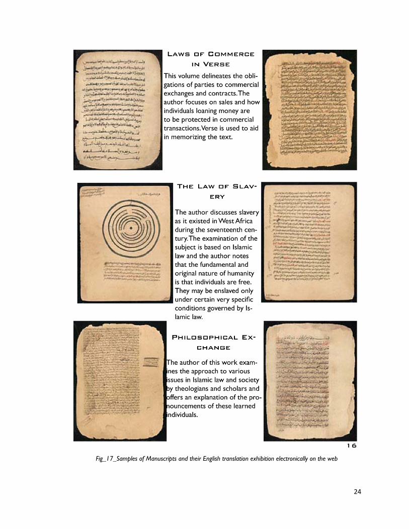
Fig_16_Samples of Manuscripts and their English translation exhibition electronically on the web
24
Fig_17_Samples of Manuscripts and their English translation exhibition electronically on the web
25
4_Concrete Poetry for Non-Concrete Landscape…
I feel I exist on the boundaries. Somewhere between science and art, art and architecture,
public and private, east and west. I am always trying to find a balance between these opposing
forces, finding the place where opposites meet. Water out of stone, glass that flows like water,
the fluidity of a rock, stopping time. Existing not on either side, but on the line that divides. And
that line takes on a dimensionality. It takes on a sense of place and shape.
_Maya Lin
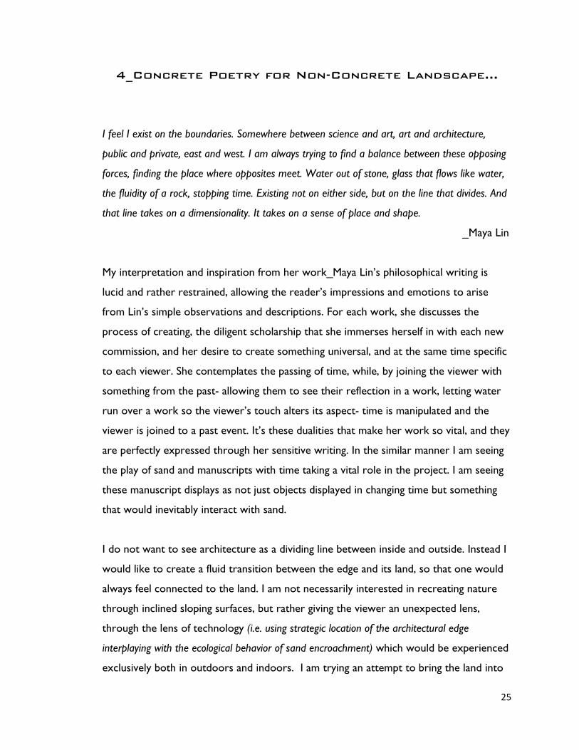
My interpretation and inspiration from her work_Maya Lin’s philosophical writing is
lucid and rather restrained, allowing the reader’s impressions and emotions to arise
from Lin’s simple observations and descriptions. For each work, she discusses the
process of creating, the diligent scholarship that she immerses herself in with each new
commission, and her desire to create something universal, and at the same time specific
to each viewer. She contemplates the passing of time, while, by joining the viewer with
something from the past- allowing them to see their reflection in a work, letting water
run over a work so the viewer’s touch alters its aspect- time is manipulated and the
viewer is joined to a past event. It’s these dualities that make her work so vital, and they
are perfectly expressed through her sensitive writing. In the similar manner I am seeing
the play of sand and manuscripts with time taking a vital role in the project. I am seeing
these manuscript displays as not just objects displayed in changing time but something
that would inevitably interact with sand.
I do not want to see architecture as a dividing line between inside and outside. Instead I
would like to create a fluid transition between the edge and its land, so that one would
always feel connected to the land. I am not necessarily interested in recreating nature
through inclined sloping surfaces, but rather giving the viewer an unexpected lens,
through the lens of technology (i.e. using strategic location of the architectural edge
interplaying with the ecological behavior of sand encroachment) which would be experienced
exclusively both in outdoors and indoors. I am trying an attempt to bring the land into

26
confines of interior space by dissecting the landscapes into sections that could be passed
through in a series of continuous patterns along the entire edge. These would not just
be fences or thicker walls (like barricades) with some programmed space within. It is
about how people interact with the moving sand.
By using minimal forms and by manipulation of the scale, I want to refine the landscape
into something that can be experienced indoors. The Viewers would be connected to
the landscape through unique vantage points, so that they begin to be less about the
objects frozen in time and space but more about the journey through and into them.
The intent is to create work on the edges and boundaries of the city, such that the
architectural experience becomes less of a centerpiece and begins to recreate its own
the environment.
Thus the project mediates between two types of population_Population of HUMANS
and Population of SAND. The project as titled, The NOMADIC EDGE is a distinctive
proposal set along the RIM of the mysterious city, TIMBUKTU_MALI in SAHARA
DESERT The design approach is to be inspired by the site itself, growing out of existing
topographical opportunities found in the DRAMATIC sand dunes and mountainous
features which shelters facilities for tourists, nomads and animals. The spaces are
connected in series enhancing an open STREETSCAPE experience through valleys in
between the dunes, balancing and blurring the distinctions between nature and
architecture. By using minimal forms that engage with the action of sand, the design
attempts to refine the landscape into something that can be experienced indoors. It also
aims to connect the ACTOR (visitors) to the dunescapes by offering them with
increasingly unique VANTAGE POINTS, so that they begin to be less about objects
frozen in time and space and more about the journey. The inclination of architectural
surfaces for walking, sitting, relaxing, working and displaying, would not only aid with the
blowing sand behavior but also encourage the actor to pay attention to the articulation
of the spaces. The EXPERIENTIAL MOMENTS throughout the edge are sited within the
GRAINS of the landscape resulting into the new architectural interventions growing out

27
of topography_spanning, terracing, breaking, burrowing into and wrapping up… within
the existing landscape features.
Fig_18_Shifting Edge of the city_Timbuktu
PROGRAMMATIC INTERVENTIONS
MANUSCRIPT HOUSING_ African countries have thrown their weights behind efforts
to preserve the Priceless Timbuktu Manuscripts, ancient documents that hold the key to
some of the secrets of the continent’s history and cultural heritage. Some of these
manuscripts date back to the 13th century and are currently held in a very fragmented
manner in 24 smaller private libraries in and around Timbuktu. Few still remain in the
huge metal trunks in nomad’s houses due to lack of appropriate space to store 700,000
manuscripts. Thus, THE EDGE would inhabit these along one specific location by
bringing all the fragmented locations in one destined space.

28
MANUSCRIPT EXHIBITION_The manuscripts provide a written testimony of African
literature, astronomy, mathematics, politics, chemistry, climatology etc in middle ages.
Thus, THE EDGE would aim to make these manuscripts accessible to the local nomads
as well as tourists for viewing the cultural hidden literature and show that the convential
historical view of Africa as a purely: oral continent” is not correct.
NOMAD / TOURIST SHELTER_The city is hit by sandstorms at a rate of three times a
year, forcing all the fractured and damaged houses to built and rebuilt as per the scale of
destruction. Thus, THE EDGE attempts to make a provision for all the dislocated
nomad families for a short period of time until their original house falls in the right
shape. Also, since the city is welcomed by around 50,000 tourists annually, THE EDGE
along with temporary nomad shelter would make provision for tourist shelter
encouraging close interactions with both the groups’ through common spatial
formations.
SALT TRADE / ANIMAL SHED_Timbuktu’s proximity to Niger River was an essential
reason for its success as a trading port. Even today, around 5,000 camel caravans leave
Timbuktu twice a year (March and November) to bring salt from the mines at
Taoudenni, some 600km away to the north. When the caravan’s return after a month,
the salt is then unloaded in Timbuktu and sent upriver to Mopti or downriver to Gao
from the river port of Kabara, 10km from Timbuktu. This, THE EDGE would serve as an
unloading space for big salt slabs (1m x 2.5m) where these would be broken down into
smaller salt cubes and then get transported to Kabara port. The city consists of
approximately 8,000 camels out of which 5,000 camels participate during the salt trade.
This, THE EDGE would also accommodate animal shed for around 5,000 camels on an
average which would spatially connect the existing city with the new edge through roofs
cape / canopy.....
TOUAREG FESTIVAL_The Touareg Festival is a huge cultural even taking place in the
outskirts of the city on the sand dune surface for three days. This festival brings all
aspects of the Touareg culture involving songs and Touareg dances, poetries, camel rides
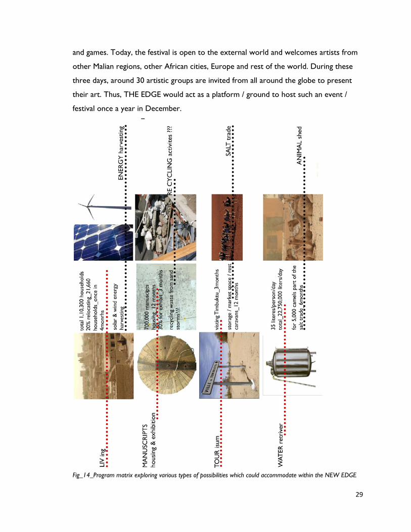
29
and games. Today, the festival is open to the external world and welcomes artists from
other Malian regions, other African cities, Europe and rest of the world. During these
three days, around 30 artistic groups are invited from all around the globe to present
their art. Thus, THE EDGE would act as a platform / ground to host such an event /
festival once a year in December.
Fig_14_Program matrix exploring various types of possibilities which could accommodate within the NEW EDGE
30
5_Strategies to Deal with Sand
I am approaching the sand as an acceptance towards its natural ecological behavior and
condition rather than creating a walled city or a barrier to stop the sand to encroach
the city. Touareg nomads have adapted their lifestyle in such an extreme climatic
situations with sand_they live, breathe and eat sand. Hence as a strategy, I want the
project to accommodate within the existing eco-system which works with the sand
instead of attempting to stop it from entering into the city. The programmatic nature of
manuscripts storage and display would try to positively induce itself with the nature of
the blowing sand over the period of time. Although sand flows along the wind direction,
there is no front or back to it. Keeping this fact in mind, the newly developed EDGE
would get covered, uncovered and recovered with sand depending upon the change in
the ecological system. It attempts to work independently within the system such that
certain parts of the project de-actives when covered with sand where as activates when
uncovered with sand.
SAND is a magical material with beautiful contradictions. It is simple and complex,
peaceful and violent, always the same but never the same, endlessly fascinating. One
Billion grains of sand come into existence in the world each second as a result of cyclic
process. When rocks and mountains die, grains of sand are born. Some of these grains
accumulate into massive quantity resulting into formation of sand dunes. In a way a static
stone mountain becomes a moving mountain of sand which indeed has led into
dangerous situations over the centuries by slowly and steadily eating up the cities.
About how far away do I need to go to deal with the moving sand? The dunes here
move from southward to west towards the city at a pace of around 600m a year, that’s
almost Sahara eating 1m of arable land each day & physically pushing people away from
their homes. Sand dunes cover only 1/5th surface of the deserts but still those extreme
environments are ideal places to control the movement of blowing sand to some extent
by stopping the sand grains from ever launching from its crust. A good way of doing that
31
is use some kind of sand catcher. Tress or cactus are good for this but one of the
problems with planting trees is the people in these regions are so poor that they cop
them out for fire wood. My approach to this is an alternative to just planting trees and
hoping that they would not get chopped down. The filtered edge that I am proposing
essentially does three things: _adds roughness to the blowing sand i.e. some kind of sand
catching chamber through spatial configuration of L/U/C wall formations, _provides
physical support structure to the tectonic spaces housing manuscripts and other
program and _it creates physical, habitable spaces within.
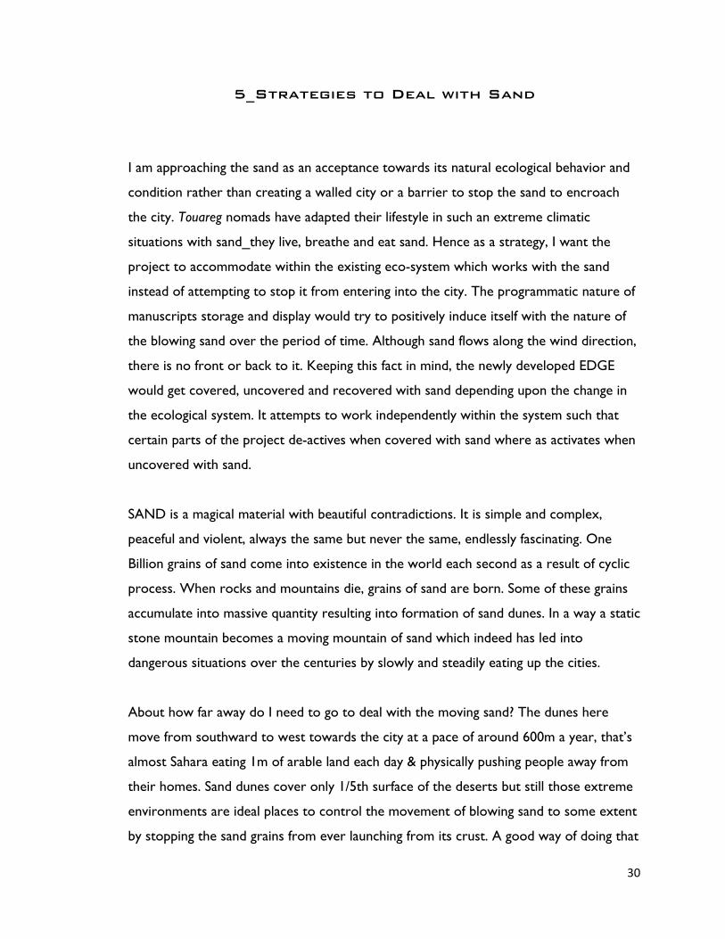
EXISTING MEASURES TO STABLIZE THE SAND DUNES
A government project to solidify sand in the Tianmo Desert west of Beijing has
prevented sandstorms from ravishing the capital during the last few years, a Xinhua
News Agency report said. The government started solidifying the sand in a 2,667-
hectare area of the Tianmo Desert in north China’s Hebei province in 2000 in an attempt
to stop blinding sandstorms from blowing into the capital and Tianjin each spring.
Located 80 kilometers west of Beijing and adjacent to a municipal reservoir, the Tianmo
Desert is one of the major sources of sandstorms in northern China.
Fig_15_Checkerboard system for sand dune stabilization in Ningxia

32
OPERATIVE THEME_Envelope vs INTERlope Sand into CITY vs. city into SAND
Fig_16_Sketches explaining the idea and implications of operative theme on sand and city
33
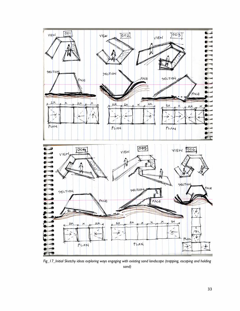
Fig_17_Initial Sketchy ideas exploring ways engaging with existing sand landscape (trapping, escaping and holding sand)

34
Fig_18_ Analog models studying the various conditional ways of separating and segregating the programmed space from sand
As the first step towards conceptual approach, I started with few study analog models
based on my initial sketch ideas. I developed six different conditional modules that
engage & interact with sand as well as welcome the program incorporating a dual
functional nature within the space and architecture.
Fig_001_Single storied minimal space unit with inclined wall and floor to accommodate
the accumulation of sand from desert side over the period of time; opposite perforated
wall surface for manuscript display.
Fig_002_Double storied space unit with inclined wall and floor to accommodate the
accumulation of sand from desert side over the period of time; opposite double storied
perforated wall surface for manuscript display.
Fig_003_Single storied underground space unit with inclined wall and mezzanine floor
like idea such that it sits within the dunes; opposite perforated wall surface for
manuscript display.
Fig_004_Single leveled underground space unit with inclined wall and floor for relaxing
and viewing the manuscript display.
Fig_005_Single multi-storied space unit with inclined wall and mezzanine floors sitting
within the sand dune surface; opposite multileveled perforated wall surface for
manuscript display. The in-between passage way houses the manuscript storage hidden
from public access areas.

35
Cyclic development of sand filtration towards the EDGE_How the concrete conditional
moments studied in the analogs respond to the blowing sands over the years.
Fig_19_Digital analysis to study the blowing over and blowing away movement of sand over the years.
36
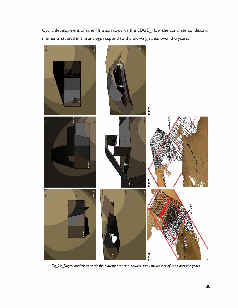
Cyclic development of sand filtration towards the EDGE_How the concrete conditional
moments studied in the analogs respond to the blowing sands over the years.
Fig_20_Digital analysis to study the blowing over and blowing away movement of sand over the years.
37
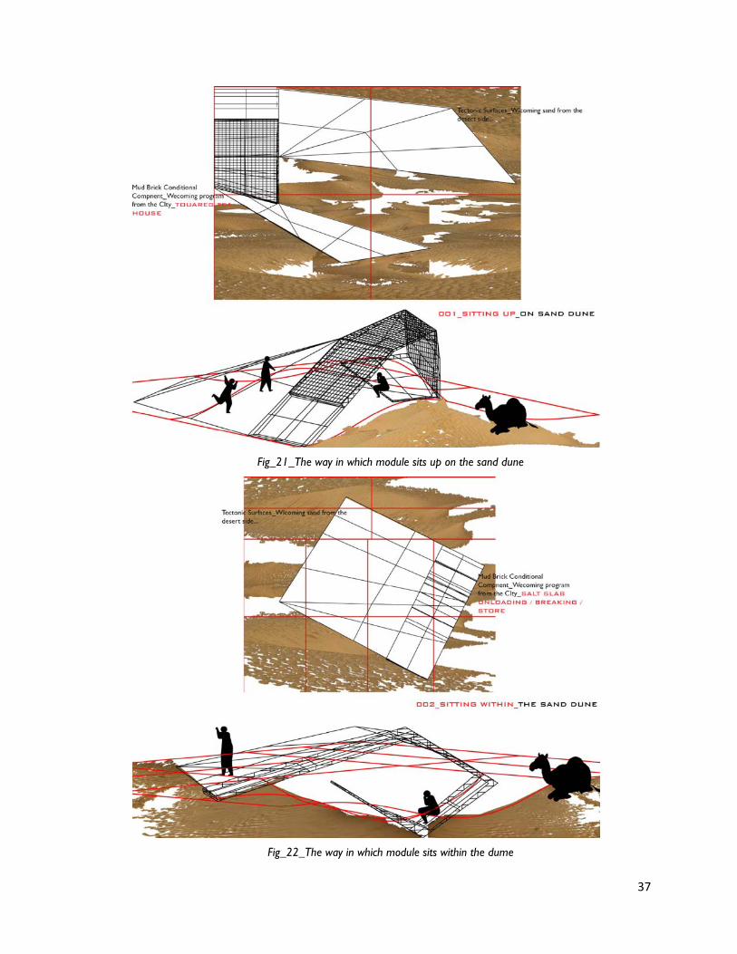
Fig_21_The way in which module sits up on the sand dune
Fig_22_The way in which module sits within the dume
38
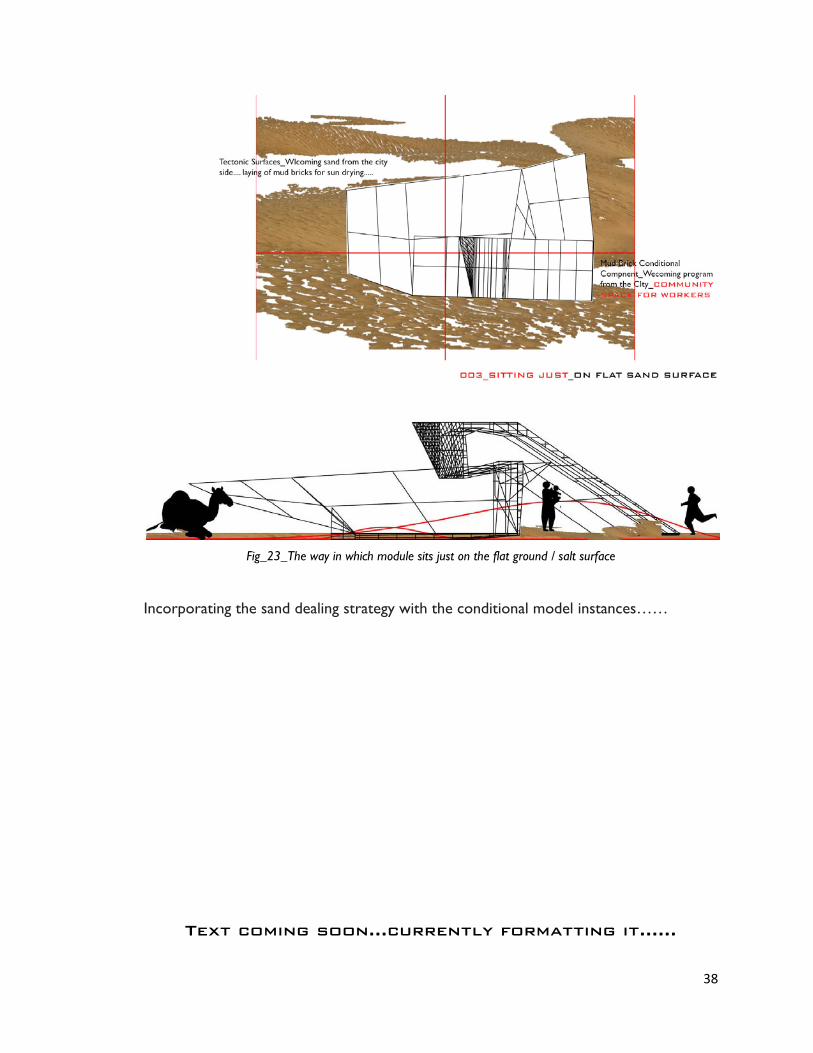
Fig_23_The way in which module sits just on the flat ground / salt surface
Incorporating the sand dealing strategy with the conditional model instances……
Text coming soon…currently formatting it……

39
6_Conceptual Design Approach
Text coming soon…currently formatting it……
40
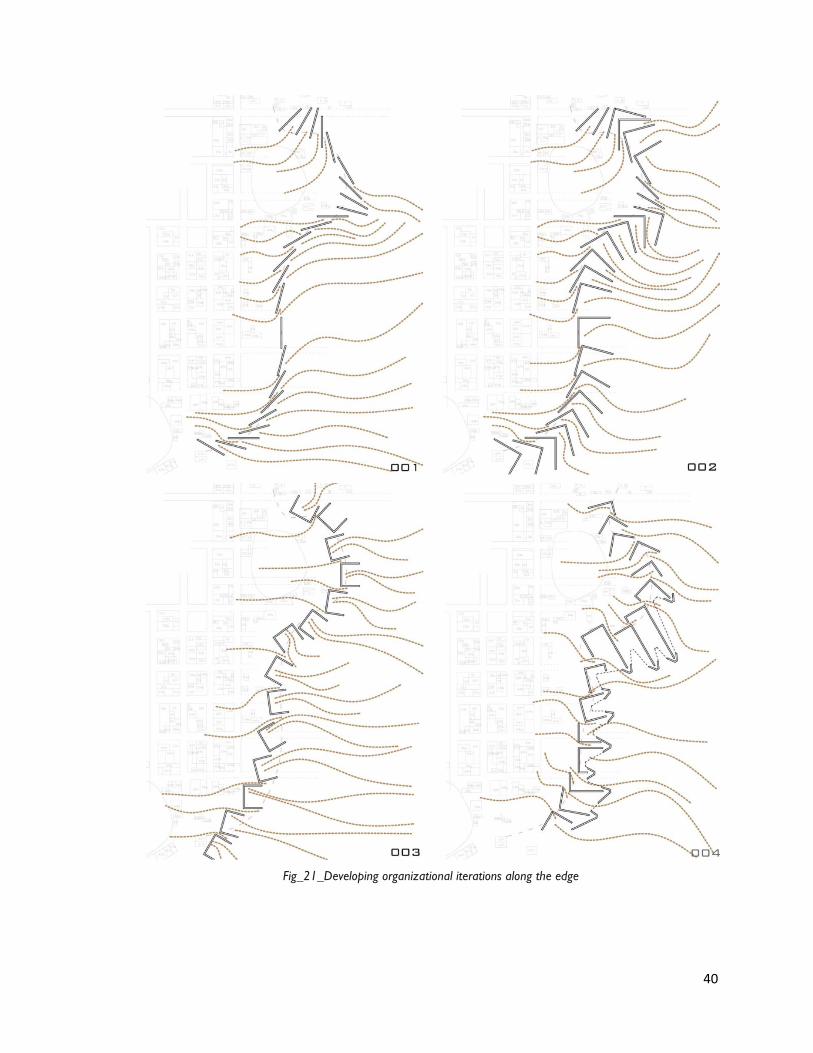
Fig_21_Developing organizational iterations along the edge

41
The intent of these diagrammatic studies was to establish a simple component system
along the edge which gets multiplied and repeated throughout with different experiential
instances, merging sand and the program/activities together. I initiated this with a simple
single wall start (length_25m) fig_001, which was later followed by L_wall & U_wall
component formations. Each of these are placed in such a way, that they engage & open
_up towards the desert / sand surface and correspond to the sand flow in all dimensions
and directions. After developing few iterations, I am narrowing down my approach
towards these arrangement pattern, fig_004, where the edge consists of two types of
component formation_the inner wall consists the urban program where as
the outer wall consists the desert born program with green cactus plantations and many
such other methods which stabilize the dune to some extent. The in between space
within these wall components would act as a buffer space for moving people along the
edge / program…
Obligatory Speculations
It was great to talk to JEROME CHOU, landscape architect as part of three
quarter review discussion and following are some of his comments & suggestions to take
the project ahead towards final design stage….
1_Create speculative existing terrain of sand dunes on the site (in Timbuktu, Sahara
Desert)
2_Rethinking about the wall placement strategies… (i.e taking the first step with one
single line wall component along straight line and then develop a strategy based on
existing topographical terrain)
3_Merging all design components together (wall and analog module conditions with
existing sand dune conditions) with the program.
42
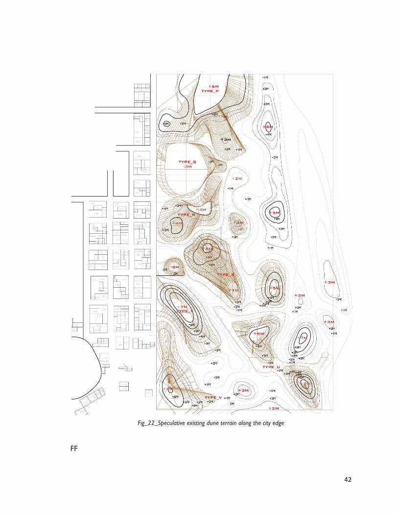
Fig_22_Speculative existing dune terrain along the city edge
FF
43
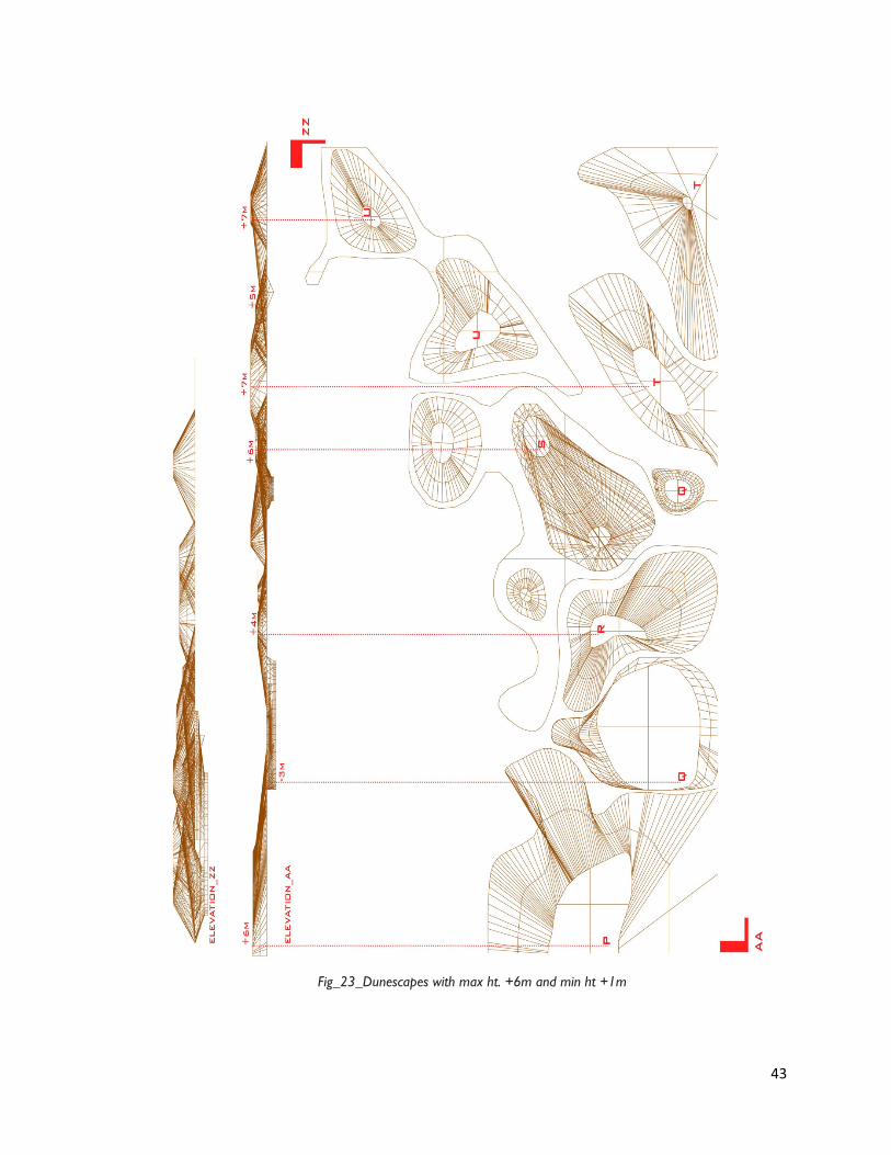
Fig_23_Dunescapes with max ht. +6m and min ht +1m
44
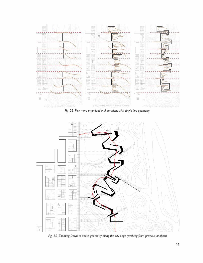
Fig_22_Few more organizational iterations with single line geometry
Fig_25_Zooming Down to above geometry along the city edge (evolving from previous analysis)
45
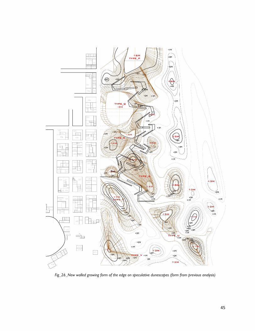
Fig_26_New walled growing form of the edge on speculative dunescapes (form from previous analysis)
46
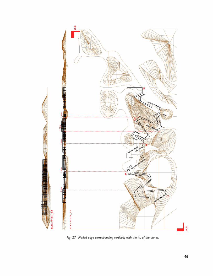
Fig_27_Walled edge corresponding vertically with the ht. of the dunes.
47
7_Design Development
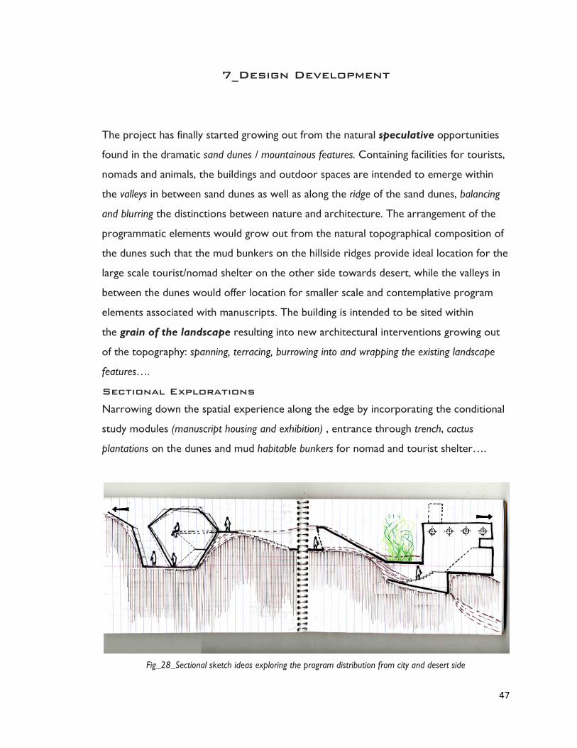
The project has finally started growing out from the natural speculative opportunities
found in the dramatic sand dunes / mountainous features. Containing facilities for tourists,
nomads and animals, the buildings and outdoor spaces are intended to emerge within
the valleys in between sand dunes as well as along the ridge of the sand dunes, balancing
and blurring the distinctions between nature and architecture. The arrangement of the
programmatic elements would grow out from the natural topographical composition of
the dunes such that the mud bunkers on the hillside ridges provide ideal location for the
large scale tourist/nomad shelter on the other side towards desert, while the valleys in
between the dunes would offer location for smaller scale and contemplative program
elements associated with manuscripts. The building is intended to be sited within
the grain of the landscape resulting into new architectural interventions growing out
of the topography: spanning, terracing, burrowing into and wrapping the existing landscape
features….
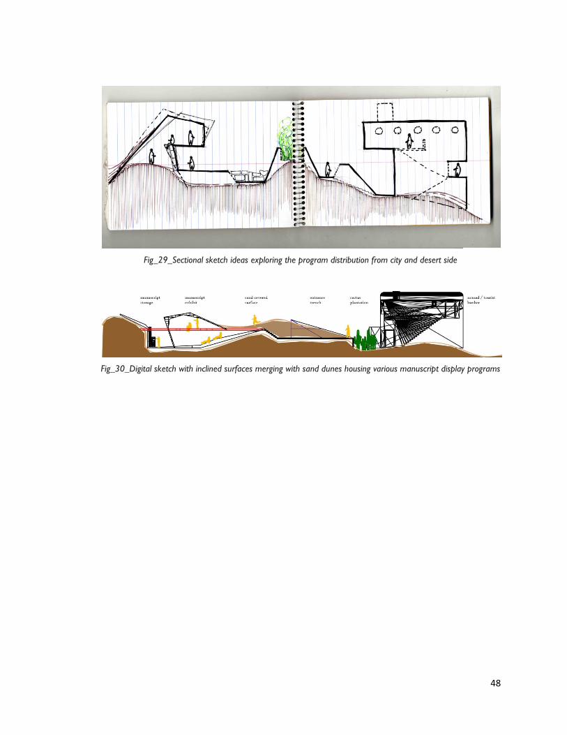
Sectional Explorations
Narrowing down the spatial experience along the edge by incorporating the conditional
study modules (manuscript housing and exhibition) , entrance through trench, cactus
plantations on the dunes and mud habitable bunkers for nomad and tourist shelter….
Fig_28_Sectional sketch ideas exploring the program distribution from city and desert side
48
Fig_29_Sectional sketch ideas exploring the program distribution from city and desert side
Fig_30_Digital sketch with inclined surfaces merging with sand dunes housing various manuscript display programs

49