drainage basin characteristics of the minnesota...
TRANSCRIPT
Drainage Basin Characteristics of the Minnesota River
PAUL FASCHING*
ABSTRACT - The geomorphology of the Minnesota River Basin is poorly understood, yet much of modern fluvial ecology requires this information as a prerequisite to physical, chemical, or biological studies. The purpose of this paper is to provide background descriptive geomorphological river basin data for the Minnesota River. Eleven descriptive parameters (river gradient, Form f, Shape 1, Shape 2, circularity ratio, elongation ration, stream order, bifurcation ratio, average area by order, number of lakes per order and number of lower order streams entering higher streams) were determined for the Minnesota River Basin as a whole as well as for ten subbasins. A total of 6,188 streams were categorized, with 77% being first order, 18% second order, 4% third order, 1% founh order, 0.3% fifth order and 0.01 % sixth order. The Minnesota River itself was determined to be a seventh order stream. A bifurcation ratio of3.8 for the entire Minnesota River was found to be consistent with an earlier prediction of 3.5 for the average basin. The streams that run off the Coteau des Prairies were found to have a smaller drainage basin per order of stream than the Blue Eanh, Chippewa and Pomme de Terre rivers. No difference was found among the subdivisions of the Minnesota River in the number of lower order streams entering higher order streams. Of the remaining descriptive parameters only two, Shape 2 and river gradient, showed any noticeable difference among basins. The river gradient is higher in the Coteau des Prairies than in other streams in the Minnesota Basin. The Blue Eanh and Pomme de Terre River basins had different values from the mean for Shape 2. The Pomme de Terre River Basin had high value, meaning it is a long and narrow basin. The Blue Eanh River Basin had a low value, meaning its basin is wider than it is long. The two most notable findings were, first , that the Minnesota River is a seventh order river for most of its length beginning at the junction of the Yellow Bank and the mainstem. Secondly, even though Big Stone Lake is considered as the source of the Minnesota River for geopolitical reasons, this study indicates the source of the Minnesota River is the Little Minnesota River, because it is already a fifth order river when it enters Big Stone Lake and drains 1,157 square kilometers.
Introduction
The Minnesota River is the largest tributary of the Mississippi River in Minnesota. It drains an area of 43,964 square kilometers, 5,203 of which are in Iowa and South Dakota (1). The Minnesota River is termed an underfit river, flowing in the valley of the once mighty River Warren that drained Glacial Lake Agassiz. There are ten major river basins in the Minnesota system, chosen because of their size and complexity. The Little Minnesota, Yellow Bank, Whetstone, Lac Qui Parle, Yellow Medicine, Redwood, and Cottonwood systems all run off the Coteau des Prairies, a broad, flat, iron-shaped area 153 to 244 meters higher than the central plains (2). The Blue Earth, Chippewa and the Pomme de Terre, three river systems that are not part of the Coteau des Prairies, were also included in this study.
The quantitative fluvial geomorphology has not been established for the Minnesota River Basin. Yet this information is a prerequisite to many physical, chemical or biological studies of modern fluvial ecology. Cummins (3) states that lake research, conducted on isolated reaches without a spatial temporal perspective of general watershed processes, has often proven too narrow to be of extensive use either for the development of theory or management application. The River Continuum Hypothesis embodies the concept of ecological changes such as production/ respiration, as a continuous drainage basin gradient from headwaters to river mouths. The P/ R ratio has been found to shift from heterotrophy to autotrophy and levels to heterotrophy in relation to stream order in many rivers. This research establishes a first step in the
*Mankato State University
10
quantitative geomorphological base for the Minnesota River Basin.
Methods
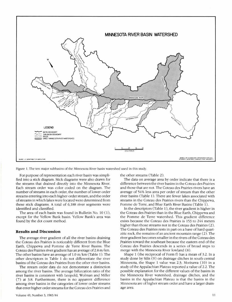
The Minnesota River was divided into ten major watersheds. Seven of them were found in Bulletin No. 10 of the Minnesota Department of Natural Resources (1). The other three were added because of their size and because they are subdivisions of the Big Stone Lake Watershed (Figure 1). Eight parameters of the basins were determined. All measurements were traced two times with a map reader, averaged and converted to kilometers. The longest basin length was found by determining a straight line between the termination point and the most distant opposite point without crossing the drainage area perimeter. The longest basin width is a straight line perpendicular to, and half the distance up, the longest basin length. The river gradient is the slope in meters per kilometer from the termination point to the beginning of the longest main stream. Form f ( 4) is the drainage area divided by the basin length squared. Shape 1 (Corps of Engineers) is the reciprocal of Form f. Shape 2 ( 4) is the basin length divided by basin width. Circularity ratio ( 5) was calculated by dividing drainage area by the area of the circle with the same basin perimeter. Elongation ratio ( 6) is the diameter of a circle equal to the drainage area divided by the maximum length of the basin. '
The raw data were obtained from either USGS 7.5 minute topographic maps, when available, or alternatively from 15 minute topographic maps. Streams that did not drain directly into the ten basins were assumed to drain directly into the Minnesota River. Those lakes that were part of the river network were included in this study.
journal of the Minnesota Academy of Science
MINNESOTA RIVER BASIN WATERSHED
"'
\
LEGEND ~ BASIN BOUNDARY ..-._..-- SU3·BASIN BOUNDARY ~RIVER !·:·:·:·:·:·:·:·:·:.::::::! DIRECT MINNESOTA RIVER WATERSHED
8UREAU OF F'L A'i"'ING AJ«O CARTOGRAPI-11C SE RVICES GEOGRAP'"IY OE PAR TMEtH. M.o.Nt< ATO STATE UNI YERSI TY
Figure 1. The ten major subbasins of the Minnesota River basin watershed used in this study.
For purpose of representation each river basin was simplified into a stick diagram. Stick diagrams were also drawn for the streams that drained directly into the Minnesota River. Each stream order was color coded on the diagram. The number of streams in each order, the number of lower-order streams entering into each higher-order stream, and the order of streams in which lakes were located were determined from these stick diagrams. A total of 6,188 river segments were identified and classified.
The area of each basin was found in Bulletin No. 10 (1), except for the Yellow Bank basin. Yellow Bank's area was found by the dot count method.
Results and Discussion
The average river gradient of all the river basins draining the Coteau des Prairies is noticeably different from the Blue Earth, Chippewa and Pomme de Terre River Basins. The Coteau des Prairies river gradient has an average of2.8 m/ km. The other basins have an average of 1.0 m/ km (Table 1 ). The other descriptors in Table 1 do not differentiate the river basins of the Coteau des Prairies from the other river basins.
The stream order data do not demonstrate a distinction among the river basins. The average bifurcation ratio of the river basins is consistent with Leopold, Wolman and Miller (7) at 3.8. Furthermore, there is no apparent difference among river basins in the categories of lower order streams that enter higher order streams for the Coteau des Prairies and
Volume 49, Number 3, 1983/ 84
the other streams (Table 2). The data on average area by order indicate that there is a
difference between the river basins in the Coteau des Prairies and those that are not. The Coteau des Prairies rivers have an average of 54% less area per order of stream than the other river basins (Table 1). There are fewer lakes associated with streams in the Coteau des Prairies rivers than the Chippewa, Pomme de Terre , and Blue Earth River Basins (Table 1 ).
In the descriptors (Table 1), the river gradient is higher in the Coteau des Prairies than in the Blue Earth, Chippewa and the Pomme de Terre watershed. This gradient difference exists because the Coteau des Prairies is 153 to 244 meters higher than those streams not in the Coteau des Prairies (2). The Coteau des Prairies rests in part on a base of hard quartzitic rock, the remains of an ancient mountain range (2) . The river gradient becomes smaller in the rivers of the Coteau des .Prairies toward the southeast because the eastern end of the Coteau des Prairies descends in a series of broad steps to merge with the Minnesota River lowland (8).
Shape 1 (the reciprocal of Form f) has a mean of 3.2. In a study done by Silis (9) on drainage ditches in south-central Minnesota, the Shape 1 value was 2.3 ; Morisawa (10) in a study of the Appalachian Plateau reported a value of2.2. The possible explanation for the different values of the basins in the Minnesota River watershed, drainage ditches, and the basins in the Appalachian Plateau is that the basins in the Minnesota are of higher stream order and have a larger drainage area.
11

~
~
0 u 0.
.:! .c: 0. ~
~ 0 ~
"
Longest B~sin length in km Longest Basin width in km
River Gradient m/km
form f
shape
shapP.
Circularity Ratio
Elongation Ratio
c - ~ u 0 ~ u u ~ ~
.2"' - ~
"'
Area in square km
~
~
"' .. ....
1st
2nd
Jrd
4th
5th
6th
7th
1-2
2-3
3-4
4-5
S-6
6-7
1st
2nd
3rd
4th
5th
6th
7th
1st
2nd
3rd
4th
5th
4R.9 118 . 2
23.1 9 . 7
.032 1.1
0 50 .18
2 . 0 50 6
2 .I 12 0 2
.67 .26
0 79 .48
224 190
53 46
11 II
4 . 2 4.1
4.8 4 . 2
3.6 s.s
3.0 2 . 0
3 . 9 4.0
1157 2502
5 . 2 13.2
21.8 57.0
133 0 7
45 . 8
1.0
.30
3 0 3
3.3
.42
.62
407
86
16
4.2
50 4
3 0 2
2 . 5
2.0
3 0 6
5366
13.2
62.4
~ c 0 u ~
47.99
29 0 2
4.6
. 44
2 0 3
1.6
.61
0 7 5
180
36
5.0
4.5
2 . 7
3.0
3 0 8
1008
50 7
28 .o
Coteau des Prairies
44 0 7
29.0
3 0 4
.46
2.2
1.7
.4 3
.R2
273
65
16
4 0 2'
4 .I
J .2
2.5
2.0
J .2
1052
3 0 9
17 .I
69.0 86.0
43 0 7 25.0
2,4 2 0 3
0 54 .24
1.9 4.2
1.6 3.4
. 67 .)~
.82 .55
520 348
118 81
25 20
4 .4 4.3
5.0 4.1
3.5 3 0 3
2.) 6.0
J.O
3.6 4.4
'0 0 0 ) '0 ~
"' 100.6
18 .4
2.3
.19
5.3
50 5
.28
.49
202
44
8
4.6
50 5
4.0
2.0
4.0
2771 1735 1914
5.4 4 . 9 9 . 6
23 . 6 29.5 43.5
105 . 2 227.4 335.4 125 . 9 70.2 110.9 86 . 8 239.3
385.9 1251.0 1073.3 339.9 210 . 3 396.0 289.3 946 . 6
1157 2502 2683 . 2 1008 525 . 8 923 . 9 1735 1914
5366 1052 2771
13 23 34 10 17 21
25
12
total 13 39 62 10 18 22
'0 0 0
~ 0 u u 0
u
119 0 7
37.7
1.6
.24
4 . 2
3.2
. 38
. 55
451
115
27
10
3 0 9
4 . 3
2.7
5.0
2.0
3 0 6
3354
7 . 5
29 . 3
92 0 7
132 0 7
0.96
.97
1.0
0 70
.56
1.1
~ u
u 0 u ~
~ ~ ~ c -~ c "-~
"'
750 1220 4765
ISS 292 1091
32 67 241
13 65
19
4.8 4 0 2 4.4
4.8 4.4 4.6
2.5 7 . 4 4.0
4 . 3 4.5 3.2
3 . 0 2 0 7
6 . 0
3.9 5.1 4.1
9218 15,091 43,771
12.2 9.1
59.6 40.1
124.3 288 .o 27.8
335.4 709.0 729 . 6
167 7. 0 3071.7 2302 .s
3354 9218 7293.4
43.771
39 96 262
12 14 55
32
4
57 117 254
Table 1. Geomorphic descriptors, stream order, bifurcation ratio , average area by order, and lakes for the ten subbasins of the Minnesota River basin watershed.
12 Journal of the Minnesota Academy of Science

------------Coteau des Prairies---------------.<: "' "' "' w 0 +' "' +' w "' " w 0 .. +' +'
0 "' :> 0
& ~ ~ .s "' ;. "' 0 0 w "' w +' :> 0 " "" "' "' rl w w w "" "' 0 0 0 !i 0
(l) w rl(l)
5~ m t "" +' rl ..... rl ·.-< +' a .'S s ·.-< w ~ a 0 .. rl 'O "' +' "' 0 (l) .<: !i ~~ w (l) (l) 0 rl '>! "''""' 0 ><Ill ><:>: ~ 0 "' ~'>!
1cc 88 172 72 124 236 162 88 230 310 586 2174 # of 1st order to make 2nd (%) (36) (35) (33 ) (32 ) (34 ) (35) (36 ) (34 ) (38 ) (32) (37 ) (35)
(% ) 118 102 235 108 149 284 186 114 221 440 634 259 1 # of ot her 1st into other s tream ord er (40) (41 ) (45) (47 ) (41 ) (42) (41 ) (44) (36 ) (46) (40) (42)
22 22 32 16 32 48 40 16 54 64 134 478 # of 2nd ord er t o make 3rd (%) (8) (9) (6) (7 ) (9) (7) (9) (6) (9) (8) (8) (8)
17 10 29 9 14 32 25 13 30 54 69 251 other 2nd's into 3r d (%) (6) (4) (6) (4) (4) (5) ( 5) ( 5) (5) (6) (4) (4)
2nd into 4th (%) 8 9 20 1 14 27 12 9 13 17 20 150 (3) (4 ) (4 ) (0.4 ) (4) (4) ( 3) (4) (2 ) ( 2) (1) ( 2) 6 5 10 4 8 4 6 4 18 11 76
2nd into 5t h (% ) (2) (2 ) (4) (1) ( 1 ) (0 . 9 ) (2) (0 .7 ) (2) (0 . 7) (1) 5 1 3 14 2 25
2nd i nto 6th (% ) (1) (0 . 3) (0 . 4) (2) (0 . 2) (0 . 4) 58 58
2nd into 7th (% ) (4) (0 . 9) 6 4 10 6 10 14 12 4 20 26 18 130
# of 3rd's to make 4th (% ) (2 ) (2) (2) (3 ) ( 3) (2) (3) (2 ) (3 ) ( 3) (1 ) ( 2) 4 3 1 1 3 8 6 2 4 4 14 50
ot her 3rd•s into 4th (%) (1) (1 ) (0 . 2) (0 . 4) (1) (1) (1) (0 . 8) (0 .7 ) (0 . 5) (0 . 9) (0 . 8) 1 4 1 1 2 1 2 2 1 2 4 21
3rd into 5th (% ) (0. 3) (2) (0 . 2) (0 . 4) (0 . 6) (0 .1 ) (0 . 4) (0 . 8 ) (0 . 2) (0 . 2) (0 . 3) (0 . 3) 4 2 2 8
3rd into 6t h (%) (0 . 8) (0 . 3) (0 . 3) (0 . 1) 31 31
3rd i nto 7th (%) (2) (0 . 5) 2 2 4 2 4 6 2 2 4 6 4 38
#of 4th 's t o make 5th (%) (0 . 7) (0 . 8) (0 . 8) (0 . 9) (1) (0 .9) (0 . 4) (0 . 8) (0 . 7) (0 . 6) (0 . 3) (0 . 6) 1 1 1 4 3 7 17
othe r 4th 's into 5t h (%) (0 . 3) (0. 4) (0 . 3) (1) (0 . 5) (0 .7) (0 . 3) 1 1 3 5
4t h into 6th (%) (0 . 2) (0 . 1) (0 .5 ) (0 . 08) 5 5
4th into 7th (%) (0 . 3) (0 . 08) 2 2 2 2 2 12
# of 5t h ' s t o make 6th (%) (0 . 4) (0 . 6) (0 . 3) (0 . 3) (0 . 2) (0 . 2) 1 1 2
ot her 5th 's into 6th (%) (0 .1 ) (0 .1 ) (0 . 03) 2 7
5th 's into 7th (%) (0 .1 ) (0 . 1) 2
#of 6th 's to make 7th (0 . 03) 4
other 6t h 's that go into 7th (%) (0 . 06)
Table 2. Stream order data for the subbasins of the Minnesota River basin watershed.
Shape 2 of the descriptors compares basin length and basin width. Two basins have different values than the mean of 3.4. The Pomme des Terre River Basin has a value of 12.2, which shows that this basin is long and narrow, and the Blue Earth River Basin is 0.70, indicating that the basin is noticeably wider than long. The Pomme de Terre River Valley cuts sharply through a till plain and is hypothesized to have been formed by a stream of high velocity (tunnel valley) or to have carried relatively little sediment ( 11 ). An explanation for the exceptional width of the Blue Earth River Basin probably would involve the past capture of the LeSueur River by the Blue Earth.
Circularity ratio compares the shape of the basin to a circle (the closer the value to 1.0, the more the basin is shaped like a circle.) The mean value for the basins is 0.47, with a range from 0.26 to 0.67. Studies by Gray (12) show ranges of0.39-0.80 (Iowa), 0.39-0.87 (Missouri) , and 0.33-0.68 (Nebraska), all consistent with the mean and range of this study.
Elongation ratio identifies whether a basin resembles an oval or circle. A value of 1.0 shows the basin is round ; any value lower or higher than 1.0 shows the basin to be oval. The mean in this study was 0.70, which is consistent with drainage ditch sheds at 0.73 found bySilis (9) and studies by Gray ( 12) in Iowa (0.48-0.77) , Missouri (0.46- 0.90), Ohio (0.58-
Volume 49, Number 3, 1983/ 84
0.84), and North Carolina (0.62-0.78). Stream order, bifurcation ratio, and number of lower order
going into higher order show no significant difference among the different river basins. All these river systems run through unconsolidated sediment, meaning the path and shape are not controlled by the substrata they flow over. The sediments found in the Minnesota River Valley were brought in by the Des Moines lobe of the Wisconsin Glaciation (13).
There is a noticeable difference for area by order between the rivers that run through the Coteau des Prairies and the Blue Earth, Chippewa, and Pomme de Terre. Rivers that run through the Coteau des Prairies have on the average only46% of the drainage area per order that the Blue Earth, Chippewa, and Pomme de Terre have. It is apparent that the rivers off the Coteau des Prairies from higher location have more gradient and therefore smaller drainage area per order. However, as has been shown by Quade eta!. (14) , when artifical drainage is considered the flatter areas of south-central Minnesota approach the drainage areas seen in the Coteau des Prairies Rivers.
There are more lakes found in the Blue Earth, Chippewa, and the Pomme de Terre system than the rivers that run through the Coteau des Prairies, which again is hypothesized to be the result of gradient differences.
13

Big Stone lake is considered the source of the Minnesota River ( 1 ). The source of the Minnesota River is in my opinion more accurately the Little Minnesota River. The Little Minnesota when entering Big Stone lake is already a fifth order stream and has an area of 1,157 square kilometers.
This study also shows that the main stem, Minnesota River is a seventh order by junction of the main stem and the Yellow Bank River. This same order remains for much of its length and has important limnological implications. From the perspective of the River Continuum Hypothesis one would expect the physiology (interaction of biology and chemistry). to be similar for much of its length. A seventh order river should be heterotrophic (sixth should be autotrophic) and shows a dominance of collectors. Future research could test the above River Continuum Hypothesis with the spatial geomorphic perspective provided by this paper.
Acknowledgements
The author expresses appreciation to Dr. Henry W. Quade of the Department of Biology at Mankato State University for advice and guidance throughout this study and thanks to Dr. Perry Wood of Mankato State University's Department of Geography for the production of the map.
References
1. Minnesota Dept. of Natural Resources. 1959. Hydrologic Atlas of Minnesota Bull No. 10.
2. Waters, T.F., 1977. The Streams and Rivers of Minnesota. Minneapolis, Minn: Univ. of Minn. Press. 378 pp.
3. Cummins, K.W. 1974. The natural stream ecosystem. In: J.V. Ward and).A. Stanford ( ed. ), The Ecology of Regulated
14
Streams pp. 7-23. New York: Plenum Press. 4. Horton, R.E., 1932. Drainage-basin characteristics. Am.
Geophys. Union Trans. pp. 350-361. 5. Miller, V.L., 1953. A quantitative geomorphic study of
drainage basin characteristics in the Clinch Mt. area Va. and Tenn. Tech Rept. 3, Office of Naval Reserve Proj N: 389-042, Columbia Univ.
6. Schumm, S.A. 1956. Evolution of drainage systems and slope in badlands and perth. Ceo!. Soc. Am. Bul 67:597-646.
7. Leopold, L.B., M.G. Wolman and J.P. Miller. Fluvial Processes in Geomorphology. San Francisco and London : W.H. Freeman and Co. 522 pp.
8. Ojakangas, R.W. and C.L. Matsch. 1982 .. Minnesota Geology. Minneapolis, Minn: Univ. Minn. Press. 255 pp.
9. Silis, A.Z. 1979. A quantitative geomorphogical study of public drainage ditches in south central Minnesota. Masters of Arts Thesis, Mankato State Univ., Mankato, Minn. 69 pp.
10. Morisawa, M.E. 1968. Streams: Their Dynamics and Morphology. McGraw-Hill Book Co. 175 pp.
11. International Associat ion for Quarternary Research (INQUA) VIIth Congress. 1965. Guidebook for Field Conference C, Upper Mississippi Valley. pp. 38-40.
12. Gray, D.M. , 1961. Interrelationships of watershed characteristics. jour. of Geophis. Research 66: 1215-1223.
13. Wright, H.E.,Jr. , 1972. Physiography of Minnesota. In: P.K. Sims and G.B. Morey ( ed.) Geology of Minnesota: A Centennial Volume, pp. 537-576. Minn. Geo. Survey.
14. Quade, H.W., Boyum, K.W. , Braaten, D.O. , Gordon, D., Pierce, C.L., Silis, A.Z. , Smith, D.R., and Thompson, B.C., 1980. The nature and effect of county drainage ditches in south central Minnesota. Water Resources Research Center Bulletin, 105. Univ. Minn. Grad. School. 121 pp.
journal of the Minnesota Academy of Science