dryland environments - international arid lands consortium · dryland environments peter f. ffo...
TRANSCRIPT

Dryland Environments
Peter F. Ffolliott, Professor, School of Renewable Natural Resources, University of Arizona, Tucson,
Arizona 875721, USA
Jeffrey O. Dawson, Professor, Department of Natural Resources and Environmental Sciences,
University of Illinois, Urbana, Illinois 61801, USA
James T. Fisher, Professor and Head, Department of Agronomy and Horticulture, New Mexico State
University, Las Cruces, New Mexico 88003, USA
Itshack Moshe, Deputy Director, Southern Region, Land Development Authority, Gilat DN Negev
85410, Israel
Tim E. Fulbright, Regents Professor, Caesar Kleberg Wildlife Research Institute, Texas A&M
University-Kingsville, Texas 78363, USA
Abdullah Al Musa, President, University of Jordan, The University Street, Amman 11195, Jordan,
TEL: 962-(6)-535-2500 x2114, FAX: 962-(6)-535-5522, EMAIL: a lmusa@ ju.edu.jo
W. Carter Johnson, Professor, Department of Horticulture, Forest, Landscape and Parks, South
Dakota State University, Brookings, South Dakota 57007, USA
Paul Verburg, Assistant Research Professor, Division of Earth and Ecosystem Sciences, Desert
Research Institute, Reno, Nevada 89512, USA
ABSTRACT
One-half of the world’s countries have portions or all of their land in dryland environments. Theselands and their sub-humid margins represent one-third of the earth’s surface and are the home tonearly 40 percent of the world’s population. It is here where land and environmental degradationis occurring at alarming rates, often leading to desertification, and threatening the livelihood ofmore than 900 million inhabitants. Drylands are diverse in terms of their climate, soils, flora, fauna,land use, and people. The nature of this diversity and other inherent characteristics of drylandenvironments are considered in this paper.
INTRODUCTION
One-half of the world’s countries have portions or all of their land in dryland environments. Theselands and their sub-humid margins represent one-third of the earth’s surface and are the home tonearly 40 percent of the world’s population (White et al. 2002). It is here where land andenvironmental degradation is occurring at alarming rates, often leading to desertification, andthreatening the livelihood of more than 1 billion people. Drylands are diverse in terms of theirclimate, soils, flora, fauna, land use, and people. No consistent characterization or practicaldefinition of drylands can be made because of this diversity. One binding feature of all drylandenvironments, however, is their aridity.
- 2 -
ARIDITY
Aridity results from the presence of dry descending air. Aridity is found mostly in places whereanticyclonic conditions are persistent, for example, in regions lying under the anticyclones of thesub-tropics. The influence of subtropical anticyclones on rainfall increases with the presence ofcool surfaces. Arid conditions often develop in the lee of major mountain ranges that disrupt thestructure of cyclones passing over them, creating rain shadow effects. Rainfall is also hinderedby the presence of greatly heated land surfaces temperature-wise. As a consequence, large areasof dry climate exist far from the sea.
Aridity can be expressed in a number of ways as a function of rainfall and temperature. Onecommon representation of aridity is the index used by the United Nations Educational, Scientificand Cultural Organization (UNESCO), expressed as the ratio of average annual precipitation toaverage potential evapotranspiration, the latter being calculated by Penman's method, taking intoaccount atmospheric humidity, solar radiation, and wind (Baumer and Salem 1985). That is,
P Aridity index = ------
ETP
where P = precipitation ETP = potential evapotranspiration Three bioclimatical zones of high aridity are delineated by this index: hyperarid (<0.03), arid(0.03-<0.20), and semiarid (0.20-<0.50). Of the total land area in the world, hyperarid zones cover4.2%, arid zones 14.6%, and semiarid zones 12.2%. Hyperarid zones are regions where annualrainfall is low, rarely exceeding 100 mm. Rainfall is infrequent and irregular, with sometimes norain for several years. Sparse annual and perennial vegetation and scattered shrubs feature thelandscape. True nomadic pastoralism is frequently practiced. Arid zones are characterized by highrainfall variability, with annual amounts generally ranging between 100 and 300 mm. Vegetationis sparse, comprised of annual and perennial grasses, other herbaceous plants, shrubs, and smalltrees. Extensive and often nomadic pastoralism are found and there is little farming except whereirrigation is possible. Annual rainfall in semiarid zones varies from 300 to 800 mm, depending onthe relative occurrences of summer and winter rains. Native vegetation includes a variety ofgrasses and grass-like plants, forbs and half-shrubs, and shrubs and trees. Rain-fed sustainedlevels of agricultural production is often supported. Sedentary livestock production also occurs.These three bioclimatical zones, together with their surrounding sub-humid margins (0.50-<0.75),comprise the dryland regions of the world.
Large areas of drylands are located in North and South America, North Africa, the Sahelian region,Africa South of the Equator, the Near East, and the Asia and the Pacific regions (Figure 1). Morespecifically, hyperarid zones are located in Saharan Africa, northern and southeastern SaudiArabia, Ethiopia, and Namibia. Arid and semiarid zones are more widespread, although there isa tendency for them to be found toward the western edges of tropical and sub-tropical areas of thecontinental masses, a feature that is particularly marked in southern Africa, the Americas, theIndian sub-continent, and, to some extent, Australia.

- 3 -
Figure 1. Dryland regions of the world (adapted from Dregne 1983).
- 4 -
CLIMATE
Rainfall and Temperature Patterns
Dryland environments are characterized generally by inadequate and variable rainfall. Some ofthese environments have excessive heat while others are cold areas. However, large contrastsin climate occur, such as that found in Tibet and Mongolia. Three major types of climate –Mediterranean, Tropical, and Continental – are found in the drylands of the world. Rainy seasonsin a Mediterranean climate normally occur in autumn and winter (Figure 2a). Summers are hot withlittle or no rains, while winter temperatures are relatively mild. Rainfall occurs during the summerin areas typical of a Tropical climate (Figure 2b). The greater the distance from the equator, theshorter the rainy season is. Winters are long and dry. Rainfall is distributed more-or-less evenlythroughout the year in a Continental climate, although there is a tendency toward greater summerrainfall (Figure 2c). Summers are hot while winters are comparatively cold.
Modifications of the three major types of climate are found throughout dryland environments. Forexample, two rainfall periods occur in Tucson, Arizona, one in the hot summer and another in thecool winter (Figure 3). Although total annual rainfall is frequently less than 300 mm, its distributioninto two seasons partly explains the relatively dense cover of small trees, shrubs, and otherherbaceous species which is common to the Sonoran Desert of northern Mexico and thesouthwestern United States.
Rainfall variability and the occurrence of prolonged periods of droughts are a characteristic ofdryland regions that must be recognized in the planning and management of natural andagricultural resources (Jackson 1989). Over two-thirds of Africa receives annual rainfall duringthree months and there are large variations in the amount of annual rainfall that occur. Themaximum annual rainfall recorded in Liberia is 1,203 mm, the minimum is 123 mm, and theaverage is 461 mm. At Meru, Kenya, rainfall amounts in October have ranged from as little as 15mm to as much as 1,386 mm. Even in the most arid areas, rainfall can be quite variable. Theaverage annual rainfall at the Red Sea station of Hurghada is only 8 mm. In November 1991,however, 41 mm of rain fell in one day. While more examples could be presented, the point madeis that average values of seasonal or annual rainfall do not necessarily provide a representativepicture of the climatological conditions for many dryland regions.
Rainfall intensity is another parameter that must be considered in planning and management ofnatural resources. Because the soils of dryland environments often can not absorb all of the rainthat falls in large storms, water is often lost from a site by runoff processes (Brooks et al. 1997).At the opposite extreme of the spectrum, water from a rainfall of low intensity can be lost throughevaporation when the rain falls on a dry soil surface. Rainfall intensity also relates to the risk of soilerosion. Individual rain drops carry enough energy to be capable of removing top-soil upon impact,causing splash erosion which can degrade or destroy the soil structure through time.
Dryland environments are frequently characterized by a relatively cool and dry season, followedby a relatively hot and dry season, and, finally, by a moderate and rainy season. There are oftensignificant diurnal fluctuations in temperatures that restrict the growth of plants within theseseasons. Plant growth takes place between species-specific maximum and minimumtemperatures. Extremely high or low temperatures can be damaging to plants. Plants mightsurvive high temperatures if they can compensate for these high temperatures by transpiration, buttheir growth rates can be affected negatively. High temperatures at the surface layer of the soilresult in a rapid loss of soil moisture because of the high evaporation and transpiration rates.

- 5 -
Figure 2bFigure 2a
Figure 2c
Figure 2. Annual precipitation and temperature in a) Rabat, Morocco, b) Sennar, Sudan, and c)Alice Springs, Australia. (Bars represent precipitation; lines represent temperature)

- 6 -
Figure 3. Annual precipitation and temperature in Tucson, Arizona. (Bars represent precipitation;lines represent temperature)
While problems of low temperature are generally less common in dryland environments, when theyoccur over relatively long periods of time, plant growth can be restricted. Plants die at prolongedtemperatures below 0° C.
Atmospheric Moisture
Atmospheric moisture (humidity) has importance to the water balance of a soil body. There is atendency for water to evaporate into the atmosphere when the moisture content of the soil is higherthan the air. When the opposite is the case, water will condensate into the soil. Atmospherichumidity is generally low in dryland environments. Occasional occurrences of dew or mist alonglarge water bodies can lead to higher humidity in the air than otherwise expected and, therefore,reduce evapotranspiration and conserve soil moisture.
Wind
Dryland environments are typically windy, largely because of the scarcity of vegetation and otherobstacles that can reduce air movements. Wind moves the moist air that surrounds plants and soilbodies and, as a consequence, decreases atmospheric moisture and increases evapotranspirationrates. Some plants inherently transpire less than other plants and, therefore, are adapted to dryenvironments. Dust storms are also frequent when little or no rain falls. Soil erosion by windoccurs whenever the soil, vegetation, and climatic conditions are conductive to this kind of erosion.These conditions are encountered in environments with loose, dry, and fine soil, a smooth groundsurface, a sparse vegetative cover, and sufficiently strong wind to initiate soil movement. Amongthe more damaging impacts resulting with wind-blown soil particles is the sorting out of the soilmaterial. Erosion by wind gradually removes silt, clay, and organic material from the soil surface,with the remaining materials being sandy and infertile. The residual sand that piles up in dunes onsome landscapes presents a threat to the surrounding lands.

- 7 -
DROUGHT
Occurrences and the effects of drought require special attention in planning and management ofnatural and agricultural resources in dryland regions. A drought is a departure from the averageor normal conditions in which shortage of water adversely impact ecosystem functioning and theresident populations of people. The terms drought and aridity are sometimes used interchangeablyand, therefore, incorrectly. Aridity refers to the average conditions of limited rainfall and watersupplies, not to the departures therefrom which define a drought.
It is known that drought will likely occur in the future, but it is not possible to reliably predict whenthey will occur, their severity, or how long they will last. Because of the uncertainties associatedwith drought and the severity of the impacts, there are many considerations about drought thatmust be taken into account in planning and management of natural and agricultural resources indrought-prone regions. Drought is generally characterized by shortages of water, food for people,and forage for livestock that can lead to unplanned and often unwise use of available agriculturaland natural resources (Box 1). Serious degradation of land and resources can result if contingencyplanning is not undertaken to meet these shortages.
Box 1 The Palmer Drought Index
The Palmer drought index (Palmer 1965) is used as an indicator of drought severity and aparticular index value is often the signal to begin or discontinue a drought contingency plan (Lohaniand Longanathan 1997). A drought is defined (by this index) as a time interval of time in the orderof months or years in duration during which the actual moisture supply at a location consistentlyfalls short of the climatically appropriate moisture supply. The severity of a drought is consideredto be a function of both the magnitude and frequency of the moisture deficiency. While otherdrought indices have been developed to give (theoretically) better representations of relativewetness and dryness than the Palmer indices (McKee et al. 1993, 1998), the Palmer drought indexand its variations have been used for monitoring and decision-making for decades and, therefore,are familiar to the user community. If other drought indices are to replace the Palmer indices,comparisons of the characteristics of the respective indices will be necessary so that users cantransfer their familiarity with the Palmer index to the other indices (Guttman 1998).
GEOMORPHOLOGY
Mountain massifs, plains, pediments, and deeply incised ravines and drainage patterns in thedrylands regions of the world display sharp changes in slope and topography, and a high degreeof angularity. Streams and rivers traverse wide floodplains at lower elevations and, at times, aresubject to changes of course and display braided patterns. Many of these landforms are coveredby unstable sand dunes or sand sheets. Sand can also inundate grazing lands, fields ofagricultural crops, and cities and villages. Other geomorphical features and processes influencesoil formation and characteristics, including the distribution of coarse and fine soil fractions fromtransportation processes, reworking, and disposition by wind and water and the periodic inundationof floodplains. Among the beneficial effects of these influences are the replenishment of soilnutrients and leaching of accumulated salts in the soil.
- 8 -
SOILS
Soils are diverse in their origin, structure, and physical and chemical properties. Important aspectsof the formation of soils in dryland environments are the frequently encountered large diurnalchanges in temperature that cause mechanical and physical disintegration of rocks and wind-blownsands that score and abrade exposed rock surfaces. The physical disintegration of rocks leavesrelatively large fragments which are then slowly broken up by chemical weathering. Vegetationalso plays a fundamental role in the process of soil formation by breaking up rock particles andenriching the soil with organic matter from above- and below-ground plant parts. This role can belessened in dryland environments because of the sparse vegetation and limited development ofabove-ground plant parts. However, the root systems of these plants are often extensive laterallyand vertically extensive and it is this characteristic which mainly affects the soil.
Of primary importance to planners and managers of natural and agricultural resources are thewater-holding capacity of these soils and their ability to supply nutrients. Soil depth and texturelargely governs the amount of water that can be held in a soil body. However, the depth of soilsin dryland regions is often limited by a hardpan layer, restricting water-holding capacities androoting depth. These hardpans, often consisting CaCO3 or silicaceous materials, can bemore-or-less continuous and occur between 5 and 60 cm below the surface. As there is littledeposition, accumulation, or decomposition of organic material in dryland environments, theorganic content of the soils is low and, therefore, natural soil fertility is also low. The limited organicmatter that is present can be quickly lost when soils are cultivated for agricultural crop production.Soils are often characterized by the extensive leaching of nutrients and intensive weathering ofminerals on older exposed surfaces.
WATER RESOURCES
Much of the water that is available to people living in drylands regions is found in large rivers thatoriginate in areas of higher elevation. These rivers include the Nile in the Sudan and Egypt; theTigris, the Indus, the Ganges, the Senegal, and the Niger; and the Colorado in the western UnitedStates. Groundwater resources can also be available to help support development. However, therelatively limited recharge of groundwater resources is dependent largely on the amount, intensity,and duration of the rainfall, and soil properties, the latter including infiltrations capacities andwater-holding characteristics of the soil, which also influence the amount of surface runoff. Muchof the rainfall is lost by evapotranspiration, and, as a result, groundwater is recharged only locallyby seepage through the soil profile. Surface runoff events, soil moisture storage, and groundwaterrecharge in dryland regions are generally more variable and less reliable than in more humidregions. Groundwater is frequently used at rates that exceed recharge.
Water that is available for use in many drylands regions can be affected by salinity. Problems ofsalinity are more widespread and acute in the drylands than other regions (Armitage 1987).Although most soil bodies contain some soluble salts, it is only when the accumulations of saltsattain a level that is harmful to plant survival and growth that a saline condition has developed. Ineffect, therefore, plants “define” the salinity of soil in terms of their relative tolerances.Mineralization of groundwater resources is also a common problem. The causes of mineralizationinclude the evaporation from water surfaces and shallow groundwater, fossil brines from ancientlagoons and lakes, and airborne salts deposited by precipitation and in the form of dry fallout.
- 9 -
VEGETATION
Main Plant Forms
Three plant forms - ephemeral annuals, succulent perennials, and non-succulent perennials - arefound in dryland environments. Ephemeral annuals appear after rains and complete their life cycleduring a short season (+_8 weeks). Ephemerals are small in size, have shallow roots and, at times,form relatively dense stands and provide some forage. Succulent perennials store water throughthe enlargement of parenchymal tissue, thereby reducing transpiration rates. This water can thenbe consumed in periods of drought. Cacti are typical succulent perennials. Non-succulentperennials that withstand the stress of dryland environments are the majority of plants in theseregions. Three forms of non-succulent perennials - evergreen, drought-deciduous, andcold-deciduous - are found in the drylands. Evergreen plants are active biologically throughout theyear, drought-deciduous plants are dormant in the dry season, and cold-deciduous plants aredormant in the cold season.
Adaptive Attributes
Many plants have adaptations which enable them to reproduce, survive, and grow in some of theharshest environments in the world. The extremes of dryland climates largely dictate the form ofthe physiological adaptations and ecological requirements of plants in these regions.Xeromorphological leaf structures, physiological controls of transpiration and metabolism rates,moisture and nutrient storage organs, and thorns are common features. Such specializationsbecome less pronounced as aridity becomes less severe and the conditions for plant establishmentand growth become favorable. At the more “arid end” of the dryland environmental spectrum, onlya few of the specially adapted plants provide food for people or livestock, although leaves andflowers of some plants are useful as supplements. Some plants have evolved specialized rootingsystems, while others have unique leaf characteristics that allow them to withstand prolongedperiods of drought through a reduction in transpiring surfaces (Box 2). Other plants simply losetheir leaves when soil moisture conditions become too dry. Cuticularization, the formation ofsurface plaster-like layers of cutin; cutinazation, the impregnation of cell walls with cutin to form awater-tight layer; and special arrangements of stomata in recesses and grooves to provideprotection from the dry atmosphere are other xerophytic characteristics of these plants.
Box 2
Adaptions of Plants to Dryland Environments of the Southwestern United States (Went 1955)
Mesquite (Prosopis velutina) has roots from 10 to 30 m long that enable the plant to tap intounderground lenses of fresh water. This morphological adaptation allows mesquite to occupy floodplains and other sites with relatively shallow groundwater and, in doing so, avoid stresses that otherplants undergo during drought. The evergreen creosote bush (Larrea divaricata) has awide-reaching root system and specialized adaptations that reduce competition for soil moistureby surrounding plants. The evenly-spaced pattern of creosote bush that is evident from above isdue largely to excretion of toxic substances that kill other plants. Spacing of creosote bush isrelated to rainfall - the less the rainfall, the wider the spacing. Greater amounts of rainfall seemto leach the “poisons” from the soil.

- 10 -
Annual plants also have characteristics that enable them to survive. Seeds of some annualsremain dormant in the soil for many years and only germinate under special conditions. Many ofthe annuals in the southwestern United States have no morphological adaptations to withstanddrought conditions, but they require only 10 to 20 mm of rainfall before they will germinate. Seedslie dormant in the upper layers of the soil until this threshold amount of rainfall occurs. Apparently,the mechanism by which seeds discriminate between rainfall of more than the threshold amountis the amount of leaching required to remove inhibitors to germination.
WILDLIFE
Characteristics of Wildlife Inhabiting Dryland Regions
Species of indigenous wildlife inhabiting dryland regions often have physiological and ecologicaladvantages in relation to livestock. Among the more significant of these advantages are theirabilities to thrive without an abundance of surface water by their movements in time and space,their use of the sparse vegetation for food and cover, and their minimal impacts on the environmentwhen their populations are balanced properly with the environment (Heady and Heady 1982, Child1989, Ffolliott et al. 1995). Many of these wildlife species possess attributes of disease, heat, anddrought tolerance, and reproductive and meat production characteristics that are generally moreefficient than livestock.
Uses of Wildlife Resources
Principal ways in which the wildlife resources are used by people include cropping for meat, skins,and trophies, and viewing and photography by tourists (Heady and Heady 1982, Child 1989). Themeat of wildlife is often a source of food for pastoralists and agricultural cultivators of marginallands in times of drought. It is likely that the importance of wildlife for meat will increase in manycountries in the future as the carrying capacities for livestock continue to decline because ofovergrazing. Harvesting of wildlife for skins and trophies in many countries is driven mainly byneeds for increased incomes, and, as a consequence, populations can be decimated withoutregard to more sustainable wildfire values. Cropping of wildlife is a form of use on relatively openlands that are not sanctuaries, while viewing and photography are more prevalent in natural parksand reserves where concentrations of wildlife can be seen.
LAND USE
Largely unconfined livestock grazing has historically been widespread in the dryland regions of theworld and will continue to be a significant and, in some countries, a dominant land use into thefuture. The number of livestock can be a measure of one’s wealth and status. Small-scale andmostly rainfed agricultural cropping is found on sites favorable to this form of land use (Ffolliott etal. 2002). Larger-scale more intensive agriculture is practiced where irrigation technology isavailable and economically feasible. Intensive forestry practices have been uncommon in the past,although this form of land use has been increasing, especially with the establishment of energyplantations for fuelwood (Ffolliott et al. 1995). Interest in dryland forestry as a sustainable land usehas been gaining attention by both foresters and local people.
- 11 -
Combinations of agricultural cropping, livestock production, forestry, and other types of productionsystems are frequently placed on the same piece of lands, either rotationally, simultaneously, orspatially on the same piece of lands. Regardless of the nature of these combinations, attainingecological stability and sustainable benefits to users of the land is the goal. Combined productionsystems that include trees or shrubs are known more commonly as agroforestry systems (Nair1989, Gordon and Newman 1997, Buck et al. 1999). Historically, it has been a common practicefor rural people living in the dryland regions to cultivate agricultural crops and tree or shrubs inintimate combinations (Box 3). Agroforestry is recognized by professional and lay stakeholders asa set of systems, practices, and technologies that are capable of yielding food and wood whileconserving resources and, when necessary, rehabilitating ecosystem
Box 3
Examples of Agroforestry Practices in Dryland Regions
Neem (Azadirachta indica) has been planted in windbreaks of two rows in the Majja Valley ofcentral Niger for more than 25 years (Persaud et al. 1986). Local villagers began to harvestfuelwood by varying methods from the oldest windbreaks 10 years after their initial plantings.Harvesting the fuelwood by removing branches overhanging the alleys from trees in both rowsmaintained the environmental benefits of the windbreaks in controlling wind erosion and, in doingso, increased the yields of millet and other cereals planted in adjoining fields.
The Dehesa system in southwestern Spain consists of two closely relative agroforestry practices(Maranon 1988, Joffre et al. 1989). Livestock are grazed in woodlands that are dominated byQuercus ilex, with Q. suber and Q. faginea occasionally intermingled, at which time the practiceis silvopastoral in nature. Cereals are cropped on one-fifth of the area every 5 years, when thepractice is agrosilvipastoral. Mature Q. ilex trees are harvested for fuelwood, other local woodproducts, and acorns. When they are present, Q. suber is harvested for cork every 10 years andQ. ilex is lopped every 8 to 12 years to enhance production of acorns.
Multipurpose trees are agroforestry systems in themselves. A well-known multipurpose tree in theSahelian region is Acacia albida. Farmers value the tree for fodder and green manure and it isharvested for tannis and gums, charcoal, and wood for carpentry (Hocking 1987). A unique featureof A. albida is its leaflessness in the rainy season, which minimizes its competition with agriculturalcrops. The tree also provides shade for people and their livestock.
Consumptive and non-consumptive uses of wildlife resources, recreational activities and tourism,and amenity plantations of trees and shrubs are also important components in many efforts toattain conservation and sustainable use of dryland systems. Although it is not always possible toplace monetary values on these components, they frequently make economically significantcontributions to overall developmental activities and the general well-being of local people. It isnecessary, therefore, to consider the varied roles that wildlife, recreation and tourism, and amenityplantations play in dryland regions when addressing issues related to land use.
- 12 -
PEOPLE
Almost 75% of the people inhabiting dryland environments live in semiarid zones, 25% in aridzones, and only 1% in hyperarid zones. The mostly rural human population densities are generallyless than 1/km2 in the hyperarid zone, below 5/km2 in the arid zone, and about 10/km2 in thesemiarid zone (FAO 1989a). The populations inhabiting in dryland regions is 72% agricultural, 7%animal-based, and 21% urban. Increasing populations of people moving into spreading urbanareas is a major demographical feature of the dryland regions, however, paralleling this migrationin other regions.
Rural people living in drylands are arranged roughly into nomadic, seminomadic, transhumant, andsedentary populations. Nomadic people are found in pastoral groups which depend on livestockfor subsistence and, whenever possible, farming as a supplement. Following the irregulardistribution of rainfall, they migrate in search of pastures and water for their animals. Seminomadicpeople are also found in pastoral groups which depend largely on livestock and practice agriculturalcultivation at a base camp, where they return for varying periods of time. Transhumant populationscombine farming and livestock production during favorable seasons, but seasonally they mightmigrate along regular routes when forage for grazing diminishes in the farming area. Sedentaryfarmers practice rainfed or irrigated agriculture. Land use practices are often a form of agroforestryin structure and function.
There is often little distinction between a farmer and a pastoralist. People living in drylandenvironments generally take into account the limitations of the local conditions they confront andadopt to whatever land use is suitable and feasible in seeking their livelihood. However, thedelicate balance that is achieved through traditional forms of farming and livestock production iseasily upset; this is shown by a general deterioration of grazing lands in dryland regions. A maincause of this deterioration - often referred to as desertification in its most severe form - is the over-population of people and their livestock, where agricultural cropping and pastoralism becomecompetitive rather than complementary forms of land use.
DESERTIFICATION
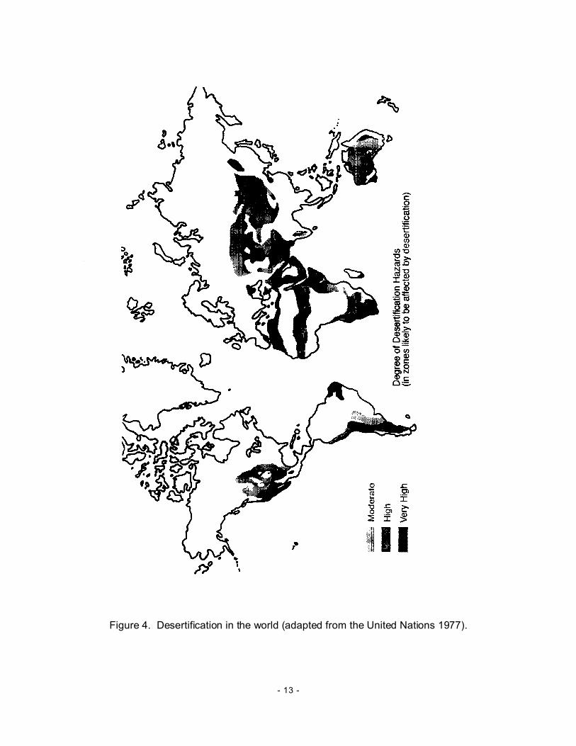
A map of the dryland regions of the world (Figure 1), when compared to a world map ofdesertification (Figure 4), shows a close correlation between the drylands and the locations ofareas that are likely to be affected by desertification. This correlation is often explained by thefragile dryland environments undergoing aeolian and fluvial erosion, soil salinization, and loss ofvegetation by overgrazing by livestock, over cutting of fuelwood and trees, and other excessiveuses of the land and natural resources by people (El-Baz 1991). The prevailing climate also exertsa persisting stress on both soil and vegetative resources. Relatively little disturbance can causeinstability and imbalance, leading to desertification as a result. Desertification plagues all regionsof the world and results from varying combinations of climatic and other natural stresses andhuman activities.
- 13 -
Figure 4. Desertification in the world (adapted from the United Nations 1977).
- 14 -
The United Nations Environment Program (UNEP) has estimated that 35 million km2 of the drylandregions of the world, an area approximately the size of both North and South America, are affectedby desertification or the threat of desertification (FAO 1989b, UNEP 1992). Nearly 25 million km2
of this area has been classified as exposed to either high and very high desertification risk. Equallyimportant is the fact that 30,000 km2 are reduced to a state of “uselessness” every year, a loss thatis expected to continue into the future unless remedial actions are taken. Destruction of theimpacted lands’ productive capacity brought about by desertification costs the world more than $75billion each year.
The multitude of problems that constitute desertification defy a single solution. The magical “magicbullet” does not exist nor is it realistic to expect that it will ever exist (Mouat et al. 1995). Physical,biological, and economic and other social factors causing desertification vary so widely and arefound in such a bewildering array of combinations that most of the “formula-based solutions” fordealing with the issues of desertification are incomplete and insufficient. Desertification control andthe related resource development is likely more a social activity than a technical one.Desertification, therefore, is largely a problem for people to mitigate.
CONCLUDING COMMENTS
Sustaining land use is a challenge to the people living in dryland environments. Problemscommonly faced by these people include desertification, inadequate knowledge of more productiveland-use practices, and low levels of investment. The issue of desertification has already beendiscussed. However, people can also confront major problems in attempting to attain a level ofsustainable land use because of their inadequate knowledge of alternative land use practices(Ffolliott et al. 1995, Squires and Sidahmed 1998). Many people have a “tradition” in agriculturethat is not always matched by a similar attitude toward other land uses such as forestry, wildliferanching, or ecotourism, all of which have become profitable enterprises in many dryland regionsof the world. This lack of appreciation can be a barrier to the initiation of these land uses,especially on marginal agricultural lands. The barriers are often overcome through the educationof people, extension services, and, most of all, through demonstrating the benefits obtainedthrough more diversified land-use activities.
The drylands of the world also suffer from the vicious cycle of low productivity, low levels ofinvestment, and, as a result, poverty. Investments, apart from those made for irrigated agricultureactivities, are relatively low (Marples 1986, Ffolliott et al. 1995, Squires and Sidahmed 1998). Lowproductivity, low levels of investment, and land degradation often leading to desertification areresponsible for regional poverty and income disparities. The poverty and hunger that are prevalentin sub-Saharan Africa is a poignant example of this situation. Other critical problems include theinherent problem of water scarcity, tenure considerations, and ineffective developmental policies.Improving this situation requires that a variety of technical and institutional problems be solved.Among these solutions is increasing the level of investments in appropriate agriculture, alternativeland use practices, and other appropriate income-generating interventions. Other solutions aredesigning strategies for risk management and implementing programs for more equitable landdistribution and levels of income
- 15 -
REFERENCES Armitage, F. B. 1987. Irrigated forestry in arid and semi-arid lands: A synthesis. International Development
Research Center, O ttawa, Canada.
Baum er, M. C., and B. B. Salem. 1985. The arid zone. In: FAO. Sand dune stabilization, shelterbelts and
afforestation. FAO Conservation Guide 10, Rome, Italy, pp. 1-8.
Brooks, K. N., P. F. Ffolliott, H. M. Gregersen, and L. F. DeBano. 1997. Hydrology and the managem ent of
watersheds. Iowa State University Press, Ames, Iowa, USA.
Buck, L. E., J. P. Lassoie, and E. C. M. Fernandes, editors. 1999. Agroforestry in sustainable agricultural
systems. Lewis Publishers, Boca Raton, Florida, USA.
Child, G. S. 1989. Utilization of wildlife. In: FAO. Role of forestry in combating desertification. FAO
Conservation Guide 21, Rome, Italy, pp. 173-182.
Dregne, H. E. 1983. Desertification in arid lands. Harwood Academ ic Publishers, New York, USA.
El-Baz, F. 1991. Desertification. Geotimes 36(2):52-54.
FAO. 1989a. Arid zone forestry: A guide for field technicians. FAO Conservation Guide 20, Rom e, Italy.
FAO. 1989b. Role of forestry in com bating desertification. FAO Conservation Guide 21, Rome, Italy.
Ffolliott, P. F., K. N. Brooks, and M. M. Fogel. 2002. Managing watersheds for sustaining agriculture and
natural resource benefits into the future. Quarterly Journal of International Agriculture 41(1/2):23-40.
Ffolliott, P. F., K. N. Brooks, H. M. Gregersen, and A. L. Lundgren. 1995. Dryland forestry: Planning and
management. John Wiley & Sons, Inc., New York, USA.
Gordon, A. M., and S. N. Newman, editors. 1997. Tem perate agroforestry systems. CAB International,
London, England.
Guttman, N. B. 1998. Comparing the Palmer drought index and the standardized precipitation index. Journal
of the American Water Resources Association 34:113-121.
Heady, H. F., and E. B. Heady. 1982. Range and wildlife managem ent in the tropics. Longman, Inc., New
York, USA.
Heathcote, R. L. 1983. The arid lands: Their use and abuse. Longm an, London, England.
Hocking, D. 1987. Acacia albida - the farmers choice for semi-arid and arid zones. Nitrogen Fixing Tree
Association NFT Highlights 98-02, Waimanalo, Hawaii, USA.
Jackson, I. J. 1989. Climate, water and agriculture in the tropics. Longman Publishers, Singapore.
Joffre, R., J. Vacher, C. Los Llanos, and G. Long. 1989. The Dehesa: An agrosilvipastoral system of the
Mediterranean region with special reference to the Sierra Morena area of Spain. In: Nair, P. K. R., editor.
Agroforestry systems in the tropics. Kluwer Academic Publishers, Dordrecht, The Netherlands, pp. 427-
453.
Lohani, V. K., and G. V. Longanathan. 1997. An early warning system for drought management using the
Palmer drought index. Journal of the American Water Resources Association 33:1375-1386.
- 16 -
Maranon, T. 1988. Agrosylvopastoral systems in the Iberian peninsula: Dehesas and Montados. Rangelands
10:255-258.
Marples, S. 1986. Production and investment in marginal areas. In: Davis, T. J., editor. Development of
rainfed agriculture under arid and semiarid conditions. The World Bank, Washington, DC, USA, p. 87.
McKee, T. B., N. J. Doeskin, and J. Kleist. 1993. The relationship of drought frequency and duration to time
scales. In: Proceedings of the 8th conference on applied clim atology. Am erican Meteorological Society,
Boston, Massachusetts, USA, pp. 179-184.
McKee, T. B., N. J. Doeskin, and J. Kleist. 1998. Drought monitoring with multiple time scales. In:
Proceedings of the 9th conference on applied climatology. American Meteorological Society, Boston,
Massachusetts, pp. 233-236.
Mouat, D. A., C. F. Hutchinson, and B. C. McClure. 1995. Introduction. In: Mouat, D. A., and C. F.
Hutchinson. Desertification in developed countries. Kluwer Academic Publishers, Dordrecht, The
Netherlands, pp. 1-4
Nair, P. K. R., editor. 1989. Agroforestry systems in the tropics. Kluwer Academ ic Publishers, Dordrecht,
The Netherlands.
Palmer, W . C. 1965. Meteorological drought. U.S. W eather Bureau, Research Paper 45, W ashington, DC,
USA.
Persaud, N., S. Long, M. Gandah, and M. Ouattara. 1986. Influence of wood-harvesting method on wind
protection between rows of neem (Azardirachta indica) plantation in Niger, West Africa. In: Hintz, D. L.,
and J. R. Brandle, editors. International symposium on windbreak technology. Great Plains Agricultural
Council Publication 117, pp. 211-212.
Squires, V. R., and A. E. S idahmed. 1998. Drylands: Sustainable use of rangelands into the twenty-first
century. International Fund for Agricultural Development, Rome, Italy.
United Nations. 1977. Desertification: Its causes and consequences. Pergamon Press, Ltd., London,
England.
UNEP. 1992. World atlas of desertification. Edward Arnold, London, England.
W ent, F. W . 1955. The ecology of desert plants . Scientific Am erican 192(4):68-75.
W hite, R. P., D. Tunstall, and N. Henninger. 2002. An ecosystem approach to drylands: Building support for
new development policies. Information Policy Brief 1, W orld Resources Institute, Washington, DC, USA.