duncton mill key: route instructions walks near midhurst ...€¦ · walks near midhurst and...
TRANSCRIPT
Walks near Midhurst and Duncton Mill
DunctonMill
Duncton
Sutton
Burton Chapel
The Warren
CrouchFarm
The WhiteHorse
WW
Start/Finish
A285
A285
Time: 2–2.5 hours
Distance: 5miles/8km
Bus: 99/99A
Duncton Mill Walks near Midhurst and Duncton MillDiscover another way to visit the South Downs National Park. Go to www.traveline.co.uk or call 0871 200 22 33 to find public transport information. For train timetables, visit www.nationalrail.co.uk or call 08457 484950.
South Downs National ParkThe South Downs National Park is Britain’s newest National Park, rich in landscape, culture and wildlife. Discover ancient woodland and enjoy spectacular views as you explore the open downs and heathlands. Within these landscapes lie bustling market towns and peaceful rural villages, historic houses and the remains of ancient settlements.
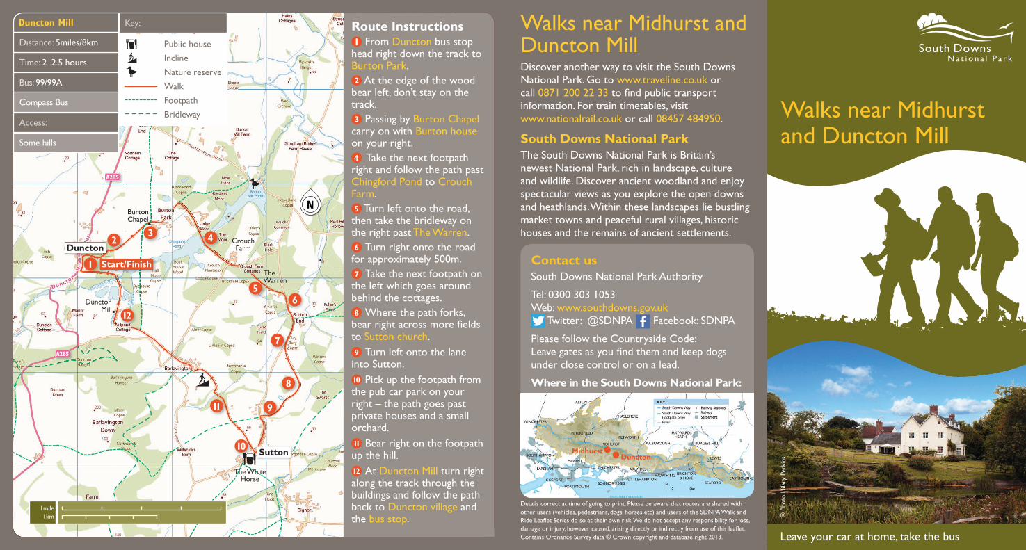
Route Instructions From Duncton bus stop
head right down the track to Burton Park.
At the edge of the wood bear left, don’t stay on the track.
Passing by Burton Chapel carry on with Burton house on your right.
Take the next footpath right and follow the path past Chingford Pond to Crouch Farm.
Turn left onto the road, then take the bridleway on the right past The Warren.
Turn right onto the road for approximately 500m.
Take the next footpath on the left which goes around behind the cottages.
Where the path forks, bear right across more fields to Sutton church.
Turn left onto the lane into Sutton.
Pick up the footpath from the pub car park on your right – the path goes past private houses and a small orchard.
Bear right on the footpath up the hill.
At Duncton Mill turn right along the track through the buildings and follow the path back to Duncton village and the bus stop.
Access:
Some hills
Key:
Public house
Incline
Nature reserve
Walk
Footpath
Bridleway
Leave your car at home, take the bus
Compass Bus
© P
hoto
Hila
ry P
erki
ns
Details correct at time of going to print. Please be aware that routes are shared with other users (vehicles, pedestrians, dogs, horses etc) and users of the SDNPA Walk and Ride Leaflet Series do so at their own risk. We do not accept any responsibility for loss, damage or injury, however caused, arising directly or indirectly from use of this leaflet. Contains Ordnance Survey data © Crown copyright and database right 2013.
Contact usSouth Downs National Park Authority
Tel: 0300 303 1053 Web: www.southdowns.gov.uk
Twitter: @SDNPA Facebook: SDNPA
Please follow the Countryside Code: Leave gates as you find them and keep dogs under close control or on a lead.
Where in the South Downs National Park:
DunctonMidhurst
1mile1km
National Trust Footpath
Rother River
WoolbedingBridge
Cemetery
Cowdray ruins
StedmanMill
EastshawFarm
Midhurst
Woolbeding
Easebourne
June Lane
Half Moon Inn
The WhiteHorse
g
metery
A286
A272
A272
A272
JuJ
Start/Finish
A286
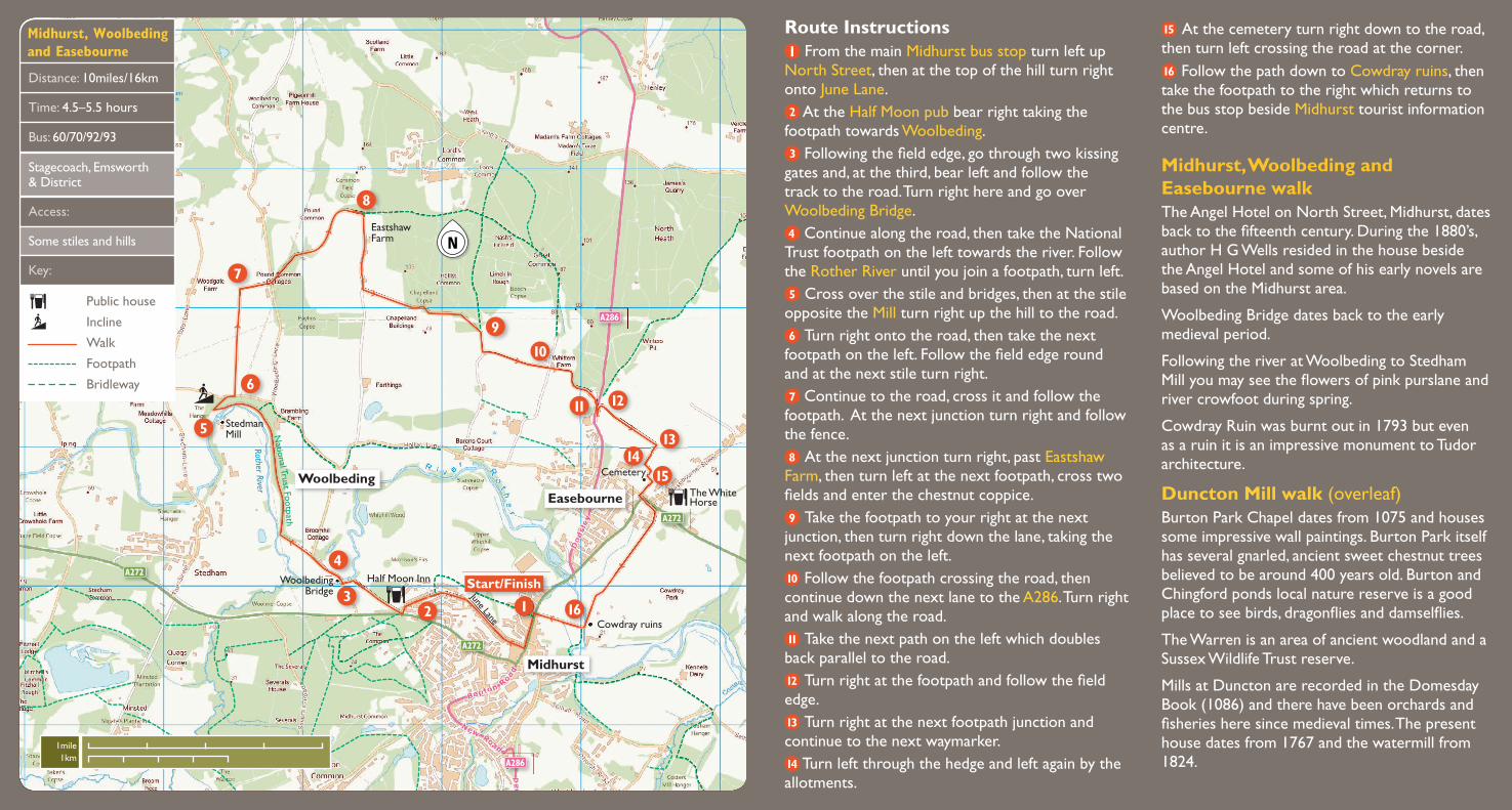
Route Instructions From the main Midhurst bus stop turn left up
North Street, then at the top of the hill turn right onto June Lane.
At the Half Moon pub bear right taking the footpath towards Woolbeding.
Following the field edge, go through two kissing gates and, at the third, bear left and follow the track to the road. Turn right here and go over Woolbeding Bridge.
Continue along the road, then take the National Trust footpath on the left towards the river. Follow the Rother River until you join a footpath, turn left.
Cross over the stile and bridges, then at the stile opposite the Mill turn right up the hill to the road.
Turn right onto the road, then take the next footpath on the left. Follow the field edge round and at the next stile turn right.
Continue to the road, cross it and follow the footpath. At the next junction turn right and follow the fence.
At the next junction turn right, past Eastshaw Farm, then turn left at the next footpath, cross two fields and enter the chestnut coppice.
Take the footpath to your right at the next junction, then turn right down the lane, taking the next footpath on the left.
Follow the footpath crossing the road, then continue down the next lane to the A286. Turn right and walk along the road.
Take the next path on the left which doubles back parallel to the road.
Turn right at the footpath and follow the field edge.
Turn right at the next footpath junction and continue to the next waymarker.
Turn left through the hedge and left again by the allotments.
Time: 4.5–5.5 hours
Distance: 10miles/16km
Bus: 60/70/92/93
Access:
Some stiles and hills
Midhurst, Woolbeding and Easebourne
Key:
At the cemetery turn right down to the road, then turn left crossing the road at the corner.
Follow the path down to Cowdray ruins, then take the footpath to the right which returns to the bus stop beside Midhurst tourist information centre.
Public house
Incline
Walk
Footpath
Bridleway
Stagecoach, Emsworth & District
Midhurst, Woolbeding and Easebourne walkThe Angel Hotel on North Street, Midhurst, dates back to the fifteenth century. During the 1880’s, author H G Wells resided in the house beside the Angel Hotel and some of his early novels are based on the Midhurst area.
Woolbeding Bridge dates back to the early medieval period.
Following the river at Woolbeding to Stedham Mill you may see the flowers of pink purslane and river crowfoot during spring.
Cowdray Ruin was burnt out in 1793 but even as a ruin it is an impressive monument to Tudor architecture.
Duncton Mill walk (overleaf)Burton Park Chapel dates from 1075 and houses some impressive wall paintings. Burton Park itself has several gnarled, ancient sweet chestnut trees believed to be around 400 years old. Burton and Chingford ponds local nature reserve is a good place to see birds, dragonflies and damselflies.
The Warren is an area of ancient woodland and a Sussex Wildlife Trust reserve.
Mills at Duncton are recorded in the Domesday Book (1086) and there have been orchards and fisheries here since medieval times. The present house dates from 1767 and the watermill from 1824.
1mile1km