earth science for secondary schools: earth science
TRANSCRIPT
Earth Science for Secondary Schools
Earth Science Teaching Curriculum
By
Chelsea DeVries
Brent G. Hallock
Advisor
California Polytechnic State University
Earth and Soil Sciences Department
San Luis Obispo
2010
i
Approval Page
TITLE: Earth Science for Secondary Schools
AUTHOR: Chelsea D. DeVries
DATE SUBMITTED: December 8, 2010
Brent G. Hallock
Senior Project Advisor Signature
Dr. Lynn Moody
Department Chair Signature

ii
Acknowledgments
• I want to thank Dr. Moody and Dr. Hallock for being so kind, supportive, helpful,
and PATIENT with me through my journey at Cal Poly. I may never have made it
without them!!!!
• I also want to thank my loving parents, for knowing exactly what to say every
time I wanted to give up.
• I want to thank my lovely husband-to-be, for being the rock I needed to stand on
when I felt like I was in sinking sand.
• Lastly, but DEFINETLY not least, I want to thank Katherine O’Clair and Debra
Leopard for helping me with all the “computer stuff.”
• I am very grateful the Internet, books, and journals that were used to complete
this project. Please refer to the resources page when any picture, photograph, or
chart is listed.
iii
Table of Contents
Table of Contents Page
Tile Page
Approval Page i
Acknowledgements ii
Table of Contents iii
Abstract 1
Introduction 2
Material and Methods 3
Results 7
Resources 82
Appendix 85
***Power Point Presentations included on CD
1
Abstract
Creating this senior project, based on secondary Earth Science curriculum, will be
directed toward teachers and will assist in lessons and instruction and reaching students
at a deeper level. This Earth Science curriculum will challenge students and enlighten
teachers. This curriculum will impact students in a way that they will never forget. After
completing this course, the students will be knowledgeable and have a strong
foundation in the fundamentals of Earth Science. Creating this curriculum will challenge
students in subjects such as, the universe, biodiversity / conservation biology,
introduction to soils, rocks and minerals, and the geography of California. The result of
this project will inform high school students of the importance of knowing how the
earth works and basic understanding of Earth systems.
2
Introduction
Teaching has always been a passion of mine and developing a curriculum for earth
Sciences fit the position for a senior project. This senior project includes a brief
introduction of how Earth Sciences have developed, how the future of teaching will
affect its curriculum, and how to approach different students and their learning abilities.
The other half of the curriculum will include five experiments the will touch on
astronomy, biology, rocks and minerals, introduction to soils, and geography of
California. The purpose of this project is to allow a teacher to use this curriculum in his
or her classroom. This project will reach students at a deeper level of learning and allow
them to retain the information.
3
Materials and Methods
In order to establish teaching curricula for high school aged students, I have created
different lectures and lab assignments, and quizzes. The following table exemplifies the
order of subjects one would teach and the manner in which the information will be
presented.
Five labs and lectures:
Universe
• Lecture: Teacher led lecture based on each planet
o Students take notes
• Lab: assign one planet to groups of students. Have them create a detailed model
of assigned planet.
• Presentation: create a detailed presentation on assigned planet; include a two
page written report.
• Quiz
Biodiversity / Conservation Biology
• Lecture: Teacher led lecture based on scope of biodiversity on Earth, extinction,
causes of biodiversity loss, conservation efforts
o Students take notes
• Lab: identify locations, climates characteristics, and productivity associated with
the major biomes of the world
4
• Homework assignment: a two page written report on favorite animal, plant, or
reptile
• Review questions for test
Rocks and Minerals
• Lecture: Teacher led lecture on igneous, metamorphic, and sedimentary rocks;
rock cycle, minerals
• Lab: Define different rocks in rock cycle. Fill out charts for rock cycle
• Quiz: knowledge of subject matter
Introduction to Soils
• Lecture: Teacher led lecture on soil horizons, soil profiles, soils color (hue, value,
chroma)
• Homework: write a paper on favorite soil order; share with class
• Quiz: perform knowledge of soil horizons
Geography of California
• Lecture: teacher led lecture on 11 geomorphic provinces and natural hazards in
California.
• Lab: form groups and draw three types of faults discussed in lecture; class
discussion
• Homework: draw picture of California with 11 provinces. Write a paragraph of
your favorite feature
5
Results
Universe
• Lecture: Teacher led lecture based on each planet
o Students take notes
• Lab: assign one planet to each student. Have them create a detailed model of
assigned planet.
• Presentation: create a detailed presentation on assigned planet; include two
page written reports.
• Sources: internet
Biodiversity / Conservation Biology
• Lecture: Teacher led lecture based on scope of biodiversity on Earth, extinction,
causes of biodiversity loss, conservation efforts
o Students take notes
• Lab: identify locations, climate characteristics, and productivity associated with
the major biomes of the world
• Homework assignment: a two page written report on favorite animal, plant, or
reptile
• Sources: science book, lab manual, internet
Rocks and Minerals
• Lecture: Teacher led lecture on igneous, metamorphic, and sedimentary rocks;
rock cycle, minerals
6
• Lab: Define different rocks and rock cycle. Fill out charts for rock cycle
• Quiz: knowledge of subject matter
• Sources: science book, lab manual, internet
Introduction to Soils
• Lecture: Teacher led lecture on soil horizons, soil profiles, soils color (hue, value,
chroma)
• Homework: take home paper on favorite soil order. Share with the class.
• Quiz: perform knowledge of soil horizons
• Sources: science book, internet
Geography of California
• Lecture: teacher led lecture on geomorphic provinces and natural hazards in
California
• Lab: draw the three different types of faults discussed in class. Share with class.
• Homework: draw the state of California with eleven provinces. Write a
paragraph (6-8 sentences) of favorite feature.
• Sources: internet

7
Universe / Solar System
Lecture Outline
Sun
Definition: The Sun is a star, a hot ball of glowing gases at the heart of our solar system.
Facts: Our Sun is a ball of hot, glowing gases. The part we can see is about 11,000F
(6,100 degrees C). It gets hotter as you go deeper. The hottest the oven in your kitchen
gets is 500F (260 degrees C). The surface of our Sun boils like a pot of soup. It also
shoots flares of hot gas thousands of miles into space. The suns influence extends far
beyond the orbits of distant Neptune and Pluto. Without the Sun's intense energy and
heat, there would be no life on Earth. And though it is special to us, there are billions of
stars like our Sun scattered across the Milky Way galaxy.
• Its’ light travels to earth at 1,381,760 MPH!
• The sun only looses 61 F traveling to Earth (92.million MPH)
• The age of the sun is 4.6 billion years old.
• Composition: 92% Hydrogen / 7.8% Helium
WHAT'S IT LIKE ON THE SUN?
The Sun is way too hot to visit. A person or spacecraft couldn't even get near it. Even if
you could get close, powerful gravity would make one of your arms weigh as much as
your whole body. It would be impossible to move.
***FUN FACTS***
8
• 100,000,000,000 tons of dynamite would have to explode every second to match
the energy produced by the Sun.
• 1,300,000: Rough number of crushed up Earths that could fit inside our Sun.
Mercury
Sun-scorched Mercury is only slightly larger than Earth's Moon. Like the Moon, Mercury
has very little atmosphere to stop impacts, so it is covered with craters. Mercury's day
side is super-heated by the Sun, but at night, temperatures drop hundreds of degrees
below freezing. Ice may even exist in the craters. Mercury's egg-shaped orbit takes it
around the Sun every 88 days. There is no water on Mercury. But there might be a little
ice in deep craters. Mercury has cliffs and valleys just like Earth. Some cliffs are a mile
high. You would need very special spacesuit to visit Mercury. It would have to protect
you from extreme heat and cold and dangerous radiation from the Sun. Even NASA's
MESSENGER spacecraft, which launches for Mercury in 2004, needs a shade to protect it
from the Sun's blistering heat and radiation.
Why Explore Mercury?
• Mercury is an extreme planet: the smallest, the densest, the one with the oldest
surface, the one with the largest daily variations in surface temperature, and the
least explored.
• Mercury, like Earth, has a global internal magnetic field. Mars and Venus do not!
9
• Less than half of the surface of Mercury has been imaged by a spacecraft.
***FUN FACTS***
• Average distance from the sun: 35,983,095 miles
• Orbit Velocity: 107,088 mph
• Minimum/Maximum Surface Temperature: -279 / 801 °F
• 104,000 MPH: Mercury travels around the sun - about 40,000 mph faster than
Earth.
• 176: Number of Earth days you'd have to stay up to equal one day on Mercury.
• 870°F: Hottest temperature on Mercury.
• -297°F: Coldest temperature on Mercury.
• ONLY 45: Rough percentage of Mercury's surface that has been photographed in
detail.
Venus
Venus is a dim world of intense heat and volcanic activity. Similar in structure and size to
Earth, Venus' thick, toxic atmosphere traps heat in a runaway 'greenhouse effect.' The
scorched world has temperatures hot enough to melt lead. Glimpses below the clouds
reveal volcanoes and deformed mountains. Venus spins slowly in the opposite direction
of most planets. Venus is the second planet from our Sun. It is Earth's closest neighbor.
Venus is the second brightest object in our night sky. Only the moon is brighter. Venus'
dazzling beauty at night explains its name. It is named for the Roman goddess of love

10
and beauty. Even though it is so close to Earth, Venus is very mysterious. The surface is
hidden beneath hot, poisonous air made up mostly of carbon dioxide. Scientists must
use radar to 'see' through Venus' clouds. Venus has no moon and no rings.
What’s it like on Venus?
Hot, confusing and pretty much yucky. To get to the surface of Venus, you would have
to pass through clouds of sulfuric acid, hurricane-force winds and lightning. On the
ground, it would look like a very hazy, overcast day on Earth. Instead of cooling things
down, the clouds on Venus reflect sunlight and trap heat, a lot like a greenhouse keeps
plants warm. On Venus the 'greenhouse effect' is out of control. It can get up to almost
900F. The air is thick and poisonous. Venus' atmosphere is so heavy it would feel like
you were deep in the ocean. Remember how your head feels squeezed at the bottom
of a swimming pool? That is pressure. On Venus, the pressure is so strong it would crush
you. Metal spacecrafts were smashed after a few hours on the surface of Venus!! This is
a strange planet. Venus spins backwards so the Sun rises in the west and sets in the
east. And because the planet rotates so sluggishly, a day on Venus is longer than it takes
to go around the Sun. Imagine if we switched to Venusian clocks on Earth. A school day
would last four months! Almost all the surface features of Venus are named for
amazing Earth women. A volcanic crater is named for Sacajawea, the Native American
who guided Lewis and Clark's exploration. A deep canyon is named for Diana, Roman
goddess of the hunt.
11
***FUN FACT***
• 854°F: Average temperature on the surface of Venus.
Earth
Earth is an ocean planet. Our world has an abundance of water - and life - makes it
unique in our solar system. Other planets, plus a few moons, have ice, atmospheres,
seasons and even weather, but only on Earth does the whole complicated mix come
together in a way that encourages life! Our moon makes Earth a more livable planet by
moderating our home planet's wobble on its axis, leading to a relatively stable climate,
and creating a rhythm that have guided humans for thousands of years. The Moon was
likely formed after a Mars-sized body collided with Earth and the debris formed into the
most prominent feature in our night sky. It is the fifth largest planet in our solar system.
It is the only planet we know of where life exists. Earth is different in very important
ways. Most of our planet is covered with water. The air is made of nitrogen, oxygen and
a little carbon dioxide - just right for us to breathe. Earth is home to people, plants and
animals because it has both water and the right kind of atmosphere.
Earths’ Moon: Our moon is a natural satellite. Unlike the robotic satellite's that send
T.V. signals and science data back to Earth, natural satellites were there long before
people. We just kind of borrowed the name satellite when we first started launching
spacecraft into Earth orbit. From the moon, Earth looks four times bigger than a full
12
Moon. If you looked in the right places on the moon, you would find pieces of
equipment, American flags and even a camera left behind by astronauts. The moon is
covered with craters. The moon has no atmosphere to protect it, space rocks - some as
big as mountains - have smashed into it. Tycho Crater is more than 52 miles wide! The
moon's surface is rocky and covered with dust. The moon's weak gravity means it is easy
to move around, even in a heavy spacesuit. It is impossible for people to explore the
Moon without a spacesuit. There is no air and radiation from the Sun is very dangerous.
It gets very hot and very cold on the moon. When the Sun is shining, the moon sizzles at
265 F. It can drop down to 170 F below zero.
***FUN FACTS***
• Minimum / Maximum Surface Temp: -126 / 136 F
• Atmospheric Constituents: Nitrogen, Oxygen
• Nitrogen is 80% of the air and is crucial to the makeup of DNA
• Earth is the only planet in our solar system that has liquid water on the surface.
Mars
Though details of Mars' surface are difficult to see from Earth, telescope observations
show seasonally changing features and white patches at the poles. For decades, people
speculated that bright and dark areas on Mars were patches of vegetation that Mars
could be a likely place for life-forms, and that water might exist in the polar caps. When
the Mariner 4 spacecraft flew by Mars in 1965, many were shocked to see photographs

13
of a bleak, cratered surface. Mars seemed to be a dead planet. Later missions,
however, have shown that Mars is a complex member of the solar system and holds
many mysteries yet to be solved. Mars is a rocky body about half the size of Earth. As
with the other terrestrial planets - Mercury, Venus, and Earth - the surface of Mars has
been altered by volcanism, impacts, crustal movement, and atmospheric effects such as
dust storms. Mars is the fourth planet from the Sun. It is sometimes called the 'Red
Planet' because of its red soil. The soil on Mars is red because it contains iron oxide
(rust). Mars is one of the brightest objects in the night sky. It has been known since
ancient times. The planet is named for the Roman God of War. The thin air on Mars
makes it a dangerous place for humans. It is mostly poisonous carbon dioxide. You
would need a spacesuit to visit Mars. Recently, scientists found lots of frozen water
(scientists say water ice) just under the surface of Mars. This means astronauts who
may visit Mars in the future will have plenty of water - enough to fill Lake Michigan
twice. Mars is a rocky planet. It is dusty and dry. The sky would be hazy and red instead
of blue. Sometimes giant dust storms cover the whole planet.
Mars’ Moons: Asaph Hall was about to give up his frustrating search for a Martian moon
one August night in 1877, but his wife Angelina urged him on. He discovered Deimos
the next night, and Phobos six nights after that. Ninety-four years later, NASA's Mariner
9 spacecraft got a much better look at the two moons from its orbit around Mars. The
dominant feature on Phobos, is a crater 6 miles wide - nearly half the width of the moon
itself. It was given Angelina's maiden name: Stickney. Hall named the moons for the
14
mythological sons of Ares, the Greek counterpart of the Roman god, Mars. Phobos
means fear or panic, and Deimos means flight. Mars' moons are among the smallest in
the solar system. Phobos is a bit larger than Deimos, and orbits only 3,700 miles above
the Martian surface. No known moon orbits closer to its planet. It whips around Mars
three times a day, while the more distant Deimos takes 30 hours for each orbit. Phobos
is gradually spiraling inward, drawing about 1.8 meters closer to the planet each
century. Within 50 million years, it will either crash into Mars or break up and form a
ring around the planet.
***FUN FACTS***
• Minimum / Maximum Suface Temperature: -125- 23F
• Composition: Carbon Dioxide, Nitrogen, Argon
• 687: Number of days it takes for Mars to orbit the sun. A Martian year.
• 66.5: Years it would take to travel the minimum distance between Earth and
Mars at 60 mph. It takes only five minutes at the speed of light.
• -81°F: Average temperature on Mars
Asteroids and their Moons
Asteroids are rocky, airless worlds that orbit our Sun, but are too small to be called
planets. Tens of thousands of these 'minor planets' are gathered in the main asteroid
belt, a vast doughnut-shaped ring between the orbits of Mars and Jupiter. Asteroids that
pass close to Earth are called near-earth objects.
15
Moons: It seems likely that most asteroid moonlets are fragments from past collisions.
It's also possible that some loose-rubble asteroids passed close enough to a planet at
some point for gravity to pull them apart and create natural satellites (the formal name
for a moon).
• Just as 17th century astronomer Galileo Galilei was first to see moons around
another planet, the 20th century spacecraft named in his honor was the first to
discover a moon orbiting an asteroid.
• Most scientists imagined asteroids as isolated mountains or rock piles tumbling
alone through space. But while en route to Jupiter in 1993, NASA's Galileo
spacecraft flew by a 19-mile-wide asteroid called Ida and discovered that it has
its own little moon. Just one mile wide, the moon was named Dactyl. Ida and
Dactyl were the first binary - or double - asteroids.
• It was six years before another asteroid-moon system was found, but a small
avalanche of discoveries followed:
o In 1999, astronomers using Earth-based telescopes found that 135-mile-
wide Eugenia has an eight-mile-diameter moon, which they dubbed Petit-
Prince.
o In 2000, 90-mile-wide Pulcova was discovered to have its own moon,
about nine miles wide.
16
o In 2001, scientists found Linus orbiting Kalliope, and another moon
around asteroid Sylvia.
• Dozens of binary asteroids have been confirmed in the main asteroid belt and
among Near-Earth objects, including some in which the moon is much closer in
size to the main asteroid. Some Trans-Neptunian objects (beyond the orbit of
Neptune) also are binaries.
• Astronomers used radar to observe some of the closer asteroid-moon pairs.
Most of the others were discovered in visible light, using ground-based
telescopes with adaptive optics. These systems use computer-controlled
deformable mirrors to compensate for the blurring effects of Earth's
atmosphere, creating sharper images.
• Observing a moon orbiting an asteroid enables scientists to calculate the
asteroid's mass and density.
Meteors and Meteorites
"Shooting stars," or meteors, are bits of interplanetary material falling through Earth's
atmosphere and heated to incandescence by friction. These objects are called
meteoroids as they are hurtling through space, becoming meteors for the few seconds
they streak across the sky and create glowing trails. Several meteors per hour can
usually be seen on any given night. Sometimes the number increases dramatically -
17
these events are termed meteor showers. Some occur annually or at regular intervals
as the Earth passes through the trail of dusty debris left by a comet. Meteor showers
are usually named after a star or constellation that is close to where the meteors appear
in the sky. Perhaps the most famous are the Perseids, which peak around August 12
every year. Every Perseid meteor is a tiny piece of the comet Swift-Tuttle, which swings
by the Sun every 135 years. Other meteor showers and their associated comets are the
Leonids (Tempel-Tuttle), the Aquarids and Orionids (Halley), and the Taurids (Encke).
Most comet dust in meteor showers burns up in the atmosphere before reaching the
ground; some dust is captured by high-altitude aircraft and analyzed in NASA
laboratories.
***FUN FACTS***
• 120,000: Weight (in pounds) of the largest iron meteorite found on Earth.
• 2,200: Weight (in pounds) of the largest rock meteorite found on Earth.
Jupiter
The most massive planet in our solar system, with four large moons and many smaller
moons, Jupiter forms a kind of miniature solar system. Jupiter resembles a star in
composition. In fact, if it had been about 80 times more massive, it would have become
18
a star rather than a planet. On January 7, 1610, using his primitive telescope,
astronomer Galileo Galilei saw four small "stars" near Jupiter. He had discovered
Jupiter's four largest moons, now called Io, Europa, Ganymede, and Callisto. These four
moons are known today as the Galilean satellites. Jupiter also includes temporary
moons which are counted once they have orbited one time around the planet. Jupiter
has 62 total.
WHAT'S IT LIKE ON JUPITER?
This is not a nice place to visit. It is a giant ball of gas. There is nowhere to land. Any
spacecraft - or person - passing through the colorful clouds gets crushed and melted.
Remember how your head feels squeezed when you dive into the deep end of a pool?
That is pressure. On Jupiter, the pressure is so strong it squishes gas into liquid.
Jupiter's atmosphere can crush a metal spaceship like a paper cup. Jupiter's stripes and
swirls are cold, windy clouds of ammonia and water. Jupiter's Great Red Spot is a giant
storm as wide as three Earths. This storm has lasted hundreds of years. Jupiter's
atmosphere is poisonous. It is mostly hydrogen and helium. There is dangerous
radiation, too. It gets very hot and very cold. Scientists think Jupiter's core may be a
thick, super hot soup. It might be up to 50,000 F down there. Jupiter has its own 'mini
solar system' of 50 moons. Scientists are most interested in the Galilean satellites - the
four largest moons discovered by Galileo Galilei in 1610. Europa, may have an ocean
under its frozen surface. Calisto's crater-pocked landscape may be the oldest in the
19
solar system. Ganymede is the solar system's largest moon. It is bigger than Pluto and
Mercury. And little Io has more volcanoes than anywhere else in the solar system.
Jupiter also has three rings, but they are very hard to see and not nearly as pretty as
Saturn's.
Jupiter: Moons
The planet Jupiter's four largest moons are called the Galilean satellites, after Italian
astronomer Galileo Galilei, who observed them in 1610. The German astronomer Simon
Marius claimed to have seen the moons around the same time, but he did not publish
his observations and so Galileo is given the credit for their discovery. These large moons,
named Io, Europa, Ganymede, and Callisto, are each distinctive worlds.
• Lo is the most volcanically active body in the solar system. Its surface is covered
by sulfur in different colorful forms. As Lo travels in its slightly elliptical orbit,
Jupiter's immense gravity causes 'tides' in the solid surface 300 feet high on Lo,
generating enough heat to give rise to the volcanic activity and drive off any
water. Lo's volcanoes are driven by hot silicate magma.
• Europa's surface is mostly water ice, and there is evidence that it may be
covering an ocean of water or slushy ice. Europa is thought to have twice as
much water as Earth. This moon intrigues astrobiologists because of its potential
for having a 'habitable zone.' Life forms have been found thriving near
20
subterranean volcanoes on Earth and in other extreme locations that may be
analogues to what may exist on Europa.
• Ganymede is the largest moon in the solar system (larger than the planet
Mercury), and is the only moon known to have its own internally generated
magnetic field.
• Callisto's surface is extremely heavily cratered and ancient - a record of events
from the early history of the solar system. However, the very few small craters
on Callisto indicate a small degree of current surface activity.
The interiors of Lo, Europa, and Ganymede have a layered structure (as does Earth). Lo
has a core, and a mantle of at least partially molten rock, topped by a crust of solid rock
coated with sulfur compounds. Europa and Ganymede both have a core; a rock
envelope around the core; a thick, soft ice layer; and a thin crust of impure water ice. In
the case of Europa, a global subsurface water layer probably lies just below the icy crust.
Layering at Callisto is less well defined and appears to be mainly a mixture of ice and
rock.
Three of the moons influence each other in an interesting way. Lo is in a tug-of-war
with Ganymede and Europa, and Europa's orbital period (time to go around Jupiter
once) is twice Lo's period, and Ganymede's period is twice that of Europa. In other
words, every time Ganymede goes around Jupiter once, Europa makes two orbits, and
21
Lo makes four orbits. The moons all keep the same face towards Jupiter as they orbit,
meaning that each moon turns once on its axis for every orbit around Jupiter.
***FUN FACTS***
• 12: Years it takes Jupiter to travel around our sun.
• 1,321: Number of Earths that could fit inside Jupiter.
• 3: The number of rings around Jupiter.
Saturn
Saturn was the most distant of the five planets known to the ancients. Like Jupiter,
Saturn is made mostly of hydrogen and helium. Its volume is 755 times greater than
that of Earth. Winds in the upper atmosphere reach 500 meters (1,600 feet) per second
in the equatorial region. These super-fast winds, combined with heat rising from within
the planet's interior, causes the yellow and gold bands visible in the atmosphere.
Saturn's spectacular and complex rings are made mostly of water ice. Spacecraft images
reveal braided rings, ringlets and spokes - dark features in the rings that circle the planet
at different rates from that of the surrounding ring material. Saturn's ring system
extends hundreds of thousands of kilometers from the planet, yet the vertical depth is
typically about 10 meters (30 feet) in the main rings, although when viewed edge-on
there are vertical formations in some rings that seem to pile up in bumps or ridges more
than 3 kilometers (2 miles) tall.
22
Saturns Moons:
Saturn, the sixth planet from the Sun, is home to a vast array of intriguing and unique
worlds. From the cloud-shrouded surface of Titan to crater-riddled Phoebe, each of
Saturn's moons tells another piece of the story surrounding the Saturn system.
Christiaan Huygens discovered the first known moon of Saturn. The year was 1655 and
the moon is Titan. Giovanni Domenico Cassini made the next four discoveries: Lapetus
(1671), Rhea (1672), Dione (1684), and Tethys (1684). Mimas and Enceladus were both
discovered by William Herschel in 1789. The next two discoveries came at intervals of
50 or more years - Hyperion (1848) and Phoebe (1898). As telescopic resolving power
increased through the 19th century, Saturn's family of known moons grew. In 1966
Epimetheus and Janus were discovered. By the time Cassini-Huygens was launched in
1997, Saturn's moon count had reached 18. The number of known moons soon
increased with high-resolution imaging techniques used on ground-based telescopes.
Cassini discovered four more moons after its arrival at Saturn and may find even more
during its mission. There is a total of 53 natural satellites orbiting Saturn. Each of
Saturn's moons bears a unique story. Two of the moons orbit within gaps in the main
rings. Some, such as Prometheus and Pandora, interact with ring material, shepherding
the ring in its orbit. Some small moons are trapped in the same orbits as Tethys or
Dione. Janus and Epimetheus occasionally pass close to each other, causing them to
periodically exchange orbits.

23
Unique aspects of the moons:
• Titan: Titan is so large that it affects the orbits of other near-by moons. At 3,200
miles across, it is the second largest moon in the solar system. Titan hides its
surface with a thick nitrogen-rich atmosphere. Titan's atmosphere is similar to
Earth's atmosphere of long ago, before biology took hold on our home planet.
Titan's atmosphere is approximately 95% nitrogen with traces of methane.
While Earth's atmosphere extends about 37 miles into space, Titan's extends
nearly ten times that of Earth's atmosphere into space.
• Lapetus: has one side as bright as snow and one side as dark as black velvet,
with a huge ridge running around most of its dark-side equator.
• Phoebe: orbits the planet in a direction opposite that of Saturn's larger moons,
as do several of the recently discovered moons.
• Mimas: has an enormous crater on one side, the result of an impact that nearly
split the moon apart.
• Enceladus: displays evidence of active ice volcanism.
• Hyperion: has an odd flattened shape and rotates chaotically, probably due to a
recent collision.
• Pan: orbits within the main rings and helps sweep materials out of a narrow
space known as the Encke Gap.

24
• Tethys: has a huge rift zone called Ithaca Chasma that runs nearly three-quarters
of the way around the moon.
Sixteen of Saturn's moons keep the same face toward the planet as they orbit. Called
'tidal locking,' this is the same phenomenon that keeps our Moon always facing toward
Earth. Saturn’s Rings:
Saturn’s Rings:
There are thousands of rings made of up billions of particles of ice and rock. The
particles range in size from a grain of sugar to the size of a house. The rings are believe
to be pieces of comets, asteroids or shattered moons that broke up before they reached
the planet. Each ring orbits at a different speed around the planet. Saturn's rings are by
far the largest and most spectacular. With a thickness of about 3,200 feet or less, they
span up to 175,000 miles, about three quarters of the distance between the Earth and
its moon.
***FUN FACTS***
• Saturn is called the 'jewel of the solar system' because of its beautiful rings.
• 1,100 mph: Wind speeds at Saturn's equator. Earth's most violent tornadoes
hit 200 mph.
• -217°F: Temperature near the cloud tops of Saturn.
25
Uranus
Uranus was discovered in 1781 by astronomer William Herschel. It is the seventh planet
from the Sun, and the first planet found with the aid of a telescope. It is so distant that it
takes 84 years to complete one orbit around the sun. Uranus rotates east to west.
Uranus' rotation axis is tilted almost parallel to its orbital plane, so Uranus appears to be
rotating on its side. This may be the result of a collision with a planet-sized body early in
the planet's history, which apparently radically changed Uranus' rotation. Because of
Uranus' unusual orientation, the planet experiences extreme variations in sunlight
during each 20-year-long season. Uranus is very cold, windy and, like most of the other
planets, poisonous to humans. It is a gas planet like Jupiter, Saturn and Neptune. There
is nothing to land on. The air - atmosphere - gets thicker and thicker until it is squished
into liquid. A person or spacecraft diving through Uranus' clouds would be crushed.
Seasons on Uranus last more than 20 years because the planet is tilted on its side.
Scientists think it may have been hit by a planet-sized object a long time ago. Uranus is
extremely cold at the cloud tops. Deeper down is a layer of 'superheated' water,
ammonia and methane. Scientists think methane shoots to the surface in huge bubbles
and becomes bright clouds. The methane also absorbs red light and reflects the blue-
green colors we see when we look at Uranus through a telescope. Down near the core
of Uranus, it heats up to 9,000F. Uranus is so far away it is difficult to study. Scientists
use math to predict what the planet is like. Uranus' 11 rings weren't discovered until
26
1977. And several of Uranus' 27 known moons were discovered as recently as 2003.
There may be more undiscovered moons out there.
Uranus’ Moons: Oberon and Titania are the largest Uranian moons. William Lassell,
who had been first to see a moon orbiting Neptune, discovered the next two, Ariel and
Umbriel. Nearly a century passed before Gerard Kuiper found Miranda in 1948. And
that was it until a NASA robot made it to distant Uranus.
• Miranda: has giant fault canyons as much as 12 times as deep as the Grand
Canyon, terraced layers, surfaces that appear very old, and others that look
much younger.
• Ariel: has few large craters and many small ones, indicating that fairly recent
low-impact collisions wiped out the large craters that would have been left by
much earlier, bigger strikes. Intersecting valleys pitted with craters scars its
surface.
• Umbriel: ancient, and the darkest of the five large moons. It has many old, large
craters and sports a mysterious bright ring on one side.
The Hubble Space Telescope and improved ground-based telescopes have raised the
total to 27 known moons. All of Uranus's inner moons appear to be roughly half water
ice and half rock. The composition of the moons outside the orbit of Oberon remains
unknown, but they are likely captured asteroids.
27
Uranus’s Rings: Uranus, like Saturn, is encircled with a band of rings. The Kuiper team
had a better vantage point and were first to publish the surprising news that Uranus was
encircled by five narrow rings, which they named Alpha, Beta, Gamma, Delta and
Epsilon in order of increasing distance from the planet.
***FUN FACTS***
• 50,600: Closest distance (in miles) a spacecraft has come to Uranus.
• -350°F: Average temperature on Uranus.
• 27: Number of known moons orbiting Uranus
Neptune
The ice giant Neptune was the first planet located through mathematical predictions
rather than through regular observations of the sky. Galileo had recorded it as a fixed
star during observations with his small telescope in 1612 and 1613. When Uranus didn't
travel exactly as astronomers expected it to, a French mathematician, Urbain Joseph Le
Verrier, proposed the position and mass of another as yet unknown planet that could
cause the observed changes to Uranus' orbit. After being ignored by French
astronomers, Le Verrier sent his predictions to Johann Gottfried Galle at the Berlin
Observatory, who found Neptune on his first night of searching in 1846. Seventeen days
later, its largest moon, Triton, was also discovered. Nearly 2.8 billion miles from the
Sun, Neptune orbits the Sun once every 165 years. It is invisible to the naked eye
28
because of its extreme distance from Earth. The unusual elliptical orbit of the dwarf
planet Pluto brings Pluto inside Neptune's orbit for a 20-year period out of every 248
Earth years. Pluto can never crash into Neptune, though, because for every three laps
Neptune takes around the Sun, Pluto makes two. This repeating pattern prevents close
approaches of the two bodies.
WHAT'S IT LIKE ON NEPTUNE?
Windy!! Neptune may be the windiest planet in the solar system. Winds tear through
the clouds at more than 1,200 mph. The winds blew Neptune's Great Dark Spot-- a
storm as big as Earth-- across the planet at 700 mph. That spot has since disappeared
and a new one appeared on a different part of planet. Neptune gets its blue color from
a layer of methane gas above the clouds. Methane absorbs red light so only blue colors
show up when we look at Neptune. Scientists think there might be an ocean of super
hot water under Neptune's cold clouds. It does not boil away because of the incredible
pressure. That pressure makes it impossible for a spacecraft -- or person -- to drop deep
into the clouds. Neptune has six rings and 13 known moons. Neptune's largest moon,
Triton, gets colder than Pluto.
***FUN FACTS***
• 2011: Year Neptune will complete one orbit of the sun since its discovery in
1846.
• 16: Earth hours in a Neptunian day.
29
Pluto
Tiny, cold and incredibly distant, Pluto was discovered in 1930 and long considered to be
the ninth planet. But after the discoveries of similar intriguing worlds even farther out,
Pluto was reclassified as a dwarf planet. This new class of worlds may offer some of the
best evidence of the origins of our solar system. Pluto is named for the Roman god of
the underworld. Venetia Burney, an 11-year-old girl from Oxford, England, suggested
the name. (Imagine if astronomers had listened to the New York Times. Right now you'd
be reading about the planet Minerva!)
WHAT'S IT LIKE ON PLUTO?
Cold!! How cold? Imagine a world so chilly that even the air can freeze and fall like
snow. Brrrr!! From Pluto, our Sun would look like a very bright star. There is no air to
breathe on Pluto, so you would need a spacesuit to explore. Pluto and Charon (one of
Pluto’s moons) are so far away they are difficult to see - even with powerful telescopes.
Even the best pictures are very fuzzy. We can only guess what Pluto's surface looks like.
It is probably covered with frost. Some areas may be brighter than snow, while others
are "darker than coal." Charon may be covered with ice. Imagine a giant skating rink.
***FUN FACTS***
• 6.4: Number of Earth days you'd need to stay up to equal one day on Pluto.
• -356°F: Estimated average temperature on Pluto. (-128°F: Coldest spot on
Earth. Seems toasty compared to Pluto)
• 248: Years it takes Pluto to travel around the sun. A Plutonian year.
30
Oort Cloud / Kuiper Belt
In 1950, Dutch astronomer Jan Oort proposed that certain comets come from a vast,
extremely distant, spherical shell of icy bodies surrounding the solar system. This giant
swarm of objects is now named the Oort Cloud, occupying space at a distance between
5,000 and 100,000 astronomical units. (One astronomical unit, or AU, is the mean
distance of Earth from the Sun: about 150 million kilometers or 93 million miles.) The
outer extent of the Oort Cloud is considered to be the "edge" of our solar system, where
the Sun's physical and gravitational influence ends. The Oort Cloud probably contains
0.1 to 2 trillion icy bodies in solar orbit. Occasionally, giant molecular clouds, stars
passing nearby, or tidal interactions with the Milky Way's disc disturb the orbit of one of
these bodies in the outer region of the Oort Cloud, causing the object to streak into the
inner solar system as a so-called long-period comet. These comets have very large,
eccentric orbits and are observed in the inner solar system only once.
The Kuiper Belt is made up of millions of icy and rocky objects that orbit our Sun beyond
the orbits of Neptune and Pluto. Astronomers think the frozen objects in the Kuiper
Belt may hold clues about the origin of our solar system - sort of like how fossils tell the
story of dinosaurs on Earth. Scientists think the gravity of big planets like Jupiter and
Saturn swept all these icy leftovers out to the edge of our solar system. It's hard to say
exactly what's going on in the Kuiper Belt. Even the biggest of the Kuiper Belt Objects is
smaller than the United States and it is billions of miles away where the Sun's light is

31
weak. They are very hard to see even with the most powerful telescopes. Kuiper Belt
Objects are so hard to find that it took more than 40 years to find one after a scientist
worked out the math that said they should be floating around way out there on the
edge of our solar system.
32
Universe / Solar System
Lab Assignment
• Create individual groups of 5 students and assign a planet to each group.
• Have them create a detailed model of the assigned planet to hang from the
ceiling in the class room. Include other moons or asteroids that may be located
near the assigned planet.
• Have students bring in any art supplies that may be needed to complete this
assignment.
• This project should take two to three class periods.
33
Name:
Date:
Universe / Solar System
QUIZ
1. Define Sun (include location) :
2. T / F : Mercury, like Earth, has a global internal magnetic field.
3. Name the planet that has a thick, toxic atmosphere that traps heat in a runaway
‘greenhouse effect.’
•
4. What type of planet is the Earth known as?
•
5. Name the two famous moons of Mars that Asaph Hall discovered.
•
•
6. What two planets is the asteroid belt located between?
•
7. Meteorites become meteors for the few seconds they streak across the sky and
create glowing trails. What do we call these?
•
8. Name the most massive planet in our solar system?
•
9. What are Saturn’s rings made up of?
•
10. Name the first planet to be discovered through mathematical predictions?
•
34
Universe / Solar System
QUIZ ANSWERS
1. The sun is a star, a hot ball of glowing gases at the heart of the solar system
2. T
3. Venus
4. Ocean planet
5. Diemos, Phobos
6. Between the orbits of Mars and Jupiter
7. Shooting stars; also acceptable: meteors, interplanetary material
8. Jupiter
9. Billions of particles of ice and rock
10. Neptune
35
Universe / Solar System
Presentation
• Each student will be assigned a planet, moon, or famous asteroid to present to
the class.
• This presentation should be no longer than five minutes.
• The student will demonstrate his or her knowledge learned from the teacher
given lecture and any other interesting facts that may pertain to the assigned
planet, moon, or asteroid.
• Visual aids are encouraged.
36
Biodiversity / Conservation Biology
Lecture Outline
Scope of Biodiversity on Earth
Biodiversity: “the variety of organisms considered at all levels, from genetic variants
belonging to the same species through arrays of species to arrays of genera, families,
and still higher taxonomic levels; biodiversity includes the variety of ecosystems, which
comprise both the communities of organisms within particular habitats and physical
conditions under which they live.” Edward O. Wilson
• “The variety of life in all its forms, levels and combinations.” (United Nations
Environmental Programme / UNEP)
Species Diversity: the number or variety of species in the world or in a particular region.
• Species diversity is species richness, the number of species, and another is
evenness or relative abundance, or the extent to which numbers of individuals of
different species are equal or skewed.
• Species: distinct type of organism or populations, or a group of populations that
can breed with one another and produce fertile offspring.
• Taxonomist: a scientist who classifies species, use an organisms physical
appearance and genetic makeup to determine to which specie it belongs. They
also group species by their similarity into a hierarchy of categories meant to
reflect evolutionary relationships.
37
o Example: The tiger represents one species that is different from the
world’s other species of large cats such as the jaguar, the leopard, and
the African lion.
Hierarchical system (taxonomy): Species that are similar in their appearance, behavior,
and genetics are placed in same genus, and organisms of similar genera are placed in
the same family. Families are placed within orders, orders within classes, classes within
phyla, and phyla within kingdoms.
o Example: humans (Homo sapiens, a species in the genus Homo) and
tigers (Panthera tigris, a species in the genus Panthera) are both
mammals, so both are classified within the Class Mammalia. However
the differences between the two have evolved so much over time that
we are placed in different orders and families.
Genetic Diversity: the differences in DNA composition among individuals within a given
specie.
o Two repercussions:
� Species becomes adapted to local environment and its genetic
diversity may decrease. The specie does well as long as the
environment does not change, but may be more vulnerable to
disease and inbreeding.
38
� In the long term; species with more genetic diversity may have a
better chance of survival because of built in variations to cope
with environmental change.
Ecosystem Diversity: the number and variety of ecosystems in some specified area
• Community diversity: refers to the number and variety of biotic community
types.
• Habitat diversity: refers to the number and variety of habitats
• Landscape diversity: refers to the variety and geographic arrangement of
habitats, communities, or ecosystems over a wide area, including the sizes,
shapes, and interconnectedness of patches of these entities.
Biodiversity is not distributed evenly. For example, not all groups of organisms contain
equal number of species. For some groups, only one or a few exist. For others,
organisms have given rise to many species in a short amount of time.
• Example: Asteraceae; consists of flowering plants such as daisies, ragweed, and
sunflowers. This group began with a common ancestor 30 million years ago,
now consists of over 20,000 species. Such explosion is called radiation.
• Adaptive radiation: occurs when an ancestral species gives rise to many species
that fill different niches. EX: Galapagos finch; evolved different types of bills for
different types of food.

39
• Latitudinal gradient: species richness generally increases as one approaches the
equator.
Biodiversity Loss and Species Extinction
Extirpation: extinction of a particular population from a given area, but not the entire
species globally. EX: The tiger
Extinction is a natural process. If organisms did not naturally go extinct, we would be
roaming around with dinosaurs. Paleontologist’s estimate 99% of all species that have
ever lived are already extinct.
5 Mass extinctions: Event Date cause Types of life Affected
%ofLifeDepleted
1. Ordovician 440 MYA unknown marine org./terrestrial >20%of families
record unknown 2. Devonian 370 MYA unknown “ “ >20%of families
3. Permo-Triassic 250 MYA poss. Volcanism “ “/ terrestrial >50%fam./80-
95% species
Less known 4. End-Triassic 202 MYA unknown marine org./terrestrial 20%
fam./50%genera
record less known 5. Cretaceous/ 65 MYA asteroid marine/terrestrial org. 15% fam./>50%
species
Tertiary including dinosaurs
6. Current beginning 0.01 human impact lg. animals, organisms ongoing
MYA habitat destruction
Land/resource use
Hunting ect.
6th Mass Extinction:

40
• Human started the sixth mass extinction. Waves of extinction have seemingly
followed close to the heels of human arrival. For example: Polynesians reached
Hawaii and many birds went extinct, many more extinctions followed in larger
island nations such as New Zealand and Madagascar. Large vertebrates went
extinct in Australia after Aborigines arrived; North America lost 35 genera of
large mammals after humans arrived.
o EXTINCT: dodo bird on the Indian Ocean island of Mauritius in the 17th
century, Passenger pigeon, Carolina parakeet, great auk, Labrador duck,
Bachman’s warbler, ivory billed woodpecker.
o BRINK OF EXTINCTION: whooping crane, California condor, Kirtland’s
warbler
“HIPPO”: major causes of species loss
Habitat alteration: farming, graze changes, clearing forests, hydroelectric dams,
urbanization
Invasive species: push native species out when introducing non natives
Pollution: air pollution, water pollution, agriculture run-off, PCB’s (endocrine disruptors)
Population growth: human population growth poses threat to native species
Overexploitation: over harvesting species from the wild, over consumption of resources
Conservation Biology: The Search for Solutions
41
Conservation Biology: a scientific discipline devoted to understanding the factors,
forces, and processes that influence the loss, protection, and restoration of biological
diversity within and among ecosystems.
Island Biogeography: Developed by E.O. Wilson and ecologist Robert MacArthur (1963).
Originally applied to oceanic islands to explain how species come to be distributed
among them. This theory predicts the number of species on an island based on the
island’s size and its distance from the nearest mainland.
EX: The Sikhote-Alin Mountains, last refuge of the Siberian tiger, are an example
of a habitat island.
• Area Effect: large island generally contain more species than small ones because
large islands tend to have more habitats.
• Distance Effect: the farther an island is from a continent, or source of
immigrants, the fewer species live on the island.
Conservation Efforts
• Convention on International Trade in Endangered Species of Wild Fauna and
Flora (CITES)
o Protects endangered species by banning international transport of their
body parts.
• Convention on Biological Diversity
42
o A treaty outlining the importance of conserving biodiversity and
committing nations to conserving this diversity
• Wildlife Conservation Society
• World Wide Fund for Nature
• Conservation International
• World Wildlife Fund-U.S.
• Nature Conservancy
Community Based Conservation: biologists engaging local people in efforts to protect
the land and wildlife in their own backyards.
Innovative Strategies:
• Debt-for-nature swap: these swaps occur when an NGO raises money and then
offers to pay a portion of a developing county’s international debt, in exchange
for a promise by the recipient to set aside reserves, fund environmental
education, and better manage protected areas.
• Conservation concession: they step in and encourage/ pay nations to maintain
and keep natural resource intact.
43
Biodiversity / Conservation Biology
Lab Assignment
Biomes of the World
Purpose: The purpose of this lab is for the student to identify the locations, climate
characteristics, and productivity associated with the major biomes of the world.
Materials: Colored pencils, photocopy of a map of the world
Procedure A: Using the text provided as a reference and colored pencils, shade in the
different locations of the nine major world biomes on the blank map. Use a different
color for each biome type and create a key.
44
Biodiversity / Conservation Biology
Homework Assignment
Write a two page typed report on your favorite animal, plant, or reptile. Information in
the report should include: biodiversity, extinction (if applicable), and any conservation
efforts to keep it safe. Also include location of habitat, food (omnivore, herbivore, ect.),
predators, and anything that makes it unique to its environment.
Specific Format (for paper):
• 2 pages (500- 600 words per page)
• 12 point / Arial font
45
Biodiversity / Conservation Biology
Review Questions
1. What is biodiversity, and what benefits does it provide? Give as many examples
of potential benefits.
2. What is the difference between specie and sub specie?
3. List and describe three levels of biodiversity.
4. What is the difference between extinction and extirpation? How are they
related?
5. What is HIPPO?
6. List and describe five invasive species.
7. Explain Island biogeography. Use the tiger to support your explanation.
8. What are debt – for – nature swaps? How do they work?
46
Introduction to Soils
Lecture Outline
Key Points:
• Soils support plant life and is composed of regolith and organic material, water,
and air
• Soils have several different layers called horizons
• Several factors determine the type and depth of soils
• Soils can be classified by their physical characteristics
Bedrock: a collective name for rocks and mineral fragments produced by weathering.
Regolith includes materials form ground surface down to the bedrock below. In perfect
conditions soil forms on top of the bedrock.
Soil: a stratified mixture of regolith that includes sufficient organic material, water, and
air to support plant life.
The accumulation of dead and decaying plants and animals provides organic material
necessary for soils to form. This top layer of soil is mixed with regolith by burrowing
animals, worms, and insects such as termites and ants.
Leaching: Water that flows down through the soil into distinct layers with characteristic
properties.
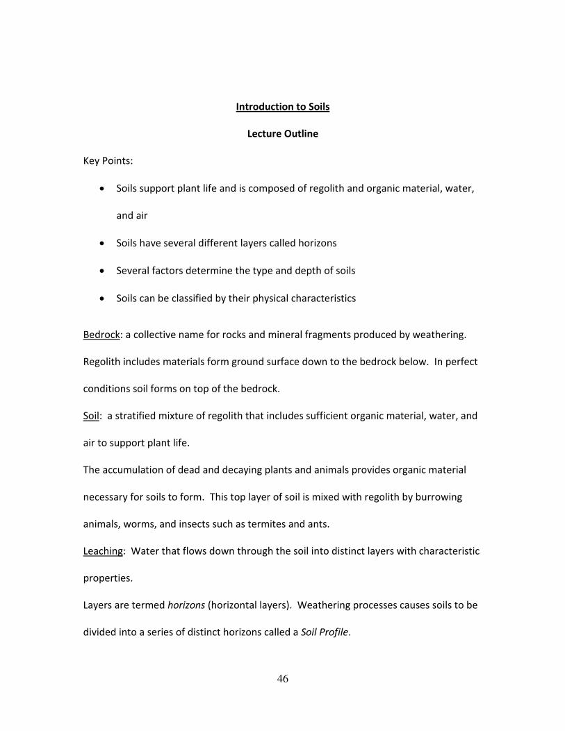
Layers are termed horizons (horizontal layers). Weathering processes causes soils to be
divided into a series of distinct horizons called a Soil Profile.

47
Each Horizon in a soil profile is designated a letter. Beginning at the top”
O horizon: Organic debris, dead leaves, and other plant and animal remains generally
make up at least 30% of this layer. This layer can be buried, but is on the top.
A horizon: This layer consists of topsoil, dark organic material mixed with mineral grains
by organic activity. Soluble ions and fine particles are carried downward, away from the
A horizon, by leaching of clay and clay transport.
E horizon: This horizon consists of subsurface layers that have lost most of their
minerals. It may be embedded in or replace an A horizon.
B horizon: Ions that were dissolved from the A horizon are precipitated here, and clays
that are carried down from the A horizon are deposited. Little organic material is
present at this depth. The accumulation of iron oxide gives the soil a red color in areas
where there is plenty of rain. In dry climates, calcium carbonate may accumulate to
form a white layer.
C horizon: The lowest layer consists of soil parent material, either weathered bedrock
(regolith) or unconsolidated sediments.
R horizon: bedrock
48
Figure From:sparkcharts.sparknotes.com / Nov. 24, 2010
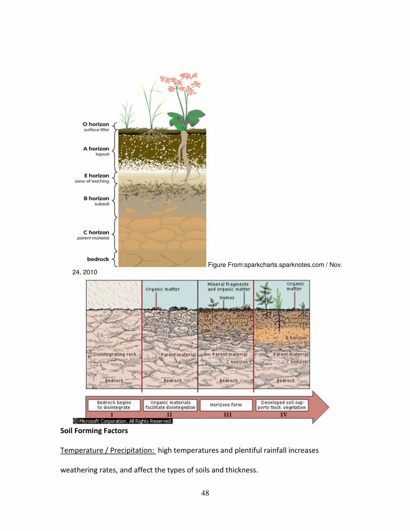
Soil Forming Factors
Temperature / Precipitation: high temperatures and plentiful rainfall increases
weathering rates, and affect the types of soils and thickness.
49
EX: steep slopes have slow soil formation because water flows rapidly and
transports material away from the slope.
Time: it takes time for weathering to form a soil.
EX: bare rock surfaces exposed to cold climates take thousands of years to
develop.
Thick soils are not necessarily fertile soils. The topsoil can change over time, depending
on the relative rates of leaching and replacement of nutrients from weathering and
decay of organic material. Heavy rain can carry away nutrients.
EX: the rainforest only has a few inches of top soil
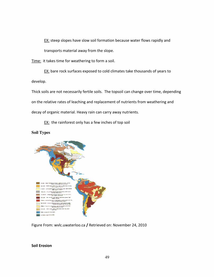
Soil Types
Figure From: wvlc.uwaterloo.ca / Retrieved on: November 24, 2010
Soil Erosion
50
Soil erosion factors:
1. Frequency of rainfall: intense, infrequent rainfall removes more soil than steady,
moderate precipitation. Lack of rain causes soil to dry out, making them lighter
and vulnerable to wind erosion.
2. Wind velocity: fast moving wind generates more erosion than gentle breezes.
Trees shelter soil from winds.
3. Character of soil: soil full of organic material has an open texture that allows
water to infiltrate rather than rush over top.
4. Vegetation cover: grass, crop debris, or other material act as cover for soils,
protecting from direct impact of rain drops.
5. Slope of land surface: Long, steep slopes lose more material to soil erosion from
water than do shorter gentler slopes.
51
Introduction to Soils
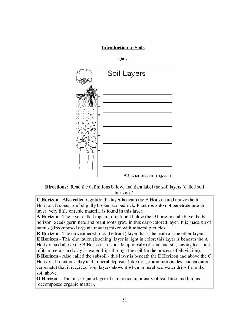
Quiz
Directions: Read the definitions below, and then label the soil layers (called soil
horizons).
C Horizon - Also called regolith: the layer beneath the B Horizon and above the R
Horizon. It consists of slightly broken-up bedrock. Plant roots do not penetrate into this
layer; very little organic material is found in this layer.
A Horizon - The layer called topsoil; it is found below the O horizon and above the E
horizon. Seeds germinate and plant roots grow in this dark-colored layer. It is made up of
humus (decomposed organic matter) mixed with mineral particles.
R Horizon - The unweathered rock (bedrock) layer that is beneath all the other layers
E Horizon - This eluviation (leaching) layer is light in color; this layer is beneath the A
Horizon and above the B Horizon. It is made up mostly of sand and silt, having lost most
of its minerals and clay as water drips through the soil (in the process of eluviation).
B Horizon - Also called the subsoil - this layer is beneath the E Horizon and above the C
Horizon. It contains clay and mineral deposits (like iron, aluminum oxides, and calcium
carbonate) that it receives from layers above it when mineralized water drips from the
soil above.
O Horizon - The top, organic layer of soil, made up mostly of leaf litter and humus
(decomposed organic matter).
52
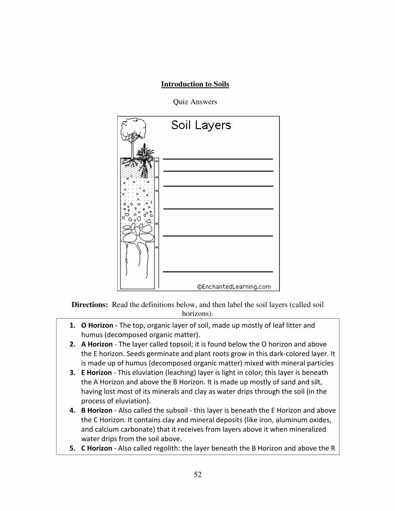
Introduction to Soils
Quiz Answers
Directions: Read the definitions below, and then label the soil layers (called soil
horizons).
1. O Horizon - The top, organic layer of soil, made up mostly of leaf litter and
humus (decomposed organic matter).
2. A Horizon - The layer called topsoil; it is found below the O horizon and above
the E horizon. Seeds germinate and plant roots grow in this dark-colored layer. It
is made up of humus (decomposed organic matter) mixed with mineral particles
3. E Horizon - This eluviation (leaching) layer is light in color; this layer is beneath
the A Horizon and above the B Horizon. It is made up mostly of sand and silt,
having lost most of its minerals and clay as water drips through the soil (in the
process of eluviation).
4. B Horizon - Also called the subsoil - this layer is beneath the E Horizon and above
the C Horizon. It contains clay and mineral deposits (like iron, aluminum oxides,
and calcium carbonate) that it receives from layers above it when mineralized
water drips from the soil above.
5. C Horizon - Also called regolith: the layer beneath the B Horizon and above the R

53
Horizon. It consists of slightly broken-up bedrock. Plant roots do not penetrate
into this layer; very little organic material is found in this layer.
6. R Horizon - The unweathered rock (bedrock) layer that is beneath all the other
layers
54
Introduction to Soil
Take Home Assignment
• There are twelve soil orders. Choose one of the soils that interest you the most
and create a two page paper on the soil. Include places it is located, common
weather conditions, pro’s and con’s of the condition of the soil, and three
thought provoking or interesting facts about your soil.
• Be prepared to share with the class. It may be helpful to create some 3 x 5 cards
to keep you on track while sharing with the class.
55
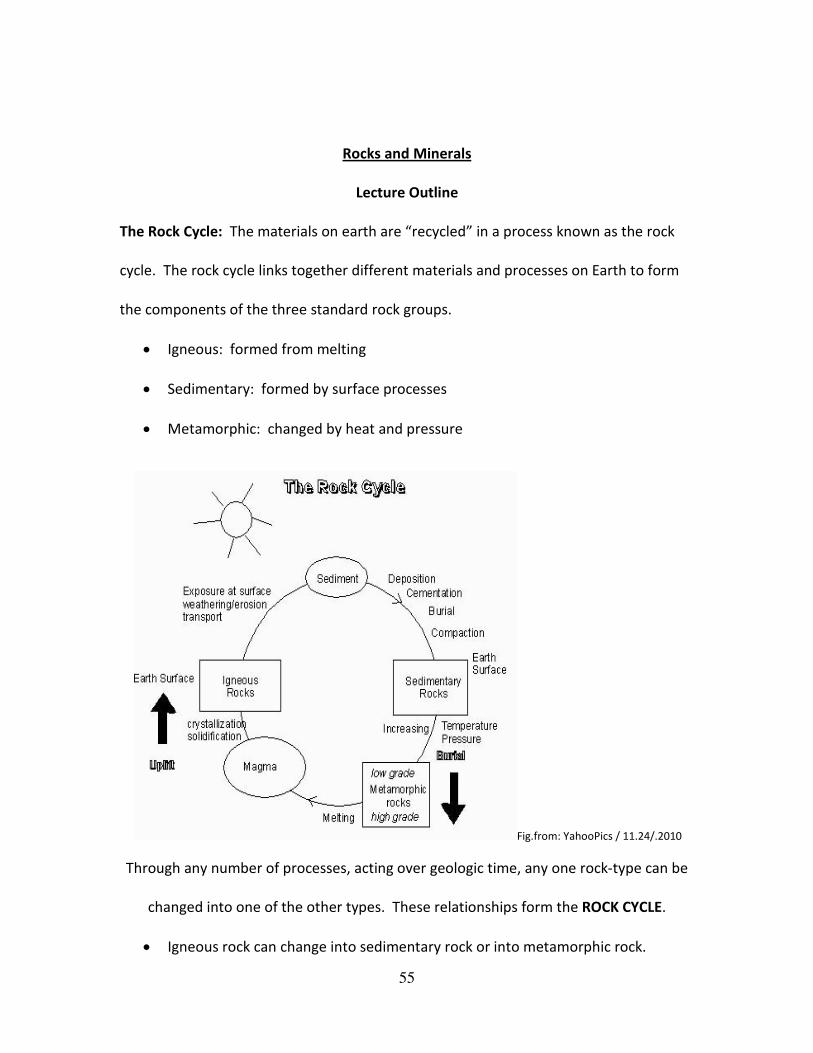
Rocks and Minerals
Lecture Outline
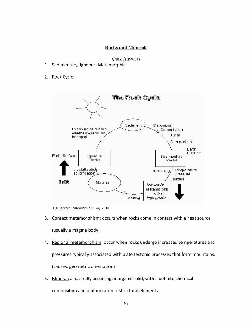
The Rock Cycle: The materials on earth are “recycled” in a process known as the rock
cycle. The rock cycle links together different materials and processes on Earth to form
the components of the three standard rock groups.
• Igneous: formed from melting
• Sedimentary: formed by surface processes
• Metamorphic: changed by heat and pressure
Fig.from: YahooPics / 11.24/.2010
Through any number of processes, acting over geologic time, any one rock-type can be
changed into one of the other types. These relationships form the ROCK CYCLE.
• Igneous rock can change into sedimentary rock or into metamorphic rock.
56
o Igneous rock forms when magma cools and makes crystals. Magma is a
hot liquid made of melted minerals. The minerals can form crystals when
they cool. Igneous rock can form underground, where the magma cools
slowly. Or, igneous rock can form above ground, where the magma cools
quickly.
• Sedimentary rock can change into metamorphic rock or into igneous rock.
o On Earth's surface, wind and water can break rock into pieces. They can
also carry rock pieces to another place. Usually, the rock pieces, called
sediments, drop from the wind or water to make a layer. The layer can
be buried under other layers of sediments. After a long time the
sediments can be cemented together to make sedimentary rock. In this
way, igneous rock can become sedimentary rock.
All rock can be heated. But where does the heat come from? Inside Earth there is heat
from pressure (push your hands together very hard and feel the heat). There is heat
from friction (rub your hands together and feel the heat). There is also heat from
radioactive decay (the process that gives us nuclear power plants that make electricity).
• Metamorphic rock can change into igneous or sedimentary rock.
• So, what does the heat do to the rock? It bakes the rock.
• Baked rock does not melt, but it does change. It forms crystals. If it has crystals
already, it forms larger crystals. Because this rock changes, it is called

57
metamorphic. (Remember that a caterpillar changes to become a butterfly. That
change is called metamorphosis). Metamorphosis can occur in rock when they
are heated to 300 to 700 degrees Celsius.
• When Earth's tectonic plates move around, they produce heat. When they
collide, they build mountains and metamorphose the rock.
• The rock cycle continues. Mountains made of metamorphic rocks can be broken
up and washed away by streams. New sediments from these mountains can
make new sedimentary rock.
• The rock cycle never stops!
Fig. From: cotf.edu / Nov. 24, 2010
Definitions: Igneous, Sedimentary, Metamorphic
Igneous Rocks:
• Form from the cooling of melted rock (magma)
58
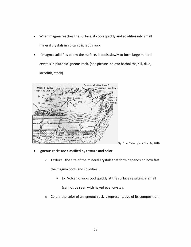
• When magma reaches the surface, it cools quickly and solidifies into small
mineral crystals in volcanic igneous rock.
• If magma solidifies below the surface, it cools slowly to form large mineral
crystals in plutonic igneous rock. (See picture below: batholiths, sill, dike,
laccolith, stock)
Fig. From:Yahoo pics / Nov. 24, 2010
• Igneous rocks are classified by texture and color.
o Texture: the size of the mineral crystals that form depends on how fast
the magma cools and solidifies.
� Ex. Volcanic rocks cool quickly at the surface resulting in small
(cannot be seen with naked eye) crystals
o Color: the color of an igneous rock is representative of its composition.
59
� Ex. Light-colored igneous rocks such as; rhyolite and granite are
formed from silica rich magmas and contain white, pink, or
translucent silica rich minerals.
Sedimentary Rocks:
• Form as layered beds or strata.
o Different colors, textures, and resistance to erosion.
• Depending on the process that formed them, sedimentary rocks are classified as
clastic, chemical, or biochemical.
o Clastic: composed of sediments- rocks and mineral fragments that form
when rocks break apart at or near Earth’s surface. (makes up 86% of all
sedimentary rocks)
� 1. Break down of rock due to weathering
� 2. Transportation of the eroded material from the source area
� 3. Lithification; the deposition and subsequent conversion of
material to rock
o Chemical: crystallized from a solution (seawater) as a result of changing
physical conditions. (evaporation)
� Ex. Table salt; comes from the mineral halite from the evaporation
of seawater.
o Biochemical: formed by the actions of living organisms or are composed
of the remains of dead organisms.
60
� The dead organisms create the mineral calcite at the bottom of
the ocean. When it precipitates from solution it creates
limestone, or chalk.
Metamorphic Rock
Metamorphism: relates to a change in mineral composition or texture that occurs in
solid rocks as a result of increasing pressure or temperature.
• Metamorphism occurs when the composition or texture of a rock changes due to
change in temperature, pressure, or chemical reaction.
• The temperature range for a rock metamorphism is 200 – 1,100 degrees C
• Metamorphism that occurs in narrow zones around heat sources is contact
metamorphism
• Metamorphism that occurs over large areas in association with mountain belts is
termed regional metamorphism.
Contact metamorphism: occurs when rocks come in contact with a heat source (usually
a magma body)
Regional metamorphism: occur when rocks undergo increased temperatures and
pressures typically associated with plate tectonic processes that form mountains.
(causes: geometric orientation)
Minerals
61
Mineral: a naturally occurring, inorganic solid, with a definite chemical composition and
uniform atomic structural elements.
Minerals are identified by physical properties:
1. Crystal form
2. Cleavage
3. Hardness
4. Color
5. Luster
6. Streak
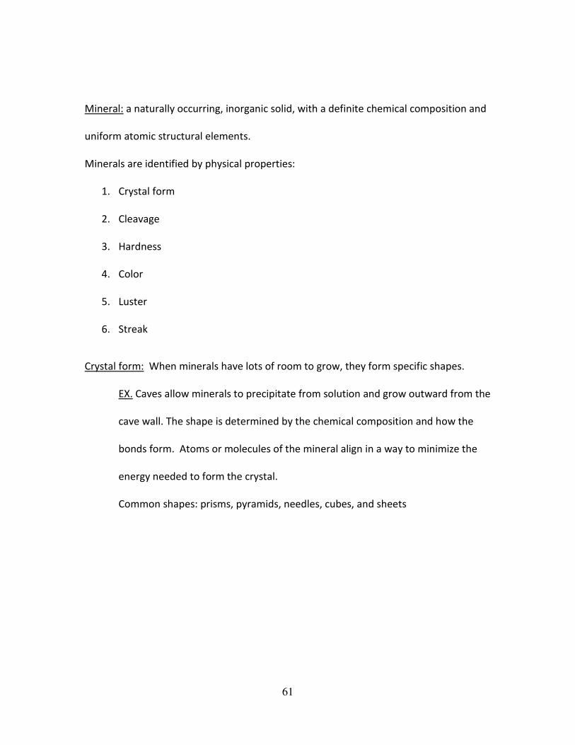
Crystal form: When minerals have lots of room to grow, they form specific shapes.
EX. Caves allow minerals to precipitate from solution and grow outward from the
cave wall. The shape is determined by the chemical composition and how the
bonds form. Atoms or molecules of the mineral align in a way to minimize the
energy needed to form the crystal.
Common shapes: prisms, pyramids, needles, cubes, and sheets
62
Photos from: schwigorphotos Igor Schwartzmann, http://www.angelstarcreations.com, mineralminers.com®, Figure: Created 8 February, 1997Last Update 23 January, 2001
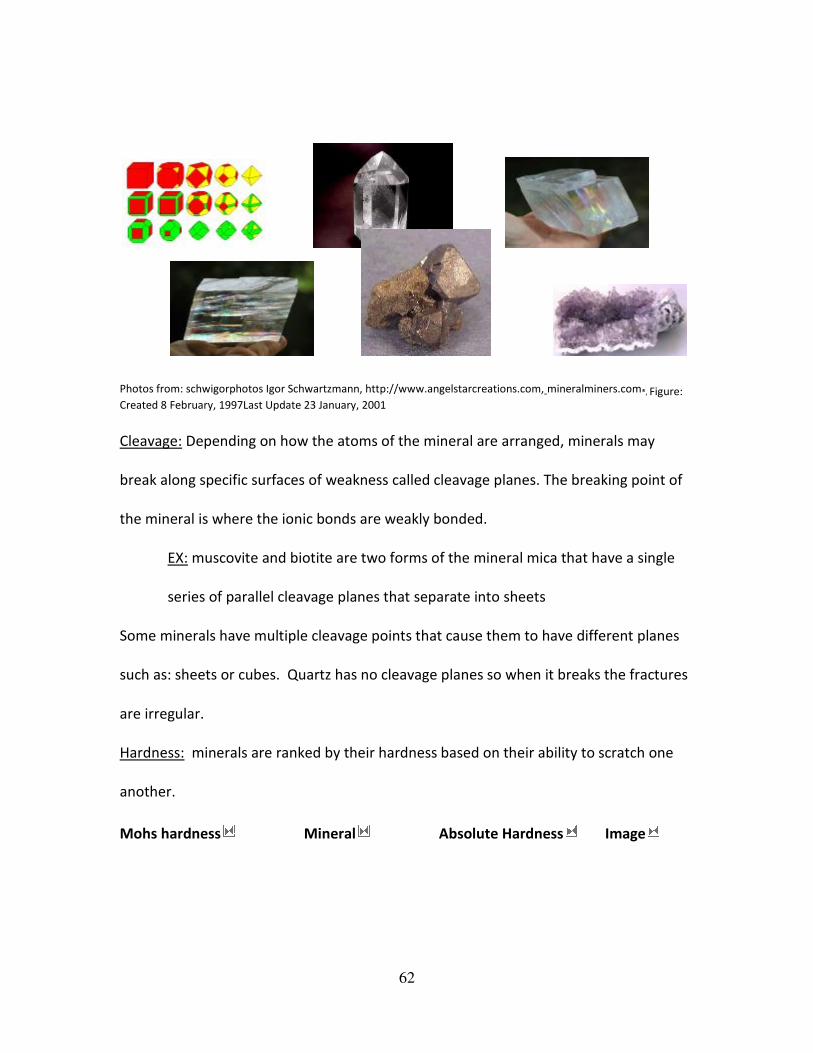
Cleavage: Depending on how the atoms of the mineral are arranged, minerals may
break along specific surfaces of weakness called cleavage planes. The breaking point of
the mineral is where the ionic bonds are weakly bonded.
EX: muscovite and biotite are two forms of the mineral mica that have a single
series of parallel cleavage planes that separate into sheets
Some minerals have multiple cleavage points that cause them to have different planes
such as: sheets or cubes. Quartz has no cleavage planes so when it breaks the fractures
are irregular.
Hardness: minerals are ranked by their hardness based on their ability to scratch one
another.
Mohs hardness Mineral Absolute Hardness Image
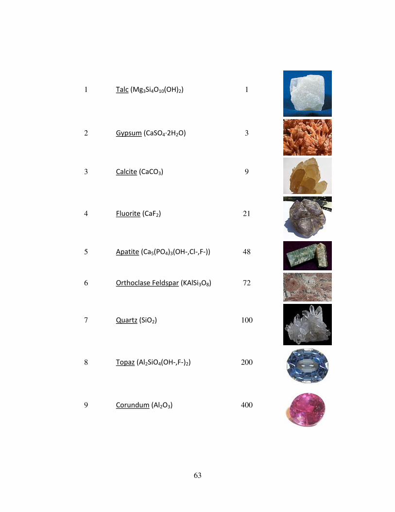
63
1 Talc (Mg3Si4O10(OH)2) 1
2 Gypsum (CaSO4·2H2O) 3
3 Calcite (CaCO3) 9
4 Fluorite (CaF2) 21
5 Apatite (Ca5(PO4)3(OH-,Cl-,F-)) 48
6 Orthoclase Feldspar (KAlSi3O8) 72
7 Quartz (SiO2) 100
8 Topaz (Al2SiO4(OH-,F-)2) 200
9 Corundum (Al2O3) 400
64
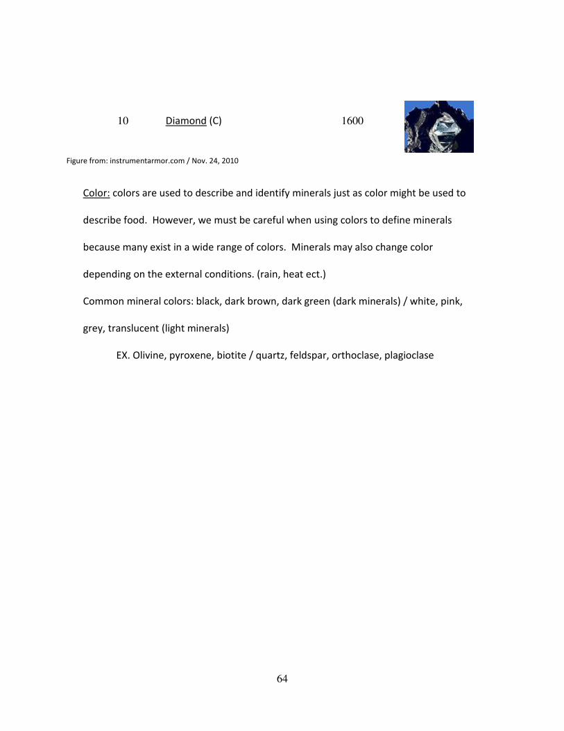
10 Diamond (C) 1600
Figure from: instrumentarmor.com / Nov. 24, 2010
Color: colors are used to describe and identify minerals just as color might be used to
describe food. However, we must be careful when using colors to define minerals
because many exist in a wide range of colors. Minerals may also change color
depending on the external conditions. (rain, heat ect.)
Common mineral colors: black, dark brown, dark green (dark minerals) / white, pink,
grey, translucent (light minerals)
EX. Olivine, pyroxene, biotite / quartz, feldspar, orthoclase, plagioclase
65
Rocks and Minerals
Lab Assignment
Rock Cycle
Purpose: The purpose of this lab is to illustrate the various changes that ricks and rock
material can go through over time on the Earth. You will also identify the natural
processes and pathways that together make up the rock cycle.
Materials: samples of igneous, sedimentary, and metamorphic rocks, glue, a black pen /
marker
Procedure: collect as many different types of rocks around your neighborhood or
purchase some from a local store. When in class, identify as best as you can. Place in
groups. Have the teacher check over rock identification. Proceed to glue rocks to the
figure 20-1 Rock Cycle lab sheet.
66
Name:
Date:
Rocks and Minerals
Quiz
1. List the three major types of rocks in the rock cycle and name the process in
which they are formed.
2. Draw the rock Cycle
3. Define: contact metamorphism
4. Define: regional metamorphism
5. Define: mineral
6. List four of the six identifying physical properties of minerals
7. T / F When minerals have lots of room to grow, they form specific shapes.
8. List a mineral that has sheet like cleavage.
9. What is the hardest mineral?
10. What can cause minerals to change colors?
67
Rocks and Minerals
Quiz Answers
1. Sedimentary, Igneous, Metamorphic
2. Rock Cycle:
Figure from: YahooPics / 11.24/.2010
3. Contact metamorphism: occurs when rocks come in contact with a heat source
(usually a magma body)
4. Regional metamorphism: occur when rocks undergo increased temperatures and
pressures typically associated with plate tectonic processes that form mountains.
(causes: geometric orientation)
5. Mineral: a naturally occurring, inorganic solid, with a definite chemical
composition and uniform atomic structural elements.
68
6.
• Crystal form
• Cleavage
• Hardness
• Color
• Luster
• Streak
7. T
8. Muscovite, Biotite
9. Diamond
10. Rain, heat, elements, external conditions
69
Geography of California
Lecture Outline
Key Points:
• 11 geomorphic provinces of California
• Natural hazards
o Earthquakes
o Volcano’s
o Wild fires
o Snow storms
11 Geomorphic Provinces
1. Klamath Mountains: The Klamath Mountains are a mountain range in northwest
California and southwest Oregon, the highest peak being Thompson Peak (2,744
m / 9,002 ft) in Trinity County, California. They have a very varied geology, with
substantial areas of serpentine and marble, and a climate summers with limited
rainfall. As a consequence of the geology, they have a unique flora including
several endemic or near-endemic species, such as Lawson's Cypress, Foxtail Pine,
Brewer's Spruce and Kalmiopsis.
2. Cascade Range: The Cascade Range is a mountainous region stretching from
British Columbia in Canada down to the northern part of California. The Cascades
(as they are called for short) are part of the Pacific Ring of Fire, the ring of
volcanoes around the Pacific Ocean. All of the known historic eruptions in the
70
contiguous United States have been from Cascade volcanoes. The last Cascade
volcano to erupt in California was Lassen Peak, which erupted from 1914 to
1921. Lassen is the most southerly active volcano of the Cascade chain. This
region is located in the northeastern section of the state bordering Oregon and
Nevada, mostly north of the Central Valley and the Sierra Nevada mountain
range. The area is centered on Mount Shasta, near the Trinity Alps. Mount
Shasta is a dormant volcano, but there is some evidence that it or Shastina, a
smaller companion, erupted in the 18th Century.
3. Modoc Plateau: In the northeast corner of the state lies the Modoc Plateau, an
expanse of lava flows at an altitude of 4,000 to 6,000 ft with cinder cones,
juniper flats, pine forests, and seasonal lakes. Nearly 1 million acres of the
Modoc National Forest lie on the plateau between the Medicine Lake Highlands
in the west and the Warner Mountains in the east. The plateau supports large
herds of mule deer, Rocky Mountain Elk, and pronghorn antelope. There are
also several herds of wild horses on the plateau. The Clear Lake National Wildlife
Refuge and Long Bell State Game Refuge are located on the plateau as well. The
Lost River watershed drains the north part of the plateau, while southern
watersheds either collect in basin reservoirs or flow into the large Big Sage
Reservoir, which sits in the center of Modoc County.
4. Basin and Range: To the east of the Sierra is the Basin and Range geological
province, which extends into Nevada. The Basin and Range is a series of
71
mountains and valleys (specifically horsts and grabens), caused by the extension
of the Earth's crust. One notable feature of the Basin and Range is Mono Lake,
which is the oldest lake in North America. The Basin and Range also contains the
Owens Valley, the deepest valley in North America (more than 10,000 feet deep,
as measured from the top of Mount Whitney.) In the eastern part of the state,
below the Sierra Nevada, there is a series of dry lake beds that were filled with
water during the last ice age (fed by ice melt from alpine glaciers but never
directly affected by glaciation). Many of these lakes have extensive evaporite
deposits that contain a variety of different salts. In fact, the salt sediments of
many of these lake beds have been mined for many years for various salts, most
notably borax (this is most famously true for Owens Lake and Death Valley). In
this province resides the White Mountains, which are home to the oldest living
thing in the world, the bristlecone pine.
5. Coast Ranges: To the west of the Central Valley lies the Coast Ranges, including
the Diablo Range, just east of San Francisco, and the Santa Cruz Mountains, to
the south of San Francisco. The Coast Ranges north of San Francisco become
increasingly foggy and rainy. These mountains are noted for their coast
redwoods, which live within the range of the coastal fog, the tallest trees on
Earth.
6. Central Valley: California's geography is largely defined by its central feature —
the Central Valley, a huge, fertile valley between the coastal mountain ranges
72
and the Sierra Nevada. The northern part of the Central Valley is called the
Sacramento Valley, after its main river, and the southern part is called the San
Joaquin Valley, after its main river. The whole Central Valley is watered by
mountain-fed rivers (notably the San Joaquin, Kings, and Sacramento) that drain
to the San Francisco Bay system. The rivers are sufficiently large and deep that
several inland cities, notably Stockton, California, and Sacramento, California are
seaports. The southern tip of the valley has interior drainage and thus is not
technically part of the valley at all. Tulare Lake, once 570 square miles and now
dry and covered with agricultural fields, once filled much of the area.
7. Sierra Nevada: In the east of the state lies the Sierra Nevada, which runs north–
south for 400 miles. The highest peak in the contiguous United States, Mount
Whitney at 14,505 feet, lies within the Sierra Nevada. The topography of the
Sierra is shaped by uplift and glacial action. The Sierra has 200–250 sunny days
each year, warm summers, fierce winters, and varied terrain, a rare combination
of rugged variety and pleasant weather. The famous Yosemite Valley lies in the
Central Sierra. The large, deep freshwater Lake Tahoe lies to the North of
Yosemite. The Sierra is also home to the Giant Sequoia, the most massive trees
on Earth. The most famous hiking and horse-packing trail in the Sierra is the
John Muir Trail, which goes from the top of Mt. Whitney to Yosemite valley, and
which is part of the Pacific Crest Trail that goes from Mexico to Canada. The
73
three major national parks in this province are Yosemite National Park, Kings
Canyon National Park, and Sequoia National Park.
8. Transverse Ranges: Southern California is separated from the rest of the state
by the east-west trending Transverse Ranges, including the Tehachapi, which
separate the Central Valley from the Mojave Desert. Urban Southern California
intersperses the valleys between the Santa Susana Mountains, Santa Monica
Mountains and San Gabriel Mountains, which range from the Pacific Coast,
eastward over 100 miles, to the San Bernardino Mountains, north of San
Bernardino. The highest point of the range is Mount San Gorgonio at
11,499 feet. The San Gabriel Mountains have Mount Wilson observatory. The
Transverse Ranges include a series of east–west trending mountain ranges that
extend from Point Conception at the western tip of Santa Barbara County,
eastward (and a bit south) to the east end of the San Jacinto Mountains in
western Riverside County. The Santa Ynez Mountains make up the westernmost
ranges, extending from Point Conception to the Ventura River just west-
northwest of Ojai, in Ventura County. Pine Mountain Ridge, Nordhoff Ridge–
Topatopa Mountains, Rincon Peak–Red Mountain, Sulphur Mountain, Santa
Paula Ridge, South Mountain–Oat Mountain–Santa Susana Mountains, Simi Hills,
Conejo Mountains–Santa Monica Mountains are all part of the Western
Transverse Ranges, in Ventura and western Los Angeles Counties. The Liebre
Mountains occupy the northwest corner of Los Angeles County, and represent a
74
northwestern extension of the San Gabriel Mountains, both on the Pacific Plate
side of the San Andreas Fault. The fault divides the San Gabriel Mountains from
the San Bernardino Mountains further to the east in San Bernardino County. It is
possible to surf in the Pacific Ocean and ski on a mountain during the same
winter day in Southern California.
9. Mojave Desert: There are harsh deserts in the Southeast of California. These
deserts are caused by a combination of the cold offshore current, which limits
evaporation, and the rain shadow of the mountains. The prevailing winds blow
from the ocean inland. When the air passes over the mountains, adiabatic
cooling causes most water in the air to rain on the mountains. When the air
returns to sea level on the other side of the mountains, it recompresses, warms
and dries, parching the deserts. When the wind blows from inland, the resulting
hot dry foehn winds are called the Santa Ana Winds. The Mojave Desert is
bounded by the peninsular Tehachapi Mountains on the Northwest, together
with the San Gabriel and the San Bernardino Mountains on the Southwest.
These Western boundaries are quite distinct, forming the dominant pie-slice
shaped Antelope Valley in Southern California. The outlines of this valley are
caused by the two largest faults in California: the San Andreas and the Garlock.
The Mojave Desert extends Eastward into the State of Nevada. The Mojave
Desert receives less than 6 inches of rain a year and is generally between 3,000
and 6,000 feet of elevation. Areas such as the Antelope Valley desert which is a
75
high desert received snow each year, in the past it could snow 2-3 times a year;
however, recently snow level has declined significantly to once a year or less.
Most of the towns and cities in the California portion of the Mojave are relatively
small, except for Palmdale and Lancaster. However, some are quite famous like
Barstow, a popular stop on the famous U.S. Route 66. The Mojave Desert also
contains the lowest, hottest place in the Americas: Death Valley, where
temperature normally approaches 120 °F in late July and early August.
10. Peninsular Range: The southernmost mountains of California are the Peninsular
Ranges, which are East of San Diego and continue into Baja California (Mexico) in
the Sierra San Pedro Martir. The Peninsular Ranges contain the Laguna
Mountains, the San Jacinto Mountains, the Santa Rosa Mountains, the Santa Ana
Mountains and the Palomar Mountain Range, notable for its famous Palomar
observatory. San Jacinto Peak's eastern shoulder has a cable tram that runs
from the desert floor to nearly the top of the mountain where riders can set off
hiking or go cross-country skiing
11. Colorado Desert: To the east of the peninsular ranges lie the Colorado and
Sonoran Deserts, which extend into Arizona and Mexico. The ground elevation is
generally lower and in some areas was compressed downward, therefore the
eastern Coachella and Imperial Valleys north of the U.S.-Mexican border are
below sea level, the lowest community in the U.S. is Calipatria, California at 160
feet below sea level. One feature of the desert is the Salton Sea, an inland lake
76
that was formed in 1905 when a swollen Colorado River breached a temporary
canal near the U.S.-Mexico border and flowed into the Salton Sink (Salton Basin)
for almost two years. Today, the Salton Sea, a new version of historic Lake
Cahuilla, remains as California's largest lake.
Natural Hazards of California
Earthquakes: An earthquake (also known as a quake, tremor, temblor or seismic
activity) is the result of a sudden release of energy in the Earth's crust that creates
seismic waves. At the Earth's surface, earthquakes manifest themselves by shaking and
sometimes displacing the ground. When a large earthquake epicenter is located
offshore, the seabed sometimes suffers sufficient displacement to cause a tsunami. The
shaking in earthquakes can also trigger landslides and occasionally volcanic activity.
• The San Francisco earthquake of 1906 was a major earthquake that struck San
Francisco, California, and the coast of Northern California at 5:12 a.m. on
Wednesday, April 18, 1906. Shaking was felt from Oregon to Los Angeles, and
inland as far as central Nevada. The earthquake and resulting fire are
remembered as the worst natural disaster in the history of the United States.
• The Loma Prieta earthquake, also known as the Quake of '89 and the World
Series Earthquake, was a major earthquake that struck the San Francisco Bay
Area of California on October 17, 1989, at 5:04 p.m. The quake killed 63 people
throughout northern California, injured 3,757 and left some 3,000-12,000 people
homeless.
77
• The Northridge earthquake occurred on January 17, 1994 at 4:31 a.m., in
Northridge, a neighborhood in the city of Los Angeles, California, lasting for
about 45 seconds. This was a holiday Monday - Martin Luther King, Jr. Day. The
earthquake had a "strong" moment magnitude of 6.7, but the ground
acceleration was one of the highest ever instrumentally recorded in an urban
area in North America. Seventy-two deaths were attributed to the earthquake,
with more than 9,000 injured. In addition, the earthquake caused an estimated
$20 billion in damage, making it one of the costliest natural disasters in U.S.
history.
Faults associated with earthquakes:
• Strike-slip fault: Strike-slip faults are steep structures where the two sides of the
fault slip horizontally past each other.
• Normal fault: Normal faults occur mainly in areas where the crust is being
extended such as a divergent boundary.
• Thrust fault (reverse): Reverse/thrust faults occur in areas where the crust is
being shortened such as at a convergent boundary.
Volcano’s:
• Lassen Peak (also known as Mount Lassen) is the southernmost active volcano
in the Cascade Range. Located in the Shasta Cascade region of Northern
California, Lassen rises 2,000 feet above the surrounding terrain and has a
78
volume of half a cubic mile, making it one of the largest lava domes on Earth. It
was created on the destroyed northeastern flank of now gone Mount Tehama, a
stratovolcano that was at least 1,000 feet higher than Lassen Peak. Lassen Peak
has the distinction of being the only volcano in the Cascades other than Mount
St. Helens to erupt during the 20th century. Lassen Peak has the highest known
winter snowfall amounts in California. There is an average annual snowfall of
660 inches, and in some years, more than 1,000 inches of snow falls at its base
altitude of 8,250 feet.
• Mount Shasta is located at the southern end of the cascades in Siskiyou County,
California and at 14,179 feet is the second highest peak in the Cascades and the
fifth highest in California. Mount Shasta has an estimated volume of 85 cubic
miles which makes it the most voluminous stratovolcano in the Cascade Volcanic
Arc. There are seven named glaciers on Shasta, with the four largest (Whitney,
Bolam, Hotlum, and Wintun) radiating down from high on the main summit cone
to below 10,000 feet primarily on the north and east sides. The Whitney Glacier
is the longest and the Hotlum is the most voluminous glacier in the state of
California. The United States Geological Survey considers Shasta a dormant
volcano, which will erupt again. It is impossible to pinpoint the date of next
eruption, but it likely will occur within the next several hundred years.
Wildfires: Major contributing factors to the extreme fire conditions were drought in
Southern California, hot weather, and the strong Santa Ana winds with gusts
79
reaching 85 mph. California's "fire season," which traditionally runs from June to
October, has become a year-round threat due to a mixture of perennial drought and
the increasing number of homes built in canyons and on hillsides surrounded by
brush and forest.
Ex. The Witch Creek Fire was the largest of the October 2007 wildfires and
surpassed the 1970 Laguna Fire as the second-largest fire in California History.
Hundreds of thousands of residents were informed of evacuations through the
Reverse 911 system. This evacuation came almost four years to the day after the
Cedar Fire of 2003.
80
Geography of California
Lab Assignment
• Get into assigned groups of three or four
• Use colored pencils or markers to draw the three specific faults discussed in
lecture.
o Draw one fault per page. (large enough for the class to see in a
presentation
• Be prepared to share with the class if called upon.
81
Geography of California
Homework Assignment
• Draw an outlined picture of California
• With colored pencils or markers, draw in the eleven different geomorphic
provinces of California.
• Label each province with a different color.
• Choose your favorite province and write a paragraph (6-8 sentences) about your
favorite features, animals, flora, ect.
82
Resources
Universe / Solar System
Internet:
http://solarsystem.nasa.gov
http://www.nenature.com
http://images.search.yahoo.com
http://www.scholastic.com
http://myastrologybook.com
http://www.indianchild.com/pluto.htm
http://hal.physast.uga.edu
http://www.star.le.ac.uk/edu
Biodiversity / Conservation Biology
Internet: http://www.about.com (biology)
Book: Environment “The Science Behind the Stories”
By: Scott Brennen and Jay Withgott
Pgs.: 455-488 (chp. 15)
Lab Manual: Science of Earth Systems: Lab Manual
By: Stephen D. Butz
Pgs.: 155 Lab 42 “Biomes of the World”
Rocks and Minerals
83
Book: The Good Earth: Introduction to Earth Sciences
By: McConnell, Steer, Knight, Owens, Park
Lab Manual: Science of Earth Systems: Lab Manual
By: Stepehn D. Butz
Internet:
http://pasadena.wr.usgs.gov
http://www.cotf.edu
http://images.search.yahoo.com
http://en.wikipedia.org
http://geology.com
Rocks and Minerals
Book: The Good Earth: Introduction to Earth Sciences
By: McConnell, Steer, Knight, Owens, Park
Lab Manual: Science of Earth Systems: Lab Manual
By: Stepehn D. Butz
Internet:
http://pasadena.wr.usgs.gov
http://www.cotf.edu
http://images.search.yahoo.com
http://en.wikipedia.org
http://geology.com
84
Geography of California
Internet:
http://www.wikipedia.com
• Geography of CA
• Hazards
• Volcanos
• Fires
85
Appendix
The valuable sources I used came from professor notes and curricula used in the past. I
read and updated old labs for an updated curriculum. Soil journals, books, and CD’s
were used to support lectures. Old tests and quizzes were used to create new ones.
Figures, Charts, and photographs were cited in resources and below the item. They
were all retrieved from the Internet.