easement survey of underground waterline for cold ocean ... · easement survey of underground...
TRANSCRIPT

2017
Survey Project Technical Report
Ryan G. Billard
February 20, 2017
Easement Survey of Underground Waterline
for Cold Ocean Salmon Inc.

Easement Survey of Underground
Waterline for Cold Ocean Salmon Inc.
Ryan G. Billard
Report submitted in partial fulfillment
of the requirements to become a licenced
Newfoundland Land Surveyor under the
Association of Newfoundland Land Surveyors
This report accepted by
___________________________________
Association of Newfoundland Land Surveyors
St. John’s, NL
February 20, 2017

ii
ABSTRACT
The purpose of this report is to identify and explain the day to day roles and responsibilities of a
licensed land surveyor during the completion of a typical legal survey. The project explained in
this report will provide a step by step guide through the process of creating an easement over
both Crown and private lands for the purpose of installing and maintaining an industrial
waterline.
The report will outline in great detail the level of effort involved in the preliminary research and
route selection process of creating the easement. This includes the various research tools
available such as LandGazette, Provincial, Municipal, and Federal mapping services, as well as
several registry systems such as the Crown Lands Registry and the Registry of Deeds.
This report will also discuss the requirements for retracing and establishing existing and new
boundaries during the completion of the easement survey. This will be accomplished by
reviewing and evaluating the existing documentary evidence along with the finding and
evaluation of physical evidence and occupation on the ground within the project limits.
Finally, this report will discuss the survey standards followed for the demarcation and
delineation of the survey boundaries retraced and created for this project.

iii
ACKNOWLEDGEMENTS
I would like to express my sincere appreciation to my sponsor, Mr. Ian Edwards, NLS, for his
knowledge, patience, and guidance throughout the duration of this project. Mr. Edwards’s
experience in the surveying profession over the last 35 years has added great value and input to,
not only this report, but to my young professional career and the careers of many before me. I
extend my sincere gratitude to Mr. Edwards for all of the time and effort he has spent throughout
the last couple of years answering my questions and guiding me through the profession of
surveying and enabling me the opportunity to pursue a successful career as a member of the
Association of Newfoundland Land Surveyors.
I would also like to thank my family for their continued support throughout the last number of
years and for being by my side during this entire process. Their unwavering love and
encouraging words have helped me face some of the toughest decisions I have been faced with
throughout my young career and without them this would not be possible.
Finally, I would like to thank the Association of Newfoundland Land Surveyors, particularly the
members of the Board of Examiners, for volunteering their time in reviewing this project. I know
that your combined years of experience will enable me and other aspiring Land Surveyors to
conduct the duties of a Professional Newfoundland Land Surveyor with the upmost integrity,
professionalism, and respect. Thank you once again for your continued efforts and support.

iv
Table of Contents
ABSTRACT .................................................................................................................................................. ii
ACKNOWLEDGEMENTS ......................................................................................................................... iii
Table of Contents ......................................................................................................................................... iv
List of Figures .............................................................................................................................................. vi
List of Tables .............................................................................................................................................. vii
Abbreviations and Definitions ................................................................................................................... viii
1.0 Introduction ............................................................................................................................................. 1
1.1 Background ......................................................................................................................................... 2
1.2 Scope of Work .................................................................................................................................... 2
2.0 Route Selection and Research ................................................................................................................. 4
2.1 LandGazette ........................................................................................................................................ 4
2.2 Crown Lands Registry ........................................................................................................................ 6
2.3 Provincial and Municipal Mapping ..................................................................................................... 6
2.3.1 Town of St. Alban’s ..................................................................................................................... 7
2.3.2 Department of Environment and Conservation ............................................................................ 8
2.4 Land Owners and Resident Knowledge ............................................................................................ 11
2.5 Proposed Waterline Route ................................................................................................................ 11
2.5.1 Proposed Easement Route - Option A ....................................................................................... 11
2.5.2 Proposed Easement Route - Option B ........................................................................................ 12
3.0 Applications and Approvals .................................................................................................................. 16
3.1 Newfoundland Aqua Services Limited ............................................................................................. 16
3.2 Department of Environment and Conservation................................................................................. 17
3.2.1 Canada Marine Act and Orders in Council ................................................................................ 17
3.2.2 The Lands Act, c36, SNL 1991 Section 7 Application .............................................................. 19
3.2.3 Permit to Occupy - Cosmas MacDonald .................................................................................... 20
3.2.4 Permit to Occupy - Town of St. Alban's .................................................................................... 21
3.2.5 Vacant Crown Land ................................................................................................................... 22
3.2.6 Application Approval and Survey Authorization ...................................................................... 22

v
3.2.7 Environmental Assessment ........................................................................................................ 23
3.3 Transport Canada (Navigation Protection Program) ......................................................................... 23
3.4 Town of St. Alban's........................................................................................................................... 24
3.5 Cornelius MacDonald ....................................................................................................................... 25
4.0 Initial Field Visit and Data Collection .................................................................................................. 26
4.1 Project Survey Control ...................................................................................................................... 26
4.1.1 Crown Land Survey Monuments ............................................................................................... 27
4.1.2 Canadian Hydrographic Service Benchmarks ........................................................................... 30
4.2 Topographic Survey .......................................................................................................................... 33
4.3 Investigation of Municipal Infrastructure ......................................................................................... 34
5.0 Boundary Retracement and Determination ........................................................................................... 35
5.1 Newfoundland Aqua Services Limited Title Number 28480 ........................................................... 35
5.1.1 Documentary Evidence .............................................................................................................. 35
5.1.2 Field Evidence and Boundary Retracement ............................................................................... 37
5.2 Cornelius MacDonald Title Number 41204 ...................................................................................... 42
5.2.1 Documentary Evidence .............................................................................................................. 42
5.2.2 Field Evidence and Boundary Retracement ............................................................................... 43
5.3 Boundary Determination and Monumentation ................................................................................. 50
6.0 Final Plan Preparation ........................................................................................................................... 51
6.1 Legal Easement Survey Plan - Newfoundland Aqua Services Limited ............................................ 51
6.2 Crown Land Survey Plans ................................................................................................................ 53
6.3 Legal Easement Survey Plan - Cosmas MacDonald ......................................................................... 53
6.4 Engineering Drawings ...................................................................................................................... 54
7.0 Conclusion and Recommendations ....................................................................................................... 55
References ................................................................................................................................................... 57
Appendix A – Issued Titles
Appendix B – Applications and Approvals
Appendix C – Crown Land Survey Monuments
Appendix D - EquipmentSpecifications
Appendix E – Final Survey Plans
Appendix F – Maps and Proposed Plans

vi
List of Figures
Figure 1: Project Area ................................................................................................................................... 1
Figure 2: Existing Titles from LandGazette ................................................................................................. 5
Figure 3: Town of St. Alban's Land Use Zoning Map .................................................................................. 7
Figure 4: 1:2500 Mapping (No Contours) .................................................................................................... 8
Figure 5: 1:2500 Mapping (With Contours) ................................................................................................. 9
Figure 6: Wellhead Protected Water Supply Area - St. Alban's ................................................................. 10
Figure 7: Proposed Waterline Route - Option A ......................................................................................... 12
Figure 8: Approval Letter From Town of St. Alban's ................................................................................. 13
Figure 9: Proposed Waterline Route - Option B ......................................................................................... 14
Figure 10: Permit to Occupy - Cosmas MacDonald ................................................................................... 20
Figure 11: Permit to Occupy - Town of St. Alban's .................................................................................... 21
Figure 12: Municipal Roads Encountered .................................................................................................. 24
Figure 13: Crown Land Monuments Within the Town of St. Alban's ........................................................ 28
Figure 14: Boundary Retracement Field Sketch - Newfoundland Aqua Services ...................................... 39
Figure 15: Foreshore of the Waters of St. Alban's Barasway ..................................................................... 41
Figure 16: Found Monumentation - Cornelius MacDonald Grants ............................................................ 45
Figure 17: General Geometry of Fence and Surveyed Boundary ............................................................... 46
Figure 18: Parcel 3 Boundary and Found Monumentation ......................................................................... 47
Figure 19: Final Position and Orientation of All Parcels ............................................................................ 50

vii
List of Tables
Table 1: Issued Crown Titles Along Easement Route ................................................................................ 15
Table 2: Crown Land Survey Monuments .................................................................................................. 29
Table 3: Crown Land Survey Monument Comparison - Control Verification ........................................... 29
Table 4: Canadian Hydrographic Service Benchmarks .............................................................................. 31
Table 5: Shift From Geodetic to Chart Datum ............................................................................................ 33
Table 6: Crown Land Monument Observations - Boundary Retracement (1) ............................................ 38
Table 7: Computed Monument Coordinates vs Observed Monument Coordinates ................................... 40
Table 8: Crown Land Monument Observations - Boundary Retracement (2) ............................................ 44
Table 9: Positional Deviations of Found Monument - Parcel 3 .................................................................. 48
Table 10: Computed vs Observed Monumentation - NAS Easement Survey ............................................ 52
Table 11: Computed vs Observed Monumentation - Cosmas MacDonald Easement Survey .................... 54

viii
Abbreviations and Definitions
ANLS - Association of Newfoundland Land Surveyors
Brackish Water - water that is saltier than fresh water, but not as salty as sea water. For the
purposes of this report, brackish water is water containing 177ppt salt content
CADO - Companies and Deeds Online
Chart Datum (LLWLT) - the average of the lowest predicted water levels (predictions from
tidal constituents determined by analysis of water level data) from each year over a nineteen year
nodal modulation cycle
Committee of the Executive Council of Newfoundland - committee responsible for the overall
operations of Government of Newfoundland and Labrador, decision making, planning
formulation of policy and the general development of Government of Newfoundland and
Labrador and all its resources
COS - Cold Ocean Salmon Limited
Crown Lands - land owned and managed by the Provincial Government
The Crown - Department of Environment and Conservation and its successor Departments of
which the Lands Branch is included (currently Department of Municipal Affairs and
Environment)
EAL - Edwards and Associates Limited
Foreshore - land that forms the part of the shore between the ordinary high water mark and the
ordinary low water mark
The Minister - the Minister of the Department or delegated authority
NAS - Newfoundland Aqua Services Limited
Navigable Waters - waters that provide a channel for commerce and transportation of people
and goods

ix
North American Datum 1983 (NAD83) - a unified horizontal or geometric datum providing
spatial reference for Canada and the United States. It is a earth-centered reference that corrects
for some distortions from the previous NAD27 datum by using a more dense set of positions
from terrestrial and Doppler satellite data
NPP - Navigation Protection Program. A Transport Canada program specializing in the
administration and enforcement of the Navigation Protection Act
Order in Council - an order of the Governor General by and with the advice and consent of the
Queen's Privy Council. For the purpose of this report the Order in Council facilitates the transfer
of lands between both the Provincial and Federal Government, and vice versa
Real Time Kinematic (RTK) - a GPS survey method utilizing at least one base station and one
rover unit whereby the base station acts as a transmitter broadcasting a correction from an
established position to a rover unit. The rover receives this correction permitting coordinate
positions to be established
Salmon Smolt - a young salmon that is at the stage of development when it assumes the silvery
color of an adult salmon and is ready to migrate from a hatchery to the sea
Sinuosities - a curve, bend or turn especially pertaining to the irregular shape of a stream or road
etc.
Trunk Pipeline - a complex of structures used for transporting water, petroleum or petroleum
products from the place of extraction or production to points of use or distribution

1
1.0 Introduction
In early 2014 Edwards and Associates Limited (EAL) was approached by Cold Ocean Salmon
Limited (COS) and asked to provide both legal surveying services and engineering services to
facilitate the design and installation of an underground waterline to its salmon hatchery in
Swanger’s Cove, St. Alban’s, NL. The project would involve determining the best route for an
underground pipeline from an existing well, located on a privately owned property on Birchy
Point, to the COS salmon hatchery located approximately 2 kilometers from the well site in
Swanger’s Cove. Figure 1 below presents an overview of the entire project area.
Figure 1: Project Area

2
1.1 Background
COS, a division of Cooke Aquaculture, expanded on its aquaculture operations in 2010 with the
opening of its state of the art salmon hatchery in Swanger’s Cove, St. Alban’s, NL. The hatchery
produces approximately 3 million salmon smolt annually and employs anywhere from 12-24 full
time and part time employees from the surrounding communities. The hatchery serves as the
housing facility for the salmon smolt until they have reached a developmental stage whereby
they are required to be released into salt water cages that will allow for their continued growth
and development into adult salmon. This transition period is a crucial stage for the salmon smolt
and must be done gradually which involves introducing the salmon smolt to brackish water. COS
had made several attempts at drilling wells at their hatchery site and other nearby locations in
search of the ideal brackish water supply but were unsuccessful in obtaining such a water supply.
There was however, an existing well located on a privately owned property approximately 2
kilometers south of the hatchery site that contained the perfect mixture of fresh and salt water
that would allow COS to transition their salmon smolt from the hatchery to the salt water cages.
Therefore, the decision was made by COS to attempt to pipe the brackish water from the existing
well location to their hatchery. Some preliminary discussions had already taken place between
COS and the owner of property on which the well was located as well as with the Town of St.
Alban’s. It was at this preliminary stage of the project that COS enlisted the help of EAL to
assist in determining the most economical and efficient route to run the proposed waterline.
1.2 Scope of Work
Initial meetings with COS took place in late summer /early fall of 2014 to discuss the project
requirements and what would be expected of EAL to complete the project. During these
meetings COS provided information on the number and size of waterlines they intended to have
installed as well as the easement width required to allow for the installation and maintenance of
the waterlines. It was determined that two 125mm pipes would be required and that an easement
width of six meters would be sufficient to allow for the construction and maintenance of the
waterlines.
EAL would be required to research property ownership along the selected route and ensure that
the proper legal easement surveys were completed to allow COS to install their waterlines. This

3
would require an in depth search of any and all available mapping that would identify any private
titles as well as areas of Crown Land. It would also be required to search for any
environmentally protected areas and identify any natural boundaries or infrastructure, such as
brooks, streams, roads, municipal water lines or sewer lines, etc. Once a route had been finalized
and approved it would be required to have legal easement plans prepared for any portions of the
easement that crossed either Crown Lands or privately owned lands. Furthermore, COS also
required a complete set of engineering drawings that would be used during the construction and
installation of the water lines.

4
2.0 Route Selection and Research
Selecting a route for the waterlines was one of the most important steps in this project. The goal
of the route selection was to identify the most economical and efficient route for the client while
at the same time reducing any social or environmental disruption caused by installing the
waterline. To achieve this, extensive research was required using the various mapping and
research tools available within the province. This research would identify the land tenure
situation along the proposed route and would allow for a desired route to be selected that would
meet the requirements as stated above.
The research tools that were used during this stage of the project will be discussed in the next
sections of the report and are as follows:
a) LandGazette;
b) Crown Lands Registry;
c) Registry of Deeds - Companies and Deeds Online (CADO);
d) Provincial and Municipal mapping;
(i) Town of St. Alban's;
(ii) Department of Environment and Conservation;
e) Land owners and residents knowledge.
Furthermore, during other work conducted by EAL in St. Alban’s, consultations were held with
other surveyors who may have done work in the area. These consultations revealed several
survey plans within the Town of St. Alban’s however none of the plans obtained through this
process were along either of the proposed routes which will discussed in Section 2.5.1 and
Section 2.5.2 of this report. Even though the survey plans obtained were of no assistance for this
project, talking to other surveyors is often a great way to find out information about a particular
area especially if they have done a significant amount of work in that area.
2.1 LandGazette
LandGazette is the officially recognized land survey registry system of the Association of
Newfoundland Land Surveyors (Association of Newfoundland Land Surveyors, 2017) and is an

5
online web enabled provincial cadastre containing real property information throughout the
province of Newfoundland and Labrador. There are currently over 15 000 privately surveyed
parcels and 78 000 Crown titles plotted in LandGazette which made it the perfect starting point
for conducting research for this project (Myles, 2017). A search of the LandGazette system
identified numerous Crown titles in the project area as well as several private surveys that had
been entered by members of the ANLS. This information made it possible to evaluate what lands
had been granted or leased by Crown Lands to private individuals and what land remained under
the jurisdiction of the Provincial Crown as Crown Land. Figure 2 presents the plot that was
obtained from LandGazette and shows the previously issued titles and some of the private survey
parcels.
Figure 2: Existing Titles from LandGazette

6
It should be noted that this information alone was not enough to identify every potential parcel of
land or private title that may exist in the project area. Figure 2 only shows the titles which have
been recognized and registered with Crown Lands along with the parcels that have been
voluntarily entered by members of the ANLS. Other private titles may exist throughout the
project area and further investigation was required to identify those parcels, which is discussed in
the next couple of sections in this report.
2.2 Crown Lands Registry
As discussed in the previous section, a search of the LandGazette system identified the majority
of the Crown Titles that have been issued by Crown Lands within the project area. However, the
Crown Titles layer within LandGazette is only updated every six months so there may still have
been titles issued by Crown Lands that did not show up in LandGazette. In an effort to identify if
any of these titles existed, the Central Regional Lands Office was contacted and a request was
made to have the most recent information made available for the project area. In response to the
request for information the Central Regional Lands Office was very co-operative in providing
two digital CAD files showing both issued titles and quit claim titles. The information contained
within both digital files was compared with the information obtained from LandGazette. From
this comparison it was determined that LandGazette did in fact have the most current and
complete data in relation to recognized and existing issued titles within the project area. No
further requests were made of Crown Lands at this time and no title documents were actually
requested as this information was being used solely for the purposes of identifying a potential
route.
2.3 Provincial and Municipal Mapping
In addition to searching LandGazette and the Crown Lands Registry, a search was also done on
any existing Municipal and Provincial mapping. These maps could provide some useful
information as to infrastructure in the area, environmental protection areas, land use zoning and
development regulations. Information pertaining to these map services were obtained through
correspondence with municipal officials at the Town of St. Alban's and officials at the

7
Department of Environment and Conservation, Surveys and Mapping Division and is presented
below in Section 2.3.1 and Section 2.3.2.
2.3.1 Town of St. Alban’s
Through several conversations and discussions with town officials a copy of the Land Use
Zoning Map, presented in Figure 3 below, was obtained. Refer to Section F1 of Appendix F,
Maps and Proposed Plans, for a larger copy of the Land Use Zoning Map.
Figure 3: Town of St. Alban's Land Use Zoning Map

8
This map provided information regarding the development zones within the Town and gave an
indication of areas that could be readily developed for the purpose of the waterline. One area of
interest that was discovered through acquiring this map was the protected public water supply
areas within the Town. The map also identified the limits of the Municipal Planning Area as well
as public roads. Identifying the protected well field area was of significant importance to
establishing the easement route and will be discussed in greater detail in Section 2.5.1 of this
report.
2.3.2 Department of Environment and Conservation
The Surveys and Mapping Division is a central service group to government and the public that is
responsible for coordinating the provincial geomatics strategy and facilitating integration of geo-spatial
data by providing standard services in topographic mapping, geodesy, aerial photography, and
geographical names (Government of Newfoundland and Labrador, 2017). Through this mapping service
copies of the 1:2500 digital maps for the area of St. Alban's were obtained. These maps assisted in
detailing some of the existing infrastructure such as buildings and roadways within the Town of St.
Alban's and also provided an indication of topographic elevations through the use of contour lines. Figure
4 and Figure 5 below show the extents of the 1:2500 digital maps obtained from the Surveys Mapping
Division and the information contained within them.
Figure 4: 1:2500 Mapping (No Contours)

9
Figure 5: 1:2500 Mapping (With Contours)
The water shed area identified in Figure 3, presented above, also prompted a search of the
mapping available through the Department of Environment and Conservation, Water Resources
Management Division. A search of this resource returned a map which further detailed the limits,
as well as the different types, of protection zones within the water shed area. Figure 6 below
presents the map acquired from the Water Resources Management Division showing the
Wellhead Protected Water Supply Area for the Town of St. Albans.

10
Figure 6: Wellhead Protected Water Supply Area - St. Alban's

11
2.4 Land Owners and Resident Knowledge
The last avenue of research that was conducting before determining a proposed route for the
waterline was contacting local residents and land owners in the area to get any information
relative to the land tenure within the project area. Several contacts were provided through town
officials as well as employees of COS and several conversations were held with residents
throughout the town, specifically those relatively close to the project area. Through these
conversations several survey plans emerged, however, none of the survey plans were within the
proposed easement route. In some instances, where no survey plans existed, residents were able
to provide information as to the physical location of claimed boundaries (i.e. fence lines, tree
lines, landscaped areas, etc.). This information aided in identifying claimed land areas that would
or should be avoided if possible during the easement route selection process.
2.5 Proposed Waterline Route
After researching, compiling, and evaluating all of the information discussed in Section 2.1 to
Section 2.4 a desired route was proposed and submitted to COS for review. The proposed
waterline route was selected based on an evaluation of all the compiled research which was over
layed on the 1:2500 mapping. The proposed route was then placed in areas that appeared to be
unoccupied or undeveloped as to limit the number of private easements that would be required.
Topography was not a major concern as COS had indicated that they would be using electric
pumps to pump the water from the well site to the hatchery site. It should be noted that the
proposed routes discussed in Section 2.5.1 and Section 2.5.2 of this report are proposed routes
only and are subject to field verification to ensure the route is clear of any occupation of private
claims which will be discussed in Section 4.0 of this report.
2.5.1 Proposed Easement Route - Option A
COS were in agreement with the location of the proposed waterline route partially because it
would connect to an existing easement owned by COS that had been previously established
within the town. Figure 7 below presents the first proposed waterline route. Refer to Section F2
of Appendix F for a larger copy of Proposed Waterline Route - Option A.

12
Figure 7: Proposed Waterline Route - Option A
COS met with the Town of St. Alban's during a weekly council meeting and during the meeting
concerns were raised by the town due to the fact that the proposed waterline route passed through
a section of the protected water supply. Due to the fact that the pipeline would be carrying
brackish water concerns were raised about contamination of the Town's water supply in the event
of a break or leak in the pipeline. For this reason the Town rejected the routing of the waterline
through the protected water supply and a new route was sourced and presented to the Town.
2.5.2 Proposed Easement Route - Option B
As a result of the issues discussed in the previous section, a new route was proposed for the
waterline easement. This route completely avoided the protected water supply area; however, it
was not logical to have the new route connect to the existing easement held by COS. Once again,
COS met with the Town of St. Alban's and presented the revised easement route. This time the

13
proposed waterline route was acceptable to members of the Town Council, subject to COS
obtaining permissions from other government agencies in order to proceed with the project.
Figure 8 below presents the approval letter issued by the Town of St. Alban's for the Proposed
Easement Route, Option B.
Figure 8: Approval Letter From Town of St. Alban's

14
Figure 9, below, presents the proposed route, Option B, for the waterline easement that was
approved by the Town of St. Alban's. Refer to Section F3 of Appendix F for a larger copy of the
Proposed Waterline Route - Option B.
Figure 9: Proposed Waterline Route - Option B
The waterline easement begins at the location of the brackish water well situated on a privately
owned property on Birchy Point. The easement extends across the privately owned property,
through the Waters of St. Alban’s Barasway and then crosses the northerly shoreline reservation
for the Waters of St. Alban’s Barasway. From the limits of the shoreline reservation the
easement would continue in a northerly direction through a municipal roadway (Bayview Drive)
before turning towards the northeast and continuing through another public access road (Farm
Road). The waterline easement continues along said public access road for approximately 300
meters before turning to the northwest through another privately owned property (Cosmas

15
MacDonald). After crossing the private owned property the waterline easement continues
through Crown Land before terminating at another existing well location situated just south of
the COS salmon hatchery property.
A more in depth search of LandGazette revealed Crown Titles located along the waterline
easement and information pertaining to the titles of interest was obtained and compiled. Table 1
below presents the Crown titles that were along the easement route.
Table 1: Issued Crown Titles Along Easement Route
Paper copies of these documents were then requested from the Crown Lands Office so they
could be thoroughly reviewed. The review and retracement of these titles will be discussed later
in Section 5.0 of this report.
NAME TITLE # CL REGISTRY INFO TITLE TYPE ISSUED DATE
Cornelius MacDonald 41204 Vol:161 Fol:54 Grant (Section 36) 2/9/1981
Cosmas MacDonald 132346 - Permission to Occupy (2yr) 7/21/2010
Town of St. Alban's 139137 - Permission to Occupy (1yr) 3/20/2012
Newfoundland Aqua Service Limited 28480 Vol:187 Fol:137 Commercial Grant 10/5/1988

16
3.0 Applications and Approvals
With the easement route approved by both COS and the Town of St. Alban's the next step in the
project was to identify the land tenure status along each section of the easement. This would
enable COS to approach each respective land owner identified and request the necessary
approvals to create an easement along each section of the proposed route. Based on the land
owners identified, survey plans and descriptions could then be prepared in accordance with the
applicable standards (i.e. Crown Land Survey Standards for Crown Land or Survey Standards as
dictated in Section 12 and Section 14 of the ANLS Manual of Practice, Standards of Professional
Conduct, Knowledge and Skill).
3.1 Newfoundland Aqua Services Limited
The first section of the easement begins at the location of the salt water well. This well is situated
on a parcel of land currently owned by Newfoundland Aqua Services Limited (NAS) and is
located on Birchy Point, in the Town of St. Alban's. Research on this parcel of land revealed that
the parcel was originally granted by the Crown to Bay D'Espoir Enterprises Limited in October
of 1988 and can be found in Volume 187 Folio 137 of the Crown Lands Registry. Section A1 of
Appendix A, Issued Crown Titles, contains a copy of the original title document, amended in
May of 1991, issued to Bay D'Espoir Enterprises Limited. In June of 1995 NAS acquired this
parcel of land from Bay D'Espoir Enterprises Limited through a deed of conveyance which was
registered in Roll 1305 Frame 2500 at the Registry of Deeds for the Province of Newfoundland
and Labrador. See Section A2 of Appendix A for the above mentioned deed of conveyance.
Furthermore, in February of 2013 NAS acquired an additional parcel of land from the Crown
which included an infilled area that surrounded the original parcel of land which was acquired
from Bay D'Espoir Enterprises Limited. This acquisition allowed the Crown to recognize the
conveyance of the original title from Bay D'Espoir Enterprises Limited to NAS and subsequently
the newly amended grant was issued under the name of NAS. The aforementioned amended
grant can be found in Section A3 of Appendix A and shows the extents of all land currently
owned by NAS.

17
COS had previously approached the owner and operator of NAS and preliminary discussions had
taken place with respect to COS being allowed to tap into the water source. The owner of NAS
had no issues with COS making use of the water contained within the well and were very
cooperative in working out the terms and conditions of the easement agreement. It was suggested
by EAL that an easement survey be completed with a full written description to delineate the
boundaries of the agreed upon easement. The boundaries would also be physically demarcated
on the ground so that both parties would be aware of the full extents of the easement and to
ensure that the waterline was actually constructed within the agreed upon boundaries. The field
work and plan preparation for this section of the easement will be further discussed in Section
5.0 and Section 6.0, respectively, of this report.
3.2 Department of Environment and Conservation
The next section of the easement route extends through the Waters of St. Alban's Barasway and
also through the northerly shoreline reservation for the Waters of St. Alban's Barasway.
Applications and approvals for these sections were granted through Crown Lands, Central
Region and are discussed in the next sections of this report. Any application made to the Crown
for the acquisition of Crown Lands within a municipal planning area must be accompanied by a
Municipal Recommendation Form signed by a person who is authorized to act on behalf of the
Town. COS had already received approval from the Town of St. Alban's for the installation of
the required waterline, therefore, obtaining the signed municipal recommendation form was
simply a matter of presenting the town clerk with the completed form for signature. EAL was
authorized by COS to act on their behalf in completing this recommendation form and the form
was completed and sent to the Town of St. Alban's for signature. The completed Municipal
Recommendation Form can be found in Section B1 of Appendix B, Applications and Approvals.
3.2.1 Canada Marine Act and Orders in Council
Before an application was made to Crown Lands for the section of the easement that crossed the
Water's of St. Alban's Barasway, it was necessary to identify whether this harbour was controlled
by the Federal or Provincial Crown. Through correspondence with members of Public Works

18
and Government Services Canada, Atlantic Division it was discovered that the Federal
Government maintains a list of all designated public harbours within Canada. The list was found
in Schedule 1, Designated Public Ports, of the Public Ports and Public Port Facilities Regulations
(SOR/2001-154), which is a regulation enabled by the Canada Marine Act, and contains a by
province listing and description of the harbours which have been designated. There are ten
harbours listed under the Province of Newfoundland and Labrador, however, St. Alban’s is not
listed, meaning that the harbour is not federally controlled. Refer to Section B2 of Appendix B
for Schedule 1, Designated Public Ports.
Further research into the jurisdiction of St. Alban's barasway also revealed that in 1967 the
Committee of the Executive Council of Newfoundland had approved a transfer of the
administration and control of the waters of Bay D'Espoir, along with a small portion of land, to
Her Majesty in right of Canada for the development of a National Harbour. The transfer was
facilitated by Order in Council Number 793-67 and was later amended by Order in Council
Number 159-68, which stated the condition that should the waters of Bay D'Espoir cease to be
used for the purpose of a National Harbour, Her Majesty in right of Canada will transfer the
administration and control thereof to Her Majesty in right of the Province of Newfoundland (Her
Majesty in Right of Canada, 1967). See Section B3 of Appendix B for the aforementioned Order
in Council. In April of 2010 the Minister of Environment and Conservation on behalf of Her
Majesty the Queen in Right of Newfoundland and Labrador evoked the clause stated in the
amended Order in Council and the waters of Bay D'Espoir were once again transferred back into
the control and administration of the Province of Newfoundland and Labrador. See Section B4 of
Appendix B for the title document transferring administrative control back to the Province of
Newfoundland and Labrador.
Having considered all of the documents mentioned above it was determined that an application
would have to be made to the Provincial Crown in order to obtain an easement across the waters
of St. Alban's Barasway.

19
3.2.2 The Lands Act, c36, SNL 1991 Section 7 Application
The next area identified along the easement route extended through the northerly shoreline
reservation for the waters of St. Alban's Barasway and as a result an application would have to
be made to the Provincial Crown under Section 7 of The Lands Act, c36, SNL19991, as
amended. It is stated in Section 7(1) that where Crown lands that border on a lake, pond, river,
the seashore or foreshore are granted, leased or licenced under this part, it is considered, in the
absence of an express grant, lease or licence of those Crown lands, that a strip of Crown land not
less than 15 meters wide around and adjoining the lake, pond, seashore or foreshore or along
each bank of the river was not intended to pass and did not pass to the grantee, lessee or licencee
(Queen's Printer, 2017). However, there are several exceptions to this section of The Lands Act
that allow for this reservation to be issued to a grantee, lessee or licencee which is covered in
Section 7(2) of the Lands Act. Under this sub section there are several circumstances that would
permit COS, with approval of the Lieutenant-Governor in Council, to be issued a lease for an
easement through the said 15 meter reservation.
Section 7(2)(a) states that where an applicant demonstrates that a grant, lease or licence of the
land is necessary for the purpose of an industrial undertaking and the grant, lease or licence
would not cause undue injury to the rights of others then a grant, lease or licence shall be issued
to the applicant (Queen's Printer, 2017). This subsection would apply to the waterline
undertaking and intent of COS to obtain an easement through the reservation as their waterline
would be used to support their industrial operations at their hatchery site in Swanger's Cove.
Additionally, as the waterline would be installed under the surface there would be no undue
injury or harm caused to the rights of others. Through correspondence with land survey
inspectors in the Central Regional Lands Office it was also determined that because public
access would not be blocked as a result of the installation of the waterlines, there was no need to
give public notice or to do any of the advertising as outlined in Section 7(5) of the Land Act.
Refer to Section B5 of Appendix B for a copy of the correspondence with land survey inspectors
from the Central Regional Lands Office. Also see Section B6 of Appendix B for the Notice of
Intent which accompanied the application made to Crown Lands.
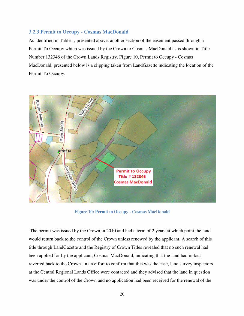
3.2.3 Permit to Occupy - Cosmas MacDonald
As identified in Table 1, presented above, another section of
Permit To Occupy which was issued by the Crown to Cosmas MacDonald as is shown in Title
Number 132346 of the Crown Lands Registry
MacDonald, presented below is a clipping taken from LandGazette
Permit To Occupy.
Figure 10
The permit was issued by the Crown in 2010 and had a term of 2 years at which point the land
would return back to the control of the Crown unless renewed by the applicant. A search of this
title through LandGazette and the Registry of Crown Titles reveale
been applied for by the applicant, Cosmas MacDonald, indicating that the land had in fact
reverted back to the Crown. In an effort to confirm that this was the case, land survey inspectors
at the Central Regional Lands Office wer
was under the control of the Crown and no application had been received for the renewal of the
20
Cosmas MacDonald
As identified in Table 1, presented above, another section of the easement passed through a
which was issued by the Crown to Cosmas MacDonald as is shown in Title
Number 132346 of the Crown Lands Registry. Figure 10, Permit to Occupy - Cosmas
is a clipping taken from LandGazette indicating the location of the
10: Permit to Occupy - Cosmas MacDonald
The permit was issued by the Crown in 2010 and had a term of 2 years at which point the land
would return back to the control of the Crown unless renewed by the applicant. A search of this
title through LandGazette and the Registry of Crown Titles revealed that no such renewal had
been applied for by the applicant, Cosmas MacDonald, indicating that the land had in fact
reverted back to the Crown. In an effort to confirm that this was the case, land survey inspectors
at the Central Regional Lands Office were contacted and they advised that the land in question
was under the control of the Crown and no application had been received for the renewal of the
the easement passed through a
which was issued by the Crown to Cosmas MacDonald as is shown in Title
Cosmas
the location of the
The permit was issued by the Crown in 2010 and had a term of 2 years at which point the land
would return back to the control of the Crown unless renewed by the applicant. A search of this
d that no such renewal had
been applied for by the applicant, Cosmas MacDonald, indicating that the land had in fact
reverted back to the Crown. In an effort to confirm that this was the case, land survey inspectors
e contacted and they advised that the land in question
was under the control of the Crown and no application had been received for the renewal of the

Permit To Occupy original issued to Cosmas MacDonald. This section of land would also fall
under the application which would be made to Crown Lands.
3.2.4 Permit to Occupy - Town of St. Alban's
The Town of St. Alban's had also been issued a
along the easement route. This Permit To Occupy
Crown Lands Registry and is presented below in Figure 11
Alban's. Refer to Section A4 of Appendix A for the
the Town of St. Alban's.
Figure 11
The permit was issued by the Crown in 2012 and had a term of 1 year at which point the
applicant could apply for an extension
search of LandGazette and the Registry of Crown Titles revealed that no such extensions had
21
original issued to Cosmas MacDonald. This section of land would also fall
cation which would be made to Crown Lands.
Town of St. Alban's
The Town of St. Alban's had also been issued a Permit To Occupy by the Crown which fell
Permit To Occupy is registered in Title Number 1
is presented below in Figure 11, Permit to Occupy - Town of St.
of Appendix A for the full copy of the Permit To Occupy
11: Permit to Occupy - Town of St. Alban's
The permit was issued by the Crown in 2012 and had a term of 1 year at which point the
pply for an extension if the site had not yet been developed. However, another
he Registry of Crown Titles revealed that no such extensions had
original issued to Cosmas MacDonald. This section of land would also fall
ccupy by the Crown which fell
is registered in Title Number 139137 of the
Town of St.
Permit To Occupy issued to
The permit was issued by the Crown in 2012 and had a term of 1 year at which point the
if the site had not yet been developed. However, another
he Registry of Crown Titles revealed that no such extensions had

22
been applied for by the Town of St. Alban's. Once again, land survey inspectors at the Central
Regional Lands Office were consulted and they were able to confirm that no application for
extension had been submitted and the land in question was under control of the Crown. This
section of land would also be applied for under the application made to Crown Lands.
3.2.5 Vacant Crown Land
There were also several sections along the easement route that, through LandGazette and a
search of the Registry of Crown Titles, were identified as vacant or unoccupied Crown Land.
The land tenure of these areas was also discussed with the municipality, COS, and locals from
the Town of St. Alban's to ensure that no private titles existed within the identified areas. In the
absence of any documentary evidence or testimonies stating any private claims over the areas of
vacant Crown land, EAL and the Crown were confident that these areas were in fact under the
control of the Provincial Crown and as such these areas would also be applied for through Crown
Lands.
Refer to Section B7 of Appendix B for the complete application which was made to Crown
Lands, Central Regional Lands Office, which includes all sections of Crown lands identified in
Section 3.2.1 to Section 3.2.5 of this report.
3.2.6 Application Approval and Survey Authorization
After review and approval of the application for Crown land an approval letter was sent to COS
advising them that they must have the land surveyed by a registered member of the ANLS. The
approval letter also advises COS of the area that the survey must not exceed as well as any
special instructions that must be followed during the survey. COS advised EAL through email
correspondence that they had received the letter of approval from the Crown and as per Section 2
of the Crown Land Survey Standards - 2009, a survey authorization was requested by EAL.
Shortly thereafter the Crown issued the survey authorization along with any other special
instructions deemed necessary by the Minister. Refer to Section B8 of Appendix B for the
complete survey authorization issued by the Crown to EAL.

23
3.2.7 Environmental Assessment
Typically, for industrial projects similar to this waterline easement, it would be necessary to
conduct an environmental assessment on the proposed easement route. This assessment would be
conducted in accordance with the Environmental Assessment Regulations 2003 and once
completed, the findings of the assessment would be submitted to, and reviewed by, the
Department of Environment and Conservation, Environmental Assessment Division. However,
under Part III, Designated Undertakings and Exceptions, of the Environmental Assessment
Regulations 2003 there are conditions whereby environmental assessments may not be required.
One of the exceptions listed in this document can be found Section 35(2)(a) under Prime
Contracting and states "an undertaking that will be engaged in the construction of a trunk
pipeline for the transmission of water from a source to a point of distribution where a portion of
that pipeline will be more than 500 meters from an existing right of way shall be registered"
(Queen's Printer, 2017). Given that the waterline being proposed for this project was at no point
more than 500 meters away from an existing right of way meant that no environmental
assessment would be required and therefore such an assessment was not completed for this
project.
3.3 Transport Canada (Navigation Protection Program)
It was shown in Section 3.2.1 that the waters of St. Alban's Barasway were deemed under the
control of the Provincial Crown however as St. Alban's Barasway is classified as being navigable
waters, notice of works must be given to Transport Canada for any work undertaken in such
navigable waters. Through correspondence with members of Transport Canada, Navigation
Protection Program, Atlantic Region, it was determined that the works being undertaken by COS
to install a waterline through the waters of St. Alban's Barasway did in fact comply with the
requirement to seek Transport Canada's approval under the Navigation Protection Act. As a
result an application was made on behalf of COS to Transport Canada for the works to be
conducted during the installation of the waterlines. The full application made to Transport
Canada along with the subsequent approval can be found in Section B9 of Appendix B.

24
3.4 Town of St. Alban's
A large portion of the waterline easement was proposed to follow along a series of municipal
roads locally known as Voyce Cove Road and Bayview Drive. See Figure 12, Municipal Roads
Encountered.
Figure 12: Municipal Roads Encountered
Discussions on the terms and conditions of approval to allow COS to install their waterline
through sections of the municipal roads, presented above, were handled internally between COS
and the Town of St. Alban's. As a result of these discussions, and eventual agreement, it was
determined by both parties that easement plans would not be required for this section of the
waterline easement. The Town of St. Alban's did issue a Building Permit to COS granting their
permission to use the land along their roadways to install their waterlines and some terms and
conditions were outlined in the building permit. Refer to Section B10 of Appendix B for the
building permit issued by the Town of St. Alban's to COS.

25
3.5 Cornelius MacDonald
The final section of the easement route that would require approval was over a section of land
originally granted by the Crown to Cornelius MacDonald, now Cosmas MacDonald, and is
shown in Volume 161 Folio 54 of the Crown Lands Registry. Refer to Section A5 of Appendix
A for the grant issued by the Crown to Cornelius MacDonald, now Cosmas MacDonald. COS
and EAL approached Mr. MacDonald to discuss the possibility of acquiring an easement through
his land that would allow COS to install their pipeline. Mr. MacDonald was reluctant in the
beginning to approve of the easement as he maintained a small agricultural farm on the land
where he grew various fruits and vegetables. Eventually, Mr. MacDonald agreed to allow COS
access to his land subject to terms and conditions as negotiated by the legal councils of the
parties involved. An easement plan would be required to delineate and demarcate the boundaries
of the easement over Mr. MacDonald's land and an easement agreement was signed and
registered under Registration Number 756270 at the Registry of Deeds for the Province of
Newfoundland and Labrador. Refer to Section B11 of Appendix B for the easement agreement
between COS and Cosmas MacDonald.

26
4.0 Initial Field Visit and Data Collection
Now that all research had been completed along the easement route and approvals had been
received from all parties involved in the project, the next step was to make an initial field visit to
St. Alban's. Planned activities for the initial field visit included the following:
(a) verification of project survey control (a combination of both Crown Land
Monuments within the community as well as Canadian Hydrographic Service
(CHS) benchmarks);
(b) topographic survey along the land section of the easement route;
(c) profile survey across the waters of St. Alban's Barasway;
(d) investigate any and all existing municipal infrastructure along the municipal
section of the easement route.
4.1 Project Survey Control
As this project would require survey plans to be prepared in accordance with both the Crown
Land Survey Standards and the survey standards as outlined by the ANLS it would first be
necessary to identify the geographic reference system and projection required. Section 3.3 of the
Manual of Practice, Standards of Professional Conduct, Knowledge and Skill as published by the
ANLS states that the current Provincial geographic referencing system is to be based on the
North American Datum 1983 (NAD83) and the Modified Three Degree Transverse Mercator
Projection for the Province of Newfoundland and Labrador (Association of Newfoundland Land
Surveyors, 2017). Section 4 of the Crown Land Survey Standards also states that all surveys
should be referenced in accordance with the ANLS standards, regulations and Manual of
Practice, Standards of Professional Conduct, Knowledge and Skill (Department of Environemnt
and Conservation, Lands Branch, 2017). Therefore it was determined that the reference system
for the project would be NAD83 in combination with the Modified Three Degree Transverse
Mercator Projection.

27
There were 2 types of project survey control implemented during the project that would have to
be verified during the initial site visit and they are the Crown Land Survey Monuments and the
CHS benchmarks.
4.1.1 Crown Land Survey Monuments
Crown land survey monuments form a network of over 7000 permanent survey markers, with
precise positions for the reference of topographic mapping, land surveys, and engineering
surveys and are integrated with the Geodetic Survey of Canada (Governement of Newfoundland
and Labrador, 2017). These monuments are located within most of the municipalities and
communities within the Province of Newfoundland and Labrador at strategic locations to avoid
disturbance from development within the community and allow intervisibilty between other
stations or monuments. Published coordinates values for these monuments are made available
online through a web map service served up by LandGazette. The monument directory can be
found under the free utilities section and allows you to search for a specific monument by
entering the unique monument number, if known, or through a search by community which yield
results for all the monuments located with a selected community. Figure 13 presents a screen
shot taken from Google Earth showing the crown land monuments within the Town of St.
Alban's.

28
Figure 13: Crown Land Monuments Within the Town of St. Alban's
Selecting the icons shown on that map reveals a pop up dialogue window that identifies the
unique number of each monument. These monument numbers were recorded and coordinate
values for each were retrieved from LandGazette. Table 2, Crown Survey Monuments, presents
the crown survey monuments that were to be used for the project survey control. It should be
noted that there were two monuments listed within the Town that had been destroyed. It is
unknown how these monuments were destroyed but as is common within a lot of municipalities
as development occurs some monuments become destroyed and or removed. Refer to Section C1
of Appendix C, Crown Land Survey Monuments, for a full listing of details for the crown land
survey monuments listed below.

29
Table 2: Crown Land Survey Monuments
It was determined that where applicable a dual frequency Global Positioning System (GPS)
would be used to conduct all field activities and observations during the project. The GPS
utilized consisted of a Topcon GB-1000 base station along with a Topcon Hiper Lite Plus Real
Time Kinematic (RTK) receiver. Refer to Section D1 of Appendix D, Equipment Specifications,
for specifications and published accuracies of the Topcon GB-1000 base station and Section D2
of Appendix D for specifications and published accuracies of the Topcon Hyper Lite Plus RTK
Receiver.
Upon arriving in St. Alban's the GB-1000 base station was setup over crown land monument
81G2314. The published coordinates for the point were entered as the base station location and
the instrument height above the control monument was recorded and entered. Once the base
station was started, redundant observations were made on crown land monuments 81G2316 and
81G2319 using the hyper lite plus receiver to verify that the positions being recorded were
accurate. The observed northing, easting, and elevation of the two other crown land monuments
were then compared to the published values, as issued by Surveys and Mapping Division. Table
3, Crown Land Survey Monument Comparison - Control Verification, presents the delta values
between the observed and published coordinate values for the project survey control.
Table 3: Crown Land Survey Monument Comparison - Control Verification
Monument Number Northing Easting Elevation Condition
81G2314 5305127.815 316686.897 20.866 Good
81G2316 5304451.302 316515.056 22.233 Good
81G2319 5302192.534 317353.593 23.177 Good
Survey Control Coordinate Table NAD83 MTM Zone 2
Monument Northing (m) Easting (m) Elevation (m) Northing (m) Easting (m) Elevation (m) ∆ Northing (m) ∆ Easting (m) ∆ Elevation (m)
81G2316 5304451.302 316515.06 22.233 5304451.304 316515.069 22.172 0.002 0.013 0.061
81G2319 5302192.534 317353.59 23.177 5302192.539 317353.588 23.161 0.005 0.005 0.016
Published Coordinates Observed Coordinates Deltas
Coordinate Comparison, NAD83, MTM Zone 2

30
As seen in Table 3 above, the magnitudes of the delta values were relatively small between the
published and observed coordinates for the crown land monuments within the project area. For
this reason it was deemed that these monuments were acceptable to be used as the project survey
control and subsequently would be used as such throughout the duration of the project.
As per the equipment specifications for the Topcon GPS system used, refer to Section D1 of
Appendix D, the accuracies of the horizontal positions recorded were expected to be within
10mm + 1ppm(D), where D is the distance from the base station that the observation was made
using the rover unit. Given that the maximum distance for any observation made using the rover
unit was approximately 1800 meters, the accuracy of the positions obtained were expected to be
within 12mm. Another way to check the accuracy of the positions being recorded by the GPS is
to observe the horizontal dilution of precision (HDOP) and vertical dilution of precision (VDOP)
which is displayed on the Topcon FC200 data collector. These values are calculated based on the
geometry or configuration of the satellites that the GPS is currently tracking. The more widely
spread the satellites are in the sky the lower the HDOP and VDOP values will be which means a
more accurate position. If the satellites are grouped closely together (i.e. all the satellites are
directly or close to directly overhead) the higher these values will be which will result in slightly
less accurate position being obtained. The Topcon FC200 data collector also enables the
surveyor to check the sky plot of the satellites being tracked by the GPS and this can be used to
check the geometry of the satellites.
4.1.2 Canadian Hydrographic Service Benchmarks
As mentioned in Section 3.3 the waters of St. Alban's Barasway were deemed by Transport
Canada as navigable waters and as a result the CHS has published a nautical chart pertaining to
the safe navigation for marine vessels in such waters. For navigation safety, depths on these
charts are referenced to Chart Datum or Lower Low Water Large Tide (LLWLT), which is a
low-water datum that the water level will very seldom fall below (Fisheries and Oceans Canada,
2017). For this reason the elevations from the previously verified crown land survey monuments
would not be acceptable to use for this portion of the project. It was decided that observations
would be made on several CHS benchmarks located within St. Alban's using the dual frequency
GPS which would establish geodetic elevations on the CHS benchmarks. A comparison between

31
the observed geodetic elevations and the Chart Datum elevations, published by the CHS, on the
same benchmarks would enable a mean elevation shift to be calculated. This mean elevation shift
could then be applied to all observations made across the waters of St. Alban's Barasway in order
to have Chart Datum elevations. This information would not be used in the preparation of any of
the legal survey plans required across St. Alban's Barasway, however, they would be required to
create engineering drawings for COS to facilitate the construction and installation of the
waterline across St. Alban's Barasway which is a part of the original scope of work as identified
in Section 1.2 of this report. In addition, this information would also be used in support of the
application made to NPP.
Two CHS benchmarks, M12F9002 and M12F9003, were targeted to be used for the project due
mainly to their close proximity to the project area and ease of access. These benchmarks were
newly established in 2012 by the CHS and information pertaining to the Chart Datum elevations
of the benchmarks was not yet available through the station benchmarks database on the CHS
website. However, after contacting members of the CHS, elevations and written descriptions for
the benchmarks were obtained. Table 4, Canadian Hydrographic Service Benchmarks, presents
the Chart Datum elevations and description as provided by the CHS.
Table 4: Canadian Hydrographic Service Benchmarks
Benchmark
Number
Chart Datum
Elevation (m)Description
M12F9002 3.887
M12F9002 is a standard CHS bronze tablet measuring 8 cm in diameter and stamped
“M12F9002” and is cemented vertically into the base of a concrete mooring bollard that
measures 52 cm X 80 cm. This mooring bollard is located approximately 1.0 m NE of the
most southerly corner of the St. Alban’s Seafoods wharf and 0.7 m NW of the most SE
wharf face. It’s approx. NAD83 position is: 47-51-44.041N and 55-50-08.666W
M12F9003 3.741
M12F9003 is a standard CHS bronze tablet measuring 8 cm in diameter and stamped
“M12F9003” and is cemented vertically into the concrete base of the wharf at St. Alban’s
Seafoods. This BM is located on the SW side of the wharf at the beginning of the wheel
guard when walking towards the wharf from land. It is located 19 cm NW of the most NW
portion of the wheel guard and 14 cm NE of the edge of the concrete deck.
Canadian Hydrographic Service Benchmarks

32
As previously mentioned, observations on both CHS benchmarks were done using GPS and
geodetic elevations were obtained for each benchmark. A mean elevation shift was then
calculated between both sets of elevations and applied to all topographic observations made
across St. Alban's Barasway. It should be noted that observations across St. Alban's Barasway
were completed using GPS as most of the harbour could be walked across during low tide.
Observations on the remaining section, which was under water even at low tide, were made from
a small boat using the GPS on a telescopic pole. The boat was held stationary at approximately
10m intervals across the barasway and the telescopic pole was lowered until it touched the
seafloor. The bottom of the telescopic pole used was flat, as opposed to the pointed tip on the
bottom of most poles. This prevented the pole from sinking into the soft muddy bottom of
seafloor. The antennae height for the receiver was then changed to reflect the height of the pole
and an observation was recorded. The horizontal positions recorded would have the same
accuracies as the other sections of the route where topo was conducted and as described in
Section 4.1.1 of this report. The vertical accuracies of the positions recorded were expected to be
within 15mm + 1ppm(D), where D is the distance from the base station that the observation was
made using the rover unit, refer to equipment specifications under Section D1 of Appendix D.
Again, given that the maximum distance of any observation was approximately 1800 meters
from the base station the vertical accuracies were expected to be within 17mm.
Combining the data from walking the shoreline, along with the data collected in the boat
provided a complete profile across the barasway with elevations relative to geodetic datum. The
calculated elevation shift between geodetic elevation and Chart Datum was then applied to the
observations to get resultant Chart Datum elevations for the profile. Table 5, Shift From
Geodetic to Chart Datum, presents the computed mean elevation shift as described above.

33
Table 5: Shift From Geodetic to Chart Datum
4.2 Topographic Survey
With verification of the project survey control complete, a topographic survey was completed
along the entire centerline of the easement route. The primary objective of the topographic
survey was to collect elevation data along the easement route which would assist in creating the
plan and profile in support of the engineering drawings for the waterline. However, during this
initial topographic survey other important features were collected as well. These important
features include the following:
(a) power and utility lines including guy wires;
(b) local roads, driveways, public accesses, trails etc.;
(c) brooks, rivers, streams or other waterways;
(d) roadside ditches, drains (manmade or natural);
(e) existing occupation such as fence lines, houses, sheds or other buildings;
All of these observed features would help in fine tuning the location of the waterline easement,
as well as make it possible to plan for any potential conflicts between existing infrastructure and
the newly installed waterlines. It should be noted that during the topographic survey no physical
evidence or occupation was observed through the Crown Land sections along the waterline
easement route. These sections consisted of open water along the St. Alban’s Barasway, a vacant
public road leading up to the Cosmas MacDonald property, and undeveloped forest along the
remaining Crown Land section up to the hatchery well site.
Benchmark
Number
Chart
Datum
Elevation
Observed
Geodetic
Elevation
∆ Elevation
M12F9002 3.887 4.983 -1.096
M12F9003 3.741 4.853 -1.112
-1.104
Elevation Shift From Geodtic to Chart Datum
Mean Elevation Shift

34
4.3 Investigation of Municipal Infrastructure
As a large section of the easement was planned to traverse along sections of the municipally
owned public roads, it was necessary to identify any existing municipal infrastructure such as
water lines, sewer line, culverts etc, within the area. This process would identify any areas where
infrastructure already existed and, if possible, could be avoided when creating the final easement
and installing the waterlines. Meetings were held with personnel employed with the Town of St.
Alban's and copies of old as-builts were obtained which showed approximately locations of
existing infrastructure in the easement area. An extensive survey of the area was completed with
the assistance of town resources who helped with locating some of the more difficult to find
infrastructure.

35
5.0 Boundary Retracement and Determination
After the months of careful and thorough research and planning involved with route selection for
the easement, the next step in the project would be to retrace the existing surveyed boundaries
that intersected with the easement route. The extensive research through LandGazette, the Crown
Lands Registry, CADO, discussions and consultation with local residents, as well as discussions
with the client, COS, and employees of the Town of St. Alban's made it possible to avoid many
of the private titles that existed along the easement route. There were, however, a couple of
private properties that would be influenced by the easement route. The private properties affected
were those of NAS, Crown Title number 28480 Volume 187 Folio 137, and Cornelius
MacDonald (now Cosmas MacDonald), Crown Title number 41204 Volume 161 Folio 54. The
next sections of this report will discuss the examination, interpretation, and evaluation of both
the documentary evidence contained within each of these title documents as well as the field
evidence to support the boundaries as described in the issued title documents.
5.1 Newfoundland Aqua Services Limited Title Number 28480
The first private property to be examined was that of NAS. This property contained the brackish
water well which was to serve as the point of commencement for the new waterline easement. As
previously discussed in Section 3.1, this property was conveyed from the previous owner, Bay
D'Espoir Enterprises Limited, through a deed of conveyance registered at the Registry of Deeds
and also by means of an amended grant from Crown Lands. Section 5.1.1 will discuss the
documentary evidence found within the aforementioned documents.
5.1.1 Documentary Evidence
The first piece of documentary evidence examined was that of the original grant issued by the
Crown to Bay D'Espoir Enterprises Limited. This document was of particular importance
because it signifies the original land transfer from the Crown to a private party. Even though
more recent surveys of the property existed, this document, as well as the related documents that
will be discussed in this section, was important to review to achieve a good understanding of the
history of the parcel of land and how the parcel may have evolved or changed from the time it

36
was initially created. This historic information should never be overlooked when conducting
research on a parcel of land especially when more recent or up to date surveys exist.
The survey description of the original grant indicates that the point of commencement for the
surveyed boundary was tied to the intersection of the centerline a local road leading to the shore
and centerline of the road from Harrison Point to the Trans Canada Highway. The boundary then
continued along property identified as being claimed by the Canadian National Telephone
Company. Next the boundary followed along the sinuosities of a shoreline reservation, ten
meters wide, created by the natural boundary of the Ordinary High Water Mark (O.H.W.M) for
the waters of Ship Cove and Bay D'Espoir, as observed during the time of the original survey,
before arriving back at the point of commencement. Refer to Section A1 of Appendix A for the
original grant issued by the Crown to Bay D'Espoir Enterprises Limited.
In June of 1995, a new survey was conducted to facilitate the conveyance of the above described
parcel of land to NAS. Although a new survey is not always required when conveying land from
one person to another, a new survey was conducted for a number of different reasons. The first
reason being that the previous survey was referenced to Magnetic North and was conducted over
20 years ago; the second reason being that there were several issues found within the previous
survey. These issues consisted of the following:
(a) the reference tie from the intersection of the two roads could not be identified;
(b) the field notes for the survey shows the location of the grant 16.489 meters short
of the distance from the post office fence; and
(c) the error of closure was 1:300.
The new survey was conducted by A.W. Wall, NLS, on June 03, 1995 and the reference tie for
the revised survey was taken from a distance from the telephone building, located on the adjacent
property, to the grant boundary line as indicated in the original field notes from the original
survey. The revised survey also contained a reference tie to Crown Land Monument 81G2316
and all bearings were referenced to Grid North NAD83. There was no indication on the subject
survey of any iron bars or monumentation that may have been found from the previously issued

37
survey. Refer to Section A2 of Appendix A for the Deed of Conveyance from Bay' D'Espoir
enterprises Limited to NAS which includes a copy of the 1995 survey plan.
The final piece of documentary evidence pertaining to this property is the amended grant which
was issued by the Crown to NAS in February 2013. This amended grant was issued to include
the previous acquired parcel of land conveyed by Bay D'Espoir Enterprises Limited to NAS, and
also to include a new portion of land to be acquired from the Crown. This new portion of land
consisted of an infilled area that extended into and beyond the ten meter shoreline reservation
and into the waters of Bay D'Espoir. This survey was completed by James A. Burden, NLS, in
September 2011 and the amended grant was issued to NAS in February 2013. The survey
contained a starting point with a coordinate that was referenced to Grid North NAD83 and
indicated that several capped iron bars or monuments had been placed along the boundary.
Again, there was no indication on the plan that any iron bars or monumentation from the
previous survey were found. Refer to Section A3 of Appendix A for the amended grant issued by
the Crown to NAS, which includes a copy of the 2011 survey plan.
As this survey plan represented the most recently surveyed and accepted boundary for the
property of NAS this boundary would have to be physically retraced in the field. Section 5.1.2 of
this report details the physical evidence found in the field to support the monumentation as
documented in the amended grant for NAS.
5.1.2 Field Evidence and Boundary Retracement
Having reviewed the documentary evidence as described in the previous section a retracement
survey could now be completed of the amended grant belonging to NAS. The goal of the
retracement survey was to find and observe any monumentation that would support the
delineated boundary as described in the amended grant. Also the retracement survey would
identify any discrepancies that would be found between existing field evidence and the
documentary evidence as described in the amended grant.
With the assistance of Micro Survey 2009 Premium, a well known computer-aided design
(CAD) program, coordinates were computed for all of the deflection points along the previously
surveyed boundary of NAS's property. These coordinates were then programmed into a Topcon

38
FC200 data collector that would be used with the Topcon dual frequency GPS system described
in Section 4.1.1 of this report. Once in the field, the GPS was setup in a similar fashion as
described in Section 4.1.1 and redundant observations were made to the two previously verified
crown land monuments at the both beginning and end of the field exercise. Table 6, Crown Land
Monument Observations - Boundary Retracement (1), presents the variances in position and
elevation between the published and observed coordinates for the crown land monuments that
were observed.
Table 6: Crown Land Monument Observations - Boundary Retracement (1)
The delta values between the published and observed control had very small magnitudes, as seen
during the initial project control verification, and therefore the GPS was deemed to be properly
setup and the proper corrections were being received by the rover unit.
Having verified the GPS setup, a search was then conducted on the NAS property in an effort to
find any of the original monumentation from the amended grant. The search commenced along
the northerly boundary of the property along the waters of Bay D'Espoir. This boundary was of
particular interest as this would be the boundary that the new waterline easement would abut to
and cross. Several of the original monuments were found along this boundary. In fact, 3 of the 4
monuments placed along this boundary were observed and there was no indication that any of
the monuments had been disturbed or tampered with since being originally place. All the found
monuments still had survey caps in place over the iron bar and the monuments were relatively
straight in the ground, meaning that the monuments were not leaning to one side or the other or
had no bends or buckling within them.
Monument Northing (m) Easting (m) Elevation (m) Northing (m) Easting (m) Elevation (m) ∆ Northing (m) ∆ Easting (m) ∆ Elevation (m)
81G2316 5304451.302 316515.056 22.233 5304451.301 316515.07 22.184 0.001 0.014 0.049
81G2319 5302192.534 317353.593 23.177 5302192.547 317353.578 23.156 0.013 0.015 0.021
Published Coordinates Observed Coordinates Deltas
Coordinate Comparison, NAD83, MTM Zone 2

39
Furthermore, a search was done along the southwesterly and southeasterly boundary of the
property, however only one other monuments was found. Again the monument appeared to
relatively undisturbed as it was fairly straight in the ground and had its original survey cap intact.
Figure 14, below, presents a copy of the survey plan that was used in the field to retrace the
boundaries of the property and indicates which survey monuments were found during the
retracement.
Figure 14: Boundary Retracement Field Sketch - Newfoundland Aqua Services

40
The observed coordinates of the found monumentation were recorded and compared to the
computed coordinates as per the survey plan issued with the amendment grant to NAS. When
observing a found monument two observations were recorded on each monument to provide a
redundant check on that point. The satellite position was dumped between observation, meaning
the GPS rover was turned upside down for approximately 10 seconds so that the lock between
the rover and satellites was lost. Once up righted the rover was enabled to lock on to the satellites
and once a fixed position was achieved the second observation was recorder. Table 7, Computed
Monument Coordinates vs Observed Monument Coordinates, presents the delta values between
the computed monument coordinates and the observed monument coordinates. Monument
numbers shown in Table 7 correspond with those shown in Figure 14.
Table 7: Computed Monument Coordinates vs Observed Monument Coordinates
Coordinate Comparison, NAD83, MTM Zone 2
Published Coordinates Observed Coordinates Deltas
Monument
#
Northing
(m) Easting (m)
Northing
(m) Easting (m)
∆ Northing
(m)
∆ Easting
(m)
14 5303341.461 316716.589 5303341.501 316716.508 0.040 0.081
5303341.507 316716.514 0.046 0.075
5003 5303430.043 316704.201 5303430.04 316704.206 0.003 0.005
5303430.047 316704.203 0.004 0.002
5008 5303397.75 316682.131 5303397.773 316682.096 0.023 0.035
5303397.753 316682.113 0.003 0.018
5009 5303434.078 316710.128 5303434.083 316710.084 0.005 0.044
5303434.099 316710.115 0.021 0.013
Based on the relatively low magnitudes of the delta values between the computed and observed
monumentation, it was determined that the monumentation was undisturbed from the original
placement and therefore the original bearings and distances as shown on the amended grant
could be upheld.

41
In addition to a search for existing monumentation, observations were also taken on all the
infrastructure located on the NAS property. This information would be used to tactfully position
the waterline easement on the property as to not interfere with any of the operations or
infrastructure belonging to NAS.
The new O.H.W.M was also re-observed around the infilled area as this formed the majority of
the boundary for the NAS property. Identifying this feature is not always a simple task for a
surveyor and often requires careful and close examination of the natural evidence that exists
along the particular shoreline. In this instance, the foreshore area for the waters of St. Alban's
Barasway was quite large as the tide drains a long way out into the barasway. Figure 15, below,
shows two pictures of the large foreshore area for the waters of St. Alban's Barasway.
Figure 15: Foreshore of the Waters of St. Alban's Barasway
This made it quite difficult to determine where the actual O.H.W.M fell, however, there were
some features along the shoreline that helped in identifying the O.H.W.M. Some of the most
notable features that helped in determining this location were the clearly visible vegetation line
created along the shore and the discoloration that appears along the rocks and gravel that form
the shoreline. Additional, there were deposits of debris along the O.H.W.M that get left behind
when the high tide starts to recede which also provides a good indication of the normal level of
the high tide.

42
Having collected all of the above mentioned information EAL was confident that the retracement
survey of the NAS property was completed and now focused its attention to retracement of the
other private property impacted by the waterline easement.
5.2 Cornelius MacDonald Title Number 41204
The final private property that would have to be retraced for this project was that of Cornelius
MacDonald. This property is currently owned by Cosmas MacDonald and was passed from
Cornelius to Cosmas, however, no deed of conveyance or bill of sale was ever registered at the
Registry of Deeds. In depth discussions about the property and how ownership had been
transferred were held with Cosmas during the initial site visit and at that time Cosmas was able
to provide enough information about the property to confirm that he was the current owner of the
property. Discussions with other residents of the Town of St. Alban's also confirmed that
Cosmas was the undisputed owner of the property which was originally granted to Corenelius
MacDonald. Section 5.2.1 details the documentary evidence that was found in relation to the
property.
5.2.1 Documentary Evidence
As previously mentioned, Cornelius MacDonald was originally granted this property from the
Crown in February 1981. The original grant actually consisted of 3 parcels of land, all of which
were shown on the same survey plan and detailed in the same metes and bounds description
attached to the original grant. Refer to Section A5 of Appendix A for the original grant
document.
The original survey plan shows that all 3 parcels are tied by way of a single reference line from
another grant, issued to The R.C. Episcopal Corporation, located within the Town of St. Alban's.
Additional reference lines consisting of a magnetic bearing and distance were used to tie each of
the three parcels together. Two of the three parcels were located on the southerly side of a local
road and the third parcel was located to the north of the local road. Unlike the previously
discussed NAS property, there had been no recent surveys completed on either of these parcels
therefore computing coordinates to use for searching for the original boundary would prove to be

43
more difficult. The only information that could be relied on was the original tie line to the R.C.
Episcopal Corporation property. A copy of this grant was obtained through previous work
completed by EAL for COS within the Town of St. Alban's and is attached in Section A6 of
Appendix A.
It was discovered that during other work performed by EAL, the R.C. Episcopal Corporation
property had been tied to grid based on found evidence of original monumentation that supported
the boundaries of the property as described in the original grant. Using this information a block
containing the original relative geometry of all the magnetic parcels was created in Micro Survey
2009 and the block was then aligned to match the boundaries of the R.C. Episcopal Corporation
grant, which had been tied to the provincial grid system. This process provided approximate
coordinate values for the parcels of land granted to Cornelius MacDonald and would serve as a
starting point to begin searching for evidence in the field.
Other than the original tie line to the R.C. Episcopal Corporation grant and the reference to the
local road there was very little information in the survey description of Cornelius MacDonald
that would prove helpful for retracing the boundary in the field. With the information that was
compiled it would be necessary to complete an extensive field search for any original
monumentation and occupation that would help position the Cornelius MacDonald grants with
some degrees of confidence.
5.2.2 Field Evidence and Boundary Retracement
Upon completion of the review and evaluation of the existing documentary evidence a field visit
was conducted to try and retrace the original boundaries of the Cornelius MacDonald grants. As
described in Section 5.1.2, GPS was setup in a similar fashion and redundant checks were done
on several crown land monuments at both the beginning and end of the field exercise to ensure
that the system was setup properly and the correct positions were being recorded. Table 8,
Crown Land Monument Observations - Boundary Retracement (2), presents the results of the
redundant checks on the crown land monuments completed for this portion of the boundary
retracement.

44
Table 8: Crown Land Monument Observations - Boundary Retracement (2)
Upon arriving at the site, the local road which was mentioned in the original grant was clearly
visible, however it appeared to be more of a trail than a road as lack of use of the road had
caused it to become grown in with vegetation. The limits of the road way were observed and
recorded.
It could also be seen that several fences had been erected around the subject parcels of land. The
original grant showed no indication of fences on the property meaning that the fences had been
erected after the grant was issued. The majority of the fences were well maintained and in good
repair but there were sections of the fence that indicated it had been standing for quite some time.
This was indicated by the existence of several old rotten wooden fence posts that had fallen over
and were replaced by newer wooden fence posts. There were also several sections of old rusted
wire fencing material that was grown into the ground which had been replaced by newer wire
fencing. The old wire material still followed the general line of the existing fence and in most
places was still attached to the rotten fence posts as well as those still in good repair. Before
searching for any iron bars or original monumentation the entire property was walked to get a
sense of the general footprint of the land being occupied by Cosmas MacDonald. Mr.
MacDonald was present during some of this time and walked some of the property indicating the
limits of land which he believed to be included in the grants. During the walkthrough Mr.
MacDonald also pointed out the location of an existing iron bar which he was considering one of
the corners of his parcel of land. Mr. MacDonald made it known that the iron bar he pointed out
was the only one he has ever seen on the property.
After a completing a walkthrough of the entire site, all of the visible physical evidence of
occupation was recorded using GPS which included fences, trails and roads, landscaped areas
and the iron bar which was pointed out by Mr. MacDonald. After collecting all of the occupation
Monument Northing (m) Easting (m) Elevation (m) Northing (m) Easting (m) Elevation (m) ∆ Northing (m) ∆ Easting (m) ∆ Elevation (m)
81G2316 5304451.302 316515.056 22.233 5304451.298 316515.073 22.189 0.004 0.017 0.044
81G2319 5302192.534 317353.593 23.177 5302192.549 317353.582 23.147 0.015 0.011 0.030
Published Coordinates Observed Coordinates Deltas
Coordinate Comparison, NAD83, MTM Zone 2

45
on the land, a search commenced for other monuments which may have been placed during the
original survey of the property. Using the computed approximate coordinates a stake out was
done to each location in an effort to uncover more monumentation. With the help of a metal
detector a thorough search was completed at 17 locations around all 3 parcels. As the coordinates
being searched were only approximate, a search radius of approximately 4-5 meters around each
point was used to look for evidence of any existing monumentation. The field search continued
for 2 consecutive days until all property corners were investigated. At the end of the search only
2 monuments had been found including the one pointed out by Mr. MacDonald. Figure 16,
below, presents all of the points that were searched and shows the graphical locations of the two
monuments that were found.
Figure 16: Found Monumentation - Cornelius MacDonald Grants

46
With the field search complete all of the found evidence and occupation was reviewed and
evaluated to determine the final location of the boundaries. All observations were downloaded in
Micro Survey 2009 and line work was created by connecting the points of common features and
a comparison was done between the geometry of the existing occupation and found evidence and
the relative geometry of the parcels as defined in the original grants. Immediately it could be
seen that the general geometry of the existing observed fence line was similar to that of one of
the surveyed parcels. Given that one of the found monuments was located at the corner of the
said fence line further supported the indication that this fence line closely followed the original
surveyed boundary. The block of surveyed boundaries, which was created as described in the
previous section, was then positioned at the location of the found monument and rotated to best
fit the location of the existing fence line. Doing this made it even more evident that the geometry
of the existing fence line closely matched that of the original surveyed boundary of one of the
parcels. Figure 17, presented below, shows the rotated fit between the existing fence line and
found monument as compared to the geometry of the surveyed parcel.
Figure 17: General Geometry of Fence and Surveyed Boundary

47
Furthermore, when the position of the grants was rotated and fit to this monumentation and
occupation the location of the other found monument also aligned closely with the boundary of
survey Parcel 3. Refer to Figure 18, below.
Figure 18: Parcel 3 Boundary and Found Monumentation
The deviations of the position of the found iron bar were analyzed and found to be within an
acceptable tolerance to support the position of the grants and are summarized in Table 9,
Positional Deviations of Found Monument - Parcel 3, below.

48
Table 9: Positional Deviations of Found Monument - Parcel 3
It should be noted that the found position of the existing monument located on Parcel 3 was
approximately two feet below the surface of the ground and on an angle. In an effort to not
further disturb the original monument, dirt was removed from the hole by hand and an
observation was taken at the location where the monument appeared to enter the ground. The fact
that the monument was located this far below the ground and on an angle was considered when
accepting its position and may serve as an explanation as to the positional error, especially in the
East-West direction, which was the direction in which the monument was predominately leaning.
As an additional check on the positions of the two found iron bars on Parcel 1 and Parcel 3, an
inverse was done between the two points. As per the reference survey, the distance between the
two points should have been 220.170 meters and the actual observed distance between the two
found iron bars was 220.371 meters. Again, given that this was the only evidence of original
monumentation found and the fact that the occupation on the land generally fit within the
boundaries of each parcel, these two monuments were considered as original monumentation.
No monuments were found around the perimeter of Parcel 2 and the only occupation within that
area was that of some vegetable gardens that were being maintained by Cosmas MacDonald.
With the combined block of surveyed parcels being shifted and rotated to fit the monumentation
and occupation as described above, the position of the vegetable gardens did fit inside the
boundaries of this parcel. Additionally, the frontage of the property did align very well with the
direction of the road which bordered the northerly limit of the property. This provided further
confidence that the position and orientation of the original grants had been placed correctly.
The final, and likely most important, factor that helped in deriving the final position of the
original boundaries for this grant was evaluating the found evidence under the priority of
evidence, more commonly known as the hierarchy of evidence. According to Section (2.4) of the
∆ Northing ∆ Easting
-0.034 0.198
Deviations in Position of FIB on Parcel 3

49
ANLS Manual of Practice, Standards of Professional Conduct, Knowledge and Skill, as well as
several accepted common law cases, the hierarchy of evidence or priority of evidence is as
follows:
(a) natural boundaries;
(b) original monuments or evidence as to the location of original monuments;
(c) fences or possession reasonably dating back to the creation of the boundary limit
or corner;
(d) other limits as called for in the deeds; and
(e) measurements as contained in deeds or as shown on the survey plan or plans.
(i) coordinate values are deemed to be measurements.
As this boundary retracement dealt with no natural boundaries the highest level of priority was
given to the monumentation that were found in the field and that, after careful scrutiny and
examination, were deemed to be original. This found evidence coupled with the support of the
existing fences and occupation on the property, which aligned relatively well with the geometry
of the surveyed properties, provided further confidence that the boundaries of the surveyed
parcels had been positioned as close to the originally established location as possible.
Figure 19 presents the final position and orientation of the Cornelius MacDonald grants.

50
Figure 19: Final Position and Orientation of All Parcels
5.3 Boundary Determination and Monumentation
Now that the necessary research, documentary evidence review, and retracement surveys were
completed the new boundaries for the waterline easement could be established and where
required monuments could be placed. Section 6.0 explains the requirements for plan preparation
and monumentation required along these newly established boundaries.

51
6.0 Final Plan Preparation
As the easement route crossed both private lands and Crown land it would be necessary to ensure
survey plans were created as per the applicable set of standards. Both the Crown Land Survey
Standards 2009, and the ANLS Manual of Practice, Standards of Professional Conduct,
Knowledge and Skill Sections 12 and 13 were referenced during the creation of survey plans.
6.1 Legal Easement Survey Plan - Newfoundland Aqua Services Limited
The NAS property was a privately owned property and therefore the survey plan and description
was prepared as per Section 12 and Section 13 of the ANLS Manual of Practice, Standards of
Professional Conduct, Knowledge and Skill. Refer to Section E1 of Appendix E, Final Survey
Plans, for final survey plans for the easement created over NAS property. Monuments were
placed at all property corners and in any locations where iron bars could not be placed in the
ground (i.e. over asphalt surface, concrete surfaces) a survey tack or nail was placed in the
ground. The property had already been cleared of any trees and brush so there was no need to cut
or clear the easement boundaries. As described in Section 5.1.2, two observations were recorded
on each placed iron bar or survey nail to provide a redundant position on that point. Table 10,
Computed vs Observed Monumentation - NAS Easement Survey, presents the delta values
between the computed easement corners and both recorded observations for the same.

52
Table 10: Computed vs Observed Monumentation - NAS Easement Survey
Pt Number Description Northing (m) Easting (m) Northing (m) Easting (m) ∆ Northing (m) ∆ Easting (m)
5303370.340 316711.091 0.002 -0.003
5303370.338 316711.084 0.004 0.004
5303413.693 316707.266 0.003 0.003
5303413.691 316707.274 0.005 -0.005
5303419.182 316709.487 0.001 -0.005
5303419.181 316709.488 0.002 -0.006
5303448.758 316750.718 0.003 0.003
5303448.756 316750.717 0.005 0.004
5303453.756 316748.228 -0.002 -0.004
5303453.757 316748.221 -0.003 0.003
5303455.057 316750.919 0.004 0.006
5303455.060 316750.923 0.001 0.002
5303452.514 316752.200 0.005 -0.004
5303452.518 316752.194 0.001 0.002
5303453.703 316754.450 0.003 -0.002
5303453.708 316754.452 -0.002 -0.004
5303452.301 316755.657 0.001 0.002
5303452.299 316755.662 0.003 -0.003
5303462.556 316769.956 -0.003 -0.004
5303462.549 316769.953 0.004 -0.001
5303465.191 316769.710 0.002 0.003
5303465.186 316769.718 0.007 -0.005
5303464.535 316768.410 0.004 -0.005
5303464.534 316768.404 0.005 0.001
5303469.900 316765.718 0.006 0.004
5303469.910 316765.717 -0.004 0.005
5303471.608 316769.139 0.004 -0.006
5303471.611 316769.136 0.001 -0.003
5303475.729 316768.758 -0.003 0.004
5303475.731 316768.760 -0.005 0.002
5303475.009 316774.853 0.003 -0.003
5303475.008 316774.857 0.004 -0.007
5303459.671 316776.237 0.006 -0.001
5303459.676 316776.241 0.001 -0.005
5303415.318 316714.394 0.005 0.001
5303415.327 316714.389 -0.004 0.006
5303412.791 316713.377 -0.004 -0.004
5303412.792 316713.374 -0.005 -0.001
5303370.866 316717.062 0.003 0.003
5303370.863 316717.067 0.006 -0.002
Capped Iron Bar
Capped Iron Bar
Survey Nail
20
19
18
17
16
15
14
13
Capped Iron Bar
Capped Iron Bar
Capped Iron Bar
Capped Iron Bar
Capped Iron Bar
316768.762
316769.133
316765.722
5303370.869
5303412.787
5303415.323
5303459.677
5303475.012
5303475.726
5303471.612
5303469.906
316717.065
316713.373
316714.395
316776.236
316774.850
7
6
316748.2245303453.754Survey Nail5
12
11
10
9
8
5303452.519
5303455.061
Survey Nail
Capped Iron Bar
Capped Iron Bar
Capped Iron Bar
Survey Nail
Survey Nail
Survey Nail
316707.2695303413.696Capped Iron Bar2
316768.405
316769.713
316769.952
316755.659
316754.448
316752.196
316750.925
5303464.539
5303465.193
5303462.553
5303452.302
5303453.706
316750.7215303448.761Capped Iron Bar4
316709.4825303419.183Capped Iron Bar3
Published Coordinates Observed Coordinates Deltas
Coordinate Comparison, NAD83, MTM Zone 2
316711.0885303370.342Capped Iron Bar1
53
6.2 Crown Land Survey Plans
All Crown land survey plans were prepared as per the instructions stated within the survey
authorization and in accordance with Section 7 and Section 9 of the Crown Land Survey
Standards 2009.
It was originally perceived that monumentation would be required for the sections of the
easement crossing Crown lands however, discussions with personnel at the Central Regional
Office of Crown Lands confirmed that no monumentation was required when conducting a lease
for easement survey. Therefore no monumentation was placed along these sections. It was also
confirmed by personnel at the Central Regional Office that there would be no requirement to cut
any of the easement boundaries that may fall within treed or heavy brush areas. However, to
ensure that COS were aware of where their easement was located on the ground, the centerline of
the easement was clear cut and a combination of ribbons along the cutline and wooden stakes in
the clear or open areas were used to demarcate the centerline of the easement.
Along with final copies of the survey plans and descriptions the Surveyors Report was completed
and returned with the survey authorization. A copy of the completed survey authorization,
including the surveyors report can be found in Section E2 of Appendix E. There were 3 parcels
of Crown land surveyed in total and copies of all three survey plans and descriptions can be
found in Section E3 of Appendix E.
6.3 Legal Easement Survey Plan - Cosmas MacDonald
The property of Cosmas MacDonald was also private land and as such the survey plan and
description for this section of the easement was prepared as per Section 12 and Section 13 of the
ANLS Manual of Practice, Standards of Professional Conduct, Knowledge and Skill.
Monuments were placed at all property corners and deflection points along and through Mr.
MacDonald's land and all boundary lines through the property were clear cut and marked with
orange survey ribbon. Refer to Section E4 of Appendix E for the final survey plan and
description for the easement over Mr. MacDonald's land. Table 11, Computed vs Observed
Monumentation - Cosmas MacDonald Easement Survey, presents the delta values between the
computed easement corners and both recorded observations for the same.

54
Table 11: Computed vs Observed Monumentation - Cosmas MacDonald Easement Survey
6.4 Engineering Drawings
In the agreement made between COS and the Town of St. Alban's there was no requirement to
have legal easement survey plans prepared and EAL were not requested by either the Town of
St. Alban's or COS to do so. However, to facilitate the construction and installation of the
waterline throughout the entire easement route EAL were requested to prepare engineering
drawings showing plan and profile views of the waterline along the easement. A copy of these
drawings was submitted to the Town so that they could be aware of where the waterline was
located in relation to their existing infrastructure. Refer to Section E5 of Appendix E for the full
set of engineering drawings prepared for COS.
Pt Number Description Northing (m) Easting (m) Northing (m) Easting (m) ∆ Northing (m) ∆ Easting (m)
5304568.974 316750.894 -0.002 -0.002
5304568.976 316750.899 -0.004 -0.007
5304531.884 316794.806 0.004 -0.002
5304531.885 316794.793 0.003 0.011
5304527.648 316790.570 -0.005 -0.006
5304527.642 316790.553 0.001 0.011
5304562.986 316754.530 -0.005 0.001
5304562.978 316754.527 0.003 0.004
5304566.746 316759.269 -0.008 0.000
5304566.741 316759.272 -0.003 -0.003
5304573.523 316755.155 0.002 -0.008
5304573.525 316755.151 0.000 -0.004
Published Coordinates Observed Coordinates Deltas
Coordinate Comparison, NAD83, MTM Zone 2
316750.8925304568.972Found Iron Bar5011
316754.5315304562.981Capped Iron Bar5088
316790.5645304527.643Capped Iron Bar5087
316794.8045304531.888Capped Iron Bar5086
316755.1475090
316759.2695304566.738Capped Iron Bar5089
5304573.525Capped Iron Bar

55
7.0 Conclusion and Recommendations
Through the completion of this project and the preparation of this report, a great deal of
knowledge and experience has been acquired about the day to day activities and responsibilities
of a licensed Newfoundland Land Surveyor. From the extensive research that happens "behind
the scenes" in an office or behind a desk to the exhausting and physically challenging field work,
there is a multitude of information that a Land Surveyor is expected to know. This information is
vital in maintaining the integrity of the surveying profession and more importantly in protecting
the members of the public. One of the most important duties and responsibilities of a licensed
land surveyor is to ensure the protection of the public and the information and knowledge gained
through the completion of this report will certainly help in fulfilling those duties and
responsibilities.
In order to continue to fulfill that responsibility however, there are several recommendations
under this report to be considered. The first recommendation deals with the accessibility of
information from the Crown Lands Registry. Although this information is openly available to the
public, the methods for obtaining this information can sometimes create a road block or, at the
very least, create delays in completing a task associated with the research portion of a project.
Being able to access this information online through LandGazette allows 24/7 access to this layer
of information however as this information is updated only once every six months one can never
be sure if the most current information is being displayed. Furthermore, LandGazette does not
have access to the actual scanned documents that are associated with the Crown Titles shown
and copies of the same are not always easily obtained, especially for those who are
geographically separated from a Regional Lands Office. It is hereby recommended that this
documentation be made available, at least to members of ANLS, through some sort of online
application that would allow surveyors access to this vital information at their convenience.
Secondly, with the increased reliance on GPS equipment being used to conduct surveying
operations it is recommended that GPS Standards/Guidelines or Specifications be created and
placed in the Manual of Practice, Standards of Professional Conduct, Knowledge and Skill. This
standard would provide a means for conformity in terms of the methods and procedures
implemented for achieving the desired accuracy and results when using GPS in surveying. The
set of standards could be developed by the Act and Manual of Practice, Standards of Professional

56
Conduct, Knowledge and Skill committee in consultation with members of the ANLS, Council
members as well as sister associations who have undertaken similar measures and may be able to
offer valuable advice or opinions.
It is with great trust and confidence that this report is submitted to the satisfaction of the Board of
Examiners as partial fulfillment of the requirements to become a licensed Newfoundland Land
Surveyor. It is anticipated that this report has proven to the Board of Examiners that the
necessary knowledge and experience has been gained through conducting this project to enable
the author to successfully carry out the day to day duties and responsibilities associated with that
of a member of the ANLS.

57
References
Association of Newfoundland Land Surveyors. (2017, March 03). By-Laws. Retrieved from
http://www.anls.ca/wp-content/uploads/2014/08/ByLawsMay2016.pdf
Association of Newfoundland Land Surveyors. (2017, March 05). Manual of Practice, Standards
of Professional Conduct, Knowledge and Skill. Retrieved from
https://www.anls.ca/resources/manual-of-practice/
Department of Environemnt and Conservation, Lands Branch. (2017, March 04). Crown Land
Survey Standards - 2009. Retrieved from https://www.anls.ca/pdf/crown_lands2009.pdf
Fisheries and Oceans Canada. (2017, March 06). Chart 1: Symbols, Abbreviations and Terms.
Retrieved from http://www.charts.gc.ca/publications/chart1-carte1/sections/intro-eng.asp
Governement of Newfoundland and Labrador. (2017, March 05). Geodetic Surveys. Retrieved
from http://www.ma.gov.nl.ca/lands/maps/geodetic.html
Government of Newfoundland and Labrador. (2017, March 03). Survey and Mapping Division.
Retrieved from
http://www.ma.gov.nl.ca/department/branches/divisions/surveys_maps.html
Her Majesty in Right of Canada. (1967). Order in Council. Canada: Committee of the Executive
Council of Newfoundland.
Myles, D. (2017, 03 05). IBL IT Support. (R. Billard, Interviewer)
Queen's Printer. (2017, March 18). Environmental Assessment Regulations, 2003 under the
Environmental Protection Act. Retrieved from
http://www.assembly.nl.ca/Legislation/sr/Regulations/rc030054.htm

58
Queen's Printer. (2017, March 04). Lands Act SNL 1991 Chapter 36; Section 7(1). Retrieved
from http://www.assembly.nl.ca/legislation/sr/statutes/l3691.htm#7_
Queen's Printer. (2017, March 04). Lands Act SNL 1991 Chapter 36; Section 7(2)(a). Retrieved
from http://www.assembly.nl.ca/legislation/sr/statutes/l3691.htm#7_