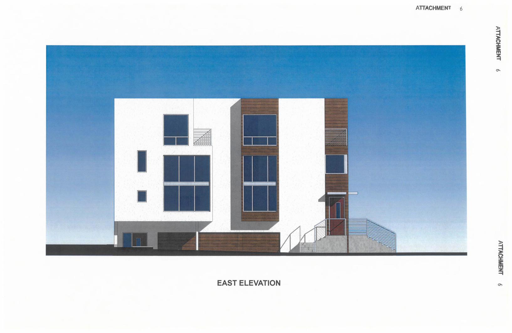
east elevation - san diego
TRANSCRIPT
AlTACHMENT .~6
EAST ELEVATION

ATTACHMENT 6
NORTH ELEVATION

ATTACHMENT .6
SOUTH ELEVATION

WEST ELEVATION
I
!I
II --
~---
rTACHMENT 6

Attachment 7
RESOLUTION NUMBER R- _
DATE OF FINAL PASSAGE--------
VACATION OF DRAINAGE EASEMENT AT 7452 AND7460 HERSCHEL AVENUE
WHEREAS, California Streets and Highways Code section 8320 et seq. San Diego
Municipal Code section 125.1001 et seq. provide a procedure for the summary vacation of public
easements by City Council resolution; and
WHEREAS, it is proposed that Drainage Easement No. 652678 be vacated; and
WHEREAS, under Charter Section 280(a)(2), this resolution is not subject to veto by the
Mayor because this matter requires the City Council to act as a quasi-judicial body, a public
hearing was required by law implicating due process rights of individuals affected by the
decision, and the Council was required by law to consider evidence at the hearing and to make
legal findings based on the evidence presented; and
WHEREAS, the matter was set for public hearing on _
testimony having been heard, evidence having been submitted, and the City Council having fully
considered the matter and being fully advised concerning the same; NOW, THEREFORE,
BE IT RESOLVED, by the Council of the City of San Diego, that with respect to six foot
drainage easement between Pearl Street and approximately parallel to Herschel Avenue, the
Council finds that:
(a) There is no present or prospective use for the easement, either for the facility
or purpose for which it was originally acquired, or for any other public use of a like nature
that can be anticipated.
-PAGE 1 OF 4-

Attachment 7
In that the twenty-four inch storm drain pipe will be relocated within the public right-of
way of Herschel Avenue and Pearl Street, the existing easement and abandoned existing storm
drain pipe will have no prospective use. The new twenty-four inch storm drain pipe will serve
the drainage needs which necessitated the original pipe and easement. There is no other use of a
like nature for this specific easement which can be reasonably anticipated.
(b) The public will benefit from the abandonment through improved utilization
of the land made available by the abandonment.
Presently the properties which have the drainage easement over them are limited by the
existence of the easement in that the properties may not redevelop or place new buildings over
the area of the existing easement. The adopted La Jolla Community Plan designates these sites
for a recommended density greater than the existing development. Without the vacation or
abandonment of the existing easement new buildings may not be placed over the area of the
easement and thus without the vacation of the easement the recommended density of the adopted
La Jolla Community Plan may not be realized. Without the redevelopment of the property three
new dwelling units would not be available to add to the housing stock of the City. The public
will benefit by the vacation of the easement through the addition of new housing opportunities,
the increase in property tax revenue, the improved utilization of urban land and the development
of new housing units designed and constructed to current state and local code requirements.
(c) The abandonment is consistent with any applicable land use plan.
The adopted La Jolla Community Plan identifies this property for Medium High
Residential density development. The abandonment of the drainage easement will facilitate the
redevelopment of the site at the density recommended by the adopted La Jolla Community Plan
and without the abandonment of the easement the recommended density for this site as identified
-PAGE 2 OF 4-

Attachment 7
by the La Jolla Community Plan would not be realized. For these reasons the proposed easement
abandonment is consistent with the policies and goals of the adopted La Jolla Community Plan.
(d) The public facility or purpose for which the easement was originally
acquired will not be detrimentally affected by this abandonment or the purpose for which
the easement was acquired no longer exists.
The easement was acquired for the purposes of placing and maintaining a public storm
drain pipe of twenty-four inches in diameter to serve the drainage needs of the neighborhood.
With the relocation of a new twenty-four inch storm drain pipe to the public right-of-way of
Herschel Avenue, the easement will no longer be necessary. With the relocation of a new
twenty-four inch storm drain pipe to the public right-of-way of Herschel Avenue the drainage
needs of the neighborhood will continue to be served and the purpose for which the drainage
easement was acquired will cease its material necessity to meet the drainage needs of the
neighborhood.
BE IT FURTHER RESOLVED, that the drainage easement located within 7452 and
7460 Herschel Avenue in connection with Coastal Development Permit No. 472934 and
Tentative Map Waiver No. 477793, as more particularly described in the legal description
marked as Exhibit "A," and shown on Drawing No. 21055-B, marked as Exhibit "B,'~ which are
by this reference incorporated herein and made a part hereof, is ordered vacated.
BE IT FURTHER RESOLVED, that said easement abandonment is conditioned upon the
relocation of the existing twenty-four inch storm drain to the satisfaction of the City Engineer,
including the City Engineer's inspection and acceptance of all related work. In the event this
condition is not completed within three years following the adoption of this resolution, then this
resolution shall become void and be of no further force or effect.
-PAGE 3 OF 4-

Attachment 7
BE IT FURTHER RESOLVED, that the Development Services Department shall record
a certified copy of this resolution with attached exhibits, attested by the City Clerk under seal, in
the office of the County Recorder.
APPROVED: JAN I. GOLDSMITH, City Attorney
By[Attorney]Deputy City Attorney
[Initials] :[Initials][Month]/[Day]/[Year]Or.Dept: [Dept]JO: 438154Drawing No. [INSERT Drawing No.]R-Error! Reference source not found.General Formal Easement Abandonment 4-13-09 Fonn.doc
-PAGE 4 OF 4-

Attachment 8
(R-INSERT)
RESOLUTION NUMBER R-__~
DATE OF FINAL PASSAGE.__~
A RESOLUTION GRANTING MAP WAIVERNO. 477793 FOR THE HABITERRA PROJECT,PROJECT NO. 136041
WHEREAS, Marco Sanchez and Enrique Salcedo, Applicant/Subdivider, and
Richard E. Matter, Engineer, submitted an application with the City of San Diego for
Map Waiver No. 477793 to waive the requirement for a Tentative Map to demolish
existing improvements and construct a four unit condominium and to waive the
requirement to underground existing overhead utilities. The project site is located 7460
Herschel Avenue within the La Jolla Community Plan area, and legally described as
portions of Lots 30, 31, and 32, Block 16, Center Addition to La Jolla Park, Map
No. 915, filed August 4, 1904, in the La Jolla Community Plan area, in the RM-3-7,
Coastal Overlay, Coastal Height Limit, Parking Impact, and Residential Tandem Parking
Overlay Zones; and
WHEREAS the map proposes the subdivision of a 0.11 acre site into one (1) lot
for a four unit residential condominium; and
WHEREAS, the project is exempt from environmental review pursuant to Section
15332 of the California Environmental Quality Act (CEQA) on the basis that the
facilities are existing; and
Page 1 of 10

Attachment 8
WHEREAS, a preliminary soils and geological reconnaissance report are waived
by the City Engineer pursuant to the Subdivision Map Act and Section 144.0220 of the
Municipal Code of the City of San Diego; and
WHEREAS, the subdivision is a condominium project as defined in Section 1350
et seq. of the Civil Code of the State of California and filed pursuant to the Subdivision
Map Act. The total number of condominium dwelling units is four; and
WHEREAS, the requested underground waiver of the existing overhead facilities,
qualifies under the guidelines of Council Policy No. 600 25-Underground Conversion of
Utility Lines at Developers Expense in that:
The conversion involves a short span of overhead facility, less than a full block in length,
and it has been determined that such conversion is not a part of a continuing effort to
accomplish a total undergrounding within a specific street or area.
WHEREAS, on V13 - HEARING DATE, the Council of the City of San Diego
considered Tentative Map Waiver No. 477793 including the waiver of the requirement to
underground existing overhead utilities, and pursuant to Sections 125.0122 and 144.0240
of the Municipal Code of the City of San Diego and Subdivision Map Act Section 66428,
received for its consideration written and oral presentations, evidence having been
submitted, and heard testimony from all interested parties at the public hearing, and the
Page 2 of 10

Attachment 8
City Council having fully considered the matter and being fully advised concerning the
same; NOW THEREFORE,
BE IT RESOLVED by the Council of the City of San Diego, that it adopts the following
findings with respect to Tentative Map Waiver No. 477793:
1. The proposed subdivision and its design or improvement are consistent withthe policies, goals, and objectives of the applicable land use plan (LandDevelopment Code Section 125.0440.a and State Map Act Sections 66473.5,66474(a), and 66474(b». The proposed project is a subdivision of the propertyto create four condominium ownership interests, and complies with thedevelopment regulations of the RM-3-7 Zone in the La Jolla Community Planwhich identifies the site for medium high residential development at a densityrange of 30-45 dwelling units per acre. The proposed subdivision complies withthe policies, goals, and objectives of the applicable land use plan.
2. The proposed subdivision complies with the applicable zoning anddevelopment regulations of the Land Development Code (Land DevelopmentCode Section 125.0440. (b). The proposed project is a subdivision of theproperty to create four condominium ownership interests, and complies with thedevelopment regulations of the RM-3-7 Zone in the La Jolla Community Planwhich identifies the site for medium high residential development at a densityrange of 30-45 dwelling units per acre. Development of the property will meet allrequirements of these regulations. In these ways the proposed development willcomply with the applicable and relevant regulations of the Land DevelopmentCode.
3. The site is physically suitable for the type and density of development (LandDevelopment Code Section 125.0440.(c) and State Map Act Sections 66474(c)and 66474(d». The proposed project is a subdivision of the property to createfour condominium ownership interests, and complies with the developmentregulations of the RM-3-7 Zone in the La Jolla Community Plan which identifiesthe site for medium high residential development at a density range of 30-45dwelling units per acre. Development of the property will meet all requirementsof these regulations. Therefore, the site is physically suitable for the type anddensity of development.
4. The design of the subdivision or the proposed improvements are not likely tocause substantial environmental damage or substantially and avoidableinjure fish or wildlife or their habitat (Land Development Code Section
Page 3 of 10

Attachment 8
125.0440.d and State Map Act Section 66474(ej), The proposed subdivision isexempt from environmental review pursuant to Article 19, Section 15332, In-FillDevelopment, of the California Environmental Quality Act (CEQA). Theproposed project is a subdivision of the property to create four condominiumownership interests and would not likely to cause substantial environmentaldamage or substantially and avoidable injure fish or wildlife or their habitat.
5. The design of the subdivision or the type of improvements will not bedetrimental to the public health, safety, and welfare (Land DevelopmentCode Section 125.0440.e and State Map Act Section 66474(t). The proposedproject is a subdivision of the property to create four condominium ownershipinterests, and would not be detrimental to the public health, safety, and welfare.
6. The design of the subdivision or the type of improvements will not conflictwith easements acquired by the public at large for access through or use ofproperty within the proposed subdivision (Land Development Code Section125.0440.f and State Map Act Section 66474(g». An existing drainageeasement will be vacated and existing facilities relocated from within the projectboundaries as shown on Map Waiver No. 655907 to the public right-of-way. Assuch no conflict will occur with the recording of the subdivision and therefore noconflict will result which would negatively affect the public at large.
7. The design of the proposed subdivision provides, to the extent feasible, forfuture passive or natural heating and cooling opportunities (LandDevelopment Code Section 125.0440.g and State Map Act Section 66473.1).The proposed project is a subdivision of the property to create four condominiumownership interests, and would not be impact future passive or natural heating andcooling opportunities.
8. The decision maker has considered the effects of the proposed subdivision onthe housing needs of the region and that those needs are balanced against theneeds for public services and the available fiscal and environmentalresources (Land Development Code Section 125.0440.h and State Map ActSection 66412.3). The proposed project is a subdivision of the property to createfour condominium ownership interests, and would not impact the housing withinthe region, public services, or the available fiscal and environmental resources.
9. The requested underground waiver of the existing overhead facilities,qualifies under the guidelines of Council Policy No. 600-25 UndergroundConversion ofUtility Lines at Developers Expense in that:
The conversion involves a short span of overhead facility of less than a full blockin length and it has been determined that such conversion is not a part of acontinuing effort to accomplish a total undergrounding within a specific street orarea.
Page 4 of 10

Attachment 8
That said Findings are supported by the minutes, maps, and exhibits, all of which are
herein incorporated by reference.
BE IT FURTHER RESOLVED that, based on the Findings hereinbefore adopted by the
City Council, Tentative Map Waiver No. 477793 including the waiver of the
requirement to underground existing overhead utilities, is hereby granted to Marco
Sanchez and Enrique Salcedo, Applicant/Subdivider, subject to the following conditions:
PASSED AND ADOPTED BY THE COUNCIL OF THE CITY OF SAN DIEGO,
CALIFORNIA, ON V13 - HEARING DATE [IN CAPS].
APPROVED: JAN I. GOLDSMITH, City Attorney
By _
NAMEDeputy City Attorney
Page 5 of 10

Attachment 8
CONDITIONS FOR MAP WAIVER NO. 477793
HABITERRA PROJECTPROJECT NO. 136041
ADOPTED BY RESOLUTION NO. R- ON ---"-
GENERAL
1. This Tentative Map Waiver will expire INSERT DATE - 3 YEARS FROMDECISION DATE.
2. Compliance with all of the following conditions shall be assured, to thesatisfaction of the City Engineer, prior to the recordation of the Parcel Map unlessotherwise noted.
3. Prior to the Tentative Map Waiver expiration date, a Parcel Map to consolidatethe existing lots into one lot shall be recorded in the Office of the CountyRecorder.
4. Prior to recording of the Parcel Map taxes must be paid on this property pursuantto section 66492 of the Subdivision Map Act. A tax certificate, recorded in theoffice of the County Recorder, must be provided to satisfy this condition.
5. The Parcel Map shall conform to the provisions of Coastal Development PermitNo. 472934.
6. The Subdivider shall defend, indemnify, and hold the City (including its agents,officers, and employees [together, "Indemnified Parties"] harmless from anyclaim, action, or proceeding, against any Indemnified Party to attack, set aside,void, or annul City's approval of this project, which action is brought within thetime period provided for in Government Code section 66499.37. City shallpromptly notify Subdivider of any claim, action, or proceeding and shallcooperate fully in the defense. If City fails to cooperate fully in the defense,Subdivider shall not thereafter be responsible to defend, indemnify, or hold Cityharmless. City may participate in the defense of any claim, action, or proceedingif City both bears its own attorney's fees and costs, and defends the action in goodfaith. Subdivider shall not be required to payor perform any settlement unlesssuch settlement is approved by the Subdivider.
ENGINEERING
7. The Subdivider shall relocate the existing public drain, which currently crossesthe site, to public right-of-way, satisfactory to the City Engineer.
Page 6 of 10
Attachment 8
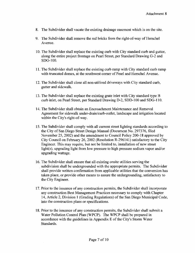
8. The Subdivider shall vacate the existing drainage easement which is on the site.
9. The Subdivider shall remove the red bricks from the right-of-way of HerschelAvenue.
10. The Subdivider shall replace the existing curb with City standard curb and gutter,along the entire project frontage on Pearl Street, per Standard Drawing G-2 andSDG-I00.
11. The Subdivider shall replace the existing curb ramp with City standard curb rampwith truncated domes, at the southwest comer of Pearl and Herschel Avenue.
12. The Subdivider shall close all non-utilized driveways with City standard curb,gutter and sidewalk.
13. The Subdivider shall replace the existing grate inlet with City standard type Bcurb inlet, on Pearl Street, per Standard Drawing D-2, SDD-I00 and SDG-II0.
14. The Subdivider shall obtain an Encroachment Maintenance and RemovalAgreement for sidewalk under-drainlcurb-outlet, landscape and irrigation locatedwithin the City's right-of-way.
15. The Subdivider shall comply with all current street lighting standards according tothe City of San Diego Street Design Manual (Document No. 297376, filedNovember 25,2002) and the amendment to Council Policy 200-18 approved byCity Council on February 26, 2002 (Resolution R-296141) satisfactory to the CityEngineer. This may require, but not be limited to, installation of new streetIighus), upgrading light from low pressure to high pressure sodium vapor and/orupgrading wattage.
16. The Subdivider shall ensure that all existing onsite utilities serving the. subdivision shall be undergrounded with the appropriate permits. The Subdivider
shall provide written confirmation from applicable utilities that the conversion hastaken place, or provide other means to assure the undergrounding, satisfactory tothe City Engineer.
17. Prior to the issuance of any construction permits, the Subdivider shall incorporateany construction Best Management Practices necessary to comply with Chapter14, Article 2, Division 1 (Grading Regulations) of the San Diego Municipal Code,into the construction plans or specifications.
18. Prior to the issuance of any construction permits, the Subdivider shall submit aWater Pollution Control Plan (WPCP). The WPCP shall be prepared inaccordance with the guidelines in Appendix E of the City's Storm WaterStandards.
Page 7 of 10

Attachment 8
19. The Subdivider shall underground any new service run to any new or proposedstructures within the subdivision.
20. The Subdivider shall ensure that all existing onsite utilities serving thesubdivision shall be undergrounded with the appropriate permits. The Subdividershall provide written confirmation from applicable utilities that the conversion hastaken place, or provide other means to assure the undergrounding, satisfactory tothe City Engineer.
21. Conformance with the "General Conditions for Tentative Subdivision Maps,"filed in the Office of the City Clerk under Document No. 767688 on May 7, 1980,is required. Only those exceptions to the General Conditions which are shown onthe Map Waiver and covered in these special conditions will be authorized.
22. All public improvements and incidental facilities shall be designed in accordancewith criteria established in the Street Design Manual, filed with the City Clerk asDocument No. 769830.
MAPPING
23. "Basis of Bearings" means the source of uniform orientation of all measuredbearings shown on the map. Unless otherwise approved, this source will be the,California Coordinate System, Zone 6, North American Datum of 1983 (NAD83).
24. "California Coordinate System means the coordinate system as defined in Section8801 through 8819 of the California Public Resources Code. The specified zonefor San Diego County is "Zone 6," and the official datum is the "North AmericanDatum of 1983."
25. Every Parcel Map shall:
a. Use the California Coordinate System for its "Basis of Bearing" andexpress all measured and calculated bearing values in terms of saidsystem. The angle of grid divergence from a true median (theta ormapping angle) and the north point of said map shall appear on each sheetthereof. Establishment of said Basis of Bearings may be by use of existingHorizontal Control stations or astronomic observations.
b. Show two measured ties from the boundary of the map to existingHorizontal Control stations having California Coordinate values of ThirdOrder accuracy or better. These tie lines to the existing control shall beshown in relation to the California Coordinate System (i.e., grid bearingsand grid distances). All other distances shown on the map are to be shown
Page 8 of 10

Attachment 8
as ground distances. A combined factor for conversion of grid-to-grounddistances shall be shown on the map.
26. The design of the subdivision shall include private easements, if any, servingparcels of land outside the subdivision boundary or such easements must beremoved from the title of the subdivided lands prior to filing any parcel or finalmap encumbered by these easements.
SEWER AND WATER
27. The Subdivider agrees to design and construct all proposed public water facilitiesin accordance with established criteria in the most current edition of the City ofSan Diego Water Facility Design Guidelines and City regulations, standards andpractices pertaining thereto. Water facilities as shown on the approved tentativemap shall be modified at final engineering to comply with standards.
INFORMATION:
• The approval of this Tentative Map Waiver by the Council of the City of SanDiego does not authorize the Subdivider to violate any Federal, State, or Citylaws, ordinances, regulations, or policies including but not limited to, the FederalEndangered Species Act of 1973 and any amendments thereto (16 USC Section1531 et seq.).
• If the Subdivider makes any request for new water and sewer facilities (includingservices, fire hydrants, and laterals), then the Subdivider shall design andconstruct such facilities in accordance with established criteria in the most currenteditions of the City of San Diego water and sewer design guides and Cityregulations, standards and practices pertaining thereto. Off-site improvementsmay be required to provide adequate and acceptable levels of service and will bedetermined at final engineering.
• Subsequent applications related to this Tentative Map Waiver will be subject tofees and charges based on the rate and calculation method in effect at the time ofpayment.
• Any party on whom fees, dedications, reservations, or other exactions have beenimposed as conditions of approval of the Tentative Map Waiver, may protest theimposition within 90 days of the approval of this Tentative Map Waiver by filinga written protest with the City Clerk pursuant to California Government CodeSection 66020.
• Where in the course of development of private property, public facilities aredamaged or removed the property owner shall at no cost to the City obtain therequired permits for work in the public right-of-way, and repair or replace the
Page 9 of 10

Attachment 8
public facility to the satisfaction of the City Engineer. Municipal Code Section142.0607.
• This development may be subject to impact fees, as established by the CityCouncil, at the time of issuance of building permits.
• This development may be subject to payment of School Impact Fees at the time ofissuance of building permits, as provided by Education Code Section 17620, inaccordance with procedures established by the Director of Building Inspection.
Page 10 of 10

Attachment 9
(R-INSERT)
RESOLUTION NUMBER R-NUMBER
ADOPTED ON DATETb( @3Tb)
WHEREAS, Marco Sanchez and Enrique Salcedo, Owner/Permittee, filed an application
with the City of San Diego for a Coastal Development Permit No. 472934 to demolish the
existing building and construct four residential condominium units known as the Habiterra
project, located at 7460 Herschel Avenue, and legally described as portions of Lots 30, 31, and
32,Block 16, Center Addition to La Jolla Park, Map No. 915, filed August 4, 1904, in the La
Jolla Community Plan area, in the RM-3-7, Coastal Overlay, Coastal Height Limit, Parking
Impact, and Residential Tandem Parking Overlay Zones; and
WHEREAS, on INSERT DATE, the Planning Commission of the City of San Diego
considered Coastal Development Permit [CDP] No. 472934, and pursuant to Resolution No.
PCReso#-PC voted to recommend City Council approval of the permit; and
WHEREAS, the matter was set for public hearing on DATE, testimony having been
heard, evidence having been submitted, and the City Council having fully considered the matter
and being fully advised concerning the same; NOW, THEREFORE,
BE IT RESOLVED, by the Council of the City of San Diego, that it adopts the following
findings with respect to CDP Permit No.472934:
Coastal Development Permit - Section 126.0708
1. The proposed coastal development will not encroach upon any existing physicalaccess way that is legally used by the public or any proposed public accessway identified ina Local Coastal Program land use plan; and the proposed coastal development willenhance and protect public views to and along the ocean and other scenic coastal areas asspecified in the Local Coastal Program land use plan.
The proposed project is located at 7460 Herschel Avenue on a 0.11 acre site in the RM-3-7,Coastal Overlay, Coastal Height Limit, Parking Impact, and Residential Tandem Parking Overlay
Page 1 of3

Attachment 9
Zones within the La Jolla Community Plan. The project proposes to demolish an existingbuilding and construct a four unit condominium project. The proposed condominium projectwill be developed entirely within the private property and will not encroach upon any existingphysical access way legally used by the public or any proposed public accessway identified in aLocal Coastal Program land use plan in as much as there are no legally used by the public or anyproposed public accessways located on the private property. The proposed development will beconstructed completely within the boundaries of the private property and will observe allrequired yard setbacks. The La Jolla Community Plan and Local Coastal Program identify thelocation of all public view corridors within the community and do not identify any such corridorwithin or along Herschel Avenue. From the property at 7460 Herschel Avenue there are noviews to the ocean or other scenic coastal areas. As such the proposed project will have no effectupon the public views to and along the ocean and other scenic coastal areas as identified in theLocal Coastal Program land use plan.
2. The proposed coastal development will not adversely affect environmentallysensitive lands.
The proposed project is located at 7460 Herschel Avenue on a 0.11 acre site in the RM-3-7,Coastal Overlay, Coastal Height Limit, Parking Impact, and Residential Tandem Parking OverlayZones within the La Jolla Community Plan. The project proposes to demolish an existingbuilding and construct a four unit condominium project. The site has been previously developedwith a single family structure, landscaping and other minor site improvements. There are nosensitive habitats or species located on the site nor is the site adjacent to the City of San Diego'sMulti-Habitat Planning Area. The proposed project will have no significant environmental effectand is categorically exempt under the California Environmental Quality Act. In the absence ofany environmentally sensitive lands present on the site the proposed development will have noadverse affect to or upon environmentally sensitive lands.
3. The proposed coastal development is in conformity with the certified Local CoastalProgram land use plan and complies with all regulations of the certified ImplementationProgram.
The proposed project is located at 7460 Herschel Avenue on a 0.11 acre site in the RM-3-7,Coastal Overlay, Coastal Height Limit, Parking Impact, and Residential Tandem Parking OverlayZones within the La Jolla Community Plan. The project proposes to demolish an existingbuilding and construct a four unit condominium project. The proposed project is located withinthe La Jolla Community Plan area on a parcel designated for Medium High residential use whichwould provide for a density range of thirty to forty dwelling units per acre. The site measures0.11 acres and would be allowed a maximum density of three to four dwelling units. Theproposed density is consistent with the land use designation. The project would adhere topolicies and objectives established by the community plan in that the design of the proposedstructure does not affect any existing physical access way that is legally used by the public or anyproposed public accessway identified in a Local Coastal Program land use plan. Furthermore theproposed project will have a harmonious physical and aesthetic relationship with other existingstructures in the neighborhood. Being determined the proposed project will be consistent withthe La Jolla Community Plan policies and objectives the project is in conformity with the
Page 2 of3

Attachment 9
certified Local Coastal Program land use plan and complies with all regulations of the certifiedImplementation Program.
4. For every Coastal Development Permit issued for any coastal developmentbetween the nearest public road and the sea or the shoreline of any body of water locatedwithin the Coastal Overlay Zone the coastal development is in conformity with the publicaccess and public recreation policies of Chapter 3 of the California Coastal Act.
The proposed project is located at 7460 Herschel Avenue on a 0.11 acre site in the RM-3-7,Coastal Overlay, Coastal Height Limit, Parking Impact, and Residential Tandem Parking OverlayZones within the La Jolla Community Plan. The project proposes to demolish an existingbuilding and construct a four unit condominium project. The project site is not located betweenthe nearest public road and the sea or the shoreline of any body of water located within theCoastal Overlay Zone. Therefore, the proposed project to demolish an existing building andconstruct a four unit condominium project will have no affect upon public access and therecreation policies of Chapter 3 of the California Coastal Act and therefore be in conformancewith such Act.
The above findings are supported by the minutes, maps and exhibits, all of which are
herein incorporated by reference.
BE IT FURTHER RESOLVED, that the recommendation of the Planning Commission is
sustained, and Coastal Development Permit No. 472934 is granted to Marco Sanchez and
Enrique Salcedo, Owner/Permittee, under the terms and conditions set forth in the permit
attached hereto and made a part hereof.
APPROVED: JAN I. GOLDSMITH, City Attorney
ByNAMEDeputy City Attorney
ATTY/SEC. INITIALSDATEOr.Dept:ClerkR-INSERTForm=permitr.frm(61203wct)Reviewed by John S. Fisher
Page 3 of3

Attachment 10
RECORDING REQUESTED BYCITY OF SAN DIEGO
DEVELOPMENT SERVICESPERMIT INTAKE, MAIL STATION 501
WHEN RECORDED MAIL TOCITY CLERK
MAIL STATION 2A
SPACE ABOVE THIS LINE FOR RECORDER'S USEJOB ORDER NUMBER: 42-8154
COASTAL DEVELOPMENT PERMIT NO.472934HABITERRA - PROJECT NO. 136041
CITY COUNCIL
This Coastal Development Permit No.472934 is granted by the Council of the City of San Diegoto MARCO SANCHEZ and ENRIQUE SALCEDO, Owner/Permittee, pursuant to San DiegoMunicipal Code [SDMC] section 126.0708. The 0.11 acre site is located at 7460 HerschelAvenue in the RM-3-7, Coastal Overlay, Coastal Height Limit, Parking Impact, and ResidentialTandem Parking Overlay Zones within the La Jolla Community Plan. The project site is legallydescribed as portions of Lots 30, 31, and 32, Block 16, Center Addition to La Jolla Park, MapNo. 915, filed August 4, 1904.
Subject to the terms and conditions set forth in this Permit, permission is granted toOwner/Permittee to demolish the existing building and construct four residential condominiumunits, described and identified by size, dimension, quantity, type, and location on the approvedexhibits [Exhibit "A"] dated [INSERT Approval Date] , on file in the Development ServicesDepartment.
The project shall include:
a. Demolition of the existing building and other site improvements and construction of afour unit residential condominium development;
b. Landscaping (planting, irrigation and landscape related improvements);
c. Off-street parking;
d. Accessory improvements determined by the Development Services Department to beconsistent with the land use and development standards in effect for this site per theadopted community plan, California Environmental Quality Act Guidelines, public andprivate improvement requirements of the City Engineer, the underlying zone(s),conditions of this Permit, and any other applicable regulations of the SDMC in effectfor this site.
Page 1 of8

Attachment 10
STANDARD REQUIREMENTS:
1. This permit must be utilized within thirty-six (36) months after the date on which all rightsof appeal have expired. Failure to utilize and maintain utilization of this permit as described inthe SDMC will automatically void the permit unless an Extension of Time has been granted.Any such Extension of Time must meet all SDMC requirements and applicable guidelines inaffect at the time the extension is considered by the appropriate decision maker.
2. No permit for the construction, occupancy or operation of any facility or improvementdescribed herein shall be granted, nor shall any activity authorized by this Permit be conductedon the premises until:
a. The Owner/Permittee signs and returns the Permit to the Development ServicesDepartment; and
b. The Permit is recorded in the Office of the San Diego County Recorder.
3. Unless this Permit has been revoked by the City of San Diego the property included byreference within this Permit shall be used only for the purposes and under the terms andconditions set forth in this Permit unless otherwise authorized by the Development ServicesDepartment.
4. This Permit is a covenant running with the subject property and shall be binding upon theOwner/Permittee and any successor or successors, and the interests of any successor shall besubject to each and every condition set out in this Permit and all referenced documents.
5. The continued use of this Permit shall be subject to the regulations of this and any otherapplicable governmental agency.
6. Issuance of this Permit by the City of San Diego does not authorize the Owner/Permitteefor this permit to violate any Federal, State or City laws, ordinances, regulations or policiesincluding, but not limited to, the Endangered Species Act of 1973 [ESA] and any amendmentsthereto (16 U.S.C. § 1531 et seq.).
7. The Owner/Permittee shall secure all necessary building permits. The Owner/Permittee isinformed that to secure these permits, substantial modifications to the building and siteimprovements to comply with applicable building, fire, mechanical and plumbing codes andState law requiring access for disabled people may be required.
8. Construction plans shall be in substantial conformity to Exhibit "A." No changes,modifications or alterations shall be made unless appropriate application(s) or amendment(s) tothis Permit have been granted.
9. All of the conditions contained in this Permit have been considered and have beendetermined to be necessary in order to make the findings required for this Permit. It is the intent
Page 2 of8

Attachment 10
of the City that the holder of this Permit be required to comply with each and every condition inorder to be afforded the special rights which the holder of the Permit is entitled as a result ofobtaining this Permit.
In the event that any condition of this Permit, on a legal challenge by the Owner/Permitteeof this Permit, is found or held by a court of competent jurisdiction to be invalid, unenforceable,or unreasonable, this Permit shall be void. However, in such an event, the Owner/Permittee shallhave the right, by paying applicable processing fees, to bring a request for a new permit withoutthe "invalid" conditions(s) back to the discretionary body which approved the Permit for adetermination by that body as to whether all of the findings necessary for the issuance of theproposed permit can still be made in the absence of the "invalid" condition(s). Such hearingshall be a hearing de novo and the discretionary body shall have the absolute right to approve,disapprove, or modify the proposed permit and the condition(s) contained therein.
10. The Owner/Permittee shall defend, indemnify, and hold harmless the City, its agents,officers, and employees from any and all claims, actions, proceedings, damages, judgments, orcosts, including attorney's fees, against the City or its agents, officers, or employees, relating tothe issuance of this permit including, but not limited to, any action to attack, set aside, void,challenge, or annul this development approval and any environmental document or decision. TheCity will promptly notify Owner/Permittee of any claim, action, or proceeding and, if the Cityshould fail to cooperate fully in the defense, the Owner/Permittee shall not thereafter beresponsible to defend, indemnify, and hold harmless the City or its agents, officers, andemployees. The City may elect to conduct its own defense, participate in its own defense, orobtain independent legal counsel in defense of any claim related to this indemnification. In theevent of such election, Owner/Permittee shall pay all of the costs related thereto, includingwithout limitation reasonable attorney's fees and costs. In the event of a disagreement betweenthe City and Owner/Permittee regarding litigation issues, the City shall have the authority tocontrol the litigation and make litigation related decisions, including, but not limited to,settlement or other disposition of the matter. However, the Owner/Permittee shall not be requiredto payor perform any settlement unless such settlement is approved by Owner/Permittee.
AFFORDABLE HOUSING REQUIREMENTS:
11. Prior to the issuance of the first residential building permit, the Owner/Permittee shallcomply with the affordable housing requirements of the City's Inclusionary Housing Ordinance(Chapter 14, Article 2, Division 13 of the Land Development Code) by payment of theInc1usionary Housing In-Lieu Fee.
ENGINEERING REQUIREMENTS:
12. The Coastal Development Permit shall comply with all conditions of the Tentative MapWaiver 477793.
13. Prior to foundation inspection, the Owner/Permittee shall submit a building padcertification signed by a Registered Civil Engineer or a Licensed Land Surveyor, certifying thatthe pad elevation based on USGS datum is in accordance with the approved plans.
Page 3 of8

Attachment 10
14. Prior to the issuance of the first residential building permit, the Owner/Permittee shallassure by permit and bond the relocation of the existing twenty-four inch storm drain to thesatisfaction of the City Engineer, including the City Engineer's inspection and acceptance of allrelated work.
LANDSCAPE REQUIREMENTS:
15. Prior to issuance of construction permits for public right-of-way improvements, theOwner/Permittee shall submit complete landscape construction documents for right-of-wayimprovements to the Development Services Department for approval. Improvement plans shallprovide for a forty square foot area around each tree which is unencumbered by utilities.Driveways, utilities, drains, water and sewer laterals shall be designed so as not to prohibit theplacement of street trees.
16. In the event that a foundation only permit is requested by the Owner/Permittee, a site planor staking layout plan shall be submitted identifying all landscape areas consistent with Exhibit'"A." These landscape areas shall be clearly identified with a distinct symbol, noted withdimensions and labeled as 'landscaping area.'
17. Prior to issuance of any construction permits for buildings; the Owner/Permittee shallsubmit complete landscape and irrigation construction documents consistent with the LandDevelopment Manual, Landscape Standards to the Development Services Department forapproval. The construction documents shall be in substantial conformance with Exhibit ~~A."
18. Prior to Final Inspection, it shall be the responsibility of the Owner/Permittee to install allrequired landscape. A "No Fee" Street Tree Permit, if applicable, shall be obtained for theinstallation, establishment, and on-going maintenance of all street trees.
19. The Owner/Permittee shall maintain all landscape in a disease, weed and litter freecondition at all times. Severe pruning or "topping" of trees is not permitted. The trees shall bemaintained in a safe manner to allow each tree to grow to its mature height and spread.
20. The Owner/Permittee shall be responsible for the maintenance of all landscapeimprovements in the right-of-way consistent with the Land Development Manual, LandscapeStandards unless long-term maintenance of said landscaping will be the responsibility of aLandscape Maintenance District or other approved entity. In this case, a Landscape MaintenanceAgreement shall be submitted for review by a Landscape Planner.
21. If any required landscape, including existing or new plantings, hardscape, landscapefeatures, or other improvements, indicated on the approved construction document plans isdamaged or removed during demolition or construction, the Owner/Permittee shall be required torepair and/or replace any landscape in kind and equivalent size per the approved documents tothe satisfaction of the Development Services Department within 30 days of damage or prior to aFinal Landscape Inspection.
Page 4 of8

Attachment 10
PLANNINGIDESIGN REQUIREMENTS:
22. No fewer than six off-street parking spaces [seven provided] shall be maintained on theproperty at all times in the approximate locations shown on the approved Exhibit "A." Parkingspaces shall comply at all times with the SDMC and shall not be converted for any other useunless otherwise authorized by the Development Services Department.
23. A topographical survey conforming to the provisions of the SDMC may be required if it isdetermined, during construction, that there may be a conflict between the building(s) underconstruction and a condition of this Permit or a regulation of the underlying zone. The cost ofany such survey shall be borne by the Owner/Permittee,
24. There shall be compliance with the regulations of the underlying zone(s) unless a deviationor variance to a specific regulation(s) is approved or granted as condition of approval of thispermit. Where there is a conflict between a condition (including exhibits) of this permit and aregulation of the underlying zone, the regulation shall prevail unless the condition provides for adeviation or variance from the regulations.
25. The height(s) of the building(s) or structure(s) shall not exceed those heights set forth in theconditions and the exhibits including, but not limited to, elevations and cross sections, or themaximum permitted building height of the underlying zone, whichever is lower.
26. A topographical survey conforming to the provisions of the Municipal/Land DevelopmentCode may be required if it is determined, during construction, that there may be a conflictbetween the building(s) under construction and a condition of this permit or a regulations of theunderlying zone. The cost of any such survey shall be borne by the Owner/Permittee.
27. All signs shall comply with the San Diego Municipal Code Chapter 14, Article 2, Division12, Sign Regulations.
28. All fences and retaining walls shall comply with the San Diego Municipal Code Section142.0301.
29. No structures or other encroachments over three feet in height are permitted within thevisibility triangle.
TRANSPORTATION REQUIREMENTS
30. Prior to the issuance of the first building permit, the Owner/Permittee shall assure by permitand bond the closure of all under-utilized driveways along the project's frontage and replace withcurb, gutter and sidewalk, satisfactory to the City Engineer.
31. Prior to the issuance of the first building permit, the Owner/Permittee shall assure by permitand bond the construction of a twenty foot wide driveway along the project's frontage on PearlStreet, satisfactory to the City Engineer.
Page 5 of8

Attachment 10
32. Prior to the issuance of the first building permit, the Owner/Permittee shall assure by permitand bond the construction ofa maximum of twenty-five foot wide driveway along the project'sfrontage on Herschel Avenue, satisfactory to the City Engineer.
33. The Owner/Permittee shall provide and maintain adequate visibility area on both sides ofthe two proposed driveways along the setback lines of Pearl Street and Herschel Avenue. Noobstacles higher than thirty-six inches shall be located within this area, including yet not limitedto walls, landscaping, or other improvements.
34. The "study" area as shown on the Exhibit "A" shall not be converted to any other useincluding a bedroom at any time. The restriction on the change of use for "Study" area shall bereflected and disclosed on any future lease and/or sale agreement(s) of the dwelling units on thisproperty.
WASTEWATER REQUIREMENTS:
35. Prior to the issuance of any building permits, the Owner/Permittee shall provide anEncroachment Maintenance Removal Agreement for the private shared lateral in the public rightof-way.
36. All on-site wastewater systems shall be private.
37. All proposed public sewer facilities are to be designed and constructed in accordance withestablished criteria in the most current City of San Diego Sewer Design Guide.
38. All proposed private sewer facilities located within a single lot are to be designed to meetthe requirements of the California Uniform Plumbing Code and will be reviewed as part of thebuilding permit plan check.
39. No trees shall be installed within ten feet of any sewer facilities or in any sewer accesseasement. No shrubs exceeding three feet in height at maturity shall be installed within ten feetof any public sewer main or within access easements.
WATER REQUIREMENTS:
40. Prior to the issuance of any building permits, the Owner/Permittee shall assure, by permitand bond, the design and construction of new water service(s) as needed, and the removal of allexisting unused services, within the Hershel Avenue and Pearl Street rights-of-way adjacent tothe project site in a manner satisfactory to the Director of Public Utilities and the City Engineer.
41. Prior to the issuance of any certificates of occupancy, public water facilities necessary toserve the development, including services, shall be complete and operational in a mannersatisfactory to the Director of Public Utilities and the City Engineer.
INFORMATION ONLY:
Page 6 of8

Attachment 10
• Any party on whom fees, dedications, reservations, or other exactions have been imposedas conditions of approval of this development permit, may protest the imposition withinninety days of the approval of this development permit by filing a written protest with theCity Clerk pursuant to California Government Code §66020.
• This development may be subject to impact fees at the time of construction permit issuance.
APPROVED by the Council of the City of San Diego on [date and resolution number] .
Page 7 of8

Attachment 10
Coastal Development Permit No. 472934Date of Approval:
AUTHENTICATED BY THE DEVELOPMENT SERVICES DEPARTMENT
Kelly BroughtonDirectorDevelopment Services
NOTE: Notary acknowledgmentmust be attached per Civil Codesection 1189 et seq.
The undersigned Owner/Permittee, by execution hereof, agrees to each and every condition ofthis Permit and promises to perform each and every obligation of Owner/Permittee hereunder.
MARCO SANCHEZOwner/Permittee
By ~
NAMETITLE
ENRIQUE SALCEDO Owner/Permittee
By _NAMETITLE
NOTE: Notary acknowledgmentsmust be attached per Civil Codesection 1189 et seq.
Page 8 of8

City of San DiegoDevelopment Services1222 First Ave., MS-302San Diego, CA 92101
THO<CITY a .. SAN D,o<aa (619) 446-5000
·-ATTACHMENT 1 J
Ownership DisclosureStatement
Approval Type: Check appropriate box for type of approval (s) requested: , Neighborhood Use Permit I)(Coastal Development Permit
, Neighborhood Development Permit 'Site Development Permit 'Planned Development Permit 'Conditional Use Permit'Variance 'Tentative Map 'Vesting Tentative Map, Map Waiver [" Land Use Plan Amendment • 'Other
Project TRle HA1) iTei\ 1\A Project r~or~2)~/Y (
Project Address:
"74-&;0 ~L,- ~A- So L.---VA-. Q}031
Part I • To be completed when property Is held by Individual(s) IBysigning the Ownership Disclosure Statement the Qwner(s) acknQwledge that an application for a permit map or other matter, as identifiedabove wi!! be filed with the City of San DiegQ on the subject property with the intent to record an encumbrance against the property. Please listbelow the owner(s) and tenant(s) (if applicable) of the above referenced property. The list must include the names and addresses of all personswho have an interest in the property, recorded or otherwise, and state the type of property interest (e.g., tenants who will benefit from the permit, allindividuals who own the property). A signature is required of at least one of the prQperty owners. Attach additional pages if needed. A signaturefrom the Assistant Executive Director of the San Diego Redevelopment Agency shall be required for all project parcels for which a Disposition andDevelopment Agreement (DDA) has been approved I executed by the City Council. Note: The applicant is responsible for notifying the ProjectManager of any changes in ownership during the time the appllcation is being processed or considered. Changes in ownership are to be given tothe Project Manager at least thirty days prior to any public hearing on the subject property. Failure to provide accurate and current ownershipinformation could result in a delay in the hearing process.
Additional pages attached rYes I No
Name of indiVidual (type or print): Name ot indiVidual (type or print):MARGO sANCHez....- EN Rjd>U6 SAI-CEro·~-Owner r Tenant/Lessee I Redevelopment Agency Ii< Owner r Tenant/Lessee I Redevelopment Agency
S~i3tllr~ss:I(eJfner ofvti . Street ACItess: .f\e.·7the/r al vci.IS JClty/S~IZIP: -))] tk City/SS~ D1fjD aA-On{5D .
Fax No: Phone No: Fax No:
P~ 8Ig~a~BA?)+ 0 J:133Date: ;7e
&1/0 781 re..
07{3, I07Name of Individual (type or print): Name of Individual (type or print):
I Owner ,Tenant/Lessee I Redevelopment Agency I Owner ITenant/Lessee I Redevelopment Agency
Street Address: Street Address:
City/State/Zip: City/StatelZip:
Phone No: Fax No: Phone No: Fax No:
Signature: Date: Signature: Date:
Printed on recycled paper. Visit our web site at www.sandiego.qov/development-servicesUpon request, this information is available in alternative formats for persons with disabilities.
DS-318 (5-05)

AnACHMENT 1 2
La Jolla Community Planning AssociationCDP CONSENT AGENDA
April 2008
Attention: Jeff Robles, Project manager
4-7-08 CDPFINAL
Project Name: HABITERRA7460 Herchel ave
Project Number: JO 42-8154 I PTS 136041
Zone:
Permits: CDP
DPM: Jeff Robles 619 [email protected]
Applicant: Jorge Ozomo 858-967-5761
Scope of Work: (pROCESS 2) Coastal Development Permit to demolish existing building and construct 4 residential for rent unitson a 0.08 acre site at 7460 Herschel Avenue in the RM-3-7 Zone within the la Jolla Community Plan, CoastalOverlay (non-appealable), Coastal Ht Limit, Parking Impact, Residential Tandem Parking Transit area CouncilDistrict 1. Notice Cards= 2.
MOTION: Findings can be made with the condition that the F.A.R. is under 8,640 sq ft.
(Merten/Collins 5-0-0)
, , ,Out of the room: Lightner, Peto, Whittemore
MOTION: To have Tim Golba contact the city and look into the project at 5956 La Jolla Mesa and refer to Phil Merten'sresearch to setbacks (MertenlLyon 5-0-0)
---'-~C.P.~ Approved motion: To accept the recommendation of the CDP committee to approve theHabiterra residences and the Entenmann Residence and forward the recom dation tothe City. (HayesIMorton 8-0-0)
Signature -------\:."e..;---=------?'=~ Date:-¥lr~8
\t-)

Attachment 13
PROJECT DATA SHEETPROJECT NAME: Habiterra, Project 136041
PROJECT DESCRIPTION: Demolition of an existing building and construction of 4condominium units on a 0.08 acre site located at 7460Herschel Avenue.
COMMUNITY PLAN La JollaAREA:
DISCRETIONARY Coastal Development Permit, Easement Abandonment andACTIONS: Tentative Map Wavier
COMMUNITY PLAN LAND Medium High Residential (30-45 DU/AC)USE DESIGNATION:
ZONING INFORMATION:
ZONE: RM-3-7
HEIGHT LIMIT: 40 feet
LOT SIZE: 7,000 square feet
FLOOR AREA RATIO: 1.80
FRONT SETBACK: 10-feet/20-feet
SIDE SETBACK: 5-feet
STREETSIDE SETBACK: 10 feet
REAR SETBACK: 5 feet
PARKING:
LAND USE EXISTING LAND USEDESIGNATION &
ADJACENT PROPERTIES: ZONE
NORTH: Medium High Density Commercial officeResidential & RM-3-7
SOUTH: Medium High Density Single Family ResidentialResidential & RM-3-7
EAST: Medium High Density Multi-Family ResidentialResidential & RM-3-7
WEST: Medium High Density Multi-Family ResidentialResidential & RM-3-7
DEVIATIONS ORNone requested or required.VARIANCES REQUESTED:
COMMUNITY PLANNING On April 7, 2008 the La Jolla Community PlanningGROUP Association voted 8:0:0 to recommend approval of theRECOMMENDATION: proposed project.

DEVELOPMENT SERVICES
Project ChronologyHabiterra - PTS# 136041
Attachment 14
City ApplicantDate Action Description Review Response
Time
08/28/07 First Submittal Project Deemed Complete
10/30107 First Assessment Letter 45 days
03/26/08 Second Submittal 106 days
04/24/08 Second Review Complete 21 days
08111108 Third Submittal 77 days
09/09/08 Third Review Complete 21 days
11121108 Fourth Submittal 53 days
12/16/08 Fourth Review Complete 17 days
04/29/09 Fifth Submittal 91days
05/29/09 Fifth Review Complete 22 days
07/09/09 Sixth Submittal (Concurrent with Cycle Seven) 29 days
07/29/09 Sixth Review Complete 14 days
07113109 Seventh Submittal (Concurrent with Cycle Six)
07/20/09 Seventh Review Complete
07/27/09 Eighth Submittal 5 days
07/31/09 Eighth Review Complete 4 days
08/06/09 Ninth Submittal 4days
08/12/09 Ninth Review Complete 12 days
08/12/09 Issues Complete
09117109 Public Hearing 26 days
TOTAL STAFF TIME182 days

Attachment 14
TOTAL APPLICANT TIME I 365 days
TOTAL PROJECT RUNNING TIME From Deemed Complete to Planning 18 months and 7 daysCommission