east of the jordan (v. matthews)
DESCRIPTION
East of the Jordan (v. Matthews)TRANSCRIPT


“EAST OF THE JORDAN”
Territories and Sites of the Hebrew Scriptures

ASOR Books Volume 6
Victor Matthews, editor
Billie Jean Collins
ASOR Director of Publications
“EAST OF THE JORDAN”
TERRITORIES AND SITES OF THE HEBREW SCRIPTURES
by
Burton MacDonald
American Schools of Oriental Research • Boston, MA

Printed in the United States of Americaon acid-free paper.
“EAST OF THE JORDAN”Territories and Sites of the Hebrew Scriptures
Copyright © 2000The American Schools of Oriental Research
Cover illustration: Aerial photograph of Tell Hisban,
courtesy of Richard Cleave.
Library of Congress Cataloging-in-Publication Data
MacDonald, Burton, 1939- “East of the Jordan” : territories and sites of the Hebrew scriptures/ by Burton MacDonald.
p. cm. — (ASOR books : v. 6)Includes bibliographical references and index.
ISBN 0-89757-031-6 (alk. paper)1. Jordan—Antiquities. 2. Excavations (Archaeology)—Jordan. 3.
Bible. O.T.—Antiquities. I. Title. II. Series. DS153.3 .M32 2000 933—dc21
00-008888

Contents
List of Figures vi
List of Tables vi
Abbreviations vii
Acknowledgments viii
1 Introduction 1
2 Biblical Site Identification: History and Methodology 9
3 Natural Environment 21
4 Sodom, Gomorrah, Admah, Zeboiim, Bela (=Zoar)—the “Cities of the Plain”—and Lasha 45
5 Exodus Itineraries: Routes and Related Sites Eastof the ªArabah, the Dead Sea, and the Jordan 63
6 Settlement of the Israelite Tribes East of the Jordan 101
7 Ammonite Territory and Sites 157
8 Moabite Territory and Sites 171
9 Edomite Territory and Sites 185
10 Gilead Territory and Sites 195
Appendix: List of Biblical Site Identifications for Jordan 209
References 213
Indexes 275
v

vi
List of Figures
Fig. 1 Situation Map of Jordan 22
Fig. 2 Major Morphological Units 24
Fig. 3 Major Wadis 28
Fig. 4 Rainfall Map 32
Fig. 5 Soils 35
Fig. 6 Plant Geographical Territories 37
Fig. 7 The Dead Sea Region 46
Fig. 8 Exodus Itineraries East of the 'Arabah,the Dead Sea and the Jordan 64
Fig. 9 Israelite Settlements “Beyond the Jordan” 102
Fig. 10 Ammonite Territory and Sites 158
Fig. 11 Moabite Territory and Sites 172
Fig. 12 Edomite Territory and Sites 186
Fig. 13 Gilead: North and South of the Jabbok 196
List of Tables
Table 1 Mean Monthly Temperature in °C 30
Table 2 Precipitation in mcm 30

vii
Abbreviations
ASGA Archaeological Survey of Greater 'Amman
DH Deuteronomistic History
JVS Jordan Valley Survey
LXX The Septuagint
MI The Mesha Inscription/The Moabite Stone
MT The Massoretic Text
NAB The New American Bible (1986, 1991)
NJB The New Jerusalem Bible (1985)
NOAB The New Oxford Annotated Bible with the Apocryphal/Deuterocanonical Books (1991)
NRSV The New Revised Standard Version Bible (1991)
OL Old Latin
P Priestly writer
REV The Revised English Bible (1989)
SGNAS Southern Ghors and Northeast 'Arabah Archaeological Survey
WHS Wadi al-Hasa Archaeological Survey
Acknowledgments
A number of people made important contributions to this book. Amongthem, I wish to acknowledge Alexander (Sandy) MacEachern who devel-oped the database for the project and helped in numerous ways with itsoperation. Allan MacKinnon and Geri Frizzle acted as research assistants;they did most of the data entry and management of the database. GregoryWalsh worked on the maps for the book as well as doing the layout whileJane Strickler provided invaluable editorial assistance. While in Jordan, Ihad access to the facilities of the American Center of Oriental Research(ACOR) in Amman; I am grateful to the staff of ACOR for their help.Library staff at St. Francis Xavier University, the University of Toronto,and the École Biblique et Archéologique Française à Jerusalem gave theirtime and energy to the project. The Social Sciences and Humanities Re-search Council of Canada provided the major funding for the work. Inaddition, the St. Francis Xavier University Council for Research providedannual grants towards the completion of the project.
viii

CHAPTER 1
INTRODUCTION
The present work stems, in part, from an interest in the archaeology ofJordan that goes back to the late 1970s when I worked as an area supervisorat Bab adh-Dhra', an Early Bronze Age site on the eastern side of the Wadi'Arabah-Dead Sea-Jordan Depression (see Chapter 2). My interest at thetime (as it continues to be) was not merely archaeological but also biblicalsince my training was primarily in Near Eastern Studies with an emphasison the Old Testament/Hebrew Scriptures. A reading of that body of literatureconvinced me of the importance of the area “east of the Jordan” (1 Kings17.3) relative to biblical peoples, places, and events.
One cannot do archaeological work in Jordan for long and have aninterest in biblical studies without raising questions relative to the locationof the biblical places and events that are so much a part of the narratives,for example, of Genesis, Numbers, Deuteronomy, Joshua, Judges, 1 and 2Chronicles, and the major prophets. And this interest is one that Christians,Jews, and Muslims share. But it is not only the student of the Bible whowishes to know the identity of the site that he/she is surveying and/or exca-vating. All archaeologists will, at one time or another, ask the question,“What was the name (or, What were the names….) of this site during itsperiods of occupation?”
Abel (1967), Glueck (1934; 1935; 1939a; 1951), and Simons (1959)produced major works on biblical site identification that are of relevance toareas east of the Jordan River. There is much in these volumes that is ofvalue and, thus, they will be referenced throughout this work. These vol-umes, however, were completed before the late 1960s, a period that can beseen as a watershed as far as archaeological work in Jordan is concerned.Moreover, the segments of these works that deal with areas in Transjordandepend, to a large extent, on Glueck’s own archaeological survey work,namely, “Explorations in Eastern Palestine,” in the 1930s and 1940s. Thiswork, however, is now dated and does not reflect current archaeologicalreality. For example, Glueck posited that the Early Iron history of SouthGilead and Ammon paralleled that of Moab and Edom, “a flourishing pe-riod between the thirteenth and eighth centuries B.C., and a period ofincreasing deterioration culminating in final ruin probably during the firstpart of the sixth century B.C.” (1939: 269; see also his 1934: 81–83; 1935:137–40; 1951: 423). In the 1960s and 1970s, Glueck revised somewhat his
1

2 / “East of the Jordan”
position on the archaeological histories of Ammon, Moab, and Edom in thelight of new archaeological data (1970). However, his positions on thelocation of biblical sites continue to be repeated in biblical atlases andgeographies. Furthermore, Glueck’s excavation of Tall al-Khalayfi in thespring months of 1938–1940 (1938a; 1938b; 1939b; 1940; 1965b) led himto identify the site with biblical Ezion-geber (Num 33.35–36; Deut 2.8; 1Kings 9.26; 2 Chr 8.17; 20.36), date it to the tenth century, and associate itwith Solomon (1970: 109–10). However, Pratico’s reassessment of Glueck’sexcavated material and reports on the site has led him to date it no earlierthan the eighth century B.C. (1982; 1985; 1992). But the identification ofEzion-geber with Tall al-Khalafyi, as if the site dated to the time of Solomon,is still made (see, for example, Pritchard 1987: 224).
Beginning in the late 1960s, archaeological excavations and surveyprojects have revealed an archaeological history for the area “east of theJordan” that is, in many cases, at variance with Glueck’s scenario. Forexample, the results of Mittmann’s survey work in northern Jordan in 1966–1967 (1970), Ibach’s work in the Hisban region in 1973, 1974, and 1976(1987), McGovern’s survey and excavations in the Baq'ah Valley just northof 'Amman beginning in 1977 (1980; 1983; 1986; 1987; 1989; 1992; 1993;1997), Miller’s survey of the al-Karak plateau in 1978, 1979 and 1982(1991), the writer’s work between 1979 and 1983 along the south bank ofWadi al-Hasa (1988), in the Southern Ghors and Northeast 'Arabah in 1985and 1986 (1992), and in the Tafila-Busayra region beginning in 1999, andJobling’s work in the 1980s (1989) in the al-'Aqaba to Ma'an region causedmany to question Glueck’s conclusions relative to the archaeological his-tory of Jordan. Moreover, numerous excavations, the results of which willbe referred to repeatedly in this work, over the past thirty years provideresults for specific sites that are not in keeping with Glueck’s survey resultsfor these same sites (see, for example, Sauer 1985; 1986). This all leads tothe need to reassess biblical site identification in Jordan in the light of recentfindings. This reassessment is evident in the work of such scholars as Aharoni(1979), Bartlett (1989), Dearman (1989b), Hübner (1992a), Kallai (1986),Knauf (1991a; 1992a), Lemaire (1981; 1987a; 1992a; 1992b), MacDonald(1994a), Miller (1983; 1989a; 1991), Mittmann (1970; 1995), and Peterson(1980). The work of these researchers and their positions on the identifica-tion of specific biblical sites will be mentioned frequently in subsequentchapters.
The area “beyond the Jordan toward the east” (Josh 12.1) is pivotal inthe first book of the Bible. For example, in the stories about Abraham andhis nephew Lot, the latter, after separating from his uncle, settled among

Introduction / 3
the “cities of the Plain and moved his tent as far as Sodom” (Gen 13.12), aregion generally associated with the area east of the Dead Sea. It is fromthis area that the four eastern kings took Lot (Genesis 14) and to whereAbraham subsequently returned him (Gen 14.16). Both Abraham and Lotare main figures in the stories of the destruction of Sodom and Gomorrah(Gen 19.1–38) and after this event it is in the same general area that thebiblical writer sets the narrative of Lot’s fathering of Moab and Ammon(Gen 19.30–38). Later on in the Genesis’ account, the inheritance of Esau,Isaac’s son and Jacob’s twin brother, is said to be in the land of Edom(27.39). Moreover, Esau becomes the eponymous ancestor of the Edomites(36.8–9). Reconciliation between Jacob, upon his return from Paddan-aram(31.18), and Esau takes place in Transjordan (32.1–33.20). And in the finalchapter of the book, one tradition has Joseph holding a seven day period ofmourning for his father Jacob “beyond the Jordan” (50.10).
It is “on the east side of the Jordan” (Deut 4.41; 1 Chr 6.78) that thebiblical authors place most of the events associated with the wanderings ofthe Israelites, under the leadership of Moses, after their departure fromKadesh-barnea (Num 20.1–29) until their arrival “in the Plains of Moabacross the Jordan from Jericho” (Num 22.1). The area “on the east side ofthe Jordan” (Deut 4.41; 1 Chr 6.78) is where the Israelite tribes of Reuben,Gad, and the half-tribe of Manasseh are said to have settled perminently.Moreover, it is the homeland of several of Israel’s enemies, for example,Ammonites, Moabites, and Edomites.
This volume is intended as a reference tool for all those interested inthe location of Old Testament/Hebrew Scriptures’ territories and sites eastof the Jordan. To this end, it presents the arguments for and against suchlocations. For example, the location of the site of Heshbon, the capital ofthe Amorite king Sihon (Num 21.26), is one that is debated. This is due, toa large extent, to various approaches to the biblical text. The writer willpresent various opinions relative to the site’s location and choose whatappears to be the best candidate based on information provided by the bib-lical text (and sometimes extra-biblical literary information), toponymicconsiderations, and archaeology (see Chapter 5). On the other hand, theevent of the death of Uriah the Hittite (2 Sam 11.17) is generally acknowl-edged to have taken place at Rabbath-ammon, the capital of the Ammo-nites (see Chapter 7). The presentation will, thus, be straightforward.
Of course, there can be different approaches to the identification ofbiblical sites “from the Jordan eastward” (2 Kings 10.33) and the presentwork is just one of these approaches. The present approach is one thatattempts to treat all the territories and sites of the Old Testament/Hebrew

4 / “East of the Jordan”
Scriptures in Transjordan in a systematic fashion. It will, thus, follow theorder of the canonical books of the Bible.
One of the assumptions of this volume is that the biblical text waswritten for a religious rather than an historical purpose. This, however,does not deny that there is history contained in the Bible. History, however,in the writer’s opinion, is generally used in the Bible as a vehicle to conveyreligious beliefs.
Another assumption of this work is that the authors and editors ofbiblical texts wrote both to inform, and to shape the ideas of, their contem-porary audience. They thus provided narrative contexts that had meaningfor their readers. A story that refers to Sihon (Num 21.21–32) or Jephthah(Judges 11), for example, would be set in a territory or at a site known tothe writer and his audience rather than at a site necessarily occupied duringthe time of the person in question.
My experience in the field of Near Eastern archaeology has led me tothe general conclusion that the biblical stories about Transjordanian placesand events best fit into the Iron II period and later. This conclusion comesfrom a general knowledge of the results of current archaeological workthroughout Jordan and specifically from my archaeological survey worksouth of Wadi al-Hasa (MacDonald et al. 1988), in the Southern Ghors andNortheast 'Arabah (MacDonald et al. 1992), and in the Tafila-Busayra re-gion (beginning in 1999). The findings of the above-listed surveys indicatethat there are few, if any, Late Bronze Age materials and a paucity of Iron IAge materials in the areas surveyed. On the other hand, the Iron II Age iswell-represented in all these areas. Thus I was forced to question the tradi-tionally held opinion that the Moses-led group, on its way from Egypt tothe land of Canaan, passed through/around Edom (and Moab) during theLate Bronze-Iron I periods (MacDonald 1994b). On the basis of recentarchaeological work, I concluded that a Moses-led group would have en-countered little, if any, opposition if it had passed through the territories inquestion during the periods traditionally associated with this event. How-ever, recent archaeological evidence indicates that opposition to such apassage would be understandable during the Iron II period. Thus, the nar-ratives relative to the exodus best fit the settlement history of the area dur-ing the Iron II rather than the previous two archaeological periods. Simi-larly, the narrative of Israel’s defeat of Sihon and the capture of his capitalcity of Heshbon would fit better the archaeological history of this site dur-ing the Iron II rather than the Late Bronze–Iron I period (see Chapter 5).This does not mean that the present writer denies that there are older tradi-tions behind the biblical narratives. However, the texts in question were

Introduction / 5
most probably written in light of the settlement conditions that prevailed inthe Iron II period and probably towards the end of that period. Thus, theassumption here is that although the biblical writer may have used materialthat predates his time, he set that material into a context, namely, the Iron IIand later periods, that would be meaningful to his readers.
The method of treatment, as mentioned previously, chosen for thiswork is one that follows the order of the canonical books of the Bible.Thus, after a treatment of the history of biblical site identification, espe-cially as it pertains to the area of Transjordan, the methodology that I em-ploy is set forth (Chapter 2). This methodology, of course, is dependent onthe work of many others, including as mentioned previously Abel, Glueck,and Simons, who have sought to identify the location of biblical sites bothwest and east of the Jordan River. Such dependency is acknowledgedthroughout the work.
I think it is important to locate biblical sites in their natural environmentsince this will hopefully help the reader understand why a group wouldchoose to camp and/or settle where it did. To this end, Chapter 3 treats thenatural environment of Jordan. It was the environment that determined to alarge extent a particular biblical group’s destiny, political structures, naturalborders, and so forth. And the question will invariably be asked, “has theenvironment changed since this area/site was settled in antiquity?” I thinkthat it has! The evidence for such a position is presented in this chapter.
Some of the earliest mentioned sites located “east of the Jordan” areSodom, Gomorrah, Admah, Zeboiim, and Bela (=Zoar) (and the associatedsite of Lasha), that is, the “cities of the Plain” (Gen 13.12) associated, asindicated previously, with Abraham and Lot. These sites are the subject ofChapter 4. In this and subsequent chapters, various scholarly opinions willbe presented as to the location of the sites and territories in question. I willpresent these opinions and take a position relative to each site and territo-ry’s location based on textual, toponymic, and artifactual grounds.
The stories of the exodus itineraries of the wandering Israelites fol-low next in the canonical books of Numbers and Deuteronomy. To a largeextent, these itineraries deal with routes and related sites east of Wadi'Arabah, the Dead Sea, and the Jordan River. They are treated in Chapter 5.
It is in Transjordan that the Israelite tribes are said to have settled firstbefore crossing the Jordan River. Indeed, as mentioned previously, threetribes, namely, Reuben, Gad, and the half-tribe of Manasseh, are not allo-cated territory west of the Jordan and remain as settled populations ofTransjordan. The intent in Chapter 6 is to determine the territory and sitesin which the biblical writers posit that these tribes lived, either temporarily
6 / “East of the Jordan”
or permanently. The reader must keep in mind that the biblical writer, inassigning a territory and sites to Reuben, for example, may have been mo-tivated by religious and nationalistic purposes.
The Israelites had competitors for territories and sites east of the Jor-dan. These competitors included the Ammonites, Moabites, and Edomites.Where is the territory that the Bible sees as the possession of these groups?And what are the sites that the biblical authors posit as places, that is, townsand villages, that these groups possessed? Chapters 7–9 are devoted toanswering these questions.
Finally, the toponym Gilead appears frequently in the biblical text,either in relation to the Israelite tribes or to one of its neighbors located“east of the Jordan.” It is treated in Chapter 10.
The Appendix, “East of the Jordan Sites and their Identification,” servesas a summary of the conclusions of the work.
Spelling of Arab toponyms in this study is based on the transliterationsystem used by The Royal Jordanian Geographic Centre. It follows a sys-tem adopted by the United Nations, by the Board on Geographic Names (adivision of the United States Defense Department), and by the British Per-manent Committee on Geographic Names whose aim is a consistent methodof writing Arabic names in English based on formal Arabic.
Spelling in this work also follows the conventions outlined in Zaghloul(1988) and the practice of the most recent volumes of the Annual of theDepartment of Antiquities of Jordan and Studies in the History and Ar-chaeology of Jordan. The most frequent examples of this practice are Tallfor Tell and Khirbat for Khirbet. Diacritics are not used, except where thename is taken as an Arabic word. Similarly, general references are spelledTell and Khirbet, unless the place names are taken directly from printedworks. The most obvious exception to this practice is the spelling of placenames from quoted works. For example, biblical quotations are generallytaken from The New Oxford Annotated Bible with the Apocryphal/Deuterocanonical Books (NOAB), eds. B. M. Metzger and R. E. Murphy(New Revised Standard Version), New York: Oxford University, 1991. Oneexample will suffice: In NOAB the spelling is Medeba while the standardtranslation of the Arabic toponym is Madaba. The reader will thus find twospellings for the toponym.
Eusebius’ Onomastikon is referred to frequently throughout the work.All references are from Klostermann’s edition, Eusebius: Das Onomastikonder biblischen Ortsnamen (Hildesheim: Olms, 1904, 1966).
Site coordinates found in the Appendix are those of the Universal Trans-verse Mercator. These coordinates are generally taken from JADIS (The

Introduction / 7
Jordan Antiquities Database and Information System): A Summary of theData, ed. G. Palumbo, Amman: Department of Antiquities of Jordan andthe American Center of Oriental Research, 1994.
Biblical Site Identification / 9
CHAPTER 2
BIBLICAL SITE IDENTIFICATION:HISTORY AND METHODOLOGY
INTRODUCTION
The focus of this chapter is methodology, specifically the scientificstudy of texts, toponyms, and artifactual evidence employed in the identifi-cation of biblical sites. First, I will review the efforts of pilgrims and re-searchers to determine the location of biblical settlements and sites wherebiblical events took place, giving special emphasis to the region east of theJordan River. In addition, I will consider several of the pitfalls in biblicalsite identification as they pertain to Jordan.
HISTORY OF BIBLICAL SITE IDENTIFICATIONRELATIVE TO JORDAN
The fall of Jerusalem and with it the destruction of the temple in A.D. 70understandably resulted in a decreased number of Jewish pilgrimages tothe land of the Bible. These events did not bring the tradition of suchpilgrimages to an end (Mazar 1975), however, as rabbis encouraged themto help keep alive the hope of national rebirth (Alexander 1974: 29, 341 n. 43).
In the first centuries of the common era, Christian pilgrims also jour-neyed to Palestine in search of sites of biblical significance, and with therecognition of Christianity as the official religion of the Roman Empire inthe fourth century, these pilgrimages gained special importance (Wilkinson1977; Hunt 1984; Silberman 1995: 11). At this time, biblical sites wereidentified primarily as a stimulus to religious sentiment (Bliss 1907: 40–41).
The first serious attempts at biblical site identification were madepossible by Eusebius, Bishop of Caesarea (A.D. 263–339), and Jerome, amonk of Bethlehem (ca. A.D. 345–420). Eusebius prepared the Onomastikon(Klostermann 1966), an alphabetical index of all the names of towns men-tioned in the Bible, which Jerome translated from Greek into Latin in theearly fifth century (Bliss 1907: 41; Wilkinson 1977: 1–2). The MadabaMosaic Map, dated to the second half of the sixth century and intended forpilgrims, is another good indication of early Christian interest in the loca-tion of biblical sites (Saller and Bagatti 1949; O’Callaghan 1953; Avi-Yonah1954, 1977; Gold 1958; Donner and Cüppers 1977; Wilkinson 1977; North
9

10 / “East of the Jordan”
1979: 85; Piccirillo 1989a: 91–93; 1993: 997–99; Piccirillo and Alliata1998). With the advent of Islam in the seventh century, Muslim travelersalso became interested in the location of biblical sites (Le Strange 1965;Duri 1990). And when the Crusaders brought the Holy Land under Christianrule between the eleventh and thirteenth centuries, biblical site identificationwas given new impetus (Bliss 1907: 75). During the early part of Ottomancontrol of biblical lands (A.D. 1516–1918), however, efforts to identify bib-lical locations nearly ceased.
The primary goal of early explorers was to find the places where holyevents had occurred. Once found, or thought to have been found, the siteswere simply described for those at home (Ben-Arieh 1972: 82). This trendcontinued until the early nineteenth century when, beginning withNapoleon’s invasion of Palestine in 1799, the Holy Land was rediscovered.For many scholars, this event marks the advent of the modern era in Palestineand in the entire Middle East; in the opinion of Ben-Arieh, for example,Napoleon’s invasion was a turning point in the knowledge and study of theregion (1972: 83).
Clarke (1810–23), one of the new group of explorers, arrived in Pal-estine with the British fleet after the defeat of Napoleon at Acre in 1799.His interest was in locating the sites of biblical history through first-handcomparison of the biblical landscape with scriptural sources (Silberman1995: 13). During the first two decades of the nineteenth century, he wasfollowed by a number of explorers to Old and New Testament sites, includingSeetzen (beginning in 1802), Burckhardt (in 1810–1812), Buckingham (in1816), and Irby and Mangles (in 1817–1818).
Seetzen traveled extensively in Jordan. He understood the importanceof Arabic place names in identifying ancient sites and thus was able to seemany ancient names in their Arabic guise (King 1983: 4). He recognizedthe New Testament period site Macherus in the Arabic toponym Mukawer(Seetzen 1854–55, 1859), and discovered the remains of ancient Gerasa(= Jarash) and Philadelphia (= 'Amman) (King 1983: 4).
Burckhardt (1822), best known for his rediscovery of Petra, traveledthrough Jordan disguised as an Arab sheikh. He moved Arabic toponymyan important step forward by following a careful system of transcriptionfor Arabic names, something Seetzen had not done (Ben-Arieh 1972: 84;Rainey 1978: 1). Burckhardt, along with Seetzen, initiated the modern topo-graphical study of Palestine (King 1983: 4).
Robinson and Smith brought to the field both profound biblical schol-arship in philology and linguistics and a thorough knowledge of Arabic.Trained in Hebrew and Greek as well as in biblical studies, Robinson ar-

Biblical Site Identification / 11
gued that in order to study the country it is essential to recognize the rela-tionship between its physical background and its historical development.Smith was a former pupil of Robinson and a natural linguist fluent in thespoken dialects of the eastern Mediterranean. During his ministry in Beiruthe translated the Bible into Arabic.
Robinson and Smith joined forces in Cairo in 1838, planning to travelextensively through Sinai to Palestine in order to study both the physicaland historical geography of the Holy Land. They hoped to identify as manybiblical sites as possible (King 1983: 2), and succeeded in matching doz-ens of names from the Bible and post-biblical sources with those used bythe native population. Their three-volume report on this trip (Robinson andSmith 1841) made use of Smith’s detailed linguistic notes on Arabictoponyms (Smith 1841a; 1841b). This extensive gazette of place names,including the results of journeys Smith made independently, appears as anappendix in only the first edition of the 1841 Robinson and Smithpublication. In Kampffmeyer’s opinion (1892: 12), the gazette is the mostreliable witness to Arabic toponymy in Syria-Palestine compiled duringthe entire nineteenth century.1
The work of Robinson and Smith (1841; Robinson, Smith et al. 1856)is generally recognized as foundational for the study of nineteenth centuryPalestine, and Robinson is often called the “father of research” on the country(Ben-Arieh 1972: 85). His knowledge of ancient sources enabled him toformulate some linguistic rules governing the transformation of place names(Rainey 1978: 2; Silberman 1995: 13). At this stage in the exploration ofPalestine, however, Robinson and others failed to recognize the impor-tance of tells, which they thought were natural formations (Ben-Arieh 1972:85; King 1983: 3–5).
Guérin (1868–75), who visited Palestine on five occasions between1852 and 1875, followed Robinson in attempting to identify biblical sitesby means of details in the landscape. Like his predecessor, however, hefailed to recognize the significance of tells (King 1983: 5). After 1863, themap of the Holy Land that Guérin produced replaced Robinson’s equallyincomplete archaeological and topographical maps (Ben-Arieh 1972: 88).
Working in Palestine in 1868, Palmer (1871; Conder 1881) recordedevery geographic term he could collect. Due to his efforts, the Survey ofWestern Palestine (Conder and Kitchener 1881–83) is a major witness tothe toponymy of the area in the latter half of the nineteenth century. Conder(1889) began the Survey of Eastern Palestine in 1881 but political circum-stances prevented its completion (Rainey 1978: 2; King 1983: 8).

12 / “East of the Jordan”
Merrill (1881) and Schumacher (1888; 1889a; 1889b) exploredTransjordan at the end of the nineteenth century. Schumacher, a Germanengineer, mapped Transjordan over a twenty year period, thus completingConder’s work. Sometimes Schumacher worked for the PalestineExploration Fund, at other times for the German Society for the Explorationof the Holy Land, organizations that came into existence in 1865 and 1877respectively. To a large extent, Schumacher’s mapping activities were madepossible by Turkish Railways, which employed him as an engineer-surveyor(Ben-Arieh 1972: 90–91). Steuernagel (1927) later reworked the placenames in Schumacher’s lists.
Brünnow and von Domaszewski (1904–1909) and Musil (1907–1908),at the end of the nineteenth and beginning of the twentieth centuriesrespectively, carried forward site identification work in this region. Thelatter, especially, recorded the toponyms of his time with care andcompetence (Knauf 1991a: 282).
While the search for biblical sites during the nineteenth centurydepended on information in the written sources, and on contemporary Arabicplace names which often preserve the memory of ancient names, a newingredient was added during the first half of the twentieth century. Beginningin about the 1920s, the significance and stratified nature of tells came to begenerally recognized. Ceramic dating had been developed to the extentthat the main archaeological periods could be distinguished, andarchaeological evidence began to be emphasized in discussions of biblicalsite identification (Miller 1983: 120).
By the beginning of the twentieth century, research institutes inJerusalem began to organize intensive field trips for the study oftopographical and archaeological problems. The work of the École Bibliqueet Archéologique Française de Jérusalem, founded in 1890, resulted in thecomprehensive, two-volume work of Abel (1967) in 1933 and 1938 on thegeography of Palestine. Dalman and Alt led annual excursions for theGerman Evangelical Church’s Institut für Altertumswissenschaft desHeiligen Landes, founded in 1902. Glueck’s work on behalf of the AmericanSchools of Oriental Research (established in 1900) during the 1930s and1940s (1934; 1935; 1939a; 1951) was of special importance for biblicalsite identification in Jordan. Klein, Maisler (Mazar), and Yeivin were amongthe leading Jewish scholars of this period, and their publications and surveyscontributed to a wider understanding of toponyms (Rainey 1978: 2).
With the blossoming of archaeological research in Jordan during thepast thirty-five years, a number of researchers have turned their attentionto the relationship between new discoveries and the location of biblical

Biblical Site Identification / 13
sites. Among these scholars are Aharoni (1979), Bartlett (1989), Dearman(1989), Hübner (1992a), Kallai (1986), Knauf (1991a; 1992a), Lemaire(1981; 1987; 1992a; 1992b), MacDonald (1994a), Miller (1983; 1989a;1991), Mittmann (1970; 1995), Ottosson (1969), and Peterson (1980). Thework of these researchers and their positions on the identification of specificbiblical sites will be mentioned frequently in subsequent chapters.
PRINCIPLES OF IDENTIFICATION
Three factors come into play in the identification of an ancient settle-ment: 1) topographical and historical information derived from ancientwritten sources; 2) analysis of the site’s name, development, and preserva-tion in the area; and 3) artifactual evidence recovered by excavation and/orsurvey (Grollenberg 1956: 19–20; Aharoni 1979: 124; Miller 1983: 119–20).
Topographical and Historical Information Derived from Ancient Written Sources
A researcher must begin with the biblical text(s), both early and late,in which the name is mentioned. One must first examine the MassoreticText (MT) in which the toponym is preserved, keeping in mind the latestadvances in the study of Hebrew phonetics and morphology. Interpretationcan be controlled by the version(s) used, and this is especially true of theolder manuscripts of the Septuagint (Rainey 1978: 12).
Each biblical text dealing with a particular site must be examinedcritically. It must be studied in relation to all other texts dealing with thatsite since identification cannot be made without consideration of the rela-tionships among neighboring locations. The biblical text has undergonechanges during the long period of its transmission, and despite the caretaken in the process of transmission, some errors affecting place namesmay have crept into the text. This is especially true of place names that arementioned only once in the Bible and in which occupation ceased prior totheir mention (Aharoni 1979: 115). In cases where several copies of thesame list are preserved, it is possible to trace the errors that have crept intothe text during its transmission.
The study of biblical texts will often locate a site only generally, sincethey seldom provide exact geographical details. Though a text will some-times supply information about a site that helps identify it, for the mostpart sites are mentioned only in lists of geographical names or incidentally

14 / “East of the Jordan”
in relation to some other matter without their locations being accuratelyfixed. Aharoni cautions that in the case of boundary lists and roads, oneought not to expect a perfectly clear geographical arrangement (1979: 125).
A biblical text must not always be viewed as contemporaneous withthe events, peoples and places with which it deals. For example, the bibli-cal narrative of the Israelites’ defeat of Sihon, King of Heshbon (Num 21.21–26; Deut 1.4) may or may not recount an actual historical event. The biblicalexegete must therefore attempt to determine a date of origin for the narrativein which the site is mentioned, as well as the biblical author’s intention inusing the narrative. Researchers must evaluate critically the periods in which,according to the text, a particular settlement was in existence (Aharoni1979: 128). However, the usefulness of biblical passages in identifyingsites does not depend solely on their historical accuracy; even novelistsprovide precise geographical information about the people and events intheir books.
To augment the biblical information on a site’s location, geographersmust look for topographical information in documents earlier than, con-temporary with or later than the biblical text. Such a search can be fruitfulsince there is a great deal of information about ancient Palestine in docu-ments of all kinds, including cuneiform tablets (see e.g., Luckenbill 1926;1927; Pritchard 1969), commemorative stela such as the Mesha Inscription(see e.g., Dearman 1989), ancient records of travel, and so forth.
Records of Egyptian campaigns in Palestine and Syria (see e.g.,Pritchard 1969; Ahituv 1984) may provide information about a site and itslocation. These records contain lists diligently compiled by chroniclerswho accompanied pharaohs on their expeditions to conquered towns. Simi-larly, scribes often accompanied Assyrian conquerors, and their annals pro-vide a further source of information on site location (Grollenberg 1956:20). The Egyptian and Assyrian documents are contemporaneous with thesettlements and events they describe, and they have therefore not under-gone the transmission history that the biblical text has experienced. In theiruse, however, a geographer must be acquainted with the principles adoptedby chroniclers, who were usually scrupulous about details, for transcribingforeign names (Grollenberg 1956: 20).
The Targums (Alexander 1974) and Talmud (Neubauer 1868) attemptto identify biblical sites since the location of some sites had a direct bearingon halakah (McNamara 1972: 34), and their identifications must be takeninto consideration. One must be cautious, though, since apparently theTargums and Talmud identified sites with places in existence in their timein order to make the scriptures intelligible to their contemporaries (Alexander

Biblical Site Identification / 15
1974: 5; McNamara 1972: 34). The Jewish writer Flavius Josephus (ca.A.D. 37–100) deserves special mention since his work contains a great dealof geographical information that may help in the task of site location (Möllerand Schmitt 1976).
In their biblical commentaries, early Christian writers passed on vari-ous traditions about biblical sites. These traditions were collected byEusebius, who wrote on the geography of the Bible and eventually com-piled the Onomastikon, which provides information about the name of thesite during his time and frequently gives the distance(s) between biblicalsites and other locations better known to his contemporaries. For example,the Onomastikon locates Esbus (= Heshbon) in the mountains, a distanceof twenty Roman miles from Jericho (84: 3–5). Jerome, in translatingEusebius’ index into Latin, enriched it with explanatory material and madeoccasional corrections, though he omitted some places that Eusebius notes.The Onomastikon, and Jerome’s translation and emendations to it in hisLiber Locorum, thus provided the western world with a guide to the land ofthe Bible (Bliss 1907: 42; Grollenberg 1956: 20; Wilkinson 1977; Piccirilloand Alliata 1998: 71). In addition, the testimony of the pilgrim Egeria,dated to about A.D. 400, and the accounts of visits of Peter the Iberian to themonastery on Mount Nebo in the fifth century are important works forlocating the sites associated with the last days of Moses (Piccirillo andAlliata 1998: 72–78).
The Notitia Dignitatum is a list of all high offices in the eastern andwestern parts of the Roman Empire, dated to the end of the fourth andbeginning of the fifth centuries. Its toponyms and information on the distri-bution of army units along the eastern Roman frontier makes it of value inthe location of biblical sites (Mann 1976: 8; Dodgeon and Lieu 1991: 340).
The Madaba Mosaic Map reveals that Christians in sixth century Pal-estine were interested in biblical site location (Saller and Bagatti 1949;O’Callaghan 1953; Avi-Yonah 1954, 1977; Gold 1958; Donner and Cüppers1977; Wilkinson 1977; North 1979: 85; Piccirillo 1989a: 91–93; 1993: 997–99). The map can therefore be helpful in site identification.
Bliss (1907: 42–43, 107–10) and Grollenberg (1956: 20) cite the Ger-man Dominican Burchardus de Mont Sion (1896) whose work A Descrip-tion of the Holy Land, written about 1283, can be of value for site identifi-cation (Grabois 1982). Burchardus knew all the earlier onomastics anddescriptions and had a complete command of the Arabic language. He mademany journeys on foot throughout the Holy Land and contributed greatlyto the knowledge of Palestine.

16 / “East of the Jordan”
Finally, the work of early Arab geographers must be considered, asthey frequently had an interest in biblical places (Le Strange 1965).
Aharoni (1979: 125–28) counsels researchers to be cautious when han-dling sources whose avowed aim is the identification of historical sites. Heasserts that one cannot always trust the traditions available to these writers,though their work contains valuable mentions and descriptions of contem-porary place names.
Analysis of a Site’s Name, Development, and Preservation in the Area
In the area of Semitic studies, toponymical research focused on thesurvival of biblical names in the contemporary Middle East (Kampffmeyer1892) in order to determine the phonetic and linguistic processes to whichplace names were subjected during the course of their transmission.
A study of contemporary Arabic place names is necessary for biblicalsite identification since modern Arabic toponyms in Jordan and Israel arethought to continue the tradition of biblical names. Containing importanthistorical, linguistic and cultural information, they are quite possibly themost important resource for site identification. Geographers must there-fore consider the results of toponymic investigations of the origin, devel-opment and transmission of biblical site names into contemporary Arabicplace names.
In the biblical text, the language of place names is Hebrew. Sincebiblical Hebrew is similar to the earlier Canaanite language of Palestine,there would be little difference in the geographical names transmitted be-tween the Bronze and Iron Ages in Palestine. But Hebrew was replaced toa large extent by Aramaic during the Persian and Roman periods and, afterthe beginning of the Islamic period, Aramaic was in turn replaced by Ara-bic. Many names, including place names, would have altered as a result ofchanges in the spoken languages. Some modifications had to do with dif-ferences in the pronunciation of certain consonants while others derivedfrom different methods of word formation in Aramaic and Arabic.Kampffmeyer (1892) established the rules governing these changes by com-paring ancient and modern geographical names in cases where the identifi-cation was certain, and explaining the changes in terms of linguistic andphonetic laws. Kampffmeyer drew on the work of Smith (1841a; 1841b),Palmer (1881), and the Palestine Exploration Fund Map (which is based onthe work of Smith and Palmer) to determine the exact Arabic spelling andpronunciation. To the works which Kampffmeyer used may now be addedthe material assembled by the Survey Department under the British Man-date, along with the list of antiquity sites published by the Mandatory De-

Biblical Site Identification / 17
partment of Antiquities, based upon the investigations of its own regionalsupervisors (Aharoni 1979: 118–19).2
By studying a complete corpus of contemporary Semitic place namesfrom Lebanon, Wild (1973) established a sound stratigraphy for thetoponyms of Syria and Palestine that distinguishes a Canaanite, an Ara-maic, and an Arabic stratum. Knauf has refined but not altered thisstratigraphy for Jordan by introducing substrata such as “pre-standardArabic” (1991a).
Due to transcription problems, the original form of a toponym is notalways certain. A researcher must avail herself/himself of the many impor-tant resources outlined above in order to bridge the gaps among theCanaanite/Hebrew, Aramaic, and later Arabic toponymy (Rainey 1978: 12).
Categories of Biblical Toponyms. Although it is not always possibleto arrive conclusively at the origin and meaning of toponyms, many ofthem can be explained with reasonable certainty. On the basis of scholarlyexplanations, researchers have attempted to classify biblical toponyms. Dueto the nature of the evidence, and since more than one interpretation ispossible, there are a variety of classification systems.
Borée (1930) carried out important work on the collection, analysisand classification of Canaanite and Israelite geographical names from Pal-estine (Rainey 1978: 5–6; Aharoni 1979: 129 n. 3). Prior to Borée, Gray(1902) provided a fourfold classification of place names: 1) those originat-ing in religious ideas or practices (Beth-baal-meon/Baal-meon/Beth-meon,Beth-bamoth, and Penuel); 2) those derived from the natural or artificialfeatures of a place ('Arabah, Argob, al-Jubeihah, and Sela'); 3) those derivedfrom names of trees, plants, and animals (Abel-shittim and Beth-nimrah);and 4) those derived from social, political, and industrial characteristics ofa place, e.g., 'Ir, Kiriath, Zoar, and ar-Rabbah. More recently, Aharoniclassified biblical place names on the basis of their meaning and origin as:1) divine names (Beth-baal-meon/Baal-meon and Baal-Peor); 2) names ofmen or clans (Penuel); 3) definition of a region or an area, i.e., names whichdescribe the nature of a site and its surroundings (Mizpah/Mizpeh, Rehoboth,and Kedemoth); 4) agricultural features such as soil (Tob, Madmen, andBeth-jeshimoth); 5) special buildings (Mahanaim and Succoth); 6) generalcharacteristics (ar-Rabbah and Zoar); 7) names of animals (Nimrin); and8) names of plants (Abel-shittim; Aharoni 1979: 108–10).3 Rainey’s (1978:6–7) categories of place names are similar to Aharoni’s. Knauf, on the otherhand, organizes Near Eastern place names on the basis of land formation,flora, fauna, land usage, social and political status, religious status, andhistorical events (1992a: 602–3).

18 / “East of the Jordan”
Important cultural, social and religious information is contained intoponyms (Gray 1902; Knauf 1992a: 601–2). Knowledge of the categoryinto which a toponym falls can often help in determining the nature of asite and, therefore, its location.
Continuity and Transference of Toponyms in the Ancient Near East.There is general agreement among those who study the toponymy of theancient Near East that the names of towns and villages have been pre-served with amazing consistency (Grollenberg 1956: 19). In this connection,Aharoni states, “this continuity of the settlement was in force throughoutthe Bronze and Iron Ages, in spite of long intermissions in the respectivehistories of various settlements” (Aharoni 1979: 105). Aharoni thinks thereare two main reasons why the names of places and regions were preservedin Palestine over thousands of years with surprisingly few changes: 1) duringthe various periods of its history the country’s residents spoke Semiticlanguages more or less closely related to one another; and 2) in spite of thechanges that took place in the population’s composition, there was usuallya continuity of settlement so that each new wave of residents inherited theolder names from its predecessors (1979: 107). It is this continuity of placenames up to the present day that has made possible most of the certainbiblical site identifications.
But not every name that appears on a map of Palestine is attached tothe tell or ruin whose archaeological remains suit the period of the histori-cal town. There are instances where the name has been transferred to anearby location (Grollenberg 1956: 19). Aharoni (1979) and Rainey (1978)hold that it is possible to establish two rules relative to the transference oftoponyms. The first rule states that the name may be preserved at a nearbygeographical feature; the original site may have undergone a change ofname but the ancient name may still be found in the vicinity. For example,the ancient name may have been transferred to a nearby ruin or tomb, to anearby village or to a local stream bed. The second rule of toponym trans-ference states that the name may have transferred to a younger site. Peoplemoving to new settlements may take the old name to their new location.Such transference was common in Palestine from the Hellenistic periodonwards when social and political developments allowed people to leavethe safety of tells and settle in plain areas nearby (Rainey 1978: 10; Aharoni1979: 123–24; Miller 1983: 125). A good example of name transference isthe fact that ancient Jericho was situated on Tall al-Sultan and the name isnow preserved in the village of al-Riha close by (Rainey 1978: 10; Miller1983: 125). Aharoni is of the opinion that this shift seldom took place overa distance of more than a few miles and that the new settlement, along with

Biblical Site Identification / 19
the old name, was generally located on land that belonged to the previoussettlement (1979: 123–24).
Transference of ancient names to new sites is done intentionally in themodern state of Israel. An ancient name may be applied to a new site forreasons of nostalgia; for example, the modern city of Arad bears the nameof an ancient site located around 10 km away at Tel Arad. Sometimes anancient name is given to a site in the mistaken belief that this is the correctidentification (Rainey 1978: 11–12; Miller 1983: 125). A good example ofthis is the use of the ancient name Kiriath Gath in the mistaken belief thatTall Seh Ahmed al-‘Areini represents Philistine Gath (Miller 1983: 125).
Artifactual Evidence
The third step in identifying a site is considering the available ar-chaeological information, for there must be agreement between the resultsof toponymic investigation and archaeological findings. Specifically, foran archaeological site to be proposed as the identification of a biblicalsettlement, two requirements must be fulfilled: 1) the period(s) of occupa-tion of the site, as determined by excavation and/or archaeological survey,must conform to the appearance of the settlement in written sources (forexample, an archaeological site proposed as a place listed in the MeshaInscription [dated to ca. 830 B.C.] must have evidence of occupation fromat least the latter part of the ninth century B.C.); and 2) the site must matchthe expected size and nature of its settlement (Aharoni 1979: 128; forexample, according to the Mesha Inscription, the Moabite king is said to befrom Dibon; therefore, the archaeological site proposed as the location ofhis capital should be of considerable size).
PITFALLS IN BIBLICAL SITE IDENTIFICATIONRELATIVE TO JORDAN
Baly (1987) points out the pitfalls with the identification of biblicalsites east of the Jordan River. He contends that biblical writers, who livedfor the most part in Cisjordan, had little or no personal knowledge of theland east of the Jordan. They spoke of it as outsiders with only second-hand knowledge. They could see the land, at least the western extremitiesof it, across the Jordan, but always from a distance. Moreover, biblicalwriters often wrote about the area in a prejudiced manner (Baly 1987: 124),as the land of their enemies, that is, the land of the Ammonites, the Moabites,the Edomites, and so forth. In addition, as Noort points out, “a large number

20 / “East of the Jordan”
of Old Testament texts depict Transjordan as historically, geographically,and ideologically constituting a foreign country” (1987: 125).
There is some validity to the warnings of Baly and Noort. Neverthe-less, biblical writers and editors knew the land east of the Jordan as one inwhich Reuben, Gad, and the half-tribe of Manasseh settled. They often hadvery precise information (for example, town lists and border descriptions[Aharoni 1979: 252; Budd 1984: 341]) of the places in which these tribeslived and what were considered their territorial possessions. And they of-ten had knowledge of routes through the land to the east (Noth 1968: 243;Budd 1984: xxviii; Miller 1989a: 580).
CONCLUSIONS
Biblical texts on the geography of the Jordan eastward frequently havea long tradition behind them, for it was in this territory that Gad, in thewords of the Mesha Inscription, “lived in the land of 'Atarot forever” (line10). However, the most certain biblical site identifications are those thatdepend upon the preservation of ancient names (Aharoni 1979: 128–29).Name preservation at a particular site cannot be viewed in isolation, how-ever, and there must be agreement among the modern toponym, the writtensource(s), and the archaeological evidence. But absolute proof is not re-quired since this can rarely be achieved in any aspect of ancient study (Miller1983: 119).
Since biblical maps, atlases and commentaries reveal that scholarlyopinion on biblical site identification tends to be accumulative rather thancritical and self-corrective, we need to re-examine the identification of sitesand territories previously accepted as received opinion.
NOTES
1 Robinson and Smith resumed their work fifteen years later during a trip from Beirut to Cairo (Robinson,Smith et al. 1856).2 See Aharoni (1979: 119–23) for an outline of the main principles governing the changes that takeplace as geographical names are transmitted through the centuries.3 Gray (1902) and Aharoni (1979) use many more place names as examples of their categories; theexamples provided here refer only to sites located east of the Jordan River. There is, of course,overlapping in the examples Gray and Aharoni use.

Biblical Site Identification / 21
CHAPTER 3
NATURAL ENVIRONMENT
INTRODUCTION
To a large extent, the natural environment of a country or region deter-mines the destiny of its people. It often determines the country’s economicbase, its political relations, the location of its farms, villages, towns andcities, the routes of travel, and even, at times, its national borders (Laney1988: 11). A thorough knowledge of Jordan’s natural environment helps tosituate biblical events, peoples, and thought, since it was the setting forevents described in the Bible as taking place east of the Jordan River. Herelived Ammonites, Amorites, Arameans, Edomites, Gadites, Gileadites,Manassehites, Moabites and Reubenites, building houses and developingcommunities, planting crops, worshiping god(s), burying their dead.
In this chapter, I will describe the natural environment of Jordan,beginning with the country’s location among the nations of the MiddleEast. Following Bender (1974), I divide the country into five morphologi-cal units and provide a description of each. The chapter covers Jordan’sclimates, soils, and plant geographical territories and their interrelation-ships, and concludes with a brief description of the mineral raw materialsand natural animal resources most important in biblical periods.
LOCATION
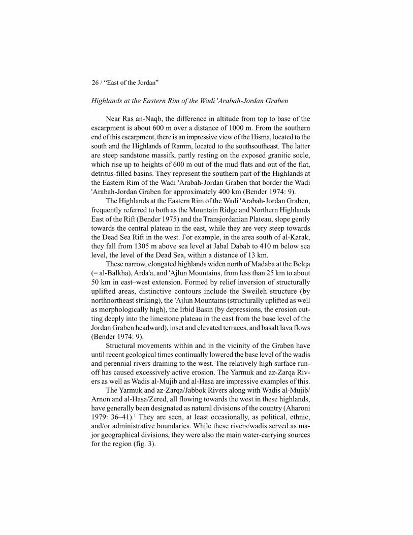
Encompassing an area of about 9,250,000 hectares (Ahmad 1989: 43),Jordan is situated in the northwestern part of the Arabian Peninsula, bor-dered by the Mediterranean, the Red Sea, the Indian Ocean, and the Per-sian Gulf. It constitutes part of the west-central segment of the Fertile Cres-cent and is thus on the land bridge between Egypt to the southwest andMesopotamia, present-day Iraq and northeast Syria, to the east and north-east (fig. 1). Due to its location, Jordan has a very diversified morphology(Bender 1974: 6).
GEOMORPHOLOGY
From west to east, the land of Jordan is divided into three main geo-graphical units: the Dead Sea Rift Valley, the Transjordanian Plateau, and
21

22 / “East of the Jordan”
Fig. 1. Situation Map of Jordan.

Natural Environment / 23
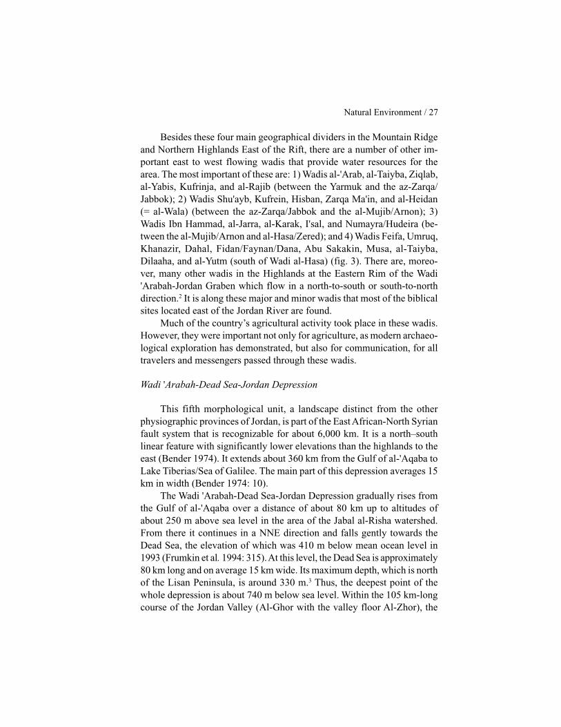
the desert. Bender (1974) points out that the landscape is more complexthan this division suggests, that it actually divides the country, from east towest, into five major morphological units (fig. 2): 1) Northeastern Desert(which is in turn divided into the Northeast Jordanian Plateau Basalts andthe Northeast Jordanian Limestone Plateau); 2) Azraq-Wadi SirhanDepression; 3) Central Desert Areas of East Jordan; 4) Highlands at theEastern Rim of the Wadi 'Arabah-Jordan Graben; and 5) Wadi 'Arabah-Dead Sea-Jordan Depression (Bender 1974: 6–11).
Northeastern Desert of Jordan
Located east of Mafraq-Azraq-Wadi Sirhan, this area forms two mor-phological units, the Northeast Jordanian Plateau Basalts and the North-east Jordanian Limestone Plateau.
The Northeast Jordanian Plateau Basalts, frequently referred to as theHauran or in Arabic as Harrat ash-Shaba, meaning Black Desert, is thesouthern extension of the Jabal al-Drouz-Basalt-Highlands. It begins about15 km east of Mafraq and extends for 160 km towards the east, covering anarea of about 11,000 km2 in Jordan. Many isolated hills and long rows ofvolcanoes interrupt it. Elevations reach more than 1100 m in thenorthnorthwest at the northern border of Jordan. From here the land falls inheight towards the southsoutheast, over a distance of approximately 50 kmin the direction of the Azraq Depression, to about 550 m. From there, overa distance of approximately 150 km, elevations decrease even more, toabout 500 m towards the eastern edge of Wadi Sirhan (Bender 1974: 6).Lava flows make the area almost inaccessible.
The Northeast Jordanian Limestone Plateau, the second morphologi-cal unit of the Northeastern Desert of Jordan, is a monotonous, flat, stonydesert that extends eastward from the Black Desert beyond the eastern bor-ders of Jordan. Small scarps formed by more resistant beds of the Tertiarysedimentary sequence occasionally interrupt it. The land rises in all direc-tions from the eastern margin of the plateau basalts, with elevations ofabout 625 m approximately 10 km westnorthwest of the H4 pump stationof the International Petroleum Company pipeline. The plateau forms a flat,dish-like depression: westward to the basalt shield up to more than 700 m;southeastward, over a distance of about 120 km, to altitudes of about 750 m;eastward and northeastward, over 60–80 km, to altitudes of about 800 m;and northward and northwestward, over 100 km, to altitudes of about 750 mat Roumana in Syria. The area contains many flats, frequently more than10 km long but rarely more than 1 km wide (Bender 1974: 6–7).

24 / “East of the Jordan”
Azraq-Wadi Sirhan Depression
This is a clearly defined morphological unit that begins at the south-ern rim of the Jabal al-Drouz basalt shield and borders the NortheasternDesert of Jordan on the west. It extends across the Azraq oasis to the south-east, crosses the Jordan-Saudi Arabia border after 80 km, and runs south-ward, east of the border, for more than 300 km as far as the area of Al-Jaufin Saudi Arabia. The lower elevations of this unit, about 500 m, occur inthe northwestern part of the depression. The axis of the depression gradu-
Fig. 2. Major Morphological Units.

Natural Environment / 25
ally rises towards the southeast to about 700 m. The catchment area of thewadi systems, which are oriented towards the northeast and drain into thedepression, extends westward for more than 100 km into the Central DesertAreas of East Jordan (Bender 1974: 8). In antiquity, the Wadi SirhanDepression was one of the main routes from northern and northeasternJordan into Saudi Arabia (Baly 1974: 31).
Central Desert Areas of East Jordan
The third morphological unit of Jordan also represents a distinct land-scape. It is bordered in the north and east by the catchment area of theAzraq-Wadi Sirhan Depression; in the southeast by the Tubeiq Highlands.To the south it reaches as far as the Ras an-Naqb escarpment; and in thewest it extends as far as the eastern slopes of the highlands along the east-ern side of Wadi 'Arabah. The region forms a cuesta topography, the cuestascarps being partly “drowned” in masses of detritus rock of the arid weath-ering cycle. The horizontal or gently dipping sedimentary complex thatcomprises this unit is in most cases covered by calcareous-siliceous detri-tus, which mainly consists of fractured, sharp-edged cherts. Chert detrituscovers hundreds of km2 and is known as the flint-strewn desert, in Arabic,Hamada. In the south, the cuesta landscape subsides to elevations of about850 m towards the depression of Al-Jafr, a flat, oval, dish-like depressionwith a catchment area of about 150 km southeast–northwest in length andabout 100 km southwest–northeast in width. The center of the Al-JafrDepression is partly occupied by a mud flat covering an area of 240 km2.From the Al-Jafr mud flats, the limestone plateau of the Central DesertAreas of East Jordan rises southeastward and southward to the TubeiqHighlands, which occupy about 10,000 km2 of southeast Jordan. Due to thescarcity of water, extremely high summer temperatures, and inaccessibility,even nomadic Bedouin avoid these highlands. They are the least exploredarea of Jordan (Bender 1974: 8).
The limestone plateau of the Central Desert Areas of East Jordan endssouthwest of the Al-Jafr Depression at the Escarpment of Ras an-Naqb.This escarpment reaches altitudes of about 1,700 m above sea level at JabalDarb al-Haj, approximately 40 km southwest of Ma'an. From there it con-tinues southeastward with a gradual fall in elevation across the village ofRas an-Naqb towards Hitiya where the elevation of the escarpment is about1000 m. It can be traced farther towards the east and then towards theeastnortheast for about 60 km (Bender 1974: 9).
26 / “East of the Jordan”
Highlands at the Eastern Rim of the Wadi 'Arabah-Jordan Graben
Near Ras an-Naqb, the difference in altitude from top to base of theescarpment is about 600 m over a distance of 1000 m. From the southernend of this escarpment, there is an impressive view of the Hisma, located to thesouth and the Highlands of Ramm, located to the southsoutheast. The latterare steep sandstone massifs, partly resting on the exposed granitic socle,which rise up to heights of 600 m out of the mud flats and out of the flat,detritus-filled basins. They represent the southern part of the Highlands atthe Eastern Rim of the Wadi 'Arabah-Jordan Graben that border the Wadi'Arabah-Jordan Graben for approximately 400 km (Bender 1974: 9).
The Highlands at the Eastern Rim of the Wadi 'Arabah-Jordan Graben,frequently referred to both as the Mountain Ridge and Northern HighlandsEast of the Rift (Bender 1975) and the Transjordanian Plateau, slope gentlytowards the central plateau in the east, while they are very steep towardsthe Dead Sea Rift in the west. For example, in the area south of al-Karak,they fall from 1305 m above sea level at Jabal Dabab to 410 m below sealevel, the level of the Dead Sea, within a distance of 13 km.
These narrow, elongated highlands widen north of Madaba at the Belqa(= al-Balkha), Arda'a, and 'Ajlun Mountains, from less than 25 km to about50 km in east–west extension. Formed by relief inversion of structurallyuplifted areas, distinctive contours include the Sweileh structure (bynorthnortheast striking), the 'Ajlun Mountains (structurally uplifted as wellas morphologically high), the Irbid Basin (by depressions, the erosion cut-ting deeply into the limestone plateau in the east from the base level of theJordan Graben headward), inset and elevated terraces, and basalt lava flows(Bender 1974: 9).
Structural movements within and in the vicinity of the Graben haveuntil recent geological times continually lowered the base level of the wadisand perennial rivers draining to the west. The relatively high surface run-off has caused excessively active erosion. The Yarmuk and az-Zarqa Riv-ers as well as Wadis al-Mujib and al-Hasa are impressive examples of this.
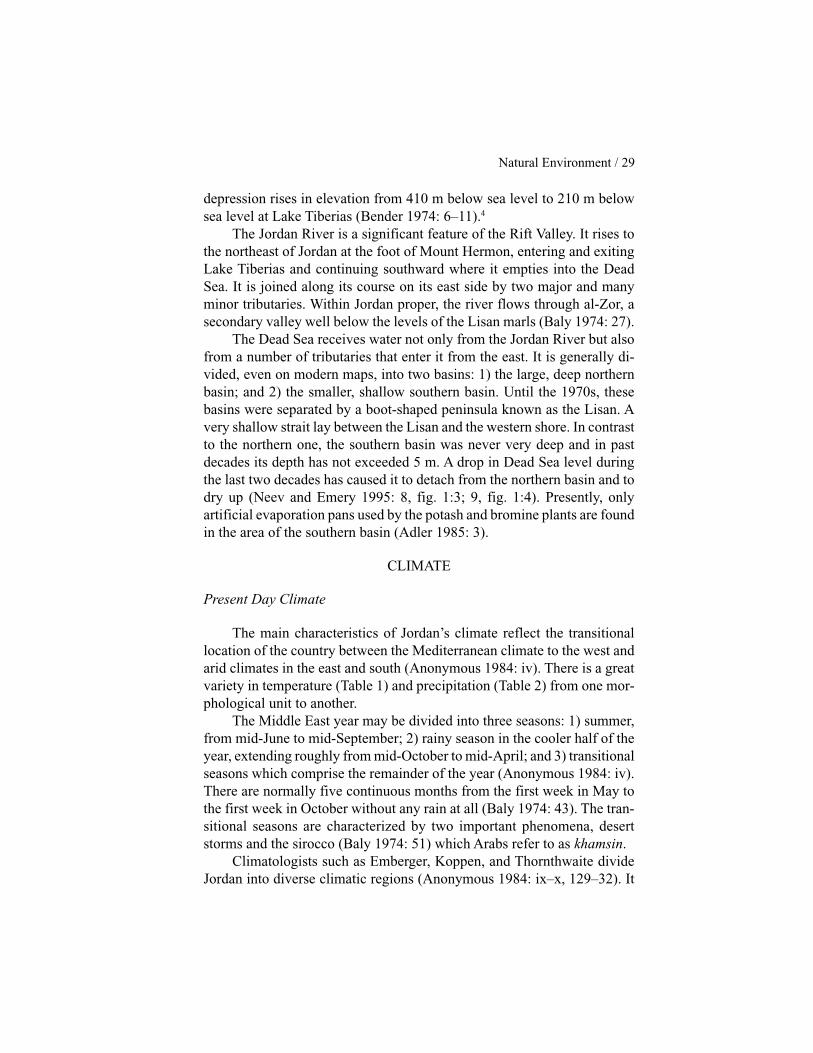
The Yarmuk and az-Zarqa/Jabbok Rivers along with Wadis al-Mujib/Arnon and al-Hasa/Zered, all flowing towards the west in these highlands,have generally been designated as natural divisions of the country (Aharoni1979: 36–41).1 They are seen, at least occasionally, as political, ethnic,and/or administrative boundaries. While these rivers/wadis served as ma-jor geographical divisions, they were also the main water-carrying sourcesfor the region (fig. 3).
Natural Environment / 27
Besides these four main geographical dividers in the Mountain Ridgeand Northern Highlands East of the Rift, there are a number of other im-portant east to west flowing wadis that provide water resources for thearea. The most important of these are: 1) Wadis al-'Arab, al-Taiyba, Ziqlab,al-Yabis, Kufrinja, and al-Rajib (between the Yarmuk and the az-Zarqa/Jabbok); 2) Wadis Shu'ayb, Kufrein, Hisban, Zarqa Ma'in, and al-Heidan(= al-Wala) (between the az-Zarqa/Jabbok and the al-Mujib/Arnon); 3)Wadis Ibn Hammad, al-Jarra, al-Karak, I'sal, and Numayra/Hudeira (be-tween the al-Mujib/Arnon and al-Hasa/Zered); and 4) Wadis Feifa, Umruq,Khanazir, Dahal, Fidan/Faynan/Dana, Abu Sakakin, Musa, al-Taiyba,Dilaaha, and al-Yutm (south of Wadi al-Hasa) (fig. 3). There are, moreo-ver, many other wadis in the Highlands at the Eastern Rim of the Wadi'Arabah-Jordan Graben which flow in a north-to-south or south-to-northdirection.2 It is along these major and minor wadis that most of the biblicalsites located east of the Jordan River are found.
Much of the country’s agricultural activity took place in these wadis.However, they were important not only for agriculture, as modern archaeo-logical exploration has demonstrated, but also for communication, for alltravelers and messengers passed through these wadis.
Wadi 'Arabah-Dead Sea-Jordan Depression
This fifth morphological unit, a landscape distinct from the otherphysiographic provinces of Jordan, is part of the East African-North Syrianfault system that is recognizable for about 6,000 km. It is a north–southlinear feature with significantly lower elevations than the highlands to theeast (Bender 1974). It extends about 360 km from the Gulf of al-'Aqaba toLake Tiberias/Sea of Galilee. The main part of this depression averages 15km in width (Bender 1974: 10).
The Wadi 'Arabah-Dead Sea-Jordan Depression gradually rises fromthe Gulf of al-'Aqaba over a distance of about 80 km up to altitudes ofabout 250 m above sea level in the area of the Jabal al-Risha watershed.From there it continues in a NNE direction and falls gently towards theDead Sea, the elevation of which was 410 m below mean ocean level in1993 (Frumkin et al. 1994: 315). At this level, the Dead Sea is approximately80 km long and on average 15 km wide. Its maximum depth, which is northof the Lisan Peninsula, is around 330 m.3 Thus, the deepest point of thewhole depression is about 740 m below sea level. Within the 105 km-longcourse of the Jordan Valley (Al-Ghor with the valley floor Al-Zhor), the

28 / “East of the Jordan”
Fig. 3. Major Wadis.
Natural Environment / 29
depression rises in elevation from 410 m below sea level to 210 m belowsea level at Lake Tiberias (Bender 1974: 6–11).4
The Jordan River is a significant feature of the Rift Valley. It rises tothe northeast of Jordan at the foot of Mount Hermon, entering and exitingLake Tiberias and continuing southward where it empties into the DeadSea. It is joined along its course on its east side by two major and manyminor tributaries. Within Jordan proper, the river flows through al-Zor, asecondary valley well below the levels of the Lisan marls (Baly 1974: 27).
The Dead Sea receives water not only from the Jordan River but alsofrom a number of tributaries that enter it from the east. It is generally di-vided, even on modern maps, into two basins: 1) the large, deep northernbasin; and 2) the smaller, shallow southern basin. Until the 1970s, thesebasins were separated by a boot-shaped peninsula known as the Lisan. Avery shallow strait lay between the Lisan and the western shore. In contrastto the northern one, the southern basin was never very deep and in pastdecades its depth has not exceeded 5 m. A drop in Dead Sea level duringthe last two decades has caused it to detach from the northern basin and todry up (Neev and Emery 1995: 8, fig. 1:3; 9, fig. 1:4). Presently, onlyartificial evaporation pans used by the potash and bromine plants are foundin the area of the southern basin (Adler 1985: 3).
CLIMATE
Present Day Climate
The main characteristics of Jordan’s climate reflect the transitionallocation of the country between the Mediterranean climate to the west andarid climates in the east and south (Anonymous 1984: iv). There is a greatvariety in temperature (Table 1) and precipitation (Table 2) from one mor-phological unit to another.
The Middle East year may be divided into three seasons: 1) summer,from mid-June to mid-September; 2) rainy season in the cooler half of theyear, extending roughly from mid-October to mid-April; and 3) transitionalseasons which comprise the remainder of the year (Anonymous 1984: iv).There are normally five continuous months from the first week in May tothe first week in October without any rain at all (Baly 1974: 43). The tran-sitional seasons are characterized by two important phenomena, desertstorms and the sirocco (Baly 1974: 51) which Arabs refer to as khamsin.
Climatologists such as Emberger, Koppen, and Thornthwaite divideJordan into diverse climatic regions (Anonymous 1984: ix–x, 129–32). It

30 / “East of the Jordan”
Table 1: Mean Monthly Temperature in °C. From “Climatic Atlas ofJordan,” Meteorological Department, Jordan’s Ministry of Transport, 1971(Ahmad 1989: 8).
Month Rift Valley Uplands Eastern DesertsJanuary 14 4–8 10February 14–16 4–8 10–12March 16–2 8–10 12–14April 20–24 12–14 16–18May 26–28 14–20 20–26June 28–32 18–22 22–28July 30–32 20–24 26–30August 30–32 20–24 26–30September 28–30 24–28 18–22October 26 16–20 20–22November 20–22 12–14 16–18December 14–16 6–10 10–12
Table 2: Precipitation in mcm. From “The Annual Report, 1987,” WaterAuthority of Jordan (Ahmad 1989: 7).
Water Basin Precipitation Volume1986-87 Long Term Average
Yarmuk Basin 500 440az–Zarqa Basin 890 910Eastern Basins Adjacentto the Jordan River 870 860Azraq Basin 790 830al–Mujib Basin 770 890al–Hasa Basin 200 480al–Jafr Basin 410 480Eastern Basins Adjacentto the Dead Sea 340 330North Wadi 'Arabah Basin 250 490South Wadi 'Arabah andRed Sea Basins 250 350South Desert Basin 90 90Wadi Sirhan Basin 250 250Hammad Basin 1090 900TOTAL 6700 7300

Natural Environment / 31
is sufficient for our purposes, however, to follow Bender and divide thecountry into a Mediterranean, a semi-arid, and an arid zone (1974: 11–15;see also Ahmad 1989: 6). This classification does justice to the transitionallocation of the country.
The Highlands at the Eastern Rim of Wadi 'Arabah-Jordan Graben asfar south as ash-Shawbak are dominated by a Mediterranean climate, whichranges from subhumid (>600 mm precipitation per year; average January =3°C, average August = 27°C to 33°C) to semi-arid (precipitation between300 and 600 mm a year; average January = 3°C to 7°C, average August =30°C to 35°C) (Bender 1974: 187). From April to October this climate hasdry summers with an average maximum annual temperature of 38.8°C;from November until March it is winter with an average minimum annualtemperature of 0.5°C.
The average annual rainfall in the Mediterranean zone is 300 mm ormore: in the northern area of Qweilbeh/Abila, 350–450 mm; at as-Salt, 700mm; at Jabal 'Amman (the part of the plateau in the center of the city), 375mm; the 'Amman airport at Marka 268 mm (Harlan 1981: 158); in theHisban region, 400 mm; at Na'ur, 525 mm; in the al-Karak region, 350mm; at al-Mazar, 375 mm; at ash-Shawbak, 300 mm. In the south, rainfallis sufficient to permit no more than a single line of villages along the rim(Baly 1974: 61).
There is a wide transition zone east and south of the areas with aMediterranean climate and running to the fully arid climate that character-izes the desert areas of East and South Jordan. In this semi-arid transitionzone, the average annual maximum temperature is +40°C, and the averageannual minimum temperature is -1.6°C; the average annual rainfall is be-tween 50 and 300 mm (Baly 1974: 61). The segment of this zone, which isimmediately east of the highlands and at times close to the fields and farm-ing villages, is often referred to as steppeland and is more often pastoralthan agricultural. In times of drought, the Bedouin moved from the desertto these steppes where dry grass provides pasture land (Hütteroth andAbdulfattah 1977: 62).
The arid or desert zone of Jordan receives less than 50 mm precipita-tion per year (fig. 4). Moreover, the distribution is extremely erratic fromyear to year, and there is a strong tendency for much of it to come in heavystorms during the transitional seasons (Baly 1974: 61–62).
About 90% of Jordan receives less than 200 mm of precipitation peryear which is totally dissipated by evaporation. Only about 14% of themean annual rainfall is exploitable: 70% drains toward the Jordan Valley,

32 / “East of the Jordan”
Fig. 4. Rainfall Map.

Natural Environment / 33
Dead Sea, and Wadi 'Arabah; the remaining 30% can only be utilized bydrilling wells (Anonymous 1986: i). At least 300 mm of rainfall per year isnecessary for sustainable agriculture (Issar 1995: 351).
Ancient Climates
Evidence suggests that the present climate is not indicative of pastclimates in all periods. Knowledge of ancient climates in different periodsis important since climate change can have a direct effect upon what plantscan grow in a specific area. This in turn will affect the natural animal re-sources in the area, as well as the availability of land for farming and/orpasturage. In other words, climate affects soil productivity, and changes inclimate can lead to prosperity or famine.
Since our interest here is climatic conditions in biblical periods, wemust recognize that paleoclimates are far from well understood. Conse-quently, all claims concerning climate are tentative, and subject to changeas new data become available.
The changing level of the Dead Sea over time is an indicator of cli-matic variations. Citing evidence from the salt caves of Mount Sedom lo-cated at the southwestern end of the Dead Sea and correlating this withother studies on Holocene climates, Frumkin et al. (1991; 1994) posit thatthe EB I–III period in Israel was the moistest period during the last 6000years. According to their findings, the level of the Dead Sea rose to at least300 m below sea level during the EB I–III period, indicating increasedprecipitation throughout the Dead Sea drainage basin (Frumkin et al. 1991:198; 1994: 325–26). Subsequently, there was a drop of nearly 100 m toabout 400 m below sea level in the span of a few centuries from 2400 to2000 B.C. In the opinion of Frumkin et al. (1991; 1994), this drop suggestsan arid period similar to the present climate, perhaps even more arid. Rabanand Galili (1985) also have evidence of an increase in the level of theMediterranean Sea during this time. This indicates a warm climate sincethe melting of the polar ice caps affected the level of the MediterraneanSea but not the level of the Dead Sea (Issar 1995: 354). Issar (1995: 354)and Weiss et al. (1993) contend that a warm, dry period contributed to thecollapse of the empires of the Middle East around 2000 B.C.
This dry period continued until about 1200 B.C. in the Middle and LateBronze Ages (Frumkin et al. 1991: 198; 1994: 325–26). Stiebing (1989)argues that the Late Bronze Age probably ended as a result of climate change.His evidence includes such indicators of past climatic conditions as pollen,

34 / “East of the Jordan”
tree rings, and lake levels (dated by radiocarbon, tree ring chronology, andother scientific dating methods). According to Stiebing, there is evidencefor a series of narrow tree rings, indicating poor growing conditions be-tween ca. 1300 and 1000 B.C. He also finds indications of a change fromMediterranean to Saharan vegetation at the end of the Late Bronze Age,which suggests a shift from a relatively moist to a much drier climate (1989:186). This period was succeeded by even lower Dead Sea levels, reachingapproximately 395–400 m below sea level between the tenth and seventhcenturies B.C. Thus there are indications of a slightly drier climate relativeto preceding centuries (Frumkin et al. 1991: 198). According to a recentstudy of isotopes from tamarisk wood buried in the Roman siege ramp atMasada, the climate became colder beginning sometime between 300 and200 B.C. These new data match other observations which point to theconclusion “that about two thousand years ago the climates of the areasbordering the desert of the Middle East were colder and more humid” (Issarand Yakir 1997: 104; see also Issar 1990). The period in question coincideswith the Roman occupation of the Near East. There is evidence of a rise inthe Dead Sea level, also indicative of a moister climate, during the firstcentury B.C. and continuing into the first two centuries of the common era(Frumkin et al. 1991: 198–99; Heim et al. 1997; Bruins 1994).
SOILS AND CROPS
There are a variety of soil types related to the various morphologicalunits and climate zones of the country. The main soils are Red Mediterra-nean, Yellow Mediterranean, Yellow Steppe, and Grey Desert (fig. 5).5 Inaddition, there are several other associated soils (Bender 1974: 192–93;Anonymous 1986: 134; Ahmad 1989: 46–47).
Red Mediterranean soils, whose formation depends to a large extenton the specific conditions of the Mediterranean climate, cover extensiveareas in the Highlands at the Eastern Rim of the Wadi 'Arabah-JordanGraben. They are found, for example, in the Irbid-Ramtha and Sweilehdepressions as well as from 'Ajlun in the north to ash-Shawbak in the south(Bender 1974: 187; Ahmad 1989: 46). In flat locations, they are well suitedfor the cultivation of cereals, tomatoes, melons and tobacco; in mountain-ous areas, they are suitable for the cultivation of grapes, olives, kernel- andstone-fruits, as well as for forestry (oak, pine varieties; Bender 1974: 189).
Yellow Mediterranean is a transitional type of soil between the RedMediterranean and the Yellow Steppe (Moormann 1959). It is confined to

Natural Environment / 35
Fig. 5. Soils.
the cooler zone of the semi-arid climate with annual precipitation between250 and 350 mm. It can be observed in narrow strips on both sides of theJordan-Wadi 'Arabah Graben and on the eastern side of the highlands eastof the Rift, as well as in the southern extension of these highlands betweenash-Shawbak and Ras an-Naqb (Bender 1974: 189). This type of soil canbe used for cereal production, applying the dry-farming system and alsofor grazing. With irrigation, more intensive cultivation would be possible(Bender 1974: 189).
Yellow Steppe soils cover a more-or-less wide belt east of the YellowMediterranean soil. They are found in the warm, semi-arid Mediterranean

36 / “East of the Jordan”
climate zone, which extends from Syria in the north to the escarpment ofRas an-Naqb in the south. There are also yellow steppe soils on both sidesof the Jordan-Wadi 'Arabah Graben, south of the az-Zarqa River and GhorFaria, which are associated with undeveloped skeletal soils on wadi grav-els and exposed bedrock (Bender 1974: 189–90). They are also found inthe area between Mafraq and al-Jiza east of 'Amman. Yellow steppe soilsare used for barley production and/or pasture land, and their yields, as withYellow Mediterranean soil, can be improved by intensive irrigation (Bender1974: 190).
Grey Desert soils (Sierosem) develop in areas with <150 mm precipi-tation/year, which occupy more than half the total territory of Jordan. Thesesoils are associated with dense flint pavement, which is widespread in eastJordan and are also called Hamada or Hamada-Yerma. They are generallypoorly developed and shallow because of chemical weathering under desertconditions and severe wind erosion. They contain seldom more than 0.5%organic matter, and without irrigation, provide only poor sites for grazing(Bender 1974: 190–92).
PLANT GEOGRAPHICAL TERRITORIES
Jordan can be divided into three plant geographical territories or regions(fig. 6): the Mediterranean, the Irano-Turanian, and the Saharo-Sindian.Each territory is characterized not only by its flora and vegetation but alsoby its climate and soils (Zohary 1962: 51). In addition, there are Sudanianflora and vegetation at the outlet areas of some watercourses into the lowerJordan Valley and Dead Sea (Zohary 1962: 53; Danin 1995: 24–26).6
The Mediterranean territory, characterized by a sub-humid Mediterra-nean climate, is readily recognizable by its flora and vegetation. Its mosttypical soil variety is Red Mediterranean. However, rendzina, basalt, andsandy soils also occur. It includes a long belt of the Highlands at the East-ern Rim of Wadi 'Arabah-Jordan Graben extending as far south as the heightsof Edom (Zohary 1962: 51). Its boundaries with the adjoining Irano-Turanianterritory cannot be precisely drawn because the Mediterranean vegetationof the eastern and southern margins, which border on steppes and deserts,has been subject to heavy human devastation. Plants from adjacent territorieshave been able to penetrate the area, and there is a fairly broad transitionbelt of mixed flora and vegetation in these borderlands. With the exceptionof this transition belt, the territory is generally characterized by forest andmaquis climax communities (Zohary 1962: 51).

Natural Environment / 37
Fig. 6. Plant Geographical Territories.

38 / “East of the Jordan”
Bender suggests that the Mediterranean territory was probably allwooded prior to the early historical periods when deforesting started. Hecites copper-ore smelting as one reason for the deforestation (1974: 11).Harlan, however, posits that the plateau proper, especially in the southernpart of the territory, does not receive adequate rainfall to support a forest oreven a woodland (1985: 128; 1988: 44). The woodlands have generallyretreated in the Middle East due to land clearing, overgrazing, charcoalproduction, and harvesting firewood (Harlan 1981: 163). Nevertheless,Querous aegilops and Pinus halepensis are still to be found in the 'Ajlundistrict north of 'Amman. In the mountainous area between at-Tafila andash-Shawbak, scattered specimens of Quercus coccifera ssp. calliprinosand Juniperus phoenicea cover the steep slopes (Bender 1974: 11; Harlan1988: 43).
The Irano-Turanian territory encircles the Mediterranean from south,east and west, merging with the Syrian Desert in the northeast. Its annualprecipitation varies from 350 to 200 mm. The rainy season is somewhatshorter and the rainfall less evenly distributed than in the Mediterraneanterritory. The main soil variety of this region is Yellow Steppe. Vegetationcomprises herbaceous and dwarf shrub communities, with almost noarboreal climax. Agriculture is very poor, unstable, and almost entirelyconfined to plains and valleys (Zohary 1962: 51).
The Saharo-Sindian territory is the largest of the three plant geographi-cal territories of Jordan, covering more than half the total area of the coun-try. It includes east, south and northeast Jordan as well as a narrow spurwithin Wadi 'Arabah, protruding northwards from the Gulf of al-'Aqaba.The boundaries this territory shares with the Irano-Turanian territory arevague. The Saharo-Sindian has a typical desert climate with a short rainyseason and a long, hot, dry summer. Annual precipitation varies from 25 to200 mm. The main soil variety is Grey Desert. Agriculture is altogetherlacking, except in oases or flooded wadis. Vegetation is extremely poorand mainly confined to depressions, wadis and runnels. In the limestone-,marl-, chert- and basalt-deserts of North and Central-East Jordan,particularly in the wadi courses, Artemisia sp., Zygophyllum dumosum,Chenola arabica, Suaeda vermiculata, Traganum nudatum, and Anabasisarticulata are still to be found. In the sandstone desert and in the wadiscrossing the granitic basement of southeastern and southern Jordan occurmainly Haloxylon persicum, Traganum nudatum, Zilla spinosa, Ferula sp.,and a few Acacia tortilis (Zohary 1962: 51, 53; Bender 1974: 15).

Natural Environment / 39
NATURAL RESOURCES
Water
The critical natural resource of Jordan is water (Harlan 1988). It ischronically in short supply. Harlan asserts that “the water supply … deter-mines the abundance and distribution of other resources such as plants andanimals available for hunting-gathering cultures, the crops that can be grownby farmers, and the animals that can be reared by nomads” (1988: 40). Theprimary source of water is rainfall; secondary sources, all of which ulti-mately depend on rainfall, are springs, wells, flowing streams, and mois-ture stored in the soil (Harlan 1988: 40).
Natural Raw Materials
Bender lists the mineral raw materials of Jordan as: 1) hydrocarbons:a) oil, gas, and asphalt; and b) bituminous rocks; 2) metallic ores: a) cop-per; b) manganese; c) iron; and d) chromium, nickel, uranium, pyrite; 3) non-metallic ores: a) phosphate; b) apatite; c) baryte, feldspar, mica, quartz,glass sands, rutile, and mineral painting pigments; d) semi-precious stones;e) sulphur and gypsum; f) clay; g) rock salt, potassium salt, and salt of theDead Sea; and 4) building material: a) decoration stones; b) building stones;and c) raw materials for Portland cement (1974: 146–73; see also Ahmad1989: 48–60).
The Dead Sea was a major source of commercial bitumen in the an-cient Near East (Hammond 1959: 40; Forbes 1964: 29–30; Bender 1974:146; Sperber 1976). Its specific product is true bitumen, which explains theclassical references to asphalt, and justifies applying the name asphalticlake to the Dead Sea (MacDonald 1992a: 20).
In the Faynan area of Jordan (Hauptmann 1986a: 415; Hauptmannand Weisgerber 1987: 421), there are two different ore horizons: mixedmanganese and copper ores, and only copper ores. A team from the Ger-man Mining Museum in Bochum, West Germany investigated these re-sources and their associated technologies during various archaeologicalperiods (Bachmann and Hauptmann 1984; Hauptmann, Weisgerber, andKnauf 1985; Hauptmann 1986a; Hauptmann and Weisgerber 1987;Hauptmann 1989). Hauptmann and Weisgerber (1987) contend that copperproduction in the area extends from the Chalcolithic Period up to thethirteenth century A.D. The periods of greatest importance for this production

40 / “East of the Jordan”
were the Chalcolithic, Early and Middle Bronze, Iron I, Iron IIC, andMamluk (Hauptmann and Weisgerber 1987: 421–24). In Hauptmann’s es-timation, the Faynan region may represent the oldest large-mining area forcopper in the Near East known to date (1986a: 416). Not only was copperproduced in the area but there is also evidence of the export of copper oresfrom the region during the Neolithic and Chalcolithic Periods (Hauptmann1989).
There are iron ore deposits with only limited possibilities for exploita-tion present at Wardeh, some 35 km northnorthwest of 'Amman in thesouthern 'Ajlun District (Van den Boom and Lahloub 1962: 6; Torrente1967: 5; Basha 1968: 3; Coughenour 1976; 1989). The predominant pot-tery Coughenour collected at the site, which shows evidence of both min-ing and smelting, is Ayyubid-Mamluk (1976: 73, 75). Glueck (1951: 232)and Bender (1974: 157) are in general agreement with this date since theyattribute mining activity in the area to the Medieval and Crusader periodsrespectively.
Thin layers and lenses of clays rich in kaolin are widespread in theupper part of the massive white sandstones of the Lower Cretaceous inJordan. Bender identifies notable clay deposits of great thickness near thevillage of Mahis, about 17 km westnorthwest of 'Amman, and near GhorKabid, approximately 25 km north of the northern end of the Dead Sea.The clays from both locations are well-suited for the production of ceram-ics (Bender 1974: 168).
De Vaux notes the exploitation of salt by the Qumran community inantiquity (1961: 68). More recently, rock salt has been produced in smallquantities in the area of the Azraq Depression. There are practically unlim-ited amounts of rock salt in the area of the Lisan Peninsula where the rocksalt body occupies about 35 km2 of the central part of the peninsula. Benderestimates the amount of rock salt dissolved in the Dead Sea at about 12,650million tons. Also dissolved in large quantities in the same body of waterare potash and magnesium salts (Bender 1974: 168–72). This potash iscommercially exploited by the Arab Potash Company located at the south-east side of the Dead Sea immediately north of as-Safi. The local popula-tion still mine salt from the Dead Sea using methods which have probablynot changed in centuries.
Decoration stones in the form of marbles are quarried between al-Jizaand al-Hasa both east and west of the Desert Highway; the marbles are infact massive, hard, dense limestones. Travertine is another valuable deco-ration stone found in the Jordan Valley. A possible quarry site for this mate-

Natural Environment / 41
rial is located about 10 km south of Dayr 'Alla where good, polishablequality travertine exists in thick beds (Bender 1974: 172).
Since wood is a scarce and expensive commodity, a large number ofrock types have been used as building stone through the millennia. Sand-stone has been used extensively in building; however, the tombs and theaterin Petra are good examples of how poorly resistant to corrosion this type ofstone is. Basalts have also been used extensively for construction, espe-cially in the northeast of the country, for example, at Umm al-Jimal. Calichewas used in Jarash for pillars and square stones. Oolitic limestone is easilyworkable and served as the material for many structures. Oyster limestonecan be seen in many ruins in the 'Amman area, for example, in the decoratedfaçades of Qasr al-Mushatta, an Umayyad palace (Bender 1974: 172–73).
Natural Animal Resources
Jordan is presently almost devoid of wild animals (Ahmad 1989: 66).There are some gazelle in the southern part of the country and boar inhabitthe natural vegetation of the Jordan Valley. Small animals such as foxes,hedgehogs and hares are seen occasionally throughout the country. Hyenasare heard at night, and locals still tell stories of the presence of wolves. Dueto decreased water levels (Ahmad 1989: 72–77), the many species of birdsthat once stopped at the Azraq Oasis on their migratory paths havediminished significantly. In contrast to the present dearth of wildlife,nineteenth century travelers reported that gazelle were common on theupland plains; ibex were sighted on the escarpment, and wild boar andleopards in the canebrakes; hyenas and jackals scavenged kills; doves wereabundant and rock partridge (Caccabis saxatilis) could be found in theplains, at least in the ruins of ancient towns and villages; fish were abundantin the streams (Harlan 1982; 1985; 1988). In Harlan’s words, “the picturepresented is one teeming with animal life. It was a pleasant, fat land” (1988:45).
In an earlier time, the uplands undoubtedly supported herds of wildcattle and wild horses (onagers); deer would have been more common inthe woodlands; lion and cheetah would have been present as predators;jackals and hyenas would have scavenged kills; and wild camels wouldhave roamed the deserts and semi-deserts (Harlan 1985; 1988: 45). Today,this abundance of wildlife has given way to the domesticated animal, tocamels, donkeys, goats, and sheep, and the streams are populated only byminiature fish.

42 / “East of the Jordan”
CONCLUSIONS
In antiquity, Jordan was a land bridge between the great geographicalregions of Egypt and Mesopotamia, and influenced by both. On many oc-casions it came under the direct control of Egyptians, Israelites, Arameans,Assyrians, Babylonians, Persians, Greeks, and Romans. Thus the peoplesof Jordan during biblical periods did not live in isolation.
Descriptions of the morphological units of Jordan provide an over-view of the areas of the country where habitation was possible during bib-lical periods. These descriptions, along with information on past climates,soils, flora, fauna, and other natural resources, make it clear why peoplelived mainly in the Highlands at the Eastern Rim of the Wadi 'Arabah-Jordan Graben and the northern segment of the Wadi 'Arabah-Dead Sea-Jordan Depression.
A knowledge of paleoclimates helps us understand the environmentalconditions people faced in this area of the Near East, just as analysis ofsoils and the flora that grew in them provides a view of the available food,pasturage, firewood, shade, and so forth. These crops, along with informa-tion on the other natural resources of different segments of the country,provide insight into the economic base of the peoples who lived “beyondthe Jordan” (Gen 50.10, 11; Deut 3.8; et passim) or “across the Jordan”(John 1.28; 10.40) in biblical periods.
NOTES
1 The modern name for these rivers/wadis is followed by the biblical name (see the following chapters).2 Many of these wadis change names throughout their course. The names used here generally comefrom what the wadi is called at its western extremity as indicated on “The Hashemite Kingdom ofJordan (Archaeological Maps)” (Scale 1:250,000) (Jordan National Geographic Centre and theDirectorate of Military Survey with the cooperation of the Department of Antiquities, 1978–1982).3 Until about 1975, Lynch’s 1848 measurement of approximately 398 m for the depth of the Dead Seawas accepted as valid (Adler et al. 1985).4 Distances and elevations given for Lake Tiberias and the Dead Sea are only approximate. The lengthsof both, as well as their elevations, change depending upon precipitation, evaporation, and the amountof water taken from them as well as from the wadis and springs which feed them. The level of the DeadSea has dropped appreciably in recent decades: Bender (1974) and “The Hashemite Kingdom of Jordan(Archaeological Maps)” (1979) give -392 m; Amiran et al. (1970) give the September 1960 level as -397.37 m; Adler et al. (1985) give -400 m; while Frumkin et al. (1994: 315) give -410 m as the level ofthe Dead Sea. The level continues to drop. The same is true of Lake Tiberias, the level of which isgenerally given as 210 or 212 m below the level of the Mediterranean Sea. However, Amiran et al.(1970) give its elevation as 206.46 m below sea level, with a maximum depth of 44 m, on May 26,1961.5 The description of soil types given here follows Bender (1974) who in turn depends on the work of M.Baker, Jr., Inc. and Harza Engineering Company, in the Jordan Valley in 1955 and in the Azraq areabeginning in 1955 (1958); Moormann (1959) in East Jordan; Willimott et al. in a part of Wadi al-Hasa

Natural Environment / 43
in 1962 (1963) and in the area of Al-Qatrana in 1963 (1964); and Gruneberg (1967) in close cooperationwith the Soils Department of the Natural Resources Authority of Jordan beginning in 1962 (Bender1974: 185).6 For the purpose of phytogeographical analysis, Danin (1995: 26–27) divides Jordan into four maindistricts: Gilead (#28), 'Amman (#29), Moab (#30), and Edom (#31). He also places the western segmentsof Jordan in districts shared with Israel: Kinneret Valley (#18); Beth Shean Valley (#19); Lower JordanValley (#23); Dead Sea Valley (#24); and 'Arabah Valley (#25). In each district he posits flora from thevarious plant geographical provinces: Mediterranean; Mediterranean and Irano-Turanian; Irano-Turanian;Saharo-Sindian; Thermophilous, including Sudanian, Tropical, and Subtropical; and Other Chorotypes.

44 / “East of the Jordan”
PR:PAGE 44
IS BLANK

The “Cities of the Plain” and Lasha / 45
CHAPTER 4
SODOM, GOMORRAH, ADMAH, ZEBOIIM,BELA (= ZOAR)—THE “CITIES OF THE PLAIN”
—AND LASHA
INTRODUCTION
Sodom and Gomorrah are famous biblical sites. Along with Admah,Zeboiim, and Bela (= Zoar) (Gen 14.2), they are called the “cities of thePlain” (Gen 13.12) and are known in popular as well as scholarly circles asplaces of depravity. They are generally associated with the Dead Sea buttheir precise locations are not easily pinpointed (fig. 7).
Those who interpret the Bible literally see Sodom and Gomorrah, alongwith Admah and Zeboiim, as actual places God destroyed because of theimmorality of the inhabitants. For those interpreters, God spared Bela(= Zoar) because of Abraham and Lot. Others see the Sodom and Gomorrahsaga as an etiology that accounts for the Wasteland along the shores of theDead Sea (Irvin 1978: 28; Gunkel 1987: 93) or as “a purely mythical tale”(Gaster 1969: 161). Following the position of a number of commentators, Iview the Sodom and Gomorrah narratives as recounting an actual naturalcatastrophe to which were added Israelite and non-Israelite traditions alongwith the authors’ perspectives on punishment and God’s justice (see, forexample, Clapp 1936: 907–9; Von Rad 1972; Westermann 1981: 362; Rast1987: 196; Loader 1990: 47–48). Our primary interest in this chapter islocating the sites which the first storytellers and later the biblical writershad in mind in their narratives of devastation. Since Lasha is associated inGen 10.19 with four of the cities of the Plain as the last point on the Canaaniteborder description, it will also be treated here.
THE CITIES OF THE PLAIN IN BIBLICAL AND OTHER TEXTS
Four of the five cities of the Plain appear for the first time in the Biblein the description of the territory of the Canaanites, the original dwellers ofthe Promised Land, whose land “extended from Sidon, in the direction ofGerar, as far as Gaza, and in the direction of Sodom, Gomorrah, Admah,and Zeboiim, as far as Lasha” (Gen 10.19). The western Canaanite bound-ary thus extended along the coast of the Mediterranean Sea from Sidon inthe north to Gaza in the south. One would expect the boundary to turn
45

46 / “East of the Jordan”
Fig. 7. The Dead Sea Region.

The “Cities of the Plain” and Lasha / 47
eastward towards the shores of the Dead Sea where the cities of the Plainwere seemingly located (Aharoni 1979: 76). The boundary went from here“as far as Lasha.”
Genesis 13 narrates the separation of the patriarch Abram/Abrahamfrom his nephew Lot because their possessions were so great that the landcould not support both of them living together (v 6). The point of separa-tion was Bethel (or between Bethel and Ai) (Gen 13.3) in the hills to thenorth of Jerusalem and northwest of Jericho. From here large stretches ofthe surrounding area are visible (Speiser 1964: 97; Abel 1967, 1: 371–72;Von Rad 1972: 172). Abram permitted Lot to choose where he wished tolive and Lot picked “all the plain of the Jordan” (v 11) because it “was wellwatered everywhere like the garden of the Lord, like the land of Egypt, inthe direction of Zoar; this was before the Lord had destroyed Sodom andGomorrah” (v 10).1 Thus, Abram settled in the land of Canaan, presumablythe land described in Gen 10.19, while Lot “journeyed eastward” (v 11)and settled “among the ‘cities of the Plain’ and moved his tent as far asSodom” (v 12). In this text, “all the plain of the Jordan” would appear tobe, at least in part, the Jordan Valley between the Sea of Galilee in thenorth and the Dead Sea in the south (Van Seters 1975: 117). Neev andEmery see it encompassing a more extensive area, including the entire scopeof the Dead Sea basin from near the Yarmuk or az-Zarqa Rivers in thenorth to the Amazyahu fault escarpment immediately south of the DeadSea (1995: 123). Simons thinks the indication that Abraham settled in theland of Canaan while Lot journeyed eastward and moved his tent as far asSodom rules “out particularly any close geographical connection betweenSodom and jebel usdum on the western shore of the Dead Sea” (1959:223). From this text, the cities of the Plain would appear to be in the JordanValley (however extensive it may be) and east of the land of Canaan. Thelocation of the cities of the Plain, however, cannot be deduced from thistext alone.
Genesis 13 is, in fact, an introduction to the tradition on Lot that has aTransjordanian origin and which is centered on the history of Sodom andGomorrah. The tradition was probably originally independent of theAbraham cycle (de Vaux 1971: 164). Its purpose is to prepare the readerfor the presence in Transjordan of two descendants of Lot who are closerelatives of Israel, namely, the Moabites and the Ammonites (Gen 19.30–38) (Speiser 1964: 97).
Genesis 14 narrates a campaign of four eastern kings against the re-bellious kings of Sodom, Gomorrah, Admah, Zeboiim, and Bela (= Zoar).The rebels joined forces in the Valley of Siddim, that is, the Dead Sea

48 / “East of the Jordan”
(v 3),2 which contained bitumen/slime pits (v(v) 10–11). After the rebels’defeat, the victorious kings took Lot hostage (v(v) 11–12). Abraham cameto his nephew’s assistance, defeated the alliance of the eastern kings (v 15)and rescued Lot (v 16). 3
The presence of bitumen/asphalt/slime pits in the valley of the Salt orDead Sea is in agreement with Josephus’ designation of this body of wateras “Lake Asphaltitis” (Ant 1.9; JW 3.10.7). There are also ancient andmodern witnesses to the presence of bitumen/asphalt in and along the DeadSea (Strabo; Diodorus; Josephus [JW 4.8.4]; Klein 1880: 251; Harland 1942;1943; Neev and Emery 1995: 143). Tar seepage associated with borderfaults in the Wadi 'Arabah-Jordan Graben is normal (Neev and Emery 1995:141–43). However, this phenomenon is not restricted to a particular area ofthe Dead Sea and thus is not especially helpful in locating the cities of thePlain in which the rebellious kings joined forces and from which they fledinto the mountains to the east and/or west of the Dead Sea.
Abram/Abraham, living by the oaks of Mamre (Gen 13.18) at Hebron,interceded with God not to destroy the sinful cities of Sodom and Gomorrah(Gen 18.16–33). And it was from Mamre that Abraham’s visitors left to goto Sodom (Gen 18.22) where they received hospitality from Lot (Gen 19.1–3).4 Moreover, it was presumably from the same area that Abraham, afterthe destruction of the cities, “looked down toward Sodom and Gomorrahand toward all the land of the Plain” (Gen 19.28). On the basis of this text,Sodom and Gomorrah and all the land of the Plain appear to be locatedaround the southern segment of the Dead Sea (Van Seters 1975: 117).
It would seem that the area described as “all the Plain” and “all theland of the Plain” in Genesis 19, verses 25 and 28 respectively, is located atthe southwestern, southern, and/or southeastern segments of the Dead Sea.Neev and Emery are even more specific and, on the basis of the narrative,locate Sodom and Gomorrah in the south basin of the Dead Sea (1995:123–24). They would place Admah and Zeboiim in the same general areasince the kings of these two cities cooperated in the alliance against theeastern kings (Gen 14.2–3). Due to the geography of the area, suchcooperation would be difficult, in the opinion of Neev and Emery, if Admahand Zeboiim were located in the north basin (1995: 124).
The destruction of Sodom and Gomorrah is described in Gen 19.24–25: “The Lord rained on Sodom and Gomorrah sulfur and fire from theLord out of heaven; and he overthrew those cities, and all the Plain, and allthe inhabitants of the cities, and what grew on the ground” (emphasis added).The destruction is also described in Gen 19.28 in which Abraham “lookeddown toward Sodom and Gomorrah and toward all the land of the Plain

The “Cities of the Plain” and Lasha / 49
and saw the smoke of the land going up like the smoke of a furnace.” Deut29.23 describes the resulting devastation: “all its soil burned out by sulfurand salt, nothing planted, nothing sprouting, unable to support any vegeta-tion.” In all cases, the Bible attributes the results to God.
God spared Zoar out of favor to Abraham and Lot.5 It was here thatLot and his two daughters came (Gen 19.23) before moving (“for he wasafraid to stay in Zoar” [Gen 19.30]), and Lot “went up out of” it with hisoffspring and settled in a cave in the hills surrounding the Dead Sea to thewest and east (Gen 19.30). Genesis 19 goes on to relate the birth of theancestors of the Moabites and the Ammonites as a result of incest betweenLot and his daughters (v(v) 31–38). This Israelite tale was told partly toridicule these racially related but rival nations, and partly to give folk ety-mologies for their names (MacDonald 1994a: 37).
Efforts to locate the cities of the Plain are assisted by other biblicaltexts. For example, when the Israelites encamped in the Plains of Moab(Num 22.1; 26.3, 63; 31.12; 33.48, 49; et passim), that is, in the area acrossfrom Jericho northeast of the Dead Sea (see Chapter 4), there is no mentionof Sodom, Gomorrah, or any of the other cities of the Plain (Lagrange1932: 513). Thus they would seem to be located elsewhere. Furthermore,when Moses went up from the Plains of Moab to Mount Nebo and the topof Pisgah (see Chapter 4) from where the Lord showed him the PromisedLand (Deut 34.1–4), his view apparently included the area to the northtowards Gilead (see Chapter 9) as far as Dan; the land to the northwestincluding Naphtali, Ephraim, and Manasseh; Judah to the west as far as theWestern Sea, that is, the Mediterranean; the Negeb to the southwest; and“the Plain—that is, the valley of Jericho, the city of palm trees—as far asZoar” (Deut 34.3). Moses’ view certainly took in Jericho below him to thewest. Zoar would appear to be well south of where he was standing, ratherthan immediately below him. Finally, in Isaiah’s oracle against Moab, Zoarappears to be on that country’s frontier (15.5). This too would place thesite in some distant region of Moab.
Some scholars, on the basis of biblical texts, have found support for anorthern (Power 1930; Simons 1959: 222–29) as well as a southern(Lagrange 1932; Harland 1942, 1943; Neev and Emery 1995) location forthe cities of the Plain. Others hold that three of the cities, namely, Sodom,Gomorrah, and Zoar, are located in the southern segment while Admah andZeboiim may be located north of the Dead Sea (Albright 1924; 1926; Kyleand Albright 1924: 286; Kraeling 1956: 71; Astour 1966: 72–73; Van Seters1975: 117). Genesis 13, for example, appears to favor a location north ofthe Dead Sea since it is from somewhere between Bethel and Ai that Abram

50 / “East of the Jordan”
and Lot viewed the plain of the Jordan (Power 1930; Van Seters 1975:117). Other biblical texts, for example, Gen 10.19; Num 21.1; Deut 34.1–4; and Isa 15.5, appear to support a location farther south in what is pres-ently the southeastern plain of the Dead Sea, and/or south of the Dead Sea(Lagrange 1932).
Extra-biblical texts provide useful information about the cities of thePlain, especially Sodom, and about their demise, as well as indications ofthe cities’ location. Recounting information about 13 local cities includingSodom, which he gathered from people living near Masada on the westernshore of the Dead Sea, the first century B.C. Roman writer Strabo writes ofthe “oft-repeated assertions of the local inhabitants, that there were oncethirteen inhabited cities in that region of which Sodom was the metropolis… and that by reason of earthquakes and of eruptions of fire and of hotwaters containing asphalt and sulfur, the lake burst its bounds, and rockswere enveloped with fire; and, as for the cities, some were swallowed upand others were abandoned by such as were able to escape” (Geography16.2.44). Strabo asserts that earthquakes, fire, and other disasters destroyedthe cities. Significantly, he states that some of the cities were swallowed upwhile the remains of others, abandoned by their inhabitants, are still inexistence.
Philo speaks of the same destruction by lighting and flamingthunderbolts—“ruins and cinders and brimstone and smoke, and the duskyflame still arises as though fire were smouldering within”—which couldstill be seen in Syria in his day (De Vita Mosis 2.56–58). Josephus writes ofthe kings who came against Sodom and “pitched their camp at the valecalled the Slime Pits …; and now, upon the destruction of the city of Sodom,that vale became the Lake Asphaltitis” (Ant 1.9), that is, the Dead Sea(Peutinger Table 9; Avi-Yonah 1954: 40). In The Jewish Wars, Josephusalso associates Sodom (4.8.2; 4.8.4) and Zoar (4.8.4) with Lake Asphaltitisand relates how traces of the destroyed five cities are still to be seen (4.8.4).
Tacitus describes a plain not far from a lake or Jewish Sea, which wasonce fertile and the site of great cities, which were devastated by lightning.He comments further that traces of this disaster still exist and that the veryground looks burnt and has lost its fertility (Histories 5.7). The NotitiaDignitatum (Or 34.26) locates a cavalry unit of the Roman army at Zoar,giving the site’s location as the southeast end of the Dead Sea (Seeck 1876:73).
The Targums do not give identifications for Sodom, Gomorrah, Admah,and Zeboiim. This may be because the rabbis thought the cities had been

The “Cities of the Plain” and Lasha / 51
overcome by catastrophe, vanishing from the map so as to have no contem-porary equivalent (Alexander 1974: 57, 181). Eusebius places Bela (= Zoar),which in his day was called Zoara and was the location of a Roman mili-tary camp, next to the Dead Sea (42.1–5). He places Sodom, without greaterprecision, next to the same sea (150.10–11). Jerome, for his part, in hiscommentary on Isa 15.5, places Zoar on the border of Moab and thus ap-parently southeast of the Dead Sea (Neubauer 1868: 256).
Zoar is called the “city of palms” in various versions of the Talmud,which locate it southeast or on the east shore of the Dead Sea (Neubauer1868: 256). The Madaba Mosaic Map places “Bela also Z[oar now] Zoora”at the southeastern extremity of the Dead Sea. It locates a sanctuary of“Saint Lot” in the mountains immediately to the north of Zoar (Saller andBagatti 1949: 194–95; O’Callaghan 1953; Avi-Yonah 1954: 42 and pl. 4;1977; Gold 1958; Donner and Cüppers 1977).
The Gaulian bishop Arculf visited the Holy Land at the end of theseventh century. About his visit to the Dead Sea he reports that “its lengthas far as Zoari in Arabia measures five hundred and eighty stades, and itsbreadth, as far as the environs of Sodom, one hundred and fifty stades”(Meehan 1958: 89).6 It appears that Arculf’s description is from a positionat the northwestern end of the Dead Sea. If so, then Zoar in Arabia ought tobe located at the southern extremity and Sodom along the eastern shore ofthe sea.
Le Strange summarizes the scholarly debate on the part of Arab geog-raphers relative to the location of Zughar (= Zoar) (1965: 286–87). Oneside of the debate places the site at the northern end of the Dead Sea, nearJericho, with the result that the Zoar of Lot has been identified with Tallash-Shaghur, not far to the east of the Jordan ford.7 Le Strange states, how-ever, that Arab geographers were unanimous in placing Zughar at the south-ern extremity of the Dead Sea, thus confirming the position of Josephus,followed by Eusebius and Jerome in the Onomastikon, who speak of theDead Sea as stretching from Jericho in the north to Segor in the south.According to Arab geographers “Zughar lay near the Dead Sea, one or twodays’ march from Jericho, three days’ from Jerusalem, one from Ma'ab(near al-Karak), and four from the head of the Gulf of al-'Aqaba. From allof which it is impossible that a town opposite Jericho, across the JordanFord, can be intended” (Le Strange 1965: 287).
Clearly, extra-biblical texts are almost unanimous in placing Sodom,Gomorrah, Admah, Zeboiim, and Bela (= Zoar) south or southeast of theDead Sea.

52 / “East of the Jordan”
TOPONYMIC CONSIDERATIONS
The meaning of a place name may help locate a site. The toponymAdmah comes from the Hebrew word adamah, and it is generally trans-lated as “earth,” “ground” (Borée 1930: 35), “red arable soil,” or “cultiva-ble, plantable ground” (Koehler and Baumgartner 1958: 13). Bela, basedon the root blh, means “be worn out, decay” (Koehler and Baumgartner1958: 128), “destroyed” (Van Seters 1975: 116), or “to devour” (McNamara1972: 203). Bela, another name for Zoar meaning “be small,” “be insignifi-cant” (Koehler and Baumgartner 1958: 811; Ant 1.11.4), suggests the sizeof Zoar was the basis for its name (Gray 1902: 3318). Gomorrah is basedon the root ªmr which means “be deep,” “copious (water)” (Koehler andBaumgartner 1958: 717) and “stretch over,” “cover up,” including by wa-ter (Borée 1930: 39). Gaster thinks the biblical writer chose the nameGomorrah “simply because that name suggests a Semitic word gh-m-rmeaning ‘submerge’” (1969: 161). The toponym Sodom is probably re-lated to the Arabic sadama meaning “fasten,” “fortify,” “strengthen” (Borée1930: 27). Zeboiim means “hyenas” (Gray 1902: 3316). The meanings ofthese toponyms are very general, and thus not helpful in locating the citiesof the Plain.
However, there may be some help available from the investigations oftoponyms in the Dead Sea area. There is, for example, an Adamah/Adam(= Tall ad-Damiyya) on the east bank of the Jordan, 40 km north of theDead Sea. It is famous as a ford (Josh 3.16) as well as a place where land-slides block the flow of the river (Phythian-Adams 1934: 138). It is locatedat a point where Wadis Farah and az-Zarqa meet the Jordan River from thewest and east respectively (Wright and Filson 1956: 65; Aharoni 1979:34). This may be the same site as the Admah of our texts (Kyle and Albright1924: 286; Astour 1966: 72; Van Seters 1975: 117) or it may simply pre-serve the name of the site of interest here. Moreover, there is a place, at thesouthwestern extremity of the Dead Sea along the western side of its south-ern depression, called Jabal Usdum or Jabal Sudum by the local popula-tion (Kraeling 1956: 71), and generally translated into English as MountSedom, where pillars of salt can still be seen. This name is undoubtedlytransmitted from the biblical Hebrew name Sodom (Abel 1967, 2: 467;Neev and Emery 1995: 123). The name Zoar appears as an inhabited placeduring the Roman, Byzantine, and early Islamic periods, and extra-biblicaltexts invariably locate it at the southeast extremity of the Dead Sea near orat present-day as-Safi (Kraeling 1956: 71). Neither Gomorrah nor Zeboiimare attested in the area’s toponyms, though Astour suggests the latter may

The “Cities of the Plain” and Lasha / 53
be equated with the city of Sa-bu-ma, located in the middle Jordan Valley(1966: 72–73) of the Amarna Tablets (274.6).
There is both toponymic and textual support for locating Sodom andZoar in the southwest and southeast areas of the Dead Sea respectively. Onthe other hand, the biblical name Admah, and possibly the name Zeboiim,may be preserved north of the Dead Sea. A possible resolution of the evi-dence locating the cities of the Plain both north and south of the Dead Seamay come from seeing the biblical narratives as combining two independ-ent traditions about the destruction of these cities (Astour 1966). Theremay have been a northern tradition that knew only of the destruction ofAdmah and Zeboiim and a southern one that knew of the annihilation ofSodom and Gomorrah (Astour 1966: 72–73; Van Seters 1975: 117). Simi-larly, biblical tradition may have originally centered only on a pair of cit-ies, namely, Sodom and Gomorrah (see, for example, Rast 1987).
LOCATING THE CITIES OF THE PLAIN: ARCHAEOLOGICAL,GEOLOGICAL, AND CLIMATOLOGICAL CONSIDERATIONS
Though textual and toponymic investigations provide important indi-cations about the location of the cities of the Plain, they are inconclusive.To obtain greater geographical precision, our attention must turn to theresults of archaeological, geological, and climatological explorations inthe area of the Dead Sea. Over the past seventy years a great deal of ar-chaeological survey and excavation work has taken place both north andsouth of the Dead Sea where textual and toponymic investigations appearto locate the cities of the Plain.
Among scholars who locate the cities of the Plain in the southern areaof the Dead Sea, there are some who posit that Sodom, Gomorrah, andother cities have been submerged by rising waters (Blanckenhorn 1896:51–59; Albright 1924: 7–9; 1926: 58; 1935: 135–36; Kyle and Albright1924: 283–84, 291; Glueck 1935: 7–8; Harland 1942: 31; 1943: 42; Wright1957: 50).8 However, Baney’s underwater archaeological survey in the areaproduced no positive results (1962), and this position now receives littlesupport (Kraeling 1956: 71; Simons 1959: 227–28; Rast 1987: 193; Neevand Emery 1995). Some authors hold that the cities were the victims ofearthquake activity that has left them concealed forever (Clapp 1936: 339–43; Wallis 1966: 145; Harris and Beardow 1995: 358–59). Similarly,Blanckenhorn suggests the cities were so utterly destroyed by earthquakesthat no trace of them survives (1896: 56). These theories are also generallyrejected (see, for example, Rast 1987: 193; however, see Harris and Beardow

54 / “East of the Jordan”
1995) since the textual evidence, both biblical and extra-biblical, indicatesat least some visible remains.
The early results of archaeological work carried out by the PontificalBiblical Institute between 1929 and 1938 at the Late Neolithic-Chalcolithicperiod site of Tulaylat Ghassul (Mallon, et al. 1934), around 5 km from thenortheast corner of the Dead Sea, led Power to locate the cities of the Plainin this area (1930). He found support for his position in the textual evidence.Lagrange (1932) disagreed with Power’s position and Glueck (1951), whocarried out extensive survey work in the area in the late 1930s and early1940s, did not support it either. However, the University of Sydney’s workat Tulaylat Ghassul between 1975 and 1978 (Hennessy 1989a) and againbeginning in 1994 (Bourke et al. 1995; Bourke 1997) reveals that the sitesuffered considerably from earthquake activity. This form of destructionmatches biblical descriptions of the demise of the cities of the Plain.
The East Jordan Valley Survey carried out extensive archaeologicalwork in the area northeast of the Dead Sea in 1976 (Yassine, et al. 1988).The results from this work do not corroborate the Genesis narrative of thedestruction of cities. Moreover, Prag excavated both Tall Iktanu (1989b,1991) and Tall al-Hammam (1991) in the same area while Flanagan,McCreery, and Yassine excavated Tall Nimrin farther to the north (Flanaganand McCreery 1990; Flanagan, et al. 1992; 1994).9 Finally, theArchaeological Survey of the Hesban Region included Tall Iktanu and othernearby sites in its coverage (Ibach 1987). All this survey and excavationwork immediately northeast of the Dead Sea has not pinpointed the locationof the cities of the Plain.
However, archaeological investigation in the regions immediatelysoutheast and east of the Dead Sea provide more encouraging leads in theeffort to locate the cities. First, Kraeling correctly points out that there isno suitable site for habitation along the southwestern shores of the DeadSea since, with the exception of the one at 'Ayn Gedi in the vicinity ofJabal Usdum, the brooks there are salty (1956: 71). Similarly, Rast con-cludes, relative to archaeological finds along the southwestern shore overthe past thirty years, “none of these ruins or the periods they representhelps to explain the Sodom tradition, or offers a primary location for it”(1987: 192).10 The situation along the southeastern shore of the Dead Sea isentirely different. Here, starting with Wadi Ibn Hammad at Ghor al-Hadithain the north to Wadi Khanazir in the south, there is a line of wadis enteringthe area from the plateau to the east that brings abundant water to the south-eastern plain. It is on this plain, both in antiquity and presently, that agro-pastoralism and its consequent habitation was and is possible (McCreery

The “Cities of the Plain” and Lasha / 55
1980; Donahue 1981: 140–41; Harlan 1981: 155–59; 1982; 1985;MacDonald et al. 1992). It is also here, and especially in the area from theLisan Peninsula southward, that there are archaeological remains that mayhelp in locating the cities of the Plain (Rast 1987: 192–97). This area isespecially rich in archaeological finds from the Pottery Neolithic, LateChalcolithic, Early Bronze, Roman/Nabataean, Byzantine, and Islamicperiods (Albright 1924, 1926; Mallon 1924; Frank 1934; Glueck 1935;Rast and Schaub 1974, 1978, 1980, 1981; Frolich and Lancaster 1985; Kinget al. 1987; Rast 1987; MacDonald et al. 1987; 1992).
Albright (1924: 8–9; 1926: 58; 1935: 134–36), Kyle (1928; see alsoKyle and Albright 1924), and Mallon (1924) carried out joint explorationsand soundings along the southeast coast of the Dead Sea in 1924. As aresult of this work, Albright, followed by Glueck (1935: 7–8), and Harland(1942: 31–32), posited that Zoar, Sodom, and Gomorrah are now submergedby the waters of the Dead Sea but were at one time located on Wadis al-Hasa, Numayra, and I'sal respectively (Kyle and Albright 1924: 285–86).Albright understood the Early Bronze Age site of Bab adh-Dhra' to havebeen a sanctuary of Sodom and Gomorrah (1924: 7; 1935: 126–37; Kyleand Albright 1924: 280). As for Admah and Zeboiim, he placed them atWadis adh-Dhra' and al-Buqrasheh respectively, in which case they too aresubmerged by the waters of the Bay of al-Mazra'a (1926: 58). Albright did,however, leave open the possibility that these two cities may be locatedfarther north in the plain of the Jordan (1924: 8; 1926: 58).
Rast finds possible locations for at least two cities of the Plain (1987:193–97) in ruins from the Early Bronze Age, especially at Bab adh-Dhra'and Numayra (15 km to the south). The first and more important of thesesites was occupied throughout the Early Bronze Age while the second wasinhabited in the EB III period (ca. 2500–2350 B.C.) only. Thus for approxi-mately one hundred fifty years, there was a thriving civilization along thesoutheastern shore of the Dead Sea (Rast 1987: 194). The two towns wereabandoned ca. 2350 B.C. Numayra shows evidence of destruction by firewhile Bab adh-Dhra' has ruined and abandoned structures along withevidence of demolition of the upper part of the town wall, some of whichwas exposed to fire (Rast and Schaub 1981: 16–18; Schaub 1993: 134).
Rast sees the destruction of these two cities giving rise to non-Israel-ite, Transjordanian traditions which Israel took up in the latter half of theIron Age (for a similar dating see Loader 1990: 48). He locates Sodom atBab adh-Dhra' and Gomorrah at Numayra (1987: 195–96), in part becauseBab adh-Dhra' was the larger and more important city in antiquity, as wasSodom in relation to Gomorrah. Rast finds support for his identification in

56 / “East of the Jordan”
Donahue’s opinion (1980: 50; 1981: 153; 1985: 135–36, 139) that two se-vere earthquakes occurred, about fifty years apart, near the end of the thirdmillennium B.C., that destroyed segments of both Bab adh-Dhra' andNumayra. The second quake resulted in the final and total abandonment ofNumayra while only a seminomadic existence continued at Bab adh-Dhra'which was also abandoned shortly thereafter (Donahue 1980; 1981; 1985;Rast and Schaub 1980; 1981; Coogan 1984). Subsequently, the area alongthe southeast plain of the Dead Sea remained uninhabited for more than athousand years, until the Iron II period (MacDonald 1992b; MacDonald etal. 1992; N. Lapp 1994).
The evidence of destruction at Bab adh-Dhra' and Numayra fits theevidence of devastation throughout the Levant (Wright 1961: 86; Kenyon1979: 117–19; Issar 1995). Mesopotamia suffered similar devastation aroundthe end of the EB III period (Weiss et al. 1993).
In support of Rast’s argument, Neev and Emery posit that the first partof the one thousand year period of abandonment of the area could beexplained by an extremely dry climate during the latter part of the EB IVperiod and a very wet climate, lasting for about eight hundred years, duringthe Middle and Late Bronze periods (1995: 144–45, 148). During the lattertwo periods, according to Neev and Emery, the level of the Dead Sea roseby nearly 100 m to about 300 m below sea level. This rise in water levelwould have flooded the agricultural land in the Dead Sea basin. Brinesflooded the Lisan Peninsula and the depression south of the Dead Sea asfar south as the foot of the Amazyahu fault escarpment.
Neev and Emery relate the stories of Sodom and Gomorrah to “geo-logic-tectonic activity of vast areas with resulting submergence of soils ordestruction of settlements” (1995: 121). Comparing the biblical descrip-tion of the Sodom and Gomorrah event with available geological,climatological and archaeological knowledge of the region, they concludethat it could have happened only at the end of EB III (1995: 121–22).
Although in agreement with Rast on many details relative to the citiesof the Plain, Neev and Emery place Zoar, Sodom and Gomorrah in thesouth basin of the Dead Sea. Specifically, they place Zoar at Bab adh-Dhra'(1967; 1995: 109, 127, 150); the city of Sodom, which they think wasthoroughly destroyed by a great earthquake, near Mount Sedom (1995:128) on toponymic grounds; and Gomorrah near the city of Sodom on theplain of that name (1995: 150). They locate the pillar of salt associatedwith Lot’s wife either in the tall, rock salt layers on the east flank of MountSedom or near the east flank of the Lisan Peninsula (1995: 130).11 As forthe other two cities of the Plain, Admah and Zeboiim, Neev and Emery

The “Cities of the Plain” and Lasha / 57
suggest they could have existed in the south basin though they are notexplicitly mentioned in the context of the destruction (1995: 123–24). Theirlocation of Admah and Zeboiim in the south basin is based on the Genesis14 account of their alliance against eastern kings, which would be difficultif they were located in the region of the north basin due to the geography ofthe eastern side of the Dead Sea (Neev and Emery 1995: 124). For Neevand Emery, then, the biblical description of the destruction of Sodom andGomorrah refers specifically to the depressed part of the south basin (1995:124).12
Neev and Emery’s location of Zoar at or near Bab adh-Dhra' is basedon their contention that in the first century Zoar was a seaport (1995: 132).It had to be located on the shore and north of the east–west Roman roadthat Trajan paved in A.D. 106 or near the head of the Bay of Mazra'a, theonly natural deepwater haven (1995: 132–33). In Neev and Emery’s opin-ion, if Zoar were at as-Safi it could never have functioned as an efficientharbor (1995: 133). But if “that is Zoar” is a gloss, it may not help identifythe location of Bela.
Neev and Emery understand two expressions in Genesis 19—“sulfurand fire from the Lord out of heaven” (v 24) and “smoke of the land goingup like the smoke of a furnace” (v 28)—as “products of light fractions ofhydrocarbons escaping from underground reservoirs and igniting uponreaching the surface” (1995: 140), as a result of earthquake activity (1995:121). This position has been argued by Clapp (1936: 907–9) followed byHarland (1943: 48–49).
Many commentators, influenced especially by extra-biblical texts,locate Bela (= Zoar) at as-Safi at the eastern end of Wadi al-Hasa in thesoutheastern plain of the Dead Sea (Albright 1924: 8–9; 1926: 58; 1935:134–36; Glueck 1935: 8; Harland 1942: 31–32; Aharoni 1979: 35, 443).More specifically, some scholars locate it at Khirbat Sheikh 'Isa immedi-ately south of Wadi al-Hasa and modern-day as-Safi (De Luynes 1874, 1:247–51; Klein 1880: 253; Musil 1907; Mallon 1924: 436–39, especially438 n. 2; Frank 1934: 204–5). Albright’s 3 m deep sounding at this site,however, uncovered nothing earlier than the Byzantine period (Albright1924: 4; Kyle and Albright 1924: 283, 291). The Southern Ghors andNortheast 'Arabah Archaeological Survey (SGNAS) collected Early Bronze,Roman, Byzantine, and Islamic period sherds (MacDonald et al. 1992: 104,249) while King et al. report Byzantine sherds from Khirbat Sheikh 'Isa(1987: 448, 456). Finally, Waheeb’s 20 ≈ 4 m trench at the site uncovered awall built of well-dressed stones along with a large number of Late Is-lamic, Byzantine, and Nabataean sherds (1995: 555). There seems to be

58 / “East of the Jordan”
little doubt that the site was Byzantine–Early Islamic Zoar(a)/Zughar orSughar. Nevertheless, there is no archaeological support for settlement inthe area before the Roman/Nabataean and Byzantine periods. The EarlyBronze sherds recovered by excavations and surveys probably come fromthe extensive EB I–III cemetery at ancient as-Safi and Tawahin as-Sukkar/Qasr al-Tub(ah) (MacDonald et al. 1992: 61, 64, 249; Waheeb 1995). Whileit is reasonable to locate Zoar at Khirbat Sheikh 'Isa, there is no support forlocating Bela there. And the possible gloss “that is Zoar” (Knauf 1992c:654) may be the only connection between the two sites.
Scholars have searched for the remains of the Church of Saint Lotdepicted on the Madaba Mosaic Map (Saller and Bagatti 1949: 194–95;O’Callaghan 1953; Avi-Yonah 1954; 1977; Gold 1958; Donner and Cüppers1977) in the vicinity of the southern end of the Dead Sea. They believe thechurch commemorates the events of Gen 19.30–38. Donner and Knauf(1985; 1986) thought they found a possible location for the site at a smallhermitage, which Frank (1934; see also Alt and Wickert 1935) first discov-ered in 1932 in the north cliffs at the mouth of Wadi al-Hasa. Now, how-ever, it seems clear that the site depicted on the Madaba Mosaic Map isDayr 'Ayn 'Abata confidently called Lot’s Cave/Kahf Lut.
The SGNAS first reported the site of Dayr 'Ayn 'Abata in 1987(MacDonald et al. 1987). On the basis of the architectural and otherartifactual remains at the site, SGNAS team members questioned whetheror not the site was indeed the “sanctuary of St. Lot” (MacDonald et al.1988; 1992: 104; MacDonald and Politis 1988). Politis began to excavatethe site in 1988 (1989) and has continued his work there (1990; 1992a;1992b; 1993a; 1993b; 1994; 1995). He dates the substantial structures atthe site between the Byzantine and Early Abbasid periods (around the fifth–ninth centuries). These structures are remnants of a monastery complexconsisting of “a three-apse basilica church built around a cave, a largearched reservoir with a water-catchment system, domestic and kitchen areas,and terraced fields surrounding the settlement” (Politis 1993a: 336).Inscriptions found at the site mention Saint Lot. Pilgrims would haveundoubtedly been shown the cave in which Lot lived with his daughters,suggesting that Byzantine religious leaders thought Lot came from thesouthern part of the Dead Sea, and that Sodom was located there.
LASHA
Although Lasha is not listed as one of the cities of the Plain, it appearsalong with four of these cities in the description of the territory of the
The “Cities of the Plain” and Lasha / 59
Canaanites (Gen 10.19). The toponym Lasha is found only in Gen 10.19.Since it probably comes from the Semitic root lsª meaning “bore,” “drill,”“perforate” (Borée 1930: 26), the name does not help identify its location.
Jerome (Quaest. in Gen 10.19) identifies Lasha with the hot springsof Callirrhoe (= az-Zara Oasis) on the east coast of the Dead Sea belowZarqa Maªin, famous in Jewish and Christian tradition as the place whereHerod the Great sought healing (see Josephus Ant 17.6.4). SupposedlyJerome is following Pseudo-Jonathan which has “as far as Callirrhoe” com-pleting the quotation of Gen 10.19 and substituting Callirrhoe for biblicalLasha (Simons 1959: 94–96; McNamara 1972: 193; Alexander 1974: 181–82, 185). There is, however, no archaeological support for such a location(Donner 1963: 60–62; Westermann 1984: 524; Strobel 1989; 1997: 271–72).
By emending the toponym, Wellhausen equated Lasha with Laish,that is, Dan of Judges 18.27 (1876: 403–4), a convincing identificationsince it provides the northeastern point of the Canaanite territory and com-pletes the boundary description of Gen 10.19 (Abel 1967, 2: 368). How-ever, it is not located in The Hashemite Kingdom of Jordan.
CONCLUSIONS
Although there is support in biblical texts for locating the cities of thePlain both north and south of the Dead Sea, the majority of the texts favora southern location for these cities. Extra-biblical texts are unanimous inlocating the cities, particularly Sodom and Zoar, in relation to the southernbasin of the Dead Sea.
Toponymic considerations support the location of Sodom at MountSedom on the western shore of the southern basin of the Dead Sea. How-ever, this is for the most part at variance with the texts as well as with agro-pastoral possibilities in the area, and the name may have transferred fromthe eastern to the western shore of the Dead Sea. There is also toponymicsupport for locating Admah and possibly Zeboiim north of the Dead Sea.The place name Zoar seems continually to have been associated in biblicaland extra-biblical texts with the southeastern segment of the Dead Sea,though its identification with Bela is probably due to a textual gloss and isnot supported by the archaeological record.
With the exception of earthquake activity at Tulaylat al-Ghassul, thereis little archaeological support for locating the cities of the Plain north ofthe Dead Sea in the southeastern Jordan Valley. However, archaeologicalfindings in the southeastern plain of the Dead Sea are promising for the

60 / “East of the Jordan”
location of Sodom and Gomorrah. Evidence of earthquakes at Bab adh-Dhra' and Numayra matches biblical and extra-biblical accounts of thedestruction of the cities of the Plain. These sites were in ruins when thebiblical texts were written and the traditions behind them established. EarlyBronze Age cemeteries at Bab adh-Dhra', as-Safi, Feifeh, and Rujm andKhirbat Khanazir add to the impression of death and devastation in thearea. The barren environment of the region reveals that it suffered a catas-trophe, and suggests why biblical writers locate the cities there. However,the archaeological evidence to date does not permit the precise location ofthe five cities of the Plain in this region, nor the identification of Sodomwith Bab adh-Dhra' and Gomorrah with Numayra or vice versa. It is possi-ble that we have a combination of Judean and Israelite traditions of de-struction of sinful cities south and north of the Dead Sea respectively.
NOTES
1 The expression “in the direction of Zoar” (Gen 13.10) may be a marginal gloss (Speiser 1964: 97).Moreover, the identification of Bela with Zoar in Gen 14.2, an historical place during at least theRoman, Byzantine, and Islamic periods, may also be a gloss (Knauf 1992c: 654).2 The expression “that is, the Dead Sea” is a gloss. The “Valley of Siddim” may refer to a time when thelower basin of the Dead Sea was not covered with water.3 This depiction of Abraham as a successful military leader is not in keeping with the usual portrayal ofIsrael’s ancestors as peaceful herders; it links Abraham with the great figures of history, and addsmilitary glory to his reputation (Astour 1966: 65; Van Seters 1975).4 The distance from Mamre to the southern end of the Dead Sea is ca. 70 km.5 Biblical writers must have known about one settlement in the Dead Sea region in their time. Thiswould explain why they posited that Bela (= Zoar), a small place, is spared destruction. And it isgenerally in the area of as-Safi that past visitors to the southeast plain of the Dead Sea say such asettlement existed (MacDonald et al. 1992: 1–3).6 According to Arculf’s reckoning, the Dead Sea measured around 107.30 (north–south) ≈ 27.75 (west–east) km.7 Glueck found only a small number of medieval and comparatively modern Arabic sherds at Tall ash-Shaghur (1951: 392). East Jordan Valley Survey team members collected possible Iron I, a few Iron II,Ayyubid/Mamluk (dominant), modern, and unidentified sherds at the site (Yassine, et al. 1988: 192).Moreover, they state that the site was settled for the first time during the Ayyubid/Mamluk period(1988: 203).8 Abel sees Admah and Zoar submerged by water due to seismic activity (1967, 2: 238–39, 466).9 Excavations are ongoing at Tulaylat Ghassul, Iktanu, Tall al-Hammam, and Tall Nimrin.10 See Neev and Emery (1995: 125–26) for a contrary position that archaeological investigations alongthe west flank of the south basin of the Dead Sea indicate habitation in the area at the eleventh centuryB.C. fortress at Mezad Gozal (Aharoni 1964) as well as the Chalcolithic temple and the seventh centuryB.C. settlement at ªAyn Gedi. Aharoni writes of his soundings in 1964 at Mezad Gozal, an Edomite fortthat he dates to the eleventh to tenth centuries B.C., on the shore of the Dead Sea near the northern tip ofMount Sedom, noting the fort was destroyed by fire (Aharoni 1964). He does not associate the site withany of the cities of the Plain.11 Harland (1942: 23) locates the Pillar of Salt and its association with the legend of Lot’s wife at JabalUsdum.
The “Cities of the Plain” and Lasha / 61
12 Neev and Emery (1995: 124–25) make much of the supposed five Early Bronze Age sites that Rastand Schaub (1974) reported in the southeast plain of the Dead Sea, though Rast no longer argues thisposition (1987). Moreover, the Southern Ghors and Northeast 'Arabah Archaeological Survey’s workin the area (MacDonald et al. 1987; 1992) and the Expedition to the Dead Sea Plain’s excavations atFeifeh and Khirbat Khanazir (N. Lapp 1994; MacDonald 1995) have revealed Early Bronze Agecemeteries at as-Safi, Feifeh, and Khirbat and Rujm Khanazir. These projects have shown, however,that there is no evidence of Early Bronze Age settlements at any of these sites. The main structure atFeifeh, probably a fort, is Iron II in date (N. Lapp 1994), and this is probably the age of the “tower” atRujm Khanazir (MacDonald et al. 1987; 1992). Archaeological investigations have not uncovered anyevidence indicating that the site was destroyed. Thus, Van Hattem’s position that “Feifeh is a strongcandidate for Sodom” is untenable (1981: 90).

62 / “East of the Jordan”
PR:PAGE 62
IS BLANK

Exodus Itineraries / 63
CHAPTER 5
EXODUS ITINERARIES:ROUTES AND RELATED SITES EAST OF THE
'ARABAH, THE DEAD SEA, AND THE JORDAN
INTRODUCTION
Our interest here is in those portions of the exodus itineraries that dealwith routes and sites east of Wadi 'Arabah, the Dead Sea, and the JordanRiver. To this end, after some general comments about the composition,sources, and historical value of the biblical Books of Numbers, Deuter-onomy, and Judges in which these itineraries are found, we will focus onthe five main wilderness-itinerary texts: Num 20.14–21, 22 (and 21.4); Num21.10–20; Num 33.35–49; Deut 2.1–26; and Judg 11.14–26. In these pas-sages, biblical writers describe routes and stopping places in their storiesof Israelite wanderings, conquests, and settlement east of the Jordan. De-spite conflicting information about the exodus itineraries as they pertain toJordan, biblical authors must have had some ideas about travel routes throughTransjordan. Our goal is to locate, as far as possible, the routes and stoppingplaces they describe (fig. 8).
THE EXODUS ITINERARIES IN NUMBERS,DEUTERONOMY, AND JUDGES
Three of the wilderness itineraries of interest here are found in theBook of Numbers, which, as literary and historical criticism reveal, is acomplex accumulation of traditions rather than simply a factual account ofIsrael’s journey from Sinai to the border of the Promised Land. The Bookof Numbers is part of a larger literary whole, continuing a story begun inthe Books of Genesis, Exodus, and Leviticus. The story is completed withthe death of Moses, narrated in Deuteronomy (34.1–12) and the settlementof the tribes in Cisjordan, told in Joshua (Budd 1984: xviii). At the core ofthe tradition is the historical fact of Israel’s presence in the land of Canaan,which Numbers partly explains.
The Book of Numbers lacks many elements that modern historiansrequire. There is no information about the use of sources close to or con-temporary with the period described, no indication of annals, chronicles,
63

64 / “East of the Jordan”
Fig. 8. Exodus Itineraries East of the 'Arabah, the Dead Sea, and the Jordan.

Exodus Itineraries / 65
inscriptions, nor is there a firm background of dates that can be matchedwith the known history of the second half of the second millennium B.C.Such history as the Book of Numbers preserves is mediated by earlier nar-rative tradition; there is no independent witness from the priestly (P) text(Budd 1984: xxvii). Consequently, though Numbers is of interest to histo-rians, conclusions drawn from the text are necessarily tentative and provi-sional (Budd 1984: xxvi).
The priestly revisions of tradition found in the Book of Numbers be-long to that movement in Judaism that originated in Babylon in exilic times,and that brought about a resettlement in Palestine beginning at the end ofthe sixth century (Budd 1984: xix). Numbers is thus a fresh presentation oftradition that incorporates older material, and occasionally interpretativecomment, while at the same time providing a distinctive theological structure(Budd 1984: xxii).
The Books of Deuteronomy and Judges are part of the DeuteronomisticHistory (DH) (McKenzie 1992: 160) found in the Books of Deuteronomy-Kings (Von Rad 1966: 12; Martin 1975: 5; Mayes 1985: 10; Weinfeld 1991:13, 1992: 3). This history, composed after the destruction of Jerusalem in587 B.C., is far more than a new edition of an existing work (Martin 1975:5). Its author made use of a variety of sources to create a new history ofIsrael embracing Moses, the conquest, the Judges, and the monarchy (Mayes1985: 11–12). Of special importance for the present study is the text’s ac-knowledgement that the crossing of the Arnon (Deut 2.24–25), and notmerely the Jordan, as in older sources (Weinfeld 1991: 13), begins the re-alization of the divine promise of the land.
The Book of Deuteronomy is a mosaic of traditional Pentateuchalmaterial (Von Rad 1966: 12), and depends on these traditions and theirrevision according to Hezekiah and Josiah’s principles of reform (Weinfeld1991: 1). Although many theological ideas in Deuteronomy reach back toearly years, the book is in general a “distillation of the teaching of priest,prophets, and wise men … presupposing the long existence of that teachingin Israel” (Mayes 1979: 81). The language of the book resembles mostclosely that of the seventh century and later in Judah, and its general his-torical background is found in the latter years of the Judean kingdom. Thus,the book must be seen in the context of the last decades of the kingdom ofJudah (Mayes 1979: 81).
The Book of Judges presents “history as a recurrent cycle of typicaloccurrences” (Martin 1975: 5; Mayes 1985: 12). Its author made use ofvarious sources upon which he imposed his own viewpoint and/or particu-
66 / “East of the Jordan”
lar theological ideas (Martin 1975: 5). In these sources were stories of pasttribal heroes and people who played a judicial role in Israelite society (Martin1975: 5).
RELATIONSHIP AMONG NUM 20.14–21, 22 (AND 21.4); NUM21.10–20; NUM 33.35–49; DEUT 2.1–26; AND JUDG 11.14–26
There is a lack of consistency in the Bible’s presentations of Israel’sjourney from Kadesh to the Plains of Moab. For example, while Num 20.14–21 and Judges 11.17–18 indicate that the Israelites did not cross throughEdomite territory, Deut 2.1–9 seems to imply that they traveled peacefullythrough the territory of both Edom and Moab (see especially Deut 2.4, 8, 9;Bartlett 1989: 91; Miller 1989a: 583). The conflict here can partly beaccounted for by the fact that biblical writers did not know the exact routetaken by the Israelites, though they realized that only by detouring aroundthe desert could the Israelites avoid Edomite and Moabite territory (Miller1989a: 584–85).
Commentators have had difficulty constructing an actual route basedon Num 21.10–20. Miller calls the text “a geographical hodgepodge totallyincomprehensible in terms of the geographical realities of southernTransjordan” (1989a: 587). Davies sees Num 21.10–13 as a literary andgeographical conflation of Numbers 33 and Judges 11 (1983). In a similarvein, Mittmann concludes that the text is a late redactional piece with pro-nounced deuteronomistic influence (1973). Nevertheless, there may be aplausible itinerary in Num 21.10–20 (Seebass 1997).
Num 33.1–49 is the longest and most complete of the wilderness itin-eraries. Its presentation of the route was borrowed from the repertoire ofthe Israelite royal court. Its aim is to describe the route, and camping placesalong it, that the Israelites supposedly followed after their departure fromEgypt en route to the border of the land that God had promised (Noth 1968:242). According to Davies (1979), it represents a coherent and unified textrather than a composite of the itinerary segments presented earlier in theExodus-Numbers narrative. The text probably describes an actual routewidely known in ancient times (Noth 1968: 243; Budd 1984: xxviii; Miller1989a: 580).
Deuteronomy 2 combines competing traditions regarding Israel’s en-counter with the peoples of Transjordan. As a result, it is not an entirelycoherent itinerary of the journey from Kadesh to northern Moab. It doesmake clear, however, that the Israelites passed through, rather than around,

Exodus Itineraries / 67
Moab proper (Snaith 1967: 276–77; Miller 1989a: 583). Jephthah’s responsein Judges 11 represents another “deuteronomistic” version of the Israelitejourney through Transjordan. There are significant differences between itand the version in Deut 2.1–26.
Clearly, it is not possible to take all these texts and produce a coherentroute. The different traditions of P and DH are not reconcilable, and effortsto make sense of them will result in failure due to their geographical in-consistencies. Nonetheless, biblical writers had a general sense of possibleroutes and sites along them, which we will attempt to identify.
THE TEXTS
Num 20.14–21, 22; 21.4
Commentary: Num 20.14–21 recounts Moses’ request of Edom (v(v)14, 19) to pass through its land by way of the King’s Highway (v 17).Moses made the request from Kadesh, which is said to be “on the edge” ofEdomite territory (v 16). The request was denied “so Israel turned awayfrom them,” the Edomites (v 21). It would seem from this passage thatIsrael detoured around Edom to the east. Num 20.22 merely notes that theIsraelites set out from Kadesh and came to Mount Hor. Num 21.4, whichhas the Israelites at Mount Hor rather than Kadesh, appears to refer to thesame request denied in Num 20.21 for it states that the Israelites set outfrom Mount Hor “to go around the land of Edom.”
This text poses several problems. First of all, it is far from proven thata king of Edom existed as early as the time of Moses. There is no archaeo-logical evidence of a large population and towns in Edom at such an earlydate (Bienkowski 1992; MacDonald 1992b; 1994b). This difficulty is notlessened by the biblical tradition that states that there was no king in Edom(1 Kings 22.47) at the time of King Jehoshaphat of Judah (870–846 B.C.).Moreover, according to 2 Kings 8.20, Edom was freed from the control ofJudah and had its own king only under the reign of Joram of Judah (848–841 B.C.). Even if there were temptations to revolt in order to acquireindependence before this date, Edom was only, from the beginning of theJudean monarchy until the middle of the ninth century, a territory depend-ent upon the Judean kingdom.
Secondly, the text of Num 20.16 presents Kadesh as a town on theedge of Edomite territory. This would be strange for the Mosaic periodsince an Edomite presence in the eastern Negeb is attested to by several

68 / “East of the Jordan”
sites, including a shrine at Horvat Qitmit and an Edomite ostracon at Horvat'Uza only at the end of the seventh or beginning of the sixth century B.C.(Beit-Arieh and Cresson 1985; Beit-Arieh 1995). Although an Edomiteseal of Qaus/Qos and a sherd with some letters were found previously atTall 'Aro'er in the Negeb (Biran and Cohen 1976: 139, pl. 28:B; Biran1982: 162, pl. 23:B; Naveh 1985), the ostracon furnishes the first clear anddirect historical evidence for Edomite penetration into the Negeb (Bartlett1972; Aharoni 1981: 146–47), which otherwise is only hinted at in theBible (2 Kings 24.2; Ezek 35.6). There is even more evidence of Edomitepresence in the form of an Edomite shrine at Horvat Qitmit (Beit-Arieh1995b). Besides these sources, there is also evidence of Edomite pottery inthe Negeb at such late Iron Age sites as Tall Malhata, Tall 'Ira, Tall 'Aro'er,Tall 'Arad, and Tall Masos (Beit-Arieh and Cresson 1985: 100; and seeChapter 9).
The text probably reflects the situation at the end of the seventh orbeginning of the sixth century when Edom moved, at a time when Judahwas weak, into the eastern Negeb (see Chapter 9). This would have led tohostility, or perhaps increased hostility, between Judah and Edom at theend of the monarchial period (Briend 1987: 42). Thus the text describes aparticular geographical and cultural situation, rather than an historical con-dition at the end of the Late Bronze or beginning of the Iron Age.
Site Identification: Kadesh, the King’s Highway, Mount Hor, and “theland of Edom” are places and regions mentioned in Num 20.14–21 and21.4. Their location needs to be determined. The land of Edom is consideredmore fully in Chapter 9.
i) Kadesh (Num 20.14, 16, 22): Kadesh is said to be “a town on theedge of your territory” (Num 20.16), that is, Edomite territory. It was fromKadesh that the Israelites came to Mount Hor (Num 20.22) from which“they set out by way of the Red Sea to go around the land of Edom” (Num21.4).
Although the Targums, for the most part, make no attempt to locatethe wanderings of the Israelites in the desert (Alexander 1974: 195–96;Davies 1979: 16), they consistently identify Kadesh with Petra (= Rekem)(Alexander 1974: 198; Davies 1979: 16–18) and Kadesh-barnea with RekemGe'a (Alexander 1974: 190–98). They locate Rekem (= Petra = Kadesh) onthe borders of, but outside, the Land of Israel (Alexander 1974: 194–95).Josephus, however, makes no mention of this tradition (Davies 1979: 17).
Eusebius follows the Targums in identifying Kadesh with Petra(= Rekem) in the land of Edom (112: 8). Moreover, he adds that Miriam

Exodus Itineraries / 69
died and was buried there (112: 9–11), and that it was the place whereMoses struck the rock to provide water for the people (Ex 17.1–7; Num20.2–13).
Despite these assertions from antiquity, Kadesh is generally locatedtoday at either 'Ayn Qadeis (Davies 1979: 74–77, 88, 113 n. 58) or about8 km to the NNW at 'Ayn al-Qudeirat (Woolley and Lawrence 1914–1915;Simons 1959: 136, et passim; Abel 1967, 1: 306, 2: 412; Cohen 1993: 843),“the richest and most centrally located of a group of springs on the southernedge of the Negev” (Aharoni 1979: 70). Located west of Wadi 'Arabah, it isof no further concern here.
ii) King’s Highway (Num 20.17; 21.22): The King’s Highway hasbeen identified with the main Transjordanian north–south route from Irbidto the Gulf of al-'Aqaba (see Aharoni 1979: 44 map 3). It traversed the areareferred to in Chapter 3 as the Highlands at the Eastern Rim of the Wadi'Arabah-Jordan Graben, and was located west of the modern Desert Highwayas well as west of both the Ottoman Darb al-Hajj and the Roman Via NovaTriana.
The name “King’s Highway” appears only in the Bible. This may not bean official designation for the route; it could have been called merely “thehighway” (Num 20.19). Its northern section is called “the Road to Bashan”(Num 21.33; Deut 3.1) since it went from Heshbon, capital of King Sihon, toAshtaroth, capital of King Og of Bashan (Aharoni 1979: 55).
iii) Mount Hor (Num 20.22, 23, 25, 27; 21.4; 33.37, 38, 39, 41; 34.7,8; Deut 32.50): The Israelites set out from Kadesh and came to Mount Hor(Num 20.22), which was “on the border of the land of Edom” (Num 20.23;see also Num 33.37) where Aaron died (Num 33.39). Since Kadesh is alsosaid to be “a town on the edge of” Edomite territory (Num 20.16), there isa close geographical relationship between Kadesh and Mount Hor. It doesnot appear, however, that either site is in Edomite territory. Moreover, MountHor cannot be a great distance from Arad in the Negeb since the king ofArad, when he heard that Israel was coming, came out to do battle (Num21.1; 33.40).
A tradition dating at least to the time of Josephus has the death ofAaron taking place on one of the mountains surrounding Petra, the me-tropolis of the Arabs of Arabia (Ant 4.4.7), which the Targums identifywith biblical Kadesh. Eusebius is aware of this tradition for he also locatesMount Hor east of the 'Arabah near Petra, which he identifies with Kadesh.He states that until his time the rock Moses struck when his people askedfor water was visible in this region (112: 10).

70 / “East of the Jordan”
Modern Arabic names in the vicinity of Petra embody traditions aboutimportant events of the post-Sinai period of the wilderness wanderings(Alexander 1974: 198), for example: 'Ayn Musa where Moses is said to havestruck the rock; Wadi Musa in which the waters from this spring flow throughPetra and on to the 'Arabah; and of course Mount Hor, the site of Aaron’s death(Alexander 1974: 198). Alexander thinks these traditions developed to explainthe entrance (as-Siq) at Petra and associate it with Num 16.31–32, which relateshow the earth opened up and swallowed Korah and all their goods after Moseshad finished speaking to the people (1974: 198–99).
Burckhardt was aware of these traditions. Disguised as a Bedouin in1812, he was able to see the city of Petra on the pretense of offering a goatas sacrifice to the prophet Aaron (1822: 419–31; see also Palmer 1871:433–35).
Biblical traditions about the area around Petra persist to the present.For example, the Mountain of Aaron (Jabal Nabi Harun/Jabal Harun) (elev.ca. 1350 m), to the southwest of the main segment of Petra and visible fromit, is the location of a tomb, the upper portion of which is a white mosque1
said to belong to Aaron. From this location one is able to look down on the'Arabah and across it to the eastern Negeb. However, the tomb is mostlikely a refurbished Byzantine church, dating to the time of Justinian (A.D.527–565), which commemorated the death of Aaron and the passing of themantel to his son Eleazar (Num 20.28) (Abel 1967, 1: 388–89; see alsoPeterman and Schick 1996: 477–78).
The difficulty in accepting a mountain in the neighborhood of Petra asthe location of Mount Hor is that Petra is not on the “edge”/“border” ofEdom but in Edom. Petra and vicinity would have been at the western edgeof Edomite territory only in the city’s formative years. The text, however,appears to be late and dated to a time, possibly the seventh or sixth century,when the Edomites had expanded westward into the central Negeb. Moreo-ver, Mount Hor is closely associated with Kadesh, which is probably lo-cated at 'Ayn al-Qudeirat. Thus, a location west of the 'Arabah and in theneighborhood of Kadesh should be sought for Mount Hor (Davies 1979:91). For this reason, as well as the fact that Mount Hor cannot be locatedfar from Arad, no further consideration will be given to this site.2
Num 21.10–20
Commentary: The places mentioned in Num 21.10–11 are part of alist found in Numbers 33, a priestly redaction. Even if there are ancient

Exodus Itineraries / 71
elements conserved in Num 21.12–20, the text is composite and the datelate. The outline provided in v(v) 12–13, “From there they set out, andcamped in the Wadi Zered. From there they set out, and camped on theother side of the Arnon,” does not permit retracing of the ancient itinerarythat the Moses-led group would have followed (Briend 1987: 43). Never-theless, an attempt must be made to identify the sites the biblical writer/editor had in mind.
Site Identification: The Moses-led group, according to Numbers 21,set out from Mount Hor by way of the Red Sea “to go around the land ofEdom” (v 4). On the way at an unspecified place, Moses made a serpent ofbronze so that those bitten by poisonous snakes would not die (v 8). Then“the Israelites set out, and camped in Oboth” (v 10). From Oboth they wentsuccessively to Iye-abarim, Wadi Zered, Arnon, Waheb in Suphah, Ar, Beer,Mattanah, Nahaliel, Bamoth, and finally “to the valley lying in the regionof Moab by the top of Pisgah that overlooks the Wasteland” (v 20). Ourtask here is to identify, as far as possible, the sites that the biblical writerhad in mind.
i) Oboth (Num 21.10–11; 33.43–44): The biblical text locates Obothafter an unspecified place at which Moses made the serpent of bronze (pos-sibly Punon = Faynan, a copper mining and smelting area; see below),after leaving Mount Hor. It places Oboth before Iye-abarim. According toBartlett, the toponym Oboth can mean “water skins” (1989: 49–50). Pope,however, translates the place name as “ghosts” (1977: 173; see also Borée1968: 47).
A number of authors have located Oboth at the oasis of al-Weibeh(Musil 1907/08, 2.2: 202–4) on the west side of Wadi 'Arabah across fromFaynan (Simons 1959: 259–60; Abel 1967, 2: 400–401). The oasis is at acrossroads for travel coming to/from al-'Aqaba, Wadi 'Arabah, Petra, andGaza (Musil 1907/08, 2.2: 202; Abel 1967, 2: 400–401). About the onlysupport for the location of Oboth at Al-Weibeh is that it would be a suitablecamping ground (Simons 1959: 259–60). The problem with the location,however, is that it demands an inexplicable detour to the west, given thegeneral northeast direction of the Israelites traveling toward the Highlandsat the Eastern Rim of the Wadi 'Arabah-Jordan Graben (Davies 1979: 90;Ferch 1992d: 7). While admitting that no precise identification of the sitecan be made, Davies opts for Wadi al-Weibeh as its most probable locationthough he acknowledges it is rather close to Khirbat Faynan (1979: 118 n.53), which he identifies with Punon, 16 km to the north.

72 / “East of the Jordan”
Based on his translation of Oboth as “water skins” and the context ofboth Num 21.10 and 33.44, Bartlett suggests a location between Punon orsomewhere in Wadi 'Arabah and Moab, possibly in northern Edom be-tween Dana and Wadi al-Hasa. He sees the location as possibly al-'Aynahon the north bank of Wadi al-Hasa and thus in Moabite territory (1989: 49–50). From the context of both Num 21.11 and 33.44, however, it wouldappear that Iye-abarim is the first Israelite camping spot in the territory ofMoab. On the basis of this information plus Num 21.4 (“to go around theland of Edom”), Num 21.10–11 locates Oboth outside both Moab and Edom.Num 33.44, on the other hand, probably locates the site in Wadi 'Arabahand/or in northern Edom.
ii) Iye-abarim (Num 21.11; 33.44): The first and second elements inthe toponym Iye-abarim may be translated as “heap of stone, of rubble”and “the opposite side” respectively. Thus, the biblical writer could bethinking of ruins on the other side of Wadi 'Arabah or the Dead Sea, orgenerally in Transjordan. The text seems to provide some geographicalinformation as it states that Iye-abarim is “in the wilderness bordering Moabtoward the sunrise” (Num 21.11). However, as Seebass contends (1997:257), “toward the sunrise” is probably a gloss, a position supported by theindication in Num 33.44 that Iye-abarim is located in the territory of Moab.
Eusebius places Gai, the LXX reading of Iye-abarim in Num 33.44,near Petra (62: 17–18), which in his day was called Gaia. Such a location isin line with the tradition of Eusebius’ time that associated all importantevents of the post-Sinai period of the desert wanderings with Petra (Alex-ander 1974: 198). The Madaba Mosaic Map, on the other hand, has an Aiain the mountains to the east of the Dead Sea and south of Charachmoab(= al-Karak) (Avi-Yonah 1954: 41 and pl. 3). Most commentators havesought an actual site for Iye-abarim. However, since the only indication inthe text is that the Israelite encampment appears to be north or northeast ofOboth “in the wilderness bordering Moab toward the sunrise,” commenta-tors have sought a suitable location along what they perceive to be an ac-tual route. Glueck (1939a: 68–69 n. 224) favored Khirbat al-Mudayna onWadi al-Hasa as the location of the site, and several current biblical atlases(see, e.g., Beitzel 1985: map 25 [86–87] and map 27 [94] and Aharoni andAvi-Yonah 1993: 48) and some commentators (Aharoni 1979: 202;Mattingly 1992e: 588) follow this opinion. There is, however, neither anindication in the text as to the precise geographical location of the site nora toponymic relationship between the name Khirbat al-Mudayna and Iye-abarim that would support such an identification. Nor is there an archaeologi-

Exodus Itineraries / 73
cal basis for locating the site here, since despite Glueck’s contention thissite was not likely in existence in either the Iron II or Persian periods. VanZyl locates Iye-abarim in the desert to the east of Moab, somewhere to thesouth of Wadi al-Sultani (1960: 62).
Other authors have seen a toponomic similarity between the first ele-ment in Iye-abarim and 'Ay, a modern settlement on an ancient site, locatedca. 10 km southwest of al-Karak (Abel 1967, 1: 379; Davies 1979: 90;Miller 1991: 109; however, Avi-Yonah [1954: 41] considers the identifica-tion unlikely). This identification is supported by Donner’s report (1964:90) of surface pottery dated to Iron Age II and Miller’s (1991a: 109) ofceramics from the Iron I, Iron II, and Iron IIC/Persian periods at the site.
Pope makes a novel suggestion relative to the location of both Obothand Iye-abarim, which he translates as “ghosts” and “ruins of the departed”respectively (1977: 173; see also Borée 1968: 47 and 90). In his opinion,the sites in question are to be found on the border of Moab where there aredolmen concentrations (1977: 173). In support of Pope’s position and hisunderstanding of “toward the sunrise” as a gloss, there are hundreds of EBI–IV tombs, if not dolmens, between Wadi Khanazir and Bab adh-Dhra'(Schaub 1973; Rast and Schaub 1974; Frolich and Lancaster 1985; Schauband Rast 1989; N. Lapp 1994; MacDonald et al. 1992; 1995), that is, bothsouth and north of the western extremity of Wadi al-Hasa, the traditionalborder between Edom and Moab. The biblical author could have knownthis area as a place of burial, thus the designation “ghosts” and “ruins of thedeparted.” Placing both Oboth and Iye-abarim in the southeast plain of theDead Sea has merit relative to Wadi Zered and Num 33.44–45 (see below).
iii) Wadi Zered (Num 21.12; Deut 2.13–14): Eusebius locates the ZeredRiver “in a deserted place” (92: 10). The Madaba Mosaic Map depicts ariver within deep cliffs flowing east to west south of Charachmoab (= al-Karak). The name of the river, Zared, is almost completely preserved (Avi-Yonah 1954: 42 and pl. 3; Abel 1967, 1: 489). It appears that the MadabaMosaic Map identified Wadi Zered with Wadi al-Hasa. The Talmud, onthe other hand, identifies the River Zered with Wadi al-Karak (Neubauer1868: 21).
Today Wadi Zered is generally identified with Wadi al-Hasa (Glueck1934: 4; Simons 1959: 52, 260; Abel 1967, 1: 489; Aharoni 1979: 35; Briend1987: 43; Lemaire 1987: 60) although by some with hesitation (see, e.g.,Davies 1979: 92). The reason for this identification is that the parallelbetween the crossings of Wadi Zered (Deut 2.9–13) and Wadi Arnon (Deut2.18–24) identifies the former with no smaller a stream than Wadi al-Hasa(Simons 1959: 260).

74 / “East of the Jordan”
There are a number of objections to the identification of Wadi Zeredwith Wadi al-Hasa, based on the assumption that Num 21.10–20 describesan actual route that a traveling group would have taken. For example, Smith(1915: map 30) and Van Zyl (1960: 62) identify Wadi Zered with Wadi al-Sultani, a southeastern branch of Wadi al-Mujib while Neev and Emeryidentify the Zered with Wadi Tarfawiya, a north-flowing tributary of Wadial-Mujib midway between the Dead Sea and the Desert Highway (1995: 7,fig. 1:2; 8, fig. 1:3; 109, fig. 4:15; and 137–38). (They may have the samewadi in mind as Van Zyl.) Bartlett holds that the identity of the Valley ofZered must remain uncertain. He sees it as possibly the upper end of Wadial-Hasa near Qal'at al-Hasa, which is immediately west of the Desert High-way, or perhaps the upper reaches of Wadi al-Nukheila, which flows northalong the east side of Moab to join Wadi al-Mujib (1989: 53). Miller seesdifficulties in associating the Zered with the al-Hasa (1989b: 29–30). De-spite these opposing views, Wadi al-Hasa is probably the biblical Zered.
In this connection, note that several commentators see “the Wadi ofthe Willows” (Isa 15.7) as Wadi Zered (Simons 1959: 52, 260; Baly 1974:233; Clements 1980: 153; Ellison 1988: 1067; Ferch 1992b: 920). Herion,moreover, identifies the “Brook of the 'Arabah” (Amos 6:14) with WadiZered (1992: 1082).
iv) Arnon (Num 21.13, 14, 24, 28; Judg 11.18, 22, 26): The Israelitesleft the encampment in Wadi Zered to camp “on the other side of the Arnon,in the wilderness that extends from the boundary of the Amorites” (Num21.13). The Arnon is almost unanimously identified with modern Wadi al-Mujib (De Saulcy 1854: 421; Smith 1915: map 29; Glueck 1939a: 115;Rudolph 1958: 263; Simons 1959: 52; Abel 1967, 1: 177; Davies 1979: 92;Watts 1985: 231; Dearman 1989b: 58), the most spectacular wadi in Jor-dan. Biblical writers designated it as “the boundary of Moab, between Moaband the Amorites” (Num 21.13) and as “the border of Moab” (Num 21.15;see also Num 22.36 and Judg 11.18). In the Bible, the Arnon probablydesignates more than the main branch of Wadi al-Mujib (Dearman1989b: 58).
Wadi al-Mujib is a perennial stream that has its source near the Ro-man legion fortress of Lajjun located around 16 km northeast of al-Karak.From there it flows in a northwesterly direction for a distance of around 25km before it turns to the west and flows another 25 km, finally emptyinginto the Dead Sea at Ras al-Ghor. It and its many tributaries drain most ofthe Moabite plateau to the north and south of its gorge.

Exodus Itineraries / 75
v) Waheb in Suphah (Num 21.14): Although the Hebrew word whbmeans “watershed,” it is understood here as a place name. It introduces apoetic fragment from the “Book of the Wars of the Lord” (Christensen1974) into the Transjordanian itinerary of the Israelites. The Septuagintand the Old Latin read Zoob for Waheb, assuming the Hebrew readingZahab, which is the name of a place in Deut 1.1. The site cannot be identi-fied, though it is generally seen to be an unspecified place or region nearthe Arnon (Simpson 1988: 1002; Ferch 1992e: 865).
vi) Ar/Ir (Num 21.15, 28; 22.36; Deut 2.9, 18, 29; Isa 15.1; Amos 2.2):Ar/Ir of Moab means literally “city”/”city of Moab.” Thus it may refer tothe principal city, that is, the city of Moab. It is probably one with Ir-Moabof Num 22.36, Kir of Isa 15.1 (Simons 1959: 435; Clements 1980: 152;Watts 1985: 230), and Kerioth of Amos 2.2 (Andersen and Freedman 1989:289) since Moabite ªar and Hebrew ªir are dialectal variants of wordsmeaning “city” (Andersen and Freedman 1989: 289). In Deut 2.9, 29, Moaband Ar seem to be synonymous. If so, Ar could be the name of both aspecific city and the region of Moab.
Num 21.15 does not locate Ar with any precision. It does, however,associate it with the Arnon and the slopes of its wadis (presumably tributar-ies of the Arnon) along the border of Moab. Num 21.28 also appears toassociate Ar of Moab with the Arnon.
If Ir-Moab and Ar of Moab are one, then the city ought to be located atthe extremity of the boundary of Moab, which in the mind of the biblicalwriter is formed by the Arnon (Num 22.36). According to Deut 2.18, moreo-ver, Ar seems to be located on the boundary of Moab, that is, on the Arnon.It would appear that biblical writers did not know exactly where Ar/Ar ofMoab or Ir was located. They thought it was a city of Moab and that it layon or close to the Arnon which they designated as the northern border ofMoab (Num 21.13). But they also use it as a synonym for Moab.
Because of the geographical imprecision of the texts, authors who seeAr/Ar of Moab as referring to a specific site have identified it with severaldifferent archaeological ruins and/or settlements. Among them are:a) Khirbat al-Balu' (Miller 1989a: 593–94; Mattingly 1992a: 321);3 b) Ar-Rabba/Rabbath Moab/Ancient Areopolis (Delitzsch 1867: 323; Tristram1873: 124; Ewald 1874: 236; Conder 1883: 402; Musil 1907/08, 1: 332 n.1; Procksch 1930: 209; Olivier 1989);4 c) Khirbat al-Mudayna 'Alya, whereWadi al-Lejjun flows into Wadi al-Mujib (Van Zyl 1960: 73 [tentatively]);5
and d) Khirbat al-Misna' (Van Zyl 1960: 72 [tentatively]).6 Other authorsinsist the location of the site is unknown. Simons holds that Ar is the name
76 / “East of the Jordan”
of a region and equivalent to Moab (1959: 435). I do not accept any ofthese suggestions as the location of Ar/Ir of Moab; I believe the term refersto the capital city of Moab as well as to Moab itself, and the capital citywould have been Dibon.
vii) Beer (Num 21.16): The Hebrew word beºer means “well” (Borée1968: 21). On its own, this translation is not very helpful in locating thesite; in context, however, it would seem to indicate a place where waterwas available to the Israelites.
Many commentators assert that Beer is located in Wadi ath-Thamadsince the term “ath-Thamad” refers to all sorts of cavities containing stag-nant water left from the winter rains (Koenig 1963: 13 n. 47). In such placesone may dig and easily find water. This particular Wadi ath-Thamad issupposedly the only possible place north of Wadi al-Mujib where anadequate water supply is available for a large number of people and, thus,Beer is located there according to Glueck (1934: 13), Simons (1959: 436),and Abel (1967, 1: 461; 2: 217). More specifically, Van Zyl holds that Beeris located in this wadi at Khirbat al-Mudayna (1960: 85–86). Scholars tendto identify Beer of Num 21.16 with Beer-elim of Isa 15.8 (Simons 1959:262, 436; Watts 1985: 231). The latter name means literally “well ofterebinths” and such trees grow in Wadi ath-Thamad.
Davies’ position that no particular well is obviously the site of Beer(1979: 92) appears reasonable since the site could have been any placenorth of the Arnon where water was available. For the storyteller knew thatpeople would have to stop for water somewhere along the way, and if noparticular place was known, why should he not call the place “Beer”?
viii) Mattanah (Num 21.18, 19): The itinerary of Numbers 21 is con-tinued in v 18a with the expression “from the wilderness.” This seems tobe a continuation from v 13, which reads “in the wilderness.” Thus, v(v)14–15, a quotation from “the Book of the Wars of the Lord,” and v(v) 16–18a, a fragment from the “Song of the Well,” appear to be insertions fromancient poetic collections. Though the Hebrew word Mattanah means “gift”/“donation” (Gray 1903: 290; Borée 1968: 38), it is understood here as atoponym.
Mattanah is generally identified with Khirbat al-Mudayna on Wadiath-Thamad (Glueck 1934: 13; Simons 1959: 262; Van Zyl 1960: 85–86;Abel 1967, 2: 381). Van Zyl thinks, moreover, that Beer (Num 21:16) andMattanah may be located at the same site (1960: 86). On the basis of thepresent evidence, it is impossible to know what site the biblical writer hadin mind.

Exodus Itineraries / 77
ix) Nahaliel (Num 21.19): The Hebrew word nahaliªel may be trans-lated as “valley (wadi) of El (God).” Therefore, it probably refers to a valley/wadi rather than to a specific town or village. According to the context, itought to be located between the Arnon and the Plains of Moab across fromJericho. Eusebius locates it near the Arnon (136.4).
Nahaliel has been identified variously with Wadi Zarqa Ma'in (Conder1883: 141, 144; Smith 1915: map 29; 1972: 561–62 [tentatively]; Wrightand Filson 1956, pl. 9; Davies 1979: 92), which flows into the Dead Sea29 km north of the Arnon; possibly with Wadi Habis (Abel 1967, 2: 217),an upper branch of Wadi Zarqa Ma'in, and with Wadi Eskheileh, the centralstream of the Wadi al-Mujib system, because it has been thought that thename Nahaliel is preserved there (Davies 1979: 92). Simons holds that thesite’s location is unknown (1959: 262). Based on the meaning of the sitename, it is not difficult to understand how the healing springs of WadiZarqa Ma'in could be seen as a sign of divine presence and/or favor (Davies1979: 92). The wadi is thus a good candidate for the location of Nahaliel.
x) Bamoth (Num 21.19, 20): The name means “high place” (Borée1968: 47) and so ought to refer to a site associated with the sanctuary of adeity. The deity is not identified.
Eusebius identifies Bamoth only in a very general manner as an Amoritecity on the Arnon, which was a Reubenite possession (44. 6–7). Somecommentators have seen the Bamoth of Num 21.19–20 as Bamoth Ba'al,that is, “the high place of Ba'al,” of Num 22.41 and Josh 13.17 (see, e.g.,Simons 1959: 262, 265; Abel 1967, 2: 261; Davies 1979: 92) as well as theBeth Bamoth of the Mesha Inscription (line 27) (see, e.g., Abel 1967, 2:261; Davies 1979: 92; Dearman 1997: 209).
If Bamoth is the Bamoth Ba'al of Num 22.41, then it ought to be lo-cated in a place that overlooks the Israelite encampment in the “Plains ofMoab across the Jordan from Jericho” (Num 22.1). Similarly, according toJosh 13.17, it ought to be located on the tableland or “the Mishor.” If Bamothof Num 21.19–20 is one with Beth Bamoth in the Mesha Inscription, thecontext of the latter allows no precise location (Simons 1959: 265). Aboutall that Num 21.19–20 tells us about Bamoth’s location is that it is north ofNahaliel and south of “the valley lying in the region of Moab by the top ofPisgah that overlooks the Wasteland.”7
Simons, who sees Bamoth and Bamoth Ba'al as one, thinks the site ofKhirbat al-Queiqiyeh, located south of Mount Nebo, meets the require-ment of the biblical texts (1959: 265). Abel is of the opinion that the dolmensites of al-Queiqiye and Maslubiye were regarded as ancient sacred places

78 / “East of the Jordan”
which gave their name to the nearby site of Khirbat al-Queiqiyeh, and inagreement with Simons, sees it as a possible location for Bamoth (= BamothBa'al) (1967, 2: 261; see also Musil 1907/08, 1: 267–69). It appears that thesite cannot be more precisely identified.
The identification of “the valley lying in the region of Moab” (Num21.20) depends to a great extent upon the identification of Pisgah, and willtherefore be treated at the end of the discussion on Pisgah.
xi) Pisgah (Num 21.20): The expression “the top of Pisgah” occurs inNum 21.20 as well as in Num 23.14, Deut 3.27, and 34.1, while “the slopesof Pisgah” occurs in four passages (Deut 3.17; 4.49; Josh 12.3; 13.20). Onetext, Deut 34:1, indicates that Mount Nebo and “the top of Pisgah” are thesame. On the basis of these texts, Pisgah can be located in that region ofMoab which “overlooks the Wasteland” (Num 21.20), in “the field ofZophim” (Num 23.14), “opposite Jericho” (Deut 34.1), and in a place thatprovides a view in all directions including the Jordan and Gilead (Deut3.27; 34.1). Its slopes are said to be east of the Sea of the 'Arabah, that is,the Dead Sea (Deut 3.17; 4.49; Josh 12.3). Thus it must be a high hill ormountain east of Jericho and at the northern end of the Dead Sea, fromwhich one can view the surrounding countryside without obstruction.
Ras al-Siyagha (elev. 710 m) to the northwest and Mukhayyat (elev.790 m) to the southeast are two important peaks of the Mount Nebo ridge(Piccirillo 1990a: 29; 1992b). The ridge is bordered on the north by Wadi'Uyun Musa and on the south by Wadi Afrit, both of which drain into thesoutheastern Jordan Valley. It provides a dramatic view of the Jordan Val-ley and the Dead Sea. Both Ras al-Siyagha and Mukhayyat are good candi-dates for the location of Pisgah. However, the former is preferable sincethe toponym Pisgah comes from the Hebrew pasag, which means “split/cut off ” and Ras al-Siyagha has the appearance of being cut off or projectingfrom the plateau to the west of Madaba, especially if viewed from the east.
Most scholars agree that Pisgah is Ras al-Siyagha (Simons 1959: 75,263; Abel 1967, 1: 379–84; Ottosson 1969: 116; Piccirillo and Alliata 1998:110). This choice is in keeping with early Christian tradition for it was onRas al-Siyagha that the Byzantines chose to build their fourth-century churchand monastery and later their sixth-century basilica as a memorial to Mo-ses (Saller 1941; Corbo 1967; 1970; Piccirillo 1976; 1989b: 569–70; Alliata1990; see also Abel 1967, 1: 384; Piccirillo and Alliata 1998). Ras al-Siyaghais presently the site of a Franciscan church and monastery (Piccirillo andAlliata 1998). On the basis of the textual, toponymic and archaeologicalinformation available, it can be concluded with some confidence that “thetop of Pisgah” and “the slopes of Pisgah” are located at Ras al-Siyagha.

Exodus Itineraries / 79
xii) “The Valley lying in the region of Moab” (Num 21.20): “The Valleylying in the region of Moab” would appear to be associated with Pisgah.Thus Wadi 'Uyun Musa, meaning literally “springs of Moses,” immediatelynorth of the ridge on which Ras al-Siyagha is located, is a good candidatefor its identification.
xiii) Wasteland (Num 21.21; 23.28): The Hebrew word jeshimon isused to designate a “desert” or “Wasteland” in Deut 32.10 and Isa 43.19(Simons 1959: 22). In Num 21.20 and 23.28 the term may be translatedeither in this general sense or as a toponym, as in various contemporaryEnglish versions of the Bible (see n. 7). The passages in Deuteronomy andIsaiah suggest that the area or specific location must be visible from the topof Pisgah and the top of Peor respectively, perhaps in the area northeast ofthe Dead Sea in what is designated as the “Plains of Moab” (see below).The lack of agricultural possibilities in the area is well-described by theHebrew word jeshimon.
Num 33.35–49
Commentary: Num 33.1–49 probably describes an actual route widelyknown in ancient times (Noth 1968: 243; Miller 1989a: 580), running fromthe northern end of the Gulf of al-'Aqaba, along the east side of Wadi 'Arabah,onto the Transjordanian Plateau north of Wadi al-Mujib (Noth 1968: 245).Our primary interest here is verses 35–49.
Site Identification: The itinerary under discussion includes Ezion-geber(and the associated site of Eloth/Elath), Mount Hor, Zalmonah, Punon,Oboth, Iye-abarim/Iyim, Dibon-gad, Almon-diblathaim, Mountains ofAbarim, Nebo, Plains of Moab, Beth-jeshimoth, and Abel-shittim. Sincethree of these sites, namely Mount Hor (see n. 2), Oboth (see above, Num21.10–11), and Iye-abarim (see above, Num 21.11), have been treatedpreviously, our attention here will focus on possible locations for the othersites.
i) Ezion-geber (Num 33.35–36; Deut 2.8; 1 Kings 9.26; 22.48; 2 Chr8.17; 20.36): The earliest mention of the toponym Ezion-geber occurs inNum 33.1–49. The Israelites camped at Ezion-geber (v(v) 35–36) on theirway from Egypt to the border of the land of Canaan, before setting upcamp in the Wilderness of Zin (= Kadesh) (v(v) 36–37). In another exodusitinerary in Deut 2.1–25, Ezion-geber is mentioned along with Elath (v 8)in the context of a peaceful Israelite passage through Edomite territory.King Solomon is said to have “built a fleet of ships at Ezion-geber, whichis near Eloth on the shore of the Red Sea, in the land of Edom” (1 Kings

80 / “East of the Jordan”
9.26). Moreover, 2 Chr 8.17 has Solomon at “Ezion-geber and Eloth on theshore of the sea, in the land of Edom.” From here apparently, “ships wentto Ophir with Solomon’s servants in them” (2 Chr 8.18). It is said thatJehoshaphat’s ships, built in Ezion-geber (2 Chr 20.36) and intended forpassage to Ophir, “were wrecked at Ezion-geber” (1 Kings 22.48).
These texts supply important though general geographical informa-tion relative to the location of Ezion-geber and Eloth/Elath, suggesting thatboth sites were located on the shore of the Red Sea in the land of Edom andthat at least one of them, Ezion-geber, was a shipbuilding port from whichships went off to Ophir 8 and Tarshish (1 Kings 22.48; 2 Chr 20.36). 9 Thereis no indication, however, as to their precise location on a particular shoreof the sea, and whether or not they were located east or west of the 'Arabah.Since the two sites are linked in the texts, they will be treated together.
Josephus locates Ezion-geber “not far from the city of Aelana” (= Aila)(Ant 8.163). He also remarks that it was located in the Egyptian Bay of theRed Sea (Ant 8.6.4). Eusebius (62.15–16) places it near the Red Sea andAila, and identifies it with a place called Aisia or Asia. It is important tonote that neither Josephus nor Eusebius identify Ezion-geber with Aila.
On toponomyic grounds, scholars located Ezion-geber at the oasis ofGhadyan, which has a good supply of water (Robinson and Smith 1841, 1:250–51; Palmer 1871: 523; Smith 1915: map 8 [tentatively]; Borée 1968:90; cf. Glueck 1935: 41 n. 97). This identification has generally not foundfavor since the oasis, located in a small wadi leading to Wadi 'Arabah, issome 32 km north of the Gulf of al-'Aqaba and there is no evidence that thegulf extended this far north in recent millennia (Glueck 1935: 41). Moreover,Glueck found no pottery remains earlier than the Nabataean period at thesite (1935: 41).
Phythian-Adams locates Ezion-geber at al-Meniyyeh (1933; 1934:187–88), a smelting site on the west side of Wadi 'Arabah (Glueck 1935:42–44) in what is now known as the Timna Valley (Rothenberg 1972: 18;1988: 2; Aharoni 1979: 36). This identification must be rejected because it,like Ghadyan, is too far from the sea (Glueck 1935: 45).
More recently, scholars have identified Ezion-geber with Tall al-Khalayfi (Frank 1934: 243–44; Glueck 1935; 48, 1938b; 1939a: 3, 7; 1965b;1970; Sellin 1936: 123–28; Simons 1959: 342; Abel 1967, 2: 216, 320;Aharoni 1979: 434), a site that Frank discovered in 1932 (1934: 243–44).Tall al-Khalayfi is located about 500 m north and about midway betweenthe eastern and western shores of the Gulf of al-'Aqaba/Eilat in the formerno man’s land between Jordan and Israel. Glueck excavated the site during

Exodus Itineraries / 81
three campaigns between 1938 and 1940 (1938a; 1938b; 1939b; 1940) andsuggested that it was built west of Elath during the time of Solomon. Hedated it between the tenth and fifth centuries B.C. (1970: 109–10). Glueck’sdating of the Tall al-Khalayfi, however, has recently come under closescrutiny. Practico has re-examined the excavated pottery and posited thatthe site dates from the eight to the sixth centuries with some material fromthe fifth and fourth centuries B.C. (1982; 1983; 1985). Thus, it cannot beSolomonic. There is little in the way of archaeological evidence at the siteto indicate that it was in any way associated with sea trade. Little protectionfrom storms exists for boats at the northern end of the Gulf of al-'Aqaba.
Some scholars have sought the location of Ezion-geber at JeziratFara'un (“Island of the Pharaohs”), an island some 12 km south of modernEilat on the west coast of the Gulf of al-'Aqaba. Rothenberg, for example,argued for this identification in 1961, based on discoveries at the site, in-cluding: 1) Iron I period sherds (the same Midianite and Negeb-type warethat he found in the Timna smelting camps [see Rothenberg 1988: 92–96)and possibly Iron Age II sherds; 2) evidence of a well-built harbor on thelandward side; 3) evidence of a casemate wall of cyclopean character, withtraces of defensive towers projecting into the sea; and 4) the fact that theisland is the only natural anchorage in the northern part of the Gulf of al-'Aqaba/Eilat (1972: 203–7). He sees it as an original Egyptian mining port(1961: 86–92, 185–89; 1965: 18–28; 1972: 202–7), an identificationpreviously made by De Laborde (1836: 290) and von Schubert (1839; 2:379). Jezirat Fara'un is thus a good candidate for the location of Ezion-geber.
ii) Eloth/Elath (Deut 2.8; 1 Kings 9.26; 2 Kings 14.22; 16.6; 2 Chr8.17; 26.2): Though Eloth/Elath does not appear in Numbers 33, it will beconsidered here because of its close geographical and textual associationwith Ezion-geber.
Eloth, which means “palm trees,” appears to be distinct from Ezion-geber (Deut 2.8; 2 Chr 8.17). King Azariah of Judah rebuilt it and restoredit to Judah (2 Kings 14.22).10 2 Kings 16.6 appears to concur with 1 Kings9.26 in placing Eloth/Elath under the control of the Edomites after Judah’sexpulsion.
Strabo notes that Aelana/Aela was a city 1260 stades from Gaza andsituated near the head of the Arabian Gulf (Geography 16.2.30).11 He indi-cates that from Aelana merchants took seventy days to reach the southernArabian Peninsula whence they acquired frankincense and myrrh(Geography 16.4.4). The Peutinger Table, a fourth century road map of the
82 / “East of the Jordan”
Roman Empire, locates Aila fifty Roman miles12 from Phara(n), that is, theFeiran oasis in Wadi Feiran in south Sinai, and sixteen from Dianam (Weber1976; Finkelstein 1979). Eusebius identifies Aila as an important seaportand base camp of the Tenth Roman Legion on the Red Sea at the edge ofPalestine, noting that it was formerly called Ailath (6: 20).
Glueck thinks that Eloth was Ezion-geber’s successor and thus thatTall al-Khalayfi is to be identified with it (1939a: 7). Bartlett appears to beof the same opinion when he writes, “Elath may perhaps be identified withthe site of Tell el-Kheleifeh” (1989: 46). Several scholars, however, seeclassical Aila as the successor of biblical Eloth, and identify it with modernal-’Aqaba or with a site just to the northwest of Eloth (De Laborde 1836:290; Robinson and Smith 1841: 251; Palmer 1871: 523; Smith 1915: map8; Frank 1934: 244; Simons 1959: 342; Abel 1967, 2: 311–12; Aharoni1979: 434). It is now supposedly covered with sand.
Parker’s recent excavations in the modern town of al-'Aqaba uncov-ered evidence of occupation from at least the first century B.C. to the sev-enth century A.D. (1996; 1997a; 1997b). While this excavation is probablyin the process of uncovering the Aila of classical sources, there is no evi-dence that the site existed during the Old Testament period. Unless the textis dated to the end of the period, Parker’s excavated site cannot be theEloth or Ezion-geber of the Bible.
Deut 2.8 presents Elath and Ezion-geber as two distinct places. It mayprovide geographical information when it states that the Israelites left be-hind the Route of the 'Arabah, Elath, and Ezion-geber. If the text givesthese places in a particular order, indicating that the Israelites left Ezion-geber, Elath, and the Route of the 'Arabah, then Jezeirat Fara'un could in-deed be Ezion-geber and Tall al-Khalayfi could be Eloth/Elath.
It is only at Ezion-geber that shipbuilding is said to have taken place(1 Kings 9.26; 2 Chr 20.36; see also 1 Kings 22.48). Eloth is said to be onthe shores of the Red Sea but is not associated with shipbuilding. Thus, theinland site of Tall al-Khalayfi is a good possibility for Eloth/Elath’s loca-tion. In time this site was replaced to the south by Aila of the classicalsources (Parker 1996; 1997b) and then by Ayla, still farther south, of theIslamic period (Khouri and Whitcomb 1988; Whitcomb 1989; 1990; 1994;1995). This fits the textual, toponymic and archaeological evidence.
iii) Zalmonah (Num 33.41–42): The biblical writer seems to locateZalmonah, which may mean “dark” or “shady,” between Mount Hor andPunon. Otherwise, no indication of its location is given in the text. Aharoni(1979: 202) sees the name preserved at the Roman fort of Calamona in the

Exodus Itineraries / 83
Notitia Dignitatum (Seeck 1876: 74.43) but also places it tentatively at al-Salmaneh (1979: 443), a wadi entering the 'Arabah from the east betweenFaynan and the Dead Sea.13 Davies finds the equation of Zalmonan andCalamona unlikely (1979: 90).
Abel places Zalmonah at Bir Madhkur (1967, 2: 216). However, thisidentification has little support since Glueck, who reports finding exten-sive Nabataean/Roman ruins, a well, a reservoir, and a small spring atKhirbat and Bir Madhkur, found no pottery earlier than the Nabataean pe-riod there (1935: 35–37). Although Glueck sees Khirbat and Bir Madhkuras marking the Nabataean caravan route in the 'Arabah, giving direct ac-cess to Petra to the southeast and to al-'Aqaba and Faynan to the south andnorth respectively (1935: 36), there is no evidence that it was a stoppingpoint during the Iron Age. Thus Simons (1959: 259) and Davies (1979: 90)are probably correct in positing that Zalmonah’s location is unknown.
iv) Punon (Num 33.42-43): Punon/Pinon is generally associated, ontoponymic grounds, with the well-known mining and smelting area ofFaynan on the east side of Wadi 'Arabah (Seetzen 1854-55, 3: 17; Glueck1934: 32; 1935: 32–36; Simons 1959: 259; Abel 1967, 2: 216; Noth 1968:245; Weippert 1971; Aharoni 1979: 202; Davies 1979: 90; Bartlett 1989:50; Miller 1989a: 581; Seebass 1997: 257).
The route that the biblical writer envisages would likely not have goneas far east as Khirbat Faynan, as some authors suggest; it would have passedby the western reaches of Wadi Faynan immediately west of 'Ayn Fidan.(The narrative of the poisonous snakes of Num 21.4–9 could be associatedwith the same area.)
Hauptmann et al. of the German Mining Museum, Bochum, carriedout archaeometallurgical explorations and mining-archaeological studiesin the Wadi Faynan region beginning in 1983. On the basis of this work,Hauptmann et al. (1985) have posited ore and metal production in the areain the Prepottery and Pottery Neolithic, Chalcolithic, Bronze Age, Iron AgeIIB and IIC, Roman, and Islamic periods (Hauptmann and Weisgerber 1992;Najjar et al. 1995). The largest copper production in the entire Near Eastoutside Cyprus was concentrated in the Faynan area, especially at the twosmelting sites of Khirbat Faynan and Khirbat an-Nahas during the IronAge IIB and IIC periods (Hauptmann et al. 1985; Knauf and Lenzen 1987;Hauptmann and Weisgerber 1992: 63–64). Thus, routes to and from thearea would have gone in all directions.
Begun in 1994, the work of the British Institute at Amman forArchaeology and History in Wadi Faynan has added immeasurably to our

84 / “East of the Jordan”
knowledge of the region (Barnes et al. 1995; Barker et al. 1997; 1998;Findlater et al. 1998; Finlayson and Mithen 1998; Freeman and McEwan1998; Wright et al. 1998), revealing that the Bronze, Iron, Nabataean, Ro-man, Byzantine, and medieval Islamic were major periods of settlement inthe area. The Bronze and Iron Age developments it has documented are ofparticular interest for biblical studies.
The identification of Punon with the Faynan region is probably correctsince it has textual, toponymic and archaeological support.
v) Oboth (Num 33.44) and vi) Iye-abarim/Iyim (Num 33.44–45): Obothhas been treated previously as a site in Num 21.10–20. Its location in thearea between Wadi Khanazir and Bad adh-Dhra' matches the Exodus itin-erary.
Iye-abarim has also been treated previously in the itinerary of Num21.11 where it is said to be “in the wilderness bordering Moab toward thesunrise.” In Num 33.44–45, however, Iye-abarim is said to be “in the terri-tory of Moab.” The name of the site is given only as Iyim, meaning “ruins,”in Num 33.45. Following Pope’s suggestion (1977: 173), Iye-abarim/Iyimcould be any “ruins,” even “graves” and/or concentrations of dolmens inthe territory of Moab south of the Arnon. This could be a reference to thenumerous graves/tombs in the Southeast Plain of the Dead Sea. A locationof the site at the modern village of 'Ay, however, also fits the itinerary (see,e.g., Miller 1991: 109 and above on Num 21.11).
vii) Dibon-gad (Num 33.45–46): Dibon-gad (Num 33.45–46), Dibon(Num 21.30; 32.3, 34; Josh 13.9, 17; Isa 15.2, 9; Jer 48.18, 22), and Daibonof the Mesha Inscription (lines 21 and 28) are generally seen as the samesite, and are almost universally identified on toponymic and geographicgrounds with modern Dhiban, located on the plateau 5 km north of theArnon (Musil 1907/08, 1: 376–80, 382 n. 10; Smith 1915: map 29; Glueck1934: 1, 51; 1939a: 115; Noth 1935: 248; 1944: 50; 1960: 157; 1968: 240,245; Winnett 1952: 7–8; Rudolph 1958: 263; Simons 1959: 117, 132 etpassim; Van Zyl 1960: 77–80; Winnett and Reed 1964: 66; Abel 1967, 2:304–5; Ottosson 1969: 80, 85; Baly 1974: 233 n. 1; Aharoni 1979: 202;Davies 1979: 90; Dearman 1989a: 171; Miller 1989b: 28; Hübner 1992a:143; Ahlstrom 1993: 416; Dearman 1997: 206; Seebass 1997: 257; Weippert1997: 23). (Dhiban may also be the tpun-tpnieu of Egyptian sources [Redford1982a; 1982b; Miller 1989b: 13; Kitchen 1992: 25].) Eusebius identifiesthe site as a very large city near the Arnon (Klostermann 1966: 76), whichmatches the location of modern Dhiban.

Exodus Itineraries / 85
According to its excavators, the earliest occupation at Dhiban mayencompass EB II–IV; there is no evidence of either Middle or Late Bronzeoccupation (Winnett and Reed 1964: 66; Tushingham 1992: 195).Excavators also found pottery characteristic of the early Iron Age but nostructures can yet be associated with it. The Iron II period is represented bytwo stages of a major gateway, a city wall standing to a height of 3.5 m,many cisterns, and a necropolis east of the tell (Winnett and Reed 1964:66–67; Tushingham 1992: 195). Dhiban was also an important site “duringthe medieval and early Arab, the Byzantine, the Roman-Nabataean …Periods” (Winnett and Reed 1964: 66).
There is ample toponymic and archaeological evidence for the identi-fication of biblical Dibon with the site of Dhiban. The discovery of theMesha Inscription at the site (Dearman 1989a) confirms this identification.
viii) Almon-diblathaim (Num 33.46–47): Almon-diblathaim is the nextstop on the Num 33.35–49 itinerary, a suitable resting place between Dibon-gad and the “Mountains of Abarim.” Because the Hebrew diblathaim is adual form, a twin site is sought as the location of Almon-diblathaim, whichis generally understood to be the Beth-diblathaim of Jer 48.22.14
Simons (1959: 261) and Abel (1967, 2: 242, 269) identify Almon-diblathaim (Num 33.46–47) and Beth-diblathaim (Jer 48.22) with the twinsites of Khirbat ad-Deleilat al-Gharbiyya and Khirbat ad-Deleilat ash-Sharqiyya respectively. The former is a completely ruined site command-ing a junction of three roads 4 km north of Libb at which Glueck collectedNabataean, Byzantine, and medieval Arab sherds (1939: 137). From ad-Deleilat ash-Sharqiyya, which is also a ruined site, Glueck reports Iron I–II, as well as Nabataean, Byzantine, and medieval Arab sherds (1934: 32).Van Zyl, who sees Almon-diblathaim and Beth-diblathaim as the same,identifies Almon-diblathaim with ad-Deleilat ash-Sharqiyya, near ad-Deleilat al-Gharbiyya (1960: 86; see also Aharoni 1979: 202, 430), appar-ently on the basis of Glueck’s reported pottery reading. Noth, however,argues that Almon-diblathaim remains unknown (1968: 245).
Because of the dual form of the names Almon and Beth-diblathaim,the twin sites of Khirbat ad-Deleilat al-Garbiyya and ash-Sharqiyya appearto be suitable identifications. This conclusion is supported by their geo-graphical location relative to the Num 33.35–49 itinerary, as well as ar-chaeological evidence for occupation of at least one during the Iron Age.
ix) Mountains of Abarim (Num 33.47–48): Baly translates the harei-haªabarim of Num 33.47–48 as “the heights beyond” or “distant heights.”He understands the expression as a very vague and general one for “the

86 / “East of the Jordan”
land over there” (1987: 124). In other words, these are the heights fromwhich Moses viewed the promised land, where he died, and was buried.
Some geographical information, probably in the form of a gloss, isgiven in Num 33.47. “The Mountains of Abarim” are said to be “beforeNebo” (NRSV), “east of Nebo” (REV), “opposite Nebo” (NAB), or “fac-ing Nebo” (NJB) (Num 33.47). In Deut 32.49 the expression “mountain ofthe Abarim, Mount Nebo” (Deut 32.49) appears to place “mountain of theAbarim” and “Mount Nebo” in apposition. Thus, Eusebius identifies themountains of the Abarim with Mount Nebo, which is in the land of Moabacross the Jordan opposite Jericho (16: 24–25).
It is from the mountains of the Abarim that one can view the southernJordan Valley, the northern end of the Dead Sea, the mountains to the northas far as as-Salt, and the eastern side of the Judean hills both north andsouth of Jerusalem. The Mountains of Abarim would be located on MountNebo where the road passed from Dhiban to the “Plains of Moab” (Simons1959: 261; Baly 1974: 220–21; Aharoni 1979: 202; Davies 1979: 18 n. 52;Geraty and Running 1989: 3; Miller 1989a: 581).
x) Nebo (Num 33.47): Nebo, a Semitic word which is apparently as-sociated with the Babylonian god Nabu (Borée 1968: 65), is the name ofboth a geographical feature called Mount Nebo (Deut 32.49; 34:1) and avillage/town. Since the geographical feature was treated in association withPisgah (Num 21:20) and the Mountains of Abarim (Num 33.47–48), wewill focus on the village/town (Num 32.3, 38; 33.47; Isa 15.2; 46.1; Jer48.1, 22; 1 Chr 5.8; MI line 14).
The village of Nebo is depicted in the Bible and in the Mesha Inscrip-tion as a city of Moab that Israel once occupied. Eusebius describes it as a“deserted village” in his time (the fourth century A.D.), located eight Ro-man miles south of Esbus (= Heshbon) (136: 12–13). The biographer ofPeter the Iberian knew a village by that name on the mountain of Nebo,which was inhabited by Christians (Saller and Bagatti 1949: 3, 208, 215).
Nebo is generally identified with Khirbat al-Mukhayyat (Musil 1907/08, 1: 347 n. 3; Noth 1944: 43; Saller and Bagatti 1949: 207–17; Simons1959: 132, 435; Van Zyl 1960: 89; Abel 1967, 2: 397–98; Ottosson 1969:87; Baly 1974: 232; Kallai 1986: 442; Holladay 1989: 354–55; Miller 1989b:28; Piccirillo 1990a: 34; Harrison 1996a: 4; Piccirillo and Alliata 1998:110, 113, 221), a site located around 3 km to the southeast of Ras al-Siyagha.Others locate it at (or tentatively at) Khirbat 'Uyun Musa (see, for example,Aharoni 1979: 44; see Dearman 1997: 207–8 for identification of the siteat either Khirbat al-Mukhayyat or Khirbat 'Uyun Musa).
Exodus Itineraries / 87
One of the main reasons for locating Nebo at Khirbat al-Mukhayyat isthat it is the only major ruin in the Mount Nebo region with significant IronAge remains (Ottosson 1969: 87; Piccirillo and Alliata 1998: 113). Condersurveyed the site in 1881 (1889: 191), Musil in 1901 (1907/08: 334–40),Glueck in 1934 (1935: 110–11), and the Danish Palestine Foundation be-ginning in 1992 (Mortensen 1992, 1993). This last group found the areavery rich in archaeological sites, including megalithic platforms from theChalcolithic and Early Bronze Age, tombs possibly from the same periods,and Iron II and Byzantine sherds (Mortensen 1992, 1993). The FranciscanArchaeological Institute began to excavate the site in 1935 (Saller andBagatti 1949; Piccirillo 1990a: 34), uncovering three churches and a mon-astery, along with evidence of a Byzantine settlement at the tell and nearby(Saller and Bagatti 1949; Piccirillo 1989d; Piccirillo and Alliata 1998: 221–44). The contents of two tombs Ripamonti cleared in the 1960s illustratethe history of Nebo in the Iron Age II period (Saller 1966: 185, 295–96),especially between the seventh and sixth centuries B.C. (Piccirillo and Alliata1998: 124). Piccirillo and Alliata summarize the archaeological finds atKhirbat al-Mukhayyat by stating that “the village was inhabited from theMiddle Bronze II up to the Arab epoch, with a gap for both the Late Bronzeand the Iron I periods” (1998: 244). Khirbat al-Mukhayyat is thus the bestcandidate for the location of the Nebo in Num 33.47.
xi) Plains of Moab (Num 33.48–49): The expression “Plains of Moab”appears twelve times in the Bible (Num 22.1; 26.3, 63; 31.12; 33.48–50;35.1; 36.13; Deut 34.1, 8; Josh 13.23). De Vaux attributes these texts to thePriestly writer, making them late (1973: 118). A great deal of geographicinformation is provided as to the location of the Plains of Moab. They arelocated “by the Jordan opposite Jericho” (Num 26.3, 63); “across the Jordanfrom Jericho” (Num 22.1); “by the Jordan at Jericho” (Num 31.12; 33.48,50; 35.1; 36.13); and “beyond the Jordan east of Jericho” (Josh 13.32).
Eusebius places the “Plains of Moab” beside Mount Peor, which inhis opinion, is alongside the road going from Livias (= Tall al-Rama), inthe Jordan Valley, to Esbus (= Heshbon) (12: 20–25). The Plains of Moabinclude the area at the southern extremity of the Jordan Valley between theJordan River and the mountains to the east. They extend from the north-eastern side of the Dead Sea towards the north (Noth 1960: 156; Dearman1989b: 58), possibly as far as Wadi Nimrin (Glueck 1951: 366, 395; Simons1959: 50; Van Zyl 1960: 113, 115–116; Abel 1967, 1: 281; Aharoni 1979:34; Geraty and Running 1989: 3).15

88 / “East of the Jordan”
xii) Beth-jeshimoth (Num 33.49): The general location of this site isindicated in the texts. Beth-jeshimoth and Abel-shittim are noted as thesouthern and northern extremities respectively of the Israelite camp east ofthe Jordan, across from Jericho in the “Plains of Moab” (Num 33.49). Beth-jeshimoth appears again in the description of the land that the Israelites aresaid to have conquered east of the Jordan (Josh 12.3). It subsequentlybecomes the inheritance of the tribe of Reuben (Josh 13.20). In these texts,Beth-jeshimoth is seen in relation to the Dead Sea and the foot of the slopesof Pisgah, and said to be one of the towns on the frontier of Moab (Ezek25.9).
The word Beth-jeshimoth means “house of devastation/destruction”(Borée 1968: 77). The second element in the name is preserved at foursites: Khirbat Sweimeh, Rujm and Tall al-'Azeimeh, and Wadi al-'Azeimeh(Glueck 1951: 398–402), in the southern segment of the Plains of Moab.Since the original name was eventually shared by several sites (Glueck1943: 25), the biblical site must be identified on archaeological rather thantoponymic grounds.
Eusebius describes a site called Bethsimerth that is generally seen asthe equivalent of biblical Beth-jeshimoth. In his day it was called Isimuthand was located opposite Jericho and about ten Roman miles south nearthe Dead Sea (48: 6–8). This description is not precise enough to pinpointits location. Moreover, by the time of Eusebius the name Beth-jeshimothcould have migrated from its original location.
Glueck found Middle Chalcolithic, Iron Age I–II, Roman and laterpottery at Tall al-'Azeimeh along with the foundations of a wall of undeter-mined age. He believes the entire area may be enclosed in a wall (1951:401–2). According to Glueck, Tall al-'Azeimeh occupies a strategic posi-tion on a track leading from the southeastern end of the Jordan Valley to theMadaba area and is the only possible site along Wadi al-'Azeimeh whichcan be identified with Beth-jeshimoth (1951: 402). The East Jordan ValleySurvey team found Iron II and possible or probable Iron II pottery at foursites: 'Azeimeh South, Mweis, Mweis North, and 'Azeimeh Camp, alongWadi 'Azeimeh. Specifically, the team reported Iron II pottery at 'AzeimehSouth, presumably Tall al-'Azeimeh (Yassine, Sauer, and Ibrahim 1988:193). Unlike Glueck, they found no Iron Age I sherds in the region of Wadi'Azeimeh.
The majority of scholars follow Glueck (1943a: 24–25; 1951: 402) inlocating Beth-jeshimoth at Tall al-'Azeimeh (Noth 1953a: 121; 1968: 245;Koehler and Baumgartner 1958: 124; Simons 1959: 118; Van Zyl 1969:

Exodus Itineraries / 89
89; Wevers 1969: 145; Aharoni 1979: 34, 432; Davies 1979: 118 n. 52;Zimmerli 1983: 15; Kallai 1986: 442; Dearman 1989a: 193; Miller 1989a:582; 1989b: 27; Dearman 1997: 206) rather than at Khirbat Sweimeh(Mallon 1929: 218–20; Abel 1967, 2: 69, 275; Borée 1968: 77; Ottosson1969: 124) or Rujm al-'Azeimeh. The reason for Glueck’s choice is that hefound no sherds earlier than the Roman period at either Khirbat Sweimehor Rujum al-'Azeimeh (1951: 399–400).
From the south, Tall al-'Azeimeh overlooks the wadi of the same name.It is less than 3 km eastnortheast of Khirbat Sweimeh and less than 0.75 kmeastsoutheast of Rujm al-'Azeimeh (Glueck 1951: 400–401). On the basisof geographical information in biblical texts, toponymic data, and archaeo-logical findings, Tall al-'Azeimeh is a good choice for the location of Beth-jeshimoth.
xiii) Abel-shittim/Shittim (Num 33.49; 25.1; Josh 2.1; 3.1; Mic 6.5):Abel-shittim is associated with Beth-jeshimoth as the northern extremityof the Israelite camp in the Plains of Moab (Num 33.49). It appears thatAbel-shittim and Shittim (Num 25.1; Josh 2.1; 3.1; Mic 6.5) are one andthe same. Simons, however, has difficulty with this equation since he un-derstands Shittim with the definite article to designate a small region, namely,the whole of the area covered by the Israelite camp, while Abel-shittim isone extremity of the camp (1959: 268).
It was while camped at Shittim that “the people began to have sexualrelations with the women of Moab” (Num 25.1). From Shittim Joshua sentout spies to “view the land, especially Jericho” (Josh 2.1) and from hereJoshua and all the Israelites set out to cross the Jordan (Josh 3.1). God asksthe people to remember what happened at Shittim (Mic 6.5).16
Abel-shittim may be translated as “meadow”/“pasturage” of “acacias”(Gray 1902: 3315; Borée 1968:81). The name, which designates a fertilearea, is well-suited to the agro-pastoral possibilities of the southeasternplain of the Jordan Valley. However, it has not been preserved in any of theplace names there. Moreover, since biblical designations are insufficientlyprecise to pinpoint its location, one must turn to archaeology in an effort toidentify the site. Eusebius locates Shittim only generally, placing it besideMount Pisgah (154: 10).
The earlier tendency was to identify Abel-shittim with Tall al-Kefrein(Albright 1926: 49; Mallon 1929: 220, 223–24; Abel 1967, 2: 234) becausethe site was judged to be a fortress, and Iron I and II sherds were reportedthere (Glueck 1951: 371–74). However, Abel-shittim is now generally lo-cated at Tall al-Hammam on Wadi al-Meqta'a, the eastern extension of Wadi

90 / “East of the Jordan”
al-Kefrein, 2.5 km to the southeast (Glueck 1943a: 13–18; 1951: 378, 382;Simons 1959: 268; Van Zyl 1960: 94; Noth 1953a: 29, 142; 1968: 196;Aharoni 1979: 429; Davies 1979: 118 n. 52; Miller 1989a; 1989b: 27; Briend1990: 19). The reason for choosing Tall al-Hammam rather than Tall al-Kefrein is that the former is, in the words of Glueck, “the most outstandingand impressive site in the entire area of the Plains of Moab, with the possibleexception of Tall Iktani” (1951: 379).
Tall al-Hammam appears to be a very large and strongly built IronAge I–II fortess completely enclosed by a strong outer fortification wall(Glueck 1951: 379). The East Jordan Valley Survey reports Iron I–II sherdsas dominant at the site (Yassine, Sauer, and Ibrahim 1988: 192, 197–98).Prag’s 1990 work at the site indicates that relative to the northeast tell atHammam “the most prominent ruins are probably of the Iron Age II andPersian periods, when it appears to have been strongly fortified. Theseremains were recorded in some detail by Glueck, who dated them to theIron Age 1 and 2 periods” (1991: 60). Tall al-Hamman is a good, thoughnot certain, candidate for the location of Abel-shittim.
Deut 2.1–26
Commentary: Deuteronomy 2 has the Israelites traveling south alongthe western border of Edom as far as the Gulf of al-'Aqaba, then northalong the 'Arabah, and finally through Moabite territory immediately tothe east of the Dead Sea (Deut 2.1–13, 28–29; Snaith 1967: 276–77). Ac-cording to this itinerary, there is a peaceful passage through Edom (v(v) 4,8), transit “along the Route of the Wilderness of Moab” (v 8b), crossing of“the boundary of Moab at Ar” (v 18), and no encroachment on the land ofthe Ammonites (v 37).
Site Identification: Mount Seir, Route of the 'Arabah, Elath, Ezion-geber, Route of the Wilderness of Moab, Ar, Wadi Zered, Arnon, Heshbon,and the Wilderness of Kedemoth are all of importance in this text. How-ever, since Elath, Ezion-geber, Ar, Wadi Zered, and the Arnon have beentreated previously, they will not be discussed here. Mount Seir will be treatedin relation to Edom (see Chapter 9).
i) Route of the 'Arabah (Deut 2.8): The Hebrew word arabah means“dry land” (Simons 1959: 49), “desert” or “waste country” (Gray 1902:3314), and is used as a synonym for desert (Aharoni 1979: 35). In a broadsense, it can designate that part of the Rift Valley that extends from the Seaof Galilee in the north to the Red Sea in the south (Josh 12.3) (Aharoni

Exodus Itineraries / 91
1979: 41). Bender, as noted in Chapter 3, refers to it as the “Wadi 'Arabah-Dead Sea-Jordan Depression” (1974: 6–11). Frequently, however, the'Arabah designates a less extensive area of the Rift Valley, namely, thatportion from the Dead Sea to the northern tip of the Red Sea at al-'Aqaba/Eilat; this is the area usually signified in modern usage (Simons 1959: 49;Aharoni 1979: 35). The Dead Sea or Salt Sea is also called the “Sea of the'Arabah” (Deut 3.17; 4.49; Josh 3.16; 2 Kings 14.25).
The “route of the 'Arabah” would presumably be the road in the 'Arabahjoining Elath/Eloth and Ezion-geber on the Gulf of al-'Aqaba/Eilat withJudah, the Dead Sea, and Edom and Moab in the northwest, north, andnortheast respectively (Bartlett 1989: 39).17
ii) Route of the Wilderness of Moab (Deut 2.8): After traveling alongthe route/road of the 'Arabah, the Israelites changed directions and went“along the route of the wilderness/desert of Moab” (Aharoni 1979: 55, 203map 14). It would seem that the wanderers turned northeast to a route in theeastern segment of Moab in what is now the steppeland region (see Chapter3). This route would be in the area bordering the two morphological unitsthat Bender refers to as the “Central Desert Areas of East Jordan” on theeast and the “Highlands at the Eastern Rim of the Wadi 'Arabah-JordanGraben” on the west (1974: 6–11). It would be east of the King’s Highway(Num 20.17; 21.22), treated above. Activity in this zone is more oftenpastoral than agricultural. The Route of the Wilderness of Moab wouldmost probably parallel or follow the same track as the ancient Darb al-Hajjroute, the Ottoman railway, and/or the modern Desert Highway. It wouldavoid the major settled areas of Moab as well as the deeply cut, east–westflowing wadis to the west, which made traveling difficult at any season ofthe year and virtually impossible in the rainy season (usually from lateNovember to March; see Chapter 3).
In Deut 2.1–25, the relationship of the Israelites to the Moabites par-allels their relationship to the Edomites, that is, no engagement in battleand no taking of territory since God has given Ar (Moab) to the descendantsof Lot (v 9). Here again, the Israelites appear to pass peacefully throughMoabite as they did through Edomite territory (v(v) 8, 29).
iii) Heshbon (Deut 2.24, 26, 30): Up to this point in the Deuteronomy2 itinerary, God has commanded the Israelites not to engage the descend-ants of Esau (v 5) and the descendants of Lot, that is, Moab (v 9) andAmmon (v 19) in battle. The situation now changes. God tells the people toengage King Sihon the Amorite of Heshbon in battle and take possessionof his land (v 24). The conflict comes only after King Sihon refuses the

92 / “East of the Jordan”
Israelites’ request to pass peaceably through his land, paying for food andwater (v(v) 27–30).
On the basis of biblical data, Heshbon can be located generally on thecentral Transjordanian plateau (Deut 3.10; 4.43; Josh 13.16) east of theJordan River between Wadi Arnon in the south and Wadi Jabbok in thenorth (Deut 2.24; Josh 12.2). It is mostly west of both the territory of theAmmonites (Josh 12.2) and “the Wilderness of Kedemoth” (Deut 2.26). Itis related to such well-known and confidently identified sites as Medeba (=Madaba) and Dibon (= Dhiban) (Num 21.30). From biblical sources, nothingmore definite can be posited about its location.
Eusebius places Heshbon, which in his day was called Esbus, in themountains of Gilead ca. twenty Roman miles from the Jordan across fromJericho (84: 1–5). The Talmud locates it at Housban/Hisban (Neubauer1868: 21).
From a toponymic point of view, there is no doubt that the modernvillage and associated tall of Hisban, situated in a rolling plain ca. 9 kmnorth of the modern town of Madaba and ca. 20 km southwest of 'Amman,bear the biblical name. The question is whether the biblical name has re-mained at the same site down through the centuries or migrated to modernTall Hisban from some nearby or even distant location.
Andrews University excavated Tall Hisban for five seasons from 1968to 1976 (Horn 1969; 1972; Boraas and Horn 1969; 1973; 1975; Lugenbealand Sauer 1972; Sauer 1973; Boraas and Geraty 1976; 1978; 1979; Geraty1983a; 1983b; 1992; 1993; 1997; Geraty and Merling 1994; Ibach 1987).In 1978, Baptist Bible College continued the excavation of a Byzantinechurch at the site. Other than some Late Bronze Age sherds, the excavatorsuncovered no remains earlier than the Iron Age I period when there wasprobably a small, unfortified village at the site, dated to the twelvth–eleventhcenturies and dependent on an agrarian-pastoral economy (Geraty 1992:182; 1997: 20). Although there is evidence of the site’s habitation duringthe tenth–eighth centuries, the best-preserved Iron Age remains date to theseventh–sixth centuries. The archaeological record indicates “a generalprosperity and continued growth, probably clustered around a fort” (Geraty1997: 20–21; see also Geraty 1992: 182). This settlement may have cometo a violent end (Geraty 1992: 182; 1997: 21). There is no evidence foroccupation during the Persian period but the site was reoccupied in theLate Hellenistic period. Habitation at Hisban continued throughout theRoman and Byzantine periods when it reached its zenith (LaBianca 1989:264–67; Geraty 1992: 182–83; 1997: 21).18

Exodus Itineraries / 93
A problem with the location of biblical Heshbon at Tall Hisban is theapparent discrepancy between the archaeological evidence and the biblicalaccount of the Israelite capture of the site from the Amorite king Sihon(Num 21.21–35; see also Deut 2.26–35). The site’s conquest, as narrated inthe Bible, would have taken place, according to traditional dating, aroundthe end of the thirteenth and the beginning of the twelvth centuries B.C.However, the archaeological evidence does not support the location of anAmorite capital city at Tall Hisban in either the Late Bronze or Early IronAges.
A solution to this problem can be found in the consensus among crit-ics that the prose segment of Num 21.21–35 belongs to a lateDeuteronomistic stratum of the Pentateuch while the poetic portion (v(v)27b–30) originally had nothing to do with the conquest of Heshbon (Miller1983: 124). Thus, from a literary critical perspective the narrative is eitherlegendary (van Seters 1980: 117–19; Timm 1989a: 175; 1989b: 94–95) oranachronistic (Miller 1983: 124). Further, biblical writers may have settheir narratives at sites that were known to them and their readers, as wasthe practice of writers of the Palestinian Targumim of the Pentateuch (Al-exander 1974: 5).
In conclusion, with few exceptions, commentators identify Tall Hisbanwith biblical Heshbon (Noth 1935: 248; 1944: 51, 53; 1968: 240; Simons1959: 117, 121, 298, 449; Van Zyl 1960: 92; Abel 1967, 2: 348–49, 424;Ottosson 1969: 86; Baly 1974: 233 n. 11; Peterson 1980: 622–24; Aharoni1979: 436; Boling 1985: 25 [tentatively]; Geraty and Running 1989: ix;Miller 1989b: 28; Timm 1989a: 175; Knauf 1990; Lemaire 1992a: 68*[tentatively]; Weippert 1997: 23).19 Some scholars look for biblical Heshbonat another site, for example, Jalul (Horn 1976; 1982: 10, 11; Ibach 1978;Boling 1988: 47 [tentatively]), or understand Heshbon as more than thename of a city and primarily the name of a region (Merling 1991). Despitethese dissenting voices, it appears almost certain on textual, toponymicand archaeological grounds that the biblical site of Heshbon is to be identi-fied with Tall Hisban.
iv) The Wilderness of Kedemoth (Deut 2.26; Josh 13.18; 21.37; 1 Chr6.79): It was from “the Wilderness of Kedemoth” that Moses sent a mes-sage to King Sihon of Heshbon requesting permission to pass through hisland (Deut 2.26–27). Kedemoth is one of the towns of Reuben (Josh 13.18)assigned along with its pasture lands to the Merarite families, as a leviticalcity (Josh 21.37; 1 Chr 6.79).
According to the Bible, Kedemoth is located north of Wadi Arnon/al-Mujib (Deut 2.24). Since it is described as the Wilderness of Kedemoth itshould be sought in the desert and/or steppe area on the eastern fringes of

94 / “East of the Jordan”
the good agricultural land (see Chapter 3). In Josh 13.15–21 it is associatedwith securely located sites in the tableland/Mishor, such as Madaba andHeshbon.
In his study of geographical names, Aharoni places Kedemoth in thatcategory that describes the geographical location of a site (Aharoni 1979:109). Indeed, the toponym is based on the Hebrew root qdm, which means“front”/“east” (Koehler and Baumgartner 1958: 823; Borée 1968: 48).Eusebius is of little help in locating Kedemoth, merely restating the rel-evant information in Deut 2.26 and Josh 13.18 (114: 5–6).
Commentators such as Ottosson (1969: 123) and Kallai (1986: 441)posit that the location of Kedemoth is uncertain. Nevertheless, a number ofscholars, some tentatively, have located it at four different sites: 1) Qasr az-Za'feran [Glueck’s Qasr az-Za'feran I] (Glueck 1934: 30–31; Wright andFilson 1956: 125; Simons 1959: 118, 262 [the twin ruin of Qasr az-Za'feranI and II]); Cohen 1962c: 4 [or at Khirbat ar-Rumeil]; Abel 1967, 2: 69, 74,217, 415 [the twin ruin of Qasr az-Za'feran I and II]); 2) Qasr Saliya (VanZyl 1960: 75; Anderson 1964: 2; Peterson 1980: 682; Boling and Wright1982: 342; 1992: 10–11; Boling 1985: 25; Dearman 1989a: 184; 1989b:63); 3) Khirbat ar-Rumeil (Cohen 1962c: 4 [or at Qasr az-Za'feran]); and 4)Khirbat 'Aleiyan (Aharoni 1979: 202, 203 map 14, 438; Pritchard 1987:231; Aharoni and Avi-Yonah 1993 maps 52, 108 and 113).
Qasr az-Za'feran, Khirbat ar-Rumeil and Khirbat 'Aleiyan are locatednortheast while Qasr Saliya is southeast of Dhiban. All are in the stepperegion. Peterson (1980) generally agrees with Glueck (1934) relative to thepottery and associated occupation at Qasr az-Za'feran I and II. Parker ismore detailed. He sees both sites as watchtowers. At his Qasr az-Za'feran A(presumably Glueck’s Qasr az-Za'feran I), Parker collected Modern,Umayyad, Late Roman, Nabataean (predominant), Iron II and Iron I sherds(1976: 23). From Qasr az-Za'feran B he reports Late Roman IV, Early Byz-antine, and Iron II (predominant) sherds (1976: 23). Parker thinks Qasr az-Za'feran A may be Iron Age (1986: 44–45).
Based on the architectural remains, as well as the large quantities ofEarly Iron I–II pottery at the site, Glueck calls Khirbat ar-Rumeil an EarlyIron I–II fortress (1939a: 118–22). Parker, who classifies the site as a watch-tower, collected only Iron I and Iron II sherds at the site (1976: 23; 1986:43). According to Parker’s findings, the latter period was by far predomi-nant at the site (1976: 23; 1986: 43). Peterson, however, reports potteryrepresenting occupation during only the ninth–eighth centuries B.C. atKhirbat ar-Rumeil (1980: 681).

Exodus Itineraries / 95
Glueck sees Khirbat 'Aleiyan as a fortified site at which there was athriving settlement during Early Iron I and II as well as during the Nabataeanperiod (1939a: 116–17). Glueck (1934: 35–36) reports Iron Age I–II andNabataean sherds; Parker notes Iron I, Iron II (predominant), Nabataean,Late Roman, and Ayyubid/Mamluk sherds (1976: 23; 1986: 48); whileAnderson (1964) posits Late Bronze occupation at Qasr Saliya. Parker sug-gests the site was founded in the Iron Age and grew into an extensive set-tlement (1986: 48).
On the basis of biblical data, toponymic considerations, and archaeo-logical findings from the four sites in question, it is impossible confidentlyto identify one as the location of Kedemoth. There appear to be Iron I and/or Iron II remains at each site. Furthermore, Khirbat al-Mudayna in Wadiath-Thamad has, for the most part, the same occupational history as thefour sites discussed above. It is also located in the border area between theHighlands at the Eastern Rim of the Wadi 'Arabah-Jordan Graben and theCentral Desert of East Jordan. It is immediately northeast of Khirbat ar-Rumeil and the twin sites of Qasr az-Za'feran I and II, and thus is as viablea location of Kedemoth as the sites proposed above.
Van Zyl chooses Qasr Saliya as the location of biblical Kedemothsince it is the most easterly of the sites and, therefore, could have beencalled Kedemoth (1960: 75). His argument is valid, and Qasr Saliya is agood candidate for the location of Kedemoth.
Judg 11.14–26
Commentary: According to Judg 11.14–26, the Israelites turned southas far as the Gulf of al-'Aqaba in order to avoid crossing Edomite territory,and then came north again well to the east of Edom and Moab (v 18). Theycame in from the desert north of the Arnon gorge from which they sentmessengers to King Sihon of the Amorites, king of Heshbon (v 19). Thispassage indicates that neither Edom nor Moab granted Israel permission topass through its land (v 17). The Israelites thus “went around the land ofEdom and the land of Moab, arrived on the east side of the land of Moab,and camped on the other side of the Arnon. They did not enter the territoryof Moab, for the Arnon was the boundary of Moab” (v 19). A battle ensuedbetween Israel and Sihon, and the former was victorious (v(v) 20–23).
Site Identification: Sites in this text include the Arnon (v(v) 13, 18,22, 26), the Jabbok (v(v) 13, 22), Heshbon (v(v) 19, 26), and Aroer (v 26).The Arnon and Heshbon have been treated. The land of Edom and the land

96 / “East of the Jordan”
of Moab are territories the Israelites went around, rather than passingthrough, to camp on the other side of the Arnon (v 18). These lands will betreated in the chapters on Edom (Chapter 9) and Moab (Chapter 8). Ourcurrent focus is the Jabbok and Aroer.
i) Jabbok (Gen 32.22; Num 21.24; Deut 2.37; 3.16; Josh 12.2; Judg11.13, 22): The Jabbok first appears in the Bible in the narrative of Jacob’sreturn from Haran to be reconciled with his brother Esau who lived in theland of Seir, the territory of Edom (Gen 32.3). Jacob, along with his twowives, two maids, and eleven children, crossed the ford of the Jabbok beforemeeting Esau (Gen 32.22).
In the context of Israelite settlement east of the Jordan, the Jabbok isconsistently designated as a boundary: 1) between King Sihon the Amoriteand the Ammonites (Num 21.24; Josh 12.2); 2) of Ammon (Deut 2.37;3.16); and 3) between Israel and Ammon (Judg 11.13, 22).
The Jabbok is almost universally identified with Wadi az-Zarqa (Noth1935: 234; Simons 1959: 52; Abel 1967, 1: 174–75; de Vaux 1967: 121;Aharoni 1979: 23 map 2). It is one of the four major streams/wadis ofJordan (see Chapter 3). It begins near the 'Amman Citadel at Ras al-'Ayn(elev. 758 m) and flows in a northeasterly direction as far as the moderncity of az-Zarqa. From there it turns northwest, then west, and finally south-west until it meets the Jordan (elev. -350 m) just north of Damiyeh, ca. 37km north of the Dead Sea. Its total length is ca. 100 km.20
ii) Aroer (Num 32.34; Deut 2.36; 3.12; 4.48; Josh 12.2; 13.9, 16; Judg11.26; 2 Sam 24.5; 2 Kings 10.33; 1 Chr 5.8; Jer 48.19): The territory thatthe Israelites took from Sihon stretched from Aroer on the edge of WadiArnon as far as Gilead (Deut 2.36; 3.12), while the land that they took fromSihon and Og went from Aroer as far as Mount Sirion (= Hermon) (Deut4.48; Josh 13.9). Specifically, the territory of King Sihon who lived atHeshbon started at Aroer in the south (Josh 12.2). The victories of Hazaelagainst Israel from the Jordan eastward started from Aroer, which is byWadi Arnon (2 Kings 10.33). Clearly, Aroer is located on the edge of WadiArnon/al-Mujib, at the southern extremity of Israelite possessions east ofthe Jordan.
The Mesha Inscription depicts Aroer as one of the towns the Moabiteruler built; as in the biblical texts, it is here associated with the Arnon (line26). Eusebius, in keeping with the biblical data, places Aroer on the bankof Wadi Arnon (12: 5–6).
There seems to be little doubt that the biblical toponym Aroer is pre-served at 'Ara'ir on the northern bank of Wadi Arnon, 3 km southeast of
Exodus Itineraries / 97
Diban and 4 km east of the Madaba-al-Karak highway. Moreover, the bib-lical site is located there as well (Brünnow and von Domaszewski 1904/05,1: 32; Glueck 1934: 49; Noth 1935: 248; 1944: 41, 50, 53; 1968: 240;Rudolph 1958: 265; Simons 1959: 299, 348, 363; Van Zyl 1960: 76–77;Abel 1967, 2: 69, 250; Gray 1967: 132; Snaith 1967: 333; Ottosson 1969:80; Olávarri 1975: 98; Aharoni 1979: 430; Dearman 1989a: 185; Holladay1989: 359; Miller 1989a: 583, 1989b: 28; Pienarr 1989; Hübner 1992: 143;Dearman 1997: 206).
Burckhardt visited 'Ara'ir during his 1812 travels through Jordan (1822:372–75). 'Ara'ir was one of the sites Glueck surveyed during the first yearof his Explorations in Eastern Palestine (1934: 49): He describes the site aspossibly a fortress, the outer walls of which likely belong to the Iron Age(1934: 50). However, information about 'Ara'ir’s archaeological historycomes primarily from Olávarri’s work there during three seasons between1964 and 1966 (Olávarri 1965; 1969; 1975; 1993). According to Olávarri,the site was never a town or settlement but rather a strategically positionedfortress guarding the King’s Highway where it crossed the Arnon (1975:98). He suggests that 'Ara'ir was occupied at the end of the third andbeginning of the second millennium B.C., with a gap in its occupation duringthe Middle Bronze period, then renewed habitation at the end of the LateBronze and beginning of the Iron Age. Olávarri saw evidence of housesand strong walls that formed part of the Israelite fortress during the IronAge, leading him to believe Mesha conquered this fortress and built a newone over it. The new structure occupied an area of 50 m2 with exterior andinterior walls measuring 2.00 and 1.50 m respectively. An additional dou-ble defense wall was erected on the northwest side of the site, the sidefacing the plain. 'Ara'ir was abandoned between the seventh and third cen-turies B.C. (Olávarri 1975).
Scholars are virtually unanimous on three points: 1) the site of 'Ara'irfits the geographical indications in the texts, both biblical and extra-bibli-cal, relative to Aroer; 2) 'Ara'ir preserves the toponym Aroer; and 3) thearchaeological remains at 'Ara'ir are consistent with the literary evidenceon Aroer. Thus, the site of 'Ara'ir is the location of biblical Aroer.
CONCLUSIONS
Though they provide very little precise information about the route,Num 20.14–21, 22, and 21.4 describe Israel setting out from Kadesh andthen from Mount Hor, both on the border of Edomite territory. The people

98 / “East of the Jordan”
are forced “to go around the land of Edom” since permission was not grantedto pass through Edomite territory along the King’s Highway.
In the second itinerary passage, Num 21.10–20, Mount Hor is again astarting point for the passage via Transjordan. The route taken, however,bears little resemblance to the one outlined above. Many stopping pointsalong the way, for example, Oboth, Iye-abarim, Beer, and Nahaliel, appearto be general indicators rather than precise places. One wonders how fa-miliar the itinerary writer was with the geography and topography ofTransjordan.
Num 33.1–49 makes the most sense of all the itineraries and indicatesan actual route. In Num 33.35–49, Israel travels from Ezion-geber on theGulf of al-'Aqaba, north through the 'Arabah, camping at Kadesh and MountHor (“on the edge of the land of Edom”), past the eastern side of Wadi'Arabah and the Dead Sea, up onto the Transjordanian Plateau, presumablysouth of the Arnon, then to Dhiban, Mount Nebo, and the Plains of Moab atthe northeastern end of the Dead Sea across from Jericho.
In Deut 2.1–25, Kadesh is again a starting point for the passage throughTransjordan. From here, after skirting Mount Seir for a long time, Israeltravels through the territory of Esau/Edom, leaving behind the 'Arabah,Elath and Ezion-geber. This appears to be a detour rather than a direct route.Israel then goes through Moabite territory “along the Route of the Wildernessof Moab,” crosses the Arnon, presumably its eastern extension, and possiblythe boundary of Moab in the mind of the writer, approaching the frontier ofthe Ammonites where the people camp at Kedemoth and send a message toKing Sihon of Heshbon. The passage is vague and confusing, and indicatesthat the writer had very little knowledge of possible routes throughTransjordan.
Judg 11.14–26 also reveals the writer’s scant knowledge of actual travelpossibilities in first millennium Transjordan. It locates the people at Kadeshfrom where they set out to detour around the land of both Edom and Moab.It has them camped north of the Arnon, outside Moabite territory, whencemessengers are sent to King Sihon of Heshbon.
On the basis of textual and literary study of these texts plus archaeo-logical evidence from biblical sites identified with confidence, we mayconclude that the passages in question probably date to the end of the IronII period. Only then were most of the identified sites occupied; there islittle or no evidence of their occupation during either the Iron I or earlyIron II Age.

Exodus Itineraries / 99
NOTES
1 There are various interpretations of the inscription dating the mosque: Palmer states that “over thedoor is an inscription, stating that the building was restored by Es Shim’aní, the son of MohammedCalaón, Sultan of Egypt, by his father’s orders, in the year 739 of the Hijrah” (1871: 435); Peake notesthat the inscription “states that the shrine was built by Shimaani, son of Nasir Muhammed Lalauni inAH 728” (1958: 82, 135); and Philby writes that “an Arabic inscription gives the date of the constructionof the building as AH 900 (the last figure is, however, scarcely legible, and it may be anything from 900to 909 = A.D. 1495 approximately)” (1925: 9).2 Although positive identification of the location of Mount Hor is impossible, certain authors haveplaced it at Jabal Madurah, 24 km northeast of Kadesh (Roth 1992: 287). Simons has difficulty withthis location since it is too far within Edomite territory (1959: 258). On the basis of Deut 10.6, wherethe location of Aaron’s death and burial is given as Moserah, Abel sees Mount Hor as one of the peaksof Moseroth (1967, 1: 387; see also Simons 1959: 258). Aharoni suggests that a height named 'Imaretal-Khureisheh, which is on the road to Arad and which towers over an important road junction 13 kmnorth of Kadesh-barnea, deserves consideration as the location of Mount Hor (1961: 141; 1979: 202,436).3 Khirbat al-Balu' is located south of the Arnon at the head of Wadi al-Balu' and ca. 11 km northeast ofAr-Rabba. Glueck visited the site in 1933 and reported pottery from the late Early Bronze to medievalArabic (1934: 55–56). Crowfoot carried out soundings at the site in the same year (1934). His workproduced slight evidence of Early Bronze sherds and evidence of remains from the Iron Age to theRoman period. Miller surveyed the site in 1978. He collected large quantities of sherds spanning theEarly Bronze to the Late Islamic period on the north and south banks of the wadi where the ruins of thesite are spread (Miller 1991: 41–43). Worschech, who began excavations at the site in 1985, reportssettlement during the Late Bronze and early Iron I period in the area just southwest of what is presentlydesignated the Qasr. He found evidence of the settlement’s expansion to the east and north of the Qasrduring the Iron II period. In fact, Worschech reports Iron Age pottery all over the site with the exceptionof the area near the Mamluk settlement (Worschech, Rosenthal, and Zayadine 1986: 292).4 Ar-Rabba, which Knauf translates as “metropolis [of the region]” (1992a: 602), is located at an importanthighway junction on the main or King’s Highway on the central al-Karak Plateau. Brünnow and vonDomaszewski (1904/05, 1: 46–51, 54–59) and Musil (1907/08, 1: 370–75) were among the earlyexplorers who visited the site before Glueck. The latter reports that he did not find a sherd from theEarly Iron Age or earlier at the site (1934: 62). The Archaeological Survey of the Kerak Plateau, however,reports a few possible Late Bronze as well as Iron Age, Iron I, Iron II, and Iron IIC/Persian among thenumerous sherds collected at the site (Miller 1991: 65).5 Khirbat al-Mudayna 'Alya is located on a northeast–southwest oriented promontory with steep sidesall around except at the southwest end where Wadi al-Lajjun flows into Wadi al-Mujib ca. 7 kmeastsoutheast of al-Smakiyyah (Miller 1991: 74). Glueck (1934: 52–53, 63, 82, 98 pl. 12) visited thesite and characterized it as an Iron Age fortress. Miller describes it as a walled settlement encompassingan area ca. 275 ≈ 110 m that may have served “a primarily military function” (1991: 74). Among thesherds which he collected at the site were twelve from the Iron I period (1991: 74). Recent archaeologicalsoundings at the site led the excavators to date the site provisionally to the early tenth century B.C.(Routledge 1995: 236).6 Khirbat al-Misna' is located on a low hill ca. 2.5 km northeast of Ar-Rabba. Glueck reports severalwalled compounds and numerous sherds all around the site. He found a large number of Bronze andEarly Iron Age sherds on the north side of the mound (1934: 62–63, 102 site plan). Miller reports LateBronze, Iron Age, Iron I, and Iron II among the sherds that the Archaeological Survey of the KerakPlateau collected at the site (1991: 64).7 The NRSV and NJB read “overlooks the Wasteland” and “overlooking the desert” respectively, whilethe REV and NAB read “overlooking Jeshimon” and “overlooks Jeshimon” respectively.8 Ophir is generally identified with Somalia.9 The location of Tarshish is a matter of debate. See Baker (1992) for a summary.
100 / “East of the Jordan”
10This assertion is based on the fact that Azariah’s father Amaziah defeated the Edomites (2 Kings 14.7)who had successfully revolted against Judah during the reign of King Jehoram (2 Kings 8.20–22).11 A stade/stadium measures 185 meters/607 feet. Strabo locates Aelana/Aela/Aila 233 km from Gaza.12 A Roman mile is 1,480 meters. Aila would thus be 74 km from the Feiran oasis in the Sinai.13 There is an eastern branch of Wadi Feifeh called Wadi Salim on “The Hashemite Kingdom of Jordan(Archaeological Map),” Sheet 2 (Scale 1:250,000).14 Beth-diblathaim of Jer 48:22 and the Bet Diblaten of the Mesha Inscription (line 30) are generallyseen as the same site (Simons 1959: 261; Van Zyl 1960: 86 n. 9; Abel 1967, 2: 269; Dearman 1997:209; for a discussion of the problem and possible solutions see Dearman 1989a: 187).15 Davies thinks that the Plains of Moab are “either in Wadi Hesban itself or farther to the west at thepoint where it enters the Jordan Valley” (1979: 36). This location appears too restrictive.16 The Wadi Shittim or “the valley of the acacias” of Joel 3.18 appears to be associated with Judah(Wolff 1977: 83–84).17 Aharoni (1979: 58), however, refers to the route that ran along the 'Arabah south of the Dead Seaconnecting Zoar with Elath on the Gulf of al-'Aqaba as “the way of the Reed Sea” (Ex 13.18; Num14.25; 21.4; Deut 1.40; 2.1). He refers to a route going from Kadesh-barnea to Tamar on the west sideof the 'Arabah as the “way to the 'Arabah” (1979: 203 map 14).18See LaBianca (1989) for a summary of the findings of earlier explorations and recent multidisciplinaryinquires at the site. See the same publication and Geraty (1992) for a bibliography (up to 1989) on thesite and its vicinity.19 To these references may be added the multiple contemporary commentaries on the Books of Numbers,Deuteronomy, Joshua, Isaiah, Jeremiah, and so forth which make the same identification.20Redford (1982a; 1982b) translates as “stream” number 92, 'Abil II, of a toponym list of Thutmose III,which he understands as a description of a route leading due south from Damascus to the regions ofMoab and Edom. According to Redford, the stream in question is Wadi az-Zarqa (1982a: 119, 1982b;see also Kitchen 1992: 23–35). This is an early (ca. 1450 B.C.) reference to the geographical featureunder study.

Settlement of the Israelite Tribes / 101
CHAPTER 6
SETTLEMENT OF THE ISRAELITETRIBES EAST OF THE JORDAN
INTRODUCTION
Several texts treat the settlement of the Israelite tribes, that is, theReubenites, the Gadites, and the half-tribe of Manasseh, east of the JordanRiver (fig. 9). They generally deal with at least two of the tribes and inseveral instances with the three tribes together, and present diverse pointsof view about the territories and sites of the Israelite tribes settled east ofthe Jordan. Rather than treating each tribe separately we will consider themas they appear in the texts in question, and follow the order of the texts inthe Bible.
The Book of Numbers contains three texts, 21.21–35; 32.1–42; and34.14–15, dealing with the settlement of the tribes east of the Jordan. In theBook of Deuteronomy, there are two on this topic: 3.3–17 and 29.7–8. Ad-ditional relevant texts, namely Josh 12.1–6; 13.8–31; 17.1, 5–6; 18.7; andJudg 11.21–22, 26, are part of the work of the Deuteronomistic historian(Phillips 1973: 2). Finally, 1 Chr 5.1–23 is important for our present pur-pose. Since general comments on Numbers, Deuteronomy and theDeuteronomistic History appear in Chapter 5, discussion here will be re-stricted, for the most part, to the texts noted above.
The Books of Chronicles are generally dated to the Persian period(538–333 B.C.) and more specifically to the fifth (Myers 1965: lxxxvii–vix;North 1990: 363–64) or fourth century (Klein 1992: 995). They are a paral-lel version of Israel’s history in Genesis through Kings, but they differconsiderably from the Deuteronomistic History. The books’ author (Myers1965: lxxxvi–vii; North 1990: 364; Klein 1992: 993–94) rewrote, edited,quoted and supplemented material from the Pentateuch, Samuel and Kingsin efforts to shore up the Jewish community of Judah beset by oppositionand despair (Myers 1965: lxxxvi).
Several texts deal with the Israelite cities of refuge and the Leviticaltowns east of the Jordan. Deut 4.41–43 and Josh 20.8 describe the formerwhile Josh 21.27–39 (and 1 Chr 6.39–66 [6.54–81]) treat the latter. Penuelis not among those sites the Israelites settled; however, it will be treated atthe end of this chapter as a site related to Israelite activities and interestsbeyond the Jordan.
101

102 / “East of the Jordan”
Fig. 9. Israelite Settlements “Beyond the Jordan.”

Settlement of the Israelite Tribes / 103
TEXTS FROM NUMBERS
Num 21.21–35
Commentary: The purpose of Num 21.21–35 is to vindicate Israelitesettlement in Transjordan. The passage narrates in a general way how theIsraelites gained possession of territory in Transjordan and Bashan bydefeating King Sihon of the Amorites and gaining “possession of his landfrom the Arnon to the Jabbok, as far as to the Ammonites” (v 24). It alsorecounts Israel’s defeat of King Og of Bashan, and the resulting “posses-sion of his land” (v 35). Num 21.21–35, which comes at the end of theitinerary narrative in Num 21.10–20, is not a single unit. It contains linkingand summarizing statements (v(v) 21, 31), a narrative of Israel’s confron-tation with King Sihon of the Amorites and capture of his territory (v(v)22–26), the “taunt song against Heshbon” (v(v) 27–30), the capture of thevillages of Jazer (v 32), and the battle against Og and possession of his land(v(v) 33–35).
The taunt song against Heshbon, which recounts the Israelite tribes’capture of Heshbon along with the defeat of Moab, is probably an ancienttext and a witness to war in Transjordan. Both its ultimate origin and thedate of the song’s campaign are uncertain (Budd 1984: xxix).
Site Identification: Sites singled out in Num 21.22–26, 32–34 includethe King’s Highway (v 22), Jahaz (v 23), the Arnon (v(v) 24, 26), the Jabbok(v 24), Heshbon (v(v) 25, 26, 34), Jazer (v 32), the Road to Bashan (v 33),and Edrei (v 33). In addition, Heshbon (v(v) 27, 28, 30), Ar of Moab (v 28),Arnon (v 28), Dibon (v 30), and Medeba (v 30) are mentioned in the tauntsong against Heshbon. Heshbon and the Arnon appear twice in the text.Most of these sites have been treated in Chapter 5; our focus here is onJahaz, Jazer, Edrei, and Medeba.
i) Jahaz (Num 21.23; Deut 2.32; Josh 13.18; 21.36; Judg 11.20; Isa15.4; Jer 48.21, 34; 1 Chr 6.78): Jahaz, and its alternative spelling Jahzah,is the site where the initial battle between the Amorites, represented bySihon of Heshbon (Num 21.26), and the Israelites took place (Num 21.23;21.32; Deut 2.32; Judg 11.20). According to Num 21.23, it is located in thewilderness “which extends from the boundary of the Amorites” (Num 21.13),that is, on the eastern edge of the settled area. It is one of the towns thatMoses is said to have given to the Reubenites as an inheritance (Josh 13.18).In the oracles against Moab, however, it appears to be a possession of Moab(Isa 15.4; Jer 48.34), and in lines 19–20 of the Mesha Inscription, it is saidto be one of the places the Moabite king took from the Israelites. In summary,

104 / “East of the Jordan”
Jahaz ought to be located north of the Arnon/al-Mujib on the western edgeof the desert. It would appear to be associated with the “Wilderness ofKedemoth” (Deut 2.26; Josh 13.18; 21.37; 1 Chr 6.79). The site was oncean Amorite possession that became a town of the Reubenites who, in turn,lost it to the Moabites during the time of Mesha. It was later devastated (Isa15.4; Jer 48.21, 34), probably by the Assyrians.
Eusebius locates Jahaz between Madaba and Dhiban (104: 11). Thereare no further references to Jahaz in early Christian, post-biblical Judaic, ormedieval Islamic literature.
Commentators propose several different archaeological sites for thelocation of Jahaz, including: Jalul (Wright and Filson 1956: 124; Abel 1967:2: 354); Khirbat Iskandar (Rudolph 1958: 263; Bernhardt 1960: 155; Abel1967, 2: 354 [if there are Iron Age remains]); Libb (de Vaux 1967; Simons1959: 118 [possible]); Khirbat al-Mudayna on Wadi ath-Thamad (Dearman1984: 122, 1989b: 63, 1992b: 612; Aharoni 1979: 187, 308 [tentatively];Boling 1985: 25 [tentatively]); Khirbat 'Aleiyan (Van Zyl 1960: 80); Khirbatar-Rumeil; Umm al-Walid (Musil 1907/08, 1: 107 and 122 n. 1; Smith1915: 29–30); Qasr Saliya; Rujm al-'Aliya; and Khirbat al-Taym. Glueckposits a number of these sites, namely Khirbat al-Mudayna, Khirbat 'Aleiyan,Khirbat ar-Rumeil, and Qasr Saliya (Rujm al-'Aliya may also be added), aspart of the frontier defenses on the eastern border of Moab during the IronAge (1939: 117–23). With the exception of Jalul, Khirbat Iskandar, Khirbatal-Mudayna, and Umm al-Walid, these and other proposed sites have yet tobe excavated.
Since the site’s location is uncertain, scholars have suggested severalpossibilities, rather than only one, as candidates for the location of Jahaz.Dearman, for example, posits both Libb and Khirbat Iskandar, because oftheir location on the King’s Highway, as well as Khirbat al-Mudayna aslikely choices (1984; 1992b: 612; 1997: 208–9); Smelik suggests Khirbatal-Mudayna, Khirbat ar-Rumeil, and Khirbat 'Aleiyan as possible locations(1992: 76); Kallai proposes Qasr Saliya, Khirbat 'Aleiyan, and Khirbat ar-Rumeil (and Rujm al-'Alya) (1986: 440–41); Peterson (1980: 659–60) optsfor Libb, al-Mudayna, and 'Aleiyan as the best candidates; and Grohman(1962) cites Jalul, Khirbat al-Taym, and Umm al-Walid as the most likelylocations.
Jalul is a viable candidate for the location of Jahaz because it is lo-cated at the edge of the desert, as indicated in Num 21:23, and it has evi-dence of Iron II occupation (Herr et al. 1994: 158–63). However, this istrue of several candidates for Jahaz. In addition, Jalul does not match thelocation Eusebius gives for Jahaz.

Settlement of the Israelite Tribes / 105
Khirbat Iskandar fits the location for Jahaz that Eusebius provides,though it does not agree with the Bible’s geographical indications. Archi-tectural remains at the site date almost exclusively to the EB IV period(Richard 1989; 1993; Richard and Long 1995). The site was abandonedfollowing this period, that is, some time after 2000 B.C. (Richard 1993:652; Richard and Long 1995: 83–84). Since “[o]nly a smattering of sherdsfrom the Late Bronze, Iron Age, and Roman-Byzantine period has come tolight, and none in a stratified context on the mound” (Richard and Long1995: 84), Khirbat Iskandar is a poor candidate for the location of Jahaz.
Libb is presently the site of a modern village. It fits Eusebius’ geo-graphical information and has an abundance of Iron Age pottery (Glueck1934: 32). However, it does not match the Bible’s description of the loca-tion of Jahaz.
Khirbat al-Mudayna is a fortified, predominantly Iron II site (Glueck1933; 1934: 13–14; Daviau 1997) on the edge of the desert between Madabaand Dhiban. It is thus an excellent candidate for the location of Jahaz (seeDearman 1984: 122, 1989b: 63, 1992b: 612, 1997: 208–9). However,Khirbat ar-Rumeil, located just south of Khirbat al-Mudayna, is also anexcellent choice for Jahaz since it displays the same characteristics. Moreo-ver, Glueck characterizes the site as one of the most, if not the most, per-fectly preserved examples of an Early Iron I–II fortress in eastern Palestine(1939: 118). He collected large quantities of Early Iron I–II sherds bothinside and outside the ruins (1939: 122). Parker classifies the site as awatchtower (1976: 23; 1986: 43). He found only Iron Age sherds at the sitewith Iron II by far the dominant period represented (1976: 23; 1986: 43;see also Daviau 1997).
Khirbat 'Aleiyan is located ca. 8 km northeast of Dhiban. It is a seriesof ruins from which Glueck reports quantities of Early Iron I–II sherds,including some particularly fine painted ware (1939: 116–17). However, Jifound no diagnostic sherds earlier than the Iron II period at the site (1997:499). As noted above, Van Zyl proposes this site as the location of Jahaz(1960: 80).
Umm al-Walid is not a good candidate for the location of Jahaz, sinceit is a predominantly Roman, Byzantine, and Umayyad site (Glueck 1934:10–12; Parker (1976: 23; 1986: 41–43; Haldimann 1992).
Clearly, there is no scholarly consensus on the location of Jahaz/Jahzah;the debate continues. Peterson does not see compelling evidence for select-ing one rather than another of the three sites he proposes (1980: 659–60).His choices for the location of Jahaz are based on their Iron Age remains,fortifications, and proximity to the desert. In the final analysis, Peterson
106 / “East of the Jordan”
opts for Khirbat al-Mudayna as the location for Jahaz (1980: 659–60), agood candidate for the site’s location though certainty is not yet possible.
ii) Jazer (Num 21.32; 32.3, 35; Josh 13.25; 21.39; 2 Sam 24.5; 1 Chr6.81; 26.31; Isa 16.8, 9; Jer 48.32; 1 Macc 5.8): According to Num 21.32,Jazer was a possession of the Amorites that the Israelites captured, whileNum 32.3 identifies it as a place the Reubenites and Gadites desired. Jazerwas among the towns that Moses is said to have allotted to the Gadites,who rebuilt it (Num 32.35). It is listed as Gadite territory (Josh 13.25) andas a Levitical city (Josh 21.39; 1 Chr 6.81); and it is cited as one of theplaces where Joab took the census in Transjordan (2 Sam 24.5). Davidfound men of great ability in Jazer in Gilead (1 Chr 26.31), thus associatingthe site with the district of Gilead (see Chapter 10). Jazer appears in theoracles of both Isaiah (16.8, 9) and Jeremiah (48.32) against Moab, and soit would appear to be a Moabite possession. Finally, Judas Maccabeus issaid to have crossed the Jordan and taken Jazer and its villages (1 Macc5.8).
Josephus states that Judas seized Jazer, took the wives and childrencaptive, burned the city, and then returned to Judea (Ant 12.8.1). Eusebiusplaces the city ten Roman miles west of Philadelphia, fifteen from Heshbon,and at the source of a large stream that flows into the Jordan (104.13, 18–19). The crusader Marino Sanuto provides geographical information aboutJazer, noting that “the brook Arnon rises on Mount Pisgah, and enters Jor-dan below Jaazer” (1897: 33).
Several sites have been proposed as the location of biblical Jazer. Theyinclude: 1) Beit Zerah (Conder 1889: 91); 2) Khirbat Jazzir (Driver 1909:563; Simons 1959: 119–120, 437; Abel 1967, 2: 357; Gray 1967: 134; deVaux 1967: 135; Boling and Wright 1982: 344; Budd 1984: 246; Boling1985: 25); 3) Khirbat/Qasr as-Sar (Seetzen 1854/55; Merrill 1881: 484;Van Zyl 1960: 94 [or near Na'ur]; Aharoni 1979: 437 [tentatively]; Kallai1986: 268 [or another site slightly to the west in the region]; Kasher 1988:28 n. 12); 4) Khirbat as-Sireh (Landes 1956: 37; Van Zyl 1960: 94); 5) al-Yadudeh (Schultze 1932: 68; De Groot 1934: 149; and Noth, in some of hisearlier writings [1935: 248, 250 n. 2, 1944: 32]); 6) near Na'ur or in thedistrict of Na'ur without further precision (Noth 1959: 65–71; Van Zyl 1960:94; Ottosson 1969: 80; Baly 1974: 221 n. 12, 227); and 7) Yajuz (Oliphant1880: 223–35; Cheyne 1901, 2: 2340–41) or Kom Yajuz (Cohen 1962b:806).
Many of these sites are not serious candidates for the location of bib-lical Jazer. For example, all the archaeological remains from Beit Zerahare, in Ibach’s opinion (1987: 209), from the Byzantine period, while most
Settlement of the Israelite Tribes / 107
of the sherds that Peterson found at Khirbat/Qasr as-Sar belong to the Ara-bic period along with a single ninth/eighth century B.C. bowl, which is scantevidence for occupation during the Iron Age (1980: 631; see, however,Glueck 1939: 153–55). Similarly, archaeological remains from Khirbat al-Yadudeh are from the Roman (an inscription) and Byzantine (a church)periods (Piccirillo 1989e; see also Glueck 1934: 6 and Kallai 1986: 269)while those from Yajuz are also from the Roman and Byzantine periods(Glueck 1939: 177). Although Glueck reported a preponderance of EarlyIron I sherds from Kom Yajuz (1989: 178–79), most of the sherds Petersoncollected at the site were modern along with three late Iron II vessels andtwo seventh/sixth century B.C. storage jars (1980: 637).
Landes (1956: 37) and Van Zyl (1960:94) tentatively suggest that Jazerbe identified with Khirbat as-Sireh, situated ca. 2 km northeast of Khirbatas-Sar. In favor of this identification, Landes argues that the location of thesite fits the distances to Heshbon and 'Amman provided by Eusebius. Landesalso bases his identification on the note in Eusebius that at Jazer there wasa large river emptying into the Jordan River. He found evidence for thesource of this river at the “fountain” of Jazer. Moreover, according to Landes,Khirbat as-Sireh is near the large spring called 'Ayn as-Sir, which flowsinto Wadi as-Sir, which, in turn, flows into the Jordan by way of Wadi al-Kafrein.
There are several arguments against this identification. Relying only onEusebius can lead to false conclusions when it comes to biblical site identifi-cation, since this early Christian author is often unreliable about distancesbetween sites (Peterson 1980: 641). Moreover, there is no ceramic evidenceof occupation at Khirbat as-Sireh during the Iron Age (Peterson 1980: 640),nor is there any resemblance between the modern name as-Sireh and thebiblical name Jazer. For these reasons, it is impossible to follow Landes inidentifying biblical Jazer with Khirbat as-Sireh (Peterson 1980: 638–41).Simons thinks, moreover, that Landes overlooks the possibility that the an-cient settlement along with its name may have transferred to a nearby siteduring the Hellenistic period (1959: 120 n. 82).
There are topographical, linguistic, Eusebian, and archaeologicalgrounds for identifying Jazer with Khirbat Jazzir. De Vaux reports ceramicevidence from both the Iron and Hellenistic periods at the site. Simons(1959: 119–20), along with de Vaux (1967: 135), points out that nearbyKhirbat al-Suq was the site’s Hellenistic successor. He thinks, however,that the ancient name is better preserved at 'Ayn Jazer, close to Khirbat al-Suq, than at Khirbat Jazzir.

108 / “East of the Jordan”
Khirbat Jazzir is located 4 km south of as-Salt. It is at the head ofWadi Shu'ayb, which flows into the Jordan River, and thus fits Eusebius’description of Jazer’s location. 'Ayn Jazer is located less than 1 km fromKhirbat Jazzir. This could be the Byzantine Azer, which preserves the bib-lical name and which Eusebius associates with Jazer (de Vaux 1967).
Based on the available evidence, there seems to be little doubt thatKhirbat Jazzir is the best candidate for the site of biblical Jazer. It matchesthe biblical and extra-biblical literary information, it is toponymically vi-able, and there is archaeological evidence of settlement during the IronAge.
iii) Edrei (Deut 1.4; 3.1, 10; Num 21.33; Josh 12.4; 13.12, 31): Infor-mation from biblical texts indicates that Edrei is in the north in the ancientkingdom of Og. Edrei is one of the capitals of King Og of Bashan (Deut1.4; Josh 12.4; 13.12). It is also the place to which Og came to do battlewith the Israelites (Deut 3.1; Num 21.33) who are said to have taken all theland of Bashan as far as Salecah and Edrei (Deut 3.10). Edrei was one ofthe towns allotted to Machir son of Manasseh (Josh 13.31).
Most scholars see a toponymic relationship between the Syrian townof Dera'a, located on a tributary of Wadi Yarmuk ca. 100 km south ofDamascus on the present Jordanian-Syrian border, and the biblical topo-nym Edrei (Simons 1959: 124; Abel 1967, 2: 72; Aharoni 1979: 433;Weippert 1997: 33). Boling is tentative about this identification, locatingthe biblical site “at or near Dera'a in the valley of the Upper Yarmuq” (1988:42).1
Albright sounded the site of Dera'a in 1925. In sections made in thedebris from the ancient site, he collected sherds representing all ages fromthe Early Bronze down to the present. Early Iron sherds were particularlywell represented in his collection (1925: 16). Dera'a is a good candidate forbiblical Edrei, with textual, toponymic, and archaeological support.
iv) Medeba (Num 21.30; Josh 13.9, 16; 1 Chr 19.7; Isa 15.2; 1 Macc9.3, 6): As we have noted, the toponym Medeba appears for the first time inthe Bible in the “taunt song against Heshbon” (Num 21.27–30). It is alsofrequently associated with the Mishor, the “tableland” or “flat country,”which is generally recognized as the plain area between Heshbon in thenorth, the Arnon in the south, the Dead Sea escarpment in the west, and thedesert in the east (Noth 1935: 248 n. 2; Rudolph 1958: 263; Simons 1959:63–64; Gray 1967: 132; Baly 1974: 229). For example, “all the tablelandfrom Medeba” is part of the allotment Moses gave to the half-tribe ofManasseh, the Reubenites, and the Gadites (Josh 13.8–9), specifically tothe Reubenites (Josh 13.16). The Ammonites camped before Medeba in

Settlement of the Israelite Tribes / 109
preparation for their battle with David (1 Chr 19.7). According to Isaiah’soracle concerning Moab, Medeba appears to be one of the Moabite townsdestroyed (15.2), probably by the Assyrians. The family of Jambri fromMedeba came out and seized John Maccabeus, the brother of Jonathan, andhis possessions (1 Macc 9.36).
Medeba and its land appear in the Mesha Inscription first as an Israel-ite possession (lines 7–8); later, Mesha claims to have built Medeba (line30), presumably after he took it from the Israelites.
Josephus mentions Medeba frequently in the Antiquities. He repeatsthe 1 Macc 9.35–42 narrative about the conflict between the Maccabeesand the Jambri family of Medeba that took place ca. 160 B.C. (13.1.2). Later,in 129/28 B.C., according to Josephus, John Hyrcanus captured Medebaafter a six-month siege, in his attempt to gain control of a segment of thecommercially important King’s Highway (13.9.1). Apparently Medebaremained under Hasmonean control down through the reign of AlexanderJannaeus (103–76 B.C.) (Ant 13.15.4). Hyrcanus II offered Medeba, alongwith other Hasmonean-held towns his father Alexander had taken from theArabians/Nabataeans, to the Nabataean king Aretas II in return for assistancein the civil war against his brother Aristobulus (Ant 14.1.4).
Eusebius notes that Medeba is a city of Arabia near Heshbon (128.19–20). In a similar vein, the various geographers of the Roman-Byzantineperiod assigned Medeba to the Roman province of Arabia (Piccirillo 1992a:657). The Mishna locates biblical Medeba at the modern site of the samename (Neubauer 1868: 252).
There seems to be little doubt that the biblical name and site of Medebaare found presently at the modern town of Madaba (Tristram 1873: 319–28; Musil 1907/08, 1: 113–23; Noth 1935: 237, 1944: 53; Simons 1959:117, 345, 435; Van Zyl 1960: 88; Abel 1967, 2: 381–82; Aharoni 1979:439; Piccirillo 1990a; 1992a; 1997). There is complete toponymic corre-spondence between the ancient and modern names.
The modern town of Madaba is located 30 km southwest of 'Ammanamid the fertile plains of the central Jordanian plateau at the Eastern Rimof the Wadi 'Arabah-Jordan Graben. The ancient settlement, which is bur-ied to a large extent by the modern town, lies on a natural rise created bybranches of Wadi Madaba, which flows eventually to Wadi Zarqa Ma'in.One notable aspect of the site is that it is not near a perennial water source.
Regular excavations on the tall of Madaba began between 1965 and1968 and again beginning in 1979 (Piccirillo 1992a: 657; 1997: 394). Inaddition, Harrison carried out a systematic collection of surface sherds atthe site in 1993 (1996b), identifying material from as early as the Early
110 / “East of the Jordan”
Bronze Age (Harrison 1996b: 19). The only witness to occupation of thesite from the thirteenth to the tenth centuries B.C. is two tombs discoveredto the east and south of the tall (Piccirillo 1992a: 657; 1997: 394; Harrison1996a: 12–13). Madaba appears to have flourished over the course of theIron II period (Harrison 1996a).
Summary: Num 21.21–35 restricts Israelite settlement east of the Jordanto a small area. The land that the people occupied extended from WadiArnon/al-Mujib in the south to Wadi Jabbok/az-Zarqa in the north, theboundary of the Ammonites (v 24). It extended as far east as the “wilder-ness”/desert (v 23). No mention is made of the western boundary. Accord-ing to this text, Israelite territory does not appear to have extended into the“Plains of Moab” (see Chapter 5). There is general notice that Israel settledin all the towns of the Amorites, in Heshbon and its villages (v 25), and inJazer and its villages (v 32). The text notes in a very general and summaryfashion that the people took possession of the land of King Og of Bashan(v 35).
Num 32.1–42
Commentary: Num 32.1–42 is filled with discrepancies. There areindications that the chapter is not a literary unit but rather composed ofvarious elements, presumably from different periods (Noth 1968: 235).
The text deals with Moses’ allotment of land in Transjordan to Reubenand Gad (and the half-tribe of Manasseh) on condition that they help theother tribes in the battle for Canaan (v(v) 20–22, 28–30). Jazer appears inthe text as both a district and a specific site. In the first segment of the text(v(v) 1–5), the land that the Reubenites and Gadites desire is described in ageneral sense as “the land of Jazer and the land of Gilead” (v 1). Specificsites in these two areas include Ataroth, Dibon, Jazer, Nimrah, Heshbon,Elealeh, Sebam, Nebo, and Beon (v 3). Later in the text, the territory Mo-ses allotted “to the Gadites and to the Reubenites and to the half-tribe ofManasseh” appears to be much more extensive for it includes “the king-dom of King Sihon of the Amorites and the kingdom of King Og of Bashan,the land and its towns, with the territories of the surrounding towns” (v 33).The text enumerates Gadite towns, namely Dibon, Ataroth, Aroer, Atroth-shophan, Jazer, Jogbehah, Beth-nimrah, and Beth-haran (v(v) 34–36), andReubenite towns, namely Heshbon, Elealeh, Kiriathaim, Nebo, Baal-meon,and Sibmah (v(v) 37–38). The two tribes in question are said to have rebuiltand given names to these towns (v 38).

Settlement of the Israelite Tribes / 111
In Num 32.3 the Gadites and Reubenites are described as jointly inter-ested in a total of nine sites in the land of Jazer and the land of Gilead.However, in v(v) 34–38 the Gadites are said to have rebuilt eight siteswhile in v(v) 37–38 the Reubenites are said to have rebuilt six, for a total offourteen sites. The five additional locations include Aroer, Atroth-shophan,Jogbehah, Beth-haran, belonging to the Gadites, and Kiriathaim, belong-ing to the Reubenites. Budd thinks the reason for the discrepancy is that thePriestly writer added a selection of towns in verse three to the list in v(v)34–38, omitting others that were no longer familiar (1984: 342). Surpris-ingly, Medeba does not appear in this text.
Num 32.33 introduces the half-tribe of Manasseh as a partner of theReubenites and Gadites in Moses’ allotment of territory in Transjordan.This introduction is followed up at the end of the chapter with notice that“the descendants of Machir son of Manasseh went to Gilead, captured it,and dispossessed the Amorites who were there” (v 39). In v 40, however,Moses is said to have given Gilead to Machir. Finally, Jair, another son ofManasseh, is said to have captured villages and renamed them Havvoth-jair while Nobah captured Kenath and its villages (v(v) 41–42).
The initiative taken by Machir and Jair in the conquest of Gilead (Num32.39, 41) stands out in the treatment of the inheritance of the half-tribe ofManasseh relative to the allotment given to the tribes of Reuben and Gad.This initiative is unique for tribes located east of the Jordan. While Num32.34–38, containing the oldest traditions of Gad and Reuben (Budd 1984:xxx), appears to imply a peaceful occupation of the land, Num 32.39 hasthe descendants of Manasseh capturing Gilead and dispossessing theAmorites who lived there. The text goes on to recount how Jair the son ofManasseh and Nobah went and captured specific towns and their villages(v(v) 41–42). Of course, the biblical text states that “Moses gave Gilead toMachir son of Manasseh, and he settled there” (Num 32.40).
Scholars generally agree that Numbers 32 dealt originally with onlytwo tribes, Gad and Reuben, and that Manasseh represents a later additionto the chapter (Gray 1903: 427; Bergman 1936: 234; Noth 1968: 240–41).
Budd (1984; see also Noth 1968: 235) thinks that Numbers 32 is partof a Yahwistic Transjordanian tradition. He posits there were two mainpieces of traditional material available to the Yahwist: 1) the list of cities inv(v) 34–38, which likely derived from archives and ultimately from Gaditeand Reubenite sources; and 2) traditions on the tribe of Manasseh relatedto the area in question, which the Yahwist preserved in v(v) 39, 41–42(1984: 341). Thus according to Budd, the Yahwist was aware of Gadite,Reubenite, and Manassite traditions about Transjordan and felt obliged tomake use of them (1984: 341).

112 / “East of the Jordan”
Site Identification: A number of the sites in Num 32.1–42, namelyAroer, Dibon, Jazer, Heshbon, and Nebo, are treated in Chapter 5. The landof Gilead will be treated later. This section will therefore focus on locatingthe “land of Jazer” (v 1); Ataroth, Nimrah, Elealeh, Sebam, and Beon (v 3);Atroth-shophan, Jogbehah, Beth-nimrah, and Beth-haran (v(v) 34–36);Kiriathaim, Baal-meon, and Sibmah (v(v) 37–38); and Havvoth-jair andKenath/Nobah (v(v) 41–42). Since Sebam (v 3) and Sibmah (v 38) areunderstood to be the same site, they will be treated under Sebam. Beon(v 3) and Baal-meon (v 38) are also considered the same site, and will bediscussed together.
i) The land of Jazer (Num 32.1): According to Num 32.1, the Reubenitesand Gadites desired the “land of Jazer” and the “land of Gilead” since theywere good places for cattle (Num 32.3). In Num 32.1, Jazer is identified asthe name of a district while in Num 21.32; 32.3; et passim, it is the name ofa principal town.
The location of the land of Jazer depends to a large extent on the locationof the town of Jazer. Thus, de Vaux, in keeping with his location of Jazer atKhirbat Jazzir, places the land of Jazer in the Wadi Shu'ayb and Wadi Azraqbasin (1967; see also Gray 1967: 134). Noth, consistent with his placementof Jazer near Na'ur or in the district of Na'ur (1959: 65–71), locates the landof Jazer farther southwest in the territory at the entrance to the valley thatemerges into the Jordan Valley as Wadi Kafrein (1968: 236–37). Ottossonlocates it in the area where the hill country of Gilead gives way to theplateau of the Mishor (1969: 68). Baly appears to place it in the same generalarea since he states, “the district is that broad, rather gentle, hill country,rising to over 3,000 feet (900 m) in height, which lies between 'Ammanand Na'ur, and evidently thought of as distinct from Gilead (Num 32.3 andJosh 13.25)” (1974: 221). Budd (1984: 343) and Snaith (1967: 330) placethe land of Jazer farther to the north, as the northern half of the area betweenWadis Arnon and Jabbok. In keeping with our identification of KhirbatJazzir as Jazer, the land of Jazer should be located in Wadi Shu'ayb and theWadi Azraq basin.
ii) Ataroth (Num 32.3; 32.34): Ataroth first appears as one of the placesthat the Reubenites and Gadites desired (Num 32.3). They came to Moses,to Eleazar the priest, and to the leaders of the congregation (Num 32.2),and requested that Ataroth and several other places be given to them aspossessions (Num 32.5). Later in the narrative, the town becomes part ofthe allotment of the Gadites who are said to have rebuilt it (Num 32.34).
From the context of Numbers 32, Ataroth would appear to be withineither the land of Jazer or the land of Gilead (Num 32.1). It is associated

Settlement of the Israelite Tribes / 113
with such places as Dibon, Jazer, Nimrah, Heshbon, Elealeh, Sebam, Nebo,and Beon, which the Reubenites and Gadites also desired (Num 32.3). It isassociated with some of these towns plus Aroer, Atroth-shophan, Jogbehah,Beth-nimrah, and Beth-haran as the inheritance of the Gadites alone (Num32.34). Geographical indications in the biblical texts locate Ataroth eitherin the area between the Arnon in the south and 'Amman in the north on theTransjordanian plateau or in the Plains of Moab. It is not possible to locateAtaroth precisely on the basis of the biblical data alone. Eusebius followsthe biblical data, indicating that Ataroth was formerly an Amorite city thatbecame a Gadite possession (12. 27–28).
The Mesha Inscription relates Ataroth to the territory of the Gadites.The places mentioned in the inscription appear to be located in the Mishor,that is, the tableland north of the Arnon and at least as far north as Medeba(line 30). Thus, Ataroth should be identified with a site in this region. TheInscription also states that the Gadites lived in the land of Ataroth forever(line 10) and that Israel rebuilt Atarot for himself (line 11). Mesha foughtagainst Ataroth, took it, and killed its entire population (line 11). Thus,while biblical data indicates that the Israelites took possession of Atarothfrom the Amorites (Num 32.23), the Mesha Inscription suggests the Gaditeslived there peacefully and rebuilt the town, which was later devastated byMesha.
Since the toponym Ataroth translates as “corrals” (Borée 1968: 48;Knauf 1992a: 602), its meaning does not identify its location; in an areawhere cattle graze there would likely be many corrals. The Hebrew topo-nym Ataroth is preserved at the modern Arabic sites Khirbat and Rujm'Atarus, and at the mountain by the same name (Tristram 1873: 290; Musil1907/08, 1: 399 n. 1; Noth 1968: 240). However, it is at Khirbat 'Atarus,located ca. 14 km northwest of Dhiban on the west slope of Jabal 'Atarusthat the biblical site is generally located (Tristram 1873: 285; Glueck 1939:135; Alt 1926: 33; 1953; Noth 1944: 43, 50; 1959: 27–28; 1960: 157; 1968:240; Simons 1959: 132; Van Zyl 1960: 84; Schottroff 1966: 173–79; Snaith1967: 330; Abel 1967, 2: 255; Ottosson 1969: 80; Baly 1974: 233 n. 11;Aharoni 1979: 431; Budd 1984: 343; Niemann 1985; Kallai 1986: 249;Dearman 1989a: 177; Miller 1989b; 28; Hübner 1992: 143; Dearman 1997:208; Piccirillo and Alliata 1998: 56).
Khirbat 'Atarus is situated on a high point on the ridge that forms thewatershed between Wadis Heidan and Zarqa Ma'in. Glueck thinks it wasonce a walled settlement but there is nothing left of it now except a mass ofshapeless ruins. He reports collecting a large number of Early Iron I–IIsherds at the site (1939: 135).

114 / “East of the Jordan”
Khirbat 'Atarus is a good candidate for the location of biblical Ataroth,agreeing with both biblical information and the Mesha Inscription. Thepreservation of the biblical name at the site and archaeological remainsfrom the Iron Age are also evidence for this choice.
iii) Nimrah (Num 32.36)/Beth-nimrah (Josh 13.27): Gray (1902: 3316)and Borée (1968: 77) translate Nimrah as “leopard” while Knauf rendersBeth-nimrah as “pantherville” (1992: 602). The biblical toponym is pre-served at Tall Nimrin (Glueck 1959: 368; Simons 1959: 122; Van Zyl 1960:43 n. 1; Abel 1967, 2: 278), which is located on the south side of WadiShu'ayb where it enters the Jordan Valley. Eusebius merely states that Beth-nimrah belonged to the Gadites and that it is located across the Jordan nearLivias (48: 16–17).
Commentators generally see Nimrah and Beth-nimrah as one and thesame, and identify it with Tall Bleibil (Albright 1926: 48; Mallon 1929: 96;Abel 1931: 214–15, 1967, 2: 70, 278; Mallon, Koeppel, and Neuville 1934:150; Noth 1935: 249; 1944: 51; Glueck 1951: 124, 370; Simons 1959: 122;Gray 1967: 135; de Vaux 1967: 135; Noth 1968: 240 [tentatively]; Aharoni1979: 112–14, 432; Kallai 1986: 266; Hübner 1992: 143 n. 77).
Tall Bleibil is located on the north side of Wadi Shu'ayb about 1.5 kmnortheast of Tall Nimrin. It is situated so that it dominates the approachesto and from the Jordan Valley and the highlands to the east (Glueck 1951:370). Glueck reports that the site was occupied during the Iron Age I–II,after which it was completely abandoned, “never again to be reoccupied”(1951: 124). He found no visible building remains on the rectangular hill-top where Tall Bleibil is situated though he does report that from the air thesite looks as if it had been surrounded by an outer fortification wall (1951:370).
Tall Nimrin appears to be a better candidate for the location of biblicalNimrah/Beth-nimrah than Tall Bleibil. Glueck reports occupation at TallNimrin “from the Roman through the medieval Arabic period” (1951: 124).Although the Hebrew toponym Nimrah is found at Tall Nimrin, Glueck,followed by many commentators, opts for Tall Bleibil as the ancient site onthe basis of his pottery collection. This would seem to be a case of anincorrect identification obtaining the status of accepted scholarly opinion.
Before the archaeological investigations of Glueck, however, a numberof explorers located Nimrah/Beth-nimrah at Tall Nimrin. Among those whoproposed such an identification are Merrill (1881: 384–86) and Conder(1883: 402, 404). More recently, Butler locates the biblical site at eitherTall Nimrin or Tall Bleibil (1983: 165).

Settlement of the Israelite Tribes / 115
The East Jordan Valley Survey team reports Early-Middle Bronze,Iron I, and Iron II among the sherds it collected at Tall Nimrin (Yassine,Sauer, and Ibrahim 1988: 192, 198), and with “the possible exceptions ofthe Late Bronze and Early Iron Ages, the survey indicates that Tall Nimrinwas occupied continuously from approximately 2000 B.C. to the present”(Flanagan and McCreery 1990: 136). Excavations have followed up thissurvey work (Flanagan and McCreery 1990; Flanagan, McCreery, andYassine 1992, 1994). From the 1993 excavations alone, it is evident thatMB II, Iron I, Iron II, Persian, Roman, Byzantine, Umayyad, and Ayyubid/Mamluk are the principal periods represented in ceramic collections(Flanagan, McCreery, and Yassine 1994: 222). Iron II vessels were the mostcommon types excavated during the 1993 season. This pottery dates fromthe ninth–sixth centuries B.C. (Flanagan, McCreery, and Yassine 1994: 224).The Iron I pottery, belonging to the late eleventh–tenth centuries B.C., wasconcentrated in one area (Flanagan, McCreery, and Yassine 1994: 224).
Based on the preservation of the toponym at the site along with con-vincing archaeological evidence from the Iron I and especially from theIron II period, it appears that the preferred location of Nimrah/Beth-nimrahis Tall Nimrin rather than Tall Bleibel. Tall Nimrin, moreover, suits theimprecise geographical indications of the texts as convincingly as TallBleibel.
iv) Elealeh (Num 32.3, 37; Isa 15.4; 16.9; Jer 48.34): Elealeh appearsfirst, followed by eight other sites, as desirable to the Reubenites and theGadites (Num 32.3). It is later singled out as one of the towns in Reuben’spossession that the Reubenites are said to have rebuilt (Num 32.37). Itappears in the oracles of Isaiah (15.4, 16.9) and Jeremiah (48.34) againstMoab as a place suffering devastation, probably at the hands of both theAssyrians and Babylonians. It must have been a Moabite possession, thoughit is not mentioned in the Mesha Inscription as one of the towns the Moabiteruler took from the Israelites.
Elealeh is always associated with Heshbon in the Bible, with the latteralways coming first. According to Num 32.3 and 37, Elealeh would seemto be located in either the northern extremity of the Mishor/“tableland” oron the Plains of Moab. The former location appears more probable.
The toponym Elealeh may mean “the lofty place” (Reed 1972: 19),indicating the site’s geographical setting. But the name could also be acompound of the name for God (ªEl) and the verb ªalah and could, accord-ing to Reed, mean something like “whither God ascends.” Reed opts forthe former of the two possible meanings (1972: 19).

116 / “East of the Jordan”
Eusebius locates Elealeh one Roman mile from Esbus (= Heshbon).He states that Elealeh was a large town during his time (84: 10–13).
The Hebrew Elealeh is preserved in the archaeological site of El-'Allocated 3 km northeast of Tall Hisban (Warren 1869: 289; Tristram 1873:352; Merrill 1881: 240; Conder 1883: 138; 1889: 16–19; Glueck 1934: 6;Abel 1967, 2: 312). Moreover, the biblical Elealeh is generally located atthis site (Robinson 1856: 551; Conder 1889: 16; Noth 1935: 248; 1944: 51;1968: 240; Rudolph 1958: 263; Simons 1959: 132; Van Zyl 1960: 93; Snaith1967: 331; Abel 1967, 2: 312; Ottosson 1969: 86; Reed 1972: 19; Baly1974: 233; Aharoni 1979: 434; Budd 1984: 343; Watts 1985: 231; Miller1989a: 28; Holladay 1989: 362; Hübner 1992: 141).
The site of El-'Al is impressive since many walls and building foun-dations are still clearly visible. Though Glueck found no Bronze Age sherdsat the site, he did find numerous Early Iron I–II, some Hellenistic, andquantities of medieval sherds among the ruins (Glueck 1934: 6). Reed,from his 1962 soundings at the site (1964, 1965, 1972), reports that thepresent walls may have been reused from the Iron Age, and that the debrisagainst the lower walls contained pottery predominantly from the Iron Iand Iron II periods (1972: 23). There are also Iron I and Iron II/Persiansherds among those Ibach collected at the site (1987: 11).
There appears to be little doubt that the archaeological ruin of El-'Al isthe location of the biblical site of Elealeh. The site’s relation to Heshbon inboth the biblical texts and Eusebius, the preservation of the Hebrew toponymat the site, and the archaeological evidence all support this position.
v) Sebam (Num 32.3)/Sibmah (Num 32.38; Josh 13.19; Isa 16.8, 9;Jer 48.32): Following the Samaritan Pentateuch and the Septuagint, Buddreads the Sebam of Num 32.3 as Sibmah (Num 32.38; et passim) (1984:343). The MT has Sebam, the Syriac (Peshitta) has Sebah, and TargumOnkelos has Simah (Snaith 1967: 337). Thus, Sebam and Sibmah are dis-cussed here as the same site.
Like Elealeh, Sebam/Sibmah is always associated with Heshbon inbiblical texts. It appears to be in the Mishor (Josh 13.16–21). Moreover, itis apparently located in a vine-growing area (Isa 16.8, 9; Jer 48.32). If thereading is Sibmah, then the site is possibly Khirbat Qarn al-Qibsh locatedabout 5 km westsouthwest of Hisban on Wadi Salma (Noth, 1953: 52;Simons 1959: 118; Van Zyl 1960: 91; Abel 1967, 2: 458; Ottosson 1969:87–88; Baly 1974: 233; Holladay 1989: 362). The soil at this site is suit-able for cultivating vines (Van Zyl 1960: 91).
Glueck reports settlement remains in the form of remnants of a greatwall at Khirbat Qarn al-Qibsh, located on a high, flat-topped hill. On the

Settlement of the Israelite Tribes / 117
basis of the ceramics at the site, he posits habitation between 2200 and1800 B.C., from the thirteenth to eighth centuries and to a lesser extentdown to the sixth century B.C., and then during the Nabataean period (1935:111).
There is no unanimity on the location of Sebam/Sibmah. For exam-ple, Simons (1959: 118) thinks that the height of al-Karmiyeh (“vineyards”),northeast of Hisban, may also preserve the memory of “the vines of Sibmah”(Isa 16.8, 9; Jer 48.32). Conder (1889: 221), followed by Musil (1907/08,1: 355, 356 n. 3), posits Khirbat Sumiye/Sumia, located 3.5 km to thenorthwest of Hisban, as the site of Sebam/Sibmah. Other commentators,while admitting that the site is located in the area around Heshbon (Jones1991: 16 n. 1), think its location is unknown (Snaith 1967: 331; Wüst 1975:160; Budd 1984: 343; Kallai 1986: 441–42; Holladay 1989: 362). Thisjudgement is sound.
vi) Beon (Num 32.3)/Baal-meon (Num 32.38; Ezek 25.9; 1 Chr 5.8)/Beth-baal-meon (Josh 13.17)/Beth-meon (Jer 48.23)/Baean (1 Macc 5.4):Beon (Num 32.3), Baal-meon (Num 32.38; Ezek 25.9; 1 Chr 5.8), Beth-baal-meon (Josh 13.17), and Beth-meon (Jer 48.23) are probably the samesite (Gray 1902: 3312; Van Zyl 1960: 87; Abel 1967, 2: 259; Ottosson1969: 87; Baly 1974: 233), and are treated as such. To these names may beadded Baean (1 Macc 5.4).
Beon appears as one of the towns that the Reubenites and Gaditeswanted for pasturing their cattle (Num 32.3), while Baal-meon is a placethe Reubenites are said to have rebuilt (Num 32.38). In Ezekiel’s oracleagainst Moab, Beon is a place in Moab taken by “the people of the East”(25.10). Beth-baal-meon is one of the towns of the Reubenites in the table-land (Josh 13.17) while Beth-meon is a town in the Jeremian oracle againstMoab upon which judgement has come (48.23), probably at the hands ofthe Babylonians at the end of the seventh century. Finally, Baean is one ofthe places in Transjordan which Judas Maccabeus attacked and destroyed(1 Macc 5.4).
Baal-meon appears twice (lines 9, 30) in the Mesha Inscription as oneof the places the Moabite king built. He made a reservoir in it.
Simons understands Baean (1 Macc 5.4) as a tribal name rather than atoponym (1959: 405). Tedesche and Zeitlin, on the other hand, understandit as a toponym (1950: 110). The Hebrew toponym meon is probably pre-served in the name of the modern village of Ma'in (Zimmerli 1983: 15–16).It also most likely appears in the last part of the name of Wadi Zarqa Ma'in.Gray thinks that beth, which survives in the toponym Beth-baal-meon, prob-ably referred originally to the temple of the god Baal, and that the name
118 / “East of the Jordan”
eventually came to be used of the town/village in which the temple stood(1902: 3312; see also Knauf 1992a: 603).
Eusebius claims to know the site of biblical Baal-meon. He describesit as a large village 9 Roman miles from Esbus (44.20–21 and 46.1–2).
Sherds from the Byzantine and Arabic periods are the earliest potterythat Glueck reports from Ma'in (1934: 33), located ca. 8 km to the south-west of Madaba. Piccirillo sees the site as a mainly Byzantine settlement inantiquity. He reports, however, that remnants of Nabataean sculpture canstill be seen there (1989c: 376).
Seetzen, unlike Tristram (1873: 316–18), Conder (1883: 139, 1889:176–78), and Musil (1907/08, 1: 397–99), did not visit the modern villageof Ma'in. He nevertheless identified it on toponymic grounds with biblicalBeon/Baal-meon/Beth baal-meon/Beth-meon (1854/55). He is followed inthis identification by a long list of commentators (including Noth 1935:248; 1944: 44, 51; Rudolph 1958: 263; Van Zyl 1960: 87; Abel 1967, 2:259; Gray 1967: 133; Snaith 1967: 331; Wevers 1969: 145; Baly 1974:233; Aharoni 1979: 431; Budd 1984: 343; Dearman 1989a: 175–76; 1997:208; Allen 1990: 67; Piccirillo and Alliata 1998: 56, 127).
Although the toponym Meon is probably preserved at modern Ma’in,there is no archaeological evidence of settlement at the site during the IronAge. Since geographical indications in the text are imprecise, our conclu-sion must be that the location of Beon/Baal-meon/Beth-baal-meon/Beth-meon/Baean remains unknown.
vii) Atroth-shophan (Num 32.35): Atroth-shophan is mentioned onlyonce in the Bible (Num 32.35), listed among the towns of the tableland theGadites are said to have rebuilt (Num 32.34–35).
As for Ataroth (Num 32.34, et passim), the first part of the toponymAtroth-shophan is thought to be preserved in the modern Arabic namesªAtarus as in Jabal, Khirbat, and Rujm (Ottosson 1969: 80).
Since Ataroth is generally located at Khirbat 'Atarus, some commen-tators locate Atroth-shophan at Rujm 'Atarus (Tristram 1873: 290; Van Zyl1960: 84 [who reads ªAtroth Shuphim]). The latter site is situated less than3 km to the northeast of the former.
Glueck describes Rujm 'Atarus, located on a high hill providing a clearview especially towards the east, south, and west, as a strong Early Iron I–II fortress (1939: 135–36). He thinks the fortress measured ca. 19 ≈ 18 mand served as protection for the larger site of Khirbat 'Atarus as well asguarding the tracks leading to and from Wadi Zarqa Ma'in (1939: 136).
There are others, however, who say that Atroth-shophan cannot beidentified because geographical indications in the text are imprecise (Simons

Settlement of the Israelite Tribes / 119
1959: 132; Abel 1967, 2: 356; Noth 1968: 240). Certainly we can draw noconclusions about the site’s location based on their order in Num 32:1–42.Nevertheless, since the first part of the name is probably preserved at Jabal,Khirbat, and Rujm 'Atarus, and the archaeological remains at both Khirbatand Rujm 'Atarus are compatible with the textual information, Rujm 'Atarusmay well be Atroth-shophan. This is so especially if Khirbat 'Atarus isAtaroth.
viii) Jogbehah (Num 32.35; Judg 8.11): Jogbehah is another town al-lotted to and rebuilt by the Gadites (Num 32.35). It appears, along withNobah, in the narrative of Gideon’s pursuit of the Midianite army east ofthe Jordan (Judg 8.11), which locates Jogbehah to the west of a caravanroute Gideon took to attack the army.
The Hebrew toponym Jogbehah is based on the Hebrew ªbh “to behigh” (Gray 1902: 3314; Borée 1968: 101). The toponym may convey some-thing about the site’s geographical situation: perhaps picturesquely indi-cating the situation of the town itself or a lofty, natural feature in theneighborhood (Gray 1902: 3314).
The biblical toponym Jogbehah, along with the site itself, may bepreserved in the Arabic place name and site of al-Jubeihah (Noth 1935:238; 1968: 240; Simons 1959: 132, 295; Abel 1967, 2: 365; Snaith 1967:333; de Vaux 1967: 134; 1973: 123; Baly 1974: 223–24; Wüst 1975; Aharoni1979: 437; Kallai 1986: 296–97; Lemaire 1981: 55; Hübner 1992: 143 andn. 73). The modern site of al-Jubeihah is presently in the greater 'Ammanarea known as Jubeihah, north of the University of Jordan and southeast ofthe town of Suweileh.
Glueck describes the archaeological site of al-Jubeihah as a rujm malfuflocated on a rise on the north side of the Suweileh-'Amman road (1939:172). As Gray suggests, the rise on which the site was located may havecontributed to its name. The walls of the rujm, built of massive limestoneblocks, were about 2 m thick and were preserved in Glueck’s time to anaverage of three courses high. Glueck assigns the rujm to the Iron Age onthe basis of its relation to other rujm malfuf structures in the Greater 'Am-man area. He sees this date supported by several Early Iron I–II sherds thathe collected at the site (1939: 172).
The Archaeological Survey of Greater 'Amman team reports four sitesthat bear the name Jubeihah (Abu Dayyah et al. 1991). At Sites 206 and208, team members collected Iron Age II sherds. The first site is tentativelyidentified as a settlement while the second consists merely of sherds, ba-sins, and cupmarks ('Abu Dayyah et al. 1991: 392–93).
120 / “East of the Jordan”
At the time of my visit to the area in 1991 all that remained of whatwas probably the site Glueck refers to were some limestone blocks in anarea that is presently mainly residential. It is impossible to say with com-plete confidence where in this general area the ancient rujm Glueck de-scribes was located.
If biblical Jogbehah is not located at al-Jubeihah then it could be iden-tified with a nearby site. Oded (1971: 33–34) and Kallai (1986: 296–97)see Tall Safut as a possibility, and Oded (1971: 33–34) and Hübner (1992:144 n. 79) suggest Khirbat Umm Oseij, located about 1.5 km northwest ofRujm al-Jubeihah.
The area of modern al-Jubeihah is a good candidate for the location ofbiblical Jogbehah. The toponym is preserved there, and there are archaeo-logical ruins from the Iron Age in the area. This is probably as much cer-tainty as is possible considering the imprecise textual information.
ix) Beth-haran (Num 32.36)/Beth-haram (Josh 13.27): Since Beth-haran (Num 32.36) is probably the same site as Beth-haram (Josh 13.27)(Neubauer 1868: 247 n. 5; Glueck 195; Van Zyl 1960: 93; Abel 1967, 2:273; Ottosson 1969: 86; Aharoni 1979: 432), it is treated as such here.
The toponym appears first as the name of a possession of the Gaditeswho are said to have rebuilt Beth-haran along with several other sites (Num32.36). It occurs again as one of these cities, this time located in the valleyin association with Beth-nimrah, Succoth, and Zaphon (Josh 13.37).
The Hebrew beth-Haran(m) may be translated as “house of the sum-mit/high place” (Borée 1968: 76), and may provide geographic informa-tion about the site’s location.
If the sites of Josh 13.27, that is, Beth-haram, Beth-nimrah, Succoth,and Zaphon, are listed from south to north, one would look for Beth-haramin the Plains of Moab to the south of Beth-nimrah which, as indicated above,is probably located at Tall Nimrin at the mouth of Wadi Shu'ayb.
Eusebius states that the Beth-haram of Josh 13.27 is a Gadite city, andplaces it near the Jordan. He reports that it was called Bethramtha in Ara-maic and later called Livias (48: 13–15); Jerome adds: “by Herod in honourof Augustus” (49: 13). Josephus reports that its name was later changed toJulias (JW 2.13.2, 4.7.6).
The Talmud has Beth Ramtha as the modern name of Beth-haram orbiblical Haran. Like Eusebius, it locates Beth Ramtha on the Jordan andbelonging to the Gadites (Neubauer 1868: 247).
Tall Iktanu, one of the most important archaeological sites in the Plainsof Moab (Glueck 1951: 394; Ibach 1987: 22), is the site most often identi-fied with Beth-haran/Beth-haram (Albright 1926: 49; Glueck 1951: 394–

Settlement of the Israelite Tribes / 121
95; Simons 1959: 229; Van Zyl 1960: 92; Ottosson 1969: 86; Aharoni 1979:432; Kallai 1986: 266). It is located on a large, isolated hill that commandsaccess to both the Plains of Moab to the west and the plateau to the east. Itis ca. 0.5 km south of Wadi ar-Rama, as the lower course of Wadi Hisban iscalled.
Tall Iktanu was visited early on by Merrill (1873: 230, 235–36) andthen by Glueck (1951: 394–95), who saw the site as an Iron Age I–II for-tress (1951: 394). Glueck found a fortified area of the site at the southeastend of the summit of the hill, where he identified traces of a 1-m thick wallenclosing the area. The sherds Glueck collected at the site range from Mid-dle Chalcolithic to Iron Age with a few Byzantine and medieval Arabicfragments. He collected large numbers of Iron I–II sherds, of which Iron IIwas predominant, within and immediately around the fortified area (1951:395). The East Jordan Valley Survey team reports that the site was foundedduring the Early Bronze Age and has no Late Bronze Age fragments. Teammembers report Iron I–II pottery at Tall Iktanu North but no Iron Age sherdsat Tall Iktanu South (Yassine, Sauer, and Ibrahim 1988: 191, 193). Relativeto the north hill Prag, on the basis of her excavations at Tall Iktanu in 1966,1987, 1989 and 1990 (1974; 1988; 1989a; 1989b; 1990; 1991), reports that“the majority of the walls visible on the upper part of the main tall appearto be related to the Iron Age/Persian/?Hellenistic fort” (1989a: 35). Fur-thermore, she writes, “only the north tell appears to have been re-occupiedin the Iron Age, apparently in the Iron I period. The construction of a fort,perhaps to be identified as Beth-Haram, is not yet dated but its use mayhave continued into the Persian/?Hellenistic periods” (1989a: 45).
Other scholars have located Beth-haran/Beth-haram at Tall ar-Rama(Conder 1883: 402; Musil 1907/08, 1: 344, 347 n. 4; Mallon 1930: 220–22;Abel 1931: 219; 1967, 2: 273; Mallon, Koeppel, and Neuville 1934: 149;Noth 1935: 249; 1944: 51; Simons 1959: 122 [tentatively]; de Vaux 1967:135; Hübner 1992: 140, 143), a high mostly natural mound in the fertileplain of Ghor ar-Rama. The mound is now the location of an Islamiccemetery. Glueck collected large quantities of Roman, Byzantine, and me-dieval Arabic sherds at the site (1951: 390–91). The East Jordan ValleySurvey team posits the site was newly founded in the Iron II period (Yassine,Sauer, and Ibrahim 1988: 198).
The choice for the location of biblical Beth-haran(m) appears to beeither Tall Iktanu or Tall ar-Rama. Both sites are located on hills in keepingwith the meaning of the toponym. They are both situated on the Plains ofMoab not far from one another. Moreover, both sites have Iron II remains,that is, remains generally associated with identified sites in Numbers 34.
122 / “East of the Jordan”
Of the two sites, Tall Iktanu is the more imposing. There is nevertheless along tradition associating Beth-haran(m) with Beth Ramtha or Tall ar-Rama.Though certainty is not possible, Tall ar-Rama is the most convincing sitefor biblical Beth-haran(m).
x) Kiriathaim (Num 32.37; Josh 13.19; Jer 48.1, 23; Ezek 25.9; andGen 14.5[possibly])2: Kiriathaim is another place the Reubenites are saidto have rebuilt (Num 32.37). It is listed among their towns and located inthe tableland (Josh 13.17–19). In the Jeremian oracle concerning Moab itappears as one of the towns that is put to shame (48.1) and upon whichjudgement has come (48.23) at the hands of the Babylonians. In the lattertext, Moab is said to be located in the tableland. Kiriathaim appears inEzekiel’s oracle against Moab as one of the frontier towns that God is saidto have given over to “the people of the East” (25.9).
The Mesha Inscription cites Qiryaten, which the Moabite king built(line 10), and which is generally seen as biblical Kiriathaim (Abel 1967, 2:419; Peterson 1980: 97; Dearman 1989a: 176). From the context of theinscription, it can be concluded that the site is located in the tableland.
The Hebrew toponym Kiriathaim means “the two cities.” It is the dualform of Kerioth (Gray 1902: 3317), suggesting that Kiriathaim consists oftwo places. Eusebius identifies Kiriathaim with a Christian village 10 Ro-man miles to the west of Madaba. He calls it by the Latin name Caraiatha(112: 16–17).
Three sites, namely Khirbat al-Qureijat, Khirbat al-Qureiyeh, andKhirbat al-Mukhayyat, are generally selected as the location of biblicalKiriathaim, primarily on toponymic grounds.
Rudolph (1958: 265), Simons (1959: 214), Abel (1967, 2: 419), andPiccirillo and Alliata (1998: 56) locate Kiriathaim at Khirbat al-Qureijat,which is ca. 9 km westnorthwest of Dhiban and 21 km to the southwest ofMadaba. Glueck describes the place as a large, completely destroyed site.He collected small numbers of Nabataean, Roman, Byzantine and medi-eval Arabic sherds, and numerous modern sherds at the site (1939: 131).On the basis of the lack of Iron Age material, Glueck did not associate thesite with any Old Testament place. Moreover, Noth (1935: 251 n. 3) andVan Zyl (1960: 83) question the identification of Khirbat al-Qureijat withbiblical Kiriathaim.
Ottosson thinks that indications in the biblical texts and the MeshaInscription place Kiriathaim near Baal-meon and Nebo. In agreement withBernhardt (1960: 142–43, esp. n. 26), Kuschke (1961: 24ff), Noth (1953:79) and Dearman (1997: 208), Ottosson locates the site at Khirbat al-

Settlement of the Israelite Tribes / 123
Qureiyeh (1968: 86–87), located ca. 10 km west of Madaba. Aharoni (1979:438) tentatively locates Kiriathaim at Qaryat al-Mekhaiyet (= KhirbatMukhayyat), ca. 5 km westnorthwest of Madaba. Gray locates the site inthe vicinity of Madaba without further precision (1967: 133).
Kallai does not accept any of these three locations for Kiriathaim,stating that nothing definite can be said about its identification (1986: 442).This judgement appears sound.
xi) The Territories of the Descendants of Machir son of Manasseh(Num 32.39–42): The descendants of Machir son of Manasseh capturedGilead, dispossessed the Amorites, and settled there (Num 32.39). Jair,another son of Manasseh, captured Amorite villages and renamed themHavvoth-jair (Num 32.41). Finally, Nobah, another descendant of Manasseh,captured Kenath and its villages and renamed it Nobah after himself (Num32.42).
a) Havvoth-jair (Num 32.41; Deut 3.14; Josh 13.30; Judg 10.4; 1 Kings4.13; 1 Chr 2.23): The villages that Jair son of Manasseh captured from theAmorites and renamed Havvoth-jair, that is, “villages”/ “settlements of Jair”(Num 32.41), are said to be located on the border of the Geshurites and theMaacathites in Bashan (Deut 3.14). Josh 13.30 states that the inheritanceof the half-tribe of Manasseh includes all the settlements (n = 60) of Jair inBashan. There is no consistency in the biblical information on the locationof Havvoth-jair. In Judg 10.4, for example, Jair the Gileadite judge is saidto have thirty sons who had thirty towns called Havvoth-jair. These townsare in Gilead. One of the twelve officials of Solomon was Ben-geber inRamoth-gilead. He administered the villages of Jair in Gilead as well as theregion of Argob in Bashan for a total of sixty great cities (1 Kings 4.13). 1Chr 2.22 states, moreover, that Jair had twenty-three towns in the land ofGilead, and that “Geshur and Aram took from them Havvoth-jair, Kenathand its villages, sixty towns” (v 23).
There appears to be little doubt that the Havvoth-jair are located inGilead (Simons 1959: 133) and on the border of Bashan (Aharoni 1979:209). De Vaux places them at the northern extremity of Israelite settlementeast of the Jordan, that is, the region between the mountains of 'Ajlun andthe Yarmuk (1967: 97; see also Weippert 1997: 25). This is in the area ofthe plains of Irbid. Deuteronomy and the deuteronomistic tradition expandedthe territory of Manasseh by having it include the territory of Bashan(Weinfeld 1991: 185).
b) Kenath/Nobah (Num 32.42; Judg 8.11): Nobah was, Gray thinks(1903: 441), a Manassite clan like Machir and Jair. It is possible that theexpression “son of Manasseh” has dropped out of the text.

124 / “East of the Jordan”
Nobah captured Kenath and named it after himself (Num 32.42).Gideon, in his pursuit of the Midianite army, crossed the Jordan and wentup by the caravan route east of Nobah and Jogbehah and attacked the army(Judg 8.11). The old name of the place persisted, however, for Geshur andAram took from Jair and his descendants Kenath and its villages, amongother places (1 Chr 2.23). Gray thinks the toponym was retained by latergenerations because the new name failed to establish itself (1903: 441).
Nobah is associated in Num 32.42 with the half-tribe of Manassehand thus with the area Havvoth-jair in the northern segment of Gilead be-tween the 'Ajlun mountains and the Yarmuk. In Judg 8.11, however, it isassociated with Jogbehah, which is located close to 'Amman. It cannot beassumed that the same site is meant in both Num 32.42 and Judg 8.11 (Gray1903: 441); the texts may refer to two different sites in two distinct parts ofthe country.
Lemaire locates the Nobah of Judg 8.11 at Tall Hejjaj, that is, on aroute from Succoth and Penuel to Jogbehah (1981: 55). He thinks this isthe “caravan route” of Judg 8.11. Mallon, however, proposed an unnamedtall to the north of Suweileh, most probably Tall Safut, as the site’s loca-tion. Wimmer, Tall Safut’s excavator, follows this identification (1992; see,however, 1997). De Vaux thinks that Tall Safut is a possible but uncon-firmed location for Nobah (1967: 134 n. 3).
On the premise that Nobah in Judg 8.11 and Num 32.42 are two dif-ferent sites, Gray locates the Nobah of the latter text at Kanawat, on thewestern slopes of the Hauran mountains in Syria, which was an importantplace, at least during the Roman period (Gray 1903: 441). In the final analy-sis, however, there is no place in Transjordan that can definitely be identi-fied as the site of Kenath/Nobah.
Summary: With the exception of general statements in Numbers 32that the Reubenites and Gadites desired the lands of Jazer and Gilead (v 1),that they will receive the land of Gilead as a possession (v 29), that theterritory of the Reubenites, the Gadites, and the half-tribe of Manassehincluded the kingdom of King Sihon of the Amorites and the kingdom ofKing Og of Bashan (v 33), and that the descendants of Machir son ofManasseh captured Gilead (v 39), the territory allotted to the Israelite tribeseast of the Jordan is very limited. For example, the land of Jazer probablyincluded only the vicinity of Wadi Shu'ayb and the Wadi Azraq basin.Moreover, the towns that the Gadites are said to have rebuilt are restrictedto the southern segment of the Mishor where such sites as Dibon, Ataroth,Aroer, and Atroth-shophan are located, to sites north of ancient Ammon,for example, Jazer and Jogbehah, and to sites in the Jordan Valley to the

Settlement of the Israelite Tribes / 125
northeast of the Dead Sea, namely Beth-nimrah and Beth-haran in the Plainsof Moab. The towns that the Reubenites are said to have rebuilt are locatedin the very limited area of Hisban and Mount Nebo where such sites asHeshbon, Elealeh, Kiriathaim, Nebo, Baal-meon, and Sibmah are located.Finally, the territory that the descendants of Manasseh possessed includedthe Havvoth-jair (v 41) and Kenath (v 42).
Num 34.14–15
Num 34.14–15 provides little information about the specific territoryof the tribe of the Gadites, the tribe of the Reubenites, and the half-tribe ofManasseh (v 14). It states only generally that these tribes “have taken theirinheritance beyond the Jordan at Jericho eastward, toward the sunrise”(v 15). It is therefore of no help in determining the specific holdings oftribes east of the Jordan.
TEXTS FROM DEUTERONOMY
Regarding the two texts from the Book of Deuteronomy, 3.3–17 and29.7–8, on the settlement of the Israelite tribes east of the Jordan, the gen-eral historical background is the last years of the Judean kingdom (Weinfeld1972: 7). This is not to deny that Deuteronomy has antecedents in writtencollections (Mayes 1979: 81).
The Book of Deuteronomy’s theological treatment of the land, its un-derstanding and its meaning for the faith and life of Israel, is central to ourstudy (Mayes 1979: 81; Miller 1990: 44). The land is understood as the giftof God to Israel (Mayes 1979: 79–81) and “all descriptions of it, of Israel’srelation to it, and of Israel’s life in it grow out of this fundamental presup-position” (Miller 1990: 44). At the time of the Deuteronomist, there was adanger that the land on which the people had lived for centuries would betaken away. This fact and its historical context must be taken into consid-eration in any discussion of Deuteronomy’s treatment of the settlement ofthe tribes of Israel east of the Jordan.
Deut 3.3–17
Commentary: The context of Deut 3.3–17 is Moses’ historical over-view (Deut 1.1–3.29) of events since the departure from Sinai (Horeb).The text provides an overview of Israelite possessions east of the Jordan,dealing for the most part with districts/regions rather than specific towns/villages, mentioned in Num 32.1–42.

126 / “East of the Jordan”
According to v(v) 3–4 of Deuteronomy 3, the Israelites captured allsixty towns of Og of Bashan, the whole region of Argob, and the kingdomof Og of Bashan. In v 8, however, the land the Israelites won east of theJordan is said to have been formerly the territory of the two kings of theAmorites. The captured land extended from Wadi Arnon in the south toMount Hermon, that is, Sirion or Senir in the north. This very general andinclusive statement of Israelite possessions east of the Jordan becomes morespecific in v 10, which describes the land as including all the towns of thetableland, the whole of Gilead, and all of Bashan as far as Salecah andEdrei, towns in Og’s kingdom in Bashan. The former land of the two Amoritekings is here broken up into three segments, namely the tableland, thewhole of Gilead, and all of Bashan. Moses divided the captured land amongthe three tribes of Reuben, Gad, and half-Manasseh: 1) the Reubenites andthe Gadites received territory north of Aroer (Heb. “territory from Aroer”)on the edge of Wadi Arnon, as well as half the hill country of Gilead and itstowns (v 12); and 2) the half-tribe of Manasseh received the rest of Gileadand all of Bashan, Og’s kingdom (“the whole region of Argob”) (v 13).There is additional detail about the tribe of Manasseh: 1) Jair the Manassiteacquired the region of Argob as far as the border of the Geshurites and theMaacathites, and he named it Havvoth-jair after himself (v 14); and 2) Mosesallotted Gilead to Machir (v 15).
Deut 3.3–17 ends with another description of Reubenite and Gaditepossessions in Transjordan, this time including the territorial boundaries oftheir land: from Gilead in the north to Wadi Arnon in the south, and then upto the Jabbok. The middle of the wadi formed the boundary of the Ammo-nites (v 16), and the Jabbok presumably formed the northern and easternboundaries of Reubenite and Gadite possessions. In the west, Israelitepossessions east of the Jordan extended from the 'Arabah, with the Jordanand its banks, from Chinnereth down to the Sea of the 'Arabah, that is, theDead Sea, with the lower slopes of Pisgah on the east (v 17).
Site Identification: A number of locations mentioned in Deut 3.3–17,namely Aroer, Pisgah, Arnon, and the Jabbok, have been treated previ-ously (see Chapter 5); the land of Gilead will be dealt with later (Chapter10). Our focus here is on identifying the region of Argob, the kingdom ofOg of Bashan, and Bashan. Since Mount Hermon,3 Salecah,4 and Ashtaroth5
are not located in The Hashemite Kingdom of Jordan, they are briefly dis-cussed in the Notes.
i) The whole region of Argob, the kingdom of Og of Bashan (Deut3.4, 13–14; 1 Kings 4.13; 2 Kings 15.25): The expression “the whole re-

Settlement of the Israelite Tribes / 127
gion of Argob” occurs three times in Deuteronomy 3 (v(v) 4, 13–14) whilethe expression “the region of Argob” appears in 1 Kings 4.13. Argob ap-pears as a personal name in 2 Kings 15.25.
In Deut 3.4, the Israelites are said to have captured the whole regionof Argob, the kingdom of Og in Bashan. But in Deut 3.13, the half-tribe ofManasseh received the whole region of Argob; specifically, Jair theManassite acquired the whole region of Argob as far as the border of theGeshurites and the Maacathites (Deut 3.14). Ben-geber, one of Solomon’stwelve officials in Israel, lived in Ramoth-gilead, and administered the vil-lages of Jair son of Manasseh, which are in Gilead, and the region of Argob,which is in Bashan, sixty great cities with walls and bronze bars (1 Kings4.13).
The Hebrew toponym Argob perhaps designates a rich and earthy soil(Gray 1902: 3314), a meaning that may help locate the region of Argob.The personal name Argob does not assist us, however, as it appears in2 Kings, in which a man named Argob joined Pekah, a captain in the serviceof King Pekahiah of Israel, in conspiring against and attacking their leaderin Samaria (2 Kings 15.25).
Verses 4 and 14 of Deuteronomy 3 appear to indicate that the “wholeregion of Argob” is synonymous with the kingdom of Og in Bashan. InDeut 3.13, however, the “whole region of Argob” seems to be a “portion ofBashan” (Simons 1959: 8–9, 13). This also appears to be the meaning of1 Kings 4.13 where the region of Argob is said to be in Bashan. In the lattertext, the villages of Jair son of Manasseh are said to be in Gilead while theregion of Argob is said to be in Bashan. This is at variance with Deut 3.14,which identifies Argob with the “villages of Jair” and places them in Bashanrather than in Gilead. In expanding the area of Manasseh to the north, theauthor of Deuteronomy extended the meaning of the “settlements of Jair”by linking them to the territory of Bashan (Weinfeld 1991: 185). TheDeuteronomistic historian followed this lead and in Josh 13.30 placed allthe “settlements of Jair” in Bashan (Weinfeld 1991: 185).
The geographical extent of Argob and its relation to Bashan is un-clear. The Deuteronomic authors/editors appear to have been uncertain aboutwhat territory was included in the whole region of Argob and what was itsrelation to Bashan. Wherever its location, however, the Deuteronomistunderstood it to be part of the land of Israel.
The meaning of the Hebrew hebel, which the NRSV translates as “re-gion,” is also uncertain. The word could mean a territory, a lot determinedby draw, or a confederation. De Vaux (1973) thinks that the Havvoth-jair,that is, the villages of Jair, are identical with the region of Argob. In his

128 / “East of the Jordan”
opinion, Argob is the land between the 'Ajlun mountains in the south andthe Yarmuk River in the north. De Vaux suggests that this area, the mostnortherly segment of the land that the Israelites penetrated east of the Jordan,became part of the territory of Machir late in the period of the Judges (1973:97; see also Bergman 1936: 239).
Simons, on the other hand, places the region of Argob in Bashan (1959:8), arguing that in the west Argob bordered on the territory of the Geshuritesand Maacathites, the present district of Golan. He sees Argob as identicalwith the “sixty cities” in the kingdom of Og (Deut 3.14a) but distinct fromthe “villages of Jair” in Gilead (1959: 8). Thus, Simons understands theregion of Argob to cover practically “the whole of the southern part ofBashan, from the eastern edge of el-lega (Trachon) to the border of theGeshur-Maacath territories, i.e. approximately nahr er-ruqqad” (1959: 9).
Aharoni locates Bashan in the northern district of Transjordan mainlynorth of the Yarmuk. He understands Argob to be an area of Bashan, prob-ably located at its center (1979: 37, 308 map 23), “evidently the rich andfertile region north of the Yarmuk River” (1979: 314). However, most com-mentators correctly think the location of Argob is uncertain (see, for exam-ple, Thompson 1992: 376) since the biblical author was unclear about itslocation.
ii) Bashan (Num 21.31–35; 32.33; Deut 1.4; 3.1–14; 4.47–48; Josh12.4–5; 13.8–12; 13.31–32 [see also 17.1, 5]; 1 Kings 4.13, 19; 2 Kings8.32–33; 1 Chr 5.11, 16, 23; Ps 22.12; 68.15; Isa 2.13; Ezek 27.6; 39.18;Zech 11.2; Amos 4.1, et passim): After dispossessing the Amorites in Jazer,the Israelites turned, went up the Road to Bashan, battled its king at Edrei,and did to King Og of Bashan as they did to King Sihon of the Amorites,killing him and taking possession of his land (Num 21.31–35). Num 21.33vaguely indicates that Og’s land was “up the Road to Bashan” past Sihon’s.
Num 32.33 states that Moses gave to the Gadites, the Reubenites, andthe half-tribe of Manasseh the kingdom of King Sihon of the Amorites andthe kingdom of King Og of Bashan, the land and its towns, along with theterritories of the surrounding towns. Deut 1.4 repeats the Book of Num-bers’ information that Moses defeated King Og of Bashan, adding that KingOg reigned in Ashtaroth and Edrei.
Deut 3.1–14 also restates this information, but adds that King Og is anAmorite and that the Israelites took from him and King Sihon the landbeyond the Jordan, from Wadi Arnon to Mount Hermon, the towns of thetableland, all of Gilead and Bashan, as far as Salecah and Edrei, towns ofOg’s kingdom in Bashan (v 10). The Reubenites and Gadites received theterritory north of Aroer, which is on the edge of Wadi Arnon, as well as half

Settlement of the Israelite Tribes / 129
the hill country of Gilead and its towns (v 12). Moses gave to the half-tribeof Manasseh the rest of Gilead and all of Bashan, Og’s kingdom (v 13), asfar as the border of the Geshurites and Maacathites (v 14). If the southernhalf of Gilead is south of Wadi Jabbok, then the half-tribe of Manassehpossessed the northern half of Gilead, north of Wadi Jabbok, along with allof Bashan, the former territory of King Og, as far as the border of theGeshurites and the Maacathites.
Deut 4.47–48 clarifies the extent of the Israelite possessions east ofthe Jordan River, stating that the Israelites occupied the land of Sihon ofHeshbon and Og of Bashan, from Aroer on Wadi Arnon to Mount Sirion(= Hermon) (Deut 3.9), together with all the 'Arabah on the east side of theJordan as far as the Sea of the 'Arabah, under the slopes of Pisgah. KingOg, whom the Israelites defeated, lived at Ashtaroth and Edrei (Josh 12.4),ruling over Mount Hermon, Salecah, and Bashan to the boundaries of theGeshurites and Maacathites, and over half of Gilead to the boundary ofKing Sihon of Heshbon (Josh 12.4).
Josh 13.8–12 provides additional information regarding the inherit-ance of the Israelites relative to Bashan and attributes to Israel the conquestof a much-expanded territory east of the Jordan. The text has the Israelitespossessing not only Gilead and territory as far south as Wadi Arnon, butalso the region of the Geshurites and Maacathites, all Mount Hermon, allBashan to Salecah, and all the kingdom of Og in Bashan (v 12). Josh 3.13is the first of a series of passages in Joshua and Judges that indicate theconquest was not total, that the Israelites did not drive out the Geshurites orthe Maacathites. Geshur and Maacath live in Israel to this day.
Joshua 13 states that the inheritance of the half-tribe of Manassehextended from Mahanaim, through Bashan, the kingdom of King Og ofBashan, and all the settlements of Jair, 60 towns in Bashan, and half ofGilead, Ashtaroth, and Edrei, the towns in the kingdom of Og in Bashan(v(v) 30–31). The text specifies that these territories were allotted to thepeople of Machir son of Manasseh according to their clans (v 31), informa-tion that is repeated in Josh 17.1, 5.
Golan in Bashan, belonging to the tribe of Manasseh, is one of thecities of refuge named by Moses and Joshua respectively (Deut 4.43; Josh20.8). The Gershonites, one of the Levite families, received by lot 13 townsfrom the families of the tribe of Issachar, the tribe of Asher, the tribe ofNaphtali, and the half-tribe of Manasseh in Bashan (Josh 21.6; 1 Chr 6.62).Josh 21.27 clarifies this statement: Golan in Bashan and Beeshterah are thetwo towns of the half-tribe of Manasseh given to the Gershonites as Leviti-cal cities. In 1 Chr 6.71 the two towns listed are Golan and Ashtaroth ratherthan Golan and Beeshterah.

130 / “East of the Jordan”
On the subject of Solomon’s administrative officials, Ben-geber inRamoth-gilead was responsible for the villages of Jair son of Manasseh inGilead, Argob, and Bashan, a total of sixty great cities with walls and bronzebars (1 Kings 4.13, 19).
King Hazael the Aramean defeated the Israelites from the Jordan east-ward, including all the land of Gilead, the Gadites, the Reubenites, and theManassites, from Aroer, by Wadi Arnon, that is, Gilead and Bashan (2 Kings8.32–33).
1 Chr 5.11 states that the sons of Gad lived beside the sons of Reubenin the land of Bashan as far as Salecah, while 1 Chr 5.16 has them living inGilead, in Bashan and its towns, and in the pasture land of Sharon to itslimits. This information reappears in 1 Chr 5.23, which states that the half-tribe of Manasseh lived in the land and that they were numerous from Bashanto Baal-hermon, Senir, and Mount Hermon. Formerly the half-tribe ofManasseh was said to live in Bashan as well as in half of Gilead (see Joshua13).
Several biblical passages describe Bashan as notable for its fertility,strong bulls and cows, mountains, and oak trees. Psalms mentions Bashan’sstrong bulls (22.12) and its mighty and many-peaked mountains (68.15).Isa 2.13 describes the “oaks of Bashan.” Ezekiel speaks of both the “fatlingsof Bashan” (39.18) and its “oaks” (27.6), which are said to wail for thethick forest that has been felled (Zech 11.2). Amos 4.1 characterizes thewealthy women of Samaria as “you cows of Bashan.”
Taken as a whole, the biblical texts describe Bashan as an Amoritekingdom located north of the kingdom of the Amorite King Sihon ofHeshbon. It seems also to have been north of half of Gilead, that is, north ofthe Jabbok, extending to and including Mount Sirion (Hermon). Bashanwas bordered not only by the northern half of Gilead but also by the terri-tory of the Geshurites and Maacathites. It included such cities as Ashtaroth,Edrei, Golan, and Salecah as well as Shaphat (1 Chr 5.12) and Beeshterah.Despite all this information, however, the biblical texts do not pinpoint theterritory of King Og of Bashan that Moses is said to have given to the half-tribe of Manasseh. Bashan, Geshur and Maacath seem to be contiguous(Josh 12.5) though their locations are not precisely identified; Bashan, forexample, is “up the road” from the kingdom of Sihon (Num 21.31–35).
The toponym basan is thought to be a Semitic name that refers to theattractive qualities of the land. Speier interprets the name from the modern,Arabic-dialect form betene, meaning “stonefree place good for grazing”(1953: 306; see also Täubler 1958: 230 and Noth 1959: 25). This meaningof the toponym finds support in the Bible (see, for example, Ezek 29.18; Ps22.13; Amos 4.1).

Settlement of the Israelite Tribes / 131
Despite the imprecise nature of the biblical information on Bashan, itseems to have included land both north and south of the Yarmuk River. Ofparticular interest is the indication that southern Bashan included the fer-tile plain area of Irbid, between the Yarmuk River in the north and thenorthern foothills of the 'Ajlun Mountains immediately north of Tall al-Husn in the south. Southern Bashan would thus be bordered on the west bythe Jordan Valley immediately south of Lake Tiberias and on the east bythe desert.6
c) Summary: According to Deut 3.1–17 the settlement of the Israelitetribes east of the Jordan included the former possessions of two Amoritekings, namely Sihon and Og. Territory occupied included the tableland,the whole of Gilead, and all of Bashan. Specifically, the inheritance ofReuben and Gad included territory bounded: on the south by the Arnon; onthe north by the Jabbok; on the west by the Sea of the 'Arabah, the Jordanand its banks, and Lake Chinnereth; and on the east by the Jabbok and thedesert. The territory of the half-tribe of Manasseh included part of Gileadand all of Bashan, the whole region of Argob.2) Deut 29.7–8:
Deut 29.7–8, found in Moses’ third address (Deut 29.1–30.20), pro-vides only a general description of Israel’s possessions in Transjordan, notingthat the Israelites took the land of King Sihon of Heshbon and King Og ofBashan (v 7) and “gave it as an inheritance to the Reubenites, the Gadites,and the half-tribe of Manasseh” (v 8).
TEXTS FROM JOSHUA
Josh 12.1–6; 13.8–31; 17.1, 5–6; and 18.7 also deal with the posses-sions/inheritance of the Israelite tribes east of the Jordan. They are part ofthe Deuteronomistic History that used the original Book of Deuteronomyas an introduction and was written in the light of deuteronomic law (Phillips1973: 3). The texts from Joshua therefore share the same general back-ground and theology as Deuteronomy.
Texts from the Book of Joshua will be considered in sequence, withsites and/or regions treated in the order of their first appearance. Locationsthat have been dealt with previously or are the subject of special treatmentfurther on will not be considered here.
Josh 12.1–6
Commentary: Josh 12.1–6 provides general information on Israeliteterritorial possessions east of the Jordan. Verse 1 summarizes these posses-

132 / “East of the Jordan”
sions by stating that they extend from Wadi Arnon to Mount Hermon, in-cluding all the 'Arabah eastward. This statement is fleshed out in verses 2–5, which reveal that the author has in mind the entire territories of KingSihon and King Og. Specifically, the territory possessed includes the landtaken from King Sihon the Amorite who lived at Heshbon and ruled overAroer, which is on the edge of Wadi Arnon. Sihon’s territory extended fromthe middle of the valley, that is, the Arnon, as far as the river Jabbok, whichwas the boundary of the Ammonites. In other words, it consisted of half ofGilead (v 2). The western border of Sihon’s kingdom was the 'Arabah tothe Sea of Chinnereth eastward and in the direction of Beth-jeshimoth, tothe Sea of the 'Arabah, that is, the Dead Sea, south to the slopes of Pisgah(v 3). The territory included the land of King Og of Bashan who lived atAshtaroth and Edrei (v 4) and ruled over Mount Hermon and Salecah andBashan to the boundaries of the Geshurites and Maacathites, and over halfof Gilead to the boundary of King Sihon of Heshbon (v 5). Josh 12.1–6ends by saying that Moses gave all this land as a possession to the Reubenitesand the Gadites and the half-tribe of Manasseh (v 6).
b) Site Identification: Such geographical features as the 'Arabah, theSea of the 'Arabah, and the Sea of Chinnereth/Lake Tiberias/Sea of Galileehave been treated in Chapter 3 in relation to one of the major morphologicalunits of Jordan, the Wadi 'Arabah-Dead Sea-Jordan Depression. It only needsto be reiterated here that in the Bible, the word ªarabah, which means the“desert” or “waste country” (Gray 1902: 3314; Simons 1959: 49), can referto all or only a portion of the Wadi 'Arabah-Dead Sea-Jordan Depression(Seely 1992). In modern usage, the 'Arabah generally refers to that portion ofthe depression that extends from the Dead Sea to the Gulf of al-'Aqaba/Elath(Simons 1959: 49; Aharoni 1975: 35; Khouri 1981: 216–19).
Josh 13.8–31
Commentary: It is important to note, relative to Joshua 13, that thedescription of the territory of the Transjordanian tribes lacks boundary de-lineation. Aharoni thinks the editors of the Book of Joshua had only twotypes of source material for this area: “town lists and border descriptionsbased on terminal reference points according to the formulation ‘from X toY.’” Thus Joshua 13 contains only descriptions of regions with their mainpopulation centers east of the Jordan (Aharoni 1979: 252).
Josh 13.8–31 duplicates much of the infrmation discussed previously,though there is additional data on Israelite possessions in Transjordan, aswell as some interesting contradictory statements in the text.

Settlement of the Israelite Tribes / 133
Deuteronomy considered land “beyond the Jordan eastward” (Deut13.8) as part of Israel. In this area, according to Joshua 13.8–31, the landthat Moses gave to the half-tribe of Manasseh, the Reubenites, and theGadites extended from Aroer on the edge of Wadi Arnon and “the town thatis in the middle of the valley” (v 9). It included all the tableland from Medebaas far as Dibon, and all the cities of King Sihon of Heshbon as far as theboundary of the Ammonites (v 10). It took in Gilead, and the region of theGeshurites and Maacathites, and all Mount Hermon, and all Bashan toSalecah (v 11), as well as all the kingdom of Og in Bashan who reigned inAshtaroth and Edrei (v 12). This general description is followed by de-tailed enumerations of the inheritance of the Reubenites (v(v) 15–23), theGadites (v(v) 24–28), and the half-tribe of Manasseh (v(v) 29–31). Spe-cific areas and towns are spelled out for each allotment.
Among the texts that describe the territory of Reuben, Josh 13.15–23is by far the most detailed. Reubenite holdings extended from Aroer, on theedge of Wadi Arnon, and “the town that is in the middle of the valley,” andall the tableland by Medeba (v 16). More specifically, the Reubenite terri-tory included Heshbon and all its towns in the tableland; Dibon, Bamoth-baal, and Beth-baal-meon (v 17); Jahaz, Kedemoth, and Mephaath (v 18);Kiriathaim, Sibmah, and Zereth-shahar on the hill of the valley (v 19); andBeth-peor, the slopes of Pisgah, and Beth-jeshimoth (v 20). In effect, theReubenite inheritance included all the towns of the tableland and all thekingdom of Sihon (v 21). Its border to the west was the Jordan and itsbanks (v 23).
The inheritance Moses gave to the Gadites (v 24) included Jazer, allthe towns of Gilead, and half the land of the Ammonites to Aroer, which iseast of Rabbah (v 25). It extended from Heshbon to Ramath-mizpeh andBetonim and from Mahanaim to the territory of Debir (Heb. Lidebir) (v 26),and included Beth-haram, Beth-nimrah, Succoth, and Zaphon in the JordanValley (v 27). In addition, the inheritance included the rest of the kingdomof King Sihon of Heshbon, the Jordan and its banks, as far as the lower endof the Sea of Chinnereth, eastward beyond the Jordan (v 27).
Of particular interest here is the indication in Josh 13.25 that Gaditeterritory included half the land of the Ammonites, since according to Josh13.10, Israelite territory extended only as far as the Ammonite boundary.
Moses also gave an inheritance to the half-tribe of Manasseh (v 29),which extended from Mahanaim through all Bashan. In fact, according tothe text, it included the whole kingdom of King Og of Bashan, and all thesettlements of Jair, sixty towns in Bashan (v 30). In addition, it includedhalf of Gilead, Ashtaroth, and Edrei, the towns of the kingdom of Og inBashan (v 31).

134 / “East of the Jordan”
According to Josh 13.25 the inheritance of the Gadites included allthe towns of Gilead, yet Josh 13.31 includes half of Gilead in the inherit-ance of the half-tribe of Manasseh.
These boundary and site enumerations are not entirely clear concern-ing the relationship between the possessions of the Reubenites and Gadites.There are inconsistencies: 1) according to Josh 13.17, the Reubenites in-herit Heshbon while according to Josh 13.26, the Gadites inherit “fromHeshbon;” 2) according to Josh 13.21, the Reubenites inherit “all the king-dom of King Sihon of the Amorites,” while according to Josh 13.27, theGadites inherit “the rest of the kingdom of King Sihon of Heshbon;” and 3)“the border of the Reubenites was the Jordan and its banks” (Josh 13.23)while the inheritance of the Gadites included “the Jordan and its banks, asfar as the lower end of the Sea of Chinnereth, eastward beyond the Jordan”(Josh 13.27). Clearly, one must carefully work out the relationship betweenReubenite and Gadite territory and towns.
It would appear from Josh 13.8–31 that, generally speaking, the inher-itance of the Reubenites, both on the plateau and in the Jordan Valley, wassouth of the Gadite inheritance. According to Josh 13.8–28 Reuben occu-pied the territory between Wadi 'Uyun Musa and the Arnon. Gad settledfarther north, roughly speaking between Wadi 'Uyun Musa and the Jabbok.This situation reflects the early occupation of the tribes when Reuben wasin his prime (Gen 49.3; Judg 5.16), or at least their early history, for in theninth century, Reuben seems not to exist anymore: the Mesha Inscriptiondoes not mention Reuben. By the latter half of the ninth century B.C., Gadlived in territory once occupied by the first-born of Jacob; it seems thatthen Reuben was already incorporated into Gad (Bergman 1936: 243).
According to Josh 13.11, the Israelite inheritance included the regionof the Geshurites and Maacathites. Josh 13.13, however, states that theIsraelites did not drive out the Geshurites or Maacathites but that Geshurand Maacath live within Israel. Due to conflicting biblical information onIsraelite territorial possessions east of the Jordan, no clear picture of Isra-el’s possessions can be drawn.
Site Identification: As the above outline indicates, there are manytoponyms in this text. A number have been treated previously, but an effortmust be made to locate: “the town that is in the middle of the valley” (v(v)9, 16); Mephaath (v 18); Zereth-shahar on the hill of the valley (v 19);Beth-peor (v 20); Ramath-mizpeh (v 26); Betonim (v 26); Mahanaim (v26); territory of Debir/Lo-debar (Heb. Lidebir) (v 26); Succoth (v 27); andZaphon (v 27). Aroer, which is east of Rabbah, the Ammonite capital, alsoappears in Judges 11.33 as an Ammonite town that Jephthah defeated, and

Settlement of the Israelite Tribes / 135
will thus be treated as an Ammonite site. The region of the Geshurites andMaacathites (v 11; see also v 13) is not within The Hashemite Kingdom ofJordan and is therefore treated in the Notes.7
i) “the town that is in the middle of the valley” (Josh 13.9, 16; Deut2.36; 2 Sam 24.5): The Hebrew ha-ir, that is, “the town,” in this instance isgenerally understood as a toponym (Simons 1959: 116). There is thus ananonymous town said to be “in the middle of the valley,” and which ap-pears not to be “Ir-Moab” (Num 22.36).8
The most recently proposed candidate for the location of this site isKhirbat al-Mudayna on the south bank of Wadi al-Mujib/Arnon, some 7–8km west of where the modern road crosses the wadi (Worschech 1986: 26;Worschech, Rosenthal, and Zayadine 1986: 285–87, 290). AlthoughWorschech recently examined the site, it was Musil who first reported it(1907/08, 1: 19, 137). A number of sites have been suggested as “the town”of Josh 13.9, 16. Musil (1907/08, 1: 329–30, 332–33 n. 1), followed byAbel (1967, 2: 69, 351), has suggested Khirbat al-Mudayna at the junctureof Wadi Saliya and Wadi Sa'ideh as its location. Pienarr, on the other hand,thinks that the term ªir in Josh 13.16 can be understood as designating asmall “outpost” of the Arnon, which, due to its size, could have disap-peared without a trace over time (1989). If so, the site cannot be located.
ii) Mephaath (Josh 13.18; 21.37; 1 Chr 6.79; Jer 48.21): Mephaath isone of the towns that Moses is said to have given the Reubenites as aninheritance (Josh 13.18). It, along with its pasture lands, is one of the Le-vitical towns of the tribe of Reuben (Josh 21.37; 1 Chr 6.79). In the Jeremianoracle against Moab (48.1–47), Mephaath is said to be one of the towns inthe tableland upon which judgement has come (v 21).9
It appears, on the basis of Jer 48.21, that Mephaath is located in thetableland. A similar location for the site can possibly be deduced from Josh13.18 as well. Thus Mephaath should be sought between the Arnon and thearea as far north as Heshbon. Its location is associated with such sites asJahaz and Kedemoth (Josh 13.18) which, as indicated previously, are gen-erally sought in the eastern fringes of the settled area.
Strange as it may seem, both Eusebius and Jerome associate Mephaathwith the tribe of Benjamin but locate it in Transjordan next to the desert orin an isolated area. They add that it is a Roman military outpost (128–29:20–22). The Notitia Dignitatum places auxiliary cavalry troops of the Ro-man army in the camp of Mefaa (Or 37.19), while the Arab historian al-Bakry records the locality as a village of the Belqa' (= al-Balkha) of Syria(Piccirillo 1990a: 42). It appears that Mephaath should be sought on thefringes of the agricultural land or at the beginning of the steppe. As a mili-

136 / “East of the Jordan”
tary outpost, it would appear to be positioned, at least in the Roman period,so as to protect this land from seminomadic pastoralists.
On the basis of toponymic research some commentators see the He-brew word mephaªath preserved at the modern site of Khirbat Nefa'ah andthe ancient site identified with Tall Jawa 1.5 km to the southwest (Musil1907/08, 1: 352–53, 356 n. 1; Alt 1933: 28–29; Wright and Filson 1956:125; Van Zyl 1960: 94; Abel 1967, 2: 385; Peterson 1980: 693; Aharoni1979: 439 [tentatively]; Boling 1985: 25; Kallai 1986: 261; Knauf 1988:162). Both sites are located southeast of 'Amman.
Daviau, who excavated Tall Jawa for five seasons between 1989 and1995, dates most of the artifacts and architecture at the site to the Iron IIperiod (1992a; 1992b; 1993a; 1-993b; 1994; 1996). Among the ruins, sheidentifies an extensive Iron II fortification system consisting of a casematewall that measures about 7 m thick and appears to surround most of themound (1993a; 1994; 1996). There are Byzantine and Early Islamicstructures as well at the site (Daviau 1993a; 1994; 1996).
Other scholars identify Mephaath with Khirbat Nefa'ah (Musil 1907/08, 1: 352–53, 356 n. 1; Rudolph 1947: 247; Koehler and Baumgartner1958: 519; Noth 1953: 129; Elitzur 1989: 277) and not with its neighborTall Jawa, 1.5 km to the south. Musil argued that the site was a suburb ofTall Jawa, and Roman in date though he had no ceramic evidence to sup-port this claim (1907/08, 1: 352). Alt saw support for a Bronze Age date forthe site in its ceramics (1933: 28). Peterson identified Iron II sherds at thesite but refused to argue for Iron II occupation on the basis of such scantyevidence (1980).
Simons also sees the biblical name preserved in Khirbat Nefa'ah, andconsidered the archaeological data satisfactory for this location of Mephaath;alternatively, he would seek the site at Tall Jawa (1959: 118). It is possiblethat the ancient site could have moved, possibly changing names, fromKhirbat Nefa'ah to Tall Jawa or vice versa in different periods (Peterson1980: 693).
Due to recent archaeological discoveries, many scholars have resur-rected Germer-Durand’s 1896 identification of Umm ar-Rasas as biblicalMephaath. Prior to recent excavations, Palmer (1871), Tristram (1873),Brünnow and von Domaszewski (1904/05, 2: 63–73), Musil (1907/08, 1:109–10), and Glueck (1934: 39–40) reported on Umm ar-Rasas, located 30km southeast of Madaba, halfway between the King’s Highway and theDesert Road. The archaeological remains at the site, which consists of avery large walled town or fortified camp filled with ruins and cisterns, areprimarily Byzantine (Glueck 1934: 39). An area about the same size is

Settlement of the Israelite Tribes / 137
located outside the north wall of the camp (Peterson and Piccirillo 1992:696). Piccirillo reports ceramics dating to the end of the Iron II Age at thesite (1990b). Archaeological work in 1986 uncovered a mosaic with in-scriptions in the eighth century Church of St. Stephen at the northern edgeof the site. Kastron Mefaªa, that is, the camp of Mefaªa, is one of thetoponyms on the mosaic, and the first element of the toponym, kastron,reflects the military nature of the site (Peterson and Piccirillo 1992: 696).These archaeological and toponymic findings clearly identify Umm ar-Rasasas biblical Mephaath (Dearman 1989a: 183–84; 1997: 210; Miller 1989b:28; Piccirillo 1990a: 42; 1990b).
iii) Zereth-shahar on the hill of the valley (Josh 13.19): The valley inthis text is usually understood as the Dead Sea valley. Due to the similaritybetween the first part of the toponym and az-zara, the site is frequentlylocated in the hot spring area of ancient Callirrhoe on the eastern shore ofthe Dead Sea, south of the mouth of Wadi Zarqa Ma'in (Abel 1967, 2: 69,457; Ottosson 1969: 124; Aharoni 1979: 443 [tentatively]; Dearman 1989b:60 [tentatively]). Simons (1959: 188), followed by Boling and Wright (1982:342–43) and Kallai (1986: 441), rejects this location since the text indi-cates a site “on the hill of the valley,” that is, the Jordan Valley, which canhardly refer to a place at the level of the Dead Sea.
Several explorers have visited, described, and surveyed the area of az-Zar'ah/Callirrhoe, and Strobel (1989: 634), beginning in 1985, has carriedout excavations there. As a result of this work, it is evident that Early Ro-man and Byzantine are the only two periods of settlement at the site (Strobel1989: 637–39), and therefore it is not a good candidate for the location ofbiblical Zereth-shahar.
Strobel has proposed Boz al-Mushelle as the location for the town “onthe hill of the valley” (1997: 274, 276 fig. 6). He understands this site as thelocation of an important Canaanite fortress during the Egyptian hegemonyof Ramses II and Ramses III. He bases his opinion on the assumption thatbiblical Zereth-shahar ought to be in the area between the towns of thetableland and the uppermost watershed of Pisgah. Boz al-Mushelle fits thesegeographical criteria; moreover, it was located on one of the most importantroutes of Moab.
Strobel’s excavations at Boz al-Mushelle have uncovered pottery in ashaft and nearby dump belonging primarily to the Iron I and Iron II periods.In the area of the fortress and the extensive urban settlement, however,sherds of the Late Bronze period are predominant (Strobel 1997: 274). Thusthe site is archaeologically suitable for both a Canaanite and a biblicalsettlement. It could indeed be the Zereth-shahar on the hill of the valley.

138 / “East of the Jordan”
iv) Beth-peor (Josh 13.20; Deut 3.29; 4.46; 34.6)/Baal of Peor (Num25.3, 5)/Peor (Num 23.28; 25.18)/Baal-Peor (Hos 9.10): Beth-peor is prob-ably the same site as Baal of Peor in Num 25.3, 5; Peor of Num 23.28;25.18; and Baal-Peor of Hos 9.10, the place of a shrine to the fertility godBaal. Van Zyl thinks the toponym could have been the name of a god andthat it may be an abbreviation for Beth-baal-Peor (1960: 91).
Beth-peor is associated with the slopes of Pisgah (= Ras al-Siyagha)and Beth-jeshimoth (= Tall al-'Azeimeh) in the Plains of Moab across fromJericho (Josh 13.20). It was “in the valley opposite Beth-peor” (Deut 3.29)that Moses provided the people with an historical review of events fromthe time of their departure from Mount Sinai to their arrival “beyond theJordan in the land of Moab” (Deut 1.1–3.29). Beth-peor is said to be “be-yond the Jordan,” “in the land of King Sihon of the Amorites, who reignedat Heshbon” (Deut 4.46). When Moses died in the land of Moab (Deut34.5) “he was buried in a valley in the land of Moab, opposite Beth-peor”(Deut 34.6). While encamped at Shittim/Abel-shittim (Num 25.1), the Is-raelites worshipped Baal, the Canaanite god of storm and fertility at thecult center of Peor (Num 23.28; 25.18)/Baal of Peor (Num 25.3, 5)/Baal-Peor (Hos 9.10). Thus Beth-peor/Baal-Peor/Baal of Peor/Peor should besought in the northwestern segment of the land of Moab, specifically in thearea between Ras al-Siyagha and Tall al-'Azeimeh and probably not farfrom Tall al-Hammam.
Eusebius associates Beth-peor of Josh 13.20 with the Reubenites. Helocates it in Transjordan, next to Mount Peor, across from Jericho and sixmiles from Livias (48: 3–5).
A number of scholars identify Beth-peor with the ruins of Khirbat al-Shech Dschayil, a Roman fort located about 10 km west of Hesban on theslopes of a summit and commanding a good view of the surrounding coun-try (Musil 1907/08, 1: 348 n. 5; Koehler and Baumgartner 1958: 125, 770;Noth 1953: 80; 1960: 155; Abel 1967, 2: 278; Gray 1967: 133). This site isprobably the same as Khirbat al-Mahatta (Ibach 1987: 16), though Henkerejects this identification and locates Beth-peor at 'Uyun Musa/Khirbat 'UyunMusa (1959). Other commentators also favor this site (Kallai 1986: 442;Ibach 1987: 16), since Ibach found Iron I pottery there but none at Khirbatal-Mahatta (1987: 16).
The dominant pottery Ibach collected at 'Uyun Musa, a small site atthe foot of Mount Nebo, was Iron I. Ibach also collected Iron II/Persiansherds at the site (1987: 160).
Dearman (1989a: 181; 1989b: 60, 1997: 207–8) thinks that of the twosites in question, Khirbat al-Shech Dschayil/Khirbat Muhatta and 'Uyun

Settlement of the Israelite Tribes / 139
Musa, the former, located on the ridge immediately north of 'Uyun Musa,is the better candidate for Beth-peor (though see Dearman 1997: 207–8;Cross 1988: 50–52). Simons states, however, that the location of the sitecannot be determined with precision, and that it could be Tall al-Mahatta,Khirbat al-Shech Dschayil (he seems to understand these as two differentsites), or Rujm al-Benat (1959: 264). Simons thinks that the “valley oppo-site Beth-peor” may be Wadi 'Uyun Musa (1959: 264). Miller believes Beth-peor is located on the northwestern edge of the Moabite plateau, that is,west of Tall Hesban and overlooking Wadi 'Uyun Musa (1989b: 28).Certainty is not presently possible.
v) Ramath-mizpeh (Josh 13.26): The toponym Ramath-mizpeh is men-tioned only once in the Bible (Josh 13.26). It may be translated “watch-tower.” The name is so general that any attempt to locate the site on thisbasis would be conjecture (Ottosson 1969: 127).
Several commentators locate Ramath-mizpeh at Khirbat al-Sar, around15 km north of Hesban (Noth 1938; Simons 1959: 121; Kallai 1986: 263).Noth agrees, basing his identification on the idea that the three place namesof Heshbon, Ramath-mizpeh, and Betonim constitute a north–south bound-ary line between Reuben and Gad that was added secondarily to the text(1938). Mittmann dismisses this view as speculative (1970: 235–42), andWüst (1975: 120–32) concludes that Heshbon and Betonim were added toJosh 13.26 to support the larger territorial claims of Gad. De Vaux (1967:135) locates the site at Khirbat al-Jel'ad, situated between as-Salt and thelower Jabbok, while Gese (1958: 64) and N. Lapp (1993a: 646) locate thesite tentatively at Khirbat as-Sireh and 'Iraq al-Emir respectively. N. Lappcontends that of the sites proposed for the location of Ramath-mizpeh, only'Iraq al-Emir “has both a satisfactory position and evidence of an Iron AgeI occupation” (1993a: 646). It seems likely, however, that the biblical au-thor was referring to an Iron II rather than an Iron I Age site.
Although the location of Ramath-mizpeh is unknown, the biblicalwriter could well have had in mind one of the Rujm al-Malfuf structures inthe vicinity of ancient Ammon (Boraas 1971; Kletter 1991; Najjar 1992,1993; Thompson 1973c; 1975; 1989; Cretaz 1986; Yassine 1988a; Younker1989). Such a structure is suitable as far as the meaning of the toponym isconcerned. Moreover, if the sites in Josh 13.26 are listed in a south-to-north direction, a watchtower in the vicinity of Rabbath-ammon would fitwell among Heshbon, Betonim and Mahanaim. Furthermore, the archaeo-logical dating of these structures matches the chronology for this segmentof the Deuteronomistic History.

140 / “East of the Jordan”
vi) Betonim (Josh 13.26): Indications in the biblical text are not help-ful in locating Betonim. Eusebius locates it in Transjordan in a very gen-eral way, attributing the site to Gad, and noting that a site by the same nameexisted in his time (48: 11–12).
The Hebrew toponym betonim appears to be preserved at KhirbatBatneh, which is located around 5 km southsouthwest of as-Salt where deVaux found some Iron Age sherds (de Vaux 1967: 135; see also Glueck1939: 236). It is thus at Khirbat Batneh that commentators generally andconvincingly locate biblical Betonim (Noth 1938: 25–26; 1959: 44; Simons1959: 121; Abel 1967, 2: 285; Gray 1967: 134; de Vaux 1967: 135; Ottosson1969: 127; Baly 1974: 224; Aharoni 1979: 433; Kallai 1986: 263; Hübner1992: 137).
vii) Mahanaim (Josh 13.26, 30; 21.38; Gen 32.2; 2 Sam 2.8, 12, 29;17.24, 27; 19.32; 1 Kings 2.8; 4.14; 1 Chr 6.80): Mahanaim is an inherit-ance of the Gadites (Josh 13.26, 30) and is listed as one of the Gadite citiesof refuge of the same tribe (Josh 21.38). It lies on the southern border of thehalf-tribe of Manasseh (Josh 13.30). The toponym appears in Gen 32.2 asthe location from which Jacob sent messengers to his brother Esau in theland of Seir (Gen 32.3). It was to Mahanaim that Abner, the commander ofSaul’s army, took Ishbaal son of Saul (2 Sam 2.8, 12) and to where thesame commander fled when Joab pursued him (2 Sam 2.29). David alsofled across the Jordan (2 Sam 17.22) and came to Mahanaim (2 Sam 17.24,27; 19.32; 2 Kings 2.8) when Absalom revolted against him (2 Sam 16.1–23). Mahanaim was the seat of an official of an administrative district ofSolomon east of the Jordan (1 Kings 4.14). Finally, Mahanaim with itspasture land on the east side of the Jordan was a Levitical city of the tribeof Gad (1 Chr 6.80).
Geographical information in the biblical and non-biblical texts revealsthat Mahanaim is located east of the Jordan and near the Jabbok (Gen 32.22–23). On the basis of Genesis 32 it appears to be located south of the Jabbok(v(v) 22–24) and near Penuel (v(v) 30–31), and should therefore be soughtwithin the allotment of the tribe of Gad.
The toponym Mahanaim appears in a tenth century Egyptian topo-graphical list located at the south entrance to the temple of Amon at Karnak(Aharoni and Avi-Yonah 1977: 120; Aharoni 1979: 323–25). It appears inthe list as one of the cities that Pharaoh Shishak is said to have destroyedduring his campaign in Palestine in the fifth year of Rehoboam the son ofSolomon (1 Kings 14.25–26; 2 Chr 12.2–12).
Although Josephus makes reference to Manalis (= Mahanaim) in theAntiquities he gives no clue as to its location. He notes, however, that the

Settlement of the Israelite Tribes / 141
meaning of the Greek is “camps” (Ant 7.10), and the Hebrew toponymMahanaim is a dual form, generally translated as “camps.”
The site of Mahanaim has not been conclusively identified, though anumber of archaeological ruins have been suggested for its location, in-cluding Tall adh-Dhahab (= al-Garbiyya and ash-Sharqiyya), meaning lit-erally “the hill of gold” west and east, Khirbat Mahne, Tall Hejjaj, and Tallar-Reheil. Coughenour (1989) and others (for example, Dalman 1913: 71–72; Noth 1938: 55; Mazar 1957: 61; Aharoni and Avi-Yonah 1977: 27, 98,99, 108, 109, 110, 113, 120; Aharoni 1979: 439; Slayton 1992: 473) opt forTall adh-Dhahab al-Garbiyya as Mahanaim’s location since it, along withits twin mound of Tall adh-Dhahab ash-Sharqiyya, fits the designation ofthe toponym as “camps.” Furthermore, the site is located adjacent to theJabbok and thus in Gilead at the southernmost end of the 'Ajlun region.
Tall adh-Dhahab al-Garbiyya is located on the north side of a U-bendin Wadi az-Zarqa. It is connected at its northnortheast end by a narrow landbridge to the 'Ajlun mountains. It is across the wadi from its twin site Talladh-Dhahab ash-Sharqiyya. The former, the larger of the two sites, hasarchitectural remains consisting of numerous foundation walls that are barelypreserved above ground level (Gordon and Villiers 1983: 277). Glueck foundseveral Early Iron I–II sherds on the slope of the site, but he thought theyoriginated from Tall adh-Dhahab ash-Sharqiyya to the south and concludedthat the Iron I–II period settlement was located at the eastern rather thanthe western site (1939: 234). Gordon and Villiers also report Iron Agematerial from Tall adh-Dhahab al-Garbiyya: painted sherds of Iron IB in-cluded bowl and krater rims; a broad platter rim and numerous jar rimswere from Iron IC; and identifiable Iron II pottery was not common but afigurine head from this phase confirms occupation (1983: 283). Gordonand Villiers found Iron Age sherds dominant at Tall adh-Dhahab ash-Sharqiyya (1983: 283), which, along with its twin mound, served as a gate-way to the iron resources of the adjacent 'Ajlun region.
Robinson (1865: 86) follows Moses hap-Parchi (ca. A.D. 1315) (Davisand Gehman 1944: 371) in identifying Mahanaim with Khirbat Mahneh,located around 23 km north of Wadi az-Zarqa along the Roman road thatgoes from Pella in the Jordan Valley to 'Ajlun. Oliphant (1881: 142–43),Wright and Filson (1956: 125, 223), and Abel (1967, 2: 373–74) accept thisidentification on toponymic grounds. The site, however, is not a suitablecandidate for the location of Mahanaim since Mittmann reports only Byz-antine and Arabic occupation (1970: 259).
There are a number of scholars who identify Mahanaim with Tall Hejjaj(Noth 1941: 86; 1955: 19; 1960: 183; 1966: 96; de Vaux 1967: 31; 1978:

142 / “East of the Jordan”
585; Ottosson 1969: 127–28, 218; Peterson 1980: 613–14; Weippert 1997:21, 32), and several others accept this as a probability (Kraeling 1956: 204–06; Grollenberg 1956: 67–68 maps 4, 11, 15, 17; Simons 1959: 232;Mittmann 1970: 222 n. 34; Gray 1970: 139; May 1974: 134; Herrmann1975: 168; Soggin 1977: 346; Hübner 1992: 177 n. 94).
Noth accepts Tall Hejjaj, located in the hills 4 km to the south of Wadiaz-Zarqa, as the best candidate for Mahanaim since, according to his in-terpretation, it satisfies the requirements of the Jacob story best: it fits withAbner’s march to Mahanaim (2 Sam 2.29); it suits the information givenfor the boundary of Gad (Josh 13.26); and it accords with the possibility ofAhimaaz and the Cushite arriving by different routes that converge northof the city (1941: 86; 1955: 19; 1960: 183; 1966: 96). According to deVaux, the site was occupied for the entire Iron Age period (1967: 131).However, Tall Hejjaj does not preserve the ancient name nor does it have atwin mound to correspond with the name Mahanaim (Coughenour 1989:59). It is, furthermore, an unimpressive site that does not suit the roles thatthe biblical texts attribute to it.
On the “territory of Judah” map, Baly and Tushingham place Mahanaimat Tall ar-Reheil, located around 20 km east of the Jordan Valley and over-looking, from the north, a bend in Wadi az-Zarqa (1971: 115), but theylocate Mahanaim at Tall al-Dhahab al-Gharbiyya on a different map (1971:120). May (1974: 134) and Negenman (1969: 64) suggest the site as asecondary possibility for the location of Mahanaim. Although Glueck re-ports numerous Early Iron I–II sherds from his visit to Tall ar-Reheil (1939:224), it does not fit the criteria for the location of Mahanaim (Coughenour1989: 59).
Though a number of commentators argue that the location of the siteis uncertain (Cohen 1962d: 226–27; von Rad 1972: 314; Baly 1974: 223),one can with some confidence locate biblical Mahanaim at the twin sites ofTall adh-Dhahab al-Garbiyya and ash-Sharqiyya.
viii) Territory of Debir/Li-debir (Josh 13.26; 2 Sam 9.4–5; 17.27; Amos6.13): The allotment of the tribe of Gad is said to have run from Mahanaimto the boundary/territory of Debir/Li-debir (translated as “Debir” in theNRSV). Mephibosheth, the only surviving son of Saul, was in the house ofMachir son of Ammiel at Lo-debar from where he was brought to David (2Sam 9.4–5). One of those who came to David’s assistance after his flightfrom Jerusalem to Mahanaim was Machir son of Ammiel from Lo-debar (2Sam 17.27). Amos uses the word “Lo-debar” in a scornful fashion (6.13).
On the basis of the biblial information, one ought to look for Lo-debarin the hills to the east of Mahanaim rather than in the Jordan Valley (see Josh13.27).

Settlement of the Israelite Tribes / 143
The toponym lodebar (Heb. Lidebir) has been used in an effort tolocate the site. For example, the site is often identified with Khirbat Ummad-Dabar (Rowley 1970: 108; Abel 1967, 2: 70, 304; Aharoni 1979: 439[tentatively]) in Ghor to the south of Wadi al-'Arab, or 'Idbar, located ca. 10km to the east of Umm Qays. The former is rejected because it is locatedtoo far to the north (Lemaire 1981: 49) and the latter because it has noarchaeological remains earlier than the Byzantine period (Mittmann 1970:23–24, 257).
Metzger’s (1960) and Mittmann’s (1970: 244) suggestions that Lo-debaris to be found at Tall al-Hammah, eastnortheast of Tall Dayr 'Alla, or KhirbatHamid, 3 km southsoutheast of 'Ajlun , respectively are conjecture (Lemaire1981: 49). Most authors correctly posit that the location of Lo-debar is uncer-tain (Simons 1959: 122; Gray 1967: 134–35; Soggin 1972: 158; Butler 1983:165; Kallai 1986: 264; Miller and Hayes 1986: 175; Lott 1992).
ix) Succoth (Gen 33.17; Josh 13.27; Judg 8.5, 6, 8, 14, 15, 16; 1 Kings7.46; 2 Chr 4.17; Ps 60.6 [= 108.7]): It was at Succoth hat Jacob, afterdeparting from his brother Esau in the neighborhood of the Jabbok, builthimself a house and made “booths” for his cattle (Gen 33.17). Succoth isamong the places in the Jordan Valley that Moses is said to have given tothe Gadites as an inheriance (Josh 13.27). In Gideon’s pursuit of the kingsof Midian, he crossed the Jordan and sought sustenance from the people ofSuccoth who refused his request and were subsequently punished (Judg8.5–16). The burnished bronze vessels and utensils that Hiram made forSolomon’s temple were cast in the clay ground of “the plain of the Jordan”between Succoth and Zarethan (1 Kings 7.46; 2 Chr 4.17). In view of thetradition in Gen 33.17, the Vale of Succoth is possibly mentioned in Ps60.6 [= 108.7] to substantiate claims of ownership east of the Jordan froman early period (Weiser 1962: 440).
The biblical texts clearly place Succoth in the eastern segment of theJordan Valley, easily accessible from the region of the Valley of Jezreel tothe west. They place it in relation to such places as Beth-haram, Beth-nimrah, and Zaphon. All four sites are probably listed in a south–northdirection. They also place Succoth in the region of the Jabbok.
Shishak’s victory march east of the Jordan indicates that Succoth oughtto be located to the west of Tall Dayr 'Alla (Mazar 1957). The JerusalemTalmud locates Succoth 1300 m to the east of Tar'ala, that is, Tall Dayr'Alla (de Vaux 1967: 130; Franken 1997: 138).
Without certainty we have located Beth-haram/n at Tall ar-Rama, andNimrah (Num 32.36)/Beth-nimrah at Tall Nimrin. Succoth is most prob-ably located to the north of these sites. The two most popular locations for
144 / “East of the Jordan”
Succoth are Tall al-Khisas (Abel 1967, 2: 470; de Vaux 1967: 130, 135;Gray 1967: 135; Franken 1979; Butler 1983: 165; Lemaire 1981: 52–53,1987b: 49), 2 km north of the Jabbok and 11 km northeast of the Damiyyaford, and Tall Dayr 'Alla (Glueck 1951: 347–48, 350; Simons 1959: 231–32; Ottosson 1969: 128; Rowley 1970: 157; Aharoni 1979: 442; Kallai1986: 266; Weippert 1997: 22). Glueck put forth the sites of Tall Qa'dan,ca. 0.50 km northeast of Tall Dayr 'Alla, and Tall Umm Hamad, less than7 km southsouthwest of Tall Dayr 'Alla, as possible locations for Succoth(1951: 349–50). Nonetheless, the debate has centered around the two mainsites of Tall al-Khisas and Tall Dayr 'Alla.
Based on the fact that the toponym is preserved at the chosen site andthat the meaning of its Arabic name is “mound of booths” (Abel 1967, 2:470; Lemaire 1981: 52), “booths”/“huts” (Knauf 1992a: 602) or “huts ofbranches” (Abel 1967, 2: 470), I opt for Tall al-Khisas as the location ofbiblical Succoth. The archaeological material supports this conclusion, sinceGlueck reports some LB II and large numbers of Iron Age I–II sherds at thesite (1951: 312). Furthermore, there is no problem from a geographicalpoint of view with the location of Succoth at this site.
x) Zaphon (Josh 13.27; Judg 12.1): Besides being cited as one of thepossessions of the Gadites in the Jordan Valley, Zaphon appears in the Bookof Judges as the place to which the men of Ephraim came to complainagainst the fact that Jephthah did not call upon them to fight against theAmmonites (12.1).
The Hebrew meaning of Zaphon as “north” is used in Job 26.7 and Isa14.13, indicating that it ought to be located to the north of its associatedsites, Beth-haram, Beth-nimrah, and Succoth.
Josephus mentions Saphoth (Ant 13.12.5) as the site of the battle be-tween Alexander Janneus and Ptolemy, which he places at the Jordan River.The site may be identified with biblical Zaphon (Lemaire 1981: 55). TheJerusalem Talmud (Shebiªit 1 ≈ 2) identifies Zaphon with 'Ammata, that is,modern-day Tall 'Ammata where Wadi ar-Rajib enters the Jordan Valley.
Zaphon is generally identified with Tall as-Sa'idiyya (Simons 1959:299–300; Abel 1967, 2: 70, 448; de Vaux 1967: 135; Aharoni 1979: 34,288, 443; Butler 1983; 165–66; Tubb and Chapman 1990: 94). Glueck,however, prefers Tall al-Qos (1951: 352–53), located on the north side ofWadi al-Rajib and a little more than 5 km north of Tall Dayr 'Alla. LB IIand Iron Age II sherds were mong those he collected at the site (1951:352). The East Jordan Valley Survey team supports this identification byreporting Iron I and II sherds at the site (Ibrahim, Sauer, and Yassine 1976:50, 56). Kallai concurs (1986: 264 and 266 n. 345).

Settlement of the Israelite Tribes / 145
The University Museum of the University of Pennsylvania under thedirection of Pritchard from 1964–1967 and the British Museum under thedirection of Tubb from 1985 to the present have uncovered extensive re-mains at Tall as-Sa'idiyya from the Iron Age period (see esp. Pritchard1980; 1985; Tubb 1989; 1997). These remains support the choice of Tallas-Sa'idiyya as the location of biblical Zaphon.
c) Summary: The Reubenite towns listed in Josh 13.8–31 are locatedin the area from the Arnon in the south to Heshbon in the north as well as inthe Plains of Moab. They are thus in the eastern, central and western seg-ments of the Highlands at the Eastern Rim of the Wadi 'Arabah-JordanGraben and in that segment of the Wadi 'Arabah-Dead Sea-Jordan Depres-sion immediately northeast of the Dead Sea. Gad’s possessions are locatedto the north of Reuben’s as far as Mahanaim in the highlands as well as inthe northern segment of the depression. The half-tribe of Manasseh’s allot-ment includes half of Gilead and all Bashan, that is, the northern segmentof the highlands (see Chapter 3).
Josh 17.1, 5–6
Josh 17.1–13 deals with the allotment made to the tribe of Manasseh.Only information on the portion of the allotment that is east of the Jordan isof interest here. That data, however, is extremely general. Manasseh is saidto be the firstborn of Joseph (v 1). To Machir the first-born of Manasseh,the father of Gilead, were allotted Gilead and Bashan (v 1), which is on theother side of the Jordan (v 5). Verse 6 repeats that the land of Gilead wasallotted to the rest of the Manassites.
Josh 18.7
Josh 18.7 is another brief and vague statement concerning the inherit-ance of Gad, Reuben, and the half-tribe of Manasseh. It merely restatesJosh 13.8 to the effect that the inheritance that Moses gave these tribes was“beyond the Jordan eastward.”
TEXTS FROM JUDGES
Judg 11.21–22, 26
In his dispute with the king of the Ammonites (Judg 11.12–28),Jephthah, a mighty warrior and the son of Gilead (Judg 11.1), states that

146 / “East of the Jordan”
God gave Sihon and all his people into the hands of Israel. As a result,Israel occupied all the land of the Amorites, extending from the Arnon tothe Jabbok and from the wilderness to the Jordan (v(v) 21–22). The textprovides more detail when it states that “Israel lived in Heshbon and itsvillages, in Aroer and its villages, and in all the towns that are along theArnon” (v 26). The sites and/or territories mentioned in Judg 11.21–22, 26have been treated previously.
TEXTS FROM 1 CHRONICLES
1 Chr 5.1–23
1 Chr 5.1–23 is another text dealing with the descendants of Reuben,Gad, and the half-tribe of Manasseh and their dwelling places. A descend-ant of Reuben, namely Bela son of Azaz, son of Shema, son of Joel, “livedin Aroer, as far as Nebo and Baal-meon” (v 8). He “also lived to the east asfar as the beginning of the desert this side of the Euphrates, because theircattle had multiplied in the land of Gilead” (v 9). Finally, the descendantsof Reuben are said to have “lived in their tents throughout all the regioneast of Gilead” (v 10). 1 Chronicles 5 envisages the descendants of Reubenas Bedouin roaming the desert (v 9) east of Gilead (v 10). The sons of Gadlived beside the descendants of Reuben “in the land of Bashan as far asSalecah” (v 11). Moreover, they are said to have “lived in Gilead, in Bashanand in its towns, and in all the pasture lands of Sharon to their limits”(v 16). The Chronicler draws upon Deut 3.10 for his description of theterritory in which the sons of Gad lived: “The members of the half-tribe ofManasseh lived in the land; they were very numerous from Bashan to Baal-hermon, Senir, and Mount Hermon” (v 23). He thus has the three tribesoccupying the territory east of the Jordan from Aroer (1 Chr 5.8) in thesouth to Mount Hermon (1 Chr 5.23) in the north.
The possessions of Reuben’s descendants listed here are repeated fromNum 32.38 in which Moses is said to have given Nebo and Baal-meon tothe Reubenites. However, while Num 32.34 attributes Aroer to Gad, 1 Chr5.8 makes it a possession of a descendant of Reuben. According to theMesha Inscription all three places are in the possession of the Moabites bythe end of the ninth century (Myers 1965:37; Dearman 1989a). The situa-tion remains the same at the time of Jeremiah (48.1, 19, 23) in the lastquarter of the seventh century.
b) Site Identification: Most of the sites and/or regions indicated in1 Chr 5.1–23 have been treated previously. We now need to consider “the

Settlement of the Israelite Tribes / 147
pasture lands of Sharon.” Since Baal-hermon is not located in The HashemiteKingdom of Jordan, it will be treated as a note along with Baal-gad.10
Pasture Lands of Sharon (1 Chr 5.16b): 1 Chronicles 5 posits that thesons of Gad lived beside the sons of Reuben (v 11) in the land of Bashan (v12), in Gilead (v 15), and “in all the pasture lands of Sharon to their limits”(v 16b). The name Sharon appears as s-r-n (No. 21) in the topographicallist of Thutmose III, and Aharoni thinks context identifies Sharon as thepasture lands in 1 Chr 5.16b (1979: 110).
Sharon is also mentioned in the Mesha Inscription (line 13), thoughthere is no indication of its location other than a general understanding thatthe inscription lists places located between Wadi Arnon in the south andMadaba in the north.
The generally accepted position is that since the Hebrew word Sharonmeans “flat country” and is practically equivalent to Mishor, it is properlyidentified with the Mishor of Reuben (Simons 1959: 123; Abel 1967, 1:430). If so, we have an indication of Gad’s expansion towards the south inconjunction with Reuben’s demise.
CITIES OF REFUGE AND LEVITICAL TOWNS
Deut 4.41–42 states that “Moses set apart on the east side of the Jor-dan three cities to which a homicide could flee, someone who unintention-ally kills another person.” The three cities in question, Bezer, Ramoth inGilead, and Golan, belong to the Reubenites, the Gadites, and the half-tribeof Manasseh respectively (Deut 4.43). Further, at the time of Joshua theIsraelites are said to have set aside the three cities for the same purpose(Josh 20.8). There are also Levitical towns: 1) two towns from the half-tribe of Manasseh, Golan in Bashan and Beeshterah, along with their pas-ture land (Josh 21.27); 2) four towns of the tribe of Reuben: Bezer, Jahzah,Kedemoth, and Mephaath, all with their pasture lands (Josh 21.36–37);and 3) four towns out of the tribe of Gad: Ramoth in Gilead, Mahanaim,Heshbon, and Jazer, all with their pasture lands (Josh 21.38–39). (See also1 Chr 6.39–66 [6.54–81] on the Levitical towns.) Bezer, Golan in Bashan,and Ramoth in Gilead are towns on both lists.
The majority of these cities of refuge and Levitical towns have beentreated previously. Bezer, the Bozrah of Jer 48.24, will be treated alongwith the sites of Moab while Ramoth in Gilead will be treated in Chapter10. Since Golan in Bashan11 and Beeshterah12 are not located within TheHashemite Kingdom of Jordan, they will be discussed in the notes.

148 / “East of the Jordan”
The four Levitical towns of the tribe of Reuben, namely Bezer, Jahzah,Kedemoth, and Mephaath, are located on the eastern edge of the Highlandsat the Eastern Rim of the Wadi 'Arabah-Jordan Graben. They are just at theedge of the steppe region and ordered in a north-to-south direction. Thefour Levitical towns of the tribe of Gad, namely Ramoth in Gilead,Mahanaim, Heshbon, and Jazer, are located in the central segment of thissame morphological unit. They too, with the exception of Jazer, are locatedin a north-to-south direction.
PENUEL
Penuel (Gen 32.30, 31; Judg 8.8–9, 17; 1 Kings 12.25; 1 Chr 4.4;8.25): Penuel appears for the first time (spelled Peniel) in the story of Jacob’swrestling with the messenger of God (Gen 32.24–31). Jacob called theplace Peniel, that is, the “face of God/El,” since he had “seen God face toface” (Gen 32.31). Gideon, in his pursuit of the kings of Midian across theJordan, sought food from the people of Penuel who refused him (Judg 8.8–9). On his return, Gideon punished the people of Penuel by breaking downtheir tower and killing the men of the city (Judg 8.17). Jeroboam went outfrom Shechem in the hill country of Ephraim and built Penuel. In 1 Chr 4.4Penuel is cited as the father of Gedor while in 1 Chr 8.25 he is one of thesons of Shashak.
From a geographical point of view, Penuel is the place to which Gideoncame after leaving Succoth (Judg 8.5–8). Gideon was traveling west toeast. One of the main candidates for the location of Penuel is Tall adh-Dhahab al-Garbiyya; I have identified the ruin and its twin, Tall adh-Dhahabash-Sharqiyya, as Mahanaim.
The position taken here is in agreement with commentators who lo-cate Penuel at Tall Dayr 'Alla (van der Kooij 1986; Briend 1990: 18; Lemaire1981: 52), a major archaeological site located 4 km north of the bridge overWadi az-Zarqa. Excavations at the site began in 1960, first under the directionof Franken of the University of Leiden, and since 1978, by that universityin co-operation with Yarmouk University. Work to date has revealed thatduring the Bronze and Iron Ages, Dayr 'Alla was a large sanctuary withauxiliary buildings, including storerooms, workshops and dwellings(Franken 1969, 1989, 1992a, 1992b, 1997: 137; van der Kooij 1993; vander Kooij and Ibrahim 1989). It was in a sanctuary dated to the eighthcentury that the excavators uncovered the Dayr 'Alla inscriptions, “proto-Aramaic” texts in which the prophet Balaam son of Beor plays a role (Num22–24) (Hoftijzer and van der Kooij 1976, 1991; Franken 1964, 1997: 138;Lemaire 1997).

Settlement of the Israelite Tribes / 149
Support for the identification of Penuel with Tall Dayr 'Alla comesfrom the site’s geographical location, history, sanctuaries, and religiousinscriptions.
ZARETHAN
Zarethan (Josh 3.16; 1 Kings 4.12, 7.46): Zarethan is said to be besideAdam where the waters of the River Jordan are wholly cut off to permit theIsraelites to cross over opposite Jericho (Josh 3.16). It is said to be besideBaysan below Jezreel (1 Kings 4.12). Solomon cast the pots, shovels, andbasins for the house of God in the plain of the Jordan between Succoth andZarethan (1 Kings 7.46 [2 Chr 4.17 reads “between Succoth and Zeredah”]).
Adam is confidently identified with the site of Tall ad-Damiyya, 30km northeast of Jericho (see Chapter 4); thus, Zarethan should be sought inits vicinity. Further topographical information about the location of Zarethanis given in 1 Kings 4.12: it is said to be “beside Beth-shean” (= Baysan)and below Jezreel. Finally, the vessels Hiram made for Solomon’s templewere cast between Succoth (= Tall al-Khisas) and Zarethan. Thus, Zarethanis located in the Jordan Valley in the area between Tall ad-Damiyya in thesouth and Baysan in the north. The topographical indications, however, arenot precise.
Zarethan has most frequently been located at either Tall as-Sa'idiyya(Glueck 1951: 340; Rowley 1970: 169; Tubb 1990: 94) or Tall Umm Hamad(Aharoni 1979: 34, 284 n. 222, 288 map 20 [tentatively]; Kallai 1986: 62 n.86), two important sites on the east side of the Jordan Valley. Others,however, locate it on the west side of the Jordan River, for example, atQarn Sartabeh, opposite Tall ad-Damiyya (Abel 1969, 2: 450–51). Lemaireis probably correct when he posits that the site’s location is uncertain (1981:56; see also Ottosson 1969: 216).
CONCLUSIONS
There are various traditions behind the Books of Numbers, Deuter-onomy, Joshua, Judges, and 1 Chronicles’ assignment of tribal territoriesand towns to Reuben, Gad, and the half-tribe of Manasseh. Some of thesetraditions provide only an idealized picture of Israelite possessions east ofthe Jordan; others are no more than vague generalizations. Num 21.21–35,for example, says only that the land the people occupied extended fromWadi Arnon to Wadi Jabbok, the boundary of the Amorites. The text alsostates, in a general and summary fashion, that Israel settled in the towns of

150 / “East of the Jordan”
the Amorites and that the people took possession of the land of King Og.Num 34.14–15 indicates that the three easterly settled tribes took their in-heritance beyond the Jordan at Jericho eastward, toward the sunrise.
Num 32.1–34 provides somewhat more information, positing that theGadites rebuilt towns in the southern segment of the tableland, north ofancient Ammon, and in the southern segment of the Jordan Valley north-east of the Dead Sea. The towns that the Reubenites rebuilt are located inthe area of Heshbon and Mount Nebo. Finally, the descendants of the half-tribe of Manasseh possessed the Havvoth-jair and Kenath, that is, territoryin northern Gilead and on the border of Bashan, or the territory north of theJabbok to the Yarmuk. This last statement is probably a later addition to thetext.
Towns such as Dibon, Aroer, and Jazer, which Num 32.34–36 assignsto the Gadites, appear as Moabite sites in other biblical texts. Similarily,towns such as Heshbon, Elealeh, Kiriathaim, Nebo, and Baal-meon, whichNum 32.37–38 assigns to the Reubenites, appear in the Bible as Moabitetowns. The Levitical cities of Bezer/Bozrah, Jahzah, and Mephaath of thetribe of Reuben (Josh 21.36–37) and the Levitical cities of Heshbon andJazer of the tribe of Gad (Josh 21.38–39) also appear as Moabite sites.Seven of these sites appear in the Mesha Inscription as belonging to theMoabites (Dearman 1989a: 171–86). Clearly, there were early traditions ofReubenite possessions east of the Jordan, though by the time of Mesha,Reuben is no longer in existence. According to the latter oracles of Isaiahand Jeremiah against Moab, the Gadites have replaced the Reubenites tobe replaced in turn by the Moabites (see Chapter 8).
Deut 3.1–17 provides somewhat more information when it states thatthe inheritance of Reuben and Gad included territory north of Aroer andhalf the hill country of Gilead. This territory was bordered on the south bythe Arnon, on the north by the Jabbok, on the west by the Sea of the 'Arabah,the Jordan and its banks, and Lake Chinnereth, and on the east by the Jabbokand the desert. The inheritance of the half-tribe of Manasseh included therest of Gilead and all of Bashan, the whole region of Argob. The Books ofDeuteronomy and Numbers state vaguely that the Israelites took the landof Sihon and Og and gave it as an inheritance to the Reubenites, the Gadites,and the half-tribe of Manasseh (Deut 29.7–8).
The Book of Joshua also contains general information on tribal allot-ments east of the Jordan, stating that they include territory from Wadi Arnonto Mount Hermon, with all the 'Arabah eastward (12.1–6). Detailed infor-mation in Josh 13.8–31 indicates that Reuben is allotted a line of towns onthe eastern edge of the highlands, another line on the western edge of the

Settlement of the Israelite Tribes / 151
highlands, and territory in the region of Mount Nebo and in the Plains ofMoab. Gad is allotted territory north of Reuben, including half of Gilead,that is, the mountainous area north of Heshbon, half the land of the Ammo-nites, as far north as Mahanaim to the territory of Debir. Manasseh’s allot-ment includes the other half of Gilead from Mahanaim through all Bashan.While Numbers 32 has Gad’s territory south of Reuben’s, Joshua 13 hasGad settled north of Reuben.
Joshua contains vague statements concerning tribal holdings east ofthe Jordan. For example, Josh 17.1 and 5–6 contains the general statementthat to Machir the first-born of Manasseh were allotted Gilead and Bashan,while Josh 18.7 merely repeats Josh 13.8, stating that the inheritance Mo-ses gave these tribes was “beyond the Jordan eastward.”
According to Judg 11.21–22 and 26, Israel’s allotment is quite re-stricted. It includes all the land of the Amorites from the Arnon to the Jabbok,the southern and northern boundaries respectively, and from the wildernessto the Jordan, the eastern and western boundaries respectively. The territoryincluded Heshbon and its villages, Aroer and its villages, and all the townsalong the Arnon.
1 Chronicles 5 speaks of Reuben’s descendants who are said to live inAroer, as far as Nebo and Ball-meon, or to the east as far as the beginningof the desert, or in their tents throughout all the region east of Gilead. Gadlived beside the descendant of Reuben in the land of Bashan as far as Salecahwhile one-half Manasseh lived from Bashan to Baal-hermon, Senir, andMount Hermon.
NOTES
1 Redford understands the toponymic list of Thutmose III as a description of a route leading due southfrom Damascus via Edrei (located on the south side of Wadi Yarmuk) to the regions of Moab and Edom(1982a; 1982b; see also Kitchen 1992). Number 91 in the list reads ªU-t-r-ªa, which Redford translatesas Edrei (1982a: 119). According to Redford, this is a mid-fifteenth century B.C. reference to Dera'a.2 Mattingly thinks the “plain of Kiriathaim” (Gen 14.5) may be associated with the Kiriathaim in theterritory of Reuben (1992f: 85; see also Simons 1959: 214).3 Mount Hermon = Sirion = Senir (Deut 3.8–9; 4.48; Josh 11.3, 17; 12.1, 5; 13.5, 11; Judg 3.3; 1 Chr5.23; Ps 42.6; 89.12 et passim): Deut 3.9 states that the Sidonians, that is, the Phoenicians, calledMount Hermon Sirion while the Amorites called it Senir. In Song 4.8 and 1 Chr 5.23, however, Hermonand Senir are distinguished from each other (Simons 1959: 41). It is not known whether the threetoponyms, Hermon, Sirion, and Senir, refer to the entire Anti-Lebanon range or only to its southernspur, which today is commonly called Mount Hermon in English and Jabal al-Sheikh in Arabic. Simonsposits that in extra-biblical documents Sh-r-j-n (Ugaritic) and Sarijana (Hittite) are names for thewhole of the Anti-Lebanon Mountains, of which Mount Hermon is the highest and most southerly(1959: 41). The rabbinical name of Mount Hermon was Jabal al-Telg, that is, “Snow Mountain.” Thedesignation Jabal al-Sheikh, however, is more commonly used (Simons 1959: 41).
The toponym Hermon derives from hrm, which means “ban,” “taboo,” or “consecrated” in manySemitic languages. In Arabic, Al-Haram means a sacred enclosure (Arav 1992b).

152 / “East of the Jordan”
Mount Hermon is located in the northern extremity of the land above and to the east of the valleyof Lebanon (Josh 11.17). From its base, fed by its melting snow, the Jordan River has its birth. King Ogof Bashan is said to have ruled over Mount Hermon (Josh 12.4–5). Before the Israelite conquest, it wasknown as the home of the Hivites (Judg 3.3). The Deuteronomist considers Mount Hermon the northernboundary of Israelite possessions/inheritance in Transjordan (Josh 12.1) and the Chronicler sees it asthe northern border of the half-tribe of Manasseh (1 Chr 5.23). However, as we have noted, this is aliterary boundary that never actually existed (de Vaux 1973: 97; see also Bergman 1936: 239 andWeinfeld 1991: 185).
Mount Hermon is known archaeologically for its many temples, twenty of which have beensurveyed to date. The mountain appears to have been an ancient cultic center of the Canaanite/Phoenicianpopulation. The pottery associated with these temples, however, is late, from the second century B.C. tothe seventh century A.D. (Arav 1992b: 159). The Israel Survey’s Map of Lebanon, 1:250,000 (1982),defines the limits of Mount Hermon as from the Beirut-Damascus highway in the north to Paneas in thesouth and from Hasbayah in the west to Qal'at Jendel in the east (Dar 1988: 43 n. 1).4 Salecah (Deut 3.10; Josh 12.5; 13.11; 1 Chr 5.11): The territory that the Israelites took from the twoAmorite kings, Sihon and Og, is said to have included all of Bashan as far as Salecah and Edrei, in Og’skingdom in Bashan (Deut 3.10; Josh 13.11). King Og of Bashan ruled over Mount Hermon and Salecahand all Bashan (Josh 12.5). The sons of Gad lived beside the Reubenites in the land of Bashan as far asSalecah (1 Chr 5.11). The latter site, according to the Deuteronomist, is the most easterly point ofIsraelite territorial possession. Since Edrei, Bashan, and Mount Hermon have all been treated previously,our focus here is on Salecah.
It is generally recognized that Salecah is on the southeastern extremity of the land of Bashan. Themodern town of Salkhad, located at the top of an imposing basalt cone in the Jabal Druze range anddominating the entire Hauran region, is the candidate most often put forward as its location (Simons1959: 122 [tentatively]; Abel 1967, 2: 440; Ottosson 1969: 111–12; Aharoni 1979: 441; Boling 1988:42). The link between the biblical and modern sites is due primarily to the phonetic similarity of theirnames. On the basis of present information, the biblical site cannot be located with any certainty.5 Ashtaroth (Deut 1.4; Josh 9.10; 12.4; 13.12, 31; 1 Chr 6.71): Ashtaroth and Edrei appear as twincapital cities of King Og of Bashan (Deut 1.4). Except in Josh 9.10 and 1 Chr 6.71, Ashtaroth is alwayslinked with Edrei. Along with Golan, it is a city of refuge for the half-tribe of Manasseh (1 Chr 6.71).Beeshterah, which in Josh 21.27 replaces Ashtaroth as a city of refuge for Manasseh, may be a variationon the name Ashtaroth (Simons 1959: 205; Abel 1967, 2: 255; Aharoni 1979: 116; Peterson 1980: 577;1992c).
The toponym Ashtaroth does not appear in the Bible after the narratives dealing with the conquest/settlement. There are, however, references to Ashteroth-karnaim, which played an important role afterthe conquest (Amos 6.13).
The toponym Ashtaroth is a plural of Astarte, the name of the Canaanite fertility goddess (Day1992a).
Ashtaroth possibly appears in the Execration Texts, from the end of the nineteenth or earlyeighthteenth century B.C., as one of the cities of Bashan in a list of major places in Canaan (Albright1941a: 33; Pritchard 1969: 329 n. 8; Aharoni and Avi-Yonah 1977: 26–27; Aharoni 1979: 146; Day1992a). It appears again as place No. 28 in a topographical list of Thutmose III, dated to ca. 1468 B.C.,which contains detailed information about the land of Canaan (Pritchard 1969: 242; Aharoni and Avi-Yonah 1977: 33; Aharoni 1979: 154–56, 160; Day 1992b). Ashtaroth is mentioned in the fourteenthcentury Tall al-Amarna Letters (Letters 197 and 256) as a city-kingdom (Mercer 1939: 582–83, 664–67; Mazar 1961: 18–19; Pritchard 1969: 486; Aharoni and Avi-Yonah 1977: 35; Aharoni 1979: 160,172). After this time, Ashtaroth is not mentioned again until the biblical period (Peterson 1980: 579–80).
The biblical site of Ashtaroth is generally located at Tall 'Ashtarah (Schumacher 1889b: 209–10;Albright 1925: 15–16; 1941a: 33; Mercer 1939: 583; Simons 1959: 214; Abel 1967, 2: 72, 255; Aharoniand Avi-Yonah 1977: 175; Peterson 1980: 580, 584; Aharoni 1979: 431; Kellermann 1981; Kallai1986: 273; Boling 1988: 42; Day 1989: 47, 1992b). The tall was once an important settlement on theKing’s Highway in a fertile basaltic tableland.
Schumacher visited Tall 'Ashtarah in 1889. He described the site, the summit of which rose to

Settlement of the Israelite Tribes / 153
around 24 m above the surrounding country, as occupying an isolated position in the plain with anabundance of water nearby. He observed traces of fortifications around the southern and southwesternfoot of the mound (1889b: 209). However, Schumacher found that the ruins at the site were not sufficientlyextensive to be those of a large city (1889b: 209).
Albright’s survey of Tall 'Ashtarah in 1925 uncovered pottery from the Early, Middle, and LateBronze periods as well as from the first two phases of the Early Iron Age. Although he found sherdsdating from Early Iron I, he sees little evidence of an important settlement at the site after the early partof the first millennium B.C. (Albright 1925: 15; 1945).
Albright also collected pottery from the Early and Middle Bronze, Early Iron, Hellenistic-Romanand Arabic at Sheikh Sa'd (1925: 15). He identified it with Karnaim (1925: 15), proposing that theAssyrian district capital was at Karnaim while Ashtaroth was probably destroyed. He suggested thetwo towns, about 5 km apart, alternated in prosperity and even in existence (Albright 1925: 15). Oneproblem Peterson (1980: 586 n. 24) sees in Albright’s suggestion is that the goddess of Karnaim wasnot Astarte, but Atargatis (2 Macc 12.26), the Canaanite 'Attar-'Ate.
Tall al-Ash'ari, located about 6 km south of Tall 'Ashtarah, is another candidate for the location ofAshtaroth (Simons 1959: 205). Its ruins are more imposing than those of Tall 'Ashtarah (Schumacher1889b: 209; Albright 1925: 15). Albright identified Early Bronze, Late Bronze, and Hellenistic-Romanpottery at the site. However, he also noted the absence of Early Iron fragments at Tall al-Ash'ari (1925:15–16), which militates against its identity as Ashtaroth/Beeshterah.
Although there is no connection between the names Ashtaroth and Ash'ari (Albright 1925: 16),Gray hints at a possible relationship between the two (1962: 254) and further suggests that the Ashteroth-karnaim of Gen 14.5 is the same as Ashtaroth (1962: 254). Cohen rejects this proposal (1962a: 255).6 Despite the imprecise biblical information on Bashan, Baly attempts to describe it. He understandsthe territory as bordered on the north by the rocky Wasteland of Al-Wa'arah, some 27 km southwest ofDamascus, where the final outflow of al-Leja (Hellenistic trachonitis) basalt covers the foot of MountHermon, while the southern limit is not the Yarmuk River but the foothills of Gilead, some 8 km southof the present Irbid-Mafraq road (1974: 213; see also Aharoni 1979: 37). The eastern border wouldmost likely have extended to Jabal Druze/Mount Hauran, probably biblical Mount Bashan of Psalms68.15 (Simons 1959: 13; Aharoni 1979: 37–38), possibly including Jabal Druze, and Salecah (Simons1959: 13), while the western boundary would have been the Sea of Galilee and the River Jordan northof this sea.7 Region of the Geshurites and Maacathites (Josh 13.11 [see also 13.13]; Deut 3.14; Josh 12.5; 13.2; 1Sam 27.8; 2 Sam 3.3; 10.6 [10.8 and 1 Chr 19.6–7]; 13.37–38; 14.23, 32; 15.8; 2 Kings 25.23–24 [Jer40.8]; 1 Chr 2.23; 3.2; 4.19): It is only in Josh 13.11 that the half-tribe of Manasseh, the Reubenites,and the Gadites received an inheritance that included the region of the Geshurites and Maacathites.Other texts, for example, Deut 3.14 and Josh 12.5, suggest that Jair the Manassite acquired territoryonly as far as the border of the Geshurites and Maacathites. Josh 13.2 states that the region of theGeshurites remains for the Israelites to take, while Josh 13.13 posits that Israel did not drive out theGeshurites or Maacathites but that Geshur and Maacath live in Israel to this day. 1 Sam 27.8 states thatDavid made raids on the Geshurites. The relationship between Israel and Geshur (and Maacath) couldnot have been unpleasant, however, since Absalom, the third son of David, was also the son of Maacah,daughter of King Talmai of Geshur (2 Sam 3.3; 1 Chr 3.2). It was to Geshur that Absalom fled after hekilled King David’s sons (2 Sam 13.27–38), and from there that Joab brought him back to Jerusalem (2Sam 14.23, 32; 15.8). In their conflict with David, the Ammonites hired the king of Maacah and onethousand men to fight against the Israelite leader (2 Sam 10.6; see also 2 Sam 10.8 and 1 Chr 19.6–7).1 Chr 2.23 states that Geshur and Aram took Havvoth-jair, Kenath and its villages, sixty towns, fromthe descendants of Machir, father of Gilead. Jaazaniah/Jezaniah, son of the Maacathites, was one ofthose who came to Gedaliah, governor to the king of Babylon, at Mizpah to hear that they need not beafraid of the Babylonian officials (2 Kings 25.23–24; Jer 40.8). Eshtemoa the Maacathite appears in alist of the descendants of Judah (1 Chr 4.19).
Mazar identifies biblical Geshur with the Land of Garu in Amarna Letter No. 256 (1986: 117; seealso Pritchard 1969: 486). This position follows the suggestion of Albright who understands Garu,along with its towns, to correspond roughly to modern Golan (1943: 9). It is possible that the Garu-people of Amarna Letter No. 256 are the ancestors of the Geshurites in the Bible (Kochavi 1989: 3).

154 / “East of the Jordan”
Ma'oz describes Geshur as covering some 350 km2 of the most fertile land in the Golan. He understandsthe area of ancient Geshur as bounded by Wadi Samakh to the north, the Yarmuk River to the south,Wadi Raqqad to the east, and the Sea of Galilee to the west (1992: 996).
Maachah is the name of one of the sons of Nahor’s concubine Reumah (Gen 22.20–24) (Mazar1986: 118), and also appears as a toponym in the Execration Texts (Posener 1940). Mazar concludesthat at least as early as the beginning of the second millennium B.C., the group of Maachah tribesinhabited territory in northern Mesopotamia, which was called by their name (1986: 119).
The regions of the Geshurites and Maacathites are generally bounded by the eastern edge of theJordan rift on the west, Mount Hermon on the north, the Yarmuk River on the south, and the plateau ofBashan stretching beyond Wadi Raqqad on the east (Mazar 1986: 114). Specifically, Geshur and Maacathlay in the southern and northern segment of the Golan Heights respectively (Simons 1959: 7; Abel1967, 1: 250; Kallai 1986: 305; Mazar 1986: 114).
The Israelis have conducted archaeological surveys in the Golan Heights since 1967 (Epstein andGuman 1972; Ma'oz 1986; Kochavi 1989). Their work has resulted in the discovery of twenty-sevenMB II, eight Late Bronze, and eighteen Iron Age I sites. As in other regions of Canaan, there is amarked decline in the settlement density in the Golan from the Middle Bronze towards the Late Bronzewith a revival of occupation around the eleventh century B.C., that is, the Iron I period (Kochavi 1989:14–15). Following up this work, the Land of Geshur Archaeological Project, begun in 1987, aims tounderstand the region’s settlement patterns and socioeconomic processes during the biblical period,that is, the Bronze and Iron Ages (Kochavi 1989: 1; Kochavi et al. 1992: 32). Excavations at five keysites in the Golan have begun to reveal the occupational history of biblical Geshur.8 For the position that “the town that is in the middle of the valley” and Ir-Moab are the same, see Abel(1967, 2: 69, 351).9 Verses 14–38 of Jeremiah 48 probably date to the threat from Nebuchadrezzar in 601 B.C. in responseto Jehoiakim’s short-lived revolt (2 Kings 24.1–4).10 Baal-hermon appears only twice in the Bible (Judg 3.3; 1 Chr 5.23). In the first text, Baal-hermon isdesignated as a mountain forming part of Mount Lebanon. The Hivites were among those the Lord leftin the land to test Israel; they lived on Mount Lebanon, from Mount Baal-hermon as far as Lebo-hamath. The toponym appears for the second time in relation to the half-tribe of Manasseh, which issaid to have lived in the land and been very numerous from Bashan to Baal-hermon, Senir, and MountHermon (1 Chr 5.23).
Baal-gad occurs only in Joshua where it appears in the description of the land that Joshua took(11.17; 12.7) as well as in the account of the land that Joshua was not able to take but still remained tobe possessed (13.5). In all references, Baal-gad is located in the valley of Lebanon and/or below MountHermon.
Both Baal-gad and Baal-hermon are toponyms containing the name of, and probably linked with,the Canaanite, male fertility god Baal.
Simons (1959: 124–25) prefers to take the Baal-hermon of 1 Chr 5.23 as a toponym identical toor as a substitute for Baal-gad (Josh 11.17; 12.7; 13.5). He would locate it at Tall Haush, close to MountHermon and about 12 km north of Hasbeija (1959: 277). His rapid surface exploration of the tall in1953 yielded pottery from the Early, Middle, and Late Bronze as well as from the Byzantine and Arabicperiods (1959: 277 n. 232). Haas’ visit to the site in 1954 achieved the same results (Kuschke 1954:129).
On the basis of 1 Chr 5.23, Abel distinguishes between Baal-hermon and Baal-gad. He thinksBaal-hermon refers to a sacred mountain place that could be Iqlim al-Bellan (1967, 2: 259), and heplaces Baal-gad below Mount Hermon in the Baq'ah, that is, the valley of Lebanon (Josh 13.5; 12.7;11.17), possibly at Hasbeija (1967, 2: 258).
Aharoni understands the Mount Baal-hermon of Judg 3.3 as the sacred southern peak of Hermon,that is, the region above Dan, the traditional northern limit of the Israelite occupation (1979: 238–39)while Franklyn thinks Baal-hermon may be one of the peaks of Mount Hermon. Franklyn bases hisopinion on 1 Chr 5.23, in which the half-tribe of Manasseh dwells in three places, namely Baal-hermon,Senir, and Mount Hermon. Since Senir and Mount Hermon are two peaks in the Anti-Lebanon range,Baal-hermon could be the name of another (Franklyn 1992: 552). Braun, on the other hand, tentativelyplaces Baal-hermon at modern Baneas, that is, at New Testament Caesarea Philippi (1986: 77–78).

Settlement of the Israelite Tribes / 155
11 Golan and Golan in Bashan appear as a city of refuge and a Levitical town (Deut 4.41–42; Josh 20.8;21.27; 1 Chr 6.71). The toponym appears to be preserved at the site of Saham al-Jaulan (Simons 1959:205; Boling 1988: 421; Weinfeld 1991: 233), located ca. 15 km northwest of Dera'a in a fertile basaltictableland. For this reason commentators, some tentatively (for example, Abel 1967, 2: 338–39; Aharoni1979: 435; Mayes 1979: 159; Peterson 1980: 573–74; Kallai 1986: 471), locate the site there (see Arav1992a). Schumacher was the first to make this identification although he found no remains earlier thanthe Christian period (1989b: 92–93).12 The Beeshterah of Josh 21.27 is generally seen as the Ashtaroth of 1 Chr 6.71 (Simons 1959: 205;Abel 1967, 2: 255; Peterson 1992c), since they are likely variations on the same name (Peterson 1992c).As noted above in the discussion of Ashtaroth (N. 5), the site is generally identified with Tall 'Ashtarah(Abel 1967, 2: 255) or Tall al-Ash'ari (Simons 1959: 205).

156 / “East of the Jordan”
PR:PAGE 156IS BLANK

Ammonite Territory and Sites / 157
CHAPTER 7
AMMONITE TERRITORY AND SITES
INTRODUCTION
Information on Ammonite territory and sites comes from three sources:biblical texts, epigraphic material, and archaeology. The biblical informa-tion is found, for the most part, in Numbers, Deuteronomy, and theDeuteronomistic History (see the introduction to Chapter 5). With carefulconsideration, Ammonite epigraphic material such as inscriptions, sealsand ostraca can be important indicators of Ammonite territory. Caution isnecessary regarding other archaeological remains, as well. Some scholarsspeak confidently of Ammonite, Moabite, and Edomite pottery and archi-tecture, while others are more tentative in their identification of tribal arti-facts. Due to the present state of knowledge, it is difficult, if not impossi-ble, to distinguish among Ammonites, Moabites, and/or Edomites, or forthat matter among Reuben, Gad, and the half-tribe of Manasseh.
Biblical information on Ammonite territory and sites is presented inthe context of Israelite territorial possessions and interests east of the Jor-dan River (fig. 10). Written from an Israelite point of view, we cannot expectthis data to be complete, unbiased or sympathetic to the Ammonites.
AMMONITE TERRITORY ACCORDING TO THE TEXTS
Num 21.24, Deut 3.16, and Josh 12.2 state that the Ammonite bound-ary is the Jabbok while Deut 2.37 indicates the land of the Ammonites is inthe upper region of the Jabbok and the associated hill country where itstowns are located.
Deut 2.18–19 provides very general information on the Ammonite“homeland” when it states that after the Israelites cross the boundary ofMoab at Ar, they will approach the frontier of the Ammonites. This textindicates the territory of the Ammonites is located north of Moab land, thatis, north of the Arnon (Num 21.13; 22.36).
Judg 11.13, part of the Jephthah narrative (Judg 10.6–12.7), is morespecific about Ammonite territorial possessions, stating that the Ammo-nites considered their land to extend “from the Arnon to the Jabbok and tothe Jordan.” This is the region which today is referred to as al-Balkha (the
157

158 / “East of the Jordan”
Fig. 10. Ammonite Territory and Sites.
Ammonite Territory and Sites / 159
Belqa; Geraty and Running 1989: 3), and extends about 85 km (from Wadial-Mujib to Wadi az-Zarqa) by about 35 km (from the Jordan River to thedesert).
The former inhabitants of the land of the Ammonites were theRephaim, whom God destroyed so the Ammonites could dispossessthem and settle in their place (Deut 2.21). The Ammonites called theRephaim “Zamzummim” (Deut 2.20).
Biblical writers express two attitudes relative to Ammonite territorialpossessions: 1) the Book of Numbers notes the reason the Israelites did notconquer Ammonite land is that the boundary of the Ammonites was strong(21.24); and 2) the Deuteronomist states that the reason the Israelites didnot take possession of Ammonite land was because the Lord gave that landto the descendants of Lot (Deut 2.19; see also 2.21).1
Whatever its boundaries and extent, the territory of the Ammoniteswas not a static entity, since the Ammonites were an aggressive peoplewho sought to enlarge their holdings. Judg 3.12–13 states that King Eglonof Moab, in alliance with the Ammonites and the Amalekites, went anddefeated Israel and took possession of the city of palms, that is, Jericho(Deut 34.3). The Amalekites, nomads of southern Palestine, are out of placein the narrative (de Vaux 1973: 118). It is possible that the Ammoniteswere involved with Moab in this incident. However, the association here ofAmmonites with Moab may be redactional (de Vaux 1973: 118).
Biblical texts indicate that the Ammonites and Israelites competed forterritory, especially east of the Jordan River. The Ammonites are said, inthe introduction to the Jephthah story (Judg 10.6–12.7), to have “crushedand oppressed the Israelites ... that were beyond the Jordan in the land ofthe Amorites, which is in Gilead” (Judg 10.8).2 They are, moreover, said tohave “crossed the Jordan to fight against Judah and against Benjamin andagainst the house of Ephraim” (Judg 10.9). According to 1 Sam 10.27–11.11, Nahash, king of the Ammonites, oppressed the Gadites andReubenites living beyond the Jordan and besieged Jabesh-gilead (1 Sam11.1–2). The prophet Amos, in the mid-eighth century, depicts the Ammo-nites as having “ripped open pregnant women in Gilead in order to enlargetheir territory” (1.13). The women referred to are probably Israelite. In thelatter half of the seventh century Zephaniah alludes to Ammon’s territorialboastings at the expense of the Israelites (2.8). These biblical texts clearlyindicate enmity between Ammonites and Israelites, and explain why theirauthors are biased against the Ammonites.

160 / “East of the Jordan”
EPIGRAPHIC MATERIAL AND AMMONITE POSSESSIONS
Ammonite epigraphic material such as inscriptions, seals and ostracacan be important indicators of Ammonite territory. Caution is required,however, since a script can be used outside its “homeland,” and inscrip-tions, seals and ostraca are frequently found far from their places of origin.A good example of this is the Akkadian cuneiform tablet found at Tawilanin southern Jordan (Bennett and Bienkowski 1995: 67–68). Moreover, thereis frequently disagreement among scholars as to ethnicity of a particularscript; the Dayr 'Alla plaster texts are a good illustration of this point(Lemaire 1997).
A number of inscriptions point to Ammonite presence in the area of'Amman. These include three royal inscriptions, namely, the Citadel, Theater,and Statue, plus the Tall Siran Bottle and an engraved cup.
The Citadel Inscription (Horn 1967/68; Shea 1981) found in 1961 ison a large stone slab measuring 24 ≈ 19 cm. It is fragmentary and consistsof eight lines of writing generally dated to the beginning of the eighth century(Millard 1991: 141; Israel 1997: 106; but see Cross 1969 and Puech 1985:10 for a ninth century date). It was probably originally a monumentinscription. The text refers to an Ammonite king who received instructionsfrom the Ammonite god Milcom to carry out the building of some“structures”/“entrances,” possibly parts of the citadel or even a temple. Italso describes Milcom’s curse against those who act hostilely toward theking or defile the structure(s), and his blessings promised for the “structures”/“entrances” and those who frequent them. Zayadine goes so far as to seethe text as a dedicatory inscription of a temple to Milcom. He locates thetemple on the middle terrace of the citadel (Zayadine 1986d: 19) where theremains of the Roman temple now stand (Kanellopoulos 1994; Koutsoukouet al. 1997).
The Theater Inscription, measuring ca. 87 cm long and 5–17 cm wide,was also discovered in 1961 during the excavation of the Roman theater.Its two lines of writing include the words bn ªmn[nº] (“Ammonites”). Schol-ars are nearly unanimous in dating it to ca. 600 B.C. (Millard 1991: 141;Israel 1997: 106).
The Statue Inscription, dated variously between the ninth and seventhcenturies B.C. (Puech 1985: 5–9), is one of several statues found in 'Am-man. It has an inscription, consisting of two lines on its pedestal whichZayadine reads as “Yerah'azar, son of Sanib” and Puech reads as “Yarih'ezerson of Zakkur, son of Sanip” (1985: 8). The latter is mentioned about 730 B.C.in the Assyrian Annals of Tiglath-pileser III (Luckenbill 1926: 287–88;

Ammonite Territory and Sites / 161
Pritchard 1969: 282). The statue probably bears the name of at least oneAmmonite king (see Aufrecht 1989: 106).
The Tall Siran Bottle, excavated on the campus of the University ofJordan in northwest 'Amman, bears an inscription made for Amminadab,son of Hissal-el, son of Amminadab, each titled “king of the Ammonites.”An Amminadab of Ammon is listed by Ashurbanipal among the kings whopaid tribute at the start of his reign, about 667 B.C. (Weippert 1987: 99). Heis believed to be the grandfather of the Amminadab for whom the bottlewas made. Scholars date the inscription to around 600 B.C. (Zayadine andThompson 1989: 170; Puech 1985: 12; Millard 1991: 141).
Finally, a cup found in an Iron II tomb at Umm Udhayna in southwest'Amman is engraved with the name of its Ammonite owner (Hübner 1992a:30–31). It too is dated to the sixth century (Israel 1997: 106).
A number of seals also provide evidence about the Ammonite “home-land.” One tomb in 'Amman yielded the simple seal of Adoni-nur, servantof Amminabad, who was probably the king of Ammon mentioned byAshurbanipal. A Baalis seal impression, that is, a bulla, was found in theexcavation of Tall al-'Umayri (Herr 1985; Younker 1985). Baalis was anAmmonite king during the time of Nebuchadnezzar, ca. 580 B.C. (Weippert1987: 101).
Finally, ostraca, designated as Ammonite and dated to the seventh–fifth centuries B.C. (Jackson 1983; Cross 1986; Aufrecht 1989; Hübner1992a; Israel 1997), have been uncovered in the excavations of Tall al-Mazar (Yassine and Teixidor 1986), Tall al-'Umayri, and Tall Hisban (Cross1975; 1986). Moreover, the excavations at Khirbat Umm ad-Dananir andSahab have produced pottery sherds engraved with Ammonite personalnames in a fragmentary condition (Israel 1997: 106). These ostraca provideinformation on places associated with the Ammonites.
These five inscriptions provide evidence of Ammonite presence in the'Amman area, especially in the region of the Citadel, from the beginning ofthe eighth to the sixth century B.C. Moreover, the seals and ostraca point toAmmonite sites or at least presence from Tall al-Mazar, north of WadiJabbok, to Tall Hisban in the south during the period from the seventh–fifth centuries B.C. Nonetheless, caution is required when considering a sitesuch as Tall al-Mazar as Ammonite on the basis of epigraphic materialalone.
ARCHAEOLOGY AND AMMONITE TERRITORY
Based on the results of archaeological surveys and excavations, re-searchers have attempted to flesh out the picture that the Bible and epi-

162 / “East of the Jordan”
graphic data paint relative to Ammonite territory and boundaries. As withepigraphic material, it is often impossible to determine whether artifactualmaterial, such as pottery sherds or architecture, is Ammonite, Moabite,Gileadite, or Amorite. At the present state of research, the ethnicity ofarchaeological material is difficult, if not impossible, to determine.
As a result of his biblical studies and explorations in Eastern Palestinein the 1930s, Glueck concluded that the north–south extent of Wadi az-Zarqa marked the western boundary of the original Ammonite kingdom.He thought this kingdom consisted of the small, fertile strip on the east sideof the wadi and continued to the desert. Glueck extended the territory ofthe Ammonites south of 'Amman to such sites as as-Sweiwina and RujmWasiyeh. The Ammonite towns, in his opinion, were located in the brokenupland district on the east side of Wadi Jabbok. He allowed for some west-ward expansion of the territory, especially in the 'Amman district, to in-clude at least the malfuf (“cabbage”) towers since he thought they wereintegrated into the defense system centering upon 'Amman (1939: 246–47).
Glueck’s position on the Ammonite “homeland” was generally ac-cepted for decades. In keeping with this position, in the late 1950s andearly 1960s German scholars (for example, Gese [1958], Hentschke [1960],Fohrer [1961], Graf-Reventlow [1963]) conducted a number of surveys,especially southwest of 'Amman, with the object of defining more pre-cisely the Ammonite borders in the area. Following Glueck’s lead, Gese,the first of these German archaeological surveyors, emphasized that themalfuf towers formed a chain or line of border forts (Grenzfestungen) be-tween Ammon and the Israelite tribes (1958: 57). Hentschke (1960), Fohrer(1961), and Graf-Reventlow (1963) followed Gese’s lead. Each surveyed asmall section of the line from Wadi as-Sir to Na'ur and Rujm Fehud, outlin-ing what they believed to be the southern and southwestern Ammoniteborders.
There is now much more data on the Ammonites than Glueck and hisfellow surveyors had available. This is because beginning in the 1970s,excavations began at Abu Nuseir (Abu Ghanimeh 1984), the 'Amman Air-port Structure (Herr 1983; Hennessy 1989b), the 'Amman Citadel (Zayadineet al. 1989; Humbert et al. 1989; Humbert and Zayadine 1989; 1992), “Am-monite” towers (for example, Rujm al-Malfuf North [Boraas 1971] andSouth [Thompson 1973c], Rujm al-Mekheizin [Thompson 1975; 1984],and Kilda [Yassine 1988a; Najjar 1992, 1993]), tombs in 'Amman; al-Dreijat(Younker et al. 1990), Khirbat al-Hajjar (Thompson 1972), al-Meqablein,Rujm al-Henu (Clark 1983; McGovern 1993: 146; 1986; 1983; 1980: 64),
Ammonite Territory and Sites / 163
Rujm Selim, Sahab (Ibrahim 1972; 1989), Tall Dayr 'Alla (Franken 1969;1992a; 1992b; 1997), Tall al-Hammam (Prag 1991), Tall Hisban (Horn1969; 1972; Boraas and Horn 1969; 1973; 1975; Lugenbeal and Sauer 1972;Sauer 1973; Boraas and Geraty 1976; 1978; 1979; Geraty 1983a; 1983b;1992; 1997; Geraty and Merling 1994; Ibach 1987), Tall Iktanu (Prag 1989a;1989b; 1990; 1991), Tall Jalul (Herr et al. 1994), Tall Jawa (Younker et al.1990; Daviau 1992a; 1992b; 1993a; 1993b), Tall al-Mazar (Yassine 1984a;1984b; 1986; 1988; McCreery and Yassine 1997), Tall Nimrin (Dornemann1990; Flanagan and McCreery 1990; Flanagan, McCreery, and Yassine1992), Tall Safut (Wimmer 1985; 1987a; 1987b; 1992; 1997), Tall Siran(Thompson 1973b), Tall al-'Umayri (Geraty et al. 1986; 1988; Herr 1989;Younker et al. 1990; Herr et al. 1991a; 1991b), and Umm ad-Dananir(McGovern 1980; 1983; 1986; 1987; 1989; 1992; 1993: 145–46). Theseexcavations provide a great deal of information about the Ammonitehomeland. Moreover new light is being shed on the Ammonite homelandby surveys, mostly by Americans, for example, McGovern in the Baq'ahValley northwest of 'Amman (1986; 1987), Simmons and Kafafi in the areaof 'Ayn Ghazal along Wadi az-Zarqa between the modern cities of 'Ammanand az-Zarqa (1988; 1992), Ibach in the Hisban region (1987), and theMadaba Plains Project in the vicinity of Tall al-'Umayri, south and southwestof 'Amman (Geraty et al. 1986; 1987; 1988; 1989a; 1989b; Herr 1989;Younker et al. 1990; Herr et al. 1991; 1994).
Sauer (1985), Kletter (1991), Herr (1992), and Hübner (1992a) makeuse of data from these excavations and surveys, together with the results ofbiblical and epigraphic studies, to present a picture of the Ammonite home-land. Their conclusions are especially relevant for the late Iron II period.Sauer and Herr generally agree on an expanded Ammonite territory. Kletterand Hübner, however, describe a much more restricted homeland, bothchronologically and territorially.
Sauer describes the growth of Ammon especially during the periodbeginning with its status as a vassal of Assyria, then Babylonia, and thenPersia (1985: 212). He finds support for Ammonite expansion in the ar-chaeological record in the form of what he terms Ammonite materials suchas pottery, inscriptions, sculpture, and tombs in the region of 'Amman aswell as at such sites as al-Meqablein, Sahab, Khirbat al-Hajjar, Tall Siran,Tall Hisban, Baq'ah Valley, Tall Dayr 'Alla, Tall al-Mazar, and Tall as-Sa'idiyya. Sauer concludes that during the late Iron II–Persian periods theAmmonites extended their territory as far west as the Jordan River, to-wards the north into the Baq'ah Valley, and southward as far as Tall Hisban(1985: 212–13).

164 / “East of the Jordan”
Herr (1992) thinks it is now possible to draw conclusions about Am-monite boundaries from a chronological as well as a territorial point ofview. He applies the terms Ammon and Ammonite to an apparent ethnicgroup of the central Transjordanian plateau that fits the late Iron II period,arguing that aspects of its material culture and epigraphic remains suggesta coherent, unified nationality separate from other groups nearby. Wheredistinctive elements of this culture are found in excavations, according toHerr, they are localized to the region north of Madaba and Jalul and southof Wadi az-Zarqa. Thus, this Ammonite culture is present at such sites as'Amman, especially the Citadel; Sahab; Tall Dayr 'Alla; Tall Hisban; Tallal-Mazar; Tall Safut; Tall al-'Umayri; and Umm ad-Dananir. Specifically,Herr posits that the southern boundary of the Ammonites was in the Madaba-Jalul region. He admits, however, that further excavations, which are justbeginning at Jalul, are needed, noting that there is none of the typical Am-monite pottery south of this region in the Iron Age tombs at Mount Nebo.According to Herr, the northern boundary of this Ammonite ethnic groupwould have been the natural barrier of Wadi az-Zarqa (1992: 175). He ad-mits, however, that the history of settlements in the hilly region betweenthe Baq'ah Valley and Wadi az-Zarqa is still not well known and that fur-ther archaeological survey work, followed by excavations, is necessary toelucidate settlement patterns in this region during the first millennium B.C.
In the Jordan Valley, Herr identifies the Ammonite corpus of late IronII pottery at Tall Dayr 'Alla while there is little of this pottery at Tall as-Sa'idiyya just a few kilometers to the north. Still farther north at Pella, forexample, there are no Ammonite pottery forms. Herr concludes that just asfor the southern boundary, the northern boundary of Ammonite ceramicforms is well-defined. Since very little of this ceramic corpus has beenfound at Jericho, Herr argues that Ammonite culture extended to the desertin the east while to the west it stopped at the Jordan River (1992: 175).Based on the dating of Ammonite script and pottery, he dates this Ammo-nite cultural group to the late Iron II (1992: 175), and finds it difficult to goback much before this period.
Starting with a reassessment of Glueck’s, and the general German,position that the Rujm al-Malfuf buildings were fortified towers built as adefense line for the early Ammonite kingdom, Kletter (1991) reviewed thescholarly positions on these towers. After studying their number, function(s),and dates, he concluded that the buildings represent “more or less, the areaof the Ammonite settlement and therefore the borders of Ammon duringthe Assyrian period” (1991: 43), that is, from around 734–732 B.C. to 630–620 B.C., when Assyrian power declined in the west (1991: 6). These bor-

Ammonite Territory and Sites / 165
ders, according to Kletter, were compact, well-defined, and easy to defendexcept on the eastern side, and he notes that “the same borders defined thekingdom of Ammon for a long period” (1991: 43; 40 map).
Hübner locates the Ammonite territory in the western segment of thecentral Transjordanian plateau, north of a line from Hisban to Mount Neboas far north as Wadi az-Zarqa which he posits, citing Deut 3.16 and Josh12.2, was its most probable northern boundary in the Old Testament period(1992: 11, 139 n. 4). According to Hübner, al-Warde, the iron-producingarea to the north of the Jabbok, was not Ammonite territory (1992: 150).He sees the southern border of the Ammonite state as probably north ofHisban, Elealeh, Khirbat Masuh, and Umm al-'Amad or south of al-Yadude,Tall Jawa, and Sahab (Hübner 1992a: 141). The western border in the IronAge was, Hübner posits, in the western area of the Transjordanian plateauin the upper part of Wadi al-Bahhat or Wadi as-Sir. Settlements in this areaincluded Umm al-Qanafid, Khirbat al-Haggar, and Rujm al-Kursi (1992:142).
Hübner extends Ammonite territory northwestward to include theBaq'ah Valley, including Rujm al-Henu and Rujm al-Hawi, but he does notknow just where the Ammonite border in the northwest and west of thehinterland of the Baq'ah Valley was located. He posits that the territories ofas-Salt, Khirbat ar-Rasune, and Khirbat Jel'ad were often in Gileadite-Israelite hands (Hübner 1992a: 145). Hübner thinks it likely that Wadi Ummad-Dananir, which goes in a northerly direction from Khirbat Umm ad-Dananir, and, later, the upper segment of Wadi ar-Rumman was the bound-ary between Gilead and Ammon (1992a: 145). Khirbat ar-Rumman, ac-cording to Hübner, was most likely an Ammonite border location (1992a:145). The beginning of the steppe or the desert was, in his opinion, theboundary of Ammonite territory in the east (Hübner 1992a: 146). Insummary, according to Hübner, Ammon was around 40–50 km (north tosouth) ≈ around 25–35 km (west to east), with a total territory of around1300 km2. Ammon’s neighbors were Moab to the south and southwest;Israel to the north and northwest; and, perhaps, in the northeast the territoryof the Aramaeans (Hübner 1992a: 146; 330–31 map).
AMMONITE SITES
Judg 11.33 lists three of the twenty Ammonite towns Jephthah is saidto have defeated, namely, Aroer, Minnith, and Abel-keramim. Other Am-monite sites specifically mentioned in the Bible are Jazer (Num 21.24; 1Macc 5.8);3 Rabbah (= Rabbath-ammon, “the royal city” [2 Sam 12.26])
166 / “East of the Jordan”
(Deut 3.11; Josh 13.25; 2 Sam 11.1; et passim); “the Water City” (2 Sam12.27); Ai (Jer 49.3); and Heshbon (Jer 49.3). Heshbon and Jazer are treatedin Chapters 5 and 6; the remaining sites will be considered here.
Judg 10.6–12.7 describes a confrontation between the people of Gilead,led by Jephthah, and the Ammonites over territory immediately south ofWadi Jabbok where there is a common border between Gileadites andAmmonites (de Vaux 1973: 75). Although the text describes only generalhistorical, geographical and topographical features (Soggin 1984: 182),the biblical narrator uses the story of the Ammonite defeat “to legitimatethe Israelite claim to this part of Transjordan” (Ahlstrom 1993: 403). In-deed, Israelites have been added only secondarily to the passage (de Vaux1973: 76). The summarizing statement in Judg 11.33 is in line withDeuteronomistic theology (Richter 1966).
Judg 11.33 ends the account of Jephthah’s battle with the Ammonites(Judg 10.6–12.7) by stating that “he inflicted a massive defeat on themfrom Aroer to the neighborhood of Minnith, twenty towns, and as far asAbel-keramim. So the Ammonites were subdued before the people of Is-rael.” The passage provides information on the Ammonite sites Aroer,Minnith, and Abel-keramim. It also makes the very general statement thatJephthah defeated “twenty towns” of the Ammonites, which probably in-clude Aroer, Minnith, and Abel-keramim.
Judg 11.33 does not indicate the direction in which Jephthah wastraveling when he defeated the Ammonites, and so Aroer, Minnith, andAbel-keramim cannot be identified with any confidence. However, theyare generally placed in the district to the west of 'Amman (Aharoni 1979:265; Boling 1975: 208) and tentatively identified with a variety of archaeo-logical ruins.
i) Aroer (Judg 11.33; Josh 13.25): The toponym Aroer means “juni-per” (Koehler and Baumgartner 1958: 735; Borée 1968: 33; Rowley 1970:17), a translation which is of little assistance in locating the site since thisspecies of tree is found throughout west-central Jordan. Furthermore, thereare no contemporary Arabic toponyms in the area of 'Amman that derivefrom the Hebrew place name ªaroªer.
The Aroer in question here is not, contrary to the position of Alt (1959,1: 159 n. 3) and Glueck (1939: 247–49), the one on the edge of Wadi Arnon.It is rather the Aroer which, depending on the translation, is “east”/“toward”/“facing” Rabbah (= Rabbath-ammon) (Josh 13.25).
Abel locates Aroer northwest of 'Amman at 'Argan (= 'Erjan [Arajan])(Abu Dayyah et al. 1991: 385) or at Khirbat as-Safra, 7 km east of thecapital city (1967, 2: 250),4 though there is little or no archaeological sup-port for its location at the former site (Abu Dayyah et al. 1991: 387, 389).

Ammonite Territory and Sites / 167
Several commentators place Aroer at Khirbat al-Beider (Mittmann 1969;1970; de Vaux 1973: 124–26; Hübner 1992a: 133, 135 [tentatively]; Alhstrom1993: 407–8), a tell 5 km north of the 'Amman citadel (= Jabal al-Qal'ah).Glueck describes the site as an impressive, completely walled town dating tothe Iron I–II period (1939: 174), while the Archaeological Survey of Greater'Amman (ASGA) lists the site as a settlement with Late Bronze, Iron II–Persian, and Early Roman remains (Abu Dayyah et al. 1991: 390).
Other places proposed for the location of Aroer include Khirbat as-Smesani (as-Semsaneh) (Kallai 1986: 252 n. 323) or as-Sweiwina (as-Suwewinah) (Glueck 1939: 247). Glueck describes the former as locatedon a high hill and consisting of walls of large, roughly shaped rectangularblocks and a large quantity of Early Iron I–II sherds (1939: 160). He de-scribes the latter as an extensively ruined Early Iron Age village, 3 kmsouthsouthwest of what was 'Amman in the 1930s (1939: 168–70). Glueckreports that all building remains at the site are constructed of large, roughlyhewn flint blocks (1939: 169).
None of these candidates for Aroer is convincing, and Noth (1959:40) and Simons (1959: 120, 299) are probably correct when they state thatits location is unknown.
ii) Minnith (Judg 11.33): Eusebius knew of a place called Maanith fourRoman miles from Esbus (= Heshbon) on the way to Philadelphia (= 'Am-man) (132: 1–2). Partly on the basis of this information, De Saulcy (1854)proposed Umm al-Qenafid, located on a high hill at the beginning of WadiHisban, as the location of Minnith. Alt (1959, 1: 159 n. 3), followed by Ibach,who collected Iron I and Iron II/Persian sherds at the site (1987: 24), andYounker (1992a: 842), opt for Umm al-Hanafish/Umm al-Basatin, ca. 6 kmto the northeast of Hisban at the intersection of an ancient route. Most scholarscorrectly think the site cannot be identified (Simons 1959: 299; Ottosson1969: 172; de Vaux 1973: 126; Hübner 1992a: 135–36).
iii) Abel-keramim (Judg 11.33): The toponym Abel-keramim meansliterally “pasture/meadow of the vineyards” (Gray 1902: 3314; Borée 1968:81; Rowley 1970: 1) and would seem to refer to a place where vines werecultivated. This designation is too general to help locate the site since vinescan be grown in a number of areas on the central Transjordanian plateau(Herr 1995a).
Eusebius locates Abel-keramim about 7 Roman miles from Philadel-phia at a place called Abela (32: 13–16). No site by this name is presentlyknown in the area.
Abel-keramim is sometimes located in a general fashion in the hillydistrict of the northern al-Balkha (Simons 1959: 299; Ottosson 1969: 172).

168 / “East of the Jordan”
Attempts to be more precise result in the choice of Na'ur (Abel 1967, 2: 37,233–34; Aharoni 1979: 429 [tentatively]), near Na'ur (Redford 1982a: 119),or Khirbat as-Suq (Alt 1959, 1: 159 n. 3), all on the way from Philadelphiato Hisban, as candidates for Abel-keramim’s location. Mittmann (1969:75), de Vaux (1973: 126), and Ahlstrom (1993: 408) identify it with KomYajuz, 3.5 km north of Khirbat al-Beider, which they identify with Aroer,though there is no archaeological support for this identification.
Recent archaeological findings have led to the identification of Abel-keramim with both Tall al-'Umayri (Redford 1982a; 1982b) and Sahab(Knauf 1984b; Kafafi 1985: 17; Hübner 1992a: 132–33, 141 [tentatively]).Both Tall al-'Umayri (Geraty et al. 1985; 1986; 1987; 1988; 1989a; 1989b;Herr et al. 1991a; 1991b; 1994; 1996; Herr 1995b) and Sahab (Ibrahim1989; 1997) have impressive remains from the Iron II period.
Abel-keramim cannot be identified with any degree of certainty. Nev-ertheless, the wine-growing capabilites of the region of Tall al-'Umayri,the discovery of important Iron II remains at the site, including a seal datedto around 600 B.C. containing the name of the Ammonite god Milkom andan Ammonite king Baalis who was ruler during the time of Nebuchadnezzarca. 580 B.C. (Weippert 1987: 101), make it an appealing candidate for Abel-keramim.
iv) Rabbah (= Rabbath-ammon, “the royal city” [2 Sam 12.26] (Deut3.11; Josh 13.25; 2 Sam 11.1; et passim and “the Water City” [2 Sam 12.27]):Joab fought against Rabbah of the Ammonites and took “the royal city” (2Sam 12.26). Moreover, in a report about the incident to David, he claimsthat he took “the Water City” (2 Sam 12.27).
The meaning of Rabbah is “large” and probably refers to the size ofthe city. The first element in the toponym appears to have been the origin ofits name (Gray 1902: 3318). The second element of the name is ammon,indicating that the city in question belonged to the Ammonites.
Rabbath-ammon is invariably identified with the 'Amman Citadel/Jabalal-Qal'ah located in what is today downtown 'Amman (see, for example,Simons 1959: 3, 334, 450, 453; Bright 1965: 325; Abel 1967, 1: 277; 2:424–25; Aharoni 1979: 441; Dornemann 1983; Humbert and Zayadine 1992:21; Burdajewicz and Segal 1993). Topographically, the 'Amman Citadelconsists of several terraces (Dornemann 1983: 197 fig. 4; Humbert andZayadine 1992: 216 fig. 1, 217) on which remains from the Iron Age havebeen uncovered.
Dornemann posits that his soundings at the citadel, north of the upperterrace, must be understood in the context of biblical references to Davidand Solomon (1983: 172). The materials he excavated span much of the

Ammonite Territory and Sites / 169
tenth century B.C. and continue on into the ninth century (1983: 172).Dornemann argues there is evidence of the rebuilding of the city wall, whichhe dates to ca. 980 B.C., after its capture by David and for a minor rebuild-ing that took place just before or ca. 900 B.C. (1983: 172). Humbert andZayadine have confirmed Iron Age II fortifications and dwellings on thecitadel’s third terrace (1992).
“The Water City” (2 Sam 12.27) was probably a section of the citythat supplied it with water. It was apparently separated from the upper city,that is, the citadel area, or the city proper (Abel 1967, 2: 434), and mostlikely had its own defenses (Simons 1959: 334). Ras al-'Ayn, southwest ofthe citadel at the source of Wadi az-Zarqa, is an excellent candidate for itslocation.
v) Ai (Jer 49.3): In the Jeremian oracle against the Ammonites, Ai,which means “ruin,” is said to be “laid waste”/“despoiled” (49.3). Its con-dition causes the prophet to implore Heshbon to “wail,” and ought to beassociated with the latter site and its vicinity. However, no Ai is known eastof the Jordan.
Instead of “Ai is laid waste”/“despoiled,” of the NRSV and REV re-spectively, other translations read “the ravager approaches” (NAB) and “Arhas been laid waste” (NJB). Thus, Ai could be a common name rather thana toponym (Holladay 1989: 368). Certain identification is currentlyimpossible (Bright 1965: 325).
CONCLUSIONS
Several biblical texts place the Ammonites in al-Balkha, in the terri-tory from Wadi al-Mujib to Wadi Jabbok and from the Jordan River to thedesert. Other texts describe a much more limited Ammonite territory in theupper region of the Jabbok and the associated hill country. All the textsnote, however, that the Ammonites took every opportunity to expand theirterritory west of the Jordan and north of the Jabbok.
The temporary character of Ammon’s boundaries must be emphasized.They fluctuate according to various influences, opportunities, and/or pres-sures. Ammon moves its boundaries farther to the west, south(west), and/or north(west) as opportunities present themselves, while Ammonite terri-tory shrinks under less favorable circumstances. With the exception ofRabbath-ammon (and its associated “Water City”) and Heshbon, it is im-possible to identify the Ammonite sites in the Bible with any certainty.

170 / “East of the Jordan”
There is little archaeological and epigraphic support for the biblicalstatement that the territory of the Ammonite extended “from the Arnon tothe Jabbok and to the Jordan” (Judg 11.13). The best we can do is look atthe evidence, and see Ammonite territory as comprising a small area suchas that which Glueck, Kletter, and Hübner envision or a somewhat ex-panded territory such as that which Sauer and Herr posit. This latter posi-tion comes closest to Judg 11.13 (see fig. 10).
With the exceptions of Heshbon, Jazer and Rabbah, there is little firmevidence for the identification of Ammonite sites. More data is neededbefore convincing locations for Aroer, Minnith, and Abel-keramim can beannounced.
The best information we have about the Ammonites is from the lateIron II period when Ammon was a vassal state of Assyria. This situationmay have extended in time to the Babylonian and Persian domination ofTransjordan. Little can presently be convincingly stated about the Ammo-nites during either the Iron I or early Iron II period. The Bible is thus prob-ably describing the Ammonites as biblical writers knew them during thelate Iron II Age.
NOTES
1 The same reason is given to explain why the Israelites are not to take possession of Moabite territory(Deut 2.9). See Gen 19.30–38 on the origin of the Ammonites and Moabites.2 The term “Amorite” is a general rather than a specific designation for the pre-Israelite inhabitants ofthe land. The terms “Canaanite” and “Amorite” occur in the Old Testament with the same meaning(Noth 1960: 141 n. 1, 162; see also Sayce and Soggin 1979: 113–14).3 Concerning Jazer as an Ammonite site, the NAB and NJB translation of Num 21.24b indicates thatJazer marked the Ammonite boundary/frontier. (The NRSV and REV, however, translate the text as“for the boundary of the Ammonites was strong” and “where the territory became difficult” respectively.)If their translation is correct, the site would have been, at least for a time, in Ammonite territory.Moreover, Josephus associates the city of Jazer with the Ammonites during the time of the MaccabeanWars (Ant 12. 329).4 When early commentators such as Abel and Glueck refer to the “capital city” they mean what is nowthe city center. In their time (the 1930s and 1940s) the hills of Shmesani, Khilda, al-Jubeihah, and Abu'Alanda were bare of structures (Abu Dayyah et al. 1991: 363). Today, due to rapid development, mostof the sites to which they refer in the area of 'Amman have been destroyed.

Moabite Territory and Sites / 171
CHAPTER 8
MOABITE TERRITORY AND SITES
INTRODUCTION
Information on Moabite territory and sites (fig. 11) comes from threesources: biblical texts, epigraphic material, and archaeology. The MeshaInscription will be used as a supplement to the Bible in the attempt to delin-eate Moabite territory and identify Moabite sites.
MOABITE TERRITORY
Biblical writers insist that the Arnon is the northern boundary of Moab(Num 21.13; 22.36; Deut 2.18; Judg 11.18). They also note that Moabiteterritory south of the Arnon is what the Israelites either by-passed (Num21.11; Judg 11.18), after requesting permission from the king of Moab andbeing refused (Judg 11.17), or passed through (Deut 2.8-9) on their journeyfrom Egypt to the Plains of Moab (Num 22.1).
According to biblical texts, at the time of their settlement east of theJordan, Israel took the land of the Amorites, that is, land “from the Arnonto the Jabbok and from the wilderness to the Jordan” (Judg 11.22), not theland of the Moabites (Judg 11.15). At this time there was no war betweenIsrael and Moab (Judg 11.25), though there was a struggle for land be-tween Sihon, the Amorite king of Heshbon, and the Israelites.
Biblical writers restrict Moab to the territory south of the Arnon andthus avoid saying that Israel took Moabite territory. They are keeping God’scommandment to Moses not to harass the Moabites or engage them in bat-tle since God will not give Israel any of the territory of Moab because it isthe property of the descendants of Lot (Gen 19.37; Deut 2.9), the nephewof Abraham (Gen 12.5). This is the same attitude taken towards the terri-tory of the Ammonites (Deut 2.19). Biblical writers acknowledge, how-ever, that Moab once controlled territory north of the Arnon as far as Heshbon(Num 21.30). The Moabites lost this land, from Jazer to the Arnon, not tothe Israelites but to the Amorites (Num 21.26).
Despite the biblical writers’ positions on Moabite territory, it isMoabites and not Amorites that we read about in the area immediatelynorth of the Arnon. This supposedly former Amorite land, now said to be inIsrael’s possession, is consistently referred to as the land of Moab. For the
171

172 / “East of the Jordan”
Fig. 11. Moabite Territory and Sites.
Moabite Territory and Sites / 173
Israelites are said to have camped “in the Plains of Moab” (Num 22), thatis, the fertile area to the east of the Jordan across from Jericho andimmediately northeast of the Dead Sea (see Chapter 5). And it was herethat Balak, the Moabite king, invited a Mesopotamian diviner to put a curseon the Israelites (Num 22.1-40). It is here, specifically at Shittim, that themen of Israel began to have sexual relations with the women of Moab (Num25.1). Moreover, there must have been Moabites in the area since they aresaid to be in fear of the Israelites (Num 22.3). Clearly, biblical writers knewthis area as Moabite territory.
During the period of the Judges of Israel, King Eglon of Moab is saidto have taken possession of the city of palms, that is, Jericho (Judg 3.12-30). Upon the murder of Eglon, the Benjaminites do not pursue the Moabiteseast of the Jordan, that is, towards the Plains of Moab. At this time there isno mention of the Israelite tribes and/or Amorites east of the Jordan. Com-ments focus on ejecting the Moabites from territory only west of the Jor-dan River in the area of Jericho (de Vaux 1973: 118). In a story set in thesame period, Naomi, her husband, and their two sons “went into the coun-try of Moab and remained there” (Ruth 1.2). Later, Naomi and her daugh-ter-in-law Ruth returned “from the country of Moab” (Ruth 1.22; 2.6). WhenSaul pursued David, the latter sent his parents to the king of Moab to keepthem safe (1 Sam 22.3–4). The Book of Ruth provides no indication as towhere in the land of Moab David sent his parents. It does not seem farfetchedto suppose that the area the biblical writer had in mind is immediately northof the Arnon.
David is said to have defeated the Moabites and received tribute fromthem (2 Sam 8.2-3; 1 Chr 18.2). In fact, according to 2 Sam 24.5, the terri-tory north of the Arnon was a Gadite possession during the time of David.Certainly, during the time of Omri and Ahab, kings of Israel, Moabite terri-tory north of the Arnon was under Israelite control (2 Kings 1.1; 3.5; MIline 9). This was the situation until King Mesha of Moab, who ruled ca.853-830 B.C., defeated the Gadites (2 Kings 1.1; MI line 9). Mesha statesthat the Gadites had lived in the land of 'Atarot forever (MI line 10). Hetook 'Atarot (MI line 11), Nebo (MI lines 16-17), and Jahaz (MI lines 18-19) from Israel. Indeed, the Mesha Inscription (Miller 1974; Drinkard 1989;Mattingly 1989) assumes that the territory north of the Arnon belonged toMoab and credits King Mesha with recovering it from Israelite control.Accordingly, the inscription has the vast majority of Moabite sites locatednorth of the Arnon, including the capital city, Dibon (MI lines 1–2; Dearman1989a). Moreover, the temple of Chemosh, the Moabite national god, islocated in Qarhoh, a quarter of Dibon (MI line 3).

174 / “East of the Jordan”
Despite biblical statements to the contrary, Moabite territory includedland north as well as south of the Arnon. The territory on the plateau to thenorth extended, at least during the time of Isaiah and Jeremiah, as far as thesites of Elealeh (Isa 15.4; 16.9; Jer 48.34) and Heshbon (Isa 15.4; 16.8, 9;Jer 48.2, 34–35). It corresponded to what biblical writers call the “table-land” (Mishor) or “the tableland by Medeba” (Deut 3.10; 4.43; Josh 13.9.16-17, 21; 20.8), and in the southeastern Jordan Valley, it included the Plainsof Moab. In an earlier period, though, Israel occupied traditionally Moabland north of the Arnon. We do not read of Israel’s possession of Moabiteterritory to the south of the Arnon, traditionally seen as extending to theZered (= Wadi al-Hasa).
The southern segment of Moab’s territory is relatively isolated. It isdelineated by the Arnon on the north; the Zered to the south; the Dead Seato the west; and the desert to the east. Northern Moab, on the other hand, ismore open to outside influences.
From an archaeological point of view, insufficient work has been donein the territory both north and south of the Arnon to delineate precisely theextent of Moabite control during particular periods of the Iron Age. Ongo-ing work at Madaba (Bikai and Daley 1996; Harrison 1996a; 1996b; 1997;1998) and Khirbat al-Mudayna on Wadi ath-Thamad (Fraser 1997; Daviau1997) may clarify this situation in regard to northern Moab. The artifactualmaterial from these two sites can now be viewed in relation to previousexcavations immediately north of the Arnon at Dhiban, 'Ara'ir, and Lahun(Homès-Fredericq 1992; Homès-Fredericq et al. 1997) as well as to theexcavations at Jalul, Hisban, and Tall al-'Umayri.
Daviau’s present position is that the border between Ammon and Moabran just south of Rujm al-Heri, an Iron II fortified settlement just 3 kmnorth of Khirbat al-Mudayna (1997: 225-27). However, texts such as Isaiah15–16 and Jeremiah 48 indicate that the border of Moab extended farthernorth to include Medeba, Nebo, Heshbon, and Elealeh within Moab some-time during the seventh century. South of the Arnon, important work delin-eating Moabite territory is ongoing at al-Balu' (Worschech 1986; 1989;1990; 1996; 1997), Khirbat al-Mudayna al-Mu'arrajeh (Olávarri 1983),Khirbat al-Mudayna 'Aliya (Routledge 1995a; 1995b) both on Wadi Lajjun,and Khirbat al-Mudaybi' (Mattingly 1995; 1996a; 1996b; 1996c: 365–66).
MOABITE SITES
Moabite toponyms are found in Am 2.1–3; Isa 15.1–9; 6.1–11; Jer48.1–47; and Ezek 25.8–11.

Moabite Territory and Sites / 175
Texts
i) Amos 2.1–3: Amos reproaches Moab for burning the bones of theking of Edom (v 1). Details of this activity are not provided and no precisedate can be given for the action. Unless the text is a later addition to Amos,the burning must have taken place before the second half of the eighthcentury (Mays 1969: 1; Wolff 1977: 89). Though the deed did not harmIsrael, in the prophet’s view the action was a crime against Yahweh (Mays1969: 39–40). He says that as a result of this atrocity, Moab will be de-feated militarily and lose its royal power (v(v) 2–3). With the exception ofMoab, Kerioth (v 2) is the only toponym in the text.
ii) Isaiah 15–16: The devastation that Isaiah 15–16 describes was prob-ably due to an incursion of groups from the desert that drove Moabite refu-gees toward the border of Judah (Watts 1985: 229, 232). Clements positsthat there is no clear historical background for the prophecies and littlebasis for either asserting or denying an Isaianic origin to any of them (1980:151; see also Holladay 1989: 348).
The chapters in Isaiah may be divided into three segments: i) 15.1–9,the night raid upon Moab and its consequences; ii) 16.1–5, the answer tothe request for a place of refuge; and iii) 16.6–11, a lament upon the de-struction of the vineyard of Moab (Kaiser 1974: 65–73). Isa 15.2c–7a and16.6–11 = Jer 48.29–37 (see below). The three segments probably date tothe beginning of Hezekiah’s reign ca. 718 B.C. (Watts 1985: 228–29).
iii) Jeremiah 48.1–47: Chapter 48 of Jeremiah appears to be a sequenceof three oracles: a) v(v) 1–13; b) v(v) 14–38; and c) v(v) 39–45. Latereditors expanded each part, especially verses 14–38, with material fromIsaiah 15–16. The first half of Jeremiah 48 consists of material only foundhere while the second half contains many repetitions and reminiscencesabout Moab found elsewhere, including Isaiah 15–16; Isa 24.17–18; andNum 24.17; 21.28–29 (Holladay 1989: 347). Jeremiah is clearly dependenton the Isaian text (Watts 1985: 229; see also Holladay 1989: 348).
The oracle of Jeremiah against Moab finds its place, along with thoseagainst Philistia, Ammon, Edom, and so forth, in the years of his proclama-tion, that is, the end of the seventh and beginning of the sixth centuries B.C.Jeremiah insists that Moab, along with Judah, will suffer destruction at thehands of the Babylonians (Holladay 1989: 364).
iv) Ezekiel 25.8–11: In Ezekiel’s oracle (25.8–11), Moab is given intothe hands of the same people of the east as were summoned against Ammon(25.3–7; Zimmerli 1983:15). The chronological setting is clearly post-587

176 / “East of the Jordan”
B.C. Ezekiel tells Moab that her fortresses will not avail against Yahweh’sonslaught while her eastern frontier will be overrun by the nomadic tribesof the desert (Allen 1990:68).
Site Identification
Moabite toponyms found in Am 2.1–3; Isa 15.1–9; 6.1–11; Jer 48.1–47; and Ezek 25.8–11 are: 1) Ar (Isa 15.1); 2) Arnon (Isa 16.2); 3) Aroer(Jer 48.19); 4) Beer-elim (Isa 15.8); 5) Beth-diblathaim (Jer 48.22); 6) Beth-gamul (Jer 48.23); 7) Beth-jeshimoth (Ezek 25.9); 8) Beth-meon (Jer 48.23)and Baal-meon (Ezek 25.9); 9) Bozrah (Jer 48.24); 10) Dibon (Isa 15.2, 9;Jer 48.18, 22); 11) Dimon (Isa 15.9); 12) Eglaim (Isa 15.8); 13) Eglath-shelishiyah (Isa 15.5; Jer 48.34); 14) Elealeh (Isa 15.4; 16.9; Jer 48.34);15) Heshbon (Isa 15.4; 16.8, 9; Jer 48.2, 34, 45); 16) Holon (Jer 48.21); 17)Horonaim (Isa 15.5; Jer 48.3, 5, 34); 18) Jahaz (Isa 15.4; Jer 48.34)/Jahzah(Jer 48.21); 19) Jazer (Isa 16.8, 9; Jer 48.32); 20) Kerioth (Am 2.2; Jer48.24); 21) Kir (Isa 15.1) which possibly = Kir-hareseth (Isa 16.7) and Kir-heres (Isa 16.11; Jer 48.31); 22) Kiriathaim (Jer 48.1, 23; Ezek 25.9);23) Luhith (Isa 15.5; Jer 48.5); 24) Madmen (Jer 48.2); 25) Medeba (Isa15.2); 26) Mephaath (Jer 48.21); 27) Nebo (Isa 15.2; Jer 48.1, 22); 28)waters of Nimrim (Isa 15.6; Jer 48.34); 29) Sela (Isa 16.1); 30) Sibmah (Isa16.8, 9; Jer 48.32); 31) Wadi of the Willows (Isa 15.7); and 32) Zoar (Isa15.5; Jer 48.34; and possibly 48.4).
Many of these sites have been identified and treated in previouschapters: Ar/Ir of Moab, used both to designate the capital city of Moaband Moab itself (Chapter 5); Aroer = 'Ara'ir (Chapter 5); Beer-elim/Beer,some undetermined watering place in northern Moab (Chapter 5); Beth-diblathaim/Almon-diblathaim = Khirbat ad-Deleilat al-Garbiyya (Chapter5); Beth-jeshimoth = Tall al-'Azeimeh (Chapter 5); Beth-meon and Baal-meon, unidentified though the name is probably preserved at Ma'in (Chap-ter 6); Dibon = Dhiban (Chapter 5); Elealeh = Khirbat El-'Al (Chapter 5);Heshbon = Tall Hisban (Chapter 5); Jahaz/Jahzah = Khirbat al-Mudaynaon Wadi ath-Thamad or Khirbat ar-Rumeil (Chapter 6); Jazer = Khirbat al-Jazzir (Chapter 6); Kiriathaim = location unknown (Chapter 6); Madaba =Medeba (Chapter 6); Mephaath = Umm ar-Rasas (Chapter 6); Nebo =Khirbat al-Mukhayyat (Chapter 5); Sibmah = location unknown (Chapter6); Wadi of the Willows = Wadi al-Hasa (Chapter 4); and Zoar = an unde-termined site at the southeast end of the Dead Sea (Chapter 4).

Moabite Territory and Sites / 177
i) Beth-gamul (Jer 48.23): Beth-gamul is associated with ten othersites in Jer 48.21–24. All appear to be located in the tableland, and theredoes not seem to be any geographical order to the sites in the list.
The toponym Beth-gamul may be translated as “house of reward”(Rowley 1970: 34), a meaning that does not help in its location. Ontoponymic grounds Beth-gamul is generally identified with Khirbat al-Jumeil (Glueck 1934: 36; Simons 1959: 450; Van Zyl 1960: 75–76; Abel1967, 2: 359, 272; Rowley 1970: 34; Aharoni 1979: 432; Clements 1980:152; Dearman 1989a: 194–95; Elitzur 1989: 271; Holladay 1989: 359), asite located 12 km east of Dhiban in an area suitable for dry-land farmingon the eastern edge of the plateau in northern Moab.
Glueck describes Khirbat al-Jumeil as an extensive ruin consisting ofa number of low mounds and numerous cisterns, where he collected char-acteristic Iron I–II Age pottery, some of which he labels Moabite (1934:36). Recent sherding at the site has found no pottery earlier than the Iron IIperiod (Ji 1997: 499).
Toponymic and archaeological evidence supports Khirbat al-Jumeilas the location of Beth-gamul.
ii) Bozrah (Jer 48.24)/Bezer (Deut 4.43; Josh 20.8; 21.36; 1 Chr 6.78):The Bozrah of Jer 48.24 appears to be Bezer, a city of refuge among thecities of the Reubenites (Deut 4.41; Josh 20.8) and a Levitical town out ofthe same tribe (Josh 21.36; 1 Chr 6.78). It is certainly not the Edomitecapital (Am 1.12; Mic 2.12; Jer 49.13, 22). It appears to be ruined Beser,which Mesha is said to have rebuilt (MI line 27) (Dearman 1989a: 186).
In Josh 20.8, Bozrah/Bezer is said to be “in the wilderness on thetableland” while in 1 Chr 6.78 it is described as being “in the steppe.”Similarly, Jer 48.24 places it in the tableland. The text suggests one shouldsearch for the site in the eastern segment of the tableland between Diban inthe south and the Madaba region in the north.
The Hebrew word bozrah means a fortified place (Gray 1902: 3317;Borée 1968: 51, 108), suggesting a military connection at the site.
The site of Bozrah is generally identified with Umm al-'Amad, lo-cated ca. 13 km northeast of Madaba (Simons 1959: 207; Van Zyl 1960:91–92; Abel 1967, 2: 264; Aharoni 1979: 433; Holladay 1989: 360). Al-though Glueck reports finding only “several worn EI I–II sherds” amongthose he collected at the site (1934: 33), Ibach assesses the site as majorduring the Iron Age (1987: 23–24, 160–67). This, along with its size andlocation in a wheat-growing area, is support for identifying Umm al-'Amadwith Bozrah.

178 / “East of the Jordan”
Jalul, located ca. 5 km to the east of Madaba and the largest tall in theregion, may be a better candidate for the location of Bozrah (Dearman1989a: 186). Support for its candidacy comes from the fact that it is moreclosely related to the traditional territory of Reuben than is Umm al-'Amad.Moreover, ongoing excavations have produced evidence for Iron Age oc-cupation at the site. To date, excavators have found significant numbers ofIron I sherds and some architecture from the same period. Additional ar-chitectural remains, including a gate complex and figurines similar to thosefrom the 'Amman area, are dated to the Iron II period (Younker et al. 1993;Herr et al. 1994: 157–63; 1996: 71–75). While there is no direct evidencethat Tall Jalul is biblical Bozrah/Bezer, it, along with Umm al-'Amad, is aserious candidate for the site.
iii) Eglaim (Isa 15.8): On the basis of biblical information, Eglaimappears to be a site on Moab’s frontier. Eusebius knew of a place called“Aigalleim” 8 Roman miles south of Areopolis at ar-Rabbah (36: 19–21).Abel thinks the name of the Byzantine site is preserved at Rujm al-Gilimeh,12 km from ar-Rabbah and close to al-Karak (1967, 2: 310–11; see alsoSimons 1959: 436; Watts 1985: 231). This would fit Eusebius’ descriptionof the site’s location. Aharoni, however, tentatively locates the site at mod-ern Mazra’a on the east side of the Lisan Peninsula (1979: 35). Clements,while positing the location of the site is uncertain, says it should be lookedfor in the northwest of the country (1980: 153). Mattingly argues that thesite should be located near one of Moab’s boundaries, at the extreme oppo-site of Beer-elim (1992d: 319). As yet, the site has not been found.
iv) Eglath-shelishiyah (Isa 15.5; Jer 48.34): The expression “Eglath-shelishiyah” means “third Eglath” [or Egla] possibly signifying “third heifer”(Holladay 1989: 362). Simons, however, thinks the first segment of thename, Eglath, is “wholly intelligible” and that Shelishiyah “suggests a dis-torted, inserted marginal gloss, not a place name” (1959: 436). Holladayholds that the toponym refers to a place in the region of the southeast coastof the Dead Sea (1989: 362) while Watts (1985: 231) argues the site is notidentifiable. The toponym, if indeed it is one, is repeated in Jer 48.34. Thisis no help since the Jeremiah text is dependent on Isa 15.5 (see above), andit must be concluded that the location of Eglath-shelishiyah is unknown.
v) Holon (Jer 48.21): The biblical text locates Holon in the tablelandalong with Jahaz/Jahzah, Mephaath, and eight other sites. Albright argues,on philological grounds, for the identification of Holon with Khirbat 'Alin(1924: 11) and reports Iron Age pottery from the tenth–sixth centuries B.C. at

Moabite Territory and Sites / 179
the site (1925: 9). In agreement with Simons (1959: 449) and Holladay (1989:359), the position taken here is that the location of the site remains unknown.
vi) Horonaim (Isa 15.5; Jer 48.3, 5, 34): The Hebrew word Horonaimis a dual form meaning “the two hollows” (Gray 1902: 3319) or “holes”(Simons 1959: 436). The toponym Horonaim appears as Hauronan in theMI (lines 31–32) (Lipinski 1978: 238–40) as a place Mesha claims to havecaptured.
Horonaim appears to be a route used by Moabite refugees, possiblyfleeing towards the Judean border, which provided access to the southernextremity of the Dead Sea and neighboring land. In this context, Isa 15.5associates Horonaim with Luhith and “the waters of Nimrim.” Isa 15.5refers to “the road to Horonaim” while Jer 48.5 speaks of “the descent ofHoronaim.” A Nabataean inscription from Madaba and a Hebrew contractfrom the time of Bar Kokhba place Luhith in the southwest quadrant of theMoabite plateau, probably along a road descending from the plateau tocircle around the south end of the Dead Sea (Dearman 1992a: 289). Be-cause they provide access to the southeastern segment of the Dead Sea,Khirbat al-Meidan (Dearman 1992a: 289); 'Ai (Dearman 1992a: 289); al-'Iraq (Simons 1959: 436; Aharoni 1979: 436 and Holladay 1989: 355 [thelatter two tentatively]); Kathrabba (Dearman 1992a: 289); and Khirbat ad-Dubab (Van Zyl 1960: 64–65) are suggested as the location of Horonaim,as is al-Karak, to the north (Jones 1991: 23; see also Baly 1974: 231). Morerecently, ad-Dayr, located much farther north on an isolated peak around4 km northwest of Rakin, has been proposed as Honoraim (Worschech andKnauf 1986: 82; Knauf 1991: 28). Despite this proposal, the most probablelocation of “the road to Horonaim” or “the descent of Horonaim” is a routefrom the plateau, possibly from al-Karak, to the southeast plain of the DeadSea. Thus, al-Karak is a suitable candidate for the location of Horonaim.
vii) Kerioth (Amos 2.2; Jer 48.24). According to Amos 2.2, the strong-holds of Kerioth will be devoured. In the Jeremian oracle, Kerioth is one ofthe towns of Moab upon which judgement has come (48.24).
Mesha states that he brought booty from Ataroth to a sanctuary ofChemosh at Kerioth (MI line 13) (Lipinski 1978: 239). In this case, Keriothrefers to the city of Dibon.
The singular form kiryah appears to mean “meeting place” (Gray 1902:3317) while the plural form Kerioth means simply “city” (Knauf 1992a:602). For this reason, Kerioth and 'Ar, the capital city, are seen as identicalsince both are dialectal variants of words meaning “city” (Mayes 1969: 39;Andersen and Freedman 1989: 289). Consequently, commentators, myself

180 / “East of the Jordan”
included, understand Amos 2.2 to identify Kerioth as a capital city in theprophet’s time (Holladay 1989: 359).
viii) Kir (Isa 15.1)/Kir-hareseth (Isa 16.7)/Kir-heres (Isa 16.11): Basedon the meaning of kir as “city,” several commentators identify Kir/Kir-hareseth/Kir-heres with the capital city of Moab, which they locate in theupper Wadi al-Karak at what is today al-Karak = Kir-hareseth of Isa 16.7(Simons 1959: 435; Watts 1985: 230–31) and Kir-heres of Isa 16.11(Clements 1980: 152). However, there is no convincing evidence that al-Karak was ever the capital city of Moab, though it would certainly havebeen important during the Iron and other periods to monitor traffic in thewadi by the same name. In fact, the capital city could have been either atDhiban, as was the case in the time of Mesha, or at ar-Rabbah, strategicallylocated on the King’s Highway.
ix) Luhith (Isa 15.5; Jer 48.5): Luhith and Honoraim are associated inthe devastation that overcomes Moab. It is “at the ascent of Luhith,” aroute for flight south to Edom (Simons 1959: 436; Watts 1985: 231), thatthe fugitives weep (Isa 15.5; Jer 48.5). Mittmann thinks Isa 15.5b–8 indi-cates that the “weepers” went up from the Dead Sea (1982: 177).
A Nabataean inscription from Madaba, dated to the 46th year of thereign of King Aretas IV or 37 A.D., mentions the toponym Luhithu (Simons1959: 436; Mittmann 1982: 177), the site of a military camp whose func-tion was possibly to protect the ascent of Luhith (Mittmann 1982: 177).
The several inscriptions found in a cave of Wadi al-Habra along thewestern shores of the Dead Sea are in Nabataean, Aramaic and Greek (Yadin1962), and include a Hebrew contract dated to the time of Bar Kochba andreferring to tenants living in 'Ayn-Gedi. Two of the tenants were originallyfrom ha-Luhith which is said to lie by Mahoz-'Agaltain. Mahoza, whichmeans “port” and which appears elsewhere in the document, is referred toas a village in the district of Zoar while 'Agaltain is probably the name ofthe region (Mittmann 1982: 178). Mittmann thinks the port in question waslocated in the northern bay of the Lisan Peninsula and Luhith must havebeen located in the 'Agaltain area (1982: 178).
That Eusebius (122: 28–29) knew of a region called Luith locatedbetween Areopolis (= ar-Rabbah) and Zoar does not help us locate Luhith;though they are both in the southern segment of Moab, the two sites are farapart.
On the basis of textual information and explorations along Wadi I'sal,Mittmann understands the “ascent of Luhith” to be an ancient roadwayalong the south bank of Wadi I'sal, joining the Moabite plateau in the area

Moabite Territory and Sites / 181
of Kathrabba with the Ghor an-Numayra (1982: 180). Mittmann found theremains of both an Iron Age and a Nabataean fort on a plateau aboveKathrabba (1982: 180). In Mittmann’s opinion, this is the Nabataean mili-tary camp of Luhithu mentioned in the Madaba inscription as well as thelocation of biblical Luhith (1982: 180; see also: Holladay 1989: 356–57;Miller 1989b: 28).
There is no strong archaeological evidence for the identification ofLuhith with Kathrabba. Mittmann (1982) reports no Iron Age pottery whileMiller identified only one Iron II sherd at the site (1991: 109).
Van Zyl identifies Luhith with Khirbat al-Mudayna ar-Ras in the samegeneral region as Kathrabba (1960: 64–65). There is no strong support,however, for occupation of the site in the Iron Age: Glueck found no IronAge pottery there (1939: 88) and Miller reports only a single Iron II sherdat the site (1991: 149). Schotroff suggests Khirbat ad-Dubab in the samegeneral area as the location of Luhith (1966: 207), and Miller reports LateBronze–Iron II/Persian sherds at this site (1991: 148). Recent excavations,however, found no material earlier than Iron II pottery and it was “eitherout-of-context on the summit or in unstratified accumulations on the ter-races” (Bienkowski et al. 1997: 70).
Despite the meager evidence of Iron Age occupation in the region ofKathrabba, Jacobs reports Iron II material at twenty-four sites in her surveyof the south ridge of Wadi I'sal (1983: 262). This evidence indicates thatthe south bank of the wadi was probably used as a route from the Kathrabbaregion on the plateau to the southeastern plain of the Dead Sea during theIron II period. This supports the conclusion that the ascent of Luhith wasprobably along Wadi I'sal and that Luhith was indeed located in theKathrabba area.
x) Madmen/Dimon (Jer 48.2): The Hebrew word Madmen means “dunghill” and it is used in this sense in Isa 25.10 to describe the destruction ofMoab. Aharoni suggests that as a toponym, Madmen is typical of placenames derived from agricultural features (1979: 109).
For “Madmen,” Simons reads “Dimon” or “Me-Dimon” (1959: 449),the latter referring to the “waters of Dimon” (Simons 1959: 436–37). Fol-lowing Musil (1907, 1: 157, 170), Simons sees the toponym “Dimon” pre-served at Khirbat ad-Dimnah (1959: 436–37; see also Abel 1967, 2: 372;Rowley 1970: 11; Aharoni 1979: 439 [tentatively]; LaSor 1986a: 212),located at an altitude of 900 m and commanding access to the waters ofMgeysel, 4 km to the northwest of ar-Rabbah at the head of Wadi IbnHammad.

182 / “East of the Jordan”
Miller refers to Khirbat ad-Dimnah as a modern village on an ancientsettlement site, noting that the modern site has obscured all indications ofancient occupation. He identified only one sherd from the Iron Age at thislocation and very little in the way of Iron Age settlement in the general area(1991: 52–53). However, Worschech and Knauf discovered ruins to thesoutheast of the modern village (1986: 70–72). Among the ruins they foundsubstantial evidence of Iron II occupation. The ancient name could havetransferred from this site to the modern village, making the archaeologicalruins a suitable candidate for biblical Madmen/Dimon.
Some commentators believe that both Madmen and Dimon are playsupon the toponym Dibon/Diban (see Holladay 1989: 355). They identifythe site with Dibon (LaSor 1986a: 212; Holladay 1989: 355–56).
xi) Waters of Nimrim (Isa 15.6; Jer 48.34): The “waters of Nimrim”are said to be a “desolation” or “desolate” in Isa 15.6 and Jer 48.34 respec-tively, a clear reference to drought in Moab.
Eusebius identified the waters of Nimrim with Ben-namarin in thedistrict of Zoar at the southeastern end of the Dead Sea (138: 20–21). Jeromeplaced it on the shores of the same sea with salt waters around it (139: 21–23).
Because of the similarity among Nimrim, Numayra, and Nimrah (ofBeth-nimrah), the waters in question are often said to be either those ofWadi an-Numayra in the south or Wadi Nimrin, the western extremity ofWadi Shu'ayb, farther north (Ottosson 1969: 85; Mittmann 1982: 177).Because of the association of the waters of Nimrim with Horonaim andLuhith, the former appears to be the most probable identification (Simons1959: 436; Abel 1967, 2: 399; Rowley 1970: 126; Clements 1980; Watts1985: 231; LaSor 1986b: 537; Holladay 1989: 363; Ferch 1992c: 1116).
xii) Brook of the Willows/Gorge of the Poplars (Isa 15.7): This site isgenerally and properly identified with Wadi al-Hasa (Simons 1959: 52;Rowley 1970: 168; Baly 1974: 233; Clements 1980: 153; see Chapter 5).
xiii) Sela (Isa 16.1): The word Sela, meaning “rock,” is indicative ofthe lofty situation of the site (Gray 1902: 3314). The rock in question doesnot appear to be the Sela associated with the territory of Edom (2 Kings14.7; Jer 49.16; Ob 3; 2 Chr 25.12; see Chapter 9). Because of the nature ofthe terrain in both Moab and Edom, during the biblical period there musthave been “numerous sites built on more or less isolated prominences andknown by the name Sela`” (Glueck 1939: 26). A site in Moab called Selahas not been identified (Fanwar 1992: 1074).

Moabite Territory and Sites / 183
CONCLUSIONS
The majority of the identified sites in Isaiah 15–16 are located in north-ern Moab, that is, north of the Arnon. From this area Moabite refugees fledto the southeastern plain of the Dead Sea in the area of the western extrem-ity of Wadi al-Hasa. The refugees used routes leading down along Wadisal-Karak and I'sal and then on towards Judah.
Since Jeremiah 48 is at least partly dependent upon Isaiah 15–16, thesites that can be identified with some confidence are all located in northernMoab, save, for example, Luhith, Honoraim, and Zoar, which are locatedin southeastern Moab. With the exception of Beth-jeshimoth, located in thePlains of Moab, the sites of Ezek 25.8–11 are also located in northern Moab.
It appears that biblical writers were well informed about Moabite sitesnorth of the Arnon, if not about locations in southern Moab.

184 / “East of the Jordan”
PR:PAGE 184 IS BLANK

Edomite Territory and Sites / 185
CHAPTER 9
EDOMITE TERRITORY AND SITES
INTRODUCTION
Information relative to Edomite territorial possessions is found through-out the Old Testament. Supplemented by recent archaeological discover-ies, this information will be used to delineate Edomite territory. Severalbiblical texts contain toponyms associated with the eastern segment of Edom,and must also be considered (fig. 12).
EDOMITE TERRITORY
Although some writers conveniently describe the territory of Edom asconfined to the area between Wadi al-Hasa in the north, Wadi Hisma in thesouth, Wadi 'Arabah on the west, and the desert to the east (see, for exam-ple, Glueck 1970: 161–67; Aharoni 1979: 40), biblical texts appear to in-clude land west of Wadi 'Arabah as Edomite territory. For example, Num34.3–4 describes the southern border of Israel as extending “from the Wil-derness of Zin along the side of Edom” while Josh 15.1–3 has the boundaryof the tribe of Judah “reaching southward to the boundary of Edom, to theWilderness of Zin at the farthest south.” Moreover, the hill country of Seiris identified with Edom (Gen 36.8–9, 21) and the land of Edom is repeat-edly referred to as the land of Seir (Gen 32.3; Num 24.18; Josh 24.4; Judg5.4; 2 Chr 25.14; Isa 21.11; Ezek 25.15). The Bible locates Seir partly inthe eastern Negeb (Josh 11.17; 12.7) in relation to the territory of Simeon(1 Chr 4.42–43) and Judah (Josh 15.10; Ezek 35.2, 3, 7, 15). It also uses thename to refer to a great part, if not all, of Edomite territory east of Wadi'Arabah between the south end of the Dead Sea and the territory of Moab(Deut 2.1, 4, 5, 8, 12, 22, 29) as far south as the Gulf of al-'Aqaba.1 Theland of Edom thus included, at least in certain periods, territory west aswell as east of Wadi 'Arabah.
Edomite culture has been elucidated by excavations south of Wadi al-Hasa and east of Wadi 'Arabah at such Iron II sites as: Busayra (Bennett1973a; 1973b; 1974; 1975; 1976: 252; 1977), Feifeh (N. Lapp 1994),Ghrareh (Hart 1987a; 1987b; 1988), Khirbat an-Nahas (Fritz 1996), Tallal-Khalayfi (Glueck 1938a; 1938b; 1939b; 1940; 1965b; 1970: 106–37;Pratico 1982; 1983; 1985), Tawilan (Bennett 1969; 1970; 1971; 1976; 1984;
185

186 / “East of the Jordan”
Fig. 12. Edomite Territory and Sites.

Edomite Territory and Sites / 187
Bennett and Bienkowski 1995), and Umm al-Biyara (Bennett 1964; 1966a;1966b; 1966c; 1976: 252). Pottery (Oakeshott 1983), ostraca, seals andseal-impressions identified as Edomite have come from these sites. Forexample, Bennett uncovered a clay bulla bearing the name “Qaus-gabr,king of Edom,” one of the Edomite kings mentioned in the Assyrian annalsof Esarhaddon (Pritchard 1969: 291). She also found a short ostracon duringher excavation of Umm al-Biyara while Glueck uncovered three ostracafrom Tall al-Khalayfi. This epigraphic material indicates the Edomites useda regional variant of the Northwest Semitic script and language.
West of Wadi 'Arabah Edomite cultural material, dating from the eighthto early sixth centuries, has been uncovered at a number of sites, namely,Tel Aroer, Tel 'Ira, Tel Malhata, Horvat Qitmit, and 'En Hatzeva (Beit-Arieh1995a; Dever 1998: 48–49). Biran and Cohen have unearthed both a sealand an ostracon at Tel Aroer that contain personal names with the theophoricelement Qos, the Edomite deity (Biran 1982; Biran and Cohen 1976). Onthe basis of more than eight hundred cult stands, bowls, figurines, reliefs,and three incomplete inscriptions bearing the theophoric element Qos, Beit-Arieh has identified Horvat Qitmit as an Edomite shrine (1995b; 1996).Kochavi (1993: 936) has defined as Edomite 25% of all the pottery fromthe end of the Iron Age at Tel Malhata, 5 km away. 'En Hatzeva, locatedaround 35 km southeast of Horvat Qitmit in Wadi 'Arabah, is anotherindication of Edomite presence east of the 'Arabah. The site produced alarge variety of ceramic vessels with a cultic character that closely parallelsthe repertoire of Horvat Qitmit. Moreover, a seal uncovered at the site isinscribed in Edomite script. Other evidence for Edomite presence in theNegeb comes from Ostracon No. 24 from Arad (Aharoni 1981). Aharoniinterprets the document as a summons from the fortress commander at Aradfor immediate military reinforcement at Ramat Negeb to defend it againstpossible Edomite attack. A second ostracon from Horvat 'Uza, written inEdomite script and dated to the beginning of the sixth century, seems toindicate that it was sent by one Edomite in a position of authority to an-other, who was at the fortress of Horvat 'Uza or some other site nearby(Beit-Arieh and Cresson 1985; Beit-Arieh 1995b).2
The conclusion to be drawn from this evidence is that Edom includedterritory both east and west of Wadi 'Arabah. The evidence of Edomitepresence in the latter region is dated to the end of the Iron II period (see, forexample, Beit-Arieh 1995a: 33).

188 / “East of the Jordan”
Texts
Genesis 36, which characterizes Edom as a land in which there werekings before any king reigned over the Israelites (v 31), contains a numberof toponyms, namely, Dinhabah (v 32), Bozrah (v 33), the land of theTemanites (v 34), Avith (v 35), Masrekah (v 36), Rehoboth-on-the-River(v 37), and Pau (v 39). Several of these, including Avith, Masrekah andPau, reappear in 1 Chronicles 1.
Vawter posits that some of the Edomite material in Genesis 36 may beattributed to the Priestly writer’s zeal in assembling ancient material andthat some of it may reasonably be construed as Edomite rather than Israel-ite tradition (1977: 366). The editing of the material, whether by the Priestlyauthor or a redactor, is in Vawter’s opinion neither thorough nor serious(1977: 366). Knauf (1988) argues for a date for the list no earlier than thesixth century, reasoning that it reflects a situation in the Persian periodwhen Bozrah, Teima, Dedan, and Tall al-Khalayfi were the main centers ofgovernment. Bartlett dates the list somewhat earlier, in the reign of Uzziah/Azariah, king of Judah during the first half of the eighth century (2 Kings14.22), when Edom was a hostile neighbor on the border of Judah and thusof increased interest and concern to Judah (1989: 101).
There is no evidence that Edom possessed any form of monarchicalgovernment, dynastic or otherwise, before the ninth–eighth century B.C.Gen 36.31–39 (1 Chr 1.43–50) cannot, therefore, refer to an earlier period.Bozrah, the capital city of Edom, did not exist as an important city beforethe eighth century B.C. and so its inclusion in the list cannot date before thistime. Archaeological remains at other Edomite sites, both east and west ofthe 'Arabah, also date no earlier than this time.
EDOMITE SITES
Cities or lands associated with “the kings who reigned in the land ofEdom, before any king reigned over the Israelites” (Gen 36.31) includeDinhabah, the land of the Temanites, Avith, Masrekah, Rehoboth-on-the-River, and Pau (Gen 36.32–39). In addition, there are the “clans of Esau,according to their families and their localities by their names” (Gen 36.40).The clan names are Timna, Alvah, Jetheth, Oholibamah, Elah, Pinon, Kenaz,Teman, Mibzar, Magdiel, and Iram (Gen 36. 41–43).
In addition to the above toponyms, such names as Sela, Tophel, andUz are associated with Edomite territory east of Wadi 'Arabah.

Edomite Territory and Sites / 189
A number of the sites considered to be in Edomite territory east ofWadi 'Arabah have been treated previously (see Chapter 5). These includeElath/'Ailon/Elot/Ailath (Deut 2.8; 1 Kings 9.26; 2 Kings 16.5; 2 Chr 8.17;26.2), Ezion-geber (Num 33.35; Deut 2.8; 1 Kings 9.26; 22.49; 2 Chr 8.17;20.36), Oboth (Num 21.10; 33.43), and Pinon/Punon (Gen 36.41; Num33.42–43; 1 Chr 1.54). The toponym Elath/'Ailon/Elot/Ailath may lie be-hind the personal name Elah of Gen 36.41 (Vawter 1977: 375; Bartlett1989: 46).
i) Avith (Gen 36.35; 1 Chr 1.46): There is no clear candidate, either inEdom or elsewhere, for the site of Avith. Abel identifies it with Khirbat al-Gitte which he locates between Ma'an and al-Basta (1967, 2: 257). Bartlett,on the other hand, following Burckhardt’s contention that some hills on theeastern segment of the Moabite plateau were called al-Ghoweythe (1822:374–75), connects Avith with Moab rather than with Edom. While admit-ting the identification is far from certain, Bartlett sees this connection asnot inconsistent with information in Gen 36.35 to the effect that Avith wasthe city of Hadad, the son of Bedad, “who defeated Midian in the countryof Moab” (1989: 45). Burckhardt’s contention is not corroborated by laterexplorers and thus Knauf (1992d: 530) thinks there is insufficient evidenceto speculate about a Moabite origin for the Edomite king Hadad son ofBedad whose city was Avith. The location of Avith is therefore presentlyunknown (see, for example, Simons 1959: 220).
ii) Bozrah (Gen 36.33; Isa 34.6; 63.1; Jer 49.13, 22; Am 1.12; 1 Chr1.44): The toponym Bozrah means a fortified place and thus refers to thedefensive character or feature of the site (Gray 1902: 3317). The identifica-tion of the site with the modern town of Busayra, ca. 12 km south of at-Tafila, is generally accepted (see, for example, Seetzen 1854–55, 3: 19;Glueck 1934: 83; Simons 1959: 220; Abel 1967, 2: 287; Aharoni 1979:433; Bennett 1976; Bartlett 1989: 45–46, 89; Hart and Hübner 1992: 774).
The ancient, as well as the modern, site is located on a projecting spurthat has steep ravines in the north, west, and east and is only accessedeasily from the south. In addition to its natural defenses, the ancient site issurrounded by a strong wall 6.8 m wide. The site is located just west of themodern highway, which is often referred to as the King’s Highway of theBible (Num 20.17; 21.22), and on routes leading west down into Wadi'Arabah. It is thought that one reason for the site’s location was the coppermines and smelting sites below and to the southwest in Wadis Fidan, Faynan,and Dana (Abel 1967, 2: 287).

190 / “East of the Jordan”
Bennett’s excavations at the site between 1971 and 1974 revealed anacropolis area with evidence of occupation from the eighth to fifth centu-ries (Bennett 1973a; 1973b; 1974; 1975; 1977; 1982). Her work supportsthe identification of Bozrah as the capital of Edom.
iii) Dinhabah (Gen 36.32; 1 Chr 1.43): Dinhabah is said to be the cityof Bela son of Beor who reigned in Edom. Eusebius, who locates it inMoab rather than in Edom, places it at either Dannaia, that is, Khirbat ad-Denneh, eight Roman miles north of Ar-Rabba, or at Danaba, at the seventhmilestone from Heshbon (76: 10–12). However, there is no archaeologicalsupport for either identification (see, for example, Miller 1991b: 43–44 forthe former and Ibach 1987: 16 for the latter). The identifications are probablybased on an assumed connection between Bela son of Beor, associated withEdom, and Balaam son of Beor, connected to either Moab or Gilead, whowas summoned to Balak, the king of Moab (Num 22.2; 24.25) (Bartlett1989: 96–97). On toponymic grounds but without conviction, Abel thinksthe site of al-Basta, near Bir Denne and Wadi Abu Denne, between Ma'anand Petra ('Iraq al-Ganubiye) 12 km to the southwest of ash-Shawbak, maybe biblical Dinhabah (1967, 2: 305). Knauf finds none of these identifica-tions satisfactory on both historical and linguistic grounds (1992e: 200).As Simons argues (1959: 220), the location of Dinhabah remains unknown.
iv) Magdiel (Gen 36.43; 1 Chr 1.54): Magdiel is said to be the nameof one of the clans of Esau as well as the clan’s location (Gen 36.43).
Eusebius, understanding the clan name Magdiel as also a toponym,places it without further comment in Gebalene (124: 22–23), that is, in thenorthern segment of eastern Edom between Wadi al-Hasa and ash-Shawbakknown presently as al-Jabal (Bartlett 1989: 39).3 The site’s location is oth-erwise unknown (Bartlett 1989: 48).
v) Masrekah (Gen 36.36; 1 Chr 1.47): Masrekah is said to be the seatof Samlah, the successor of Hadad and one of the “kings” who reigned inEdom (Gen 36.36; 1 Chr 1.47). The texts do not give its location other thanto indicate it is in the land of Edom.
Eusebius locates Masrekah in the Gebalene region (124: 18–19). Abelfinds the name preserved in the toponym Jabal al-Mushraq, which is lo-cated ca. 36 km southsouthwest of Ma'an near the Nabataean site of at-Telage/Khirbat at-Telajeh (1967, 2: 380–81). Simons accepts this area asthe approximate location of Masrekah (1959: 221), and it is probably thebest identification of the site.
vi) Mibzah (Gen 36.42; 1 Chr 1.53): Mibzah (MT; LXX Mazar) is thename of one of the clans of Esau but also the clan’s location (Gen 36.43).

Edomite Territory and Sites / 191
Eusebius identifies it with Mabsara, a large village of his time located inGebalene and dependent on Petra (124: 20–21). Simons (1959: 221), how-ever, following Abel (1967, 2: 386), connects the toponym with the ªirmibsar, that is, “fortified city,” of Ps 108.10 and understands it as probablyreferring to Bozrah, the fortress city of the Edomites. This is a valid con-clusion.
vii) Pau/Pa'i/Phogor (Gen 36.39; 1 Chr 1.50): Pau is the city of Hadar/Hadad, another one of the earliest Edomite “kings” (Gen 36.39). The MTof 1 Chr 1.50 has paªi while the LXX has Phogor. Eusebius renders thetoponym Phogor (168: 7) which is also the Greek version of the HebrewPeor in Moab (Num 23.28; 25.18; 31.16; Josh 22.17). Bartlett is temptedto think of Pau as derived by error from the well-known Peor in Moab(1989: 49, 97). If this is not the case, the location of the site is unknown(Bartlett 1989: 49). Hübner (1992b: 186) follows Eusebius and locates thesite in the region of Gebalene without further precision. Little more canpresently be done to identify the site.
viii) Rehoboth-on-the-River (Gen 36.37; 1 Chr 1.47): The Hebrewword rehoboth means literally “plazas.” As a toponym it means “spacious/broad place” (Borée 1968; Knauf 1992f: 664).
The NRSV and REV translate the han-nahar of Rehoboth-on-the-Riveras “the Euphrates” while the NAB reads literally “Rehoboth-on-the-River.”The NJB has “Rehoboth-ha-Nahar” with no attempt to translate the han-nahar. Thus, the meaning of the toponym is not of help in locating the site.Most commentators have nevertheless sought to find Rehoboth on Wadial-Hasa rather than on the Euphrates.
Eusebius identifies Rehoboth in his time as a military garrison inGebalene (142: 13–14), perhaps identifying it with the military stationRobatha near Zoara, known from the Notitia Dignitatum (Seeck 1876: 73)and Byzantine sources (Abel 1967, 2: 434; Bartlett 1989: 50–51), and lo-cated on the Madaba Mosaic Map at the southeast end of the Dead Sea(Donner and Cüppers 1977).
Simons, who understands the “river” in the toponym to be Wadi al-Hasa (1959: 92), sees the name preserved in the mountain, wadi and ar-chaeological remains at 'Ayn Rihab. However, he locates the site at KhirbatMusrab since in his opinion Khirbat ar-Rihab, first reported by Glueck(1935: 101), is too insignificant to be Rehoboth’s location (1959: 221).
I found Iron Age sherds at Ras Rihab (= Glueck’s Khirbat er-Rihab)(MacDonald 1988: 8, 168–70, 179–80) and there is a spring in the areaknown today as 'Ayn Rihab (MacDonald 1988: 180). Though both Bartlett

192 / “East of the Jordan”
(1989: 51) and Knauf (1991b: 35; 1992f: 664) find the identification doubt-ful, the area of Ras Rihab is a suitable candidate for the location of Rehoboth-on-the-River (see Zwickel 1985: 33–34).
ix) Sela (2 Kings 14.7; 2 Chr 25.12; Isa 42.11; see also Jer 49.16 andOb 1.3): King Amaziah of Judah (2 Kings 14.7) (or the people of Judah [2Chr 25.12]) is said to have killed ten thousand Edomites in the Valley ofSalt and took Sela by storm (2 Kings 14.7; 2 Chr 25.12). Isaiah has peoplefrom as far away as Sela singing for joy at God’s glorious victory (42.11).And God is to bring down the people that live in the “clefts of the rock,” areference to the Edomites or Sela (Jer 49.16; Ob 1.3).
The Hebrew word Sela' means rock, and picturesquely indicates thelofty situation of a town or natural feature in the neighborhood (Gray 1902:3314).
In the mountainous area of Edom east of the 'Arabah, many locationscan be described by the term Sela. The two most frequently seen as thelocation of biblical Sela are as-Sila' (Seetzen 1954–55, 1: 425; Starcky 1966:886; Baly 1974: 237; Aharoni 1979: 441; Bartlett 1989: 52), between at-Tafila and Busayra, and Umm al-Biyara in Petra (Glueck 1934: 77; 1939:26, 82; Simons 1959: 364, 437; Abel 1967, 2: 453; Rowley 1970: 146;Moon 1971). The choice of as-Sila' is based on its proximity to Bozrah, theEdomite capital, and on the fact that it is much more accessible than Ummal-Biyara (Bartlett 1989: 123). It is especially accessible from Judah viathe eastern end of the Dead Sea and wadis leading southeastward fromthere. Moreover, Hart has collected Iron Age II pottery from the site (1986c:93; see also Lindner 1989a; 1989b). Hart does not approve either site andseeks a third possibility for Sela’s location in the region of Bozrah (1986c:93). Nonetheless, based on its accessibility and archaeological evidence,modern as-Sila' is an excellent candidate for biblical Sela.
x) Teman/the land of the Temanite(s) (Gen 36.11, 15, 34, 42; 1 Chr1.36, 45, 53; Jer 49.7, 20; Ezek 25.13; Am 1.12; Ob 1.9; Hab 3.3; Bar 3.22,23; Job 2.11; 4.1; 15.1; 22.1; 42.7, 9): Teman is the name of a son of Eliphazand grandson of Esau (Gen 36. 11; 1 Chr 1.36). It is also the name of one ofthe clans of Esau (Gen 36.15, 42; 1 Chr 1.53). Husham, one of the early“kings” in Edom was from “the land of the Temanites” (Gen 36.34; 1 Chr1.45). A number of oracles speak about the devastation God will bring againstTeman (Jer 49.20; Ezek 25.13; Am 1.12; Ob 1.9). Habakkuk says “Godcame from Teman” (3.3), which was reputed for its wisdom (Bar 3.22, 23;Jer 49.7). And Eliphaz, one of the three friends of Job, is a Temanite (Job2.11; 4.1; 15.1; 22.1; 42.7, 9).

Edomite Territory and Sites / 193
The meaning of the Hebrew word Teman, “south,” suggests its gen-eral location. Eusebius knew Teman as a region of Edom (96:18).
Glueck identified Teman with Tawilan, a village site just outside Petra(1935: 82–83; see also Rowley 1970: 162) while Simons tentatively matchedit with ash-Shawbak (1959: 90). A number of commentators have followedSimons (Cresson 1964: 4–5; Moon 1971). De Vaux has proven, however,that Teman is not used in the Bible as the name of a particular city but isemployed frequently to designate a region of Edom, that is, the land of theTemanites (Gen 36.34), which etymologically refers to the southern part ofEdom (1969). De Vaux has also pointed out that in the prophetical books,Teman is a poetic designation for the entire land of Edom (1969), a posi-tion generally followed today (Bartlett 1989: 40; Bienkowski 1990b: 97;Knauf 1992g: 347; Day 1994: 393).
xi) Tophel (Deut 1.1): Moses is said to have spoken to all Israel be-yond the Jordan, on the plain opposite Suph, between Paran and Tophel(Deut 1.1), which is generally associated with the Plains of Moab acrossfrom Jericho (Num 33.48; 36.13). Following the biblical text, Eusebiuslocates Tophel in the desert of Transjordan across from Jericho (98: 2–3).
Toponyms such as Tophel, Laban, Hazeroth, and Di-zahab are thoughtto refer to sites along the wilderness journey between Paran (= Feiran inthe Sinai [Aharoni 1979: 197 map 13, 440]) and the plain immediatelynortheast of the Dead Sea. On toponymic grounds, some commentatorshave identified Tophel with at-Tafila, immediately south of Wadi al-Hasaand thus in the northern segment of Edomite territory east of the 'Arabah.Most sites in the list, however, have been identified with places in the Sinai(Bartlett 1989: 53). Cazelles connects Tophel with a region in Moab ratherthan with at-Tafila because the names’ initial consonants differ (1959). Ourconclusion must be that the site of Tophel remains unknown.
xii) The land of Uz (Jer 25.20; Lam 4.21; Job 1.1): Uz (Gen 36.28) islisted as a grandson of Seir the Horite who formerly lived in the land ofEdom (Gen 36.21; see also Deut 2.12). “All the kings of the land of Uz”(Jer 25.20) are listed in Jer 25.17–26 among those kings and nations, in-cluding Edom (Jer 25.21), upon whom God’s judgement is to come. This isrepeated in Lam 4.21–22 where “O daughter Edom” is said to “live in theland of Uz.” Job lived “in the land of Uz” (1.1) to which the Sabeans, whoare connected with northern Arabia (Bartlett 1989: 41), came to raid (Job1.15). On the basis of the above textual evidence, the land of Uz is fre-quently identified with Edom or as the name of a region/district of Edom(Vawter 1977: 371). Day’s study (1994: 392–99) placing Uz in southern

194 / “East of the Jordan”
Edom near the Arabian border (1994: 394) clearly supports this identifica-tion.
CONCLUSIONS
Edomite territory is located both east and west of Wadi 'Arabah, thoughour interest here is in the eastern segment and its associated sites. Biblicaltexts provide little precise geographical information for identifying Edomitesites.
NOTES
1 In the Targums, Seir is the entire mountains of Edom, located east of the 'Arabah (Alexander 1974:184–85).2 The assumption here is that material culture in general reflects ethnicity and that “ethnic labels,”where attested to by textual evidence, are permissible in proper historical method (Beit-Arieh 1995a;Dever 1998: 46). On this basis, Edom can be said to have extended its territory east of the 'Arabah inthe Iron II period.3 In the Targums, the northern part of Edom is called Gebalene (Alexander 1974: 248).

CHAPTER 10
GILEAD TERRITORY AND SITES
INTRODUCTION
This chapter explores the meaning of the term “Gilead”/“the hill coun-try of Gilead”/“the land of Gilead” (fig. 13). It deals with toponyms thatinclude Gilead in their name, and considers the sites in Gilead mentionedin 1 Maccabees 5.
TERRITORY
In biblical texts, the term “Gilead”/“the hill country of Gilead”/“theland of Gilead” has both a narrow and a broad sense. It can mean landsouth or north of the Jabbok River, or encompass territory both south andnorth of the river.
In the Song of Deborah (Judg 5.2–31), one of the most ancient textson Israelite tribal union (de Vaux 1973: 64), Gilead is said “to have stayedbeyond the Jordan” (Judg 5.17) rather than joining in the Israelite battleagainst the Canaanite Sisera. In this case, the term could refer to a tribe thateventually disappeared to be replaced by Gad, and/or to a region (de Vaux1973: 64; Weippert 1997: 32). Similarly, in the Jephthah story (Judg 11.1–12.6), which relates an incident between political entities, namely, Gileaditesand Ammonites in Transjordan, Gilead signifies an autonomous entity inthe mountain zone of the western segment of the Transjordanian plateau tothe north of as-Salt and south of the Jabbok (Weippert 1997: 24–25). KhirbatJel'ad was the ancient center of the region of Gilead as well as of the tribeby the same name (de Vaux 1967; Weippert 1997: 32).
During the time of Saul, the term “Gilead” must have been used toinclude territory north of the Jabbok since reference is made to Jabesh–gilead (1 Sam 11.1; 31.11; et passim), traditionally located north of thisriver. In the list of Solomon’s administrative districts (1 Kings 4.7–19),Ben-geber is an administrator who has his “residence” in Ramoth-gilead (1Kings 4.13), which is also located north of the Jabbok, while Ahinadab isat Mahanaim (1 Kings 4.14).
The “hill country of Gilead” is where Laban caught up with his son-in-law Jacob who fled Paddan-aram for the land of Canaan (Gen 31.17–25). It was here that Jacob and Laban concluded a covenant and called the
195
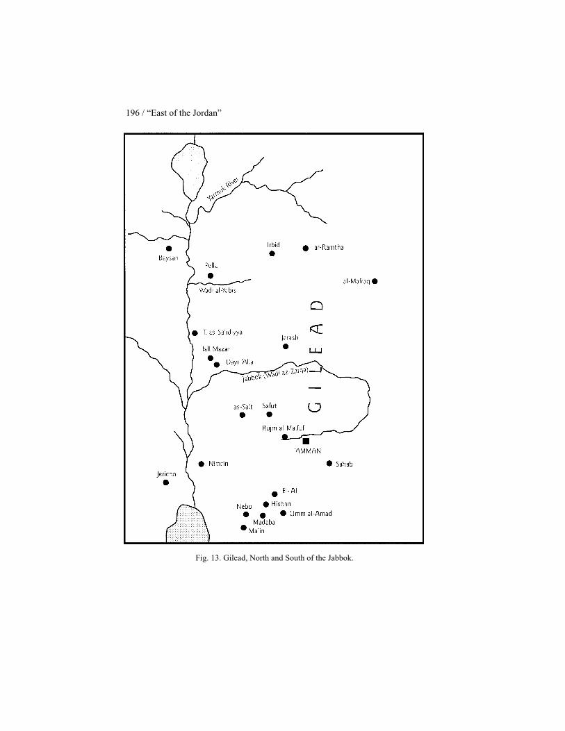
196 / “East of the Jordan”
Fig. 13. Gilead, North and South of the Jabbok.

Gilead Territory and Sites / 197
place Jegar-sahadutha (Aramaic) while Jacob called the place Galeed (He-brew) (Gen 31.47–48), both meaning “heap of stones.” Jacob called thepillar, which he set up on this occasion as a witness to the treaty, Mizpah(Gen 31.45, 49), that is, “watchpost,” and the place is known as Mizpah-gilead. The story reflects a boundary covenant between the Arameans andIsraelites, both of whom laid claim to the area in Transjordan (Gen 31.51–52) (de Vaux 1973: 125; Vawter 1977: 342–43). De Vaux thinks the “hillcountry of Gilead” in Gen 31. 21, 23 and 25 refers to Jabal Jel'ad, that is,the hill country south of the Jabbok (de Vaux 1973: 133). However, it ishard to envisage the biblical writer conceding land so far south to theArameans when the general tendency is to expand Israelite holdings inTransjordan at the expense of such groups as the Ammonites and Moabites.It would appear that the “hill country of Gilead” in Genesis 31 refers to anarea north of the Jabbok. This is not difficult to justify since such places asRamoth-gilead and Jabesh-gilead are located in the northern segment ofGilead.
Num 32.1–5 describes the land of Gilead, along with the land of Jazer,as a good place for cattle and a place that Reuben and Gad desired (seeChapter 6). In this text, Gilead must mean an area south of the Jabbok sinceall the places mentioned in Num 32.3, as well as in Num 32.34–38 (a list oftowns that the Gadites and Reubenites rebuilt; see Chapter 6), are gener-ally acknowledged to be in the region between the Arnon and the Jabbok(Budd 1984: 343).
Num 32.39–40 states that “the descendants of Machir son of Manassehwent to Gilead” and “Moses gave Gilead to Machir son of Manasseh” (seealso Deut 3.15 and Josh 17.6). Here, the reference is to Gilead locatednorth of the Jabbok (de Vaux 1967: 127; Budd 1984: 343).
Deut 3.12–13 and Josh 12.2–5 refer to two halves of Gilead dividedby the Jabbok. According to the former text, the Reubenites and Gaditestook possession of “the territory north of Aroer … as well as half the hillcountry of Gilead with its towns” (v 12) while the half-tribe of Manassehtook possession of “the rest of Gilead and all of Bashan, Og’s kingdom”(v 13). In the latter text, the rule of the Amorite king Sihon who lived atHeshbon extended from Aroer on the edge of Wadi Arnon as far as WadiJabbok or “half of Gilead” (v 2), while the territory of King Og of Bashanincluded “over half of Gilead to the boundary of King Sihon of Heshbon”(v 5). On the basis of these texts, it is evident that the Jabbok divides Gileadinto two halves (Simons 1959: 37; Abel 1967, 1: 276; Ottosson 1969: 83;1992: 1020; Baly 1974: 219, 221; Aharoni 1979: 37).

198 / “East of the Jordan”
Relative to an expanded understanding of Gilead, Deut 34.1 uses theterm to describe the land that the Lord showed Moses from the top of Pisgah:Moses is described as seeing “Gilead as far as Dan.” The term Gilead isused here to refer to the territory in Transjordan that Israel traditionallyclaimed (Simons 1959: 37), that is, territory both south and north of theJabbok. Josh 22.9 uses “the land of Gilead” as parallel to “the land ofCanaan.” In this instance, “the land of Gilead” means all of IsraeliteTransjordan, that is, territory both south and north of the Jabbok (Noth1966: 62; de Vaux 1967: 127; Braun 1986: 76)
1 Maccabees 5 deals with Judas and Jonathan Maccabeus’ defensiveand punitive measures against the Gentiles in 163 B.C. There are manyreferences in the chapter to Gilead (v(v) 9, 25, 27, 36, 45, and 55) and itstowns, namely, Dathema (v(v) 5, 9), Bozrah (v(v) 26, 28), Bosor (v(v) 26,36), Alema (v 26), Chaspho (v(v) 26, 36), Maked (v(v) 26, 36), Carnaim(v(v) 26, 43, 44), Maapha (v 35), and Ephron (v 46; see also 2 Macc 12.27).Most of these sites are located north of the Yarmuk and thus outside TheHashemite Kingdom of Jordan. In this context, Gilead refers to territory inwhat is now northern Jordan and southern Syria. Some commentators pointout, however, that in the description of these encounters, archaic titles ap-pear, for example, “Jacob” (v 2), “Esau” (v 3), and “Ammonites” (v 6). Thebiblical writer wants his readers to know that Judas and Jonathan Maccabeusand their followers are engaged in a struggle similar to that of David inorder to establish their claims or rights to an ancient heritage.
It can clearly be seen that the term Gilead is not used precisely in theBible. Originally it designated territory in the region between as-Salt andthe Jabbok. Over time, it came to designate the area north of the Jabbok aswell. Thus, it can designate all the territory of Israel east of the JordanRiver from the Arnon in the south to the Yarmuk in the north. In 1 Maccabees5 the term even includes parts of what is today southern Syria. Generally,though, Gilead designates the mountainous region from the Yarmuk Riverin the north to Wadi Hisban in the south, excluding Bashan to the north ofthe Yarmuk and the Mishor to the south of Hisban. Here the land is dividedinto two halves, both called Gilead, separated by the Jabbok. The halvescorrespond today to the 'Ajlun region to the north, and northern Belqa (= al-Balkha) to the south of the Jabbok (Simons 1959: 37; Noth 1966: 13–14;de Vaux 1967: 127). The meaning of the term changes according to thedomination and aspirations of Israelite tribes east of the Jordan (Ottosson1969: 199).
The restricted meaning of the term is probably the more primitive one(Grollenberg 1956: 150; Noth 1966: 62; 1959: 25–26; de Vaux 1967: 127;

Gilead Territory and Sites / 199
Mittmann 1970: 212). According to Numbers 32, the tribe of Gad settled inthe country of Gilead, that is, between the Arnon and the Jabbok (Noth1968: 237). But the territory of Gad did not originally extend north of theJabbok, the ideal limit given to the kingdom of Sihon to which Gad is theinheritor. Today, the mountainous region between as-Salt and Wadi az-Zarqais called Jabal Gilead, where the name survives in the modern Jabal/Khirbat/'Ayn Jel'ad (Simons 1959: 38; Noth 1959: 21; 1966: 62; 1968: 237; Gray1967: 134; de Vaux 1967: 128). The territory of Heshbon, including boththe country of Jazer (Wadi Shu'ayb basin to as-Salt) and the country ofGilead (Jabal Gilead, from as-Salt to Wadi az-Zarqa) (de Vaux 1967: 28–29), corresponds to the territory of Gad.
GILEAD SITES
The several sites associated with the name Gilead include Mizpah andMizpah-gilead; Ramoth-gilead; Jabesh-gilead; and Tishbe. Moreover, WadiCherith (1 Kings 17.3, 5) is associated with Elijah of Tishbe in Gilead whileElisha, the successor of Elijah, comes from Abel-meholah (1 Kings 19.16).In 1 Maccabees 5, there are nine other sites said to be towns of Gilead:Dathema (v(v) 9, 29); Bozrah (v(v) 26, 28); Bosor (v(v) 26, 36); Alema (v26); Chaspho (v(v) 26, 36); Maked (v(v) 26, 36); Carnaim (v(v) 26, 43, 44;see also 2 Macc 12.21, 26); Maapha (v 35); and Ephron (v 46). There arealso two towns, Caspin (2 Macc 12.13) and Charax (2 Macc 12.17), whichare generally placed in this region of Gilead. However, Ephron and Charaxmay be located in the Land of Tob rather than in Gilead. Since Bozrah andBosor are located in southern Syria they will not be treated here.
i) Mizpah (Judg 10.17; 11.11, 34) and Mizpah of Gilead (Judg 11.29):Mizpah and Mizpah of Gilead appear prominently in the Jephthah story(Judg 10.6–12.7). They are frequently assumed to be the same place. In thestory, the Israelites or perhaps only the Gileadites camped in Mizpah (Judg10.17), where there was a sanctuary to Yahweh (Judg 11.11), while theAmmonites camped in Gilead (Judg 10.17). It was from Mizpah of Gileadthat Jephthah went out against the Ammonites (Judg 11.29). After his vic-tory, he returned to his home at Mizpah (Judg 11.34).
The Hebrew term Mizpah means “watchpost” (Gray 1902: 3318) or“vantage point” (Knauf 1992a: 602). It thus provides general topographi-cal information insufficient to pinpoint its location. The addition of Gileadto the toponym gives no more than a very general indication of the locationof Mizpah.

200 / “East of the Jordan”
Consequently, identification of Mizpah is difficult. Some commenta-tors locate it at Khirbat Jel'ad (Noth 1966: 62; Abel 1967, 2: 390; de Vaux1967: 131–33; 1973: 125; Baly 1974: 224) while Noth locates it “in themodern reshuni, a few miles northwest of Gilead” (1960: 158; see also his1968: 237). Simons supports the latter position: “There are no adequatedata for a precise localization of MIZPAH situated close to GILEAD butthe ancient settlement of er-reshuni, west of hirbet gel'ad would answer therequirements” (1959: 229–30). Mittmann, however, locates Mizpah at al-Misrefe near Khirbat Jel'ad (1970: 217 n. 27) while Boling thinks its“location is uncertain but is surely to be sought in the vicinity of Jebaljel'ad and Khirbet jel'ad, south of the Jabboq” (1975: 199).
On the basis of the biblical account dealing with the life and deeds ofJephthah, Glueck would place Mizpah north of the Jabbok. However, he isnot able to find any particular site for the location of Jephthah’s home (1943:14). Following Glueck, Lemaire would also place the site north of WadiJabbok in the region of Suy, perhaps at Tall al-Masfa, which is located tothe northwest of Jarash on the main route to Pella and Wadi al-Yabis (1981:44).
Unlike de Vaux (1967: 132; 1973: 131–32) and Simons (1959: 230),who see the Mizpah of the Jephthah and Jacob stories as the same place,Glueck places the Mizpah of Jacob in northern Gilead and so does notthink the two sites are necessarily the same place (1943: 16).
In support of the location of Mizpah at Khirbat Jel'ad, both Glueckand de Vaux describe the ruins at Khirbat Jel'ad as located on top of a veryhigh hill. According to Glueck, the ruins consist of the remains of medievalArabic and modern buildings along with a Roman mausoleum situated atthe southwest end of the hill. Near the bottom of the hill, on the northwestside, Glueck reports an extensive Roman necropolis. His report indicatescave-cisterns and masses of Byzantine and medieval Arabic sherds alongwith some Roman and a small quantity of clear Early Iron I–II sherds (1939a:231–32). De Vaux adds to this description the discovery of several ancientfragments, in particular the base of a column and, on the north flank of thehill, the remains of a rampart. His collected pottery includes some Iron Ageand even more Hellenistic and Roman pieces (1938: 416–17). Relative tothe location of Mizpah at ar-Rashune, there is no convincing archaeologicalevidence of its occupation during the Iron Age.
Despite the available evidence, there is no convincing, identifiablelocation for Mizpah/Mizpah of Gilead. Neither is there proof of its locationnorth or south of the Jabbok. Biblical writers probably did not know exactlywhere the site was and thus gave it a generic name.
Gilead Territory and Sites / 201
ii) Ramoth-gilead/Ramoth in Gilead (Deut 4.43; Josh 20.8; 21.38 [1Chr 6.80]; 1 Kings 4.13; 22.3, 4, 6, 12,15, 20, 29 [2 Chr 18.2, 3, 5, 11, 14,19, 28]; 2 Kings 8.28 [2 Chr 22.5]; 2 Kings 9.1, 4, 14): Ramoth-gilead/Ramoth in Gilead served as the capital of the sixth Solomonic province(1 Kings 4.13). It was a border town that the Arameans took from Israel inthe mid-ninth century, and which the latter, with help from Judah, attemptedto recapture during the time of Ahab and Jehoshaphat (1 Kings 22; 2 Chr18). Ahaziah and Joram, kings of Judah and Israel respectively, waged waragainst King Hazael of Aram at Ramoth-gilead (2 Kings 8.28; 2 Chr 22.5).The Syrians wounded Joram there (2 Chr 22.5). At Ramoth-gilead Elishafomented the revolution of Jehu against Joram (2 Kings 9). The site,“belonging to the Gadites”/”out of the tribe of Gad,” was both a city ofrefuge (Deut 4.43; Josh 20.8; 21.38) and a Levitical city (Josh 21.38; 1 Chr6.80).
The Deuteronomistic History relates Ramoth-gilead to Manasseh inGilead and Argob in Bashan (1 Kings 4.13), suggesting it is located in thenorth.
The Hebrew ramoth means “heights”/“high places”; combined with“Gilead” it should refer to prominent or well-known heights in the regionof Gilead. We should look for a site that meets this description.
Eusebius locates Ramoth-gilead on the Jabbok (146: 4–5), probablyincorrectly (Glueck 1951: 96 n. 219) since biblical texts seem to place thesite north of the Jabbok.
The ramoth of Ramoth-gilead appears to be preserved in both the namesof the modern town of ar-Ramtha (Smend 1902:158; Hölscher 1906), onthe present Jordanian-Syrian border, and the archaeological site of Tall ar-Rumeith (Glueck 1943: 12; 1951: 99–100; Simons 1959: 121, 207), justsouth of the border. Partly for this reason, commentators have often optedfor one or the other as the biblical site’s location.
There is also archaeological support for choosing Tall ar-Rumeith,situated in the fertile plain area just to the southeast of the junction of the'Amman-Damascus and Irbid-Mafraq highways, as the location for Ramoth-gilead. Glueck reports large numbers of Iron Age I–II sherds at the site(1951: 98). P. Lapp, who sounded the site in 1962 (1963) and excavated itin 1967 (1967; 1968), found that the earliest strata (VIII–V) with ceramicgroups whose typology is Syrian date to the tenth–eighth centuries B.C. Heposits a massive destruction of the site at the end of Stratum V after whichit was not reoccupied until the second century B.C. (P. Lapp 1967; 1968; seealso Sauer 1985: 212 and N. Lapp 1989; 1997). The site was primarily a
202 / “East of the Jordan”
fort rather than a major settlement (N. Lapp 1989; 1997). Peterson’s ran-dom sherd collection at Tall ar-Rumeith leads him to affirm the occupationof the site during the eighth century B.C. (1980: 599–600). Thus, the site isfrequently identified with biblical Ramoth-gilead (see, for example, Glueck1943; 1951: 98–99; Noth 1959: 50–51; 1966: 62; Simons 1959: 21, 207;Ottosson 1969: 32–34, 217–18; Mittmann 1970: 225; Oded 1970: 180;Aharoni 1979: 441; Mayes 1979: 159; Peterson 1980: 596–600; Sauer 1985:212; LaSor 1988: 40; Dearman 1989a: 164; Weinfeld 1991: 232; N. Lapp1997: 444).
Ar-Ramtha, a modern and ancient site located on an important east–west road between Dera'a and Irbid, as well as on the north–south highwaybetween Damascus and 'Amman, is another candidate for the location ofRamoth-gilead. Glueck reports Iron Age I–II sherds on the east side of thelow rise on which the present town sprawls (1943: 11; 1951: 97).
One difficulty with the identification of Ramoth-gilead with Tall ar-Rumeith is the smallness of the site (Lemaire 1981; N. Lapp 1997: 444). Itwas most probably not much more than a mudbrick fort, measuring roughly37 ≈ 32 m, and some houses (N. Lapp 1997: 445). An argument against theidentification of ar-Ramtha with Ramoth-gilead is its location. For thesereasons, and despite the fact that there is no relation between the ancientand modern names, several commentators, myself included, have soughtthe site at a more imposing location, choosing Tall al-Husn, a large prima-rily artificial mound located south of Irbid at the northern edge of the 'Ajlunmountains overlooking the vast plain to the north and northeast, as perhapsthe best choice for Ramoth-gilead (Albright 1929; Abel 1967, 2: 430–31;de Vaux 1967: 132; Lemaire 1981; Kallai 1986; Weippert 1997: 33). Tallal-Husn is by far the most important site in the area and guarded the ap-proaches to the most fruitful areas of Gilead from the Hauran (Glueck 1951:96). Glueck reports masses of Iron Age pottery on its surface (1951: 96).Further, Leonard’s examination of waterpipe trenches at the tell turned upIron Age material, while his sounding at one trench uncovered pottery fromthe same period, “perhaps more specifically Iron II” (1987: 359, 369, 388–89).
iii) Jabesh-gilead (Judg 21.8, 9, 10, 12, 14; 1 Sam 10.27; 11.1, 3, 5, 9,10; 31.11, 12, 13; 2 Sam 2.4, 5, 12; 21.12; 2 Kings 15.10, 13, 14; 1 Chr10.11, 12): Jabesh-gilead first appears as the place from which the Israel-ites procured four hundred young virgins for the men of the nearly-exterminated tribe of Benjamin (Judg 21.8–14). It seems to be outside theland of Canaan (Judg 21.12). To Jabesh-gilead fled seven thousand men

Gilead Territory and Sites / 203
who had escaped from the eye-gouging Nahash, king of the Ammonites(1 Chr 10. 27). Nahash besieged the place (1 Sam 11.1) and Saul came asits deliverer (1 Sam 11.11). When the Philistines killed Saul and his sonsand hung their bodies on the wall of Baysan, the inhabitants of Jabesh-gilead, after traveling all night long (1 Sam 31.12), stole the bodies, burnedthem at Jabesh-gilead, and buried their bones under the tamarisk tree inJabesh (1 Sam 31.13; compare with 1 Chr 10.11–12). When David wasanointed king over the house of Judah, he was told the men of Jabesh-gilead buried Saul (2 Sam 2.4). Subsequently he asked for a blessing uponthe inhabitants of the city (2 Sam 2.5), and took the bones of Saul from thecitizens of Jabesh-gilead, burying them in the tomb of Saul’s father Kish atZela in the territory of Benjamin (2 Sam 21.12–14).
It is thought that the toponym Jabesh, which means “dryness of theground” (Gray 1902: 3314) or “well-draining soil” (Edelman 1992a: 594),is preserved in the yabis of Wadi al-Yabis (Van Kasteren 1890: 211; Aharoni1979: 34, 288; Edelman 1992a: 594). The site is accordingly sought nearthis wadi.
As the word Gilead in the toponym Jabesh-gilead indicates, the site islocated in the land of Gilead. This is not particularly helpful since Gileadincluded territory both south and north of the Jabbok.
Jabesh in Gilead appears to have been outside and north of Ammoniteterritory (1 Sam 11.1), a night’s march from Baysan and outside Philistineterritory (1 Sam 31.11, 12; 1 Chr 10.11, 12). However, biblical texts pro-vide no precise location for the site.
Josephus provides the general information that Jabesh-gilead is a“metropolis” in Gilead (Ant 6.5.1). Eusebius locates Jabesh-gilead in themountains at a village called Iabeis Galaad in the vicinity of the sixth mile-stone from Pella on the Roman road to Gerasa (= Jarash) (110: 11–13).
Attempts to locate Jabesh-gilead are heavily influenced by Eusebius’statement about the site’s location. Thus the site is frequently located atTall al-Maqlub (Merrill 1818: 440; Noth 1953b; 1959: 49–52; 1960: 167 n.3; 1966: 62; Simons 1959: 315; Ottosson 1969: 195–96; Mittmann 1970:214; Aharoni 1979: 379, 437; Lemaire 1981: 44–45; 1987: 49 [tentatively];Briend 1990: 18; Edelman 1984; 1992a: 594–95; Hübner 1992a: 169) orDayr Halawa/ad-Dayr (Robinson 1856: 319; Steuernagel 1927: A.156; andAbel 1967, 2: 352), the hill-site immediately westsouthwest of Tall al-Maqlub and overlooking Wadi al-Yabis from the south.
Archaeologically, there is evidence of Iron Age I and II occupation atTall al-Maqlub when the site was a large fortified town and the neighboring

204 / “East of the Jordan”
hillsides were first terraced for agriculture (Mabry and Palumbo 1988: 278;1997: 366). However, neither Glueck (1951: 223–24) nor the Wadi al-YabisSurvey (Mabry and Palumbo 1988: 279; Palumbo 1994: 2.66–67) reportremains earlier than the Roman period at Dayr Halawa/ad-Dayr.
Despite Eusebius’ statements on the location of Jabesh-gilead, com-mentators frequently place it at Tall al-Meqbereh and/or its twin site of TallAbu al-Kharaz, located 300 m to the east (Glueck 1951: 268–75; 1943b;McKenzie 1965: 407; see also Baly 1981: 442). The tells are located justnorth of Wadi al-Yabis at the eastern edge of the Jordan Valley and ca. 4 kmfrom the Jordan River. Tall Abu al-Kharaz, the higher of the two sites,provides an excellent view of Baysan. Excavations and survey work at thesite have documented Late Bronze I–II and Iron II remains (Fischer 1991;1993; 1994; 1995; 1996; Mabry and Palumbo 1988), while soundings atTall al-Meqbereh have uncovered 3 m “of stratified Late Bronze and IronAge deposits” (Palumbo et al. 1993: 307; see also Mabry and Palumbo1988 and Palumbo and Mabry 1992: 7).
Older identifications for Jabesh-gilead include Khirbat Miryamim(Merrill 1881: 325; Oliphant 1881: 160–61, 174) and Kufr Abil (VanKasteren 1890: 211–12), neither of which is currently accepted.
Relative to the archaeological remains, there is no reason to choosethe twin sites of Tall al-Meqbereh and Tall Abu al-Kharaz over Tall al-Maqlub as the location of Jabesh-gilead. Since all three sites were occu-pied during the Iron Age, the identification of Jabesh-gilead with Tall al-Maqlub stands and falls with Eusebius’ statement.
iv) Tishbe in Gilead (1 Kings 17.1; 21.17, 28; 2 Kings 1.3, 8; 9.36):The ninth century prophet, Elijah, was a Tishbite from Tishbe in Gilead(1 Kings 17.1)
Tishbe in Gilead is frequently located at either Listib/al-Istib in thenorthwest 'Ajlun mountains (van Kasteren 1890: 207–11; Lemaire 1981:44) or at Khirbat Umm al-Hedamus which lies 2 km to the east (Mittmann1970: 222 n. 34, 230 n. 59 [tentatively]; Thiel 1990: 134). The formeridentification is based on the suggestion of a metathesis between the He-brew Tishbe and the Arabic al-Istib (Glueck 1951: 226; see Abel 1967, 2:486). There is the popular association of the name Elijah with the vicinityof Listib, as evidenced in the toponym Mar Ilyas, located about 0.50 km tothe southeast of Listib (Glueck 1951: 226).
One difficulty with locating Tishbe at Listib/al-Istib is that the sitewas almost certainly not occupied before the Roman-Byzantine period(Glueck 1951: 218; Simons 1959: 360; Mabry and Palumbo 1988: 279).

Gilead Territory and Sites / 205
However, Mittmann thinks the name could have moved to Listib/al-Istibfrom Khirbat Umm al-Hedamus (1970). Archaeological support forMittmann’s position comes from the Wadi al-Yabis Survey’s 1989 surfacecollection and 1990 sounding of the site (Palumbo 1992: 25–32). This workconfirmed Mittmann’s (1970: 68) reading of the surface pottery as IronAge, the major period of occupation, especially the ninth century (Palumbo1992: 32). Glueck believes the connection of Elijah with Listib and thenearby site of Mar Ilyas may rest upon the memory that the prophet was athome in this region (1951: 218, 227). Simons asserts that “at best … listiband mar eljas may be taken as approximate indications of the location ofTISHBEH” (1959: 360). Ottosson is less certain, stating only that “Elijah’shome probably lay in northern Gilead” (1969: 34). This is probably thebest assessment possible given current data.
v) Wadi Cherith (1 Kings 17.3, 5): After God’s announcement to Ahababout a drought in Israel, God told Elijah to hide by “Wadi Cherith, whichis east of the Jordan” (1 Kings 17.3, 5). There, at least for a time during thedrought, Elijah drank from the wadi and ravens fed him (1 Kings 17. 6, 7).
The Hebrew word cherith means “cutting.” This is not very helpful inlocating Wadi Cherith since there are several deep-cut wadis flowing west-ward to the Wadi 'Arabah-Dead Sea-Jordan Depression from both northernand southern Gilead (see Chapter 3).
The expression “east of the Jordan” in 1 Kings 17.3, 5 probably refersto territory outside Ahab’s jurisdiction, since the king wanted to meet andbe reconciled with the prophet in order to bring the drought to an end(1 Kings 18.7–16). Eusebius’ vague statement that Wadi Cherith is acrossthe Jordan (174: 16) probably indicates that he did not know the wadi’slocation.
The wadi in question is often tentatively identified with Wadi al-Yabissince Elijah was from Tishbe, which is frequently located in that region ofGilead (Abel 1967, 1: 484–85; Ottosson 1969: 230 [tentatively]; Rowley1970: 45; Briend 1990: 8; Younker 1992b: 899). Glueck identifies WadiCherith “with one of the easternmost branches of the Wadi el-Yabis in thehighlands of North Gilead” (1951: 219), while Simons writes, “there areno data allowing us to identify the nahal in question, as long as no trace ofits proper name has been found” (1959: 360). This is a sound conclusion.
vi) Abel-meholah (Judg 7.22; 1 Kings 4.12; 1 Kings 19.16): Gideon’sforces surprised the Midianites and the latter fled “as far as Beth-shittahtoward Zererath, as far as the border of Abel-meholah, by Tabbath” (Judg7.22). In conjunction with such well-known sites as Taanach, Megiddo,

206 / “East of the Jordan”
Baysan, and Jezreel, Abel-meholah next appears as part of Solomon’s fifthadministrative district (1 Kings 4.12). It is also the place from which comesElisha, the successor of Elijah (1 Kings 19.16).
The Hebrew abel-meholah means “the meadow of the dancing” (Borée1968: 81; Rowley 1970: 1), suggesting an agricultural location. Eusebiuslocates Abel-meholah 10 miles from Scythopolis (= Baysan) at Bethmaela(34.21–22). In his translation of Eusebius, Jerome adds “to the south,” thatis, south of Scythopolis (35.19).
The site has proponents for its location both west and east of the Jor-dan River. Relative to its eastern location, Glueck opts for Tall al-Maqlub,overlooking Wadi al-Yabis from the north (1951: 213–17, 220–23, 377–78). Ottosson also chooses a site east of the Jordan. Following Noth (1959:52–60), he places Abel-meholah at Tall Abu al-Kharaz (1969: 217; see alsoNoth 1959: 60). Other commentators, on the basis of the description ofSolomon’s fifth district, opt for a western location for the site. Edelman(1992b: 11), following Simons (1959: 294), Abel (1967, 2: 234), and Aharoni(1979: 313, 429), thinks that Tall Abu Sus, in the western ghor 15 km southof Baysan is the best candidate, based on the descriptions in Judg 7.22 and1 Kings 4.12. This is a reasonable location for the site.
vi) Tabbath (Judg 7.22): In relation to Judg 7.22, Aharoni (1979: 284n. 222 [tentatively]), Abel (1967, 2: 474), and Simons (1959: 293) locateTabbath at Ras at-Tabat above Wadi Kufrinja in the 'Ajlun region.
When the Gentiles attacked the Israelites of Gilead in an attempt todestroy them, the Jews fled to Dathema and from there sent a letter to JudasMaccabeus and his brothers requesting help (1 Macc 5.9). Judas and hisbrother Jonathan responded to the request for assistance. In 163 B.C. theycrossed the Jordan on a three-day journey into the wilderness where theymet Nabataeans who reported that the Jews had been shut up in Bozrah,Bosor, Alema, Chaspho, Maked, Carnaim, and other towns of Gilead(1 Macc 5.26). Judas went to the stronghold of Dathema (1 Macc 5.29) andthen took Maapha (1 Macc 5.35) and Chaspho, Maked, Bosor, and theother towns of Gilead (1 Macc 5.36). He also conquered Carnaim (1 Macc5.43–44; 2 Macc 12.21–26), and on the return to Judah, he took the town ofEphron (1 Macc 5.46–51). These towns, now part of The Hashemite King-dom of Jordan, are of primary interest here. Thus, sites in southern Syriawill not be considered; these include Bozrah (= Busra ash-Sham [Simons1959: 425; Abel 1967, 2: 286; Rowley 1970: 40]), Bosor (= Busr al-Hariri[Abel 1967, 2: 241; Baly 1974: 216]), Alema (= 'Alma [Simons 1959: 334;Abel 1967, 2: 241]), Chaspho (= al-Muzeibir [Abel 1923: 519; Simons

Gilead Territory and Sites / 207
1959: 423–24] or Khisfin [Grollenberg 1956: map 31]) (see also 2 Macc12.13–16), Maked (= Tall al-Jemid [Abel 1923: 519] or Tall Miqdad [Rowley1970: 112]), and Carnaim (= Sheikh Sa'd [Abel 1923: 519; Simons 1959:425; Rowley 1970: 44; Aharoni 1979: 438]). Many authorities read Alemafor the Maapha of 1 Macc 5.35 (Metzger and Murphy 1991: 198 AP).
vii) Dathema (1 Macc 5.9, 29): Dathema is the fortress to which theIsraelites of Gilead fled when the Gentiles attacked them. One should lookfor it in the vicinity of Bozrah and Bosor. Possible locations include al-Husn (Glueck 1951: 96), ar-Ramtha (Metzger and Murphy 1991: 197 AP),and Tall Hamad in the plain of Hauran (Abel 1967, 2: 303; Rowley 1970:51). Simons follows the latter identification because of the site’s ancientcity walls and suitable location as a place of refuge (1959: 425). Because ofthe frequent confusion of the Hebrew daleth and resh, the site’s name maybe preserved at ar-Ramtha, a good candidate for the location of the site.
viii) Maapha (1 Macc 5.35): Maapha is another city that Judas is saidto have plundered and burned with fire. Some authorities read Alema forMaapha (Metzger and Murphy 1991: 198 AP). Abel places it at Beit Ras innorthern Jordan (1923: 519). However, the site has not been identified.
ix) Ephron (1 Macc 5.46; 2 Macc 12.27): The city of Ephron is lo-cated east of the Jordan, on the route Judas and the Israelites took on theirreturn from Gilead to Judah. Judas asked permission to pass through thetown but the inhabitants refused his request, following which he destroyedthe town, passing through it over the bodies of the dead (1 Macc 5.48–51).The town is generally identified with at-Taiyiba, at the head of a wadi bythe same name, west of Irbid (Abel 1923: 520–21; 1967, 2: 318–19; Simons1959: 425; see also Goldstein 1976: 532 map 7; 1983: 515 map 6). Basedon the preservation of the name and the geographical indications, at-Taiyibais a suitable location for Ephron.
x) Charax (2 Macc 12.17): Charax is the final city Judas encountereden route to rescue the Israelites of Gilead from the Gentiles. It appears to belocated in the region of what the Jews called Toubiani (2 Macc 12.17),perhaps the people of Tob (1 Macc 5.13). The biblical writer places it 95miles/750 stadia from Caspin/Chaspho. Simons locates it at al-Karak, 20km northwest of Bozrah/Busra ash-sham, which he maintains is closeenough to at-Taiyiba to be within the Toubi region (Simons 1959: 424–25).Goldstein says the text does not refer to a place named Charax but alludesto a “palisaded camp,” that is, a fortress palace, at 'Iraq al-Amir, west of'Amman (1983: 440; also see Smith 1992 and Abel 1923: 515). It was theseat of the Tobiad dynasty in Ammonitis (Lapp 1983; Villeneuve 1988;
208 / “East of the Jordan”
Will, Larché and Zayadine 1991; Zayadine 1997). This is an imaginativepossible location for Charax.
THE LAND OF TOB
The land of Tob appears five times in the Old Testament: Judg 11.3, 5;2 Sam 10.6, 8; 1 Macc 5.13. Jephthah fled to the land of Tob (Judg 11.3),and it was there that the elders of Gilead went to bring him back to fightagainst the Ammonites (Judg 11.5). The Ammonites hired men of Tob(2 Sam 10.6) to fight against David (2 Sam 10.8). The Israelites sent aletter to Judas Maccabeus stating that all their kindred in the land of Tobhad been killed (1 Macc 5.13). Moreover, the Jews who are called Toubiani(2 Macc 12.17) are perhaps people of Tob.
The context of 2 Sam 10.6 places the land of Tob in northern Jordan.The city list of Thutmose III has a place called t-b-y and Amarna Letter No.205 mentions Dubu. These toponyms are generally considered to be bibli-cal Tob (Simons 1959: 91; Abel 1967, 2: 10; de Vaux 1973: 125; Aharoni1979: 115; Ahlstrom 1993: 400).
The name Tob, meaning “good,” may be preserved in one of the tayibehnames of Jordan. The site that matches the literary data is at-Taiyiba (Simons1959: 91; Abel 1967, 2: 10; Ahlstrom 1993: 400), identified in this workwith Ephron (1 Macc 5.46; 2 Macc 12.27), and located in northwesternJordan between Wadi az-Zarqa and the Yarmuk River.
CONCLUSIONS
Originally, Gilead referred to the mountainous region south of theJabbok, known today as Jabal Jel'ad. Over time, the term came to be usedfor the mountainous region north of the Jabbok, today’s 'Ajlun region. TheBible refers to two halves of Gilead divided by the Jabbok. In 1 Maccabees5 the term Gilead is used to designate the northern segment of what istoday The Hashemite Kingdom of Jordan and southern Syria.
Most of the sites studied in this chapter are located in the northernsegment of Gilead. They are generally found in the western segment of theHighlands at the Eastern Rim of the Wadi 'Arabah-Dead Sea-Jordan De-pression, an area in which rainfall is plentiful and in which agriculturalactivities can successfully be pursued.

Acknowledgements / 209
APPENDIX
LIST OF BIBLICAL SITE IDENTIFICATIONS FOR JORDAN
Biblical Toponym Modern Arabic Name UTME/UTMN
Abel-keramim Tall al-'Umayri(?) 7733/35297Abel-meholah Tall Abu Sus; west of Jordan River -Abel-shittim/Shittim Tall al-Hamman(?) 7537/35257Adam Tall ad-Damiyya 74034/355498Admah Unidentified -Ai Unidentified -Almon-diblathaim/ Kh. ad-Deleilat al-Garbiyya and 7652/35019Beth-diblathaim Kh. ad-Deleilat ash-SharqiyyaAr/Ir Dhiban; capital city of Moab 7635/34888Argob, region of Unidentified; but in the north of Jordan -Arnon Wadi al-Mujib -Aroer (on Arnon) 'Ara'ir 7679/34854Aroer (in Ammon) Unidentified -Ataroth Kh. 'Atarus 7531/34965Atroth-shophan Rujm 'Atarus(?) 7550/34984Avith Unidentified -Baal-meon/Beon/ Unidentified -
Beth-meon/Beth-baal-meon/Baean
Baal of Peor/ Unidentified -Baal-peor
Bamoth/ Unidentified -Bamoth Ba'al
Bashan Land both south and north of the Yarmuk -Beer/Beer-elim No particular site but where water is available -Bela (that is, Zoar) Unidentified; but in SE plain of the Dead Sea -Beth-diblathaim Kh. ad-Deleilat al-Garbiyya and 7652/35019
Kh. ad-Deleilat ash-SharqiyyaBeth-gamul Kh. al-Jumeil 7748/34879Beth-haran(m) Tall ar-Rama 75032/352434Beth-jeshimoth Tall al-'Azeimeh 7468/35197Beth-nimrah/Nimrah Tall Nimrin 74826/353262Beth-peor Unidentified -Betonim Kh. Batneh 7561/35450Bezer/Bozrah Tall Jalul 7707/35131
or Umm al-'Amad 7748/35206Bozrah, city of Edom Busayra 749600/3404000Brook of the Willows Wadi al-Hasa -Charax 'Iraq al-Amir(?) 76022/353426Dathema Ar-Ramtha(?) 2192/36065
209

210 / “East of the Jordan”
Dimon/Madmen Kh. ad-Dimnah 7574/34653Debir/Li-debir Unidentified -Dibon/Dibon-gad Dhiban 7635/34888Dinhabah Unidentified -Edrei Dera'a; in Syria -Eglaim Unidentified -Eglath-shelishiyah Unidentified -Elealeh El-'Al 7677/35240Eloth/Elath Tall al-Khalayfi 6918/32705Ephron At-Taiyiba 7552/36039Ezion-geber Jezirat Fara'un(?) -Gilead, land of Territory north and south of Wadi az-Zarqa -Gomorrah Unidentified; probably along SE side of Dead Sea -Havvoth-jair Between Jabal 'Ajlun and the Yarmuk -Heshbon Tall Hisban 7660/35219Holon Unidentified -Horonaim Al-Karak 7575/34529Iye-abarim/Iyim In SE plain of the Dead Sea between Wadi -
Khanazir and Bab adh-Dhra'Jabbok Wadi az-Zarqa -Jabesh-gilead Tall al-Meqbereh, 74370/358793
Tall al-Maqlub, or 7523/35883Abu al-Kharaz 74431/358789
Jahaz/Jahzah Kh. al-Mudayna in Wadi ath-Thamad(?) 77597/349869Jazer Kh. Jazzir 7572/35460Jazer, land of In Wadi Shu'ayb and Wadi Azraq basin -Jogbehah Al-Jubeihah 7698/35457Kedemoth Qasr Saliya(?) or a nearby site 7773/34838Kenath/Nobah UnidentifiedKerioth Dhiban; capital city of Moabites 7635/34888King’s Highway Main N–S route from Irbid to al-'Aqaba; -
in the Highlands at the Eastern Rim of theWadi 'Arabah-Jordan Graben
Kir/Kir-hareseth/ Capital city of the Moabites -Kir-heres
Kiriathaim Unidentified -Luhith In the area of Kathrabba 7502/34480Luhith, ascent of Along Wadi I'sal 7421/34546Maapha Unidentified -Madmen/Dimon Kh. ad-Dimnah 7574/34653Magdiel Unidentified -Mahanaim Tall adh-Dhahab al-Garbiyya and 7533/35642
Tall adh-Dhahab ash-Sharqiyya 7534/35643Masrekah Jabal al-Mushraq area -Mattanah Unidentified -Medeba Madaba 7648/35124Mephaath Umm ar-Rasas 7774/34888

Appendix / 211
Mibzah Busayra, capital city of the Edomites 749600/3404000Minnith Unidentified; but in 'Amman region -Mishor Plateau between Arnon and Heshbon -Mizpah-gilead/ Unidentified -
Mizpah of GileadMountains of Abarim On Mount Nebo -Nahaliel Wadi Zarqa Ma'in -Nebo Kh. al-MukhayyatNimrah/Beth Nimrah Tall Nimrin 74826/353262Nimrim, waters of Wadi an-Numayra -Oboth In SE plain of the Dead Sea between -
Wadi Khanazir and Bab adh-Dhra'Pau/Pa'i/Phogor Unidentified; but in northern Edom -Penuel/Peniel Tall Dayr 'Alla 74713/356542Peor Unidentified -Pisgah Ras al-Siyagha 7581/35180Plains of Moab NE side of the Dead Sea -Punon Faynan 7391/33911Rabbath-ammon 'Amman Citadel/Jabal al-Qal'ah 77745/353925Ramath-mizpeh A Rujm al-Malfuf structure in vicinity -
of 'Amman(?)Ramoth-gilead/ Tall al-Husn 7707/35979
Ramoth in GileadRehoboth-on-the-River Ras Rihab 7462/34263Route of the 'Arabah Main N–S route in Wadi 'Arabah between -
the Gulf of al-'Aqaba and the Dead SeaRoute of the Wilder- Close to what is now the Darb al-Hajj, Ottoman -
ness of Moab Railway, and/or Desert HighwaySea of the 'Arabah Dead Sea -Sebam/Sibmah Unidentified; but in the area of Heshbon -Seir Mountains of Edom east of the 'Arabah -Sela (in Moab) Unidentified -Sela (in Edom) As-Sila' 74648/340841Sharon, pasture lands Mishor (see above) -Shittim See Abel-shittim -Sibmah/Sebam See Sebam/Sibmah -Sodom Unidentified; probably at SE side of Dead Sea -Succoth Tall al-Khisas -Tabbath Ras at-Tabat -Teman, land of Entire land of Edom -Tishbe in Gilead Unidentifed but in northern Gilead -Tob, land of Between Wadi az-Zarqa and Yarmuk River -Tophel Unidentified -Town that is in the Unidentified -
middle of the valleyUz, land of In southern Edom near the Arabian border -Valley lying in the … Wadi 'Uyun Musa 7592/35189

212 / “East of the Jordan”
Wadi Cherith Unidentified -Wadi Zered Wadi al-Hasa -Wadi of the Willows Wadi al-Hasa -Waheb in Suphah Unidentified; but probably near Arnon -Wasteland Northeast of Dead Sea in the Plains of Moab -Zalmonah Unidentified -Zaphon Tall as-Sa'idiyya 74271/357322Zarethan UnidentifiedZeboiim Unidentified; but possibly N of Dead Sea -Zereth-shahar Boz al-Mushelle(?)Zoar (that is, Bela) Unidentified; but at SE plain of Dead Sea -

Appendix / 213
REFERENCES
Abel, F.-M.1931 Exploration du Sud-Est de la vallée du Jourdain. Revue Biblique
40: 214–26, 375–400.1967 Géographie de la Palestine. Vol. 1: Géographie Physique et
Historique. Vol. 2: Géographie Politique Les Villes. TroisièmeEdition. Paris: Gabalda.
Abu Dayyah, A. S.; Greene, J. A.; Hassan, I. H.; and Suleiman, E.1991 Archaeological Survey of Greater Amman, Phase 1: Final Report.
Annual of the Department of Antiquities of Jordan 35: 361–95.Abu Ghanimeh, K.
1984 Abu Nseir Excavations. Annual of the Department of Antiquities ofJordan 28: 305–10.
Adams, R. B.1991 The Wadi Fidan Project, Jordan, 1991. Levant 23: 181–83.1992 Romancing the Stones: New Light on Glueck’s 1934 Survey of East-
ern Palestine as a Result of Recent Work by the Wadi Fidan Project.Pp. 177–86 in Early Edom and Moab: The Beginning of the IronAge in Southern Jordan, ed. P. Bienkowski. Sheffield Archaeologi-cal Monographs 7. Sheffield: Collis in Association with NationalMuseums and Galleries on Merseyside.
Adams, R. B., and Genz, H.1995 Excavations at Wadi Fidan 4: A Chalcolithic Village Complex in
the Copper Ore District of Feinan, Southern Jordan. Palestine Ex-ploration Quarterly 127: 8–20.
Adler, R. et al., eds.1985 Atlas of Israel: Cartography, Physical and Human Geography. 3rd
ed. New York: The Survey of Israel, Macmillan and CollierMacmillan.
Aharoni, Y.1961 Kadesh-barnea and Mount Sinai. Pp. 115–45 in God’s Wilderness:
Discoveries in Sinai, ed. B. Rothenberg. London: Thames and Hud-son.
1964 Mezad Gozal. Israel Exploration Journal 14: 112–13.1979 The Land of the Bible: A Historical Geography. 2nd rev. ed., Trans.
and ed. A. F. Rainey. London: Burns & Oates.1981 Arad Inscriptions. Jerusalem: Israel Exploration Society.
Aharoni, Y., and Avi-Yonah, M.1993 The Macmillan Bible Atlas. 3rd rev. ed. New York: Macmillan.
Ahituv, S.1984 Canaanite Toponyms in Ancient Egyptian Documents. Jerusalem:
Magnes.
213

214 / “East of the Jordan”
Ahlstrom, G. W.1993 The History of Ancient Palestine from the Palaeolithic Period to
Alexander’s Conquest (with a contribution by G. O. Rollefson), ed.D. Edelman. Journal for the Study of the Old Testament, Supple-ment Series 146. Sheffield: Sheffield Academic.
Ahmad, A. A.1989 Jordan Environmental Profile: Status and Abatement. Amman:
United States Agency for International Development.Albright, W. F.
1924 The Archaeological Results of an Expedition to Moab and the DeadSea. Bulletin of the American Schools of Oriental Research 14: 1–12.
1925 Bronze Age Mounds of Northern Palestine and the Hauran: TheSpring Trip of the School in Jerusalem. Bulletin of the AmericanSchools of Oriental Research 19: 5–19.
1926 The Jordan Valley in the Bronze Age. Pp. 13–74 in Annual of theAmerican Schools of Oriental Research 6 (1924–1925), ed. B. W.Bacon. New Haven, CT: American Schools of Oriental Research.
1929 New Israelite and Pre-Israelite Sites: The Spring Trip of 1929. Bul-letin of the American Schools of Oriental Research 35: 1–13.
1935 The Archaeology of Palestine and the Bible. 3rd ed. New York:Revell.
1941a The Land of Damascus between 1850 and 1750 B.C. Bulletin of theAmerican Schools of Oriental Research 83: 30–36.
1941b New Egyptian Data on Palestine in the Patriarchal Age. Bulletin ofthe American Schools of Oriental Research 81: 16–21.
1943 Two Little Understood Amarna Letters from the Middle Jordan Val-ley. Bulletin of the American Schools of Oriental Research 89: 7–17.
1944 The Oracles of Baalam. Journal of Biblical Literature 63: 207–33.1945 The List of Levitic Cities. Pp. 49–73 in Louis Ginzberg: Jubilee
Volume on the Occasion of his Seventieth Birthday, ed. AmericanAcademy for Jewish Research. New York: American Academy forJewish Research.
1968 Archaeology and the Religion of Israel: The Ayer Lectures of theColgate-Rochester Divinity School. 5th ed. Baltimore: JohnsHopkins University.
Alexander, P. S.1974 The Toponymy of the Targumim with Special Reference to the Ta-
ble of the Nations and the Boundaries of the Land of Israel. Unpub-lished Ph.D. Dissertation, Oxford University.
Allen, L. C.1990 Ezekiel 20–48. Word Biblical Commentary 29. Dallas, TX: Word.

References / 215
Alliata, E.1990 Nuovo settore del monastero al Monte Nebo-Siyagha. Pp. 427–66
in Christian Archaeology in the Holy Land. New Discoveries: Es-says in Honour of Virgilio, eds. G. C. Bottini; D. Di Segni; and E.Alliata. Jerusalem: Franciscan.
Al-Muheisen, Z., and Villeneuve, F.1991 Khirbet edh-Dharih 1991. Liber Annuus 41: 507–9.1992 Khirbet edh-Dharih 1992. Liber Annuus 42: 356–59.1994 Khirbet edh-Dharih. American Journal of Archaeology 98: 540–
42.1995 Khirbet edh-Dharih. American Journal of Archaeology 98: 521–
22.Alt, A.
1926 Ataroth. Palästina Jahrbuch 22: 33.1933 Das Institut im Jahre 1932. Palästina Jahrbuch 29: 5–29.1935 Aus der ‘Araba II: Römische Kastelle und Strassen. Zeitschrift des
Deutschen Palätina-Vereins 58: 1–59.1953 Neue Erwagungen über die Lage von Mizpa, Ataroth, Beeroth, und
Gideon. Zeitschrift des Deutschen Palästina-Vereins 69: 1–27.1959 Kleine Schriften zur geschichte des volkes Israel. 3 vols. Munchen:
Beck’sche.Alt, A., and Wickert, L.
1935 Aus der ‘Araba III: Inschriften und Felszeichnungen. Zeitschriftdes Deutschen Palästina-Vereins 58: 60–74.
Amiran, D. H. K. et al., eds.1970 Atlas of Israel: Cartography, Physical Geography, Human and Eco-
nomic Geography, History. 2nd ed. Amsterdam: Survey of Israel,Ministry of Labour, Jerusalem, and Elsevier.
'Amr, A. J.1973 Excavations at Meqablein. Annual of the Department of Antiquities
of Jordan 18: 73–74.Andersen, F. I., and Freedman, D. N.
1989 Amos: A New Translation with Notes and Commentary. The An-chor Bible 24A. New York: Doubleday.
Anderson, B. W.1964 Archaeological Newsletter 3, 1963–64. American Schools of Ori-
ental Research, January 4, 1–2.Anonymous
1965 East Bank Jordan Water Resources. The Hashemite Kingdom ofJordan Central Water Authority. Report by Sir M. Macdonald andPts. 4 vols.
1984 National Atlas of Jordan. Part 1: Climate and Agroclimatology.Amman: Jordan National Geographic Centre.

216 / “East of the Jordan”
1986 National Atlas of Jordan. Part 2: Hydrology and Agrohydrology.Amman: Royal Jordanian Geographic Centre.
Arav, R.1992a Golan. Pp. 1057–58 in The Anchor Bible Dictionary, 2, ed. D. N.
Freedman. New York: Doubleday.1992b Hermon, Mount. Pp. 158–60 in The Anchor Bible Dictionary, 3,
ed. D. N. Freedman. New York: Doubleday.Astour, M.C.
1966 Political and Cosmic Symbolism in Genesis 14 and in its BabylonianSources. Pp. 65–112 in Biblical Motifs: Origins and Transforma-tions, ed. A. Altmann. Cambridge, MA: Harvard University.
Aufrecht, W. E.1989 A Corpus of Ammonite Inscriptions. Ancient Near Eastern Texts &
Studies 4. Lewiston: Mellen.Avi-Yonah, M.
1954 The Madaba Mosaic Map: With Introduction and Commentary.Jerusalem: The Israel Exploration Society.
1977 Medeba (Madaba). Pp. 821–23 in Encyclopedia of Archaeological Ex-cavations in the Holy Land, 3, eds. M. Avi-Yonah and E. Stern. Jerusa-lem: The Israel Exploration Society and Massada.
Bachmann, H.-G., and Hauptmann, A.1984 Zur alten Kupfergewinnung in Fenan und Hirbet en-Nahas im Wadi
Arabah in Südjordanien. Ein Vorbericht. Der Anschnitt (Zeitschriftfür kunst und kultur im Bergrau) 36.4: 110–23.
Bailey, C.1984 Bedouin Place-Names in Sinai: Towards Understanding a Desert
Map. Palestine Exploration Quarterly 116: 42–57.Baker, D. W.
1992 Tarshish. Pp. 331–33 in The Anchor Bible Dictionary, 4, ed. D. N.Freedman. New York: Doubleday.
Baker, M. Jr., Inc., and Harza Engineering Company1958 Princess ‘Alia Project: Definite Plan Report. Amman: Develop-
ment Board, Government of Jordan.Baly, D.
1974 The Geography of the Bible. New and rev. ed. Guildford and Lon-don: Lutterworth.
1987 The Pitfalls of Biblical Geography in Relation to Jordan. Pp. 123–24 in Studies in the History and Archaeology of Jordan III, ed. A.Hadidi. Amman: Department of Antiquities.
Baly, D., and Tushingham, A. D.1971 Atlas of the Biblical World. New York: World.
Baney, R. E.1962 Search for Sodom and Gomorrah. Kansas City: CAM.

References / 217
Barker, G. W.; Creighton, O. H.; Gilbertson, D. D.; Hunt, C. O.; Mattingly, D. J.;McLaren, S. J.; and Thomas, D. C.
1997 The Wadi Faynan Project, Southern Jordan: A Preliminary Reporton Geomorphology and Landscape Archaeology. Levant 29: 19–40.
Barker, G. W.; Adams, R.; Creighton, O. H.; Gilbertson, D. D.; Grattan, J. P.; Hunt,C. O.; Mattingly, D. J.; McLaren, S. J.; Mohamed, H. A.; Newson, P.; Reynolds,T. E. G.; and Thomas, D. C.
1998 Environment and Land Use in the Wadi Faynan, Southern Jordan:the Second Season of Geoarchaeology and Landscape Archaeology(1997). Levant 30: 5–25.
Barnes, H.; Flender, M.; Ruben, I.; Shafiq, R.; and McQuitty, A.1995 The Wadi Feynan Project, Phase 3. British Institute at Amman for
Archaeology and History, unpublished report. Amman.Bartlett, J. R.
1972 The Rise and Fall of the Kingdom of Edom. Palestine ExplorationQuarterly 104: 26–37.
1989 Edom and the Edomites. Journal for the Study of the Old Testa-ment, Supplement Series 77. Sheffield: Sheffield Academic.
Barton, C. M., and Clark, G. A.1993 Cultural and Natural Formation Processes in Late Quaternary Cave
and Rockshelter Sites of Western Europe and the Near East. Pp.33–52 in Formation Processes in Archaeological Context, eds. P.Goldberg; D. T. Nash; and M. D. Petraglia. Monographs in WorldArchaeology 17. Madison: Prehistoric.
Basha, S. H.1968 Stratigraphic Accumulation, Origin and Prospection of Iron Ore
Deposits at Warda-Southern ‘Ajlun District. Amman: Natural Re-sources Authority, Investigation and Research Department, MineralLaboratory Division.
Beit-Arieh, I.1989 New Data on the Relationship between Judah and Edom toward the
End of the Iron Age. Pp. 125–31 in Recent Excavations in Israel:Studies in Iron Age Archaeology, eds. S. Gitin and W. G. Dever.Annual of the American Schools of Oriental Research 49. WinonaLake: Eisenbrauns.
1995a The Edomites in Cisjordan. Pp. 33–40 in You Shall Not Abhor anEdomite for He is Your Brother: Edom and Seir in History and Tra-dition, ed. D. V. Edelman. Archaeology and Biblical Studies 3.Atlanta: Scholars.
Beit-Arieh, I., ed.1995b Horvat Qitmit: An Edomite Shrine in the Biblical Negev. Mono-
graph Series of the Institute of Archaeology, Tel Aviv University.Tel Aviv: Institute of Archaeology.

218 / “East of the Jordan”
Beit-Arieh, I.1996 Edomites Advance into Judah. Biblical Archaeology Review 22.6:
28–36.Beit-Arieh, I., and Cresson, B.
1985 An Edomite Ostracon from Horvat ‘Uza. Tel Aviv 12.1: 96–101.Beitzel, B. J.
1985 The Moody Atlas of Bible Lands. Chicago: Moody.Ben-Arieh, Y.
1972 The Geographical Exploration of the Holy Land. Palestine Explo-ration Quarterly 104: 81–92.
Bender, F.1974 The Geology of Jordan. Trans. M. K. Khdeir. Berlin: Gebruder
Borntraeger.1975 Geology of the Arabian Peninsula: Jordan. United States Geologi-
cal Survey. Professional Paper 561-1.Benjamin ben Jonah of Tudela
1840–41 The Itinerary of Rabbi Tudela. Trans. and ed. A. Asher. 2 vols.London: Asher.
Bennett, C.-M.1964 Umm el-Biyara-Petra. Revue Biblique 71: 250–53.1966a Des fouilles à Umm el-Biyara: Les Edomites à Petra. Bible et terre
sainte 84: 1, 6–16.1966b Fouilles d‘Umm el-Biyara, rapport préliminaire. Revue Biblique
73: 372–403.1966c Umm el-Biyara. Palestine Exploration Quarterly 98: 123–26.1969 Tawilan (Jordanie). Revue Biblique 76: 386–90.1970 Tawilan (Jordanie). Revue Biblique 77: 371–74.1971 A Brief Report on Excavations at Tawilan, Jordan, 1968–70. Le-
vant 3: v–vii.1973a Excavations at Buseirah, Southern Jordan, 1971: A Preliminary Re-
port. Levant 5: 1–11.1973b The Third Season of Excavation at Buseirah. Annual of the Depart-
ment of Antiquities of Jordan 18: 85.1974 Excavations at Buseirah, Southern Jordan, 1973: Third Preliminary
Report. Levant 7: 1–19.1975 Excavations at Buseirah, Southern Jordan, 1973: Fourth Prelimi-
nary Report. Levant 7: 1–19.1976 Edom. Pp. 251–52 in Interpreter’s Dictionary of the Bible, Supple-
mentary Volume, ed. K. Crim. Nashville: Abingdon.1977 Excavations at Buseira, Southern Jordan 1974: Fourth Preliminary
Report. Levant 9: 1–10.1982 Neo-Assyrian influence in Transjordan. Pp. 181–87 in Studies in
the History and Archaeology of Jordan I, ed. A. Hadidi. Amman:Department of Antiquities.

References / 219
1984 Excavations at Tawilan in Southern Jordan, 1982. Levant 16: 1–23.Bennett, C.-M., and Bienkowski, P.
1995 Excavations at Tawilan in Southern Jordan. British Academy Mono-graphs in Archaeology 8. Oxford: British Institute at Amman forArchaeology and History.
Bergman, A.1936 The Israelite Tribe of Half-Manasseh. Journal of the Palestine Ori-
ental Society 16: 224–54.Bernhardt, K.-H.
1960 Beobachtungen zur Identifizierung moabitischer Ortslagen.Zeitschrift des Deutschen Palästina-Vereins 76: 136–58.
Bienkowski, P.1989 Prosperity and Decline in the LBA Canaan: A Reply to Liebowitz
and Knapp. Bulletin of the American Schools of Oriental Research275: 59–63.
1990a The Chronology of Tawilan and the ‘Dark Age’ of Edom. ARAM 1& 2: 35–44.
1990b Umm el-Biyara, Tawilan and the ‘Dark Age’ of Edom. Levant 22:91–109.
1992 The Beginning of the Iron Age in Southern Jordan: A Framework.Pp. 1–13 in Early Edom and Moab: The Beginning of the Iron Age inSouthern Jordan, ed. P. Bienkowski. Sheffield Archaeological Mono-graphs 7. Sheffield: Collis in Association with National Museumsand Galleries on Merseyside.
Bienkowski, P., ed.1991 Treasures from an Ancient Land: The Art of Jordan. Stroud, Glouces-
tershire: Sutton.1992 Early Edom and Moab: The Beginning of the Iron Age in Southern
Jordan. Sheffield Archaeological Monographs 7. Liverpool: Collisin Association with National Museums and Galleries on Mersey-side.
Bienkowski, P.; Adams, R.; Philpott, R. A.; and Sedman, L.1997 Soundings at Ash-Shorabat and Khirbat Dubab in the Wadi Hasa,
Jordan: the Stratigraphy. Levant 29: 41–70Bikai, P. M.
1993 Khirbet Salameh 1992. Annual of the Department of Antiquities ofJordan 37: 521–32.
Bikai, P. M., and Dailey, T. A., eds.1996 Madaba: Cultural Heritage. Amman: American Center of Oriental
Research.Biran, A.
1982 Notes and News: Aroer. Israel Exploration Journal 32: 161–63.Biran, A., and Cohen, B.
1976 Notes and News: Aroer. Israel Exploration Journal 26: 138–40.
220 / “East of the Jordan”
Blanckenhorn, M.1896 Entstehung und Geschichte des Todten Meeres. Zeitschrift des
Deutschen Palästina-Vereins 19: 1–59.Bliss, F. J.
1907 The Development of Palestine Exploration. The Ely Lectures for1903. New York: Scribner’s.
Boling, R. G.1975 Judges: Introduction, Translation and Commentary. The Anchor
Bible 6A. Garden City: Doubleday.1985 Levitical Cities: Archaeology and Texts. Pp. 23–32 in Biblical and
Related Studies Presented to Samuel Iwry, eds. A. Kort and S.Morschauser. Winona Lake: Eisenbrauns.
1988 The Early Biblical Community in Transjordan. Sheffield: Almond.Boling, R. G., and Wright, G. E.
1982 Joshua: A New Translation with Notes and Commentary. The An-chor Bible 6. Garden City: Doubleday.
Boraas, R. S.1971 A Preliminary Sounding at Rujm El-Malfuf, 1969. Annual of the
Department of Antiquities of Jordan 16: 31–45.Boraas, R. S., and Geraty, L. T., eds.
1976 The Fourth Campaign at Tell Hesban (1974). Andrews UniversitySeminary Studies 14: 1–16.
1978 The Fifth Campaign at Tell Hesban (1976). Andrews UniversitySeminary Studies 16: 101–16.
1979 The Long Life of Tell Hesban, Jordan. Archaeology 32 (1): 10–20.Boraas, R. S., and Horn, S. H.
1969 The First Campaign at Tell Hesban (1968). Andrews UniversitySeminary Studies 7: 97–117.
1973 The Second Campaign at Tell Hesban (1971). Andrews UniversitySeminary Studies 11: 1–6.
1975 The Third Campaign at Tell Hesban (1973). Andrews UniversitySeminary Studies 13: 101–16.
Borée, W.1930 Die alten Ortsnamen Palästinas. 2nd ed. Hildesheim: Olms (re-
print, 1968).Bossut, P.; Kafafi, Z.; and Dollfus, G.
1988 Khirbet ed-Dharih (Survey Site 49/WHS 524), Un noveau gisementnéolithique avec céramique du Sud-Jordanien. Paléorient 14.1: 127–31.
Bourke, S. J.1997 The Urbanisation Process in the South Jordan Valley: Renewed Ex-
cavations at Tulaylat al-Ghassul 1994/1995. Pp. 249–59 in Studiesin the History and Archaeology of Jordan VI, eds. G. Bisheh; M.Zaghloul; and I. Kehrberg. Amman: Department of Antiquities.

References / 221
Bourke, S. J.; Seaton, P. L.; Sparks, R. T.; Lovell, J. L.; and Mairs, L. D.1995 A First Season of Renewed Excavation by The University of Syd-
ney at Tulaylat al-Ghassul. Annual of the Department of Antiquitiesof Jordan 39: 31–64.
Braun, R.1986 1 Chronicles. Word Biblical Commentary 14. Waco: Word.
Briend, J.1987 La marche des Hébreus au-delà du Jordain. Pp. 41–46 in La Jordanie
de l’âge de la pierre à l’époque byzantine. Rencontres de l’Écoledu Louvre. Paris: La Documentation française.
1990 Regards sur le Jourdain et sa valée. Monde de la Bible 65: 8–19.Bright, J.
1965 Jeremiah: A New Translation with Introducton and Commentary.The Anchor Bible 21. 2nd ed. Garden City: Doubleday.
Brown, R. M.1991 Ceramics from the Kerak Plateau. Pp. 169–279 in Archaeological
Survey of the Kerak Plateau, ed. J. M. Miller. Atlanta: Scholars.Bruins, H. J.
1994 Comparative Chronology of Climate and Human History in theSouthern Levant from the Late Chalcolithic to the Early Arab Pe-riod. Pp. 301–14 in Late Quaternary Chronology and Paleoclimatesof the Eastern Mediterranean, eds. O. Bar-Yosef and R. S. Kra.RADIOCARBON. Tucson: University of Arizona.
Brünnow, E., and von Domaszewski, A.1904–09 Die Provincia Arabia auf Grund Zweier in Den Jahren 1897 und
1898 Unternommenen Reisen und der Berichte Früherer Reisender,3 vols. Strassburg: Trübner.
Budd, P. J.1984 Numbers. Word Biblical Commentary 5. Waco: Word.
Burchardus de Mont Sion.1896 A Description of the Holy Land. Trans. A. Stewart. London: Pales-
tine Pilgrims’ Text Society.Burckhardt, J. L.
1822 Travels in Syria and the Holy Land. London: Murray.Burdajewicz, M., and Segal, A.
1993 Rabbath-ammon. Pp. 1243–52 in The New Encyclopedia of Ar-chaeological Excavations in the Holy Land, 4, ed. E. Stern. Jerusa-lem: The Israel Exploration Society & Carta.
Butler, T. C.1983 Joshua. Word Biblical Commentary 7. Waco: Word.
Byrd, B. F., and Rollefson, G. O.1984 Natufian Occupation in the Wadi el Hasa, Southern Jordan. Annual
of the Department of Antiquities of Jordan 28: 143–50.

222 / “East of the Jordan”
Cazelles, H.1959 Tophel (Deut. 1.1). Vetus Testamentum 9: 412–15.
Cheyne, T. K.1901 Jazer. Pp. 2340–41 in Encyclopaedia Biblica: A Critical Diction-
ary of the Literary, Political and Religious History, the Archaeol-ogy, Geography and Natural History of the Bible, 2, eds. T. K. Cheyneand J. S. Black. Toronto: Morang.
Christensen, D. L.1974 Num 21:14–15 and the Book of the Wars of Yahweh. The Catholic
Biblical Quarterly 36: 359–60.Clapp, F. G.
1936 Geology and Bitumens of the Dead Sea Area, Palestine andTransjordan. American Association of Petroleum Geologists Bulle-tin 20: 881–909.
Clark, G. A.1992 Wadi Hasa Paleolithic Project 1992. Liber Annuus 42: 343–44.1994 Wadi el-Hasa Palaeolithic Project and North Bank Survey. Ameri-
can Journal of Archaeology 98: 527–28.Clark, G. A.; Lindly, J.; Donaldson, M.; Garrard, A.; Coinman, N.; Schuldenrein,J.; Fish, S.; and Olszewski, D.
1987 Paleolithic Archaeology in the Southern Levant: A Preliminary Re-port of Excavations at Middle, Upper and Epipaleolithic Sites inWadi el-Hasa, West-Central Jordan. Annual of the Department ofAntiquities of Jordan 31: 19–78.
1988 Excavations at Middle, Upper and Epipalaeolithic Sites in WadiHasa, West-Central Jordan. Pp. 209–85 in The Prehistory of Jor-dan, eds. A. N. Garrad and H. G. Gebel. BAR International Series396.i, ii. Oxford: BAR.
Clark, G. A.; Olszewski, D.; Schuldenrein, J.; Rida, N.; and Eighmey, J.1994 Survey and Excavation in Wadi al-Hasa: A Preliminary Report of
the 1993 Field Season. Annual of the Department of Antiquities ofJordan 38: 41–55.
Clark, V. A.1983 The Iron IIC/Persian Pottery from Rujm al-Henu. Annual of the
Department of the Antiquities of Jordan 27: 143–63.Clarke, E. D.
1810–23 Travels in Various Countries of Europe, Asia and Africa. 6 vols.Vols. 2-4: Greece, Egypt and the Holy Land. London: Cadell andDavies.
Clements, R. E.1980 Isaiah 1–39. New Centry Bible Commentary. Grand Rapids, MI:
Eerdmans.Cohen, R.
1993 Kadesh-barnea. Pp. 841–47 in The New Encyclopedia of Archaeo-
References / 223
logical Excavations in the Holy Land, 3, ed. E. Stern. Jerusalem:The Israel Exploration Society & Carta.
Cohen, S.1962a Ashteroth-Karnaim. P. 255 in The Interpreter’s Dictionary of the
Bible: An Illustrated Encyclopedia, 1, ed. G. A. Buttrick. New York:Abingdon.
1962b Jazer. P. 805–6 in The Interpreter’s Dictionary of the Bible: AnIllustrated Encyclopedia, 2, ed. G. A. Buttrick. New York: Abingdon.
1962c Kedemoth. P. 4 in The Interpreter’s Dictionary of the Bible: AnIllustrated Encyclopedia, 3, ed. G. A. Buttrick. New York: Abingdon.
1962d Mahanaim. Pp. 226–27 in The Interpreter’s Dictionary of the Bible:An Illustrated Encyclopedia, 3, ed. G. A. Buttrick. New York:Abingdon.
Coinman, N. R.1990 Refiguring the Levantine Upper Paleolithic: A Comparative Exami-
nation of Lithic Assemblages from the Southern Levant. Unpub-lished Ph.D. Dissertation, Arizona State University.
1993 WHS 618 - Ain el-Buhira: An Upper Paleolithic Site in the WadiHasa, West-Central Jordan. Paléorient 19.2: 17–37.
Coinman, N. R.; Clark, G. A.; and Donaldson, M. L.1989 Aspects of Structure in an Epipaleolithic Occupation Site in West
Central Jordan. Pp. 213–36 in Alternative Approaches to LithicAnalysis, eds. D. Henry and G. Odell. Washington: ArcheologicalPapers of the American Anthropological Association, No. 1.
Conder, C. R.1881 The Survey of Western Palestine. Arabic and English Name Lists
Collected during the Survey of Lieutenants Conder and Kitchener,R. E. Transliterated and Explained by E. H. Palmer. London: Com-mittee of the Palestine Exploration Fund.
1883 Heth and Moab: Explorations in Syria in 1881 and 1982. London:Bentley.
1889 The Survey of Eastern Palestine I. Memoirs of the Topography,Orography, Hydrography, Archaeology, Etc. Vol. 1: The ‘AdwanCountry. London: Committee of the Palestinian Exploration Fund.
Conder, C. R., and Kitchener, H. H.1881–83 The Survey of Western Palestine. Memoirs of the Topography,
Orography, Hydrography, and Archaeology, 3 vols., ed. with addi-tions by E. H. Palmer and W. Besant. London: Committee of thePalestine Exploration Fund.
Coogan, M. D.1984 Numeira 1981. Bulletin of the American Schools of Oriental Re-
search 255: 75–81.Corbo, V.
1967 Nuovi scavi archeologici nella cappella del battistero della basilica

224 / “East of the Jordan”
del Nebo (Siyagha). Liber Annuus 17: 241–58.1970 Scavi archeologici sotto I mosaici della basilica del Monte Nebo
(Siyagha). Liber Annuus 26: 281–318.Coughenour, R. A.
1976 Preliminary Report on the Exploration and Excavation of Mugharatel Wardeh and Abu Thawab. Annual of the Department of Antiqui-ties of Jordan 21: 71–78, 186–89.
1989 A Search for Mahanaim. Bulletin of the American Schools of Ori-ental Research 273: 57–66.
Cresson, B. C.1964 A Study of the Anti-Edom Bias in Old Testament Religion. Unpub-
lished Ph.D. Dissertation, Duke University.Cretaz, C.
1986 Les Tours Ammonites. Le Monde de la Bible 46: 21.Cross, F. M.
1969 Epigraphic Notes on the Amman Citadel Inscription. Bulletin ofthe American Schools of Oriental Research 193: 13–19.
1973 Notes on the Ammonite Inscription from Tell Siran. Bulletin of theAmerican Schools of Oriental Research 212: 12–15.
1975 Ammonite Ostraca from Heshbon. Andrews University SeminaryStudies 13: 1–20.
1984 Reuben, First Born of Jacob. Zeitschrift für die alttestamentlicheWissenschaft, Supplement 100: 46–65.
1986 An Unpublished Ammonite Ostracon from Heshbon. Pp. 475–89in The Archaeology of Jordan and Other Studies Presented toSiegfried H. Horn, eds. L. T. Geraty and L. G. Herr. Berrien Springs:Andrews University.
Crowfoot, J. W.1934 An Expedition to Balu‘ah. Palestine Exploration Fund Quarterly
Statement 66: 76–84.Dalman, G.
1913 Jahresberichte des instituts für das Arbeitsjahr 1912/13. 8: DieZeitreise. Auf den suche nach Mahanaim. Palästina-Jahrbuch 9:66–73.
Danin, A.1995 Man and the Natural Environment. Pp. 24–37 in The Archaeology
of Society in the Holy Land, ed. T. E. Levy. London: Leicester Uni-versity.
Dar, S.1988 The History of the Hermon Settlements. Palestine Exploration
Quarterly 120: 26–44.Daviau, P. M.
1992a The Excavations at Tell Jawa, Jordan (1989, 1991): A PreliminaryReport of the Iron Age, Byzantine and Early Islamic Remains. Echos

References / 225
du Monde Classique/Classical Views 36-N.S. 11: 119–35.1992b Preliminary Report of the Excavations at Tell Jawa in the Madaba
Plains (1991). Annual of the Department of Antiquities of Jordan36: 145–62.
1993a Preliminary Report of the Third Season of Excavations at Tell Jawa,Jordan (1992). Annual of the Department of Antiquities of Jordan37: 325–40.
1993b Tell Jawa. American Journal of Archaeology 97: 478–79.1994 Excavations at Tell Jawa, Jordan (1993): Preliminary Report. An-
nual of the Department of Antiquities of Jordan 38: 173–93.1996 The Fifth Season of Excavations at Tall Jawa (1994): A Preliminary
Report. Annual of the Department of Antiquities of Jordan 40: 83–100.
1997 Moab’s Northern Border: Khirbat al-Mudayna on the Wadi ath-Thamad. Biblical Archaeologist 60.4: 222–28.
Davies, G. I.1979 The Way of the Wilderness: A Geographical Study of the Wilderness
Itineraries in the Old Testament. Cambridge: Cambridge Univer-sity.
1983 The Wilderness Itineraries and the Composition of the Pentateuch.Vetus Testamentum 33: 1–13.
Davis, J. D., and Gehman, H. S., eds.1944 The Westminster Dictionary of the Bible. Philadelphia: Westmin-
ster.Day, J.
1989 Molech: A God of Human Sacrifice in the Old Testament. Cam-bridge: Cambridge University.
1992a Ashtaroth. P. 491 in The Anchor Bible Dictionary, 1, ed. D. N.Freedman. New York: Doubleday.
1992b Ashtoreth. Pp. 491–94 in The Anchor Bible Dictionary, 1, ed. D.N.Freedman. New York: Doubleday.
1994 How Could Job Be an Edomite? Pp. 392–99 in The Book of Job, ed. W.A. M. Beuken. Bibliotheca Ephemeridum TheologicarumLovaniensium 114. Leuven: Leuven University.
Dearman, J. A.1984 The Location of Jahaz. Zeitschrift des Deutschen Palästina-Vereins
100: 122–26.1989a Historical Reconstruction and the Mesha Inscription. Pp. 155–210
in Studies in the Mesha Inscription and Moab, ed. J. A. Dearman.Atlanta: Scholars.
1989b The Levitical Cities of Reuben and Moabite Toponymy. Bulletin ofthe American Schools of Oriental Research 276: 55–66.
1992a Horonaim. P. 289 in The Anchor Bible Dictionary, 3, ed. D. N.Freedman. New York: Doubleday.

226 / “East of the Jordan”
1992b Jahaz. P. 612 in The Anchor Bible Dictionary, 3, ed. D. N. Freed-man. New York: Doubleday.
1997 Roads and Settlements in Moab. Biblical Archaeologist 60.4: 205–13.
Dearman, J. A., ed.1989 Studies in the Mesha Inscription and Moab. Atlanta: Scholars.
de Groot, J.1934 I Samuel. Groningen.
de Laborde, L.1836 Journey through Arabia Petraea to Mount Sinai, and the Excavated
City of Petra, the Edom of the Prophecies. London: Murray.Delitzsch, F.
1867 The Prophecies of Isaiah. Trans. J. Martin. Edinburgh: Clark.de Luynes, D.
1874 Voyage d’exploration à la Mer Morte, à Petra et sur la rive gauchedu Jourdain. 2 vols. Paris: Bertrand.
de Saulcy, F.1854 Narrative of a Journey round the Dead Sea and in the Bible Lands
in 1850 and 1851. Including an Account of the Discovery of theSites of Sodom and Gomorrah. New ed. 2 vols. London: Bentley.
de Vaux, R.1938 Exploration de la région de Salt. Revue Biblique 47: 398–435.1961 L’archéologie et les manuscripts de la Mer Morte. London: Oxford
University.1967 Notes d’Histoire et de Topographie Transjordaniennes. Pp. 115–49
in Bible et Orient. Paris: Cerf (Article publié dans Vivre et PenserI = Revue Biblique 50 [1941]: 16–47).
1969 Teman, ville ou région d’Edom? Revue Biblique 379–85.1971 Histoire ancienne d’Israël: des origines à l’installation en Canaan.
Études Bibliques. Paris: Gabalda.1973 Histoire ancienne d’Israël: La Periode des Juges. Études Bibliques
57.2. Paris: Gabalda.1978 The Early History of Israel. Trans. D. Smith, Philadelphia: West-
minster.Dever, W.G.
1998 Archaeology, Ideology, and the Quest for an “Ancient” or “BiblicalIsrael.” Near Eastern Archaeology 61.1: 39–52.
Dodgeon, N. H., and Lieu, S. N. C.1991 The Roman Eastern Frontier and the Persian Wars (AD 226–363):
A Documentary History. London: Routledge.Donahue, J.
1980 Geology. Bulletin of the American Schools of Oriental Research240: 47–52.

References / 227
1981 Geologic Investigations at Early Bronze Sites. Pp. 137–54 in TheSoutheastern Dead Sea Plain Expedition: An Interim Report of the1977 Season. Annual of the American Schools of Oriental Research46, eds. W. E. Rast and R. T. Schaub. Cambridge, MA: AmericanSchools of Oriental Research.
1985 Hydrologic and Topographic Change during and after Early BronzeOccupation at Bab edh-Dhra'. Pp. 131–40 in Studies in the Historyand Archaeology of Jordan II, ed. A. Hadidi. Amman: Departmentof Antiquities.
Donahue, J., and Beynon, D. E.1988 Geologic History of the Wadi el Hasa Survey Area. Pp. 26–39 in
The Wadi el Hasa Archaeological Survey 1979–1983, West-CentralJordan, ed. B. MacDonald. Waterloo: Wilfrid Laurier University.
Donahue, J.; Peer, B.; and Schaub, R. T.1995 The Southeastern Dead Sea Plain: Changing Shorelines and their
impact on Settlement Patterns of the Major Historical Periods of theRegion. Paper delivered at The Sixth International Conference onthe History and Archaeology of Jordan, Turin.
Donner, H.1963 Kallirrhoë: Das Sanatorium Herodes des Grossen. Zeitschrift des
Deutschen Palästina-Vereins 79: 59–89.1964 Remarks and Observations on the Historical Topography of Jordan.
Annual of the Department of Antiquities of Jordan 8–9: 88–92.Donner, H., and Cüppers, H.
1977 Die Mosaikkarte von Madeba, I. Tafelband. Wiesbaden:Harrassowitz.
Donner, H., and Knauf, E. A.1985 Ghor es-Safi et Wadi el-Kerak (1983). Revue Biblique 92: 429–30.1986 Ghor as-Safi - Wadi al-Karak 1983. Archiv für Orientforschung 33:
266–67.Dornemann, R. H.
1983 The Archaeology of the Transjordan in the Bronze and Iron Ages.Milwaukee: The Milwaukee Public Museum.
1990 Preliminary Comments on the Pottery Traditions at Tell Nimrin, Il-lustrated from the 1989 Season of Excavations. Annual of the De-partment of Antiquities of Jordan 34: 153–81.
Drinkard, J. F.1989 The Literary Genre of the Mesha Inscription. Pp. 131–54 in Studies
in the Mesha Inscription and Moab, ed. J. A. Dearman. Atlanta:Scholars.
Driver, S. R.1909 On Maps of Palestine Containing Sites. The Expository Times 21:
562–66.
228 / “East of the Jordan”
Duri, A. A.1990 Jerusalem in the Early Islamic Period. Pp. 105–29 in Jerusalem, A
History, ed. K. J. Asali. New York: Olive Branch.Edelman, D. V.
1984 Saul’s Rescue of Jabesh-gilead (1 Sam 11:1–11): Sorting Story fromHistory. Zeitschrift des Deutschen Palästina-Vereins 96: 195–209.
1992a Jabesh-gilead. Pp. 594–95 in The Anchor Bible Dictionary, 3, ed.D. N. Freedman. New York: Doubleday.
1992b Abel-Meholah. Pp. 11–12 in The Anchor Bible Dictionary, 1, ed.D. N. Freedman. New York: Doubleday.
Elitzur, Y.1989 The Identification of Mefa'at in View of the Discoveries from Kh.
Umm Er-Rasas. Israel Exploration Journal 39: 267–77.Ellison, H. L.
1988 Willows, Brook of the. P. 1067 in International Standard BibleEncyclopedia, 4, rev. ed. G. W. Bromiley. Grand Rapids: Eerdmans.
Engel, T.1993 Charcoal Remains from an Iron Age Copper Smelting Slag Heap at
Feinan, Wadi Arabah (Jordan). Vegetation, History andArchaeobotany 2: 205–11.
Epstein, C., and Gutman, S.1972 The Golan. Pp. 244–98 in Judea, Samaria, and the Golan: Ar-
chaeological Survey in 1967–68, ed. M. Kochavi. Jerusalem: TheIsrael Exploration Society & Carta.
Ewald, H.1874 The History of Israel. Vol. 5. London: Longmans, Green.
Ferch, A. J.1989 A Review of Critical Studies of Old Testament References to
Heshbon. Pp. 39–58 in Historical Foundations: Studies of LiteraryReferences to Hesban and Vicinity, eds. L. T. Geraty and L. G. Run-ning. Hesban 3. Berrien Springs: Andrews University/Institute ofArchaeology.
1992a Beer-elim. P. 640 in The Anchor Bible Dictionary, 1, ed. D. N.Freedman. New York: Doubleday.
1992b Brook of the Willows. P. 920 in The Anchor Bible Dictionary, 6, ed.D. N. Freedman. New York: Doubleday.
1992c Nimrin, The Waters of. P. 1116 in The Anchor Bible Dictionary, 4,ed. D. N. Freedman. New York: Doubleday.
1992d Oboth. P. 7 in The Anchor Bible Dictionary, 5, ed. D. N. Freedman.New York: Doubleday.
1992e Waheb. P. 865 in The Anchor Bible Dictionary, 6, ed. D. N. Freed-man. New York: Doubleday.

References / 229
Findlater, G.; El-Najjar, M.; Al-Shiyab, A.-H.; O’Hea, M.; and Easthaugh, E.1998 The Wadi Faynan Project: the South Cemetery Excavations, Jordan
1996: a Preliminary Report. Levant 30: 69–83.Finegan, J.
1979 Archaeological History of the Ancient Middle East. Boulder:Westview.
Finkelstein, I.1979 The Holy Land in the Tabula Peutingeriana: A Historical-Geographi-
cal Approach. Palestine Exploration Quarterly 111: 27–34.Finkelstein, E., and Perevolotsky, A.
1990 Processes of Sedentarization and Nomadization in the History ofSinai and the Negev. Bulletin of the American Schools of OrientalResearch 279: 67–88.
Finlayson, B., and Mithen, S.1998 The Dana-Faynan (South Jordan) Epipalaeolithic Project: Report
on Reconnaissance Survey, 14–22 April 1996. Levant 30: 27–32.Fischer, P. M.
1991 Tell Abu al-Kharaz: The Swedish Jordan Expedition 1989, FirstSeason Preliminary Report from Trial Soundings. Annual of theDepartment of Antiquities of Jordan 35: 67–104.
1993 Tell Abu al-Kharaz: The Swedish Jordan Expedition 1991, SecondSeason Preliminary Excavation Report. Annual of the Departmentof Antiquities of Jordan 37: 279–305.
1994 Tell Abu al-Kharaz. The Swedish Jordan Expedition 1992: ThirdSeason Preliminary Excavation Report. Annual of the Departmentof Antiquities of Jordan 38: 127–45.
1995 Tall Abu al-Kharaz. The Swedish Jordan Expedition 1993: FourthSeason Preliminary Excavation Report. Annual of the Departmentof Antiquities of Jordan 39: 93–119.
1996 Tall Abu al-Kharaz. The Swedish Jordan Expedition 1994: FifthSeason Preliminary Excavation Report. Annual of the Departmentof Antiquities of Jordan 40: 101–10.
Flanagan, J. W., and McCreery, D. W.1990 First Preliminary Report of the 1989 Tell Nimrin Project. Annual of
the Department of Antiquities of Jordan 34: 131–52.Flanagan, J. W.; McCreery, D. W.; and Yassine, K. N.
1992 Preliminary Report of the 1990 Excavation at Tell Nimrin. Annualof the Department of Antiquities of Jordan 36: 89–111.
1994 Tell Nimrin: Preliminary Report on the 1993 Season. Annual of theDepartment of Antiquities of Jordan 38: 205–44.
1996 Tall Nimrin: Preliminary Report on the 1995 Excavation and Geo-logical Survey. Annual of the Department of Antiquities of Jordan40: 271–92.

230 / “East of the Jordan”
Flannery, K.V.1976 Sampling by Intensive Surface Collection. Pp. 51–62 in The Early
Mesoamerican Village, ed. K. V. Flannery. New York: Academic.Fohrer, G.
1961 Eisenzeitliche Anlagen im Raume sudlich von na'ur und dieSudwestgrenze von Amman. Zeitschrift des Deutschen Palästina-Vereins 77: 56–71.
Forbes, R. J.1964 Studies in Ancient Technology. Vol. 1. 2nd ed. Leiden: Brill.
Frank, F.1934 Aus der 'Araba I: Reiserberichte. Zeitschrift des Deutschen
Palästina-Vereins 57: 191–280.Franken, H. J.
1964 Clay Tablets from Deir 'Alla, Jordan. Vetus Testamentum 14: 377–79.
1969 Excavations at Tell Deir 'Alla. Vol. 1: A Stratigraphical and Ana-lytical Study of the Early Iron Age Pottery. Documenta et monumentaOrientis antiqui 16. Leiden: Brill.
1979 The Identity of Tell Deir 'Alla, Jordan. Akkadica 14: 11–15.1989 Deir 'Alla (Tell). Pp. 20105 in Archaeology of Jordan. II1. Field
Reports: Surveys & Sites A-K, eds. D. Homès-Fredericq and J. B.Hennessy. Leuven: Peeters.
1992a Excavations at Tell Deir 'Alla. Vol. 2: The Late Bronze Age Sanctu-ary. Leuven: Peeters.
1992b Deir 'Alla, Tell. Pp. 126–29 in The Anchor Bible Dictionary, 2, ed.D. N. Freedman. New York: Doubleday.
1997 Deir 'Alla, Tell. Pp. 137–38 in The Oxford Encyclopedia of Archae-ology in the Near East, 3, ed. E. M. Meyers. New York: OxfordUniversity.
Franklyn, P. N.1992 Baal-Hermon. P. 552 in The Anchor Bible Dictionary, 1, ed. D. N.
Freedman. New York: Doubleday.Fraser, R.
1997 Khirbet al-Mudayna/Wadi ath-Thamad. American Journal of Ar-chaeology 101: 512–13.
Freeman, P. W. M., and McEwan, L. M.1998 The Wadi Faynan Survey, Jordan: a Preliminary Report on Survey
in Area WF2 in 1997. Levant 30: 61–69.Fritz, V.
1996 Ergebnisse einer Sondage in Hirbet en-Nahas, Wadi el-'Araba(Jordanien). Zeitschrift des Deutschen Palästina-Vereins 112.1: 1–9.
Frolich, B., and Lancaster, W. J.1985 Archaeological Survey in Wadi al 'Arabah, Jordan. Unpublished
References / 231
report submitted to the Assistant Secretary for Science, SmithsonianInstitution, Washington, D.C.
Frumkin, A.; Magaritz, M.; Carmi, I.; and Zak, I.1991 The Holocene Climatic Record of the Salt Caves of Mount Sedom,
Israel. The Holocene 1.3: 191–200.Frumkin, A.; Carmi, I.; Zak, I.; and Magaritz, M.
1994 Middle Holocene Environmental Change determined from the SaltCaves of Mount Sedom, Israel. Pp. 315–32 in Late QuaternaryChronology and Paleoclimates of the Eastern Mediterranean, eds.O. Bar-Yosef and R. S. Kra. RADIOCARBON. Tucson: Univer-sity of Arizona.
Fulton, A. S., and LaSor, W. S.1986 Kedar. P. 5 in The International Standard Bible Encyclopedia, 3,
rev. ed. W. S. LaSor. Grand Rapids: Eerdmans.Gaster, T. H.
1969 Myth, Legend, and Custom in the Old Testament. New York: Harper& Row.
Geraty, L. T.1983a Heshbon: The First Casualty in the Israelite Quest for the Kingdom
of God. Pp. 239–48 in The Quest for the Kingdom of God, Studiesin Honor of George E. Mendenhall, eds. H. B. Huffmon et al. WinonaLake: Eisenbrauns.
1983b Tell Hesban: 2700 Years of Frontier History. Annual of the Depart-ment of Antiquities of Jordan 27: 646–47.
1985 The Andrews University Madeba Plains Project: A PreliminaryReport on the First Season at Tell El-'Umeiri. Andrews UniversitySeminary Studies 23: 85–110.
1992 Heshbon. Pp. 181–84 in The Anchor Bible Dictionary, 3, ed. D. N.Freedman. New York: Doubleday.
1993 Heshbon. Pp. 626–30 in The New Encyclopedia of ArchaeologicalExcavations in the Holy Land, 2, ed. E. Stern. Jerusalem: The IsraelExploration Society & Carta.
1997 Hesban. Pp. 19–22 in The Oxford Encyclopedia of Archaeology intheNear East, 3, ed. E. M. Meyers. New York: Oxford University.
Geraty, L. T., and Merling, D.1994 Hesban after Twenty-Five Years. Berrien Springs: Andrews Uni-
versity.Geraty, L. T., and Running, L. G., eds.
1989 Historical Foundations: Studies of Literary References to Hesbanand Vicinity. Hesban 3. Berrien Springs: Andrews University/In-stitute of Archaeology.
Geraty, L. T. et al.1985 The Andrews University Madaba Plains Project: A Preliminary

232 / “East of the Jordan”
Report on the First Season at Tell el-'Umeiri. Andrews UniversitySeminary Studies 23: 85–100.
Geraty, L. T.; Herr, L. G.; and LaBianca, O. S.1986 Madaba Plains Project: A Preliminary Report of the 1984 Season at
Tell el-'Umeiri and Vicinity. Bulletin of the American Schools ofOriental Research, Supplement 24: 117–44.
1987 Madaba Plains Project: A Preliminary Report on the First Season atTell el-'Umeiri and Vicinity. Annual of the Department of Antiqui-ties of Jordan 31: 187–99.
1988 The Joint Madaba Plains Project: A Preliminary Report on the Sec-ond Season at Tell el-'Umeiri and Vicinity (June 18 to August 6,1987). Andrews University Seminary Studies 26: 217–52.
1989a Madaba Plains Project: The 1987 Season at Tell el-'Umeiri and Vi-cinity. Annual of the Department of Antiquities of Jordan 33: 145–76.
Geraty, L. T.; Herr, L. G.; LaBianca, O. S. and Younker, R. W.1989b Madaba Plains Project I: The 1984 Season at Tell el-'Umeiri and
Vicinity and Subsequent Studies. Berrien Springs: Andrews Uni-versity.
Gese, H.1958 Ammonitische Grenzfestungen zwischen wadi es-sir undna'ur.
Zeitschrift des Deutschen Palästina-Vereins 74: 55–66.Giveon, R.
1971 Les Bédouins Shosou des documents Egyptiens. Leiden: Brill.Glueck, N.
1933 Further Explorations in Eastern Palestine. Bulletin of the AmericanSchools of Oriental Research 51: 9–18.
1934 Explorations in Eastern Palestine, I. Annual of the AmericanSchools of Oriental Research 14 (1933–1934), eds. M. Burrows andE. A. Speiser. Philadelphia: American Schools of Oriental Research.
1935 Explorations in Eastern Palestine, II. Annual of the AmericanSchools of Oriental Research 15 (1934–35). New Haven: AmericanSchools of Oriental Research.
1938a The First Campaign at Tell el-Kheleifeh (Ezion-geber). Bulletin ofthe American Schools of Oriental Research 71: 3–18.
1938b The Topography and History of Ezion-geber and Elath. Bulletin ofthe American Schools of Oriental Research 72: 2–13.
1939a Explorations in Eastern Palestine, III. Annual of the AmericanSchools of Oriental Research 18–19 (1937–1939). New Haven:American Schools of Oriental Research.
1939b The Second Campaign at Tell el-Kheleifeh (Ezion-geber: Elath).Bulletin of the American Schools of Oriental Research 75: 8–22.
1940 The Third Season of Excavation at Tell el-Kheleifeh. Bulletin ofthe American Schools of Oriental Research 79: 2–18.
References / 233
1943a Some Ancient Towns of the Plains of Moab. Bulletin of the Ameri-can Schools of Oriental Research 91: 7–26.
1943b Jabesh-gilead. Bulletin of the American Schools of Oriental Re-search 89: 2–6.
1951 Explorations in Eastern Palestine, IV. Annual of the AmericanSchools of Oriental Research 25–28 (1945–1949). New Haven:American Schools of Oriental Research.
1965a Deities and Dolphins: The Story of the Nabataeans. New York:Farrar, Straus and Giroux.
1965b Ezion-geber. Biblical Archaeologist 28: 70–87.1970 The Other Side of the Jordan. Rev. ed. Cambridge, MA: American
Schools of Oriental Research.Gold, V. R.
1958 The Mosaic Map of Madeba. Biblical Archaeologist 23: 50–71.Goldstein, J. A.
1976 I Maccabees: A New Translation with Introduction and Commen-tary. The Anchor Bible 41. Garden City: Doubleday.
1983 II Maccabees: A New Translation with Introduction and Commen-tary. The Anchor Bible 41A. Garden City: Doubleday.
Goodburn, R., and Bartholomew, P., eds.1976 Aspects of the Notitia Dignitatum: Papers Presented to the Confer-
ence in Oxford December 13 to 15, 1974. British ArchaeologicalReports Supplementary Series 15. Oxford: British ArchaeologicalReports.
Gordon, R. E., and Villiers, L. E.1983 Telul edh Dhahab and its Environs Surveys of 1980 and 1982: A
Preliminary Report. Annual of the Department of Antiquities ofJordan 27: 275–89.
Görg, M.1989 Zur Identität der 'Seir-Länder. Biblische Notizen 46: 7–16.
Grabois, A.1982 Christian pilgrims in the Thirteenth Century and the Late Kingdom
of Jerusalem: Burchard of Mount Sion. Pp. 285–96 in Outremer:Studies in the History of the Crusading Kingdom of Jerusalem, eds.B. Z. Kedar; H. E. Mayer; and R. C. Smail. Jerusalem: Ben-Zvi.
Graf-Reventlow, H. G.1963 Das ende der ammonitischen grenzbefestigungskette? Zeitschrift
des Deutschen Palästina-Vereins 79: 127–37.Graham, M. P.
1989 The Discovery and Reconstruction of the Mesha Inscription. Pp.41–92 in Studies in the Mesha Inscription and Moab, ed. J. A.Dearman. Atlanta: Scholars.
Gray, G. B.1902 Place-names. Cols. 3307–20 Encyclopedia Biblica: A Critical Dic-

234 / “East of the Jordan”
tionary of the Literary, Political and Religious History, the Archae-ology, Geography, and Natural History of the Bible, 3, eds. T. K.Cheyne and J. S. Black. Toronto: Morang.
1903 A Critical and Exegetical Commentary on Numbers. The Interna-tional Critical Commentary. Edinburgh: Clark.
Gray, J.1962 Ashtaroth. Pp. 254–55 in The Interpreter’s Dictionary of the Bible:
An Illustrated Encyclopedia, 1, ed. G. A. Buttrick. New York:Abingdon.
1967 Joshua, Judges and Ruth. New Century Bible. New ed. London:Nelson.
1970 I and II Kings. 2nd ed. Philadelphia: Westminster.Grohman, B. E. D.
1958 A History of Moab. Unpublished Ph.D. Dissertation, Johns HopkinsUniversity.
1962 Jahaz. P. 278 in The Interpreter’s Dictionary of the Bible: An Illus-trated Encyclopedia, 2, ed. G. A. Buttrick. New York: Abingdon.
Grollenberg, L. A.1956 Atlas of the Bible. Trans. and eds. J. M. H. Reid and H. H. Rowley.
London: Nelson.Gruneberg, F.
1967 Ergebnisse bodenkundlicher Untersuchungen im südlichen Hochlandvon Jordanien. Unpublished Report, Geological Survey of the Fed-eral Republic of Germany, Hanover.
Guérin, V.1868–75 Description géographie, historique et archéologique de la Pales-
tine. 3 vols. Paris. Imprimé par autorisation de l’empereur à l’Impr.impériale.
Gunkel, H.1987 The Folktale in the Old Testament. Trans. M. D. Rutter. Sheffield:
Sheffield Academic.Hackett, J. A.
1984 The Balaam Text from Deir 'Alla. Chico, CA: Scholars.1986 Some Observations on the Balaam Tradition at Deir 'Alla. Biblical
Archaeologist 49: 216–22.Hadidi, A.
1992 Amman. Pp. 189–92 in The Anchor Bible Dictionary, 1, ed. D. N.Freedman. New York: Doubleday.
Haldimann, M.-A.1992 Les Implantations Omeyyades dans La Balqa: L’Apport d’Umm-
el-Walid. Annual of the Department of Antiquities of Jordan 36:307–23.
Hammond, P. C.1959 The Nabataean Bitumen Industry at the Dead Sea. Biblical Ar-
chaeologist 22: 40–48.

References / 235
Harlan, J. R.1981 Natural Resources of the Southern Ghor. Pp. 155–64 in The South-
eastern Dead Sea Plain Expedition: An Interim Report of the 1977Season, eds. W. E. Rast and R. T. Schaub. Annual of the AmericanSchools of Oriental Research 46. Cambridge, MA: AmericanSchools of Oriental Research.
1982 The Garden of the Lord: A Plausible Reconstruction of Natural Re-sources of Southern Jordan in Early Bronze Age. Paléorient 8.1:71–78.
1985 The Early Bronze Age Environment of the Southern Ghor and MoabPlateau. Pp. 125–29 in Studies in the History and Archaeology ofJordan II, ed. A. Hadidi. Amman: Department of Antiquities.
1988 Natural Resources. Pp. 40–47 in The Wadi el Hasa ArchaeologicalSurvey 1979–1983, West-Central Jordan, ed. B. MacDonald. Wa-terloo: Wilfrid Laurier University.
Harland, J. P.1942 Sodom and Gomorrah. I: The Location of the Cities of the Plain.
Biblical Archaeologist 5.2: 1–32.1943 Sodom and Gomorrah. II: The Destruction of the Cities of the Plain.
Biblical Archaeologist 6.3: 41–54.Harris, G. M., and Beardow, A. P.
1995 The Destruction of Sodom and Gomorrah: A Geotechnical Perspec-tive. Quarterly Journal of Engineering Geology 28: 349–62.
Harrison, T. P.1996a History of Madaba. Pp. 1–17 in Madaba: Cultural Heritage, eds.
P. M. Bikai and T. A. Dailey. Amman: American Center of OrientalResearch.
1996b Surface Survey. Pp. 19–23 in Madaba: Cultural Heritage, eds. P.M. Bikai and T. A. Dailey. Amman: American Center of OrientalResearch.
1998 Tell Madaba. American Journal of Archaeology 101: 508–10.Hart, S.
1986a Le Pays d’Edom. Le Monde de la Bible. 46: 30–33.1986b Some Preliminary Thoughts on Settlements in Southern Edom. Le-
vant 18: 51–58.1986c “Sela`”: The Rock of Edom. Palestine Exploration Quarterly 118:
91–95.1987a Five Soundings in Southern Jordan. Levant 19: 33–47.1987b The Edom Survey Project 1984–85: the Iron Age. Pp. 287–90 in
Studies in the History and Archaeology of Jordan III, ed. A. Hadidi.Amman: Department of Antiquities.
1988 Excavations at Ghrareh, 1986: Preliminary Report. Levant 20: 89–99.

236 / “East of the Jordan”
Hart, S., and Falkner, R. K.1985 Preliminary Report on a Survey in Edom, 1984. Annual of the De-
partment of Antiquities of Jordan 29: 255–77.Hart, S., and Hübner, U.
1992 Bozrah. Pp. 774–76 in The Anchor Bible Dictionary, 1, ed. D. N.Freedman. New York: Doubleday.
Hauptmann, A.1986a Archaeometallurgical and Mining-Archaeological Studies in the
Eastern 'Arabah, Feinan Area, 2nd Season. Annual of the Depart-ment of Antiquities of Jordan 30: 415–19.
1986b Die Gewinnung von Kupfer: Ein uralter Industriezweig auf der Ostseitedes Wadi Arabah. Pp. 31–43 in Petra: Neue Ausgrabungen undEntdeckungen, ed. M. Lindner. Munich: Delp.
1989 The Earliest Periods of Copper Metallurgy in Feinan. Pp. 119–35 inArchäometallurgie der Alten Welt/Old World Archaeology, eds. A.Hauptmann; E. Pernicka; and G. A. Wagner. Der Anschnitt(Zeitschrift für kunst und kultur im Bergbau) 7.
Hauptmann, A., and Weisgerber, G.1987 Archaeometallurgical and Mining-Archaeological Investigations in
the Area of Feinan, Wadi 'Arabah (Jordan). Annual of the De-partment of Antiquities of Jordan 31: 419–37.
1992 Periods of Ore Exploitation and Metal Production in the Area ofFeinan, Wadi Arabah, Jordan. Pp. 61–66 in Studies in the Historyand Archaeology of Jordan IV, eds. M. Zaghloul; K. 'Amr; F.Zayadine; R. Nabeel; and N. R. Tawfiq. Amman: Department ofAntiquities.
Hauptmann, A.; Weisgerber, G.; and Knauf, E. A.1985 Archäometallurgische und bergbauarchäologische untersuchungen
im gebiet von Feinan, Wadi Arabah (Jordanien). Der Anschnitt(Zeitschrift für kunst und kultur im Bergbau) 5–6: 163–95.
Hee-Suk Moon, C.1971 A Political History of Edom in the Light of Recent Literary and
Archaeological Research. Unpublished Ph.D. Dissertation, EmoryUniversity.
Heim, C.; Nowaczyk, N. R.; Negendank, J. F. W.; Leroy, S. A. G.; and Ben-Avraham, Z.1997 Near East Desertification: Evidence from the Dead Sea.
Naturwissenschaften 84: 398–401.Henke, G.
1959 Zur Lage von Beth Peor. Zeitschrift des Deutschen Palästina-Vereins75: 155–63.
Hennessy, J. B.1989a Ghassul (Tuleilat el/Teleilat el). Pp. 230–41 in Archaeology of Jor-
dan II1. Field Reports: Surveys & Sites A-K, eds. D. Homès-Fredericq and J. B. Hennessy. Leuven: Peeters.

References / 237
1989b 'Amman Airport. Pp. 167–78 in Archaeology of Jordan II1. FieldReports: Surveys & Sites A-K, eds. D. Homès-Fredericq and J. B.Hennessy. Leuven: Peeters.
Henry, D. O.1985 Late Pleistocene Environment and Paleolithic Adaptions in Southern
Jordan. Pp. 67–77 in Studies in the History and Archaeology of JordanII, ed. A. Hadidi. Amman: Department of Antiquities.
Hentschke, R.1960 Ammonitische Grenzfestungen sudwestlich von ‘amman. Zeitschrift
des Deutschen Palästina-Vereins 76: 103–23.Herion, G. A.
1992 Zered, Brook of. P. 1082 in The Anchor Bible Dictionary, 6, ed. D.N. Freedman. New York: Doubleday.
Herr, L. G.1978 The Scripts of Ancient Northwest Semitic Seals. Harvard Semitic Mu-
seum/Harvard Semitic Monograph Series 18. Missoula: Scholars.1983 The Amman Airport Excavations, 1976. Annual of the American
Schools of Oriental Research 48. Winona Lake: Eerdmans.1985 The Servant of Baalis. Biblical Archaeologist 48.2: 169–72.1992 Shifts in Settlement Patterns of Late Bronze and Iron Age Ammon.
Pp. 175–77 in Studies in the History and Archaeology of Jordan IV,eds. M. Zaghloul; K. 'Amr; F. Zayadine; R. Nabeel; and N. R. Tawfiq.Amman: Department of Antiquities.
1995a Wine Production in the Hills of Southern Ammon and the Foundingof Tall al-'Umayri in the Sixth Century BC. Annual of the Depart-ment of Antiquities of Jordan 39: 121–25.
1995b The Late Iron II–Persian Ceramic Horizon at Tall al-ªUmayri. Pp.617–19 in Studies in the History and Archaeology of Jordan V, eds.K. Amr; F. Zayadine; and M. Zaghloul. Amman: Department ofAntiquities.
Herr, L. G.; Geraty, L. T.; LaBianca, O. S.; and Younker, R. W.1991a Madaba Plains Project 2: The 1987 Season at Tell el-'Umeiri and
Vicinity and Subsequent Studies. Berrien Springs: Andrews Uni-versity.
1991b Madaba Plains Project: The 1989 Excavations at Tell el-'Umeiri andVicinity. Annual of the Department of Antiquities 35: 155–79.
1994 Madaba Plains Project: The 1992 Excavations at Tell el-'Umeiri,Tell Jalul, and Vicinity. Annual of the Department of Antiquities ofJordan 38: 147–72.
Herr, L. G.; Geraty, L. T.; LaBianca, O. S.; Younker, R. W.; and Clark, D. R.1996 Madaba Plains Project 1994: Excavations at Tall al-'Umayri, Tall
Jalul and Vicinity. Annual of the Department of Antiquities of Jor-dan 40: 63–81.

238 / “East of the Jordan”
Herrmann, S.1976 A History of Israel in Old Testament Times. Trans. J. S. Bowden.
Philadelphia: Westminster.Hoftijzer, J., and van der Kooij, G.
1976 Aramaic Texts from Deir 'Alla. Documenta et Monumenta OrientisAntiqui 19. Leiden: Brill.
1991 The Balaam Text from Deir 'Alla Reevaluated: Proceedings of theInternational Symposium Held at Leiden, 21–24 August 1989.Leiden: Brill.
Holladay, W. L.1989 Jeremiah 2: A Commentary on the Book of the Prophet Jeremiah
Chapters 26–52. Minneapolis: Fortress.Hölscher, G.
1906 Bermerkungen zur Topographie Palästinas. Zeitschrift des deutschenPalästina-Vereins 29: 135–37.
Homès-Fredericq, D.1992 Late Bronze and Iron Age Evidence from Lehun in Moab. Pp. 187–
202 in Early Edom and Moab: The Beginning of the Iron Age inSouthern Jordan, ed. P. Bienkowski. Sheffield ArchaeologicalMonographs 7. Sheffield: Collis in Association with National Mu-seums and Galleries on Merseyside.
Homès-Fredericq, D., and Hennessy, J. B., eds.1989 Archaeology of Jordan II1–2: Field Reports: Surveys & Sites.
Leuven: Peeters.Homès-Fredericq, D.; De Drapper, M.; and De Vliegher, B.-M.
Al-Lahun: A Geo-Archaeological Approach of the Belgian Excava-tions in Jordan. Pp. 57–65 in Studies in the History and Archaeol-ogy of Jordan VI, eds. G. Bisheh; M. Zaghloul; and I. Kehrberg.Amman: Department of Antiquities.
Horn, S.H.1967–68 The Amman Citadel Inscriptions [sic]. Annual of the Department
of Antiquities of Jordan 12–13: 68–73.1969 The 1968 Heshbon Expedition. Biblical Archaeologist 32: 26–41.1972 The 1971 Season of Excavations at Tell Hesban. Annual of the
Department of Antiquities of Jordan 17: 15–22.1976 Heshbon. Pp. 410–11 in Interpreter’s Dictionary of the Bible, Sup-
plementary Volume, eds. K. Crim et al. Nashville: Abingdon.1982 Hesban in the Bible and Archaeology. Occasional Papers of the
Horn Archaeological Museum 2. Berrien Springs: Horn Archaeol-ogy Museum, Andrews University.
Hübner, U.1992a Die Ammoniter: Untersuchungen zur Geschichte, Kultur und Reli-
gion einer Transjordanischen Volkes im 1. Jahrtausend V. Chr.
References / 239
Abhandlungen des Deutschen Palästinavereins, Band 16.Wiesbaden: Harrassowitz.
1992b Pau. P. 186 in The Anchor Bible Dictionary 4, ed. D. N. Freedman.New York: Doubleday.
Humbert, J.-B., and Zayadine, F.1989 Amman (Rabbat Ammon, Philadelphia): La terrasse basse de la
Citadelle. Pp. 22–29 in Contribution française à l’archéologiejordanienne, 1989. Amman: Institut français pour archéologie duProche Orient.
1992 Trois campagnes de fouilles à Amman (1988–1991): Troisièmeterrasse de la citadelle. Revue Biblique 99: 214–60.
Humbert, J.-B.; Zayadine, F.; and al-Najjar, M.1989 Citadelle d‘Amman, Jebel Qala'h, 1988–1989. Liber Annuus 39:
248–53.Hunt, E. D.
1984 Holy Land Pilgrimages in the Later Roman Empire AD 312–460.Oxford: Clarendon.
Hütteroth, W.-D.1975 The Pattern of Settlement in Palestine in the Sixteenth Century:
Geographical Research on Turkish Defter-i Mufassal. Pp. 3–10 inStudies on Palestine During the Ottoman Period, ed. M. Ma'oz. Je-rusalem: Magnes.
Hütteroth, W.-D., and Abdulfattah, K.1977 Historical Geography of Palestine, Transjordan and Southern Syria
in the Late 16th Century. Erlanger Geographische Arbeiten 5.Erlangen: Frankische Geographische Gesselfschaft.
1978 Palastina und Transjordanien im 16 Jahrhundert Wirtschaftsstrukturlandlicher Siedlungen nach osmanishcen Steuerregistern. Beiheftezum Tübingen Atlas des Vorderen Orients 19. Wiesbaden: Reichert.
Ibach, R. D.1978 An Intensive Surface Survey at Jalul. Andrews University Seminary
Studies 16: 215–22.1987 Archaeological Survey of the Hesban Region: Catalogue of Sites
and Characterization of Periods. Hesban 5. Berrien Springs: Insti-tute of Archaeology and Andrews University.
Ibrahim, M. M.1972 Archaeological Excavations at Sahab, 1972. Annual of the Depart-
ment of Antiquities of Jordan 17: 23–36.1989 Sahab. Pp. 516–20 in Archaeology of Jordan II2. Field Reports:
Sites L–Z, eds. D. Homès-Fredericq and J. B. Hennessy. Leuven:Peeters.
1997 Sahab. Pp. 450–52 in The Oxford Encyclopedia of Archaeology inthe Near East, 4, ed. E. M. Meyers. New York: Oxford University.

240 / “East of the Jordan”
Ibrahim, M. M., and van der Kooij, G.1983 Excavations at Tell Deir 'Alla, Season 1982. Annual of the Depart-
ment of Antiquities of Jordan 27: 577–85.Ibrahim, M. M.; Sauer, J. A.; and Yassine, K.
1976 The East Jordan Valley Survey, 1975. Bulletin of the AmericanSchools of Oriental Research 222: 41–66
Irvin, D.1978 Mytharion: The Comparison of Tales from the Old Testament and
the Ancient Near East. Alter Orient und Altes Testament 32.Neukirchen-Vluyn: Neukirchener.
Israel, F.1986 Les Dialectes de Transjordanie. Le Monde de la Bible 46 (nov.–
dec. 1986): 44.1997 Ammonite Inscriptions. Pp. 105–7 in The Oxford Encyclopedia of
Archaeology in the Near East, 1, ed. E. M. Meyers. New York:Oxford University.
Issar, A. S.1990 Water Shall Flow from the Work. Heidelberg: Springer.1995 Climatic Change and the History of the Middle East. American
Scientist 83.4: 350–55.1997 Isotopes from Wood Buried in the Roman Siege Ramp at Masada:
The Roman Period’s Colder Climate. Biblical Archaeologist 60.2:101–6.
Isserlin, B. S. J.1956a Israelite and Pre-Israelite Place-Names in Palestine: A Historical and
Geographical Sketch. Palestine Exploration Quarterly 89: 133–44.1956b Place Name Provinces in the Semitic-speaking Ancient Near East.
Pp. 83–110 in Proceedings of the Leeds Philosophical and LiterarySociety, A VIII, part 2. Leeds: Leeds Philosophical and LiterarySociety.
Jackson, K. P.1983 The Ammonite Language of the Iron Age. Harvard Semitic Mono-
graphs 27. Chico, CA: Scholars.Jacobs, L. K.
1983 Survey of the South Ridge of the Wadi 'Isal, 1981. Annual of theDepartment of Antiquities of Jordan 27: 245–74.
Ji, Chang-ho C.1997 Archaeological Survey of the Dhiban Plateau. American Journal
of Archaeology 101: 499–500.Jobling, W. J.
1989 'Aqaba-Ma'an Archaeological and Epigraphic Survey. Pp. 16–24in Archaeology of Jordan II1. Field Reports: Surveys and Sites A–K, eds. D. Homès-Fredericq and J. B. Hennessy. Leuven: Peeters.

References / 241
Jones, B. C.1991 In Search of Kir-hereseth: A Case Study in Site Identification. Jour-
nal for the Study of the Old Testament 52: 3–24.1996 Howling over Moab: Irony and Rhetoric in Isaiah 15–16. Society
of Biblical Literature Dissertation Series 157. Atlanta: Scholars.Josephus, F.
1926 The Jewish War (The Loeb Classical Library). Trans. St. J. Thackery.New York: Putnam.
1987 The Works of Josephus: Complete and Unabridged. New updateded. Trans. W. Whiston. Peabody: Hendrickson.
Kafafi, Z. A.1985 Egyptian Topographic Lists of the Late Bronze Age on Jordan (East
Bank). Biblische Notizen 29: 17–21.Kaiser, O.
1973 Isaiah 13–39: A Commentary. The Old Testament Library. Trans.R. A. Wilson. Philadelphia: Westminster.
Kallai, Z.1986 Historical Geography of the Bible: The Tribal Territories of Israel.
Leiden: Brill.Kampffmeyer, G.
1892 Alte Namen im heutigen Palästina und Syrien: I. Namen des AltenTestaments. Leipzig: Hinrichs (Zeitschrift des Deutschen Palästina-Vereins 15 [1892]: 1–33, 65–116 and 16 [1893]: 1–71).
Kanellopoulos, C.1994 The Great Temple of Amman: The Architecture. Amman: American
Center of Oriental Research.Kasher, A.
1988 Jews, Idumaeans, and Ancient Arabs: Relations of the Jews in Eretz-Israel with the Nations of the Frontier and the Desert during theHellenistic and Roman Era (332 BCE–70 CE). Tübingen: Mohr.
Kellermann, D.1981 'Astarot-'Astarot Qarnayim-Qarnayim. Historisch-geographische
Erwagungen zu Osten in Nordlicken Ostjordonland. Zeitschrift desDeutschen Palästina-Vereins 97: 47–70.
Kenyon, K. M.1979 Archaeology in the Holy Land. 4th ed. New York: Praeger.
Khouri, R. G.1981 The Jordan Valley: Life and Society below Sea Level. New York:
Longman.Khouri, R. G., and Whitcomb, D.
1988 Aqaba “Port of Palestine on the China Sea.” Amman: Al-Kutba.King, G. R. D.; Lenzen, C. J.; Newhall, A.; King, J. L.; and Deemer, J. D.
1987 Survey of Byzantine and Islamic Sites in Jordan. Third Season Pre-

242 / “East of the Jordan”
liminary Report (1982), The Southern Ghor. Annual of the Depart-ment of Antiquities of Jordan 31: 439–59.
King, P. J.1983 American Archaeology in the Mideast: A History of the American
Schools of Oriental Research. Philadelphia: American Schools ofOriental Research.
Kitchen, K. A.1992 The Egyptian Evidence on Ancient Jordan. Pp. 21–34 in Early Edom
and Moab: The Beginning of the Iron Age in Southern Jordan, ed. P.Bienkowski. Sheffield Archaeological Monographs 7. Sheffield:Collis in Association with National Museums and Galleries on Mer-seyside.
Klein, F. A.1880 Notes on a Journey to Moab. Palestine Exploration Fund Quarterly
Statement 249–55.Klein, R. W.
1992 Chronicles of the Kings (Israel/Judah), Book of the. Pp. 991–1002in The Anchor Bible Dictionary, 1, ed. D. N. Freedman. New York:Doubleday.
Kletter, R.1991 The Rujm el-Malfuf Buildings and the Assyrian Vassal State of
Ammon. Bulletin of the American Schools of Oriental Research284: 33–50.
Klostermann, E., ed.1966 Eusebius: Das Onomastikon der biblischen Ortsnamen. Hildesheim:
Olms (reprint of 1904 edition).Knauf, E. A.
1984a Zum Vordringen des Arabischen im Libanon vor dem Islam. DieWelt des Orients 15: 119–22.
1984b Abel Keramim. Zeitschrift des Deutschen Palästina-Vereins 100:119–21.
1988 Midian: Untersuchungen zur Geschicte Palästinas undNordarabiens am ende des 2. Jahrtausends v. Chr. Wiesbaden:Harrassowitz.
1990 Hesbon, Sihons Stadt. Zeitschrift des Deutschen Palästina-Vereins106: 135–44.
1991a Toponymy of the Kerak Plateau. Pp. 281–91 in ArchaeologicalSurvey of the Kerak Plateau. Conducted during 1978–1982 underthe direction of J. Maxwell Miller and J. M. Pinkerton, ed. J. M.Miller. Atlanta: Scholars.
1991b Eglen and 'Ophrah: Two Toponymic Notes on Judges. Journal forthe Study of the Old Testament 51: 25–44.
1992a Toponyms and Toponymy. Pp. 601–5 The Anchor Bible Diction-ary, 6, ed. D. N. Freedman. New York: Doubleday.

References / 243
1992b Abel-keramim. Pp. 10–11 in The Anchor Bible Dictionary, 1, ed.D. N. Freedman. New York: Doubleday.
1992c Bela. P. 654 in The Anchor Bible Dictionary, 1, ed. D. N. Freed-man. New York: Doubleday.
1992d Avith. P. 530 in The Anchor Bible Dictionary, 1, ed. D. N. Freed-man. New York: Doubleday.
1992e Dinhabah. Pp. 200–1 in The Anchor Bible Dictionary, 2, ed. D. N.Freedman. New York: Doubleday.
1992f Rehoboth. P. 664 in The Anchor Bible Dictionary, 5, ed. D. N.Freedman. New York: Doubleday.
1992g Teman. Pp. 347–48 in The Anchor Bible Dictionary, 6, ed. D. N.Freedman. New York: Doubleday.
Knauf, E. A., and Lenzen, C.1987 Edomite Copper Industry. Pp. 83–88 in Studies in the History and
Archaeology of Jordan III, ed. A. Hadidi. Amman: Department ofAntiquities.
Kochavi, M.1989 The Land of Geshur Project: Regional Archaeology of the Southern
Golan (1987–1988 Seasons). Israel Exploration Journal 39.1–2:1–17.
1993 Tel Malhata. Pp. 934–36 in The New Encyclopedia of Archaeologi-cal Excavations in the Holy Land, ed. E. Stern. Jerusalem: TheIsrael Exploration Society & Carta.
Kochavi, M. et al.1992 Rediscovered! The Land of Geshur. Biblical Archaeology Review
18.4: 30–44, 84–85.Koehler, L., and Baumgartner, W., eds.
1958 Lexicon in Veteris Testamenti Libros. Leiden: Brill.Koenig, J.
1963 La Localisation du Sinai et les traditions des scribes. Revue d’histoireet de philosophie religieuse 43: 2–31.
Koucky, F. L., and MacDonald, B.1985 The Northeast 'Araba Archaeological Reconnaissance Survey, 1985.
Annual of the Department of Antiquities of Jordan 29: 293–94.Koutsoukou, A.; Russell, K. W.; Najjar, M.; and Momani, A.
1997 The Great Temple: The Excavations. Amman: American Center ofOriental Research.
Kraeling, E. G.1956 Rand McNally Bible Atlas. New York: Rand McNally.
Kubiena, W. L.1953 The Soils of Europe, illustrated diagnosis and systematics. With
Keys and Descriptions for easy Identification of the most ImportantSoil Formations of Europe with Consideration of the most FrequentSynonyms. London: Murby.

244 / “East of the Jordan”
Kuschke, A.1954 Beiträge zur Siedlungsgeschichte der Bika'. Zeitschrift des
Deutschen Palästina-Vereins 70: 104–29.1961 Das deutsche Evangelische Instiut für Altertumswissenschaft des
Heiligen Landes. Lehrkursus 1960. Zeitschrift des DeutschenPalästina-Vereins 77: 1–37.
Kyle, M. G.1928 Explorations at Sodom. New York: Revell.
Kyle, M. G., and Albright, W. F.1924 Results of the Archaeological Survey of the Ghor in Search for the
Cities of the Plain. Bibliotheca Sacra 81: 276–91.LaBianca, O. S.
1989 Hesban. Pp. 261–69 in Archaeology of Jordan II1. Field Reports:Surveys & Sites A–K, eds. D. Homès-Fredericq and J. B. Hennessy.Leuven: Peeters.
Lagrange, M.-J.1932 Le Site de Sodome d’après les textes. Revue Biblique 41: 489–514.
Landes, G. M.1956 The Fountain at Jazer. Bulletin of the American Schools of Oriental
Research 144: 30–37.1961 The Material Civilization of the Ammonites. Biblical Archaeolo-
gist 24: 66–86.Laney, J. C.
1988 Baker’s Concise Bible Atlas: A Geographical Survey of Bible His-tory. Grand Rapids: Baker.
Lapp, N. L.1989 Rumeith (Tell el). Pp. 494–97 in Archaeology of Jordan II2. Field
Reports: Surveys & Sites L–Z, eds. D. Homès-Fredericq and J. B.Hennessy. Leuven: Peeters.
1993a 'Iraq el-Emir. Pp. 646–49 in The New Encyclopedia of Archaeologi-cal Excavations in the Holy Land, 2, ed. E. Stern. Jerusalem: TheIsrael Exploration Society & Carta.
1993b Feifa. American Journal of Archaeology 97: 482–83.1994 “Who Is This That Comes from Edom?” Pp. 216–29 in Scripture
and Other Artifacts: Essays on the Bible and Archaeology in Honorof Philip J. King, eds. M. D. Coogan; J. C. Exum; and L. E. Stager.Louisville: Westminster/Knox.
1997 Rumeith, Tell er-. Pp. 444–45 in The Oxford Encyclopedia of Ar-chaeology in the Near East, 4, ed. E. M. Meyers. New York: Ox-ford University.
Lapp, N. L., ed.1983 The Excavations at Araq el-Emir, 1. Pp. 1–154 in Annual of the
American Schools of Oriental Research 47. Winona Lake, IN:American Schools of Oriental Research.

References / 245
Lapp, P. W.1963 Tell er-Rumeith. Revue Biblique 70: 406–11.1967 Tell er-Rumeith. American Schools of Oriental Research Newslet-
ter 6: 7.1968 Tell er-Rumeith. Revue Biblique 75: 98–105.
LaSor, W. S.1986a Madmen. P. 212 in The International Standard Bible Encyclope-
dia, 3, ed. G. W. Bromley. Grand Rapids: Eerdmans.1986b Nimrim, Waters of. P. 537 in The International Standard Bible
Encyclopedia, 3, ed. G. W. Bromley. Grand Rapids: Eerdmans.1988 Ramoth-gilead. Pp. 40–41 in The International Standard Bible En-
cyclopedia, 4, ed. G. W. Bromley. Grand Rapids: Eerdmans.Lemaire, A.
1981 Galaad et Makir. Vetus Testamentum 31: 39–61.1987a La Jordanie de l’Age de la Pierre á l’Époque Byzantine. Paris: La
Documentation française.1987b Ammon, Moab, Edom: L’époque du fer en Jordanie. Pp. 47–74 in
La Jordanie de l’âge de la pierre à l’époque byzantine. Rencontrede l’École du Louvre. Paris: La Documentation française.
1992a Heshbon=Hisban. Pp. 64*–70* in Eretz-Israel: Archaeological,Historical and Geographical Studies, 23, eds. E. Stern and T. Levi.Jerusalem: The Israel Exploration Society/Hebrew Union College-Jewish Institute of Religion.
1992b Les territoires d’Ammon, Moab et Edom dans la deuxième moitiédu IXe S. Av. N.E. Pp. 209–14 in Studies in the History and Ar-chaeology of Jordan IV, eds. M. Zaghloul; K. 'Amr; F. Zayadine; R.Nabeel; and N. R. Tawfiq. Amman: Department of Antiquities.
1997 Deir 'Alla Inscriptions. Pp. 138–40 in The Oxford Encyclopedia ofArchaeology in the Near East, 2, ed. E. M. Meyers. New York:Oxford University.
Lenzen, C. J., and McQuitty, A.1984 Khirbet Salameh. Annual of the Department of Antiquities of Jor-
dan 28: 295.1987 The Site of Khirbet Salameh. Annual of the Department of Antiqui-
ties of Jordan 31: 201–4.Leonard, A.
1987 The Jarash-Tell el-Husn Highway Survey. Annual of the Depart-ment of Antiquities of Jordan 31: 343–90.
Le Strange, G.1965 Palestine under the Moslems: A Description of Syria and the Holy
Land from A.D. 650 to 1500. Trans. from the works of The MedievalArab Geographers by Guy Le Strange. Beirut: Khayats (reprint of1890 original).

246 / “East of the Jordan”
Levy, T. E., ed.1995 The Archaeology of Society in the Holy Land. London: Leicester
University.Lindly, J., and Clark, G.
1987 A Preliminary Lithic Analysis of the Mousterian Site of 'Ain Difla(WHS Site 634) in the Wadi Ali, West-Central Jordan. Proceedingsof the Prehistoric Society 53: 279–92.
Lindner, M.; Gunsam, E.; Just, I.; Schmid, A.; and Schreyer, E.1984 New Explorations of the Deir-Plateau (Petra) 1982/1983. Annual of
the Department of Antiquities of Jordan 28: 163–81.1989a Es-Sela': Eine antike Fliehburg 50 km nordlich von Petra. Pp. 271–
285 in Petra und das Konigreich der Nabataer, ed. M. Lindner.Munich: Delp.
1989b Sela (el/es-Sala'). Pp. 557–59 in Archaeology of Jordan II2. FieldReports: Sites L–Z, eds. D. Homès-Fredericq and J. B. Hennessey.Leuven: Peeters.
Lindner, M.; Farajat, S.; Knauf, E. A.; and Zeitler, J. P.1990 Es-Sadeh: A Lithic–Early Bronze–Iron II (Edomite)–Nabataean Site
in Southern Jordan: Report on the Second Exploratory Campaign,1988. Annual of the Department of Antiquities of Jordan 34: 193–237.
Lindner, M., and Farajat, S.1987 An Edomite Mountain Stronghold North of Petra (Ba'ja III). Annual
of the Department of Antiquities of Jordan 31: 175–85.Lindner, M.; Farajat, S.; and Zeitler, J. P.
1988 Es-Sadeh: An Important Edomite-Nabataean Site in Southern Jor-dan: A Preliminary Report. Annual of the Department of the Antiq-uities of Jordan 32: 75–99.
Lipinski, E.1978 The Mesha Inscription. Pp. 237–40 in Near Eastern Religious Texts
Relating to the Old Testament, ed. W. Beyerlin. Philadelphia: West-minster.
Loader, J. A.1990 A Tale of Two Cities: Sodom and Gomorrah in the Old Testament,
Early Jewish and Early Christian Traditions. Contributions to Bib-lical Exegesis and Theology, 1. Kampen: Kok.
Lott, J. K.1992 Debir. Pp. 112–13 in The Anchor Bible Dictionary, 2, ed. D. N.
Freedman. New York: Doubleday.Luckenbill, D. D.
1926 Ancient Records of Assyria and Babylonia, Vol. 1: Historical Recordsof Assyria from the Earliest Times to Sargon. Chicago: Universityof Chicago.

References / 247
1927 Ancient Records of Assyria and Babylonia, Vol. 2: Historical Recordsof Assyria from Sargon to the End. Chicago: University of Chicago.
Lugenbeal, E. N., and Sauer, J. A.1972 Seventh–Sixth Century B.C. Pottery from Area B at Heshbon. An-
drews University Seminary Studies 10.1: 21–69.Mabry, J., and Palumbo, G.
1988 The 1987 Wadi el-Yabis Survey. Annual of the Department of An-tiquities of Jordan 32: 275–305.
1997 Yabis, Wadi el-. Pp. 365–67 in The Oxford Encyclopedia of Ar-chaeology in the Near East, 5, ed. E. M. Meyers. New York: Ox-ford University.
MacDonald, B.1986 Southern Ghors and Northeast 'Arabah Archaeological Survey, Jor-
dan, 1986. Annual of the Department of Antiquities of Jordan 30:407–9.
1988 Summary and Conclusions. Pp. 289–96 in The Wadi el Hasa Ar-chaeological Survey 1979–1983, West-Central Jordan, ed. B.MacDonald. Waterloo: Wilfrid Laurier University.
1992a Natural Resources. Pp. 15–21 in The Southern Ghors and North-east 'Arabah Archaeological Survey, ed. B. MacDonald. SheffieldArchaeological Monographs 5. Sheffield: Collis.
1992b Evidence from the Wadi el-Hasa and Southern Ghors and NortheastArabah Archaeological Surveys. Pp. 113–42 in Early Edom andMoab: The Beginning of the Iron Age in Southern Jordan, ed. P.Bienkowski. Sheffield Archaeological Monographs 7. Sheffield:Collis in Association with National Museum and Galleries on Mer-seyside.
1994a Ammon, Moab and Edom: Early States/Nations of Jordan in theBiblical Period (end of 2nd and during the 1st Millennium B.C.).Amman: Al Kutba.
1994b Early Edom: The Relation between the Literary and ArchaeologicalEvidence. Pp. 230–46 in Scripture and Other Artifacts: Essays onthe Bible and Archaeology in Honor of Philip J. King, eds. M. D.Coogan; J. C. Exum; and L. E. Stager. Louisville: Westminster/Knox.
1995 EB IV Tombs at Khirbat Khanazir: Types, Construction, and Rela-tion to other EB IV Tombs in Syria-Palestine. Pp. 129–37 in Studiesin the History and Archaeology of Jordan V: Art and TechnologyThroughout the Ages, eds. K. 'Amr; F. Zayadine; and M. Zaghloul.Amman: Department of Antiquities.
MacDonald, B.; Rollefson, G. O.; Banning, E. B.; Byrd, B. F.; and D’Annibale, C.1983 The Wadi el Hasa Archaeological Survey 1982: A Preliminary Re-
port. Annual of the Department of Antiquities of Jordan 27: 311–23.
248 / “East of the Jordan”
MacDonald, B.; Clark, G. A.; Gregory, M.; Neeley, M.; and Adams, R. B.1987 Southern Ghors and Northeast 'Arabah Archaeological Survey 1986,
Jordan: A Preliminary Report. Annual of the Department of Antiq-uities of Jordan 31: 391–418.
MacDonald, B.; Banning, E. B.; Donahue, J. and Beynon, D. E.; Harlan, J. R.;Coinman, N. R.; Clark, G. A. and Lindly, J.; Clark, G. A., Majchrowicz, D., andCoinman, N. R.; Betlyon, J., King, G., and Piccirillo, M.
1988 The Wadi el Hasa Archaeological Survey 1979–1983, West CentralJordan. Waterloo: Wilfrid Laurier University.
MacDonald, B.; 'Amr, K.; Broeder, N. and Skinner H. C. W.; Meyer, C.; Neeley,M. P.; Reese, D. S.; and Whitcomb, D. S.
1992 The Southern Ghors and Northeast 'Arabah Archaeological Survey.Sheffield Archaeological Monographs 5. Sheffield: Collis.
MacDonald, B.; Banning, E. B.; and Pavlish, L. A.1980 The Wadi el Hasa Survey 1979: A Preliminary Report. Annual of
the Department of Antiquites of Jordan 24: 169–83.MacDonald, B.; Rollefson, G. O.; and Roller, D. W.
1982 The Wadi el Hasa Survey 1981. Annual of the Department of An-tiquities of Jordan 26: 117–31.
MacDonald, B., and Koucky, F. L.1986 The Northeast 'Arabah: An Archaeological Reconnaissance Survey
in May-June 1985. Archiv für Orientforschung 33: 273–75.MacDonald, B.; Clark, G. A.; and Neeley, M. P.
1988 Southern Ghors and Northeast 'Araba Archaeological Survey 1985and 1986, Jordan: A Preliminary Report (with an Appendix by G.A. Clark). Bulletin of the American Schools of Oriental Research272: 23–45.
MacDonald, B., and Politis, K. D.1988 Deir 'Ain 'Abata: A Byzantine Church/Monastery Complex in the
Ghor Es-Safi. Liber Annuus 38: 287–96.Mallon, A.
1924 Voyage d’exploration au sud-est de la Mer Morte. Biblica 5: 413–55.
1929 Notes sur quelques sites du Ghor oriental. Biblica 10: 94–99, 214–32.
Mallon, A.; Koeppel, R.; and Neuville, R.1934 Teleilat Ghassul I. Compte rendu des fouilles de l’Institut Biblique
Pontifical 1929–32. Rome: Pontifical Biblical Institute.Mann, J. C.
1976 What was the Notitia Dignitatum For? Pp. 1–9 in Aspects of theNotitia Dignitatum: Papers Presented to the Conference in OxfordDecember 13 to 15, 1974. BAR Supplementary Series 15. Oxford:BAR.

References / 249
Ma'oz, Z. U.1986 The Golan Heights in Ancient Times: A Research in Historical Ge-
ography. Qatzrin, Israel (Hebrew).1992 Geshur. P. 996 in The Anchor Bible Dictionary, 2, ed. D. N. Freed-
man. New York: Doubleday.Martin, J. D.
1975 The Book of Judges. Cambridge: Cambridge University.Mattingly, G. L.
1989 Moabite Religion and the Mesha Inscription. Pp. 211–38 in Studiesin the Mesha Inscription and Moab, ed. J. A. Dearman. Atlanta:Scholars.
1992a Ar. P. 321 in The Anchor Bible Dictionary, 1, ed. D. N. Freedman.New York: Doubleday.
1992b Aroer. Pp. 399–400 in The Anchor Bible Dictionary, 1, ed. D. N.Freedman. New York: Doubleday.
1992c Beth-gamul. P. 686 in The Anchor Bible Dictionary, 1, ed. D. N.Freedman. New York: Doubleday.
1992d Eglaim. P. 319 in The Anchor Bible Dictionary, 2, ed. D. N. Freed-man. New York: Doubleday.
1992e Iye-Abarim. P. 588 in The Anchor Bible Dictionary, 3, ed. D. N.Freedman. New York: Doubleday.
1992f Kiriathaim. P. 85 in The Anchor Bible Dictionary, 4, ed. D. N. Freed-man. New York: Doubleday.
1995 Kerak Resources Project: The 1995 Field Season. American Centerof Oriental Research Newsletter 7.2: 4.
1996a The Race against Progress in Central Jordan. Biblical Archaeolo-gist 59.1: 69.
1996b Kerak Resources Project. American Journal of Archaeology 100.3:511–12.
1996c Al-Karak Resources Project 1995: A Preliminary Report on the Pi-lot Season. Annual of the Department of Antiquities of Jordan 40:349–68.
May, H. G., ed.1974 Oxford Bible Atlas. London: Oxford University.
Mays, J. L.1969 Amos: A Commentary. The Old Testament Library. Philadelphia:
Westminster.Mayes, A. D. H.
1974 Israel in the Period of the Judges. London: SCM.1979 Deuteronomy. The New Century Bible Commentary. Grand Rap-
ids: Eerdmans.1985 Judges. Sheffield: Journal for the Study of the Old Testament.

250 / “East of the Jordan”
Mazar, B.1957 The Campaign of Pharaoh Shishak to Palestine. Vetus Testamen-
tum, Supplements 4: 57–66.1961 Geshur and Maacah. Journal of Biblical Literature 80: 16–28.1975 The Mountain of the Lord. Garden City: Doubleday.1986 Geshur and Maachah. Pp. 113–25 in The Early Biblical Period:
Historical Studies, eds. S. Ahituv and B. A. Levine. Jerusalem: Is-rael Exploration Society.
McCreery, D. W.1980 The Nature and Cultural Implications of Early Bronze Age Agricul-
ture in the Southern Ghor of Jordan - An Archaeological Recon-struction. Unpublished Ph.D. Dissertation, University of Pittsburgh.
1997 Mazar, Tell El-. Pp. 443–44 in The Oxford Encyclopedia of Ar-chaeology in the Near East, 3, ed. E. M. Meyers. New York: OxfordUniversity.
McGovern, P. E.1980 Explorations in the Umm ad-Dananir Region of the Baq'ah Valley
1977–1978. Annual of the Department of the Antiquities of Jordan24: 55–67.
1983 Test Soundings of Archaeological and Resistivity Survey Results atRujm el-Henu. Annual of the Department of Antiquities of Jordan27: 105–41.
1986 The Late Bronze Age/Early Iron Ages of Central Transjordan: TheBaq'ah Valley Project, 1977–1981. Philadelphia: The UniversityMuseum.
1987 Central Transjordan in the Late Bronze and Early Iron Ages: AnAlternate Hypothesis of Socio-Economic Transformation and Col-lapse. Pp. 267–73 in Studies in the History and Archaeology ofJordan III, ed. A. Hadidi. Amman: Department of Antiquities.
1989 The Baq'ah Valley Project 1987, Khirbet Umm ad-Dananir and al-Qesir. Annual of the Department of Antiquities of Jordan 33: 123–36.
1992 Settlement Patterns of the Late Bronze and Iron Ages in the GreaterAmman Area. Pp. 179–83 in Studies in the History and Archaeol-ogy of Jordan IV, eds. M. Zaghloul; J, 'Amr; F. Zayadine; R. Nabeel;and N. R. Tawfig. Amman: Department of Antiquities.
1993 Baq'ah Valley. Pp. 144–47 in The New Encyclopedia of Archaeo-logical Excavations in the Holy Land, 1, ed. E. Stern. Jerusalem:The Israel Exploration Society & Carta.
1997 Baq'ah Valley. Pp. 272–74 in The Oxford Encyclopedia of Archae-ology in the Near East, 1, ed. E. M. Meyers. New York: OxfordUniversity.
McKenzie, J. L.1965 Jabesh-gilead. P. 407 in Dictionary of the Bible. Milwaukee: Bruce.

References / 251
McKenzie, S. L.1992 Deuteronomistic History. Pp. 160–68 in The Anchor Bible Diction-
ary, 2, ed. D. N. Freedman. New York: Doubleday.McNamara, M.
1972 Targum and Testament: Aramaic Paraphrases of the Hebrew Bible: ALight on the New Testament. Shannon: Irish University.
Meehan, D., ed.1958 Adamnan’s De locis Santis. Dublin: Dublin Institute for Advanced
Studies.Menéndez, M.
1983 The Iron I Structures in the Area Surrounding Medeineh alMa'arradjeh (Smakieh). Annual of the Department of Antiquities ofJordan 27: 179–84.
Mercer, S. A., ed.1939 The Tell el-Amarna Tablets, 2, Toronto: Macmillan.
Merling, D.1991 Heshbon: A Lost City of the Bible. Archaeology in the Biblical
World 1.2: 10–17.Merrill, S.
1881 East of the Jordan: A Record of Travel and Observations in theCountries of Moab, Gilead, and Bashan during the Years 1875–1877. New York: Scribner’s (reprint, 1883).
Metzger, B. M., and Murphy, R. E., eds.1991 The New Oxford Annotated Bible with the Apocryphal/
Deuterocanonical Books (New Revised Standard Version). NewYork: Oxford University.
Metzger, M.1960 Lodebar und der tell mghanne. Zeitschrift des Deutschen Palästina-
Vereins 76: 97–102.Millard, A.
1991 Writing in Jordan: From Cuneiform to Arabic. Pp. 133–59 in Treas-urers from an Ancient Land: The Art of Jordan, ed. P. Bienkowski.Liverpool: National Museums and Galleries on Merseyside.
Miller, J. M.1974 The Mesha Stela as a Memorial Inscription. Palestine Exploration
Quarterly 106: 9–18.1983 Site Identification: A Problem Area in Contemporary Biblical Schol-
arship. Zeitschrift des Deutschen Palästina-Vereins 99: 119–29.1989a The Israelite Journey through (around) Moab and Moabite
Toponymy. Journal of Biblical Literature 108.4: 577–95.1989b Moab and the Moabites. Pp. 1–40 in Studies in the Mesha Inscrip-
tion and Moab, ed. J. A. Dearman. Atlanta: Scholars.
252 / “East of the Jordan”
Miller, J. M., ed.1991 Archaeological Survey of the Kerak Plateau. ASOR Archaeological
Reports 1. Atlanta: Scholars.Miller, J. M., and Hayes, J. H.
1986 A History of Ancient Israel and Judah. Philadelphia: Westminster.Miller, P. D.
1990 Deuteronomy. Louisville: Knox.Mitchell, T. C.
1991 Israel and Judah from the Coming of Assyrian Domination until theFall of Samaria, and the Struggle for Independence in Judah (c. 750–700 B.C.). Pp. 322–70 in Cambridge Ancient History, 3.2. Cam-bridge: Cambridge University.
Mittmann, S.1969 Aroer, Minnith und Abel Keramin. Zeitschrift des Deutschen
Palästina-Vereins 85: 63–75.1970 Beiträge zur Siedlungs- und Territorialgeschichte des nördlichen
Ostjordanlandes. Abhandlungen des Deutschen Palästinavereins.Wiesbaden: Harrassowitz.
1973 Num 20.14–21 – eine redaktionelle kompilation. Pp. 143–49 inWort und geschichte: Festschrift für Karl Elliger zum 70. Gegurtstag,eds. H. Gese and H. R. Rüger. Neukirchen-Vluyn: Neukirchener.
1982 The Ascent of Luhith. Pp. 175–80 in Studies in the History andArchaeology of Jordan I, ed. A. Hadidi. Amman: Department ofAntiquities.
1995 Die Gebietsbeschreibung des Stammes in Josua 13, 15–23.Zeitschrift des Deutschen Palästina-Vereins 111: 1–27.
Möller, C., and Schmitt, G.1976 Siedlungen Palästinas nach Flavius Josephus. Beihefte zum
Tübinger Atlas des Vorderen Orients: Reihe B, Geisteswissenschaften14. Wiesbaden: Reichert.
Moormann, F.1959 Report to the Government of Jordan on the Soils of East Jordan.
Rome: Food and Agricultural Organization of the United Nations,Report No. 1132.
Mortensen, P.1992 A Survey in the Mount Nebo Area 1992. Liber Annuus 42: 344–46.1993 The Archaeological Mapping of Sites in the Mount Nebo Area. The
1993 Survey. Liber Annuus 43: 462–63.Murphy, R. E.
1952 A Fragment of an Early Moabite Inscription from Dibon. Bulletinof the American Schools of Oriental Research 125: 20–23.
Musil, A.1907/08 Arabia Petraea. Band I: Moab: Topographischer Reisebericht; Band
II: Edom Topographischer Reisebericht, Teil 1 and 2; Band III:

References / 253
Ethnologischer Reisebericht. Vienna: Hölder (reprint New York:Olms, 1989).
Mussell, M.-L.1989 The Seal Impression from Dhiban. Pp. 247–51 in Studies in the
Mesha Inscription and Moab, ed. A. Dearman. Atlanta: Scholars.Myers, J. M.
1965 I Chronicles: Introduction, Translation, and Notes. The AnchorBible 12. Garden City: Doubleday.
Na'aman, N.1997 King Mesha and the Foundation of the Moabite Monarchy. Israel
Exploration Journal 47.1–2: 83–92.Najjar, M.
1992 Rescue Excavations at Kilda/Amman. Annual of the Departmentof Antiquities of Jordan 36: 12–20 (Arabic) (see his Bibliography,p. 412).
1993 Kilda, Amman. American Journal of Archaeology 97: 479–81.Najjar, M.; Hauptmann, A.; Weisgerber, G.; and Bachmann, H. G.
1995 The Early Bronze Age at Faynan/Wadi 'Arabah: A Period of NewTechnology in Copper Production. Pp. 519–21 in Studies in theHistory and Archaeology of Jordan V: Art and TechnologyThroughout the Ages, eds. K. 'Amr; F. Zayadine; and M. Zaghloul.Amman: Department of Antiquities.
Naveh, J.1985 Published and Unpublished Aramaic Ostraca. 'Atiqot 17: 114–21.
Neeley, M. P.1995 Tor al-Tareeq. American Center of Oriental Research Newsletter
7.2: 4–5.Neev, D., and Emery, K. O.
1967 The Dead Sea. Depositional Processes and Environments ofEvaporites. Bulletin of the Geological Survey of Israel 41: 1–147.
1995 The Destruction of Sodom, Gomorrah, and Jericho: Geological,Climatological, and Archaeological Background. New York: Ox-ford University.
Negenman, J.1969 New Atlas of the Bible. Garden City: Doubleday.
Neubauer, A.1868 La Géographie du Talmud. Paris: Lévy Frères.
Niemann, H. M.1985 Ein Statuettentorso von der Hirbet 'Atarus. Zeitschrift des Deutschen
Palästina-Vereins 101: 171–77.Noort, E.
1987 Transjordan in Joshua 13: Some Aspects. Pp. 125–30 in Studies inthe History and Archaeology of Jordan III, ed. A. Hadidi. Amman:Department of Antiquities.

254 / “East of the Jordan”
North, F.1946 The Oracle Against the Ammonites in Jeremiah 49:1–6. Journal of
Biblical Literature and Exegesis 65: 37–43.North, R.
1979 A History of Biblical Map Making. Beihefte zum Tübinger Atlasdes Vorderen Orients b/32. Wiesbaden: Reichert.
1990 The Chronicler: 1–2 Chronicles, Ezra, Nehemiah. Pp. 362–98 inThe New Jerome Biblical Commentary, eds. R. E. Brown; J. A.Fitzmyer; and R. E. Murphy. Englewood Cliffs: Prentice-Hall.
Noth, M.1935 Studien zu den historisch-geographischen dokumenten des
Josuabuches. Zeitschrift des Deutschen Palästina-Vereins 58: 185–255.
1938 Ramath-mizpeh und Betonim (Jos. 13.26). Palästina-Jahrbuch 34:23–29.
1941 Beiträge zur Geschichte des Ostjordanlandes. Palästina-Jahrbuch37: 86.
1944 Israelitische Stämme zwischen Ammon und Moab. Zeitschrift fürdie Alttestamentliche Wissenschaft 60: 11–57.
1953a Das Buch Joshua. 2nd ed. Tübingen: Mohr.1953b Jabesh-gilead: Ein Beitrag zur Methode alttestamentischer
Topographie. Zeitschrift des Deutschen Palästina-Vereins 69: 28–41.
1959 Gilead und Gad. Zeitschrift des Deutschen Palästina-Vereins 75:14–73.
1960 The History of Israel. 2nd ed. Trans. P. R. Ackroyd. London:Black.
1966 The Old Testament World. Trans. V. Gruber. London: Black.1968 Numbers: A Commentary. The Old Testament Library. Trans. J. D.
Martin. Philadelphia: Westminster.Oakeshott, M.F.
1983 The Edomite Pottery. Pp. 53–63 in Midian, Moab and Edom: TheHistory and Archaeology of Late Bronze and Iron Age Jordan andNorth-West Arabia, eds. J. F. A. Sawyer and D. J. A. Clines. Shef-field: Journal for the Study of the Old Testament.
O’Brien, J. M.1985 The Ammonites. Biblical Archaeologist 48.3: 176.
O’Callaghan, R.T.1953 Madaba (Carte de). Cols. 627–704 in Supplément au dictionnaire
de la Bible, 5, ed. H. Cazelles. Paris: Letouzey et Ané.Oded, B.
1968 The Political Status of Israelite Transjordan during the Period of theMonarchy (Hebrew; English summary, pp. x–xi). Unpublished Ph.D.Dissertation, Jerusalem.
References / 255
1970 Observations on Methods of Assyrian Rule in Transjordania afterthe Palestinian Campaign of Tiglath-Pileser III. Journal of NearEastern Studies 29: 177–86.
1971 Jogbehah and Rugm el-Jebeha. Palestine Exploration Quarterly103: 33–34.
Olávarri, E.1965 Sondages à 'Aro'er sur l’Arnon. Revue Biblique 72: 77–94.1969 Fouilles à 'Aro'er sur l’Arnon. Revue Biblique 76: 230–59.1975 Aroer. Pp. 98–101 in Encyclopedia of Archaeological Excavations
in the Holy Land, 1, ed. M. Avi-Yonah. Englewood Cliffs: Prentice-Hall.
1983 La Campagne de fouilles 1982 à Khirbet Medeinet al-Mu'arradjehprès de Smakieh (Kerak). Annual of the Department of Antiquitiesof Jordan 27: 165–78.
1993 Aroer (in Moab). Pp. 92–93 in The New Encyclopedia of Archaeo-logical Excavations in the Holy Land, 1, ed. E. Stern. Jerusalem:The Israel Exploration Society & Carta.
Oliphant, L.1881 The Land of Gilead, with Excursions in the Lebanon. New York:
Appleton (Edinburgh: Blackwood, 1880).Olivier, H.
1989 Archaeological Evidence Pertaining to a Possible Identification ofAr-Moab and Er-Rabbah. Nederduits Gereformeerde TeologieseTydskrift 30: 179–89.
Olszewski, D.; Clark, G.; and Fish, S.1990 WHS 784X (Yutil al-Hasa): A Late Ahmarian Site in the Wadi Hasa,
West-Central Jordan. Proceedings of the Prehistoric Society 56:33–49.
Ottosson, M.1969 Gilead: Tradition and History. Trans. J. Gray. Lund: Gleerup.
Paine, J. A.1875 An Index of Arabic Names found in the Foregoing Articles, To-
gether with a Plan of Transliterating. Palestine Exploration Society3: 133–40.
Palmer, E. H.1871 The Desert of the Exodus: Journeys on Foot in the Wilderness of
the Forty Years’ Wanderings. Cambridge, UK: Deighton & Bell. Palumbo, G.
1992 The 1990 Wadi el-Yabis Survey Project and Soundings at Khirbetum el-Hedamus. Annual of the Department of Antiquities of Jordan36: 25–37.
Palumbo, G., ed.1994 JADIS: The Jordan Antiquities Database and Information System,

256 / “East of the Jordan”
a Summary of the Data. Amman: The Department of Antiquities ofJordan and The American Center of Oriental Research.
Palumbo, G., and Mabry, J.1992 Wadi el-Yabis. American Center of Oriental Research Newsletter
4.2: 7.Palumbo, G.; Mabry, J.; Abu Abileh, M.; Avellino, E.; Biewers, M.; Conati, C.;Kana'an, R.; and Mammini, S.
1993 The Wadi el-Yabis Survey and Excavations Project: Report on the1992 Season. Annual of the Department of Antiquities of Jordan37: 307–24.
Pardee, D.1979 Literary Sources for the history of Palestine and Syria II: Hebrew,
Moabite, Ammonite, and Edomite Inscriptions. Andrews Univer-sity Seminary Studies 17.1: 47–69.
Parker, S. T.1976 Archaeological Survey of the Limes Arabicus: A Preliminary Re-
port. Annual of the Department of Antiquities of Jordan 21: 19–31.1986 Romans and Saracens: History of the Arabian Frontier. American
Schools of Oriental Research Dissertation Series 6. Winona Lake:Eisenbrauns.
1996 The Roman 'Aqaba Project: The 1994 Campaign. Annual of theDepartment of Antiquities of Jordan 40: 231–57.
1997a Preliminary Report on the 1994 Season of the Roman Aqaba Project.Bulletin of the American Schools of Oriental Research 305: 19–44.
1997b Human Settlement at the Northern Head of the Gulf of al-'Aqaba:Evidence of Site Migration. Pp. 189–93 in Studies in the Historyand Archaeology of Jordan VI, eds. G. Bisheh; M. Zaghloul; and I.Kehrberg. Amman: Department of Antiquities.
Paul, S. M.1991 Amos: A Commentary on the Book of Amos. Minneapolis: Fortress.
Peake, F.1958 A History of Jordan and Its Tribes. Coral Gables: University of
Florida.Pellegrino, C.
1994 Return to Sodom and Gomorrah: Bible Stories from Archaeologists.New York: Random House.
Peterman, G. L.1992a Geographic Information Systems: Archaeology’s Latest Tool. Bib-
lical Archaeologist 55: 162–67.1992b Geographic Information Systems and Archaeology. American
Center of Oriental Research Newsletter 4.1: 8–9.Peterman, G., and Schick, R.
1996 The Monastery of Saint Aaron. Annual of the Department of Antiq-uities of Jordan 40: 473–80.

References / 257
Peterson, J. L.1980 A Topographical Surface Survey of the Levitical “Cities” of Joshua
21 and I Chronicles 6: Studies on the Levites in Israelite Life andReligion. Unpublished Ph.D. Dissertation, Chicago Institute ofAdvanced Theological Studies and Seabury-Western TheologicalSeminary.
1992a Jazer. Pp. 650–51 in The Anchor Bible Dictionary, 3, ed. D. N.Freedman. New York: Doubleday.
1992b Kedemoth. Pp. 10–11 in The Anchor Bible Dictionary, 4, ed. D. N.Freedman. New York: Doubleday.
1992c Beeshterah. Pp. 647–48 in The Anchor Bible Dictionary, 1, ed. D.N. Freedman. New York: Doubleday.
Peterson, J. L., and Piccirillo, M.1992 Mephaath. P. 696 in The Anchor Bible Dictionary, 4, ed. D. N.
Freedman. New York: Doubleday.Philby, H. St. J. B.
1925 Petra and Its Surroundings. Pp. 1–19 in Petra: Its History and Monu-ments, ed. A. Kennedy. London: Country Life.
Phillips, A.1973 Deuteronomy: Commentary. Cambridge: Cambridge University.
Philo1935 De Vita Mosis II. VI. The Loeb Classical Library. Trans. F. H.
Colson. Cambridge, MA: Harvard University.Phythian-Adams, C. W. J.
1933 Israel in the Arabah. Palestine Exploration Fund Quarterly State-ment 137–46.
1934 The Call of Israel: An Introduction to the Study of Divine Election.London: Oxford University.
Piccirillo, M.1976 Campagna archeologica nella basilica di Mosè sul Monte Nebo-
Siyagha (1 luglio–7 settembre 1976). Liber Annuus 26: 281–318.1989a Chiese e Mosaici di Madeba. Studium Biblicum Franciscanum-
Collectio Maior 34. Jerusalem: Franciscan.1989b Siyaghah. Pp. 569–70 in Archaeology of Jordan II2. Field Reports:
Sites L–Z, eds. D. Homès-Fredericq and J. B. Hennessy. Leuven:Peeters.
1989c Ma'in. Pp. 376–77 in Archaeology of Jordan II2. Field Reports:Sites L–Z, eds. D. Homès-Fredericq and J. B. Hennessy. Leuven:Peeters.
1989d Makhayyat (Khirbet el). Pp. 377–78 in Archaeology of Jordan II2.Field Reports: Sites L–Z, eds. D. Homès-Fredericq and J. B.Hennessy. Leuven: Peeters.
1989e Yadudeh. Pp. 631–32 in Archaeology of Jordan II2. Field Reports:

258 / “East of the Jordan”
Sites L–Z, eds. D. Homès-Fredericq and J. B. Hennessy. Leuven:Peeters.
1990a Madeba; Mount Nebo; Umm er-Rasas: A Brief Guide to the Antiq-uities. Amman: Al Kutba.
1990b L’identificazions storico delle ravine di Umm er-rasas Kastron mefaain Giordania. Biblica 71.4: 526–41.
1992a Medeba. Pp. 656–58 in The Anchor Bible Dictionary, 4, ed. D. N.Freedman. New York: Doubleday.
1992b Nebo, Mount. Pp. 1056–58 in The Anchor Bible Dictionary, 4, ed.D. N. Freedman. New York: Doubleday.
1993 Medeba (Madaba). Pp. 992–1001 in The New Encyclopedia of Ar-chaeological Excavations in the Holy Land, 3, ed. E. Stern. Jerusa-lem: The Israel Exploration Society & Carta.
1997 Madeba. Pp. 393–97 in The Oxford Encyclopedia of Archaeologyin the Near East, 3, ed. E. M. Meyers. New York: Oxford Univer-sity.
Piccirillo, M., and Alliata, E.1998 Mount Nebo: New Archaeological Excavations 1967–1997. Studium
Biblicum Franciscanum Collectio Major 27. Jerusalem: StudiumBiblicum Franciscanum.
Pienarr, D. N.1989 Die stad aan die rivier (Jos 13:16). Nederduits Gereformeerde
Teologiese Tydskrif 30: 376–82.Politis, K. D.
1989 Excavations at Deir 'Ain 'Abata 1988. Annual of the Department ofAntiquities of Jordan 33: 227–33.
1990 Excavations at Deir 'Ain 'Abata 1990. Annual of the Department ofAntiquities of Jordan 34: 377–87.
1992a Excavating Lot’s Sanctuary in Jordan: Evidence of a Forgotten Bib-lical Episode. Minerva: The International Review of Ancient Artand Archaeology 3.4: 6–9.
1992b Excavations at Deir 'Ain 'Abata 1991. Annual of the Department ofAntiquities of Jordan 36: 281–90.
1993a Deir 'Ain 'Abata. Pp. 336–38 in The New Encyclopedia of Archaeo-logical Excavations in the Holy Land, 1, ed. E. Stern. Jerusalem:The Israel Exploration Society & Carta.
1993b The 1992 Season of Excavations and 1993 Season of Restoration atDeir 'Ain 'Abata. Annual of the Department of Antiquities of Jordan37: 503–20.
1994 Deir 'Ain 'Abata, Ghor es-Safi. American Journal of Archaeology98: 550–51.
1995 Deir 'Ain 'Abata. American Journal of Archaeology 99: 529–30.
References / 259
Pope, M. H.1977 Notes on the Ugaritic Rephaim Texts. Pp. 163–82 in Essays on the
Ancient Near East in Memory of Jacob Joel Finkelstein, ed. M. DeLong Ellis. Memories of the Connecticut Academy of Arts & Sci-ence 19. Hamdon: Archon.
Posener, G.1940 Princes et pays d’Asie et de Nubie: Textes hiératiques sur des figu-
rines d’envoûtement du Moyen Empire. Bruxelles: Fondationégyptologique Reine Elisabeth.
Potter, J. M.1993 Middle Paleolithic Assemblage and Settlement Variability in West-
Central Jordan. Anthropological Research Papers 45. Tempe: Ari-zona State University.
1995 Lithic Technology and Settlement Pattern Variability within theLevantine Mousterian: A Comparison of Sites WHS 621 and WHS634 from Wadi al-Hasa. Pp. 497–504 in Studies in the History andArchaeology of Jordan V: Art and Technology throughout the Ages,eds. K. 'Amr; F. Zayadine; and M. Zaghloul. Amman: Departmentof Antiquities.
Power, E.1930 The Site of the Pentapolis. Biblica 11: 23–62, 149–82.
Pratico, G. D.1982 Tell el-Kheleifeh 1938–40: A Forthcoming Reappraisal. Biblical
Archaeologist 45: 120–21.1985 Nelson Glueck’s 1938–40 Excavations at Tell el-Kheleifeh. A Re-
appraisal. Bulletin of the American Schools of Oriental Research259: 1–32.
1992 Nelson Glueck’s 1938–40 Excavations at Tell el-Kheleifeh. Atlanta:Scholars.
Prag, K.1974 The Intermediate Early Bronze–Middle Bronze Age: An Interpreta-
tion of the Evidence from Transjordan, Syria and Lebanon. Levant6: 69–116.
1988 Kilns of the Intermediate Early Bronze–Middle Bronze Age at TellIktanu, Preliminary Report, 1987 Season. Annual of the Depart-ment of Antiquities of Jordan 32: 59–73.
1989a Iktanu (Tell). Pp. 275–80 in Archaeology of Jordan II1. Field Re-ports: Surveys & Sites A–K, eds. D. Homès-Fredericq and J. B.Hennessy. Leuven: Peeters.
1989b Preliminary Report on the Excavations at Tell Iktanu, Jordan, 1987.Levant 21: 33–45.
1990 Preliminary Report on the Excavations at Tell Iktanu, Jordan, 1989.Annual of the Department of Antiquities of Jordan 34: 119–30.

260 / “East of the Jordan”
1991 Preliminary Report on the Excavations at Tell Iktanu and Tell al-Hammam, Jordan, 1990. Levant 23: 55–66.
Pritchard, J. B., ed.1969 Ancient Near Eastern Texts Relating to the Old Testament. 3rd ed.
with Supplement. Princeton: Princeton University.1987 The Harper Atlas of the Bible. New York: Harper & Row.
Pritchard, J. B.1980 The Cemetery at Tell es-Sa'idiyeh, Jordan. Monograph 41. Phila-
delphia: University of Pennsylvania Museum.1985 Tell es-Sa'idiyeh: Excavations on the Tell, 1964–1966. Monograph
60. Philadelphia: University of Pennsylvania Museum.Procksch, O.
1930 Isaiah I–XXXIX. Kommentar zun Alten Testament 9. Leipzig:Diechert.
Puech, E.1985 L’inscription de la statue d’Amman et la paléographie Ammonite.
Revue Biblique 92: 5–24.Raban, A., and Galili, E.
1985 Recent Maritime Archaeological Research in Israel - A PreliminaryReport. The International Journal of Nautical Archaeology, andUnderwater Exploration 14.4: 332–49.
Rainey, A. F.1978 The Toponymics of Eretz-Israel. Bulletin of the American Schools
of Oriental Research 231: 1–17.Rast, W. E.
1987 Bab edh-Dhra and the Origin of the Sodom Saga. Pp. 185–201 inArchaeology and Biblical Interpretation: Essays in Memory of D.Glenn Rose, eds. L. G. Perdue; L. E. Toombs; and G. L. Johnson.Atlanta: Knox.
Rast, W. E., and Schaub, R. T.1974 Survey of the Southeastern Plain of the Dead Sea, 1973. Annual of
the Department of Antiquities of Jordan 19: 5–53.1978 A Preliminary Report of Excavations at Bab edh-Dhra', 1975. Pp.
1–60 in Annual of the American Schools of Oriental Research 43(1976). Cambridge, MA: American Schools of Oriental Research.
1980 Preliminary Report of the 1979 Expedition to the Dead Sea Plain,Jordan. Bulletin of the American Schools of Oriental Research 240:21–61.
1981 The Southeastern Dead Sea Plain Expedition: An Interim Report ofthe 1977 Season. Pp. 1–190 in Annual of the American Schools ofOriental Research 46 (1979): 1–190. Cambridge, MA: AmericanSchools of Oriental Research.
Redford, D. B.1982a Contact Between Egypt and Jordan in the New Kingdom: Some

References / 261
Comments on Sources. Pp. 115–20 in Studies in the History andArchaeology of Jordan I, ed. A. Hadidi. Amman: Department ofAntiquities.
1982b A Bronze Age Itinerary in Transjordan (Nos. 89–101 of ThutmoseIII’s List of Asiatic Toponyms). Journal of the Society for the Studyof Egyptian Antiquities 12: 55–74.
Redman, C. L., and Watson, P. J.1970 Systematic, Intensive Surface Collection. American Archaeologist
35: 279–91.Reed, W. L.
1964 The Material Remains of the Ancient Moabites. Year Book of theAmerican Philosophical Society, 585–89.
1965 The History of Elealeh ('el-`al) in Moab. The College of the BibleQuarterly 42.1: 12–16.
1972 The Archaeological History of Elealeh in Moab. Pp. 18–28 in Stud-ies on the Ancient Palestinian World: Festschrift for F. V. Winnett,eds. J. W. Wevers and D. B. Redford. Toronto Texts and Studies 2.Toronto: University of Toronto.
Reed, W. L., and Winnett, F. V.1963 A Fragment of an Early Moabite Inscription from Kerak. Bulletin
of the American Schools of Oriental Research 172: 1–9.Rendtorff, R.
1960 Zur Lage von Jaser. Zeitschrift des Deutschen Palästina-Vereins76: 124–35.
Richard, S.1989 Iskandar (Khirbet). Pp. 301–9 in Archaeology of Jordan II1. Field
Reports: Surveys and Sites A–K, eds. D. Homès-Fredericq and J. B.Hennessy. Leuven: Peeters.
1993 Iskander, Khirbet. Pp. 649–52 in The New Encyclopedia of Ar-chaeological Excavations in the Holy Land, 2, ed. E. Stern.Jerusalem: The Israel Exploration Society & Carta.
Richard, S., and Long, J. C.1995 Archaeological Expedition to Khirbat Iskandar and its Vicinity, 1994.
Annual of the Department of Antiquities of Jordan 39: 81–92.Richter, W.
1966 Die Uberlieferungen um Jephthah Ri 10, 17–12, 6. Biblica 47: 485–556.
Robinson, E.1865 Physical Geography of the Holy Land. Boston: Crocker and Brewer.
Robinson, E., and Smith, E.1841 Biblical Researches in Palestine, Mount Sinai and Arabia Petraea:
A Journal of Travels in the Year 1883. 3 vols. Boston: Crocker &Brewster.

262 / “East of the Jordan”
Robinson, E.; Smith, E.; et al.1856 Later Biblical Researches in Palestine, and in the Adjacent Regions.
A Journal of Travels in the Year 1852. Boston: Crocker & Brewster.Robinson, M.
1987 Europe and the Mystique of Islam. Seattle: University of Washing-ton.
Roller, D. W.1983 The 'Ain La'ban Oasis: A Nabataen Population Center. American
Journal of Archaeology 87: 173–82.Rollefson, G., and Kafafi, Z.
1985 Khirbet Hammam: A PPNB Village in the Wadi el Hasa, SouthernJordan. Bulletin of the American School of Oriental Research 258:63–69.
Roth, R. L.1992 Hor. P. 387 in The Anchor Bible Dictionary, 3, ed. D. N. Freedman.
New York: Doubleday.Rothenberg, B.
1961 God’s Wilderness: Discoveries in Sinai. London: Thames and Hud-son.
1965 König Salomon’s hafen im Roen Meer new entdeckt. Das HeiligeLand 97: 19–28.
1972 Timna: Valley of the Biblical Copper Mines. London: Thames andHudson.
1988 The Egyptian Mining Temple at Timna. London: The Institute forArchaeo-Metallurgical Studies, Institute of Archaeology, Univer-sity College.
Routledge, C.1995a Pillared Buildings in Iron Age Moab. Biblical Archaeologist 58:
236.1995b Khirbet Medeinet 'Aliya 1994. American Journal of Archaeology
99: 516.Rowley, H. H.
1970 Dictionary of Bible Place Names. London: Oliphants.Rudolph, W.
1958 Jeremia. 2nd ed. Tübingen: Mohr.Saggs, H. W. F.
1955 The Nimrud Letters, 1952–Part II. Iraq 17: 126–54.Saller, S. J.
1941 The Memorial of Moses on Mount Nebo. Part I. The Text; Part II.The Plates. Publications of the Studium Biblicum Franciscanum 1.Jerusalem: Franciscan.
1966 Iron Age Tombs at Nebo, Jordan. Liber Annuus 16: 163–298.Saller, S. J., and Bagatti, B.
1949 The Town of Nebo (Khirbet el-Mekhayyat), with a Brief Survey of

References / 263
Other Ancient Christian Monuments in Transjordan. Publicationsof the Studium Biblicum Franciscanum 7. Jerusalem: Franciscan.
Sanuto, M.1897 Secrets for the True Crusaders to help them to recover the Holy
Land. Proceedings from the Prehistoric Society 12. London: Pal-estine Exploration Fund.
Sauer, J. A.1973 Heshbon Pottery 1971: A Preliminary Report on the Pottery from
the 1971 Excavations at Tell Heshban. Berrien Springs: AndrewsUniversity.
1979 Iron I Pillared House in Moab. Biblical Archaeologist 42.1: 9.1985 Ammon, Moab, and Edom. Pp. 206–14 in Biblical Archaeology
Today: Proceedings of the International Congress on Biblical Ar-chaeology Jerusalem, April 1984. Jerusalem: Israel ExplorationSociety/The Israel Academy of Sciences and Humanities in coop-eration with the American Schools of Oriental Research.
1986 Transjordan in the Bronze and Iron Ages: A Critique of Glueck’sSynthesis. Bulletin of the American Schools of Oriental Research263: 1–26.
Sayce, A. H., and Soggin, J. A.1979 Amorites. Pp. 113–14 in The International Standard Bible Ency-
clopedia, 1, rev. ed. eds. G. W. Bromley et al. Grand Rapids, MI:Eerdmans.
Schaub, R. T.1973 An Early Bronze IV Tomb from Bab edh-Dhra'. Bulletin of the
American Schools of Oriental Research 210: 2–19.1991 Feifa and Wadi Khanazir. American Journal of Archaeology 95:
261–62.1993 Bab edh-Dhra'. Pp. 130–36 in The New Encyclopedia of Archaeo-
logical Excavations in the Holy Land, 1, ed. E. Stern. Jerusalem:The Israel Exploration Society & Carta.
Schaub, R. T., and Rast, W. E.1989 Bab edh-Dhra': Excavations in the Cemetery Directed by Paul W.
Lapp (1965–67). Winona Lake, IN: Eisenbrauns.Schottroff, W.
1966 Horonaim, Nimrin, Luhith und der Westrand des Landes Ataroth.Zeitschrift des Deutschen Palästina-Vereins 82: 163–208.
Schuldenrein, J., and Clark, G. A.1994 Landscape and Prehistoric Chronology of West-Central Jordan.
Geoarchaeology 9.1: 31–55.Schultze, F.
1932 Ein neuer Meilenstein und die Lage von Jazer. Palästina-Jahrbuch28.

264 / “East of the Jordan”
Schumacher, G.1888 The Jaulan. Survey for the German Society for the Exploration of
the Holy Land. London: Bentley.1889a Abila of the Decapolis. London: Palestine Exploration Fund.1889b Across the Jordan: Being an Exploration and Survey of Part of
Hauran and Jaulan. London: Watt.Seebass, H.
1997 Edom und seine Umgehung nach Numeri xx–xxi: zu Numeri xxi10–13. Vetus Testamentum 47: 255–62.
Seeck, O., ed.1876 Notitia Dignitatum accedunt Notitia Urbis Constant-inopolitanae
et Laterculi Prouinciarum. Berolini: Weidmannos (reprint Frank-furt: Minerva, 1962).
Seely, D. S.1992 Arabah. Pp. 321–22 in The Anchor Bible Dictionary, 1, ed. D. N.
Freedman. New York: Doubleday.Seetzen, U. J.
1854–55 Reisen durch Syrien, Palästina, Phönicien, die Transjordan-Länder,Arabia Petraea und Unter-Aegypten, 3 vols., eds. F. Kruse et al.Berlin: Reimer.
1859 Commentaire zu Ulrich Jasper Seetzen’s Reisen durch Syrien U.S.W.,4, eds. F. Kruse et al. Berlin: Reimer.
Sellin, E.1936 Zur Lage von Ezion-geber. Zeitschrift des Deutschen Palästina-
Vereins 59: 123–28.Senior, D., ed.
1990 The Catholic Study Bible: The New American Bible. New York:Oxford University.
Shaw, E. B.1965 Fundamentals of Geography. New York: Wiley.
Shea, W. H.1981 The Amman Citadel Inscription Again. Palestine Exploration Quar-
terly 113: 105–10.Silberman, N. A.
1995 Power, Politics and the Past; the Social Construction of Antiquity inthe Holy Land. Pp. 9–20 in The Archaeology of Society in the HolyLand, ed. T. E. Levy. London: Leicester University.
Simmons, A. H.1992 The 'Ain Ghazal Survey: Patterns of Settlement in the Greater Wadi
Zarqa Area. Pp. 77–82 in Studies in the History and Archaeology ofJordan IV, eds. M. Zaghloul; K. 'Amr; F. Zayadine; R. Nabeel; andN. R. Tawfiq. Amman: Department of Antiquities in cooperationwith Maison de l’Orient Méditerranéen, Université Lumière.

References / 265
Simmons, A., and Kafafi, Z.1988 Preliminary Report on the 'Ain Ghazal Archaeological Survey, 1987.
Annual of the Department of Antiquities of Jordan 32: 27–41.Simons, J.
1959 The Geographical and Topographical Texts of the Old Testament: AConcise Commentary in XXXII Chapters. Leiden: Brill.
Simpson, J. W.1988 Waheb. P. 1002 in International Standard Bible Encyclopedia, 4,
rev. ed. G. W. Bromley. Grand Rapids: Eerdmans.Slayton, J. C.
1992 Penuel. P. 223 in The Anchor Bible Dictionary, 4, ed. D. N. Freed-man. New York: Doubleday.
Smelik, K. A. D.1992 King Mesha’s Inscription: Between History and Fiction. Pp. 59–92
in Converting the Past: Studies in Ancient Israelite and MoabiteHistoriography. Oudtestamentische Studien 28. Leiden: Brill.
Smend, R.1902 Beiträge zur Geschichte und Topographie des Ostjordanlandes.
Zeitschrift für die altestamentliche Wissenschaft 22: 158.Smith, A. M.; Stevens, M.; and Niemi, T. M.
1992 The Southeast Araba Archaeological Survey: A Preliminary Reportof the 1994 Season. Bulletin of the American Schools of OrientalResearch 305:45–71.
Smith, E.1841a Essay on the Pronunciation of the Arabic. Pp. 89–111 in Biblical
Researches in Palestine, Mount Sinai and Arabia Petraea. A Jour-nal of Travels in the Year 1838, 3, eds. E. Robinson and E. Smith.Boston: Crocker & Brewster.
1841b Lists of Arabic Names of Places in Palestine and the Adjacent Re-gions. Pp. 112–96 in Biblical Researches in Palestine, Mount Sinaiand Arabia Petraea. A Journal of Travels in the Year 1838, 3, eds.E. Robinson and E. Smith. Boston: Crocker & Brewster.
Smith, G. A.1966 The Historical Geography of the Holy Land. 25th ed. New York:
Harper & Row.Smith, G. A., ed.
1915 Atlas of the Historical Geography of the Holy Land. London: Hodderand Stoughton.
Snaith, N. H., ed.1967 Leviticus and Numbers. The Century Bible. New ed. London:
Nelson.Soggin, J. A.
1972 Joshua: A Commentary. Old Testament Library. Philadelphia: West-minster.

266 / “East of the Jordan”
1977 The Davidic-Solomonic Kingdom. Pp. 332–80 in Israelite andJudaean History, eds. J. H. Hayes and J. M. Miller. Philadelphia:Westminster.
1984 A History of Israel: from the beginnings to the Bar Kochba Revolt.Trans. J. Bowden. London: SCM.
Speier, S.1953 Bermerkungen zu Amos. Vetus Testamentum 3: 305–10.
Speiser, E. A.1964 Genesis. The Anchor Bible 1. 2nd ed. New York: Doubleday.
Sperber, D.1976 Objects of Trade between Palestine and Egypt in Roman Times.
Journal of Glass Studies 30: 51–61.Stager, L. E.
1985 Merenptah, Israel, and Sea Peoples: New Light on an Old Relief.Eretz-Israel 18:56*–64*.
Starcky, J.1965 Pétra et la Nabatène. Cols. 886–1017 in Supplément au dictionnaire
de la Bible, 7, ed. H. Cazelles. Paris: Letouzey et Ané.Steuernagel, D. C.
1927 Namenliste des nördlichen Ostjordanlandes, nach den Angaben vonG. Schumacher ausgearbeitet von Carl Steuernagel. Leipzig: J. C.Hinrichs (Lieferung 4 of Steuernagel, D.C., Der ‘Adschlun. Leip-zig, 1927).
Stiebing, W. H.1989 Out of the Desert? Archaeology and the Exodus/Conquest Narra-
tives. Buffalo: Prometheus.Strabo
1930 The Geography of Strabo. Loeb Classical Library 7. Trans. H. L.Jones. New York: Putnam.
Strobel, A.1989 Zar'ah (el)/Kallirrhoe. Pp. 633–39 Archaeology of Jordan II2. Field
Reports: Sites L–Z, eds. D. Homès-Fredericq and J. B. Hennessy.Leuven: Peeters.
1997 Ancient Roads in the Roman District of South Peraea: Routes ofCommunication in the Eastern Area of the Dead Sea. Pp. 271–80 inStudies in the History and Archaeology of Jordan VI, eds. G. Bisheh;M. Zaghloul; and I. Kehrberg. Amman: Department of Antiquities.
Tacitus1931 The Histories of Tacitus. The Loeb Classical Library 3. Trans. C.
H. Moore. Cambridge, MA: Harvard University (reprint 1979).Täubler, E.
1958 Biblische Studien; die Epoche der Richter. Tübingen: Mohr.Tedesche, S., and Zeitlin, S.
1950 The First Book of Maccabees. New York: Harper.
References / 267
Thompson, H. O.1972 The 1972 Excavation of Khirbet Al-Hajjar. Annual of the Depart-
ment of Antiquities of Jordan 17: 47–72.1973a The Biblical Ammonites. The Australian Journal of Biblical Ar-
chaeology 1.6 (= 2.2): 31–38.1973b The Excavation of Tell Siran (1972). Annual of the Department of
Antiquities of Jordan 18: 5–14.1973c Rujm Al-Malfuf South. Annual of the Department of Antiquities of
Jordan 18: 47–50.1975 Rujm al-Malfuf sud et Rujm al-Mekheizin. Revue Biblique 82: 97–
100.1984 The Excavation of Rujm el-Mekheizin. Annual of the Department
of Antiquities of Jordan 28: 31–38.1989 The Towers of Jordan. Pp. 1–9 in Archaeology in Jordan, ed. H. O.
Thompson. New York: Lang.1992 Argob. P. 376 in The Anchor Bible Dictionary, 1, ed. D. N. Freed-
man. New York: Doubleday.Timm, S.
1989a Die Ausgrabungen in Hesban als Testfall der neueren Palästina-Archäologie. Nederduits Gereformeerde Teologiese Tydskrif 30:167–78.
1989b Moab zwischen den Mächten: Studien zu historischen Denkmälernund Texten. Ägypten und Altes Testament 17. Wiesbaden:Harrassowitz.
Torrente, A.1967 Considerations on the Present Status of the Prospection for Iron in
Jordan. Trans. A. Karmoul. Amman: Natural Resources Authority,The Hashemite Kingdom of Jordan.
Tristram, H. B.1873 The Land of Moab: Travels and Discoveries on the East Side of the
Dead Sea and the Jordan. New York: Harper.1897 Bible Places, or the Topography of the Holy Land; a Succinct Ac-
count of all the Places, Rivers, and Mountains of the Land of Israel,mentioned in the Bible, so far as they have been identified, togetherwith their Modern Names and Historical References. London: Soci-ety for Promoting Christian Knowledge.
Tubb, J. N.1989 Sa'idiyeh (Tell el). Pp. 521–42 in Archaeology of Jordan II2. Field
Reports: Sites L–Z, eds. D. Homès-Fredericq and J. B. Hennessy.Leuven: Peeters.
1997 Sa'idiyeh, Tell es-. Pp. 452–55 in The Oxford Encyclopedia of Ar-chaeology in the Near East, 4, ed. E. M. Meyers. New York: Ox-ford University.
268 / “East of the Jordan”
Tubb, J. N., and Chapman, R. L.1990 Excavations at Tell es-sa'idiyeh. Pp. 94–110 in Archaeology and
the Bible, eds. J. N. Tubb and R. L. Chapman. London: The BritishMuseum.
Tushingham, A. D.1992 Dibon. Pp. 194–96 in The Anchor Bible Dictionary, 2, ed. D. N.
Freedman. New York: Doubleday.Van den Boom, A., and Lahloub, H.
1962 Mining in Jordan. Amman: The Hashemite Kingdom of Jordan.Van der Kooij, G.
1986 Deir 'Alla. Le Monde de la Bible 46 (Nov.–Dec.): 34–35.1993 Deir 'Alla, Tell. Pp. 338–42 in The New Encyclopedia of Archaeo-
logical Excavations in the Holy Land, 1, ed. E. Stern. Jerusalem:Israel Exploration Society & Carta.
Van der Kooij, G., and Ibrahim, M. M., eds.1989 Picking Up the Threads: A Continuing Review of Excavations at
Deir 'Alla, Jordan. Leiden: Archaeological Center, University ofLeiden.
Van Hattem, W. C.1981 Once Again: Sodom and Gomorrah. Biblical Archaeologist 44: 87–
92.Van Kasteren, J. P.
1890 Bemerkungen über einige alte Ortschaften im Ostjordanlande.Zeitschrift des Deutschen Palästina-Vereins 13: 205–19.
Van Seters, J.1972 The Conquest of Sihon’s Kingdom: A Literary Examination. Jour-
nal of Biblical Literature 91: 182–97.1975 Abraham in History and Tradition. New Haven: Yale University.1980 Once Again – The Conquest of Sihon’s Kingdom. Journal of Bibli-
cal Literature 99: 117–19.Van Zyl, A. H
1960 The Moabites. Pretoria Oriental Series 3. Leiden: Brill.Vawter, B.
1977 On Genesis: A New Reading. Garden City: Doubleday.Villeneuve, F.
1984 Première campagne de fouilles à Khirbet edh-Dharih, Wadi Laaban.Liber Annuus 34: 437–40.
1988 Prospection archéologique et géographique historique: la régiond’Iraq al-Amir (Jordanie). Pp. 257–88 in Géographie historique auProche-Orient, eds. P.-L. Gatier; B. Helly; and J.-P. Rey-Coquais.Notes et monographies techniques no. 23. Paris: CNRS.
Von Rabenau, K.1978 Ammonitische Verteidigungsanlagen zwishcen Hirbet el-Bisara und
el-Yadude. Zeitschrift des Deutschen Palätina-Vereins 94: 46–55.

References / 269
Von Rad, G.1966 Deuteronomy: A Commentary. Trans. D. Barton. Philadelphia:
Westminster.1972 Genesis: A Commentary. Rev. ed., trans. J. H. Marks. Philadel-
phia: Westminster.Von Schubert, G. H.
1838–39 Reise in das Morgenland in den Jahren 1836 und 1837. 3 vols.Erlangen: Palm and Enke.
Vyhmeister, W. K.1989 The History of Heshbon from the Literary Sources. Pp. 3–23 in
Historical Foundations: Studies of Literary References to Hesbanand Vicinity, eds. L. T. Geraty and L. G. Running. Hesban 3. BerrienSprings: Andrews University/Institute of Archaeology.
Waheeb, M.1995 The First Season of the An-Naq' Project, Ghawr as-Safi. Annual of
the Department of Antiquities of Jordan 39: 553–55.Wallis, G.
1966 Die Stadt in den Überlieferungen der Genesis. Zeitschrift für diealttestamentliche Wissenschaft 78: 133–48.
Warren, C. R.1869 Expedition to the East of the Jordan, July and August, 1867. Pales-
tine Exploration Fund Quarterly Statement 1: 284–306.Watson, C. M.
1915 Fifty Years’ Work in the Holy Land; a Record and a Summary. Lon-don: The Committee of the Palestine Exploration Fund.
Watts, J. D. W.1985 Isaiah 1–33. Word Biblical Commentary 24. Waco: Word.
Weber, E.1976 Tabula Peutingeriana, Codex Vindobonensis 324: Kommentar. Graz:
Akademische Druck-u. Verlagsanstalt.Weinfeld, M.
1972 Deuteronomy and the Deuteronomic School. Oxford: Clarendon.1983 The Extent of the Promised Land – the Status of Transjordan. Pp.
59–73 in Das Land Israel in biblischer Zeit: Jerusalem-Symposium1981 der Hebräischen Universität und der Georg-August Universität,ed. G. Strecker. Göttingen: Vandenhoeck & Ruprecht.
1991 Deuteronomy 1–11: A New Translation with Introduction and Com-mentary. The Anchor Bible 5. New York: Doubleday.
1992 Deuteronomy and the Deuteronomic School. Winona Lake:Eisenbrauns (reprint of 1972 edition).
Weippert, M.1971 Edom: Studien und Materialien zur Geschichte de Edomiter auf
Grund schriftlicher und archäologischer Quellen. Unpublished Ph.D.Dissertation, University of Tübingen.

270 / “East of the Jordan”
1978 The Israelite ‘Conquest’ and the Evidence from Transjordan. Pp.15–34 in Symposia Celebrating the Seventy-Fifth Anniversary ofthe Founding of the American Schools of Oriental Research (1900–1975), ed. F. M. Cross. Cambridge, MA: American Schools of Ori-ental Research.
1981 Edom und Israel. Theologische Realenzyklopädie 9.1–2: 291–99.1982 Remarks on the History of Settlement in Southern Jordan during
the Early Iron Age. Pp. 153–62 in Studies in the History and Ar-chaeology of Jordan I, ed. A. Hadidi. Amman: Department ofAntiquities.
1987 The Relations of the States East of the Jordan with the Mesopota-mian Powers during the First Millennium BC. Pp. 97–105 in Studiesin the History and Archaeology of Jordan III, ed. A. Hadidi. Am-man: Deptartment of Antiquities.
1997 Israélites, Araméens et Assyriens dans la Transjordanie septentrionale.Zeitschrift des Deutschen Palästina-Vereins 113: 19–38.
Weiser, A.1962 The Psalms: A Commentary. The Old Testament Library. Philadel-
phia: Westminster.Weiss, H.; Courty, M.-A.; Wetterstrom, W.; Guichard, F.; Senior, L.; Meadow, R.;and Curnow, A.
1993 The Genesis and Collapse of Third Millennium North Mesopota-mian Civilization. Science 261: 995–1004.
Westermann, C.1981 Genesis: Biblischer Kommentar Altes Testament I.2. Neukirchen-
Vluyn: Neukirchener.1984 Genesis 1–11: A Commentary. Trans. J. J. Scullion. London: SPCK.
Wevers, J. W.1969 Ezekiel. New Century Bible Commentary. Grand Rapids: Eerdmans.
Whitcomb, D.1989 Evidence of the Umayyad Period from the Aqaba Excavations. Pp.
164–84 in The Fourth International Conference on the History ofBilad al-Sham during the Umayyad Period, eds. M. Bakhit and R.Schick. Amman: University of Jordan.
1990 “Diocletian’s” misr at ̀ Aqaba. Zeitschrift des Deutschen Palästina-Vereins 106: 156–61.
1994 Water and Recent Excavations at Aqaba. The Oriental Institute Newsand Notes 141: 1–5.
1995 The Misr of Ayla: New Evidence for the Early Islamic City. Pp.277–78 in Studies in the History and Archaeology of Jordan V: Artand Technology Throughout the Ages, eds. K. 'Amr; F. Zayadine;and M. Zaghloul. Amman: Department of Antiquities.

References / 271
Wild, S.1973 Libanesische Ortsnamen. Typologie und Deutung. Beiruter Texte
und Studien 9. Wiesbaden: Steiner.Wilkinson, J.
1977 Jerusalem Pilgrims: Before the Crusades. Warminster: Aris &Phillips.
Will, E.; Larché, F.; and Zayadine, F.1991 Iraq al Amir, le château du Tobiade Hyrcan. Paris: Geuthner.
Willimott, S. G.; Gilchrist Shirlaw, D. W.; Smith, R. A.; and Birch, B. P.1963 The Wadi el Hasa Survey, Jordan. Durham: Department of Geogra-
phy, University of Durham.Willimott, S. G.; Birch, B. P.; McKee, R. F.; Atkinson, K.; and Nimry, B. S.
1964 Conservation Survey of the Southern Highlands of Jordan. Dur-ham: Department of Geography, University of Durham.
Wimmer, D. H.1985 The Third Archaeological Expedition to Tell Safut. Liber Annuus
35: 408–10.1987a The Excavations at Tell Safut. Pp. 279–82 in Studies in the History
and Archaeology of Jordan III, ed. A. Hadidi. Amman: Departmentof Antiquities
1987b Tell Safut Excavations, 1982–85: A Preliminary Report. Annual ofthe Department of the Antiquities of Jordan 31: 157–74.
1989 Safut. Pp. 512–15 in Archaeology of Jordan II2. Field Reports: Sur-veys & Sites L–Z, eds. D. Homès-Fredericq and J. B. Hennessy.Leuven: Peeters.
1992 Safut, Tell. Pp. 896–97 in The Anchor Bible Dictionary, 5, ed. D.N. Freedman. New York: Doubleday.
1997 Safut, Tell. Pp. 448–50 in The Oxford Encyclopedia of Archaeol-ogy in the Near East, 4, ed. E. M. Meyers. New York: Oxford Uni-versity.
Winnett, F. V.1952 Excavations at Dibon, 1950–51. Bulletin of the American Schools
of Oriental Research 125: 7–20.Winnett, F. V., and Reed, W. L.
1964 The Excavations at Dibon (Dhiban) in Moab. Annual of the Ameri-can Schools of Oriental Research 36–37 (1957–1958). New Haven:American Schools of Oriental Research.
Wolff, H. W.1977 Joel and Amos: A Commentary on the Books of the Prophets Joel
and Amos. Hermenia. Trans. W. Janzen; S. D. McBride; and C. A.Muenchow. Philadelphia: Fortress.
Woolley, C. L., and Lawrence, T. E.1914–15 The Wilderness of Zin. Annual of the Palestine Exploration Fund
3: 62–71.

272 / “East of the Jordan”
Worschech, U. F.1986 Le pays de Moab. Le Monde de la Bible 46: 25–27.1989 Preliminary Report on the Second Campaign at the Ancient Site of
el-Balu' in 1987. Annual of the Department of Antiquities of Jordan33: 111–21.
1990 Ergebnisse der Grabungen in el-Balu' 1987: Ein Vorbericht.Zeitschrift des deutschen Palästina-Vereins 106: 86–113.
1996 City Planning and Architecture at the Iron Age City of al-Balu' inCentral Jordan. Pp. Studies in the History and Archaeology of Jor-dan VI, eds. K. 'Amr; F. Zayadine; and M. Zaghloul. Amman:Department of Antiquities.
1997 Balu'. Pp. 269–70 in The Oxford Encyclopedia of Archaeology inthe Near East, 1, ed. E. M. Meyers. New York: Oxford University.
Worschech, U. F., and Knauf, E. A.1986 Diamon und Horonaim. Biblische Notizen 31: 70–75.
Worschech, U. F.; Rosenthal, U.; and Zayadine, F.1986 The Fourth Survey Season in the Northwest Ard el-Kerak, and
Soundings at Balu'. Annual of the Department of Antiquities ofJordan 30: 285–309
Wright, G. E.1957 Biblical Archaeology. Philadelphia: Westminster.1961 The Archaeology of Palestine. Pp. 73–112 in The Bible and the
Ancient Near East: Essays in Honor of W. F. Albright, ed. G. E.Wright. London: Routledge & Kegan Paul.
Wright, G. E., and Filson, F. V., eds.1956 The Westminster Historical Atlas to the Bible. Rev. ed. Philadel-
phia: Westminster.Wright, K.; Najjar, M.; Last, J.; Moloney, N.; Flender, M.; Gower, J.; Jackson, N.;Kennedy, A.; and Shafiq, R.
1998 The Wadi Faynan Fourth and Third Millennia Project, 1997: Reporton the First Season of Test Excavations at Wadi Faynan 100. Levant30: 33–60.
Wüst, M.1975 Untersuchungen zu den siedlungsgeographischen Texten des Alten
Testaments. Vol. 1, Ostjordanland. Beihefte zum Tübinger Atlasdes Vorderen Orients, Reihe B (Geisteswissenschaften) 9.Wiesbaden: Reichert.
Yadin, Y.1962 Expedition D – The Cave of the Letters. Israel Exploration Journal
12: 227–57.Yamauchi, E. M.
1990 Persia and the Bible. Grand Rapids: Baker.Yassine, K.
1984a Tell El Mazar I: Cemetery A. Amman: Shukayr & Akasheh and theUniversity of Jordan.

References / 273
1984b The Open Court Sanctuary from the Iron I at Tell el-Mazar MoundA. Zeitschrift des Deutschen Palästina-Vereins 100: 108–18.
1988a Ammonite Fortresses, Date and Function. Pp. 11–31 in Archaeol-ogy of Jordan: Essays and Reports, ed. K. Yassine. Amman: De-partment of Archaeology, University of Jordan.
1988b Archaeology of Jordan: Essays and Reports. Amman: Departmentof Archaeology, University of Jordan.
Yassine, K.; Ibrahim, M. M.; and Sauer, J. A.1988 The East Jordan Valley Survey 1976 (Second Part). Pp. 189–207 in
Archaeology of Jordan: Essays and Reports, ed. K. Yassine. Am-man: Department of Archaeology, University of Jordan.
Yassine, K., and Teixidor, J.1986 Ammonite and Aramaic Inscriptions from Tell el-Mazar in Jordan.
Bulletin of the American Schools of Oriental Research 264: 45–50.Younker, R. W.
1985 Israel, Judah, and Ammon and the Motifs on the Baalis Seal fromTell el-'Umeiri. Biblical Archaeologist 48: 173–80.
1989 Towers in the Region Surrounding Tell el-'Umeiri. Pp. 195–98 inMadaba Plains Project 1: The 1984 Season at Tell el-'Umeiri andVicinity and Subsequent Studies, eds. L. G. Herr et al. BerrienSprings: Andrews University.
1991a The Judgment Survey. Pp. 269–334 in Madaba Plains Project 2:The 1987 Season at Tell el-'Umeiri and Vicinity and SubsequentStudies, eds. L. G. Herr et al. Berrien Springs: Andrews University.
1991b Architectural Remains from the Hinterland Survey. Pp. 335–42 inMadaba Plains Project 2: The 1987 Season at Tell el-'Umeiri andVicinity and Subsequent Studies, eds. L. G. Herr et al. BerrienSprings: Andrews University.
1992a Minnith. P. 842 in The Anchor Bible Dictionary, 4, ed. D. N. Freed-man. New York: Doubleday.
1992b Cherith, Brook of. P. 899 in The Anchor Bible Dictionary, 1, ed. D.N. Freedman. New York: Doubleday.
Younker, R. W.; Geraty, L. T.; LaBianca, O. S.; and Clark, R. W.1990 The Joint Madaba Plains Project: A Preliminary Report of the 1989
Season, Including the Regional Survey and Excavations at el-Dreijat,Tell Jawa, and Tell el-'Umeiri (June 19 to August 8, 1989). An-drews University Seminary Studies 28: 5–52.
1993 The Joint Madaba Plains Project: A Preliminary Report of the 1992Season, Including the Regional Survey and Excavations at Tell Jaluland Tell El-'Umeiri (June 16 to July 31, 1992). Andrews UniversitySeminary Studies 31: 205–38.
Zaghloul, M., ed.1988 General Index (Authors & Sites): 1–30, 1951–1986. Annual of the

274 / “East of the Jordan”
Department of Antiquities of Jordan. Amman: Department of An-tiquities.
Zayadine, F.1985 Fouilles de Djebel el Akhdar (Amman). Syria 63: 152–53.1986a Les fortifications pre-helleniques et hellenistiques en Transjordanie
et en Palestine. Pp. 149–56 in La fortification dans l’histoire dumonde grec (CNRS Colloque Internationale 614 [decembre 1982]).Paris: CNRS.
1986b Ammon, Moab et Edom: Une longue histoire commune avec Israel.Le Monde de la Bible 46: 10–16.
1986c The Moabite Inscription. Annual of the Department of Antiquitiesof Jordan 30: 302–04.
1986d La citadelle d’Amman. Le Monde de la Bible 46: 17–20.1997 'Iraq el-Amir. Pp. 177–81 in The Oxford Encyclopedia of Archaeol-
ogy in the Near East, 3, ed. E. M. Meyers. New York: Oxford Uni-versity.
Zayadine, F., and Thompson, H. O.1989 The Ammonite Inscription from Tell Siran. Pp. 159–93 in Archae-
ology in Jordan, ed. H. O. Thompson. New York: Lang.Zayadine, F.; Humbert, J.-B.; and Najjar, M.
1989 The 1988 Excavations on the Citadel of Amman, Lower Terrace,Area A. Annual of the Department of Antiquities of Jordan 33: 357–63.
Zimmerli, W.1983 Ezekiel 2: A Commentary on the Book of the Prophet Ezekiel Chap-
ters 25–48. Philadelphia: Fortress.Zohary, M.
1962 Plant Life of Palestine: Israel and Jordan. New York: Ronald.1982 Plants of the Bible. Cambridge: Cambridge University.
Zwickel, W.1983 Rehobot-Nahar. Biblische Notizen 29: 28–34.

Appendix / 275
275
Abel-keramim 166–170, 211Abel-meholah 199, 205, 206Abel-shittim 17, 79, 87–90, 138Adam 52, 149Admah 5, 45, 47–53, 55, 57, 59, 60Ai 47, 49, 166, 169Alema 198, 199, 206, 207Almon-diblathaim 79, 84, 85, 176Ammon 1–3, 91, 95, 125, 140, 150, 161–
165, 170, 174–176Ar-Rabba 75, 98, 99, 190Ar/Ir 74, 75, 176'Arabah 1, 4, 5, 17, 23, 25–27, 30–32, 35,
36, 38, 42, 43, 57, 61, 63, 69–71, 79,80, 82, 89, 90, 94, 97, 99, 109, 126,129, 131, 132, 145, 148, 150, 151, 185,187–189, 192–194, 208
Argob 17, 123, 126–128, 130, 131, 150, 201Arnon 27, 65, 70–77, 83, 84, 90, 91, 93–
98, 103, 106, 108, 110, 112, 113, 126,128–135, 145–147, 150, 151, 157, 167,170, 171, 173, 174, 176, 182, 183, 197–199
Aroer 95–97, 110–113, 124, 125, 128, 130,132, 133, 135, 146, 150, 151, 166–168,170, 176, 187, 197
Ashtaroth 69, 128, 129, 132–134, 152, 153,155
Ataroth 110, 112–114, 118, 119, 124, 179Atroth-shophan 110–113, 118, 119, 124Avith 188, 189Baal of Peor 138Baal-gad 147, 154, 155Baal-hermon 130, 146, 147, 151, 154, 155Baal-meon 17, 110, 112, 117, 118, 122, 125,
146, 150, 176Baal-peor/Baal of Peor 138Baean 117, 118Bamoth 71, 77Bamoth Ba'al 77Bashan 69, 103, 108, 110, 123, 124, 126–
133, 145–148, 150–155, 197, 198, 201Beer 71, 75, 76, 97, 176Beer-elim 76, 176, 178Beeshterah 129, 147, 148, 152, 153, 155
INDEX OF BIBLICAL TOPONYMS
Bela 5, 45, 47, 51, 52, 57 60Beon 110, 112, 113, 117, 118Beth-baal-meon 17, 117, 118, 133Beth-diblathaim 84, 85, 99, 176Beth-gamul 176, 177Beth-haram 120, 121, 133, 143, 144Beth-haran 110–113, 120–122, 125Beth-jeshimoth 17, 79, 87, 89, 132, 133,
138, 176, 183Beth-meon 17, 117, 118, 176Beth-nimrah 17, 110, 112–115, 120, 125,
133, 143, 144Beth-peor 133, 135, 138, 139Bethel 47, 49Betonim 133, 134, 139, 140Bezer 147, 148, 150, 177, 178Bosor 198, 199, 206, 207Bozrah 147, 150, 176–178, 188, 189, 190,
191, 192, 198, 199, 206, 207Brook of the Willows 182Canaan 4, 47, 63, 79, 110, 152, 154, 195,
198, 202Carnaim 198, 199, 207Caspin 199, 207Charachmoab 72, 73Charax 199, 207Chaspho 198, 199, 206, 206Chinnereth 126, 131–134, 150Cities of the Plain 3, 5, 45, 47–50, 52–61Damascus 99, 108, 151, 152, 153Dan 49, 59, 155, 198Dathema 198, 199, 206, 207Dead Sea 1, 3, 5, 23, 26, 27, 29, 30, 32, 34,
36, 39, 40, 42, 43, 45, 47–61, 63, 72–74, 76–78, 82, 84, 85, 87, 89, 90, 95,97, 99, 108, 125, 126, 132, 137, 145,150, 173, 174, 176, 178–182, 185, 191–193, 205, 208
Debir 133, 135, 142, 151Di-zahab 193Dibon 19, 75, 84, 91, 103, 110, 112, 113,
124, 133, 150, 173, 176, 179, 182Dibon-gad 79, 84Dimon 176, 181, 182Dinhabah 188, 190

276 / “East of the Jordan”
Edom 1–4, 36, 43, 66–71, 73, 79, 89, 90,94, 95, 97, 99, 151, 175, 180, 182, 185,187–190, 192–194
Edrei 103, 108, 126, 128–130, 132–134,151, 152, 212
Eglaim 176, 178Eglath-shelishiyah 176, 178Elealeh 110, 112, 113, 115, 116, 125, 150,
165, 174, 176Eloth/Elath 79, 81, 82Ephron 198, 199, 206, 207, 208Ezion-geber 2, 79–82, 90, 97, 189Gad 3, 5, 20, 110, 111, 126, 130, 131, 134,
139, 140, 142, 145–152, 157, 195, 197,199, 201
Gaza 45, 71, 81, 99Gerar 45Gerasa 10, 203Geshur 123, 124, 128–130, 134, 153, 154Geshurites 123, 126–130, 132–135, 153,
154Gilead 1, 6, 43, 49, 77, 91, 96, 106, 110–
113, 123, 124, 126–134, 141, 145–148,150, 151, 153, 154, 159, 165, 166, 190,195, 197–208
Golan 128, 129, 147, 148, 152, 154, 155Gomorrah 3, 5, 45, 47–49, 50–53, 55–57,
60Haran 95, 110–113, 120–122, 125Havvoth-jair 111, 112, 123–127, 150, 154Hazeroth 193Hebron 48Heshbon 3, 4, 14, 15, 69, 86, 87, 90–95, 97,
103, 106–110, 112, 113, 115– 117, 125,129, 130–135, 138, 139, 145–148, 150,151, 166, 167, 169–171, 174, 176, 190,197, 199
Holon 176, 178Horonaim 176, 179, 182Iye-abarim/Iyim 72, 73, 79, 83Jabbok 27, 91, 96, 103, 110, 112, 126, 129,
130–132, 134, 139–141, 143, 144, 146,150, 151, 157, 161, 162, 165, 166, 169–171, 195, 197–201, 203, 208
Jabesh-gilead 159, 195, 197, 199, 202–204Jahaz/Jahzah 105, 176, 178Jazer 103, 106–108, 110, 112, 113, 124, 125,
128, 133, 147, 148, 150, 166, 170, 171,176, 199
Jazer (land of) 110–113, 124, 197Jericho 3, 15, 18, 47, 49, 51, 76– 78, 85, 87,
88, 91, 97, 125, 138, 149, 150, 159,164, 173, 193
Jezreel 143, 149Jogbehah 110–113, 119, 120, 124, 125Jordan 1–7, 9, 10, 12, 16, 17, 19–21, 23,
25–27, 29–31, 34, 36, 38–48, 50–52,55, 59, 63, 65, 69, 71, 74, 77, 78, 80,85, 87–91, 94–96, 99, 101, 106–115,119–161, 164, 166, 169–171
Jordan River 1, 5, 9, 19–21, 27, 29, 30, 52,63, 87, 91, 101, 107, 108, 129, 144,149, 152, 157, 159, 164, 169, 173, 198,204, 206
Jordan Valley 29, 32, 36, 40, 41, 43, 47, 53,54, 60, 78, 85, 87– 89, 99, 112, 114,115, 121, 125, 131, 133, 134, 137, 141–145, 149, 150, 164, 174, 204
Kadesh-barnea 3, 68, 98, 99Kedemoth 17, 90, 91, 93, 94, 97, 104, 133,
135, 147, 148Kerioth 74, 122, 175, 176, 179King’s Highway 67–69, 90, 96–98, 103,
104, 109, 137, 153, 180, 189Kir/Kir-hareseth/Kir-heres 180Kiriathaim 110–112, 122, 123, 125, 133,
150, 151, 176Laban 193, 195Laish 59Lake Tiberias 27, 29, 42, 131, 132Lasha 5, 45, 47, 58Li-debir 142Lo-debar 135, 142Luhith 176, 179, 180–183Maacathites 123, 126–130, 132– 135, 153,
154Maapha 198, 199, 206, 207Madmen 17, 176, 181, 182Magdiel 188, 190Mahanaim 17, 129, 133–134, 139–143, 145,
147, 148, 151, 195Maked 198, 199, 206Masrekah 188, 190Mattanah 71, 76

Indexes / 277
Medeba 6, 91, 103, 108, 109, 111, 113, 133,174, 176
Mephaath 133, 136, 147, 148, 150, 176, 178Mibzah 190Minnith 166, 167, 170Mishor 77, 93, 108, 112, 113, 115, 116, 125,
147, 174, 198Mizpah 17, 154, 197, 199, 200Mizpah-gilead 197, 199Moab 1–4, 43, 49, 51, 66, 72–79, 83, 85–
91, 94, 95, 97, 99, 103, 104, 106, 109,110, 113, 115, 117, 120–122, 125, 135,137, 138, 145, 147, 150, 151, 154, 157,159, 165, 171, 173–177, 179–183, 185,189, 190, 191, 193
Mount Hermon 29, 126, 128–130, 132, 133,146, 150–155
Mount Hor 67–71, 79, 82, 97, 98Mount Nebo 15, 49, 77, 78, 85, 86, 97, 125,
139, 150, 151, 164, 165Mount Peor 87, 138Mount Pisgah 89, 106Mount Sedom 32, 52, 56, 59, 61Mount Seir 90, 97Mountains of Abarim 79, 84, 85, 86Nahaliel 71, 76, 77, 97Nebo 15, 49, 77–79, 85, 86, 97, 110, 112,
113, 122, 125, 139, 146, 150, 151, 164,165, 173, 174, 176
Negeb 49, 67–70, 80, 185, 187Nimrah 17, 110, 112–115, 120, 125, 133,
143, 144, 182Nimrim 176, 179, 182Nobah 111, 112, 119, 123, 124Oboth 71–73, 79, 84, 97, 189Ophir 79, 99Paddan-aram 3, 195Paran 193Pau/Pa'i/Phogor 191Peor 17, 78, 87, 133, 135, 138, 139, 191Pinon/Punon 64, 79, 82–83, 189Pisgah 49, 71, 77, 78, 86, 87, 89, 106, 126,
129, 132, 133, 137, 138, 198Plains of Moab 3, 49, 66, 76–79, 85, 87–
89, 97, 99, 110, 113, 115, 120–122, 125,138, 145, 151, 171, 173, 174, 183, 193
Rabbah 17, 133, 135, 165–168, 170, 178,
180, 181Rabbath Moab 75Rabbath-ammon 3, 140, 166–168, 170Ramath-mizpeh 133, 135, 139Ramoth-gilead 123, 127, 130, 195, 197, 199,
201, 202Rehoboth-on-the-River 188, 191Road to Bashan 69, 103, 128Route of the 'Arabah 82, 90Route of the Wilderness of Moab 89, 90,
97Sea of Chinnereth 132, 133, 134Sea of Galilee 27, 47, 90, 132, 153, 154Sea of the 'Arabah 90, 126, 129, 131, 132,
150Sebam 110, 112, 113, 116, 117Seir 90, 95, 97, 140, 185, 193, 194Sela 17, 176, 182, 188, 192Senir 126, 130, 146, 151, 154, 155Sharon 130, 146, 147Shittim 17, 79, 87–89, 99, 138, 173Sibmah 110, 112, 116, 117, 125, 133, 176Sodom 3, 5, 45, 47–60Succoth 17, 120, 124, 133, 134, 143, 144,
148, 149Suph 193Taanach 205Tabbath 205, 206Tarshish 79, 99Teman 188, 193Tishbe 199, 204, 205Tob 17, 199, 207, 208Tophel 188, 193Uz 188, 193Valley (lying in the region of Moab) 71, 77,
78Valley of Siddim 47, 60Wadi Cherith 199, 205Wadi Jabbok 91, 110, 129, 150, 161, 162,
166, 169, 197, 200Wadi of the Willows 74, 176Wadi Yarmuk 108, 151Wadi Zered 70, 71, 73, 74, 90Waheb in Suphah 71, 74Wasteland 45, 71, 77, 78, 99, 153Water City 166, 168–170Wilderness of Kedemoth 90, 91, 93, 104
278 / “East of the Jordan”
INDEX OF ARCHAEOLOGICAL SITES
Wilderness of Zin 79, 185Zalmonah 79, 82Zaphon 120, 133, 134, 143–145Zarethan 143, 149Zeboiim 5, 45, 47–53, 55–57, 59
Abu al-Kharaz, Tall 204, 206Abu Sus, Tall 206Aila/Ailath 79–82, 99, 189Ajlun 26, 34, 38, 40, 123, 124, 128, 133,
143, 145, 198, 202, 204, 206, 208Al-'Aqaba 27, 38, 69, 71, 79–83, 89, 90,
94, 97, 99, 132, 185'Aleiyan, Kh. 93, 94, 104, 105Al-'Alya, Rujm 104'Amman 10, 31, 36, 38, 40, 41, 43, 91, 95,
107, 109, 112, 113, 119, 124, 136, 160–164, 166–169, 178, 201, 202
'Amman Citadel 95, 162, 167–169'Ammata, Tall 144Arad 19, 68–70, 98, 187'Ara'ir 96, 97, 174, 176'Argan (= 'Erjan) 167Aroer, Tel 95–97, 110–113, 125, 126, 129,
130, 132, 133, 135, 146, 150–152, 166–168, 170, 176, 187, 197
Al-Ash'ari, Tall 153, 155'Ashtarah, Tall 153, 155'Atarus, Kh. and Rujm 113, 114, 118, 119'Ayn Fidan 83'Ayn Gedi 54, 61'Ayn Rihab 191Al-'Azeimeh 88, 138, 176Azraq Basin 30, 112, 124Bab adh-Dhra' 1, 55–57, 60al-Balkha, (= the Belqa) 26, 135, 157, 167,
169, 198Al-Balu', Kh. 75, 98, 174Baneas 155Baq'ah Valley 163–165Al-Basta 189, 190Batneh, Kh. 140Baysan 149, 203–206Beit Ras 207
Beit Zerah 106Belqa (= al-Balkha) 26, 136, 159, 198Bir Madhkur 83Bleibil, Tall 114, 115Boz al-Mushelle 137Busayra 2, 4, 185, 189, 192Callirrhoe 59, 137Dana 27, 71, 189Danaba 190Ad-Dayr 179, 203, 204Dayr 'Alla, Tall 41, 143–145, 148, 149, 163,
164Dayr 'Ayn 'Abata 58Dayr Halawa/ad-Dayr 203, 204Dedan 188Ad-Deleilat al-Garbiyya, Kh. 85, 176Ad-Deleilat ash-Sharqiyya, Kh. 85Ad-Denneh, Kh. 190Dera'a 108, 151, 155, 202Desert Highway 40, 69, 73, 90Adh-Dhahab al-Garbiyya, Tall 141, 142,
148Adh-Dhahab ash-Sharqiyya, Tall 141, 148Dhiban 84, 85, 91, 94, 97, 104, 105, 113,
122, 174, 176, 177, 180Edom 1–4, 36, 43, 66–71, 73, 79, 89, 90,
94, 95, 97, 99, 151, 175, 180, 182, 185,187–190, 192–194
El-'Al 116, 176'En Hatzeva 187Faynan 27, 39, 40, 71, 82, 83, 189Feifeh 60, 61, 99, 185Feiran/Phara(n) 81, 99, 193Gebalene 190, 191, 194Ghadyan 80Al-Gitte, Kh. 189Ghor al-Haditha 54Ghor an-Numayra 180
Zered 27, 70, 71, 73, 74, 90, 174Zereth-shahar 133, 135, 137, 138Zoar 5, 17, 45, 47, 49, 50–53, 55–60, 99,
176, 180, 182, 183, 191

Indexes / 279
Ghrareh 185Gulf of al-'Aqaba 27, 38, 69, 79–81, 89, 94,
97, 99, 132, 185Al-Hajjar, Kh. 163Hamad, Tall 144, 149, 207Hamid, Kh. 143Al-Hammam, Tall 54, 60, 90, 138, 163Al-Hasa 2, 4, 27, 30, 40, 43, 55, 57, 58, 71–
74, 174, 176, 182, 183, 185, 190, 191,193
Hasbeija 154, 155Hauran 23, 124, 152, 153, 202, 207Haush, Tall 154Hejjaj, Tall 124, 141, 142Hisban, Tall 2, 27, 31, 92–94, 116, 117, 121,
125, 161, 163–165, 167, 168, 174, 176,198
Horvat Qitmit 67, 68, 187Al-Husn, Tall 131, 202, 207'Idbar 143Iktanu, Tall 54, 60, 120, 121, 163Iqlim al-Bellan 155'Ira, Tel 68, 187'Iraq al-Emir 139Irbid 26, 34, 69, 123, 131, 153, 201, 202,
207Iskandar, Kh. 104, 105Al-Jabal 190Jabal 'Amman 31Jabal Druze 152, 153Jabal Gilead 199Jabal al-Mushraq 190Jabal al-Qal'ah 167, 168Jabal al-Sheikh 151, 152Jabal al-Telg 152Jabal Usdum/Sudum 52, 54, 61Al-Jafr Basin 30Jalul 92, 104, 163, 164, 174, 178Jarash (= Gerasa) 10, 41, 200, 203Jawa, Tall 136, 163, 165Jazzir, Kh. 106, 107, 108, 112, 176Al-Jel'ad, Kh. 139Jezirat Fara'un 80, 81Al-Jubeihah 17, 119, 120, 170Al-Jumeil, Kh. 177Al-Kafrein, Tall 89, 107Kanawat 124
Al-Karak 2, 26, 27, 31, 51, 72–74, 96, 98,178, 179, 180, 183, 207
Kastron Mefa'a 137Kathrabba 180, 181Kenath 111, 112, 123–125, 150, 154Al-Khalayfi, Tall 2, 80–82, 185, 187, 188Khanazir, Kh. and Rujm 27, 54, 60, 61, 73,
83Al-Khisas, Tall 144, 149Kilda 163Kom Yajuz 106, 107, 168Kufr Abil 204Lahun 174Libb 85, 104, 105Lisan Peninsula 29, 40, 55–57, 178, 180Listib/al-Listib 204, 205Livias (= Tall ar-Rama) 87, 114, 120, 138Ma'an 26, 189, 190Macherus 10Madaba 6, 9, 15, 26, 51, 58, 72, 73, 78, 88,
91, 93, 96, 104, 105, 109, 110, 118, 122,123, 137, 147, 163, 164, 174, 176–181,191
Mafraq 23, 36, 153, 201Al-Mahatta, Kh. 138, 139Mahne, Kh. 141Ma'in 27, 59, 76, 109, 113, 117, 118, 137,
176Al-Maqlub, Tall 203, 204, 206Malhata, Tel 68, 187Mar Ilyas 204, 205Al-Masfa, Tall 200Masuh, Kh. 165Al-Mazar, Tall 31, 161, 163, 164Mazra'a 55, 57Megiddo 205Al-Meidan, Kh. 179Al-Meniyyeh 80Al-Meqbereh, Tall 204Mezad Gozal 61Mgeysel 181Miryamim, Kh. 204Al-Misna', Kh. 75, 99Al-Misrefe 200Al-Mudaybi', Kh. 174Al-Mudayna, Kh. 72, 75, 76, 94, 98, 104,
105, 106, 135, 174, 176, 181

280 / “East of the Jordan”
Al-Mudayna al-Mu'arrajeh, Kh. 174Al-Mudayna 'Alya, Kh. 75, 98Al-Mudayna ar-Ras, Kh. 181Muhatta, Kh. 138Al-Mukhayyat, Kh. 86, 122, 176Musrab, Kh. 191An-Nahas, Kh. 83, 185Na'ur 31, 106, 112, 168Nefa'ah, Kh. 136Nimrin, Tall 17, 54, 60, 87, 114, 115, 120,
144, 163, 182Numayra 27, 55, 56, 60, 180, 182Palestine 1, 9–18, 65, 81, 86, 96, 105, 141,
159, 162Pella 141, 164, 200, 203Petra 10, 41, 68–72, 82, 190, 192Qa'dan, Tall 144Qarn al-Qibsh 116, 117Qaryat al-Mekhaiyet 123Qasr Saliya 94, 95, 104Qasr as-Sar 106, 107Al-Qos, Tall 145Al-Queiqiyeh 77Al-Qureijat, Kh. 122Al-Qureiyeh, Kh. 122, 123Qasr az-Za'feran I and II 94, 95Ar-Rabbah 17, 178, 180, 181Rakin 179Ar-Rama, Tall 121, 122, 144Ar-Ramtha 201, 202, 207Ras al-'Ayn 95Ras an-Naqb 25, 26, 36Ras Rihab 191Ras al-Siyagha 78, 86, 138Ras at-Tabat 206Ar-Rasune, Kh. 165Ar-Reheil, Tall 141, 142Rift Valley 23, 29, 30, 90Ar-Rihab, Kh. 191Robatha 191Rujm al-'Aliya 104Rujm al-Benat 139Rujm al-Gilimeh 178Rujm al-Hawi 165Rujm al-Henu 163, 165Rujm al-Heri 174Rujm al-Kursi 165
Rujm Malfuf , North and South 119Ar-Rumeil, Kh. 93, 94, 104, 105, 176Ar-Rumeith, Tall 201, 202As-Safi 40, 52, 57, 58, 60, 61As-Safra, Kh. 167Safut, Tall 120, 124, 163, 164Sahab 161, 163–165, 168Saham al-Jaulan 155As-Sa'idiyya 144, 145, 149, 163, 164Salecah 108, 126, 128, 129, 130, 132, 133,
146, 151, 152, 153Salkhad 152As-Salt 31, 85, 108, 139, 140, 165, 195,
198, 199Al-Sar, Kh. 139As-Sila' 192Ash-Shawbak 31, 34, 36, 38, 190, 193Al-Shech Dschayil, Kh. 138, 139Sheikh 'Isa, Kh. 57, 58Shmesani 170Siran, Tall 160, 161, 163As-Sireh, Kh. 106, 107, 139As-Smesani/as-Semsaneh, Kh. 167As-Suq, Kh. 168Suweileh 119, 124Sweimeh, Kh. 87, 88As-Sweiwina/as-Suwewinah 162, 167At-Tafila 38, 189, 192, 193At-Taiyiba 207, 208Tawahin as-Sukkar 58Tawilan 160, 185, 192Al-Taym, Kh. 104Teima 188At-Telage/Telajeh, Kh. 190Timna 80, 188Transjordan 1, 3–6, 12, 19, 47, 63, 66, 72,
97, 103, 106, 110–112, 117, 124, 126,128, 131, 133, 135, 138, 140, 152, 166,170, 193, 195, 197, 198
Tulaylat Ghassul 54, 59Al-'Umayri, Tall 161, 163, 164, 168, 174Umm al-'Amad 165, 177, 178Umm al-Biyara 187, 192Umm ad-Dananir, Kh. 161, 163–165Umm Hamad, Tall 144, 149Umm al-Hanafish/Umm al-Basatin 167Umm al-Hedamus 204
Indexes / 281
Umm Oseij, Kh. 120Umm al-Qanafid 165Umm Qays 143Umm al-Qenafid 167Umm Udhayna 161Umm al-Walid 104, 105'Uyun Musa, Kh. 78, 86, 134, 138, 139Wadi Afrit 78Wadi al-'Arab 143Wadi 'Arabah 1, 5, 23, 25, 26, 27, 30–32,
34, 36, 38, 42, 63, 69, 71, 79, 80, 82,90, 94, 97, 109, 132, 145, 148, 185,187–189, 194, 208
Wadi Arnon 73, 91, 93, 95, 96, 110, 126,128–130, 132, 133, 147, 150, 151, 167,197
Wadi al-'Azeimeh 88Wadi Azraq 112, 124, 212Wadi al-Bahhat 165Wadi al-Balu' 98Wadi Faynan 83Wadi al-Habra 180Wadi al-Hasa 2, 4, 27, 43, 57, 58, 71–74,
174, 176, 182, 183, 185, 190, 191, 193Wadi Hisma 185Wadi Ibn Hammad 54, 181Wadi I'sal 180, 181Wadi al-Kafrein 107Wadi Khanazir 54, 73, 83
Wadi Kufrinja 206Wadi al-Lejjun 75Wadi al-Mujib 73–76, 79, 98, 135, 159, 169Wadi Musa 69Wadi Nimrin 87, 182Wadi al-Nukheila 73Wadi an-Numayra 182Wadi al-Rajib 145Wadi Raqqad 154Wadi Shu'ayb 108, 112, 114, 120, 124, 182,
199Wadi as-Sir 107, 162, 165Wadi Sirhan 23, 25, 30Wadi al-Sultani 72, 73Wadi ath-Thamad 75, 76, 94, 104, 174, 176Wadi Umm ad-Dananir 165Wadi 'Uyun Musa 78, 134, 139Wadi al-Yabis 200, 203–206Wadi az-Zarqa 95, 99, 141, 142, 148, 159,
162–165, 169, 199, 208Wadi Zarqa Ma'in 76, 109, 117, 118, 137Al-Warde 165Al-Weibeh 71Al-Yadude 165Yajuz 106, 107, 168Az-Zara Oasis 59Zin 79, 185Zughar/Sughar 51, 58
INDEX OF BIBLICAL PASSAGES
Gen 19.37 171Gen 22.20–24 154Genesis 31 197Gen 31.17–25 195Gen 31.45 197Gen 31.47–48 197Gen 31.51–52 197Gen 32.2 96, 140, 153, 155Gen 32.3 96, 140, 148, 185Gen 32.22 96, 140Gen 32.24–31 148Gen 32.30 148Gen 32.31 148Gen 33.17 143
Gen 10.19 45, 47, 50, 59Gen 12.5 171Genesis 13 47, 49Gen 13.12 3, 5, 45Genesis 14 3, 47, 57Gen 14.2 45, 48, 60Gen 14.5 122, 151, 153Gen 18.16–33 48Genesis 19 48, 49, 57Gen 19.1–3 3, 48Gen 19.23 49Gen 19.24–25 48Gen 19.28 48Gen 19.30–38 3, 47, 58, 170

282 / “East of the Jordan”
Genesis 36 188Gen 36.8–9 185Gen 36.11 192Gen 36.15 192Gen 36.21 193Gen 36.28 193Gen 36.31 188Gen 36.31–39 188Gen 36.32 188, 190Gen 36.33 189Gen 36.34 192, 193Gen 36.35 189Gen 36.36 190Gen 36.37 191Gen 36.39 191Gen 36.41 189Gen 36.42 190Gen 36.43 190Ex 17.1–7 69Num 20.2–13 69Num 20.14–21 63, 66–68, 97Num 20.16 67–69Num 20.17 69, 91, 189Num 20.19 69Num 20.22 67–69, 97Num 20.23 69Numbers 21 70, 76Num 21.1 50, 69Num 21.4 67, 68, 71, 83, 97Num 21.4–9 83Num 21.10 63, 66, 70, 71, 73, 79, 83, 98,103, 189Num 21.10–11 70, 71, 79Num 21.10–13 66Num 21.10–20 63, 66, 70, 73, 83, 97, 103Num 21.11 71, 72, 79, 83, 84, 171Num 21.12 71, 73Num 21.13 74, 75, 103, 157, 171Num 21.14 75Num 21.15 74, 75Num 21.16 75, 76Num 21.18 76Num 21.19 76, 77Num 21.19–20 77Num 21.20 77, 78Num 21.21 4, 14, 79, 92, 103, 110, 150Num 21.21–26 14
Num 21.21–35 92, 103, 110, 149Num 21.22 103Num 21.23 103Num 21.24 96, 157, 166Num 21.26 3, 103, 171Num 21.27 108Num 21.28 75Num 21.30 84, 91, 108, 171Num 21.31–35 128, 130Num 21.32 106, 112Num 21.33 69, 108, 128Num 22.1 3, 49, 77, 87, 171, 173Num 22.1–40 173Num 22.3 173Num 22.36 74, 75, 135Num 23.14 77Num 23.28 138, 191Num 24.17 175Num 24.18 185Num 25.1 89, 138, 173Num 25.3 138Num 26.3 87Num 31.12 87Numbers 32 111, 113, 124, 151, 199Num 32.1 110, 112, 113, 126, 150, 197Num 32.1–42 110, 112, 125Num 32.1–5 197Num32.3 86, 106, 111–113, 115–117, 197Num 32.33 111, 128Num 32.34 96, 111–113, 118, 146, 150, 197Num 32.34–38 111, 197Num 32.35 106, 118, 119Num 32.36 114, 120, 144Num 32.37 115, 122, 150Num 32.37–38 150Num 32.38 116, 117, 146Num 32.39 111, 123, 197Num 32.39–40 197Num 32.41 123Num 32.42 123, 124Numbers 33 66, 70, 81Num 33.1–49 66, 79, 98Num 33.35 2, 63, 66, 79, 84, 85, 97, 189Num 33.35–36 2, 79Num 33.35–49 63, 66, 79, 84, 85, 97Num 33.37 69Num 33.39 69

Indexes / 283
Num 33.41 82Num 33.41–42 82Num 33.42–43 82, 189Num 33.44 71–73, 83Num 33.44–45 73, 83Num 33.45–46 84Num 33.46–47 84Num 33.47 85, 86Num 33.47–48 85, 86Num 33.48 87, 193Num 33.48–49 87Num 33.49 87, 89Num 34.3–4 185Num 34.14–15 125, 150Deut 1.1 74, 125, 138, 193Deut 1.1–3.29 125, 138Deut 1.4 14, 108, 128, 152Deuteronomy 2 66, 89, 91Deut 2.1 63, 66, 79, 89, 91, 98, 185Deut 2.1–9 66Deut 2.1–25 79, 91, 98Deut 2.1–26 63, 67, 90Deut 2.4 66Deut 2.8 2, 79, 81, 82, 91, 171, 189Deut 2.9 73, 75, 170, 171Deut 2.12 193Deut 2.13–14 73Deut 2.18 73, 75, 157, 171Deut 2.19 159, 171Deut 2.24 65, 92, 93Deut 2.26 91–93, 104Deut 2.26–27 93Deut 2.26–35 92Deut 2.32 103Deut 2.36 96, 135Deut 2.37 96, 157Deut 29.1–30.20 131Deut 29.7–8 131, 150Deut 3.1 69, 108, 128, 131, 150Deut 3.1–14 128Deut 3.1–17 131, 150Deut 3.3–17 125, 126Deut 3.4 126Deut 3.8–9 151Deut 3.9 129, 151Deut 3.10 92, 108, 146, 152, 174Deut 3.12 197
Deut 3.12–13 197Deut 3.14 123, 127, 153Deut 3.15 197Deut 3.16 157, 165Deut 3.17 77, 90Deut 3.27 77Deut 32.10 78Deut 32.49 85Deut 32.50 69Deut 34.1 49, 50, 77, 87, 198Deut 34.1–4 49, 50Deut 34.5 138Deut 34.6 138Deut 4.41 3, 101, 147, 155, 177Deut 4.41–42 147, 155Deut 4.41–43 101Deut 4.43 92, 129, 147, 177, 201Deut 4.47–48 129Deut 4.48 96Josh 2.1 89Josh 3.1 89Josh 3.16 52, 90, 149Josh 9.10 152Josh 11.3 151Josh 11.17 152, 154, 185Josh 12.1 2, 101, 131, 132, 152Josh 12.1–6 101, 131, 132Josh 12.2 92, 96, 157, 165, 197Josh 12.2–5 197Josh 12.3 77, 87, 90Josh 12.4 108, 128, 129, 152Josh 12.4–5 128, 152Josh 12.5 130, 152, 153Joshua 13 129, 130, 132, 133, 151Josh 13.2 153Josh 13.5 155Josh 13.8 108, 129, 132–134, 145, 151Josh 13.8–12 129Josh 13.8–31 132–134, 145, 151Josh 13.9 84, 96, 108, 135, 174Josh 13.11 134, 152, 153Josh 13.13 134, 153Josh 13.15–21 93Josh 13.16 92, 108, 116, 135Josh 13.17 77, 117, 122, 134Josh 13.18 93, 103, 104, 135Josh 13.19 116, 122, 137
284 / “East of the Jordan”
Josh 13.20 87, 138Josh 13.21 134Josh 13.23 87, 134Josh 13.25 106, 112, 133, 134, 166–168Josh 13.26 134, 139, 140, 142Josh 13.27 114, 120, 134, 142, 144Josh 13.30 123, 127, 140Josh 13.31 108, 134Josh 13.32 87Josh 15.1–3 185Josh 15.10 185Josh 17.1 129, 145, 151Josh 17.1–13 145Josh 17.6 197Josh 18.7 145, 151Josh 20.8 101, 129, 147, 155, 177, 201Josh 21.27 101, 129, 147, 152, 155Josh 21.27–39 101Josh 21.36 147, 150, 177Josh 21.36–37 147, 150Josh 21.37 93, 135Josh 21.38 140, 147, 150, 201Josh 21.38–39 147, 150Josh 21.39 106Josh 22.9 198Josh 24.4 185Judg 3.3 151, 152, 154, 155Judg 3.12–30 173Judg 5.17 195Judg 5.2–31 195Judg 5.4 185Judg 7.22 205, 206Judg 8.5 143, 148Judg 8.5–8 148Judg 8.8–9 148Judg 8.11 119, 123Judg 8.17 148Judg 10.17 199Judg 10.4 123Judg 10.6–12.7 157, 159, 166, 199Judges 11 4, 66, 135, 146Judg 11.1 145, 195Judg 11.1–12.6 195Judg 11.3 208Judg 11.5 208Judg 11.11 199Judg 11.12–28 145
Judg 11.13 96, 157, 170Judg 11.14–26 63, 66, 95, 98Judg 11.15 171Judg 11.17 171Judg 11.18 74, 171Judg 11.20 103Judg 11.21–22 101, 145, 151Judg 11.22 171Judg 11.26 96, 145Judg 11.29 199Judg 11.33 165Judg 11.34 199Judg 12.1 144Judg 21.8 202Judg 21.8–14 202Judg 21.12 202Ruth 1.2 173Ruth 1.22 1731 Sam 10.27 159, 2021 Sam 11.1 159, 195, 202, 2031 Sam 11.11 2021 Sam 22.3–4 1731 Sam 27.8 1531 Sam 31.11 2031 Sam 31.12 2031 Sam 31.13 2032 Sam 2.4 202, 2032 Sam 2.5 2032 Sam 2.8 1402 Sam 2.29 140, 1422 Sam 3.3 1532 Sam 8.2–3 1732 Sam 9.4–5 142, 1432 Sam 10.6 154, 2082 Sam 10.8 154, 2082 Sam 14.23 1532 Sam 17.24 1402 Sam 17.27 1432 Sam 21.12 2032 Sam 21.12–14 2032 Sam 24.5 96, 106, 135, 1731 Kings 2.8 1401 Kings 4.12 149, 205, 2061 Kings 4.13 123, 126, 127, 130, 195, 2011 Kings 4.14 140, 1951 Kings 4.7–19 1951 Kings 7.46 143, 149

Indexes / 285
1 Kings 9.26 2, 79, 81, 82, 1891 Kings 12.25 1481 Kings 17.1 2041 Kings 17.3 1, 199, 2051 Kings 18.7–16 2051 Kings 19.16 199, 2051 Kings 22 67, 79, 82, 2011 Kings 22.48 79, 822 Kings 1.1 1732 Kings 1.3 2042 Kings 8.28 2012 Kings 8.32–33 128, 1302 Kings 9 2012 Kings 9.1 2012 Kings 10.33 3, 962 Kings 14.7 99, 182, 1922 Kings 14.22 81, 1882 Kings 14.25 902 Kings 15.10 2022 Kings 15.25 1262 Kings 16.5 1892 Kings 16.6 812 Kings 24.1–4 1542 Kings 25.23–24 153, 1541 Chronicles 1 1881 Chr 1.36 1921 Chr 1.43 188, 1901 Chr 1.43–50 1881 Chr 1.44 1891 Chr 1.45 1921 Chr 1.46 1891 Chr 1.47 190, 1911 Chr 1.50 1911 Chr 1.53 190, 1921 Chr 1.54 189, 1901 Chr 2.23 123, 124, 153, 1541 Chr 3.2 1531 Chr 4.19 1541 Chr 4.4 1481 Chr 4.42–43 1851 Chr 5 146, 147, 1511 Chr 5.1–23 101, 146, 1471 Chr 5.8 961 Chr 5.11 128, 130, 1521 Chr 5.16 1301 Chr 5.16b 1471 Chr 5.23 130, 146, 151, 152, 154, 155
1 Chr 5.8 86, 95, 117, 1461 Chr 6.39–66 101, 1471 Chr 6.71 129, 152, 1551 Chr 6.78 3, 103, 1771 Chr 6.79 93, 104, 1351 Chr 6.80 140, 2011 Chr 6.81 1061 Chr 8.25 1481 Chr 10.11 202, 2031 Chr 10.11–12 2031 Chr 18.2 1731 Chr 19.6–7 153, 1541 Chr 19.7 108, 1091 Chr 26.31 1062 Chr 4.17 143, 1492 Chr 8.17 2, 79, 81, 1892 Chr 8.18 792 Chr 18.2 2012 Chr 20.36 79, 822 Chr 22.5 2012 Chr 25.12 182, 1922 Chr 25.14 1852 Chronicles 18 201Job 1.1 193Job 1.15 193Job 2.11 192Ps 22.12 128Ps 42.6 151Ps 60.6 143Song 4.8 151Isa 2.13 128Isaiah 15–16 174, 175, 182, 183Isa 15.1 75, 175, 176, 180Isa 15.1–9 174, 176Isa 15.2 84, 86, 108, 176Isa 15.2c–7a 175Isa 15.4 103, 104, 115, 174, 176Isa 15.5 50, 51, 176, 178, 179, 180Isa 15.6 176, 182Isa 15.7 74, 176, 182Isa 15.8 76, 176, 178Isa 15.9 176Isa 16.1 176, 182Isa 16.2 176Isa 16.7 176, 180Isa 16.8 106, 116, 117, 176Isa 16.11 176, 180

286 / “East of the Jordan”
INDEX OF SUBJECTS
Isa 21.11 185Isa 24.17–18 175Isa 25.10 181Isa 34.6 189Isa 42.11 192Isa 43.19 78Jer 25.20 193Jer 25.21 193Jer 40.8 153, 154Jer 48.1 86, 122, 175, 176Jer 48.1–47 174, 176Jer 48.2 174, 176, 181Jer 48.3 176, 179Jer 48.5 176, 179, 180Jer 48.18 84, 176Jer 48.19 96, 176Jer 48.21 103, 104, 135, 176–178Jer 48.21–24 177Jer 48.22 84, 176Jer 48.23 117, 176, 177Jer 48.24 147, 176, 177, 179Jer 48.29–37 175Jer 48.31 176Jer 48.32 106, 116, 117, 176Jer 48.34 103, 115, 174, 176, 178, 182Jer 49.7 192Jer 49.13 177, 189Jer 49.16 182, 192Jer 49.20 192Lam 4.21 193Lam 4.21–22 193Bar 3.22 192Ezek 25.8–11 174, 175, 183Ezek 25.9 87, 117, 122, 176Ezek 25.13 192
Ezek 25.15 185Ezek 27.6 128Ezek 29.18 130Ezek 35.2 185Hos 9.10 138Am 1.12 177, 189, 192Am 2.1–3 174–176Am 2.2 75, 176Ob 3 182Mic 2.12 177Mic 6.5 88, 89Hab 3.3 192Zech 11.2 128, 1301 Maccabees 5 195, 198, 199, 2081 Macc 5.4 1171 Macc 5.8 106, 1661 Macc 5.9 206, 2071 Macc 5.13 207, 2081 Macc 5.26 2061 Macc 5.29 2061 Macc 5.35 206, 2071 Macc 5.36 2061 Macc 5.43 2061 Macc 5.43–44 2061 Macc 5.46 206–2081 Macc 5.46–51 2061 Macc 5.48–51 2071 Macc 9.36 1092 Macc 12.13 199, 2062 Macc 12.17 199, 207, 2082 Macc 12.21 199, 2062 Macc 12.21–26 2062 Macc 12.26 1532 Macc 12.27 198, 207, 208
British 145Central Desert Areas of East Jordan 23, 25Citadel Inscription 160Climate:
Ancient 32, 34Arid 31Holocene 32Mediterranean 29, 31Present 29
American Center of Oriental Research 7Andrews University 92Archaeological Survey of Greater 'Amman
119Archaeological Survey of the Kerak Plateau
98, 99Azraq-Wadi Sirhan Depression 23, 25, 26British Institute at Amman for Archaeology
and History 83

Indexes / 287
Semi-arid 31Danish Palestine Foundation 86Deuteronomistic History 101, 131, 140,
157, 201East Jordan Valley Survey 115, 121, 145École Biblique et Archéologique Français
de Jerusalem 12Explorations in Eastern Palestine 1, 96, 162Franciscan Archaeological Institute 86German Mining Museum 39, 83German Society for the Exploration of the
Holy Land 12Highlands at the Eastern Rim of the Wadi
'Arabah-Jordan Graben 23, 26, 27, 31,36, 42, 109, 145, 148, 208
Land of Geshur Archaeological Project 154Liber Locorum 15Lot’s Cave 49, 58Madaba Mosaic Map 9, 15, 51, 58, 72, 73,
191Madaba Plains Project 163Mesha Inscription 19, 20, 77, 84, 86, 96,
99, 113, 114, 122, 171, 173Natural Resources:
Animal 41Bitumen 39, 48Clay 40Copper Ore 39, 40Iron Ore 40Manganese 39Mineral Raw Materials 39, 40, 41Salt 40Stone 40, 41Water 39
Northeastern Desert of Jordan 23
Notitia Dignitatum 15, 82, 191Onomastikon 6, 9, 15, 51Palestine Exploration Fund 12, 16Peutinger Table 81Plant Geographical Territories:
Irano-Turanian 36, 38, 43Mediterranean 36, 38, 43Saharo-Sindian 36, 38, 43Sudanian 36, 43
Pontifical Biblical Institute 54Priestly Text 65, 70, 87, 111, 188Soil:
Grey Desert 34, 36, 38Red Mediterranean 34, 36, 43Yellow Mediterranean 34–36Yellow Steppe 34, 36, 38
Southern Ghors and Northeast 'ArabahArchaeological Survey 2, 4, 58, 61
Statue Inscription 160Survey of Eastern Palestine 11Survey of Western Palestine 11Tafila-Busayra Archaeologial Survey 2, 4Tall Siran Bottle 160, 161Talmud 14, 73, 91, 120, 144Targums 14, 50, 68, 69, 194Theater Inscription 160University Museum of the University of
Pennsylvania 145University of Leiden 148Wadi 'Arabah-Dead Sea-Jordan Depression
23, 27, 28, 29, 42, 205Wadi al-Hasa Archaeological Survey 2, 4Wadi al-Yabis Survey 203, 204Yarmouk University 148

Other Volumes in the
ASOR Books Series
1 Larry G. Herr with Warren C. TrenchardPublished Pottery of Palestine
2 Itamar SingerMuwatalli’s Prayer to the Assembly of Gods through the Storm-Godof Lightning (CTH 381)
3 Tomis Kapitan (ed.)Archaeology, History and Culture in Palestine and the Near East:Essays in Memory of Albert E. Glock
4 Stephen L. Cook and S. C. Winter (eds.)On the Way to Nineveh: Studies in Honor of George M. Landes
5 Samuel Wolff (ed.)Studies in the Archaeology of Israel and Neighboring Lands inMemory of Douglas L. Esse (published jointly with The OrientalInstitute of the University of Chicago).

REVELATION
