east patrol section 106 historic … patrol section 106 historic resources survey prepared for: the...
TRANSCRIPT

EAST PATROL SECTION 106 HISTORIC RESOURCES SURVEY
PREPARED FOR: The City of Kansas City, Missouri
PREPARED BY: Rosin Preservation, LLC
January 16, 2012


TABLE OF CONTENTS INTRODUCTION .................................................................... 1 METHODOLOGY ................................................................... 4
FIELD SURVEY ...................................................................................4 ARCHIVAL RESEARCH .....................................................................5 COMPILATION OF DATA ..................................................................5 DATA ANALYSIS ................................................................................6
ARCHITECTURAL ANALYSIS ........................................................................ 6 ESTABLISHING DATES OF CONSTRUCTION AND PROPERTY HISTORIES ....... 6 EVALUATION OF INTEGRITY ........................................................................ 7
NATIONAL REGISTER ELIGIBILITY ............................................10 EVALUATING NATIONAL REGISTER ELIGIBILITY ...................................... 10
HISTORIC CONTEXT ......................................................... 13 SURVEY RESULTS ............................................................... 23
PHYSICAL DESCRIPTION OF SURVEY AREA ............................23 LOCATION AND SETTING ............................................................................ 23
HISTORIC PROPERTY TYPES ........................................................24 RESIDENTIAL PROPERTY TYPES ................................................................. 25 COMMERCIAL PROPERTY TYPES ................................................................ 26 OTHER PROPERTY TYPES ........................................................................... 26
ARCHITECTURAL STYLES AND BUILDING FORMS ................26 RESIDENTIAL ARCHITECTURAL STYLES .................................................... 28 VERNACULAR FOLK HOUSE FORMS ........................................................... 31 COMMERCIAL BUILDING FORMS ................................................................ 35 COMMERCIAL ARCHITECTURAL STYLES ................................................... 37 RELIGIOUS BUILDINGS ............................................................................... 38
DATES OF CONSTRUCTION ...........................................................38 ARCHITECTURAL INTEGRITY ......................................................39
SURVEY RECOMMENDATIONS ...................................... 42 NATIONAL REGISTER ELIGIBILITY ............................................42
REGISTER-LISTED PROPERTIES .................................................................. 42 INDIVIDUALLY ELIGIBLE PROPERTIES ....................................................... 43 MULTIPLE PROPERTY SUBMISSION ............................................................ 43 POTENTIAL HISTORIC DISTRICTS ............................................................... 44
LOCAL CONSERVATION DISTRICTS ..........................................44 ADDITIONAL RESEARCH ...............................................................45
BIBLIOGRAPHY .................................................................. 47

LIST OF FIGURES FIGURE 1 – PROJECT AREA (MAP) ............................................. 3 FIGURE 2 – PROPERTY TYPES (TABLE) .................................... 25 FIGURE 3 – ARCHITECTURAL STYLES (TABLE) ....................... 27 FIGURE 4 – VERNACULAR FORMS (TABLE) ............................. 27 FIGURE 5 – DATES OF CONSTRUCTION (TABLE)...................... 38 FIGURE 6 – ARCHITECTURAL INTEGRITY (TABLE) ................. 39 FIGURE 7 – DATES OF CONSTRUCTION (MAP) ......................... 40 FIGURE 8 – ARCHITECTURAL INTEGRITY (MAP) ..................... 41 FIGURE 9 – NATIONAL REGISTER ELIGIBILITY (MAP) ............ 46

East Patrol Historic Resources Survey
- 1 -
INTRODUCTION The City of Kansas City, Missouri (City) is developing a new Police Department campus that will include the East Patrol Police Station, a crime lab, warehousing for evidence and records, and secure parking for staff and visitors. The project will use funds from the U.S. Department of Housing and Urban Development (HUD) to help relocate residents from the project area. As part of the City’s compliance with Section 106 of the National Historic Preservation Act of 1966, as amended (Section 106), Rosin Preservation, LLC was contracted to conduct a survey to identify historic resources that may be directly or indirectly affected by the new construction. The East Patrol Historic Resources Survey encompasses two objectives:
1) to identify, record, photograph, and evaluate through architectural/historic survey those individual properties and potential districts in the Survey Area that, on the basis of age, integrity and associations, meet the eligibility criteria for listing in the National Register of Historic Places, and
2) to substantiate such assessments; and to identify and characterize those portions of the Survey Area which, on the basis of insufficient age or integrity, exclude them from consideration for nomination in the National Register of Historic Places and to substantiate such assessments.
The survey examined a total of 313 buildings on nineteen city blocks in a predominantly residential area on the east side of Kansas City (Figure 1). The area of direct effect (project area) includes four full blocks bounded by East 26th and East 27th Streets, Brooklyn and Prospect Avenues. The State Historic Preservation Office (SHPO) working with the City of Kansas City Historic Preservation Office (KCHPO) defined the surrounding Area of Potential Effect (APE), which also formed the boundaries of the Survey Area. The APE provides a roughly one-block buffer around the project area. Indirect effects from the project may affect resources within this zone. The streets bounding the APE are East 25th Street, East 28th Street, Garfield Avenue, and Montgall Avenue. The southeast corner of the APE overlaps the northwest corner of the Santa Fe Place Historic District, which is listed in the National Register of Historic Places (National Register).1 During November and December 2011, Rosin Preservation principal Elizabeth Rosin, associates Kristen Ottesen and Rachel Nugent, and sub-consultants Brad Finch, Susan Jezak Ford, and Jesse Lange performed survey activities. Ms. Nugent and Mr. Finch completed field survey and 1 The Santa Fe Place Historic District was listed in the National Register of Historic Places on 30 May 1986.

East Patrol Historic Resources Survey
- 2 -
photography. Ms. Ford and Mr. Lange completed archival research. Ms. Ottesen, Ms. Nugent, and Ms. Rosin entered data into a Microsoft Access Database. Finally, Ms. Rosin and Ms. Nugent analyzed the data, prepared the historic context, and developed survey recommendations. Molly Gosnell with Midwest GeoInfo, LLC prepared the maps of project findings. Ms. Rosin, assisted by Ms. Nugent, prepared this report of findings.

East Patrol Historic Resources Survey
- 3 -
FIGURE 1 – PROJECT AREA

East Patrol Historic Resources Survey
- 4 -
METHODOLOGY Rosin Preservation completed the East Patrol Section 106 Historic Resources Survey in conformance with the procedures for historic resources survey outlined in National Register Bulletin 24: Guidelines for Local Survey: A Basis for Preservation Planning. Evaluation of resources for significance was in accordance with National Register Bulletin 15: How to Apply the National Register Criteria for Evaluation. The scope of work included the following:
• Field survey and photography of individual properties.
• Archival research sufficient to develop a historic context for the Survey Area and to identify dates of construction (approximate to within five years) for all buildings surveyed.
• Compilation of physical and historical information in a database and preparation of a report that summarizes the findings.
• Preliminary identification of each resource’s architectural style or property type, period of construction, and architectural integrity.
• Preliminary identification of all architecturally significant sites, objects, buildings, structures, and districts within the Survey Area.
• Evaluation and determination of properties and districts that appear eligible for listing in the National Register of Historic Places.
• Recommendations for future preservation of historic resources identified in the Survey Area.
FIELD SURVEY
During field survey the consultants examined every resource in the Survey Area regardless of age, whether it had been previously surveyed, or its existing National Register designation. The team took high-resolution digital photographs and recorded information about the exterior physical appearance of each resource, specifically building materials, architectural style, and condition. Primary elevation photographs conform to Missouri SHPO standards for survey documentation.

East Patrol Historic Resources Survey
- 5 -
ARCHIVAL RESEARCH
Historical research is critical to understanding the evolution of the built environment as well as the social history of the Survey Area. Research occurred concurrently with field survey and data review. This approach allowed the team to merge field and research data to create a strong and understandable relationship between the events in Kansas City’s history and its built environment, to develop a historic context for the Survey Area, and to establish dates of construction for individual properties. A variety of primary and secondary resources provided background information about the people, buildings, and developments that created the residential and commercial community that exists in 2012. The consultants reviewed the existing National Register nomination for the Santa Fe Place Historic District and written histories of Kansas City. Other pertinent primary and secondary source materials were gathered from the KCHPO, the Missouri Valley Room at the Kansas City Public Library, the State Historical Society of Missouri – Kansas City Research Center2, the Miller Nichols Library at the University of Missouri – Kansas City (UMKC) and Google Books. The KCHPO has the most complete collection of Kansas City building permits, dating from 1907, when the City began issuing them, to the early 1960s. Later permits were accessed on microfiche at the Permit Office at City Hall. Other resources available from the KCHPO were atlases from 1891, 1907 and 1925; a vertical file for Kansas City architects and builders; and the collection of 1940 Tax Assessor photographs that document existing buildings within the city limits that year. The Missouri Valley Room has historic maps, photographs, vertical files, pamphlets and city directories. Sanborn Fire Insurance Maps for Kansas City were accessed on-line through the Kansas City Public Library.
COMPILATION OF DATA
Rosin Preservation compiled survey information in a Microsoft Access database using a template provided by the KCHPO for the Kansas City Historic Resources Survey Form. The template received from the City included existing historical information already in KCHPO files and GIS identifiers (street addresses and parcel numbers) for all 525 parcels within the survey area. The database fields record each building’s physical features (e.g., plan, materials, architectural style and/or property type, outbuildings, etc.) as well as historical information (e.g., date of construction, original and current function). When linked with digital records from past and future surveys, this database will enhance the understanding of historic resources in Kansas City. The database can also use the City’s parcel identification information system to link to
2 Formerly known as the Western Historical Manuscript Collection, this repository is also on the campus of UMKC.

East Patrol Historic Resources Survey
- 6 -
Geographic Information System (GIS) and mapping software to facilitate analysis and to create visual presentations of the data more easily.
DATA ANALYSIS
The consultants analyzed three categories of data to identify contiguous historic districts and/or individual properties that appear potentially eligible for National Register listing. The following three categories address issues important in determining the significance of a property or properties and its National Register eligibility.
• Architectural Style/Property Type • Date of Construction • Architectural Integrity
The “Survey Results” section of this report provides a detailed description of this analysis and the survey findings. ARCHITECTURAL ANALYSIS After compiling and reviewing the results of the field survey, Rosin Preservation analyzed architectural styles and vernacular property types by reviewing photographs and database information. Rosin Preservation assigned each building an architectural style and/or vernacular property type. A Field Guide to American Houses by Virginia and Lee McAlester and The Buildings of Main Street: A Guide to American Commercial Architecture by Richard Longstreth provided guidance for identifying properties by architectural style, building form, and function and ensured the use of terminology consistent with National Register nomenclature. ESTABLISHING DATES OF CONSTRUCTION AND PROPERTY HISTORIES Building permits and historical maps and atlases provided the starting point for determining dates of construction. Because much of the Survey Area developed before the City began issuing building permits in 1907, the 1896 and 1909 Sanborn maps, the 1891 Hopkins Atlas, and the 1907 Tuttle & Pike Atlas were used to narrow dates of construction for individual buildings. When neither building permits nor historic maps provided conclusive information, architectural style and comparison to similar buildings in the Survey Area were used to estimate construction dates. The database identifies properties without specific documentation of building date as circa (“c.”). Rosin Preservation also used city directories to identify the names and occupations of historical residents and businesses in the Survey Area. Because the Survey Area was relatively large, time was limited, and culling this information is time-consuming, the consultant limited directory

East Patrol Historic Resources Survey
- 7 -
review to three streets: Brooklyn, Montgall and Olive Avenues. Entries were reviewed for all resources standing in the Survey Area along these three streets for the years, 1917 (the first year Kansas City directories were indexed by address as well as name), 1935, 1951, and 1962 (50 years ago).
EVALUATION OF INTEGRITY All properties eligible for listing in the National Register, whether for individual significance or as contributing elements to a historic district, must retain sufficient architectural integrity to convey the period of time in which they are significant.3 The National Park Service uses the following areas to define integrity. A property must retain integrity in a majority of these areas to be eligible for the register.
• Location: The place where the historic property was constructed or the place where the historic event occurred.
• Design: The combination of elements that create the form, plan, space, structure, and style of a property.
• Setting: The physical environment of a historic property. • Materials: The physical elements that were combined during a particular period
of time and in a particular pattern or configuration to form a historic property.
• Workmanship: The physical evidence of the crafts of a particular culture or people during any given period in history or prehistory.
• Feeling: A property’s expression of the aesthetic or historic sense of a particular period of time.
• Association: The direct link between an important historic event or person and a historic property.4
Based on visual inspection, each building received an integrity rating of Excellent, Good, Fair, or Poor based primarily on how much of the building’s original design, workmanship, exterior materials, and overall feeling of a past period of time remain.5 Comparison with the 1940 Tax Assessor photographs confirmed the retention or loss of historic features. The consultants
3 A contributing property to a historic district does not have to meet the same threshold for integrity as an individual landmark, but it must retain enough fabric to contribute to the significance of the district. Properties contributing to a district that is significant in the area of architecture must retain a higher degree of integrity than properties in a district that is significant for associations with an important individual or with historical events or patterns of history. 4 U.S. Department of the Interior, National Park Service, National Register of Historic Places, National Register Bulletin 15: How to Apply the National Register Criteria for Evaluation (Washington, DC: National Register Publications, 1998), 45. 5 Architectural integrity differs from physical condition. A building with excellent integrity may be in very poor condition and, conversely, a building with very poor integrity may be in excellent condition.

East Patrol Historic Resources Survey
- 8 -
employed a “glass half-full” approach to integrity evaluation, considering the reversibility of alterations as well as the quality of alterations. The following criteria served as the basis for rating architectural integrity in this survey. Excellent • The original form and massing of the building are intact; • The exterior cladding material has not been altered; • The majority of the building’s openings are unaltered or were altered in a sensitive and
appropriate manner using similar materials, profiles, and sizes as the original building elements;
• Significant decorative elements, including porches, are intact; • Design elements intrinsic to the building’s style are intact; • The overall feeling or character of the building for the time period in which it was erected is
intact. Changes over a period of time are sympathetic and compatible to the original design in color, size, scale, massing, and materials;
• Character-defining elements from the time period in which the building had significant associations with events or important individuals remain intact; and
• If over fifty years in age, the building appears to be individually eligible for listing in the National Register of Historic Places or would be a contributing element to a historic district.
Good • The original form and massing of the building are intact; • Significant portions of original exterior cladding materials remain; • Some alteration of original building openings or spaces has occurred using new materials and
profiles, but not causing irreversible damage to the original configuration of openings and spaces;
• Significant decorative elements, including porches, remain intact; • Alterations to the building are reversible and the historic character of the property could be
easily restored; • Additions to a secondary elevation are in an appropriate manner, respecting the materials,
scale, and character of the original building design; • The historic feeling or character of the building is slightly weakened by change or lack of
maintenance; and • The building would be a contributing element to a historic district and/or it might be
independently eligible for register listing if restored in conformance with the Secretary of the Interior’s Standards for Rehabilitation.
Fair • The original form and massing of the building are intact; • Exterior cladding material has been altered or added; however, there is some indication upon
visual inspection that if removed, enough of the original cladding material might remain that the property could be restored to its original appearance;

East Patrol Historic Resources Survey
- 9 -
• The majority of the building’s openings were altered in an inappropriate manner using new materials, profiles, and sizes;
• Some alterations to significant decorative elements, including porches; • Additions generally respect the materials, scale, and character of the original building design,
but may be more difficult to reverse without altering the essential form of the building; • Historic feeling or character of the building is compromised, but the property could be
restored, although reversal of alterations and removal of inappropriate materials could be costly; and
• If restored in conformance with the Secretary of the Interior’s Standards for Rehabilitation, and if the property has associations with a district’s area of significance, the property might be a contributing resource to a historic district.
Poor • The form and massing of the building were altered; • Exterior materials were altered; • The majority of the building’s openings, such as windows and doors, were altered in an
inappropriate manner using new materials, profiles, and sizes; • Multiple decorative elements, including porches, have been altered; • Alterations are irreversible or would be extremely difficult, costly, and possibly physically
damaging to the building to reverse; • Later additions do not respect the materials, scale, or character of the original building
design; • The overall historic feeling and character of the building is significantly compromised; and • Further investigations after removal of non-historic materials and alterations may reveal that
the structure retains greater architectural integrity than originally apparent and should be re-evaluated.
NATIONAL REGISTER ELIGIBILITY
Following data analysis, the consultants conducted preliminary evaluations of all inventoried properties according to the criteria and standards for historic resources established by the National Park Service in order to make management recommendations. This included a preliminary assessment of individual eligibility for listing in the National Register and/or as contributing elements to a National Register historic district. EVALUATING NATIONAL REGISTER ELIGIBILITY In addition to retaining integrity of their historic architectural design, properties listed in the National Register of Historic Places must meet certain criteria of historic significance. Historic significance is the importance of a property to the history, architecture, archaeology, engineering, or culture of a community, a state, or the nation. Information such as date, function, associations, and physical characteristics affect significance.

East Patrol Historic Resources Survey
- 10 -
To be listed in the National Register, properties must have significance in at least one of the following areas.
• Criterion A: Association with events, activities, or broad patterns of history. • Criterion B: Association with the lives of persons significant in our past. • Criterion C: Embody distinctive characteristics of construction, or represent the
work of a master, or possess high artistic values, or represent a significant and distinguishable entity whose components may lack individual distinction.
• Criterion D: Have yielded, or be likely to yield information important in prehistory or history.
The consultants analyzed data relating to the architectural integrity and historic significance of each surveyed property to identify contiguous districts and individual properties that appear potentially eligible for National Register listing.6 Rosin Preservation used the following terminology to complete this analysis.
• Individually Eligible applies to properties that retain excellent architectural integrity and clearly represent associations with the established historic context(s). A property that independently meets the National Register Criteria for Evaluation can also be contributing to a historic district if it falls within the district boundaries and has associations with the district’s areas of significance.
• Contributing to a District applies to properties that do not retain sufficient integrity
or associations to merit individual listing but would enhance the historic associations and the architectural qualities of a historic district. A National Register district is a significant concentration of sites, buildings, structures, or objects that are united historically or aesthetically by design, physical development, or historic events. Contributing properties do not have to be individually distinctive, but must contribute to a grouping that achieves significance as a whole. The majority of the components that define a district’s historic character, even if they are individually undistinguished, must possess integrity, as must the district as a whole. Contributing buildings typically have “Excellent” or “Good” integrity, although there may be occasions where resources with “Fair” integrity are contributing.
6 SHPO staff makes official determinations of National Register eligibility for properties in Missouri.

East Patrol Historic Resources Survey
- 11 -
• Non-Contributing to a District applies to individual properties located within a historic district that have lost their historical integrity, were not present during the period of significance or do not relate to the documented significance of the district. In some cases, non-contributing buildings can be reclassified as contributing if alterations are reversed to reveal intact historic fabric and features.
• Not Eligible applies to individual properties that no longer possess historical integrity
due to alterations or to properties that are located within a historic district but have lost their historical integrity, were not present during the period of significance or do not relate to the documented significance of the district. Buildings with integrity ratings of “Fair” may become eligible as contributing resources if non-historic alterations are reversed.
• Less than Fifty Years of Age applies to properties that are less than fifty years old
and have not reached the general threshold for National Register eligibility. The National Park Service considers fifty years to be the length of time needed to develop historical perspective and to evaluate significance. The National Register Criteria do allow the designation of properties that are less than fifty years of age if they can document exceptional significance. For this Survey, the fifty-year cut-off was 1962. Buildings in this category that received integrity ratings of excellent or good may be eligible for the National Register once they reach fifty years.
• Vintage is the term that the consultants applied to properties that retain sufficient integrity to contribute to a historic district, although they do not lie within the boundaries of a potential district. They may be isolated from other clusters of historic buildings or part of a cluster that lacks sufficient density or significance to become a district. Like Contributing resources, these buildings generally have “Excellent” or “Good” integrity, although some buildings with “Fair” integrity also fall into this category.

East Patrol Historic Resources Survey
- 12 -
HISTORIC CONTEXT The recorded history of the East Patrol Survey Area has roots in one of the most influential of America’s great frontier trails. For 60 years, the Santa Fe Trail was a link in international commerce, influencing economies throughout North America and even in Europe.7 In addition to facilitating trade between the U.S. and Mexico, the Santa Fe Trail functioned as a military highway during the Mexican-American War (1846-48) and provided an avenue for westward expansion. The trail did much to spur the development of Jackson County, in the process shaping the Kansas City region. The trail followed three major routes through Kansas City at different times in its history. The original route was followed by Capt. Will Becknell in 1821 on his trip from Old Franklin, Missouri to Santa Fe, New Mexico. It crossed the Missouri River by ferry at Lexington, traveled through Independence, and roughly followed the modern alignment of Interstate 435 south along the Blue River. The trail crossed the Blue River at Red Bridge Crossing and then headed west into Kansas. After the founding of Westport in 1833, the trail followed a more-direct route between Independence and this new eastern terminus, crossing the Blue River at approximately 27th Street and cutting across the southern tip of the Survey Area near 28th Street and Prospect Avenue. The following year, the third route was established to connect the riverboat docks at Westport Landing to the town of Westport.8 The other overland trails departing Independence (Oregon, California, and Mormon) followed similar routes as they headed into the Western frontier. As a growing number of travelers began passing through Jackson County the land in and around the Survey Area became highly desirable. Unlike the rugged bluffs above the Missouri River, it was relatively level with fertile soil for farming. The land grew in value as settlers started using the second Santa Fe Trail route and Westport as their jumping off point for westward travels. The first claim for land in the Survey Area was filed in 1827 when John Thornton acquired the land that today lies east of Prospect Avenue between 25th and 27th Streets (Section 10, Township 49, Range 33). Solomon Allen claimed the bulk of the remaining land within the Survey Area in 1833 and 1836 (Sections 9, 15, and 16, Township 49, Range 33). Thornton built a distillery and 7 “Santa Fe Trail,” Booklet, U.S. Department of the Interior, National Park Service, Missouri Valley Special Collections, Kansas City Public Library, Kansas City, MO. 8 “The Three Major Routings of the Santa Fe Trail Through the Kansas City Area,” Map, Santa Fe Trail Vertical File, Missouri Valley Special Collections, Kansas City Public Library, Kansas City, MO. The settlement of Westport pre-dates Kansas City by nearly a decade. Westport Landing, roughly the foot of Grand Boulevard and Main Streets at the Missouri River, became the nucleus for the new city, which formed as the Town of Kansas in 1838.

East Patrol Historic Resources Survey
- 13 -
grain mill that served travelers on the Santa Fe Trail, as well as residents of Westport. Business was lucrative; in the early 1830’s a single caravan on the Santa Fe Trail might include 100 wagons and 200 travelers.9 At the height of the Santa Fe trade, Kentuckians Jones and Rachael Lockridge purchased 320 acres from Thornton in 1835 and 200 acres from Allen in 1838.10 Jones Lockridge died one year later, leaving his widow Rachael, their five children and slaves to tend the 520 acres, referred to by the family as the “home farm.” The 1840 census records Rachael Lockridge as the head of household and owner of five slaves: three young adults (one woman and two men) and two boys.11 Rachael’s youngest son, Thomas J. Lockridge, purchased land, including the home farm, from his mother in 1850 and 1851. Additional land purchases extended his holdings north and east, creating a parcel that would be bounded today by 17th Street, 31st Street, Indiana Avenue and Brooklyn Avenue. Harvesting walnut, oak and other timbers from his land, Thomas operated a thriving lumber business and sawmill. He later purchased a city lot and constructed Lockridge Hall at 5th and Main Streets. Located in the heart of Kansas City’s bustling Old Town commercial district, Lockridge Hall was the city’s first public hall and the first building in Kansas City to use kerosene lighting.12 After incorporation of the City of Kansas City in 1851, real estate speculation became fervent. Thomas was an avid participant. In 1859 he platted an addition, subdividing the land north of 23rd Street between Troost and Prospect Avenues. The new blocks connected neatly to the grid of streets established by other plats radiating east and south from the heart of the growing city.13 It is not clear how much development occurred on these blocks before the Civil War. The Civil War brought difficult times for many in Jackson County, including Thomas Lockridge, whose loyalties lay with the Confederacy. While Union troops occupied Kansas City during the
9 Priscilla Jackson-Evans, National Register of Historic Places Nomination Form “The Santa Fe Place Historic District,” listed 30 May 1986, Kansas City, Missouri. 10 Warranty Deed, Book D, Page 99, 2 November 1835, and Warranty Deed, Book E, Page 550, 5 May 1838, Jackson County Recorder of Deeds, Jackson County, Missouri. 11 Jackson County, Missouri Census 1840, Microfilm, Missouri Valley Special Collections, Kansas City Public Library. 12 “Santa Fe Neighborhood Assessment Report,” 28 July 2001, p. 4, FOCUS Kansas City, City Planning and Development Department, City of Kansas City, Missouri, Missouri Valley Special Collections, Kansas City Public Library, Kansas City, MO. Warranty Deed, Book 19, Page 518, 25 May 1852, Jackson County Recorder of Deeds, Jackson County, Missouri. 13 Map of Kansas City and Suburbs, Brick McDounough & Company, 1877. Missouri Valley Special Collections, Kansas City Public Library, Kansas City, Missouri. Accessed on-line at http://www.kchistory.org/cdm4/item_viewer.php?CISOROOT=/Maps&CISOPTR=1511&CISOBOX=1&REC=1.

East Patrol Historic Resources Survey
- 14 -
war years, bands of guerrillas sympathetic to both the North and the South attacked towns, burned crops, and killed civilians on both side of the Missouri-Kansas border. Following a particularly notorious and bloody raid on Lawrence, Kansas in 1863 by rebel William Quantrill, Union General Thomas Ewing issued Order No. 11, requiring all individuals living outside Union-occupied towns in Jackson, Bates and Cass Counties to prove their loyalty to the Union or leave the district. Even those who proved loyal were required to move to within one mile of a Union-controlled town. Many families left the area rather than comply. Union troops and sympathizers burned the abandoned fields and houses.14 Whether Thomas Lockridge complied with Order No. 11 is unknown, but he did begin selling land in 1863 and 1865.15 Thomas Lockridge died in 1868, leaving his remaining estate to his young children Charles and Nannie Lockridge.16 In his will Thomas stipulated that all of his real estate holdings could be sold except the home farm, which could only pass from one familial heir to another.17 The home farm included the majority of the present day Santa Fe Place neighborhood (just southeast of the Survey Area) north of 30th Street. The end of the Civil War brought renewed interest in building a new city on the edge of the Plains. Kansas City grew from a population of 28,000 in 1867 into a nascent metropolis of nearly 65,000 residents by 1880. Much of that surge followed construction in 1868 of the Hannibal Bridge. This was the first railroad bridge to cross the Missouri River, and industrial expansion naturally ensued. As expected in times of such swift growth, Kansas City’s physical community evolved in a haphazard manner, with housing for the rich and the poor, retail stores, professional offices, and industrial concerns often located cheek by jowl. Annexations in 1875 extended the city limits east to Cleveland Avenue and south to 31st Street, encompassing the Survey Area. The Brink, McDonough and Company Map of Kansas City & Suburbs published in 1877 shows the 1859 Lockridge Addition still at the eastern edge Kansas City’s developed area.18 The land south and east to the new city limits was held by multiple individuals. While these exurban holdings were generally larger blocks of one-quarter section or one quarter-quarter section, smaller parcels lined Lockridge Road as it cut a diagonal path from roughly 22nd Street and
14 Sherry Lamb Schirmer & Richard D. McKinzie, At the River’s Bend: An Illustrated History of Kansas City, Independence and Jackson County, (Woodland Hills, California: Windsor Publications, 1982), 36-39. 15 Warranty Deeds, Book H2, Page 304, 1860; Book H3, Page 453, 5 July 1865, Jackson County Recorder of Deeds, Jackson County, Missouri. 16 Santa Fe Place NR nomination, 8: 2-3. 17 Ibid. 18 Brink, McDonough and Company, Map of Kansas City & Suburbs,1877, Missouri Valley Room, Kansas City Public Library, Kansas City, Missouri. Accessed on-line http://www.kchistory.org/cdm4/item_viewer.php?CISOROOT=/Maps&CISOPTR=1511&CISOBOX=1&REC=2.

East Patrol Historic Resources Survey
- 15 -
Brooklyn Avenue to 28th Street, just west of Prospect Avenue. The map shows these parcesl ranging from 5 to 12 acres, often with a house and/or a small orchard near the road. Rampant real estate speculation kept pace with the city’s growing population. Capitalizing on the tremendous demand for new housing, speculators platted sixteen separate additions within the Survey Area between 1885 and 1892. Already by 1887 the Survey Area had transformed from rural exurbs to suburban neighborhoods. The G.M. Hopkins map published that year shows platted subdivisions, rather than farms, lining Lockridge Road.19 Public transportation followed the burgeoning population into the new suburbs. By the early 1890s street cars ran down Brooklyn and Prospect Avenues, providing affordable and reliable transportation to workplaces downtown or in the industrial East or West Bottoms.20 Charles and Nannie Lockridge were not to be left out of this opportunity. They would eventually have their father’s will and the prohibition against selling the home farm revoked, claiming that he was not of sound mind and the will was forged.21 Guided by Nannie’s husband, real estate developer Victor Bell, they began transforming the home farm into an exclusive residential enclave called Santa Fe Place in 1897.22 The northwest corner of Santa Fe Place overlaps the survey area at 27th Street and Prospect Avenue (see Figure 1). Houses stood on about one-third of the platted lots in the Survey Area when the Sanborn Fire Insurance Company published their map of Kansas City in 1896.23 Some blocks had dense rows of single-family houses with identical footprints, suggesting the work of speculative investors. On other blocks the development was much lighter and more sporadic. Many of the houses were modest in size with rectangular footprints that suggest vernacular gable-front forms. Other slightly larger dwellings had more-rambling footprints that allude to the Victorian fashion of the era. Small commercial buildings anchored one or two corner lots in the Survey Area. Two dwellings on the 2600 block of Olive were oriented toward the alignment of the old Lockridge
19 G.M. Hopkins, 1887 Map of Kansas City, Missouri & Vicinity, Missouri Valley Room, Kansas City Public Library, Kansas City, Missouri. Accessed on-line http://www.kchistory.org/cdm4/item_viewer.php?CISOROOT=/Maps&CISOPTR=1238&CISOBOX=1&REC=2 20 Hudson-Kimberly Publishing Co., Park, Boulevard, Street Railway and Railway Map of Kansas City, MO and Kansas City, Kas,1894, Missouri Valley Special Collections, Kansas City Public Library, Kansas City, Missouri. Accessed on-line http://www.kchistory.org/cdm4/item_viewer.php?CISOROOT=%2FMaps&CISOPTR=1564&DMSCALE=12.5&DMWIDTH=750&DMHEIGHT=512.275157997&DMMODE=viewer&DMFULL=0&DMX=267&DMY=182.862421001&DMTEXT=%2520street%2520car&DMTHUMB=0&REC=13&DMROTATE=0&x=700&y=428. 21 Union Abstract and Guarantee Company, Santa Fe Place, Abstract of Title, p.12, Logan Horridge Abstract Collection, Jackson County Historical Society, Jackson County Courthouse, Independence, Missouri. 22 “Santa Fe Neighborhood Assessment Report,” 28 July 2001, p. 4, FOCUS Kansas City, City Planning and Development Department, City of Kansas City, Missouri, Missouri Valley Special Collections, Kansas City Public Library, Kansas City, MO. 23 Sanborn Fire Insurance Company Map, 1896, Sheets 305 & 306. Accessed on-line.

East Patrol Historic Resources Survey
- 16 -
Road rather than the modern street grid, a testament to the frontier era that was quickly passing into history. Kansas City in the early twentieth century was a highly segregated place. For a period following the Civil War the races mixed with some ease. African Americans patronized many of the same restaurants, theaters and hotels as whites. After 1900, however, Kansas City enacted formal measures to segregate people of color. Not only were commercial venues limited to African Americans, but zoning measures restricted the neighborhoods where they lived. The area around 18th and Vine Streets became the commercial and cultural heart of the African American community. African American residential neighborhoods radiated out from this hub within a zone bounded by 10th Street, 27th Street, Troost and Brooklyn Avenues, encompassing the northwest corner of the Survey Area. 24 Kansas City continued to grow during the final years of the nineteenth century. The population reached 163,000 in 1900 and was just shy of 250,000 by 1910. The 1909 Sanborn Map showed only a handful of vacant lots scattered around the Survey Area.25 Modest one-and-a-half and two story houses densely lined the streets. A few rambling footprints on larger lots were scattered among the blocks. Small sheds or barns lined the rear alleys behind a minority of houses. Commercial buildings, some with upper story residences, marked the corners of 26th Street and Brooklyn Avenue as well as Prospect Avenue at 26th & 27th Streets. Developers had started building apartment flats as well as single-family residences in an effort to capitalize on the on-going housing shortage, and several were located in the Survey Area. A “temporary” structure for the Wabash Avenue Christian Church anticipated the construction of the building that stands today at the corner of 27th Street and Wabash Avenue.26 Lockridge Road was reduced to a dashed line that passed through the lots, unacknowledged by any of the standing buildings. In 1917 the city directory for the first time published the occupations of city residents along with their addresses and phone numbers. This listing provides a demographic snapshot of the residents in the Survey Area. The directory suggests that it was a largely middle class neighborhood, featuring a mix of white-collar and blue-collar workers. Typical occupations included clerks, salesmen, insurance agents, construction workers, and machine operators. Some residents worked as low level managers with titles such as superintendent, foreman, and inspector in a variety of businesses. There were also skilled tradesmen and professionals. A few were business owners. The names listed in the directory include many that are identifiably ethnic, predominantly of German or Irish decent. 24 Santa Fe Place NR, 8:10. 25 Sanborn Fire Insurance Map, 1909, Sheets 380-386. Accessed on-line. 26 Wabash Avenue Christian Church was later known as Central Christian Church. Since the 1940s the building has housed the Morningstar Baptist Church.

East Patrol Historic Resources Survey
- 17 -
It is unclear from the city directory entries how many African Americans lived in the Survey Area at this time. Despite the zoning restrictions, Kansas City’s African American population was growing and needed more and better housing. The traditional African American neighborhoods were overcrowded and offered limited options, so African American families began moving beyond the zoned boundaries. Sometimes violence resulted as neighborhoods began to racially diversify. Just north of the Survey Area, the 2400 block of Montgall Avenue was one area that underwent racial change during this period. The 1910 census documents nineteen African American households living on the block.27 In 1911, Lincoln High School teacher Hezekiah Walden moved with his family into a home at 2442 Montgall. Shortly after their move, the home was bombed.28 In 1910 and 1911, six homes of African Americans were bombed on Montgall Avenue.29 Deed covenants were also used to restrict where African Americans could live. Local real estate mogul J.C. Nichols was an early and active proponent of this tool. Before World War I, Nichols began developing new residential enclaves south of Brush Creek and the city limits. These developments attracted middle and upper-middle class residents away from the city’s older neighborhoods, such as those in the Survey Area that had developed after the Civil War. Beginning in 1908, Nichols applied universal deed covenants to his new subdivisions as a tool to “protect” the developments from the depreciation that would occur if “undesirable” elements came into the neighborhoods and decreased property values. “Protection” meant prohibiting the construction of multi-family apartment buildings, specifying the direction that houses could face on particular lots, and setting a minimum cost for new construction. It also dictated who could not purchase property within the subdivision, typically excluding African Americans, Jews and other ethnic groups. This trend was adopted by other developers and neighborhood groups around Kansas City and throughout the country. The residents of the Santa Fe Place neighborhood adopted covenants in 1931 that stated “no real estate could be sold, given, or rented to Blacks for 30 years.”30 The Survey Area felt the impact of the new Nichols developments by 1935. The city directory published that year shows residents employed in jobs similar to those listed in 1917, but with a skew away from white collar professions toward blue collar and working class occupations. 27 Ashley Winchell et al., Washington Wheatley Neighborhood Action Plan, 2008, University of Missouri – Kansas City. 28 Charles Coulter, Take Up the Black Man’s Burden (Columbia, MO: University of Missouri Press, 2006), p. 252. 29 Sherry Lamb Schirmer, A City Divided: The Racial Landscape of Kansas City 1900-1960 (Columbia, MO: University of Missouri Press, 2006), p. 73-4. 30 Santa Fe Place NR, 8:10 and Union Abstract and Guarantee Company, Abstract of Title, Santa Fe Place, Logan Horridge Abstract Collection, p 72, Jackson County Historical Society, Jackson County Courthouse, Independence, Missouri.

East Patrol Historic Resources Survey
- 18 -
There were many salesmen, clerks, and laborers, as well as some skilled tradesmen, but the number of professionals, managers, and business owners was notably less, suggesting that these individuals had moved to new subdivisions elsewhere in the city. Around this time, the federal government, through the Public Works Administration (PWA) offered city officials $4 million to clear slums and build new modern housing. City Manager Henry McElroy, a cog in the political machine of Tom Pendergast, denied that the city had any slums, even though a housing survey conducted by the PWA identified more than 150,000 dwellings that they deemed uninhabitable.31 The city directory listings do not indicate race, but a 1934 housing survey prepared by the City Plan Commission sheds light on the racial mix of the population.32 The report indicates the locations of so-called “negro districts,” blocks where 50 percent or more of the residents were African American. The area surrounding 18th and Vine had the highest concentration of African American residences in Kansas City. The majority of the Survey Area, however, also met the definition as “negro districts.” The exception was a group of blocks in the extreme southeast corner. Few African Americans lived east of Prospect or South of 27th Street33 and Santa Fe Place remained a whites-only neighborhood. The housing shortage for African Americans did not abate. In fact it became increasingly acute during World War II when workers moved to Kansas City to work in defense industries. In March 1944 the federal government announced plans to build a temporary residential development for African American defense workers on property owned by the Catholic diocese. This property was a nearly abandoned cemetery, bounded by Brooklyn and Euclid Avenues, 25th and 26th Streets. After two existing burials were removed for reinterment, 100 temporary frame dwellings were moved by truck from Parsons, Kansas to create the Brooklyn Place Housing Project. The complex included mostly duplex housing and some single-family units, ranging from 3-5 rooms in size. Each unit had a bathroom and kitchen, coal heat, and gas-heated water. The government hoped the Brooklyn Place housing project would be complete and fully occupied by June 1, 1944.34 Almost exactly five years after the original announcement, with the war over, the 31 “Good Homes to Replace Blighted Areas,” Kansas City Star, 13 March 1946, Mounted Clippings, Missouri Valley Special Collections, Kansas City Public Library, Kansas City, Missouri. 32 It is not clear if this is the same survey the Star referenced as having been conducted by the PWA, although it likely is. 33 Kansas City Plan Commission Map, 1934, Missouri Valley Special Collections, Kansas City Public Library, Kansas City, MO. 34 “Negro Home Unit,” Kansas City Star, 13 March 1944, Mounted Clippings, Missouri Valley Special Collections, Kansas City Public Library, Kansas City, Missouri. These buildings are no longer extant. The religious facility and

East Patrol Historic Resources Survey
- 19 -
National Catholic Community service organization acquired Brooklyn Place from the federal government. The organization planned to continue operating the housing development, adding supervised playgrounds to enhance the “community spirit.”35 As the African American population continued to move farther east and south in Kansas City, one notable hold out to integration was Santa Fe Place. The neighborhood renewed its racially restrictive covenants in 1947. The next year the United States Supreme Court declared racially restrictive covenants unconstitutional. After the federal court’s ruling, middle and upper class African American families attempted to move into Santa Fe Place. In early 1948, the first African American family purchased property in the neighborhood, but fearing reprisal did not move in immediately. When they eventually moved in December of 1948 they received a court summons the following day. It took two years and twenty-eight separate lawsuits, four of which were heard by the Missouri Supreme Court, before the family was able to remain in the neighborhood.”36 While the effects of the Supreme Court ruling are not immediately evident through the archival record, new suburban housing developments definitely affected the make-up of the Survey Area in the years after World War II. New suburbs were being built ever farther south in Kansas City, in towns to the east, and across the state line in Kansas, drawing many predominantly white middle class families away from Kansas City’s urban core. The city directory published in 1950 documents a continuing decline in the Survey Area in the number of households with distinctively ethnic surnames and an increase in the number of individuals employed in unskilled and blue collar jobs. Dominating the occupations were laborers, maintenance workers, maids, clerks, and porters. A number of individuals worked for the railroads or were City employees. Skilled tradespeople included steel workers, a barber, and a butcher. The mix of occupations remained fairly constant over the next decade, although the number of professionals increased. Clerks, porters, laborers, custodians, housekeepers, stockmen, and millworkers were the dominant occupations in the 1962 city directory. Skilled workers included barbers, auto mechanics, contractors, a paper hanger, and a carpenter. Among the professionals were a teacher and an elementary school principal, police officers and fire fighters, a real estate broker, a nurse, and two musicians (both employed by Benny’s Tavern at 5940 Prospect). parking lot for the Church of Jesus Christ of Latter Day Saints at 2530 Brooklyn Avenue now occupy the entire block. 35 “A Church Plan, “ Kansas City Star, 14 March 1948, Mounted Clippings, Missouri Valley Special Collections, Kansas City Public Library, Kansas City, Missouri. This housing development no longer stands. A modern church is the only building on the property. 36 Santa Fe Place NR, 8:10-11 and Jewel Freeman, “Santa Fe Place: A Study of Minority Movement in Kansas City, Missouri” (Unpublished Master’s Thesis, University of Kansas, 1939), p. 17-8.

East Patrol Historic Resources Survey
- 20 -
Today the Survey Area is associated with four distinct neighborhood groups: Wendell Phillips, Washington Wheatley, Key Coalition and Santa Fe Place. Most of the Survey Area falls within the Wendell Phillips neighborhood, bounded by 18th Street, 27th Street, The Paseo, and Prospect Avenue. Washington Wheatley lies due east of Wendell Phillips, terminating at I-70. To the south, Santa Fe Place lies south of 27th Street to 31st Street between Prospect and Indiana Avenues. Key Coalition is west of Santa Fe Place between Woodland and Prospect Avenues.37
The Survey Area played a role in Kansas City’s modern Civil Rights history. By the 1960s, many influential African American leaders lived in or near this 19-block area, and key events played out at locations here. Leon Jordan Leon Jordan was one of the most prominent African American leaders in the state of Missouri.38 His life was highlighted by numerous accomplishments, including being the first African-American to achieve the rank of lieutenant in the Kansas City Police Department and serving three terms in the Missouri House of Representatives. Jordan also co-founded Freedom Inc., Kansas City’s leading African American political organization.39 Born in 1905 and raised in Kansas City, Jordan attended the segregated Lincoln High School. He met his wife, Orchid, while they both were attending Wilberforce University in Ohio. The couple moved to Kansas City after graduation in 1934. Jordan’s early professional life was diverse, but always centered on community building and public service. After serving in the army, Jordan worked as a social worker, a college professor, and a school teacher before joining the Kansas City Police Department in 1938.40 Jordan was granted a leave of absence in 1947 to serve as the Chief of Police for the West African nation of Liberia. This new position, directing over 450 officers, afforded Jordan great opportunity and responsibility.41 Following his return to Kansas City in 1952 Jordan was dissatisfied with his level of responsibility within the Kansas City Police Department and voiced a complaint to the Police Board regarding the underutilization of his skills and the discrimination he felt.42 This resulted in Jordan being promoted to lieutenant. Jordan resigned four days later, however, after learning that his new position held no real responsibility.43 This move cemented Jordan’s reputation and 37 The southern boundary of Key Coalition is often disputed with the Ivanhoe neighborhood to its south. Ivanhoe claims that Key Coalition ends at 31st Street. 38 “Who Was Leon Jordan?” Kansas City Call, 12 December 1974. 39 Amy Hart, “The Foundry of Freedom” (Thesis, 2006), p. 81, Missouri Valley Special Collections, Kansas City Public Library, Kansas City, MO. 40 Hart, p. 82. 41 “Leon Jordan,” Missouri Valley Special Collections Biography, Kansas City Public Library, 1999. 42 Bill Moore, “Mission to Liberia, Acrimony at Home,” Kansas City Star, 15 July 1970, p. 2B. 43 “Varied Career Led Jordan to Politics,” Kansas City Star, 15 July 1970, p. 5B.

East Patrol Historic Resources Survey
- 21 -
earned him the respect of the black community. He was seen by many as a strong community leader and separate from the white power system.44 Jordan later embarked on a political and entrepreneurial career. First elected to public office in 1958, Jordan and colleague Bruce R. Watkins founded Kansas City’s first black political organization. Freedom Inc. provided a voice for underrepresented members of the community and groomed African American political candidates for office. The organization was headquartered in the Survey Area at 2542 Prospect Avenue. Jordan’s participation in local politics and in the leadership of Freedom, Inc. propelled him into the spotlight within Kansas City and Missouri. In 1964, Jordan was elected to the Missouri State House of Representatives. During this period Jordan resided in the Survey Area at 2745 Garfield Avenue. Jordan also owned and operated the Green Duck tavern and liquor store at 2546 Prospect Avenue. Located next door to Freedom, Inc, the Green Duck was known for “top-level political discussions” and as a place where candidates went to receive support from Jordan.45 The Green Duck was also a spot of tragedy. In the early hours of July 15, 1970 Jordan was shot and killed outside of his tavern. Firemen stationed a few doors up the block heard the gunshots and were the first responders. Many of these men had spent time at the Green Duck and were familiar with the civil rights leader.46 The murder remained unsolved for nearly 41 years, until the summer of 2011 when the Kansas City Police Department released a report pointing to James “Doc” Dearborn as the gunman and mastermind of the murder. Charges were not brought due to the fact that Dearborn and many of the witnesses were dead.47 Bernard Powell Bernard Powell was another important Kansas City civil rights figure. Powell was a well-known advocate for “youth services, employment, neighborhood improvement, justice, and equality”48 who coined the phrase “ghetto or goldmine, the choice is yours.” Powell was born in Kansas City in 1947 and grew up at 28th Street and Brooklyn Avenue. He became involved with the civil rights movement as a youth. At the age of 13, he joined the NAACP and marched with Dr. Martin Luther King Jr. in Selma, Alabama. In the mid-1960’s Powell was named the regional director for the Congress of Racial Equality.49 44 Hart, p. 85-86. 45 Henry Clay Gold, “State Felt His Power,” Kansas City Star, 15 July 1970, p. A:1 and Hart, p. 86-7. 46 Thomas J. Bogdon, “Shots Wake Firemen to Find Old Friend Murdered in Street,” Kansas City Star, 15 July 1970, p. 5B and Hart, 88-9. 47 Mike McGraw and Glenn Rice, “Case Closed,” Kansas City Star, 21 June 2011. 48 Bernard Powell, Vertical File, Missouri Valley Special Collections, Kansas City Public Library, Kansas City, MO. 49 “Bernard Powell,” Biography, 1999, Missouri Valley Special Collections, Kansas City Public Library, Kansas City, MO.

East Patrol Historic Resources Survey
- 22 -
After Dr. King’s assassination and the riots that followed, many African American youth were in turmoil, struggling with the assassination of the movement’s national leader and the violence that swept through their neighborhoods in its wake. In October of 1968, Powell and others founded the Social Action Committee of 20 (SAC-20). SAC-20 aimed to improve the lives of African American youth through leadership training and job skills programs. In addition to training programs, SAC-20 immunized babies and developed a program to help prevent Sickle Cell Anemia.50 The commercial building at 2701 Prospect Avenue was the first storefront location of SAC-20.51 Powell’s work did not go unnoticed as he was named “Outstanding Man of the Year” by the National Junior Chamber of Commerce and he received the National Jefferson Award for public service.52 Powell’s life was also cut tragically short. At the age of 32 he was shot and killed at Papa Doc’s Social Club at 27th Street and Indiana Avenue. This murder remains unsolved. A statue honoring Bernard Powell stands in Spring Valley Park across from his childhood home.53 The Survey Area has witnessed Kansas City’s evolution from a rural stop along the Santa Fe Trail, to a middle-class suburban neighborhood at the end of the nineteenth century, to a pivotal center of Kansas City’s Civil Rights Movement in the mid-twentieth century. In recent years, population decline, loss of structures, and disinvestment have a toll, yet evidence of this past remains.
50 Winchell et al., Washington Wheatley Neighborhood Action Plan. 51 Ibid, S. Gibson, Personal Interview by Ashley Winchell, 11 May 2008. 52 “Bernard Powell,” Biography, 1999. 53 Ibid.

East Patrol Historic Resources Survey
- 23 -
SURVEY RESULTS
PHYSICAL DESCRIPTION OF SURVEY AREA LOCATION AND SETTING The East Patrol Historic Resources Survey includes roughly nineteen blocks bounded by East 25th Street, Garfield Avenue, East 28th Street, and the lots on the east side of Montgall Avenue on the east side of Kansas City, Missouri. There are 525 parcels within this area, 212 of which are vacant. Review of the 1909 and 1951 Sanborn Fire Insurance Maps revealed that 204 of these lots were vacant in 1951. Three (3) additional lots were vacant in 1951 but had buildings in 1909. Five (5) lots were historically undeveloped. The Survey examined the 313 extant buildings. The Survey Area is predominantly residential, with clusters of commercial resources found along Prospect Avenue and 27th Street. The southeast corner of the Survey Area overlaps the boundaries of the Santa Fe Place Historic District. The surveyed resources illustrate a variety of residential, commercial, and religious property types and architectural styles constructed in Kansas City’s working-class neighborhoods over a 110-year period, beginning circa 1890 and ending in 1998. Variations in the character and types of resources provide information about the historic patterns of development that occurred in Kansas City. The Survey Area is relatively flat with the center four blocks being the crest of a wide hill. The blocks within the Survey Area form an axial grid that corresponds to Kansas City’s traditional platting system. The orthogonal street grid follows the Kansas City convention with numbered streets running east-west and named streets running north-south, forming narrow blocks with a long north-south orientation. The blocks within the Santa Fe Place Historic District are an exception to this convention. The Santa Fe Place blocks have a long east-west orientation and named intermediary streets to maintain the numbered street alignment. A slight jog in the 2500 blocks of Olive and Wabash Streets reflects the location of Lockridge Road, which traversed the Lockridge land holdings along a diagonal alignment. Gravel or asphalt alleys, running north-south, bisect most blocks and provide access to garages at the rear of the properties. Prospect Avenue is the primary north-south thoroughfare through the Survey Area. Commercial and residential resources line this wide street. East 27th Street and Brooklyn Avenue are also heavily traveled streets with traffic signals at major intersections. The remaining narrow city streets are unstriped two-way streets, or one-way in alternating directions, regulated by stop

East Patrol Historic Resources Survey
- 24 -
signs. All streets within the Survey Area have concrete curbs and sidewalks. The residential streets have grass easement strips that separate the road from concrete sidewalks. Late-nineteenth and early-twentieth century commercial and residential development characterizes the Survey Area. A handful of buildings representing religious, recreational, and governmental uses such as churches, a theater, and a fire station are interspersed among the commercial and residential properties. The few late-twentieth century commercial, residential, and religious buildings scattered throughout the Survey Area exhibit a contemporary design aesthetic but with massing and materials similar to the surrounding resources. The Survey Area includes both single-family and multi-family residential properties constructed between the 1890s and the 1910s. The residential lots are generally long and narrow, flanked by a sidewalk in front and an alley at the rear. The land surrounding each building is predominantly flat, although many lots have steep or gentle slopes at the street frontage held back with stone or concrete block retaining walls and concrete steps. Some houses have basement garages in the front elevation that take advantage of this change in grade. While lot widths are irregular, setbacks for residential resources are fairly uniform. The majority of resources front the north-south streets with only a handful of lots oriented to face the east-west streets. The exception again is Santa Fe Place. The majority of the commercial buildings front Prospect Avenue and East 27th Street, although several single-family residences remain along Prospect Avenue as well, specifically in the 2500 block. The historic commercial buildings along Prospect typically form a uniform streetwall abutting the sidewalk, while newer construction is set back from the street to accommodate parking. The commercial resources on Brooklyn Avenue were constructed as filling stations or small grocery stores, and are set back from the street to accommodate gas pumps and parking. Although the functions may have changed, these resources retain historic setbacks.
HISTORIC PROPERTY TYPES To assist in understanding the historic property types found in the Survey Area, Rosin Preservation identified surveyed properties based on their original function as well as their architectural style and/or vernacular building form/type. A property type is a set of individual resources that share physical or associative characteristics. Property types link the ideas incorporated in the historic contexts with the actual historic resources that illustrate those ideas. By examining resources according to (1) original function and (2) architectural style, the analysis addressed both shared associative (functional) characteristics as well as physical (architectural style/building form/type) characteristics.

East Patrol Historic Resources Survey
- 25 -
ORIGINAL FUNCTIONAL PROPERTY TYPES Drawn from the National Register subcategories for function and use, the consultant identified different categories of historic building functions for the surveyed properties. While the functions of some buildings have changed from their original use, this analysis was based on the original building function. Figure 2 shows the distribution of primary resources by historic function.
Figure 2: PROPERTY TYPES
TYPE TOTAL RESIDENTIAL: SINGLE-FAMILY 275 RESIDENTIAL: MULTI-FAMILY 19 COMMERCIAL 15 RELIGIOUS 2 RECREATIONAL 1 GOVERNMENTAL 1 TOTAL 313
Residential Property Types Residential property types account for 94 percent of the resources in the Survey Area. Although these structures express a limited range of building forms and architectural styles, they provide considerable information about the influences that shaped working-class neighborhoods in Kansas City at the turn of the twentieth century. Single-Family Residential Functional Property Type With 275 such resources, single-family dwellings are the predominant property type surveyed. Their significance derives from the information they impart about the distribution and appearance of single-family dwellings erected in this community for working and middle class socio-economic groups. This property sub-type illustrates a variety of architectural styles and vernacular folk house forms that were popular during the era of their construction. All are detached dwellings located on rectangular lots platted on a grid system. The width of street frontage varies somewhat by block. In general, the single-family residences are one- to two-and-one-half story buildings constructed with masonry foundations; masonry, wood, stucco, or synthetic wall cladding; and asphalt shingle gable or hip roofs. Multi-Family Residential Functional Property Type The Survey Area includes 19 multi-family properties. Most are duplexes or flats that date from the early part of the twentieth century. They are similar in form and architectural style to the

East Patrol Historic Resources Survey
- 26 -
single-family residences of contemporary construction. A few multi-family buildings contain more than two units, including several examples of the Kansas City Colonnade apartment type. These rectangular buildings typically have stone foundations and brick walls with minimal applied ornament. Commercial Building Property Type Comprising just five percent of the surveyed resources, the relatively few commercial buildings are located along Prospect Avenue and Brooklyn Avenue at the intersections of East 26th and East 27th Streets. The majority of commercial buildings have retail sales or service functions that are typical of residential neighborhoods throughout Kansas City. They are business houses designed for small operations providing wholesale or retail sales involving the receipt and disbursal of goods. Usually sited on one or two lots, the older commercial buildings have rectangular plans with the short side facing the street or are set back to incorporate parking lots in front of the building. Newer, mid- to late-twentieth century buildings are more commonly situated at the center or rear edge of the lot with the long side facing the street and parking in front. All of the commercial buildings in the Survey Area are one story tall, with the exception of a single two-story building. The two-story design incorporates public spaces on the first floor and office, residential, meeting, storage, or light industrial spaces on the upper floors. Storefronts housed retail or wholesale vending, public entry, showroom, or office spaces. Stylistic treatments for the commercial properties in the Survey Area reflect architectural styles popular in the era in which they were built. They typically have a flat roof and masonry construction. Depending on the date of construction, structural elements include load-bearing brick walls, concrete block, or steel construction. Similarly, storefronts incorporate combinations of brick, glass block, stone veneer and wood. Other Property Types This survey also identified two religious properties (churches); one recreational resource (a theater); and one government resource (fire station). Because the survey included so few examples of these property types, it is not possible to define characteristics for the buildings in each category. However, it is worth noting that all have exterior architectural treatments that reflect conscious design choices specific to their functions and periods of construction. The fire station and Morning Star Baptist Church, in particular, have high style exterior designs.
ARCHITECTURAL STYLES AND VERNACULAR BUILDING FORMS
Classifications based on shared physical attributes include categorization by architectural styles and/or vernacular building forms. The architectural styles and vernacular forms identified in the Survey Area and assigned to the properties follow the terminology and classifications accepted by the National Register of Historic Places program. This hierarchy and nomenclature relies

East Patrol Historic Resources Survey
- 27 -
heavily on the forms and styles discussed for residential buildings in A Field Guide to American Houses by Virginia and Lee McAlester and for commercial buildings in The Buildings of Main Street: A Guide to American Commercial Architecture by Richard Longstreth. A Field Guide to American Houses includes common vernacular forms of architecture adapted throughout the country under the category of “National Folk Houses.”54 Longstreth classifies commercial buildings by building function and form, such as the “one-part commercial block.” Such terminology is often combined with the building’s style (i.e., “Italianate one-part commercial block”). The 313 buildings surveyed include 155 that represent a formal architectural style, 150 examples of vernacular building forms, and 8 that have no discernible style. In addition to representing elements of specific formal architectural styles such as form, roof shape, fenestration, or ornament, 103 residential resources have masonry cladding on the first story and wood, asbestos, or synthetic siding on the upper stories, communicating the vernacular Kansas City Shirtwaist style. These resources were identified as either Colonial Revival/Kansas City Shirtwaist or Prairie School/Kansas City Shirtwaist, depending on their other defining stylistic features. Figures 3 and 4 show the distribution of properties by building style and type.
Figure 3: ARCHITECTURAL STYLES STYLE TOTAL PRAIRIE SCHOOL 62 COLONIAL REVIVAL 57 COLONIAL REVIVAL: DUTCH COLONIAL 14 CRAFTSMAN BUNGALOW 11 CLASSICAL REVIVAL 5 MODERN MOVEMENT: RANCH 3 CONTEMPORARY 1 GOTHIC REVIVAL 1 ROMANESQUE REVIVAL 1 TOTAL 155
Figure 4: VERNACULAR FORMS
STYLE TOTAL NATIONAL FOLK HOUSE: GABLE-FRONT 54 FOLK VICTORIAN: HIPPED WITH LOWER CROSS GABLES 32
54 The term “vernacular” is used in its broadest application and refers to common local and/or regional building forms and the use of materials specific to a particular period.

East Patrol Historic Resources Survey
- 28 -
BUNGALOW 12 ONE-PART COMMERCIAL BLOCK 10 NATIONAL FOLK HOUSE: GABLE-FRONT-AND-WING 9 NATIONAL FOLK HOUSE: PYRAMIDAL ROOF 6 FOLK VICTORIAN: GABLE-FRONT-AND-WING 6 FOLK VICTORIAN: PYRAMIDAL ROOF 5 FOLK VICTORIAN: GABLE-FRONT 5 FREE-STANDING COMMERCIAL BLOCK 5 EARLY TWENTIETH CENTURY COMMERCIAL STYLE 4 TWO-PART COMMERCIAL BLOCK 1 NATIONAL FOLK HOUSE: SIDE GABLE 1 OTHER/NO STYLE 8 TOTAL 158
RESIDENTIAL ARCHITECTURAL STYLES Single-family residences were the dominant functional and architectural building type surveyed. The residential architecture of the Survey Area represents a range of styles from the late nineteenth century Eclectic Period styles through the post-World War II Modern Movement Ranch style, as well as the gamut of nineteenth and twentieth century folk house forms. Eclectic Period Residential Architectural Styles The McAlesters divide the Eclectic Period of American residential architecture into three subcategories: Anglo-American, English, and French Period Houses; Mediterranean Period Houses; and Modern Houses. The Eclectic Movement drew inspiration from American Colonial-era architecture as well as the architecture of Europe. Designs emphasized strict adherence to stylistic traditions and minimal variation and innovation. During the same time period, and in contrast to the European and Colonial American-influenced designs, Modern houses also appeared. Dwellings in this subcategory represent the burgeoning impact of the Arts and Crafts Movement, Frank Lloyd Wright’s Prairie School style, and European modernism in the early twentieth century.55 The National Register of Historic Places differentiates between the Revival styles of European and Colonial American antecedents and the “modern” distinctly American styles reflecting the Prairie School influences emanating from Chicago and the Arts and Crafts Movement. Under the National Register classification of “Late 19th and Early 20th Century Revivals,” the McAlester’s Anglo-American, English, and French Period Houses are synonymous with Colonial Revival, Classical Revival, Tudor Revival, Late Gothic Revival,
55 Virginia McAlester and Lee McAlester, A Field Guide to American Houses (New York: Alfred A. Knopf, 1988) 318-19.

East Patrol Historic Resources Survey
- 29 -
2743 Brooklyn
2307 East 26th Street
Italian Renaissance, and French Renaissance styles. The McAlesters “Mediterranean Period Houses” include the Mission/Spanish Colonial Revival, Spanish Revival, and Mediterranean Revival styles. The National Park Service general category of “Late 19th and Early 20th Century American Movements” includes residential architecture in the Prairie School and Bungalow/Craftsman styles. Anglo-American, English, and French Period Houses Colonial Revival The term “Colonial Revival” refers to the rebirth of interest in the styles of early English and Dutch houses on the Atlantic Seaboard. The Georgian and Adams styles, often combined, form the backbone of the revival styles. Those built in the late nineteenth century were interpretations of the earlier colonial style, while those built from about 1915 to 1930 were more exact copies of the earlier adaptations. As their use continued into the mid-twentieth century, the style became more simplified.56 The residence at 2743 Brooklyn is a good example of the Dutch Colonial subtype of the Colonial Revival. Character-defining features include the gambrel roof, brick façade, and gabled dormers. Classical Revival The World’s Columbian World’s Exposition held in Chicago in 1893 sparked a renewed popular interest in classical architecture. The Classical Revival (or Neoclassical) style appeared in
various forms through World War II. Although never as popular as the Colonial Revival, the two styles shared many similarities. Both emphasized geometric forms and symmetrical façades and featured classically inspired entrances. Porches with classical columns (often full height) distinguish Classical Revival designs from Colonial Revival architecture.57 In the Survey Area, the Classical Revival style is most commonly utilized for multifamily dwellings.
56 Ibid, 234-36. 57 Ibid, 343-49.

East Patrol Historic Resources Survey
- 30 -
2625 Olive Street 2619 East 27th Street
2725 Garfield Avenue
The colonnaded apartment building at 2307 East 26th Street is a wonderful example of the style with full-height columns, a symmetrical façade, and decorative brickwork including quoins. Modern Houses Prairie School Prairie School is a uniquely American architectural style that originated with Frank Lloyd Wright and other Chicago architects around the turn of the twentieth century. Pattern books spread the style throughout the Midwest over the next decade. Prairie School houses have a rectangular mass capped by a shallow gable or hipped roof. Banded windows, contrasting trim details between stories, and wide overhanging eaves underscore the strong horizontal emphasis
of these design treatments.58 The square porch supports, wide eaves, shallow hipped roof, and strong horizontal massing identify the dwelling at 2625 Olive Street as a Prairie School design. The dwelling at 2619 East 27th Street is an excellent example of the gabled roof subtype of the Prairie School with its wide bellcast eaves and cornice returns, and full-width gabled porch. The use of stone cladding on the first story communicates the Kansas City Shirtwaist vernacular style common throughout the Survey Area. Craftsman Craftsman houses date from circa 1905 through 1930. Most evolved from the early designs of Charles Sumner Greene and Henry Mather Greene who practiced architecture in California from 1893 to 1914. The Greene’s designed both elaborate and simple bungalow houses that incorporated designs inspired from the English 58 Ibid, 439-41.
East Patrol Historic Resources Survey
- 31 -
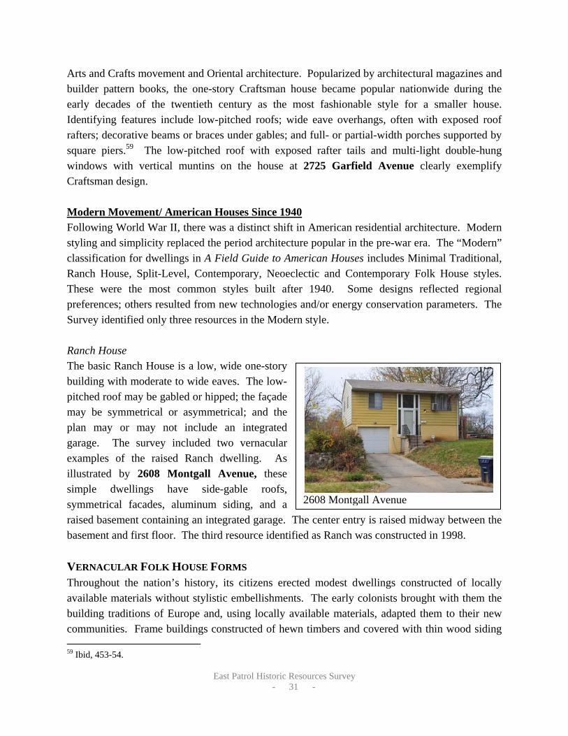
2608 Montgall Avenue
Arts and Crafts movement and Oriental architecture. Popularized by architectural magazines and builder pattern books, the one-story Craftsman house became popular nationwide during the early decades of the twentieth century as the most fashionable style for a smaller house. Identifying features include low-pitched roofs; wide eave overhangs, often with exposed roof rafters; decorative beams or braces under gables; and full- or partial-width porches supported by square piers.59 The low-pitched roof with exposed rafter tails and multi-light double-hung windows with vertical muntins on the house at 2725 Garfield Avenue clearly exemplify Craftsman design. Modern Movement/ American Houses Since 1940 Following World War II, there was a distinct shift in American residential architecture. Modern styling and simplicity replaced the period architecture popular in the pre-war era. The “Modern” classification for dwellings in A Field Guide to American Houses includes Minimal Traditional, Ranch House, Split-Level, Contemporary, Neoeclectic and Contemporary Folk House styles. These were the most common styles built after 1940. Some designs reflected regional preferences; others resulted from new technologies and/or energy conservation parameters. The Survey identified only three resources in the Modern style. Ranch House The basic Ranch House is a low, wide one-story building with moderate to wide eaves. The low-pitched roof may be gabled or hipped; the façade may be symmetrical or asymmetrical; and the plan may or may not include an integrated garage. The survey included two vernacular examples of the raised Ranch dwelling. As illustrated by 2608 Montgall Avenue, these simple dwellings have side-gable roofs, symmetrical facades, aluminum siding, and a raised basement containing an integrated garage. The center entry is raised midway between the basement and first floor. The third resource identified as Ranch was constructed in 1998. VERNACULAR FOLK HOUSE FORMS Throughout the nation’s history, its citizens erected modest dwellings constructed of locally available materials without stylistic embellishments. The early colonists brought with them the building traditions of Europe and, using locally available materials, adapted them to their new communities. Frame buildings constructed of hewn timbers and covered with thin wood siding 59 Ibid, 453-54.

East Patrol Historic Resources Survey
- 32 -
2532 Olive Street
dominated the early folk building in New England where massed plans more than one room deep became the norm. In the early settlements of the Tidewater South, frame houses that were one room deep became common. As settlement expanded to the West, what became a Midland tradition of log buildings evolved out of a blending of the two Eastern traditions. Simplified vernacular interpretations of Victorian forms (Folk Victorian) were popular throughout the country in the late nineteenth century. These were closely related to and often based on National Folk forms, representing more elaborate, high-style designs applied to the same forms. The character of American folk housing changed significantly as the nation’s railroad network expanded in the decades from 1850 to 1890. Builders of modest dwellings no longer relied on local materials. Instead, railcars could rapidly and cheaply move mass manufactured construction materials (pre-cut lumber, nails, window and door frames, and ornamental details) from distant plants over long distances. It was not long until vernacular houses of light balloon or braced framing replaced hewn log dwellings. Despite the change in building technique and materials, the older folk house shapes persisted. The resulting houses were simple dwellings defined by their form and massing, but lacking identifiable stylistic characteristics. Even after communities became established, folk house designs remained popular as an affordable alternative to more ornate and complex architectural styles.60 These traditional prototypes and new innovative plans comprise distinctive families of residential forms that dominated American folk building through the first half of the twentieth century. Gable Front House The eponymous gable front shape of this vernacular house type referenced the triangular pediment on the façade of the Greek temple. As a building style, this trend originated with the Greek Revival architectural movement that dominated American design during the period from 1830 to 1850. Settlers brought the design west as they followed the expansion of the eastern railroad network in the 1850s. The adaptability of the gable-front form to narrow urban lots assured its popular use, and it remained a dominant residential building form well into the twentieth century.61 The survey identified 59 gable front houses, five of which were specifically identified as Folk Victorian for their use of segmental arched windows or delicate spindlework. The residence at 2532 Olive Street clearly illustrates the gable front house form.
60 Ibid, 89-90. 61 Ibid, 90.

East Patrol Historic Resources Survey
- 33 -
2640 Montgall Avenue
2515 Montgall Avenue
2632 Olive Street
These typical late nineteenth century examples feature nearly symmetrical front façades, wood columns supporting the full-width front porch, and minimal architectural ornament. Hipped Roof with Lower Cross Gables The survey identified 32 resources with a hipped roof and lower cross gables. These asymmetrical forms are the vernacular versions of the Queen Anne style. The primary one- or two-story block of the house has a hipped roof. Gabled wings or dormers projecting slightly from the front elevation often have shallow peaks. Additional details, such as patterned shingles,
verge boards, finials, and cresting, emphasize the complexities of the forms but are used sparingly on these simplified designs. Eclectic fenestration adds to the intricacy of the Queen Anne designs. Window patterns include simple one-over-one double-hung sashes, front-gable picture windows, narrow paired windows, and single panes surrounded by small colored glass squares. Extensive one-story porches are common and
accentuate the asymmetry of the façade. They always address the front entrance area and cover part or all of the front façade. The house at 2640 Montgall Avenue is a rambling one-story dwelling with a primary hipped block and a projecting gabled wing. A wraparound porch connects the two sections. The residence at 2515 Montgall Avenue is an excellent example of the two-story form that displays elements of Queen Anne styling in the porch posts and massing.
Gable Front and Wing House Very similar to its Gable Front cousin, the Gable Front and Wing house gained popularity in rural areas. In this form, a secondary side-gable block placed perpendicular to the main gable-front gives the house its distinctive L-shaped massing. Like the Gable-Front House, architectural ornament is minimal. Both the one-story and two-story forms became common in the Midwest. The residence at 2632 Olive Street is

East Patrol Historic Resources Survey
- 34 -
2735 Brooklyn Avenue 2619 East 25th Street
2736 Olive Street
a good example of one of the fifteen Gable Front and Wing houses identified in the survey, with its steep cross-gable roof, narrow windows, and minimal ornament. Pyramidal Roof House The Survey identified eleven examples of the Pyramidal Roof Folk House form. While side-gabled roofs normally cover massed-plan folk houses of rectangular shape, those with more nearly square plans commonly have pyramidal roofs. The pyramidal roof form (an equilateral hipped roof) has a more complex roof framing system, but requires fewer long-spanning rafters and is therefore less expensive to build. This Folk House form often appeared in small towns concurrent with the arrival of the railroad and became a favored replacement for the smaller Hall-and-Parlor house and the narrow two-story I-house during the early twentieth century. The dwelling at 2735 Brooklyn Avenue is a simple example of this form, with its square plan and no ornament. The residence at 2619 East 25th Street is a slightly more elaborate Folk Victorian example with segmental arched window openings and flat topped hipped roof. Like most folk house forms, the roof pitch and the size and location of the porches vary.
Bungalow The Survey identified twelve examples of the vernacular Bungalow house form, including 2736 Olive Street. This residential form is a one-and-one-half-story dwelling with a side-gable roof and a large gabled dormer rising from the front roof slope. The full-width porch is integrated under the primary roof. The first-story cladding is often masonry, typically brick. These dwellings were constructed in the first decade of the twentieth century but lack any of the distinct features that represent the Craftsman style such as exposed rafter tails, rustic stone, or wood

East Patrol Historic Resources Survey
- 35 -
2542 Prospect Avenue
shingle siding. While this vernacular form is not represented in A Field Guide to American Houses, the presence of multiple resources with similar designs indicates a local trend. COMMERCIAL BUILDING FORMS Commercial architecture is distinguished first by building form and second by its architectural style. In The Buildings of Main Street: A Guide to American Commercial Architecture, Richard Longstreth identifies and categorizes buildings common to central and neighborhood commercial areas according to the composition of their façades. Despite intricate detailing and stylistic treatments or the lack thereof, the organization of the commercial façade can be reduced to simple patterns that reveal major divisions or zones. Due to their functional nature, many commercial buildings exhibit restrained architectural details. In addition to the storefront, cornice, and parapet, important character-defining elements of commercial buildings include corner posts, bulkheads, transoms, signs, and doors. Fifteen resources in the Survey Area were identified as commercial buildings. These small buildings occupy narrow city lots at prominent intersections or along commercial corridors, such as Prospect Avenue. Early- to mid-twentieth century commercial buildings are scattered along this wide street, interspersed with early-twentieth century residential dwellings. Most of the surveyed commercial buildings are simple, one or two-story forms. The traditional building material is brick, while mid-century commercial buildings were often constructed of concrete block. The Survey Area also includes free-standing mid-twentieth century retail stores that break the traditional pattern of setbacks, size, massing, and materials. The most conspicuous alterations to commercial buildings in the Survey Area reflect the modernization or infill of first-story display windows and entrances. Many of these alterations have left the original openings and spatial relationships of the storefront intact but obscured. Other changes are more-easily reversible, such as the addition of awnings and applications of wood or metal sheathing over original openings or transoms. Utilizing Longstreth’s basic commercial building property types, the historic commercial buildings identified by the survey include One- and Two-Part Commercial Blocks, as well as later Free-Standing Commercial Block forms.
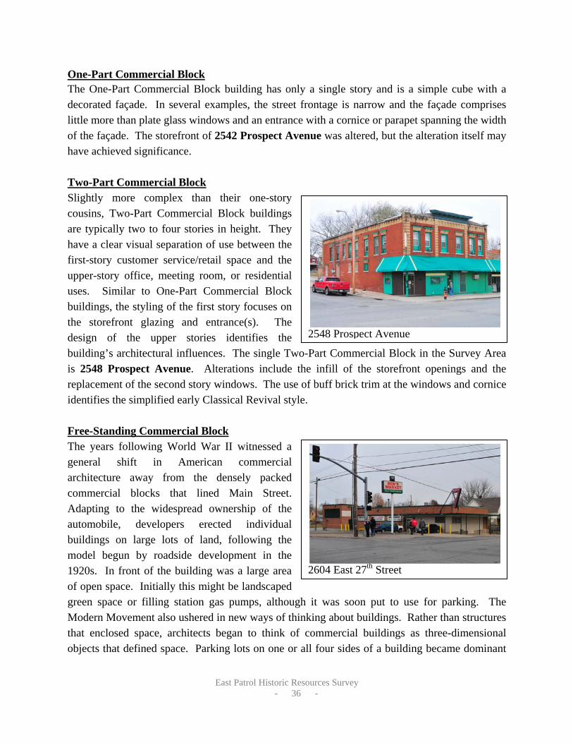
East Patrol Historic Resources Survey
- 36 -
2548 Prospect Avenue
One-Part Commercial Block The One-Part Commercial Block building has only a single story and is a simple cube with a decorated façade. In several examples, the street frontage is narrow and the façade comprises little more than plate glass windows and an entrance with a cornice or parapet spanning the width of the façade. The storefront of 2542 Prospect Avenue was altered, but the alteration itself may have achieved significance. Two-Part Commercial Block Slightly more complex than their one-story cousins, Two-Part Commercial Block buildings are typically two to four stories in height. They have a clear visual separation of use between the first-story customer service/retail space and the upper-story office, meeting room, or residential uses. Similar to One-Part Commercial Block buildings, the styling of the first story focuses on the storefront glazing and entrance(s). The design of the upper stories identifies the building’s architectural influences. The single Two-Part Commercial Block in the Survey Area is 2548 Prospect Avenue. Alterations include the infill of the storefront openings and the replacement of the second story windows. The use of buff brick trim at the windows and cornice identifies the simplified early Classical Revival style. Free-Standing Commercial Block The years following World War II witnessed a general shift in American commercial architecture away from the densely packed commercial blocks that lined Main Street. Adapting to the widespread ownership of the automobile, developers erected individual buildings on large lots of land, following the model begun by roadside development in the 1920s. In front of the building was a large area of open space. Initially this might be landscaped green space or filling station gas pumps, although it was soon put to use for parking. The Modern Movement also ushered in new ways of thinking about buildings. Rather than structures that enclosed space, architects began to think of commercial buildings as three-dimensional objects that defined space. Parking lots on one or all four sides of a building became dominant
2604 East 27th Street

East Patrol Historic Resources Survey
- 37 -
2604 Prospect Avenue
defining features of the commercial landscape, relegating the building to the role of back drop.62 Ben’s Super Market at 2604 East 27th Street is a good example of this mid-twentieth century Free-Standing Commercial Block with simple Modern Movement features. Corrugated metal siding covers original storefront display windows but the historic openings remain visible as the wrap around the south and west facades. An older building occupying the corner lot was replaced with a parking lot when the current building was constructed in 1962. COMMERCIAL ARCHITECTURAL STYLES After the Civil War, commercial centers tended to become specialized according to administrative, retail, wholesale, industrial, or recreational use. New building types and reinterpretations of traditional building types appeared as styles changed. The fifteen commercial resources in the Survey Area exhibit restrained designs that only vaguely reference formal architectural styles. Late Nineteenth and Twentieth Century Revivals In the survey, the surviving examples of Late Nineteenth and Early Twentieth Century Revival style commercial architecture date from circa 1900 to circa 1930. Like their residential counterparts, the contemporaneous Classical Revival and Mission/Spanish Colonial Revival
styles reflect the influences of historic architecture derived from European and American antecedents. The commercial building at 2604 Prospect Avenue has a clay tile pent roof that reflects the influence of the Mission/Spanish Colonial Revival style on a simple 1920s commercial building. While the addition of the gabled roof compromises its integrity, the character-defining elements remain evident.
Modern Movement In the Survey Area, the few examples of Modern Movement commercial design were constructed in the 1950s and early 1960s. These modest, utilitarian buildings had brick or concrete block walls, flat roofs, cubic forms with a horizontal emphasis, and very little or no ornament. The commercial building at 2604 East 27th Street is a good example of the simplified use of Modern Movement design features.
62 Richard Longstreth, The Buildings of Main Street, (Washington, DC: The Preservation Press, 1987), 126-131.

East Patrol Historic Resources Survey
- 38 -
2411 East 27th Street
RELIGIOUS BUILDINGS Religious buildings are often more architecturally expressive than commercial buildings, although they are generally conservative in their selection of an architectural idiom. Classical motifs and traditional styling with historical antecedents are the most common stylistic treatments. The survey included two churches. Constructed in 1913 and 1998, the represent common architectural styles and religious building forms from their period of construction. The pointed-arch windows and stone trim highlight the dark red brick Morning Star Baptist Church (historically the Wabash Avenue Christian Church) at 2411 East 27th Street and provide an excellent example of Gothic Revival architecture applied to religious buildings. Gothic architecture has a long history of use for European churches and was frequently adopted by American congregations as an archetypical style. By contrast, the Church of Jesus Christ of Latter-Day Saints at 2530 Brooklyn Avenue is a much simpler contemporary Colonial Revival design with a red brick façade, cross-gable roof, and center steeple.
DATES OF CONSTRUCTION
Using the information provided by the City, as well as the building and water permits, city atlases, Sanborn Insurance Company maps, listings in city directories and architectural style, the consultants estimated dates of construction for the buildings surveyed. Dates of building additions, alterations, and out buildings were not considered in the analysis. Figures 5 and 7 present the distribution of buildings by dates of construction.
Figure 5: ESTIMATED DATES OF CONSTRUCTION ERA TOTAL PERCENT
PRE- 1891 15 5 1891- 1906 214 68 1907 – 1917 61 19 1920 – 1930 7 2 1946 – 1962 8 3
1963 - PRESENT 8 3 TOTAL: 313 100

East Patrol Historic Resources Survey
- 39 -
It is interesting to note that buildings constructed around the turn of the twentieth century account for a majority of the surveyed properties. Only a handful of extant resources date to the 1880s when these neighborhoods were first platted. Even fewer resources date to the 1920s and the post-World War II period, which were considered residential building booms in other parts of Kansas City.
ARCHITECTURAL INTEGRITY All properties eligible for listing in the National Register of Historic Places must retain sufficient architectural integrity to convey the period of time for which they are significant. As described above in the Methodology, each building received an integrity rating of Excellent, Good, Fair, or Poor. Figures 6 and 8 illustrate the results of the Integrity Analysis.
Figure 6: ARCHITECTURAL INTEGRITY
INTEGRITY TOTAL PERCENT EXCELLENT 18 6 GOOD 112 36 FAIR 142 45 POOR 33 11 LESS THAN FIFTY YEARS OF AGE 8 2 TOTAL: 313 100
Integrity ratings represent a sliding scale of alterations to the historic fabric and the features of individual buildings. Both the quantity of changes and the reversibility of changes affected the ranking each building received. Buildings rated “Excellent” and some rated “Good” may be individually eligible for register listing if they also have significant associations that meet one or more of the National Register Criteria. Buildings that received an integrity rating of “Good” and some rated as “Fair” could be listed as contributing resources to a historic district. An integrity rating of “Poor” and in some cases “Fair” reflects the presence of numerous alterations that significantly diminish architectural integrity, regardless of historical significance. It is possible that many of the surveyed buildings rated “Fair” may retain some or all of their original historic fabric behind later alterations, such as siding, and if these changes were reversed they may improve their integrity ranking and register eligibility.
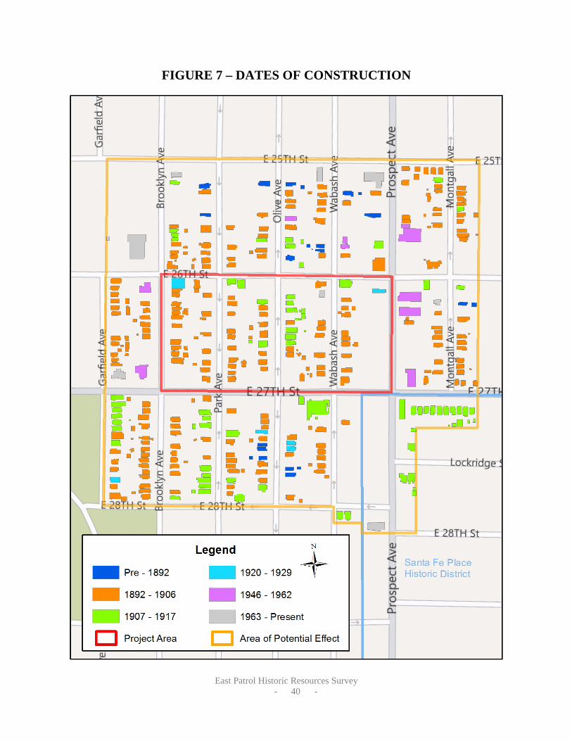
East Patrol Historic Resources Survey
- 40 -
FIGURE 7 – DATES OF CONSTRUCTION

East Patrol Historic Resources Survey
- 41 -
FIGURE 8 – ARCHITECTURAL INTEGRITY

East Patrol Historic Resources Survey
- 42 -
SURVEY RECOMMENDATIONS
As documented in the Historic Context and in the Survey Findings, the East Patrol Historic Resources Survey represents a fascinating slice of Kansas City history. The built environment testifies to the rapid residential development that changed the face of the landscape in the years before World War I. After the War, development of the area was substantially complete. While little changed physically, shifting demographics put this area at the epicenter of the local Civil Rights Movement, the significance of which is briefly presented in the Historic Context. Rosin Preservation offers the following recommendations for future preservation action.
NATIONAL REGISTER ELIGIBILITY Based on date of construction, architectural integrity and historical associations, analysis of the survey data identified resources that appear eligible for listing in the National Register as well as resources that do not appear to be register-eligible. All of the register-eligible properties appear to meet one or more National Register criteria as well as the requirements for historical/architectural integrity. Figure 9 illustrates the Survey Recommendations.
REGISTER-LISTED PROPERTIES The southeast corner of the Survey Area encompasses the northwest corner of the Santa Fe Place Historic District. This predominantly residential district was designated to the National Register in 1986. Fifteen resources on East 27th Street, Prospect Avenue and Lockridge Avenue fall within the district boundaries. Twelve residential resources retain integrity and continue to communicate the historic context for which Santa Fe Place was designated. The surveyed resources that contribute to the Santa Fe Place Historic District are:
• 2607, 2611, 2615, 2619, 2621, 2623, 2701, 2703, 2707 East 2th Street • 2603, 2604, 2607 Lockridge Avenue
The commercial building at 2806 Prospect Avenue was built after the period of significance and is non-contributing to the district. The commercial building at 2701 Prospect Avenue has been extensively altered since 1986 by the installation of historically inappropriate fenestration that changed the size and shape of the storefront window openings. Because of these changes it must be reclassified as non-contributing to the Santa Fe Place Historic District. However, as noted in the context, this building has significant associations with Kansas City’s Civil Rights movement as the offices of the SAC-20 organization. If the fenestration was restored it may be register eligible in association with a context for Civil Rights, as described below.

East Patrol Historic Resources Survey
- 43 -
INDIVIDUALLY ELIGIBLE PROPERTIES The survey identified ten properties that appear to meet the criteria for register listing as individual resources with local significance. Several of these resources have significance in conjunction with an existing National Register Multiple Property Submission (MPS) or with the Civil Rights era context. These properties are:
• 2701 Garfield Avenue, 2745 Garfield Avenue, 2528 Park Avenue, 2603 Wabash Avenue, 2307 East 26th Street and 2306 East 28th Street: locally significant under Criteria A and C, these apartment buildings meet the registration requirements defined in the Colonnade Apartment Buildings of Kansas City MPS. Most importantly, they retain the distinctive columned porches that define this property type.
• 2501-03 and 2505-07 East 28th Street: locally significant under Criteria A and C, these twin apartment buildings meet the registration requirements presented in the Middle and Working Class Apartment Buildings of Kansas City MPS.
• 2700 Wabash Avenue (2411 East 27th Street) (Morning Star Baptist Church): locally significant under Criterion C for architecture; also meets Criteria Consideration A for Religious Properties.
• 2534 Prospect Avenue (Kansas City Fire Station): locally significant under Criterion A for government and Criterion C for architecture.
MULTIPLE PROPERTY SUBMISSION A multiple property submission (MPS) is a National Register tool that defines one or more contexts associated with a particular historic era or property type within a specific geographical area and the registration requirements for nominating resources associated with these contexts. For example, Kansas City has MPS documents for several resource types, including Colonnade Apartment Buildings and Working Class Apartment Buildings. By outlining the context; the associated property types and architectural styles; the period of significance; and the registration requirements for National Register eligibility, an MPS makes it easier to list properties on the register without having to “reinvent the wheel” every time a related property is designated. The MPS is also an aid in identifying potentially eligible resources and planning for their protection. An MPS would be an ideal way to document the history of the Civil Rights Movement in Kansas City. Eligible resources would be locally significant under Criterion A for social history (Civil Rights Movement). For at least the next decade, they would also need to meet Criteria Consideration G for properties that have achieved significance in less than 50 years. The survey identified four resources that have significant associations with this context. Three of these retain integrity and could be individually listed on the National Register as part of the MPS.

East Patrol Historic Resources Survey
- 44 -
• 2542 and 2548 Prospect Avenue: these buildings housed the Green Duck Tavern and
Liquor Store, owned by Leon Jordan, and the headquarters of Freedom, Inc., founded in 1961 to organize a political voice for Kansas City’s African American community.
• 2745 Garfield Avenue was Leon Jordan’s residence during this period and would meet National Register Criterion B for association with significant persons.
As mentioned above, 2701 Prospect Avenue also has significant associations with the Civil Rights context as the headquarters of the organization SAC-20; however alterations to fenestration would need to be reversed before the building could be listed on the National Register. In addition to these properties, resources outside the Survey Area will likely be eligible for the National Register in conjunction with a Kansas City Civil Rights Movement MPS. Additional research may also identify other resources in the Survey Area that have a significant connection to events or person associated with the Civil Rights context. POTENTIAL HISTORIC DISTRICTS The Survey Area encompassed several clusters of buildings dating from the late-nineteenth and early-twentieth centuries that retain “Good” or “Fair” integrity. Some of these pockets initially appeared to merit consideration for designation as one or more National Register historic districts. However, further analysis determined that none possesses the level of significance necessary to meet the National Register criteria. Instead, Rosin Preservation recommends exploring the creation of conservation districts as a means to recognize and protect the historic character of the Survey Area. Figure 9 identifies these buildings as “Vintage.” Vintage buildings should not be considered “throw-away” resources. They enhance our understanding of the built environment and give legitimacy to the history of their surroundings. It is possible that additional research, beyond the scope of this project, could identify an area of significance or historical associations for some of these resources that would elevate their status to National Register eligible. Similarly, the reversal of unsympathetic alterations might restore sufficient integrity to reconsider the Register eligibility of one building or a group of buildings.
LOCAL CONSERVATION DISTRICTS
Conservation Districts are a tool that has become popular nationwide for maintaining the character of existing neighborhoods and providing protection to historic resources that do not retain sufficient integrity to be listed in the National Register. Locally designated, Conservation

East Patrol Historic Resources Survey
- 45 -
Districts can stabilize property values in older neighborhoods while protecting the unique qualities of these communities. In Conservation Districts, design review is limited to major changes (such as new construction, exterior alterations, and demolition). This provides protection against adverse changes to the visual context of the district, while encouraging property owners to make appropriate changes that reinforce the qualities that define the district. Within the Survey Area the nodes with the greatest concentrations of Vintage buildings would benefit most from the implementation of a Conservation District to protect their historic and architectural character. These include:
• the 2600 and 2700 blocks of Garfield Avenue facing Spring Valley Park; • the 2500 blocks of Brooklyn (east) and Park (west ) Avenues; • the 2600 block of East 25th Street and the 2500 block of Montgall; and • the 2700 blocks of Brooklyn, Park and Olive.
ADDITIONAL RESEARCH The East Patrol Historic Resources Survey touched on the themes of Kansas City’s African American history and the Civil Rights Movement in an effort to identify and evaluate resources that might merit register listing in conjunction with these contexts, with which the Survey Area has strong connections, both geographical and historical. Further exploration of these contexts was hampered by an extremely tight project schedule. Rosin Preservation recommends additional research to better define these themes and to identify associated resources throughout Kansas City. The Civil Rights movement, in particular, is still of relatively recent memory, and there is a unique opportunity to capture oral histories of individuals who participated in or witnessed these events first hand. While anticipated connections to Kansas City’s Jazz heritage did not materialize during the survey, this context also merits further exploration. Expansion of the historic contexts and the further investigation and identification of related resources can be used to support building rehabilitation in the Survey Area and throughout Kansas City’s traditionally African American neighborhoods, by providing access to incentives such as historic tax credits that will support private investment in revitalization. Further research and context development could also provide a vehicle for the expansion of historic tourism activities on Kansas City’s east side in association with these themes.

East Patrol Historic Resources Survey
- 46 -
FIGURE 9 – NATIONAL REGISTER ELIGIBILITY

East Patrol Historic Resources Survey
- 47 -
BIBLIOGRAPHY
1940 Tax Assessor Photographs. Historic Preservation Office, City Planning and Development, Kansas City, Missouri.
“A Church Plan.” Kansas City Star, 14 March 1948. Mounted Clippings. Missouri Valley
Special Collections, Kansas City Public Library, Kansas City, Missouri. “Bernard Powell.” Vertical File, Missouri Valley Special Collections, Kansas City Public
Library, Kansas City, MO.
Bogdon, Thomas J. “Shots Wake Firemen to Find Old Friend Murdered in Street.” Kansas City Star, 15 July 1970. Microfilm. Kansas City Public Library, Kansas City, Missouri.
Brink McDounough & Company. Map of Kansas City and Suburbs, 1877. Missouri Valley
Special Collections, Kansas City Public Library, Kansas City, Missouri. Accessed on-line at http://www.kchistory.org/cdm4/item_viewer.php?CISOROOT=/Maps&CISOPTR=1511&CISOBOX=1&REC=1 (accessed 15 December 2011).
Building Permits. Historic Preservation Office, City Planning and Development, Kansas City,
Missouri. Conrads, David. “Leon Jordan.” Missouri Valley Special Collections Biography. Kansas City,
Missouri: Kansas City Public Library, 1999. Coulter, Charles. Take Up the Black Man’s Burden. Columbia, MO: University of Missouri
Press, 2006. Freeman, Jewel. “Santa Fe Place: A Study of Minority Movement in Kansas City, Missouri.”
Unpublished Master’s Thesis, University of Kansas, 1939. Gold, Henry Clay. “State Felt His Power.” Kansas City Star, 15 July 1970, p. A:1. Microfilm.
Kansas City Public Library, Kansas City, Missouri. Hart, Amy “The Foundry of Freedom.” Master’s thesis, Central Missouri State University, 2006.
Missouri Valley Special Collections, Kansas City Public Library, Kansas City, Missouri. Hopkins, G.M. 1887 Map of Kansas City, Missouri & Vicinity. Missouri Valley Room, Kansas
City Public Library, Kansas City, Missouri. Accessed on-line http://www.kchistory.org/cdm4/item_viewer.php?CISOROOT=/Maps&CISOPTR=1238&CISOBOX=1&REC=2 (accessed 15 December 2011).

East Patrol Historic Resources Survey
- 48 -
Hudson-Kimberly Publishing Co. Park, Boulevard, Street Railway and Railway Map of Kansas City, MO and Kansas City, Kas. 1894. Missouri Valley Special Collections, Kansas City Public Library, Kansas City, Missouri. Accessed on-line http://www.kchistory.org/cdm4/item_viewer.php?CISOROOT=%2FMaps&CISOPTR=1564&DMSCALE=12.5&DMWIDTH=750&DMHEIGHT=512.275157997&DMMODE=viewer&DMFULL=0&DMX=267&DMY=182.862421001&DMTEXT=%2520street%2520car&DMTHUMB=0&REC=13&DMROTATE=0&x=700&y=428 (accessed 15 December 2011).
Jackson County (Missouri) Recorder of Deeds. Warranty Deed. Book 19, Page 518. 25 May
1852. Jackson County, Missouri. Jackson County (Missouri) Recorder of Deeds. Warranty Deed. Book D, Page 99, 2 November
1835. Jackson County, Missouri. Jackson-Evans, Priscilla. National Register of Historic Places Nomination Form “The Santa Fe
Place Historic District.” Listed 30 May 1986. Kansas City, Missouri. Kansas City Directory, Vol. XLVII. Kansas City: Gate City Directory Co., 1917. Microfilm.
Missouri Valley Special Collections, Kansas City Public Library, Kansas City, Missouri. Kansas City Plan Commission Map, 1934. Missouri Valley Special Collections, Kansas City
Public Library, Kansas City, MO. Longstreth, Richard. The Buildings of Main Street. Washington, DC: The Preservation Press,
1987. McAlester, Virginia and Lee McAlester. A Field Guide to American Houses. New York: Alfred
A. Knopf, 1988. McGraw, Mike and Glenn Rice, “Case Closed.” Kansas City Star, 21 June 2011. Microfilm.
Kansas City Public Library, Kansas City, Missouri.
Missouri Census. Jackson County. 1840. Microfilm, Missouri Valley Special Collections, Kansas City Public Library, Kansas City, Missouri.
Moore, Bill. “Mission to Liberia, Acrimony at Home.” Kansas City Star, 15 July 1970, p. 2B.
Microfilm. Kansas City Public Library, Kansas City, Missouri. “Negro Home Unit,” Kansas City Star, 13 March 1944. Mounted Clippings. Missouri Valley
Special Collections, Kansas City Public Library, Kansas City, Missouri. Polk’s Kansas City (Jackson County, Missouri) Directory, Vol. LXV. Kansas City: Gate City
Directory Co., 1935. Microfilm. Missouri Valley Special Collections, Kansas City Public Library, Kansas City, Missouri.

East Patrol Historic Resources Survey
- 49 -
Polk’s Kansas City (Jackson County, Missouri) Directory, Vol. LXXVI. Kansas City: R. L. Polk
and Company, 1950-51. Microfilm. Missouri Valley Special Collections, Kansas City Public Library, Kansas City, Missouri.
Polk’s Kansas City (Jackson County, Missouri) Directory 1962, Vol. LXXXVI. Kansas City:
R.L. Polk & Company. 1960. Microfilm. Missouri Valley Special Collections, Kansas City Public Library, Kansas City, Missouri.
Riley, Kimberly R. “Bernard Powell,” Biography, 1999, Missouri Valley Special Collections,
Kansas City Public Library, Kansas City, MO. Sanborn Fire Insurance Company Maps, Kansas City (Jackson County) 1896, 1909, and
1909/corrected to 1951, Vol. 3. Digital Sanborn Maps, 1867-1970, ProQuest, LLC. All Sanborn maps are copyrighted 2001 by The Sanborn Map Company, Sanborn Library, LLC.
“Santa Fe Neighborhood Assessment Report.” Kansas City, Missouri: FOCUS Kansas City, City
Planning and Development Department, 2001. Missouri Valley Special Collections, Kansas City Public Library, Kansas City, Missouri.
Schirmer, Sherry Lamb. A City Divided: The Racial Landscape of Kansas City 1900-1960.
Columbia, MO: University of Missouri Press, 2006. Schirmer, Sherry Lamb and Richard D. McKinzie. At the River’s Bend: An Illustrated History of
Kansas City, Independence and Jackson County. Woodland Hills, California: Windsor Publications, 1982.
“The Three Major Routings of the Santa Fe Trail Through the Kansas City Area.” Map. Santa Fe
Trail Vertical File. Missouri Valley Special Collections, Kansas City Public Library, Kansas City, Missouri.
Union Abstract and Guarantee Company. Santa Fe Place, Abstract of Title. Logan Horridge
Abstract Collection, Jackson County Historical Society. Jackson County Courthouse, Independence, Missouri.
U.S. Department of the Interior, National Park Service. National Register of Historic Places,
National Register Bulletin 15: How to Apply the National Register Criteria for Evaluation. Washington, DC: National Register Publications, 1998.
U.S. Department of the Interior, National Park Service. “Santa Fe Trail,” Booklet, Missouri
Valley Special Collections, Kansas City Public Library, Kansas City, Missouri.

East Patrol Historic Resources Survey
- 50 -
“Varied Career Led Jordan to Politics.” Kansas City Star, 15 July 1970, p. 5B. Microfilm. Kansas City Public Library, Kansas City, Missouri.
“Who Was Leon Jordan?” Kansas City Call, 12 December 1974. Winchell, Ashley. et al., Washington Wheatley Neighborhood Action Plan. Kansas City,
Missouri: University of Missouri – Kansas City, 2008.