east staffordshire borough council strategic flood risk
TRANSCRIPT

EAST STAFFORDSHIRE BOROUGH COUNCIL STRATEGIC FLOOD RISK ASSESSMENT UPDATE 26/09/2013
Confidentiality: Public

Project number: 50600218 Dated: 26/09/2013 2
Quality Management
Issue/revision Issue 1 Revision 1 Revision 2 Revision 3
Remarks Draft report – combined updates to Level 1 & Level 2 SFRA undertaken in 2008
Date 26 September 2013
Prepared by Rachel Bird
Signature
Checked by Andy Smith
Signature
Authorised by Andy Smith
Signature
Project number 50600218
Report number
File reference U:\50600218 - East Staffordshire BC SFRA & WCS\C Documents \Reports\Working\Updated_SFRA

3
East Staffordshire Borough Council Strategic Flood Risk Assessment Update
26/09/2013
Client Anna Miller East Staffordshire Borough Council The Maltsters Wetmore Road Burton upon Trent Staffordshire DE14 1LS
Consultant Rachel Bird Keble House Southernhay Gardens Exeter EX1 1NT UK Tel: +44 (0)1392 267500 Fax: +44 (0)1392 267599 www.wspgroup.com
Registered Address WSP UK Limited 01383511 WSP House, 70 Chancery Lane, London, WC2A 1AF, UK
WSP Contacts Rachel Bird – [email protected] Ola Holmstrom – [email protected] Andy Crowell – [email protected] Andy Smith – [email protected]

Project number: 50600218 Dated: 26/09/2013 4
Table of Contents
1 Executive Summary .............................................................. 6
2 Project Background ............................................................... 8 2.1 General overview ................................................................... 8 2.2 Scope .................................................................................... 8 2.3 Consultation ........................................................................... 8 2.4 Structure of this report ........................................................... 9 2.5 Data used .............................................................................. 9 2.6 Limitations & assumptions ................................................... 10
3 Study Area ........................................................................... 11 3.1 Overview .............................................................................. 11 3.2 Topography ......................................................................... 12 3.3 Soils & Geology ................................................................... 14 3.4 Land use .............................................................................. 17
4 River Catchments ................................................................ 18 4.1 Overview .............................................................................. 18 4.2 River Trent catchment ......................................................... 19 4.3 River Dove catchment ......................................................... 21 4.4 River Blithe catchment ......................................................... 23 4.5 Trent and Mersey Canal ...................................................... 23
5 Review of Historic Flooding ................................................. 25 5.1 Causes of Flooding .............................................................. 25 5.2 Overview .............................................................................. 25 5.3 River Flooding ..................................................................... 26 5.4 Tidal Flooding ...................................................................... 27 5.5 Surface Water Flooding ....................................................... 27 5.6 Sewer Flooding .................................................................... 28 5.7 Groundwater Flooding ......................................................... 28 5.8 Canal flooding ...................................................................... 28 5.9 Blithfield Reservoir ............................................................... 29
6 Current & Future Flood Risk Overview ................................ 30 6.1 Fluvial Flooding ................................................................... 30 6.2 Tidal Flooding ...................................................................... 34 6.3 Surface Water Flooding ....................................................... 34 6.4 Sewer Flooding .................................................................... 35 6.5 Groundwater Flooding ......................................................... 35 6.6 Flooding from artificial bodies .............................................. 37 6.7 Flood Mitigation Measures ................................................... 37 6.8 Flood Warning & Emergency Response .............................. 38 6.9 Climate Change ................................................................... 39
7 Planning Policy .................................................................... 41 7.1 Planning Documents............................................................ 41 7.2 Potential Development Sites ................................................ 41

5
7.3 Flood Risk Guidance ........................................................... 45 7.4 Impacts of Developments on Flood Risk ............................. 50
8 Burton upon Trent - Development & Flood Risk .................. 52 8.1 Flood Risk to the development sites .................................... 52 8.2 Potential impact on nearby land .......................................... 55 8.3 Summary ............................................................................. 56
9 Uttoxeter – Development & Flood Risk ................................ 58 9.1 Flood Risk to the development sites .................................... 58 9.2 Potential impact on nearby land .......................................... 60 9.3 Summary ............................................................................. 61
10 Rural Villages – Development & Flood Risk ........................ 63 10.1 Flood Risk to the development sites .................................... 63 10.2 Potential impact on nearby land .......................................... 65 10.3 Summary ............................................................................. 65
11 Conclusions & Recommendations ....................................... 66 11.1 Conclusions ......................................................................... 66 11.2 Recommendations ............................................................... 66 GLOSSARY
APPENDICES Appendix A – Data register Appendix B – Historic flooding information Appendix C – Flood maps and defence information Appendix D – Hydraulic modelling Appendix E – Surface water flood maps Appendix F – Hazard maps Appendix G – SHLAA

Project number: 50600218 Dated: 26/09/2013 6
Executive Summary East Staffordshire Borough Council commissioned WSP to undertake an update to their Level 1 and Level 2 Strategic Flood Risk Assessments. This update has been written in accordance with the National Planning Policy Framework and its associated Technical Guidance, published in March 2012.
All sources of flood risk have been considered within this SFRA, via the use of information collated from various stakeholders, including East Staffordshire Borough Council, the Environment Agency and Staffordshire County Council.
To support the Environment Agency Fluvial Flood Map, and to provide the necessary evidence for use in the Sequential and Exception tests, hydraulic modelling has been undertaken for the main rivers within the borough. This utilised existing hydraulic models where the one dimensional channel components have been linked to the two dimensional floodplain components. The outputs of this modelling include hazard mapping (Appendix F).
Chapter 1 provides the introduction while Chapters 2 to 5 provide a summary of the flood risk to the whole borough, whilst Chapters 7 to 9 provide more details regarding the preferred development sites as highlighted by East Staffordshire Borough Council. These are split into the areas of Burton-upon-Trent, Uttoxeter and Rural Villages. A summary of the results of the assessment of the preferred developments sites is provided below, where green shows the risk is low and further assessment is unlikely to be required. Orange shows that there is a significant risk and so further assessment will be needed to show that the development will be safe and not have an adverse impact on the surrounding area. Red shows that there is a high level of risk and any development is likely to be at risk of flooding without further assessment and the inclusion of mitigation measures as appropriate.
Site name Flood Zone
3
1 in 100yr+CC defended
Surface Water risk
Groundwater risk
Safe access / egress
Flood compensation
required
Finished Floor
Levels
BURTON-UPON-TRENT Derby Road 5% 0% Moderate Moderate Yes No Ground level
Pirelli 5% 0% Moderate Significant Yes No Ground level
Branston Depot 100% 75% Moderate Significant Via moderate Yes >46.81mODN
Coors - Middle Yard 90% 40% Moderate Significant Via low Yes >45.2mODN
Harehedge 0% - Moderate Low Yes No Ground level Beamhill 0% - Moderate Low Yes No Ground level
Guinevere 0% - Low Significant Yes No Ground level Bargates 2.5% 0% Low Significant Yes No Ground level
Branston Locks 10% 15% Moderate Significant Yes Yes >46.74mODN LSOB 10% 12% Low Significant Yes Yes >48.4mODN
Model Dairy Farm 0% - Moderate Low Yes No Ground level UTTOXETER
JCB 40% 35% Significant Significant Yes Yes >78 – 80mODN
Brookside Rd 90% 25% Moderate Significant Yes Yes >76.7 – 77.4mODN
Stone Road 0% 0% Low Moderate Yes No Ground level Hazelwalls - site 1 0% 0% Moderate Moderate Yes No Ground level Hazelwalls - site 2 0% 0% Low Moderate Yes No Ground level

7
Site name Flood Zone
3
1 in 100yr+CC defended
Surface Water risk
Groundwater risk
Safe access / egress
Flood compensation
required
Finished Floor
Levels
West of Uttoxeter 0% 0% Low Moderate Yes No Ground level RURAL VILLAGES College Fields (Rolleston-on-Dove)
0% 0% Low Low Yes No Ground levels
Efflinch Lane (Barton-under-Needwood)
0% 0% Moderate Significant Yes No Ground levels
South of Tutbury (Tutbury) 0% 0% Low Low Yes No Ground levels
Rocester 0% 0% Low Significant Yes No Ground levels

Project number: 50600218 Dated: 26/09/2013 8
1 Project Background
1.1 General overview 1.1.1 In February 2008 Royal Haskoning produced a Level 1 Strategic Flood Risk Assessment (SFRA) for
the East Staffordshire Borough Council area. This was then followed by a more detailed Level 2 Assessment in August 2008. Since those documents were produced, East Staffordshire Borough Council have further developed their Local Development Framework. The Government Guidance relating to planning policy has also been updated.
1.1.2 East Staffordshire Borough Council therefore commissioned WSP UK Ltd to update the Level 1 and Level 2 assessments, taking into account the latest guidance and policies, as well as the recent flooding events in 2012. The two documents have been combined into one document as part of this update to simplify the assessment of flood risk across the borough.
1.2 Scope 1.2.1 The scope for this SFRA is in accordance with the National Planning Policy Framework (NPPF), and
it’s associated Technical Guidance, produced by the Department for Communities and Local Government in March 2012. The NPPF replaces the Planning Policy Statement 25: Development and Flood Risk (2006), which was used for the original SFRAs.
1.2.2 The Council is in the process of preparing its Local Development Framework (LDF) as required by the Planning and Compulsory Purchase Act (2004). As part of this process they produced a Local Plan Preferred Option document in July 2012, which follows on from the Issues and Options consultation undertaken in 2007. The preferred options specified are the focus of this assessment, however all sites that have been considered are included within this SFRA to ensure a robust evidence base is presented.
1.2.3 The Local Plan Preferred Option is for urban extensions of Burton upon Trent and Uttoxeter, combined with limited growth of rural villages. This includes for both greenfield and brownfield sites. Flood risk is a key consideration in the allocation of land for development, especially with the current concerns over climate change. Therefore, to enable the developments to be sited in appropriate locations to minimise damage to property and threat to life the Council needs to be informed by the most accurate picture of flood risk possible.
1.2.4 The key aims of this SFRA are to therefore provide an updated picture of the flood risk to the whole borough, both now and in the future, with a specific focus on the areas of proposed development. This assessment will look at all sources of flooding and ensure that the requirements of the NPPF are factored into the decision making process for assessing both the allocated sites, and potential windfall sites.
1.3 Consultation 1.3.1 The original SFRAs were produced by Royal Haskoning in close consultation with East Staffordshire
Borough Council and the Environment Agency. Input to the SFRA was also provided by Severn Trent Water, British Waterways and the Highways Agency. For the updated SFRA Staffordshire County Council as the Lead Local Flood Authority have also been consulted.

9
1.4 Structure of this report 1.4.1 As stated above, originally the Level 1 and Level 2 assessments were separate documents. As this
update is looking at both documents it has been agreed with East Staffordshire Borough Council that the documents would be combined to avoid duplication of information. The first five sections of this document are primarily made up of details from the Level 1 assessment i.e. background information, whilst the rest of the document provides the more detailed information that would normally be provided within the Level 2 Assessment, particularly regarding the proposed development sites. Where possible technical information has been included in the appendices rather than the main text to make the document clearer and easier to understand and use.
1.4.2 The structure of the report is summarised below:
Section 1 – Summary of the background to this report
Section 2 to Section 5 – Summary of the flood risk to the whole borough
Section 6 – Planning Policy information
Section 7 to Section 9 – Specific information regarding the proposed development sites
Section 10 – Conclusions both relating to flood risk across the borough and specifics relating to the development site.
1.5 Data used 1.5.1 The data used in the study derives from several sources, most notably the Environment Agency,
East Staffordshire Borough Council and Staffordshire County Council. A data register is provided in Appendix A.
1.5.2 The key types of data obtained include:
OS background mapping;
Topographic survey – LiDAR (Light Detection and Ranging);
Geology information
National Flood Zones and historic flooding records from all sources of flooding;
Flood Map for Surface Water (FMfSW);
Flood defences, structures and flood alleviation measures;
Flood risk studies and modelling reports;
Catchment Flood Management Plan (CFMP);
Groundwater susceptibility
Flood warning areas; and
Local plan and LDF documents and development proposals.
1.5.3 A Preliminary Flood Risk Assessment (PFRA) was completed by Staffordshire County Council in March 2011 to comply with the Flood Risk Regulations 2009. This was produced in accordance with the Environment Agency’s Final PFRA Guidance, published in December 2010. The PFRA focused on the local flood risk i.e. ordinary watercourses, surface water, groundwater to the County Council area and has therefore been used as an additional data source for this SFRA update.
Project number: 50600218 Dated: 26/09/2013 10
1.6 Limitations & assumptions 1.6.1 The conclusions of this SFRA are based on information currently available. The areas of the
proposed potential development sites are indicative only. The final sites will be subject to the outcome of on-going studies commissioned by the Council that will provide the evidence base for the emerging Local Development Framework.
1.6.2 The SFRA maps (1 in 10,000 scale) for the entire East Staffordshire Borough are based on the Environment Agency’s latest released Flood Zone information, (November 2012).
1.6.3 The Flood Map for Surface Water (FMfSW) has been used to give an indication of the risk from surface water flooding across the borough. The Environment Agency, in co-ordination with the Lead Local Flood Authorities, is currently updating the FMfSW, which is expected to be released in December 2013. Any assessments after this information is released should therefore refer to the Updated FMfSW (UFMfSW) rather than the information provided in this SFRA. Initial reviews of the data however suggest that they are no major changes expected within the borough.
1.6.4 The Environment Agency provided hydraulic models where available across the borough. These hydraulic models were reviewed, adjusted where necessary, and used to provide further information regarding the flood risk within the modelled area, including hazard information. Information regarding the models and any changes that were required as part of this study is provided in Appendix D.
1.6.5 The records of historic flooding only relate to reported incidents. These may therefore not be complete, particularly for the smaller events that only affected a limited number of properties or greenfield sites. The locations of the flood extents are also approximate and depend on the level of detail provided. These incidents should therefore be used as a guide to the historic flood risk to the borough but not a definitive record of all flooding events.

11
2 Study Area
2.1 Overview 2.1.1 The borough of East Staffordshire lies to the North East of the West Midlands conurbation. It covers
an area of 150 square miles. In 2011 the population totaled 113,600 (2011 census) with 69,250 living in the principal town of Burton upon Trent (including the parishes of Branston, Outwoods and Stretton). The two main towns of Burton and Uttoxeter lie at opposite ends of the borough, with Burton on the boundary in the South East corner and Uttoxeter to the North West. They are surrounded by a number of outlying villages and hamlets, the largest of which are concentrated along the Southern and Eastern borders.
2.1.2 The principal town of Burton is located along the River Trent, which flows through the main town centre, separating the Stapenhill and Winshill areas to the South of the river from the Branston, Shobnall, Horninglow and Stretton areas to the North. There are also a number of tributary streams and brooks, draining the surrounding fields and hills which flow through the areas mentioned above, discharging into the Trent in the centre of the town. The Trent and Mersey Canal follows a similar route to the River Trent through the borough, lying roughly parallel to the A38. Consequently there are a number of developed areas that exist within the floodplain, giving rise to concern over flooding.
2.1.3 Uttoxeter, the second largest settlement with a population of approximately 13,000 in 2011, is affected by a number of watercourses. Most notable is Picknall brook which flows through the Southern part of the town, joined by a network of streams draining the steep hillsides to the south and forming a confluence with Picknall Brook in the middle of its course through Uttoxeter. The River Dove, a tributary of the River Trent, flows to the east of the main town and the River Tean forms the Northern border of the urban extent, joining the Dove to the Northeast.
2.1.4 Both Uttoxeter and Burton have suffered from a number of flooding events, as have many of the villages and hamlets, the largest of which tend to be located along the Rivers Blithe, Dove and Trent and their tributary brooks and streams.
2.1.5 The borough also contains a network of streams, pools and brooks all having the potential to cause flooding. There is a large water supply reservoir, Blithfield Reservoir located on the River Blithe to the West of the borough, just upstream of its confluence with the River Trent. In addition, Branston Water Park is located just outside Burton next to the River Trent, consisting of a number of water-filled sand and gravel pits.
2.1.6 Figure 1 shows the East Staffordshire borough boundary and includes key features such as main towns, villages, watercourses, roads and railways.
2.1.7 East Staffordshire is bounded by six planning authority areas:
Lichfield Borough;
Stafford Borough Council;
Staffordshire Moorland Borough Council
The Peak Borough National Park;
Derbyshire Dales Borough Council; and
South Derbyshire Borough Council.

Project number: 50600218 Dated: 26/09/2013 12
Figure 1 - Location plan
2.2 Topography 2.2.1 The Environment Agency has provided filtered and unfiltered LiDAR (Light Detection And Ranging),
which is a type of Digital Terrain Model (DTM). The LiDAR data provides full coverage of the main watercourses within the borough, with the exception of a few small patches, as shown in Figure 2). It is, however, restricted to these main watercourses and does not extend far beyond their courses. There are therefore gaps in the LiDAR for most of the centre and large parts of the east and north of

13
the borough. As there are only minor watercourses and headwaters within these regions and no large settlements or development proposals, the extent of the LiDAR should be sufficient for this SFRA.
2.2.2 The LiDAR spatial resolution in this area is generally 2m although there are also areas of 1m and 0.5m resolution. Taken together with the generally accepted vertical accuracy of ±11cm to 25cm, this indicates that in the areas covered by the LiDAR data would provide a good representation of ground surface for the required flood risk mapping where modifications to the current Flood Zones are required. The LiDAR data therefore provides the topographic information necessary to produce flood outlines for different return period flood events, including the 1 in 1000 year (Flood Zone 2) and also to assess the impacts of climate change along the main watercourses. The LiDAR data coverage is also sufficient for use in conjunction with channel cross section surveys, to undertake any potential hydraulic modeling.
Figure 2 - LIDAR coverage

Project number: 50600218 Dated: 26/09/2013 14
2.2.3 Figure 2 shows the extent of LiDAR currently available within the borough, whilst Figure 3 shows the contours for the borough. This highlights that generally the borough is relatively low lying in the south east, rising to the west and north. The majority of the borough is between 50mODN and 130mODN, whilst the north part of the borough insert with the Peak District, showing elevations of between 200mODN to 360mODN.
Figure 3 - Contour plan
2.3 Soils & Geology 2.3.1 Figure 4 shows the bedrock geology for East Staffordshire, based on 1:625,000 UK Geology data
downloaded from the British Geological Society website. This shows that the majority of the borough is overlying mudstone, siltstone and sandstone, with a small area of limestone in the north of the borough.

15
Figure 4 - Bedrock geology and fault lines
Reproduced with the permission of the British Geological Survey ©NERC. All rights Reserved
2.3.2 In terms of soils the majority of the borough is made up of slowly permeable, seasonally wet slightly acid but base-rich loamy and clayey soils, with impeded drainage. In the river floodplains the soils are made up of loamy and clayey floodplain soils with naturally high groundwater, along with freely draining soils.1
2.3.3 Figure 5 shows the hydrogeology for the borough, again taken from the 1:625,000 information available from the British Geological Society website.
1 Data obtained from the National Soil Map of England and Wales

Project number: 50600218 Dated: 26/09/2013 16
Figure 5 – Hydrogeology
Reproduced with the permission of the British Geological Survey ©NERC. All rights Reserved
2.3.4 It can be seen from Figure 5 that the majority of the borough is a low productivity aquifer where flow is virtually all through fractures and other discontinuities. This correlates with the geology and soil information discussed above. There is however an area of highly productive aquifer in the north of the borough, which has significant intergranual flow.

17
2.4 Land use 2.4.1 East Staffordshire Borough Council is a rural council with two large settlements of Burton-upon-Trent
in the south east and Uttoxeter in the north. There are then numerous rural villages throughout the borough, including Mayfield, Denstone, Rocester in the north, Marchington, Tutbury and Rolleston-on-Dove in the east, Abbots Bromley and Yoxall in the west and Barton-under-Needwood in the south.
2.4.2 The land use is generally grassland with pockets of woodland and arable land.

Project number: 50600218 Dated: 26/09/2013 18
3 River Catchments
3.1 Overview 3.1.1 Figure 6 illustrates the river system within the East Staffordshire Borough which largely falls within
the following three Main River catchments, details of which are provided in Sections 3.2 to 3.4 below:
River Trent
River Dove; and
River Blithe.
Figure 6 - Rivers within the borough

19
3.2 River Trent catchment 3.2.1 The River Trent flows in an Easterly direction, forming the south eastern boundary of the borough,
and passes through the town of Burton upon Trent. The River Trent rises in the South Pennines on Biddulph Moor, North of Stoke on Trent and, by Burton, drains a catchment of over 3000 km2. Through Burton it carries extreme flows of approximately 468m3/s in a 1 in 100 year event, (Fluvial Trent Hydraulic and Economic Study: Burton Hydraulic Modelling Report). Burton has suffered on numerous occasions from fluvial flooding, both as a result of rainfall and snow melt. Due to the location of Burton, moderately high up in the catchment, there is a relatively quick response time between rainfall and the rise in river levels, making flood forecasting problematic and reducing the viability of temporary and demountable defences through the town. Following floods in 1947, defences were built through Burton town centre to a 1 in 100 year standard. After a review of the November 2000 floods, these defences were upgraded in 2006-7 and are now mostly at a 1 in 200 year standard (East Staffordshire Borough Council), protecting over 7000 properties (Environment Agency).
3.2.2 The tributaries of the River Trent within the East Staffordshire Borough are Dale Brook, Stapenhill Brook, Johnson’s Brook, “Kitling Greaves Brook”, “Bitham Lane Brook”, Shobnall Brook, Tatenhill Brook, Barton Brook, the River Swarbourn and the River Dove, each of which are described in Sections 3.2.3 to 3.2.12 below. The confluence of the River Blithe with the River Trent is located just upstream, outside the boundary of the borough.
3.2.3 Dale Brook:
Flows in a North-Westerly direction, forming the Northern border of the Winshill area of Burton and joins the River Trent just downstream of Meadow’s Farm.
The brook rises on the slopes between Bretby and Winshall.
Natural channel that runs behind residential gardens.
There is no history of flooding from the watercourse itself, but there have been issues regarding the routing of surface water flows into the brook through the residential gardens. Work was carried out to solve this problem in the late 1990s and there have been no reports of incidents since.
3.2.4 Stapenhill Brook
Flows in a Westerly direction through the Stapenhill area of Burton and joins the River Trent just downstream of St Peter’s Bridge.
The brook initiates at the privately owned (although the owner is unidentified) balancing lake, which serves the Brislincote Valley Estate, close to the borough boundary next to Development Site 37 (previously the Model Dairy Farm).
Just downstream of the balancing lake is a Council-maintained hydrobrake.
Most of the channel is natural, with the exception of the last 500m which is culverted.
In the early 1990s this culvert had to undergo repairs following an explosion caused by the wedging of a child’s tricycle in the channel. It now has a grill covering the open end.
3.2.5 Johnson’s Brook
Small tributary flowing in a north-westerly direction parallel to the rear of houses on Highlands Drive in the Winshill area of Burton.
The Brook is in open form for most of its length, with a culverted section at the downstream end, where it feeds into the Trent.
The culvert appears to be unstable, but, as it is in private ownership, no realignment has taken place.

Project number: 50600218 Dated: 26/09/2013 20
3.2.6 ‘Kitling Greaves Brook’
This watercourse flows in an Easterly direction through the ‘’Outwoods’ area of Burton, before entering the Knightsbridge Way balancing lake, exiting into the Horninglow channel (an open channel built in the 1960s) which subsequently feeds the lower section of Shobnall Brook and then into the Trent at Wetmore Hall Farm.
The brook has multiple culverted and open sections.
Flooding occurred as the result of the blinding of the grill at the top end of the culvert in June 1999 which resulted in de-silting work being carried out.
The top culvert is now under the control of the Highways Agency.
There is a balancing pond between the new Forest Edge Way development and the brook downstream of the top culvert.
The open section of the Brook next to De Ferrers School was reprofiled for aesthetic reasons in spring 2007.
Alarms have been installed on the lower culverts, in addition to improved grill clearance and regular inspections following the blinding of the balancing lake grill, which resulted in flooding in November 2000.
3.2.7 ‘Bitham Lane Brook’
Small watercourse draining the ‘Outwoods’ area of Burton between Horninglow and Stretton and feeds into the Northern end of the Knightsbridge Way balancing lake.
Mostly open but culverted in the middle section.
Alarms have been installed on the lower culverts, in addition to improved grill clearance and regular inspections following the blinding of the balancing lake grill and subsequent flooding in November 2000.
3.2.8 Shobnall Brook
This watercourse flows in a South-Easterly direction through Shobnall, before adjusting course from its original channel to flow in a North-Easterly direction, partially as the Horninglow channel, entering the River Trent at Wetmore Hall Farm.
The channel is partially culverted: along Forest Road; under the A38; and through the developed area as it is diverted towards the north east and enters the Horninglow channel.
The Brook experienced severe flooding in July 1999 along its entire length.
The field ditch which feeds into Shobnall Brook from Lordswell Road is culverted through the Lordswell Road cul-de-sac and had its entrance re-profiled, with the addition of a grill, following the 1999 floods.
3.2.9 Tatenhill Brook
This watercourse flows in a Southerly direction through the village of Tatenhill and enters the River Trent upstream of Branston.
The channel is mostly open, with small culverted sections through the Old Mill in Tatenhill, underneath the canal and under the A38.
The culvert through the Old Mill was rebuilt after it became blinded by a tree trunk in July 1999 and collapsed.
This Brook also caused flooding in Branston Water Park when it overflowed in November 2000.
3.2.10 Barton Brook
This brook flows in an Easterly direction through Barton under Needwood and enters the River Trent at Walton-on-Trent.

21
The channel is partially culverted in sections through Barton village and under the A38 and the railway.
There have been problems associated with the blinding of the grill under the A38, resulting in the flooding of the road.
This brook is now a Main River and the maintenance is the responsibility of the Environment Agency.
A new drainage system, constructed as part of a residential development around the village centre has produced an increase in peak discharge of storm water to Barton Brook2.
Flooding has occurred along the route of Barton Brook during severe rainfall events.
Flooding has occurred upstream of the culvert entrances on Wales Lane, St James Road, Efflinch Lane and land upstream of the Trent and Mersey Canal as a result of inadequate capacity. This has resulted in the flooding of properties and gardens.
The off take from the fishing pond at Efflinch Lane is via a control pipe and weir. In times of storm the control on the outlet causes the pond to overtop the bank flowing into the watercourse.
Extensive flooding at the rear of gardens of properties along Meadow Rise adjacent to Barton Brook has occurred on a regular basis (at least once a year) and has extended to the cartilage of the nearest buildings.
As a result of the flooding incidents listed above, it is also understood that the Barton Brook is unable to cater for major flood events, and that significant flooding could be expected on this watercourse. This is shown on the hazard maps in Appendix F.
3.2.11 River Swarbourn
This river flows in a southerly direction from the village of Newborough to the village of Yoxall before turning Southeast and joining the River Trent just upstream of Alrewas.
The river drains an area of approximately 44km², much of which is rural.
Due to the steepness of its catchment, the river has a rapid response to rainfall with peak flows being achieved within 7-8 hours after the start of an event (River Swarbourn Flood Modelling and Alleviation Report, 2002)
There are no raised flood defences or culverts along the river, although there are a number of small weirs through Yoxall village.
As a result of the steep catchment significant flooding occurs in Yoxall with flood waters rising fast and with very little warning, as occurred during the August 1987 and November 2000 events (River Swarbourn Flood Modelling and Alleviation Report, 2002).
3.2.12 River Dove
Described in Section 3.3 below.
3.3 River Dove catchment 3.3.1 Within East Staffordshire the River Dove passes close by the towns and villages of Mayfield,
Rocester, Uttoxeter, Marchington, Tutbury, Rolleston on Dove and the Clay Mills end of Burton upon Trent, discharging into the River Trent slightly downstream of Burton at Newton Solney.
3.3.2 At the confluence with the River Trent the River Dove drains a catchment area of approximately 911km2. At Rocester the 1 in 100 year return period flow is approximately 430m3/s (Dove-Churnet model). No flood alleviation schemes are in place along the Dove valley, although there are a few
2 (Barton under Needwood, Barton Brook Improvement Scheme, 1989).

Project number: 50600218 Dated: 26/09/2013 22
limited areas with raised defences (all designed to 1 in 100 year standard): along the Mill Fleam near Rolleston on Dove; around the bridge at Tutbury; and along the stretch of river from Coton on the Clay, past Aston Bridge to Marchington Prison.
3.3.3 The main tributaries of the River Dove, from the East Staffordshire side are Rolleston Brook, Tutbury Mill Fleam, Marchington Brook, Picknall Brook, The River Tean and the River Churnet, which are described below in Sections 3.3.4 to 3.3.9.
3.3.4 Rolleston Brook
Rolleston Brook drains the area to the north of Burton upon Trent.
The watercourse flows in a north easterly direction and joins the Tutbury Mill Fleam just north of the village of Rolleston on Dove.
Just upstream of the village of Rolleston, the river feeds a fishpond.
There are no defences along the Brook, although the stretch of channel is maintained through the village by the Environment Agency.
3.3.5 Tutbury Mill Fleam
The Mill Fleam leaves the River Dove just upstream of Tutbury and flows in a south easterly direction parallel to the Main River and rejoins the Dove just downstream of Rolleston on Dove.
The section of channel downstream of Tutbury is maintained by the Environment Agency and the final section before it rejoins the River Dove is protected by flood defences of a 1 in 100 year standard.
3.3.6 Marchington Brook
This brook drains the hills behind Marchington and flows in a north easterly direction, past the south eastern side of the village and joins the River Dove just downstream.
The brook has two Environment Agency maintained culverts, underneath Green Lane and underneath Church Lane.
3.3.7 Picknall Brook
Picknall Brook drains an area of just under 23km².
Its headwaters are north west of the village of Wirthington, where the watercourse is referred to as Dagdale Brook. It then flows east through the village of Dagdale and rural farmland until it reaches the Southern part of Uttoxeter, where its name changes to Picknall Brook. Beyond Uttoxeter the Brook adjusts to a south easterly course and joins the River Dove downstream of the town next to the village of Woodford.
There are three formal flood defences on the Brook within Uttoxeter: an embankment, maintained by the Environment Agency, located upstream of Hockley Road bridge; a brick wall on either side of the channel along Station Road, also maintained by the Environment Agency; and a privately owned defence between the Brook and the JCB factory site.
In addition, there are a couple of culverts – one under Hockley Road and the other along Station Road.
The 1 in 100 year return period flow is 21.4 m3/s (Dove-Uttoxter-Picknall-Marchington model).
The Brook is also fed by an unnamed, mainly culverted, watercourse which flows almost due north through the Balance Hill area, in the south of Uttoxeter.
3.3.8 River Tean
The River Tean forms the boundary of the borough from Lower Tean to Fole and then flows in an easterly direction parallel to the A50, next to the northern boundary of Uttoxeter, before splitting into two channels and entering the River Dove from one channel beside the A50 Bridge and another approximately 1km upstream.

23
The river is separated from the town of Uttoxeter by the A50, which appears to act as a flood barrier, and does not flow through any notable settlements within the borough, although it does flow along the perimeter of the sewage works, a couple of kilometres north of Church Leigh.
This river is fed by minor tributaries draining the surrounding hills within East Staffordshire.
The 1 in 100 year return period flow is 40.4m³/s (Dove-Churnet model).
3.3.9 River Churnet
The River Churnet enters the borough a few kilometres downstream of Alton and then follows a southerly course past the village of Denstone and merges with the River Dove downstream of Rocester.
Between Denstone and its confluence with the Dove, much of the channel is privately maintained, as stated in the NFCDD database.
For approximately 600m beside the village of Rolleston, the channel has privately maintained, 1 in 100 year standard, raised flood defences along its left bank.
The 1 in 100 year return period flow is approximately 124m²/s (Dove-Churnet model)
The river has one major, unnamed tributary within the East Staffordshire boundary, which drains the northern area of Wootton Park via a series of pools.
There are also a number of pools between the main river and the JCB factory at Rocester
3.3.10 In addition there is one minor tributary stream, Denstone Brook, which runs through the village of Denstone in an easterly direction before turning north and joining the River Churnet upstream of Rocester.
3.4 River Blithe catchment 3.4.1 Within East Staffordshire the River Blithe does not pass through any towns or large villages. It flows
in a mainly southerly direction, entering the borough at its north western corner, just upstream of Upper Leigh. It then continues south to Woodcock Heath, where it forms the western border of the borough for a couple of kilometres. Beyond Newton the river curves to the south east and forms the SSSI, Blithfield Reservoir. Upon exiting the reservoir, the River forms the south western boundary for another 3 km before leaving the borough and merging with the River Trent upstream of King’s Bromley. Just upstream of Blithfield reservoir, the Blithe has a 1 in 100 year return period flow of 31m³/s (CEH dataset).
3.4.2 Along its course through East Staffordshire, the River Blithe is joined by Tad Brook, Ash Brook and Pur Brook, as well as a number of other, unnamed, tributaries. Apart from a couple of hamlets, none of these watercourses flow through any major settlements. They also do not have a noted history of flooding and there are no developments planned along their lengths.
3.5 Trent and Mersey Canal 3.5.1 The Trent and Mersey Canal runs parallel with the A38 and River Trent across the south eastern
corner of the borough, from Clay Mills (the north eastern extent of Burton upon Trent) to Alrewas. At this southern extent of the borough, the Canal outfalls into the River Trent for a short stretch before resuming its own path into the Lichfield region of Staffordshire.
3.5.2 There are a number of lock structures, sluices and weirs along the course of the Canal through the borough as listed below:
Alrewas Weir (on the Trent next to the outfall of the canal)
Project number: 50600218 Dated: 26/09/2013 24
Weir 3, Weir 4 and Sluice 14 (Wychnor)
Sluice 12, Sluice 13 and Wychnor Lock (Wychnor Business Park)
Weir 3, Sluice 10 and Tatenhill Lock (Branston Water Park)
Branston Lock (next to Branston Junction)
Dallow Lane Lock (Shobnall)
Weir 2 (Stretton)
Sluice 8, on Culvert 102 (Stretton)
Weir 1A (Clay Mills)
3.5.3 In addition to acting as navigational features, the lock structures also serve to regulate water levels. This is achieved through a series of fixed and manually operated sluices and weirs, which aim to maintain a freeboard of 300mm. Even during flood events, the Canal system deals well with flows derived from the small catchments and feeder streams draining directly to it. No problems have been observed regarding flooding from the Canal, although there is potential for them to occur, as discussed in Section 4.8

25
4 Review of Historic Flooding
4.1 Causes of Flooding 4.1.1 The possible causes of flooding within East Staffordshire include:
Fluvial flooding from overflow of watercourses and existing flood defences including water retention facilities such as flood storage reservoirs/washlands and storm water balancing ponds;
Breaching of flood defences (including flood storage areas);
Mechanical, structural or operational failure (including due to blockages) of hydraulic structures, pumps etc;
Surface water flooding (including sewer flooding, highway drainage flooding and overland flooding);
Manmade waterways such as reservoirs and canals; and
Groundwater flooding.
4.1.2 Using data from stakeholders the historic flood risk to the borough has been assessed and summarised in the following sections.
4.2 Overview 4.2.1 Historical flood information from all sources of flooding has been collected from the Environment
Agency, Council, Severn Trent Water, Highways Agency and the Canal and River Trust in addition to anecdotal and media reports.
4.2.2 Historically, the key source of flooding within the borough was from the Environment Agency’s Main River network shown in Figure 6, as a result of heavy rainfall, rapid snow thaw or a combination of both, as occurred in the spring of 1947. However, much of the flooding in recent years is attributable to the blinding or blocking of grills or culverts or the overloading of the drainage systems. This was especially notable in the summer of 1999 and the autumn of 2000 in Burton, Uttoxeter and many of the surrounding villages. Many of the waterways in which the problematic culverts were located remain as ordinary watercourses.
4.2.3 The figures in Appendix B indicate the locations that are known to have been affected from all forms of flooding within the borough. The excel spreadsheets in Appendix B summarise the different historic flood events including an indication of causes of flooding (if known). For ease of reference, each event has a unique identification number (“ID”) enabling cross reference with the figures.
4.2.4 Whereas a single incident of Main River flooding has the potential to cause disruption to a large number of properties, very heavy rainfall, or rapid snow melt, within the borough has the potential to result in large numbers of individual local floods. Surface water run-off management in the entire borough therefore remains an important issue for all developments which highlight the need for Sustainable Drainage Systems (SUDS) thereby maximising the use of source control measures.
4.2.5 As part of the PFRA, Staffordshire County Council have collated a register of flooding incidents across the whole of the Staffordshire area within a Flood Schedule. An extract of this was provided for East Staffordshire Borough Council area which is included in Appendix B on the figures and in spreadsheet format.
4.2.6 In 2012 there were a large number of incidents from various sources. These have not yet all been included in the Flood Schedule and so Staffordshire County Council provided a list of the main areas

Project number: 50600218 Dated: 26/09/2013 26
that were highlighted as problem areas, as shown in Table 1 below. Any future developments in these areas may require further investigation into the causes of the flooding.
Table 1 - Summary of locations shown to have had flooding problems in 2012
Town Address Main problem Abbots Bromley Ashbroooke Lane Surface water and sewer problems
Barton-under-Needwood Main Street Watercourse flooding – potential scheme planned
Bramshall Old Station House Highway flooding Branston Lichfield Road, Water Park Main river flooding
Burton-upon-Trent
Burton Bridge Main river flooding Harper Court Surface water flooding Hollyhock Way Watercourse flooding Kiltlin Greaves Lane Watercourse flooding Mona Road Watercourse flooding Stapenhill Road Highway flooding
Stretton (Burton-upon-Trent)
Brittania Drive Unknown Corden Avenue Highway and land drainage Hillfield Lane Surface water sewer problems Moor Furlong Highway drainage problem Sunningdale Close Surface water runoff
Beech Avenue Watercourse flooding – potential scheme planned
Calwick Bank Dove House Highway flooding Croxden Abbey Farm Farm and highway drainage Dodsleigh Dodsleigh Lane Runoff onto highway Draycott in the Clay Stubbey Lane Watercourse flooding Hanbury Anslow Road Watercourse flooding Hoar Cross East Cottage Watercourse flooding Loxley Green The Cottage Surface water flooding
Marchington Church Lane Main river flooding Around the village Highway drainage problems Bag Lane Watercourse flooding
Newborough Village Watercourse flooding Rocester New highway Main river flooding
Rollestone-on-Dove
Brookside Main river flooding
Beacon Road Watercourse flooding – potential scheme planned
Meadow View Watercourse flooding
Station Road Watercourse flooding – potential scheme planned
South Hill Watercourse flooding
Tutbury Belmont Road Highway flooding Burnside Cottage Surface water flooding
Uttoxeter Derby Road Main river flooding
4.3 River Flooding 4.3.1 Appendix B indicates that the River Dove and River Trent have caused a long history of flooding
within the borough. The most severe flooding occurred in 1947 when harsh winter conditions rapidly thawed as a consequence of prolonged rainfall.

27
4.3.2 However, many events have affected Uttoxeter as a result of the overtopping of Picknall Brook. The most notable of these occurred in autumn 2000 when the water level reached a maximum of 81.34m AOD at Hockley Road (Picknall Brook SFRM). In addition, the events of summer 1999 and autumn 2000 caused flooding in Burton, even though the water in the Trent was held back by the flood defences, as a result of the overtopping of non-main river watercourses in the suburbs of the town. Many of these were the result of surcharging of culvert entrances.
4.3.3 Many of the other tributaries of the Dove and the Trent, namely the River Swarbourn, Tatenhill Brook, Barton Brook, Marchington Brook, Denstone Brook and Rolleston Brook have also caused occurrences of flooding in the surrounding villages.
4.3.4 There was also significant flooding across the borough during 2012. This included 6th and 7th July 2012 where flooding was observed in Uttoxeter along the Picknall Brook, as well as in Dovefields, Brook Street. Church Lane and Church Street in Marchington were also affected, along with areas of Rolleston-on-Dove and Barton-under-Needwood. Flooding also nearly occurred in Horninglow.
4.3.5 Flooding also occurred between the 23rd and 27th November 2012, with the worst day being Sunday 25th November. The flooding affected approximately 20 properties flooded in a number of communities, including Denstone, Marchington, Uttoxeter, Rolleston on Dove, Barton under Needwood and Burton upon Trent. Most of the flooding was surface water flooding, rather than fluvial flooding. The A38 was flooded on the northbound carriageway adjacent to Branston Water Park, and the road was closed in both directions by the Highways Agency between the A5 and the A50. The subsequent traffic disruption caused more problems than the flooding itself.
4.3.6 The Civil Contingencies Unit was informed by Chris Clarke of the Environment Agency at 0900hrs on the 26th that the Agency was considering issuing a Severe Flood Warning for Drakelow.
4.3.7 The Environment Agency issued 13 Flood Alerts and 11 Flood Warnings during the period 21 – 26 November for the East Staffordshire area. The peak on the Dove at Marston on Dove was 2.52m; (2000, 2.55m); this is a 1 in 10 year event. On the Trent at Drakelow the peak was 3.69m; (2000, 3.79m); this is a 1 in 25 year event.
4.4 Tidal Flooding 4.4.1 The borough is located approximately 70km from the nearest shoreline at Connah’s Quay, Chester. It
therefore is not affected by tidal flooding.
4.5 Surface Water Flooding 4.5.1 The Highways Agency were consulted and asked to provide information on highway flooding related
incidents. The main route through the borough which the Highways Agency is responsible for is the A38, which transgresses the south eastern corner, through Burton upon Trent. The other main road in the borough is the A50, which is currently under a DBFO contract. Records of flooding have been provided for the A38 covering the period 2002-2007. These are presented in Appendix B. There have apparently not been any occurrences of flooding on the A50 throughout its history.
4.5.2 Liaison with the Council’s Drainage Engineer also identified a number of locations where flooding was attributable to problems associated with surface water flooding due to inadequate road drainage.
4.5.3 Whilst there are very few records of historical surface water flooding this may well be due to the previous recording approaches and the issues associated with clearly defining surface water flooding from other sources. This lack of historical data should not be used in isolation to infer that surface

Project number: 50600218 Dated: 26/09/2013 28
water flooding does not happen across the borough or the low importance of considering the impacts to future development sites.
4.6 Sewer Flooding 4.6.1 Severn Trent Water was consulted and asked to provide information on previous sewer flooding and
those areas deemed to be at potential risk.
4.6.2 There are a number of properties on Severn Trent Water’s “At Risk Flooding Register”, which Severn Trent Water uses to capture reported incidents of sewer flooding within their area. Those properties affected by sewer flooding are reported to the Office of Water Services (Ofwat) as part of Director General Performance Measure 5 (known as DG5).
4.6.3 DG5 is the performance measure that Ofwat judges water companies by for sewer flooding. It covers two measures:
The number of properties at risk of internal flooding from sewers due to hydraulic overloading within the last ten years; and
Properties which are internally flooded. Sewer flooding can be caused by temporary problems, such as blockages or sewer collapses, or because of hydraulic overloading.
4.6.4 The locations of previously flooded properties are covered by the Data Protection Act. For this reason Severn Trent Water was unable to supply a map indicating properties at risk of sewer flooding but they agreed to supply this information in an alternative less detailed format. This makes it possible to broadly identify the areas where sewer flooding has occurred.
4.6.5 The figures in Appendix B include the locations that have been subject to some localised surface sewer flooding according to the information released by Severn Trent Water
4.6.6 There are relatively few occurrences of surface sewer water flooding within the borough and all are located outside the Flood Zone boundaries. Occurrences are located in the villages of Rough Hay, Anslow, Tutbury, Denstone and Mayfield, in addition to the suburb of Stapenhill in Burton upon Trent.
4.7 Groundwater Flooding 4.7.1 The Environment Agency’s groundwater team was consulted and confirmed that there have been
very few recorded incidences of groundwater flooding within East Staffordshire. The only events that have occurred are as a result of the cessation of the quarrying of gravel and sand in the area and thus the abstraction of water from the pits. Once the abstraction machines were removed, the groundwater levels rose and filled some of the pits, hence the existence of the Branston Water Park. As a result of this, there has been one report regarding the occurrence of minor cellar flooding.
4.8 Canal flooding 4.8.1 The Canal and River Trust were consulted in order to gain an understanding of the flood risk arising
from the Trent and Mersey Canal. The canal system is effectively self-regulating, with water levels controlled through a system of sluices and weirs, aiming to maintain a freeboard of 300mm. In isolation, the canal system operates effectively, and is able to accommodate the flows that enter it from feeder streams and its own small catchment areas.
4.8.2 At the present time there have not been any occurrences of flooding from the canal. However, it has been recognised that problems may arise if the River Trent interacts with the canal system. Around

29
the Branston area, South of Burton, there are locations where the canal is within Flood Zone 2 and, for a short stretch, Flood Zone 3. If the river levels in the Trent exceed the bank heights of the canal, any water entering the canal system will quickly use the storage afforded by the available freeboard. The canal will then act as a conduit to flood water and may exacerbate the flooding. This situation has not yet been observed, although it has been recognised by the Canal and River Trust that any increase in runoff close to the canal, for example, from a new development, or in the occurrence of an extreme flood, could result in such an event. In addition, it has also been recognised that a failure to remove sufficient water from the canal system at Wychnor may result in a backing up of the canal and therefore a potential flood risk for the surrounding area, including the A38.
4.9 Blithfield Reservoir 4.9.1 South Staffordshire Water’s Blithfield Reservoir is located just over a kilometre south west of Abbots
Bromley, on the River Blithe. It is a SSSI, used primarily as a water supply reservoir, but also as a recreational and educational facility. The water is retained by a clay cored dam structure. Dam failure would therefore result in the rapid release of a large volume of water down the River Blithe towards its confluence with the River Trent, 7km downstream at Kings Bromley. Although there are no significant settlements on the River Blithe, such an event could have significant consequences in terms of flood risk to properties downstream on the Trent, including the town of Burton.
4.9.2 However, it should be noted that the operation of reservoirs is strictly managed. Legislation has been in place since the 1930s when a dam failure resulted in the loss of life. This early legislation was updated by the Reservoirs Act 1975, with further updates currently being finalised by Government. Reservoir owners have ultimate responsibility for the safety of their reservoirs. The Environment Agency has the role of enforcing the Reservoirs Act 1975. The Reservoir Act 1975 places a demand on the reservoir owner to appoint a Panel Engineer to supervise and inspect the operation and management of the reservoir.

Project number: 50600218 Dated: 26/09/2013 30
5 Current & Future Flood Risk Overview
5.1 Fluvial Flooding 5.1.1 The Environment Agency currently produce and publish a Flood Map for England that shows the risk
of fluvial and tidal flooding, excluding the presence of defences. The Flood Map is split into three zones:
Flood Zone 3 – high risk – flooding from a 1 in 100 year (1% AEP) fluvial event or a 1 in 200 year (0.5% AEP) tidal event;
Flood Zone 2 – medium risk – flooding from a 1 in 1,000 year (0.1% AEP) fluvial or tidal event; and
Flood Zone 1 – low risk – flooding for events greater than the 1 in 1,000 year (0.1% AEP) event i.e the rest of the country.
5.1.2 These Flood Zones are published on the Environment Agency web site as part of their “What’s in your backyard” information3. It covers all Main Rivers and the major Ordinary Watercourses.
5.1.3 Flood Zone 3 is then split further into Flood Zones 3a and 3b where 3b is functional floodplain, i.e. land where water has to flow or be stored in times of flood. This is generally thought to be equivalent to land that floods from a 1 in 20 year (5% AEP) event.
5.1.4 Appendix C shows the Environment Agency Flood Map for East Staffordshire Borough Council, along with the location of defences and Areas Benefiting from Defences (ABD). The Flood Map and ABD areas used as an initial indication of the flood risk to an area.
5.1.5 The Flood Zones provide an indication of the fluvial risk to an area, excluding the presence of defences, however they are limited to high order flood events and do not account for climate change. Hydraulic modelling is therefore used to provide further information on areas of known flood risk.
5.1.6 Existing 1D-2D linked hydraulic models were provided by the Environment Agency covering the following watercourses:
River Trent;
River Dove;
River Churnet;
Shobnall Brook;
River Swarbourn;
Barton Brook;
River Alder;
River Tean;
Rolleston Brook;
Foston Brook;
Hilton Brook;
Picknall Brook;
Marchington Brook; and
3 http://www.environment-agency.gov.uk/homeandleisure/37793.aspx

31
Uttoxeter Brook.
5.1.7 These models were generally ISIS-TUFLOW linked hydraulic models, where the channel is represented by the 1-dimensional ISIS model and the floodplain is represented by the 2-dimensional TUFLOW model. The Swarbourne model was an ESTRY-TUFLOW model, where ESTRY represented the 1-dimensional channel instead of ISIS.
5.1.8 The models were reviewed and updates made where necessary to ensure consistency across all of the models used to inform this SFRA. A summary of the model review process and changes made to each model is provided in Appendix D.
5.1.9 All models were then run for the 1 in 20 year, 1 in 100 year, 1 in 1,000 year events, along with the 1 in 100 year event with a 20% increase in flow to account for climate change. This is in line with the NPPF guidance for fluvial modelling. The 1 in 20 year results provide an indication of the functional floodplain locations, whilst the other events match with the key return periods considered during planning.
5.1.10 Table 2 to Table 5 provides a summary of the model results for each of the four return periods modelled, the results of which are shown as a hazard rating in Appendix F.
5.1.11 Note that for the Burton modelling two scenarios were modelled based on the two key original scenarios included within the September 2011 modelling. Scenario 1 assumed a short duration storm with a focus on the tributaries, whilst Scenario 3 assumed a long duration storm with a focus on the Main River Trent. Both sets of results are discussed in the tables below.
5.1.12 Due to its long length throughout the borough, and the number of significant tributaries along its reach, the River Dove was modelled as four separate models. Ultimately they could be combined into one complete model although that would result in extremely long run times and was therefore was not undertaken as part of this study. The extents of each model are shown in Appendix D.
5.1.13 Generally the results all show that the Main Rivers have wide areas of functional floodplain. As the return periods increase the extents increase slightly, along with the hazard rating. By the 1000 year there are extensive areas of extreme hazard along the routes of the Main Rivers.
Table 2 - Discussion of 1 in 20 year model results
Model 1 in 20 year hazard rating
River Trent – Scenario 1
There is functional floodplain cutting through Burton-upon-Trent along the line of the River Trent. This generally shows as a significant hazard. The flooding is however generally contained by defences and so no properties are at risk. There is also a small amount of flooding with a moderate rating from the Tatenhill Brook that passes under the railway before joining with the Trent downstream of Burton-upon-Trent.
River Trent – Scenario 3
The flood extents are generally the same as Scenario one however there are areas of extreme hazard within the functional floodplain. There is also more flooding from the small tributary that passes under the A38 before joining with the Trent and Mersey Canal. This has a low to moderate rating.
Dove – Churnet There is a large area of functional floodplain along the length of the River Dove and River Churnet, generally with a significant hazard, although there are pockets of extreme hazard. This affects land both east and west of Rocester. No properties are thought to be at risk.
Dove – Uttox-Picknall - Marchington
There is a large area of functional floodplain along the length of the River Dove, with a low to significant hazard, and pockets of extreme hazard. The flood extents start to encroach on Doveridge and Sudbury. There is low hazard flooding from the Marchington Brook upstream of the railway, which affects the properties along Church Lane on the eastern edge of Marchington. There is significant hazard in the area to the south of the

Project number: 50600218 Dated: 26/09/2013 32
Model 1 in 20 year hazard rating
railway at Densy Meadows Farm. There is only minor flooding in the Uttoxeter area, which is generally a low hazard.
Dove – Rolleston The functional floodplain extents along the length of the River Dove, reaching the outskirts of Sudbury with a significant hazard. Flooding occurs across almost the whole area of Scropton and Hatton north of the railway. The area of Hatton south of the railway is protected by the flood defences. The northern areas of Rolleston-on-Dove are also at risk, to a significant hazard. Marston-on-Dove is also affected and flooding is shown on the fields to the west of Hilton. Uttoxeter Road generally acts as a barrier to the flooding extending northwards.
Dove Model 4 There is a large area of significant hazard covering the functional floodplain at the confluence of the River Dove and the River Trent. This affects the outskirts of Burton-upon-Trent and Egginton. Note that the defences at the west of Egginton are shown to be outflanked.
Barton In the upstream reaches there is low hazard flooding in the fields adjacent to Barton Park. The river is generally in bank through Barton-under-Needwood, other than around Church Lane and Meadow Rise. The hazard is generally still low in these areas although properties are shown to be at risk. There is then large areas of low hazard in the sports ground fields north and south of the river, which also reaches properties along Station Road to the north, along with flooding around the Barton Turn roundabout just upstream of where the Barton Brook joins with the River Trent.
Swarbourne There is functional floodplain on the east of Yoxall with low to moderate rating alongside the village, and the fields to the south of the Sewage works. No properties are shown to be at risk.
Table 3 - Discussion of 1 in 100 year model results
Model 1 in 100 year hazard rating
River Trent – Scenario 1
The flood extents are roughly the same as the 1 in 20 year results, with the flood defences containing the flow, however the hazard rating is generally significant to extreme. There is also flooding in the fields upstream and downstream of the A38 from the tributary that feeds into the Trent and Mersey Canal. This generally has a hazard rating of low to moderate, although there areas of significant hazard. The flooding north of the railway from the Tatenhill Brook has also increased to a significant hazard.
River Trent – Scenario 3
The extents are similar to Scenario 1 with the defences still protecting the main town. The hazard is generally extreme throughout the functional floodplain. There is also greater flooding from the Tatenhill Brook, with areas of significant hazard north of the railway. Flooding with a low to moderate hazard rating also starts to affect the depot along Parkway, south of the Trent and Mersey Canal.
Dove – Churnet The flood extents generally become wider compared to the 1 in 20 year results, and the hazard rating generally increases. This results in greater areas of extreme hazard increase.
Dove – Uttox-Picknall - Marchington
Flooding starts on the eastern side of Uttoxeter, generally with a low hazard rating. The rest of the extent is generally increased from the 1 in 20 year results, with larger areas of significant and extreme hazard. More of the fields at the downstream end of the model are also affected.
Dove – Rolleston The flood extents generally increase slightly compared to the 1 in 20 year event, however no new areas are at risk. The areas of moderate and significant hazard increase. Flooding also starts on the Rolleston Brook upstream and within Rolleston-on-Dove

33
Model 1 in 100 year hazard rating
affecting properties along The Lawns.
Dove Model 4 The flood extents increase compared to the 1 in 20 year results filling in gaps and spreading into nearby fields. Areas of extreme hazard increase, particularly on the outskirts of Burton-upon-Trent.
Barton Flooding through the town occurs between Wales Lane and downstream of the sports ground, affecting numerous properties. Generally the hazard rating is low, although there are areas of moderate and significant hazard adjacent to the river. Flooding also extends into the fields to the north of Station Road. Low hazard flooding starts in the fields on the left bank by the Sewage Works and Barton Turn. The A38 is also shown to be at risk.
Swarbourne The flood extents increase compared to the 1 in 20 year results, affecting properties along Main Street in Yoxall and Bond End Farm. The hazard rating is also generally increased to significnat. The width of the flooding is also increased in the fields downstream of Yoxall.
Table 4 - Discussion of 1 in 100 year plus climate change model results
Model 1 in 100 year plus climate change hazard rating
River Trent – Scenario 1
The defences still contain the flooding from the River Trent through Burton-upon-Trent, however the areas of extreme hazard have increased from the 1 in 100 year event. The area of significant hazard has also increased around the tributary to the canal.
River Trent – Scenario 3
The defences of the River Trent are shown to be overtopped in the area around Bridge Street, affecting the A511, and Station Street. This flooding affects properties between Little Burton and Station Street, with a hazard rating of low to moderate, with small pockets of significant hazard. There is also extensive flooding in the area of land between the railway from Birmingham Curve Junction to the river, with moderate to significant hazard. This is due to overtopping of the River Trent defences. There is also extensive flooding in the Branston area, north of the railway between Shobnall Road and the works south of Branston Water Park. This flooding has a hazard rating ranging from low to significant.
Dove – Churnet The extents increase slightly from the 1 in 100 year event, and hazard ratings increase, resulting in large areas of the floodplain having an extreme hazard rating. However, there are no new areas of flooding.
Dove – Uttox-Picknall - Marchington
The flood extents increase slightly from the 1 in 100 year event but no major new areas are at risk. The hazard rating has also increased compared to the 1 in 100 year results, with a large proportion of the functional floodplain area now at extreme hazard.
Dove – Rolleston The flood extents increase compared to the 1 in 100 year results, with flooding in the south of Hilton. The rating has generally increased to significant, with large pockets of extreme risk.
Dove Model 4 There are only very minor changes in flood extent and hazard rating compared to the 1 in 100 year results.
Barton There are no major changes to the flooding as a result of climate change. Flood extents generally increase throughout the town although the majority of the hazard is still low, with slightly larger pockets of moderate and significant hazard.
Swarbourne There is just a slight increase in the flood extent compared to the 1 in 100 year results, with additional properties along Main Street in Yoxall affected.

Project number: 50600218 Dated: 26/09/2013 34
Table 5 - Discussion of 1 in 1,000 year model results
Model 1 in 1,000 year hazard rating
River Trent – Scenario 1
The defences still show that the town of Burton-upon-Trent is protected, although the floodplain area is now almost entirely showing as an area of extreme hazard. The flooding from the Tatenhill Brook has increased with increased field flooding downstream of Brookfields Farm and the works south of Branston Water Park. These areas of flooding are generally a low to moderate hazard.
River Trent – Scenario 3
Large areas of Burton-upon-Trent are affected, with a significant hazard rating. Flooding starts in the Horninglow area, with significant hazard, extending up to Princess Way. The Derby Road area is also affected due to overtopping of the railway, with a low hazard. The flooding also increases north of the railway in the Branston area.
Dove – Churnet The flood extents are slightly increased over the 1 in 100 year results, however now the majority of the floodplain is classified as being an extreme hazard.
Dove – Uttox-Picknall - Marchington
The majority of Uttoxeter to the east of Dove Way is shown to be at risk with significant to low hazard. The properties on the outskirts of Doveridge are affects with a significant rating and generally the functional floodplain is classified as being at extreme hazard.
Dove – Rolleston There are no major changes to the 1 in 100 year extents, however most of the area that is affected is at significant or extreme risk. There are areas of low risk in the fields to the north of the River Dove.
Dove Model 4 A large proportion of the functional floodplain is shown to be at extreme hazard, with only small increases in flood extents compared to the 1 in 100 year results.
Barton Flooding occurs along the whole length of the watercourse, affecting properties throughout Barton-under-Needwood. Generally the hazard is low to moderate, with large pockets of significant hazard.
Swarbourne Properties in Yoxall are affected along Main Street (from south of Kings Street) and Bond Street at significant hazard. There are also areas of extreme hazard adjacent to the watercourse and low to significant hazard in the fields to the south of Yoxall.
5.2 Tidal Flooding 5.2.1 The borough is located approximately 70km from the nearest shoreline at Connah’s Quay, Chester. It
therefore is not affected by tidal flooding.
5.3 Surface Water Flooding 5.3.1 The Environment Agency have produced mapping of surface water flood risk, called the Flood Map
for Surface Water (FMfSW). This is currently being updated in coordination with the Lead Local Flood Authorities (in this case Staffordshire County Council) and is due to be released in December 2013. Following its release the Updated FMfSW (UFMfSW) should be used to assess potential development sites rather than the information provided in this report, however an initial review of the new dataset compared to the old information shows no significant changes. The FMfSW should therefore still provide a good indication of the flood risk to the borough.
5.3.2 Note that the FMfSW and its update are not suitable for identifying whether an individual property will flood, instead it is to highlight general areas that are vulnerable. This is because the modelling only gives an indication of broad areas at risk, and because information on floor levels, construction characteristics or designs of properties has not been incorporated into the mapping. This detailed

35
information would be required to be able to say whether flooding of certain depth would enter into an individual property and cause damage.
5.3.3 Two rainfall events, one with a 1 in 30 and the other with a 1 in 200 chance of occurring in any year, are modelled and mapped. However, users must note that this is the chance of this rainfall, and not of the resulting flood extent occurring. Consequently it only provides a general indication of areas which may be more likely to suffer from surface water flooding in these rainfall probabilities.
5.3.4 For each rainfall probability, the map provides two layers of information which can be used individually to indicate:
'Surface Water Flooding' (flooding greater than 0.1m deep);
'Deeper Surface Water Flooding' (flooding greater than 0.3m deep).
5.3.5 The 0.3m threshold is chosen as it represents a typical value for the onset of significant property damages when property flooding may start (above doorstep level) and because it is at around this depth that moving through floodwater (driving or walking) may become more difficult; both of which may lead emergency planners/responders to consider the need to close roads or evacuate areas.
5.3.6 The FMfSW shows that there is potential for surface water flooding across the borough. As expected this generally follows the routes of the watercourses and drains. There are also areas of localised ponding with the urban areas of Uttoxeter and Burton-upon-Trent, however these are generally quite small. More details can be found on the figures in Appendix E.
5.4 Sewer Flooding 5.4.1 For the purposes of this SFRA, locations of sewer flooding have been based on historical information
rather than detailed modelling. In urban areas where sewer flooding has been shown to be an issue hydraulic modelling may be required as part of a detailed Flood Risk Assessment.
5.4.2 Further information regarding sewer flooding can be obtained from Severn Trent Water.
5.5 Groundwater Flooding 5.5.1 The Environment Agency have produced a strategic scale map showing potential groundwater flood
areas on a 1km square grid, entitled Areas Susceptible to Groundwater Flooding (AStGWF). This was developed for use by Lead Local Flood Authorities (LLFA) for use in Preliminary Flood Risk Assessments (PFRAs) as required under the Flood Risk Regulations (2009). It is designed to give a broad feel for the wider areas which might be at risk from groundwater flooding, covering England and Wales.
5.5.2 The susceptible areas are represented by one of four area categories (listed below) showing the proportion of each 1km square that is susceptible to groundwater emergence. It does not show the likelihood of groundwater flooding occurring.
5.5.3 In common with the majority of datasets showing areas which may experience groundwater emergence, this dataset covers a large area of land, and only isolated locations within the overall susceptible area are actually likely to suffer the consequences of groundwater flooding.
5.5.4 The classifications applied to each 1km grid square are:
Less than 25% susceptible
Between 25% and 50% susceptible
Between 50% and 75% susceptible

Project number: 50600218 Dated: 26/09/2013 36
Greater than 75% susceptible.
5.5.5 The information for the borough was shown in the Staffordshire PFRA, an extract of which is provided in Figure 7. This shows that for the East Staffordshire Borough Council area the majority of the boundary has a low susceptibility to groundwater flooding (less than 25%). There are areas along the line of the main rivers where the susceptibility is high (greater than 75%), due to the presence of a high water table. Groundwater flooding should therefore be considered when assessing development in Burton-upon-Trent and Uttoxeter.
Figure 7 - Extract of the AStGWF with ESBC boundary shown in black

37
5.6 Flooding from artificial bodies 5.6.1 The Environment Agency has produced Reservoir Inundation Mapping for reservoirs across England
and Wales. This assessment has focussed on the category A, high risk reservoirs, and includes Blithfield Reservoir. The mapping, which can be viewed on the Environment Agency website “What’s in your backyard”, shows the largest area that might be flooded if a reservoir were to fail and release the water it holds. Since this is a worst case scenario, it's unlikely that any actual flood would be this large.
5.6.2 The reservoir flood map displays information for large reservoirs holding over 25,000 cubic meters of water. It does not display information for smaller reservoirs or for reservoirs commissioned after reservoir mapping began in spring 2009. The map also does not display information about how likely any area is to be flooded or about the depth or speed of the flood waters, although this information is available to emergency planners.
5.6.3 Reservoir flooding is extremely unlikely to happen. There has been no loss of life in the UK from reservoir flooding since 1925. All large reservoirs must be inspected and supervised by reservoir panel engineers. As the enforcement authority for the Reservoirs Act 1975 in England, the Environment Agency ensure that reservoirs are inspected regularly and essential safety work is carried out.
5.6.4 However, in the unlikely event that a reservoir dam failed, a large volume of water would escape at once and flooding could happen with little or no warning. If you live or work in an area that could be affected, you should plan in advance what you would do in an emergency. You may need to evacuate immediately. Consider where you would go to safety, and be ready to follow the advice of emergency services.
5.6.5 To find out about local emergency plans, contact the local authority responsible for the reservoir, which is East Staffordshire Borough Council for Blithfield Reservoir.
5.6.6 The reservoir flood map for the Blithfield Reservoir shows a slightly wider extent than Flood Zone 2 along the River Blithe until it joins with the River Trent. The flood extent then covers a similar extent to Flood Zone 2 on the left bank but extends further out on the right bank, potentially affecting King’s Bromley, Rileyhill and Alrewas.
5.7 Flood Mitigation Measures 5.7.1 The figures in Appendix C identify the key flood risk management structures within the Borough,
which comprise raised flood embankments and flood walls.
5.7.2 The Environment Agency has the responsibility for looking after the formal defences that are owned by them. In addition to inspection and routine maintenance of their formal defences and other structures, the Environment Agency carries out or ensures that the routine maintenance has been undertaken by the riparian owners. This routine maintenance includes elements such as bank clearance or in-channel work to remove weed growth and silt, and non-routine maintenance (e.g. removal of blockages) of the designated Main Rivers. For Ordinary Watercourses the responsibility for routine maintenance falls to the riparian owners although the LLFA / local authority are able to enforce this.
5.7.3 The maintenance and operation of all key hydraulic structures including flood defences has a significant impact upon flood risk management and it is therefore critical to identify the owners as well as the condition of such structures as part of a SFRA. However, further details are available from Staffordshire County Council as they are the LLFA and as part of their duties under the Flood and Water Management Act (2010) they are responsible for the maintenance of an Asset Register which

Project number: 50600218 Dated: 26/09/2013 38
details the structures or features which in their view have a significant effect on flood risk in Staffordshire.
5.7.4 A brief description of the existing flood risk management measures managed by various organisations is given below.
Environment Agency
5.7.5 As can be seen from the figures and table in Appendix C and the modelling results in Appendix F, Burton is protected by the River Trent flood alleviation scheme. These flood defences were initially erected, and the Burton Weirs removed, in the 1960s following the 1947 floods. Although they have been updated and extended over the years, the last major improvement works were carried out in 2006-2007. The scheme comprises raised defences, mostly along the north bank of the river through Burton, and is now considered to be of 1 in 200 year standard throughout the whole town, with the exception of a short stretch adjacent to the Meadowside Centre.
5.7.6 The previous flood alleviation scheme was observed to operate effectively during the November 2000 flood event, although water did seep through the weaknesses in the structures (Burton upon Trent FRMP, 2005)
Staffordshire County Council/East Staffordshire District Council
5.7.7 There is not an extensive flood alleviation scheme in place along the Dove valley, although there are a few limited areas with raised defences (all designed to 1 in 100 year standard): along the Mill Fleam near Rolleston on Dove; around the bridge at Tutbury; and along the stretch of river from Coton on the Clay, past Aston Bridge to Marchington Prison.
5.7.8 At present, the Council does not maintain any raised defences within the borough other than fulfilling general drainage aspects of non-main river watercourses and associated surface water balancing features.
Private
5.7.9 There are a few short sections of privately maintained raised defences within the borough: the Sudbury A515 Road Bridge at Aston Bridge, across the River Dove; the wall and earth bank beside the JCB factory along Picknall Brook in Uttoxeter; and a short section of defence just North of Rocester on the River Churnet.
5.7.10 All of these are reported by the Environment Agency as being designed to a 100 year standard, with the exception of the section outside the Riverside Hotel, which is recorded as being of a 200 year standard.
5.8 Flood Warning & Emergency Response 5.8.1 Within the borough of East Staffordshire, as elsewhere in England, the responsibility for fluvial flood
warning rests primarily within the Environment Agency. It provides flood warnings for designated Flood Warning Areas that are based on risk categories, which take into account factors such as the likelihood and impact of flooding, and the resulting risk for each area. The Environment Agency has supplied the details of present flood warning arrangements for the borough. However, the Environment Agency continuously updates its flood warning system and therefore the relevant Agency Area staff should be contacted for the latest information.
5.8.2 The current flood warning zone covers nearly all of the main rivers within the borough, including the entire extent of the Rivers Trent, Dove, Blithe (with the exception of Blithfield Reservoir), Tean and Churnet, and the downstream sections of Picknall Brook (through Uttoxeter), River Swarbourn (through Yoxall), Rolleston Brook (through Rolleston on Dove) and a small section of Marchington

39
brook (not extending through Marchington village itself). These can be viewed on the Environment Agency website, “What’s in your backyard”.
5.8.3 Flood Warnings are disseminated by the Environment Agency via a system known as Floodline Warning’s Direct. The service is a free flood warning service that provides warnings direct to customers 24 hours a day by telephone, text or email. The message details the level of warning issued for the area for which the warning is in force and advice on what action to take. As flood events develop the public is encouraged to visit the website or phone Floodline for updates. This system requires residents of “at risk property” to register their telephone numbers with the Environment Agency. Concerned parties are able to obtain current flood warning information according to a particular river or Flood Warning Area.
5.8.4 Other current methods of warning dissemination include:
The media – warnings are issued through the media; they are broadcast on TV weather bulletins and on radio weather and travel reports, they are also available on Facebook.
Floodline 0845 988 1188 – offers callers the option to listen to recorded flood warning information 24 hours a day and speak to a trained operator for more advice.
Internet – The EA’s website www.environment-agency.gov.uk/flood contains live warning information.
5.8.5 If anyone has not currently registered their phone number but is at risk of flooding, they should consider contacting the Environment Agency.
5.8.6 The EA issues flood warnings using a set of four easily recognisable codes which include:
Flood Alert, where flooding of low-lying land and roads is possible, be prepared;
Flood Warning, where flooding of homes, businesses and main roads is expected and immediate action is required;
Severe Flood Warning, where severe flooding is expected. Danger to life and property; and
Warning no longer in force, where flood warnings and flood alerts have been removed in the last 24 hours.
5.8.7 A Flood Alert would be issued when water levels along the river are forecast to cause out-of-bank flooding of low-lying land and roads.
5.8.8 A Flood Warning is issued when the Environment Agency anticipate flooding to property. The trigger levels currently set for this are based on the levels of permanent dwellings.
5.8.9 The trigger for issue of a Severe Flood Warning is dependent on a number of factors, but is essentially used when there is thought to be extreme danger to life.
5.8.10 The Environment Agency generally aims to give a two-hour lead time for all of the above levels of warning prior to any properties being flooded. However in certain cases of severe or “flash flooding” this may not always be possible. The Environment Agency cannot provide flood warnings for surface water, road drains, sewer flooding and burst drains. The information on these will come from the Highways Agency, Council, Severn Trent Water and the public. Certain areas may be at additional risk due to their location downstream of heavily urbanised areas and urban areas that have the potential for “flash flooding”, surcharging the capacity of existing sewers and watercourses.
5.9 Climate Change 5.9.1 NPPF clearly emphasises the need for addressing climate change impacts to deal with the increased
and new risks of flooding within the lifetime of planned development.

Project number: 50600218 Dated: 26/09/2013 40
5.9.2 Where 100 year water levels and flows were available from hydraulic models the approximate increase in flood level was determined by adding 20% to the flows.
5.9.3 For un-modelled watercourses the following approach should be applied:
Future Flood Zone 3 is equivalent to the current Flood Zone 2
Future Flood Zone 3b is equivalent to the current Flood Zone 3a
5.9.4 This is a conservative approach, which should be applied until the actual area is demonstrated via hydraulic modelling as part of a detailed site specific FRA.

41
6 Planning Policy
6.1 Planning Documents 6.1.1 Local planning authorities must prepare a local plan which sets planning policies in a local authority
area. These are very important when deciding planning applications. Independent planning inspectors must look at all local plan documents that local authorities in England prepare for an examination. The examination is the last stage of the process for producing a local plan. The process should have fully involved everyone who has an interest in the document and they should have had the chance to comment.
6.1.2 Local plans must be positively prepared, justified, effective and consistent with national policy in accordance with section 20 of the Planning and Compulsory Purchase Act 2004 (as amended) and the National Planning Policy Framework (NPPF).
6.1.3 The National Planning Policy Framework4 was published on 27 March 2012, replacing the Planning Policy Statements. The framework gives guidance to local councils in drawing up local plans and on making decisions on planning applications.
6.1.4 The NPPF is a key part of the government’s reforms to make the planning system less complex and more accessible. It vastly simplifies the number of policy pages about planning.
6.1.5 The framework acts as guidance for local planning authorities and decision-takers, both in drawing up plans and making decisions about planning applications.
6.1.6 The Government aim is for every area to have a clear local plan which sets out local people's views of how they wish their community to develop, consistent with the framework and against which planning applications for planning permission will be judged.
6.2 Potential Development Sites 6.2.1 The East Staffordshire Local Plan details the preferred options for development across the borough.
This includes a summary of the option selection process.
6.2.2 The preferred option is for urban extensions to Burton upon Trent and Uttoxeter, along with development in selected rural villages. The option provides a balanced approach to growth, addressing rural needs whilst placing the majority of growth in the main urban centres and areas of need. Details on the sites selected are provided in the following sections, with further information provided within the Local Plan.
6.2.3 Burton upon Trent 6.2.4
4 https://www.gov.uk/government/publications/national-planning-policy-framework--2

Project number: 50600218 Dated: 26/09/2013 42
6.2.5 Table 6 details the preferred option development sites in Burton upon Trent, along with the type of development and approximate location. These are shown on Figure 8, along with the locations of developments within the rural villages of Barton-under-Needwood, Tutbury and Rolleston-on-Dove.
Figure 8 - Burton upon Trent preferred option development sites (extract from Local Plan)
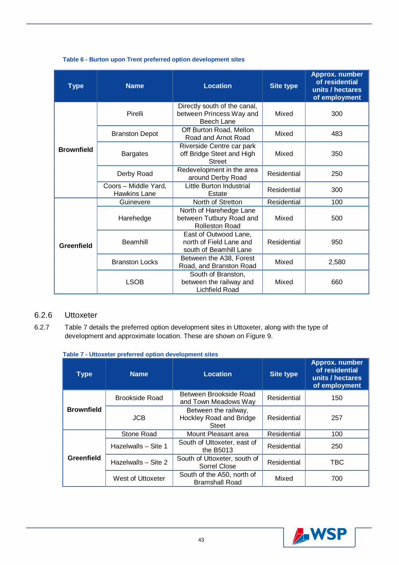
43
Table 6 - Burton upon Trent preferred option development sites
Type Name Location Site type Approx. number
of residential units / hectares of employment
Brownfield
Pirelli Directly south of the canal, between Princess Way and
Beech Lane Mixed 300
Branston Depot Off Burton Road, Mellon Road and Arnot Road Mixed 483
Bargates Riverside Centre car park off Bridge Steet and High
Street Mixed 350
Derby Road Redevelopment in the area around Derby Road Residential 250
Coors – Middle Yard, Hawkins Lane
Little Burton Industrial Estate Residential 300
Greenfield
Guinevere North of Stretton Residential 100
Harehedge North of Harehedge Lane
between Tutbury Road and Rolleston Road
Mixed 500
Beamhill East of Outwood Lane, north of Field Lane and south of Beamhill Lane
Residential 950
Branston Locks Between the A38, Forest Road, and Branston Road Mixed 2,580
LSOB South of Branston,
between the railway and Lichfield Road
Mixed 660
6.2.6 Uttoxeter 6.2.7 Table 7 details the preferred option development sites in Uttoxeter, along with the type of
development and approximate location. These are shown on Figure 9.
Table 7 - Uttoxeter preferred option development sites
Type Name Location Site type Approx. number
of residential units / hectares of employment
Brownfield Brookside Road Between Brookside Road
and Town Meadows Way Residential 150
JCB Between the railway,
Hockley Road and Bridge Steet
Residential 257
Greenfield
Stone Road Mount Pleasant area Residential 100
Hazelwalls – Site 1 South of Uttoxeter, east of the B5013 Residential 250
Hazelwalls – Site 2 South of Uttoxeter, south of Sorrel Close Residential TBC
West of Uttoxeter South of the A50, north of Bramshall Road Mixed 700

Project number: 50600218 Dated: 26/09/2013 44
Figure 9 - Uttoxeter preferred option development sites (extract from Local Plan)
6.2.8 Rural areas 6.2.9 Table 8 details the preferred option development sites in the rural villages, along with the type of
development and approximate location. These are shown on Figure 8 and Figure 10.
Table 8 - Rural villages preferred option development sites
Type Name Location Site type Approx. number
of residential units / hectares of employment
Greenfield
Efflinch Lane In the south of Barton-
under-Needwood, off Mill Lane
Residential 130 (plus ~25 windfall)
South of Tutbury Tutbury – between the A511 and Green Lane Mixed 212 (plus ~20
windfall)
College Fields Rolleston-on-Dove, sports field south of Twentylands Residential 100 (plus ~ 25
windfall) Windfall Rocester Land south of Main Street Mixed 90

45
Figure 10 - Extract from the Uttoxeter preferred option showing the development in Rocester
6.2.10 In addition to the development sites detailed in Table 8 there is also expected to be windfalls in the following villages:
Abbots Bromley (~40 units)
Yoxall (~40 units)
Draycott in the Clay (~20 units)
Mayfield (~20 units)
Marchington (~20 units)
Denstone (~20 units)
6.2.11 Strategic Housing Land Availability Assessment (SHLAA) 6.2.12 There were also a large number of SHLAA sites assessed by the council which have been included
in this SFRA assessment. Details of these sites are provided in Appendix G. Note that some of these sites overlap with the preferred option sites.
6.3 Flood Risk Guidance 6.3.1 The NPPF therefore states that all proposals in Flood Zones 2 and 3 should be subjected to the
Sequential Test, the Exception Test (if required), and accompanied by a Flood Risk Assessment. The specific requirements are provided in the Technical Guidance to the National Planning Policy Framework (March 2012).
6.3.2 Within this Technical Guidance Table 2 provides a Flood Risk Vulnerability Classification which is then used in Table 3 to highlight the flood risk vulnerability and flood zone ‘compatibility’. An extract of Table 3 from the Technical Guidance is shown below in Table 9.

Project number: 50600218 Dated: 26/09/2013 46
Table 9 - Copy of Table 3 from the NPPF Technical Guidance
6.3.3 Table 9 shows that Highly Vulnerable use e.g. emergency service stations, basements, mobile homes, can only be provided in Flood Zone 1. If the Exception Test is passed then they can also be provided in Flood Zone 2. More Vulnerable uses e.g. buildings used for dwelling and hospitals are appropriate in Flood Zones 1 and 2 and only Flood Zone 3a if the Exception Test is passed. Commercial uses are then classed as Less Vulnerable and so appropriate in all areas except Flood Zone 3b.
6.3.4 Any development permitted in line with NPPF should be designed and constructed to remain operational and safe for users in times of flood, for the lifetime of the development.
6.3.5 The Environment Agency will object to any development which does not accord with guidance contained within NPPF.
6.3.6 Application of the Sequential Test 6.3.7 The policies in NPPF require that all stages of the development planning process should take
account of both the nature and spatial distribution of flood risk and the degree of vulnerability of different types of development. Reinforcing the philosophy of managing flood risk through avoidance/prevention, NPPF requires that planners and developers do not simply match land use types to areas or zones with an ‘acceptable’ degree of flood risk. Rather, a sequential approach to location of new development is required, by application of the Sequential Test as defined in the NPPF Technical Guidance.
6.3.8 The application of the Sequential Test requires the identification of Flood Zones as defined in Table 1 of the NPPF Technical Guidance. Also, it will require LPAs to demonstrate that there are no reasonable available sites in areas with a lower probability of flooding that would be appropriate to the type of development or land use proposed, by considering all forms of flooding based on a Level 1 SFRA (i.e. as reported in this report and accompanying maps).

47
6.3.9 Application of the Exception Test 6.3.10 If, following application of the Sequential Test, it is not possible, consistent with wider sustainability
objectives, for the development to be located in zones with a lower probability of flooding, the Exception test can be applied if appropriate (as shown in Table 9). For the Exception Test to be passed the following two elements must be addressed:
It must be demonstrated that the development provides wider sustainability benefits to the community that outweigh flood risk; and
A site-specific Flood Risk Assessment must demonstrate that the development will be safe for its lifetime taking account of the vulnerability of its users, without increasing flood risk elsewhere, and, where possible, will reduce flood risk overall.
6.3.11 Information within this SFRA can be used as an evidence base for the Exception Test.
6.3.12 Flood Risk Assessments 6.3.13 In order to provide relevant information and to steer the planning-process in the right direction, the
minimum requirements for flood risk assessments are that they should:
be proportionate to the risk and appropriate to the scale, nature and location of the development;
consider the risk of flooding arising from the development in addition to the risk of flooding to the development;
take the impacts of climate change into account as per Tables 4 and 5 of the NPPF Technical Guidance;
be undertaken by competent people, as early as possible in the particular planning process, to avoid misplaced effort and raising landowner expectations where land is unsuitable for development;
consider both the potential adverse and beneficial effects of flood risk management infrastructure including raised defences, flow channels, flood storage areas and other artificial features together with the consequences of their failure;
consider the vulnerability of those that could occupy and use the development, taking account of the Sequential and Exception Tests and the vulnerability classification as per Tables 2 and 3 of the NPPF Technical Guidance, including arrangements for safe access;
consider and quantify all the different types of flooding (whether from natural and human sources and including joint and cumulative effects), this needs to include fluvial, surface, ground water along with artificial sources and identify flood risk reduction measures, so that assessments are fit for the purpose of the decisions being made;
consider the effects of a range of flooding events including extreme events on people, property, the natural and historic environment and river and coastal processes;
include the assessment of the residual risk after risk reduction measures have been taken into account and demonstrate that this is acceptable for the particular development or land use;
consider how the development will modify run-off and demonstrate the use of Sustainable Drainage Systems (SUDS), where feasible to mitigate that impact;
consider the impacts of the development upon water quality, particularly the Water Framework Directive; and
be supported by appropriate data and information, including historical information on previous events.
6.3.14 At the planning application stage, an appropriate site-specific FRA should be carried out to demonstrate how flood risk from all sources of flooding to the development itself and flood risk to others would be managed by fully taking into account climate change impacts. This should be

Project number: 50600218 Dated: 26/09/2013 48
undertaken for all applications in Flood Zones 2 and 3, and for applications greater than 1 hectare within Flood Zone 1. This ensures that the impact of the development on the local area is considered for all major developments, as discussed further in Section 6.4.
6.3.15 Surface Water Management 6.3.16 Historically, surface water drainage systems have been designed to remove surface water from a site
as quickly as possible by means of underground piped systems. This has the potential to increase flooding problems downstream and does not contribute to the natural recharge of groundwater levels. Such systems contribute to the transport of pollutants from urban areas to watercourses and groundwater.
6.3.17 With concerns surrounding the impacts of climate change, the requirements of the NPPF and Water Framework Directive, a more sustainable approach to drainage is required to reduce flood risk, manage water quality and provide integrated amenity benefits. The effective disposal of surface water from development is a material planning consideration in determining proposals for the development and use of land. It will always be much more effective to manage surface water flooding at and from new development early in the land acquisition and design process rather than to resolve problems after development.
6.3.18 Local authorities are encouraged to promote the use of SUDS for the management of surface water run-off. SUDS aim to mimic natural drainage processes and remove pollutants from urban run-off at source. They comprise a wide range of techniques, including green roofs, permeable paving, rainwater harvesting, swales, detention basins, ponds and wetlands. To realise the greatest improvement in water quality and flood risk management these components can be used in combination. The surface water drainage arrangements for any development site should be such that the volumes and peak flow rates of surface water leaving a developed site are no greater than the rates prior to the proposed development, unless specific off-site arrangements are made and result in the same net effect. Where possible, particularly in known problem areas, the run-off from the site may need to be limited further. ESBC / SCC – do you want us to specify the additional reduction required?
6.3.19 Successful implementation of SUDS will require the early consideration of a wide range of issues surrounding their management, long-term adoption and maintenance. The design team and stakeholders should take every opportunity for early discussion about SUDS and should consider them at the feasibility stage of a development, to realize the optimum contribution.
6.3.20 At the time of writing SUDS Approval Boards (SABs) are likely to come in to place in April 2014, this places the responsibility for approving the design of SUDS and the discharge rates from development sites with the LLFA.
6.3.21 All growth sites can increase flood risk on the receiving watercourses unless the additional runoff from the future development is adequately managed.
6.3.22 Flood Warning & Emergency Planning 6.3.23 The Environment Agency operates a national flood warning system for a large number of existing
properties currently at risk of flooding in order to enable householders to protect life or take early action to manage the effect of flooding on property. New developments should consider the role of flood warning in managing residual risks although they should not rely solely on them. Section 5.8 discussed the present availability of flood warning and emergency response arrangements within the borough.

49
6.3.24 Developments which include areas likely to flood will need to provide appropriate flood warning and formulate appropriate emergency plans to ensure their safe occupancy in the future. As a minimum, where any such development takes place in flood risk areas it is important that there is adequate passive flood warning in place, with signs highlighting the susceptibility to flooding and clearly signed evacuation routes where necessary.
6.3.25 Residual Risk Management 6.3.26 Flood risk to people and property associated with new developments can be managed but it can
never be completely removed; a residual risk will always remain after flood management or mitigation measures have been put in place. Residual risk can be defined as the risk remaining after applying the sequential approach and taking mitigating actions.
6.3.27 Local Planning Authorities and developers should always consider residual flood risk issues relating to a development. The potential sources of this residual risk will need to be identified in the FRA, along with their potential impacts, and the most significant will have to be mitigated through flood risk management measures. The costs of such measures may be low compared to the damages they avoid and may enhance the value of the development.
6.3.28 As with all aspects of development and flood risk, it is best to consider residual flood risk early in the planning process, as measures to manage it may impact on site layout and the extent of developable land.
6.3.29 Although flooding cannot be wholly prevented, its impacts can be reduced through good planning and management. Thus it is vital to make the most of opportunities to reduce existing flood risk to communities. For instance, opportunities to re-create and safeguard functional flood plain and washlands and to design more liveable developments combining sustainable defences, green/recreational space and increased flood storage should be investigated as early as possible when planning new developments.
6.3.30 Residual flood risk management needs to be coordinated with emergency procedures.
6.3.31 Flood resilience and resistance 6.3.32 Residual flood risk management can be dealt with using both resilient and resistant construction
techniques, details of which are provided in Table 10 below. Generally resilient construction is favoured because it can be achieved more consistently and is less likely to encourage occupiers to remain in buildings that could be inundated by rapidly raising water levels.
Table 10 - Comparison of resilient and resistant construction
Resilient construction Resistant construction
Definition Flood resilient buildings are designed to reduce the consequences of flooding and facility recovery sooner than conventional buildings.
Flood resistant construction can prevent entry of water or minimise the amount of water that may enter a building where there is flooding outside.
Examples Use of water-resistant materials for floors, wall and fixtures
Siting of electrical controls, cables and appliances at a higher than normal level.
The uses for the lower floors of buildings in Flood Zones 2 and 3 should be considered in line with
Barriers to doorways
Flood gates
Covers for airbricks and other wall vents
Project number: 50600218 Dated: 26/09/2013 50
Resilient construction Resistant construction
Table 1 of the NPPF Technical Guidance.
Comment If the lowest floor level is raised above the predicted flood level, access should be considered for restricted mobility.
It is essential plans are in place and there is a clear understanding of the mechanisms that lead to flooding.
This should be used with caution and be accompanied by resilience measures as effective flood exclusion may depend on occupiers undertaking a specific task e.g. putting a barrier up.
6.3.33 Note that flood resistance and resilience measures should not be used to justify development in inappropriate locations.
6.4 Impacts of Developments on Flood Risk 6.4.1 The NPPF states that developments need to be assessed to determine not only the flood risk to the
development site, but also the impact the development site could have on the flood risk to nearby land.
6.4.2 The impact of each of the proposed development sites has been assessed in respect to the following:
potential increase in surface water runoff; and
loss of floodplain storage area.
6.4.3 Surface Water Drainage 6.4.4 Many of the currently proposed development allocations are on Brownfield sites and will therefore be
unlikely to contribute additional runoff. However, there are also a number of potential sites proposed on currently undeveloped areas (Greenfield sites).
6.4.5 If these sites are chosen for development then it will be necessary to pay closer attention to the disposal of surface water in order to ensure that the development does not contribute additional runoff to receiving watercourses and thereby increase the risk of flooding to other areas.
6.4.6 However, it is anticipated that current awareness of sustainable drainage techniques (SUDS), which will be required as a prerequisite of any future development, may have the ability, through careful and considerate design to reduce the rate of runoff from the proposed sites for the larger events and therefore potentially reduce the flooding to existing areas. The provision of SUDS is a Council Policy and is the first method of disposal to be considered for surface water.
6.4.7 The specific SUDS to be used for each development depends on the geology and topography of the site, along with the availability of space within the development site boundary. Figure 7 highlights that there are significant areas across the borough that may be heavily susceptible to groundwater flooding. This should be factored into any choice on the use of SUDS within a development site.
6.4.8 Loss of Floodplain Storage 6.4.9 Any developments that fall within Flood Zones 2 and 3 have the potential to:
reduce floodplain storage due to the construction of buildings or raising of land;
impede water flows; and

51
increase flood risk elsewhere.
6.4.10 As part of a site specific Flood Risk Assessment the potential for loss of floodplain storage needs to be assessed and compensatory storage provided within the site at a level for level, volume for volume basis.

Project number: 50600218 Dated: 26/09/2013 52 Revised:
7 Burton upon Trent - Development & Flood Risk
7.1 Flood Risk to the development sites 7.1.1 Burton upon Trent lies within the River Trent and River Dove catchments. Table 11 shows the preferred option development sites and
details the flood risk to each site from fluvial, surface water and groundwater flooding, where high risk is red, moderate risk is orange and yellow and low risk is green. Table 12 then provides further details of the fluvial risk based on the hydraulic modelling outputs and Table 13 provides an overall summary of the flood risk to each site. The results of the modelling can be found in Appendix F.
Table 11 - Flood Risk to the Burton upon Trent preferred development sites
Site name Capacity Type5 Historic incidents
Proportion of site within EA Flood Map EA Flood
Warning Area
Proportion of site within areas of FMfSW AStGWF
Within a modelled
area? Flood Zone 2
Flood Zone 3 ABD Deep
30yr 30yr Deep 200yr 200yr
Derby Road6 250 R Yes 25% 5% 5% Yes 0% 2.5% 1% 10% 50- 75% Yes Pirelli 300 M No 20% 5% 0% Yes 1% 5% 2.5% 10% >75% Yes Branston Depot 483 M Nearby 100% 100% 100% Yes 1% 5% 2.5% 10% >75% Yes Coors - Middle Yard 300 R Nearby 100% 90% 100% Yes 0% 5% 2.5% 15% >75% Yes Harehedge 500 M No 0% 0% 0% No 2.5% 5% 5% 10% <25% No Beamhill 950 R Yes 0% 0% 0% No 2.5% 5% 5% 5% <25% No Guinevere 100 R No 0% 0% 0% No 0% 0% 0% 0% >75% No Bargates 350 M Yes 100% 2.5% 100% Yes 0% 0% 0% 0% >75% Yes Branston Locks 2580 M Yes 50% 10% 0% Alert 3% 15% 5% 20% 0- 75% Yes LSOB 660 M Yes 90% 10% 0% Alert 0% 2.5% 0% 5% >75% Yes Model Dairy Farm 84 R No 0% 0% 0% No 5% 10% 7.5% 15% <25% No
7.1.2 The majority of the sites have a low percentage of their site area within Flood Zone 3. Provided the developments are designed so that the areas of floodplain are avoided, particularly for the higher vulnerability uses, then these sites satisfy the NPPF criteria for residential or mixed use developments. Note that the Environment Agency Flood Zones do not take account of defences.
7.1.3 A number of the sites are shown to be entirely within Flood Zone 2. However, these areas are generally protected by flood defences and therefore are Areas Benefitting from Defences. The only site that doesn’t have protection is the LSOB. Further information regarding the
5 R = residential, M = mixed 6 No specific site has been confirmed for the Derby Road site however an approximate area has been highlighted

53
impact of defences is provided in Table 12 which presents the with defences model results, where the percentage of the site that is covered by each hazard rating7 is specified. Some of the sites do not fall within a modelled area and therefore no results are provided.
7.1.4 Note that small ordinary watercourses / ditches flow through the Beamhill and Branston Locks sites. There is also a small watercourse to the east of the Harehedge sites. These watercourses are too small to be picked up by the Environment Agency Flood Map and have not been modelled as part of this study. The risk from these watercourses should be considered as part of a site specific Flood Risk Assessment.
7.1.5 Generally the flood risk due to surface water appears to be low for all the development sites listed above, with only small parts of the development sites at risk from surface water flooding of greater than 300mm. Surface water flow routes, on to, through and off site should however still be considered, and how they will be accommodated should be demonstrated as part of a site specific flood risk assessment.
7.1.6 Table 11 highlights that the majority of the sites have a potential to be susceptible to groundwater flooding. This would therefore need to be included within a detailed Flood Risk Assessment for each site, and factored into the choice of SUDS utilised within the development.
Table 12 - Summary of defended fluvial model results for Burton upon Trent
Site name Within 1 in 1,000yr model
extent Within 1 in 100yr+CC model
extent Within 1 in 100yr model
extent Within 1 in 20yr model
extent Low Mod Sign Ext Low Mod Sign Ext Low Mod Sign Ext Low Mod Sign Ext
Derby Road 10% 2.5% 0% 0% 0% 0% 0% 0% 0% 0% 0% 0% 0% 0% 0% 0% Pirelli 5% 5% 5% 0% 0% 0% 0% 0% 0% 0% 0% 0% 0% 0% 0% 0% Branston Depot 5% 30% 35% 0% 40% 25% 10% 0% 0% 0% 0% 0% 0% 0% 0% 0% Coors - Middle Yard
20% 20% 40% 0% 30% 10% 1% 0% 0% 0% 0% 0% 0% 0% 0% 0%
Harehedge - - - - - - - - - - - - - - - - Beamhill - - - - - - - - - - - - - - - - Guinevere - - - - - - - - - - - - - - - - Bargates 20% 2.5% 0% 0% 0% 0% 0% 0% 0% 0% 0% 0% 0% 0% 0% 0% Branston Locks 25% 10% 15% 0% 10% 5% 1% 0% 10% 2.5% 1% 0% 5% 1% 0% 0% LSOB 10% 2.5% 0% 0% 5% 5% 2.50% 0% 2.5% 2.5% 1% 0% 2.5% 1% 0% 0% Model Dairy Farm - - - - - - - - - - - - - - - -
7.1.7 Table 12 confirms that generally the fluvial risk to the sites at Burton upon Trent is low with none of the site falling within an area of Extreme Hazard, up to and including the 1 in 1,000 year event. There are areas of Significant Hazard during the 1,000 year event for Pirelli, Branston Depot, Coors and Branston Locks. When producing the Masterplans for these sites the areas of Significant Hazard should be used for green open space or low vulnerability uses where possible.
7 Low hazard = rating of less than 0.75, Moderate hazard = rating of between 0.75 and 1.25, Significant hazard = rating of between 1.25 and 2, Extreme hazard = rating greater than 2

Project number: 50600218 Dated: 26/09/2013 54 Revised:
Table 13 - Summary of overall flood risk to the Burton upon Trent preferred development sites
Site name Access and egress during 1 in 100yr + CC General summary comments
Derby Road Site and surrounding area is not at risk. Safe access / egress via Princess Way or Horninglow Road
Defended up to and including the 1 in 100yr+CC, small potential for surface water flooding and moderate susceptibility to groundwater flooding. Suitable for all types of development.
Pirelli Site and surrounding area is not at risk. Safe access / egress via Princess Way.
Defended area. Small surface water risk and high susceptibility to groundwater flooding. Suitable for all types of development.
Branston Depot
Site itself is not at risk during Scenario 18, however site and surrounding area shows a moderate hazard for Scenario 3. Mitigation works would be required to ensure safe access / egress for Scenario 3.
Only affected by Scenario 3 for 1 in 100yr+CC. Small surface water flood risk and high susceptibility to groundwater flooding. Provision of safe access / egress will require mitigation works. Exception test will also need to be passed.
Coors - Middle Yard
Site itself is not at risk during Scenario 1, however site and surrounding area shows a low to moderate hazard for Scenario 3. Safe access / egress via Horninglow Street. Note this will be via a flooded area but only a low hazard.
Protected up to and including 1 in 100yr, however will be at risk in the future (only for Scenario 3) - not at risk for Scenario 1. Small potential for surface water flooding and high susceptibility to groundwater flooding. Suitable for all types of development.
Harehedge No fluvial risk nearby Small surface water risk only, limited groundwater susceptible and no fluvial risk. Flood risk from the watercourse to the east of the site should be considered. Suitable for all types of development.
Beamhill No fluvial risk nearby Small surface water risk only, limited groundwater susceptible and no fluvial risk. Flood risk from the watercourse that runs through the site should be considered. Suitable for all types of development.
Guinevere No fluvial risk nearby No surface water or fluvial risk. Suitable for all types of development.
Bargates Site itself not at risk however flooding to the east. Safe access / egress via Bridge Street, A511.
Protected up to and including the 1 in 100yr+CC, still at risk from 1 in 1000yr, no surface water risk but high susceptibility to groundwater flooding. Suitable for all types of development.
Branston Locks Parts of the site show a low – moderate risk. Adjacent areas to the south west and north east also at risk. Safe access / egress via Branston Road and the A38.
Small parts of the site at risk from all returns periods suggesting parts of the site are functional floodplain. Development should be avoided in these parts of the site. Moderate surface water risk and moderate to high susceptibility to groundwater flooding. Exception test will need to be passed.
LSOB Parts of the site and surrounding area at significant risk. Safe access / egress via A38.
Small parts of the site at risk from all returns periods suggesting parts of the site are functional floodplain. Development should be avoided in these parts of the site. Small surface water risk and high susceptibility to groundwater flooding.
Model Dairy Farm No fluvial risk nearby so all routes suitable as safe access and egress. Small surface water risk. No fluvial risk but high susceptibility to groundwater flooding.
8 Scenario 1 assumes a short duration storm, focussing on the risk from the tributaries, whilst Scenario 3 assumes a long duration storm focussing on the risk from the River Trent

55
7.2 Potential impact on nearby land 7.2.1 Table 14 summarises the potential impact the developments could have on the flood risk to the nearby area and specifies what mitigation
measures may be required. Table 14 - Potential impacts of the developments on the flood risk to Burton upon Trent
Site name Post development surface water runoff Floodplain compensation Finished Floor Levels
Derby Road
There is flood risk to the surrounding area and therefore surface water runoff should be limited to at most the existing brownfield runoff rates. The potential for limiting the outflow further should be considered to try to reduce the flood risk to the surrounding properties. ESBC / SCC – do you want us to specify the additional reduction required here and the other sites?
None of the site is shown to be at risk of fluvial flooding and therefore floodplain compensation will not be required.
Finished floor levels do not need to be raised above the current ground level, other than the inclusion of a freeboard in accordance with Building Regulations.
Pirelli
There is flood risk to the surrounding area and therefore surface water runoff should be limited to at most the existing brownfield runoff rates. The potential for limiting the outflow further should be considered to try to reduce the flood risk to the downstream properties.
None of the site is shown to be at risk of fluvial flooding and therefore floodplain compensation will not be required.
Finished floor levels do not need to be raised above the current ground level, other than the inclusion of a freeboard in accordance with Building Regulations.
Branston Depot
There is flood risk to the surrounding area and therefore surface water runoff should be limited to at most the existing brownfield runoff rates. The potential for limiting the outflow further should be considered to try to reduce the flood risk to the surrounding properties.
The majority of the site is at risk from the 1 in 100 year plus climate change event. Depths of flooding across the site range from between 100mm and 360mm. Floodplain compensation will therefore be required if any of the site is developed and / or raised. Hydraulic modelling would be required as part of the FRA to show that the development does not impact on third parties.
The water level across the site during the 1 in 100 year plus climate change event is approximately 46.81mODN. Finished floor levels would need to be raised above this level with an appropriate freeboard allowance to be agreed with the Environment Agency.
Coors - Middle Yard
There is flood risk to the surrounding area and therefore surface water runoff should be limited to at most the existing brownfield runoff rates. The potential for limiting the outflow further should be considered to try to reduce the flood risk to the surrounding properties.
Approximately 40% of the site is at risk from the 1 in 100 year plus climate change event. Depths of flooding across the site range from between 150mm and 400mm. Floodplain compensation will therefore be required if any of the site is developed and / or raised. Hydraulic modelling would be required as part of the FRA to show that the development does not impact on third parties.
The water level across the site during the 1 in 100 year plus climate change event is approximately 45.2mODN. Finished floor levels would need to be raised above this level with an appropriate freeboard allowance to be agreed with the Environment Agency.
Harehedge
There is flood risk to the east of the site. Surface water runoff should be limited to the existing greenfield runoff rates. The potential for limiting the outflow further should be considered to try to reduce the flood risk to the surrounding properties.
None of the site is shown to be at risk of fluvial flooding and therefore floodplain compensation will not be required.
Finished floor levels do not need to be raised above the current ground level, other than the inclusion of a freeboard in accordance with Building Regulations.

Project number: 50600218 Dated: 26/09/2013 56 Revised:
Site name Post development surface water runoff Floodplain compensation Finished Floor Levels
Beamhill
There is flood risk to the east of the site. Surface water runoff should be limited to the greenfield runoff rates. The potential for limiting the outflow further should be considered to try to reduce the flood risk to the surrounding properties.
None of the site is shown to be at risk of fluvial flooding and therefore floodplain compensation will not be required.
Finished floor levels do not need to be raised above the current ground level, other than the inclusion of a freeboard in accordance with Building Regulations.
Guinevere The surrounding risk is low. Surface water runoff should be limited to the greenfield runoff rates.
None of the site is shown to be at risk of fluvial flooding and therefore floodplain compensation will not be required.
Finished floor levels do not need to be raised above the current ground level, other than the inclusion of a freeboard in accordance with Building Regulations.
Bargates The surrounding risk is low. Surface water runoff should be limited to at most the existing brownfield runoff rates.
None of the site is shown to be at risk of fluvial flooding and therefore floodplain compensation will not be required.
The site itself is not at risk however the adjacent land is, with water levels of approximately 45.95mODN. This level should therefore be considered when determining the site levels.
Branston Locks
There is flood risk to the south of the site. Surface water runoff should be limited to the greenfield runoff rates. The potential for limiting the outflow further should be considered to try to reduce the flood risk to the surrounding properties.
Approximately 20% of the site is at risk from the 1 in 100 year plus climate change event. Depths of flooding across the site range from between 200mm and 550mm. Floodplain compensation will therefore be required if any of the site is developed and / or raised. Hydraulic modelling would be required as part of the FRA to show that the development does not impact on third parties.
The water level across the site during the 1 in 100 year plus climate change event is approximately 46.74mODN. Finished floor levels would need to be raised above this level with an appropriate freeboard allowance to be agreed with the Environment Agency.
LSOB The surrounding risk is low. Surface water runoff should be limited to the greenfield runoff rates.
Approximately 15% of the site is at risk from the 1 in 100 year plus climate change event. Depths of flooding across the site are up to 300mm. Floodplain compensation will therefore be required if any of the site is developed and / or raised. Hydraulic modelling would be required as part of the FRA to show that the development does not impact on third parties.
The water level across the site during the 1 in 100 year plus climate change event is approximately 48.4mODN. Finished floor levels would need to be raised above this level with an appropriate freeboard allowance to be agreed with the Environment Agency.
Model Dairy Farm
There is flood risk to the east of the site. Surface water runoff should be limited to at most the existing brownfield runoff rates. The potential for limiting the outflow further should be considered to try to reduce the flood risk to the surrounding properties.
None of the site is shown to be at risk of fluvial flooding and therefore floodplain compensation will not be required.
Finished floor levels do not need to be raised above the current ground level, other than the inclusion of a freeboard in accordance with Building Regulations.
7.3 Summary 7.3.1 Table 15 summarises the flood risk to the development sites and the impact on the surrounding area, with green showing no issues, yellow
it needs to be considered, and orange could have impacts on the Masterplan for site.

57
Table 15 - Summary of Burton upon Trent development sites
Site name Flood Zone 3 1 in 100yr+CC defended Surface Water Groundwater Safe access /
egress Flood
compensation required
Finished Floor Levels
Derby Road 5% 0% Moderate Moderate Yes No Ground level Pirelli 5% 0% Moderate Significant Yes No Ground level
Branston Depot 100% 75% Moderate Significant Via moderate Yes >46.81mODN Coors - Middle Yard 90% 40% Moderate Significant Via low Yes >45.2mODN
Harehedge 0% - Moderate Low Yes No Ground level Beamhill 0% - Moderate Low Yes No Ground level
Guinevere 0% - Low Significant Yes No Ground level Bargates 2.5% 0% Low Significant Yes No Ground level
Branston Locks 10% 15% Moderate Significant Yes Yes >46.74mODN LSOB 10% 12% Low Significant Yes Yes >48.4mODN
Model Dairy Farm 0% - Moderate Low Yes No Ground level

Project number: 50600218 Dated: 26/09/2013 58 Revised:
8 Uttoxeter – Development & Flood Risk
8.1 Flood Risk to the development sites 8.1.1 Uttoxeter lies within the Dove catchment and its tributaries; River Tean, Uttoxeter Brook and the Picknall Brook. Table 16 shows the
preferred option development sites and details the flood risk to each site from fluvial, surface water and groundwater flooding, where high risk is red, moderate risk is orange and yellow and low risk is green. Table 17 then provides further details of the fluvial risk based on the hydraulic modelling outputs.
8.1.2 Table 18 provides an overall summary of the flood risk to each site. The results of the modelling can be found in Appendix F.
Table 16 - Flood Risk to the Uttoxeter preferred development sites
Site name Capacity Type9 Historic incidents
Proportion of site within EA Flood Map EA Flood
Warning Area
Proportion of site within areas of FMfSW
AStGWF Within a modelled area? Flood
Zone 2 Flood Zone 3 ABD Deep
30yr 30yr Deep 200yr 200yr
JCB 257 R Yes 100% 40% 3% Yes 10% 25% 10% 35% >75% Yes
Brookside Rd 150 R Yes 100% 90% 0% Yes 5% 10% 5% 15% >75% Yes
Stone Road 100 R No 30% 0% 0% No 0% 2.5% 2.5% 5% 25-50% Yes
Hazelwalls - site 1 250 R No 0% 0% 0% No 2.5% 10% 5% 10% 25-50% No
Hazelwalls - site 2 0 R No 0% 0% 0% No 1% 2.5% 2.5% 2.5% 25-50% No
West of Uttoxeter 700 M No 0% 0% 0% No 1% 5% 2.5% 5% 50-75% No
8.1.3 The majority of the sites have a low percentage of their site area within Flood Zone 3. Provided the developments are designed so that the areas of floodplain are avoided, particularly for the higher vulnerability uses, then these sites satisfy the NPPF criteria for residential or mixed use developments. Note that the Environment Agency Flood Zones do not take account of defences.
8.1.4 The one site that is shown to have a significant fluvial risk is Brookside Road, which is almost entirely within Flood Zone 3. In addition, the JCB site is shown to be 100% within Flood Zone 2 with only limited areas benefiting from defences. Further information regarding the impact
9 R = residential, M = mixed

59
of defences is provided in Table 17 which presents the with defences model results, where the percentage of the site that is covered by each hazard rating10 is specified. Some of the sites do not fall within a modelled area and therefore no results are provided.
8.1.5 Note that for the Brookside Road site the exception test would need to be passed for this site to be developed.
8.1.6 There is an ordinary watercourse that runs between the two Hazelwall sites that has not been modelled for the EA Flood Map. The risk from this watercourse is therefore unknown and should be considered as part of a site specific Flood Risk Assessment.
8.1.7 Generally the flood risk due to surface water appears to be low for all the development sites listed above, with only small parts of the development sites at risk from surface water flooding of greater than 300mm. Surface water flow routes should however still be considered as part of a site specific flood risk assessment.
8.1.8 Table 16 highlights that the majority of the sites have a potential to be susceptible to groundwater flooding, particularly the JCB and Brookside Road sites. This would therefore need to be included within a detailed Flood Risk Assessment for each site, and factored into the choice of SUDS utilised within the development.
Table 17 - Summary of defended fluvial model results for Uttoxeter
Site name Within 1 in 1,000yr model
extent Within 1 in 100yr+CC model
extent Within 1 in100yr model
extent Within 1 in 20yr model
extent
Low Mod Sign Ext Low Mod Sign Ext Low Mod Sign Ext Low Mod Sign Ext
JCB 10% 5% 30% 5% 15% 5% 15% 2.5% 15% 5% 10% 0% 5% 1% 1% 0% Brookside Rd 30% 10% 15% 0% 50% 10% 10% 0% 40% 10% 10% 0% 40% 5% 2.5% 0% Stone Road 0% 0% 0% 0% 0% 0% 0% 0% 0% 0% 0% 0% 0% 0% 0% 0% Hazelwalls - site 1 - - - - - - - - - - - - - - - - Hazelwalls - site 2 - - - - - - - - - - - - - - - - West of Uttoxeter - - - - - - - - - - - - - - - -
8.1.9 Table 17 confirms that there is a significant flood risk to the Brookside Road site, with parts of the site at risk during the 1 in 20 year event, suggesting that area is functional floodplain. The development should avoid these areas where possible and instead utilise the areas as green open space. The same applies to the JCB site however for a smaller area and generally a lower hazard rating. The flood risk to both sites increases with increasing return periods and therefore a sequential approach should be utilised for both sites as part of the Master plan design stage.
8.1.10 The other sites are shown to not be at risk from fluvial flooding based on the modelling available. Note that Table 17 does not account for the ordinary watercourse adjacent to the Hazelwalls sites, however the FMfSW provides an indication of flood risk due to this watercourse.
10 Low hazard = rating of less than 0.75, Moderate hazard = rating of between 0.75 and 1.25, Significant hazard = rating of between 1.25 and 2, Extreme hazard = rating greater than 2

Project number: 50600218 Dated: 26/09/2013 60 Revised:
8.1.11 Modelling work is currently underway adjacent to the West of Uttoxeter site as part of a site specific Flood Risk Assessment. This modelling was not available for use within the SFRA however should be considered once it has been finalised and is publically available.
Table 18 - Summary of overall flood risk to the Uttoxeter preferred development sites
Site name Access and egress during 1 in 100yr + CC General summary comments
JCB There are various potential safe access/ egress routes to the north of the site, namely either Pinfold Street, Bridge Street, or Market Street.
Approximately 7% of the site is functional floodplain and therefore development should be avoided in these areas. Due to the fluvial flood risk, the exception test would need to be passed for this development to proceed and a sequential approach should be utilised when determining the Master plan for the site. The groundwater and surface water flood risk to the site would also need to be considered as part of a site specific Flood Risk Assessment.
Brookside Rd There is a safe access/ egress route to the west via Town Meadows Way.
Approximately 50% of the site is functional floodplain and therefore development should be avoided in these areas. Due to the fluvial flood risk, the exception test would need to be passed for this development to proceed and a sequential approach should be utilised when determining the Master plan for the site. This site may struggle to pass the sequential test due to the high fluvial risk. The groundwater and surface water flood risk to the site would also need to be considered as part of a site specific Flood Risk Assessment.
Stone Road Site itself is not at risk. Safe access / egress is via Stone Road
The whole site is shown to be protected from fluvial flooding along with a minimal surface water risk. The site is therefore appropriate for all uses, however the groundwater risk should be considered as part of a site specific Flood Risk Assessment.
Hazelwalls - site 1 Sites themselves are not shown to be at risk based on the current modelling. Safe access / egress is via the A518 and the B5103. The risk from the ordinary watercourse however needs to be confirmed when considering access and egress.
Available modelling shows no fluvial risk to the site, however the risk from ordinary watercourse should be considered within a site specific Flood Risk Assessment. The groundwater and surface water risk to the sites, particularly site 1 should also be included in the FRA and the choice of SUDS.
Hazelwalls - site 2
West of Uttoxeter Site itself is not at risk. Safe access / egress is via the A50 The modelling confirms the fluvial risk to the site is low, along with the surface water risk. The groundwater risk should be investigated further however the site is appropriate for all uses.
8.2 Potential impact on nearby land 8.2.1 Table 19 summarises the potential impact the developments could have on the flood risk to the nearby area and specifies what mitigation
measures may be required.

61
Table 19 - Potential impacts of the developments on the flood risk to Uttoxeter
Site name Surface water runoff Floodplain compensation Finished Floor Levels
JCB
There is flood risk to the surrounding area and therefore surface water runoff should be limited to at most the existing brownfield runoff rates. The potential for limiting the outflow further should be considered to try to reduce the flood risk to the properties to the south east of the site.
Approximately 40% of the site is at risk from the 1 in 100 year plus climate change event. Depths of flooding across the site range from approximately 200mm in the east part of the site, up to approximately 1.5m in the deepest locations. Significant floodplain compensation will therefore be required if any of the flooded areas are developed and / or raised. Hydraulic modelling would be required to show that the development does not impact on third parties.
The water level across the site during the 1 in 100 year plus climate change event is between 80mODN in the west to 78mODN in the east. Finished floor levels would need to be raised above this level with an appropriate freeboard allowance to be agreed with the Environment Agency.
Brookside Rd
There is flood risk to the surrounding area and therefore surface water runoff should be limited to at most the existing brownfield runoff rates. The potential for limiting the outflow further should be considered to try to reduce the flood risk to the properties to the south east of the site.
The majority of the site is at risk from the 1 in 100 year plus climate change event. Depths of flooding across the site range from between 200mm and 700mm. Significant floodplain compensation will therefore be required if any of the site is developed and / or raised. Hydraulic modelling would be required as part of the FRA to show that the development does not impact on third parties.
The water level across the site during the 1 in 100 year plus climate change event is between 77.4mODN in the west to 76.7mODN in the east. Finished floor levels would need to be raised above this level with an appropriate freeboard allowance to be agreed with the Environment Agency.
Stone Road There are no noticeable areas of flood risk in the surrounding area. Surface water runoff should therefore be limited to the greenfield runoff rates.
None of the site is shown to be at risk of fluvial flooding and therefore floodplain compensation will not be required.
Finished floor levels do not need to be raised above the current ground level.
Hazelwalls - site 1 The playing field and surrounding properties
downstream of these sites is shown to be at risk. Surface water runoff should be limited to the greenfield runoff rates. The potential for limiting the outflow further should be considered to try to reduce the flood risk to the properties to the north of the sites
The sites are not shown to be at risk of fluvial flooding. There may however be some risk from the ordinary watercourse. Raising of land adjacent, or the installation of buildings, should be avoided adjacent to the watercourse. If this is not possible then compensatory floodplain storage will need to be provided on the site. The quantity of storage will need to be confirmed as part of a site specific FRA and agreed with the Environment Agency.
The flood risk from the ordinary watercourse should be confirmed before agreeing finished floor levels. Based on the modelling to date finished floor levels do not need to be raised above the current ground level.
Hazelwalls - site 2
West of Uttoxeter
Flooding potential to the east of the site. Surface water runoff should be limited to the greenfield runoff rates. The potential for limiting the outflow further should be considered to try to reduce the flood risk to the properties to the east of the site.
None of the site is shown to be at risk of fluvial flooding and therefore floodplain compensation will not be required.
Finished floor levels do not need to be raised above the current ground level.
8.3 Summary 8.3.1 Table 20 summarises the flood risk to the development sites and the impact on the surrounding area, with green showing no issues, yellow
it needs to be considered, and orange could have impacts on the Masterplan for site.

Project number: 50600218 Dated: 26/09/2013 62 Revised:
Table 20 - Summary of Uttoxeter development sites
Site name Flood Zone 3 1 in 100yr+CC defended Surface Water Groundwater Safe access /
egress Flood
compensation required
Finished Floor Levels
JCB 40% 35% Significant Significant Yes Yes >78 – 80mODN Brookside Rd 90% 25% Moderate Significant Yes Yes >76.7 – 77.4mODN Stone Road 0% 0% Low Moderate Yes No Ground level Hazelwalls - site 1 0% 0% Moderate Moderate Yes No Ground level Hazelwalls - site 2 0% 0% Low Moderate Yes No Ground level West of Uttoxeter 0% 0% Low Moderate Yes No Ground level

63
9 Rural Villages – Development & Flood Risk
9.1 Flood Risk to the development sites 9.1.1 Efflinch Lane lies within the Trent and Barton Brook catchments, whilst the other three development sites are within the Dove catchment.
Rocester is also affected by the River Churnet. Table 23 shows the preferred option development sites and details the flood risk to each site from fluvial, surface water and groundwater flooding, where high risk is red, moderate risk is orange and yellow and low risk is green. Table 22 then provides further details of the fluvial risk based on the hydraulic modelling outputs and Table 23 provides an overall summary of the flood risk to each site. The results of the modelling can be found in Appendix F.
Table 21 - Flood Risk to the Rural Villages preferred development sites
Site name Capacity Type11 Historic Incidents
Proportion of site within EA Flood Map EA Flood
Warning Area
Proportion of site within areas of FMfSW
AStGWF Within a modelled
area? Flood Zone 2
Flood Zone 3 ABD Deep
30yr 30yr Deep 200yr 200yr
College Fields (Rolleston-on-Dove) 100 R No 0% 0% 0% No 0% 0% 0% 0% <25% Yes
Efflinch Lane (Barton-under-Needwood) 130 R No 0% 0% 0% Alert 0% 5% 2.5% 20% >75% Yes
South of Tutbury (Tutbury) 212 M No 0% 0% 0% No 5% 0% 0% 0% <25% Yes
Rocester 90 M No 50% 0% 0% No 0% 2% 1% 5% >75% Yes
9.1.2 All of the rural village sites detailed above are within Flood Zone 1 and therefore the proposed developments are suitable in terms of fluvial flood risk.
9.1.3 Generally the flood risk due to surface water appears to be low for all the development sites listed above, with only very small areas thought to be at risk from flooding greater than 300mm in depth. Surface water flow routes should however still be considered as part of a site specific flood risk assessment.
9.1.4 Table 21 shows that the sites, and potential windfall sites, in Rocester and Barton-under-Needwood show a high susceptibility to groundwater flooding, whilst Tutbury and Rolleston-on-Dove have a low susceptibly. This risk would therefore need to be included within a detailed Flood Risk Assessment for Rocester and Barton-under-Needwood, and factored into the choice of SUDS utilised within the development.
11 R = residential, M = mixed
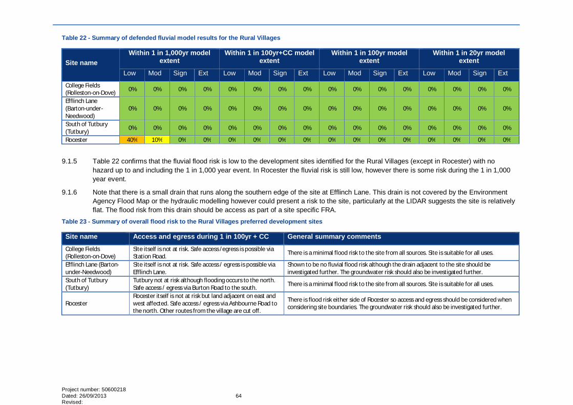
Project number: 50600218 Dated: 26/09/2013 64 Revised:
Table 22 - Summary of defended fluvial model results for the Rural Villages
Site name Within 1 in 1,000yr model
extent Within 1 in 100yr+CC model
extent Within 1 in 100yr model
extent Within 1 in 20yr model
extent
Low Mod Sign Ext Low Mod Sign Ext Low Mod Sign Ext Low Mod Sign Ext
College Fields (Rolleston-on-Dove) 0% 0% 0% 0% 0% 0% 0% 0% 0% 0% 0% 0% 0% 0% 0% 0%
Efflinch Lane (Barton-under-Needwood)
0% 0% 0% 0% 0% 0% 0% 0% 0% 0% 0% 0% 0% 0% 0% 0%
South of Tutbury (Tutbury) 0% 0% 0% 0% 0% 0% 0% 0% 0% 0% 0% 0% 0% 0% 0% 0%
Rocester 40% 10% 0% 0% 0% 0% 0% 0% 0% 0% 0% 0% 0% 0% 0% 0%
9.1.5 Table 22 confirms that the fluvial flood risk is low to the development sites identified for the Rural Villages (except in Rocester) with no hazard up to and including the 1 in 1,000 year event. In Rocester the fluvial risk is still low, however there is some risk during the 1 in 1,000 year event.
9.1.6 Note that there is a small drain that runs along the southern edge of the site at Efflinch Lane. This drain is not covered by the Environment Agency Flood Map or the hydraulic modelling however could present a risk to the site, particularly at the LIDAR suggests the site is relatively flat. The flood risk from this drain should be access as part of a site specific FRA.
Table 23 - Summary of overall flood risk to the Rural Villages preferred development sites
Site name Access and egress during 1 in 100yr + CC General summary comments
College Fields (Rolleston-on-Dove)
Site itself is not at risk. Safe access /egress is possible via Station Road. There is a minimal flood risk to the site from all sources. Site is suitable for all uses.
Efflinch Lane (Barton-under-Needwood)
Site itself is not at risk. Safe access / egress is possible via Efflinch Lane.
Shown to be no fluvial flood risk although the drain adjacent to the site should be investigated further. The groundwater risk should also be investigated further.
South of Tutbury (Tutbury)
Tutbury not at risk although flooding occurs to the north. Safe access / egress via Burton Road to the south. There is a minimal flood risk to the site from all sources. Site is suitable for all uses.
Rocester Rocester itself is not at risk but land adjacent on east and west affected. Safe access / egress via Ashbourne Road to the north. Other routes from the village are cut off.
There is flood risk either side of Rocester so access and egress should be considered when considering site boundaries. The groundwater risk should also be investigated further.

65
9.2 Potential impact on nearby land 9.2.1 The flood risk to the development sites identified for the rural villages is low and therefore none of the sites will require floodplain
compensatory storage. Finished floor levels also do not need to be raised above the existing ground levels.
9.2.2 For all the sites the surface water runoff should be limited to at most the existing greenfield runoff rates. Where possible the runoff rates should be limited further to try to reduce downstream flood risk. This is particularly relevant for the College Fields site where there is noticeable flood risk to the north west of the site.
9.3 Summary 9.3.1 Table 24 summarises the flood risk to the development sites and the impact on the surrounding area, with green showing no issues, yellow
it needs to be considered, and orange could have impacts on the Masterplan for site. Table 24 - Summary of Rural Villages development sites
Site name Flood Zone 3 1 in 100yr+CC defended Surface Water Groundwater Safe access /
egress Flood
compensation required
Finished Floor Levels
College Fields (Rolleston-on-Dove) 0% 0% Low Low Yes No Ground levels
Efflinch Lane (Barton-under-Needwood) 0% 0% Moderate Significant Yes No Ground levels
South of Tutbury (Tutbury) 0% 0% Low Low Yes No Ground levels
Rocester 0% 0% Low Significant Yes No Ground levels

Project number: 50600218 Dated: 26/09/2013 66 Revised:
10 Conclusions & Recommendations
10.1 Conclusions 10.1.1 Flooding is a key issue in the borough and one that should be considered in all stages of the
planning process. Historically, the key sources of flooding were from the River Trent and River Dove. The recent construction of flood alleviation measures for the town of Burton-upon-Trent has reduced the risk from the River Trent. However, more recent events have resulted in flooding from more minor watercourses and from surface water run-off.
10.1.2 The information and knowledge gathered through this SFRA will inform the emerging Local Plan and future flood risk management needs of the borough. This SFRA considers all sources of flooding within the borough based on a desktop study and consultation carried out with the Environment Agency, the Council, Staffordshire County Council, Severn Trent Water, Canal and River Trust and the Highways Agency. It has been written in accordance with the National Planning Policy Framework and its Technical Guidance (March 2012).
10.1.3 The findings of the SFRA are given in the form of this report and the accompanying maps. These maps provide the basis for the application of Sequential Test.
10.1.4 Hydraulic modelling has also been undertaken covering the preferred development sites within the borough using existing hydraulic models. This information can be used as an evidence base for the Exception Test.
10.1.5 An assessment has also been made as to the potential impact the preferred development sites may have on the surrounding area. This therefore highlights where compensatory floodplain may be required along with further limitations to the volume and flow of surface water runoff from the sites.
10.2 Recommendations 10.2.1 The information in this SFRA should be used as a guide to assess flood risk throughout the borough.
10.2.2 Management of surface runoff from the proposed sites should use a combination of site specific and strategic SUDS measures encouraging ‘source control’ where possible. These measures should be developed with a strategic approach to flood management in mind.

GLOSSARY ABD Areas Benefitting from defences
Canal and River Trust
Canal and River Trust is the organisation responsible for 2,200 miles of Britain’s canals and rivers
Catchment Flood Management Plan (CFMP)
A strategic planning tool through which the Environment Agency works with other key decision-makers within a river catchment to identify and agree policies for sustainable flood risk management.
Chance of flooding The chance of flooding is used to describe the frequency of a flood event occurring in any given year, e.g. there is a 1 in 100 chance of flooding in this location in any given year. This can also be described as an annual probability, e.g. a 1% annual probability of flooding in any given year. The guidance uses the chance of flooding with the annual probability of a flood incident occurring in brackets. The use of return periods should be avoided.
Designing for Exceedence
Designing for Exceedence is an engineering philosophy or approach which aims to plan for and manage flows which are larger than the designed capacity of infrastructure during rainfall events. An example of deigning for exceedence would be the use of car parks to store water during flood events. CIRIA have published a designing for exceedence best practice manual.
DG5 Register A Water and Sewerage Company (WaSC) held register of properties which have experienced sewer flooding (either internal or external flooding) due to hydraulic overload, or properties which are ‘at risk’ of sewer flooding more frequently than once in 20 years.
Digital Elevation Model (DEM)
A model of the elevation of the ground surface and includes building, vegetation etc.
Digital Terrain Model (DTM)
A model of the terrain of the earth’s surface (‘bare earth’)
Environment Agency
Environment Act 1995, and is a Non-Departmental Public Body of Defra. The Environment Agency is the leading public body for protecting and improving the environment in England and Wales today and for future generations. The organisation is responsible for wide-ranging matters, including the management of all forms of flood risk, water resources, water quality, waste regulation, pollution control, inland fisheries, recreation, conservation and navigation of inland waterways. It will also have a new strategic overview for all forms of inland flooding
Environment Agency Flood Zones
Flood zones on the maps produced by Environment Agency providing an indication of the probability of flooding (from rivers and the coast) within all areas of England and Wales.
ESTRY A 1 dimensional hydraulic modelling package
Exceedence flows Excess flow that appears on the surface once the capacity of the underground drainage system is exceeded
Exception test The exception test is used in spatial planning to ensure that development that has to be in a flood risk area is appropriate and safe. It is part of the NPPF policy approach. The exception test should only be applied after the NPPF sequential test has been applied.
Flood Hazard map A map which identifies flood risk areas and shows:
a) the likely extent (including water level or depth) of possible floods,
b) the likely direction and speed of flow of possible floods, and

Project number: 50600218 Dated: 26/09/2013 Revised:
c) whether the probability of each possible flood occurring is low, medium or high.
Flood Map for Surface Water
A surface water flood map created by the EA to show which areas are likely to be at risk of flooding from rainfall flowing across the land surface. This does not account for the presence of buildings or other land features.
Flood Risk Assessment (FRA)
An assessment of the flood risk to and from a proposed new development to demonstrate how flood risk from all sources of flooding to the development itself and flood risk to others will be managed now and taking climate change into account (see NPPF and Technical Guidance)
Flood Risk Management Plan
A plan for the management of a significant flood risk. The plan must include details of:
a) objectives set by the person preparing the plan for the purpose of managing the flood risk, and
b) the proposed measures for achieving those objectives (including measures required by any provision of an Act of subordinate legislation).
Flood Risk Regulations 2009
Legislation that transposed the Floods Directive in England and Wales
Flood risk map A map showing in relation to each flood risk
(a) the number of people living in the area who are likely to be affected in the event of flooding,
(b) the type of economic activity likely to be affected in the event of flooding,
(c) any industrial activities in the area that may increase the risk of pollution in the event of flooding,
(d) any relevant protected areas that may be affected in the event of flooding,
(e) any areas of water subject to specified measures or protection for the purpose of maintaining the water quality that may be affected in the event of flooding, and
(f) any other effect on— (i) human health, (ii) economic activity, or (iii) the environment (including cultural heritage).
Floods and Water Management Bill
The proposed Floods and Water Bill was laid in parliament on the 19th November 2009 and will clarify the legislative framework for managing surface water flood risk in England.
Flood Zones Flood zones on the maps produced by Environment Agency providing an indication of the probability of flooding (from rivers and the coast) within all areas of England and Wales.
Functional Flood Plain
The area of the flood plain which is frequently flooded and is not suitable for most forms of development.
Greenfield runoff rate
The rate of runoff which would occur from a site that was undeveloped and undisturbed.
Highways Agency The national body responsible for managing, maintaining and improving England’s motorways and trunk roads
Highways Authority
Local authority (unitary or county) with responsibility for managing, maintaining and improving England’s roads which are not under the responsibility of the Highways Agency
ISIS A 1D hydraulic modelling package
LDF Local Development Framework

Lead Local Flood Authority (LLFA)
LLFA are responsible for developing, maintaining and applying a strategy for local flood risk management in their areas and for maintaining a register of flood risk assets. They also have lead responsibility for managing the risk of flooding from surface water, groundwater and ordinary watercourses.
LiDAR A form of DTM collected by the EA from an airbourne craft.
Local Planning Authority (LPA)
The local planning authority (LPA) is empowered by law to exercise planning functions. Often the local borough or district council. National parks and the Broads authority are also considered to be local planning authorities. County councils are the authority for waste and minerals matters.
Local Resilience Forums (LRF)
LRFs are multi-agency forums, bringing together all organisations that have a duty to co-operate under the Civil Contingencies Act, and those involved in responding to emergencies. They prepare emergency plans in a co-ordinated manner.
Main River Main Rivers are watercourses marked as such on a main river map. Generally main rivers are larger streams or rivers, but can be smaller watercourses. Main Rivers are determined by Defra in England, and the Environment Agency has legal responsibility for them.
Multi-Agency Flood Plans (MAFP)
Multi-Agency Flood Plans are specific emergency plans which should be which should be developed by LRFs, to deliver a coordinated plan to respond to flood incidents.
National Planning Policy Framework (NPPF)
The Framework sets out planning policies for England and how they are expected to be applied. It provides guidance for local planning authorities and decision-takers, both in drawing up plans and making decisions about planning applications.
Ofwat Ofwat (the Water Services Regulation Authority) is the economic regulator of the water and sewerage sector in England and Wales. The industry comprises 21 regional water only and water and sewerage companies. Ofwat seeks to protect consumers, promote value and safeguard the future for the provision of water services. It does this by, wherever appropriate, promoting effective competitive values and acting to enable efficient water and sewerage companies to carry out and finance their functions. For sewerage these functions include the effectual drainage’ of existing (and future) customers’ premises. The price limits Ofwat sets every 5 years allow the companies to deliver any levels of service acceptable to consumers or required by statute, including meeting growth or changes in demand.
Operational Expenditure (OPEX)
The costs incurred through the day-to-day management of an operation, and maintenance of an asset or a scheme. Public Expenditure defined as annual by the Office of National Statistics for Treasury allocation 86 purposes. Privatised water utilities also define OPEX budgets.
Ordinary watercourse
An ordinary watercourse is any other river, stream, ditch, cut, sluice, dyke or non-public sewer which is not a Main River. The local authority or Internal Drainage Board have powers for such watercourses
Pluvial flooding ‘Pluvial’ flooding (or surface runoff flooding) is caused by rainfall and is that flooding which occurs due to water ponding on or flowing over the surface before it reaches a drain or watercourse.
Resilience measures
Resilience measures are designed to reduce the impact of water that enters property and businesses, and could include measures such as raising electrical appliances
Resistance measures
Resistance measures are designed to keep flood water out of properties and businesses, and could include flood guards for example
Riparian owners A riparian owner is someone who owns land or property adjacent to a watercourse. A riparian owner has a duty to maintain the watercourse and allow flow to pass through freely.

Project number: 50600218 Dated: 26/09/2013 Revised:
Risk In flood risk management risk is defined as the probability of a flood occurring x consequence of the flood
Sequential Test A planning principle that seeks to identify, allocate or develop certain types or locations of land before others. The test is designed to guide development away from areas at high risk from flooding.
Severn Trent Water (ST)
One of the ten water authorities in England formed under the Water Act 1973, to supply fresh water and treat sewage for around 8 million people living in the Midlands region of England and also certain regions of Wales.
Strategic Flood Risk Assessment (SFRA)
A SFRA provides information on areas at risk from all sources of flooding. The SFRA should form the basis for flood risk management decisions, and provides the basis from which to apply the Sequential Test and Exception Test (as defined in PPS25) in the development allocation and development control process (see NPPF and Technical Guide)
Surface water flooding
In this context, surface water flooding describes flooding from sewers, drains, groundwater, and runoff from land, small water courses and ditches that occurs as a result of heavy rainfall.
Sustainable Drainage Systems (SuDS)
Sustainable drainage systems: a sequence of management practices and control measures designed to mimic natural drainage processes by allowing rainfall to infiltrate and by attenuating and conveying surface water runoff slowly compared to conventional drainage. SuDS can operate at different levels; ideally in a hierarchy of source control, local control and regional control, and can be used in both rural and urban areas.
Tuflow A 2D hydraulic modelling package
UK Climate Impacts Programme (UKCIP)
UKCIP was established to co-ordinate scientific research into the impacts of climate change. In 2002 UKCIP released climate change scenario data, which was updated in 2009
Water Framework Directive (WFD)
A European Community Directive (2000/60/EC) of the European Parliament and Council designed to integrate the way water bodies are managed across Europe. It requires all inland and coastal waters to reach “good status” by 2015 through a catchment-based system of River Basin Management Plans, incorporating a programme of measures to improve the status of all natural water bodies

APPENDICES
Appendix A – Data register

Project number: 50600218 Dated: 26/09/2013 Revised:
Appendix B – Historic flooding information

Appendix C – Flood maps and defence information

Project number: 50600218 Dated: 26/09/2013 Revised:
Appendix D – Hydraulic modelling

Appendix E – Surface water flood maps

Project number: 50600218 Dated: 26/09/2013 Revised:
Appendix F – Hazard maps

Appendix G – SHLAA

WSP Keble House Southernhay Gardens Exeter EX1 1NT UK Tel: +44 (0)1392 267500 Fax: +44 (0)1392 267599 www.wspgroup.com