easy loader user guide
DESCRIPTION
Easy Loader User GuideTRANSCRIPT
EasyLoader11.0
USER GUIDE

Information in this document is subject to change without notice and does not represent a commitment on the part of the vendor or its representatives. No part of this document may be reproduced or transmitted in any form or by any means, electronic or mechanical, including photocopying, without the written permission of Pitney Bowes Software Inc., One Global View, Troy, New York 12180-8399.©2011 Pitney Bowes Software Inc. All rights reserved. MapInfo, Group 1 Software, and EasyLoader are trademarks of Pitney Bowes Software Inc. All other marks and trademarks are property of their respective holders.United States:Phone: 518.285.6000Fax: 518.285.6070Sales: 800.327.8627Government Sales: 800.619.2333Technical Support: 518.285.7283Technical Support Fax: 518.285.6080pbinsight.comCanada:Phone: 416.594.5200Fax: 416.594.5201Sales: 800.268.3282Technical Support:.518.285.7283Technical Support Fax: 518.285.6080pbinsight.caEurope/United Kingdom:Phone: +44.1753.848.200Fax: +44.1753.621.140 Technical Support: +44.1753.848.229 pbinsight.co.ukAsia Pacific/Australia:Phone: +61.2.9437.6255Fax: +61.2.9439.1773Technical Support: 1.800.648.899pbinsight.com.auContact information for all Pitney Bowes Software Inc. offices is located at: http://www.pbinsight.com/about/contact-us.Adobe Acrobat® is a registered trademark of Adobe Systems Incorporated in the United States.© 1993 - 2011 Safe Software, Inc.libtiff © 1988-1995 Sam Leffler, copyright © Silicon Graphics, Inc.libgeotiff © 2011 Niles D. Ritter.Portions © 1999 3D Graphics, Inc. All Rights Reserved.HIL - Halo Image Library © 1993, Media Cybernetics Inc. Halo Imaging Library is a trademark of Media Cybernetics, Inc.Portions thereof LEAD Technologies, Inc. © 1991-2011. All Rights Reserved.Portions © 1993-2011 Ken Martin, Will Schroeder, Bill Lorensen. All Rights Reserved.ECW by ERDAS © 1993-2011Portions © 2011 ERDAS. All Rights Reserved.Contains FME ® Objects; © 2011 Safe Software, Inc.Crystal Reports ® is proprietary trademark of BusinessObjects. All Rights Reserved.Microsoft Bing © 2011 Microsoft Corporation.This product contains 7-Zip, which is licensed under GNU Lesser General Public License, Version 2.1, February 1999 with the unRAR restriction. The license can be downloaded from http://www.7-zip.org/license.txt. The source code is available from http://www.7-zip.org.Civic England - Public Sector Symbols Copyright © 2011 West London Alliance. The symbols may be used free of charge. For more information on these symbols, including how to obtain them for use in other applications, please visit the West London Alliance Web site at http://www.westlondonalliance.org/© 1984-2011 Tele Atlas. All Rights Reserved. This material is proprietary and the subject of copyright protection and other intellectual property rights owned or licensed to Tele Atlas. The use of this material is subject to the terms of a license agreement. You will be held liable for any unauthorized copying or disclosure of this material.Products named herein may be trademarks of their respective manufacturers and are hereby recognized. Trademarked names are used editorially, to the benefit of the trademark owner, with no intent to infringe on the trademark.May 5, 2011

EasyLoader 11.0 3 User Guide
Table of Contents
Chapter 1: Uploading Data with MapInfo EasyLoader . . . . . . . . . . . . . . . . . . . . . . 4Introduction . . . . . . . . . . . . . . . . . . . . . . . . . . . . . . . . . . . . . . . . . . . . . . . . . . . . . . . . . . . . .5History of EasyLoader Changes . . . . . . . . . . . . . . . . . . . . . . . . . . . . . . . . . . . . . . . . . . . .5
What’s New in EasyLoader 11.0 . . . . . . . . . . . . . . . . . . . . . . . . . . . . . . . . . . . . . . . . . . .5What’s New in EasyLoader 10.0 . . . . . . . . . . . . . . . . . . . . . . . . . . . . . . . . . . . . . . . . . . .5What’s New in EasyLoader 9.5.1 . . . . . . . . . . . . . . . . . . . . . . . . . . . . . . . . . . . . . . . . . . .6What’s New in EasyLoader 9.5 . . . . . . . . . . . . . . . . . . . . . . . . . . . . . . . . . . . . . . . . . . . .6What’s New in EasyLoader 9.0 . . . . . . . . . . . . . . . . . . . . . . . . . . . . . . . . . . . . . . . . . . . .6
Uploading Data with EasyLoader . . . . . . . . . . . . . . . . . . . . . . . . . . . . . . . . . . . . . . . . . . .6Unsupported Geometries in Oracle, SQL Server, and PostGIS . . . . . . . . . . . . . . . . . . .9Loading Oracle Spatial Data. . . . . . . . . . . . . . . . . . . . . . . . . . . . . . . . . . . . . . . . . . . . . . . .9
Loading for Oracle Locator. . . . . . . . . . . . . . . . . . . . . . . . . . . . . . . . . . . . . . . . . . . . . . . .9Loading Long/Lat Tables into Oracle 9i . . . . . . . . . . . . . . . . . . . . . . . . . . . . . . . . . . . . . .9Loading Native Tables that Contain Text Objects into Oracle 11g . . . . . . . . . . . . . . . . .9Validating Oracle Data . . . . . . . . . . . . . . . . . . . . . . . . . . . . . . . . . . . . . . . . . . . . . . . . . .10
Loading Microsoft SQL Server Spatial Data . . . . . . . . . . . . . . . . . . . . . . . . . . . . . . . . . .11Loading PostGIS Spatial Data . . . . . . . . . . . . . . . . . . . . . . . . . . . . . . . . . . . . . . . . . . . . .13
Validating PostGIS Data . . . . . . . . . . . . . . . . . . . . . . . . . . . . . . . . . . . . . . . . . . . . . . . .13Understanding the MapInfo EasyLoader Dialog Box . . . . . . . . . . . . . . . . . . . . . . . . . .13
Connecting to a Remote Database . . . . . . . . . . . . . . . . . . . . . . . . . . . . . . . . . . . . . . . .13Table Processing Options . . . . . . . . . . . . . . . . . . . . . . . . . . . . . . . . . . . . . . . . . . . . . . .14
Understanding the Options Dialog Box . . . . . . . . . . . . . . . . . . . . . . . . . . . . . . . . . . . . .15Spatial Object Type Options . . . . . . . . . . . . . . . . . . . . . . . . . . . . . . . . . . . . . . . . . . . . .15Server Table Processing Options . . . . . . . . . . . . . . . . . . . . . . . . . . . . . . . . . . . . . . . . .16
Uploading Tables with Time and DateTime Columns . . . . . . . . . . . . . . . . . . . . . . . . . .18Using the Command Line Flags to Run EasyLoader. . . . . . . . . . . . . . . . . . . . . . . . . . .19
Mixing Command Line Flags with the EasyLoader User Interface . . . . . . . . . . . . . . . .22Creating a New Map Catalog . . . . . . . . . . . . . . . . . . . . . . . . . . . . . . . . . . . . . . . . . . . . . .23Using the MAPINFO_MAPCATALOG. . . . . . . . . . . . . . . . . . . . . . . . . . . . . . . . . . . . . . . .24
MAPINFO_MAPCATALOG Table Structure . . . . . . . . . . . . . . . . . . . . . . . . . . . . . . . . .24
1
Uploading Data with MapInfo EasyLoaderThe EasyLoader utility allows you to upload MapInfo TAB files to a remote database, such as Oracle, SQL Server, Microsoft Access or PostgresSQL/ PostGIS. The spatial information in the TAB files is maintained in the remote database and is available for viewing and analyzing in MapInfo Professional.
In this section:
Introduction . . . . . . . . . . . . . . . . . . . . . . . . . . . . . . . . . . . . . . . . . . . .5History of EasyLoader Changes . . . . . . . . . . . . . . . . . . . . . . . . . . . .5Uploading Data with EasyLoader . . . . . . . . . . . . . . . . . . . . . . . . . . .6Unsupported Geometries in Oracle, SQL Server, and PostGIS . . .9Loading Oracle Spatial Data . . . . . . . . . . . . . . . . . . . . . . . . . . . . . . .9Loading Microsoft SQL Server Spatial Data . . . . . . . . . . . . . . . . .11Loading PostGIS Spatial Data . . . . . . . . . . . . . . . . . . . . . . . . . . . . .13Understanding the MapInfo EasyLoader Dialog Box . . . . . . . . . .13Understanding the Options Dialog Box . . . . . . . . . . . . . . . . . . . . .15Uploading Tables with Time and DateTime Columns . . . . . . . . . .18Using the Command Line Flags to Run EasyLoader . . . . . . . . . .19Creating a New Map Catalog . . . . . . . . . . . . . . . . . . . . . . . . . . . . . .23Using the MAPINFO_MAPCATALOG . . . . . . . . . . . . . . . . . . . . . . .24
Chapter 1: Uploading Data with MapInfo EasyLoaderIntroduction
IntroductionEasyLoader is a utility available from Pitney Bowes Software Inc. that allows you to upload MapInfo TAB files to a remote database. The spatial information in the TAB files is maintained in a SQL Server database and is available for viewing and analyzing in MapInfo Professional. EasyLoader can also upload a text object to SQL Server if text-supported SpatialWare (4.6 or later) is on the server.
EasyLoader is installed into the \Tools directory during the MapInfo Professional installation process. EasyLoader supports the following databases:
• Oracle• SQL Server• Microsoft Access• PostgreSQL / PostGIS
For spatial database support, the Database Management System (DBMS) must be able to handle spatial geometry, either by itself (as in Oracle Spatial) or through MapInfo SpatialWare (for SQL Server). If one of the above DBMS does not have spatial object type support, the table can only be uploaded as XY data: XY or XY with MapInfo Key (MICode). Only one server connection may be open at any one time.
You can download a copy of EasyLoader from the Pitney Bowes Software Inc. web site, at http://www.pbinsight.com, by selecting Support > Product Downloads and then clicking the EasyLoader link. This takes you to the EasyLoader download page where you can download both EasyLoader and the EasyLoader User Guide.
History of EasyLoader ChangesThis section provides a history of features and enhancements that have been added to EasyLoader since 9.0.
What’s New in EasyLoader 11.0EasyLoader 11.0 provides support for PostgreSQL 9.0 with PostGIS 1.5.2 (with the ODBC driver delivered with PostgreSQL 9.0). PostGIS extends a PostgreSQL database to support spatial data (geographic objects). PostGIS follows the OpenGIS Simple Features Specification for SQL.
What’s New in EasyLoader 10.0EasyLoader 10.0 adds the following new features:
• Ability to upload geometry objects to PostgresSQL / PostGIS.• Ability to upload geometry objects to Microsoft SQL Server Spatial. For more details, see What’s
New in EasyLoader 9.5.1.
EasyLoader 11.0 5 User Guide
Chapter 1: Uploading Data with MapInfo EasyLoaderUploading Data with EasyLoader
What’s New in EasyLoader 9.5.1EasyLoader 9.5.1 adds the following new features:
• Ability to upload text objects defined in native tables (TAB files) to Oracle 11g or higher.• Ability to upload geometry objects to Microsoft SQL Server 2008 Spatial. Geometry objects using
the Lat/Long coordinate system can be uploaded to fields of type Geography or Geometry. Geometry objects using other coordinate systems can be uploaded to fields of type Geometry only.
• A native table’s default view setting is now saved in the Map Catalog for use in other databases.
What’s New in EasyLoader 9.5EasyLoader 9.5 provides support for Oracle 11g. This support corresponds to the Oracle 11g support available in MapInfo Professional 9.5.
What’s New in EasyLoader 9.0EasyLoader 9.0 provides support for uploading Time and DateTime data types to remote databases. This support corresponds to the Time and DateTime data types available in MapInfo Professional 9.0.
Uploading Data with EasyLoaderYou must set up your ODBC connections prior to uploading TAB files to remote databases.
To upload MapInfo TAB files using EasyLoader:
1. In MapInfo Professional, from the Tools menu, click EasyLoader and select EasyLoader from the submenu to display the EasyLoader dialog box. If the EasyLoader option does not display, load it using the instructions below.To load EasyLoader for this session only or for all subsequent sessions:a. From the Tools menu, click Tool Manager.b. Scroll to the EasyLoader entry.To load EasyLoader into the Tools menu for the current session of MapInfo Professional, select the Loaded check box. To reload EasyLoader into the Tools menu for all subsequent sessions, select the AutoLoad check box.
Select both check boxes to load EasyLoader for the current session and all subsequent sessions.
If the Map Catalog is present and there are no entries in it, the Map Catalog button does not enable.
EasyLoader 11.0 6 User Guide
Chapter 1: Uploading Data with MapInfo EasyLoaderUploading Data with EasyLoader
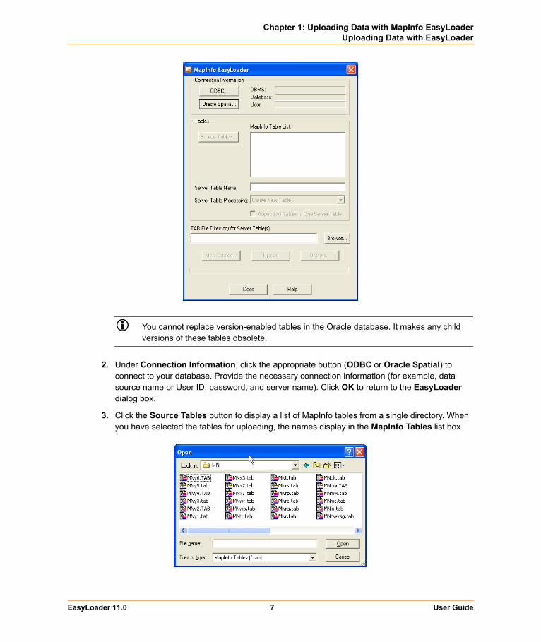
You cannot replace version-enabled tables in the Oracle database. It makes any child versions of these tables obsolete.
2. Under Connection Information, click the appropriate button (ODBC or Oracle Spatial) to connect to your database. Provide the necessary connection information (for example, data source name or User ID, password, and server name). Click OK to return to the EasyLoader dialog box.
3. Click the Source Tables button to display a list of MapInfo tables from a single directory. When you have selected the tables for uploading, the names display in the MapInfo Tables list box.
EasyLoader 11.0 7 User Guide
Chapter 1: Uploading Data with MapInfo EasyLoaderUploading Data with EasyLoader
4. Choose the tables you want to upload and select the appropriate Server Table processing task (Create new table, Append to existing table, Replace existing Table). These and additional options are explained in Understanding the MapInfo EasyLoader Dialog Box on page 13.
The Upload button is not available until one or more tables are chosen.
5. To create local TAB files, provide a directory or browse to its location. By default, EasyLoader does not generate these files. The file naming convention for these tables is yourServerTableName_srv.tab.
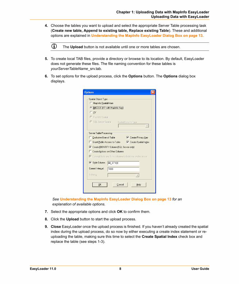
6. To set options for the upload process, click the Options button. The Options dialog box displays.
See Understanding the MapInfo EasyLoader Dialog Box on page 13 for an explanation of available options.
7. Select the appropriate options and click OK to confirm them.
8. Click the Upload button to start the upload process.
9. Close EasyLoader once the upload process is finished. If you haven’t already created the spatial index during the upload process, do so now by either executing a create index statement or re-uploading the table, making sure this time to select the Create Spatial Index check box and replace the table (see steps 1-3).
EasyLoader 11.0 8 User Guide

Chapter 1: Uploading Data with MapInfo EasyLoaderUnsupported Geometries in Oracle, SQL Server, and PostGIS
Unsupported Geometries in Oracle, SQL Server, and PostGISSome times when you are creating a Map in MapInfo Professional and you are storing the results in Oracle, SQL Server Spatialware, SQL Server Spatial, or PostGIS, you create maps which use geometries that are not supported by these DBMS engines.
• Oracle does not support arcs, ellipses, rectangles, and rounded rectangles. • SQL Server Spatial does not support arcs, and lines that do not have distinct points.• SQL Server SpatialWare does not support arcs, ellipses, and rounded rectangles.• PostGIS does not support arcs, ellipses, rectangles, and rounded rectangles.
EasyLoader will skip the unsupported object type and insert the attribute data, it will not throw a message.
Loading Oracle Spatial DataYou can upload Oracle Spatial data using EasyLoader.
Loading for Oracle LocatorEasyLoader loads data for the Oracle Locator. Loading data for the Oracle Locator is the same as loading data for Oracle Spatial.
Loading Long/Lat Tables into Oracle 9iWhen uploading tables that use the Longitude/Latitude coordinate system (Geodetic Data) to Oracle 9i, it is important to verify that all geometry coordinates are between (-180,180) longitude and (-90, 90) latitude. Geodetic data coordinates beyond that range are not supported in Oracle Spatial and may cause problems. You may check your data using MapInfo Professional before loading, or by using the Oracle Spatial SDO_GEOM.VALIDATE_LAYER( ) function on the table after loading it to Oracle Spatial.
EasyLoader assigns the default datum World Geodetic System 1984 (WGS84) to any “datumless” Long/Lat coordinate system when loading Oracle 9i.
Loading Native Tables that Contain Text Objects into Oracle 11gIf you are using Oracle 11g or later, you can use EasyLoader to upload a native table (TAB file) that contains text objects to an Oracle Spatial database table. (Previous versions of EasyLoader discarded any text objects when uploading a TAB file to Oracle.) When you upload the TAB file, EasyLoader uploads the text objects to Oracle as annotation text fields.
Oracle 11g stores MapInfo geometry objects (such as points, polylines, and polygons) as SDO_GEOMETRY types and stores MapInfo text objects as ANNOTATION_TEXT types. A TAB file may contain both geometry and text objects. MapInfo Professional, however, only supports
EasyLoader 11.0 9 User Guide
Chapter 1: Uploading Data with MapInfo EasyLoaderLoading Oracle Spatial Data
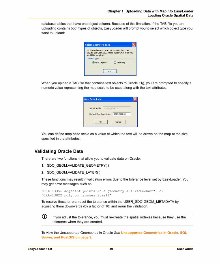
database tables that have one object column. Because of this limitation, if the TAB file you are uploading contains both types of objects, EasyLoader will prompt you to select which object type you want to upload:
When you upload a TAB file that contains text objects to Oracle 11g, you are prompted to specify a numeric value representing the map scale to be used along with the text attributes:
You can define map base scale as a value at which the text will be drawn on the map at the size specified in the attributes.
Validating Oracle DataThere are two functions that allow you to validate data on Oracle:
1. SDO_GEOM.VALIDATE_GEOMETRY( )
2. SDO_GEOM.VALIDATE_LAYER( )
These functions may result in validation errors due to the tolerance level set by EasyLoader. You may get error messages such as:
"ORA-13356 adjacent points in a geometry are redundant", or"ORA-13022 polygon crosses itself"
To resolve these errors, reset the tolerance within the USER_SDO-GEOM_METADATA by adjusting them downwards (by a factor of 10) and rerun the validation.
If you adjust the tolerance, you must re-create the spatial indexes because they use the tolerance when they are created.
To view the Unsupported Geometries in Oracle See Unsupported Geometries in Oracle, SQL Server, and PostGIS on page 9.
EasyLoader 11.0 10 User Guide

Chapter 1: Uploading Data with MapInfo EasyLoaderLoading Microsoft SQL Server Spatial Data
Loading Microsoft SQL Server Spatial DataMicrosoft SQL Server Spatial includes Geography and Geometry data types. Geography fields hold geometries specified in the Lat/Long coordinate system. Geometry fields hold geometries specified in all other coordinate systems.
If you choose to upload to a Geometry field type, then Easyloader runs the SQL Server Spatial MakeValid( ) function to fix any geometry that SQL Server Spatial deems invalid. This may shift point locations for certain geometries.
In the Options dialog box, EasyLoader enables you to control how the geometry data in a native table is uploaded to SQL Server Spatial.
Keep the default selection of Always Geometry if you want EasyLoader to always upload geometry objects to Geometry fields regardless of the coordinate system they use.
Select Auto Select if you want EasyLoader to automatically decide whether the geometry object is uploaded to a Geography field (in cases where the geometry object uses the Lat/Long coordinate system) or a Geometry field (in cases where the geometry object does not use the Lat/Long coordinate system).
When the Auto Select option is selected, if for any reason a geometry object that uses the Lat/Long coordinate system cannot be uploaded to a Geography field, it will instead be uploaded to a Geometry field.
EasyLoader 11.0 11 User Guide
Chapter 1: Uploading Data with MapInfo EasyLoaderLoading Microsoft SQL Server Spatial Data
To view the Unsupported Geometries in SQL See Unsupported Geometries in Oracle, SQL Server, and PostGIS on page 9
EasyLoader supports uploading MapInfo native tables into SQL Server Spatial. SQL Server Spatial allows spatial data to be stored into two data types; Geometry and Geography.
SQL Server's rules that define what a valid geometry or geography are different than MapInfo Professional's rules.
The SQL Server Spatial's Geography data type does not support:
• polygons that contain self intersecting boundaries• geography instances that span more than one hemisphere• lines/polygon boundaries that have two successive, identical nodes
The SQL Server Spatial's Geometry type does not support:
• polygons that contain self intersecting boundaries• lines/polygon boundaries that have two successive, identical nodes
Refer to SQL Server books online for complete information on the rules that define these two types:
http://www.microsoft.com/sqlserver/2008/en/us/spatial-data.aspx
This means that you may have geometry data that are valid in a MapInfo TAB format that cannot be loaded into SQL Server Spatial without correction/edits.
EasyLoader aborts the upload if it comes across the geometry that SQL Server rejects. It will display the primary key of the record that contains the rejected object. A "MapInfo Upload Utility Error" message displays.
You may want to try the following steps to make the geometry acceptable to SQL Server.
• Use MapInfo Professional's Clean operation on the Object menu to correct the geometry.• If your upload was to Geography type and it fails, try loading it to Geometry, correct the instance
using the MakeValid() method on the Geometry type, and uploading the instance again. You will need a working knowledge of SQL and access to a SQL Server Spatial client to use this approach.
Consider the following example. Let's suppose the Geometry update failed for the row (state = 'Florida').
• selectively update the offending geometry, using the MakeValid() method• update states_geom set geom = geom.MakeValid() where state = 'Florida'• force an operation that does not alter the geometry, but forces a topology construction. here, we
perform a union of the Geometry with its own start point• update states_geom set geom = geom.STUnion(geom.STStartPoint()) where state = 'Florida'• now this query will attempt to create a Geography instance from the reformed Geometry• select state_name, sw_member, Geography::STGeomFromWKB(geom.STAsBinary(), 4269)
from states_geom, where state = 'Florida'
EasyLoader 11.0 12 User Guide
Chapter 1: Uploading Data with MapInfo EasyLoaderLoading PostGIS Spatial Data
Loading PostGIS Spatial DataEasyLoader supports uploading MapInfo native tables into PostGIS. PostGIS stores spatial data in a geometry column called sp_geometry. Unsupported data types are ignored resulting in an empty record in the sp_geometry geometry column.
For a list of unsupported data types, see Unsupported Geometries in Oracle, SQL Server, and PostGIS on page 9.
When upload a table to a PostGIS database, EasyLoader uploads the table with a Serial datatype for the primary key column. This allows the database to automatically increment the key column.
Validating PostGIS DataTo check if a geometry object is valid in PostGIS, use the function called isvalid. The following is an example SQL statement:
select isvalid(sp_geometry) from test
Understanding the MapInfo EasyLoader Dialog Box This section explains the options in the EasyLoader dialog box.
Connecting to a Remote DatabaseODBC ButtonThe ODBC button enables you to connect to a server using ODBC and prompts you for a data source. Use this dialog box to identify where the data you want to upload is located. You must have your data connections set up before using the ODBC button to connect to the remote database in this manner.
To connect to a database using the ODBC button:
1. Click ODBC in the MapInfo EasyLoader dialog box. The Select Data Source dialog box displays.
2. Do one of the following:• Click the File Data Source tab and use the Look in drop-down list or the Up button to locate
the database you want to upload from and click it. Click OK to display your selection in the EasyLoader dialog box.
• Click the Machine Data Source tab and double-click the data source driver you want to connect to and navigate to the database you want to upload. Click it and click OK to display your selection in the EasyLoader dialog box.
EasyLoader 11.0 13 User Guide
Chapter 1: Uploading Data with MapInfo EasyLoaderUnderstanding the MapInfo EasyLoader Dialog Box
Oracle Spatial ButtonClick this button to connect to an Oracle Spatial server. Enter your user name, password, and the server name to complete the connection. This button is only enabled if the Oracle Client software is installed.
Oracle Client software does not come with EasyLoader.
Source Tables ButtonClick this button to identify the source tables you want to upload. The Source Tables button is available only after you have made a connection to a server. This action enables you to select one or more MapInfo tables from a single directory.
Server Table NameType the name of the database server table to which you are uploading the selected tables.
Append All Tables to One Server TableClick this option to upload all MapInfo tables listed in the MapInfo Table list to a single server table. The server table name is the one visible in Server Table box. This feature should be used to upload tables with the same structure and style to one table.
Example: Instead of creating a new table for each street layer, check the Append All to One check box, and only one table is created. Then all of the tables are appended to this table.
TAB File Directory for Server Table(s)Generates TAB files to access remote DBMSs when you provide the TAB file directory. By default, an empty directory, the loader does not generate .tab files. The newly generated .tab file is the Server Table Name plus _srv.tab. Click Browse to search for the directory you need.
Map Catalog ButtonClick this button to add a new Map Catalog or to unregister a table from the Map Catalog. For more information, see Creating a New Map Catalog on page 23.
Upload ButtonClick this button when you have set all of the parameters you want for uploading the table(s) you have specified.
Options ButtonClick this button to specify the spatial object types and the server processing options for the current upload. For instructions about using the Options dialog box, click Understanding the Options Dialog Box on page 15.
Table Processing OptionsThis section provides a comprehensive description of the table options available in EasyLoader. There are four table processing options associated with the main EasyLoader dialog box.
• Create New TableA server table is created with the name that you specify. If this option is chosen and a table with the same name already exists on the server, an error message displays, making you aware of this problem. Use a different name or choose the option Replace Existing Table to upload the table.
EasyLoader 11.0 14 User Guide
Chapter 1: Uploading Data with MapInfo EasyLoaderUnderstanding the Options Dialog Box
• Replace Existing TableWhen this option is selected, if a server table of the same name already exists, it is dropped and a new table is created to match the MapInfo table being uploaded.
• Append to Existing TableThe MapInfo table is appended to the server table if the server table exists and the structure of the two tables match. Otherwise, you get an error and the table is not uploaded. The tables must have the same table structure and be in the same projection for Oracle Spatial.
• Append All Tables to One Server TableAll MapInfo tables listed are uploaded to a single server table. The server table name is the one visible in the Server Table box. This feature is meant to be used to upload tables with the same structure and projection to one table. For example, instead of creating a new table for each street layer, check the Append All Tables to One Server Table box, and only one table is created. All of the tables are then appended to this table.
It is possible that some tables will not be appended if their table structure differs.
If you choose the Replace Table option and this check box is selected, the server table is dropped, a new table is created, and all tables listed are appended to that one. If you select the Create Table option and this check box is selected, the server table is created, and all tables listed are appended to that one.
If this option is chosen, all tables must have the same table structure and be in the same projection.
Understanding the Options Dialog Box This section explains the settings in the Options dialog box.
Spatial Object Type Options Choose from MapInfo SpatialWare or Oracle Spatial (depending on the type of connection), MICODE (XY with MapInfo Key), XY, PostGIS Spatial, or SQL Server Spatial. The default for loading spatial data is MapInfo SpatialWare or Oracle Spatial, if this option is available; otherwise the MICODE option is the default.
• MapInfo SpatialWare – To select this option, the server must be Oracle Spatial or have MapInfo SpatialWare installed. Tables are uploaded as spatial data. This option is disabled (grayed) if SpatialWare is not installed on the server, or if it is not available to the currently selected database.
EasyLoader 11.0 15 User Guide
Chapter 1: Uploading Data with MapInfo EasyLoaderUnderstanding the Options Dialog Box
• MICODE (XY with MapInfo Key) – Use this option if the server is not Oracle Spatial or does not have MapInfo SpatialWare installed. This option stores the data as XY coordinates on the server and creates the server table as a point table. If the MapInfo table to be uploaded is not a point table and this option is chosen, the centroid is abstracted and stored on the server table, if you instruct it to do so. The difference between XY and MICODE is that the MICODE provides a MapInfo key as the spatial index, making its performance superior to XY.
• XY – This option is the same as the MICODE option, except that this option does not create a spatial index.
• PostGIS Spatial – Use this option with a spatialized PostGIS database.• SQL Server Spatial – Use these options if the server is Microsoft SQL Server Spatial.
• Auto Select – EasyLoader automatically decides whether to upload the geometry object to a Geography field (if the geometry object is using a Lat/Long coordinate system) or to a Geometry field (if the geometry object is using another coordinate system).
• Always Geometry – EasyLoader always uploads the geometry object to a Geometry field, regardless of the coordinate system specified for the geometry object.
When the Auto Select option is selected, if for any reason a geometry object that uses the Lat/Long coordinate system cannot be uploaded to a Geography field, it will instead be uploaded to a Geometry field.
Server Table Processing Options• Exclusive User of Table
You can significantly speed up load time on large tables if you know that you are the only one attempting to update or upload the table. If you do not select this option, EasyLoader verifies after each commit that no other updates are made to the table while it is being uploaded. Selecting this option prevents this test from occurring, which can improve runtime performance for large tables.
• Create Primary KeyBy selecting this check box, a primary key is created for the Create New Table and Replace Existing Table operations. This primary key is created in the column SW_MEMBER for SpatialWare, MI_PRINX for Oracle, or MI_SQL_REC_NUM for XY and MICODE. These columns are sequential numbers that are generated by EasyLoader. These columns are always created, but do not have to be a primary key.For the Append To Existing Table operation, the primary key is not created.
• Grant Public Access to TableThe PUBLIC is granted all access to the server table.
EasyLoader 11.0 16 User Guide
Chapter 1: Uploading Data with MapInfo EasyLoaderUnderstanding the Options Dialog Box
• Create Spatial IndexBy selecting this check box, a spatial index (called <table_name>ind) is created for the tables on the geometry column. You may also build your own spatial index to suit your specific needs. If you choose to do this, clear this check box to save loading time.By selecting this check box, a spatial index (called <table_name>_SX) is created for Oracle Spatial tables on the geometry column . The index tiling level is based on the SDO_TUNE.ESTIMATE_TILING_LEVEL function. For tables with fewer than 7500 rows, the tiling level is restricted to 8. After the index is built the ANALYZE table function is run on the index table. The spatial index is R-Tree for Oracle 8.17 or later.
• Create IDENTITY Column (SQL Server only) Select this check box if you wish to create the primary key column (SW_MEMBER) with IDENTITY properties. When this feature is in use, the primary key column values are generated automatically by SQL Server. You do not need to fill in the key manually when a new row is inserted.In EasyLoader version 8.x, the key column (SW_MEMBER) is created with IDENTITY property by default, which is opposite from some older versions (before 6.8). To upload the table without IDENTITY, select the Options button and clear the Create IDENTITY Column check box.
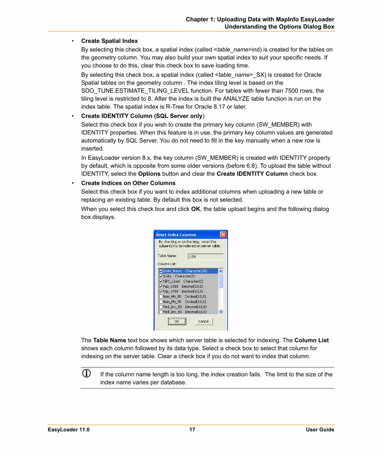
• Create Indices on Other ColumnsSelect this check box if you want to index additional columns when uploading a new table or replacing an existing table. By default this box is not selected.When you select this check box and click OK, the table upload begins and the following dialog box displays.
The Table Name text box shows which server table is selected for indexing. The Column List shows each column followed by its data type. Select a check box to select that column for indexing on the server table. Clear a check box if you do not want to index that column.
If the column name length is too long, the index creation fails. The limit to the size of the index name varies per database.
EasyLoader 11.0 17 User Guide
Chapter 1: Uploading Data with MapInfo EasyLoaderUploading Tables with Time and DateTime Columns
• Convert Time column to Timestamp on the serverThis option is automatically handled by the software, with selects it when connected to a DBMS, such as Oracle and Access, that does not have date or time data types and unselects it for a DBMS, such as SQL Server Spatial or PostGIS, that has both date and time data types.
• Style Column This option allows you to specify whether per-row styles are loaded with the data. You can also specify the name of the column in the text box next to the Style Column check box. The default column name is MI_STYLE.
To load per-row styles, the MapInfo Map catalog for the database must contain the following columns: RENDITIONTYPE, RENDITIONCOLUMN, RENDITIONTABLE, and NUMBER_ROWS. See MAPINFO_MAPCATALOG Table Structure on page 24 for more information.
• Commit IntervalUse this option to specify a commit interval for uploading. EasyLoader commits the inserted records when the commit interval is reached. The default commit interval is 1000. If the commit interval is set to 0 (zero), the whole range of records is inserted as a single transaction, before a commit is issued.
• SchemaUse this option to specify a schema to which you want to upload the table. This is valid for SQL Server 2005 servers and PostgresSQL/PostGIS.
Uploading Tables with Time and DateTime ColumnsTime and DateTime data types sometimes require conversion because of variations from server to server, and between the server and MapInfo data types. The following table shows how the data types are converted from MapInfo Professional to each server.
* The MapInfo data type will be extended on the servers. When the same data comes back to MapInfo Professional, the data type will be as is indicated on the server. This conversion is consistent with MapInfo Professional behavior when a MapInfo table is saved to a server using MapInfo Professional.
From MapInfo Professional To Oracle To MS Access To MS SQL Server
DATE DATE DATETIME* DATETIME*
TIME TIMESTAMP(3)* DATETIME* DATETIME*
DATETIME TIMESTAMP(3) DATETIME DATETIME
EasyLoader 11.0 18 User Guide
Chapter 1: Uploading Data with MapInfo EasyLoaderUsing the Command Line Flags to Run EasyLoader
On servers that do not support DATE or TIME data types, the data is converted to a DATETIME type. In this conversion, part of the data will be missing because the MapInfo types contain either the date or the time, but not both. The server default values for the date or the time are used to fill in the missing data. Conversions to DATETIME are made for SQL Server versions earlier than version 10 (prior to SQL Server Spatial).
For example, if the server does not support the MapInfo DATE type, the upload process converts the DATE type to a DATETIME type. The date value comes from the MapInfo table, but the time value is filled in with the server default value for time. The following table shows how the MapInfo data types are converted when they are not supported on the server and what default value are used to fill in the missing data:
*SQL Server versions earlier than version 10 (prior to SQL Server Spatial).
Using the Command Line Flags to Run EasyLoaderYou can run the EasyLoader executable from the command line. For example:
easyloader.exe /T c:\data\states.tab;mystates /G /Y
Do not enclose file names in quotation marks. Command line arguments are interpreted correctly without quote marks, even if the filename includes spaces. If you use quotation marks, EasyLoader cannot parse the filenames correctly and errors occur.
EasyLoader supports the following flags to allow you to specify additional upload parameters from the command line:
• /A Append All Tables to One – Use this flag to upload multiple tables to a single table (as long as the table structures are the same).
Syntax: /A• /B Schema Name – Use this flag to specify a schema name when you upload tables to a SQL
Server 2005 server.Syntax: /B SchemaName
MapInfo Data Type To Server Data TypeServer Default
Values Databases
MapInfo DATE type DATETIME/TIMESTAMP type midnight: 12:00.00.000 AM
All databases
MapInfo TIME type DATETIME/STAMP type current date MS Access, MS SQL Server*
MapInfo TIME type DATETIME/STAMP type first day of current month and year
Oracle
EasyLoader 11.0 19 User Guide
Chapter 1: Uploading Data with MapInfo EasyLoaderUsing the Command Line Flags to Run EasyLoader
• /C Create Indices for All Locally-Indexed Columns – Use this flag to mandate that only the columns that were indexed on the local table be automatically indexed on the server table, when you upload a new table or replace an existing table.This command line option does not allow you to make or reset column selections. That additional capability is supported by the EasyLoader user interface (see Create Indices on Other Columns on page 17 and Mixing Command Line Flags with the EasyLoader User Interface on page 22).
Syntax: /C• /D .tab File Directory for Server Table(s) – Use this flag to generate TAB files and provide the
TAB file directory to access a remote DBMS. The default is an empty directory, in which case EasyLoader does not generate .tab files. The naming convention of your newly generated .tab file is yourServerTableName_srv.tab. The directory must be valid (empty is treated as valid) to upload a table.Command line option is /D PathName.
Syntax: /D C:\tempDo not enclose file names in quotation marks.
• /E Exclusive Use of Table – Use this flag to improve load time on large tables significantly if you know that you are the only one attempting to update the table. Specifying this flag does not guarantee that EasyLoader can obtain exclusive use; you must guarantee that to the loader. EasyLoader checks on the current maximum value of the primary key column (MI_PRINX) after each commit to ensure that it detects any other entries that may have been made by other processes. This flag prevents that check from occurring, which can significantly improve the upload time for large tables.This flag may be placed within a shortcut, allowing the interactive use of the EasyLoader interface for other functions.
Syntax: /E• /F Log File name – Use this flag to specify the name and location of the log file. Whenever you
upload a table, EasyLoader produces a log file. By default, a log file named EasyLoader.log is created in the Windows TEMP directory. If you specify a file name but do not provide a path, EasyLoader creates the log in the same directory as the EasyLoader.EXE file.Syntax: The first example shows just the name of the log file, which is written to the directory in which EasyLoader.exe is located; the second example specifies the full path for the log file.
/F myLogFile.txt/F c:\temp\myLogFile.txt
Do not enclose file names in quotation marks.• /G Grant all – Use this flag to grant all rights to PUBLIC. This flag is turned OFF by default.
Syntax: /G• /I Do Not Create a Spatial Index – Use this flag to prevent EasyLoader from creating a spatial
index on the uploaded table. By default EasyLoader creates a spatial index. This flag is turned OFF by default, meaning a spatial index is created. For IDS/UDO tables, EasyLoader creates a spatial index, and then issues the 'update statistics medium' statement. See the /U flag description, which controls the unique index. For Oracle Spatial tables, the spatial index is created on the geometry column and is called <table_name>_SX; for SpatialWare tables, the index is created on the column geometry column and is called hg<table_name>ind.
Syntax: /I
EasyLoader 11.0 20 User Guide

Chapter 1: Uploading Data with MapInfo EasyLoaderUsing the Command Line Flags to Run EasyLoader
• /K Create Automated Key Column for SQL Server – Use this flag to generate the unique key column values automatically in SQL Server. You do not need to fill the key manually when you insert a new row. The key column (SW_MEMBER) can be created with IDENTITY property as an option. For this feature to work, use MapInfo Professional 6.5.0.3100 or later and EasyLoader 6.8 or later.In EasyLoader version 7.x, the key column (SW_MEMBER) is created with IDENTITY property by default, which is opposite from some older versions. Therefore, omitting the K option in the command line has the same action as specifying /K, (that is, it creates the key column with IDENTITY property). If you want to turn off the property, you must provide a keyword NO_IDENTITY following /K.See Mixing Command Line Flags with the EasyLoader User Interface on page 22.
Syntax: /KExample: /K NO_IDENTITY
• /L List of MapInfo tables – Use this flag to specify a text file that contains a list of tables you want to upload. The format of each line is the same as the /T flag.
Syntax: /L ListOfTables.txtDo not enclose file names in quotation marks.
• /M MICODE/XY – Use this flag to specify the object type to be used if it is SpatialWare. If the /M flag is used, provide MICODE (for XY with MapInfo key) or XY (for XY only) after /M. Any words other than MICODE or XY after /M are treated as errors, and EasyLoader does not run (the main EasyLoader dialog box does not appear). If you do not use the /M flag, EasyLoader uses SpatialWare as the default if the selected database has SpatialWare installed.
Syntax: /M MICODEExample: /M X
• /O Connection String – Use this flag to set a connection string for Oracle Spatial to be passed to the program. See the /S flag for ODBC connections.
Syntax: /O user_name/password@server_name• /P A | C | R – Use this flag to specify what to do with the table(s) being loaded to the server.
Use A to append to an existing server table.Use C to create a new server table. If you specify the C option and the table you are uploading has the same name as a table on the server, upload operation fails.Use R to replace an existing table.
Syntax: /P A• /Q Quit – Use this flag to exit EasyLoader when the upload is complete.
Syntax: /Q• /R Replace the server table – Use this flag to drop the server table and create and upload the
new table. EasyLoader creates a table on the server even if the table did not exist previously. Syntax: /R
• /S Connection String – Use this flag to pass an ODBC connection string to the program. If enough information to connect is supplied, the ODBC connection dialog box does not appear. See the /O flag for Oracle Spatial connections. The following examples illustrate the syntax of this flag. The first example uses a datasource, the second supplies the full connection string.
/S DSN=MyDataSource/S UID=MyId;DATABASE=MyDB;HOST=MyServer;SERVER=MyServer_tli;SERVICE=sqlexec;PROTOCOL=onsoctcp
EasyLoader 11.0 21 User Guide
Chapter 1: Uploading Data with MapInfo EasyLoaderUsing the Command Line Flags to Run EasyLoader
• /T MapInfo Table Name;Server Table Name;Range – Use this flag to pass a single table name to the program. Use a semicolon symbol as the separator between the MapInfo table name, the server name, and the range. The range is in the format starting number <COMMA> ending number. The server table name and the range are optional.
Syntax: /T c:\data\states.tab;mystates;1,500
Do not enclose file names in quotation marks.
• /U Do Not Create a Primary Index – Use this flag to add a primary key constraint by default. This flag prevents a primary key from being created on the table. This flag is turned OFF by default, which means that a primary key is created by default. See /I which controls the spatial index. For Oracle Spatial tables, the primary key is created on the column MI_PRINX and is called <table_name>_PK. For SpatialWare tables, the primary key is created on the column SW_MEMBER and is called <table_name>_PK.
Syntax: /U• /V Oracle Version – Use this flag to load tables on an Oracle 8.1.6 server with the 8.1.5 format.
This not generally recommended, but it is available if you have a special need to do this. If you want to accomplish this using the graphical interface, see Mixing Command Line Flags with the EasyLoader User Interface on page 22.
Syntax: /V• /X Commit interval – Use this flag to specify a commit interval. EasyLoader commits the
inserted records when it reaches the commit interval you specify. The default commit interval is 1000. This same interval applies to the creation of the spatial index for Oracle Spatial. If the commit interval is set to 0 (zero), the whole range of records is inserted as a single transaction, before a commit is issued.
Syntax: /X 500• /Y Style Column Name – Use this flag to specify whether per-row styles are being loaded with
the data. You can also specify the name of the column to be used. If you do not provide a name, the default MI_STYLE column name is created. If you specify the NO_STYLE keyword after the /Y flag, EasyLoader does not create a style column on the server table.
Syntax: /Y [StyleColumnName | NO_STYLE] • /Z Always Geometry – Use this flag to specify that the table is to be uploaded as a Geometry
data type in Microsoft SQL Server Spatial, regardless of the coordinate system specified in the native table. For more information, see Loading Microsoft SQL Server Spatial Data on page 11.
Syntax: /Z
Mixing Command Line Flags with the EasyLoader User InterfaceCommand line flags may be mixed with the EasyLoader user interface by using a Windows shortcut. This makes it easier to set flags as your default while being able to override them from the interface. These flags are only available from the command line.
• Create a shortcut to EasyLoader. • Right-click and choose Send To > Desktop to create the shortcut on the desktop, or right-click
and drag to move a shortcut to a folder of your choice.• Right-click the shortcut and choose Properties.
EasyLoader 11.0 22 User Guide

Chapter 1: Uploading Data with MapInfo EasyLoaderCreating a New Map Catalog
• Under the Shortcut tab, within the Target edit box, add the appropriate command line flags to the end of the line, separated by spaces.
When EasyLoader is run from that shortcut, the specified flags will be in effect.
Creating a New Map CatalogThe Map Catalog stores the metadata used by MapInfo Professional and other MapInfo products to open tables with geometry data. You can create the Map Catalog without uploading a table at the same time.
To create a Map Catalog successfully, you must have administrator privileges to the database server or the system administrator needs to grant you permission to create the Map Catalog.
There are two operations you can perform:
• If your database does not have a Map Catalog, you can use EasyLoader to create one.• If your database has a Map Catalog already, you can delete entries in the catalog that are no
longer valid.
To create a new Map Catalog and delete entries from an existing Map Catalog:
1. Open EasyLoader. The MapInfo EasyLoader dialog box displays.If the Map Catalog is present and there are no entries in it, the Map Catalog button does not enable.
2. In the Connection Information box, identify the connection you either create the Map Catalog for or delete Map Catalog entries from.
3. When you click the Map Catalog button, one of the following things happens:• If there is no Map Catalog available for the current database, EasyLoader creates the
MapInfo Owner and then creates the Map Catalog. This concludes the Map Catalog creation process.
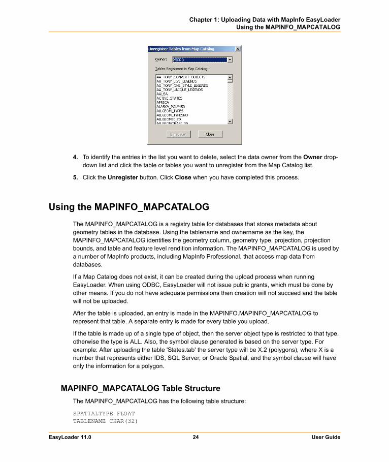
• If there is a Map Catalog, use the Unregister tables from Map Catalog dialog box to delete obsolete tables from the list.
EasyLoader 11.0 23 User Guide
Chapter 1: Uploading Data with MapInfo EasyLoaderUsing the MAPINFO_MAPCATALOG
4. To identify the entries in the list you want to delete, select the data owner from the Owner drop-down list and click the table or tables you want to unregister from the Map Catalog list.
5. Click the Unregister button. Click Close when you have completed this process.
Using the MAPINFO_MAPCATALOGThe MAPINFO_MAPCATALOG is a registry table for databases that stores metadata about geometry tables in the database. Using the tablename and ownername as the key, the MAPINFO_MAPCATALOG identifies the geometry column, geometry type, projection, projection bounds, and table and feature level rendition information. The MAPINFO_MAPCATALOG is used by a number of MapInfo products, including MapInfo Professional, that access map data from databases.
If a Map Catalog does not exist, it can be created during the upload process when running EasyLoader. When using ODBC, EasyLoader will not issue public grants, which must be done by other means. If you do not have adequate permissions then creation will not succeed and the table will not be uploaded.
After the table is uploaded, an entry is made in the MAPINFO.MAPINFO_MAPCATALOG to represent that table. A separate entry is made for every table you upload.
If the table is made up of a single type of object, then the server object type is restricted to that type, otherwise the type is ALL. Also, the symbol clause generated is based on the server type. For example: After uploading the table 'States.tab' the server type will be X.2 (polygons), where X is a number that represents either IDS, SQL Server, or Oracle Spatial, and the symbol clause will have only the information for a polygon.
MAPINFO_MAPCATALOG Table StructureThe MAPINFO_MAPCATALOG has the following table structure:
SPATIALTYPE FLOATTABLENAME CHAR(32)
EasyLoader 11.0 24 User Guide
Chapter 1: Uploading Data with MapInfo EasyLoaderUsing the MAPINFO_MAPCATALOG
OWNERNAME CHAR(32)SPATIALCOLUMN CHAR(32)DB_X_LL FLOATDB_Y_LL FLOATDB_X_UR FLOATDB_Y_UR FLOATVIEW_X_LL FLOATVIEW_Y_LL FLOATVIEW_X_UR FLOATVIEW_Y_UR FLOATCOORDINATESYSTEM CHAR(254)SYMBOL CHAR(254)XCOLUMNNAME CHAR(32)YCOLUMNNAME CHAR(32)RENDITIONTYPE INTEGERRENDITIONCOLUMN CHAR(32)RENDITIONTABLE CHAR(32)NUMBER_ROWS INTEGER
The following script, which is shipped with EasyLoader, may be used to modify an existing MAPINFO.MAPINFO_MAPCATALOG to add the rendition columns if they do not exist. Run this script as user MAPINFO.
ALTER TABLE MAPINFO.MAPINFO_MAPCATALOG ADD RENDITIONTYPE INTEGER;ALTER TABLE MAPINFO.MAPINFO_MAPCATALOG ADD RENDITIONCOLUMN CHAR(32);ALTER TABLE MAPINFO.MAPINFO_MAPCATALOG ADD RENDITIONTABLE CHAR(32);
EasyLoader 11.0 25 User Guide