ecological assessment report - australia · ecological assessment report – 55fty1153 (stage 2)...
TRANSCRIPT

Ecological Consulting
Ecological Assessment Report Lot 55 on Plan FTY1153 (Stage 2)
Compiled by BOOBOOK for Origin
Document No. Q-8200-15-RP-1320
Revision Date Description Author Verifier Approved
A 14/9/2015 Draft issued for client review R. Johnson, R. Shojinaga C. Eddie C. Eddie
0 1/10/2015 Final report issued to client C. Eddie, R. Shojinaga C. Eddie C. Eddie
15 Quintin Street PO Box 924 Roma QLD 4455 Ph. 07 4622 2646 Fax 07 4622 1325 [email protected] ABN: 94 617 952 309 www.boobook.biz

Rev 0 i
Table of Contents 1. Introduction .............................................................................................................................................................. 1
1.1. Scope of Works ................................................................................................................................................. 1
1.2. Definitions & Abbreviations .............................................................................................................................. 1
1.2.1. Definitions ................................................................................................................................................. 1
1.2.2. Abbreviations ............................................................................................................................................ 1
1.2.1. Document References ............................................................................................................................... 2
2. Site Context ............................................................................................................................................................... 4
3. Methodology ............................................................................................................................................................. 4
3.1. Desktop & Literature Review ............................................................................................................................ 4
3.2. Field Survey ....................................................................................................................................................... 5
3.2.1. Vegetation Community Survey ................................................................................................................. 5
3.2.2. Habitat Survey ........................................................................................................................................... 6
3.2.3. Threatened Flora & Fauna Survey............................................................................................................. 6
3.2.4. Pest Flora and Fauna Survey ..................................................................................................................... 6
3.2.5. Disturbance Survey ................................................................................................................................... 7
3.2.6. Watercourse/Wetland Survey .................................................................................................................. 7
3.2.7. Survey Limitations ..................................................................................................................................... 7
4. Results & Discussion ................................................................................................................................................. 7
4.1. Desktop & Literature Review ............................................................................................................................ 7
4.2. Field Survey ....................................................................................................................................................... 7
4.2.1. Commonwealth Environmental Matters .................................................................................................. 7
4.2.1.1. Ground-truthed Threatened Ecological Communities ...................................................................... 8
4.2.1.2. Threatened Flora ............................................................................................................................... 9
4.2.1.3. Threatened Fauna ........................................................................................................................... 10
4.2.1.4. Migratory Fauna .............................................................................................................................. 13
4.2.1.5. Marine Fauna .................................................................................................................................. 14
4.2.2. Queensland Environmental Matters ....................................................................................................... 15
4.2.2.1. Ground-truthed Regional Ecosystems ............................................................................................ 16
4.2.2.2. Threatened Flora ............................................................................................................................. 20
4.2.2.3. Threatened Fauna ........................................................................................................................... 22
Pest Fauna ........................................................................................................................................................... 24
Disturbances ........................................................................................................................................................... 24
Watercourses and Wetlands ................................................................................................................................... 25
Conclusions ............................................................................................................................................................. 26
Appendix A. Site Location and Vegetation Survey Points. ............................................................................................. 27
Appendix B. Results of EPBC Protected Matters Search Tool ........................................................................................ 29
Appendix C. Wildlife Online Database Search Results. .................................................................................................. 38
Appendix D. EHP Mapped Regional Ecosystems. ........................................................................................................... 44
Appendix E. EHP Mapping of ESAs and Other Environmental Values on Site. ............................................................... 46

Rev 0 ii
Appendix F. List of Fauna and Native Flora Species Identified on Site........................................................................... 48
Appendix G. Ground Truthed TEC at the Site ................................................................................................................. 53
Appendix H. Ground Truthed Regional Ecosystems. ...................................................................................................... 55
Appendix I. Special Least Concern Flora and Fauna Recorded at the Site ..................................................................... 59
Appendix J. Pest Fauna Recorded at the Site. ................................................................................................................ 61
Appendix K. Ground Truthed Drainage Features and Watercourses Present on Site. .................................................. 63
List of Tables Table 1: Definitions ........................................................................................................................................................... 1 Table 2: Abbreviations ...................................................................................................................................................... 1 Table 3: Associated Document References....................................................................................................................... 2 Table 4: Site Context ......................................................................................................................................................... 4 Table 5: Desktop and Literature Review Sources ............................................................................................................. 4 Table 6: Commonwealth Environmental Matters – Field Survey Results ......................................................................... 8 Table 7: Field survey results for EPBC Act threatened flora with potentially suitable RE and likelihood of occurrence. 9 Table 8: Field survey results for EPBC Act threatened fauna with potentially suitable RE and likelihood of occurrence. ........................................................................................................................................................................................ 10 Table 9: Field survey results for EPBC Act migratory fauna with potentially suitable RE and likelihood of occurrence. ........................................................................................................................................................................................ 13 Table 10: Field survey results for EPBC Act marine fauna with potentially suitable RE and likelihood of occurrence. . 14 Table 11: State environmental matters – field survey results ........................................................................................ 15 Table 12: Ground-truthed remnant and regrowth regional ecosystems ....................................................................... 17 Table 13: Field survey results for NC Act EVNT flora with potentially suitable RE and likelihood of occurrence. ......... 20 Table 14: Field survey results for NC Act EVNT fauna with potentially suitable RE and likelihood of occurrence. ....... 22 Table 15: Pest fauna recorded at the Site. ...................................................................................................................... 24 Table 16: Ground-truthed drainage features at the Site. ............................................................................................... 25
Conclusions drawn in this report are based on available information at the time of writing. Any additional information may alter such conclusions and the author reserves the right to do so if such information becomes available. This report has been made as at the date of the report and is not to be used after six (6) months and not if there are any material changes meanwhile. In either event it should be referred back for review. To the extent permitted by law BOOBOOK does not accept liability for any loss or damage which any person may suffer arising from any negligence or breach of contract on its part. This report was prepared for the benefit of the party to whom it is directed only and for the purpose identified within. BOOBOOK does not accept responsibility to any other person for the contents of the report.

Ecological Assessment Report – 55FTY1153 (Stage 2)
Rev 0 1
1. Introduction
This report provides a description of the ecological values found within part of Lot 55 on Plan FTY1153 (55FTY1153) including Lands Leases 10WT285, 5WT314, 6WT314 and 2AB229 herein referred to as ‘the Site’. The results are based on an initial desktop assessment followed by a field survey to confirm the vegetation communities, flora and fauna species, habitat values and areas of disturbance.
This report has been compiled by BOOBOOK Ecological Consulting. The field survey was conducted between the 1st and 5th of September 2015 by Craig Eddie (Principal Ecologist), Richard Johnson (Senior Ecologist), Rosamund Aisthorpe (Intermediate Botanist) and Ryan Shojinaga (Intermediate GIS Officer). Craig Eddie and Rosamund Aisthorpe were approved to undertake ecological surveys relating to the Australia Pacific LNG Pty. Ltd. (Australia Pacific LNG) project by the Commonwealth Department of Environment (formerly the Department of Sustainability, Environment, Water, Population and Communities) in writing on 31st March and 11th May 2011 respectively.
1.1. Scope of Works
An ecological assessment survey was required for a nominated part of 55FTY1153 including Lands Leases 10WT285, 5WT314, 6WT314 and 2AB229 located approximately 81 km north-northeast of Roma, south central Queensland. The survey was conducted within nominated linear and non-linear infrastructure zones buffered from their centre line or centre point by approximately 50 m. The site location and survey sites are shown in Appendix A.
1.2. Definitions & Abbreviations
1.2.1. Definitions
Table 1: Definitions
Term Definition
Motion A proprietary product of Motion Computing®: it comprises a tablet PC with in-built GPS positioning capacity, allowing capture of spatial and other data in the field.
Site Nominated parts of 55FTY1153 including Lands Leases 10WT285, 5WT314, 6WT314 and 2AB229 (see Appendix A).
Likelihood of Occurrence
The likelihood of occurrence of flora and/or fauna of conservation concern at the Site, as used in Origin/Australia Pacific LNG spatial data attribute tables: Possible: <50% likelihood; Probable: 50-90% likelihood; Likely: >90% likelihood. The category “Unlikely” is not used in the spatial attribute tables. It is used here to define probabilities of occurrence that are at or approaching zero.
1.2.2. Abbreviations
The following abbreviations are found throughout this report.
Table 2: Abbreviations
Abbreviation Description
ALA Atlas of Living Australia
BOM Bureau of Meteorology
BRI Queensland Herbarium, Brisbane
DEHP Department of Environment and Heritage Protection
DOE Department of the Environment
e.g. For example
EPBC Act Environment Protection and Biodiversity Conservation Act 1999
ESA Environmentally Sensitive Area
EVNT Endangered, Vulnerable or Near Threatened
ha Hectare (s)
km Kilometer (s)
LP Act Land Protection (Pest and Stock Route Management) Act 2002

Ecological Assessment Report – 55FTY1153 (Stage 2)
Rev 0 2
Abbreviation Description
m Metre (s)
MNES Matters of National Environmental Significance
NC Act Nature Conservation Act 1992
NC Reg Nature Conservation (Wildlife) Regulation 2006
PMST Protected Matters Search Tool
RE (s) Regional Ecosystem (s)
REDD Regional Ecosystem Description Database
SLC Special Least Concern
TEC (s) Threatened Ecological Community (ies)
VM Act Vegetation Management Act 1999
1.2.3. Document References
The following documents are referred to throughout this report.
Table 3: Associated Document References
Document Number Title
ALA (2015). Atlas of Living Australia. http://www.ala.org.au/
AVH (2015). Australia’s Virtual Herbarium. http://chah.gov.au/avh/
Barrett, G., Silcocks, A., Barry, S., Cunningham, R. and Poulter, R. (2003). The New Atlas of Australian Birds. Birds Australia, Melbourne
Birdlife Australia (2015). Birdata. Birdlife Australia, Melbourne. http://www.birdata.com.au/homecontent.do
Bean, A.R. (2004). The taxonomy and ecology of Solanum subg. Leptostemonum (Dunal) Bitter (Solanaceae) in Queensland and far north-eastern New South Wales, Australia. Austrobaileya 6(4): 734-736
BoM (2015a). Bureau of Meteorology - Climate statistics for Australian Locations. Australian Government, Canberra. Accessed 8/9/2015. http://www.bom.gov.au/climate/averages/tables/cw_043091.shtml
BoM (2015b).Bureau of Meteorology March 2015 Daily Weather Observations – Roma. Accessed 8/9/2015. http://www.bom.gov.au/climate/dwo/IDCJDW4104.latest.shtml
Burnett, S. (2012). Northern Quoll. In: Curtis, L.K. and Dennis, A.J. (eds) Queensland’s Threatened Animals. CSIRO Publishing, Melbourne. Pp. 340-341.
DEHP (2015a) Wildlife Online. Department of Environment and Heritage Protection, Brisbane. Accessed 31/08/2015 http://www.ehp.qld.gov.au/wildlife/wildlife-online/
DEHP (2015b) Map of Environmentally Sensitive Areas. Department of Environment and Heritage Protection, Brisbane. Accessed 31/08/2015 http://www.ehp.qld.gov.au/licences-permits/maps_of_environmentally_sensitive_areas.php
DEHP (2015c) Map of Referable Wetlands. Department of Environment and Resource Management, Brisbane. Accessed 31/08/2015 http://www.ehp.qld.gov.au/ecosystems/wetlands/referable-wetlands-maps.html
DEHP (2015d) Protected Plants Flora Survey Trigger Map. Department of Environment and Heritage Protection, Brisbane. Accessed 31/08/2015 https://www.ehp.qld.gov.au/licences-permits/plants-animals/protected-plants/map-request.php
DEHP (2015e) Regional Ecosystem Description Database (REDD). https://environment.ehp.qld.gov.au/regional-ecosystems/
DEHP (2015f). Plunkett Mallee - Eucalyptus curtisii. WetlandInfo, Department of Environment and Heritage Protection, Queensland. http://wetlandinfo.ehp.qld.gov.au/wetlands/ecology/components/species/?eucalyptus-curtisii
Dennis, A. (2012). Northern Quoll. In: Curtis, L.K. and Dennis, A.J. (eds) Queensland’s Threatened Animals. CSIRO Publishing, Melbourne. Pp. 374-375.
DNRM (2015) Regional Ecosystem and Remnant Map—version 8.1 for the purpose of the Vegetation Management Act 1999. The Department of Natural Resources and Mines, Brisbane. Accessed 31/08/2015 http://www.dnrm.qld.gov.au/land/vegetation-management/vegetation-maps/vegetation-map-request
DEHP (2012) Mature Regrowth Mapping. The Department of Environment and Heritage Protection, Queensland Government, Brisbane.
DoE (2015a) Protected Matters Search Tool. Department of the Environment. Canberra. Accessed 31/08/2015 http://www.environment.gov.au/epbc/pmst/index.html
DoE (2015b) Species Profile and Threats Database (EPBC Act List of Threatened Ecological Communities). Department of the Environment, Canberra. http://www.environment.gov.au/cgi-bin/sprat/public/sprat.pl
DoE (2015c) Environmental Protection and Biodiversity Conservation Act 1999, Department of Environment, Canberra. http://www.environment.gov.au/epbc/what-is-protected/threatened-species-ecological-communities

Ecological Assessment Report – 55FTY1153 (Stage 2)
Rev 0 3
Document Number Title
DSITI (2015a). BioCondition Benchmarks for Regional Ecosystem Condition Assessment. Department of Science, Information Technology and Innovation. Queensland Government, Brisbane
DSITI (2015b). HERBRECS Queensland Herbarium specimen database. Department of Science, Information Technology and Innovation, Queensland Government, Brisbane.http://www.qld.gov.au/environment/plants-animals/plants/herbarium/
Eddie, C. (2012). Yakka Skink. In: Curtis, L.K. and Dennis, A.J. (eds) Queensland’s Threatened Animals. CSIRO Publishing, Melbourne. Pp. 224-225.
Forbes, V.R. (1968). Taroom Queensland Sheet SG/55-8. 1: 250,000 Geological Series – Explanatory notes. Bureau of Mineral Resources, Geology and Geophysics , Department of National Development, Canberra.
Garnett, S.J., Szabo, J.K. and Dutson, G. (2011).The Action Plan for Australian Birds 2010. CSIRO Publishing, Melbourne
Higgins, P.J. and Davies, S.J.J.F. (1996). Handbook of Australian, New Zealand and Antarctic Birds. Volume 3: Snipe to Pigeons. Oxford University Press, Melbourne
Higgins, P.J., Peter, J.M. and Steele, W.K. (eds) (2001). Handbook of Australian, New Zealand and Antarctic Birds. Volume 5: Tyrant-flycatchers to Chats. Oxford University Press, Melbourne
Hobson, R. (2012). Dunmall’s Snake. In: Curtis, L.K. and Dennis, A.J. (eds) Queensland’s Threatened Animals. CSIRO Publishing, Melbourne. Pp. 243-244
Holmes, T. (2012). Glossy Black-Cockatoo. In: Curtis, L.K. and Dennis, A.J. (Eds) Queensland’s Threatened Animals. CSIRO Publishing, Melbourne. Pp. 282-283
Limpus, C., Limpus, D., Parmenter, J., Hodge, J., Forest, M. and McLachlan, J. (2011). The Biology and Management Strategies for Freshwater Turtles in the Fitzroy Catchment, with particular emphasis on Elseya albagula and Rheodytes leukops: A study initiated in response to the proposed construction of Rookwood Weir and the raising of Eden Bann Weir. Queensland Department of Environment and Resource Management, Brisbane
Marchant, S. and Higgins, P.J. (1993). Handbook of Australian, New Zealand and Antarctic Birds. Volume 2: Raptors to Lapwings. Oxford University Press, Melbourne
Neldner, V.J., Wilson, B. A., Thompson, E.J. and Dillewaard, H.A. (2012). Methodology for Survey and Mapping of Regional Ecosystems and Vegetation Communities in Queensland. Version 3.2.Updated August 2012. Queensland Herbarium, Environmental Protection Agency, Brisbane.
Peck, S. (2012). Collared Delma. In: Curtis, L.K. and Dennis, A.J. (Eds) Queensland’s Threatened Animals. CSIRO Publishing, Melbourne. Pp. 218-219
Pizzey, G. and Knight, F. (2010). The Field Guide to the Birds of Australia. Eighth edition. Harper Collins, Melbourne.
QMDC (2008). Reptiles of the Brigalow Belt: an information kit. WWF-Australia and Queensland Murray Darling Committee
Queensland Parliamentary Counsel (1999) Vegetation Management Act. Queensland Government, Brisbane. http://www.legislation.qld.gov.au/LEGISLTN/CURRENT/V/VegetManA99.pdf
Queensland Parliamentary Counsel (2002) Land Protection (Pest and Stock Route Management) Act, Queensland Government, Brisbane. http://www.legislation.qld.gov.au/legisltn/current/l/landprpsrma02.pdf
Queensland Parliamentary Counsel, (2000) Water Act. Queensland Government, Brisbane. http://www.legislation.qld.gov.au/legisltn/current/w/watera00.pdf
Queensland Parliamentary Counsel, (2006) Nature Conservation (Wildlife) Regulation. Queensland Government, Brisbane. http://www.legislation.qld.gov.au/LEGISLTN/CURRENT/N/NatureConWiR06.pdf
Reis, T. (2012). Squatter Pigeon. In: Curtis, L.K. and Dennis, A.J. (Eds) Queensland’s Threatened Animals. CSIRO Publishing, Melbourne. Pp. 254-255
Santos (2012). Field Guide to Trees and Shrubs of Eastern Queensland Oil and Gas Fields. Second Edition. Santos, Adelaide
Sattler, P. and Williams, R. (eds) (1999). The Conservation Status of Queensland’s Bioregional Ecosystems. Environmental Protection Agency, Queensland Government, Brisbane.
TSSC (2008a). Approved Conservation Advice for Cadellia pentastylis. [Online]. Threatened Species Scientific Committee, Canberra. http://www.environment.gov.au/biodiversity/threatened/species/pubs/9828-conservation-advice.pdf
TSSC (2008b). Approved Conservation Advice for Tylophora linearis. [Online]. Threatened Species Scientific Committee, Canberra. http://www.environment.gov.au/biodiversity/threatened/species/pubs/55231-conservation-advice.pdf
TSSC (2008c). Approved Conservation Advice for Xerothamnella herbacea. [Online]. Threatened Species Scientific Committee, Canberra. http://www.environment.gov.au/biodiversity/threatened/species/pubs/4146-conservation-advice.pdf
TSSC (2008). Approved Conservation Advice for Eucalyptus virens. [Online]. Threatened Species Scientific Committee, Canberra. http://www.environment.gov.au/biodiversity/threatened/species/pubs/10181-conservation-advice.pdf
TSSC (2013). Commonwealth Conservation Advice for Brigalow Ecological Community. http://www.environment.gov.au/biodiversity/threatened/communities/pubs/028-conservation-advice.pdf

Ecological Assessment Report – 55FTY1153 (Stage 2)
Rev 0 4
Document Number Title
Valentine, P. and Johnson, S. (2012). Pale Imperial Hairstreak Butterfly. In: Curtis, L.K. and Dennis, A.J. (eds) Queensland’s Threatened Animals. CSIRO Publishing, Melbourne. Pp. 34-35
Watson, D. (2012). Painted Honeyeater. In: Curtis, L.K. and Dennis, A.J. (eds) Queensland’s Threatened Animals. CSIRO Publishing, Melbourne. Pp. 322-323
Wilson, S. (2015). A Field Guide to Reptiles of Queensland. Reed New Holland, Sydney
Q-LNG01-15-MP-0109 Australian Pacific LNG (2011) Environmental Constraints Planning and Field Development Protocol.
2. Site Context
Table 4: Site Context
Bioregion
The Site is entirely within Subregion 24 (Carnarvon) of the Brigalow Belt bioregion. This subregion is characterized by an undulating to hilly landscape with areas of deep valleys and gorges (Sattler and Williams 1999). Typically present in this region are mixed eucalypt woodland or forest, usually with a shrubby understorey, and frequently dominated by Narrow-leaved Ironbark (E. crebra), Spotted Gum (Corymbia citriodora) and White Cypress Pine (Callitris glaucophylla).
Current land use
Previous land use of the Site has included logging and grazing of domestic livestock. The majority of the Site contains remnant woodlands and open forests dominated by Narrow-leaved Ironbark (Eucalyptus crebra), Spotted Gum (Corymbia citriodora subsp. variegata) and White Cypress Pine (Callitris glaucophylla). Small areas have been cleared and these are dominated by non-native grasses such as Buffel Grass (Cenchrus ciliaris). Disturbances other than logging and grazing include access tracks and areas subject to erosion and wildfire. Coal seam gas extraction infrastructure including wells, flowlines and access tracks, as well as power lines with associated cleared easements, are located within Lands Lease 10WT285.
Soils and geology
The Taroom 1: 250,000 series SG 55-12 map (Forbes 1968) indicates that one geological unit is exposed at the Site, this being the Hutton Sandstone (Jlh)The sandstones and minor mudstones of the Formation form a topography of undulating low hills with some low scarps. Soils at the Site are sandy loams (deep sands and sandy-surfaced duplex soils) with smaller areas of clay loam and sandy alluvium. Land zones as defined within Sattler and Williams (1999) occurring at the Site include land zones 3 (Quaternary alluvial systems), 9 (Cainozoic fine-grained sediment deposits) and 10 (Cainozoic coarse-grained sediment deposits).
Climate
The nearest Bureau of Meteorology (BOM) weather station to the Site is at Roma, about 81 km south-southwest of the Site. Yearly average temperatures at Roma range from a mean maximum of 34.2°C in January to a mean minimum of 3.7°C in July (BOM 2015a). Average annual rainfall is 582.4 mm, with the highest monthly average rainfall occurring in February (87.1 mm) and the lowest occurring in July (22.7 mm) (BOM 2015a). At the time of the field survey conditions were fine and cool to warm (daily temperature maxima from 19.8.0°C to 29.4°C (BOM 2015b)).
3. Methodology
The methodology employed in compilation of this Ecological Assessment Report consisted of:
A desktop and literature review of ecological databases and literature sources as direct references for the survey undertaken; and
A field survey of the Site.
An explanation of these activities is outlined in this section.
3.1. Desktop & Literature Review
Sources utilised in the desktop and literature review are listed in Table 5 below.
Table 5: Desktop and Literature Review Sources
Database Co-ordinates or search area Date of search Appendix
DoE (2015a) Environmental Protection Biodiversity and Conservation Act 1999 (EPBC Act) Protected Matters Search Tool (PMST)
Lat -25.8176°S, Long 148.9559°E with 10 km buffer
31/08/2015 Appendix B

Ecological Assessment Report – 55FTY1153 (Stage 2)
Rev 0 5
Database Co-ordinates or search area Date of search Appendix
DEHP (2015a) Nature Conservation Act 1992 (NC Act) Protected Species Lists Wildlife Online Database
Lat -25.8176°S, Long 148.9559°E with 10 km buffer
31/08/2015 Appendix C
Department of Natural Resources and Mines (DNRM 2015) Regional Ecosystem and Remnant Map—version 8.1
Lot 55 on Plan FTY1153 31/08/2015 Appendix D
Department of Environment and Heritage Protection (DEHP 2015b) Map of Environmentally Sensitive Areas (ESA)
Lat -25.8176°S, Long 148.9559°E 31/08/2015 Appendix E
DEHP (2015c) Map of Referable Wetlands and Wetland Protection Areas
Lot 55 on Plan FTY1153 31/08/2015 N/A
DEHP (2015d) Protected Plants Flora Survey Trigger Map Lat -25.8176°S, Long 148.9559°E 31/08/2015 N/A
Australia Geological Mapping, Roma Map SHEET SG55-12 1:250,000 Geological series (Milligan et al.1971).
N/A 31/08/2015 N/A
3.2. Field Survey
Ecological surveys were conducted in accordance with:
The Methodology for Survey and Mapping of Regional Ecosystems and Vegetation Communities in Queensland (Neldner et al. 2012); and
In line with the methodology described in the Environmental Constraints Planning and Field Development Protocol (Q-LNG01-15-MP-0109, Australia Pacific LNG 2011).
Field surveys were undertaken between 1st and 5th of September 2015.
3.2.1. Vegetation Community Survey
Baseline botanical surveys were undertaken to describe dominant flora and vegetation community structure throughout the survey site. Ground-truthing of the DNRM Regional Ecosystem (RE) designation (DNRM 2015) at and surrounding the Site was undertaken via the quaternary level of data collection as described in Neldner et al. (2012) and random meander assessments.
The vegetation community surveys were undertaken within 50 m x 50 m or 50 m x 10 m plots for the purpose of typifying the vegetation community under assessment. Vegetation community data was entered into the data fields provided by the Motion Tablet data capture system. Vegetation community assessments were undertaken at representative plots within all identified REs and regrowth within the Site. The locations of the vegetation community survey sites are presented in Appendix A.
Relative abundance data was collected for each stratum within the community as per the methodology described in the Environmental Constraints Planning and Field Development Protocol (Q-LNG01-15-MP-0109 Australia Pacific LNG (2011)), as presented by the vegetation structure point data sheet of the Motion unit. Representative photo(s) were taken of the subject vegetation community via a Canon digital camera. Photo aspect data was recorded.
Vegetation community polygons were verified in accordance with Queensland RE description and biodiversity status (DNRM 2015) and EPBC Threatened Ecological Community (TEC) criteria (DoE 2015).
RE polygons were assigned to remnant or non-remnant status as defined by the Vegetation Management Act 1999. Remnant vegetation was that which had achieved a canopy layer covering more than 50% of that of the undisturbed canopy and a height more than 70% of the undisturbed height of the vegetation. Reference benchmarks for these criteria were obtained from published data (DEHP 2015e, DSITIA 2015a).
Threshold minimum patch sizes used to map RE polygons were generally as per the minimum size limits (for inland areas) of 5 ha and 75 m for linear features (Neldner et al. 2012). Only the portion of vegetation patches within the infrastructure footprint or buffer have been mapped apart from endangered REs where the full extent of endangered RE polygons intersecting the infrastructure footprint or buffer have been mapped.
Areas of vegetation that have previously been cleared or disturbed (e.g. by wildfire) and contained well advanced woody vegetation floristically and structurally consistent with the RE but typically <70% of the height and <50% density of the RE were mapped as mature regrowth for the purposes of this report. Other regrowth which lacks structural and floristic components (i.e. immature regrowth) is mapped as non-remnant vegetation.

Ecological Assessment Report – 55FTY1153 (Stage 2)
Rev 0 6
Though Brigalow (Acacia harpophylla dominant and co-dominant) TEC condition criteria with respect to age, patch size and exotic perennial plant cover are available and applicable to both mature (remnant) and regrowth vegetation (DoE 2015) some ambiguity is present in defining the presence of structural elements typical of the community. DoE states (TSSC 2013) that Brigalow regrowth is part of the Brigalow TEC only if it retains the species composition and structural elements typical of that found in undisturbed areas of the TEC and that areas that have been cleared within the past 15 years will not have regained the structure and species composition typical of remnant Brigalow and, therefore, will not qualify as TEC. BOOBOOK has undertaken discussions with DoE (P. Barraclough, DoE, pers. comm.) to attempt to resolve the definition of structural elements. Matters requiring clarification are whether vegetation must possess structural differentiation (e.g. canopy and lower tree/tall shrub layers), whether the presence of species capable of forming structural layers is sufficient, and whether threshold values for these elements and/or species can be established. At this time no advice has been received from DoE.
For the purposes of this report a conservative approach to definition of TEC has been taken in that Brigalow regrowth is considered TEC only if evidence of development of structural features typical of the intact vegetation community are present (providing it also meets all other condition criteria) such as patch size (>0.5 ha) and ground layer condition (>50% native perennial species cover in ground layer).
3.2.2. Habitat Survey
Habitat surveys were generally undertaken in conjunction with vegetation community survey within the 50 m x 10 m quadrant (Appendix A). Within each habitat survey plot, a range of habitat features (such as abundance or density of logs, rocks/stones, loose bark, leaflitter, gilgai and tree hollows) were recorded on the relevant Motion data sheet. Where deemed appropriate, representative photo(s) were taken of the given habitat patch using a Canon digital camera. Photo aspect data is entered into the relevant data sheet.
3.2.3. Threatened Flora & Fauna Survey
Threat-listed species are those listed under the EPBC Act 1999 and the Nature Conservation (Wildlife) Regulation 2006. For the purposes of this report, this includes EPBC Act-listed Migratory and Marine fauna, and NC Act-listed Special Least Concern flora and fauna.
Targeted threat-listed flora searches were undertaken for species highlighted by the database and literature review. Searches were undertaken based on incidental field observations of high quality habitat, the identification of distinct ecological features through the preliminary desktop and literature review, or within the vicinity of a vegetation community survey/habitat feature plots where field ecologists deemed the given area to be of sufficient potential value to a threatened species to warrant such a search.
A representative selection of each SLC flora species detected was recorded; however, additional specimens of SLC plants may occur at the Site.
Fauna species were recorded opportunistically at survey sites and in other parts of the Site that were traversed. No systematic fauna surveys were undertaken. Active searches were undertaken for fauna where time permitted. This included overturning rocks, logs, fallen bark and other ground debris, raking leaf litter, peeling loose bark on trees/stumps, checking burrows and crevices with torches, looking for animal traces (scats, sloughs, shells, scratches, diggings and burrows) and scanning logs for basking reptiles.
Any observations of threatened or other significant species (whether within search areas or opportunistically) were recorded using the Motion data capture system. Where practicable, photo(s) were taken of the subject threatened species and representative specimens of SLC plants.
3.2.4. Pest Flora and Fauna Survey
A survey was conducted for the presence and abundance of Weeds of National Significance (WoNS), declared weeds fauna as defined by the Land Protection (Pest and Stock Route Management) Act 2002 (LP Act) and other naturalised flora, including significant environmental and/or agricultural weeds. Full details of the methodology and findings of the survey are presented in the accompanying Weed Survey Report, Origin Document No. Q-8200-15-RP-1321. Presence and abundance of declared (LP Act) and other non-native fauna were recorded at the time of the survey both within survey plots and opportunistically while traversing the Site. Exotic fauna species records were entered into the Motion data capture system when encountered.

Ecological Assessment Report – 55FTY1153 (Stage 2)
Rev 0 7
3.2.5. Disturbance Survey
Evidence of disturbance at survey sites was recorded for type, severity and estimated time of most recent occurrence. The recording of disturbance was also conducted at opportunistic levels where appropriate.
3.2.6. Watercourse/Wetland Survey
All mapped ordered streams within each property were assessed, across their full length, to determine if these mapped features were watercourses or drainage features as defined by the Water Act 2000. Ordered stream assessments included assessment of the presence/absence of a defined channel with bed and banks, riparian vegetation and hydrophytes. The extent of streams assessed as watercourses was mapped using imagery and/or a GPS-derived track log. Mapping of the extent of streams assessed as drainage features was not required under the scope of works. If potential wetlands were encountered they were assessed against the hydrological and biotic criteria of the Queensland Wetland Program wetland definition (DERM 2011).
3.2.7. Survey Limitations
A number of factors are considered likely to influence survey results for particular species or species groups. These factors include:
Timing (seasons) and duration of the survey period;
Weather conditions in the preceding seasons and immediately prior to the survey; and
Restricted spatial area of the habitats within the Site.
Although some rainfall had fallen at the Site immediately prior to the survey the area generally had been dry for some months prior to the survey. The field investigations undertaken were limited to passive techniques (e.g. no live trapping) and were limited to early spring. Some cryptic flora species may only be detected during particular flowering periods. Additional survey effort would be required to provide a more comprehensive inventory of flora and fauna species, including threatened and pest species.
4. Results & Discussion
This section includes the results of the database and literature review. Some information is contained in the appendices and is referenced below.
4.1. Desktop & Literature Review
Results of the desktop and literature review can be found in Appendix B, Appendix C, Appendix D and Appendix E, as listed in Table 5.
4.2. Field Survey
Results of field surveys are detailed in the following sections. A comprehensive list of fauna and native flora species encountered at survey sites or opportunistically during the field survey is included in Appendix F.
4.2.1. Commonwealth Environmental Matters
Field survey results for Commonwealth environmental matters (Matters of National Environmental Significance (MNES) are summarised in Table 6.

Ecological Assessment Report – 55FTY1153 (Stage 2)
Rev 0 8
Table 6: Commonwealth Environmental Matters – Field Survey Results
Commonwealth
Environmental Matters
Present
(Y/N) Location Description
i Status Condition Comments
TECs Y Three patches: survey sites Q08-HSFB and Q03-HSFA and vegetation structure point (Device ID: ORG138782)
Brigalow (Acacia harpophylla dominant and co-dominant)
E Two patches of mature regrowth and one patch of remnant RE 11.9.5
Currently grazed by cattle.
EPBC threat-listed flora N n/a n/a n/a n/a n/a
EPBC threat-listed fauna N n/a n/a n/a n/a n/a
EPBC Act Listed Migratory/Marine species
Y seen at one location
Rainbow Bee-eater Merops ornatus
Marine Migratory
Species
n/a n/a
i Status taken from DoE 2015c
4.2.1.1. Ground-truthed Threatened Ecological Communities
The only TEC detected at the Site was Brigalow (Acacia harpophylla dominant and co-dominant). Two areas of A. harpophylla dominated advanced regrowth of RE 11.9.5 and one patch of remnant RE 11.9.5 in the west of the Site met floristic, structural and condition criteria for the TEC (DoE 2015b, TSSC 2013).
Vegetation floristically consistent with the Brigalow (Acacia harpophylla dominant and co-dominant) TEC was present in one other area within the Site. This was represented by survey site Q01-HSFB. The vegetation in this area did not meet the condition criteria for the TEC (DoE 2015b) due to poor ground layer condition (i.e. >50% dominance of exotic perennial grasses) and lack of structural elements. Locations of TEC are shown in Appendix G.

Ecological Assessment Report – 55FTY1153 (Stage 2)
Rev 0 9
4.2.1.2. Threatened Flora
No EPBC Act listed threatened flora was recorded during the field survey at the Site. Based on field inspection results, an assessment of the likelihood of occurrence of EPBC Act listed threatened flora identified within the desktop searches (Table 5) is summarised in Table 7.
Table 7: Field survey results for EPBC Act threatened flora with potentially suitable RE and likelihood of occurrence.
Family Scientific / Common
Name Status
ii General Habitat Requirements / Notes
Potentially Suitable RE at Site
Likelihood of Occurrence
Surianaceae Cadellia pentastylis Ooline
V
Occurs on ridge slopes and undulating plains within Brigalow (Acacia harpophylla) woodland - open forest and semi-evergreen vine thicket (SEVT) (TSSC 2008a, Santos 2012).
11.9.5 Unlikely: all potential habitat was examined at the Site. The species is conspicuous and readily identified but was not observed at the Site.
Apocynaceae Tylophora linearis Slender Tylophora
E
Dry sclerophyll woodland (TSSC 2008b). The Site is 130 km north of the only collection site in Queensland, near Glenmorgan (AVH 2015).
11.3.18, 11.3.39, 11.10.1, 11.10.1c, 11.10.7, 11.10.9,
11.10.11
Unlikely: suitable habitat is present but the Site is outside the known range of the species (the species has only been collected once in Queensland).
Euphorbiaceae Bertya opponens V
Occurs in Eucalyptus- and Acacia-dominated woodlands on shallow soils of ridges, scarps and slopes, generally associated with sandstone (DoE 2015b)
11.10.1, 11.10.1c, 11.10.7
Possible: suitable habitat is present and the Site is within the known distribution of the species (ALA 2015). The species was not detected during field assessment.
ii E = Endangered; V = Vulnerable
Ecological Assessment Report – 55FTY1153 (Stage 2)
Rev 0 10
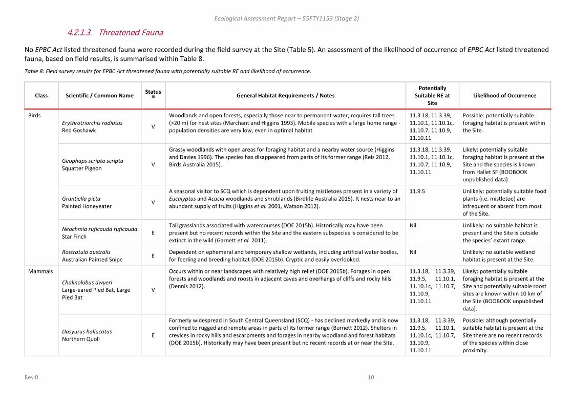
4.2.1.3. Threatened Fauna
No EPBC Act listed threatened fauna were recorded during the field survey at the Site (Table 5). An assessment of the likelihood of occurrence of EPBC Act listed threatened fauna, based on field results, is summarised within Table 8.
Table 8: Field survey results for EPBC Act threatened fauna with potentially suitable RE and likelihood of occurrence.
Class Scientific / Common Name Status
iii
General Habitat Requirements / Notes Potentially
Suitable RE at Site
Likelihood of Occurrence
Birds Erythrotriorchis radiatus Red Goshawk
V
Woodlands and open forests, especially those near to permanent water; requires tall trees (>20 m) for nest sites (Marchant and Higgins 1993). Mobile species with a large home range - population densities are very low, even in optimal habitat
11.3.18, 11.3.39, 11.10.1, 11.10.1c, 11.10.7, 11.10.9, 11.10.11
Possible: potentially suitable foraging habitat is present within the Site.
Geophaps scripta scripta Squatter Pigeon
V
Grassy woodlands with open areas for foraging habitat and a nearby water source (Higgins and Davies 1996). The species has disappeared from parts of its former range (Reis 2012, Birds Australia 2015).
11.3.18, 11.3.39, 11.10.1, 11.10.1c, 11.10.7, 11.10.9, 11.10.11
Likely: potentially suitable foraging habitat is present at the Site and the species is known from Hallet SF (BOOBOOK unpublished data)
Grantiella picta Painted Honeyeater
V
A seasonal visitor to SCQ which is dependent upon fruiting mistletoes present in a variety of Eucalyptus and Acacia woodlands and shrublands (Birdlife Australia 2015). It nests near to an abundant supply of fruits (Higgins et al. 2001, Watson 2012).
11.9.5 Unlikely: potentially suitable food plants (i.e. mistletoe) are infrequent or absent from most of the Site.
Neochmia ruficauda ruficauda Star Finch
E Tall grasslands associated with watercourses (DOE 2015b). Historically may have been present but no recent records within the Site and the eastern subspecies is considered to be extinct in the wild (Garnett et al. 2011).
Nil Unlikely: no suitable habitat is present and the Site is outside the species’ extant range.
Rostratula australis Australian Painted Snipe
E Dependent on ephemeral and temporary shallow wetlands, including artificial water bodies, for feeding and breeding habitat (DOE 2015b). Cryptic and easily overlooked.
Nil Unlikely: no suitable wetland habitat is present at the Site.
Mammals
Chalinolobus dwyeri Large-eared Pied Bat, Large Pied Bat
V
Occurs within or near landscapes with relatively high relief (DOE 2015b). Forages in open forests and woodlands and roosts in adjacent caves and overhangs of cliffs and rocky hills (Dennis 2012).
11.3.18, 11.3.39, 11.9.5, 11.10.1, 11.10.1c, 11.10.7, 11.10.9, 11.10.11
Likely: potentially suitable foraging habitat is present at the Site and potentially suitable roost sites are known within 10 km of the Site (BOOBOOK unpublished data).
Dasyurus hallucatus Northern Quoll
E
Formerly widespread in South Central Queensland (SCQ) - has declined markedly and is now confined to rugged and remote areas in parts of its former range (Burnett 2012). Shelters in crevices in rocky hills and escarpments and forages in nearby woodland and forest habitats (DOE 2015b). Historically may have been present but no recent records at or near the Site.
11.3.18, 11.3.39, 11.9.5, 11.10.1, 11.10.1c, 11.10.7, 11.10.9, 11.10.11
Possible: although potentially suitable habitat is present at the Site there are no recent records of the species within close proximity.

Ecological Assessment Report – 55FTY1153 (Stage 2)
Rev 0 11
Class Scientific / Common Name Status
iii
General Habitat Requirements / Notes Potentially
Suitable RE at Site
Likelihood of Occurrence
Nyctophilus corbeni South-eastern Long-eared Bat
V
Distribution and habitat preferences very poorly known (Reardon 2012). Inhabits range of dry forest and woodland types in SCQ, roosts in tree hollows and crevices and under loose bark (DOE 2015b).
11.3.18, 11.3.39, 11.9.5, 11.10.1, 11.10.1c, 11.10.7, 11.10.9, 11.10.11
Probable: suitable foraging habitat and shelter sites (hollow-bearing trees) are present throughout the Site.
Phascolarctos cinereus Koala (combined populations of Qld, NSW and the ACT)
V
Requires eucalypt woodland and forest with suitable food trees (primarily Eucalyptus spp.) (DOE 2015b).
11.3.18, 11.3.39, 11.9.7, 11.10.1, 11.10.1c, 11.10.7, 11.10.11
Probable: the Site contains large tracts of eucalypt-dominated woodland/open forest with potential food plants (i.e. Eucalyptus populnea, E. crebra, E. fibrosa, E. melanophloia, E. orgadophila, E. moluccana, Corymbia citriodora subsp. variegata).
Reptiles Delma torquata Collared Delma
V
Occupies eucalypt woodlands and open forests and lives under surface rock and woody debris (Wilson 2015, DOE 2015b). Small and difficult to detect. Recent survey work has greatly expanded knowledge of its distribution and habitat (Peck 2012).
11.3.18, 11.3.39, 11.9.7, 11.10.1, 11.10.1c, 11.10.7, 11.10.9, 11.10.11
Possible: the Site contains potentially suitable habitat with shelter sites including small rocks, logs and leaflitter.
Denisonia maculata Ornamental Snake
V
Potentially present in all lowlands associated with the Dawson - Fitzroy River catchments (DOE 2015b). Preys on frogs and is associated with ephemeral and permanent wetlands where it shelters in soil cracks and under debris e.g. logs, rocks (Wilson 2015, DOE 2015b).
Nil Unlikely: the Site is not within the species known range and potentially suitable habitat with cracking clays is absent from the Site.
Elseya albagula White-throated Snapping Turtle, Southern Snapping Turtle
CE
Permanent streams with pools in drainages of the Fitzroy, Mary and Burnett Rivers (Limpus et al. 2011, DOE 2015b).
Nil Unlikely: no suitable riverine habitat occurs within the Site.
Egernia rugosa Yakka Skink
V
Lives in woodland and open forests and also grassland with regrowth trees where it requires suitable soils for burrows, sinkholes, abandoned rabbit warrens or large fallen woody material for shelter (Eddie 2012).
11.3.18, 11.3.39, 11.9.7, 11.10.1, 11.10.1c, 11.10.7, 11.10.9, 11.10.11
Possible: the Site contains potentially suitable habitat with shelter sites including logs and log piles.
Furina dunmalli Dunmall's Snake
V
Very poorly known species that occupies woodlands and open forests; may be reliant on presence of abundant fallen woody debris (Hobson 2012).
11.3.18, 11.3.39, 11.9.5, 11.10.1, 11.10.1c, 11.10.7, 11.10.9, 11.10.11
Possible: the Site contains potentially suitable habitat with shelter sites including logs.

Ecological Assessment Report – 55FTY1153 (Stage 2)
Rev 0 12
Class Scientific / Common Name Status
iii
General Habitat Requirements / Notes Potentially
Suitable RE at Site
Likelihood of Occurrence
Rheodytes leukops Fitzroy River Turtle, Fitzroy Tortoise, Fitzroy Turtle, White-eyed River Diver
V
Dependent on permanent streams with a preference for deep pools often with intervening riffle zones (DOE 2015b). Not recorded from upper drainages of the Fitzroy River catchment (Limpus et al. 2011).
Nil Unlikely: no suitable riverine habitat occurs within the Site.
iii E = Endangered; V = Vulnerable

Ecological Assessment Report – 55FTY1153 (Stage 2)
Rev 0 13
4.2.1.4. Migratory Fauna
One species of EPBC Act migratory fauna was recorded during the field survey at the Site, this being the Rainbow Bee-eater (Merops ornatus) (Table 6). An assessment of the likelihood of occurrence of EPBC Act listed migratory fauna, based on field results, is summarised within Table 9.
Table 9: Field survey results for EPBC Act migratory fauna with potentially suitable RE and likelihood of occurrence.
Class Scientific / Common Name General Habitat Requirements/ Notes Potentially Suitable RE at Site Likelihood of Occurrence
Birds Apus pacificus Fork-tailed Swift
Seasonal migrant to Australia present October – April; aerial, commonly travelling in flocks ahead of low pressure cells in pursuit of insects which it takes on the wing (Pizzey and Knight 2010).
11.3.18, 11.3.39, 11.9.5, 11.10.1, 11.10.1c, 11.10.7, 11.10.9, 11.10.11
Probable: aerial feeder seasonally present overhead.
Ardea modesta ( as A. alba in PMST) Eastern Great Egret, Great Egret, White Egret
Freshwater wetlands, including artificial water-bodies in disturbed habitats (Pizzey and Knight 2010).
Nil Unlikely: wetland habitat is absent from the Site. Recorded within 10 km of the Site (DEHP 2015a).
Ardea ibis Cattle Egret
Widely distributed through coastal and near-coastal Australia but a scarce visitor to southern inland Queensland (Birdlife Australia 2015). Frequents freshwater wetlands but often forages in pasture; roosts in wetlands (Pizzey and Knight 2010).
Nil Unlikely: wetland habitat is absent from the Site.
Gallinago hardwickii Latham's Snipe, Japanese Snipe
Migrates between Japan and Australia, where it is a spring - autumn visitor. Feeds on invertebrates found on the margins of freshwater wetlands, including artificial water-bodies (Pizzey and Knight 2010).
Nil Unlikely: wetland habitat is absent from the Site.
Hirundapus caudacutus White-throated Needletail
Seasonal migrant to Australia present October – April; aerial, commonly travelling in flocks ahead of low pressure cells in pursuit of insects which it takes on the wing (Pizzey and Knight 2010).
11.3.18, 11.3.39, 11.9.5, 11.10.1, 11.10.1c, 11.10.7, 11.10.9, 11.10.11
Probable: aerial feeder seasonally present overhead. Recorded within 10 km of the Site (DEHP 2015a).
Merops ornatus Rainbow Bee-eater
Widespread and abundant species frequently present in southern inland Queensland during spring and summer (Birdlife Australia 2015, Barrett et al. 2003). Feeds on aerial insects and nests in burrows in sandy soils (Pizzey and Knight 2010).
11.3.18, 11.3.39, 11.10.1, 11.10.1c, 11.10.7, 11.10.9, 11.10.11
Confirmed: two birds seen in trees associated with a drainage line. Suitable breeding habitat is present in RE 11.3.18, 11.3.39 and 11.10.9.
Myiagra cyanoleuca Satin Flycatcher
October-April breeding migrant to south-eastern Australia (Birdlife Australia 2015). Insectivorous and live in closed forests and moist open forests (Pizzey and Knight 2010).
11.3.18, 11.3.39, 11.9.5, 11.10.1, 11.10.1c, 11.10.7, 11.10.9, 11.10.11
Possible: may use woodland habitat during migratory passage.

Ecological Assessment Report – 55FTY1153 (Stage 2)
Rev 0 14
4.2.1.5. Marine Fauna
One EPBC Act marine fauna species were recorded during the field survey at the Site (Table 6). An assessment of the likelihood of occurrence of other EPBC Act listed marine fauna identified in the PMST search (DoE 2015a)as potentially present at the Site, based on field results, is summarised within Table 10.
Table 10: Field survey results for EPBC Act marine fauna with potentially suitable RE and likelihood of occurrence.
Class Scientific / Common Name General Habitat Requirements/ Notes Potentially Suitable RE at Site Likelihood of Occurrence
Birds Apus pacificus Fork-tailed Swift
Seasonal migrant to Australia present October – April; aerial, commonly travelling in flocks ahead of low pressure cells in pursuit of insects which it takes on the wing (Pizzey and Knight 2010).
11.3.18, 11.3.39, 11.9.5, 11.10.1, 11.10.1c, 11.10.7, 11.10.9, 11.10.11
Probable: aerial feeder seasonally present overhead.
Ardea modesta ( as A. alba) Eastern Great Egret, Great Egret, White Egret
Freshwater wetlands, including artificial water-bodies in disturbed habitats (Pizzey and Knight 2010).
Nil Unlikely: wetland habitat is absent from the Site. Recorded within 10 km of the Site (DEHP 2015a).
Ardea ibis Cattle Egret
Widely distributed through coastal and near-coastal Australia but a scarce visitor to southern inland Queensland (Birdlife Australia 2015). Frequents freshwater wetlands but often forages in pasture; roosts in wetlands (Pizzey and Knight 2010).
Nil Unlikely: wetland habitat is absent from the Site.
Gallinago hardwickii Latham's Snipe, Japanese Snipe
Migrates between Japan and Australia, where it is a spring - autumn visitor. Feeds on invertebrates found on the margins of freshwater wetlands, including artificial water-bodies (Pizzey and Knight 2010).
Nil Unlikely: wetland habitat is absent from the Site.
Haliaeetus leucogaster White-bellied Sea-Eagle
More common coastally but some birds occur far inland along major rivers, including the Fitzroy-Dawson and Maranoa-Balonne systems (Birdlife Australia 2015).
Nil Unlikely: wetland habitat is absent from the Site.
Hirundapus caudacutus White-throated Needletail
Seasonal migrant to Australia present October – April; aerial, commonly travelling in flocks ahead of low pressure cells in pursuit of insects which it takes on the wing (Pizzey and Knight 2010).
11.3.18, 11.3.39, 11.9.5, 11.10.1, 11.10.1c, 11.10.7, 11.10.9, 11.10.11
Probable: aerial feeder seasonally present overhead. Recorded within 10 km of the Site (DEHP 2015a).
Merops ornatus Rainbow Bee-eater
Widespread and abundant species frequently present in southern inland Queensland during spring and summer (Birdlife Australia 2015, Barrett et al. 2003). Feeds on aerial insects and nests in burrows in sandy soils (Pizzey and Knight 2010).
11.3.18, 11.3.39, 11.10.1, 11.10.1c, 11.10.7, 11.10.9, 11.10.11
Confirmed: two birds seen in trees associated with a drainage line. Suitable breeding habitat is present in RE 11.3.18, 11.3.39 and 11.10.9.
Myiagra cyanoleuca Satin Flycatcher
October-April breeding migrant to south-eastern Australia (Birdlife Australia 2015). Insectivorous and live in closed forests and moist open forests (Pizzey and Knight 2010).
11.3.18, 11.3.39, 11.9.5, 11.10.1, 11.10.1c, 11.10.7, 11.10.9, 11.10.11
Possible: may use woodland habitat during migratory passage.

Ecological Assessment Report – 55FTY1153 (Stage 2)
Rev 0 15
Class Scientific / Common Name General Habitat Requirements/ Notes Potentially Suitable RE at Site Likelihood of Occurrence
Rostratula benghalensis (sensu lato) Painted Snipe
Dependent on ephemeral and temporary shallow wetlands, including artificial water bodies, for feeding and breeding habitat (DOE 2015b). Cryptic and easily overlooked.
Nil Unlikely: wetland habitat is absent from the Site.
4.2.2. Queensland Environmental Matters
Field survey results for State environmental matters are summarised in Table 11.
Table 11: State environmental matters – field survey results
State Environmental Matters Present
(Y/N) Location Description
iv Status* Comments
Endangered regional ecosystems Y
Survey sites Q03-HSFA, Q01-HSFB, Q08-HSFB, Q01-HSFC
11.9.5 Brigalow (Acacia harpophylla) and/or Belah (Casuarina cristata) shrubby open forest on Cainozoic fine-grained sediments
Endangered Three patches of advanced regrowth; one patch of remnant
Of concern regional ecosystems Y Survey sites Q04-HSFA, Q04-RVA
11.9.7 Eucalyptus populnea, Eremophila mitchellii shrubby woodland on fine-grained sedimentary rocks
Of concern Two patches of advanced regrowth.
NC Act listed flora (EVNT) N n/a n/a n/a n/a
NC Act listed fauna (EVNT) N n/a n/a n/a n/a
Special Least Concern flora Y Refer to Appendix I.
Kurrajong (Brachychiton populneus) Narrow-leaved Bottle Tree (Brachychiton rupestris) Black Orchid (Cymbidium canaliculatum) Sandalwood (Santalum lanceolatum ) Mulga Fern (Cheilanthes sieberi) Rock Fern (Cheilanthes distans)
Special Least Concern n/a
Special Least Concern fauna Y Refer to Appendix I.
Short-beaked Echidna (Tachyglossus aculeatus) Rainbow Bee-eater (Merops ornatus)
Special Least Concern Echidna scats detected on ridge crest within RE 11.10.1c.
iv Status and description taken from Nature Conservation (Wildlife) Regulation 2006

Ecological Assessment Report – 55FTY1153 (Stage 2)
Rev 0 16
4.2.2.1. Ground-truthed Regional Ecosystems
DNRM (2015) mapping for the Site and the results of ground truthing can be summarised as follows:
For convenience the proposed infrastructure footprint can be divided into three regions: north, east and south.
Most remnant or regrowth vegetation mapped (DNRM 2015) within the northern footprint is identified as RE 11.10.9. At the far western end of the northern footprint vegetation is mapped in a mixed polygon as 11.10.9/11.10.11. Vegetation associated with broad valleys (mostly cleared) is mapped as either RE 11.3.2 or a mixed polygon of 11.3.2/11.3.25. Ground-truthing confirmed that most remnant vegetation within the footprint was RE 11.10.9, with a lesser occurrence of RE 11.10.11 (3 polygons). However, more diversity was found to be present in remaining vegetation. An area of regrowth RE 11.9.5 was identified on a hill slope, with associated regrowth RE 11.9.7 closely adjacent. A further area of regrowth RE 11.9.7 was present in a largely cleared hilltop in the central part of this footprint. Vegetation associated with drainage lines was found to be RE 11.13.18. RE 11.3.2 and 11.3.25 were not detected.
All remnant vegetation in the east of the Site is mapped (DNRM 2015) as RE 11.10.1. Ground-truthing confirmed the presence of RE 11.10.1 on much of the area, with an occurrence of RE 11.10.1c at the northern end of the proposed footprint. A small area of regrowth RE 11.9.5 was detected and RE 11.10.7 was present at the south-western extremity of the footprint.
Most remnant vegetation in the south of the Site is mapped (DNRM 2015) as RE 11.10.1 except for small areas of RE 11.9.4 on the plateau and RE 11.3.2 (subdominant) associated with a valley. Ground-truthing showed a small area of RE 11.10.1c but otherwise RE 11.10.1 was absent from the area. Part of the area mapped as RE 11.9.4 was found to be RE 11.9.5, while elsewhere it consisted of non-remnant vegetation. No RE 11.9.4 was detected. Vegetation associated with a valley was ground-truthed as RE 11.3.39. Remaining vegetation on the plateau and slopes was ground-truthed as RE 11.10.7.
A summary of ground-truthed vegetation is presented in Table 12. All ground truthed regional ecosystems and regrowth are represented schematically in Appendix G.

Ecological Assessment Report – 55FTY1153 (Stage 2)
Rev 0 17
Table 12: Ground-truthed remnant and regrowth regional ecosystems
RE ID RE Polygon Identifiers Survey
Site(s)
Status
(Biodiversity)v
REDD Short description Field Description Extent/Condition
Remnant 11.3.18
383A0F0644C8864 A255027077F6C56
Q05-HSFA No concern at present
Eucalyptus populnea, Callitris glaucophylla, Allocasuarina luehmannii shrubby woodland on alluvium
Eucalyptus populnea woodland; tall shrub layer dominated by Eremophila mitchellii; grassy ground layer of several perennial species.
some evidence of historical thinning (ring-barking)
Remnant
11.3.39
19C2251D7F14062 2CC70894180DF9C 718BE4C92941C55
Q06-HSFB Q07-HSFB
No concern at present
Eucalyptus melanophloia ± E. chloroclada open woodland on undulating plains and valleys with sandy soils
Eucalyptus melanophloia woodland with E. populnea, Angophora floribunda and E. chloroclada; minimal shrub layer development; ground layer dominated by Cenchrus ciliaris, Themeda triandra, T. avenacea and Arundinella nepalensis.
Confined to narrow valley bottoms and adjoining slopes between sandstone ridges. Some areas have many trees with low DBH however tree height and canopy density meet remnant vegetation criteria. Ground layer is dominated by non-native grasses in places.
Remnant 11.9.2
6E663F27226A20E
Q09-HSFB No concern at present
Eucalyptus melanophloia +/- E. orgadophila woodland on fine-grained sedimentary rocks
Eucalyptus orgadophila woodland; shrubby midlayer frequently containing SEVT spp.; grassy ground layer.
Limited occurrence on southern boundary of Site; non-native pasture grasses are abundant; rich in fauna habitat especially tree hollows
Remnant 11.9.5
306B801215BF9CC N/A Endangered Acacia harpophylla and/or Casuarina cristata open forest on fine-grained sedimentary rocks
Acacia harpophylla woodland; midlayers include Geijera parviflora, Eremophila mitchellii, Casuarina cristata and Atalaya hemiglauca; low shrub layer dominated by Carissa ovata; grassy ground layer dominated by Ancistrachne uncinulata.
One polygon which meets Brigalow TEC criteria: remnant Acacia harpophylla dominated RE 11.9.5 meeting structural and condition criteria (DoE 2015b) including dominance of native perennial grasses in ground layer.
Regrowth 11.9.5
32B8F8F7785CAF3 4B1E8F6B8FF16E7 7147A4CE30B427C
Q01-HSFB Q08-HSFB Q03-HSFA
Endangered Acacia harpophylla and/or Casuarina cristata open forest on fine-grained sedimentary rocks
Acacia harpophylla low open forest with scattered emergent mature trees. Sparse shrub layer composed of Geijera parviflora, Eremophila mitchellii, Citrus glauca and Carissa ovata. Ground layer variably dominated by non-native Cenchrus ciliaris or in other areas by native perennial grasses e.g. Paspalidium caespitosum.
Two polygons (4B1E8F6B8FF16E7 and 7147A4CE30B427C) meet Brigalow TEC criteria: mature regrowth (>15 years old) of Acacia harpophylla dominated RE 11.9.5 meeting structural and condition criteria (DoE 2015b). The remaining polygon (32B8F8F7785CAF3) does not meet TEC criteria in that it lacks structural elements of the community and/or has >50% cover of exotic perennial plants.

Ecological Assessment Report – 55FTY1153 (Stage 2)
Rev 0 18
RE ID RE Polygon Identifiers Survey
Site(s)
Status
(Biodiversity)v
REDD Short description Field Description Extent/Condition
Regrowth 11.9.7
27DF6DB53501F10 533605E87794F57 5C81A7F22B80A00
Q04-RVA Q04-HSFA
Of Concern Eucalyptus populnea, Eremophila mitchellii shrubby woodland on fine-grained sedimentary rocks
Eucalyptus populnea woodland; low tree layer of Geijera parviflora, Eremophila mitchellii and Callitris glaucophylla; shrub layer dominated by Carissa ovata; grassy ground layer dominated by Ancistrachne uncinulata.
Areas show varying levels of disturbance/recovery from previous clearing
Remnant 11.10.1
2CB4AEFFA281411 627A222F59ECD3D
Q05-HSFB Q01-HSFA Q02-HSFA
No concern at present
Corymbia citriodora woodland on coarse-grained sedimentary rocks
Corymbia citriodora subsp. variegata, Eucalyptus crebra woodland – open forest; upper midlayer dominated by Petalostigma pubescens, Alphitonia excelsa, Allocasuarina luehmannii and Acacia longispicata; lower midlayer dominated by multiple shrub spp.; ground layer dominated by native perennial grass, Gahnia aspera, Cheilanthes sieberi and Scleria sphacelata with occasional non-native species including Cenchrus ciliaris and Megathyrsus maximus.
Extensive community on ridge crests and adjoining slopes at the extreme eastern end of the Site. Vegetation community generally in good condition however trees with large DBH are rare due to past disturbances (e.g. logging).
Remnant 11.10.1c
4480295CAD23192 5F51BFDC60A2E37
Q04-HSFB
No concern at present
Eucalyptus fibrosa, Eucalyptus spp. woodland
Eucalyptus fibrosa woodland with scattered E. crebra and Corymbia trachyphloia; shrubby midlayer including Acacia spp. and a diversity of small shrub spp.; ground layer dominated by Lomandra spp., Scleria sphacelata and Gahnia aspera.
Patchily distributed on ridge tops and grading into RE 11.10.7 or 11.10.1. Evidence of past fires present. Some areas disturbed by existing access tracks.
Remnant 11.10.7
3205FE4B7F7C6AB 4ADB808C625E978 5CF25CDFA43B175 7F05E32F17D8680
Q02-HSFB Q03-HSFB
No concern at present
Eucalyptus crebra woodland on coarse-grained sedimentary rocks
Eucalyptus crebra woodland +/- E. melanophloia; lower tree layer of Callitris glaucophylla and/or Allocasuarina luehmannii; shrub layer of varying spp. or absent; ground layer dominated by native perennial grasses and forbs.
Extensive community on ridge tops and slopes within the Site. Evidence of selective logging and wildfire is present. Areas show varying degrees of White Cypress Pine in the understorey attributable to fire history.
Remnant
11.10.9
1213E0D8819FB29 14BC3AD8523A7BB 6BBC04E039CE1F5 6BC585582BC9299 7432D1312EAEFEC
Q02-RVA Q06-HSFA
No concern at present
Callitris glaucophylla woodland on coarse-grained sedimentary rocks
Callitris glaucophylla woodland with associated spp. including Eucalyptus melanophloia, E. crebra, E. populnea, Angophora leiocarpa & Corymbia clarksoniana. Shrub/low tree layer of varying composition and density, probably relating to fire history. Grassy ground layer.
Extensive community at northern end of the Site. Evidence of selective logging, erosion and wildfire.

Ecological Assessment Report – 55FTY1153 (Stage 2)
Rev 0 19
RE ID RE Polygon Identifiers Survey
Site(s)
Status
(Biodiversity)v
REDD Short description Field Description Extent/Condition
Regrowth
11.10.9
1523657B5974088
Q03-RVA Callitris glaucophylla low woodland (advanced regrowth) with associated Eucalyptus populnea and Allocasuarina luehmannii; sparse midlayer of canopy recruits and Eremophila mitchellii; ground layer composed of Eremochloa bimaculata, Heteropogon contortus
Minor occurrences where previous clearing or thinning has extended into this RE
Remnant 11.10.11
2406C4473942CA8 244FEE3034377B3 7C8F30BA21D4EFF
Q05-RVA
No concern at present
Eucalyptus populnea, E. melanophloia +/- Callitris glaucophylla woodland on coarse-grained sedimentary rocks
Eucalyptus populnea, Callitris glaucophylla woodland on sandy loam soils; E. melanophloia sometimes co-dominant. Shrub/low tree layer of varying composition and density, probably relating to fire history. Grassy ground layer.
Some evidence of historical thinning (ring-barking)
v Status and description taken from DEHP 2015e

Ecological Assessment Report – 55FTY1153 (Stage 2)
Rev 0 20
4.2.2.2. Threatened Flora
No records of threatened flora were contained in a Protected Plants Flora Survey Trigger Map for the Site (DEHP 2015d). No NC Act listed flora species were recorded during the field survey at the Site. An assessment of the likelihood of occurrence, based on field inspection results, of NC Act listed threatened flora species potentially present at the Site is summarised in Table 13.
Table 13: Field survey results for NC Act EVNT flora with potentially suitable RE and likelihood of occurrence.
Family Scientific /
Common Name Status
vi
General Habitat
Requirements/ Notes
Potentially
Suitable RE Likelihood of Occurrence
Acanthaceae Xerothamnella herbacea
Herbaceous Xerothamnella
E Occurs in Brigalow (Acacia harpophylla) communities (including advanced regrowth) along watercourses and drainage features (TSSC 2008c).
11.9.5 Possible: The Site is within the species range (ALA 2015) and suitable habitat is potentially present
Apocynaceae Tylophora linearis
Slender Tylophora
E Dry sclerophyll woodland (TSSC 2008b). The Site is 130 km north of the only collection site in Queensland (AVH 2015).
11.3.18, 11.3.39, 11.10.7, 11.10.9, 11.10.1, 11.10.1c, 11.10.11
Unlikely: suitable habitat is present but the Site is outside the known range of the species (the species has only been collected once in Queensland).
Celastraceae Apatophyllum teretifolium
Sandstone Prickle-bush
NT Occurs in dry sclerophyll woodland on crests of sandstone ridges with coarse sandy soil and along cliff edges (Santos 2012).
11.10.1, 11.10.7
Possible: The Site is within the species range (ALA 2015) and suitable habitat is potentially present
Myrtaceae Eucalyptus curtisii
Plunkett Mallee
NT Occurs in dry sclerophyll woodland on sandy podsols with impeded drainage, shallow stony soils, clay loams and stony clays with a surface layer of loose stones (DEHP 2015f).
11.10.1, 11.10.7
Possible: The Site is within the species range (ALA 2015) and suitable habitat is potentially present
Myrtaceae Eucalyptus virens
Shiny-leaved Ironbark
V Occurs in dry sclerophyll woodland on sandstone ridges (TSSC 2008d).
11.10.1, 11.10.7
Possible: The Site is within the species range (ALA 2015) and suitable habitat is potentially present
Myrtaceae Melaleuca groveana
Grove’s Paperbark
NT Dry sclerophyll woodland on crests of sandstone ridges with loamy or sandy soil (Santos 2012).
11.10.1, 11.10.7
Possible: The Site is within the species range (ALA 2015) and suitable habitat is potentially present
Myrtaceae Melaleuca irbyana
Swamp Tea-tree
E Occurs on plateau tops with reddish-brown loamy clay soils (Santos 2012)
11.10.1, 11.10.7
Possible: The Site is within the species range (ALA 2015) and suitable habitat is potentially present
Myrtaceae Sannantha brachypoda
V Occurs on plateau tops in red-brown loams and on sandstone scarp crests (BOOBOOK unpubl. data)
11.10.1, 11.10.7
Possible: The Site is within the species range (ALA 2015) and suitable habitat is potentially present

Ecological Assessment Report – 55FTY1153 (Stage 2)
Rev 0 21
Family Scientific /
Common Name Status
vi
General Habitat
Requirements/ Notes
Potentially
Suitable RE Likelihood of Occurrence
Picrodendraceae
Pseudanthus pauciflorus subsp. arenicola
NT Occurs in crevices on vertical or near vertical rock faces and sandstone cliffs within dry sclerophyll woodland (DSITI 2015b).
11.10.1, 11.10.7
Possible: The Site is within the species range (ALA 2015) and suitable habitat is potentially present
Surianaceae Cadellia pentastylis
Ooline
V Occurs on ridge slopes and undulating plains within Brigalow (Acacia harpophylla) woodland - open forest and semi-evergreen vine thicket (SEVT) (TSSC 2008a, Santos 2012).
11.9.5 Unlikely: all potential habitat was examined at the Site. The species is conspicuous and readily identified but was not observed at the Site.
vi E = Endangered; V = Vulnerable; NT = Near Threatened

Ecological Assessment Report – 55FTY1153 (Stage 2)
Rev 0 22
4.2.2.3. Threatened Fauna
No NC Act listed fauna species were detected during the field survey. An assessment of the likelihood of occurrence of all other NC Act listed threatened fauna species potentially present at the Site, based on field results, is summarised within Table 14.
Table 14: Field survey results for NC Act EVNT fauna with potentially suitable RE and likelihood of occurrence.
Scientific / Common Name Statusvii
General Habitat Requirements/ Notes Potentially
Suitable RE Likelihood of Occurrence
Calyptorhynchus lathami
Glossy Black-Cockatoo
V Dependent on the fruits of several species of Casuarina and Allocasuarina spp. found in a variety of forest types (Pizzey and Knight 2010, Garnett et al. 2011). It will visit isolated trees and remnant patches where food trees are present (Holmes 2012).
11.9.5, 11.10.1, 11.10.7, 11.10.9, 11.10.11
Possible: potentially suitable habitat food plants Casuarina cristata and Allocasuarina luehmannii are present in nominated REs and as scattered trees throughout the Site.
Erythrotriorchis radiatus
Red Goshawk
E Woodlands and open forests, especially those near to permanent water; requires tall trees (>20 m) for nest sites (Marchant and Higgins 1993). Mobile species with a large home range - population densities are very low, even in optimal habitat.
11.3.18, 11.3.39, 11.10.1, 11.10.1c, 11.10.7, 11.10.9, 11.10.11
Possible: potentially suitable foraging habitat is present within the Site.
Geophaps scripta scripta
Squatter Pigeon (southern subspecies)
V Grassy woodlands with open areas for foraging habitat and a nearby water source (Higgins and Davies 1996). The species has disappeared from parts of its former range (Reis 2012, Birds Australia 2015).
11.3.18, 11.3.39, 11.10.1, 11.10.1c, 11.10.7, 11.10.9, 11.10.11
Likely: potentially suitable foraging habitat is present at the Site and the species is known from Hallett SF (BOOBOOK unpublished data)
Grantiella picta
Painted Honeyeater
V A seasonal visitor to SCQ which is dependent upon fruiting mistletoes present in a variety of Eucalyptus and Acacia woodlands and shrublands (Birdlife Australia 2015). It nests near to an abundant supply of fruits (Higgins et al. 2001, Watson 2012).
11.9.5 Unlikely: potentially suitable food plants (i.e. mistletoe) are infrequent or absent from most of the Site.
Neochmia ruficauda ruficauda
Eastern Star Finch
E Tall grasslands associated with watercourses (DOE 2015b). Historically may have been present but no recent records within the Site and the eastern subspecies is considered to be extinct in the wild (Garnett et al. 2011).
Nil Unlikely: no suitable habitat is present and the Site is outside the species’ extant range.
Rostratula australis
Australian Painted Snipe
V Dependent on ephemeral and temporary shallow wetlands, including artificial water bodies, for feeding and breeding habitat (DOE 2015b). Cryptic and easily overlooked.
Nil Unlikely: no suitable wetland habitat is present at the Site.
Jalmenus eubulus
Pale Imperial Hairstreak
V Usually associated with Brigalow (Acacia harpophylla) open forests and woodlands (Valentine and Johnson 2012).
11.9.5 Possible: suitable larval food plants (mature Acacia harpophylla) are present within the Site.

Ecological Assessment Report – 55FTY1153 (Stage 2)
Rev 0 23
Scientific / Common Name Statusvii
General Habitat Requirements/ Notes Potentially
Suitable RE Likelihood of Occurrence
Chalinolobus dwyeri
Large-eared Pied Bat
V Occurs within or near landscapes with relatively high relief (DOE 2015b). Forages in open forests and woodlands and roosts in adjacent caves and overhangs of cliffs and rocky hills (Dennis 2012).
11.3.18, 11.3.39, 11.9.5, 11.9.7, 11.10.1, 11.10.1c, 11.10.7, 11.10.9, 11.10.11
Likely: potentially suitable foraging habitat is present at the Site and potentially suitable roost sites are known within 10 km of the Site (BOOBOOK unpublished data).
Dasyurus hallucatus
Northern Quoll E
Formerly widespread in South Central Queensland (SCQ) - has declined markedly and is now confined to rugged and remote areas in parts of its former range (Burnett 2012). Shelters in crevices in rocky hills and escarpments and forages in nearby woodland and forest habitats (DOE 2015b). Historically may have been present but no recent records at or near the Site.
11.3.18, 11.3.39, 11.9.5, 11.9.7, 11.10.1, 11.10.1c, 11.10.7, 11.10.9, 11.10.11
Possible: although potentially suitable habitat is present at the Site there are no recent records of the species within close proximity.
Nyctophilus corbeni
South-eastern Long-eared Bat
V Distribution and habitat preferences very poorly known (Reardon 2012). Inhabits range of dry forest and woodland types in SCQ and roosts in tree hollows and crevices and under loose bark (DOE 2015b).
11.3.18, 11.3.39, 11.9.5, 11.9.7, 11.10.1, 11.10.1c, 11.10.7, 11.10.9, 11.10.11
Probable: suitable foraging habitat and shelter sites (hollow-bearing trees) are present throughout the Site.
Phascolarctos cinereus Koala
V Within species known range (Martin et al. 2008); requires eucalypt woodland and forest habitat with suitable food trees (primarily Eucalyptus spp.) (DOE 2015b).
11.3.18, 11.3.39, 11.9.7, 11.10.1, 11.10.1c, 11.10.7, 11.10.11
Probable: the Site contains large tracts of eucalypt-dominated woodland/open forest with potential food plants (i.e. Eucalyptus populnea, E. crebra, E. fibrosa, E. melanophloia, E. orgadophila, E. moluccana, Corymbia citriodora subsp. variegata).
Acanthophis antarcticus
Common Death Adder
V A widespread but patchily distributed snake (ALA 2015). Lives in woodlands, open forests and heathlands; requires abundant shelter/ambush predation cover e.g. low shrubs, rocks, logs, dense leaf litter (Wilson 2015).
11.9.2, 11.9.5, 11.9.7, 11.10.1, 11.10.1c, 11.10.7, 11.10.11
Possible: areas of dense shrub, rock and leaf litter cover are present in limited amounts within the Site.
Delma torquata
Collared Delma
V Occupies eucalypt woodlands and open forests and lives under surface rock and woody debris (Wilson 2015, DOE 2015b). Small and difficult to detect. Recent survey work has greatly expanded knowledge of its distribution and habitat (Peck 2012).
11.3.18, 11.3.39, 11.9.7, 11.10.1, 11.10.1c, 11.10.7, 11.10.9, 11.10.11
Possible: the Site contains potentially suitable habitat with shelter sites including small rocks, logs and leaflitter.
Denisonia maculata
Ornamental Snake
V Potentially present in all lowlands associated with the Dawson - Fitzroy River catchments (DOE 2015b). Preys on frogs and is associated with ephemeral and permanent wetlands where it shelters in soil cracks and under debris e.g. logs, rocks (Wilson 2015, DOE 2015b).
Nil Unlikely: the Site is not within the species known range and potentially suitable habitat with cracking clays is absent from the Site.

Ecological Assessment Report – 55FTY1153 (Stage 2)
Rev 0 24
Scientific / Common Name Statusvii
General Habitat Requirements/ Notes Potentially
Suitable RE Likelihood of Occurrence
Elseya albagula
White-throated Snapping Turtle, Southern snapping Turtle
E Permanent streams with pools in drainages of the Fitzroy, Mary and Burnett Rivers (Limpus et al. 2011, DOE 2015b).
Nil Unlikely: no suitable riverine habitat occurs within the Site.
Egernia rugosa
Yakka Skink
V Lives in woodland and open forests and also grassland with regrowth trees where it requires suitable soils for burrows, sinkholes, abandoned rabbit warrens or large fallen woody material for shelter (Eddie 2012).
11.3.18, 11.3.39, 11.9.5, 11.9.7, 11.10.1, 11.10.1c, 11.10.7, 11.10.9, 11.10.11
Possible: the Site contains potentially suitable habitat with shelter sites including logs and log piles.
Furina dunmalli
Dunmall’s Snake
V Very poorly known species that occupies woodlands and open forests; may be reliant on presence of abundant fallen woody debris (Hobson 2012).
11.3.18, 11.3.39, 11.9.5, 11.9.7, 11.10.1, 11.10.1c, 11.10.7, 11.10.9, 11.10.11
Possible: the Site contains potentially suitable habitat with shelter sites including logs.
Rheodytes leukops
Fitzroy River Turtle
V Dependent on permanent streams with a preference for deep pools often with intervening riffle zones (DOE 2015b). Not recorded from upper drainages of the Fitzroy River catchment (Limpus et al. 2011).
Nil Unlikely: no suitable riverine habitat occurs within the Site.
Strophurus taenicauda
Golden-tailed Gecko
NT Lives in dry open forest and woodlands, especially those with well-developed shrub layer where it shelters in tree hollows and splits, and under loose bark (QMDC 2008).
11.3.18, 11.3.39, 11.9.5, 11.9.7, 11.10.1, 11.10.1c, 11.10.7, 11.10.9, 11.10.11
Likely: habitat trees with small hollows and/or decorticating bark are present throughout the Site.
vii
E = Endangered; V = Vulnerable; NT = Near Threatened
4.2.2.4. Pest Fauna
Pest fauna on site has been mapped based on field survey results (Appendix J). Table 15 describes pest fauna detected at the Site.
Table 15: Pest fauna recorded at the Site.
Scientific Name Common Name Status* Area of Occurrence
Oryctolagus cuniculus. European Rabbit Class 2 declared pest Scats were observed at several locations.
Sus scrofa Feral Pig Class 2 declared pest Diggings seen in sandy soil at survey site Q06-HSFA.
*Status taken from LP Act/DoE 2015a
4.2.3. Disturbances
The majority of the southern and eastern regions of the Site retain a cover of remnant vegetation though a narrow access track is present in much of the footprint here. Clearing within these regions is of very limited extent and remnant and regrowth vegetation within the footprint is contiguous with large tracts of remnant vegetation. Some areas of vegetation, notably RE 11.10.1 show reduced presence of large trees as a result of logging practices. The

Ecological Assessment Report – 55FTY1153 (Stage 2)
Rev 0 25
southern and eastern regions appear to be subject to periodic fire. This may be prescribed fire to manage fuel loads as little evidence was seen of severe fire impacts. Livestock (cattle) grazing occurs in these areas but no water infrastructure was apparent; a factor limiting the impact of grazing on the vegetation.
The northern region has been more impacted, with several areas of clearing associated with the slopes and floors of broad valleys during development for livestock grazing. These and adjacent areas of remnant vegetation continue to be grazed by cattle. However, most remaining remnant and regrowth vegetation is in the form of large patches. Extensive areas of RE 11.10.9 in this region show evidence of selective logging of White Cypress Pine (Callitris glaucophylla) and removal of non-commercial species. Most of the footprint here followed an existing formed track accessing several gas wells and cleared rights-of-way for flowlines and power lines were also present.
Some soils at the Site (generally associated with drainage lines but also on cleared slopes) showed severe sheet and gully erosion.
4.2.4. Watercourses and Wetlands
Ten mapped (DNRM 2015) streams (orders 1-3) within the Site were assessed all of which are un-named. No mapped streams were identified to be watercourses as defined by the Water Act 2000. All mapped streams were determined to be drainage features, as defined by the Water Act 2000. Table 16 provides details of the characteristics of examined streams and their classification as per the Water Act 2000 criteria. The location of stream assessment sites are mapped in Appendix K.
Table 16: Ground-truthed drainage features at the Site.
Site Mapped stream
order Is
Watercourse? Description and justification
W01-HSFA 1 No Drainage feature: shallow U-shaped gully; incised central channel with banks to 0.6m height, up to 1.2m wide; no hydrophytes; no riparian vegetation (advanced regrowth of RE 11.9.7/11.9.5); no evidence of extended flows
W02-HSFA 1 No Drainage feature: no defined bed or banks upstream; downstream of formed road grossing is a shallow incised central channel to 0.3m depth, 2m width; no hydrophytes; no riparian vegetation (cleared ex-RE 11.3.18); no evidence of extended flows
W03-HSFA 3 No Drainage feature: no defined bed or banks; narrow incised channel to 0.2m depth, 0.8m width; no hydrophytes; no riparian vegetation (cleared ex-RE 11.3.39 or 11.3.18); no evidence of extended flows
W04-HSFA 1 No Drainage feature: minor channel (broad U-shape) to 0.2m depth, 1.0m width; no hydrophytes; no riparian vegetation (RE 11.10.9); no evidence of extended flows
W06-RVA 1 No Drainage feature: Shallow V-shaped gully with eroded banks to 0.9m height; no hydrophytes; no riparian vegetation (cleared ex-RE 11.10.11); no evidence of extended flows
W01-HSFB 1 No Drainage feature: nil defined bed/banks, riparian vegetation or hydrophytes
W02-HSFB 1 No Drainage feature: head of gully with shallow narrow scoured channel, 0.5 m deep, up to 2 m wide; nil riparian vegetation, hydrophytes, defined bed/banks or evidence of prolonged flows
W03-HSFB 2 No Drainage feature: no defined bed/banks, riparian vegetation, hydrophytes or evidence of prolonged flows
W04-HSFB 1 No
Drainage feature: no defined bed/banks (shallow scoured channel present), riparian vegetation, hydrophytes or evidence of prolonged flows
W05-HSFB
1 No
Drainage feature: no defined bed/banks, riparian vegetation, hydrophytes or evidence of prolonged flows
*Flora Wetland Indicator Species (DEHP 2015f)

Ecological Assessment Report – 55FTY1153 (Stage 2)
Rev 0 26
No Referable Wetlands were identified during desktop searches (DEHP 2015c). No unmapped wetlands were detected during field assessments at the Site.
5. Conclusions
An ecological assessment of the Site showed the following ecological values to be present:
One TEC: Brigalow (Acacia harpophylla dominant and co-dominant).
One Endangered RE: 11.9.5.
One Of Concern RE: 11.9.7.
Six Special Least Concern flora species:
o Kurrajong (Brachychiton populneus);
o Narrow-leaved Bottle Tree (Brachychiton rupestris);
o Mulga Fern (Cheilanthes sieberi);
o Bristly Cloak Fern (Cheilanthes distans);
o Black Orchid (Cymbidium canaliculatum); and
o Sandalwood (Santalum lanceolatum).
Potential habitat for ten EPBC Act threat-listed species: Bertya opponens, the Red Goshawk, Squatter Pigeon, Large-eared Pied Bat, Northern Quoll, South-eastern Long-eared Bat, Koala, Collared Delma, Dunmall’s Snake and the Yakka Skink.
Potential habitat for twenty-one NC Act threat-listed species: Herbaceous Xerothamnella, Sandstone Prickle-bush, Plunkett Mallee, Green Mallee, Grove’s Paperbark, Swamp Tea-tree, Sannantha brachypoda, Pseudanthus pauciflora subsp. arenicola, Glossy Black-Cockatoo, Red Goshawk, Squatter Pigeon, Northern Quoll, Large-eared Pied Bat, South-eastern Long-eared Bat, Koala, Collared Delma, Common Death Adder, Dunmall’s Snake, Golden-tailed Gecko, Yakka Skink and the Pale Imperial Hairstreak butterfly.
The following environmental constraints were recorded at the Site:
Two Class 2 declared pest animals:
o European Rabbit; and
o Feral Pig.
It is recommended that the findings in this report are considered during detailed development planning such that disturbance to the ecological values of the site and locality may be avoided wherever practical. Where disturbance is unavoidable, impact mitigation measures are to be implemented in accordance with the approved site environmental management plan and regulatory approval conditions.

Ecological Assessment Report – 55FTY1153 (Stage 2)
Rev 0 27
Appendix A. Site Location and Vegetation Survey Points.

Ecological Assessment Report – 55FTY1153 (Stage 2)
Rev 0 28

Ecological Assessment Report – 55FTY1153 (Stage 2)
Rev 0 29
Appendix B. Results of EPBC Protected Matters Search Tool

Ecological Assessment Report – 55FTY1153 (Stage 2)
Rev 0 30

Ecological Assessment Report – 55FTY1153 (Stage 2)
Rev 0 31

Ecological Assessment Report – 55FTY1153 (Stage 2)
Rev 0 32

Ecological Assessment Report – 55FTY1153 (Stage 2)
Rev 0 33

Ecological Assessment Report – 55FTY1153 (Stage 2)
Rev 0 34

Ecological Assessment Report – 55FTY1153 (Stage 2)
Rev 0 35

Ecological Assessment Report – 55FTY1153 (Stage 2)
Rev 0 36

Ecological Assessment Report – 55FTY1153 (Stage 2)
Rev 0 37

Ecological Assessment Report – 55FTY1153 (Stage 2)
Rev 0 38
Appendix C. Wildlife Online Database Search Results.

Ecological Assessment Report – 55FTY1153 (Stage 2)
Rev 0 39

Ecological Assessment Report – 55FTY1153 (Stage 2)
Rev 0 40

Ecological Assessment Report – 55FTY1153 (Stage 2)
Rev 0 41

Ecological Assessment Report – 55FTY1153 (Stage 2)
Rev 0 42

Ecological Assessment Report – 55FTY1153 (Stage 2)
Rev 0 43

Ecological Assessment Report – 55FTY1153 (Stage 2)
Rev 0 44
Appendix D. EHP Mapped Regional Ecosystems.

Ecological Assessment Report – 55FTY1153 (Stage 2)
Rev 0 45

Ecological Assessment Report – 55FTY1153 (Stage 2)
Rev 0 46
Appendix E. EHP Mapping of ESAs and Other Environmental Values on Site.

Ecological Assessment Report – 55FTY1153 (Stage 2)
Rev 0 47

Ecological Assessment Report – 55FTY1153 (Stage 2)
Rev 0 48
Appendix F. List of Fauna and Native Flora Species Identified on Site.
Class Scientific name Common name Legislative status
(NC Act, LP Act)*
Legislative status
(EPBC Act)*
FLORA Abutilon oxycarpum var. incanum Low Lantern-bush LC -
Acacia conferta Crowded-leaf Wattle LC -
Acacia excelsa Ironwood LC -
Acacia harpophylla Brigalow LC -
Acacia leiocalyx subsp. leiocalyx Early Flowering Black Wattle LC -
Acacia longispicata Slender-flowered Wattle LC -
Acacia omalophylla Yarran LC -
Alectryon connatus Alectryon LC -
Alectryon diversifolius Scrub Boonaree LC -
Allocasuarina luehmannii Bulloak LC -
Alphitonia excelsa Red Ash LC -
Alstonia constricta Bitterbark LC -
Amyema congener Variable Mistletoe LC -
Ancistrachne uncinulata Hooky Grass LC -
Angophora floribunda Rough-barked Apple LC -
Angophora leiocarpa Smooth-barked Apple LC -
Apophyllum anomalum Warrior Bush LC -
Aristida caput-medusae Many-headed Wiregrass LC -
Aristida sp. A Grass - -
Arundinella nepalensis Reedgrass LC -
Atalaya hemiglauca Whitewood LC -
Bertya oleifolia A Bertya LC -
Boronia occidentalis Rock Boronia LC -
Boronia sp. A Boronia - -
Bothriochloa decipiens Pitted Bluegrass LC -
Brachychiton populneus Kurrajong SLC -
Brachychiton rupestris Narrow-leaved Bottle Tree SLC -
Breynia oblongifolia Coffee Bush LC -
Brunoniella australis Blue Trumpet LC -
Bulbostylis barbata Watergrass LC -
Bursaria incana Prickly Pine LC -
Bursaria spinosa subsp. spinosa Sweet Bursaria LC -
Callitris endlicheri Black Cypress Pine LC -
Callitris glaucophylla White Cypress Pine LC -
Calotis cuneifolia Purple Burr-daisy LC -
Canthium coprosmoides - -
Capparis canescens Wild Orange LC -
Capparis lasiantha Wait-A-While LC -

Ecological Assessment Report – 55FTY1153 (Stage 2)
Rev 0 49
Class Scientific name Common name Legislative status
(NC Act, LP Act)*
Legislative status
(EPBC Act)*
Capparis loranthifolia Narrow-leaf Bumble Tree LC -
Capparis mitchellii Bumble Tree LC -
Carissa ovata Currant Bush LC -
Cassinia laevis Cough Bush LC -
Casuarina cristata Belah LC -
Cheilanthes distans Bristly Cloak Fern SLC -
Cheilanthes sieberi Mulga Fern SLC -
Chloris ventricosa Tall Chloris LC -
Chrysocephalum apiculatum Yellow Buttons LC -
Citrus glauca Desert Lime LC -
Cleistochloa subjuncea No Common Name LC -
Clematicissus opaca Small-leaved Water Vine, Pepper Vine
LC -
Coronidium oxylepis subsp. lanatum LC -
Corymbia citriodora Lemon-scented Gum LC -
Corymbia clarksoniana Clarkson's Bloodwood LC -
Corymbia trachyphloia Brown Bloodwood LC -
Croton phebalioides Narrow-leaved Croton LC -
Cymbidium canaliculatum Black Orchid SLC -
Cymbopogon bombycinus Citronella Grass LC -
Cymbopogon refractus Barbed-wire Grass LC -
Dampiera adpressa Bushy Dampiera, Purple Beauty-bush LC -
Dianella longifolia Long-leaved Flax Lily, Smooth Flax Lily
LC -
Dinebra decipiens Slender Canegrass LC -
Diospyros humilis Small-leaved Ebony LC -
Dodonaea boroniifolia Fern-leaf Hop-bush LC -
Dodonaea heteromorpha Maple-fruited Hop-bush LC -
Dodonaea lanceolata Hop Bush LC -
Dodonaea stenophylla LC -
Dodonaea triangularis Triangle-leaved Hop-bush LC -
Ehretia membranifolia Peach Bush LC -
Einadia hastata Berry Saltbush LC -
Elaeodendron australe Red Olive Plum LC -
Enneapogon sp. A Grass - -
Enteropogon ramosus Twirly Windmill Grass LC -
Lissanthe pluriloculata LC -
Eragrostis sp. A Lovegrass - -
Eremophila debilis Winter Apple LC -
Eremophila longifolia Long-leaved Emu Bush, Berrigan LC -
Eremophila mitchellii False Sandalwood LC -

Ecological Assessment Report – 55FTY1153 (Stage 2)
Rev 0 50
Class Scientific name Common name Legislative status
(NC Act, LP Act)*
Legislative status
(EPBC Act)*
Eucalyptus chloroclada Baradine Red Gum LC -
Eucalyptus crebra Narrow-leaved Ironbark LC -
Eucalyptus fibrosa Dusky-leaved Ironbark LC -
Eucalyptus melanophloia Silver-leaved Ironbark LC -
Eucalyptus moluccana Gum-topped Box LC -
Eucalyptus orgadophila Mountain Coolibah LC -
Eucalyptus populnea Poplar Box LC -
Eulalia aurea Silky Browntop LC -
Euphorbia tannensis subsp. eremophila Desert Spurge LC -
Exocarpos latifolius Broad-leaved Native Cherry LC -
Flindersia australis Crow’s Ash LC -
Gahnia aspera Rough Saw-Sedge LC -
Geijera parviflora Wilga LC -
Gonocarpus elatus Hill Raspwort LC -
Grevillea floribunda Rusty Spider-flower LC -
Grevillea striata Beefwood LC -
Grewia latifolia Dysentery Bush LC -
Heteropogon contortus Black Speargrass LC -
Hibbertia cistoidea A Guinea-flower LC -
Hovea sp. - -
Indigofera brevidens Desert Indigo LC -
Indigofera hirsuta LC -
Jacksonia scoparia Dogwood LC -
Jasminum simplicifolium subsp. australiense Stiff Jasmine LC -
Laxmannia sp. - -
Leptospermum lamellatum Weeping Tea-tree LC -
Lomandra filiformis Wattle Mat-rush LC -
Lomandra leucocephala Woolly Mat-rush LC -
Lomandra multiflora Many-flowered Mat-rush LC -
Maireana microphylla Cotton Bush LC -
Marsdenia viridiflora Native Pear LC -
Maytenus cunninghamii Yellowberry Bush LC -
Melichrus sp. (Isla Gorge P.Sharpe+ 601) An Urn-heath LC -
Mirbelia aotoides LC -
Myoporum acuminatum Boobialla LC -
Owenia acidula Emu Apple LC -
Ozothamnus cassinioides Straw Dogwood LC -
Ozothamnus diosmifolius Rice Flower, White Dogwood, Pill Flower, Sago Bush
LC -
Panicum effusum Hairy Panic LC -

Ecological Assessment Report – 55FTY1153 (Stage 2)
Rev 0 51
Class Scientific name Common name Legislative status
(NC Act, LP Act)*
Legislative status
(EPBC Act)*
Parsonsia eucalyptophylla Gargaloo LC -
Parsonsia lanceolata Rough Silkpod LC -
Paspalidium caespitosum Brigalow Grass LC -
Petalostigma pubescens Quinine Tree LC -
Pittosporum angustifolium Weeping Pittosporum, Gumbi Gumbi LC -
Plectranthus parviflorus Cockspur Flower LC -
Pomax umbellata Pomax LC -
Portulaca filifolia Slender Pigweed LC -
Prostanthera sp. (Baking Board V.Hando 135) - -
Psydrax odorata Shiny-leaved Canthium LC -
Pterocaulon serrulatum Apple Bush, Toothed Ragwood LC -
Pterocaulon sphacelatum Fruit-salad Plant LC -
Salsola australis Soft Roly-poly LC -
Santalum lanceolatum Sandalwood SLC -
Scaevola spinescens Maroon Bush LC -
Scleria sphacelata Razor Grass LC -
Secamone elliptica Corky Milk Vine LC -
Senna artemisioides subsp. zygophylla Butter Bush LC -
Setaria surgens Pigeon Grass LC -
Sida hackettiana Spiked Sida LC -
Solanum jucundum A Potato Bush LC -
Solanum mitchellianum Western Prickly Nightshade LC -
Solanum parvifolium Small-leaved Nightshade LC -
Spartothamnella juncea Square-stemmed Broom, Bead Bush LC -
Themeda avenacea Wild Oats LC -
Themeda triandra Kangaroo Grass LC -
Ventilago viminalis Supplejack LC -
FAUNA Acanthiza nana Yellow Thornbill LC -
Acanthiza reguloides Buff-rumped Thornbill LC -
Artamus leucorynchus White-breasted Woodswallow LC -
Carlia pectoralis sensu lato LC -
Chalcites lucidus Shining Bronze-cuckoo LC -
Chthonicola sagittata Speckled Warbler LC -
Cinclosoma punctatum Spotted Quail-thrush LC -
Colluricincla harmonica Grey Shrike-thrush LC -
Coracina novaehollandiae Black-faced Cuckoo-shrike LC -
Cracticus nigrogularis Pied Butcherbird LC -
Cracticus torquatus Grey Butcherbird LC -
Dacelo novaeguineae Laughing Kookaburra LC -
Daphoenositta chrysoptera Varied Sittella LC -

Ecological Assessment Report – 55FTY1153 (Stage 2)
Rev 0 52
Class Scientific name Common name Legislative status
(NC Act, LP Act)*
Legislative status
(EPBC Act)*
Eopsaltria australis Eastern Yellow Robin LC -
Geopelia humeralis Bar-shouldered Dove LC -
Geopelia striata Peaceful Dove LC -
Heteronotia binoei Bynoe's Gecko LC -
Lerista fragilis Eastern Mulch Slider LC -
Lichmera indistincta Brown Honeyeater LC -
Lygisaurus foliorum Burnett's Skink LC -
Macropus giganteus Eastern Grey Kangaroo LC -
Macropus robustus Common Wallaroo LC -
Malurus melanocephalus Red-backed Fairy-wren LC -
Melithreptus albogularis White-throated Honeyeater LC -
Merops ornatus Rainbow Bee-eater SLC Migratory species
Microeca fascinans Jacky Winter LC -
Morethia boulengeri Boulenger's Skink LC -
Nesoptilotis leucotis White-eared Honeyeater LC -
Ninox novaeseelandiae Southern Boobook LC -
Oryctolagus cuniculus Rabbit Class 2 -
Pachycephala rufiventris Rufous Whistler LC -
Pardalotus striatus Striated Pardalote LC -
Philemon corniculatus Noisy Friarbird LC -
Pomatostomus temporalis Grey-crowned Babbler LC -
Rhipidura albiscapa Grey Fantail LC -
Rhipidura leucophrys Willie Wagtail LC -
Smicrornis brevirostris Weebill LC -
Strepera graculina Pied Currawong LC -
Struthidea cinerea Apostlebird LC -
Sus scrofa Pig Class 2 -
Tachyglossus aculeatus Short-beaked Echidna SLC -
Taeniopygia bichenovii Double-barred Finch LC -
Trichoglossus haematodus moluccanus Rainbow Lorikeet LC -
*Status taken from Nature Conservation (Wildlife) Regulation 2006 and DoE 2015c

Ecological Assessment Report – 55FTY1153 (Stage 2)
Rev 0 53
Appendix G. Ground Truthed TEC at the Site

Ecological Assessment Report – 55FTY1153 (Stage 2)
Rev 0 54

Ecological Assessment Report – 55FTY1153 (Stage 2)
Rev 0 55
Appendix H. Ground Truthed Regional Ecosystems.

Ecological Assessment Report – 55FTY1153 (Stage 2)
Rev 0 56

Ecological Assessment Report – 55FTY1153 (Stage 2)
Rev 0 57

Ecological Assessment Report – 55FTY1153 (Stage 2)
Rev 0 58

Ecological Assessment Report – 55FTY1153 (Stage 2)
Rev 0 59
Appendix I. Special Least Concern Flora and Fauna Recorded at the Site

Ecological Assessment Report – 55FTY1153 (Stage 2)
Rev 0 60

Ecological Assessment Report – 55FTY1153 (Stage 2)
Rev 0 61
Appendix J. Pest Fauna Recorded at the Site.

Ecological Assessment Report – 55FTY1153 (Stage 2)
Rev 0 62

Ecological Assessment Report – 55FTY1153 (Stage 2)
Rev 0 63
Appendix K. Ground Truthed Drainage Features and Watercourses Present on Site.

Ecological Assessment Report – 55FTY1153 (Stage 2)
Rev 0 64