ecological regions of the northwest territories … · about the cover: the main cover photo...
TRANSCRIPT

ECOLOGICAL REGIONS OF THE NORTHWEST TERRITORIES
NORTHERN ARCTIC
ECOSYSTEM CLASSIFICATION GROUP
Department of Environment and Natural Resources Government of the Northwest Territories
2013

ECOLOGICAL REGIONS OF THE NORTHWEST TERRITORIES
NORTHERN ARCTIC
This report may be cited as:
Ecosystem Classification Group. 2013. Ecological Regions of the Northwest Territories – Northern Arctic. Department of Environment and Natural Resources, Government of the Northwest Territories, Yellowknife, NT, Canada. x + 157 pp. + insert map (printed copies).
Library and Archives Canada Cataloguing in Publication
Northwest Territories. Ecosystem Classification Group Ecological regions of the Northwest Territories, northern Arctic / Ecosystem Classification Group.
Includes bibliographical references. ISBN 978-0-7708-0205-9
1. Ecological regions--Northwest Territories. 2. Biotic communities--Arctic regions. I. Northwest Territories. Dept. of Environment and Natural Resources II. Title.
QH106.2 N55 N67 2013 577.09719'3 C2013-980025-5 For more information contact: Department of Environment and Natural Resources P.O. Box 1320 Yellowknife, NT X1A 2L9 Phone: (867) 920-8064 Fax: (867) 873-0293 Web Site: http://www.enr.gov.nt.ca About the cover: The main cover photo shows Bailey Point, located on the north side of Liddon Gulf (Melville Coastal Plain MA Ecoregion, p. 54). A muskox skull on lush green tundra is in the foreground on the back cover. In the midground is multi-year pack ice, and in the far distance is the low dome of the Dundas Peninsula and to the right of the title on the front cover, the uplands of Melville Island. Bailey Point contains the most favourable habitat for muskoxen among the High Arctic Islands north of M’Clure Strait. As a critical refuge for these animals, it has been an important source for restocking neighbouring regions after harsh climatic conditions caused heavy mortalities in poorer habitats. Such dispersals are an important adaptation in the Arctic Islands. Small herds have been observed recently on and near Bailey Point. The small digital images in the inset boxes on the cover are enlarged with captions on page 28 (Northern Arctic High Arctic-oceanic Ecoregion), page 36 (Northern Arctic High Arctic Ecoregion), page 52 (Northern Arctic Mid-Arctic Ecoregion) and page 80 (Northern Arctic Low Arctic-north Ecoregion). Aerial images: Dave Downing. Ground images, main cover image and plant images: Bob Decker, Government of the Northwest Territories. Document images: Except where otherwise credited, aerial images in the document were taken by Dave Downing and ground-level images were taken by Bob Decker, Government of the Northwest Territories.

i
Members of the Ecosystem Classification Group
Dave Downing Ecologist, Onoway, Alberta.
Bob Decker Forest Ecologist, Forest Resources, Forest Management Division, Environment and Natural Resources, Government of the Northwest Territories, Hay River, Northwest Territories.
Tom Chowns Environmental Consultant, Powassan, Ontario.
Charles Tarnocai Research Scientist, Agriculture and Agri-Food Canada, Ottawa, Ontario.
Dr. Suzanne Carrière Wildlife Biologist (Biodiversity), Wildlife Division, Environment and Natural Resources, Government of the Northwest Territories, Yellowknife, Northwest Territories.
Brian Maier Resource Analyst, Forcorp Solutions Inc., Edmonton, Alberta.
Kathleen Groenewegen GIS Specialist, Forest Resources, Forest Management Division, Environment and Natural Resources, Government of the Northwest Territories, Hay River, Northwest Territories.

ii
Acknowledgements The authors thank Bas Oosenbrug who had the vision and the drive to initiate this project in 2004 and the scientific, organizational and editorial skills to effectively manage the project and the team until his retirement in 2010. We enjoyed our collaborations with Bas and value our lasting friendship with him. The support of Tom Lakusta (Forest Management Division, Environment and Natural Resources, Government of the Northwest Territories [GNWT]), Dr. Nicole McCutchen, Lynda Yonge, Susan Fleck (Wildlife Division, Department of Environment and Natural Resources, GNWT) is gratefully acknowledged. Evelyn Gah (Protected Areas Strategy, Land and Water Division, Environment and Natural Resources, GNWT) has provided valuable technical and editorial support to the project and was part of the initial planning team for this project. Martin Callaghan (Forest Management Division, Department of Environment and Natural Resources, GNWT Inuvik) and Tracy Davison (Inuvik Region, Department of Environment and Natural Resources, GNWT both provided assistance with field logistics advice and weather information.
We thank David Kroetsch, Agriculture and Agri-Food Canada, for providing the initial classification upon which the Northwest Territories version was built; John Downing, for assistance in obtaining and interpreting bedrock geology information; and Wayne Pettapiece, for compiling most of the glossary of terms in Appendix 5. We also acknowledge members of the 1995 Ecological Stratification Working Group, members of the 1989 Ecoclimatic Regions Working Group and all researchers who compiled various geologic and natural resource assessments for the area. In particular, we thank Sylvia Edlund for her insightful ecological descriptions and frameworks that proved indispensable to delineation of ecoregions for the northern islands and climatic concepts for the southern islands. Joanna Wilson (Wildlife Biologist (Species at risk), Wildlife Division, Department of Environment and Natural Resources, GNWT) and Craig Machtans (Biologist, Environment Canada) provided thoughtful reviews of the document.
Field support and accommodation throughout the Northern Arctic was courteously provided by the Holman Co-op Arctic Char Inn (Ulukhaktok) and by Roger and Jackie Kuptana at the PolarGrizz Lodge (Sachs Harbour). Roger and Jackie also provided valuable insights into the landscapes and wildlife of the Northern Arctic, particularly Banks Island. Gary Bristow (fuel manager, Ulukhaktok) provided useful information on winter conditions in the Minto Inlet area. Parks Canada (Sachs Harbour and Inuvik) provided documents and helpful information; thanks to John Lucas and Molly Kirk for their help. Safe and reliable air transportation was provided in 2010 by Larry Buckmaster (Landa Air) and in 2011 by Kenn Borek Air Ltd. (DC-3 transport of camp to and from Mould Bay) and Canadian Helicopters (pilot Eric Krone and engineer Dan Garbutt).
Susanne Downing provided data entry services for the Northern Arctic photo themes and for approximately 65,000 previous thematic records for the Taiga Plains, Taiga Shield, Cordillera and Southern Arctic ecosystem classifications. Her attention to detail and accurate transcription of handwritten records is appreciated.
The Forest Management Division and Wildlife Division of Environment and Natural Resources, Government of the Northwest Territories, both contributed funds and resources to the Northern Arctic Ecosystem Classification Project.

iii
Preface The Northwest Territories covers an area of 1,355,672 square kilometres, almost 14 percent of Canada’s land mass. It spans 2,120 km north to south from the 60th parallel to the tip of Borden Island, the most northerly point of land. This vast land, born of ancient climates and geologic upheavals and molded by the pressures of immense ice sheets, is continually transformed by sun, wind, rain and snow. Its landscapes are a living partnership linking geology, topography and climate to plants, animals and microbes in associations called ecosystems. Ecosystems in the Northwest Territories range from tiny – a single lichen on a boulder or a tree trunk – to immense expanses of forests, wetlands and tundra across the plains, uplands and mountains. In the extreme southwest, mixedwood boreal forests flourish under relatively moist, mild climates and contain trembling aspen, balsam poplar and white spruce that soar to heights of over 30 metres. They are replaced at higher latitudes and elevations by open subarctic or sub-alpine conifer forests, stunted discontinuous groves of black and white spruce, and finally by treeless frozen tundra where extreme cold, drought and exposure to winds limits plant growth on the most northerly islands and the highest elevations to scattered, sheltered patches of a few herbs, lichens, mosses and soil microbes where the largest plants hug the ground, scarcely exceeding two centimetres in height.
The Northern Arctic, the area covered by this document, includes 216,771 square kilometres within the Northwest Territories and encompasses most of the islands north of the mainland. Much of Nunavut also falls within the Northern Arctic. Banks, Prince Patrick, Eglinton, Emerald, and Brock Islands lie entirely within the Northwest Territories. Melville, Mackenzie King, Borden and Victoria Islands are shared with Nunavut. Pack ice surrounds all of the islands for much of the year and records indicate that some islands (Brock, Borden, Emerald and Mackenzie King) are encircled by thick pack ice that persists for many years, except for a narrow zone of open water close to shore.
Ecosystems in the Northwest Territories are connected to global ecosystems by energy and material flows through time and space, but these interactions are so complex that we cannot comprehend them in their totality. Because we depend on healthy ecosystems for our survival, we need to know how natural ecosystems are structured and how they function so that we can manage our activities for the present and for the future. Ecosystem classification is one approach to attaining the understanding we need, and is accomplished by defining landscape units that are recognized as different from others through their physical and biological characteristics.
Physical landscape characteristics such as latitude, elevation, climate, geology and topography control temperature, moisture, light and nutrient levels. They act together with biological factors like competition and grazing to determine plant community development, the associated populations of consumers and decomposers that depend on plants, and the living soil that supports plant growth (Major 1951; Jenny 1941). In Northern Arctic environments where plant community development is strongly controlled by climate, soils and terrain, growth is restricted to a few weeks in midsummer and plants tend to be widely spaced. Competition between plants is usually of less significance to plant growth in the Northern Arctic than it is in more southerly ecosystems. Animal grazing can be a highly significant influence locally (e.g., grazing by snow geese on Banks Island can significantly change plant communities in areas of high goose population density) but it is generally of less importance than physical factors are at the scale of regional ecosystems.
At the core of ecosystem classification is the mapping and description of vegetation and terrain patterns. These patterns are determined by examining various physical factors and their influences on vegetation at various scales. At the global scale, the Biome or Vegetation Zone is recognized (Walter 1979, Scott 1995, Commission for Environmental Cooperation 1997). At the national scale in Canada, Ecozones, Ecoregions and Ecodistricts are described (Ecological Stratification Working Group 1995). The Northwest Territories has modified the Canadian national scale and classification framework to match the multi-level continental ecosystem classification framework – Ecological Regions of North America – developed by the Commission for Environmental Cooperation in 1997. The Canadian and continental systems are outlined in Section 1 of this report.

iv
Ecosystem classification maps and descriptions have been used in one form or another by people for thousands of years to support rational ecological management. They are of value because they provide a means of presenting and understanding biophysical patterns and processes in a visual and descriptive geographic context and because they provide a common basis for communication. In Canada, the value of regional ecosystem classification systems as a foundation for sustainable resource management has been recognized since at least the 1960s. Numerous meetings and committee reports over several decades led to the establishment of a national ecological classification framework that was published in 1995 (Ecological Stratification Working Group 1995).
The Government of the Northwest Territories has until recently used the 1995 version of the national ecosystem classification framework as the basis for identifying candidate protected areas, forest management planning, wildlife habitat management and environmental impact assessment and mitigation. In 2004, in response to increasing development pressures in the Mackenzie River Corridor, the mapping and description of the 1995 Taiga Plains Ecozone was examined by an external reviewer to assess its utility. Subsequently, a series of workshops in 2004 – 2006 and an intensive survey of the entire Taiga Plains in 2005 led to significant changes and enhancements to the 1995 map and map description of this landscape, and a revised map and report were produced in early 2007 (Ecosystem Classification Group 2007 [revised 2009]).
Similar revisions were undertaken in 2006 through 2008 for the 1996 Taiga Shield Ecozone bordering the Taiga Plains to the east (Ecosystem Classification Group 2008), in 2007 through 2010 for the 1996 Taiga Cordillera and Boreal Cordillera Ecozones bordering the Taiga Plains to the west (Ecosystem Classification Group 2010) and in 2008 through 2012 for the Southern Arctic (Ecosystem Classification Group 2012). The current report outlines revisions undertaken for the Northern Arctic that have been underway since late 2009.
Initial planning for the Northern Arctic survey involved a geographic information system-based review of several spatial data sources including LandsatTM imagery, digital elevation models, hydrology, permafrost, bedrock and surficial geology, soils and interpolated climate models. Previous ecological and geological maps and documents for the area were reviewed and integrated. The Circumpolar Arctic Vegetation Map (CAVM Team 2003) and substantial work by Edlund and others (Edlund 1983a, 1983b; Edlund 1990; Edlund and Egginton 1984; Edlund and Alt 1989) provided a broad-scale and comprehensive overview of Northern Arctic biophysical characteristics in the Northwest Territories and Nunavut and a conceptual framework for understanding its relationship to Arctic ecosystems in Canada and elsewhere. All of this information facilitated the review of landscapes and existing mapped ecosystem units from a number of different perspectives. From this review, provisional ecosystem units were developed.
Air and ground assessment of the provisional units was an integral part of the revision process. In the summer of 2010, a fixed-wing survey traversed the two largest Arctic Islands within the Northwest Territories (Banks and Victoria Islands) and a small portion of Eglinton and Melville Islands, covering a flying distance of approximately 13,700 km. A detailed record of landscape and ground features was captured in over 6,000 geographically referenced digital images accompanied by text comments. In 2011, a helicopter survey of both the northern Arctic Islands (Prince Patrick, Melville, Borden, Brock, Emerald and Mackenzie King Islands) and the southern Islands (Banks, Victoria) covered a flying distance of approximately 7,900 km and nearly 13,000 digital images and theme comments were recorded in an identical format to that collected in 2010. Site, vegetation and soil information collection was limited in 2010 to two plots at Ulukhaktok and Sachs Harbour because of limited ground access using the fixed-wing aircraft but in 2011, 63 reconnaissance ground plots were established and included general descriptions of vegetation, landscapes and soils as well as numerous photographs. Subsamples within many of the plots examined local terrain variations such as upland and wetland areas and the transitions between them. All observations from reconnaissance ground plots were captured in theme comments associated with ground plot images.
All of the digital images were reviewed following the survey and corrections and additions to the comments were made to many of the records. Both the images and related themes derived from the comments were indispensable for the mapping process.

v
This is the final report of a consistently-structured five-report series describing regional ecosystems of the Northwest Territories. It and the accompanying map (Appendix 3 and back pocket in published hardcopy version) provide ecological descriptions and spatial representations of ecoregions within the Northern Arctic. Better spatial information, an understanding of climate and landscape patterns and processes gained through intensive aerial surveys and reviews of various approaches to landscape classification in the Arctic have resulted in the recognition of 21 Level IV1
This report integrates currently available information about climatic, physiographic, vegetation, soil and wildlife attributes to characterize each of the ecoregions within the Northern Arctic in a format that is suited to both technical and non-technical users. For this purpose, it has been organized into four sections.
ecoregions within the Northwest Territories portion of the Northern Arctic, compared to seven ecoregions delineated by the Ecological Stratification Working Group in 1995.
· Section 1 defines the Ecological Regions of North America ecosystem classification framework as applied to the Northern Arctic and its relationship to the national classification system that is applied across much of Canada. The climatic and physiographic factors that exert major influences on Arctic landscapes are discussed, and the permafrost and vegetation features that characterize the Northern Arctic are presented.
· Section 2 details the methods employed to review and refine the 1996 Canadian Ecological Framework to better represent landscape patterns and to describe these patterns within the continental framework.
· Section 3 describes the Northern Arctic and includes the following subsections. o Section 3.1 provides an overview of Section 3 contents. o Section 3.2 provides an overview of the Northern Arctic within the Northwest Territories
and of two logical subdivisions within it, the southern islands (Banks and Victoria Islands) and the northern islands, all north of M’Clure Strait (Prince Patrick, Eglinton, Melville, Emerald, Brock, Mackenzie King and Borden Islands).
o Section 3.3 explains how Level III and Level IV ecoregions are described. o Section 3.4 describes the Level III Northern Arctic High Arctic-oceanic Ecoregion and two
Level IV Ecoregions within it. o Section 3.5 describes the Level III Northern Arctic High Arctic Ecoregion and six Level IV
Ecoregions within it. o Section 3.6 describes the Level III Northern Arctic Mid-Arctic Ecoregion and eleven Level
IV Ecoregions within it. o Section 3.7 describes the Level III Northern Arctic Low Arctic-north Ecoregion and two
Level IV Ecoregions within it. · Section 4 describes the mammals and birds found throughout that part of the Northern Arctic lying
mainly within the Northwest Territories.
The report concludes with a list of cited references, common and scientific names of vascular plants mentioned in the text or commonly occurring in the Northwest Territories portion of the Northern Arctic along with images of some representative and unusual plants (Appendix 1), a summary of changes from the 1996 published version of Ecozones and Ecoregions for the Northern Arctic to the current version (Appendix 2), a page-size map and legend for the Northern Arctic (Appendix 3), a discussion of sea ice trends over the last 30 years that influence Arctic climates (Appendix 4) and a glossary of useful terms (Appendix 5). A folded map of the Northern Arctic Ecosystem Classification is provided in a map pocket at the back of printed copies of this report.
1 Level I, Level II, Level III and Level IV ecoregion definitions are provided in Section 1.

vi
Table of Contents
Members of the Ecosystem Classification Group ................................... i Acknowledgements ..................................................................... ii Preface ................................................................................... iii Section 1: Concepts, Climates and Landscapes ..................................1
1.1 Introduction ............................................................................. 1
1.2 Classification Framework ............................................................. 1
1.3 Mapping Concepts and Landscape Descriptions .................................. 1 1.3.1 Level I Ecoregions ................................................................. 3 1.3.2 Level II Ecoregions ................................................................ 3 1.3.3 Level III Ecoregions ............................................................... 3 1.3.4 Level IV Ecoregions ............................................................... 5 1.3.5 Further Divisions of Level IV Ecoregions ........................................ 6 1.3.6 Long-term Value of the Northern Arctic Ecosystem Classification ........... 6
1.4 How Level III Ecoregions are Defined ............................................... 6 1.4.1 Climatic Factors Influencing Level III Ecoregions ............................... 6
1.4.1.1 Factors influencing regional climate ....................................... 7 1.4.1.2 Factors influencing local climate ........................................... 7 1.4.1.3 Climate change ............................................................... 8
1.4.2 Landscape and Vegetation Features That Define Level III Ecoregions ........ 8 1.4.2.1 Permafrost features ......................................................... 8 1.4.2.2 Vegetation features ......................................................... 10
1.5 How Level IV Ecoregions are Defined ............................................ 11 1.5.1 Landscape and Climate Features That Define Level IV Ecoregions ......... 11 1.5.2 Recurring Vegetation Patterns in Level IV Ecoregions ....................... 15
Section 2: Methods ................................................................... 17
2.1 Introduction ........................................................................... 17
2.2 GIS Processes .......................................................................... 17 2.2.1 Information Assembly ........................................................... 17 2.2.2 Map Production and Database Update ......................................... 17
2.3 Field Data Collection ................................................................ 17
2.4 Post-field Data Review and Mapping .............................................. 18 2.4.1 General Procedures ............................................................. 18 2.4.2 Information Sources Used to Describe Ecoregions ........................... 18
vii
Section 3: Level II, Level III and Level IV Ecoregions of the Northern Arctic ................................................. 21
3.1 Introduction ......................................................................... 21
3.2 Northern Arctic Summary ......................................................... 21 3.2.1 Overview ........................................................................... 21 3.2.2 Northern Islands (western Queen Elizabeth Islands) ............................ 23 3.2.3 Southern Islands .................................................................... 23
3.3 How Level III and Level IV Ecoregions are Described .......................... 24
3.4 Northern Arctic High Arctic-oceanic (HAo) Ecoregion ......................... 28 3.4.1 Polar Islands HAo Ecoregion
(ecoregion label 2.1.1.1). ............................................................. 30 3.4.2 Prince Patrick Lowland HAo Ecoregion
(ecoregion label 2.1.1.2). ............................................................. 34
3.5 Northern Arctic High Arctic (HA) Ecoregion ..................................... 36 3.5.1 Prince Patrick Upland HA Ecoregion
(ecoregion label 2.1.2.1). ............................................................ 38 3.5.2 North Melville Upland HA Ecoregion
(ecoregion label 2.1.2.2). ............................................................ 40 3.5.3 Central Melville Upland HA Ecoregion
(ecoregion label 2.1.2.3). ............................................................ 42 3.5.4 Dundas Peninsula HA Ecoregion
(ecoregion label 2.1.2.4). ............................................................ 46 3.5.5 Northwest Slopes HA Ecoregion
(ecoregion label 2.1.2.5). ............................................................ 48 3.5.6 Parker Plateau HA Ecoregion
(ecoregion label 2.1.2.6). ............................................................ 50
3.6 Northern Arctic Mid-Arctic (MA) Ecoregion ...................................... 52 3.6.1 Melville Coastal Plain MA Ecoregion
(ecoregion label 2.1.3.1). ............................................................ 54 3.6.2 West Banks Coastal Plain MA Ecoregion
(ecoregion label 2.1.3.2). ............................................................ 58 3.6.3 Central Banks Upland MA Ecoregion
(ecoregion label 2.1.3.3). ............................................................ 60 3.6.4 Thomsen Valley MA Ecoregion
(ecoregion label 2.1.3.4). ............................................................ 62 3.6.5 East Banks Hills MA Ecoregion
(ecoregion label 2.1.3.5). ............................................................ 64 3.6.6 West Prince Albert Lowland MA Ecoregion
(ecoregion label 2.1.3.6). ............................................................ 66 3.6.7 West Prince Albert Upland MA Ecoregion
(ecoregion label 2.1.3.7). ............................................................ 68 3.6.8 East Prince Albert Plain MA Ecoregion
(ecoregion label 2.1.3.8). ............................................................ 70 3.6.9 Shaler Mountains MA Ecoregion
(ecoregion label 2.1.3.9). ............................................................ 72 3.6.10 Tahiryuak Upland MA Ecoregion
(ecoregion label 2.1.3.10). ........................................................... 76 3.6.11 Wollaston Peninsula MA Ecoregion
(ecoregion label 2.1.3.11). ........................................................... 78

viii
3.7 Northern Arctic Low Arctic-north (LAn) Ecoregion ............................. 80 3.7.1 South Banks Coastal Plain LAn Ecoregion
(ecoregion label 2.1.4.1). ........................................................... 82 3.7.2 Prince Albert Coastlands LAn Ecoregion
(ecoregion label 2.1.4.2). ............................................................ 84
Section 4: Mammals and Birds of the Northern Arctic ........................... 88 4.1 Introduction ............................................................................. 89 4.2 Mammals of the Northern Arctic .................................................... 90
4.2.1 Ungulates ......................................................................... 90 4.2.2 Large Carnivores ................................................................. 93 4.2.3 Mustelids .......................................................................... 95 4.2.4 Rodents ........................................................................... 95 4.2.5 Lagomorphs ....................................................................... 96
4.3 Birds of the Northern Arctic ......................................................... 96 4.3.1 Geese and Swans ................................................................. 96 4.3.2 Ducks .............................................................................. 97 4.3.3 Grouse ............................................................................ 98 4.3.4 Loons .............................................................................. 98 4.3.5 Eagles and Hawks ................................................................ 99 4.3.6 Wading Birds ..................................................................... 100 4.3.7 Shorebirds ....................................................................... 100 4.3.8 Gulls, Terns and Jaegers ....................................................... 102 4.3.9 Owls .............................................................................. 104 4.3.10 Corvids ........................................................................... 104 4.3.11 Larks ............................................................................. 104 4.3.12 Pipits ............................................................................. 104 4.3.13 Sparrows ......................................................................... 105 4.3.14 Longspurs and Buntings ......................................................... 105 4.3.15 Finches ........................................................................... 105 4.3.16 Vagrants .......................................................................... 105
References Cited in Sections 1 to 3 and Appendices ......................... 107 References Consulted for Section 4 (Wildlife) ................................. 111 Appendix 1. Selected Vascular Plant Species of the Northern Arctic .... 120 Appendix 2. Changes to 1996 Ecozones and Ecoregions ................... 129 Appendix 3. Ecological Regions of the Northwest Territories:
Northern Arctic ..................................................... 134 Appendix 4. Seasonal sea ice trends in the Arctic Islands, Northwest
Territories ........................................................... 136 Appendix 5. Glossary of Terms .................................................. 138

ix
List of Figures
Figure 1. Level I and Level II ecoregions define broad regional landscapes of the
Northwest Territories. ............................................................... 4 Figure 2. Level III ecoregions show the distribution of regional climates and are
nested within the Level II ecoregions. .............................................. 4 Figure 3. Level IV ecoregions are nested within Level II and Level III ecoregions
and are differentiated on the basis of bedrock geology, landform, hydrology and vegetation. .......................................................... 5
Figure 4. Non-sorted circles are widespread in the Northern Arctic and are created by permafrost action. .................................................... 12
Figure 5. Turf hummocks indicate permafrost activity in areas of windblown sands and silts. ........................................................................... 12
Figure 6. Sorted circles are common on northern islands within the Northern Arctic. .............................................................................. 12
Figure 7. Ice-wedge polygons form when dry to moist materials shrink and crack. ............................................................................... 12
Figure 8. Low-centre polygons are relatively young permafrost features occurring in wet areas and consist of thin peat deposits. .................................. 13
Figure 9. High-centre polygons are relatively old permafrost features occurring in wet areas and consist of thick peat deposits. ................................... 13
Figure 10. Eroding high-centre polygons are remnants of ancient peatlands. .............. 13 Figure 11. Flow slides are a kind of slope failure that is common in silty soils where
permafrost melts and liquefies the silt. ......................................... 13 Figure 12. Cryptogam – herb barrens are the dominant vegetation type in the
coldest, driest places of the Northern Arctic. ................................... 16 Figure 13. Rush- grass – forb- cryptogam tundra is a dominant community type in
the High Arctic Ecoregion. ......................................................... 16 Figure 14. Prostrate dwarf-shrub - herb tundra is widespread and is one of the two
main tundra types on Banks and Victoria Islands. ................................ 16 Figure 15. Nontussock sedge – moss – dwarf shrub tundra is found on the southern
coasts of Banks and Victoria Islands on moist, relatively warm sites. ........... 16 Figure 16. Ground reconnaissance locations from the 2010 and 2011 field surveys. ....... 20 Figure 17. Transects flown during the 2010 and 2011 field surveys. ......................... 20 Figure 18. Lake and pond density decreases markedly from south to north. ............... 22 Figure 19. Stream density trends. ............................................................. 22 Figure 20. Ice- free conditions in mid-July 2010, south coast of Banks Island. ............. 22 Figure 21. Continuous cover of multi-year pack ice between two northern islands in
mid-July 2011. ..................................................................... 22 Figure 22. Generalized bedrock geology of the Northern Arctic. ............................ 25 Figure 23. Generalized surficial geology of the Northern Arctic. ............................ 26 Figure 24. Glacial history of the Northern Arctic. ............................................ 27 Figure 25. 1996 National Ecological Framework: Ecoregions of the Northern Arctic
Ecozone, Northwest Territories. ................................................. 132 Figure 26. 2013 Level IV Ecoregions and major physiographic elements of the Level
II Northern Arctic Ecoregion, Northwest Territories. ............................ 133 Figure 27. 2013 Level III and Level IV Ecoregions of the Northern Arctic. ................. 135 Figure 28. Median pack ice cover for summer and autumn, western Arctic
Archipelago. ....................................................................... 137

x
List of Tables
Table 1. Northwest Territories classification framework as applied to the Northern Arctic, compared to Canada’s National Classification Framework. ................ 2
Table 2. Selected climatic data for eight weather stations representative of four Level III Ecoregions. .................................................................. 9
Table 3. Climate and landscape characteristics of four Level III Ecoregions within the Northern Arctic, Northwest Territories. ....................................... 14
Table 4. Circumpolar vegetation units that occur within the Northern Arctic. ............ 15 Table 5. Surficial and bedrock geology spatial information sources reviewed for
classification of the Northern Arctic. .............................................. 19 Table 6. Summary of changes between 1996 Northern Arctic Ecozone and 2013 Level
II, Level III and Level IV Ecoregions of the Northern Arctic. ....................... 130

1
Section 1: Concepts, Climates, and Landscapes
1.1 Introduction This section explains the system that classifies the Northwest Territories into ecologically meaningful units based on climate, physiography and vegetation patterns. Section 1.2 provides an overview of the North American continental ecosystem classification system, a comparison to the related Canadian framework and its application to the Northwest Territories. Section 1.3 reviews mapping concepts, including the practical aspects of applying the ecosystem classification scheme to the Northwest Territories. Section 1.4 explains how climatically distinct regional land areas are delineated (Level III ecoregions, defined in Section 1.3.3). Section 1.5 explains how these regional areas are divided into units characterized by vegetation and physiography (Level IV ecoregions, defined in Section 1.3.4), how units are named and how they are described.
1.2 Classification Framework The recognition that climate and landforms influence biotic processes differently from place to place and at all scales encouraged the development of an integrated climate and landform-based ecosystem classification approach in Canada; this system has been under development since the 1960s. The Subcommittee on Biophysical Land Classification (Lacate 1969) developed the first nationally applied multi-level definition of landscapes using these criteria. The Canada Committee on Ecological Land Classification (CCELC) was formed in 1976; the Ecoregions Working Group was established shortly afterwards with a mandate to develop the concept and hierarchy for the Ecoclimatic Regions of Canada (Ecoregions Working Group, 1989). The CCELC further defined classification elements and the methods for mapping them (Wiken and Ironside 1977); CCELC developed a multi-level classification framework, shown in Table 1 (Marshall et al. 1996; Commission for Environmental Cooperation 1997).
From 1996 to early 2006, this national scheme was used to delineate and describe ecosystem units within the Northwest Territories (Ecological Stratification Working Group 1995; Downing et al. 2006). Discussions with other experts in Canada and the United States in 2006 indicated the value of integrating the Northwest Territories ecosystem classification framework with the continental Ecological Regions of North America2
2 Further information available at the Commission for
Environmental Cooperation website:
and
http://www.cec.org/files/pdf/BIODIVERSITY/eco-eng_EN.pdf and http://www.epa.gov/wed/pages/ecoregions/ecoregions.htm
ecosystems of the Taiga Plains, Taiga Shield, Cordillera and Southern Arctic were subsequently described as units within that classification.
Like the Canadian system, the North American continental framework is a multilevel, nested system for delineating and describing ecosystems; the Government of the Northwest Territories uses this information for planning and reporting purposes. Currently, the top four levels of the continental framework as applied to the Northern Arctic are Level I ecoregions, Level II ecoregions, Level III ecoregions and Level IV ecoregions.
1.3 Mapping Concepts and Landscape Descriptions
The classification scheme adopted for the Northwest Territories supports the logical division of landscapes into units that reflect the ecological relationships between climate, topography, parent materials and biota. The approach starts with the largest landscape complex (Level I global to continental scale). Level II, III and IV ecoregions are nested within these and are recognized as discrete units by vegetation and landform patterns at increasingly large scales. Level III and Level IV ecoregions cover areas of hundreds to thousands of square kilometres and encompass considerable complexity. At each level and associated scale of the ecoregion hierarchy, the smallest mapping unit is about two square centimetres; this is usually the smallest area that reasonably represents a significant difference between adjacent mapped polygons.
The spatial delineation and description of any of these units depends on the mapper’s concept of what constitutes an ecologically meaningful pattern and the information available to support this conclusion. The mapping process is therefore inherently subjective. Mapped units and their descriptions are based on several factors: the best empirical information available at the time; a reasonable compromise between differing viewpoints; and the acknowledgement that map units are abstract representations of real-world landscapes. For example, boundaries between Level I, II and III ecoregions are shown as sharp lines on a map or in a GIS database, but are not always so well defined in nature. Clearly visible features such as the topographic differences between the generally level landscapes of the Taiga Plains and the elevated plateaus and ridges of the adjacent Cordillera are readily observed and mapped. Where regional climatic differences are the boundary criterion, as they are for example along most of the Southern Arctic – Taiga Shield and Southern Arctic – Taiga Plains interface (Ecosystem Classification Group 2012), boundaries between map units are more usefully viewed as broad transition zones perhaps tens of kilometres in width.

Table 1. Northwest Territories ecosystem classification framework as applied to the Northern Arctic compared to Canada’s National Ecosystem Classification.
Northwest Territories/Continental Ecosystem Classification
National Ecosystem Classification Equivalent Description
Level I Ecoregion (Tundra). Ecoclimatic Province (Ecoregions Working Group 1989)1
Global – Continental: Scale 1:50,000,000. Equivalent to global biomes. Used as the first level of stratification for international planning and management initiatives.
Level II Ecoregion (Northern Arctic). Ecozone Territorial – National: Scale 1:30,000,000. Subdivision of global biomes. Used for national state-of-environment tracking.
Level III Ecoregion (Low Arctic-north, Mid-Arctic, High Arctic, High Arctic-
oceanic).
Ecoprovince (Canada Committee on Ecological Land Classification) or Ecoclimatic Region (Ecoregions
Working Group 1989)
Regional: For the Northwest Territories (Northern Arctic), Level III ecoregions are defined by regional climatic differences within Level II ecoregions and approximate Ecoclimatic Regions defined in Ecoclimatic Regions of Canada (Ecoregions Working Group 1989). Scale 1:2,000,000 – 1:10,000,000.
Level IV Ecoregion (21 in Northern Arctic, nested within four Level III
ecoregions).
Ecoregion
Regional: Broad recurring vegetation and landform patterns within a regional climatic framework. For the Northwest Territories, physiographic characteristics (e.g., plains, hill systems) and geographic features (e.g., major rivers and valleys) are employed to subdivide Level III ecoregions into Level IV ecoregions. Scale 1:250,000 – 1:1,500,000.
No current equivalent in North American continental system Ecodistrict
Subregional: Subdivisions of an ecoregion based on distinctive landform differences. Ecodistricts, ecoregions and ecozones are defined for all provinces and territories in Canada in the national system. For the Northwest Territories, the ecodistrict might include or more Soil Landscape (SLC) polygons (refer to Section 1.3.5 for discussion). Scale 1:50,000 – 1:250,000.
Ecosection
Subregional: More specific delineation of recurring landform and vegetation patterns, usually with reference to major community type groups or soil subgroups. They are typically represented as complexes and may be used for regional and subregional integrated resource planning. An SLC polygon with vegetation attributes linked to physical characteristics could be regarded as an ecosection. Scale 1:20,000 – 1:50,000.
Ecosite Local: Scale 1:20,000 – 1:50,000. May be mapped at the operational level (“ecosites”, “site series”) for example, forest resources inventory.
Ecoelement Local: Scale <1:10,000. Usually a single vegetation type on a single soil type and site, but
could be complexed in boreal, subarctic and arctic landscapes. They are delineated where very detailed information is required (e.g., detailed pre-harvest assessments, special features delineation, detailed habitat mapping).
1. The term tundra for the Northern Arctic was not used in the 1989 publication. The Northern Arctic including all of the Arctic Islands falls within the Arctic Ecoprovince of that publication.
2

3
These ecosystem classification concepts provide the basis for an explicit, structured approach involving the application of consistent rules for mapping, naming and describing units. The criteria for mapping discrete units are provided in Sections 1.4 and 1.5 and are further explained in Section 3.
1.3.1 Level I Ecoregions North America includes 15 broad, Level I ecological regions (ecoregions) that provide the basic framework for the ecological mosaic of the continent and provide context at global or intercontinental scales (Commission for Environmental Cooperation 1997). These ecoregions are similar in scale and scope to the global biomes (e.g., Walter 1979) and are mapped at a scale of about 1: 50,000,000.
Three Level I ecoregions span the Northwest Territories. The Tundra occurs north of tree line and includes both the Southern Arctic and the Northern Arctic. The Taiga includes most of the area between tree line and the 60th parallel. The Northwestern Forested Mountains extend from Alaska to New Mexico; in the Northwest Territories it includes the southernmost quarter of the main mountain ranges with its northern limits at about 63º N along the Yukon- Northwest Territories border and in the Nahanni Range west of Fort Simpson.
1.3.2 Level II Ecoregions Level II ecoregions are useful for national and sub-continental overviews of physiography, wildlife and land use (Commission for Environmental Cooperation 1997). They are more or less equivalent to the Canadian ecozone, defined as “areas of the earth’s surface representative of large and very generalized ecological units characterized by interactive and adjusting abiotic and biotic factors … the ecozone defines, on a sub-continental scale, the broad mosaics formed by the interaction of macro-scale climate, human activity, vegetation, soils, geological and physiographic features of the country.” (Ecological Stratification Working Group 1995). They are nested within Level I ecoregions and are represented at a scale of 1:5,000,000 to 1:10,000,000. There are currently 20 Level II ecoregions within Canada, nine of which are in the Northwest Territories.
Level II ecoregions of the Northwest Territories include a broad range of climatic and physiographic conditions. Boundaries are recognized by major changes in physiography (e.g., the well-defined bedrock boundary between the Taiga Plains and the Taiga Shield or the transition to mountainous terrain that marks the boundary
between the Taiga Plains and Cordillera). Boundaries are also recognized by regional climate changes (e.g., the change from very cold continental climates in the Tundra Plains of the Southern Arctic to extremely cold and dry Arctic climates of the Northern Arctic that are indicated by a change from relatively diverse continuous tundra to scattered species-poor tundra patches).
The Level II Northern Arctic Ecoregion is part of the Level I Tundra Ecoregion. The Northern Arctic Ecoregion is a geologically complex expanse of lowlands, plains, hills and low mountain ranges on several islands that span nearly 600 km from south to north and include four distinct climatic regions described below in Sections 1.3.3, 3.2 and 3.4 through 3.7. Figure 1 shows the Northern Arctic Level II Ecoregion and its geographic relationship to the mainland Level II Taiga Plains, Taiga Shield, Cordillera and Southern Arctic Ecoregions.
1.3.3 Level III Ecoregions Level III ecoregions are approximately equivalent to the Canadian ecoprovince (Ecological Stratification Working Group 1995) or ecoclimatic region (Ecoregions Working Group 1989). In this document, Level III ecoregions are characterized by regional climatic differences, approximately as defined at the ecoclimatic region level in Ecoclimatic Regions of Canada (Ecoregions Working Group 1989). The criteria for recognizing Level III ecoregions are provided in Section 1.4. Figure 2 shows how Level III ecoregions are distributed across the mainland Northwest Territories.
Level III ecoregions provide a logical framework within which Level IV ecoregions having similar physiographic characteristics and climatic regimes can be discussed. They are represented at map scales of 1:2,000,000 to 1:5,000,000; there are currently 73 Level III ecoregions in Canada and 19 Level III ecoregions in the Northwest Territories. The climatic, vegetation and landscape features that are used to delineate and define the Northwest Territories Level III ecoregions are discussed in Section 1.4.
In the Northern Arctic, there are four Level III Ecoregions within the Northwest Territories: High Arctic-oceanic; High Arctic; Mid-Arctic; and Low Arctic-north. Figure 2 shows how these and other Level III ecoregions are distributed across the Northwest Territories. Section 3 describes Level III ecoregions in more detail.

4
Figure 1. Level I and Level II ecoregions define broad regional landscapes of the mainland Northwest Territories within
the Northern Arctic and the adjacent mainland Level II Taiga Plains, Taiga Shield, Cordillera and Southern Arctic Ecoregions. Level II Ecoregions are discussed in Section 3.2 of this report.
Figure 2. Level III ecoregions are an interpretation of regional climates and are nested within the Level II ecoregions (delineated by heavy black lines). Details about the mapping criteria used to define the Level III Ecoregions within the Northern Arctic are presented in Section 1.4 of this report. A description of these Ecoregions is provided at the beginning of Sections 3.4 through 3.6 respectively.

5
1.3.4 Level IV Ecoregions Level IV ecoregions are subdivisions of the Level II and Level III ecoregions and are nested within them. Ecoregions at this level are typically characterized by distinctive regional ecological factors, including climate, physiography, vegetation, soil, water and fauna (Marshall et al. 1996). Level IV ecoregions have been variously defined, depending on the landscape and the classification objectives, as “total landscape ecoregions” (physiography–vegetation), “habitat ecoregions” (wildlife habitat–vegetation–physiography), “soil ecoregions” (soil–vegetation) or “ecoclimatic ecoregions” (ecologically effective macroclimate as expressed by vegetation) (Ecoregions Working Group 1989).
Climate, physiography, vegetation and soils all define Level III and Level IV ecoregions to the extent that available information allows. Long-term annual climate data records are very sparse from the Northern Arctic, but there is sufficient climate-related terrain and vegetation information to reasonably delineate and describe Level III and Level IV ecoregions.
Information sources include: existing surficial and bedrock geology maps; good-quality satellite imagery; terrain models; geo-referenced digital photographs; observed relationships between climate and climate surrogates such as permafrost-affected upland and wetland features, forest cover density and composition south of the tree line and tundra type north of tree line, and plant species distribution. Level IV ecoregions are usually represented at a scale of 1:250,000 to 1:1,500,000.
The Northern Arctic includes 21 Level IV Ecoregions. Two of these occur within the Level III High Arctic-oceanic Ecoregion, six within the High Arctic Ecoregion, 11 within the Mid-Arctic Ecoregion, and two within the Low Arctic-north Ecoregion. Figure 3 shows a few of the mapped Level IV ecoregions within the Mid-Arctic and Low Arctic-north Ecoregions as an example; the inset box shows the level of detail displayed at this level of classification for part of the Northern Arctic. Section 3 of this report discusses Level IV ecoregions of the Northern Arctic in detail.
Figure 3. Level IV ecoregions (light gray lines) are nested within Level II and Level III ecoregions and are differentiated on the
basis of bedrock geology, landform, hydrology and vegetation. The inset box shows portions of four Level IV ecoregions within the Level II Northern Arctic and the Level III Mid-Arctic (mauve) and Low Arctic-north (blue) Ecoregions. Details about the mapping criteria used to define Northern Arctic Level IV ecoregions are presented in Section 1.5; individual Level IV ecoregions are described in Sections 3.4 through 3.7. A map of Level III and Level IV ecoregions is presented in Appendix 3 and in the foldout map in the back pocket of printed copies of this report.

6
1.3.5 Further Divisions of Level IV Ecoregions
Two additional classification levels form part of the 1996 ecosystem classification framework of the Northwest Territories. The ecodistrict is a finer physiographic subdivision of the Level IV ecoregion. Ecodistricts may also include one or more smaller units. “Soil Landscapes of Canada (SLC) polygons” are described by a standard set of attributes such as surface form, slope class, general texture and soil type, water table depth, permafrost and lake area. SLC polygons may contain one or more distinct soil landscape components and may also contain small but highly contrasting inclusion components. The location of these components within the polygon is not defined.
The ecodistrict and the SLC level of classification are neither detailed in this report nor presented on the map because ecoregions are only mapped to a regional Level IV scale. The 1996 ecodistrict units delineated by the Ecological Stratification Working Group (1995) have proven useful for current mainland ecosystem classification purposes because they reveal general climatic trends through interpolated models developed by Agriculture and Agri-Foods Canada (1997). These models are not readily applicable to the Arctic Islands because they have inadequate data to produce a sufficiently detailed indication of climatic trends at high latitudes (Section 1.4). The 1996 SLC map units delineated and described by the Ecological Stratification Working Group (1995) are the largest-scale classification levels in that framework and provide general information that is of assistance in the description of parent geologic materials, soils and wetland-upland proportions within each Level IV ecoregion. The ecodistrict and SLC levels of classification are usually represented at scales of about 1:50,000 to 1:250,000.
1.3.6 Long-term Value of the Northern Arctic Ecosystem Classification
The 2013 Northern Arctic ecosystem classification is a reasonable approximation of Northwest Territories biophysical patterns in the Arctic Islands given the climatic and biophysical information currently available. It is based partly on present-day evidence of past climatic trends that are not necessarily representative of future trends (refer to Section 1.4.1). It is likely that current ecological classification concepts will change in response to new information, climate change, improved analytical techniques and revised viewpoints on how national and global classifications ought to be presented. This document and the accompanying map will serve both as a framework for current resource management and as a benchmark against which future ecosystem changes can be assessed.
1.4 How Level III Ecoregions are Defined
Ecoclimatic Regions of Canada (Ecoregions Working Group 1989) has provided the initial concept for Level III ecoregion delineations in the Northwest Territories and has been used in modified form to date for the Taiga Plains, Taiga Shield, Cordillera and Southern Arctic. In all four of these classifications, modifications have been necessary to adjust boundaries based upon better information, to refine definitions of the ecoclimatic regions and to integrate ecoclimatic regions across the arctic, subarctic and boreal Northwest Territories. Modifications are also necessary for the Northern Arctic classification. Ecoclimatic Regions of Canada includes four Ecoclimatic Regions in that portion of the Level II Northern Arctic Ecoregion within the Northwest Territories. From south to north, these are the Low Arctic, Mid-Arctic, High Arctic and High Arctic-oceanic Ecoclimatic Regions. Climate models produced by Agriculture and Agri-foods Canada (1997) at the ecodistrict level have proven useful in previous reports (Ecosystem Classification Group 2007[rev. 2009], 2008, 2010, 2012) for illustrating regional trends in solar energy inputs, temperature and precipitation, three important elements that influence ecosystems and that contribute to Level III ecoregion delineation. These models are not as useful north of the mainland Northwest Territories because data are extremely limited. Consequently, other models were reviewed and applied. The Circumpolar Arctic Vegetation Map (CAVM Team 2003), published interpretations of available climatic data and associated vegetation trends (Edlund 1983a, 1983b; Edlund 1990; Edlund and Alt 1989), other climate-related summaries (Zoltai et al. 1980, Woo and Young 1996) and Environment Canada station data are referenced in this section and in other sections of this report where Level III Ecoregion and climatic descriptions are provided. The principal climatic and geographic factors that influence and define the Northern Arctic generally are summarized in Section 1.4.1. Vegetation and landform features used to delineate and differentiate Level III ecoregions are discussed in Section 1.4.2.
1.4.1 Climatic Factors Influencing Level III Ecoregions
Climate can be defined as the cumulative long-term effects of weather, involving the processes of heat and moisture exchange between the earth and atmosphere. Regional climates are defined by the interaction of several interacting factors that in the Northern Arctic are reflected by the distribution of permafrost and vegetation features. Selected climatic data for eight stations within four Level III Ecoregions are presented in Table 2. General climate descriptions and summaries of vegetation and permafrost characteristics for each of the Level III ecoregions are provided in Table 3.

7
Arctic climates are determined by both regional factors (Section 1.4.1.1) and by local factors (Section 1.4.1.2) that significantly modify regional climatic influences. Climate change over time has been and will continue to be a controlling influence on regional to local ecosystems (Section 1.4.1.3).
1.4.1.1 Factors influencing regional climate
Latitude All of the Northern Arctic within the Northwest Territories experiences periods where the sun is either above or below the horizon for 24 hours a day; the duration of these periods is dependent on latitude and increases northward. As one moves from south to north, the maximum angle of the sun measured above the horizon at mid-day decreases; as shown in Table 2, the maximum sun angle also decreases during the growing season from June to August. A decrease in sun angle with increasing latitude and progression of the growing season produces a corresponding decrease in the amount of solar energy, further reduced by the longer passage the sun’s rays must take through the atmosphere at higher (more northerly) latitudes. The prevalence of clouds particularly in July and August is another important factor that reduces solar energy inputs. As a general rule, lower solar energy inputs are accompanied by lower summer and annual average temperatures and less precipitation (Bliss 1999). This trend is evident in Table 2 when calculated values of solar radiation are compared to temperature and precipitation data. Latitudinal effects can be modified significantly by elevation, slope, slope aspect and parent material; Edlund and Alt (1989) discuss these interactions and the influence they exert on plant species distribution and diversity in the northern Arctic Islands. Growing season conditions are a function of many interacting factors that contribute to the overall regional and local climatic regime.
Regional and global circulation patterns General north-to-south circulation patterns in the atmosphere redistribute heat, without which Arctic and Subarctic regions would experience a net annual energy loss. They also redistribute moisture. Upper air flow is determined by two features: an upper low that is usually over the central Arctic Islands during the summer and that intensifies and moves to the northern Foxe Basin during the winter; and the Aleutian Low/Pacific High (Klock et al. 2002).
Winter patterns: A north-westerly upper air flow holds cold Arctic high pressure systems across the Northwest Territories and often drives these systems south into the Prairies (Klock et al. 2002). Cold, generally dry air masses persist, but low pressure systems to the east and west create strong northerly winds and blowing snow, unimpeded by trees; wind patterns and snow deposition are influenced by local topography. Blowing snow occurs in excess of 90 days per year in the western Arctic Islands, with somewhat lower frequencies (60-90 days per year) over Victoria Island
and southern Banks Island; blizzards occur between five and ten days per year on average (Hudson et al. 2003).
Summer patterns: The summer upper flow pattern is weaker than the winter pattern and averages west-northwest. Temperature contrasts between warm air from the south and the cold air over the Arctic Basin produce low pressure systems and cold fronts (Klock et al. 2002; Hudson et al. 2003). Melting sea ice provides surface moisture and low cloud and fog persist over the ocean, drifting onto the coast or farther inland if the terrain is flat and the wind is strong. Stratiform clouds are present between 70 and 80 percent of the time over northwestern Banks Island and the northern Arctic Islands, with 60 to 70 percent cloud cover over Victoria Island and southern Banks Island.
Proximity to oceans:
1.4.1.2 Factors influencing local climate
The Arctic Islands are surrounded for most of the year by pack ice which has a cooling influence on both regional and local landscapes and markedly increases albedo (discussed below in Section 1.4.1.2). In May, pack ice around the southern half of Banks and Victoria Islands begins to melt and by late August and early September melting has reached its maximum extent. Pack ice remains fast to the shores of the northwesternmost islands year-round and is termed “old” ice because it may have formed in previous years. Puddles form on the pack ice surface and along with open-water leads, provide a source of moisture that contributes to cloud and fog development (Edlund and Alt 1989). September and October are typically months of relatively high snowfall generated by weather systems that pick up moisture from open water areas before new ice forms (Hudson et al. 2003). Most of the meteorological stations listed in Table 2 are on or near the ocean and are probably somewhat milder, cloudier and moister during the growing season than higher-elevation inland sites (Zoltai et al. 1980). Appendix 4 provides a more detailed discussion of seasonal pack ice patterns and their potential influences on regional and local climates.
Topography and parent materials Table 2 shows a south-to-north decline in precipitation within the Northern Arctic. Within this general pattern, topography can significantly affect precipitation distribution, most notably snow accumulation. Windward slopes and open areas may be blown free of snow, whereas lee slopes, gullies and valleys collect more snow that melts later in the growing season and provides a source of moisture for snowpatch tundra communities. Different parent materials also contribute to the effectiveness of precipitation and microsite temperatures. Coarse-textured deposits and bouldery terrain usually store less moisture within the rooting zone of plants than medium- to fine-textured materials. Dark-coloured materials absorb and radiate more solar energy than light-coloured materials. Edlund (1983a, 1983b) and Edlund and Alt (1989) outline the importance of soil drainage and soil chemistry to plant community composition and distribution.

8
As elevations increase, average temperatures fall and average wind speeds rise. These trends are reflected by landscape characteristics typical of more northerly climates at regionally high elevations; the highest elevations on Melville Island likely experience climates that are as dry and cold as those of the northernmost islands and are consequently essentially unvegetated with small remnant glaciers. Finally, north-facing slopes receive less direct sun exposure than south-facing slopes and this tendency increases with latitude. Albedo Albedo is the ratio of the amount of solar radiation reflected by a body to the amount incident on it, commonly expressed as a percentage (Klock et al. 2002). Coniferous forest cover has a low albedo and reflects about nine percent of incident sunlight (Eugster et al. 2000) and high lake densities decrease albedo (CAVM Team 2003). Snow and ice cover reflect considerably more incident sunlight; extensive ice-covered areas (e.g., pack ice surrounding most of the Arctic Islands) increase albedo. Cloud and fog which are usually present when winds are light during the open water season along the coast (Klock et al. 2002) also increase albedo. Southerly slopes intercept more solar radiation than northerly slopes that consequently retain reflective snow cover for longer periods in the spring and early summer.
1.4.1.3 Climate change
Northern environments are highly sensitive to climate change (Eugster et al. 2000). Duk-Rodkin et al. (2004) provide extensive evidence for markedly different climates in the Northwest Territories and Yukon over the last three million years. Zoltai (1995) presents evidence indicating that permafrost zones were considerably further north 6,000 years ago in the Holocene Warm Period than they are at the present time. Woo et al. (1992) suggest that average annual surface temperatures may increase by 4oC in Northern Canada in future; Tarnocai et al. (2004) indicate that the depth of thaw penetration into permafrost is sensitive to past temperature change and has responded measurably to recent major climatic events. Eight to ten thousand years ago, tree line was north of its present location; pollen records indicate that black and white spruce grew on the Tuktoyaktuk Peninsula, about 50 to 100 km north of the current distributional limit (Spear 1982, Hare and Ritchie (1971).3
Northern climates and ecosystems have historically been highly changeable and will undoubtedly continue to be so. This ecosystem classification should be viewed as the
Edlund (1983a) suggests that temperature changes of only a degree or two in the Northern Arctic could have a marked effect on plant community composition as reflected by the growth form, composition and presence of shrubs. Reduced pack ice cover in recent years might reflect temperature changes and could affect local climates.
3 Current tree line mapping interpretations and the inherent variability
associated with pollen-based studies (tree pollen can be blown some distance from its source) might influence the accuracy of this estimate.
present-day representation of a dynamic Arctic climate system and a useful benchmark against which to compare future environmental states.
1.4.2. Landscape and Vegetation Features That Define Level III Ecoregions
The methods used to delineate and define Level III and Level IV ecoregions in the Northern Arctic and in the preceding Taiga Plains, Taiga Shield, Cordillera and Southern Arctic classifications (Ecosystem Classification Group 2007 [revised 2009], 2008, 2010, 2012) employ characteristics that can be assessed using broad-scale information and a combination of extensive aerial surveys and focused ground stops. These methods, described in Section 2, were developed as an efficient and practical means of collecting and collating information across very large sampling areas within a short summer time frame and with the resources available. Observations of features that produce characteristic signatures on satellite images coupled with oblique aerial digital images collected along flight transects are of central importance to Level III ecoregion delineation, as are topographic features from digital elevation models and National Topographic Series maps, regional surficial and bedrock geology maps, and hydrology. In the Taiga Plains, Taiga Shield and Cordillera, readily visible permafrost and vegetation characteristics were used to indicate climatic influences and arrive at a reasonable approximation of Level III ecoregion boundaries. Forest characteristics, such as the presence or absence of indicator tree species (jack pine, lodgepole pine, deciduous trees) and the vigour and density of forest growth were easily seen on oblique aerial digital images and their distribution was mapped to aid in Level III ecoregion delineation. Permafrost and vegetation characteristics are also useful in the Arctic, but vegetation trends are more subtle. It is the distribution of tundra (e.g., continuous vs. patchy, slope position and aspect, parent material relationships) and the presence or absence of broad species groups (tall shrubs, dwarf shrubs, herbaceous communities, lichen-moss communities) that reflects regional trends in the colder and drier treeless Arctic. Permafrost and vegetation characteristics together with available climate data and models and considerable previous work done in the area by others (Zoltai 1997; Zoltai et al. 1980; Peterson et al. 1981; Edlund 1983a, 1983b; Edlund and Alt 1989; Edlund 1990; CAVM Team 2003) were used to arrive at a reasonable approximation of Level III ecoregion boundaries.
1.4.2.1 Permafrost features
Permafrost features typical of the Northern Arctic include ice-wedge polygons, turf hummocks, solifluction features, sorted and non-sorted circles, stripes and nets, high- and low-centre polygons, and paleo-permafrost features (eroding high-centre polygons or polygonal peat plateaus that are remnants of a warmer period thousands of years ago).

Table 2. Selected climatic data for eight weather stations representative of four Level III Ecoregions. Weather stations from Nunavut that occurred within reasonably close proximity to the Northwest Territories and within one of the four Level III Ecoregions are included.
Northern Islands Southern Islands
Station, latitude/longitude, Level III Ecoregion
Mean annual temperature
(oC)
Mean annual
precipitation (mm)
Mean July
temp. (oC)
Mean July precip. (mm)
Solar angle June 21a
Solar angle
July 21
Solar angle
August 21
Solar radiation
June (mJ/m2)b
Solar radiation
July (mJ/m2)
Solar radiation August
(mJ/m2) Isachsen (Nunavut) 78o47’N/103o33’W High Arctic-oceanic
-19.2 110 3.2 20.5 34 31 23 23 18 10
Mould Bay (NWT) 76o14’N/119o21’W High Arctic
-17.7 97 3.9 15.1 37 34 25 23 17 9
Rea Point (Nunavut) 75o22’N/105o43’W High Arctic
-17.4 < 3 observations 4.0 < 3
observations 37 34 25 25 18 10
Resolute Airport (Nunavut) 74o43’N/94o59’W High Arctic
-16.3 147 4.2 24.9 37 34 26 23 18 11
Aulavik (NWT) 74o8’N/119o59’W Mid-Arctic
-14.6 No data 5.8 24.3 39 36 27 21 15 8
Thomsen R. (NWT) 73o14’N/119o32’W Mid-Arctic
-14.1 No data 7.9 24.9 39 36 27 26 19 10
Sachs Harbour (NWT) 72o0’N/125o16’W Low Arctic-north
-13.5 126 6.2 16.5 41 38 30 28 20 12
Ulukhaktok (Holman) (NWT) 70o46’N/117o48’W Low Arctic-north
-11.6 158 8.8 23.4 43 40 31 28 20 12
a. Calculation of solar angle based on the calculation procedure by NOAA (http://www.srrb.noaa.gov/highlights/sunrise/azel.html) b. Values for insolation from Woo and Young (1996), with estimates for Sachs Harbour and Ulukhaktok from Agriculture and Agri-Food Canada (1997) models. All other
climate values from Environment Canada Canadian Daily Climate Data repository (ftp://ftp.tor.ec.gc.ca/Pub/Data/Canadian_Daily_Climate_Data_CDCD/)
9

10
Ice-wedge polygons are a very common permafrost indicator, usually forming regular grids on sandy to clayey parent materials where the individual polygons are tens of metres across. Non-sorted circles and stripes often occur inside the boundaries of ice-wedge polygons and are more localized indicators of permafrost. Sorted circles and nets are more common in the northern Arctic Islands than elsewhere in the Northwest Territories because they form under conditions of extreme cold that prevail there. High-centre polygons and low-centre polygons are permafrost-related wetlands that occur primarily on Banks and Victoria Islands in areas that are moist enough to promote the present-day development of localized organic deposits; eroded high-centre polygons and polygonal peat plateaus are the remnants of ancient wetlands that developed under moister, warmer climates (Zoltai et al. 1980). Some features, such as pingos, are uncommon in the Arctic Islands because there is insufficient water for their formation. Many of these features are illustrated and further explained in Figures 4 through 114
1.4.2.2 Vegetation features
and are summarized in Table 3.
The term tundra is derived from the Finnish word tunturi, meaning “completely treeless heights” (Chernov 1985, cited in Scott 1995 p. 32). The name reflects the fact that Arctic climates are too harsh for trees to establish and grow except in sheltered locales along the southern transition area between Subarctic and Arctic climates. Tundra communities in the Northern Arctic include continuous to sparse tundra, with dwarf shrubs, sedges, grasses and broad-leaved herbs at low to mid elevations on the southern Arctic Islands. Northward and at higher elevations, willows and a few other shrubs assume a prostrate growth form and plant diversity decreases. The northernmost Arctic Islands are polar deserts where it is too cold and dry for shrubs and sedges to grow; cryptogamic crusts, bryophytes and lichens are the dominant cover occurring in moist locales within a mostly barren landscape, with a few scattered patches of cushion forbs and a few species of grasses and rushes (Edlund 1983a,b; Edlund 1990; Scott 1995; Bliss 1999; CAVM Team 2003).
Plants and plant communities of the tundra and the polar deserts and semideserts further to the north have adapted to a very short growing season and a number of controlling factors (Walter 1979; Edlund 1983a, 1983b; Edlund and Alt 1989; Zoltai et al. 1992; Scott 1995; Bliss 1999; CAVM Team 2003) that include:
· Temperature. Average daily air temperatures are above 0oC for three to four months in the Southern Arctic, where temperatures in the warmest month (July) do not exceed 10oC. Temperatures are above 0oC for less than two months in the Northern Arctic. Increasing elevation is equivalent to a northward latitudinal shift and influences both plant development and the expression of permafrost features; the temperature-elevation gradient used in preparation of the Circumpolar Arctic Vegetation map is about 1oC decrease for every 150 m increase in elevation (CAVM Team 2003). Microsite variations have a major influence on surface
4 Appendix 5 contains a glossary of terms.
temperatures which are of more importance to plant growth than air temperatures at standard measurement heights. South-facing slopes have longer growing seasons and are warmer and drier than northerly slopes as discussed above in Section 1.4.1.2. Parent materials also influence temperatures in the rooting zone; coarse-textured well-drained soils warm up more quickly and have a deeper active layer (surface layer where permafrost melts seasonally) than water-saturated soils do.
· Wind. Wind redistributes snowfall, exposing some areas and depositing snow on lee slopes and in depressions, gullies and valleys. In areas blown free of snow, exposed plant parts are subject to desiccation and physical damage from windblown ice crystals or sand particles. Exposed areas are often colonized by lichen communities with a few scattered dwarf shrubs and herbs.
· Water. Water availability affects the type of community development that occurs and is determined by regional climate modified by local terrain conditions including slope, aspect, slope position, soil texture and frost cracks or erosion rills. Rapidly drained sands and exposed rock may be non-vegetated or support only lichen communities. Soil moisture is markedly influenced by slope position and snow patch distribution; vegetation communities are better developed and more diverse in moist to wet areas on lower slopes or below snow patches. Snow patches are important throughout the Southern and Northern Arctic. Above 74o N latitude, they are common in valleys, and persist throughout the short summer because of low sun angles and low air temperature. On gentle slopes (less than about three degrees) where water flows in sheets rather than in tracks, snowpatch fens develop below snow patches, with relatively luxuriant growth and minor peat development (National Wetlands Working Group 1988). Low shrub communities in the Northern Arctic are often correlated with snow deposition areas and occur more frequently in river valley bottoms, steep banks and drainages where snow collects. Edlund (1983a) points out the importance of distance from lower snowbank boundaries in determining vegetation composition; moist areas furthest downslope from snow banks are the most diverse because the growing season is effectively longer than areas closest to them.
· Nutrients. Low temperatures affect the rate at which plants can take up nutrients. Many Arctic soils are extremely deficient in nitrogen and seepage areas or places where birds or grazing animals congregate are often comparatively species-rich. Insufficient or excessive calcium and other macronutrients can affect the growth of plants and the composition of plant communities; an excess of calcium carbonate (or chloride salts in tidal flat areas along the coast) can make water uptake more difficult for many Arctic plants. This can affect the extent of tundra development; for example, highly calcareous substrates on the northern Parry Peninsula in the Southern Arctic create patterns in tundra distribution and type similar to those seen in higher-latitude mid-Arctic climatic regions (Ecosystem Classification

11
Group 2012). Moderate variations in soil chemistry affect the dominance of certain species. Dryas integrifolia and Saxifraga oppositifolia are characteristic of mildly alkaline parent materials in southern and northern parts of the Northern Arctic respectively, whereas Luzula spp. are associated with mildly acidic parent materials (Edlund and Alt 1990).
· Mechanical factors. Frost action (cryoturbation) is the most common form of mechanical disturbance. It produces sorted and non-sorted circles, stripes and nets, turf hummocks, or patterned ground. Saturated active layers can flow downslope slowly or rapidly (solifluction, retrogressive flow slides). These events affect the development of plant communities through disturbance of the rooting zone, exposure of new soils for colonization and modifications to the water regime. The type of frost action changes from south to north as the dominant types of permafrost features change.
The combined influence of these factors results in plant community types that recur under similar environmental conditions regionally and globally and that have recently been presented in a comprehensive mapped framework of circumpolar Arctic plant community types (the Circumpolar Arctic Vegetation Map [CAVM] with supporting data (CAVM Team 2003). Because these community types correspond reasonably well to the 2010 and 2011 ground stop and aerial information collected across the Northern Arctic and to other regional vegetation and biophysical studies (Zoltai et al. 1979; Zoltai et al. 1980; Edlund 1983a, 1983b; Edlund 1990; Peterson et al. 1981) and because they are part of an explicitly defined and internationally accepted framework, they are referenced in this report both as indicators of a range of Northern Arctic conditions for Level III ecoregions and as descriptors of major vegetation cover trends for Level IV ecoregions. The major CAVM community types are summarized in Section 1.5.2 (Table 4).5
1.5 How Level IV Ecoregions are Defined
Level IV ecoregions are the most detailed mapped units presented in this report. They are recognized and named according to a combination of features, discussed in Section 1.5.1. Section 1.5.2 provides an overview of vegetation patterns that are common to many of the Northern Arctic Level IV ecoregions.
1.5.1 Landscape and Climate Features That Define Level IV Ecoregions
Level IV ecoregions are consistently named with reference to three descriptive components: geographic location; dominant landscape feature; and ecoclimate.
5 The Canadian National Vegetation Classification working group is
currently working toward a comprehensive classification of subarctic and arctic plant communities.
Geographic location The ecoregion’s name is defined by a feature of local or regional significance and in the Northern Arctic generally by a named feature on National Topographic Series maps (e.g., Shaler Mountains), a major water feature (e.g., Tahiryuak Lake), or a place name (e.g., Dundas Peninsula).
Dominant landscape feature Twelve major landscape elements constitute the second component of ecoregion names in the Northern Arctic and these are defined by their form, position relative to other elements, topographic variability, parent materials and hydrologic processes, all of which modify the effects of regional climates. Landscape elements are described in alphabetical order below. · Coastlands are narrow linear areas parallel to the seacoast that are
influenced by both oceanic and terrestrial processes and that include a variety of landforms.
· Hills are prominences rising generally no more than about 500 m above the surrounding areas. They may have gentle to abrupt slopes; slope steepness and aspect along with bedrock substrates near or at the mineral soil surface can strongly influence vegetation development. Drainage patterns are well developed relative to those of the surrounding lower-lying areas. In the Northern Arctic, this term is used to name ecoregions with variable topography that are markedly higher than the surrounding terrain and that often have distinctive bedrock and surficial geology features.
· Islands are land masses completely surrounded by water. · A lowland is an area of low relief at the lower ranges of regional
elevation; it receives water inputs from adjacent higher terrain. It is typically imperfectly- to poorly-drained, has a higher proportion of wetlands than other landscape types and is nearly level. Drainage patterns are poorly defined.
· Mountains are areas that display large differences in relief. Bedrock exposures, steep slopes and deeply incised parallel stream channels are characteristic. The Shaler Mountains have historically been recognized by that name on National Topographic Series maps and are therefore recognized in this classification.
· A peninsula is a land mass surrounded on three sides by water. · A plain is an extensive area that is typically level, gently sloping or
hummocky and that can occur at low to high elevations, the latter often as part of high elevation plateaus. It is referred to as a coastal plain when it borders the coastline and is influenced by marine and terrestrial factors.
· A plateau is an extensive level to gently sloping upland area at a higher elevation than its surroundings, often underlain by horizontally-oriented bedrock strata. They can be deeply eroded by streams.
· A slope is an area with variable local relief underlain by a regionally inclined surface.
· Upland is a general term for an area that is higher than the surrounding area, sometimes several hundred metres higher, that are not plateaus or hills. Uplands usually have undulating to hummocky terrain, a higher proportion of moderately well- to well-drained sites than lowlands or plains and a lower proportion of wetlands. Drainage patterns tend to be dendritic (resembling tree roots).
· A valley includes any lower-elevation area bounded by plateaus, mountains, hill systems or plains, typically including a stream channel at its lowest point.

12
Figure 4. Non-sorted circles are common indicators of continuous permafrost throughout the Northern Arctic. Freezing of the soil forces a mixture of boulders, gravels, sand, silt and clay upward and outward from the centre, creating a raised dome. Soil movement limits vegetation development in the centre, but the slightly lower circle rims are more stable and have enough moisture to support plant growth. Location: South Banks Coastal Plain LAn Ecoregion, Banks Island. NWT2010-07-18DSC_0021.JPG
Figure 5. Turf hummocks are pushed up by frost and usually occur with sandy and silty soils. The hummocks are exposed to the sun for 24 hours a day during the brief Arctic summer, encouraging plant growth that traps silts and over hundreds of years, enlarge the hummocks. They provide both food and protection from predators for small mammals. Location: South end of Eglinton Island, Prince Patrick Upland HA Ecoregion. NWT2011-07-11DSC_0078.JPG /inset NWT2011-07-11DSC_0078.JPG
Figure 6. Sorted circles form over permafrost in colder environments than non-sorted circles. The centres are fine-textured materials pushed up by frost heaving. In less extreme conditions, these sometimes support patchy tundra but here, on the glacial heights of Melville Island, only scattered individual plants and a few lichens and mosses survive between and on the stones. Location: Central Melville Highlands HA Ecoregion. NWT2011-07-12DSC_0367.JPG (zoom in for inset)
Figure 7. Ice-wedge polygons form in cold climates on dry to moist parent materials that shrink and crack when they cool quickly at the onset of winter. In the summer, meltwaters flow into the cracks and freeze when they contact permafrost at the bottom. Tundra vegetation is denser in the cracks and provides forage for muskoxen, seen here in the centre of the image. Location: Shaler Mountains MA Ecoregion.. NWT2010-07-12DSC_0399.JPG

13
Figure 8. Low-centre polygons are indicative of continuous permafrost in wet terrain (e.g., drained lakes, within which these have developed). Ice wedges develop in cracks, pushing up soil ridges adjacent to the wedges and creating dams that trap water inside the resulting polygons. High-rimmed ridges surrounding wet shallow central pools of water are distinguishing features. Location: East Banks Hills MA Ecoregion. NWT2010-07-16DSC_0156.JPG/inset zoom same image
Figure 9. High-centre polygons are the long-term result of the same processes that produce low-centre polygons. The dome-shaped peat surface can take hundreds to thousands of years to develop because plant growth and peat accumulation are very slow. Unlike low-centre polygons, these polygons are relatively dry in the centre which is above the local water table. Location: Central Banks Upland MA Ecoregion. NWT2011-07-22DSC_0009.JPG/zoom same image for inset
Figure 10. Eroded organic deposits – polygonal peat plateaus and high-centre polygons - are ancient peatlands that developed perhaps five thousand years ago when somewhat milder climates and excess moisture provided conditions favourable to peat development. The inset shows part of a modern-day polygonal peat plateau about 800 km to the south, in the Taiga Plains. Location: Prince Patrick Upland HA Ecoregion / inset: Keller Plain LS (Low Subarctic) Ecoregion, east of Norman Wells. NWT2011-07-11DSC_0071.JPG/inset NWT2005-07-15-001DSC_0722
Figure 11. Slope failures called retrogressive flow slides occur when permafrost underlying silty soils melts. This image shows the semicircular scar of a large flow slide along the south coast of Banks Island. The inset shows the edge of a flow slide which is actively eroding; the muddy flow below the ice and soil wall is treacherous. Location: South Banks Coastal Plain LAn Ecoregion, Banks Island. NWT2011-07-23DSC_0026.JPG/ inset NWT2011-07-23DSC_0023.JPG

Table 3. Climate and landscape characteristics of four Level III Ecoregions within the Northern Arctic, Northwest Territories.
Distinguishing Characteristic
Level III Ecoregion High Arctic-oceanic (HAo) Ecoregion High Arctic (HA) Ecoregion Mid-Arctic (MA) Ecoregion Low Arctic-north (LAn) Ecoregion
Temperature regime 1,2
Average annual temperature: -19 to -21oC Average July temperature: <+4oC
Average annual temperature: -16 to -18oC Average July temperature: +4 to +5oC
Average annual temperature: -14 to -16oC Average July temperature: +6 to+8oC
Average annual temperature: -11 to -14oC Average July temperature: +7 to +9oC
Precipitation patterns 1,2
Average annual precipitation 90-110 mm; most between June and October
Average annual precipitation 90-150 mm; most between June and October
Average annual precipitation 130-150 mm; most between July and October
Average annual precipitation 130-170 mm; most between July and October
Relative insolation 1
Annual: 8-9 mJ/m2/day July: 17-18 mJ/m2/day
Annual: 8-9 mJ/m2/day July: 17-18 mJ/m2/day
Annual: 8-9 mJ/m2/day July: 16-19 mJ/m2/day
Annual: 8-9 mJ/m2/day July: 19-20 mJ/m2/day
Characteristic permafrost features, peatlands and soils3
Continuous permafrost. Ice wedge polygons, sorted and nonsorted circles, stripes and nets, turf hummocks on finer-textured soils, very limited peatland development because of limited moisture and short growing season. Flow slides and other slope failures are uncommon. Soils are Cryosols or non-soils, with Gleysolic Turbic Cryosols in snow patch fens.
Continuous permafrost.
Ice wedge polygons, sorted and nonsorted circles, stripes and nets, turf hummocks on finer-textured soils, limited peatland development because of limited moisture and short growing season. Flow slides and other slope failures are uncommon. Soils are Cryosols or non-soils, with Gleysolic Turbic Cryosols in snow patch fens.
Continuous permafrost. Ice wedge polygons, sorted and nonsorted circles, stripes and nets. Low-centre polygon and high-centre polygons in depressions (old lake beds, valley bottoms), turf hummocks. Flow slides are common in saturated silty tills and lacustrine materials. Soils are Cryosols, Gleysolic Turbic Cryosols (snow patch fens) and non-soils on bedrock and rubble.
Continuous permafrost.
Characteristic tundra cover3
Ice wedge polygons, sorted and nonsorted circles, stripes and nets. Low-centre polygon and high-centre polygons in depressions (old lake beds, valley bottoms), turf hummocks. Flow slides are common in saturated silty tills and lacustrine materials. Soils are Cryosols, Gleysolic Turbic Cryosols (snow patch fens) and non-soils on bedrock and rubble.
Non-vegetated or cryptogam-herb barren on the driest sites; moss-dominated rush – grass – forb – cryptogam tundra on moister sites.
Non-vegetated or cryptogam-herb barren on the driest sites; carbonate and noncarbonate mountain complex on elevations >400 mASL; rush – grass – forb – cryptogam tundra on moister sites, prostrate dwarf herb-shrub tundra.
Prostrate dwarf herb – shrub tundra; sedge – grass – moss wetland; graminoid prostate dwarf-shrub – forb tundra.
Prostrate dwarf herb – shrub tundra, nontussock sedge – dwarf shrub – moss tundra; sedge – grass – moss wetland; sedge – moss – dwarf shrub wetland, erect dwarf-shrub tundra, localized occurrences of low-shrub tundra with tall willows in protected areas.
Differences from Ecoclimatic Regions of Canada (1989)
The Ecoclimatic Regions map shows all of Prince Patrick and Eglinton Islands and the northern third of Melville Island as HAo. 2011 field visits and a review of work by Edlund (1990) led to reassigning part of Prince Patrick Island, all of Eglinton Island and most of Melville Island to HA.
HA is more extensive than displayed on the Ecoclimatic Regions map and now includes nearly all of Melville Island and parts of Prince Patrick and Eglinton Islands. The HA areas on Banks Island are slightly smaller.
MA now occupies much of the area formerly within the LA on the Ecoclimatic Regions map. It is also recognized as numerous small and separate subunits along the coast of Melville Island.
LA is less extensive than shown on the Ecoclimatic Regions map. Its extent is now interpreted to be narrow south-facing to level lowland and coastal strips, based on field observations of plant occurrences in 2010-2011.
Bioclimate4 Subzone A (0-3 oC July temperature, mostly barren or poorly developed moss layer, <5% cover of vascular plants, net primary production (NPP) <0.3 t ha-1yr-1). Mainly within Edlund’s (1990) bioclimatic zone 1 (no shrubs present).
Subzone B (3-5 oC July temperature, moss layer 1-3 cm thick, herbaceous layer 5-10 cm tall, 5-25% cover of vascular plants, NPP 0.2-1.9 t ha-1yr-1). Subzone C southern half of Melville Island (see MA Ecoregion column for description). Edlund’s 1990 bioclimatic zones 2 and 3.
Subzone C (5-7 oC July temperature, moss layer 3-5 cm thick, herbaceous layer 5-10 cm tall, 5-50% cover of vascular plants, NPP 1.7-2.9 t ha-1yr-1). Bioclimatic zone 4 on Melville Island (Edlund 1990).
Subzone D (7-9 oC July temperature, moss layer 5-10 cm thick, herbaceous dwarf-shrub layer 10-40 cm tall, 50-80% cover of vascular plants, NPP 2.7-3.9 t ha-1yr-1). Not assigned a bioclimatic zone by Edlund (1990).
1 Data generalized from published models in Woo and Young (1996) and Edlund and Alt (1989) for the northern islands and from Agriculture and Agri-Food Canada (1997) for Banks and Victoria Islands.
2 Descriptive climatic information obtained from Ecoclimatic Regions of Canada (Ecoregions Working Group 1989) augmented by climate records (Environment Canada Climate Normals 1971-2000; Zoltai et al. 1980; Table 3 of this report).
3 Site and general geomorphic information were obtained from the 2010 and 2011 field program ground and aerial observations. Edlund (1983a, 1983b, 1990) provided much of the information upon which vegetation types were named and classified within the Circumpolar Arctic Vegetation Map system (CAVM Team 2003) (refer to Sections 1.5.1, 1.5.2 and 2 of this report).
4 The general bioclimatic subzones assigned in the Circumpolar Arctic Vegetation Map (CAVM Team 2003), with equivalents in Edlund’s 1990 classification of Melville Island.
14

15
Ecoclimate The ecoregion name includes the ecoclimate, expressed as a two-letter code (High Arctic-oceanic HAo; High Arctic HA; Mid-arctic MA; Low Arctic-north LAn) following the naming conventions outlined in Ecoclimatic Regions of Canada (Ecoregions Working Group 1989) with the addition of a lowercase modifier (HAo, LAn) that indicates subregional climate variations. The Low Arctic-north modifier was developed for the Southern Arctic classification (Ecosystem Classification Group 2012) and was not part of the classification produced by the Ecoregions Working Group (1989).
Level IV ecoregions are defined by vegetation, soil and landform characteristics that together differentiate one ecoregion from another. The reference site is the vegetation – landform – soil combination that succinctly describes the central concept of a Level IV ecoregion. It is conventionally regarded as a site with “deep, well- to moderately well-drained, medium-textured soils, with neither a lack nor an excess of soil nutrients or moisture and neither exposed nor protected from climatic extremes” (Strong and Leggat 1992; Ecoregions Working Group 1989). Sites meeting these criteria are considered to reflect the regional climate. However, in the Arctic, deep soils are the exception rather than the rule, because permafrost is continuous, the active layer is generally less than a metre thick for a few weeks during the growing season and bedrock is close to or at the surface in places. Reference conditions therefore vary between Level IV ecoregions and are determined by the most commonly occurring combination of landform, soil and vegetation within the ecoregion.
For example, the Southern Coastal Plain LAn Ecoregion on Banks Island occurs on a low-elevation complex of variably-textured marine, glaciofluvial and glaciolacustrine deposits. The soils there are relatively deep and moderately well drained on uplands; even though they are underlain by permafrost they are comparable to the concept of a conventional reference site. The Prince Patrick Lowland HAo Ecoregion is characterized by extensive well drained sandy plains in a much colder environment where permafrost is near to the surface. The conventional reference site definition is not as applicable to this Ecoregion.
1.5.2 Recurring Vegetation Patterns in Level IV Ecoregions
The Circumpolar Arctic Vegetation Map (CAVM Team 2003) describes 15 vegetation units that are associated with circumpolar environments, 12 of which are mapped within the Northern Arctic; they are listed in Table 4 along with the major species that characterize them and their general distribution within the Northern Arctic. Figures 12 through 15 provide representative images of the four most extensive units. The occurrence of these units within Level IV ecoregions is provided in the individual ecoregion descriptions in Sections 3.4 through 3.7. The CAVM map assigns one vegetation type to large land areas, but this represents only the dominant type. Several vegetation types usually occur together, because local landform characteristics too small to represent on regional maps such as snow accumulation areas and bedrock outcrops determine smaller-scale distribution patterns.
Table 4. Circumpolar vegetation units that occur within the Northern Arctic1 Unit name and CAVM map code
Description, major species Distribution within Level III Ecoregions
Cryptogam – herb barren (B1)/Cryptogam – barren complex (bedrock) (B2)
B1: Dry to wet barren desert-like landscapes mainly in bioclimatic subzone A, but also in B and C on dry sites. Sparse (2-40%) horizontal plant cover, plants generally <2 cm tall in a single layer. No sedges or shrubs. Saxifraga oppositifolia, Phippsia algida, mosses, liverworts, cryptogamic crusts made up of black crustose lichens and cyanobacteria. B2: As for B1, but areas of exposed rock and lichens interspersed with more vegetated areas and lakes.
B1: Extensive (High Arctic-oceanic, High Arctic, excessively drained areas Mid-Arctic. B2: Melville Island.
Rush – grass– forb – cryptogam tundra (G1)
Moist tundra, bioclimatic subzones A and B. Single layer 5-10 cm tall, plant cover 40-80%, Alopecurus alpinus, Luzula spp., Saxifraga oppositifolia, Oxyria digyna, mosses, lichens, cryptogamic crusts. Prostrate dwarf shrubs (Salix spp., Dryas spp.) and sedges present but not dominant.
Extensive (High Arctic-oceanic, High Arctic
Graminoid – prostrate dwarf-shrub – forb tundra (G2)
Moist to dry tundra, nonacidic soils, plant cover 40-80%, height 5-15cm, Carex spp., Eriophorum sp, prostrate dwarf-shrubs (Salix spp., Dryas spp.), herbs, mosses, lichens. Similar to P1, but on moister areas.
Extensive (Mid-Arctic, High Arctic)
Prostrate dwarf-shrub – herb tundra (P1)
Dry tundra, plant cover 20-80%, 5-10cm tall, dominantly prostrate dwarf-shrubs (Dryas spp., Salix arctica, other Salix spp.). Other common plants are various sedges, grasses, mosses, lichens.
Extensive (Mid-Arctic, Low Arctic-north)
Prostrate/hemiprostrate dwarf-shrub tundra(P2)
Moist tundra on acidic substrates, plant cover 40-100%, 10-20 cm tall, Cassiope tetragona, Salix spp., Luzula spp., Oxyria digyna
Minor occurrences in Mid-Arctic, Melville Island
Carbonate mountain complex (B4b)
Dry calcareous tundra complexes in bioclimatic subzone B – mesic zonal sites are uncommon, more common are plant communities on dry and rocky areas or in snow accumulation areas. Carex spp., Dryas integrifolia
Upper elevations, High Arctic, Melville Island
Non-carbonate mountain complex (B3b, B3c)
Dry non-calcareous tundra complexes in bioclimatic subzones B and C – mesic zonal sites are uncommon, more common are plant communities on dry and rocky areas or in snow accumulation areas. Carex spp., Dryas integrifolia
Upper elevations, High Arctic, Melville Island
Nontussock sedge – moss – dwarf-shrub tundra(G3)
Moist tundra, plant cover 50-100%, 10-20 cm tall, Dryas integrifolia, Salix spp., Carex spp., numerous broad leaved forbs, grasses. Shrubs can attain heights of >40cm in favourable locales.
Low Arctic-north on Banks and Victoria Islands
Sedge – grass – moss wetland (W1)
Wetland complexes including water, low wet areas and moist elevated microsites. Carex spp., Salix spp., Eriophorum spp., grasses and forbs.
Throughout Northern Arctic
Low-shrub tundra (S2) Moist tundra, warm sites, shrubs >40 cm tall. In the Northern Arctic, includes small Salix alaxensis communities in sheltered valleys, southernmost parts of Banks and Victoria Islands.
Uncommon, Low Arctic- north.
1 Source: Circumpolar Arctic Vegetation Map (CAVM Team 2003)

16
Figure 12. Cryptogam – herb barrens are the dominant vegetation type in the coldest, driest places of the Northern Arctic. The blackish crusts are composed of lichens, mosses, algae and bacteria with a few scattered cushion-form herbs (purple saxifrage [Saxifraga oppositifolia], arctic poppy [Papaver spp.], rushes [Luzula spp.]). There are no shrubs. Location: Cape Malloch, Borden Island, Polar Islands HAo Ecoregion. NWT2011-07-14DSC_0557.JPG/inset NWT2011-07-14DSC_0558.JPG
Figure 13. Rush – grass – forb – cryptogam tundra is a dominant community type in the High Arctic ecoregion. Moister conditions allow the development of a taller and denser plant cover than on the cryptogam barrens. The inset shows the upper stem and flower spike of alpine foxtail (Alopecurus alpinus), the most common grass. Location: Northern Melville Island, North Melville Upland HA Ecoregion. NWT2011-07-12DSC_0177.JPG/inset NWT2011-07-12DSC_0180.JPG
Figure 14. Prostrate dwarf-shrub – herb tundra is widespread and occurs together with the slightly moister graminoid – prostrate dwarf-shrub – herb tundra as the main tundra types of Banks and Victoria Islands. Mountain avens (Dryas integrifolia), forms the small green hummocks in this image and is shown in the inset. Dryland sedges (Carex spp.), grasses, mosses and lichens are common associates. Location: West Prince Albert Lowland MA ecoregion, Victoria Island. NWT2011-07-27DSC_0199.JPG/ inset NWT2011-07-27DSC_0208.JPG
Figure 15. Nontussock sedge – moss – dwarf-shrub tundra grows along the southern coasts of Banks and Victoria Islands on moist and relatively warm sites. It includes a variety of willows, grasses and broad-leaved herbs. The purple-pink flower spikes in the image are boreal sweetvetch (Hedysarum boreale), surrounded by Alaska willow (Salix alaxensis) shrublands about 20 cm tall. Location: South Banks Coastal Plain LAn Ecoregion, Banks Island. NWT2011-07-23DSC_0184.JPG

17
Section 2: Methods
2.1 Introduction
The 2013 Northern Arctic ecosystem classification was jointly developed by representatives from the Government of the Northwest Territories, Environment and Natural Resources (ENR), the Government of Canada (Agriculture and Agri-Food Canada) and consultants with expertise in ecosystem classification. Revisions to the current Northwest Territories classification were based on recent concept-development work applied to the Taiga Plains, Taiga Shield, Cordillera and Southern Arctic classifications (Ecosystem Classification Group 2007 [revised 2009], 2008, 2010, 2012). The revision process employed a variety of spatial data sources including Landsat imagery, digital elevation models, hydrology, permafrost, bedrock geology, surficial geology, soils and climate that were displayed on a common base within the ESRI ArcGIS® 10.0 geographic information system (GIS) platform. This provided an efficient way to view landscapes from various perspectives. Air and ground verification of the proposed changes was an integral part of the revision process. Map compilations and technical reports prepared by other scientists provided useful insights into landscape patterns and ecological relationships. Section 2 presents in general terms the GIS processes and data employed, the field data collection methods and the process by which concepts, GIS-based data, field data and other available information was integrated to produce the final map and report.
2.2 GIS Processes 2.2.1 Information Assembly ESRI ArcGIS® 10.0 was the principal GIS software used to manage the spatial datasets. All datasets were transformed to a common projection (Lambert Conformal Conic, NAD 83 Datum) and maintained in an ArcGIS® 9.2 Geodatabase. Other software packages used to create and manipulate spatial data were ArcInfo® 9.2 and ArcView® 3.2. A brief description of spatial themes is provided below.
Soil Landscapes of Canada The Soil Landscapes of Canada (SLC) spatial database, modified by ENR using the Soil Carbon Digital Database of Canada, was supplied as a polygon shapefile. It provided some useful attribute data and conceptual guidance for initial ecoregion line placement.
Digital Elevation Model (DEM) This dataset is derived from Canadian Digital Elevation Data (CDED) files and consists of an ordered array of ground elevations at regularly spaced intervals. The source digital data for CDED at a scale of 1:250,000 are extracted from the hypsographic and hydrographic elements of the digital National Topographic Data Base. This dataset was supplied by ENR in the form of a pre-processed hillshade raster file with a ground resolution of 125 metres.
Ecoclimatic Regions of Canada The Ecoclimatic Regions of Canada Digital Database consists of an ArcInfo coverage with associated Polygon Attribute Table.
Satellite Imagery SPOT imagery at a resolution of 10 meters was supplied by ENR. For some areas where SPOT images were not available, Landsat 7 ETM Imagery was provided by ENR via the NWT Spatial Data Warehouse (SDW) web service. (http://sdw.enr.gov.nt.ca/arcgis/services)
Hydrologic Data Lake and pond sizes, densities and distributions were useful for unit definitions, as were the density and form of streams. These features from the National Topographic Database (NTDB) 1:250K hydrology data were made available through ENR.
2.2.2 Map Production and Database Update All map products were created with ArcGIS® 10.0.
Two map products were developed for ecoregion analyses:
1) DEM theme maps consisting of a hillshade raster overlaid with preliminary ecoregion polygons and base features (hydrology, community locations); and
2) SPOT or Landsat 7 maps with preliminary ecoregion polygons and base features (hydrology).
Each of these two theme maps could then be compared with or overlaid by other themes as required. The general working map scale was 1:500,000. Scales ranging from 1:100,000 to 1:750,000 were used during the mapping process. Detailed contour coverages (1:250,000 scale, 20 m contour intervals) were useful for defining ecoregion boundaries. Ecoregion boundary edits were done within an ArcGIS® ArcMapTM environment that provided the ability to incorporate various dataset file formats (vector, raster) and allowed for spatial editing based on the underlying themes.
2.3 Field Data Collection An extensive aerial reconnaissance of the entire Northern Arctic area was conducted between July 8 and 21, 2010 and July 10 and 27, 2011, using ecoclimatic lines prepared from existing information (Ecoclimatic Regions of Canada [Ecoregions Working Group 1989]) as an initial stratification. Representatives of ENR (Bob Decker), Agriculture and Agri-Food Canada (Charles Tarnocai) and an ecological consultant (Dave Downing) participated. Flight lines were planned in advance to cover the area efficiently given aircraft and fuel limitations. The aerial survey spanned a total of 30 days, of which 24 days were available for flying. In 2010, a fixed-wing Cessna® 337 was used and only airport landings were possible. In 2011, a Eurocopter® AS350 B2 A-star rotary-wing aircraft was used to facilitate site visits. Aerial traverses totalled 13,700 km in 2010 and 7,900 km in 2011. A Panasonic® Toughbook 19 tablet computer with ArcPad™ 8 software, connected to a Garmin® Mobile 10 GPS receiver

18
was used for navigation. With this system, the planned flight lines, Landsat imagery and provisional ecoregion lines could be simultaneously viewed and a Garmin® GPSMap76CSx global positioning system (GPS) unit with an external antenna provided real-time location information.
Information collected during aerial traverses included:
· Digital images, captured with a Nikon® D2Xs 12 megapixel single-lens reflex camera and an 18-200 mm zoom lens with vibration reduction;
· Geographic locations (waypoints), collected at the same time as digital images with a Garmin® GPSMap 76CSx GPS unit; and
· Comments linked to waypoint and digital photo numbers that included photo direction and free-form remarks about landform, vegetation, permafrost, wildlife and other features.
Approximately 18,000 geo-referenced oblique-view aerial digital images were recorded, of which approximately 13,000 had accompanying comments. On average, a geo-referenced image was collected and a comment recorded every two to three km during aerial surveys, or about every 30 seconds.6 Figure 17 shows the flight lines flown during the aerial reconnaissances in July 2010 and July 2011; the Level III ecoregion themes are shown to illustrate transect coverage across each of these ecoregions7
2.4 Post-field Data Review and Mapping
. Approximately 4,100 of these digital images were recorded at 62 ground reconnaissance points (Figure 16), where general information on site conditions, plant species and landscape variations was collected.
2.4.1 General Procedures Digital images were organized by flight line and date to facilitate their use. All of the digital information themes outlined above in Section 2.2 and below in Section 2.4.2 were combined on an ArcGIS 9.2® platform to produce different views of landscapes that provided insights into processes and patterns. In addition, flight lines were overlaid on the thematic map layers; the digital images and associated comments were then reviewed to augment the vegetation, permafrost and landform patterns detectable through existing coverages and models. Ecoregion boundaries were finalized and ecoregion descriptions were completed in accordance with the conceptual framework developed by members of the Ecosystem Classification Group. On-screen line adjustments were made using software editing tools.
6 The geo-referenced digital image location indicates the point at which
the image was collected, not the image centre, as most of the images were oblique views and not directly below the aircraft.
7 Level III ecoregion concepts are described in Sections 1.4 and 3.3.
2.4.2 Information Sources Used to Describe Ecoregions A number of standard information sources were consulted during preparation of the ecoregion descriptions and are briefly discussed below.
Geology and Geomorphology Several Geological Survey of Canada (GSC) maps provided a good general overview of surficial geology (Surficial Materials of Canada [Fulton 1995]) and bedrock geology (Geological Map of Canada [Wheeler et al. 1997]; Geological Map of the Arctic [Harrison et al. 2008]; Geology of the Canadian Archipelago and Northern Greenland [Okulitch 1991]). These and other bedrock and surficial geology maps at various scales were obtained from the GSC website8
Soils
and provided further detail on the bedrock and surficial geology throughout the Northern Arctic; refer to Table 5 below. Reports by Fyles (1963), Peterson et al. (1981), Vincent (1982), Hodgson et al. (1984) and England et al. (2009) provide detailed descriptions of geology, geomorphology and historical geology for Banks and Victoria Islands.
The Canadian System of Soil Classification (Soil Classification Working Group 1998) is the authority for soil names. Soil Landscape of Canada (SLC) polygon delineations and associated attributes was one of several information sources used to assess soil types and distributions within ecoregions. Very general soil descriptions for the entire circumpolar area are provided in Jones et al. (2010). More specific soil references are provided for Banks Island [Zoltai (1979), Zoltai et al. (1980)] Victoria Island [Peterson et al. (1981) and Melville Island [Edlund (1990)].
Vegetation Vegetation descriptions are general and are based on the Circumpolar Arctic Vegetation Map schema discussed in Section 1.5.1 that could most readily be applied to the interpretation of aerial oblique images. Edlund (1990) completed detailed vegetation mapping for Melville Island; the units she developed provided the template for regional vegetation classification in the northern Arctic Islands and were helpful in both the field survey process as a guide to aerial classification from oblique photos and in the mapping process as a guide to vegetation – environment relationships. Other classification systems are referenced where appropriate.
Common and scientific vascular plant names used in this report follow NWT Species 2011 – 2015 (Working Group on General Status of NWT Species 2011). A list of common and scientific plant names is provided in Appendix 1.
8 Geological Survey of Canada Map Image Rendering Database for Geoscience: gdr.nrcan.gc.ca/mirage/index_e.php

19
Table 5. Surficial and bedrock geology spatial information sources reviewed for classification of the Northern Arctic, Northwest Territories
Map Area Comments (GSC= Geological Survey of Canada) Filename as provided on Geological Survey of Canada website (see footnote 8, p.18)
Surficial Geology Entire Northwest Territories Surficial Materials of Canada. GSC Map 1880a. gscmap-a_1880A_e_1995_mn1.pdf Entire Northwest Territories Glacial history of Canada. GSC Map 1253a. gscmap-a_1253A_e_1968_mn1.pdf Entire Northwest Territories Glacial history of Canada. GSC Map 1702a. gscmap-a_1702A_e_1987_mn1.pdf
Banks Island Banks Island surficial geology maps. GSC Open File 577 (black and white)/GSC Map 1565A (color composite).
gscof_577_e_1978_mn1.pdf, ~mn02.pdf, ~mn3.pdf, ~mn4.pdf, ~mn05.pdf (extended geology and vegetation legend), ~mn6.pdf, ~mn07.pdf, ~mn08.pdf/ gscmap-a_1565a_b_1983_mn01.pdf
Victoria Island Southwestern Victoria Island, deglaciation model. GSC Map 2027A. gscmap-a_2027A_e_2003_mn1.pdf
Central Melville Island – Dundas Peninsula GSC Map 1583a gscmap-a_1583a_e_1984_mn01.pdf
Western Melville Island GSC Map 1753a. gscmap-a_1753a_e_1992_mn01.pdf
Borden Island Borden Island 1978 paper map. Hand drawn draft. GSC Open File 544. GSC Memoir 332 referenced on map. gscof_544_e_1978_mn01.pdf
Wollaston Peninsula GSC Map 1650a. gscmap-a_1650a_e_1989_mn01.pdf
NTS Mapsheet 87E/2 Linaluk Island, Victoria Island. South side of Prince Albert Sound. GSC Open File 4319. gscof_4319_e_2003_mn1.pdf
NTS Mapsheet 77F Preliminary map, northwest of Prince Albert Sound, Victoria Island. GSC Open File 2883. gscof_2883_e_1994_mn1.pdf
NTS Mapsheet 77G Preliminary map, northwest of Prince Albert Sound, Victoria Island. GSC Open File 2883. gscof_2883_e_1994_mn2.pdf
NTS Mapsheets 77B,C GSC map 1781a. East and south of Prince Albert Sound, Victoria Island. gscof_1781a_e_1992_mn1.pdf
NTS Mapsheets 87E/9, E/16 North of Prince Albert Sound, Victoria Island. GSC Open File 4320. gscof_4320_e_2003_mn1.pdf
NTS Mapsheet 87E/4 Wollaston Peninsula, Victoria Island. GSC Open File 4321. gscof_4321_e_2003_mn1.pdf
NTS Mapsheets 87E/10, E/15 North of Prince Albert Sound, Victoria Island. GSC Open File 4336. gscof_4336_e_2004_mn01.pdf
NTS Mapsheets 87C/15, C/16, F/1, F/2
Wollaston Peninsula (west end), Victoria Island. GSC Open File 3899. gscof_3899_e_2000_mn01.pdf
NTS Mapsheets 87F/10, F/14, F/15 Holman area, Victoria Island. GSC Open File 4352. gscof_4352_e_2004_mn01.pdf NTS Mapsheets 87E/9, E/16 North-central Prince Albert Sound. GSC Open File 4320. gscof_4320_e_2004_mn01.pdf
NTS Mapsheets 87E/12, E/13 North-central Prince Albert Sound. GSC Open File 4351. gscof_4351_e_2004_mn01.pdf
Bedrock Geology
Circumpolar Map and several legends. GSC Open File 5816. gscof_5816_e_2008_mn01.pdf, ~ mn02.pdf, ~mn03.pdf, ~mn04.pdf, ~mn05.pdf
Southern Banks and Victoria Islands GSC Open File 3845. gscof_3845_e_2000_mn01.pdf
Banks Island GSC Map 1454a gscmap-a_1454a_e_1979_mn01.pdf
Melville Island GSC Map 1844a with accompanying legend. gscmap-a_1844a_e_1994_mn01.pdf, gscmap-a_1844a_e_1994_mn02.pdf
Arctic archipelago GSC Map 1715a. gscmap-a_1715a_e_1991_mn01.pdf Prince Patrick and Eglinton Islands GSC Map 2026a with accompanying legend. gscmap-a_2026A_e_2004_mn01.pdf, ~mn02.pdf
NTS Mapsheet 77G/14 Alabaster Lake, Victoria Island. Includes bedrock and surficial geology. GSC Open File 3509. gscof_3509_e_1997_mn1.pdf
NTS Mapsheet 78B/6 Glenelg Bay, Victoria Island. Includes bedrock and surficial geology. GSC Open File 2921. gscof_2921_e_1994_mn1.pdf
NTS Mapsheet 78B/3 Kimiksana Lake, Victoria Island. Includes bedrock and surficial geology. GSC Open File 3508. gscof_3508_e_1997_mn1.pdf
NTS Mapsheet 77G/13 Shaler Mountains, Victoria Island. Includes bedrock and surficial geology. GSC Open File 3507. gscof_3507_e_1997_mn1.pdf
NTS Mapsheet 78B Wynniat Bay, Victoria Island. Includes bedrock and surficial geology. GSC Open File 3671. gscof_3671_e_1998_mn1.pdf
NTS Mapsheet 78B/4 Kilian Lake, Victoria Island. Includes bedrock and surficial geology. GSC Open File 3111. gscof_3111_e_1995_mn1.pdf
NTS Mapsheet 78B/11 Reynolds Point, Victoria Island. Includes bedrock and surficial geology. GSC Open File 3121. gscof_3121_e_1995_mn1.pdf

20
Northern Islands Southern Islands Figure 16. Ground reconnaissance locations with information used for ecoregion descriptions are shown here overlaid upon the outline of
Level IV ecoregions; colour shades indicate the extent of Level III ecoregions. Red dots are locations where reconnaissance information was collected during the 2010-11 field program. A detailed map of the Northwest Territories Northern Arctic classification is provided in Appendix 3; Level III and Level IV ecoregions are described in Sections 3.4 through 3.7.
2010 transects 2011 transects
Figure 17. Transects flown during July 2010 and July 2011. Each transect line is actually a series of dots; each dot indicates an individual georeferenced digital photo location. A detailed map of the Northwest Territories Northern Arctic classification is provided in Appendix 3 and Level III ecoregions are described in Sections 3.4 through 3.7.

21
Section 3: Level II, Level III and Level IV Ecoregions of the Northern Arctic
3.1 Introduction This section provides a general overview of the Level II Northern Arctic Ecoregion and the four Level III ecoregions that are included within it (Section 3.2), a summary of how Level III and Level IV ecoregions are described (Section 3.3) and detailed descriptions of four Level III and 21 Level IV ecoregions (Sections 3.4 to 3.7). Within each Level III ecoregion, Level IV ecoregions are organized in the order of their occurrence on the map, reading from west to east and higher to lower latitudes.
The ecoregion label numbers on the Northern Arctic ecosystem map (Appendix 3) and to the right of each Level IV ecoregion name in the title bar were determined in part by the existing framework of the continental Ecological Regions of North America (Commission for Environmental Cooperation 1997) discussed in Section 1.2. They do not correspond to the section numbers; for example, Section 3.4 presents attributes of the Level III High Arctic-oceanic Ecoregion, which corresponds most closely to ecoregion label 2.1.1 in the continental Ecological Regions of North America.9
3.2 Northern Arctic Summary
3.2.1 Overview The Level II Northern Arctic Ecoregion, part of the Level I Tundra Ecoregion (Section 1.3.1), covers 216,771 km2, or 16 percent of the total Northwest Territories area (1,355,672 km2). The distance from its southernmost extent on Victoria Island to Borden Island, the northernmost point of land in the Northwest Territories (1,050 km) is nearly as far as the distance from the farthest north point on the mainland (the Baillie Islands on Bathurst Peninsula) to the 60th parallel (1,200 km). Spanning almost ten degrees of latitude, the Northern Arctic displays definite north to south trends in both physical and biological characteristics.
Four Level III ecoregions occur within the Northern Arctic, each representing climatic conditions that become more extreme from south to north, trends that are expressed in permafrost-related landforms and tundra cover. North of M’Clure Strait, High Arctic ecoclimates are the dominant influence on Melville, Prince Patrick, Eglinton, Emerald, Brock, Mackenzie King and Borden Islands. South of 9 The Level III unit names and boundary concepts for the 2013
Northern Arctic ecosystem classification have been changed from those shown on the Ecological Regions of North America map to incorporate local and regional climatic and physiographic knowledge. For example, unit 2.1.9 is labeled as the “Banks Island and Amundsen Gulf Lowlands” on the Ecological Regions of North America map, but it spans three Level III ecoregions and two islands and therefore does not correspond to the current ecological boundary concept for this unit.
M’Clure Strait, Mid-Arctic ecoclimates are prevalent on Banks and Victoria Islands. A more detailed summary of the northern and southern islands is given below in Sections 3.2.2 and 3.2.3, respectively.
The Northern Arctic becomes drier and colder as one moves from south to north. Lakes and ponds are smaller and less numerous than those on the mainland and decline markedly in density from south to north (Figure 18). Stream density appears relatively consistent across the Arctic Islands (Figure 19). Streams on the Arctic Islands can have extensive drainages and broad floodplains (e.g. the Bernard River on Banks Island that flows east to west across nearly the entire width of the island), but they are shallow and flow with lower volumes than comparable mainland streams, and many of the drainages on the northern islands are dry most of the year. In the Taiga Plains, vast lowland areas are occupied by organic deposits because of extensive wetland tracts where plant growth is better and where peat accumulation is significant. In the Northern Arctic, peat development is limited to scattered lowlands and areas below melting snow patches. The Beaufort Sea and Arctic Ocean exert a profound effect on the climate, influencing local and regional temperatures, precipitation regimes and solar energy (discussed in Section 1.4 and Appendix 4). Figures 20 and 21 illustrate the differences in pack ice extent in mid-July of 2010 and 2011 at the south end of Banks Island and the permanently ice-bound area between Prince Patrick Island and northern Melville Island in the far north, respectively.
The Northern Arctic has a complex geologic history. The underlying bedrock spans an age range of several hundred million years and includes mainly coarse- to fine-textured massive to layered calcareous and non-calcareous sedimentary rocks. Igneous intrusions also occur on Victoria Island where they are exposed as spectacular cliffs and plateaus.
All of the Northern Arctic was glaciated, the southern half by the most recent Laurentide glaciers which receded between 10,000 and 8,000 years ago10
10 Quaternary geology is controversial particularly with respect to
Banks Island. Two contrasting theories have been advanced (Vincent 1982; England et al. 2009). Discussions of glacial history concerning Banks Island in this report are generalized from the later paper; both papers contributed specific information on parent materials that is relevant to ecological characteristics.
and the islands north of M’Clure Strait by previous glacial events. Glacial till deposits on uplands may be derived from materials transported thousands of kilometres by flowing ice or from the underlying bedrock where local glaciers formed. Till materials display a range of landforms such as deep deposits of hummocky till along the east side of Banks Island and till veneers and blankets on weathered bedrock in its interior. The widespread presence of glacial erratics (granitic boulders) that had their origins on the Canadian Shield attests to the fact that many areas were influenced by the continental Laurentide ice sheet. A few areas, such as higher elevations on Melville Island, developed small glaciers that transported materials derived from the underlying bedrock for short distances.

22
Figure 18. Lake and pond density clearly decreases from south to north in the Northern Arctic, and is also related to materials, with fewer lakes in bedrock-dominated areas such as the dry bedrock spine of the Shaler Mountains on Victoria Island (arrow). NWT2005-07-22_001DSC_0164
Figure 19. Stream density appears to remain much the same from south to north, but the volume of water carried by streams in the far north is lower than that in the south, and many streams are ephemeral, fed seasonally by snow patches.-07-15DSC_0157 , inset NWT2009-07-15DSC_0162
Figure 20. Cape Kellett and the Beaufort Sea just west of Sachs Harbour were ice-free on July 16, 2010. The long hook-shaped barrier bar is produced by ocean currents and wave action that transport sediments from the coastline. Location: near South Banks Coastal Plain LAn Ecoregion, Banks Island. NWT2010-07-16DSC_0339.jpg
Figure 21. Fitzwilliam Strait between Prince Patrick Island and the north end of Melville Island has a continuous cover of multi-year pack ice on July 15, 2011. The crack in the foreground is an open water lead; the blue patches are meltwater ponds from which water evaporates and condenses to form the low stratus cloud and fog layer typical of the northern islands in summer. Location: Fitzwilliam Strait. NWT2011-07-15DSC_0044.jpg

23
Glacial and modern-day streams have deposited sands and silts in fluvial plains and terraces, sometimes reworked by winds. From the current ocean level up to elevations of 40 to 60 mASL (metres above sea level) fine- to coarse-textured marine sediments were deposited in a band several kilometres wide along the coasts as the glaciers melted and ocean waters flooded lands that had been depressed by thick ice sheets. The land surface rebounded slowly after the glaciers melted and exposed these sediments, which are now often complexed with tills and fluvial materials inshore.
Bedrock is close to or at the surface in places. Permafrost underlies the entire area, and produces an array of upland and wetland forms. Frost action churns the soil, bringing boulders, gravels and finer textured soils to the surface. Because of constant frost churning and the extremely short growing season, soil development is very limited. Orthic Turbic Cryosolic (permafrost-affected) soils are dominant, with limited Brunisolic Turbic Cryosol soil development on well-drained soils with deep active layers, Gleysolic Turbic Cryosols in wet areas, and non-soils on bedrock and areas subject to frequent water or wind sorting. Figures 22 through 24 are generalized maps of bedrock geology, surficial geology and glacial history in the Northern Arctic; the Level IV ecoregion lines and map codes in these three figures are described in Sections 3.4 through 3.7 and shown in Appendix 3.
The form and composition of tundra vegetation also changes markedly from south to north in response to climate. The southerly Level III Low Arctic-north and Mid-Arctic Ecoregions support a relatively diverse tundra with a variety of shrubs, broad-leaved herbs, graminoids, mosses and lichens covering from 60 to 100 percent of the ground surface and reaching heights of 20 cm or more. There is a marked change in vegetative cover and composition from the south side of M’Clure Strait to the north side where vascular plant diversity is lower in the Level III High Arctic Ecoregion; tundra cover is sparse except for areas of fine textured and relatively moist soils at lower elevations or below melting snow patches. In the bleak polar deserts of the far northern islands (High Arctic-oceanic Ecoregion), there are no shrubs and much of the ground is barren; only moist drainages support sparse cushion-form forbs and grasses that struggle to reach two centimetres, surrounded by a thin black crust of bacteria, algae, lichens and mosses that stabilize parent materials, help to retain moisture and absorb sunlight that warms the soil.
3.2.2 Northern Islands (western Queen Elizabeth Islands)
The northern islands include six major islands north of M’Clure Strait (Melville, Eglinton, Prince Patrick, Brock, Mackenzie King and Borden Islands) and several small islands that together cover a land area of 56,867 km2 within the Northwest Territories. Prince Patrick, Brock and Eglinton Islands are entirely within the Northwest Territories; Melville, Mackenzie King and Borden Islands are shared with Nunavut. The northernmost islands (Borden, Brock, Mackenzie King, and the western two-thirds of Prince Patrick Island) belong to the Level III Northern Arctic High Arctic-oceanic Ecoregion, the coldest and driest ecoclimatic region in the Northwest
Territories and in Canada. These islands are surrounded by multi-year pack ice for most of the year, receive less than 120 mm of precipitation annually, have average temperatures of four to five degrees Celsius in July, the warmest month, and are exposed to cold oceanic winds year-round. At somewhat lower latitudes, the Level III Northern Arctic High Arctic Ecoregion with marginally higher precipitation and temperature averages includes the hilly southeastern third of Prince Patrick Island, all of Eglinton Island, and most of Melville Island. Climates at high elevations on Melville Island where there are small remnant glaciers are likely comparable to High Arctic-oceanic climates. In a few sheltered bays and along the southern coast of Melville Island up to the limits of marine sediment deposition, milder temperatures and more favourable soils result in small pockets of nearly continuous, somewhat more species-rich tundra with a prostrate shrub component that is more characteristic of the Level III Northern Arctic Mid-Arctic Ecoregion than of the High Arctic or High Arctic-oceanic Ecoregions. The northern islands are predominantly Devonian to Cretaceous sandstones, siltstones and shales, with a broad band of dolomites and limestones running west to east along the upper third of Melville Island. High escarpments border the ocean along the western coastline of Melville Island; rugged terrain with deep valleys characterizes much of its interior. The other islands are generally low-relief although there are some local hill systems on Prince Patrick and Mackenzie King Islands. The northwestern half of Borden, Brock and Prince Patrick Islands is a gently sloping plain underlain by Cenozoic clastics (mineral fragments derived from sedimentary rocks that were mechanically transported) and tends to be well- to rapidly-drained with coarse sandy and gravelly textures.
There are many drainages but few flowing streams, and in mid-summer they may only be a few centimetres deep. Snow patches are frequent and support snowpatch fens where gentle slopes allow sheets of water to flow. Much of the landscape is barren or nearly so; in shallow braided drainages and low-lying areas, the predominant vegetation type is a black cryptogamic crust composed of algae, bacteria and crustose lichens with a few scattered mosses, cushion forbs like opposite-leaved saxifrage (Saxifraga oppositifolia), and grasses (ice grass [Phippsia algida]; alpine foxtail [Alopecurus alpinus]). Sedges and shrubs are rare and the only continuous tundra development is below snow patches or in stream drainages where there is sufficient moisture. The exceptions are the Mid-Arctic areas on Melville Island and low-elevation High Arctic communities on Prince Patrick, Eglinton and Melville Islands. Three of four Level III ecoregions and seven of 21 Level IV ecoregions occur in the Northern Islands.
3.2.3 Southern Islands The southern islands include Banks Island, entirely within the Northwest Territories, Victoria Island, slightly less than half within the Northwest Territories, and a few small offshore islands, altogether covering 147,466 km2. Banks Island and Victoria Island are mostly within the Level III Mid-Arctic Ecoregion that is characterized by mean July temperatures of

24
six to eight degrees Celsius and somewhat higher precipitation (130-150 mm annually) than the High Arctic. The northwest and northeast corners of Banks Island are assigned to the Level III High Arctic Ecoregion because high summer sea ice cover in the adjacent M’Clure Strait (refer to Figure 28, Appendix 4) and lower temperatures at higher elevations result in sparse tundra cover on frost-shattered rock or gravelly conglomerates. Higher-elevation areas of northwestern Victoria Island have tundra types that indicate some High Arctic influences. The southern coastlines of Banks and Victoria Islands are somewhat warmer and have developed tundra and permafrost features typical of the Level III Low Arctic-north Ecoregion. This Level III Ecoregion is the only place where permanent settlements (Sachs Harbour and Ulukhaktok [Holman]) are established.
The bedrock geology of Banks Island is distinctly different from that of Victoria Island. Cretaceous shales and siltstones occupy the eastern portion of Banks Island; the central and western areas are underlain by Cenozoic clastic sediments derived from mechanical transport of sedimentary rocks and characterized by a weathered hummocky to gently westward sloping surface with long, shallow rivers occupying more or less parallel low-relief valleys. The northeast corner is occupied by a dissected plateau consisting of Devonian sandstones, silts and shales; the southeastern corner consists of rugged Proterozoic and Cretaceous bedrock forming a headland of high cliffs. In comparison, Victoria Island is dominantly composed of Cambrian limestones north and south of the Shaler Mountains, which are a complex of Proterozoic igneous rocks surrounded by eroded Proterozoic limestones, dolomites, gypsum, and sandstones.
The glacial history of the southern islands has been the subject of much study, but the latest evidence presented by England et al. (2009) suggests that all of Banks and Victoria Islands were ice-covered during the last major glacial period (Laurentide). Rolling to level weathered till plains across central and west Banks Island are evidence of erosion over several hundred thousand years (Zoltai et al. [1980]). Extensive glaciofluvial and modern fluvial deposits also occur in the central and western portions. Hummocky, silty till of more recent origins runs north to south along the eastern third. Victoria Island is also a complex of tills, glaciofluvial and eolian materials. Both islands have areas of bedrock where glacial deposits are thin and discontinuous.
Tundra cover ranges from continuous and diverse within the narrow strip of Low Arctic-north Ecoregion along the southern coastlines to sparse with low vascular species diversity in the High Arctic uplands and on areas of thin or discontinuous glacial deposits over bedrock. The predominant tundra type in the Mid-Arctic Ecoregion consists of dwarf shrubs, sedges, grasses, broad-leaved forbs, mosses and lichens that cover from 20 to 80 percent of the ground surface. Vegetation cover in the Mid-Arctic central and western portions of Banks Island is markedly higher than elsewhere, probably due to better moisture supply on the weathered, low-relief tills. Three of four Level III ecoregions and 14 of 21 Level IV ecoregions occur in the Southern Islands.
3.3 How Level III and Level IV Ecoregions are Described Each Level III and Level IV ecoregion description in Sections 3.4 through 3.7 begins with a one- or two-sentence overview statement and a point-form summary outlining the distinguishing ecosystem characteristics. Climate statistics (average annual temperature, average temperatures of the warmest and coldest months, average annual precipitation, wettest and driest months, average annual daily solar radiation input, average daily solar radiation input in June and December) are summarized at the Level III ecoregion level; for most Level IV ecoregions there is insufficient information to provide a meaningful summary. Where information is available, local climatic influences are discussed.
Within each Level III and Level IV ecoregion, the following attributes are described: · Total area and elevation statistics (source: GIS spatial
data); · General description of ecoregion characteristics;
· Discussion of geology and geomorphology, including dominant bedrock types, surficial landforms and parent material characteristics and underlying geologic features that influence ecosystems. (Sources: Soil Landscapes of Canada polygon attributes within ecoregions, surficial and bedrock geology maps and 2010-11 digital photographs and field observations);
· Discussion of soil features. Soils are described to the Great Group level, reflecting the degree of reliability in the available data. Because the dominant soil-modifying factor is permafrost, most soils belong to the Cryosolic order. (Sources: Soil Landscapes of Canada polygon attributes within ecoregions; Jones et al. 2010; 2010-11 digital photos, 2011 field observations);
· Discussion of typical vegetation for the ecoregion, using the circumpolar vegetation units summarized above in Section 1.4.1 (Table 4) as the framework for description. (Sources: 2010-11 digital photographs, reconnaissance-level data from fieldwork in 2011, Circumpolar Arctic Vegetation Map classes [CAVM Team 2003], work by Edlund [1983a, 1983b, 1990] for the northern islands and other authors for the southern islands);
· Discussion of water and wetland features; · Discussion of notable features (Sources: Government of
the Northwest Territories staff and other knowledgeable individuals, publications, 2010-11 digital photographs, field visits);
· Descriptive photographs, included with each ecoregion on facing pages.
Ecozones and Ecoregions of Canada descriptions (Ecological Stratification Working Group 1995) were reviewed and incorporated as appropriate. Characteristics of adjacent marine ecosystems follow Wilkinson et al. (2009). A glossary of terms used in this report is provided in Appendix 5.

25
Figure 22. Generalized bedrock geology of the Northern Arctic showing major geologic age classes. (Source: Wheeler et al. 1997). Narrow black lines enclose numbered Level IV ecoregion units; refer to Sections 3.4 through 3.7 for descriptions.

26
Figure 23. Generalized surficial geology of the Northern Arctic. (Source: Fulton 1995). Narrow black lines enclose numbered Level IV ecoregions; refer to Sections 3.4 through 3.7 for descriptions.

27
Figure 24. Glacial history of the Northern Arctic (source: Prest et al. 1968). Narrow black lines enclose numbered Level IV ecoregions; refer to Sections 3.4 through 3.7 for descriptions. The purple tones on the map are areas that were thought to be unaffected by the most recent (Laurentide) glacial event; however, a recent analysis (England et al. 2009) argues that Laurentide ice sheets did cover the area.

28
3.4 NORTHERN ARCTIC HIGH ARCTIC-oceanic (HAo) ECOREGION
The low-elevation northern coastal plains on Prince Patrick, Borden and Brock Islands are dominated by landscapes where dry, sandy uplands, barren of vegetation, are patterned by shallow drainages that contain enough moisture to support black algal, moss and lichen crusts in which mosses and a few dwarf vascular plants can grow. Very few of the drainages contain water and those that do receive most of their moisture from melting snow patches, here visible along the low streambanks in the centre of the image. NWT2011-07-14DSC_0134.jpg
More continuous tundra cover develops on fine-textured moist soils. Mosses and lichens are dominant, and the cover and diversity of vascular plants is low. The inset shows a small frost-cracked soil plate; the white and greyish-green tones are mosses and lichens, the tiny plant with thick reddish-green leaves is a purple saxifrage (see image to right) and the grasses are perhaps two to three centimetres tall. NWT2011-07-14DSC_0609.jpg/ inset NWT2011-07-14DSC_0613
The purple saxifrage is one of very few herbs that can survive the harshest climates in the Northern Arctic. Its tiny, waxy leaves and low-growing cushion growth form reduce its exposure to wind and damaging ice crystals, and maximize its use of a meagre water supply. NWT2011-07-14DSC_0616.jpg W

29
General Description The Level III Northern Arctic HAo Ecoregion includes the northwestern two-thirds of Prince Patrick Island and all of Brock, Borden and Mackenzie King Islands. Several smaller islands (Emerald, Eight Bears, Fitzwilliam Owen, Polynia, McConnell and Jenness) occur between the larger islands. All islands belonging to the Ecoregion were influenced by the most recent Laurentide glacial and earlier continental glaciations. All have low-relief topography and, except for low hill systems in parts of Borden and Mackenzie King Islands, are gently sloping to level lowland plains that are covered by a mix of marine sediments and sandy to fine-textured weathered tills and outwash deposits. Conglomerates and sandstones of recent origin underlie the part of Prince Patrick Island that lies within the Ecoregion and the northwestern halves of Brock and Borden Islands. A complex of Paleozoic sandstones, siltstones and shales occurs elsewhere. There are almost no lakes and streams are shallow and narrow; snow patches are common on lee slopes of valleys and provide an important moisture supply. Permafrost is continuous. The Ecoregion is a polar desert; the extremely cold, dry climate restricts plant growth and continuous tundra is restricted to non-vascular plant and algal crusts with scattered cushion forbs and grasses in seepage areas and depressions. Two Level IV ecoregions are defined within the Northern Arctic HAo Ecoregion.
Climate This is the coldest and driest Level III Ecoregion in the Northwest Territories. There is only one High Arctic-oceanic climate station nearby at Isachsen (Ellef Ringnes Island, Nunavut) but Mould Bay on Prince Patrick Island is similar; the following climate statistics are derived from Table 2, Section 1.4 of this report and published analyses (Ecoregions Working Group 1989; Woo and Young 1996; Edlund and Alt 1989). The average annual temperature is about –19 to –21oC, the average temperature in January, the coldest month, is about –35oC and only reaches +4oC in July, the warmest month. Frost and snow can occur in any month. Average annual precipitation is about 90 to 110 mm, most falling between June and October. The average daily solar input during the growing season (refer to Section 1.4.2 for further explanation) reaches a high of 23 mJ/m2/day in June, dropping to 10 mJ/m2/day in August. These average values are modified considerably by slope and slope aspect. Wind can be a significant factor in snow redistribution and plant survival. All of the islands are permanently surrounded by multi-year pack ice that significantly influences climate. Refer to Section 1.4.1 and Appendix 4 for a general overview of climatic influences.
Topography, Geology, Soils and Hydrology Gently sloping and undulating lowlands occupy most of the islands, with minor hill systems reaching a maximum elevation of less than 150 mASL on Borden and Mackenzie King Islands. Cenozoic conglomerates and sandstones underlie the lowlands on Prince Patrick Island and the northwestern halves of Borden and Brock Islands. Triassic, Jurassic and Cretaceous shales and siltstones occupy the southwestern portions of Brock and Borden Islands. Mackenzie King Island is a complex of sandstones, siltstones and coal seams. Glaciofluvial, alluvial, marine and eolian deposits are extensive on the lowlands below about 60 mASL with gently rolling to sloping weathered till (colluvium) on higher terrain. According to interpretations by Dyck et al. (2002) the islands belonging to this Ecoregion were ice-covered in the most recent Laurentide glaciations and subsequently were partly submerged along their coastlines as the ice melted and ocean waters flooded over lands that had been depressed by the weight of overlying ice sheets. Permafrost is continuous; ice-wedge polygons are the most widespread large-scale permafrost-related landform, with non-sorted circles, sorted circles and turf (earth) hummocks providing local relief. Cryosols are the dominant soil throughout; there is no soil development on frost-shattered and exposed bedrock. Peatlands are very limited in extent, occurring mainly in association with snow patches and having layers only a few centimetres deep. There is a dense drainage network, but most channels are occupied by ephemeral or intermittent streams and snow patches, with only a few narrow, shallow permanent creeks and rivers. There are very few ponds; all are shallow and less than about 10 hectares in size.
Vegetation Vegetation development is severely curtailed by extreme cold, very short growing seasons, and desert-like precipitation. A defining characteristic of the Northern Arctic HAo Ecoregion is the absence of shrubs and sedges. On the most exposed or driest areas (Prince Patrick Island, the north slopes of Brock and Borden Islands and the interior of Mackenzie King Island) the uplands are mostly barren of vegetation; numerous drainage channels have enough soil moisture to support a black cryptogamic crust of lichens, mosses, liverworts, algae and bacteria. Within these crusts, a few vascular plants grow to heights of perhaps two centimetres in the most exposed locales. On southerly slopes with moister fine-textured soils, grasses and herbs grow somewhat taller (5-10 cm) within mats of moss- and lichen- dominated tundra that may cover 40 to 80 percent of the ground surface between frost boils. Seepage areas below snow patches are often covered by brightly coloured moss carpets.
3.4 NORTHERN ARCTIC HIGH ARCTIC-oceanic (HAo) ECOREGION (ecoregion label 2.1.1)*
Overview: The Northern Arctic HAo Ecoregion is the coldest, driest Level III Ecoregion in the Northwest Territories. It includes all or parts of four main islands and several smaller islands in the extreme northwest. The islands included within the Ecoregion are nearly level to gently rolling, and are permanently bounded by multi-year pack ice. Because of the extremely dry and cold conditions, tundra development is restricted both in area and in species composition; only cushion forbs, a few dwarf grasses and crusts composed of algae, lichens and bacteria are found here. * ecoregion label codes are shown on map; refer to Section 3.1 for discussion of code assignment
Total area: 22,289 km2. Ecoregion shown in red.

30
3.4.1 Polar Islands HAo Ecoregion (ecoregion label 2.1.1.1)*
Overview: The Polar Islands HAo Ecoregion includes the most remote islands in the Northwest Territories Arctic Archipelago; they are surrounded by pack ice year-round, and tundra is limited to moist, sheltered pockets in the extremely cold polar desert climate.
Summary: · Low-elevation islands surrounded by multi-year pack
ice; short, cold, dry summers and extremely cold winters.
· Much of the landscape is barren, with limited tundra development in drainage channels and on fine-textured soils where moisture is available during the brief growing season.
* ecoregion label codes are shown on map; refer to Section 3.1 for discussion of code assignment.
Total area: 9,394 km2 (4% of Northern Arctic Ecoregion). Ecoregion shown in red.
Average elevation (range) mASL: 40 (0 – 150).
General Description The Polar Islands HAo Ecoregion includes three major islands (Borden, Brock and Mackenzie King) and several smaller islands (Emerald, Fitzwilliam Owen, Eight Bears, Polynia, McConnell and Jenness); the easternmost portions of Borden and Mackenzie King Islands lie within Nunavut. All of the islands have level to gently rolling topography. Lowlands up to 20 mASL occupy from 60 percent of the total area on the larger islands to over 90 percent on the smaller islands; the lowlands have been influenced by post-glacial marine advances and modern-day geomorphic processes. Brock and Borden Islands are geologically divided in a northeast to southwest direction; the northwestern halves are unconsolidated sand and conglomerate plains and the southeastern halves are eroded siltstones and shales with more topographic relief. All of the other islands are a complex of wind and water-eroded sandstones, siltstones and shales. Wind, water and permafrost are the main present-day influences on the landscape, producing sandy glaciofluvial and eolian plains, a branched pattern of drainages only a few of which are occupied by shallow streams, and a network of ice-wedge polygons. There are no lakes, and the primary source of surface water appears to be seasonal snow melt from snow patches that persist through the short summer. Multi-year pack ice surrounds all of the islands for the entire year with only a few open leads and shoreline open water areas. Winds blow constantly across the ice and meltwater puddles form on its surface in June and July; low air temperatures and high relative humidity results in very short, cold and cloudy summers. Tundra development is restricted to areas where moisture is adequate to support the growth of cryptogamic crusts composed of mosses, lichens, soil algae, bacteria, and a few dwarf vascular plants.
Geology and Geomorphology Cenozoic sandstones and conglomerates underlie the northwestern halves of Brock and Borden Islands and have weathered to nearly barren sands and gravels. These areas contrast sharply with the Cretaceous siltstones and sandstones of the southeastern halves; weathering of these rock types produces finer soils that promote the development of turf hummocks and larger patches of tundra. Mackenzie King Island is a complex of sandstones, siltstones and coal seams; water and wind erosion has produced an area of low mesas and wind-scoured bedrock knobs in an eolian plain in the east-central interior.
The smaller islands are composed of weathered Cretaceous siltstones and shales. The islands were glaciated during the last Laurentide event (Dyck et al. 2002) and subsequently flooded by
marine transgressions along their coasts (Prest et al. 1968). Ice-wedge polygons, non-sorted circles and turf hummocks are the dominant permafrost features. Soils Orthic Turbic Cryosols are dominant. Gleysolic Turbic Cryosols occur below melting snow patches (Tarnocai and Zoltai 1988) and may have thin (up to 20 cm) surface or buried organic layers comprised of dead mosses. Regosolic Turbic Cryosols are extensive in areas where parent materials are continually disturbed, such as on the eolian plains of Mackenzie King Island. Vegetation The northern halves of Brock and Borden Islands and the interior of Mackenzie King Island are sandy, nutrient poor and rapidly drained, and are exposed to the direct effects of cold polar winds blowing unimpeded across the vast pack ice expanses to the north and west. These extreme environments are essentially barren, with only a few widely scattered moss and lichen tufts on the dry uplands. Even drainages with flowing water are mostly unvegetated and where plant cover does occur, it is composed of cryptogamic crusts composed of cyanobacteria, lichens, algae, and mosses accompanied by cushion forbs and a few grasses that may reach heights of two centimetres. There are no prostrate shrubs or sedges. Elsewhere in the Ecoregion where finer-textured, somewhat moister and more nutrient-rich parent materials occur, the rush – grass – forb – cryptogam tundra type is common (CAVM Team 2003); it has higher cryptogam cover with more vascular species diversity. Snowpatch seepage areas often support brightly-coloured wet moss-dominated tundra composed of various mosses (probably Orthothecium spp., Ditrichum spp, Brachythecium spp. and Drepanocladus spp. [Afonina et al. 2005]). Water and Wetlands There are no ponds and although stream drainages form extensive branching networks, most are ephemeral and only a few have flowing water. There are only two named streams (DuVernet River and Oyster Creek, both on Borden Island). Snow patch fens are the dominant wetland feature. The Ecoregion is surrounded by the Central Arctic Archipelago Marine Ecoregion (Wilkinson et al. 2009). Notable Features These remote uninhabited islands are the driest, coldest and windiest landscapes in the Northwest Territories.

31
3.4.1 Polar Islands HAo Ecoregion
The northern halves of Brock and Borden Islands are sand and gravel lowlands crisscrossed by hundreds of shallow drainages, only a few of which have any water. These high polar deserts are largely barren; the blackish areas in some of the drainages support a thin crust of mosses, lichens, algae and bacteria with only a few vascular plants. NWT2011-07-14DSC_0435
Pack ice surrounds the shorelines of all islands within this Ecoregion. This image, taken at the northernmost point of Borden Island, shows upthrust plates of multi-year pack ice. The grayish patch at the bottom of the “V” between the two main plates is a hummock of gravelly sand several metres high pushed into a ridge by onshore ice movements. NWT_RD2011-07-14DSC_0437
Mosses and algae form thin red and green carpets over wet sands on a river delta at the north end of Brock Island. There are only a few vascular plants here, including ice-grass (Phippsia algida, no flowering heads), shown here in the inset; it is only about 2 cm tall. NWT_RD2011-07-14DSC_0488(zoom and crop to upper left), inset NWT2011-07-14DSC_0571
On the southern sides of Brock and Borden Islands, finer-textured soils allow better tundra development. Here on gently rolling silty soils, yellow Arctic poppies (Papaver radicatum) dot lichen and moss-dominated tundra interspersed with golden-brown patches of grasses and other herbs. NWT2011-07-14DSC_0685

32
3.4.1 Polar Islands HAo Ecoregion
The two upper images on this page show differences in snow patch form and associated tundra. The left-hand image from the north side of Brock Island shows snow accumulations remaining in drainage channels accompanied by limited snow patch fen development (blackish cryptogamic crusts in snowmelt areas - arrows). NWT2011-07-14DSC_0372, crop and zoom
In contrast, this valley on southern Borden Island has a long snow patch on the upper lee side that supplies seepage water to yellow and red moss fens. Note the thin gray stripe between the snow and the mosses (arrow); in this area the snow has only recently left and almost no vegetation growth is possible during the few weeks until winter returns. NWT2011-07-14DSC_0656
Mackenzie King Island is sparsely vegetated and mostly low-lying. Part of its interior is occupied by a barren eolian (windblown sand) plain that has eroded bedrock exposures in places. Castle Butte, about 30 m in height, is capped by erosion-resistant bedrock. Black cryptogamic tundra occupies moist gullies on its sideslopes. NWT2011-07-14DSC_0735
The barren plain south of Castle Butte (left) is sculpted by wind and water. In the foreground, snowmelt or rainfall has left a network of fine rivulets in moist sand. In the background, light-colored sand dunes form in the lee of a bedrock outcrop, Windblown sand erodes rock, smoothing its edges (inset). NWT_RD2011-07-14DSC_0834/ inset NWT2011-07-14DSC_0757

33
3.4.1 Polar Islands HAo Ecoregion
The more southerly Emerald Island has fine-textured soils and is still subject to very severe climates, but tundra development is better than on the northwesterly sides of Brock and Borden Islands with a higher proportion of rushes and grasses interspersed with mosses (the golden-brown tones in this image). NWT_RD2011-07-15DSC_0069
Parts of three non-sorted circles, each about 20 cm across, and their associated vegetation are shown in this view of the tundra on Emerald Island. The frost-heaved silty soil in the circle centres is too dry and unstable for plant growth. The deeper cracks between circles hold moisture and support mosses, grasses, and herbs. NWT_RD2011-07-15DSC_0088
Where pack ice moves onshore because of wind and water currents, it scrapes the shoreline and pushes up long ridges of bare soil. Rushes, grasses, and mosses dominate in the golden-brown tundra to the right of the ridges. NWT2011-07-14DSC_0770
Peary caribou are the smallest North American caribou and are found only in the high Arctic. Their populations have declined markedly in recent years because harsh winters have limited their access to forage, and they were listed as endangered by the Federal government in 2011. NWT2011-07-14DSC_0024

34
3.4.2 Prince Patrick Lowland HAo Ecoregion (ecoregion label 2.1.1.2)*
Overview: The Prince Patrick Lowland HAo Ecoregion is a gently sloping sandy plain crisscrossed by numerous branched drainages; exposed to the Arctic Ocean and perennially surrounded by pack ice, it is mostly barren.
Summary: · Level to gently sloping sandy plain with numerous
shallow drainages and very few ponds. · Cryptogamic tundra composed of black microbial
crusts, lichens, mosses and scattered vascular plants occupies moist depressions throughout the Ecoregion.
* ecoregion label codes are shown on map; refer to Section 3.1 for discussion of code assignment.
Total area: 12,895 km2 (6% of Northern Arctic Ecoregion). Ecoregion shown in red.
Average elevation (range) mASL: 40 (0 – 100).
General Description
The Prince Patrick Lowland HAo Ecoregion occupies the majority of Prince Patrick Island, and its boundary with the adjacent Prince Patrick Upland HA Ecoregion is defined by an elevational limit of about 80 mASL, a geologic change, a transformation from plain to plateau and a corresponding change in topography. The dominant landforms are gently sloping to undulating sandy plains with many extensively branched subparallel drainages, oriented mostly from southeast to northwest. Continuous permafrost underlies the entire Ecoregion, its presence indicated by extensive ice-wedge polygon networks. Multi-year pack ice surrounds the Ecoregion; Arctic weather systems bring meagre snowfall amounts borne on strong winds that redistribute the snow in deep drifts on the lee sides of hills and drainages. During June and July, when meltwater puddles and leads form in the pack ice, water evaporates and condenses inland as extensive cloud and fog banks that reduce insolation and keep temperatures low during the growing season. The rapidly drained sandy uplands are mostly barren, but snow melt water remaining in drainages and shallow depressions is adequate for the establishment of black cryptogamic crusts composed of algae, bacteria, lichens, mosses, rushes, and dwarf herbs. Geology and Geomorphology Cenozoic sandstones and conglomerates are the dominant bedrock types; they weather under the influence of wind, water and frost to produce extensive, mostly barren sand and gravel plains with many shallow drainages and depressions moist enough to support some tundra growth. In the extreme south and along the northeast coastline, Devonian and Cretaceous clastics derived from sandstones, siltstones, shales and limestones erode to produce finer-textured soils that on which there is somewhat better tundra development. The Ecoregion was ice-covered during the most recent Laurentide glaciation (Dyck et al. 2002) and subsequently flooded by marine transgressions along the coast (Prest et al. 1968). Consequently, the terrain up to an elevation of 40 to 60 mASL is probably a combination of fluvial, glaciofluvial and marine sediments. Ice-wedge polygons are the predominant permafrost feature, with minor occurrences of sorted and non-sorted circles and stripes. Soils Orthic Turbic Cryosols are dominant. Regosolic Turbic Cryosols occur in areas where parent materials are continually disturbed, such as narrow belts along the coastline where pack ice thrust onshore pushes up ridges.
Vegetation This Ecoregion is a polar desert, exposed to the full effect of Arctic weather systems. Extremely cold and dry conditions limit vascular and non-vascular plant growth to those areas where there is an adequate supply of moisture. The sandy parent materials have low nutrient-holding capacity, further limiting plant growth. The dominant tundra form is cryptogam – herb barren, characterized by black crusts of algae and cyanobacteria within which grow lichens, mosses, and cushion-form grasses, rushes, and dwarf herbs. Branching drainage patterns and low-lying areas are starkly evident because of this tundra type, their black colouration contrasting strongly with the tan-coloured upland sands that have only scattered mounds and clumps of mosses, lichens and vascular plants. The rush – grass – forb –cryptogam tundra type is common adjacent to small shallow ponds and may indicate a somewhat better local water and nutrient supply; it is differentiated from the cryptogam – herb barren by its golden-brown appearance and has a higher proportion of grasses, rushes and mosses, as well as a more diverse vascular flora. This Ecoregion and the Polar Islands HAo Ecoregion both fall within Edlund’s (1983a, 1990) Biozone 1, north of what Edlund termed the “mini-tree line” where it is too cold and dry for shrub and sedge establishment. Water and Wetlands Stream drainages form extensive branching networks but most are ephemeral and only a few have flowing water, fed mostly by melting snow patches that accumulate on the lee sides of deeper valleys. There are no named streams or lakes. Ponds are sparsely distributed and there are probably fewer than 200 within the Ecoregion; they mostly occur near the coast below 40 mASL, are shallow and average about 10 hectares in area. Snow patch fens are the dominant wetland feature but they are not common, because the mostly level to gently sloping terrain and shallow drainage channels do not encourage deep snow deposition. The Ecoregion borders the Central Arctic Archipelago Marine Ecoregion (Wilkinson et al. 2009). Notable Features The west and north coasts of Prince Patrick Island are as inaccessible as the more northerly islands belonging to the Polar Islands HAo Ecoregion. Minor earthquakes (magnitude 4.5 or less on the Richter scale) are common across Prince Patrick Island and between Prince Patrick and Brock Islands (Energy, Mines and Resources 1994); in 2008, over 50 earthquakes were recorded in a one-month period, one with a magnitude of 5.7 (Bent and Heyek 2011). A colony of ivory gulls that once inhabited this area has disappeared.

35
3.4.2 Prince Patrick Lowland HAo Ecoregion
The south and western portions of the Ecoregion are a nearly level sandy and gravelly plain. Shallow drainages and depressions are covered by black crusts of algae and bacteria that include mosses, lichens, and a few dwarf vascular plants. The golden-brown patches in moister areas are a combination of mosses and rushes. Low cloud, visible at the top of the image, is typical during the summer. NWT2011-07-10DSC_0135
The barren uplands are composed of dry, rapidly drained sands and rounded gravels. Scattered lichen and moss patches and compact clumps of rush (Luzula spp.) and other vascular plants capture windblown sand grains and stabilize the sand. NWT2011-07-10DSC_0106
Moister areas near ponds and below melting snow patches are covered by black algal and bacterial crusts (dark patches) and by moss-dominated tundra (green areas). The inset is a close-up of several mosses and a grass, probably ice-grass (Phippsia algida). NWT2011-07-10DSC_0110/ inset NWT2011-07-10DSC_0111
The northeastern portion of this Ecoregion is partly underlain by finer-textured bedrock that erodes to form gently rounded hill systems, deeply cut by drainages that collect windblown snow. Well-developed ice-wedge polygons are common; the light green areas around the pond are moss-dominated tundra patches.. NWT2011-07-10DSC_0171

36
3.5 NORTHERN ARCTIC HIGH ARCTIC (HA) ECOREGION
This view of a plateau slope from central Melville Island shows the range of parent material and tundra types associated with the High Arctic Ecoregion. At the highest elevations, frost-shattered rock and cold temperatures limit tundra development to isolated pockets, and snow patches are common. On the slopes, melting snow provides moisture that supports cryptogamic crusts (black tones) and continuous herb-moss tundra (green tones) in drainages; sparse purple saxifrage and rush tundra grows on the uplands (grayish-green and brown tones). The river is fed by a small ice field on the plateau. NWT2011-07-11DSC_0117.JPG
Sparse grass and cushion forb-dominated tundra occupies weathered bedrock and till, usually gravels and finer-textured materials. The boulder was left behind by melting glacial ice and is about 4 m long and 1 m in height; the darker patch to the left of the boulder is continuous tundra that established downwind where snow collects and melts, providing moisture during the short growing season.. NWT_RD2011-07-12DSC_0256.JPG
The Arctic poppy (Papaver radicatum) is a showy plant that is very common throughout the Northern Arctic. Its flower petals focus solar energy on the floral centre and speed up the seed maturation process. NWT_RD2011-07-15DSC_0572.JPGW

37
General Description The Level III Northern Arctic HA Ecoregion includes the hilly southeastern third of Prince Patrick Island, all of Eglinton Island, all of Melville Island except isolated and sheltered fluvial deltas and coastal plains below 40 mASL, the northwestern tip of Banks Island, and a high isolated plateau on northeastern Banks Island. Dissected plateaus and bedrock ridges are the dominant physiographic features; locally extensive coastal plains occupy the north end of Melville Island and Eglinton Island and the northwesternmost tip of Banks Island. Several remnant ice caps occur at the highest elevations on Melville Island. A complex of mostly non-calcareous frost-shattered Paleozoic sandstones, siltstones and shales are the dominant parent materials; till blankets, marine deposits and fluvial deposits are also present, the latter two at elevations below about 60 mASL. There are few ponds; streams cut deeply into the plateaus in places, and meander through poorly defined valleys in others. Snow patches provide local moisture sources and are less common in the southern part. Permafrost is continuous. Elevation, parent material textures and chemistry, local topography and pack ice duration control tundra development, with barren to sparse tundra at high elevations (above about 250 mASL) or on frost-shattered rock, and more continuous tundra on moist sandy or finer-textured soils at lower elevations. Six Level IV ecoregions are defined within the Northern Arctic HA Ecoregion. Climate This Ecoregion has a climate only slightly less extreme than that of the more northerly High Arctic-oceanic Ecoregion. Mould Bay on Prince Patrick Island, Rea Point on Melville Island and Resolute Airport (Nunavut) are the reference climate stations. The following climate statistics are derived from Table 2, Section 1.4 of this report and published analyses (Ecoregions Working Group 1989; Woo and Young 1996; Edlund and Alt 1989). The average annual temperature is about –16 to –18oC, the average temperature in January, the coldest month, is about –35oC and only reaches +4oC in July, the warmest month. Temperatures likely decrease by two to three degrees at elevations over 400 mASL based on biogeographic models (CAVM Team 2003) and the highest elevations in the Melville Hills are probably as cold or colder than locales in the most northerly islands. Frost and snow can occur in any month. Average annual precipitation is about 90 to 150 mm, most falling between June and October. The average daily solar input during the growing season (refer to Section 1.4.2 for further explanation) reaches a high of 23 to 25 mJ/m2/day in June, dropping to 10 mJ/m2/day in August. These average values are modified considerably by slope and slope aspect. Wind can be a significant factor in snow redistribution and plant survival. Multi-year pack ice significantly influences climate across much of the Ecoregion. Refer to Section 1.4.1 and Appendix 4 for a general overview of climatic influences.
Topography, Geology, Soils and Hydrology Dissected plateaus, hill systems and bedrock ridges are the dominant topographic features on Melville, Prince Patrick and Banks Island, but extensive lowlands and coastal plains occupy the north end of Melville Island and Eglinton Island and the northwesternmost tip of Banks Island. The highest terrain in the Northwest Territories Northern Arctic occurs on central Melville Island (755 mASL), along with several remnant ice caps. Mostly non-calcareous, frost-shattered Devonian sandstones, siltstones and shales and bouldery to sandy tills are the main parent materials, with a complex of marine and fluvial deposits on coastal plains and localized outcrops of calcareous bedrock on northern Melville Island. Cenozoic sand and gravel conglomerates occur on northwestern Banks Island; Paleozoic limestones form parts of the plateau tops on northeastern Banks Island. According to interpretations by Dyck et al. (2002) the islands belonging to this Ecoregion were ice-covered in the most recent Laurentide glaciations and subsequently were partly submerged along their coastlines as the ice melted and ocean waters flooded over lands that had been depressed by the weight of overlying ice sheets. Permafrost is continuous; ice-wedge polygons, non-sorted circles, sorted circles and turf (earth) hummocks occur on gravels and finer parent materials. Cryosols are the dominant soil throughout, with Gleysolic Turbic Cryosols in wet seepage areas. There is no soil development on frost-shattered and exposed bedrock. Peatlands occur in seepage areas but peat deposits are only a few centimetres thick. The plateaus are deeply incised by streams; the lowlands have shallow meandering or braided rivers in broad valleys. There are very few ponds across most of the Ecoregion. Vegetation Vegetation development is controlled by parent materials (availability of water and nutrients), elevation and local topography (slopes, protected areas). Crustose lichens on rock are the only vegetation on the most exposed high-elevation areas in central Melville Island or on bedrock exposures. Cryptogam-dominated tundra (black crusts including lichens, mosses, liverworts, algae and bacteria, with cushion-form vascular plants within the matrix) occupies terrain that provides some moisture and enough fine parent materials for crusts to form and vascular plants to take root. More continuous tundra with more diverse vascular components is associated with moist slopes, valley bottoms and coastal areas. Tundra including prostrate shrubs (willows) and mountain avens (Dryas integrifolia) occurs in warmer microclimates (lower elevations, protected valleys and more southerly latitudes) and calcareous soils. Sedge – grass – moss tundra is widespread on wet lowlands and seepage slopes.
3.5 NORTHERN ARCTIC HIGH ARCTIC (HA) ECOREGION (ecoregion label 2.1.2)*
Overview: The Northern Arctic HA Ecoregion includes most of Melville Island, Eglinton Island, part of Prince Patrick Island and the extreme northwest and northeast corners of Banks Island. Pack ice surrounds most of the Ecoregion year-round. Tundra is absent or limited at high elevations and on bouldery or excessively well-drained sites; it is locally continuous and relatively diverse at lower elevations on moist soils. * ecoregion label codes are shown on map; refer to Section 3.1 for discussion of code assignment
Total area: 45,637 km2. Ecoregion shown in red.

38
3.5.1 Prince Patrick Upland HA Ecoregion (ecoregion label 2.1.2.1)*
Overview: The Prince Patrick Upland HA Ecoregion includes the eroded plateaus and lowlands of southeastern Prince Patrick Island and Eglinton Island; tundra cover improves at lower elevations and latitudes where parent materials hold sufficient water and nutrients.
Summary: · Eroded plateau and lowland complexes. · Tundra development is dependent on elevation,
latitude and parent material, with more continuous tundra on low-elevation southerly areas with medium to fine-textured dark-coloured soils.
* ecoregion label codes are shown on map; refer to Section 3.1 for discussion of code assignment.
Total area: 6,157 km2 (3% of Northern Arctic Ecoregion). Ecoregion shown in red.
Average elevation (range) mASL: 80 (0 – 260).
General Description Prince Patrick Upland HA Ecoregion includes the hilly southeastern quarter of Prince Patrick Island and all of Eglinton Island. Eroded plateaus with steep, gullied side slopes or gently sloping colluvial aprons and adjacent lowlands are the dominant landscape feature on both southeast Prince Patrick and Eglinton Islands, contrasting with the gently-sloping coarse-textured plains of the adjacent Prince Patrick Lowland HAo Ecoregion that occupy much of the Island. The slopes descend from the plateaus to surround the major embayments on Prince Patrick Island (Walker and Intrepid Inlets, Mould and Jameson Bays) and provide a topographic barrier to Arctic weather systems for eastern Prince Patrick Island and Eglinton Island. Wind and water erosion and permafrost activity break down Paleozoic sandstones, siltstones and shales, producing a range of soil textures. During July and August, areas of open water often form at the southern end of Prince Patrick and Eglinton Islands. The combination of open water, topographic protection and patches of finer-textured and relatively moist soils creates climate and site conditions that support locally extensive herbaceous tundra in drainages, lowlands and gentle slopes from Mould Bay south and east to Eglinton Island. Snow patches are important water sources but are less common here than in High Arctic-oceanic Ecoregions. The lowlands north of Mould Bay, the sandy plains at the north end of Eglinton Island and plateau tops and steep slopes throughout the Ecoregion are mostly barren. Geology and Geomorphology Devonian, Jurassic and Cretaceous sandstones, siltstones and shales form the plateaus; bedrock exposures are common on the eroded slopes and plateau tops. Erosion and frost action produce a range of sandy to clayey-textured parent materials that are redistributed by wind and water and deposited in colluvial aprons at the base of the slopes, ancient and modern deltas, and fluvial and eolian lowland plains. Retrogressive flow slides occur occasionally in silty soils as a result of permafrost melting. The islands were glaciated during the last Laurentide event (Dyck et al. 2002) and subsequently flooded by marine transgressions along their coasts (Prest et al. 1968); Hodgson et al. (1994) mention the likelihood that local ice caps were present on the larger islands during the Laurentide glaciation. Ice-wedge polygons and non-sorted circles and stripes are the most common permafrost forms; turf hummocks develop in silty to clayey soils with good tundra development on level to gentle slopes. Eroding high-centre polygons are occasional on south Eglinton and Prince Patrick Islands, and are indicative of past climates that were moist and warm enough to allow peat formation.
Soils Orthic Turbic Cryosols are dominant. Gleysolic Turbic Cryosols occur below melting snow patches (Tarnocai and Zoltai 1988). Regosolic Turbic Cryosols and non-soils are extensive in areas where parent materials are continually disturbed, such as on the eolian and fluvial plains at the north end of Eglinton Island and on eroding slopes. Organic Cryosols are uncommon and associated with minor occurrences of low-centre polygons and remnant high-centre polygons that formed thousands of years ago. Vegetation Plateau tops, actively eroding slopes, eolian and fluvial plains, and lowlands in the north part of the Ecoregion have limited tundra development and are mostly barren. The cooler temperatures associated with higher elevations on the plateau tops and more exposure to drying winds probably produce local conditions that are similar to High Arctic-oceanic climates to the north and west. Cryptogamic barrens composed of algal and bacterial crusts with a few mosses, lichens and vascular plants form a thin black patina in moist drainage channels and depressions in the northernmost part of the Ecoregion (Prince Patrick Island). Tundra growth improves to the south at lower elevations and covers much of the soil surface on lowland plains and gentle lower slopes where there are dark-coloured medium to fine textured soils that supply adequate nutrients, hold sufficient moisture and absorb solar radiation. There, a complex of rush – grass – forb cryptogam tundra and graminoid – prostrate dwarf-shrub – forb tundra occurs in association with turf hummocks. Colder temperatures at higher elevations on southerly plateaus result in networks of small non-sorted circles having sparser tundra cover with more exposed frost-heaved soil. Sedge – grass – moss fens often develop below melting snow patches or in local seepage areas. Prostrate shrubs (Arctic willow, mountain avens), sedges, and cotton-grasses are present but not dominant. Water and Wetlands There are only a few ponds; the largest is Landing Lake (Prince Patrick Island). Stream drainages form extensive branching networks but most are ephemeral and only a few have flowing water. There is only one named stream (Statue Creek, on Prince Patrick Island). Snow patch fens are the most common wetland type. The Ecoregion is surrounded by the Central Arctic Archipelago Marine Ecoregion (Wilkinson et al. 2009). Notable Features Lowlands around the southern inlets are designated Important Bird Areas (Latour et al. 2006) and recognized in the Olokhaktomiut Community Conservation Plan (2008). Brant (a goose species) that breed here and on neighbouring islands are genetically distinct from other populations.

39
3.5.1 Prince Patrick Upland HA Ecoregion
The northern uplands of this Ecoregion are mostly barren. The black areas are slightly moister, sheltered places where a thin crust of bacteria and algae has formed; by stabilizing the soil, conserving moisture and absorbing the sun’s energy, it creates conditions suitable for the growth of mosses, lichens and a few vascular plants. NWT2011-07-12DSC_0071
The southern plateaus and their side slopes are markedly different from the northern uplands. In this image from the central part of Eglinton Island, fine-textured dark-coloured soils on the slopes of a plateau remnant support continuous golden-brown tundra composed of rushes, grasses and mosses. NWT2011-07-11DSC_0064
Moderately dry upland areas in the Ecoregion have a low-growing open tundra cover. The grayish-brown areas are frost-heaved blocks of silty clay soil about 2 cm across, between which grow a variety of lichens, mosses and vascular plants (the inset shows the red flower stalk of mountain sorrel (Oxyria digyna), a common tundra plant. NWT2011-07-11DSC_0050), inset NWT2011-07-11DSC_047 - zoom
The hummocky features are eroded remnants of an organic permafrost landform (high-centre polygon or polygonal peat plateau) that developed in warmer, moister times. The inset shows one of these peat hummocks, about 2 m in height and 3 m in length on Eglinton Island. These are common further south on Banks and Victoria Islands, but uncommon here. NWT2011-07-11DSC_0071/ inset NWT2011-07-11DSC_0073

40
3.5.2 North Melville Upland HA Ecoregion (ecoregion label 2.1.2.2)*
Overview: The North Melville Upland HA Ecoregion includes lowland coastal plains and east-west trending plateau and hill systems; tundra cover is highest on the coastal lowlands.
Summary: · Low hill systems and adjacent coastal lowlands
underlain by sandstones and shales. · Tundra development is most continuous on coastal
plains but also occurs within seepage areas in the low hill systems.
* ecoregion label codes are shown on map; refer to Section 3.1 for discussion of code assignment.
Total area: 2,465 km2 (1% of Northern Arctic Ecoregion). Ecoregion shown in red.
Average elevation (range) mASL: 60 (0 – 160).
General Description The North Melville Upland HA Ecoregion includes Sproule Peninsula and the low hills and coastal plains west of Hecla and Griper Bay and north of the higher Central Melville Upland HA Ecoregion. Two long east-west trending low plateaus with gentle side slopes occupy the southern part of Sproule Peninsula; the northern half is a low-elevation level to gently undulating plain. Multi-year pack ice remains fast to the peninsula and the coastline along Hecla and Griper Bay throughout most years, controlling maximum air temperatures and providing a moisture source that contributes to low cloud and fog during the brief cold summer. Prince Patrick Island to the west acts as a topographic barrier to Arctic weather systems from the northwest which together with low elevations results in a less extreme High Arctic climate, indicated by tundra that is more diverse and more extensive than the cryptogam-dominated tundra of the High Arctic-oceanic islands to the west and north. Weathering of Mesozoic and Paleozoic sandstones and shales, coastal flooding over the last few thousand years and till deposition by a local ice cap provide coarse- to fine-textured parent materials with variable moisture and nutrient-holding capacities. Tundra development is best below about 60 mASL on the lowlands where there are large areas of continuous tundra cover on level to undulating terrain; in these areas, snow patches are local and uncommon. At elevations above 60 mASL, tundra patches in drainages are interspersed with barren areas on convex slopes and snow patches are more common, both trends probably indicative of cooler temperatures with increasing elevation. Ice-wedge polygons and non-sorted circles and stripes indicate continuous permafrost. Geology and Geomorphology Jurassic and Cretaceous sandstones and shales underlie the plateaus and coastal plains; the bedrock weathers to sandy to clayey parent materials. Edlund (1990) maps the more northerly of the two plateaus on Sproule Peninsula (Cretaceous sandstones and shales) as moderately calcareous. Small bedrock exposures are occasional in the uplands. The coastal plains were partly flooded by post-glacial oceans that deposited marine sediments to present-day elevations of about 30 mASL (Prest et al. 1968). Melville Island was partly covered by a local ice cap during the most recent Laurentide glaciation (England et al. 2009) that deposited till blankets over part of the Ecoregion (Fulton 1995). Ice-wedge polygons and non-sorted circles and stripes are the most common permafrost forms; turf hummocks develop on level to gentle slopes in fine-textured soils with good tundra development. Retrogressive flow slides occur occasionally in silty lowland soils. Remnant high-centre polygons occur in isolated areas, and are indicative of past climates that were moist and warm enough to promote wetland plant growth and allow the accumulation of deep peat layers.
Soils Orthic Turbic Cryosols are dominant. Gleysolic Turbic Cryosols occur below melting snow patches (Tarnocai and Zoltai 1988). Regosolic Turbic Cryosols and non-soils are limited to areas where parent materials are continually disturbed which in this Ecoregion are areas of retrogressive flow slides and ridges along the coastline where pack ice presses against the shore. Organic Cryosols are uncommon and are associated with limited occurrences of remnant high-centre polygons that developed under moister, milder conditions. Vegetation Near the coastline adjacent to permanent pack ice, a complex of rush – grass – forb – cryptogam tundra and graminoid – prostrate dwarf-shrub – forb tundra occurs; the lowlands further inland and seepage areas on the slopes and plateau tops of the uplands are both mapped as predominantly prostrate dwarf-shrub – forb tundra (CAVM Team 2003). Edlund (1990) interprets much of Sproule Peninsula including the southernmost of the two plateaus and most of the lowlands as Luzula tundra; purple saxifrage (Saxifraga oppositifolia) tundra and grass meadow tundra are shown as dominant on the more northerly of the two plateaus. This representation appears to be related to the distribution of more alkaline parent materials and their association with purple saxifrage tundra on the northerly plateau, shown on the same (1990) map. Aerial observations during 2011 indicated a general agreement with Edlund’s mapping concepts for the lowlands, but there did not appear to be a continuous cover of either Luzula tundra or purple saxifrage tundra that the map indicates for plateau areas; both kinds of tundra do occur there but as discontinuous patches interspersed with barren areas. Sedge – grass – moss wetlands occupy seepage areas below snow patches, dried lakebeds, and low-lying parts of remnant eroding polygonal peat plateaus. Willows are present but not common, reflecting the influence of cold High Arctic climates. Water and Wetlands There are very few mapped waterbodies within the Ecoregion, but small, shallow meltwater ponds associated with thawing ice-wedge polygons on the coastal plains are locally common. Numerous small ephemeral streams that drain the uplands are tributaries of three shallow rivers with broad, sandy to gravelly alluvial plains. The only named stream is Kitson River, which flows into Hecla and Griper Bay. Snow patch fens are the most common wetland feature. The Ecoregion is bordered by the Central Arctic Archipelago Marine Ecoregion (Wilkinson et al. 2009). Notable Features A very small part of the Sabine Peninsula lies within the Northwest Territories and is included with this Ecoregion.

41
3.5.2 North Melville Upland HA Ecoregion
Areas near the permanent ice pack along the coast are a complex of community types that indicate both cold High Arctic climates and adequate soil moisture for continuous tundra development. The black-coloured areas are dominated by a bacterial and algal crust with lichens, mosses and a few herbs. The golden-brown areas are dominated by Luzula spp. (rushes). NWT2011-07-12DSC_0190.JPG
This ground view of the golden-brown tundra area in the left-hand image shows a continuous cover of grasses, rushes, herbs, mosses and lichens. The small yellow flowers dotting the tundra and shown in the inset are snowy buttercup (Ranunculus nivalis), a widespread Arctic species of moist tundra. NWT2011-07-12DSC_0175.JPG/ inset NWT_RD2011-07-12DSC_0098.JPG (crop).
The rounded slopes of the eroded plateaus in the background and the gray to reddish-brown tops of the ice-wedge polygons in the foreground (arrow) are convex and shed water; they are too dry to support more than a few scattered vascular plant and moss clumps. The lower-lying golden-green areas near the meltwater ponds are moist enough to support grasses, herbs and mosses. NWT2011-07-12DSC_0209.JPG
On Melville Island, Eglinton Island and the southern part of Prince Patrick Island, muskoxen are most often found on lowlands below elevations of about 60 mASL, where continuous tundra cover provides adequate forage. They are seldom seen in islands further north, or on the northwest part of Prince Patrick Island. NWT2011-07-15DSC_0177.JPG adjust quality and crop.

42
3.5.3 Central Melville Upland HA Ecoregion (ecoregion label 2.1.2.3)*
Overview: The Central Melville Upland HA Ecoregion includes rugged hills and eroded plateaus. Large areas are barren or sparsely vegetated; more continuous tundra development is restricted to seepage areas and moist low-elevation sandy to clayey soils.
Summary: · Two subunits defined by geology, a northern ridged
subunit with calcareous bedrock and a southern higher-elevation non-calcareous plateau subunit.
· Extensive barren areas dominate the Ecoregion, but continuous tundra cover occurs locally on moist fine-textured soils and areas receiving seepage.
* ecoregion label codes are shown on map; refer to Section 3.1 for discussion of code assignment.
Total area: 16,079 km2 (7% of Northern Arctic Ecoregion). Ecoregion shown in red.
Average elevation (range) mASL: 350 (0 – 755).
General Description The Central Melville Upland HA Ecoregion occupies about two-thirds of Melville Island within the Northwest Territories. The Ecoregion includes three peninsulas separated by deep bays and has two main subunits. The northern subunit, about 30 percent of the Ecoregion, includes the Canrobert Hills, a series of calcareous east-west trending ridges with maximum elevations from 300 to 400 mASL, a central lower shale and sandstone area (200 mASL) and a small eroded eastern plateau (Raglan Range, about 400 mASL). The southern subunit, the remaining 70 percent of the Ecoregion, is a high-elevation non-calcareous eroded plateau averaging about 400 mASL with scarps that plunge steeply to deep, broad valleys or to the Arctic Ocean. This subunit includes three small glaciers and the highest elevation point (755 mASL) in the Northern Arctic within the Northwest Territories. The northern subunit is geologically diverse, with corresponding variation in the texture of weathered bedrock. Frost-cracked sandstone and siltstone comprises large areas of rubbly colluvium in the southern subunit. Both subunits have areas of exposed bedrock. The combined influence of moisture availability, parent material and elevation contributes to locally continuous tundra development in the northern subunit and on lower slope positions in the southern subunit. Higher elevations with correspondingly cooler temperatures together with bouldery landscapes that provide few sites for plant growth result in large barren to sparsely vegetated areas in both subunits. Geology and Geomorphology The northern subunit is geologically complex, consisting of calcareous Ordovician, Silurian and Devonian dolomites, black shales and sandstones. Some of the black shale areas weather to fine-textured dark silty and clayey parent materials that support continuous cryptogam – herb tundra. The central lowlands of the northern subunit are dominated by Cambrian sandstones and shales; extensive areas have a striking red colouration produced by the weathering of shales that apparently oxidized and ignited spontaneously (Harrison 1994). These shales have a bricklike consistency and are generally sparsely vegetated. The eastern plateau of the northern subunit and most of the southern subunit are non-calcareous Devonian sandstones and siltstones that frost action breaks into angular boulders, cobbles and pebbles with a few finer-textured pockets in deposition areas on lower slopes and valleys. They are mostly barren at higher elevations. Several small glaciers are remnants of a large ice cap that dominated Melville Island during the last glacial period. Ice-wedge polygons, frost-shattered rock and occasional retrogressive flow slides in silty soils are evidence of continuous permafrost.
Soils Orthic and Regosolic Turbic Cryosols are the dominant types, occurring where parent materials are fine enough (gravels or finer) to allow soil development. There is little to no soil development within frost-shattered boulder fields and on exposed bedrock at higher elevations in the plateaus. Vegetation The Circumpolar Arctic Vegetation Map shows the northern subunit as carbonate mountain complex (west) and non-carbonate mountain complex (Raglan Range), with rush – grass – forb – cryptogam tundra at lower elevations (CAVM Team 2003). Edlund (1990) maps higher elevations in the northern subunit as barren, with purple saxifrage tundra (associated with calcareous soils) along some of the ridges and in the lowlands, and cryptogam barrens in the Raglan Range. Field observations in 2011 indicated that relatively extensive areas of continuous moss-dominated tundra corresponding to Edlund’s purple saxifrage tundra type were associated with dark-coloured rounded shale hills in the western part of the northern subunit, where higher soil temperatures and adequate moisture and nutrients promote growth. The southern subunit is dominated by cryptogam – herb barrens, cryptogam – bedrock complexes and higher-elevation variants of the non-carbonate mountain complex (CAVM Team 2003). Edlund (1990) shows much of the southern subunit as either unvegetated or occupied by cryptogamic barrens (dominated by crustose lichens on bedrock, with mosses and herbs in sheltered areas); the southwestern portion has limited continuous tundra development associated with lower slopes and calcareous soils. Water and Wetlands Deeply incised permanent and ephemeral streams drain the highlands. There are only three named streams: Kitson River (headwaters in the Raglan Range); Giddy River (headwaters in the Blue Hills, southern subunit); and Hawk Creek (Canrobert Hills, northern subunit). The Leopold Glacier and two other mapped glaciers occupy plateau tops at elevations over 500 mASL in the southern subunit. Four deep bays 35 to 60 km in length and several smaller bays are confined by steep slopes and are ice-covered except for a brief period in late August and early September. The Ecoregion is bordered by the Central Arctic Archipelago Marine Ecoregion (Wilkinson et al. 2009). Notable Features The presence of remnant glaciers and the high, rugged terrain differentiate this Ecoregion from others in the Northern Arctic. Part of the area is recognized as significant in the Olokhaktomiut Community Conservation Plan (2008).

43
3.5.3 Central Melville Upland HA Ecoregion
Dark-coloured shales (background) and dry, light coloured limy shales (foreground) are common in the western part of the northern subunit. The golden-brown tones are moss-dominated tundra on shales; the moist, fine-textured soils provide water and nutrients and the dark surface absorbs solar energy and warms the soil. Thin angular rock fragments on the limy shales are very dry and support a lower cover of mosses and herbs. NWT2011-07-15DSC_0432.JPG
A closer view of tundra on a lower slope in the same area as the left-hand image shows its main constituents (moss-dominated tundra on moister soils [upper left-hand box] and non sorted circles with grass – herb – moss cover on gravelly areas [lower left-hand box]). Mountain avens (Dryas integrifolia - upper right-hand box) and Arctic willow [Salix arctica - lower right hand box) are associated with warm calcareous sites in the Ecoregion. ll: NWT2011-07-15DSC_0414.JPG ul: NWT_RD2011-07-15DSC_0581.JPG ur: NWT_RD2011-07-15DSC_0608.JPG lr: NWT_RD2011-07-15DSC_0574.JPG
Bright red shales with sparse tundra cover a large part of the lower-elevation central area in the northern subunit. The colouration is thought to be the result of spontaneous combustion, perhaps in low-grade coals associated with the shales. Similar colours are seen today in the Smoking Hills on Cape Bathurst in association with burning coal seams. NWT2011-07-12DSC_0266.JPG
The red shales weather to clayey soils that are mostly unvegetated, but they support good upland and wetland tundra growth where moisture is adequate. Scattered wetlands such as the one in the background (light green tones and shallow ponds) occur in valley bottoms and support a continuous plant cover consisting of sedges, cotton-grasses and other herbs. NWT_RD2011-07-12DSC_0220.JPG

44
3.5.3 Central Melville Upland HA Ecoregion
The cold, boulder-strewn summit of the Raglan Range in the eastern part of the northern subunit is mostly barren except for lichens on the boulder surfaces and isolated pockets of mosses and herbs. Snow-covered ice in the valleys may be the remnants of a glacier. NWT2011-07-15DSC_0218.JPG
Parallel meltwater rivulets cross the surface of Leopold Glacier, northernmost of three small icefields in the northern part of the southern subunit. Cold summers at high elevations close to the ice and rapidly drained gravelly to bouldery sandstone rubble surrounding the glaciers create extensive barrens where only crustose lichens grow on stone. NWT2011-07-12DSC_0388.JPG
Mostly barren landscapes on gravelly to bouldery terrain characterize much of the high-elevation landscapes in the northern and central portions of the southern subunit. The differences in colouration are due to changes in surface materials and local moisture, not to changes in vegetative cover. NWT2011-07-13DSC_0143.JPG
Fine-textured dry soils in the highlands of the southern subunit support a very sparse tundra covering less than 10% of the soil surface. Arctic false-wallflower (Parrya arctica - mauve flowers) and short-leaved fescue (Festuca brachyphylla - grass) (both within inset) are two components of the tundra here. NWT2011-07-12DSC_0353.JPG/inset NWT_RD2011-07-12DSC_0260.JPG

45
3.5.3 Central Melville Upland HA Ecoregion
Higher elevation areas in the southern part of the southern subunit are similarly dry and barren; the inset shows how moss and herb growth is restricted to moist soil cracks. It is too cold for prostrate shrubs like arctic willow to grow here. NWT2011-07-11DSC_0109.JPG/inset NWT2011-07-11DSC_0113.JPG
At lower elevations in the southern subunit, particularly in the vicinity of Bailey Point, climatic conditions are less severe and soils are moister. The golden-brown hues indicate the widespread local occurrence of tundra dominated by rushes (Luzula spp.). NWT2010-07-17DSC_0190.JPG
The highest point in the Northern Arctic within the Northwest Territories is on Melville Island, at 755 mASL. At this elevation, average temperatures during the growing season are about 3oC on average lower than at sea level and frost-shattered quartzose sandstones and the occasional patch of frost-heaved sand or silt provide almost no places for either mosses or vascular plants to establish. NWT_RD2011-07-11DSC_0384.JPG
The only vegetation noted during a field visit in July 2011 at the highest point on Melville Island included crustose lichens on rounded sandstone cobbles, a fruticose lichen and a moss, probably Rhacomitrium sp. NWT2011-07-11DSC_0235.JPG

46
3.5.4 Dundas Peninsula HA Ecoregion (ecoregion label 2.1.2.4)*
Overview: The Dundas Peninsula HA Ecoregion is a dissected plateau-lowland complex that is mostly barren or sparsely vegetated except for lowland areas around the peninsula and to the east and north.
Summary: · Two subunits defined by topography, a gently domed
western plateau and an eastern lower-elevation area. · Patches of continuous tundra occur at lower elevations
and on finer-textured calcareous tills; bouldery substrates and cold temperatures restrict tundra growth on higher-elevation uplands.
* ecoregion label codes are shown on map; refer to Section 3.1 for discussion of code assignment.
Total area: 8,499 km2 (4% of Northern Arctic Ecoregion). Ecoregion shown in red.
Average elevation (range) mASL: 250 (0 – 320).
General Description The Dundas Peninsula HA Ecoregion occupies about 40 percent of Melville Island within the Northwest Territories. Most of the Ecoregion is the Dundas Peninsula; this area is referred to below as the western subunit. It occupies about 60 percent of the Ecoregion and is a gently domed, deeply dissected plateau with steep-walled valleys and high escarpments along the coast. It is surrounded by the waters of Liddon Gulf and M’Clure Strait on the north and south respectively and has an average elevation of approximately 250 mASL. The eastern subunit includes the lowlands east of Winter Harbour to the Nunavut border and north to McCormick Inlet with average elevations of about 60 mASL. Paleozoic sandstones and siltstones underlie most of the Ecoregion, weathering to variably-textured soils; bedrock exposures and frost-shattered bedrock are common. The Ecoregion was glaciated by local and continental ice sheets from the north and south respectively in the last glaciations and till blankets cover part of the western subunit. Areas of continuous tundra occur at lower elevations (below about 100 mASL) on relatively moist soils in both subunits. Barren areas with crustose lichens on bedrock or sparse herb and cryptogam tundra are prevalent at higher elevations where the climate is more severe and in areas dominated by bedrock, frost-shattered boulder fields or coarse textured soils. Geology and Geomorphology The Ecoregion is mostly underlain by non-calcareous Devonian sandstones, siltstones and shales. The eastern subunit has some localized areas of weakly calcareous bedrock. Shales underlie the extreme north adjacent to McCormick Inlet. The Ecoregion was partly ice-covered during the most recent Laurentide glaciations, on the south side of the peninsula by continental ice sheets from the west and on the north by local ice sheets from the central highlands of Melville Island (England et al. 2009; Prest et al. 1968). Till deposits from both sources blanket the Ecoregion in the central portion of the western subunit, but the majority of the area is rubbly frost-shattered bedrock. An area of sandstone bedrock in the eastern subunit that has weathered to sandy colluvium is associated with a higher pond density and occurrence of minor tundra wetlands. Ice-wedge polygons, frost-shattered rock, occasional retrogressive flow slides in silty soils, low-centre polygons and remnant eroding high-centre polygons (in lowlands of the eastern subunit) are evidence of continuous permafrost.
Soils Orthic Turbic Cryosols and Regosolic Turbic Cryosols are the dominant types, occurring where parent materials are fine enough (sands, silts, clays) to allow soil development. There is little to no soil development on frost-shattered boulder fields at higher elevations in the plateaus. Gleysolic Turbic Cryosols are associated with wet areas around ponds and in seepage tracks and drainages. Vegetation The Circumpolar Arctic Vegetation Map indicates that cryptogam – herb barrens, cryptogam – bedrock complexes, rush – grass – cryptogam tundra and graminoid – prostrate dwarf-shrub – forb tundra are the dominant types in the Ecoregion; prostrate dwarf-shrub – herb tundra is associated with the till blankets (CAVM Team 2003). The detailed map prepared by Edlund (1990) shows that tundra cover is more diverse and continuous than in the higher elevation, more northerly Central Melville Upland HA Ecoregion. Cryptogam barrens are associated with rubbly bedrock areas throughout the Ecoregion. Luzula (rush) tundra occurs with finer-textured somewhat acidic mineral soil; purple saxifrage tundra grows on somewhat calcareous till blankets. Continuous Luzula tundra on lower-elevation areas along the coastline in the western subunit and a tundra-pond complex in the eastern subunit were observed in aerial overflights in 2010 and 2011 and along with Edlund’s 1990 bioclimatic interpretation indicates a transition to somewhat less extreme Mid-Arctic climates in protected near shore locales (refer to discussion in Section 3.6.1). Water and Wetlands Deeply incised permanent and ephemeral streams drain the highlands. There are no named streams or waterbodies: There are more than 300 ponds mostly less than 10 hectares in size, a higher concentration than in other Ecoregions on Melville Island. Liddon Bay and M’Clure Strait are partially ice-free in many years from mid-August to mid-September (refer to Appendix 4). Sparsely vegetated wet areas are locally common in an area of high pond density north of Winter Harbour in the eastern subunit. Satellite imagery indicates that snow patches are apparently less common in this Ecoregion than in the Central Melville Upland HA and North Melville Upland HA Ecoregions. The Ecoregion is mostly surrounded by the Central Arctic Archipelago Marine Ecoregion (Wilkinson et al. 2009). Notable Features Part of this area is recognized as significant in the Olokhaktomiut Community Conservation Plan (2008).

47
3.5.4 Dundas Peninsula HA Ecoregion
The western tip of the Ecoregion has a climate that is somewhat moderated by low elevations and proximity to the Arctic Ocean, which is partly ice-free during the growing season. Patches of continuous rush and grass-dominated tundra (golden-brown patches) grow on plateau tops; the steep valley walls are mostly barren. Enhance photo to show Luzula tundra. NWT2010-07-17DSC_0232.JPG
The higher elevation lands between Liddon Bay and Winter Harbour and across much of the Dundas Peninsula have large dry, bouldery areas, here appearing as gray and grayish-brown areas. Some tundra development does occur below snow patches and along valleys; the golden-brown areas are sedge – cottongrass – rush tundra and the black areas are cryptogamic crusts (lichens, mosses, algae and bacteria). NWT2011-07-13DSC_0402.JPG
Shallow ponds are locally common east and north of Winter Harbour. Sandy, well drained and probably nutrient poor soils together with cold temperatures restrict continuous tundra development to narrow bands around the ponds; elsewhere, plant growth is sparse. NWT2011-07-13DSC_0243.JPG
The grid pattern of raised landforms in the centre of the image is probably a remnant field of high-centre polygons (deep organic deposits) that developed with milder, moister climates thousands of years ago. These features are uncommon in the eastern part of the Ecoregion. NWT2011-07-13DSC_0394.JPG

48
3.5.5 Northwest Slopes HA Ecoregion (ecoregion label 2.1.2.5)*
Overview: The Northwest Slopes HA Ecoregion is a cold level to rolling sloping plain in the extreme northwest of Banks Island, with sparse tundra on dry, gravelly uplands and local patches of continuous tundra in wet areas.
Summary: · A gently sloping landscape with a pond-studded coastal
lowland and dry, dissected gravelly uplands. · Tundra is sparse and dominated by cryptogams and
cushion forbs on dry uplands, and more continuous with cryptogamic crusts and herbs in seepage areas and drainages.
* ecoregion label codes are shown on map; refer to Section 3.1 for discussion of code assignment.
Total area: 4,009 km2 (2% of Northern Arctic Ecoregion). Ecoregion shown in red.
Average elevation (range) mASL: 100 (0 – 320).
General Description The Northwest Slopes HA Ecoregion is a rolling to nearly level landscape occupying the extreme northwest corner of Banks Island. It slopes gently downward from low eroded hills in the east at elevations of 200 to 300 mASL to level coastal plains in the west at elevations of zero to 60 mASL. The adjacent Western Coastal Plain MA Ecoregion to the south and Central Upland MA Ecoregion to the east have better tundra development on similar sites; the boundary between these Ecoregions is somewhat indefinite because it represents a climatic transition. Several major rivers and their tributaries carve shallow to deep valleys; the larger rivers have broad fluvial plains with many braided channels. Ponds are rare on the uplands, but abundant on the coastal plains. Gravelly to sandy soils derived from weathered Cenozoic bedrock occupy most of the Ecoregion, with small areas of somewhat older eroded and weathered sandstones, siltstones and shales in the northeastern hills. A nearly continuous cover of pack ice surrounds the Ecoregion on two sides for most of the year. During July and August, meltwater puddles form on the pack ice surface, providing a moisture source that contributes to frequent low cloud and fog, reducing insolation and limiting maximum air temperatures. Short, cold summers in the coastal lowlands, a decline in average temperature with increases in elevation to the northeast and the dominance of coarse-textured parent materials result in large areas with sparse tundra cover and sporadic prostrate shrub occurrence, both attributes of High Arctic ecoregions. Snow patches are shorter-lived in this Ecoregion than on the islands north of M’Clure Strait and tundra development in moist areas is more continuous, both features reflecting a transition from High Arctic to Mid-Arctic climates at more southerly latitudes. Permafrost is continuous and ice-wedge polygons are common, particularly in the coastal lowlands. Geology and Geomorphology The Ecoregion is underlain by gently sloping poorly lithified Cenozoic sands and gravels into which streams have carved many valleys, most of which are shallow. Pronounced erosion of soft, interbedded Cretaceous sandstones, silts and shales provides greater relief and badland areas along the eastern border. Surficial deposits are mainly rounded gravels and sands derived from weathered Cenozoic bedrock, with coarse-textured till blankets along the southern border. Gravelly and sandy fluvial and glaciofluvial deposits occupy broad present-day and glacial valleys across about 30 percent of the Ecoregion; intricately-braided fluvial sands and gravels comprise the floor of broad valleys on the coastal plains, where ice-wedge polygons are common. Remnant high-centre polygons are found in some moist stream valleys, but are much less common than elsewhere on most of Banks Island.
Soils Orthic Turbic Cryosols occur where parent materials are fine enough (gravels or finer) to allow soil development. Brunisolic Static Cryosols are associated with sandy to gravelly soils over bedrock where the frost table is deeper. Gleysolic Turbic Cryosols are associated with seepage areas in shallow valleys or around the margins of ponds on the coastal plains. Vegetation The Circumpolar Arctic Vegetation Map (CAVM Team 2003) associates sedge – grass – moss wetlands with the pond-studded coastal lowlands; aerial surveys in 2010 (this study) showed that they are also locally common in low-lying upland areas (stream drainages, depressions) and in seepage areas, often below snow patches on valley sides. Aerial and ground surveys in 2010-2011 revealed that black cryptogamic crusts composed of algae, bacteria and lichens with herbs and mosses in the matrix are commonly associated with wet areas, as they are in High Arctic and High Arctic-oceanic Ecoregions on the islands north of M’Clure Strait. The CAVM map, interpretations by Zoltai (1997) and 2010-2011 aerial and ground surveys (this study) indicate that well-drained uplands are a complex of cryptogam – herb barrens and graminoid – prostrate dwarf-shrub – forb tundra. Mountain avens (Dryas integrifolia) and purple saxifrage (Saxifraga oppositifolia) are dominant on neutral to calcareous substrates and Luzula spp. are dominant on more acidic soils. Fluvial plains are well drained and dry with variable graminoid – prostrate dwarf-shrub – forb tundra; terraces that are frequently disturbed by flooding are mostly barren. Water and Wetlands Kaersock River, Ballast Brook and Log Creek flow north into M’Clure Strait and Relfe and Fawcett Rivers flow west to the Arctic Ocean. All have broad lower valleys with complex braided channels, all have their headwaters in the Ecoregion, and all have numerous tributaries. There are almost no ponds in the uplands above 100 mASL, but there are hundreds of ponds mostly with areas of less than 0.1 km2 in the coastal lowlands. Wetlands are widespread and often supplied by seepage waters from melting snow patches but are rarely extensive. Pack ice surrounds the Ecoregion on two sides and the 30-year median indicates that it covers more than 90 percent of the ocean surface even in July and August (refer to Appendix 4). The Ecoregion borders the Central Arctic Archipelago Marine Ecoregion (Wilkinson et al. 2009). Notable Features This is an important calving area for the Peary caribou and is recognized as ecologically and culturally significant in the Sachs Harbour Community Conservation Plan (2008).

49
3.5.5 Northwest Slopes HA Ecoregion
The northwesternmost point of Banks Island (Cape Prince Albert) is a remote lowland with hundreds of small ponds surrounded by sedge tundra. The threadlike black areas are cryptogamic crusts (thin mats of algae, bacteria and lichens) that are common in moist areas within the High Arctic and High Arctic-oceanic Ecoregions. NWT2010-07-17DSC_0656.JPG, enhance to show black cryptogamic crusts
Ballast Brook has deposited a very wide, sandy to gravelly fluvial fan near its mouth where it enters M’Clure Strait. There are many braided stream channels and all are shallow. The gray tones are sands and gravels; because they are well drained, frequently disturbed by flooding and in a very cold climate, they are barren. NWT2010-07-17DSC_0676.JPG
The uplands are a complex of dry gravelly hills with sparse tundra (gray-toned areas) and seepage slopes with more continuous moist sedge-dominated tundra. The left inset is a ground view of sparse gravelly tundra with cushions of mountain avens (Dryas integrifolia); a 5 cm tall mountain sorrel (Oxytropis digyna) and various lichens are shown in the right inset. NWT2011-07-22DSC_0534.JPG/left inset NWT2011-07-22DSC_0538.JPG/ right NWT2011-07-22DSC_0543.JPG (crop and sharpen)
Cotton-grass (Eriophorum Scheuchzeri) grows with sedges and mosses in low, wet areas that receive their water supply from melting permafrost. The surrounding dry, gravelly uplands support a much sparser vegetation cover. NWT_RD2011-07-22DSC_0654.JPG

50
3.5.6 Parker Plateau HA Ecoregion (ecoregion label 2.1.2.6)*
Overview: The Parker Plateau HA Ecoregion is a cold south-sloping plateau occupying the northeast corner of Banks Island, with barren to sparsely vegetated landscapes across much of the area.
Summary: · A high plateau with steep cliffs and deeply incised
valleys on the north, sloping downward to lower-elevation undulating terrain in the south.
· Unvegetated to sparsely vegetated bedrock exposures and bouldery till in the north; somewhat better local tundra development to the southwest at lower elevations.
* ecoregion label codes are shown on map; refer to Section 3.1 for discussion of code assignment.
Total area: 8,428 km2 (4% of Northern Arctic Ecoregion). Ecoregion shown in red.
Average elevation (range) mASL: 250 (0 – 440).
General Description The Parker Plateau HA Ecoregion is an isolated deeply dissected plateau occupying the northeasternmost portion of Banks Island. It is distinguished from the adjacent Thomsen Valley MA and East Hills MA Ecoregions by high-elevation uplands, deep valleys, fewer lakes and lower tundra cover. There are two subunits separated on the basis of elevation, topography, and tundra development. The northwestern subunit includes terrain above 300 mASL north of the Morin River, Kange River, Dissection Creek and White Sand Creek drainages. It is bounded on the north and east by steeply sloping escarpments which plunge to M’Clure Strait; there is no coastal plain. The western part of this subunit has limestone-capped plateaus with dry, gravelly to bouldery surfaces, short steep cliffs and bouldery talus slopes; it is mostly non-vegetated except for lichens on rock and scattered mosses and vascular plants. The eastern part of this subunit has clayey and silty tills typically with sparse tundra cover in which prostrate shrub cover is minor or absent, indicating a High Arctic climatic influence. The southeastern subunit includes terrain below 300 mASL south of the above-named streams; there is little exposed bedrock, valley walls are lower and more gently sloping, and there are a few ponds. Gently undulating fine-textured moist tills support areas of continuous tundra on the uplands, and prostrate shrubs and other species indicate a transition to more moderate Mid-Arctic climates. In both subunits, seepage slopes and flat valley bottoms with coarse to fine soils support continuous tundra with plants characteristic of Mid-Arctic environments. Continuous permafrost is indicated by ice-wedge polygons and non-sorted circles and stripes. Geology and Geomorphology The Ecoregion is underlain by interbedded Devonian sandstones, siltstones and shales that are generally non-calcareous, but frost-shattered limestone underlies the western part of the northwestern subunit where it is exposed as cliffs in upper valley walls and the coastal escarpments. Non-calcareous sandy till blankets the bedrock in the eastern part of the northwestern subunit and across most of the southeastern subunit. In the western part of the southeastern subunit bouldery till prevails on uplands and tundra development is restricted to seepage areas. In the eastern part of the subunit, tundra cover on valley slopes and upland seepages is comparatively lush compared to the uplands; growth may be enhanced by carbonates and other nutrients in seepage waters and the soil. Ice-wedge polygons and non-sorted circles and stripes are common on till blankets. High-centre polygons are rare in the northwestern subunit, but occur occasionally in valley bottoms in the southeastern subunit.
Soils Orthic Turbic Cryosols are dominant, occurring where parent materials are fine enough (gravels or finer) to allow soil development; Brunisolic Static Cryosols are associated with sandy to gravelly soils over bedrock, where there is permafrost but no cryoturbation. Gleysolic Turbic Cryosols are associated with wet seepage areas and valley bottoms. Vegetation The Circumpolar Arctic Vegetation Map (CAVM Team 2003) shows cryptogam – herb barren as the dominant type associated with the western part of the northwestern subunit, consistent with colder temperatures and High Arctic climates at higher elevations than elsewhere in the Ecoregion and with dry, bouldery frost-shattered bedrock. Cryptogamic crusts, the presence of the cushion forb Saxifraga oppositifolia and the absence of Salix arctica (a widespread prostrate shrub in the Mid-Arctic) at one high-elevation 2011 field site are also consistent with this interpretation. Prostrate dwarf-shrub – herb tundra is mapped as the dominant type elsewhere (CAVM Team 2003), also consistent with both site conditions and 2011 field plot observations; it also occurs on fine-textured soils on valley slopes and bottoms in the northwestern subunit. Continuous sedge – grass – moss wetlands occupy local areas receiving seepage and valley bottoms where thawing permafrost provides adequate moisture; these conditions are more common in the southeastern subunit. Water and Wetlands A number of rivers and creeks have their headwaters in this Ecoregion. The Mercy, Morin and Green Rivers occupy deeply incised valleys. The Mercy River empties into Mercy Bay; Morin and Green Rivers flow into M’Clure Strait. The Kange and Parker Rivers drain into M’Clure Strait. Dissection Creek and White Sand Creek are tributaries of the Thomsen River and occupy low, poorly defined valleys. There are almost no ponds in the northwestern subunit; they become more common at lower elevations toward the southern boundary with the East Banks Hills MA Ecoregion. Wetlands are relatively uncommon and small in the northwestern subunit and become more extensive in the southeastern subunit. The Ecoregion is bordered on the north and east by the Central Arctic Archipelago Marine Ecoregion (Wilkinson et al. 2009). Notable Features This Ecoregion contains both High Arctic and Mid-Arctic elements and its climate is not as extreme as that of the Northwest Slopes HA Ecoregion. This Ecoregion is an important caribou calving area and is recognized as significant in the Sachs Harbour Community Conservation Plan (2008).

51
3.5.6 Parker Plateau HA Ecoregion
The plateau in the northwestern part of the Ecoregion is capped by frost-shattered limestone, here exposed as small cliffs. Talus slopes below the cliffs are too bouldery for plant growth and the upper plateau is very dry with areas of barren to very sparse tundra, but the lower valley slopes receive seepage waters and have finer-textured soils that support continuous tundra (green tones). NWT2010-07-20DSC_0183.JPG
Till blankets the bedrock in the northeast part of the Ecoregion. Upland tundra development is sparse (green tones) on gravelly to sandy tills. The dark green stripes in the foreground (arrows) are small vegetated erosion rills related to permafrost. The lighter areas adjacent to the stripes are mostly barren. The inset shows sparse tundra with herbaceous cushion plants; there are no shrubs. NWT2011-07-22DSC_0400.JPG/inset NWT2011-07-22DSC_0357.JPG
The southeastern part of the Ecoregion, a lower-elevation gently rolling plain, has a different appearance than the northwestern part. The climate here has both High Arctic and Mid-Arctic elements, reflected by the green tones of both upland and wetland tundra. The large faintly visible polygonal shapes are permafrost features (ice-wedge polygons); non-sorted circles form networks within them. NWT2010-07-20DSC_0282.JPG
Tundra growth in the southeastern part of the Ecoregion is more diverse and more vigorous than in the northwestern part. Turf hummocks form in sandy to silty tills initially as a result of frost action. The ones in this image are about 30 cm across and 20 cm in height, and support vegetation that is characteristic of both High Arctic and Mid-Arctic climates, including poppies, purple saxifrage, willows and legumes. NWT_RD2011-07-22DSC_0474.JPG

52
3.6 NORTHERN ARCTIC MID-ARCTIC (MA) ECOREGION
Tundra cover in the Northern Arctic Mid-Arctic Ecoregion is influenced by topographic relief, soil texture and soil chemistry. In the left-hand image (Central Banks Upland MA Ecoregion, centre of Banks Island), the Bernard River (middle distance) flows from left to right through low-relief gently undulating weathered till uplands surrounded by shallow meltwater channels. The gray-green tones on the moderately moist uplands are mountain avens-dominated tundra with over 50 percent cover; the bright green tones are sedge – grass – moss wetlands. The right-hand image (West Prince Patrick Lowlands MA Ecoregion, west-central Victoria Island) shows higher-relief less weathered tills; the light-coloured hilltops indicate sparse tundra cover (less than 20 percent) on dry, calcareous soils. NWT2010-07-17DSC_0338.JPG(left)/ NWT2010-07-12DSC_0102.JPG (right)
Mountain avens (Dryas integrifolia), purple saxifrage (Saxifraga oppositifolia), dryland sedges (Carex spp.), Arctic willow (Salix arctica), and a variety of grasses, other herbs, mosses and lichens are part of tundra communities in the Mid-Arctic Ecoregion. Plants cover over half the ground surface on this moderately stony loam till near the centre of Banks Island. NWT_RD2011-07-22DSC_0123.JPG
Mountain avens (Dryas integrifolia) is the Territorial flower. It is almost always the dominant plant species in upland tundra communities in the Mid-Arctic Ecoregion and grows on dry to moist calcareous soils. Both the flowers and the feathery seed heads are shown in this image. NWT_RD2011-07-15DSC_0608.JPG
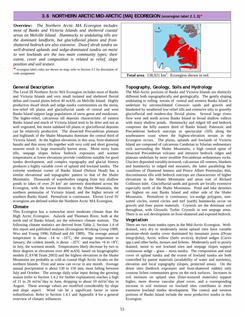
53
General Description The Level III Northern Arctic MA Ecoregion includes most of Banks and Victoria Islands and very small isolated and sheltered fluvial deltas and coastal plains below 40 mASL on Melville Island. Highly productive dwarf shrub and sedge tundra communities on the moist, low-relief till plains and glaciofluvial sands of central and west Banks Island support large populations of snow geese and muskoxen. The higher-relief, calcareous till deposits characteristic of eastern Banks Island and much of Victoria Island tend to be drier and not as well vegetated, but moist subdued till plains or glaciofluvial deposits can be relatively productive. The dissected Precambrian plateaus and highlands of the Shaler Mountains dominate the central third of Victoria Island. At the highest elevations in this area, frost-shattered basalts and thin stony tills together with very cold and short growing seasons result in large essentially barren areas. Moist stony loam tills, seepage slopes below bedrock exposures and warmer temperatures at lower elevations provide conditions suitable for good tundra development, and complex topography and glacial history produces a highly variable cover of upland and lowland tundra. The extreme southeast corner of Banks Island (Nelson Head) has a similar elevational and topographic pattern to that of the Shaler Mountains. Thousands of waterbodies ranging from tiny shallow ponds to lakes of over 20 km2 are unevenly distributed across the Ecoregion, with the lowest densities in the Shaler Mountains, the northern peninsulas of Victoria Island, and the higher terrain of southern Banks Island. Permafrost is continuous. Eleven Level IV ecoregions are defined within the Northern Arctic MA Ecoregion. Climate This Ecoregion has a somewhat more moderate climate than the High Arctic Ecoregion. Aulavik and Thomsen River, both at the north end of Banks Island, are the reference climate stations. The following climate statistics are derived from Table 2, Section 1.4 of this report and published analyses (Ecoregions Working Group 1989; Woo and Young 1996; Edlund and Alt 1989). The average annual temperature is about –14 to –16oC, the average temperature in January, the coldest month, is about –35oC and reaches +6 to +8oC in July, the warmest month. Temperatures likely decrease by two to three degrees at elevations over 400 mASL based on biogeographic models (CAVM Team 2003) and the highest elevations in the Shaler Mountains are probably as cold as coastal High Arctic locales on the northern Islands. Frost and snow can occur in any month. Average annual precipitation is about 130 to 150 mm, most falling between July and October. The average daily solar input during the growing season (refer to Section 1.4.2 for further explanation) reaches a high of 21 to 26 mJ/m2/day in June, dropping to about 10 mJ/m2/day in August. These average values are modified considerably by slope and slope aspect. Wind can be a significant factor in snow redistribution. Refer to Section 1.4.1 and Appendix 4 for a general overview of climatic influences.
Topography, Geology, Soils and Hydrology The Mid-Arctic portions of Banks and Victoria Islands are distinctly different both topographically and geologically. The gently sloping undulating to rolling terrain of central and western Banks Island is underlain by unconsolidated Cenozoic sands and gravels and blanketed by weathered low-relief tills and extensive silty to gravelly glaciofluvial and modern-day fluvial plains. Several large rivers flow west and north across Banks Island in broad shallow valleys with many shallow ponds. Hummocky and ridged till and bedrock comprises the hilly eastern third of Banks Island; Paleozoic and Precambrian bedrock outcrops as spectacular cliffs along the southeastern coast where the highest-elevation terrain in the Ecoregion occurs. The plains, uplands and lowlands of Victoria Island are composed of calcareous Cambrian to Silurian sedimentary rock surrounding the Shaler Mountains, a high central spine of dissected Precambrian volcanic and intrusive bedrock ridges and plateaus underlain by more erodible Precambrian sedimentary rocks. Glaciers deposited variably-textured, calcareous till veneers, blankets and hummocky to ridged end moraines, the latter paralleling the coastlines of Diamond Jenness and Prince Albert Peninsulas; thin, discontinuous tills with bedrock outcrops are characteristic of higher elevations in the Shaler Mountains and areas east of Richard Collinson Inlet. Glaciofluvial sands and gravels are locally extensive especially north of the Shaler Mountains. Pond and lake densities are highest on east Banks Island and either side of the Shaler Mountains. Permafrost is continuous; ice-wedge polygons, non-sorted circles, sorted circles and turf (earth) hummocks occur on gravels and finer parent materials. Cryosols are the dominant soil throughout, with Gleysolic Turbic Cryosols in wet seepage areas. There is no soil development on frost-shattered and exposed bedrock. Vegetation There are two main tundra types in the Mid-Arctic Ecoregion. Well-drained, very dry to moderately moist upland sites have variable prostrate-shrub tundra cover dominated by mountain avens (Dryas integrifolia), Arctic willow (Salix arctica), dryland sedges (Carex spp.) and other herbs, mosses and lichens. Moderately well to poorly drained, moist to wet lowland sites and seepage slopes support continuous sedge – grass – moss tundra. The composition and total cover of upland tundra and the extent of lowland tundra are both controlled by parent materials (availability of water and nutrients), elevation and local topography (slopes, protected areas). On the driest sites (bedrock exposures and frost-shattered rubble) only crustose lichen communities grow on the rock surfaces. Increases in soil moisture on upland sites (finer-textured materials) support higher, more diverse vascular plant cover, and a corresponding increase in soil moisture on lowland sites contributes to more extensive lowland tundra development. The central and western portions of Banks Island include the most productive tundra in this Ecoregion.
3.6 NORTHERN ARCTIC MID-ARCTIC (MA) ECOREGION (ecoregion label 2.1.3)*
Overview: The Northern Arctic MA Ecoregion includes most of Banks and Victoria Islands and sheltered coastal areas on Melville Island. Hummocky to undulating tills are the dominant landform, but glaciofluvial plains and frost-shattered bedrock are also extensive. Dwarf shrub tundra on well-drained uplands and sedge-dominated tundra on moist to wet lowlands are the two main community types; their extent, cover and composition is related to relief, slope position and soil texture. * ecoregion label codes are shown on map; refer to Section 3.1 for discussion of code assignment
Total area: 138,921 km2. Ecoregion shown in red.

54
3.6.1 Melville Coastal Plain MA Ecoregion (ecoregion label 2.1.3.1)*
Overview: The Melville Coastal Plain MA Ecoregion includes 24 small subunits in sheltered locales within inlet and along the coast. Moist soils support continuous tundra characteristic of Mid-Arctic climates on islands south of M’Clure Strait; it provides diverse habitat for a variety of wildlife species.
Summary: · Sheltered or south-facing coastal locations. · Moist fluvial and marine clays to gravels with a
continuous, diverse tundra cover having Mid-Arctic characteristics.
* ecoregion label codes are shown on map; refer to Section 3.1 for discussion of code assignment.
Total area: 1,378 km2 (1% of Northern Arctic Ecoregion). Ecoregion subunits shown in red.
Average elevation (range) mASL: 20 (0 – 80).
General Description The Melville Coastal Plain MA Ecoregion includes 24 small subunits on Melville Island. All of these subunits occur at elevations below 60 mASL on level to gently sloping coastal and fluvial plains within inlets or on south-facing coastal slopes that are subject to less extreme temperatures than the adjacent uplands. The three largest subunits are Winter Harbour (south coast of Dundas Peninsula), Bailey Point (south coast of Liddon Gulf) and McCormick Inlet (southwest coastline of Hecla and Griper Bay); the most northerly subunit is on a fluvial fan in a shallow inlet on the west coast of Canrobert Hills peninsula. Low elevations, discontinuous pack ice late in the growing season, sheltered and south-facing sites and soil characteristics together create localized Mid-Arctic environments. Moist gravelly to clayey soils of marine and fluvial origin are vegetated by continuous tundra with a diverse flora that includes species that are common in the Mid-Arctic but uncommon in most of the High Arctic. Permafrost is continuous, and its presence is mainly indicated by ice-wedge polygons, non-sorted circles and stripes, and turf hummocks. This Ecoregion is recognized despite its small size because it is disproportionately important for wildlife, providing forage for Peary caribou, muskoxen and smaller herbivores that are prey species for wolves and Arctic foxes and habitats for numerous other vertebrate and invertebrate species.
Geology and Geomorphology Bedrock underlying each of the subunits is the same as that in the adjacent uplands; most subunits are adjacent to the Central Melville Upland HA, and are underlain by Devonian sandstones, siltstones and shales, with calcareous bedrock near the most northerly Mid-Arctic subunit on Canrobert Peninsula. Reddish-orange shales thought to have been produced by spontaneous ignition and subsequent weathering (Harrison 1994) occur within part of the isolated eastern subunit beside McCormick Inlet. Melville Island was glaciated during the last Laurentide event (Dyck et al. 2002) and much of the area occupied by the Ecoregion was subsequently flooded by marine transgressions along the coast (Prest et al. 1968), generally to present-day elevations of 60 mASL or less. Beach ridges indicate past sea levels in some places. Glaciofluvial, marine and current fluvial processes (delta formation, alluvial terrace development in braided stream environments which occur in most of the subunits) have produced gravelly to clayey coastal plains that receive moisture from seepage and streamflow and that are reasonably well supplied with nutrients. Ice-wedge polygons and non-sorted circles and stripes are the most common permafrost forms but are not widespread; turf hummocks develop in silty to clayey soils with good tundra development on level to gentle slopes.
Soils Orthic Turbic Cryosols are dominant, with Regosolic Turbic Cryosols in areas where parent materials are continually disturbed, such as fluvial plains, tidal flats and coastlines.
Vegetation All of the subunits have more diverse tundra with more continuous cover than the adjacent Central Melville Upland HA Ecoregion. They are too small to show on the Circumpolar Arctic Vegetation Map (scale 1:7,500,000), but would include graminoid – prostrate dwarf-shrub – forb tundra, prostrate dwarf-shrub – herb tundra and prostrate/hemiprostrate dwarf-shrub tundra, with sedge – grass – moss tundra in wet areas (CAVM Team 2003). Edlund (1990) shows many of the subunits including the three largest subunits named in the General Description on a vegetation map of Melville Island (scale 1:250,000) and assigns them to “Bioclimate Zone 4: enriched prostrate shrub zone”, characterized by a mean July air temperature above 5oC. In this zone, Dryas – Salix tundra is the main vegetation type and includes the three CAVM types mentioned above. It is recognizable from the air by areas of continuous green to gray-green tundra cover at low elevations, and on the ground by the presence of indicator species that are typical of neutral to mildly calcareous well-drained soils in Mid-Arctic climates south of M’Clure Strait but absent or uncommon across the northern islands. These species include mountain avens (Dryas integrifolia), Arctic willow (Salix arctica), members of the pea family (Oxytropis spp., Astragalus spp.) and members of the aster family (Arctic butter-bur [Petasites frigidus], snow arnica [Arnica frigida], northern dandelion [Taraxacum phymatocarpum] and others). Dense, species-rich sedge meadows occupy wet areas and similarly have species that are absent or uncommon in the High Arctic. Water and Wetlands Almost all subunits include the lower terminus of rivers and creeks flowing from the highlands. All of the subunits are influenced by ocean waters and sea ice in some manner; the Ecoregion lies adjacent to the Central Arctic Archipelago Marine Ecoregion (Wilkinson et al. 2009). Notable Features The Bailey Point area on the north side of Liddon Gulf has been recognized for its high habitat value (Thomas et al. 1981) and is recognized as significant in the Olokhaktomiut Community Conservation Plan (2008). William Parry’s expedition spent the winter of 1819 at Winter Harbour in their search for the Northwest Passage. Parry Rock, on which the names of the ships and their captains were chiselled by the party surgeon, was designated a national historic site in 1930 (Parks Canada 2012).

55
3.6.1 Melville Coastal Plain MA Ecoregion
The most northerly of the subunits occupies a broad, flat valley within the Canrobert Hills (background). The tundra here is highly productive for this area. The green patch in the midground is river beauty (Chamerion latifolium). The pink flowers are a type of lousewort that is uncommon on the islands north of M’Clure Strait. NWT_RD2011-07-12DSC_0344.JPG
This plant, alpine milk vetch (Astragalus alpinus) is a member of the pea family and grows with other plants on the moist calcareous river flat in the left-hand image. It, along with other members of the pea family, are restricted to warmer locales on Melville, Eglinton and Prince Patrick Islands. It is probably at its northern limits here (Edlund and Alt 1989). NWT2011-07-12DSC_0503.JPG
Sandy-textured moist deposits on bouldery river flats just west of Bailey Point in a relatively warm sheltered valley support diverse, productive prostrate shrub and herb tundra which provides excellent habitat for wildlife. NWT2011-07-11DSC_0207.JPG
Lower slopes receiving moisture are also prime wildlife habitat. The sharp contrast between the gray-brown bouldery slope and the green tundra marks the position of contact springs (arrows), where groundwater surfaces. The slopes below the contact springs receive water and nutrients that, together with the southerly aspect and low elevation, create locally favourable growing conditions. NWT2011-07-11DSC_0127.JPG

56
3.6.1 Melville Coastal Plain MA Ecoregion
The Bailey Point area north of Liddon Gulf is one of the largest subunits in the Ecoregion. South-facing slopes are warmed by the sun, seepage from snowmelt and groundwater supplies moisture and nutrients to the soil, and better tundra development than elsewhere on Melville Island is the result. NWT_RD2011-07-11DSC_0246.JPG
This ground view of Bailey Point looks across Liddon Gulf to the low, flat-topped plateau of Dundas Peninsula about 30 km distant. In the foreground, a thick carpet of prostrate willows, grasses, forbs and mosses grows on moist calcareous soils. The weathered skeleton of a muskox attests to the habitat value of this area. NWT_RD2011-07-11DSC_0307.JPG
The gravelly calcareous soils of Winter Harbour on the south side of Dundas Peninsula are drier than those of Bailey Point and are not as well vegetated. The presence of muskox tracks, scat and bones (not shown) indicates that this area is also valuable habitat. NWT2011-07-13DSC_0376.JPG
Parry Rock at Winter Harbour marks the 1819 winter camp of William Parry’s unsuccessful attempt to sail through the Northwest Passage. The gray metal plaque at its centre was placed by Captain J-E. Bernier on July 1 1909, claiming Canadian sovereignty over all Arctic islands between 60o and 141o longitude to the North Pole. NWT2011-07-13DSC_0371.JPG

57
3.6.1 Melville Coastal Plain MA Ecoregion
The circle of life in this Mid-Arctic tundra pocket at the south end of Hecla and Griper Bay begins with rich moist soils that support continuous tundra in a low-elevation area protected from winter storms by highlands to the west. NWT_RD2011-07-15DSC_0429.JPG
Muskoxen graze on the tundra plants, preferring sedges and grasses in wet meadows during the summer and supplementing that food source with willows, herbs and grasses from ridges and slopes that are windblown and snow-free during winter. NWT2011-07-11DSC_0207.JPG/ inset NWT2011-07-11DSC_0208.JPG
Muskox bones and a new generation of wolves attest to the success of some hunts. What the wolves do not eat is consumed by scavengers, insects and microbes, ultimately returning nutrients to the soil that can be used by plants, promoting tundra growth. NWT2011-07-15DSC_0309.JPG /NWT_RD2011-07-15DSC_0441.JPG wolf pup
Wolves hunt the muskoxen that with their body mass, horns and defense strategies are formidable prey species; they protect their calves within a circle of adults facing outward. Hunts are not often successful. Upper left: NWT2011-07-15DSC_0299.JPG: Main: NWT_RD2011-07-26DSC_0493.JPG bull (from Victoria Island).

58
3.6.2 West Banks Coastal Plain MA Ecoregion (ecoregion label 2.1.3.2)*
Overview: The West Banks Coastal Plain MA Ecoregion is a level to undulating marine-fluvial plain with extensive wetlands surrounding thousands of small ponds and dry uplands with variable tundra cover. It is an important breeding area for thousands of lesser snow geese.
Summary: · Mix of gravelly, sandy and silty marine, fluvial and
weathered till deposits. · Extensive sedge - moss wetlands surrounding small
ponds and well-drained tundra-covered uplands.
* ecoregion label codes are shown on map; refer to Section 3.1 for discussion of code assignment.
Total area: 9,497 km2 (4% of Northern Arctic Ecoregion). Ecoregion shown in red.
Average elevation (range) mASL: 40 (0 – 160).
General Description The West Banks Coastal Plain MA Ecoregion occupies level to gently rolling terrain in a band from 30 to 50 km wide, about 240 km from north to south, and includes several small offshore islands. Elevations are generally below about 80 mASL except for an area north of the Bernard River that reaches elevations of 160 mASL. It occurs at lower elevations and has a higher proportion of wetlands than the Central Banks Upland MA Ecoregion to the east. Broad, wet river floodplains, meltwater channels and marine lowlands are vegetated by sedge and moss fens and speckled by thousands of shallow ponds. The interspersed undulating to rolling uplands are dry, well drained weathered tills and bedrock with sparse to continuous herb and prostrate shrub tundra cover. Ponds are less extensive and both upland and wetland vegetation is sparser to the north of the Bernard River, where colder temperatures at higher elevations and latitudes indicate a transition to High Arctic conditions. Permafrost is continuous, and its presence is mainly indicated by ice-wedge polygons, non-sorted circles and stripes, low- and high-centre polygons, and turf hummocks. Much of this Ecoregion is within the Banks Island Bird Sanctuary No. 1, established to protect breeding habitat for waterfowl.
Geology and Geomorphology The Ecoregion is underlain by gently sloping poorly lithified Cenozoic sands and gravels of the Beaufort Formation. Broad gravelly to silty glaciofluvial and modern-day fluvial plains and terraces cover about 30 percent of the Ecoregion. Glacial meltwater channels are occupied by large braided rivers and a complex of ponds, wetlands and fluvial terraces. Frequently flooded terraces are mostly unvegetated, but terraces that are protected from flooding by levees or elevation are tundra-covered with well-developed ice-wedge polygons. Marine silts, sands and gravels occur in discontinuous pockets along the coastline. The Ecoregion was ice-covered during the last glaciation by a cold-based glacier (England et al. 2009). Undulating to rolling rounded, weathered till and bedrock occur across the remaining 70 percent of the Ecoregion. Continuous permafrost is indicated by the widespread and common occurrence of ice-wedge polygons, non-sorted circles and stripes and turf hummocks. Organic landforms including low-centre polygons and remnant high-centre polygons are common and locally extensive in wet valley bottoms. Soils Orthic Turbic Cryosols and Gleysolic Turbic Cryosols are the dominant soil types, the latter in low-lying wet areas along the coast and in broad, flat poorly drained valley bottoms. Organic Fibric Cryosols may be associated with high-centre polygons, and organic deposits derived from mosses and sedges are common in wet lowlands.
Vegetation Graminoid – prostrate dwarf-shrub – forb tundra and sedge – grass – moss tundra are the dominant types shown on the Circumpolar Arctic Vegetation Map (CAVM Team 2003). Hines et al. (2010) conducted an intensive land cover survey across Banks Island Bird Sanctuary No.1 that includes all of the Ecoregion except the area north of Bernard River. They described six terrestrial cover classes, of which three are dominant within the Ecoregion. The lowland pond complex (similar to the CAVM sedge – grass – moss tundra type) is concentrated in the broad meltwater channels of the Egg, Big and Storkerson Rivers and their tributaries. Water sedge (Carex aquatilis) and mosses (Drepanocladus spp. and others) occur on peaty wetlands between small circular ponds. The moist and wet tundra type (also similar to the sedge – grass – moss tundra type) is associated with the Bernard River floodplain and with lower slopes, valley bottoms, snowpatch seepage areas, and low centre polygons in stream drainages. Major species are sedges, cottongrasses (Eriophorum spp.), grasses and mosses; cover is mostly continuous. The dwarf shrub – herb type (similar to the CAVM graminoid – prostrate dwarf-shrub – forb tundra type) occupies upper slopes, hilltops and dry fluvial terraces. Mountain avens (Dryas integrifolia), Arctic willow (Salix arctica), locoweed (Oxytropis spp.), purple saxifrage (Saxifraga oppositifolia), dryland sedges and other herbs are the main species that grow mainly in moist cracks between non-sorted circles, stripes and ice-wedge polygons or exhibit more continuous cover on moist lower slopes. Low-lying fluvial terraces subject to disturbance by flooding and stream erosion are mostly unvegetated. Water and Wetlands Countless ponds dot the coastline and occupy the broad flat valleys of old meltwater channels but are less common in upland areas. There are many named rivers and creeks; the main rivers from south to north are the Egg, Big, Storkerson and Bernard Rivers. The Bernard River has its origins in the East Banks Hills MA Ecoregion over 200 km to the southeast. This Ecoregion probably has the highest proportion of wetlands of any Ecoregion in the Northwest Territories Northern Arctic. It lies adjacent to the Central Arctic Archipelago Marine Ecoregion (Wilkinson et al. 2009). Notable Features The low, wet tundra – pond complex within the Ecoregion provides breeding habitat for thousands of lesser snow geese, other waterfowl, and shorebirds. It is a designated Important Bird Area (Latour et al. 2006) and is recognized as ecologically and culturally significant in the Sachs Harbour Community Conservation Plan (2008). Norway Island is an important denning area for polar bear, and muskoxen were commonly sighted during aerial traverses in 2010 and 2011.

59
3.6.2 West Banks Coastal Plain MA Ecoregion
Small ponds surrounded by wetlands and dry uplands are characteristic of broad meltwater channels in the Ecoregion. The green and brownish-orange tones around the shallow ponds are sedge and moss wetlands. In the foreground, the speckled area is frost-heaved river gravel with herb and grass tundra. The gravelly terraces of Big River show as a very thin gray band running east to west in the distance. NWT2010-07-16DSC_0370.JPG adjust colors
Gently rolling hills with dry tundra cover (arrows - greenish-gray tones) and moist sedge and cottongrass tundra on the lower slopes and valleys (light green tones) is characteristic of higher terrain throughout the Ecoregion. These areas provide excellent muskox habitat. NWT2010-07-20DSC_0051.JPG
Although the pond-wetland complex in the upper left image may look uniformly wet from an aerial view, it is not. The foreground in this image is dry tundra dominated by cushions of mountain avens, dryland sedges, lichens and mosses. The greener tones in the midground are moist tundra with a higher component of willows and sedges. In the wettest places (not shown here) stands of water sedge (Carex aquatilis) and mosses are found. NWT_RD2011-07-21DSC_0073.JPG
The diversity of local landscapes, abundant vegetation in the lowlands and close proximity to ponds provides excellent nesting and brood rearing habitat for lesser snow geese. The smaller gray-coloured birds are goslings that cannot fly yet and that depend upon access to water to escape predators such as Arctic foxes. NWT2011-07-20DSC_0098.JPG

60
3.6.3 Central Banks Upland MA Ecoregion (ecoregion label 2.1.3.3)*
Overview: The Central Banks Upland MA Ecoregion spans the length of Banks Island. It includes broad fluvial plains and undulating to rolling bedrock and till uplands. The gray-green tones of dry upland dwarf shrub-herb tundra contrast strongly with the verdant hues of moist sedge tundra on lower slopes.
Summary: · Mostly a rolling to undulating low-relief sandy till
plain, with significant glaciofluvial deposits. · Dwarf shrub – herb tundra on well-drained uplands,
with sedge-dominated tundra on moist slopes and valley bottoms.
* ecoregion label codes are shown on map; refer to Section 3.1 for discussion of code assignment.
Total area: 29,843 km2 (14% of Northern Arctic Ecoregion). Ecoregion shown in red.
Average elevation (range) mASL: 100 (20 – 400).
General Description The Central Banks Upland MA Ecoregion is the largest Ecoregion in the Northern Arctic, extending nearly the full length of Banks Island and occupying approximately half of its area. It is mostly a level to rolling plain averaging 100 mASL with low-relief valleys; the southern and northern ends are dissected hilly landscapes, reaching elevations of 350 to 400 mASL. It has a lower proportion of wetlands than the West Banks Coastal Plain MA Ecoregion to the west, less continuous tundra than the Thomsen Valley MA Ecoregion to the northeast, and fewer lakes and mostly gentler terrain than the East Hills MA Ecoregion to the east. Parent materials include weathered tills, extensive fluvial and glaciofluvial plains, and weathered bedrock. The dominant tundra types are sparse to continuous herb and prostrate shrub cover on the uplands, with sedge – grass tundra on moist slopes and valley bottoms. Tundra form and composition change from south to north, with species more typical of Low Arctic and High Arctic climates in the extreme south and north, respectively. The presence of continuous permafrost is indicated by a number of features. Organic deposits are locally extensive in valley bottoms.
Geology and Geomorphology The Ecoregion is partly underlain by gently sloping poorly lithified Cenozoic sands and gravels of the Beaufort Formation and partly by highly erodible shales, siltstones and sandstones of the slightly older Eureka Sound Formation. Broad gravelly to silty glaciofluvial and modern-day fluvial plains and terraces cover about 30 percent of the Ecoregion. Weakly calcareous weathered sandy loam till occurs across the remaining 70 percent of the Ecoregion. Continuous permafrost is indicated by the widespread and common occurrence of ice-wedge polygons, non-sorted circles and stripes and turf hummocks; retrogressive flow slides are locally common near M’Clure Strait. Organic deposits associated with low-centre polygons and remnant polygonal peat plateaus are widespread and locally extensive in wet valley bottoms. Soils Orthic Turbic Cryosols are the dominant soils on dry to moist sites. Gleysolic Turbic Cryosols are associated with wet soils. Fibric and Mesic Organic Cryosols are locally extensive in valley bottoms with low-centre polygons and remnant polygonal peat plateaus. Vegetation Most of the Ecoregion is dominated by two plant community types. The most extensive type, the graminoid – prostrate dwarf-shrub – forb type (CAVM Team 2003) occupies uplands across 70 to 80 percent of the Ecoregion. Mountain avens (Dryas integrifolia),
Arctic willow (Salix arctica) and dryland sedges are the main species, with several other herbs, grasses, mosses and lichens typical of Mid-Arctic climates and calcareous soils. On dry soils, tundra cover is discontinuous and plants grow mainly in moist frost cracks and erosion rills. On moister soils, tundra covers more of the soil surface. The complex of dry to moist sites produces a gradation of colour tones in aerial views; tan to light gray-green colours are associated with dry sites and discontinuous Dryas-dominated tundra, and distinctly green hues are associated with more continuous, species-rich tundra on moist, silty soils especially in the northernmost part (refer to Section 3.6.4: Vegetation for further discussion). The second type, the sedge – grass – moss tundra type, occupies 20 to 30 percent of the Ecoregion and is associated with valleys and seepage areas below snow patches. A continuous mat of sedges, cotton-grasses, willows and a variety of herbs and mosses impart a bright green colouration that contrasts strongly with the gray-green tones of typical upland tundra. Zoltai (1997) identified a tundra type similar to the CAVM rush – grass– forb – cryptogam tundra. It includes Luzula spp., Saxifraga oppositifolia and prostrate Salix arctica and occurs at elevations above 200 mASL north of the Bernard River; it is likely indicative of a climate intermediate between Mid-Arctic and High Arctic. Hines et al. (2010) associate a lowland pond complex (most similar to the CAVM sedge – grass – moss tundra type) with the broad lake-studded meltwater plains of the Big and Storkerson Rivers and their tributaries. It occupies less than five percent of the Ecoregion. Water and Wetlands Lake density and parent material appear to be related in this Ecoregion; the highest lake and pond densities are associated with glaciofluvial plains and broad meltwater channels. A dense network of drainage channels, most occupied by ephemeral streams, feeds into several major rivers. The main rivers from south to north are Big River, Storkerson River and Bernard River, all of which flow west across the Ecoregion. Most of the Bernard River lies within the Ecoregion. Wetlands are common in valley bottoms; the extensive presence of eroding high-centre polygons suggests that warmer, moister paleoclimates promoted wetland vegetation growth and the slow accumulation of deep peat deposits (Zoltai et al. 1980). Notable Features This Ecoregion is part of Banks Island Bird Sanctuary No. 1 and Aulavik National Park and is recognized as ecologically and culturally significant in the Sachs Harbour Community Conservation Plan (2008).

61
3.6.3 Central Banks Upland MA Ecoregion
Dry gravels deposited by glacial rivers occupy the central part of the Ecoregion. The gray tones on uplands are sparse dwarf shrub and grass tundra; the green tones in low areas are wetter sedge meadows with black-coloured cryptogamic crusts. In the ground-view inset, patches of mountain avens and dryland sedge are surrounded by lichen-covered stones. NWT2011-07-22DSC_0137.JPG/ inset NWT2011-07-22DSC_0106.JPG zoom &crop
Better tundra development on finer-textured eroded tills in the southern part of the Ecoregion is indicated by grayish-green tones on the frost-patterned uplands. In the ground-view inset, a dense cover of willow, saxifrage, cinquefoil, grasses, sedges and mosses completely covers the mineral soil. The Ecoregion provides excellent muskoxen habitat; a small herd is visible at the tip of the arrow. NWT_RD2011-07-22DSC_0007.JPG/ inset NWT_RD2011-07-22DSC_0063.JPG
Thick frost-cracked blankets of decomposed mosses, sedges and other plants are common in moist to wet areas. The brown peat hummocks are dry on top and lightly vegetated by grasses, sedges, mountain avens and willows; the moist to wet green channels between them have a dense cover of sedge and willow. NWT2011-07-20DSC_0128.JPG
These showy flowering plants are commonly found in Mid-Arctic tundra. Clockwise from upper left, they are capitate lousewort (Pedicularis capitata), moss campion (Silene acaulis), prickly saxifrage (Saxifraga tricuspidata) and narrowleaf arnica (Arnica angustifolia). NWT_RD2011-07-22DSC_0138.JPG/ NWT_RD2011-07-22DSC_0052.JPG/ NWT_RD2011-07-22DSC_0192.JPG/ NWT_RD2011-07-22DSC_0194.JPG

62
3.6.4 Thomsen Valley MA Ecoregion (ecoregion label 2.1.3.4)*
Overview: The Thomsen Valley MA Ecoregion is a low elevation low-relief till and weathered bedrock plain with good tundra development on uplands and dense, continuous sedge meadows in depressions.
Summary: · Mostly a dissected till and weathered bedrock plain
with low-relief valleys and extensive ice-wedge polygon development.
· Diverse continuous tundra on moist fine-textured soils in the north, variable tundra cover on drier soils, extensive sedge wetlands in lowlands.
* ecoregion label codes are shown on map; refer to Section 3.1 for discussion of code assignment.
Total area: 4,780 km2 (2% of Northern Arctic Ecoregion). Ecoregion shown in red.
Average elevation (range) mASL: 80 (0 – 260).
General Description The Thomsen Valley MA Ecoregion includes most of the Thomsen River. Narrow fluvial, glaciofluvial and eolian plains parallel the river. Most of the surrounding Ecoregion is a low elevation, low-relief dissected plain. Erodible bedrock and loamy, moderately calcareous tills are the main parent materials. In the northern third of the Ecoregion, soft, dark-gray shaly bedrock weathers to fine-textured, moist soils that support a dense, diverse green carpet of prostrate shrub and herb tundra. Soils in the southern two-thirds of the Ecoregion are sandier and drier, and shrub-herb tundra cover is controlled by local moisture supply, with better development in moist frost cracks and on concave and lower slopes receiving seepage. Sedge, grass and cotton-grass dominated wetlands are a conspicuous landscape feature of low-lying areas, their bright-green hues contrasting strongly with the green and gray-green tones of upland tundra. Organic deposits are locally extensive in valley bottoms. The combination of upland and wetland tundra communities and relatively sheltered lowlands produces some of the best muskox habitat in the Northern Arctic. Geology and Geomorphology Cretaceous shales and sandstones underlie most of the Ecoregion, with a minor area of frost-shattered Devonian sandstones, siltstones, shales and limestones in the east-central portion and erodible Cenozoic shales in the west-central portion. A narrow (1 to 4 km wide) band of gravelly to sandy fluvial, glaciofluvial and eolian deposits parallels the Thomsen River. It is flanked by weakly to moderately calcareous loamy tills and weathered shaly residuum derived from underlying bedrock. These upland parent materials provide adequate moisture and nutrients for continuous tundra development on uplands and wetlands. South and east of Mercy Bay, erosion-resistant limestone outliers of the plateau to the east are surrounded by glaciomarine and till deposits; the largest of these outliers is named Gyrfalcon Bluff. Continuous permafrost is indicated by the widespread and common occurrence of ice-wedge polygons, non-sorted circles and stripes, turf hummocks and retrogressive flow slides in silty materials. Low-centre polygons and eroded high-centre polygons are common in wet valley bottoms. There are a few low pingos along the Thomsen River. Soils Orthic Turbic Cryosols are common and widespread on the uplands. Regosolic Turbic Cryosols are associated with fluvial and eolian materials and are the dominant soils adjacent to the Thomsen River. Gleysolic Turbic Cryosols occur in wet depressions between uplands and underlie wet sedge meadows. Fibric and Mesic Organic Cryosols are locally extensive in valley bottoms and form low-centre polygons and eroding high-centre polygons.
Vegetation The Ecoregion includes some of the most productive tundra areas on Banks Island. The Circumpolar Arctic Vegetation Map (CAVM Team 2003) delineates two major plant community types within the Ecoregion, the graminoid – prostrate dwarf-shrub – forb type in the northern third, and the prostrate dwarf-shrub – forb tundra type in the southern two-thirds. The graminoid – prostrate dwarf-shrub – forb type corresponds to the Salix – Grass Tundra Subtype described by Zoltai et al. (1980) for the Thomsen River area. From the air and on the ground, this upland tundra type is markedly different from typical dry upland tundra cover in the southern part of the Ecoregion and elsewhere on most of Banks Island. In typical prostrate dwarf-shrub – forb tundra, a combination of live and dead leaves in tussocks of mountain avens (Dryas integrifolia) imparts a greenish-gray colour, the intensity of which is dependent on its total cover. In the northern part of the Ecoregion, Dryas tussocks have fewer dead leaves. Along with Arctic willow (Salix arctica), legumes (Astragalus spp., Oxytropis spp.), other herbs and various grasses and sedges, the resulting continuous upland tundra cover has a distinctly different green hue. This tundra type appears to be associated with dark-coloured silty weathered shales and tills that provide moisture and nutrients and that occur at relatively low elevations (below 150 mASL) in the Thomsen River valley and on uplands to the west in the Central Banks MA Ecoregion. Sedge – grass – moss wetlands occupy moist to wet low areas and depressions. Covering approximately 30 percent of the Ecoregion, their bright green tones contrast strongly with upland vegetation. Minor areas of frost-shattered bedrock and active fluvial and eolian deposits are barren to sparsely vegetated. Water and Wetlands The Thomsen River is the main watercourse; the Muskox River and White Sand Creek are its major tributaries. Shoran Lake is the only named waterbody and there are a few large lakes east of the Thomsen River. Mercy and Castel Bays are prominent marine features that are part of the Central Arctic Archipelago Marine Ecoregion (Wilkinson et al. 2009). The Investigator, a ship commanded by Captain M’Clure who was searching for a route through the Northwest Passage, was icebound in Mercy Bay in 1851 and sank sometime later; its current location was discovered by Parks Canada divers in 2010. Notable Features This Ecoregion includes the northern component of Banks Island Bird Sanctuary No. 1 and lies entirely within Aulavik National Park. The interspersion of highly productive and diverse upland and wetland tundra provides excellent muskox habitat. Species typical of Low Arctic climates (Salix alaxensis, Arctostaphylos rubra) have been collected in the river valley.

63
3.6.4 Thomsen Valley MA Ecoregion
The upper image shows typical dry upland tundra as gray-green tones on well-drained soils with bright-green sedge meadows in the low areas and on valley slopes. The lower image shows diverse, continuous tundra on moist silty soils, with the Thomsen River in the background. NWT2010-07-19DSC_0086.JPG upper cell/NWT2011-07-22DSC_0502.JPG lower cell
Turf hummocks with mountain avens (Dryas integrifolia), Arctic willow (Salix arctica) and a variety of herbs, grasses and mosses constitute the diverse, continuous tundra in the lower image to the left. The inset shows a butterfly (Arctic fritillary, brown and white wings) resting on a willow catkin. NWT2011-07-22DSC_0485.JPG/ insetNWT2011-07-22DSC_0494.JPG
The mixture of diverse, productive upland tundra (greenish-gray colours to the right of the stream) and sedge meadows (bright green colours to the left of the stream) provides high-quality forage for muskoxen. NWT2011-07-22DSC_0295.JPG
Gyrfalcon Bluff is an outlier of the same limestone formation that underlies the Parker Plateau HA Ecoregion to the east. The cliffs have been continuously occupied by nesting gyrfalcons since at least the 1850’s when their presence was first recorded in survey journals. NWT2010-07-20DSC_0173.JPG

64
3.6.5 East Banks Hills MA Ecoregion (ecoregion label 2.1.3.5)*
Overview: The East Banks Hills MA Ecoregion is a complex of high eroded plateaus, low hills and undulating plains. Dry calcareous tills limit tundra development.
Summary: · High eroded plateaus in the south, discontinuous hills
in the central portion, dissected undulating to sloping plains in the north, with dry, silty calcareous tills.
· Sparse patchy dwarf shrub and herb tundra is the dominant cover type, with sedge wetlands in meltwater channels and depressions.
* ecoregion label codes are shown on map; refer to Section 3.1 for discussion of code assignment.
Total area: 14,493 km2 (7% of Northern Arctic Ecoregion). Ecoregion shown in red.
Average elevation (range) mASL: 150 (0 – 732).
General Description The East Banks Hills MA Ecoregion includes three subunits. The northern subunit is a sloping dissected loamy till plain with few lakes at the base of the Parker Plateau. The central subunit occupies most of the Ecoregion. At its southern end, it is part of an eroded plateau that narrows northward to form a discontinuous hill system along the coast surrounded by a low-relief plain. High lake and pond densities, loamy, calcareous tills, extensive ice-wedge polygons, numerous flow slides and widespread ice-contact features such as kame mounds, eskers and moraine are distinguishing features. The southern subunit is a deeply dissected domed plateau; it occurs south of DeSalis Bay and is characterized by elevations over 400 mASL, patchy tills, steep eroded slopes, weathered exposed bedrock and fewer lakes. Sparse, patchy prostrate shrub and herb tundra is the dominant cover type across most of the Ecoregion, reflecting dry, calcareous soils; tundra cover increases on lower slope positions and finer-textured soils where there is more available moisture. Sedge and cotton-grass meadows on seepage slopes and low-lying terrain occupy between five and 30 percent of the Ecoregion. Geology and Geomorphology Devonian shales underlie the northern subunit and its southern boundary coincides with an increase in lake density. Elsewhere, soft, poorly lithified Cretaceous to Cenozoic sandstones and shales form the dissected plateaus of the southern subunit and the narrow eroded hills of the central subunit. Impressive cliffs that mark the seaward extent of the southern subunit are Precambrian sandstones with interbedded igneous layers that formed when magma was forced along horizontal fractures in the sandstone. Highly calcareous silty tills blanket the northern and central subunits and include high-relief ice-contact kame, moraine and esker features, widespread and recent retrogressive flow slides and extensive ice-wedge polygon nets that give this Ecoregion a distinctly different appearance than the rounded, weathered tills of the adjacent Central Banks Upland MA Ecoregion. Pockets of sandy glaciofluvial and fine-grained glaciomarine sediments occur within the central subunit. The southern subunit is a complex of till and weathered bedrock on the plateau tops; variably-textured colluvium occurs on the slopes and valleys, and sorted circles on the plateau top, reflecting colder local climates. Low-centre and relict high-centre polygons are relatively uncommon and are mostly restricted to the central subunit. Soils Regosolic and Orthic Turbic Cryosols are probably the most common soils, with Gleysolic Turbic Cryosols in wet depressions
between uplands (Zoltai 1997). Fibric and Mesic Organic Cryosols are associated with low-centre polygons and eroding relict high-centre polygons. Vegetation The Circumpolar Arctic Vegetation Map (CAVM Team 2003) displays one general plant community type for the Ecoregion, the prostrate dwarf-shrub – forb tundra type. This type includes the Dryas barrens type of Vincent and Edlund (1978), who describe it as typical of the silty highly calcareous till dominating much of the Ecoregion. It includes mountain avens (Dryas integrifolia), with a minor component of Arctic willow (Salix arctica), alpine meadow-foxtail (Alopecurus alpinus), other grasses, dryland sedges and crucifers. Plants cover less than 20 percent of the ground surface and are mainly restricted to drainage runnels on slopes and in frost cracks where there is sufficient moisture. At the base of moister slopes, tussock tundra with a higher cover of mountain avens and arctic willow and higher herb diversity occurs. Sedge – grass – moss wetlands (CAVM Team 2003) are synonymous with the Carex-Eriophorum type of Vincent and Edlund (1978); these wetlands occupy moist to wet low areas and depressions which are most common in meltwater channels, and are readily distinguished by their bright green colouration. Observations made during the 2010 and 2011 field surveys revealed that better upland and wetland tundra development often occurs in association with sandy glaciofluvial and glaciomarine parent materials near ponds, where calcium levels are probably lower and moisture is in better supply. Water and Wetlands Numerous rivers have their headwaters in this Ecoregion, including the Thomsen, Big, Bernard, Atitok, Rufus, Masik and Nelson Rivers. Their tributaries carve deep V-shaped valleys into the southern plateaus. There are hundreds of ponds and lakes; although most are less than 0.2 km2, several lakes exceed 10 km2 and include the largest lakes on Banks Island. Wetlands are less common and less extensive than in the adjacent Central Banks MA Ecoregion and Thomsen Valley MA Ecoregion. Prince of Wales Strait on the eastern border is part of both the Central Arctic Archipelago and Beaufort-Chukchi Seas Marine Ecoregions (Wilkinson et al. 2009). Notable Features The sea cliffs along the southern boundary are a visually striking feature. The highest-elevation terrain on Banks Island occurs in the southern subunit, where sorted circles, sparse tundra with low species diversity and the presence of cryptogamic crusts indicates the influence of both Mid-Arctic and High Arctic climates. Durham Heights, at 732 mASL, is the highest point on Banks and Victoria Islands.

65
3.6.5 East Banks Hills MA Ecoregion
This image shows a typical landscape in this Ecoregion. A netlike pattern of ice-wedge polygons, each polygon several tens of metres on a side, has formed in dry glacial till that supports a generally sparse tundra cover. The bright green tones in the drained lakebed (midground) are sedge wetlands where denser plant cover responds to a constant moisture supply. NWT2010-07-16DSC_0182.JPG
A ground view of part of an ice-wedge polygon shows how sparse the vegetation is. Widely spaced clumps of mountain avens (Dryas integrifolia) grow on dry, gravelly silt soils. Better growth in the shallow track (a frost crack between two polygons) indicates a better moisture supply; the inset shows mountain avens, Arctic willow (Salix arctica) and mosses in the track. NWT2011-07-23DSC_0261.JPG/ inset NWT2011-07-23DSC_0260.JPG
Retrogressive flow slides form when permafrost melts; the meltwater liquefies silty till or lakebed deposits, causing them to flow downslope in a soupy mass. The inset shows the active edge of a flow slide; ice is overlain by silty till and melting releases boulders, gravels and mud. These areas are hazardous; the mud, like quicksand, cannot support any weight, and the active edge is constantly breaking away. NWT2011-07-23DSC_0251.JPG /insetNWT2011-07-23DSC_0262.JPG
Layered cliffs of ancient sedimentary and igneous rock rise nearly 300 metres from the Beaufort Sea near Nelson Head. Talus cones at the base of the cliffs and outlying spires of resistant rock indicate the slow continuous progress of erosion. NWT2010-07-17DSC_0492.JPG

66
3.6.6 West Prince Albert Lowland MA Ecoregion (ecoregion label 2.1.3.6)*
Overview: Dry, calcareous undulating to hummocky till and glaciofluvial deposits with sparse tundra cover on uplands and sedge tundra on seepage slopes define the West Prince Albert Lowland MA Ecoregion.
Summary: · Undulating to hummocky tills and glaciofluvial deposits,
some areas of bedrock and windblown sands. · Sparse patchy dwarf shrub and herb tundra is the
dominant cover type, with sedge wetlands in meltwater channels and depressions.
* ecoregion label codes are shown on map; refer to Section 3.1 for discussion of code assignment.
Total area: 20,536 km2 (9% of Northern Arctic Ecoregion). Ecoregion shown in red.
Average elevation (range) mASL: 140 (0 – 460).
General Description The West Prince Albert Lowland MA Ecoregion occupies most of the Prince Albert Peninsula on Victoria Island and includes three subunits. The central subunit includes most of the Ecoregion. It is an undulating to hummocky plain comprised of sandy to clayey calcareous tills that surrounds the somewhat higher West Prince Albert Upland MA Ecoregion; it also includes a large west-central glaciofluvial lowland, low hills in the southern third, and many ponds and lakes. The eastern subunit is a gently sloping marine plain that extends southwest of Richard Collinson Inlet up to an elevation of about 150 mASL. Large, windblown, nearly barren sand flats with only a few lakes are a distinguishing feature of this subunit. The southern subunit is a small higher-elevation dissected Precambrian bedrock plateau with thin, discontinuous tills, frost-shattered bedrock and rock outcrops east of Walker Bay and west of several large lakes in the southeast corner. Sparse, patchy prostrate shrub and herb tundra is the dominant cover type across most of the Ecoregion on dry, calcareous tills or thin, stony soils over bedrock; more continuous tundra cover is associated with finer-textured tills and drumlin fields in the northwest and southeast parts of the Ecoregion. Sedge and cotton-grass meadows on seepage slopes and low-lying terrain occupy about 30 percent of the Ecoregion. Permafrost features such as ice-wedge polygons are widespread and well-developed especially on sandy to clayey parent materials. Geology and Geomorphology Cambrian to Devonian limestones underlie most of the Ecoregion. The central subunit includes a belt of undulating to hummocky calcareous till deposited in the most recent Laurentide glaciation that extends from Walker Bay north to Peel Point and along the north side of Richard Collinson Inlet, and a drumlinized till plain in the central and southeastern portions. Glacial meltwaters carved several broad valleys and large sandy to silty glaciofluvial plains cover part of the inland area from Walker Bay north to Deans Dundas Bay. Ice-wedge polygons and non-sorted circles and stripes are a conspicuous feature of tills in this subunit; slope failures in silty tills are common along the coastline. The gently sloping plain of the eastern subunit is composed of glaciomarine and glaciofluvial sands and silts deposited during Laurentide glacial retreat; wind and water have since reworked these deposits. The southern subunit is defined by flat-lying eroded Precambrian sandstones and limestones often capped by gabbro. It is thinly covered by till, bedrock exposures are frequent, and frost-shattered rock is common; kame deposits are occasional, occurring as steep-sided conical hills. Permafrost features include well-developed ice-wedge polygon nets, non-sorted stripes and circles and turf hummocks. Low- and high-centre polygons occur sporadically and are most frequent in the eastern subunit where they are associated with silty soils.
Soils Regosolic and Orthic Turbic Cryosols are probably the most common soils, with Gleysolic Turbic Cryosols in wet depressions between uplands. Fibric and Mesic Organic Cryosols are associated with low-centre polygons and eroding relict high-centre polygons. Vegetation The graminoid – prostrate dwarf-shrub – forb tundra type covers most of the Ecoregion (CAVM Team 2003). Peterson et al. (1981) describe a Dryas-Carex rupestris-Kobresia type as common on Victoria Island, covering five to 25 percent of the ground surface, with plant growth concentrated in depressions and frost cracks. Based on composition and plant cover patterns viewed from the air and at ground stops elsewhere in the Ecoregion, it appears to be synonymous with the CAVM type. Lower slope positions, level to undulating fine-textured till plains (e.g. till drumlin fields in the southeast portion) and less calcareous parent materials (such as glaciofluvial deposits) provide more available moisture and support a higher plant cover. Prostrate dwarf-shrub – herb tundra with mountain avens and Arctic willow (Salix arctica) occupies part of the central subunit north of Richard Collinson inlet (CAVM Team 2003), also consistent with the findings of Peterson et al. (1981) who describe a Dryas-Salix arctica type that is more common on northern Victoria Island. Cryptogam – herb barrens are associated with large areas of windblown sand and silt in the eastern subunit (CAVM Team 2003), but Peterson et al. (1981) also found large well-vegetated areas dominated by Carex-Eriophorum wetlands between Salix arctica-forb tundra on sandy patterned ground north and south of Richard Collinson Inlet. Sedge – grass – moss wetlands (CAVM Team 2003) occupy moist to wet low areas and depressions throughout the Ecoregion and cover about 30 percent of the area. Water and Wetlands Lake density and size varies throughout the Ecoregion; several large lakes (>20km2) occupy the southeastern corner. A somewhat higher silty till ridge mapped by Fyles (1963) along the coastline has a lower lake density than the lower-elevation and coarser-textured till and glaciofluvial deposits to the east. The Central Arctic Archipelago Marine Ecoregion (Wilkinson et al. 2009) surrounds the Ecoregion. Notable Features The southern half of this Ecoregion is a relatively productive area and numerous muskox herds were noted there during aerial field surveys for this project in 2010, foraging mainly on upland and seepage areas with good tundra cover. The plains at the west end of Richard Collinson Inlet are a huge nearly barren windblown area of sand that is prone to dust storms. Parts of the Ecoregion are noted for their significance in the Olokhaktomiut Community Conservation Plan (2008).

67
3.6.6 West Prince Albert Lowland MA Ecoregion
Numerous ponds, hummocky till and sparse tundra on the dry uplands are typical of much of the Ecoregion. The threadlike stripes (tip of arrow) on the hill slopes are permafrost features; they are dark-colored because mountain avens and other tundra plants are concentrated in moist erosion rills. The light-green areas are sedge and cotton-grass tundra in moist seepage areas and depressions. NWT2010-07-11DSC_0148.JPG
The southern subunit is a low, eroded rocky plateau. The plateau tops are covered by thin, stony tills and frost-shattered bedrock and support very sparse tundra. The green slopes and depressions are a mixture of dwarf-shrub – herb and sedge tundra, the latter on moist to wet soils. NWT2010-07-11DSC_0449.JPG
Parent materials strongly influence tundra development. The gravelly tills in the foreground and on the small hills in the midground are sparsely vegetated; mountain avens (Dryas integrifolia), sedges and a few herbs grow in moist protected depressions. Tundra cover is more continuous on silty tills that hold more moisture. NWT_RD2011-07-27DSC_0298.JPG
The area west of Richard Collinson Inlet is a complex of silt and sand barrens and productive tundra. The upper image shows a vast dry silty plain deposited by post-glacial seas and eroded by wind and water; there are very few plants. The lower image shows the same silty materials in a lower, moister area; dense cotton-grass, sedge and herb meadows support muskox herds. NWT2010-07-11DSC_0316.JPG top/NWT_RD2011-07-24DSC_0183.JPG bottom

68
3.6.7 West Prince Albert Upland MA Ecoregion (ecoregion label 2.1.3.7)*
Overview: The West Prince Albert Upland MA Ecoregion is a low, discontinuous ridge with gravelly to clayey tills and variable tundra cover; at the highest elevations, both Mid-Arctic and High Arctic climatic influences are evident.
Summary: · Gravelly to bouldery glacial drift at higher
elevations, silty to clayey drift at lower elevations, few lakes.
· Sparse dwarf shrub and herb tundra at high elevations, more tundra cover at lower elevations, sedge wetlands in meltwater channels and depressions.
* ecoregion label codes are shown on map; refer to Section 3.1 for discussion of code assignment.
Total area: 3,072 km2 (1% of Northern Arctic Ecoregion). Ecoregion shown in red.
Average elevation (range) mASL: 220 (140 – 420).
General Description The West Prince Albert Upland MA Ecoregion is a low discontinuous ridge with gentle side slopes and hummocky to rolling local relief. It is differentiated from the surrounding West Prince Albert Lowland MA Ecoregion by higher elevation, a lower proportion of lakes, ponds and seepage areas, minor occurrence of glaciofluvial deposits, higher incidence of remnant snow patches in summer and sparse upland tundra cover. The Ecoregion is underlain by calcareous Paleozoic bedrock and blanketed by variably-textured tills. At elevations above 260 mASL, dry, gravelly to bouldery surface layers, areas of frost-shattered bedrock and cooler temperatures limit upland dwarf-shrub tundra cover to discontinuous patches in erosion rills, frost cracks and lower slopes. Silty to clayey glacial deposits at lower elevations are moister and support better tundra development, but are less extensive than bouldery and gravelly materials. Sedge and cotton-grass meadows on seepage slopes and low-lying terrain occupy about 20 percent of the Ecoregion. Permafrost features such as ice-wedge polygons are common especially on finer-textured materials; remnant peatlands that developed thousands of years ago under wetter and somewhat more temperate climates occur locally at lower elevations in the southern half of the Ecoregion. Geology and Geomorphology Cambrian to Devonian limestones underlie all of the Ecoregion and are exposed in places; frost-shattered bedrock is common. Fyles (1963) mapped most of the area within the Ecoregion as a deposit of thick drift (materials moved by glaciers and by the action of meltwater streams), dissected by small river-cut valleys and meltwater channels. The resulting eroded landscape contrasts with the surrounding morainal, glaciofluvial and glaciomarine terrain that originated from the deposition of materials, and Fyles (1963) suggested that the area could have been thinly ice-covered during the most recent Laurentide glaciation or possibly ice-free. Aerial surveys during the 2010-2011 field seasons suggest that finer-textured materials occupy lower elevation positions. They were probably deposited there as colluvium or slopewash from water erosion of the uplands. Permafrost features include well-developed ice-wedge polygon nets on finer-textured deposits, non-sorted stripes and circles, turf hummocks and relict eroded polygonal peat plateaus.
Soils Regosolic and Orthic Turbic Cryosols are probably the most common soils, with Gleysolic Turbic Cryosols in wet depressions between uplands. Fibric and Mesic Organic Cryosols are associated with eroding relict polygonal peat plateaus or high-centre polygons. Vegetation Tundra types in this Ecoregion are generally similar to the surrounding West Prince Albert Lowland MA Ecoregion. The graminoid – prostrate dwarf-shrub – forb tundra type is assigned to all of the Ecoregion (CAVM Team 2003), and is synonymous with the Dryas-Carex rupestris-Kobresia type of Peterson et al. (1981) that covers five to 25 percent of the ground surface, with plant growth concentrated in depressions and frost cracks. The gravelly and bouldery surface layers typical of higher elevations in the Ecoregion are too well drained and dry to support extensive plant cover and are sparsely vegetated. More continuous plant cover occurs at lower elevations where finer-textured materials have accumulated as colluvium from upslope erosion. Tundra vegetation with High Arctic characteristics (black cryptogamic crusts, low cover and diversity and the codominance of purple saxifrage [Saxifraga oppositifolia] and mountain avens [Dryas integrifolia]) occurs at the highest elevations in the northern part of the Ecoregion, where average July temperatures are about 2oC cooler on average according to elevation models (CAVM Team 2003). Edlund (1983b) assigned a High Arctic climate to the northern part of the Peninsula including this Ecoregion. Sedge – grass – moss wetlands (CAVM Team 2003) occupy moist to wet low areas and depressions throughout the Ecoregion and cover about 20 percent of the area. Water and Wetlands Lake density is markedly lower in this Ecoregion than in the surrounding West Prince Albert Lowland MA Ecoregion and is one of the landscape characteristics that separates these Ecoregions. Numerous small un-named permanent and ephemeral streams drain the uplands and form dendritic patterns on the slopes. Notable Features The landscapes of this Ecoregion are comparable to the weathered till landscapes of central Banks Island both in the appearance of upland terrain and in the relatively common localized occurrence of relict eroded polygonal peat plateaus.

69
3.6.7 West Prince Albert Upland MA Ecoregion
Remnant snow patches and very sparse tundra (gray tones) are typical of landscapes in the northern half of the Ecoregion. Short, cold summers at higher elevations combined with gravelly to bouldery soils restrict plant growth to moist depressions and lower slopes receiving seepage (green to black tones). Compare this image to the one on the right. NWT2010-07-11DSC_0285.JPG
At lower elevations in the southern part of the Ecoregion, dark grayish-green tones on lower slopes indicate better development of tundra dominated by mountain avens (Dryas integrifolia) on soils with silty to clayey soils. Ancient peat deposits (brown tones along streamside) and sedge tundra (green tones) occupy moist valleys carved by glacial streams thousands of years ago. NWT2011-07-27DSC_0295.JPG
Slope location, moisture supply and soil texture control tundra development as illustrated by these images from a pond-upland complex at the highest elevations in the Ecoregion. Frost-heaved cobbles and boulders cover the uplands (upper image); lichens cover the rock surfaces, with vascular plants and mosses in pockets of finer soils. The white flowering heads of cotton-grass dot a fen that occupies a low wet area with finer-textured soils (lower image). NWT_RD2011-07-27DSC_0422.JPG(upper)/NWT_RD2011-07-27DSC_0409.JPG(lower)
The Ecoregion is influenced by both High Arctic and Mid-Arctic climates. Black-coloured lichen, algal and bacterial crusts and the tiny reddish-green clustered leaves of purple saxifrage (Saxifraga oppositifolia – tip of arrow) are typical of High Arctic areas (upper image). Apetalous campion (Silene uralensis; striped purple flowers, left-centre) and Sudetan lousewort (Pedicularis sudetica; arched pink flowers) are more common in Mid-Arctic areas (lower image). NWT2011-07-27DSC_0267.JPG upper/NWT_RD2011-07-27DSC_0402.JPG

70
3.6.8 East Prince Albert Plain MA Ecoregion (ecoregion label 2.1.3.8)*
Overview: The East Prince Albert Plain MA Ecoregion is mainly a frost-shattered calcareous bedrock plain with bouldery till on which tundra cover is sparse to absent.
Summary: · Bouldery, calcareous till with exposed frost-
shattered bedrock, with narrow belts of finer till at the north end and along the southwestern boundary.
· Rapidly drained, coarse-textured and highly calcareous soils severely limit tundra development except in the extreme southwest part.
* ecoregion label codes are shown on map; refer to Section 3.1 for discussion of code assignment.
Total area: 9,866 km2 (5% of Northern Arctic Ecoregion). Ecoregion shown in red.
Average elevation (range) mASL: 200 (0 – 420).
General Description The East Prince Albert Plain MA Ecoregion is level to undulating, with the highest elevations adjacent to the Shaler Mountains in the south. It is distinguished from the adjacent West Prince Albert Lowland MA Ecoregion by a higher proportion of bedrock and bouldery till, fewer lakes and lower tundra cover on both upper slope and low-lying areas; the Shaler Mountains MA Ecoregion occupies higher elevations and is geologically distinct. The Ecoregion is underlain by calcareous Paleozoic bedrock, frequently exposed through blankets of coarse gravelly to bouldery tills that severely restrict upland and lowland dwarf-shrub tundra development. The central and northern two-thirds of the Ecoregion are nearly barren to very sparsely vegetated. Silty to clayey tills in the southwestern portion of the Ecoregion support more continuous tundra cover on both uplands and lowlands. Sedge and cotton-grass meadows on seepage slopes and low-lying terrain occupy less than ten percent of the Ecoregion except in the southwest where moisture is in better supply; black cryptogamic algal, bacterial and lichen crusts are commonly associated with seasonally wet depressions in the central and northern portions. Permafrost features are poorly expressed where bedrock and bouldery tills are the dominant materials, but ice-wedge polygons and non-sorted circles and stripes are evident where tills are clayey to sandy. Sorted circles indicative of very cold climates were observed in a few places. Geology and Geomorphology Cambrian to Silurian carbonate sedimentary bedrock underlies all of the Ecoregion and frost-shattered exposures are common especially in the western half. Fyles (1963) mapped a belt of clay-rich till mixed with marine deposits approximately 20 km wide around the northern perimeter of the Ecoregion between Richard Collinson Inlet and Glenelg Bay, and another clayey till deposit with a locally extensive north-south trending drumlin field in the southwesternmost part. Minor glaciofluvial deposits occur east of Richard Collinson Inlet and along glacial meltwater channels; there are local gravelly kame deposits in the till belts. Eskers several kilometres long are associated with the drumlin field. Well-developed beach ridges are common along the northern coastline. Frost-shattered till boulders and bedrock are indicative of permafrost action; ice-wedge polygons and non-sorted circles and stripes are associated with finer-textured tills and are much less common. There are a few relict polygonal peat plateaus in the southwesternmost part of the Ecoregion.
Soils Regosolic Turbic Cryosols are probably the most common soils, with Gleysolic Turbic Cryosols in wet depressions between uplands and little to no soil development on bouldery tills and frost-shattered bedrock. Fibric and Mesic Organic Cryosols are associated with eroding relict polygonal peat plateaus or high-centre polygons. Vegetation Prostrate dwarf-shrub – herb tundra with mountain avens (Dryas integrifolia) and Arctic willow (Salix arctica) is assigned to most of the Ecoregion on the Circumpolar Arctic Vegetation Map; plant productivity estimates indicate that the central and northern parts of this Ecoregion have about the same plant biomass as most of Prince Patrick and Melville Islands (CAVM Team 2003). Peterson et al. (1981) describe several Dryas-dominated barrens types on Victoria Island; much of the Ecoregion would be assigned to the barren extreme of their Dryas type (less than five percent vegetation cover), here associated with highly-calcareous, frost-shattered bouldery tills and bedrock on uplands. In seasonally moist depressions, cryptogamic crusts composed of algae, mosses, lichens, and bacteria (the patina type of Peterson et al. 1981) form black coatings on cobbles and boulders; they are widespread in the northern two-thirds of the Ecoregion and are similar to cryptogamic crusts (cryptogam – herb barrens) observed in the northern Islands. Locally extensive patches of more continuous tundra with cover exceeding 20 percent were noted during aerial surveys in 2010 and 2011 and are associated with clayey till deposits and drumlin fields in the southwestern and to a lesser degree in coastal northern parts of the Ecoregion. Upland portions of these better-vegetated areas likely correspond to the Dryas-Salix arctica type of Peterson et al. (1981); lowland portions receiving seepage water are sedge – grass – moss wetlands (CAVM Team 2003). Water and Wetlands There are relatively few lakes in the northern half of the Ecoregion, corresponding to a high proportion of bedrock and rubbly till materials. Lake density increases to the south where parent materials are generally finer-textured. There are very few permanent streams and wetlands. The Central Arctic Archipelago Marine Ecoregion (Wilkinson et al. 2009) partly surrounds the Ecoregion. Notable Features Vegetation productivity is comparable to that of High Arctic ecoregions on the northern Islands. No muskoxen were observed in overflights during 2010 or 2011.

71
3.6.8 East Prince Albert Plain MA Ecoregion
The gray tones of frost-shattered bedrock and bouldery till are typical of much of this Ecoregion. The uplands are very dry and plants, mostly clumps of mountain avens (Dryas integrifolia – see inset), are widely scattered. Rivers and ponds are shallow and bouldery, and sedge – cotton-grass tundra occurs in small discontinuous strips (green tones) along their shores. NWT2011-07-24DSC_0277.JPG/ inset NWT2011-07-24DSC_0239.JPG (zoom and clip)
The conical gravel and sand hills are called kame moraine and are part of a long moraine belt stretching along the coastline around the northern end of the Ecoregion; when the last glaciers melted, clays, silts, sands, gravels and boulders carried in the ice were left behind. These hills are very dry and mostly barren; there is enough moisture in low areas for some tundra growth (green patches). NWT2011-07-24DSC_0296.JPG
Seasonally moist depressions have just enough moisture to support black crusts of algae, bacteria, and lichens on boulders and a few small green patches of cotton-grass where there are finer soils. The lighter patches are silts and sands pushed up by permafrost at the centre of sorted circles; the lower right inset shows black and green algal and bacterial crusts on a boulder surface. NWT2011-07-24DSC_0268.JPG(lower left inset)/ NWT2011-07-24DSC_0252.JPG/ NWT2011-07-24DSC_0258.JPG(lower right inset)
In the southwest corner of the Ecoregion, ice-wedge polygons (hexagonal features), non-sorted circles and stripes (dark lines perpendicular to slope), the grayish-green tones of mountain avens and Arctic willow (Salix arctica) on uplands and the brighter green colours of locally extensive sedge – cotton-grass tundra in wet lowlands indicate the presence of fine-textured tills that hold more moisture and allow better tundra development than elsewhere. NWT2010-07-11DSC_0338.JPG

72
3.6.9 Shaler Mountains MA Ecoregion (ecoregion label 2.1.3.9)*
Overview: The Shaler Mountains MA Ecoregion includes deeply eroded bedrock ridges and plateaus and undulating stony till plains; most of the uplands are sparsely vegetated, but continuous tundra communities are common on lower slopes and lowlands.
Summary: · Precambrian igneous and sedimentary bedrock with
variably-textured till veneers and blankets. · Barren to sparsely vegetated uplands; better tundra
development on seepage slopes, stream valleys, and fine-textured till and glaciofluvial materials.
* ecoregion label codes are shown on map; refer to Section 3.1 for discussion of code assignment.
Total area: 22,489 km2 (10% of Northern Arctic Ecoregion). Ecoregion shown in red.
Average elevation (range) mASL: 400 (0 – 655).
General Description The Shaler Mountains MA Ecoregion is a series of sloping bedrock benches, ridges, and dissected plateaus extending northeast from Diamond Jenness Peninsula across the centre of Victoria Island to the tip of Natkusiak Peninsula. Stony Laurentide tills occur throughout the Ecoregion and are highly variable in local extent, thickness, and composition. There are three subunits. The southern subunit includes that part of the Ecoregion mainly south and east of the Kuujjua River; it is blanketed by thick mostly stony tills that cover much of the underlying bedrock. At the highest elevations in this subunit, there is very limited tundra development but at lower elevations, the bright green tones of sedge tundra highlight seepage slopes and moist valleys. Dwarf shrub tundra cover is very sparse on bouldery tills but can be nearly continuous on loamy tills and sandy glaciofluvial deposits. The northwest subunit occupies a belt about 30 km wide from Minto Inlet north of the Kuujjua River northeast to the south end of Glenelg Bay. It is characterized by parallel sloping bedrock benches and ridges and plateau remnants with numerous ponds and large lakes in the valleys. Seepage slopes below escarpments, glaciofluvial terraces and fine-textured tills support locally continuous tundra. The northern subunit is the largest and includes the highest terrain on Victoria Island. It is dominated by frost-shattered bedrock at elevations above approximately 400 mASL and by bouldery tills with frequent rock exposures at lower elevations. Although tundra cover can be locally extensive in moist lowlands and on snowpatch seepage slopes, much of this subunit is nearly barren. Geology and Geomorphology Several hundred million years ago, volcanoes poured lava over Precambrian limestones, siltstones and sandstones and magma was forced into fissures and bedding planes in the sedimentary rock, producing thick basalt caps and gabbro sills and dykes of varying depth. Erosion of the softer sedimentary rocks left behind isolated steep-sided plateau remnants with gabbro caps surrounding two central high-elevation ancient basaltic volcanic flows. Laurentide glaciers deposited tills of varying thickness and stone content across the Ecoregion along with locally extensive gravelly to silty glaciofluvial and eolian deposits in broad meltwater channels; till deposits are thick enough to mask the bedrock in areas south and east of the Kuujjua River. Local colluvial deposits accumulate at the base of basalt and gabbro cliffs and rock glaciers occur occasionally in the northern subunit. The extreme north part of the Ecoregion, the northern tip of Natkusiak Peninsula, is an outlier of Cambrian carbonates overlain by stony tills; beach ridges along the peninsula coastline are indicative of marine inundation since deglaciation.
Soils Regosolic Turbic Cryosols are probably the most common soils on tills and glaciofluvial deposits, with little to no soil development on bouldery tills and frost-shattered bedrock. Gleysolic Turbic Cryosols are associated with wet seepage areas. Vegetation Prostrate dwarf-shrub – herb tundra with mountain avens (Dryas integrifolia) and Arctic willow (Salix arctica) is assigned to most of the Ecoregion on the Circumpolar Arctic Vegetation Map (CAVM Team 2003). However, elevation, parent materials and slope position significantly modify tundra cover and composition. Peterson et al. (1981) describe five Dryas-dominated tundra types from a north-south transect across the approximate centre of the Ecoregion. The sparsely vegetated Dryas and Dryas-Saxifraga oppositifolia types with five to 20 percent plant cover are likely the most common communities on well-drained dry stony till, colluvium, and glaciofluvial deposits on all three subunits. Sedges (Carex spp.) and Arctic willow increase proportionately as does the total tundra cover with improved moisture on lower slope positions and on finer tills mainly in the northwest and southern subunits. Mineral-rich seepage slopes below basalt and gabbro exposures together with locally warmer valleys bordered by dark-colored igneous cliffs and talus slopes that absorb solar energy probably contribute to better tundra development at lower elevations in these subunits. The northern subunit is nearly barren over large areas because bedrock and stony tills are unfavourable substrates and because average July temperatures are probably 3-4oC colder than at sea level according to elevation models shown on the CAVM map (CAVM Team 2003). Edlund (1983b) assigned a High Arctic climate regime to the general area. Lowlands (valley bottoms, abandoned stream channels and depressions) receiving seepage water are occupied by sedge – grass – moss wetlands (CAVM Team 2003) and are more common in the southern and northwest subunits for environmental reasons discussed above. Water and Wetlands The Kuujjua River is the main watercourse. The largest lakes are in the northwest unit. Wetland development is minor and localized. Notable Features The extent of Precambrian volcanic and intrusive bedrock makes this Ecoregion unique in the western Canadian Arctic Archipelago. It is a geologically and biologically diverse landscape of magnesium- and iron-rich basalts and gabbros, calcareous sedimentary rocks, glacial deposits, complex topography and microclimates, and highly variable tundra cover.

73
3.6.9 Shaler Mountains MA Ecoregion
The northernmost part of the Ecoregion, the Natkusiak Peninsula, is a cold, windswept place. The thin parallel lines on the slope parallel to the shore are beach ridges created by ice and wave action when the ocean covered more of the land. Thousands of years ago, the Continental glaciers melted and sea levels rose but since then, sea levels have dropped and the land, no longer pressed down by the ice, has risen. NWT2010-07-11DSC_0578.JPG
Cliffs near Glenelg Bay clearly show how thin dark brown erosion-resistant plates, or “sills”, of igneous rock overlie thick dark and light gray Precambrian sedimentary limestones and shales and white gypsum layers. A massive failure produced the bouldery talus piles in the foreground; their appearance suggests that they might have icy cores that deform slowly, producing lobes that have the appearance of rock glaciers NWT2010-07-11DSC_0661.JPG
Even in bedrock-dominated areas at the cold north end of the Ecoregion, local topography and moisture accumulation allows the development of locally continuous tundra patches. The green tones in this image are moist sedge and cottongrass meadows. The low bedrock ridges are a complex of limestones and darker igneous rocks; they absorb solar energy in summer and probably create warm microclimates that favour growth. NWT2010-07-11DSC_0641.JPG
The importance of snowmelt moisture to tundra growth is seen here. The melting snow patch in the background supplies moisture during the growing season to this patch of sedge and cottongrass tundra. In sharp contrast, the area above the snowpatch (inset) supports only a sparse cover of mountain avens (Dryas integrifolia), purple saxifrage (Saxifraga oppositifolia) and a few other species. NWT2011-07-24DSC_0346.JPG/ inset NWT2011-07-24DSC_0330.JPG

74
3.6.9 Shaler Mountains MA Ecoregion
At the highest elevations in the Ecoregion, above 600 mASL, it is very cold and frost-shattered basalt provides a poor growing medium. Even when there is adequate soil moisture (note the shallow stream in the left-centre image), there is no vegetation development. The reddish colours are iron oxides; basalts are rich in both iron and magnesium. NWT2010-07-12DSC_0310.JPG
This landscape in the northern part of the northwest subunit just south of Glenelg Bay is geologically diverse. The gray-toned tilted plates of eroding Precambrian limestones are capped by brown igneous rock (gabbro) layers. Gravelly terraces deposited by glacial and modern rivers line the riverbank to the far left. Tundra growth is localized but continuous in areas that are moist enough to support it. NWT2010-07-15DSC_0152.JPG
This view is typical of most of the lake-dotted central portion of the northwest subunit. Frost-shattered pinkish-gray sedimentary rocks have sparse tundra, but the gently undulating loamy tills on the left side of the image have better tundra development, indicated by the gray-green tones and highlighted by thin frost stripes downslope. The bright green tones are sedge meadows in lowlands; the area is good muskox habitat (inset). NWT2010-07-12DSC_0349.JPG/inset NWT2010-07-12DSC_0339.JPG
Seepage waters flowing from dark-coloured gabbros (igneous rocks) are enriched by nutrients and warmed by the sun; together with fine-textured materials on the slopes (indicated by the faint development of ice-wedge polygons and perhaps deposited in glacial lakes) they contribute to lush, continuous bright-green sedge and cotton-grass tundra. This tundra type is common on sandy to clayey seepage slopes below cliffs throughout the Ecoregion. NWT2010-07-11DSC_0716.JPG

75
3.6.9 Shaler Mountains MA Ecoregion
In this image from the northern part of the southern subunit, a low lichen-covered dome of volcanic rock in the foreground is surrounded by loamy tills; the dark stripes are cracks caused by frost action and erosion, and plant growth is concentrated in them because of higher moisture. The highlands of the Shaler Mountains are in the distance; note the snow patches. NWT2010-07-15DSC_0356.JPG
At the highest elevations in the southern subunit, stony loam till blankets the bedrock in most places. Tundra cover is generally very sparse, but a few moist locales such as the sandy valley bottom near the pond (inset) support sedge and cotton-grass meadows, and there is sufficient forage to support muskoxen. NWT2010-07-10DSC_0457.JPG/inset NWT2010-07-10DSC_0458.JPG
In a few places in the high terrain of the southern subunit, glacial rivers and modern-day streams have cut through the till deposits, revealing the underlying volcanic rock; the purple-red colours are due to oxidation of minerals in the basalt. NWT2010-07-12DSC_0408.JPG
The northern dandelion (Taraxacum phymatocarpum) is widespread above the Arctic Circle and occurs throughout the Northern Arctic usually in stony and gravelly places. It is related to the introduced common dandelion, but is native to North America. NWT_RD2011-07-24DSC_0362.JPG

76
3.6.10 Tahiryuak Upland MA Ecoregion (ecoregion label 2.1.3.10)*
Overview: The Tahiryuak Upland MA Ecoregion is a complex of dry, undulating to hummocky stony tills, marine silts and clays, and bedrock outcrops; tundra development is best in moist depressions and on seepage slopes.
Summary: · Marine and stony till deposits east of Prince Albert
Sound, stony tills and till-bedrock complexes along the length and at the west end of Diamond Jenness Peninsula.
· Continuous tundra in wet lowlands east of Prince Albert Sound, variable tundra cover elsewhere
* ecoregion label codes are shown on map; refer to Section 3.1 for discussion of code assignment.
Total area: 16,566 km2 (8% of Northern Arctic Ecoregion). Ecoregion shown in red.
Average elevation (range) mASL: 250 (40– 460).
General Description The Tahiryuak Upland MA Ecoregion is a till and bedrock complex that includes the lowlands east of Prince Albert Sound and undulating to hummocky tills with a high lake density between approximately 100 mASL and 300 mASL along the south side and the west end of Diamond Jenness Peninsula. There are three main subunits. The small eastern subunit includes the nearly level lowlands east of the Prince Albert Coastlands LAn Ecoregion from 40 mASL to 100 mASL; extensive areas of this subunit along the Kagloryuak River are poorly drained wet sands, silts and clays with a continuous sedge and Arctic willow cover. The central subunit is the largest, extending east to the Nunavut border and north to the Shaler Mountains MA Ecoregion, where a change in geology and a marked decrease in lake density at about 300 mASL defines the boundary. It includes a nearly level stony loam till plain with relatively well developed upland dwarf shrub and lowland sedge tundra around Tahiryuak Lake and southward-sloping undulating to ridged well-drained stony tills with sparse tundra cover elsewhere from the Nunavut border to approximately 115oW latitude. The western subunit includes the western half and the tip of Diamond Jenness Peninsula; it is a diverse complex of stony loam tills and bedrock exposures with more extensive well-developed dwarf shrub and sedge cover than elsewhere in the Ecoregion. Geology and Geomorphology Cambrian to Devonian limestones underlie the eastern and central subunits. The western subunit is a continuation of the Precambrian sedimentary bedrock and gabbro-capped plateau remnants that comprise the Shaler Mountains. Till was deposited across most of the Ecoregion during the last glaciation as undulating till blankets and ridged to hummocky variably-textured stony end moraine, the latter overlying relict ice from the Laurentide glaciation and extensively kettled, with large well-developed ice-wedge polygons. Gravelly and sandy kame ridges and hills are also present and are most extensive in the western portions of the central subunit (Dyck and Savelle 2003a,b,c; 2004a,b,c,d). Exposed bedrock is common in the western subunit. Bouldery marine-washed tills and a mix of thick, wet sands, silts and clays from both marine and glacial sources border the Kagloryuak River in the eastern subunit (Hodgson and Bednarski 1994); south of the river to the Nunavut border, variably-textured till blankets and a few limestone bedrock exposures occur at elevations above approximately 60 mASL (Sharpe 1992). Low- and high-centre polygons and organic deposits are most common in the eastern and western subunits. Turf hummocks and non-sorted circles and stripes are common and associated with loamy tills. Scattered retrogressive flow slides, observed mostly in the central subunit, are indicative of silty to clayey saturated soils over bedrock.
Soils Regosolic Turbic Cryosols are widespread throughout the Ecoregion. Gleysolic Turbic Cryosols are common in the western subunit, around Tahiryuak Lake in the central subunit, and in the wet lowlands of the eastern subunit. Vegetation Prostrate dwarf-shrub – herb tundra with mountain avens (Dryas integrifolia) and Arctic willow (Salix arctica) is assigned to most of the Ecoregion on the Circumpolar Arctic Vegetation Map (CAVM Team 2003). Parent materials and slope position significantly modify tundra cover and composition. Peterson et al. (1981) describe several tundra types from a north-south transect that includes terrain similar to that within the Ecoregion. The sparsely vegetated Dryas type with five to 20 percent plant cover is likely the most common community type on the dry tills of the central subunit and well- to rapidly-drained locales elsewhere. On the plains around Tahiryuak Lake, upland dwarf-shrub tundra cover includes a higher proportion of sedges and Arctic willow; tundra cover can be locally extensive in moist lowlands. In seasonally moist depressions, particularly in the central subunit, crusts composed of algae, mosses, lichens, and bacteria (the patina type of Peterson et al. 1981) form black coatings on boulders. The extensive wet lowlands of the eastern subunit are likely a complex of the Salix arctica – graminoids – moss type and the Carex – Eriophorum type (both allied with the CAVM sedge – grass – moss wetland type). The higher tundra cover on tills within the western subunit probably belongs to the Dryas – Carex – Salix type of Peterson et al. (1981), who associate this type with moderately moist uplands. Lush tundra growth on seepage slopes below bedrock outcrops is a striking feature of the western subunit and includes sedges, horsetails (Equisetum spp.) and various species that are found in both Mid-Arctic and Low Arctic ecoclimates. Water and Wetlands The Kagloryuak River is the main watercourse and flows into Prince Albert Sound. The Kuuk River drains Tahiryuak Lake. The Ecoregion is characterized by a high lake and pond density; Tahiryuak and Burns Lakes are the largest lakes. Wetland development is locally extensive especially in the eastern subunit. Notable Features The eastern and western subunits of the Ecoregion are highly productive relative to most other Mid-Arctic areas on Victoria Island. Latour et al. (2006) noted the importance of the Tahiryuak Lake and Kagloryuak River areas to migratory birds and it is noted as an important area in the Olokhaktomiut Community Conservation Plan (2008).

77
3.6.10 Tahiryuak Upland MA Ecoregion
This image west of Tahiryuak Lake is typical of the central subunit. Dry, undulating to hummocky tills support very sparse tundra cover on the uplands. Narrow wetlands along shallow streams and on pond shorelines include sedges and black crusts composed of algae, bacteria, and lichens. NWT2010-07-10DSC_0501.JPG,
The lowlands in the eastern subunit are much different from the dry uplands in the left image. The Kagloryuak River meanders across a level, wet plain underlain by silts, sands and clays. Wet sedge, cotton-grass and willow meadows provide excellent forage for caribou and habitat for migratory birds. NWT2010-07-10DSC_0580.JPG
The western subunit is a complex of eroded bedrock plateaus (background, highlighted by snowpatches and dark colours), loamy stony tills (gray tones, foreground and midground) and moisture-dependent tundra cover. The golden-green sedge tundra patch in the centre foreground is fed by moisture seeping through the till and bedrock from the pond to the left. NWT2010-07-10DSC_0434.JPG
This tundra community on gravelly tills high in the western subunit includes mountain avens (Dryas integrifolia), rock sedge (Carex rupestris), willows (Salix spp.), and several herbs. The pink showy flowers of alpine sweet-vetch (Hedysarum alpinum) dot the meadow; this member of the pea family typically grows in warmer locales on the mainland. NWT2011-07-26DSC_0037.JPG/ inset NWT2011-07-26DSC_0032.JPG

78
3.6.11 Wollaston Peninsula MA Ecoregion (ecoregion label 2.1.3.11)*
Overview: The Wollaston Peninsula MA Ecoregion includes a central level to hummocky till landscape with variable tundra cover surrounded by a thin belt of ancient mostly unvegetated gravel beaches.
Summary: · An inland complex of undulating till blankets, lacustrine
veneers, and hummocky to ridged end moraine and a narrow coastal belt of marine-derived gravels.
· Continuous moist tundra (on lacustrine veneers), relatively good upland tundra cover ( on till blankets), sparse tundra development (on hummocky moraine, beach gravels).
* ecoregion label codes are shown on map; refer to Section 3.1 for discussion of code assignment.
Total area: 6,400 km2 (3% of Northern Arctic Ecoregion). Ecoregion shown in red.
Average elevation (range) mASL: 200 (0– 360).
General Description The Wollaston Peninsula MA Ecoregion occupies the northernmost 20 percent of the Wollaston Peninsula that lies mostly within Nunavut. The Ecoregion is part of a larger landscape dominated by the Colville Mountains that includes extensive undulating till plains and hummocky end moraines; between the uplands and the ocean there is a nearly level to moderately sloping belt of marine, till and glaciofluvial deposits. Calcareous Paleozoic bedrock underlies the entire Ecoregion and outcrops in a few places. Undulating stony loam till plains cover approximately 20 percent of the Ecoregion and occur mostly at higher elevations along the southern border with Nunavut. On these plains, upland dwarf shrub tundra cover is relatively good and moist lacustrine veneers and blankets around many of the lakes support continuous sedge tundra. Approximately 70 percent of the Ecoregion is hummocky coarse-textured till. Tundra development is sparse on the predominantly well- to rapidly drained hummocks and ridges, but locally continuous on lower slopes and in swales. A sloping belt of gravelly marine, glaciofluvial and till deposits occupies about ten percent of the Ecoregion between the coastline and the area of hummocky till, below approximately 100 mASL. It is characterized by conspicuous beach ridges, meltwater channels running parallel to the shoreline, a few bedrock outcrops, and isolated pockets of moist tundra surrounded by nearly barren areas. Geology and Geomorphology Cambrian to Silurian carbonate bedrock underlies the entire Ecoregion and outcrops in a few places mainly along the coastline. Till was deposited across most of the Wollaston Peninsula during the last glaciation as undulating variably-textured till blankets and ridged to hummocky variably-textured stony end moraine, the latter overlying relict ice from the Laurentide glaciation and extensively kettled, with large well-developed ice-wedge polygons (Sharpe and Nixon 1989). Ice-contact stratified drift in the form of gravelly kame mounds and end moraine ridges is scattered throughout the hummocky till areas (Dyck and Savelle 2000, 2003a,c). Lacustrine veneers surround many of the lakes and ponds within the undulating till deposits, and a locally extensive deep lacustrine deposit along the southwestern border includes a large pingo. A belt of gravelly marine deposits marked by long beach ridges parallel to the shoreline, meltwater channels containing glaciofluvial sands and gravels, undifferentiated deposits and frost-shattered bedrock occurs between the hummocky till deposits and the coastline to elevations of approximately 100 mASL. Continuous permafrost is indicated by the extensive occurrence of ice-wedge polygons and non-sorted stripes and circles.
Soils Regosolic Turbic or Static Cryosols are widespread throughout the Ecoregion, the latter on deep rapidly drained gravels. Gleysolic Turbic Cryosols are associated with lowlands, swales, and lacustrine deposits around and between ponds. Vegetation Prostrate dwarf-shrub – herb tundra with mountain avens (Dryas integrifolia) and Arctic willow (Salix arctica) is assigned to all of the Ecoregion on the Circumpolar Arctic Vegetation Map (CAVM Team 2003), however, there is considerably more local variation. There is a good relationship between tundra development and surficial geology. Peterson et al. (1981) describe three different tundra types from part of a north-south transect passing through the easternmost part of the Ecoregion’s coastal marine belt. A sparsely vegetated Dryas type with 5 to 30 percent plant cover occurs on well-drained frost modified sandy tills. Sedges (Carex spp.) and Arctic willow increase with soil moisture on finer-textured marine deposits to form a Dryas-Salix-Carex tundra type. A similar relationship between Dryas and Dryas-Salix-Carex communities on dry hummocky till and moderately moist undulating till respectively was observed during 2011 field stops and aerial surveys. Peterson et al. (1981) described a Carex-Eriophorum type associated with poorly drained sandy marine blankets. A similar wetland tundra type occurs to a limited extent on lower slopes and swales in the hummocky till uplands south of the coastal marine belt, and is widespread in the undulating till area around and between ponds on lacustrine deposits. In seasonally moist depressions within hummocky tills, crusts composed of algae, mosses, lichens, and bacteria (the patina type of Peterson et al. 1981) form black coatings on cobbles and boulders. Edlund (1983b) assigned most of Wollaston Peninsula to a Low Arctic climate regime except for the higher-elevation portions of this Ecoregion; however, because the coastline of Wollaston Peninsula is generally icebound until nearly the end of July (refer to Appendix 4) it is likely colder than the south-facing coastline of Diamond Jenness Peninsula and is unlikely to harbour plants typical of Low Arctic areas. Water and Wetlands The Kugaluk River is the only named watercourse and flows south into Nunavut from its headwaters in this Ecoregion. Hundreds of ponds and lakes occupy kettles and low areas in the till areas; the largest is Quunnguq Lake on the Northwest Territories-Nunavut border. The Ecoregion lies adjacent to the Beaufort/Chukchi Seas Marine Ecoregion (Wilkinson et al. 2009). Notable Features The field of pingos in the western portion of the Ecoregion is a unique feature of this Ecoregion.

79
3.6.11 Wollaston Peninsula MA Ecoregion
The thin lines (lower left of upper image) are beach ridges produced by wave action as meltwater from Laurentide glaciers receded and the land rose. Wet sedge meadows (green patches) grow on pockets of silts and clays (left-hand lower image); the beach ridges are mostly unvegetated (right-hand lower image) and composed of shattered rock. NWT2010-07-10DSC_0220.JPG/ NWT2011-07-26DSC_0357.JPG (inset left) NWT_RD2011-07-26DSC_0373.JPG (inset right)
Glacial ice contains sandy to clayey materials, gravels and boulders. When the ice melts at the toe of a glacier, the fine particles and rock fragments are left behind, like these gravelly hummocks that occur inland of the gravel ridges along the shore. There is very little tundra on the hillsides and tops, but the swales are moist enough to support patchy green tundra. NWT2011-07-26DSC_0199.JPG
Gently undulating till blankets deposited under glacial ice sheets are mixtures of sands, silts, clays and gravels. Sometimes, small meltwater lakes formed on top of or in front of the ice sheets and collected silts and clays. The lakes dried, exposing lakebeds that are covered by sedge – cotton-grass fens (left-hand lower image) while the uplands support a good cover of mountain avens tundra (right-hand lower image). NWT2011-07-26DSC_0313.JPG / NWT2011-07-26DSC_0332.JPG(lh inset), NWT2011-07-26DSC_0318.JPG rh inset).
Pingos are ice-cored hills that form in the beds of drained lakes. They are common along the coast near Tuktoyaktuk, but ones this large (about 35 m high) are rare in the Arctic Islands. They provide vantage points for predators such as hawks and wolves, and the lush meadows in wet soils around their base provide abundant forage for caribou and muskox. A wolf den, a pair of mating hawks, and abundant caribou and muskox remains were seen here in a 2011 site visit. NWT2011-07-26DSC_0211.JPG

80
3.7 NORTHERN ARCTIC LOW ARCTIC-north (LAn) ECOREGION
A complex landscape east of Sachs Harbour includes a hummocky till ridge, marine clays and silts with wetland communities (bright green areas), numerous shallow ponds, the Sachs River and its alluvial deposits and till slopes. This area is part of the Banks Island Bird Sanctuary and provides habitats for muskox, migratory birds and other wildlife. NWT2011-07-23DSC_0016.JPG
The columnar features (indicated by arrow) on top of this eroded plateau just north of Ulukhaktok (Holman) are frost-shattered igneous rocks; the slopes are fractured sedimentary and igneous blocks. Water seeping from the base of the plateau supports sedge tundra. The dark-coloured rocks absorb solar radiation and re-radiate it, creating warmer local conditions in the valleys. NWT2011-07-27DSC_0111.JPG
Low shrub tundra is unique to this Ecoregion within the Northern Arctic. This tundra community east of Sachs Harbour has established on moist, silty soils, and includes Alaska willow (the tallest shrub) and other dwarf shrubs, broad-leaved herbs, grasses, sedges, mosses and lichens, some of which are found only in this Ecoregion or in warmer habitats on the mainland. NWT2011-07-19DSC_0260.JPG
Alaska willow, Salix alaxensis, is an indicator of milder Low Arctic conditions. It usually inhabits floodplains and grows several metres tall in a few places on Victoria Island. The catkins (flowers – tip of arrow) and hair-covered leaves are shown here. NWT2011-07-23DSC_0178.jpg (zoom and crop)

81
3.7 NORTHERN ARCTIC LOW ARCTIC-north (LAn) ECOREGION (ecoregion label 2.1.4)*
Overview: The Northern Arctic LAn Ecoregion includes narrow low-elevation belts along the southern coasts of Victoria and Banks Islands. Level to sloping marine, fluvial and till deposits are dominant on both Islands; exposed bedrock within and adjacent to the Ecoregion is extensive on Victoria Island. Two distinguishing features of this Ecoregion are the presence of low-shrub tundra communities and plant species typical of the mainland Low Arctic which reach their northernmost distribution here. *ecoregion label codes are shown on map; refer to Section 3.1 for discussion of
code assignment
Total area: 9,923 km2. Ecoregion shown in red.
General Description The Level III Northern Arctic LAn Ecoregion is restricted to a thin belt of low-elevation coastal areas and protected valleys along the southwest and southeast shores of Banks Island and the north side of Diamond Jenness Peninsula and Minto Inlet on Victoria Island. Prostrate shrub tundra on uplands and sedge tundra on moist lowlands is dominant across much of the Ecoregion; from a distance, it appears very similar to tundra in the Mid-Arctic Ecoregion. The assignment of this area to a Low Arctic climate is based upon: climatic differences between stations within the Ecoregion and stations elsewhere (see Climate section); interpretations by other researchers; and the presence of vascular plant species typical of warmer climates on the mainland, many of which are at the northern limits of their range in this Ecoregion. These indicator species occur in prostrate shrub tundra and also form distinctive communities such as the Alaska willow shrublands of Minto Inlet. The Ecoregion includes marine, till, fluvial and eolian deposits. On Victoria Island, eroded Precambrian sedimentary rocks with thick dark-coloured igneous caps on Diamond Jenness Peninsula and around Minto Inlet form rugged landscapes where topography and geology create unusually warm microclimates that support unique ecosystems. The highest density of lakes and ponds within the Ecoregion occurs on southwest Banks Island and the lowlands at the end of Prince Albert Sound. Permafrost is continuous. Two Level IV ecoregions are defined within the Northern Arctic LAn Ecoregion. Climate This Ecoregion is restricted to low-elevation south and southwest coastlines and protected valleys. Sachs Harbour on southwest Banks Island and Ulukhaktok on Victoria Island are the reference climate stations. The following climate statistics are derived from Table 2, Section 1.4 of this report and published analyses (Ecoregions Working Group 1989; Woo and Young 1996). The average annual temperature is approximately –11 to –14oC, the average temperature in January, the coldest month, is about –28oC and reaches +7 to +9oC in July, the warmest month. Local temperatures may be significantly modified by geology and topography; protected valleys surrounded by dark-coloured igneous rock can be considerably warmer than the surrounding terrain (Edlund and Egginton 1981). Frost and snow can occur in any month. Average annual precipitation is about 130 to 170 mm, most falling between July and October. The average daily solar input during the growing season (refer to Section 1.4.2 for further explanation) reaches a high of 28 mJ/m2/day in June, dropping to about 12 mJ/m2/day in August. These average values are modified considerably by geology and topography. Wind can be a significant factor in snow redistribution. Pack ice melts along the southern coastlines more rapidly here than anywhere else in the Northern Arctic, contributing to longer growing seasons. Refer to Section 1.4.1 and Appendix 4 for a general overview of climatic influences.
Topography, Geology, Soils and Hydrology The topography and geology of this Ecoregion on Banks Island has a predominantly glacial origin and is mostly level to gently sloping. Sandy to silty marine sediments deposited on the floors of post-glacial oceans blanket the lowlands east of Sachs Harbour and north of DeSalis Bay on Banks Island. Glaciofluvial and modern-day fluvial and eolian silts and sands are complexed with the marine sediments and are bordered by glacial tills on upper slopes above the Sachs River and south of DeSalis Bay. Remnant Cenozoic sands and gravels lie between Sachs Harbour and the broad floodplain of the Kellett River. Victoria Island has in part a similar history. The east end of Prince Albert Sound and parts of the north shore of Diamond Jenness Peninsula were inundated by a post-glacial sea that deposited silts and clays and marked its retreat with an intricate filigree of coarse-textured beach ridges. The northwestern shore and western tip of Diamond Jenness Peninsula is a complex of hummocky, well drained end moraine and dissected Precambrian plateaus usually surrounded by colluvial aprons. Minto Inlet is predominantly a rugged landscape of eroded bedrock ridges, isolated plateau remnants, and deep meltwater valleys bordered by steep talus slopes and cliffs. The dark-coloured bedrock is a mix of calcareous Precambrian sedimentary layers often capped by erosion-resistant gabbros. Glaciofluvial gravels and sands and modern-day fluvial and eolian deposits blanket the valley floors and form deltas where rivers and streams enter Minto Inlet; some of these are disproportionately important as habitats for tall willow thickets and the wildlife that depends upon them. Pond and lake densities are highest along the Kellett River, on the flats east of Sachs Harbour, and at the east end of Prince Albert Sound. Permafrost is continuous; ice-wedge polygons, non-sorted circles, sorted circles and turf (earth) hummocks occur on gravels and finer parent materials. Cryosols are the dominant soil throughout, with Gleysolic Turbic Cryosols in wet seepage areas. Vegetation The two main tundra types in this Ecoregion are physiognomically similar to those in the Mid-Arctic. Well-drained, very dry to moderately moist upland sites have variable prostrate-shrub tundra cover dominated by mountain avens (Dryas integrifolia), Arctic willow (Salix arctica), dryland sedges (Carex spp.) and other herbs, mosses and lichens. Moderately well to poorly drained, moist to wet lowland sites and seepage slopes support continuous sedge – grass – moss tundra. This Ecoregion differs from the Mid-Arctic Ecoregion by the presence in both tundra types of plant species characteristic of more southerly climates that reach the northern limits of their distribution here. Low-shrub tundra occurs almost exclusively in this Ecoregion and nowhere else in the Northern Arctic. Alaska willow (Salix alaxensis) shrub thickets several metres in height on Victoria Island are the most striking expression of this tundra type, and occur in isolated warm, sheltered environments created by a combination of topographic, geologic and hydrologic features.

82
3.7.1 South Banks Coastal Plain LAn Ecoregion (ecoregion label 2.1.4.1)*
Overview: The South Banks Coastal Plain LAn Ecoregion includes a narrow, discontinuous low-elevation belt of level to sloping marine, fluvial and till deposits along the south and southwestern coastlines of Banks Island; plants characteristic of Low Arctic climates occur throughout the Ecoregion in favourable locales.
Summary: · Marine, glaciofluvial, eolian and till plains and slopes. · Moist soils with continuous, diverse tundra cover
having Low Arctic characteristics.
* ecoregion label codes are shown on map; refer to Section 3.1 for discussion of code assignment.
Total area: 2,215 km2 (1% of Northern Arctic Ecoregion). Ecoregion shown in red.
Average elevation (range) mASL: 40 (0 – 120).
General Description The South Banks Coastal Plain LAn Ecoregion occupies a narrow (1-12km) discontinuous belt along the southwestern and southeastern coastlines of Banks Island at elevations below 100 mASL. It is divided by the massive sea cliffs of Nelson Head into two subunits. The western subunit includes the lower Kellett and Masik River valleys and a broad eolian-marine plain east of Sachs Harbour with many lakes and wetlands. The eastern subunit includes the floodplains and terraces of the lower Nelson and Sandhills Rivers, complexed with moderately calcareous tills. The growing season is probably longer and warmer in this Ecoregion than elsewhere on Banks Island. By mid-July, the pack ice has mostly disappeared and ocean waters moderate local temperatures. Southerly aspects, sheltered valleys and coarse-textured materials all contribute to warmer local environments that support patches of dwarf and low-shrub tundra communities with species characteristic of both Low and Mid-Arctic Ecoregions; except for very dry or unstable soils, plant cover is mostly continuous. Widespread ice-wedge polygons, turf hummocks, non-sorted circles and stripes, low-centre polygons and numerous slope failures indicate continuous permafrost. Geology and Geomorphology Terrain features within the Ecoregion are mostly of glacial or postglacial origin. In the western subunit, glacial meltwaters deposited glaciofluvial terraces along the Kellett and Masik Rivers; these have been subsequently reworked by wind and water. Calcareous till and colluvium occur on the lower slopes above the Sachs River. Eolian sand plains and hills are mixed with recent marine and fluvial sediments in a broad lake-filled plain between the Sachs River and the coastline. Unconsolidated Beaufort Formation sands and gravels occupy the westernmost part of the subunit; Cretaceous sands, silts and clays are exposed in the valley sides of the Masik River. The eastern subunit is a complex of level to gently sloping calcareous tills, marine silts and silty to gravelly fluvial deposits. Ice-wedge polygons, non-sorted circles and stripes and low-centre polygons are the most common permafrost forms; high-centre polygons are uncommon. Turf hummocks develop in silty to clayey soils with good tundra development on level to gentle slopes. Retrogressive thaw slides are very common in silty materials and indicate permafrost melting. Soils Regosolic Turbic Cryosols are dominant on well to moderately drained parent materials, most of which are subject to recent and frequent disturbance. Gleysolic Turbic Cryosols are associated with wetlands.
Vegetation The Circumpolar Arctic Vegetation Map shows three different tundra types within the Ecoregion: low-shrub tundra (both subunits); non-tussock sedge – moss – dwarf- shrub tundra (both subunits); and sedge – grass – moss wetland (mainly in the western subunit) (CAVM Team 2003). In addition, prostrate dwarf-shrub – herb tundra with mountain avens (Dryas integrifolia) and Arctic willow (Salix arctica) on turf hummocks is widespread on dry, calcareous upland soils throughout the Ecoregion in both subunits. Rapidly drained eolian deposits and steep southerly slopes in the western subunit are sparsely vegetated. Alaska willow (Salix alaxensis) is an important component of low-shrub tundra and except for one known outlier population in the Thomsen River MA Ecoregion, is restricted to this Ecoregion on Banks Island and to the Prince Albert Coastlands LAn Ecoregion on Victoria Island. Its occurrence in these two Ecoregions is an extension of its range from the mainland, where it occurs as far south as Alberta and west to Alaska; here, its presence along with that of several other mainland species that range as far north as southern Victoria and Banks Islands (e.g., elegant Indian paintbrush [Castilleja elegans], boreal sweetvetch [Hedysarum boreale] and capitate lousewort [Pedicularis capitata]) is interpreted as an indication of Low Arctic climates. Water and Wetlands The lower reaches of the Kellett, Sachs, Masik, Nelson and Sandhills Rivers flow through the Ecoregion. Many small, shallow ponds dot the floodplain of the Kellett River. There are several named large shallow lakes east of Sachs Harbour on extensive sandy flats between the Sachs River and the shoreline. Wetlands (fens and low-centre polygons) are common on these flats, along the Kellett River and to a lesser extent in the eastern subunit. The Ecoregion borders the Beaufort-Chukchi Seas Marine Ecoregion (Wilkinson et al. 2009). Notable Features When viewed at a distance, as from an aircraft, tundra on dry uplands and slopes in this Ecoregion is very similar in appearance to tundra in Mid-Arctic ecoregions inland and northward. Plant species characteristic of Low Arctic areas are not present across the whole Ecoregion, but their occurrence in favourable locales supports its assignment to the Level III Low Arctic-north Ecoregion. The very tall (2 m and taller) isolated Alaska willow communities present in the Low Arctic portion of Victoria Island are not seen here, possibly because of differences in geology and topography that provide very localized pockets of warmer, moister microclimates on Victoria Island. Part of the Ecoregion lies within the Banks Island Bird Sanctuary and is recognized as environmentally significant within the Sachs Harbour Community Conservation Plan (2008).

83
3.7.1 South Banks Coastal Plain LAn Ecoregion
The area east of Sachs Harbour is a complex of wetlands, small ponds, large lakes, and sands deposited by wind, flowing water and the sea. The Sachs River meanders across a sandy floodplain in the upper image. In the lower image, clumps of Alaska willow (Salix alaxensis) about 20 cm in height in the foreground are indicative of Low Arctic climates. NWT2011-07-23DSC0012.jpg upper/inset NWT2011-07-19DJD_0263.jpg
The lower reaches of the Masik River occupy a broad valley. The valley floors are a combination of recently deposited sands and gravels (light gray), moist tundra (green tones), and dry hummocky tundra (greenish-gray uplands). Moist lower valley slopes support dense shrub and herb communities; the purple-flowered clumps are boreal milkvetch (Hedysarum boreale), a Low Arctic species. NWT2011-07-19DJD_0293.jpg/ inset NWT2011-07-19DJD_0307.jpg inset2NWT2011-07-23DSC_0188.jpg
The Nelson River flows across a coastal plain north and east of Nelson Head. In the foreground, the gray-green tones on patterned ground are a combination of low-shrub tundra with mountain avens (Dryas integrifolia), Arctic willow (Salix arctica), Alaska willow and various broad leaved herbs, sedges and grasses. The bright green area in the upper half of the image is a wet sedge – cotton-grass fen. NWT2011-07-23DSC_0169.JPG
The lower image is a closer view of the mountain avens - Alaska willow tundra complex to the left. The silvery-green shrubs are Alaska willow; bare frost-heaved soils cover about 40 percent of the surface. The upper image is a closer view of the wet sedge – cotton-grass fen, showing the black flower spikes of fragile-seed sedge (Carex membranacea) and the white tufts of cotton-grass (Eriophorum Scheuchzeri). NWT2011-07-23DSC_0172.JPG lower zoom and crop/NWT_RD2011-07-23DSC_0230.jpg upper

84
3.7.2 Prince Albert Coastlands LAn Ecoregion (ecoregion label 2.1.4.2)*
Overview: Fluvial and marine coastal plains, steep rock-walled inlets, plateau remnants and hummocky to undulating till along the south and southwestern shores of Victoria Island comprise the Prince Albert Coastlands LAn Ecoregion; it includes pockets of unusually diverse and vigorous shrub tundra in deep sheltered valleys.
Summary: · Silty to gravelly marine and fluvial plains, bedrock and
undulating to hummocky till. · Tundra characteristic of both Mid-Arctic and Low Arctic
climates.
* ecoregion label codes are shown on map; refer to Section 3.1 for discussion of code assignment.
Total area: 7,708 km2 (4% of Northern Arctic Ecoregion). Ecoregion shown in red.
Average elevation (range) mASL: 120 (0 – 420).
General Description The Prince Albert Coastlands LAn Ecoregion occupies a belt of variable width (1-30 km) along the south and southwestern coastlines of Victoria Island and inland along the Kuujjua River. Four subunits are defined by topographic and geomorphic attributes. The nearly level marine plains of the Kagloryuak subunit at the east end of Prince Albert Sound include wetlands, tidal flats, nearly barren coarse-textured washed till uplands and silty marine deposits with nearly continuous prostrate shrub tundra. The Jenness subunit includes the level to hummocky marine, till, fluvial and bedrock complex along the north side and around the tip of Diamond Jenness Peninsula and the islands. The dominant vegetation on uplands is prostrate shrub tundra with variable cover on gravelly marine and till deposits. Low-shrub tundra including Alaska willow and various other Low Arctic species grows in patches in moist marine and till deposits and also on seepage slopes below plateau remnants in the western third. The Minto subunit includes Minto Inlet and Walker Bay; eroded plateaus with steep side slopes and dark-coloured igneous bedrock caps surround this subunit and its lower valleys. Dense, tall Alaska willow thickets grow with other Low Arctic plants on a few moist river deltas in protected valleys that collect snow and where the growing season is significantly longer than on the surrounding uplands. The Kuujjua subunit extends nearly 100 km inland along the Kuujjua River within a broad valley surrounded by high bedrock cliffs and steep slopes; low-growing Alaska willow communities occur sporadically on moist, sandy eolian deposits. Geology and Geomorphology The Kagloryuak subunit is underlain by Paleozoic limestones and blanketed by gravelly to silty marine sediments with numerous islands of gravelly to bouldery washed till. Beach ridges formed of coarse angular Paleozoic dolomite are a prominent feature of the eastern half of the Jenness subunit; the northern limit of the Ecoregion here is defined by the extent of marine deposits (beach ridges and marine clays and silts). The western half of the Jenness subunit is a complex of hummocky end moraine, undulating till and rugged eroded Precambrian carbonate plateaus capped by gabbro; the offshore islands are also gabbro-dominated and overlain by a thin veneer of washed till. Precambrian gabbro cliffs and steep, eroded carbonate side slopes characterize the Minto subunit; the only significant till deposits are along the north side of Minto Inlet and around Walker Bay. The Kuujjua subunit is a complex of flat-lying bedrock, alluvial deposits and locally extensive eolian deposits in a broad meltwater channel confined by eroded gabbro and carbonate plateaus.
Soils Regosolic Turbic Cryosols are likely the dominant soil type across much of the Ecoregion; there are significant areas where there is no soil development on steep unstable slopes and on exposed bedrock surfaces. Gleysolic Turbic Cryosols are associated with wetlands. Vegetation Prostrate dwarf-shrub – herb tundra with mountain avens (Dryas integrifolia), Arctic willow (Salix arctica) and sedges is the most common upland tundra type. Non-tussock sedge – moss – dwarf- shrub tundra, a moister variant with higher plant cover, is the only type shown within the Ecoregion on the Circumpolar Arctic Vegetation Map (CAVM Team 2003); it does occur, together with low-shrub tundra having Alaska willow (Salix alaxensis) as an important component. Although neither of these types are dominant, their widespread presence and associated species typical of more southerly areas supports the assignment of this Ecoregion to the Level III Low Arctic-north Ecoregion. Alaska willow is valuable as a Low Arctic indicator because it is readily identifiable in aerial surveys, and it is common on floodplains on the mainland, extending as far south as Alberta and west to Alaska. Peterson et al. (1981) observed it in transects along with other Low Arctic species in the Kagloryuak subunit and well up the Kuujjua River valley. Edlund and Egginton (1981) measured stands of Alaska willow up to eight metres tall on stable floodplains in several valleys and ravines at the end and along the sunny north side of Minto Inlet, where snow accumulation and local topography protects the stands from winter extremes and where measured temperatures in the valleys were considerably higher than in the adjacent uplands or at study sites much further south on Wollaston Peninsula. It is likely that the dark-coloured gabbros and sedimentary bedrock in the adjacent plateaus absorb and reflect solar radiation, contributing to locally warmer microclimates. Water and Wetlands The lower reaches of the Kuujjua, Kuuk and Kagloryuak Rivers lie within the Ecoregion. The highest lake density is in the Kagloryuak subunit where there are also the most extensive wetlands; several large lakes occupy the valley bottom of the Kuujjua subunit. The Ecoregion borders the Beaufort-Chukchi Seas Marine Ecoregion (Wilkinson et al. 2009). Notable Features Tall Alaska willow stands at the end of Minto Inlet and elsewhere are the most northerly in Canada (Edlund and Egginton 1981) and a unique feature of the Northern Arctic. Most of the Ecoregion is recognized as significant in the Olokhaktomiut Community Conservation Plan (2008).

85
3.7.2 Prince Albert Coastlands LAn Ecoregion
The lowlands at the east end of Prince Albert Sound are diverse landscapes, important for both migratory birds and caribou. Small, shallow freshwater and tidal ponds are surrounded by sedge and grass wetlands. The whitish areas are sparsely vegetated gravels and sands deposited by the ocean as it receded after deglaciation. NWT2010-07-10DSC0611.jpg
The gray parallel lines in this image are beach ridges, created by powerful waves. Because they are composed of coarse gravelly fragments, they are resistant to erosion and are the signature of the sea’s retreat long ago. These beach ridges along the coast of Diamond Jenness peninsula are tens of metres above the current sea level. The polygonal features are caused by frost cracking. NWT2010-07-10DSC0638.jpg
In quieter offshore waters, silts and clays were deposited at the bottom of post-glacial seas. These were exposed as the waters receded and today provide moisture and nutrients supporting good tundra growth. In the upper image, a herd of muskoxen grazes on grasses and shrubs near the coast; the lower image shows a closer view of a nearby Alaska willow (Salix alaxensis) shrubland. NWT2011-07-26DSC_0381.jpg inset NWT_RD2011-07-26DSC_0392.jpg
The islands south and east of Ulukhaktok (Holman) are composed of ancient Precambrian igneous rock. Thin gravel and clay deposits on their surface were left behind by glaciers and reworked by ocean waves; although the islands appear barren from a distance, they support plants like fragile fern (inset: Cystopteris fragilis) which is near its northern limit. NWT2010-07-10DSC_0417.JPG/ inset NWT2011-07-26DSC_0169.jpg

86
3.7.2 Prince Albert Coastlands LAn Ecoregion
Parts of the Ecoregion are sparsely vegetated and look much like Mid-Arctic landscapes. Gravelly till terrain at the tip of Diamond Jenness Peninsula is too dry to support much tundra on the hummocks. Bright green sedge-willow-horsetail meadows are common throughout the Ecoregion in moist depressions and seepage slopes; common horsetail (Equisetum arvense - inset) is near its northern limits here. NWT2010-07-12DSC0009.jpg /inset NWT2010-07-18DSC_0040.jpg (zoom)
On sunny days, the dark bedrock cliffs confining this narrow hanging valley above the Kuujjua River well inland of the coast absorb solar energy and warm the air, creating conditions suitable for the growth of lush, continuous wetland and upland tundra. Plants typical of more southerly climates can survive and flower here, like the Lapland rosebay (Rhododendron lapponicum – inset). NWT2011-07-26DSC_0454.JPG inset NWT2011-07-26DSC_0451.JPG
Alaska willow communities grow far up the Kuujjua River valley and their presence is the reason for recognizing the influence of Low Arctic climates along the valley floor. Alaska willow is widespread on floodplains on the mainland and has established here in response to warmer microclimates within the valley. NWT2010-07-15DSC_0371.JPG/lower NWT2011-07-23DSC_0195.JPG
This lone muskox is less than two metres tall at the shoulder. It is surrounded by a thicket of Alaska willow at least five metres tall growing on a moist floodplain at the end of Minto Inlet. This and several other stands along the inlet’s north shore are special features of this Ecoregion that occupy warm, protected locales produced by unique combinations of geology and topography. NWT2010-07-15DSC_0078.JPG

87
3.7.2 Prince Albert Coastlands LAn Ecoregion
The panels on this page illustrate the characteristics of a tall Alaska willow shrub stand visited on July 27, 2011. The upper image in this panel shows the general location of this stand in Boot Inlet. Note the dark-coloured bedrock hills surrounding the lower valley; they absorb solar energy, creating an unusually warm local climate. The lower image shows the location of this stand on a moist gravelly floodplain. The letters in the lower image are referenced in the following captions.NWT2010-07-11DSC_0435.jpg/lower NWT2010-07-11DSC_0441.jpg
In seldom-flooded portions of the floodplain (upper image, location “A”), prostrate shrub tundra with mountain avens, sedges, and cinquefoil (Potentilla sp.) nearly covers the gravelly river terrace. The lower image (location “B”) shows the gnarled growth form of Alaska willow about one metre tall on a slightly lower terrace than the upper image; winter winds dry the exposed twigs, and windborne ice crystals cause mechanical damage. NWT_RD2011-07-27DSC_0099.jpg /NWT2011-07-27DSC_0042.jpg
In the lowest part of the floodplain (location “C”), snow accumulates and covers the willows, protecting them from desiccation and ice damage and allowing them to reach heights of over three metres. Charles Tarnocai, one of the report authors, is just under two metres tall. NWT_RD2011-07-27DSC_0064.jpg
Four plants at or near their northerly distribution limits found within the willow stand (location “C”) and near the small pond (location “D”) include (clockwise from top left): dwarf birch (Betula glandulosa); alpine bearberry (Arctostaphylos alpina); alpine sweet-vetch (Hedysarum alpinum); and arctic pyrola (Pyrola grandiflora). NWT_RD2011-07-27DSC_0106.jpg, NWT_RD2011-07-27DSC_0109.jpg, NWT2011-07-27DSC_0068.jpg, NWT2011-07-27DSC_0039.jpg,
A
B C
D

88
Peary caribou are the smallest sub-species of North American caribou. They range throughout Canada’s Arctic islands. They have experienced dramatic population swings in recent decades, possibly due to changing climatic conditions. Photo: D. Downing
Muskoxen range throughout much of the Northern Arctic where they are most numerous on Banks and Victoria islands. Although they may occasionally venture onto the most northerly islands, habitat conditions are unfavourable for sustaining muskoxen in these areas. Photo: R. Decker.
Arctic foxes are a small fox native to the tundra regions of the northern Hemisphere. In the Northern Arctic it is particularly abundant on Banks Island where this well vegetated island can support high densities of lemming prey, which are especially important in the summer denning season. Photo: R. Decker
Greater white-fronted geese have been reported from the southern Arctic islands but rarely venture north of McClure Strait. They are the most widespread species of goose in the Northern Hemisphere. Photo: R. Royse.
Snowy owls breed throughout the tundra regions of Eurasia and northern North America. They occur throughout the entire Northern Arctic wherever lemmings, their primary prey, are distributed. Photo: L. Spitalnik.
Parasitic Jaegers are one of three species of jaegers found in the Northern Arctic. It is the most southerly breeding jaeger, with its distribution in the Northern Arctic confined largely to Banks, Victoria and southern Melville islands. Parasitic Jaegers are predators that also harass other seabirds in order to steal their catch (kleptoparasitism). Photo: R. Royse.

89
Section 4: Mammals and Birds of the Northern Arctic
4.1 Introduction The Level II Northern Arctic Ecoregion supports a limited number of mammal and bird species. Climate and isolation from the mainland are likely contributing factors to low species diversity, and possibly parts of Banks Island and the northern islands were refugia during the last glaciation. 11
Among the Northern Arctic herbivores, muskoxen, brown lemmings, ptarmigan and geese prefer the lowland sedge-grass dominated habitats and lower slopes. Caribou, collared lemmings and Arctic hares generally select the drier uplands vegetated by forbs and shrubs. At high population densities, competition among herbivores may intensify across all habitat types.
Amundsen Gulf is probably a formidable barrier preventing Arctic Island colonization by many of the smaller species of mammals such as muskrat, Arctic ground squirrels, voles and shrews from the Southern Arctic mainland. The number of regularly occurring land mammals drops from 30 in the Southern Arctic to 13 on Banks and Victoria Islands. These include Peary caribou, barren-ground caribou (Dolphin & Union herd), muskox, tundra wolf, red fox, white fox, polar bear, grizzly bear, wolverine, ermine, brown lemming, nearctic collared lemming and Arctic hare. Faunal diversity and abundance are linked to primary production which is usually highest on fine-textured substrates. Sandy, stony areas of poor soil development, as well as soils derived from acidic shales or highly alkaline limestones are almost barren, except in wetlands where pH extremes may be buffered (Edlund and Alt 1989). The Mid- and Low Arctic Ecoregions of Banks and Victoria Islands provide the most favourable conditions for plant growth and support a higher diversity and biomass of plant cover than the islands north of M’Clure Strait.
Red fox, brown lemmings and migratory barren-ground caribou have not been recorded from the western Queen Elizabeth Islands and therefore have very likely not crossed M’Clure Strait. The High Arctic ecoregions (HA) of eastern Prince Patrick, Eglinton and Melville Islands support lower plant species diversity and abundance.
Muskoxen and Arctic hare populations do not appear to be sustainable over the long term in the High Arctic-
11 Western Banks, western Prince Patrick and Eglinton Islands were, until recently, thought to be part of a glacial refugium for plants and animals. If there was a refugium, it has been submerged by rising sea levels during deglaciation. The geologic history of Banks Island is controversial; the most recent paper (England et al. 2009) proposes that the whole of Banks Island was glaciated and thus was not a refugium.
oceanic ecoregions of western Prince Patrick, Emerald, Brock, MacKenzie King, and Borden Islands where sedges and shrubs are absent. A sparse discontinuous cover of lichens, mosses, grasses, cushion forbs and Arctic poppies surrounded by sandy barrens characterizes much of these islands. Peary caribou and collared lemmings are the only mammalian herbivores that can subsist in this environment, along with their tundra wolf and Arctic fox predators. A top predator, the Polar bear, hunts mostly ringed seals in the Beaufort Sea area, but will also hunt all marine mammals, and sometimes feed opportunistically on other prey, such as goose eggs.
Whales, seals and walrus are marine mammals that occasionally travel close to the island shores. Whenever a bowhead whale becomes beached along the seacoast, it provides an enormous amount of food for scavenging mammals and birds. In summer, beluga whales travel the shallow waters near the coastlines of Banks and Victoria Islands. Ringed seals, the most common pinneped in the Beaufort Sea, mostly inhabit areas of pack ice and occasionally come ashore. Bearded seals inhabit shallow coastal waters surrounding Banks, Victoria and Prince Patrick Islands in summer and sometimes haul out on land. They migrate further out into the Beaufort Sea pack ice for the winter. Harbor seals, northern fur seals and walrus are rare in the eastern Beaufort Sea.
Approximately 60 species of birds nest in the Northern Arctic, about 50 percent fewer than nest in the Southern Arctic. Many have their principal breeding ranges within the Arctic Islands; however, reproduction failures are frequent due to inclement summer weather.
Almost all birds that nest in the Northern Arctic migrate south for the winter. The only species that may reside year-round are Willow Ptarmigan, Rock Ptarmigan, Gyrfalcon, Snowy Owl and Common Raven, but many of these make short southerly migrations. Several species of ducks, loons, gulls and jaegers depend on open leads and polynias in offshore sea ice for migration pathways and food.
More than 25 bird species may be occasional visitors to the Northern Arctic, but an accurate number is difficult to estimate because so few observers are available on a regular basis. Sachs Harbour and Ulukhaktok (formerly known as Holman) are the only communities in Northern Arctic, located on Banks and Victoria Islands respectively. A weather station was staffed at Mould Bay, Prince Patrick Island from 1948 until it was abandoned in 1997. Many areas of the islands are not easily accessed by humans, and conventional sources of information such as the annual Christmas Bird Count and North American Breeding Bird Survey are not available.
Because of its remoteness, most of the Northern Arctic has seldom been visited, and our knowledge base on the abundance and distribution of most mammals and birds north of Banks and Victoria Islands is meager. In the search for the Northwest Passage, William Parry explored as far west as the island he named after Viscount Melville where they spent the winter of 1819-20. He and his

90
astronomer, Edward Sabine, were the first to describe wildlife in the area. Uncertain whether the land mass to the south was an island, second in command Lieutenant Beechy named it Banks Land.
Another 30 years passed before a ship entered those waters again at the time when over 50 expeditions were launched in search of Franklin’s ill-fated expedition to find the Northwest Passage. Commander M’Clure and his crew on board the H.M.S. Investigator wintered their first year in Prince of Wales Strait that separates Banks and Victoria Islands and after rounding Banks Island, spent two winters at Mercy Bay on the north coast before the ship was abandoned in June of 1853. Alexander Armstrong, surgeon attached to the Investigator, recorded information on wildlife they encountered. Expeditions searching for evidence of Franklin’s travels under the command of George M’Dougall, Henry Kellett, Richard Collinson and Francis McClintock also reported wildlife observations.
Interest in Arctic exploration returned a half century later with more expeditions, including Harrison’s 1905-06 search for an Arctic continent, and Bernier’s 1908-09 monitoring of the whale fishery and his claim of the entire Arctic archipelago for Canada. The Canadian Arctic Expedition of 1913-18, led by Vilhjalmur Stefansson, explored most of the NWT Arctic Islands and discovered Brock and Borden Islands. Over 70 specimens from the Northern Arctic were collected for the National Museum of Canada. Porsild published the first biological paper on Banks and Victoria Islands after his field work in 1949. Wildlife observations in the 1950s by Geological Survey of Canada field parties were summarized by Macpherson (1961). Since then, there have been fairly regular investigations of wildlife in the Northern Arctic.
4.2 Mammals of the Northern Arctic
4.2.1 Ungulates Peary caribou are a sub-species of caribou that are exclusive to Canada’s Arctic Islands. During the Wisconsin glaciations, there were several refugia for caribou in North America, including Beringia. If there was no refugium at Banks Island, caribou probably crossed to Banks on the sea ice from Beringia during the early onset of deglaciation.
According to Eger et al. (2009) caribou from Banks Island likely colonized Prince Patrick, Eglinton, Emerald, Melville, Mackenzie King, Borden, Brock and the other islands to the north, and Victoria Island to the east. Caribou from Banks Island may have also populated the Arctic mainland west of Hudson Bay.
Genetic testing shows that other small-bodied pale coloured caribou in Nunavut and Greenland (also known as Peary caribou) are probably derived from a Canadian
High Arctic – northern Greenland refugium (Eger et al. 2009).
Peary caribou migrate from some coastal areas to higher elevations as summer progresses and plants sequentially begin new growth. Photo: J. Nagy.
Similar physical appearances shared by both Peary types are likely a result of convergent evolution in similar High Arctic environments. A divergence as short as three thousand years accounts for the physical differentiation between the Banks Island Peary caribou and mainland barren-ground caribou.
The lower elevations of the Dundas Peninsula HA Ecoregion are relatively well vegetated and contain a large proportion of Melville Island’s caribou. Photo: J. Nagy.
The Peary caribou population declined steadily from about 12,000 on Banks Island in 1972, to less than 500 animals in 1998 (Larter and Nagy 2003). High harvest levels of predominantly females and wolf predation may have exacerbated the decline. Since then, numbers have recovered to about 1,000. An annual harvest quota has been implemented for Sachs Harbour residents since 1992.
The Northwest Slopes HA Ecoregion and Parker Plateau HA Ecoregion are important calving areas, even though these High Arctic ecoregions have lower plant diversity and biomass. In other parts of North America, caribou that moved to higher elevations for calving experienced less wolf predation on their offspring (e.g. Barten et al. 2001). These caribou appeared to trade-off nutrition for safety of their calves.

91
The first comprehensive wildlife survey of the Queen Elizabeth Islands was conducted in 1961 (Tener 1963), and caribou were found on all of the major islands. These Peary caribou have experienced several periods of steep decline (Miller and Anne Gunn 2003). The animals may require several good years to recuperate from the adverse physiological effects of a single severe winter. There is considerable inter-island movement and even at their lowest levels, caribou could usually be found on all of the islands where they were observed in 1961. Recent surveys indicate that a strong rebound in numbers is underway (Davison and Williams 2012).
Population crashes of Peary caribou seem to be caused by severe icing conditions in some winters that render forage unavailable. Photo: J. Nagy.
Manning (1960) provided the first scientific description of caribou on Victoria Island. He distinguished the smaller bodied resident caribou in the northwest (Minto Inlet herd) from the caribou that summered on Victoria Island and migrated to the mainland for the winter. He named these the Dolphin & Union herd after the strait they cross in migration and described them as more similar to barren–ground caribou.
Wolves are the main predator of caribou and the pingo in the background was being used as a den site. Photo: R. Decker.
DNA analysis by Eger et al. (2009) shows that the Minto Inlet animals are linked to Peary caribou on Banks Island, while the Dolphin & Union herd is more closely related to mainland barren-ground caribou.
Since the late 1990s, the Dolphin & Union herd has crossed the Shaler Mountains MA Ecoregion. Several hundred caribou now calve annually in the East Prince Albert Lowland MA Ecoregion, north to the area between Richard Collinson Inlet and Glenelg Bay. Photo: R. Decker.
Peary caribou on Minto Inlet declined steadily from about 4,500 in 1980, to less than 70 animals in 2005. The annual harvest as a proportion of estimated herd size increased between 1980 and 1992 to 30 percent, before caribou became scarce for hunters. A moratorium on caribou harvesting was established by the Ulukhaktok Hunters and Trappers Committee in 1993 and numbers rebounded to about 150 by 2010.
Mainland muskoxen populations in Canada were decimated in the late 1800s because of trade in their hides. In the Arctic Islands, they were severely exploited for food in some areas, exterminated in others and remained relatively secure in regions too remote for human travel (Tener 1957).
Muskoxen have been studied most intensively on Banks Island. M’Clure and his crew only saw six muskoxen from 1850 to 1853 during their search for clues to the disappearance of the Franklin expedition and while their ship Investigator was ice-bound for two years at Mercy Bay.
Stefansson expected daily encounters with muskoxen in his exploration of Banks Island during the Canadian Arctic Expedition (1914-1916). He and his survey team found abundant skeletal evidence that muskoxen had been there, but saw no live animals. He often saw muskoxen on Melville Island, and speculated from a comparison of bone densities between Melville and Banks Islands that “there must have been at least ten times as many to the mile in Banks Island as there are now in Melville Island.” He attributed this to the greater fertility of Banks Island.
Stefansson attributed the absence of muskoxen on Banks Island to hunts during the annual pilgrimages that Inuit carried out to salvage materials from the Investigator. Abandoned in 1853 at Mercy Bay, at the north end of the island, it provided a treasure trove of valuable items, especially iron.

92
Muskoxen shed their inner wool (qiviut) in summer. It may be spun into a soft fabric that unlike sheeps’ wool, does not shrink in water. Photo: R. Decker.
Travellers from as far away as Coronation Gulf and King William Island depended on muskoxen for food and there is some evidence that the area had been colonized by Victoria Island Inuit until around 1900. As this animal was so easily killed, Stefansson believed that the herds were soon extirpated. The last muskoxen that he heard about were killed on the southeast coast of the Island. Over 2,600 skeletal remains were determined to have originated between 1853 and 1890 (Zoltai et al. 1980), but much higher killing rates than those estimated may have been necessary to exterminate the muskox population during this time period (Will 1984).
Gunn et al. (1991) suggested it was unlikely that humans could have exterminated muskoxen from such a large land mass and suggested a more widespread cause, such as adverse winter weather that affected both Banks and Victoria. Perhaps weather was able to reduce numbers low enough for humans to administer the coup de grace.
No evidence of muskoxen for nearly forty years, in spite of their innate ability to double populations every five years, implies that muskoxen became extinct on Banks Island soon after the turn of the nineteenth century. Many years later, some animals probably emigrated from a neighbouring island. Another possibility is that high muskox densities degraded the vegetation to such low levels that decades were required for plant recovery. After the long hiatus Porsild found tracks at Mercy Bay in 1949, and Manning (1953) observed a single animal on
the Thomsen River (Thomsen Valley MA Ecoregion) in 1952.
Whether extermination and recolonization occurred, or a small number still persisted on the Island, muskox numbers have grown dramatically since the 1950s. Beginning in the 1970s, the population has been regularly monitored. A community harvest quota was established for Sachs Harbour in 1978 and a commercial harvest quota in 1981. From 3,800 in 1972, numbers climbed above 64,000 by 1994. Population changes suggest that ecological carrying capacity of Banks Island is between 65,000 and 70,000 non-calf muskoxen, and that fluctuating numbers will occasionally dip as low as 35,000 animals. Banks Island contains approximately one-third of the global population of muskoxen.
On western Victoria Island, the highest numbers of muskoxen are consistently found north of Minto Inlet between Walker Bay and the head of Minto Inlet. Photo: D. Downing.
On Banks Island, recruitment and calf survival seems to be more related to animal density than to late-winter snow depth (Larter and Nagy 2001). Even though severe winters affect demography, the population may still continue to increase. Severe weather alone cannot explain the fluctuations in population dynamics of this population. On High Arctic Islands exposed to winds, forage availability mainly depends on the ability of the animals to penetrate the snow pack; snow depth, hardness, the presence of ice layers, and ground-fast ice all make grazing more difficult. Decreased forage availability and consequent poor condition of the animals probably would increase susceptibility to parasitism.
Unlike Banks Island, there is no evidence that muskoxen disappeared during any historical periods on Victoria Island. In the early 1900s, they were restricted mainly to the area between Richard Collinson Inlet and Glenelg Bay. The first systematic surveys of muskoxen on Victoria Island did not begin until 1980. Of the 12,000 animals estimated, about three-quarters were in the western and northern parts of the Island.
The number of non-calf muskoxen in the area west of the Shaler Mountains north to the area between Richard Collinson Inlet and Glenelg Bay has been between 18,000 and 20,000 from the late 1990s to the early 2000s. The number of non-calf muskoxen had declined significantly
Muskoxen prefer lowland sedge meadows for grazing. Photo: R. Decker.
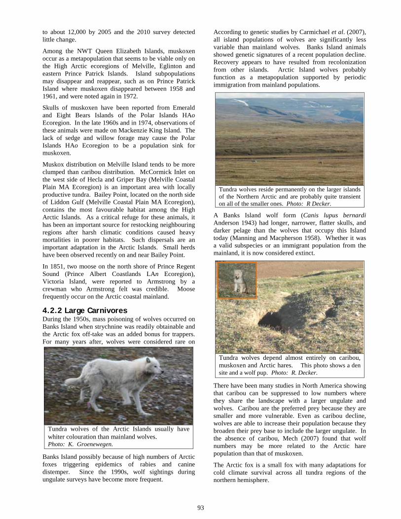
93
to about 12,000 by 2005 and the 2010 survey detected little change.
Among the NWT Queen Elizabeth Islands, muskoxen occur as a metapopulation that seems to be viable only on the High Arctic ecoregions of Melville, Eglinton and eastern Prince Patrick Islands. Island subpopulations may disappear and reappear, such as on Prince Patrick Island where muskoxen disappeared between 1958 and 1961, and were noted again in 1972.
Skulls of muskoxen have been reported from Emerald and Eight Bears Islands of the Polar Islands HAo Ecoregion. In the late 1960s and in 1974, observations of these animals were made on Mackenzie King Island. The lack of sedge and willow forage may cause the Polar Islands HAo Ecoregion to be a population sink for muskoxen.
Muskox distribution on Melville Island tends to be more clumped than caribou distribution. McCormick Inlet on the west side of Hecla and Griper Bay (Melville Coastal Plain MA Ecoregion) is an important area with locally productive tundra. Bailey Point, located on the north side of Liddon Gulf (Melville Coastal Plain MA Ecoregion), contains the most favourable habitat among the High Arctic Islands. As a critical refuge for these animals, it has been an important source for restocking neighbouring regions after harsh climatic conditions caused heavy mortalities in poorer habitats. Such dispersals are an important adaptation in the Arctic Islands. Small herds have been observed recently on and near Bailey Point.
In 1851, two moose on the north shore of Prince Regent Sound (Prince Albert Coastlands LAn Ecoregion), Victoria Island, were reported to Armstrong by a crewman who Armstrong felt was credible. Moose frequently occur on the Arctic coastal mainland.
4.2.2 Large Carnivores During the 1950s, mass poisoning of wolves occurred on Banks Island when strychnine was readily obtainable and the Arctic fox off-take was an added bonus for trappers. For many years after, wolves were considered rare on
Tundra wolves of the Arctic Islands usually have whiter colouration than mainland wolves. Photo: K. Groenewegen.
Banks Island possibly because of high numbers of Arctic foxes triggering epidemics of rabies and canine distemper. Since the 1990s, wolf sightings during ungulate surveys have become more frequent.
According to genetic studies by Carmichael et al. (2007), all island populations of wolves are significantly less variable than mainland wolves. Banks Island animals showed genetic signatures of a recent population decline. Recovery appears to have resulted from recolonization from other islands. Arctic Island wolves probably function as a metapopulation supported by periodic immigration from mainland populations.
Tundra wolves reside permanently on the larger islands of the Northern Arctic and are probably quite transient on all of the smaller ones. Photo: R Decker.
A Banks Island wolf form (Canis lupus bernardi Anderson 1943) had longer, narrower, flatter skulls, and darker pelage than the wolves that occupy this Island today (Manning and Macpherson 1958). Whether it was a valid subspecies or an immigrant population from the mainland, it is now considered extinct.
Tundra wolves depend almost entirely on caribou, muskoxen and Arctic hares. This photo shows a den site and a wolf pup. Photo: R. Decker.
There have been many studies in North America showing that caribou can be suppressed to low numbers where they share the landscape with a larger ungulate and wolves. Caribou are the preferred prey because they are smaller and more vulnerable. Even as caribou decline, wolves are able to increase their population because they broaden their prey base to include the larger ungulate. In the absence of caribou, Mech (2007) found that wolf numbers may be more related to the Arctic hare population than that of muskoxen.
The Arctic fox is a small fox with many adaptations for cold climate survival across all tundra regions of the northern hemisphere.

94
Arctic foxes may be common inland, but many move to the sea ice in winter to scavenge on seal carrion left by polar bears. Photo: R. Decker.
Banks Island is the most productive Arctic fox trapping area in North America, where numbers remain high even during the low phases of the population cycles. Their diet may be greatly supplemented in some areas by foraging in waterfowl nesting areas. Arctic foxes are brown in summer. They are characterised by two winter pelage colour phases – white and blue. In the Northern Arctic, the blue phase is less than one percent.
The lush vegetation response at this Arctic Fox den on northern Banks Island indicates that this site has been actively used by denning foxes for many years. Photo: R. Decker.
Red foxes are occasionally trapped on Banks and Victoria Islands. It is not known whether these are wanderers from the mainland or populations are sustained at very low densities. Red foxes have become much more widespread across the eastern Arctic Islands of Nunavut since the late 1940s.
Polar bears occasionally wander along the coast and inland. Pregnant females remain in snow dens during winter and emerge in spring with their cubs. A core maternity denning area occurs on the southwest coast of Banks Island.
The absence of land-denning opportunities between the outer Arctic Islands and Alaska may be why most females of the Beaufort Sea population den on the sea ice. .
Cross foxes are a colour phase of the red fox and this species is quite rare on the Arctic Islands. Photo: J. Nagy
A barren-ground grizzly killed in the Masik River valley of Banks Island during the winter of 1951-2 was the first report for the Arctic Islands. Populations on the mainland increased substantially, and since the 1990s, there have been more reports of these bears on the sea ice hunting seals. Grizzlies have occasionally been sighted on Banks, Victoria and Melville Islands (Doupé et al. 2007), but it is not known how sustainable or transient these populations are.
Polar bears are the largest and most carnivorous of bears, are mostly out on the sea ice hunting the seals. They venture onto land usually only to den or during periods of sea ice melt. Photo: R. Decker.
Evidence of past hybridization between the grizzly and polar bear (Lindqvist et al. 2010, Edwards et al. 2010) suggests that they are close relatives (Miller et al. 2012). Grizzly bears are now reported further north (Doupé et al. 2007). A grizzly–polar bear hybrid was killed at Nelson Head in April 2006 by a hunter who thought it was a normal polar bear. It had fur like a polar bear, as well as other physical traits typical of a grizzly. DNA testing confirmed it had a polar bear mother and a grizzly bear father. This was the first documented case of a grizzly–polar bear hybrid in the wild (Gau 2006 in COSEWIC 2008).

95
Barren-ground grizzlies are well adapted to Arctic tundra and are able to traverse great distances. Photo: D. Downing.
In April 2010, a hunter killed what he thought was a polar bear near Ulukhaktok (Prince Albert Coastlands LAn Ecoregion). DNA tests revealed that the bear's mother was a grizzly-polar hybrid and the father was a grizzly bear. It was the first recorded second-generation polar-grizzly bear hybrid found in the wild (see SARC 2012).
4.2.3 Mustelids Wolverines are widely distributed at low densities and occupy large home ranges. Although they occur in all habitats of the Northwest Territories, populations are centred on the mainland.
Wolverines are quite transient in the Northern Arctic, attracted to areas where concentrations of ungulates and carrion provide a source of food. Photo: R. Gau.
Ermines have a holarctic distribution that includes the tundra biomes. Although they are found throughout the eastern Arctic, including northern Ellesmere Island and Greenland, these weasels have been only reported from Banks, Prince Patrick and Victoria Islands in the Northern Arctic of the NWT. Abundance is largely dependent on lemming populations and ermines have yet to be reported on other Arctic islands where lemmings occur.
Ermines generally remain below the snow surface in winter as they hunt for lemmings. Photo: D. Johnson.
4.2.4 Rodents Lemmings are important prey for the carnivores and birds of prey that occupy the Northern Arctic. Their fluctuating numbers greatly influence the distribution and abundance of predators that depend on them.
Collared lemmings have been placed in a separate genus from true lemmings and are the only rodents that change their pelage from brown to white in winter. At this time of year, they also grow enlarged claws on their third and fourth digits of their forefeet as an adaptation for digging. Parry Channel separates the high Canadian Arctic clade of the Queen Elizabeth Islands from the low Canadian Arctic clade that includes Banks and Victoria Islands (Fedorov and Stenseth 2002).
Collared lemmings can subsist on meagre vegetation, including areas of the most northerly islands. Photo: D. Downing.
Brown lemmings are sympatric with collared lemmings on Banks and Victoria Islands. The larger brown lemming prefers wetter habitats, becomes the superior competitor at high densities, and undergoes the most extreme population fluctuations (Gruyer et al. 2008). Brown lemmings do not occur on any of the other Arctic Islands of the NWT and extend their range further south on the mainland than collared lemmings. However, during the last glacial maximum, collared lemmings ranged the furthest south, demonstrating that factors other than climate define the distribution of these two species (Graham 1986).

96
Brown lemmings are distributed only as far north as Banks and Victoria Islands. Photo: W. Lynch.
4.2.5 Lagomorphs Arctic hares are obligate tundra dwellers, ranging to the northern limits of land in North America and Eurasia. They are the most social of all hares and rabbits, often observed in large groups of up to 100 individuals. Arctic hares are pure white in winter except for small black ear tips. On the most northerly islands, they may retain most of their white coat in summer, except for some smoky grey on their heads and backs. When fleeing from predators such as foxes, wolves and Snowy Owls, these hares are able to hop on their hind legs at similar speeds to Australian kangaroos.
Arctic hares select boulder strewn hilly habitats that provide shelter from severe weather and escape from predators. Arctic willow is the main winter food for these hares, and the diet becomes more diverse in summer consisting mainly of legumes. Photo: D. Downing.
DNA evidence suggests that all Arctic hares in Canada have dispersed from a Canadian High Arctic – Northern Greenland refugium (Waltari et al. 2004). Populations periodically experience steep declines, similar to other mammals at these latitudes.
4.3 Birds of the Northern Arctic 4.3.1 Geese and Swans Tundra Swans breed in several areas of Banks and Victoria Islands where there is well vegetated tundra. The Thomsen Valley MA Ecoregion of Banks Island and the Kagloryuak River valley (Tahiryuak Upland MA
Ecoregion) on Victoria Island contain the highest densities. Tundra Swans have been reported from Winter Harbour on Melville Island in 1820 and 1910.
Lesser Snow Geese breed in the western Arctic and at over five million birds, have become the most numerous species of waterfowl in recent decades. Of the three main nesting colonies in the western Arctic, the colony centred at Egg River contains over 90 percent of the birds (Banks Island Bird Sanctuary No. 1). A study of overgrazing in lowland habitats shows that degradation of tundra vegetation is not as serious as some areas around Hudson Bay, but researchers recommend that snow goose populations should be stabilized before more serious consequences arise (Hines et al. 2010).
Lesser Snow Geese have an almost solid white plumage, although a small minority are blue phase. Photo: R. Decker.
The Thomsen Valley MA Ecoregion contains Banks Island Bird Sanctuary No. 2, set aside primarily for moulting concentrations of Snow Geese. Smaller groups of nesting pairs have been observed in the Prince Albert Coastlands LAn Ecoregion (Victoria Island), Dundas Peninsula HA Ecoregion (Melville Island), Melville Coastal Plain MA Ecoregion (Melville Island), Eglinton Island, Prince Patrick Upland HA Ecoregion (Eglinton Island and southeast Prince Patrick Island) and Prince Patrick Lowland HAo Ecoregion (northwest Prince Patrick Island).
Ross’s Goose, which breeds only in the Coronation Gulf mainland of Nunavut, is the least numerous goose in the Northern Arctic. However, it occasionally appears on southwest Banks Island.
Brant is also known as “sea goose” or “brent goose”. Although it is usually colonial in the Southern Arctic, nesting is more dispersed in the high Arctic. It is one of the smallest in body size with a short neck and all-black head. Brant feed on grasses and sedges in the littoral zone. On Banks Island, Brant are more likely to nest inland, often near Snowy Owls (Cotter and Hines 2001). The dark-bellied form that breeds in small scattered colonies on the Banks and Victoria Islands, as well as the mainland coast, winters along the Pacific coast as far as Mexico.

97
Brant are most associated with marine habitats and often nest in harsher environments than other geese. Photo: R. Royse.
Pale-bellied Brant that breed on Melville, Prince Patrick and neighbouring Islands are somewhat intermediate in appearance between Atlantic Brant and Pacific Brant, but genetically distinct from other populations (Shields 1990) and winter in the Puget Sound area of Washington State. This particular stock has been termed the Western High Arctic or Grey-bellied Brant Population (Reed et al. 1998). Other pale-bellied Brant occurring in the eastern Queen Elizabeth Islands (Nunavut) migrate to Ireland.
Greater White-fronted Geese or "speckle belly" generally breed as single pairs on the Arctic mainland and southern Victoria Island of Nunavut. Some have been reported from the West Banks Coastal Plain MA Ecoregion and Thomsen Valley MA Ecoregion of Banks Island, as well as the Prince Albert Coastlands LAn Ecoregion and Wollaston Peninsula MA Ecoregion of Victoria Island. The most northerly observation has been from Sabine Bay (Dundas Peninsula HA Ecoregion) of Melville Island.
Canada Geese breed in singular pairs across Banks, Victoria, and at least as far north as Melville Coastal Plain MA Ecoregion, and Mould Bay (Prince Patrick Upland HA Ecoregion).
Canada Goose and the smaller Cackling Goose (front). Photo: R. Royse.
They are the most abundant species of goose on western Victoria Island and are expanding their numbers northward into the West Prince Albert Lowland MA Ecoregion. Dramatic continental-wide increases in recent decades are being reflected in the Arctic Islands.
Cackling Geese were considered a small subspecies of Canada Goose until 2004. An estimated eight percent of the Canadian population nest in the Kagloryuak River valley, and a further one percent at Tahiryuak Lake and the surrounding lowlands (Hines et al. 2000). These areas contain numerous small lakes and shallow ponds and have continuous vegetation cover.
4.3.2 Ducks Surface-feeding ducks found in the Northern Arctic generally have their population centres located further south. The Northern Pintail is the most widely distributed dabbling duck on the tundra, but scattered at low density on Banks and Victoria Islands. Preferred nesting sites occur in well vegetated wetlands and shallow ponds.
Northern Pintails nest shortly after ice break-up and are early fall migrants. Photo: J. McKay.
Green-winged Teal have been reported from the South Banks Coastal Plain LAn Ecoregion (Banks Island) and the Prince Albert Coastlands LAn Ecoregion (Victoria Island).
Diving ducks occur across the Northern Arctic in much greater numbers. The Long-tailed Duck is scattered across the Northern Arctic, but may be declining continentally. Nesting is usually close to seacoasts or on lake islands and ponds further inland. Moulting and migrating flocks are more often on the seacoasts. Males have two slender and elongated central tail-feathers, the distinctive feature of this species.
Greater Scaups, White-winged Scoters and Red-breasted Mergansers have been recorded from Ulukhaktok (Prince Albert Coastlands LAn Ecoregion). Their abundance on the Arctic mainland and favourable habitat on Banks and Victoria Islands suggest that these species may be under-reported.
Eiders, generally termed sea ducks, are the most common ducks in the Northern Arctic. Instead of migrating south for the winter, they migrate westward to the Bering and Chukchi seas. They periodically suffer high mortalities due to starvation if Beaufort Sea break-up is late. Common Eiders are rarely found north of Banks and Victoria Islands, except for non-breeders. The largest concentrations are on Victoria Island within and alongside the Prince Albert Coastlands LAn Ecoregion.

98
Common Eiders are able to dive to pick mollusks and crustaceans from the sea floor in depths reaching 20 metres. Photo: L. Spitalnik.
They usually seek out small marine islands for nesting that become ice free the earliest and are protected from Arctic fox depredation. Smaller colonies occur on the barrier beaches that extend along the West Banks Coastal Plain MA Ecoregion of Banks Island. They occasionally breed on islands of inland lakes near the coast.
King Eiders range across most of the Northern Arctic, except the Polar Islands HAo Ecoregion. They are quite common on western Victoria Island, where the highest densities occur in the Kagloryuak valley (Prince Albert Coastlands LAn Ecoregion) and Tahiryuak Lake (Tahiryuak Upland MA Ecoregion). Their other main nesting areas are on the West Banks Coastal Plain MA Ecoregion and South Banks Coastal Plain LAn Ecoregion (Banks Island). Males and non-breeders spend most of the summer on salt water.
King Eiders are less confined to marine habitats than Common Eiders, and may nest earlier in tundra ponds further inland. Photo: L. Spitalnik.
4.3.3 Grouse Willow Ptarmigan are year-round residents of the Northern Arctic and some undergo seasonal movements to the mainland. They have been reported as far north as the Dundas Peninsula HA Ecoregion on Melville Island. Willow Ptarmigan is the only species of grouse in which the male contributes parental care of the chicks.
Rock Ptarmigan, the smaller of the two, prefer sparsely vegetated rockier plains. They are far more common than
Willow Ptarmigan, and probably occur on all Arctic Islands.
Rock Ptarmigan is the only species in which all populations spend their entire life cycle in the Arctic, retreating only from northernmost islands during the winter. Photo: R. Royse.
4.3.4 Loons Pacific Loons, small members of the family, are quite common on the Banks and Victoria Islands, but have only been reported from Mould Bay (Prince Patrick Upland HA Ecoregion) further north. Pacific Loons are a marine inhabitant for most of the year, except during the nesting season when they prefer inland on ponds with islands and grassy shorelines. Non-breeders are more often found in coastal bays and estuaries.
Pacific Loons usually nest in deep ponds that are able to provide adequate food resources. Photo: J. McKay
The Red-throated Loon is the smallest and differs from other loons in many physical and behavioural aspects. It is found in the Northern Arctic wherever there are inland water bodies. Red-throated Loons are able to take flight from short take-offs and from land. These characteristics allow it to nest earlier than other loons on relatively small ponds.

99
Red-throated Loons nest in shallow ponds, but their food is most often found in the sea or larger lakes and rivers. Photo: R. Popko.
Yellow-billed Loons have a narrow breeding range above treeline that does not extend north of Banks and Victoria Islands. It is the largest of this family, often confused with the Common Loon which replaces the Yellow-billed Loon further south. As the least abundant loon in North America, it is most abundant on western Victoria Island (McLaren and Alliston 1981).
Yellow-billed Loons prefers lakes characterised by clarity, low shorelines, stable water levels and early thaw. Photo: G. Vyn.
Common Loons, more often found below timberline and in the eastern Arctic, have been reported on several occasions from the Thomsen Valley MA Ecoregion.
4.3.5 Eagles and Hawks Eagles have never been reported from the Northern Arctic, although Golden Eagles occur regularly in the Southern Arctic. All raptors in the Arctic Islands nest on cliffs and distribution is limited by this habitat type.
The Rough-legged Hawk is the most common raptor in the Northern Arctic, and numbers vary according to abundance of lemmings. On northwest Victoria Island, up to 2,000 pairs may be found (Cornish and Dickson 1996). Plumage colouration may be quite variable.
Rough-legged Hawks are limited in distribution and numbers by the availability of suitable cliff nesting sites. Photo: G. Vyn.
Peregrine Falcons have recovered from extreme lows in the 1960s and 1970s to become widely distributed globally and the most common falcon in the Arctic. Peregrine means “wanderer” and they may undergo long seasonal migrations. In addition to steep cliffs, they may occasionally select other raised sites for nesting that offer wide views. Parts of Tahiryuak Upland MA Ecoregion are important. Their main source of food is shorebirds and common passerines that they take in a vertical descent termed a “stoop”.
Gyrfalcons are the largest falcon in the world, although males are considerably smaller than females. The main food consists of ptarmigan, and the limits of the Gyrfalcon’s breeding range on the Arctic Islands correspond closely to the distribution of Rock Ptarmigan (Holder, and Montgomerie 1993). They also prey on Arctic hares and small mammals. Gyrfalcons of the Northern Arctic are probably migratory and depend more on seabirds around pack ice in winter. Unlike peregrines, Gyrfalcons capture avian prey in horizontal pursuit.
Gyrfalcon plumage varies considerably between dark brown and white, although the lighter morphs predominate in the Northern Arctic. Photo: G. Vyn.

100
4.3.6 Wading Birds Sandhill Cranes are the only long-legged wading birds to inhabit the Northern Arctic. Low numbers occur in widely scattered locations on Banks and Victoria Islands, and have been reported as far as North Melville Upland HA Ecoregion. They tend to select marshy wetlands of early thaw for breeding and the nest mound is often on grass covered sand dunes (Walkinshaw 1965). Although two eggs is the typical clutch size, usually only one chick survives. Omnivorous foraging habits allow these birds to exploit a wide range of potential food resources. They are perhaps best known for their tall stature and loud bugling call. It is one of the few crane species in the world with robust populations.
Sandhill Cranes have omnivorous foraging habits allowing these birds to exploit a wide range of potential food resources. Photo: T. Sohl.
4.3.7 Shorebirds Shorebirds are a very diverse group; the majority breed at high latitudes and are circumpolar. American Golden-plovers are widespread in the Arctic Islands, mainly on dry slopes and uplands. It is no longer a game bird, and its numbers have recovered; it is now one of the most abundant shorebirds during migration along the mainland coast.
Black-bellied Plovers are the largest shorebird and most common plover in the Arctic Islands. Although they are more often found nesting on dry tundra, Black-bellied Plovers have closer affinity to marshy areas than American Golden-plovers. The wariness of Black-bellied Plovers allowed it to elude hunters, and it remained common when populations of other species of similar size were devastated by market hunting in the early 1900s.
The Semipalmated Plover is the smallest plover in the Arctic. It is found scattered on low marine coasts and gravelly, sparsely vegetated plains on Banks and Victoria Islands, and is yet to be reported from other parts of the Northwest Territories Northern Arctic.
Black-bellied Plovers are quick to give alarm calls, and may act as sentinels for mixed groups of shorebirds. Photo: L. Spitalnik.
The Semipalmated Sandpiper is the smallest shorebird found regularly in the Northern Arctic. Breeding is restricted to North America. Although widespread on Banks and Victoria Islands, it appears to be absent from the Queen Elizabeth Islands where preferred lakeshores are lacking. Recent population declines are cause for concern.
Least Sandpipers have been observed in Aulavik National Park (Thomsen Valley MA Ecoregion) of Banks Island, and Sabine Bay (Dundas Peninsula HA Ecoregion) on Melville Island. Prevalence on the Arctic mainland and observations on that part of Victoria Island within Nunavut imply that they may be under-reported in the Northern Arctic.
White-rumped Sandpipers are more common in the Northern Arctic than Southern Arctic. They occupy wet tundra generally more inland than most of the other shorebirds. These sandpipers winter in Patagonia, South America. They are dependent on key staging areas for rebuilding energy reserves for their long migration legs.
White-rumped Sandpipers’ white feathers at the base of the tail and distinctive call are the most readily identifiable characteristics. Photo: L. Spitalnik.
Baird’s Sandpiper is widespread in the Northern Arctic and also undergoes a long distance migration to wintering grounds in South America. It is often associated with mountains during migration and on the wintering grounds in Chile. It was one of the last sandpipers to be described in North America. Breeding

101
is confined to this continent where it is mainly found on dry inland landforms. This species makes an unusually large investment in egg production as it lays 120 percent of its body weight in four days, with almost no stored fat (Moskoff and Montgomerie 2002).
Baird’s Sandpipers are noted for their relatively long wings. Photo: S. Streit.
Pectoral Sandpipers prefer to nest near well-vegetated wetlands, and are one of the most widespread shorebirds in the Northern Arctic. Among adults, there is a lack of distinction between summer and winter plumage. Males inflate the throat and neck during courtship and are larger than females, which is unusual among sandpipers. Market hunting severely reduced this medium-sized shorebird and numbers have not fully recovered because of habitat loss.
The Stilt Sandpiper is another of the few shorebirds that restricts its breeding to North America. It nests in sedge tundra mainly near coastal areas of the Southern Arctic with adequate coverage of forbs and erect shrubs. Although observed as far north as the head of Minto Inlet (Prince Albert Coastlands LAn Ecoregion) on Victoria Island, they have yet to be reported from any other of the Arctic Islands.
The Dunlin has breeding populations on the Alaskan coast and around Hudson Bay. In the NWT Arctic Islands, it has only been reported from the Thomsen Valley MA of Banks Island, although the Hudson Bay population extends its range at least as far as southern Victoria Island. More observations of wanderers and migrants are to be expected in the Northern Arctic.
Dunlins’ striking breeding plumage of black belly and rufous back are readily apparent. Photo: L. Spitalnik.
Sanderlings are most common in the Queen Elizabeth Islands and appear on Banks and Victoria mainly as migrants. Unlike most Arctic birds, two clutches are often produced, and not because the first one is lost to predation as would be expected. The first is brooded by the male, and the second laid in rapid succession is brooded by the female (Parmalee and Payne 1973). Activities at non-breeding times of the year occur along marine beaches.
Sanderlings nest on bare ground near marshy swales and ponds in the high Arctic and feed along ocean shorelines. Photo: L. Spitalnik.
Red Knots are the largest sandpiper in the Northern Arctic and undergo some of the longest migrations, reaching the southern tip of South America. They have been found nesting on rock plains with scant vegetation on Melville, Eglinton and Prince Patrick Islands, and probably extend their summer distribution to the extreme northerly limits of land in the NWT, as they do in Nunavut.
Red Knots may often nest in wet habitats, but prefer to forage in dry, elevated habitats if lower elevations remain snow-covered. Photo: L. Spitalnik.
The Purple Sandpiper is uncommon in the NWT Arctic Islands, as its core breeding range in North America appears to be the eastern Queen Elizabeth Islands, Baffin Island, and Southampton Islands. It is most often found in rugged coastal areas. The name is misleading as purple is not evident in its plumage.
Buff-breasted Sandpipers, widespread in Northern Arctic occupy a breeding range mostly restricted to the western and central Canadian Arctic Islands. Their “lek” mating

102
system, where males display together in small territories, is unique among North American shorebirds.
Buff-breasted Sandpipers are mainly associated with drier habitats for nesting. Photo: L. Spitalnik.
Ruddy Turnstones breed further north than most shorebirds, but most of its core range in the Arctic Islands has yet to be discovered. From the coldest regions in Canada, it migrates to some of the warmest regions in the tropics for the winter. Densities are variable, as they often breed in loose colonies. They are primarily an inhabitant of coastlines, though a few may be found more inland, especially in the West Banks Coastal Plain MA Ecoregion of Banks Island.
Ruddy Turnstones, as their name suggests, search for arthropods by turning over stones and other debris on beaches with their strong and slightly upturned upper mandible. Photo: R. Royse.
Whimbrels seem to have a disjunctive breeding range on the southern Arctic mainland, although there are regular wanderers to Banks Island. It is the only Canadian Arctic shorebird with a decurved bill, except for the Eskimo Curlew, which is probably extinct.
Red-necked Phalaropes reside primarily on the Southern Arctic mainland, but are thinly distributed in the Northern Arctic having little overlap with Red Phalaropes. This shorebird is quite dependent on shallow freshwater ponds for foraging. With lobed toes to facilitate swimming, it spends up to nine months in open oceans. It is one of the few shorebirds to winter offshore.
Red Phalaropes have a nearly continuous circumpolar range. They are widespread in coastal tundra that contain lagoons and ponds that are well vegetated on their fringes. Nonbreeders primarily remain in the open ocean.
Red Phalaropes exhibit reversed sexual dimorphism, whereby females are larger and more brightly plumaged than males. Photo: R. Royse.
4.3.8 Gulls, Terns, and Jaegers This group of waterbirds includes largely opportunistic foragers. Herring Gulls are thinly distributed on Banks and Victoria Islands, and far more common on the mainland.
Thayer’s Gulls are close relatives to Herring Gulls and essentially replace them in the Northern Arctic. They are also closely related to Iceland Gulls of the eastern Arctic, and the taxonomic difference between the two is currently unsettled. Thayer’s Gulls primarily inhabit marine environments in the high Arctic.
Vertical cliffs are selected for nesting by Thayer’s gulls, often in association with Glaucous Gulls. Photo: R. Decker.
Glaucous Gulls are the bulkiest, most plentiful and widespread gull in the Arctic Islands. Increasing amounts of garbage may be contributing to higher numbers of Glaucous Gulls around communities. Noted for their aggressive behaviour, they nest in colonies or pairs on cliffs or on the ground.

103
Glaucous Gulls are predators and scavengers, often stealing food from other birds. Photo: G. Vyn.
Sabine’s Gull nests in small colonies or as single pairs, sporadically on low, flat terrain near the coast, and feeds primarily in fresh water or on land. It has a distinctive dark hood. As the only member of the genus Xema, Sabine's Gull displays many behaviours resembling terns and shorebirds, and its nests are often interspersed with those of Arctic Terns. It is one of only two gulls having a black bill with a yellow tip and a notched tail. It has yet to be reported from the Queen Elizabeth Islands of the Northwest Territories. On western Victoria Island, the vast majority occur in the Kagloryuak River Valley and near Tahiryuak Lake (Tahiryuak Upland MA Ecoregion).
Sabine’s Gulls have a distinctive dark hood, and is one of only two gulls having a black bill with a yellow tip and a notched tail. Photo: R. Royse.
Ivory Gulls were observed along Coyote River in 1996 and Muskox River in 2004 (Central Banks Upland MA Ecoregion, Banks Island). They have a limited migration between High Arctic nesting areas and lower Arctic wintering areas. They are very sensitive to disturbance at nesting time and all but a few colonies in the High Arctic (Northwest Territories and Nunavut) have been permanently abandoned. An example is the Polynia Islands (Polar Islands HAo Ecoregion) where they have not been observed since M’Clintock collected an egg in 1853.
Ivory Gulls have solid white plumage and black feet that are diagnostic for this species. Photo: L. Spitalnik.
A Black-legged Kittiwake was discovered at Salmon Point (Prince Patrick Upland HA Ecoregion) on Prince Patrick Island in 2000. The NWT Arctic Islands constitute a wide gap that separates the Nunavut and Alaskan subspecies.
Arctic Terns are very widespread and evenly distributed around gravelly beaches of lakes and coastlines. They are rare only in dry interior of some of the islands such as Victoria. They are known for their deeply forked tail and very short legs. Arctic Terns experience two summers each year as they undergo the longest migration by any known organism. From northern breeding grounds to the oceans around Antarctica, the round trip each year exceeds 70,000 km.
Jaegers are part of the predatory gull-like family known as skuas. The Parasitic Jaeger preys mainly on small birds and eggs. As the most abundant jaeger in the Southern Arctic, it becomes the least abundant jaeger in Northern Arctic.
Long-tailed Jaegers are the smallest and often the most abundant and widespread jaeger among the Arctic Islands. During the breeding season, they depend mainly on lemmings for food, but can substitute a wider variety of animal matter, including birds and insects when lemming populations are low.
Long-tailed Jaegers breed as far north as any bird. Photo: C. Machtans.
The Pomarine Jaeger is the largest of the three species. Pomarine, Greek for 'lid-nosed', refers to the sheath that covers the base of the bill. The large, bi-colored bill

104
contrasts with the dark face. This jaeger occupies the entire Northern Arctic, where in some years, it is perhaps the most abundant; it is invariably the least abundant in the Southern Arctic. On Banks and Victoria Islands, this jaeger seems to prefer wet, well-vegetated tundra which is the favoured habitat of brown lemmings.
Pomarine Jaegers are most dependent on lemmings. When these prey populations are low, Pomarines often do not nest and remain offshore. Photo: R. Royse.
4.3.9 Owls Short-eared Owls are widely distributed in the northern hemisphere, but not likely beyond Banks and Victoria Islands. Although their abundance is closely associated with small mammal populations, there is concern in Canada about a long term decline.
Snowy Owls are year-round residents whose movements may often be described as nomadic and unpredictable. They nest on ridges and hilltops to the northern limits of land in the Arctic Islands. Hummocks and other minor prominences are important as lookouts. These owls emigrate from the Arctic during winters when lemming populations are low. Where food is scarce, they may refrain from breeding for a year or more.
Snowy Owls are able to produce large clutches up to a dozen young per nest when lemmings are abundant. Photo: R. Royse.
4.3.10 Corvids Common Ravens are the main avian carrion foragers in the Northern Arctic and are attracted to garbage around camps. Otherwise, these scavengers range widely at low density.
Common Ravens are the only corvid found in the Arctic Islands. Photo: D. Johnson.
4.3.11 Larks Horned Larks prefer sparsely vegetated rocky plains and are one of the most abundant species in Northern Arctic areas. They are mainly insectivorous in summer and seeds become more important during migration.
Horned Larks breed in tundra and other sparsely vegetated habitats throughout Canada. Photo: L. Spitalnik.
4.3.12 Pipits American Pipits are one of the few songbirds that nest exclusively in Arctic and alpine tundra. Reported only from Banks and Victoria Islands, American Pipits prefer rocky sparsely vegetated rocky landscapes, raised beaches, cliffs with talus slopes. These birds are insectivorous in the summer and add seeds to their diet when insects are not available.
American Pipits resemble sparrows, but can be distinguished from that family by their thin bill and bobbing tail. Photo: J. Nagy.

105
4.3.13 Sparrows Some ground-foraging seed eating sparrows, common at lower latitudes, range as far north as the Northern Arctic. The American Tree Sparrow, not limited to arboreal habitats as the name suggests, may be more than a regular wanderer to Banks Island. This sparrow occurs much more frequently on the Arctic mainland.
Savannah Sparrows, White-crowned Sparrows and Dark-eyed Juncos have been reported from a few localities on Banks and Victoria Islands. Their abundance on the Arctic mainland and Nunavut parts of Victoria Island suggest that they may be more widespread.
4.3.14 Longspurs and Buntings The Lapland Longspur has been described as the most abundant breeding bird in the Northern Arctic. They tend to select wet hummocky tundra, and avoid rocky habitats. Lapland Longspurs feed on insects when they are available, but depend mainly on seeds.
Lapland Longspurs often migrate in flocks that number in the millions of birds. The arrow points to the long rear claw that gives this species its name. Photo: R. Royse.
Smith’s Longspur has been reported from Ulukhaktok (Prince Albert Coastlands LAn Ecoregion) and Cambridge Bay (Nunavut) of Victoria Island. It is widespread in the Southern Arctic and may exist at low densities in the Northern Arctic.
Snow Buntings are usually the first land birds to arrive in spring, as competition for territories containing high-quality rock crevice nest sites is intense. Snow Buntings experience less nest predation than ground nesting Arctic passerines, but rock cavities have a harsher microclimate for incubation. To compensate, male Snow Buntings feed their mates on the nest, allowing a shorter incubation period and higher hatching success.
4.3.15 Finches Common and Hoary Redpolls have occasionally been reported from Banks and Victoria Islands. They are often difficult to distinguish. Several Hoary Redpolls have been observed on a number of occasions at Mould Bay (Prince Patrick Upland HA Ecoregion).
Snow Buntings are consistently plentiful and widely distributed around sparsely vegetated rocky plains, sea cliff talus, and inland ravines. Photo: R. Decker.
Their abundance on the mainland coast, Arctic Islands of Nunavut, and Greenland suggest that Common and Hoary redpolls may be more widespread in the Northwest Territories Northern Arctic than records indicate.
Hoary Redpolls generally range further into tundra than Common Redpolls and require shrubby habitats. Photo: G. Vyn.
4.3.16 Vagrants Some bird species are occasional visitors, far from their breeding range or migration routes, and do not form a major biological component of the Northern Arctic ecoregions. However, if some are more common than expected or expanding their range they may be easily undetected by the scarcity of observers.
Trumpeter Swan – a pair reported on a lake southwest of Minto Inlet (Prince Albert Coastlands LAn Ecoregion) on Victoria Island in 1976. Other large swans observed on Banks Island could be Trumpeters.
Mallards, the most common duck in North America, have only been reported from Victoria Island at Lady Franklin Point (Wollaston Peninsula MA Ecoregion) and Ulukhaktok (Prince Albert Coastlands LAn Ecoregion).
American Wigeon – Raddi Lake (South Banks Coastal Plain LAn Ecoregion) of Banks Island in 1952. This dabbling duck is fairly common in shallow lakes and marches on the southern Arctic mainland, but has not established a breeding population on the Arctic Islands.

106
Northern Shoveler – Ulukhaktok (Prince Albert Coastlands LAn Ecoregion) of Victoria Island in 1971. Nearest concentrations occur in the Mackenzie and Anderson River deltas on the Arctic mainland.
Spectacled Eider – Sachs River (South Banks Coastal Plain LAn Ecoregion) of Banks Island in 1952. This is the only Canadian record, as the nearest population resides on the northern coast of Alaska.
Northern Fulmar – Nelson Head in 1857 and Cape Kellett in 1916 (South Banks Coastal Plain LAn Ecoregion) of Banks Island. The Atlantic subspecies is common in the eastern Arctic.
Bald Eagle – Sachs Harbour (South Banks Coastal Plain LAn Ecoregion) of Banks Island in 2010.
Sharp-shinned Hawk – Ulukhaktok (Prince Albert Coastlands LAn Ecoregion of Victoria Island in 1979. Wanderers rarely venture beyond forested landscapes.
Merlin – Sachs Harbour (South Banks Coastal Plain LAn Ecoregion) of Banks Island in 2000. This small falcon is occasionally observed in the Southern Arctic.
Western Sandpiper – Thomsen Valley MA Ecoregion, Banks Island, 1995.
Lesser Yellowlegs – Thomsen River (Thomsen Valley MA Ecoregion), Banks Island, 1999. Although extensive breeding ranges occur in northern North America, these shorebirds are less common above treeline.
Long-billed Dowitcher – listed in the checklist for Banks Island Bird Sanctuary No. 1. This medium sized shorebird breeds primarily inland from the Alaskan coast to the Mackenzie Delta.
Thick-billed Murre – north side Prince Albert Sound (Prince Albert Coastlands LAn Ecoregion) of Victoria Island in 1971. An isolated breeding colony is located at Cape Parry on the Southern Arctic coast.
Black Guillemot – Cape Prince Alfred (Northwest Slopes HA Ecoregion) in 1952 and Sachs Harbour (South Banks Coastal Plain LAn Ecoregion) of Banks Island in 2002, and Ulukhaktok (Prince Albert Coastlands LAn Ecoregion) of Victoria Island in 1971. Large breeding colonies occur in the eastern Arctic and Alaska.
Barn Swallow – Ulukhaktok (Prince Albert Coastlands LAn Ecoregion) of Victoria Island in 1971, and listed in the checklist for Banks Island Bird Sanctuary No. 1. A few have been found nesting in buildings in the Southern Arctic.
Arctic Warbler – Mould Bay (Prince Patrick Upland HA Ecoregion) of Prince Patrick Island in 1949. The specimen collected was described as fat and in breeding condition. Typically range from eastern Asia to Alaska.
Northern Waterthrush – Cape Kellett (South Banks Coastal Plain LAn Ecoregion) of Banks Island in 1915. This nearest population of this warbler occupies the Mackenzie Delta.
American Redstart – Sachs Harbour (South Banks Coastal Plain LAn Ecoregion of Banks Island in 1952. Breeding range of this warbler does not extend north of the Low Subarctic central Mackenzie valley.
Fox Sparrow – Nelson Head (South Banks Coastal Plain LAn Ecoregion) of Banks Island in 1974. The nearest reports have been from the Mackenzie and Anderson River deltas on the Arctic mainland.
Song Sparrow – De Salis Bay (South Banks Coastal Plain LAn Ecoregion) of Banks Island in 1952. The northerly range of this diverse species is Subarctic.
Harris’s Sparrow – Nelson Head (South Banks Coastal Plain LAn Ecoregion) of Banks Island in 1974. The nearest reports have been from the Mackenzie and Anderson River deltas on the Arctic mainland.7
Rusty Blackbird – Sachs Harbour (South Banks Coastal Plain LAn Ecoregion) of Banks Island in 2012.

107
References Cited In Sections 1 to 3 and Appendices Afonina, O.M., Raynolds, M.K., Walker, D.A. 2005. On the moss flora of Mould Bay (Prince Patrick Island, Arctic
Archipelago). Arctoa 14: 135-142.
Agriculture and Agri-Food Canada 1997. Canadian Ecodistrict Climate Normals 1961-1990. Revised December 1997. Website: http://sis.agr.gc.ca/cansis/nsdb/ecostrat/district/climate.html.
Balkwill, H.R. 1977. Geology, Borden Island. Geological Survey of Canada Open File 544.
Link checked March 18 2013.
Bent, A.L., Hayek, S. 2011. The Arctic Ocean Earthquake Swarm of October and November 2008. Geological Survey of Canada, Open File 6722.
Bliss, L.C. 1999. Arctic Tundra and Polar Desert biome. In M.C.Barbour and W.D.Billings (eds.) North American Terrestrial Vegetation, Second Edition. University of Cambridge Press, Cambridge, United Kingdom, pp. 1-40.
Canadian Ice Service. 2010. Sea Ice Climatic Atlas, Northern Canadian Waters 1981-2010. Environment Canada.
Canadian Society of Soil Science. 1976. Glossary of terms in Soil Science. Compiled by nomenclature committee (A. McKeague, Chair). Agriculture Canada, Ottawa. (out of print).
Cauboue, M., Strong, W.L., Archambault, L., Sims, R.A. 1996. Terminology of ecological land classification in Canada. Nat. Resour. Can., Can. For. Serv. Quebec, Sainte-Foy, Quebec.
CAVM Team. 2003. Circumpolar Arctic Vegetation Map. (1:7,500,000 scale), Conservation of Arctic Flora and Fauna (CAFF) Map No. 1. U.S. Fish and Wildlife Service, Anchorage, Alaska.
Chernov, Y.I. 1985. Thermal conditions and Arctic biota. Soviet Geography 30:102-9. (1985). The Living Tundra. Cambridge University Press, Cambridge, United Kingdom.
Commission for Environmental Cooperation. 1997. Ecological Regions of North America – Toward a common perspective. Montreal, Quebec,Canada. http://www.cec.org.
Downing, D., Decker, R., Oosenbrug, B., Tarnocai, C.,Chowns, T., Hampel, C. 2006. Ecosystem Classification of the Taiga Plains Ecozone, Northwest Territories. Prepared by Timberline Forest Inventory Consultants, Government of Northwest Territories, and Agriculture and Agri-Foods Canada. Internal report.
Dyck, A.S., Prest, V.K. 1987. Paleogeography of northern North America 18,000 – 5,000 years ago. Geological Survey of Canada Map 1703A.
Dyck, A.S., Andrews, J.T., Clark, P.U., England, J.H., Miller, G.H., Shaw, J., Veillette, J.J. 2002. The Laurentide and Innuitian ice sheets during the Last Glacial Maximum. Quarterly Science Reviews 21: 9-31.
Dyck, A.S., Prest, V.K. 1986. Late Wisconsinan and Holocene retreat of the Laurentide Ice Sheet. Geological Survey of Canada, Department of Energy, Mines and Resources, Map 1702A.
Dyck, A.S., Savelle, J.M. 2000. Surficial geology, Cape Baring area, Victoria Island, Northwest Territories. Geological Survey of Canada Open File 3899.
Dyck. A.S., Andrews, J.T., Clarke, P.U., England, J.H., Miller, G.H., Shawe, J., Veillette, J.J. 2002. The Laurentide and Innuitian ice sheets during the Last Glacial Maximum. Quaternary Science Reviews 21: 9–31.
Dyck, A.S., Savelle, J.M. 2003a. Surficial geology, Linaluk Island, Victoria Island, Northwest Territories. Geological Survey of Canada Open File 4319.
Dyck, A.S., Savelle, J.M. 2003b. Surficial geology, Woodward Point and Tahiryuak Lake areas, Victoria Island, Northwest Territories. Geological Survey of Canada Open File 4320.
Dyck, A.S., Savelle, J.M. 2003c. Surficial geology, Southern Prince Albert Sound, Victoria Island, Northwest Territories. Geological Survey of Canada Open File 4321.
Dyck, A.S., Savelle, J.M. 2004a. Surficial geology, Page Point, Victoria Island, Northwest Territories. Geological Survey of Canada Open File 4336.
Dyck, A.S., Savelle, J.M. 2004b. Surficial geology, north-central Prince Albert Sound (east half), Victoria Island, Northwest Territories. Geological Survey of Canada Open File 4337.
Dyck, A.S., Savelle, J.M. 2004c. Surficial geology, north-central Prince Albert Sound (west half), Victoria Island, Northwest Territories. Geological Survey of Canada Open File 4351.

108
Dyck, A.S., Savelle, J.M. 2004d. Surficial geology, Holman, Victoria Island, Northwest Territories. Geological Survey of Canada Open File 4352.
Dyck, A.S., St-Onge, D.A., Savelle, J.M. 2003. Deglaciation of southwestern Victoria Island and adjacent Arctic mainland, Nunavut – Northwest Territories. Geological Survey of Canada Map 2027A.
Ecological Stratification Working Group. 1995. A National Ecological Framework for Canada. Agriculture and Agri-Food Canada, Research Branch, Centre for Land and Biological Resource Research and Environment Canada, State of the Environment Directorate, Ecozone Analysis Branch, Ottawa/Hull. 125 pp. Map at 1: 7,500,000. Web version and final map published 1996.
Ecoregions Working Group. 1989. Ecoclimatic Regions of Canada, first approximation. Environment Canada, Canadian Wildlife Service, Sustainable Development Branch. Ecological Land Classification Series No. 23.
Ecosystem Classification Group. 2007 (revised 2009). Ecological Regions of the Northwest Territories – Taiga Plains. Department of Environment and Natural Resources, Government of the Northwest Territories, Yellowknife, Northwest Territories, Canada. viii + 173 pp. + folded insert map.
Ecosystem Classification Group. 2008. Ecological Regions of the Northwest Territories – Taiga Shield. Department of Environment and Natural Resources, Government of the Northwest Territories, Yellowknife, Northwest Territories, Canada. viii + 146 pp. + folded insert map.
Ecosystem Classification Group. 2010. Ecological Regions of the Northwest Territories – Cordillera. Department of Environment and Natural Resources, Government of the Northwest Territories, Yellowknife, Northwest Territories, Canada. x + 245 pp. + folded insert map.
Ecosystem Classification Group. 2012. Ecological Regions of the Northwest Territories – Southern Arctic. Department of Environment and Natural Resources, Government of the Northwest Territories, Yellowknife, Northwest Territories, Canada. x + 170 pp. + folded insert map.
Edlund, S. A. 1983a. Bioclimatic Zonation in a High Arctic Region: Central Queen Elizabeth Islands. Current Research, Part A. Geological Survey of Canada Paper 83–1A:381-390.
Edlund, S. A. 1983b. Reconnaissance Vegetation Studies on Western Victoria Island, Canadian Arctic Archipelago. Current Research, Part B. Geological Survey of Canada Paper 83–1B:75–81.
Edlund, S.A. 1990. Vegetation, central Queen Elizabeth Islands, Northwest Territories. Geological Survey of Canada, Map 1755A.
Edlund, S.A., Alt, B.T. 1989. Regional Congruence of Vegetation and Summer Climate Patterns in the Queen Elizabeth Islands, Northwest Territories, Canada. Arctic 42(1):3-23.
Edlund, S.A., Egginton, P.A. 1984. Morphology and description of an outlier population of tree-sized willows on western Victoria Island, District of Franklin. Current Research, Part A, Geological Survey of Canada, Paper 84-1A, p 279-285.
Energy, Mines and Resources Canada. 1994. National Atlas of Canada, Canada Seismicity. National Atlas Information Service and Geophysics Division, Geological Survey of Canada. Map MCR4171.
England, J.H., Furze, M.F.A., Doupé, J.P. 2009. Revision of the NW Laurentide Ice Sheet: implications for paleoclimate, the northeast extremity of Beringia, and Arctic Ocean sedimentation. Quaternary Science Reviews 28: 1573-1596.
Environment Canada Climate Normals 1971-2000. http://www.climate.weatheroffice.gc.ca/climate_normals/index_e.html. Link checked March 18 2013.
Eugster, W. Rouse, W., Pielke, R, McFadden, J., Baldocchi, D., Kittel, T., Vaganov, E., Chambers, S. 2000. Land and atmosphere energy exchange in Arctic tundra and boreal forest: available data and feedbacks to climate. Global Change Biology (2000), 6 (Suppl. 1), 84-115.
Fyles, J.G. 1963. Surficial geology of Victoria and Stefansson Islands, District of Franklin. Geological Survey of Canada, Bulletin 101.
Fulton, R.J. (Compiler). 1995. Surficial Materials of Canada. Geological Survey of Canada, Map 1880A, scale 1:5,000,000.
Gregorich, E.G., Turchenek, L.W., Carter, M.R , Angers, D.A. 2001. Soil and environmental science dictionary. CRC Press.
Harrison, J.C. 1994. Melville Island and adjacent smaller islands, Canadian Arctic Archipelago, District of Franklin, Northwest Territories. Geological Survey of Canada Map 1844a.

109
Harrison, J.C., Brent, T.A., Embry, A.E. 2004. Geology, Prince Patrick and Eglinton Islands and the surrounding channels, Canadian Arctic Archipelago, Northwest Territories. Geological Survey of Canada Map 2026A.
Harrison, J.C., St-Onge, M.R., Petrov, O., Strelnikov, S., Lopatin, B., Wilson, F., Tella, S., Paul, D., Lynds, T., Shokalsky, S., Hults, C. Bergman, S., Jepson, H.F., Solli, A. 2008. Geological map of the Arctic; Geological Survey of Canada Open File 5816.
Hines, J.E., Latour, P.B., Machtans, C.S. 2010. The effects on lowland habitat, breeding shorebirds and songbirds in the Banks Island Migratory Bird Sanctuary Number 1 by the growing colony of Lesser Snow Geese (Chen caerulescens caerulescens). Canadian Wildlife Service, Occasional Paper No. 118.
Hodgson, D.A. 1992. Surficial geology, western Melville Island, Northwest Territories. Geological Survey of Canada Map 1753A.
Hodgson, D.A., Bednarski, J. 1994. Preliminary surficial materials of Kagloryuak River (77F) and Burns Lake (77G), Victoria Island, Northwest Territories: 2 maps. Geological Survey of Canada Open File 2883.
Hodgson, D.A., Taylor, R.B., Fyles, J.G. 1994. Late Quaternary sea level changes on Brock and Prince Patrick Islands, Western Canadian Arctic Archipelago. Géographie physique et Quaternaire 48(1): 69-84.
Hodgson, D.A., Vincent, J.-S., Fyles, J.G. 1984. Quaternary geology of Central Melville Island, Northwest Territories. Geological Survey of Canada Paper 83-16.
Hodgson, D.A., Vincent, J.-S. 1984. Surficial Geology, Central Melville Island, Northwest Territories. Geological Survey of Canada Map 1583A.
Hudson, E., Aihoshi, D., Gaines, T., Simard, G., Mullock, J. 2003. The weather of Nunavut and the Arctic: Graphic Area Forecast 36 and 37. Report prepared by Meteorological Service of Canada for Nav Canada (Ottawa, Ontario).
Jenny, H. 1941. Factors of soil formation: a system of quantitative pedology. McGraw-Hill, New York.
Jones, A., Stolbovoy, V., Tarnocai, C., Broll, G., Spaargaren, O., Montanarella, L. (eds.). 2010. Soil Atlas of the Northern Circumpolar Region. European Commission, Publications Office of the European Union, Luxembourg.
Klock, R, Hudson, E., Aihoshi, D. Mullock, J. 2002. The weather of the Yukon, Northwest Territories and western Nunavut: Graphic Area Forecast 35. Report prepared by Meteorological Service of Canada for Nav Canada (Ottawa, Ontario).
Lacate, D.S. (compiler and editor). 1969. Guidelines for biophysical land classification. Canada Dept. Fisheries and Forestry. Forest Service Publication 1264.
Latour, P.B, Leger, J., Hines, J.E., Mallory, M.L., Mulders, D.L., Gilchrist, H.G., Smith, P.A., Dickson,D.L. 2006. Key migratory bird terrestrial habitat sites in the Northwest Territories and Nunavut, Occasional Paper 114 (3rd Edition) Canadian Wildlife Service, Environment Canada, Ottawa, Ontario.
Major, J. 1951. A functional, factorial approach to plant ecology. Ecology 32:392-412.
Marshall, I.B., Smith, C.A.S., Selby, C.J. 1996. A national framework for monitoring and reporting on environmental sustainability in Canada. Environmental Monitoring and Assessment 39: 25-38.
Miall, A.D. 1975. Geology, Banks Island, District of Franklin. Geological Survey of Canada Map 1454A. Accompanies Geological Survey of Canada Memoir 367.
National Research Council of Canada, 1988. Glossary of Permafrost and Related Ground-ice Terms. Technical Memorandum No. 142. Associate Committee on Geotechnical Research. Permafrost Subcommittee, Ottawa, Ontario.
National Wetlands Working Group. 1988. Wetlands of Canada. Ecological Land Classification Series No. 24. Sustainable Development Branch, Environment Canada, Ottawa, and Polyscience Publications Inc., Montreal, Quebec.
Okulitch, A.V. (compiler). 1991. Geology of the Canadian Archipelago and Northern Greenland. Geological Survey of Canada Map 1715A.
Okulitch, A.V. (compiler). 2000. Geology, Horton River, Northwest Territories – Nunavut. Geological Survey of Canada Open File 3845.
Olokhaktomiut Community Conservation Plan 2008. Prepared by the Community of Ulukhaktok, The Wildlife Management Advisory Council (NWT), and the Joint Secretariat. July 2008.
Parks Canada 2012. Canada’s Historic Places website: http://www.historicplaces.ca/en/rep-reg/place-lieu.aspx?id=11660, Link checked March 18 2013.

110
Peterson, E.B., Kabzems, R.D., Levson, V.M. 1981. Terrain and vegetation along the Victoria Island portion of a Polar Gas combined pipeline system. Prepared by Western Ecological Services (British Columbia) Ltd. for Polar Gas environmental program.
Porsild, A.E., Cody, W.J. 1980. Vascular Plants of Continental Northwest Territories, Canada. National Museum of Natural Sciences, National Museums of Canada, Ottawa, Ontario, Canada.
Prest, V.K, Grant, D.R., Rampton, V.N. 1968 (compilers). Glacial Map of Canada. Geological Survey of Canada, Department of Energy, Mines and Resources. Map 1253A.
Rainbird, R.H., Hodgson, D.A., Jefferson, C.W. 1994. Bedrock and surficial geology, Glenelg Bay (NTS 78 B/6), District of Franklin, Northwest Territories. Geological Survey of Canada Open File 2921.
Rainbird, R.H., Hodgson, D.A., Jefferson, C.W. 1995. Bedrock and surficial geology, Kilian Lake (NTS 78 B/4), District of Franklin, Northwest Territories. Geological Survey of Canada Open File 3111.
Rainbird, R.H., Hodgson, D.A. 1995. Bedrock and surficial geology, Reynolds Point (NTS 78 B/11), District of Franklin, Northwest Territories. Geological Survey of Canada Open File 3121.
Rainbird, R.H., Hodgson, D.A. 1997. Bedrock and surficial geology, Shaler Mountains, District of Franklin, Northwest Territories. Geological Survey of Canada Open File 3507.
Rainbird, R.H., Hodgson, D.A. 1997. Bedrock and surficial geology, Kimiksana Lake, District of Franklin, Northwest Territories. Geological Survey of Canada Open File 3508.
Rainbird, R.H., Hodgson, D.A. 1997. Bedrock and surficial geology, Alabaster Lake, District of Franklin, Northwest Territories. Geological Survey of Canada Open File 3509.
Rainbird, R.H. (compiler). 1998. Bedrock and surficial geology, Wynniatt Bay, District of Franklin, Northwest Territories, NTS 78B and parts of NTS 77G. Geological Survey of Canada Open File 3671.
Sachs Harbour Community Conservation Plan 2008. Prepared by the Community of Sachs Harbour, The Wildlife Management Advisory Council (NWT), and the Joint Secretariat. July 2008.
Scott, G. 1995. Canada’s Vegetation: A World Perspective. McGill-Queen’s University Press, Montreal, Canada.
Sharpe, D.R. 1992. Surficial geology, Banning Lake area, District of Franklin, Northwest Territories. Geological Survey of Canada Map 1781A.
Sharpe, D.R., Nixon, F.M. 1989. Surficial geology, Wollaston Peninsula (Victoria Island), District of Franklin, Northwest Territories. Geological Survey of Canada Map 1650A.
Soil Classification Working Group. 1998. The Canadian System of Soil Classification. Agriculture and Agri-Food Canada, Publ. No. 1646 (revised). National Research Council, Ottawa.
Strong, W.L., Leggat, K.R. 1992. Ecoregions of Alberta. Alberta Forestry, Lands and Wildlife, Edmonton, Alberta. Publ. No. T/245. Map at 1:1,000,000.
Tarnocai, C., Zoltai, S. 1988. Wetlands of Arctic Canada. National Wetlands Working Group, Canada Committee on Ecological Land Classification.
Tarnocai, C., Nixon, F.M., Kutny, L. 2004. Circumpolar Active-Layer Monitoring (CALM) Sites in the Mackenzie Valley, Northwestern Canada. Permafrost and Periglac. Process. 15: 141-153.
Tarnocai, C., Kettles, I.M., Lacelle, B. 2005. Peatlands of Canada. Agriculture and Agri-Food Canada, Research Branch, Ottawa, Ontario (digital database).
Tarnocai, C., Canadell, J.G., Schuur, E.A.G., Kuhry, P., Mazhitova, G, Zimov, S. 2009. Soil organic pools in the northern circumpolar permafrost region. Global Biogeochem. Cycles, 23, GB2023, doi:10.1029/2008GB003327
Thomas, D.G., Miller, F.L., Russell, R.H., Parker, G.R. 1981. The Bailey Point Region and other muskox refugia in the Canadian Arctic: a short review. Arctic 34(1):34-36.
van Everdingen, Robert (ed. 1998 revised May 2005). Multi-language glossary of permafrost and related ground-ice terms. Boulder, CO: National Snow and Ice Data Center/World Data Center for Glaciology.
Vincent, J-S., Edlund, S.A. 1978. Surficial Geology – Banks Island. Geological Survey of Canada. Open File 577.
Vincent, J-S. 1983. Quaternary Geology Banks Island, District of Franklin. Geological Survey of Canada Map 1565A. Accompanies Geological Survey of Canada Memoir 405.

111
Vincent, J-S. 1982. The Quaternary history of Banks Island, N.W.T., Canada. Géographie physique et Quaternaire, vol. 36(1-2):. 209-232. Digital version: http://www.erudit.org/revue/gpq/1982/v36/n1-2/032478ar.html?vue=resume. Link checked March 18 2013.
Walter, H. 1979. Vegetation of the Earth and Ecological Systems of the Geo-Biosphere. Second Edition. Springer-Verlag, New York.
Wheeler, J.O., Hoffman, P.F., Card, K.D., Davidson, A., Sanford, B.V., Okulitch, A.V, Roest, W.R. (comp.). 1997. Geological Map of Canada, Geological Survey of Canada, Map D1860A.
Wilkinson T., Wiken, E. , Bezaury-Creel, J., Hourigan, T., Agardy, T., Herrmann, H., Janishevski, L., Madden, C., Morgan, L., Padilla, M. 2009. Marine Ecoregions of North America. Commission for Environmental Cooperation. Montreal, Canada. 200 pp.
Wiken, E.B., Ironside, G.R. 1977. The development of ecological (biophysical) land classification in Canada. Landscape Planning 4: 273-282.
Woo, M.-k., Lewkowicz, A.G., Rouse, W.R. 1992. Response of the Canadian permafrost environment to climatic change. Physical Geography 13: 287-317.
Woo, M.-k., Young, K.L. 1996. Summer Solar Radiation in the Canadian High Arctic. Arctic 49(2):170-180.
Working Group on General Status of NWT Species. 2011. NWT Species 2011-2015 – General Status Ranks of Wild Species in the Northwest Territories. Department of Environment and Natural Resources, Government of the Northwest Territories, Yellowknife , Northwest Territories.
Zoltai, S.C., Karasiuk, D.J., Scotter, G.W. 1980. A natural resource survey of the Thomsen River area, Banks Island, Northwest Territories. Prepared by Canadian Forestry Service and Canadian Wildlife Service for Parks Canada (Ottawa, Ontario).
Zoltai, S.C., Sirois, J., Scotter, G.W. 1992. A natural resource survey of the Melville Hills region, Northwest Territories. Technical Report Series No. 135. Canadian Wildlife Service, Western and Northern Region, Yellowknife.
Zoltai, S.C. 1995. Permafrost distribution in peatlands of west-central Canada during the Holocene warm period 6000 years BP. Géographie physique et Quaternaire 49(1): 45-54.
Zoltai, S.C. 1997. Unpublished memo from S. Zoltai, Natural Resources Canada, Canadian Forest Service, Northern Forestry Centre (5320- 122 St., Edmonton, Alberta) to Circumpolar Arctic Vegetation Mapping group, dated April 25, 1997. Provides overview of information for the Melville Hills and Banks Island areas that is partly addressed in other publications cited above (Zoltai et al. 1980, Zoltai et al. 1992).
References Consulted for Section 4 (Wildlife) Alexander, S.A., Dickson, D.L. and S.E. Westover, 1997. Spring migration of eiders and other waterbirds in offshore areas of
the western Arctic. Pages 6–20 in Dickson, D.L. (Editor), King and Common eiders of the western Canadian Arctic. Canadian Wildlife Service Occasional Paper No. 94. Environment Canada.
Alexander, S.A., Ealey, D.M. and S.J. Barry. 1988. Spring migration of Eiders, Oldsquaws, and Glaucous Gulls along offshore leads of the Canadian Beaufort Sea. Canadian Wildlife Service Technical Report Series No. 56. Environment Canada.
Amstrup, S.C. and C. Gardner. 1994. Polar bear maternity denning in the Beaufort Sea. Journal of Wildlife Management 58: 1-10.
Anderson, R.M. 1917. Canadian Arctic Expedition, 1916 – Zoology. Pages 374-384 in Summary report of the Geological Survey. Department of Mines for the calendar year 1916.
Anderson, R.M. 1933. The distribution, abundance, and economic importance of the game and fur-bearing mammals of western North America. Fifth Pacific Science Conference, Victoria and Vancouver, B.C.
Anderson, R.M. 1943. Summary of the large wolves of Canada, with description of three new arctic races. Journal of Mammalogy 24: 386-393.
Anderson, R.M. and A.L. Rand. 1945c. The varying lemming (Genus Dicrostonyx) in Canada. Journal of Mammalogy 26: 301-306.
Anonymous. 1975. Snow Geese. Pages 222–252 in Banks Island development. Environmental considerations; 1974 research studies. Report prepared by Beak Consultants Ltd. for Panarctic Oils Ltd., Calgary. 506 pp.

112
Anonymous. 1992. Management of migratory bird sanctuaries in the Inuvialuit Settlement Region: Anderson River Delta Bird Sanctuary, Banks Island Bird Sanctuary No. 1, Banks Island Bird Sanctuary No. 2, Cape Parry Bird Sanctuary, Kendall Island Bird Sanctuary. Canadian Wildlife Service, Environment Canada unpublished report. vi + 91pp.
Armstrong, A. 1857. A personal narrative of the discovery of the north-west passage; with numerous incidents of travel and adventure during nearly five years’ continuous service in the Arctic regions while in search of the expedition under Sir John Franklin. London. Hurst and Brackett. 616pp.
Barry, S.J. and Barry, T.W. 1982. Seabird surveys in the Beaufort Sea, Amundsen Gulf, and Prince of Wales Strait, 1981 season. Report prepared by the Canadian Wildlife Service, Environment Canada, for Dome Petroleum Ltd. and Esso Resources Canada Ltd., Calgary. 52pp.
Barry, T.W. 1960. Waterfowl reconnaissance in the western Arctic. Arctic Circular 13: 51-58.
Barry, T.W. 1961. Proposed migratory bird sanctuary at Banks Island N.W.T. Canadian Wildlife Service, Environment Canada unpublished report. 4pp.
Barry, T.W. 1968. Observations on natural mortality and native use of eider ducks along the Beaufort Sea coast. Canadian Field-Naturalist 82: 140-144.
Barry, T.W. 1971. Birds of the arctic. Pages 28-30 in Canadian Wildlife Service Annual Report. Environment Canada.87pp.
Barry, T.W. 1973. Birdlife in the subsistence of natives in the Mackenzie Delta region. Canadian Wildlife Service, Environment Canada, unpublished report. 71pp.
Barry, T.W., Barry, S.J. and B. Jacobson. 1981. Sea-bird surveys in the Beaufort Sea, Amundsen Gulf, Prince of Wales Strait and Viscount Melville Sound – 1980 season. Canadian Wildlife Service, Environment Canada, unpublished report. 71pp.
Barten, N.L., Bowyer, R.T. and K.S. Jenkins. 2001. Habitat use by female caribou: tradeoffs associated with parturition. Journal of Wildlife Management 65: 77-92.
Bernier, J.E. 1910. Report on the Dominion government expedition to the northern waters and Arctic archipelago of the D. G. S. "Arctic". Department of Marine and Fisheries, Ottawa. xxix + 529pp.
Boyd, H. and L.S. Maltby. 1979. The Brant of the western Queen Elizabeth Islands, NWT. Pages 5–21 in R.L. Jarvis and J.C. Bartonek (editors), Management and biology of Pacific flyway geese. Oregon State University, Portland, Oregon.
Boyd, H., Maltby, L.S. and A. Reed. 1988. Differences in the plumage patterns of Brant breeding in High Arctic Canada. Canadian Wildlife Service, Environment Canada Progress Report No. 174. 7pp.
Bradley, S.W. 1975. Status of the Peregrine Falcon (Falco peregrinus) on, Banks Island, 1975. Canadian Wildlife Service, Environment Canada unpublished report. 30pp.
Cole, R.W. and J.E. Hines. 1989. Surveys of geese and swans in the Inuvialuit Settlement Region: 1988. Canadian Wildlife Service, Environment Canada unpublished report.
Collinson, R. 1889. Journal of H.M.S. Enterprise, on the expedition in search of Sir John Franklin’s ships by Behring Strait, 1850-55. London. vi + 531pp.
Cooke, W.W. 1906. Distribution and migration of North American ducks, geese, and swans. Division of Biological Survey – Bulletin No. 26. U.S. Department of Agriculture. Washington Government Printing Office. 90pp.
Cooke, W.W. 1910. Distribution and migration of North American shorebirds. Division of Biological Survey – Bulletin No. 35. U.S. Department of Agriculture. Washington Government Printing Office. 100pp.
Cornish, B. J. and D. L. Dickson. 1996. Distribution and abundance of birds on western Victoria Island, 1992 to 1994. Canadian Wildlife Service Technical Report Series No. 253, Prairie and Northern Region, Edmonton, Alberta. 78pp.
Cornish, B.J. and D.L. Dickson. 1997. Common Eiders nesting in the western Canadian Arctic. Pages 40–50 in Dickson, D.L. (Editor), King and Common eiders of the western Canadian Arctic. Canadian Wildlife Service Occasional Paper No. 94. Environment Canada. 75pp.
COSEWIC. 2008. Assessment and update status report on the polar bear Ursus maritimus in Canada. Committee on the Status of Endangered Wildlife in Canada, Ottawa, ON. vii + 75 pp.
Cotter, R.C. and J.E. Hines. 2000. Distribution and abundance of breeding and moulting brant on Banks Island, Northwest Territories. Canadian Wildlife Service, Environment Canada unpublished report.
Cotter, R.C. and J.E. Hines. 2001. Breeding biology of Brant on Banks Island, Northwest Territories, Canada. Arctic 54: 357-366.

113
Cowan, I. McT. 1948a. Preliminary wildlife survey of the Mackenzie Delta with special reference to the muskrat. Canadian Wildlife Service, Environment Canada unpublished report. 78pp.
Davis, W.B. 1944. Geographic variation in brown lemmings (Genus Lemmus). Murrelet 25: 19-22.
Davison, T., Pongracz, J. and J. Williams. 2012. Caribou and Muskox Survey on Banks Island and Northwest Victoria Island, 2010 Summary. Department of Environment and Natural Resources, Government of N.W.T. unpublished report. 10pp.
Davison, T. and J. Williams. 2012. Caribou and Muskoxen Survey on Melville and Prince Patrick Islands, 2012 Summary. Department of Environment and Natural Resources, Government of N.W.T. unpublished report. 6pp.
Dickson, D.L. 1993. Breeding biology of red-throated loons in the Canadian Beaufort Sea region. Arctic 46: 1–7.
Dickson, D.L., Cotter, R.C., Hines, J.E. and M.F. Kay, 1997. Distribution and abundance of King Eiders in the western Canadian Arctic. Pages 29–39 in Dickson, D.L. (Editor), King and Common eiders of the western Canadian Arctic. Canadian Wildlife Service Occasional Paper No. 94. Environment Canada. 75pp.
Dickson, D.L. and H.G. Gilchrist. 2001. Status of marine birds of the southeastern Beaufort Sea. Arctic 55 (Supplement 1): 46–58.
Doupé, J.P., England, J.H., Furze, M. and D. Paetkau. 2007. Most northerly observation of a grizzly bear (Ursus arctos) in Canada: photographic and DNA evidence from Melville Island, Northwest Territories. Arctic 60: 271–276.
eBird. 2008. eBird: An online database of bird distribution and abundance [web application]. Version 2. eBird, Ithaca, New York. [Online] Available: http://www.ebird.org
Eger, J.L., Birt, T.P., Gunn, A. and A.J. Baker. 2009. Genetic diversity and history of Peary caribou (Rangifer tarandus) in North America. Pages 73-101 in Gunn, A., McFarlane, K. and C. Strobeck (Editors), Proceedings of the Caribou Genetics and Relationships Workshop, Edmonton, AB, March 8-9, 2003.
.
Fabijan, M., Brook, R., Kuptana, D. and J.E. Hines. 1997. Subsistence harvest of King and Common eiders in the Inuvialuit Settlement Region, 1988-1994. Pages 67–73 in Dickson, D.L. (Editor), King and Common eiders of the western Canadian Arctic.
Featherston, K. 1947. Geographic variation in the incidence of occurrence of the blue phase of the arctic fox. Canadian Field-Naturalist 61: 15-18.
Fedorov, V.B., and N.C. Stenseth. 2002. Multiple glacial refugia in the North American Arctic: inference from phylogeography of the collared lemming (Dicrostonyx groenlandicus). Proceedings of the Royal Society of London. Series B: Biological Sciences. 269: 2071-2077.
Ferguson, R.S. 1991. Detection and classification of muskox habitat on Banks Island, Northwest Territories, Canada, using Landsat Thematic Mapper data. Arctic 44(Supp. 1):66 –74.
Fisher, A. 1821. A journal of a voyage of discovery to the Arctic regions: in His Majesty's ships Hecla and Griper, in the years 1819 and 1820. Longman, Hurst, Rees, Orme, and Brown. 320pp.
Fraser, P., Gunn, A. and B. McLean. 1992. Abundance and distribution of Peary caribou and muskoxen on Banks Island, NWT, June 1991. Department of Environment and Natural Resources, Government of N.W.T. Manuscript Report No. 63. 18pp.
Gilchrist, H.G. and M.L. Mallory. 2005. Declines in abundance and distribution of the ivory gull (Pagophila eburnea) in Arctic Canada. Biological Conservation, 121: 303-309.
Groves, D.J. and E.J. Mallek. 2012. Migratory bird survey in the western and central Canadian Arctic –2011. U.S. Fish and Wildlife Service unpublished report. 53pp.
Gunn, A. 2005. The decline of caribou on northwest Victoria Island (1980-1993). Department of Environment and Natural Resources, Government of N.W.T. File Report No. 133. 68pp.
Gunn, A., Buchan, A., Fournier, B. and J. Nishi. 1997. Victoria Island caribou migrations across Dolphin and Union Strait and Coronation Gulf from the mainland coast, 1976-94. Department of Environment and Natural Resources, Government of N.W.T. Manuscript Report No. 94. 74pp.
Gunn, A. and J. Dragon. 2002. Peary caribou and muskox abundance and distribution on the western Queen Elizabeth Islands, NWT and Nunavut (June - July 1997). Department of Environment and Natural Resources, Government of N.W.T. File Report No. 130. 108pp.
Gunn, A. and Fournier, B. 2000. Caribou herd delineation and seasonal movements based on satellite telemetry on Victoria Island 1987-89. Department of Environment and Natural Resources, Government of N.W.T. File Report No. 125. 104 pp.

114
Gunn, A., Miller, F.L. and J. Nishi. 2011. Status of endangered and threatened caribou on Canada's arctic islands. Rangifer 20: 39-50.
Gunn, A., Miller, F.L. and D.C. Thomas. 1981. The current status and future of Peary Caribou (Rangifer tarandus pearyi) on the Arctic Islands of Canada. Biological Conservation 19: 283-296.
Handley, C.O. 1950. The Brant of Prince Patrick Island, Northwest Territories. Wilson Bulletin 62: 128-132.
Harington, C.R. 1963a. Bird observations – Banks Island, N.W.T. Canadian Wildlife Service, Environment Canada unpublished report. 36pp.
Harington C.R. 1963b. Muskox observations on Banks Island, 1850, 1963. Canadian Wildlife Service, Environment Canada unpublished report. 7pp.
Harington C.R. 1964. Polar bear study - Banks Island, Northwest Territories. Canadian Wildlife Service, Environment Canada unpublished report. 33pp.
Harington, C.R. 1968. Denning habits of the polar bear. Canadian Wildlife Service Technical Report Series No. 5. Environment Canada. 30pp.
Heard, D.C. 1992. Distribution and abundance of caribou and muskoxen on northwestern Victoria Island. Department of Environment and Natural Resources, Government of N.W.T. Manuscript Report No. 60. 13pp.
Henry, J.D. and M. Mico. 2003. Relative abundance, habitat use, and breeding status of birds in Aulavik National Park, Banks Island, Northwest Territories. Canadian Field-Naturalist 116: 393-407.
Hines, J.E., Dickson, D.L., Turner, B.C., Wiebe, M.O., Barry, S.J., Barry, T.W., Kerbes, R.H., Nieman, D.J., Kay, M.F., Fournier, M.A. and R.C. Cotter 2000. Population status, distribution and survival of shortgrass prairie Canada Geese from the Inuvialuit Settlement Region, Western Canadian Arctic. Pages 27–58 in Dickson, K.M. (Editor) Towards conservation of the diversity of Canada Geese (Branta canadensis). Canadian Wildlife Service Occasional Paper No. 103. Environment Canada.
Hines, J.E., Latour, P.B., Squires-Taylor, C. and S.J.Moore. 2010. The effects on lowland habitat in the Banks Island Bird Sanctuary Number 1, Northwest Territories, by the growing colony of Lesser Snow Geese (Chen caerulescens caerulescens). Pages 8-26 in Hines J.E., Latour, P.B. and C.S. Machtans (Editors) The effects on lowland habitat, breeding shorebirds and songbirds in the Banks Island Migratory Bird Sanctuary Number 1 by the growing colony of Lesser Snow Geese (Chen caerulescens caerulescens). Canadian Wildlife Service Occasional Paper No. 118. Environment Canada.
Hines, J.E. and S.E. Westover. 1990. Progress Report: Surveys of geese and swans in the Inuvialuit Settlement Region, 1990. Canadian Wildlife Service, Environment Canada unpublished report. 27pp.
Hines, J.E., Westover, S.E. and D.G. Kay. 1990. Progress Report: Surveys of geese and swans in the Inuvialuit Settlement Region, 1989. Canadian Wildlife Service, Environment Canada unpublished report.
Hone, E.O. 1934. The present status of the muskox. American Committee for International Wild Life Protection. Special Publication No. 5. 87pp.
Hohn, E.O. 1953. Report of an investigation of bird life in the area of Sachs Harbour, Banks Island, N.W.T. Canadian Wildlife Service, Environment Canada unpublished report. 4pp.
Hohn, E.O. 1956. Birds and mammals observed on a cruise in Amundsen Gulf, N.W.T. Canadian Field-Naturalist 69: 41-44.
Holder, K. and R. Montgomerie. 1993. Rock Ptarmigan (Lagopus mutus). Pages 1-24 in Poole, A. and F. Gill (Editors), The birds of North America, No. 51. Philadelphia: Academy National Science and American Ornithological Union.
Howell, A.H. 1936. A revision of the American arctic hares. Journal of Mammalogy 17: 315-337.
Jingfors, K. 1985. Abundance and distribution of muskoxen on north-western Victoria Island. Department of Environment and Natural Resources, Government of N.W.T. File Report No. 47. 32pp.
Kerbes, R.H. 1983. Lesser Snow Geese colonies in the western Canadian Arctic. Journal of Wildlife Management 47: 523–526.
Kerbes, R.H. 1986. Lesser Snow Geese, Anser c. caerulescens, nesting in the western Canadian Arctic in 1981. Canadian Field-Naturalist. 100: 212–217.
Kerbes, R.H., Baranyuk, V.V. and J.E. Hines. 1999. Estimated size of the western Canadian Arctic and Wrangel Island Lesser Snow Goose populations on their breeding and wintering grounds. Pages 25-37 in Kerbes, R.H., Meeres, K.M. and J.E. Hines. Distribution, survival, and numbers of Lesser Snow Geese of the Western Canadian Arctic and Wrangel Island, Russia. Canadian Wildlife Service Occasional Paper No. 98. Environment Canada.

115
Kevan, C.L. 1971. Birds seen at Castel Bay and Sachs Harbour, Banks Island, June 23 – July 9, 1970. Canadian Wildlife Service, Environment Canada unpublished report. 11pp.
Kevan, C.L. 1974. Peary caribou and muskoxen on Banks Island. Arctic 27: 256-264.
Kuyt, E. 1974b. Waterfowl and populations in coastal Beaufort Sea. In Barry, T.W. and E. Kuyt (Editors) Seabird populations in the coastal Beaufort Sea. Canadian Wildlife Service, Environment Canada, Interim Report. A-3. 16pp.
Larter, N.C. 1998. Collared lemming abundance, diet, and morphometrics on Banks Island, 1993-1996. Department of Environment and Natural Resources, Government of N.W.T. Manuscript Report No. 107. 21pp.
Larter, N. and P. Clarkson. 1994. Southern Banks Island wolf and caribou survey, March 1993. Department of Environment and Natural Resources, Government of N.W.T. Manuscript Report No. 79. 20pp.
Larter, N.C. and J.A. Nagy. 1994. Ice conditions survey, Banks Island, October/November 1993. Department of Environment and Natural Resources, Government of N.W.T. Manuscript Report No. 77. 18pp.
Larter N.C. and J.A. Nagy. 1999a. Sex and age classification surveys of Peary caribou on Banks Island, 1982 – 1998: A Review. Department of Environment and Natural Resources, Government of N.W.T. Manuscript Report No. 114. 33pp.
Larter N.C. and J.A. Nagy. 1999b. Sex and age classification surveys of muskoxen on Banks Island, 1985 – 1998: a review. Department of Environment and Natural Resources, Government of N.W.T. Manuscript Report No. 113. 32pp.
Larter, N.C. and J.A. Nagy. 2000a. Aerial classification surveys of Peary caribou on Banks, Melville, and Northwest Victoria Islands – July 1998 and 1999. Department of Environment and Natural Resources, Government of N.W.T. Manuscript Report No.123.
Larter, N.C. and J.A. Nagy. 2000b. Annual and seasonal differences in snow depth, density, and resistance in four habitats on southern Banks Island, 1993-1998. Department of Environment and Natural Resources, Government of N.W.T. Manuscript Report No. 136. 23pp.
Larter, N.C. and J.A. Nagy. 2001a. The distribution of forage types among four terrestrial habitats on southern Banks Island. 17pp + 3 pp of figures. Department of Environment and Natural Resources, Government of N.W.T. Manuscript Report No. 142.
Larter N.C. and J.A. Nagy. 2001b. Calf production, calf survival, and recruitment of muskoxen on Banks Island during a period of changing population density from 1986-99. Arctic 54: 394-406.
Larter, N.C. and J.A. Nagy. 2003a. Upland barren habitat of southern Banks Island excluded from grazing by large herbivores for five years: effects on aboveground standing crop. Department of Environment and Natural Resources, Government of N.W.T. Manuscript Report No. 148.
Larter, N.C. and J.A. Nagy. 2003b. Wet sedge meadow habitat of southern Banks Island excluded from grazing by large herbivores for five years: effects on above ground standing crop. Department of Environment and Natural Resources, Government of N.W.T. Manuscript Report No.150.
Larter, N.C. and J.A. Nagy. 2003c. Population demography of high arctic caribou on Banks and Melville Islands. Rangifer, Special Issue No. 14: 153-159.
Larter, N.C., Raillard, M., Epp, H. and J.A.Nagy. Vegetation mapping of Banks Island with particular reference to Aulavik National Park. Department of Environment and Natural Resources, Government of N.W.T. File Report No. 138. 45pp.
Latour, P.B. 1985. Population estimates for Peary caribou and muskoxen on Banks Island in 1982. Department of Environment and Natural Resources, Government of N.W.T. File Report No. 49. 121pp.
Latour, P.B. and L.M. Alliston. 1976. Four new bird records for Banks Island, Northwest Territories. Canadian Field-Naturalist 81: 470-471.
Latour, P.B., Machtans, C.S. and J.E. Hines 2010. The abundance of breeding shorebirds and songbirds in the Banks Island Migratory Bird Sanctuary Number 1, Northwest Territories, in relation to the growing colony of Lesser Snow Geese (Chen caerulescens caerulescens). Pages 27-35 in Hines J.E., Latour, P.B. and C.S. Machtans (Editors) The effects on lowland habitat, breeding shorebirds and songbirds in the Banks Island Migratory Bird Sanctuary Number 1 by the growing colony of Lesser Snow Geese (Chen caerulescens caerulescens). Canadian Wildlife Service Occasional Paper No. 118. Environment Canada.
Lindqvist C., S.C. Schuster, Y. Sun, S.L. Talbot, J. Qi, A. Ratan, L.P. Tomsho, L. Kasson, E. Zeyl, J. Aars, W. Miller, Ó. Ingólfsson, L. Bachmann, and Ø. Wiig. 2010. Complete mitochondrial genome of a Pleistocene jawbone unveils the origin of polar bear.Proceedings of the National Academy of Sciences USA 107: 5053-5057.

116
MacDonald, S.D. 1954. Report on biological investigations at Mould Bay, Prince Patrick Island, N.W.T., in 1952. Annual Report of the National Museums of Canada, 1952-3. Bulletin No. 132: 214-238.
MacDonald, S.D., and A.H. Macpherson. 1962. Breeding places of the Ivory Gull in Arctic Canada. Ottawa: National Museum of Canada Bulletin No. 183: 111-117.
Macpherson, A.H. 1960. Notes on abundance and distribution of mammals on Banks Island and Victoria Island, N.W.T. in the summer of 1959.Canadian Wildlife Service, Environment Canada unpublished report.
Macpherson, A.H. 1961. On the abundance and distribution of certain mammals in the Western Canadian Arctic Islands in 1958-9. Arctic Circular 14: 1-17.
Macpherson, A.H. 1965. The origin of diversity of mammals of the Canadian arctic tundra. Systematic Zoology 14: 153-173.
Macpherson, A.H. 1969. The dynamics of Canadian arctic fox populations. Canadian Wildlife Service Technical Report Series No. 8. Environment Canada. 52pp.
Maher, W.J. 1967. Predation by weasels on a winter population of lemmings, Banks Island, Northwest Territories. Canadian Field-Naturalist 81: 248-250.
Maher, W.J. and R.T. Holmes 1963. Observations of muskoxen on Banks Island, Northwest Territories, Canada. Arctic 16: 276-277.
Manning, T.H. 1953. Narrative of an unsuccessful attempt to circumnavigate Banks Island by canoe in 1952. Arctic 6: 171-197.
Manning, T.H. 1960. The relationship of the Peary and barren-ground caribou. − Technical Paper Arctic Institute North America 4: 1-52.
Manning, T.H. 1960. The relationship of the Peary and barren-ground caribou. − Technical Paper Arctic Institute North America 4: 1-52.
Manning, T.H. 1971. Geographical variation in the polar bear Ursus maritimus Phipps. Canadian Wildlife Service Technical Report Series No. 5. Environment Canada. 27pp.
Manning, T.H. and A.H. Macpherson. 1958. The mammals of Banks Island. Arctic Institute of North America, Technical Paper 2. 74pp.
Maarouf, A.R. 1992. Severity of climate in the western Arctic Islands and its possible impact on caribou. Department of Environment and Natural Resources, Government of N.W.T. Manuscript Report No. 48. 42pp.
McClintock, F.L. 1857. Reminiscences of Arctic ice travel in search of Sir John Franklin and his companions. Journal of the Royal Dublin Society 1: 183-230.
McClure, R.J. 1857. The discovery of the North-west Passage. Longman, Brown, Green, Longmans, and Roberts. 405pp.
Mech, L.D. 2007. Annual Arctic Wolf Pack Size Related to Arctic Hare Numbers. Arctic 60: 309-311.
M'Dougall, G.F. 1857. The eventful voyage of H.M. discovery ship "Resolute" to the Arctic regions, in search of Sir John Franklin and the missing crews of H.M. discovery ships "Erebus" and "Terror," 1852, 1853, 1854. London: Longman, Brown, Green, Longmans, & Roberts. 530pp.
McEwen, E.H. 1955. A biological survey of the west coast of Banks Island – 1955. Canadian Wildlife Service, Environment Canada unpublished report. 55pp.
McEwen, E.H. 1956. Canus lupus bernardi Anderson, Banks Island wolf. Canadian Wildlife Service, Environment Canada unpublished report. 10pp.
McEwen, E.H. 1958. Observations on the Lesser Snow Goose nesting grounds, Egg River, Banks Island. Canadian Field-Naturalist 72: 122-127.
McFarlane, K., Gunn, A. and Strobeck, C. 2009. Proceedings from the caribou genetics and relationships Workshop. Department of Environment and Natural Resources, Government of N.W.T. Manuscript Report No. 183. 31pp.
McLaren, M.A., and W.G. Alliston 1981. Summer bird populations on western Victoria Island, NWT, July 1980. Report prepared by LGL Limited for Polar Gas Project. 147pp.
McLean, B.D. 1992. Abundance and distribution of caribou and muskoxen on Banks Island, NWT July 1987. Department of Environment and Natural Resources, Government of N.W.T. File Report No. 95. 17pp.
McLean, B.D. and P. Fraser. 1992. Abundance and distribution of Peary caribou and muskoxen on Banks Island, NWT June 1989. Department of Environment and Natural Resources, Government of N.W.T. File Report No. 106. 38pp.

117
McLean, B.D., Fraser, P. and A. Gunn. 1992. Aerial survey of Peary caribou on Banks Island, NWT, September 1990. Department of Environment and Natural Resources, Government of N.W.T. Manuscript Report No. 62. 18pp.
McLean B.D. and A. Gunn. 2005. Age and sex composition survey of Banks Island muskoxen, July - August, 1986. Department of Environment and Natural Resources, Government of N.W.T. Manuscript Report No. 161. 30pp.
McLean, B.D., Jingfors, K., and Case, R. 1986. Abundance and distribution of muskoxen and caribou on Banks Island, July 1985. Department of Environment and Natural Resources, Government of N.W.T. File Report No. 64. 45pp.
Miller, F.L. and A. Gunn. 2003. Status, population fluctuations and ecological relationships of Peary caribou on the Queen Elizabeth Islands: Implications for their survival. Rangifer, Special Issue No. 14: 213-226.
Miller, F.L. and F.D. Reintjes. 1995. Wolf-sightings on the Canadian arctic islands. Arctic 48: 313-323.
Miller, F.L., Russell, R.H. and A. Gunn. 1975. The recent decline of Peary caribou on western Queen Elizabeth Islands of Arctic Canada. Polarforschung. 45: 17-21.
Miller, F.L., Russell, R.H. and A. Gunn. 1977. Distributions, movements and numbers of Peary caribou and muskoxen on western Queen Elizabeth Islands, Northwest Territories, 1972-74. Canadian Wildlife Service, Environment Canada unpublished report. Report Series 40 55pp.
Miller, W., S.C. Schuster, A.J. Welch, A. Ratan, O.C. Bedoya-Reina, F. Zhao, H. Lim Kim, R.C. Burhans, D.I. Drautz, N.E. Wittekindt, L.P. Tomsho, E. Ibarra-Laclette, L. Herrera-Estrella, E. Peacock, S. Farley, G.K. Sage, K. Rode, M. Obbard, R. Montiel, L. Bachmann, Ó. Ingólfsson, J. Aars, T. Mailund, Ø. Wiig, S. L. Talbot, and C. Lindqvist. 2012. Polar and brown bear genomes reveal ancient admixture and demographic footprints of past climate change. Proceedings of the National Academy of Sciences USA. Published online before print July 23, 2012, doi: 10.1073/pnas.1210506109.
Nagy J.A. and A. Gunn. 2009. Productivity of Peary caribou and muskoxen on Banks and Melville islands, NT. July 2004. Department of Environment and Natural Resources, Government of N.W.T. Manuscript Report No. 204. 35pp.
Nagy, J.A., Larter, N.C. and W.H. Wright. 2009a. Population estimates for Peary caribou (Minto Inlet Herd), Dolphin and Union caribou, and muskox on northwest Victoria Island, NT, July 1998. Department of Environment and Natural Resources, Government of N.W.T. Manuscript Report No. 201. 39pp.
Nagy, J.A., Larter, N.C. and W.H. Wright. 2009b. Population estimates for Peary caribou and muskox on Banks Island, NT, July 2001. Department of Environment and Natural Resources, Government of N.W.T. Manuscript Report No. 199. 47pp.
Nagy, J.A., Larter, N.C. and W.H. Wright. 2009c. Population Estimates for Peary caribou (Minto Inlet Herd), Dolphin and Union caribou, and muskox on northwest Victoria Island, NT, July 2001. Department of Environment and Natural Resources, Government of N.W.T. Manuscript Report No. 202. 46pp.
Nagy, J.A., Larter, N.C. and W.H. Wright. 2009d. Population estimates for Peary caribou (Minto Inlet Herd), Dolphin and Union caribou, and muskox on Northwest Victoria Island, NT, July 2005. Department of Environment and Natural Resources, Government of N.W.T. Manuscript Report No. 203. 49pp.
Nishi, J.S. 2000. Calving and rutting distribution of the Dolphin and Union caribou herd based on radio-telemetry, Victoria Island (1994-1997). Department of Environment and Natural Resources, Government of N.W.T. Manuscript Report No. 127. 65pp.
Nishi, J.S. and L. Buckland. 2000. An aerial survey of caribou on western Victoria Island (5-17 June 1994). Department of Environment and Natural Resources, Government of N.W.T. File Report No. 128. 88pp.
Osborn, S. 1856. The discovery of the Northwest Passage by H.M.S. “Investigator,” Capt. R. M’Clure, 1850, 1851, 1852, 1853, 1854. London xix + 405pp.
Parmelee, D.F. and R.B. Payne. 1973. On Multiple broods and the breeding strategy of Arctic Sanderlings. Ibis 115: 218-226.
Paetkau, D., Calvert, W., Stirling, I. and C. Strobeck. 1995. Microsatellite analysis of population structure in Canadian polar bears. Molecular Ecology 4: 347-354.
Paetkau, D., Waits, L.P., Clarkson, P.L., Craighead, L., Vyse, E., Ward, R. and C. Strobeck. 1998. Variation in genetic diversity across the range of North American brown bears. Conservation Biology 12: 418-429.
Parry, W.E. 1821. Journal of a voyage for the discovery of a north-west passage from the Atlantic to the Pacific; performed in the years 1819-20, in His Majesty's ships "Hecla" and "Griper". London: xxix + 310 pp. Appendix.
Porsild, A.E. 1950. A biological exploration of Banks and Victoria Islands. Arctic 3: 45-54.

118
Porsild, A.E. 1951. Birds notes from Banks and Victoria Islands. Canadian Field-Naturalist 65: 40-42.
Raven, G.H. and D.L. Dickson. 2006. Changes in distribution and abundance of birds on western Victoria Island from 1992-1994 to 2004-2005. Canadian Wildlife Service, Prairie and Northern Region, Edmonton. Technical Report Series No. 456. 74pp.
Reed, A., Ward, D.H., Derksen, D.V. and J.S. Sedinger. 1998. Brant (Branta bernicla), The Birds of North America Online (A. Poole, Ed.). Ithaca: Cornell Lab of Ornithology; Retrieved from the Birds of North America Online: http://bna.birds.cornell.edu/bna/species/337 doi:10.2173/bna.337
Richardson, J. 1829. Fauna Boreali-Americana. Part First, Quadrupeds. John Murray, London. 300pp.
Robinson, M.J. and J.L. Robinson. 1946. Fur production in the Northwest Territories. Bureau of Northwest Territories and Yukon Affairs, Department of Mines and Resources, Ottawa. Reprinted from Canadian Geographical Journal. 16pp.
Samelius, G.; Alisauskas, R.T. 2000. Foraging patterns of arctic fox at a large arctic goose colony. Arctic 53: 279–288.
Samelius, G.; Alisauskas, R.T.; Hines, J.E. 2003. Productivity of Lesser Snow Geese on Banks Island in 1995 to 1998. Canadian Wildlife Service, Environment Canada unpublished report. 66pp.
Samelius, G. and M. Lee, 1998. Arctic fox, Alopex lagopus, predation on lesser snow geese, Chen caerulescens, and their eggs. Canadian Field-Naturalist 112: 700-701.
Species at Risk Committee. 2012. Species Status Report for Polar Bear (Ursus maritimus) in the Northwest Territories. Species at Risk Committee, Yellowknife, NT. 153p. Report available at http://nwtspeciesatrisk.ca/pdf/Polar_Bear_NWT_status_report_Dec_2012.pdf.
Searing, G.F., Kuyt, E., Richardson, W.J. and T.W. Barry. 1976. A study of seabirds in the coastal Beaufort Sea area, 1972 and 1974. Beaufort Sea Project, Technical Report No. 3. 256pp.
Sedinger, J.S., Lensink, C.J., Ward, D.H., Anthony, R.M., Wege, M.L. and G.V. Bird. 1993. Current status and recent dynamics of the Black Brant Branta bernicla breeding population. Wildfowl 44: 49-59.
Smith, T.G. 1973. The birds of the Holman Region, Western Victoria Island. Canadian Field-Naturalist 87: 35-42.
Smith, T.G. 1975. Rough-legged Hawks, Buteo lagopus (Pontoppidan) as carrion feeders in the Arctic. Canadian Field-Naturalist 89: 190.
Smith, T.G. 1981. Sharp-shinned Hawk, Accipiter striatus (Accipitriformes: Accipitridae) on Victoria Island, Northwest Territories. Canadian Field-Naturalist 95: 366.
Stefansson, V. 1913. My life with the Eskimo. MacMillan Co., New York. 538pp.
Stefansson, V. 1914. The Stefánsson-Anderson Arctic Expedition of the American Museum: preliminary ethnological report. Anthropological papers of the AMNH: 14, pt. 1. New York : Published by order of the Trustees. 395pp.
Stefansson, V. 1921. The friendly Arctic. MacMillan Co., New York. 538pp.
Stephen, J.R. 1970. A report on Banks Island muskoxen and caribou survey. Environment and Natural Resources, Government of N.W.T. unpublished report. 5pp.
Stewart, D.B. and L.M. Bernier. 1989. Distribution, habitat, and productivity of Tundra Swans on Victoria Island, King William Island, and Southwestern Boothia Peninsula, NWT. Arctic 42: 333-338.
Stirling, I. 1978. A review of population ecology studies of polar bears conducted in the western Canadian Arctic from 1971 through 1977, for the purpose of evaluating management practices. Canadian Wildlife Service, Environment Canada unpublished report.
Stirling, I. 2002. Polar bears and seals in the eastern Beaufort Sea and Amundsen Gulf: A synthesis of population trends and ecological relationships over three decades. Arctic 55: 59-76.
Stirling, I. and D. Andriashek, 1992. Terrestrial maternity denning of polar bears in the eastern Beaufort Sea area. Arctic 45: 363-366.
Stirling, I., D. Andriashek, Latour, P. and W . Calvert.1975. Distribution and abundance of polar bears in the eastern Beaufort Sea. Canadian Wildlife Service Technical Report 2.
Talbot, S.L. and G.F. Shields. 1996. Phylogeography of brown bears (Ursus arctos) of Alaska and paraphyly within the Ursidae. Molecular Phylogenetics and Evolution 5: 477-494.

119
Taverner, P.A. 1929. A study of the Canadian races of Rock Ptarmigan (Lagopus rupestris). National Museum of Canada Bulletin No. 62: 28-38.
Taverner, P.A. 1931. A study of Branta canadensis (Linnaeus). Reprinted from Annual Report of the National Museum of Canada 1929: 30-40.
Taverner, P.A. 1932. A new subspecies of Willow Ptarmigan from the arctic islands of America. Pages 87-88 in Canada Department of Mines Annual Report for 1930. National Museum of Canada Bulletin No. 68.
Taverner, P.A. 1942. The distribution and migration of the Hudsonian Curlew. Wilson Bulletin 54: 3-11.
Taylor, M.K. and J. Lee. 1995. Distribution and abundance of Canadian polar bear populations: a management perspective. Arctic 48: 147-154.
Tener, J.S. 1958. The distribution of muskox in Canada. Journal of Mammalogy 39: 398-408.
Tener, J.S. 1963. Queen Elizabeth Islands game survey, 1961. Canadian Wildlife Service Occasional Paper No. 4. Environment Canada. 94pp.
Tener, J.S. 1965. Muskoxen in Canada: a biological and taxonomic review. Department of Northern Affairs and Natural Resources. Canadian Wildlife Service Monographs No. 2. Queens Printer, Ottawa. 166pp.
Thorsteinsson, R. and E.T. Tozer. 1959. Western Queen Elizabeth Inlands, District of Franklin, Northwest Territories. Geological Survey of Canada Paper 59-I, 7 pp. + map.
Urquhart, D.R. 1970. Seismic exploration effects on the wildlife of Banks Island. Environment and Natural Resources, Government of N.W.T. unpublished report. 18pp.
Urquhart, D.R. 1971. A preliminary survey of Peary caribou and muskoxen on Banks Island, March 1971. Environment and Natural Resources, Government of N.W.T. unpublished report. 24pp.
Urquhart, D.R. 1972. The effects of oil exploration activities on the caribou, muskoxen and arctic foxes on Banks Island, N.W.T. Environment and Natural Resources, Government of N.W.T. unpublished report. 147pp.
Urquhart, D.R. 1973. Oil exploration activities and Banks Island wildlife – a guideline for the preservation of caribou, muskoxen and arctic foxes on Banks Island, N.W.T. Environment and Natural Resources, Government of N.W.T. unpublished report. 105pp.
Urquhart, D.R. and E. Kuyt. 1973. Northernmost record of the Black-billed Magpie in Canada. Canadian Field-Naturalist 87: 456.
Vincent, D. and A. Gunn. 1981. Population increase on Banks Island and implications for competition with Peary caribou. Arctic 34: 175-179.
Walkinshaw, L.H. 1965. Sandhill Crane studies on Banks Island, Northwest Territories. Blue Jay, 33: 66-72.
Waltari, E., Demboski, J.R., Klein, D.R., and J.A. Cook. 2004. A molecular perspective on the historical biogeography of the northern high latitudes. Journal of Mammalogy 85: 591-600.
Ward, D.H., Reed, A., Sedinger, J.S., Black, J.M., Derksen, D.V. and P.M. Castelli. 2005. North American Brant: effects of changes in habitat and climate on population dynamics. Global Change Biology 11: 869-880.
Wilkinson, P.F., and C.C. Shank. 1974. The range-relationships of muskoxen and caribou in northern Banks Island in summer 1973: a study of interspecies competition. LGL Ltd. 749pp.
Wilkinson, P.F., Shank, C.C., and D.F. Penner. 1976. Muskox-caribou summer range relations on Banks Island, N.W.T. Journal of Wildlife Management 40: 151– 162.
Will, R.T. 1984. Muskox procurement and use on Banks Island by nineteenth century Copper Inuit. Biological Papers of the University of Alaska, Special Report No. 4153-161.
Zoltai, S.C., Karasiuk, D.J. and G.W. Scotter. 1980. A natural resource survey of the Thomsen River area, Banks Island, Northwest Territories. Parks Canada unpublished report. 153pp.

120
Arctic willow (Salix arctica) is the most common willow across the Northern Arctic, often occurring together with mountain avens across Banks and Victoria Islands. Its leaves usually remain flat to the ground, but its catkins (flower spikes) extend upward. The wind carries pollen from male flowers (shown in this image) to female flowers downwind. Photo: R. Decker. NWT_RD2011-07-12DSC_0205.jpg
Alaska willow (Salix alaxensis) is typically a mainland species of river terraces where it grows to several metres in height. It is an indicator of the warmest, moistest environments in the Northern Arctic, and is restricted to the southern coastlines of Banks and Victoria Islands. A catkin, a group of tiny flowers, is indicated by the arrow. Photo: R. Decker. NWT_RD2011-07-23DSC_0249.jpg
Polar willow (Salix polaris), is readily identified by bright red catkins and tiny leaves. It is common on moist soils in the southern Islands, but uncommon north of M’Clure Strait. Photo: R.Decker. NWT_RD2011-07-22DSC_0473.jpg
Dwarf birch (Betula glandulosa) is a common shrub on the Northwest Territories mainland but it is uncommon on the southern Islands where it only occurs in warm sheltered places. Its thick, leathery leaves are adapted to the intense sun and drying winds of the brief Arctic summer. The flowers are tiny and like the willows, are arranged in catkins (arrows). Photo: R.Decker. NWT_RD2011-07-27DSC_0108.jpg.

121
Appendix 1. Selected Vascular Plant Species of the Northern Arctic
The following is not an exhaustive list of all vascular plant species that have been observed or could occur in the Northern Arctic; it names the most common species or genera and a few of interest because they are rare, uncommon or associated with specific habitats. For the reader’s convenience, the following plant species list is sorted by both scientific and common name.
Vascular plant scientific and common names follow NWT Species 2011-2015 (Working Group on General Status of NWT Species (2011). Scientific names follow taxonomy in the Flora of North America1.
Alaska willow Salix alaxensis (Anderss.) Cov. alkali grass Puccinellia spp. Alopecurus alpinus J.E.Smith alpine meadow-foxtail alpine bearberry Arctostaphylos alpina (L.) Spreng. alpine bilberry, bilberry Vaccinium uliginosum L. alpine bistort Bistorta vivipara L.(Gray) alpine bitter cress Cardamine bellidifolia L. alpine meadow-foxtail Alopecurus alpinus J.E.Smith alpine milk vetch Astragalus alpinus L. alpine sweet-vetch Hedysarum alpinum L. var. americanum Michx. alpine whitlow-grass Draba alpina L. American lyme grass Leymus mollis (Trin.) Pilg. Androsace chamaejasme Host. var. arctica Knuth sweet-flowered rock jasmine Anemone parviflora Michx. small-flower anemone apetalous campion Silene uralensis (Rupr) Bocquet ssp. apetala (L.) Bocquet Arctic bluegrass Poa arctica R.Br. ssp. arctica Arctic butterbur , Arctic sweet coltsfoot Petasites frigidus (L.) Fries Arctic false-wallflower Parrya arctica R.Br. Arctic locoweed Oxytropis arctica R.Br. Arctic poppy Papaver radicatum Rottb. Arctic pyrola Pyrola grandiflora Radius Arctic rush Juncus arcticus Willd. Arctic willow Salix arctica Pall. Arctic woodrush Luzula arctica Blytt. Arctagrostis latifolia (R.Br.) Griseb. ssp latifolia broad-leaf Arctic-bent grass Arctophila fulva (Trin.) Rupr. pendant-grass Arctostaphylos alpina (L.) Spreng. alpine bearberry Arctostaphylos rubra (Rehd. & Wils.) Fern red bearberry Arnica angustifolia Vahl. ssp. tomentosa (Macoun) G.W.Douglas & G. Ruyl-Douglas narrowleaf arnica
Armeria maritima (Mill.) Willd. western thrift Arnica frigida C.A.Mey. ex Iljin ssp. frigida snow arnica Artemisia campestris L. ssp. borealis (Pall.) H.M.Hall & Clem var. borealis (Pall.) M.Peck. boreal wormwood
Artemisia tilesii Ledeb. (Uncommon in Arctic Archipelago) Tilesius sagebrush Astragalus alpinus L. alpine milk vetch Astragalus spp. milk vetches Baffin fescue Festuca baffinensis Polunin Betula glandulosa Michx. dwarf birch, ground birch Bistorta vivipara L.(Gray) alpine bistort blackish locoweed Oxytropis nigrescens (Pall.) Fisch. boreal locoweed Oxytropis borealis Trautv. ex. C.A.Mey.
boreal sweet-vetch Hedysarum boreale Nutt. ssp. mackenziei (Richardson) S.L. Welsh
boreal wormwood Artemisia campestris L. ssp. borealis (Pall.) H.M.Hall & Clem var. borealis (Pall.) M.Peck.
1. http://hua.huh.harvard.edu/FNA/. Information on vascular plant nomenclature sources provided by Suzanne Carrière, Government of the Northwest Territories, November 2012.

122
broad-leaf Arctic bent-grass Arctagrostis latifolia (R.Br.) Griseb. ssp latifolia Calamagrostis purpurascens R.Br. purple reed grass Capitate lousewort Pedicularis capitata Adams Cardamine bellidifolia L. alpine bitter cress Cardamine pratensis L. s. Lat. cuckooflower Carex aquatilis Wahlenb. var. aquatilis water sedge Carex membranacea Hook. fragile-seed sedge Carex rupestris All. rock sedge Carex spp. sedges Cassiope tetragona (L.) D. Don mountain-heather, Arctic white heather Castilleja elegans (Ostenf.) Malte elegant Indian paintbrush Chamerion latifolium (L.) Holub river beauty Cotton-grass Eriophorum spp. cuckooflower Cardamine pratensis L. s. Lat. Cystopteris fragilis (L.) Bernh. fragile fern dark purple groundsel Tephroseris atropurpurea (Ledeb.) Holub ssp. frigida Draba alpina L. alpine whitlow-grass Dryas integrifolia M.Vahl. mountain avens (entire-leaved mountain avens) Dupontia fisheri R.Br. ssp. psilosantha (Rupr.) Hulten Fisher tundra grass dwarf birch Betula glandulosa Michx., dwarf fleabane Erigeron compositus Pursh elegant Indian paintbrush Castilleja elegans (Ostenf.) Malte Equisetum arvense L. field horsetail Equisetum spp. horsetails Erigeron compositus Pursh dwarf fleabane Erigeron grandiflorus Hook. ssp. arcticus Porsild (uncommon in NWT) large-flower fleabane
Eriophorum angustifolium Honck. narrow-leaved cotton-grass Eriophorum scheuchzeri Hoppe Scheuchzer’s cotton-grass Eriophorum vaginatum L. tussock cotton-grass Eriophorum spp. cotton-grass field horsetail Equisetum arvense L. Festuca baffinensis Polunin Baffin fescue Festuca brachyphylla Schultes short-leaved fescue Fisher tundra grass Dupontia fisheri R.Br. ssp. psilosantha (Rupr.) Hulten fragile-seed sedge Carex membranacea Hook. fragile fern Cystopteris fragilis (L.) Bernh. Hedysarum alpinum L. var. americanum Michx. alpine sweet-vetch Hedysarum boreale Nutt. ssp. mackenziei (Richardson) S.L. Welsh boreal sweet-vetch horsetails Equisetum spp. ice-grass Phippsia algida (Sol.) R.Br. Juncus arcticus Willd. Arctic rush Kobresia myosuroides (Vill.) Fiori & Paol. Pacific kobresia Lapland poppy Papaver lapponicum (Tolm.) Nordhagen Lapland rosebay Rhododendron lapponicum (L.) Wahlenb. large-flower fleabane Erigeron grandiflorus Hook. ssp. arcticus Porsild Leymus mollis (Trin.) Pilg. American lyme grass locoweeds Oxytropis spp. Luzula arctica Blytt. Arctic woodrush Luzula confusa Lindebl. northern woodrush Luzula spp. woodrushes marsh ragwort Senecio congestus (R.Br.) DC. milk vetches Astragalus spp.

123
moss campion Silene acaulis L. mountain avens (entire-leaved mountain avens) Dryas integrifolia M.Vahl. mountain-heather, Arctic white heather Cassiope tetragona (L.) D. Don mountain sorrel Oxyria digyna (L.) Hill
narrowleaf arnica Arnica angustifolia Vahl. ssp. tomentosa (Macoun) G.W.Douglas & G. Ruyl-Douglas.
narrow-leaved cotton-grass Eriophorum angustifolium Honck. net-veined willow Salix reticulata L. nodding saxifrage Saxifraga cernua L. northern dandelion Taraxacum phymatocarpum J. Vahl. northern jacob’s-ladder Polemonium boreale Adams northern woodrush Luzula confusa Lindebl. Oxyria digyna (L.) Hill mountain sorrel Oxytropis arctica R.Br. Arctic locoweed Oxytropis borealis Trautv. ex. C.A.Mey. boreal locoweed Oxytropis nigrescens (Pall.) Fisch. blackish locoweed Oxytropis spp. locoweeds Pacific kobresia Kobresia myosuroides (Vill.) Fiori & Paol. Papaver lapponicum (Tolm.) Nordhagen Lapland poppy Papaver radicatum Rottb. Arctic poppy Parrya arctica R.Br Arctic false-wallflower Pedicularis capitata Adams capitate lousewort Pedicularis lanata Cham. & Schlecht. wooly lousewort Pedicularis sudetica Willd. Sudetan lousewort pendant-grass Arctophila fulva (Trin.) Rupr. Petasites frigidus (L.) Fries Arctic butterbur, Arctic sweet coltsfoot Phippsia algida (Sol.) R.Br. ice-grass Phlox richardsonii Hooker (uncommon in NWT) Richardson’s phlox Pleuropogon sabinei R.Br. Sabine’s false semaphore grass Poa arctica R.Br. ssp. arctica Arctic bluegrass polar willow Salix polaris Wahlenb. ssp. pseudopolaris (Flod.) Hult. Polemonium boreale Adams northern jacob’s-ladder Potentilla nivea L. s.lat snow cinquefoil Potentilla rubricaulis Lehm. Rocky Mountain cinquefoil Potentilla vahliana Lehm. Vahl’s cinquefoil prickly saxifrage Saxifraga tricuspidata Rottb. Puccinellia spp. alkali grass purple reed grass Calamagrostis purpurascens R.Br. purple saxifrage Saxifraga oppositifolia L. Pyrola grandiflora Radius Arctic pyrola Ranunculus nivalis L snow buttercup Ranunuculus sulphureus Sol. sulphur buttercup red bearberry Arctostaphylos rubra (Rehd. & Wils.) Fern) Rhododendron lapponicum (L.) Wahlenb. Lapland rosebay Richardson’s phlox (uncommon in NWT) Phlox richardsonii Hooker river beauty Chamerion latifolium (L.) Holub rock sedge Carex rupestris All. Rocky Mountain cinquefoil Potentilla rubricaulis Lehm. Sabine’s false semaphore grass Pleuropogon sabinei R.Br. Salix alaxensis (Anderss.) Cov. Alaska willow Salix arctica Pall. Arctic willow

124
Salix polaris Wahlenb. ssp. pseudopolaris (Flod.) Hult. polar willow Salix reticulata L. net-veined willow Salix spp. willows Saxifraga aizoides L. yellow mountain saxifrage Saxifraga caespitosa L. ssp. uniflora (R.Br.) Porsild tufted saxifrage Saxifraga cernua L. nodding saxifrage Saxifraga flagellaris Willd. ssp. platysepala (Trautv.) Porsild. (Uncommon in this part of Northwest Territories) spider saxifrage
Saxifraga hirculus L. var. propinqua (R.Br.) Simm. yellow marsh saxifrage Saxifraga oppositifolia L. purple saxifrage Saxifraga tricuspidata Rottb. prickly saxifrage Scheuchzer’s cotton-grass Eriophorum scheuchzeri Hoppe sedges Carex spp. Senecio congestus (R.Br.) DC marsh ragwort short-leaved fescue Festuca brachyphylla Schultes Silene acaulis L. moss campion Silene uralensis (Rupr) Bocquet ssp. apetala (L.) Bocquet apetalous campion small-flower anemone Anemone parviflora Michx. snow arnica Arnica frigida C.A.Mey. ex Iljin ssp. frigida snow buttercup Ranunculus nivalis L. snow cinquefoil Potentilla nivea L. s.lat spider saxifrage (Uncommon in this part of Northwest Territories) Saxifraga flagellaris Willd. ssp. platysepala (Trautv.) Porsild Sudetan lousewort Pedicularis sudetica Willd. sulphur buttercup Ranunuculus sulphureus Sol. sweet-flowered rock jasmine Androsace chamaejasme Host. var. arctica Knuth Tephroseris atropurpurea (Ledeb.) Holub ssp. frigida dark purple groundsel Taraxacum phymatocarpum J. Vahl northern dandelion. Tilesius sagebrush (Uncommon in this part of Northwest Territories) Artemisia tilesii Ledeb. tufted saxifrage Saxifraga caespitosa L. ssp. uniflora (R.Br.) Porsild tussock cotton-grass Eriophorum vaginatum L. Vaccinium uliginosum L. alpine bilberry, bilberry Vahl’s cinquefoil Potentilla vahliana Lehm. water sedge Carex aquatilis Wahlenb. var. aquatilis western thrift Armeria maritima (Mill.) Willd. willows Salix spp. woodrushes Luzula spp. wooly lousewort Pedicularis lanata Cham. & Schlecht. yellow marsh saxifrage Saxifraga hirculus L. var. propinqua (R.Br.) Simm. yellow mountain saxifrage Saxifraga aizoides L.

125
Mountain avens (Dryas integrifolia) is widespread throughout the Northern Arctic on non-acidic soils. Its cushion growth form and thick leathery leaves reduce water evaporation from the plant. Its low height (less than 5 cm) allows it to exploit the thin layer of sun-warmed air at the soil surface in summer and in winter, it avoids damage by windborne ice crystals. Photo: R. Decker. NWT_RD2011-07-12DSC_0361.jpg
Purple saxifrage (Saxifraga oppositifolia) is widespread throughout the Northern Arctic and lives in the most extreme environments in the Northwest Territories. Like mountain avens, its tiny leathery leaves and cushion growth form allow it to survive. Its large showy blossoms appear soon after the snow leaves in mid- to late June. Photo: R. Decker. NWT_RD2011-07-12DSC_0180.jpg
Mountain sorrel (Oxyria digyna) grows throughout the Northern Arctic. The height of its flowering stems (red parts in this image) is highly variable depending on climate, from less than 5 cm in the High Arctic to over 20 cm in protected locales on southern Banks and Victoria Islands. Its leaves are edible and high in vitamin C. Photo: Dave Downing. NWT_RD2011-07-22DSC_0176.jpg
Prickly saxifrage (Saxifraga tricuspidata) is named because its tiny leathery leaves have three sharp teeth at their tip (inset - arrows). The Latin name of the plant is descriptive – Saxifraga means “rock-breaker” and tricuspidata means “three toothed”. It is common in dry, disturbed areas in the Mid-Arctic. Photo: R. Decker. NWT_RD2011-07-22DSC_0062.jpg

126
Moss campion (Silene acaulis) is another cushion-form plant with small waxy leaves. It is common through the Northern Arctic and along with purple saxifrage, mountain avens and mountain sorrel, extends far south as a component of alpine tundra in Alberta and British Columbia. Photo: R.Decker. NWT_RD2011-07-22DSC_0052.jpg
Arctic poppy (Papaver radicatum) has large, showy flowers that turn to face the sun. The flower petals form a dish that focuses the sun’s energy on the central green ovary; its temperature can be several degrees warmer than the surrounding air and because of this, the seeds it contains can mature in the short Arctic summer. There is considerable colour variation in poppies, from yellow to green to rose. Photo: K. Groenewegen. Papaver_sp_July2011_Kgroenewegen.jpg
Rocky Mountain cinquefoil (Potentilla rubricaulis) is a very widespread plant, extending across the entire Arctic from Alaska to Greenland and south as far as New Mexico. Photo: R. Decker. NWT_RD2011-07-22DSC_0186.jpg .NWT
Arctic false wallflower (Parrya arctica) is a member of the mustard family that is seldom found on the mainland. It is a common plant of tundra in the High Arctic, Mid-Arctic and Low Arctic Ecoregions on the central and western islands of the Arctic Archipelago. Photo: R. Decker. NWT_RD2011-07-15DSC_0552ec.jpg

127
Arctic woodrush (Luzula arctica) and other woodrush species are common and often dominant in tundra on acidic soils in the islands north of M’Clure Strait, where it imparts a golden-brown tone to the landscape. The black flower heads are composed of many individual flowers that lack petals. It provides forage for muskox, caribou, and small mammals. Photo: R. Decker. NWT_RD2011-07-14DSC_0121.jpg
Alpine meadow-foxtail (Alopecuris alpinus) is one of the most common grasses throughout the Northern Arctic and like the woodrushes and sedges with which it grows, provides forage for herbivores. Photo: R.Decker. N NWT_RD2011-07-12DSC_0255.jpg
Fragile-seed sedge (Carex membranacea, shown here) and water sedge (Carex aquatilis) are the two main sedges that occupy wet lowlands in the Northern Arctic. The white strands are not part of the sedge flower; they are windblown parts of cotton-grass seedheads (see right-hand image). Photo: R. Decker. NWT_RD2011-07-23DSC_0225ec.jpg
Scheuchzer’s cotton-grass (Eriophorum Scheuchzeri) is one of several cotton-grasses that grow extensively in wetlands and seepage areas in the Northern Arctic. This flower head is composed of hundreds of individual seeds that are carried in the wind by long white tails. Thousands of plants in bloom during the height of summer resemble snow patches. Photo: R. Decker. NWT_RD2011-07-23DSC_0222.jpg

128
Richardson’s phlox (Phlox richardsonii) is an uncommon and locally distributed species from the Arctic coastline near the Mackenzie Delta, ranging north to the western Arctic islands and west to Alaska. Photo: R. Decker. NWT_RD2011-07-20DSC_0131ec.jpg
Large-flower fleabane (Erigeron grandiflorus) is widespread in western North America, but uncommon on the Arctic Islands, where it is restricted to warm, moist sites. Photo: R. Decker. NWT_RD2011-07-23DSC_0240.jpg
Spider saxifrage (Saxifraga flagellaris) spreads by runners (the threadlike red structures). The slight swellings at the end of each plant are the buds of new plants. This plant occurs throughout the Arctic Islands, across the mainland from Nunavut to Alaska, and south to New Mexico in the alpine tundra, but is not very common. Photo: D. Downing. NWT2011-07-15DSC_0406.jpg
River beauty (Chamerion latifolium) is relatively common on gravelly to sandy river terraces and is found across Canada and much of the northern and western United States. The plant is edible, and it is the national flower of Greenland. Photo: D.Downing. NWT2011-07-19DJD_0267.jpg

129
Appendix 2. Changes to 1996 Ecozones and Ecoregions Introduction This Appendix summarizes the changes made to the 1996 version of the Northern Arctic Ecoregion as defined by the Ecological Stratification Working Group (1995) that have resulted in the revised Northwest Territories classification presented in this report. The process was similar to revisions applied to the 1996 Taiga Plains, Taiga Shield, Cordillera and Southern Arctic Ecozones (Ecosystem Classification Group 2007 (revised 2009), 2008, 2010, 2012) and improvements included: · Refinements to existing ecoregion and ecozone
boundaries;
· Subdivision of existing ecoregions into more ecologically homogeneous map units;
· Inclusion of a climatic component by applying concepts from the 1989 Ecoclimatic Regions of Canada classification; and
· Enhancement of ecoregion names to reference not only the geographic locale, but also the main landform, the regional climate and elevational descriptors.
From 1996 to early 2006, the Canadian National Ecological Framework was used to delineate and describe ecosystem units within the Northwest Territories (Ecological Stratification Working Group 1995; Downing et al. 2006). Discussions with other experts in Canada and the United States in May 2006 led to adoption of a North American continental ecosystem classification scheme (refer to Section 1.2 for further discussion).
The North American ecosystem classification system is a multi-level continental framework for delineating and describing ecosystems; the Government of the Northwest Territories use this system for planning and reporting purposes. The top four levels of the continental framework as applied in the Northwest Territories to the Taiga Plains, Taiga Shield, Cordillera, Southern Arctic and Northern Arctic are Level I ecoregions, Level II ecoregions, Level III ecoregions and Level IV ecoregions.
An intensive field program to review the existing 1996 national framework was carried out in July 2010 and July 2011 (refer to Section 2 of this report) and about 13,000 geographically referenced oblique aerial digital photographs were collected along with ground survey data throughout the Northern Arctic within the Northwest Territories. General ecoregion descriptions and map unit delineations were finalized with the participation of Territorial representatives in one two-day workshop in January 2013. Record of Changes to 1996 Classification A three-part naming convention has been adopted for Level IV ecoregions to provide better information on where they are located and what their physiographic and climatic characteristics are. This naming convention is described in Section 1.5.
Compared to the 1996 National Ecological Framework, in which seven ecoregions were identified in the Northwest Territories portion of the Northern Arctic Ecozone, the 2013 revision identifies four Level III Ecoregions and 21 Level IV ecoregions. Changes between the 1996 and 2013 versions of the Northern Arctic Level II ecoregions and their Level III and Level IV ecoregion components are summarized in Table 6.
The 1996 Northern Arctic Ecozones and Ecoregions are shown in Figure 25 and the 2013 Level III and Level IV Northern Arctic Ecoregions are shown in Figure 26. Individual ecoregions are named in Figure 25 but not in Figure 26; patterns and colours corresponding to major physiographic elements in the 2013 Northern Arctic classification graphically illustrate these broad-scale changes.

130
Table 6. Summary of changes between the 1996 Northern Arctic Ecozone and 2013 Level II, Level III and Level IV Ecoregions of the Northern Arctic. Level III Ecoregions are indicated by the suffixes HAo (High Arctic-oceanic), HA (High Arctic), MA (Mid-Arctic) and LAn (Low Arctic-north).
1996 Ecozone
2013 Level II Ecoregion
1996 Ecoregion
2013 Level III and Level IV Ecoregion Main Changes
Nor
ther
n A
rctic
Lev
el II
Nor
ther
n A
rctic
– p
art
of L
evel
I T
undr
a E
core
gion
Sver
drup
Isla
nds L
owla
nd
Polar Islands HAo
Formerly part of the 1996 Sverdrup Islands Lowland, which includes all of the 2013 Level III HAo Ecoregion, part of the 2013 Level III HA Ecoregion, and a minor component of the 2013 Level III MA Ecoregion. Includes Borden, Mackenzie King, Brock and Emerald Islands and several smaller islands.
Prince Patrick Lowland HAo
Formerly part of the 1996 Sverdrup Islands Lowland, which includes all of the 2013 Level III HAo Ecoregion, part of the 2013 Level III HA Ecoregion, and a minor component of the 2013 Level III MA Ecoregion. Differentiated from the Prince Patrick Upland HA Ecoregion by less pronounced topography, more direct exposure to weather systems from the Arctic Ocean, and sparser vegetative cover.
Prince Patrick Upland HA
Formerly part of the 1996 Sverdrup Islands Lowland, which includes all of the 2013 Level III HAo Ecoregion, part of the 2013 Level III HA Ecoregion, and a minor component of the 2013 Level III MA Ecoregion. Better vegetated, somewhat warmer and more hilly than the Prince Patrick Lowland HAo Ecoregion. Includes Eglinton Island.
North Melville Upland HA Formerly part of the 1996 Sverdrup Islands Lowland. Lower elevation and generally better developed tundra than the adjacent Central Melville Upland HA Ecoregion.
Central Melville Upland HA
The north half of this Ecoregion lies within the 1996 Sverdrup Islands Lowland Ecoregion, but is mostly above 300 mASL except along the coastline. The south half of the Ecoregion lies within the Parry Islands Plateau and includes some of the highest terrain in the Northern Arctic. Vegetation cover is variable and better developed in the northern third on calcareous substrates than on the cold, frost shattered majority of the uplands.
Parry Islands Plateau
Central Melville Upland HA Refer to above description of this Ecoregion.
Dundas Peninsula HA
A dissected plateau-lowland complex that is mostly barren or sparsely vegetated except for lowland areas around the peninsula and to the east and north. It occupies the Dundas Peninsula and lower-elevation terrain between Liddon Gulf and Hecla and Griper Bay.
Melville Coastal Plain MA
Isolated units occupying sheltered locales within inlets and along southerly coastlines on Melville Island. Moist soils support continuous tundra characteristic of Mid-Arctic climates on the islands south of M’Clure Strait; it provides diverse habitat for a variety of wildlife species. Distinctly different from the Dundas Peninsula HA and Central Melville Upland HA Ecoregions.
Banks Island
Coastal Plain
West Banks Coastal Plain MA
The 2013 ecoregion is similar in extent to that defined in 1996; however, the 1996 classification assigned a Low Arctic climate to the Ecoregion. Observations in 2010 and 2011 resulted in its reassignment to a Level III Mid-Arctic ecoclimate based on tundra patterns; the extreme south part of the 1996 ecoregion is classed as Low Arctic in the 2013 classification..
Ban
ks Is
land
Low
land
Northwest Slopes HA
A cold level to rolling sloping plain in the extreme northwest of Banks Island, with sparse tundra on dry, gravelly uplands and local patches of continuous tundra in wet areas; differentiated by sparser, more discontinuous tundra than the Central Banks Upland MA Ecoregion to the south.
Parker Plateau HA
A cold south-sloping plateau occupying the northeast corner of Banks Island, with barren to sparsely vegetated landscapes across much of the area. It is significantly different than the 1996 concept for the area and has a climate that is better characterized as High Arctic. Higher elevations and sparse tundra differentiate it from the adjacent Central Banks Upland MA and Thomsen Valley MA ecoregions.

131
Table 6. (continued)
1996 Ecozone
2013 Level II Ecoregion
1996 Ecoregion
2013 Level III and Level IV Ecoregion Main Changes
Nor
ther
n A
rctic
Lev
el II
Nor
ther
n A
rctic
– p
art
of L
evel
I T
undr
a E
core
gion
Ban
ks Is
land
Low
land
Central Banks Upland MA
Includes most of the original 1996 ecoregion; characterized by fluvial plains and undulating to rolling bedrock and till uplands. Tundra is discontinuous to continuous, with mountain avens-dominated communities on upper slopes and sedge tundra on lower slopes.
Thomsen Valley MA
A low elevation low-relief till and weathered bedrock plain with good tundra development on uplands and dense, continuous sedge meadows in depressions. Highly productive tundra on weathered shales in the northern third differentiate it from the adjacent Central Banks Upland MA and Parker Plateau HA ecoregions.
South Banks Coastal Plain LAn
Narrow, discontinuous low-elevation belt of level to sloping marine, fluvial and till deposits along the south and southwestern coastlines of Banks Island; plants characteristic of Low Arctic climates occur throughout the Ecoregion in favourable locales and differentiate it from the adjacent Central Banks Upland MA Ecoregion.
Vic
tori
a Is
land
Low
land
s
East Banks Hills MA
Complex of high eroded plateaus in the south and low till hills and undulating plains elsewhere. Dry calcareous tills limit tundra development over much of the Ecoregion and tundra is sparser and less productive than in the adjacent Central Banks Upland MA Ecoregion. The northern half of this Ecoregion was assigned to the Victoria Island Lowlands in the 1996 classification, and is similar to the landscapes of the 2013 West Prince Albert Lowland MA Ecoregion.
West Prince Albert Lowland MA
Dry, calcareous undulating to hummocky till and glaciofluvial deposits with sparse tundra cover on uplands and sedge tundra on seepage slopes define the West Prince Albert Lowland MA Ecoregion. The southern third lies within the 1996 Amundsen Gulf Lowlands Ecoregion.
West Prince Albert Upland MA
A low, discontinuous ridge with gravelly to clayey tills and variable tundra cover; at the highest elevations, both Mid-Arctic and High Arctic climatic influences are evident. Fewer lakes, sparser tundra and higher elevation differentiate it from the surrounding West Prince Albert Lowland MA Ecoregion.
Tahiryuak Upland MA
Complex of dry, undulating to hummocky stony tills, marine silts and clays, and bedrock outcrops; tundra development is best in moist depressions and on seepage slopes. Separated from the rest of the units belonging to the 1996 Victoria Island Lowlands by the Shaler Mountains.
East Prince Albert Plain MA
A frost-shattered calcareous bedrock plain with bouldery till on which tundra cover is sparse to absent. The 1996 ecoregion was assigned a Low Arctic climate but observations in 2010 and 2011 led to its reassignment as Mid-Arctic.
Am
unds
en G
ulf L
owla
nds East Banks Hills MA
See above comments for East Banks Hills MA Ecoregion. A minor portion of this Ecoregion lies within the 1996 Amundsen Gulf Lowlands Ecoregion.
Wollaston Peninsula MA
Central level to hummocky till landscape with variable tundra cover surrounded by a thin belt of ancient mostly unvegetated gravel beaches. Assigned to Low Arctic in 1996 classification, but vegetation observations in 2011 resulted in a Mid-Arctic climate assignment.
Prince Albert Coastlands LAn
Fluvial and marine coastal plains, steep rock-walled inlets, plateau remnants and hummocky to undulating till along the south and southwestern shores of Victoria Island comprise the Prince Albert Coastlands LAn Ecoregion; it includes pockets of unusually diverse and vigorous shrub tundra in deep sheltered valleys.
Shaler Mountains Shaler Mountains MA
Essentially the same boundaries and concept as the 1996 Ecoregion of the same name. Deeply eroded bedrock ridges and plateaus and undulating stony till plains; most of the uplands are sparsely vegetated, but continuous tundra communities are common on lower slopes and lowlands.

132
Figure 25. 1996 National Ecological Framework: Ecoregions of the Northern Arctic Ecozone, Northwest Territories. Seven ecoregions are coloured according to the physiographic type; units corresponding to them are demarcated by green lines. The heavier gray lines show the 2013 ecoregions that are presented in detail in Sections 3.4 to 3.7 and Appendix 3 of this report.

133
Figure 26. 2013 Level IV Ecoregion boundaries, showing major physiographic elements of the Level II Northern Arctic Ecoregion, Northwest Territories. Refer to Appendix 3 for ecoregion labels and legend and to Sections 3.4 through 3.7 for descriptions of the ecoregions.

134
Appendix 3. Ecological Regions of the Northwest Territories: NORTHERN ARCTIC
Ecoregion Labels (Figure 27, facing page)
Level III Northern Arctic High Arctic-oceanic (HAo) Ecoregion
(ecoregion label 2.1.1; report section 3.4) 2.1.1.1 Polar Islands HAo
2.1.1.2 Prince Patrick Lowland HAo
Level III Northern Arctic High Arctic (HA) Ecoregion (ecoregion label 2.1.2; report section 3.5)
2.1.2.1 Prince Patrick Upland HA
2.1.2.2 North Melville Upland HA
2.1.2.3 Central Melville Upland HA
2.1.2.4 Dundas Peninsula HA
2.1.2.5 Northwest Slopes HA
2.1.2.6 Parker Plateau HA
Level III Northern Arctic Mid-Arctic (MA) Ecoregion (ecoregion label 2.1.3; report section 3.6)
2.1.3.1 Melville Coastal Plain MA
2.1.3.2 West Banks Coastal Plain MA
Level I Tundra Ecoregion (ecoregion label 2)
Level II Northern Arctic Ecoregion (ecoregion label 2.1)
Level III Northern Arctic Mid-Arctic (MA) Ecoregion
(continued)
2.1.3.3 Central Banks Upland MA
2.1.3.4 Thomsen Valley MA
2.1.3.5 East Banks Hills MA
2.1.3.6 West Prince Albert Lowland MA
2.1.3.7 West Prince Albert Upland MA
2.1.3.8 East Prince Albert Plain MA
2.1.3.9 Shaler Mountains MA
2.1.3.10 Tahiryuak Upland MA
2.1.3.11 Wollaston Peninsula MA
Level III Northern Arctic Low Arctic-north (LAn) Ecoregion
(ecoregion label 2.1.4; report section 3.7) 2.1.4.1 South Banks Coastal Plain LAn
2.1.4.2 Prince Albert Coastlands LAn

135
Figure 27. 2013 Level III and Level IV Ecoregions of the Northern Arctic. Level IV ecoregion names corresponding
to the numbered ecoregion labels are provided on the facing page and a larger folded map is enclosed in the pocket sleeve at the back of the print version of the report. Level I, II and III ecoregions are explained in Sections 1 and 3 of the report.

136
Appendix 4. Seasonal sea ice trends in the Arctic Islands, Northwest Territories
Pack ice has a marked influence on Northern Arctic environments. It surrounds all of the islands for part or all of the year, reflecting sunlight, cooling the air, and contributing moisture from thaw puddles on the ice surface in summer and from open leads throughout the year; this moisture source creates persistent low clouds and fog beginning in late June and rain or snow from July to October, after which ice reforms in areas where pack ice has melted and thaw puddles freeze over.
The Arctic Basin Marine Ecoregion lies to the west of the Arctic Islands; adjacent to it is the Central Arctic Archipelago Marine Ecoregion that surrounds the northern two-thirds of Banks and Victoria Islands and all of the islands north of M’Clure Strait. These ecoregions are characterized by very cold seawaters, high latitudes and virtually no influence from warmer southern currents; consequently, pack ice development is nearly continuous year-round (Wilkinson et al. 2009). The Beaufort-Chukchi Sea Marine Ecoregion surrounds the southern third of Banks Island from the southwestern corner (Cape Kellett). It also includes the southern half of Prince of Wales Strait between Banks and Victoria Islands, and Minto Inlet, Prince Albert Sound, and the Wollaston Peninsula of Victoria Island. More southerly latitudes, the influence of the Mackenzie Delta’s inflow of warmer water and warmer coastal sea temperatures reduce the extent of multi-year pack ice in this Ecoregion (Wilkinson et al. 2009). Recent developments in satellite technology (RADARSAT ®) and analysis of sea ice conditions since 1980 using satellite and other data sources make it possible to view median 12
The following patterns emerge from a review of the median ice concentration charts. Individual years can depart significantly from the median; in some years, M’Clure Strait can be virtually ice-free by late summer (Zoltai et al. 1980). Selected charts referenced in the text are shown in Figure 28.
pack ice trends throughout the year that help to clarify the Level III terrestrial ecoregion classification that is based on climatic information from a limited number of stations and inferred trends that are revealed by permafrost and vegetation features. The Sea Ice Climatic Atlas (Canadian Ice Service 2010) provides median values for various ice measures displayed in a monthly (January – May) and weekly (May – December) sequence over a thirty-year period from 1981 to 2010.
· Late autumn through late spring: From October 29 to June 4, all of the islands are surrounded by pack ice. During the week of June 4, the ice begins to break up west of Banks Island and in a discontinuous string between Nelson Head and the Parry Peninsula on the mainland, but pack ice remains fast to the shore of Banks Island, all of Victoria Island, and all of the islands north of M’Clure Strait. By June 18 (Figure 28, top left), the area of light ice cover between the mainland and Nelson Head has enlarged, and the ice along the south coast of Banks Island has started to break up.
12 The median is a statistical measure of central tendency indicating
that value which lies in the centre of a measured range of values. It is a more suitable value for measuring ice parameters than an arithmetic average of all values (the mean), which can be affected more by extremely high or low values than the median.
· Early summer to mid-summer: By June 25, the ice along the south coast of Banks Island from Cape Kellett to Nelson Head has broken up and ice covers perhaps 30 percent of the water surface. The remainder of Banks Island, all of Victoria Island, and all of the northern islands are surrounded by ice with a cover of more than 90 percent. By July 23, the south coastline of Banks Island and the southern third of the west coast is free of ice, as is Minto Inlet on Victoria Island. Both Prince of Wales Strait (between Banks and Victoria Islands) and Prince Albert Sound are still mostly ice covered. Most of the west shore of Banks Island, all of the north shore of both Banks and Victoria Islands, and all of the northern islands are still ice-bound (Figure 28, top right).
· Mid-summer to late summer: By July 30, the southern third of Banks Island and Prince of Wales Strait between Banks and Victoria Islands is mostly ice-free. It is not until mid-August that the pack ice begins to melt in a narrow band along the southern coasts and inlets of the islands immediately north of M’Clure Strait and by August 27 (Figure 28, lower left), the southern and western inlets of Melville Island, the south end of Eglinton Island, and the east side of Prince Patrick Island have less than 50 percent ice cover. The north coast of Banks and Victoria Islands retain over 90 percent ice cover, although Prince of Wales Strait is mostly open and there is a small open patch in Richard Collinson Inlet on Victoria Island. The west coast of Prince Patrick Island and the northernmost islands remain completely surrounded by ice; the pack ice does not break up at all between Borden, Brock and Mackenzie King Islands.
· Late summer to early autumn: By mid-September new ice has formed in the open water areas along the southern shores and inlets of Prince Patrick, Melville and Eglinton Islands (Figure 28, lower right). Five weeks later, by the end of October, ice completely surrounds all of the islands.
These trends help to explain the occurrence of tundra communities that indicate different climatic regimes. · The growing season could be longer on the south-facing shores
and protected inlets of Melville Island than elsewhere on the islands north of M’Clure Strait because onshore air temperatures are likely warmer with lower pack ice cover, creating local Mid-Arctic climates in High Arctic regions.
· Similarly, the relatively early ice-free status of the south coast of Banks Island and Minto Inlet and the Holman area on Victoria Island probably contributes to locally milder climates that favour the relatively high cover and diversity of Low Arctic vegetation within a regional Mid-Arctic climate.
· The north side of Wollaston Peninsula on Victoria Island is judged to have a Mid-Arctic climate. The ice in Prince Albert Sound does not melt until nearly the end of July; a colder local climate along with coarse-textured rubbly materials presents a harsher environment for plant growth compared to the north side that is classed as Low Arctic near the shoreline, having south-facing aspects and generally finer, moister soils.
· High Arctic-oceanic climates prevail in the northern islands and High Arctic climates influence the higher northeast and northwest corners of Banks Island where nearly continuous pack ice in summer and elevation both contribute to low temperatures.

137
June 18 July 23
<10% 10-30% 40-60% 70-80% 90-99% 100% Land no data
August 27 September 24 Figure 28. Median pack ice cover patterns for early summer, mid-summer, late summer and early autumn, western Arctic
Archipelago. A legend to the colour values is provided in the row between the upper and lower images in the table. These patterns are discussed in the text. Source: Sea Ice Climatic Atlas, northern Canadian waters charts, 30 year median of ice concentration (Canadian Ice Service 2010).

138
Appendix 5. Glossary of Terms The following definitions are taken mainly from Terminology of Ecological Land Classification in Canada (Cauboue et al. 1999) and Soil and Environmental Science Dictionary (Gregorich et al. 2001), supplemented by Glossary of terms in Soil Science (Canadian Society of Soil Science 1976), Multi-language glossary of permafrost and related ground-ice terms (van Everdingen, 2005), Glossary of Permafrost and Related Ground-ice Terms (National Research Council 1988) and Wetlands of Canada (National Wetlands Working Group 1988). W.W. Pettapiece compiled most of this glossary from the listed sources; many of the permafrost terms are referenced in van Everdingen (2005) and National Research Council (1988). A horizon – A mineral horizon formed at or near the surface in the zone of removal of materials in solution and
suspension, or maximum accumulation of organic carbon, or both.
Ae – A horizon that has been eluviated of clay, iron, aluminum, or organic matter, or all of these.
Ah – A horizon in which organic matter has accumulated as a result of biological activity.
Ap – A horizon markedly disturbed by cultivation or pasture.
abiotic – Describing the nonliving components of an ecosystem.
Abundance – dominance – This term expresses the number of individuals of a plant species and their coverage in a phytosociological survey. The scale generally used is that of J. Braun-Blanquet from which stemmed many variations. It is based on the coverage of individuals for classes with coverage higher than 5 percent and on the abundance for classes with a lower percentage; frequently, this is also referred to as “cover-abundance”. See Braun-Blanquet method.
acid igneous rock – Describing igneous rock composed of >66% silica.
acidic (soil) – Having a pH value of less than 7.0.
active delta marsh – A marsh occupying lowlands on deltas, usually with drainage connections to active river channels. The marsh is subject to inundation at least once during a season, followed by a slow drawdown of the water levels. A high rate of sedimentation may occur in many parts of the marsh.
active layer – The seasonal thaw zone at the surface of permafrost terrain.
advance regeneration – Young trees under existing stands. Regeneration established before logging that has survived the logging operation.
aeolian (eolian) – Referring to mineral particles moved and sorted by wind, usually fine sands and coarse silt. See dune and loess.
aerobic – Occurring in the presence of oxygen as applied to chemical and biochemical processes; opposite of anaerobic.
aggregate – A group of soil particles cohering in such a way that they behave mechanically as a unit.
albedo – A measurement of reflected energy. Albedo is the coefficient of reflectance, usually applying only to short-wave radiation.
alkaline – Having a pH value of >7.0.
alliance – A vegetation classification level in the Braun-Blanquet system, a collection of associations with similar physiognomy and the same dominant and constant species. See Braun-Blanquet method.
alluvium – Mineral material deposited by flowing water, usually sands, silts and gravels.
alpine – The ecological zone that occurs above an elevational tree line, characterized by a distinct climate and vegetation.
alvar – Swedish term for an unusual landform which occurs when soils are scraped away from bare limestone bedrock by ice, wind and water. Alvars and associated biota are globally rare features.
anaerobic – Occurring in the absence of oxygen as applied to chemical and biochemical processes.
anthropogenic – Human-made or human-modified materials such that their initial physical properties have been drastically altered.
aquatic – Living or growing in water.
arable land – Land that is cultivated or suitable for cultivation (as opposed to grazing or non-cultivated land).
arctic – The ecological zone north of the latitudinal tree line, characterized by a distinct climate and vegetation.
arid – Describing a soil, climate or region where vegetation may not grow due to a severe lack of water.

139
aspect – The orientation of a slope face, expressed using a compass direction.
association – 1. A classification level in the Braun-Blanquet system, which is a subdivision of a formation based on floristic
composition, an abstract plant community. 2. Sometimes used as a general term for a collection of vegetation stands with similar composition and structure.
avalanche – A form of mass wasting involving snow and ice.
Azonal – Vegetation (or soil) that develops on atypical conditions such as flooded or rapidly drained sites.
B horizon – A subsoil horizon characterized by one of: a) An enrichment in clay, iron, aluminum, or humus (Bt or Bf). b) A prismatic or columnar structure that exhibits pronounced coatings or stainings associated with significant
amounts of exchangeable sodium (Bn or Bnt). c) An alteration by hydrolysis, reduction, or oxidation to give a change in colour or structure from the horizons
above or below, or both (Bm).
badland – A complex, nearly barren landscape of narrow ravines and gullies and rounded to sharp crests formed when soft bedrock erodes.
basal area – The area occupied by a plant near the ground surface; measured across the stem of a tree 1.3 to 1.5 m above the ground surface, or across a clump in the case of graminoids, usually 2 to 3 cm above the ground surface.
basalt – extrusive fine-grained igneous rock formed by the rapid cooling of volcanic flows. Black when first deposited, it weathers to brown or rust-red due to high iron content
bedrock – The solid rock underlying soils and the regolith or exposed at the surface.
bioclimate – All the climatic conditions (climate factors) of a region that have a fundamental influence on the survival, growth and reproduction of living organisms.
biocoenosis – A group of interacting organisms including both plants and animals.
biodiversity – Totality of the richness of biological variation, ranging from within-species genetic variation, through subspecies and species, to communities and the pattern and dynamics of these on the landscape.
Biogeoclimatic Ecosystem Classification (BEC) in British Columbia – A hierarchical ecosystem classification system applied in British Columbia that describes the variation in climate, vegetation and site conditions throughout the province.
biogeoclimatic zone – A level in the British Columbia Biogeoclimatic ecosystem classification system that represents areas with the same regional climate. See ecoclimatic region, ecoregion and ecological region.
biogeocoenosis – A group of interacting organisms living together in a particular environment, an ecosystem.
biogeography – A branch of biology or of geography that deals with the geographical distribution of plants and animals.
biomass – The mass of living organisms within a defined space, usually expressed in kg/ha or g/m2 of dry matter.
biome – Major biotic community composed of all the plants and animals and smaller biotic communities. The smaller communities in a biome possess similarities in gross external appearances (deciduous trees, grasslands, etc.) and gross climatic conditions (desert, tropical, etc.). A particular biome is defined in terms of the characteristic vegetation forms (or life forms).
Biophysical Land Classification – An approach to land classification that combines the physical and biological components of the environment. This hierarchical classification system originally included four levels, within which the physical components of classification are sometimes more heavily weighted than the biological components. The term biophysical was subsequently replaced by "ecological".
biota – The living component of an ecosystem.
biotic – Pertaining to life.
Black – A soil classification Great Group or Subgroup designation indicating a surface (Ah or Ap horizon) colour value darker than 3.5 moist and dry, with a chroma less than 2, dry (grassland or parkland soils with generally greater than 4 percent organic matter).
bog – Ombrotrophic (nutrient poor) peatland that is acidic (generally unaffected by nutrient-rich groundwater) and usually dominated by heath shrubs and Sphagnum mosses and that may include open-growing, stunted woodlands of black spruce or other tree species.

140
boreal – 1. Pertaining to the north.
2. A climatic and ecological zone that occurs south of the subarctic, but north of the temperate hardwood forests of eastern North America, the parkland of the Great Plains region and the montane forests of the Canadian cordillera.
boulder – Rock fragment over 60 cm in diameter. In engineering, practice boulders are over 20 cm in diameter.
brackish – Water with a salt content between that of fresh and sea water. Brackish water usually has 5-10 parts of salt per thousand.
Braun-Blanquet method – An approach to classifying vegetation that utilizes floristic composition (i.e. characteristic species and associations), developed in central and southern Europe. Includes the ZurichMontpellier School of Phytosociology.
break of slope – An abrupt change in slope steepness.
breccia – Bedrock formed from angular particles cemented together by hardened clay.
broadleaved forest – See deciduous forest.
Brown – A soil classification Great Group or Subgroup designation indicating a surface (Ah or Ap horizon) colour value darker than 3.5 moist and 5.5 dry with a chroma less than 3.5 moist (grassland soils with less than about 2% organic matter).
Brunisol – A soil of the Brunisolic Order. Brunisolic –
1. An Order of soils whose horizons are developed sufficiently to exclude them from the Regosolic Order but lack the degrees or kinds of horizon development specified for soils in other orders. They always have Bm or Btj horizons. The order consists of Melanic, Eutric, Sombric and Dystric Great Groups.
2. A soil classification Subgroup designation indicating the formation of a Bm or Btj horizon within the Ae of a Luvisolic soil (a strongly degraded Luvisol).
bulk density, soil – The mass of dry soil per unit bulk volume.
C horizon – A mineral horizon comparatively unaffected by the pedogenic processes operative in the A and B horizons except for the process of gleying (Cg) or the accumulation of calcium carbonate (Cca) or other salts (Csa). A naturally calcareous C horizon is designated Ck.
calcareous soil – Soil containing sufficient calcium carbonate (often with magnesium carbonate) to effervesce visibly when treated with cold 0.1 N hydrochloric acid.
C:N ratio – The ratio of the weight of organic carbon to the weight of total nitrogen in a soil or in an organic material.
Canadian System of Soil Classification – Hierarchical soil classification system in which the conceptual classes are based upon the generalization of properties of real bodies of soil. Taxa are defined on the basis of observable and measurable soil properties that reflect processes of soil genesis and environmental factors.
canopy – The more or less continuous cover of branches and foliage formed by the crowns of trees.
canopy closure – The degree of canopy cover relative to openings.
capability – A natural ability to support a selected activity such as agriculture or recreation.
catchment area – See drainage basin.
channel marsh – A marsh occurring in well-defined, abandoned channels where stream flow is discontinuous or blocked.
characteristic species – 1. A diagnostic species used to separate plant community types within the Braun-Blanquet vegetation classification
system. 2. Characteristic species may occur in more than one community, but are significant (e.g., much more abundant) in only
one community. 3. A species with high cover (abundance) and presence.
Chernozem – A soil of the Chernozemic Order.
Chernozemic – An Order of soils that have developed under xerophytic or mesophytic grasses and forbs, or under grassland – forest transition vegetation, in cool to cold, subarid to subhumid climates. The soils have a dark-coloured surface (Ah, Ahe or Ap) horizon and a B or C horizon, or both, of high base saturation. The order consists of Brown, Dark Brown, Black and Dark Gray Great Groups.

141
Chinook – A warm, dry wind characteristic of southern Alberta and northern Montana created by moisture condensation and precipitation on the western side of the mountains and compression as the dry air descends onto the plains. In the Northwest Territories, similar conditions produce Chinook-like winds in the Fort Liard area.
chroma – A measure of colour strength in the Munsell Soil Colour Chart.
chronosequence – A chronosequence is a sequence through time. Often, it refers to a secondary successional sequence within a set of plant communities.
classification – The systematic grouping and organization of objects, usually in a hierarchical manner.
clastic – a sedimentary rock formed from mineral particles (clasts) that were mechanically transported.
clay – 1. Mineral particles <0.002 mm in diameter. 2. Soil and texture class with approximately a 40 to 60% composition of clay size particles.
climate – The accumulated long-term effects of weather that involve a variety of heat and moisture exchange processes between the earth and the atmosphere.
climatic climax – Stable, self-perpetuating vegetation developed through succession in response to long-term climatic conditions, as opposed to edaphic climax. Edaphic climax – Stable, self-perpetuating vegetation developed through succession on azonal sites. See also climax.
climatic index – Number indicating a combination of climatic factors, most often temperature and precipitation, in order to describe the vegetation distribution.
climax – Stable, self-perpetuating vegetation that represents the final stage of succession.
cluster analysis – A multidimensional statistical analysis technique used to group samples according to their degree of similarity.
classification, soil – The systematic arrangement of soils into categories and classes on the basis of their characteristics. Broad groupings are made on the basis of general characteristics and subdivisions on the basis of more detailed differences in specific properties.
clay – As a particle-size term: a size fraction mm equivalent diameter.
clod – A compact, coherent mass of soil produced by digging or plowing.
coarse fragments – Rock or mineral particles 2.0 mm in diameter.
coarse texture – The texture exhibited by sands, loamy sands and sandy loams except very fine sandy loam. A soil containing large quantities of these textural classes.
codominant – Trees with crowns forming the general level of the main canopy in an even-aged stand of trees. Two plant species of similar stature and cover that occur on the same site.
collapse scar – That portion of a peatland where the whole or part of a palsa or peat plateau has thawed and collapsed to the level of the surrounding peatland.
collapse scar bog – A circular or oval-shaped wet depression in a perennially frozen peatland. The collapse scar bog was once part of the perennially frozen peatland, but the permafrost thawed, causing the surface to subside. The depression is poor in nutrients, as it is not connected to the minerotrophic fens in which the palsa or peat plateau occurs.
collapse scar fen – A fen with circular or oval depressions, up to 100 m in diameter, occurring in larger fens, marking the subsidence of thawed permafrost peatlands. Dead trees, remnants of the subsided vegetation of permafrost peatlands, are often evident.
colluvium – Unconsolidated materials moved by gravity, often occurring at the base of a slope.
community – An assemblage of organisms that interact and exist on the same site.
community type – A group of vegetation stands that share common characteristics, an abstract plant community.
companion species – In phytosociology, a species occurring in several associations with relatively the same frequency, or a species characteristic of another association, but having a lower frequency.
competition – The interaction between organisms resulting from common use of a limited resource. Intraspecific competition occurs within the same species, while interspecific competition arises between different species.
conglomerate – Bedrock formed from rounded particles cemented together by hardened clay.
conifer – A cone-bearing plant (except for the taxaceous family) belonging to the taxonomic group Gymnospermae.

142
coniferous forest – A plant community with a cover made up of 75% or more conifers.
consistence – The degree of soil cohesion and adhesion based on its resistance to deformation.
consociation – A classification level within the Scandinavian approach to vegetation classification, a collection of sociations with the same dominant species.
constant species – A species occurring more than 80% of the time within a particular plant community type.
constraint – A factor that limits the optimal condition, such as steep slopes or cold temperatures, usually associated with land use capability assessments.
continuous permafrost – Permafrost occurring everywhere beneath the exposed land surfacethroughout a geographic region with the exception of widely scattered sites, such as newly deposited unconsolidated sediments, where the climate has just begun to impose its influence on the thermal regime of the ground, causing the development of continuous permafrost
continuous permafrost zone – The major subdivision of a permafrost region in which permafrost occurs everywhere beneath the exposed land surface with the exception of widely scattered sites.
control section – The minimum depth used to classify a soil, usually 1.0 m for mineral soils and 1.6 m for organic deposits.
cordillera – An elongated range of mountains.
corridor – In a landscape, a narrow strip of land that differs from the matrix on either side. Corridors may be isolated strips, but are usually attached to a patch of somewhat similar vegetation.
coulee – A western Canadian term for a steep-sided prairie valley. It may refer to valleys that have a relatively broad bottom, often as a result of a glacial meltwater channel or to v-shaped gullies caused by more recent erosion.
cover – The area of ground covered with plants of one or more species, usually expressed as a percentage.
cover type – A very general unit of vegetation classification and mapping based on existing plant cover, e.g., closed-canopied deciduous forest, pasture, or native prairie.
crag- and - tail – a streamlined hill or ridge resulting from overriding glacial ice and consisting of a knob of resistant bedrock (the crag), with an elongate tapering body (the tail) of softer more erodible bedrock or till, or both, on its lee side.
cryoplanation terrace – Large benches carved in hillslopes in the tundra zone of unglaciated areas. Accumulation of snow against the proximal part of a terrace surface and its subsequent melt bring about processes of frost shattering, mass movement, rill wash and slope wash.
Cryosol – A soil of the Cryosolic Order.
Cryosolic – An Order of soils formed in either mineral or organic materials that have perennially frozen material within 1 m of the surface in some part of the soil body (or within 2 m if the pedon has been strongly cryoturbated). The mean annual temperature is less than 00C. The order consists of Turbic, Static or Organic Great Groups based on degree of cryoturbation and the nature of the soil material.
cryoturbation – Irregular structures formed in earth materials by deep frost penetration and frost action processes and characterized by folded, broken and dislocated beds and lenses of unconsolidated deposits, included organic horizons and even bedrock. Terms such as “frost churning” and “frost stirrings” are not recommended.
Cumulic – A soil classification Subgroup designation indicating successive mineral layers that result from deposition of materials (e.g., flood plain deposits).
Dark Brown – A soil classification Great Group or Subgroup designation indicating a surface (Ah or Ap horizon) colour value darker than 3.5 moist and 4.5 dry with a chroma greater than 1.5, dry (grassland soils with organic matter content in the 2% to 4% range).
Dark Gray – A soil classification Great Group or Subgroup designation indicating a surface (Ah or Ap horizon) colour value darker than 3.5 moist and 3.5 to 4.5 dry with a chroma of 1.5 or less (transition forest soils with less than about 2% organic matter).
dbh – The diameter of a tree at breast height. Diameter is measured at 1.3 to 1.5 m above ground surface.
deciduous – Refers to perennial plants from which the leaves abscise and fall off at the end of the growing season.
deciduous forest – A plant community with a cover made up of 75% or more of deciduous trees. Syn. broadleaved forest.
degree-day – A measure of temperature above or below a reference temperature that is generally added up for a certain period. Thus it is a cumulative measurement of the quantity of energy available for growth that makes it possible to compare growth conditions between regions.

143
delta – Alluvial deposits at the mouth of a river, usually triangular in outline with low relief.
deposit – See surficial materials.
depression – An area that is lower than the general surrounding landscape, usually less well-drained than the surrounding terrain.
diagnostic species – Plant species used to distinguish plant communities based on their presence or absence and on their abundance.
differential species – A diagnostic species that occurs primarily within one or a few plant community types, but that is less abundant and with lower constancy than characteristic species. It may be present in other communities, but with lower abundance and constancy.
discontinuous permafrost – Permafrost occurring in some areas beneath the exposed land surface throughout a geographic region where other areas are free of permafrost.
diversity – The richness of species within a given area. Diversity includes two distinct concepts: 1. Richness of species. 2. Evenness in the abundance of the species.
domain – Territory including all the regions having the same vegetation or climatic groups on modal sites.
dominant – A plant with the greatest cover and/or biomass within a plant community. The tallest trees within a forest stand, which extend above the general canopy.
drainage – The removal of excess water from soil as a result of gravitational flow. Soil drainage refers to the frequency and duration of periods when the soil is not saturated. Terms used are – excessively, well, moderately, imperfectly and poorly-drained.
drainage basin – Area tributary to or draining to a lake, stream, reservoir or other body of water. Syn. catchment area. See also watershed.
drift – A glacial deposit; materials moved by glaciers and by the action of meltwater streams.
droughty soil – A soil with low water supplying capacity (sandy or very rapidly drained soil).
drumlin – A smooth, elongated hill created by flowing glacial ice. The long axis and tapered end are oriented in the direction of glacial ice flow. See also crag-and-tail.
dryland farming – The practice of crop production in low-rainfall areas without irrigation.
duff – A general term for the litter and humus layers of the forest floor.
dune – A low hill or ridge of sand that has been sorted and deposited by wind.
dyke (dike) – an igneous intrusion into fissures in overlying rock; it is usually high-angle to vertical but tectonic deformation may rotate the sequence of strata, making it nearly horizontal.
Dystric – A soil classification Great Group designation indicating Brunisolic soils with an acidic solum – a pH (0.01M Ca Cl2) of less than 5.5 for at least 25 cm starting at the top of the B horizon.
dystrophic – Referring to a physical environment very unbalanced from a nutritive standpoint due to an excess or a significant lack of a mineral or organic element.
earth hummock – A hummock having a core of silty and clayey mineral soil which may show evidence of cryoturbation. Earth hummocks are a type of non-sorted circle (see also patterned ground and turf hummock) commonly found in the zone of continuous permafrost. They develop in materials of a high silt and clay content and/or of high ice content.
ecoclimatic province – A broad complex of ecoclimatic regions that have similar climatic conditions as reflected by vegetation. Examples of such units generally approximate continental climatic zones. See vegetation zone.
ecoclimatic region – An area characterized by a distinctive regional climate as expressed by vegetation. Equivalent to a domain.
ecodistrict – A subdivision of an ecoregion based on distinct assemblages of relief, geology, landform, soils, vegetation, water and fauna. Canadian ecological land classification (ELC) system unit. Scale 1:500,000 to 1:125,000. The subdivision is based on distinct physiographic and/or geological patterns. Originally referred to as a land district. See ecological district.
ecological district – Portion of land characterized by a distinctive pattern of relief, geology, geomorphology and regional vegetation. See ecodistrict.
ecological factor – Element of the site that can possibly influence living organisms (e.g., water available for plants). This term

144
is also frequently used to refer to ecological descriptors.
Ecological Land Classification (ELC) – The classification of lands from an ecological perspective, an approach that attempts to identify ecologically similar areas. The original system proposed by the Subcommittee on Biophysical Land Classification in 1969 included four hierarchical levels that are currently called ecoregion, ecodistrict, ecosection and ecosite. Ecozone, ecoprovince and ecoelement were later added to the upper and lower levels of the hierarchy.
ecological range – Interval included between the lower and upper limits of an ecological factor allowing the normal development of a specific organism (or a group of organisms). Syn. range of tolerance or ecological amplitude.
ecological region – A region characterized by a distinctive regional climate as expressed by vegetation.
ecological unit – Very general term used to refer to a mapping or classification unit of any rank and based on ecological criteria.
ecology – Science that studies the living conditions of living beings and all types of interactions that take place between living beings on the one hand and living beings and their environment on the other hand.
ecoprovince – A subdivision of an ecozone that is characterized by major assemblages of landforms, faunal realms and vegetation, hydrological, soil and climatic zones. Canadian ecological land classification (ELC) system unit.
ecoregion – An area characterized by a distinctive regional climate as expressed by vegetation. Canadian ecological land classification (ELC) system unit. Scale 1:3,000,000 to 1:1,000,000. Originally referred to as a land region. See ecological region and biogeoclimatic zone.
ecosite – 1. A subdivision of an ecosection that consists of an area of land with a particular parent material, having a
homogeneous combination of soils and vegetation. A Canadian ecological classification (EC) system mapping unit usually mapped at a scale of 1:50,000 to 1:10,000. Originally referred to as a "land type".
2. In Alberta, ecosite is defined as an area with a unique recurring combination of vegetation, soil, landform and other environmental components.
ecosystem – 1. A complex interacting system that includes all plants, animals and their environment within a particular area. 2. The sum total of vegetation, animals and physical environment in whatever size segment of the world is chosen for
study. 3. A volume of earth – space that is set apart from other volumes of earth – space in order to study the processes and
products of production, particularly those transactions between a community of organisms and its nonliving environment.
ecotone – The transition zone between two adjacent types of vegetation that are different.
ecotype – A group of individuals of the same species that are genetically adapted to local ecological conditions.
ecozone – An area of the earth's surface representing large and very generalized ecological units characterized by interacting abiotic and biotic factors; the most general level of the Canadian ecological classification (EC) system.
edaphic – Related to the soil.
edaphic climax – See climax.
edaphic grid – A two-dimensional graphic illustrating the relationship between soil moisture and soil fertility.
edatopic grid – See edaphic grid.
elevational zone – Altitudinal zonation of vegetation.
elfinwood – See krummholz.
eluviation – The general process of removing, or leaching of, materials from a soil horizon in solution or suspension.
emergent vegetation – Plant species that have a part extending below the normal water level. Such plants are adapted to periodic flooding and include genera such as Carex, Scirpus and Typha.
endangered species – Any indigenous species of fauna or flora whose existence in Canada is threatened with immediate extinction throughout all or a significant portion of its range, owing to the actions of humans.
endemic – An organism confined to a certain geographical area.
environment – The summation of all living and nonliving factors that surround and potentially influence an organism.
eolian – See aeolian.

145
erosion – The wearing away of the land surface by running water, wind, ice, or other geological agents, including such processes as gravitational creep.
esker – A long, usually narrow ridge of coarse-textured materials deposited on or under glaciers by flowing meltwaters. Eskers can be tens of metres high and hundreds of kilometres long.
Eutric – A soil classification Great Group designation indicating Brunisolic soils with a relatively high degree of base saturation – a pH (0.01M Ca Cl2) of 5.5 or higher for 25 cm starting at the top of the B horizon.
eutrophic – Refers to nutrient rich status and little or no acid.
evapotranspiration – The combined loss of water by evaporation from the soil surface and by transpiration from plants.
exposure – Location of a site with respect to an environmental factor such as the sun, rain or wind.
fan (alluvial fan) – Unconsolidated materials at the base of a steep slope that were carried and deposited by flowing water; these deposits generally have a conical shape.
fauna – 1. A general term for animals. 2. A list of the animal species present in an area.
fen – A peat-covered or peat-filled wetland with a water table which is usually at or above the surface. The waters are mainly nutrient-rich, minerotrophic waters from mineral soils. The vegetation consists mainly of sedges, grasses, reeds and brown mosses with some shrub cover and at times, a scanty tree layer.
fertility, soil – The status of a soil with respect to the amount and availability of elements necessary for plant growth.
field guide – A field document with keys to identify a plant community, a forest type or a site from biological and physical criteria. These keys may include complete descriptions of plant communities, forest types or forest sites of the region concerned.
fibric – An organic layer containing large amounts of weakly decomposed material whose origins are readily identifiable.
fine texture – Consisting of or containing large quantities of the fine fractions, particularly of silt and clay.
fire climax – Plant community that is maintained by repeated fires.
flark – A Swedish term to designate an elongated, wet and muddy depression in a patterned peatland.
flat bog – A bog having a flat, featureless surface and occurring in broad, poorly defined depressions.
flood plain – An area adjacent to a stream or river, consisting of alluvial sediments, that is periodically inundated during periods of high stream flow.
flora – 1. A general term for plants. 2. A list of the plant species present in an area.
fluvial – Related to stream flow and its associated erosional/depositional processes.
fluvioeolian – Referring to sediments that have been deposited or reworked by both fluvial and aeolian processes; the deposits cannot be separated as either fluvial or aeolian.
fluvio-glacial – See glaciofluvial.
fluviolacustrine – Describing lacustrine deposits that have been partially reworked by fluvial processes.
floodplain – The land bordering a stream, built up of sediments from overflow of the stream and subject to inundation when the stream is at flood stage.
fluvial – Material that has been transported and deposited by streams and rivers (also alluvial).
foothills – Low subsidiary hills at the foot of a mountain.
forb – "Forb" is only used for herbaceous plants and is generally used for broad-leaved herbs, regardless of whether they are monocots or dicots (e.g., Maianthemum is a forb).
forest – A relatively large assemblage of tree-dominated stands.
forest floor – Organic layer on soil surface consisting of one or more of L, F and H horizons.
forest region – A major geographical zone characterized by a broadly uniform topography and the same dominant tree species.
forest site – 1. Portion of land whose physical and biological characteristics are sufficiently homogeneous to justify a specific
silviculture, for a given species, with an expected productivity falling within known limits.

146
2. Forest planning unit whose bioclimatic, physical and plant characteristicsimply some given silvicultural potential and constraints.
forest site type – Summary and synthesis of the characteristics of similar forest sites grouped according to topographic and geomorphological location, nature of soil, floristic composition and vegetation dynamics, etc. It is a classification unit but is often used to name a portion of an area as well as a typological unit.
forest type – An assemblage of forest sample plots with similar floristic composition, forest productivity and site properties. See vegetation type and association.
forest typology – Study and classification of forest site (or forest types) according to growing sites, composition and stand evolution.
formation – 1. A regional vegetation zone composed of plants with similar physiognomy and environmental conditions. 2. A primary unit of bedrock in stratigraphy.
friable – A consistency term pertaining to the ease of crumbling of soils.
frost-free period – Season of the year between the last frost of spring and first frost of fall.
frost boil – See earth hummock
gabbro – intrusive igneous rocks that are coarse grained and mafic (rich in magnesium and iron)
genotype – The genetic constitution of an individual that may be transmitted.
geomorphology – The study of landforms and their origin.
glaciation – The formation, movement and recession of glaciers or ice sheets.
glacier – A mass of ice that develops as a result of snow and ice accumulation over a long period of time and that moves laterally from the centre of accumulation.
glaciofluvial – Pertaining to the meltwater streams. flowing from wasting glacier ice and especially to the deposits and landforms produced by streams; relating to the combined action of glaciers and streams.
glaciolacustrine – Pertaining to or characterized by glacial and lacustrine conditions. Said of deposits made in lakes affected by glacier ice or by meltwaters flowing directly from glaciers.
Gleysol – A soil of the Gleysolic Order.
Gleysolic – An Order of soils developed under wet conditions and permanent or periodic reduction. These soils have low chromas, or prominent mottling, or both, in some horizons. The Order includes Gleysol, Humic Gleysol and Luvic Gleysol Great Groups.
gradient (ecological gradient) – Continuous and regular variation of one or more ecological faetors.
graminoid – A plant that is grass-like; the term refers to grasses and plants that look like grasses, i.e. only narrow-leaved herbs; in the strictest sense, it includes plants belonging only to the family Poaceae.
grassland – Vegetation consisting primarily of grass species occurring on sites that are arid or at least well-drained.
gravel – Rounded rock particles with sizes ranging from 2 mm to 75 mm in diameter. gravelly – Containing appreciable or significant amounts of gravel.
Gray – A soil classification Great Group designation indicating a surface (Ae or Ap horizon) colour value 5 or higher, dry (forest soils with organic matter content less than 2 percent).
Great Group – A subdivision of a soil order having some properties that reflect differences in the strength of soil-forming processes.
ground cover – The overall canopy cover of a plant community without reference to different strata.
groundwater – The subsurface water that is below the water table. That portion of the hydrosphere which at any particular time is either passing through or standing in the soil and the underlying strata and is free to move under the influence of gravity.
growing degree-days – Accumulated heat units above a threshold temperature of 50C. See degree-day.
growing season – Number of days where the mean temperature is equal to or above 5°C.
habitat – The place in which an animal or plant lives. The sum of environmental circumstances in the place inhabited by an organism, population or community.

147
hardwood – A tree with broad leaves such as Acer, Fraxinus, Populus and Quercus.
heath – Uncultivated land generally dominated by shrubs, such as ericaceous ones.
herb (herbaceous) – A nonwoody vascular plant.
high-centre polygons – See low-centre polygons.
hill – A prominence smaller than a mountain, usually <300 m.
hilly – Large landform elements with local relief in the 200 to 500 m range. This includes foothills, dissected plateaus and major uplands.
horizon – The basic unit of soil classification that is a horizontal layer of mineral or organic material having differentiated characteristics as a result of soil-forming processes.
horizontal fen – A fen with a very gently sloping, featureless surface. This type of fen occupies broad, often ill-defined depressions and may be interconnected with other fens. Peat accumulation is generally uniform.
hue – One of the three variables of colour. A colour or shade of colour in the Munsell Soil Colour Chart such as red, green, or blue.
humic – An organic layer of highly decomposed material containing little fibre.
humification – The processes by which organic matter decomposes to form humus.
humus – A general term for partially or completely decomposed plant litter; well decomposed organic matter.
humus form – Group of soil horizons located at or near the surface of a pedon, which have formed from organic residues, either separate from, or intermixed with, mineral materials.
hummocky – A landform characterized by a complex surface of low- to moderate-relief (local relief generally less than 10 m) knolls and mounds of glacial sediments separated by irregular depressions, all of which lack linear or lobate forms (also called knob and kettle). Slopes are generally less than 0.8 km with gradients greater than 5 percent and up to 30 percent,
hydromorphic soil – A general term for soils that develop under conditions of poor drainage in marshes, swamps, seepage areas, or flats.
hydrophyte – A plant growing in water. In some cases, only the inflorescence lives out of the water.
ice-contact deposit – Deposits that occur when in contact with ice, such as kames and eskers.
ice-wedge polygon – A feature associated with areas of continuous permafrost in dry to moist mineral soil. When soil cools quickly, it shrinks and cracks form. Spring and summer meltwater flow into the cracks and freeze upon contacting the permafrost, creating ice wedges. This ice wedge cracks in subsequent years and ice accretion continues; the ice wedge can become a metre or more in width.
igneous rock – A type of rock that forms from the solidification of magma.
immature soil – A soil with indistinct or only slightly developed horizons.
impeded drainage – A condition which hinders the movement of water through soils under the influence of gravity.
impervious – Resistant to penetration by fluids or by roots.
inactive delta marsh – A marsh occupying higher portions of a delta, usually some distance from active river channels. The marsh is inundated only during very high flood stages or by wind –driven waves. Shallow water may be impounded for long periods of time.
indicator species – Species, usually plants, used to indicate an ecological condition such as soil moisture or nutrient regime that may not be directly measured.
insolation – Radiant energy received from the sun.
inventory – The systematic survey, sampling, classification and mapping of natural resources.
irrigation – The artificial application of water to the soil for the benefit of growing crops.
isohyet – Lines of equal precipitation.
isostatic rebound – A general rise in the land surface following the removal of thick glacial ice.
isotherm – Lines of equal temperature.
kame – A conical hill or irregular ridge of sand and gravel that was deposited in contact with glacier ice.

148
karst – Surface and subsurface features created by the dissolving of soluble rock such as limestone or gypsum, which results in such features as caverns and sinkholes.
kettle – A depression created by the melting of glacial ice that was buried in moraine.
key – A taxonomic tool used to identify unknown objects (e.g., plants or plant communities) through the use of paired questions.
krummholz – Scrubby, stunted growth form of trees, often forming a characteristic zone at the limit of tree growth in mountains.
lacustrine – Material deposited in lake water and later exposed; sediments generally consisting of stratified fine sand, silt and clay.
landform – 1. A topographic feature. 2. The various shapes of the land surface resulting from a variety of actions such as deposition or sedimentation, erosion
and earth crust movements.
landscape – 1. All the natural features such as fields, hills, forests, water, etc., which distinguish one part of the earth’s surface from
another part. Usually that portion of land or territory which the eye can comprehend in a single view, including all its natural characteristics.
2. A heterogeneous land area composed of a cluster of interacting ecosystems that are repeated in similar form throughout. Landscapes can vary in size, down to a few kilometres in diameter.
landscape ecology – 1. A study of the structure, function and change in a heterogeneous land area composed of interacting ecosystems. 2. The scientific basis for the study of landscape units from the smallest mappable landscape cell to the global ecosphere
landscape in their totality as ordered ecological, geographical and cultural wholes.
Remark.: This concept fluctuates greatly from one author to the other. Nevertheless, the concept generally recognizes the importance of interactions between landscape elements, the necessity of a global approach and the importance of human activities. Impact of human activities on the landscape is recognized with the concept but it also recognizes the constraints imparted by the biophysical properties of the landscape.
landscape element – The basic, relatively homogeneous, ecological unit, whether of natural or human origin, on land at the scale of a landscape.
Layer – See stratum.
leaching – The removal of soluble materials from a soil horizon by percolating water.
levee – Flood-deposited fluvial materials; when floodwaters overflow streambanks, the resulting fluvial deposits accumulate and raise the streambanks above the adjacent floodplain.
level – Refers to land without slope.
limiting factor – Ecological factor that limits the development of an organism by its presence, absence or quantity irrespective of the state of other factors.
lithic – A feature of a soil subgroup which indicates a bedrock contact within the limits of the control section.
litter – The uppermost portion of plant debris on the soil surface, usually not decomposed.
loess – Material transported and deposited by wind and consisting of predominantly silt-sized particles.
lowland – Extended plains or land that occur below a significantly elevated area.
low-centre polygon – A feature of continuous permafrost in wet terrain (e.g., drained lakes). Ice wedges develop in cracks, pushing up soil ridges adjacent to the wedges and creating dams that trap water inside the resulting polygons. The features appear as high-rimmed ridges surrounding wet shallow central pools of water. Over hundreds or thousands of years, peat deposits build up and eventually create a dome-shaped surface; these features are referred to as high-centre polygons.
loam – See soil texture. A mixture of sand, silt and clay.
loose – A soil consistency term.
Luvisol – A soil of the Luvisolic Order.
Luvisolic – An Order of soils that have eluvial (Ae) horizons and illuvial (Bt) horizons in which silicate clay is the main accumulation product. The soils developed under forest of forest-grassland transition in a moderate to cool climate.

149
The Order includes Gray Brown Luvisol and Gray Luvisol Great Groups (the latter is the most common in western Canada).
macroclimate – Regional climate related to geographical location and relief.
mapping unit – Unit that allows the definition of a geographical reference context.
marsh – A wetland with a mineral or peat substrate inundated by nutrient rich water and characterized by emergent graminoid vegetation.
massif – A large mountain mass, or a group of connected mountains that form a mountain range.
meadow – A moist area usually dominated by grasses or forbs.
mean – The average of a range of numeric values.
meander – Looped pattern of a stream course.
median – The midpoint value above and below which 50 percent of numeric observations fall.
medium texture – Intermediate between fine-textured and coarse-textured (soils). (It includes the following textural classes: very fine sandy loam, loam, silt loam and silt).
meltwater channel – A valley-like feature created by flowing water that originated from the melting of glacial ice.
mesic – 1. Describing the sites that are neither humid (hydric) nor very dry (xeric). Average moisture conditions for a given
climate. 2. An organic layer of intermediately decomposed material (between that of fibric and humic).
mesoclimate – Macroclimate that undergoes local modifications to many of its elements. The climate of a forest or a slope is a mesoclimate.
mesotrophic – Medium nutrient status and moderately acidic.
metamorphic rock – Rock formed from preexistant rock after undergoing natural geological processes such as heat or pressure. It differs from the original rock in terms of its physical, chemical or mineral properties.
microclimate – Localized climatic conditions ranging down to conditions at the stand or even individual plant environment level.
mineral soil – A soil that is largely composed of unconsolidated mineral matter.
minerotrophic – Nourished by mineral water. It refers to wetlands that receive nutrients from mineral groundwater in addition to precipitation by flowing or percolating water.
mixed-wood – Forest stands composed of conifers and angiosperms each representing between 25 and 75% of the cover; for example, trembling aspen and white spruce mixed-wood forests.
modal site – A well to moderately well-drained site without topographic or edaphic extremes that could reflect the influences of regional climate rather than local site conditions. Also used to describe typical site conditions for an ecosystem unit. See normal, zonal and reference site.
moder – Partially decomposed litter as a result of soil faunal activity, usually not matted.
moderately-coarse texture – Consisting predominantly of coarse particles. (In soil textural classification, it includes all the sandy loams except the very fine sandy loam).
moderately-fine texture – Consisting predominantly of intermediate and fine sized particles. (In soil textural classification, it includes clay loam, sandy clay loam and silty clay loam).
moisture deficit – A condition that occurs when evaporation and/or transpiration exceeds the available water supply.
moisture regime – Refers to the available moisture supply for plant growth estimated in relative or absolute terms.
mor – Raw plant litter, usually matted, with a distinctive boundary that occurs at the mineral soil surface, in which fungal activity is the primary method of decomposition.
moraine – A mound, ridge, or other distinct accumulation of generally unsorted, unstratified glacial drift, predominantly till, deposited chiefly by direct action of glacier ice, in a variety of topographic landforms that are independent of control by the surface on which the drift lies (19).
morphology, soil – The physical constitution, particularly the structural properties, of a soil profile as exhibited by the kinds, thickness and arrangement of the horizons and by the structure, consistence and porosity of each horizon.

150
mountain – Land with large differences in relief, usually refers to areas with more than 600 m of relief.
Munsell colour system – A colour designation system that specifies the relative degree of the three simple variables of colour: hue, value and chroma. For example: 10YR 6/4 is a colour with a hue 10-YR, value -6 and chroma -4. These notations can be translated into several different systems of colour names as desired. See chroma, hue and value.
mull – Decomposed organic matter that has been incorporated with mineral soil; could represent an Ah horizon,
Munsell Soil Colour Chart – A booklet of standardized colour chips used to describe soil horizon colours.
mycorrhiza – The symbiotic association of fungi with the roots of seed plants.
natural province – Vast land mass (of the order of 100,000 km2) with characteristic features determined by major geological events. There are 3 Natural Provinces recognized in Alberta).
natural region – In Alberta, an extensive land mass (of the order of 20,000 km2) characterized by permanent geographic boundaries (geological, physiographic, etc.) and a certain uniformity and individuality of climatic, topographical, geomorphological and biological conditions.
natural subregion – In Alberta, an extensive land mass (of the order of 10,000 km2) characterized by permanent geographic boundaries (geological, physiographic, etc.) and a certain uniformity and individuality of climatic, topographical, geomorphological and biological conditions.
neutral soil – A soil having a pH value of approximately 7.0 in the surface horizons.
niche – A unique habitat or set of conditions that allows a species to exist with minimalcompetition from other species.
nonsoil – rock, water, snow or ice, mineral or organic material <10 cm thick over rock or soil materials displaced by unnatural processes such as earth fill.
non-sorted circle – A non-sorted circle is a patterned ground form that is equidimensional in several directions, with a dominantly circular outline which lacks a well-defined border of stones and has a centre composed of a mixture of textures from fine through coarse mixed with gravels, cobbles and boulders. A network of non-sorted circles that meet is referred to as a non-sorted net. Non-sorted stripes form under the same influence of frost action as non-sorted circles, but because they form on slopes, they flow and elongate perpendicular to contour.
normal site – A site with deep loamy soils, with neither a lack nor an excess of soil nutrients, located in welldrained positions in the landscape and neither protected from, nor exposed to, local climatic extremes. See zonal, modal and reference site.
northern ribbed fen – A fen with parallel, low peat ridges (“strings”) alternating with wet hollows or shallow pools, oriented across the major slope at right angles to water movement. The depth of peat exceeds 1 m.
nutrient – Usually refers to one of a specific set of primary elements found in soil that are required by plants for healthy growth, such as nitrogen, phosphorus, potassium, calcium, magnesium and sulphur.
nutrient regime – The relative level of nutrient availability for plant growth.
old growth – A stand of mature or overmature trees relatively uninfluenced by human activity.
oligotrophic – A condition of low nutrient status and acidic reaction).
ombrotrophic – An ecological system that derives its nutrients solely (or primarily) from precipitation.
Order – The highest taxonomic level in the Canadian System of Soil Classification, reflecting the nature of soil environment and the effects of dominant soil-forming processes.
Organic – 1. An Order of soils that have developed dominantly from organic deposits. The majority of organic soils are saturated
for most of the year, unless artificially drained. The Great Groups include Fibrisol, Mesisol, Humisol and Folisol. 2. A soil classification Great Group designation indicating a Cryosolic soil formed in organic materials (e.g., a bog with
permafrost).
organic matter – The decomposition residues of biological materials derived from: (a) plant and animal materials deposited on the surface of the soils; and (b) roots and micro-organisms that decay beneath the surface of the soil.
Orthic – A soil classification Subgroup designation indicating the usual or typical (central concept) for the Great Group.
outcrop – Exposure of bedrock at the ground surface.
outwash – Materials washed from a glacier by flowing water and laid down as stratified sorted beds. Generally, it is made up of stratified sand and/or gravel.
overstory – The uppermost continuous layer of a vegetation cover, e.g., the tree canopy in a forest ecosystem or the uppermost

151
layer of a shrub stand.
paralithic – Poorly consolidated bedrock which can be dug with a spade when moist. It is severely constraining but not impenetrable to roots.
palsa – A peaty permafrost mound possessing a core of alternating layers of segregated ice and peat or mineral soil material. Palsas are typically between 1 and 7 metres in height and a few metres to 100 metres in diameter.
parent material – The unconsolidated and more or less chemically unweathered material from which soil develops by pedogenic processes.
parkland – Relatively open forest at both low and high elevations; open in nature.
particle size – The size of a mineral particle as measured by sedimentation, sieving, or micrometric methods. Also referred to as grain size.
patterned ground – A general term for circles, polygons, stripes, nets and steps created by frost action.
peat – An accumulation of partially decomposed plant matter under saturated conditions.
peat moss – In scientific literature, peat material is classified on the basis of its botanical composition. The most common moss peat materials are feather moss peat, brown moss peat, Drepanocladus moss peat and Sphagnum peat.
peat plateau bog – A bog composed of perennially frozen peat, rising abruptly about 1 m from the surrounding unfrozen fen. The surface is relatively flat and even and often covers very large areas. The peat was originally deposited in a non-permafrost environment and is often associated with collapse scars or fens.
peaty – A soil classification phase designation indicating an accumulation of 15 cm to 40 cm of surface peat (15 – 60 cm if fibric).
peatland – Peatlands (organic wetlands) are characterized by more than 40 cm peat accumulation on which organic soils (excluding Folisols) develop.
ped – A unit of soil structure such as a prism or granule, which is formed by natural aggregates.
pediment – Any relatively flat surface of bedrock (exposed or veneered with alluvial soil or gravel) that occurs at the base of a mountain or as a plain having no associated mountain.
pedogenesis – The mode of origin of the soil, especially the processes or soil-forming factors responsible for the development of the solum.
pedology – The aspects of soil science dealing with the origin, morphology, genesis, distribution, mapping and taxonomy of soils.
pedon – A real unit of soil, the smallest homogenous, three-dimensional unit that can be considered a soil.
peninsula – A land area surrounded on three sides by water and connected to a main land mass on the fourth side.
percolation, soil water – The downward movement of water through soil; especially, the downward flow of water in saturated or nearly saturated soil at hydraulic gradients of the order of 1.0 or less.
periglacial – The processes, conditions, areas, climates and topographic features at the immediate margins of former and existing glaciers and ice sheets and influenced by the cold temperature of the ice. Permafrost is a periglacial process.
permafrost – Ground (soil or rock and included ice and organic materials) that remain at or below 0o C for at least two consecutive years.
pH – A measure of acidity or alkalinity of a solution, based on hydrogen ion concentration. Refer to reaction, soil.
phase – Judged to meaningfully subdivide the unit, especially for management purposes. The phase is not a formal category in the taxonomy.
phenotype – The observable structural and functional properties of an organism that derive from the interaction between its genotype and its environment.
physiognomy – The general appearance of vegetation by broadly defined life forms, such as forest or grassland.
physiographic region – Topographically similar landscapes with similar relief, structural geology and elevation at a mapping scale of 1:1,000,000 to 1:3,000,000.
physiographic subregion – A subdivision of a physiographic region based on distinct patterns of relief, geology and geomorphology and drainage pattern and density at a mapping scale of 1:250,000 to 1:1,000,000.
physiography – The study of the genesis and evolution of land forms.

152
pingo – A mound of earth-covered ice found in the Arctic, Subarctic and Antarctica that can reach up to 70 metres in height and up to 2 kilometres in diameter. The term originated as the Inuit word for a small hill. They are most common in Canada along the coastal plains of the Tuktoyaktuk Peninsula. They form in the former basins of drained lakes. When water over 2 m deep is present in the Northern Arctic, lakes do not normally freeze to the bottom, allowing a thaw zone to develop between the lake bottom and the underlying continuous permafrost. If the lake waters drain away, the thaw zone is exposed, allowing the ground surface to freeze in winter, trapping a lens of liquid water between the frozen surface and the underlying permafrost. This lens gradually freezes and expands, deforming part of the drained lake bottom into a dome shape, or pingo, that eventually cracks as the soil tension becomes too great. The pingo continues to grow until all of the water in the lens freezes solid. Subsequent exposure of the ice core to sun in the cracked centre of the pingo can lead to melting and ultimately to collapse as the soil is no longer supported by the ice core.
pioneer species – Plant species that initially invade a newly exposed surface.
plain – A relatively large, level, featureless topographic surface.
plant community – A concrete or real unit of vegetation or a stand of vegetation.
plateau – An elevated area with steep-sided slopes and a relatively level surface
platy – Consisting of soil aggregates that are developed predominately along the horizontal axes, laminated; flaky.
plot – A vegetation sampling unit used to delineate a fixed amount of area for the purpose of estimating plant cover, biomass, or density. Plots can vary in their dimensions depending on the purpose of the study and the individual researcher.
polar desert – Treeless areas, generally north of the arctic tree line, where vegetation covers 0-10% of the surface, the rest being unvegetated soil surface.
polar semi-desert – Treeless areas, generally north of the arctic tree line, where vegetation covers 10-75% of the surface, the rest being unvegetated soil surface.
polygonal peat plateau bog – A perennially frozen bog, rising about 1 m above the surrounding fen. The surface is relatively flat, scored by a polygonal pattern of trenches that developed over ice wedges. The permafrost and ice wedges developed in peat originally deposited in a non-permafrost environment. Polygonal peat plateaus are commonly found near the boundary between the zones of discontinuous and continuous permafrost.
population – A group that includes all possible members of a species in a territory at a given time.
postglacial – Occurring after glaciation.
potential – General evaluation of the possible biological productivity or carbon production potential of a site resource (or an area) usually expressed in terms of values to an appropriate management regime. It may be generally established or estimated from site components that represent a permanent character (e.g., soil quality).
potential climax – The species or plant community that will form the climax vegetation on a site. The existing species or plant association may be different from the potential climax due to site disturbance and successional stage.
prairie – An extensive area of native upland grass with a semi-arid to arid climate.
precipitation – A collective term for snowfall and rainfall.
primary succession – See succession.
pristine – An undisturbed natural condition.
productivity – A measure of the physical yield of a particular crop. It should be related to a specified management. Merchantable wood volume productivity is generally expressed in m3/ha/yr. It may be further subdivided into types (gross, net, primary).or allocations (leaves, wood, above ground, below ground).
profile, soil – A vertical section of the soil through all its horizons and extending into the parent material.
proglacial – Pertaining to all observable phenomena on the face of a glacier or just beyond its ablation area.
quadrat – A vegetation sampling unit with specific dimensions and shape.
quartzite – A hard, metamorphic rock derived from sandstone through heating and pressure. Pure quartzite is usually white to grey. Quartzites often occur in various shades of pink and red due to varying amounts of iron oxide. It is resistant to weathering and because of the nearly pure silica content, breaks down to sand particles and provides little in the way of soil-forming materials.
reaction, soil – The degree of acidity or alkalinity of soil, usually expressed as a pH value reflecting the concentration of hydrogen ion, with lower numbers indicating higher hydrogen ion concentrations. Strongly acidic soils have a pH less than about 5.5, moderately acidic soils have a pH of 5.5 to 6.5, circumneutral (weakly acidic to weakly alkaline) soils

153
have a pH of 6.5 to 7.5, moderately alkaline soils have a pH of 7.5 to 8 and strongly alkaline soils have a pH greater than 8.
range – An extended group or series, especially a row or chain of mountains.
rare species – Any indigenous species of fauna or flora that, because of its biological characteristics, or because it occurs at the fringe of its range, or for some other reasons, exists in low numbers or in very restricted areas of Canada but is not a threatened species.
reconnaissance – A level of field analysis that involves relatively quick sampling for the purpose of obtaining general information about an area. In some cases, sampling quality may be high, but the intensity of sampling is very low relative to the size of the total area being studied.
reference site – A site that serves as a normal or modal condition, an "average" or benchmark in terms of vegetation, soil and general site conditions. See modal, normal and zonal site.
regeneration – The renewal of a forest crop by natural or artificial means. Also the new crop so obtained. The new crop is generally less than 1.3 metres in height.
Rego – A soil classification Subgroup designation indicating a sol profile with little or no B horizon – an AC profile (often caused by erosion truncation)
regolith – The unconsolidated mantle of weathered rock and soil material overlying solid rock.
Regosol – A soil of the Regosolic Order.
Regosolic – An Order of soils having no horizon development or development of the A and B horizons insufficient to meet the requirements of the other orders. Included are Regosol and Humic Regosol Great Groups.
relief – The difference between extreme elevations within a given area (local relief).
remote sensing – The gathering and interpretation of land-based information by indirect methods such as aerial photography or satellite imagery.
residual material – Unconsolidated and partly weathered mineral materials accumulated by disintegration of consolidated rock in place.
residual soil – Soil formed from, or resting on, consolidated rock of the same kind as that from which it was formed and in the same location.
retrogressive flow slide – A slide that consists of a headwall containing ice or ice-rich sediment, which retreats in a retrogressive fashion through melting, and a debris flow formed by the mixture of thawed sediment and ice that has slid down the failure surface to the base of the slope and frequently into a thermokarst depression, lake, or pond. Also called a retrogressive thaw slide.
ridge – An elongate crest or a linear series of crests; a range of hills or mountains.
riparian – Refers to terrain, vegetation or simply a position adjacent to or associated with a stream, flood plain, or standing waterbody.
rock – A consolidated mass of mineral matter; a general term for stones.
rolling – A landform characterized by a regular sequence of moderate slopes producing a wavelike pattern of moderate relief (20 to 100 metres). Slope lengths are often 1.6 km or greater with gradients usually greater than 5 percent.
runnel – A pattern of alternating flow channels and interchannel uplands perpendicular to contour. In permafrost-affected areas, light and dark-striped patterns on hill slopes are runnels; the light stripes are usually sparsely treed, lichen covered interchannel areas with permafrost close to the surface and the dark stripes are shallow drainage channels vegetated by dwarf birch, willow and other shrubs with a thicker active layer.
runoff (run-off) – The portion of the total precipitation in an area that flows on the surface of the land, without entering the soil, reaches streams and flows away through stream channels.
saline soil – A nonalkali soil containing soluble salts in such quantities that they interfere with the growth of most crop plants. The conductivity of the saturation extract is greater than 4 dS/m (formerly mmhos/cm), the exchangeable-sodium percentage is less than 15 and the pH is usually less than 8.5.
salinization – The process of accumulation of salts in soils.
sand – A soil particle between 0.05 and 2.0 mm in diameter.
saturation percentage – The amount of water required to saturate a unit of soil (often correlated with sodicity).
saprolite – See residual soil.

154
scree – See talus.
secondary succession – See succession.
sedimentary rock – A rock formed from materials deposited from suspension or precipitated from solution and usually more or less consolidated.
seepage – The slow movement of water near the soil surface, often occurring above an impermeable subsoil layer or at the boundary between bedrock and unconsolidated material that is exposed at ground surface, usually occurs downslope of the recharge area.
seral – Recognizably different succession stages along a successional path or sere.
seral stage – See successional stage.
shade tolerant – Plants capable of growing and successfully reproducing beneath the shading canopy of other species.
shield rock – Crystalline Precambrian rock that forms the core of continents.
shrub – A perennial plant usually with a woody stem, shorter than a tree, often with a multi-stemmed base.
shrubland – An area dominated by shrubs, usually individual plants not in contact and with a herbaceous ground cover.
sill – a nearly horizontal igneous intrusion along bedding planes between overlying rock strata
silt – Mineral particles with a diameter of 0.05 to 0.002 mm.
site – 1. The place or the category of places, considered from an environmental perspective that determines the type and
quality of plants that can grow there. 2. All the physical elements of a forest site (climate, deposit, drainage, etc.). It is a relatively homogeneous area in its
physical permanent conditions.
site index (SI) – An expression of forest site quality based on the height of dominant and co-dominant trees at a specific age.
slope – 1. An inclined surface. 2. The steepness of an inclined surface, measured in degrees or percentages from the horizontal.
slope fen – A fen occurring mainly on slowly draining, nutrient enriched seepage slopes. Pools are usually absent, but wet seepage tracks may occur. Peat thickness seldom exceeds 2 metres.
slough – A Western Canadian term for a shallow prairie pond that largely disappears in late summer, often with a muddy bottom.
snowpatch fen – In the High Arctic, perennial snow accumulations below the lee side of hills thaw during the summer. If the slope below the snowpatch is gentle (less than 3%) the meltwaters may not run off in channels but as a broad flowing sheet. Under such circumstances small snowpatch fens become established on the slopes, nourished by the meltwaters that usually contain some wind-borne mineral grains. The peat in these fens is typically less than 20 cm thick and is composed of fibric to mesic sedge and moss remains; it is underlain by heavily gleyed mineral soils.
softwood – A coniferous tree such as Pinus (pine) or Picea (spruce) and/or forest type with a cover made up of 76 to 100 percent conifers.
soil – Unconsolidated mineral material or organic material >10 cm thick that occurs at the earth's surface and is capable of supporting plant growth. It is also the zone where the biological, physical and atmospheric components of the environments interact.
soil map – A map showing the distribution of soil types or other soil mapping units in relation to the prominent physical and cultural features of the earth’s surface.
soil moisture – Water contained in the soil.
soil profile – A vertical section of the soil through all its horizons and extending into parent material.
soil structure – The combination or arrangement of primary soil particles into secondary compound units or peds. The secondary units are characterized and classified on the basis of size, shape and degree of distinctness into classes, types and grades, respectively. Common terms for kind of structure are single grain, amorphous, blocky, subangular blocky, granular, platy, prismatic and columnar.
soil survey – The systematic classification, analysis and mapping of soils within an area.
soil zone – A large area dominated by a zonal soil that reflects the influence of climate and vegetation.
solar radiation – See insolation.

155
solifluction – the downslope movement of water-saturated soil in a viscous or plastic state over an impermeable layer, often permafrost. The presence of an impermeable permafrost layer prevents the internal drainage of the soil, forcing the soil to flow down the slope. During warm periods the surface layer thaws and slides across the frozen layer, slowly moving downslope due to frost heave.
Solonetz – A soil of the Solonetzic Order.
Solonetzic – An Order of soils developed mainly under grass or grass–forest vegetative cover in semi-arid to subhumid climates. The soils have a stained brownish or blackish solonetzic B (Bn, Bnt) horizon that can be very hard when dry and a saline C-horizon. The order includes the Solonetz, Solodized Solonetz and Solod Great Groups.
solum – The upper horizons of a soil in which the parent material has been modified and in which most plant roots are contained. It usually consists of A and B horizons.
sorted circle – a type of permafrost-related patterned ground that forms under extremely cold conditions when frost action pushes parent materials to the surface; the centre of the circle is occupied by sparsely vegetated finer-textured materials, with a ring of gravels, cobbles and boulders around the outside. A network of sorted circles that meet is referred to as a sorted net. Sorted stripes form under the same influence of frost action as sorted circles, but because they form on slopes, they flow and elongate perpendicular to contour.
species – A group of organisms having a common ancestry that are able to reproduce only among themselves.
spring fen – A fen nourished by a continuous discharge of groundwater. The surface is marked by pools, drainage tracks and occasionally somewhat elevated “islands”. The nutrient level of water is highly variable between locations.
stand – A collection of plants having a relatively uniform composition and structure and age in the case of forests.
stand density – A quantitative measure of tree cover on an area in terms of biomass, crown closure, number of trees, basal area, volume, or weight.
stand structure – The distribution of trees in a stand or group by age, size, or crown classes.
stratum – Horizontal levels in vegetation (e.g., canopy, shrub stratum, herb stratum) or soil (soil layers or strata).
string bog – a pattern of narrow (2-3 metres wide), low (less than 1 metre deep) ridges oriented at right angles to the direction of drainage. Wet depressions or pools occur between the ridges. The water and peat are very low in nutrients, as the water has been derived from ombrotrophic wetlands. Peat thickness exceeds 1 metre.
stone – Rock fragment with a diameter ranging from 25 to 60 cm.
story – A horizontal stratum or layer in a plant community; in forest appearing as one or more canopies.
subalpine – A zone in the mountains that occurs below the alpine.
subarctic – A zone immediately south of the Arctic characterized by stunted, open-growing spruce vegetation.
subclimax – Successional stage of a plant community preceding the climax.
subgroup – A subdivision of a soil great group, differentiated on the basis of the kind and arrangement of horizons that indicate conformity to the central concept of the great group, intergrading towards soils of another order, or other special features.
subsoil – A general term referring to the underlying part of the soil itself and that is often considered as being located under the A horizon.
substrate – The medium on which a plant grows.
succession – The progression within a community whereby one plant species is replaced by another until a stable assemblage for a particular environment is attained. Primary succession occurs on newly created surfaces, while secondary succession involves the development or replacement of one stable successional species by another on a site having a developed soil. Secondary succession occurs on a site after a disturbance (fire, cutting, etc.) in existing communities.
successional stage – Stage in a vegetation chronosequence in a given site. Syn. seral stage.
surficial materials – Unconsolidated materials that occur on the earth's surface.
swamp – A mineral-rich wetland characterized by a dense cover of deciduous or coniferous trees, or shrubs.
sympatric – In evolutionary biology and biogeography, sympatric and sympatry are terms referring to organisms whose ranges overlap or are even identical, so that they occur together at least in some places. (source: http://en.wikipedia.org/wiki/Sympatric_speciation, accessed April 10 2012).
taiga – Refers to a coniferous boreal forest. Often, this term is used to refer to the vegetation zone of transition between boreal forest and tundra. This vegetal formation corresponds to a forest – tundra.
156
talus – A collection of fallen disintegrated material that has formed a pile at the foot of a steep slope.
terrace – Relatively level benches that are created and occur adjacent to streams or rivers, sometimes sharp or low breaks occur between individual terrace surfaces. These features are formed during a period of fluvial stability followed by a period of down cutting by a stream.
terrain See topography.
terrestrial – Pertaining to land as opposed to water.
Terric – A soil classification Subgroup designation indicating a mineral substrate within 40 cm to 140 cm of the surface (shallow peat).
texture – The relative proportions of sand, silt and clay (the soil separates) and coarser materials in a mineral sample. It is described in terms such as sand, loamy sand, sandy loam, loam, silt loam, clay loam, silty clay loam and clay that are often grouped into classes according to specific needs (fine texture, medium texture, moderately coarse texture, etc.).
thermokarst – The process by which characteristic landforms result from the thawing of ice-rich permafrost or the melting of massive ice.
thermokarst lake – A lake occupying a closed depression formed by settlement of the ground following thawing of ice-rich permafrost or the melting of massive ice.
threatened species – Any indigenous species of fauna or flora that is likely to become endangered in Canada if the factors affecting its vulnerability are not reversed.
till (glacial till) – Unstratified drift, deposited directly by a glacier without being reworked by meltwater. See also moraine
tor – Isolated rock outcrops; heavily weathered pillar-like remnants atop flat ridges; castellation above the surrounding terrain. Tors typically contain jointed blocks piled one upon the other.
topography – The physical features of an area such as land shape and relief.
toposequence – A sequence of related soils that differ one from the other primarily because of topography and its influence on soil-forming processes. The relationship between soil and vegetation types, primarily a response to different relief.
tree – A woody plant usually with a single main stem.
tree line – The uppermost elevation or northern limit of tree growth, usually on upland sites. Trees are considered to be individuals of a species that typically grows to tree size and that are over 2.5 m tall. The arctic tree line is a line north of which tree cover occupies less than 0.5% of the area. South of the arctic tree line or at lower elevations (for example, along major valleys of the Anderson, Horton and Thelon Rivers) is the forest-tundra zone where forest and tundra both occur in varying proportions in response to topography, elevation and latitude.
tundra – Treeless terrain, with a continuous cover of vegetation, found at both high latitudes and high altitudes. Tundra vegetation comprises lichens, mosses, sedges, grasses, forbs and low shrubs, including heaths and dwarf willows and birches. This vegetation cover occurs most widely in the zone immediately north of the boreal forest including the treeless parts of the forest-tundra ecotone adjacent to the tree line. In high altitudes, tundra occurs immediately above the forest zone and the upper altitudinal timberline. The term “tundra” is used to refer to both the region and the vegetation growing in the region. It should not be used as an adjective to describe lakes, polygons or other physiographic features. Areas of discontinuous vegetation in the polar semi-desert of the High Arctic are better termed barrens. Unvegetated areas of polar desert may be caused by climatic (too cold or too dry) or edaphic (low soil nutrients or toxic substrate) factors or a combination of both.
turf hummock – a permafrost-related northern Arctic landform generally less than 1m across and 50cm in height that is often associated with aeolian materials (sands, silts). It is more or less circular and is initially forced upward by frost action. It receives solar energy from all sides during the 24-hour days of the brief growing season, promoting plant growth which traps windborne silt and sand particles, resulting in the gradual accretion of materials and growth of the hummock.
Typic – A soil classification Subgroup designation indicating a depth of more than 140 cm of organic material.
undergrowth – All the shrubs, herbaceous plants and mosses growing under a canopy.
understory – Vegetation growing beneath taller plants such as trees or tall shrubs.
undulating – A landform with a regular sequence of gentle slopes producing a wavelike pattern of low local relief. Slopes are generally less than 0.8 km long with gradients of less than 5 percent.
uneven-aged – Of a forest, stand, or forest type in which intermingling trees differ markedly in age. upland –
1. A general term for an area that is elevationally higher than the surrounding area, but not a plateau.

157
2. An area that is not a wetland and that is also not imperfectly or poorly-drained.
valley – Any hollow or low-lying area bounded by hill or mountain ranges and usually traversed by a stream.
value, colour – One of the three variables of colour. A Munsell Soil Colour Chart notation that indicates the lightness of a colour.
vegetation – The general cover of plants growing on the landscape.
vegetation structure – The vertical stratification associated with a plant community. vegetation type –
1. An abstract vegetation classification unit, not associated with any formal system of classification. 2. In phytosociology, the lowest possible level to be described. See forest type and association.
vegetation zone – A naturally occurring band of vegetation that occupies a particular environment such as an elevational zone (e.g., subalpine zone).
veneer – A thin layer of unconsolidated material between 10 and 100 cm thick that does not mask the topographic character of the underlying terrain.
veneer bog – A bog occurring on gently sloping terrain underlain by generally discontinuous permafrost. Although drainage is predominantly below the surface, overland flow occurs in poorly defined drainage ways during peak runoff. Peat thickness is generally less than 1.5 metres.
von Post humification scale – A manual method for estimating degree of decomposition of peat materials. It is a 10 point scale with assessment based on colour of drained water and structure of hand squeezed material.
watershed – All lands enclosed by a continuous hydrologic – surface drainage divide and lying upslope from a specified point on a stream. See drainage basin.
water table – The upper surface of groundwater or that level below which the soil is saturated with water.
weathering – The physical and chemical disintegration, alteration and decomposition of rocks and minerals at or near the earth’s surface by atmospheric agents.
wetland – Land that is saturated with water long enough to promote hydric soils or aquatic processes as indicated by poorly-drained soils, hydrophytic vegetation and various kinds of biological activity that are adapted to wet environments.
wildlife – Natural fauna, usually limited to macro-organisms such as mammals, birds, reptiles and amphibians.
windfall – A tree uprooted or broken off by wind and areas containing such trees.
woodland – woody plants 2-8 metres tall growing somewhat closely spaced.
xeric – Describes a dry site.
zonal – Describing a soil that reflects the influence of climate and climactic vegetation (e.g., Luvisol).
zonal site – Site with conditions that could potentially support climatic climax plant communities and their associated soils and thus reflect the regional climate. See normal, modal and reference site.
zonation – The natural stratification of the landscape in response to significant area differences.