ecological sites of north dakota ecological sites of north dakota
TRANSCRIPT
www.ag.ndsu.edu�■�1
R-1556
Ecological Sites of North DakotaEcological Sites of North Dakota
Kevin K. SedivecExtension Rangeland Management Specialist,
North Dakota State University, Fargo
January 2012
Jeff rey L. PrintzRangeland Management Specialist, U.S. Department of Agriculture –
Natural Resources Conservation Service, Bismarck
A PICTORIAL GUIDE OF ECOLOGICAL SITES COMMON TO NORTH DAKOTA
2�■�R-1556�Ecological Sites of North Dakota
■ Major Land Resource Areas (MLRAs) ............................... 3
■ Ecological Site Plant Community Dynamics ..................4
■ Using the Ecological Site Description Guide ................. 6Estimated Stocking Rate Guide
■ Wildlife Habitat .......................................................................... 7
■ High Water Table Group ........................................................ 8Closed Depression
Limy Subirrigated
Saline Lowland
Subirrigated
Wet Meadow
Wet Land (Shallow Marsh)
■ Shallow and Very Shallow Group ...................................... 12Shallow Clayey
Shallow Gravel
Shallow Loamy
Shallow Sandy
Very Shallow
■ Claypan Group ..........................................................................16Claypan
Thin Claypan
Sandy Claypan
■ Sandy Ecological Group ........................................................19Sandy
Sandy Terrace
Limy Sands
Sands
Subirrigated Sands
Choppy Sands (Thin Sands)
■ Clayey Group ............................................................................23Clayey
■ Loamy Group............................................................................24Loamy
Loamy Overfl ow
Loamy Terrace
Thin Loamy
Co
nten
ts
www.ag.ndsu.edu�■�3
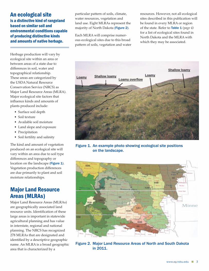
Herbage production will vary by ecological site within an area or between areas of a state due to differences in soil, water and topographical relationship. These areas are categorized by the USDA Natural Resource Conservation Service (NRCS) as Major Land Resource Areas (MLRA). Major ecological site factors that infl uence kinds and amounts of plants produced include:
• Surface soil depth• Soil texture• Available soil moisture• Land slope and exposure• Precipitation• Soil fertility and salinity
The kind and amount of vegetation produced on an ecological site will vary within an area due to soil type differences and topography or location on the landscape (Figure 1). Vegetation production differences are due primarily to plant and soil moisture relationships.
Major Land Resource Areas (MLRAs)Major Land Resource Areas (MLRAs) are geographically associated land resource units. Identifi cation of these large areas is important in statewide agricultural planning and has value in interstate, regional and national planning. The NRCS has recognized 278 MLRAs that are designated and identifi ed by a descriptive geographic name. An MLRA is a broad geographic area that is characterized by a
Figure 1. An example photo showing ecological site positions on the landscape.
An ecological siteis a distinctive kind of rangeland based on similar soil and environmental conditions capable of producing distinctive kinds and amounts of native herbage.
particular pattern of soils, climate, water resources, vegetation and land use. Eight MLRAs represent the majority of North Dakota (Figure 2).
Each MLRA will comprise numer-ous ecological sites due to this broad pattern of soils, vegetation and water
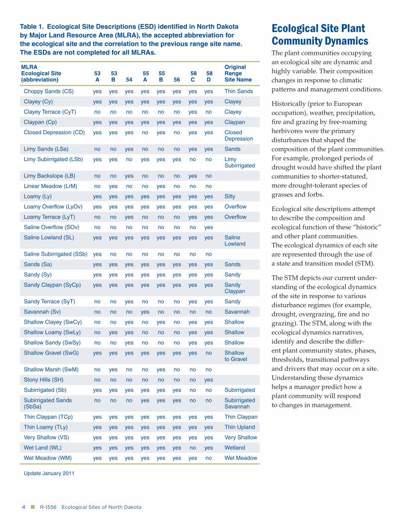
resources. However, not all ecological sites described in this publication will be found in every MLRA or region of the state. Refer to Table 1 (page 4) for a list of ecological sites found in North Dakota and the MLRA with which they may be associated.
Figure 2. Major Land Resource Areas of North and South Dakota in 2011.
Loamy overflow Loamy
Shallow loamy
Shallow loamy Loamy
4�■�R-1556�Ecological Sites of North Dakota
Table 1. Ecological Site Descriptions (ESD) identifi ed in North Dakota by Major Land Resource Area (MLRA), the accepted abbreviation for the ecological site and the correlation to the previous range site name. The ESDs are not completed for all MLRAs.
MLRA Original Ecological Site 53 53 55 55 58 58 Range (abbreviation) A B 54 A B 56 C D Site Name
Choppy Sands (CS) yes yes yes yes yes yes yes yes Thin Sands
Clayey (Cy) yes yes yes yes yes yes yes yes Clayey
Clayey Terrace (CyT) no no no no no no yes no Clayey
Claypan (Cp) yes yes yes yes yes yes yes yes Claypan
Closed Depression (CD) yes yes yes no yes no yes yes Closed Depression
Limy Sands (LSa) no no yes no no no yes yes Sands
Limy Subirrigated (LSb) yes yes no yes yes yes no no Limy Subirrigated
Limy Backslope (LB) no no yes no no no yes no
Linear Meadow (LrM) no yes no no yes no no no
Loamy (Ly) yes yes yes yes yes yes yes yes Silty
Loamy Overfl ow (LyOv) yes yes yes yes yes yes yes yes Overfl ow
Loamy Terrace (LyT) no no yes no no no yes yes Overfl ow
Saline Overfl ow (SOv) no no no no no no no yes
Saline Lowland (SL) yes yes yes yes yes yes yes yes Saline Lowland
Saline Subirrigated (SSb) yes no no no no no no no
Sands (Sa) yes yes yes yes yes yes yes yes Sands
Sandy (Sy) yes yes yes yes yes yes yes yes Sandy
Sandy Claypan (SyCp) yes yes yes yes yes yes yes yes Sandy Claypan
Sandy Terrace (SyT) no no yes no no no yes yes Sandy
Savannah (Sv) no no no yes no no no no Savannah
Shallow Clayey (SwCy) no no yes no yes no yes yes Shallow
Shallow Loamy (SwLy) no yes yes no no no yes yes Shallow
Shallow Sandy (SwSy) no no yes no no no yes yes Shallow
Shallow Gravel (SwG) yes yes yes yes yes yes yes no Shallow to Gravel
Shallow Marsh (SwM) no yes no no yes no no no
Stony Hills (SH) no no no no no no no yes
Subirrigated (Sb) yes yes yes yes yes yes no no Subirrigated
Subirrigated Sands no no no yes yes yes no no Subirrigated (SbSa) Savannah
Thin Claypan (TCp) yes yes yes yes yes yes yes yes Thin Claypan
Thin Loamy (TLy) yes yes yes yes yes yes yes yes Thin Upland
Very Shallow (VS) yes yes yes yes yes yes yes yes Very Shallow
Wet Land (WL) yes yes yes yes yes yes no yes Wetland
Wet Meadow (WM) yes yes yes yes yes yes yes no Wet Meadow
Update January 2011
Ecological Site Plant Community DynamicsThe plant communities occupying an ecological site are dynamic and highly variable. Their composition changes in response to climatic patterns and management conditions.
Historically (prior to European occupation), weather, precipitation, fi re and grazing by free-roaming herbivores were the primary disturbances that shaped the composition of the plant communities. For example, prolonged periods of drought would have shifted the plant communities to shorter-statured, more drought-tolerant species of grasses and forbs.
Ecological site descriptions attempt to describe the composition and ecological function of these “historic” and other plant communities. The ecological dynamics of each site are represented through the use of a state and transition model (STM).
The STM depicts our current under-standing of the ecological dynamics of the site in response to various disturbance regimes (for example, drought, overgrazing, fi re and no grazing). The STM, along with the ecological dynamics narratives, identify and describe the differ-ent plant community states, phases, thresholds, transitional pathways and drivers that may occur on a site. Understanding these dynamics helps a manager predict how a plant community will respond to changes in management.
www.ag.ndsu.edu�■�5
The reference plant community phase describes the plant community that would have occupied the site under the historic disturbance regime. This is the plant community that would have had the highest ecological function in terms of hydrology, species diversity and nutrient cycling. The “historic” plant communities are referred to as the “Reference State.”
One of the plant communities that occurred within the reference state usually is selected as the “Reference Plant Community” phase for inventory and evaluation purposes (i.e. similarity index).
The composition of the reference plant community is described based upon species composition data collected from sites determined to best represent this historic condition.
Additional information is gathered from other reference sources that describe the plant communities occupying the region prior to settle-ment when the natural disturbance regime would have occurred.
Since settlement, the natural disturbance regime has been altered. Fire, as a primary disturbance, essentially has been eliminated from the ecosystem. Grazing disturbances have been altered from intensive and infrequent to intensive and frequent. In other cases, fi re and grazing have been eliminated entirely. Additionally, non-native species such as Kentucky bluegrass, smooth bromegrass, crested wheatgrass and sweetclover have invaded into the sites.
Depending upon the degree of the invasion, species diversity, hydrology and nutrient cycling may be altered signifi cantly. Invasion by these species is occurring regardless of manage-ment, especially during a wet cycle period (for example, Kentucky bluegrass encroachment throughout much of the northern Plains during the wet cycle starting in 1993).
However, management intensity may limit their spread and prevent the plant community from crossing an ecological threshold. Once a threshold is crossed, major manage-ment changes and dollar investments are required for restoration.
Complete versions of ecological site descriptions are available on the Web at http://esis.sc.egov.usda.gov/.
If the ecological site descriptions for your area of interest are not available on this website, contact your local
Natural Resources Conservation Service county offi ce.
Ecological site maps for your area of interest are available via Web Soil Survey (http://websoilsurvey.nrcs.usda.gov/app/).
6�■�R-1556�Ecological Sites of North Dakota
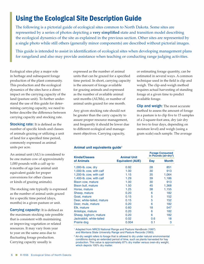
Animal unit equivalents guide1
Kinds/Classes Animal Unitof Animals Equivalent (AUE) Day Month
1,000-lb. cow, dry 0.92 28 8511,000-lb. cow, with calf 1.00 30 9131,200-lb. cow, with calf 1.15 35 1,0641,400-lb. cow, with calf 1.29 39 1,186Bison cow, mature 1.00 30 913Bison bull, mature 1.50 45 1,368Horse, mature 1.25 38 1,155Sheep, mature 0.20 6 182Goat, mature 0.15 5 152Deer, white-tailed, mature 0.15 5 152Deer, mule, mature 0.20 6 182Elk, mature 0.60 18 547Antelope, mature 0.20 6 182Sheep, bighorn, mature 0.20 6 182Jackrabbit, white-tailed 0.02 0.6 18Prairie dog 0.004 0.1 3
1 Adapted from NRCS National Range and Pasture Handbook (1997) and Montana State University Range and Pasture Records (1993).2 Air-dry weight refers to forage that is allowed to dry under natural environmental conditions during an extended period of time, such as plants harvested for hay production. This value is approximately 87% dry matter versus oven-dry weight, which depicts 100% dry matter.
Forage Consumed in Pounds (air-dry2)
Ecological sites play a major role in herbage and subsequent forage production of the plant community. This production and the ecological dynamics of the sites have a direct impact on the carrying capacity of the land (pasture unit). To further under-stand the use of this guide for deter-mining carrying capacity, we need to better describe the difference between carrying capacity and stocking rate.
Stocking rate: It is defi ned as the number of specifi c kinds and classes of animals grazing or utilizing a unit of land for a specifi ed time period, commonly expressed as animal units per acre.
An animal unit (AU) is considered to be one mature cow of approximately 1,000 pounds with a calf up to 6 months of age (see animal unit equivalent guide for proper conversions for other classes or kinds of grazing animals).
The stocking rate typically is expressed as the number of animal units grazed for a specifi c time period (days, months) in a given pasture or unit.
Carrying capacity: It is defi ned as the maximum stocking rate possible that is consistent with maintaining or improving vegetation or related resources. It may vary from year to year on the same area due to fl uctuating forage production. Carrying capacity usually is
expressed as the number of animal units that can be grazed for a specifi ed time period. In short, carrying capacity is the amount of forage available for grazing animals and expressed as the number of available animal unit months (AUMs), or number of animal units grazed for one month.
Any given stocking rate should not be greater than the carry capacity to assure proper resource management, and frequently it should be lower due to different ecological and manage-ment objectives. Carrying capacity,
or estimating forage quantity, can be estimated in several ways. A common technique used in the fi eld is clip and weigh. The clip-and-weigh method requires actual harvesting of standing forage at a given time to predict available forage.
Clip and weigh: The most accurate method to assess the amount of forage in a pasture is to clip fi ve to 15 samples of a 2-square-foot area, dry (air dry for two to four days, depending on moisture level) and weigh (using a gram scale) each sample. The average
Using the Ecological Site Description GuideThe following is a pictorial guide of ecological sites common to North Dakota. Some sites are represented by a series of photos depicting a very simplifi ed state and transition model describing the ecological dynamics of the site as explained in the previous section. Other sites are represented by a single photo while still others (generally minor components) are described without pictorial images.
This guide is intended to assist in identifi cation of ecological sites when developing management plans for rangeland and also may provide assistance when teaching or conducting range judging activities.
www.ag.ndsu.edu�■�7
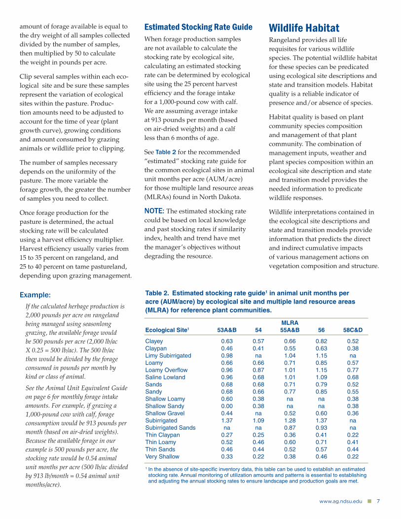
Table 2. Estimated stocking rate guide1 in animal unit months per acre (AUM/acre) by ecological site and multiple land resource areas (MLRA) for reference plant communities.
MLRAEcological Site1 53A&B 54 55A&B 56 58C&D
Clayey 0.63 0.57 0.66 0.82 0.52Claypan 0.46 0.41 0.55 0.63 0.38Limy Subirrigated 0.98 na 1.04 1.15 naLoamy 0.66 0.66 0.71 0.85 0.57Loamy Overfl ow 0.96 0.87 1.01 1.15 0.77Saline Lowland 0.96 0.68 1.01 1.09 0.68Sands 0.68 0.68 0.71 0.79 0.52Sandy 0.68 0.66 0.77 0.85 0.55Shallow Loamy 0.60 0.38 na na 0.38Shallow Sandy 0.00 0.38 na na 0.38Shallow Gravel 0.44 na 0.52 0.60 0.36Subirrigated 1.37 1.09 1.28 1.37 naSubirrigated Sands na na 0.87 0.93 naThin Claypan 0.27 0.25 0.36 0.41 0.22Thin Loamy 0.52 0.46 0.60 0.71 0.41Thin Sands 0.46 0.44 0.52 0.57 0.44Very Shallow 0.33 0.22 0.38 0.46 0.22
1 In the absence of site-specifi c inventory data, this table can be used to establish an estimated stocking rate. Annual monitoring of utilization amounts and patterns is essential to establishing and adjusting the annual stocking rates to ensure landscape and production goals are met.
amount of forage available is equal to the dry weight of all samples collected divided by the number of samples, then multiplied by 50 to calculate the weight in pounds per acre.
Clip several samples within each eco-logical site and be sure these samples represent the variation of ecological sites within the pasture. Produc-tion amounts need to be adjusted to account for the time of year (plant growth curve), growing conditions and amount consumed by grazing animals or wildlife prior to clipping.
The number of samples necessary depends on the uniformity of the pasture. The more variable the forage growth, the greater the number of samples you need to collect.
Once forage production for the pasture is determined, the actual stocking rate will be calculated using a harvest effi ciency multiplier. Harvest effi ciency usually varies from 15 to 35 percent on rangeland, and 25 to 40 percent on tame pastureland, depending upon grazing management.
Example:If the calculated herbage production is 2,000 pounds per acre on rangeland being managed using seasonlong grazing, the available forage would be 500 pounds per acre (2,000 lb/ac X 0.25 = 500 lb/ac). The 500 lb/ac then would be divided by the forage consumed in pounds per month by kind or class of animal.
See the Animal Unit Equivalent Guide on page 6 for monthly forage intake amounts. For example, if grazing a 1,000-pound cow with calf, forage consumption would be 913 pounds per month (based on air-dried weights). Because the available forage in our example is 500 pounds per acre, the stocking rate would be 0.54 animal unit months per acre (500 lb/ac divided by 913 lb/month = 0.54 animal unit months/acre).
Estimated Stocking Rate GuideWhen forage production samples are not available to calculate the stocking rate by ecological site, calculating an estimated stocking rate can be determined by ecological site using the 25 percent harvest effi ciency and the forage intake for a 1,000-pound cow with calf. We are assuming average intake at 913 pounds per month (based on air-dried weights) and a calf less than 6 months of age.
See Table 2 for the recommended “estimated” stocking rate guide for the common ecological sites in animal unit months per acre (AUM/acre) for those multiple land resource areas (MLRAs) found in North Dakota.
NOTE: The estimated stocking rate could be based on local knowledge and past stocking rates if similarity index, health and trend have met the manager’s objectives without degrading the resource.
Wildlife HabitatRangeland provides all life requisites for various wildlife species. The potential wildlife habitat for these species can be predicated using ecological site descriptions and state and transition models. Habitat quality is a reliable indicator of presence and/or absence of species.
Habitat quality is based on plant community species composition and management of that plant community. The combination of management inputs, weather and plant species composition within an ecological site description and state and transition model provides the needed information to predicate wildlife responses.
Wildlife interpretations contained in the ecological site descriptions and state and transition models provide information that predicts the direct and indirect cumulative impacts of various management actions on vegetation composition and structure.
8�■�R-1556�Ecological Sites of North Dakota
Therefore, wildlife habitat quality is directly related to these various management actions. Ecological site descriptions, along with state and transition models, enable land managers and scientists to assess potential and current wildlife habitat suitability. Ecological site descriptions also enable managers to predict potential responses of wildlife populations to vegetation dynamics based on the ecological potential of the site.
To accurately use the information found in an ecological site descriptions and state and transitional models, a manager needs to complete a good inventory of current plant species composition.
Utilizing this inventory with the ecological site descriptions and an understanding of the habitat needs of the wildlife species of interest, the manager has the necessary background information to make sound resource management decisions.
Subsequent monitoring of both plant community and wildlife population changes as management is applied provides the feedback necessary to implement an effective adaptive management plan.
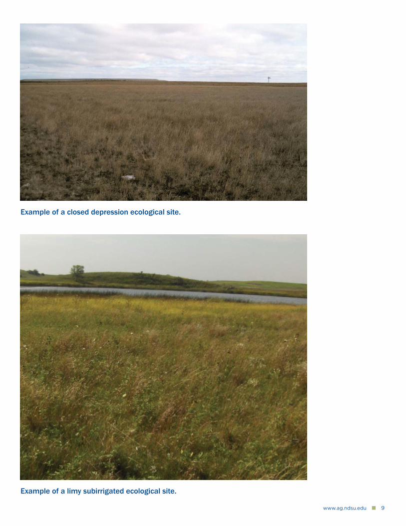
High Water Table GroupClosed DepressionThe site is poorly drained, occurs on closed upland depressions and is associated with residual soils (nonglaciated). Although salinity does not occur on this site, the subsoil layers exhibit claypan characteristics due to sodium and will form a 2-inch or longer ribbon of silty clay to clay. These areas may pond water but do not fl ood.
Major species found in the reference plant community phase include west-ern wheatgrass, slender wheatgrass, prairie cordgrass, smartweed, curlytop knotweed, alkali plantain, American Licorice and Pursh seepweed. Herbage production ranges from 3,500 pounds per acre in the east to 2,000 to 2,400 pounds per acre in the west.
Overgrazing will shift this community to one dominated by inland saltgrass, foxtail barley, curly dock, pepperweed and curlycup gumweed. Extended periods of nonuse will shift this plant community to one dominated by western wheatgrass and a variety of forbs.
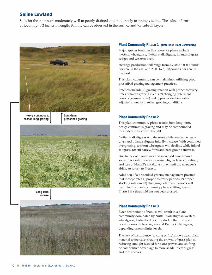
Limy SubirrigatedThe site is somewhat poorly drained and has strong to violent effervescence in all horizons of the subsoil. Carbonates occur within 16 inches of the surface. These sites occur on fl ood plains, drainage ways and around or between depressions.
Major species found in the reference plant community phase include little bluestem, big bluestem, sideoats grama, porcupine grass, green needlegrass, sedges, American licorice, Indianhemp dogbane, goldenrods, Maximilian sunfl ower and western snowberry.
Herbage production will range from 3,800 to 4,000 pounds per acre. With overgrazing, the tall and midstatured warm-season grasses and midstatured cool-season bunchgrasses decline and are replaced by grazing-tolerant forbs and Kentucky bluegrass. With extended periods of nonuse, these sites tend to become dominated by Kentucky bluegrass, smooth bromegrass and shrubs.
www.ag.ndsu.edu�■�9
Example of a limy subirrigated ecological site.
Example of a closed depression ecological site.
10�■�R-1556�Ecological Sites of North Dakota
Saline LowlandSoils for these sites are moderately well to poorly drained and moderately to strongly saline. The subsoil forms a ribbon up to 2 inches in length. Salinity can be observed in the surface and/or subsoil layers.
Plant Community Phase 1 (Reference Plant Community)
Major species found in this reference phase include western wheatgrass, Nuttall’s alkaligrass, inland saltgrass, sedges and western dock.
Herbage production will range from 3,700 to 4,000 pounds per acre in the east and 2,000 to 2,500 pounds per acre in the west.
This plant community can be maintained utilizing good prescribed grazing management practices.
Practices include: 1) grazing rotation with proper recovery times between grazing events, 2) changing deferment periods (season-of-use) and 3) proper stocking rates adjusted annually to refl ect growing conditions.
Plant Community Phase 2This plant community phase results from long-term, heavy, continuous grazing and may be compounded by moderate to severe drought.
Nuttall’s alkaligrass will decrease while western wheat-grass and inland saltgrass initially increase. With continued overgrazing, western wheatgrass will decline, while inland saltgrass, foxtail barley, forbs and bare ground increase.
Due to lack of plant cover and increased bare ground, soil surface salinity may increase. Higher levels of salinity and loss of Nuttall’s alkaligrass may limit the manager’s ability to return to Phase 1.
Adoption of a prescribed grazing management practice that incorporates 1) proper recovery periods, 2) proper stocking rates and 3) changing deferment periods will result in this plant community phase shifting toward Phase 1 if a threshold has not been crossed.
Plant Community Phase 3Extended periods of nonuse will result in a plant community dominated by Nuttall’s alkaligrass, western wheatgrass, foxtail barley, curly dock, other forbs, and possibly smooth bromegrass and Kentucky bluegrass, depending upon salinity levels.
The lack of disturbance (grazing or fi re) allows dead plant material to increase, shading the crowns of grass plants, reducing sunlight needed for plant growth and shifting he competitive advantage to more shade-tolerant grass and forb species.
Heavy, continuous, season-long grazing
Long-term nonuse
Long-term prescribed grazing
www.ag.ndsu.edu�■�11
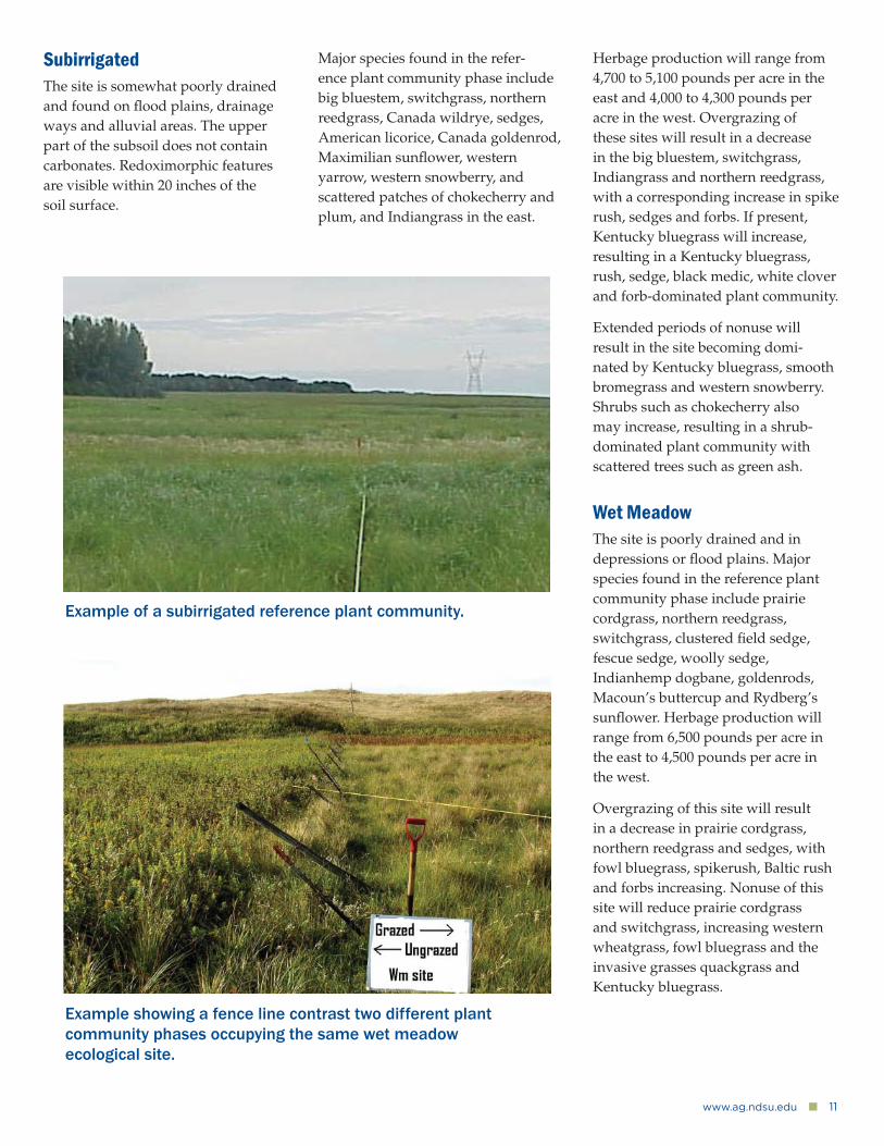
SubirrigatedThe site is somewhat poorly drained and found on fl ood plains, drainage ways and alluvial areas. The upper part of the subsoil does not contain carbonates. Redoximorphic features are visible within 20 inches of the soil surface.
Major species found in the refer-ence plant community phase include big bluestem, switchgrass, northern reedgrass, Canada wildrye, sedges, American licorice, Canada goldenrod, Maximilian sunfl ower, western yarrow, western snowberry, and scattered patches of chokecherry and plum, and Indiangrass in the east.
Herbage production will range from 4,700 to 5,100 pounds per acre in the east and 4,000 to 4,300 pounds per acre in the west. Overgrazing of these sites will result in a decrease in the big bluestem, switchgrass, Indiangrass and northern reedgrass, with a corresponding increase in spike rush, sedges and forbs. If present, Kentucky bluegrass will increase, resulting in a Kentucky bluegrass, rush, sedge, black medic, white clover and forb-dominated plant community.
Extended periods of nonuse will result in the site becoming domi-nated by Kentucky bluegrass, smooth bromegrass and western snowberry. Shrubs such as chokecherry also may increase, resulting in a shrub-dominated plant community with scattered trees such as green ash.
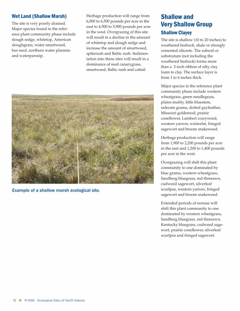
Wet MeadowThe site is poorly drained and in depressions or fl ood plains. Major species found in the reference plant community phase include prairie cordgrass, northern reedgrass, switchgrass, clustered fi eld sedge, fescue sedge, woolly sedge, Indianhemp dogbane, goldenrods, Macoun’s buttercup and Rydberg’s sunfl ower. Herbage production will range from 6,500 pounds per acre in the east to 4,500 pounds per acre in the west.
Overgrazing of this site will result in a decrease in prairie cordgrass, northern reedgrass and sedges, with fowl bluegrass, spikerush, Baltic rush and forbs increasing. Nonuse of this site will reduce prairie cordgrass and switchgrass, increasing western wheatgrass, fowl bluegrass and the invasive grasses quackgrass and Kentucky bluegrass.
Example of a subirrigated reference plant community.
Example showing a fence line contrast two different plant community phases occupying the same wet meadow ecological site.
12�■�R-1556�Ecological Sites of North Dakota
Wet Land (Shallow Marsh)The site is very poorly drained. Major species found in the refer-ence plant community phase include slough sedge, whitetop, American sloughgrass, water smartweed, bur-reed, northern water plantain and waterparsnip.
Herbage production will range from 6,000 to 6,500 pounds per acre in the east to 4,500 to 5,900 pounds per acre in the west. Overgrazing of this site will result in a decline in the amount of whitetop and slough sedge and increase the amount of smartweed, spikerush and Baltic rush. Sedimen-tation into these sites will result in a dominance of reed canarygrass, smartweed, Baltic rush and cattail.
Shallow and Very Shallow GroupShallow ClayeyThe site is shallow (10 to 20 inches) to weathered bedrock, shale or strongly cemented silicrete. The subsoil or substratum (not including the weathered bedrock) forms more than a 2-inch ribbon of silty clay loam to clay. The surface layer is from 1 to 6 inches thick.
Major species in the reference plant community phase include western wheatgrass, green needlegrass, plains muhly, little bluestem, sideoats grama, dotted gayfeather, Missouri goldenrod, prairie conefl ower, Lambert crazyweed, western yarrow, winterfat, fringed sagewort and broom snakeweed.
Herbage production will range from 1,900 to 2,200 pounds per acre in the east and 1,200 to 1,400 pounds per acre in the west.
Overgrazing will shift this plant community to one dominated by blue grama, western wheatgrass, Sandberg bluegrass, red threeawn, cudweed sagewort, silverleaf scurfpea, western yarrow, fringed sagewort and broom snakeweed.
Extended periods of nonuse will shift this plant community to one dominated by western wheatgrass, Sandberg bluegrass, red threeawn, Kentucky bluegrass, cudweed sage-wort, prairie conefl ower, silverleaf scurfpea and fringed sagewort.
Example of a shallow marsh ecological site.
www.ag.ndsu.edu�■�13
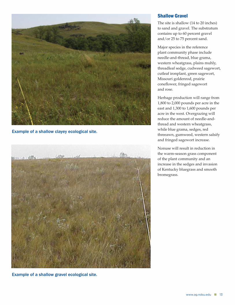
Shallow GravelThe site is shallow (14 to 20 inches) to sand and gravel. The substratum contains up to 60 percent gravel and/or 25 to 75 percent sand.
Major species in the reference plant community phase include needle-and-thread, blue grama, western wheatgrass, plains muhly, threadleaf sedge, cudweed sagewort, cutleaf ironplant, green sagewort, Missouri goldenrod, prairie conefl ower, fringed sagewort and rose.
Herbage production will range from 1,800 to 2,000 pounds per acre in the east and 1,300 to 1,600 pounds per acre in the west. Overgrazing will reduce the amount of needle-and-thread and western wheatgrass, while blue grama, sedges, red threeawn, gumweed, western salsify and fringed sagewort increase.
Nonuse will result in reduction in the warm-season grass component of the plant community and an increase in the sedges and invasion of Kentucky bluegrass and smooth bromegrass.
Example of a shallow clayey ecological site.
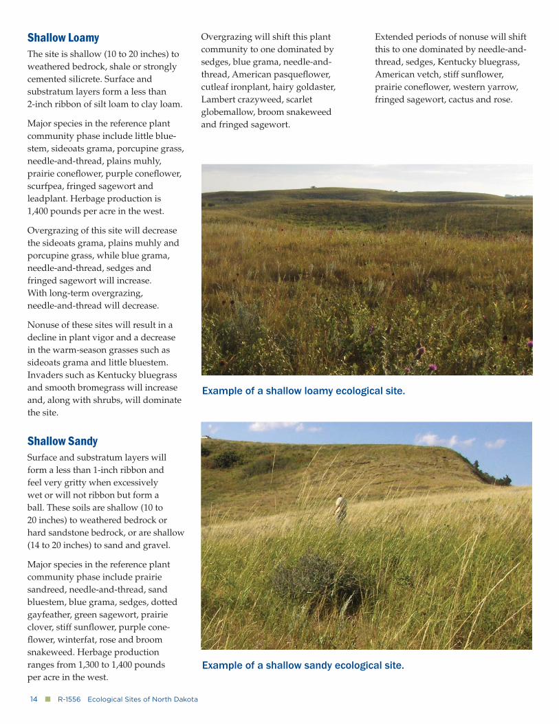
Example of a shallow gravel ecological site.
14�■�R-1556�Ecological Sites of North Dakota
Shallow LoamyThe site is shallow (10 to 20 inches) to weathered bedrock, shale or strongly cemented silicrete. Surface and substratum layers form a less than 2-inch ribbon of silt loam to clay loam.
Major species in the reference plant community phase include little blue-stem, sideoats grama, porcupine grass, needle-and-thread, plains muhly, prairie conefl ower, purple conefl ower, scurfpea, fringed sagewort and leadplant. Herbage production is 1,400 pounds per acre in the west.
Overgrazing of this site will decrease the sideoats grama, plains muhly and porcupine grass, while blue grama, needle-and-thread, sedges and fringed sagewort will increase. With long-term overgrazing, needle-and-thread will decrease.
Nonuse of these sites will result in a decline in plant vigor and a decrease in the warm-season grasses such as sideoats grama and little bluestem. Invaders such as Kentucky bluegrass and smooth bromegrass will increase and, along with shrubs, will dominate the site.
Shallow SandySurface and substratum layers will form a less than 1-inch ribbon and feel very gritty when excessively wet or will not ribbon but form a ball. These soils are shallow (10 to 20 inches) to weathered bedrock or hard sandstone bedrock, or are shallow (14 to 20 inches) to sand and gravel.
Major species in the reference plant community phase include prairie sandreed, needle-and-thread, sand bluestem, blue grama, sedges, dotted gayfeather, green sagewort, prairie clover, stiff sunfl ower, purple cone-fl ower, winterfat, rose and broom snakeweed. Herbage production ranges from 1,300 to 1,400 pounds per acre in the west.
Overgrazing will shift this plant community to one dominated by sedges, blue grama, needle-and-thread, American pasquefl ower, cutleaf ironplant, hairy goldaster, Lambert crazyweed, scarlet globemallow, broom snakeweed and fringed sagewort.
Extended periods of nonuse will shift this to one dominated by needle-and-thread, sedges, Kentucky bluegrass, American vetch, stiff sunfl ower, prairie conefl ower, western yarrow, fringed sagewort, cactus and rose.
Example of a shallow loamy ecological site.
Example of a shallow sandy ecological site.
www.ag.ndsu.edu�■�15
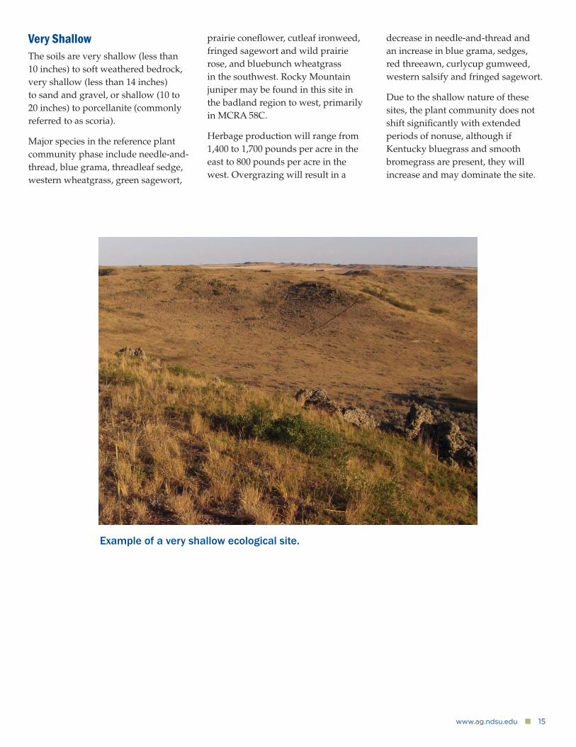
Very ShallowThe soils are very shallow (less than 10 inches) to soft weathered bedrock, very shallow (less than 14 inches) to sand and gravel, or shallow (10 to 20 inches) to porcellanite (commonly referred to as scoria).
Major species in the reference plant community phase include needle-and-thread, blue grama, threadleaf sedge, western wheatgrass, green sagewort,
prairie conefl ower, cutleaf ironweed, fringed sagewort and wild prairie rose, and bluebunch wheatgrass in the southwest. Rocky Mountain juniper may be found in this site in the badland region to west, primarily in MCRA 58C.
Herbage production will range from 1,400 to 1,700 pounds per acre in the east to 800 pounds per acre in the west. Overgrazing will result in a
decrease in needle-and-thread and an increase in blue grama, sedges, red threeawn, curlycup gumweed, western salsify and fringed sagewort.
Due to the shallow nature of these sites, the plant community does not shift signifi cantly with extended periods of nonuse, although if Kentucky bluegrass and smooth bromegrass are present, they will increase and may dominate the site.
Example of a very shallow ecological site.
16�■�R-1556�Ecological Sites of North Dakota
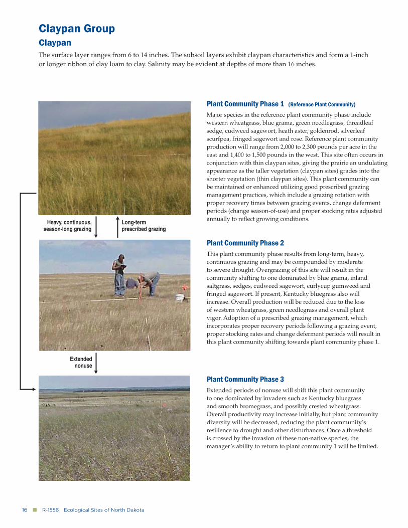
Claypan GroupClaypanThe surface layer ranges from 6 to 14 inches. The subsoil layers exhibit claypan characteristics and form a 1-inch or longer ribbon of clay loam to clay. Salinity may be evident at depths of more than 16 inches.
Plant Community Phase 1 (Reference Plant Community)
Major species in the reference plant community phase include western wheatgrass, blue grama, green needlegrass, threadleaf sedge, cudweed sagewort, heath aster, goldenrod, silverleaf scurfpea, fringed sagewort and rose. Reference plant community production will range from 2,000 to 2,300 pounds per acre in the east and 1,400 to 1,500 pounds in the west. This site often occurs in conjunction with thin claypan sites, giving the prairie an undulating appearance as the taller vegetation (claypan sites) grades into the shorter vegetation (thin claypan sites). This plant community can be maintained or enhanced utilizing good prescribed grazing management practices, which include a grazing rotation with proper recovery times between grazing events, change deferment periods (change season-of-use) and proper stocking rates adjusted annually to refl ect growing conditions.
Plant Community Phase 2This plant community phase results from long-term, heavy, continuous grazing and may be compounded by moderate to severe drought. Overgrazing of this site will result in the community shifting to one dominated by blue grama, inland saltgrass, sedges, cudweed sagewort, curlycup gumweed and fringed sagewort. If present, Kentucky bluegrass also will increase. Overall production will be reduced due to the loss of western wheatgrass, green needlegrass and overall plant vigor. Adoption of a prescribed grazing management, which incorporates proper recovery periods following a grazing event, proper stocking rates and change deferment periods will result in this plant community shifting towards plant community phase 1.
Plant Community Phase 3Extended periods of nonuse will shift this plant community to one dominated by invaders such as Kentucky bluegrass and smooth bromegrass, and possibly crested wheatgrass. Overall productivity may increase initially, but plant community diversity will be decreased, reducing the plant community’s resilience to drought and other disturbances. Once a threshold is crossed by the invasion of these non-native species, the manager’s ability to return to plant community 1 will be limited.
Heavy, continuous, season-long grazing
Long-term prescribed grazing
Extended nonuse
www.ag.ndsu.edu�■�17
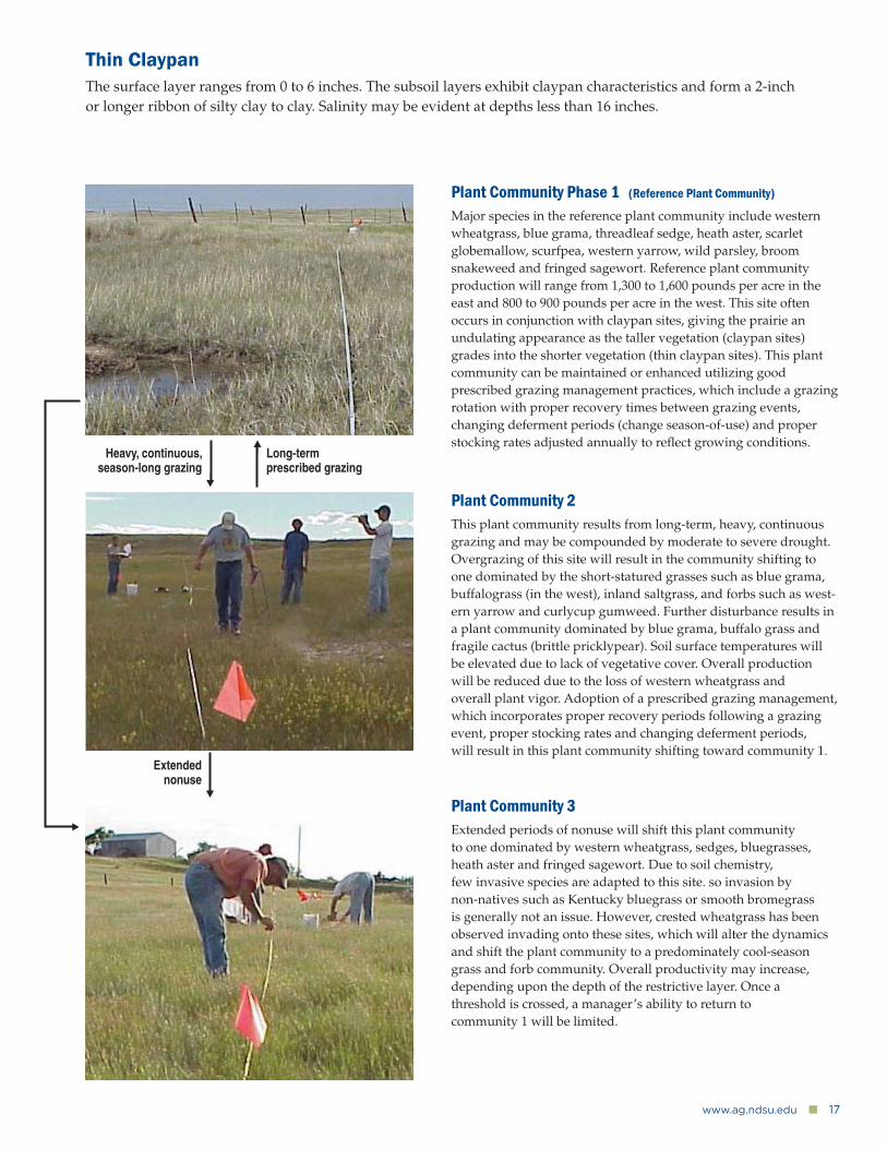
Thin ClaypanThe surface layer ranges from 0 to 6 inches. The subsoil layers exhibit claypan characteristics and form a 2-inch or longer ribbon of silty clay to clay. Salinity may be evident at depths less than 16 inches.
Plant Community Phase 1 (Reference Plant Community)
Major species in the reference plant community include western wheatgrass, blue grama, threadleaf sedge, heath aster, scarlet globemallow, scurfpea, western yarrow, wild parsley, broom snakeweed and fringed sagewort. Reference plant community production will range from 1,300 to 1,600 pounds per acre in the east and 800 to 900 pounds per acre in the west. This site often occurs in conjunction with claypan sites, giving the prairie an undulating appearance as the taller vegetation (claypan sites) grades into the shorter vegetation (thin claypan sites). This plant community can be maintained or enhanced utilizing good prescribed grazing management practices, which include a grazing rotation with proper recovery times between grazing events, changing deferment periods (change season-of-use) and proper stocking rates adjusted annually to refl ect growing conditions.
Plant Community 2This plant community results from long-term, heavy, continuous grazing and may be compounded by moderate to severe drought. Overgrazing of this site will result in the community shifting to one dominated by the short-statured grasses such as blue grama, buffalograss (in the west), inland saltgrass, and forbs such as west-ern yarrow and curlycup gumweed. Further disturbance results in a plant community dominated by blue grama, buffalo grass and fragile cactus (brittle pricklypear). Soil surface temperatures will be elevated due to lack of vegetative cover. Overall production will be reduced due to the loss of western wheatgrass and overall plant vigor. Adoption of a prescribed grazing management, which incorporates proper recovery periods following a grazing event, proper stocking rates and changing deferment periods, will result in this plant community shifting toward community 1.
Plant Community 3Extended periods of nonuse will shift this plant community to one dominated by western wheatgrass, sedges, bluegrasses, heath aster and fringed sagewort. Due to soil chemistry, few invasive species are adapted to this site. so invasion by non-natives such as Kentucky bluegrass or smooth bromegrass is generally not an issue. However, crested wheatgrass has been observed invading onto these sites, which will alter the dynamics and shift the plant community to a predominately cool-season grass and forb community. Overall productivity may increase, depending upon the depth of the restrictive layer. Once a threshold is crossed, a manager’s ability to return to community 1 will be limited.
Extended nonuse
Heavy, continuous, season-long grazing
Long-term prescribed grazing
18�■�R-1556�Ecological Sites of North Dakota
Sandy ClaypanThe depth to claypan ranges from 6 to 18 inches. The subsoil layer exhibits claypan characteristics and forms a less than 1-inch ribbon of fi ne sandy loam. Salinity may be evident at depths of more than 16 inches.
Major species in the reference plant community phase include western wheatgrass, prairie sandreed,
needle-and-thread, sedges, scurfpea, stiff sunfl ower, western wallfl ower, fringed sagewort and rose. Herbage production will range from 2,400 to 2,600 pounds per acre in the east and 1,600 to 2,000 pounds per acre in the west.
Overgrazing of this site will result in the community shifting to one dominated by blue grama, sedges,
cudweed sagewort, green sagewort, western yarrow and fringed sagewort.
Extended periods of nonuse will shift this plant community to one dominated by species such as Kentucky bluegrass, smooth brome-grass, sedges, cudweed sagewort, goldenrod, heath aster, scurfpea, fringed sagewort and western yarrow.
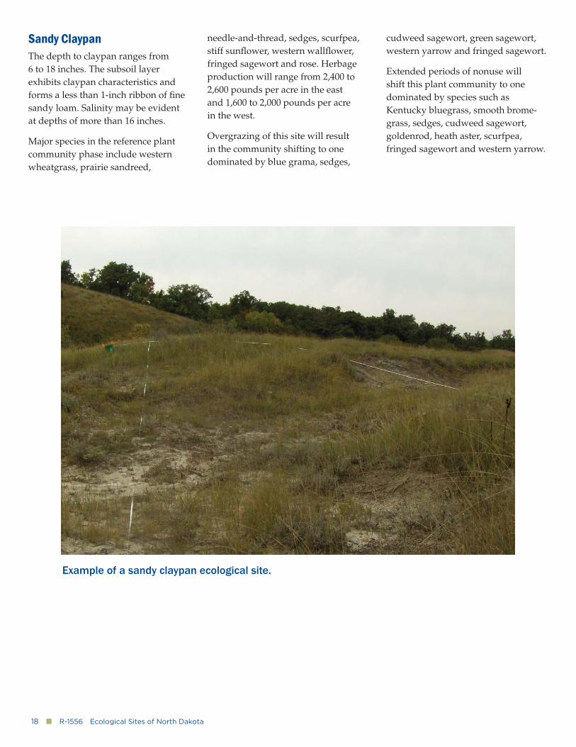
Example of a sandy claypan ecological site.
www.ag.ndsu.edu�■�19
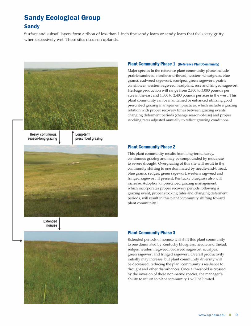
Sandy Ecological GroupSandySurface and subsoil layers form a ribon of less than 1-inch fi ne sandy loam or sandy loam that feels very gritty when excessively wet. These sites occur on uplands.
Plant Community Phase 1 (Reference Plant Community)
Major species in the reference plant community phase include prairie sandreed, needle-and-thread, western wheatgrass, blue grama, cudweed sagewort, scurfpea, green sagewort, prairie conefl ower, western ragweed, leadplant, rose and fringed sagewort. Herbage production will range from 2,800 to 3,000 pounds per acre in the east and 1,800 to 2,400 pounds per acre in the west. This plant community can be maintained or enhanced utilizing good prescribed grazing management practices, which include a grazing rotation with proper recovery times between grazing events, changing deferment periods (change season-of-use) and proper stocking rates adjusted annually to refl ect growing conditions.
Plant Community Phase 2This plant community results from long-term, heavy, continuous grazing and may be compounded by moderate to severe drought. Overgrazing of this site will result in the community shifting to one dominated by needle-and-thread, blue grama, sedges, green sagewort, western ragweed and fringed sagewort. If present, Kentucky bluegrass also will increase. Adoption of prescribed grazing management, which incorporates proper recovery periods following a grazing event, proper stocking rates and changing deferment periods, will result in this plant community shifting toward plant community 1.
Plant Community Phase 3Extended periods of nonuse will shift this plant community to one dominated by Kentucky bluegrass, needle and thread, sedges, western ragweed, cudweed sagewort, scurfpea, green sagewort and fringed sagewort. Overall productivity initially may increase, but plant community diversity will be decreased, reducing the plant community’s resilience to drought and other disturbances. Once a threshold is crossed by the invasion of these non-native species, the manager’s ability to return to plant community 1 will be limited.
Extended nonuse
Heavy, continuous, season-long grazing
Long-term prescribed grazing
20�■�R-1556�Ecological Sites of North Dakota
Sandy TerraceSurface and subsoil layers form a less than 1-inch ribbon of fi ne sandy loam or sandy loam that feels very gritty when excessively wet. These sites are on low terraces or fl ood plains and may be fl ooded occasionally.
Major species in the reference plant community phase include prairie sandreed, sand bluestem, needle-and-thread, western wheatgrass, goldenrod, penstemon, green sagewort, cudweed sagewort, prairie conefl ower, leadplant, western snowberry, chokecherry and possibly scattered cottonwood and green ash.
Herbage production will range from 2,500 to 3,000 pounds per acre. Overgrazing of this site will result in the community shifting to one dominated by needle-and-thread, blue grama, sedges, western ragweed, western salsify and fringed sagewort or Kentucky bluegrass when present.
Extended periods of nonuse will shift this plant community to one dominated by Kentucky bluegrass, smooth bromegrass, sedges, goldenrod, prairie conefl ower, hairy goldaster, western snowberry and green ash.
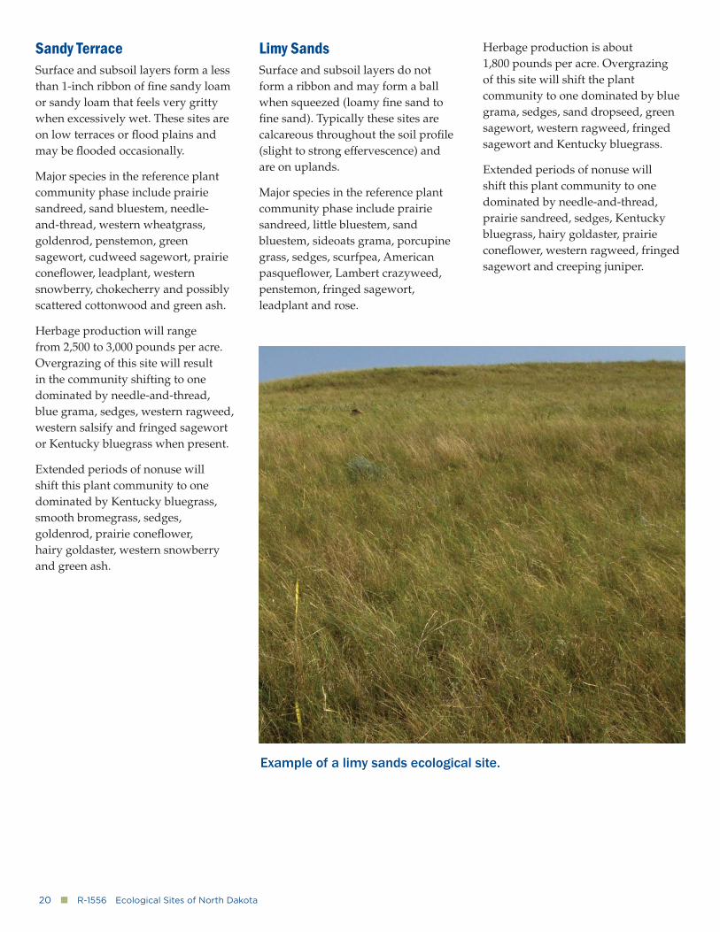
Limy SandsSurface and subsoil layers do not form a ribbon and may form a ball when squeezed (loamy fi ne sand to fi ne sand). Typically these sites are calcareous throughout the soil profi le (slight to strong effervescence) and are on uplands.
Major species in the reference plant community phase include prairie sandreed, little bluestem, sand bluestem, sideoats grama, porcupine grass, sedges, scurfpea, American pasquefl ower, Lambert crazyweed, penstemon, fringed sagewort, leadplant and rose.
Herbage production is about 1,800 pounds per acre. Overgrazing of this site will shift the plant community to one dominated by blue grama, sedges, sand dropseed, green sagewort, western ragweed, fringed sagewort and Kentucky bluegrass.
Extended periods of nonuse will shift this plant community to one dominated by needle-and-thread, prairie sandreed, sedges, Kentucky bluegrass, hairy goldaster, prairie conefl ower, western ragweed, fringed sagewort and creeping juniper.
Example of a limy sands ecological site.
www.ag.ndsu.edu�■�21
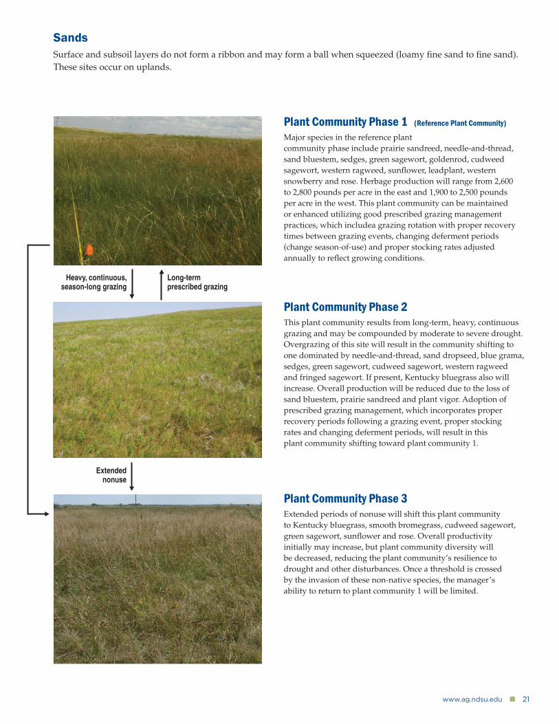
SandsSurface and subsoil layers do not form a ribbon and may form a ball when squeezed (loamy fi ne sand to fi ne sand). These sites occur on uplands.
Plant Community Phase 1 (Reference Plant Community)
Major species in the reference plant community phase include prairie sandreed, needle-and-thread, sand bluestem, sedges, green sagewort, goldenrod, cudweed sagewort, western ragweed, sunfl ower, leadplant, western snowberry and rose. Herbage production will range from 2,600 to 2,800 pounds per acre in the east and 1,900 to 2,500 pounds per acre in the west. This plant community can be maintained or enhanced utilizing good prescribed grazing management practices, which includea grazing rotation with proper recovery times between grazing events, changing deferment periods (change season-of-use) and proper stocking rates adjusted annually to refl ect growing conditions.
Plant Community Phase 2This plant community results from long-term, heavy, continuous grazing and may be compounded by moderate to severe drought. Overgrazing of this site will result in the community shifting to one dominated by needle-and-thread, sand dropseed, blue grama, sedges, green sagewort, cudweed sagewort, western ragweed and fringed sagewort. If present, Kentucky bluegrass also will increase. Overall production will be reduced due to the loss of sand bluestem, prairie sandreed and plant vigor. Adoption of prescribed grazing management, which incorporates proper recovery periods following a grazing event, proper stocking rates and changing deferment periods, will result in this plant community shifting toward plant community 1.
Plant Community Phase 3Extended periods of nonuse will shift this plant community to Kentucky bluegrass, smooth bromegrass, cudweed sagewort, green sagewort, sunfl ower and rose. Overall productivity initially may increase, but plant community diversity will be decreased, reducing the plant community’s resilience to drought and other disturbances. Once a threshold is crossed by the invasion of these non-native species, the manager’s ability to return to plant community 1 will be limited.
Extended nonuse
Heavy, continuous, season-long grazing
Long-term prescribed grazing

22�■�R-1556�Ecological Sites of North Dakota
Subirrigated SandsSurface and subsoil layers do not form a ribbon and may form a ball when squeezed (loamy fi ne sand to fi ne sand). These sites are moderately well-drained and occur on uplands. Redoximorphic features are visible from 20 to 40 inches.
Major species in the reference plant community phase include big blue-stem, sand bluestem, prairie sandreed, porcupine grass, little bluestem, sideoats grama, sedges, goldenrods, heath aster, bracted spiderwort, Maximilian sunfl ower, purple prairie clover, silky prairie clover, prairie willow and rose.
Herbage production is about 3,200 pounds per acre. Overgrazing of this site will shift the plant community to one dominated by needle-and-thread, blue grama, sand dropseed, sedges,
goldenrods, western ragweed and rose or Kentucky bluegrass when present.
Extended periods of nonuse will shift this plant community to one domi-nated by Kentucky bluegrass, smooth bromegrass, goldenrods, prairie willow and western snowberry.
Choppy Sands (Thin Sands)Surface and subsoil layers do not form a ribbon and may form a ball when squeezed (loamy fi ne sand to fi ne sand). These sites are on fl ood plains, lake plains, outwash plains, residual plains and terraces. Typical landscapes are hummocks and dunes with slopes greater than 15 percent.
Major species in the reference plant community phase include sand blue-stem, little bluestem, prairie sandreed, needle-and-thread, porcupine grass,
blue grama, sedges, bracted spider-wort, dotted gayfeather, goldenrods, green sagewort, penstemon and leadplant.
Herbage production ranges from 1,900 pounds per acre in the east to 1,600 pounds per acre in the west. Overgrazing of this site will shift the plant community to one dominated by needle-and-thread, blue grama, sand dropseed, sedges, western ragweed, green sagewort, goldenrods and fringed sagewort or Kentucky bluegrass when present. Excessive localized disturbance may lead to blowouts.
Extended periods of nonuse will shift this plant community to one dominated by Kentucky bluegrass, sedges, goldenrods, horsetail, scurfpea, western ragweed and fringed sagewort.
Example of a choppy sands ecological site.
www.ag.ndsu.edu�■�23
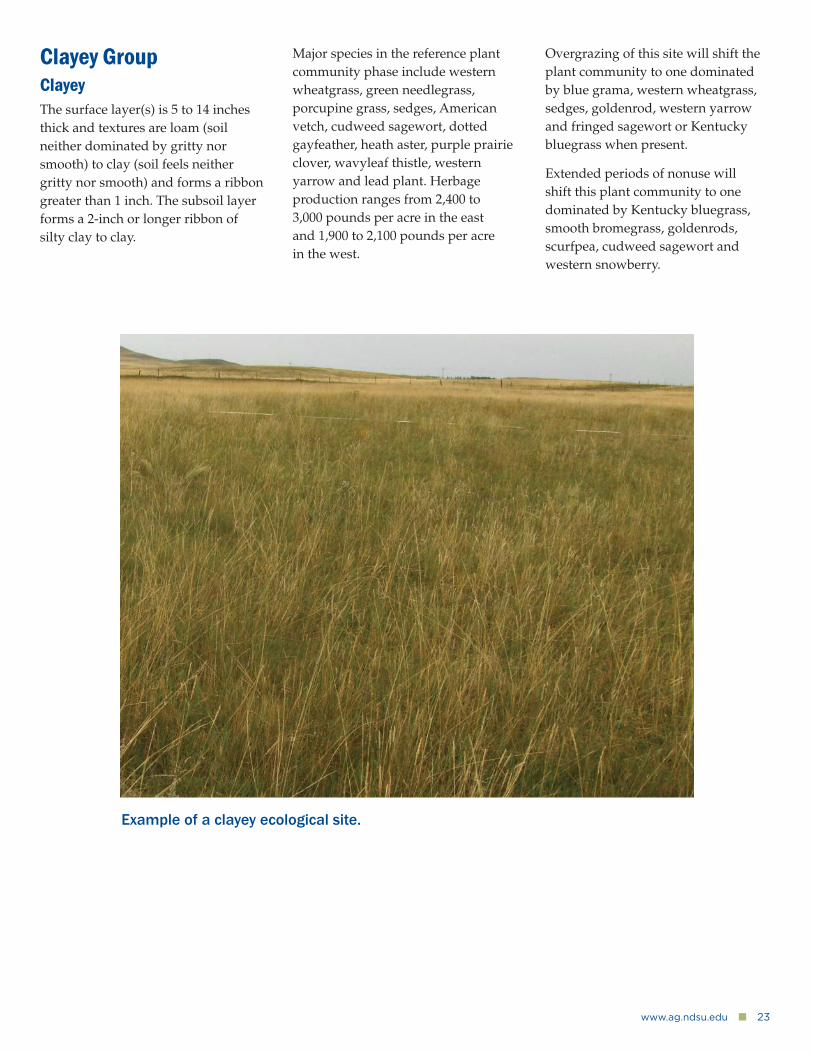
Clayey GroupClayeyThe surface layer(s) is 5 to 14 inches thick and textures are loam (soil neither dominated by gritty nor smooth) to clay (soil feels neither gritty nor smooth) and forms a ribbon greater than 1 inch. The subsoil layer forms a 2-inch or longer ribbon of silty clay to clay.
Major species in the reference plant community phase include western wheatgrass, green needlegrass, porcupine grass, sedges, American vetch, cudweed sagewort, dotted gayfeather, heath aster, purple prairie clover, wavyleaf thistle, western yarrow and lead plant. Herbage production ranges from 2,400 to 3,000 pounds per acre in the east and 1,900 to 2,100 pounds per acre in the west.
Overgrazing of this site will shift the plant community to one dominated by blue grama, western wheatgrass, sedges, goldenrod, western yarrow and fringed sagewort or Kentucky bluegrass when present.
Extended periods of nonuse will shift this plant community to one dominated by Kentucky bluegrass, smooth bromegrass, goldenrods, scurfpea, cudweed sagewort and western snowberry.
Example of a clayey ecological site.
24�■�R-1556�Ecological Sites of North Dakota
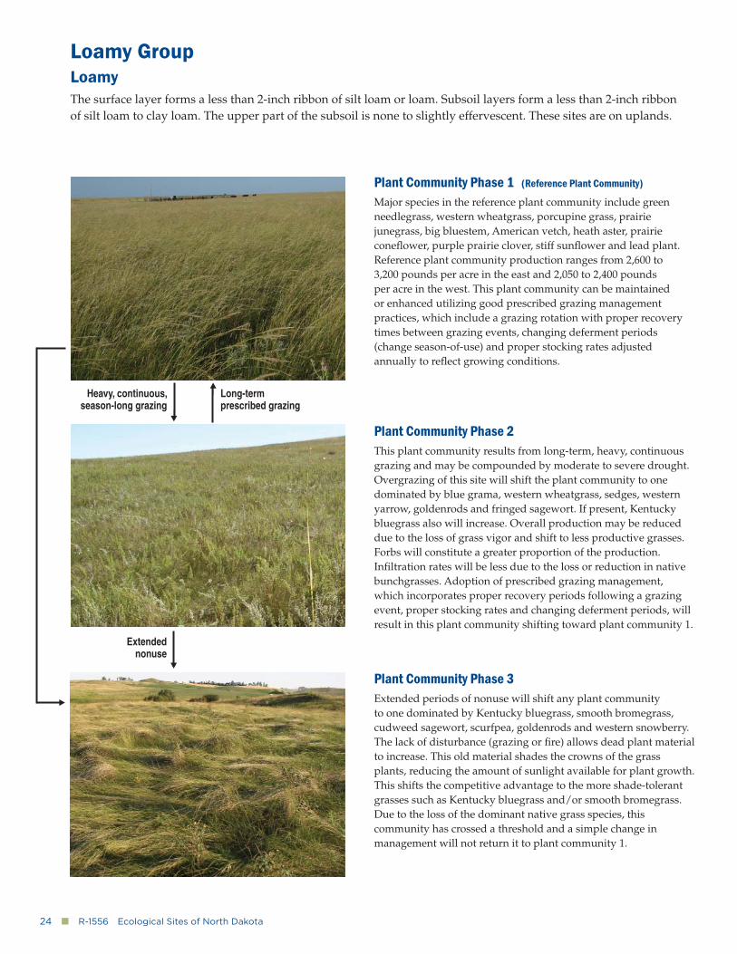
Loamy GroupLoamyThe surface layer forms a less than 2-inch ribbon of silt loam or loam. Subsoil layers form a less than 2-inch ribbon of silt loam to clay loam. The upper part of the subsoil is none to slightly effervescent. These sites are on uplands.
Plant Community Phase 1 (Reference Plant Community)
Major species in the reference plant community include green needlegrass, western wheatgrass, porcupine grass, prairie junegrass, big bluestem, American vetch, heath aster, prairie conefl ower, purple prairie clover, stiff sunfl ower and lead plant. Reference plant community production ranges from 2,600 to 3,200 pounds per acre in the east and 2,050 to 2,400 pounds per acre in the west. This plant community can be maintained or enhanced utilizing good prescribed grazing management practices, which include a grazing rotation with proper recovery times between grazing events, changing deferment periods (change season-of-use) and proper stocking rates adjusted annually to refl ect growing conditions.
Plant Community Phase 2This plant community results from long-term, heavy, continuous grazing and may be compounded by moderate to severe drought. Overgrazing of this site will shift the plant community to one dominated by blue grama, western wheatgrass, sedges, western yarrow, goldenrods and fringed sagewort. If present, Kentucky bluegrass also will increase. Overall production may be reduced due to the loss of grass vigor and shift to less productive grasses. Forbs will constitute a greater proportion of the production. Infi ltration rates will be less due to the loss or reduction in nativebunchgrasses. Adoption of prescribed grazing management, which incorporates proper recovery periods following a grazing event, proper stocking rates and changing deferment periods, will result in this plant community shifting toward plant community 1.
Plant Community Phase 3Extended periods of nonuse will shift any plant community to one dominated by Kentucky bluegrass, smooth bromegrass, cudweed sagewort, scurfpea, goldenrods and western snowberry. The lack of disturbance (grazing or fi re) allows dead plant material to increase. This old material shades the crowns of the grass plants, reducing the amount of sunlight available for plant growth. This shifts the competitive advantage to the more shade-tolerant grasses such as Kentucky bluegrass and/or smooth bromegrass. Due to the loss of the dominant native grass species, this community has crossed a threshold and a simple change in management will not return it to plant community 1.
Extended nonuse
Heavy, continuous, season-long grazing
Long-term prescribed grazing
www.ag.ndsu.edu�■�25
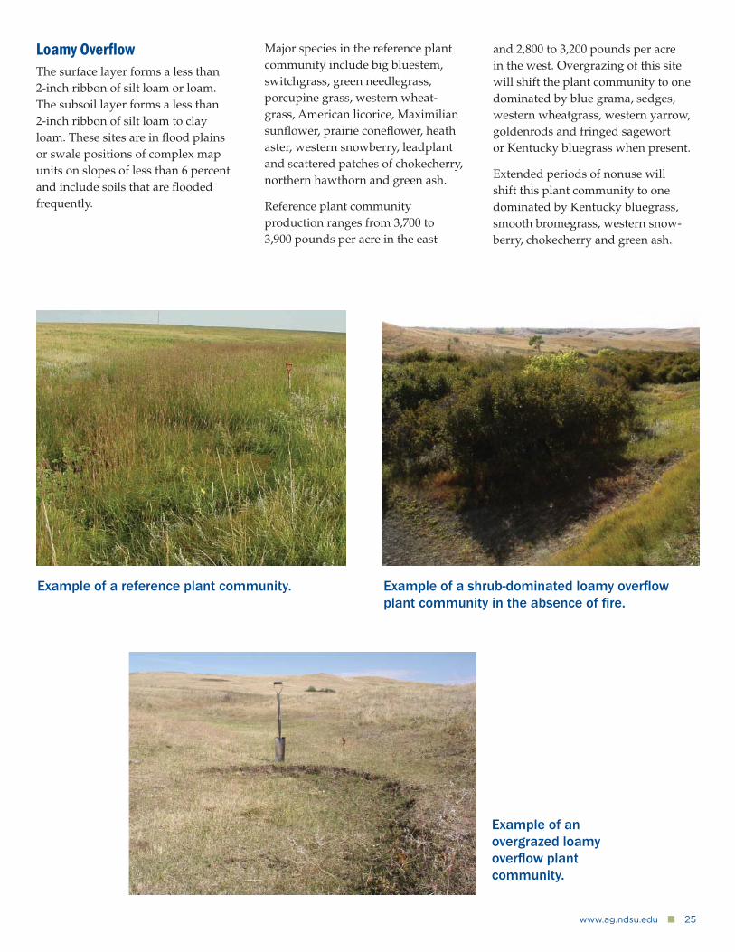
Loamy Overfl owThe surface layer forms a less than 2-inch ribbon of silt loam or loam. The subsoil layer forms a less than 2-inch ribbon of silt loam to clay loam. These sites are in fl ood plains or swale positions of complex map units on slopes of less than 6 percent and include soils that are fl ooded frequently.
Example of a reference plant community.
Example of an overgrazed loamy overfl ow plant community.
Example of a shrub-dominated loamy overfl ow plant community in the absence of fi re.
Major species in the reference plant community include big bluestem, switchgrass, green needlegrass, porcupine grass, western wheat-grass, American licorice, Maximilian sunfl ower, prairie conefl ower, heath aster, western snowberry, leadplant and scattered patches of chokecherry, northern hawthorn and green ash.
Reference plant community production ranges from 3,700 to 3,900 pounds per acre in the east
and 2,800 to 3,200 pounds per acre in the west. Overgrazing of this site will shift the plant community to one dominated by blue grama, sedges, western wheatgrass, western yarrow, goldenrods and fringed sagewort or Kentucky bluegrass when present.
Extended periods of nonuse will shift this plant community to one dominated by Kentucky bluegrass, smooth bromegrass, western snow-berry, chokecherry and green ash.
26�■�R-1556�Ecological Sites of North Dakota
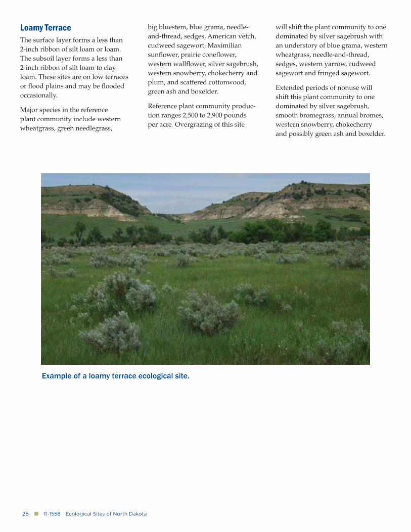
Loamy TerraceThe surface layer forms a less than 2-inch ribbon of silt loam or loam. The subsoil layer forms a less than 2-inch ribbon of silt loam to clay loam. These sites are on low terraces or fl ood plains and may be fl ooded occasionally.
Major species in the reference plant community include western wheatgrass, green needlegrass,
big bluestem, blue grama, needle-and-thread, sedges, American vetch, cudweed sagewort, Maximilian sunfl ower, prairie conefl ower, western wallfl ower, silver sagebrush, western snowberry, chokecherry and plum, and scattered cottonwood, green ash and boxelder.
Reference plant community produc-tion ranges 2,500 to 2,900 pounds per acre. Overgrazing of this site
will shift the plant community to one dominated by silver sagebrush with an understory of blue grama, western wheatgrass, needle-and-thread, sedges, western yarrow, cudweed sagewort and fringed sagewort.
Extended periods of nonuse will shift this plant community to one dominated by silver sagebrush, smooth bromegrass, annual bromes, western snowberry, chokecherry and possibly green ash and boxelder.
Example of a loamy terrace ecological site.
www.ag.ndsu.edu�■�27
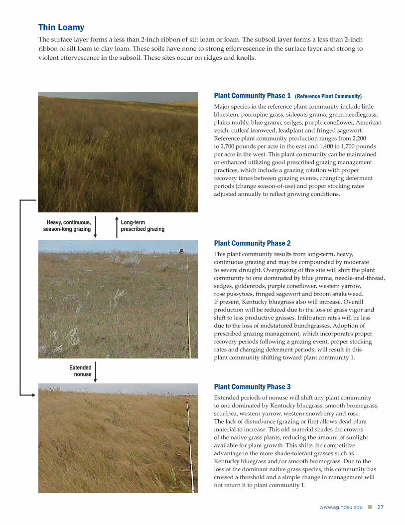
Thin LoamyThe surface layer forms a less than 2-inch ribbon of silt loam or loam. The subsoil layer forms a less than 2-inch ribbon of silt loam to clay loam. These soils have none to strong effervescence in the surface layer and strong to violent effervescence in the subsoil. These sites occur on ridges and knolls.
Plant Community Phase 1 (Reference Plant Community)
Major species in the reference plant community include little bluestem, porcupine grass, sideoats grama, green needlegrass, plains muhly, blue grama, sedges, purple conefl ower, American vetch, cutleaf ironweed, leadplant and fringed sagewort. Reference plant community production ranges from 2,200 to 2,700 pounds per acre in the east and 1,400 to 1,700 pounds per acre in the west. This plant community can be maintained or enhanced utilizing good prescribed grazing management practices, which include a grazing rotation with proper recovery times between grazing events, changing deferment periods (change season-of-use) and proper stocking rates adjusted annually to refl ect growing conditions.
Plant Community Phase 2This plant community results from long-term, heavy, continuous grazing and may be compounded by moderate to severe drought. Overgrazing of this site will shift the plant community to one dominated by blue grama, needle-and-thread, sedges, goldenrods, purple conefl ower, western yarrow, rose pussytoes, fringed sagewort and broom snakeweed. If present, Kentucky bluegrass also will increase. Overall production will be reduced due to the loss of grass vigor and shift to less productive grasses. Infi ltration rates will be less due to the loss of midstatured bunchgrasses. Adoption of prescribed grazing management, which incorporates proper recovery periods following a grazing event, proper stocking rates and changing deferment periods, will result in this plant community shifting toward plant community 1.
Plant Community Phase 3Extended periods of nonuse will shift any plant community to one dominated by Kentucky bluegrass, smooth bromegrass, scurfpea, western yarrow, western snowberry and rose. The lack of disturbance (grazing or fi re) allows dead plant material to increase. This old material shades the crowns of the native grass plants, reducing the amount of sunlight available for plant growth. This shifts the competitive advantage to the more shade-tolerant grasses such as Kentucky bluegrass and/or smooth bromegrass. Due to the loss of the dominant native grass species, this community has crossed a threshold and a simple change in management will not return it to plant community 1.
Heavy, continuous, season-long grazing
Long-term prescribed grazing
Extended nonuse
28�■�R-1556�Ecological Sites of North Dakota
For more information on this and other topics, see: www.ag.ndsu.eduNDSU encourages you to use and share this content, but please do so under the conditions of our Creative Commons license.
You may copy, distribute, transmit and adapt this work as long as you give full attribution, don’t use the work for commercial purposes and share your resulting work similarly. For more information, visit www.ag.ndsu.edu/agcomm/creative-commons.
North Dakota State University does not discriminate on the basis of age, color, disability, gender expression/identity, marital status, national origin, public assistance status, sex, sexual orientation, status as a U.S. veteran, race or religion. Direct inquiries to the Vice President for Equity, Diversity and Global Outreach, 205 Old Main, (701) 231-7708.
County Commissions, NDSU and U.S. Department of Agriculture Cooperating. This publication will be made available in alternative formats for people with disabilities upon request, (701) 231-7881. 5M-1-12
The U.S. Department of Agriculture (USDA) prohibits discrimination in all of its programs and activities on the basis of race, color, national origin, age, disability, and where applicable, sex (including gender identity and expression), marital status, familial status, parental status, religion, sexual orientation, political beliefs, genetic information, reprisal, or because all or part
of an individual’s income is derived from any public assistance program. (Not all prohibited bases apply to all programs.)
Persons with disabilities who require alternative means for communication of program information (Braille, large print, audiotape, etc.) should contact USDA’s TARGET Center at (202) 720-2600 (voice and TDD).”