economic and employment lands strategy: non-heavy …€¦ · 168. economic and employment lands...
TRANSCRIPT

166 Economic and Employment Lands Strategy:non-heavy industrial Perth metropolitan and Peel regions
Replace Image
Part 13 - Economic and Employment Lands Strategy: non-heavy industrial
Photograph courtesy: Eastcourt Property Group

167Economic and Employment Lands Strategy:non-heavy industrial
Perth metropolitan and Peel regions
Summary
The EELS provides the vital strategic direction for the necessary planning to be undertaken to ensure on-going economic growth and sustainability for the Perth metropolitan and Peel regions and for Western Australia as a whole. The aim of the strategy is to ensure that adequate forward planning is undertaken for the on-going provision of industrial land in both the Perth metropolitan and Peel regions over the next 20 years and beyond, so to ensure that the market is poised to capably respond to forecast demand.
The population-driven forecast demand for industrial land will be for an additional 4726 ha by 2031. To meet the growing needs of industry sectors, this Strategy makes the following recommendations:
1. To provide and ensure the ongoing availability of a supply of industrial land, including a buffer of undeveloped industrial land to be available if demand increases.
2. Identification of and protection for a rolling 20-year “industrial landbank” to ensure a supply of industrial land is available to meet future demand on an ongoing basis.
3. Appropriate protection for existing industrial land to sustain long-term industrial activities.
Based on current shortfalls in industrial land supply in each of the sub regions and forecast demand for the Perth metropolitan and Peel regions in the next 20 years, it will be approximately 10 years before the market can achieve a balance between supply and demand for industrial land. Priority will be afforded to the release of the remainder of existing industrial estates (representing 1758 ha supply) and all necessary feasibility studies and investigations should be promptly completed to enable delivery of the short, medium and long term sites that have been identified in this Strategy.
The EELS provides the strategic framework for the on-going identification and delivery of industrial land in the Perth metropolitan and Peel regions, which will be supported by more detailed policies and programs relating to industrial land development. It will provide for an even distribution of industrial land throughout the Perth metropolitan and Peel regions that will be available via a strategic landbank to cater for all levels of demand in the various sub-regions. A strategic landbank of industrial land is vital to sustaining the economic vitality of the Perth metropolitan and Peel regions, and to Western Australia as a whole.
To better respond to the current inadequacies and future needs of industrial estates, it is important to understand the industrial estate planning process and outcomes. The EELS represents the first stage (Strategic Landbank) of the five step process involved in delivering an industrial estate to the market, by identifying land within the Perth metropolitan and Peel regions that can be subject to future site specific and detailed investigation and analysis.

168 Economic and Employment Lands Strategy:non-heavy industrial Perth metropolitan and Peel regions
Strategic landbank
The provision of a strategic industrial landbank for Perth and Peel will be facilitated by this strategy. Sites have been identified for the short, medium and long term. The identification, protection and delivery of industrial land is an essential ongoing initiative to be undertaken by State Government, key stakeholders and the development industry itself. The current land supply stock can cater for 1758 ha of the total 4726 ha needed to meet forecast demand by 2031. The strategy has identified just under 13,000 ha of potential gross developable land, but it is a reasonable expectation that this figure will be substantially lower following the rationalisation of sites through further constraints analysis and determination of the net developable area.
A number of significant benefits can be derived from the strategic landbanking of industrial land including:
• Infrastructure and service providers can forward-plan more capably than in the past;
• An equitable balance in the social, environmental and economic outcomes can be considered and achieved;
• Local government authorities will be actively engaged in the initial stages of the preparation of design guidelines and resolution of any planning issues; and
• The identification of potential land for industrial uses will allow the protection, preservation and prioritisation over competing uses.
Estateevolution
Estatemarketing
Land assembly
Planning and environmental
studies
Strategic landbank
Planning and environmental studies
A number of planning and environmental studies and investigations must precede any development whether for residential, commercial or industrial development. The purpose of these studies is to identify any constraints and/or challenges that may need to be considered or managed prior to any development occurring. Such studies may include:
• Acid sulphate soils investigations
• Contaminated sites investigations
• Flora and fauna surveys
• Wetland boundary and classification re-evaluation
• Drainage, including groundwater monitoring
• Heritage and ethnographic surveys
• Infrastructure capacity requirements for power, gas and water
• Undertaking of modelling to determine appropriate buffers to conflicting land uses
• Buffer investigations for conservation and resource enhancement category wetlands
• Basic Raw Materials, if relevant
• Water Management and preparation of district water management strategies
• Risk assessment and planning feasibility to reclassify Priority 1 Public Drinking Water Supply Area (PDSWA) classification affecting a site, if relevant
• Preliminary planning studies associated with Metropolitan or Peel Region Scheme Amendments and Local planning scheme amendments, including rezoning.
Step 1 Step 2 Step 3 Step 4 Step 5

169Economic and Employment Lands Strategy:non-heavy industrial
Perth metropolitan and Peel regions
The timing of these studies can be anywhere from one to five years, and often are co-dependent on other studies.
Land assembly
Land assembly can represent a major challenge that needs to be managed prior to development. The acquisition and/or resumption of fragmented land into a single parcel provides a consolidated approach to the development of industrial land. One of the key outcomes of the land assembly process is the ability to develop a clear vision for an estate with well defined goals. A degree of flexibility can enhance future planning of an estate, to allow for its evolution and a more consolidated approach to approvals and infrastructure and service provision.
Early stages of the development process allow the opportunity for joint ventures and public-private partnerships. Joint ventures give the opportunity to involve the private sector and the community to produce the best outcome.
Estate marketing
Compared with residential property markets the industrial sector is a highly specialised field in which information is generally held within a relatively small circle of professional developers and real estate agents. Firms seeking to find suitable sites will be keen to get a credible assessment as to the relative merits of each location, and are likely to make use of multiple information sources. However, they will rely most heavily on advice from specialist real estate agents and use word-of-mouth referrals to help find such expertise, as well as confirming the credibility of advice and information given.
While not specifically addressed within the strategy, the issue of estate marketing should not be ignored. LandCorp and the private sector will seek to realise a return on any investments. Any land assembly and planning strategy should work in harmony with marketing strategies. The setting of clear visions for
each estate will assist this process. For major anchor tenants a well developed in-bound investment strategy will be required that links the work of the strategy with the work of those agencies such as the Department of State Development or Department of Commerce with that of LandCorp and the Department of Planning. The Small Business Development Corporation may also play a role given the large number of small businesses that will occupy the land.
Estate evolution
Finally, successful implementation of the EELS requires protection of established industrial estates in the inner and middle sectors of the metropolitan area. A consistent whole-of-government and State to local level approach to industrial land development with a close interaction between the preservation and renewal of established estates, and residential land use planning is required. This will avoid residential encroachment issues. The use of regular land user surveys is a key part of the strategy. However, it is also important to establish a knowledge management system that collects and stores information about the historical evolution of an estate. This is a key issue when attempting to understand the problems and issues that might arise in the revitalisation of older estates.
With a better appreciation of the industrial estate planning process, and having examined current trends in industrial land use planning and development, the following section is an outline of the issues that need to be addressed to create a more enabling environment for industrial land development to occur.

170 Economic and Employment Lands Strategy:non-heavy industrial Perth metropolitan and Peel regions
Economic and Employment Lands Strategy: non-heavy industrial – Key directions
The following key directions have been identified for the planning and delivery of new estates and the regeneration of existing industrial areas.
1. Diversity in lot sizes with a focus on delivering large lots
Traditional industrial ownership (small to medium enterprises and investors) industrial subdivision in WA has usually delivered a number of small lots as developers seek to maximise their returns. However, the provision of small lots has other consequences such as:
• A general decrease in the overall developable land area because of the need to provide more roads and other services; and
• A tendency to encourage development of non-industrial uses due to higher land values.
With WA’s label as a powerful resources State, the synergy between large resource projects in the North West and Perth metropolitan and Peel industrial estates needs to be better understood and catered for. Further planning is needed to understand the different requirements of “big” and “local” industry. Existing industrial estates service the needs of local industry well. Big industry is not as well served. With few industrial estates offering larger lots in the Perth and Peel markets, industrial occupiers requiring a larger lot are restricted to areas such as Kewdale and Kwinana. A mechanism designed to enable the provision of large lots is required.
A greater variety of lot sizes, in particular large lots, is necessary to cater for a variety of potential future and existing industrial occupiers, and that the economic activity occurring in regional WA can be supported by the local metropolitan economy.
The means whereby large industrial lots can be protected from further subdivision over the long-term, such as through structure planning, notification on titles or caveats with sunset clauses need to be defined and implemented.
2. Mixed-use development to create amenity
Particularly over the past 15 years, there has been a strong preference by developers and tenants to incorporate a higher proportion of office space as part of industrial developments and estates. Developers faced with increasing construction costs have needed to charge a higher office rent to make developments viable, while tenants are seeking to reduce costs by improving efficiencies wherever possible. According to the results of the Property Council of Australia Industrial Development Survey, (2009), the proportion of office space to warehouse space in new developments was 1:5; traditionally this ratio was 1:10 or 1:12. The ”Perth Airport model”, offering tenants and developers the option to co-locate head offices adjacent to their manufacturing and warehousing depots, demonstrates this trend. The benefits of a mixed-use development model for industrial include:
• Improved and greater efficiency in operations for tenants;
• The option for a greater workforce diversity;
• Higher levels of amenity for a workforce located within an estate with services such as gyms, childcare centres and cafes being available within the estates;
• Incorporation of planned transition zones between industrial and residential uses, reducing land use conflicts;

171Economic and Employment Lands Strategy:non-heavy industrial
Perth metropolitan and Peel regions
• A variety of lot sizes and built form options; and
• Improved accessibility to estates by public transport.
Structure plans for new industrial areas should include mixed use and suitable retail opportunities. These developments could be established in buffer areas and act as noise barriers to residential areas.
3. Identification of potential end users for each estate
Most existing industrial estates were planned in response to market demand at the time and often adjusted retrospectively to accommodate new tenants and end users. The strategy acknowledges that industrial estates of the future need to be forward planned, with the end user in mind. Without demand from tenants, new estates will remain undeveloped, and without provision of suitably located and sized land parcels for existing and potential industrial occupiers, the State risks economic disadvantage. Clear visions for each of the medium term sites identified in the strategy, in terms of potential build out and clustering opportunities, need to be developed in partnership with the private sector. Engaging with the private sector to harness these opportunities and attract potential occupiers to the future industrial estates is vital.
The State Government will actively engage with the private sector to better understand the end user needs and requirements and to identify and develop strategies to attract key anchor tenants to future estates.
4. Measures to facilitate greater private sector involvement
The absence of significant private sector involvement in industrial land development can be attributed to a number of key factors. The uncertainty faced by developers working through the planning process, and the number of approvals required before development can occur, has been a deterrent to developers being actively involved in the industrial property market. Consultation with the private sector and development industry has revealed that, involvement of the private sector is a more efficient way of releasing land to the market. This also reduces the risk for government agencies, as well as allowing agencies to focus on core business (the identification and facilitation of strategically located industrial land) and avoids any conflict of interest where government is the developer of the land.
A major impediment to the development of industrial land is the provision of adequate sewer, water, power and transport infrastructure. The cost of providing such infrastructure is often borne by the developer through the imposition of conditions of subdivision or development, with costs often prohibitive, particularly if major headworks are required. This can cause development to be stalled until the infrastructure front is closer to the developer’s land which, in turn, delays the release of land to the market. The State Government will continue to play a key role in facilitating private investment.
The State Government, in consultation with local government authorities, servicing and infrastructure agencies and the private sector, will explore and identify appropriate delivery models to increase private sector involvement in industrial land supply. Opportunities for Private-Public Partnerships will also be explored.

172 Economic and Employment Lands Strategy:non-heavy industrial Perth metropolitan and Peel regions
5. Incentives to facilitate regeneration of existing industrial areas and delivery of new estates
Until recently, industrial land planning has identified new parcels of land for industrial activities, rather than redevelop existing industrial estates through an increase in density of land use and employment efficiencies. Estates have a natural evolution cycle, resulting in change such as the depletion of industrial land use activities (e.g. Osborne Park), which forces industrial occupiers to relocate. Measures to facilitate the regeneration of existing brownfield industrial estates as a complement to the delivery of new estates need to be explored in the future.
As an example of the evolution of an industrial estate, Canning Vale has developed contrary to its original intent. Small lot sizes have been created, the rail spur is now disused and service retail uses have developed over time. There are few planning mechanisms that allow for large well-serviced lots to be created by the amalgamation of smaller lots. Similarly, there is no incentive for landowners to do so as returns will be lower. In terms of new estates, incentives to attract key tenants, from existing locations and interstate, should be explored in association with private industry.
In both brownfield and greenfield sites, funding needs to be allocated for the re-location of existing land users and tenants. State Government incentives should also be used to encourage the most appropriate type of industrial development. Examples of incentives that may be suitable include:
• Facilitation of tenant relocation;
• Buy back clauses in titles;
• Major tenant attraction;
• Amenity provision;
• Fast tracked development approvals;
• Land Tax and Stamp Duty concessions; and
• Infrastructure pre-servicing.
At local government level, it is important that local authorities are better informed of the economic value and importance of industrial land to their local economy and community. The appointment of economic development coordinators, who work closely with the local business community, will enable opportunities to be better identified and catered for in each local government area than often is the case.
Incentives to attract key tenants and developers will be used to facilitate agreed visions for industrial areas. In addition, local governments need to actively engage with the local business community to achieve the vision for industrial areas.
6. Strategic protection from competing uses
The encroachment of non-industrial uses, including residential uses on industrial land has been a prevailing and increasing trend over the past two decades. With the absence of a robust planning framework that protects and preserves industrial uses in their current location, industrial land is under continual threat. State and local governments need to show commitment to the use of land for industrial purposes by resisting change to industrial land use unless there is a clear strategic benefit in doing so.
Industrial land is a scarce commodity and needs to be protected from competing land uses. As first highlighted in 1987, in the WAPC paper The Future of the Perth Metropolitan Region – The Preferred Strategy, there is a continuing trend towards diversification of uses on industrial land due to a decline in traditional industrial uses, such as manufacturing. Industrial areas have since become marketed as “trade centres”, “showroom/warehouses” and “business parks”, pointing to a greater mix of uses under industrial zonings.
One prominent example of this change is the development of bulky goods retailing. More than 500,000 m² of bulky goods retail has been built in WA in recent years. Most of this will be developed on land zoned for industry.

173Economic and Employment Lands Strategy:non-heavy industrial
Perth metropolitan and Peel regions
Another example is the development of office parks within traditional industrial areas. With Perth’s major office markets (Perth CBD and West Perth) full, a number of suburban office developments have occurred in industrial areas, especially Herdsman and Belmont. The need for mixed use estates should still be pursued, however proposed land uses within the estate must demonstrate how they contribute to, rather than detract from the overall amenity and functionality of the estate. Structure planning of industrial estates will enable tighter controls to be applied over land uses and lot sizes than has previously been the case.
The State Government has endorsed Directions 2031 and Beyond as the strategic planning document for the Perth metropolitan and Peel regions. This document identifies Strategic Industrial Areas which should be afforded long term protection from incompatible or competing uses, based on their economic importance to the State, significant export function, extent of infrastructure investment and future industrial land supply.
An Assessment Framework for identifying prime industrial areas of economic importance to the State, which must have protection from rezoning and major subdivision, as used in the South Australian Industrial Land Strategy 2007, should be adopted.
Assessment Framework is attached as a reference in Appendix D.
7. Focus on sustainability
“Sustainability” and “industry” are often considered incompatible due to the past performance of some industrial estates. Sustainability is a relatively new concept within industrial development. There currently exists widespread adoption of rating tools for design and energy use in residential, commercial office and retail development. Until recently,there has been limited measures that industrial developers could undertake to assess the sustainability of their developments.
Industry recognises, particularly with climate change legislation looming, that future developments will have to be of a higher environmental standard than in previous years. To help facilitate sustainable practices in industrial property, the Green Building Council of Australia (GBCA) has recently completed its GreenStar rating tool for industrial property. The GreenStar tool measures the sustainability of buildings in terms of energy, water and material use but also includes items such as public transport links and site orientation. The Industrial Tool was ratified by the GBCA board in March and is now available for use by developers. It is expected that the tool will take time to gain traction within industry with key projects needed to further test and validate the tool.
In addition to the GBCA, LandCorp, through its triple bottom line approach and design guidelines, has encouraged sustainable industrial developments. Measures like rain water tanks and use of native vegetation have been embraced by industry.
Industrial development should be as sustainable as possible and can be assessed for its overall sustainability using techniques similar to those used in residential and commercial developments and the State government through Landcorp should develop a demonstration industrial project and measure its sustainability by using the GBCA industrial tool.

174 Economic and Employment Lands Strategy:non-heavy industrial Perth metropolitan and Peel regions
8. Understanding industrial market through data collection
Industrial land development information does not provide sufficient data for the State government to adequately plan for and deliver industrial land, therefore improved data collection and analysis is needed. The Urban Development Program (UDP) will in some part facilitate this, with planned annual monitoring through the industrial land development program and growth monitor to inform land use activity and subdivision trends. In 2011 the Department of Planning, on behalf of the WAPC, undertook a statewide industrial developers land intentions survey.
Details from the survey are used to:
• identify the yield and timing/staging of future land development areas over the next 20 years;
• assess infrastructure coordination needs;
• determine major development issues and constraints in the planning and development process;
• enable the planning process to focus on the most critical factors/areas that are delaying land development and/or increasing development costs; and
• inform regional strategies and other plans.
It is intended that the survey will be undertaken on a regular basis. The engagement of, and active participation from the private sector, will be vital to the success of this process.
Regular land use surveys will establish a knowledge management system about the historical evolution of estates and will help to facilitate the long term revitalisation of older estates.
Further work is required to understand how accurate the historical take up rates will be in predicting future needs. Recent private sector data notes that take up has been constrained by lack of supply and financial constraints. Industry needs to understand how much the level of demand varies at different
stages of the economic cycle and what potentially large space requirements are in the pipeline. Without this information being both readily available and the historical context understood, forward planning will be compromised.
An Industrial Property Group comprising public and private sector organisations involved in industrial land development will be established to provide for the sharing of information and the exchange of knowledge in order to assist with the timely provision of appropriately located and serviced industrial land.
9. Ensure adequate buffer zones are planned and protected
The forward planning of industrial estates mainly facilitated through structure planning, will enable buffer zones to be considered and accounted for in the planning of an estate. The translation of structure plan requirements into statutory local planning schemes will also enable the appropriate controls to be implemented in order to reduce the level of encroachment of residential development on industrial areas. This should be reinforced in the review of SPP 4.1 – State Industrial Buffer Policy.
To protect both adjoining land uses and industrial operations, buffer zones should be incorporated into estates rather than relying on land that is outside of the control of the developer. With the increased diversity required in new estates, less intensive uses that do not require buffers themselves should be encouraged on the periphery of estates to provide a buffer from any adjoining sensitive land use.

175Economic and Employment Lands Strategy:non-heavy industrial
Perth metropolitan and Peel regions
10. Current constraints by financial institutions will impact upon development
The recent Global Financial Crisis has seen the amount of funding for commercial property development decline, and the number of financial institutions, reduced. Remaining lenders have tightened lending requirements in terms of risk profiles and funding benchmarks. Industrial land acquisition and development, given its long lead time and low income protection, is therefore not seen to be an attractive funding option for financial institutions.
While this Strategy’s role is not to provide commentary on the practices of lending institutions, the reality of the funding environment needs to be acknowledged, as it has a direct impact on the ability of developers to provide industrial land, and in turn influences the confidence levels within the market. Lending institutions, like developers and occupiers, shy away from development that lacks some level of certainty in its delivery. While it is not appropriate for the State Government to be the sole provider of development ready land to the market, it does have a role to play in facilitating a more structured and robust planning framework, in which developers, occupiers and lenders alike can have more confidence.
Making land development-ready will be necessary in order to de-risk development from the perspective of property financiers. There will be limited debt funding available for long term landbanking. Purchasing and development options that are less reliant on debt funding, such as joint ventures and private-public partnerships, will need to be evaluated in the release plans of new, larger scale industrial estates.

176 Economic and Employment Lands Strategy:non-heavy industrial Perth metropolitan and Peel regions
Part 14 - Implementation and monitoring

177Economic and Employment Lands Strategy:non-heavy industrial
Perth metropolitan and Peel regions
As the preceding section clearly indicates, the success of the strategy will be heavily reliant on commitments from State Government (including servicing and infrastructure agencies), local government and the private sector to deliver the key recommendations and actions of this strategy. To assist with this delivery, an implementation plan is required to address how the strategy and its key actions and recommendations will be delivered both in strategic and statutory planning, and in terms of the delivery of land to the market.
Planning framework
Fundamental to the success of the EELS is the extent to which strategy principles are embedded into all strategic planning initiatives by State Government, and appropriate measures put in place to preserve, protect and prioritise industrial land uses from other competing uses.
The implementation of the EELS at a statutory level will be effected through the Metropolitan and Peel Region schemes, local government planning strategies and schemes and individual site planning, and will be subject to the appropriate statutory approvals by the Western Australian Planning Commission (WAPC) and the Environmental Protection Authority (EPA).
As depicted in figure 38, there are a number of existing planning mechanisms where the key actions and recommendations of the strategy can be embedded and acted upon. At a strategic planning level, initiatives such as the State Planning Strategy and Statements of Planning Policy will secure the importance of industrial land use planning into the future. Planning tools such as Directions 2031 and Beyond, along with a suite of supporting policy statements and legislation, will be key vehicles for implementing the key actions and recommendations of the EELS at a strategic level. At a statutory planning level, the implementation of the strategy will be even more crucial. Therefore, it is important the actions and subsequent initiatives resulting from the implementation of the strategy are supported by statutory planning processes.
The effectiveness of the implementation of the strategy recommendations and actions will be dependent on the active participation and commitment from the various responsible authorities and relevant stakeholders as identified in each of the sub- regions and key action tables for medium term sites.

178Econom
ic and Employm
ent Lands Strategy:non-heavy industrial Perth m
etropolitan and Peel regions
Figure 38: Policy framew
ork

179Economic and Employment Lands Strategy:non-heavy industrial
Perth metropolitan and Peel regions
Key actions for all sub-regions
While each sub-region has a number of key actions specific to the sub-region that need to be completed, a number of these relate to all sub-regions. Briefly, the key actions are outlined in the table below:
Sub regions - key actions
1.Develop and prepare an economic development and employment strategy in conjunction with local governments for each sub-region.
2.Prepare local demand assessments for each sub-region to determine the staging requirements for the release of land in line with population growth.
3.Infrastructure and servicing agencies to work collaboratively to facilitate development of these sites.
4.
As part of the identification and selection of potential industrial sites, undertake water management investigations and develop district water management strategies where appropriate in accordance with the Better Urban Water Management Strategy (WAPC 2008).
5.For some sub-regions, to further investigate appropriate locations for future inter modal terminals.
6.Where preliminary site investigations reveal the need, undertake Indigenous and European heritage and ethnographic studies.
7.
Complete environmental assessments (flora and fauna surveys, wetland mapping, buffering) for each of the key short term and medium term sites identified.
8.
Undertake acid sulphate soil studies and preliminary contaminated sites investigations for each of the key short and medium term sites as identified.
9.Investigate the feasibility and strengthening of east-west links in both the northern and southern sub-regions.
10.
Undertake feasibility studies with respect to each of the key medium term sites identified for each sub-region and determine the most appropriate delivery models and level of government involvement to facilitate industrial land development.
The strategy recognises that in order for these key actions to be delivered, they will need to be supported by an implementation plan. State Government intervention and facilitation of these actions is needed to address the critical shortage of industrial land supply and to achieve the strategic land banking of industrial land in a timely manner.
Implementation plan
With the critical need for industrial land in the short-to-medium term, an implementation plan is needed that outlines the essential studies and investigations to be undertaken and the estimated funding required to support these studies in order to provide infrastructure.
The implementation plan should be prepared in consultation with key agencies and stakeholders, with LandCorp as the lead agency. By engaging with key stakeholder agencies including service and infrastructure providers, a whole of government commitment to the facilitation and delivery of the key actions and recommendations of the strategy will result. The benefits of such a plan will be the provision of an implementation framework and works program, to enable agencies to program the necessary studies and investigations into their forward planning and capital works programs. The plan would comprise the following key parts:
• Implementation timeframes;
• Implementation costs; and
• Governance.
The implementation plan would detail what needs to happen for the short and medium term sites identified in the strategy to be made project ready .
Implementation timeframes
The implementation plan will detail the likely timeframes associated with the delivery of “project ready land”. The implementation timeframes for each of the sites identified will vary depending on site-specific constraints and issues. Fundamental to the overall implementation plan timeframe will be identifying

180 Economic and Employment Lands Strategy:non-heavy industrial Perth metropolitan and Peel regions
the critical lead time required to meet and redress the imbalance in the supply and demand of industrial land. The main considerations in determining timeframes for the majority of the sites will be the planning, approval and delivery of the required trunk infrastructure (water, sewer, power and roads). Other influences will include the rezoning process and probable need to undertake further environmental studies (e.g. groundwater monitoring and water management) and approvals.
The willingness of the service agencies in particular, to commit to and start detailed planning studies will be critical in meeting delivery deadlines. Capital funding to undertake the required level of planning, approvals, design, construction and commission of works will need to be secured in a timely manner to ensure the orderly progression of these works.
Implementation costs
Through the examination and review of current processes and approaches to industrial land use planning, re-activation of confidence in the industrial land development industry will be dependent on some level of government funding and commitment. The level of government intervention and facilitation will instil confidence in lending institutions which, in turn, will be more willing to pre-fund industrial land development projects being proposed by private developers.
Some level of pre-funding from State Government will be required for the following stages of development for some of the sites identified:
• Planning and technical investigations (including environmental studies and surveys) required as prerequisites for any rezoning at both the Region Scheme (Metropolitan or Peel) and local planning scheme levels; and
• Infrastructure planning studies, particularly for agencies such as Water Corporation, Western Power and Main Roads Western Australia.
While there should be no obligation on the State Government to pre-fund any of these actions, in instances where the Government is the owner of the land, either in part or in full, there may be an
incentive to fund and implement some of the priority planning and technical studies needed to support the rezoning and release of project ready land. The view of government should be that this level of initial investment will not only add value to the its existing land holding, but, importantly, expedite the de-constraining process in accordance with the strategic planning objectives of the strategy.
Where the majority of the site is held in private ownership, the responsibility for funding the required planning, environmental and servicing studies would typically rest with the landowner/landowner group. However, should the cost of some of the planning and technical studies be considered prohibitive for landowners, particularly in fragmented areas, some level of Government assistance to expedite development may be both necessary and appropriate to meet the broader objectives of the strategy.
Without the necessary government commitment to funding and planning, the substantive costs often associated with planning and delivery of trunk infrastructure may constrain and sterilise those identified short-to-medium term sites.
Governance
The shortfall in industrial land supply is symptomatic of the absence of a robust and streamlined governance framework in recent years. An effective and efficient governance framework will be critical to achieving target implementation timeframes in the most expeditious timeframe possible. An improved governance framework – a whole of government initiative – would enable the ongoing strategic identification and delivery of industrial land supply.
The establishment of the ILS Taskforce is an important facet of an overall governance framework (refer Appendix E : Governance Structure) for delivering the EELS. Its members comprise the Director Generals/CEOs from key agencies including Department of State Development, Department of Planning, Department of Environment and Conservation and LandCorp, and representation of the private sector by Property Council of WA. With a direct reporting relationship to the ICC and WAPC, it offers a vital link to the service agencies.

181Economic and Employment Lands Strategy:non-heavy industrial
Perth metropolitan and Peel regions
Its functioning may benefit from including key service agencies and by giving the ILS Taskforce decision-making authority. This would maintain and prioritise the focus on industrial land supply.
At a statutory level, the fast tracking of delivery of industrial sites can be facilitated through the application of an effective and efficient governance and statutory planning framework for industrial land development. At present, current processes require MRS/PRS rezoning and District / Local level structure planning to run consecutively. The requirement to separate these two often co-dependent processes leads to protracted timeframes, with consequential higher risks to the delivery of zoned land. A more robust and centrally facilitated outcome-focused approach is more desirable and essential to achieve timely industrial land supply.
Delivery models to support the fast tracking of development of the identified sites will be examined and further investigated within the Implementation Plan. Examples of delivery models that may be appropriate, depending on the site specific details, include:
• Local authority led implementation with the support of LandCorp;
• Local authority led implementation in collaboration with private landowners;
• LandCorp / WAPC led implementation;
• Redevelopment Authority; and
• Improvement plans / schemes.
The use of any of the above delivery models will be subject to the review and sanctioning by the ILS Taskforce, and the allocation of appropriate resources within the WAPC and other Government Agencies.
Other measures
A number of key components have been identified to execute the key actions and recommendations of the strategy. These are listed in further detail below.
Integrate state planning and environmental approvals to overcome land constraints
One of the key requirements associated with industrial land development is obtaining the necessary approvals and undertaking all required environmental and social impact studies to demonstrate how the land can be developed with the least long-term impact. As the key actions for each of the medium term sites illustrate, the approvals required for a site can span across environmental, water, planning, health, and resources or mineral resources portfolios. The number of approvals a proponent may require before development can commence, along with the holding costs associated with to acquire these approvals, is often enough of a deterrent for the private sector to not go ahead with a development. As the popularity of the Perth Airport land illustrates, the industrial land developer, while accepting certain approvals must be obtained, prefers a streamlined approvals and robust governance framework and a single agency rather than dealing with a number of authorities and agencies, as is currently the case.
Proponents typically seek to identify potential industrial estates that are free of fatal flaws as they can enter into the detailed planning and development stages with some certainty of success. As the primary decision making authorities, the WAPC, EPA and Local Government authorities have a crucial role in ensuring environmentally sound development. This role integrates with the statutory and advisory roles of the DEC and other agencies (i.e. Department of Water) with expertise in environmental issues.
The lack of coordination between approval agencies has been identified as one of the key constraints in the release of industrial land to the market. It is important that there is an improved and coordinated approach to the facilitation of these approvals. The EPA will consider environmental factors, but the planning system has to

182 Economic and Employment Lands Strategy:non-heavy industrial Perth metropolitan and Peel regions
take other social and economic factors into account. Strategic assessments must assess the triple bottom line, which would thereby reduce the issues being dealt with at the final stages of planning, the main cause of delays and frustrations to developers.
This strategy, supported by the Implementation Plan, will provide the added benefit of a targeted approach to achieving the necessary approvals and subsequent de-constraining of identified short and medium term sites. Through the implementation plan, all relevant agencies will ensure that appropriate priority is allocated to expediting the approvals needed for the efficient and timely delivery of industrial land to the market.
Provision of infrastructure
The importance of the linkage between infrastructure provision, access and industry decision-making on location and investment was often highlighted during the course of the study and in consultation with key industry stakeholders.
As a rule, the responsibility for providing infrastructure is borne by the owner of the land (with the exception of headwork charges for which a contribution may be required). However, this study also identified that the long lead times for industrial development, which are often directly associated with infrastructure provision, are also a consequence of inadequate forward planning in the staging, coordinating and budgeting by key infrastructure service providers.
Each key service agency has a rolling capital works program determining when it will deliver infrastructure (primarily for new developments). However, issues have been encountered by the development industry in recent times, which has hampered the delivery of land to the market including:
• Long lead times: agencies need time to roll out major infrastructure and need information as early as possible to be able to respond appropriately;
• Different funding models: each agency has costs to cover and targets to meet;
• Different regulatory pressures: whether they be imposed by a regulatory authority or political decision making;
• Data: all agencies need access to current, consistent data such as population projections and planning documents to be able to forecast demand more accurately;
• Location of services: there can be conflicts between installing services and finding the appropriate space; and
• The silo mentality operations of agencies.
Coordination of infrastructure provision with the urban development program will ensure that land is market-ready when it is needed, and that investment in infrastructure takes place in response to demand priorities, thereby avoiding the under-utilisation of land.
The EELS and studies that underpin the ultimate recommendations in this strategy will resolve many of the issues outlined for industrial development , particularly by forecasting demand and responding at an early stage to allow agencies to roll-out the major infrastructure required to service potential industrial estates.
Infrastructure delivery models
An issue consistently raised by developers, the private sector and local government, is the need for some form of delivery model for infrastructure that would enable its provision upfront, with an assurance that costs associated with infrastructure provision can be recovered at a later date. The impediment to the progression of industrial development caused by the lack of infrastructure provision has been highlighted throughout the strategy. The Hazelmere Industrial Area is a prime example where the absence of an infrastructure delivery framework resulted in significant delays to the ultimate development of the area, to the extent that the structure plan was adjusted to accommodate non-serviced lots, so that the development of the area as an industrial area could progress.

183Economic and Employment Lands Strategy:non-heavy industrial
Perth metropolitan and Peel regions
government for the sole purpose of infrastructure works in the subject area.
Many local authority local planning schemes now contain provisions relating to the preparation of developer contribution schemes and the preparation of a subsequent DCP thereon. A number of standard provisions address the following development contribution scheme matters:
• Guiding principles;
• Establishment of a formal development contribution area/boundary;
• Incorporation of DCPs in a Schedule of the District or Local Planning Scheme;
• Content of the DCP;
• Expiry of Developer Contribution Plan;
• Areas to be excluded (deductions);
• Need to prepare a Cost Apportionment Schedule;
• Land valuation;
• Liability for cost contributions;
• Payment of cost contributions;
• Methods and timing of payments; and
• Arbitration.
The DCP requires the preparation of an Infrastructure Cost Schedule containing the itemised estimates of costs of all common infrastructure works and the contribution required from land owners. As the Infrastructure Cost Schedule would need to be modified in response to market forces (actual costs incurred, inflation, economies of scale etc.), it is separate from the DCP and not inserted into the Town Planning Scheme in order that it can be amended without the need for a formal Scheme Amendment. The Infrastructure Cost Schedule is usually reviewed at least annually.
DCPs are widely accepted as a successful and efficient method of managing developer contributions, particularly where there is a multitude of land owners. They represent a tested and proven process that has been utilised in many localities throughout Perth.
The two most common infrastructure delivery models are outlined below, together with the merits of each:
Common infrastructure delivery models
The principle means by which common infrastructure is provided is through the payment of development contributions when approvals to subdivide and develop are being sought.
In Western Australia there are two primary methods for implementing development contributions to common infrastructure:
• Development Contribution Plans which form part of a Town Planning Scheme; and
• Private Agreements.
These are introduced and described below:
Development contribution schemes
Development Contribution Schemes represent a comprehensive and statutorily enforceable model for equitable common infrastructure contributions to be determined and levied to participating land owners. Such schemes are provided for under State Planning Policy 3.6 Development Contributions for Infrastructure and the Model Scheme Text Provisions for Development Contributions (Planning Bulletin No.41). They may be incorporated and enforced under the relevant Local Authority’s District or Local Planning Scheme.
Procedurally, the development contribution scheme process initially involves the preparation of a “Development Contribution Plan” (DCP) for the specific study area. Next, the DCP is formalised as an amendment to the Local Planning Scheme and once approved, forms part of the Scheme thereby providing statutory force and effect.
The process requires the local authority to become the custodian and administrator of the DCP as well as the “banker” for all of the funds collected under the DCP. Contributions are collected from developers by the local government and credited to a specific and individual account administered by the local
184 Economic and Employment Lands Strategy:non-heavy industrial Perth metropolitan and Peel regions
Private agreements
Legal agreements (also known as private treaties or Deeds of Agreement) represent a customised approach to establishing common infrastructure contribution arrangements. Such a model is particularly well suited to circumstances where there are only a few land owners involved. They may also be suitable where there is a degree of urgency involved with a development proposal and the relevant local planning scheme needs to be amended to introduce the provisions covering DCPs (which could take at least a year to come into effect). This approach to developer contributions requires the affected land owners to enter into a legal agreement between each other and with local and other government agencies (as required), to set out the common infrastructure requirements and the contribution arrangements. To operate successfully, a strong Heads of Agreement is essential. A private agreement is legally based, however, the cost sharing arrangements are agreed to via direct negotiation between land owners.
As implied by the title, private agreements are typically very formal in nature and are almost exclusively prepared by lawyers. The agreements would cover the same matters as those listed above for a DCP. This is essential to ensure that the process is accountable, transparent and includes processes for dispute resolution. In essence, the only difference between a private agreement and a DCP is that a private agreement is not attached to the Local Planning Scheme. In terms of specific content and format, the agreements typically define participating land owners, the overall project area, items for which contributions are required, the specific contributions for each land owner, methods for payment (including “works in kind”), administrative provisions, dispute resolution provisions and the procedure for periodic review of costs.
Additional surety can be achieved by inviting the corresponding local authority to also be a signatory to the agreement. Moreover, the local authority can be afforded the role of “Overseer” (usually for an appropriate fee) performing the important
administrative duties of presiding over all required works and in some cases, collecting levies payable from the participating land owners. As the local authority will not normally have set aside any funding for this purpose and would otherwise have to borrow funds, it is usually necessary for contributing land owners to provide some up-front “seed funding”. Additionally, an independent person or entity is required to be engaged by the developers to act as the manager, administrator and banker of the agreement.
Ideally, private agreements should be structured so that they are able to withstand challenge in a court of law, thus providing a level of certainty and comfort to all parties involved. While the private agreement is entered into and signed by the current land owner, it is essential that the agreement is attached to the land so that if the ownership changes, the private agreement “runs with” the land and remains valid. Specific clauses would be required in the private agreement in this regard.
As with a DCP, a private agreement would need to include an Infrastructure Cost Schedule containing the itemised estimates of costs of all common infrastructure works and the contribution required from land owners. The Infrastructure Cost Schedule would also need to be reviewed regularly, usually every 12 months.
Tables 3 and 4 below outline the perceived advantages and disadvantages of each method.
Development incentives
Development incentives have already been explored in the preceding chapter, however, it is important for the types of development incentives to be identified and further explored, in consultation with the private sector and developers and local authorities.

185Economic and Employment Lands Strategy:non-heavy industrial
Perth metropolitan and Peel regions
Table 3: Development contribution schemes
Advantages Disadvantages
• Tested and proven process.
• Council is an independent manager, administrator, banker and arbiter in the case of dispute resolution.
• Process is more accountable and transparent due to incorporation into the Local Planning Scheme and Council management.
• Includes clear dispute resolution processes with Local authority as independent arbiter.
• Automatically runs with the land due to inclusion in the Local Planning Scheme.
• May require a Scheme Amendment (12+ months) to initiate and also requires a further Scheme Amendment should there be a need to modify any of the provisions in the future.
• Can be very bureaucratic at all stages – including preparation and implementation. This invariably leads to some timing frustrations.
• Places strain on Local authority staff and resources.
• Council may have a different agenda to that of the land owners.
Table 4: Private agreements
Advantages Disadvantages
• Some precedent exists – has been implemented successfully elsewhere (e.g. The Marmion Avenue Extension Agreement in the City of Wanneroo).
• Works well when there are relatively few land owners.
• Only a limited role for government (Locall) in the management, administration, dispute resolution and control of monies. Administration is resourced by the land owners themselves. This is particularly relevant given that many local authorities are under-staffed.
• Process is less bureaucratic while still capable of being accountable and transparent.
• Collaboratively prepared and negotiated directly between land owners.
• No existing process for dispute resolution (will need to be determined and incorporated into private agreement).
• Appropriate person(s) need to be engaged to collect monies and act as the administrator and manager of the agreement.
• Questions regarding ongoing costs need to be addressed.
• Perceived to have less transparency and accountability.
• Requires a very strong heads of agreement (legalistic).
• Must ensure that the private agreement runs with the land.
Key implementation actions
1 Embed the EELS principles in all strategic planning initiatives across State Government.
2Review the current statutory planning framework and amend as required to put in place appropriate measures to preserve, protect and prioritise industrial land uses from other competing uses .
3 Undertake key actions identified for each of the sub-regions.
4Develop an Implementation Plan which outlines timeframes, costs and governance models, as they relate to the key actions for each short and medium term site identified in the Strategy.
5 Review current processes involved in environmental and planning approvals in order to create better integration between them.
6 Determine how infrastructure provision can be improved, including exploring different infrastructure delivery models.
7 Examine different options to provide incentives for developers and landowners to develop industrial land.

186 Economic and Employment Lands Strategy:non-heavy industrial Perth metropolitan and Peel regions
PART 15 - Key actions and recommendations

187Economic and Employment Lands Strategy:non-heavy industrial
Perth metropolitan and Peel regions
The key role of industrial land in the economic wellbeing of the Perth and Peel regions, and Western Australia as a whole, requires strategies and policies that will preserve and protect industrial land for the long term.
It is anticipated that the forecast demand for new industrial land will be 4726 ha between 2010 and 2031. The strategy has identified the following three principal objectives that will underpin the key actions required in order to meet forecast demand in the most efficient manner possible.
1. To provide and ensure the ongoing availability of a supply of industrial land, including a buffer of undeveloped industrial land to be available if demand increases.
2. To identify and protect a rolling 20-year “industrial landbank” to ensure a planned supply of industrial land is available to meet future demand on an ongoing basis.
3. To appropriately protect existing industrial land to sustain long-term industrial activities.
Based on the current shortfalls in industrial land supply in each of the sub regions and forecast demand for the Perth metropolitan and Peel regions in the next 20 years, it will be approximately 10 years before the market can achieve a balance between industrial land supply and demand. It is therefore crucial that priority be given to the release of all available land within existing industrial estates (representing 1758 ha supply) and all necessary feasibility studies and investigations be promptly completed to enable delivery of the short, medium and long term sites that have been identified in this strategy.
The following section outlines the key aims and actions required to meet these objectives.

188 Economic and Employment Lands Strategy:non-heavy industrial Perth metropolitan and Peel regions
Key Objective 1: To provide and ensure the ongoing availability of a supply of industrial land, including a buffer of undeveloped industrial land to be available if demand increases.
Governance and coordination
Key aim:To provide suitable governance and coordination of the planning and delivery of land for future industrial use.
Actions
1. The ILS Taskforce be empowered with decision-making authority and is able to champion and monitor progress in the planning and coordination and implementation of critical infrastructure for the industrial sites.
2. Extend the current membership of the ILS Taskforce to include key senior personnel from the Service Agencies - Water Corporation, Western Power and Department of Transport (Main Roads WA and Public Transport Authority).
3. Establish a joint State Government, Local Government and private sector industry reference group to monitor industrial land supply, demand and utilisation issues and trends.
4. Investigate the most effective way of sharing information and exchanging knowledge between government and the private sector, together with the formation of an Industrial Property Forecasting Group .
5. Incorporate the EELS into the Directions 2031 and Beyond framework and the Urban Development Program, thereby enabling regular reviews.
6. Investigate and determine the most effective and efficient governance frameworks for the delivery of each of the short to medium term sites, to fast-track implementation.
Forecast and monitor
Key aim:Develop and maintain a program to forecast and monitor the demand and supply of industrial land.
Actions
7. Monitor local, national and international trends in order to provide industrial land supply, location, land configuration and land use policies that will satisfy present and future industry requirements.
8. Maintain a database, with input from State Government, local government and the private sector , to monitor industrial land supply, demand and utilisation.
9. Benchmark the competitiveness of industrial development, land availability and land values with other major Australian cities.
10. Institute formal engagement arrangements (a government/industry reference group) between the State Government and private sector to better understand the end user needs and requirements and to identify and develop strategies to attract key anchor tenants to future estates.
11. Establish an Industrial Property Group comprising public and private sector organisations involved in industrial land development to provide for the sharing of information and the exchange of knowledge in order to assist with the timely provision of appropriately located and serviced industrial land.
12. Undertake and complete an Industrial Land Use Survey every three years for the first ten years before reverting back to a planned five year review period.

189Economic and Employment Lands Strategy:non-heavy industrial
Perth metropolitan and Peel regions
Key Objective 2: To identify and protect a rolling 20-year “industrial land bank” to ensure a planned supply of industrial land is available to meet future demand on an ongoing basis.
Land supply and delivery
Key aim:Maintain a rolling 20-year “industrial land bank” to ensure the availability of industrial land.
Actions
13. The State Government will work collaboratively with Local government, infrastructure and service providers and the private sector to identify appropriate mechanisms to facilitate strategic land banking for future industrial uses.
14. Review the sustainability of the Assessment Framework as used in the South Australian Industrial Land Strategy (2007) for identifying prime industrial areas of economic importance to the State which must have protection from rezoning and major subdivision.
15. Develop mechanisms to improve the coordination of supply of development-ready industrial land.
16. Implement the action plans for each of the key medium term sites to progress them to development ready status.
17. Coordinate the timely provision of public and private infrastructure to key industrial sites and locations.
18. Incorporate the infrastructure requirements for key industrial sites and locations in the Urban Development Program and the State Government’s capital works program.
Key aim:Ensure the timely delivery of development-ready land.
Actions
19. Prepare an Implementation Plan for the key short and medium term sites identified within the Industrial Land Strategy, to assign appropriate priority to planning and technical studies and governance initiatives to progress these sites to development ready status.
20. Incorporate the objectives of the EELS and the related infrastructure development programs for industrial land in the Urban Development Program and the sub-regional structure plans.
21. Undertake and prioritise the timely development of key industrial sites in government ownership.
22. Expedite the delivery of additional industrial land in the eastern sub-regions in close proximity to Perth Airport and the Kewdale rail freight terminal.
Key aim:Maintain a significant Government role in industrial land supply and facilitate greater participation by the private sector.
Actions
23. The State Government, in consultation with local government authorities, servicing and infrastructure agencies and the private sector will explore and identify appropriate delivery models to increase private sector involvement in industrial land supply. Opportunities for Private-Public Partnerships will also be explored.
24. The State Government will actively engage with the private sector to better understand the end user needs and requirements and to identify and develop strategies to attract key anchor tenants to future estates.
Continued next page

190 Economic and Employment Lands Strategy:non-heavy industrial Perth metropolitan and Peel regions
25. Industrial development should be as sustainable as possible and can be assessed for its overall sustainability using techniques and measuring tools similar to those used in residential and commercial developments and the State government through Landcorp should develop a demonstration industrial project and measure its sustainability by using the Green Building Council of Australia (GBCA) industrial tool.
26. Examine and evaluate incentives to attract key tenants and developers to facilitate agreed visions for industrial areas, and ways of activating engagement with the local business community by local government.
27. Investigate options for Infrastructure Delivery Models including existing models such as Development Contribution Plans and Private Agreements.
28. Minimise risks associated with industrial land financing by getting land development-ready. As there will be limited debt funding for long term land banking, purchasing options that are less reliant on debt funding, such as joint ventures and private-public partnerships, will need to be planned for when releasing new, larger scale industrial estates.

191Economic and Employment Lands Strategy:non-heavy industrial
Perth metropolitan and Peel regions
Key Objective 3: To appropriately protect existing industrial land to sustain long-term industrial activities.
Planning
Key aim: To protect and preserve industrial sites, particularly those considered to have State and regional significance and are located within the inner and middle sectors.
Actions
29. Examine opportunities for reducing the regulatory approval timeframes and their duplication, associated complexities and costs.
30. Encourage local authorities to adopt policies and zoning provisions within local planning schemes that protect existing and future industrial areas, and secure locations for future industrial activities .
31. Undertake master planning and feasibility studies of existing and future industrial areas in conjunction with local government.
32. Encourage local authorities to review their town planning schemes and associated development control policies to ensure that any current or future zoning protects and stimulates industrial and mixed use developments
33. Evaluate and implement the means whereby large lots can be protected from subdivision in the long-term, including structure planning, notification on titles and caveats with sunset clauses.
34. Structure plans for new industrial areas should include mixed use and retail opportunities. These developments could be established in buffer areas and act as noise barriers to residential areas.
35. Incorporate buffer zones into estates to protect both adjoining land uses and industrial operations. With the increased diversity required in new estates, less intensive uses that do not require buffers themselves should be encouraged on the periphery of estates to provide a buffer from any adjoining sensitive land use.
36. Review and update existing industrial land use planning policies at both State and local government level.
37. Prepare a suite of planning controls and planning policies that better manage the protection of existing industrial estates and the expeditious delivery of future industrial estates.
38. Encourage the consolidation of existing industrial sites through redevelopment of brownfield and infill of under-utilised sites.
39. Incorporate the EELS, its recommendations and key findings into current and future strategic planning initiatives such as Directions 2031 and Beyond, sub-regional structure plans and the proposed economic and employment strategy recommended as a key action in Directions 2031 and Beyond.

192 Economic and Employment Lands Strategy:non-heavy industrial Perth metropolitan and Peel regions
Appendicies

193Economic and Employment Lands Strategy:non-heavy industrial
Perth metropolitan and Peel regions
Appendix A: EELS methodology - technical summary
The strategy was developed over a three year period, and an extensive amount of research undertaken to better understand current industrial market conditions and reasons behind the significant shortfall in, industrial land in the Perth and Peel markets in the early to mid 2000s. The preparation of these research documents and the strategy was underpinned by a number of key assumptions, namely that:
• There will be a continued need for general and light serviced industrial land driven by increased population growth independent of economic conditions;
• Despite the global financial crisis experienced in late 2008, the economic health of the Western Australian economy and related demand for industrial land would remain generally commensurate with demand levels experienced in the lead up to the resource boom of the early 2000s;
• The spatial and multi-criteria analysis undertaken to identify potential future industrial sites represents only the preliminary stages of a more involved and complex investigative process to determine the ultimate feasibility of these sites;
• The provision of a more robust and enabling planning framework for industrial land use planning will activate greater private industry involvement in industrial land development than presently being experienced;
• The State Government and its key servicing and infrastructure agencies will better understand and subsequently choose to adopt a more coordinated and proactive approach to assisting in the facilitation of industrial land use development; and
• A strategic landbank of industrial land is necessary and should be actively maintained.
Below is a summary of the approach and methodology of the preceding studies to the EELS that were undertaken, including stakeholder consultation.
Industrial Land Needs Study
The Industrial Land Needs Study (ILNS) was the initial study undertaken. This study was undertaken and completed by Syme Marmion and Co.
The objective of this study was to establish what the current industrial land stock in both the Perth and Peel regions comprised, and using historical consumption and population growth rates, develop a forecasting model that informed what the rate of future demand for industrial land can be anticipated by 2031. At the time this was prepared, it reflected a period of strong and healthy economic growth.
ModelDevelopment
ScenarioDevelopment
Demand
Supplyanalysis
As a method of qualifying the information and recommendations that were being made in the ILNS, an Industry Reference Group comprising of key industry stakeholders was established and engaged to provide feedback on the findings. This approach ensured that the outputs of the ILNS were generally commensurate with industry knowledge and forecast projections.
Appendicies

194 Economic and Employment Lands Strategy:non-heavy industrial Perth metropolitan and Peel regions
The key outputs of the Industrial Land Needs Study were as follows:
• Trends in supply and demand in the Perth and Peel region were monitored, including:
- The historic take up rate of industrial land
- The historic floor space to land area and worker to floor space ratios per industrial sector
- The correlation of take up rates with population growth and Gross State Product
- Industrial typology, location and site requirements
- Known environmental, infrastructure and planning constraints
- Industrial land use strategic planning, policy and governance (with national and international comparisons).
• Future supply and demand scenarios for WA Tomorrow data and high-and-low annual growth patterns, as follows:
- Perth and Peel working age population projections 2006-2030
- State labour force participation rates
- State employment rate
- Perth and Peel employment self-sufficiency
- Industrial estate employment share
- Gross hectares per employee.
Within the Industrial Land Needs Study, expected demand was derived by applying a specifically formulated Industrial Land Needs model to a range of parameters. The purpose of the ILNS model is to use known relationships between the available data (both historical and projected) to develop long term forecasts for industrial land demand. The model also provides a process for comparing this demand against a known supply pipeline to identify periods where demand is in excess of supply. The main feature of the model is that it incorporates land area as a function of population growth. This relationship has been used as an increasing population is seen as the main driver of economic growth and hence the demand for industrial land. In research for the study, this was found to have a much stronger correlation with industrial land demand than other potential parameters, for example Gross State Product. A similar approach has been taken by other industrial land needs studies, for example Portland, Vancouver and Tasmania.
The ILNS model inputs and their sources are summarised in Table 5.
Table 5: ILNS Model inputs and sources
Model inputs Source
Perth and Peel working age population projections to 2030
WA Tomorrow (2005)
State labour force participation rate
ABS Labour Force Survey (2008)
State employment rate ABS Labour Force Survey (2008)
Metropolitan employment self sufficiency
ABS Census (2006)
Industrial estate employment share
ABS Census (2006) and Industrial Land Use Survey (1997,2001)
Ha/Employee (gross and occupied land)
ABS Census (2006) and Industrial Land Use Survey (1997,2001)
Current industrial land (occupied and vacant)
Industrial Land Use Survey (1997,2001)
Future releases of industrial land
Industrial Land Development Program (2006)

195Economic and Employment Lands Strategy:non-heavy industrial
Perth metropolitan and Peel regions
The structure of the model is shown below.
Land demand• Perth and Peel working
age
• State labour participation
• State employment rate
• Perth and Peel employment self sufficiency
• Industrial estate employment share
• Hectares per employee
Land supply• Current available
industrial land
• Future industrial land releases
Shortfall / surplus = land supply - land demand
In essence, the model calculates the proportion of the total population who are expected to be working in industrial estates over the 30 year period of the study and, by estimating the amount of land each employee is likely to require, converts this population to a land area equivalent. This expected demand is then subtracted from the amount of land estimated to be available at that point in time and the difference between these figures indicates the land surplus or shortfall. The model has been disaggregated to examine industrial land demand in individual planning areas.
Three scenarios are considered in the Study with the parameter values identified in Table 6:
• Scenario 1: The “business as usual” case, using WA Tomorrow population projections and parameter values that remain consistent at current levels throughout the entire period of the study. This scenario reflects the view that current economic conditions will continue for the foreseeable future.
• Scenario 2: The high growth case where economic activity ramps up to a higher level and population growth is above the WA Tomorrow projections.
• Scenario 3: The low growth case where global issues with potentially long term influences, such as high oil prices and climate change, cause reduced demand for WA’s raw commodities with the knock on effect of reducing economic activity in the Perth/Peel area.
It was agreed that for the purposes of this study, the Expected Demand (2006 – 2030) based on the WA Tomorrow Scenario 1 be applied to determine the capacity of potential industrial areas identified through the Site Assessment process. While this scenario reflects the view that current economic conditions will continue for the foreseeable future, and it is acknowledged that economic conditions have changed markedly since the commencement of this study, it is considered that these conditions are not yet expected
Table 6: Parameter values for each scenario
Scenario 1 Scenario 2 Scenario 3
Parameter Initial value (2006)
Final value (2030)
Final value (2030)
Final value (2030)
Working age population 1,090,900 1,424,600 1,566,185 1,295,328
Participation rate 68.8% 68.8% 68.8% 65.3%
Employment rate 96.7% 96.7% 96.7% 94.7%
Employment self sufficiency 87.95% 87.95% 87.95% 90.7%
Industrial estate employment share 19.7% 19.7% 18.3% 19.7%
Gross ha/employee 0.082 0.082 0.073 0.085
Demand 10,311 ha 13,466 ha 12,242 ha 12,166 ha
Supply/demand differential -2290 ha -1067 ha -991 ha

196 Economic and Employment Lands Strategy:non-heavy industrial Perth metropolitan and Peel regions
to have long term influences that will cause reduced demand for WA’s raw commodities with the knock on effect of reducing economic activity in the Perth/Peel area. Also, as the model incorporates land area as a function of population growth, it is not predicted that the economic conditions have had an impact on the population predictions of WA Tomorrow, and this is seen as the main driver of economic growth and hence the demand for industrial land.
In order to re-assess some of the assumptions made about the release of industrial land in areas where the land is not currently zoned for industrial development, these assumptions were removed and these sites (e.g. Nambeelup) have been assessed alongside of new potential industrial areas. It was identified that 1572 ha of land had been accounted for in the ILNS which may not be developed for industrial purposes for various reasons and this land was removed from the supply parameters. As a result, under this scenario a demand for 4726 hectares of additional industrial land in the Perth and Peel region is predicted by 2030.
Incorporation of 2006 ILUS data
The Industrial Land Needs Study utilised 2001 industrial land survey data and accordingly assumptions have been made on land taken up since 2001. These assumptions have since been tested on estates for which updated data has become available and found to be robust, with measured land take-up rates and land use intensity within the assumed range, but towards the higher end of estimates, and possibly in excess of it with regard to land use intensity.
Partial data from the 2006 Industrial Land Use Survey was made available in late October 2008 and incorporated it into a “composite” spreadsheet which includes 2001 data for those complexes that are yet to be surveyed. The results show that the ‘hectares per employee’ ratio has decreased from the 0.082 ha/employee to 0.067 ha/employee, indicating higher intensity of land use. The ILNS modeling includes a scenario (Scenario 2) of higher population growth (higher than WA Tomorrow) which assumes that this ratio decreases to 0.0708 ha/employee, resulting in a lower demand for land in terms of total hectares. It is expected however, that with higher unemployment
and less focus on intensification of land uses with the impacts of the recent global economic crisis that the ”hectares per employee ratio” may again be increasing.
The implication of this data for the Industrial Land Capacity study is that industries that need well located large land areas will have increasing difficulty in finding sites. Vacant industrial land in this study is as estimated for 2006, based on extrapolation from 2001 Industrial Land Use Survey. This is estimated to be 22 per cent of total existing industrial land. This area is considered to be the buffer stock (and considerably less than the historical 30 per cent level of buffer stock identified in the ILNS) and therefore was not included in the land supply pipeline. It was noted that the buffer supply would not be able to be quantified more accurately until the 2006 ILUS data were available.
The supply of industrial land assumed in the ILNS is based on data from the Industrial Land Development Program (2006). These land areas were modified to reflect known constraints. The supply figures have been subject to review through the ILCA process, with modification of land area and yield as additional constraints are identified during the development of these sites. Of the 25 areas identified in the program, only 13 (including Perth Airport) were new sites that were not previously accounted for in the ILUS data.
Based on the above, and to ensure that a conservative approach is taken to ultimately meet industrial land demand, it is considered that the target demand figures identified under the ILNS WA Tomorrow Scenario 1 was the most appropriate scenario to adopt for forecasting future demand of industrial land.
Industrial Land Capacity Assessment Study
The Industrial Land Capacity Assessment Study (ILCA), formed the second component of the studies that informed the EELS. This study was undertaken and completed by a consortium of consultants comprising Aurecon and Syme Marmion and Co., with Aurecon as the project leaders.

197Economic and Employment Lands Strategy:non-heavy industrial
Perth metropolitan and Peel regions
The principal objective of ILCA was to identify potential sites for future industrial land development to cater for the forecast demand, and beyond within the Perth and Peel regions.
The Industrial Land Capacity Assessment Study integrated the key information and data outputs from the Industrial Land Needs Study and integrated the information with further assessment:
• Size of industrial area
• Amount of vacant land
• Constraints to expansion
• Likely capacity for additional land demand
As part of the ILCA study various methods of consultation with stakeholder groups and State Government agencies were undertaken. Recognising the need for a greater level of collaboration between state and local government authorities, servicing and infrastructure groups and stakeholders, consultation with these key groups assisted in informing the ILCA study of where current needs and challenges existed.
Following on from this consultative process, a geo spatial mapping analysis and the overlaying of opportunities and constraints, which identified areas within both the Perth and Peel regions, was undertaken to identify possible locations for future industrial land development. Upon identifying general locations for industrial development, a multi-criteria analysis of each of the possible sites identified was carried out.
Multi criteria evaluation
The development of the assessment criteria for the selection and comparison of potential sites was undertaken at two levels, as identified in the brief.
Review of land capability
The GIS modelling and analysis was based upon the degree of impact of opportunities and constraints.
The “degree of constraint” was defined using DPI Sustainability Branch terms, as follows:
• Inclusive essential (IE)
- Characteristic must be present at the site e.g. proximity to urban growth areas, labour force and transport, access to infrastructure and services;
• Inclusive desirable (ID)
- Characteristics that increase the potential of the site e.g. low development costs (drainage, soils topography);
• Exclusive desirable (ED)
- Characteristics that decrease the potential of the site; e.g., the avoidance of environment and heritage values (Bush Forever, wetlands);
• Exclusive essential (EE)
- Characteristic must not be present at the site; e.g. prime agricultural land and residential land uses.
The preliminary criteria against which sites were assessed are:
Primary assessment criteria
• Minimum developable area, not constrained by legislative and statutory constraints.
• Proximity to existing and proposed urban growth areas, labour force and transport.
• Suitable site conditions (with consideration for development costs, drainage, soils, topography).
• Access to infrastructure and services (water, sewerage and power).
• Avoidance of environmental and heritage values.
• Avoidance of prime agricultural land.
• Compatibility with existing and adjoining land uses and possible buffer requirements.
Based on the review of land capability, the model below summarises the “degree of constraint” approach used in the GIS modelling and analysis.
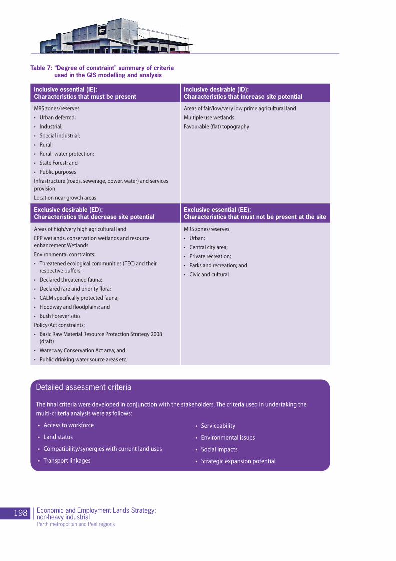
198 Economic and Employment Lands Strategy:non-heavy industrial Perth metropolitan and Peel regions
Detailed assessment criteria
The final criteria were developed in conjunction with the stakeholders. The criteria used in undertaking the multi-criteria analysis were as follows:
• Access to workforce
• Land status
• Compatibility/synergies with current land uses
• Transport linkages
• Serviceability
• Environmental issues
• Social impacts
• Strategic expansion potential
Table 7: “Degree of constraint” summary of criteria used in the GIS modelling and analysis
Inclusive essential (IE): Characteristics that must be present
Inclusive desirable (ID): Characteristics that increase site potential
MRS zones/reserves
• Urban deferred;
• Industrial;
• Special industrial;
• Rural;
• Rural- water protection;
• State Forest; and
• Public purposes
Infrastructure (roads, sewerage, power, water) and services provision
Location near growth areas
Areas of fair/low/very low prime agricultural land
Multiple use wetlands
Favourable (flat) topography
Exclusive desirable (ED): Characteristics that decrease site potential
Exclusive essential (EE): Characteristics that must not be present at the site
Areas of high/very high agricultural land
EPP wetlands, conservation wetlands and resource enhancement Wetlands
Environmental constraints:
• Threatened ecological communities (TEC) and their respective buffers;
• Declared threatened fauna;
• Declared rare and priority flora;
• CALM specifically protected fauna;
• Floodway and floodplains; and
• Bush Forever sites
Policy/Act constraints:
• Basic Raw Material Resource Protection Strategy 2008 (draft)
• Waterway Conservation Act area; and
• Public drinking water source areas etc.
MRS zones/reserves
• Urban;
• Central city area;
• Private recreation;
• Parks and recreation; and
• Civic and cultural
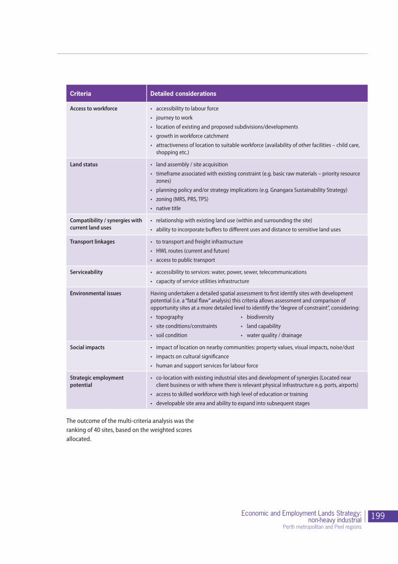
199Economic and Employment Lands Strategy:non-heavy industrial
Perth metropolitan and Peel regions
Criteria Detailed considerations
Access to workforce • accessibility to labour force
• journey to work
• location of existing and proposed subdivisions/developments
• growth in workforce catchment
• attractiveness of location to suitable workforce (availability of other facilities – child care, shopping etc.)
Land status • land assembly / site acquisition
• timeframe associated with existing constraint (e.g. basic raw materials – priority resource zones)
• planning policy and/or strategy implications (e.g. Gnangara Sustainability Strategy)
• zoning (MRS, PRS, TPS)
• native title
Compatibility / synergies with current land uses
• relationship with existing land use (within and surrounding the site)
• ability to incorporate buffers to different uses and distance to sensitive land uses
Transport linkages • to transport and freight infrastructure
• HWL routes (current and future)
• access to public transport
Serviceability • accessibility to services: water, power, sewer, telecommunications
• capacity of service utilities infrastructure
Environmental issues Having undertaken a detailed spatial assessment to first identify sites with development potential (i.e. a “fatal flaw” analysis) this criteria allows assessment and comparison of opportunity sites at a more detailed level to identify the “degree of constraint”, considering:
• topography • biodiversity
• siteconditions/constraints • landcapability
• soilcondition • waterquality/drainage
Social impacts • impact of location on nearby communities: property values, visual impacts, noise/dust
• impacts on cultural significance
• human and support services for labour force
Strategic employment potential
• co-location with existing industrial sites and development of synergies (Located near client business or with where there is relevant physical infrastructure e.g. ports, airports)
• access to skilled workforce with high level of education or training
• developable site area and ability to expand into subsequent stages
The outcome of the multi-criteria analysis was the ranking of 40 sites, based on the weighted scores allocated.

200 Economic and Employment Lands Strategy:non-heavy industrial Perth metropolitan and Peel regions
Industrial Land development research study
Planning for industrial land requires a strategic and holistic approach to a range of issues in order to ensure that the planning is responding directly to industry needs and community expectations.
The Industrial Land Development Research Study was the last study undertaken before preparation of the Industrial Land Strategy commenced. This final study was completed by a consortium led by JMG Marketing including Colliers International and Painted Dog Research.
The purpose and intent of this study was to gain a better understanding, through consultation with key industry stakeholders, government agencies and private sector representatives, of what the end needs of industrial occupiers are, or might be. Furthermore, the study aimed to identify any frustrations and challenges that industrial occupiers and developers may be facing, providing government with a good appreciation of areas where current processes and approaches may be able to be improved.
The methodology employed to undertake this study is described below:
Stage 2:qualitative research
Stage 3:quantitative research
Stage 4:workshop results
with key stakeholders
Stage 1:national and
international review

201Economic and Employment Lands Strategy:non-heavy industrial
Perth metropolitan and Peel regions
Source: Industrial Land Development Study - Tender Request document, prepared by a consortium led by JMG Marketing including Colliers International and Painted Dog Research
Stage 1:National and International Review• Literature review of best practice industrial land design,planning and development• Innovation in industrial land development• Global trends changing industrial land use• Potential impacts on the WA economy• Perspectives of Expert Panel
Stage 2:Qualitative Research• 1 x Focus Group – Heavy Industrial• 4 x focus Groups – General and Lght strati ed by industries• 1 x Focus Group – Property Services• 1 x Focus Group or Individual Interviews with LGA, RD and other key stakeholders
Stage 2: Objectives/Outcomes• Current issues facing WA industries likely to impact onindustrial land development at state and federal level• Current attitudes and future needs of WA industrial land users• Potential initiatives and strategic developments for WA industrial land planning
Stage 3: Quantitative Research• Telephone surveys of industrial land users• Sample of n = 400 in Perth strati ed by industry type and size of rm• Sample of n = 400 from Regional WA strati ed by size and focussed on key industrial sites
Stage 3:Objectives/Outcomes• Assessment of potential initiatives and strategic developments for WA industrial land planning• Validation of ideas emerging from Stages 1 and 2
Stage 4:Workshop Results• Workshop presentation of ndings to DPI, Landcorp and other key stakeholders identi ed in the study• Final reporting and recommendations
Stage 4: Objectives/Outcomes• Provision of a future planning framework for WA industrial land development• Outlook for speci c industries across WA in relation to industrial land requirements• Validation and Commercial grounding of EELS
Stage 1:Objectives/Outcomes• Synopsis of current world trends likely to impact on land development in WA including industry outlook• Summary of current best practice for industrial land development• Summary of innovation in industrial land use, planning & estate design• Provision of best practice case studies
Preliminary Workshop• Discuss and review objectives, priorities, relevant documents, processes and timing• Envisage a 2-4 hour session involving all team members

202 Economic and Employment Lands Strategy:non-heavy industrial Perth metropolitan and Peel regions
Appendix B: Key planning strategies for Perth and Peel regions - 1955 to present
The following is a summary of the key planning strategies that have been prepared and adopted for Perth and Peel regions since the mid 1950s highlighting any indicative industrial land planning intended in each, where relevant.
Stephenson Hepburn Plan (1955)encouraged centralised planning and concentrated development
• Broad vision for industrial development in the Perth metropolitan region was originally set through this plan.
• Industry was recognised as one of the four main interrelated elements of the plan.
• Planning process recognised that while employment opportunities were not a function of physical planning they could be influenced in terms of distribution, location and scale by planning measures.
• Key industrial initiatives for the plan were new areas for large industrial expansion including Kwinana.
Perth Corridor Plan (1970) promoted decentralised planning and urban expansion
• Revised strategic framework to manage the growth of the 1960s.
• Proposed radiating development corridors to channel development.
• Plan assigned industrial land to the four corridors and urban core, most of which existed and included Subiaco, East Perth, Midland and Armadale. Each of these areas have since been redeveloped into residential and mixed business precincts which has resulted in a net loss of industrial land.
Preferred Strategy (1987)following a review of the Corridor Plan, this plan proposed a revised strategic framework to manage growth
• Was the product of the Corridor Review Group which identified the trend toward diversification of industrial sites and potential for mixed uses in industrial zonings.
• Proposed a more flexible, performance based planning system, placing less emphasis on segregation of commercial, business and general industrial uses.
• Impacted on the diversification of industrial areas and further reduced the overall amount of industrial land in industrial estates in inner and middle metropolitan locations.
• Strategy recognised need for outer fringe locations to accommodate larger uses.
• Identified 7 key sites with a total of 2700 ha, including Wangara and Landsdale and extensions to five existing areas, primarily in the south.
Metroplan (1990) introduced a policy element to the principles of the Corridor Plan, creating a hierarchy of centres for commercial and business activities
• Based upon corridor planning principles with a policy thrust to create a hierarchy of centres for commercial and business activities.
• No significant new industrial areas were set aside as those areas already identified in the Corridor Review were considered adequate to cater for short to medium term demand.
State Planning Strategy (1997) the principle focus of this strategy related to economic growth opportunities presented by the mineral and extractive industries in the regions
• Provides for land use planning until 2029.
• Main focus was economic growth opportunity presented by the mineral and extractive industries in the regions.
• Report includes strategies to provide strategic industrial sites, protect access corridors and buffer zones.
• Strategic site south of RAAF Pearce was identified as a potential industrial site, as part of the North East Corridor Structure Plan.
• Last annual review was in 2000-2001.

203Economic and Employment Lands Strategy:non-heavy industrial
Perth metropolitan and Peel regions
Network City (2004)promoted the intensification of land uses, mixed use corridors and employment centres
• Reversion back to a more concentrated urban form, intensified densities and more self-sufficient employment framework.
• The identification of land suitable for redevelopment and regeneration within existing urban fabric, serviced by transport corridors and key infrastructure was identified as being the key to its success.
• Policy document, that needed an implementation plan.
• Did not address importance of industrial land – focus was more so on activity centres and catering to population needs in a residential and amenity sense. Lack of economic focus.
Building a Better Planning System (2009)
The intention of Building a Better Planning System is that it will deliver new and improved planning processes and instruments that will:
• Clear the backlog of approval applications and reduce the time taken to obtain approvals;
• Adopt a risk management based approach to development assessments to speed up approvals and simplify the processes;
• Shift the focus away from statutory processes to the achievement of strategic outcomes;
• Reduce complexities and inconsistencies through the adoption of standardised planning instruments such as Model Scheme Text and structure plans;
• Enable better infrastructure coordination and give a spatial dimension to the State budget processes;
• Focus on regional communities with particular attention being given to supporting economic development;
• Develop a new vision for Perth and the regions of WA; and
• Improve standards of governance through clearer and more effective accountabilities and responsibilities.
Achieving these key outcomes will ensure that Western Australia remains a highly competitive and attractive place to live and do business.
Directions 2031 and Beyond
an augmentation of many of the themes identified in Network City, particularly the concept of structuring growth around a network of diverse and well connected activity centres
• Encompasses the Perth and Peel Region Scheme areas.
• Applies a hierarchy and spatial distribution of centres that will be the core focus of the city’s growth over the next 20 to 25 years.
• Recognises that maintaining a strong and regionally dispersed network of industrial centres is critical to the city’s continued economic growth and prosperity.
• It is also acknowledged that not all industry is the same and therefore an identified classification of industrial centres within the Activity Centres hierarchy is necessary:
- Strategic industrial centres (Kwinana, Hope-Valley Wattleup, Henderson, Kewdale-Welshpool, Oakley, Wagerup)
- Regional industrial centres (Bayswater-Bassendean, Bibra Lake, Canning Vale, Forrestdale, Hazelmere, Maddington-Kenwick, Malaga, Nambeelup, Neerabup, O’Connor, Osborne Park, East Rockingham, and Wangara).

204 Economic and Employment Lands Strategy:non-heavy industrial Perth metropolitan and Peel regions
Appendix C: Previous planning studies and reports: Key findings
Year Study name and key fndings
1992 Industrial Land Planning Study Part 1
Prepared for LandCorp. (Planwest)The objectives were to:
• Provide an historical perspective of the evolution of industrial land planning in the region;
• Provide an analysis of activity in the industrial sector;
• Provide an analysis of demand in the sector from 1985-1990; and
• Examine future demands and compare this with the existing supply data.
Report findings:
• Distribution of industrial land was heavily weighted towards the southwest sector, accounting for 60 per cent of the regional total;
• Distance from the land to the city strongly affected industrial land values and property rentals;
• Projections highlighted that the south-west and east sectors would have land stocks lasting into the next century, while remaining sectors would have short supply;
• Land located in the outer sectors could help double the projected land supply if utilised correctly.
• Between 1985-1990 the total land area zoned ‘industrial’ under local Town Planning Schemes or the Metropolitan Region Scheme decreased significantly except for the northwest sector, which increased by 40 per cent;.
• Vacant industrial land decreased over the same period and land uses in industrial complexes had become more diverse over the five-year period of study as well.
General comments:
Most characteristics of industrial land supply in 1992 are still existent today and in some cases have expanded into major issues. The scenarios mentioned above and detailed in the report are significant to the EELS study and should be examined intently.
1996 Strategic General Industrial Land Study - Stage 1
Prepared for the then Ministry for Planning and LandCorp in 1996. (BSD Consultants).General objective was to determine and detail the potential location of future general industrial land in or adjacent to the Perth Metropolitan Area.
Study was in response to a growing recognition that many industrial areas were nearing capacity or were envisaged to be completely developed within the 10 years following the study.
Report findings:
Three sites identified as “preferred future industrial sites”, including the Kwinana buffer, South Bullsbrook and Lakes Road, Barragup.
Several conclusions and recommendations were made including:
• Amendments to the Metropolitan Region Scheme and local Town Planning Schemes;
• A deferred industrial land zone within the MRS to be investigated;
• A demand analysis be undertaken for Perth over the next 25 years; and
• The WAPC develop a best practice policy to determine appropriate uses and development criteria for future industrial estates.
General comments:
This study comprised the first stage of a more detailed investigation, being the Stage 2 report, which is reviewed below.
205Economic and Employment Lands Strategy:non-heavy industrial
Perth metropolitan and Peel regions
1997 Strategic General Industrial Land Study – Stage 2 Report
Prepared for the then Ministry for Planning and LandCorp. (Sinclair Knight Merz, in association with the Economic Research Associates, Richard Pawluk and Associates (Masterplan) and Chesterton International).
This Stage 2 Report examined:
• General industrial land requirements;
• Recent economic development;
• Perth’s regional economic activity; and
• Future demands for general industrial land.
The Ministry for Planning made projections for growth, which gave evidence that the sites could potentially fulfil the projected land requirements at the time.
Report findings:
• The preferred sites be preserved using the creation of a deferred industry zone in the MRS;
• Buffers be monitored and responsive to changing technologies;
• Current owners of the land be treated fairly and existing businesses relocated as necessary; and
• Government act as a land bank, ideally LandCorp.
General comments:
This Strategic General Industrial Land studies and associated reports are an important source of background information for the strategy, not only with regards to data findings, but also with regards to the method of data collection.
1997 General Industrial Land Needs Study
Prepared for LandCorp. (PlanWest)
The study was commissioned to address the general industrial land needs of the Perth metropolitan area and was focused on achieving four major tasks:
• The first study task was to look at previous reports dealing with industrial land in the Perth area, which gave projections for general industrial land demand;
• The second task was to analyse Perth’s industrial land demand by location and also by land use; This task used two different approaches to analyse the data, land take-up rates and population forecasts;
• The third task was to determine the available supply (current and expected) of industrial land in Perth, identifying location and availability constraints within land use categories; and
• The final task was to identify gaps between demand, forecast, contrast, and adjusted supply.
General comments:
The final stage of the report examines these different tasks as they relate to each sector of the Perth region and then gives brief recommendations and suggested actions, to compensate for lack of stock. An attempt similar to the EELS, to determine industrial land supply, demand and constraints. Therefore, a very relevant document.
1997(ongoing)
Industrial Land Use Survey
The Industrial Land Use Survey Program, prepared by DPI, is an ongoing survey program, which is aimed at providing quality information to support the Ministry for Planning’s strategic planning process in turn assisting planners, government, non-government organisations and the general public. It was anticipated that eventually the information obtained would contribute to the development of a Metropolitan Industrial Land Supply Profile.
The Survey outlines some general problems with statistical data. For example, vacant land statistics do not reflect the “real” circumstances or characteristics of a land parcel, i.e. environmental constraints are not realised, landowner intentions are not realised or established industrial land areas are not being utilised to capacity.
These issues are detailed within the Survey and are also mentioned in other reports within this literature review. In order to make the current EELS study as successful as it possibly can be, these issues need to be examined in detail and solutions need to be implemented. Therefore, this survey is extremely important to the strategy.

206 Economic and Employment Lands Strategy:non-heavy industrial Perth metropolitan and Peel regions
1999 Perth Industrial Land Capability Assessment
Prepared for the then Ministry for Planning and LandCorp.It follows on from the Industrial Land Use Survey, which reached the conclusion that there was an abundance of vacant industrial land available for immediate use within the Perth region. It was believed that this might not necessarily be the case, as there are several constraints that hinder industrial land development which were not considered within the Industrial Land Use Survey.
Report findings:
• The perceived abundance of land was not, as plentiful as predicted.
• Outlined how the amount of available land for immediate or imminent industrial development is difficult to determine, and in reality is far less than that calculated in the 1997 Survey.
• Outlined that there was minimal land available for sale and where lots were available, the landowners vacant owners were tightly holding onto them, waiting for increased value or for regulation changes allowing smaller minimum lot sizes.
• Smaller lots were becoming more attractive to the consumer, as mixed business and light industrial activity increased and proved to be more lucrative.
General Comments:
• The study concluded that any calculations for the future provision of industrial land should factor in the unavailability of between 50 per cent and 70 per cent of vacant land to account for constraints such as unknown landowner intentions.
• The report also makes several recommendations regarding how the study could be done differently to gain more accurate results as well as how to deal with land constraints early on to prevent them becoming major issues.
2000 Industrial Opportunities and Forecast Assessment Study
Series of reports prepared for Landcorp examining the future land area, location and supply of infrastructure for industrial land over a 50-year period. The series consists of three reports, each with a different purpose.
• The first two reports reviewed past literature and studies, global economic trends, existing and potential industrial areas and constraints for industrial land generally.
• The second report examined the factors identified within the first report in more detail as they related to the Perth metropolitan region, also taking into consideration such issues as industry location and the implications of changing technologies.
• The final report collates the information gathered in the first two reports and using this information as a basis, determines the anticipated projected land and infrastructure requirements for future industrial development. The report examines determinants for industrial land demand in the State, Special Industry requirements, Heavy Industry requirements and the demand for future industrial land in each specific region.
Key findings:
The final report concludes that:
There is considered to be sufficient general and light industrial land vacant or proposed to service projected population growth;
The major challenge faced by planners will be within the Kwinana industrial area, in regards to the supply of heavy industrial land. (note: at the time of this report and recommendations, Kwinana had not yet been planned so that optimum use of the land could be achieved. Furthermore, at the stage at which the report was finalised, Breton Bay and Kemerton were still proposed as heavy industrial areas, so optimising the use of Kwinana land was not seen as necessary.)
General Comments:
This series of reports uses some analysis techniques that have proved useful in the development of the EELS.

207Economic and Employment Lands Strategy:non-heavy industrial
Perth metropolitan and Peel regions
2004 Demand for Industrial land in the Peel Region
Prepared for the Peel Development Commission. (Worley Consultants and Economic Consulting Services)The study examined:
• The current and future demand for industrial land within the Peel region; and
• Factors influencing the demand of industrial land in certain locations.
Key findings:
• The report identified that there was a limited supply of vacant industrial land in the area, which was affecting demand opportunities for future industrial developments, and the expansion of existing industries;
• Outlined that among many influential land characteristics, ‘ease of access to transport’ is the most attractive feature, as industry always locates close to good transport infrastructure such as ports, rail and roads;
• Population, demographic changes and trends and employment are principal factors driving the demand for industrial land in the Peel Region; and
• Other factors such as planning controls and approvals are also important, as demand can be further suppressed by the fact that land within the region is not suitably zoned for industry, is not suitably serviced for industrial needs or is zoned for industry but is occupied by other uses.
General Comments:
The report examines different projected demand estimate scenarios for industrial land in the Peel region and is a useful resource.
2008 Industrial Land Needs Study
The current ILNS identifies a shortfall in industrial land of between 990 and 2300 hectares by the year 2030. This is based on projected additional demand and the estimated current and known future supply. It recommends that the higher end of the range initially be used as a basis for determining the additional requirement for industrial land supply for the purposes of planning and assessing the capability of the region to produce the required amount of industrial land.

208 Economic and Employment Lands Strategy:non-heavy industrial Perth metropolitan and Peel regions
Appendix D: Assessment framework from Adelaide industrial land strategy
The framework also provides a mechanism to identify prime industrial areas considered to be of economic importance to the State that must have protection from rezoning and encroachment.
The Framework is provided below.
Strategic Industrial Areas
Strategic Industrial Areas designated below should not be rezoned for non-industrial land uses.
(a) Le Fevre Peninsula/Gillman
(b) Lonsdale
(c) Edinburgh Parks/DSTO
These areas are economically important to the State on the basis of employment levels, significant exports or export function, infrastructure investment and future industrial land supply.
Prime Industrial Areas
Prime Industrial Areas should be retained for industrial activities. In determining a Prime Industrial Area, regard should be given to the following criteria:
(a) the land is contiguous to other industrial activities
(b) the land is well located in relation to supply chains and service providers
(c) the land offers potential for on-site expansion of existing industrial businesses
(d) the land is well located in relation to skilled labour pools
(e) the land is well located to take advantage of existing or proposed infrastructure or other economic development
(f ) the land is well located in relation to freight connections and other important road and/or rail networks
(g) the land provides, or offers potential for the provision of, small industrial businesses serving the local area
(h) the land provides sufficient space for adequate parking and turning space for industrial vehicles
(i) the land offers potential for 24-hour operations
(j) the land has minimal or no adjoining use constraints
(k) the land provides unconstrained vehicle access and exit
(l) the land can be commercially developed with infrastructure and site preparation for future industrial activities.

209Economic and Employment Lands Strategy:non-heavy industrial
Perth metropolitan and Peel regions
Rezoning Industrial Land
Industrial land may be suitable for other uses if:
(a) the land does not form part of a Strategic Industrial Area or a Prime Industrial Area
(b) the site is no longer conducive to continued industrial activities and there will be compelling community or economic benefits through alternative uses
(c) the rezoning will not affect (individually or cumulatively) nearby industries by, for example restricting operating hours, delivery times, or the capacity of the local transport network.
The Statement of Intent (which is the formal starting point of an amendment to a Development Plan) should provide for the following investigations to be undertaken in the preparation of a Development Plan Amendment to rezone industrial land for non-industrial activities:
(a) an evaluation of the land against the Prime Industrial Land criteria (above)
(b) evidence that the land is without realistic prospect of industrial re-use
(c) an evaluation of the potential for other industrial- or employment-generating land uses (i.e. commercial, office, retail) on the site.
Un-developed sites
The Statement of Intent should provide for the following investigations to be undertaken in the preparation of a Development Plan Amendment to rezone un-developed land to industrial use.
Un-developed sites may be suitable for re-zoning to industrial use if they meet the following criteria:
(a) the land is adjacent to existing key industrial areas
(b) the land has minimal or no adjoining use constraints
(c) the land is able to take advantage of existing or proposed infrastructure
(d) easy access to freight routes and other road and rail networks is available
(e) the land can be commercially developed with required infrastructure and site preparation works
(f ) the land provides a key strategic economic development opportunity for industry or sector development
(g) an evaluation of competing land uses and cost/benefit of zoning for industrial use has been undertaken
(h) zoning and policy area restrictions complement existing industrial activities in the area.

210 Economic and Employment Lands Strategy:non-heavy industrial Perth metropolitan and Peel regions
Minister for Planning Cabinet
InfrastructureCoordinating
Committee
ILS Task ForceChair: Department of Planning
Members: • Department of State Development (Director General) • Department of Planning (Director General)• Department of Environment and Conservation (Director General)• LandCorp (Chief Executive O�cer)• Property Council of Western Australia (Executive Director)
ILS Executive Working GroupChair: Department of Planning
Members include:DSD, DoP, DEC, LandCorp, FPA, DAFWA
Department of Planning
Planning andcoordination
Servicing agencies Local government authorities Industry reference group
LandCorpIndustrial land
delivery
Stakeholder GroupsPrivate sector
knowledge
Department ofState
DevelopmentStrategic industrial
land facilitation
Department of Environment
and ConservationEnvironmental management
and coordination
Western AustralianPlanning Commission
Appendix E: Economic and Employment Lands Strategy non-heavy industrial governance structure
211Economic and Employment Lands Strategy:non-heavy industrial
Perth metropolitan and Peel regions
Appendix F: ILS Taskforce and Working Group Members
ILS Taskforce Members
Eric Lumsden Department of Planning
Ross Holt LandCorp
Keiran McNamara Department of Environment and Conservation
Steve Wood Department of State Development
Joe Lenzo Property Council of Western Australia
ILS Working Group Members
John Chortis Department of Planning
Cane Spaseski Department of Planning
Kylie Batina Department of Planning
Nathan Brown Department of Planning
Simon Luscombe Department of Planning
John Hackett LandCorp
Olinka Combes LandCorp
Monica Pham LandCorp
David Lodwick Department of Environment and Conservation
Tim Fraser Department of State Development
Tom Grigson Department of State Development
Paul Frapple Department of Agriculture and Food
Trina Anderson Department of Agriculture and Food
Damian Stone Property Council of Western Australia
William de Haer Property Council of Western Australia

212 Economic and Employment Lands Strategy:non-heavy industrial Perth metropolitan and Peel regions
Appendix G: Glossary
Accessibility
Refers to the extent to which people have access to employment, goods and services, either through proximity or transport links to connect places.
Acid Sulphate Soils (ASS)
Are naturally occurring soils and sediments containing iron sulfides. When ASS are exposed to air the iron sulfides in the soil react with oxygen and water to produce a variety of iron compounds and sulfuric acid. The resulting acid can release other substances, including heavy metals, from the soil and into the surrounding environment.
Activity Centres
Defines places which vary in scale, composition and character but in essence are commercial focal points which include a combination of activities such as offices, retail, higher-density housing, entertainment, civic/community, education and medical services.
The Activity Centres Policy is a state planning policy for the planning and development of activity centres throughout Perth and Peel.
Agri-Food Industry
Means beyond farm gate, manufacturing and value-adding of edible product. Food manufacturing consists of gathering ingredients from local and imported sources to process and package in WA to create products for either further processing or final sale at retail or food service outlets in local, national or international markets.
Amenity
The enjoyment of the environment, whether public or private lands, by individuals or the community. It includes the enjoyment of privacy, sunlight, views, quiet, access to local facilities and similar freedom from nuisance.
Basic Raw Materials (BRM)
This means sand (including silica sand), clay, hard rock, limestone (including metallurgical limestone), gravel and other construction and road building materials. These materials are produced relatively cheaply, with the major cost being transport to the construction site. A ready supply of basic raw materials close to established and developing parts of the metropolitan region is, therefore, essential in keeping down the costs of land development and contributing to affordable housing.
Better Urban Water Management (2008)
A State Planning document which has been designed to facilitate better management of WA’s urban water resources by ensuring an appropriate level of consideration is given to the total water cycle at each stage of the planning system.
Broad Hectare Land
Refers to undeveloped land zoned for urban development outside the urban extent. These areas are generally used for rural purposes until residential subdivision takes place. This type of land is also referred to as greenfield.
Brownfield Development
Development on sites that have previously been used for other urban land uses, including industrial activities.
Buffers
These are the areas surrounding environmentally sensitive areas, and are managed for a combination of biodiversity conservation objectives as well as other resource management activities.
They may also include areas between potentially incompatible land uses such as rural and residential, and are managed to minimise impact on both resource productivity and amenity.

213Economic and Employment Lands Strategy:non-heavy industrial
Perth metropolitan and Peel regions
Bulky goods retail outlets
Larger premises used primarily for the sale of goods and items which are predominantly of a size, shape or weight as to require an extensive area for handling, storage or display.
Bush Forever
A State Government policy which identifies regionally significant bushland to be retained and protected forever and is one of the most significant conservation initiatives ever undertaken in Western Australia.
Capital Works Program
Refers to a whole of government funding program that manages capital expenditure on new infrastructure and improvements, provision of facilities and service infrastructure (including: transport, electricity, water, health and education and training).
Conditional Approval
Conditional approval is granted by the WAPC for subdivision development to begin subject to certain conditions being met. The approval is preceded by an assessment of the proposed subdivision plan by statutory referral agencies, including servicing authorities. On receipt of conditional approval, the proponent may commence subdivision development in accordance with the conditions of approval. A conditional approval remains valid for three years when five lots or fewer are approved and for four years when six lots or more are approved.
Consumption of zoned land
Refers to the amount of land developed as broad-hectare areas become built out over time. It does not include development within the urban extent.
Consumption Rates
In the context of the Industrial Land Strategy, this refers to the rate at which industrial zoned land is acquired.
Constraints
A constraint, in the context of land development is anything that prevents development from occurring. Constraints may be related to identified environmental sensitivities of a site, nearby incompatible land uses, policy framework (written or unwritten) for example.
Cottage Industry
An industry where the creation of products and services is home-based, rather than factory-based. De-constraining
This relates to the removal of any known constraints or fatal flaws that may be encountered in the process of determining the feasibility of a land parcel for future development. This may involve working with relevant agencies to remove the known constraint - or determining a manner in which the constraint can be managed and the development potential optimised.
Demand Drivers
These are the key factors which are known to influence the level and type of demand for industrial land and land use types.
Developer Contribution Scheme
Refers to a cost sharing arrangement for common infrastructure, open space and community facilities required to provide services to a given project area or industrial estate. Such cost sharing arrangements are managed through a Development Contribution Plan (DCP) which may be administered by a local authority.
Development Incentives
This refers to a variety of incentives (rate reduction, land tax exemptions) that may be offered to a developer of industrial land to facilitate more prompt development.

214 Economic and Employment Lands Strategy:non-heavy industrial Perth metropolitan and Peel regions
Development ready land
Refers to land that is zoned and serviced and is thus fully prepared for built form development.
District Centres
District Centres generally serve the main weekly household shopping, service and community needs of a district. They are predominantly retail focused but many also include a limited mix of other uses.
Employment lands
Employment land is broadly defined as land that could be used for employment generating activities, including land zoned for industrial and commercial uses.
Employment Self Sufficiency (ESS)
Measures the quantity of jobs available in a given area as a proportion of that area’s labour force.
Feasibility study
The undertaking of a range of studies that assist in determining the likelihood of a proposed product or development fulfilling the objectives of a particular investor or decision making body.
Final Approval
Final approval is the WAPC endorsement of the proponent’s submitted plan/diagram(s) of survey describing the now complete subdivision; constructed in accordance with the conditions set down in a conditional approval. Final approvals are then registered with the Office of Titles where certificates of titles for the newly created lots can be issued.
Floorspace
This is the area of all floors (floorspace) as reported by an establishment to be confined within the internal finished surfaces of permanent walls but excluding the following areas:
• all stairs, toilets, cleaners’ cupboards, lift shafts and motor rooms, escalators, tea rooms and plant rooms, and other service areas;
• lobbies between lifts facing other lifts serving the same floor;
• areas set aside as public space or thoroughfares and not for the exclusive use of occupiers of the floor or building; and
• areas set aside for the provision of facilities or services to the floor or building where such facilities are not for the exclusive use of occupiers of the floor or building.
Fragmented Land Ownership
An area identified for a potential singular development that has multiple landowners affected by the potential development.
Future Short Term Industrial Sites
For the purpose of this strategy, short term in this context refers to a period between 0 and 4 years to complete the planning process (involving relevant studies and investigations).
It represents sites that are likely to be delivered to the market shortly that have undergone significant planning.
General Industry
An industry other than a cottage, extractive, light, mining, rural or service industry. This is the main zone that applies to most industrial areas. It provides for manufacturing industry, the storage and distribution of goods and associated uses which by the nature of their operations should be separated from residential areas.
Governance
Governance is defined as the act of manner of governing. In the context of the Industrial Land Strategy, governance refers to the legal framework which will be required to allow delivery of the Strategy’s actions. This includes definitions of responsibilities.

215Economic and Employment Lands Strategy:non-heavy industrial
Perth metropolitan and Peel regions
Greenfield Development
Development on land that has not previously been developed for urban land uses
Gross areas
This is the quantity of land allocated or denoted for potential future industrial development, including areas that may be later excluded from this area, due to known constraints or development limitations.
Groundwater
Groundwater is water occurring naturally below ground level in an aquifer or water pumped, diverted or released into an aquifer for storage underground.
Heavy Industry
This land use category is only denoted by State Government policy and expressed through its agencies. It does not appear as a specific zone in either the MRS or local government zoning regimes. Currently Perth’s only heavy industry site described through planning and economic development policy is the Kwinana industrial area, which is split for the purposes of analysis into three complexes: Naval Base, Kwinana Beach and East Rockingham.
Infill Development
New development that occurs within established urban areas where the site or area is either vacant or has previously been used for another urban purpose. The scale of development can range from the creation of one additional residential lot to a major mixed–use redevelopment.
Intermodal
The movement of goods in one and the same loading unit or road vehicle, which uses successively two or more modes of transport without handling the goods themselves in changing modes. By extension, the term ‘intermodality’ has been used to describe a system of transport whereby two or more modes of transport are
used to transport the same loading unit or truck in an integrated manner, without loading or unloading, in a door-to-door transport chain.
Light Industry
An industry:
• a) in which the processes carried on, the machinery used, and the goods and commodities carried to and from the premises do not cause any injury to or adversely affect the amenity of the locality; and
• b) the establishment or conduct of which does not, or will not, impose an undue load on any existing or proposed service for the supply or provision of essential services.
Light industry traditionally provides for trade services such as mechanical repairs, construction and other light industry uses at an urban scale. These activities are the most plentiful in number (but not necessarily in terms of total area) and widest in distribution across the Metropolitan region.
Local Planning Scheme
Are detailed planning schemes developed by local governments to manage the range of permitted land uses within specified locations. Whether in respect to the MRS or PRS, local planning schemes must be consistent with the provisions identified within the relevant region scheme.
Mixed Use Development
Mixed-use developments incorporate complementary uses into a single parcel or development area. Mixed-use development allows more than one type of use in a building or set of buildings, which can mean a combination of residential, commercial, industrial, office, institutional, or other land uses.

216 Economic and Employment Lands Strategy:non-heavy industrial Perth metropolitan and Peel regions
Multi-Criteria Evaluation
This is the methodology employed to assess and determine the preferred industrial sites identified as part of this Industrial Land Strategy. A number of selected criteria were used to undertaken the Multi-Criteria evaluation of each identified site, which included:
• Access to Workforce, Land Status, Compatibility/Synergies with Current Land Uses, Transport Linkages, Serviceability, Environmental Issues, Social Impacts and Expansion Potential.
Net developable areas
Measures the actual developable area excluding take-out for items such as local roads, open space, infrastructure and environmental considerations.
Physical Infrastructure
This term refers to the key infrastructure required to service a population or land use activity. Key infrastructure considered essential for enabling productivity in the economy includes roads, utilities (including gas, telecommunications, electricity), water, wastewater (including sewer). Developing infrastructure often requires large initial investment, but the economies of scale tend to be significant.
Planning and Development Act (2005)
The legal framework for the Western Australian planning system in Western Australia is the Planning and Development Act (2005), providing for a system of land planning and development throughout the state. The WAPC is recognised under the Act as ‘a body corporate with perpetual succession’ and acts as the sole decision making body for the state, promoting orderly and proper planning in a single framework.
Potential Long Term Industrial Sites (Strategic Landbank Sites)
For the purpose of this strategy, long term in this context refers to a period 10 years or greater to complete the planning process (involving relevant studies and investigations).
The sites identified form a landbank that has been created as a result of the Industrial Land Strategy to ensure an adequate supply of industrial development sites to meet the future needs of industry in Western Australia.
Potential Medium Term Industrial Sites
For the purpose of this strategy, medium term in this context refers to a period between 4 and 10 years to complete the planning process (involving relevant studies and investigations).
These sites still require further investigative work and analysis; and de-constraining to be released to the market.
Public Drinking Water Source Areas
The Water and Rivers Commission is responsible for managing and protecting Western Australia’s water resources. The Commission utilises policies for the protection of public drinking water sources that include three levels of priority classification of lands from most to least protected: Priority 1 (P1), Priority 2 (P2) and Priority 3 (P3).
Rationalisation
This refers to the reconfiguration and consolidation of existing land uses into a more effective and purpose related format, including the removal of inappropriate land uses within existing estates.

217Economic and Employment Lands Strategy:non-heavy industrial
Perth metropolitan and Peel regions
Region Schemes
Metropolitan Region Scheme (MRS) - a large planning scheme for land use in the Perth metropolitan area. The MRS defines future land use, dividing it into broad zones and reservations.
Peel Region Scheme (PRS) - a large planning scheme which guides land use in the Peel region. The PRS defines the future use of land, dividing it into broad zones and reservations. This plan has been in operation since March 2003 and provides the legal basis for planning in the Peel region.
Remnant native vegetation
Small areas of native plant communities that are found in otherwise cleared landscapes.
Residential Encroachment
The intrusion of residential land uses onto competing uses such as industrial or commercial land.
Scheme Amendment
The process of changing zones or reservations from one use to another. The amendment process requires proposed amendments to be advertised for wider community and government comment. The amendment process is regulated by the Planning and Development Act 2005, allowing for extensive community consultation to review the proposal before a final decision is made. Region schemes may be amended in one of two ways, either as a major (substantial) amendment or as a minor (non-substantial) amendment. Lifting of urban deferment (urban deferred to urban zone) are clause 27 amendments in the MRS and clause 13 amendments in the PRS. For more information see www.planning.wa.gov.au/The+planning+system/Region+schemes/default.aspx
Secondary Centres
Secondary centres provide for the main daily shopping needs of the community and typically include a supermarket grouped together with a small range of other uses and occasionally community facilities.
Separation distances
Separation distances between land uses and industry are provided in the Environment Protection Authority’s Separation Distance Criteria. The separation distances are intended to address potential conflicts between residential and other sensitive land uses and industry due to industrial emissions such as particulates, odours and noise.
Shortfall
An amount that is less than an anticipated or expected amount. In this case, it relates to an amount of land that does not adequately cater for demand levels.
State Significant Development / major projects
Projects that are important in achieving State or regional planning objectives, or that are important in delivering the Government’s infrastructure programs or development in places that are importance to the State’s environment and/or economy. The Minister for Planning is the consent authority for State Significant Development.
Strategic employment
This refers to employment that relate to a range of industry types defined by the three-digit ANZSIC Industry classified as Export, Consumer Services (CS), Producer Services (PS), Knowledge-Intensive Consumer Services (KICS) or Knowledge-Intensive Producer Services (KIPS).

218 Economic and Employment Lands Strategy:non-heavy industrial Perth metropolitan and Peel regions
Strategic Landbank Sites
Parcels of land identified for future industrial land uses which should be considered of economic importance to the State and should be protected from rezoning and encroachment by competing land uses.
Structure Plan
Refers to a document including spatial plans that details the proposed layout of a future development area. In addition to illustrating details such as road configuration and the location of retail and community facilities such as shops, schools and public open space, a structure plan can also show details such as housing density, land use classifications and buffer zones.
Study Area
For the purposes of the Industrial Land Strategy this is the area represented by both the MRS and PRS Maps.
Sub-regions
Directions 2031 and Beyond has identified six sub-regional planning areas that will form the basis of future planning and policy development: Central, North-west, North-east, South-east, South-west and Peel.
Sustainability
Meeting the needs of the present without compromising the ability of future generations to meet their own needs.
Take Up Rates
Take up rates refer to the rate at which industrial land is purchased and developed on.
Threatened Ecological Community (TEC)
An ecological community is a naturally occurring biological assemblage that occurs in a particular type of habitat. A threatened ecological community (TEC) is one which is found to fit into one of the following categories; “presumed totally destroyed”, “critically endangered”, “endangered” or “vulnerable”.
Urban Extent
Refers to the outer boundary of urbanised land.
Vacant Lots
Refer to those lots that are undeveloped (i.e. have no premises constructed on the lot) and that are located on residential or special zones as designated under the various local planning schemes in Western Australia. The base information is provided by the Valuer General’s Office.
Wastewater
Wastewater is water which has been used for some purpose and would normally be treated or discarded as it often contains significant quantities of pollutants. There is a growing momentum favouring re-use of this water source where appropriate.
Wetlands
Wetlands Swamps, billabongs, lakes, salt marshes, mudflats, mangrove forests and virtually any land which is regularly or intermittently inundated with water that is static or flowing, fresh, brackish or salty, including areas of marine water.

219Economic and Employment Lands Strategy:non-heavy industrial
Perth metropolitan and Peel regions
Appendix H: Bibliography
Network City Community Planning Strategy for Perth and Peel March 2006, Department for Planning and Infrastructure/ Western Australian Planning Commission
Statement of Planning Policy: Metropolitan Freight Network (Draft) May 2005, Department for Planning and Infrastructure/ Western Australian Planning Commission
State Sustainability Strategy May 2005, Department for Planning and Infrastructure/ Western Australian Planning Commission
DC 4.1 Industrial Subdivision July 1998, Department for Planning and Infrastructure/ Western Australian Planning Commission
State Industrial Buffer Policy May 1997, Department for Planning and Infrastructure/ Western Australian Planning Commission
Northeast Corridor Structure Plan March 1994, Department of Planning and Urban Development
Inner Peel Region Structure Plan December 1997, Department for Planning and Infrastructure/ Western Australian Planning Commission
Industrial Land Supply Profile (Draft) 2007/2008, Department for Planning and Infrastructure/ Western Australian Planning Commission
*Industrial Opportunities and Forecast Assessment Study (Series of 3 Reports) 1998-2000, The Planning Group, for LandCorp
Demand for Industrial Land in the Peel Region 2004, Worley consultants in association with Economic Consulting Services, for the Peel Development Commission
General Industrial Land Needs Study October 1997, Plan West Consultants, for Land Corp
Industrial Land Use Survey Program May 1999, The Planning Group in association with Economic Research Associates, for LandCorp and The Ministry for Planning
Perth Industrial Land Capability Assessment March 1999, Richard Pawluk and Associates/Masterplan Consultants, for the Ministry for Planning and LandCorp
Strategic General Industrial Land Study – Stage 1 January 1996, BSD Consultants, for The Ministry for Planning and Landcorp
Strategic General Industrial Land Study – Stage 2 March 1997, Sinclair Knight Merz, in association with the Economic Research Associates, Richard Pawluk and Associates (Masterplan) and Chesterton International, for the Ministry of Planning
Industrial Land Planning Study December 1992, Plan West Consultants, for LandCorp and The Department of Planning and Urban Development
Metropolitan Adelaide Industrial Land Strategy April 2007, Planning South Australia
Urban Development Program 2003 Report (Victoria) 2003, Department of Planning and Community Development
Industrial Sites in the South West September 1992, Industrial Sites Advisory Committee
Warren Blackwood Region Industrial Sites Study June 2005, Thompson McRobert Edgeloe and ATA Environmental, for the Western Australian Planning Commission
* This series of reports is incomplete.

220 Economic and Employment Lands Strategy:non-heavy industrial Perth metropolitan and Peel regions
Abbreviations
ABS Australian Bureau of Statistics
AHD Australian Height Datum
ALT Aboriginal Lands Trust
ASS Acid Sulphate Soils
BUWM Better Urban Water Management
CCW Conservation Category Wetland
DAFWA Department of Agriculture and Food Western Australia
DCP Development Contribution Plan
DEC Department of Environment and Conservation
DIA Department of Indigenous Affairs
DoE Department of Environment
DoP Department of Planning
DoT Department of Transport
DoW Department of Water
DPC Department of the Premier and Cabinet
DPI Department of Planning and Infrastructure (now Department of Planning)
DRF Declared Rare Flora
DSD Department of State Development
DSP District Structure Plan
EELS Economic and Employment Lands Strategy
EPA Environmental Protection Authority
ESC Employment Self Containment
ESS Employment Self-Sufficiency
FESA Fire and Emergency Services Authority of Western Australia
FPA Fremantle Port Authority
GSS Gnangara Sustainability Strategy
ha Hectares
HWL High Wide Load
ICC Infrastructure Coordinating Committee
ICT Information and Communication Technology
ILCA Industrial Land Capacity Assessment
ILNS Industrial Land Needs Study
ILS Industrial Land Strategy
ILST Industrial Land Supply Taskforce
ILUS Industrial Land Use Survey
kV Kilo volts
MCA Multi Criteria Analysis
MKSEA Maddington Kenwick Strategic Employment Area
MRA Metropolitan Redevelopment Authority
MRS Metropolitan Region Scheme
MRWA Main Roads of Western Australia
PCA Property Council of Australia
PDWSA Public Drinking Water Supply Area
PRA Metropolitan Redevelopment Authority
PRS Peel Region Scheme
RAAF Royal Australian Air Force
RAV Restricted Access Vehicle
REIWA Real Estate Institute of Western Australia
SRT Swan River Trust
TEC Threatened Ecological Community
TPS Town Planning Scheme
UDP Urban Development Program
WAPC Western Australian Planning Commission
WC Water Corporation
WWTP Waste Water Treatment Plant