economic and employment lands strategy: non-heavy industrial · lands strategy (eels) is to...
TRANSCRIPT

xviii Economic and Employment Lands Strategy:non-heavy industrial Perth metropolitan and Peel regions
Replace Image
Part 1 - Introduction and background
1Economic and Employment Lands Strategy:non-heavy industrial
Perth metropolitan and Peel regions
Introduction
The objective of the Economic and Employment Lands Strategy (EELS) is to facilitate a more proactive approach to industrial land use planning and provide an ongoing supply of industrial land to cater for anticipated economic growth in Western Australia over the next 20 years and beyond. The Strategy represents the State Government’s position with respect to future industrial land use planning for the Perth and Peel regions, and factors stemming from large-scale resource projects, particularly in the State’s North-West. With an anticipated economic boom potentially larger than that experienced in the early 2000s, it is vital the State is positioned to adequately and capably respond to and support this economic growth.
Key agencies involved in its preparation include the Department of Planning, Department of State Development, Department of Environment and Conservation and LandCorp, the latter being the State Government’s appointed developer.
Corresponding with a number of other significant State planning documents, such as Directions 2031 and Beyond: metropolitan planning beyond the horizon, the State Planning Strategy (draft), the Activity Centres Policy and sub-regional plans for the Perth and Peel regions, the Strategy represents the strategic planning direction for industrial land into the future. The EELS is consistent with the wider objectives of the Western Australian Planning Commission (WAPC), which is actively pursuing a more integrated and coordinated approach to infrastructure planning and provision for infill and greenfield land releases for the Perth and Peel regions.
The Strategy focuses solely on general and light industry needs and does not include heavy industry. Therefore, references to industrial land in the EELS mean “general and light industrial land” unless otherwise stated. Demand for heavy industrial land is derived from a different set of drivers to that of general and light industrial land, being more project dependant than other industrial land uses, therefore it has been excluded from consideration in the EELS.
Purpose
Key elements of the Strategy are to:
• Identify the areas, type and locations of general and light industrial land required over the next 20 years.
• Review the existing industrial land development program and identify possible expansion opportunities.
• Identify and evaluate the suitability of locations for new general and light industrial estates.
• Develop a strategy to facilitate the ongoing supply of general and light industrial land, and assist in the restoration of the Western Australian Government’s long term general and light industrial land bank.
The Strategy details a number of key initiatives that will be actively pursued by the Government to address the industrial land supply shortfall and secure an adequate ongoing supply of industrial land over the next 20 years and beyond.
Background
Industrial land is a vital component of a healthy, growing economy. During times of economic uncertainty, the availability of industrial land and infrastructure is important in order to encourage new industries to develop. An adequate supply of appropriately serviced industrial land will assist in staving off the effects of economic slowdown, and improve confidence in any industrialised economy.
Since the 1970s, proactive and strategic planning for future industrial land has been limited in the Perth and Peel regions of Western Australia. The resources boom of the late 1990s and early 2000s exposed this inefficiency in strategic planning through a significant shortfall in development ready industrial land. The result was a stagnant industrial property market with limited opportunity to expand.
2 Economic and Employment Lands Strategy:non-heavy industrial Perth metropolitan and Peel regions
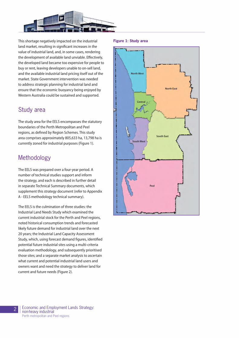
Figure 1: Study areaThis shortage negatively impacted on the industrial land market, resulting in significant increases in the value of industrial land, and, in some cases, rendering the development of available land unviable. Effectively, the developed land became too expensive for people to buy or rent, leaving developers unable to on-sell land, and the available industrial land pricing itself out of the market. State Government intervention was needed to address strategic planning for industrial land and ensure that the economic buoyancy being enjoyed by Western Australia could be sustained and supported.
Study area
The study area for the EELS encompasses the statutory boundaries of the Perth Metropolitan and Peel regions, as defined by Region Schemes. This study area comprises approximately 805,633 ha, 13,798 ha is currently zoned for industrial purposes (Figure 1).
Methodology
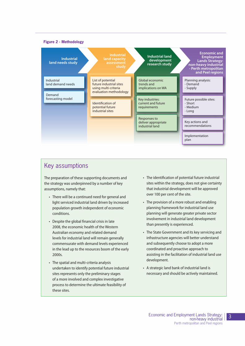
The EELS was prepared over a four-year period. A number of technical studies support and inform the strategy, and each is described in further detail in separate Technical Summary documents, which supplement this strategy document (refer to Appendix A - EELS methodology technical summary).
The EELS is the culmination of three studies: the Industrial Land Needs Study which examined the current industrial stock for the Perth and Peel regions, noted historical consumption trends and forecasted likely future demand for industrial land over the next 20 years; the Industrial Land Capacity Assessment Study, which, using forecast demand figures, identified potential future industrial sites using a multi-criteria evaluation methodology, and subsequently prioritised those sites; and a separate market analysis to ascertain what current and potential industrial land users and owners want and need the strategy to deliver land for current and future needs (Figure 2).
3Economic and Employment Lands Strategy:non-heavy industrial
Perth metropolitan and Peel regions
Key assumptions
The preparation of these supporting documents and the strategy was underpinned by a number of key assumptions, namely that:
• There will be a continued need for general and light serviced industrial land driven by increased population growth independent of economic conditions.
• Despite the global financial crisis in late 2008, the economic health of the Western Australian economy and related demand levels for industrial land will remain generally commensurate with demand levels experienced in the lead up to the resources boom of the early 2000s.
• The spatial and multi-criteria analysis undertaken to identify potential future industrial sites represents only the preliminary stages of a more involved and complex investigative process to determine the ultimate feasibility of these sites.
• The identification of potential future industrial sites within the strategy, does not give certainty that industrial development will be approved over 100 per cent of the site.
• The provision of a more robust and enabling planning framework for industrial land use planning will generate greater private sector involvement in industrial land development than presently is experienced.
• The State Government and its key servicing and infrastructure agencies will better understand and subsequently choose to adopt a more coordinated and proactive approach to assisting in the facilitation of industrial land use development.
• A strategic land bank of industrial land is necessary and should be actively maintained.
Planning analysis:- Demand- Supply
Economic andEmployment
Lands Strategy:non-heavy industrial- Perth metropolitan
and Peel regions
Future possible sites:- Short- Medium- Long
Key actions andrecommendations
Key industries:current and futurerequirements
Responses todeliver appropriateindustrial land
Industrialland demand needs
Demandforecasting model
List of potentialfuture industrial sites using multi-criteria evaluation methodology
Identi�cation ofpotential futureindustrial sites
Industrialland needs study
Industrialland capacity
assessmentstudy
Industrial landdevelopment
research study
Global economictrends andimplications on WA
Implementationplan
Figure 2 - Methodology
4 Economic and Employment Lands Strategy:non-heavy industrial Perth metropolitan and Peel regions
Part 2 - Role of industry and industrial land
Photograph courtesy: Eastcourt Property Group

5Economic and Employment Lands Strategy:non-heavy industrial
Perth metropolitan and Peel regions
Primarily providing employment opportunities, industrial land also has an intrinsic link to the economic sustainability and strength of a city and, on a wider scale, contributes to the overall national and global economy. As a significant contributor to employment for the Perth and Peel regions, its importance to the resource sector in regional Western Australia, and as a hub for international trade, it is crucial that planning for industrial land is proactive and dynamic.
What is industrial land?
The strategy focuses on light and general industry only. These are described below in further detail:
Industrial Typologies and Location Criteria
Industry typology Activity Location criteria
Light / Commercial - Local light and service industrial estates. Generally have small scale operations which don’t normally require land use buffers
• Consumer oriented e.g. household goods and clothing
• Local and district catchments
• Manufacturing which uses partially processed materials to make products
• Showroom and services
• Can be home based
• Highly accessible, visible frontage, transport / activity corridors / some residential locations
• Very close to centres of population and trade
• Areas where there is minimal impact on neighbouring uses but do not require major buffers of separation zones
• Micro / small to medium scale sites
• Local employment catchment
General - District Estates and Special Use sites of local significance. Estates with small to moderate sized industries.
• Consumer and business orientation
• Regional, state and international catchments
• Not hazardous or offensive
• Can include business parks, offices, local services, fabrication and manufacturing
• Some limited retail/bulky goods
• Interstate, interregional arterial roads, preferably High Wide Load corridors, rail freight
• Potable and processing water, sewer/ land for waste water disposal, electricity, other energy (food and metal processing are heavy water users and may require associated recycling facilities
• Large, skilled workforce catchment
• Moderate to large, relatively flat sites – any processing is land intensive
• Potential for large amounts of onsite storage
General (Warehousing and Distribution)
• Storage and display of goods
• May include wholesale
• May be hyper large sites dependent upon scope of operation
• Trend towards automated goods handling and smart buildings
• Trend towards dedicated distribution parks (see logistics below)
• Sites to be as flat as possible, allowing for large buildings with maximum accessibility for handling vehicles
• Freeways, rail freight routs
• Transport corridors
• Proximity to strategic and regional centres
• Close to equidistant between centres of population and trade
• Areas where there is minimal impact on neighbouring uses but do not require major buffers or separation zones
• Large sites, verge large lots, can be multi-storey
• Large hardstand areas and parking sites
• Local employment catchment
• Linked to logistics and transport industries
Continued on page 6
6 Economic and Employment Lands Strategy:non-heavy industrial Perth metropolitan and Peel regions
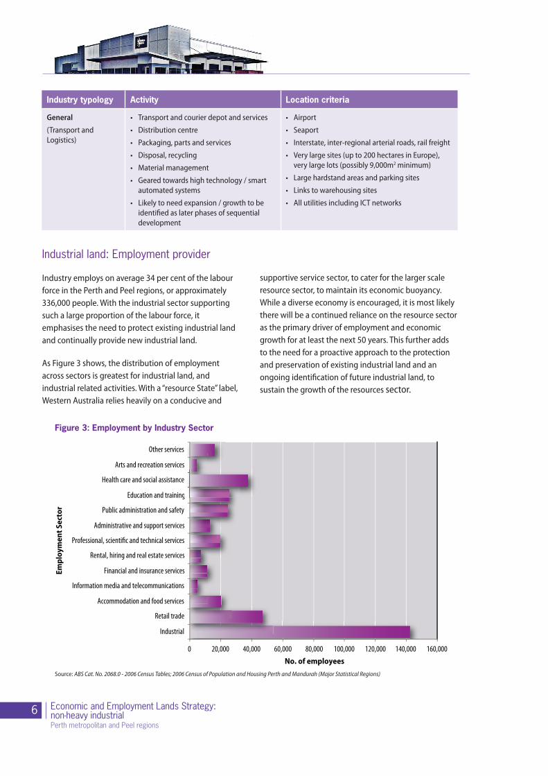
Figure 3: Employment by Industry Sector
Source: ABS Cat. No. 2068.0 - 2006 Census Tables; 2006 Census of Population and Housing Perth and Mandurah (Major Statistical Regions)
0 20,000 40,000 60,000 80,000 100,000 120,000 140,000 160,000
Industrial
Retail trade
Accommodation and food services
Information media and telecommunications
Financial and insurance services
Rental, hiring and real estate services
Professional, scienti�c and technical services
Administrative and support services
Public administration and safety
Education and training
Health care and social assistance
Arts and recreation services
Other services
Empl
oym
ent S
ecto
r
No. of employees
Industrial land: Employment provider
Industry employs on average 34 per cent of the labour force in the Perth and Peel regions, or approximately 336,000 people. With the industrial sector supporting such a large proportion of the labour force, it emphasises the need to protect existing industrial land and continually provide new industrial land.
As Figure 3 shows, the distribution of employment across sectors is greatest for industrial land, and industrial related activities. With a “resource State” label, Western Australia relies heavily on a conducive and
supportive service sector, to cater for the larger scale resource sector, to maintain its economic buoyancy. While a diverse economy is encouraged, it is most likely there will be a continued reliance on the resource sector as the primary driver of employment and economic growth for at least the next 50 years. This further adds to the need for a proactive approach to the protection and preservation of existing industrial land and an ongoing identification of future industrial land, to sustain the growth of the resources sector.
Industry typology Activity Location criteria
General (Transport and Logistics)
• Transport and courier depot and services
• Distribution centre
• Packaging, parts and services
• Disposal, recycling
• Material management
• Geared towards high technology / smart automated systems
• Likely to need expansion / growth to be identified as later phases of sequential development
• Airport
• Seaport
• Interstate, inter-regional arterial roads, rail freight
• Very large sites (up to 200 hectares in Europe), very large lots (possibly 9,000m2 minimum)
• Large hardstand areas and parking sites
• Links to warehousing sites
• All utilities including ICT networks
7Economic and Employment Lands Strategy:non-heavy industrial
Perth metropolitan and Peel regions
Industrial land: The changing face
The appearance of industrial land has changed considerably over the past two decades, with increasing pressure to convert industrial land to other higher end uses, such as offices and residential uses. There has also been an increasing blurring of the lines between what is regarded as traditional industrial uses and commercial uses. The lack of a consistent regulatory approach across local government boundaries has enabled this encroachment of less traditional, and in some cases, inappropriate land use activities in industrial zoned areas.
The contemporary challenges facing industrial areas include:
• The diversification and specialisation of industrial business models;
• The evolution of entertainment and recreation businesses into large format business models which are encroaching into traditional industrial areas; and
• Bulky-goods retailers locating into traditional industrial areas particularly in locations offering high traffic exposure.
Without a consistent regulatory framework to protect traditional industrial uses from encroaching land uses, the more commercial and higher end uses have been “allowed” to gradually intrude into industrial areas, which in effect has changed the land use composition. The resultant effect of the inconsistent approach to industrial land use planning can be seen in areas
such as Osborne Park, Malaga and Balcatta, whereby industrial estates have evolved into quasi-commercial centres, where large scale bulky good retailers are now located and traditional industrial operators have been limited in their opportunity to expand due to higher end competing uses.
Although that it is important to allow industrial land to evolve as technological advancement and innovation occurs, there is still a need to ensure that traditional industrial land uses and their operations are not impeded due to non-industrial uses being allowed to encroach into industrial land. Industrial land must be protected for industrial uses into the future.
Zoning for industry
It is important to recognise that industrial type activities are not restricted to only occurring on land which has been zoned ‘industry’ under a scheme. An example of this is land used for industrial activities within the City of Belmont. Within the upper northern portion of its local government boundary, exists a light industry area, zoned ‘light and service industry’ under the local planning scheme. Under the MRS, this area is zoned ‘Urban’. In this particular instance, the land was considered to be suitable for these lighter forms of industrial use given the specific characteristics of the area and its relationship to adjoining land uses.
By allowing industry in “urban” zones is necessary to avoid adverse impacts upon neighbouring areas, particularly residential areas. Appropriate buffer zones are typically utilised in such cases to separate incompatible land uses.
The strategy identifies potential locations where industrial type uses may be suitable. It represents the State Government’s blueprint for future industrial land use planning, in the Perth metropolitan and Peel regions. The areas identified in this strategy only indicate the extent of the investigation area, and do not represent the proposed development area or the likely extent of the rezoning of this area to industrial.
8 Economic and Employment Lands Strategy:non-heavy industrial Perth metropolitan and Peel regions
Key points• Industrial land supply is in high demand, and
a proactive approach to industrial land use planning and land banking must be undertaken as a matter of urgency.
• Industrial land is a significant provider of employment to the wider population of Perth and Peel, therefore, forms a vital part of the urban fabric and economic prosperity of the State.
• Industrial land use activities are diverse and varied, and through technological advancement and innovation, are changing rapidly in nature.
• Industrial land use activities should not be restricted to occurring just on land zoned “Industry” under a Region Scheme. Local town planning scheme provisions can also manage land use activities dependant on local issues and the local context.
• There is increased pressure and subsequent dilution of the function of industrial land because of a lack of a consistent statutory planning framework.
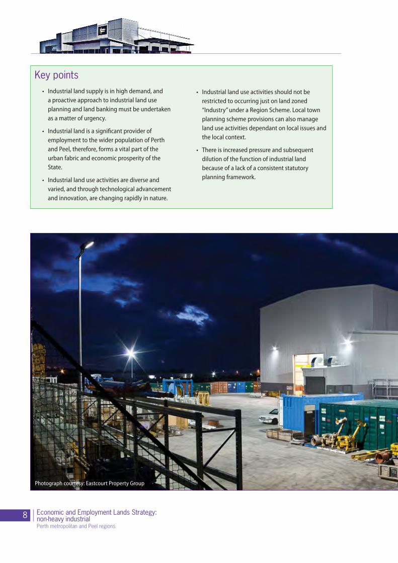
Photograph courtesy: Eastcourt Property Group

9Economic and Employment Lands Strategy:non-heavy industrial
Perth metropolitan and Peel regions

10 Economic and Employment Lands Strategy:non-heavy industrial Perth metropolitan and Peel regions
Replace Image
Part 3 - Planning for industrial development
Photograph courtesy: Eastcourt Property Group

11Economic and Employment Lands Strategy:non-heavy industrial
Perth metropolitan and Peel regions
During the past decade Western Australia has experienced an unprecedented economic boom that has transformed the State’s economy. Over the ten year period from 2001 to 2011 the population of Western Australia grew from around 1.9 million to 2.35 million (ABS, 2011). Western Australia’s population growth rate of 2.4 per cent over the past year makes Western Australia currently the fastest growing State.
This rate of population growth will not only impose significant pressures on the urban planning process for the Perth metropolitan area, but also adjacent areas such as Peel and parts of the South West along the Bunbury corridor. To cope with this projected growth it will be necessary for WA to provide optimal locations for employment opportunities, housing and infrastructure which, in turn, will require industrial development. It is vital that planning for industrial land moves in a direction where the planning system and development industry can capably respond to this anticipated demand.
Planning for industrial land
Planning for industrial land is challenging. The basis for its need is derived from unpredictable economic cycles and with the pace of innovation in technology and processes, which makes it difficult for planning regulators to respond. The strategy recognises these challenges, and aims to offer a more intuitive and responsive planning framework that factors in flexibility to accommodate this constantly changing environment.
Adding to this already challenging planning context is the lack of understanding of the vital economic benefits derived from industry. Industrial land is an essential part of the urban fabric, that must be afforded its economic and social importance.
The inconsistency applied at both State and local government levels in industrial land use planning, particularly when it comes to determining permitted land uses and the prescription of minimum lot sizes for new industrial developments, results in ad hoc industrial land use planning. Larger lots are being further subdivided into smaller “more affordable” lot sizes and inappropriate uses are being allowed in industrial areas, in the absence of any industrial land use guidelines stipulating otherwise.
This inconsistency adds further challenges for developers, and means uses that would be better suited elsewhere are permitted within industrial estates. Non-industrial uses in industrial areas directly impact on the operational capacity and potential of some industries, thus compromising the optimal functioning of industrial areas. Furthermore, the relevance of some planning regulations (e.g. car parking ratios being based on total floor areas), particularly in terms of built form and lot development, further diminishes the ability for industry operators to realise their potential.
The strategy recognises there is an urgent need to review the current planning regulations to ensure a better overall planning outcome for industrial estates.
12 Economic and Employment Lands Strategy:non-heavy industrial Perth metropolitan and Peel regions
Planning framework: Key planning documents
Historically, the prominence of industrial land use planning for the Perth and Peel regions has varied, depending on the focus of the State Government at the time, and the economic climate. The shortfall identified in late 2006 highlighted the inability of the existing planning system to adequately deliver industrial land to the market as demand dictated. The shortfall exposed a reactive rather than proactive planning system resulting in an industrial land supply deficiency unable to meet the level of demand. A summary of the key planning documents that have shaped the Perth and Peel regions are outlined in Appendix B.
In recent times, the approach to State planning has undergone a review and revitalisation. Strategic planning direction has evolved, reflecting a more holistic and integrated approach where the objectives are underpinned by social, environmental and economic considerations. The key planning documents, which have a direct relationship with the Strategy’s strategic objectives, are outlined as follows:
State Planning Strategy
The State Planning Strategy is a long-term plan providing the broad strategic direction for Western Australia. Guided by an overarching vision and State strategic directions, the strategy will shape Western Australia as it heads toward 2050. The Strategy outlines a set of planning principles, objectives and priorities for strategic land use and development in Western Australia. These principles and key objectives are listed below:
Principle Objective
Community
To enable diverse, affordable, accessible and safe communities that support social well being, quality of life and cultural identity for all West Australians
Economic
To enable trade, investment, employment and community betterment that enhances the economic prosperity for Western Australians
Environment
Conserve the State’s natural environment through managed land development, as well as supporting the sustainable supply of and demand for the State’s natural resources
InfrastructureTo coordinate physical and social infrastructure to support land development and community well being.
Regional Development
To build upon the competitive and collaborative advantages of the State’s regions in order to empower regions in land development matters
Governance
To continually improve the business of land development to be integrated, consistent, transparent and timely in order to build community confidence in land development affairs
It also recognises that the State needs strategically identified project-ready industrial areas and zoned industrial land for all industry types to afford a diversity of industrial development and to attract investment in Western Australia’s economy. Industry in Western Australia relies heavily on physical and social infrastructure, and, at the same time, is responsible for the planning and delivery of this infrastructure.

13Economic and Employment Lands Strategy:non-heavy industrial
Perth metropolitan and Peel regions
Directions 2031 and Beyond: Metropolitan planning beyond the horizon
“Directions 2031 and Beyond” was adopted and launched in August 2010. It is a high level strategic plan that establishes a vision for future growth of the Perth metropolitan and Peel regions, and provides a framework to guide the detailed planning and delivery of housing, infrastructure and services necessary to accommodate that growth. The anticipated population increase to 2.2 million by 2031 will translate directly into the need for another 328,000 houses and 353,000 jobs.
One of the key objectives of Directions 2031 and Beyond is to improve the relationship between where people live and work, to reduce commuting time and cost, and the associated impact on transport systems and the environment. The connected city scenario is expected to deliver improved levels of employment self-sufficiency across all sub-regions.
To address this anticipated demand and informed by separate strategies such as the EELS and the Department of Planning’s Urban Development Program, Directions 2031 and Beyond represents a number of sites identified in these preceding studies that indicate some level of potential for future residential and industrial land uses within the Perth and Peel regions.
Directions 2031 and Beyond recognises the importance of developing an economic and employment strategy for the Perth and Peel regions to identify and provide employment land and its distribution over the long term in order to sustain the expected population growth.
It will also ensure that suitable land is identified to support the economic activity of the city and State, particularly for infrastructure provision and industrial development.
Directions 2031 and Beyond also recognises the importance of freight movement to the city’s economic prosperity. The Western Australian Planning Commission’s State Planning Policy 5.4 Road and Rail Transport Noise identifies a freight movement network
of road and rail infrastructure. In planning for the future growth of the city it is critical that the freight network is well connected to key industrial areas and a balanced system of intermodal facilities.
Sub-regional strategies
As an implementation mechanism of Directions 2031 and Beyond, draft sub-regional strategies have been prepared for both the Central and Outer sub-regions. The draft Central Metropolitan Perth Sub-regional Strategy addresses issues relating to creating more housing opportunities across the 19 local government areas in the inner/middle sectors of metropolitan Perth. The draft Outer Metropolitan Perth and Peel Sub-regional Strategy focuses on providing an adequate supply of suitable urban land to support the strategic and sustainable growth of the city to 2031 and beyond. Both strategies also outline the need for additional employment land to cater for the increased population base that is expected over the next 20 years.
The industrial sites denoted on the sub-regional plans, which form a part of the overall Directions 2031 and Beyond document, are those future key sites identified as part of the strategy where the government’s strategic focus should be. However, it must be recognised that the ‘Under investigation’ status allocated to these sites does not imply that the land will be inevitably rezoned for industrial use. As is clearly represented in the EELS, there are further and more detailed investigations that must be carried out before any rezoning is considered. Consideration is also given to applying appropriate buffers to conflicting land uses such as residential developments and industrial land uses.

14 Economic and Employment Lands Strategy:non-heavy industrial Perth metropolitan and Peel regions
State Planning Policy 4.1 State Industrial Buffer Policy
In July 2004 the WAPC released a Draft State Industrial Buffer Policy. This policy is based on an assumption that routine industrial emissions and risk factors are identified during planning and environmental assessment processes and managed in accordance with licence conditions or statutory environmental conditions. Where licences and statutory environmental conditions are not applicable, high standards of environmental management should be adopted by industry and infrastructure providers.
The State Planning Policy 4.1 State Industrial Buffer Policy is currently under review. The purpose of the policy is to provide a consistent statewide approach for the protection and long-term security of industrial zones, transport terminals (including ports) other utilities and special uses.
It will also provide for the safety and amenity of surrounding land uses while having regard to the rights of landowners who may be affected by residual emissions and risk.
The policy establishes objectives and principles and how the principles should be applied to define and secure buffer areas and who should pay for them. It is intended that the WAPC will, after the policy has been in operation for a period of two full years, undertake a review of its effectiveness, and if necessary amend the policy.
The objectives of this policy are:
• To provide a consistent statewide approach for the definition and securing of buffer areas around industry, infrastructure and some special uses;
• To protect industry, infrastructure and special uses from the encroachment of incompatible land uses;
• To provide for the safety and amenity of land uses surrounding industry, infrastructure and special uses; and
• To recognise the interests of existing landowners within buffer areas who may be affected by residual emissions and risks, as well as the interests, needs and economic benefits of existing industry and infrastructure which may be affected by encroaching incompatible land uses.
State Planning Policy 4.2 Activity Centres for Perth and Peel
The State Planning Policy 4.2 Activity Centres for Perth and Peel (SPP4.2) gazetted on 31 August 2010, specifies broad planning requirements for the planning and development of new activity centres and the redevelopment and renewal of existing centres in the Perth and Peel regions.
SPP4.2 makes specific reference to the land use permissibility of bulky goods retail in order to reduce its potential dispersal throughout industrial zones. The policy directs bulky goods retail uses to selected Mixed Business or equivalent zones with suitable road and public transport access. Only recommended forms of retail and commercial development within industrial zones are noted in the policy. With regards to land for industrial purposes the policy aims to ensure that the key uses for industrial land are to be maintained and commensurate with industrial purposes.
Offices, unless incidental to, or servicing industrial developments, are discouraged from being located on land zoned for industry under region or local planning schemes. Criteria against which proposals can be assessed have been created for proposed office development in industrial areas. Shops and office development will only be permitted on land zoned industrial under region and local planning schemes where shops provide a local convenience service predominantly for people employed in the locality and are confined to a local centre; and offices are ancillary to the predominant industrial use of the premises or are confined to a local or small-scale centre that services industrial developments.
15Economic and Employment Lands Strategy:non-heavy industrial
Perth metropolitan and Peel regions
Planning Reform Act
On 19 August 2010, the Governor assented to the Approvals and Related Reforms (No. 4) (Planning) Bill 2009. The purpose of this Act is to amend the Planning and Development Act 2005 to streamline and improve the approvals process.
The key elements of the Act are to:
• Establish development assessment panels, which will provide a more effective and efficient approval process for development applications to build significant urban, industrial and infrastructure developments;
• Significantly extend the use of existing strategic instruments such as improvement plans and planning control areas to strengthen state and regional planning throughout the State;
• Enable the State to collect data on local development decisions to monitor the effectiveness of reforms to the approvals process;
• Provide a mechanism for local planning schemes to be updated to implement State Planning Policies (Section 77 and 76); and
• Streamline and clarify existing provisions and processes to improve the efficiency of the approvals process.
The measures provided for in this Act will enhance the ability of the State to implement the objectives of the strategy. For example, the use of improvement plans (which will be updated through improvement schemes) or planning control areas, may allow more direct development control and/or designation of industrial areas. The decision to use such tools will be based on proper planning principles and be subject to consultation requirements. There is also greater capacity to enhance implementation of State Planning Policies relevant to industrial development. The Act provides the Minister with the power to direct local governments to amend their local planning schemes to be consistent with particular State Planning Policies.
Gnangara Sustainability Strategy
The Gnangara Sustainability Strategy (GSS) has a bearing on the strategy in so much that a vast majority of the land in the North-west sub-region is affected by the nomination of what are referred to as Priority areas of the Gnangara Water Mound.
The GSS is an integrated planning strategy designed to address land, water and biodiversity issues on the Gnangara mound through a transparent decision making framework in which tradeoffs can be considered between competing values. The GSS includes all agencies responsible for the management of land and water within the Gnangara groundwater system. At the time of preparing this document, the GSS was still awaiting final government approval.
The GSS outlines the impacts of pressures on the Gnangara groundwater system. It describes the extent to which changing land use and management options can assist in adapting and responding to these impacts. The GSS also addresses the larger policy directions around land use and water management on the system and provides options for long term management. The GSS aims to protect Perth’s major drinking water supply and guides land uses to maximise the available water resource into the future.
Governance framework
The development of industrial land is a highly specialised field of activity that typically has a significant role for government. Industrial land requires long term planning and may take decades to assemble and bring to the market, then decades to fully establish. It requires a long term strategic vision for its purpose and ongoing management that few private sector organisations have the capacity to achieve. There are significant costs and risks associated with industrial land development and its strategic importance in the wider context of the State’s economic growth makes the role of Government essential.
16 Economic and Employment Lands Strategy:non-heavy industrial Perth metropolitan and Peel regions
The current governance structure spans four key areas of influence:
• State government
• Local government
• Servicing agencies
• Industry stakeholders
Key stakeholders in industrial land development
State Government
The State Government comprises many different entities, each charged with their own role and areas of responsibility to plan protect and manage the State’s assets, be it environmental, economic or social. While the roles and responsibilities of the various State Government agencies are well defined, there is a recognised need to enhance the level of inter-agency cooperation and collaboration, particularly when it comes to industrial land development.
Local government
Local government plays a vital role as the interface between the community and the wider government framework. Guided by many State Government policies, and dependent upon decisions made by the State Government agencies, local government authorities have a pivotal role in managing the orderly and proper planning within their local jurisdictions.
Local governments are increasingly challenged when managing land uses within industrial areas. The absence of a consistent statutory framework to apply to industrial estate land use planning has seen the incursion into industrial areas, particularly in the central sub-region to higher end and more commercial uses with bulky good retail uses, and entertainment uses (such as recreation centres and places of worship) being allowed to operate in industrial estates. Greater consistency, particularly as it relates to permitted land uses in industrial estates and development control on building form and the promotion of more sustainable practices, needs to be developed as a matter of urgency.
Infrastructure agencies and service providers (Infrastructure Coordinating Committee)
During the course of preparing the EELS, infrastructure provision was identified as one of the key issues and challenges that need to be overcome to create a more enabling environment for industrial land development to occur. Reporting directly to the WAPC, the Infrastructure Coordinating Committee (ICC) plays an increasingly vital role in coordinating infrastructure provision and service delivery. The ICC is chaired by the WAPC, and the infrastructure agencies and service providers represented on this committee are listed as follows:
• WAPC, Chair (Gary Prattley)
• local government representative
• professional representative
• Department of Housing
• Office of Energy
• Office of Environmental Protection Authority
• LandCorp
• Department of Environment and Conservation
• Department of Treasury
• Department of Finance
• Department of Planning
• Department of State Development
• Water Corporation
• Department of Education Services
• Department of Regional Development and Lands
• Department of Mines and Petroleum
• Department of Health
• Department of Water
• Department of Education
• Department of Transport
• Department of the Premier and Cabinet
• Department of Commerce

17Economic and Employment Lands Strategy:non-heavy industrial
Perth metropolitan and Peel regions
A major stumbling block for all servicing and infrastructure agencies for all urban development matters is the issue of pre-funding for infrastructure projects. With a relative scarcity of public funding it is important that through better coordination between the various agencies, unnecessary duplication and waste of funding does not occur. It will be imperative that the ICC engage with State and local government agencies and the private sector to plan for infrastructure over the longer term and that it leads rather than follows industrial development, as has been the case historically. The Urban Development Program, discussed later in this document, will play a vital role in providing this coordinated framework for government agencies and infrastructure and service providers to work within, to deliver an optimal outcome.
Development industry
The development industry is traditionally focused on large scale residential subdivisions and development, with the industrial portfolio of the larger scale developers being relatively small. Promoted by the resources boom, some of these development companies expanded the size of their industrial divisions in order to play a more active role in the industrial land development market. However, the global financial crisis, coupled with what had become a vastly inflated property market saw these same companies reduce their industrial land development visions, and retreated their presence in the market.
LandCorp
A major industrial land developer is LandCorp. Charged with the role of both a policy advisor and the State Government’s developer, LandCorp has an important role to play in stimulating the industrial property development market and facilitating the on going availability of industrial land to cater for forecast demand. Through the development of the EELS it was recognised that the opportunity exists for LandCorp to activate its role and increase its focus on industrial land. The strategy recognises that there is a need for government to foster a much stronger working relationships with the private sector.
Key points• Planning for industrial land is challenging
because of its particular reliance on unpredictable economic trends.
• There is a need for stricter land use planning controls to exclude inappropriate uses from areas identified for industrial development and activity
• Planning and zoning regulations need to factor-in enough flexibility for industrial land to be developed successfully, while ensuring that the amenity and environmental considerations are taken into account.
• The poor understanding of what industrial land delivers beyond its economic contribution is one of the biggest weaknesses of the existing planning framework for industrial land at both State and local government levels.
• The State Government, through the recent release of key strategic planning documents, such as Directions 2031 and Beyond and the draft sub-regional strategies, is recognising the importance of industrial land to the urban fabric and economic health of Western Australia.
• There are various influencers of industrial development. A coordinated and more collaborative framework needs to be established to optimise the development of industrial estates.
• The WAPC’s Infrastructure Coordinating Committee (ICC) is viewed as being a key facilitator in ensuring that State Government initiatives are supported across government. Its role in facilitating an improved industrial land use planning outcome is pivotal.

18 Economic and Employment Lands Strategy:non-heavy industrial Perth metropolitan and Peel regions
Part 4 - Demand analysis for industrial land
Photograph courtesy: Eastcourt Property Group
19Economic and Employment Lands Strategy:non-heavy industrial
Perth metropolitan and Peel regions
In Western Australia, a unique set of economic drivers, influenced by the State’s heavy reliance on the resources sector, also affect the levels of demand for industrial land. This interrelationship means that while population growth remains as the primary driver for industrial land demand, economic conditions can also have a significant influence on the rate and type of consumption for industrial land depending on market conditions and trends.
Industrial land demand: Western Australia
The Western Australian economy is particularly sensitive to economic activity, especially when compared to other States in Australia. Heavily reliant on an export and import market, the resources sector and its strong trading ties with the South-East Asian region, the impact of changed global economic conditions can adversely impact on the demand for industrial land, as downturns in these cycles occur.
The combination of a continued strong export-oriented economy, upward employment trends and a growing population mean that an increase in demand for industrial land is likely to continue to be experienced in the Perth Metropolitan and Peel regions for the foreseeable future.
On a global scale, long term economic growth in key international markets such as China, Japan and Korea will drive growth within these industries, and subsequently increase the demand for industrial land. Key shapers will include State and local government agencies, and their ability to set policy and build infrastructure that is attractive to major investors.
Demand drivers
One of the greatest challenges in industrial land use planning is being able to predict future demand and from where it will originate. Although population growth can be relied upon as an indicator of growth and subsequent demand for residential land, predicting future demand for industrial land is not so simple. Various other drivers affect the volume of demand, and a solid understanding of economics and a commercial knowledge base are necessary to ensure that the planning for future demand is commensurate with the economic direction of the day.
Essentially, the demand for industrial land generally derives from a local, national and/or international demand for goods and services, with value adding to both locally generated products and products

20 Economic and Employment Lands Strategy:non-heavy industrial Perth metropolitan and Peel regions
Land demand• Perth and Peel working
age
• State labour participation
• State employment rate
• Perth and Peel employment self sufficiency
• Industrial estate employment share
• Hectares per employee
Land supply• Current available
industrial land
• Future industrial land releases
Shortfall / surplus = land supply - land demand
Figure 4: Industrial Land Demand Modelling Inputs
generated in other regions. Industries usually seek sites with sufficient amenity and location advantage in order to perform their activity in a competitive way. Preferences will vary dependant upon the industry sector, but such amenities often include:
• Being contiguous to other industrial activities;
• Being well located in relation to supply chains and service providers;
• Having the potential for on-site expansion of existing industrial businesses;
• Being well located in relation to skilled labour pools;
• Being well located to take advantage of existing or proposed infrastructure or other economic development;
• Being well located in relation to freight connections and other important road and/or rail networks;
• Having the potential to provide for small industrial businesses serving the local area;
• providing sufficient space for adequate parking and turning space for industrial vehicles;
• Having the potential for 24 hour, 7 day a week operations;
• Having minimal or no adjoining land use constraints (or sufficient areas to prove internal buffers);
• Having minimal or no environmental, geotechnical or drainage constraints (or the potential to compensate off site);
• Not having constrained vehicle access and exit points;
• Being commercial developed with infrastructure and site preparation for future industrial activities; and
• Having sufficient on-site hardstand space.
Following consultation with industry bodies and private sector land owners, most land demand was from two distinct areas:
1. International and national firms seeking large warehouses (more than 4000 m²) and land areas (above 2-3 ha).
2. Small scale local businesses seeking warehouse space less than 1000 m².
Forecasting demand
The EELS was predicated on the need to identify future land for industrial use, resulting from an identified shortfall in industrial land, witnessed in the late 1990s and early 2000s. To determine how much land needs to be identified to resolve this shortfall, demand modelling was undertaken to enable forecast demand rates to be determined. A forecast model was developed based on key data considered relevant to informing future demand levels. The key model inputs used were based on both historical and projected data, which are represented and were used as indicated in figure 4.
The forecast additional demand for industrial land in the Perth and Peel regions from 2006 until 2031 is calculated to be approximately 4726 ha. It should be noted that the forecast demand was based on a “business as usual” scenario, using WA Tomorrow

21Economic and Employment Lands Strategy:non-heavy industrial
Perth metropolitan and Peel regions
population projections and parameter values that are considered to show consistent trends.
Based on a population driven model, the sub-region where the greatest demand for industrial land can be anticipated is in the North-west sub region, as figure 5 clearly indicates.
Based on the current shortfalls in industrial land supply in each of the sub regions and forecast demand for the Perth metropolitan and Peel regions in the next 20 years, it will be approximately 10 years before the market can achieve a balance between industrial land supply and demand. It is therefore crucial that priority be given to the release of all available land within existing industrial estates (representing 1758 ha supply) and all necessary feasibility studies and investigations be promptly completed to enable delivery of the short, medium and long term sites that have been identified in this strategy.
Key indicators of demand
Consumption rate
Historical consumption rates are an excellent indicator to enable future demand forecasting to be carried out. As figure 6 below indicates, WA’s economic boom has led to above average industrial land consumption between 2003 and 2010. A key driver of this demand was resources and transport and logistics firms taking up large land parcels such as the 25 ha used by Coles Distribution Centre at Perth Airport.
With a significant amount of available industrial land not readily available due to planning and environmental constraints that still remained to be resolved in 2006/07, demand for industrial land outstripped the available supply.
The consumption rate for industrial land in the Perth and Peel regions, indicates a generally cyclical trend, with demand fluctuating from 80-150 ha per annum. The average demand is 99.5 ha per annum.
Using data derived from studies undertaken as part of the strategy, and confirmed following consultation with industry bodies, such as the Property Council of Australia, existing markets will be able to supply 1211ha (25 per cent) of the projected 4726 ha of demand up to
140
150
120
100
80
60
40
20
0
Years
Num
ber o
f hec
tare
s
76
113 110
130
6152
82
115119
103
6390
137
1996/97 1997/98 1998/99 1999/00 1999/01 2001/02 2002/03 2003/04 2004/05 2005/06 2006/07 2007/08 2008/09 2009/102007/0820 20
143
Figure 6: Consumption rates 1996-2010, Perth and Peel
Source: Internal DoP database
Figure 5: Forecast demand levels by sub-region
910
1397
18281646
2442
0
500
1000
1500
2000
2500
3000
North West North East South West South East PeelSub-region
No. o
f hec
tare
s
Source: Internal DoP data/Property Council of Australia

22 Economic and Employment Lands Strategy:non-heavy industrial Perth metropolitan and Peel regions
Figure 7: Industrial land subdivision conditional approvals
Source: Internal DoP database
0
200
400
600
800
1000
1200
2001-2002 2002-2003 2003-2004 2004-2005 2005-2006 2006-2007 2007-2008 2008-2009 2009-2010
Conditional
Final lots
2031. In terms of timeframe:
• 238 ha is expected to be available in the short term.
• 430 ha is expected to be available in the medium term.
• 543 ha is expected to be available in the long term.
However, there are significant challenges facing the medium-to-long term delivery of sites in terms of coordinated planning, environmental management, infrastructure provision and finance. With strong demand anticipated from resource companies associated with the Gorgon and Pluto projects and limited development opportunities available at Perth Airport, significant supply shortages can be expected in the 2012-2014 period due long lead times associated with the development of land.
At present, using historical consumption rates, in existing industrial estates there is:
• 1.5 to 3 years supply in the short term
• 2.8 to 5.3 years supply in the medium term
• 3.6 to 6.8 years supply in the long term; and
• 8 to 15.1 years supply in total.
This demonstrates that current supply levels are finely balanced. If large outfits such as Linfox or Coles were to require a 40-50 ha site for their operations, this would significantly alter the supply/demand balance, and inflation in prices for industrial land would then be repeated.
Subdivision approvals
The analysis of subdivision approval data for industrial land is also a good indicator of industrial land development activity and levels of demand. In examining the subdivision approval data for industrial land between 2001 and 2010, the following observations were made:
• The average number of conditional approvals granted per financial year during this period was 542 industrial lots;
• 743 lots was the highest number of conditional approvals granted in 2004 to 2005;
• The lowest number of conditional approvals, being 293 lots, was recorded in 2001 to 2002.
Current conditional approvals are those approvals that are still valid, but have not yet been issued with final approval. In general, these are approvals for which construction/servicing has not yet commenced or is currently under way. The balance of conditional

23Economic and Employment Lands Strategy:non-heavy industrial
Perth metropolitan and Peel regions
approvals represents the stock of lots ready to be delivered to the market once the conditions of approval are met. Due to a number of factors, such as landowner intentions, market conditions or servicing conditions, not all conditional approvals reach final approval stage. As a rule of thumb, approximately 45 per cent of conditional approvals proceed to final approval stage for industrial land subdivisions. Final approvals represent lot creation and, therefore, correspond in a temporal sense to peaks of zoned land consumption recorded between 2001 and 2010.
Lot sizes
As land values of industrial land in the early 2000s continued to increase, the subdivision of larger lots into smaller, more affordable lots became a common trend, particularly in areas such as Bassendean and Osborne Park. Coupled with the existing trend of higher end uses locating within industrial areas, larger lots were less common, and as a result, major warehouse, transportation and storage operators were forced to look for alternative locations.
Historical trends have shown a strong demand for land parcels of 4000 sqm or less which account for 78 per cent of total industrial sales over this same period. However, a recent survey of key industry stakeholders have shown that with the increase of transport and logistic oriented industry activities, lot sizes of 4000 sqm and more, will continue to be in greatest demand.
The Perth Airport land has proven to be a popular location for these larger outfits such as Coles, Toll, Woolworths and the like to locate, given its central location, good infrastructure provision and road network. Mining companies have also chosen to locate at the airport, again making the most of what the location affords and also being within close proximity to the city and its metropolitan major operations centres. One of the other major attractors of the Perth Airport land for industrial occupiers of this scale is the availability of development ready land. This type of land is a rare product in the Western Australian industrial property market, and is an attractive option, in particular, for larger scale operators. It allows prompt start up of operations, without substantial time and costs being absorbed in gaining the necessary development and environmental approvals, before operations can commence.
Land values
In recent years there have been very high levels of growth in both land values and rents. The economic boom as well as a shortage of industrial land ready for development has driven this. Although Perth’s industrial land values and rents have traditionally sat well below those in other Australian States, recent growth has seen the Perth market come more into line with interstate land values because of this marked shortage. The rapid increase in land values in Perth between 2006 and 2008 was driven by the booming economic conditions in Perth, which led to a rapid take-up in industrial land and a subsequent shortage of available industrial land. It is worth noting that at the same time as land values were increasing in Perth, a similar trend was occurring in Adelaide and, to a lesser degree, Sydney. Melbourne has large areas of industrial land available and this, together with a relatively flat economy during this period, limited growth in land values there. However, this is likely to be a limiting factor on rent increases in Perth in the future, as national tenants are unlikely to pay significantly higher rents in Perth than those in other states.
According to Jones Lang LaSalle’s market commentary on the Perth industrial market for the September quarter of 2010, a shortage of industrial land in Perth
24 Economic and Employment Lands Strategy:non-heavy industrial Perth metropolitan and Peel regions
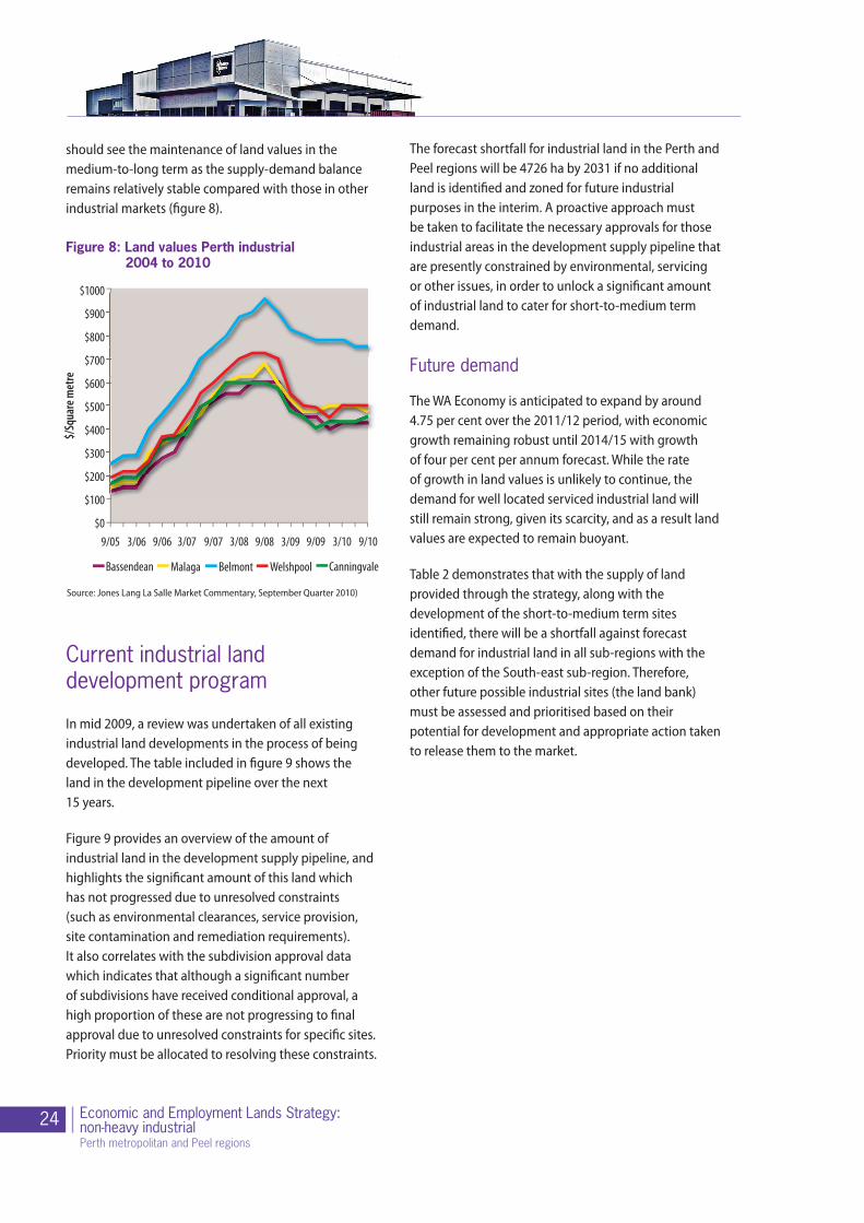
should see the maintenance of land values in the medium-to-long term as the supply-demand balance remains relatively stable compared with those in other industrial markets (figure 8).
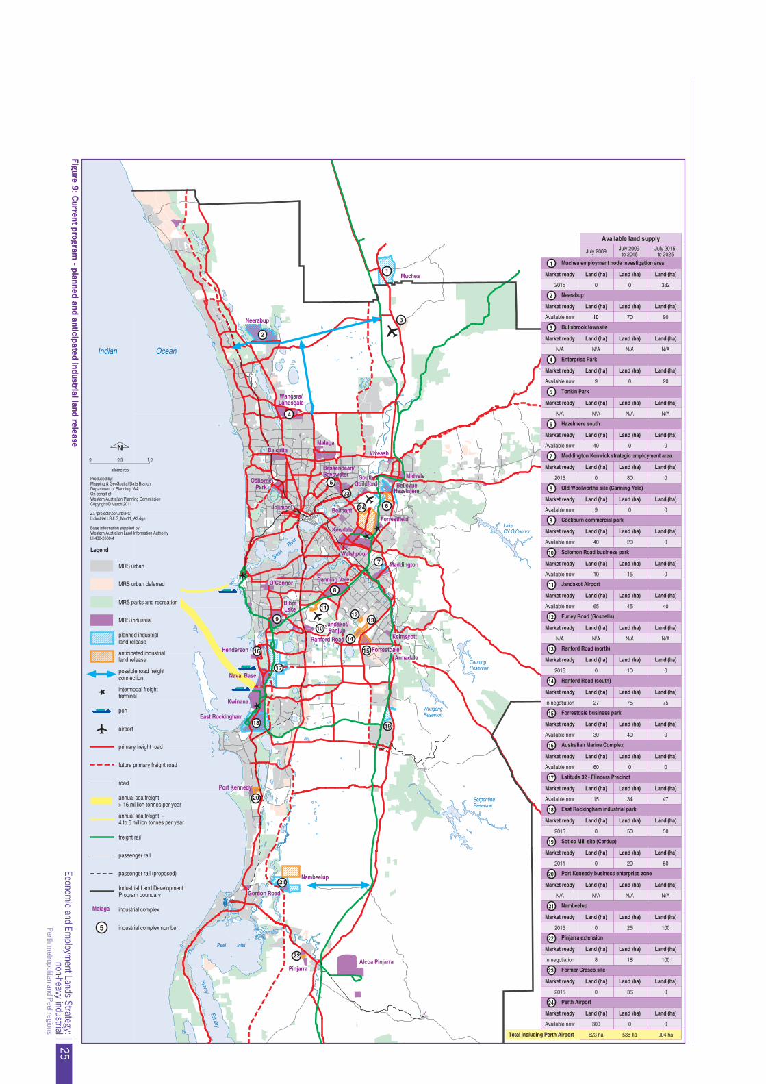
Current industrial land development program
In mid 2009, a review was undertaken of all existing industrial land developments in the process of being developed. The table included in figure 9 shows the land in the development pipeline over the next 15 years.
Figure 9 provides an overview of the amount of industrial land in the development supply pipeline, and highlights the significant amount of this land which has not progressed due to unresolved constraints (such as environmental clearances, service provision, site contamination and remediation requirements). It also correlates with the subdivision approval data which indicates that although a significant number of subdivisions have received conditional approval, a high proportion of these are not progressing to final approval due to unresolved constraints for specific sites. Priority must be allocated to resolving these constraints.
$/Sq
uare
met
re
$1000
$900
$800
$700
$600
$500
$400
$300
$200
$100
$09/05 3/06 9/06 3/07 9/07 3/08 9/08 3/09 9/09 3/10 9/10
Bassendean Malaga Belmont Welshpool Canningvale
Figure 8: Land values Perth industrial 2004 to 2010
Source: Jones Lang La Salle Market Commentary, September Quarter 2010)
The forecast shortfall for industrial land in the Perth and Peel regions will be 4726 ha by 2031 if no additional land is identified and zoned for future industrial purposes in the interim. A proactive approach must be taken to facilitate the necessary approvals for those industrial areas in the development supply pipeline that are presently constrained by environmental, servicing or other issues, in order to unlock a significant amount of industrial land to cater for short-to-medium term demand.
Future demand
The WA Economy is anticipated to expand by around 4.75 per cent over the 2011/12 period, with economic growth remaining robust until 2014/15 with growth of four per cent per annum forecast. While the rate of growth in land values is unlikely to continue, the demand for well located serviced industrial land will still remain strong, given its scarcity, and as a result land values are expected to remain buoyant.
Table 2 demonstrates that with the supply of land provided through the strategy, along with the development of the short-to-medium term sites identified, there will be a shortfall against forecast demand for industrial land in all sub-regions with the exception of the South-east sub-region. Therefore, other future possible industrial sites (the land bank) must be assessed and prioritised based on their potential for development and appropriate action taken to release them to the market.
25Econom
ic and Employm
ent Lands Strategy:non-heavy industrial
Perth metropolitan and Peel regions
5
24 6
2
3
4
7
8
9
11
10
12
14
15
13
17
16
18 19
20
22
Swan
WungongReservoir
CanningReservoir
SerpentineReservoir
LakeCY O’Connor
Neerabup
MalagaBalcatta
OsbornePark
Bassendean/Bayswater South
GuildfordMidvale
Viveash
HazelmereBellevue
Jolimont Belmont
Welshpool
Canning Vale
Kelmscott
Forrestdale
O’Connor
Kewdale
Muchea
Jandakot/Banjup
BibraLake
Maddington
Forrestfield
Armadale
Nambeelup
Alcoa PinjarraPinjarra
Gordon Road
Henderson
Kwinana
Wangara/Landsdale
Ranford Road
East Rockingham
Port Kennedy
✱
✱
✱✱
River
HarveyEstuary
Indian Ocean
Peel Inlet
Naval Base
Figure n
2015 0 0
Land (ha) Land (ha)Market ready Land (ha)
1
Land (ha) Land (ha)Market ready Land (ha)
2
N/A
Land (ha) Land (ha)Market ready Land (ha)
3
0
Land (ha) Land (ha)Market ready Land (ha)
4
Land (ha) Land (ha)Market ready Land (ha)
5
40 0
Land (ha) Land (ha)Market ready Land (ha)
6
2015 0 80
Land (ha) Land (ha)Market ready Land (ha)
7
9 0
Land (ha) Land (ha)Market ready Land (ha)
8 Old Woolworths site (Canning Vale)
40 20
Land (ha) Land (ha)Market ready Land (ha)
9
10 15
Land (ha) Land (ha)Market ready Land (ha)
10
45
Land (ha) Land (ha)Market ready Land (ha)
11
Land (ha) Land (ha)Market ready Land (ha)
12
2015 0 10
Land (ha) Land (ha)Market ready Land (ha)
13
27 75
Land (ha) Land (ha)Market ready Land (ha)
14
40
Land (ha) Land (ha)Market ready Land (ha)
15
60 0
Land (ha) Land (ha)Market ready Land (ha)
16
Neerabup
Bullsbrook townsite
Muchea employment node investigation area
Enterprise Park
Tonkin Park
Hazelmere south
Maddington Kenwick strategic employment area
Cockburn commercial park
Solomon Road business park
Jandakot Airport
Furley Road (Gosnells)
Ranford Road (north)
Ranford Road (south)
15 34
Land (ha) Land (ha)Market ready Land (ha)
17
2015 0 50
Land (ha) Land (ha)Market ready Land (ha)
18
2011 0 20
Land (ha) Land (ha)Market ready Land (ha)
19
Land (ha) Land (ha)Market ready Land (ha)
20
2015 0 25
Land (ha) Land (ha)Market ready Land (ha)
21
8 18
Land (ha) Land (ha)Market ready Land (ha)
22
100
2015 0 36
Land (ha) Land (ha)Market ready Land (ha)
23
Land (ha) Land (ha)Market ready Land (ha)
24
Forrestdale business park
Australian Marine Complex
East Rockingham industrial park
Sotico Mill site (Cardup)
Port Kennedy business enterprise zone
Nambeelup
Pinjarra extension
Perth Airport
Former Cresco site
Total including Perth Airport
Available now 20
N/A
0
Available now 0
Available now 0
Available now 0
Available now 40
0
In negotiation 75
Available now 0
Available now 0
Available now 47
50
In negotiation
Available now
0
July 2009 July 2009to 2015
July 2015to 2025
23
623 ha
0
Legend
0
MRS urban
N
✱
MRS urban deferred
MRS parks and recreation
MRS industrial
port
airport
primary freight road
future primary freight road
road
freight rail
passenger rail
passenger rail (proposed)
5 industrial complex number
industrial complexMalaga
Industrial Land DevelopmentProgram boundary
annual sea freight -> 16 million tonnes per year
annual sea freight -4 to 6 million tonnes per year
anticipated industrialland release
possible road freightconnection
0.5 1.0
kilometres
intermodal freightterminal
planned industrialland release
9
30
Industrial Land Strategy
21
Available land supply
Current program - planned and anticipated industrial land release
1
332
0
Available now
N/A N/A N/A N/A
50
N/A N/A N/A N/A
100
300 0
538 ha 904 ha
Available now 70 901010
N/A N/A N/A
N/A N/AN/A
Latitude 32 - Flinders Precinct
Z:\ \projects\pol\urb\IPC\Industrial LS\ILS_Mar11_A3.dgn
Produced by:Mapping & GeoSpatial Data BranchDepartment of Planning, WAOn behalf of:Western Australian Planning CommissionCopyright © March 2011
Base information supplied by:Western Australian Land Information AuthorityLI 430-2009-4
65
Figure 9: Current program
- planned and anticipated industrial land release

26 Economic and Employment Lands Strategy:non-heavy industrial Perth metropolitan and Peel regions
The outlook for general and light industrial land use
Increasingly there has been a move away from manufacturing operations towards transportation logistics and storage, warehousing and distribution centres. This emerging trend has resulted in an increased demand for larger lot sizes and the development of estates that can respond to and capably accommodate these larger scale uses. Access to large scale onsite hardstand space and co-located office premises will also increase the land requirements of industrial land users. Excellent access to road and rail infrastructure is becoming increasingly sought after, and will continue to be a prerequisite when such industry types are choosing a preferred location.
In recent years demand for larger lots of this type has been catered for by the Forrestfield/Kewdale/Welshpool area and the Perth airport land. As the rapid take-up rate of larger lots in the airport land indicates, industry players are looking for land parcels that are not only strategically located with easy access to key transport corridors that link to port and rail, but also land that is fully serviced and development ready.
With the ease of access and a relatively unconstrained regulatory environment compared with other locations, the airport land typifies the attributes considered favourable by such companies. The market preference
for this location is due to the availability of infrastructure and services allowing for immediate development and occupation. The airport has done particularly well in attracting major tenants in recent years as the only strategically located land parcel in Perth able to offer fully serviced large lots (which were also relatively unconstrained from an environmental perspective). The added advantage of the airport land has been the ability to provide lots that meet tenants’ specifications and the long-term vision and control over its industrial estate. However, the airport land will not last forever and alternatives will need to be found. A key objective of the strategy
should be to offer similar land parcels that are fully serviced and free of constraints.
A number of development opportunities exist beyond the airport land. Both the Hazelmere industrial area and the redevelopment of the Kewdale/Welshpool area are such examples. However, it must be recognised that fundamental to the success of these areas being redeveloped will be the timely delivery of all necessary approvals (including environmental) and access to service infrastructure and adequately catering to market needs, particularly in terms of lot size.
The Goodman development located on Bushmead Road in the Hazelmere industrial area is likely to attract other industrial land developers to the area who are wishing to develop in a similar fashion. Provided that a similar relatively unconstrained regulatory framework to the airport land can be facilitated and the provision of service infrastructure factored into the early stages of planning for any future development within the Hazelmere industrial area, then future development within this area will be highly attractive to future investors. Within the Kewdale/Welshpool area, very little vacant land is available and of that which is left, if redeveloped, is unlikely to be of suitable lot size for many users.
The overflow port proposed at Kwinana, and the intermodal facility at Latitude 32, will result in a major influx of activity in the transport logistics and
Table 2: Industrial land demand/supply forecast by planning sub-region
Planning sub-region
Demand at 2031 (ha)
Pipeline supply from current Land Development Program (ha)
Shortfall/surplus based on current Land Development Program (ha)
Central 5243 3407 -1836
North-West 2442 2004 -438
North-East 1646 1765 -117
South-East 1397 1583 194
South-West 1828 1525 -303
Peel 910 304 -606
Source: Internal DoP data/Property Council of Australia
27Economic and Employment Lands Strategy:non-heavy industrial
Perth metropolitan and Peel regions
distribution industries for the southern metropolitan and Peel regions. It will also most likely result in an increased demand for land that is well located and serviced to cater for these land use activities, which at present, do not have a significant presence in these regions comparative to the north-east sub-region.
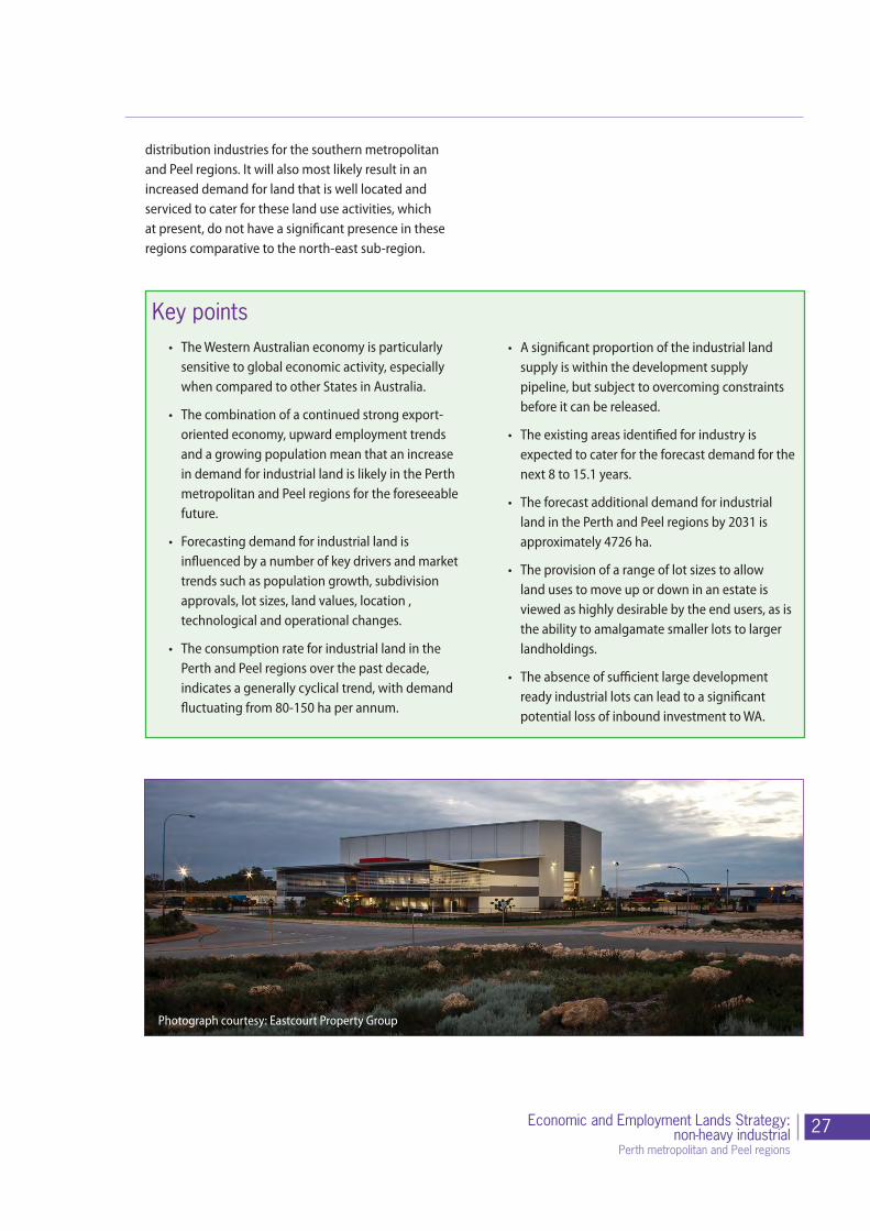
• A significant proportion of the industrial land supply is within the development supply pipeline, but subject to overcoming constraints before it can be released.
• The existing areas identified for industry is expected to cater for the forecast demand for the next 8 to 15.1 years.
• The forecast additional demand for industrial land in the Perth and Peel regions by 2031 is approximately 4726 ha.
• The provision of a range of lot sizes to allow land uses to move up or down in an estate is viewed as highly desirable by the end users, as is the ability to amalgamate smaller lots to larger landholdings.
• The absence of sufficient large development ready industrial lots can lead to a significant potential loss of inbound investment to WA.
Key points• The Western Australian economy is particularly
sensitive to global economic activity, especially when compared to other States in Australia.
• The combination of a continued strong export-oriented economy, upward employment trends and a growing population mean that an increase in demand for industrial land is likely in the Perth metropolitan and Peel regions for the foreseeable future.
• Forecasting demand for industrial land is influenced by a number of key drivers and market trends such as population growth, subdivision approvals, lot sizes, land values, location , technological and operational changes.
• The consumption rate for industrial land in the Perth and Peel regions over the past decade, indicates a generally cyclical trend, with demand fluctuating from 80-150 ha per annum.
Photograph courtesy: Eastcourt Property Group

28 Economic and Employment Lands Strategy:non-heavy industrial Perth metropolitan and Peel regions
Replace Image
Part 5 - Supply of industrial land
Photograph courtesy: Eastcourt Property Group

29Economic and Employment Lands Strategy:non-heavy industrial
Perth metropolitan and Peel regions
Industrial land supply stock
As at 1 July 2010 the total area of industrial zoned land in the Perth metropolitan and Peel region schemes totalled 13,737 ha (including 63 ha of land zoned special industry). At present, the assumed available supply of zoned industrial land for development is 9403 ha, of which 8192 ha is occupied and 1211 ha is vacant. A common misconception is that there is a more than adequate supply of industrial land available. However, on further examination the amount of industrial land actually available is significantly less than the area of zoned land due to large portions being constrained or unable to be developed in the short-to-medium term because of pre-existing activities such as limestone quarries and turf farms.
Many shortages of industrial land that generate the most publicity are those involving large firms. While these are small in number, very substantial parcels of land with highly specific requirements are involved. The challenge facing WA is to strike a balance between having a ready supply of smaller lots for the majority of small-to-medium sized firms, and keeping sufficient large lots for the major players.
The priorities in planning for more industrial land are to:
• Facilitate the more intensive use and the extension of existing industrial sites with high economic and location value;
• provide a steady supply of suitably sized lots for the majority of small-to-medium sized firms while also ensuring there are sufficient large lots for major industry types to be accommodated; and
• Prioritise the deconstraining of those new sites with high economic value, including facilitating a streamlined and consistent regulatory environment, and to encourage significant pre-planning prior to any development or rezoning .
The consumption rate of general industrial land has accelerated in recent years. In the period between 1988 and 2001 the area occupied by general industries grew by an average of 80 ha a year, but from the low point in the demand cycle in 2001 the consumption rate increased by 250 per cent over the next five years. Due to the resources boom, consumption of industrial land has run above the 15 year average trend of 99.5 ha per annum, with supply constraints causing the main restriction on demand during five of the past seven years.
Types of vacant industrial land
The type and amount of vacant industrial land can be classified into three categories:
• Development ready: Land of this type is already zoned, service infrastructure already provided, and is ready to be occupied by an end user. This category of land comprises 258 ha within Perth and Peel’s industrial land stock.
• Constrained: This category of land comprises over 953 ha of Perth and Peel’s current industrial land stock. For this land to be available to the market, significant constraints need to be overcome such as service infrastructure provision and connection, site remediation

30 Economic and Employment Lands Strategy:non-heavy industrial Perth metropolitan and Peel regions
(including decontamination), expiry of mining leases, drainage and groundwater monitoring being required, flora and fauna surveys, etc
• Not developable: This land is already zoned industrial, but has significant constraints of such magnitude or complexity which means the site cannot be developed. Such constraints may be, for example, conservation category wetlands, bush forever, threatened ecological communities (such as Carnaby’s Cockatoo or the Graceful Sun Moth) or declared rare flora or fauna.
In addition, there are also sites which may be zoned for future industrial purposes, but their availability to the general market is not expected to be in the short to medium term. This category of vacant industrial land is described as follows:
• Zoned but latent availability. This category of site includes sites which may already be zoned industrial but the timing of the land becoming available is unknown. In some instances this may be land which has been identified for future expansion, comprises part of a buffer or may be subject to an extraction licence, as issued under the Mining Act 1992. These sites in particular need to be protected and subsequent development be programmed to occur in a sequential manner.
Supply challenges and issues
An important starting point to developing an approach to facilitate the deconstraining of industrial zoned land, is to understand the key issues currently affecting industrial land supply. They are identified as follows:
• Lack of available service infrastructure:
- Electricity supply: the vast majority of industries are reliant on electricity for operational needs. However, there is a marked difference in the electricity supply provided to a domestic customer versus an industrial customer and often getting this additional supply requires significant forward planning with the servicing agencies because expensive “headworks” upgrades may be required;
- Water supply: particularly the provision of adequate levels of water pressure to allow firms to meet FESA requirements;
- Access provision: The development of residential areas around many of the older industrial estates in the Perth metropolitan area and the Peel region has resulted in traffic congestion and problems for heavy vehicle access. Small firms are particularly susceptible to problems with vehicle access into and out of their sites;
- Inadequate public transport access, which is of particular concern to firms based in the more inaccessible areas of Perth and the Peel Region in relation to moving employees to and from work, and will only result in more road traffic;
• Environmental constraints (for example, Bush Forever sites and conservation category wetlands) limiting the development potential of land;
• Extractive industries leases that can limit the developable area of industrial sites and immediate availability of industrial zoned land;
• Highly fragmented ownership of existing estates making the amalgamation of sites difficult;
• Industrial land being eroded by higher end uses (i.e. commercial office and residential);
• Lack of public-private participation in the industrial land development industries, resulting
31Economic and Employment Lands Strategy:non-heavy industrial
Perth metropolitan and Peel regions
in a fragmented and disjointed development industry;
• Existing industrial estates being underutilised due to past design trends, particularly in the central sub-region;
• The trend by industry to withhold land for future expansion or buffering purposes;
• The optimal number of employees per hectare ratio not being realised, particularly in central sub-region; and
• Land use conflicts as residential areas impact on industrial activities, resulting in the relocation or cessation of industries.
To better understand the impact of these issues on the end user, further consultation with key industry stakeholders was undertaken. As a result, the challenges and frustrations identified with current industrial land development could be divided into two major categories. These are represented below:
Planning and zoning issues:
Design and specification issues:
• Land availability
• Approvals and permits
• Multiple government agencies / coordination
• Multiple local government authorities spanning industrial estates
• Impact of mixed use zoning and approvals
• Availability of sand / fill - mining prospects
• Residential encroachment
• Landscaping
• Parking ratios
• Lot ratios and setbacks
• Lot sizes / mix within estates
• Changes to rules and regulations
• Road design and access to estates
• Utilities
• Accessibility to support services
Expanding upon these identified pressures and challenges, the key industry stakeholders expressed the following current issues for industrial land development:
• Industrial land that is available does not cater to specific operational needs and requirements;
• The lack of project ready (i.e. serviced) land to choose from and locate to, to commence immediate operations;
• Industrial estates not catering to all industry sectors, with larger lots usually not planned into the estates and inadequate protection of larger lots from being subdivided into smaller lots;
• The trend is for new estates to be located in the outer reaches of the outer sub-regions, which creates a number of challenges;
• Weaker or lagged provision of infrastructure and transport links (especially from rail terminals and freight networks), which many industries rely upon;
• Costs incurred with the relocation of a business because of expansion limitations in current location;

32 Economic and Employment Lands Strategy:non-heavy industrial Perth metropolitan and Peel regions
• Impacts on supply chain efficiencies with the incurring of higher operational costs due to further distances from suppliers, clients etc. (e.g. travel costs) and impediments on product quality because of additional distance needing to be travelled (i.e. concrete); and
• The constant threat from residential encroachment and the subsequent restrictions being imposed on occupiers (e.g. concrete batching plants in East Perth). This is particularly true for those industries located within the central sub-region.
Monitoring supply
One of the key indicators of determining whether there is an adequate ongoing supply of industrial land for market consumption is the monitoring of supply. To date, the monitoring of industrial land consumption and the type of occupier has been largely informed by the Industrial Land Use Survey (ILUS). Charting market trends and rates of occupancy, the ILUS provides a good reference for industrial land use activities and locations of industrial complexes throughout the Perth metropolitan and Peel regions. However, the challenge lies in monitoring the rate of development (in a timely manner as the ILUS is undertaken infrequently) in terms of lot sizes and consumption, due to the absence of density provisions for industrial estates.
The Urban Development Program, which replaces the Metropolitan Development Program, collates and monitors all lot development and lot consumption rates for all land uses from residential, commercial, industrial to public purposes. It will provide a more regular, comprehensive and integrated monitoring tool than the Industrial Land Use Survey to enable supply stocks to be more closely monitored.
Key points• As of 1 July 2010 the total area of industrial
zoned land in the Perth metropolitan and Peel region schemes totalled 13,737 ha (including 63 ha of land zoned special industry). The supply of zoned industrial land available for development is 9403 ha, of which 8192 ha is occupied and 1211 ha is vacant.
• The amount of land zoned industrial available for industrial development is usually significantly less than the amount of zoned land at either regional or local scheme level.
• Three categories of vacant industrial land include: development ready; constrained and not developable.
• A significant proportion of Perth and Peel’s industrial land supply is constrained by a lack of service infrastructure; environmental requirements; extractive industry leases; higher competing uses; lack of framework to facilitate public-private sector joint ventures; and inefficient use of land.
• Industry operators are faced with numerous challenges when developing land for future industrial use. These can be categorised into Planning and Zoning issues and Design and Specification issues that affect the ability for developers to get industrial land to the market.
• There is a limited amount of project ready (i.e. adequately serviced) land being made available to the market.
• The limited supply of available industrial land within the central and inner sub-regions are forcing industrial occupiers to locate at the outer reaches of the Perth metropolitan and Peel regions, which bring numerous challenges.
• The Urban Development Program (UDP) will provide a more regular, comprehensive and integrated monitoring tool to enable supply stocks to be more closely monitored.

33Economic and Employment Lands Strategy:non-heavy industrial
Perth metropolitan and Peel regions