economic development grant proposal for tellico …
TRANSCRIPT

Document Type: EA-Administrative Record Index Field: Environmental Assessment Project Name: Economic Development Grant –
Monroe County, TN (Vonore) Project Number: 2021-2
ECONOMIC DEVELOPMENT GRANT PROPOSAL FOR TELLICO WEST INDUSTRIAL PARK ENVIRONMENTAL ASSESSMENT
Monroe County, Tennessee (Vonore)
Prepared by:
TENNESSEE VALLEY AUTHORITY Knoxville, Tennessee
March 2021
For Information, contact:
Ashley Pilakowski
NEPA Compliance
Tennessee Valley Authority
400 West Summit Hill Drive, WT 11B
Knoxville, Tennessee 37902-1499
Phone: 865-632-2256
Email: [email protected]

This page intentionally left blank
i

Environmental Assessment
ii
Table of Contents 1.0 Proposed Action and Need ........................................................................................... 1
2.0 Other Environmental Reviews and Documentation .................................................... 3
3.0 Alternatives .................................................................................................................... 3
4.0 Affected Environment and Anticipated Impacts.......................................................... 4
4.1 Site Description .................................................................................................... 4 4.2 Impacts Evaluated ............................................................................................... 5
4.2.1 Air Quality and Climate Change .......................................................... 5 4.2.2 Groundwater ....................................................................................... 7 4.2.3 Soil Erosion and Surface Water .......................................................... 8 4.2.4 Aquatic Ecology ................................................................................ 10 4.2.5 Terrestrial Zoology ............................................................................ 12 4.2.6 Botany .............................................................................................. 17 4.2.7 Cultural Resources ........................................................................... 19 4.2.8 Managed and Natural Areas ............................................................. 20 4.2.9 Recreation ........................................................................................ 21 4.2.10 Visual ............................................................................................... 22 4.2.11 Noise ................................................................................................ 22 4.2.12 Socioeconomics and Environmental Justice ..................................... 23 4.2.13 Transportation .................................................................................. 25
5.0 Permits, Licenses, and Approvals ............................................................................. 26
6.0 Best management practices and Mitigation Measures ............................................. 27
7.0 List of Preparers .......................................................................................................... 27
8.0 Agencies and Others Consulted ................................................................................ 30
9.0 References ................................................................................................................... 30
List of Tables Table 4-1 Records of federal and state-listed aquatic animal species within the Lower Tellico
Lake 10-digit HUC (0601020405) watershed (TVA Request ID 37086).1 ............11 Table 4-2 Federal and State-Listed Terrestrial Species in Monroe County, TN and Other
Species of Concern Documented within 3.0 Miles of the Project Area1 ..............14 Table 4-3 Plant Species of Conservation Concern known from within 5.0 Miles of the Project
Area and Federally Listed Plants in Monroe County, TN1 ...................................18 Table 4-4 Cultural Resources Identified during the Phase I Cultural Historic Survey ..........20 Table 4-5 Natural Areas within 3.0 Miles of the Project Area..............................................21 Table 4-6 Population, Demographics, Income, and Employment in the Host State, County
and Locality ........................................................................................................23 Table 7-1 Environmental Assessment Project Team ..........................................................27

Environmental Assessment
iii
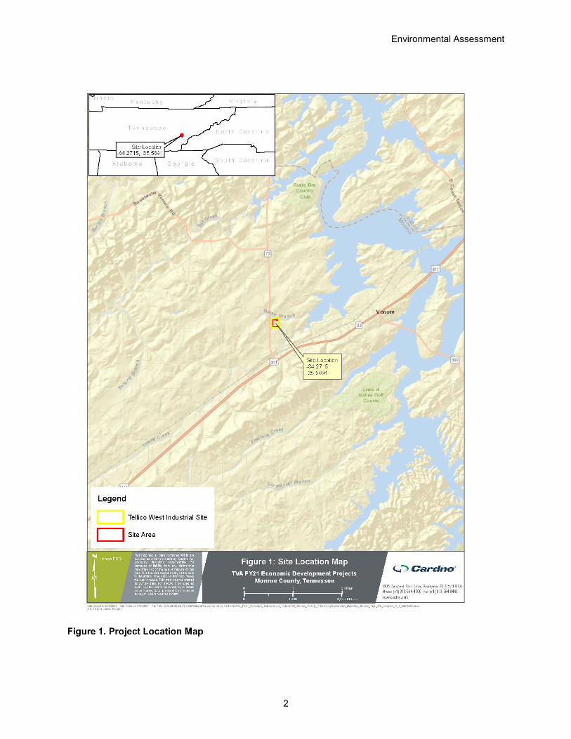
List of Figures Figure 1. Project Location Map .................................................................................................. 2
List of Attachments Attachment 1 – Project Figures
Figure 1-A: Aerial
Figure 1-B: Proposed Activities
Figure 1-C: USGS Quadrangle
Figure 1-D: FEMA Floodplain
Figure 1-E: USFWS NWI and Water Resources Inventory Map
Figure 1-F: Wetlands and Waterbodies Map
Figure 1-G: NRCS Soils Map
Attachment 2 – TVA Bat Strategy Project Screening Form
Attachment 3 – Agency Correspondence

Environmental Assessment
1
1.0 PROPOSED ACTION AND NEED
An integral part of Tennessee Valley Authority’s (TVA) mission is to promote economic development in the TVA service area. TVA provides financial assistance to help bring to market new/improved sites and facilities in the TVA service area and position communities to compete successfully for new jobs and capital investment. TVA proposes to provide an economic development grant through InvestPrep funds to the Tellico Reservoir Development Agency (TRDA) to assist with the development of the Tellico West Industrial Park. The area of TVA’s proposed action (herein referred to as the Project Area) comprises approximately 12.4 acres within a larger approximately 16-acre site proposed for development within the Tellico West Industrial Park and is located between State Road (SR) 72, Excellence Way, and Deer Crossing in Vonore, Monroe County, Tennessee (TN) (see Figure 1 below and Attachment 1, Figure 1-A, Figure 2). TVA funds would be used to assist with tree clearing, construction of a stormwater detention pond, and grading of a 125,000 square foot building pad, dirt access road, and dirt parking areas.
The primary purpose of the Proposed Action is to enable the TRDA to continue to develop the Tellico West Industrial Park. The proposed grant to the TRDA would assist with improvements to put the site in a more marketable position and allow prospects to better envision the development potential. Proposed improvements will lead to an increased probability of achieving TVA’s mission of job creation and capital investment. Target industries for the Tellico West Industrial Park include automotive suppliers, marine suppliers, suppliers for rail-served industries, and a variety of manufacturers. This Environmental Assessment (EA) assesses the environmental impacts that would potentially be affected by TVA’s Proposed Action. TVA’s decision is whether or not to provide the requested funding to the TRDA.
Environmental Assessment
2

Environmental Assessment
3
2.0 OTHER ENVIRONMENTAL REVIEWS AND DOCUMENTATION
In September 1999 and January 2000 TRC Garrow Associates, Inc. conducted archaeological surveys over portions of the Tellico West Industrial Park, which included much of the Project Area. The purpose of the surveys was to identify potential archaeological resources in the larger Tellico West Industrial Park, in which the Project Area is located. Archaeological Survey Reports detailing the results of these surveys were prepared in November 1999 (Thomas 1999) and February 2000 (Stanyard 2000).
In March 1980, TVA Division of Engineering Design Civil Engineering and Design Branch Geological Services prepared a Foundation Investigations Report to document the results of limited foundation investigations for the Lakeside Industrial Area that were conducted in November and December 1979. Geologic mapping, surface and borehole geophysics, core drilling, and earthquake risk surveys were performed. The purpose of these investigations was to rapidly and economically preview site geology and foundation conditions (TVA 1980).
In February 2021, S&ME, Inc. prepared a Preliminary Geotechnical Exploration Report (S&ME, Inc. 2021) documenting the geo-technical exploration conducted in December 2020 within the larger 16-acre site. The purpose of the geo-technical exploration was to explore sub-surface conditions and provide preliminary geo-technical recommendations for general site grading and design and construction of foundations.
The Archaeological Survey Reports, the Foundation Investigations Report, and the Preliminary Geotechnical Exploration Report were used in the preparation of this EA.
3.0 ALTERNATIVES
Based on internal scoping, TVA has determined that there are two reasonable alternatives to assess under the National Environmental Policy Act (NEPA): the No Action Alternative and the Action Alternative.
The No Action Alternative
Under the No Action Alternative, TVA would not provide InvestPrep funds to the TRDA. TVA would not be furthering its mission of promoting economic development by assisting the local community to compete successfully for new jobs and capital investment through the Proposed Action. If the TRDA were to obtain alternate funding and proceed with its current plans, the overall environmental consequences would be similar to those anticipated from implementing the Action Alternative. If the Project were postponed, environmental effects would be delayed for the duration of the postponement. If the Project were cancelled, no direct environmental effects are anticipated, as environmental conditions on the site would remain essentially unchanged from the current conditions for the foreseeable future.
The Action Alternative
Under the Action Alternative, TVA would provide InvestPrep funds to the TRDA to assist with tree clearing, construction of a detention pond, and grading of a 125,000 square foot dirt building pad, dirt access road, and dirt parking areas. The Action Alternative would require disturbance of approximately 12.4 acres and would result in clearing of approximately 10.3 acres of trees (Attachment 1, Figures 1-A and 1-B). Site activities required for the Action

Environmental Assessment
4
Alternative would occur over a short period, approximately 7 months, and would involve operation of an excavator, bulldozer, dump truck, or similar vehicles and heavy machinery. Cleared trees, stumps, vegetation, and debris would be cut and burned on-site. TVA’s preferred alternative is the Action Alternative.
It is expected that the TRDA, or its contractors, would obtain all required permits and authorizations. In compliance with those permits, TRDA, or its contractors, would take appropriate feasible measures, such as implementing best management practices (BMPs) and best construction practices, to minimize or reduce the potential environmental effects of the proposed Project to insignificant levels. These practices would include installation of sediment and erosion controls (silt fences, sediment traps, etc.), management of fugitive dust, and daytime work hours.
The Action Alternative does not include assessment of activities that may be directly or indirectly associated with adjacent lots already developed or under construction, or the eventual build-out, occupation, and future use of the Project Area. It would be speculative to do so because the future use of the site has not been defined.
4.0 AFFECTED ENVIRONMENT AND ANTICIPATED IMPACTS
4.1 Site Description
The 12.4-acre Project Area of Potential Effect (APE) is located within the Tellico West Industrial Park east of SR 72 and south of Excellence Way, approximately 0.8 mile north of United States (US) Highway 411 in Vonore, Monroe County, TN. The Project Area is located in an undeveloped area of the Tellico West Industrial Park, with no permanent structures currently present. The Project Area can be accessed from Deer Crossing Road that occurs to the east of the Project Area. Old Slag Road occurs 0.4 mile from the southern border of the Project Area. Over a dozen industries/service providers are located in the Tellico West Industrial Park, including Conagra Inc. Distribution Center, Mastercraft Boat Company, Yamaha Jet Boat Manufacturing, Sea Ray, HCB Yachts, JTEKT, Carlex Glass, Great Lakes Boat Top, and Commercial Vehicle Group.
Land use identified in the Tennessee Real Estate Assessment Data database includes Timber/Forest as assessed using land use data derived from the Computer Assisted Appraisal System (CAAS) property assessment data maintained by the State of Tennessee’s Comptroller of the Treasury (Tennessee 2021a). The CAAS data supporting documentation indicates Timber/Forest is land used, at least in part, for growing timber. Parcels in this category are identified as forested lands even if the parcel contains residential structures or mobile homes (Tennessee 2021b) (Attachment 1, Figure 1-A). The Project Area is zoned for light industrial use.
The Project Area is a wooded lot that generally consists of gently sloping topography, which is fairly consistent throughout the property (Attachment 1, Figure 1-C). Existing utilities including a 12-inch waterline, 6-inch sewer force main, 4-inch natural gas line, and overhead electrical lines are located at the Project Area boundary. Moree Branch, the nearest named stream, is a perennial stream that abuts the northern boundary of the Project Area as depicted on Attachment 1, Figure 1-C.

Environmental Assessment
5
The northernmost Project Area is bordered by a small area of deciduous, mixed evergreen and deciduous and evergreen forest and Excellence Way. An asphalt service road is present within the Project Area and connects to Deer Crossing in two locations. The Conagra Inc. Distribution Center is located immediately to the east of the Project Area. Mixed evergreen and deciduous forest borders the southernmost Project Area. An electric transmission line right-of-way and mixed evergreen and deciduous forest borders the westernmost Project Area. State Road (SR) 72 is approximately 175 feet west of the Project Area.
4.2 Impacts Evaluated
TVA has determined that the Proposed Action, subsequent to TVA’s selection of the Action Alternative, would have no impact on floodplains, land use and prime farmland, or wetlands. The Proposed Action would also not result in impacts from the creation of solid and hazardous wastes. Therefore, potential impacts to these resources are not described in further detail in this EA.
Moree Branch is a perennial stream that abuts the Project Area. Based on Monroe County, TN, Federal Emergency Management Agency (FEMA) flood insurance rate map panel number 47123C0160D, effective 2/3/2010, the Proposed Action would be located outside of identified 100-year floodplains, which would be consistent with EO 11988. In addition, Moree Branch would be protected by a no less than 30-foot undisturbed stream buffer on either side, which would be consistent with Monroe County floodplain regulations for development on unmapped streams. The Proposed Action would therefore have no impact on floodplains and their natural and beneficial resources.
No demolition or waste disposal activities are associated with the Action Alternative. Therefore, the Action Alternative would not result in the creation or disposal of solid and hazardous wastes.
There would be no impact to land use and prime farmland as the Project Area is located within a property zoned as light industrial and the Proposed Action would not result in a change to the zoned land use.
A field survey conducted in October 2020 determined there are no jurisdictional wetlands present on the parcel. There would be no impacts to wetlands as the result of either the No Action or Action Alternative for this project as there are no wetlands present within the Project Area.
Resources that could potentially be impacted (negatively or positively) by implementing the Action Alternative include air quality and climate change, groundwater, surface water, aquatic ecology, terrestrial zoology, botany, archaeology and historic structures and sites, natural and managed areas, and public recreational opportunities. Implementation of the Action Alternative could create potential impacts to the human environment, including visual effects, noise, socioeconomics and environmental justice, and transportation issues. Potential impacts to resources and impacts to the human environment resulting from implementation of the Action Alternative are discussed in detail below.
4.2.1 Air Quality and Climate Change Federal and state regulations protect ambient air quality. With authority granted by the Clean Air Act (CAA) 42 U.S.C. 7401 et seq. as amended in 1977 and 1990, the United States Environmental Protection Agency (USEPA) established National Ambient Air Quality Standards (NAAQS) to protect human health and public welfare. The USEPA codified NAAQS in 40 CFR

Environmental Assessment
6
50 for the following “criteria pollutants”: nitrogen dioxide (NO2), carbon monoxide (CO), ozone, sulfur dioxide (SO2), lead, particulate matter (PM) with an aerodynamic diameter equal to or less than 10 microns (PM10), and PM with an aerodynamic diameter equal to or less than 2.5 microns (PM2.5). The NAAQS reflect the relationship between pollutant concentrations and health and welfare effects. Primary standards protect human health, including the health of sensitive populations such as asthmatics, children, and the elderly. Secondary standards are designed to protect public welfare, including visibility, animals, crops, vegetation, and buildings. These standards reflect the latest scientific knowledge and have an adequate margin of safety intended to address uncertainties and provide a reasonable degree of protection. The air quality in Monroe County, TN meets the ambient air quality standards and is in attainment with respect to the criteria pollutants (USEPA 2021).
Other pollutants, such as hazardous air pollutants (HAPs) and greenhouse gases (GHGs) are also a consideration in air quality impacts analyses. Section 112(b) of the CAA lists HAPs, also known as toxic air pollutants or air toxics, because they present a threat of adverse human health effects or adverse environmental effects. Although there are no applicable ambient air quality standards for HAPs, their emissions are limited through permit thresholds and technology standards as required by the CAA.
GHGs are gases that trap heat in the atmosphere. They are non-toxic and non-hazardous at normal ambient concentrations. At this time, there are no applicable ambient air quality standards or emission limits for GHGs under the CAA. GHGs occur in the atmosphere both naturally and resulting from human activities, such as the burning of fossil fuels. GHG emissions due to human activity are the main cause of increased atmospheric concentration of GHGs since the industrial age and are the primary contributor to climate change. The principal GHGs are carbon dioxide (CO2), methane, and nitrous oxide.
Air quality impacts associated with activities under the Action Alternative include emissions from fossil fuel-fired equipment, fugitive dust from ground disturbances, and emissions from the burning of wood debris. Fossil fuel-fired equipment are a source of combustion emissions, including nitrogen oxides (NOX), CO, volatile organic compounds (VOCs), SO2, PM10, PM2.5, GHGs, and small amounts of HAPs. Gasoline and diesel engines used as a result of the Action Alternative would comply with the USEPA mobile source regulations in 40 CFR Part 85 for on-road engines and 40 CFR Part 89 for non-road engines. These regulations are designed to minimize emissions and require a maximum sulfur content in diesel fuel of 15 parts per million (ppm).
Fugitive dust is a source of respirable airborne PM, including PM10 and PM2.5, which could result from ground disturbances such as land clearing, grading, excavation, and travel on unpaved roads. The amount of dust generated is a function of the activity, silt and moisture content of the soil, wind speed, frequency of precipitation, vehicle traffic, vehicle types, and roadway characteristics. The TRDA, or its contractors, would comply with Tennessee Department of Environment and Conservation (TDEC) Air Pollution Control Rule 1200-3-8, which requires reasonable precautions to prevent PM from becoming airborne. Such reasonable precautions include, but are not be limited to the use of water or chemicals for control of dust in construction operations, grading of roads, or the clearing of land. In addition, the application of asphalt, water, or suitable chemicals on dirt roads, material stockpiles, and other surfaces which can create airborne dusts, are also considered reasonable precautions.

Environmental Assessment
7
Many variables affect emissions from ground-level open burning, including wind, ambient temperature, composition and moisture content of the debris burned, and compactness of the pile. In general, the relatively low temperatures associated with open burning increase emissions of NOX, CO, VOCs, PM10, PM2.5, GHGs, and HAPs. The TRDA, or its contractors, would be subject to local burn permits and the requirements in TDEC Air Pollution Control Rule 1200-3-4, which provides open burning prohibitions, exceptions, and certification requirements.
With the use of BMPs and other permit-required measures described above to reduce emissions associated with the Action Alternative, air quality impacts would be minimal, temporary, and localized; and would not be anticipated to result in any violation of applicable ambient air quality standards or impact regional air quality.
Concerning climate change, trees, like other green plants, are carbon sinks that use photosynthesis to convert CO2 into sugar, cellulose, and other carbon-containing carbohydrates that they use for food and growth. Carbon sequestration is the process by which carbon sinks remove CO2 from the atmosphere. Although forests do release some CO2 from natural processes such as decay and respiration, a healthy forest typically stores carbon at a greater rate than it releases carbon. The majority of the 16-acre site is comprised of dense regenerated eastern red cedar with approximately 1.5 acres of mature mixed deciduous-evergreen forest. The clearing of approximately 10.3 acres of trees for the Action Alternative would result in a minor loss of carbon sequestration capacity in the area since evergreen and deciduous forest habitat is common and well represented throughout the region and in the immediate vicinity of the Project Area.
Under the No Action Alternative, if the TRDA were able to secure the funding for the proposed TVA-funded actions described in this EA, similar emissions from equipment, ground disturbances, and burning would occur, resulting in similar air quality and climate change impacts as those described above for the Action Alternative. If the TRDA were not able to secure the funding for the actions described in this EA, emissions from equipment, ground disturbances, and burning would not occur and there would be no impacts to air quality and climate change from the No Action Alternative.
4.2.2 Groundwater The Project Area is located within the Valley and Ridge Province (United States National Parks Service [USNPS] 2017). The Valley and Ridge Province extends southwest to northeast and is characterized by a sequence of folded and faulted, Paleozoic sedimentary rocks that form a series of alternating valleys and ridges that extend from Alabama and Georgia to New York (United States Geological Survey [USGS] 1995).
In the eastern part of Tennessee, the principal aquifers in the Valley and Ridge Province consist of carbonate rocks that are primarily Cambrian and Ordovician in age, with minor Silurian, Devonian, and Mississippian rocks also present (USGS 1995). Locally this system is referred to as the East Tennessee aquifer system and consists of soluble carbonate rocks and some easily eroded shales underlie the valleys while more erosion-resistant siltstone, sandstone, and some cherty dolomite underlie ridges (USGS 1986). Water quality in the carbonate aquifers of the Valley and Ridge Province is characterized as hard, with dissolved solids concentrations of 170 milligrams per liter or less. Due to the complex network of fractures, bedding planes, and solution openings in the carbonate rocks in areas with thin residuum overlying the substrate, water recharges rapidly and, water quality in these aquifers is susceptible to contamination by
Environmental Assessment
8
human activities (USGS 1995). Recharge occurs primarily along the flanks of the ridges and groundwater flow is generally from the ridges (higher groundwater levels) toward major streams and center of the valleys where groundwater levels are lower (USGS 1995).
Implementation of the Action Alternative would result in ground disturbance during construction activities. Tree clearing would result in minor ground disturbance at shallow depths. Existing topography ranges from approximately ±840 feet mean sea-level (MSL) to ±860 feet (MSL). Site grading for development of the dirt building pad, dirt access roads, dirt parking areas and excavation for construction of a retention pond would result in greater ground disturbance at moderate depths. However, ground disturbances are not anticipated to be at depths that would intersect public groundwater supplies (typically 50 to 250 feet beneath the land surface [USGS 2016]) or result in significant impacts to groundwater resources. Shallow aquifers could sustain minor impacts from changes in overland water flow and recharge caused by clearing, grading and construction of a stormwater detention pond within the Project Area. Water infiltration, which is normally enhanced by vegetation, would be reduced until vegetation is re-established. In addition, near-surface soil compaction caused by heavy construction vehicles could reduce the ability of soil to absorb water. These minor impacts would be temporary and would not significantly affect groundwater resources. Furthermore, it is expected that the TRDA, or its contractors, would conduct operations involving chemical or fuel storage or resupply and equipment and vehicle servicing with care to avoid leakage, spillage, and subsequent ground water contamination.
Under the No Action Alternative, if the TRDA were able to secure the funding for the proposed TVA-funded actions described in this EA, similar ground disturbance would occur, resulting in similar impacts to groundwater resources as those described above for the Action Alternative. If the TRDA were not able to secure the funding for the actions described in this EA, ground disturbance associated with the proposed actions would not occur and there would be no impacts to groundwater resources.
4.2.3 Soil Erosion and Surface Water The Project Area is located in Monroe County, TN in the Ridge and Valley ecoregion. The Project Area drains to streams within the Lower Tellico Lake watershed (Hydrologic Unit Code [HUC]-10 0601020405). The surface water streams in the vicinity of the project are Moree Branch, Island Creek, Tellico Lake, and one ephemeral stream. Island Creek, Tellico Lake, and the ephemeral stream are all located outside of the Project Area (Attachment 1, Figure 1-F). Moree Branch is a perennial stream that abuts the northern portion of the Project Area.
Precipitation in the vicinity of the Project Area averages about 54 inches per year. The average annual air temperature ranges from a monthly average of 27 degrees Fahrenheit to 88 degrees Fahrenheit (BestPlaces 2020). Stream flow varies with rainfall and averages about 31.20 inches of runoff per year, i.e., approximately 2.30 cubic feet per second, per square mile of drainage area (USGS 2008).
The federal Clean Water Act (CWA) requires all states to identify all waters where required pollution controls are not sufficient to attain or maintain applicable water quality standards and to establish priorities for the development of limits based on the severity of the pollution and the sensitivity of the established uses of those waters. States are required to submit reports to the USEPA. The term “303(d) list” refers to the list of impaired and threatened streams and water bodies identified by the state. Moree Branch is not listed on Tennessee’s 303(d) list (TDEC

Environmental Assessment
9
2020). However, Tellico Lake, which is located about 2.1 miles northeast of the Project Area, is listed as impaired for polychlorinated biphenyl (PCB) due to contaminated sediments. Island Creek, located approximately 0.5 mile east of the Project Area, is also listed as impaired due to Escherichia coli. The primary designations for Moree Branch and Island Creek are for fish and aquatic life, recreation, irrigation and livestock watering and wildlife (TDEC 2013). Tellico Lake is also designated for domestic water supply, industrial water supply, and navigation.
Implementation of the Action Alternative would result in construction activities that have the potential to temporarily affect surface water via stormwater runoff. Soil erosion and sedimentation can clog small streams and threaten aquatic life. It is expected that the TRDA, or its contractors, would comply with all appropriate federal, state and local permit requirements. Appropriate BMPs would be followed, and all proposed project activities would be conducted in a manner to ensure that waste materials are contained, and the introduction of pollution materials to the receiving waters would be minimized. A general construction stormwater permit would be needed since more than one acre would be disturbed. This permit requires the development and implementation of a Storm Water Pollution Prevention Plan (SWPPP). The SWPPP would identify specific BMPs to address construction-related activities that would be adopted to minimize stormwater impacts. Part of these BMPs would be the construction of a stormwater detention basin to control sediment discharges from the Project Area. BMPs, as described in the Tennessee Erosion and Sediment Control Handbook (TDEC 2012), would be used during site development to avoid contamination of surface water in the Project Area.
It is anticipated that Moree Branch would be classified as a jurisdictional Waters of the United States (WOTUS) under the 2020 Navigable Waters Protection Rule (NWPR). Although the proposed action would not impact Moree Branch, which abuts the Project Area, the stream would be protected by a 30-foot undisturbed buffer on either side of the stream.
Impervious surfaces prevent rain from percolating through the soil and result in additional runoff of water and pollutants into storm drains, ditches, and streams. The Action Alternative would increase impervious flows in the Project Area. Under the required permits, all flows would need to be properly treated with either implementation of the proper BMPs or to engineer a discharge drainage system that could handle any increased flows prior to discharge into the outfall(s).
It is expected that portable toilets would be provided for the construction workforce as needed. These toilets would be pumped out regularly, and the sewage would be transported by tanker truck to a publicly-owned wastewater treatment plant that accepts pump out. Equipment washing and dust control discharges would be handled in accordance with BMPs described in the SWPPP for water-only cleaning.
Proper implementation of BMPs and other controls for the Action Alternative would be expected to result in only minor temporary impacts to surface waters.
Under the No Action Alternative, if the TRDA were able to secure the funding for the proposed TVA-funded actions described in this EA from outside sources, similar site activities would occur, resulting in similar impacts to surface water resources as those described above for the Action Alternative. If the TRDA were not able to secure the funding for the actions described in this EA, disturbance associated with the proposed actions would not occur and there would be no impacts to surface water resources.
Environmental Assessment
10
4.2.4 Aquatic Ecology 4.2.4.1 Aquatic Resources As described above, surface water streams in the vicinity of this Project Area are Moree Branch, Island Creek, Tellico Lake, and one ephemeral stream. Island Creek, Tellico Lake, and the ephemeral stream are all located outside of the Project Area. Moree Branch abuts the northern portion of the Project Area. Temporary effects to surface waters in the vicinity of the Project Area due to stormwater runoff during construction activities are described above.
No impacts to the Moree Branch are proposed. Moree Branch would be protected by a 30-foot undisturbed buffer on either side of the stream as required by the TDEC. No other surface waters are present within the Project Area, therefore implementation of the Action Alternative would not result in direct impacts to aquatic species or their habitats As such, with proper implementation of BMPs, no significant indirect impacts from erosion and sedimentation to aquatic species or their habitats would occur.
Construction activities would not involve moving aquatic species or water from different locations, and equipment and materials used during construction would be clean and free of debris that could introduce exotic species and adversely affect aquatic habitat. Thus, the Action Alternative would not contribute to the spread of exotic or invasive aquatic species.
Under the No Action Alternative, if the TRDA were able to secure funding for the proposed actions described in this EA from outside sources, similar potential impacts to aquatic species could occur as described above for the Action Alternative. However, with implementation of applicable BMPs, indirect impacts would be minimized or avoided. If the TRDA were not able to secure the funding for the actions described in this EA, ground disturbance associated with the proposed actions would not occur and there would be no impacts to aquatic resources.
4.2.4.2 Threatened and Endangered Aquatic Species The Endangered Species Act (ESA) provides broad protection for species of fish, wildlife, and plants listed as threatened or endangered in the United States. The ESA outlines procedures for federal agencies to follow when taking actions that may jeopardize federally listed species or their designated critical habitat. The policy directs federal agencies to conserve endangered and threatened species and use their authorities in furtherance of the ESA’s purposes. The State of Tennessee provides protection for species considered threatened, endangered, or deemed in need of management in the state in addition to those federally listed under the ESA.
A query of the TVA Regional Natural Heritage database (accessed October 26, 2020) for records of listed aquatic animal species indicated that occurrence of one federally listed fish species (snail darter [Percina tanasi]) has been documented within the Lower Tellico Lake 10-digit HUC (0601020405) watershed encompassing the Project Area (Table 4-1). Two state-listed fish species (lake sturgeon [Acipenser fulvescens] and blotchside logperch [Percina burtoni]), have also been documented.

Environmental Assessment
11
Table 4-1 Records of federal and state-listed aquatic animal species within the Lower Tellico Lake 10-digit HUC (0601020405) watershed (TVA Request ID 37086).1
S1 Scientific Name Element Rank2
Federal Status3
State Status (Rank4)
FISH
Blotchside Logperch Percina burtoni H --- D (S2)
Lake Sturgeon Acipenser fulvescens E --- E (S1)
Snail Darter Percina tanasi H? LT T (S2S3) 1 Source: TVA Natural Heritage Database, queried on 10/26/2020 2 Heritage Element Occurrence Rank; E = extant record ≤25 years old; H=historical record ≥ 25 years old; H?=possibly historical 3 Status Codes: LE = Listed Endangered; LT = Listed Threatened; D = Deemed In Need of Management 4 State Ranks: S1 = Critically Imperiled; S2 = Imperiled; S3 = Vulnerable
Brief habitat descriptions of species potentially occurring in the Project Area are provided below. Habitat requirements are as described in NatureServe (2021); blotchside logperch Page Burr (2011), Jenkins and Zorach, in Lee et al. (1980), and Boschung and Mayden (2004); lake sturgeon Hocutt and Wiley (1986), Becker (1983), Pflieger (1975), and snail darter Etnier and Starnes (1993).
Blotchside logperch (Percina burtoni) habitat includes gravel runs and riffles of clear, small to medium rivers or primarily large creeks and small to medium rivers with moderate gradient and usually clear water; substrates vary but usually consist of gravel and boulders, cobble, or rubble lacking major siltation. No suitable habitat for this species occur within the Project Area.
Lake sturgeon (Acipenser fulvescens) primary habitat is the bottoms of large, clean, freshwater rivers and lakes. Preferred substrates include firm sand, gravel, or rock. No suitable habitat for this species occur within the Project Area.
Snail darter (Percina tanasi) habitat includes gravel and sand runs of medium-sized rivers. Adults and spawning individuals typically inhabit sand and gravel shoals of moderately flowing, vegetated, large creeks and river. They also occur in deeper portions of rivers and reservoirs where current is present. Young occur in slackwater habitats, including the deeper portions of rivers and reservoirs. No suitable habitat for this species occur within the Project Area.
Implementation of the Action Alternative would not result in direct impacts to aquatic species or their habitats. There is no designated critical habitat for federally listed aquatic species in the Lower Tellico Lake 10-digit HUC (0601020405) watershed where the proposed work would occur. Furthermore, ground disturbance would be minimized, and all work conducted in accordance with applicable BMPs to minimize erosion and subsequent sedimentation in streams. Therefore, with proper implementation of BMPs, there would be no effect to any federally listed species and no significant impacts to threatened and endangered aquatic species or unique or important aquatic habitats would occur.
Under the No Action Alternative, if the TRDA were able to secure funding for the proposed actions described in this EA from outside sources, similar potential impacts to threatened and endangered aquatic species could occur as described above for the Action Alternative. However, with implementation of applicable BMPs, impacts would be minimized or avoided. If the TRDA were not able to secure the funding for the actions described in this EA, disturbance

Environmental Assessment
12
associated with the proposed actions would not occur and there would be no impacts to threatened and endangered aquatic species.
4.2.5 Terrestrial Zoology 4.2.5.1 Terrestrial Wildlife Field habitat assessments for terrestrial wildlife species were conducted within the Project Area on October 6, 2020. Terrestrial wildlife habitat features within the Project Area consist of forested habitat, some fragmented, and early successional habitat. Moree Branch abuts the northern portion of the Project Area. One small ephemeral stream occurs approximately 100 feet north of, but not within, the Project Area and flows into Moree Branch from the west. An industrial site is located immediately adjacent to the Project Area. Surrounding the Project Area are more forest fragments, industrial sites, and residential areas. Each of the varying community types offers suitable habitat for species common to the region, both seasonally and permanently.
The majority of the Project Area, approximately 10.3 acres, is forested. Forested acreage within the Project Area primarily consists of very dense regenerated eastern red cedar. A small amount of mature mixed deciduous-evergreen forest is also present toward the southern portion of the Project Area. These forest types provide habitat for an array of terrestrial animal species. Birds typical of this habitat include pileated woodpecker (Dryocopus pileatus), red-bellied woodpecker (Melanerpes carolinus), red-eyed vireo (Vireo olivaceus), red-tailed hawk (Buteo jamaicensis), scarlet tanager (Piranga olivacea), summer tanager (Piranga rubra), and wild turkey (Meleagris gallopavo) (National Geographic 2002, Sibley 2003). This area also provides foraging and roosting habitat for several species of bat, particularly in areas where the forest understory is partially open. Bat species likely found in this habitat include big brown bat (Eptesicus fuscus), eastern red bat (Lasiurus borealis), and evening bat (Nycticeius humeralis). Eastern chipmunk (Tamias striatus), eastern woodrat (Neotoma floridana), and white-tailed deer (Odocoileus virginianus) are other mammals likely to occur in this habitat (Kays and Wilson 2002).
Broad-headed skink (Plestiodon laticeps), eastern box turtle (Terrapene carolina carolina), five-lined skink (Plestiodon fasciatus), gray ratsnake (Pantherophis spiloides), and smooth earth snake (Virginia valeriaea) are common reptiles of eastern deciduous forests (Conant and Collins 1998, Dorcas and Gibbons 2005). Forested streams in this region likely provide habitat for amphibians including Cope’s gray treefrog (Hyla chrysoscelis), dusky salamander (Desmognathus fuscus), northern slimy salamander (Plethodon glutinosus), spring peepers (Pseudacris crucifer), and two-lined salamanders (Eurycea bislineata) (Bailey et al. 2006, Conant and Collins 1998).
Early successional habitat also occurs within the Project Area. Common inhabitants of this type of habitat include American goldfinch (Spinus tristis), brown-headed cowbird (Molothrus ater), blue-winged warbler (Vermivora cyanoptera), brown thrasher (Toxostoma rufum), eastern bluebird (Sialia sialis), eastern meadowlark (Sturnella magna), indigo bunting (Passerina cyanea), killdeer (Charadrius vociferus), and mourning dove (Zenaida macroura) (National Geographic 2002, Sibley 2003). Bobcat (Lynx rufus), coyote (Canis latrans), eastern cottontail (Sylvilagus floridanus), woodchuck (Marmota monax), red fox (Vulpes vulpes), and white-tailed deer are mammals typical of fields and cultivated land (Kays and Wilson 2002). Amphibians such as eastern narrow-toad (Gastrophryne carolinensis) and reptiles including black racer
Environmental Assessment
13
(Coluber constrictor priapus) and ring-necked snake (Diadophis punctatus) are also known to occur in this habitat type (Bailey et al. 2006, Conant and Collins 1998, Dorcas and Gibbons 2005). Pollinators such as common eastern bumble bee (Bombus impatiens), eastern tiger swallowtail (Papilio glaucus), great spangled fritillary (Speyeria cybele), and red-spotted purple (Limenitis arthemis) may occur in this region (Brock and Kaufman 2003).
Developed areas, and areas otherwise previously disturbed by human activity also occupy a small portion of the Project Area and are home to a large number of common species. American crow (Corvus brachyrhynchos), American robin (Turdus migratorius), black vulture (Coragyps atratus), Carolina wren (Thryothorus ludovicianus), common nighthawk (Chordeiles minor), eastern phoebe (Sayornis phoebe), northern cardinal (Cardinalis cardinalis), northern mockingbird (Mimus polyglottos), and turkey vulture (Cathartes aura) are birds commonly found along roads, in industrial complexes, and in residential neighborhoods (National Geographic 2002, Sibley 2003). Mammals found in these locations include, gray squirrel (Sciurus carolinensis), northern raccoon (Procyon lotor), striped skunk (Mephitis mephitis), and Virginia opossum (Didelphis virginiana) (Kays and Wilson 2002). Roadside ditches provide potential habitat for amphibians including American toad (Anaxyrus americanus) and spring peeper (Pseudacris crucifer) (Bailey et al. 2006). Reptiles potentially present include eastern fence lizard (Sceloporus undulatus) and red-bellied snake (Storeria occipitomaculata) (Conant and Collins 1998, Dorcas and Gibbons 2005).
Review of the TVA Regional Natural Heritage database in September 2020 indicated that no caves have been documented within three miles of the Project Area and no caves were identified during the field review on October 6, 2020. No additional unique or important terrestrial habitats were identified within the Project Area. In addition, no aggregations of migratory birds or wading bird colonies have been documented within three miles of the Project Area and none were observed during field surveys. A review of the United States Fish and Wildlife Service’s (USFWS) Information for Planning and Consultation (IPaC) website did not result in the identification of migratory bird species of conservation concern with the potential to occur in the Project Area and no wading bird colonies or raptor nests are known within the Project Area. Should any migratory bird species occur in the Project Area during the time of the proposed activities, it is expected that mobile individuals disturbed by tree clearing actions would flush to adjacent suitable habitat. Forested habitat within the Project Area would be permanently removed and unavailable in future years to migratory bird populations. Due to the relative abundance of similarly suitable habitat nearby and the relatively small size of the Project Area, it is not expected that populations of migratory birds would be impacted.
The Action Alternative would require disturbance of approximately 12.4 acres and would result in clearing of approximately 10.3 acres of trees. All vegetation and trees would be cleared within the Project Area. Grading would occur over the entirety of the Project Area (approximately 12.4 acres) to prepare for the building pad. Proposed actions would remove wildlife habitat, which would result in the displacement of wildlife (primarily common, habituated species) currently using the Project Area. Direct effects to some individuals may occur, particularly if those individuals are immobile during the time of habitat removal. This could be the case if activities took place during winter or breeding/nesting seasons when animals are burrowed underground and/or too young to flee. Habitat removal likely would disperse mobile wildlife into surrounding areas in an attempt to find new food sources, shelter sources, and to re-establish territories. Use of applicable BMPs would minimize potential impacts to stream banks and water quality in
Environmental Assessment
14
and adjacent to the Project Area. As mentioned above, much of the forested habitat in the Project Area is very dense regenerated eastern red cedar. Due to the amount of previously disturbed habitat to be impacted, the quality of this habitat, and the amount of similarly suitable habitat across the surrounding landscape, populations of common wildlife species likely would not be impacted by the proposed actions. Following the proposed actions, those species of animal capable of utilizing developed areas are expected to return to the Project Area.
Under the No Action Alternative, if the TRDA were able to secure the funding for the proposed TVA-funded actions described in this EA from outside sources, impacts to terrestrial wildlife species would be similar to those described for the Action Alternative. If the TRDA were not able to secure the funding for the actions described in this EA, disturbance associated with the proposed actions would not occur and there would be no impacts to terrestrial wildlife species.
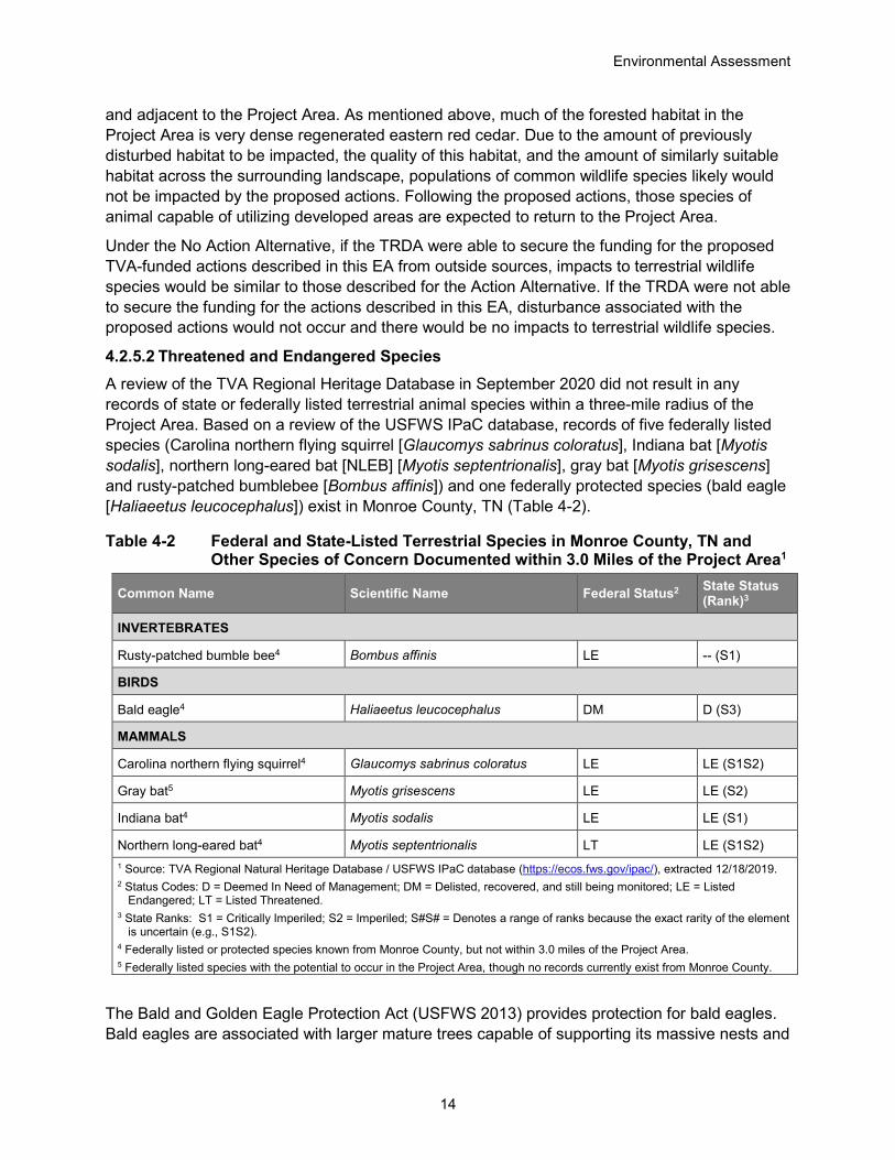
4.2.5.2 Threatened and Endangered Species A review of the TVA Regional Heritage Database in September 2020 did not result in any records of state or federally listed terrestrial animal species within a three-mile radius of the Project Area. Based on a review of the USFWS IPaC database, records of five federally listed species (Carolina northern flying squirrel [Glaucomys sabrinus coloratus], Indiana bat [Myotis sodalis], northern long-eared bat [NLEB] [Myotis septentrionalis], gray bat [Myotis grisescens] and rusty-patched bumblebee [Bombus affinis]) and one federally protected species (bald eagle [Haliaeetus leucocephalus]) exist in Monroe County, TN (Table 4-2).
Table 4-2 Federal and State-Listed Terrestrial Species in Monroe County, TN and Other Species of Concern Documented within 3.0 Miles of the Project Area1
Common Name Scientific Name Federal Status2 State Status (Rank)3
INVERTEBRATES
Rusty-patched bumble bee4 Bombus affinis LE -- (S1)
BIRDS
Bald eagle4 Haliaeetus leucocephalus DM D (S3)
MAMMALS
Carolina northern flying squirrel4 Glaucomys sabrinus coloratus LE LE (S1S2)
Gray bat5 Myotis grisescens LE LE (S2)
Indiana bat4 Myotis sodalis LE LE (S1)
Northern long-eared bat4 Myotis septentrionalis LT LE (S1S2) 1 Source: TVA Regional Natural Heritage Database / USFWS IPaC database (https://ecos.fws.gov/ipac/), extracted 12/18/2019. 2 Status Codes: D = Deemed In Need of Management; DM = Delisted, recovered, and still being monitored; LE = Listed
Endangered; LT = Listed Threatened. 3 State Ranks: S1 = Critically Imperiled; S2 = Imperiled; S#S# = Denotes a range of ranks because the exact rarity of the element
is uncertain (e.g., S1S2). 4 Federally listed or protected species known from Monroe County, but not within 3.0 miles of the Project Area. 5 Federally listed species with the potential to occur in the Project Area, though no records currently exist from Monroe County.
The Bald and Golden Eagle Protection Act (USFWS 2013) provides protection for bald eagles. Bald eagles are associated with larger mature trees capable of supporting its massive nests and

Environmental Assessment
15
are usually found near larger waterways where the eagles forage (USFWS 2007). This species requires large trees capable of supporting their massive nests situated close to these food sources. Three bald eagle records have been documented from Monroe County, the nearest of which occurs approximately 4.6 miles from the Project Area. The Project Area contains habitat suitable for nesting bald eagles, though neither bald eagles nor their nests were observed during field surveys of the Project Area in October 2020.
Carolina northern flying squirrels inhabit a mixture of high-elevation conifer and northern hardwood forests (usually greater than 4,000 feet in elevation). This species forages in conifers and dens in hardwood trees. Optimal conditions are cool, moist, mature forest with abundant standing and down snags (USFWS 1990). One Carolina northern flying squirrel record is known from Monroe County, approximately 23 miles from the Project Area. Suitable habitat is not present within the Project Area for this species, as the Project Area occurs between approximately 800-900 feet in elevation, well below the known range of this species. Additionally, no suitable snag trees were observed during field surveys of the Project Area in October 2020.
The rusty-patched bumble bee is a federally endangered insect that inhabits grasslands, prairies, woodlands, marshes, agricultural landscapes, and residential parks and gardens. This species requires diverse, abundant flowers from April to September with undisturbed nesting sites nearby in order to have sufficient food and overwintering sites for queens. They often build nests in abandoned, underground rodent cavities or large clumps of grass. Exotic, invasive pathogens and parasites are primarily responsible for the drastic decline in population for this species. Another potentially serious threat to this species is the use of novel pesticides, especially new persistent neonicotinoids (USFWS 2016). One record of rusty-patched bumblebee was documented approximately 9.7 miles from the Project Area in 1966. The Project Area occurs within the historical range of the rusty-patched bumble bee.
Gray bats are restricted to caves or cave-like habitat where they roost, breed, rear young, and hibernate year round. They migrate between summer and winter caves and use transient or stopover caves along the way. Summer caves are typically located close to rivers or lakes. Bats disperse over bodies of water at dusk to feed, primarily on flying insects (USFWS 1982). While the Project Area occurs within the known gray bat range, this species has no known documented presence from Monroe County, to date. Additionally, no caves are known within the Project Area and none were observed during field surveys of the Project Area in October 2020. Foraging habitat may be present over Moree Branch which abuts the Project Area and over the small ephemeral stream located outside of the Project Area.
Indiana bats hibernate in caves during winter and inhabit forested areas around these caves for swarming (mating) in the fall and staging in the spring, prior to migration to summer habitat. During summer, Indiana bats roost under exfoliating bark, and within cracks and crevices of trees, typically located in mature forests with an open understory and a nearby source of water. Indiana bats are known to change roost trees frequently throughout the season, yet still maintain site fidelity, returning to the same summer roosting areas in subsequent years (Pruitt and TeWinkel 2007; Kurta et al. 2002). This species forages over forest canopies, along forest edges and tree lines, and occasionally over bodies of water (Pruitt and TeWinkel 2007; Kurta et al. 2002; USFWS 2019). Seventeen Indiana bat records are known from Monroe County, the

Environmental Assessment
16
nearest of which was documented from a roost tree approximately 6.9 miles from the Project Area.
The NLEB predominantly overwinters in large hibernacula such as caves, abandoned mines, and cave-like structures. During the fall and spring, they utilize entrances of caves and the surrounding forested areas for swarming and staging. In the summer, NLEBs roost individually or in colonies beneath exfoliating bark or in crevices of both live and dead trees. Roost selection by NLEB is similar to Indiana bat; however, it is thought that NLEB are more opportunistic in roost site selection. This species also roosts in abandoned buildings and under bridges. NLEBs emerge at dusk to forage below the canopy of mature forests on hillsides and roads, and occasionally over forest clearings and along riparian areas (USFWS 2014). Eight NLEB records are known from Monroe County, the nearest of which was documented from a mist net capture approximately 10.4 miles from the Project Area.
Assessment of the Project Area for presence of summer roosting habitat for Indiana bats and NLEB followed federal guidance. No caves are known within 3.0 miles of the Project Area. No caves or other suitable winter roosting habitat were observed during the field survey of the Project Area in October 2020. No suitable summer roosting habitat was identified within the Project Area during field surveys. Based on the 2019 Range-Wide Indiana Bat Survey Guidelines (USFWS 2019), TVA has determined suitable summer roosting habitat for Indiana bat and NLEB is not present within the Project Area. Moree Branch and one small ephemeral stream located outside of the Project Area may provide foraging habitat for Indiana bat and NLEB. Additional foraging habitat for both species occurs over, alongside, and through the forest fragments within the Project Area.
One federally protected species (bald eagle) and five federally listed species (Carolina northern flying squirrel, gray bat, Indiana bat, NLEB, and rusty-patched bumble bee) were addressed based on their potential to occur within the Project Area. Bald eagles would not be impacted by the Action Alternative, as no nests are known within 3.0 miles of the Project Area, and neither birds nor nests were observed within the Project Area during field surveys. Additionally, the Action Alternative would comply with the National Bald Eagle Management Guidelines and bald eagles would not be impacted by implementation of the Action Alternative. The range of the Carolina northern flying squirrel is restricted to high elevation forests and does not typically extend to lower elevations where the Project Area occurs. In addition, the forest type in the Project Area is not suitable for Carolina northern flying squirrel. Based on guidance provided by the USFWS, (USFWS 2020) the Project Area is in the historical range of the rusty-patched bumblebee. Rusty patched bumble bee is not present. Bald eagles, Carolina northern flying squirrel, and rusty-patched bumblebee would not be impacted by the Action Alternative.
No caves or other hibernacula for gray bat, Indiana bat, or NLEB exist in the Project Area. Foraging habitat for all three species likely occurs over Moree Branch which abuts the Project Area and over the small ephemeral stream located outside of the Project Area. Moree Branch would be protected by a 30-foot undisturbed buffer on either side of the stream and BMPs would be used to minimize impacts to surface waters. Tree removal in the amount of 10.3 acres would not result in the removal of any suitable summer roosting habitat for Indiana bat or NLEB. Vegetation removal could impact foraging bats; however, similarly suitable vegetative foraging habitat is ample across the adjacent landscape, such that vegetation removal within the Project Area would not significantly impact foraging Indiana bat or NLEB.
Environmental Assessment
17
Several activities associated with the Action Alternative (including burning and tree removal) were addressed in TVA’s programmatic consultation with the USFWS on routine actions and federally listed bats in accordance with ESA Section 7(a)(2). For those activities with potential to affect bats, TVA committed to implementing specific conservation measures. These activities and associated conservation measures are identified on page 5 of the TVA Bat Strategy Project Screening Form (Attachment 2) and would be reviewed/implemented as part of the Action Alternative. Due to the absence of winter roosting habitat, a lack of suitable summer roosting habitat, and implementation of identified conservation measures (such as BMPs), the Action Alternative would not significantly impact gray bat, Indiana bat, or NLEB.
Under the No Action Alternative, if the TRDA were able to secure the funding for the proposed TVA-funded actions described in this EA from outside sources, impacts to threatened and endangered terrestrial species would be similar to those described for the Action Alternative. If the TRDA were not able to secure the funding for the actions described in this EA, disturbance associated with the proposed actions would not occur and there would be no impacts to threatened and endangered terrestrial species.
4.2.6 Botany 4.2.6.1 Vegetation Field surveys of the Project Area were conducted in October 2020 and focused on documenting plant communities, infestations of invasive plants, and possible threatened and endangered plant populations. Using the National Vegetation Classification System (Grossman et al. 1998), all vegetation observed during field surveys was categorized as deciduous forest. No forested areas in the proposed Project Area had structural characteristics indicative of old growth forest stands (Leverett 1996).
About 10.3 acres of deciduous forest, where deciduous tree species account for more than 75 percent of the canopy cover, occur throughout the Project Area. Common trees in this area include American holly (Ilex opaca), boxelder (Acer negundo), Bradford pear (Pyrus calleryana), common hackberry (Celtis laevigata), eastern red cedar (Juniperus virginiana), flowering dogwood (Cornus florida), sugar maple (Acer saccharum), sycamore (Platanus occidentalis), white oak (Quercus alba), and Virginia pine (Pinus virginiana). The herbaceous layer in these forest stands is sparse and not well developed, but common species include cat greenbriar (Smilax glauca), Cherokee sedge (Carex cherokeensis), Chinese privet (Ligustrum sinense), European blackberry (Rubus bifrons), Japanese stiltgrass (Microstegium vimineum), northern sea oats (Chasmanthium latifolium), sericea lespedeza (Lespedeza cuneata), wild grapes (Vitis sp.), and winged sumac (Rhus copallinum).
Forested vegetation within the Project Area is comprised of small diameter trees that average 15-inch diameter at breast height (DBH). These species are typically found in forest stands that are young and have been recently cleared of trees, either by human activity or some natural event. The relatively small size of the overstory trees combined with a substantial number of non-native plants in the herbaceous layer indicates the site has been heavily disturbed in the past and does not support high quality plant communities with significant conservation value.
Implementation of the Action Alternative would not result in negative impacts to vegetation on any appreciable scale. Adoption of this alternative would result in disturbance of the entire Project Area. All vegetation would be removed and the area would be graded. Impacts to

Environmental Assessment
18
vegetation may be permanent, but the vegetation found within the Project Area is comprised of non-native weeds and early successional plants that have little conservation value.
Under the No Action Alternative, the Project Area would remain in its current condition and no work would occur unless alternative funding was secured by the TRDA. The Project Area would continue to be dominated by non-native and early successional species indicative of disturbed habitats. Any changes to vegetation on-site would be the result of other natural or anthropogenic factors. If alternative funding was secured by the TRDA, impacts to vegetation would be similar to those described for the Action Alternative.
4.2.6.2 Threatened and Endangered Species An October 2020 query of the TVA Regional Natural Heritage database indicates that one state listed plant species has been previously reported from within a 5.0-mile vicinity of the Project Area. One federally threatened plant species, white fringeless orchid (Platanthera integrilabia), has been reported from Starr Mountain on the border of McMinn and Monroe County, TN (Table 4-3). White fringeless orchid occurs in small headwater wetlands on soils with low fertility and organic matter in both closed canopy forest and open situations (USWFS 2015; Shea 1992).
Field surveys conducted in October 2020 indicate that no habitat for state or federally listed plant species occurs within the Project Area. The majority of the Project Area is highly disturbed and populated primarily with non-native weedy species. No designated critical habitat for plants occurs in the Project Area.
Table 4-3 Plant Species of Conservation Concern known from within 5.0 Miles of the Project Area and Federally Listed Plants in Monroe County, TN1
Common Name Scientific Name Federal Status
State Status2
State Rank3
PLANTS
Alabama snow-wreath Neviusia alabamensis --- LT S2
White fringeless orchid Platanthera integrilabia LT LE S2S3 1 Source: TVA Natural Heritage Database, queried 11/03/2020. 2 Status Codes: LE = Listed Endangered; LT = Listed Threatened 3 State Ranks: S2 = Imperiled; S3 = Vulnerable; S#S# = Denotes a range of ranks because the exact rarity of the element is uncertain (e.g., S1S2).
Implementation of the Action Alternative would not negatively impact vegetation on any appreciable scale. Adoption of this alternative would result in wholesale disturbance across the entire Project Area. The Project Area would be graded and all vegetation would be removed. Impacts to vegetation may be permanent, but the vegetation found on site is comprised of non-native weeds and early successional plants that have little conservation value.
Under the No Action Alternative there would be no impacts to state and federally listed plant species because no work would occur. If the TRDA were able to secure other funding and the project moved forward without TVA involvement, there would still be no impacts to state and federally listed plants because no such species are present within the Project Area.

Environmental Assessment
19
4.2.7 Cultural Resources Cultural resources, including archaeological and architectural resources, are protected under various federal laws, including: the Archaeological Resources Protection Act, the Native American Graves Protection and Repatriation Act, and the National Historic Preservation Act (NHPA). Section 106 of the NHPA requires federal agencies to consult with the respective State Historic Preservation Officer (SHPO) when proposed federal actions could affect these resources.
The Project Area consists of 12.4 acres that would be directly impacted by the Action Alternative. The project setting is primarily of forested areas. The Project Area is located on the Tellico West Industrial Property, near Vonore, in Monroe County, TN, west of the Little Tennessee River and Tellico Lake on the Madisonville, TN USGS 7.5’ topographic map quadrangle.
Two separate Phase I archaeological surveys conducted in 1999 and 2000 covered the Project Area and surroundings. TRC Garrow Associates, Inc. in January 2000 conducted Phase I archaeological investigations within a 460-acre tract in Monroe County, TN (Stanyard 2000). Ten previously unrecorded archaeological resources were identified during the survey, including two archaeological sites (40MR684 and 40MR685), one prehistoric artifact locality (AR- 2), one resource that contains both prehistoric and historic material (AR-I), one historic occupation (AR-3), and five isolated finds (IFs 2-6) of prehistoric cultural material. There is one archaeological resource designated as 40MR339 documented within the Project Area by the previous documented surveys. Site 40MR339 is a light lithic scatter of unknown cultural affiliation recorded by Davis (1980) that was last visited by TRC (Stanyard 2000). Davis (1980) reported that the site was bisected by a paved road. The site was not relocated by the TRC survey in 2000 and the survey recommendation was for no further work. The failure to identify site 40MR339 during survey may be a result of obliteration of the site by agricultural plowing (as documented in the site form by Davis [1980]) or erosional events over time.
Pursuant to Section 106 of the NHPA and implementing regulations 36 CFR 800, a historic architectural survey was completed by Cardno, Inc. (Cardno) to identify National Register of Historic Places (NRHP) listed, eligible, or potentially eligible historic structures and sites within the Project Area (Hinder et al., 2021). In preparation for the survey, a search of the site survey files and other resources available at the Tennessee Historical Commission (THC) was completed. This research did not identify any previously surveyed resources within the project area. Additionally, a review was completed of the local and regional historical literature for the study area showing that the Project Area had been subjected to multiple previous surveys.
During the historic architectural survey, Cardno documented and assessed eight architectural resources (HS-1 through HS-8) which were over 45 years in age in the Area of Potential Effect (APE) (Table 4-4). The APE included the immediate 12.4-acre direct Project Area and an unobstructed 0.5 mile viewshed surrounding the direct Project Area. None of the eight surveyed properties were previously surveyed or recommended eligible to be listed in the NRHP. Based on the background research and the Phase I architectural survey, TVA found that the Action Alternative would have no effect on historic properties.

Environmental Assessment
20
Table 4-4 Cultural Resources Identified during the Phase I Cultural Historic Survey Cultural Resource
Number Description Eligibility Recommendation
HS-1 106 Holloway Road: 1973 one-story, Ranch style house Ineligible
HS-2 254 Gun Ridge Road: 1975, two-story, Split-level style house Ineligible
HS-3 235 Gun Ridge Road: 1920 one-story, Frame Vernacular house Ineligible
HS-4 234 Gun Ridge Road: 1962 one-story, Frame Vernacular house Ineligible
HS-5 143 Gun Ridge Road: 1957 one-story, Frame Vernacular house Ineligible
HS-6 132 Gun Ridge Road: 1967 one-story, Ranch style house Ineligible
HS-7 336 Pressley Road: 1965 one-story, Transverse Frame Barn Ineligible
HS-8 300-308 Pressley Road: 1959 one-story, Ranch style house Ineligible
TVA consulted with the Tennessee SHPO in a letter dated February 16, 2021 regarding TVA’s findings and recommendations. In a letter dated February 17, 2021, the Tennessee SHPO concurred with TVA’s findings and recommendations (Attachment 3). Pursuant to 36 CFR Part 800.3(f) (2), TVA also consulted with federally recognized Indian tribes regarding properties that may have religious and cultural significance to their tribe and eligible for the NRHP. TVA received no responses from the federally recognized Indian tribes regarding the Action Alternative.
Similar to the Action Alternative, under the No Action Alternative, if the TRDA were able to secure the funding for the proposed TVA-funded actions described in this EA from outside sources, there would be no impacts to cultural resources. If the TRDA were not able to secure the funding for the actions described in this EA, the proposed disturbances would not occur and existing site conditions would likely be unchanged, also resulting in no impacts to cultural resources.
4.2.8 Managed and Natural Areas Natural areas include ecologically significant sites; federal, state, or local park lands; national or state forests; wilderness areas; scenic areas; wildlife management areas (WMA); recreational areas; greenways; trails; Nationwide Rivers Inventory (NRI) streams; and wild and scenic rivers. Managed areas include lands held in public ownership that are managed by an entity (e.g., TVA, United States Department of Agriculture, United States Forest Service, State of Tennessee) to protect and maintain certain ecological and/or recreational features. Ecologically significant sites are either tracts of privately owned land that are recognized by resource biologists as having significant environmental resources or identified tracts on TVA lands that are ecologically significant but not specifically managed by TVA’s Natural Areas program. NRI streams are free-flowing segments of rivers recognized by the National Park Service (NPS) as possessing remarkable natural or cultural values.
A review of data from the TVA Regional Natural Heritage Database indicated that there are no natural or managed areas within or immediately adjacent (<0.10-mile) to the Project Area. Five natural areas are located within 3.0 miles of the Project Area and are summarized in Table 4-5.

Environmental Assessment
21
Table 4-5 Natural Areas within 3.0 Miles of the Project Area
Natural Area Distance from Site (miles) Description
Tellico Lake Reservation 0.29 Land surrounding Tellico Lake, managed by TVA for recreation and natural resource protection
Little Tennessee River 2.09 Nationwide Rivers Inventory stream; designated in 1982/1993 due to recreational and wildlife values
Tellico Lake State Wildlife Management Area 2.24 Managed by Tennessee Wildlife Resource Agency
for waterfowl habitat
Tellico River 2.50 Nationwide Rivers Inventory stream; designated in 1982/1993 due to recreational and scenic values
Fort Loudoun State Historic Park 2.59 Managed by TDEC for historic and natural
resource protection
The natural areas summarized in the above table are located greater than 0.25-mile from the Project Area, a sufficient distance such that there would be no impact to these areas from the Action Alternative.
Similar to the Action Alternative, under the No Action Alternative, if the TRDA were able to secure the funding for the proposed TVA-funded actions described in this EA, there would be no impacts to managed or natural areas. If the TRDA were not able to secure the funding for the actions described in this EA, the proposed disturbances would not occur and existing site conditions would likely be unchanged, also resulting in no impacts to natural or managed areas.
4.2.9 Recreation The Project Area is located in an undeveloped area, with no permanent structures present. The current land use in the Project Area is timber/forest (Attachment 1, Figure 1-A). The Project Area is zoned for light industrial use.
There are no developed parks or outdoor recreation areas in the immediate vicinity of the Project Area. However, there are three recreation areas nearby. These include Vonore City Park, Rarity Bay Golf and Country Club, and Fort Loudoun State Historic Park. These areas are located about 1.5 miles, 2.0 miles, and 3.0 miles respectively from the Project Area.
Because the Project Area is zoned for light industrial use and is located in a primarily industrial area, implementation of the Action Alternative is not anticipated to result in significant impacts on recreational opportunities near the Project Area. Because of the distances between the Project Area and developed recreation areas, no impacts on public use of existing recreation areas are anticipated.
Similar to the Action Alternative, under the No Action Alternative, if the TRDA were able to secure the funding for the proposed TVA-funded actions described in this EA, construction of project components would occur. However, significant impacts on recreational opportunities would not be anticipated as described above for the Action Alternative. If the TRDA were not able to secure the funding for the actions described in this EA, construction of project components would not occur and existing site conditions would likely be unchanged, also resulting in no impacts to recreational opportunities.

Environmental Assessment
22
4.2.10 Visual The Project Area is 12.4 acres consisting of forested land and some minor open/disturbed land. The project would require clearing of about 10.3 acres of forested land. The Project Area is immediately bordered by forested land to the north and south, and forested land and an industrial park to the east.
The Project Area would be about 234 feet east of SR 72 and approximately 450 feet away from residences located west of the Project Area; however, there would be dense forested land between the road, these residences, and the Project Area. Similarly, there is dense forested vegetation south and north of the Project Area. The Project Area would be bordered to the east by Deer Crossing Road and an existing industrial park east of the road.
Construction vehicles and equipment visible during construction activities (an excavator, bulldozer, dump truck, or similar vehicles and heavy machinery) would have a minor visual impact over the temporary construction period as well as a minor permanent impact due to tree removal and construction of the dirt building pad. Drivers along SR 72 would not have direct views of the Project Area or construction activities, however, drivers along Deer Crossing would. The views from the industrial park would experience a minor, permanent change to visual quality. Current views from those areas would change from forested land to developed industrial land. There are several other small to moderate sized businesses and developed industrial areas in close proximity to the industrial park. Therefore, implementation of the Action Alternative would result in only a minor overall change in visual quality.
Under the No Action Alternative, if the TRDA were able to secure the funding for the proposed TVA-funded actions described in this EA from outside sources, the proposed actions would occur, resulting in similar visual quality impacts as described above for the Action Alternative. If the TRDA were not able to secure the funding for the actions described in this EA, the proposed actions would not occur and existing site conditions would likely be maintained resulting in no visual quality impacts.
4.2.11 Noise Existing ambient noise levels, or background noise levels, are the current sounds from natural and artificial sources at receptors. The magnitude and frequency of background noise at any given location may vary considerably over the course of a day or night and throughout the year. The variations are caused in part by weather conditions, seasonal vegetative cover, and human activity. Existing sources of noise in the vicinity of the Project Area are primarily associated with traffic along the surrounding roads and the surrounding businesses and residences.
Noise impacts associated with construction activities under the Action Alternative would be primarily from construction equipment. Construction activities would involve operation of an excavator, bulldozer, dump truck, or similar vehicles and heavy machinery over the temporary duration of construction. Construction equipment noise levels are temporary and rarely steady; they fluctuate depending on the number and type of vehicles and equipment in use at any given time. In addition, construction-related sound levels experienced by a noise sensitive receptor in the vicinity of construction activity would be a function of distance, other noise sources, and the presence and extent of vegetation, structures, and intervening topography between the noise source and receptor.
Environmental Assessment
23
Primary sensitive noise receptors in the area include the business directly adjacent to the Deer Crossing Road and the Project Area (about 245 feet from the project) and the residences about 450 feet west of the Project Area. The noise would be localized and temporary, and no receptor would be exposed to significant noise levels for an extended period of time. Further, construction activities would be conducted during daylight hours only, when ambient noise levels are often higher and most individuals are less sensitive to noise. Thus, noise-related impacts resulting from implementation of the Action Alternative are anticipated to be temporary and minor.
Under the No Action Alternative, if the TRDA were able to secure the funding for the proposed TVA-funded actions described in this EA from outside sources, the proposed actions would occur, resulting in similar direct and indirect noise-related impact as described above for the Action Alternative. If the TRDA were not able to secure the funding for the actions described in this EA, the proposed actions would not occur and existing site conditions would likely be maintained resulting in no noise-related impacts.
4.2.12 Socioeconomics and Environmental Justice This section evaluates the potential impact of the Action Alternative on socioeconomic resources. It also considers the range of communities impacted to determine whether the Action Alternative is likely to have a disproportionate and adverse impact on minority and low-income populations.
This analysis focuses on the state, county, and locality within which the Action Alternative would occur. Publicly available statistics generated by the United States Census Bureau and the United States Bureau of Labor Statistics were used to characterize socioeconomic conditions in the host state (TN), county (Monroe), and locality (Madisonville, TN1) (Table 4-6). Details of the Action Alternative were then used to evaluate likely effects on existing socioeconomic resources. The demographics and income of the host county and locality were considered, relative to the demographics and wealth levels at the state level, to identify the potential for a disproportionate and adverse impact on minority and low-income populations, which is commonly referred to as an evaluation of Environmental Justice.
Table 4-6 Population, Demographics, Income, and Employment in the Host State, County and Locality
Tennessee Monroe County Madisonville, TN
Population 1
April 2010 Population 6,346,276 44,498 4,737
Most Recent Population Estimate (July 2019) 6,829,174 46,545 5,002
1 While the locality profiled here is Madisonville, TN (Population: 5,002), the parcel associated with the Action Alternative is located more closely to Vonore, TN (Population: 1,552). Madisonville, TN is approximately 6.9 miles southwest of the parcel, whereas Vonore, TN is approximately 1.7 miles east of the parcel. Both localities are located in Monroe County, TN. Madisonville, TN is profiled as a result of the availability and recency of key socioeconomics data relative to those data available for Vonore, TN.

Environmental Assessment
24
Table 4-6 Population, Demographics, Income, and Employment in the Host State, County and Locality
Tennessee Monroe County Madisonville, TN
Population Change: April 2010 to July 2018 7.6% 4.6% 5.6%
People per Square Mile 153.9 70.0 737.3
Demographics 1
White Alone, not Hispanic or Latino 73.5% 90.8% 89.2%
Black or African American Alone 17.1% 2.2% 5.1%
American Indian and Alaska Native Alone 0.5% 0.7% 0.9%
Asian Alone 2.0% 0.4% 0.0%
Native Hawaiian and Other Pacific Islander Alone 0.1% 0.1% 0.0%
Two or More Races 2.0% 1.8% 0.6%
Hispanic or Latino (of any race) 5.7% 4.6% 4.8%
Income 1
Median Household Income $53,320 $42,429 $41,148
Per Capita Income $29,859 $23,207 $31,310
Percent with Income Below the Poverty Level 13.9% 16.5% 15.9%
Employment: 2019 ACS 5-Year Estimates 2
Labor Force 3,282,671 19,221 2,401
Employed 3,109,872 17,730 2,219
Unemployed 172,799 1,491 182
Unemployment Rate (%) 5.3% 7.8% 7.6%
1 – Source: United States Census Bureau (2020a) 2 – Source: United States Census Bureau (2020b)
The results of the evaluation of Environmental Justice consist of the following:
• Relative to the average TN resident, the residents of Monroe County live at a lower population density and lower population growth. Relative to the average TN resident, the residents of Madisonville live at a much greater density and lower population growth.
• Relative to the average TN resident, the residents of Monroe County and Madisonville are less likely to self-identify as a minority race or ethnicity.

Environmental Assessment
25
• Median household income is greater in TN than in Monroe County and Madisonville. This is consistent with the observation that the proportion of Monroe and Madisonville residents living below the poverty level exceeds these proportions in TN as a whole.
• The unemployment rate in both Madisonville and Monroe County is higher than the statewide unemployment rate in TN.
During project review, a residential area in close proximity to the Project Area was identified (within 0.25 mile to the west). Using the USEPA’s EJScreen Tool, the following demographic characteristics were identified for this area. Relative to the state, this neighborhood has a lower proportion of people of color, is more linguistically isolated, has a higher proportion of population with less than high school education, and a lower proportion of low-income population.
The Action Alternative would include tree clearing, site grading and construction of a stormwater detention pond. This effort would require a small workforce, likely drawn from existing contractors working on similar projects in the region, for approximately 7 months. Implementation of the Action Alternative is not anticipated to materially impact the local economy or workforce. In addition, no negative socioeconomic impacts are expected from implementation of the Action Alternative, therefore no disproportionate negative impacts are anticipated to minority or economically disadvantaged populations as a result of the Action Alternative. Positive indirect impacts may be noted through the increase in jobs as a result of the Action Alternative.
The Action Alternative would have a positive effect on the local economy and would be unlikely to result in a disproportionate or adverse impact on minority and low-income communities. Therefore, as described throughout this document, environmental effects associated with the Action Alternative on these resources would be minor and would generally be constrained to the Project Area, already zoned as light industrial.
Under the No Action Alternative, if the TRDA were able to secure the funding for the proposed TVA-funded actions described in this EA from outside sources, similar activities would occur which would result in socioeconomic impacts similar to those described for the Action Alternative. If TRDA were not able to secure the funding for the actions described in this EA, the economic activity and socioeconomic changes would not occur.
4.2.13 Transportation The Project Area would be accessed from Deer Crossing Road. The primary site entrance would be on the eastern side of the Project Area, and may require installation of a new entrance from Deer Crossing Road. Deer Crossing Road is a local road that dead-ends south of Excellence Way and provides access to Conagra Inc. distribution center to the east and undeveloped land to the northeast and south. Deer Crossing Road intersects with Excellence Way and continues north to intersect and dead-end with Grand Vista which is northwest of the Project Area.
Deer Crossing Road is paved and unmarked along its length and is sufficiently wide for a single lane of traffic in each direction. Based on preliminary review of Google Street View images (recorded December 2007) and verified during recent field reviews, the road is in good condition and has wide, well maintained verges. The site entrance location and configuration should consider safe sight distances and other safety concerns for the traffic that would enter Deer Crossing Road from the property. Necessary precautions would be taken during mobilization

Environmental Assessment
26
and de-mobilization such as reduced speed in areas of poor visibility or poor road condition, with other precautions such as a flagman or traffic control to be considered if required.
Excellence Way is a semicircular access road that is paved along its length, provides a turning lane at the Deer Crossing intersection, and is sufficiently wide for a single lane of traffic in each direction. Excellence Way provides access to commercial properties to the east and terminates at SR 72 to the east and west. Based on a review of Google Street View images (recorded August 2007 and December 2007) and verified during recent field reviews, the road is in good condition and has narrow, vegetated verges. It is expected that necessary precautions would be taken for entering Excellence Way during mobilization and de-mobilization such as reduced speed in areas of poor visibility or poor road condition, with other precautions such as a flagman or traffic control to be considered if required. Excellence Way intersects with SR 72 to the west with traffic lights currently used. It is expected that normal care would be taken by workers entering SR 72 with regards to traffic safety.
There are no traffic count stations located on Deer Crossing Road or Excellence Way. It is anticipated that existing traffic volumes for these local roads would be minor as they provide access to a limited number of other sites, and two points of access to SR 72. Because of the anticipated limited volume of workers on the site required for tree clearing and grading activities, and the short timeframe of the proposed work, impacts to local traffic would be temporary and minor.
Based on a review of Tennessee Department of Transportation (TDOT) historical traffic data (2018) the nearest traffic count station on SR 72 is located approximately 0.58 mile south of the site entrance (Station 000106 on Route SR072). The 2018 annual average daily traffic count (AADT) for this station is 13,670. The Project Area is located approximately 1.12 miles north of the intersection of SR 72 and Highway 411. The nearest traffic station for Highway 411 is located 0.46 mile west of the intersection with SR 72 (Station 000109 of Route SR033) and has an AADT for 2018 of 14,069. In the context of the existing AADT volumes of these highways, the anticipated traffic generated by the proposed activities would be negligible. It is anticipated that implementation of the Action Alternative would have negligible impact on overall traffic volumes and level of service of either SR 72 or Highway 411.
Under the No Action Alternative, if the TRDA were able to secure the funding for the proposed TVA-funded actions described in this EA from outside sources, construction of project components would occur, resulting in negligible impact on overall traffic volumes and level of service as described above for the Action Alternative. If the TRDA were not able to secure the funding for the actions described in this EA, construction of project components would not occur and existing site conditions would likely be maintained resulting in no traffic-related impacts.
5.0 PERMITS, LICENSES, AND APPROVALS
The Action Alternative would result in greater than one acre of earth disturbing activities; therefore, it would be necessary to obtain coverage under the 2016 (or current version) NPDES General Permit for Discharges Associated with Construction Activity (TNR100000). Coverage would require submittal of a Notice of Intent (NOI) and development of a site-specific SWPPP. Impacts to WOTUS, if Moree Branch could not be protected during construction, would require a CWA Section 404 permit from the USACE. Impacts to any Waters of the State of Tennessee (not currently proposed) would require an Aquatic Resource Alteration Permit (ARAP) from the

Environmental Assessment
27
TDEC, which would include the Section 401 Water Quality Certification. Onsite burning activities would be conducted in compliance with local burn permits and the requirements in TDEC Air Pollution Control Rule 1200-3-4. The TRDA, or its contractors, would be responsible for obtaining local, state, or federal permits, licenses, and approvals necessary for the project.
6.0 BEST MANAGEMENT PRACTICES AND MITIGATION MEASURES
To minimize or reduce the environmental effects of site activities associated with the Action Alternative, the TRDA, or its contractors, are expected to ensure all clearing and grading activities conducted are in compliance with stormwater permitting requirements and use applicable BMPs to minimize and control erosion and fugitive dust during these actions. A 30-foot undisturbed buffer would be maintained on either side of the portion of Moree Branch that most closely abuts the Project Area to protect the stream and avoid impacts.
Operations involving chemical or fuel storage or resupply and vehicle servicing are expected to be handled outside of riparian areas and in such a manner as to prevent these items from reaching a watercourse. Earthen berms or other effective means are expected to be installed to protect nearby stream channels from direct surface runoff. Servicing of equipment and vehicles is expected to be done with care to avoid leakage, spillage, and subsequent surface or groundwater contamination. Oil waste, filters, and other litter are expected to be collected and disposed of properly.
Specific avoidance and conservation measures would be implemented as a part of the Action Alternative to reduce effects to Indiana bat and NLEB. These measures are identified in the TVA Bat Strategy Project Screening Form (Attachment 2).
7.0 LIST OF PREPARERS
Table 7-1 summarizes the expertise and contributions made to the EA by the Project Team.
Table 7-1 Environmental Assessment Project Team
Name/Education Experience Project Role
TVA
Ruth Horton B.A., History
25 years expertise in NEPA, Environmental Compliance and Policy
Environmental Program Manager
Ashley A. Pilakowski B.S., Environmental Management
10 years in environmental planning and policy and NEPA compliance
NEPA Compliance
Chevales Williams B.S. Environmental Engineering
15 years in water quality monitoring and compliance, 14 years in NEPA planning, input and environmental services
Surface Water
Carrie Williamson, P.E., CFM B.S. and M.S., Civil Engineering
8 years in floodplains and flood risk Floodplains
John Shelton B.S. Biology M.S. Environmental Science
7 years in field biology, 2 years in NEPA and ESA compliance
Botany

Environmental Assessment
28
Name/Education Experience Project Role
Kerry Nichols Ph.D. Anthropology, University of Missouri-Columbia, M.A. Anthropology, University of Colorado-Denver, B.A. Political Science, University of Northern Colorado
21 years of experience as a field archaeologist and SHPO project reviewer.
Cultural resources, NHPA, Section 106 compliance
Craig L. Phillips M.S., and B.S., Wildlife and Fisheries Science
10 years Sampling and Hydrologic Determinations for Streams and Wet-Weather Conveyances, 9 years in Environmental Reviews
Aquatic Ecology
Aaron Bradner M.S. Crop and Soil Environmental Science
25 years of plant identification, 20 years in Threatened and Endangered plant species and plant ecology
Aquatic Ecology
Robert A. Marker B.S. Outdoor Recreation Resources Management
45 years in outdoor Recreation planning and management
Recreation
Sara McLaughlin-Johnson B.S. Wildlife and Fisheries Sciences
4 years in field biology, 6 years conducting habitat surveys and NEPA analysis.
Terrestrial Zoology
Cardno
Rachel Bell, PMP B.S., Environmental Science, Auburn University
15 years in natural resources planning and NEPA compliance, including project management, preparation of EAs and Environmental Impact Statements (EISs), state and federal permitting, and biological and environmental studies and analysis.
EA Program Manager QA/QC
Amanda Koonjebeharry, PMP B.S., Zoology and Botany, University of the West Indies
19 years in environmental resource surveys and permitting, including EIS and EA preparation, compliance monitoring, state and federal wetland and waterbody permitting and mitigation, protected species surveys and coordination, and wetland delineations.
EA Project Manager QA/QC Purpose and Need, Other Environmental Documentation, Alternatives, Site Description, Aquatic Ecology, Botany, Archaeology and Historic Structures and Sites, Recreation, Permits, Licenses and Approvals, Best Management Practices and Mitigation Measures
Tammy Miller M.S., Natural Resources, University of Wisconsin-Steven’s Point B.S., Terrestrial Ecology-Wildlife Management, University of Vermont
18 years in biological resource investigations including NEPA compliance, waterway permitting and mitigation, threatened and endangered species surveys and coordination, wetland and stream delineations, and water quality investigation.
Air Quality and Climate Change and Managed and Natural Areas

Environmental Assessment
29
Name/Education Experience Project Role
Duane Simpson M.A., Anthropology, University of Arkansas B.A., Anthropology, Ohio University
26 years in archaeological consulting including management of projects across the southeast and midatlantic regions. Principal Investigator for over 15 years.
Archaeology
Josh Yates, P.G. M.S., Geology, University of South Florida B.S., Natural Resources Management and Engineering, University of Connecticut
15 years of hydrogeologic assessments and water resources permitting experience. This experience includes water supply planning, hydrogeologic investigations, groundwater modeling, water use permitting, well construction oversight, EIS and EA preparation, minimum flow and level (MFL) impact analysis, monitoring well network design, aquifer performance tests, and GIS analysis.
Groundwater
Sean Peacock B.S., Environmental Science, Georgia College & State University
6 years of experience in the environmental consulting field. He regularly conducts wetland and stream delineation; wildlife surveys and monitoring; gopher tortoise surveys, monitoring, and relocations; NPDES inspections, and water quality sampling.
Terrestrial Zoology
Kimberly Sechrist M.S., Environmental Science, Towson University B.S., Biology, McDaniel College (originally Western Maryland College)
Over 13 years of professional experience in the environmental consulting field. During this time, she has participated in a wide range of projects and tasks including on data validation, chemistry lab coordination and sample tracking, restoration, wetland delineation, endangered species studies and environmental sampling. She has authored numerous Land Use, Recreation, Visual, Socioeconomic, and Environmental Justice resource sections on a variety of third party EAs/EISs.
Visual and Noise
Yosef Shirazi, Ph.D. Ph.D., Marine Policy, University of Delaware M.S., Marine Science, University of North Carolina at Wilmington B.S., Biology, University of Maryland B.S., Environmental Science and Policy, University of Maryland
10 years of experience in the fields of ecology and economics. He has performed extensive work implementing and interpreting surveys and survey results, valuing ecosystem services, and evaluating the socioeconomic impacts of infrastructure projects. His areas of technical knowledge include welfare economics, biophysical relationships in coastal environments, and regional economics modeling.
Socioeconomics and Environmental Justice
Brenton Jenkins, P.E. B.S., Environmental Engineering, Louisiana State University
8 years in environmental consulting for various private and public sector clients, including project management, engineering design, permitting, and assessments, primarily in the oil and gas sector.
Transportation

Environmental Assessment
30
8.0 AGENCIES AND OTHERS CONSULTED
The following federal and state agencies and federally recognized Indian Tribes were consulted.
• Tennessee Historical Commission • Tribes Absentee Shawnee Tribe of Indians of Oklahoma, Alabama-Coushatta Tribe of
Texas, Cherokee Nation, Coushatta Tribe of Louisiana, Eastern Band of Cherokee Indians, Eastern Shawnee Tribe of Oklahoma, Jena Band of Choctaw Indians, Kialegee Tribal Town, Shawnee Tribe, The Muscogee (Creek) Nation, The Seminole Nation of Oklahoma, Thlopthlocco Tribal Town, and United Keetoowah Band of Cherokee Indians in Oklahoma.
9.0 REFERENCES
Bailey, M.A., J.N. Holmes, K.A. Buhlmann, and J.C. Mitchell. 2006. Habitat Management Guidelines for Amphibians and Reptiles of the Southeastern United States. Partners in Amphibian and Reptile Conservation Technical Publication HMG-2, Montgomery, AL.
BestPlaces. 2020. Madisonville, Tennessee Climate Data. Available at: https://www.bestplaces.net/climate/city/tennessee/madisonville. Accessed November 03, 2020.
Brock, J.P., and K. Kaufman. 2003. Field Guide to Butterflies of North America. Houghton Mifflin, New York, NY.
Conant, R., and J. T. Collins. 1998. A Field Guide to Reptiles and Amphibians: Eastern and Central North America. 3rd ed. Houghton Mifflin. Boston, Massachusetts, USA.
Davis, R.P. Stephen Jr. 1980. A Preliminary Report of Probabilistic and Non-probabilistic Archaeological Sampling in Industrial area II, Tellico Reservoir Tennessee. University of Tennessee Department of Anthropology.
Dorcas, L. and W. Gibbons. 2005. Snakes of the Southeast. The University of Georgia Press, Athens, USA.
Grossman, D. H., D. Faber-Langendoen, A. S. Weakley, M. Anderson, P. Bourgeron, R. Crawford, K. Goodin, S. Landaal, K. Metzler, K. D. Patterson, M. Pyne, M. Reid, and L. Sneddon. 1998. International classification of ecological communities: terrestrial vegetation of the United States. Volume I. The National Vegetation Classification System: development, status, and applications. The Nature Conservancy, Arlington, Virginia. 139pp.
Hinder, K. and L. Hutzell. 2021. Cultural Historic Survey of the Tellico West Industrial Property, Monroe County, Tennessee. January 2021.
Kays, R, and D. E. Wilson. 2002. Mammals of North America. Princeton University Press, Princeton, New Jersey, USA.
Kurta, A., S. W. Murray, and D. H. Miller. 2002. Roost selection and movements across the summer landscape. Pages 118-129 in A. Kurta and J. Kennedy, editors. The Indiana

Environmental Assessment
31
Bat: Biology and Management of an Endangered Species. Bat Conservation International, Austin, Texas.
Leverett, Robert 1996. Definitions and History in Eastern old-growth forests: prospects for rediscovery and recovery. Edited by Mary Byrd Davis. Island Press, Washington D.C. and Covelo, California.
National Geographic. 2002. A Field Guide to the Birds of North America. 4th ed. National Geographic Society Washington, D.C., USA.
NatureServe. 2021. NatureServe Explorer: An online encyclopedia of life [web application]. Version 7.1. NatureServe, Arlington, Virginia. Available at: http://www.natureserve.org/explorer. Accessed February 24, 2021.
Pruitt, L., and L. TeWinkel, editors. 2007. Indiana Bat (Myotis sodalis) Draft Recovery Plan: First Revision. U.S. Fish and Wildlife Service, Fort Snelling, Minnesota. 258 pages.
S&ME. Inc. 2021. Report of Preliminary Geotechnical Exploration 16 Acre Industrial Site – Tellico West Industrial Park Vonore, Tennessee S&ME Project No. 207009. S&ME, Inc. Prepared for Tellico Reservoir Development Agency.
Shea, M. 1992. Status Survey Report on Platanthera integrilabia. Technical Report to the United States Fish and Wildlife Service, Asheville, North Carolina.
Sibley, D.A. 2003. The Sibley Field Guide to Birds of Eastern North America. Alfred A. Knopf, Inc. New York, New York. (431 pp.).
Stanyard, William F. 2000. Archaeological Survey of the Tellico West Industrial Park, Monroe County, Tennessee. TRC Garrow Associates, Inc. Submitted to the Tennessee Valley Authority.
Tennessee Department of Environment and Conservation (TDEC). 2012. Tennessee Erosion and Sediment Control Handbook - Division of Water Resources. Nashville, TN. 4th Edition 2012. Retrieved from < https://tnepsc.org/handbook.asp >
TDEC. 2013. Rules of the Tennessee Department of Environment and Conservation - Use Classifications for Surface Waters.
TDEC. 2020. List of Impaired and Threatened Waters. Available at: https://www.tn.gov/environment/program-areas/wr-water-resources/water-quality/water-quality-reports---publications.html. Accessed February 23, 2021.
Tennessee, State of; Comptroller of the Treasury. 2021a. Real Estate Assessment Data. Available at: https://www.assessment.cot.tn.gov/RE_Assessment/SelectCounty.aspx?map=true&SelectCounty=054. Accessed January 20, 2021.
Tennessee, State of: Department of Economic and Community Development. 2021b. Land-Use Data. Available at: https://www.tn.gov/content/dam/tn/environment/documents/ECD_LandUseClassifications.pdf. Accessed February 24, 2021.

Environmental Assessment
32
Tennessee Valley Authority (TVA). 1980. Division of Engineering Design Civil Engineering and Design Branch Geological Services. Tellico Industrial Areas Foundation Investigations. March 1980.
Thomas, Larissa A. 1999. Archaeological Survey of Tellico Industrial Park, Monroe County, Tennessee. TRC Garrow Associates, Inc. Submitted to the Tennessee Valley Authority.
United States Census Bureau 2020a. Available at: https://www.census.gov/quickfacts/fact/table/TN,Monroecountytennessee,Madisonvillecitytennessee/PST045219. Accessed January 22, 2021.
United States Census Bureau 2020b. Available at: https://data.census.gov/cedsci/table?q=ACSDP5Y2019.DP03%20Madisonville%20city,%20Tennessee&g=0400000US47_0500000US47123_1600000US4745320&tid=ACSDP5Y2019.DP03&hidePreview=true. Accessed January 22, 2021.
United States Department of Agriculture (USDA). 2017. Available at: https://www.nass.usda.gov/Quick_Stats/CDQT/chapter/2/table/1/state/TN/county/107/year/2017 Accessed January 2021.
United States Environmental Protection Agency (USEPA). 2021. Green Book; Alabama Nonattainment/Maintenance Status for Each County by Year for All Criteria Pollutants. Available at: https://www3.epa.gov/airquality/greenbook/anayo_tn.html. Accessed January 20, 2021.
United States Fish and Wildlife Service (USFWS). 1982. Gray Bat Recovery Plan. Available at: https://ecos.fws.gov/docs/recovery_plans/1982/820701.pdf. Accessed October 27, 2020.
USFWS. 1990. Appalachian Northern Flying Squirrels. (Glaucomys sabrinus fuscus and Glaucomys sabrinus coloratus) Recovery Plan. Newton Corner, Massachusetts. 53 pp.
USFWS. 2007. National Bald Eagle Management Guidelines. Available at: http://www.fws.gov/northeast/ecologicalservices/pdf/NationalBaldEagleManagementGuidelines.pdf. Accessed October 26, 2020.
USFWS. 2013. Bald and Golden Eagle Protection Act. Available at: http://www.fws.gov/northeast/ecologicalservices/eagleact.html.Accessed October 27, 2020.
USFWS. 2014. Northern Long-eared Bat Interim Conference and Planning. Available at: http://www.fws.gov/midwest/endangered/mammals/nlba/pdf/NLEBinterimGuidance6 Jan2014.pdf. Accessed October 26, 2020.
USFWS. 2015. Endangered and Threatened Wildlife and Plants; Threatened Species Status for Platanthera integrilabia (Green pitcher plant). Federal Register 80(178): 55304-55321.
USFWS. 2016. Rusty-patched Bumblebee (Bombis affinis) Species Status Assessment. Available at: https://www.fws.gov/midwest/endangered/insects/rpbb/pdf/SSAReportRPBBwAdd.pdf. Accessed October 27, 2020.

Environmental Assessment
33
USFWS. 2019. 2019 Range-Wide Indiana Bat Summer Survey Guidelines. Available at: https://www.fws.gov/midwest/endangered/mammals/inba/surveys/pdf/2019_Rangewide_IBat_Survey_Guidelines.pdf. Accessed October 28, 2020.
USFWS. 2020. Carolina Northern Flying Squirrel. Available at: https://www.fws.gov/southeast/wildlife/mammals/carolina-northern-flying-squirrel/ Accessed October 28, 2020.
United States Geological Survey (USGS). 1986. Water Resources Investigations Report 82-4091: Preliminary Delineation and Description of the Regional Aquifers of Tennessee – The East Tennessee Aquifer System. Available at: https://pubs.usgs.gov/wri/wri824091/pdf/wrir_82-4091_a.pdf. Accessed January 29, 2021.
USGS. 1995. Ground Water Atlas of the United States, Illinois, Indiana, Kentucky, Ohio, Tennessee, HA 730-k. 1995. Available at: https://pubs.usgs.gov/ha/ha730/ch_k/K-text4.html. Accessed January 29, 2021.
USGS. 2008. Annual Precipitation and Runoff Averages. PRISM Product. The PRISM Climate Group. Oregon State University. Corvallis, OR.
USGS. 2016. Groundwater Quality in the Valley and Ridge and Piedmont and Blue Ridge Carbonate-Rock Aquifers, Eastern United States. 2016. Available at: https://pubs.usgs.gov/fs/2016/3079/fs20163079.pdf. Accessed January 29, 2021.
U.S. National Park Service (USNPS). 2017. Physiographic Provinces. Available at: https://www.nps.gov/subjects/geology/physiographic-provinces.htm. Accessed January 29, 2021.

ATTACHMENT 1
PROJECT FIGURES

Figure 1-A
Aerial

Excellence Way
High
way 7
2 W
Deer Crossing
TVA FY21 Economic Development ProjectsMonroe County, Tennessee
Figure 1-A: Aerial MapTh is m ap and all data containe d with in aresupplie d as is with no warranty. Cardno Inc.e xpre s s ly disclaim s re s pons ibility fordam ag e s or liability from any claim s th atmay aris e out of th e us e or m is us e of th ismap. It is th e s ole re s pons ibility of th e us e rto de te rm ine if th e data on th is m ap m e e tsth e us e r’s ne e ds . Th is map was not cre ate das s urve y data, nor s h ould it be us e d assuch . It is th e us e r’s re s pons ibility to obtainprope r s urve y data, pre pare d by a lice ns e dsurve yor, wh e re re quire d by law.r
Im ag e :ES RI
0 200 400 Feet
0 60 120 Meters
LegendTe llico We s t Indus trial S ite
S ite Are a
File Path: Q:\Unite dS tate s \Florida\Tam pa\Te nne s s e e Valle y Authority\TVA_FY21_Econom ic_Deve lopm e nt_Proje cts \03_Monroe_County_TN\working \arcm ap\EA_Maps\EA_Monroe_Fig1A_Ae rial_A_1_20210318.m xdDate Re vis e d: 3/18/2021GIS Analyst: Jam e s .Bottig e rDate Cre ate d: 3/18/2021
3905 Crescent Park Drive, Riverview, FL 33578 USAPhone (+1) 813-664-4500 Fax (+1) 813-664-0440 www.cardno.com
Te n n e s s e e
Ke n tucky
North Carolin a
Ge org iaAlabam a S outh Carolin a
Virg in iaIllin ois
S ite Location-84.2715, 35.5891

Figure 1-B
Proposed Activities

Parking Lots
Truck Unloading Docks
TVA FY21 Economic Development ProjectsMonroe County, Tennessee
Figure 1-B: Proposed Activities MapThis m ap and all d ata containe d within aresupplie d as is with no warranty. Car d no Inc.expre ssly d isclaim s re sponsibility ford am ag e s or liability from any claim s thatmay arise out of the use or m isuse of thismap. It is the sole re sponsibility of the use rto d e te rm ine if the d ata on this m ap m e e tsthe use r’s ne e d s. This map was not cre ate das surve y d ata, nor should it be use d assuch. It is the use r’s re sponsibility to obtainprope r surve y d ata, pre pare d by a license dsurve yor, whe re re quire d by law.r
Im ag e :2020
0 200 400 Feet
0 60 120 Meters
LegendTe llico West Ind ustrial Site
Site Are a
Propose d Pad
Dete ntion Pond
Tre e Cle aring Are a
Parking Lots & Unload ing Docks
File Path: Q:\Unite d State s\Florid a\Tam pa\Tennesse e Valley Authority\TVA_FY21_Econom ic_Developm e nt_Proje cts\03_Monroe_County_TN\working\arcm ap\EA_Maps\EA_Monroe_Fig1B_Propose d _Activities_A_1_20210224.m xdDate R e vise d : 2/24/2021GIS Analyst: Jam es.Bottig e rDate Cre ate d : 2/24/2021
3905 Crescent Park Drive, Riverview, FL 33578 USAPhone (+1) 813-664-4500 Fax (+1) 813-664-0440 www.cardno.com
Te nne sse e
Ke ntuck y
No r th Car o lina
Ge o r g iaAlabam a South Car o lina
Vir g iniaIllino is
Site Location-84.2715, 35.5891

Figure 1-C
USGS Quadrangle

S ite Location-84.2715 35.5891
TVA FY21 Economic Development ProjectsMonroe County, Tennessee
Figure 1-C: USGS Quadrangle MapTh is m ap and all data containe d with in aresupplie d as is with no warranty. Cardno Inc.e xpre s s ly disclaim s re s pons ibility fordam ag e s or liability from any claim s th atmay aris e out of th e us e or m is us e of th ismap. It is th e s ole re s pons ibility of th e us e rto de te rm ine if th e data on th is m ap m e e tsth e us e r’s ne e ds . Th is map was not cre ate das s urve y data, nor s h ould it be us e d assuch . It is th e us e r’s re s pons ibility to obtainprope r s urve y data, pre pare d by a lice ns e dsurve yor, wh e re re quire d by law.r
Im ag e :ES RI
0 2,000 4,000 Feet
0 600 1,200 Meters
LegendTe llico We s t Industrial S ite
S ite Are a
File Path: Q:\Unite dS tate s \Florida\Tam pa\Te nne s s e e Valle y Authority\TVA_FY21_Econom ic_Deve lopm e nt_Proje cts \03_Monroe_County_TN\working \arcm ap\EA_Maps\EA_Monroe_Fig1C_US GS _Quadrang le _A_1_20210224.m xdDate Re vis e d: 2/24/2021GIS Analyst: Jam e s .Bottig e rDate Cre ate d: 2/24/2021
3905 Crescent Park Drive, Riverview, FL 33578 USAPhone (+1) 813-664-4500 Fax (+1) 813-664-0440 www.cardno.com
Te n n e s s e e
Ke n tucky
North Carolin a
Ge org iaAlabam a S outh Carolin a
Virg in iaIllin ois
S ite Location-84.2715, 35.5891

Figure 1-D
FEMA Floodplain

Zone A
TVA FY21 Economic Development ProjectsMonroe County, Tennessee
Figure 1-D: FEMA Floodplain MapTh is m ap and all data containe d with in aresupplie d as is with no warranty. Cardno Inc.e xpre s s ly disclaim s re s pons ibility fordam ag e s or liability from any claim s th atmay aris e out of th e us e or m is us e of th ismap. It is th e s ole re s pons ibility of th e us e rto de te rm ine if th e data on th is m ap m e e tsth e us e r’s ne e ds . Th is map was not cre ate das s urve y data, nor s h ould it be us e d assuch . It is th e us e r’s re s pons ibility to obtainprope r s urve y data, pre pare d by a lice ns e dsurve yor, wh e re re quire d by law.r
Im ag e :2020
0 400 800 Feet
0 120 240 Meters
LegendTe llico We s t Indus trial S ite
S ite Are a
FEMA Floodplain
File Path: Q:\Unite dS tate s \Florida\Tam pa\Te nne s s e e Valle y Authority\TVA_FY21_Econom ic_Deve lopm e nt_Proje cts \03_Monroe_County_TN\working \arcm ap\EA_Maps\EA_Monroe_Fig1D_FEMA_Floodplain_A_1_20210224.m xdDate Re vis e d: 2/24/2021GIS Analyst: Jam e s .Bottig e rDate Cre ate d: 2/24/2021
3905 Crescent Park Drive, Riverview, FL 33578 USAPhone (+1) 813-664-4500 Fax (+1) 813-664-0440 www.cardno.com
Te n n e s s e e
Ke n tucky
North Carolin a
Ge org iaAlabam a S outh Carolin a
Virg in iaIllin ois
S ite Location-84.2715, 35.5891

Figure 1-E
USFWS NWI and Water Resources Inventory Map

Moree Branch
PFO1A
TVA FY21 Economic Development ProjectsMonroe County, Tennessee
Figure 1-E: USFWS NWI and Water Inventory Map
This m ap and all d ata containe d within aresupplie d as is with no warranty. Car d no Inc.expre ssly d isclaim s re sponsibility ford am ag e s or liability from any claim s thatmay arise out of the use or m isuse of thismap. It is the sole re sponsibility of the use rto d e te rm ine if the d ata on this m ap m e e tsthe use r’s ne e d s. This map was not cre ate das surve y d ata, nor should it be use d assuch. It is the use r’s re sponsibility to obtainprope r surve y d ata, pre pare d by a license dsurve yor, whe re re quire d by law.r
Im ag e :2020
0 200 400 Feet
0 60 120 Meters
LegendTe llico West Ind ustrial Site
Site Are a
NWI Wetland s
NHD Flowline
File Path: Q:\Unite d State s\Florid a\Tam pa\Tennesse e Valley Authority\TVA_FY21_Econom ic_Developm e nt_Proje cts\03_Monroe_County_TN\working\arcm ap\EA_Maps\EA_Monroe_Fig1E_USFWS_NWI_A_1_20210224.m xdDate R e vise d : 2/24/2021GIS Analyst: Jam es.Bottig e rDate Cre ate d : 2/24/2021
3905 Crescent Park Drive, Riverview, FL 33578 USAPhone (+1) 813-664-4500 Fax (+1) 813-664-0440 www.cardno.com
Te nne sse e
Ke ntuck y
No r th Car o lina
Ge o r g iaAlabam a South Car o lina
Vir g iniaIllino is
Proje ct Location-84.2715, 35.5891

Figure 1-F
Wetlands and Waterbodies Map

Tellico Lake
BWA02 – Moree Branch
BWA01 – Ephemeral Stream
TVA FY21 Economic Development ProjectsMonroe County, Tennessee
Figure 1-F: Wetlands and Waterbodies MapThis m ap and all d ata containe d within aresupplie d as is with no warranty. Car d no Inc.expre ssly d isclaim s re sponsibility ford am ag e s or liability from any claim s thatmay arise out of the use or m isuse of thismap. It is the sole re sponsibility of the use rto d e te rm ine if the d ata on this m ap m e e tsthe use r’s ne e d s. This map was not cre ate das surve y d ata, nor should it be use d assuch. It is the use r’s re sponsibility to obtainprope r surve y d ata, pre pare d by a license dsurve yor, whe re re quire d by law.r
Im ag e :2020
0 500 1,000Feet
0 150 300Meters
LegendTe llico West Ind ustrial Site
Site Are a
30' Stre am Buffe r
Ephe m e ral
Pe re nnial
File Path: Q:\Unite d State s\Florid a\Tam pa\Tennesse e Valley Authority\TVA_FY21_Econom ic_Developm e nt_Proje cts\03_Monroe_County_TN\working \arcm ap\EA_Maps\EA_Monroe_Fig1F_Wetlands_and _Wate rbod ie s_A_1_20210318.m xdDate R e vise d : 3/18/2021GIS Analyst: Jam es.Bottig e rDate Cre ate d : 3/18/2021
3905 Crescent Park Drive, Riverview, FL 33578 USAPhone (+1) 813-664-4500 Fax (+1) 813-664-0440 www.cardno.com
Te nne sse e
Ke ntuck y
No r th Car o lina
Ge o r g iaAlabam a South Car o lina
Vir g iniaIllino is
Site Location-84.2715, 35.5891
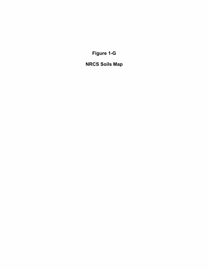
Figure 1-G
NRCS Soils Map

Ha
LtC
SeB
LtD3
SeC2
FtD
LtD3
Ba
Ba
MnB
LtC
LtD3
TVA FY21 Economic Development ProjectsMonroe County, Tennessee
Figure 1-G: NRCS SoilsThis m ap and all d ata containe d within aresup p lie d as is with no warranty. Card no Inc.e xp re ssly d isclaim s re sp onsib ility ford am age s or liab ility from any claim s thatmay arise out of the use or m isuse of thismap . It is the sole re sp onsib ility of the use rto d e te rm ine if the d ata on this m ap m e e tsthe use r’s ne e d s. This map was not cre ate das surve y d ata, nor should it b e use d assuc h. It is the use r’s re sp onsib ility to ob tainp rop e r surve y d ata, p re p are d b y a lic e nse dsurve yor, whe re re quire d b y law.r
Im age :2020Data Sourc e :
0 200 400 Feet
0 60 120 Meters
LegendTe llic o We st Ind ustrial Site
Site Are a
Ba - Be ason silt loam
FtD - Fulle rton grave lly silt loam , 15 to 25 p e rc e nt slop e s
Ha - Ham b le n silt loam , 0 to 2 p e rc e nt slop e s, oc casionally flood e d
LtC - Litz shaly silt loam , 5 to 12 p e rc e nt slop e s (sil)
LtD3 - Litz shaly silt loam, 12 to 20 p e rc e nt slop e s, se ve re ly e rod e d (sil)
MnB - Minvale silt loam, 2 to 5 p e rc e nt slop e s
Se B - Se quoia silt loam, 2 to 5 p e rc e nt slop e s
Se C2 - Se quoia silt loam , 5 to 12 p e rc e nt slop e s, e rod e d
File P ath: Q:\Unite d State s\Florida\Tam p a\Te nne sse e Valle y Authority\TVA_FY 21_Econom ic_Develop m e nt_P roje cts\03_Monroe_County_TN\working\arcm ap \EA_Map s\EA_Monroe_Fig1G_NRCS_Soils_A_1_20210224.m xdDate Re vise d : 2/24/2021GIS Analyst: Jam es.Bottige rDate Cre ate d : 2/24/2021
3905 Crescent Park Drive, Riverview, FL 33578 USAPhone (+1) 813-664-4500 Fax (+1) 813-664-0440 www.cardno.com
Te n n e sse e
Ke n tuc k y
No rth Carolin a
Ge o rg iaAlab am a South Carolin a
Virg in iaIllin o is
Site Loc ation-84.2715, 35.5891
ATTACHMENT 2
TVA Bat Strategy Project Screening Form

Project Review Form - TVA Bat Strategy (06/2019)
This form should only be completed if project includes activities in Tables 2 or 3 (STEP 2 below). This form is not required if project activities are limited to Table 1 (STEP 2) or otherwise determined to have no effect on federally listed bats. If so, include the following statement in your environmental compliance document (e.g., add as a comment in the project CEC): “Project activities limited to Bat Strategy Table 1 or otherwise determined to have no effect on federally listed bats. Bat Strategy Project Review Form NOT required.” This form is to assist in determining required conservation measures per TVA's ESA Section 7 programmatic consultation for routine
actions and federally listed bats.1
Project Name: InvestPrep - Monroe County, TN Date: Oct 5, 2020
Contact(s): Bess Hubbard CEC#: Project ID: 37086
Project Location (City, County, State): Vonore, Monroe County, TN
Project Description:
TVA funding to assist with tree clearing, grading of a 125,000 SF dirt building pad, dirt access road, and dirt parking areas, and
construction of a detention pond.
STEP 2) Select all activities from Tables 1, 2, and 3 below that are included in the proposed project.
TABLE 1. Activities with no effect to bats. Conservation measures & completion of bat strategy project review form NOT
required.
1. Loans and/or grant awards■ 8. Sale of TVA property 19. Site-specific enhancements in streams and reservoirs for aquatic animals
2. Purchase of property 9. Lease of TVA property 20. Nesting platforms
3. Purchase of equipment for industrial facilities
10. Deed modification associated with TVA rights or TVA property
41. Minor water-based structures (this does not include boat docks, boat slips or piers)
4. Environmental education 11. Abandonment of TVA retained rights 42. Internal renovation or internal expansion of an existing facility
5. Transfer of ROW easement and/or ROW equipment 12. Sufferance agreement 43. Replacement or removal of TL poles
6. Property and/or equipment transfer 13. Engineering or environmental planning or studies■
44. Conductor and overhead ground wire installation and replacement
7. Easement on TVA property 14. Harbor limits delineation 49. Non-navigable houseboats
1 Manage Biological Resources for Biodiversity and Public Use on TVA Reservoir Lands
2 Protect Cultural Resources on TVA-Retained Land
3 Manage Land Use and Disposal of TVA-Retained Land
4 Manage Permitting under Section 26a of the TVA Act
5 Operate, Maintain, Retire, Expand, Construct Power Plants
6 Maintain Existing Electric Transmission Assets
7 Convey Property associated with Electric Transmission
8 Expand or Construct New Electric Transmission Assets
9 Promote Economic Development■
10 Promote Mid-Scale Solar Generation
SECTION 1: PROJECT INFORMATION - ACTION AND ACTIVITIES
STEP 1) Select TVA Action. If none are applicable, contact environmental support staff, Environmental Project Lead, or Terrestrial
Zoologist to discuss whether form (i.e., application of Bat Programmatic Consultation) is appropriate for project:

Project Review Form - TVA Bat Strategy (06/2019)
TABLE 2. Activities not likely to adversely affect bats with implementation of conservation measures. Conservation measures and
completion of bat strategy project review form REQUIRED; review of bat records in proximity to project NOT required.
18. Erosion control, minor■ 57. Water intake - non-industrial 79. Swimming pools/associated equipment
24. Tree planting 58. Wastewater outfalls 81. Water intakes – industrial
30. Dredging and excavation; recessed harbor areas 59. Marine fueling facilities 84. On-site/off-site public utility relocation or
construction or extension
39. Berm development 60. Commercial water-use facilities (e.g., marinas) 85. Playground equipment - land-based
40. Closed loop heat exchangers (heat pumps) 61. Septic fields 87. Aboveground storage tanks
45. Stream monitoring equipment -placement and use
66. Private, residential docks, piers, boathouses 88. Underground storage tanks
46. Floating boat slips within approved harbor limits 67. Siting of temporary office trailers 90. Pond closure
48. Laydown areas■68. Financing for speculative building
construction 93. Standard License
50. Minor land based structures 72. Ferry landings/service operations 94. Special Use License
51. Signage installation 74. Recreational vehicle campsites 95. Recreation License
53. Mooring buoys or posts 75. Utility lines/light poles 96. Land Use Permit
56. Culverts 76. Concrete sidewalks
Table 3: Activities that may adversely affect federally listed bats. Conservation measures AND completion of bat strategy project
review form REQUIRED; review of bat records in proximity of project REQUIRED by OSAR/Heritage eMap reviewer or Terrestrial
Zoologist.
15. Windshield and ground surveys for archaeological resources
34. Mechanical vegetation removal, includes trees or tree branches > 3 inches in diameter
■69. Renovation of existing
structures
16. Drilling 35. Stabilization (major erosion control) ■ 70. Lock maintenance/ construction
17. Mechanical vegetation removal, does not include trees or branches > 3” in diameter (in Table 3 due to potential for woody burn piles)
36. Grading ■ 71. Concrete dam modification
21. Herbicide use 37. Installation of soil improvements 73. Boat launching ramps
22. Grubbing ■ 38. Drain installations for ponds■77. Construction or expansion of
land-based buildings
23. Prescribed burns 47. Conduit installation 78. Wastewater treatment plants
25. Maintenance, improvement or construction of pedestrian or vehicular access corridors ■ 52. Floating buildings 80. Barge fleeting areas
26. Maintenance/construction of access control measures
54. Maintenance of water control structures (dewatering units, spillways, levees)
82. Construction of dam/weirs/levees
27. Restoration of sites following human use and abuse 55. Solar panels 83. Submarine pipeline, directional boring operations
28. Removal of debris (e.g., dump sites, hazardous material, unauthorized structures) 62. Blasting 86. Landfill construction
29. Acquisition and use of fill/borrow material ■63. Foundation installation for transmission
support 89. Structure demolition
31. Stream/wetland crossings ■64. Installation of steel structure, overhead
bus, equipment, etc. 91. Bridge replacement
32. Clean-up following storm damage 65. Pole and/or tower installation and/or extension
92. Return of archaeological remains to former burial sites
33. Removal of hazardous trees/tree branches
STEP 3) Project includes one or more activities in Table 3? YES (Go to Step 4) NO (Go to Step 13)

Project Review Form - TVA Bat Strategy (06/2019)
STEP 4) Answer questions a through e below (applies to projects with activities from Table 3 ONLY)
a) Will project involve continuous noise (i.e., > 24 hrs) that is greater than 75 decibels measured on the A scale (e.g., loud machinery)?
NO (NV2 does not apply)YES (NV2 applies, subject to records review)
b) Will project involve entry into/survey of cave?NO (HP1/HP2 do not apply)YES (HP1/HP2 applies, subject to review of bat records)
c) If conducting prescribed burning (activity 23), estimated acreage: and timeframe(s) below; N/A■
STATE SWARMING WINTER NON-WINTER PUP
GA, KY, TN Oct 15 - Nov 14 Nov 15 - Mar 31 Apr 1 - May 31, Aug 1- Oct 14 Jun 1 - Jul 31
VA Sep 16 - Nov 15 Nov 16 - Apr 14 Apr 15 - May 31, Aug 1 – Sept 15 Jun 1 - Jul 31
AL Oct 15 - Nov 14 Nov 15 - Mar 15 Mar 16 - May 31, Aug 1 - Oct 14 Jun 1 - Jul 31
NC Oct 15 - Nov 14 Nov 15 - Apr 15 Apr 16 - May 31, Aug 1 - Oct 14 Jun 1 - Jul 31
MS Oct 1 - Nov 14 Nov 15 - Apr 14 Apr 15 - May 31, Aug 1 – Sept 30 Jun 1 - Jul 31
d) Will the project involve vegetation piling/burning? NO (SSPC4/ SHF7/SHF8 do not apply)YES (SSPC4/SHF7/SHF8 applies, subject to review of bat records)
e) If tree removal (activity 33 or 34), estimated amount: 10.3 ac trees N/A
STATE SWARMING WINTER NON-WINTER PUP
GA, KY, TN Oct 15 - Nov 14 Nov 15 - Mar 31 Apr 1 - May 31, Aug 1- Oct 14■ Jun 1 - Jul 31
VA Sep 16 - Nov 15 Nov 16 - Apr 14 Apr 15 - May 31, Aug 1 – Sept 15 Jun 1 - Jul 31
AL Oct 15 - Nov 14 Nov 15 - Mar 15 Mar 16 - May 31, Aug 1 - Oct 14 Jun 1 - Jul 31
NC Oct 15 - Nov 14 Nov 15 - Apr 15 Apr 16 - May 31, Aug 1 - Oct 14 Jun 1 - Jul 31
MS Oct 1 - Nov 14 Nov 15 - Apr 14 Apr 15 - May 31, Aug 1 – Sept 30 Jun 1 - Jul 31
If warranted, does project have flexibility for bat surveys (May 15-Aug 15): MAYBE YES NO
*** For PROJECT LEADS whose projects will be reviewed by a Heritage Reviewer (Natural Resources Organization only), STOP HERE. Click File/Save As, name form as “ProjectLead_BatForm_CEC-or-ProjectIDNo_Date", and submit with project information. Otherwise continue to Step 5. ***
SECTION 2: REVIEW OF BAT RECORDS (applies to projects with activities from Table 3 ONLY)
STEP 5) Review of bat/cave records conducted by Heritage/OSAR reviewer?
YES NO (Go to Step 13)
Info below completed by: Heritage Reviewer (name) Date
OSAR Reviewer (name) Date
Terrestrial Zoologist■ (name) Sara McLaughlin-Johnson Date 9/4/2020
Gray bat records: None Within 3 miles* Within a cave* Within the County
Indiana bat records: None Within 10 miles* Within a cave* Capture/roost tree* Within the County
Northern long-eared bat records: None Within 5 miles* Within a cave* Capture/roost tree* Within the County
Virginia big-eared bat records: None Within 6 miles* Within the County
Caves: None within 3 mi Within 3 miles but > 0.5 mi Within 0.5 mi but > 0.25 mi* Within 0.25 mi but > 200 feet*
Within 200 feet*
Bat Habitat Inspection Sheet completed? NO YES
Amount of SUITABLE habitat to be removed/burned (may differ from STEP 4e): 0 ( ac trees)* N/A

Project Review Form - TVA Bat Strategy (06/2019)
STEP 6) Provide any additional notes resulting from Heritage Reviewer records review in Notes box below then . . . . . . . .
. . . . . . . . . . . . . . . . . . . . . . . . . . . . . . . . . . . . . . . . . . . . . . . . . . . . . . . . . . . . . . . . . . . . . . . . . . . . . . . Go to Step 13
Notes from Bat Records Review (e.g., historic record; bats not on landscape during action; DOT bridge survey with negative results):
Field surveys of the project footprint in Oct 2020 did not identify any habitat suitable for summer roosting T&E bats.
STEPS 7-12 To be Completed by Terrestrial Zoologist (if warranted):
STEP 7) Project will involve:
Removal of suitable trees within 0.5 mile of P1-P2 Indiana bat hibernacula or 0.25 mile of P3-P4 Indiana bat hibernacula or any NLEB hibernacula.
Removal of suitable trees within 10 miles of documented Indiana bat (or within 5 miles of NLEB) hibernacula.
Removal of suitable trees > 10 miles from documented Indiana bat (> 5 miles from NLEB) hibernacula.
Removal of trees within 150 feet of a documented Indiana bat or northern long-eared bat maternity roost tree.
Removal of suitable trees within 2.5 miles of Indiana bat roost trees or within 5 miles of Indiana bat capture sites.
Removal of suitable trees > 2.5 miles from Indiana bat roost trees or > 5 miles from Indiana bat capture sites.
Removal of documented Indiana bat or NLEB roost tree, if still suitable.
N/A
STEP 8) Presence/absence surveys were/will be conducted: YES NO TBD
STEP 9) Presence/absence survey results, on NEGATIVE POSITIVE N/A
STEP 10) Project WILL WILL NOT require use of Incidental Take in the amount of acres or trees
proposed to be used during the WINTER VOLANT SEASON NON-VOLANT SEASON N/A■
STEP 11) Available Incidental Take (prior to accounting for this project) as of
TVA Action Total 20-year Winter Volant Season Non-Volant Season
9 Promote Economic Development
STEP 12) Amount contributed to TVA's Bat Conservation Fund upon activity completion: $ OR N/A
TERRESTRIAL ZOOLOGISTS, after completing SECTION 2, review Table 4, modify as needed, and then complete section for
Terrestrial Zoologists at end of form.
SECTION 3: REQUIRED CONSERVATION MEASURES
STEP 13) Review Conservation Measures in Table 4 and ensure those selected are relevant to the project. If not, manually
override and uncheck irrelevant measures, and explain why in ADDITIONAL NOTES below Table 4.
Did review of Table 4 result in ANY remaining Conservation Measures in RED?
NO (Go to Step 14)YES (STOP HERE; Submit for Terrestrial Zoology Review. Click File/Save As, name form as "ProjectLead_BatForm_CEC-or-
ProjectIDNo_Date", and submit with project information).
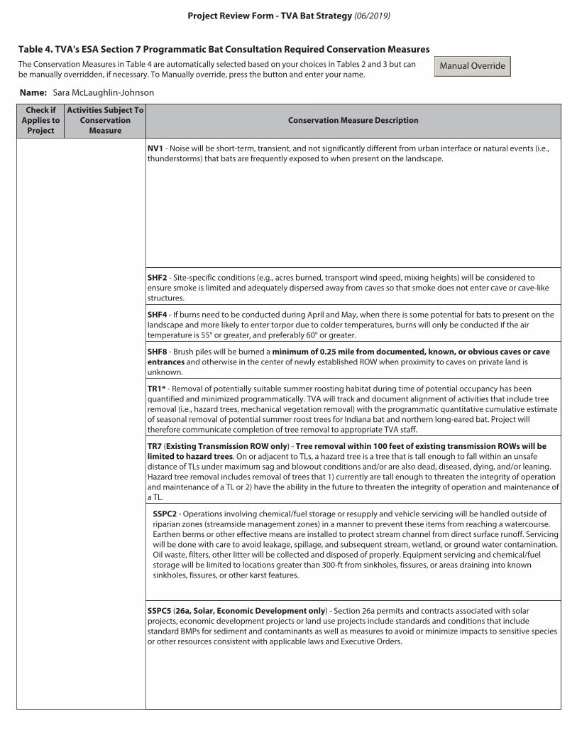
Project Review Form - TVA Bat Strategy (06/2019)
Table 4. TVA's ESA Section 7 Programmatic Bat Consultation Required Conservation Measures
The Conservation Measures in Table 4 are automatically selected based on your choices in Tables 2 and 3 but can be manually overridden, if necessary. To Manually override, press the button and enter your name.
Manual Override
Name: Sara McLaughlin-Johnson
Check if
Applies to
Project
Activities Subject To
Conservation
Measure
Conservation Measure Description
NV1 - Noise will be short-term, transient, and not significantly different from urban interface or natural events (i.e., thunderstorms) that bats are frequently exposed to when present on the landscape.
SHF2 - Site-specific conditions (e.g., acres burned, transport wind speed, mixing heights) will be considered to ensure smoke is limited and adequately dispersed away from caves so that smoke does not enter cave or cave-like structures.
SHF4 - If burns need to be conducted during April and May, when there is some potential for bats to present on the landscape and more likely to enter torpor due to colder temperatures, burns will only be conducted if the air temperature is 55° or greater, and preferably 60° or greater.
SHF8 - Brush piles will be burned a minimum of 0.25 mile from documented, known, or obvious caves or cave
entrances and otherwise in the center of newly established ROW when proximity to caves on private land is unknown.
TR1* - Removal of potentially suitable summer roosting habitat during time of potential occupancy has been quantified and minimized programmatically. TVA will track and document alignment of activities that include tree removal (i.e., hazard trees, mechanical vegetation removal) with the programmatic quantitative cumulative estimate of seasonal removal of potential summer roost trees for Indiana bat and northern long-eared bat. Project will therefore communicate completion of tree removal to appropriate TVA staff.
TR7 (Existing Transmission ROW only) - Tree removal within 100 feet of existing transmission ROWs will be
limited to hazard trees. On or adjacent to TLs, a hazard tree is a tree that is tall enough to fall within an unsafe distance of TLs under maximum sag and blowout conditions and/or are also dead, diseased, dying, and/or leaning. Hazard tree removal includes removal of trees that 1) currently are tall enough to threaten the integrity of operation and maintenance of a TL or 2) have the ability in the future to threaten the integrity of operation and maintenance of a TL.
SSPC2 - Operations involving chemical/fuel storage or resupply and vehicle servicing will be handled outside of riparian zones (streamside management zones) in a manner to prevent these items from reaching a watercourse. Earthen berms or other effective means are installed to protect stream channel from direct surface runoff. Servicing will be done with care to avoid leakage, spillage, and subsequent stream, wetland, or ground water contamination. Oil waste, filters, other litter will be collected and disposed of properly. Equipment servicing and chemical/fuel storage will be limited to locations greater than 300-ft from sinkholes, fissures, or areas draining into known sinkholes, fissures, or other karst features.
SSPC5 (26a, Solar, Economic Development only) - Section 26a permits and contracts associated with solar projects, economic development projects or land use projects include standards and conditions that include standard BMPs for sediment and contaminants as well as measures to avoid or minimize impacts to sensitive species or other resources consistent with applicable laws and Executive Orders.

Project Review Form - TVA Bat Strategy (06/2019)
L1 - Direct temporary lighting away from suitable habitat during the active season.
L2 - Evaluate the use of outdoor lighting during the active season and seek to minimize light pollution when installing new or replacing existing permanent lights by angling lights downward or via other light minimization measures (e.g., dimming, directed lighting, motion-sensitive lighting).
1Bats addressed in consultation (02/2018), which includes gray bat (listed in 1976), Indiana bat (listed in 1967), northern long-eared bat (listed in 2015), and Virginia big-eared bat (listed in 1979).
Hide All Unchecked Conservation Measures
HIDE
UNHIDE
Hide Table 4 Columns 1 and 2 to Facilitate Clean Copy and Paste
HIDE
UNHIDE
NOTES (additional info from field review, explanation of no impact or removal of conservation measures).

Project Review Form - TVA Bat Strategy (06/2019)
STEP 14) Save completed form (Click File/Save As, name form as "ProjectLead_BatForm_CEC-or-ProjectIDNo_Date") in
project environmental documentation (e.g. CEC, Appendix to EA) AND send a copy of form to [email protected]
Submission of this form indicates that Project Lead/Applicant:
(name) is (or will be made) aware of the requirements below.Bess Hubbard
• Implementation of conservation measures identified in Table 4 is required to comply with TVA's Endangered Species Act programmatic bat consultation.
• TVA may conduct post-project monitoring to determine if conservation measures were effective in minimizing or avoiding impacts to federally listed bats.
For Use by Terrestrial Zoologist Only
Terrestrial Zoologist acknowledges that Project Lead/Contact (name) has been informed ofRuth Horton
For projects that require use of Take and/or contribution to TVA's Bat Conservation Fund, Terrestrial Zoologist acknowledges that Project Lead/Contact has been informed that project will result in use of Incidental Take ac trees
and that use of Take will require $ contribution to TVA's Conservation Fund upon completion of activity
(amount entered should be $0 if cleared in winter).
For Terrestrial Zoology Use Only. Finalize and Print to Noneditable PDF.
any relevant conservation measures and/or provided a copy of this form.

ATTACHMENT 3
Agency Correspondence

3-A
Tennessee Historical Commission
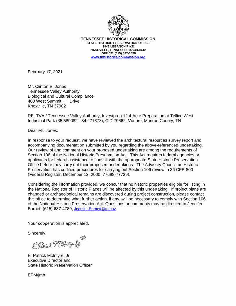
TENNESSEE HISTORICAL COMMISSION STATE HISTORIC PRESERVATION OFFICE
2941 LEBANON PIKE NASHVILLE, TENNESSEE 37243-0442
OFFICE: (615) 532-1550
www.tnhistoricalcommission.org
February 17, 2021 Mr. Clinton E. Jones Tennessee Valley Authority Biological and Cultural Compliance 400 West Summit Hill Drive Knoxville, TN 37902 RE: TVA / Tennessee Valley Authority, Investprep 12.4 Acre Preparation at Tellico West Industrial Park (35.589082, -84.271673), CID 79662, Vonore, Monroe County, TN Dear Mr. Jones: In response to your request, we have reviewed the architectural resources survey report and accompanying documentation submitted by you regarding the above-referenced undertaking. Our review of and comment on your proposed undertaking are among the requirements of Section 106 of the National Historic Preservation Act. This Act requires federal agencies or applicants for federal assistance to consult with the appropriate State Historic Preservation Office before they carry out their proposed undertakings. The Advisory Council on Historic Preservation has codified procedures for carrying out Section 106 review in 36 CFR 800 (Federal Register, December 12, 2000, 77698-77739). Considering the information provided, we concur that no historic properties eligible for listing in the National Register of Historic Places will be affected by this undertaking. If project plans are changed or archaeological remains are discovered during project construction, please contact this office to determine what further action, if any, will be necessary to comply with Section 106 of the National Historic Preservation Act. Questions or comments may be directed to Jennifer Barnett (615) 687-4780, [email protected]. Your cooperation is appreciated. Sincerely,
E. Patrick McIntyre, Jr. Executive Director and State Historic Preservation Officer EPM/jmb