editors: joan l. latchman, michal camejo, farrah madoo
TRANSCRIPT

─────────────────────────────────────────────────────────────────────────────────────────
BULLETIN OF THE SEISMIC RESEARCH CENTRE, THE UNIVERSITY OF THE WEST INDIES, ST. AUGUSTINE, TRINIDAD. Jan.-Mar.. 2012 / Page 1
Editors: Joan L. Latchman, Michal Camejo, Farrah Madoo, Hannah Ramsingh, Amit Balchan
─────────────────────────────────────────────────────────────────────────────────────────
BULLETIN OF THE SEISMIC RESEARCH CENTRE, THE UNIVERSITY OF THE WEST INDIES, ST. AUGUSTINE, TRINIDAD. Jan.-Mar.. 2012 / Page 2
Introduction
This bulletin reports on the activities at the Seismic Research Centre for the period January to March, 2012.
Data Acquisition and Processing
The Seismic Research Centre (SRC) operates 52 seismic stations as part of the Eastern Caribbean volcano and earthquake monitoring network (Fig. 1). These stations are connected to the legacy Soufrière System and the new state-of-the-art satellite Earthworm System. There are nine subnets (Trinidad, Atlantic LNG, Dominica, Barbados, Grenada, St. Vincent, Saint Lucia, St. Kitts, Antigua) comprised of 39 stations in the Soufrière System and 13 stations in the Earthworm System making up the network. The signals from each seismometer within a subnet are transmitted to the base computer and digitized by a 16-bit analogue to digital converter at 100 samples/sec. A triggering algorithm continuously searches the resulting time series from each station for possible earthquakes and, once preset triggering criteria are met (Soufrière System, 1988)1, stores the "event" preceded by a selectable length of pre-triggering time record. There are 8 types of seismometers in use:
• 1Hz, vertical component, Sercel L4C seismometer • 1Hz, vertical component, Integra LA100F seismometer • 1Hz, single component, Kinemetrics SS-1 Ranger seismometer • 1Hz, 3-component Sercel L4C-3D seismometer • 1Hz 3-component Lennartz LE3D seismometer • 5 seconds 3-component Lennartz LE3D seismometer • 3-component Guralp CMG-3ESP-compact broadband seismometer • 3-component Guralp CMG-40T broadband seismometer.
In addition, there are 2 types of accelerometers in use: Kinemetrics K2 accelerometer and Metrozet TSA-100S accelerometer.
In the Soufrière System data from each of the monitoring machines are routinely downloaded at the beginning of the working day or as often as necessary, depending on the level of activity, via telephone and internet, to computers at the TRN node. This is done in one of two ways: (i) operator-activated transfer or (ii) scheduled, software-activated transfer. The latter allows for the download of data during off-peak hours, so making it immediately available at the start of the working day. Data are analysed using software for picking phase arrival times and routine hypocentral determination (WURSTMACHINE, 1988)2. In the Earthworm System data are uploaded from the recording stations via satellite technology and downloaded to machines at the SRC.
1 Seismic data acquisition system. For further information contact SRC. 2 Seismic data processing system. For further information contact SRC.

─────────────────────────────────────────────────────────────────────────────────────────
BULLETIN OF THE SEISMIC RESEARCH CENTRE, THE UNIVERSITY OF THE WEST INDIES, ST. AUGUSTINE, TRINIDAD. Jan.-Mar.. 2012 / Page 3
While well-located, on-land, 3-station events receive special consideration; in general, events appearing in this bulletin were recorded at four or more stations. These were located and magnitudes (Mt) assigned using the following duration formula (Shepherd & Aspinall, 1983):
Fig. 1: Eastern Caribbean seismic monitoring network

─────────────────────────────────────────────────────────────────────────────────────────
BULLETIN OF THE SEISMIC RESEARCH CENTRE, THE UNIVERSITY OF THE WEST INDIES, ST. AUGUSTINE, TRINIDAD. Jan.-Mar.. 2012 / Page 4
Mt = -0.705 + 2.073 log10 τ + 0.0018R where τ is signal duration in seconds and R is hypocentral distance in km. The use of drum recording technology in the SRC dates back to 1953. Six stations are continuously displayed on two ink-pen, drum recorders, which continue to provide real-time visuals of activity in the near vicinity of the stations being displayed. Virtual drums, which consist of recorded signals from selected stations across the network, displayed on computer screens, are in operation and represent the future of continuous visual surveillance of activity in the area of responsibility.
Seismicity
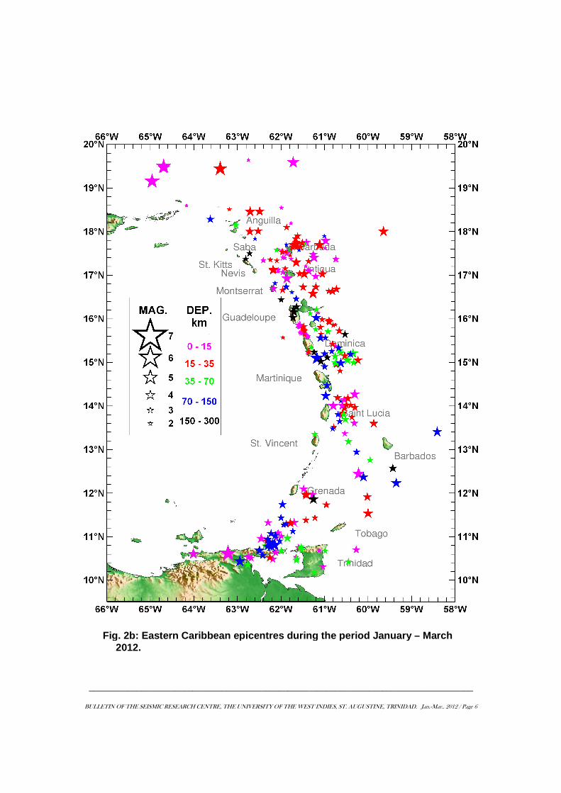
Eastern Caribbean seismicity is usually concentrated to the east of a line from St. Kitts to Martinique, with hypocentres exhibiting a relatively well-defined subduction (Wadati-Benioff) zone. From the south of Martinique to Grenada there is a substantial reduction in the frequency of earthquakes. The Trinidad and Tobago area generates significant seismic activity, with the most active area being a narrow belt of seismicity beneath and to the north-east of the Paria Peninsula of Venezuela. There is also significant activity in the Gulf of Paria. This Paria seismicity contains both shallow, <35 km, and intermediate depth, ≥35 km, earthquakes. There were 367 earthquakes recorded for the quarter and Fig. 2a shows the daily and cumulative count of those events. Fig. 2b shows the 270 (74%) of those earthquakes, for which locations could be determined, plotted according to magnitude and depth ranges. The earthquakes generally lie in a relatively wide belt which coincides with the location and curvature of the arc. The density of epicentres within this zone is variable. Details of origin time (UTC), geographic coordinates (latitude, longitude), depth and magnitude for each earthquake are available upon request. There were 25 earthquakes of magnitude greater than or equal to 4.0 and 45 events lying within the magnitude range 3.5-3.9. The largest events for the period, in the area shown, occurred far north of the Virgin Islands and far north of Anguilla and were both of magnitude 4.8. An earthquake of magnitude 5.1 located in Venezuela is also shown on the map. Felt reports were received for nine earthquakes; these ranged in magnitude from 2.9-4.5. The highest intensity associated with these events was MM INT III observed for three events of magnitudes 4.1, 3.8, and 4.5 on 23rd January, 28th January, and 11th February respectively (Table 1). There were 12 earthquakes on/near land Trinidad in the magnitude range 2.3-3.2, which maintains the somewhat elevated level being observed in the area since 2000. There were no felt reports for these earthquakes.

─────────────────────────────────────────────────────────────────────────────────────────
BULLETIN OF THE SEISMIC RESEARCH CENTRE, THE UNIVERSITY OF THE WEST INDIES, ST. AUGUSTINE, TRINIDAD. Jan.-Mar.. 2012 / Page 5
The overall seismicity pattern for this period remains consistent with that being observed for the region in recent years. The area north of 15°N latitude output 166 (61%) of the events located for the quarter, with 16% (42 events) within 12°N -15°N and the remaining 23% (62 earthquakes) south of 12°N. While, in general, the zone between Grenada and south of Martinique manifests a low level of activity, since 2008, activity in the area east of Saint Lucia has been elevated following a magnitude 4.7 earthquake on 2008/09/02; the largest in the area for the quarter was of magnitude 3.9. Since the 2008 earthquake, 186 events have been located in the area, with the largest, so far, of magnitude 5.1, on 2011/08/07. The zone marked out by the events seen in Fig. 3, which is a 3-D depiction of the earthquakes at depth, is called the Wadati-Benioff zone. It reveals the subduction of plate material that is taking place along the arc.
Fig. 2a: Daily and cumulati ve nu mber of earthquakes during the period January – March 2012.
─────────────────────────────────────────────────────────────────────────────────────────
BULLETIN OF THE SEISMIC RESEARCH CENTRE, THE UNIVERSITY OF THE WEST INDIES, ST. AUGUSTINE, TRINIDAD. Jan.-Mar.. 2012 / Page 6
Fig. 2b : Eastern Caribbean epice ntres during the period January – March 2012.

─────────────────────────────────────────────────────────────────────────────────────────
BULLETIN OF THE SEISMIC RESEARCH CENTRE, THE UNIVERSITY OF THE WEST INDIES, ST. AUGUSTINE, TRINIDAD. Jan.-Mar.. 2012 / Page 7
Fig. 3 : Depth profile of earthqua kes for the period January to March 2012

─────────────────────────────────────────────────────────────────────────────────────────
BULLETIN OF THE SEISMIC RESEARCH CENTRE, THE UNIVERSITY OF THE WEST INDIES, ST. AUGUSTINE, TRINIDAD. Jan.-Mar.. 2012 / Page 8
Table 1 : Felt earthquakes for the period 2012/01/01 – 03/31
DATE TIME (UTC)
LAT. (°N)
LONG. (°W)
DEP. (km)
MAG. (Mt) FELT REPORTS
2012/01/23 16:32:14.33 16.577 61.263 20 4.1
North-east of Guadeloupe. Felt in Antigua. MM INT: II – St. John’s III – Bethesda Village
2012/01/28 01:02:47.88 11.309 61.786 22 3.8
North-west of Trinidad. Felt in Grenada. MM INT: III – Carriacou, Prospect Hall
2012/01/29 11:33:11.26 14.268 60.308 8 4.0
East of Martinique. Felt in Saint Lucia. MM INT: II – Gros Islet
2012/02/11 05:56:38.75 10.809 62.150 80 4.5
North of Paria peninsula. Felt in Trinidad. MM INT: III – Diego Martin, Maraval, West Moorings
2012/02/18 02:22:06.82 11.964 61.416 19 4.0
South-east of Grenada. Felt in Grenada. MM INT: II – St. Andrew’s, St. George’s III – Morne Rouge, St. George’s Lance Aux Epines, Good Hope.
2012/03/03 08:40:26.92 15.093 61.176 148 4.5
South-east of Dominica. Felt in Dominica. MM INT: II – Bellevue Chopin.
2012/03/04 01:25:10.83 14.232 60.973 119 4.0
North of Saint Lucia. Felt in Saint Lucia. MM INT: II – Gros Islet
2012/03/17 21:44:18.90 10.750 61.602 3 2.9
Near north coast of Trinidad. Felt in northern parts of Trinidad. MM INT: II - Maraval, Cascade, Diego Martin.
2012/03/23 07:19:56.82 16.693 62.171 14 3.5 Southern Montserrat. Felt in Montserrat. MM INT: II
*UTC – Local Time + 4 hours MMI - Modified Mercalli Intensity

─────────────────────────────────────────────────────────────────────────────────────────
BULLETIN OF THE SEISMIC RESEARCH CENTRE, THE UNIVERSITY OF THE WEST INDIES, ST. AUGUSTINE, TRINIDAD. Jan.-Mar.. 2012 / Page 9
Volcanic Earthquakes detected during the period January - March 2012
Unusual seismic activity apparently associated with the northern Dominica volcanic centres persisted during the period. Fig. 4 shows the daily count for the period January – March 2012 (17 events for the period) along with the cumulative count since the episode started. It should be noted that volcanic centres may exhibit episodic periods of elevated seismicity for decades as symptoms precursory to eventual volcanic eruption. In the context of the big picture, therefore, such episodes should not be casually dismissed. There were two small volcanic earthquakes in southern Dominica for the period. Generally, the other volcanic centres exhibited background activity with four events recorded. Details of the activity at the Soufrière Hills Volcano may be found in releases from the Montserrat Volcano Observatory. Other Monitoring Tools Ground Deformation There were no complete GPS surveys undertaken during this period. Engineering Seismology The GFDRR Disaster Vulnerability and Risk Assessment Modeling for Jamaica and the Greater Caribbean Basin Project (see Projects) is being executed. Education and Outreach
Projects The SRC is currently engaged in 14 projects, which are pursued within its routine work programme. Details of these projects are provided in Appendix I.
Fig. 4 : Daily number of earthquakes in northern Dominica fo r the period 2012/01/01 – 03/31 and cumulative number since the start of the episode.

─────────────────────────────────────────────────────────────────────────────────────────
BULLETIN OF THE SEISMIC RESEARCH CENTRE, THE UNIVERSITY OF THE WEST INDIES, ST. AUGUSTINE, TRINIDAD. Jan.-Mar.. 2012 / Page 10
Trinidad and Tobago Microzonation Project – The launch of the Trinidad and Tobago Microzonation Project (TTMP), in Trinidad, on 25th January was the highlight of project activities for this quarter. This project, funded by Ministry of Planning and Sustainable Development (MPSD), seeks to develop maps showing details of the different levels of a particular geotechnical hazard, in areas of interest e.g. a city, that may be triggered by an earthquake. Such studies are becoming a routine strategy in promoting sustainable development in seismically active regions around the World. The Minister of Planning and Sustainable Development, the Honourable Dr. Bhoendradatt Tewari, has been in strong support of having such work done in Trinidad and Tobago. Under the project, seismic microzonation studies will be conducted in 10 towns and cities in Trinidad and Tobago and a programme will be established to enable the updating of such maps to promote the continuity of this work. The project will run for 10 years.
Plate 1a : Dr. Walter Salazar , Principal Investigator, (left) at the launch of the TTMP providing attendees with the science behind the project and the benefits in the context of sustai nable development .
Plate 1b : Attendees (right) at the launch of the TTMP Project , drawn from key development stakeholders .
Plate 1c: Ms Marie Hinds (left, with mic; Senior Land Use Planner MPSD, TTMP liaison Officer) providing clarification on TTMP.

─────────────────────────────────────────────────────────────────────────────────────────
BULLETIN OF THE SEISMIC RESEARCH CENTRE, THE UNIVERSITY OF THE WEST INDIES, ST. AUGUSTINE, TRINIDAD. Jan.-Mar.. 2012 / Page 11
Then, on 02nd February, a workshop under the GFDRR Disaster Vulnerability and Risk
Assessment Modeling Jamaica and the Greater Caribbean Basin Project, DRRC Project, was held at the Faculty of Engineering, The UWI. Mr. Machel Higgins gave a status update on the software component of the project.
Plate 1d: Representatives of the MPSD and the SRC involved in the launch of the TTMP (left to right) Mr. Lloyd Lynch (Instrumentation Engineer, SRC), Dr. Walter Salazar (Principal Investigator, TTMP, SRC), Ms Sheryl Ann Haynes (Dep. Permanent Secretary Ag., MPSD), Dr. Joan Latchman ( Director, Ag., SRC), Prof. Clement Sankat (Principal, The UWI), Ms Kamal Maharaj (Director, Ag., MPSD; representing Minister of Planning and Sustainable Development, Dr. Bhoendradatt Tewari), Dr. Richard Robertson (Geologist, SRC).
Plate 2 : Mr. Machel Higgins delivering status update on the software component of the DRRC project.
─────────────────────────────────────────────────────────────────────────────────────────
BULLETIN OF THE SEISMIC RESEARCH CENTRE, THE UNIVERSITY OF THE WEST INDIES, ST. AUGUSTINE, TRINIDAD. Jan.-Mar.. 2012 / Page 12
The meeting of the Intergovernmental Coordination Group for the Tsunami and Other Coastal Hazards Warning System for the Caribbean and Adjacent Regions (ICG/CARIBE EWS) Working Group IV: Preparedness, Readiness and Resilience was convened 06th – 07th February, 2012 at UN House, Barbados as part of the establishment process for the Caribbean Tsunami Information Centre (CTIC). There were 11 participants in the Working Group IV Meeting. The Dominican Republic, United States of America (USA), Barbados and UNESCO/IOC were represented, along with observer organisations: Caribbean Disaster Emergency Management Agency (CDEMA), The University of the West Indies, Seismic Research Centre (SRC), Caribbean Institute for Meteorology and Hydrology (CIMH) and United Nations Development Programme, Barbados and the OECS (UNDP).
Specific outcomes of the meeting were:
1. An overview of the Enhancing Resilience to Reduce Vulnerability in the Caribbean (ERC) Project initiative, which is funding the establishment and initial operation of the CTIC, and a status of the CTIC Establishment Process.
2. A review of activities executed or progress made by Working Group IV of the ICG/CARIBE EWS.
3. Sharing of the tsunami public awareness and education resources and preparedness experiences of the Intergovernmental Oceanographic Commission (IOC) of UNESCO (UNESCO/IOC), Member States and regional organisations.
4. Review of the overall progress and 2011 activities of the Interim CTIC. 5. Development of a Draft Business Plan for the CTIC. Education and Outreach During the period 23rd – 27th January, Education and Outreach activities were focussed in St. Vincent and the Grenadines. At the request of the St. Vincent and the Grenadines National Emergency Management Organization (NEMO), The UWI Seismic Research Centre (SRC) facilitated a two-day Public Education for Geological Hazards Workshop at NEMO offices in St. Vincent and conducted meetings with NEMO staff to discuss adaptation and development of geological hazards information material relevant to St. Vincent and the Grenadines. Discussions were also held to formalize the SRC’s support of NEMO’s public education programme, in an ongoing basis. The overall goal of the training was to provide NEMO staff and stakeholders with technical insight into geological hazards and public education strategies. This is needed to enhance capacity in the presentation, production and dissemination of geological hazards information to the public. Lectures were led by SRC Director & Geologist, Dr. Richard Robertson, and SRC Education Officer, Ms Stacey Edwards. Participants included NEMO staff, representatives from the Red Cross, Ministry of Education, Soufrière Monitoring Unit (SMU), Ministry of Agriculture and the media. Following the Workshop media interviews were conducted with Dr. Robertson and Ms Edwards for broadcast on local stations. The Workshop was funded by the Caribbean Emergency Disaster Agency (CDEMA) through its Technical Assistance Secondment Protocol.
─────────────────────────────────────────────────────────────────────────────────────────
BULLETIN OF THE SEISMIC RESEARCH CENTRE, THE UNIVERSITY OF THE WEST INDIES, ST. AUGUSTINE, TRINIDAD. Jan.-Mar.. 2012 / Page 13
Current Research staff at the SRC is engaged in several research projects aimed at developing understanding of the processes influencing the seismic and volcanic activity in the Eastern Caribbean. Following are some of the topics currently being pursued: Geochemical and isotopic characterization of geothermal systems in the Lesser Antilles, and its use as a tool for monitoring changes in volcanic activity – the use of long-term geochemical surveillance of volcanic-hydrothermal systems can provide useful information of the changes in chemistry of geothermal reservoirs that may be indicative of changes in magmatic input. Geothermal monitoring also allows study of the evolution of these geothermal systems over time. - Dr. Erouscilla P. Joseph Study of the hazards and impact, on human health, of persistently degassing volcanoes; and the use of geothermal sites for recreational purposes – Volcanic fluids contain components that pose health hazards to humans, animals, and plants that are exposed to them on a short or long term basis. Investigation of the concentration of these emissions and their health effects on humans who are exposed to them are undertaken in order to help develop standards for safe recreational use of geothermal sites. - Dr. Erouscilla P. Joseph Radon monitoring in earthquake forecasting for Tobago - South-west Tobago is being used as the test zone. The project seeks to explore the utility of radon as a seismic monitoring tool. – Dr. Joan L. Latchman and Dr. Erouscilla P. Joseph Magnitude output imbalance as a diagnostic tool in earthquake forecasting – Dr. Joan L. Latchman Eastern Caribbean Seismic Hazard Analysis – The study Probabilistic seismic hazard assessment at the Eastern Caribbean Islands executed in collaboration with EUCENTRE was submitted to Bulletin of the Seismological Society of America – Dr. Walter Salazar Geological mapping and geochronology of the Morne aux Diables dome complex in northern Dominica - Dr. Robert B. Watts Dynamics of Geothermal Systems in the Eastern Caribbean – modelling of the geophysical conditions of the Boiling Lake, Dominica to better understand the phenomena of its unusual activity, and study the general response of geothermal systems to deep magmatic input – Ms Deborah Robertson Visitors On 21st March, Prof. Glenn Rix, School of Civil & Environmental Engineering, Dr. Steven French, Associate Dean for Research, College of Architecture, Georgia Institute of Technology along with Laura Kovalchick, Research Scientist and Tom Douthat

─────────────────────────────────────────────────────────────────────────────────────────
BULLETIN OF THE SEISMIC RESEARCH CENTRE, THE UNIVERSITY OF THE WEST INDIES, ST. AUGUSTINE, TRINIDAD. Jan.-Mar.. 2012 / Page 14
visited. They are involved in a project, Caribbean Hazard Assessment Mitigation and Preparedness (CHAMP) Program, based out of Georgia Institute of Technology. This program is in the nascent stages of development and was borne out of the structural response work that Dr. Reginald DesRoches (Associate Chair of Civil and Environmental Engineering) was involved in after the devastating 2010 earthquake in Haiti. It focuses on the need for the assessment of preparedness and vulnerability for natural hazards within the Caribbean, as well as development of mitigation tools. The programme proposes to employ a multi-disciplinary approach to risk reduction by (1) studying the hazards in the region, (2) collecting remote sensing data to determine building types (3) assessing the vulnerability of the built environment, the adequacy of building codes, and the health infrastructure, (4) studying the level of emergency response and preparedness plans that currently exist within countries of the Caribbean. The visitors found that the Haiti situation was not representative of the Eastern Caribbean and that much of the work proposed under CHAMP is currently being addressed, in the region.
References Cited
Shepherd, J.B. and W.P. Aspinall. 1983. Seismicity and earthquake hazard in Trinidad and Tobago, West Indies. Earthquake Engineering and Structural Dynamics. 11: 229-250.

─────────────────────────────────────────────────────────────────────────────────────────
BULLETIN OF THE SEISMIC RESEARCH CENTRE, THE UNIVERSITY OF THE WEST INDIES, ST. AUGUSTINE, TRINIDAD. Jan.-Mar.. 2012 / Page 15
PersonnelPersonnelPersonnelPersonnel
Staff based at the Seismic Research Centre in Trinidad:
Joan L. Joan L. Joan L. Joan L. LatchmanLatchmanLatchmanLatchman ---- Director (Ag.)/SeismologistDirector (Ag.)/SeismologistDirector (Ag.)/SeismologistDirector (Ag.)/Seismologist
Richard E.A. Robertson - Geologist
Lloyd L. Lynch - Instrumentation Engineer
Roderick Stewart - Volcano Seismologist
Walter Salazar - Seismology Engineer
Robert Watts - Physical Volcanologist
Erouscilla Joseph - Volcanologist
Frederic Dondin - Volcanologist
Myron Chin - GEM Operational Manager
Chandradath Ramsingh - IT Officer
Stacey Edwards - Education Officer
Machel Higgins - Software Engineer
Deborah Robertson - Research Assistant (Volcanology)
Monique Johnson - Research Assistant (E &O)
Cassandra LaBarrie - Research Assistant (Seismology/GIS)
Omari Graham - Research Assistant (Seismology)
Clevon Ash - Research Assistant (E&O)
Alia Juman - Research Assistant (Seismology)
Jillian St. Bernard - Research Assistant (Seismology)
Nisha Nath - Chief Research Technician (Seismology)
Amit Balchan - Research Technician (Seismology)
Farrah Madoo - Research Technician (Seismology)
Hannah Ramsingh - Research Technician (Seismology)
Ian Juman - Research Technician (Electronics)
Garth Mannette - Engineering Technician (Electronics)
Stephen George - Engineering Technician (Electronics)
Nolan Ali - Senior Maintenance Assistant
Yvonne Joseph - Secretary
Carol Liverpool - Clerical Assistant
Susan Carr - Part-Time Library Assistant
Shaun Boodhoo - Office Assistant
Margaret Nero - Cleaner
Joenel Alexander - Groundsman
Staff based at the Montserrat Volcano Observatory (MVO):
Paul ColePaul ColePaul ColePaul Cole ---- Director (Volcanologist)Director (Volcanologist)Director (Volcanologist)Director (Volcanologist)
Henry Odbert - Volcanologist
Thomas Christopher - Petrologist
Adam Stinton - Volcanologist
Patrick John Smith - Seismologist
Caroline Murrell - Contract Officer (Environmental)
Elizabeth Cole - Contract Officer (Outreach)
Activities of the MVO staff are detailed in reports from that agency.
─────────────────────────────────────────────────────────────────────────────────────────
BULLETIN OF THE SEISMIC RESEARCH CENTRE, THE UNIVERSITY OF THE WEST INDIES, ST. AUGUSTINE, TRINIDAD. Jan.-Mar.. 2012 / Page 16
AcknowledgementsAcknowledgementsAcknowledgementsAcknowledgements
The calculation of earthquake location parameters at the Seismic Research Centre benefitted from data
supplied by the following institutions:
a) Observatoire Volcanologique De La Montagne Pelée,
97250 Saint Pierre,
MARTINIQUE, FRENCH WEST INDIES.
b) Observatoire Volcanologique De La Soufrière,
Le Houelmant 97113, Gourbeyre,
GUADELOUPE. FRENCH WEST INDIES.
c) FUNVISIS,
Apartado Postal 1892, El Llanito, 1070, Venezuela.
d) National Earthquake Information Center,
U.S. Geological Survey, Box 25425, Denver CO 80225, U.S.A.
e) University of Puerto Rico,
Department of Geology, Seismic Network, Mayaguez, P.R. 00681.

─────────────────────────────────────────────────────────────────────────────────────────
BULLETIN OF THE SEISMIC RESEARCH CENTRE, THE UNIVERSITY OF THE WEST INDIES, ST. AUGUSTINE, TRINIDAD. Jan.-Mar.. 2012 / Page 17
APPENDIX I
PROJECT ID SPONSOR OBJECTIVE DURATION STAFF
MVO
Montserrat Volcano Observatory
Government of Montserrat Manage the MVO 2008-2013
Principal – Dr. Paul Cole Others – Henry Odbert, Adam Stinton, Patrick Smith, Richard Robertson, Roderick Stewart, Erouscilla Joseph, Robert Watts, Frédéric Dondin
DRRC
Disaster Vulnerability and Risk
Assessment Modelling Jamaica
and the Greater Caribbean Basin
Project
World Bank through
Disaster Risk Reduction
Centre, The UWI, Mona
Produce a regional scale Risk Atlas for Earthquake and high resolution maps for Jamaica, Grenada and Barbados
2010-2011 Principal – Dr. Walter Salazar Others – Machel Higgins, Alia Juman, Jillian St. Bernard,
GEM
Global Earthquake Model
Global Earthquake
Model Foundation
Initiate a Regional Programme for the Caribbean under the umbrella of the Global Earthquake Model. GEM is a global collaborative effort that brings together state-of-the-art science, national, regional and international organisations and individuals aimed at the establishment of uniform and open standards for calculating and communicating earthquake risk worldwide
2011-2012
Principal – Dr. Myron Chin Others – Lloyd Lynch, Richard Robertson, Joan Latchman, Stacey Edwards
TSUAREG
Tsunami Alert Regional
European Commission
A collaborative project with the Institut de Physique du Globe de Paris through observatories in Martinique and Guadeloupe to install VSAT stations in the region with four located in Antigua, Carriacou, Dominica and Saint Lucia. The aim is to enhance the regional seismograph network for tsunami detection and to better understand the tectonics of the Eastern Caribbean
2011-2014
Principal – Lloyd Lynch Others – Lutchman Pollard, Chan Ramsingh, Electronics Technicians
COCONET
Continuously Operating Caribbean GPS Observational
Network
National Science
Foundation through
UNAVCO
Enhance geodetic and meteorologic infrastructure of the Caribbean region to improve understanding of the process-oriented geohazards experienced in the region
5 years
Principal – Lloyd Lynch Others – Richard Robertson, Machel Higgins, Electronics Technicians
REAKT
Real Time Earthquake Risk
Reduction
European Commission
SRC component: To explore the utility of earthquake real time warnings in the Eastern Caribbean. In collaboration with CCEO, Barbados and EUCENTRE, Italy
2011-2014
Principal – Dr. Walter Salazar Others – Lloyd Lynch, Joan Latchman, Stacey Edwards, Alia Juman

─────────────────────────────────────────────────────────────────────────────────────────
BULLETIN OF THE SEISMIC RESEARCH CENTRE, THE UNIVERSITY OF THE WEST INDIES, ST. AUGUSTINE, TRINIDAD. Jan.-Mar.. 2012 / Page 18
PROJECT ID SPONSOR OBJECTIVE DURATION STAFF
VUELCO
Volcanic Unrest in Europe and Latin
America: Phenomenology,
eruption precursors, hazard forecast and
risk mitigation
European Commission 2011-2015
Principal – Dr. Richard Robertson Others – Stacey Edwards, Michal Camejo,
CCRIF
Caribbean Catastrophic Risk Insurance Facility
Caribbean Catastrophic
Risk Insurance
Facility
Establish a core network of strong motion instruments in the Eastern Caribbean and Jamaica as a crucial element of implementation of effective disaster risk reduction measures for earthquakes in the region.
2012-2014
Principal – Lloyd Lynch Others – Chan Ramsingh, Electronics Technicians, Lutchman Pollard
STRONG MOTION Government of Trinidad
and Tobago
Densify the strong motion network in Trinidad and Tobago to build a database to promote understanding of earthquake generated strong motion in the country.
Principal – Lloyd Lynch Other – Omari Graham, Lutchman Pollard, Electronics Technicians
STREVA
Strengthening Resilience in
Volcanic Areas
National Environmental
Research Council
To develop and apply a practical and adaptable volcanic risk assessment framework, with a view to mitigating the impact of volcanic episodes.
Principal – Dr. Richard Robertson Others – Stacey Edwards, Joan Latchman
MICROZONATION
Seismic Microzonation
Studies in Trinidad and Tobago
Government of Trinidad
and Tobago
To develop maps showing details of different levels of a particular geotechnical hazard that may be triggered by an earthquake in 10 cities and towns throughout Trinidad and Tobago
2011-2020
Principal – Dr. Walter Salazar Others – Lloyd Lynch, Joan Latchman, Stacey Edwards, Richard Robertson
Geosciences Video Documentaries SRC
To produce three 20-minute educational video documentaries: Earthquakes in the Caribbean, Volcanoes in the Caribbean, Careers in Geosciences
Principal – Stacey Edwards Others – Staff of SRC
CORE INTERNSHIP SRC
To expose undergraduate/recent graduate level students to the work of the SRC with a view to promoting geosciences as a career option.
Principal – Stacey Edwards Others – Staff of SRC