educational register of geological sites · geomorphological interest can also be seen at langstone...
TRANSCRIPT

Educational Register of Geological Sites
SITE
Name: Dawlish Cliffs
Parish: Dawlish
Local Authority: Teignbridge
National Grid Ref: SX 960 759 - 979 782
OS Sheets: 1:50K, 192, 1:10K, SX97 NE
Locality Description: Cliff section in the vicinity of Dawlish, south east Devon. Nature and Status of Site: Four separate areas of coastal cliff exposures. The site is designated as Site of Special Scientific Interest (SSSI). Summary of Geological / Geomorphological Interests: Dawlish cliffs show one of the finest continuous exposures in the country of cross-bedded aeolian (windblown) sands and fluvial (water - laid) breccias of Permian age. The exposed rocks include the Dawlish Sandstone, the Teignmouth Breccia and the Exe Breccia formations. The pattern of cross-bedding in the sandstone demonstrates how dunes were partly eroded and then overlain by others. The angular nature of the breccias indicates that they were deposited by sheet floods. A change from the aeolian sands to the fluvial breccias may have resulted from an increase in rainfall associated with climate change at the end of the Lower Permian. A number of features of coastal geomorphological interest can also be seen at Langstone Rock including stacks, a natural arch and a blow hole. Safety Considerations: Tide times and weather conditions should always be noted when beach areas are to be accessed: former sea-cliff exposures behind the mainline railway tracks are visible from the coastal promenade at all states of the tide, however (although there is no permitted access to such areas for health and safety reasons. Hard hats should be worn at all times near accessible cliff sections. Educational Age Groups: Primary, Secondary, College/6th Form, University. Parking and Access: Langstone Rock (site plan 1) can be accessed via Dawlish Warren where there is ample sea-front parking. The other three sites (site 2, site 3 and site 4) can be visited on foot via the sea wall at Dawlish. Car parking is available at Dawlish Station. There are also regular train services to both Dawlish station and Dawlish Warren station from Exeter, Teignmouth and Newton Abbot. For timetable details, visit www.traveline.org.uk. Much of the cliff section can be viewed from the promenade on the seaward side of the railway line. ________________________________________________________________ References BENTON, M.J., COOK, E. and TURNER, P. 2002. Permian and Triassic Red Beds and the Penarth Group of Great Britain. Geological Conservation Review Series 24, Joint Nature Conservation Committee, Peterborough, 337pp. DURRANCE, E.M. and LAMING, D.J.C. 1982. The Geology of Devon, University of
Exeter, 346pp.
Educational Register of Geological Sites
LAMING, D. J. C. 1966. Imbrications, paleocurrents and other sedimentary features in Lower New red Sandstone, devonshire, England. Journal of sedimentary petrology 17: 23-28. Laming D. J. C. (1966) Imbrications, Palaeocurrents and other Sedimentary Features in the Lower New Red Sandstone, Devonshire. Jour. Sed. Pet., 36, 940-959. LAMING, D.J.C. 1982. The New Red Sandstone. In: DURRANCE, E.M. and LAMING, D.J.C. (eds), The Geology of Devon, University of Exeter, pp.148-178. MADER, D. 1985. Braidplain, floodplain and playa lake, alluvial fan, aeolian and palaeosol facies composing a diversified lithogentical sequence in the Permian and Triassic of south Devon (England). In MADER, D. (ed.), Aspects of fluvial sedomentation in the Lower Triassic Buntsandstein of Europe. Lecture Notes in Earth Sciences 4, Springer-Verlag, Berlin: 15-64, MADER, D. and YARDLEY, M.J. 1985. Migration, modification and merging in aeolian systems and the significance of the depositional mechanisms in Permian and Triassic dune sands of Europe and North America. Sedimentary Geology 43: 85-218. NEWELL, A.J. 2001. Bounding surfaces in mixed aeolian-fluvial system (Rotliegend, Wessex Basin, SW UK). Marine and Petroleum Geology 18: 339-347. SELWOOD, E.B., EDWARDS, R.A., SIMPSON, S., CHESHER, J.A., HAMBLIN, R.J.O., HENSON, M.R., RIDDOLLS,B.W. and WATERS, R.A. 1984. Geology of the Country around Newton Abbot. Memoir of the USSHER, W.A.E. 1913. The geology of the country around Newton Abbot. Memoir of the Geological Survey of Great Britain (England and Wales), Sheet 339. Detailed Geology: Coryton's Cove exposes rocks of the Teignmouth Breccia Formation. This part of the New Red Sandstone succession comprises of fine to coarse grained sandstone breccias, which commonly exhibit fining-upwards, forming planar-bedded sedimentation units with erosional bases. The coarser clasts near the base of the units, commonly show imbrication. Sandstone units are commonly interbedded with breccia towards the top of the formation and show characteristics of both fluvial and aeolian deposition. An aeolian sandstone unit within the cliffs exhibits cross-bedding and cuts into the surrounding breccias. Overlying this is the Dawlish Sandstone Formation, which comprises uncemented fluvial and aeolian cross-bedded sandstones with breccia lenses. The sandstones are composed of silty, cross-bedded, medium to fine grained or locally planar-bedded medium grained. The intercalated breccia lenses become finer upwards from irregular erosion surfaces and commonly pass up into planar-bedded fluvial sands with scattered gravel clasts. Sets and cosets of aeolian sandstone are distinguished by large scale dune cross-bedding with long, curved foresets, pronounced foreset lamination and the absence of intercalated breccias and mudstones. The sandstones are slightly better sorted, less silty and more rounded that the fluvial sandstones and contain no mica. The complex truncation planes in these beds show where the dunes were partly eroded and then overlain by others. Along the Dawlish sea wall the basal aeolian sand beds alternate with breccia horizons and pass up into uninterrupted fluvial and aeolian sands. Higher up, breccia-filled channels show the down-fan water flow that was overwhelming the up-fan wind-blown sand. Langstone Rock exposes

Educational Register of Geological Sites
the Exe Breccia Formation of late Lower Permian age. The Exmouth Sandstone and Mudstone, unconformably follow the Exe Breccia, which overlies and inter-digitates with the Dawlish Sandstone. Clast composition is dominantly sandstone, porphyry and slate. Graded sedimentation units are recognisable, and cross-bedded and planar-bedded sandstone sets are common at their tops. Sets and cosets of cross-bedded breccia occur towards the top of the formation. They comprise breccia clasts 2-4cm in diameter in a silty sand matrix. Evidence of a change from the aeolian sands to the fluvial breccias may have resulted from an increase in rainfall associated with climatic change at the end of the Lower Permian. The angular nature of the New Red Sandstone Breccias indicates sheet floods deposited them. ___________________________________________________________________ Suggested Questions 1. Identify the structural features present within the sandstone and breccia units and
whether they were formed from fluvial or aeolian processes. 2. Using the structural features, identify the direction of sediment movement. 3. Suggest an environmental setting for the development of these beds.

Educational Register of Geological Sites
Dawlish Cliffs SSSI
Diagram showing geological and geomorphological features surrounding Langstone Rock
Diagram Showing Cross-Bedding Relationships in the Cliff faces north of Dawlish
Adapted from J Perkins, Geology Explained in South Devon and East Devon.
David & Charles: Newton Abbot

Educational Register of Geological Sites
LOCATION PLAN
DAWLISH CLIFFS SSSI DAWLISH, TEIGNBRIDGE
National Grid Ref: SX 960 759 - 979 782
© Crown copyright. All rights reserved. Devon County Council Licence No. 100019783 2008
Parking and Access
• The section furthest north is best accessed from Dawlish Warren, where there is ample sea-front parking. The three other sections can be visited on foot and are accessible along the sea wall from Dawlish. Car parking is available at Dawlish Station.
Site locality
3: North from Dawlish Rail Station
1: LangstoneRock
2: Coastal section running along Ladies Mile Path
4: Coryton’s Cove
Scale 1: 50,000
Educational Register of Geological Sites
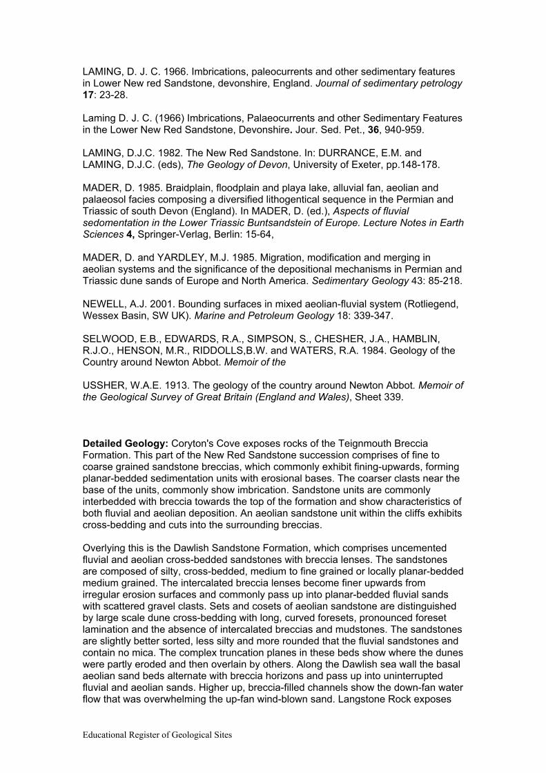
SITE PLAN 1:
LANGSTONE ROCK
DAWLISH CLIFFS DAWLISH, TEIGNBRIDGE
National Grid Ref: SX 979 780
© Crown copyright. All rights reserved. Devon County Council Licence No. 100019783 2008
Main Points of Interest:
• Fluvial sandstone with thin breccia horizons towards base. • Wide shore platform exposes fluvial sandstones and breccias. • Good exposure of thick breccia unit within fluvial sandstones on
southern side of Langstone Rock. • Several features of geomorphological interest including stacks,
arch and blow hole.
Scale 1: 5,000 Key Focal Point

Educational Register of Geological Sites
SITE PLAN 2:
COAST RUNNING ALONG LADIES MILE PATH
DAWLISH CLIFFS DAWLISH, TEIGNBRIDGE
National Grid Ref: SX 969 773 - 978 779
© Crown copyright. All rights reserved. Devon County Council Licence No. 100019783 2008
Scale 1: 10,000 Key Focal Point
A
B
A. Breccia units and horizons increase in
thickness and frequency up the succession (N.E)
B. Excellent exposures of dune-bedded sands along this section, exhibiting low angle foresests
Educational Register of Geological Sites
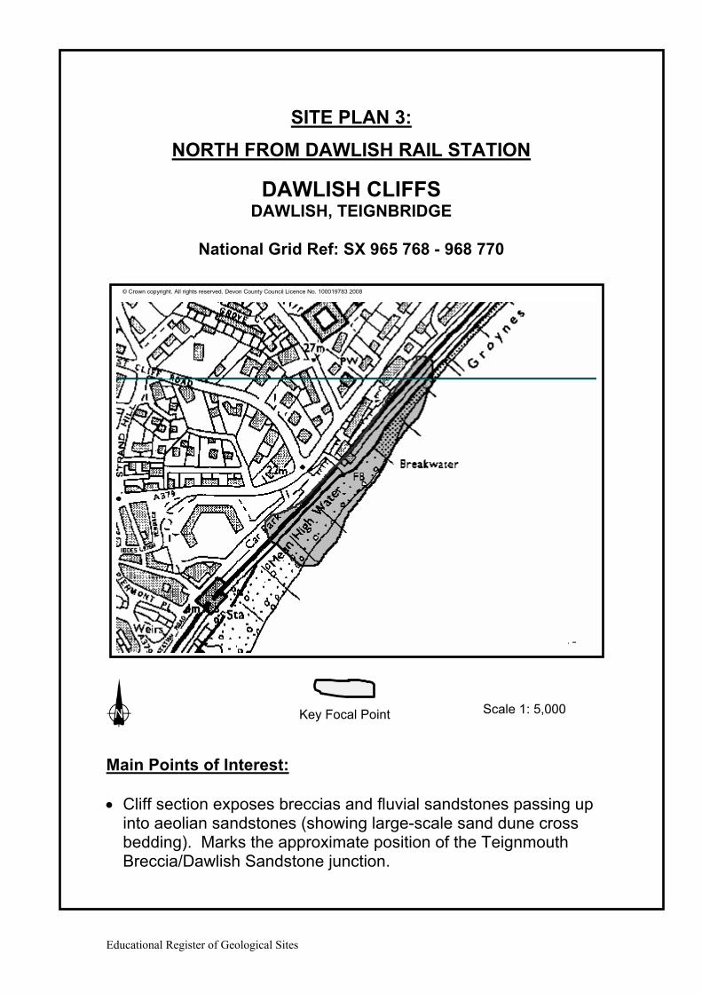
SITE PLAN 3:
NORTH FROM DAWLISH RAIL STATION
DAWLISH CLIFFS DAWLISH, TEIGNBRIDGE
National Grid Ref: SX 965 768 - 968 770
© Crown copyright. All rights reserved. Devon County Council Licence No. 100019783 2008
Main Points of Interest: • Cliff section exposes breccias and fluvial sandstones passing up
into aeolian sandstones (showing large-scale sand dune cross bedding). Marks the approximate position of the Teignmouth Breccia/Dawlish Sandstone junction.
Scale 1: 5,000 Key Focal Point

Educational Register of Geological Sites
SITE PLAN 4:
CORYTON'S COVE
DAWLISH CLIFFS DAWLISH, TEIGNBRIDGE
National Grid Ref: SX 961 759 - 962 762
© Crown copyright. All rights reserved. Devon County Council Licence No. 100019783 2008
Main Points of Interest: • Exposure of fluvial and thick aeolian sandstone of the
Teignmouth Breccia, showing large scale sand dune cross bedding.
• Cliff face, behind path, exposes breccias and fluvial sandstones. • Good cliff exposures open to some marine erosion. • Vegetated cliff section, inaccessible from shore.
Scale 1 : 5,000 Key Focal Point

Educational Register of Geological Sites
DAWLISH CLIFFS
Kev
in P
age
Kev
in P
age
General view of the former sea-cliffs in Dawlish Sandstone Formation (Permian), between Dawlish and Dawlish Warren
Cross-bedded aeolian sandstones of the Dawlish Sandstone Formation (Permian), NE of Dawlish Station.

Educational Register of Geological Sites
Kev
in P
age
Kev
in P
age
Planar bedded breccia units in the Dawlish Sandstone Formation (Permian), between Dawlish and Dawlish Warren
Planar bedded sandstone units in the upper part of the Dawlish Sandstone Formation (Permian), near Dawlish Warren. Note cross-bedded presumed fluvial unit.

Educational Register of Geological Sites
Kev
in P
age
Exe Breccia Formation, Langerstone Rock, near Dawlish Warren.