effect of water harvesting techniques on hydrological
TRANSCRIPT

Effect of Water Harvesting Techniques on Hydrological Processes and Sediment Yield in
Northern Ethiopia
Berhane Grum Woldegiorgis

Thesis committee Promotors Prof. Dr V. Geissen Personal chair, Soil Physics and Land Management Group Wageningen University & Research Prof. Dr C.J. Ritsema Professor of Soil Physics and Land Management Group Wageningen University & Research Co-promotors Dr R. Hessel Senior Scientist Wageningen University & Research Dr. C.A. Kessler Assistant professor, Soil Physics and Land Management Group Wageningen University & Research Other members Prof. Dr J. Wallinga, Wageningen University & Research Dr L.H.E. Cammeraat, University of Amsterdam, Netherlands Dr Z. Adimassu, International Water Management Institute, Addis Ababa, Ethiopia Dr O. Gonzalez Pelayo, University of Aveiro, Portugal This research was conducted under the auspices of the Research School for Socio-Economic and Natural Sciences of the Environment (SENSE)

Effect of Water Harvesting Techniques on Hydrological Processes and Sediment Yield in
Northern Ethiopia
Berhane Grum Woldegiorgis
Thesis submitted in fulfilment of the requirements for the degree of doctor at Wageningen University by the authority of the Rector Magnificus Prof. Dr A.P.J. Mol in the presence of the Thesis Committee appointed by the Academic Board to be defended in public on Tuesday 9 May 2017 at 4 p.m. in the Aula.

Berhane Grum Woldegiorgis Effect of Water Harvesting Techniques on Hydrological Processes and Sediment Yield in Northern Ethiopia, 156 pages. PhD thesis, Wageningen University, Wageningen, NL (2017) With references, with summary in English ISBN: 978-94-6343-168-2 DOI: 10.18174/412142

Table of contents
Chapter 1. General introduction .............................................................................. 7
Chapter 2. A decision support approach for the selection and implementation of water harvesting techniques in arid and semi-arid regions ..........................................................................................21
Chapter 3. Improving on-site water availability by combining in-situ water harvesting techniques in semi-arid northern Ethiopia ........................47
Chapter 4. Effect of in-situ water harvesting techniques on soil and nutrient losses in semi-arid northern Ethiopia ..................................................71
Chapter 5. Assessing the effect of water harvesting techniques on event-based hydrological responses and sediment yield at a catchment scale in northern Ethiopia using LISEM ...............................................89
Chapter 6. Synthesis ............................................................................................117
Literature cited ......................................................................................................131
English summary ....................................................................................................147
Acknowledgements ...............................................................................................151
Curriculum Vitae ....................................................................................................153


General introduction 7
1. General introduction

8 Chapter 1
1.1 Water shortage and the need for water harvesting techniques
Recent studies show that the global water resource availability will be stressed due to
climate change, population growth and other socio-economic variables (Alcamo et al.,
2007; Gerten et al., 2011; Vörösmarty et al., 2000). Many modelling-based findings predict
that the future water stress conditions will be worse than today. The increase in water
stress is mainly caused by an increase in domestic water use driven by the growth of per
capita income (Alcamo et al., 2007). Therefore, without proper and planned use of the
available water, more severe water shortages, unsustainable use of water, and conflicting
interests regarding water use can be expected. This makes improving water use efficiency
in all sectors of water applications inevitable. In arid and semi-arid regions, the main
challenges in rainfed agriculture are dry spells, short periods of water stress and temporal
rainfall variability causing crop failures, which are main constraints to crop production in
these regions of the world (Enfors and Gordon, 2008; Fox and Rockström, 2003).
A good strategy to deal with water stress is to maximize water productivity by improving
the efficiency of different rainwater applications of rainfed agricultural systems in arid and
semi-arid regions (Biazin et al., 2012; Oweis and Hachum, 2006). Large scale irrigation
systems have been the focal point as agronomic solutions to tackle crop water deficit, but
nowadays many activities are focused on interventions such as water harvesting
techniques (WHTs) and supplemental irrigation (UNDP, 2006). Supplemental irrigation is
the application of limited amount of water when rainfall is insufficient for crop growth
(Oweis et al., 1999). Supplemental irrigation is applied when there is water deficit and
helps to stop crop failures during the absence or shortage of rainfall, while WHTs help to
effectively use harvested water during the entire plant growth period as well as to bridge
moisture-stress during dry spells. From the different water management practices, WHTs
are also highly promoted by governments, non-governmental agencies and agricultural
extensions in many parts of the world particularly in African countries and India (Batchelor
et al., 2002; Stroosnijder, 2003; Vohland and Barry, 2009).
WHTs are very diverse and have been used for many years in different parts of the world.
WHTs, however, share common characteristics as they depend on local runoff sources and
are generally applied in arid and semi-arid climates (Boers and Ben-Asher, 1982; Prinz,
1996). Water harvesting is defined as the collection of water for its productive use
(Critchley and Siegert, 1991). WHTs are primarily used for crop production; however they
are also used for domestic and animal consumption with the provision of necessary
storage facilities. WHTs may be pivotal in dry areas but are also necessary for
using/optimising the available water for additional uses, even in areas with sufficient
water resources. Generally, WHTs (Figure 1.1) are classified into in-situ, micro-catchment

General introduction 9
and macro-catchment techniques, mainly based on the relative ratio of catchment to
cropping area (Liniger et al., 2011; Ngigi, 2003; Oweis et al., 2001). Micro- and macro-
catchment systems are ex-situ WHTs that require water storage structures for runoff
generated from larger catchments while in-situ techniques store water where it falls.
Other classifications of WHTs are based on type of use or storage facility (Oweis et al.,
2001).
In-situ WHTs enhance the collection of rainwater on the surface where it falls and store it
in the soil (Helmreich and Horn, 2009). The availability of water in the soil is improved
through different agronomic measures such as modifying the soil structure, vegetation
cover and density by enhancing infiltration while surface runoff and evaporation losses
from the soil surface are reduced (Vohland and Barry, 2009). This technology does not
need a runoff generation area, instead it is a technique mainly used to efficiently utilize
rainwater where it falls. It is one of the simplest and cheapest technologies that can be
implemented in a wide variety of land use systems (Ngigi, 2003). The most widely used in-
situ WHTs are tied ridges, mulching, conservation tillage and various furrow systems
(Biazin et al., 2012).
Micro-catchment WHTs collect surface runoff from the vicinity of an agricultural/cropping
area mainly from sheet flow either to be applied within the field or externally in small
reservoirs for later use. The catchment area is relatively small (less than 1000 m2) and so is
the catchment to cropping area ratio (C:CA), with values in the range of 1:1 to 10:1 (Liniger
et al., 2011). The catchments that provide runoff are normally farmlands, but nowadays
rooftops of buildings, courtyards and rock catchments are also used. On-farm micro-
catchment systems have been extensively used in different part of the world especially in
arid and semi-arid regions. The main advantage of these systems is that the farmer has a
control over the catchment and the cropping/storage area. The disadvantage of micro-
catchment systems could be that part of the crop land need to be sacrificed to collect
water. This depends on whether or not suitable areas for collecting water are available
outside and nearby to the crop land. The fact that micro-catchment WHTs are constructed
with low cost and the adoption of a simple design makes them easily adaptable and
replicable to different environments (Oweis et al., 2001; Reij et al., 1988).
Macro-catchment and flood WHTs are characterized by a large runoff catchment area.
Examples are flood storm collected from gullies, ephemeral streams or roads directed to a
storage area or arable land. The runoff is stored in surface/subsurface reservoirs or it may
be stored in the soil profile where it can be used for crop growth or pasture. These
systems are characterized by a large catchment area with a C:CA of 10:1 to 1000:1 (Liniger
et al., 2011). The advantage of such systems is that large volumes of water can be stored

10 Chapter 1
and used. The limitation of these WHTs is a poor runoff collection efficiency compared to
micro-catchments and the farmer has little control over the runoff collection area (Oweis
et al., 2001). Macro-catchment and flood water diversion techniques include small farm
reservoirs, check dams, water diversion channels, percolation ponds, cisterns, hillside
conduits, etc.
Figure 1.1: Classification of water harvesting techniques, adapted from Oweis et al. (2001).
Practical field practices show that WHTs have been beneficial in maintaining agro-
ecological ecosystems. WHTs minimize runoff, enhance soil infiltration (e.g. Al-Seekh and
Mohammad, 2009; Wakindiki and Ben-Hur, 2002), improve soil-moisture availability (e.g.
Ibraimo and Munguambe, 2007; Zougmoré et al., 2003), and reduce temporal variability of
water available for plant growth (e.g. Rockström et al., 2002). Hence, there is ample
evidence that WHTs can improve on-site water availability. However, one should also
consider that increased on-site use of water may have off-site effects downstream.
1.2 Agricultural practice and water harvesting techniques in
northern Ethiopia
The majority of the world population, primarily in sub-Saharan Africa, rely to large extent
on smallholder subsistence rainfed agriculture for food production and livelihood security
(Cooper et al., 2008; World Bank, 2007). Rural communities are faced with the challenge

General introduction 11
of improving the productivity of arable land and water resources in order to feed their
ever growing population (Rockström et al., 2000). Agricultural systems in (semi-) arid areas
are also vulnerable to environmental adversities such as climate change, extended
droughts and the occurrence of dry spells.
Agriculture is the economic back-bone of Ethiopia and still constitutes the major livelihood
base for the rural community. Agricultural practice in Ethiopia, which dates back to the
Axumite period, mainly involves the tillage of the land using oxen-driven maresha, and the
cropping systems are adapted to existing soil catena (Nyssen et al., 2008). Grains, mainly
teff, wheat, barley, maize, sorghum, and millet are the most commonly grown field crops
and are the principal sources of food for most Ethiopians.
Rainfed agriculture has been widely practiced in northern Ethiopia and 85% of the
livelihood of the population is dependent on subsistence agriculture mainly on crop
production (Araya et al., 2011). Crop production in the semi-arid northern Ethiopia, is low
because of erratic and insufficient rainfall for crop growth (Meze-Hausken, 2004) and high
losses of water by runoff and evaporation (Yosef and Asmamaw, 2015).
The occurrence of dry spells, especially in drought-prone areas such as the northern
Ethiopian highlands, hampers crop growth and is usually the primary cause for crop
failures and low yields (Rockström et al., 2002, McHugh et al., 2007). The negative effects
of these environmental adversities can only be minimized by improving the efficiency of
water use in agricultural systems (Biazin et al., 2012; Oweis and Hachum, 2006). As rain is
the primary source of water for subsistence agriculture in northern Ethiopia, water
management options should be focused on the efficient use of rainwater (Araya and
Stroosnijder, 2010). Therefore, it becomes imperative to rely on rainwater strategies that
bridge water deficiency and improve water productivity through the use of innovative and
cost effective water management techniques in order to minimize the effects of water
stresses on crop growth.
With the current problem of water shortage in (semi-) arid areas, the direction towards
the use of WHTs to improve water use efficiency has been rejuvenated and hence the
adoption rate has increased. As the suitability of WHT in a particular site depends on local
bio-physical and socio-economic conditions, as well as on policies, the selection of most
appropriate techniques is often difficult.
There have been on-going efforts by the government and others to rehabilitate the land
and improve agricultural productivity in northern Ethiopia by implementing WHTs such
stone bunds, exclosures, farm ponds, etc. (Nyssen et al., 2015; Vancampenhout et al.,

12 Chapter 1
2006; Walraevens et al., 2015). Despite the government led endeavours to implement
WHTs in the region, the adoption rate for some of these techniques was not satisfactory.
For example, farm pond, which was implemented at household level in northern Ethiopia,
was not successful because it was implemented with a top-down approach, in which farm
ponds were constructed at household level without considering local bio-physical
conditions. Many of the constructed farm ponds failed to store water for irrigation
because of excessive infiltration, and the loss of water by evaporation. It is, however,
recommended that farm ponds need to be constructed in soils with moderate infiltration
rate and terrain slopes between 0 and 10% (Singh et al., 2009). Given the rugged and
often steep landscape of northern Ethiopia, hydrology is to a large extent determined by
landscape morphology. As a result, position in the landscape is an important factor to
consider in the selection of WHTs. Distinctions can be made between, for example, slopes
and valley-floors as well as upstream and downstream parts of watersheds. Therefore, it
is, in this region, especially important to look at on-site as well as off-site effects of WHTs.
The implementation of different techniques for efficient crop production requires
knowledge of site-specific conditions, optimal design, and an appropriate selection
procedure involving local farmers and other stakeholders (Mengistie, 1997). The work
related to WHTs in northern Ethiopia carried out until now lacks a decision support system
to select the most suitable WHT given local conditions.
1.3 On-site effects of in-situ water harvesting techniques
In-situ WHTs have a great potential to improve the availability of water for agricultural use
by enhancing infiltration of rainwater into the soil layer, where it is stored, but
simultaneously reducing water losses through runoff and evaporation (Vohland and Barry,
2009). Although in-situ WHTs are primarily implemented to improve the efficiency of
water use in (semi-) arid areas, they can also contribute to minimizing soil loss from
farmlands.
Several researchers report the benefit of in-situ WHTs such as tied ridges, mulching,
conservation tillage, and furrow systems in improving on-site water availability for plant
growth. There is evidence that in-situ WHTs such as tied ridges and furrow systems are
efficient in reducing runoff from agricultural fields (e.g. Araya et al., 2011; Araya and
Stroosnijder, 2010; Gebreegziabher et al., 2009; McHugh et al., 2007). McHugh et al.
(2007) reported a decrease of runoff by 75% using tied ridges compared to conventional
tillage. Tied ridges can also improve soil-moisture content (SMC) in the soil layer due to
increased infiltration of ponded water from ridge depressions (e.g. Araya and
Stroosnijder, 2010; Motsi et al., 2004). Field investigations showed that conservation

General introduction 13
agriculture with crop residue with at least 30% left on the soil surface (Kongo and Jewitt,
2006; Rockström, 2000), tillage operation with sub-soiler and tie-ridger (Temesgen et al.,
2009) and combination of no tillage, furrows and retention of crop residue (Araya et al.,
2011) can substantially reduce runoff losses from farmlands.
In-situ WHTs such as mulching also decrease soil loss by absorbing the energy of raindrop
in detaching soil particles from the soil surface (Cerdà et al., 2016; Donjadee and
Tingsanchali, 2016). Mulching also slows down surface flow velocity thereby delaying or
disrupting the connectivity of runoff flow pathways (Cerdà et al., 2016). The effect of
mulching on decreasing soil loss from farmlands is well documented (e.g. Adekalu et al.,
2007; Gholami et al., 2013; Mwango et al., 2015; Prosdocimi et al., 2016b; Sadeghi et al.,
2015a). Other techniques such as tied ridges and furrowing systems decrease the loss of
runoff from agricultural fields, enabling the retention of detached soil particles in the
depressions. There is ample evidence that shows the benefit of tied ridges and furrow
systems in reducing soil loss from farmlands (e.g. Araya et al., 2011; Gebreegziabher et al.,
2009; Jie et al., 2013; McHugh et al., 2007). Some researchers also report the decrease of
nutrient losses by the use of in-situ WHTs as a result of reduced soil loss from agricultural
fields (Adimassu et al., 2014; Baptista et al., 2015a; Okeyo et al., 2014; Zougmoré et al.,
2009), emphasizing that any measure taken to control soil loss would also minimize
nutrient depletion (Jie et al., 2013).
Despite the proven benefits of in-situ WHTs in increasing SMCs and decreasing runoff, soil
and nutrient losses, the efficiency can be improved by combining some of these
techniques. Some researchers have already indicated an increase in SMC due to combined
use of plastic film with ridges and gravel/sand mulch with planting furrows (Li et al., 2001;
Li et al., 2000; Wang et al., 2009) and crop residues with ridges/furrows (Ramesh and
Devasenapathy, 2006). The integrated use of plastic mulch with ridges increased runoff
efficiency (higher runoff) while the coverage of planting furrows with sand/gravel mulch
decreased the loss of the harvested water by evaporation (Wang et al., 2009). Combining
in-situ WHTs ensures high-level and reliable crop production, benefiting from enhanced
soil-water storage and water-use efficiency (Li et al., 2000). The combined use of mulch
with organic amendments resulted in the reduction of runoff loss by 84-99% in the Cabo
Verde drylands (Baptista et al., 2015b).
Some tested combinations of in-situ WHTs for controlling soil and nutrient losses are crop-
residue mulching with organic amendments (Baptista et al., 2015a), runoff barriers with
nutrient management (Zougmoré et al., 2009) and tillage with mulching (Jin et al., 2008).
Other researchers also suggest the integration of in-situ WHTs with soil-fertility
improvement measures (e.g. nutrient applications, organic amendments, effective micro-

14 Chapter 1
organisms (EMs), etc.) to improve crop yield as well as increasing the efficiency of water
harvesting (Miriti et al., 2007; Nyamadzawo et al., 2013). The application of EMs on
agricultural soils can, for example, improve soil structure thereafter increasing infiltration
rate and water-holding capacity hence increasing SMC in the soil (Ismail, 2013; Lee et al.,
2008). There is some evidence (e.g. Araya et al., 2011; Araya and Stroosnijder, 2010;
Gebreegziabher et al., 2009; McHugh et al., 2007) on the effect of individual WHTs such as
mulch, tied ridges, furrow systems, conservation tillage, etc. on runoff and soil loss in
northern Ethiopia. Despite some tested combination of WHTs, there is still a lack of
information about the effect of combining tied ridges, mulch and EMs on soil properties,
on-site water availability, soil and nutrient losses in northern Ethiopia. Therefore, there is
a need to explore the benefit of combining in-situ WHTs (tied ridges, mulch and EMs) in
terms of improving soil properties, soil-moisture, runoff reduction, soil and nutrient
reduction in semi-arid northern Ethiopia.
1.4 Effect of WHTs on catchment-scale hydrological and erosion
processes
Hydrological processes at catchment scale are controlled by many physical and climatic
factors. Any significant change in land management within a catchment is expected to
trigger hydrological responses. Land use change, for example, is understood to influence
the amount of evapotranspiration, water infiltration, runoff in catchments and the
magnitude of discharge in rivers (Rust et al., 2014). Hydrological processes such as runoff,
infiltration, groundwater recharge, etc. are also likely to change following the treatment of
catchments with different WHTs.
WHTs installed in a catchment are expected to affect hydrological and erosion processes
at field or catchment level. These techniques could also affect hydrological processes
beyond the field or micro-catchment scale. A study by Dagnew et al. (2015) in Debre Mawi
catchment (95 ha) in Ethiopia, for example, showed a significant reduction in runoff
volume and sediment yield at the catchment outlet after the construction of earth bunds
with trenches. Catchment management with different WHTs such as stone bunds and
check dams in a small catchment (187 ha) in northern Ethiopia has resulted in reduction of
runoff and sediment yield at the catchment outlet (Nyssen et al., 2009a). Several other
studies also confirm that WHTs in large catchments affect catchment hydrology and
sediment transport processes (e.g. Betrie et al., 2011; Gates et al., 2011; Glendenning and
Vervoort, 2011; Ouessar et al., 2009; Wang et al., 2013). These studies were, however,
carried out at relatively coarse temporal scales (e.g. daily or annual) and could miss to
capture small-scale runoff and erosion processes in events with varying rain intensity and

General introduction 15
duration (Kandel et al., 2004). There are still research gaps on the effect of WHTs on
event-based runoff and sediment yield at catchment scale (Hessel and Tenge, 2008).
Runoff and erosion processes at catchment scale are complex to understand because of
their non-linearity and scale dependency (Lesschen et al., 2009). Runoff and sediment
yield are also characterized by high temporal and spatial variability within a catchment
(Mohamadi and Kavian, 2015; Rai and Mathur, 2008). Erosion processes in semi-arid
regions are, moreover, highly influenced by high-magnitude but less frequent rain events,
and the low soil surface protection due to sparse vegetation cover (Medeiros et al., 2010).
Therefore, extreme runoff events need to be carefully assessed because these events can
control sediment yield in the long term (White, 2005). The design of strategies to combat
the negative effects of runoff and soil loss from hillslopes often requires understanding
the characteristics of individual rain events in order to quantify the magnitude and timing
of peak water and sediment discharges (Ramsankaran et al., 2013).
Several studies were conducted worldwide to understand event-based runoff and
sediment yield at catchment level (e.g. Baartman et al., 2012; Gao and Jesefson, 2012;
Hessel et al., 2006; Medeiros et al., 2010; Rai and Mathur, 2008; Ramsankaran et al.,
2013). Some modelling studies were also carried out in Ethiopia to understand process-
based runoff and sediment transport at catchment level (e.g. Betrie et al., 2011;
Gebreyohannes et al., 2013; Haregeweyn et al., 2013). These studies were, however,
conducted at larger temporal scales and event-based hydrological studies are lacking in
Ethiopia. There is still a research gap to understand the effect of extreme rain events on
catchment hydrological responses and sediment yield, especially under the influence of
different WHTs. Event-based runoff and soil erosion models can be used to assess the
effect of WHTs on catchment hydrology and sediment yield.
1.5 Research questions and thesis outline
The main objectives of the study were to develop a decision support approach for
selection of WHTs and investigate the on-site and off-site effects of WHTs in semi-arid
northern Ethiopia.
Based on the discussion in the previous sections, which described what knowledge gaps
exist in relation to the use and adoption of WHT in northern Ethiopia, the following
research questions are formulated:
How can appropriate site-specific WHTs be selected in arid and semi-arid areas?

16 Chapter 1
What is the role of in-situ WHTs such as tied ridges and straw mulch in improving
on-site water availability in semi-arid areas?
Can in-situ WHTs help to mitigate land degradation by reducing soil and nutrient
losses from farmlands?
What is the effect of catchment-scale WHTs on catchment hydrological responses
and sediment yield in northern Ethiopia?
Figure 1. 2. demonstrates how the research was conducted and links the different topics
with the chapters of the thesis. A decision support approach was used to select in-situ and
catchment-scale WHTs, which were implemented and tested in northern Ethiopia. A key
part of the decision support approach was a GIS-based multi-criteria analysis (MCA), which
was used to identify suitable areas for WHTs using database of suitability indicators for
WHTs, which was developed by reviewing worldwide practices of WHTs (Chapter 2). The
performance of in-situ WHTs was evaluated at field level using runoff-plots established on
farmland to monitor the effect of in-situ WHTs on soil properties, runoff and SMC
(Chapter 3). The field experiment was also used to monitor the effect of the in-situ WHTs
on soil and nutrient losses from farmland (Chapter 4). The effect of WHTs at catchment
scale was also assessed using an event-based Limburg Soil Erosion Model (LISEM), based
on measured runoff and sediment yield in the catchment (Chapter 5).
Figure 1.2 Thesis outline relating the different topics and the chapters. MCA: multi-criteria analysis, WHTs:
Water harvesting techniques, EMs: effective micro-organisms.

General introduction 17
The objectives and research questions of the study are addressed in the following four
chapters (Chapter 2 to 5). Chapter 2 deals with the methodology to select appropriate
WHTs that suit specific site conditions with different bio-physical and socio-economic
conditions. The chapter also deals with bio-physical suitability analysis of WHTs based on a
developed database of suitability indicators of WHTs and using GIS-based MCA.
Chapter 3 addresses the benefit of combined use of in-situ WHTs (e.g. tied ridges,
mulches, EMs) on on-site water availability. The chapter studies the effects of individual
and combined use of WHTs on runoff and SMC. To study these effects, runoff and soil
moisture were continuously measured for two successive years (2013 and 2014) in a plot-
scale experiment which was installed in the Gule catchment, in northern Ethiopia.
Chapter 4 is related to the previous chapter and addresses the role of in-situ WHTs in
reducing soil and nutrient losses from farmland. The study was carried out using the same
experimental setup as explained in chapter 3. For this chapter, soil and nutrient losses
were monitored for two years in 2013 and 2014 in the field experiment during runoff
events.
Chapter 5 deals with the effect of catchment-scale WHTs on catchment hydrological
response and sediment yield. The effect of catchment-scale WHTs on hydrological
responses and sediment yield is studied using the event-based runoff and soil erosion
model LISEM. The model was applied to the Gule catchment in northern Ethiopia. The
model was calibrated using measured discharges and sediment yield at two outlets in the
catchment. The model was then used to simulate the effect of existing WHTs on
hydrological responses and sediment yield of the Gule catchment.
1.6 Study area
The on-site and off-site effects of different WHTs were particularly investigated in the
upper Geba catchment, which is part of the northern Ethiopian highlands, located
between 13°32′43″-14°15′13.6″N and 39°18′13.5″-39°47′4″E (Figure 1.3). The upper Geba
catchment has a total catchment area of 2380 km2. It is characterized by mountainous and
undulating topography and altitudes of 1760-3300 m a.s.l. The upper Geba catchment has
a semi-arid climate with dry (October to May) and wet (June to September) seasons.
Annual rainfall in the upper Geba catchment ranges between 520 and 680 mm and shows
high spatial and inter-annual variations. The upper Geba catchment was selected for the
study because of existing water shortage problems due to seasonal variability of rainfall.

18 Chapter 1
Figure 1.3 Location map of the study area (a). Altitude of Ethiopia (b). Drainage of the upper Geba
catchment (c). Land uses of the Gule catchment and location of the field experiment site.
Figure 1.4 Topography (a) and soil texture (b) of the Gule catchment, northern Ethiopia.

General introduction 19
Detail study on on-site and off-site effects of WHTs was concentrated in Gule catchment
(Figure 1.3c). The Gule catchment has a total area of around 12 km2 and has a rugged
topography with mountains and flat valley floors whose altitudes (Figure 1.4) range
between 2008 and 2408 m a. s. l. The land uses (Figure 1.3c) and soil types of the Gule
catchment are typical for the northern Ethiopian highlands. The catchment is
characterized by fine to coarse textured soils (Figure 1.4).

20 Chapter 1

A decision support approach for the selection and implementation of water harvesting techniques in arid and semi-arid regions 21
2. A decision support approach for the selection and implementation of water harvesting techniques in arid and semi-arid regions
Water harvesting techniques improve the availability of water, which is essential for growing crops, especially in arid and semi-arid areas. A decision support approach can help in the selection of water harvesting techniques suitable under site-specific bio-physical and socio-economic conditions. This paper describes a participatory approach for the selection of suitable water harvesting techniques in watersheds in (semi-) arid regions. It builds on a database of suitability indicators for water harvesting techniques, which was developed by integrating worldwide knowledge on their suitability. Once developed, the approach was applied on a case study for water harvesting techniques in the upper Geba watershed in northern Ethiopia. First, based on evaluation criteria and participants’ scientific and local knowledge, a pre-selection of most promising water harvesting techniques took place in a multi-stakeholder workshop. Next, the suitability indicators and a GIS-based multi-criteria analysis were used to identify suitable areas for these water harvesting techniques. The results of the multi-criteria analysis were presented to stakeholders during a second stakeholder workshop. At this workshop, a final selection of water harvesting techniques to test was made based on a participatory ranking of water harvesting techniques using economic, ecological and socio-cultural criteria. The multi-criteria analysis approach was validated by comparing the predicted suitable areas with the already existing water harvesting techniques in the watershed. This led to the result that 90% of the existing check dams and 93% of the percolation ponds were correctly identified by the approach. We conclude therefore that this approach can be successfully applied for the participatory selection of water harvesting techniques and the identification of suitable areas for their implementation. Given that this approach is based on the newly developed database of water harvesting techniques, it can be easily applied in other (semi-) arid regions.
Based on:
Grum, B., Hessel, R., Kessler, A., Woldearegay, K., Yazew, E., Ritsema, C.J., Geissen, V.,
2016. A decision support approach for the selection and implementation of water
harvesting techniques in arid and semi-arid regions. Agricultural Water Management
173, 35-47.

22 Chapter 2
2.1. Introduction
Population growth and changes in lifestyle put high pressure on existing water resources.
The main challenges associated with water use in dryland agriculture around the world are
droughts, short periods of water stress, and temporally variable rainfall that can cause
crop failures (Enfors and Gordon, 2008; Rockström et al., 2003). Rainfed agriculture,
despite its challenges, remains the dominant source of staple food production and
livelihood for many agriculturally based countries, especially in sub-Saharan Africa (Cooper
et al., 2008; World Bank, 2007). A proper and planned use of the available water and the
improvement of water-use efficiency in all sectors of water applications are thus
indispensable. Water harvesting techniques (WHTs) can improve the availability of water
and are already highly promoted by governments and non-governmental and agricultural
extension agencies in many parts of the world, particularly in African countries and India
(Batchelor et al., 2002; Stroosnijder, 2003; Vohland and Barry, 2009).
WHTs are very diverse and have been used for many years in different parts of the world.
WHTs in arid and semi-arid areas are mainly associated with agricultural uses but are also
suitable for domestic purposes. Water harvesting in a broader context is defined as the
collection of runoff for its productive use (Critchley and Siegert, 1991). WHTs may be
pivotal in dry areas but are also necessary for using/optimising the available water for
additional uses, even in areas with sufficient water resources.
Various WHTs are used in different parts of the world (Liniger et al., 2011; Mekdaschi
Studer and Liniger, 2013; Oweis et al., 2001; WOCAT, 2007), and their methods of
application differ with the local conditions (Boers and Ben-Asher, 1982; Vohland and
Barry, 2009). Various organisations have tried to share experiences and to transfer
knowledge of the WHTs implemented in different parts of the world (Liniger et al., 2011;
Oweis et al., 2001; WOCAT, 2007). These efforts, however, have been fragmented, and
comprehensive information is still lacking on the practices of different WHTs and their
suitability for various applications under different bio-physical and socio-economic
conditions. A review of WHTs (indigenous and non-indigenous) and indicators of bio-
physical suitability (applicability limits) is necessary to help stakeholders select and
evaluate the WHTs that could potentially be suitable for the physical conditions of a site.
Some approaches and tools have been developed for appraising and selecting WHTs
(Mbilinyi et al., 2005; Schwilch et al., 2009) and for assessing the potential of WHTs at
larger scales (Ouessar et al., 2013). A decision support tool was also developed to evaluate
the success of out-scaling of some agricultural water management technologies at basin
level (SEI, 2013). The establishment of a system of decision support that could simplify the

A decision support approach for the selection and implementation of water harvesting techniques in arid and semi-arid regions 23
selection of WHTs to be implemented at a specific site, however, is urgently needed, given
the variability of bio-physical and socio-economic conditions. The implementation of
different techniques for efficient crop production requires knowledge of the site-specific
conditions, optimal design, and an appropriate selection procedure involving local farmers
and other stakeholders (Mengistie, 1997). The selection and implementation of WHTs
should be designed to find appropriate WHTs that suit site-specific bio-physical and socio-
economic conditions and that can be achieved using proper scientific expertise integrated
with existing local knowledge. This integration of scientific and local knowledge is
necessary, because it enables the development of sustainable solutions to local problems
(Mbilinyi et al., 2005; Ngigi, 2003; Schwilch et al., 2009), and creates a common
understanding and shared experience amongst stakeholders towards sustainable
development (Schwilch et al., 2009).
The bio-physical suitability assessment of WHTs in large watersheds can be achieved by
using multi-criteria analyses (MCAs) embedded in geographic information systems (GISs).
GIS-based MCAs have been applied in various parts of the world to identify potential sites
for WHT application (Elewa et al., 2012; Pandey et al., 2011; Saptarshi and Raghavendra,
2009; Singh et al., 2009). Maps produced from suitability analyses deliver good spatial
visualisation, provide an understanding of potentially suitable areas, and can be presented
and explained to the participants of a WHT selection workshop.
The objective of the study is to develop and validate an approach for selecting WHTs that
are suitable to be applied in specific bio-physical and socio-economic conditions. The
approach combines site-specific indicators of bio-physical suitability in a GIS-based MCA
for identifying potential WHTs and the participation of multi-stakeholders in the selection
and implementation of the WHTs. The approach was validated in a case study in the
northern Ethiopian highlands.
2.2. The developed decision support approach
The purpose of most WHTs is to improve production in agricultural systems, and the
choice of the techniques should be targeted to meet that objective. Many WHTs are
available globally, so the selection of most appropriate techniques is often difficult. A
simplified system of decision support can facilitate WHT selection and would create a
better understanding amongst the stakeholders involved in the selection of most
appropriate techniques.

24 Chapter 2
The approach (Figure 2.1) developed and validated in this study is based on the approach
used by the EU-funded DESIRE project for the selection of conservation measures
(Schwilch et al., 2009). A GIS-based MCA, a key part of the approach, is used to identify
suitable locations for specific WHTs based on the developed database of WHTs and their
suitability indicators.
Figure 2.1 Overview of the approach for the selection and implementation of water harvesting techniques
(WHTs).
The first step in our approach is to identify and assess locally applied WHTs in a
stakeholder workshop. Various participants, such as researchers, farmers, non-
governmental organisations (NGOs), extension workers, and development agents, meet in
a common discussion forum such as a stakeholder workshop to assess potential WHTs
that they would like to consider for selection.
The second step is to make a literature review of global WHTs from the developed
database for WHTs and their suitability indicators (Table 2.1). Suitability indicators for
WHTs are specified to evaluate the suitability of the target WHTs to a specific area.

A decision support approach for the selection and implementation of water harvesting techniques in arid and semi-arid regions 25
Combining steps 1 and 2 provides a long-list of potentially suitable WHTs. As part of the
approach a detailed database of WHTs and their suitability indicators was prepared to
provide input information about bio-physical suitability of WHTs. To create the database,
a literature review was made for global WHTs used in arid and semi-arid regions. The list
of reviewed WHTs from global best practices and their suitability indicators is presented in
Table 2.1.
The WHTs were classified into in-situ, micro-catchment, and macro-catchment systems
based on a classification used in the literature (e.g. Ibraimo and Munguambe, 2007;
Liniger et al., 2011; Ngigi, 2003; Oweis et al., 2001). Most of the suitability indicators for
WHTs were retrieved from available guidelines (Critchley and Siegert, 1991; Liniger et al.,
2011; Oweis et al., 2001; Prinz, 1996). The guidelines in these reports were not identical
and some WHTs were not available in these sources. Hence, a comprehensive set of
suitability indicators was defined for an extended list of WHTs applied in arid and semi-
arid regions. We included land use and common WHT limitations as indicators to
characterize WHTs. We searched for more specific information about the values of
suitability indicators from other sources for WHTs which were not available in these
literatures (Critchley and Siegert, 1991; Liniger et al., 2011; Mekdaschi Studer and Liniger,
2013; Oweis et al., 2001; Prinz, 1996; WOCAT, 2007).
The suitability indicators used in our study were slope, land use, soil properties, annual
rainfall, topography, C:CA (ratio of catchment (C) to cropping area (CA)), and WHT
limitations. These indicators were assigned to specific WHTs separately, so the
practitioners could use them to evaluate the suitability of an area for WHT application.
The suitability indicators for WHTs reported in this study only belong to bio-physical
characteristics which help to locate suitable sites for WHTs. For most cases, the suitability
indicators were indicated in ranges, which allow a considerable range of possible locations
of suitable areas for WHTs. Similar suitability indicators have been reported by Prinz
(1996) but were few in number and considered only slope, annual precipitation, and C:CA.
The guidelines reported by Oweis et al. (2001) were general and considered the range of
the indicators on a wider scale (e.g. low, medium, and steep for slope) instead of an
optimal specific range for each WHT. The WHTs mentioned in the guidelines also belong
to dry (arid) climates so do not consider annual rainfall as a suitability indicator. In other
reports (Liniger et al., 2011; Mekdaschi Studer and Liniger, 2013; WOCAT, 2007), different
ecologic and socio-economic WOCAT (World Overview of Conservation Approaches and
Technologies) guidelines are used to characterize sustainable land management (SLM)
practices, in which information is only available for some WHTs.

26
C
ha
pte
r 2
Tab
le 2
.1 W
ate
r h
arv
esti
ng
tec
hn
iqu
es a
nd
th
eir
suit
ab
ility
ind
ica
tors
.
Wat
er
har
vest
ing
tech
niq
ue
s
Suit
abili
ty in
dic
ato
rs
Re
fere
nce
s
Lan
d u
se c
har
acte
rist
ics
Soil
pro
pe
rtie
s
An
nu
al
rain
fall
(mm
)
Top
ogr
aph
y
C:C
A
rati
o
Lim
itat
ion
s
a. In
-sit
u r
ain
wat
er
har
vest
ing
Mu
lch
ing
C
ult
ivat
ed la
nd
wit
h s
lop
e
0-5
%
Imp
erm
eab
le s
oil
2
00
-800
Lo
w t
op
ogr
aph
ic
relie
f
No
t
app
licab
le
No
t su
itab
le in
are
as w
ith
hig
h r
ain
fall
Ibra
imo
an
d
Mu
ngu
amb
e (2
007
),
Ngi
gi (
200
3)
Co
nse
rvat
ion
till
age
C
ult
ivat
ed la
nd
wit
h s
lop
e
0-5
%
Imp
erm
eab
le s
oils
2
00
-800
Lo
w t
op
ogr
aph
ic
relie
f
No
t
app
licab
le
Pro
ble
m o
f co
mp
acti
on
,
flo
od
ing
or
po
or
dra
inag
e
Ibra
imo
an
d
Mu
ngu
amb
e (2
007
),
Ngi
gi (
200
3)
b. M
icro
-cat
chm
en
t sy
ste
ms
Neg
arim
mic
ro-
catc
hm
ents
Cu
ltiv
ated
lan
d,
bar
e/sh
rub
lan
d w
ith
slo
pe
1-5
%
Thic
k so
ils (
at
leas
t 1
.5 m
etre
dee
p)
10
0-4
00
Even
an
d u
nev
en
mic
ro-c
atch
men
ts
1:1
-25:
1 C
ann
ot
be
mec
han
ized
C
ritc
hle
y an
d S
iege
rt (
19
91
), P
rin
z (2
001
)
Mes
kat
syst
ems
C
ult
ivat
ed la
nd
wit
h s
lop
e
2-1
5%
All
agri
cult
ura
l
soils
20
0-4
00
Even
an
d u
nev
en
mic
ro-c
atch
men
ts
2:1
La
ck o
f u
nif
orm
ity
in w
ater
dis
trib
uti
on
in t
he
cro
pp
ing
area
Ow
eis
et a
l. (2
001
),
Pri
nz
(20
01
)
Co
nto
ur
ben
ch
terr
aces
Bar
e/sh
rub
lan
d,
cult
ivat
ed la
nd
wit
h s
lop
e
20
-60
%
All
agri
cult
ura
l
soils
exc
ept
shal
low
on
es
20
0-6
00
Even
an
d u
nev
en
mic
ro-
catc
hm
ents
1:1
0 H
igh
co
nst
ruct
ion
an
d
mai
nte
nan
ce c
ost
s, c
ann
ot
be
mec
han
ized
Lin
iger
et
al. (
20
01
),
Mat
i (2
005
)
Sem
i-ci
rcu
lar
bu
nd
s/h
alf-
mo
on
s/
tria
ngu
lar
bu
nd
s
Bar
e/sh
rub
lan
d,
cult
ivat
ed la
nd
wit
h s
lop
e
0.5
-5%
All
soils
no
t
shal
low
an
d s
alin
e
20
0-7
50
Even
to
po
grap
hy
3:1
C
ann
ot
be
mec
han
ized
,
req
uir
e re
gula
r m
ain
ten
ance
Mat
i (2
005
), P
rin
z (2
001
)
Pit
tin
g sy
stem
s
(e.g
. Zai
pit
s/
Ch
olo
lo p
its,
Tas
sa,
etc.
)
Bar
e/sh
rub
lan
d,
cult
ivat
ed la
nd
wit
h s
lop
e 0
-
5%
All
agri
cult
ura
l
soils
35
0-6
00
Even
an
d u
nev
en
mic
ro-c
atch
men
ts
1:1
-3:1
D
eman
d h
eavy
lab
ou
r d
uri
ng
pre
par
atio
ns
Ow
eis
et a
l. (2
001
),
Pri
nz
(20
01
)
Co
nto
ur
rid
ges
/fu
rro
ws
Bar
e/sh
rub
lan
d,
graz
ing
lan
d,
cult
ivat
ed la
nd
wit
h s
lop
e 0
-
5%
All
agri
cult
ura
l
soils
no
t h
eavy
and
co
mp
acte
d
35
0-
750
Ev
en t
op
ogr
aph
y 2
:1-3
:1
No
t su
itab
le in
hea
vy a
nd
com
pac
ted
so
ils, o
r h
igh
rain
fall
Cri
tch
ley
and
Sie
gert
(19
91
), D
os
An
jos
(19
98)

A d
ecis
ion
su
pp
ort
ap
pro
ach
fo
r th
e se
lect
ion
an
d im
ple
men
tati
on
of
wa
ter
ha
rves
tin
g t
ech
niq
ues
in a
rid
an
d s
emi-
ari
d r
egio
ns
27
Trap
ezo
idal
bu
nd
s
Bar
e/sh
rub
lan
d,
graz
ing
lan
d,
cult
ivat
ed la
nd
wit
h s
lop
e
0.2
5-1
.5%
So
ils w
ith
go
od
con
stru
ctio
nal
pro
per
ties
25
0-
500
A
rea
wit
hin
bu
nd
s
sho
uld
be
even
10
:1-3
0:1
Lim
ited
to
gen
tle
slo
pes
.
Cri
tch
ley
and
Sie
gert
(19
91
), M
ati (
200
5)
Co
nto
ur
sto
ne
bu
nd
s
wit
h/
wit
ho
ut
tren
ches
Bar
e/sh
rub
lan
d,
graz
ing
lan
d,
cult
ivat
ed la
nd
wit
h s
lop
e
0-%
All
agri
cult
ura
l
soils
20
0-7
50
Even
an
d u
nev
en
top
ogr
aph
y
vari
able
O
nly
po
ssib
le w
her
e
abu
nd
ant
loo
se s
ton
e is
avai
lab
le
Cri
tch
ley
and
Sie
gert
(19
91
)
Co
nto
ur
eart
h b
un
ds
wit
h/
wit
ho
ut
tren
ches
Bar
e/sh
rub
lan
d,
graz
ing
lan
d,
cult
ivat
ed la
nd
wit
h s
lop
e 0
-
5%
Thic
k so
ils (
at
leas
t 1
.5 m
etre
dee
p)
20
0-7
50
Even
wit
ho
ut
rills
va
riab
le
No
t su
itab
le f
or
un
even
or
ero
ded
lan
d
Cri
tch
ley
and
Sie
gert
(19
91
)
Eye
bro
ws
Bar
e/sh
rub
lan
d w
ith
slo
pe
1-5
0%
Shal
low
to
med
ium
so
ils
20
0-6
00
Even
an
d u
nev
en
top
ogr
aph
y
3:1
-20:
1 N
ot
effe
ctiv
e in
ver
y lo
w
rain
fall
area
s, c
ann
ot
be
mec
han
ized
Pri
nz
(20
01
)
Fan
ya J
uu
ter
race
s
Cu
ltiv
ated
lan
d w
ith
slo
pe
5-1
6%
Mo
der
atel
y d
eep
loam
y so
ils
50
0-1
000
Hill
slo
pes
an
d
foo
tste
ps
vari
able
Lo
ss o
f la
nd
fo
r te
rrac
e b
un
d,
hig
h la
bo
ur
inp
ut
Lin
iger
et
al. (
20
11
),
Mat
i (2
005
)
Ru
no
ff s
trip
s
Bar
e/sh
rub
lan
d,
graz
ing
lan
d, c
ult
ivat
ed la
nd
wit
h s
lop
e 0
-5%
Thic
k so
ils (
at
leas
t 1
met
re
dee
p)
20
0-7
50
Even
to
po
grap
hy
<
2:1
D
istr
ibu
tio
n o
f w
ater
acr
oss
the
stri
p m
ay n
ot
be
un
ifo
rm
Ow
eis
et a
l. (2
001
)
Inte
r-ro
w s
yste
ms
(ro
ad c
atch
men
ts)
Bar
e/sh
rub
lan
d,
cult
ivat
ed la
nd
wit
h s
lop
e 0
-
5%
Thic
k so
ils (
at
leas
t 1
met
re
dee
p)
20
0-7
50
Even
to
po
grap
hy
1:1
-5:1
La
ck o
f u
nif
orm
ity
in w
ater
dis
trib
uti
on
acr
oss
th
e
cro
pp
ing
area
Ow
eis
et a
l. (2
001
), P
rin
z
(19
96
)
c. M
acro
-cat
chm
en
t sy
ste
ms
Jess
ou
r sy
stem
s
Bar
e/sh
rub
lan
d, c
ult
ivat
ed
lan
d m
od
erat
e to
ste
ep
slo
pes
All
agri
cult
ura
l
soils
less
th
an
25
0
Even
an
d u
nev
en
top
ogr
aph
y
10
0:1
-
10
,00
0:1
Bre
akd
ow
n c
an o
ccu
r if
no
pro
per
mai
nte
nan
ce is
mad
e
Ow
eis
et a
l. (2
001
),
Pri
nz
(20
01
)
Hill
sid
e co
nd
uit
s
Bar
e/sh
rub
lan
d w
ith
slo
pe
>10
%
All
agri
cult
ura
l
soils
20
0-6
00
Hill
y o
r
mo
un
tain
ou
s ar
eas
10
:1-1
00
:1
Exce
ss w
ater
nee
d t
o b
e
dis
po
sed
Ow
eis
et a
l. (2
001
),
Pri
nz
(20
01
)
Wat
er s
pre
adin
g
bu
nd
s
Bar
e/sh
rub
lan
d,
cult
ivat
ed la
nd
wit
h s
lop
e
<1%
Flo
od
pla
ins
wit
h
dee
p f
erti
le s
oils
.
10
0-3
50
Even
to
po
grap
hy
vari
able
B
un
d b
reak
age
are
po
ssib
le in
the
firs
t se
aso
n
Cri
tch
ley
and
Sie
gert
(19
91
)
Mic
ro-d
ams
B
are/
shru
b la
nd
, gra
zin
g
lan
d, c
ult
ivat
ed la
nd
wit
h
mo
der
ate
to s
teep
slo
pes
Soils
su
itab
le f
or
irri
gati
on
20
0-7
50
No
t n
eces
sari
ly
even
, nar
row
go
rge
vari
able
Ex
pen
sive
str
uct
ure
s,
suit
able
to
po
grap
hy
and
geo
logy
fo
r re
serv
oir
Ali
et a
l. (2
00
9)

28
C
ha
pte
r 2
Cis
tern
s
Bar
e/sh
rub
lan
d, g
razi
ng
lan
d w
ith
slo
pe
3-1
5%
Dee
p s
oils
2
00
-750
N
ot
nec
essa
rily
even
vari
able
H
igh
co
nst
ruct
ion
co
st,
nee
d s
tab
le c
atch
men
t,
silt
atio
n a
nd
wat
er q
ual
ity
pro
ble
ms
Ali
et a
l. (2
00
9),
Ow
eis
et a
l. (2
00
1)
Sub
-su
rfac
e d
ams
Alo
ng
stre
ams
nea
r
cult
ivat
ed la
nd
wit
h s
lop
e
0.2
-15%
San
d b
ed w
ith
shal
low
ro
ck
(2-3
met
re f
rom
bed
)
20
0-7
50
No
t n
eces
sari
ly
even
vari
able
D
iffi
cult
ies
in s
ite
sele
ctio
n a
nd
calc
ula
tin
g w
ater
sto
rage
Ali
et a
l. (2
00
9),
Jam
ali
et a
l. (2
01
3)
Ch
eck
dam
s A
lon
g st
ream
s (1
st t
o 3
rd
stre
am o
rder
), 0
-700
m
fro
m c
ult
ivat
ed la
nd
wit
h
slo
pe
<15
%
Fin
e lo
am w
ith
less
infi
ltra
tio
n
rate
20
0-7
50
Even
an
d u
nev
en
top
ogr
aph
y
vari
able
C
an s
ilt u
p q
uic
kly
and
nee
d
mai
nte
nan
ce,
imp
rop
er d
esig
n c
ause
s b
ank
ero
sio
n
Bal
oo
ni (
20
08
), P
and
ey
et a
l. (2
01
1)
Ho
use
ho
ld/f
arm
po
nd
s
Bar
e/sh
rub
lan
d,
cult
ivat
ed la
nd
wit
h s
lop
e 0
-
10
%
San
dy
clay
loam
wit
h m
od
erat
e
infi
ltra
tio
n r
ate
20
0-7
50
No
t n
eces
sari
ly
even
vari
able
Si
ltat
ion
/dep
osi
tio
n,
wat
er lo
ss d
ue
to in
filt
rati
on
for
po
rou
s m
edia
Sin
gh e
t al
. (2
009
)
Per
cola
tio
n p
on
ds
Bar
e/sh
rub
lan
d, g
razi
ng
or
gras
s la
nd
, alo
ng
stre
am
bed
s (2
nd a
nd
3rd
str
eam
ord
er)
wit
h s
lop
e 0
-10
%
Cla
y lo
am, s
and
y
clay
loam
wit
h
mo
der
atel
y h
igh
infi
ltra
tio
n r
ate
20
0-7
50
No
t n
eces
sari
ly
even
vari
able
N
eed
reg
ula
r m
ain
ten
ance
to
red
uce
silt
atio
n
Pan
dey
et
al. (
20
11),
Sin
gh e
t al
. (2
009
)

A decision support approach for the selection and implementation of water harvesting techniques in arid and semi-arid regions 29
The suitability indicators reported in Table 2.1 are relevant throughout all arid and semi-
arid regions and can be used to determine potential areas for specific WHTs. However, for
specific cases in an area, it might be necessary to add site-specific suitability indicators or
slightly modify the suitability thresholds recommended in Table 2.1. For example, during
adaptation of WHTs to a specific location, design modifications might be needed to make
them optimally suitable for site specific physical conditions.
Once the potential WHTs are identified from local and global sources (steps 1 and 2), it is
necessary to limit the number of WHTs to be considered for final selection (step 5) in
order to properly manage and simplify the selection process. The pre-selection process is
then carried out in a pre-selection multi-stakeholder workshop which consists of local
stakeholders and researchers. Pre-selection of potential WHTs is achieved by using bio-
physical and socio-economic evaluation criteria in line with the target area/watershed
(step 3). This results in a short-list of potentially suitable WHTs to a specific area.
Indigenous WHTs might be the easiest to apply and adapt to suit site specific conditions,
especially if these conditions are similar to the conditions for which the WHT has so far
been applied. During pre-selection, however, the inclusion of innovative WHTs from other
areas might be crucial if these techniques can potentially improve agricultural
productivity. Such innovative WHTs might be more difficult to adapt and apply, but once
this is done, the benefits might be greater. To optimize benefits from WHTs applications, it
might be necessary to combine some of the WHTs. The combinations should however be
done for WHTs that supplement each other and improve the efficiency of water
harvesting without causing any significant additional cost in developing the system. The
list of WHTs which was gathered from local and worldwide practices should be evaluated
based on some evaluation criteria to pre-select potential WHTs. These criteria can vary
from one place to the other depending on the existing bio-physical and socio-economic
conditions. For example, WOCAT questionnaires were used by Schwilch et al. (2009), for
assessment of SLM practices.
The database of suitability indicators for WHTs is also used in step 4 to identify potential
areas where each pre-selected WHT could be applied. A GIS-based MCA, an essential part
of the decision support approach, is used to assess the suitability of pre-selected WHTs in
a specific area. The MCA requires spatial databases as input to carry out the suitability
analysis. Suitability indicators for the pre-selected WHTs are extracted from Table 2.1.
Specific WHTs may have different suitability indicators, so an overall assessment of all
WHTs combined could be misleading. Therefore, the MCA should be done separately for
each WHT by considering its suitability indicators. The spatial databases are then modified
in GIS to create thematic maps based on the extracted suitability indicators for each WHT.
The maps with suitability indicators are overlaid in GIS to perform MCA, which results in

30 Chapter 2
identification of suitable areas for the different WHTs separately. In step 5, the MCA
information is provided to stakeholders as input to the participatory selection of WHTs.
The final selection of WHTs for later testing and implementation is achieved in a
participatory multi-stakeholder workshop which involves farmers, local extension workers,
NGOs, development agents, researchers, and governmental representatives. The
participants of the workshop are able to define selection criteria based on economic,
ecological and socio-cultural benefits to rank the pre-selected WHTs. For ranking the
WHTs based on the selection criteria, the choice of an analysis tool for a given situation
could be challenging. It is recommended that the tool used for decision-making in the
selection workshop should not be too complex, time-taking, costly and data intensive
(Schwilch et al., 2012a).
Once selected, the WHTs can be implemented in step 6. This study focused on steps 1–5,
which are described within the frame-work of the upper Geba case study to illustrate the
approach.
Figure 2.2 Location and drainage network of the case study area. Map on the left shows drainage basins of
Ethiopia.
A decision support approach for the selection and implementation of water harvesting techniques in arid and semi-arid regions 31
2.3. Implementation in the upper Geba watershed
2.3.1. Case study area description
The Geba catchment in the regional state of Tigray in the northern highlands of Ethiopia
drains into the Tekeze River basin (Figure 2.2). The study area is the upper part of the
Geba catchment between 13°32′43″-14°15′13.6″N and 39°18′13.5″-39°47′4″E with a total
basin area of 2380 km2. The upper Geba watershed is generally characterised by a
mountainous and undulating topography and altitudes of 1760–3300 m a.s.l. The major
land uses/covers for the upper Geba watershed are cultivated land (51.9%) and shrub land
(45.9%). The remaining land uses include grass land (1.2%), bare land (0.6%) and water
bodies (0.1%). The major soil types in the watershed based on the FAO (1998) soil
classification and the study by Hunting (1974) are Leptosols (37%), Cambisols (21%) and
Luvisols (17%). Other soils types include Calcisols (10%), Vertisols (9%), Alisols (3%) and
Arenosols (3%).
The upper Geba watershed has a semi-arid climate with a dry (October to May) and a wet
(June–September) season. The rainfall pattern is erratic and is highly spatially and
temporally variable. The watershed receives an average annual rainfall of 520–680 mm.
The temperature in the upper Geba watershed is relatively constant throughout the year
(16–20 oC), with diurnal variations being larger than seasonal changes. The livelihood of
the people in the study area is mainly dependent on a subsistent agriculture with mixed
farming system, i.e. rainfed crop production and livestock. The main crops grown in the
rainy season are barley, wheat, teff (Eragrostis tef), maize, sorghum, and vegetables. The
livestock mainly consists of cattle, sheep, goats, poultry, donkeys, camels, horses, and
mules.
2.3.2. Identification and pre-selection of potential WHTs (steps 1–3)
Locally applied WHTs were inventoried and assessed in a pre-selection stakeholder
workshop conducted in the study area with the active participation of the EU-funded
WAHARA (www.wahara.eu) project team (Mekelle University) and other stakeholders in
the watershed. The WAHARA project research team documented the information
obtained in the workshop regarding local WHT practices (step 1, Figure 2.1).
Moreover, the team reviewed best WHTs from other parts of the world, potentially
suitable to the study site. The review was aimed at exploring innovative WHTs which have
32 Chapter 2
been successfully applied in other areas and having the potential to introduce new
technology to the study site (step 2, Figure 2.1).
The research team then used criteria to assess and evaluate the potential WHTs gathered
from local and global sources. The evaluation criteria used in the assessment of the WHTs
were availability of local knowledge, innovativeness, cost, adaptability, suitability to local
environments, and socio-economic benefits. The research team used these criteria to
compile the final list of pre-selected WHTs (step 3, Figure 2.1).
Many WHTs have been used within the area of this case study, especially in the last two
decades. Some techniques were indigenous, but most were recently introduced to the
area and to the regional state in general. Indigenous techniques included ridging systems,
conservation tillage, and contour earth/stone bunds with or without trenches. Other
techniques such as household ponds, percolation ponds, check dams, bench terraces,
micro-dams, cisterns, semi-circular bunds, and eye brows have been recently introduced
but are currently widely used in the watershed.
Some of the techniques were combined during pre-selection to maximise benefits. The
combination of WHTs was made for these techniques which would potentially improve
the efficiency of water harvesting and productivity. For example, a series of community
ponds used locally were integrated with the new technique of hillside conduits, and
hillside cisterns were combined with bench terraces. Eight WHTs were pre-selected based
on the evaluation criteria stated above. These eight techniques were deep stone/soil
faced trenches, hillside cisterns on bench terraces, hillside conduits with a series of
community ponds, check dams, percolation/sediment storage ponds with hand-dug wells,
infiltration pits coupled with biological measures, soil-improvement methods (e.g. use of
mulch, compost, or effective micro-organisms), and sub-surface dams.
The selection and implementation of WHTs should start by identifying local techniques
and indigenous knowledge. The use of indigenous knowledge helps to change and
improve existing agricultural or water management systems such as WHTs (Mbilinyi et al.,
2005). The meeting of stakeholders in a pre-selection workshop helps to generate
substantial knowledge about existing WHT practices. Moreover, the workshop creates a
shared understanding amongst actors involved and lays a platform for future
development of WHTs (Schwilch et al., 2009).

A decision support approach for the selection and implementation of water harvesting techniques in arid and semi-arid regions 33
2.3.3. GIS-based MCA for bio-physical suitability assessment of WHTs
(step 4)
The GIS-based MCA was used to assess the bio-physical suitability of the pre-selected
WHTs in the case study area. Spatial databases, which were necessary for the MCA, were
prepared in GIS. Based on the extracted suitability indicators, the spatial databases were
modified to thematic maps so as to use them in the MCA to locate suitable areas for
WHTs.
Application of the MCA to locate suitable areas for WHTs
The suitability analysis was carried out within the GIS interface using the weighted linear
combination procedure (Eq. (2.1)) described by Eastman et al. (1995). The weighted linear
combination is the most commonly used decision rule in GIS-based land suitability analysis
because it is simple to understand and easy to apply within the GIS environment
(Malczewski, 2000).
The suitability of sites for WHTs was analysed by combining thematic maps with various
attributes and by using a set of decision rules applied to the maps. The thematic maps of
land use, soil, drainage, and rainfall were prepared in ArcGIS, and necessary classifications
were applied to suit the defined suitability indicators for each WHT. The attributes of all
maps were scaled to a range of 1–9, similar to the methods by Mbilinyi et al. (2007) and
Saptarshi and Raghavendra (2009). The values for each suitability indicator in a map
attribute were assigned based on the database of WHTs suitability indicators (Table 2.1).
All maps were then overlaid in an ArcGIS weighted overlay to produce a suitability map
based on a composite suitability score for each WHT. The composite suitability score is a
score of all attributes of the thematic maps of a given cell in the overlay for each WHT.
The composite suitability score of each area using the multi-criteria evaluation decision
rule is described in Eq. (2.1).
S = ∑ WiXi × ∏cj (2.1)
where S is composite suitability score, Wi is weight assigned to each criterion, Xi is
criterion score (cells), ∏ is products of constraints (1-suitable, 0-unsuitable), cj is
constraints or Boolean criteria, and ∑ is sum of weighted criteria (suitability indicators).
After the weighted overlay, each cell in the map was classified into highly suitable,
moderately suitable, and unsuitable based on the composite suitability score of each
area/cell for each WHT separately. The overall conceptual framework of the suitability
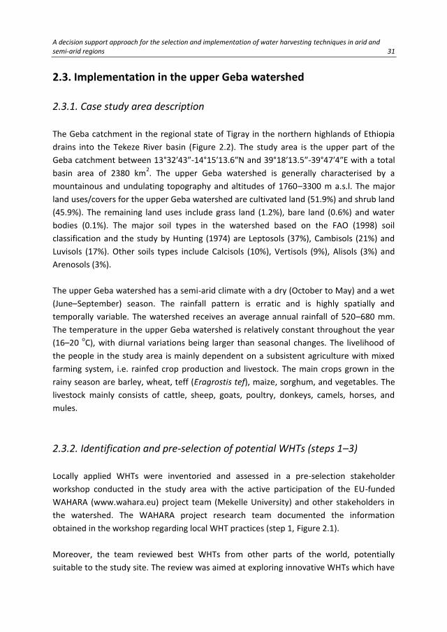
analysis (step 4, Figure 2.1) is shown in Figure 2.3.
34 Chapter 2
Figure 2.3 Conceptual framework for identifying suitable areas for water harvesting techniques (WHTs).
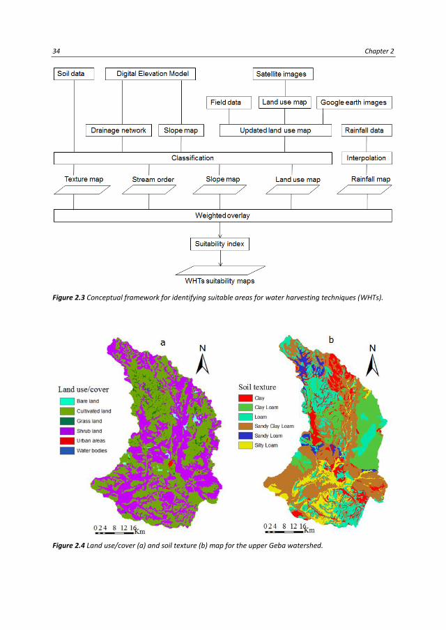
Figure 2.4 Land use/cover (a) and soil texture (b) map for the upper Geba watershed.

A decision support approach for the selection and implementation of water harvesting techniques in arid and semi-arid regions 35
Preparation of spatial databases
The GIS-based MCA requires spatial databases to test bio-physical suitability of pre-
selected WHTs in the case study. Spatial data from GISs were processed for parameters
such as land use/cover, soil texture, slope, drainage networks, and rainfall maps. The data
for land use/cover of the study area were adopted from NEDECO (1998) as a shape file
and were then modified in ArcGIS using ground observations and the latest (2011 and
2013) Google Earth images (Figure 2.4a). The high spatial resolution of the Google Earth
images provided detailed mapping information for the classification of land use/cover (Hu
et al., 2013; Mering et al., 2010).
A soil map of the study area was provided by the Bureau of Agriculture and Rural
Development of Ethiopia, prepared using the FAO (1998) soil classification, and was
digitised in ArcGIS from the detailed regional soil and land classification study by Hunting
(1974). A soil-texture map (Figure 2.4b) of the study area was then generated by collecting
descriptions of the textures of the major soils of the world, available from FAO (2001). A
spatial annual rainfall map of the watershed was produced using the annual records
(1994–2012) of seven meteorological stations (Adigrat, Hawzien, Sinkata, Edagahamus,
Wukro, Mekelle and Hagereselam) within or near the watershed (Figure 2.5a). The spatial
rainfall data were generated in ArcGIS using Inverse Distance Weighting (IDW)
interpolation.
Figure 2.5 Annual rainfall (a) and slope class (b) map for the upper Geba watershed.

36 Chapter 2
Figure 2.6 Drainage network and stream order classes for the upper Geba watershed.
A Digital Elevation Model (DEM) with a resolution of 90 m was downloaded from Jarvis et
al. (2006). The DEM was used to generate slope gradients (Figure 2.5b) and to identify a
drainage network with notations of stream (drainage) order. The drainage network was
generated using 5 ha as a threshold for the upstream area of the smallest streams in the
network. The drainage network was further classified into stream orders (Strahler, 1957)
using the ArcGIS interface for hydrological analysis, which produced six classes (Figure
2.6).
Extraction of suitability indicators for the pre-selected WHTs in the case study
Suitability indicators indicate if a given area can be potentially used for WHTs. Based on
the suitability indicators available in Table 2.1, the suitability analysis was made for each
WHT separately. Eight potential WHTs for the case study were shortlisted in the pre-
selection stakeholder workshop for consideration for final selection. Potential sites for all
these pre-selected techniques can be identified using the available suitability indicators
for the specific WHTs. A detailed suitability exercise was carried out for three techniques
(check dams, percolation ponds and bench terraces) from the eight pre-selected WHTs to
demonstrate the methodology. Most of the suitability indicators for these three

A decision support approach for the selection and implementation of water harvesting techniques in arid and semi-arid regions 37
techniques were extracted from Table 2.1 and are summarized in Table 2.2. Stream order
was considered as a suitability indicator particularly for check dams and percolation ponds
because these two WHTs can be located along stream beds with a specific stream order.
The specific requirement of distance to cultivated land for check dams is already indicated
under the land use suitability indicator in Table 2.1.
Table 2.2 Suitability indicators adopted to locate suitable areas in the study area for check dams,
percolation ponds and bench terraces.
Water
harvesting
techniques
Slope
(%)
Soil properties Land use/cover Annual
rainfall
(mm)
Stream order
Check dams <15 Fine loam with less
infiltration rate
River streams≤ 700 m
from cultivated land
250-750 1st to 3rd
Percolation
ponds
<10 (Sandy) clay loam with
moderately high infiltration
rate
Bare/shrub land, grass
land, along stream beds
250-750 2nd and 3rd
Bench terraces 20-60 All agricultural soils except
shallow ones
Bare/shrub land,
cultivated land
200-600 Not applicable
Check dams are small barriers constructed in shallow rivers and streams for harvesting
water and controlling erosion (Balooni et al., 2008). These structures supplement
irrigation in dry periods and improve overall water availability in sub-watersheds. The
potential sites for check dams are streams of the 1st
to 3rd
orders at a maximum of 700 m
from cultivated land. The land use/cover map was thus buffered to a distance up to 700 m
around cultivated land using ArcInfo.
Percolation ponds are formed by structures constructed across small streams (2nd
and 3rd
orders) or other places to collect surface runoff during rainy periods. Infiltration and
percolation raise the level of the groundwater, which can then be harvested during dry
seasons. The soils where percolation ponds are located must have medium to high
infiltration rates to ensure good infiltration, but the infiltrated water should not be quickly
lost downstream to higher order streams (above 3rd
) where harvesting of the water would
be difficult.
Bench terraces are banks of structures across long slopes used to convert mountainous
areas to arable land. They can be located on steep slopes (20–60%) but are also
sometimes used on more gently sloping agricultural land to disrupt long slopes. Shallow
soils are not suitable for bench terraces due to the small volume of soil for bench
formation.

38 Chapter 2
2.3.4. Participatory selection of WHTs based on socio-economic and
ecological criteria (step 5)
The final selection of WHTs was carried out in a multi-stakeholder workshop based on
socio-economic and ecological selection criteria defined by the participants. The
participants of the selection workshop included farmers, local extension workers, NGOs,
development agents, researchers, and governmental representatives. A total of 63
participants from four local administrative areas (Woredas) were involved. Information
and MCA results of the pre-selected WHTs were presented to the participants of the
workshop. The participants accepted the eight proposed techniques and added two
others.
The participants defined the criteria to be used for ranking and final selection from the list
of WHTs. The proposed criteria were categorized into economic, socio-cultural, and
ecological benefits. The list of criteria was long, so the number to be used in the final
selection was reduced. An effort was made to consider at least one criterion from each of
the three benefit categories, some of the criteria were modified, and similar criteria were
combined.
The local participants were divided into four groups based on their geographical locations
(Woredas), and the stakeholders, consisting of representatives from NGOs and the
government, development agents, and the researchers, were randomly distributed to
these groups. The groups rated the selection criteria on a scale of 1–10.
Each group ranked the criteria, and the rates assigned by each group were averaged to
produce the final ranking. The same group of participants evaluated each of the pre-
selected WHTs by each of the selection criteria on a scale of 1–10. The evaluation of the
WHTs by the four groups was combined and analysed to rank the techniques to be
selected.
The Analytical Hierarchy Process (AHP) of decision making (Saaty, 1980, 2004) was then
used to rank the proposed selection criteria and the ten WHTs. First, the six selection
criteria were com-pared pairwise to rank or determine the weighted score of each
criterion. Once the ten proposed WHTs were rated on a scale of 1–10 by each of the six
criteria, then the ten WHTs were compared pair-wise taking into account the weighted
score of each criterion. The rank of each WHT was then determined by the outcome of the
weighted score of the WHTs after the AHP analysis.

A decision support approach for the selection and implementation of water harvesting techniques in arid and semi-arid regions 39
The description and suitability maps of the pre-selected WHTs provided valuable
information about the applicability of the proposed WHTs to the study area. It also
bridged knowledge gaps among the participants of the workshop regarding the proposed
WHTs. With the aid of the suitability maps and the description of the WHTs, the
stakeholders were able to easily evaluate the WHTs based on the agreed selection criteria.
The suitability maps can also be used by land users to locate suitable areas for selected
WHTs.
In addition to the eight pre-selected WHTs presented in the selection workshop, two other
techniques, namely large semi-circular bunds and on-farm (in-situ) conservation
measures, were added to the list of techniques or technologies to be considered for
selection. The participants insisted that if selected and implemented the two new
techniques could be important to improve productivity while improving soil and water
conservation. The participants emphasised that in-situ WHTs such as infiltration pits and
soil-improvement methods need further research to allow introduction of new practices
of soil management at the field level. The participants were also strongly interested in
contributing to the scientific research on some of the locally practised techniques, such as
percolation ponds and check dams.
Table 2.3 Proposed potential water harvesting techniques selection criteria.
The selection criteria proposed by the participants of the workshop based on the
ecological, economic, and socio-cultural benefits are shown in Table 2.3. These criteria
reflected the socio-economic and ecological problems in the area of the case study and
anticipated the criteria to be considered to foster the adoption of these technologies.
Most of the criteria listed in Table 2.3 would also be relevant for other areas. The full list
Economic benefits Ecological benefits Socio-cultural benefits
Production
improvement
Profitable
Having big role on erosion
protection
Suitable to different landscape,
soil and climatic conditions
Improve availability of additional
arable land
Adapt to climate change
Improve water availability
Allow diversified cropping system
Improve land reclamation
Not conflicting with existing
ecological conditions
Adaptable
Socially acceptable
Create employment
opportunities
(beneficial to the
youth)
Reduce water
fetching distance
Reduce workload
Not conflicting with
health and sanitation
Improve gender
participation
(beneficial to females)
Acceptable by all
parties

40 Chapter 2
of criteria in Table 2.3 provided much insight, but the workshop agreed to limit the
number of selection criteria to prevent the selection procedure from becoming too
complex. The selection criteria and their AHP weighted scores are presented for the study
area (Table 2.4).
Based on the criteria and their weights defined in Table 2.4, the selection and ranking of
the WHTs techniques are described in Table 2.5. The top four WHTs were proposed for
testing and evaluation with field research. The workshop emphasised that the
performance evaluation of the selected WHTs in the field research should involve the local
farmers, government, and development agencies to make use of the outcomes and to
promote the adoption and expansion of the techniques.
Table 2.4 Prioritized selection criteria and their analytical hierarchy process (AHP) weighted scores.
Objective Criteria AHP weighted score
Improve production Crop production 0.191
Profitable Profitability 0.162
Reduce erosion, increase arable land and reclaim
plantation
Land rehabilitation 0.177
Suitable to different ecological conditions Ecological suitability 0.148
Adaptable and socially acceptable Adaptability 0.171
Beneficial to females and the youth Job opportunity 0.150
The participants of the workshop finally agreed with the AHP results and the ranking of
the WHTs. The participants emphasised that the results reflected their rating of the
proposed WHTs and the selection criteria and promised to cooperate during the testing of
the selected techniques. Most of the selected WHTs have recently been partly or fully
applied in the region. Even though the implementation of WHTs in the region was good,
the results from previous interventions were not satisfactory due to the lack of
involvement of appropriate stakeholders in the selection and implementation of the
techniques. The field practices were also not supported by scientific research.
The selection criteria used for the selection of WHTs should suit to existing ecological and
socio-economic conditions of the specific site. The criteria chosen were supposed to bring
ecological, economic and socio-cultural benefits to the study site. Similar selection criteria
were recommended by Schwilch et al. (2009), to facilitate a sustainable selection of SLM
options. In addition to the selection criteria proposed by the stakeholders (Table 2.3) in
the study area, other criteria such as land and water ownership, implementation costs
(installation, operation and maintenance) can influence the suitability of different WHTs.
Some WHTs (e.g. mulches and ridges) can be owned by farmers and applied at farm level
while others such as micro-dams and sub-surface dams should be implemented at
community level, as they are too expensive to be implemented by individual farmers.

A decision support approach for the selection and implementation of water harvesting techniques in arid and semi-arid regions 41
It is helpful to use an analysis tool to accomplish the ranking of the pre-selected WHTs
based on the selection criteria. The AHP used in the selection workshop was simple and
efficient where the tool was able to quickly sort out the ranking of WHTs and the results
were easily communicated to the participants. The workshop created a co-learning
process in which the stakeholders were able to share their experiences and choices about
WHTs to be implemented in the study site. Similar collaborations were achieved in other
studies, e.g. in the DESIRE project (Schwilch et al., 2012b). The WAHARA workshop
resulted in a common understanding amongst the participants in which they promised to
collaborate and participate in the testing and implementation of the selected WHTs, thus
paving the way for field tests and implementation (step 6, Figure 2.1).
Table 2.5 Ranking and the analytical hierarchy process (AHP) weighted score of the proposed water
harvesting techniques after the selection workshop.
No.
Water harvesting technique
AHP weighted
score
Rank
Remark
1 T1: Series of hillside cisterns on bench terraces 0.112 3 To be tested
2 T2: Stone/soil faced trench bunds 0.104 5
3 T3: Hillside conduits with series of community ponds 0.100 6
4 T4: Percolation/sediment storage ponds with hand-dug
wells
0.114 1 To be tested
5 T5: Check dams 0.113 2 To be tested
6 T6: Infiltration trenches coupled with biological measures 0.097 7
7 T7: Soil-improvement methods (e.g. mulching, compost,
effective micro-organisms)
0.108 4 To be tested
8 T8: Sub-surface dams 0.072 10
9 T9: Large semi-circular bunds 0.089 9
10 T10: On-farm (in-situ) conservation measures (e.g. deep
tillage)
0.091 8
2.4. Validation of the developed approach
The developed approach was in a general sense validated by its application in the upper
Geba watershed, which showed that the approach did result in selection of WHTs for
testing and implementation in step 6 (Figure 2.1).
A more detailed validation of part of the approach was performed by comparing the areas
that were, according to the application of the MCA, suitable for check dams, percolation
ponds and bench terraces with sites in which these WHTs are currently already
implemented.
The bio-physical suitability of WHTs to the case study was carried out by a GIS-based MCA,
the core part of the proposed decision support approach. To ascertain the validity of the

42 Chapter 2
suitability analysis, suitability indexes produced from the GIS-based MCA were
superimposed with the locations of existing structures in ArcGIS. The resulting maps of the
MCA for check dams and percolation ponds were compared with existing locations of the
structures. The suitability maps were validated with 80 and 92 existing locations of check
dams and percolation ponds, respectively. The results of the validation were reported in
percent showing locations of existing structures coinciding with the suitability indexes. Of
the three techniques for which suitable areas were identified, check dams and percolation
ponds were already widely implemented in the study area, and bench terraces were used
on steep slopes.
Figure 2.7 Suitability map for check dams in the upper Geba watershed.
The GIS-based MCA for check dams is depicted in Figure 2.7. The validation of the
suitability map with existing check dams in the study area showed that 48% of the check
dams were in highly suitable streams, 42% were in moderately suitable streams, and only
10% were in unsuitable streams. The suitability mapping for check dams was generally
satisfactory and could be used for further prioritisations of locations for the construction
of check dams.
The suitability map indicated that the study area contained many potential areas for
percolation ponds (Figure 2.8). Nine percent of the total area of the watershed was highly
suitable for the construction of percolation ponds, and 14% was moderately suitable. The
potential areas were mainly on grass land, but some were on bare land and shrub land.
The study area contains much shrub land (Figure 2.4a), which is not ideal for percolation

A decision support approach for the selection and implementation of water harvesting techniques in arid and semi-arid regions 43
ponds because most of it has steep slopes. Agricultural areas had a high potential for
percolation ponds but were excluded because they are used for cultivation.
Figure 2.8 Suitability map for percolation ponds in the upper Geba watershed.
The validation of the suitability map (Figure 2.8) showed that 63% of the 92 existing
percolation ponds were in highly suitable areas, 30% were in moderately suitable areas,
and only 7% were in unsuitable areas. This distribution indicated that the suitability
mapping worked well for identifying suitable areas for percolation ponds and could be
used for the future planning and development of percolation ponds.
The use of percolation ponds is increasing in the study area. Most existing percolation
ponds are on grass land, because grass land is within or in close proximity to agricultural
areas. Hand-dug wells within the grass land or the adjacent crop land are then used to
extract groundwater for irrigation. The construction of a series of percolation ponds
upslope of cultivated areas makes use of bare land and shrub land identified suitable areas
in the analysis. This is advised to enhance groundwater recharge and hence maximise the
amount of water that can be sustainably extracted in the downstream cultivated areas.
Nine percent of the study area was highly suitable for the construction of bench terraces,
and 26% was moderately suitable (Figure 2.9). The installation of bench terraces on
hillsides is potentially economically feasible, because bench terraces are constructed on
steep slopes that are generally unsuitable for conventional farming and because they
increase the availability of arable land. Proper construction of terraces on steep slopes
also decreases the rate of soil loss in runoff. Other benefits include the improvement of

44 Chapter 2
water availability in the benched areas and their surroundings, especially downstream,
because the terraces improve infiltration. The study area currently contains few bench
terraces but has considerable potential for more. The existing government policy in
support of technologies that increase the availability of farm land should encourage the
construction of more bench terraces on hillsides.
Figure 2.9 Suitability map for bench terraces in the upper Geba watershed.
The suitability analysis for these three WHTs satisfactorily located suitable areas for future
development. Similar GIS-based MCAs have been used in other regions to identify
potential suitable areas for WHTs (Elewa et al., 2012; Saptarshi and Raghavendra, 2009;
Singh et al., 2009). The analyses in these regions showed that GIS-based MCAs are
valuable because they can identify potential sites for WHTs in large areas and under a
number of suitability criteria. The proposed potential sites in these analyses (Elewa et al.,
2012; Saptarshi and Raghavendra, 2009; Singh et al., 2009), however, were not validated
with the existing locations of WHTs. In other studies (Mbilinyi et al., 2007; Pandey et al.,
2011), remote sensing and GIS-based analysis for identifying suitable sites for soil and
water conservation structures and validated with existing locations and site conditions
was able to match the existing and proposed structures. The same MCA can also be
applied to other WHTs by utilizing the newly developed database of WHTs and their
suitability indicators (Table 2.1) to identify potential areas in other regions of the world.
The application and validation of the developed approach in the upper Geba watershed
indicated that it can be applied in similar regions in the country with similar bio-physical
and socio-economic conditions, but some modifications may be necessary if these

A decision support approach for the selection and implementation of water harvesting techniques in arid and semi-arid regions 45
conditions vary significantly. Identifying generic criteria for the selection of WHTs in
different ecological, economic, and socio-cultural conditions would be useful, although the
weight of the criteria might differ. WHTs that improve the availability of arable land and
hence create job opportunities for youths would be beneficial in the study area and similar
regions in Ethiopia with high population growth and a dependence on agriculture by the
majority of the society. Other WHTs may be used in other parts of the world where site-
specific conditions may differ. The WHTs database in this paper, however, has been
compiled from many parts of the world, and their suitability indicators have also been
defined. The approach presented here can thus be used for other areas with arid and
semi-arid climates provided that necessary modifications are made to comply with the
site-specific conditions.
The decision support approach is helpful to facilitate the selection and implementation of
appropriate WHTs in a given area to improve agricultural production. The decision support
approach however did not consider the impacts of existing and new WHTs on water
availability and water demands of various uses at different watershed scales. The current
adoption rate of WHTs is low and hence the resulting marginal impacts are minimum
(Ngigi, 2003; Oweis and Hachum, 2006). It is however probable that the widespread
application of WHTs at a watershed or basin level would improve water availability for
downstream users (Rockström et al., 2003) but it could also have negative implications for
other water users (Ngigi, 2003; Rockström et al., 2003). Therefore, there is a need to
carryout hydrological modelling to assess the impacts of WHTs at a watershed or basin
level before these techniques can be up-scaled (Ngigi, 2003; SIWI, 2001).The developed
decision support approach in general and the GIS-based MCA in particular will be however
very useful in identifying suitable areas for specific WHTs in large watershed with different
bio-physical settings. The resulting WHTs suitability maps from the MCA provide valuable
information for land users and stakeholders who intend to select and apply specific WHTs
for a given area.
2.5. Conclusions
Water harvesting techniques are widely applied in arid and semi-arid climates to improve
the availability of water for various uses. Selecting appropriate techniques is crucial for
optimising the impact of water harvesting, given site-specific bio-physical and socio-
economic conditions. Our approach which combined a GIS-based multi-criteria analysis
and a participatory multi-stakeholder workshop proved to assist the selection of
appropriate water harvesting techniques because it integrated bio-physical
knowledge/tools with socio-economic criteria. The inclusion of selection criteria relevant

46 Chapter 2
to ecological, economic, and socio-cultural benefits was crucial in the multi-stakeholder
selection workshop, so similar criteria should also be considered in other parts of the
world. Combining water harvesting techniques can maximise benefits, and the possibilities
for such combinations should thus be explored. A key tool in this approach is the GIS-
based multi-criteria analysis for identifying suitable areas for water harvesting techniques.
The GIS-based multi-criteria analysis, which was successfully validated in the case study,
was also an important tool for identifying potential water harvesting techniques in large
watersheds constrained by a number of decision criteria (e.g. suitability indicators).The
multi-criteria analysis generates suitability maps that provide valuable information on the
types of water harvesting techniques that could be applied at a specific site, facilitating
decision making for land-use planners. The same approach could be used in other parts of
the world with arid and semi-arid climates. The extensive list of water harvesting
techniques and their suitability indicators from this study should provide valuable inputs
for multi-criteria analyses and should thus simplify decision making for applying water
harvesting techniques for stakeholders and land-use planners.

Improving on-site water availability by combining in-situ water harvesting techniques in semi-arid northern Ethiopia 47
3. Improving on-site water availability by combining in-situ water harvesting techniques in
semi-arid northern Ethiopia
Crop production in arid and semi-arid environments is strongly affected by temporal variation of water availability during the growth period. In-situ water harvesting techniques such as tied ridges and mulching improve water availability over time and may improve crop yield. A field experiment was conducted in 2013 and 2014 in the Gule sub-watershed, northern Ethiopia to study the effect of combining in-situ water harvesting techniques on on-site water regime, i.e., runoff and soil-moisture content. Five treatments with tied ridges, straw mulch, and effective micro-organisms, alone or in combination, and an untreated control were tested. Combined tied ridges and straw mulch with and without effective micro-organisms significantly reduced average runoff per event by 78 and 88%, respectively, compared to the control. Tied ridges alone reduced runoff by 56% and straw mulch with and without effective micro-organisms reduced runoff by 49 and 53%, respectively. Average soil-moisture content over the two years was significantly higher (22.4%) in combined tied ridges and straw mulch than the control (19.9%). Tied ridges or straw mulch alone significantly reduced runoff and improved soil-moisture content, but the two combined were more efficient. Based on the results of field experiment in 2014, multiple regression models were formulated to predict runoff using rainfall, 30-minute rain intensity, soil-moisture content, slope, soil organic-matter and saturated and unsaturated hydraulic conductivities for the treatments. The regression analysis indicated that the models predicted runoff well (r2=0.63-0.83). The regression also showed that runoff could be estimated from rainfall, rain intensity, and soil-moisture content for farmlands when runoff data was not available. The findings suggest that combined straw mulch and tied ridges enhance water infiltration into the soil and improve water availability during the growing season, thereby protecting crops from dry periods.
Submitted as:
Grum, B., Assefa, D., Hessel, R., Woldearegay, K., Ritsema, C.J., Aregawi, B., Geissen, V.
Improving on-site water availability by combining in-situ water harvesting techniques
in semi-arid northern Ethiopia. Agricultural Water Management.

48 Chapter 3
3.1 Introduction
The efficient use of water in agricultural systems is needed to improve crop production
and resilience to environmental adversities that may be caused by climate change and
extended droughts, especially in arid and semi-arid areas. Marginal and erratic rainfall
aggravated by the loss of water by runoff and evaporation are the main causes of low crop
production in these areas (Yosef and Asmamaw, 2015). Ethiopia has been dependent on
subsidence rainfed agriculture for centuries, and crop production has thus been heavily
reliant on the availability of rainwater (Araya and Stroosnijder, 2010; Yosef and
Asmamaw, 2015). Most of the cultivation in Ethiopia is in the highlands, which have fragile
natural resources and often coarse-textured soils low in organic-matter and water holding
capacity that are prone to wind and water erosion (Boelee et al., 2013). Water harvesting
techniques (WHTs) have played a key role in improving the efficient use of rainwater and
have increased the sustainability and reliability of rainfed agriculture (Biazin et al., 2012).
In-situ WHTs such as tied ridges, mulching, conservation tillage, and the application of
compost and manure (Mati, 2005) improve the availability of water in the soil profile to
decrease the effects of dry periods caused by the seasonal variation of rainfall. Soils can
temporarily hold water, so in-situ water harvesting prolongs the availability of water in the
root zone by reducing runoff and evaporation losses (Vohland and Barry, 2009). Some
techniques (e.g. ridges and furrows) can conserve water in the soil profile mainly by
reducing net runoff, and others (e.g. mulching) can conserve water by reducing
evaporation.
The effect of mulch on soil properties, soil-water storage, and crop yield is well
documented (Chakraborty et al., 2008; Cook et al., 2006; Li et al., 2007; Ramakrishna et
al., 2006). Several other studies have focused on the effect of conservation agriculture
(e.g. contour furrows and soil tillage) on soil and water conservation (Abrisqueta et al.,
2007; Araya et al., 2011; Gebreegziabher et al., 2009; McHugh et al., 2007; Mesfine et al.,
2005; Temesgen et al., 2009). The effects of individual tied ridges and mulching on water
availability and crop production have also been evaluated in different parts of the world
(Araya and Stroosnijder, 2010; Mudatenguha et al., 2014; Wang et al., 2009).
Combining WHTs (e.g. mulching and tied ridges) ensures high-level and reliable crop
production, benefiting from enhanced soil-water storage and decreased net runoff (Li et
al., 2000). Integrating in-situ water harvesting techniques and soil fertility improvement
measures is needed not only to improve yield but also to increase the efficiency of water
harvesting (Miriti et. al, 2007; Nyamadzawo et al., 2013). The application of effective

Improving on-site water availability by combining in-situ water harvesting techniques in semi-arid northern Ethiopia 49
micro-organisms (EMs) to the soil can enhance soil properties such as infiltration rate and
water holding capacity hence increase soil-moisture (Ismail, 2013; Lee et al., 2008).
Combinations of in-situ WHTs such as wood-chip mulch and ridges substantially improved
the growth and straw yield of sorghum (Chiroma et al., 2006a). Moreover, combined
application of wood-shavings mulch with ridge tillage improved soil fertility and slowed
down the acidification of a coarse-textured soil (Chiroma et al., 2006b). Similarly,
combined use of ridges and furrows with gravel/plastic mulch improved runoff and water
use efficiency, and significantly increased corn yield (Li et al., 2000; Li et al., 2001). Positive
effects of ridges and mulch on cowpea physiological responses have been demonstrated
(Ramesh and Devasenapathy, 2006). Little information, however, is available on the effect
of in-situ WHTs (e.g. ridges and straw mulch) integrated with soil fertility improvement
methods (e.g. EMs) on runoff retention and soil-moisture content (SMC). Therefore, this
study tests the efficacy of individual and combined application of straw mulch, tied ridges,
and EMs in reducing runoff and increasing SMC to improve water availability for plant
growth and recommend improved soil-water management for (semi-) arid regions.
3.2 Materials and Methods
3.2.1 Study site description
The study was conducted in the Gule sub-watershed in the upper Geba watershed, part of
the Tekeze River basin in northern Ethiopia (13°52′49″N, 39°28′59″E; Figure 3.1). The sub-
watershed has a catchment area of around 12 km2. It is characterized by a rugged
topography with mountains and flat valley floors whose altitudes range between 2008 and
2408 m a.s.l. The study area has a semi-arid climate with two major seasons, a rainy
season in the summer, often June to September, and a dry season from October to May.
Rain is rare during the dry season, except for some showers towards the beginning of the
rainy season. Average daily temperature for the sub-watershed is 20 oC. The minimum and
maximum temperatures are 11 and 31 oC respectively. The sub-watershed was chosen
based on criteria set during a stakeholder workshop for selection of WHTs (Grum et al.,
2016).
The experiment was conducted at a farmer training center located on the flat valley floor
of the sub-watershed whose mean altitude is 2050 m a.s.l. The field experiment had a
total size of 1750 m2 and a field slope ranging between 1.8 and 3.4%. The experiment site
has Eutric Cambisols (IUSS Working Group WRB, 2015) soil type with a sandy clay loam soil
texture. The initial soil properties at the experimental site are summarized in Table 3.1.

50 Chapter 3
Table 3.1 Selected initial soil properties at the experimental site.
Property Mean ±SD
Soil texture -
0.063-2 mm, sand (%) 64.6±4.7
0.002-0.063 mm, silt (%) 12.6±3.5
<0.002 mm, clay (%) 22.8±1.9
Slope (%) 2.4±0.4
Bulk density, Bd (g cm-3) 1.6±0.0
pH (H2O) 6.8±0.2
Soil organic-matter, SOM (g kg-1) 8.3±2.6
Unsaturated hydraulic conductivity, Ks (m d-1) 1.8±1.0
Saturated hydraulic conductivity, Ksat (m d-1) 4.2±1.7
Figure 3.1 Location of the study area. (a) Drainage basins of Ethiopia. (b) Drainage of the upper Geba
catchment. (c) Land use of the Gule sub-watershed and location of the experimental site.

Improving on-site water availability by combining in-situ water harvesting techniques in semi-arid northern Ethiopia 51
3.2.2 Experimental design
The experiment was conducted during the rainy seasons in 2013 and 2014. The in-situ
WHTs used in the field experiment were selected by stakeholders in a participatory WHT
selection workshop (Grum et al., 2016). The experiment site was established in May 2013.
The experiment had a completely randomized block design with five treatments and a
control, with three replicates, for a total of 18 plots. The treatments consisted of single
and combined WHTs (Table 3.2). Each plot was 3 × 15 m (Figure 3.2).
After significant rain, the experimental field was ploughed twice by oxen-driven maresha a
month and a week before sowing. The experiment plots were then established by hand.
The plots in each replicate were separated by earth bunds 50 cm wide and 40 cm high to
prevent water flow from neighboring plots and to provide access to the plots. The runoff
from the plots was collected in a corrugated iron gutter and then directed into 300-400 L
sub-surface barrels buried at the end of each plot. The crop used in the experiment was
maize (Zea mays L.). Maize seeds were planted in each plot with 30 cm between plants
and 60 cm between rows. The distance between rows in the plots with ridges, however,
was 70 cm to allow enough space for the tied ridges. The tied ridges were 3 m long, 1.9 m
apart, center to center, and had a mean height of 20 cm.
Table 3.2 Description of the treatments in the field experiment.
Treatment Description
T0 (control) Basal fertilizationa
T1 Basal fertilization + Tied ridges
T2 Basal fertilization + Straw mulch (15 Mg ha-1)
T3 Basal fertilization + Straw mulch (15 Mg ha-1) and tied ridges
T4 Basal fertilization + Straw mulch (15 Mg ha-1) and 4 L ha-1 of EMs
T5 Basal fertilization + Straw mulch (15 Mg ha-1), tied ridges, and 4 L ha-1 of EMs a Basal fertilization: 100 kg ha-1 urea (46% N) and 100 kg ha-1 diammonium phosphate (18% N, 46% P) applied to the
entire field experiment. EMs: effective micro-organisms.
3.2.3 Field measurements
Composite soil samples were collected to a depth of 20 cm for characterizing the physical
and chemical properties of the experimental site before the beginning of the rainy season
in 2013 and 2014 (Table 3.1). Soil physical properties such as bulk density, soil organic-
matter (SOM), saturated (Ksat) and unsaturated (Ks) hydraulic conductivities were also
measured after crop harvest both in 2013 and 2014. Bulk density was determined by core
method and Ksat was determined by a laboratory permeameter using the constant-head

52 Chapter 3
method. Ks was measured in the field using a mini-disk infiltrometer after crop harvest in
2013 and 2014, both under dry conditions.
Figure 3.2 Layout of the experimental runoff plots. (a) Typical plot with tied ridges. (b) Typical plot without
tied ridges. (c) Photograph of the field layout. (d). Rainfall and temperature measurement using an RG3-M
rain gauge and a hobo pendant temperature data logger.
Rainfall and temperature were continuously monitored using a tipping-bucket data-
logging rain gauge (RG3-M, precision 0.2 mm per tip) and a hobo pendant temperature
data logger, respectively, installed at the experimental site (Figure 3.2). A standard rain
gauge was also installed at the site to measure rainfall. Rainfall in 2013 was only measured
using the standard rain gauge, because the data logger was not ready for use. Runoff
volume after each rain event was determined by measuring the volume of water collected
in the subsurface barrels. SMC was measured daily in 2013 and 2014 using a Trime-PICO64
(time-domain reflectometer or TDR method) soil-moisture sensor (Eijkelkamp, Giesbeek,
the Netherlands) to a depth of 15 cm at six sampling points per plot.

Improving on-site water availability by combining in-situ water harvesting techniques in semi-arid northern Ethiopia 53
3.2.4 Data analysis
Statistical analysis was carried out using SPSS 22 (IBM Corporation, New York, USA).
Normality of data was tested using the Kolmogorov-Smirnov test. The normally distributed
data were analyzed using least squares one-way analyses of variance to identify
significance differences between treatments. The homogeneity of the variances for the
measured data was checked using Levene’s test. The data that failed the normality test
were analyzed using non-parametric tests for statistical differences. The Kruskal-Wallis H
test was used to identify if a treatment had a significant effect on a measured variable.
The pairwise Mann-Whitney U-test was used to determine if a measured variable differed
significantly between treatments.
Total seasonal (for the rainy season) runoff was derived from rain events that generated
runoff. Average seasonal SMC was generated from daily soil-moisture measurements in
the plots for all treatments.
Runoff reduction per event of a treatment was calculated by:
𝑅 (%) =𝑄𝑐−𝑄𝑡
𝑄𝑐× 100 (3.1)
where R is the reduction in runoff by a treatment compared to the control (%), Qc is the
measured runoff (mm) in the control, and Qt is the measured runoff (mm) in a treatment.
Runoff coefficient (C) was estimated from the total seasonal runoff during the rainy
season by:
𝐶 (%) =𝑄
𝑃× 100 (3.2)
where Q is total seasonal runoff (mm) and P is total seasonal rainfall (mm) for rain events
producing runoff.
Rainfall and rain intensity thresholds for runoff generation were estimated using the
method by Fu et al. (2013). Rainfall or rain intensity was plotted against runoff and
regression lines were fitted by least square method. Thresholds were determined at three
SMC levels (<20%, 20-30% and >30%) for all treatments using measured runoffs in 2014.
Principal component analysis (PCA) was performed to identify the main factors affecting
runoff and SMC. Two PCAs were performed separately for two groups, the hydrological
and soil parameters (runoff, SMC, slope, SOM, Ksat, and Ks) and the hydro-meteorological

54 Chapter 3
variables (runoff, rainfall, 30-minute rain intensity (I30) and SMC). For the hydrological and
soil parameters group, runoff per treatment was total of seasonal runoff and SMC was
average of seasonal daily measurements in 2013 and 2014. For SOM, Ksat and Ks, data
were taken from measurements at the end of the rainy season (after crop harvest) in 2013
and 2014 per treatment (n=36). For the hydro-meteorological variables, the PCA was
performed based on runoff, rainfall and rain intensity events and daily SMC in 2013 and
2014 (n=630). Rainfall and rain intensity were not included in the first PCA, because total
seasonal rainfall was the same for all treatments. Therefore, we formulated the second
PCA to demonstrate the relationships amongst the hydro-meteorological variables.
Extracted components with eigenvalues >1 were chosen to explain the associations
amongst the variables. A factor analysis for the related variables was carried out after
testing the normality of the data used in the analysis. Most of the data were not normally
distributed, so we used Spearman’s rank correlation to identify correlations amongst
variables.
Regression models were formulated to predict runoff per event using predictor variables
such as rainfall, I30, SMC, slope, SOM, Ksat, and Ks for different treatments. Runoff per
treatment, rainfall and rain intensity data were based on event-based measurements in
2014. SMC data per treatment was based on daily measurements in 2014. SOM, Ksat and
Ks data per treatment were taken from measurements after crop harvest in 2014.
Regression analysis was performed after confirming the assumptions of linearity between
the dependent and independent variables, the statistical independence, homoscedasticity,
and normality of the predictor errors. The degree of multicollinearity amongst predictor
variables was tested using tolerance (Eq. 3.3). Multicollinearity refers to a near perfect
linear combination amongst predictor variables and disrupts the uniqueness of parameter
estimates of a regression model. Tolerance was calculated by:
Tolerancej = 1 − rj2 (3.3)
where rj2 is the coefficient of determination of a regression of predictor variable j on all
other predictor variables. A tolerance near 1 indicates no multicollinearity and a tolerance
<0.1 indicates that further assessment is required. Multicollinear predictor variables were
excluded from the regression analysis. Statistical independence amongst predictor
variables was evaluated using the Durbin-Watson test. A Durbin-Watson value <2
indicates no significant dependence amongst predictor variables.

Improving on-site water availability by combining in-situ water harvesting techniques in semi-arid northern Ethiopia 55
The multiple regression model to estimate runoff was:
𝑌 = 𝛽0+ 𝛽1𝑋1 + 𝛽2𝑋2 + 𝛽3𝑋3 + ⋯ ⋯ + 𝛽𝑛𝑋𝑛 + ɛ (3.4)
where Y is dependent variable, i.e., runoff per event (mm), X1, X2, X3 and Xn are predictor
variables, β0 is a constant, β1, β2, β3 ......and βn are parameter estimates of the predictor
variables, ɛ is the residual error.
The performance of the regression models was evaluated using the coefficient of
determination (r2) and the Nash-Sutcliffe efficiency (NSE) coefficient (Nash and Sutcliffe,
1970). The coefficient of determination describes how well the regression line of observed
and predicted data pass through each data point. R2 ranges between 0 and 1, with 0
indicating no correlation and 1 indicating a balanced dispersion between model
predictions and observations.
𝑟2 = (∑ (𝑂𝑖−��)(𝑃𝑖−��)𝑛
𝑖=1
√∑ (𝑂𝑖−��)2𝑛𝑖=1 √∑ (𝑃𝑖−��)2𝑛
𝑖=1
)
2
(3.5)
where 𝑂𝑖 is observed runoff (mm), �� is average observed runoff (mm), 𝑃𝑖 is predicted
runoff (mm), and �� is average predicted runoff (mm).
NSE measures the goodness of fit between a model prediction and the measured data. It
measures how well the observed and predicted data fit the regression line with a slope of
1. NSE ranges from -∞ to 1, and a value of 1 indicates perfect agreement between
predicted and observed data. A value of 0 indicates that the model is able to predict as
well as the mean observed data and a value <0 indicates that the mean of the observed
data is a better estimate than the model output.
𝑁𝑆𝐸 = 1 −∑ (𝑂𝑖−𝑃𝑖)2𝑛
𝑖=1
∑ (𝑂𝑖−��)2𝑛𝑖=1
(3.6)
where 𝑂𝑖 is observed runoff (mm), �� is average observed runoff (mm), and 𝑃𝑖 is predicted
runoff (mm).

56 Chapter 3
3.3 Results
3.3.1 Characteristics of rainfall and soil hydro-physical properties
The sub-watershed has a semi-arid climate with temperature varying more diurnally than
seasonally. The average daily temperature range during the 2014 rainy season was 16-23
°C, with a mean of 19 °C. The minimum and maximum daily temperatures were 10 and 38
°C, respectively. The distribution of rainfall was good throughout the 2013 rainy season,
except for low rainfall in September (Figure 3.3a). The main rainy season in 2014 began in
June, but rainfall was low for nearly three weeks in July (Figure 3.3b). Rainfall was well
distributed in the other months.
Figure 3.3 Rainfall in 2013 (a) and rainfall, rain intensity, and temperature at the experimental site in 2014
(b). Plus (+) indicates a rain that generated runoff.

Improving on-site water availability by combining in-situ water harvesting techniques in semi-arid northern Ethiopia 57
The total rainfalls for the 2013 and 2014 rainy seasons were 402 and 552 mm,
respectively. The main rains fell in July and August. Most of the rains in 2013 and 2014
produced runoff in the plots (Figure 3.3), 49% of the 41 rains in the 2013 rainy season and
46% of the 57 rains in 2014. Rain intensity was not measured in 2013 so is shown in Figure
3.3b only for 2014. Rainfall and I30 were closely correlated (Figure 3.4), so the rainfall for
2013 was likely a good indicator of runoff for that year.
Soil physical properties such as bulk density and SOM did not vary significantly (p>0.05)
amongst the treatments over the two seasons of experiment. SOM was generally low in
the experiment field and did not significantly (p>0.05) improve after the application of
straw mulch despite some variations in magnitude. Ksat and Ks showed little variation
(p>0.05) among treatments. Generally, the magnitude of Ksat was significantly (p<0.05)
higher than Ks for all treatments (Table 3.3).
Figure 3.4 Relationship between rain intensity (I30) and rainfall (Rf).
Table 3.3 Average bulk density (Bd), soil organic-matter (SOM), saturated (Ksat) and unsaturated (Ks)
hydraulic conductivities for different treatments over two years of experiment. All measurements were
made after crop harvest in 2013 and 2014.
Treatment
Bd (g cm-3) SOM (g kg-1) Ksat (m d-1) Ks (m d-1)
Median (min, max)b
(n=6)
Mean±SDa
(n=6)
Mean±SDa
(n=6)
Median (min, max)b
(n=6)
T0 1.53 (1.48, 1.57) 8.60±1.64 4.68±2.32 1.48 (0.71, 3.03)
T1 1.59 (1.56, 1.59) 7.92±3.69 3.77±1.17 1.74 (0.68, 3.61)
T2 1.59 (1.49, 1.61) 10.02±3.77 3.06±1.13 1.49 (0.81, 4.12)
T3 1.56 (1.50, 1.64) 9.11±3.90 4.75±1.96 1.28 (0.61, 3.33)
T4 1.60 (1.51, 1.65) 7.81±2.50 3.28±1.08 1.25 (0.90, 4.58)
T5 1.60 (1.46, 1.80) 6.53±4.46 5.33±2.99 1.18 (0.53, 3.94) a Normally distributed data, b not normally distributed data. T0: Control, T1: Tied ridges, T2: Straw mulch, T3: Tied ridges
+ straw mulch, T4: Straw mulch + EMs, T5: Tied ridges + straw mulch + EMs.

58 Chapter 3
3.3.2 Effect of treatment on runoff
Runoff per event was significantly lower (p<0.05) in all treatments compared to the
control (Table 3.4). The order of magnitude of runoff for all treatments was
T0>T4=T2>T1≥T5=T3 in 2013 and T0>T1>T2=T3=T4=T5 in 2014. Runoff was thus lowest in
T3 in both years.
T3 and T5 were most efficient at reducing runoff in both years. T3 reduced runoff by 91
and 84% compared to the control in 2013 and 2014, respectively. T5, reduced runoff by
78% in both 2013 and 2014. T2 and T4 also reduced runoff, but the efficiency of reduction
was significantly higher in 2014 than in 2013, perhaps due to the cumulative effect of
mulch application in the two experimental seasons.
Table 3.4 Average runoff per event, runoff reduction, seasonal runoff coefficient, and daily soil-moisture
content for the treatments. Different letters indicate significant differences (p<0.05) between treatments,
a<b<c<d.
Treatment
Runoff
(mm)
Runoff reduction
(%)
Seasonal runoff
coefficient (%)
Soil-moisture
content (%)
2013 Median (min, max)b (n=24)
Median (min, max)b
(n=24)
Median (min, max)b
(n=3)
Mean±SDa
(n=30)
T0 4.33 (1.8, 9.5) d 0 (0,0) 34.7 (30.8, 35.8) 20.4±2.6 a
T1 1.20 (0.4, 4.5) b 65 (-16, 93) 12.2 (11.1, 14.1) 21.1±2.7 ab
T2 3.00 (0.3, 6.8) c 23 (-9, 92) 22.5 (17.9, 27.7) 19.9±2.6 a
T3 0.38 (0.0, 3.2) a 91 (11, 100) 4.2 (2.9, 6.4) 22.6±3.3 c
T4 3.13 (1.0, 8.6) c 20 (-19, 89) 21.4 (18.9, 27.8) 20.5±1.3 a
T5 0.98 (0.0, 4.1) ab 78 (-12, 100) 7.1 (6.8, 11.4) 22.0±3.6 bc
2014
Median (min, max)b
(n=81)
Median (min, max)b
(n=81)
Median (min, max)b
(n=3 )
Median (min, max)b
(n=180)
T0 5.21 (0.3, 11.2) c 0 (0,0) 30.2 (28.4, 32.1) 19.3 (5.5, 40.8) a
T1 2.62 (0.2, 9.2) b 46 (-29, 87) 16.2 (15.5, 17.5) 20.3 (6.9, 40.4) ab
T2 0.66 (0.0, 8.9) a 82 (6, 100) 7.9 (6.1, 8.6) 21.4 (8.8, 40.1) bc
T3 0.57 (0.0, 8.8) a 84 (14,100) 6.7 (6.0, 6.8) 22.9 (8.2, 46.2) d
T4 0.77 (0.0, 8.8) a 78 (-14,100) 10.1 (6.8, 11.2) 20.6 (7.1, 42.7) b
T5 0.86 (0.0, 8.6) a 78 (-8, 100) 9.3 (6.5, 9.6) 22.1 (7.8, 44.3) cd a Normally distributed data, b not normally distributed data. T0: Control, T1: Tied ridges, T2: Straw mulch, T3: Tied ridges
+ straw mulch, T4: Straw mulch + EMs, T5: Tied ridges + straw mulch + EMs.
The seasonal runoff coefficient was higher in 2013 than 2014 for T0, T2 and T4 (Table 3.4).
The control (T0) had the highest runoff coefficients of 34.7 and 30.2% in 2013 and 2014,
respectively. T3 had the lowest runoff coefficients of 4.2 and 6.7% in 2013 and 2014,
respectively.

Improving on-site water availability by combining in-situ water harvesting techniques in semi-arid northern Ethiopia 59
Figure 3.5 To be continued on next page

60 Chapter 3
Figure 3.5 Continued
Figure 3.5 Rainfall and runoff for the treatments in 2013 (a), rainfall, rain intensity (I30), and runoff for the
treatments in 2014 (b to d). Different letters indicate significant differences between treatments (Mann-
Whitney U-test, p<0.05), a<b<c<d<e. T0: Control, T1: Tied ridges, T2: Straw mulch, T3: Tied ridges + straw
mulch, T4: Straw mulch + EMs, T5: Tied ridges + straw mulch + EMs.

Improving on-site water availability by combining in-situ water harvesting techniques in semi-arid northern Ethiopia 61
3.3.3 Characteristics of runoff per rain events
The amount of runoff was high in both 2013 and 2014 (Figure 3.5). Nearly half of the rains
in 2013 and 2014 produced runoff in the plots (Figure 3.3). Runoff was highest in the
control (T0) for most rains in August 2013. T3 produced the lowest runoff, followed by T1.
T0 generated significantly (p<0.05) more runoff in 2014 than the other treatments for all
runoff-generating rains except for those on 28 July, 7 August and 17 September. Runoff
was relatively higher in all treatments after the relatively high rainfall (36 mm) at the
highest rain intensity (I30=66 mm h-1
) on 5 August 2014 compared to the other rains.
Runoff in T0 was highest on 31 July at 10.9 mm, for which the rainfall and I30 were 44 mm
and 36 mm h-1
, respectively.
The amount of runoff generated from the plots was relatively lower in July 2014,
especially in the first weeks, compared to similar rains in August (Figure 3.5). For example,
the rains on 5 July (rainfall=21 mm, I30=40 mm h-1
) and 3 August (rainfall=19 mm, I30=mm
h-1
) were similar. Runoff in the control was however significantly lower on 5 July (4.1 mm)
than on 3 August (9.1 mm). The difference in runoff between these two events is mainly
attributed to soil- moisture differences in July and August. Runoff was significantly
(p<0.05) lower in the other treatments (T1-T5) than the control on 5 July but was relatively
higher on 3 August except in T3 and T5. Runoff tended to be higher with higher I30,
although the effect was more apparent in the control. Runoff was, for example,
significantly higher (p<0.05) in the control than the other treatments on 14 July (rainfall=9
mm, I30=18 mm h-1
) but was relatively lower in all treatments, including the control, on 28
July (rainfall=10 mm, I30=10 mm h-1
).
Rainfall threshold for runoff generation varied with treatments and antecedent SMC.
Rainfall threshold refers to the minimum rainfall above which runoff will be generated.
Rainfall and rain intensity (in terms of I30) threshold computations are illustrated by the
correlation plots as shown in Figure 3.6. Generally, rainfall thresholds decreased with
increasing antecedent SMC for all treatments (Table 3.5). Rainfall thresholds were lower in
the control (T0) than the other treatments (T1-T5) for similar SMCs. Rainfall threshold for
T0 was 4.3 mm when SMC was below 20%. Rainfall threshold for T0 was 4 mm when
antecedent SMC was between 20 and 30% and slightly decreased to 3.8 mm when SMC
exceeded 30%. The highest rainfall threshold was recorded by tied ridges (T1) with 4.8 mm
when SMC was below 20%. T0 had the lowest rain intensity threshold with 5.4 mm h-1
when SMC exceeded 30%. Rain intensity threshold decreased when antecedent SMC was
increased. Rain intensity thresholds were similar for T1-T5 for similar SMCs.

62 Chapter 3
Figure 3.6 Examples of determination of rainfall and rain intensity (I30) thresholds (arrow) at 0-20%
antecedent soil-moisture content. Correlations (a) between runoff and rainfall for T0 (control) (b) between
runoff and rain intensity (I30) for T0 (c) between runoff and rainfall for T1 (tied ridges), (d) between runoff
and rain intensity (I30) for T1.
Table 3.5 Rainfall and rain intensity thresholds for runoff generation at different soil-moisture contents for
various treatments.
Treatment Soil-moisture content (%) Rainfall (mm) Rain intensity,
I30 (mm h-1)
T0
<20 4.3 6.6
20-30 4.0 5.8
>30 3.8 5.4
T1
<20 4.8 7.1
20-30 4.2 7.0
>30 4.1 6.4
T2-T5
<20 4.5 7.2
20-30 4.3 7.0
>30 4.2 6.4
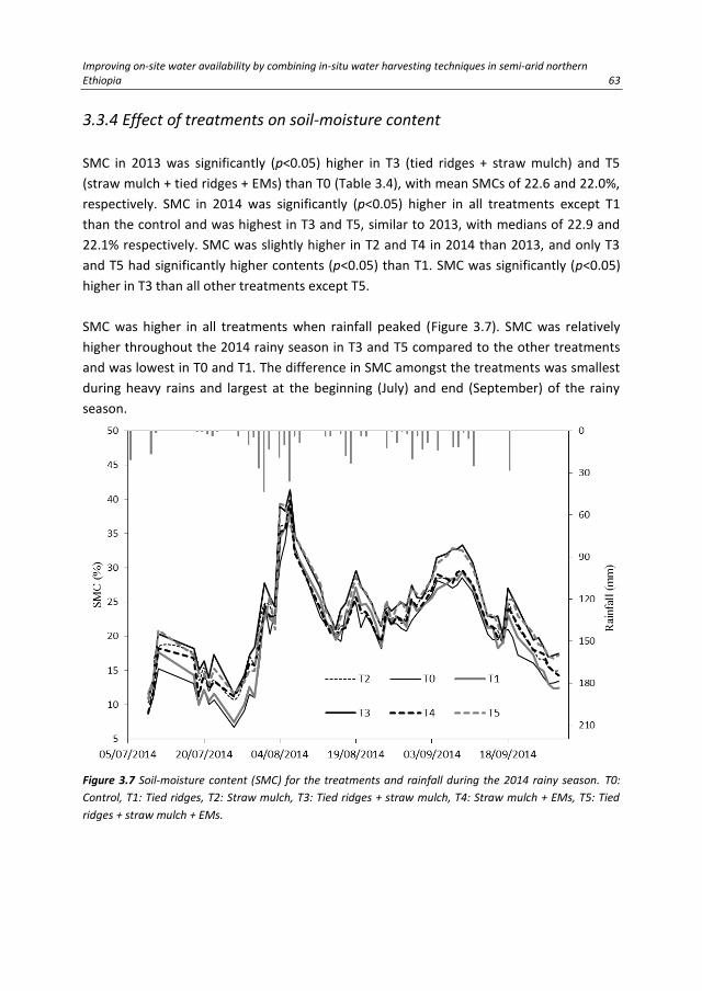
Improving on-site water availability by combining in-situ water harvesting techniques in semi-arid northern Ethiopia 63
3.3.4 Effect of treatments on soil-moisture content
SMC in 2013 was significantly (p<0.05) higher in T3 (tied ridges + straw mulch) and T5
(straw mulch + tied ridges + EMs) than T0 (Table 3.4), with mean SMCs of 22.6 and 22.0%,
respectively. SMC in 2014 was significantly (p<0.05) higher in all treatments except T1
than the control and was highest in T3 and T5, similar to 2013, with medians of 22.9 and
22.1% respectively. SMC was slightly higher in T2 and T4 in 2014 than 2013, and only T3
and T5 had significantly higher contents (p<0.05) than T1. SMC was significantly (p<0.05)
higher in T3 than all other treatments except T5.
SMC was higher in all treatments when rainfall peaked (Figure 3.7). SMC was relatively
higher throughout the 2014 rainy season in T3 and T5 compared to the other treatments
and was lowest in T0 and T1. The difference in SMC amongst the treatments was smallest
during heavy rains and largest at the beginning (July) and end (September) of the rainy
season.
Figure 3.7 Soil-moisture content (SMC) for the treatments and rainfall during the 2014 rainy season. T0:
Control, T1: Tied ridges, T2: Straw mulch, T3: Tied ridges + straw mulch, T4: Straw mulch + EMs, T5: Tied
ridges + straw mulch + EMs.

64 Chapter 3
3.3.5 Relationships amongst the hydro-meteorological and soil parameters
Factors affecting runoff and soil-moisture content
The PCA for the hydrological and soil parameters indicated that the first two PCs explained
57.3% of the total variance (Figure 3.8). PC1 described 35.9% of the total variance and had
strong positive loadings for SMC (0.89) and Ks (0.88). The high and positive loadings in PC1
of these two factors may be due to their strong correlation (r=0.80, p<0.01). PC2
accounted for 21.4% of the total variance and was mainly associated with runoff and
slope, with moderate factor loadings of 0.63 and 0.67, respectively.
Figure 3.8 Principal component analysis of the hydrological and soil parameters: runoff (Rn), soil-moisture
content (SMC), slope (Sl), soil organic-matter (SOM), saturated (Ksat), and unsaturated (Ks) hydraulic
conductivities. The PCA was based on total seasonal runoff, average seasonal SMC, and SOM, Ksat and Ks
taken from measurements after crop harvest.
The PCA for the hydro-meteorological data obtained from event-based measurements
identified two components that explained 86.7% of the total variation. PC1 accounted for
61.3% of the total variation (Figure 3.9) and was mainly associated with I30, rainfall, and
runoff, with factor loadings of 0.96, 0.94, and 0.80, respectively. The positive and high
loadings for the three variables may be attributed to the link between runoff and both

Improving on-site water availability by combining in-situ water harvesting techniques in semi-arid northern Ethiopia 65
rainfall and I30. Runoff was moderately correlated with rainfall (r=0.59, p<0.01) and I30
(r=0.70, p<0.01). PC2 was strongly linked with SMC and accounted for 25.4% of the total
variance in the hydro-meteorological data.
Figure 3.9 Principal component analysis of the hydro-meteorological parameters: runoff (Rn), rainfall (Rf),
rain intensity (I30), and soil-moisture content (SMC). The PCA was performed based on event data for
rainfall, rain intensity and runoff, and daily measurements for SMC (n=630) for 2013 and 2014.
Establishing multiple regression to estimate runoff
PC1 (rainfall-runoff component) of the PCA for the hydro-meteorological group indicated
that runoff was closely associated with rainfall and I30, and PC2 (runoff component) of the
PCA for the hydrological and soil parameters group indicated that runoff was moderately
associated with slope. We thus used multiple linear regressions to determine if runoff
could be predicted using meteorological, hydrological, and soil physical parameters.
Rainfall and I30 (Figure 3.9) and SMC and Ks (Figure 3.8) were closely associated, so the
problem of multicollinearity was examined using the magnitude of the tolerance in the
regression analysis.
The multiple linear regression analysis for estimating runoff per event from the measured
rainfall, I30, SMC, slope, SOM, Ksat, and Ks resulted in a significant (p<0.05) overall model

66 Chapter 3
fit for all treatments (Table 3.6). The regression models performed well for all treatments,
with r2
of 0.63, 0.77, and >0.8 for T0, T1, and T2-T5, respectively. The NSEs for the
regression models also indicated good agreement between estimated and measured
runoff, with values ranging from 0.62 to 0.81 for the various treatments (Figure 3.10).
Figure. 3.10 Relationship between estimated and measured runoff for the treatments in 2014. T0: Control,
T1: Tied ridges, T2: Straw mulch, T3: Tied ridges + straw mulch, T4: Straw mulch + EMs, T5: Tied ridges +
straw mulch + EMs.
Slope and Ksat were excluded from the regression model for T0 because these two
variables were highly multicollinear (tolerance near 0) with the other predictors. The
variables excluded from the regression models for the other treatments are identified (-)
in Table 3.6.

Improving on-site water availability by combining in-situ water harvesting techniques in semi-arid northern Ethiopia 67
Parameter estimates for rainfall and I30 were positive and significant (p<0.05) for all
treatments, except rainfall for T3. The parameter estimates for SMC were positive and
significant (p<0.05) for all treatments except T0 (control). Rainfall, I30, and SMC were thus
positively correlated with runoff, indicating that runoff tended to increase as these
predictor variables increased. The regression model for the control performed moderately
but significantly (p<0.05) well (r2=0.63, NSE=0.62) compared to the other treatments,
which showed relatively better model performance (r2=0.77-0.83, NSE=0.77-0.82). The
runoff regression model for the control was less influenced by SMC, with a non-significant
(p>0.05) and small parameter estimate (β3=-0.02).
Runoff was generally less affected by slope, SOM, Ksat, and Ks, demonstrated by the non-
significant (p>0.05) parameter estimates in all treatments, except for Ksat in T5 and SOM
in T4. These results indicate that runoff can basically be predicted using rainfall, rain
intensity, and SMC at the field scale where slope and soil properties are generally less
variable.
Table 3.6 Linear regression analysis for runoff (n=54) and model parameter estimates for different
treatments. Regression model: 𝑅𝑢𝑛𝑜𝑓𝑓 = 𝛽0+𝛽1𝑅𝑓 + 𝛽2𝐼30 + 𝛽3𝑆𝑀𝐶 + 𝛽4𝑆𝑙 + 𝛽5𝐾𝑠𝑎𝑡 + 𝛽6𝐾𝑠+𝛽7𝑆𝑂𝑀.
Data for runoff, rainfall and I30 belong to event-based measurements and SMC on a daily basis. SOM, Ksat
and Ks were based on measurements after crop harvest in 2014.
Parameter estimate (βi)
Predictor variable T0 T1 T2 T3 T4 T5
Constant, β0 6.05 3.81 -5.75a -3.18a -8.09a -1.96a
Rainfall, Rf (mm), β1 0.12a 0.19a 0.08a 0.04 0.10a 0.10a
Rain intensity, I30 (mm), β2 0.11a 0.05a 0.09a 0.09a 0.08a 0.06a
Soil-moisture content, SMC (%), β3 -0.02 0.07a 0.12a 0.07a 0.08a 0.05a
Slope, Sl (%), β4 - -0.62 - -0.76 -1.33 -
Saturated hydraulic conductivity, Ksat (m d-1), β5 - - - - - -0.11a
Unsaturated hydraulic conductivity, Ks (m d-1), β6 -0.76 - 0.17 - - -
Soil organic-matter, SOM (g kg-1), β7 -0.48 -0.55 0.06 0.12 0.73a -0.06
r2 0.63* 0.77* 0.83* 0.82* 0.83* 0.83* a Parameter estimate significant (p<0.05), * Model fit significant (p<0.05). T0: Control, T1: Tied ridges, T2: Straw mulch,
T3: Tied ridges + straw mulch, T4: Straw mulch + EMs, T5: Tied ridges + straw mulch + EMs.
3.4 Discussion
3.4.1 Effect of treatments on soil hydro-physical properties, runoff and soil-
moisture content
The non-significant variation of bulk density, SOM, Ksat and Ks shows the uniformity of
soil physical properties in the field and less effect of the treatments on significantly

68 Chapter 3
altering these properties. Non-significant effect of straw mulch on SOM and bulk density
might be attributed to the application rate or a significant effect might be revealed in the
long term under successive applications. Lower values of Ks than Ksat in the plots is most
probably due to a slower rate of water conductivity in unsaturated soils than saturated
soil conditions (FAO, 2001).
T1 (tied ridges) reduced average runoff per event moderately well, by 65 and 46% in 2013
and 2014, respectively. Runoff was significantly lower than normal agricultural practices
without treatment. This result is consistent with previous studies (Araya and Stroosnijder,
2010; McHugh et al., 2007). The very low runoff for T3 (straw mulch+ tied ridges) and T5
(straw mulch + tied ridges + EMs) in both experimental seasons demonstrated that
combining mulch and tied ridges can potentially be effective in reducing runoff in
farmlands. Mulch combined with various soil conservation measures such as compost,
pigeon-pea hedges, and manures has produced similar results, in which runoff was
reduced by 84-99% (Baptista et al., 2015b).
All treatments significantly reduced runoff in 2014 relative to the control. The higher
reduction for T2 (straw mulch) and T4 (straw mulch + EMs) in the second year of the
experiment demonstrated that annual additions of straw mulch may be nearly as effective
as combined straw mulch and tied ridges. Runoff did not differ significantly between
mulch alone and combined mulch and tied ridges. Tied ridges alone were less effective in
reducing runoff compared to combined straw mulch and tied ridges. Low runoff at the
beginning of the 2014 rainy season may have been due to the unsaturated state of the soil
profile (Araya et al., 2011). Runoff is primarily generated when rain intensity exceeds the
infiltration capacity of the soil (Beven, 2004).
The higher soil-water storage of the combined mulch and tied ridges compared to either
alone was attributed to the cumulative effect of reduced runoff and evaporation and
enhanced infiltration. Tied ridges can reduce runoff and enhance infiltration but are less
effective in preventing the loss of water from the soil by evaporation (Mudatenguha et al.,
2014). Mulching can reduce runoff and evaporation and so helps to retain water in the soil
profile (Stroosnijder, 2003). Our results, however, indicated that the efficiency of mulching
in retaining water was enhanced when combined with tied ridges, because the ridges
were able to prolong infiltration of the water they temporarily stored. Higher SMCs were
reported when various mulching systems such as gravel/sand, plastic, and groundnut crop
residue were combined with ridges or furrows, compared to ridges or furrows without
mulching (Ramesh and Devasenapathy, 2006; Wang et al., 2009).
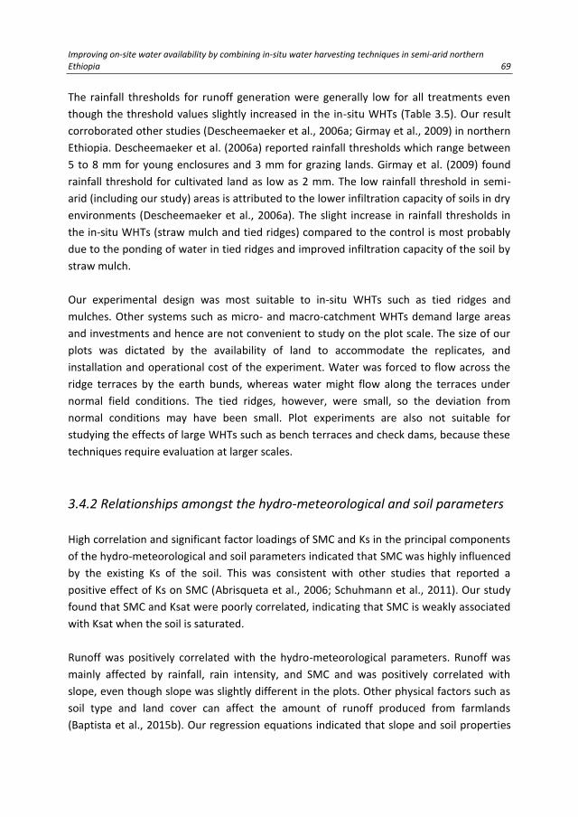
Improving on-site water availability by combining in-situ water harvesting techniques in semi-arid northern Ethiopia 69
The rainfall thresholds for runoff generation were generally low for all treatments even
though the threshold values slightly increased in the in-situ WHTs (Table 3.5). Our result
corroborated other studies (Descheemaeker et al., 2006a; Girmay et al., 2009) in northern
Ethiopia. Descheemaeker et al. (2006a) reported rainfall thresholds which range between
5 to 8 mm for young enclosures and 3 mm for grazing lands. Girmay et al. (2009) found
rainfall threshold for cultivated land as low as 2 mm. The low rainfall threshold in semi-
arid (including our study) areas is attributed to the lower infiltration capacity of soils in dry
environments (Descheemaeker et al., 2006a). The slight increase in rainfall thresholds in
the in-situ WHTs (straw mulch and tied ridges) compared to the control is most probably
due to the ponding of water in tied ridges and improved infiltration capacity of the soil by
straw mulch.
Our experimental design was most suitable to in-situ WHTs such as tied ridges and
mulches. Other systems such as micro- and macro-catchment WHTs demand large areas
and investments and hence are not convenient to study on the plot scale. The size of our
plots was dictated by the availability of land to accommodate the replicates, and
installation and operational cost of the experiment. Water was forced to flow across the
ridge terraces by the earth bunds, whereas water might flow along the terraces under
normal field conditions. The tied ridges, however, were small, so the deviation from
normal conditions may have been small. Plot experiments are also not suitable for
studying the effects of large WHTs such as bench terraces and check dams, because these
techniques require evaluation at larger scales.
3.4.2 Relationships amongst the hydro-meteorological and soil parameters
High correlation and significant factor loadings of SMC and Ks in the principal components
of the hydro-meteorological and soil parameters indicated that SMC was highly influenced
by the existing Ks of the soil. This was consistent with other studies that reported a
positive effect of Ks on SMC (Abrisqueta et al., 2006; Schuhmann et al., 2011). Our study
found that SMC and Ksat were poorly correlated, indicating that SMC is weakly associated
with Ksat when the soil is saturated.
Runoff was positively correlated with the hydro-meteorological parameters. Runoff was
mainly affected by rainfall, rain intensity, and SMC and was positively correlated with
slope, even though slope was slightly different in the plots. Other physical factors such as
soil type and land cover can affect the amount of runoff produced from farmlands
(Baptista et al., 2015b). Our regression equations indicated that slope and soil properties

70 Chapter 3
did not significantly affect runoff, because they varied little within the experimental design
but should be taken into account for larger areas where variations may be larger.
The positive and significant parameter estimates of SMC for T1-T5 in the runoff regression
models, unlike for T0 (control), substantiated the role of straw mulch and tied ridges,
individually or combined, in controlling the amount of runoff generated in the plots. The
regression models were able to estimate runoff per event with good performance using
measured rainfall, rain intensity, and daily SMC for the various in-situ WHTs. In areas
where runoff data are not readily available, regression models can be useful for predicting
runoff using hydro-meteorological input data for different in-situ WHTs, provided that
variations in field slope and soil properties are not large. In large areas, where variations in
slope and soil properties are expected, runoff can also be greatly affected by slope and
soil properties.
3.5 Conclusions
In coarse-textured soils with gentle slopes, tied ridge combined with straw mulch was the
most efficient technique for in-situ water harvesting. Tied ridge combined with straw
mulch significantly increased soil-moisture content in the farmlands by limiting water
losses via runoff and evaporation thereby improving temporal soil-water distribution. In-
situ water harvesting was substantiated during low rainfall or dry periods because of
prolonged water availability for crops. An improved soil-moisture distribution over dry
periods helps the resilience of crops to environmental adversities such as climate change
and drought.
Regression models are provided to estimate runoff from farmlands based on available
data for rainfall, rain intensity and daily soil-moisture content when field variations for
slope and soil properties are minimal. Knowing the amount of runoff generated from
farmlands under different in-situ water harvesting techniques helps to properly manage
the available water.

Effect of in-situ water harvesting techniques on soil and nutrient losses in semi-arid northern Ethiopia 71
4. Effect of in-situ water harvesting techniques on soil and nutrient losses in semi-arid northern
Ethiopia
Land degradation, mainly due to soil erosion and nutrient losses, is a global problem for sustainable agriculture. Farmlands in the Ethiopian highlands are susceptible to water erosion because of steep slopes and extensive cultivation. A field experiment was conducted in the Gule sub-watershed in northern Ethiopia to assess the efficacy of in-situ water harvesting techniques in reducing soil and nutrient losses. The research was carried out on a sandy clay loam soil under semi-arid conditions. Soil erosion and nutrient losses were monitored during the rainy season (June to September) in 2013 and 2014. Five treatments with tied ridges, wheat-straw mulch, and effective micro-organisms, alone or in combination, and an untreated control were tested. Combined tied ridges and straw mulch, with and without effective micro-organisms significantly reduced average soil loss over the two rainy seasons by 82 and 90%, respectively, compared to the control. Tied ridges alone reduced average soil loss by 60%. Straw mulch with and without effective micro-organisms decreased average soil loss by 81 and 85%, respectively. Combined tied ridges and straw mulch significantly decreased average total nitrogen and total phosphorus losses by 82 and 83%, respectively. Average nutrient losses were also significantly decreased by tied ridges (59% for nitrogen, 52% for phosphorus) and straw mulch (63% for nitrogen, 68% for phosphorus). Our results indicated that in-situ water harvesting techniques can effectively reduce soil and nutrient losses from farmland and were more efficient when the techniques were combined.
Based on:
Grum, B., Assefa, D., Hessel, R., Woldearegay, K., Kessler, A., Ritsema, C.J., R., Geissen, V.,
2016. Effect of in-situ water harvesting techniques on soil and nutrient losses in semi-
arid northern Ethiopia. Land Degradation and Development. DOI: 10.1002/ldr.2603.

72 Chapter 4
4.1 Introduction
Land degradation is considered as the main global problem preventing future sustainable
agricultural production (Zougmoré et al., 2009). Accordingly, soil erosion is a serious
problem due to its severe impacts on agricultural productivity, ecosystem services and
environmental balances (Panagos et al., 2015). Soil loss from farmland is aggravated by
inappropriate soil management and tillage practices and the absence of erosion control
measures (Cerdà et al., 2009; Rodrigo Comino et al., 2015; Prosdocimi et al., 2016a).
Farmlands in the Ethiopian highlands are often located on steep slopes and are extensively
cultivated; therefore they are highly susceptible to water erosion in the rainy seasons
(Damene et al., 2013; Taddese, 2001; Teshome et al., 2013). Moreover, farmer’s decision
to invest on sustainable land management practices is highly constrained by existing land
quality, land fragmentation and land tenure systems (Teshome et al., 2016). Soil loss in the
Ethiopian highlands is reported to be around 1.9 billion Mg yr-1
and 80% of the loss comes
from cultivated areas (FAO, 1986). Land degradation, mainly by water erosion, is a primary
cause of low and declining soil productivity in Ethiopia (Araya et al., 2011). Water erosion
causes the removal of soil from farmland, which results in the loss of valuable plant
nutrients with the eroded soil (Kraaijvanger and Veldkamp, 2015; Taddese, 2001).
Land degradation in the Tigray region of northern Ethiopia became so critical that it
hampered agricultural productivity, so the government and others endeavoured to
rehabilitate the land using soil and water conservation measures (Nyssen et al., 2015;
Vancampenhout et al., 2006; Walraevens et al., 2015), mainly stone bunds and area
exclosures (Descheemaeker et al., 2006b; Desta et al., 2005; Nyssen et al., 2007).
According to Desta et al. (2005), stone bunds reduced annual soil losses from sheet and rill
erosion by 68%. Runoff, however, spilt over these structures because in-situ water
harvesting techniques (WHTs) were rarely used in the agricultural fields (Gebreegziabher
et al., 2009). A new paradigm of soil conservation and land rehabilitation by in-situ soil
and water management is therefore needed (Nyssen et al., 2009b).
In-situ WHTs enhance the collection of rainwater on the surface where it falls and store it
in the soil layer (Helmreich and Horn, 2009). The most widely used in-situ WHTs are tied
ridges, mulching, conservation tillage and various furrow systems (Biazin et al., 2012).
Some studies in Tigray and other parts of Ethiopia have focused on the role of
conservation agriculture (e.g. contour furrows, conservation tillage, terwah and derdero)
in reducing soil loss from farmland (Araya et al., 2011; Gebreegziabher et al., 2009;
McHugh et al., 2007). The effect of different soil management practices on soil erosion

Effect of in-situ water harvesting techniques on soil and nutrient losses in semi-arid northern Ethiopia 73
have also been studied in other parts of the world (Adekalu et al., 2007; Fernández and
Vega, 2016; Mekonnen et al., 2015b; Mwango et al., 2015; Prosdocimi et al., 2016b). In-
situ WHTs have been applied in a variety of climates and landscapes, mainly to improve
on-site soil-water regimes and to reduce soil and nutrient losses in runoff (Adimassu et al.,
2014; Al-Seekh and Mohammad, 2009; Okeyo et al., 2014).
The effects of combining different measures of soil management, such as crop-residue
mulching with organic amendments (Baptista et al., 2015a), runoff barriers with nutrient
management (Zougmoré et al., 2009) and tillage with mulching (Donjadee and
Tingsanchali, 2016; Jin et al., 2008), on soil and/or associated nutrient losses have been
studied. Other researchers also investigated the effect of combined use of rice-straw
compost with phosphogypsum (Mahmoud and Abd El-Kader, 2015) and crushed maize-
straw residue with urea (Tejada and Benítez, 2014) on improving soil chemical and
biological properties. Little information, however, is available on the effect of combining
in-situ WHTs such as tied ridges and straw mulch on the reduction of soil and nutrient
losses from farmland. Combining different in-situ WHTs helps to reduce runoff, soil and
associated nutrient losses (Baptista et al., 2015a). Integrating WHTs with nutrient
management can also help to ensure higher and more sustainable agricultural productivity
(Miriti et al., 2007). For example, the application of bio-fertilisers such as effective micro-
organisms (EMs) to the soil enhances the physical properties of the soil such as infiltration
rate and water-holding capacity (Ismail, 2013).
Therefore the aims of this study were (i) to assess the effect of in-situ WHTs on soil and
nutrient losses and maize yield (ii) to evaluate the efficacy of combining in-situ WHTs
(straw mulch, tied ridges and EMs) for controlling soil erosion .
4.2 Materials and methods
4.2.1 Description of the study area
The study was conducted at a farmer-training centre in the Gule sub-watershed of the
upper Geba catchment in northern Ethiopia (13°52′49″N, 39°28′59″E; Figure 4.1). The sub-
watershed has a rugged topography with mountains and flat valley floors and with
altitudes ranging between 2008 and 2408 m a.s.l. It has a semi-arid climate, with two
major seasons, a rainy and a dry season. The rainy season is often from June to
September, and the dry season is from October to May (Nyssen et al., 2010). Rainfall
measurements of three successive years (2013-2015) using a meteorological station that
was installed for the purpose of this study showed an average annual rainfall of 465 mm.

74 Chapter 4
The temperature is relatively constant throughout the year. Average daily temperature
ranges between 15 and 25 °C, with a mean of 20 °C. The study area was selected based on
a set of criteria established during a stakeholders’ workshop for selecting WHTs (Grum et
al., 2016). The experimental site was on the flat valley floor of the sub-watershed at a
mean altitude of 2050 m a.s.l. The site had a total area of 1750 m2, and slopes ranged
between 1.8 and 3.4%. The experiment was conducted on a Eutric Cambisols soil type
(IUSS Working Group WRB, 2015) with a sandy clay loam texture.
Figure 4.1 Location of the study area. (a) Topography of Ethiopia. (b) Land use of the Gule sub-watershed
and location of the experimental site.
Table 4.1 Description of the treatments in the field experiment.
Treatment Description
T0 (control) Basal fertilisationa
T1 Basal fertilization + tied ridges
T2 Basal fertilization + straw mulch (15 Mg ha-1)
T3 Basal fertilization + straw mulch (15 Mg ha-1) and tied ridges
T4 Basal fertilization + straw mulch (15 Mg ha-1) and 4 L ha-1 of EMs
T5 Basal fertilization + straw mulch (15 Mg ha-1), tied ridges, and 4 L ha-1 of EMs a Basal fertilization: 100 kg ha-1 urea (46% N) and 100 kg ha-1 diammonium phosphate (18% N, 46% P) applied to the
entire field experiment. EMs: effective micro-organisms.

Effect of in-situ water harvesting techniques on soil and nutrient losses in semi-arid northern Ethiopia 75
4.2.2 Experimental design
The experiment was carried out for two successive rainy seasons (June to September) in
2013 and 2014. The experiment had a completely randomized block design consisting of
five treatments and a control. The treatments were selected by stakeholders in a
participatory WHT selection workshop (Grum et al., 2016). Each treatment had three
replicates with plot size of 3 × 15 m, for a total of 18 plots (Figure 4.2). The treatments and
the application of measures are described in Table 4.1.
The experimental field was ploughed twice by oxen-driven maresha a month and a week
before sowing. The experimental plots were then established by hand. Each plot was
isolated by earth bunds 50 cm wide and 40 cm high to prevent the flow of water from
neighbouring plots and to provide access to the plots during inspection.
A basal fertiliser was applied to the entire field (all plots) at rates of 64 kg ha-1 nitrogen (N)
and 46 kg ha-1
phosphorus (P) in the form of inorganic fertilisers (urea and diammonium
phosphate). These rates of fertilisation are blanket recommendations and commonly
applied rates in the region (Araya and Stroosnijder, 2010). Wheat-straw mulch was applied
for T2-T5 at a rate of 15 Mg ha-1
. Wheat straw (Triticum aestivum L.), typically used for
feedstocks, consists of cellulose (35%), hemicellulose (25%) and lignin (19%) (Windeatt et
al., 2014). Wheat straw contains 0.6% N (Nicholson et al., 1997; Smil, 1999) and 0.1% P
(Smil, 1999). The nutrient inputs from the straw mulch for T2-T5 were thus 90 kg N ha-1
and 15 kg P ha-1
.
The crop used in the experiment was maize (Zea mays L.). Maize seeds were planted in
each plot in rows with 30 cm between plants and 60 cm between rows in plots without
tied ridges and 70 cm between rows in plots with ridges. Tied ridges for T1, T3, and T5
were established after maize had fully germinated and emerged. The ridges were 20 cm
high, 3 m long, and 1.9 m apart and were tied in the middle. Each plot with tied ridges
therefore had seven tied ridges in the rows (Figure 4.2). All plots were manually hoed and
weeds were removed one and two months after planting. Dry wheat-straw mulch was
spread onto the soil surface in T2-T5 at a rate of 15 Mg ha-1
after the maize had fully
germinated and emerged. A diluted solution (1:500) of activated EMs (EMRO, Okinawa,
Japan) was also sprayed onto the soil surface in T4 and T5. The EMs consisted of a selected
group of micro-organisms, predominantly lactic acid bacteria, yeast, and phototrophic
bacteria. The activated EMs were prepared one week before sowing at a ratio of 2:96:2 of
molasses, rainwater and inactivated EMs, respectively. The EMs were applied twice, at
sowing and mid of the growing season (early August), at a rate of 4 L ha-1
.

76 Chapter 4
Figure 4.2 Layout of the experimental runoff plots. (a) Experiment plots with tied ridges (T1, T3 and T5). (b)
Experiment plots without tied ridges (T0, T2 and T4). (c) Photograph of the field layout with treatments. (d)
Soil-moisture measurement by using Trime-PICO64 soil-moisture sensor.
Eroded soil exported with the runoff after each rain was collected in 300-400 L subsurface
barrels buried at the end of each plot. The exported soil with runoff was channelled from
the plots by a corrugated iron gutter placed directly above the barrels and was then
directed into the barrels by a metal inlet pipe (Figure 4.2).
4.2.3 Data collection and measurements
Composite soil samples were collected to a depth of 20 cm before the beginning of the
rainy season in 2013 and 2014 for characterising the physical and chemical properties
(Table 4.2). Soil samples were also collected using ergonomic hand auger (Eijkelkamp,
Giesbeek, Netherlands) from three sampling points in each plot at the end of the

Effect of in-situ water harvesting techniques on soil and nutrient losses in semi-arid northern Ethiopia 77
experimental period to depths of 20 and 40 cm for the analysis of pH, soil organic carbon
(SOC) content, and nutrient (N and P) contents.
Table 4.2 Selected initial soil properties at the experimental site.
Properties Mean±SD
Soil texture -
0.063-2 mm, sand (%) 64.6±4.7
0.002-0.063 mm, silt (%) 12.6±3.5
<0.002 mm, clay (%) 22.8±1.9
Bulk density (g cm-3) 1.6±0.0
pH (H2O) 6.8±0.2
Soil organic carbon (g kg-1) 4.7±1.9
Total nitrogen (mg kg-1) 4.4±2.0
Available phosphorus (mg kg-1) 8.2±2.1
Soil texture was determined by the hydrometer method, bulk density by the core method
(Blake and Hartge, 1986), and pH by potentiometry. SOC content was analysed by the
Walkley Black method (Nelson and Sommers, 1982), total N (TN) content by the Kjeldahl
method (Jackson, 1958), total P (TP) and available-P content by the Olsen method (Olsen
and Sommers, 1982).
Rainfall was measured using tipping-bucket data-logging RG3-M HOBO (precision: 0.2 mm
per tip) rain gauge (Onset, Bourne, MA, USA) installed at the site. Soil-moisture content
(SMC) was monitored daily using a Trime-PICO64 (time-domain reflectometer or TDR
method) soil-moisture sensor (Eijkelkamp, Giesbeek, Netherlands) to a depth of 15 cm at
six sampling points in each plot in 2013 and 2014.
Runoff volume per plot was measured after each rain event. An aliquot of 1 L was
collected from each barrel after thoroughly stirring the collected runoff. The aliquot was
used to analyse sediment concentration, soil and nutrient losses in the eroded soil in 2013
and 2014. Each water sample was first filtered through a Whatman Grade 42 filter paper
by gravity, and the sediment residue on the filter paper was then dried at room
temperature. The dried residue was weighed to determine the sediment concentration in
the runoff, and the total amount of eroded soil per plot. The loss of nutrients (N and P),
was determined from only five of the runoff events distributed over each experimental
year due to the expense of the analyses.
4.2.4 Data analysis
Statistical analysis was performed using SPSS 22 (IBM Corporation, New York, USA).
Normally distributed data were analysed using a least squares one-way analysis of

78 Chapter 4
variance. The data that were not normally distributed were analysed using non-parametric
tests for statistical differences. Significant difference between treatments for a measured
variable was tested using the pairwise Mann-Whitney U-test. All statistical tests were
considered significant at a probability value of 0.05 (p<0.05).
The fraction of exported nutrients in eroded soils per runoff event for each treatment was
calculated by:
𝐹𝑟𝑎𝑐𝑡𝑖𝑜𝑛 𝑜𝑓 𝑛𝑢𝑡𝑟𝑖𝑒𝑛𝑡 𝑙𝑜𝑠𝑠 (%) = 𝑁𝑢𝑡𝑟𝑖𝑒𝑛𝑡 𝑙𝑜𝑠𝑠 𝑖𝑛 𝑒𝑟𝑜𝑑𝑒𝑑 𝑠𝑜𝑖𝑙
𝑁𝑢𝑡𝑟𝑖𝑒𝑛𝑡 𝑖𝑛𝑝𝑢𝑡× 100 (4.1)
Soil/nutrient loss reduction per runoff event of a treatment relative to the control was
calculated by:
𝑅 (%) =𝑂𝑐−𝑂𝑡
𝑂𝑐× 100 (4.2)
where R is the reduction in soil/nutrient loss by a treatment relative to the control (%), Oc
is the measured soil (kg ha-1
) or nutrient (g ha-1
) loss in the control, and Ot is the measured
soil (kg ha-1
) or nutrient (g ha-1
) loss in a treatment.
Principal component analysis (PCA) was carried out to identify the factors affecting the soil
and nutrient losses using averaged data per treatment and the control for 2013 and 2014
(n=36). The PCA tested seven variables: runoff, soil loss, TN loss, TP loss, SMC, bulk
density, and plot slope. Correlations between variables were analysed using Spearman’s
rank correlation at a significance level of 0.01 (p<0.01). Regression analyses were
performed between soil loss and runoff and between nutrient loss and soil loss. The
regression analyses were carried out separately for the control (T0) and the in-situ WHTs
(T1-T5).
4.3 Results
4.3.1 Effect of the treatments on soil and associated nutrient losses
The effects of treatments on runoff, soil and nutrients losses are summarized in Table 4.3.
Runoff was significantly lower in T1-T5 than T0. Median runoff was lowest and highest in
T3 (0.6 mm) and T0 (4.7 mm), respectively.

Effect of in-situ water harvesting techniques on soil and nutrient losses in semi-arid northern Ethiopia 79
Soil loss per event was significantly lower in all WHTs than the control. Median soil loss
was highest in T0 at 90.6 kg ha-1
and lowest in T3 at 8.3 kg ha-1
. Median soil loss was
significantly higher (36.4 kg ha-1
) in T1 than T2-T5. Median soil loss per event for the
various treatments was in the order T0>T1>T2=T3=T4=T5. Seasonal soil loss was also
significantly higher in the control than the WHTs and was significantly lower in T2-T5 than
T0 and T1.
Table 4.3 Average runoff and soil, total N, and total P losses per event over two seasons (2013 and 2014).
Treat-
ment
Runoff
(mm)
Soil loss
(kg ha-1)
Seasonal soil
loss (Mg ha-1)*
Total N loss
(g ha-1)
Total P loss
(g ha-1)
Median
(min, max)
(n=84)
Median
(min, max)
(n=84)
Median
(min, max)
(n=3)
Median
(min, max)
(n=30)
Median
(min, max)
(n=30)
T0
4.7
(0.3, 11.2) d
90.6
(2.3, 865.1) c
4.3
(3.6, 4.7) d
364.1
(36.2, 1731.3) c
259.2
(14.2, 746.9) c
T1
2.0
(0.2, 9.2) c
36.4
(2.0, 529.8) b
2.1
(1.7, 2.2) c
134.3
(8.4, 996.2) b
96.7
(3.1, 393.1) b
T2
0.9
(0.2, 8.9) b
16.8
(0.7, 373.6) a
1.0
(0.5, 1.3) ab
154.7
(5.3, 977.9) b
95.1
(1.8, 313.0) b
T3
0.6
(0.1, 8.8) a
8.3
(0.5, 306.4) a
0.8
(0.7, 0.9) a
42.6
(1.3, 1019.5) a
20.0
(1.0, 301.2) a
T4
1.0
(0.2, 8.8) b
10.9
(0.8, 437.5) a
1.3
(1.2, 1.4) b
208.9
(1.9, 1230.8) b
104.6
(0.9, 399.6) b
T5
0.9
(0.1, 8.6) b
11.7
(0.4, 388.1) a
0.8
(0.8, 1.4) ab
98.8
(0.8, 613.2) ab
62.8
(0.3, 451.4) ab
Different letters show significant (Mann-Whitney U-test, p<0.05) difference between treatments, a<b<c<d. * Seasonal soil loss was computed from runoff events in 2014. T0: Control, T1: Tied ridges, T2: Straw mulch, T3: Tied
ridges + straw mulch, T4: Straw mulch + EMs, T5: Tied ridges + straw mulch + EMs.
The WHTs had significant effects on TN and TP losses in the sediments. The TN and TP
losses were the highest in the control, with medians of 364.1 and 259.2 g ha-1
,
respectively. Nutrient losses were significantly lower in all WHTs than the control. Nutrient
losses were lowest in T3 but did not differ significantly from the losses in T5. Nutrient
losses in the sediments were generally higher for N than P. Nutrient losses were generally
higher in the treatments with EMs (T4 and T5) than in the corresponding treatments
without EMs (T2 and T3). The event-based statistical analysis (Figure 4.3) showed no
significant differences in nutrient losses between the treatments with and without EMs.
T3 (90%) and T1 (60%) decreased soil losses the most and least, respectively (Table 4.4).
The efficiencies of reductions in nutrient losses for the treatments ranged between 56 and
84% for TN and between 52 and 86% for TP. T3 decreased the loss of both TN and TP the

80 Chapter 4
most, by 84 and 86%, respectively, and T1 and T4 decreased the loss of both TP and TN the
least, by 52 and 56%, respectively.
Figure 4.3 Soil, total N and total P losses per event for different treatments (n=3). Different letters show
significant (Mann–Whitney U-test, p<0·05) difference between treatments, a<b<c<d. Error bars are
standard deviations. T0: Control, T1: Tied ridges, T2: Straw mulch, T3: Tied ridges + straw mulch, T4: Straw
mulch + EMs, T5: Tied ridges + straw mulch + EMs.

Effect of in-situ water harvesting techniques on soil and nutrient losses in semi-arid northern Ethiopia 81
Table 4.4 Efficiencies of reduction in runoff, and soil, total N and total P losses compared to control over
two seasons (2013 and 2014).
Treatment
Runoff reduction (%)
Soil loss
reduction (%)
Total N loss
reduction (%)
Total P loss
reduction (%)
Median (min, max)
(n=84)
Median (min, max)
(n=84)
Median (min, max)
(n=30)
Median (min, max)
(n=30)
T0 0 (0, 0) 0 (0, 0) 0 (0, 0) 0 (0, 0)
T1 49 (-29, 93) 60 (-32, 94) 59 (-30, 95) 52 (-14, 96)
T2 80 (-17, 96) 85 (-53, 98) 70 (-55, 98) 73 (-45, 98)
T3 85 (0, 99) 90 (-24, 99) 84 (-49, 100) 86 (-11, 100)
T4 77 (-19, 96) 81 (-50, 99) 56 (-21, 99) 63 (-45, 99)
T5 79 (-32, 98) 82 (-32, 99) 80 (2, 98) 80 (3, 98)
T0: Control, T1: Tied ridges, T2: Straw mulch, T3: Tied ridges + straw mulch, T4: Straw mulch + EMs, T5: Tied ridges +
straw mulch + EMs.
The fractions of nutrients exported with eroded soil compared to inputs (basal fertilisation
and straw mulch) during the growing season in 2014 were low in T2-T5 (Table 4.5). The
fractions, however, were significantly higher in T1 (tied ridges) and T0. In T0, 14.3 and
9.3% of the N and P inputs respectively, were exported with the eroded soil. The fractions
of N and P exported with the eroded soil for T1 were 5.8 and 3.6%, respectively. The
fractions of exported nutrients were significantly lower in T1-T5 than T0. The fractions of
exported nutrients were significantly higher in T4 than the other treatments, even though
T2-T5, received the same inputs.
Table 4.5 Nutrient inputs (N and P) and fractions of exported nutrients in eroded soils (median (min, max))
relative to the inputs in 2014 (n=3).
Treatment
Nutrient inputs
Fractions of N and P losses
Total N (kg ha-1) Total P (kg ha-1) Total N (%) Total P (%)
T0 64 46 14.3 (13.7, 16.1) d 9.3 (7.5, 9.9) d
T1 64 46 5.8 (4.0, 8.1) c 3.6 (2.9, 4.5) c
T2 154 61 1.4 (0.7, 1.7) a 1.5 (0.7,1.6) a
T3 154 61 1.1 (1.1, 1.4) a 1.3 (1.2, 1.3) a
T4 154 61 1.9 (1.8, 2.1) b 1.9 (1.7, 2.2) b
T5 154 61 1.2 (0.9, 1.6) a 1.1 (1.0, 1.7) a
Different letters show significance (Mann-Whitney U-test, p<0.05) difference between treatments, a<b<c<d. T0: Control,
T1: Tied ridges, T2: Straw mulch, T3: Tied ridges + straw mulch, T4: Straw mulch + EMs, T5: Tied ridges + straw
mulch + EMs.
4.3.2 Effect of the treatments on sediment and nutrient concentrations
Sediment concentrations were significantly (p<0.05) lower in T2-T5 than T0 (Table 4.6).
Sediment concentration in T1 did not differ significantly from those in the other
treatments (T2-T5) or T0. The concentrations varied little amongst T1-T5 but were highest
and lowest in T0 and T4 at 2.39 and 1.20 g L-1
, respectively. Sediment concentrations in
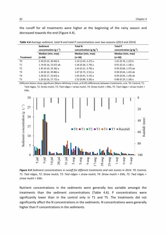
82 Chapter 4
the runoff for all treatments were higher at the beginning of the rainy season and
decreased towards the end (Figure 4.4).
Table 4.6 Average sediment, total N and total P concentrations over two seasons (2013 and 2014).
Treatment
Sediment
concentration (g L-1)
Total N
concentration (g kg-1)
Total P
concentration (g kg-1)
Median (min, max)
(n=84)
Median (min, max)
(n=30)
Median (min, max)
(n=30)
T0 2.39 (0.10, 30.40) b 1.53 (1.03, 3.27) a 1.01 (0.76, 1.22) b
T1 1.74 (0.16, 22.07) ab 1.56 (0.36, 2.79) a 0.91 (0.25, 1.18) a
T2 1.45 (0.10, 25.36) a 1.63 (0.21, 3.79) a 0.95 (0.06, 1.37) ab
T3 1.34 (0.10, 39.86) a 1.67 (0.73, 3.51) a 0.94 (0.64, 1.42) ab
T4 1.20 (0.17, 23.63) a 1.65 (0.41, 3.15) a 0.95 (0.05, 1.24) ab
T5 1.26 (0.16, 27.72) a 1.52 (0.89, 3.26) a 0.86 (0.19, 1.18) a
Different letters show significant (Mann-Whitney U-test, p<0.05) differences between treatments, a<b. T0: Control, T1:
Tied ridges, T2: Straw mulch, T3: Tied ridges + straw mulch, T4: Straw mulch + EMs, T5: Tied ridges + straw mulch +
EMs.
Figure 4.4 Sediment concentrations in runoff for different treatments and rain events in 2014. T0: Control,
T1: Tied ridges, T2: Straw mulch, T3: Tied ridges + straw mulch, T4: Straw mulch + EMs, T5: Tied ridges +
straw mulch + EMs.
Nutrient concentrations in the sediments were generally less variable amongst the
treatments than the sediment concentrations (Table 4.6). P concentrations were
significantly lower than in the control only in T1 and T5. The treatments did not
significantly affect the N concentrations in the sediments. N concentrations were generally
higher than P concentrations in the sediments.
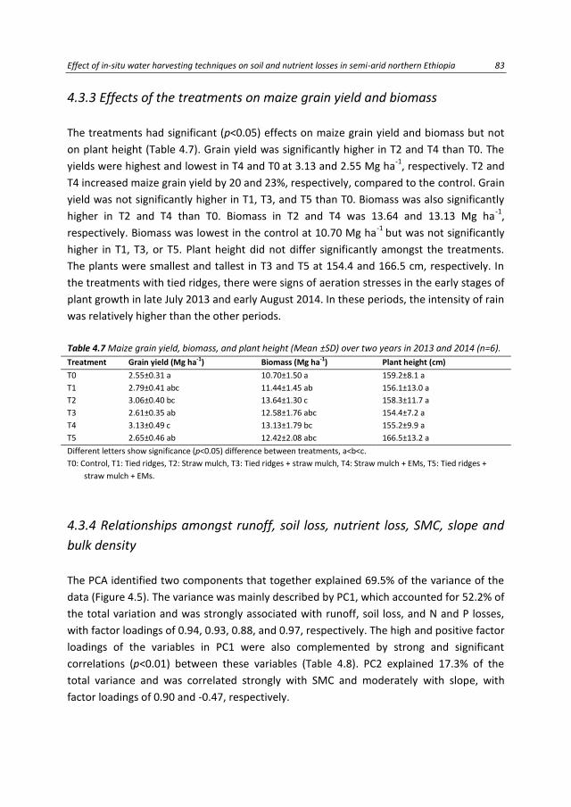
Effect of in-situ water harvesting techniques on soil and nutrient losses in semi-arid northern Ethiopia 83
4.3.3 Effects of the treatments on maize grain yield and biomass
The treatments had significant (p<0.05) effects on maize grain yield and biomass but not
on plant height (Table 4.7). Grain yield was significantly higher in T2 and T4 than T0. The
yields were highest and lowest in T4 and T0 at 3.13 and 2.55 Mg ha-1
, respectively. T2 and
T4 increased maize grain yield by 20 and 23%, respectively, compared to the control. Grain
yield was not significantly higher in T1, T3, and T5 than T0. Biomass was also significantly
higher in T2 and T4 than T0. Biomass in T2 and T4 was 13.64 and 13.13 Mg ha-1
,
respectively. Biomass was lowest in the control at 10.70 Mg ha-1
but was not significantly
higher in T1, T3, or T5. Plant height did not differ significantly amongst the treatments.
The plants were smallest and tallest in T3 and T5 at 154.4 and 166.5 cm, respectively. In
the treatments with tied ridges, there were signs of aeration stresses in the early stages of
plant growth in late July 2013 and early August 2014. In these periods, the intensity of rain
was relatively higher than the other periods.
Table 4.7 Maize grain yield, biomass, and plant height (Mean ±SD) over two years in 2013 and 2014 (n=6). Treatment Grain yield (Mg ha-1) Biomass (Mg ha-1) Plant height (cm)
T0 2.55±0.31 a 10.70±1.50 a 159.2±8.1 a
T1 2.79±0.41 abc 11.44±1.45 ab 156.1±13.0 a
T2 3.06±0.40 bc 13.64±1.30 c 158.3±11.7 a
T3 2.61±0.35 ab 12.58±1.76 abc 154.4±7.2 a
T4 3.13±0.49 c 13.13±1.79 bc 155.2±9.9 a
T5 2.65±0.46 ab 12.42±2.08 abc 166.5±13.2 a
Different letters show significance (p<0.05) difference between treatments, a<b<c.
T0: Control, T1: Tied ridges, T2: Straw mulch, T3: Tied ridges + straw mulch, T4: Straw mulch + EMs, T5: Tied ridges +
straw mulch + EMs.
4.3.4 Relationships amongst runoff, soil loss, nutrient loss, SMC, slope and
bulk density
The PCA identified two components that together explained 69.5% of the variance of the
data (Figure 4.5). The variance was mainly described by PC1, which accounted for 52.2% of
the total variation and was strongly associated with runoff, soil loss, and N and P losses,
with factor loadings of 0.94, 0.93, 0.88, and 0.97, respectively. The high and positive factor
loadings of the variables in PC1 were also complemented by strong and significant
correlations (p<0.01) between these variables (Table 4.8). PC2 explained 17.3% of the
total variance and was correlated strongly with SMC and moderately with slope, with
factor loadings of 0.90 and -0.47, respectively.

84 Chapter 4
Figure 4.5 Principal component analysis of runoff (Rn), soil-moisture content (SMC), soil loss, total N (TN)
loss, total P (TP) loss, slope (Sl) and bulk density (Bd), based on average seasonal data (n=36) in 2013 and
2014.
Table 4.8 Regression equations for estimating soil (kg ha-1), total N (g ha-1), and total P (g ha-1) losses in the
control (T0) and in-situ WHTs (T1-T5). Control (T0) In-situ WHTs (T1-T5)
Log soil loss = 1.25 × log runoff + 1.17
(r2=0.52, n=84, p<0.01)
Log soil loss = 1.33 × log runoff + 1.18
(r2=0.63, n=420, p<0.01)
Nitrogen loss = 1.70 × soil loss +30.72
(r2=0.71, n=30, p<0.01)
Nitrogen loss = 1.90 × soil loss −12.11
(r2=0.74, n=150, p<0.01)
Phosphorus loss = 0.89 × soil loss +25.57
(r2=0.96, n=30, p<0.01)
Phosphorus loss = 0.82 × soil loss +6.34
(r2=0.84, n=150, p<0.01)
T0: Control, T1: Tied ridges, T2: Straw mulch, T3: Tied ridges + straw mulch, T4: Straw mulch + EMs, T5: Tied ridges +
straw mulch + EMs.
The correlation analysis between runoff and soil loss per event identified a significant
(p<0.01) logarithmic relationship between the two variables (Table 4.8). Fifty-two percent
of the variation in soil loss in T0 was explained by the runoff. The explanatory capability
improved slightly for the in-situ WHTs (T1-T5), where runoff accounted for 63% of the
variability in soil loss.

Effect of in-situ water harvesting techniques on soil and nutrient losses in semi-arid northern Ethiopia 85
Nutrient losses were positively and significantly (p<0.01) correlated with soil losses in both
the control and the in-situ WHTs. Soil loss accounted for 71 and 96% of the variation in the
losses of N and P for T0, respectively, and 74 and 84% for T1-T5, respectively.
4.4 Discussion
4.4.1 Soil and nutrient losses
The application of the in-situ WHTs significantly decreased the loss of soil compared to T0.
Straw mulch (with or without tied ridges) was efficient in reducing soil loss from cultivated
land. The positive effect of crop residue mulching on soil loss in cultivated lands have also
been documented in other ecosystems in the world (Adekalu et al., 2007; Fernández and
Vega, 2016; Gholami et al., 2013; Mwango et al., 2015; Prosdocimi et al., 2016b; Sadeghi
et al., 2015a). The good performance of the straw mulch for decreasing soil loss was
associated with its good performance in decreasing runoff and sediment concentration
compared to the control. This result was also confirmed by other researchers (Gholami et
al., 2013; Sadeghi et al., 2015a; Sadeghi et al., 2015b; Prosdocimi et al., 2016b).
Our study did not analyse the costs and social acceptance of straw mulch in the study
area. Some researchers have tested the effect of different mulching rates on soil erosion
in agricultural fields (Donjadee and Tingsanchali, 2016; Jordán et al., 2010; Lal, 1998).
Further research, however, is necessary to determine an optimum rate of mulch
application in terms of cost effectiveness and soil erosion control (Cerdà et al., 2016;
Jordán et al., 2010).
The efficiency of the decrease in soil loss for the tied ridges alone (T1) was mainly
associated with runoff reduction, because the sediment concentration for the tied ridges
was not significantly lower than for the control and the other treatments (T2-T5).
T3 and T5 registered the lowest seasonal soil loss (0.8 Mg ha-1
) in 2014. T0 had the highest
seasonal soil loss (4.3 Mg ha-1
). The seasonal soil losses for T1, T2 and T4 were 2.1, 1.0 and
1.3 Mg ha-1
, respectively. This result is similar to a study in northern Ethiopia by McHugh
et al.( 2007), who reported soil loss from cultivated land on flat (<3%) plains of <2 Mg ha-1
.
The rate of seasonal soil loss in the control, however, was lower in our study than in other
plot-level studies in northern Ethiopia (Araya et al., 2011; Girmay et al., 2009; Nyssen et
al., 2008). The lower rate of soil loss in our study was probably associated with the sandy
clay loam soil texture, and differences in crop cover and to a lower slope gradient and
slightly lower seasonal rainfall.

86 Chapter 4
The lower sediment concentrations in T2-T5 were associated with the application of straw
mulch in these treatments, emphasising the role of mulch in decreasing the effects of
raindrop splashes on soil surfaces (Cerdà et al., 2016; Okeyo et al., 2014) and hence
slowing the detachment of soil particles. Sediment concentrations tended to decrease
towards the end of the rainy season irrespective of treatment. Our results corroborated
those of other studies in northern Ethiopia and other regions (Araya et al., 2011;
Gebreegziabher et al., 2009; Sirjani and Mahmoodabadi, 2014). The decrease in sediment
concentrations in runoff late in the rainy season is due to the increase in crop cover, which
dissipates the energy of raindrops and decreases the velocity of water on the soil surface
(Gebreegziabher et al., 2009).
The higher efficiency of decreasing nutrient losses by the in-situ WHTs (T1-T5) compared
to T0 was mainly associated with the reduction of runoff and soil losses. The treatments
had no significant effect on TN concentrations in the sediments. The differences in the
nutrient losses in the in-situ WHTs were mainly associated with the amounts of runoff and
soil losses in the treatments, consistent with other findings (Ali et al., 2007; Baptista et al.,
2015a; Zougmoré et al., 2009), where nutrient losses were primarily a function of the
amounts of runoff and soil loss. Although nutrient losses were generally higher in the
treatments with EMs than the corresponding treatments without EMs, the effect of EMs
was however inconclusive because the differences were not significant either for medians
(Table 4.3) or per event (Figure 4.3).
The fractions of exported nutrients in the eroded soils compared to the nutrient inputs
were significantly higher in T0 and T1 than T2-T5 (Table 4.5), likely due to the lower
nutrient inputs in T0 and T1. The straw mulch application might have increased the
nutrient contents in T2-T5. The slightly higher and significant fraction of nutrient exports
in T4 than T2 may be an indication of the release (mineralisation) of nutrients from straw
mulch due to the microbial activity of the EMs. N and P may not be immediately released
by the decomposition of the organic matter in wheat-straw mulch due to its high C:N ratio
(Bertoldi et al., 1983), but the application of straw mulch can maintain carbon and N
stocks in the soil (Abbasi et al., 2015; Smil, 1999). The availability of soil nutrients,
contributed by the straw mulch, would help in the long term to maintain soil quality by
minimizing the fraction of nutrient exports in eroded soils.
Several researches demonstrated the dependency of soil erosion rates at various plot-
scale experiments (e.g. Le Bissonnais et al., 1998; Moreno-de las Heras et al., 2010;
Parsons et al., 2006; Sadeghi et al., 2015b). A field experiment by Parsons et al. (2006)
revealed the decrease of soil erosion rate with increasing plot length. Moreno-de las Heras
et al. (2010) confirmed the decrease of soil erosion rate with plot length in less degraded

Effect of in-situ water harvesting techniques on soil and nutrient losses in semi-arid northern Ethiopia 87
lands. On the contrary, the rate of soil loss substantially increased with increasing plot
length for highly degraded lands. These findings confirm the variation of soil erosion rates
with the scale of plot experiments. Therefore, the soil erosion rates from this study might
slightly differ from field conditions because of the size of the plots and the setup of the
experiment.
4.4.2 Maize grain yield and biomass
Maize grain yield and biomass were significantly higher in the treatments with straw
mulch (with and without EMs) compared to the control. The effect of the mulch on yield
may have been due to an increase in soil-moisture and decrease in evaporation in the
plots by the mulch during dry periods. The release of N from mulch decomposition may
also have contributed to the higher grain yield and plant biomass in the treatments with
mulch. The use of EMs with the mulch, however, did not significantly increase yield. The
lack of effect of the EMs on yield may have been due to the slow release of nutrients from
the mulch because of its high C:N ratio (Bertoldi et al., 1983). Some studies, however,
reported an increase in grain yield by using good organic amendments (e.g. compost and
farmyard manure) with EMs (Hu and Qi, 2013; Hussain et al., 1999; Javaid and Bajwa,
2011). Hussain et al. (1999) reported an increase in wheat and rice grain yields by using
farmyard manure with EMs. In another study, the long term application of EMs with
compost increased wheat grain yield (Hu and Qi, 2013). Further research is required to
ascertain the benefits of EM application with different organic materials for increasing the
release of nutrients to the soil and thus for increasing maize yield.
Tied ridges alone or combined with straw did not significantly increase grain yield or plant
biomass compared to the control, perhaps because excess water in the root zone with the
tied ridges from successive and intensive rains caused aeration stress. Similar symptoms of
aeration stress were reported in another study in northern Ethiopia in barley fields during
seasons with high rainfall (Araya and Stroosnijder, 2010). Maize is vulnerable to aeration
stress during the early stages of growth (Mason et al., 1987). Nutrient deficiency due to
restricted nutrient uptake is the primary reason of inhibited plant growth in waterlogged
soils (Steffens et al., 2005). Anaerobic soil conditions caused by waterlogging also enhance
the release of N2 to the atmosphere (Eickenscheidt et al., 2014). Grain yield might thus be
improved if tied ridges are avoided during the early stages of plant growth. The time of
application of tied ridges merits further study for the improvement of grain yield in
northern Ethiopia.

88 Chapter 4
4.4.3 Factors influencing soil and nutrient losses
The PCA indicated that runoff, soil loss, and nutrient (N and P) losses were closely
associated with each other, demonstrated by high factor loadings in the PCs (Figure 4.5)
and the strong correlations (Table 4.8). Event-based logarithmic soil loss was positively
correlated with logarithmic runoff. Soil loss is primarily governed by runoff (Ali et al.,
2007), which allows the estimation of soil loss per event using measured runoff. A similar
logarithmic relationship was established by Girmay et al. (2009), in which runoff volume
alone accounted for 76% of the variability in annual soil loss.
The positive and direct correlation between the nutrient and soil losses suggested that
nutrient losses from farmland could be easily estimated using data for soil loss. Similar
associations were reported between soil and nutrient losses from micro-dam catchments
in northern Ethiopia (Haregeweyn et al., 2008a). This underlines that any measure taken
to decrease soil loss will also proportionally decrease N and P losses (Jie et al., 2013).
4.5 Conclusions
In-situ water harvesting techniques are useful for reducing soil erosion and nutrient losses
form farmland. The combined use of tied ridges and straw mulch was the best in-situ
water harvesting technique for reducing soil loss from farmland with coarse-textured soils
and gentle slopes. All in-situ water harvesting techniques significantly reduced soil loss
and associated nutrient losses. Straw mulch (with or without effective micro-organisms)
significantly increased maize grain yield and biomass, substantiating the role of straw
mulch in improving in-situ water harvesting for combatting soil-moisture deficiency during
dry periods. The use of straw mulch as an in-situ water harvesting technique would further
help in the long term to mitigate nutrient losses from the soil due to the release of
nutrients from the straw. Further research, however, is required to identify the stage of
plant growth when tied ridges should be installed for improving maize yield in northern
Ethiopia.

Assessing the effect of water harvesting techniques on event-based hydrological responses and sediment yield at a catchment scale in northern Ethiopia using LISEM 89
5. Assessing the effect of water harvesting techniques on event-based hydrological
responses and sediment yield at a catchment scale in northern Ethiopia using LISEM
Runoff and sediment yield in semi-arid catchments are highly influenced by infrequent but very heavy rains. These events occur over short temporal scales, so runoff and sediment transport can only be understood using an event-based analysis. We applied a hydrological and erosion model, LISEM, to the Gule catchment (~12 km2) in northern Ethiopia. The objectives of the study were: (a) to evaluate the performance of LISEM in describing event-based hydrological processes and sediment yield in a catchment under the influence of different water harvesting techniques, and (b) to study the effect of the water harvesting techniques on catchment-scale event-based runoff and sediment yield. The model performed satisfactorily (NSE>0.5) for most of the events when discharge was calibrated at the main outlet (Gule) and at a sub-outlet (Misbar). Runoff and sediment yield needed to be calibrated separately for each event because of the variable characteristics of the rains. Runoff coefficients for the Gule catchment and Misbar sub-catchment were expectedly low due to the implementation of water harvesting techniques, which can store runoff from the rains and increase infiltration into the soil. Simulated and measured sediment yields were of similar orders of magnitude. The calibration of event-based sediment concentration was less accurate, and LISEM generally overestimated sediment yield compared to the measurements. Catchment-scale model simulations indicated that runoff and sediment yield could be effectively reduced by implementing water harvesting techniques. The model estimated 41 and 67% reductions in runoff and sediment yield at the Gule outlet, respectively. Similarly, runoff and sediment yield at the Misbar sub-outlet were reduced by 45 and 55%, respectively. LISEM can thus be used to simulate the effects of different existing or new water harvesting techniques on catchment hydrology and sediment yield. The results of scenario predictions could be useful for land-use planners who intend to implement different measures of catchment management.
Submitted as:
Grum, B., Woldearegay, K., Hessel, R., Baartman, J.E.M., Abdulkadir, M., Yazew, E., Kessler,
A., Ritsema, C.J., Geissen, V. Assessing the effect of water harvesting techniques on
event-based hydrological responses and sediment yield at a catchment scale in
northern Ethiopia using LISEM. Catena.

90 Chapter 5
5.1 Introduction
Land degradation is a global challenge to the environment and sustainable agricultural
production. Increased pressure on natural resources caused by high population density
has led to land degradation in the Ethiopian highlands (Nyssen et al., 2009a). Erosion by
runoff coupled with poor land management in these semi-arid highlands are the main
causes of the degradation.
Runoff and erosion are complex at catchment scales and difficult to understand because
of their non-linearity and scale dependency (Lesschen et al., 2009). Runoff and sediment
yield are also characterised by high temporal and spatial variability within a catchment
(Mohamadi and Kavian, 2015; Rai and Mathur, 2008). Sediment yield at catchment levels
is controlled by many factors, such as rain intensity, soil and rock properties, vegetation
cover, topography, soil-moisture content (SMC), infiltration rate, and natural and artificial
geomorphic features (Medeiros et al., 2010). There are several studies about hydrological
responses and sediment yield under different measures of land management (e.g. Betrie
et al., 2011; Haregeweyn et al., 2008b; Lanckriet et al., 2012; Nyssen et al., 2010; Nyssen
et al., 2009a) at catchment level. These studies were, however, carried out at a coarser
temporal scale (e.g. daily or annual) and may miss to capture small-scale runoff and
erosion processes in events of varying rain intensity (Kandel et al., 2004).
Erosion in semi-arid regions is exacerbated by the heavy but infrequent rains and the low
protection of the soil surface due to sparse vegetation cover (Medeiros et al., 2010).
Extreme runoffs must therefore be carefully assessed, because these events can control
long-term sediment yield (White, 2005), and a few storms may cause most of the yearly
total erosion. The design of strategies to combat the negative effects of runoff and soil
loss from hillslopes also often require an understanding of the characteristics of individual
rains for quantifying the magnitude and timing of peak water and sediment discharges
(Ramsankaran et al., 2013).
Runoff and erosion also influence the availability and sustainability of water resources in a
catchment. An understanding of event-based runoff and erosion not only helps for
managing existing schemes of water harvesting but also for implementing new
techniques, such as check dams, percolation ponds, and micro-dams. Recent endeavours
in the Tigray region of northern Ethiopia have tried to rehabilitate the land by water
harvesting techniques (WHTs), such as stone bunds, infiltration or deep trenches, check
dams, and percolation ponds (Desta et al., 2005; Nyssen et al., 2004; Vancampenhout et
al., 2006; Walraevens et al., 2015).

Assessing the effect of water harvesting techniques on event-based hydrological responses and sediment yield at a catchment scale in northern Ethiopia using LISEM 91
The durability and sustainability of water-storage structures, however, can be threatened
by siltation due to excessive erosion from brief but heavy rains (Haregeweyn et al., 2008b;
Ramsankaran et al., 2013). Check dams, for example, are useful for stabilising gullies by
controlling runoff and peak discharges and by reducing the velocity of flow and settling
sediment behind the structures (Nyssen et al., 2009a). These structures, however, can be
damaged by peak flows during periods of intense rains. For example, 39% of 400 loose-
rock check dams in Tigray have been damaged by intensive rainstorms (Nyssen et al.,
2004).
The design, implementation, and operation of water harvesting structures requires an
understanding of site-specific peak water and sediment discharges during periods of
extreme events, which can be attained by applying event-based hydrological and erosion
models. Several studies of event-based catchment-scale runoff and sediment yield have
been carried out worldwide (e.g. Baartman et al., 2012; Gao and Jesefson, 2012; Hessel et
al., 2006; Medeiros et al., 2010; Rai and Mathur, 2008; Ramsankaran et al., 2013). Process-
based runoff and sediment yield at a catchment scale in Ethiopia have also been modelled
(e.g. Betrie et al., 2011; Gebreyohannes et al., 2013; Haregeweyn et al, 2013). Event-based
runoff and sediment yield, however, have not yet been modelled for Ethiopia. The effect
of extreme events on catchment hydrology and sediment yield in the Ethiopian highlands
is not well understood, especially under the influence of different WHTs. We used the
Limburg Soil Erosion Model (LISEM) to study the effect of WHTs on event-based
hydrological processes and soil erosion. LISEM is a physically event-based hydrological and
erosion model and so is suitable for the planning and evaluation of measures for
mitigating soil erosion (De Roo et al., 1996b). The objectives of this study were therefore
to (a) evaluate the performance of LISEM in predicting hydrological responses and
sediment yield under different WHTs in the Gule catchment in semi-arid northern
Ethiopia, and (b) investigate the effect of WHTs on catchment runoff and sediment yield.
5.2 Materials and Methods
5.2.1 Description of study area
The study was conducted in the Gule catchment in the northern Ethiopian highlands
(Figure 5.1), located between 13°51′59″-13°54′40″N and 39°27′16″-39°29′49″E. The Gule
catchment lies within the upper Geba catchment, which drains to the Tekeze River basin.
The Gule catchment has a rugged topography, with mountains, hillslopes, and flat valley
floors, with altitudes ranging between 2008 and 2408 m a.s.l.

92 Chapter 5
The catchment has a semi-arid climate, with distinct dry and wet (rainy) seasons. The rainy
season is relatively short and occurs between June and September. The dry season
(October to May) is characterised by little or no rainfall, except for some rains towards the
beginning of the rainy season. Rain gauges installed at the study site recorded mean
annual rainfall of 465 mm between 2013 and 2015. Temperatures in the Gule catchment
vary little throughout the year compared to the considerable diurnal variations. Average
daily temperature in the Gule catchment ranges between 15 and 25 °C.
Figure 5.1 Location of the study area. (a) Topography of Ethiopia. (b) Drainage of the upper Geba
catchment, and (c) Land uses of the Gule catchment.

Assessing the effect of water harvesting techniques on event-based hydrological responses and sediment yield at a catchment scale in northern Ethiopia using LISEM 93
The study area is dominated by different rock and soil types (Figure 5.2): (a) steep slopes
and cliff-forming areas dominated by Adigrat sandstone, which is fractured and has a high
infiltration capacity, (b) intermediate slopes of mainly siltstone and claystone, which have
low permeability, and (c) flat areas dominated by unconsolidated sediments, which have
high permeability and infiltration capacity. These unconsolidated sediments are underlain
by Edaga Arbi tillite and metamorphic rocks (metavolcanic and metasedimentary), which
have low to moderate permeability. The rock and soil properties along the landscapes are
generally characterised as rocky in the upper section, gravelly and sandy in the central
section, and sandy and silty in the lower section. The soils in the lower sections of the
landscape have large capacities to store water, which can reduce subsurface outflow and
enhance groundwater storage. The underlying Edaga Arbi tillite layer and metamorphic
rocks prevent deep percolation of water and encourage the storage of subsurface water in
the weathered rocks and overlying unconsolidated sediments. This setting is geologically
ideal for the development of shallow (hand-dug) groundwater wells in the lower section of
the catchment.
Figure 5.2 Geo-hydrological model and water harvesting techniques implemented at different sections of
the catena in Gule catchment, northern Ethiopia.
The Gule catchment has a total area of ~12 km2. The Misbar sub-catchment has an area
of ~2.4 km2. The major land uses for the Gule catchment are cultivated land (48%), shrub
land (46%), grass land (5%), and wood land (1%). The most widely cultivated crops are
wheat, barley, millet, teff (Eragrostis tef), maize, and sorghum. The catchment is
characterised by fine- to coarse-textured soils with the major textural classes consisting of
sandy loam (24%), sandy clay (21%), sandy clay loam (14%), clay loam (13%), loam (13%),
and silty loam (12%).

94 Chapter 5
The catchment is currently well managed with various WHTs such as stone bunds, deep
trenches, check dams, and percolation ponds (Figures 5.1 and 5.3). Stone bunds have been
constructed along the contours of the slopes mainly in the hilly and shrub-dominated
areas. Deep trenches are often dug behind the stone bunds in shrub land, grass land, and
farm land to collect runoff and to trap sediments in the trenches. Areas treated with deep
trenches cover ~1.4% of the Gule catchment and ~5.2% of the Misbar sub-catchment.
The Misbar sub-catchment has a total area of ~2.4 km2. Check dams have been
constructed across streams or gullies to facilitate the harvesting of rainwater and to
control soil erosion by trapping eroded sediment behind the structures (Balooni et al.,
2008; Nyssen et al., 2009a). Two types of check dams, namely gabion or stone masonry
check dams and concrete check-dam ponds, have been constructed in the catchment
(Figure 5.3). Several percolation ponds have also been recently built to enhance the
infiltration of collected rainwater and hence enhance groundwater recharge to the
existing hand-dug wells. The integrated management of the catchment with these
different WHTs has created new groundwater and has enhanced existing wells, which are
used for water supply (household and livestock) and for irrigation during the dry season.
Figure 5.3 Examples of water harvesting techniques implemented in the Gule catchment (a) percolation
pond (b) deep trench (c) gabion check dam (d) concrete check-dam pond.

Assessing the effect of water harvesting techniques on event-based hydrological responses and sediment yield at a catchment scale in northern Ethiopia using LISEM 95
5.2.2 LISEM
LISEM is a physically based hydrological and soil-erosion model developed to simulate
event-based runoff, erosion, and sediment transport at catchment levels (De Roo et al.,
1999a, 1999b). The model is built in a raster-based geographic information system and
can be used to simulate the spatial variability of erosion and sedimentation at a
catchment scale. LISEM incorporates several processes to simulate runoff and sediment
transport.
The interception and storage of water by plants during a rain is calculated based on the
maximum canopy storage and leaf area index (LAI). Infiltration is then calculated using the
Holtan (Beasley and Huggins, 1982), SWATRE (Belmans et al., 1983), or Green and Ampt
(Green and Ampt, 1911) method, depending on the availability of soil input data. The
amount of runoff stored in depressions is estimated based on measured random
roughness (RR) of the soil surface. The four-point finite-difference solution of the kinetic-
wave and Manning’s equations are used to simulate overland and channel flows. The
amount of sediment transport in LISEM is simulated based on the balance between
erosion and deposition. Erosion is caused by both splash detachment by raindrops and
flow detachment by runoff. See De Roo et al. (1996b) for detailed process descriptions and
mathematical equations.
5.2.3 Model input parameters
The input parameters for the LISEM were measured for the study area in 2014 and 2015.
Soil texture (Figure 5.4) was determined for 62 sample sites distributed over the
catchment. The sites were chosen to represent the different soil types in the catchment.
Soil texture was first determined in the laboratory using a hydrometer. A soil-texture map
was then produced by ordinary kriging interpolation using the known textures at the 62
measurement sites. A 20×20 m digital elevation model was used to generate slope
gradients, local drain directions, and catchment outlet points. Land uses (Figure 5.1) were
derived from recent Google Earth images (2011 and 2013) and ground observations. The
land-use classes for 2014 and 2015 were then updated to classify the cultivated land into
different crop covers (wheat, millet, teff, and fallow).
Most of the LISEM input parameters, such as LAI, plant cover, plant height, RR, and stone
fraction, were extrapolated from the land uses, based on 22 measurement sites
distributed over the catchment. Stone fraction was derived from land use because farmers
remove or leave stones depending on the land use. Land use thus has a larger effect on

96 Chapter 5
stone cover than soil type. Initial SMC was also measured at the 22 measurement sites,
but the measured SMCs were associated with the corresponding soil texture at each
measurement site because SMC was more closely associated with soil type than land use.
The initial SMC was then extrapolated based on the soil-texture classes at the 22
measurement sites. Median size (d50) of soil texture, saturated hydraulic conductivity
(Ksat), and aggregate stability were extrapolated based on the measurements at the 62
sample sites (Figure 5.4). Manning’s roughness coefficient (n) for the land uses was
estimated as described by Chow (1959). The Green and Ampt parameters (porosity and
wetting-front soil-suction head) for the soil textures were obtained from Rawls et al.
(1993).
Figure 5.4 Topography (a) and soil texture (b) of the Gule catchment, northern Ethiopia.
Measurement of LISEM input parameters
LAI: LAIs for the land uses were measured every two weeks in 2014 and 2015 during the
rainy season (June to September). The total numbers of plants were counted for the
cultivated land (wheat, millet, and teff), fallow land, and grass land, and total leaf area was
measured over a 50×50 cm sample plot. First, the average leaf area of a plant was
estimated based on measurements from plants in the sample plot. The total leaf area was
then determined by multiplying the average leaf area of a plant by the total number of
plants in the plot. LAI for shrubs and trees was estimated from representative sample sites
using 5×5 m plots.
Plant cover: Plant cover was measured every two weeks in 2014 and 2015 using the same
sample sites for LAI. Five photographs were taken using a digital camera at the
measurement sites in the cultivated land and grass land where plants were short. Plant
cover for the shrubs and trees was estimated by measuring the proportion of the 5×5 m
plots covered by plants using a measuring tape. The fraction of plant cover for cultivated
land and grass land was then analysed by ImageJ (Abramoff et al., 2004) using the digital
pictures.

Assessing the effect of water harvesting techniques on event-based hydrological responses and sediment yield at a catchment scale in northern Ethiopia using LISEM 97
Plant height: Plant height for each land use was measured at each measurement site
every two weeks in 2014 and 2015 using a measuring tape. Plant height for cultivated
land, grass land, and shrubs was estimated using averages of representative plant heights
at the sample site. The height of trees was estimated, because measurement using a tape
was difficult.
Initial SMC: Initial SMC was monitored every 1-2 weeks at the measurement sites using a
Trime-PICO64 (time-domain reflectometer) soil-moisture sensor (Eijkelkamp, Giesbeek,
Netherlands). SMCs were measured at five soil depths (0, 10, 20, 40, and 70 cm) using 3-5
measurements for each measurement site. The SMCs were then averaged for two layers
(0-40 cm and 40-70 cm) to satisfy the requirements of the two-layered Green and Ampt
infiltration model. The two soil layers describe the differences in the soil properties for the
study area.
RR: The RR of each land use was measured over two (2014 and 2015) rainy seasons using a
constructed pin meter (Jester and Klik, 2005). Five photographs were taken at each
measurement site using a digital camera. The roughness of the surface was then
determined from the photographs by calculating the standard deviation of the pin
positions on the pin board.
Ksat: Soil samples were collected at the 62 sample sites (Figure 5.4) by coring. Ksat was
then determined by a laboratory permeameter using the constant-head method.
Soil cohesion: Cohesion of the soil for the soil-texture classes was measured using a
Torvane. Soil cohesion was measured 10 times at each of the 22 measurement sites for
both dry and wet conditions. Cohesion was measured twice during the rainy seasons in
2014 and 2015.
Stone fraction: The fraction of stone cover for the land uses was estimated based on the
areal coverage of stones over a unit area for each land use. Stone fraction was assumed
not to vary with time.
5.2.4 Measurement of rainfall, discharge, and groundwater level Rainfall for the study area was measured using three gauging stations (Figure 5.1) installed
for this study. Rain intensity was measured at 5-min intervals using a tipping-bucket data-
logging RG3-M HOBO (precision: 0.2 mm per tip) rain gauge (Onset, Bourne, USA).
Discharge was measured at the Gule outlet and Misbar sub-outlet using mini- and baro-
diver water-level loggers with capacities of 10 m (Eijkelkamp, Giesbeek, Netherlands).
Water depth or stage at the outlets were recorded every 5 min. A discharge rating curve
98 Chapter 5
was then developed for the Gule outlet for 2014 and 2015 (Figure 5.5). The discharge at
this outlet was calculated based on the rating curves. The rating curve for the main outlet
was developed using velocities measured by a current meter during some of the rains.
Velocity was measured at various depths across the river, depending on the depth of flow.
Average velocity for each measured section of the river was the velocity at 60% of the
depth of flow. Velocities and depths of flow during the dry seasons were determined using
the floating method to include low flows. Discharge rating curves for the Gule outlet were
developed by fitting stage and discharge using a power-law function (Herschy, 1995):
𝑄 = 𝑐1(ℎ − ℎ0)𝑐2 (5.1)
where Q is the discharge, h is the stage, ho is the maximum depth of water for zero
discharge, and c1 and c2 are calibration coefficients.
The sub-outlet (Misbar) was deliberately located at an existing broad-crested weir for
measuring discharge for the Misbar sub-catchment. The discharge for the sub-outlet was
thus estimated using the discharge equation for a broad-crested weir (Kay, 2008).
Groundwater level was manually measured weekly using a scale bar (meter) in an open
hand-dug well in the lower section of the Gule catchment (Figure 5.1).
5.2.5 Model implementation
LISEM version 2.64 was used to simulate event-based hydrological processes and
sediment yield at the Gule outlet and Misbar sub-outlet. LISEM requires detailed hydro-
meteorological and spatial input data. The spatial data were prepared at a pixel size of 20
m, and all simulations were run at 15 s time steps. Infiltration was modelled using the two-
layer Green and Ampt method. The soil was divided into upper (0-40 cm) and lower (40 to
2000 cm, if it exists as in some cases weathered tillite rock was encountered) layers based
on the measured soil depths for the catchment.
Calibration was performed using discharge and suspended-sediment concentration (SSC)
measured at the Gule and Misbar outlets. Each event was calibrated separately. Discharge
for the Gule outlet was calibrated for 25 rains. Discharge for the Misbar sub-outlet was
calibrated using 12 rains, which were a subset of the 25 rains used for Gule. Discharge was
calibrated by comparing the measured and simulated hydrographs for peak discharge,
runoff volume, and timing of peak discharge. We decided to separate base flow from the
observed discharge at the outlets, because LISEM does not simulate base flow. Base flow
was, however, observed prior to the rains in some of the streams, especially near the main

Assessing the effect of water harvesting techniques on event-based hydrological responses and sediment yield at a catchment scale in northern Ethiopia using LISEM 99
outlet. Base flow was separated by the recession method (Tallaksen, 1999). The
performance of the discharge calibration was then evaluated using the Nash-Sutcliffe
efficiency (NSE) coefficient (Nash and Sutcliffe, 1970). Earlier studies of runoff using LISEM
(e.g. De Roo et al., 1996a) indicated that Ksat and Manning’s n values were the most
uncertain, so discharge was calibrated using these parameters.
Sediment yield was then calibrated using SSCs measured at the Gule and Misbar outlets.
Sediment yield was calibrated using 11 and 9 rain events for the Gule and Misbar outlets,
respectively. The number of sediment-calibration events was limited by the availability of
measured SSCs. We used cohesion, d50, and aggregate stability for the calibration,
because these parameters determine erosion rate and transport capacity in LISEM.
The effect of WHTs on runoff and sediment yield for the Gule catchment was determined
by simulating LISEM with and without WHTs using the method developed by Hessel and
Tenge (2008). The method involves the calibration of LISEM input parameters at pixel
scales based on P-factors, i.e. the ratio of runoff and erosion rates in areas with WHTs to
the rates in areas without WHTs, to simulate the effect of WHTs at a catchment scale. This
is similar to the P-factors which are used, for example, in the RUSLE model (Renard et al.,
1996).
Information on the effect of different WHTs on runoff and erosion was collected from the
literature and reported as P-factors. Runoff and sediment yields for stone bunds and deep
trenches were simulated at pixel scales by changing the LISEM input parameters until the
simulation results matched the reported P-factors for each WHT. Pixel scale was used
because reported P-factors are usually based on experimental plots that are of similar
dimensions as the pixels in our model. Calibrations for gabion check dams using the P-
factor used micro-catchments (~0.5 km2); because gabion check dams have larger
catchments than stone bunds and deep trenches. Check-dam and percolation ponds were
entered into LISEM as water and sediment-storage structures (buffers), because they
impound water and sediment. Simulation was then carried out at the catchment scale by
incorporating the calibrated values of the LISEM input parameters and entering water-
storage structures (check-dam and percolation ponds) in areas where the WHTs were
implemented. We simulated runoff and sediment yield without WHTs at the catchment
scale by removing the calibrated values (at 1-pixel and micro-catchment scales) of the
LISEM input parameters and the water-storage structures. The reductions of runoff and
sediment yield by the WHTs were then estimated by calculating the differences of the
simulations with and without WHTs.

100 Chapter 5
Table 5.1 Average values of LISEM input parameters for different land uses of the Gule catchment.
Model parameter Wheat Millet Teff Fallow Grass land Shrub land Wood land
Manning’s na 0.04 0.04 0.03 0.04 0.03 0.13 0.15
Leaf area index (m2 m-2) 3.30 5.00 3.70 0.70 1.60 2.00 6.00
Random roughness (cm) 0.80 1.10 1.10 1.20 0.70 0.50 0.50
Plant cover (fraction) 0.52 0.44 0.29 0.10 0.81 0.31 0.91
Plant height (m) 0.38 0.50 0.18 0.05 0.19 1.50 10.0
Stone cover (fraction) 0.09 0.09 0.09 0.09 0.01 0.50 0.50 a Estimated from Chow (1959)
Table 5.2 Average values of LISEM input parameters for soil texture of the Gule catchment.
Model parameter
Clay
loam
Loam
Loamy
sand
Sandy
clay
Sandy
clay loam
Sandy
loam
Silt
Silt
loam
Ksat (cm d-1) 197 222 323 297 186 187 194 257
Cohesion (kPa) 0.51 0.44 0.51 0.50 0.54 0.45 0.69 0.67
Porosity (cm3 cm-3) 0.46 0.39 0.44 0.37 0.37 0.42 0.52 0.45
Initial soil-moisture content (cm3 cm-3) 0.20 0.20 0.13 0.16 0.15 0.13 0.21 0.17
Median texture (µm) 41.0 53.0 42.0 49.0 30.0 40.0 30.0 41.0
Aggregate stability (median of drop no.) 10.5 9.30 8.50 11.3 9.00 8.00 14.3 12.5
Figure 5.5 Discharge rating curves at the Gule outlet for 2014 (a) and 2015 (b). Q: discharge (m3 s-1), h:
water depth or stage (m).

Assessing the effect of water harvesting techniques on event-based hydrological responses and sediment yield at a catchment scale in northern Ethiopia using LISEM 101
5.3 Results
5.3.1 Measured field and estimated model input data
The field measurements for LAI, RR, plant cover, and plant height for the land uses are
summarised in Table 5.1. The values for the input parameters are averages of the
measurements for the rainy seasons in 2014 and 2015.
Average values of the LISEM input parameters, which were extrapolated based on soil
texture, are summarised in Table 5.2. Most of the LISEM input parameters used in the
simulations varied with time, depending on the measurement interval, although only the
averages are reported in Tables 5.1 and 5.2. D50 for the soil textures for the Gule
catchment was variable, but we used a constant value of 41 µm for the sediment-yield
simulations, because this value was the average for the soil-texture classes and because
the values for these classes were not clearly correlated with texture class (e.g. d50 was not
higher for sand than loam).
The developed discharge rating curves for the Gule outlet for 2014 and 2015 are shown in
Figure 5.5. The fitted rating curves matched the measured discharges reasonably well. The
measured maximum depth of flow without discharge (stagnant water) was 2 cm. The
rating-curve equations were quite similar for 2014 and 2015, and the coefficients differed
only slightly.
5.3.2 Model calibration
Table 5.3 summarises the model calibrations for Ksat and Manning’s n and the model
performance for calibrated events at the Gule and Misbar outlets. The event-based
calibration of LISEM for discharge substantially reduced Ksat compared to the field
measurements. The calibrated Ksat values for the events at the Gule outlet were quite
variable, ranging between 0.2 and 7.2% of the measured Ksat inputs. Calibrated Ksat
values for the Misbar outlet ranged between 0.5 and 6.0% of the measured inputs. The
calibration of Manning’s n for the Gule and Misbar outlets indicated high variability
amongst the events. The calibrated n values for the events ranged from 33 to 190% and 12
to 70% of the estimated values for the Gule and Misbar outlets, respectively.
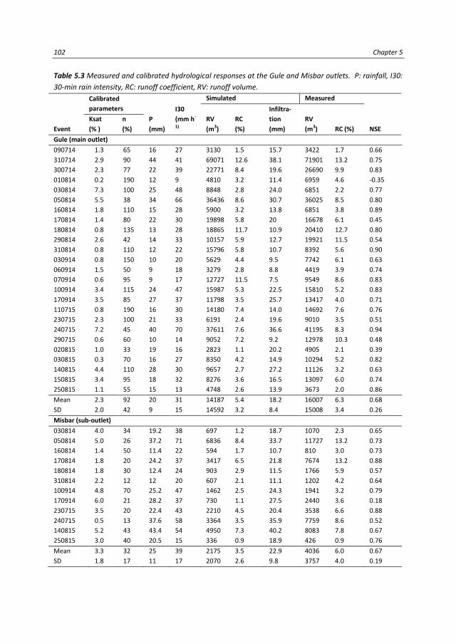
102 Chapter 5
Table 5.3 Measured and calibrated hydrological responses at the Gule and Misbar outlets. P: rainfall, I30:
30-min rain intensity, RC: runoff coefficient, RV: runoff volume.
Event
Calibrated
parameters
P
(mm)
I30
(mm h-
1)
Simulated Measured
NSE
RV
(m3)
RC
(%)
Infiltra-
tion
(mm)
RV
(m3) RC (%)
Ksat
(% )
n
(%)
Gule (main outlet)
090714 1.3 65 16 27 3130 1.5 15.7 3422 1.7 0.66
310714 2.9 90 44 41 69071 12.6 38.1 71901 13.2 0.75
300714 2.3 77 22 39 22771 8.4 19.6 26690 9.9 0.83
010814 0.2 190 12 9 4810 3.2 11.4 6959 4.6 -0.35
030814 7.3 100 25 48 8848 2.8 24.0 6851 2.2 0.77
050814 5.5 38 34 66 36436 8.6 30.7 36025 8.5 0.80
160814 1.8 110 15 28 5900 3.2 13.8 6851 3.8 0.89
170814 1.4 80 22 30 19898 5.8 20 16678 6.1 0.45
180814 0.8 135 13 28 18865 11.7 10.9 20410 12.7 0.80
290814 2.6 42 14 33 10157 5.9 12.7 19921 11.5 0.54
310814 0.8 110 12 22 15796 5.8 10.7 8392 5.6 0.90
030914 0.8 150 10 20 5629 4.4 9.5 7742 6.1 0.63
060914 1.5 50 9 18 3279 2.8 8.8 4419 3.9 0.74
070914 0.6 95 9 17 12727 11.5 7.5 9549 8.6 0.83
100914 3.4 115 24 47 15987 5.3 22.5 15810 5.2 0.83
170914 3.5 85 27 37 11798 3.5 25.7 13417 4.0 0.71
110715 0.8 190 16 30 14180 7.4 14.0 14692 7.6 0.76
230715 2.3 100 21 33 6191 2.4 19.6 9010 3.5 0.51
240715 7.2 45 40 70 37611 7.6 36.6 41195 8.3 0.94
290715 0.6 60 10 14 9052 7.2 9.2 12978 10.3 0.48
020815 1.0 33 19 16 2823 1.1 20.2 4905 2.1 0.39
030815 0.3 70 16 27 8350 4.2 14.9 10294 5.2 0.82
140815 4.4 110 28 30 9657 2.7 27.2 11126 3.2 0.63
150815 3.4 95 18 32 8276 3.6 16.5 13097 6.0 0.74
250815 1.1 55 15 13 4748 2.6 13.9 3673 2.0 0.86
Mean
SD
2.3
2.0
92
42
20
9
31
15
14187
14592
5.4
3.2
18.2
8.4
16007
15008
6.3
3.4
0.68
0.26
Misbar (sub-outlet)
030814 4.0 34 19.2 38 697 1.2 18.7 1070 2.3 0.65
050814 5.0 26 37.2 71 6836 8.4 33.7 11727 13.2 0.73
160814 1.4 50 11.4 22 594 1.7 10.7 810 3.0 0.73
170814 1.8 20 24.2 37 3417 6.5 21.8 7674 13.2 0.88
180814 1.8 30 12.4 24 903 2.9 11.5 1766 5.9 0.57
310814 2.2 12 12 20 607 2.1 11.1 1202 4.2 0.64
100914 4.8 70 25.2 47 1462 2.5 24.3 1941 3.2 0.79
170914 6.0 21 28.2 37 730 1.1 27.5 2440 3.6 0.18
230715 3.5 20 22.4 43 2210 4.5 20.4 3538 6.6 0.88
240715 0.5 13 37.6 58 3364 3.5 35.9 7759 8.6 0.52
140815 5.2 43 43.4 54 4950 7.3 40.2 8083 7.8 0.67
250815 3.0 40 20.5 15 336 0.9 18.9 426 0.9 0.76
Mean
SD
3.3
1.8
32
17
25
11
39
17
2175
2070
3.5
2.6
22.9
9.8
4036
3757
6.0
4.0
0.67
0.19

Assessing the effect of water harvesting techniques on event-based hydrological responses and sediment yield at a catchment scale in northern Ethiopia using LISEM 103
Figure 5.6 Discharge hydrographs at the Gule outlet for selected events in 2014 and 2015. P: rain intensity
(mm h-1), Q: discharge (L s-1).

104 Chapter 5
Figure 5.7. Discharge hydrographs at the Misbar sub-outlet for selected events in 2014 and 2015. P: rain
intensity (mm h-1), Q: discharge (L s-1).

Assessing the effect of water harvesting techniques on event-based hydrological responses and sediment yield at a catchment scale in northern Ethiopia using LISEM 105
Measured and simulated discharges after calibration for most events at the Gule and
Misbar outlets agreed well (Table 5.3). A satisfactory hydrological model should have an
NSE>0.5 (Moriasi et al., 2007). Twenty-one of the 25 calibrated events at the Gule outlet
were satisfactory. The model calibration was better for the Misbar sub-outlet, with only 1
of 12 events deemed unsatisfactory (NSE<0.5). The model generally performed less well
for the Gule outlet for light rains, i.e. rains with low rainfall and/or 30-min rain intensity
(I30). For example, the model predicted discharge poorly for events 010814 and 290715,
which had relatively low rainfalls and I30s. The model, however, predicted discharge well
for events 060914 and 070914, which had low rainfalls but moderate I30s. The model also
performed poorly for events with moderate rainfalls but with low I30s (e.g. 020815). Event
250815 was an exception to this generalisation, in which discharge was predicted well
despite the event having a low I30.
The measured and simulated discharge hydrographs for the Gule and Misbar outlets
matched well for most events (Figures 5.6 and 5.7). The model was able to simulate runoff
peaks for most single-peak storms but responded differently when an event had more
than one peak. The model was able to simulate small runoff peaks following a major peak
(e.g. 170814). The model, however, could not capture runoff peaks prior to a larger peak
(e.g. 170914). The model simulations also showed some double-peaked hydrographs (e.g.
140815 at Gule and 030814 at Misbar) although these peaks were not observed in reality.
Figure 5.8 Relations between simulated and measured sediment yields at Gule (a) and Misbar (b) outlets.
SY: sediment yield.
Aggregate stability, soil cohesion, and d50 were associated with erosion and deposition in
the LISEM model. The default values of the sediment parameters overestimated the SSCs
compared to the measured values. The calibration of event-based SSCs was unsatisfactory,
so the simulated and measured sediment yields calculated based on average sediment
concentration in an event were compared. Simulated soil cohesion increased substantially
(104-fold) for the calibrated events. The simulated d50 increased 3-fold. Simulated and

106 Chapter 5
measured values for the Gule (r2=0.57, n=15, p<0.01) and Misbar (r
2=0.77, n=12, p<0.01)
outlets agreed to some extent, despite the tendency of LISEM to overestimate sediment
yield (Figure 5.8).
5.3.3 Hydrological responses
Table 5.3 shows the measured and simulated runoff volumes, runoff coefficients, and
amounts of infiltration for the Gule and Misbar outlets. Runoff volume at both outlets
generally increased with rainfall and I30. Simulated runoff volume for the Gule outlet was
moderately correlated with rainfall (r2=0.67, n=25, p<0.01) and I30 (r
2=0.48, n=12, p<0.01).
The better correlation of runoff volume with rainfall than I30 was most apparent for
events 310714 (rainfall=44 mm, I30=41 mm h-1
) and 240715 (rainfall=40 mm, I30=70 mm
h-1
). Runoff volume was higher for 310714 than 240715, even though I30 was higher for
240715 than 310714. The higher runoff volume for 310714 than 240715 was likely due to
the double-peak rainstorm (data not shown) for 310714. Runoff volume increased
substantially in the second peak of the event due to the saturation of the soil layer in the
previous rainfall peak. Similarly, runoff volume was higher for both 240715 and 310714
than 050814, despite a higher I30 for 050814. Runoff volume for the Misbar sub-outlet
was also moderately correlated with rainfall (r2=0.55, n=25 p<0.01) and I30 (r
2=0.65, n=12,
p<0.01).
Figure 5.9 Monthly static water level of a shallow groundwater monitoring well downstream of the Misbar
sub-outlet. P: annual rainfall (mm).

Assessing the effect of water harvesting techniques on event-based hydrological responses and sediment yield at a catchment scale in northern Ethiopia using LISEM 107
Average measured and simulated runoff coefficients were low, at 6.3 and 5.4% for the
Gule outlet and 6 and 3.5% for the Misbar sub-outlet, respectively. The coefficients were
similar for the Gule and Misbar outlets, despite the large difference in catchment areas.
The low runoff coefficients for the rains were compensated by the high levels of
infiltration in the catchments (Table 5.3). Infiltration during the rains (n=25) was high for
the Gule catchment, with a mean of 18.2 mm. Average infiltration was even higher during
the rains (n=12) for the Misbar sub-catchment, at 22.9 mm.
The low runoff coefficients for rains for the Gule catchment were likely due mainly to a
combination of three factors, namely a fairly fine to coarse soil type (high infiltration), the
flatter topography of the lower section of the catchment, and the retention of runoff by
the WHTs implemented in the upper and central sections of the catchment. The monthly
static water level of the monitoring well located slightly below the Misbar sub-catchment
is shown in Figure 5.9. An increase in groundwater level from 2010 to 2015 could not have
been due to rainfall and was probably due to the WHTs that were installed between 2011
and 2013. The groundwater level in the well rose substantially especially during the dry
months of the year.
5.3.4 Sediment yield
Simulated and measured sediment yields per event for the Gule and Misbar outlets are
summarised in Table 5.4. Sediment yield varied considerably for the different rains.
Average measured sediment yields per event for the Gule and Misbar outlets were 401
and 249 kg ha-1
, respectively. Average sediment yields for extreme events (e.g. 050814),
however, were higher, at 759 and 809 kg ha-1
for Gule and Misbar, respectively. Average
simulated sediment yields for the Gule and Misbar outlets were 491 and 523 kg ha-1
,
respectively. The simulated and measured sediment yields generally had similar orders of
magnitude for the Gule outlet. SSCs for the Gule and Misbar outlets varied moderately
amongst the measured events. Average measured SSCs were generally higher for Gule
than Misbar. Average SSCs were 27.2 and 14.6 g L-1
for the Gule and Misbar outlets,
respectively (Table 5.4).
The simulated sediment yields after calibration were generally higher than the measured
values. Average measured sediment yield per unit area was higher for the Gule than the
Misbar outlet. Sediment yields for the events were well correlated with runoff volume,
both for the model simulations and observations (Figure 5.10). The higher slopes of the
regression lines of the model simulations compared to the observations demonstrated
that simulated sediment yield tended to increase more quickly than the measured

108 Chapter 5
sediment yield for a similar change in runoff volume. Similarly, the regression lines
indicated that sediment yield responded quicker for the Misbar than the Gule outlet for
similar changes in runoff volume. The higher response of sediment yield for the Misbar
sub-catchment than the Gule catchment highlights the difference in catchment size.
Sediment yield with runoff volume is expected to respond slower in larger catchments
where physical variations are large.
Table 5.4 Measured and simulated sediment yields at the Gule and Misbar outlets. * SSCs were estimated
based on average measured values over the year.
Event
Simulated
sediment yield (kg ha-1)
Measured
SSC (g L-1)
Measured
sediment yield (kg ha-1)
Gule (n=15) Misbar (n=12) Gule (n=15) Misbar (n=12) Gule (n=15) Misbar (n=12)
030814 172 198 22.2 10.7 294 48
050814 1004 1136 24.3* 16.5* 759 809
160814 266 80 24.3* 13.4 252 45
170814 707 983 27.4 23.0 455 736
180814 555 240 20.8 10.9 435 80
310814 345 0 24.3* 16.5* 237 83
100914 512 451 24.3* 16.5* 359 134
170914 453 226 18.4 22.7 320 207
230715 259 964 39.3 16.2 398 240
240715 1324 1025 16.7 9.7 597 315
290715 526 na 31.4 no data 492 no data
030815 399 na 31.5 no data 369 no data
140815 223 911 28.5 7.7 366 261
150815 323 na 43.3 no data 520 no data
250815 293 58 31.8 11.2 166 31
Mean (SD) 491 (317) 523 (442) 27.2 (7.3) 14.6 (4.9) 401 (151) 249 (262)
Figure 5.10 Correlations between sediment yield (SY) and runoff volume (RV) at the Gule and Misbar
outlets.

Assessing the effect of water harvesting techniques on event-based hydrological responses and sediment yield at a catchment scale in northern Ethiopia using LISEM 109
5.3.5 Effect of WHTs on catchment runoff and sediment yield
The P-factors obtained from the literature are summarised in Table 5.5. The P-factors
varied considerably for the WHTs. A deep trench combined with a stone bund was the
most effective technique for reducing runoff and sediment yield. Stone bunds and gabion
check dams reduced soil loss more effectively than runoff.
Table 5.6 shows the calibrated multiplication factors for the LISEM input parameters that
mostly affect runoff after calibration using the P-factor simulations. Manning’s n and Ksat
needed to be changed the most to replicate the P-factors observed for the WHTs. The
higher changes to Manning’s n due to the implementation of the WHTs reflected the
ability of WHTs to reduce soil loss by slowing the flow velocity and trapping eroded soil.
The large changes in the values of the LISEM input parameters (mainly Ksat and Manning’s
n) were expectedly caused by deep trench combined with stone bund, because this
technique had the lowest P-factor (Table 5.5).
Table 5.5 Estimated P-factors for runoff and sediment yield due to different water harvesting techniques.
Water harvesting technique
Runoff
References Literature Used
Stone bunds 0.20-0.35, 0.73 0.70 Al-Seekh and Mohammad (2009), Taye et al. (2013)
Deep trenches 0.31 0.30 Taye et al. (2013)
Stone bunds + deep trenches 0.16 0.20 Taye et al. (2013)
Gabion check dams 0.84-0.91, 0.73-0.85 0.80 Guyassa et al. (2015), Xu et al. (2013)
Water harvesting technique
Sediment yield
Literature Used References
Stone bunds 0.32, 0.36 0.40 Desta et al. (2005), Taye et al. (2013)
Deep trenches 0.10 0.10 Taye et al. (2013)
Stone bunds + deep trenches 0.04 0.05 Taye et al. (2013)
Gabion check dams 0.33, 0.37-0.43 0.40 Boix-Fayos et al. (2008), Xu et al. (2013)
Table 5.6 Calibrated values of LISEM input parameters using the P-factors for the Gule catchment.
Water harvesting technique Ksat Manning’s n Random roughness Aggregate stability
Stone bunds 1.12 2.25 1.2 1.0
Deep trenches 1.55 2.79 1.2 0.8
Stone bunds + deep trenches 1.58 3.72 1.5 0.8
Gabion check dams 1.04 1.21 1.0 1.0
Values are given as multiplication factors
The results of the catchment-level simulations for runoff and sediment yield with and
without WHTs for the 12 events for the Gule and Misbar outlets are shown in Table 5.7.
The result for event 310814 was not included for the Misbar sub-outlet because of the
zero simulated sediment yield for the baseline, i.e. with WHTs (Table 5.4). The catchment-
level simulation by LISEM with and without WHTs showed that the amount of reduction in
runoff volume and sediment yield varied amongst the events. The reduction in runoff and

110 Chapter 5
sediment yield due to the use of WHTs generally tended to decrease with increasing
rainfall. The model predicted an average 41% reduction in runoff volume for the Gule
outlet due to the implementation of WHTs. Similarly, the WHTs reduced sediment yield
for the Gule outlet by 67%. The WHTs also decreased runoff volume and sediment yields
for the Misbar outlet, by 45 and 55%, respectively.
Table 5.7 Effectiveness of water harvesting techniques (WHTs) on reducing runoff volume and sediment
yield for the Gule outlet and Misbar sub-outlet.
Event
Runoff volume (m3) Sediment yield (kg ha-1)
Without WHTs With WHTs Reduction (%) Without WHTs With WHTs Reduction (%)
Gule outlet
030814 19884 8848 55.5 662 172 74.0
050814 54287 36436 32.9 2754 1004 63.5
160814 9531 5900 38.1 703 266 62.2
170814 24421 15796 35.3 1926 707 63.3
180814 27885 18865 32.3 1435 555 61.3
310814 14335 8590 40.1 939 345 63.3
100914 29063 15987 45.0 2105 512 75.7
170914 22514 11798 47.6 1594 453 71.6
230715 12623 6191 51.0 928 259 72.1
240715 51445 37611 26.9 2950 1324 55.1
140815 17530 9657 44.9 1003 223 77.8
250815 8716 4748 45.5 912 293 67.9
Mean
SD
24354
14884
15036
11162
41.3
8.4
1493
787
509
350
67.3
6.9
Misbar sub-outlet
030814 1335 697 47.8 531 198 62.6
050814 11810 6836 42.1 2257 1136 37.4
160814 1143 594 48.0 336 80 76.3
170814 4597 3608 21.5 1474 1039 29.5
180814 2213 903 59.2 914 240 73.7
100914 2192 1462 33.3 857 451 47.4
170914 1658 730 56.0 864 226 73.9
230715 4357 2210 49.3 1838 964 47.6
240715 5465 3364 38.4 1561 1025 34.3
140815 9042 4950 45.3 1683 911 45.9
250815 704 336 52.3 256 58 77.6
Mean
SD
4047
3565
2535
2119
44.8
14.1
1143
658
575
436
55.1
18.2
5.4 Discussion
5.4.1 Hydrological processes
The larger influence of rainfall than I30 on runoff volume in the Gule catchment may have
been due to its longer duration of discharge compared to the Misbar sub-catchment. The

Assessing the effect of water harvesting techniques on event-based hydrological responses and sediment yield at a catchment scale in northern Ethiopia using LISEM 111
differences in the width (duration) in the discharge hydrographs at the Gule and Misbar
outlets were likely due to the differences in the catchment sizes. Discharge hydrographs
are expected to be wider for large than small catchments because of the delay of
upstream runoff to reach the outlet, which attenuates the discharge peak. Runoff volume
for runoffs with narrow hydrographs is mainly controlled by the magnitude of the peak
discharges.
LISEM was unable to consistently simulate small runoff peaks for hydrographs with
multiple peaks. The difficulty of the model to correctly simulate runoff peaks for complex
(multiple-peaked) hydrographs has also been noted by other studies (Hessel et al., 2006,
Jetten et al., 1999). The model was, however, able to reproduce small runoff peaks
occurring after a rain's major runoff peak. The failure of LISEM to simulate double peaks
(e.g. 170914) could be due to the arrival of water from different parts of the catchment at
different times or an uneven distribution of rainfall in the catchment. The absence of
double peaks in reality, despite the model simulations (e.g. 140815 at Gule and 030814 at
Misbar), could have been due to the coincidence of double peaks at the catchment
outlets.
The poorer performance of LISEM for light rains could be attributed to the spatial
variability and uncertainty of the input data, variability in rainfall over the catchment, or
the larger effect of initial storage in ponds and channels (Hessel, 2002). Sheik et al. (2010)
noted that runoff prediction was highly influenced by initial SMC in events with low runoff
coefficients and rain intensity. SMC was also measured for 1-2 weeks, a measurement
interval that might not fully characterise actual moisture conditions in the catchment at
the start of a rain. Ksat values for the catchment were also interpolated from 62 field
samples in the catchment; these measurement sites may thus not adequately represent
the entire catchment. Other unaccounted topographic features such as field boundaries,
hedges, and paths (Hessel et al., 2006) may be important, especially for light rains.
The magnitude of the runoff coefficients for the Gule and Misbar catchments were similar
despite the differences in catchment area. Many studies have confirmed the decrease of
area-specific unit runoff with increasing catchment area (e.g. Cammeraat, 2002; Cantón et
al., 2011; Cerdan et al., 2004; Lesschen et al., 2009; Nyssen et al., 2010), which is mainly
caused by local storage and infiltration (Cammeraat, 2002).
The most probable reason for the unexpectedly similar runoff coefficients for the Gule and
Misbar catchments, despite the differences in catchment areas, is the retention of runoff
by the WHTs. The Misbar sub-catchment has a larger area with deep trenches and more
check dams and percolation ponds than the entire Gule catchment (Figure 5.1). The

112 Chapter 5
modelled reduction of runoff by the WHTs was also slightly higher at the Misbar (45%)
than the Gule (41%) outlet. The recent (2014 and 2015) rise in the level of static water at
the monitoring well immediately below the Misbar outlet (Figure 5.1) further indicated an
improved infiltration of water due to the implementation of WHTs. Most of the check
dams in the Misbar sub-catchment were constructed before the 2013 rainy season and
were upgraded in late 2014. The monthly static-water level at the monitoring well rose
substantially in 2014 and 2015 despite no significant increase in annual rainfall during
these two years compared to 2010 and 2013. Other studies in northern Ethiopia have also
reported the reduction of runoff due to the implementation of WHTs at catchment levels
(Lanckriet et al., 2012; Nyssen et al., 2010; Walraevens et al., 2015). For example, the
annual runoff coefficient for the May Zeg-Zeg catchment in northern Ethiopia decreased
from 8 to 1.6% after catchment management with stone bunds and check dams. Similarly,
the construction of a series of percolation ponds and deep trenches in the Mendae plain
in northern Ethiopia enhanced the local infiltration of runoff collected from hillslopes,
thereby allowing little or no outflow of water from the ponds (Walraevens et al., 2015).
The calibrated Ksat values were substantially lower than the measured values, consistent
with other findings (De Barros et al., 2014; Hessel et al., 2006; Hessel et al., 2003a). The
large differences between the calibrated and measured Ksat values highlight the
difficulties in characterising Ksat at the catchment level. Ksat tends to be spatially and
temporally variable at catchment scales (De Roo, 1996b). Disturbances in soil sampling,
the inability of field measurements to account for the effects of sealing or crusting,
incomplete saturation of the field, and very large differences in conductivity for very small
changes in SMC in very wet soils (Hessel et al., 2003a) may also have contributed to the
higher measured Ksat values.
5.4.2 Sediment yield
Sediment yields for the Gule and Misbar catchments were quite variable for the different
rains. Extremely heavy rains delivered the highest sediment yields. High sediment yields in
extreme events are due to the intensive impacts of raindrops, detaching soil particles and
causing surface wash and high runoff volumes (Cerdà et al., 2016). The contribution of
extreme events to overall sediment yield, especially in semi-arid areas, is thus quite large
(Baartman et al., 2012; Coppus and Imeson, 2002; Gonzalez-Hidalgo et al., 2010).
Interestingly, average measured sediment yield per unit area was higher for the Gule
catchment than the Misbar sub-catchment, despite Gule's larger catchment area (Table
5.4). The lower sediment yield at the Misbar sub-outlet compared to the Gule outlet

Assessing the effect of water harvesting techniques on event-based hydrological responses and sediment yield at a catchment scale in northern Ethiopia using LISEM 113
contradicts the general premise that sediment yield decreases with increasing catchment
size. Despite the variations in spatial scales (De Vente and Poesen, 2005), catchment-level
studies often indicate decreases in sediment yield with increasing catchment area (Cantón
et al., 2011; De Vente and Poesen, 2005; De Vente et al., 2007; Nyssen et al., 2004;
Vanmaercke et al., 2014). The lower sediment yield in the larger catchments area was
likely due to increased sedimentation at the feet of slopes or in dry channels, flood plains,
and other sinks in the larger catchment (De Vente et al., 2007).
The decrease in sediment yield with area should, however, be considered carefully,
because factors other than area can also contribute to sediment yield (Vanmaercke et al.,
2011). For example, Vanmaercke et al. (2014) showed that 40% of the variation in
sediment yield in Africa was due to seismic activity, topography, vegetation cover, and
runoff. Tamene et al. (2006) reported that the variability of sediment yield in northern
Ethiopian catchments was mostly associated with topography, gully erosion, surface
lithology, and land cover. Haregeweyn et al. (2008b) found an inverse and significant
correlation (r=-0.66) between the fraction of catchment area affected by WHTs and
sediment yield, which emphasises the role of WHTs as sediment sinks.
In our study, the higher number of check dams and larger coverage of deep trenches in
the Misbar than the Gule catchment have likely contributed to the lower rate of measured
sediment yield at the Misbar sub-catchment, because the SSCs for the different events
were lower at the Misbar than the Gule outlet (Table 5.4). LISEM, however,
underestimated the effect of the WHTs in reducing sediment yield in the Misbar sub-
catchment; the modelled reduction in sediment yield was higher at the Gule outlet (67%)
than at the Misbar sub-outlet (55%). It was not clear why the modelled effect of WHTs on
sediment yield was lower for the Misbar sub-outlet than for the Gule outlet. Evidence
worldwide suggests that WHTs such as stone bunds (Nyssen et al., 2009a), check dams
(Abedini et al., 2012; Mekonnen et al., 2015a; Nyssen et al., 2009a; Polyakov et al., 2014),
percolation ponds (Fiener et a., 2005; Verstraeten and Poesen, 2001), and Fanya juu
terraces (Fisseha et al., 2011) can reduce catchment sediment yield. The efficiency of
reduction, however, could be improved by combining some of these techniques, despite
the demonstrated benefits of individual WHTs in reducing runoff and sediment yield from
catchments (Grum et al., 2016; Mekonnen et al., 2015b; Nyssen et al., 2009a).
LISEM tended to overestimate sediment yield for the Gule and Misbar catchments, which
has also been reported for tropical catchments (De Barros et al., 2014; Hessel et al., 2006).
The poor performance of LISEM in predicting sediment yield arises from the difficulty of
modelling sediment transport, because it is highly complicated by the high spatial
variability of several factors controlling erosion in a catchment (De Barros et al., 2014;

114 Chapter 5
Ramsankaran et al., 2013). The model efficiency in our study may also have been affected
by the limited number of events used in the analysis, due to the unavailability of
measured sediment concentrations for all events.
The measured and calibrated values for soil cohesion differed widely. This result was
consistent with a study in Brazil, in which the magnitudes of the measured soil cohesion
and aggregate stability had to be substantially increased to calibrate sediment yield (De
Barros et al., 2014). This adjustment poses a challenge for adapting physically consistent
and realistic values of soil parameters as LISEM inputs for predicting sediment yield. This
problem may be due to the lack of representativeness of spatial data for a catchment or a
structural problem in LISEM for describing erosion. Hessel (2003a) also indicated that the
current analysis of erosion by LISEM does not adequately describe erosion on steep
slopes, such as in our study area. The ability of the values of soil cohesion and aggregate
stability in LISEM to adequately represent soil physical parameters therefore requires
further study (De Barros et al., 2014).
The calibration of LISEM for a small catchment in northern Ethiopia in our study has
provided good model performance for runoff and a resemblance between measured and
simulated average sediment yields. The prediction capability of LISEM, however, was
suboptimal because it was calibrated for separate events, but it remained a useful tool to
explore the responses of catchment hydrology and sediment yield to land-use scenarios
and the implementation of WHTs (De Roo et al., 1996a, 1996b; Hessel et al., 2003b).
Hessel et al. (2003b) has successfully applied LISEM for determining the impact of land-use
scenarios in the Danangou catchment on the Chinese Loess Plateau. Baartman et al.
(2012) has also used LISEM to investigate the effect of rain intensity and duration on soil
erosion in the Prado catchment in southeastern Spain. Based on these experiences and
the successful calibration of LISEM for runoff and sediment yield at the Gule catchment,
LISEM can be further used for evaluating the effects of land-use changes and the
widespread implementation of WHTs in the study area.
5.4 Conclusion
The good calibrations at the Gule and Misbar outlets showed that LISEM could be applied
in northern Ethiopia to small catchments containing WHTs. The following conclusions can
be drawn from this study:
The performance of LISEM in predicting runoff was better for the smaller sub-
catchment than the entire catchment, due to the increased spatial complexity
with increasing catchment size.

Assessing the effect of water harvesting techniques on event-based hydrological responses and sediment yield at a catchment scale in northern Ethiopia using LISEM 115
LISEM needed to be calibrated separately for each runoff event because of the
added complexity of a smaller temporal scale and the variable characteristics of
the rains. LISEM failed to reproduce some runoff peaks for multiple-peaked
events, especially those peaks that occurred prior to a major peak in an event.
The calibration of event-based SSC was less accurate, and LISEM tended to
overestimate sediment yield compared to measured values.
The general trend of area-specific decreases in runoff and sediment yield with
increasing catchment area was violated in catchments with WHTs, demonstrating
the effect of WHTs in reducing runoff and sediment yield in catchments with
WHTs.
LISEM was successfully calibrated for the Gule catchment for runoff and sediment
yield and so can be further used to evaluate the effect of land-use scenarios.
LISEM can be used to quantify the hydrological responses and sediment yields
from the implementation of existing and/or new WHTs at a catchment level.

116 Chapter 5

Synthesis 117
6. Synthesis

118 Chapter 6
6.1 General discussion This chapter synthesizes the main findings of this PhD project in the context of the four
research questions in order to understand the effects of water harvesting techniques
(WHTs) on the availability of rainwater for agricultural use and the mitigation of land
degradation in northern Ethiopia. It also presents the major scientific and social
contributions, extension and policy implications of this project and highlights future
research directions.
The synopsis diagram (Figure 6.1) demonstrates how the in-situ and catchment-scale
WHTs were selected, as well as the effects of these WHTs on on-site water regime, soil
erosion, catchment hydrology and sediment yield. First, a decision support approach,
which integrated a GIS-based multi-criteria analysis (MCA) with a participatory multi-
stakeholder workshop, was developed for the selection of suitable WHTs for a given area.
The decision support approach was applied on a case study in northern Ethiopia and
resulted in the selection of in-situ and catchment-scale WHTs which were then tested for
their effects.
Figure 6.1. Synopsis of the process of water harvesting techniques (WHTs) selection, and on-site and off-
site effects of WHTs. EMs: effective micro-organisms, MCA: multi-criteria analysis, SOM: soil organic
matter, Ks: unsaturated hydraulic conductivity, Ksat: saturated hydraulic conductivity.

Synthesis 119
The selection procedure for WHTs investigated in research question I is discussed in detail
in the following section. The decision support could be improved using the lessons
acquired during the implementation and performance evaluation of the selected WHTs
(Figure 6.1, dotted line with arrows).
A plot-scale experiment was setup to evaluate the performance of the selected in-situ
WHTs in improving on-site water availability for agricultural uses. The effects of the in-situ
WHTs on runoff and soil-moisture were monitored using the field experiment. Similarly,
the effects of the in-situ WHTs on soil properties such as bulk density, soil organic matter
(SOM), saturated (Ksat) and unsaturated (Ks) hydraulic conductivities were also measured.
The in-situ WHTs, in general, decreased runoff and soil erosion, and increased availability
of soil moisture (Figure 6.1). The effect of the in-situ WHTs is discussed in detail in relation
to research questions II and III.
The performance of the catchment-scale WHTs (e.g. percolation ponds and check dams),
was monitored at catchment level in a case study in northern Ethiopia. Discharge and
sediment yield measurements and modelling studies showed that WHTs help to decrease
catchment-level runoff and sediment yield (Figure 6.1). The effect of WHTs on catchment
hydrology and sediment yield is discussed in detail in relation to research question IV.
I. How can appropriate site-specific WHTs be selected in arid and semi-arid areas?
Overall, the decision support approach developed in this project (Chapter 2) emphasizes
that the selection and implementation of WHTs requires the integration of scientific and
local knowledge as well as maintaining the participation of relevant stakeholders. Similar
to our approach, other researchers (Mbilinyiet al., 2005; Ngigi, 2003; Schwilch et al.,
2009), also recommend the integration of scientific expertise with local knowledge in
order to create a common understanding among the stakeholders and develop
sustainable solutions to existing local problems.
A new insight in the decision support approach from this project was the development of
suitability indicators (Table 2.1) for bio-physical assessment of WHTs to a specific area.
Land users and extension workers can use the information in Table 2.1 to check if existing
bio-physical properties of an area fit with the suitability indicators of specific WHTs. The
developed database of suitability indicators for WHTs makes it different from other similar
efforts (e.g. Critchley and Siegert, 1991; Liniger et al., 2011; Mekdaschi Studer and Liniger,
2013; Oweis et al., 2001; Prinz, 1996) because it contains a comprehensive set of
suitability indicators for an extended list of WHTs applied in arid and semi-arid regions.
The suitability indicators of WHTs can also be used by researchers or by development
agents to identify areas where specific WHTs can be applied at catchment level. This kind

120 Chapter 6
of assessment however requires multi-criteria evaluation and decision making in which
several criteria/constraints are considered to identify suitable areas for WHTs.
It is worth noting that the list of WHTs and the suitability indicators in Table 2.1 are not
exhaustive. The table only contains WHTs that are most commonly applied worldwide. For
those WHTs which are not included in this study, it may be necessary to look for other
sources to assess the bio-physical suitability of the techniques. The suitability ranges in
Tab. 2.1 were compiled from the literature (e.g. Critchley and Siegert, 1991; Liniger et al.,
2011; Oweis et al., 2001; Prinz, 1996), hence it might be necessary to change the
suitability ranges but with justified explanations.
It remains a challenge to identify suitable areas in large catchments in which bio-physical
characteristics are expected to significantly vary spatially (Grum et al., 2016; Pandey et al.,
2011). In this case, the use of some decision-making tools such as the GIS-based MCA
becomes inevitable. The comparative advantage with the use of decision support tools
such as the GIS-based MCA in locating suitable areas is that it makes decision making
easier in large catchments (Oweis et al., 2001; Pandey et al., 2011). The GIS-based MCA
approach of this project was successfully tested in the upper Geba catchment in northern
Ethiopia to identify suitable areas for catchment-scale WHTs such as check-dams,
percolation ponds and bench terraces. Our approach was able to correctly locate 90% of
80 existing check dams and 93% of 92 existing percolation ponds in the catchment. The
suitability indices using this GIS-based MCA identified 23 and 35% of the upper Geba
watershed as suitable for the construction of percolation ponds and bench terraces,
respectively. This has the potential to greatly increase the effective use and benefit of
catchment-scale WHTs in northern Ethiopia.
Although socio-economic suitability indicators of WHTs are not included in Table 2.1,
stakeholders can define these indicators/criteria during the evaluation and selection of
WHTs (e.g. Table 2.3) in stakeholder workshops (Grum et al., 2016; Mbilinyi et al., 2005;
Schwilch et al., 2012b). It is worth noting that the specific criteria listed in Table 2.3 might
not necessarily be appropriate for other areas. For example, in northern Ethiopia the
stakeholders prioritized selection criteria such as “improving availability of arable land”,
considering the limited availability of land for agricultural use. This was also reflected in
the selection of bench terraces (Table 2.5), which are used to produce new arable land
from uncultivated shrub lands on hillslopes. The regional government of Tigray has also
recently started promoting the construction of bench terraces on uncultivated shrub lands
to provide new arable land to the youth. In other areas, this criterion may not be
necessary and hence other criteria might be prioritized for selection of WHTs.

Synthesis 121
The selection workshop highlighted the need for combining WHTs to maximize benefits,
and to do more research for testing the performance of WHTs. Based on the stakeholders
recommendations, the performance of in-situ (Chapter 3 and 4) and catchment-scale
WHTs (Chapter 5) was evaluated at field and catchment scales, respectively. Results from
these evaluations validated the belief of the stakeholders that combining WHTs helps to
maximize benefits (Grum et al., 2016; Mekonnen et al., 2015b). Combination of in-situ
WHTs such as tied ridges and straw mulch was more effective in improving on-site water
availability (Table 3.4) and decreasing soil losses (Tables 4.3 and 4.4) compared to the
techniques alone. Moreover, catchment-scale assessment of several combinations of
WHTs such as stone bunds, check dams, percolation ponds and check dams resulted in
reduction of runoff and sediment yield by 41-45% and 55-67%, respectively (Table 5.7).
The benefits of WHTs as highlighted in Chapters 3, 4 and 5 reflect the need for
participatory selection of WHTs in which technical knowledge is combined with
stakeholders participation in decision making.
II. What is the role of in-situ WHTs such as tied ridges and straw mulch in improving on-
site water availability in semi-arid areas?
The development of the decision support approach was intended to select WHTs which
can be applied at field and catchment scales (Figure 6.1). In addition to the bio-physical
suitability of the techniques (Chapter 2, Table 2.1), the decision methodology requires that
techniques be ranked and selected by the stakeholders in a participatory selection
workshop. The selected WHTs can then be evaluated for effectiveness. The highest
ranking in-situ WHT (Table 2.5) was soil-improvement methods (e.g. mulching, compost,
EMs, etc.) which was selected for further testing. Furthermore, tied ridges are also tested
in this project to evaluate their effectiveness when combined with straw mulch. On-site
water availability was evaluated by looking at effects on soil physical properties, runoff,
and SMC.
It has been reported that in-situ WHTs can affect the on-site water regime (e.g. Adimassu
et al., 2014; Al-Seekh and Mohammad, 2009; Okeyo et al., 2014), as a result of changes in
runoff and SMC. This research project confirmed such results for the in-situ WHTs tested,
with average runoff reduction efficiency over two years (2013 and 2014) ranging between
49% and 88%. The most effective technique in reducing runoff was when tied ridges were
combined with straw mulch. The improved efficiency of runoff reduction due to the
combined use of in-situ WHTs was also found in studies in Cape Verde (e.g. Baptista et al.,
2015b). The combined use of tied ridges and straw mulch also significantly improved SMC.
This result too is consistent with other studies (e.g. Ramesh and Devasenapathy, 2006;
Wang et al., 2009) in India and China which reported improved SMCs in the soil by the use
of different crop-residue mulches with ridges or furrows. This research project has now

122 Chapter 6
verified the beneficial effects of the combined use of these in-situ WHTs for the conditions
of northern Ethiopia.
Our results also provide an important insight on the use of the WHTs tested for increasing
SMC. While maize yield significantly increased when straw mulch was used alone (Chapter
4, Table 4.7), it did not significantly increase by the combined use of straw mulch with tied
ridges, despite an increase in SMC. The increase is likely the result of the improved
temporal distribution of moisture in the soil during dry periods (Stroosnijder, 2003).
However, in the case of the combination of straw mulching and tied ridges, there were
noticeable signs of aeration stress during intensive rain events in late July 2013 and early
August 2014, which would hinder crop growth. Similar symptoms of aeration stress were
also reported in another study in northern Ethiopia due to the use of tied ridges in barley
fields during seasons with high rainfall (Araya and Stroosnijder, 2010). This indicates in
general that the application of in-situ WHTs is not always a simple yes/no decision, and in
particular that tied ridges should not be applied during the entire plant growth period,
especially during times with high rainfall. Tied ridges can possibly help to increase grain
yield in northern Ethiopia when it is applied during drier periods, usually towards the end
of the rainy season or in drier regions.
The better performance of in-situ WHTs in reducing runoff and increasing SMC when
combined supports the stakeholders’ understanding that combining WHTs can maximize
benefits (Chapter 2). However it is important to note that improving water availability in
the soil does not mean that benefits are maximized as shown by the lack of a significant
increase in maize yield when tied ridges and straw mulch were combined (Table 4.7). This
is a good indication that the decision support approach can be enriched using lessons
learnt from the implementation of WHTs. For example, in addition to defining the
selection criteria, stakeholders need to think about whether WHTs need to be combined
or not, and if so when.
III. Can in-situ WHTs help to mitigate land degradation by reducing soil and nutrient
losses from farmlands?
Our research demonstrated that all in-situ WHTs in our study were effective in
significantly reducing soil loss (Table 4.3). The good performance of straw mulch in this
respect is mainly attributed to its capability to reduce runoff and sediment concentration
which has also been noted by other researchers (Gholami et al., 2013; Sadeghi et al.,
2015a; Sadeghi et al., 2015b; Prosdocimi et al., 2016b). Straw mulch helps to protect the
soil from the impact of raindrop splash and consequently reduces the detachment of soil
particles (Cerdà et al., 2016; Okeyo et al., 2014). Straw mulch also slows down overland
flow (Cerdà et al., 2016; Jordán et al., 2010) and thus reduces its capacity to detach the

Synthesis 123
soil as well as its transport capacity. While tied ridges can reduce soil loss from farmland
by trapping runoff and eroded soil in the ridge depressions, the reduction of soil loss in
this project was primarily the result of reduced runoff as we found no significant effect of
tied ridges on sediment concentration (Chapter 4, Table 4.6).
Although no specific analysis was made to quantify the contribution of in-situ WHTs to
reducing runoff and sediment yield at catchment outlets, it can be argued that the
contributions could be significant if the use of in-situ WHTs in a catchment is large (e.g.
Lanckriet et al., 2012). The reduction in soil loss through use of in-situ WHTs also impacted
the loss of nutrients from farmland. The in-situ WHTs tested reduced total N (TN) and total
P (TP) losses with tied ridges in combination with straw mulch being the most efficient
technique (Tables 4.3 and 4.4). Our result is in agreement with studies in other areas that
reported a better efficiency of nutrient loss reduction by combining mulch with compost
(Baptista et al., 2015a) and stone rows/grass strips with compost (Zougmoré et al., 2009).
This positive effect of the combined use of these in-situ WHTs is now confirmed for
northern Ethiopian conditions.
Another potential benefit of straw mulch related to nutrient losses that was revealed in
our research is the maintenance of nutrient (N and P) stocks in the soil. For example,
despite the fact that wheat straw contains 0.6% N (Nicholson et al., 1997; Smil, 1999) and
0.1% P (Smil, 1999), it is not immediately released into the soil due to its high C:N ratio
(Bertoldi et al., 1983). The nutrients will, however, be released to the soil over time due to
decomposition and mineralization of straw in the soil. Therefore, the use of straw as
mulch would also help in the long run to balance the depletion of nutrients from soils.
Where immediate release of nutrients is required from mulch, it is advisable to use
organic materials such as compost and organic farmyard manure which have relatively
lower C:N compared to straw mulch (Bertoldi et al., 1983).
Although mulching was one of the techniques the stakeholders selected for
implementation (Chapter 2, Table 2.5) and showed positive results, it will be important to
more closely investigate its acceptance by farmers as an in-situ water harvesting option
because wheat straw in the study areas is also used as animal feed. Despite the current
acreage of maize cultivation in northern Ethiopia is small compared to other crops and
only a small amount of wheat-straw mulch is needed, the competition from animal feed
might limit its use. Ways to address this include investigating the use of other types of
crop residues for mulching, especially if that crop residue is cheap and not used for animal
feeding. Furthermore, it is necessary to compare different rates of straw mulch
applications and determine the most optimum rate in terms of cost-effectiveness (Cerdà
et al., 2016; Jordán et al., 2010).

124 Chapter 6
IV. What is the effect of catchment-scale WHTs on catchment hydrological responses
and sediment yield in northern Ethiopia?
Regarding the effect of catchment-scale WHTs such as check dams, percolation ponds, and
deep trenches on catchment-scale hydrological responses and sediment yield, our findings
support that catchment management with WHTs helps to increase ground water level in
hand-dug wells, and to decrease runoff and sediment yield at catchment outlets. Model-
based analysis using LISEM at the outlet and sub-outlet of the Gule catchment in northern
Ethiopia suggested that the current WHTs applied in the catchment decreased event-
based runoff volume by 41 and 45%, respectively (Table 5.7). Sediment yield was similarly
decreased by WHTs at the outlet and sub-outlet, with 67 and 55%, respectively. Our
results are consistent with the findings of other researchers (e.g. Nyssen et al., 2010;
Walraevens et al., 2015) in northern Ethiopia.
The reduction in catchment-level runoff and sediment yield has consequences on the
availability of water and status of land degradation in a catchment (Nyssen et al., 2010). It
can also have either positive or negative implications for downstream water users (Ngigi,
2003; Rockström et al., 2003). On the one hand, it is possible that downstream water
availability might improve due to upstream implementation of WHTs, for example, a
higher base flow resulting from enhanced infiltration of water. On the other hand, the
abstraction of runoff by upstream WHTs might decrease the direct availability of water for
downstream users. Not only WHTs need to be implemented at catchment level to improve
water availability and reduce the effect of erosion, it is also necessary to integrate
different WHTs in the catchment so that benefits are maximized (Mekonnen et al., 2015b).
Of equal importance is assessing the impact of WHTs at a watershed or basin level before
these techniques can be up-scaled (Ngigi, 2003; SIWI, 2001).
6.2 Limitations of the study
Although this PhD study used sound methodologies of decision support, field experiments
and modelling, some limitations in relation to scope, experiment setup and model
applications can be pointed out.
In Chapter 2, Table 2.1 provides bio-physical suitability indicators for different WHTs which
can be applied in arid and semi-arid areas. The suitability indicators listed here are limited
only to bio-physical conditions and lacked socio-economic criteria, which are of course
necessary to assess socio-economic suitability of WHTs. If the socio-economic suitability
indicators were included, it would have been easier for researchers and land users to carry
Synthesis 125
out socio-economic suitability assessment of WHTs for implementation or prior to
stakeholder workshops during the selection process.
The field experiments (Chapter 3 and 4) were conducted over two rainy seasons in a semi-
arid climate in northern Ethiopia. If long-term experiments were used and field trials were
setup at different slopes and soil types, the results would have been richer and could have
provided more insights. The field experiment was conducted for in-situ WHTs on field
slopes which ranged between 1.8 and 3.4% and on a sandy clay loam Cambisols. Although
it is highly recommended that in-situ WHTs are applied at ground slopes below 5%
(Ibraimo and Munguambe, 2007; Ngigi, 2003), it is possible that in-situ WHTs may be used
in higher ground slopes in which the performance of the techniques could be different
from the result reported in this study. Furthermore, the performance of the in-situ WHTs
could also differ in other soil types, as was evident, for example, in the study by Baptista
et al. (2015b). Therefore, up-scaling of the results presented in Chapter 3 and 4 is limited
to farmlands with gentle slopes and coarse-textured soils.
For the catchment scale work, the LISEM model was used to assess the effect of different
WHTs on event-based hydrological and erosion processes in the Gule catchment of
northern Ethiopia. Due to the variable characteristics of the rain events, each rain event
was calibrated separately for discharge and sediment yield, as was also done in other
similar studies (Baartman et al., 2012; Hessel et al., 2006; Hessel et al., 2003a). Calibration
of LISEM for separate events, however, limits its capability as a predictive model for future
events (Hessel et al., 2006). Therefore, it should be noted that the current calibrated
LISEM in the study area cannot be used to predict runoff and sediment yield using future
climatic conditions. If events were calibrated uniformly, LISEM would have wider
applications in the Gule catchment than it has now.
6.3 Implications for mitigating water shortage and land degradation
The findings of this research are discussed in light of contributions to science and society,
as well as implications for policies and extension.
6.3.1 Scientific and societal contributions One of the most important scientific contributions of this thesis is the development of a
decision support approach for the selection of WHTs which underscores the importance of
integrating local and scientific knowledge for improving agricultural productivity. This
research also shows the crucial importance of decision-making tools such as the GIS-based
MCA which uses the weighted linear combination procedure (Eastman et al., 1995) and

126 Chapter 6
the Analytical Hierarchy Process (AHP) of decision making (Saaty, 2004) as part of the
decision support approach.
Furthermore, the results on the effect of field and catchment-scale WHTs contributes to
present knowledge on Integrated Watershed Management (IWM), in order to efficiently
use available water within the watershed and minimize land degradation by implementing
WHTs at field and land-scape levels. The result of this study contributes also to the use of
Climate Smart Agriculture (CSA) technologies (FAO, 2010), which aim to make landscapes
more resilient to climate change.
The timely use of mulch alone or in combination with tied ridges was found to have
various positive effects which can enhance the resilience of farmlands in northern Ethiopia
to the effect of climate variability by minimizing the chances of crop failure. Furthermore,
in-situ WHTs improve resilience in socio-economic adaptability as a result of increased
food security and income (Vohland and Barry, 2009).
Our study has shown that the use of catchment-scale WHTs such as stone bunds, check-
dams, percolation ponds, etc. reduce runoff losses from a catchment, hence increasing
ground water levels, which was also seen as key by other researchers in northern Ethiopia
(e.g. Nyssen et al., 2010; Walraevens et al., 2015). The increase in ground-water storage
(sometimes called “water bank” in the Ethiopian context) due to the use of WHTs also
enhances the resilience of agricultural systems to climate change.
The model-based assessment of the effect of catchment-scale WHTs using LISEM, also
contributes to the understanding of event-based hydrological processes. Although there
already existed model-based efforts to quantify runoff and sediment yield at a catchment
scale in Ethiopia (e.g. Betrie et al., 2011; Gebreyohannes et al., 2013; Haregeweyn et al.,
2013), evidence was lacking on the effect of WHTs on event-based hydrological and
erosion processes. The calibrated LISEM in northern Ethiopia can be used for assessing the
impact of existing or future land-use scenarios on catchment hydrology and sediment
yield.
The societal contribution of this research is evident in the Ethiopian context, where
around 85% of the society is dependent on rain-fed agriculture. Any research contributing
to the improvement of the agricultural systems will be welcomed by the society as it
enables greater food security. The improved efficiency of water harvesting at farm and
catchment level contributes to the improvement of water availability and reductions in
loss of soil and nutrients. This in turn can improve crop yield and the livelihood of the
residents of northern Ethiopia.

Synthesis 127
The use of the participatory approach in the selection and implementation of WHTs not
only empowers local stakeholders in decision-making, it can also increase the chance of
the selected WHTs being adopted. This enhanced adoption can also pave a way to upscale
these techniques to other areas in the country.
6.3.2 Extension and policy implications The findings of this research and other studies conducted elsewhere (Baptista et al.,
2015b; Schwilch et al., 2009; Tavares et al., 2014) show that decision making regarding the
selection and implementation of land management technologies is most effective as a
collective effort in which all relevant stakeholders are involved. Currently in Ethiopia, land
management practices such as WHTs are implemented using a top-down approach
without proper consultation with the local community. In a top-down approach, land
users are considered as executors of decisions made at a higher level regarding the
implementation of land management practices (Schwilch et al., 2009). The result often in
the failure or non-acceptance of the implemented land management practices (Schwilch
et al., 2009). Therefore, it is strongly recommended that the current land management
strategy in Ethiopia be consciously revised to a participatory approach in which all relevant
stakeholders, including the farmers, are involved at all levels of decision making regarding
land management practices. This requires the participation of farmers, researchers and
experts from governmental and non-governmental organizations, representatives of
government officials, extension workers, and development agents, etc. in the selection of
WHTs.
The results of this study demonstrate that in-situ WHTs are useful to improve on-site
water availability for plant growth as well as reducing soil loss from farmlands. Farmers
therefore need to be advised to use straw mulch for decreasing the prevalence of crop
failures during dry spells and mitigating soil degradation. The use of straw mulch further
improves maize yield substantiating the role of mulch in increasing water availability in the
soil for plant growth. There are other studies in Ethiopia showing that various on-farm
conservation agriculture decreases runoff and soil losses from farmlands (e.g. Araya et al.,
2011; Gebreegziabher et al., 2009; McHugh et al., 2007). Due to the increased use of such
on-farm conservation activities and other agricultural inputs (e.g. fertilizers and improved
seeds) total food production has now improved in Ethiopia (Nyssen et al., 2015).
Therefore, government policies on agricultural systems need to be re-formulated to up-
scale the use of on-farm conservation measures beyond field research trials. For better
effect, policy makers and researchers need to work together, with farmers, to explore how
and where this on-farm conservation measures can be applied.

128 Chapter 6
Research findings from this study and other similar works in northern Ethiopia (e.g. Nyssen
et al., 2010; Walraevens et al., 2015) indicate that catchment management with WHTs and
small reservoirs (Haregeweyn et al., 2013; Haregeweyn et al., 2008) have contributed to
the reduction of sediment yield and an increase in groundwater tables. These findings
along with the positive impacts of in-situ WHTs are promising developments for
addressing food insecurity in northern Ethiopia (Nyssen et al., 2010) and improving on the
efforts of the government and other actors to rehabilitate degraded land using soil and
water conservation measures (Nyssen et al., 2015; Vancampenhout et al., 2006;
Walraevens et al., 2015). Considering that the economic backbone of Ethiopia is still highly
dependent on agriculture and to realize the agriculture led industrialization policy, lessons
learnt in northern Ethiopia need to strengthened and up-scaled to other areas in the
country. This requires documentation and preparation of guidelines of best practices and
approaches of WHTs so that similar techniques can be applied elsewhere.
One possible approach, which was emphasized in this study (Chapter 5), is the
implementation of individual or combined WHTs at different landscapes of a catchment to
maximize the effectiveness of the techniques (Mekonnen et al., 2015b). So, preparation of
guidelines (in local languages as well) on best practices of WHTs in Ethiopia requires a
strong commitment and a collaborative effort among different actors such as policy
makers, research institutions and governmental and non-governmental development
agents as well as other stakeholders. Current efforts in Ethiopia for sharing best practices
of land management are usually through field visits. Although experience sharing through
field visits is beneficial, it needs a lot of effort and resource to move people from region to
other and hence the intended impact can be undermined due to financial limitations.
The implementation of landscape-based WHTs has further implications on the use of
downstream water resources. The retention of sediments by WHTs upstream of a
catchment further helps to decrease siltation of downstream water-storage structures
such as check-dam ponds, percolation ponds and micro-dams (Haregeweyn et al., 2008b).
However, downstream water supplies can also be negatively affected. Therefore, policy
makers and land users need to study existing landscape conditions and downstream water
uses before they can implement WHTs at catchment level. Looking at the different
landscapes of a catchment, erosion prone areas can be protected by implementing
appropriate WHTs which can effectively decrease erosion in the catchment as well as
reducing sediment yield downstream of the catchment.

Synthesis 129
6.4 Research challenges and future research directions
This thesis has addressed the selection of WHTs by developing a decision support
approach and evaluating the effect of in-situ and catchment-scale WHTs on various
hydrological processes and sediment yields at various scales. The following issues,
however, need to be further investigated in order to obtain a full-fledged understanding
of the effects of implementation of WHTs, which is needed to maximize the benefits
locally, and to allow up-scaling to larger catchments.
Explore the application of the decision support approach using socio-economic
suitability indicators. A comprehensive evaluation of the suitability of WHTs
considering both bio-physical and socio-economic factors prior to the selection
workshop would simplify decision-making for stakeholders.
Assess the effect of different straw mulch application rates on runoff, soil-
moisture, soil and nutrient losses and requirements for additional nutrients
based on local conditions.
Investigate the effectiveness of EMs applied with organic materials of varying C:N
ratio to ascertain the release of nutrient to the soil for increasing crop yield.
Identify the stage of plant growth when tied ridges can be safely installed in order
to avoid collection of excess water in the ridge depressions and aeration stress.
The evaluation can be done for different crops, as crops have variable sensitivity
to aeration stress due to excess water.
Further explore the capability of LISEM to adequately describe soil erosion
processes in steeply sloping catchments and the representativeness of the values
of soil erosion parameters in LISEM to adequately represent soil physical
parameters. This is necessary before sediment yield modelling results can be
directly up-scaled to other areas.
Evaluate the effect of different catchment-level land-use scenarios (e.g. land-use
change and/or the use of new WHTs) on catchment hydrology and sediment
yield. Despite the proven benefits of catchment-scale WHTs in reducing runoff
and sediment yield in the upper Geba catchment, it will be important to
understand the extent of the effects of future WHT interventions on water
resource availability in the catchment. This will be of value in planning further
catchment-based interventions.

130 Chapter 6
6.5 General conclusions
The thesis developed and demonstrated the benefits of multi-faceted approach to
selecting WHTs that can be implemented in arid and semi-arid areas. It further
investigated the role of in-situ and catchment-scale WHTs on the capture and availability
of rainwater for agricultural production and erosion control in northern Ethiopia. The
following general conclusions are drawn based on the results of the study.
A decision support approach which integrates bio-physical knowledge/tools,
socio-economic criteria, GIS-based MCA where needed and participatory, multi-
stakeholder workshops helps to more effectively select appropriate WHTs.
In-situ WHTs improve water availability by significantly decreasing net runoff loss
from farmlands. Straw mulch was the most optimum in-situ WHT for improving
maize yield in the semi-arid northern Ethiopia. In relatively water scarce or arid
areas, tied ridges combined with straw mulch are an efficient technique for
reducing runoff and improving soil-moisture in farmlands.
In-situ WHTs are useful for mitigating soil degradation by decreasing soil and
nutrient losses from farmlands. The efficiency of reduction in soil and nutrient
losses increased when straw mulch was applied in combination with tied ridges.
LISEM can be used to model runoff and sediment yield in catchments under the
influence of WHTs. The model performance for runoff prediction by LISEM was
satisfactory although LISEM overestimated sediment yield at catchment level.
Catchment-scale model simulations indicated that runoff and sediment yield can
be reduced by implementing WHTs in a catchment. The general trend of area-
specific decrease in unit runoff and sediment yield with increasing catchment
area was violated in catchments with WHTs, demonstrating the effect of WHTs in
reducing runoff and sediment yield at catchment level.

Literature cited 131
Literature cited
Abbasi, M.K., Tahir, M.M., Sabir, N., Khurshid, M., 2015. Impact of the addition of different
plant residues on nitrogen mineralization–immobilization turnover and carbon
content of a soil incubated under laboratory conditions. Solid Earth 6, 197-205.
Abedini, M., Md Said, M.A., Ahmad, F., 2012. Effectiveness of check dam to control soil
erosion in a tropical catchment (The Ulu Kinta basin). Catena 97, 63-70.
Abramoff, M., Magalhaes, P.J., Ram, S., 2004. Image processing with ImageJ. Biophotonics
Int. 11, 36-42.
Abrisqueta, J.M., Plana, V., Mounzer, O.H., Mendez, J., Ruiz-Sánchez, M.C., 2007. Effects of
soil tillage on runoff generation in a Mediterranean apricot orchard. Agric. Water
Manag. 93, 11-18.
Abrisqueta, J.M., Plana, V., Ruiz-Canales, A., Ruiz-Sánchez, M.C., 2006. Unsaturated
hydraulic conductivity of disturbed and undisturbed loam soil. Span. J. Agric. Res. 4,
91-96.
Adekalu, K.O., Olorunfemi, I.A., Osunbitan, J.A., 2007. Grass mulching effect on infiltration,
surface runoff and soil loss of three agricultural soils in Nigeria. Biores. Technol. 98,
912-917.
Adimassu, Z., Mekonnen, K., Yirga, C., Kessler, A., 2014. Effect of soil bunds on runoff, soil
and nutrient losses, and crop yield in the central highlands of Ethiopia. Land Degrad.
Dev. 25, 554-564.
Alcamo, J., Flörke, M., Märker, M., 2007. Future long-term changes in global water
resources driven by socio-economic and climatic changes. Hydrol. Sci. J. 52, 247-275.
Ali, I., Khan, F., Bhatti, A.U., 2007. Soil and nutrient losses by water erosion under mono-
cropping and legume inter-cropping on sloping land. Pak. J. Agric. Res. 44, 3-4.
Ali, A., Oweis, T., Salkini, A.B., El-Naggar, S., 2009. Rainwater cisterns: traditional
technologies for dry areas. ICARDA, Aleppo, Syria.
Al-Seekh, S.H., Mohammad, A.G., 2009. The effect of water harvesting techniques on
runoff, sedimentation, and soil properties. Environ. Manag. 44, 37-45.
Araya, T., Cornelis, W.M., Nyssen, J., Govaerts, B., Bauer, H., Gebreegziabher, T., Oicha, T.,
Raes, D., Sayre, K.D., Haile, M., Deckers, J., 2011. Effects of conservation agriculture
on runoff, soil loss and crop yield under rainfed conditions in Tigray, northern
Ethiopia. Soil Use Manag. 27, 404-414.
132
Araya, A., Stroosnijder, L., 2010. Effects of tied ridges and mulch on barley (Hordeum
vulgare) rainwater use efficiency and production in Northern Ethiopia. Agric. Water
Manag. 97, 841-847.
Baartman, J.E., Jetten, V.G., Ritsema, C.J., De Vente, J., 2012. Exploring effects of rainfall
intensity and duration on soil erosion at the catchment scale using openLISEM: Prado
catchment, SE Spain. Hydrol. Process. 26, 1034-1049.
Balooni, K., Kalro, A.H., Kamalamma, A.G., 2008. Community initiatives in building and
managing temporary check-dams across seasonal streams for water harvesting in
South India. Agric. Water Manag. 95, 1314-1322.
Baptista, I., Ritsema, C., Geissen, V., 2015a. Effect of integrated water-nutrient
management strategies on soil erosion mediated nutrient loss and crop productivity
in Cabo Verde drylands. PLos One 10, 1-23.
Baptista, I., Ritsema, C., Querido, A., Ferreira, A.D., Geissen, V., 2015b. Improving
rainwater-use in Cabo Verde drylands by reducing runoff and erosion. Geoderma 237-
238, 283-297.
Batchelor, C., Singh, A., Mohan Rao, R.M., Butterworth, J., 2002. Mitigating the potential
unintended impacts of waterharvesting. IWRA International Regional Symposium on
Water for Human Survival, New Delhi, India.
Beasley, D., Huggins, L., 1982. ANSWERS users manual. U.S. Environmental Protection
Agency. Purdue University, West Lafayette, Indiana.
Belmans, C., Wesseling, J.G., Feddes, R.A., 1983. Simulation model of the water balance of
a cropped soil: SWATRE. J. Hydrol. 63, 271-286.
Bertoldi, M.D., Vallini, G., Pera, A., 1983. The biology of composting: A review. Waste
Manag. Res. 1, 157-176.
Betrie, G.D., Mohamed, Y.A., Van Griensven, A.A., Srinivasan, R., 2011. Sediment
management modelling in the Blue Nile Basin using SWAT model. Hydrol. Earth Syst.
Sci. 15, 807-818.
Beven, K., 2004. Robert E. Horton's perceptual model of infiltration processes. Hydrol.
Process. 18, 3447-3460.
Biazin, B., Sterk, G., Temesgen, M., Abdulkedir, A., Stroosnijder, L., 2012. Rainwater
harvesting and management in rainfed agricultural systems in sub-Saharan Africa: A
review. Phys. Chem. Earth, Parts A/B/C 47-48, 139-151.
Blake, G.R., Hartge, K., 1986. Bulk density, in: Klute A. (Eds.), Methods of soil analysis, part
1, physical and mineralogical methods. Am. Soc. Agron., Madison, pp. 363-375.
Boelee, E., Yohannes, M., Poda, J.N., Mccartney, M., Cecchi, P., Kibret, S., Hagos, F.,
Laamrani, H., 2013. Options for water storage and rainwater harvesting to improve
health and resilience against climate change in Africa. Reg. Environ. Change 13, 509-
519.

Literature cited 133
Boers, M., Ben-Asher, J., 1982. A review of rainwater harvesting. Agric. Water Manag. 5,
145-158.
Boix-Fayos, C., Barberá, G.G., López-Bermúdez, F., Castillo, V.M., 2007. Effects of check
dams, reforestation and land-use changes on river channel morphology: Case study of
the Rogativa catchment (Murcia, Spain). Geomorph. 91, 103-123.
Cammeraat, L.H., 2002. A review of two strongly contrasting geomorphological systems
within the context of scale. Earth Surf. Process. Landf. 27, 1201-1222.
Cantón, Y., Solé-Benet, A., De Vente, J., Boix-Fayos, C., Calvo-Cases, A., Asensio, C.,
Puigdefábregas, J., 2011. A review of runoff generation and soil erosion across scales
in semiarid south-eastern Spain. J. Arid Environ. 75, 1254-1261.
Cerdà, A., Flanagan, D.C., Le Bissonnais, Y., Boardman, J., 2009. Soil erosion and
agriculture. Soil Tillage Res. 106, 107-108.
Cerdà, A., Gonzalez-Pelayo, O., Gimelnez-Morera, A., Jordan, A., Pereira, P., Novara, A.,
Brevik, E.C., Prosdocimi, M., Mahmoodabadi, M., Keesstra, S.D., Garcia, Orenes, F.,
Ritsema, C.J., 2016. Use of barley straw residues to avoid high erosion and runoff
rates on persimmon plantations in Eastern Spain under low frequency-high magnitude
simulated rainfall events. Soil Res. 54, 154-165.
Cerdan, O., Le Bissonnais, Y., Govers, G., Lecomte, V., Van Oost, K., Couturier, A., King, C.,
Dubreuil, N., 2004. Scale effect on runoff from experimental plots to catchments in
agricultural areas in Normandy. J. Hydrol. 299, 4-14.
Chakraborty, D., Nagarajan, S., Aggarwal, P., Gupta, V.K., Tomar, R.K., Garg, R.N., Sahoo,
R.N., Sarkar, A., Chopra, U.K., Sarma, K.S.S., Kalra, N., 2008. Effect of mulching on soil
and plant water status, and the growth and yield of wheat (Triticum aestivum L.) in a
semi-arid environment. Agric. Water Manag. 95, 1323-1334.
Chiroma, A.M., Alhassan, A.B., Yakubu, H., 2006a. Growth, nutrient composition and straw
yield of sorghum as affected by land configuration and wood-chips mulch on a sandy
loam soil in Northeast Nigeria. Int. J. Agric. Biol. 8, 770-773.
Chiroma, A.M., Folorunso, O.A., Alhassan, A.B., 2006b. The effects of land configuration
and wood-shavings mulch on the properties of a sandy loam soil in Northeast Nigeria.
1. Changes in chemical properties. Tropicultura 24, 129-134.
Chow, V.T., 1959. Open-channel hydraulics. McGraw-Hill, New York.
Cook, H.F., Valdes, G.S.B., Lee, H.C., 2006. Mulch effects on rainfall interception, soil
physical characteristics and temperature under Zea mays L. Soil Tillage Res. 91, 227-
235.
Cooper, P.J.M., Dimes, J., Rao, K.P.C., Shapiro, B., Shiferaw, B., Twomlow, S., 2008. Coping
better with current climatic variability in the rain-fed farming systems of sub-Saharan
Africa: An essential first step in adapting to future climate change? Agric. Ecosyst.
Environ. 126, 24-35.

134
Coppus, R., Imeson, A.C., 2002. Extreme events controlling erosion and sediment
transport in a semi-arid sub-andean valley. Earth Surf. Process. Landf. 27, 1365-1375.
Critchley, W., Siegert, K., 1991. A manual for the design and construction of water
harvesting schemes for plant production. Water Harvesting (AGL/MISC/17/91), FAO,
Rome.
Dagnew, D.C., Guzman, C.D., Zegeye, A.D., Tibebu, T.Y., Getaneh, M., Abate, S., Zemale,
F.A., Ayana, E.K., Tilahun, S.A., Steenhuis, T.S., 2015. Impact of conservation practices
on runoff and soil loss in the sub-humid Ethiopian highlands: The Debre Mawi
watershed. J. Hydrol. Hydromech. 63, 210-219.
Damene, S., Tamene, L., Vlek, P.L.G., 2013. Performance of exclosure in restoring soil
fertility: A case of Gubalafto district in North Wello zone, northern highlands of
Ethiopia. Catena 101, 136-142.
De Barros, C.A.P., Minella, J.P.G., Dalbianco, L., Ramon, R., 2014. Description of
hydrological and erosion processes determined by applying the LISEM model in a rural
catchment in southern Brazil. J. Soils Sediments 14, 1298-1310.
De Roo, A.P.J., Offermans, R.J.E., Cremers, N.H.D.T., 1999a. LISEM: A single-event,
physically based hydrological and soil erosion model for drainage basins. II: Sensitivity
analysis, validation and application. Hydrol. Process. 10, 1119-1126.
De Roo, A.P.J., Wesseling, C.G., Ritsema, C.J., 1996b. LISEM: a single-event physically based
hydrological and soil erosion model for drainage basins. I: Theory, input and output.
Hydrol. Process. 10, 1107-1 117.
De Vente, J., Poesen, J., 2005. Predicting soil erosion and sediment yield at the basin scale:
Scale issues and semi-quantitative models. Earth-Sci. Rev. 71, 95-125.
De Vente, J., Poesen, J., Arabkhedri, M., Verstraeten, G., 2007. The sediment delivery
problem revisited. Prog. Phys. Geogr. 31, 155-178.
Descheemaeker, K., Nyssen, J., Poesen, J., Raes, D., Haile, M., Muys, B., Deckers, S., 2006a.
Runoff on slopes with restoring vegetation: A case study from the Tigray highlands,
Ethiopia. J. Hydrol. 331, 219-241.
Descheemaeker, K., Nyssen, J., Rossi, J., Poesen, J., Haile, M., Raes, D., Muys, B.,
Moeyersons, J., Deckers, S., 2006b. Sediment deposition and pedogenesis in
exclosures in the Tigray highlands, Ethiopia. Geoderma 132, 291-314.
Desta, G., Nyssen, J., Poesen, J., Deckers, J., Haile, M., Govers, G., Moeyersons, J., 2005.
Effectiveness of stone bunds in controlling soil erosion on cropland in the Tigray
highlands, northern Ethiopia. Soil Use Manag. 21, 287-297.
Donjadee, S., Tingsanchali, T., 2016. Soil and water conservation on steep slopes by
mulching using rice straw and vetiver grass clippings. Agric. Nat. Res. 50, 75-79.
Dos Anjos, N.F.R., 1998. Source book of alternative technologies for freshwater
augmentation in Latin America and the Caribbean. Int. J. Water Res. Dev. 14, 365-398.

Literature cited 135
Eastman, R.J., Jin, W., Kyem, P.A., Toledano, J., 1995. Raster procedure for multi-
criteria/multi-objective decisions. Photogramm. Eng. Remote Sens. 61, 539-547.
Eickenscheidt, T., Heinichen, J., Augustin, J., Freibauer, A., Drösler, M., 2014. Nitrogen
mineralization and gaseous nitrogen losses from waterlogged and drained organic
soils in a black alder (Alnus glutinosa (L.) Gaertn.) forest. Biogeosci. 11, 2961-2976.
Elewa, H., Qaddah, A., El-Feel, A., 2012. Determining potential sites for runoff water
harvesting using remote sensing and geographic information systems-based modeling
in Sinai. Am. J. Environ. Sci. 8, 42-55.
Enfors, E.I., Gordon, L.J., 2008. Dealing with drought: the challenge of using water system
technologies to break dryland poverty traps. Glob. Environ. Change 18, 607-616.
FAO, 2010. “Climate-Smart” agriculture: policies, practices and financing for food security,
adaptation and mitigation. FAO UN, Rome.
FAO, 2001. Lecture notes on the major soils of the world. World Soil Resources Reports 94.
FAO UN, Rome.
FAO, 1998. The soil and terrain database for northeastern Africa (CDROM), Rome.
FAO, 1986. Ethiopian highlands reclamation study. Final Report Volume 1. FAO UN, Rome.
Fernández, C., Vega, J.A., 2016. Effects of mulching and post-fire salvage logging on soil
erosion and vegetative regrowth in NW Spain. For. Ecol. Manag. 375, 46-54.
Fiener, P., Auerswald, K., Weigand, S., 2005. Managing erosion and water quality in
agricultural watersheds by small detention ponds. Agric. Ecosyst. Environ. 110, 132-
142.
Fisseha, G., Gebrekidan, H., Kibret, K., Bedadi, B., Yitaferu, B., 2011. Participatory
development of soil conservation measures at the Debre-Mewi watershed in the
upper catchment of the Blue Nile basin, northwest Ethiopia. J. Biodivers. Environ. Sci.
1, 199-213.
Fox, P., Rockström, J., 2003. Supplemental irrigation for dry-spell mitigation of rainfed
agriculture in the Sahel. Agric. Water Manag. 61, 29-50.
Fu, C., Chen, J., Jiang, H., Dong, L., 2013. Threshold behavior in a fissured granitic
catchment in southern China: 1. Analysis of field monitoring results. Water Res. Res.
49, 2519-2535.
Gao, P., Josefson, M., 2012. Event-based suspended sediment dynamics in a central New
York watershed. Geomorphol. 139-140, 425-437.
Gates, J.B., Scanlon, B.R., Mu, X., Zhang, L., 2011. Impacts of soil conservation on
groundwater recharge in the semi-arid Loess Plateau, China. Hydrogeol. J. 19, 865-
875.
Gebreegziabher, T., Nyssen, J., Govaerts, B., Getnet, F., Behailu, M., Haile, M., Deckers, J.,
2009. Contour furrows for in situ soil and water conservation, Tigray, northern
Ethiopia. Soil Tillage Res. 103, 257-264.

136
Gebreyohannes, T., De Smedt, F., Walraevens, K., Gebresilassie, S., Hussien, A., Hagos, M.,
Amare, K., Deckers, J., Gebrehiwot, K., 2013. Application of a spatially distributed
water balance model for assessing surface water and groundwater resources in the
Geba basin, Tigray, Ethiopia. J. Hydrol. 499, 110-123.
Gerten, D., Heinke, J., Hoff, H., Biemans, H., Fader, M., Waha, K., 2011. Global water
availability and requirements for future food production. J. Hydrometeorol. 12, 885-
899.
Gholami, L., Sadeghi, S.H., Homaee, M., 2013. Straw mulching effect on splash erosion,
runoff, and sediment yield from eroded plots. Soil Sci. Soc. Am. J. 77, 268-278.
Girmay, G., Singh, B.R., Nyssen, J., Borrosen, T., 2009. Runoff and sediment-associated
nutrient losses under different land uses in Tigray, northern Ethiopia. J. Hydrol. 376,
70-80.
Glendenning, C.J., Vervoort, R.W., 2011. Hydrological impacts of rainwater harvesting
(RWH) in a case study catchment: The Arvari River, Rajasthan, India Part 2.
Catchment-scale impacts. Agric. Water Manag. 98, 715-730.
Gonzalez-Hidalgo, J.C., Batalla, R.J., Cerdà, A., De Luis, M., 2010. Contribution of the
largest events to suspended sediment transport across the USA. Land Degrad.
Develop. 21, 83-91.
Green, H.W., Ampt, G.A., 1911. Studies on soil phyics. J. Agric. Sci. 4, 1-24.
Grum, B., Hessel, R., Kessler, A., Woldearegay, K., Yazew, E., Ritsema, C., Geissen, V. 2016.
A decision support approach for the selection and implementation of water
harvesting techniques in arid and semi-arid regions. Agric. Water Manag. 173, 35-47.
Guyassa, E., Frankl, A., Zenebe, A., Poesen, J., Nyssen, J., 2015. Tropical lakes in a changing
environment: Water, land, biology, climate and humans. Book of abstracts,
TropiLakes2015.
Haregeweyn, N., Poesen, J., Deckers, J., Nyssen, J., Haile, M., Govers, G., Verstraeten, G.,
Moeyersons, J., 2008a. Sediment-bound nutrient export from micro-dam catchments
in northern Ethiopia. Land Degrad. Develop. 19, 136-152.
Haregeweyn, N., Poesen, J., Nyssen, J., Govers, G., Verstraeten, G., De Vente, J., Deckers,
J., Moeyersons, J., Haile, M., 2008b. Sediment yield variability in northern Ethiopia: A
quantitative analysis of its controlling factors. Catena 75, 65-76.
Haregeweyn, N., Poesen, J., Verstraeten, G., Govers, G., De Vente, J., Nyssen, J., Deckers,
J., Moeyersons, J., 2013. Assessing the performance of a spatially distributed soil
erosion and sediment delivery model (Watem/Sedem) in northern Ethiopia. Land
Degrad. Develop. 24, 188-204.
Helmreich, B., Horn, H., 2009. Opportunities in rainwater harvesting. Desalination 248,
118-124.
Herschy, R.W., 1995. Streamflow measurement, second edition. Chapman and Hall,
London.

Literature cited 137
Hessel, R., 2002. Modelling soil erosion in a small catchment on the Chinese Loess plateau.
PhD thesis. Utrecht University, Utrecht.
Hessel, R., Jetten, V., Liu, B., Zhang, Y., Stolte, J., 2003a. Calibration of the LISEM model for
a small Loess Plateau catchment. Catena 54, 235-254.
Hessel, R., Messing, I., Liding, C., Ritsema, C., Stolte, J., 2003b. Soil erosion simulations of
land use scenarios for a small Loess Plateau catchment. Catena 54, 289-302.
Hessel, R., Tenge, A., 2008. A pragmatic approach to modelling soil and water
conservation measures with a catchment scale erosion model. Catena 74, 119-126.
Hessel, R., Van Den Bosch, R., Vigiak, O., 2006. Evaluation of the LISEM soil erosion model
in two catchments in the East African Highlands. Earth Surf. Process. Landf. 31, 469-
486.
Hu, C., Qi, Y., 2013. Long-term effective microorganisms application promote growth and
increase yields and nutrition of wheat in China. Eur. J. Agron. 46, 63-67.
Hu, Q., Wu, W., Xia, T., Yu, Q., Yang, P., Li, Z., Song, Q., 2013. Exploring the use of google
earth imagery and object-based methods in land use/cover mapping. Remote Sens. 5,
6026-6042.
Hunting, 1974. Central Tigre development study. Working paper I: soils and land
classification, Hemel Hempstead, Hunting Technical Services Ltd.
Hussain, T., Javaid, T., Parr, J.F.J., Jilani, G., Haq, M., 1999. Rice and wheat production in
Pakistan with effective microorganisms. Am. J. Altern. Agric. 14, 30-36.
Ibraimo, N., Munguambe, P., 2007. Rainwater harvesting technologies for small scale
rainfed agriculture in arid and semi-arid areas. Waternet Project, South Africa.
Ismail, S.M., 2013. Influence of effective microorganisms and green manure on soil
properties and productivity of pearl millet and alfalfa grown on sandy loam in Saudi
Arabia. Afr. J. Microbiol. Res. 7, 375-382.
IUSS Working Group WRB, 2015. World reference base for soil resources 2014, update
2015. International soil classification system for naming soils and creating legends for
soil maps. World Soil Resources Reports No. 106. FAO, Rome.
Jackson, M.L., 1958. Soil chemical analysis. Prentice-Hall Inc., New Jersey, USA.
Jamali, I.A., Olofsson, B., Mörtberg, U., 2013. Locating suitable sites for the construction of
subsurface dams using GIS. Environ. Earth Sci. 70, 2511-2525.
Jarvis, A., Reuter, H.I., Nelson, A., Guevara, E., 2006. Hole-filled seamless SRTM data V3,
International FAO Centre for Tropical Agriculture (CIAT).
Javaid, A., Bajwa, R., 2011. Field evaluation of effective microorganisms (EM) application
for growth, nodulation, and nutrition of mung bean. Turk. J. Agric. For. 35, 443-452.
Jester, W., Klik, A., 2005. Soil surface roughness measurement-methods, applicability, and
surface representation. Catena 64, 174-192.
Jetten, V., De Roo, A.D., Favis-mortlock, D., 1999. Evaluation of field-scale and catchment-
scale soil erosion models. Catena 37, 521-541.

138
Jie, Y., Haijin, Z., Xiaoan, C., Le, S., 2013. Effects of tillage practices on nutrient loss and
soybean growth in red-soil slope farmland. Int. Soil Water Conserv. Res. 1, 49-55.
Jin, K., Cornelis, W.M., Gabriels, D., Schiettecatte, W., De Neve, S., Lu, J., Buysse, T., Wu,
H., Cai, D., Jin, J., Harmann, R., 2008. Soil management effects on runoff and soil loss
from field rainfall simulation. Catena 75, 191-199.
Jordán, A., Zavala, L.M., Gil, J., 2010. Effects of mulching on soil physical properties and
runoff under semi-arid conditions in southern Spain. Catena 81, 77-85.
Kandel, D.D., Western, A.W., Grayson, R.B., Turral, H.N., 2004. Process parameterization
and temporal scaling in surface runoff and erosion modelling. Hydrol. Process. 18,
1423-1446.
Kay, M., 2008. Practical hydraulics, second edition. Taylor and Francis, Landon and New
York.
Kongo, V.M., Jewitt, G.P.W., 2006. Preliminary investigation of catchment hydrology in
response to agricultural water use innovations: A case study of the Potshini
catchment – South Africa. Phys. Chem. Earth 31, 976-987.
Kraaijvanger, R., Veldkamp, T., 2015. Grain productivity, fertilizer response and nutrient
balance of farming systems in Tigray, Ethiopia: A multi-perspective view in relation to
soil fertility degradation. Land Degrad. Develop. 26, 701-710.
Lal, R., 1998. Mulching effects on runoff, soil erosion and crop response on Alfisols in
Western Nigeria. J. Sustain. Agric. 11, 135-154.
Lanckriet, S., Araya, T., Cornelis, W., Verfaillie, E., Poesen, J., Govaerts, B., Bauer, H.,
Deckers, J., Haile, M., Nyssen, J., 2012. Impact of conservation agriculture on
catchment runoff and soil loss under changing climate conditions in May Zeg-zeg
(Ethiopia). J. Hydrol. 475, 336-349.
Le Bissonnais, Y., Benkhadra, H., Chaplot, V., Fox, D., King, D., Daroussin, J., 1998. Crusting,
runoff and sheet erosion on silty loamy soils at various scales and upscaling from m2
to small catchments. Soil Tillage Res. 46, 69-80.
Lee, C.T., Ismail, M.N., Razali, F., Muhamud, I.I., Sarmidi, M.R., Khamis, A.K., 2008.
Application of effective microorganisms on soil and maize. J. Chem. Nat. Res. Eng.
Spēc. Edition, 1-13.
Lesschen, J.P., Schoorl, J.M., Cammeraat, L.H., 2009. Modelling runoff and erosion for a
semi-arid catchment using a multi-scale approach based on hydrological connectivity.
Geomorphol. 109, 174-183.
Li, X.Y., Gong, J.D., Gao, Q.Z., Li, F.R., 2001. Incoporation of ridge and furrow method of
rainfall harvesting with mulching for crop production under semiarid conditions. Agric.
Water Manag. 50, 173-183.
Li, X.Y., Gong, J.D., Wei, X.H., 2000. In-situ rainwater harvesting and gravel mulch
combination for corn production in the dry semi-arid region of China. J. Arid Environ.
46, 371-382.

Literature cited 139
Li, Y.S., Wu, L.H., Zhao, L.M., Lu, X.H., Fan, Q.L., Zhang, F.S., 2007. Influence of continuous
plastic film mulching on yield, water use efficiency and soil properties of rice fields
under non-flooding condition. Soil Tillage Res. 93, 370-378.
Liniger, H.P., Mekdaschi Studer, R., Hauert, C., Gurtner, M., 2011. Sustainable land
management in practice guidelines and best practices for sub-Saharan Africa.
TerrAfrica, World Overview of Conservation Approaches and Technologies (WOCAT)
and Food and Agriculture Organization of the United Nations (FAO UN).
Mahmoud, E., Abd El-Kader, N., 2015. Heavy metal immobilization in contaminated soils
using phosphogypsum and rice straw compost. Land Degrad. Dev. 26, 819-824.
Malczewski, J., 2000. On the use of weighted linear combination method in GIS: Common
and best practice approaches. Trans. GIS 4, 5-22.
Mason, W.K., Pritchard, K.E, Small, D.R., 1987. Effects of early season waterlogging on
maize growth and yield. Aust. J. Agric. Res. 38, 27-35.
Mati, B.M., 2005. Overview of water and soil nutrient management under smallholder
rainfed agriculture in East Africa. Working Paper 105. International Water
Management Institute (IWMI), Colombo, Sri Lanka.
Mbilinyi, B.P., Tumbo, S.D., Mahoo, H.F., Mkiramwinyi, F.O., 2007. GIS-based decision
support system for identifying potential sites for rainwater harvesting. Phys. Chem.
Earth, Parts A/B/C 32, 1074-1081.
Mbilinyi, B.P., Tumbo, S.D., Mahoo, H.F., Senkondo, E.M., Hatibu, N., 2005. Indigenous
knowledge as decision support tool in rainwater harvesting. Phys. Chem. Earth, Parts
A/B/C 30, 792-798.
McHugh, O.V., Steenhuis, T.S., Berihun, A., Fernandes, E.C.M., 2007. Performance of in situ
rainwater conservation tillage techniques on dry spell mitigation and erosion control
in the drought-prone north Wello zone of the Ethiopian highlands. Soil Tillage Res. 97,
19-36.
Medeiros, P.H.A., Güntner, A., Francke, T., Mamede, G.L., Carlos De Araújo, J., 2010.
Modelling spatio-temporal patterns of sediment yield and connectivity in a semi-arid
catchment with the WASA-SED model. Hydrol. Sci. J. 55, 636-648.
Mekdaschi Studer, R., Liniger, H., 2013. Water harvesting: guidelines to good practice.
Centre for Development and Environment (CDE), Bern; Rainwater Harvesting
Implementation Network (RAIN), Amsterdam; MetaMeta, Wageningen; The
International Fund for Agricultural Development (IFAD), Rome.
Mekonnen, M., Keesstra, S.D., Baartman, J.E., Ritsema, C.J., Melesse, A.M., 2015a.
Evaluating sediment storage dams: structural off-site sediment trapping measures in
northwest Ethiopia. Cuadernos Investigación Geográfica 41, 7-22.
Mekonnen, M., Keesstra, S.D., Stroosnijder, L., Baartman, J.E.M., Maroulis, J., 2015b. Soil
conservation through sediment trapping: A review. Land Degrad. Develop. 26, 544-
556.

140
Mengistie, A., 1997. Land surface water harvesting techniques and their application for
drought mitigation measures. Suslainabiliiy of water resources under increasing
uncertainty. Proceedings of the Rabat Symposium S1, IAHS 240, Rabat, Morroco.
Mering, C., Baro, J., Upegui, E., 2010. Retrieving urban areas on google earth images:
application to towns of West Africa. Int. J. Remote Sens. 31, 5867-5877.
Mesfine, T., Girma, A.G., Al-Tawaha, A.R.M., 2005. Effect of reduced tillage and crop
residue ground cover on yield and water use efficiency of sorghum (Sorghum bicolor
(L.) Moench) under semi-arid conditions of Ethiopia. World J. Agric. Sci. 1, 152-160.
Meze-Hausken, E., 2004. Contrasting climate variability and meteorological drought with
perceived drought and climate change in northern Ethiopia. Clim. Res. 27, 19-31.
Miriti, J.M., Esilaba, A.O., Bationo, A., Cheruiyot, H., Kihumba, J., Thuranira, E.G., 2007.
Tied-ridging and integrated nutrient management options for sustainable crop
production in semi-arid eastern Kenya, in: Bationo, A. (Eds.), Advances in integrated
soil fertility management in sub-Saharan Africa: challenges and opportunities.
Springer, Dordrecht, pp. 435-441.
Mohamadi, M.A., Kavian, A., 2015. Effects of rainfall patterns on runoff and soil erosion in
field plots. Int. Soil Water Conserv. Res. 3, 273-281.
Moreno-de las Heras, M., Nicolau, J.M., Merino-Martín, L., Wilcox, B.P., 2010. Plot-scale
effects on runoff and erosion along a slope degradation gradient. Water Res. Res. 46,
W04503.
Moriasi, D.N., Arnold, J.G., Van Liew, M.W., Bingner, R.L., Harmel, R.D., Veith, T.L., 2007.
Model evaluation guidelines for systematic quantification of accuracy in watershed
simulations. Trans. ASABE 50, 885-900.
Motsi, K.E., Chuma, E., Mukamuri, B.B., 2004. Rainwater harvesting for sustainable
agriculture in communal lands of Zimbabwe. Phys. Chem. Earth 29, 1069-1073.
Mudatenguha, F., Anena, J., Kiptum, C.K., Mashingaidze, A.B., 2014. In situ rain water
harvesting techniques increase maize growth and grain yield in a semi-arid agro-
ecology of Nyagatare, Rwanda. Int. J. Agric. Biol. 16, 996-1000.
Mwango, S.B., Msanya, B.M., Mtakwa, P.W., Kimaro, D.N., Deckers, J., Poesen, J., 2015.
Effectiveness of mulching under miraba in controlling soil erosion, fertility restoration
and crop yield in the Usambara mountains, Tanzania. Land Degrad. Dev. 27, 1266-
1275.
Nash, J.E., Sutcliffe, J.V., 1970. River flow forecasting through conceptual models, Part I - A
discussion of principles. J. Hydrol. 10, 282290.
NEDECO (Netherlands Engineering Consultants), 1998. Tekeze river basin integrated
development master plan project. Ministry of Water Resources of Ethiopia, Sectoral
reports volume xv, xiv and vii, Addis Ababa, Ethiopia.

Literature cited 141
Nelson, D.W., Sommers, L.E., 1982. Total carbon, organic carbon and organic matter., in:
Page, A.L., Miller, R.H., Kenney, D.R. (Eds.), Methods of soil analysis, part 2, chemical
and microbiological properties. Am. Soc. Agron, Madison, pp. 539-577.
Ngigi, S.N., 2003. What is the limit of up-scaling rainwater harvesting in a river basin? Phy.
Chem. Earth 28, 943-956.
Nicholson, F.A., Chambers, B.J., Mills, A.R., Strachan, P.J., 1997. Effects of repeated straw
incorporation on crop fertilizer nitrogen requirements, soil mineral nitrogen and
nitrate leaching losses. Soil Use Manag. 13, 136-142.
Nyamadzawo, G., Wuta, M., Nyamangara, J., Gumbo, D., 2013. Opportunities for
optimization of in-field water harvesting to cope with changing climate in semi-arid
smallholder farming areas of Zimbabwe. SpringerPlus 2, 1-9.
Nyssen, J., Clymans, W., Descheemaeker, K., Poesen, J., Vandecasteele, I., Vanmaercke,
M., Zenebe, A., Van Camp, M., Haile, M., Haregeweyn, N., Moeyersons, J., Martens,
K., Gebreyohannes, T., Deckers, J., Walraevens, K., 2010. Impact of soil and water
conservation measures on catchment hydrological response- A case in north Ethiopia.
Hydrol. Process. 24, 1880-1895.
Nyssen, J., Clymans, W., Poesen, J., Vandecasteele, I., De Baets, S., Haregeweyn, N.,
Naudts, J., Hadera, A., Moeyersons, J., Haile, M., Deckers, J., 2009a. How soil
conservation affects the catchment sediment budget - A comprehensive study in the
north Ethiopian highlands. Earth Surf. Process. Landf. 34, 1216-1233.
Nyssen, J., Frankl, A., Zenebe, A., Deckers, J., Poesen, J., 2015. Land management in the
northern Ethiopian highlands: Local and global perspectives; past, present and future.
Land Degrad. Dev. 26, 759-764.
Nyssen, J., Poesen, J., Deckers, J., 2009b. Land degradation and soil and water
conservation in tropical highlands. Soil Tillage Res. 103, 197-202.
Nyssen, J., Poesen, J., Gebremichael, D., Vancampenhout, K., D’aes, M., Yihdego, G.,
Govers, G., Leirs, H., Moeyersons, J., Naudts, J., Haregeweyn, N., Haile, M., Deckers, J.,
2007. Interdisciplinary on-site evaluation of stone bunds to control soil erosion on
cropland in northern Ethiopia. Soil Tillage Res. 94, 151-163.
Nyssen, J., Poesen, J., Moeyersons, J., Haile, M., Deckers, J., 2008. Dynamics of soil erosion
rates and controlling factors in the northern Ethiopian highlands towards a sediment
budget. Earth Surf. Process. Landf. 33, 695-711.
Nyssen, J., Veyret-picot, M., Poesen, J., Moeyersons, J., Haile, M., Deckers, J., Govers, G.,
2004. The effectiveness of loose rock check dams for gully control in Tigray, northern
Ethiopia. Soil Use Manag. 20, 55-64.
Okeyo, A.I., Mucheru-Muna, M., Mugwe, J., Ngetich, K.F., Mugendi, D.N., Diels, J.,
Shisanya, C.A., 2014. Effects of selected soil and water conservation technologies on
nutrient losses and maize yields in the central highlands of Kenya. Agric. Water
Manag. 137, 52-58.

142
Olsen, S.R., Sommers, L.E., 1982. Phosphorus, in: Page, A.L., Miller, R.H., Kenney, D.R.
(Eds.), Methods of soil analysis, part 2, chemical and microbiological properties. Am.
Soc. Agron., Madison, pp. 403-430.
Ouessar, M., Bruggeman, A., Abdelli, F., Mohtar, R.H., Gabriels, D., Cornelis, W.M., 2009.
Modelling water-harvesting systems in the arid south of Tunisia using SWAT. Hydrol.
Earth Syst. Sci. 13, 2003-2021.
Ouessar, M., Hessel, R., Kirkby, M., Sghaier, M., Ritsema, C., 2013. Report on the
assessment of potential of water harvesting. WAHARA report number 10, deliverable
1.4, IRA, Tunisia.
Oweis, T., Hachum, A., 2006. Water harvesting and supplemental irrigation for improved
water productivity of dry farming systems in West Asia and North Africa. Agric. Water
Manag. 80, 57-73.
Oweis, T., Hachum, A., Kijne, J., 1999. Water harvesting and supplementary irrigation for
improved water use efficiency in dry areas. SWIM Paper 7. International Water
Management Institute (IWMI), Colombo.
Oweis, T., Prinz, D., Hachum, A., 2001. Water harvesting: Indigeous knowledge for the
future of drier environments. ICARDA, Aleppo, Syria.
Panagos, P., Borelli, P., Poesen, J., Ballario, C., Lugato, E., Meusberger, K., Montanarella, L.,
Alewell, C., 2015. The new assessment of soil loss by water erosion in Europe. Environ.
Sci. Policy 54, 438-447.
Pandey, A., Chowdary, V.M., Mal, B.C., Dabral, P.P., 2011. Remote sensing and GIS for
identification of suitable sites for soil and water conservation structures. Land Degrad.
Dev. 22, 359-372.
Parsons, A.J., Brazier, R.E., Wainwright, J., Powell, D.M., 2006. Scale relationships in
hillslope runoff and erosion. Earth Surf. Process. Landf. 31, 1384-1393.
Polyakov, V.O., Nichols, M.H., Mcclaran, M.P., Nearing, M.A., 2014. Effect of check dams
on runoff, sediment yield, and retention on small semiarid watersheds. J. Soil Water
Conserv. 69, 414-421.
Prinz, D., 2001. Water harvesting for afforestation in dry areas. Proceedings, 10th
International Conference on Rainwater Catchment Systems. Mannheim, Germany, pp.
195-198.
Prinz, D., 1996. Water harvesting: past and future, in: Pereira, L.S., Feddes, R.A, Gilley, J.R,
Lesaffre, B. (Eds.), Sustainability of irrigated agriculture. Springer, Dordrecht, pp.137-
168.
Prosdocimi, M., Cerdà, A., Tarolli, P., 2016a. Soil water erosion on Mediterranean
vineyards: A review. Catena 141, 1-21.
Prosdocimi, M., Jordán, A., Tarolli, P., Keesstra, S., Novara, A., Cerdà, A., 2016b. The
immediate effectiveness of barley straw mulch in reducing soil erodibility and surface
runoff generation in Mediterranean vineyards. Sci. Total Environ. 547, 323-330.

Literature cited 143
Rai, R.K., Mathur, B.S., 2007. Event-based sediment yield modeling using artificial neural
network. Water Res. Manag. 22, 423-441.
Ramakrishna, A., Tam, H.M., Wani, S.P., Long, T.D., 2006. Effect of mulch on soil
temperature, moisture, weed infestation and yield of groundnut in northern Vietnam.
Field Crop. Res. 95, 115-125.
Ramesh, T., Devasenapathy, P., 2006. Physiological response of cowpea in a rainfed alfisol
ecosystem to the impulse of soil moisture conservation practices. Gen. Appl. Plant
Physiol. 32, 181-190.
Ramsankaran, R., Kothyari, U.C., Ghosh, S.K., Malcherek, A., Murugesan, K., 2013.
Physically-based distributed soil erosion and sediment yield model (DREAM) for
simulating individual storm events. Hydrol. Sci. J. 58, 872-891.
Rawls, W.J., Brakensiek, D.L., Logsdon, S.D., 1993. Predicting saturated hydraulic
conductivity utilizing fractal principles. Soil Sci. Soc. Am. J. 57, 1193-1197.
Reij, C., Mulder, P., Begemann, L., 1988. Water harvesting for plant production. Rechnical
Paper Number 91. The World Bank,Washington.
Renard, K.G., Foster, G.R., Weesies, G.A., McNool, D.K., Yoder, D.C., 1996. Predicting soil
erosion by water: A guide to conservation planning with the revised universal soil loss
equation (RUSLE). Agricultural Handbook Number 703. USDA, Washington DC.
Rockström, J., 2000. Water resources management in smallholder farms in Eastern and
Southern Africa: An overview. Phys. Chem. Earth 25, 275-283.
Rockström, J., Barron, J., Fox, P., 2003. Water productivity in rain-fed agriculture:
challenges and opportunities for smallholder farmers in drought-prone tropical
agroecosystems, in: Kijne, J.W., Barker, R., Molden, D. (Eds.), Water productivity in
agriculture: Limits and opportunities for improvement. CAB International,
Wallingford, pp. 145-162.
Rockström, J., Barron, J., Fox, P., 2002. Rainwater management for increased productivity
among small-holder farmers in drought prone environments. Phys. Chem. Earth 27,
949-959.
Rodrigo Comino, J., Brings, C., Lassu, T., Iserloh, T., Senciales, J.M., Martínez Murillo, J.F.,
Ruiz Sinoga, J.D., Seeger, M., Ries, J.B., 2015. Rainfall and human activity impacts on
soil losses and rill erosion in vineyards (Ruwer Valley, Germany). Solid Earth 6, 823-
837.
Rust, W., Corstanje, R., Holman, I.P., Milne, A.E., 2014. Detecting land use and land
management influences on catchment hydrology by modelling and wavelets. J.
Hydrol. 517, 378-389.
Saaty, T.L, 2004. Decision making - The analytic hierarchy and network processes
(AHP/ANP). J. Sys. Sci. Sys. Eng., 13, 1-35.
Saaty, T.L., 1980. The analytic hierarchy process. McGraw-Hill, New York.

144
Sadeghi, S.H.R., Gholami, L., Homaee, M., Darvishan, K.A., 2015a. Reducing sediment
concentration and soil loss using organic and inorganic amendments at plot scale.
Solid Earth 6, 445-455.
Sadeghi, S.H.R., Gholami, L., Sharifi, E., Khaledi Darvishan, A., Homaee, M., 2015b. Scale
effect on runoff and soil loss control using rice straw mulch under laboratory
conditions. Solid Earth 6,1-8.
Saptarshi, P.G., Raghavendra, R.K.. 2009. GIS-based evaluation of micro-watersheds to
ascertain site suitability for water conservation structures. J. Indian Soc. Remote Sens.
37, 693-704.
Schuhmann, R., Koniger, F., Emmerich, K., Stefanescu, E., Stacheder, M., 2011.
Determination of hydraulic conductivity based on (soil) - moisture content of fine
grained soils, in: Elango, L. (Eds.), Hydraulic conductivity - issues, determination and
applications. InTech, Rijeka, pp. 165-188.
Schwilch, G., Bachmann, F., de Graaff, J., 2012a. Decision support for selecting SLM
technologies with stakeholders. Appl. Geogr. 34, 86-98.
Schwilch, G., Bachmann, F., Liniger, H.P., 2009. Appraising and selecting conservation
measures to mitigate desertification and land degradation based on stakeholder
participation and global best practices. Land Degrad. Dev. 20, 308-326.
Schwilch, G., Bachmann, F., Valente, S., Coelho, C., Moreira, J., Laouina, A., Chaker, M.,
Aderghal, M., Santos, P., Reed, M.S., 2012b. A structured multi-stakeholder learning
process for sustainable land management. J. Environ. Manag. 107, 52-63.
SEI (Stockholm Environment Institute), 2013. Targeting AGwater Management
Interventions (TAGMI). http://iwmi-tagmi.cloudapp.net. Accessed on March 11, 2016.
Sheikh, V., Van Loon, E., Hessel, R., Jetten, V., 2010. Sensitivity of LISEM predicted
catchment discharge to initial soil moisture content of soil profile. J. Hydrol. 393, 174-
185.
Singh, J.P., Singh, D., Litoria, P.K., 2009. Selection of suitable sites for water harvesting
structures in Soankhad watershed, Punjab using remote sensing and geographical
information system (RS&GS) approach: A case study. J. Indian Soc. Remote Sens. 37,
21-35.
Sirjani, E., Mahmoodabadi, M., 2014. Effects of sheet flow rate and slope gradient on
sediment load. Arab. J. Geosci. 7, 203-210.
SIWI (Stockholm International Water Institute), 2001. Water harvesting for upgrading of
rainfed agriculture: problem analysis and research needs. SIWI Report 11. SIWI,
Stockholm.
Smil, V., 1999. Crop residues: Agriculture's largest harvest. BioSci. 49, 299-308.
Steffens, D., Hütsch, B.W., Eschholz, T., Lošák, T., Schubert, S., 2005. Water logging may
inhibit plant growth primarily by nutrient deficiency rather than nutrient toxicity.
Plant Soil Environ. 51, 545-552.

Literature cited 145
Strahler, A.N., 1957. Quantitative analysis of watershed geomorphology. Am. Geophys.
Union Trans. 38, 913-920.
Stroosnijder, L., 2003. Technologies for improving green water use efficiency in West
Africa. Water conservation technologies for sustainable dryland agriculture in sub-
Saharan Africa symposium and workshop. Bloemfontein, South Africa.
Taddese, G., 2001. Land degradation: A challenge to Ethiopia. Environ. Manag. 27, 815-
824.
Tallaksen, L.M., 1995. A review of baseflow recession analysis. J. Hydrol. 165, 349-370.
Tamene, L., Park, S.J., Dikau, R., Vlek, P.L.G., 2006. Analysis of factors determining
sediment yield variability in the highlands of northern Ethiopia. Geomorphol. 76, 76-
91.
Tavares, J.P., Ferreira, A.D., Reis, E.A., Baptista, I., Amoros, R., Costa, L.R., et al. 2014.
Appraising and selecting strategies to combat and mitigate desertification based on
stakeholder knowledge and global best practices in Cape Verde archipelago. Land
Degrad. Dev. 25, 45–57.
Taye, G., Poesen, J., Van Wesemael, B., Vanmaercke, M., Teka, D., Deckers, J., Goosse, T.,
Maetens, W., Nyssen, J., Hallet, V., Haregeweyn, N., 2013. Effects of land use, slope
gradient, and soil and water conservation structures on runoff and soil loss in semi-
arid northern Ethiopia. Phys. Geogr. 34, 236-259.
Tejada, M., Benítez, C., 2014. Effects of crushed maize straw residues on soil biological
properties and soil restoration. Land Degrad. Develop. 25, 501-509.
Temesgen, M., Hoogmoed, W.B., Rockström, J., Savenije, H.H.G., 2009. Conservation
tillage implements and systems for smallholder farmers in semi-arid Ethiopia. Soil
Tillage Res. 104, 185-191.
Teshome, A., de Graaff, J., Ritsema, C., Kassie, M., 2016. Farmers' perceptions about the
influence of land quality, land fragmentation and tenure systems on sustainable land
management in the north western Ethiopian highlands. Land Degrad. Dev. 27, 884-
898.
Teshome, A., Rolker, D., de Graaff, J., 2013. Financial viability of soil and water
conservation technologies in northwestern Ethiopian highlands. Appl. Geogr. 37, 139-
149.
UNDP (United Nations Development Program), 2006. Beyond scarcity: Power, poverty and
the global water crisis. Human Development Report 2006. United Nations
Development Programme.
Vancampenhout, K., Nyssen, J., Gebremichael, D., Deckers, J., Poesen, J., Haile, M.,
Moeyersons, J., 2006. Stone bunds for soil conservation in the northern Ethiopian
highlands: Impacts on soil fertility and crop yield. Soil Tillage Res. 90, 1-15.
Vanmaercke, M., Poesen, J., Broeckx, J., Nyssen, J., 2014. Sediment yield in Africa. Earth-
Sci. Rev. 136, 350-368.

146
Vanmaercke, M., Poesen, J., Verstraeten, G., De Vente, J., Ocakoglu, F., 2011. Sediment
yield in Europe: Spatial patterns and scale dependency. Geomorphol. 130, 142-161.
Verstraeten, G., Poesen, J., 2001. Modelling the long-term sediment trap efficiency of
small ponds. Hydrol. Process. 15, 2797-2819.
Vohland, K., Barry, B., 2009. A review of in situ rainwater harvesting (RWH) practices
modifying landscape functions in African drylands. Agric. Ecosys. Environ. 131, 119-
127.
Vörösmarty, C.J., Green, P., Salisbury, J., Lammers, R.B., 2000. Global water resources:
Vulnerability from climate change and population growth. Sci. 289, 284-288.
Wakindiki, I., Ben-Hur, M., 2002. Indigenous soil and water conservation techniques:
Effects on runoff, erosion, and crop yields under semi-arid conditions. Aust. J. Soil Res.
40, 367-379.
Walraevens, K., Gebreyohannes, T., Amare, K., Hussein, A., Berhane, G., Baert, R., Ronsse,
S., Kebede, S., Hulle, V.L., Deckers, J., Martens, K., Camp, M.V., 2015. Water balance
components for sustainability assessment of groundwater-dependent agriculture:
Example of the Mendae plain (Tigray, Ethiopia). Land Degrad. Dev. 26, 725-736.
Wang, H., Gao, J.E., Zhang,S.L., Zhang, M.J., Li, X.H., 2013. Modeling the impact of soil and
water Conservation on surface and ground water based on the SCS and visual
Modflow. Plos One 8, e79103.
Wang, Y., Xie, Z., Malhi, S.S., Vera, C.L., Zhang, Y., Wang, J., 2009. Effects of rainfall
harvesting and mulching technologies on water use efficiency and crop yield in the
semi-arid Loess Plateau, China. Agric. Water Manag. 96, 374-382.
White, S., 2005. Sediment yield prediction and modelling. Hydrol. Process. 19, 3053-3057.
Windeatt, J.H., Ross, A.B., Williams, P.T., Forster, P.M., Nahil, M.A., Singh, S., 2014.
Characteristics of biochars from crop residues: Potential for carbon sequestration and
soil amendment. J. Environ. Manag. 146, 189-197.
WOCAT, 2007. Where the land is greener: Case studies and analyis of soils and water
conservation initiatives world wide, in: Liniger, H., Critchely, W. (Eds.), World
Overview of Conservation Approaches and Technologies (WOCAT), CTA, Wageningen;
FAO, Rome; UNEP, Nairobi and CDE, Bern.
World Bank, 2007. Agriculture for Development. World development report overview.The
World Bank, Washington
Xu, Y.D., Fu, B.J., He, C.S., 2013. Assessing the hydrological effect of the check dams in the
Loess Plateau, China, by model simulations. Hydrol. Earth Syst. Sci. 17, 2185-2193.
Yosef, B.A., Asmamaw, D.K., 2015. Rainwater harvesting: An option for dry land agriculture
in arid and semi-arid Ethiopia. Int. J. Water Res. Environ. Eng. 7, 17-28.
Zougmoré R., Mando A., Stroosnijder L., 2009. Soil nutrient and sediment loss as affected
by erosion barriers and nutrient source in semi-arid Burkina Faso. Arid Land Res.
Manag. 23, 85-101.

English summary 147
English summary
Rainfed agriculture is widely practiced in northern Ethiopia with 85% of the livelihood of
the society depending on subsistence agriculture, mainly crop production. Crop
production in semi-arid and arid northern Ethiopia is highly influenced by the erratic
rainfall pattern and sometimes insufficient rainfall for crop growth. The temporal
variability of rainfall and the occurrence of dry spell, especially in drought-prone areas
such as the northern Ethiopian highlands are the main causes for crop failures and low
yields. The negative effects of these climatic adversities can be minimized by using water
management strategies that improve the temporal availability and distribution of water
for crop growth. Since rain is the principal source of water for subsistence agriculture in
northern Ethiopia, it is necessary to implement water management options that most
effectively utilize rainwater.
The efficient use of rainwater for different agricultural systems can be increased by
implementing water harvesting techniques (WHTs), which are able to bridge water
deficiencies during dry spells and hence decrease the prevalence of crop failures. The
landscape of the northern Ethiopian highlands is characterized by a rugged topography,
usually with steep slopes; hence hydrology is primarily influenced by landscape
morphology. For this reason, it is important to distinguish different positions in the
landscape such as slopes and valley-floors as wells as upstream and downstream in order
to select appropriate WHTs for different parts of the landscape. The objectives of the
study are therefore to develop a decision support approach for selection of WHTs and
evaluate the on-site and off-site effects of the selected WHTs on hydrological and erosion
processes.
After the general introduction (Chapter 1), Chapter 2 discusses the development of a
decision support approach that facilitates the selection of WHTs by integrating site-
specific bio-physical and socio-economic conditions. The selection procedure mainly
involves identification and assessment of WHTs based on local and global best practices,
pre-selection, bio-physical suitability analysis and final selection with stakeholders. Once
selected, the WHTs can be implemented in the target area and tested for their
performances.

148
This decision support approach was validated with a case study for WHTs in the upper
Geba watershed in northern Ethiopia. Using the decision support methodology, eight
potential WHTs were pre-selected for implementation in the upper Geba watershed. Next,
using the suitability indicators for WHTs and a GIS-based MCA, suitable areas were
identified for three of these WHTs, namely check dams, percolation ponds and bench
terraces and suitability maps were generated. The MCA was validated by comparing the
predicted suitable areas with the already existing locations of WHTs in the watershed. The
result was that 90% of the existing check dams and 93% of the percolation ponds in the
upper Geba watershed were correctly identified by the approach. At the final selection
workshop, the selection of WHTs to take to further testing was made based on a
participatory ranking of the candidate WHTs using economic, ecological and socio-cultural
criteria.
Chapter 3 assessed the benefits of individual and combined use of in-situ WHTs such as
tied ridges and straw mulch and effective micro-organisms (EMs) in improving on-site
water availability for crop production. A plot-scale experiment was setup to monitor the
effect of the in-situ WHTs on soil properties, runoff and soil-moisture content (SMC). Soil
properties such as bulk density, soil organic matter, saturated and unsaturated hydraulic
conductivities did not change after the application of the in-situ WHTs. However the WHTs
did impact both runoff and SMC.
Event-based runoff was significantly reduced by the use of the in-situ WHTs. The efficiency
of runoff reduction per event for the various in-situ WHTs in general ranged between 49
and 88%. Tied ridges alone reduced average runoff from farmland by 56%. The application
of straw mulch, with and without EMs in farmland, decreased runoff by 49 and 53%,
respectively. Next to the individual benefits of straw mulch and tied ridges for decreasing
runoff from farmland, the efficiency of runoff reduction was even more improved when
the two techniques were combined. Combined tied ridges and straw mulch with and
without EMs significantly reduced average runoff per event by 78 and 88%, respectively.
While SMC in the farmland did not increase when tied ridges were used alone, it was
improved when straw mulch was applied alone or in combination with tied ridges. SMC
was significantly higher when the two techniques (straw mulch and tied ridges) were
combined. The higher efficiency in soil-moisture retention is primarily attributed to the
cumulative effect of water storage by tied ridges and straw mulch, as well as the reduction
of water evaporation from the soil by straw mulch.
Chapter 4 focuses on the role of in-situ WHTs in reducing soil erosion and nutrient losses
from farmland. Effect on maize yield was also investigated. The field experiment

English summary 149
demonstrated that in-situ WHTs are useful for mitigating land degradation by decreasing
soil erosion, consequently reducing soil and nutrient losses. For example, tied ridges alone
reduced average soil loss per event by 60%. Straw mulch (with and without EMs) reduced
average soil loss per event by 83%. Similarly, the combined use of straw mulch with tied
ridges reduced average soil loss by 86%. Nutrient losses (N and P) were also reduced by
the use of in-situ WHTs in farmlands. Tied ridges decreased total N and P losses by 59 and
52%, respectively. Total N and P losses also decreased by 63 and 68%, respectively, due to
the use of straw mulch. Combining tied ridges with straw mulch was even more efficient
with 82 and 83% of reductions in total N and P losses, respectively.
Maize grain yield in the field experiment significantly increased only for straw mulch used
alone. Maize yield did not significantly increase with tied ridges alone or combined with
straw mulch. The increase in yield with straw mulch is most likely attributed to the
improved temporal distribution of soil-moisture and the reduction of water evaporation
from the soil layer. The lack of any significant yield increase from tied ridges in
combination with straw mulch is most probably due to excess water in the root zone
when this combination was used during periods with intensive rain events, causing
aeration stress and disrupting the normal growth of the maize.
Chapter 5 deals with a catchment-scale study on the effect of WHTs on hydrological
responses and sediment yield. The study was conducted in the Gule catchment (area ~12
km2), in northern Ethiopia, which is well managed with WHTs such as stone bunds, deep
trenches, check dams and percolation ponds. The effects of the WHTs on event-based
runoff and sediment yield were monitored for two years (2014 and 2015) at two outlets,
namely Gule (main outlet) and Misbar (sub-outlet). The effect of the WHTs on ground
water level was also monitored by measuring static water levels in a hand-dug well
located within the catchment.
Field measurements showed that WHTs in the catchment help to increase ground water
level in hand-dug wells, and decrease runoff and sediment yield at the outlets. Model-
based assessment using LISEM after calibration for event-based runoff and sediment yield
using measurements at the outlets, also showed a reduction in catchment-level runoff and
sediment yield due to WHTs. The model-based simulation at the Gule and Misbar outlets
showed that the current WHTs applied in the catchment are able to decrease the event-
based runoff volume by 41 and 45%, respectively. Similarly, sediment yield was reduced at
both the Gule outlet and Misbar sub-outlet, by 67 and 55%, respectively. The reduction in
catchment-level runoff helps to improve the availability of water in a catchment, for
example, by raising ground water levels in hand-dug wells, as was demonstrated in our
study. The reduction in catchment-level sediment yield due to WHTs further indicates that

150
WHTs are useful for mitigation of land degradation caused by water erosion. The benefits
from WHTs at catchment level can be maximized by optimizing the locations of the WHTs
in the catchment. The locations of WHTs, for example, can be made based on landscapes
to improve the efficiency of water harvesting. Some WHTs such as stone bunds, deep
trenches, and percolation ponds need to be located in the upper part of the catchment in
order to enhance ground water recharge so that the infiltrated water can be harvested
downstream with, for example, check-dam ponds and hand-dug wells.
This project developed and validated a decision support approach, which is suitable for
northern Ethiopia for selecting and implementing effective WHTs. This decision approach
helps to select WHTs that improve availability of water at farmlands and catchments,
hence decreasing overreliance on subsistent rainfed agriculture. This project has verified
that in semi-arid areas, such as the northern Ethiopian highlands, in-situ WHTs such as tied
ridges and straw mulch can be used to improve rainwater capture and on-site water
availability for crop growth. These in-situ WHTs also decrease the loss of soil from
farmlands. Furthermore, the project shows that catchment management with WHTs is
also useful to decrease runoff and sediment yield at catchment outlets under conditions
found in northern Ethiopia.

Acknowledgements 151
Acknowledgements The long journey, which was seemingly never ending, has come to a conclusion. Despite all
the hardship, I always echo the old English proverb made famous by Shakespeare, “All is
well that ends well”. The journey was, however, never easy and without the support and
encouragement of the people who were close to me, the “end” would have been
different. I am therefore indebted to the following people for their unconditional support
during my PhD study as well as for their valuable encouragement and advice when I
needed.
First, I would like to thank my promoter Prof. Coen Ritsema, the Soil Physics and Land
Management group leader, for willingly accepting me as a PhD student to the group, for
his valuable discussions during proposal writing, and for his assistance in resolving
administrative issues during my stay in Wageningen. My deep and heartfelt gratitude goes
to my other promoter and supervisor Prof. Violette Geissen for her never-ending support
and guidance during proposal writing, research set-up, arrangement of equipment
purchase for field work, daily supervision on progress of the study, guidance on the use of
statistical analysis tools and PhD thesis writing. I would also like to thank her for her keen
and cheerful support in arranging and resolving any administrative issues in relation to the
PhD study, at all costs. Her valuable encouragement and support during good and
desperate times was indispensable. My gratitude goes as well to Dr. Rudi Hessel for his
guidance on the use of LISEM, assistance during proposal writing and for thoroughly
reading and revising all the chapters of the thesis. He had always time to read and revise
my manuscripts and I have learnt a lot from his critical comments and suggestions. I was
really blessed to have him in my supervision team. I am also thankful to Dr. Aad Kessler
who had helped me a lot during writing the proposal and chapters of the thesis. I really
appreciate your critical and honest comments and suggestions on the contents and
structure of the chapters. I thank Jantiene Baartman too for her technical support on the
use of LISEM.
I would like to express my heartfelt gratitude to my local supervisor Dr. Kifle Woldearegay
for his incessant support during the field research work and writing of the thesis. It was
really easy and inspiring working with you. I thank Dr. Dereje Assefa, Dr. Mohammed
Abdulkadir and Dr. Eyasu Yazew for their support and co-authorship in the PhD work.

152
Special thanks for Berihu Aregawi and Kelali Haftu too for their assistance during the field
work.
I am very grateful for the European Union’s (EU) Seventh Framework Program (FP7/2007-
2013) for funding my PhD study and research through the Water Harvesting for Rainfed
Africa (WAHARA) project (contract number 265570).
I would like to thank Mekelle University, School of Civil Engineering for granting me the
study leave for pursuing my PhD study as well as providing field equipment and laboratory
for conducting my research. I thank all my colleagues in the School of Civil Engineering for
their friendly support and encouragement during my PhD study.
I am thankful to the staff and students of the Soil Physics and Land Management group at
Wageningen University for their support and friendship during my stay away from home. I
am greatly indebted to Klaas Oostindie for his assistance in assembling and outlining my
PhD thesis book, for nicely formatting some figures and providing a design for the cover
page of the thesis book. I am thankful to Demie Moore for helping me in editing the
English of the synthesis and English summary of the thesis. I am indebted to thank my
friends in Wageningen University, particularly Kaveh, Célia, Ammar, Mohamed, Xiaomei,
Karrar, Samuel, Mulatie, Walle, Akalu, Zenebe, Lingtong, Everton, Ricardo, Isaurinda, Vera,
Sija, Rens and many others from the “Atlas Gang” group for their friendship and support
during my stay in Wageningen.
My heartfelt gratitude goes to the cheerful Marnella van der Tol and Annelies van de
Bunte for their uninterrupted support in administrative arrangements. Special thanks to
Anita Kok and Esther van den Brug for their support in administrative and financial
matters.
My sincere gratitude goes to my mother Mitsilal Alemayehu, my late father Grum
Woldegiorgis, my aunt Alganesh Alemayehu and her husband Negassi Assefa, brothers
and sisters for their endless love and caring throughout my life.
My sincere and heartfelt gratitude goes to my lovely wife HanaMariam Gebru, for her love
and caring, continuous support, and for handling household issues during my absence. I
thank you for your patience and encouragement during hardships and desperate
conditions. My thanks and apologies go to my children Saron and Eliana for your tolerance
during my absence and for not giving you ample time even when I was in Mekelle.

Curriculum Vitae 153
Curriculum Vitae
Berhane Grum Woldegiorgis was born on March 28, 1980 in Digum,
Ethiopia.
He has got his bachelor’s degree (BSc.) in Civil Engineering from
Mekelle University in July 2006. In August 2006, he was employed by
Mekelle University, in the department of Civil Engineering as
instructor, with rank of graduate assistant.
In September 2007, he got a scholarship from the Swedish International Development
Agency (SIDA) to pursue his graduate program in Environmental Engineering and
Sustainable Infrastructure in the Royal Institute of Technology (KTH), in which he got his
masters’ degree (MSc.) in August 2009.
Starting from September 2009 till April 2012, he continued to work in Mekelle University,
in the department of Civil Engineering as lecturer and researcher. He has been teaching
courses mainly engineering mechanics, hydraulics I, hydraulics II and open channel
hydraulics. He was also a member of the Mekelle University and the Flemish International
University Council (MU-IUC) research project funded by the Belgium government, in which
he worked as hydrologist.
In April 2012, Berhane Grum was admitted to a PhD program at Wageningen University in
the Land Degradation and Development (currently Soil Physics and Land Management)
research group. His PhD research topic was on “Effect of Water Harvesting Techniques on
Hydrological processes and Sediment Yield in northern Ethiopia”. The research work was
relevant to the semi-arid northern Ethiopia in which the existing rainfed agriculture is
highly affected by climatic variability and availability of water. The PhD study was funded
by the European Union's Seventh Framework Program (FP7/2007-2013), under the Water
Harvesting for Rainfed Africa (WAHARA) project.
He has participated and presented his research results at international meetings and
symposiums. He participated in the “Agro Environ Symposium 2012” in Wageningen, the
Netherlands. He also presented his study in the WAHARA Annual Plenary meeting in July
2015, which took place in Ouagadougou, Burkina Faso and in the SENSE-WIMEK

154
symposium on “Hazard, risk and sustainability in the soil environment” in October 2015, at
Wageningen, the Netherlands. In addition to his PhD study, he was also partly involved in
teaching courses in Mekelle University and doing research entitled “potential of water
harvesting from road catchments” under the UPGro catalyst project.
Berhane is married and has two children, a 6-years and 3-years old daughters.
Email contact: [email protected] ; [email protected]
Publications
Peer reviewed papers
Grum, B., Hessel, R., Kessler, A., Woldearegay, K., Yazew, E., Ritsema, C., Geissen, V. 2016.
A decision support approach for the selection and implementation of water
harvesting techniques in arid and semi-arid regions. Agricultural Water Management
173, 35-47.
Grum, B., Assefa, D., Hessel, R., Woldearegay, K., Kessler A., Ritsema C., Geissen, V. 2016.
Effect of in situ water harvesting techniques on soil and nutrient losses in semi-arid
northern ethiopia. Land Degradation and Development, online early view.
Grum, B., Assefa, D., Hessel, R., Woldearegay, K., Ritsema, C., Aregawi, B., Geissen, V.
Improving on-site water availability by combining in-situ water harvesting techniques
in semi-arid northern Ethiopia. Agricultural Water Management. Under review.
Grum, B., Woldearegay, K., Hessel, R., Baartman, J.E.M., Abdulkadir, M., Yazew, E., Kessler,
A., Ritsema, C., Geissen, V. Assessing the effect of water harvesting techniques on
event-based hydrological responses and sediment yield at a catchment scale in
northern Ethiopia using LISEM. Catena. Under review.
Proceedings/Reports/Master’s thesis
Woldearegay, K., Van Steenbergen. F., Agujetas, M., Grum, B., Van Beusekom, M. 2015.
Water harvesting from roads: climate resilience in Tigray, Ethiopia. IRF Europe &
Central Asia Regional Congress September 15-18, 2015-Istanbul Turkey.
Grum, B., Woldearegay, K., Van Steenbergen. F., Puertas, D.G., Van Beusekom, M.,
Agujetas, M. 2014. Reconnaisance Report: Potentials of water harvesting from road
catchments: the case of Freweign-Hawzien-Abreha Weatsbeha route, Tigray,
Northern Ethiopia. http://roadsforwater.org.
Grum, B., Setegn, S., Janssen, P-E., 2009. Application of SWAT model for water balance
and climate change impact assessment in Geba watershed, Ethiopia. Master’s thesis.
KTH, the Royal Institute of Technolohgy, Sweden, Stockholm.

Curriculum Vitae 155

156