einn ad 2.1aerodrome location indicator and nameiaip.iaa.ie/iaip/published files/aip...
TRANSCRIPT

EINN AD 2 - 1AIP IRELAND
24 MAY 2018
24 MAY 2018
EINN AD 2.1 AERODROME LOCATION INDICATOR AND NAME
EINN –SHANNON/International
EINN AD 2.2 AERODROME GEOGRAPHICAL AND ADMINISTRATIVE DATA
EINN AD 2.3 OPERATIONAL HOURS
EINN AD 2.4 HANDLING SERVICES AND FACILITIES
1 ARP coordinates and site at Aerodrome 524207N 0085529WMid Point RWY 06/24
2 Direction and distance from the CITY 25KM (13.5NM) WNW of Limerick City3 Elevation/Reference temperature 46ft AMSL/20.2°C (Max Temp) 0.7°C (MNM Temp) 4 Geoid undulation at AD ELEV PSN 189ft5 MAG VAR/Annual change 04º W (2017)/11’ decreasing6 AD Administration, address, telephone, telefax,
telex, AFSPost: Shannon Airport Authority
Shannon Airport Co Clare
Phone:+ 353 61 712 000
Fax: + 353 61 471 719
Telex: SAF EI72016
AFS: EINNYDYX7 Types of traffic permitted (IFR/VFR) IFR/VFR8 Remarks Nil
1 AD Administration H242 Customs and immigration H243 Health and sanitation H244 AIS Briefing Office H245 ATS Reporting Office (ARO) H246 MET Briefing Office H247 ATS H248 Fuelling H249 Handling H2410 Security H2411 De-icing H2412 Remarks Nil
1 Cargo handling facilities: AVBL from Servisair (IRL) Ltd and Sky Handling Partners2 Fuel/oil types JET A1Fuel,
Oil Grades: 80, 100, 120; Turbo Oils: 300, 390, 2380;Hydraulic Oils: 500B; Others PN
3 Fuelling facilities/capacity 1HR PN required for operators not having standing arrangements
4 De-icing facilities Contact Airport Operations
Irish Aviation Authority AIRAC Amdt 005/18

EINN AD 2 - 2 AIP IRELAND24 MAY 2018
24 MAY 2018
EINN AD 2.5 PASSENGER FACILITIES
EINN AD 2.6 RESCUE AND FIRE FIGHTING SERVICES
EINN AD 2.7 SEASONAL AVAILABILITY - CLEARING
5 Hangar space available for visiting aircraft Contact Airport Operations6 Repair facilities for visiting aircraft AVBL from Transaero Engineering Ireland, Shannon
Aerospace, Eirtech, Signature, Aer Lingus, and Westair Aviation7 Remarks Nil
1 Hotels At Airport2 Restaurants 300 seats3 Transportation Buses, Taxis, Car Hire4 Medical facilities RFFS trained Cardiac and Emergency first responders, First Aid
at AirportHospitals – Limerick, EnnisDoctor on request, call out chargeCardiac ambulance available on request
5 Bank and Post Office ATM’s and Bureau de Change at Airport Post Office, Shannon Town Centre – 2M
6 Tourist Office At Airport7 Remarks Short term Car Parking - 310 spaces
Long term Car Parking - 4900 spaces
1 AD category for fire fighting Required CAT9Available CAT9
2 Rescue equipment Equipment to meet ICAO requirements.3 Capability for removal of disabled aircraft 70,000kg capability on site. Additional equipment available from
Dublin Airport. Contact the Coordinator
Phone:+ 353 61 712 4974 Remarks Communication with Rescue and Fire Fighting Service
Frequency 121.600MHz AVBL for direct communication between ACFT and Rescue and Fire Fighting Service. 121.600MHz should be requested initially via ATC. Call sign for the Rescue and Fire Fighting Service is “Shannon Fire”. It is mandatory for both ACFT and Rescue and Fire Fighting Service to maintain contact with ATC at all times. ATC do not have access to 121.600MHz. Frequency 121.600MHz is H24 and is AVBL within 8NM radius of Shannon Airport.
1 Type(s) of clearing equipment 2 De-icing Vehicles, 1 Sweeper2 Clearance priorities Contact Airport Operations3 Remarks Refer to Aerodrome Manual/Airport Operations
Phone:+ 353 61 712 497
Irish Aviation AuthorityAIRAC Amdt 005/18

EINN AD 2 - 3AIP IRELAND
24 MAY 2018
24 MAY 2018
EINN AD 2.8 APRONS, TAXIWAYS AND CHECK LOCATION DATA
EINN AD 2.9 SURFACE MOVEMENT GUIDANCE AND CONTROL SYSTEM AND MARKINGS
1 Apron surface and strength West Apron Surface: CONC Strength: PCN 75/R/C/W/U
East Apron Surface: CONC Strength: PCN 60/R/C/W/U
East Parking Area
Surface: CONCStrength: PCN 60/R/C/W/U
Long Term Parking Area
Surface: CONCStrength: PCN 60/R/C/W/U
2 Taxiway width, surface and strength TAXIWAY WIDTH SURFACE STRENGTHA 23 M ASPH PCN75/R/C/W/UC 23 M ASPH PCN60/F/D/W/TD1 23 M ASPH PCN75/R/C/W/UD2 23 M ASPH PCN75/R/C/W/UE3 23 M CONC PCN60/R/C/W/UG 23 M CONC/ASPH PCN55/R/C/W/TH1 23 M CONC PCN17/R/D/W/UH2 23 M CONC PCN17/R/D/W/U
3 Altimeter checkpoint location and elevation Location: Terminal Apron / Elevation: 9ft AMSL4 VOR checkpoint Nil5 INS checkpoint EINN AD 2.24-26 Remarks Nil
1 Use of aircraft stand ID signs, TWY guide lines and visual docking/parking guidance system of aircraft stands
Taxiing guidance signs at all intersections and at all holding pointsMandatory signs lighted.AGNIS at stands 30, 32, 34 and 37.Guidelines on aprons and taxiways.Taxiway information markings.Marshalling at aircraft stands.
2 RWY/TWY markings and LGT RWY 06/24 Designation THR, TDZ, centreline, edge, aiming point, Displaced Threshold RWY 24.TWY Centreline, Edge, Holding Positions, Intersection MarkingsAPRON Stand lead-in lines and markings, Wing-tip clearance lines
3 Stop bars Controllable stop-bar on TWY D2Fixed stop-bars on TWY A, TWY C, TWY G, disused RWY 13, disused RWY 09Runway guard lights configuration A on TWY C and TWY D2Intermediate holding position lights on TWY AIntermediate holding position lights on TWY D2
4 Remarks See also EINN 2.14 and EINN 2.15 for lighting
Irish Aviation Authority AIRAC Amdt 005/18

EINN AD 2 - 4 AIP IRELAND24 MAY 2018
24 MAY 2018
EINN AD 2.10 AERODROME OBSTACLES
In approach/TKOF areas In circling area and at AD Remarks1 2 3
RWY/Area affected
Obstacle type Elevation
Markings/LGT
Coordinates Obstacle type Elevation
Markings/LGT
Coordinates
a b c a b06/APCH24/TKOF
Tree28.5M/94ft
Nil
524121.8N0085720.24W
Tree53.5M/176ft
Nil
524346.99N0085438.93W
Mast71.5M/235ft
LGTD
524436.86N0085538.80W
Pole75.5M/248ft
Nil
524219.36N0084906.26W
Tree103.0M/338ft
Nil
524202.81N0090457.85W
Tree68.0M/223ft
Nil
524443.36N0085338.48W
Tree69.0M/227ft
Nil
524430.78N0085259.60W
Mast72.0M/236ft
LGTD
524434.86N0085538.80W
Glide Path 2421.5M/71ft
Nil
524232.13N0085447.67W
Glide Path 0631.5M/103ft
Nil
524147.22N0085623.10W
Mast331.0M/1086ft
LGTD
524339.24N0084222.21W
Mast329.0M/1078ft
LGTD
524327.74N0084236.49W
Camera Mast27.0M/89ft
LGTD
524150.44N0085545.50W
24/APCH06/TKOF
DVOR/DME39.5M/130ft
LGTD
524315.64N0085306.77W
Mast307.0M/1006ft
LGTD
524326.12N0084308.63W
Mast311.5M/1021ft
Nil
523747.54N0082721.29W
Irish Aviation AuthorityAIRAC Amdt 005/18

EINN AD 2 - 5AIP IRELAND
24 MAY 2018
24 MAY 2018
EINN AD 2.11 METEOROLOGICAL INFORMATION PROVIDED
EINN AD 2.12 RUNWAY PHYSICAL CHARACTERISTICS
1 Associated MET Office Shannon Airport2 Hours of service H243 Office responsible for TAF preparation Met Eireann Central Aviation Office, Shannon.
Periods of validity 24 HRInterval of issuance. 6 HR respectively
4 Type of landing forecast Interval of issuance.
METAR, TREND.30 Minutes.
5 Briefing/consultation provided Internet-based self-briefing facility.Personal briefing by telephone from Central Aviation Office, Shannon
6 Flight documentation Language(s) used
Charts and TabularEnglish
7 Charts and other information available for briefing or consultation
6-hourly Synoptic Chart;6-hourly prognostic chart (surface);Prognostic chart of significant weather;Prognostic chart of wind/temperature at upper levels;Prognostic chart of tropopause levels.
8 Supplementary equipment available for providing information
Weather surveillance radar IRVR RWY 06 and 24 – touchdown, midpoint, stop-end
9 ATS units provided with information EISN FIX/ACC Shannon TWR
10 Additional information (limitation of service, etc.) Refer to GEN 3.5.4.2 to request additional information.
DesignationsRWYNR
TRUE BRG Dimensions of RWY
Strength (PCN) and surface of RWY and SWY
THR coordinates RWY end
coordinates THR Geoid
undulation
THR elevation and highest
elevation of TDZ of precision APP
RWY
1 2 3 4 5 6
06 052.22º 3199M x 45M 75 R/C/W/UASPH
524135.42N 0085636.67W
THR 46ft
524238.80N 0085421.98W
189ft
24 232.25º 3199M x 45M 75 R/C/W/UASPH
524236.03N 0085427.87W
THR 15ft
524135.42N 0085636.67W
189ft
Irish Aviation Authority AIRAC Amdt 005/18
EINN AD 2 - 6 AIP IRELAND24 MAY 2018
24 MAY 2018
EINN AD 2.13 DECLARED DISTANCES
EINN AD 2.14 APPROACH AND RUNWAY LIGHTING
EINN AD 2.15 OTHER LIGHTING, SECONDARY POWER SUPPLY
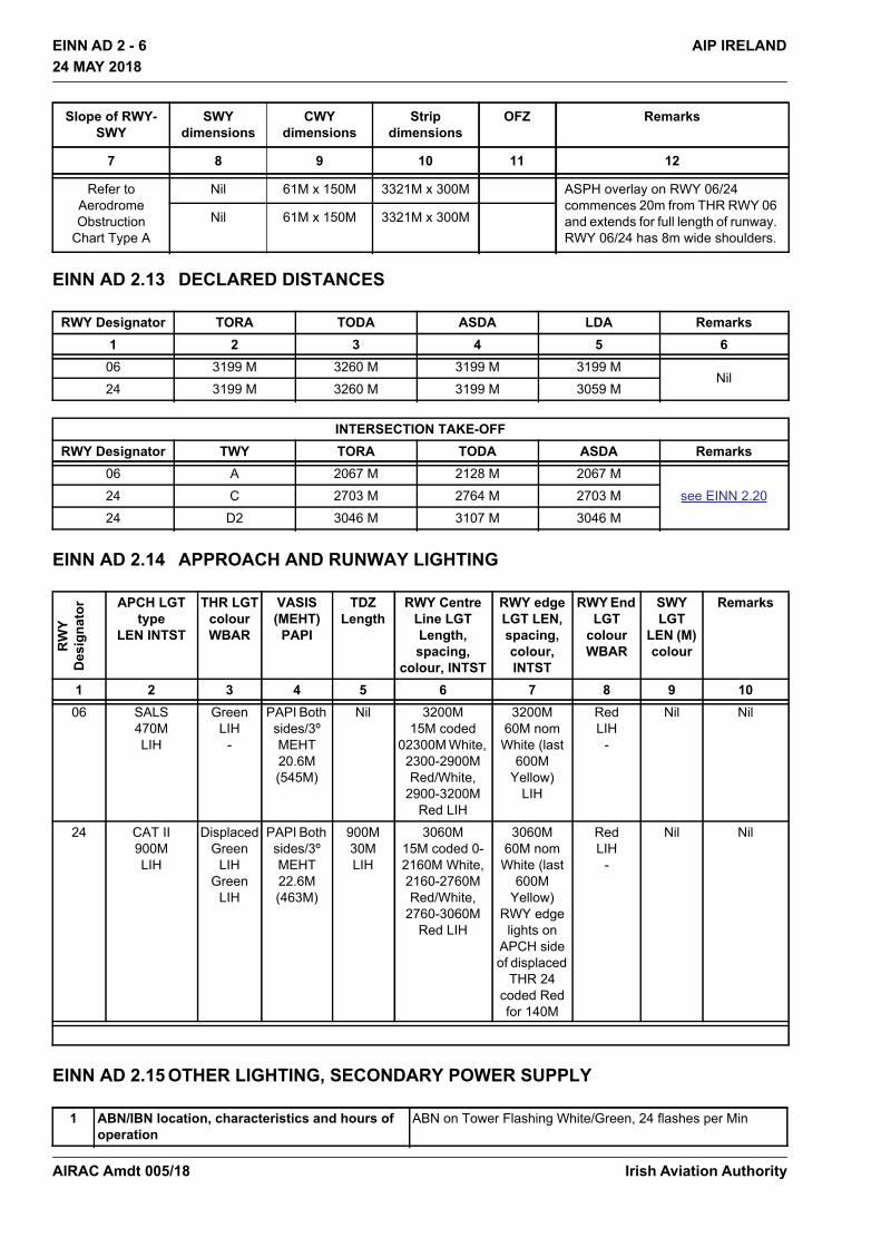
Slope of RWY-SWY
SWY dimensions
CWY dimensions
Strip dimensions
OFZ Remarks
7 8 9 10 11 12
Refer to Aerodrome Obstruction
Chart Type A
Nil 61M x 150M 3321M x 300M ASPH overlay on RWY 06/24 commences 20m from THR RWY 06 and extends for full length of runway. RWY 06/24 has 8m wide shoulders.
Nil 61M x 150M 3321M x 300M
RWY Designator TORA TODA ASDA LDA Remarks1 2 3 4 5 606 3199 M 3260 M 3199 M 3199 M
Nil24 3199 M 3260 M 3199 M 3059 M
INTERSECTION TAKE-OFFRWY Designator TWY TORA TODA ASDA Remarks
06 A 2067 M 2128 M 2067 Msee EINN 2.2024 C 2703 M 2764 M 2703 M
24 D2 3046 M 3107 M 3046 M
RW
YD
esig
nato
r APCH LGTtype
LEN INTST
THR LGTcolourWBAR
VASIS(MEHT)
PAPI
TDZLength
RWY Centre Line LGT Length, spacing,
colour, INTST
RWY edge LGT LEN, spacing, colour, INTST
RWY End LGT
colour WBAR
SWY LGT
LEN (M) colour
Remarks
1 2 3 4 5 6 7 8 9 1006 SALS
470MLIH
GreenLIH
-
PAPI Both sides/3º MEHT 20.6M (545M)
Nil 3200M15M coded
02300M White, 2300-2900M Red/White,
2900-3200M Red LIH
3200M60M nom White (last
600M Yellow)
LIH
RedLIH
-
Nil Nil
24 CAT II900MLIH
DisplacedGreen
LIHGreen
LIH
PAPI Both sides/3º MEHT 22.6M (463M)
900M30M LIH
3060M15M coded 0-2160M White,2160-2760M Red/White,
2760-3060M Red LIH
3060M60M nom White (last
600M Yellow)
RWY edge lights on
APCH side of displaced
THR 24 coded Red for 140M
RedLIH
-
Nil Nil
1 ABN/IBN location, characteristics and hours of operation
ABN on Tower Flashing White/Green, 24 flashes per Min
Irish Aviation AuthorityAIRAC Amdt 005/18

EINN AD 2 - 7AIP IRELAND
24 MAY 2018
24 MAY 2018
EINN AD 2.16 HELICOPTER LANDING AREA
Nil
EINN AD 2.17 ATS AIRSPACE
EINN AD 2.18 ATS COMMUNICATIONS FACILITIES
2 LDI location and LGT Anemometer location and LGT
Nil 2 Nr. Adjacent TWY C and south of TWR
3 TWY edge and centre line lighting Edge blue all TWY’s except TWY’s C, G and H2Edge blue retro-reflective markers TWY’s C, G and H2 and blue lights at intersection with RWY 06/24Coloured coded centreline lights on TWY’s A, D1 and D2
4 Secondary power supply/switch-over time Secondary power supply provided, switch-over time 15 SEC (1 SEC in Low Visibility Procedures)Electric battery lamps
5 Remarks Apron: FloodlightingApron edge: Blue omni- directional, elevated and insetObstacles: Fixed RedWDI’s 4Nr, (1 lighted). See Aerodrome Chart EINN AD 2.24-1
1 Designation and lateral limits Shannon Control ZoneCircle, Radius 15NM 524207N 0085529W (Shannon ARP)(See Remarks)
2 Vertical limits 5000ft AMSL3 Airspace classification C
(See Remarks)4 ATS unit call sign Language(s) Shannon Tower
English5 Transition altitude 5000ft6 Remarks The following airspace within the Shannon Control Zone is
uncontrolled • Circle, radius 1.5 NM 523958N 0084053W, SFC to
1000ft AMSL. • Area within bearings from 045º True BRG clockwise to
180ºTrue BRG from 523958N 0084053W to INT with boundary
Service designation Call sign Frequency Hours of Operation Remarks1 2 3 4 4
GND Shannon Ground 121.800 MHz 1000-1600 Local Time NilTWR Shannon Tower 118.700 MHz H24 Nil
121.800 MHzAPP Shannon Approach 121.400 MHz H24 Nil
120.200 MHzAPP (RADAR) Shannon Approach
RADAR121.400 MHz H24 Nil
ATIS Shannon Information 130.955 MHz H24 8.33 Channel
Irish Aviation Authority AIRAC Amdt 005/18

EINN AD 2 - 8 AIP IRELAND24 MAY 2018
24 MAY 2018
EINN AD 2.19 RADIO NAVIGATION AND LANDING AIDS
D-ATIS Shannon Information H24 Operators equipped with AEEC623 compliant ACARS-MU can interface with the service through ARINC and SITA service provider’s network.
Type of aid,MAG VAR,
Type of supported OP (for VOR/ILS/
MLS, give declination)
ID Frequency Hours of operation
Position of transmitting
antenna coordinates
Elevation of DME
transmitting antenna
Remarks
1 2 3 4 5 6 7DVOR/DME 4º W 2017
SHA 113.300 MHz H24 524315.6N 0085306.8W
200ft Designated Operational Coverage 300 NM/70,000ft 180ºTrue BRG to 360º True BRG. Designated Operational Coverage 100 NM/50,000ft.
NDB ENS 352 kHz H24 525418.6N 0085540.0W
Designated Operational Coverage 40 NM
NDB FOY 395 kHz H24 523358.5N 0091143.5W
Designated Operational Coverage 50 NM
ILS LLZ RWY 06 CAT 1 4º W 2017
ISE 109.5 MHz H24 524245.3N 0085408.2W
Coverage restricted to 35º either side of course line. Signals received outside coverage sector, (including back beam radiation), should be ignored.
ILS GP RWY 06 332.6MHz H24 524147.2N 0085623.1W
GP Angle 3º RDH 55ft Full scale fly down indication may not be maintained when above GP sector. Full scale fly up indication may not be maintained when left of LLZ sector and below GP.
ILS DME RWY 06
ISE CH32X(109.5 MHz)
H24 524147.2N 0085623.1W
100ft DME Zero ranged to THR 06. DME zero range is displaced from DME antenna by 445M.
ILS LLZ RWY 24 CAT II 4º W 2017
ISW 110.95MHz H24 524129.4N 0085649.6W*
Coverage restricted to 35° either side of the course line. Signals received outside coverage sector, (including back beam radiation), should be ignored. No LLZ coverage below 3000ft MSL AT 25 NM EINN *Data whose accuracy has not been quality assured.
ILS GP RWY 24 330.65MHz H24 524232.1N 0085447.7W
GP Angle 3° RDH 59ft
LO RWY 24 OL 339 kHz H24 524456.4N 0084926.0W
Designated Operational Coverage 15NM
OM RWY 24 2 Dashes per sec
75 MHz H24 524455.5N 0084927.0W
MM RWY 24 Dots and Dashes
75 MHz H24 524254.8N 0085347.9W
Service designation Call sign Frequency Hours of Operation Remarks1 2 3 4 4
Irish Aviation AuthorityAIRAC Amdt 005/18
EINN AD 2 - 9AIP IRELAND
24 MAY 2018
24 MAY 2018
EINN AD 2.20 LOCAL TRAFFIC REGULATIONS
1. Taxiing Restrictions 180º turns executed by wide-bodied aircraft on RWY 06/24 are permitted only at runway ends.
Aircraft using the turn pads should follow the marked taxiing guidance lines and use the minimum speed necessary to complete the turning manoeuvre.
2. Marshalling Services Marshalling Service is mandatory for all arriving aircraft intending to park on either the West, Central or East Aprons. Marshalling Service is otherwise available on request from the Airport Operations Office
Phone:+ 353 61 712 240
or
Phone:+ 353 61 712 241
Use of the Marshalling Service does not imply the necessity to avail of full handling services.
3. Availability of Intersection Take-Off’s
3.1 Take-off’s using less than the full length of the runway are available from TWY/RWY intersections as listed in EINN AD 2.13 DECLARED DISTANCES The datum from which the reduced declared distances on Runway 06/24 are measured is the intersection of the extended downwind edge of the specific taxiway with the runway edge, projected perpendicular to the runway centreline.
3.2 The take-off run available (TORA) is displayed on an illuminated sign adjacent to the taxiway.
3.3 Intersection take-off’s are subject at all times to pilots’ discretion and aircraft operational requirements. Pilots should advise as early as possible of their ability to accept intersection take-off’s.
3.4 Approval for intersection take-off’s is subject to the air traffic situation.
EINN AD 2.21 NOISE ABATEMENT PROCEDURES
Aircraft operators shall ensure, at all times that aircraft are operated in a manner calculated to cause the least disturbance practicable in areas surrounding the airport.
EINN AD 2.22 FLIGHT PROCEDURES
1. Holding areas Protected airspace is provided for Holding Areas in accordance with the criteria contained in PANS –OPS ICAO Doc 8168, Volume II to facilitate navigation using VOR, NDB and DME navigation aids.
2. SID and STAR
2.1 RNAV Equipped Aircraft
ILS DME RWY 24
ISW CH46Y(110.95 MHz)
H24 524232.1N 0085447.7W
100ft DME Zero ranged to THR 24. DME zero range is displaced from DME antenna by 391M.
Type of aid,MAG VAR,
Type of supported OP (for VOR/ILS/
MLS, give declination)
ID Frequency Hours of operation
Position of transmitting
antenna coordinates
Elevation of DME
transmitting antenna
Remarks
1 2 3 4 5 6 7
Irish Aviation Authority AIRAC Amdt 005/18

EINN AD 2 - 10 AIP IRELAND24 MAY 2018
24 MAY 2018
SIDs and STARs for RWY24 and RWY06 have been developed in accordance with ICAO Doc 8168 (PANS OPS) and comply with EUROCONTROL guidelines for the design of Terminal Procedures for Area Navigation.The supporting navigation infrastructure includes the choice of DME/DME, GNSS, VOR/DME (for reversionary navigation purposes) and INS/IRS as permitted by the Aircraft Flight Manual (AFM) and/or approved by the appropriate regulatory authority.Use of DME/DME may not be available below about 6000ft where terrain may obstruct line of sight with the DME infrastructure.Operators which have obtained operational and airworthiness approval, from their regulatory authority, may operate the RNAV SID and STAR procedures in accordance with the conditions of approval including • P-RNAV certificated aircraft; • B-RNAV certificated aircraft only above MSA;Climb to MSA on the initial segments of the RNAV SID may be conducted using conventional navigation.If the RNAV equipment fails, or navigation accuracy of +1 NM can not be maintained, inform ATC as soon as possible. Radar vectoring will be provided.
2.2 RTF Phraseology
Phraseology used will be as provided in the European Regional Supplementary Procedures (ICAO Doc 7030) and outlined in EUROCONTROL Guidance material for RNAV SID and STAR.Examples of phraseology for ATC are:
{CALLSIGN} CLEARED {STAR designator} ARRIVAL, RUNWAY {designator}.Note: On such a clearance flight crew shall continue on route until reaching start point of the STAR.
{CALLSIGN} ADVISE IF ABLE {designator} DEPARTURE [or ARRIVAL].If ATC are unable to issue a requested SID or STAR:{CALLSIGN} UNABLE TO ISSUE (designator) DEPARTURE [or ARRIVAL] DUE [Reason]Examples of pilot phraseology in the event of being unable to accept SID or STAR
UNABLE (designator) DEPARTURE [or ARRIVAL] DUE TO RNAV TYPE.UNABLE RNAV DUE EQUIPMENT
2.3 Non RNAV Equipped aircraft Non RNAV equipped aircraft will be assigned a departure clearance based on the omni directional procedures referenced in EINN AD 2.22.6.
3. Visual Manoeuvring Approaches Visual manoeuvring (circling) approaches are permissible, on request, to all runways.
4. Speed Control – General Provisions Speed Restrictions
5. Arrival Procedures
5.1 Clearance to enter the CTA and CTR
Arriving Aircraft capable of flying STAR will normally be cleared on a STAR appropriate to the route by ATC. On occasions ATC may radar vector aircraft for arrival (Due traffic or technical reasons).
General Routeing to Holds
Initial Segment
Final Approach REMARKS
Below FL100, Max IAS 250KT
At DERAG and ELPOM, Max IAS 220KT
Max IAS 210KT
Recommended IAS 160 KT from FAF to OM
1. ATC may request specific speeds for accurate spacing. Comply with speed adjustments as promptly as feasible within operational constraints.
2. If unable to comply with the above, advise ATC as soon as possible
Irish Aviation AuthorityAIRAC Amdt 005/18

EINN AD 2 - 11AIP IRELAND
24 MAY 2018
24 MAY 2018
Standard Arrivals Routes used in the Shannon CTA are based on Holding Patterns at DERAG and ELPOM.
5.2 Initial Approach Procedures.
5.2.1 With Radar Control
In order to expedite the flow of traffic, aircraft may be cleared on STAR, or may receive radar vectors on to final approach track from the hold or earlier on the Standard Arrival Route.Pilots should plan their flight profile in such a manner as to be able to achieve the Minimum Holding Level at the appropriate hold.Actual descent clearance will be as directed by ATC.
5.2.2 Without Radar Control. When RADAR is not serviceable, aircraft will be cleared to join the instrument approach procedure appropriate to the landing direction from the appropriate hold.
5.2.3 Communications failure procedures for arriving aircraft.
Aircraft experiencing communications failure in the Shannon CTR/CTA shall set transponder code A7600 and comply with standard ICAO procedures.Supplemented by the following:Traffic cleared on STAR Aircraft cleared on a STAR and experiencing a Communications failure shall follow the route of the STAR at the last cleared level or altitude. On reaching the appropriate hold fix, descend to 3000ft and complete the instrument approach procedure appropriate to the Runway in use.Traffic Radar vectored to final approach Aircraft being radar vectored to final approach should join, in the most expeditious manner, and complete the Instrument Approach procedure appropriate to the Runway in use.If unable to comply with above, or uncertain of position, climb to 3000ft QNH, proceed in the most expeditious manner to the hold appropriate to the Runway in use and complete the Instrument Approach Procedure appropriate to the Runway in Use
6. Departure Procedures
6.1 RWY’s 06 and 24
Aircraft capable of complying with Standard Instrument Departures will proceed in accordance with the SID.If an aircraft is unable to comply with Standard Instrument Departure the phraseology “Unable to comply with {departure} due {reasons}”Pilots who cannot comply with Standard Instrument Departures shall advise ATC in good time using the phraseology “Unable to comply with {departure} due {reasons}, so that alternative clearances can be issued.
6.2 RWY’s 06 and 24 -Omnidirectional departures
Pilots who cannot comply with any of the Omnidirectional Departure procedures must inform ATC in good time so that alternative clearances can be issued.Note: CAT A, B aircraft may be assigned an Omnidirectional Departure appropriate to CAT C, D aircraft at the discretion of ATC
6.3 Communications failure procedures for departing aircraft.
Aircraft experiencing communications failure in Shannon CTA/CTR shall set transponder code A7600 and comply with the following procedures:RFL below FL080: Departing traffic cleared by ATC to a level/altitude below the RFL, shall comply with Communication failure procedures as outlined in ICAO Annex 2.
Irish Aviation Authority AIRAC Amdt 005/18

EINN AD 2 - 12 AIP IRELAND24 MAY 2018
24 MAY 2018
RFL FL080 or above: Departing traffic cleared by ATC to a level or altitude below FL080 shall maintain the cleared level for a period of three minutes following the time the altitude/level is reached and thereafter adjust level and speed in accordance with filed flight plan.Departing Traffic experiencing a communications failure above FL080 shall comply with communications failure procedures as outlined in ICAO Annex 2
7. Low Visibility Procedures
7.1 Low Visibility Procedures apply when the cloud ceiling is below 200ft (60M) and/or the IRVR is less than 550M.
7.2 Only RWY 24 may be used for CAT II operations. The CAT II holding position on TWY D2 must be used.
7.3 When these procedures are in operation and RWY 24 is in use the following standard taxi route system applies:
• Departing aircraft shall normally use TWY’s D1 and D2. • Arriving aircraft shall normally use TWY A.
7.4 TWY/Stop-bar/Centreline lighting/lead on/lead off will be in use.
7.5 At no time shall an aircraft or vehicle cross an illuminated stop bar and any instruction to do so should be challenged. In exceptional circumstances when the stop bar cannot be extinguished the authorisation to cross the illuminated stop bar may be given by ATS. This shall always be challenged and confirmation received that this instruction is part of a contingency arrangement due to a failure of the stop bar. All aircraft and vehicles operators shall request for the instruction to cross an illuminated stop bar to be reconfirmed by ATS and read back before proceeding.
7.6 Pilots will be informed by ATIS broadcast or RTF when Low Visibility Procedures are in operation
7.7 Full details of Low Visibility Procedures are available on request from Aerodrome Administration (see EINN AD 2.3.1)
8. Holding Procedures
A standard rate of descent of 1000ft per min in holding patterns will be used unless otherwise instructed by ATC. Pilots must advise ATC if unable to comply with the standard rate of descent. All turns are to be made at a bank angle of 25° or a rate of 3° per second, whichever requires the lesser bank
Holding Point LOC Co-ordinates MAG Track Inbound
Dir of Turn Limiting Outbound Direction
Holding Level
MNM MAX
DERAG See STAR Chart RWY 24
238º Right Hand 19D SHA 3000 FL140
ELPOM See STAR Chart RWY 06
058° Left Hand 20D SHA 3000 FL140
FOYNES (FOY) (Contingency)
See STAR Chart RWY 24
050° Left Hand 3000 FL140
ENNIS (ENS) (Contingency)
SEE EINN AD 2-19
076° Left Hand 3500
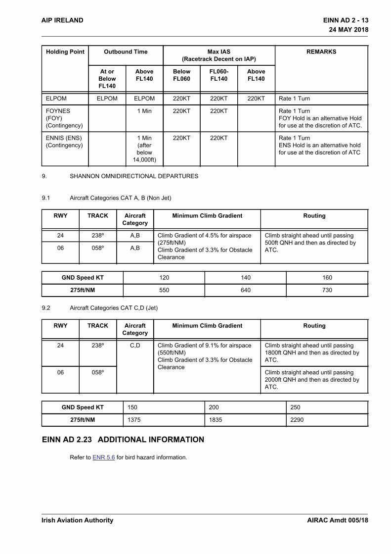
Holding Point Outbound Time Max IAS(Racetrack Decent on IAP)
REMARKS
At or Below FL140
Above FL140
Below FL060
FL060-FL140
Above FL140
DERAG 220KT 220KT Rate 1 Turn
Irish Aviation AuthorityAIRAC Amdt 005/18
EINN AD 2 - 13AIP IRELAND
24 MAY 2018
24 MAY 2018
9. SHANNON OMNIDIRECTIONAL DEPARTURES
9.1 Aircraft Categories CAT A, B (Non Jet)
9.2 Aircraft Categories CAT C,D (Jet)
EINN AD 2.23 ADDITIONAL INFORMATION
Refer to ENR 5.6 for bird hazard information.
ELPOM ELPOM ELPOM 220KT 220KT 220KT Rate 1 Turn
FOYNES (FOY) (Contingency)
1 Min 220KT 220KT Rate 1 Turn FOY Hold is an alternative Hold for use at the discretion of ATC.
ENNIS (ENS) (Contingency)
1 Min(after below
14,000ft)
220KT 220KT Rate 1 TurnENS Hold is an alternative hold for use at the discretion of ATC
RWY TRACK Aircraft Category
Minimum Climb Gradient Routing
24 238º A,B Climb Gradient of 4.5% for airspace (275ft/NM)Climb Gradient of 3.3% for Obstacle Clearance
Climb straight ahead until passing 500ft QNH and then as directed by ATC.06 058º A,B
GND Speed KT 120 140 160
275ft/NM 550 640 730
RWY TRACK Aircraft Category
Minimum Climb Gradient Routing
24 238º C,D Climb Gradient of 9.1% for airspace (550ft/NM)Climb Gradient of 3.3% for Obstacle Clearance
Climb straight ahead until passing 1800ft QNH and then as directed by ATC.
06 058º Climb straight ahead until passing 2000ft QNH and then as directed by ATC.
GND Speed KT 150 200 250
275ft/NM 1375 1835 2290
Holding Point Outbound Time Max IAS(Racetrack Decent on IAP)
REMARKS
At or Below FL140
Above FL140
Below FL060
FL060-FL140
Above FL140
Irish Aviation Authority AIRAC Amdt 005/18

EINN AD 2 - 14 AIP IRELAND24 MAY 2018
24 MAY 2018
EINN AD 2.24 CHARTS RELATED TO AERODROME
Name Page
Aerodrome Chart – ICAO EINN AD 2.24-1
Aircraft Parking/Docking Chart – ICAO EINN AD 2.24-2
Aerodrome Obstacle Chart RWY 06/24 – ICAO TYPE A EINN AD 2.24-4
Precision Approach Terrain Chart RWY 24 – ICAO EINN AD 2.24-5
RNAV Standard Departure Chart RWY 24 – ICAO EINN AD 2.24-7A
RNAV Standard Departure Chart RWY 06 – ICAO EINN AD 2.24-8A
RNAV Standard Terminal Arrival Chart RWY 24 – ICAO EINN AD 2.24-9A
RNAV Standard Terminal Arrival Chart RWY 06 – ICAO EINN AD 2.24-10A
Instrument Approach Chart ILS CAT I & II or LLZ RWY 24 EINN AD 2.24-11
Instrument Approach Chart ILS or LLZ RWY 06 – ICAO EINN AD 2.24-12
Instrument Approach Chart VOR RWY 24 – ICAO EINN AD 2.24-13
Instrument Approach Chart VOR RWY 06 – ICAO EINN AD 2.24-14
Visual Approach Chart – ICAO EINN AD 2.24-15
Irish Aviation AuthorityAIRAC Amdt 005/18