el cajon boulevard - san diego · pdf file4.0 technical analysis ... pedestrian-friendly...
TRANSCRIPT

E L C A J O N B O U L E V A R D Complete Boulevard Planning Study
Highland Avenue to 50th Street
January 2017Final Report

Table of Contents
1.0 Introduction.................................................................................................................................1
2.0 Existing Conditions Analysis.........................................................................................................1 3.0 Public Outreach Summary ...........................................................................................................3
4.0 Technical Analysis.........................................................................................................................4
5.0 Next Steps....................................................................................................................................7
Appendix A - Existing Conditions Analysis Appendix B - Public Outreach Summary
Appendix C - Technical Analysis
El Cajon Boulevard - Final Report

El Cajon Boulevard - Final Report
1
1.0 IntroductionThe Complete Boulevard Planning Study (“the Plan”) focused on an approximately three-quarter mile segment of El Cajon Boulevard between Highland Avenue and 50th Street, encompassing the Little Saigon Cultural and Commercial District. This portion of El Cajon Boulevard is located at the convergence of the Mid-City communities of City Heights and Talmadge. The purpose of this planning effort was to provide mobility and urban design recommendations that ultimately would catalyze meaningful and transformative investments on El Cajon Boulevard to facilitate a beautiful, vibrant and welcoming area for shopping, eating, neighborhood services, and pedestrian activity for residents and visitors.
The Complete Boulevard Planning Study was funded through a grant from the San Diego Association of Governments (SANDAG) Smart Growth Incentive Program (Fiscal Year 2014-2015). Additional funding for public outreach and active transportation planning activities was provided by the County of San Diego Healthy Works: Prevention Initiative Program. The Metropolitan Transit System (MTS) recently made significant investments in Rapid Bus Service along this corridor, and the recommendations described in this Plan are intended to capitalize on these transit improvements for the community.
Strategies presented in this Plan build upon the City of San Diego’s Pedestrian Master Plan (2015), the San Diego Bicycle Master Plan (2013), and several other neighborhood-level planning documents. The Plan also considered the planned regional bicycle projects as part of the Mid-City Bicycle Corridors Project on nearby Monroe Avenue and Orange Avenue.
The City of San Diego adopted the Vision Zero policy in 2015 as a strategy to create safer roadways in our neighborhoods. The main goal of this policy is to reduce all traffic fatalities to zero by the Year 2025 (“Vision Zero”). El Cajon Boulevard is named as a Vis ion Zero high priority corridor. It serves as a major connector between urban and suburban neighborhoods poised to see significant growth and development pressure in the next 10-20 years in the City of San Diego.
The vision for the El Cajon Boulevard Study is a vibrant, safe, pedestrian, bicycle and transit-friendly area that works in concert with the Mid-City Rapid services to help residents, community members, and businesses realize the transformative potential of the corridor. Through this effort, El Cajon Boulevard is being re-envisioned as a “complete street,” one that is intended to provide safe access for all users including pedestrians, transit riders, bicyclists, and motorists. This Plan identifies complete street and urban design recommendations along the corridor based on existing conditions, adjacent planning efforts, and extensive public participation activities.
The following report provides a summary of the various elements that went into creating the Complete Boulevard Planning Study. These components include:
• Existing Conditions Analysis;
• Public Outreach Summary; and
• Technical Analysis.
2.0 Existing Conditions AnalysisDuring the existing conditions analysis, previous studies were reviewed to understand and incorporate any previous planning efforts in and around the study area. The studies included long-range transportation plans, design guidance, completed projects, on-going projects, proposed projects, and traffic impact studies. Overall, opportunities identified in the Existing Conditions Analysis included a bicycle facility, bicycle racks, transit stations/stops, pedestrian-friendly crossings, adequate pedestrian lighting, pedestrian benches, sidewalks with a minimum width of 5 feet, and trash/recycle receptacles.

El Cajon Boulevard - Final Report
2
An "at scale" basemap was prepared with available data to establish a correct understanding of the existing conditions of the corridor. El Cajon Boulevard is currently a four-lane roadway with a two-way left turn lane that accommodates on-street parallel parking on both sides. The paved width of El Cajon Boulevard ranges between 68 feet and 70 feet, with one section near Winona Avenue narrowing to 62 feet (Figure 1) for the Rapid Bus Stops. Daily traffic volumes range from 24,000-27,000 ADT and are projected to increase to 28,000-34,000 ADT by 2035.
MTS currently operates Local Bus Route 1 and the Mid-City Rapid Transit Bus Route 215 along El Cajon Boulevard within the project area. Rapid Bus Route 215 is provided seven days a week with service from 4:30AM to 1:39 AM on weekdays, with predominately 15 minute headways. Local Bus Route 1 service is provided seven days a week with service from 4:49 AM to 12:28 AM, with 15-minute headways during the day and 20 - 30 minute headways during off peak hours (2016 schedule). The corridor experiences high levels of transit ridership. However, many bus stops lack amenities such as a bench or shade structures.
There is continuous sidewalk along both sides of El Cajon Boulevard ranging from 8 feet to 15 feet in width. The sidewalk area lacks a unified design, adequate lighting, and has utilities and other street furniture that impedes the pedestrian travel way. In most locations, parked cars provide a buffer between traffic and pedestrians on the sidewalk. The crosswalks across El Cajon Boulevard span wide distances with no pedestrian refuge area in the middle of the street. Only 5 out of 26 intersections along the corridor have traffic signals for pedestrians crossing El Cajon Boulevard. There are 72 curb ramps along the corridor, and 44 were identified as non-ADA conforming or missing curb ramps altogether.
The plans reviewed included:
• City Heights Urban Greening Plan (2014)
• San Diego Pedestrian Master Plan (2015)
• San Diego Bicycle Master Plan (2013)
• San Diego Forward (The Regional Plan) (2015)
• 2050 Regional Bike Plan
• Regional Transit Vision
• SR 15 Mid-City Ctrline Transit Stations Fact Sheet
• Mid-City Rapid Bus Project
Travel Lanewith
Sharrow
7’ 12’ 11’ 11’ 12’ 7’10’Turn Lane Travel Lane ParkingParking Travel Lane
with Sharrow
Travel LaneSidewalk Sidewalk
• Hoover High School Mobility Assessment
• Little Saigon Design Guidelines
• North Park Mid-City Regional Bike Corridors Project
• Mid-City Communities Plan
• Kensington/Talmadge Pedestrian Plan
• City Heights Pedestrian Plan
• Walkable Neighborhoods Economic Study
• Seniors, Sidewalks and the Centennial
• Safe for All 2011 Street Design Benchmark Study for the SD Region
Figure 1: Existing Conditions

El Cajon Boulevard - Final Report
3
There is a bicycle route along El Cajon Boulevard with appropriate pavement markings to raise awareness that people on bicycles may share the lane with vehicles and buses. Many cyclists avoid the area or choose to ride on the sidewalk due to a stressful riding environment on the roadway.
The existing space within the public right-of-way is underutilized and opportunities exist for future street furniture, public art, banners, and plantings. Several areas along the sidewalk between the roadway and the businesses are narrowed and constrained,thereby limiting opportunities for urban design elements.
The existing conditions analysis evaluated the existing intersection traffic control, regional connectivity, parking, safety, level of service for vehicles, level of traffic stress for bicyclists, transit routes and boardings/alightings, Pedestrian Environmental Quality Index, traffic counts, bicycle counts, and pedestrian crossing counts to produce multimodal recommendations. These recommendations also identified corridor enhancement opportunities where specific opportunities existed for medians, bulb-outs, and improved pedestrian space.
The Existing Conditions Report is available in Appendix A.
3.0 Public Outreach Summary The Complete Boulevard Plan has been developed through a robust community involvement process which is documented in the Public Outreach Summary (Appendix B). This process included a public website and public outreach events, public meetings, and ad-hoc working group meetings to share information about the project process and to provide an opportunity for the public to contribute input to help shape the Plan. A complete list of stakeholders that participated in the process is included in Appendix B.
The strategic outreach built upon planned activities in the vicinity, created new opportunities for close community interaction, and fostered active community participation to identify opportunities for enhancements. As part of the outreach effort, public notices for scheduled outreach events were prepared and distributed in person, via email, and website announcements to the community and stakeholders.
In addition to public gatherings, stakeholder and business specific surveys were conducted, both by the project team with the collaboration of the El Cajon Boulevard Business Improvement Association representatives, and separately by representatives from the Little Saigon District.

El Cajon Boulevard - Final Report
4
The outreach included a three-pronged approach including:
1. Public outreach events including a Walk Audit; a focus group meeting, door-to-door surveys. The surveys were conducted in English, Vietnamese, and Spanish.
2. Public meetings to obtain feedback and understanding of the corridor; subsequent public meetings included the presentation of initial findings and potential options to improve the corridor. Comment cards were provided at the meetings to solicit feedback on the alternatives and various urban design features.
3. Ad-hoc working group discussions to include review and discussion on the alternatives, and refinement of the alternative improvement strategies to address stakeholder concerns.
The complete Public Outreach Summary is provided in Appendix B.
4.0 Technical AnalysisTechnical analysis (fully presented in Appendix C) was performed to evaluate the corridor in each of the following six categories:
1. Existing Conditions;2. Traffic/Vehicular Activity;3. Parking Capacity;4. Pedestrian Activity;5. Bicycle Activity; and 6. Transit Ridership.
In all, fourteen alternatives were developed and evaluated by the City, ad-hoc working group, stakeholders, and the public.
The following general corridor improvements were identified:
• Improved sidewalk conditions with streetscape enhancements that include street furniture, lighting, signage, street trees, and drought-tolerant landscaping;
• Curb Extensions/Bulb Outs in select locations, where feasible, to decrease the overall crossing width of roadway and increase the visibility of pedestrians by aligning them with the parking lane;
• Pedestrian improvements such as high visibility marked crosswalks, enhanced crosswalks, pedestrian refuges, ADA curb ramps, and sidewalk improvements;
• Bicycle improvements including Share the Road signs and “Sharrow” pavement markings, a segment of bike lane, and bike racks;
• Planted and hardscaped raised medians that will provide a buffer to separate traffic in opposing directions and reduce the number of potential bicycle, pedestrian, and vehicle conflicts by eliminating in turning movements;
• Opportunities for parks, plazas, or open space enhancements;
• Branding Improvements such as monuments that portray the unique culture and history of the Little Saigon District, Talmadge neighborhood, and the
El Cajon Boulevard - Final Report
5
Boulevard that may also include statues, banners, and signs; and
• Stormwater improvements to minimize flooding, treat runoff, and support landscaping.
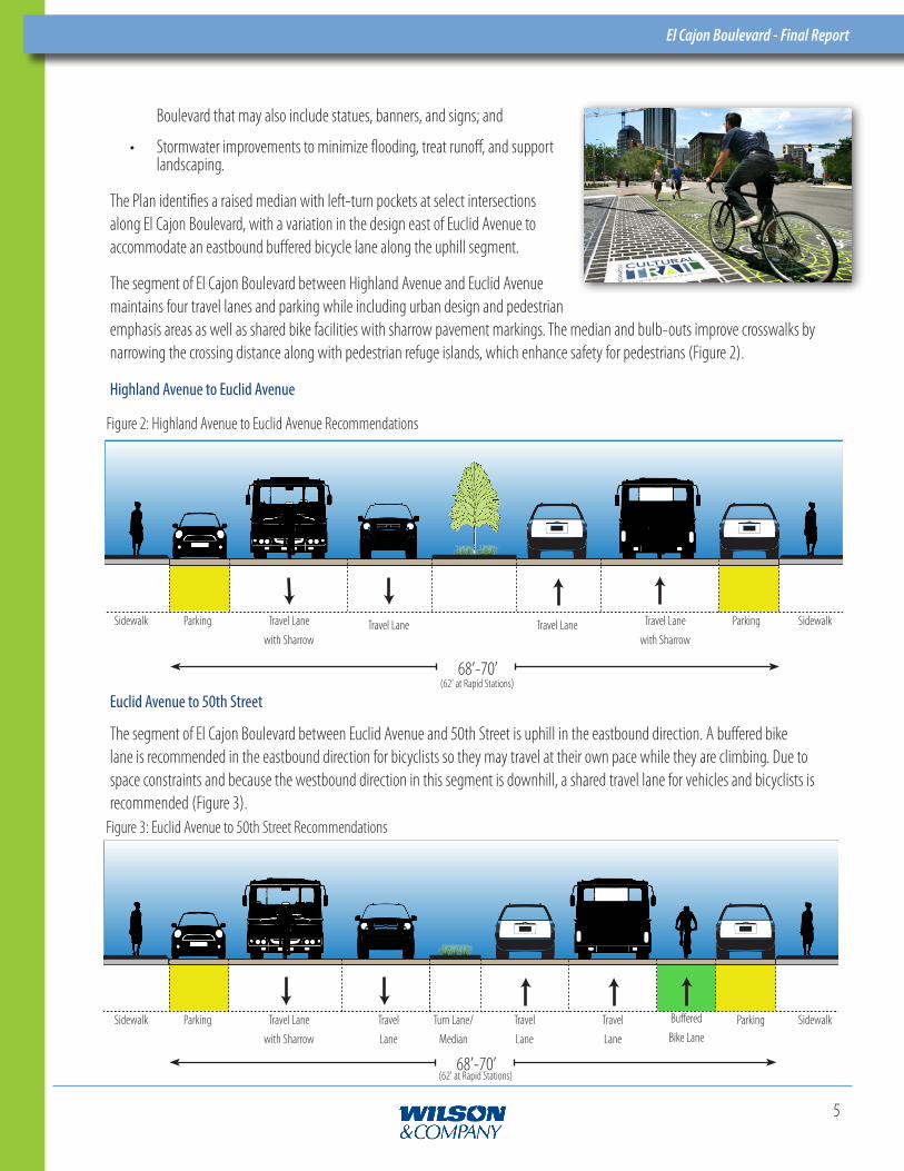
The Plan identifies a raised median with left-turn pockets at select intersections along El Cajon Boulevard, with a variation in the design east of Euclid Avenue to accommodate an eastbound buffered bicycle lane along the uphill segment.
The segment of El Cajon Boulevard between Highland Avenue and Euclid Avenue maintains four travel lanes and parking while including urban design and pedestrian emphasis areas as well as shared bike facilities with sharrow pavement markings. The median and bulb-outs improve crosswalks by narrowing the crossing distance along with pedestrian refuge islands, which enhance safety for pedestrians (Figure 2).
Highland Avenue to Euclid Avenue
Travel Lanewith Sharrow
ParkingSidewalk Travel Lane Travel Lanewith Sharrow
Travel Lane Parking Sidewalk
68’-70’(62' at Rapid Stations)
Figure 2: Highland Avenue to Euclid Avenue Recommendations
The segment of El Cajon Boulevard between Euclid Avenue and 50th Street is uphill in the eastbound direction. A buffered bike lane is recommended in the eastbound direction for bicyclists so they may travel at their own pace while they are climbing. Due to space constraints and because the westbound direction in this segment is downhill, a shared travel lane for vehicles and bicyclists is recommended (Figure 3).
Travel Lanewith Sharrow
ParkingSidewalk Travel Lane
Turn Lane/ Median
Travel Lane
Parking SidewalkTravel Lane
Buffered Bike Lane
68’-70’(62' at Rapid Stations)
Figure 3: Euclid Avenue to 50th Street Recommendations
Euclid Avenue to 50th Street

El Cajon Boulevard - Final Report
6
This Plan increases safety throughout the corridor for vehicles, pedestrians, and bicyclists. The raised median and restricted left turn access throughout the corridor improves safety by reducing conflict points for vehicles, bicyclists, and pedestrians at intersections, alleys, and driveways as well as providing a refuge for pedestrians crossing the street.
A median will reduce the number of conflict points between vehicles at intersections and alleys by 63% and at driveways by 78%. It will reduce the number of conflict points between vehicles and pedestrians at intersections and alleys by 35% and at driveways by 50% (Figure 5).*
Vehicle/Pedestrian Con�ictsVehicle/Vehicle Con�icts
*Bicyclists are allowed to make the same movements as vehicles, so they will have the same reduction in conflict points as vehicles in the Plan.
Potential Conflict Points without Median
Pedestrian
368
124
241
62
0
50
100
150
200
250
300
350
400
Intersection, Alleys Driveways
Conf
lic P
oint
s
Existing Conflicts
Proposed Conflicts
35% 50%Intersections, Alleys Driveways Intersections, Alleys Driveways
565
279
208
62
0
100
200
300
400
500
600
Intersection, Alleys Driveways
Conf
lict
Poi
nts
22% 63%
Vehicle
368
124
241
62
0
50
100
150
200
250
300
350
400
Intersection, Alleys Driveways
Conf
lict
Poi
nts
Existing Conflicts
Proposed Conflicts
78%
Figure 4: Potential Conflict Points in a 4-Way Intersection
Figure 5: Conflicts Reduced by Proposed Plan

El Cajon Boulevard - Final Report
7
During the long term corridor vision process, a long term recommendation for the corridor emerged which includes maintaining four travel lanes, parking on both sides of the street, raised cycle track, sidewalk, and a raised and planted median which transitions to a turn pocket at specific locations. This requires additional right-of-way that could be acquired during the redevelopment process (Figure 6). It is recommended that this long-term recommendation be vetted for inclusion in the next update of the Mid-City Communities Plan.
Figure 6: Long Term Corridor Vision
The Technical Analysis is provided in Appendix C.
5.0 Next StepsNext steps toward implementation include identifying funding, project design, and developing a schedule for phased implementation. The following issues need to be addressed as part of the next phase of the project: coordination with MTS related to moving bus stops, coordination with the Police and Fire-Rescue Departments regarding emergency access at new raised medians, and coordination with the Business Improvement Association and Little Saigon District related to assuring maintenance of landscaping and other urban design features proposed as part of the project.
68’-70’
New ROW Needed
New ROW Needed
Turn Lane/
Median
TravelLane
TravelLane
TravelLane
TravelLane
ParkingParkingCycleTrack
CycleTrack
New ROW
Needed
New ROW
Needed

Appendix A - Existing Conditions Analysis
Introduction
Previous Study Review
Available Data
Multimodal Level of Service Analysis
Walk Audit Summary and Public Involvement
Assets/Liabilities/Opportunities/Constraints
Appendix A - Traffic Counts
Appendix B - Pedestrian Counts
Appendix C - Bicycle Counts
Appendix B - Public Outreach Summary
Introduction
Public Outreach Events
Public Meetings
Ad-Hoc Working Group Meetings
Appendix A - Community Outreach
Appendix B - Public Meetings
Appendix C - Ad-Hoc Working Group Meetings
Appendix C - Technical Analysis
Introduction
Existing Conditions Analysis
Traffic/Vehicular Activity
Parking Analysis
Pedestrian Activity
Bicycle Activity
El Cajon Boulevard - Final Report Appendix

(Appendix C - Technical Analysis, continued)
Transit Ridership and Amenities
Proposed Alternatives
Appendix A - Synchro Analysis
Appendix B - Sight Distance Evaluation
Appendix C - Auto Turn Evaluation
Appendix D - Alternative Evaluations
Appendix E - Corridor Layout & Cost Structure
Appendix F - Landscaping Plan
El Cajon Boulevard - Final Report Appendix

E L C A J O N B O U L E V A R D Complete Boulevard Planning Study
Highland Avenue to 50th Street
Existing Conditions Analysis Appendix A

E L C A J O N B O U L E V A R D Complete Boulevard Planning Study
Highland Avenue to 50th Street
Public Outreach SummaryAppendix B

E L C A J O N B O U L E V A R D Complete Boulevard Planning Study
Highland Avenue to 50th Street
Technical AnalysisAppendix C