el description/location: special … l_bure… · maintain wildlife connectivity, wildlife and...
TRANSCRIPT

El Paso to Golden Valley Wildlife Corridor
Description/Location: South and East of the El Paso Wilderness, north of Redrock‐Garlock Road and west of highway 395. Special Designations/Management Plan/Date: new proposal Relevance and Importance Criteria: Relevant biological resources including wildlife and plant assemblages Desert tortoise and Mojave ground squirrels occur here. In addition, the area provides excellent habitat for foraging and nesting of numerous raptor species, including golden eagles and burrowing owls. A variety of songbirds, including loggerhead shrikes and Le Conte's thrashers, use the area, both during migration and as nesting habitat. There are at least four special status bat species, including the sensitive Townsend’s big‐eared bat, that call this area home. This area encompasses an essential movement corridor which links wildlife habitats in the Golden Valley Wilderness to those in the El Paso Mountains and Western Rand Mountains ACEC. There are plants that are endemic to a portion of this area such as the Red Rock poppy and the Red Rock tarplant.
Goals: Protect wildlife and plant species and habitat. Maintain habitat connectivity for wildlife with a movement corridor between the El Paso mountains, the Golden Valley Wilderness and Western Rand Mountains ACEC. Maintain healthy desert ecosystem for desert species such as desert tortoise, Mohave ground squirrel, burrowing owl, kit fox, American badger, and a variety of bird species. Prevent habitat fragmentation. For NLCS Lands: Where this ruleset differs from the plan‐wide NLCS rulesets, the more restrictive rules will apply. Designation and Acreage by Alternative:
Alternative BLM Acres of NLCS
within ACEC or Wildlife Allocation
BLM Acres within ACEC
BLM Acres within Wildlife Allocation
ACEC Disturbance Cap
No Action 0 0 0 NA
Preferred Alternative
0 57,900 0 1%
1 0 57,900 0 1%
2 56,000 56,000 0 0.25%
3 0 57,900 0 1%
4 0 57,900 0 0.25%
* Acreage values are for BLM managed lands Alternatives: Under All Alternatives, this area would be identified as an ACEC and would be managed to support and maintain wildlife connectivity, wildlife and plant populations, and natural habitat. No Action – this conservation area would not exist, as it does not exist currently.

Objectives (desired future conditions)/Allowable Uses/Management Actions Resource
Objective: Soils exhibit functional biological and physical characteristics that are appropriate to soil type, climate, and land form. Allowable Uses: Restrict construction activities when soils are susceptible to heightened risk of erosion. Management Action: Ensure soils to meet or exceed the Soil Standard of Rangeland Health, as indicated by ground or plant cover, diversity of plant species, minimal evidence of accelerated wind and water erosion and the presence of biological soil crusts where appropriate. Objective: Protect the hydrologic flow regime in all of the riparian areas Allowable Uses: Existing water rights Management Action: Manage riparian/wetland vegetation, structure, and diversity and stream channels and floodplains so that they are function and achieving physical and biological objectives. Management Action: Monitor Proper Functioning Condition and restore natural flow stream morphology when needed Management Action: Monitor water uses
Soil, water, air
Objective: Protect the following special status plants by ensuring habitat is in a stable or improving condition to keep the species from becoming listed under the ESA. Management Action: Protect and monitor populations of special status plants Red Rock Poppy (Eschscholzia minutiflora ssp. twisselmannii) Red Rock tarplant (Deinandra arida) Management Action: Prohibit collection of plants except by permit Management Action: Rehabilitate/revegetate disturbed area to maintain intact vegetation communities and prevent fragmentation.
Vegetation (incl. special status species)
Objective: Prevent habitat fragmentation, which impedes wildlife movement. Management Action: Maintain wildlife connectivity between wilderness areas to maintain/increase genetic diversity
Objective: Protect and enhance habitat to maintain stable or increasing population trends of special status species to ensure persistence: Management Action: Designate Species below as priority species for management and protection. Le Conte’s Thrasher (Toxostoma lecontei) State Species of Special Concern Loggerhead Shrike (Lanius ludovicianus) BLM Sensitive American Badger (Taxidea taxus) State Special Animal Desert Tortoise (Gopherus agassizii) Federally and State threatened Mohave ground squirrel (Spermophilus mohavensis) State threatened Townsend's big‐eared bat (Corynorhinus townsendii) BLM sensitive Pallid bat (Antrozous pallidus) BLM sensitive Spotted bat (Euderma maculatum) BLM sensitive Western Mastiff bat (Eumops perotis californicus) BLM sensitive
Fish and Wildlife (incl. special status species)
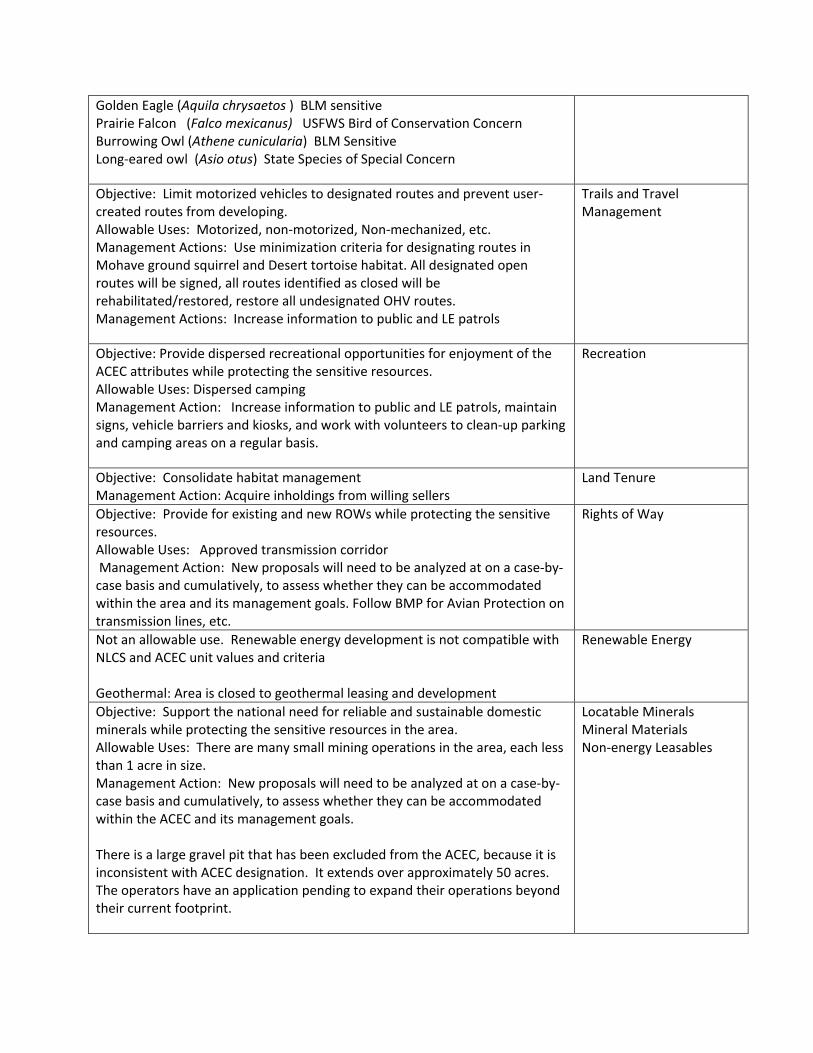
Golden Eagle (Aquila chrysaetos ) BLM sensitive Prairie Falcon (Falco mexicanus) USFWS Bird of Conservation Concern Burrowing Owl (Athene cunicularia) BLM Sensitive Long‐eared owl (Asio otus) State Species of Special Concern
Objective: Limit motorized vehicles to designated routes and prevent user‐created routes from developing. Allowable Uses: Motorized, non‐motorized, Non‐mechanized, etc. Management Actions: Use minimization criteria for designating routes in Mohave ground squirrel and Desert tortoise habitat. All designated open routes will be signed, all routes identified as closed will be rehabilitated/restored, restore all undesignated OHV routes. Management Actions: Increase information to public and LE patrols
Trails and Travel Management
Objective: Provide dispersed recreational opportunities for enjoyment of the ACEC attributes while protecting the sensitive resources. Allowable Uses: Dispersed camping Management Action: Increase information to public and LE patrols, maintain signs, vehicle barriers and kiosks, and work with volunteers to clean‐up parking and camping areas on a regular basis.
Recreation
Objective: Consolidate habitat management Management Action: Acquire inholdings from willing sellers
Land Tenure
Objective: Provide for existing and new ROWs while protecting the sensitive resources. Allowable Uses: Approved transmission corridor Management Action: New proposals will need to be analyzed at on a case‐by‐case basis and cumulatively, to assess whether they can be accommodated within the area and its management goals. Follow BMP for Avian Protection on transmission lines, etc.
Rights of Way
Not an allowable use. Renewable energy development is not compatible with NLCS and ACEC unit values and criteria Geothermal: Area is closed to geothermal leasing and development
Renewable Energy
Objective: Support the national need for reliable and sustainable domestic minerals while protecting the sensitive resources in the area. Allowable Uses: There are many small mining operations in the area, each less than 1 acre in size. Management Action: New proposals will need to be analyzed at on a case‐by‐case basis and cumulatively, to assess whether they can be accommodated within the ACEC and its management goals. There is a large gravel pit that has been excluded from the ACEC, because it is inconsistent with ACEC designation. It extends over approximately 50 acres. The operators have an application pending to expand their operations beyond their current footprint.
Locatable Minerals Mineral Materials Non‐energy Leasables

Objective: Provide for livestock grazing opportunities in a manner that limits impacts on other resources Allowable Uses: Adjust livestock use where monitoring data indicate changes are necessary to meet resource objectives. Management Actions: Manage grazing authorizations to meet or exceed the Standards for Rangeland Health.
Livestock grazing

14 £¤395
El Pasoto Golden
EaglesFlyway
Western RandMountainsReduction
Fremont-KramerReduction
Mojave GroundSquirrel ACEC
WesternRand
MountainsRed
MountainSpring
Last ChanceCanyon
Jawbone/Butterbredt
Fremont-KramerDWMA
ÆN
Preferred Alternative ACECsDate Printed: 5/29/2013
Prepared by BLM California State Office
3.5Miles
5Kilometers
El Paso to Golden
GTLFInterstateUS HwyCA HwyCounty HwyBLM Field Office
CDCA BoundaryDRECP Boundary
CitiesOHV Areas
ACEC Layers
Proposed NLCSProposed ACECExisting ACEC
Legislatively andLegally ProtectedDesign Focus Areas
State
PrivateMilitary
Land Status
Other Federal
Bureau of LandManagement

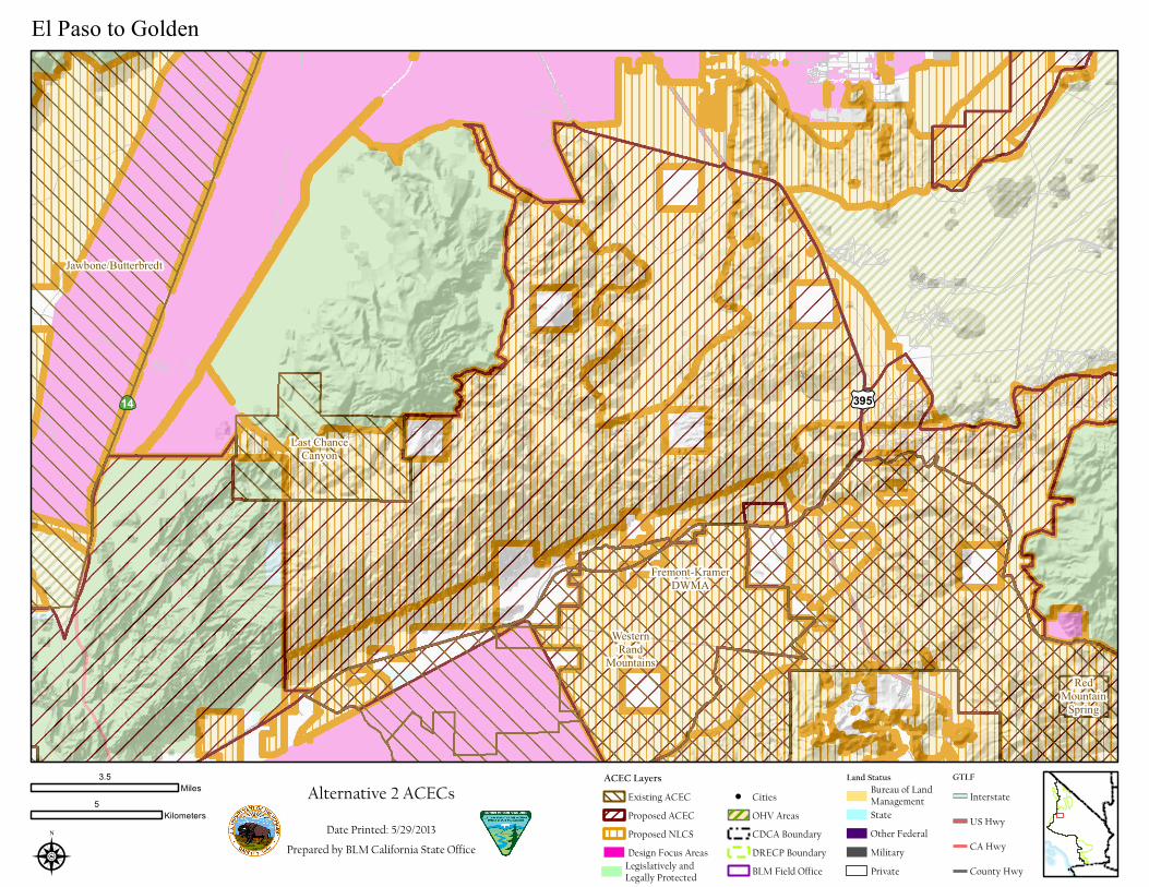
14 £¤395
WesternRand
MountainsRed
MountainSpring
Last ChanceCanyon
Jawbone/Butterbredt
Fremont-KramerDWMA
ÆN
Alternative 1 ACECsDate Printed: 5/29/2013
Prepared by BLM California State Office
3.5Miles
5Kilometers
El Paso to Golden
GTLFInterstateUS HwyCA HwyCounty HwyBLM Field Office
CDCA BoundaryDRECP Boundary
CitiesOHV Areas
ACEC Layers
Proposed NLCSProposed ACECExisting ACEC
Legislatively andLegally ProtectedDesign Focus Areas
State
PrivateMilitary
Land Status
Other Federal
Bureau of LandManagement
14 £¤395
WesternRand
MountainsRed
MountainSpring
Last ChanceCanyon
Jawbone/Butterbredt
Fremont-KramerDWMA
ÆN
Alternative 2 ACECsDate Printed: 5/29/2013
Prepared by BLM California State Office
3.5Miles
5Kilometers
El Paso to Golden
GTLFInterstateUS HwyCA HwyCounty HwyBLM Field Office
CDCA BoundaryDRECP Boundary
CitiesOHV Areas
ACEC Layers
Proposed NLCSProposed ACECExisting ACEC
Legislatively andLegally ProtectedDesign Focus Areas
State
PrivateMilitary
Land Status
Other Federal
Bureau of LandManagement

14 £¤395
WesternRand
MountainsRed
MountainSpring
Last ChanceCanyon
Jawbone/Butterbredt
Fremont-KramerDWMA
ÆN
Alternative 3 ACECsDate Printed: 5/29/2013
Prepared by BLM California State Office
3.5Miles
5Kilometers
El Paso to Golden
GTLFInterstateUS HwyCA HwyCounty HwyBLM Field Office
CDCA BoundaryDRECP Boundary
CitiesOHV Areas
ACEC Layers
Proposed NLCSProposed ACECExisting ACEC
Legislatively andLegally ProtectedDesign Focus Areas
State
PrivateMilitary
Land Status
Other Federal
Bureau of LandManagement
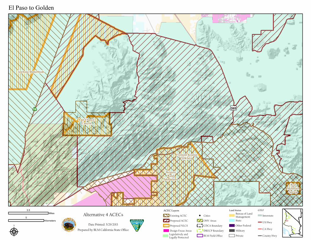
14 £¤395
WesternRand
MountainsRed
MountainSpring
Last ChanceCanyon
Jawbone/Butterbredt
Fremont-KramerDWMA
ÆN
Alternative 4 ACECsDate Printed: 5/29/2013
Prepared by BLM California State Office
3.5Miles
5Kilometers
El Paso to Golden
GTLFInterstateUS HwyCA HwyCounty HwyBLM Field Office
CDCA BoundaryDRECP Boundary
CitiesOHV Areas
ACEC Layers
Proposed NLCSProposed ACECExisting ACEC
Legislatively andLegally ProtectedDesign Focus Areas
State
PrivateMilitary
Land Status
Other Federal
Bureau of LandManagement