element 1 - planning
TRANSCRIPT

Element 1Urban structure


This publication may be of assistance to you but the State of Victoria and its employees do not guarantee that the publication is without flaw of any kind or is wholly appropriate for your particular purposes and therefore disclaims all liability for any error, loss or other consequence which may arise from you relying on any information in this publication.
Page 1 of 2Urban Design Guidelines for Victoria
1Element 1 Urban structure
This element covers
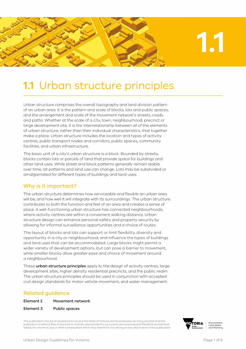
1.1 Urban structure principles
General principles for the arrangement of streets, paths, blocks and lots, public open spaces, activity centres, public transport nodes and corridors and residential neighbourhoods.
1.2 Activity centre structure
The layout of areas that are the focus for enterprise and social interaction, incorporating services and facilities, shopping, employment and residences.
1.3 Large development site structure
The layout of large parcels of land within cities and towns that have become available for development and their integration into the existing urban area.
1.4 Higher density residential precinct structure
The layout of an area’s blocks, lots, streets and public spaces to accommodate people living in apartments or residential mixed-use buildings. The precinct often will have larger lot sizes and be within or near an activity centre or a large development site.
1.5 Public realm structure
The layout and detail design of the public and street spaces that comprise the public realm.

Page 2 of 2Urban Design Guidelines for Victoria
© The State of Victoria Department of Environment, Land, Water and Planning 2017
This work is licensed under a Creative Commons Attribution 4.0 International licence. You are free to re-use the work under that licence, on the condition that you credit the State of Victoria as author. The licence does not apply to any images, photographs or branding, including the Victorian Coat of Arms, the Victorian Government logo and the Department of Environment, Land, Water and Planning (DELWP) logo.
To view a copy of this licence, visit http://creativecommons.org/licenses/by/4.0/
ISBN 978-1-76047-520-8 – Online (pdf/word)
Part 2 of 8 parts
Disclaimer
This publication may be of assistance to you but the State of Victoria and its employees do not guarantee that the publication is without flaw of any kind or is wholly appropriate for your particular purposes and therefore disclaims all liability for any error, loss or other consequence which may arise from you relying on any information in this publication.
Accessibility
If you would like to receive this publication in an alternative format, please telephone the DELWP Customer Service Centre on 136 186, or email [email protected] (or relevant address), or via the National Relay Service on 133 677, www.relayservice.com.au. This document is also available on the internet at www.planning.vic.gov.au
This publication may be of assistance to you but the State of Victoria and its employees do not guarantee that the publication is without flaw of any kind or is wholly appropriate for your particular purposes and therefore disclaims all liability for any error, loss or other consequence which may arise from you relying on any information in this publication.
Page 1 of 6Urban Design Guidelines for Victoria
1.1 Urban structure principles
Urban structure comprises the overall topography and land division pattern of an urban area. It is the pattern and scale of blocks, lots and public spaces, and the arrangement and scale of the movement network’s streets, roads and paths. Whether at the scale of a city, town, neighbourhood, precinct or large development site, it is the interrelationship between all of the elements of urban structure, rather than their individual characteristics, that together make a place. Urban structure includes the location and types of activity centres, public transport nodes and corridors, public spaces, community facilities, and urban infrastructure.
The basic unit of a city’s urban structure is a block. Bounded by streets, blocks contain lots or parcels of land that provide space for buildings and other land uses. While street and block patterns generally remain stable over time, lot patterns and land use can change. Lots may be subdivided or amalgamated for different types of buildings and land uses.
Why is it important?The urban structure determines how serviceable and flexible an urban area will be, and how well it will integrate with its surroundings. The urban structure contributes to both the function and feel of an area and creates a sense of place. A well-functioning urban structure has connected neighbourhoods, where activity centres are within a convenient walking distance. Urban structure design can enhance personal safety and property security by allowing for informal surveillance opportunities and a choice of routes.
The layout of blocks and lots can support or limit flexibility, diversity and opportunity in a city or neighbourhood, and influence the types of buildings and land uses that can be accommodated. Large blocks might permit a wider variety of development options, but can pose a barrier to movement, while smaller blocks allow greater ease and choice of movement around a neighbourhood.
These urban structure principles apply to the design of activity centres, large development sites, higher density residential precincts, and the public realm. The urban structure principles should be used in conjunction with accepted civil design standards for motor vehicle movement, and water management.
Related guidanceElement 2 Movement network
Element 3 Public spaces
1.1

Page 2 of 6Urban Design Guidelines for Victoria
1.1 Urban structure principles
Objective 1.1.1 To provide a permeable and functional urban structure of blocks and streets
Permeability refers to the extent to which the urban structure permits, or restricts, the movement of people or vehicles through an area, and the capacity of the area network to carry people or vehicles.
1.1.1 a Create an interconnected street layout with regular block sizes.
→ TIP An interconnected street layout provides a choice of routes, allowing people to move about and goods to be transported with ease and efficiency.
1.1.1 b Create a permeable block layout with block dimensions ranging from 120m to 240m long and 60m to 120m wide.
→ TIP A block perimeter of around 600m provides for good pedestrian and vehicular access and an efficient subdivision pattern of the block. Smaller blocks may be appropriate in more intense urban areas.
240 m
60 m
120 m
60 m
perimeter ≤ 600 m
1.1.1 c Extend streets, pedestrian and bicycle paths from existing areas into new areas with direct roads, streets and paths.
1.1.1 d Align pedestrian connections along desire-lines with short, straight travel paths.
→ TIP People generally choose the shortest practical path to their destination. Curving street alignments can increase pedestrian and cycling distances, and reduce sightlines. However, in sloping topography, curving streets may be more appropriate to enable flatter travel paths.

Page 3 of 6Urban Design Guidelines for Victoria
1.1 Urban structure principles
Objective 1.1.2 To provide a legible urban structure of blocks and streets
The legibility of an area refers to the ease with which a person is able to find their way around and navigate through the area.
1.1.2 a Lay out street and block patterns with direct, straight or near straight streets.
→ TIP Areas with straight streets and clear sightlines are easier to navigate and safer for pedestrians. Tight curving streets can reduce neighbourhood legibility and be more difficult to develop and service.
1.1.2 b Use the area’s topography, slope and contours to achieve an accessible movement network.
→ TIP Curving street alignments may increase pedestrian and cycling distances, and reduce sightlines. However in sloping topography, curving streets may be more appropriate to enable flatter travel paths.
1.1.2 c Lay out street and block patterns to create view lines to key landmarks.
→ TIP Highly visible landmarks and landscape features aid navigation and way-finding as well as contributing to a sense of place.
1.1.2 d Where a cul-de-sac is necessary, limit the length to less than 75m, with a straight alignment or clear sightlines to the end.
→ TIP A short cul-de-sac allows views from the adjoining street to the cul-de-sac end.
< 75m

Page 4 of 6Urban Design Guidelines for Victoria
1.1 Urban structure principles
Objective 1.1.3 To ensure the urban structure supports accessibility from neighbourhoods to activity centres and public transport
1.1.3 a Lay out streets and blocks to provide reasonable walking distances from dwellings to an activity centre and public transport services.
→ TIP A 400m (or 5 minute) street walking distance to an activity centre provides good accessibility for lots intended for medium and higher density residential uses.
<400m
1.1.3 b Create a street and block layout where 95 per cent of dwellings are located no more than:
• 400m street walking distance from the nearest existing or proposed bus stop, or
• 600m street walking distance from the nearest existing or proposed tram stop, or
• 800m street walking distance from the nearest existing or proposed railway station.
→ TIP 400m is about a 5 minute walk; 600m is about a 7 minute walk; 800m is about a 10 minute walk.
1.1.3 c Provide continuous, direct pedestrian and bicycle access routes from the surrounding neighbourhood to railway stations and public transport stops and interchanges and activity centres.
→ TIP Pedestrian and bicycle access routes to a public transport node or activity centre should accommodate both public transport users and others moving around the neighbourhood. More people using the paths will create a safer environment.

Page 5 of 6Urban Design Guidelines for Victoria
1.1 Urban structure principles
Objective 1.1.4 To ensure that the urban structure provides good amenity and safe interfaces between infrastructure corridors and adjacent land uses
1.1.4 a Locate major infrastructure corridors and installations to minimise their potential to be a barrier to cross movement.
→ TIP Infrastructure corridors such as railway lines, motorways and pipe tracks can be barriers to crossing but may provide opportunities for parallel linear parks and paths.
1.1.4 b Provide conveniently located grade separated pedestrian and bicycle crossings across rail corridors, motorways and other natural barriers, to connect neighbourhoods and key destinations.
→ TIP In urban areas, the crossing location and frequency should be informed by local circumstances and need.
1.1.4 c Where a freight railway or motorway corridor interfaces with lots for residential or other sensitive uses, locate the rear boundary of lots toward the corridor.
→ TIP Locating the rear boundaries of lots toward a freight railway or motorway corridor interface provides better opportunities for noise mitigation where relevant.
1.1.4 d Where a railway operating corridor serves only metropolitan passenger services, provide a street between the railway operating corridor and the surrounding area, to provide an active frontage.
→ TIP A street is not an effective noise buffer, but metropolitan services are generally of lesser noise impact than diesel freight trains.
1.1.4 e Where lots adjoin high volume or high speed major roads, provide a service road and front lots on to the service road.
→ TIP Avoid block layouts where lots back onto arterial or major roads. This results in poor pedestrian safety and landscape amenity along the road.

Page 6 of 6Urban Design Guidelines for Victoria
1.1 Urban structure principles

This publication may be of assistance to you but the State of Victoria and its employees do not guarantee that the publication is without flaw of any kind or is wholly appropriate for your particular purposes and therefore disclaims all liability for any error, loss or other consequence which may arise from you relying on any information in this publication.
Page 1 of 6Urban Design Guidelines for Victoria
1.2 1.2 Activity centre structure
Activity centres, although of different sizes and types, are a focus for enterprise and social interaction, incorporating community facilities and services, shopping, employment and residences. Activity centres are the focus of public transport nodes where services converge. Activity centres include metropolitan centres, regional cities and town centres in rural areas.
An activity centre generally has an intense central core with smaller street blocks and a higher density of streets and lots. The structure of activity centres should allow for more intensive development, street frontage exposure for display, safe public spaces and pedestrian access to facilities.
Why is it important?Activity centres provide residents, visitors and workers with easy access to a range of services and facilities as well as opportunities for establishing businesses, or simply being sociable and meeting others. By providing a variety of lot sizes and shapes in a connected movement network, an activity centre can accommodate a wide variety and scale of uses and buildings and respond to the changing needs of residents, businesses and visitors.
Some specialised and single-focus activity centres may have extended periods of inactivity with poor safety out-of-hours. Activity centres with a diverse mix of activities and uses adds to their vibrancy and economic viability as well as improving perceptions of safety and reducing opportunities for crime..
Related guidanceElement 1.1 Urban structure principles
Element 2 Movement network
Element 4 Public transport environs
Page 2 of 6Urban Design Guidelines for Victoria
1.2 Activity centre structure
Objective 1.2.1 To ensure accessible and functional activity centres
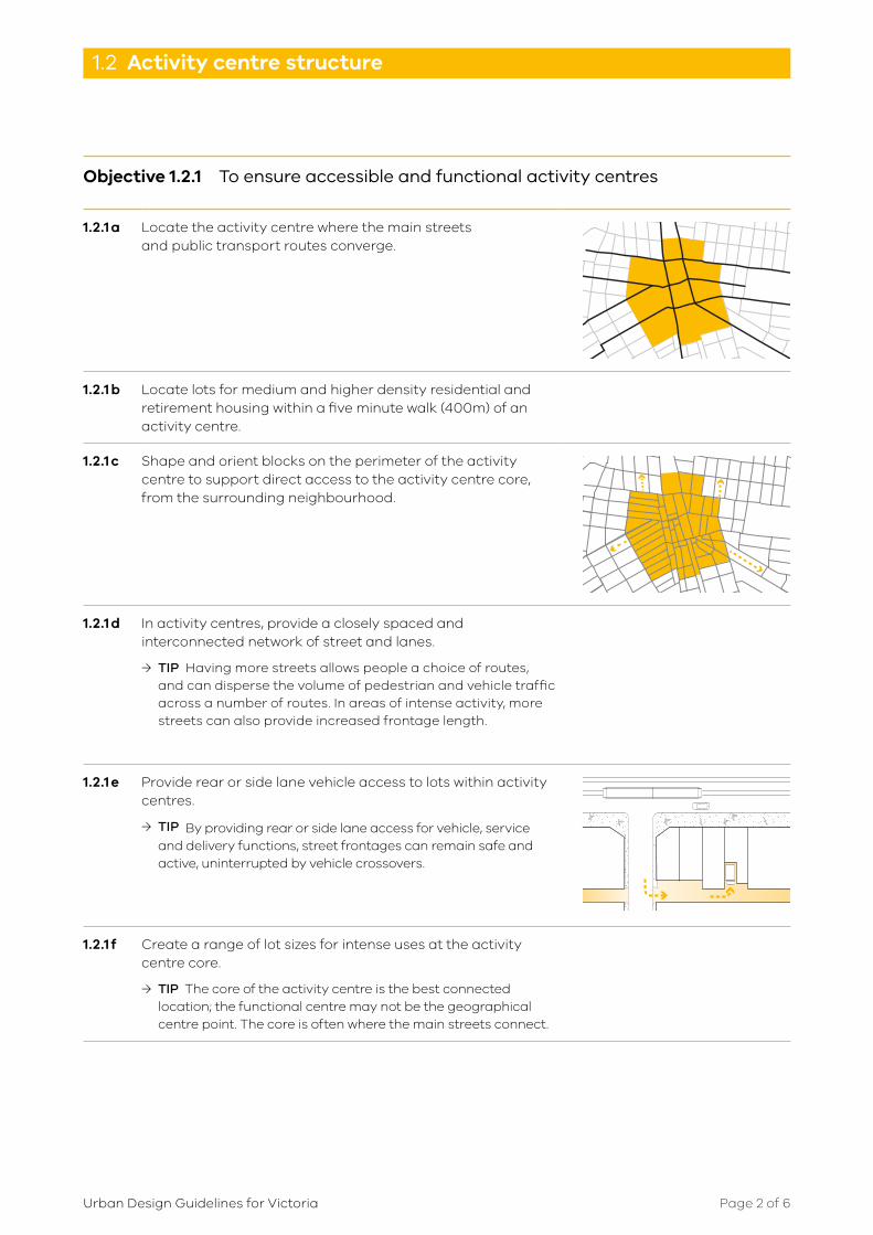
1.2.1 a Locate the activity centre where the main streets and public transport routes converge.
1.2.1 b Locate lots for medium and higher density residential and retirement housing within a five minute walk (400m) of an activity centre.
1.2.1 c Shape and orient blocks on the perimeter of the activity centre to support direct access to the activity centre core, from the surrounding neighbourhood.
1.2.1 d In activity centres, provide a closely spaced and interconnected network of street and lanes.
→ TIP Having more streets allows people a choice of routes, and can disperse the volume of pedestrian and vehicle traffic across a number of routes. In areas of intense activity, more streets can also provide increased frontage length.
1.2.1 e Provide rear or side lane vehicle access to lots within activity centres.
→ TIP By providing rear or side lane access for vehicle, service and delivery functions, street frontages can remain safe and active, uninterrupted by vehicle crossovers.
1.2.1 f Create a range of lot sizes for intense uses at the activity centre core.
→ TIP The core of the activity centre is the best connected location; the functional centre may not be the geographical centre point. The core is often where the main streets connect.

Page 3 of 6Urban Design Guidelines for Victoria
1.2 Activity centre structure
Objective 1.2.2 To ensure activity centre structure supports public transport access
1.2.2 a Provide for train stations and public transport interchanges within the core of activity centre.
→ TIP While frequent bus movements on pedestrian priority streets are not desired, an interchange crossing the main street at one end may be a convenient, accessible option.
1.2.2 b On streets within activity centres that accommodate public transport services, minimise intersections and vehicle access points to lots.
→ TIP Private vehicles entering or turning out of a street that accommodates on-road public transport, can cause service delays. See Guideline sources and references for link to Public Transport Guidelines.
1.2.2 c Provide for priority or separated lanes for public transport on roads where multiple public transport routes converge within activity centres.

Page 4 of 6Urban Design Guidelines for Victoria
1.2 Activity centre structure
Objective 1.2.3 To ensure the activity centre structure supports safety and amenity
1.2.3 a Locate lots intended for retail and commercial uses on well-connected main streets in activity centres.
→ TIP Intense and diverse commercial activities on smaller lots with narrower frontages, or mixed uses with multiple tenancies, contribute to an active and interesting public realm.
1.2.3 b Locate lots for active uses and uses with long operating hours on pedestrian priority streets.
→ TIP Personal safety is best achieved by having people present on the street during the day and at night, and by providing opportunities for informal surveillance of public spaces.
1.2.3 c Provide lots for shops on streets that allow zero street setbacks and continuous built frontages.
→ TIP Retail activities in buildings function best when they have direct access abutting the footpath and when supported by similar neighbours.
1.2.3 d Surround the activity centre core with lots that are large enough to accommodate higher density residential uses and workplaces.
→ TIP Small, narrow lots are difficult to develop at higher densities.
1.2.3 e Locate large public facilities, such as hospitals, schools, and major recreation facilities on public transport routes and at the edge of activity centres.
→ TIP Facilities that occupy large land areas can create a barrier to movement through an activity centre. Out of operating hours, the facilities may present an inactive edge to streets and paths.
1.2.3 f Locate lots for large format uses that generate high vehicle traffic volumes on wider streets at the edge of activity centres, and with easy access to major roads.

Page 5 of 6Urban Design Guidelines for Victoria
1.2 Activity centre structure
Objective 1.2.4 To activate the activity centre’s interface with its barrier edges
Typical barriers or edges to an activity centre are railway or motorway corridors, a water body or a natural feature.
1.2.4 a Where an activity centre has a barrier or edge, provide an active public space or a street between the edge and the adjacent buildings.
→ TIP Where a barrier or edge has few passing pedestrians or little activity in the adjacent buildings (e.g. has a rear boundary toward the edge), public spaces in these areas may attract fewer visitors and be a security risk.
Objective 1.2.5 To respond to change within an activity centre.
As an activity centre evolves and changes, its structure may need review to provide new connections, changes in land use patterns or the re-allocation of public space for different activities. Structure planning can assist in managing this change.
1.2.5 a Create a regular block and lot pattern within the activity centre that enables future lot subdivision or consolidation.
→ TIP Irregular shaped lots can limit future lot subdivision or consolidation.
1.2.5 b Where activity centres experience increased residential densities or an expanding worker population, maintain or increase the capacity of the pedestrian movement network by adding new mid-block links and public spaces.
→ TIP Periodic reviews of the functionality and safety of the public realm in an activity centre, may indicate need for adjustment to its structure.
1.2.5 c As an activity centre evolves and intensifies, allow future development to front laneways.
1.2.5 d When consolidating or subdividing lots, maintain a fine-grained street frontage.
→ TIP Fine-grained street frontages have multiple shopfronts with doorways and windows.

Page 6 of 6Urban Design Guidelines for Victoria
1.2 Activity centre structure

This publication may be of assistance to you but the State of Victoria and its employees do not guarantee that the publication is without flaw of any kind or is wholly appropriate for your particular purposes and therefore disclaims all liability for any error, loss or other consequence which may arise from you relying on any information in this publication.
Page 1 of 4Urban Design Guidelines for Victoria
1.3 1.3 Large development site structure
Large parcels of land within cities and towns sometimes become available for development and new uses. Often in prime locations, these sites can be publicly owned (such as railway corridors, surplus government land or dockyards) or they can be former commercial, industrial or institutional sites that are no longer needed for their original purpose. They may be located in activity centres or are accessible to transport connections, services and jobs.
Large development sites need to integrate with the existing urban structure of a city or neighbourhood. This often involves creating new residential or commercial areas and movement networks, as well as infrastructure, public spaces and community facilities.
Why is it important?Large development sites that become available contribute to the growth and evolution of cities and towns. The way a parcel of redeveloped land is connected to the surrounding area and divided into blocks, lots and streets will influence the area’s accessibility and potential future use patterns.
Large development sites can provide an opportunity to repair and enhance the existing urban infrastructure in the area, and there may be too few dwellings to sustain local business activity, insufficient public space or recreation opportunities. The development of the site may also enable new connections to be made between adjacent established areas.
Related guidanceElement 1.1 Urban structure principles
Element 1.5 Public realm structure
Element 2 Movement network

Page 2 of 4Urban Design Guidelines for Victoria
1.3 Large development site structure
Objective 1.3.1 To integrate a large development site into its surrounding area
1.3.1 a Connect the development site’s movement network to the movement network of the surrounding area.
→ TIP The movement network includes pedestrian and bicycle paths, public transport services, streets and roads.
1.3.1 b Create new links across the development site to connect the new neighbourhood with the surrounding area.
1.3.1 c Provide at least two ‘through’ streets across a new neighbourhood in a development site, linking ‘centre to edge’.
→ TIP Very large development sites may require additional through routes.
Page 3 of 4Urban Design Guidelines for Victoria
1.3 Large development site structure
Objective 1.3.2 To ensure large development site structure provides a high level of amenity and functionality for residents
1.3.2 a Where possible, include uses and facilities in the development site that are lacking or insufficient in the surrounding neighbourhood.
1.3.2 b Locate higher intensity activities on well-connected streets within a development site.
→ TIP Higher intensity activity examples are shops, community services, cafes and cinemas.
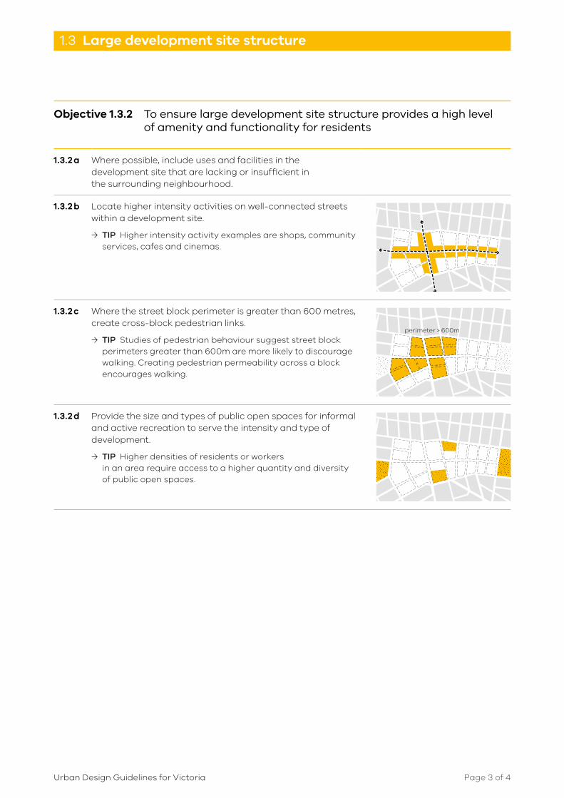
1.3.2 c Where the street block perimeter is greater than 600 metres, create cross-block pedestrian links.
→ TIP Studies of pedestrian behaviour suggest street block perimeters greater than 600m are more likely to discourage walking. Creating pedestrian permeability across a block encourages walking.
perimeter > 600m
1.3.2 d Provide the size and types of public open spaces for informal and active recreation to serve the intensity and type of development.
→ TIP Higher densities of residents or workers in an area require access to a higher quantity and diversity of public open spaces.

Page 4 of 4Urban Design Guidelines for Victoria
1.3 Large development site structure
Objective 1.3.3 To large development sites maintain the amenity of adjacent residential uses
1.3.3 a Create a transition from large development sites to adjacent residential neighbourhoods using scale, built form and uses.
→ TIP A transition can be achieved through the arrangement and size of new blocks and lots at the development site edge and the future built form, location of activities and street design.
EXISTINGNEW
Objective 1.3.4 To ensure the public realm of large development sites is well‑maintained and managed
1.3.4 a Develop public open spaces, civil infrastructure and streets to a standard acceptable for ongoing maintenance and management.
→ TIP The local council standards and materials should be met for adoption and for ongoing management of the public realm within large development sites.

This publication may be of assistance to you but the State of Victoria and its employees do not guarantee that the publication is without flaw of any kind or is wholly appropriate for your particular purposes and therefore disclaims all liability for any error, loss or other consequence which may arise from you relying on any information in this publication.
Page 1 of 4Urban Design Guidelines for Victoria
1.4 1.4 Higher density residential
precinct structure
A higher density residential precinct generally has larger lot sizes that are able to accommodate apartment and mixed-use developments. The precinct may be in or adjacent to an activity centre or within a large development site.
The streets and blocks in a higher density residential precinct provide for a high level of connectivity within and through the precinct. They also provide for an appropriate level of active street frontage and commercial uses at street level.
Why is it important?With a larger population in a defined area it is crucial that the structure of a higher density residential precinct provides a high level of amenity in public spaces, access to facilities and services, protection of privacy and personal safety.
Related guidanceElement 1.1 Urban structure principles
Element 1.2 Activities area structure
Element 1.3 Large development site structure
Element 1.5 Public realm structure
Element 2.2 Pedestrian priority streets
Element 3.2 Street spaces and plazas
Element 3.4 Communal open space
Element 5.2 Higher density residential buildings
Element 6 Objects in the public realm
Page 2 of 4Urban Design Guidelines for Victoria
1.4 Higher density residential precinct structure
Objective 1.4.1 To ensure higher density residential precincts are accessible
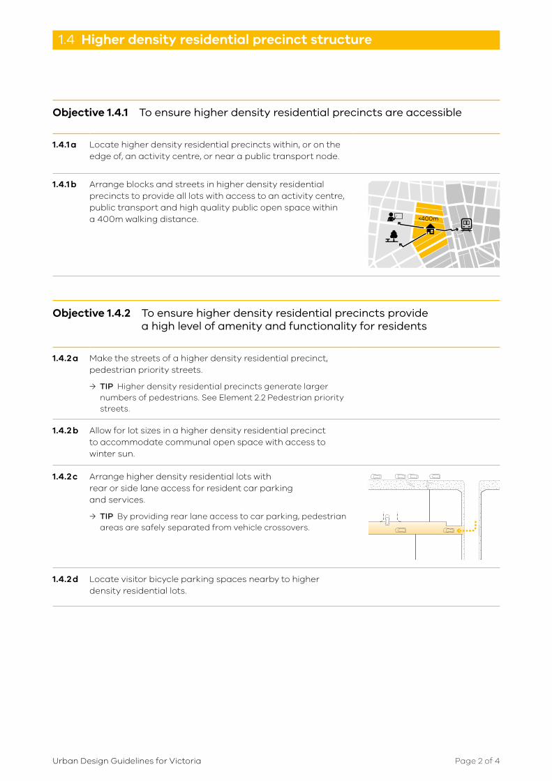
1.4.1 a Locate higher density residential precincts within, or on the edge of, an activity centre, or near a public transport node.
1.4.1 b Arrange blocks and streets in higher density residential precincts to provide all lots with access to an activity centre, public transport and high quality public open space within a 400m walking distance. <400m
Objective 1.4.2 To ensure higher density residential precincts provide a high level of amenity and functionality for residents
1.4.2 a Make the streets of a higher density residential precinct, pedestrian priority streets.
→ TIP Higher density residential precincts generate larger numbers of pedestrians. See Element 2.2 Pedestrian priority streets.
1.4.2 b Allow for lot sizes in a higher density residential precinct to accommodate communal open space with access to winter sun.
1.4.2 c Arrange higher density residential lots with rear or side lane access for resident car parking and services.
→ TIP By providing rear lane access to car parking, pedestrian areas are safely separated from vehicle crossovers.
1.4.2 d Locate visitor bicycle parking spaces nearby to higher density residential lots.
Page 3 of 4Urban Design Guidelines for Victoria
1.4 Higher density residential precinct structure
Objective 1.4.3 To ensure a well‑maintained, high amenity residential precinct
1.4.3 a Manage visitor and resident traffic and parking at the precinct scale.
→ TIP Higher density residential precincts may generate increased demand for on-street visitor parking.
1.4.3 b Integrate provision for household waste and recyclable collection in the precinct structure.
→ TIP Planning for future waste management systems at the subdivision and development stage can avoid waste bins lining a street or blocking paths.

Page 4 of 4Urban Design Guidelines for Victoria
1.4 Higher density residential precinct structure

This publication may be of assistance to you but the State of Victoria and its employees do not guarantee that the publication is without flaw of any kind or is wholly appropriate for your particular purposes and therefore disclaims all liability for any error, loss or other consequence which may arise from you relying on any information in this publication.
Page 1 of 8Urban Design Guidelines for Victoria
1.5 1.5 Public realm structure
The public realm comprises spaces and places that are open and freely accessible to everyone, regardless of their economic or social conditions.These spaces can include streets, laneways and roads, parks, public plazas, waterways and foreshores.
Public realm structure delivers the location of and connection to destinations and activities. It includes layout and detailed design to support the function and amenity of streets, public spaces, public transport access and the interface between the public realm and private property. While the overall urban structure may be enduring, the purpose and detailed arrangement of public spaces may change over time.
Why is it important?The public realm provides a space for people to be free to access, to move about and to enjoy recreation. It enables people to carry out their daily business, to engage in activities or meet with others or simply to be. The public realm must be attractive, inclusive and safe to be in. An inhabited and well maintained public realm feels safe and encourages people to use spaces.
Related guidance1.1 Urban structure principles
1.2 Activity centre structure
1.3 Large development site structure
1.4 Higher density residential precinct structure
2 Movement network
3 Public spaces
4 Public transport environs
6 Objects in the public realm

Page 2 of 8Urban Design Guidelines for Victoria
1.5 Public realm structure
Objective 1.5.1 To ensure a public realm structure where the movement network and the land uses support each other
1.5.1 a Locate local walking destinations and activities along main pedestrian streets and paths.
→ TIP Local walking destinations can include railway stations, bus and tram stops and interchanges, shops, schools parks, recreation and community facilities.
1.5.1 b Provide for a level of active frontage and lot access appropriate to the street function and building use patterns.
→ TIP Level of active frontage is reduced where vehicle access to narrow lots is via its street frontage. Driveways and crossovers reduce street activation and compromise pedestrian safety. See Element 5 Buildings.
1.5.1 c Co-locate public transport nodes with active uses and busy public spaces.
→ TIP Active uses and public spaces can attract other people to use the public transport node. This helps increase the numbers of people using the area and improves security, particularly at night.
1.5.1 d Locate active, non-residential uses at ground level at the interface with major public transport nodes.
→ TIP Railway stations and major bus and tram interchanges generate many vehicle movements and operate from early morning to late night. Active commercial uses can benefit from the passing pedestrians and this contributes to safety in the area.
1.5.1 e Where a railway station or a public transport interchange interfaces with a public space, provide active uses at ground level at the station or interchange interface with the public space.

Page 3 of 8Urban Design Guidelines for Victoria
1.5 Public realm structure
Objective 1.5.2 To ensure the public realm structure provides for accessible, safe and conveniently located public spaces.
Public spaces provide opportunities for active and informal recreation. The location and context of public spaces within the urban structure is critical to a space’s success. Public space that has poor access, or is located away from the community it serves, will not be well used.
1.5.2 a Create public spaces where the local catchment has sufficient potential users to activate the space.
→ TIP A walkable catchment to a public space varies with the public space type and the user. A local park catchment distance is shorter for a child or older person than for other users. A plaza lunch place may need to be within five minutes’ walk of a workplace to be attractive.
1.5.2 b Provide for a variety of parks and public spaces, for informal and active recreation, located within a 400m walking distance from dwellings, workplaces, schools and shops.
→ TIP 400m is a five minute walk.
1.5.2 c Locate public spaces where they can be connected to their surrounding area via pedestrian priority streets and paths.
→ TIP Public spaces are used if they are convenient and safe to access.

Page 4 of 8Urban Design Guidelines for Victoria
1.5 Public realm structure
Objective 1.5.3 To ensure the public realm structure provides for suitably‑sized, comfortable and purposeful public spaces
The size and dimensions of a public space affect its possible uses and safety in terms of informal surveillance from the surrounding area.
Large public spaces can feel uninhabited and lonely, even overwhelming and threatening. Conversely, a small space may feel comfortable for quiet uses but not be a functional size for some active uses.
1.5.3 a Provide the number and types of public spaces that meet local needs.
→ TIP A strategic planning process can identify and establish local needs and the appropriate type and size of public space to serve the community’s needs.
1.5.3 b Create public spaces of sufficient size to accommodate desired activities.
→ TIP Often the most popular and cared-for plazas and parks are compact and intimate.

Page 5 of 8Urban Design Guidelines for Victoria
1.5 Public realm structure
Objective 1.5.4 To ensure a public realm structure where streets support the amenity and function of neighbourhoods
1.5.4 a Make the main streets sufficiently wide to serve their function in the movement network and as a public place, and to accommodate services infrastructure.
→ TIP A street may need to accommodate public transport lanes and stops, pedestrians, cyclists, vehicles as well as accessible utilities infrastructure and service verges.
1.5.4 b Where a street functions as an activity centre main street, provide block lengths and street widths to accommodate on-road public transport vehicles and accessible public transport stops.
1.5.4 c Set the street width in relation to the future building height and setback distance so as to allow daylight and winter sun access to key public spaces within streets.
→ TIP In some situations, creating shaded streets may improve comfort levels in hot weather.
→ TIP A strategic planning process can identify and establish key public spaces.
1.5.4 d Provide space within the street for trees, landscaping and to accommodate social activities and utility infrastructure.
→ TIP Streets can be used for informal socialising and recreation, outdoor dining, street vendors, public transport waiting facilities, infrastructure services and street furniture. See Element 6 Objects in the public realm.
1.5.4 e Where lots front pedestrian priority streets or are 6m or less in lot width, provide rear vehicle access to off-street parking.
→ TIP Where narrow lots have vehicle access from the front, car parking access may dominate the street interface, while crossovers may reduce pedestrian safety.
1.5.4 f Provide commercial lots with service access lanes or service courts separated from pedestrian access.
→ TIP Providing service lanes and service courts in commercial premises ensures pedestrians are safely separated from vehicles.
Page 6 of 8Urban Design Guidelines for Victoria
1.5 Public realm structure
Objective 1.5.5 To ensure the public realm structure provides high amenity and safe interfaces between different uses
Interfaces occur between different land uses, or a new and an existing neighbourhood.
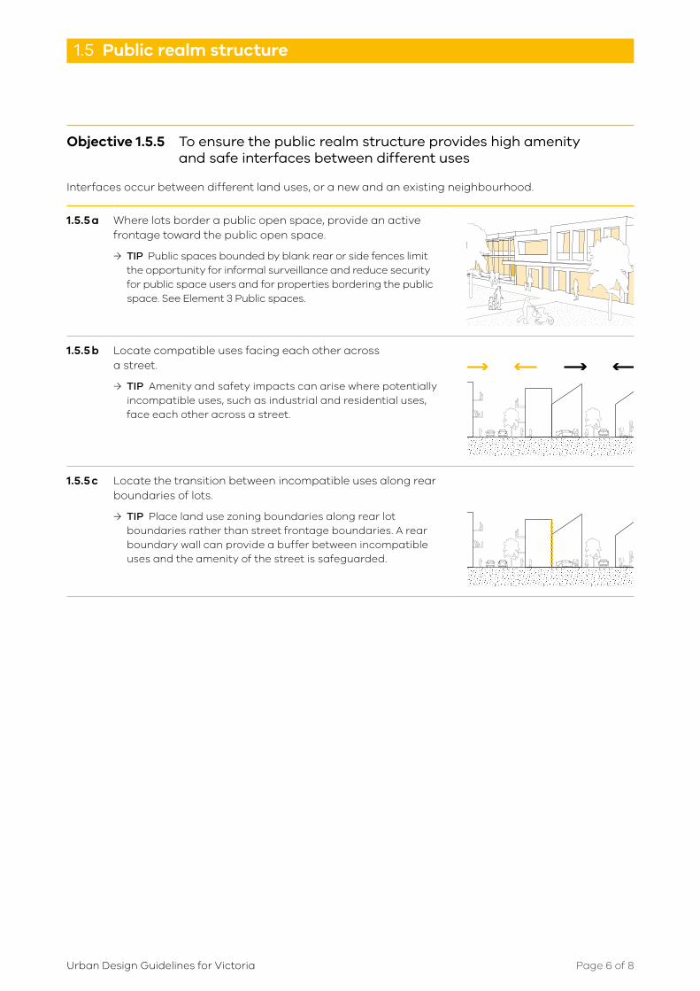
1.5.5 a Where lots border a public open space, provide an active frontage toward the public open space.
→ TIP Public spaces bounded by blank rear or side fences limit the opportunity for informal surveillance and reduce security for public space users and for properties bordering the public space. See Element 3 Public spaces.
1.5.5 b Locate compatible uses facing each other across a street.
→ TIP Amenity and safety impacts can arise where potentially incompatible uses, such as industrial and residential uses, face each other across a street.
1.5.5 c Locate the transition between incompatible uses along rear boundaries of lots.
→ TIP Place land use zoning boundaries along rear lot boundaries rather than street frontage boundaries. A rear boundary wall can provide a buffer between incompatible uses and the amenity of the street is safeguarded.

Page 7 of 8Urban Design Guidelines for Victoria
1.5 Public realm structure
Objective 1.5.6 To ensure a well‑managed, high amenity public realm
The public realm has many stakeholders and is managed by a number of agencies, each with different responsibilities and interests. This adds to the complexity of developing and managing a successful place.
1.5.6 a Develop public spaces, civil infrastructure and streets to a standard acceptable for ongoing maintenance and management.
→ TIP The local council standards and materials should be met for adoption and for ongoing management of public spaces.
1.5.6 b Establish a an integrated management agreement for a precinct to coordinate the maintenance and repair program for the public realm.
→ TIP For example, regularly maintain landscaping and public facilities, and when repairing paving, also replant missing street trees.
1.5.6 c Where neighbourhoods experience increased residential densities, review the amount and type of public open space and street space to meet the local community’s needs.
→ TIP Periodic reviews of use and density pattern changes and urban infrastructure performance will assess the need for intervention. Structure planning can assist in managing this change.

Page 8 of 8Urban Design Guidelines for Victoria
1.5 Public realm structure