emplacement of the most recent lava flows on huala–lai...
TRANSCRIPT
Abstract A detailed field and petrologic study of the ca.1800 A.D. flows at Huala–lai Volcano documents at leasttwo eruptive episodes, the Hu‘ehu‘e flow field ending in1801, and the Ka‘u–pu–lehu flow several decades earlier.The morphology and stratigraphy of the Ka‘u–pu–lehuflow require an emplacement duration of several days toweeks. Based on a comparison with recent eruptive ac-tivity at Mauna Loa volcano, the eruption cannot haveoccurred at the anomalously high rate (104–105 m3/s)proposed by previous workers. The hummocky flow sur-face of the later phase of the Hu‘ehu‘e eruption suggestsa duration of months, based on a comparison with recenteruptive activity at Kı-lauea Volcano. Although none ofthe ca. 1800 flows show evidence for extraordinarily fastemplacement or unusual fluid rheologies, both flowsshow unusual features. The abundant xenoliths for whichthe Ka‘u–pu–lehu flow is famous were transported in nu-merous episodes of deposition and remobilization, dur-ing which they eroded the channel systems throughwhich they traveled. Lava transport in proximal and me-dial regions of both flow fields was probably through la-va tubes, as evidenced by preserved tubes and by theprevalence of pa–hoehoe-lined channels that require ther-
mally efficient transport of lava over great distances.Both flows also show abundant evidence for re-occupa-tion of older cones and lava tubes, a characteristic thatmay typify infrequent eruptions of older volcanic sys-tems. Although lava flows from Huala–lai Volcano do notshow anomalous eruptive behavior, they pose a substan-tial hazard for coastal communities of Kona.
Introduction
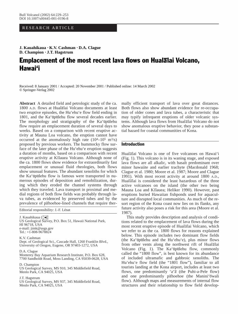
Huala–lai Volcano is one of five volcanoes on Hawai‘i(Fig. 1). This volcano is in its waning stage, and exposedlava flows are all alkalic, with basalt predominant overminor hawaiite and earlier trachyte (Macdonald 1968;Clague et al. 1980; Moore et al. 1987; Moore and Clague1991). With most recent activity at around 1800 A.D.,Huala–lai is considered the least hazardous of the threeactive volcanoes on the island (the other two beingMauna Loa and Kı-lauea; Heliker 1990). However, pasteruptions buried Hawaiian fishponds used for aquacul-ture and disrupted local communities. As much of the re-sort region of the Kona coast now lies on its flanks, anyfuture activity also poses a risk for this area (Moore et al.1987).
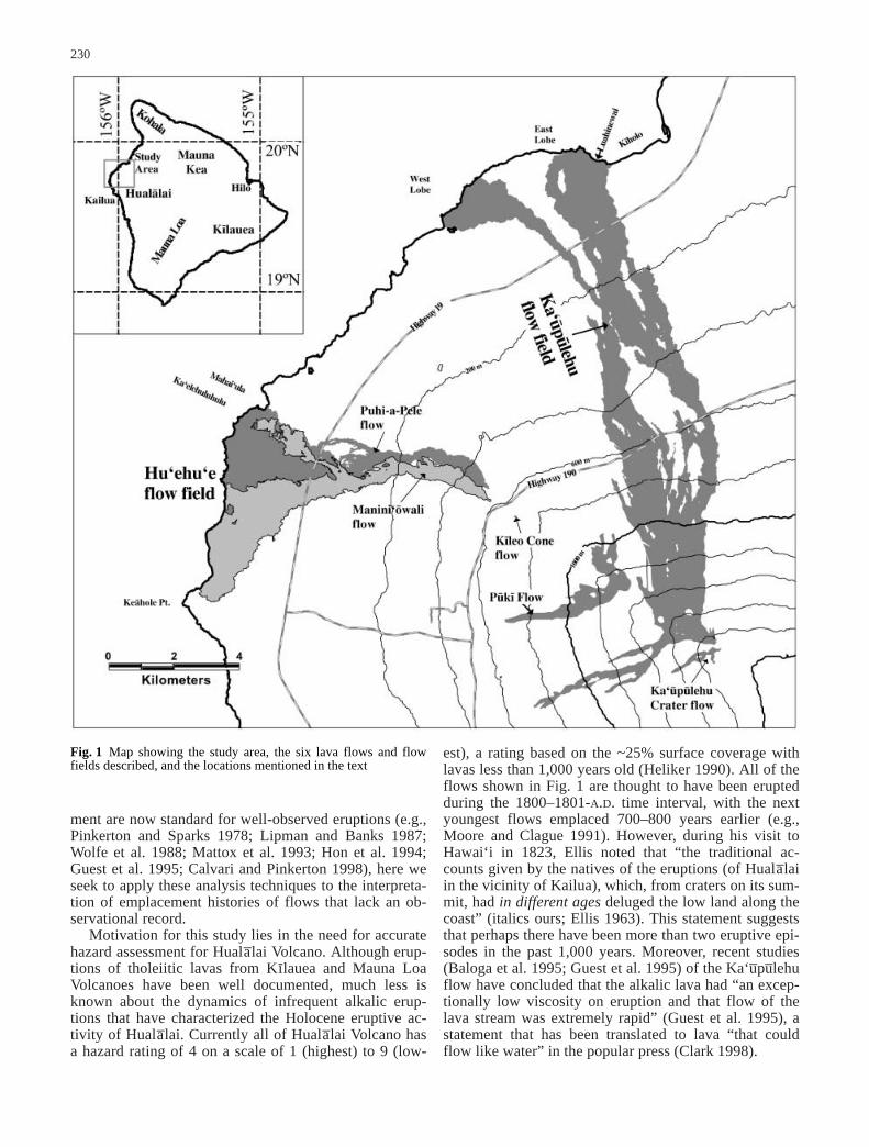
This study provides description and analysis of condi-tions related to the emplacement of lava flows during themost recent eruptive episode of Huala–lai Volcano, whichwe refer to as the ca. 1800 flows for reasons explainedbelow. This episode includes two dominant flow fields(the Ka‘u–pu–lehu and the Hu‘ehu‘e), plus minor flowsfrom other vents along the northwest rift of Huala–laiVolcano (Fig. 1). The Ka‘u–pu–lehu flow, commonlycalled the “1800 flow”, is best known for its abundanceof included ultramafic and gabbroic xenoliths. TheHu‘ehu‘e flow field (the “1801 flow”), familiar to alltourists landing at the Kona airport, includes at least twoflows, one predominantly ‘a‘a– (the Puhi-a-Pele flow)and one predominantly pa–hoehoe (the Manini‘o–waliflow). Although maps and measurements of internal flowstructures and their relationship to flow field develop-
Editorial responsibility: J.-F. Lénat
J. Kauahikaua (✉ )US Geological Survey, P.O. Box 51, Hawaii National Park, HI 96718, USAe-mail: [email protected].: +1-808-9678824
K.V. CashmanDept. of Geological Sci., Cascade Hall, 1260 Franklin Blvd., University of Oregon, Eugene, OR 97403-1272, USA
D.A. ClagueMonterey Bay Aquarium Research Institute, P.O. Box 628, 7700 Sandholdt Road, Moss Landing, CA 95039-0628, USA
D. ChampionUS Geological Survey, MS 910, 345 Middlefield Road, Menlo Park, CA 94025, USA
J.T. HagstrumUS Geological Survey, MS 937, 345 Middlefield Road, Menlo Park, CA 94025, USA
Bull Volcanol (2002) 64:229–253DOI 10.1007/s00445-001-0196-8
R E S E A R C H A RT I C L E
J. Kauahikaua · K.V. Cashman · D.A. ClagueD. Champion · J.T. Hagstrum
Emplacement of the most recent lava flows on Huala–lai Volcano, Hawai‘i
Received: 8 January 2001 / Accepted: 20 November 2001 / Published online: 14 March 2002© Springer-Verlag 2002
ment are now standard for well-observed eruptions (e.g.,Pinkerton and Sparks 1978; Lipman and Banks 1987;Wolfe et al. 1988; Mattox et al. 1993; Hon et al. 1994;Guest et al. 1995; Calvari and Pinkerton 1998), here weseek to apply these analysis techniques to the interpreta-tion of emplacement histories of flows that lack an ob-servational record.
Motivation for this study lies in the need for accuratehazard assessment for Huala–lai Volcano. Although erup-tions of tholeiitic lavas from Kı-lauea and Mauna LoaVolcanoes have been well documented, much less isknown about the dynamics of infrequent alkalic erup-tions that have characterized the Holocene eruptive ac-tivity of Huala–lai. Currently all of Huala–lai Volcano hasa hazard rating of 4 on a scale of 1 (highest) to 9 (low-
est), a rating based on the ~25% surface coverage withlavas less than 1,000 years old (Heliker 1990). All of theflows shown in Fig. 1 are thought to have been eruptedduring the 1800–1801-A.D. time interval, with the nextyoungest flows emplaced 700–800 years earlier (e.g.,Moore and Clague 1991). However, during his visit toHawai‘i in 1823, Ellis noted that “the traditional ac-counts given by the natives of the eruptions (of Huala–laiin the vicinity of Kailua), which, from craters on its sum-mit, had in different ages deluged the low land along thecoast” (italics ours; Ellis 1963). This statement suggeststhat perhaps there have been more than two eruptive epi-sodes in the past 1,000 years. Moreover, recent studies(Baloga et al. 1995; Guest et al. 1995) of the Ka‘u–pu–lehuflow have concluded that the alkalic lava had “an excep-tionally low viscosity on eruption and that flow of thelava stream was extremely rapid” (Guest et al. 1995), astatement that has been translated to lava “that couldflow like water” in the popular press (Clark 1998).
230
Fig. 1 Map showing the study area, the six lava flows and flowfields described, and the locations mentioned in the text
Thus, from the perspective of hazard assessment, sev-eral questions can be raised about the ca. 1800-A.D. erup-tive activity. The first is whether all of these flows(Fig. 1) were truly emplaced during the same eruptiveepisode (1800–1801 A.D.). A second is whether the flowswere emplaced with unusual rapidity (e.g., Baloga et al.1995), or in a manner similar to those observed at MaunaLoa and Kı-lauea Volcanoes. A third is the degree towhich the abundant xenoliths in the Ka‘u–pu–lehu flowprovide insight into conditions of eruption and flow em-placement. A final question is whether unusual featuresof the Ka‘u–pu–lehu and Hu‘ehu‘e flow fields may becharacteristic of alkalic eruptions and, thus, may be usedto refine hazard assessments for Huala–lai Volcano.
Previous work
The first modern geologic description of the ca. 1800 lavaflows from Huala–lai Volcano is that of Stearns and Macdonald (1946). They focused primarily on theKa‘u–pu–lehu flow, noting its remarkable xenoliths, largechannels, and abundant lava balls. Although ultramaficxenoliths (cumulates from crystallization during the tho-leiitic stage of Huala–lai Volcano; Clague 1987), are com-mon in all ca. 1800 lavas, the Ka‘u–pu–lehu flow is unusu-al in containing “many thousands of angular and sub-angular xenoliths of dunite and gabbro” (Stearns andMacdonald 1946). Many of these xenoliths are found asunusual accumulations of nodules (discrete xenolithscovered with thin lava coatings). Richter and Murata(1961) first described the famous “relay station” xenolithnodule site, which was later studied in detail by Jacksonet al. (1981) and Jackson and Clague (1982).
The planetary community has also used theKa‘u–pu–lehu flow as a terrestrial analog for supposedrapidly emplaced lava flows on Mars and Venus. McGetchin and Eichelberger (1975) first suggested thisanalogy, based in part on reports of “eye-witness” ac-counts that flows had traveled from the vent to the coast(a distance of 15 km) in 2–3 h. Using an assumed effu-sion rate of 0.5–1×10³ m3/s, the entire flow field widthof 1.8 km, and a lava viscosity of 10–100 Pa s, they cal-culated flow advance rates of 3–4 m/s (10–15 km/h) anda flow thickness of 0.08–0.2 m. More recent studies(Baloga and Spudis 1993; Baloga et al. 1995; Guest etal. 1995) have reached similar conclusions, with flow ad-vance velocities estimated at 4–10 m/s, and effusion
rates in excess of 7×10⁴ m3/s. These flow advance andeffusion rates are significantly greater than the maximumobserved in Hawai‘i (2.5 m/s and ~103 m3/s, instanta-neous, and <1 m/s and 200 m3/s, sustained, measuredduring the 1950 eruption of Mauna Loa; Finch and Macdonald 1953). Additionally, such high effusion ratesrequire an extraordinarily short eruption duration (38 minbased on the flow volume of 1.6×10⁸ m3; Table 1).
Here we first re-examine the historical record to ad-dress the actual constraints that these accounts provideon the time, duration, and conditions of flow emplace-ment. We then describe the geology, morphology, andstratigraphy of each ca. 1800 lava flow, and include de-tailed maps of eruptive units, new age data, a compre-hensive description of all xenolith nodule deposits, andmeasurements of glass chemistry (used to constraineruptive temperatures and rheologies). We conclude thatthe Ka‘u–pu–lehu flow and Hu‘ehu‘e flow field were theconsequence of two separate eruptions, the latter in1800–1801 and the former possibly decades before.Most of the preserved flow features are similar to thoseproduced during modern eruptions, and, thus, there islittle evidence to suggest unusual lava rheologies ofHuala–lai alkali basalts. However, we note that even for“normal” lava rheologies, effusion rates, and flow em-placement behavior may represent a serious hazard giventhe abnormally steep slopes and extensive coastal devel-opment on Huala–lai. Moreover, certain features commonto all ca. 1800 flows are unusual (in comparison to flowsfrom Mauna Loa and Kı-lauea) and may help to refinelava flow hazard assessment for Huala–lai Volcano.
Historic accounts
The “extremely fluid” reputation of the Ka‘u–pu–lehu flowlies primarily in historic accounts of rapid flow emplace-ment (e.g., Brigham 1909; Bryan 1915). However, uponcareful examination, Kauahikaua and Camara (1996,2000) find that historic accounts are often contradictoryand call into question the assumption of anomalouslyrapid flow advance referenced above, and also the com-mon inference that all of these flows (called ca. 1800 byus) were actually erupted during 1800–1801 A.D. (e.g.,Powers 1920; Stearns and Macdonald 1946; Stearns1966; Clague 1982; Moore et al. 1987). Some written ac-counts suggest that these flows may have been active atany time between 1774 (Choris 1822) and 1811 (Dutton
231
Table 1 Flow factsName Area Average Volume Maximum
(km2) thickness (106 m3) length(m) (km)
Ka‘u–pu–lehu Crater flow 0.28 2 0.6 1.5Ka‘u–pu–lehu flow field 31.8 5 160 16.7Pu–kı- flow 2.24 2 4.5 3.9Kı-leo Cone flow 0.0036 2 0.007 0.07Puhi-a-Pele flowa ~10 2 ~20.0 >8.7Manini‘o–wali flowa >9.6 3 >29 >10.4
a Submarine flow dimensionsare unknown. Schwartz andFornari (1982) find Hu‘ehu‘elavas more than 8 km offshoresuggesting that these estimatesmay represent only 50–70% ofthe total erupted volume

1883, 1884). Here we briefly summarize these accounts;details can be found in Kauahikaua and Camara (1996,2000).
No first-hand account is preserved for any eruption ofHuala–lai Volcano, despite definite evidence for at leastone post-European contact (post-1778 A.D.) eruptive epi-sode. Four second-hand accounts exist, three based onconversations with the Englishman John Young (Bishop1829; Ellis 1963; Lisianskii 1968), and one reporting aconversation with the Englishman Isaac Davis (Campbell1967). Both Bishop’s and Ellis’ accounts describe flowsthat traveled into Ka‘elehuluhulu, near Mahai‘ula(Fig. 1), a village bordering the Hu‘ehu‘e flow field. No-where do the accounts mention simultaneous flows orgive any indication that either Young or Davis witnessedthe emplacement of the Ka‘u–pu–lehu flow, even thoughthis eruption would have been an impressive sight, moreworthy of remark than the smaller-volume and less ex-tensive Hu‘ehu‘e eruption. These accounts include no di-rect information on flow advance rates or conditions ofemplacement, with the exception of Ellis’ noting thatJohn Young was “impressed by the irresistible impetuos-ity” of the lava, and Campbell’s recounting of IsaacDavis’ descriptions of activity related to lava–water in-teraction at the coast (Kauahikaua and Camara 2000).
What is the origin of accounts of extremely rapidflow emplacement? Gilman (1845) provides a vivid de-scription of the rapid advance of Huala–lai lava flows to avillage that bordered the fishpond Pa‘aiea. Archeologicalevidence for the location of the Pa‘aiea fishpond be-tween Kea–hole Point and Mahai‘ula (Kauahikaua andCamara 2000; see Fig. 1) indicates that this account alsorefers to the 1801 Hu‘ehu‘e eruption. Later workerswrongly placed the Pa‘aiea fishpond in the vicinity ofthe Ka‘u–pu–lehu flow, perhaps leading to Brigham’s(Brigham 1909, p. 14) statement that “it (the Ka‘u–pu–lehuflow) appears to have flowed fifteen miles in two orthree hours.” This one statement, made over 100 yearsafter the eruption, is the source of the rapid emplacementinterpretation of all later workers (starting with Bryan1915). Kauahikaua and Camara (2000) suggest insteadthat a minimum duration of the 1801 activity may beestimated from the historical story that Kamehameha, the supreme Hawaiian leader at that time, stopped flows near Mahai‘ula with a personal sacrifice. IfKamehameha was either in Hilo or Kohala when theeruptive activity commenced, as legend suggests, theeruption must have lasted long enough for messengers toreach Kamehameha, and for the king to travel toMahai‘ula (i.e., at least days). In summary, it appearsthat there are no first-hand accounts of either theKa‘u–pu–lehu or the Hu‘ehu‘e eruption, although the latterwas witnessed, and four second-hand accounts have beenidentified. None of these accounts gives any informationon eruption duration or rates of flow advance. We inferfrom these accounts that the most energetic phase of theHu‘ehu‘e eruption (producing the Puhi-a-Pele flow; seebelow) lasted for at least days, and that flows from thiseruption flooded the Pa‘aiea fishpond. Finally, it seems
likely that most or all of the Hu‘ehu‘e flow field was em-placed during the 1800–1801 time period.
So when was the larger Ka‘u–pu–lehu flow emplaced?As no first-hand accounts of the eruption exist, we canonly summarize the conflicting historical accounts. Itwas the first of the ca. 1800 flows (e.g., Powers 1920;Jaggar 1938, and all later references). The earliest datesuggested for this event is 1774 (Choris 1822). Ellisidentifies the Ka‘u–pu–lehu flow field as that of the “greateruption about the year 1800,” but he provides second-hand accounts only of the Hu‘ehu‘e eruption; thus thebasis for his dating of the Ka‘u–pu–lehu flow is unclear.Kamakau (1961), using Hawaiian language newspaperaccounts from the 1860s, tells of a flow that started atHu‘ehu‘e and flowed to Mahai‘ula, Ka‘u–pu–lehu and Kı-holo (that is, all of the ca. 1800 flows; Fig. 1). However,we now know that flows reaching these locations werefed by different vents, and another account (Kamakau1961) suggests that Luahinewai, an anchialine pond cur-rently located within the northeastern edge of theKa‘u–pu–lehu flow (Fig. 1), already existed in 1791(Kauahikaua and Camara 2000). Finally, Powers (1920)explicitly states that his interpretation that both theKa‘u–pu–lehu and Hu‘ehu‘e flow fields were emplaced in1801 was different from pre-existing accounts of only asingle flow at this time. This statement implies thatPowers was responsible for linking both flows to the1800–1801 time period. Although the exact eruption dateof the Ka‘u–pu–lehu flow is uncertain, the eruption proba-bly occurred prior to, and distinct from, that producingthe Hu‘ehu‘e flow field. The Hu‘ehu‘e eruption probablyended in 1801, and it is possible that the two differentphases of that eruption (i.e., those producing the Puhi-a-Pele and Manini‘o–wali flows) are the source of the1800–1801 distinction.
Geologic mapping and flow field ages
We have identified six separate eruptive units that com-prise the flows from five vents designated as historicA.D.-1800–1801 eruption by Moore and Clague (1991).By vent location (from upslope to downslope; Fig. 1),we informally designate these units as (1) theKa‘u–pu–lehu Crater flow, (2) the Ka‘u–pu–lehu flow field,(3) the Pu–kı- flow (equivalent to the ‘Middle flow’ ofMoore and Clague 1991), (4) the Kı-leo Cone flow (notpreviously recognized), (5) the Puhi-a-Pele flow, and (6)the Manini‘o–wali flow. The latter three flows make upthe Hu‘ehu‘e flow field (Fig. 1). All six flows wereerupted from vents along the northwest rift zone ofHuala–lai. As discussed above, the Ka‘u–pu–lehu flow waslikely emplaced prior to the Hu‘ehu‘e flow field. Nostratigraphic constraints link the Pu–kı- or Kı-leo Coneflow to either eruption. Below we outline the generalstratigraphy of each flow, including relative age relationsand details of flow morphology that can be related toemplacement conditions by analogy with observationson Kı-lauea and Mauna Loa lava flows. We then present
232

new 14C and paleomagnetic age data for the Ka‘u–pu–lehuand Manini‘o–wali flows.
Ka‘u–pu–lehu Crater flow
The Ka‘u–pu–lehu Crater flow issued from an older weath-ered cone at Ka‘u–pu–lehu Crater (Stearns and Macdonald1946; Fig. 2). Excavations 700 m SW of the vent revealminor spatter at the flow base, but (in protected places)abundant tephra on top. These observations suggest thatactivity at Ka‘u–pu–lehu Crater preceded, or was contem-poraneous with, lava fountaining accompanying the em-placement of the Ka‘u–pu–lehu flow. Young lava veneersthe crater rim, and shelly spatter-fed flows coat much ofthe cone and extend 250 m to the northeast and 400 m tothe southeast (Fig. 2). Lava also filled the crater to an es-timated level of 25 m, but drained back down the vent atthe end of the eruption. Ponded lava reached 2 m abovethe current breach in the crater rim and overflowed to thesouthwest to create a single channelized pa–hoehoe flowthat traveled 1.5 km. If the maximum lava level reflectsponding because of limitations on flow out the breach
(i.e., hydraulically critical flow conditions), exit veloci-ties may be estimated at 4–5 m/s directly from the streamthickness inferred in the breach. Xenoliths apparent in asingle excavated exposure of the flow are small (<5 cm),but fairly abundant.
Ka‘u–pu–lehu flow field
Vent area
The Ka‘u–pu–lehu flow field is the largest and most com-plex of all the ca. 1800 flows. It erupted from an exten-sive fissure system that initiates north of Ka‘u–pu–lehucrater and continues in three segments 2.5 km to thenorthwest (Fig. 2). The fissure system starts 170 m northof Ka‘u–pu–lehu Crater and continues to the northwest for0.36 km. It is then offset to the south and extends for1.39 km through (and beyond) the Pu‘u ‘Alala– cone.From there the fissure jumps 120 m north and extendsanother 0.57 km toward the fissure feeding the Pu–kı-
flow. The westernmost Ka‘u–pu–lehu fissure is markedalong its length by abundant spatter without significantspatter ramparts; nowhere did it construct a cone. Theeastern fissure fed the major channel system that pro-duced the eastern Ka‘u–pu–lehu flow lobe (Figs. 1, 2).Scoria and spatter are abundant immediately south of thefissure, and a tephra blanket is well preserved to thesouthwest (the flows traveled north), where its thicknessexceeds 2 m immediately south of Pu‘u ‘Alala–. Whiledifficult to map in much of the upslope region because of
233
Fig. 2 Flow margins are plotted over aerial photos of the vent areafor the Ka‘u–pu–lehu Crater flow, the Ka‘u–pu–lehu flow field, and thePu–kı- flow. Two unnamed cones and two pit craters mentioned inthe text are identified. Also shown are some locations where xeno-liths in either outcrop or nodule habit are found. A filled star indi-cates where the uppermost super-elevation mentioned in the text islocated (just southeast of Pu‘u ‘Alala–)

thick vegetation, tephra from this eruption can be tracedat least 0.8 km to the southwest, where it is approximate-ly 0.3 m thick.
Several collapse pits mark the fissure betweenKa‘u–pu–lehu crater and Pu‘u ‘Alala–. The eastern vent pitcrater (pit A on Fig. 2) is ~70 m wide and >45 m deep.Its walls show large variations in the thickness of depos-its accumulated during the Ka‘u–pu–lehu eruption. Com-bined spatter and flow thicknesses exceed 21 m on thesouth side of the pit, but thin to <3 m on the northernside. Here, an exiting channel was beheaded by the pitcrater collapse. Individual flows fed from this area are2–6 m thick. The western pit crater (pit B on Fig. 2) hasapproximately the same dimensions as pit A, but con-tains three separate pits. The easternmost of these is thelargest, and a pronounced lava level 25.5 m below therim and 17.3 m above the crater floor indicates tempo-rary ponding and lava storage during the eruption. Achannel feeding lava from this pit toward Pu‘u ‘Alala–
remains filled to 9.1 m with dense lava. Another chan-nelized flow (2.2 m thick) exits from this area to thenorth, is choked at its base with large xenoliths, and iscapped with 6.3 m of spatter and accumulations of thinflows. As all of these features formed prior to pit craterformation (they are preserved in cross section in the pitcrater walls), it is likely that pit crater collapse markedthe end of the eruption.
An interesting feature of the Ka‘u–pu–lehu vent area isthe evidence for reoccupation of older cones. AlthoughKa‘u–pu–lehu Crater forms a striking example, our map-ping in the vent region suggests that Pu‘u ‘Alala– mayalso have been reoccupied. Interior walls of Pu‘u ‘Alala–
have xenoliths (such as those prevalent in theKa‘u–pu–lehu flow) only in the highest spatter layer withinthe cone, where they are abundant only in a few thin lay-ers. The base of this spatter layer coincides with a bench30 m above the crater floor that may represent the rim ofthe pre-existing cone, and spatter accumulated to addi-tional 30 m above this height. Similar cone reoccupationhas not been documented in recent eruptions of MaunaLoa or Kı-lauea, although fissure eruptions have propa-gated through older cones on both volcanoes.
Flow stratigraphy
Flows emanating from the fissure system traveled pri-marily to the north (nearly perpendicular to the strike ofthe fissure), although minor flows were also emplaced tothe south. In general, flows issuing from the fissures arerelatively thin (2–3 m) and contain shallow pa–hoehoechannels (5–15 m wide, 1–1.5 m deep). Limited expo-sures in proximal regions show that lava changed to ‘a‘a–
morphologies within 1 km down slope, with channelsenlarging slightly over the first kilometer of transport(10–20 m wide, 1.5–2 m deep). In medial to distal flowregions, we recognize three widespread map units thatare stratigraphically (and thus temporally) distinct(Fig. 3). Both the spatial distribution and flow features of
each unit can be used to infer emplacement style, and toplace qualitative constraints on the time required forflow development.
Early xenolith-bearing ‘a‘a– is distinctive in its brown-ish color and numerous accretionary lava balls. Loosexenoliths are abundant both on the flow surface and inthe dense flow interior, which may contain up to40 vol% xenoliths (maximum ~30 cm diameter). Thisearly ‘a‘a– unit can be seen on both the westernmost andeasternmost boundaries of the Ka‘u–pu–lehu flow field, es-pecially along the 610-m elevation (Fig. 3). It is also pre-served in isolated flow levees and road cut exposures inthe flow field interior, and can be traced to the coast
234
Fig. 3 Map of entire Ka‘u–pu–lehu flow field showing three mainflow types (early, main-phase, and late ‘a‘a–) along with the chan-nel network. phh, pa–hoehoe. Contour interval is 200 m
along the eastern flow lobe margin. The large area cov-ered by early ‘a‘a–, together with its basal stratigraphiclocation, suggest that this early xenolith-bearing ‘a‘a– un-derlies much of the flow field and represents the firstmajor phase of the eruption. However, the early ‘a‘a– lobethat lies between the main east and west flow lobes (ex-tending a short distance below the 600-m contour) con-tains channels that preserve xenolith nodule clumps andrare nodule-bearing lava crusts, suggesting that theseball ‘a‘a– channels remobilized xenoliths from upslope ar-eas where they were previously concentrated in nodulebeds.
Main phase ‘a‘a– was emplaced through existing (ear-ly) ‘a‘a– channels in both the western and eastern flowlobes. It contains neither distributed xenoliths nor abun-dant lava balls, but, instead, has a clinkery black orbrown surface. Most striking are the ubiquitous pa–hoe-hoe-lined channels that characterize this phase and con-tain abundant thin overflows, inset channels within outerlevees, glassy spatter and drips on channel walls, and nu-merous lava “boats” in middle to distal flow regions.These channels transported main phase ‘a‘a– to the coastthrough both eastern and western channel systems. Rarebeach sand found up to 0.4 km inland suggests that insome coastal areas this phase of the flow caused minorextension of the coastline (Stearns and Macdonald1946). In overall morphology, Ka‘u–pu–lehu channels re-semble proximal to medial channels of the Mauna Loa1984 (Lipman and Banks 1987) and Kı-lauea 1983–1985(Wolfe et al. 1988) eruptions. Somewhat unusual is theextent to which these channels are partially roofed over,especially on steeper slopes, and the distance to whichchannels carried pa–hoehoe lava.
Late ‘a‘a– fills the pa–hoehoe-veneered channels anddefines the flow margins over the upslope area of the
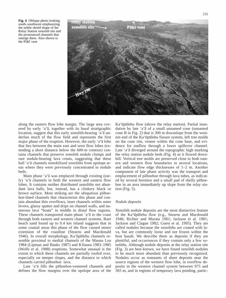
Ka‘u–pu–lehu flow (above the relay station). Partial inun-dation by late ‘a‘a– of a small unnamed cone (unnamedcone B in Fig. 2) that is 300 m downslope from the west-ern end of the Ka‘u–pu–lehu fissure system, left tree moldson the cone rim, veneer within the cone base, and evi-dence for outflow through a lower spillover channel.Late ‘a‘a– diverged around the topographic high markingthe relay station nodule beds (Fig. 4) as it flowed down-hill. Vertical tree molds are preserved close to both east-ern and western flow boundaries in several locations,and indicate flow edge thicknesses of 1–2 m. Anothercomponent of late phase activity was the transport andemplacement of pa–hoehoe through lava tubes, as indicat-ed by several hornitos and a small pad of shelly pa–hoe-hoe in an area immediately up slope from the relay sta-tion (Fig. 5).
Nodule deposits
Xenolith nodule deposits are the most distinctive featureof the Ka‘u–pu–lehu flow (e.g., Stearns and Macdonald1946; Richter and Murata 1961; Jackson et al. 1981;Jackson and Clague 1982; Guest et al. 1995). They arecalled nodules because the xenoliths are coated with la-va, but are commonly loose and not frozen within thehost basalt. We describe them as deposits if they areplentiful, and occurrences if they contain only a few xe-noliths. Although nodule deposits at the relay station site(Fig. 3) are best known, we have found xenolith nodulesto be much more abundant than previously recognized.Nodules occur as remnants of sheet deposits near thesource regions of the western flow lobe, in overflow de-posits in the western channel system between 975 and365 m, and in regions of temporary lava ponding, partic-
235
Fig. 4 Oblique photo lookingsouth–southwest emphasizingthe subtle shield shape of theRelay Station xenolith site andthe pronounced channels thatemerge there. Also shown isthe Pu–kı- vent

ularly at those locations associated with distributary for-mation in the western channel.
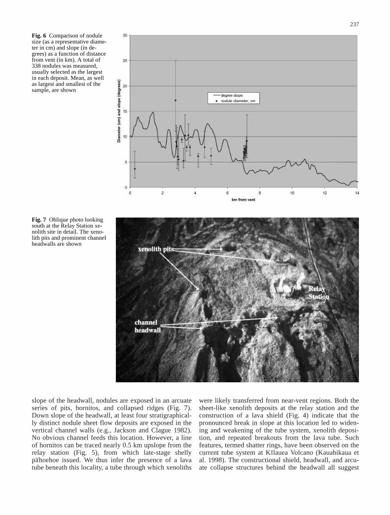
Xenolith nodule deposits are restricted to a singlepa–hoehoe-dominated channel system in the western lobeof the Ka‘u–pu–lehu flow, although they are found in dif-ferent distributaries of that channel (Fig. 5). Down slopeof the relay station, all nodule deposits are confined to asingle channel emanating from the relay station at thebase of an 18-m-high headwall. Within this channel,nodule deposits are preserved as either overflow leveesfrom the channel, or as bedload deposits in locations oftemporary ponding and channel splitting. Nodules showno systematic change in size along the channel as either
a function of distance from the vent, or of depositionalslope (Fig. 6). Both slumping of nodules back into activechannels and drainage of lava from between close-packed nodules indicate prolonged exposure to the heatof an active channel, heating that was perhaps enhancedby the high heat capacity of the (predominantly dunite)nodules themselves.
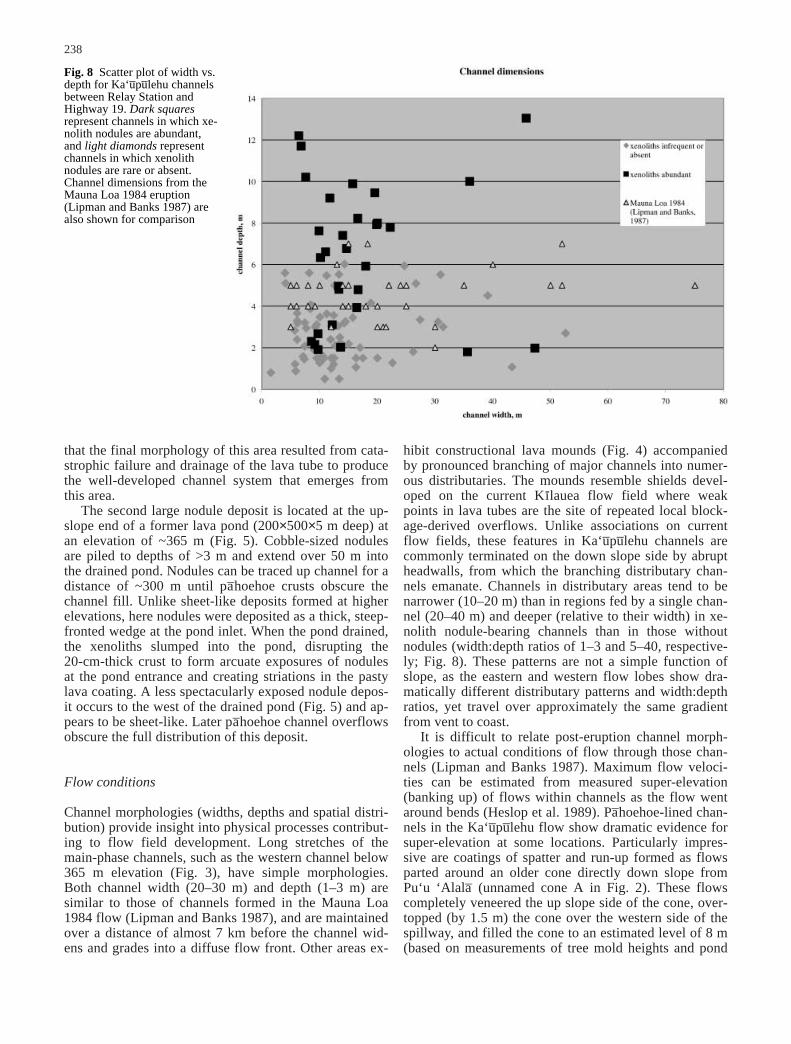
Two locations preserve unusual concentrations of xe-noliths and, therefore, merit detailed description. Thefirst is the relay station locality of Richter and Murata(1961). This deposit is located at the top of a broad con-structional shield (Fig. 4) and was partially drained by anassociated headwall and channel system (Fig. 5). Up-
236
Fig. 5 Detail of Fig. 3 includ-ing Relay Station and lowerpond showing channels (lines)and xenolith occurrences (dia-monds). phh pa–hoehoe
slope of the headwall, nodules are exposed in an arcuateseries of pits, hornitos, and collapsed ridges (Fig. 7).Down slope of the headwall, at least four stratigraphical-ly distinct nodule sheet flow deposits are exposed in thevertical channel walls (e.g., Jackson and Clague 1982).No obvious channel feeds this location. However, a lineof hornitos can be traced nearly 0.5 km upslope from therelay station (Fig. 5), from which late-stage shellypa–hoehoe issued. We thus infer the presence of a lavatube beneath this locality, a tube through which xenoliths
were likely transferred from near-vent regions. Both thesheet-like xenolith deposits at the relay station and theconstruction of a lava shield (Fig. 4) indicate that thepronounced break in slope at this location led to widen-ing and weakening of the tube system, xenolith deposi-tion, and repeated breakouts from the lava tube. Suchfeatures, termed shatter rings, have been observed on thecurrent tube system at Kı-lauea Volcano (Kauahikaua etal. 1998). The constructional shield, headwall, and arcu-ate collapse structures behind the headwall all suggest
237
Fig. 6 Comparison of nodulesize (as a representative diame-ter in cm) and slope (in de-grees) as a function of distancefrom vent (in km). A total of338 nodules was measured,usually selected as the largestin each deposit. Mean, as wellas largest and smallest of thesample, are shown
Fig. 7 Oblique photo lookingsouth at the Relay Station xe-nolith site in detail. The xeno-lith pits and prominent channelheadwalls are shown
that the final morphology of this area resulted from cata-strophic failure and drainage of the lava tube to producethe well-developed channel system that emerges fromthis area.
The second large nodule deposit is located at the up-slope end of a former lava pond (200×500×5 m deep) atan elevation of ~365 m (Fig. 5). Cobble-sized nodulesare piled to depths of >3 m and extend over 50 m intothe drained pond. Nodules can be traced up channel for adistance of ~300 m until pa–hoehoe crusts obscure thechannel fill. Unlike sheet-like deposits formed at higherelevations, here nodules were deposited as a thick, steep-fronted wedge at the pond inlet. When the pond drained,the xenoliths slumped into the pond, disrupting the 20-cm-thick crust to form arcuate exposures of nodulesat the pond entrance and creating striations in the pastylava coating. A less spectacularly exposed nodule depos-it occurs to the west of the drained pond (Fig. 5) and ap-pears to be sheet-like. Later pa–hoehoe channel overflowsobscure the full distribution of this deposit.
Flow conditions
Channel morphologies (widths, depths and spatial distri-bution) provide insight into physical processes contribut-ing to flow field development. Long stretches of themain-phase channels, such as the western channel below365 m elevation (Fig. 3), have simple morphologies.Both channel width (20–30 m) and depth (1–3 m) aresimilar to those of channels formed in the Mauna Loa1984 flow (Lipman and Banks 1987), and are maintainedover a distance of almost 7 km before the channel wid-ens and grades into a diffuse flow front. Other areas ex-
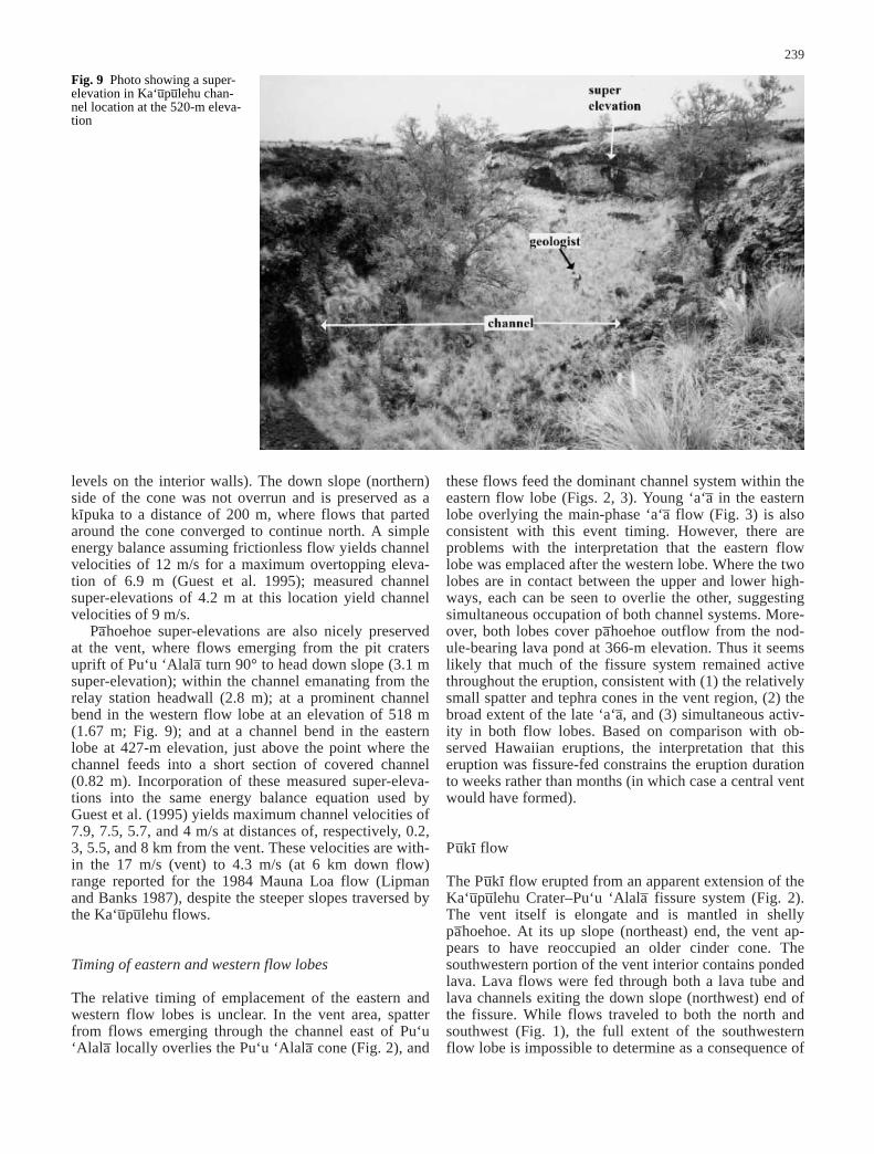
hibit constructional lava mounds (Fig. 4) accompaniedby pronounced branching of major channels into numer-ous distributaries. The mounds resemble shields devel-oped on the current Kı-lauea flow field where weakpoints in lava tubes are the site of repeated local block-age-derived overflows. Unlike associations on currentflow fields, these features in Ka‘u–pu–lehu channels arecommonly terminated on the down slope side by abruptheadwalls, from which the branching distributary chan-nels emanate. Channels in distributary areas tend to benarrower (10–20 m) than in regions fed by a single chan-nel (20–40 m) and deeper (relative to their width) in xe-nolith nodule-bearing channels than in those withoutnodules (width:depth ratios of 1–3 and 5–40, respective-ly; Fig. 8). These patterns are not a simple function ofslope, as the eastern and western flow lobes show dra-matically different distributary patterns and width:depthratios, yet travel over approximately the same gradientfrom vent to coast.
It is difficult to relate post-eruption channel morph-ologies to actual conditions of flow through those chan-nels (Lipman and Banks 1987). Maximum flow veloci-ties can be estimated from measured super-elevation(banking up) of flows within channels as the flow wentaround bends (Heslop et al. 1989). Pa–hoehoe-lined chan-nels in the Ka‘u–pu–lehu flow show dramatic evidence forsuper-elevation at some locations. Particularly impres-sive are coatings of spatter and run-up formed as flowsparted around an older cone directly down slope fromPu‘u ‘Alala– (unnamed cone A in Fig. 2). These flowscompletely veneered the up slope side of the cone, over-topped (by 1.5 m) the cone over the western side of thespillway, and filled the cone to an estimated level of 8 m(based on measurements of tree mold heights and pond
238
Fig. 8 Scatter plot of width vs.depth for Ka‘u–pu–lehu channelsbetween Relay Station andHighway 19. Dark squaresrepresent channels in which xe-nolith nodules are abundant,and light diamonds representchannels in which xenolithnodules are rare or absent.Channel dimensions from theMauna Loa 1984 eruption (Lipman and Banks 1987) arealso shown for comparison
levels on the interior walls). The down slope (northern)side of the cone was not overrun and is preserved as a kı-puka to a distance of 200 m, where flows that partedaround the cone converged to continue north. A simpleenergy balance assuming frictionless flow yields channelvelocities of 12 m/s for a maximum overtopping eleva-tion of 6.9 m (Guest et al. 1995); measured channelsuper-elevations of 4.2 m at this location yield channelvelocities of 9 m/s.
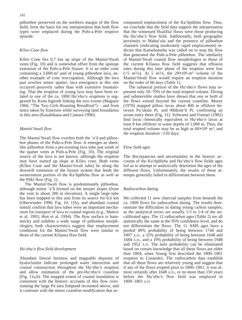
Pa–hoehoe super-elevations are also nicely preservedat the vent, where flows emerging from the pit cratersuprift of Pu‘u ‘Alala– turn 90° to head down slope (3.1 msuper-elevation); within the channel emanating from therelay station headwall (2.8 m); at a prominent channelbend in the western flow lobe at an elevation of 518 m(1.67 m; Fig. 9); and at a channel bend in the easternlobe at 427-m elevation, just above the point where thechannel feeds into a short section of covered channel(0.82 m). Incorporation of these measured super-eleva-tions into the same energy balance equation used byGuest et al. (1995) yields maximum channel velocities of7.9, 7.5, 5.7, and 4 m/s at distances of, respectively, 0.2,3, 5.5, and 8 km from the vent. These velocities are with-in the 17 m/s (vent) to 4.3 m/s (at 6 km down flow)range reported for the 1984 Mauna Loa flow (Lipmanand Banks 1987), despite the steeper slopes traversed bythe Ka‘u–pu–lehu flows.
Timing of eastern and western flow lobes
The relative timing of emplacement of the eastern andwestern flow lobes is unclear. In the vent area, spatterfrom flows emerging through the channel east of Pu‘u‘Alala– locally overlies the Pu‘u ‘Alala– cone (Fig. 2), and
these flows feed the dominant channel system within theeastern flow lobe (Figs. 2, 3). Young ‘a‘a– in the easternlobe overlying the main-phase ‘a‘a– flow (Fig. 3) is alsoconsistent with this event timing. However, there areproblems with the interpretation that the eastern flowlobe was emplaced after the western lobe. Where the twolobes are in contact between the upper and lower high-ways, each can be seen to overlie the other, suggestingsimultaneous occupation of both channel systems. More-over, both lobes cover pa–hoehoe outflow from the nod-ule-bearing lava pond at 366-m elevation. Thus it seemslikely that much of the fissure system remained activethroughout the eruption, consistent with (1) the relativelysmall spatter and tephra cones in the vent region, (2) thebroad extent of the late ‘a‘a–, and (3) simultaneous activ-ity in both flow lobes. Based on comparison with ob-served Hawaiian eruptions, the interpretation that thiseruption was fissure-fed constrains the eruption durationto weeks rather than months (in which case a central ventwould have formed).
Pu–kı- flow
The Pu–kı- flow erupted from an apparent extension of theKa‘u–pu–lehu Crater–Pu‘u ‘Alala– fissure system (Fig. 2).The vent itself is elongate and is mantled in shellypa–hoehoe. At its up slope (northeast) end, the vent ap-pears to have reoccupied an older cinder cone. Thesouthwestern portion of the vent interior contains pondedlava. Lava flows were fed through both a lava tube andlava channels exiting the down slope (northwest) end ofthe fissure. While flows traveled to both the north andsouthwest (Fig. 1), the full extent of the southwesternflow lobe is impossible to determine as a consequence of
239
Fig. 9 Photo showing a super-elevation in Ka‘u–pu–lehu chan-nel location at the 520-m eleva-tion

extensive bulldozing on the Huala–lai Ranch. We havechosen to show a more conservative (shorter) flowlength than that of Moore and Clague (1991) based inpart on their note that their presumed distal flow (beyondHwy 190) did not show the same paleomagnetic direc-tion as lava demonstrably related to the Pu–kı- flow. Bothflow lobes have pa–hoehoe morphologies near the vent,but transform rapidly to ‘a‘a– during flow to the north andsouth. Xenoliths are present, but are not common and areusually small (~1 cm).
Hu‘ehu‘e flow field
Puhi-a-Pele flow
The Puhi-a-Pele flow is the oldest unit of what is com-monly called the Hu‘ehu‘e, or 1801 A.D. lava flow(Fig. 1). Spatter and Pele’s tears underlie flows near thevent, and this eruption created an agglutinated spatterrampart up to 40 m high along a 0.7-km long fissuresystem (Fig. 10). Lava fed from these cones is shellypa–hoehoe at the vents, but changes rapidly to ‘a‘a– down
slope. ‘A‘a– generated during early phases of the eruptionwas apparently transported through at least three majorchannels, each progressively abandoned so that laterflows traveled only through the southernmost channel(Fig. 11a). While ‘a‘a– flow margins and minor flowlobes to the north have spiney ‘a‘a– morphologies, thechannels are pa–hoehoe -veneered and covered much ofthe area below 123-m elevation with pa–hoehoe over-flows. As in the Ka‘u–pu–lehu flow, the southernmostchannel is roofed over in many places.
Maturation of the channel system apparently allowedtransport of pa–hoehoe all the way to the coast during la-ter stages of this eruption (Fig. 11a). Puhi-a-Pele pa–hoe-hoe is now exposed over much of the northern coastalextent of the Hu‘ehu‘e flow field and can also be seen assmall kı-pukas in the overlying Manini‘o–wali flow(Fig. 11b). Pa–hoehoe that comprises this flow is predom-inantly xenolith free, with the exception of a smallpa–hoehoe overflow from the lava tube (exposed in aroadcut), which has basal xenoliths that decrease in sizefrom >4 to <1 cm with distance away from the tube. Ad-ditionally, small scattered xenoliths can be found at sev-eral locations along the coast. Although overlying Man-ini‘o–wali lava obscures the point of transition from early‘a‘a– channels to later sheet-like pa–hoehoe, channelswithin the ‘a‘a– appear to connect to both large lava tubesand channels preserved in the pa–hoehoe (Fig 11a). Lavatubes can be traced for nearly 2 km and are particularlywell exposed in the vicinity of Hwy 19. The spatial rela-tionship between channels in the two flow types, togetherwith the relative age relations of the ‘a‘a– and sheet-like
240
Fig. 10 Aerial photograph of Hu‘ehu‘e flow field vent area show-ing the Kı-leo cone flow, the Manini‘o–wali flow, and the Puhi-a-Pele flow. The Kı-leo cone flow is inside an older cone that mustbe its vent. The Puhi-a-Pele flow originated from the Puhi-a-Pelespatter rampart via a set of channels; the last active channel is la-beled. There is no obvious vent for the Manini‘o–wali flow, whichbegins where pa–hoehoe lava emerges from a skylight in an oldertube. Manini‘o–wali tube trace is from Oberwinder (1996)

241
Fig. 11 a Reconstruction of the Puhi-a-Pele flow, showing the up-per section consisting mostly of ‘a‘a– with pa–hoehoe-lined chan-nels, and the lower section consisting mostly of pa–hoehoe withtubes and pa–hoehoe channels. Tubes and channels are dashedwhere inferred beneath the later Manini‘o–wali flow. Pa–hoehoechannel B overrode pa–hoehoe channels A and C, suggesting thatA and C had ceased activity before B burst out of the A channel alittle more than 1 km upslope. Tube D must have formed whenchannel C already existed because its location seems to be parallelto, and therefore responding to C. By similar logic, pa–hoehoe
channel E must have formed after channel A. A lower case h de-notes exposures of hyaloclastite indicating lava–water interactionat the coast. Circles offshore are localities investigated by Moore(1970); filled circles indicate where pillow lavas were found, pos-sibly offshore of ocean entries; unfilled circles indicate where pil-low lavas were not found. b Manini‘o–wali flow issued out of apre-existing lava tube, traveled downslope, and forked around themain Puhi-a-Pele tube/channel before entering the ocean on thesouth side. A single large lava tube was formed within this flow.Contour interval is 200 m
pa–hoehoe preserved on the northern margin of the flowfield, form the basis for our interpretation that both flowtypes were emplaced during the Puhi-a-Pele eruptiveepisode.
Kı-leo Cone flow
Kı-leo Cone lies 0.7 km up slope of the Manini‘o–walivents (Fig. 10) and is somewhat offset from the upslopeextension of the Puhi-a-Pele fissure. It is an older conecontaining a 3,600-m2 pad of young pa–hoehoe lava, an-other example of cone reoccupation. Although the lavapad overlies minor spatter, lava emergence at this siteoccurred passively rather than with extensive fountain-ing. That the eruption of young lava may have been re-lated to one of the ca. 1800 Hu‘ehu‘e eruptions is sug-gested by Kona legends linking the two events (Maguire1966; “The Two Girls Roasting Breadfruit”) – and fromnotes taken by Emerson while surveying land boundariesin this area (Kauahikaua and Camara 1996).
Manini‘o–wali flow
The Manini‘o–wali flow overlies both the ‘a‘a– and pa–hoe-hoe phases of the Puhi-a-Pele flow. It emerges as sheet-like pa–hoehoe from a pre-existing lava tube just south ofthe spatter vents at Puhi-a-Pele (Fig. 10). The originalsource of the lava is not known, although the eruptionmay have started up slope at Kı-leo cone. Both vents (Kı-leo Cone and the Manini‘o–wali tube) lie along thedownrift extension of the fissure system that feeds thewesternmost portion of the Ka‘u–pu–lehu flow as well asthe Pu–kı- flow (Fig. 1).
The Manini‘o–wali flow is predominantly pa–hoehoe,although minor ‘a‘a– formed on the steeper slopes (fromthe vent to about 200 m elevation). A single large tubehas been mapped in this unit from its source for 6.6 km(Oberwinder 1996; Fig. 10, 11b), and abundant coastaltumuli confirm that lava tubes were an important mecha-nism for transport of lava to coastal regions (e.g., Mattoxet al. 1993; Hon et al. 1994). The flow surface is hum-mocky and exhibits a wide range of pa–hoehoe morph-ologies; both characteristics suggest that emplacementconditions for the Manini‘o–wali flow were similar tothose of the current Kı-lauea flow field.
Hu‘ehu‘e flow field development
Abundant littoral hornitos and mappable deposits ofhyaloclastite indicate prolonged water interaction andcoastal construction throughout the Hu‘ehu‘e eruptionand allow estimation of the pre-Hu‘ehu‘e coastline(Fig. 11a,b). The mapped extent of coastal inundation isconsistent with the historic accounts of this flow over-running the large Pa‘aiea fishpond recounted above, andit contrasts with the minor coastline modification that ac-
companied emplacement of the Ka‘u–pu–lehu flow. Thus,we conclude that the field data support the interpretationthat the witnessed Huala–lai flows were those producingthe Hu‘ehu‘e flow field. Additionally, both geographicproximity to Mahai‘ula and the presence of pa–hoehoechannels (indicating moderately rapid emplacement) in-dicate that Kamehameha was called on to stop the flowthat generated the Puhi-a-Pele pa–hoehoe. The similarityof Manini‘o–wali coastal flow morphologies to those ofthe current Kı-lauea flow field suggests that effusionrates during this later phase of the eruption were low(<5 m3/s). At 5 m3/s, the 29×106-m3 volume of theManini‘o–wali flow would require an eruption durationon the order of 66 days (Table 1).
The subaerial portion of the Hu‘ehu‘e flows may re-present only 50–70% of the total erupted volume. Divingand submersible studies have shown that one or both ofthe flows extend beyond the current coastline. Moore(1970) mapped pillow lavas about 400 m offshore be-tween Pu‘ukala Pt. and Ma–kole‘a– Pt. confirming anocean entry there (Fig. 11). Schwartz and Fornari (1982)find lavas chemically equivalent to Hu‘ehu‘e lavas atleast 8 km offshore in water depths of 1,000 m. Thus, thetotal erupted volume may be as high as 60×106 m3, andthe eruption duration ~120 days.
Flow field ages
The discrepancies and uncertainties in the historic ac-counts of the Ka‘u–pu–lehu and Hu‘ehu‘e flow fields agesled us to attempt to analytically determine the ages of thedifferent flows. Unfortunately, the results of these at-tempts generally failed to differentiate between them.
Radiocarbon dating
We collected 11 new charcoal samples from beneath theca. 1800 flows for radiocarbon dating. The results dem-onstrate the difficulties in dating young carbon samples,as the analytical errors are usually 1/3 to 1/4 of the un-calibrated ages. The 12 radiocarbon ages (Table 2) are allstatistically the same at the 95% confidence level, and donot differentiate the flows. The 11 AMS ages have apooled 49% probability of being between 1744 and1807 A.D., a 32% probability of being between 1648 and1684 A.D., and a 19% probability of being between 1948and 1952 A.D. The later probability can be eliminatedbased on certain knowledge that all these flows are olderthan 1804, when Young first described the 1800–1801eruption to Lisianskii. The radiocarbon data establishthat all these flows are relatively young and suggest thatif any of the flows erupted prior to 1800–1801, it was al-most certainly after 1648 A.D., or no more than 150 yearsbefore the Hu‘ehu‘e flow field was emplaced in1800–1801 A.D.
242
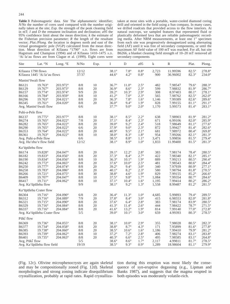
Paleomagnetism
Paleomagnetic samples were taken at 31 separate flowoutcrops in five of the flows to obtain site mean direc-tions of remanent magnetization. No paleomagnetic sam-ples were obtained from the lava flow at the bottom ofKı-leo Cone. Directional averages were calculated foreach site with associated Fisherian statistics (Table 3).The 95% confidence circle around the mean magnetic di-rection for the five sampled flows includes all four othermean directions; the five flows cannot be differentiatedat the 95% level (McFadden and Jones 1981). The meanmagnetic direction of the so-called 1790 flow of Kı-laueaVolcano (Hagstrum and Champion 1994) differs fromthe average of the 12 sites in the 1800–1801 A.D.Hu‘ehu‘e flow field by only 1.1° (different at the 77%probability level), and from the average of the 19 sites inthe Ka‘u–pu–lehu flow field by only 1.6° (different at the93% probability level). The mean magnetic direction ofthe ‘Ai la‘au flows on Kı-lauea, erupted in about1410–1470 A.D., differs from that of the 1800–1801 A.D.Hu‘ehu‘e flow field by about 6.9° (99% probability lev-el; McFadden and Jones 1981). The similarity in mag-netic directions among the 1800–1801 Hu‘ehu‘e flowfield, the Ka‘u–pu–lehu flow field, and the Kı-lauea “1790”flows, and their difference from the 1410–1475 A.D. Kı-
lauea ‘Ai la‘au flows, suggests that the Ka‘u–pu–lehu flowfield is unlikely to be more than 100 years older than theHu‘ehu‘e flow field, suggesting that it erupted during the18th century.
243
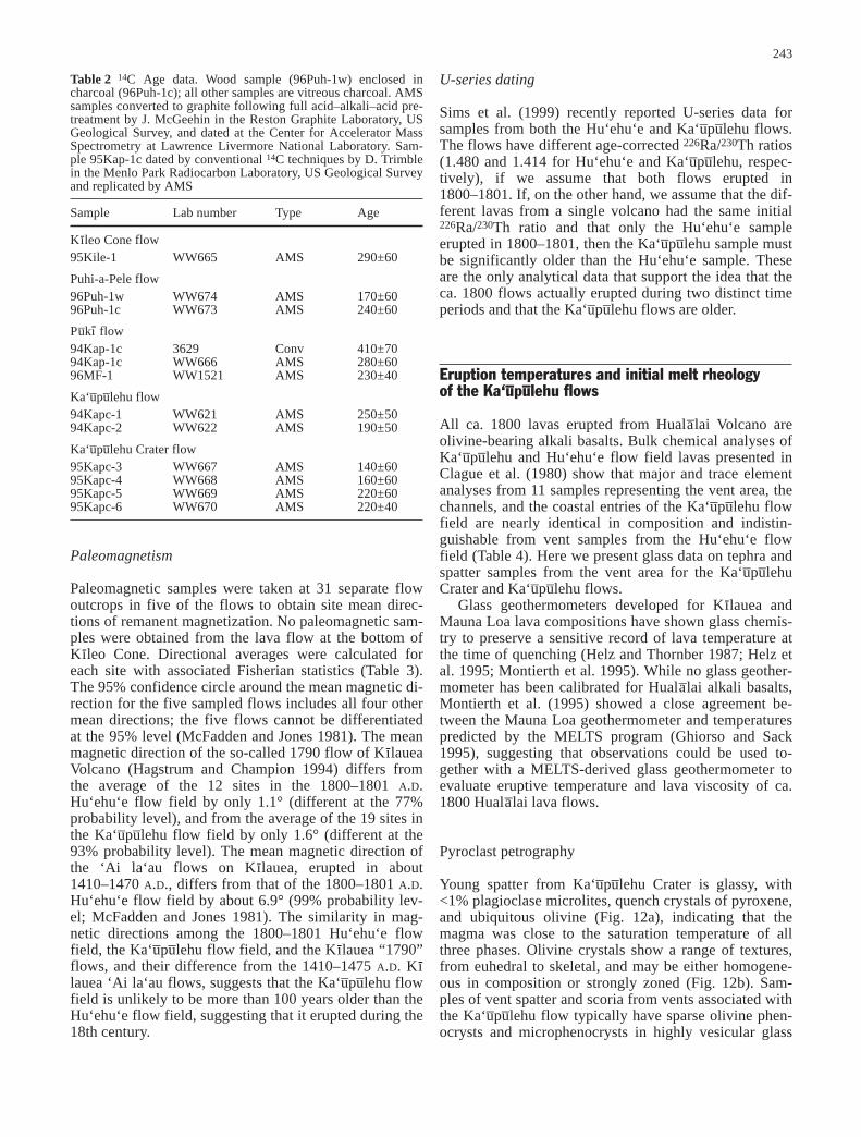
Table 2 14C Age data. Wood sample (96Puh-1w) enclosed incharcoal (96Puh-1c); all other samples are vitreous charcoal. AMSsamples converted to graphite following full acid–alkali–acid pre-treatment by J. McGeehin in the Reston Graphite Laboratory, USGeological Survey, and dated at the Center for Accelerator MassSpectrometry at Lawrence Livermore National Laboratory. Sam-ple 95Kap-1c dated by conventional 14C techniques by D. Trimblein the Menlo Park Radiocarbon Laboratory, US Geological Surveyand replicated by AMS
Sample Lab number Type Age
Kı-leo Cone flow95Kile-1 WW665 AMS 290±60
Puhi-a-Pele flow96Puh-1w WW674 AMS 170±6096Puh-1c WW673 AMS 240±60
Pu–kı- flow94Kap-1c 3629 Conv 410±7094Kap-1c WW666 AMS 280±6096MF-1 WW1521 AMS 230±40
Ka‘u–pu–lehu flow94Kapc-1 WW621 AMS 250±5094Kapc-2 WW622 AMS 190±50
Ka‘u–pu–lehu Crater flow95Kapc-3 WW667 AMS 140±6095Kapc-4 WW668 AMS 160±6095Kapc-5 WW669 AMS 220±6095Kapc-6 WW670 AMS 220±40
U-series dating
Sims et al. (1999) recently reported U-series data forsamples from both the Hu‘ehu‘e and Ka‘u–pu–lehu flows.The flows have different age-corrected 226Ra/230Th ratios(1.480 and 1.414 for Hu‘ehu‘e and Ka‘u–pu–lehu, respec-tively), if we assume that both flows erupted in1800–1801. If, on the other hand, we assume that the dif-ferent lavas from a single volcano had the same initial226Ra/230Th ratio and that only the Hu‘ehu‘e sampleerupted in 1800–1801, then the Ka‘u–pu–lehu sample mustbe significantly older than the Hu‘ehu‘e sample. Theseare the only analytical data that support the idea that theca. 1800 flows actually erupted during two distinct timeperiods and that the Ka‘u–pu–lehu flows are older.
Eruption temperatures and initial melt rheology of the Ka‘u–pu–lehu flows
All ca. 1800 lavas erupted from Huala–lai Volcano areolivine-bearing alkali basalts. Bulk chemical analyses ofKa‘u–pu–lehu and Hu‘ehu‘e flow field lavas presented inClague et al. (1980) show that major and trace elementanalyses from 11 samples representing the vent area, thechannels, and the coastal entries of the Ka‘u–pu–lehu flowfield are nearly identical in composition and indistin-guishable from vent samples from the Hu‘ehu‘e flowfield (Table 4). Here we present glass data on tephra andspatter samples from the vent area for the Ka‘u–pu–lehuCrater and Ka‘u–pu–lehu flows.
Glass geothermometers developed for Kı-lauea andMauna Loa lava compositions have shown glass chemis-try to preserve a sensitive record of lava temperature atthe time of quenching (Helz and Thornber 1987; Helz etal. 1995; Montierth et al. 1995). While no glass geother-mometer has been calibrated for Huala–lai alkali basalts,Montierth et al. (1995) showed a close agreement be-tween the Mauna Loa geothermometer and temperaturespredicted by the MELTS program (Ghiorso and Sack1995), suggesting that observations could be used to-gether with a MELTS-derived glass geothermometer toevaluate eruptive temperature and lava viscosity of ca.1800 Huala–lai lava flows.
Pyroclast petrography
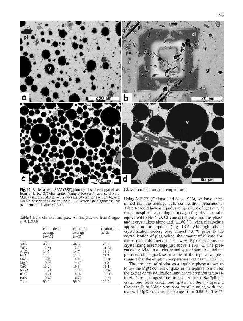
Young spatter from Ka‘u–pu–lehu Crater is glassy, with<1% plagioclase microlites, quench crystals of pyroxene,and ubiquitous olivine (Fig. 12a), indicating that themagma was close to the saturation temperature of allthree phases. Olivine crystals show a range of textures,from euhedral to skeletal, and may be either homogene-ous in composition or strongly zoned (Fig. 12b). Sam-ples of vent spatter and scoria from vents associated withthe Ka‘u–pu–lehu flow typically have sparse olivine phen-ocrysts and microphenocrysts in highly vesicular glass
(Fig. 12c). Olivine microphenocrysts are again skeletaland may be compositionally zoned (Fig. 12d). Skeletalmorphologies and strong zoning indicate disequilibriumcrystallization, probably at rapid rates. Rapid crystalliza-
tion during this eruption was most likely the conse-quence of syn-eruptive degassing (e.g., Lipman andBanks 1987), and suggests that the magma erupted inboth episodes was moderately volatile-rich.
244
Table 3 Paleomagnetic data. Site The alphanumeric identifier;N/No the number of cores used compared with the number origi-nally taken at the site; Exp. the strength of the peak cleaning fieldin mT; I and D the remanent inclination and declination; a95 the95% confidence limit about the mean direction; k the estimate ofthe Fisherian precision parameter; R the length of the resultantvector; Plat./Plong. the location in degrees north and east of thevirtual geomagnetic pole (VGP) calculated from the mean direc-tion. Mean direction of Kı-lauea “1790” A.D. flows are fromHagstrum and Champion (1994) and of Kı-lauea 1410–1475 A.D.‘Ai la‘au flows are from Clague et al. (1999). Eight cores were
taken at most sites with a portable, water-cooled diamond coringdrill and oriented in the field using a Sun compass. In many cases,we drilled roadcuts that provided access to the flow interiors. Atnatural outcrops, we sampled features that represented fluid orplastically deformed lava that are reliable paleomagnetic record-ing media. After NRM measurements, at least one 1” specimenfrom each site was progressively demagnetized using alternatingfield (AF) until it was free of secondary components, or until themaximum AF field value of 100 mT was reached. For all, but siteB6266, a blanket cleaning field strength of 10–20 mT removed allsecondary components
Site Lat. °N Long. °E N/No Exp. I D a95 k R Plat. Plong.
Kı-lauea 1790 flows 12/12 38.1° 7.8° 0.8° 2,723 11.99596 82.5° 278.8°Kı-lauea 1445 ‘Ai la‘au flows 37/37 44.6° 4.2° 0.8° 900 36.96002 82.3° 234.0°
Manini‘o–wali flowB6121 19.763° 203.972° 8/8 10 36.7° 11.0° 2.5° 482 7.98547 79.6° 288.3°B6129 19.767° 203.973° 8/8 20 36.9° 8.6° 2.3° 599 7.98832 81.9° 286.7°B6157 19.774° 203.974° 9/9 20 39.2° 10.3° 2.9° 308 8.97403 80.1° 278.1°B6166 19.784° 203.959° 8/8 10 41.2° 7.0° 2.3° 565 7.98762 82.5° 262.0°B6296 19.763° 204.021° 8/8 20 36.3° 7.8° 1.6° 1,146 7.99389 82.6° 289.6°B6345 19.761° 204.020° 8/8 20 36.0° 9.4° 1.9° 828 7.99155 81.1° 291.1°Avg. Manini‘o–wali flow 6/6 37.7° 9.0° 2.0° 1,170 5.99573 81.4° 283.1°
Puhi-a-Pele flowB6137 19.775° 203.977° 8/8 10 38.1° 8.5° 2.2° 638 7.98903 81.9° 281.2°B6274 19.765° 204.022° 7/8 20 37.1° 8.4° 2.3° 671 6.99106 82.0° 285.9°B6282 19.765° 204.022° 8/8 20 39.0° 9.2° 2.4° 518 7.98649 81.1° 277.6°B6290 19.765° 204.022° 6/6 20 37.9° 9.0° 2.3° 872 5.99427 81.4° 282.6°B6353 19.764° 204.022° 8/8 20 40.9° 9.5° 2.1° 681 7.98972 80.4° 269.8°B6361 19.763° 204.022° 8/8 10 38.0° 8.3° 1.8° 954 7.99266 82.1° 281.3°Avg. Puhi-a-Pele flow 6/6 38.5° 8.8° 1.1° 3,471 5.99856 81.5° 279.4°Avg. Hu‘ehu‘e flow field 12/12 38.1° 8.9° 1.0° 1,833 11.99400 81.5° 281.3°
Ka‘u–pu–lehu flowB6174 19.828° 204.047° 8/8 20 39.1° 12.2° 2.8° 383 7.98174 78.4° 280.5°B6182 19.833° 204.056° 8/8 20 37.3° 8.4° 2.7° 422 7.98340 82.1° 285.1°B6190 19.834° 204.056° 8/8 10 36.3° 10.1° 1.9° 889 7.99213 80.5° 290.4°B6242 19.772° 204.065° 8/8 20 37.6° 10.0° 2.5° 481 7.98543 80.6° 284.4°B6250 19.777° 204.074° 8/8 20 39.2° 9.4° 3.0° 340 7.97939 80.9° 277.1°B6258 19.783° 204.086° 8/8 20 40.1° 8.2° 2.3° 580 7.98794 81.8° 270.5°B6266 19.721° 204.075° 8/8 30 38.8° 4.6° 1.9° 829 7.99155 85.2° 266.6°B6409 19.707° 204.047° 8/8 10 37.5° 9.8° 1.7° 1,084 7.99354 80.7° 284.6°B6417 19.711° 204.062° 8/8 10 37.1° 10.4° 1.6° 1,195 7.99414 80.2° 286.2°Avg. Ka‘u–pu–lehu flow 9/9 38.1° 9.2° 1.3° 1,558 8.99487 81.2° 281.5°
Ka‘u–pu–lehu Crater flowB6304 19.716° 204.090° 6/8 20 36.4° 11.3° 1.0° 4,685 5.99893 79.4° 289.5°B6312 19.716° 204.089° 7/9 20 37.8° 8.4° 3.0° 415 6.98553 82.0° 281.8°B6321 19.715° 204.090° 8/8 20 37.6° 6.4° 2.8° 383 7.98174 83.9° 280.5°B6329 19.716° 204.084° 8/8 20 41.3° 11.4° 2.6° 444 7.98422 78.7° 271.5°B6337 19.716° 204.084° 8/8 20 41.6° 13.2° 1.9° 814 7.99140 77.0° 272.8°Avg. Ka‘u–pu–lehu Crater flow 5/5 39.0° 10.1° 3.0° 659 4.99393 80.3° 278.5°
Pu–kı- flowB6369 19.736° 204.055° 8/8 20 38.1° 10.0° 2.9° 355 7.98028 80.5° 282.3°B6377 19.734° 204.058° 8/8 20 38.8° 8.7° 4.3° 171 7.95899 81.6° 277.8°B6385 19.738° 204.060° 8/8 20 38.5° 10.6° 1.6° 1,186 7.99410 79.9° 281.2°B6393 19.739° 204.062° 8/8 10 37.2° 7.2° 2.8° 406 7.98274 83.1° 283.8°B6401 19.735° 204.063° 8/8 20 40.3° 6.6° 2.5° 495 7.98585 83.1° 264.8°Avg, Pu–kı- flow 5/5 38.6° 8.6° 1.7° 2,117 4.99811 81.7° 278.5°Avg. Ka‘u–pu–lehu flow field 19/19 38.5° 9.3° 0.9° 1,289 18.98604 81.1° 279.9°
Glass composition and temperature
Using MELTS (Ghiorso and Sack 1995), we have deter-mined that the average bulk composition presented inTable 4 would have a liquidus temperature of 1,217 °C atone atmosphere, assuming an oxygen fugacity constraintequivalent to Ni–NiO. Olivine is the only liquidus phase,and it crystallizes alone until 1,180 °C, when plagioclaseappears on the liquidus (Fig. 13a). Although olivinecrystallization occurs over almost 40 °C prior to thecrystallization of plagioclase, the amount of olivine pro-duced over this interval is <4 wt%. Pyroxene joins thecrystallizing assemblage just above 1,150 °C. The pres-ence of olivine in all cinder and spatter samples, and thepresence of plagioclase in some of the tephra samples,suggest that the eruption temperature was near 1,180 °C.
The presence of olivine as a liquidus phase allows usto use the MgO content of glass in the tephras to monitorthe extent of crystallization (and hence eruption tempera-ture). Glass compositions in spatter from Ka‘u–pu–lehucrater and from cinder and spatter in the Ka‘u–pu–lehuCrater to Pu‘u ‘Alala– vent area are all similar, with nor-malized MgO contents that range from 6.88–7.45 wt%,
245
Table 4 Bulk chemical analyses. All analyses are from Clague et al. (1980)
Ka‘u–pu–lehu Hu‘ehu‘e Kea–hole Pt.average average (n=2)(n=11) (n=2)
SiO2 46.8 46.5 46.1TiO2 2.41 2.27 1.82Al2O3 14.7 14.7 13.1FeO 12.5 12.4 11.9MnO 0.19 0.19 0.18MgO 9.09 9.17 11.8CaO 10.2 10.3 11.4Na2O 2.91 2.78 2.26K2O 0.91 0.87 0.66P2O5 0.28 0.28 0.21Total 99.9 99.9 100.0
Fig. 12 Backscattered SEM (BSE) photographs of vent pyroclastsfrom a, b Ka‘u–pu–lehu Crater (sample KAPG1), and c, d Pu‘u‘Alala– (sample KAU1). Scale bars are labeled for each photo, andsample descriptions are in Table 5. v Vesicle; pl plagioclase; pxpyroxene; ol olivine; gl glass
and SiO2 contents that range from 47.0–48.4 wt%(Table 5). Comparison of measured glass MgO contentwith the MELTS model suggests eruption temperaturesof 1,158–1,172 °C (Fig. 13b). The lower end of thisrange is defined by the three plagioclase-bearing sam-ples, whereas the higher temperature glasses are limitedto plagioclase-free cinder layers near Pu‘u ‘Alala–.
The abundance of incompatible elements (TiO2 andK2O) provides another check on eruption temperature.Both are slightly elevated relative to bulk sample values,and, when compared with MELTS, suggest eruption tem-peratures of 1,162–1,180 °C. This temperature range isconsistent with the phase boundaries indicated inFig. 13a for plagioclase-bearing and plagioclase-freesamples. The slight discrepancy between these tempera-tures and those based on the MgO-based thermometermay be a consequence of fractional, rather than equilibri-um crystallization, as indicated by zoning evident in themicrophenocrystic olivine (Fig. 12b). We would expectthat fractional crystallization would deplete the compati-ble elements more quickly than in the equilibrium crys-tallization scenario modeled. Based on all of these data,then, we suggest that Ka‘u–pu–lehu lavas were erupted at atemperature of ~1,180 °C.
The rheology of the Ka‘u–pu–lehu lavas can be estimat-ed from the measured glass composition and inferredmelt temperature (e.g., Shaw 1972). The microlite-freelava would have had a viscosity of ~40 Pa s (Shaw1972). Addition of <5 vol% crystals would increase thisvalue by a maximum of 1.2 times (Pinkerton and Stevenson1992). Thus, the initial viscosity of Ka‘u–pu–lehu lavaswas probably no higher than 50 Pa s. Two additional fac-tors may influence flow viscosity. All of our calculationshave been made assuming no dissolved volatiles. Thisassumption is not appropriate for magma ascent in a con-duit, but degassing upon eruption is efficient (Mangan etal. 1993), so that volatiles remaining in lava during flowwill be negligible (<0.1 wt%; Cashman et al. 1994). Ad-ditionally, in these low viscosity lavas, the presence of50% bubbles is likely to increase viscosity by ~20%(Manga et al. 1998). If we include the potential influenceof bubbles, the viscosity of the vent lavas may have beenas high as 60 Pa s, slightly lower than the minimum vis-cosity (60–90 Pa s) estimated for lava erupted fromMauna Loa in 1984 (Moore 1987; Crisp et al. 1994) andsimilar to viscosities of submarine lavas erupted from Kı-lauea Volcano (Clague et al. 1995).
246
Fig. 13 a MELTS-based phase diagram for ca. 1800 Huala–lailava. b Calculated and measured glass compositions from Pu‘u‘Alala– and Ka‘u–pu–lehu Crater areas. Solid lines show predictedcompositional changes with temperature based on the MELTSprogram (Ghiorso and Sack 1995). Dark gray lines and shadedareas are measured glass compositions and inferred temperatures.Light gray lines show the maximum standard deviation for theglass analyses
Table 5 Glass analyses – Ka‘u–pu–lehu flow. KAPG-1 Young spat-ter in Ka‘u–pu–lehu Crater; 94KAU1 upper cinder layer exposed inupper channel emerging from eastern cinder cone; 94KAU2 lowercinder layer exposed in upper channel emerging from easterncinder cone; 94KAU3 uppermost cinder layer in rootless ‘a‘a– flow,
north side of main vent, Pu‘u ‘Alala–; 94KAU4 spatter and cinderfrom road cut near rift between Ka‘u–pu–lehu Crater and Pu‘u‘Alala–; 95ALA1 cinder 2′ below the surface in post hole west ofPu‘u ‘Alala–; 95ALA4 south rim of fissure east of eastern vent, 4′ below the surface
KAPG-1 94KAU1 94KAU2 94KAU3 94KAU4 95ALA1 95ALA4
SiO2 46.77 46.83 46.88 47.9 47.36 46.99 47.50TiO2 2.64 2.57 2.68 2.54 2.63 2.55 2.61Al2O3 15.49 15.46 15.51 15.41 15.48 15.16 15.8FeO 12.16 12.02 12.46 12.25 11.86 12.03 12.61MnO 0.18 0.17 0.16 0.16 0.16 0.16 0.17MgO 7.14 7.25 7.34 7.37 6.97 6.81 7.28CaO 10.7 10.66 10.73 9.65 10.7 10.89 9.77Na2O 3.17 3.05 2.52 2.32 2.48 3.14 3.32K2O 0.97 0.97 0.92 1.01 0.99 1.00 1.09P2O5 0.32 0.29 0.35 0.33 0.34 0.31 0.3Total 99.54 99.29 99.57 98.94 98.98 99.04 100.45No. of analyses 10 10 10 8 7 10 8
Discussion
The physical characteristics of the ca. 1800 lava flowsfrom Huala–lai Volcano allow us to assess the conditionsunder which these flows were emplaced. Detailed map-ping coupled with emplacement observations of recentflows from both Hawai‘i and Mount Etna (e.g., Pinker-ton and Sparks 1976; Guest et al. 1987; Lipman andBanks 1987; Wolfe et al. 1988; Mattox et al. 1993; Honet al. 1994; Calvari and Pinkerton 1998) provides a com-prehensive database on which semi-quantitative interpre-tations of the development of older flow fields can bebased. Our maps of all ca. 1800 flows, thus provide thebasis for our reconstruction of temporal changes in flowactivity during emplacement of the larger flows and ourinterpretation of many flow features. In the followingdiscussion we use the field data and new flow dates, to-gether with an analysis of historical accounts of ca. 1800eruptive activity (Kauahikaua and Camara 2000), to con-strain the range of lava flow emplacement behavior thathas occurred during recent eruptions of Huala–lai Volca-no. Of primary interest are the implications of our inter-preted eruption conditions and flow emplacement stylefor assessment of future hazards posed by Huala–lai Vol-cano.
How many eruptive episodes were there?
Based on the interpretation of historical accounts, weconclude that the six mappable ca. 1800 A.D. lava flows(e.g., Moore and Clague 1991) were erupted during atleast two separate episodes. The most recent of these wasin 1800–1801 A.D. and produced the Hu‘ehu‘e flow field(including the Puhi-a-Pele flow, the Manini‘o–wali flow,and probably the Kı-leo Cone flow). Two Englishmen inthe area witnessed this eruption, and their accounts areretold in several different sources (e.g., Ellis 1963). Toour knowledge, there are no first-hand descriptions ofthe eruption that produced the Ka‘u–pu–lehu flow, whichleads us to speculate that this flow was emplaced duringa separate eruptive episode prior to the 1790 arrival ofthose English witnesses.
Do these six flows (Ka‘u–pu–lehu Crater flow,Ka‘u–pu–lehu flow field, Pu–kı- flow, Kı-leo Cone flow,Manini‘o–wali flow, and the Puhi-a-Pele flow) representmore than two eruptive periods? Stratigraphic evidencesuggests that the eruption at Ka‘u–pu–lehu Crater precededat least the main phase of the Ka‘u–pu–lehu eruption. Thiseruption likely marked the initiation of the Ka‘u–pu–lehueruption, although it is possible that it represents a sepa-rate, and earlier, eruptive episode. Similarly, we believethat the young lava in Kı-leo Cone was most likely anearly manifestation of the eruption that produced theManini‘o–wali flow. There are no available stratigraphicconstraints for linking the Pu–kı- flow to any of the othereruptive episodes. However, all six flows have 14C agesand paleomagnetic secular variation patterns that are in-distinguishable within error and, therefore, link all theflows to the same 100–150-year period.
Emplacement styles and eruption durations
Each ca. 1800 flow has distinctive morphological char-acteristics related to the average rate at which lava waserupted (e.g., Pinkerton and Wilson 1994), to short-termvariations in eruption rates and vent locations, and to theterrain over which the flows traveled. However, all flowsalso have similarities that distinguish them from tholeii-tic flows of Mauna Loa and Kı-lauea, and allow assess-ment of ways in which future eruptions of Huala–lai maydiffer from recently observed eruptions at these volca-noes. We review the emplacement of each of the two ma-jor flow fields (sections Ka‘u–pu–lehu flow field andHu‘ehu‘e flow field), with the goal of summarizing keyaspects of emplacement that were specific to the individ-ual eruptions. Then we examine unusual aspects of theKa‘u–pu–lehu flow field that relate to transport and deposi-tion of xenolith nodules (section Ka‘u–pu–lehu flow fea-tures directly related to xenolith nodule transport) andfeatures of all recent Huala–lai flows that may aid in im-proved accuracy of hazard assessment (section Unusualaspects of the flows and implications for hazard assess-ment).
Ka‘u–pu–lehu flow field
The two major ‘a‘a– lobes that comprise the Ka‘u–pu–lehuflow (Fig. 1) cover a total of 31.8 km2, with an estimatedsubaerial volume of 160×106 m3 (Table 1). Separation ofthe flow into two lobes appears more a function of to-pography than of sequential eruption, as field relationsindicate simultaneous activity in the two lobes, withmuch of the fissure system remaining active throughoutthe eruption. The near constant thickness of the two flowlobes throughout their length and the limited tephra conebuilding related to this event, also suggest a predomi-nantly fissure-fed eruption. While such an event is notunprecedented (e.g., Mauna Loa 1950, 1984), it probablyindicates that the eruption duration was days to weeksrather than months. That the eruption duration was nothours (e.g., Baloga et al. 1995) is indicated by the com-plexity of the eruptive stratigraphy and the extent ofchannel development, as discussed below.
Ka‘u–pu–lehu flow morphologies (flow lengths andthicknesses) and internal structures (channel widths anddepths) are generally similar to those of flows from Kı-lauea and Mauna Loa (e.g., Lipman and Banks 1987;Wolfe 1988), with the great width of the flow near thevent area (1.9 km; Fig. 1) a consequence of flow em-placement perpendicular to, rather than parallel to, thestrike of the rift zone. Channels in both flow lobes ma-tured with time, as evidenced by levees of early, xeno-lith-bearing ‘a‘a– preserved outside of deeper, narrowerpa–hoehoe-lined channels that characterize the mainphase of activity. The change in channel geometry fromwide and shallow to narrow and deep is common wherechannelized flow continues for several days (Lipman andBanks 1987). A consequence of this geometrical change
247
is an increase in thermal efficiency of the channel, and,thus, in the channel’s ability to transport of pa–hoehoe togreater distances down flow (Cashman et al. 1999).
No quantitative constraints are available for rates ofchannel development. Accounts of the 1950 eruption ofMauna Loa (e.g., Finch and Macdonald 1953) discusschannel formation within hours. However, these chan-nels did not transport abundant pa–hoehoe until 9–12 days after their formation. Assuming that the 1984and 1950 eruptions of Mauna Loa are appropriate ana-logs for the Ka‘u–pu–lehu eruption, this would suggest aneruption duration of at least several days. That the erup-tion did not last several months to years is indicated bythe absence of a large tephra cone at the vent and of ex-tensive pa–hoehoe flow fields, such as those that havecharacterized much of the 1983–present Kı-lauea erup-tion (e.g., Heliker and Wright 1991; Mattox et al. 1993).Effusion rates averaged over the 23-day duration of the1950 and 1984 Mauna Loa flows are 190 and 110 m3/s,respectively. A similar duration for the Ka‘u–pu–lehu flowwould suggest an average effusion rate of ~80 m3/s; con-versely, an average eruption rate of 100–200 m3/s wouldrequire emplacement durations of 9–19 days. An erup-tion duration of 1–3 weeks in consistent with all of theavailable field observations and implies an average erup-tion rate that is high, but within the observed range forrecent eruptive activity at Kilauea and Mauna Loa.
Tephra glass compositions indicate eruption tempera-tures of ~1,180 °C, yielding estimated melt viscosities of~40–60 Pa s. These viscosities are slightly lower thanthose calculated for 1984 Mauna Loa lava (Moore 1987;Crisp et al. 1994) and comparable to submarine lavas Kı-lauea’s Puna Ridge (Clague et al. 1995). Are theselow calculated viscosities sufficient to produce anoma-lously high rates of emplacement? We believe not, andpresent evidence to support this conclusion in the con-text of arguments made by previous workers for ex-tremely low viscosities and rapid flow emplacement.
Thin lava rinds on xenolith nodules
Baloga and Spudis (1993) use thin rinds as evidence ofextraordinarily low fluid viscosities. Although theserinds are unusual in appearance, they are not ubiquitous,and are most prevalent where continued transport of lavathrough the channels after xenolith emplacement resultedin partial melting and remobilization of lava from withinthe xenolith piles. Thus, these thin lava rinds provide ev-idence for protracted flow through xenolith-bearingchannels. Remelting of lava may also have been aided bythe high heat capacity of the xenoliths themselves (seealso Guest et al. 1995).
Estimated lava flow velocities of 9–11 m/s
Evidence for high velocity transport of lava throughchannels (as recorded in super-elevations at channel
bends) has been used to infer high rates of flow advanceand emplacement (Baloga et al. 1995; Guest et al. 1995).We have shown that super-elevation velocities calculatedfor proximal and medial channel locations are compara-ble with (or slightly less than) those observed withinchannels during the 1950 and 1984 eruptions of MaunaLoa (e.g., Finch and Macdonald 1953; Lipman andBanks 1987), even though the Ka‘u–pu–lehu flow traversedsteeper slopes in proximal areas, and thus do not requireanomalous flow conditions. Moreover, as channel veloc-ities are likely to exceed flow advance rates by a factorof 10–100 (e.g., Lipman and Banks 1987; Wolfe et al.1988), rates of lava flow advance, particularly in flatcoastal areas, were probably <1–0.1 m/s.
Absence of cooling and crystallization during flow
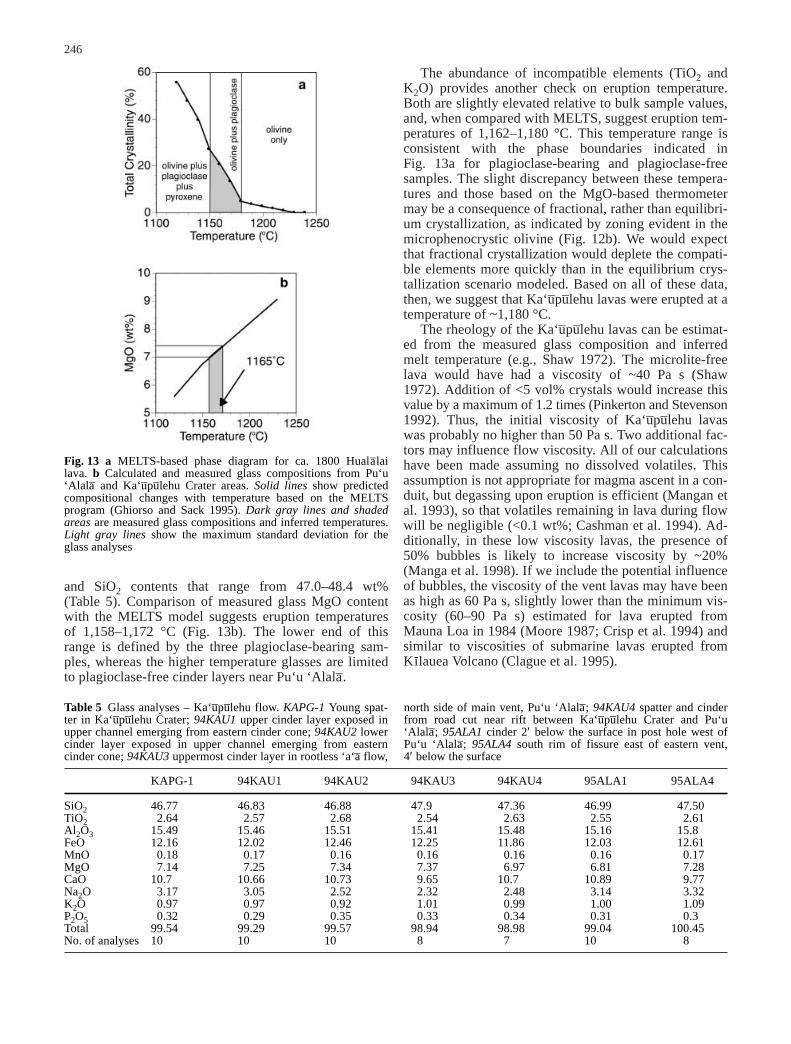
Baloga et al. (1995) state that Ka‘u–pu–lehu lava cooledvery little during flow emplacement. However, they pro-vide no supporting evidence for this statement. Absenceof flow cooling is not consistent with the predominanceof ‘a‘a– in the Ka‘u–pu–lehu flow, as ‘a‘a– does not formwithout extensive crystallization (Kilburn and Guest1993; Crisp et al. 1994; Cashman et al. 1999; Polacci etal. 1999). Crystallization during flow is confirmed bycomparison of the plagioclase-free vent spatter (Fig. 12c,d)with a plagioclase-bearing sample from the quenchedrind of a lava ball collected within a Ka‘u–pu–lehu chan-nel, just below the relay station locality. This sample hasnumerous microlites of plagioclase, olivine, and minor(quench?) pyroxene (Fig. 14), suggesting cooling of15–20° during transport away from the vent (e.g.,Fig. 13). Both the rate of cooling (~5°/km) and the highnumber density of microlites are similar to those ob-served in active channelized flows (Cashman et al.1999). However, the abundance of pa–hoehoe overflowslater in the eruption, particularly along the western flowlobe, does indicate that rates of lava cooling decreasedsubstantially as channels matured and portions of thechannel roofed over.
Absence of flow front thickening
The nearly uniform thickness of the Ka‘u–pu–lehu flow hasbeen cited as evidence for unusually fluid lava rheology(Baloga and Spudis 1993; Baloga et al. 1995). Flowthickening is indeed common in ‘a‘a– flows that stop inmid-slope (e.g., Lipman and Banks 1987; Kilburn andGuest 1993), but thickening does not occur when flowadvance is limited by interaction with the ocean. For ex-ample, ‘a‘a– levees of 3–4 m height at coastal Ka‘u–pu–lehuflow margins are comparable to those of the 1859 ‘a‘a–
flows from Mauna Loa, emplaced 6 km to the northalong the same coastal plain. Both effusion rates andflow front velocities of the 1859 ‘a‘a– flow are fairlywell-constrained at <200 m3/s and 0.04 m/s, respectively(Rowland and Walker 1990). At similar rates,
248

Ka‘u–pu–lehu flows would require >4 days to travel fromvent to coast, and >9 days for the total eruption durationrather than the 25 and 38 min for, respectively, flowfront advance and flow emplacement required by theminimum flow front velocity, 10 m/s, and mass eruptionrate, 7×10⁴ m3/s, suggested by Baloga et al. (1995).
In summary, we believe that the overall morphologyof the Ka‘u–pu–lehu flow indicates eruption at high rates(100–200 m3/s) over a relatively short time (one to threeweeks), but we find no support for the extraordinarilyhigh eruption rates (~105 m3/s) and rapid flow advance(~10 m/s) proposed by Baloga et al. (1995) and Guest etal. (1995).
Hu‘ehu‘e flow field
Most of the Hu‘ehu‘e flow field was emplaced around1800–1801 A.D., although eruptive episodes may haveboth pre- and post-dated this time period. Legends andpartial descriptions suggest that this eruption started atKı-leo Cone, although it seems more likely that activityat Kı-leo Cone initiated the later Manini‘o–wali eruptiveepisode. The Hu‘ehu‘e eruption commenced with thegeneration of ‘a‘a– flows fed by fountaining at the Puhi-a-Pele spatter vents (Figs. 10 and 11). Channelized ‘a‘a–
flows advanced down slope (and down rift), traveling atleast 5 km from the vents. The channel system migratedsouth with time, perhaps indicating non-steady effusion(e.g., Guest et al. 1987). Maturation of the channelsystem, perhaps accompanied by a decrease in effusionrate, allowed eventual transport of pa–hoehoe lava tocoastal areas. These channel-fed pa–hoehoe flows inun-dated the Pa‘aiea fishpond and are probably the flowsthat Kamehameha was called upon to stop. This phase ofthe eruption likely continued for at least days.
Pa–hoehoe emanating from a pre-existing lava tubenear the Puhi-a-Pele spatter cones postdated emplace-ment of the Puhi-a-Pele flow field and produced theManini‘o–wali pa–hoehoe flows. These flows were em-placed south of the Puhi-a-Pele flows, although theymantle the earlier flows near the lower highway(Fig. 11a, b). A well-developed tube system aided lavatransport to the coast during this phase of the eruption,and the tube may have occupied one of the Puhi-a-Pelechannels for a short stretch. The hummocky flow surfaceand pasty appearance of the lava suggest that much ofthe Manini‘o–wali flow was emplaced at low effusionrates (i.e., the 3–5 m3/s of the current Kı-lauea eruption;Kauahikaua et al. 1998). Evidence for extensive interac-tion with water at ocean entries includes spatter andsmall littoral cone formation that also suggest prolongedemplacement at low rates of effusion (e.g., Mattox andMangan 1997). We conclude that the initial, relativelyhigh effusion rate phase of the eruption may have lastedonly days, but the development of the entire Hu‘ehu‘eflow field probably occurred over several months duringthe 1800–1801 time period.
Thus, we find little in either the Ka‘u–pu–lehu or theHu‘ehu‘e flow field morphologies that would indicateanomalously fast flow advance. Instead, we concludethat most of morphological features of the Ka‘u–pu–lehuflow are similar to those observed to form during moder-ate to high effusion rate eruptions of Mauna Loa Volca-no, and that these eruptions provide a reasonable guideto both maximum expected rates of effusion and of flowfront advance during future eruptions of Huala–lai Vol-cano. In contrast, pa–hoehoe morphologies of theManini‘o–wali flow (Hu‘ehu‘e flow field) demonstratethat prolonged, low effusion rate eruptions of Huala–laiVolcano can produce large lava deltas and hummocky in-flated flow features similar in all respects to those cur-rently being produced at Kı-lauea Volcano.
249
Fig. 14 Backscattered SEM (BSE) photographs of a glassy sam-ple collected from a lava ball rind in the Ka‘u–pu–lehu channel be-low the relay station. Images are shown for two different magnifi-cations; labels are the same as in Fig. 12
Ka‘u–pu–lehu flow features directly related to xenolithnodule transport
The abundant xenoliths for which the Ka‘u–pu–lehu flow isfamous preserve important information on flow dynam-ics during the eruption, and, thus, enhance our under-standing of physical processes responsible for flow em-placement. Here we review earlier work concerningeruption conditions required for xenolith entrainment,provide an overview of xenolith distribution throughoutall phases of the Ka‘u–pu–lehu flow, and examine bothconditions of xenolith transport and the effect of thattransport on the development of Ka‘u–pu–lehu channels.
Ka‘u–pu–lehu xenoliths are cumulate in origin and arelikely the solidified remnants of magma chambers activeduring the tholeiitic stage of volcano growth (Jackson etal. 1981; Clague 1987; Bohrson and Clague 1988; Chenet al. 1992). Thus the xenoliths were probably entrainedat fairly shallow levels within the volcanic edifice. Ananalysis based strictly upon Stokes settling velocity (lowReynolds number, low particle concentration, Newtonianfluid) shows that the larger (50 cm diameter) noduleshave settling velocities of ~0.5–1.5 m/s (for xeno-lith.05–0.5 m in diameter, assuming a fluid viscosity of50 Pa s and a density contrast of 500 kg/m3;McGetchinand Eichelberger 1975). As effusive lava commonly ex-its from vents at >1 m/s, transport of xenoliths to the sur-face does not require unusually high eruptive velocities.More problematic are conditions of initial entrainment ofxenoliths at depth, assuming that equally high velocitiesare required. This problem may be partially alleviated ifthe magma possesses a yield strength (Sparks et al.1977), although the low crystal content of theKa‘u–pu–lehu tephra makes a substantial yield strength un-likely. The restriction of dispersed xenoliths to the earli-est phase of the eruption (the lava ball ‘a‘a–) suggests thatconditions suitable for entrainment occurred only earlyin the eruptive sequence. These conditions were likelycreated by the long repose interval preceding theKa‘u–pu–lehu eruption (~500–600 years), combined withthe intermediate depth of magma storage (Clague 1987),both of which would require that the magma break apathway to the surface after substantial pressurization.
Xenolith nodules are distributed throughout early ‘a‘a–
flows and are concentrated into nodule beds only withinthe western pa–hoehoe channel system (Fig. 3). Mostnodule transport and deposition occurred early in theeruption, as evidenced by preservation of xenoliths asouter (early) channel levee deposits, the breach of thelower lava pond (and accompanying slumping of noduledeposits) prior to the formation of both the western andeastern channel systems, later “beheading” of the chan-nel that fed the lower pond, and remelting of the inter-nodular lava and late-stage mobilization of nodules re-sulting from continued lava flow through the channels.Additionally, the presence of nodule-bearing lava crustsin the middle ball ‘a‘a– channel, the four separate nodulelayers exposed in channel walls at the relay station, andthe numerous nodule-bearing overflow deposits in chan-
nels below the relay station all support the interpretationthat numerous episodes of deposition and remobilizationof xenoliths occurred within this channel early in theeruptive sequence.
Nodule deposition is most pronounced at abruptbreaks in slope (Fig. 6), particularly at the relay stationlocality, reflecting the velocity decrease that accompa-nied flow widening. Nodules were remobilized andtransported further down the channel system when a ma-jor blockage of the lava tube feeding this area caused acatastrophic rupture and created a massive channel justbelow the relay station. Between the relay station siteand the lower pond, temporary ponding occurred locallywhere slopes decreased. Final deposition of xenoliths oc-curred at a major slope break at the 380-m elevation.
A notable consequence of xenolith transport was ero-sion of channel systems, as indicated by the anomalouslyhigh depth:width ratios of xenolith-bearing channels(Fig. 8). Initial transport of lava as bedload rather thansuspended load is suggested by calculated xenolith set-tling velocities (0.05–1.5 m/s), which are large relativeto the observed flow thicknesses (~1–5 m). Bedloadtransport efficiency is a function of bed shear stress, par-ticle size, and density contrast between the particle andthe fluid. Bed shear stress is controlled by the square ofthe flow velocity (e.g., Richards 1982). Although quanti-tative analysis of transport conditions is complicated byan absence of good constraints on the exact conditions offlow during transport (particularly the thickness of thebedload), xenoliths show no systematic decrease in sizewith distance of transport, as might be expected for sus-pended load transport under conditions of steadily de-creasing down-channel velocity. This observation, to-gether with the thick accumulation of xenoliths at themouth of the lower pond, suggests that the final episodeof xenolith transport may have occurred as a mass flowof high particle concentration.
Unusual aspects of the flows and implications for hazard assessment
Although the ca. 1800 lava flows from Huala–lai are sim-ilar in gross morphology to recent flows from MaunaLoa and Kı-lauea, some unusual features of the Huala–laiflows may be important for improved lava flow hazardassessment for this area. Two such features are the abun-dance of pa–hoehoe carried in ‘a‘a– channels and the ten-dency for those channels to partially roof over. A third isthe frequency of reoccupation of older cones and lavatube systems. The first two characteristics may be a man-ifestation of the lower initial viscosity of Huala–lai’s al-kali basalt composition, although the third may be a signof an aging volcano, where eruptions are separated bylong repose intervals and lava is preferentially funneledthrough existing pathways.
250

Pa–hoehoe-lined channels
Fluid pa–hoehoe lines the western channel system of theKa‘u–pu–lehu flow and most of the ‘a‘a– channels in thePuhi-a-Pele flow. Abundant thin overflows on channelmargins, partial tubing-over of portions of the channels,and abundant glassy spatter and drips on channel wallsall attest to the dominance of pa–hoehoe throughout muchof the active life of these channels. Although pa–hoehoeis a common feature of proximal ‘a‘a– channels formedon Kı-lauea and Mauna Loa (Lipman and Banks 1987;Wolfe et al. 1988), it is rare to find abundant pa–hoehoein medial to distal channel reaches.
What conditions of flow in channels permit extensivetransport of pa–hoehoe? At moderate to high flow rates,transport of lava as pa–hoehoe requires that the lavamaintain a low effective viscosity (Peterson and Tilling1980). Lava viscosity can remain low only if minimalcooling and crystallization occurs (e.g., Cashman et al.1999). Thus, transport of pa–hoehoe to distal parts of theKa‘u–pu–lehu flow requires either rapid transport of lava,or well-insulated channels. We suggest that both of theseconditions were met. Channel velocities may have beenas high as 9–12 m/s near the vent and 4–8 m/s in the me-dial regions. At these flow rates, lava could travel the4 km to the relay station site in 500–1,000 s and wouldbe transported to the lower pa–hoehoe channels (at12 km) in less than an hour. If rates of flow cooling weresimilar to those measured in recent open channel flows(~0.005 °C/s; Crisp et al. 1994; Cashman et al. 1999),these rapid flow rates would allow a maximum of 15 °Ccooling over 12 km, once channels were established.Cooling of 15 °C would result in a flow temperature of1,165 °C (assuming an eruption temperature of1,180 °C) and crystallinity of 15–20 vol% (Fig. 13),within the range found by Cashman et al. (1999) forpa–hoehoe morphologies.
There is also both direct and indirect evidence for la-va tube formation in the Ka‘u–pu–lehu and the Puhi-a-Pele‘a‘a– flows. Both channel systems have short stretchesthat have roofed over entirely. In the Puhi-a-Pele flow,channels within the ‘a‘a– appear to connect to large lavatubes preserved within the pa–hoehoe phase of the sameeruption. In the Ka‘u–pu–lehu flow, local breakouts fromlava tubes created mounds and small shields within theflow field, and catastrophic collapse of these tube sys-tems probably created the high headwalls and deep chan-nels that mark the downslope side of these features (par-ticularly at the relay station locality; Figs. 4 and 7). Ad-ditionally, late-stage hornito development and pa–hoehoebreakouts along the base of the first major slope break(Fig. 3) appear to mark locations of persistent lava tubeactivity during the waning stages of the Ka‘u–pu–lehueruption. Although the formation of lava tubes within‘a‘a– has been documented for many years (e.g., Macdonald1972; Guest et al. 1987), only recently has tube transportbeen recognized as an important component of many‘a‘a– eruptions (e.g., Calvari and Pinkerton 1998, 1999).Tube formation is important because it permits the trans-
port of lava to much greater distances than allowed by surface flow (e.g., Pinkerton and Wilson 1994;Kauahikaua et al. 1998).
Reoccupation of older lava pathways
Another characteristic of the ca. 1800 Huala–lai lavaflows is the re-occupation of older cones and lava tubes.Of the six discrete flows comprising the ca. 1800 unit, atleast four (Ka‘u–pu–lehu Crater flow, Ka‘u–pu–lehu flow, Kı-leo Cone flow, and Manini‘o–wali flow) issued frompre-existing structures. A fifth, the Pu–kı- flow, also ap-pears to have initiated within an older cone edifice that isnow only visible on the uprift side because the downriftand downslope sides of the vent have been overwhelmedby lava flows.
Conditions of reoccupation differed among thesevents. At the extremes, Pu‘u ‘Alala– hosted vigorousfountaining, with spatter-fed deposits adding substantial-ly to the height of the cone and a thick (~2 m) blanket ofspatter and tephra deposited in down wind areas. In con-trast, passive filling of Kı-leo Cone produced only minorspatter, and lava exiting from the tube that fed theManini‘o–wali flow shows no sign of any associatedfountaining. These differences in re-occupation style re-flect differences in flow emplacement styles of subse-quent flows from each area. Energetic fountaining ob-served in the Ka‘u–pu–lehu vent area resulted in the exten-sive ‘a‘a– of the Ka‘u–pu–lehu flow, both signs of high ratesof effusion. Passive upwelling of lava in Kı-leo Cone andpassive effusion of lava from the tube feeding the pa–hoe-hoe -dominated Manini‘o–wali flow are consistent withbehavior anticipated for low rates of effusion character-istic of pa–hoehoe flow emplacement.
Tube reoccupation is not unprecedented. Wentworthand Macdonald (1953) interpreted the lowest Mauna Loa1935 vent to be the result of a similar reoccupation of anancient lava tube, as was the lowest 1942 Mauna Loaflow. However, the combined evidence for reoccupationof both older cones and older tubes is not common andmay aid future hazard assessments at Huala–lai Volcano.
Conclusions
The ca. 1800 A.D. lava flows from Huala–lai Volcano ex-hibit a wide range in surface morphologies that reflect acorresponding range in conditions of eruption and flowemplacement, conditions that might be anticipated forfuture activity at Huala–lai Volcano. Careful mapping offlows produced during different phases of eruptive activ-ity can provide important clues to the eruption history,particularly when compared with flow morphologiesformed during well-characterized recent eruptions. Suchcomparisons suggest that the Ka‘u–pu–lehu and Puhi-a-Pele lava flows were erupted at moderate to high rates(~100 m3/s), well within the bounds of eruption rates ob-served during the past 150 years of activity at Mauna
251
Loa and Kı-lauea Volcanoes. In contrast, the hummockymorphology of the Manini‘o–wali flow indicates that itwas erupted at a much lower rate (<5 m3/s) and that em-placement probably occurred over a period of months.
We have identified several unusual features ofHuala–lai lava flows that will help to refine hazard as-sessments for the volcano. Our conclusion that oldercones and lava tubes are likely vent areas for futureeruptive activity can be used to improve flow coverageprobability maps by applying flow probability analysisto existing vent locations (e.g., Wadge et al. 1994). Ourobservations that alkali basalts of Huala–lai are morelikely to develop lava tubes within ‘a‘a– flows than arethe tholeiitic basalts of Mauna Loa and Kı-lauea requiremodification of simple empirical relationships betweeneruption rate and flow length to account for the insulat-ing effects of tubes. Additionally, if increased thermal ef-ficiency of channels allows more rapid transport of lavathrough those channels, then predictive flow modelsmust incorporate time-progressive modifications to lavatransport parameters. Finally, if the Ka‘u–pu–lehu andHu‘ehu‘e flows were separated in time, then current as-sessments of eruption recurrence intervals must be al-tered to accommodate this new information.
Acknowledgements The authors thank Sonia Calvari, ChrisKilburn, Pete Lipman, Ken Hon, and Don Swanson for very con-structive reviews and Perry Kealoha of the Kamehameha Schools,Huala–lai Ranch, Fred Duerr of the Kona Village Resort, andHeather Cole of the Ka‘u–pu–lehu Development Corporation forgraciously granting access to the property. This work was partiallysupported by NSF (EAR9508144 to K.V.C., and 9902851 toK.V.C. and J.P.K.).
References
Baloga S, Spudis PD (1993) Reconstruction of the dynamics ofthe 1800–1801 Hualalai eruption: implications for planetarylava flows (abstract). In: Lunar and Planetary Science Confer-ence, 24th, Abstracts, pp 55–56
Baloga S, Spudis PD, Guest JE (1995) The dynamics of rapidlyemplaced terrestrial lava flows and implications for planetaryvolcanism. J Geophys Res 100:24509–24519
Bishop DS (ed) (1829) Journal of Delia Stone (“Mrs. A.”). BishopMuseum, Honolulu, pp 20–21
Bohrson WA, Clague DA (1988) Origin of ultramafic xenolithscontaining exsolved pyroxenes from Hualalai Volcano, Hawaii.Contrib Mineral Petrol 100:139–155
Brigham WT (1909) The volcanoes of Kilauea and Mauna Loa onthe island of Hawaii, vol 2. Bernice P. Bishop Museum Mem-oirs
Bryan WA (1915) Natural history of Hawaii. Hawaiian GazetteCo. Ltd. Honolulu
Calvari S, Pinkerton H (1998) Formation of lava tubes and exten-sive flow field during the 1991–1993 eruption of Mount Etna.J Geophys Res 103:27291–27301
Calvari S, Pinkerton H (1999) Lava tube morphology on Etna andevidence for lava flow emplacement mechanisms. J VolcanolGeotherm Res 90:263–280
Campbell A (1967) A voyage round the world, from 1806 to 1812;in which Japan, Kamschatka, the Aleutian Island, and theSandwich islands were visited; including a narrative of theauthor's shipwreck on the island of Sannack, and his subse-quent wreck in the ship's long-boat: with an account of thepresent state of the Sandwich Islands, and a vocabulary oftheir language. University of Hawaii Press, Honolulu
Cashman KV, Mangan MT, Newman S (1994) Surface degassingand modifications to vesicle size distributions in active basaltflows. J Volcanol Geotherm Res 61:45–68
Cashman KV, Thornber C, Kauahikaua JP (1999) Cooling andcrystallization of lava in open channels, and the transition ofpa–hoehoe lava to ‘a‘a–. Bull Volcanol 61:306–323
Chen CH, Presnall DC, Stern R (1992) Petrogenesis of ultramaficxenoliths from the 1800 Kaupulehu flow, Hualalai Volcano,Hawaii. J Petrol 33:163–202
Choris L (1822) Isles Sandwich: voyage pittoresque autour dumonde. Firmin Didot, Paris, pp 1–2
Clague DA (1982) Petrology of tholeiitic basalt dredged fromHualalai Volcano, Hawaii (abstract). EOS, Trans Am GeophysUnion 63:1138
Clague DA (1987) Hawaiian xenolith populations, magma supplyrates, and development of magma chambers. Bull Volcanol49:577–587
Clague DA, Jackson ED, Wright TL (1980) Petrology of HualalaiVolcano, Hawaii: implication for mantle composition. In:Garcia MO, Decker RW (ed) Bulletin Volcanologique, G.A.Macdonald Special Memorial Issue, pp 641–656
Clague DA, Moore JG, Dixon JE, Friesen WB (1995) Petrology ofsubmarine lavas from Kilauea’s Puna Ridge, Hawaii. J Petrol36:299–349
Clague DA, Hagstrum JT, Champion DE, Beeson MH (1999) Kı-lauea summit overflows: their ages and distribution in thePuna District, Hawai‘i. Bull Volcanol 61:363–381
Clark H (1998) Hawaii’s two “sleeping giants” still threaten fierydestruction. Honolulu Advertiser, 26 July, pp A1, A17
Crisp J, Cashman KV, Bonini JA, Hougen SB, Pieri DC (1994)Crystallization history of the 1984 Mauna Loa lava flow. J Geophys Res 99:7177–7198
Dutton CE (1883) Recent exploration of the volcanic phenomenaof the Hawaiian Islands. Am J Sci 25:219–226
Dutton CE (1884) The Hawaiian volcanoes: US GeologicalSurvey, 4th Annual Report, Government Printing Office,Washington, DC, pp 75–219
Ellis W (1963) Journal of William Ellis – narrative of a tour ofHawaii, or Owyhee; with remarks on the history, traditions,manners, customs and language of the inhabitants of the Sand-wich Islands. Advertiser Publishing Company, Ltd. Honolulu
Finch RH, Macdonald GA (1953) Hawaiian volcanoes during1950. US Geol Surv Bull 996-B:27–89
Ghiorso MS, Sack RO (1995) Chemical mass transfer in magmaticprocesses. IV. A revised and internally consistent thermody-namic model for the interpolation and extrapolation of liq-uid–solid equilibria in magmatic systems at elevated tempera-tures and pressures. Contrib Mineral Petrol 119:197–212
Gilman G (ed) (1845) Trip to Hawaii. Hawaiian Historical SocietyLibrary
Guest JE, Kilburn CRJ, Pinkerton H, Duncan AM (1987) The evolution of lava flow-fields: observations of the 1981 and1993 eruptions of Mount Etna, Sicily. Bull Volcanol 49:527–540
Guest JE, Spudis PD, Greeley R, Taylor GJ, Baloga SM (1995)Emplacement of xenolith nodules in the Kaupulehu lava flow,Hualalai Volcano, Hawaii. Bull Volcanol 57:179–184
Hagstrum JT, Champion DE (1994) Paleomagnetic correlation ofLate Quaternary lava flows in the lower east rift zone ofKilauea Volcano, Hawaii. J Geophys Res 99:21679–21690
Heliker CC (1990) Volcanic and seismic hazards on the island ofHawaii. US Geological Survey General Interest Publication
Heliker CC, Wright TL (1991) The Pu‘u O‘o-Kupaianaha eruptionof Kilauea. EOS, Trans Am Geophys Union 72:521, 526, 530
Helz RT, Thornber CR (1987) Geothermometry of Kilauea Ikilava lake, Hawaii. Bull Volcanol 49:651–668
Helz RT, Banks NG, Heliker C, Neal CA, Wolfe EW (1995) Com-parative geothermometry of recent Hawaiian eruptions. J Geo-phys Res 100:17637–17657
Heslop SE, Wilson L, Pinkerton H, Head JW III (1989) Dynamicsof a confined lava flow on Kilauea Volcano, Hawaii. BullVolcanol 51:415–432
252
Hon K, Kauahikaua J, Denlinger R, Mackay K (1994) Emplace-ment and inflation of pahoehoe sheet flows: observations andmeasurements of active lava flows on Kilauea Volcano,Hawaii. Geol Soc Am Bull 106:351–370
Jackson ED, Clague DA (1982) Distribution of the nodule beds ofthe 1800–1801 Kaupulehu flow on Hualalai Volcano, island ofHawaii. US Geological Survey Miscellaneous Field StudiesMap MF-1355
Jackson ED, Clague DA, Engleman E, Friesen WB, Norton D(1981) Xenoliths in the alkalic basalt flows of Hualalai Volca-no, Hawaii. US Geological Survey Open-File Report 81-103
Jaggar TA Jr (1938) Our Hawaiian volcanoes. Castle and Cooke,Ltd.
Kamakau SM (1961) Ruling chiefs of Hawaii. The KamehamehaSchools Press, Honolulu
Kauahikaua J, Camara B (1996) The most recent eruptions ofHualalai Volcano, Hawai‘i: an annotated bibliography. USGeological Survey Open-File Report 96-671
Kauahikaua J, Camara B (2000) The most recent eruptions ofHuala–lai volcano, Hawai‘i: geological evidence from the his-torical record. In: McCoy F, Heikenin G (eds) Geologic haz-ards and antiquity. Geol Soc Am Spec Pap 345:25–32
Kauahikaua J, Cashman KV, Mattox TN, Heliker, CC, Hon KA,Mangan MT, Thornber CR (1998) Observations on basaltic la-va streams in tubes from Kı-lauea volcano, island of Hawai‘i. JGeophys Res 103:27303–27323
Kilburn CRJ, Guest JE (1993) Aa lavas of Mount Etna, Sicily. In:Kilburn CRJ, Luongo G (eds) Active lavas: monitoring andmodelling. University College London Press, London, pp 73–106
Lipman PW, Banks NG (1987) Aa flow dynamics, Mauna Loa1984. In: Decker RW, Wright TL, Stauffer PH (eds) US Geo-logical Survey Professional Paper 1350: volcanism in Hawaii.pp 1527–1567
Lisianskii IF (1968) Voyage round the world in the years 1803,1804, 1805, and 1806. Da Capo Press, New York
Macdonald GA (1968) Composition and origin of Hawaiian lavas.Geol Soc Am Mem 116:477–522
Macdonald GA (1972) Volcanoes. Prentice-Hall, Inc. EnglewoodCliffs
Maguire ED (1966) Kona legends. Petroglyph Press, Hilo,pp 4–10
Manga M, Castro J, Cashman KV, Loewenberg M (1998) Rheol-ogy of bubble-bearing magmas. J Volcanol Geotherm Res87:15–28
Mangan MT, Cashman KV, Newman S (1993) Vesiculation of ba-saltic magma during eruption. Geology 21:157–160
Mattox TN, Mangan MT (1997) Littoral hydrovolcanic explo-sions: a case study of lava–seawater interaction at KilaueaVolcano. J Volcanol Geotherm Res 75:1–17
Mattox TN, Heliker C, Kauahikaua J, Hon K (1993) Developmentof the 1990 Kalapana flow field, Kilauea Volcano, Hawaii.Bull Volcanol 55:407–413
McFadden PL, Jones DL (1981) The fold test in palaeomagnetism.Geophys J R Astron Soc 67:53–58.
McGetchin TR, Eichelberger (1975) Solid Earth geosciencesresearch activities at LASL, July 1–December 31, 1974. LosAlamos Scientific Laboratory of the University of California,Los Alamos, pp 77–90
Montierth C, Johnston AD, Cashman KV (1995) An empiricalglass-composition-based geothermometer for Mauna Loa la-vas. In: Rhodes JM, Lockwood JP (eds) Mauna Loa revealed:structure, composition, history, and hazards. Am GeophysUnion Geophys Monogr 92:207–217
Moore HJ (1987) Preliminary estimates of the rheological proper-ties of 1984 Mauna Loa lava. In: Decker RW, Wright TL,Stauffer PH (eds) Volcanism in Hawaii. US Geol Surv ProfPap 1350:1569–1588
Moore JG (1970) Pillow lava in a historic lava flow from HualalaiVolcano, Hawaii. J Geol 78:239–243
Moore RB, Clague DA (1991) Geologic map of Hualalai Volcano,Hawaii. US Geological Survey Miscellaneous InvestigationsMap I-2213
Moore RB, Clague DA, Rubin M, Bohrson WA (1987) HualalaiVolcano: a preliminary summary of geologic, petrologic, andgeophysical data. In: Decker RW Wright TL, Stauffer PH(eds) Volcanism in Hawaii. US Geol Surv Prof Pap 1350:571–585
Oberwinder M (1996) Genese und interne Struktur des oberenTeiles des lavastromes von 1801 (Genesis and internal struc-ture of the upper part of the 1801 lava flow). Master’s Thesis,University of Kiel
Peterson DW, Tilling RI (1980) Transition of basaltic lava frompahoehoe to a‘a, Kilauea Volcano Hawaii: field observationsand key factors. In: McBirney AR (ed) Gordon A. MacdonaldMemorial Volume. J Volcanol Geotherm Res Spec Issue,pp 271–293
Pinkerton H, Sparks RSJ (1976) The 1975 sub-terminal lavas,Mount Etna: a case history of the formation of a compoundlava field. J Volcanol Geotherm Res 1:167–182
Pinkerton H, Sparks RS (1978) Field measurements of the rheolo-gy of lava. Nature 276:383–384
Pinkerton H, Stevenson RJ (1992) Methods of determining therheological properties of magmas at sub-liquidus tempera-tures. J Volcanol Geotherm Res 53:47–66
Pinkerton H, Wilson L (1994) Factors controlling the lengths ofchannel-fed lava flows. Bull Volcanol 56:108–120
Polacci M, Cashman KV, Kauahikaua J (1999) Textural character-ization of the pahoehoe–aa transition in Hawaiian basalt. BullVolcanol 60:595–609
Powers S (1920) Notes on Hawaiian petrology. Am J Sci50:256–280
Richards K (1982) Rivers: forms and process in alluvial channels.Methuen, London
Richter DH, Murata K. (1961) Xenolithic nodules in the1800–1801 Kaupulehu flow of Haulalai Volcano. US GeolSurv Prof Pap 424-B:B215–B217
Rowland SK, Walker GP (1990) Pahoehoe and aa in Hawaii: volu-metric flow rate controls the lava structure. Bull Volcanol52:615–628
Schwartz DA, Fornari DJ (1982) Submersible investigations of thenorthwest rift zone of Hualalai Volcano, Hawaii (abstract).EOS, Trans Am Geophys Union 63:1138
Shaw HR (1972) Viscosities of magmatic silicate liquids; an em-pirical method of prediction. Am J Sci 272:870–893
Sims KWW, DePaolo DJ, Murrell MT, Baldridge WS, GoldsteinS, Clague DA, Jull M (1999) Porosity of the melting zone andvariations in the solid mantle upwelling rate beneath Hawaii:inferences from 238U–230Th–226Ra and 235U–231Pa disequilib-ria. Geochem Cosmochem Acta 63:4119–4138
Sparks RS, Pinkerton H, MacDonald R (1977) The transport ofxenoliths in magmas. Earth Planet Sci Lett 35:234–238
Stearns HT (1966) Geology of the State of Hawaii. Pacific Books,Palo Alto, CA
Stearns HT, Macdonald GA (1946) Geology and ground-waterresources of the island of Hawaii. Hawaii (Terr.), scale1:125,000. Division of Hydrography Bulletin 9
Wadge G, Young PAV, McKendrick IJ (1994) Mapping lava flowhazards using computer simulation. J Geophys Res 99:489–504
Wentworth CK, Macdonald GA (1953) Structures and forms ofbasaltic rocks in Hawaii. US Geol Surv Bull vol 994
Wolfe EW (ed) (1988) The Puu Oo eruption of Kilauea Volcano,Hawaii: episodes 1 through 20, January 3, 1983, through June8, 1984, (folded maps, scale 1:50,000 in pocket. US Geologi-cal Survey Professional Paper 1463
Wolfe EW, Neal CA, Banks NG, Duggan TJ (1988) Geologic ob-servations and chronology of eruptive events. In: Wolfe EW(ed) The Puu Oo eruption of Kilauea Volcano, Hawaii: epi-sodes 1 through 20, January 3, 1983, through June 8, 1984,folded maps, scale 1:50,000 in pocket. US Geological SurveyProfessional Paper 1463
253