energy working for britain wylfa newydd project · pdf fileoff-site power station facilities:...
TRANSCRIPT
© Horizon Nuclear Power Wylfa Limited
1 | SECTION HEADEREN
ERGY WO
RKING FO
R BRITAIN
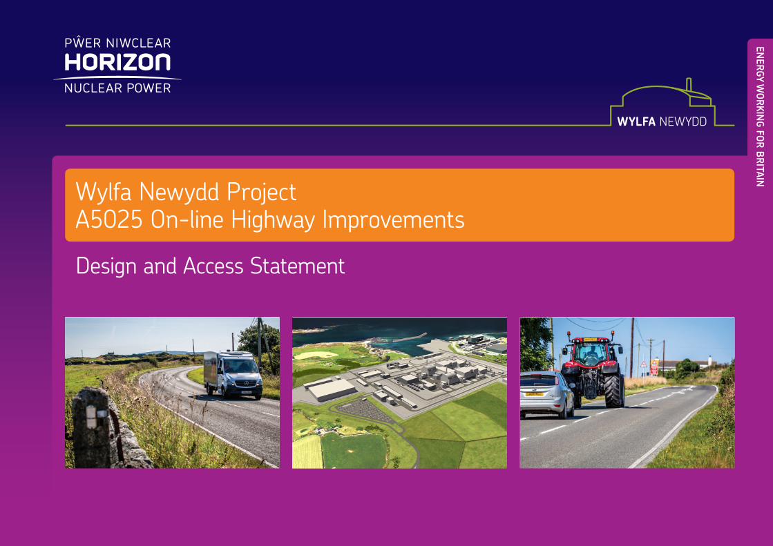
Wylfa Newydd ProjectA5025 On-line Highway Improvements
Design and Access Statement

Wylfa Newydd Project Design Access Statement A5025 On-line Highway Improvements
© Horizon Nuclear Power Wylfa Limited
Page i
Contents 1 Introduction ....................................................................................................... 1 1.1 Overview .......................................................................................................... 1
Context ............................................................................................................. 1 1.2 Requirement for a Design and Access Statement ............................................ 3 1.3 Overview and Objectives .................................................................................. 3 1.4 Description of the Proposed Development ....................................................... 3
Overview of Improvements within Sections 1, 3, 5 and 7 ................................. 4 Overview of Improvements within Sections 2, 4, 6 and 8 ................................. 4
2 Site Context ...................................................................................................... 5 2.1 Overview .......................................................................................................... 5 2.2 Physical Context ............................................................................................... 5 2.3 Economic Context ............................................................................................ 9 2.4 Social Context .................................................................................................. 9 2.5 Policy Context .................................................................................................. 9
National planning policy context ....................................................................... 9 Local planning policy context ............................................................................ 9
2.6 Consultation ................................................................................................... 11 A5025 On-line Highway Improvements responses ......................................... 11 Stage Three Pre-Application Consultation (May 2017) ................................... 12 Statutory Pre-Application Consultation (July 2017) ........................................ 12 Stakeholder engagement ............................................................................... 12
2.7 Summary of design development ................................................................... 12 Road design development .............................................................................. 12 Temporary Construction Compound ............................................................... 13
3 Design Principles and Concepts of Proposed Development .......................... 14 3.1 Overview ........................................................................................................ 14 3.2 Concepts ........................................................................................................ 14 3.3 Key elements of the A5025 On-line Highway Improvements .......................... 14
Widening ........................................................................................................ 14 Reconstruction ............................................................................................... 14 Surface Dressing ............................................................................................ 14 Temporary Construction Compound ............................................................... 14
3.4 The overall site scale ...................................................................................... 15 3.5 Landscape proposals ..................................................................................... 15 3.6 Lighting proposals .......................................................................................... 17 3.7 Community Safety .......................................................................................... 17
A5025 Safety .................................................................................................. 17 Temporary Construction Compound Safety ................................................... 17 Community ..................................................................................................... 17
4 Environmental Sustainability .......................................................................... 18 4.1 Sustainable Design ......................................................................................... 18
Drainage and water ......................................................................................... 18 Building materials ............................................................................................ 18 Lighting ........................................................................................................... 18
4.2 Natural Habitats .............................................................................................. 18 4.3 Waste .............................................................................................................. 19 5 Accessibility and Movement ............................................................................ 19 6 Construction .................................................................................................... 20 7 Post operation ................................................................................................. 21 8 Summary ......................................................................................................... 21 9 Abbreviations and Glossary ............................................................................ 22 10 References ...................................................................................................... 30
List of Tables Table 5-1 Construction traffic forecasts .................................................................... 19 Table 10-1 Schedule of references ....................................................................... 30
List of Figures Figure 1-1 Overview of the A5025 On-line Highway Improvements ............................. 2 Figure 1-2 Section of new carriageway at Bytheicws (Section 4) ................................. 4 Figure 2-1 Typical stone wall ....................................................................................... 5 Figure 2-2 Typical hedgerow ........................................................................................ 6 Figure 2-3 Environmental features along the A5025 Sections 1-4 ............................... 7 Figure 2-4 Environmental features along the A5025 Sections 5-8 ............................... 8 Figure 3-1 Sketch of proposed stone wall cross section ............................................ 16 Figure 3-2 Sketch of proposed stone wall elevation ................................................... 16 Figure 3-3 Sketch of proposed clawdd ....................................................................... 16 Figure 3-4 Indicative Temporary Construction Compound Layout ............................. 17

Design Access Statement Wylfa Newydd ProjectA5025 On-line Highway Improvements
© Horizon Nuclear Power Wylfa Limited Page ii
[This page is intentionally blank]

Wylfa Newydd Project Design Access Statement A5025 On-line Highway Improvements
© Horizon Nuclear Power Wylfa Limited
Page 1
1 Introduction 1.1 Overview 1.1.1 This Design and Access Statement (DAS) has been prepared by Horizon Nuclear Power
Wylfa Limited (Horizon) in support of a full planning application for proposed on-line highway improvements to the existing A5025, for submission to the Isle of Anglesey County Council (IACC). These improvements seek to address physical and operational constraints on the stretch of the A5025 between Valley and the proposed Power Station Access Road Junction south of Tregele, in relation to its width, alignment, overtaking opportunities and surfacing condition.
1.1.2 The improvements are required in order to mitigate the predicted impacts of increased traffic associated with construction activities that would be undertaken at the Wylfa Newydd Development Area, and from operational Power Station traffic, that would travel along this part of the highway network. The purpose of this DAS is to communicate how the design of the proposal, including access, has been considered from the outset of the development process and how the objectives of good design have been used to inform this, based on the principles set out in the Design Approach and Landscape Strategy, to be submitted in support of this application.
Context 1.1.3 Horizon is applying to the Secretary of State for a Development Consent Order (DCO)
under the Planning Act 2008 to construct, operate and maintain a new nuclear power station on land west of Cemaes on the Isle of Anglesey.
1.1.4 The Wylfa Newydd Project (the Project) comprises the Wylfa Newydd DCO Project and the Enabling Works.
1.1.5 The Wylfa Newydd DCO Project is defined as those parts of the Project which are to be consented by the DCO, comprising: the Power Station; other on-site development; the Marine Works; the Off-Site Power Station Facilities; and the Associated Development:
Power Station: the proposed new Nuclear Power Station, including two UK Advanced Boiling Water Reactors to be supplied by Hitachi-GE Nuclear Energy Ltd., supporting facilities, buildings, plant and structures, and radioactive waste and spent fuel storage buildings;
Other on-site development: including landscape works and planting, drainage, surface water management systems, public access works including temporary and permanent closures and diversions of public rights of way, new Power Station Access Road and internal site roads, car parking, construction compounds and temporary parking areas, laydown areas, working areas and temporary works and structures, temporary construction viewing area, diversion of utilities, perimeter and construction fencing;
Marine Works: comprising a Cooling Water System intake and outfall, Marine Off-Loading Facility and breakwater structures;
Off-Site Power Station Facilities: comprising the Alternative Emergency Control Centre (AECC), Environmental Survey Laboratory (ESL) and a Mobile Emergency Equipment Garage (MEEG); and
Associated Development: comprising works included in the DCO which facilitate the delivery of the Nationally Significant Infrastructure Project, and which principally include: a Site Campus providing accommodation for construction workers; a temporary Park and Ride facility at Dalar Hir for construction workers; a temporary Logistics Centre at Parc Cybi; A5025 Off-line Highway Improvements; and an electrical connection to the National Grid substation.
1.1.6 Horizon will prepare planning applications under the Town and Country Planning Act 1990 (as amended) (the ‘TCPA’) for the Enabling Works, to be submitted to the IACC as the determining local planning authority.
1.1.7 The Enabling Works comprise the A5025 On-line Highway Improvements TCPA works (the Proposed Development) and the Site Preparation and Clearance (SPC) TCPA works.
1.1.8 The following terms are used in this document when describing the geographical areas related to the Project:
Power Station Site - the indicative areas of land and sea within which the majority of the permanent Power Station buildings, plant and structures would be situated. It would include the two nuclear reactors, steam turbines, the Cooling Water System intake and pumphouse, outfall structures, breakwaters, the Site Campus and the Marine Off-Loading Facility, as well as other ancillary structures.
Wylfa Newydd Development Area - the indicative areas of land and sea including the areas surrounding the Power Station Site that would be used for the construction and operation of the Power Station. This area is representative of the maximum area that would be physically affected by Power Station Main Construction activities and used to form the setting and features of the operational Power Station.
1.1.9 As outlined in paragraph 1.1.1, this DAS relates to the Proposed Development (see figure 1-1). Please refer to the glossary in section 9 for the terms used in this Design and Access Statement.
Design Access Statement Wylfa Newydd ProjectA5025 On-line Highway Improvements
© Horizon Nuclear Power Wylfa Limited Page 2
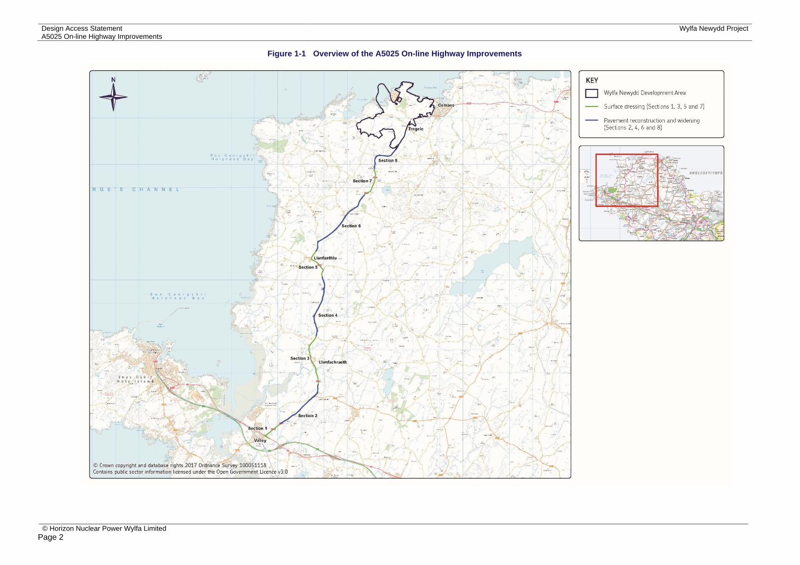
Figure 1-1 Overview of the A5025 On-line Highway Improvements

Wylfa Newydd Project Design Access Statement A5025 On-line Highway Improvements
© Horizon Nuclear Power Wylfa Limited
Page 3
1.2 Requirement for a Design and Access Statement 1.2.1 Current requirements for Design and Access Statements in Wales are set out in the Town
and Country Planning (Development Management Procedure) (Wales) Order 2012 (as amended) [RD1].
1.2.2 ‘Major’ developments, with the exception of engineering operations and change of use of land or buildings, require a Design and Access Statement to accompany the application submission. The Proposed Development falls under the definition of major development as it is being carried out on a site having an area of 1 hectare or more1.
1.2.3 Article 7 of the Town and Country Planning (Development Management Procedure) (Wales) Order 2012 (as amended) [RD1] confirms that Design and Access Statements are required to:
Explain the design principles and concepts that have been applied to the development;
Demonstrate the steps taken to appraise the context of the development and how the design of the development takes that context into account;
Explain the policy or approach adopted to access, and how policies relating to access in the development plan have been taken into account; and
Explain how any specific issues which might affect access to the development have been addressed.
1.2.4 Technical Advice Note 12: Guidance on Design and Access Statements, published by the Welsh Government in March 2016 [RD2], and the ‘Design and Access Statements in Wales’ guidance issued by Design Commission for Wales in 2014 [RD3] have also been considered.
1.2.5 The matters listed above have been incorporated in the preparation of this Design and Access Statement.
1.3 Overview and Objectives 1.3.1 The A5025 Highway Improvements form an important component of the Wylfa Newydd
Project, and are required as part of the wider transport strategy. National policy recognises the urgent need for new nuclear power stations, to be brought forward as soon as possible [RD4]. Should the DCO be granted for the Wylfa Newydd DCO Project, it would be necessary for construction traffic to use the A5025 from the A5 east of Valley junction to travel to the Wylfa Newydd Development Area.
1.3.2 Whilst the Proposed Development is required to facilitate the Wylfa Newydd Project, the existing road does not meet current highway standards and needs improving. The existing route has issues in relation to its width, alignment and overtaking opportunities, which currently affect the movement of traffic along the road.
1.3.3 The objectives of the Proposed Development are to:
1 As defined article 2 of the Town and Country Planning (Development Management Procedure) (Wales) Order 2012 (as amended) [RDx)
upgrade the route, both in terms of standard of construction and road geometry, such that it can support increased levels of traffic, and improve safety and accessibility;
ensure that all relevant abnormal loads can pass along the full length of the A5025; reduce any potential increase in road accident risk; reduce any adverse impacts on local communities; reduce any adverse impacts on the environment; and seek opportunities where possible to achieve improvements for local communities
and the environment through road design measures.
1.4 Description of the Proposed Development 1.4.1 Whilst the Proposed Development is relatively limited in nature compared to later phases
of the Power Station works, it is intrinsically linked to later construction phases, allowing the ingress and egress of vehicles carrying materials and construction equipment. The works are also essential to facilitate access to the Power Station by servicing and maintenance vehicles once it becomes operational.
1.4.2 The description of the Proposed Development is as follows:
“Improvements to the existing A5025 between the A5 east of Valley junction to the proposed Power Station Access Road Junction, to include reconstruction and localised widening of the existing pavement and application of a surface dressing. The proposals also comprise a Temporary Construction Compound including a temporary pavement recycling facility, and other associated works such as drainage infrastructure, boundary treatments, planting, new signage and road markings”.
1.4.3 The Proposed Development extends to 16.19km of the existing A5025 between Valley and the proposed Power Station Access Road Junction and is proposed to be implemented along the following sections (see Figure 1-1 for their location):
Section 1 – A5 east of Valley junction to north of Valley Junction (A5/A5025) – a length of 1.06km;
Section 2 – north of Valley Junction (A5/A5025) to north of Llanynghenedl – a length of 2.46km;
Section 3 – north of Llanynghenedl to north of Llanfachraeth – a length of 2.28km; Section 4 – north of Llanfachraeth to south of Llanfaethlu – a length of 2.7km; Section 5 – south of Llanfaethlu to north of Llanfaethlu – a length of 1.43km; Section 6 – north of Llanfaethlu to north of Llanrhuddlad – a length of 3.36km; Section 7 – north of Llanrhuddlad to north of Cefn Coch – a length of 1.3km; and Section 8 – north of Cefn Coch to the proposed Power Station Access Road Junction
– a length of 1.6km.
Design Access Statement Wylfa Newydd ProjectA5025 On-line Highway Improvements
© Horizon Nuclear Power Wylfa Limited Page 4
1.4.4 The Proposed Development involves the implementation of on-line improvements largely within the existing highway boundary of the A5025. In summary, these comprise:
improvement of the existing pavement through the application of a surface dressing through Sections 1, 3, 5 and 7;
reconstruction and localised widening of the existing pavement through Sections 2, 4, 6 and 8;
modifications and improvements to existing signage and road markings through Sections 1–8; and
the construction of a Temporary Construction Compound (incorporating a temporary pavement recycling facility) within Section 7, immediately adjacent to the A5025.
1.4.5 The A5025 Off-line Highway Improvements would be implemented around the time of completion of the Proposed Development (subject to the grant of consent) through Sections 1, 3, 5 and 7. In summary, these would involve the construction of bypasses to reduce the effects of future traffic on existing communities, the formation of new junction arrangements (including the provision of the proposed Power Station Access Road Junction), and localised improvements to existing bends.
1.4.6 The A5025 Off-line Highway Improvements form an integral component of the Wylfa Newydd DCO Project application, and do not form part of the planning application for the Proposed Development.
Overview of Improvements within Sections 1, 3, 5 and 7 1.4.7 Works involving the application of surface dressing to the existing pavement would be
undertaken within Sections 1, 3, 5 and 7, under traffic management conditions.
1.4.8 Surface dressing would be applied through the laying of a bitumen binder followed by the application of chippings to improve skid resistance. Road markings would then be applied following adhesion, and existing signage would be replaced where necessary.
1.4.9 No changes would be made to existing drainage regimes, junctions, accessibility, boundary treatments or landscaping, and no permanent land take or earthworks would be required to implement the surface dressing.
1.4.10 The Temporary Construction Compound, incorporating the temporary pavement recycling facility, would be located within a site adjacent to the A5025 at Cefn Coch (Section 7), including a temporary pavement recycling facility, which would handle and process highway arisings. The Temporary Construction Compound would be used for site offices in the form of portable cabins, construction staff parking, storage of construction materials, storage and management of waste (including a cess pit and portable toilets); potential short-term parking of plant when not in use or awaiting transport off-site, and for welfare facilities. The site is approximately 1.28ha in size and is located 1.1km north of Llanrhuddlad. Following the removal of the Temporary Construction Compound, the site will be restored to an agreed condition.
Overview of Improvements within Sections 2, 4, 6 and 8 1.4.11 Reconstruction and widening of the existing pavement would be undertaken within
Sections 2, 4, 6 and 8.
1.4.12 The improvements have been designed to follow the existing horizontal and vertical alignment of the existing carriageway wherever possible. Widening would be undertaken to provide a minimum cross-section (width) of 7.3m, comprising a carriageway width of 6.7m and a 0.3m wide hardstrip on either side of the paved area. Additional widening would be provided on some existing bends to enable Heavy Goods Vehicles (HGVs) to pass safely.
1.4.13 A minimum 450mm verge width would be provided within the existing highway boundary on either side of the road, where possible. Where this is not achievable, widening outside the existing highway boundary would be necessary.
1.4.14 Widening beyond the highway boundary would require small amounts of land to be taken permanently, with boundaries reinstated in new positions. In locations where widening outside the highway boundary is required and it is deemed practical, a 700mm minimum verge width would be provided.
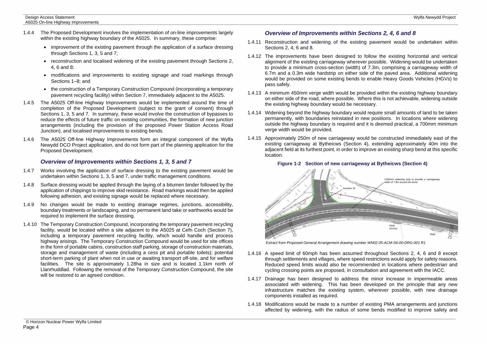
1.4.15 Approximately 250m of new carriageway would be constructed immediately east of the existing carriageway at Bytheicws (Section 4), extending approximately 40m into the adjacent field at its furthest point, in order to improve an existing sharp bend at this specific location.
Figure 1-2 Section of new carriageway at Bytheicws (Section 4)
1.4.16 A speed limit of 60mph has been assumed throughout Sections 2, 4, 6 and 8 except through settlements and villages, where speed restrictions would apply for safety reasons. Reduced speed limits would also be recommended in locations where pedestrian and cycling crossing points are proposed, in consultation and agreement with the IACC.
1.4.17 Drainage has been designed to address the minor increase in impermeable areas associated with widening. This has been developed on the principle that any new infrastructure matches the existing system, wherever possible, with new drainage components installed as required.
1.4.18 Modifications would be made to a number of existing PMA arrangements and junctions affected by widening, with the radius of some bends modified to improve safety and
Extract from Proposed General Arrangement drawing number WN02.05-ACM-S6-00-DRG-001 R1
Field Access
1200mm widening strip to provide a carriageway width of 7.9m around the bend
Junction 16
PMA
Wylfa Newydd Project Design Access Statement A5025 On-line Highway Improvements
© Horizon Nuclear Power Wylfa Limited
Page 5
forward visibility. Boundary treatments, walls and hedges would be aligned to provide better visibility. Improvements, such as the installation of gates, would also be made to several PRoWs that meet the road, and short new sections of cycleway would be formed. The majority of existing laybys would be retained and unaffected by the widening.
1.4.19 Low-noise road surfacing, comprising a thin surface course material incorporating 10mm aggregate, would be applied to reduce the effects of noise associated with future traffic flows along the highway (these being associated with the construction and future operation of the Power Station).
1.4.20 Widening would also require the replacement of some bus shelters, telephone boxes, road markings and signage at different locations along the highway.
1.4.21 Sections of carriageway made redundant by the Proposed Development, such as those resulting from the improvements at Bytheicws (Section 4), would be stopped up and returned to adjacent landowners.
1.4.22 Full information relating to the Proposed Development is set out at Section 3 of the Planning Statement and Section 2 of the Environmental Report.
2 Site Context 2.1 Overview 2.1.1 This section gives a contextual description of the A5025 from Valley to the Power Station
Access Road Junction (the site of the Proposed Development) and the surrounding area, providing an informed evidence base to guide the principles and concepts of the Proposed Development.
2.2 Physical Context 2.2.1 The A5025 is a principal transportation route around the western, northern and eastern
parts of the Isle of Anglesey . The route connects the northern coast and villages in the west and north to the A55 at two points, one in the north-west and one in the south-east at the Menai Bridge.
2.2.2 The A5025 forms the main access route to the existing Magnox Power Station on the northern coastline near Tregele, and provides access to a number of small villages and scattered rural properties dispersed across agricultural land.
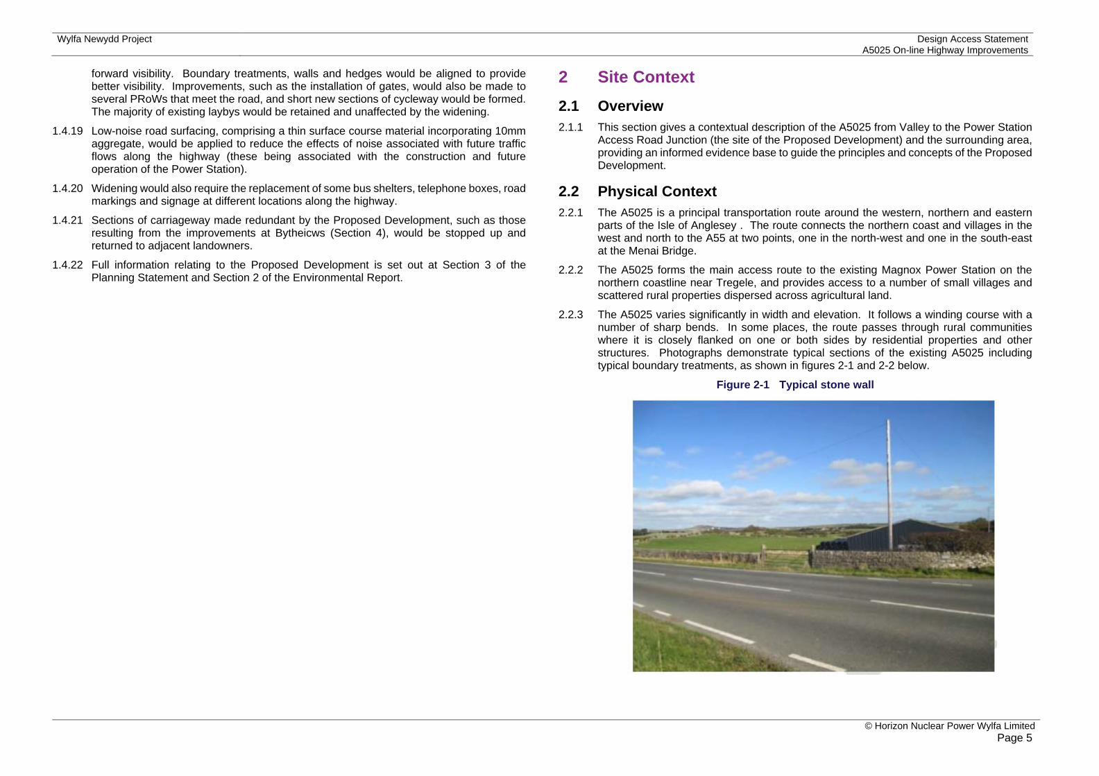
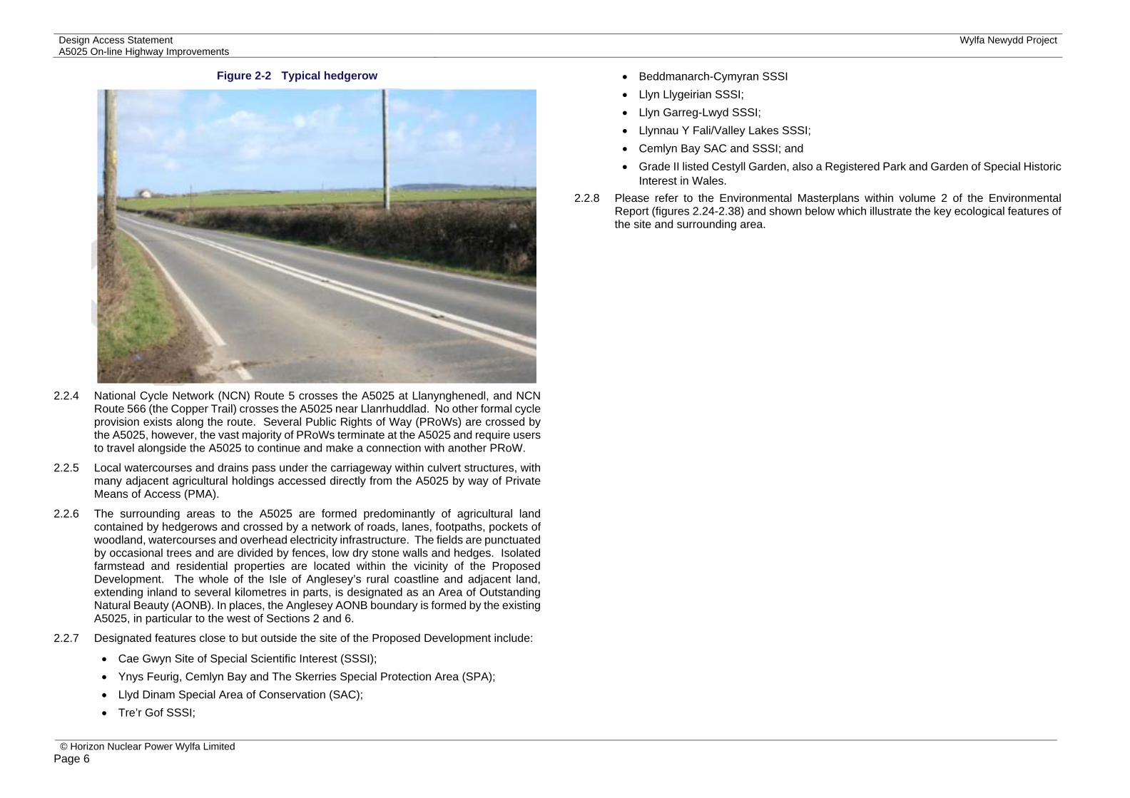
2.2.3 The A5025 varies significantly in width and elevation. It follows a winding course with a number of sharp bends. In some places, the route passes through rural communities where it is closely flanked on one or both sides by residential properties and other structures. Photographs demonstrate typical sections of the existing A5025 including typical boundary treatments, as shown in figures 2-1 and 2-2 below.
Figure 2-1 Typical stone wall
Design Access Statement Wylfa Newydd ProjectA5025 On-line Highway Improvements
© Horizon Nuclear Power Wylfa Limited Page 6
Figure 2-2 Typical hedgerow
2.2.4 National Cycle Network (NCN) Route 5 crosses the A5025 at Llanynghenedl, and NCN
Route 566 (the Copper Trail) crosses the A5025 near Llanrhuddlad. No other formal cycle provision exists along the route. Several Public Rights of Way (PRoWs) are crossed by the A5025, however, the vast majority of PRoWs terminate at the A5025 and require users to travel alongside the A5025 to continue and make a connection with another PRoW.
2.2.5 Local watercourses and drains pass under the carriageway within culvert structures, with many adjacent agricultural holdings accessed directly from the A5025 by way of Private Means of Access (PMA).
2.2.6 The surrounding areas to the A5025 are formed predominantly of agricultural land contained by hedgerows and crossed by a network of roads, lanes, footpaths, pockets of woodland, watercourses and overhead electricity infrastructure. The fields are punctuated by occasional trees and are divided by fences, low dry stone walls and hedges. Isolated farmstead and residential properties are located within the vicinity of the Proposed Development. The whole of the Isle of Anglesey’s rural coastline and adjacent land, extending inland to several kilometres in parts, is designated as an Area of Outstanding Natural Beauty (AONB). In places, the Anglesey AONB boundary is formed by the existing A5025, in particular to the west of Sections 2 and 6.
2.2.7 Designated features close to but outside the site of the Proposed Development include:
Cae Gwyn Site of Special Scientific Interest (SSSI); Ynys Feurig, Cemlyn Bay and The Skerries Special Protection Area (SPA); Llyd Dinam Special Area of Conservation (SAC); Tre’r Gof SSSI;
Beddmanarch-Cymyran SSSI Llyn Llygeirian SSSI; Llyn Garreg-Lwyd SSSI; Llynnau Y Fali/Valley Lakes SSSI; Cemlyn Bay SAC and SSSI; and Grade II listed Cestyll Garden, also a Registered Park and Garden of Special Historic
Interest in Wales. 2.2.8 Please refer to the Environmental Masterplans within volume 2 of the Environmental
Report (figures 2.24-2.38) and shown below which illustrate the key ecological features of the site and surrounding area.

Wylfa Newydd Project Design Access Statement A5025 On-line Highway Improvements
© Horizon Nuclear Power Wylfa Limited
Page 7
Figure 2-3 Environmental features along the A5025 Sections 1-4

Design Access Statement Wylfa Newydd ProjectA5025 On-line Highway Improvements
© Horizon Nuclear Power Wylfa Limited Page 8
Figure 2-4 Environmental features along the A5025 Sections 5-8

Wylfa Newydd Project Design Access Statement A5025 On-line Highway Improvements
© Horizon Nuclear Power Wylfa Limited
Page 9
2.3 Economic Context 2.3.1 Employment in agriculture is of significant local importance, whilst employment in the
construction sector is slightly higher locally to the A5025 than within the Isle of Anglesey or the rest of Wales.
2.3.2 Beneficial effects are likely to be realised as a result of the Proposed Development through the provision of local employment opportunities for construction workers. It is anticipated that construction would be carried out over a 66-week period (excluding a 4-week restoration period for the Temporary Construction Compound). Based on 125 workers required throughout the 66-week duration of construction, this results in an estimate of 159 job-years of employment (where one job-year equates to one job held for one year) as a direct result of the construction of the Proposed Development.
2.3.3 No direct impacts on employment are expected as a result of the operation of the Proposed Development. Please refer to Section 4 of the Environmental Report for further details regarding the socio-economic impacts of the Proposed Development.
2.4 Social Context 2.4.1 The A5025 forms the main access route to the Existing Power Station and provides access
to a number of small villages and scattered rural properties dispersed across an area traditionally dominated by agriculture and the tourism industry.
2.4.2 The main communities situated along the site of the Proposed Development include the villages of Llanrhuddlad, Llanfaethlu, Llanfachraeth, Llanynghenedl and Valley. Facilities within these villages include shops, places of worship, hotels and accommodation, recreational areas and places of education. A small number of facilities are located along the A5025 outside these communities.
2.4.3 The Welsh language is inextricably linked to the social and cultural fabric of communities across the Isle of Anglesey. This context has informed the way in which the design of the proposals have been taken forward, particularly where decisions would have an impact on the social and cultural context, for instance in terms of improved access to jobs and social events.
2.4.4 Local residents have a strong reliance on the A5025 as a means of accessing wider services and facilities by car. Pedestrians, cyclists and, to a lesser extent, horse riders use the A5025 as a recreational route and for journeys between residential properties and community facilities.
2.4.5 Impacts of the Proposed Development on public access and recreation can be found in Section 5 of the Environmental Report. Please also refer to the Welsh Language Impact Assessment and Rapid Health Impact Assessment Screening Statement submitted in support of this application for further details.
2.5 Policy Context 2.5.1 The Planning and Compulsory Purchase Act 2004 (s.38 (6)) [RD5] requires that
applications must be considered in accordance with the Development Plan unless material considerations indicate otherwise.
2.5.2 Planning policy relevant to the Proposed Development is detailed in the Planning Statement which accompanies this planning application. This section outlines national and local planning policy related to design and access issues.
National planning policy context
Planning Policy Wales (2016) [RD6] 2.5.3 At a national level, Planning Policy Wales Edition 9 (PPW), published in January 2016,
together with a number of Technical Advice Notes (TANs), circulars and policy clarification letters, set out the land use planning policies of the Welsh Government. The intention of the PPW document is to:
encourage sustainable development; and form the basis for the preparation of development plans.
2.5.4 The national policy confirms that good design is central to achieving sustainable development.
2.5.5 The national policy is supported by TAN 12: Design [RD2], which outlines the measures necessary to promote sustainability through good design.
2.5.6 The following TANs have also been considered with regard to the Proposed Development:
TAN 5: Nature Conservation and Planning (2009); TAN 6: Planning for Sustainable Rural Communities (2010); TAN 11: Noise (1997); TAN 12: Design (2006); TAN 13: Tourism (1997); TAN 15: Development and Flood Risk (2004); TAN 16: Sports, Recreation and Open Space (2009); TAN 18: Transport (2007); TAN 20: Planning and the Welsh language (2013); TAN 21: Waste (2014); TAN 23: Economic Development (2014); and TAN 24: The Historic Environment (2017).
Local planning policy context
Local Development Plan 2.5.7 The statutory Development Plan for the Isle of Anglesey currently comprises the Gwynedd
Structure Plan (GSP) [RD7] and Ynys Môn Local Plan (YMLP) [RD8].
2.5.8 The GSP sets out the strategic approach to development for the period 1991 to 2006, and the Ynys Môn Local Plan provides more detailed policies informed by the GSP for the period 1991 to 2001. The Stopped Unitary Development Plan (UDP) [RD9] was prepared with the intention of replacing the extant Development Plan. This document underwent independent examination and was subject to an Inspector’s Report. However, the IACC resolved to stop work on the document and not progress towards adoption in December 2005, in order to start work on the Local Development Plan.
Design Access Statement Wylfa Newydd ProjectA5025 On-line Highway Improvements
© Horizon Nuclear Power Wylfa Limited Page 10
2.5.9 Despite the Stopped UDP [RD9] not proceeding to formal adoption, the advanced stage the document had reached in the process of adoption, prior to the IACC deciding to cease its further progression, means its provisions can be considered a material consideration in the determination of planning applications. The weight to be afforded to relevant policies within this document should be based on consistency with current national planning policy.
2.5.10 The current Development Plan is in the process of being replaced by a new Joint Local Development Plan (JLDP), which will cover both the IACC and Gwynedd County Council areas for the period 2011 to 2026. For the purposes of this Design and Access Statement, Horizon has referred to the Composite Version of the JLDP incorporating Matters Arising Changes (2017) [RD11].
2.5.11 The draft JLDP has been through the examination process and the Inspectors' Report was published on 30 June 2017. The Inspectors concluded that, subject to the changes set out in Appendix A (the Councils’ Matters Arising Changes) and B (Matters Arising Changes proposed by the Inspectors) of the Report, the JLDP is sound. It is expected that the JLDP will be adopted in July or August 2017. Once adopted, it will replace the current Development Plan.
2.5.12 The New Nuclear Build at Wylfa Supplementary Planning Guidance (Wylfa SPG) was published by IACC in 2014 [RD10]. Its purpose is for IACC to provide advice on important local direct or indirect matters relevant to the Wylfa Newydd Project in response to national and local policies and strategies. The Wylfa SPG (2014) [RD10], while not forming part of the development plan, represents the most up to date adopted guidance and position of IACC in relation to the Wylfa Newydd Project. Given its direct relevance to the Wylfa Newydd Project and, accordingly, its provisions represent an important material consideration for this application. Guidance contained within the Wylfa SPG can therefore be given according weight in the determination of the application. It is however understood that the SPG is currently being revised by IACC and will be adopted within 6 months of the JLDP adoption.
2.5.13 Highway improvements to the A5025 are supported by adopted and emerging planning policy. Policies FF2, FF5 and FF11 of the GSP [RD7] confirm the need to provide for the expeditious movement of traffic. The UDP [RD9] supports improvements to the highway network especially where there is a need to contribute to the local economy, improve road safety and promote accessibility (Policies TR2 and TR3). The Wylfa SPG confirms in Objective 6 that the Project should promote the sustainable movement of people and materials. Paragraph 5.6.1 of the Wylfa SPG confirms that key junctions and sections of carriageway may need improving to cope with peak traffic flows, including sections of the A5025.
Design
2.5.14 Good design is recognised as an important feature by the relevant adopted planning policies. Ynys Mon Local Plan Policy 42 confirms the IACC will favour proposals for development which promote a high quality of design and that, inter alia, the Council will take into account how the development fits in with its surroundings, the provisions made for landscaping, the provisions made for pedestrian access and the extent to which the proposals meet the need to minimise artificial light pollution.
2.5.15 GSP Policy D4 confirms location, siting and design will be material considerations for all applications and D29 seeks to ensure new developments exhibit a high standard of design and are suitably sited in the townscape or landscape.
2.5.16 Policy GP2 of the Stopped UDP [RD9], also promotes high quality design and sets out criteria for achieving this. For example, considering how the development fits in with the character of its surroundings, the provisions made for boundary details and the promotion of sustainability measures.
2.5.17 Draft Strategic Policy PS 5 of the emerging Anglesey and Gwynedd Joint Local Development Plan [RD11] states that development will be supported where proposals promote high standards of design that make a positive contribution to the local area. Furthermore, Policy PCYFF2 confirms that proposals will be expected to demonstrate high quality design which fully takes into account the natural, historic and built environment context.
Access 2.5.18 PPW [RD6] states that when determining applications relating to transport, accessibility
by a range of different transport modes should be considered (paragraph 8.7). Furthermore, paragraph 11.1.13 states that local authorities should seek to protect and enhance the rights of way network. TAN 18: Transport (2007) [RD12] and TAN 16: Sport, Recreation and Open Space (2009) [RD13] similarly promotes walking and cycling and encourages the use of PRoWs.
2.5.19 Policy CH12 of the GSP [RD7] relates to public access and the aim to develop a network of waymarked footpaths, bridleways and cycle ways. The proposal has incorporated improved access to PRoWs, new crossing points and sections of surfaced cycle ways as part of the works (please refer to Section 2 of Environmental Report for further details).
2.5.20 Policy FF15 of the GSP [RD7] requires convenient and safe access for pedestrians, the disabled, the elderly, and pram or wheelchair users to be provided as part of new developments. Policy PS4 of the draft JLDP (May 2017) [RD11] states that the Council will support improvements that maximise accessibility for all modes of transport and that this will be achieved by, inter alia, securing convenient access via footways and cycle infrastructure.
2.5.21 The design of the Proposed Development incorporates the inclusion of facilities to ensure continued accessibility to existing footways, a new footpath would be provided to the west of the highway to allow pedestrians to access Llanfaethlu village from the properties to the north of the bypass. A safe crossing point would be provided across the A5025, which is an improvement on the existing conditions which currently provide no provisions for pedestrians. Please refer to chapter 6 of the Environmental Report for further detail.
Supplementary Planning Guidance 2.5.22 A number of Supplementary Planning Guidance documents have been published by the
IACC to further inform Development Plan policies. The document of most relevance to the Proposed Development and a material consideration in the determination of the application, is the Wylfa SPG. This document sets out guidance to inform the interpretation of the Development Plan policies and IACC’s vision and objectives for the new nuclear development.
Wylfa Newydd Project Design Access Statement A5025 On-line Highway Improvements
© Horizon Nuclear Power Wylfa Limited
Page 11
2.5.23 Policy GP20 of the Wylfa SPG requires all development related to the Wylfa Newydd Project to adopt high quality design principles.
2.5.24 Policy GP14 states that where the use of road transport is required, the potential impacts on the highway infrastructure should be assessed, and the highway improvements should, where appropriate, minimise congestion, ensure safety and minimise environmental impacts associated with noise, air quality and severance.
2.5.25 Other SPG produced by the IACC of relevance to the proposals are the Design in the Urban and Rural Built Environment SPG (2008) [RD14], and the Planning and the Welsh Language SPG (2007) [RD15].
2.5.26 Consideration of compliance with the above planning policy and guidance is provided in the Planning Statement.
2.6 Consultation 2.6.1 Horizon has carried out a number of public and stakeholder consultations on the Wylfa
Newydd Project, which included the A5025 Highway Improvements. These include the following:
Stage One Pre-Application Consultation (September 2014) – During the Stage One Pre-Application Consultation, residents and other consultees attended exhibitions, presentations, drop-in sessions and open surgeries; and viewed regular updates on our social media accounts and consultation website. Over 400 responses were made to the Stage One Pre-Application Consultation.
Associated Development Consultation (July 2015) – This comprised targeted consultation, particularly for local authorities and the local communities of the Isle of Anglesey. Information was distributed directly to households in the form of a special edition newsletter providing an update on emerging proposals for the Associated Development (including the A5025 Highway Improvements).
Project Update (January 2016) – Horizon held a further public consultation which presented updated proposals for the Wylfa Newydd Project as a whole, with a particular focus on sharing Horizon’s thoughts on Associated Development and Off-Site Power Station Facilities. Over 450 people attended 11 exhibitions across the Isle of Anglesey, Gwynedd and Conwy during this time and over 100 responses to this consultation were received. As part of this work, Horizon also held drop-in sessions for young people at local schools, taking project information to them and gathering feedback.
Local Planning Consultation (May 2016) – Horizon held a series of information events in May 2016 to present the Site Preparation and Clearance proposals, to prepare the Power Station Site for construction, and proposals for the On-line Highway Improvements to the existing A5025 (an early version of the Proposed Development). The consultation presented the environmental constraints and sensitivities that have been considered, as well as potential environmental effects and measures to reduce them. These events were held across one week in May 2016 and over 350 attendees attended the six events.
Stage Two Pre-Application Consultation (September 2016) – 15 events were held as well as a series of pop-up events in areas of high footfall across the Isle of Anglesey and North Wales and regular drop-in sessions at a mobile consultation cabin in Tregele. Alongside the public events meetings were held with local stakeholders including Community Councils, the Isle of Anglesey, Gwynedd and Conwy Councils. Horizon also extended outreach to local primary and secondary schools on the island, sharing our proposals with the pupils and asking for their feedback. In total, the public exhibitions attracted 467 visitors.
2.6.2 At all public consultation events, both Welsh and English speaking staff were on hand to answer any questions.
A5025 On-line Highway Improvements responses 2.6.3 Broad support was received following consultation for the need for road improvements,
noting that the identified road proposals were a step towards this. Feedback received centred upon the following themes and subjects, which have been taken into account as part of the design development:
general support for improving the existing A5025 in the manner proposed by Horizon; requests for landscaping to reduce potential pollution; requests for signage to be provided for local services; an overall preference for a shorter but more intensive duration of construction works; safety concerns in relation to continued access to private properties and visibility
during construction; concern over the direction of traffic (to and from site) and the potential for drivers to
use back roads surrounding the A5025 during the construction period; concerns over potential noise increases and the effect of construction on commercial
interests; concern over the potential for mud and debris on the road during construction; concerns over the proximity of construction traffic to residential properties and the
effect construction may have on the Welsh language; potential for disruption to wildlife; requests for further information on cycle routes, footpaths and national routes; and concerns over increasing flood risk.
2.6.4 The above comments were factored into the design evolution process. Details of how these specific themes and subjects have been addressed by Horizon are presented within appendix 3.1 (summary of assessment scope) and appendix 3.2 (consultation summary) in volume 3 of the Environmental Report.
2.6.5 Further details of consultation feedback received in relation to the A5025 On-line Highway Improvement works is provided in the Pre-application Consultation Report submitted in support of this planning application.

Design Access Statement Wylfa Newydd ProjectA5025 On-line Highway Improvements
© Horizon Nuclear Power Wylfa Limited Page 12
Stage Three Pre-Application Consultation (May 2017) 2.6.6 In May 2017, Horizon launched the third stage of pre-application consultation. This
consultation provided an update on the Wylfa Newydd Project since the Stage Two Pre-Application Consultation in autumn 2016 and requested feedback on the changes since made. A series of exhibitions and pop up events and stakeholder meetings were held from 24 May to 22 June 2017 to present the updated proposals.
Statutory Pre-Application Consultation (July 2017) 2.6.7 The Proposed Development constitutes 'major development' under the TCPA and is
therefore subject to a requirement to carry out Pre-Application Consultation in accordance with section 61Z of the TCPA and Part1A of the Town and Country Planning (Development Management Procedure) (Wales) (Amendment) Order 2016 [RD16]. This is the stage of the consultation that Horizon are currently conducting.
2.6.8 Responses received during this section 61Z consultation will be taken into account by Horizon in finalising the design and environmental assessment of the Proposed Development. Details of the consultation carried out by Horizon, a summary of the responses received and how Horizon has addressed those responses will be summarised in a Pre-Application Consultation Report accompanying the planning application.
Stakeholder engagement 2.6.9 The design of the Proposed Development has been developed in consultation with a
number of stakeholders including, but not limited to, the following:
Welsh Government; IACC; Design Commission for Wales (DCfW); and Natural Resources Wales (NRW).
2.6.10 The key responses from these stakeholders are set out in appendix 3.2 of the Environmental Report, which have been taken into account as part of the design process and the environmental assessment of the Proposed Development.
2.7 Summary of design development 2.7.1 The Proposed Development has been subject to a process of design evolution, informed
by both consultation with stakeholders and the iterative consideration of environmental matters. Appendices 3.1 and 3.2 within volume 3 of the Environmental Report provide an overview of material issues raised during the process of screening, scoping and consultation, and identify how and where these have been considered in the Environmental Report. An explanation is also provided where a particular aspect or request has not been considered further or included in the assessment.
2.7.2 These processes have helped inform the identification and selection of strategic and local highway solutions, the approaches to construction and delivery of the improvements, and the refinement of designs to reduce, where practicable, their potential environmental effects.
Road design development 2.7.3 Independent studies conducted for Horizon in 2010 and 2011, identified that a package of
road improvements would be needed to ensure routes used by future development traffic associated with the Wylfa Newydd Project are of a suitable standard.
2.7.4 The first stage of design work and optioneering (a process of identifying, assessing and evaluating options) for the A5025 Highway Improvements commenced in 2011. A series of conceptual design options were developed and subjected to assessment and evaluation.
2.7.5 Following development of the conceptual designs, Horizon progressed the development of route options in 2014. Studies into the current condition of the existing carriageway were undertaken in 2015, which identified a need for strengthening of the existing pavement in order to sustain future traffic.
2.7.6 The review of options concluded that surface dressing of the existing pavement would be required within Sections 1, 3, 5 and 7, and that pavement reconstruction and widening works (involving the recycling of the existing pavement) would be required within Sections 2, 4, 6 and 8.
2.7.7 The designs were then developed further, focusing on modifications to the existing carriageway to widen bends, improve stopping sight distances from junctions, improve route signage, reconstruct the existing pavement and apply surface dressing. Minor modifications were also made in respect of the Proposed Development extents in Valley, which took into account the relationship of the Proposed Development with the A5025 Off-line Highway Improvements.
2.7.8 Detailed engineering designs were developed for the Proposed Development from mid-2015, following further site surveys and consultation.
2.7.9 Factors considered in the final stage of design development included the following:
Safety – Horizon held risk workshops and identified which sections will require traffic management measures during construction. A Stage 2 Road Safety Audit will be undertaken in August 2017;
Speed limits – whether the improvements should be designed to operate at the existing speed limits or should be designed to a higher design speed;
Highway alignment – whether widening should be within the highway verge or beyond the existing highway boundary, by considering aspects such as safety, visibility, available land and any requirements for minor earthworks;
Surface treatments – whether sections of the pavement should incorporate finishes that are designed to reduce vehicle noise, and the operational life expectancy that different finishes would achieve;
Junctions and access – whether existing parking and access arrangements for residents, businesses, pedestrians, cyclists and horse riders should be closed, retained, replaced or enhanced;
Drainage – whether the existing drainage should be maintained or improved along the road by considering current drainage regimes and the condition of existing infrastructure, giving due regard to potential effects associated with flooding and climate change;

Wylfa Newydd Project Design Access Statement A5025 On-line Highway Improvements
© Horizon Nuclear Power Wylfa Limited
Page 13
Boundary treatments – identifying the most appropriate solutions for different locations along the road, such as the reinstatement of boundary features, and developing alignment options that avoid effects on hedgerows and stone walls where possible;
Environmental integration – identifying options for landscaping within available land, in order to integrate the improved sections of the road into the receiving environment; and
Construction – examining how to reduce the transportation of materials to and from construction areas, for example through the recycling of materials and the identification of sites for materials storage.
2.7.10 Further detail on how the above design stages and consultation have informed and changed the design of the proposals is set out in appendix 3.2 of the Environmental Report.
2.7.11 It was concluded in April 2016, as part of the design development process, that the Proposed Development should include provision for a dedicated Temporary Construction Compound within the overall design (including a temporary pavement recycling facility). This was triggered by Horizon's decision in early 2016, to separate the A5025 On-line and Off-line Highway Improvements (to be prepared as two separate planning applications at that time), to enable the A5025 On-line works to be completed first.
2.7.12 The requirement for the Temporary Construction Compound was influenced by the need to accommodate the temporary pavement recycling facility close to the proposed works; therefore, significantly reducing vehicle movements. The benefits of this are to reduce temporary land take requirements, the quantities of waste generated, the transportation of material off-site, and the requirement to import new material and vehicle movements on the highway network.
2.7.13 Optioneering was undertaken in May and June 2016, to identify potential sites for the Temporary Construction Compound and a preferred location was identified to the west of the existing A5025 near Cefn Coch (Section 7). It is assumed that up to 95% of the existing pavement material would be able to be recycled within the facility, thereby reducing the need for materials disposal and the reliance on importing raw materials.
Temporary Construction Compound 2.7.14 The Temporary Construction Compound will be managed by the appointed contractor and
will be used to store materials, plant, equipment and standard temporary offices. The proposed layout for the Temporary Construction Compound is therefore indicative at this stage (as illustrated on Figure 3-4).
2.7.15 The layout of the Temporary Construction Compound has been developed to meet a series of requirements, driven by the site constraints and the functional operational constraints. The key site constraints have been identified to:
respond to the context of the site; maximise the retention of key site characteristics; break down the scale and potential impact of the areas of parking/stockpiling of
materials; and reduce the potential impact of the structures on-site.
2.7.16 The final layout of the Temporary Construction Compound will be determined by the appointed contractor, with details provided in the Construction and Environmental Management Plan (CEMP) to be prepared by the contractor in line with the principles set out in the Code of Construction Practice (CoCP) in volume 3 (appendix 14.1) of the Environmental Report, to be submitted in support of this application.
2.7.17 In summary, although the potential for design alternatives is limited for the Proposed Development as a whole, further information of design alternatives considered is provided in chapter 2 of the Environmental Report.
2.7.18 The final designs and construction methodology for the Proposed Development are presented in section 2.7 of the Environmental Report.

Design Access Statement Wylfa Newydd ProjectA5025 On-line Highway Improvements
© Horizon Nuclear Power Wylfa Limited Page 14
3 Design Principles and Concepts of Proposed Development
3.1 Overview 3.1.1 As required by the Town and Country Planning (Development Management Procedure)
(Wales) Order 2012 (as amended) [RD1] this section considers the design principles and concepts applied to this development.
3.2 Concepts 3.2.1 The Proposed Development forms a significant part of the initial activities to facilitate the
construction of the new Power Station at Wylfa Newydd.
3.2.2 In developing the Proposed Development, Horizon has had regard to planning policy guidance relating to design. At national level, PPW confirms that good design is central to achieving sustainable development. To understand local context, particular regard has been given to TAN 12: Design (2016) and the Urban and Rural Built Environment SPG published by IACC in 2008.
3.2.3 Whereas the objective of securing a high standard of sustainable design is the key design driver for many types of development, due to the nature of the activities associated with the Proposed Development, design alternatives available to Horizon are limited and this factor has therefore dictated design and layout to a significant degree. It should however be noted that the temporary pavement recycling facility helps to minimise the carbon footprint of the Proposed Development. Minimisation of the carbon footprint would be achieved through re-using recycled materials and ensuring that the temporary pavement recycling facility is located in close proximity to where the Proposed Development is taking place (i.e. the A5025).
3.2.4 In addition to environmental considerations, decisions on the design alternatives for the Proposed Development were taken on the basis of:
existing on-site infrastructure; engineering solutions; feedback from consultation and engagement with key stakeholders; maximising the retention of key site characteristics and environmental features; and utility services and other infrastructure works.
3.2.5 Policy FF2 of the GSP [RD7] states that the balance between facilitating the movement of traffic and the need to conserve the environment, should be achieved through the careful alignment, landscape and design of improvements to roads. Furthermore, Policy FF5 states that priority for improvements on roads are given to schemes which improve road safety, road conditions, poor alignments and inadequate overtaking opportunities. As explained in this document, the A5025 does require improvements to address these matters. As set out in chapter 6 of the Environmental Report, the design of the Proposed Development, that will ensure these improvements are made, has been sensitively considered in the context of the environment and landscape within which the improvements are located.
3.3 Key elements of the A5025 On-line Highway Improvements 3.3.1 The Proposed Development that would be delivered include the following key elements
(please see application plans for full details):
Widening 3.3.2 It is proposed to widen the existing A5025 to a standard minimum carriageway width of
6.7m with two 0.3m hardstrips on either side of the carriageway to provide a minimum paved width of 7.3m, wherever possible. This is to allow safer movement of vehicles. Either side of the paved area, a minimum of 450mm verge width would remain within the existing highway boundary, wherever possible.
3.3.3 The improvements would provide additional widening on some existing bends which would be modified to improve safety and forward visibility. Depending on the radius of the curve, the required widths are significantly greater than for straight sections of highway, due to the increased clearances required for long vehicles (particularly HGVs) to negotiate curves. The requirements set out in Design Manual for Roads and Bridges (Highways Agency, 2011) (DMRB) [RD17] have been applied to all bends along the route corridor. Several locations on straighter alignments that do not meet these standards have also been identified and alignment designs have been developed to rectify these.
Reconstruction 3.3.4 This involves removing and replacing the layers which make up the highway pavement to
improve the performance of the highway during the construction phase of the Wylfa Newydd Project when greater levels of traffic will use the A5025.
Surface Dressing 3.3.5 This involves re-dressing the existing road surface by spraying bitumen binder onto the
road and then applying and rolling in stone chippings. This ensures better quality road surfaces along the route. Surface dressing the road will extend its lifespan and provide a long-term benefit to road users.
Temporary Construction Compound 3.3.6 In order to handle the materials removed from the existing highway and recycle them into
a base layer for the new road surface, a Temporary Construction Compound (including temporary pavement recycling facility) would be provided.
3.3.7 The Temporary Construction Compound is proposed to include the following (subject to contractor’s requirements):
perimeter fencing; temporary portable cabins stacked no greater than two units high; power generator; construction staff parking bays; storage and management of waste (including a cess pit and portable toilets); storage of fuels (diesel) and lubricants; storage of construction materials and water;
Wylfa Newydd Project Design Access Statement A5025 On-line Highway Improvements
© Horizon Nuclear Power Wylfa Limited
Page 15
potential short-term parking of plant when not in use or awaiting transport off-site, staff welfare facilities; and temporary pavement recycling facility.
3.3.8 The key functional and operational requirements of the Temporary Construction Compound are:
plant likely to include: crusher, mixer, silo for storing materials, excavator, loading shovel (some plant comparable to the size of an articulated lorry);
the temporary pavement recycling facility is expected to handle approximately 14,000m³ of highway arisings obtained from the existing pavement within Sections 2, 4, 6 and 8; and
the need for site offices (portable cabins), construction staff parking, short term parking of plant and for welfare facilities.
3.3.9 The Temporary Construction Compound would be demobilised and the land restored to its former condition following completion of the construction works.
3.4 The overall site scale 3.4.1 The Proposed Development would be largely confined to the highway boundary except
where the widening takes place in Sections 2, 4, 6 and 8. In these instances, the modifications would require land take immediately adjacent to the existing highway boundary. Land would also be required temporarily to facilitate the construction process.
3.4.2 The total temporary and permanent land take associated with the planning application boundary within Sections 2, 4, 6 and 8, and including a Temporary Construction Compound within Section 7, comprises approximately 5.8ha of land. This is split as follows:
Approximately 3.7ha of land, of which 1.3ha would be associated with the Temporary Construction Compound, would be taken temporarily to facilitate construction of the Proposed Development.
Approximately 2.1ha of land beyond the existing highway boundary would be permanently taken to accommodate the widening of the road.
3.4.3 Approximately 0.11ha of the total land take would occur within the designated Anglesey AONB: 0.07ha would be permanently taken; and 0.04ha used temporarily during construction.
3.4.4 Policy D1 of the GSP [RD7] and Policy 30 of the YMLP [RD8] confirms that within an AONB, priority will be given to the protection of landscapes. The Proposed Development has sought to do this as far as possible. On completion of construction, changes to the character of the AONB would be barely perceptible.
3.5 Landscape proposals 3.5.1 General Policy 1 of the YMLP [RD8] states that landscape impacts should be taken into
account with determining applications. Emerging planning policy within the draft JLDP (2017) [RD11] seeks to ensure that high quality design and construction takes into account the overall natural, built environment and landscape context of the site.
3.5.2 In accordance with Policy 42 of the Ynys Mon Local Plan [RD8], Policy D4 of the GSP [RD7] (and the above referenced policies) the Proposed Development has been carefully designed to minimise impacts on the landscape character of the site and surrounding area. For example, the following mitigation measures have been embedded into the design of the Proposed Development within Sections 2, 4, 6 and 8 to ensure the development sits well within its surroundings:
widening within the existing highway boundary wherever possible and, where this is not achievable, minimising the area of new hardstanding introduced;
the inclusion of new sections of shared-use footpaths and cycle paths to provide better connectivity between the improved road and important recreational routes;
the development of a landscape planting strategy to visually screen and contain roadside features, improve landscape integration and reinstate field boundaries using hard and soft landscaping;
the application of a Thin Surface Course System to attenuate noise generated by the interaction of vehicle tyres and the carriageway surface;
the incorporation of existing infrastructure and regimes into the overall drainage design, to reduce the requirement to install new drainage components;
the inclusion of a dedicated temporary pavement recycling facility within a Temporary Construction Compound to reduce temporary land take requirements, the quantities of waste generated, the transportation of material off-site, the requirement to import new material and vehicle movements on the road network; and
the development of an indicative internal layout of the Temporary Construction Compound to reduce noise, dust and intrusion into the surrounding landscape and visual environment through the use of wooden perimeter fencing, the careful positioning of stockpiled material and temporary offices (portable cabins), and demarcation of protective buffer areas around watercourses.
3.5.3 Due to the nature of the surface dressing operations within Sections 1, 3, 5 and 7, no specific measures have required to be embedded into the design.
3.5.4 Horizon has produced a Design Approach and Landscape Strategy. This forms part of the planning application documentation and sets out a management plan for landscaping associated with the Proposed Development, post construction. In summary, for the first three years, landscape management and general maintenance would be undertaken by the appointed contractor responsible for the implementation of the planning and seeding works. This would include an initial 12 months defects correction period for planting.
3.5.5 Policy 32 of the YMLP [RD8] states that trees, hedgerows, stone walls, and other traditional landscape features should be protected. Horizon has sought to do this where possible. The Design Approach and Landscape Strategy confirms Horizon’s aims to retain trees and hedgerows and to retain grass verges where possible. Where vegetation and grass verges require removal, mitigation would be provided. Like-for-like vegetation replacement at a particular location may not always be possible due to visibility splay requirements. Replacement vegetation would therefore be provided as close as possible to the original vegetation location. Where possible, existing hedgerows marked for removal would be translocated to a new position at the site clearance stage. Grass verges would be re-seeded with a typical highway verge mix.

Design Access Statement Wylfa Newydd ProjectA5025 On-line Highway Improvements
© Horizon Nuclear Power Wylfa Limited Page 16
3.5.6 Replacement stone walls and cloddiau (as illustrated in figures 3.1-3.3 below) would be constructed to match existing boundary features, using original materials were possible. Stones would be replaced in a similar orientation to replicate microhabitat for lichens, mosses and liverworts.
Figure 3-1 Sketch of proposed stone wall cross section
Figure 3-2 Sketch of proposed stone wall elevation
Figure 3-3 Sketch of proposed clawdd

Wylfa Newydd Project Design Access Statement A5025 On-line Highway Improvements
© Horizon Nuclear Power Wylfa Limited
Page 17
3.6 Lighting proposals 3.6.1 The design has considered the context that the Isle of Anglesey is working towards a Dark
Sky Reserve Status and is in line with Policy 42 of the YMLP [RD8] and the principles of paragraph 5.14.5 of TAN 12 (2014) [RD2] which seeks to minimise artificial light pollution. Consideration has been given to the presence of existing road lighting and proposed lighting has been carefully planned to minimise light spill onto adjacent and environmentally sensitive areas, water courses, hedgerows and other habitats.
3.6.2 The Temporary Construction Compound would be fitted with temporary lighting. Lighting columns would be fitted around the perimeter of the site and to the site offices, and would be of a height no greater than five metres to minimise light spill during periods of darkness. The lighting proposals would follow standard working hours (see paragraph 6.1.4 of this DAS).
Figure 3-4 Indicative Temporary Construction Compound Layout
3.7 Community Safety
A5025 Safety 3.7.1 A key objective of the Proposed Development is to upgrade the route, both in terms of
standard of construction and road geometry, such that it can support increased levels of traffic, and improve safety and accessibility.
3.7.2 Working areas would temporarily affect locations where PRoWs meet the existing carriageway. In order to maintain safety during the works, a Temporary Traffic Regulation Order for temporary closures to affected PRoWs would be sought from the IACC for a period of up to six weeks within Sections 2, 4, 6 and 8, and for up to one week in Sections 1, 3, 5 and 7.
3.7.3 The new cycle path in Section 2 of the A5025 would result in cyclists being able to cross the A5025 as a single traffic movement rather than having to cross by way of a staggered junction movement. This would increase safety at this junction and would have a beneficial effect on recreational cyclists. In Section 8, a new segregated cycle path would be provided on the western side of the A5025 between Nanner Road and a junction to the east, which leads to Llanfechell. The cycle path would be 2m wide and segregated from the A5025 by a grassed verge. Figure 5-4 within volume 2 shows the details of this new section of cycle route. This improvement would result in a beneficial effect on existing cyclists and pedestrians using the route between Nanner Road and Llanfechell.
Temporary Construction Compound Safety 3.7.4 Wooden hoarding (fencing) of a height no greater than 2.4m would be installed around
the perimeter of the site to provide containment of the operations, site security and visually screen activities within the Temporary Construction Compound. This would likely be finished in a green tone to assist visual integration with the local environment and could be subject to a condition on any planning permission granted.
3.7.5 External lighting would be to the minimum lux level required to meet applicable standards. Lighting columns would be fitted around the perimeter of the site and to the site offices, and would be of a height no greater than 5m to minimise light spill during periods of darkness.
Community 3.7.6 In line with the CoCP, it is intended that there will be a dedicated community liaison contact
for highway improvements who will have detailed knowledge about the construction work, how it will be undertaken and will be best placed to address any queries or concerns.
3.7.7 In accordance with Policy 1 of the YMLP [RD8] and Policy TRA4 of the GSP [RD7] the Proposed Development has been prepared taking into account the potential effects on pedestrian and vehicular traffic matters, public rights of way, cycling and accessibility of vehicular access. Horizon has limited the effects on PRoWs and NCNs as far as possible and the CoCP will set out measures to manage footpath closures and limit adverse impacts as far as possible.
Design Access Statement Wylfa Newydd ProjectA5025 On-line Highway Improvements
© Horizon Nuclear Power Wylfa Limited Page 18
4 Environmental Sustainability 4.1 Sustainable Design
Drainage and water 4.1.1 The current drainage system relies on runoff from the road discharging over the edge into
adjoining land, ditches or watercourses. In several locations, runoff is discharged into gullies installed at low points, which are connected to ditches and watercourses. The drainage proposals can be summarised as follows:
no changes to the existing drainage regimes in Sections 1, 3, 5 and 7; new infrastructure in Sections 2, 4, 6 and 8 would comprise a combination of culverts,
gullies, dished channels, filter strips, carrier/filter drains and kerb drainage to capture and carry road runoff to watercourse discharge points. Gullies and carrier/filter drains would connect to existing ditches or watercourses and discharge to existing outfalls;
two attenuation ponds would be created in Section 2 to attenuate and control the discharge of road runoff into nearby watercourses (see figure 2.4 within volume 2 of the Environmental Report). Both attenuation ponds would be accessible directly from the A5025 to permit future maintenance and inspection, and would be contained by fencing for safety reasons; and
a new drainage system would be provided within Section 4 at Bytheicws as part of the proposed bend improvements at this location. This would involve the use of new filter/carrier drains to capture the additional surface water runoff arising from the new section of carriageway, with subsequent discharge into an existing watercourse located immediately south.
Building materials 4.1.2 The temporary structures proposed at the Temporary Construction Compound would
comprise temporary offices (portable cabins), which would offer a number of benefits in terms of reducing energy use and carbon emissions, including the following:
design to meet and exceed latest standards for energy efficiency; the temporary offices (portable cabins) would be built off-site and transported to the
Temporary Construction Compound, resulting in minimal site deliveries. There can be significantly fewer vehicle movements using this method rather than a traditional building project, reducing emissions associated with vehicle use;
typically less energy is required to produce a temporary office than a traditionally constructed one; and
off-site manufacture to tight tolerances can help create very airtight buildings, minimising draughts that reduce thermal efficiency.
Lighting 4.1.3 As noted above, the Temporary Construction Compound would be fitted with temporary
lighting. Lighting columns would be fitted around the perimeter of the site and to the site offices, and would be of a height no greater than 5m to minimise light spill during periods of darkness.
4.2 Natural Habitats 4.2.1 The development site has been surveyed by a suitably qualified ecologist to identify any
features of ecological value and protection and mitigation measures required. The findings and recommendations have been incorporated into the Environmental Masterplans, which are submitted with this application (in volume 2 of the Environmental Report).
4.2.2 Construction has the potential to affect ecological features through the loss of habitat as a result of site clearance, earthworks and excavation activities, the formation and presence of the Temporary Construction Compound and the establishment of landscaping. There will be pre-construction ecological surveys undertaken from March to July 2018, prior to the start of construction works in August 2018.
4.2.3 The following measures have been embedded within the design of the Proposed Development to minimise the effects on ecological features:
translocation of suitable existing hedgerow material to the realigned boundary and re-use of the walling stone pertinent to each location;
applying a protective 10m buffer area around watercourses to avoid any potential hydrological connectivity with the Proposed Development;
no site clearance during the bird breeding season; (March to August); and when reusing walling stone, replace material on the same orientation to maintain the
micro environment for any lichens, mosses or liverworts present. 4.2.4 The A5025 On-line Highway Improvements Protected and Legally Controlled Species
Report, submitted to support this application, presents measures to avoid offences to minimise effects on nature conservation.
4.2.5 Designated features close to but outside the site of the Proposed Development include:
Cae Gwyn Site of Special Scientific Interest (SSSI); Ynys Feurig, Cemlyn Bay and The Skerries Special Protection Area (SPA); Llyd Dinam Special Area of Conservation (SAC); Tre’r Gof SSSI; Beddmanarch-Cymyran SSSI; Llyn Llygeirian SSSI; Llyn Garreg-Lwyd SSSI; Llynnau Y Fali/Valley Lakes SSSI; Cemlyn Bay SAC and SSSI; and Grade II listed Cestyll Garden, also a Registered Park and Garden of Special Historic
Interest in Wales.

Wylfa Newydd Project Design Access Statement A5025 On-line Highway Improvements
© Horizon Nuclear Power Wylfa Limited
Page 19
4.2.6 Chapter 11 of the Environmental Report confirms that no adverse effects are predicted on these designated sites.
4.2.7 The limited nature of the works associated with the Proposed Development is such that the effects predicted on the ecological receptors range from neutral to slight positive. Therefore, no additional mitigation measures are required.
4.3 Waste 4.3.1 The handling, storage and disposal of waste would be managed by the appointed
contractor set out in the preliminary Site Waste Management Plan which will be produced by the contractor adhering to the principles in the CoCP.
4.3.2 Consideration will be given to waste minimisation using Horizon’s principles of waste hierarchy minimisation (in decreasing order of preference):
prevention and minimisation; preparing for re-use; recycling; other recovery; and disposal.
5 Accessibility and Movement 5.1.1 It is anticipated that the workforce for the Proposed Development will commute on a daily
basis from their usual place of residence and not require temporary accommodation during these works.
5.1.2 An understanding of traffic generated by the Proposed Development has been derived from a review of on-site activities works, experience and understanding of similar projects.
5.1.3 Vehicles accessing the site of the Proposed Development will utilise the A5025 to Valley and the A55 thereafter. Vehicles accessing the Temporary Construction Compound would access the site via the existing A5025 and through a security gate. Vehicles would then proceed to one of the parking zones. Persons would walk along a designated pedestrian route to the Temporary Construction Compound buildings.
5.1.4 A total of 30 parking bays have been included in the indicative design of the Temporary Construction Compound. These would be used by the contractor's office-based staff and the client's site team. Construction workers would be encouraged to car share and, where practicable, there is potential for minibuses to be made available to construction workers travelling from their residential accommodation and the Temporary Construction Compound.
5.1.5 Vehicles undertaking deliveries of day to day consumables and/or facilities management would enter the Temporary Construction Compound site in the same manner as staff vehicles and then be able to pass through the security gate and to the allocated delivery parking zone.
5.1.6 With regards to managing traffic movements, the contractor will prepare a Construction Traffic Management Plan as part of the CEMP, to be based on the principles set out in the CoCP. It is anticipated that this will be submitted in response to a planning condition attached to any grant of planning permission.
5.1.7 The type and number of vehicle trips along the A5025 which would be generated during construction of the Proposed Development are presented within the table below.
Table 5-1 Construction traffic forecasts Vehicle type Average Annual Daily
Traffic (two-way flows) Average Annual Weekday Traffic (two-way flows)
Cars/light goods vehicles 162 195
HGVs 41 46
Total 203 241
5.1.8 The National Cycle Network intersects the A5025 in a number of locations, and new crossing points and sections of surfaced cycleways would be provided as part of the improvement works.
5.1.9 Working areas would temporarily affect locations where PRoWs meet the existing carriageway. In order to maintain safety during the works, Traffic Regulation Orders for temporary closures to affected PRoWs would be sought from the IACC for a period of up to six weeks within Sections 2, 4, 6 and 8, and up to one week in Sections 1, 3, 5 and 7.

Design Access Statement Wylfa Newydd ProjectA5025 On-line Highway Improvements
© Horizon Nuclear Power Wylfa Limited Page 20
5.1.10 Where PRoWs intersect or terminate at the A5025, the improvements have been designed so as not to affect their operation. Several PRoWs are crossed by the A5025 and during construction works there may be a need to temporarily divert footpath users to other appropriate and well-used PRoWs. However, the vast majority terminate at the A5025 and require users to walk alongside the A5025 to continue and make a connection with another PRoW. Sufficient verge width at the intersections with the A5025 would be provided to keep pedestrians away from the carriageway edge.
5.1.11 Modifications would be made to a number of existing access arrangements and junctions affected by widening, with the radius of some bends increased to improve safety and forward visibility. The proposed boundary treatments, walls and hedges have also been aligned to provide better visibility. Improvements, such as the installation of gates, would also be made to several PRoWs that interface with the road, and short new sections of cycleway would be formed. The majority of existing laybys would be retained and unaffected by the widening.
5.1.12 A PMA is typically access to premises that is not part of the highway network itself. All PMAs along the A5025 have been assessed to enable Horizon to incorporate appropriate designs. In the case of the A5025, these are mostly driveways (they do not include agricultural accesses). Existing arrangements at junctions and PMAs would be modified where necessary to improve visibility and safety for residents and businesses joining and leaving the A5025. Further details regarding modifications and improvements to existing PMAs can be found in chapter 2 of the Environmental Report.
6 Construction 6.1.1 Construction operations within Sections 2, 4, 6 and 8 would be undertaken concurrently
in order to reduce the total duration of disruption on the road network. Upon completion of those sections, the application of surface dressing to Sections 1, 3, 5 and 7 would commence.
6.1.2 Feedback from consultation undertaken in May 2016, has established that the public would prefer a slightly longer delay during temporary traffic management to allow a reduction in the overall construction period.
6.1.3 The activities associated with construction of the Proposed Development would be carried out from August 2018, over approximately a 66-week period, plus an additional 4-week period for restoration of the Temporary Construction Compound. The construction durations are estimated as follows:
Section 2 – 52 weeks; Section 4 – 50 weeks; Section 6 – 62 weeks to; Section 8 – 42 weeks; and Surface dressing within Sections 1, 3, 5 and 7 = four weeks.
6.1.4 It is expected that summer construction work would be undertaken between the hours of 07:00 and 19:00 Monday to Friday, and between 07:00 and 13:00 on Saturday. Winter construction would be undertaken between the hours of 08:00 and 16:00, Monday to Friday, and between 08:00 and 13:00 on Saturday.
6.1.5 Construction works would be undertaken in travelling segments, using temporary traffic management measures including signal controlled traffic lights, stop-go boards and single lane running through working areas. A minimum separation distance of 1 kilometre between traffic-controlled roadworks would be retained during the works.
6.1.6 A number of existing utilities such as buried telecommunications infrastructure would need to be diverted and/or protected prior to the commencement of the above activities. Such works would be undertaken by contractors appointed by the relevant statutory undertaker(s).
6.1.7 Construction activities would be managed using best practice site management techniques, for example by damping down areas of exposed soil to minimise the amount of dust released into the air and hence mitigate any impact at source. Other standard mitigation measures would be employed by the appointed contractor in order to minimise potential impacts.
6.1.8 Separate work to construct new sections of road (the A5025 Off-line Highway Improvements), which we have consulted on previously, is planned to start in autumn 2019 and would take around 18 months to complete.
6.1.9 The A5025 On-line Highway Improvements CoCP presents the good practice mitigation measures that the contractor would have to apply during construction.

Wylfa Newydd Project Design Access Statement A5025 On-line Highway Improvements
© Horizon Nuclear Power Wylfa Limited
Page 21
7 Post operation 7.1.1 Following completion of the Proposed Development, areas of land temporarily used during
construction would be returned to landowners in a condition comparable to that at the start of the works.
7.1.2 All temporary plant and equipment associated with the construction stage of the A5025 On-line Highway Improvements would be demobilised and removed from site at the end of the construction period of the Proposed Development
7.1.3 Land used for the Temporary Construction Compound would be restored to its former use and condition by Horizon at the end of construction of the Proposed Development, over a four-week period. This would involve:
the removal and disposal of the portable cabins and perimeter fencing; the removal and disposal of hardstanding (crushed aggregate) material; removal of temporary utility connections; minor earthworks to return the site to its former contours and profile; restoration of the soil profiles through the re-use of stored topsoil and light
compaction to produce a stable soil structure; restoration of former boundary treatments; and reseeding of the topsoil using an appropriate species mix.
7.1.4 Restoration activities would be expected to be completed at the end of the construction period, for a period of up to four weeks.
8 Summary 8.1.1 This DAS has been prepared by Horizon to support an application seeking planning
permission for the A5025 On-line Highway Improvements (the Proposed Development), associated with the proposed Wylfa Newydd Project.
8.1.2 The Proposed Development forms an important component of the Wylfa Newydd Project, and is required as part of the wider transport strategy. National policy recognises the urgent need for new nuclear power stations, to be brought forward as soon as possible [RD4].
8.1.3 The A5025 between Valley and the Power Station Access Road Junction does not meet current highway standards and needs improving. The existing route has issues in relation to its width, alignment and overtaking opportunities, which currently affect the movement of traffic along the road.
8.1.4 The implementation of the Proposed Development will form part of the initial activities to facilitate the construction of the Wylfa Newydd Project and ultimately allow the operation of the Power Station, and therefore the generation of electricity to commence as early as possible.
8.1.5 This DAS is a statutory requirement for the Proposed Development and has been prepared in accordance with the requirements set out in regulations and in planning policy.
8.1.6 This DAS demonstrates the process undertaken to develop the proposals and the regard had to site context in determining the appearance of the Proposed Development. It demonstrates that a sustainable approach has been incorporated in the design of the proposals as far as possible or practicable.
8.1.7 Matters relating to access have also been explained, which demonstrate that planning policy requirements have been taken into account where relevant to ensure safe access can be provided during the works, including for site workers, deliveries and for users of public highways and PRoWs in and around the site.
8.1.8 The assessment undertaken in this DAS demonstrates that the proposals can be considered acceptable and supports the granting of planning permission for the Proposed Development.
Design Access Statement Wylfa Newydd ProjectA5025 On-line Highway Improvements
© Horizon Nuclear Power Wylfa Limited Page 22
9 Abbreviations and Glossary Full title Abbreviation Description
A
A5025 Off-line Highway Improvements
- The A5025 Off-line Highway Improvements would be implemented through Sections 1, 3, 5 and 7. These would involve the construction of bypasses, the formation of new junction arrangements (including the provision of the proposed Power Station Access Road Junction), and localised improvements to existing bends.
A5025 On-line Highway Improvements
- Improvements to the existing A5025 between the A5 east of Valley junction to the proposed Power Station Access Road Junction, to include reconstruction and localised widening of the existing pavement and application of a surface dressing. The proposals also comprise a Temporary Construction Compound including a temporary pavement recycling facility, and other associated works such as drainage infrastructure, boundary treatments, planting, new signage and road markings.
Advanced Boiling Water Reactor
- A third generation evolution of the boiling water reactor design. The Power Station will use the Advanced Boiling Water Reactor design provided by Hitachi-GE, adapted for use in the UK.
Alternative Emergency Control Centre
AECC A facility that is physically separate from but local to the Power Station and forms part of the Power Station. This would provide back-up command and communications facilities that would be used to manage an incident at the Power Station Site in the extremely unlikely event that the primary facilities on the Power Station Site were not available.
Ancient semi-natural woodland
- A type of ancient woodland, acknowledged as non-statutory designated sites and protected under the National Planning Policy Framework.
Full title Abbreviation Description
Area of Outstanding Natural Beauty
AONB Areas of countryside in England, Wales and Northern Ireland which have been designated under the Countryside and Rights of Way Act 2000 for the purpose of conserving and enhancing the natural beauty of the designated area.
Associated Development AD Works included in the DCO which facilitate the delivery of the Nationally Significant Infrastructure project, and which principally include: the Site Campus; a temporary Park and Ride facility at Dalar Hir for construction workers; A temporary Logistics Centre at Parc Cybi; A5025 Off-line Highway Improvements; and an electrical connection to the National Grid substation.
Attenuation pond - A pond designed to slow the passage of water from surface runoff to the ground/drainage system.
B
Best and Most Versatile (Agricultural Land Classification)
BMV Used to define Agricultural Land Classification grades 1, 2 and 3a.
Bitumen - A viscous or solid mixture of hydrocarbons occurring in asphalt or tar and used as a highway surfacing material.
British Standard BS Standard produced by the British Standards Institution.
Buffer Zone Specified area or distance surrounding a site or feature of interest.
C
Carriageway - The width of the highway pavement that can be used by motorised vehicles and NMUs.
Clawdd - A raised earth bank, usually stone faced, possibly with a hedge planted on top.
Cloddiau - Plural of clawdd.

Wylfa Newydd Project Design Access Statement A5025 On-line Highway Improvements
© Horizon Nuclear Power Wylfa Limited
Page 23
Full title Abbreviation Description
Code of Construction Practice
- A document outlining a series of measures and standards of work for adoption throughout the entire construction period. Ensures compliance with legislation and the effective planning, management and control of construction activities, with the aim of controlling adverse effects on the local community and the environment.
Cooling Water System CWS The once-through system that removes, using Cooling Water, the proportion of heat energy produced by the Nuclear Reactors which cannot be converted into electricity, and for this Project includes the intakes, pumphouses, breakwaters, seal pits and outfall structures as well as connecting pipelines and tunnels, for each Generating Unit.
Conservation Area - An area designated under section 69 of the Planning (Listed Building and Conservation Areas) Act 1990 as being an area of “special architectural or historic interest, the character or appearance of which it is desirable to preserve or enhance”.
Construction Environmental Management Plan
CEMP A plan which outlines how a construction project will avoid, minimise or mitigate effects on the environment and surrounding area and the protocols to be followed in implementing these measures in accordance with environmental commitments.
Cumulative Effects - Impacts that result from incremental changes caused by other past, present or reasonably foreseeable actions together with the project.
Cumulative Effects Assessment
- An assessment to identify the potential significant effects caused by the interactions of the effects on the environment from different aspects of the same project and from other projects.
D
Full title Abbreviation Description
Daily Construction Commuting Zone
DCCZ The defined area for assuming reasonable daily commuting behaviour to the Power Station Site during the construction and operation of the Power Station.
Design Approach and Landscape Strategy
- A document detailing the development of the landscape design shown on the Environmental Masterplan. It also includes a description of the planting and seeding types and measures for their implementation and maintenance.
Design Commission for Wales
- The Design Commission for Wales is a small, expert public body working throughout Wales to help make it a better place, by design. The Commission is a private limited company incorporated by the Welsh Government in 2002 as a wholly controlled subsidiary. Its funding agreement is that of a Welsh Government Sponsored Body. The Commission promotes good design across all sectors, in the interests of good quality in the built environment in Wales and in the design quality of buildings, places and public realm.
Design Manual for Roads and Bridges
DMRB A comprehensive manual, prepared by the Highways Agency (now Highways England) that sets out all current standards, advice notes and other published documents relating to the design, assessment and operation of trunk roads (including motorways).
Development Consent Order
DCO The consent for a Nationally Significant Infrastructure Project required under the Planning Act 2008.
E
Embedded mitigation - Measures to avoid or reduce environmental impact that can reasonably be incorporated into the design of the scheme that is submitted to the relevant decision making as part of the application for the proposals.

Design Access Statement Wylfa Newydd ProjectA5025 On-line Highway Improvements
© Horizon Nuclear Power Wylfa Limited Page 24
Full title Abbreviation Description
Enabling Works - The works required to remove and clear parts of the Wylfa Newydd Development Area of vegetation, topsoil, existing services, utilities and other features and structures, including ecology mitigation, in order to allow the earthworks and Main Construction stage activities to commence. This work would also include the installation of any new services or utilities required to support the Main Construction stage activities.
Environment Agency - The executive non-departmental public body with responsibility for environmental regulation in England.
Environmental assessment - A method and a process by which information about environmental effects is collected, assessed and used to inform decision-making.
Environmental Impact Assessment
EIA The process through which the likely significant effects of a development on the environment are identified and assessed.
Environmental Report - A non-statutory document which reports the findings of the environmental assessment process.
Environmental Statement - The document(s) setting out the EIA process and the findings of the EIA as required under the EIA Regulations.
Environmental Survey Laboratory
ESL A facility that is physically separate from but local to and part of the Power Station.
Evaluation (archaeological) - The determination of the significance of effects on archaeological features and values which involves making judgements as to the value of the receptor/resource that is being affected and the consequences of the effect on the receptor/resource based on the magnitude of the impact.
Existing Power Station - The existing Magnox nuclear power station at Wylfa.
F
Full title Abbreviation Description
Flood Consequence Assessment
FCA The process of assessing potential flood risk to a site and identifying whether there are any flooding or surface water management issues that may warrant further consideration or may affect the feasibility of a development. Assessment requirements are set out in Planning Policy Wales Technical Advice Note 15: Development and Flood Risk (TAN 15).
Floodplain - A floodplain is flat or nearly flat land adjacent to a stream or river, stretching from the banks of its channel to the base of the enclosing valley walls and (under natural conditions) experiences flooding periods of high discharge.
Fluvial - A term that relates to rivers and streams and the processes that occur within them.
G
Good practice mitigation - Mitigation measures that would occur with or without input from the environmental assessment feeding into the design process (for example, mitigation that represents established industry practice or legal compliance).
Great crested newts GCN A species of newt protected as a European Protected Species under the Habitats Directive and the Habitats Regulations.
Ground investigation - An intrusive investigation undertaken to collect information relating to the ground conditions, normally for geotechnical or land contamination purposes.
Groundwater - All water which is below the surface of the ground in the saturation zone (below the water table) and in direct contact with the ground or subsoil.
H
Habitats Directive - Council Directive 92/43/EEC of 21 May 1992 on the conservation of natural habitats and of wild fauna.
Habitats Regulations - Conservation of Habitats and Species Regulations 2010.

Wylfa Newydd Project Design Access Statement A5025 On-line Highway Improvements
© Horizon Nuclear Power Wylfa Limited
Page 25
Full title Abbreviation Description
Habitats Regulations Assessment
- The process by which plans and projects are assessed for whether they are likely to have a significant effect on a European Designated Site either alone or in combination with other plans or projects, pursuant to the Habitats Directive and the Habitats Regulations.
Health Impact Assessment HIA The process by which a project is assessed to determine the potential health effects on a population, particularly vulnerable or disadvantaged groups.
Heavy Goods Vehicle HGV A commercial carrier vehicle with a gross vehicle weight of more than 3.5 tonnes.
Heritage asset - A building, monument, site, place, area or landscape identified as having a degree of significance meriting consideration in planning decisions because of its heritage interest. Heritage assets include designated heritage assets and assets identified by the local planning authority (including local listing).
Horizon Nuclear Power Wylfa Limited
Horizon The applicant.
Historic landscape type HLT Landscape parcel with a common character such as land use or field pattern.
Historic Parks and Gardens - Historic Parks and Gardens in Wales are those sites thought to be of national importance and which have been included in the Register of Parks and Gardens of Special Historic Interest in Wales.
I
Important hedgerow - A hedgerow that is at least 30 years old and which meets certain criteria relating to its particular archaeological, historical, wildlife and landscape value.
Invasive Species - Non-native UK plants that are invasive, for example Japanese Knotweed.
Invertebrates - Animals without backbones.
Isle of Anglesey County Council
IACC The local authority governing the area within which the Wylfa Newydd Project is intended to be constructed.
Full title Abbreviation Description
J
Joint Local Development Plan
JLDP The local development plan being prepared by IACC and Gwynedd Councils.
Joint Nature Conservation Committee
JNCC The public body that advises the UK Government and Welsh Government on UK-wide and international nature conservation.
K
Kilometre km A unit of length.
L
Land use - What land is used for, based on broad categories of functional land cover, such as urban and industrial use and the different types of agriculture and forestry.
Landscape character - A distinct, recognisable and consistent pattern of elements in the landscape that makes one landscape different from another, rather than better or worse.
Landscape Character Area LCA A discrete geographical area of a particular landscape type.
Landscape character assessment
- The process of identifying and describing variation in the character of the landscape, and using this information to assist in managing change in the landscape. It seeks to identify and explain the unique combination of elements and features that make landscapes distinctive.
Listed Building (inc. Grades I, II and II*)
A building placed on the Statutory List of Buildings of Special Architectural or Historic Interest. Grade I buildings are of exceptional interest, Grade II* buildings are of more than special interest and Grade II buildings are of special interest. The latter comprise over 90% of all listed buildings. Listed building consent must be applied for to make any change to a listed building.
Local Landscape Character Area
LLCA Single, unique areas which are the discrete local geographical areas of a particular landscape character type.
Design Access Statement Wylfa Newydd ProjectA5025 On-line Highway Improvements
© Horizon Nuclear Power Wylfa Limited Page 26
Full title Abbreviation Description
Local planning authority - A local planning authority is the local authority or council that is empowered by law to exercise statutory town planning functions for a particular area of the United Kingdom.
Logistics Centre - An Off-Site facility at which deliveries can be consolidated into fewer loads and the timing of traffic movements to the Wylfa Newydd Development Area can be controlled during both the Enabling Works and Main Construction stages of development of the Power Station.
M
Macadam - Broken stone of even size bound with tar or bitumen and compressed for use as a road surface.
Made ground - Land or ground created by filling in a low area with rubbish or another fill material.
Main Construction - Construction activities within the Wylfa Newydd Development Area that would result in the completion of the Power Station, including final levelling and deep excavations for the Power Station foundations, civil construction activities, commissioning of both Units and site finishing.
Materials Management Plan
MMP A plan that is used to outline how a construction project will treat and/or use all materials, normally as part of a construction project or similar development to minimise or mitigate effects on the environment and surrounding area.
Metre m Unit of length.
Mitigation - Measures intended to avoid, reduce and, where possible, remedy significant adverse environmental effects.
Mobile Emergency Equipment Garage
MEEG An Off-Site facility for the managed storage of vehicles and equipment for responding to any incidents that might arise during the operational phase of the Power Station.
N
Full title Abbreviation Description
National Cycle Network NCN A national cycling route network of the United Kingdom, which was established to encourage cycling throughout Britain, as well as for the purposes of bicycle touring.
National Policy Statement NPS Statements prepared and designated by the Secretary of State under the Planning Act 2008, which establish national policy for Nationally Significant Infrastructure Projects, including energy, transport and water, waste water and waste and against which applications for Development Consent Orders are assessed.
National Policy Statement for Energy EN-1
NPS EN-1 The National Policy Statement designated in July 2011, which sets out the overarching national policy for delivery of major energy infrastructure projects.
National Policy Statement for Nuclear Power Generation EN-6
NPS EN-6 The National Policy Statement designated in July 2011 which sets out national policy on new nuclear power stations.
Nationally Significant Infrastructure Projects
- A type of project listed in the Planning Act 2008, which must be consented by a DCO.
Natural Resources Wales NRW The public body whose stated purpose is to ensure that the natural resources of Wales are sustainably maintained, enhanced and used, now and in the future. It absorbed the regulatory and advisory duties of the Environment Agency Wales, Countryside Council for Wales and the Forestry Commission in Wales.
Non-motorised users NMUs A collective term used to describe pedestrians, cyclists and equestrians (horse riders).
Non-statutory consultee - Consultees who - whilst not designated by law - may have an interest in a development proposal (see statutory consultee).

Wylfa Newydd Project Design Access Statement A5025 On-line Highway Improvements
© Horizon Nuclear Power Wylfa Limited
Page 27
Full title Abbreviation Description
Non-road Mobile Machinery NRMM Any mobile machine, item of transportable industrial equipment, or vehicle - with or without bodywork - that is: •not intended for carrying passengers or goods on the road •installed with a combustion engine - either an internal spark ignition (SI) petrol engine, or a compression ignition diesel engine.
O
Off-Site - Areas of land needed for the Wylfa Newydd Project that would be outside the Wylfa Newydd Development Area.
Off-Site Power Station Facilities
- The emergency and other facilities that would be physically separate from the Power Station Site and would complement the facilities within the Power Station Site, including an Alternate Emergency Control Centre, Environmental Survey Laboratory and Mobile Emergency Equipment Garage.
Ordnance Survey - The UK national mapping agency currently operating as a government owned company.
P
Park and Ride facility - The park and ride is a temporary facility where workers can park their vehicles securely and transfer to shuttle buses, which would take them to the Power Station Site. The site is designed to include a zone for buses to collect and drop off passengers, with a management office and parking for staff (working at the park and ride facility).
Pavement - Materials comprising the sub-base, base course and surface course placed on a sub-grade to support the traffic load.
Phase 1 habitat survey - A rapid system for the recording of semi-natural vegetation and other wildlife habitats first published by the Joint Nature Conservancy Council in 1990.
Full title Abbreviation Description
Planning Policy Wales PPW Guidance prepared by the Welsh Government setting out the current land use planning policy for Wales, to be taken into account by local planning authorities when preparing Development Plans.
Plant - The machinery or infrastructure used to construct or support the operation of a given development or facility.
Power Station - The proposed new nuclear power station, including two UK Advanced Boiling Water Reactors to be supplied by Hitachi-GE Nuclear Energy Ltd., supporting facilities, buildings, plant and structures, and radioactive waste and spent fuel storage buildings.
Power Station Access Road
- The proposed new access road linking the A5025 to the Power Station Site.
Power Station Access Road Junction
- The proposed junction connecting the A5025 and the Power Station Access Road.
Power Station Site - The indicative areas of land and sea within which the majority of the permanent Power Station buildings, plant and structures would be situated. It would include the two nuclear reactors, steam turbines, the cooling water system intake and pumphouse, outfall structures, breakwaters and the Marine Off-Loading Facility, as well as other ancillary structures.
Private Means of Access PMA An existing or proposed means of accessing a private property, for example a private road or gated access to an agricultural land holding.
Proposed Development - The A5025 On-line Highway Improvements.
Project - The Wylfa Newydd Project.
Public Right of Way PRoW Highways such as footpaths, cycle ways and national trails that allow the public a legal right of passage.
R
Registered Park and Garden
- A register of parks and gardens of historic significance held by Historic England.

Design Access Statement Wylfa Newydd ProjectA5025 On-line Highway Improvements
© Horizon Nuclear Power Wylfa Limited Page 28
Full title Abbreviation Description
Runoff - Precipitation that flows as surface water from a site, catchment or region to the sea.
S
Scheduled Monument / Schedule Ancient Monument
- A heritage asset designated and protected under the Ancient Monuments and Archaeological Areas Act 1979.
Scoping - The process of identifying the issues to be addressed by the EIA (or environmental assessment) process. It is a method of ensuring that an assessment focuses on the important issues and avoids those that are considered unlikely to be significant.
Scoping Opinion - A written opinion of the relevant planning authority, following a request from the applicant for planning permission, as to the information to be provided in the Environmental Statement.
Screening - The formal process undertaken to determine whether it is necessary to carry out a statutory EIA and publish an Environmental Statement in accordance with the EIA Regulations.
Screening Opinion - A written opinion provided by the relevant planning authority on whether a project constitutes development requiring formal EIA.
Secretary of State - The cabinet minister who (among other things) ultimately determines applications for Development Consent Orders.
Setting - The surroundings in which a place is experienced, whilst embracing an understanding of perceptible evidence of the past in the present landscape.
Severance - The perceived separation of residents from facilities and services they use within their community caused by new or improved roads, or by changes in traffic flows.
Site of Special Scientific Interest
SSSI Sites designated as being of special interest for their flora, fauna or geological or physiographical features and protected under the Wildlife and Countryside Act 1981.
Full title Abbreviation Description
Site Preparation and Clearance
SPC The term used for the works required to clear the Power Station site in preparation for Main Construction of the Power Station.
Site Waste Management Plan
- A plan that is used to outline how a construction project will avoid, minimise or mitigate effects on waste production and handling on the environment and surrounding area.
Special Area of Conservation
SAC An area which has been identified as being important for a range of vulnerable habitats, plant and animal species within the European Union and are designated under the Habitats Directive.
Special Landscape Area SLA A non-statutory designation applied by the local planning authority to define areas of high landscape importance within their administrative boundary.
Special Protection Area SPA A Site designated under the Birds Directive due to their international importance for the breeding, feeding, wintering, or the migration of, rare and vulnerable species of birds.
Stakeholder - An organisation or individual with a particular interest in a project.
Standing stones - A prehistoric monument found chiefly in the British Isles and France consisting of a tall upright stone.
Study area - The spatial area within which environmental effects are assessed (i.e. extending a distance from the development footprint in which significant environmental effects are anticipated to occur). This area varies between the different environmental topic areas.
Sub-base - In highway engineering a layer of aggregate material laid on sub-grade (native material under the road). The main load bearing layer of pavement.
Subsoil - Soil lying immediately beneath topsoil lacking topsoil’s organic matter.
Surface dressing - A treatment consisting of spraying the road with a bitumen binder and adding a layer of stone chippings.
Wylfa Newydd Project Design Access Statement A5025 On-line Highway Improvements
© Horizon Nuclear Power Wylfa Limited
Page 29
Full title Abbreviation Description
Sustainable Drainage Systems
SuDS A sequence of water management practices and facilities designed to drain surface water in a manner that will provide a more sustainable approach than the practice of routing runoff through a pipe to a watercourse.
T
Technical Advice Note TAN A series of topic-specific policy documents that supplement Planning Policy Wales.
Temporary Construction Compound
- An area where construction materials are stored and construction site offices occur along with parking areas for construction workers and machinery.
Topsoil The upper layer of soil usually 5-20cm deep with a high concentration of organic matter in which plants grow.
Tourism - A social, cultural and economic phenomenon that entails the movement of people to places outside their usual environment for personal or business/professional purposes.
Town and Country Planning Act 1990
TCPA The Act that forms part of the land use planning regime in the UK and (among other things) establishes the legal framework in respect of applications for, and determination of, planning permissions.
Traffic Regulation Order - Legal documents that allow the police or local authorities to enforce road restrictions to control or direct traffic.
Trial trenching - A method of archaeological evaluation used to determine the presence or absence of archaeological features, deposits or structures and assess their character and significance.
U
Unexpected Contamination Plan
- A management plan setting out the actions to be taken when previously unidentified contamination is encountered during construction works. May involve activities such as cessation of work in that area, risk assessment and production of a remediation strategy to clean up / dispose of the contaminated material.
Full title Abbreviation Description
Unit - All plant and systems, nuclear and non nuclear, associated with a single nuclear reactor and connected steam turbine generator.
Unitary Development Plan - A statutory document that sets out a local planning authority's planning policies to control development.
V
Visual amenity - The overall pleasantness of the views people enjoy of their surroundings, which provides an attractive visual setting or backdrop for the enjoyment of activities of the people living, working, recreating, visiting or travelling through an area.
W
Water body - A discrete section of a river, groundwater area, lake or coast that is a defined management unit under the WFD.
Water Framework Directive WFD Directive 2000/60/EC of the European Parliament and of the Council of 23 October 2000 establishing a framework for Community action in the field of water policy.
Wildlife and Countryside Act 1981
- The principal piece of UK legislation relating to the protection of wildlife.
Wylfa Newydd Development Area
- The indicative areas of land and sea including the areas surrounding the Power Station Site that would be used for the construction and operation of the Power Station. This area is representative of the maximum area that would be physically affected by Power Station Main Construction activities and used to form the landscaped setting of the operational Power Station.
Wylfa Newydd DCO Project - Those parts of the Wylfa Newydd DCO Project which are to be consented by a Development Consent Order - comprising: the Power Station; other on-site development; Marine Works; the Off-Site Power Station Facilities; and the Associated Development.
Wylfa Newydd Project - The Wylfa Newydd DCO Project and Enabling Works.

Design Access Statement Wylfa Newydd ProjectA5025 On-line Highway Improvements
© Horizon Nuclear Power Wylfa Limited Page 30
10 References Table 10-1 Schedule of references
ID Reference
RD1 Town and Country Planning (Development Management Procedure) (Wales) Order 2012 (as amended). [Online] Available at: http://www.legislation.gov.uk/wsi/2012/801/made [Accessed 2017].
RD2 Welsh Government, 2016b. Technical Advice Note 12: Guidance on Design and Access Statements [Online] Available at: http://gov.wales/topics/planning/policy/tans/tan12/?lang=en [ Accessed 2017]
RD3 Design and Access Statements in Wales’ guidance issued by Design Commission for Wales in 2014 [Online] Available at: https://dcfw.org/design-and-access-statements-in-wales/ [ Accessed 2017]
RD4 Overarching National Policy Statement for Energy (EN-1) dated July 2011 (NPS EN-1).[Online] Available at: https://www.gov.uk/government/publications/national-policy-statements-for-energy-infrastructure [ Accessed 2017]
RD5 UK Government, 2004. Planning and Compulsory Purchase Act 2004, London: UK Government.
RD6 Welsh Government, 2016. Planning Policy Wales (Edition 9, November 2016). [Online] Available at: http://gov.wales/topics/planning/policy/ppw/?lang=en [Accessed 2017].
RD7 IACC, 1993. Gwynedd Structure Plan, Llangefni: IACC.[online] Available at: http://www.anglesey.gov.uk/planning-and-waste/planning-policy/current-plans-and-policies/gwynedd-structure-plan/ [Accessed 2017]
RD8 IACC, 1996. Ynys Môn Local Plan. [Online] Available at: http://www.anglesey.gov.uk/planning-and-waste/planning-policy/currentplans-and-policies/ynys-mn-local-plan/ [Accessed 2017].
RD9 IACC, 2005. Stopped UDP (unadopted) December 2005. [Online] Available at: http://www.anglesey.gov.uk/planning-and-waste/planning-policy/currentplans-and-policies/unitary-development-plan/stopped-udp-unadopted-december-2005/ [Accessed 2017].
RD10 IACC, 2014. New Nuclear Build at Wylfa: Supplementary Planning Guidance, Llangefni: IACC.[Online] Available at: http://www.anglesey.gov.uk/Journals/2014/08/11/q/k/h/Wylfa-NNB-SPG-Adopted-July-2014.pdf [ Accessed 2017]
RD11 IACC and Gwynedd Council, 2017 Joint Local Development Plan - Composite incorporating Matters Arising Version. Available at: http://www.anglesey.gov.uk/Journals/z/t/f/Composite-Plan-MACs-2017.pdf [Accessed 2017].
RD12 Welsh Government, 2007. Technical Advice Note 18: Transport [Online] Available at: http://gov.wales/topics/planning/policy/tans/tan18/?lang=en [Accessed 2017]
ID Reference
RD13 Welsh Government, 2009. Technical Advice Note 16: Sport, Recreation and Open Space [Online] Available at: http://gov.wales/topics/planning/policy/tans/tan16e/?lang=en [Accessed 2017]
RD14 IACC, 2008. Design in the Urban and Rural Built Environment SPG [Online] Available at http://www.anglesey.gov.uk/supplementary-planning-guidance-design-in-the-urban-and-rural-built-environment/102464.article [Accessed 2017]
RD15 IACC, 2007. Planning and the Welsh Language SPG [Online] Available at: http://www.anglesey.gov.uk/Journals/public/attachments/69/Planning_and_the_Welsh_Language.pdf [Accessed 2017]
RD16 Town and Country Planning (Development Management Procedure) (Wales) (Amendment) Order 2016 [Online] Available at: http://legislation.data.gov.uk/wsi/2016/59/made/data.htm?wrap=true [Accessed 2017]
RD17 Design Manual for Roads and Bridges (Highways Agency, 2011) (DMRB)

Horizon Nuclear PowerSunrise House 1420 Charlton Court Gloucester Business Park Gloucester GL3 4AE
T +44 (0) 1242 508508
www.horizonnuclearpower.com
CONTACT US: If you have any questions or feedback regarding the Wylfa Newydd Project you can contact us on our dedicated Wylfa Newydd Freephone hotline and email address, by calling on 0800 954 9516 or emailing [email protected]
All material in this document is, unless specified otherwise, copyright of Horizon Nuclear Power Wylfa Ltd and may not be reproduced without prior permission. Any unauthorised use or copying of the material may violate trademark, copyright and other proprietary rights and civil and criminal statutes. The material shall not be used in any manner that infringes any trademark, copyright or other proprietary rights and Horizon Nuclear Power Wylfa Ltd reserves all rights with respect to such unauthorised use.
WN0904-QUD-OS-REP-00002_English