engaging the user community on the swot mission’s data ... filecnes swot mission program offices...
TRANSCRIPT

1
Some of this work was carried out at the Jet Propulsion Laboratory, California Institute of Technology, under a contract with the National Aeronautics and Space Administration
Engaging the User Community on the SWOT Mission’s Data Product Characteristics:
Preparing for SWOT
3nd SWOT Application Workshop 1st SWOT Early Adopters Training Workshop
29-30 May 2018
Northeastern University, Boston, Massachusetts
WORKSHOP REPORT
Prepared by
SWOT Application Working Group Leads:
Ed Beighley, Northeastern University (lead author) Margaret Srinivasan, Jet Propulsion Laboratory, California Institute of Technology
Alice Andral, CNES Faisal Hossain, University of Washington
With Contributions from: All workshop participants

2
Some of this work was carried out at the Jet Propulsion Laboratory, California Institute of Technology, under a contract with the National Aeronautics and Space Administration
SUMMARY
During May 26-27, 2018, a workshop/webinar was delivered at Northeastern University in Boston (Massachusetts) to provide information and training on the application potential of the planned Surface Water and Ocean Topography (SWOT) mission. SWOT is a research satellite mission jointly developed by NASA and the French space agency (CNES), with participation from the Canadian and UK space agencies, to serve both the hydrology and oceanography communities. The workshop was organized by the SWOT Application Working Group (SAWG) leads comprising Margaret Srinivasan (NASA JPL), Alice Andral (CNES), Faisal Hossain (University of Washington) and Ed Beighley (Northeastern University) with support and direction provided by French Space Agency (CNES) SWOT Program Manager Selma Cherchali and NASA Applied Sciences Water Resources Program Manager Bradley Doorn. This is the third such application workshop organized by SAWG to educate the user community on future SWOT data products and to maximize their readiness of the use of SWOT data after launch in 2021. Previous workshop reports are available at the JPL web site: (https://swot.jpl.nasa.gov/sci_meetings.htm). Two key differences for this workshop as compared to previous workshops were first a focus on hydrology only and second a focus on hands-on training with remote sensing data to prepare the SWOT Early Adopter community in a stepwise manner for actual SWOT data. Thus, the workshop was appropriately titled the “3nd
SWOT Application User Workshop: 1st SWOT Early Adopters Training Workshop.”
More than 40 participants attended the workshop over the two-day period with approximately 85% attending remotely via the webinar. These participants represented various stakeholder agencies from the public and private sector that deal with inland water issues. They included the U.S. Army Corps of Engineers (USACE), U.S. Geological Survey (USGS), U.S. Naval Research Lab (NRL), U.S. Navy, U.S. National Geospatial Agency (NGA), Indian Institute of Technology (IIT), Vietnam National Center for Water Resources Planning and Investigation (NAWAPI), Ministry of Natural Resources and Environment of Vietnam (MNREV), Vietnam National University of Civil Engineering (VNUCE), Pakistan Council of Research in Water Resources (PCRWR), Asian Disaster Preparedness Center (ADPC), University of Bonn-Brazil, Federal University of Technology-Minna Nigeria, Institut National de Recherche en Sciences et Technologies pour l'Environnement et l'Agriculture (IRSTEA), the Centre Européen de Recherche et de Formation Avancée en Calcul Scientifique (CERFACS), Collecte Localisation Satellites (CLS), BRL Ingénierie a French consulting firm in water and environment, CNR the holder of the Rhone River concession and FM Global. Several participants from the NASA and CNES SWOT Mission program offices and from the SWOT Science Team (ST) were also present to update the applications community on the mission, engage in open discussions and answer questions. Eighteen presentations were delivered during the workshop, along with two in-depth hands-on activities. The workshop culminated with a discussion and survey on Early Adopter (EA) Feedback. The goals of this workshop were:
Goal 1: Engage EAs in an instructive and hands-on activities to broaden their experience with the mission and with satellite data, and gather information from EAs on their planned activities and eventual uses of SWOT information products.
Goal 2: Document the activities and outcomes of the workshop into the broader Earth science-interested community, and identify strategies in near future to maximize the societal relevance of SWOT mission and its data.

3
Some of this work was carried out at the Jet Propulsion Laboratory, California Institute of Technology, under a contract with the National Aeronautics and Space Administration
INTRODUCTION
MOTIVATION FOR THE WORKSHOP
Scheduled for launch in 2021, the Surface Water and Ocean Topography (SWOT) mission will measure global surface water extents and elevations for a suite of water bodies (lakes/reservoirs, rivers, estuaries, oceans, sea and land ice) at a finer spatial and temporal (in many locations) resolution than is currently possible. The high spatial resolution measurements and high accuracy of elevations and extents for global surface water bodies will provide the applications community with unique opportunities to solve societally relevant challenges. These may include diverse issues such as fisheries management, flood inundation mapping/risk mitigation/forecasting, inland and ocean navigation, wild life conservation, water availability, global data assimilation for improving forecast of ocean tides and weather, reservoir management, climate change impacts and adaptation, and river discharge estimation.
Although SWOT is a research mission and not scheduled for launch until 2021, work by the SWOT Applications Working Group (SAWG) to build strong engagement with the applications community is well underway. This workshop builds on two previous workshops designed to engage the applications community with the SWOT mission. In this workshop, the first one dedicated to Early Adopters Training, the focus was on introducing the “Class of 2018” SWOT Early Adopters to the SWOT mission in hydrology, its capabilities and science goals, and share what we know of the expected mission data products and data access plans. We provided hands-on experiences for the SWOT community of stakeholders and user agencies on the use of remote sensing data. The focus on showcasing visual before actual SWOT data products, highlighting the spatial-temporal aspects of the SWOT mission, was intended to keep the user community engaged with the mission while the Science Team continues to refine tools and methods for developing truly synthetic SWOT data products that account for all relevant SWOT measurement and data product characteristics.
AIMS AND KEY WORKSHOP QUESTIONS
The workshop aimed to provide hands-on training with datasets that describes the well-constrained characteristics of the SWOT mission, such as spatial-temporal sampling, swath, altitude, coverage etc. Using this stepwise approach, the goal was to get the user community ready for actual and more quantitative SWOT data in future. In this approach, the workshop sought answers to specific and important questions that represent valuable feedback from EAs for maximizing the user-readiness of SWOT mission data. The key questions posed to workshop participants included;
§ What are the operational and research requirements for your [river, reservoir, lake, wetland, coastal] applications?
§ Do you currently use remote sensing/satellite data in your research/operations? If yes, please say what it is, and comment on its availability, utility, and performance.
§ What do you consider to be the biggest challenge to incorporating satellite data for improved operational capacity?

4
Some of this work was carried out at the Jet Propulsion Laboratory, California Institute of Technology, under a contract with the National Aeronautics and Space Administration
§ Do you see any critical gaps around freshwater observations from space (time latency, spatial/temporal resolution, non-observed or poorly-observed hydrological variable)?
§ How can the SAWG enhance and support involvement from private industry, state agencies, and universities in NASA and CNES Applications efforts?
In addition, this was the first SWOT Applications workshop to primarily utilize the webinar format with nearly 85% of participants attending online. One goal of this dual format (webinar and limited in-person) for the workshop was to reach out to the SWOT user community as wide and far as possible while minimizing the in-situ costs and logistics of organizing a large event. To facilitate the webinar, a moderator (Carla Lauter) was used to collect real-time feedback, manage presentation transitions and capture audio-visual recordings, which enables the SAWG to repurpose the template for future engagements while keeping costs for delivery to a minimum. Specific questions were asked of participants regarding the format and delivery of the webinar content. Responses to the format were generally positive.
WORKSHOP GOALS
The workshop had two key goals, as follows:
Goal 1 - Engage EAs in an instructive and hands-on activities to broaden their experience with the mission and with satellite data, and gather information from EAs on their planned activities and eventual uses of SWOT information products.
Goal 2 - Document the activities and outcomes of the workshop into the broader Earth science-interested community, and identify strategies in near future to maximize the societal relevance of SWOT mission and its data.
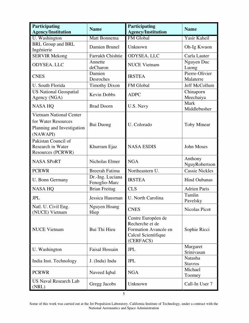
MAKE UP OF WORKSHOP PARTICIPANTS
Table below provides a distribution of participants according to their parent organization.
Participating Agency/Institution Name Participating
Agency/Institution Name
CNES Alice Andral Asian Disaster Preparedness Center (ADPC)
Susantha Jayasinghe
Northeastern U. Ed Beighley U. Montana Du Jinyang Institut national de Recherche en Sciences et Technologies pour l'Environnement et l'Agriculture (IRSTEA)
Felix Billaud USGS J.W. Jones
5
Some of this work was carried out at the Jet Propulsion Laboratory, California Institute of Technology, under a contract with the National Aeronautics and Space Administration
Participating Agency/Institution Name Participating
Agency/Institution Name
U. Washington Matt Bonnema FM Global Yasir Kaheil BRL Group and BRL Ingénierie Damien Brunel Unknown Oh-Ig Kwuon
SERVIR Mekong Farrukh Chishtie ODYSEA, LLC Carla Lauter
ODYSEA, LLC Annette deCharon NUCE Vietnam Nguyen Duc
Luong
CNES Damien Desroches IRSTEA Pierre-Olivier
Malaterre U. South Florida Timothy Dixon FM Global Jeff McCollum US National Geospatial Agency (NGA) Kevin Dobbs ADPC Chinaporn
Meechaiya
NASA HQ Brad Doorn U.S. Navy Mark Middlebusher
Vietnam National Center for Water Resources Planning and Investigation (NAWAPI)
Bui Duong U. Colorado Toby Minear
Pakistan Council of Research in Water Resources (PCRWR)
Khurram Ejaz NASA ESDIS John Moses
NASA SPoRT Nicholas Elmer NGA Anthony NguyRobertson
PCRWR Breerah Fatima Northeastern U. Cassie Nickles
U. Bonn Germany Dr.-Ing. Luciana Fenoglio-Marc IRSTEA Hind Oubanas
NASA HQ Brian Freitag CLS Adrien Paris
JPL Jessica Hausman U. North Carolina Tamlin Pavelsky
Natl. U. Civil Eng. (NUCE) Vietnam
Nguyen Hoang Hiep CNES Nicolas Picot
NUCE Vietnam Bui Thi Hieu
Centre Européen de Recherche et de Formation Avancée en Calcul Scientifique (CERFACS)
Sophie Ricci
U. Washington Faisal Hossain JPL Margaret Srinivasan
India Inst. Technology J. (Indu) Indu JPL Natasha Stavros
PCRWR Naveed Iqbal NGA Michael Toomey
US Naval Research Lab (NRL) Gregg Jacobs Unknown Call-In User 7

6
Some of this work was carried out at the Jet Propulsion Laboratory, California Institute of Technology, under a contract with the National Aeronautics and Space Administration

7
Some of this work was carried out at the Jet Propulsion Laboratory, California Institute of Technology, under a contract with the National Aeronautics and Space Administration
WORKSHOP AGENDA
The following agenda identifies the topics covered during the workshop. Note that, this was the first time a dual online and in-person format was utilized to maximize outreach and to repurpose the tools and content in a cost-effective manner.
DAY 1: Tuesday, 29 May 2018
8 – 8:15 Intro/Welcome/Objectives Margaret Srinivasan (JPL), Alice Andral (CNES), Faisal Hossain (UW), Ed Beighley (NEU)
Technical Information and Data for SWOT
8:15 - 8:45 Remote sensing applications in hydrology; use of multi-variable/satellite data
Tamlin Pavelsky (UNC)
8:45 - 9:00 CalVal/quality verification, in situ & model data
Adrien Paris (CLS)
9:00 - 9:30 Data access at PO.DAAC and THEIA
Jessica Hausman (JPL)
Alice Andral (CNES)
9:30–10:15 Preparing SWOT use with the SWOT large scale simulator for hydrology
Damien Desroches (CNES)
10:15–10:45 Break
10:45-11:30 SWOT simulated ‘overflight’ activity description Cassie Nickels and Ed Beighley (NEU)
Hearing from our Early Adopters
11:30-12:30
BRL Group Damien Brunel (BRL)
Compagnie Nationale du Rhône (CNR)
Alice Andral (CNES) for Sébastien Legrand (CNR)
FM Global Jeff McCollum (FM Global)
NASA SPoRT Nicholas Elmer (NASA)

8
Some of this work was carried out at the Jet Propulsion Laboratory, California Institute of Technology, under a contract with the National Aeronautics and Space Administration
USGS John Jones (USGS)
12:30 – 1:30 Lunch
Hands-On – Data Activity
1:30 – 3:30
Hands-on Demonstration of Satellite-based Reservoir and Water Management: Understanding current and future (SWOT) potential in the Mekong River basin
Matt Bonnema (UW)
3:30 – 4:00 Break
4 - 5 Hands-On (continued) Matt Bonnema (UW)
Closing Remarks and Summary
5 -5:30 Review Day 1
Objectives for Day 2 Margaret Srinivasan (JPL), Alice Andral (CNES), Ed Beighley (NEU)
DAY 2: Wednesday, 30 May 2018 8 – 8:15 Outline plans for the day Margaret Srinivasan (JPL), Alice Andral
(CNES), Ed Beighley (NEU)
8:15 – 9:00 Hands-On Follow Up/Questions Matt Bonnema (UW)
9-9:15 SWOT Limitations Nicolas Picot (CNES)
Hearing from our Early Adopters
9:15 – 10:15 Vietnam National Center for Water Resources Planning and Investigation (NAWAPI)
Bui Duong (NAWAPI)
Asia Disaster Preparedness Center (ADPC)
Chinaporn Meechaiya (ADPC), Susantha Jayasinghe (ADPC)
Indian Institute of Technology (IIT)
J. Indu Indus (IIT)

9
Some of this work was carried out at the Jet Propulsion Laboratory, California Institute of Technology, under a contract with the National Aeronautics and Space Administration
Pakistan Council of Research in Water Resources (PCRWR)
Breerah Fatima (PCRWR)
10:15-11:15 Break
11:15-11:45 PO.DAAC on the Cloud, User Services
Natasha Stavros (JPL)
Early Adopter Feedback
11:45-12:45 • What would you like to see in future (Project, SAWG)? • What will help you in your work process (wrt SWOT) • Distribute questionnaire/online - feedback • Feedback on workshop online (to improve future online workshops)
Closing Remarks and Summary
12:45-1:15 ● Near and long-term plans ● Recap
Margaret Srinivasan (JPL), Alice Andral (CNES), Ed Beighley (NEU)

10
Some of this work was carried out at the Jet Propulsion Laboratory, California Institute of Technology, under a contract with the National Aeronautics and Space Administration
WORKSHOP DELIBERATIONS
INFORMATIONAL SESSIONS The workshop kicked off with SAWG leads presenting a welcome presentation that emphasized the key objectives and goals of the workshop. The presentation stressed that the meeting was tailored for providing the application community with insights on the mission and data portals, hands-on experiences, including with datasets similar to what will be available from SWOT, and, most importantly, an opportunity showcase their planned or potential Early Adopter projects and ask questions. The welcome session was then followed by messages from Tamlin Pavelsky (SWOT Science Hydrology Team Lead-U.S.) on remote sensing applications in hydrology; Adrien Paris (CLS) on CalVal (Figure 1); Jessica Hausman (JPL) and Alice Andral (CNES) on data access; Damien Desroches (CNES) on the SWOT large scale simulator for hydrology; and Cassie Nickles (NEU) on temporal/spatial sampling characteristics (Figure 2). On day two, detailed project discussions continued with presentations from Nicolas Picot (CNES) on SWOT limitations and Natasha Stavros (JPL) PO.DAAC Cloud and User Services.
The focus of the SAWG and the SWOT Applications Program is to build a community of applied and operational users, to be distinguished from the rich research community focused on the science agenda and the Project and engineering groups who are currently building the SWOT spacecraft and data architecture systems. With three years remaining before launch, the SWOT data distribution and repository systems being developed by the Physical Oceanography Distributed Active Archive Center (PO.DAAC) for NASA and by the THEIA Land Data Center in hydrology and AVISO in oceanography for CNES. These centers that will host the SWOT data products are currently seeking feedback and use case scenarios to incorporate into their systems.
Figure 1. Details on planned Cal/Val activities. Source; Adrien Paris (CLS).

11
Some of this work was carried out at the Jet Propulsion Laboratory, California Institute of Technology, under a contract with the National Aeronautics and Space Administration
Figure 2. Highlighting spatial-temporal sampling in the Mississippi River basin. Source: Cassie Nickles (NEU).
HEARING FROM PARTICIPANTS AND SWOT EARLY ADOPTERS Over the two days, nine Early Adopter organizations presented their current and/or future activities for which SWOT data can be transformative. Application areas included: Hydrologic Information Systems; Hydropower; Flood Hazard Mapping; Satellite-Based monitoring of river discharge, reservoir storage, and groundwater storage; and Forecasting water levels and discharges. The Figure 3 provides a glimpse of the exciting activities presented by our Early Adopters: From Top left to bottom Right: Hydrological Information Systems by Damien Brunel (BRL Group); Hydropower by Alice Andral (CNES) for Sébastien Legrand (Compagnie Nationale du Rhône); Global Flood Hazard Mapping by Jeff McCollum (FM Global); US National Water Model by Nicholas Elmer (NASA SpoRT); Satellite-Based Streamflow Gauging Stations by John Jones (USGS); Satellite-Based Reservoir Monitoring by Bui Duong (Vietnam National Center for Water Resources Planning and Investigation, NAWAPI); Water Level Forecasting by Chinaporn Meechaiya and Susantha Jayasinghe (Asia Disaster Preparedness Center, ADPC); Flood Forecasting by J. Indu Indus (Indian Institute of Technology, IIT); and Satellite-Based Groundwater Monitoring by Breerah Fatima (Pakistan Council of Research in Water Resources, PCRWR).

12
Some of this work was carried out at the Jet Propulsion Laboratory, California Institute of Technology, under a contract with the National Aeronautics and Space Administration
Figure 3. Sample Images from Early Adopter Presentations (presenter details listed above).
In addition to the presentations, discussion sessions were focused on hearing from the participants on how SWOT data can be used in their applications. A key focus is of work is to ensure that Early Adopter applications are ready when the SWOT mission begins distributing

13
Some of this work was carried out at the Jet Propulsion Laboratory, California Institute of Technology, under a contract with the National Aeronautics and Space Administration
data products. Below are few comments from workshop participants and SWOT Early Adopters:
USGS – “Better access to SWOT simulated data and timely engagement with NASA/SWOT expertise would bolster SWOT success and help meet USGS science and resource management objectives (of being the nation’s hydrologic data repository)”
NASA SPoRT (EA) – “Assimilation of SWOT Water Surface Elevation may have potential to improve initialization of National Water Model & Discharge prediction.”
CNR – France – “SWOT Data should be available in GIS format (e.g. Hydroweb Theia); Historical data should be easy to download with uncertainty information; Discharge estimation needs to be worked on.”
BRL – France – “SWOT Data has value for practitioners and water managers in both Europe and Africa if latency and uncertainty are known a priori.”
Indian Institute of Technology - Bombay (EA) – “Need to focus on examining real -time urban flood forecasting scenario with SWOT and explore calibration of hydrodynamic models.”
PCRWR (EA) – “SWOT can be useful in transboundary river and reservoir monitoring & for precise assessment of regulation paradigm in Indian reservoirs. SWOT should be explored for optimizing reservoir operations and monitoring wetlands formed due to waterlogging.”
ADPC (EA) – “SWOT can improve current altimeter-based virtual stream-gauging system in Southeast Asia; Agricultural DSS needs to be ready for ingesting SWOT data.”
NAWAPI – “SWOT data are needed for improving operational monitoring and forecasting of water, improving hydrologic models and monitoring transboundary rivers and reservoirs.”
HANDS-ON DATA ACTIVITY Two hands-on demonstrations were presented. The first was presented by Cassie Nickle (NEU) and focused on spatial/temporal sample of SWOT in the Mississippi River Basin. The demonstration showed participants how to utilize newly developed python scripts implemented in ArcGIS to extract SWOT-like measurements from their own datasets and the SWOT orbit to capture the temporal sampling of SWOT (Figure 4). The tool also enables users to include optional SWOT discharge uncertainties estimates based on user specified uncertainty parameters.

14
Some of this work was carried out at the Jet Propulsion Laboratory, California Institute of Technology, under a contract with the National Aeronautics and Space Administration
Figure 4. SWOT Spatial/Temporal Sampling Demo using the Mississippi River Basin.
The second demonstration was by Matt Bonnema (UW) and focused on satellite-based reservoir and water management in the Mekong River Basin. The session provided participants with:
1) Basic uses of SWOT observations for reservoir monitoring and management, and 2) How to use SWOT-like sampling capabilities to derive important quantities related to
reservoirs and their impact on streamflow Background on SWOT, remotely sensed lake/reservoir datasets and various water applications in Bangladesh and the Mekong were presented. A series of example calculations and participant problems relevant to future SWOT measurements (water elevation and extent) were performed. In total, three problems were performed: (1) calculating reservoir storage change based; and (2) estimating effective reservoir storage and (3) estimating reservoir outflow. The Figure 5 provides and overview of the three problems.
Required datasets: SWOTHandsOn.zip and solutions: SWOTHandsOnSolution.zip are available online and were share with the participants.

15
Some of this work was carried out at the Jet Propulsion Laboratory, California Institute of Technology, under a contract with the National Aeronautics and Space Administration
Figure 5. Overview of the three participant problems presented during the 3nd SWOT Application Workshop - 1st SWOT Early Adopters Training Workshop; participants provided required datasets, training on how to perform required calculations, time
to perform/discuss problems and final solutions.

16
Some of this work was carried out at the Jet Propulsion Laboratory, California Institute of Technology, under a contract with the National Aeronautics and Space Administration
Material and Execution of Hands-on Session (Contributed by Matthew Bonnema) This demonstration began by re-introducing the early adopters to the basic concepts of SWOT, a general description of how it works and overview of the sampling characteristics such as return period and swath width. Two short animations illustrating the SWOT observational swath were shown to give early adopters a better visual representation of how SWOT will observe water bodies. Some basic terminology pertaining to the SWOT orbit (cycle and pass) was also covered here. Early adopters were also introduced to the SWOT Swath Visualizer on the SWOT website (https://swot.jpl.nasa.gov/visualizer.htm). This tool allows for the visualization of the planned SWOT orbit, providing end users with information about when and where SWOT will observe a water feature of interest. This tool is returned to at the end of the session for a take home assignment for the attendees.
A majority of the demonstration focused on exploring potential applications of SWOT observations to reservoir monitoring, using the Mekong River Basin for real world examples. Three different concepts were demonstrated: calculating reservoir storage change between subsequent SWOT observations, estimating effective reservoir storage, and integration of reservoir storage changes into reservoir outflow models. These concepts were demonstrated by fist walking through an example of how the calculation is done, and then allowing the early adopters time to work through a similar problem on their own. These problems were designed to be solvable with only basic Excel skills to make sure attendees of any technical skill level could participate. Reservoir water elevation, surface area, storage change, and outflow time series used in these examples were derived from historical in-situ observations and observations from current satellite remote sensors. This data was presented as only representing the temporal sampling frequency of SWOT and does not represent the actual accuracy of SWOT water body observations. For the first hands on problem, participating early adopters were given a 1-year time series of surface area and water elevation observations of Sirindhorn Reservoir in the Mekong River Basin, which mimics the observations expected of SWOT. These observations were sampled at the same frequency as expected SWOT observations. The task for the early adopters was to estimate reservoir storage change between subsequent observations. For the second problem, the early adopters were given a time series of storage changes for the Lam Pao Reservoir and tasked with estimating the effective storage of the reservoir. A few assumptions were made to simplify the problem, specifically that this reservoir emptied to near minimum storage during that year’s dry season and filled to near full during that year’s wet season. The point of this task is to highlight that SWOT will not observe total reservoir storage, only storage changes, but also to show that with a time series of storage changes, certain characteristics of reservoirs can be approximated. For the third task, the early adopters were given a storage change time series (mimicking expected SWOT observations) of the Chulabhorn Reservoir, as well as estimates of reservoir inflow, taken from a hydrologic model of the upstream basin. They were then tasked with estimating reservoir outflow using a simple mass balance model (Outflow = Inflow – Storage Change). The main goal of this task was to show early adopters in a simple way how SWOT observations could be integrated into hydrologic models. All early adopters who participated in these hands-on demonstrations appeared to understand the concepts being presented and were able to solve the tasks with little difficulty. After the three hands on demonstrations were completed, the early adopters were asked to take a short, multiple choice quiz. Overall, the early adopters scored very well on the quiz, with most

17
Some of this work was carried out at the Jet Propulsion Laboratory, California Institute of Technology, under a contract with the National Aeronautics and Space Administration
respondents answering above 90% of the questions correctly. Based on the results, the early adopters have a good understanding of the basic ideas and specifications of the SWOT mission (e.g. what physical quantities SWOT is and isn’t measuring, how wide the observational swath is, etc.). Respondents also correctly answered simple questions related to SWOT sampling frequency. For example, most correctly identified how frequently locations in the Mekong River Basin will be observed, and everyone understood that estimated storage change occurs between observations and frequency is dependent on the frequency of SWOT observations. However, a more complex question about sampling frequency gave respondents more trouble. Only 64% correctly answered a question about the observation frequency of a reservoir observed at two different times within the 21-day SWOT orbit. This indicates that while the respondents had a good understanding of the basics, more complex specifics pertaining to observational frequency are still not intuitive. The final question on the quiz asked respondents to give feedback about what they did and didn’t like about this demonstration session. The feedback was overwhelmingly positive, with many finding the hands-on portions useful (Figure 6). The only criticism was that the hands on was a little too easy and too much time as given to complete the three tasks.
Figure 6. Results of the hands-on demonstration quiz.
After the quiz, one final assignment was given for the early adopters to complete before the beginning of the session the following day. This assignment asked participants to select any surface water feature of their choice, locate it using the SWOT Swath Visualizer tool introduced earlier, and determine the frequency at which SWOT will observe that feature. Participants were also asked to write what characteristics of their water feature they expected to see in the SWOT observations. We received 5 responses, mostly about reservoirs in the U.S. All respondents managed to use the SWOT Swath Visualizer successfully and determine the sampling frequency. One response about a river experiencing tidal effects fostered a good discussion the following day about what temporal characteristics of water features will be seen by SWOT (phenomena occurring on monthly or seasonal scales) and what will likely be not (daily

18
Some of this work was carried out at the Jet Propulsion Laboratory, California Institute of Technology, under a contract with the National Aeronautics and Space Administration
phenomena like tides). Overall, the early adopters in attendance achieved a good understanding of SWOT sampling frequency by the end of the session.
SUMMARY DISCUSSIONS The workshop discussions largely focused on the presentation topics (e.g., clarification of presented material) with specific insights on: data access (tools, services, etc.), accuracy, latency and resolution; need for synthetic data products from the official SWOT simulators; and the need for additional feedback from the participants and broader user community on what is needed to ensure their applications are ready for when SWOT data are available. The key findings from the workshop discussions and participant survey are provided next.
WORKSHOP FINDINGS Based on discussions throughout the workshop and participant survey responses (approximately 30% of non-mission attendees), the following key findings are summarized:
§ Participants are engaged in a range of Applications: rivers, lakes, reservoirs, wetlands, coastal and ocean, with the majority of participants focused on inland rivers, lakes/reservoirs and wetlands. See the breakdown of responses provided by participants in Appendix 2 Question 1.
§ Participants are experienced in using satellite data products. For example, 90% of the survey responses indicated they currently use Satellite data (e.g., Altimetry, MODIS, LandSat, SMAP, GRACE, GSMAP). See the breakdown of responses provided by participants in Appendix 2 Question 2.
§ Challenges to incorporating satellite data into applications include: data accuracy, latency and access. Similar to our second Applications Workshop, 46% of the survey responses indicated the data latency as a major challenge and suggested latency of less than a few days is critical. See the breakdown of responses provided by participants in Appendix 2 Question 3.
§ Data latency and measurement space/time resolutions were highlighted as critical gaps around freshwater observations from space. For example, 65% of the survey responses indicated the space/time resolution of measurements as a critical gap. See the breakdown of responses provided by participants in Appendix 2 Question 4.
§ Needs identified for enhancing and supporting involvement from private industry, state agencies, and universities in NASA and CNES Applications efforts included: funding support for R&D pilot studies (i.e., proof-of-concept projects), tools to simplify data access, and training workshops. See the breakdown of responses provided by participants in Appendix 2 Question 5.
§ In terms of workshop format, the participants found the webinar format worked well. Two challenges were noted: difficulty hearing some presenters (i.e., those presenting not off-set locations) and open discussions including all participants.

19
Some of this work was carried out at the Jet Propulsion Laboratory, California Institute of Technology, under a contract with the National Aeronautics and Space Administration
However, participants were very supportive of more webinar-based training workshops.
RECOMMENDATIONS § Expand the use of webinar-based workshops for the Applications community with
continued focus on: technical aspects of SWOT data products, user tools, user training, and broader exposure of Early Adopter Projects and other relevant applications (i.e., users want to hear more from the broader user community). Careful selection and management of the Webex audio connection to ensure quality throughout the workshop will be implemented in future workshops.
§ Explore webinar options that allow presenters to pre-record and upload presentations with audio recordings prior to the workshop. Presenters will be expected to attend their sessions and play a larger role in moderating open discussions. This will address both challenges in the audio quality experienced in the first part of the workshop, and open discussion comments noted in our participant survey.
§ Continue working closely with the SWOT Science Team on the development of synthetic SWOT data products to share with the Early Adopters.
§ Prepare the next applications workshops for Early adopters centered around SWOT’s quantitative measurements, the final selection of SWOT data products, and PO.DAAC plans.
Near-term Tasks for SAWG (2018-2019) § Disseminate key outcomes of workshop in wide-audience forums (EOS, BAMS, AWRA
IMPACT etc.), § Continue implementation of Early Adopter Program (seven proposals received) and provide
guidance to these groups,
§ Update SWOT website to showcase Early Adopters,
§ Maintain engagement and continue outreach with user community,
§ Prepare for a May-2019 SWOT User Workshop (quantitative – simulator-based).
Tasks ahead for SAWG and SWOT Community (2018-2021) § Develop required tutorials, training, and outreach material,
§ Provide early adopters with case studies and synthetic SWOT data products, § Develop tools to access, analyze and sub-set and analyze SWOT data products,
§ Continue Applications workshops focused on technical aspects of SWOT data products, user tools, user training, and broader exposure of Early Adopter Projects and other relevant applications (i.e., users want to hear more from the broader user community).

20
Some of this work was carried out at the Jet Propulsion Laboratory, California Institute of Technology, under a contract with the National Aeronautics and Space Administration
APPENDIX 1
Questionnaire Survey for Workshop Participants
1. What are the operational and research requirements for your [river, reservoir, lake, wetland, coastal] applications?
2. Do you currently use remote sensing/satellite data in your research/operations? Yes, No,
Not sure; If yes, please say what it is, and comment on its availability, utility, and performance.
3. What do you consider to be the biggest challenge to incorporating satellite data for
improved operational capacity? 4. Do you see any critical gaps around freshwater observations from space (time latency,
spatial/temporal resolution, non-observed or poorly-observed hydrological variable)? Yes, No, Not sure; If yes, please explain your answer.
5. How can we enhance and support involvement from private industry, state agencies, and
universities in NASA and CNES Applications effort? 6. Did you attend any portion of the workshop via WebEx? Yes, No 7. Rate the effectiveness of remote workshop attendance on a scale from 1 to 7. (1 = Not
effective at all; 7= Extremely effective). 8. What was the most effective aspect of the workshop? 9. What was the least effective aspect of the workshop? 10. Please share any comments that would improve our ability to effectively deliver remote
workshops in the future.

21
Some of this work was carried out at the Jet Propulsion Laboratory, California Institute of Technology, under a contract with the National Aeronautics and Space Administration
APPENDIX 2
SWOT Applications Workshop Survey Summary for the Key Questions 1-5
Question 1 - What are the operational and research requirements for your [river, reservoir, lake, wetland, coastal] applications?
Question 2 - Do you currently use remote sensing/satellite data in your research/operations?
27%
18%14%
14%
23%
4%
Operational Focus
River (discharge & elevation)
Reservoir (elev, vol, discharge)
Lake
Wetland
Coastal
Other
26%
11%
5%5%11%
42%
Current RS Used
Altimetry
Rainfall
Sparse data areas
Long time series
Near real-time
Other

22
Some of this work was carried out at the Jet Propulsion Laboratory, California Institute of Technology, under a contract with the National Aeronautics and Space Administration
Question 3 - What do you consider to be the biggest challenge to incorporating satellite data for improved operational capacity?
Question 4 - Do you see any critical gaps around freshwater observations from space (time latency, spatial/temporal resolution, non-observed or poorly-observed hydrological variable)?
23%
46%
7%
8%
8%8%
Challeges to Use RS
Accuracy
Latency
Data access
Virtual stations
Training
Other

23
Some of this work was carried out at the Jet Propulsion Laboratory, California Institute of Technology, under a contract with the National Aeronautics and Space Administration
Question 5 - How can we enhance and support involvement from private industry, state agencies, and universities in NASA and CNES Applications effort?
14%
29%
36%
7%7%
7%
Gaps
Latency
Resolution (spatial)
Resolution (temporal)
Global river discharge
Vegetated water (floodedforest)
43%
29%
14%
14%
Support Needs from Users
Support for R&D
Continuation of SAWGWorkshop
Ensure Open Access Data
Other