engineering (drainage) evidence statement · engineering (drainage) evidence statement lancefield...
TRANSCRIPT

F 301 Ver 2.0
ENGINEERING (DRAINAGE)
EVIDENCE STATEMENT
LANCEFIELD ROAD PSP &
APPLICATION FOR PLANNING PERMIT P18855
PREPARED BY ANDREW MATHESON FOR
WINCITY DEVELOPMENT PTY LTD
AUGUST 2017
Building 8, 270 Ferntree Gully Road, Notting Hill, 3168 | (03) 9501 2800 | [email protected] | Certified to ISO 14001, ISO 9001 & AS/NZS 4801
F 512 Ver 2.0
Our Ref: 08618/U Address: Lancefield Road Precinct Structure Plan
Page 2 of 35
Table of Contents
1. Preliminary Information ................................................................................................................. 3
1.1 Name and Address ..................................................................................................................................................................... 3
1.2 Education and Experience ...................................................................................................................................................... 3
1.3 Area of Expertise ......................................................................................................................................................................... 3
1.4 Expertise to Make the Report................................................................................................................................................. 3
1.5 Instructions ................................................................................................................................................................................... 3
1.6 Report Preparation..................................................................................................................................................................... 3
1.7 Identity of Other Persons Relied upon in this Report ................................................................................................... 4
1.8 Summary of Opinions ............................................................................................................................................................... 4
1.9 Provisional Opinions Not Fully Researched ..................................................................................................................... 4
1.10 Matters Outside of My Expertise ........................................................................................................................................... 4
1.11 Practice Note Declaration........................................................................................................................................................ 4
2. Introduction..................................................................................................................................... 5
3. Definitions ....................................................................................................................................... 5
4. Summary .......................................................................................................................................... 6
5. Melbourne Water Revised Draft Developer Services Scheme ..................................................... 7
6. Exhibited PSP Documents .............................................................................................................. 8
7. VPA Response to 96A Application ............................................................................................... 18
8. Revised Town Centre Concept Plan ............................................................................................. 26
9. VPA 96A Application RFI ............................................................................................................... 28
10. Conclusion ..................................................................................................................................... 29
11. Appendix A – Break of Slope Analysis ......................................................................................... 30
12. Appendix B – David Lock and Associates Revised Town Centre Concept Plan ........................ 34
13. Appendix C – Revised Melbourne Water Draft Developer Services Scheme ............................ 35

Our Ref: 08618/U Address: Lancefield Road Precinct Structure Plan
Page 3 of 35
1. Preliminary Information
1.1 Name and Address
Andrew Matheson, Civil Engineer.
Taylor's Development Strategists 8/270 Ferntree Gully Road, Notting Hill Vic 3168
1.2 Education and Experience
My educational qualifications and membership of professional associations are as follows:
� Bachelor of Engineering (Civil), 2005, Swinburne University
My professional experience includes 13 years experience as a Civil Engineer, comprising:
� 2 years, Manager & Engineering Strategist, Taylors Development Strategists
� 9 years, Engineer & Senior Engineer, GHD
� 2 years, Under Graduate Engineer, Land Management Surveys
1.3 Area of Expertise
I have been involved in the land development and civil infrastructure projects for thirteen (13)
years and spent most of that time practising in the field of Civil Engineering and specialising
in the design and delivery of rural, urban, residential and industrial roads, drainage, sewer
and water main infrastructure in Australia.
1.4 Expertise to Make the Report
I have considerable experience in the engineering considerations for associated projects of
this nature having delivered subdivision infrastructure and major road and drainage
infrastructure throughout metropolitan Melbourne for approximately 13 years in my capacity
as a Civil Engineering Consultant and Project Manager. My Curriculum Vitae is attached.
1.5 Instructions
I was instructed by WinCity Development Pty Ltd to prepare a report and present my opinion
on the drainage strategy proposed in the Lancefield Road PSP
1.6 Report Preparation
In the preparation of this report I have reviewed:
� The submission to the VPA prepared on behalf of WinCity Development Pty Ltd.
� Submissions received, most notably; Submissions of Council and Melbourne Water.
� The s96A Permit Application (Ref: P18855) and all supporting information.
� The Draft Planning Permit relating to the above application.
� The VPA Assessment of the s96A Permit Application
� The revised Town Centre Concept Plan prepared by David Locke and Associates.
� The revised Melbourne Water developer services scheme concept plans
� Site Inspections
Our Ref: 08618/U Address: Lancefield Road Precinct Structure Plan
Page 4 of 35
1.7 Identity of Other Persons Relied upon in this Report
I was assisted in the preparation of this report by additional members of staff acting under
my express instructions. The opinions in this report, however, remain my own.
1.8 Summary of Opinions
My opinions in relation to this matter are attached.
1.9 Provisional Opinions Not Fully Researched
To the best of my knowledge all matters on which I have made comment in this statement
have been appropriately researched or are based on my knowledge and experience. The
statement does not contain any provisional opinions that have not been fully researched.
1.10 Matters Outside of My Expertise
To the best of my knowledge, none of the matters on which I have made comment in this
statement are outside my area of expertise. To the best of my knowledge the report is
complete and does not contain matters which are inaccurate.
1.11 Practice Note Declaration
I have made all the enquiries that I believe are desirable and appropriate and that no matters
of significance that I regard as relevant have, to my knowledge been withheld from the Panel.
I have read the Guide to Expert Evidence and agree to be bound by it.
Signature:
Date: 14 August, 2017

Our Ref: 08618/U Address: Lancefield Road Precinct Structure Plan
Page 5 of 35
2. Introduction
I have been instructed by WinCity Development Pty Ltd to provide my expert opinion on the matters
raised relating to the Lancefield Road PSP, VPA Request for Further Information, the Draft Permit
relating to the s96A application (Ref: P18855).
I have been asked to undertake:
• A review of the Melbourne Water revised draft Developer Services Scheme drainage
strategy for the Subject Site;
• A review of the exhibited PSP documents;
• A review of the VPA response to the 96A Application; and
• A review of the revised Town Centre Concept Plan.
This Statement has been structured in a manner that responds to each of the above items and a
detailed assessment/response can be referred to as follows:
Section Issue/s Considered
Section 5.0 Melbourne Water Revised Draft Developer Services Scheme
Section 6.0 Exhibited PSP Documents
Section 7.0 VPA Response to the 96A Application
Section 8.0 Town Centre Concept Plan
Section 9.0 VPA 96A Application RFI
3. Definitions
VPA Victorian Planning Authority
PSP Lancefield Road Precinct Structure Plan
MWC Melbourne Water Corporation
DSS Developer Services Scheme
WSUD Water Sensitive Urban Design
RFI Request for Information
Our Ref: 08618/U Address: Lancefield Road Precinct Structure Plan
Page 6 of 35
4. Summary
The Subject Land (Lot 3 on LP208321, Lot 4 on LP208321 and Lot 3-22 on PP2258) comprises of
275Ha of land. Melbourne Water has is proposed that the Subject Lane be encumbered by 7 large
constructed wetlands and 2 smaller basins which are mostly located in land which can be developed
for residential uses. The proposed constructed wetlands provide benefit to an external drainage
catchment (land owned by others) to the west of Lancefield Road.
I have been instructed by WinCity that they will adopt the revised Melbourne Water Draft Developer
Scheme Services plan. It is my opinion that the revised 96A masterplan prepared by Taylors is
generally in accordance with the revised MWC draft DSS and PSP. It is my opinion that a note
should be added to Plan 11 in the PSP stating that “confirmation of size and final location of wetland
reserves is subject to functional and detailed design approval to the satisfaction of Melbourne Water”.
I have reviewed the David Lock and Associates Town Centre Concept Plan and compared it to the
revised Melbourne Water draft Developer Services Scheme Plan. It is my opinion that there is a
conflict between the location of the Community Facility and Wetland WL-15. It is my opinion that the
wetland location should be retained and the Community Facility relocated.
I have reviewed the revised Break of Slope line provided by the VPA and note that within the 96A
Application area, the alignment has been placed satisfactorily. It is my opinion that within Title 3-
22/PP2258, particularly in the north-east corner, the Break of Slop line has been incorrectly located
and should be amended in accordance with scientifically assessed alignment.

Our Ref: 08618/U Address: Lancefield Road Precinct Structure Plan
Page 7 of 35
5. Melbourne Water Revised Draft Developer Services Scheme
I have reviewed the revised draft Melbourne Water Developer Services Scheme (MWC DSS) as
provided by the VPA to WinCity on the 27th June 2017.
I have also been instructed by WinCity that they will adopt the revised draft DSS into the revised
Masterplan for the 96A Application and for the balance of the Subject Land.
I have reviewed the revised Masterplan prepared by Taylors and it is my opinion that the proposed
locations for stormwater treatment infrastructure presented is generally in accordance with MWC’s
revised draft DSS.
While WinCity has accepted the revised draft DSS, it is my opinion that Melbourne Water and the
VPA should permit a degree of flexibility when the functional and detail designs for the stormwater
treatment systems are presented for approval.
It is my opinion that a note should be added to Plan 11 in the PSP stating that “confirmation of size
and final location of wetland reserves is subject to functional and detailed design approval to the
satisfaction of Melbourne Water”.
Our Ref: 08618/U Address: Lancefield Road Precinct Structure Plan
Page 8 of 35
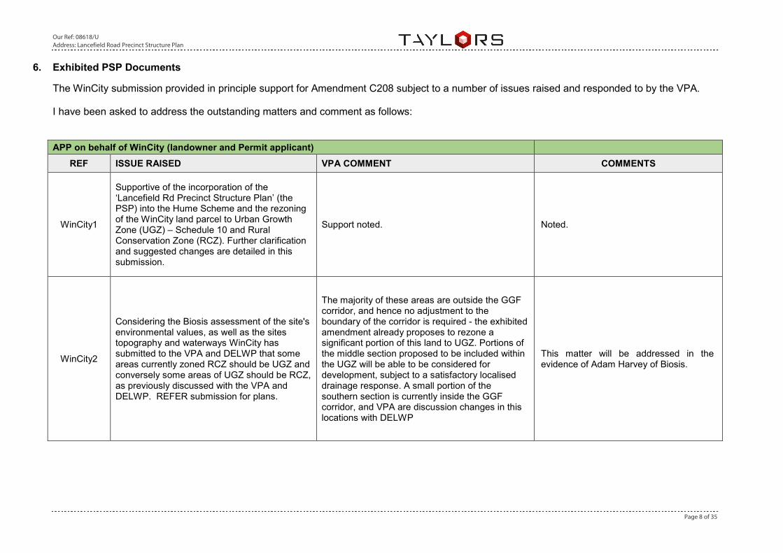
6. Exhibited PSP Documents
The WinCity submission provided in principle support for Amendment C208 subject to a number of issues raised and responded to by the VPA.
I have been asked to address the outstanding matters and comment as follows:
APP on behalf of WinCity (landowner and Permit applicant)
REF ISSUE RAISED VPA COMMENT COMMENTS
WinCity1
Supportive of the incorporation of the ‘Lancefield Rd Precinct Structure Plan’ (the PSP) into the Hume Scheme and the rezoning of the WinCity land parcel to Urban Growth Zone (UGZ) – Schedule 10 and Rural Conservation Zone (RCZ). Further clarification and suggested changes are detailed in this submission.
Support noted. Noted.
WinCity2
Considering the Biosis assessment of the site's environmental values, as well as the sites topography and waterways WinCity has submitted to the VPA and DELWP that some areas currently zoned RCZ should be UGZ and conversely some areas of UGZ should be RCZ, as previously discussed with the VPA and DELWP. REFER submission for plans.
The majority of these areas are outside the GGF corridor, and hence no adjustment to the boundary of the corridor is required - the exhibited amendment already proposes to rezone a significant portion of this land to UGZ. Portions of the middle section proposed to be included within the UGZ will be able to be considered for development, subject to a satisfactory localised drainage response. A small portion of the southern section is currently inside the GGF corridor, and VPA are discussion changes in this locations with DELWP
This matter will be addressed in the evidence of Adam Harvey of Biosis.

Our Ref: 08618/U Address: Lancefield Road Precinct Structure Plan
Page 9 of 35
WinCity3
40m setback from the escarpment is noted as a requirement of a setback from the break of slope even though the zoning is reliant on this topographical change. A more flexible approach should be considered that is responsive to a variety of on-site conditions and outcomes, via the adoption of a range of appropriate road cross sections. Details of this and comments about the requirements are shown further in this submission (REFER submission for requested alternate cross-section details).
The 40m 'interface with escarpment (visual)' has been applied to avoid the visual impact of development from within the creek corridor, adjacent to the creek itself. The VPA agree that where the creek corridor is less narrowly defined (e.g. where a gully/tributary extends from the creek), the 40m setback may not achieve this. The VPA are currently reviewing the application of the 40m mandatory setback in these locations, and will provide more information on our final position shortly.
This will be addressed in the evidence of Nick Hooper.
WinCity4
The BAL rating should be confirmed as per the local conditions, and an appropriate road cross section (as supplied) adopted to meet the defendable space setback. This should not exclude the option of increased setbacks within lots or appropriate building envelopes.
The PSP does not define standard BAL rating requirement for housing abutting the escarpment. There will therefore be scope for a range of bushfire management treatments
This will be addressed in the evidence of Nick Hooper.
WinCity5 Plan 5 - incorrectly labels 'interface with railway' on subject property.
This will be corrected. Noted.
WinCity6
Cross section ‘Regionally Significant Landscape: Escarpment top – 4.7. visually sensitive’ implies that you must have 25.2 metres buffer distance to a carriageway easement from break of slope. There is a lack of clarity as to why this distance is required given that under this scenario, houses are in excess of 40 metres setback from the break of slope, even though visually that 40 metres includes substantial landscaping, shared path, and a 7.3 metres road carriageway. Where is the impact coming from? Additional clarity needs to be given as to whose view line is being protected and why.
See WinCity 3 above. The view lines being protected are from within the creek corridor itself.
This will be addressed in the evidence of Nick Hooper.

Our Ref: 08618/U Address: Lancefield Road Precinct Structure Plan
Page 10 of 35
WinCity7
R44 - why within Cross section ‘Regionally Significant Landscape: Escarpment top – visually sensitive’ have the roads have been excluded from this 20 metres.
See above. The setback apply to development This will be addressed in the evidence of Nick Hooper.
WinCity8
It appears Figures 4-7 are plans and not cross sections and there is no reference within the PSP document, which we can find, to ‘Interface Cross Section’ diagrams. These need to be made clear if they’re referred to in the PSP.
Interface Cross Sections will be included. Noted.
WinCity9
What is the purpose / specific requirement for the 30m ‘conservation interface zone’ as referred to on Figure 7? This is a poor use of serviceable land and should be deleted from the PSP and mapping.
The Conservation Interface Zone refers only to those areas within 30m of a conservation area boundary. It does not imply no development.
This will be addressed in the evidence of Nick Hooper.
WinCity10
Suggest the notation on the determination of the break of slope line to be detained via survey rather than an arbitrary line on the plan as currently shown.
The break of slope line has been redefined based on a virtual 'Walk through' of the site, undertaken by the VPA, Council and Melbourne Water. It is therefore not considered necessary to enable any further refinements through a notation of this type. It is also important that the break of slope is defined in the PSP as the basis for determining zone boundaries in certain locations
WinCity have instructed me to review the break of slope line as defined by the exhibited PSP and with the revised break of slope line as provided by the VPA in May 2017. I am satisfied that the proposed Break of Slope has been appropriately positioned within the 96A Application area. For the balance of the site, I am generally satisfied that the Break of Slope line has been defined accurately, with exception of an area on Title 3-22/PP2258 where the break of slope line should be reassessed. I have included a detailed description, plans and sections along with my evaluation of this area in Appendix A of this report.

Our Ref: 08618/U Address: Lancefield Road Precinct Structure Plan
Page 11 of 35
WinCity11
Suggest the wording relating to the Linear open space within the Visually Sensitive Cross section is currently not adding towards the sites open space contribution and this is not acceptable.
The setback from the break of slope required in the visually sensitive cross section is required to allow urban development in a location with high landscape values. The development setback is for therefore principally for landscape reasons.
This will be addressed in the evidence of Nick Hooper.
WinCity12
Plan 10 and Figure 7 – The sheer number of shared paths within proximity to each other on our client’s property appears to be excessive and insufficiently justified. It is suggested a consolidated plan showing shared path network to ensure clear and sensible movement patterns.
The shared path network shown within the conservation areas on the Conservation Area Management Plan is indicative, and will be not be required as subdivisional works. The required shared path network as part of subdivisional works is limited to that shown on Plan 10
This will be addressed in the evidence of Nick Hooper.

Our Ref: 08618/U Address: Lancefield Road Precinct Structure Plan
Page 12 of 35
WinCity13
Compared to other properties within the PSP, the WinCity is encumbered by a considerably greater area of wetlands / retarding basins that any other parcel within the precinct. It is noted that WL-13, WL-14 & WL-15 provide storm water retardation and quality treatment for external catchments or land outside the subject land and should be allocated for funding as these are a region resource for other upstream.
The DSS are designed based on Melbourne Water's 'Principles for Provision of Waterway and Drainage Services for Urban Growth' (16 principles). Melbourne Water has had extensive consultation and engagement with the drainage consultants of WinCity. Melbourne Water has outlined the process for designing Development Services Schemes and provided a detailed response to proposed changes to asset location. Based on extensive discussions, Melbourne Water is hopeful that WinCity can submit a proposed drainage layout which meets the objectives and requirements of the DSS. It must be noted that the current Section 96A application is not in accordance with the DSS and this position was outlined to the applicant in writing on 10th February, 2017.
I am instructed that WinCity is adopting the revised MWC DSS strategy and as such the original wetland locations are superseded. I am satisfied that the proposed MWC wetland locations presented on the revised Masterplan and for the 96A Application are generally in accordance with the MWC DSS strategy.
WinCity14
WL-13 is at least 10-15 years away from development as it relies on WinCity’s land being developed to create the need for its water retarding function. This will impact on the timing and development of other upstream land parcels located outside of WinCity’s land holding.
Melbourne Water advises that temporary works can be provided on upstream properties if development occurs out of sequence (i.e. from top of catchment to the bottom). In isolation, this is not a sufficient reason to change the location of the DSS asset because there are many factors which have been considered in the location of this asset (topography, geomorphology etc.)
Please refer to my response to WinCity 13.

Our Ref: 08618/U Address: Lancefield Road Precinct Structure Plan
Page 13 of 35
WinCity15
It is also noted that these are uncredited in the Land budget (section 2.3) as open space as is the considerable area of Landscape Values that remains unclear as to its location and why this is not a credited item given it is unusable land that can be adequately serviced.
Drainage assets required under a DSS are paid for by that DSS, and are therefore not credited through the ICP. The Landscape values areas are considered undevelopable for slope, water quality, or landscape reasons, however the VPA and MW are refining the landscape values areas to identify additional areas that may be able to be developed, subject to a localised drainage response
Noted.
WinCity16
In order to achieve a more equitable spread of assets and realize the benefits 5.15. of other storm water quality treatment technology on the subject land the following amendments to the Integrated Water Management Plan (and MW DDS) are proposed: a) Relocation of WL-12 into the south-east corner of the land located at 250 Lancefield Road.
See Win City 13 Please refer to my response to WinCity 13.
WinCity17
b) Relocation of WL-14 immediately to the west of the location shown in the PSP which could eliminate a separate drainage and sewerage sub catchment on the subject land and potentially remove the requirement for WL-16 (Sediment basin);
See Win City 13 Please refer to my response to WinCity 13.
WinCity18
c) Relocate the component of WL-13 (or part thereof) which caters for the existing and proposed development on the western side of Lancefield Road to the western side of Lancefield Road;
See Win City 13 Please refer to my response to WinCity 13.
WinCity19
d) Relocate WL-15 downstream to the confluence of the two existing watercourses with the provision of a linear wetland or bio-retention cell / retarding basin which better responds the existing topography and vegetation to be retained;
See Win City 13 Please refer to my response to WinCity 13.
Our Ref: 08618/U Address: Lancefield Road Precinct Structure Plan
Page 14 of 35
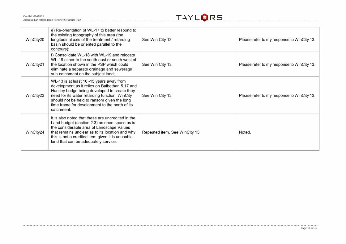
WinCity20
e) Re-orientation of WL-17 to better respond to the existing topography of this area (the longitudinal axis of the treatment / retarding basin should be oriented parallel to the contours);
See Win City 13 Please refer to my response to WinCity 13.
WinCity21
f) Consolidate WL-18 with WL-19 and relocate WL-19 either to the south east or south west of the location shown in the PSP which could eliminate a separate drainage and sewerage sub-catchment on the subject land;
See Win City 13 Please refer to my response to WinCity 13.
WinCity23
WL-13 is at least 10 -15 years away from development as it relies on Balbethan 5.17 and Huntley Lodge being developed to create they need for its water retarding function. WinCity should not be held to ransom given the long time frame for development to the north of its catchment.
See Win City 13 Please refer to my response to WinCity 13.
WinCity24
It is also noted that these are uncredited in the Land budget (section 2.3) as open space as is the considerable area of Landscape Values that remains unclear as to its location and why this is not a credited item given it is unusable land that can be adequately service.
Repeated item. See WinCity 15 Noted.

Our Ref: 08618/U Address: Lancefield Road Precinct Structure Plan
Page 15 of 35
WinCity25
It is considered that bio-retention cells and / or floating wetlands respond to the opportunities and constraints on the subject land and would be more appropriate than traditional constructed wetlands. The following justification is provided:
Melbourne Water has considered the submission for alternative treatment types. Melbourne Water would not support the use of bio retention systems for catchment areas greater than 10 Hectares, consistent with the Melbourne Water 'MUSIC Guidelines' (2016) (pg. 19). Melbourne Water is required to provide a robust, cost-effective plan to manage the quality and increased quantity stormwater run-off as the Regional Floodplain Management and Drainage Authority. Based on the 'Principles for Provision of Waterway and Drainage Services for Urban Growth', Melbourne Water MUSIC Guidelines, constructability, future maintenance implications, we have developed a robust DSS.
I agree with the VPA response.
WinCity26
It is considered that due to the extent of overland flows from an external catchment to the west of Lancefield Road flowing through the southern-most parcel of land being 45 Gellies Road, that this property should be incorporated into the Oldbury MW DSS or funds made available to in the ICP to undertake some rehabilitation of the existing watercourse environs.
Based on the description, this property is located within the Sunningdale Avenue Development Services Scheme. Works must be in accordance with the DSS. The scheme boundaries (and works) are based on the 'Principles for Provision of Waterway and Drainage Services for Urban Growth'. It is noted that waterways are not an ICP item.
I agree with the VPA response.
WinCity27 Plan 7 – SR-03 should be located further north. This park is an impost that locates too much open space within WinCity’s lands.
While there is a significant amount of drainage land on the submitters site, this is a product of the natural drainage of the land, with a number of significant tributaries of the Emu Creek crossing the land. Given the scale of the landholdings relative to the broader PSP, the planned, credited open space network across the site is not considered excessive.
This will be addressed in the evidence of Nick Hooper.
Our Ref: 08618/U Address: Lancefield Road Precinct Structure Plan
Page 16 of 35
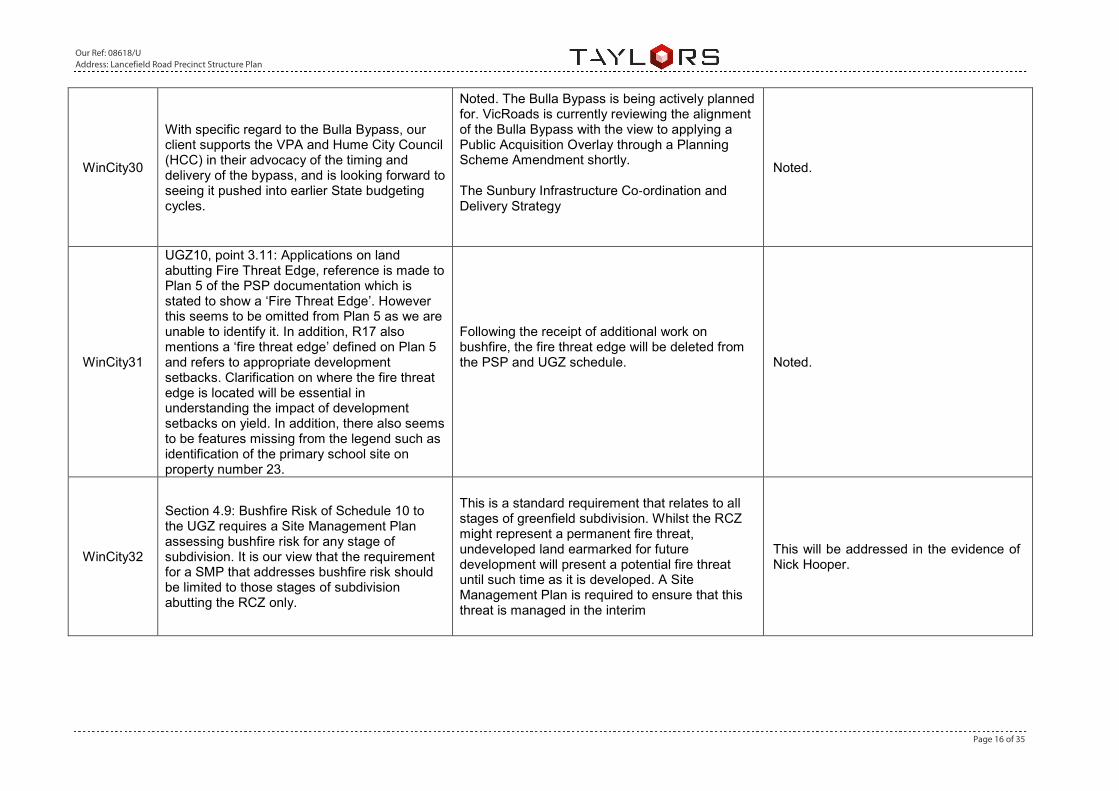
WinCity30
With specific regard to the Bulla Bypass, our client supports the VPA and Hume City Council (HCC) in their advocacy of the timing and delivery of the bypass, and is looking forward to seeing it pushed into earlier State budgeting cycles.
Noted. The Bulla Bypass is being actively planned for. VicRoads is currently reviewing the alignment of the Bulla Bypass with the view to applying a Public Acquisition Overlay through a Planning Scheme Amendment shortly. The Sunbury Infrastructure Co‐ordination and Delivery Strategy
Noted.
WinCity31
UGZ10, point 3.11: Applications on land abutting Fire Threat Edge, reference is made to Plan 5 of the PSP documentation which is stated to show a ‘Fire Threat Edge’. However this seems to be omitted from Plan 5 as we are unable to identify it. In addition, R17 also mentions a ‘fire threat edge’ defined on Plan 5 and refers to appropriate development setbacks. Clarification on where the fire threat edge is located will be essential in understanding the impact of development setbacks on yield. In addition, there also seems to be features missing from the legend such as identification of the primary school site on property number 23.
Following the receipt of additional work on bushfire, the fire threat edge will be deleted from the PSP and UGZ schedule.
Noted.
WinCity32
Section 4.9: Bushfire Risk of Schedule 10 to the UGZ requires a Site Management Plan assessing bushfire risk for any stage of subdivision. It is our view that the requirement for a SMP that addresses bushfire risk should be limited to those stages of subdivision abutting the RCZ only.
This is a standard requirement that relates to all stages of greenfield subdivision. Whilst the RCZ might represent a permanent fire threat, undeveloped land earmarked for future development will present a potential fire threat until such time as it is developed. A Site Management Plan is required to ensure that this threat is managed in the interim
This will be addressed in the evidence of Nick Hooper.

Our Ref: 08618/U Address: Lancefield Road Precinct Structure Plan
Page 17 of 35
WinCity33
We also query the UGZ Decision Guidelines which reference the ‘Sunbury Infrastructure Coordination and Delivery Strategy’. We are unclear of the status of this report or its contents.
The Sunbury Infrastructure Co-ordination and Delivery Strategy was exhibited alongside the PSP. However in response to other submissions, the VPA now propose to remove formal reference to this strategy in the PSP and the UGZ Schedule, and to treat this as a background document only
Noted
WinCity34
In accordance with the amendments sought under section 3.2 of this submission, the boundary of the Incorporated Plan Overlay Schedules 3 and 4 will need to be altered in accordance with any boundary alterations between the RCZ and UGZ.
Agreed. The IPO will be modified to reflect changes in zone boundaries.
Noted
Our Ref: 08618/U Address: Lancefield Road Precinct Structure Plan
Page 18 of 35
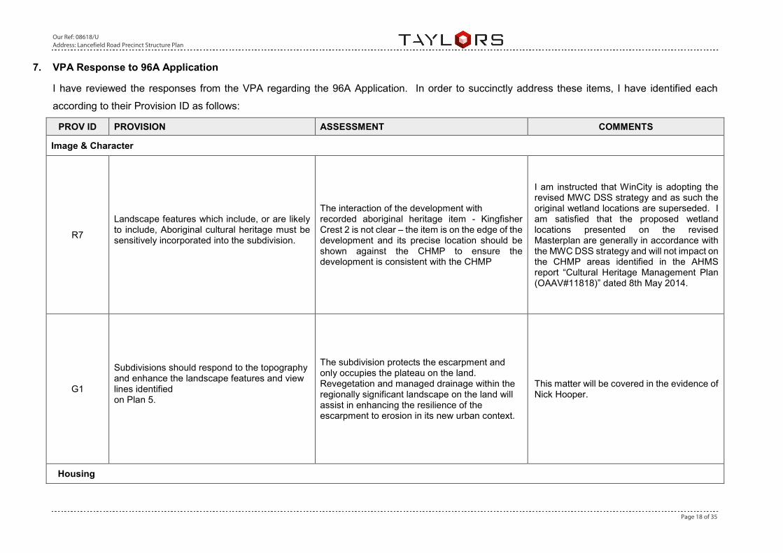
7. VPA Response to 96A Application
I have reviewed the responses from the VPA regarding the 96A Application. In order to succinctly address these items, I have identified each
according to their Provision ID as follows:
PROV ID PROVISION ASSESSMENT COMMENTS
Image & Character
R7
Landscape features which include, or are likely to include, Aboriginal cultural heritage must be sensitively incorporated into the subdivision.
The interaction of the development with recorded aboriginal heritage item - Kingfisher Crest 2 is not clear – the item is on the edge of the development and its precise location should be shown against the CHMP to ensure the development is consistent with the CHMP
I am instructed that WinCity is adopting the revised MWC DSS strategy and as such the original wetland locations are superseded. I am satisfied that the proposed wetland locations presented on the revised Masterplan are generally in accordance with the MWC DSS strategy and will not impact on the CHMP areas identified in the AHMS report “Cultural Heritage Management Plan (OAAV#11818)” dated 8th May 2014.
G1
Subdivisions should respond to the topography and enhance the landscape features and view lines identified on Plan 5.
The subdivision protects the escarpment and only occupies the plateau on the land. Revegetation and managed drainage within the regionally significant landscape on the land will assist in enhancing the resilience of the escarpment to erosion in its new urban context.
This matter will be covered in the evidence of Nick Hooper.
Housing
Our Ref: 08618/U Address: Lancefield Road Precinct Structure Plan
Page 19 of 35
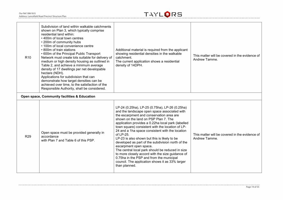
R10
Subdivision of land within walkable catchments shown on Plan 3, which typically comprise residential land within: • 400m of local town centres • 200m of community hubs • 100m of local convenience centre • 800m of train stations • 600m of the Principal Public Transport Network must create lots suitable for delivery of medium or high density housing as outlined in Table 2, and achieve a minimum average density of 17 dwellings per net developable hectare (NDH). Applications for subdivision that can demonstrate how target densities can be achieved over time, to the satisfaction of the Responsible Authority, shall be considered.
Additional material is required from the applicant showing residential densities in the walkable catchment. The current application shows a residential density of 14DPH.
This matter will be covered in the evidence of Andrew Tamme.
Open space, Community facilities & Education
R29 Open space must be provided generally in accordance with Plan 7 and Table 6 of this PSP.
LP-24 (0.25ha), LP-25 (0.75ha), LP-26 (0.25ha) and the landscape open space associated with the escarpment and conservation area are shown on the land on PSP Plan 7. The application provides a 0.22ha local park (labelled town square) consistent with the location of LP-24 and a 1ha space consistent with the location of LP-25. LP-23 is also shown but this is likely to be developed as part of the subdivision north of the escarpment open space. The central local park should be reduced in size to more closely accord with the size guidance of 0.75ha in the PSP and from the municipal council. The application shows it as 33% larger than planned.
This matter will be covered in the evidence of Andrew Tamme.
Our Ref: 08618/U Address: Lancefield Road Precinct Structure Plan
Page 20 of 35
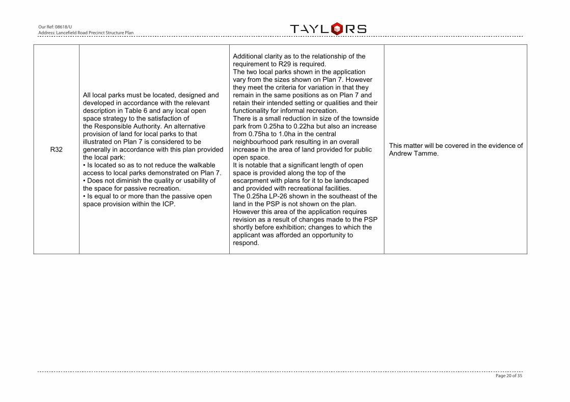
R32
All local parks must be located, designed and developed in accordance with the relevant description in Table 6 and any local open space strategy to the satisfaction of the Responsible Authority. An alternative provision of land for local parks to that illustrated on Plan 7 is considered to be generally in accordance with this plan provided the local park: • Is located so as to not reduce the walkable access to local parks demonstrated on Plan 7. • Does not diminish the quality or usability of the space for passive recreation. • Is equal to or more than the passive open space provision within the ICP.
Additional clarity as to the relationship of the requirement to R29 is required. The two local parks shown in the application vary from the sizes shown on Plan 7. However they meet the criteria for variation in that they remain in the same positions as on Plan 7 and retain their intended setting or qualities and their functionality for informal recreation. There is a small reduction in size of the townside park from 0.25ha to 0.22ha but also an increase from 0.75ha to 1.0ha in the central neighbourhood park resulting in an overall increase in the area of land provided for public open space. It is notable that a significant length of open space is provided along the top of the escarpment with plans for it to be landscaped and provided with recreational facilities. The 0.25ha LP-26 shown in the southeast of the land in the PSP is not shown on the plan. However this area of the application requires revision as a result of changes made to the PSP shortly before exhibition; changes to which the applicant was afforded an opportunity to respond.
This matter will be covered in the evidence of Andrew Tamme.

Our Ref: 08618/U Address: Lancefield Road Precinct Structure Plan
Page 21 of 35
Conservation Area Concept Plan
G54
Drainage of stormwater wetlands should be designed to minimise the impact of urban stormwater on the biodiversity values of the conservation area.
Further assessment required against drainage scheme.
I am instructed that WinCity is adopting the revised MWC DSS strategy and as such the original wetland locations are superseded. I am satisfied that the proposed MWC wetland locations presented on the revised Masterplan are generally in accordance with the MWC DSS strategy. Treated stormwater flows will be discharged via MWC scheme pipe networks and via existing tributaries to Emu Creek and will be designed and constructed so to minimise disturbance to conservation zones and biodiversity values adjacent to Emu Creek.
Public Transport
R66
Bus stop facilities must be designed as an integral part of town centres and activity generating land uses such as schools, sports reserves, and employment areas.
Bus stop locations have not yet been determined by the public transport authority.
This matter will be covered in the evidence of Nick Hooper.
Integrated Water Management
R73
Final design and boundary of constructed waterway corridors, retarding basins, wetlands, stormwater quality treatment infrastructure and associated paths, boardwalks, bridges and planting, must be to the satisfaction of Melbourne Water and the Responsible Authority.
The applications does not accord with the drainage layouts shown in the PSP and requires revision following further consultation with Melbourne Water.
I am instructed that WinCity is adopting the revised MWC DSS strategy. I am satisfied that the proposed wetland locations presented on the revised Masterplan are generally in accordance with the MWC DSS strategy.
Our Ref: 08618/U Address: Lancefield Road Precinct Structure Plan
Page 22 of 35
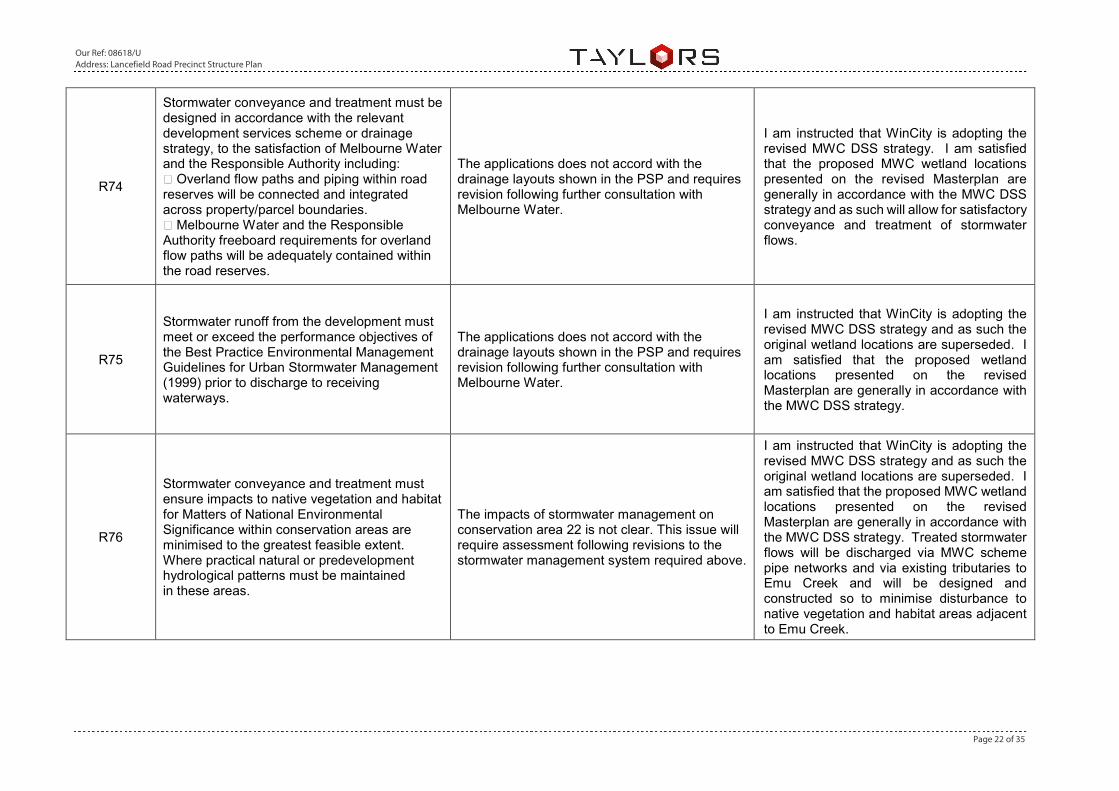
R74
Stormwater conveyance and treatment must be designed in accordance with the relevant development services scheme or drainage strategy, to the satisfaction of Melbourne Water and the Responsible Authority including: Overland flow paths and piping within road reserves will be connected and integrated across property/parcel boundaries. Melbourne Water and the Responsible Authority freeboard requirements for overland flow paths will be adequately contained within the road reserves.
The applications does not accord with the drainage layouts shown in the PSP and requires revision following further consultation with Melbourne Water.
I am instructed that WinCity is adopting the revised MWC DSS strategy. I am satisfied that the proposed MWC wetland locations presented on the revised Masterplan are generally in accordance with the MWC DSS strategy and as such will allow for satisfactory conveyance and treatment of stormwater flows.
R75
Stormwater runoff from the development must meet or exceed the performance objectives of the Best Practice Environmental Management Guidelines for Urban Stormwater Management (1999) prior to discharge to receiving waterways.
The applications does not accord with the drainage layouts shown in the PSP and requires revision following further consultation with Melbourne Water.
I am instructed that WinCity is adopting the revised MWC DSS strategy and as such the original wetland locations are superseded. I am satisfied that the proposed wetland locations presented on the revised Masterplan are generally in accordance with the MWC DSS strategy.
R76
Stormwater conveyance and treatment must ensure impacts to native vegetation and habitat for Matters of National Environmental Significance within conservation areas are minimised to the greatest feasible extent. Where practical natural or predevelopment hydrological patterns must be maintained in these areas.
The impacts of stormwater management on conservation area 22 is not clear. This issue will require assessment following revisions to the stormwater management system required above.
I am instructed that WinCity is adopting the revised MWC DSS strategy and as such the original wetland locations are superseded. I am satisfied that the proposed MWC wetland locations presented on the revised Masterplan are generally in accordance with the MWC DSS strategy. Treated stormwater flows will be discharged via MWC scheme pipe networks and via existing tributaries to Emu Creek and will be designed and constructed so to minimise disturbance to native vegetation and habitat areas adjacent to Emu Creek.
Our Ref: 08618/U Address: Lancefield Road Precinct Structure Plan
Page 23 of 35
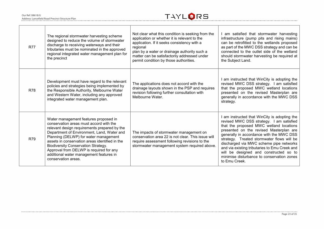
R77
The regional stormwater harvesting scheme designed to reduce the volume of stormwater discharge to receiving waterways and their tributaries must be nominated in the approved regional integrated water management plan for the precinct
Not clear what this condition is seeking from the application or whether it is relevant to the application. If it seeks consistency with a regional plan by a water or drainage authority such a matter can be satisfactorily addressed under permit condition by those authorities.
I am satisfied that stormwater harvesting infrastructure (pump pits and rising mains) can be retrofitted to the wetlands proposed as part of the MWC DSS strategy and can be connected to the outlet side of the wetland should stormwater harvesting be required at the Subject Land.
R78
Development must have regard to the relevant policies and strategies being implemented by the Responsible Authority, Melbourne Water and Western Water, including any approved integrated water management plan.
The applications does not accord with the drainage layouts shown in the PSP and requires revision following further consultation with Melbourne Water.
I am instructed that WinCity is adopting the revised MWC DSS strategy. I am satisfied that the proposed MWC wetland locations presented on the revised Masterplan are generally in accordance with the MWC DSS strategy.
R79
Water management features proposed in conservation areas must accord with the relevant design requirements prepared by the Department of Environment, Land, Water and Planning (DELWP) for water management assets in conservation areas identified in the Biodiversity Conservation Strategy. Approval from DELWP is required for any additional water management features in conservation areas.
The impacts of stormwater management on conservation area 22 is not clear. This issue will require assessment following revisions to the stormwater management system required above.
I am instructed that WinCity is adopting the revised MWC DSS strategy. I am satisfied that the proposed MWC wetland locations presented on the revised Masterplan are generally in accordance with the MWC DSS strategy. Treated stormwater flows will be discharged via MWC scheme pipe networks and via existing tributaries to Emu Creek and will be designed and constructed so to minimise disturbance to conservation zones to Emu Creek.

Our Ref: 08618/U Address: Lancefield Road Precinct Structure Plan
Page 24 of 35
G68
Development should support and facilitate the use of alternative water supplies nominated in the approved integrated water management plan for the precinct.
It is not clear what plan or document is referred to as being the ‘approved integrated water management plan for the precinct’.
I am satisfied that the proposed Masterplan could support and facilitate an alternative water supply in the form of stormwater harvesting. Stormwater harvesting infrastructure (pump pits and rising mains) can be retrofitted to the proposed MWC DSS strategy, connected to the outlet side of the wetland should stormwater harvesting be required at the Subject Site.
G69
Maximise the potential for integration of stormwater management infrastructure with recreation and environmental uses in open space where this does not conflict with the primary function of the open space.
There is likely to be significant integration of stormwater management with the landscape open space to be set aside around the Emu Creek tributary. Assessment by Melbourne Water required.
I am instructed that WinCity is adopting the revised MWC DSS strategy. I am satisfied that the proposed MWC wetland locations presented on the revised Masterplan are generally in accordance with the MWC DSS strategy and as such will adequately integrate with landscape open space set aside around Emu Creek.
G71
The design and layout of roads, road reserves, car parks and public open space should optimise water use efficiency and long-term viability of vegetation and public uses through the use of overland flow paths, Water Sensitive Urban Design initiatives such as rain gardens and locally treated storm water for irrigation.
The applications does not accord with the drainage layouts shown in the PSP and requires revision following further consultation with Melbourne Water.
I am instructed that WinCity is adopting the revised MWC DSS strategy. I am satisfied that the proposed MWC wetland locations presented on the revised Masterplan are generally in accordance with the MWC DSS strategy.
G72 Increase the use of fit-for-purpose alternative water sources such as storm water, rain water and recycled water.
No provision is made to use retained storm water for irrigation. Further review is required by Melbourne Water, Western Water and the Hume City Council.
I am satisfied that stormwater harvesting infrastructure (pump pits and rising mains) can be retrofitted to the proposed MWC DSS strategy, connected to the outlet side of the wetland should stormwater harvesting be required at the Subject Site.
Our Ref: 08618/U Address: Lancefield Road Precinct Structure Plan
Page 25 of 35
Utilities
R81
Delivery of underground services must be coordinated, located, and bundled (utilising common trenching) to facilitate the planting of trees and other vegetation within road verges.
The application does not propose to use common trenching. It is not clear how achievable this is given the conflicting requirements and determining referral authority status of service authorities.
I am instructed by WinCity that the delivery and coordination of underground services will be in accordance with the GAA “Engineering Design and Construction Manual for Subdivision in Growth Areas” April 2011 and associated standard drawings, which makes allowance for the use of shared trenching to facilitate the planting of trees and other vegetation within the road reserve.
Retarding Basins Table
WI-15 3.40 Retarding
Basin Generally located as shown on Plan 11
Council
WI-17 2.70 Retarding Basin
Generally located as show on Plan 11
Council
WI-15 and WI-17 are shown on the land in the PSP. Neither of these assets are represented on in the application. The application requires revision following further consultation with Melbourne Water.
I am instructed that WinCity is adopting the revised MWC DSS strategy and as such the original wetland locations are superseded. I am satisfied that the proposed wetland locations presented on the revised Masterplan are generally in accordance with the MWC DSS strategy.

Our Ref: 08618/U Address: Lancefield Road Precinct Structure Plan
Page 26 of 35
8. Revised Town Centre Concept Plan
I have reviewed the Town Centre Concept Plan design prepared by David Lock and Associates,
dated 19th June 2017 (Appendix B). It is my opinion that the proposed town centre plan and the
revised Melbourne Water Developer Services Scheme strategy conflicts with one another.
The MWC DSS requires that PSP exhibited wetland, WL-15, be amended so that it is positioned ‘off-
line’ from the existing tributary that runs along the eastern boundary of the town centre site. This
results in a smaller wetland/sediment pond being located above the break of slope line inside the
town centre area as presented in the David Lock and Associates design plan. Directly, the revised
wetland impacts on the proposed location of the Community Facilities.
It is my opinion that the Community Facilities should be relocated to allow for the proposed MWC
DSS wetland to be located above the break of slope alignment, directly upstream of the proposed
bridge across the adjacent tributary, for the following reasons;
• Proximity to Tributary – To ensure maximum catchment capture and treatment, the wetland
should be located as close to the tributary as possible to minimise untreated stormwater flows
from entering the tributary and ultimately Emu Creek.
• Break of Slope Line – The placement of the wetland above the break of slope line minimises
the earthworks required and thus overall footprint required for the drainage reserve.
Construction of the wetland within the tributary would result in a much large infrastructure
footprint and consequently disturbance to the tributary as result of batter slopes ‘chasing’ the
existing terrain. A requirement of Melbourne Water is to achieve batter slopes no steeper
than 1m vertical to every 5m horizontal (1v:5h) or 20% gradient. This results in improved
safety and ability to maintain landscapes. The slope within the tributary is 1v in 5.6h or a
gradient of approximately 17.8%. A 1v:5h batter slope from a 1m high embankment or dam
wall would require approximately 46 metres of horizontal distance before it intersects the
1v:5.6h tributary slope. The land above the break of slope line is flatter at a slope of 1v in
18h, or a gradient of approximately 5.5%. The same scenario of a 1m high embankment of
dam wall would only take approximately 7 metres of horizontal distance before it intersects
the 1v:18h terrain above the break of slope line. Figures 1 & 2 below show visually the impact
of earthworks construction on steep terrain.
• Reduced Maintenance and Construction Costs – A smaller drainage reserve, because of
placing the wetland above the break of slope line, will result in less area that is to be
maintained by Wyndham Council (ieR mowing of grassed areas, removal of weeds etcR).
Similarly, a reduce earthworks footprint will be easier and less expensive to construct.

Our Ref: 08618/U Address: Lancefield Road Precinct Structure Plan
Page 27 of 35
Figure 1 – Earthworks Fill Batter Example
Figure 2 – Earthworks Cut Batter Example
Earth Mound for Basin Wall
Earthworks Batter 20% (1v:5h) Earthworks Batter 20% (1v:5h)
Additional batter length and fill required on steeper
Natural Surface
Earthworks Batter 20% (1v:5h)
Additional batter length and cut required on steeper Natural Surface
Our Ref: 08618/U Address: Lancefield Road Precinct Structure Plan
Page 28 of 35
9. VPA 96A Application RFI
I have reviewed the VPA supplied request for information pertaining to the 96A Application issued
on the 18th of July 2017. I have review item 3 in the RFI response and I am satisfied that the revised
masterplan addresses the requirements of the Melbourne Water revised draft DSS. (Appendix C)
I have reviewed the remaining items and I am satisfied that Mr Nick Hooper and Mr Andrew Tamme
have addressed these points in their evidence.

Our Ref: 08618/U Address: Lancefield Road Precinct Structure Plan
Page 29 of 35
10. Conclusion
It is my opinion that the WinCity masterplan is worthy of support and Planning Permit P18855 is
worth of approval subject to the following;
• WinCity adopts the revised Melbourne Water Draft Developer Services Scheme. It is my
opinion that the 96A Application masterplan is generally in accordance with the revised draft
DSS.
• A note should be added to Plan 11 within the PSP stating that “confirmation of size and final
location of wetland reserves is subject to functional and detail design approval to the
satisfaction of Melbourne Water”;
• Amend the David Lock and Associates Town Centre Concept Plan so that the conflict
between the Community Facility and Wetland WL-15 is resolved. It is my opinion that the
wetland location should be retained and the Community Facility relocated.
• Review the Break of Slope line within Title 3-22/PP2258 which has been incorrectly located
and amend in accordance with scientifically assessed alignment.
ANDREW MATHESON
Taylors
August 2017
Our Ref: 08618/U Address: Lancefield Road Precinct Structure Plan
Page 30 of 35
11. Appendix A – Break of Slope Analysis
WinCity have instructed me to review the break of slope line as defined by the exhibited PSP and with the revised break of slope line as provided by the VPA in May 2017. I understand that the break of slope has been
defined by a ‘virtual’ site inspection conducted by the VPA. The exhibited PSP defines the break of slope on Plan 3 as “setback required for bush fire management, protection of visual and landscape qualities, and
linear trails”. The PSP also allows on the ‘Local Access Street Level 1 (16m)’ cross section, the development on land as steep as a 17.5% gradient. To assess the break of slope I have overlayed the supplied VPA
linework on to the feature and 1 metre contour information obtained from the Victorian Government’s Open Data Directory. I have examined the 1 metre contour data for abrupt changes in gradient or for areas that
exceed 17.5% gradient in proximity of the VPA supplied break of slope line. It is my opinion that the VPA Break of Slope line has been incorrectly located in the north-east corner of Title 3-22/PP2258, which forms part
of the Subject Land, and that the Break of Slope location which I have identified by scientific analysis should be adopted.
Break of Slope Comparison Plan (3-22/PP2258)
VPA Supplied Break of Slope
Taylors Assessed Break of Slope

Our Ref: 08618/U Address: Lancefield Road Precinct Structure Plan
Page 31 of 35
Section A
Section B
PSP Supplied Break of Slope Taylors Assessed
Break of Slope
18.8m
PSP Supplied Break of Slope
Taylors Assessed Break of Slope
11.2m

Our Ref: 08618/U Address: Lancefield Road Precinct Structure Plan
Page 32 of 35
Section C
Section D
Taylors Assessed Break of Slope
13.1m
Taylors Assessed Break of Slope
6.5m
PSP Supplied Break of Slope
PSP Supplied Break of Slope
Our Ref: 08618/U Address: Lancefield Road Precinct Structure Plan
Page 33 of 35
Section E
Taylors Assessed Break of Slope
32.5m
PSP Supplied Break of Slope
Our Ref: 08618/U Address: Lancefield Road Precinct Structure Plan
Page 34 of 35
12. Appendix B – David Lock and Associates Revised Town Centre Concept Plan

Our Ref: 08618/U Address: Lancefield Road Precinct Structure Plan
Page 35 of 35
13. Appendix C – Revised Melbourne Water Draft Developer Services Scheme