engineering feasibility study yellow creek lake …€¦ · · 2014-03-05engineering feasibility...
TRANSCRIPT

Engineering Feasibility Study Yellow Creek Lake Watershed Franklin, Seward, and Clay Townships Kosciusko County, Indiana
February 2014 Prepared for: Yellow Creek Watershed Alliance Dave Patterson 6579 West Grimme Lane Claypool, Indiana 46510 260-432-7200 Prepared by: Davey Resource Group A Division of The Davey Tree Expert Company 1500 North Mantua Street Kent, Ohio 44240 800-828-8312

Davey Resource Group i February 2014
Table of Contents
Acknowledgements ............................................................................................................................... ii Executive Summary .............................................................................................................................. iii Introduction ........................................................................................................................................... 1 Information Gaps .................................................................................................................................. 6 Public Outreach ..................................................................................................................................... 8 Feasibility Assessment Methods .......................................................................................................... 8 Feasibility Assessment Results .......................................................................................................... 12 Findings and Recommendations ........................................................................................................ 31 References ........................................................................................................................................... 34
Tables 1. Recommended Annual Phosphorus Reduction per Lake (JFNew 2009) .................................. 5 2. Recommended Vegetated Buffer Strip Width Based On Slope (Eck 2000) ............................. 6 3. Non-Point Source Pollution Generated and Estimated Removal from Wetland
Installation in South Diamond Lake Sub-Watershed .............................................................. 14 4. Summary of Estimated Costs for Yellow Creek Resort Group Pier ....................................... 20 5. Summary of Estimated Costs for Yellow Creek Resort Natural Shoreline Stabilization....... 21 6. Timeline for Yellow Creek Resort Natural Shoreline Stabilization ........................................ 21 7. Summary of Estimated Costs for Amanda’s Point Project...................................................... 24 8. Timeline for Amanda’s Point Project ...................................................................................... 25 9. Two-Stage Ditch Construction Unfeasibility Summary .......................................................... 28 10. Summary of Obstacles to Feasibility for Each Project. ........................................................... 32 11. Feasibility Conclusions Summary ........................................................................................... 32
Figures 1. Location of Yellow Creek Lake watershed on an Indiana county map. .................................... 3 2. Evaluated project locations within Yellow Creek Lake watershed. .......................................... 4 3. Recommended vegetated buffer strip locations......................................................................... 7 4. Diagram of conceptual 2-stage ditch (The Nature Conservancy 2013). ................................ 25 5. Evaluated 2-stage ditch construction locations. ...................................................................... 27
Appendices A. Public Information Brochure B. Public Meeting Notes C. Yellow Creek Lake Historical (1951) Aerial and Current Lake Shoreline D. Yellow Creek Lake Group Pier E. Yellow Creek Lake Natural Shoreline Stabilization Plan F. Erosion Intensity Worksheets G. Amanda’s Point Shoreline Stabilization Plan

Davey Resource Group ii February 2014
Acknowledgements This study was made possible by funding from the Indiana Department of Natural Resources (IDNR) Lake and River Enhancement (LARE) Program, the Kosciusko County Community Foundation, and Yellow Creek Watershed Alliance (YCWA). Davey Resource Group project team members conducted fieldwork, data collection, report writing and mapping, public outreach, and provided project oversight. The Davey Resource Group project team consisted of Chad Appleman, Caleb Asbury, Jacob Bannister, Alicia Douglass, Ken Christensen, and Holly Richards.
Individuals who provided project consultation, assisted with field reconnaissance, and/or contributed to this report via personal communication, include: Dr. Nate Bosch, Director of Kosciusko Lakes and Streams and Assistant Professor of Environmental Biology at Grace College; Rod Edgell from IDNR LARE Program; Wayne Stanger, retired Nobel County Soil and Water Conservation District; Dave Patterson from the YCWA; Logan Garner from the Indiana Department of Agriculture; John Bender from Diamond Lake; Buddy Busby, Alan Grossnickle, and Tammy Cole from Beaver Dam Lake; Sam St. Clair, Amy Lybarger, and Duane Reithman with the Natural Resources Conservation Service (NRCS); Andrea Baker with the Kosciusko County Soil and Water Conservation District (SWCD); Kent Wamsley, The Nature Conservancy; Richard Kemper, the Kosciusko County Surveyor; and Tim Woodward, Turkey Creek Regional Sewer District.
Special thanks are due to numerous Yellow Creek Lake watershed stakeholders including: Todd Hoffman, Kevin Hohman Luther Miller, and Amanda Pruitt who assisted project staff by allowing access to their property.
Special thanks are also due to the dedicated YCWA members who promoted, organized, and helped facilitate the public stakeholder meeting.

Davey Resource Group iii February 2014
Executive Summary The Yellow Creek Lake watershed Engineering Feasibility Study is designed to provide a brief overview of current watershed water quality and quantity conditions and investigate the feasibility of potential projects that would improve water quality in the watershed. The study was funded by an IDNR LARE Program grant with a match provided by YCWA. YCWA retained Davey Resource Group, a division of The Davey Tree Expert Company, to conduct the study.
The Yellow Creek Lake watershed consists of 6,535 acres (2,645 hectares) located in southwestern Kosciusko County, Indiana. The watershed study area is west of State Route (SR) 15 and mostly north of SR 14.
Multiple best management practices (BMPs) that would improve the quality of water reaching Yellow Creek Lake were evaluated as part of this study. BMPs often aim to reduce non-point source pollution in a watershed—sediment and nutrients constitute the most predominant non-point source pollutants. Specific BMPs evaluated include two-stage ditch construction, vegetated buffer strip installation, floodplain reconnection, shoreline stabilization, and wetland development projects. Factors taken into consideration for determining the feasibility of each project include land availability, permit requirements, environmental impacts, and costs associated with each project.
Recommendations for further actions include: stabilizing the shoreline at Amanda’s Point using a combination of bioengineered materials and glacial stone; stabilizing the southern shore of Yellow Creek Lake using a variety of bio-engineering techniques; reducing wave action and foot traffic along the southeastern Yellow Creek Lake shoreline by replacing current piers with a floating group pier; and ongoing promotion of installing vegetated buffer strips throughout the watershed.
A lack of available land and landowner interest is an obstacle to the feasibility of constructing wetlands south of Diamond Lake and reconnecting the stream to its floodplain between Diamond Lake and Yellow Creek Lake. A lack of suitable soil types in critical locations is an obstacle to the feasibility of constructing a two-stage ditch within the watershed.

Davey Resource Group 1 February 2014
Introduction YCWA is an organization dedicated to improving water quality in Yellow Creek Lake and the lakes that drain to it, including Beaver Dam Lake, Diamond Lake, Hill Lake Loon Lake, and McClures Lake (Photograph 1).
YCWA pursued and was awarded funding from the IDNR LARE Program to conduct an Engineering Feasibility Study. Davey Resource Group was retained by YCWA to conduct the study. The purpose of the study was to investigate the feasibility of implementing five projects in the Yellow Creek Lakes watershed. Four of the projects were preselected from those identified in the Yellow Creek Lakes Watershed Diagnostic Study which was completed in 2009 by JFNew. The fifth project involved assessing the feasibility of constructing a two-stage ditch in an unspecified location within the watershed. A sixth project was added during the course of the study by LARE Biologist Rod Edgell. The proposed projects are as follows:
● Project 1—Assess the feasibility of constructing a wetland south of Diamond Lake along County Road (CR) 550 South to reduce nutrients flowing to the lake.
● Project 2—Examine the potential of locating an alternate discharge point and upgrading a privately owned waste water treatment plant at Yellow Creek Lake Ministries Campground on the southwest side of Yellow Creek Lake.
● Project 3—Assess the feasibility of bioengineering techniques to stabilize the south shoreline of Yellow Creek Lake on property owned by Yellow Creek Resort.
● Project 4—Assess the feasibility of stabilizing eroding shoreline on Amanda’s Point in Beaver Dam Lake.
● Project 5—Assess the feasibility of constructing a two-stage ditch within the watershed.
● Project 6—Assess the feasibility of reconnecting the stream between Yellow Creek Lake and Diamond Lake to its floodplain on the Miller property.
The goal of the Engineering Feasibility Study is to determine the feasibility of proposed construction projects, prepare for engineered design if necessary, and ensure project implementation success.
Prior to the start of this study, Yellow Creek Lake Ministries independently contracted assistance to assess sewage treatment needs and design and permit upgrades to the current system. Work contracted by Yellow Creek Lake Ministries was far beyond the scope of work proposed for Project 2 as included in this study; consequently, assessing feasibility of this proposed work was no longer necessary as part of this study.
Photograph 1 (12-18-12). This winter view from the south side of Yellow Creek Lake depicts still water, which significantly contrasts from a typical summer day.

Davey Resource Group 2 February 2014
Project Location The Yellow Creek Lake watershed consists of approximately 6,535 acres (2,645 hectares) (U.S. Geological Survey [USGS] 2012). The watershed is located in Clay, Franklin, Lake, and Seward Townships in southwest Kosciusko County, Indiana (Figure 1). SR 14 crosses the southernmost portion of the watershed. The locations of Projects 1–4 and 6 are depicted on Figure 2. The locations of tributaries assessed for conversion to two-stage ditches as part of Project 5 are scattered across the watershed. Specific locations assessed are further identified in the Feasibility Assessment Results section of this report.
The watershed contains six different lakes as well as many streams and drains that connect the lakes to one another. Beaver Dam Lake is located on the western edge of the watershed. It is primarily fed by Eaton Ditch but also collects overland flow from many areas draining directly into the lake. Water leaves Beaver Dam Lake through an unnamed tributary and flows into nearby Loon Lake. The water flowing from Beaver Dam Lake constitutes the majority of inflow for Loon Lake (JFNew 2009). An unnamed tributary also contributes water to Loon Lake. McClures Lake is also found in the western half of the watershed. Primary inflow of water to this lake includes an unnamed tributary and overland flow. Both Loon Lake and McClures Lake drain to Yellow Creek Lake via Yellow Creek.
Hill Lake is located in the eastern portion of the watershed. This lake is not fed by any tributary drains. Hydrology is derived from overland flow and groundwater. Water leaves the lake and flows to Diamond Lake through the Michaels Ditch. It is the single largest contributor of water to Diamond Lake (JFNew 2009). Water also drains to Diamond Lake via two unnamed tributaries and overland flow. Diamond Lake drains eastward via an unnamed tributary to Yellow Creek Lake.
Yellow Creek Lake is the most downstream lake in the watershed. Water reaches the lake via two main sources: Yellow Creek from the south draining Beaver Dam, Loon, and McClures Lakes and also from an unnamed tributary originating from Diamond Lake. A smaller amount of water drains directly into Yellow Creek Lake via overland flow.

Davey Resource Group 3 February 2014
Figure 1. Location of Yellow Creek Lake watershed on an Indiana county map.

Davey Resource Group 4 February 2014
Figure 2. Evaluated project locations within Yellow Creek Lake watershed.

Davey Resource Group 5 February 2014
Historical Studies and Other Background Information Yellow Creek Lakes Watershed Diagnostic Study was completed by JFNew in June 2009. The study determined that water quality generally decreased when moving towards Yellow Creek Lake through the watershed. This is believed to be due to the increase in contact with the surrounding watershed containing large quantities of agricultural practices. Agricultural practices lead to increases in non-point source pollution, including sediment and nutrients. In Beaver Dam and Hill Lakes, on the edge of the watershed, the surrounding land use does not influence water quality as much as downstream in Diamond Lake, Loon Lake, McClures Lake, and ultimately Yellow Creek Lake. The drainage area to lake size ratio is lower in the upstream lakes. Consequently, this indicates a lower influence from the watershed, and the lakes are predicted to show fewer signs of non-point source pollution influence. However, shortly after the JFNew report in 2009 was completed, a cyanobacteria (blue-green algae) bloom was recorded in Hill and Diamond Lakes. A cause for the algal bloom is still unknown (N. Bosch, personal communication, November 5, 2013). Nutrients and sediment transport downstream in the watershed are key components in decreasing water quality. For this reason, the downstream lakes were found to have high eutrophic scores on the Carlson’s Trophic Status Index (Carlson TSI). Eutrophication can result in an increase in algal concentration—another characteristic witnessed in the watershed. Eutrophication results from high phosphorus concentrations both dissolved in the water and bound to sediment reaching the lakes. Prioritize efforts that reduce phosphorus inputs to the lakes rather than addressing phosphorus already present in the Yellow Creek Lakes. Land use in the watershed constitutes a large part of the water quality problems experienced within the Yellow Creek Lake watershed. It is estimated that approximately 70% of the land in the watershed is used for row-crop agriculture (Purdue Univ. 2013). Various row-crop farming practices can result in significant amounts of non-point source pollutants, such as sediment, nitrogen, and phosphorus, reaching waterways. Livestock pastures and hay fields constitute approximately another 4% of land use in the watershed (Purdue Univ. 2013). These areas can also be a source of nutrients in the watershed. Grace College and the Indiana Clean Lakes Program have collected water quality data for all lakes in the watershed (Lesko 2007, Indiana Clean Lakes Program 2009). Large quantities of data from these sources were used in the watershed diagnostic study completed in 2009. The data indicate a wide fluctuation in total phosphorus concentration within the upstream lakes of Beaver Dam Lake, Diamond Lake, Hill Lake, Loon Lake, and McClures Lake. However, an upward trend of total phosphorus concentration was found in Yellow Creek Lake—the most downstream lake in the watershed. Other data from these sources include depth-volume profiles, nitrogen compound concentrations, Secchi disk measurements, and water temperature data. Table 1 summarizes the reductions required to reduce phosphorus concentration to an acceptable level (0.03 mg/L) in each lake.
Table 1. Recommended Annual Phosphorus Reduction per Lake (JFNew 2009)
Lake Phosphorus Reduction Needed (pounds/year) Percent Reduction Needed
Hill Lake 31 12.2% Beaver Dam Lake 2,110 80.1% Loon Lake 1,502 83.7% McClures Lake 750 77.2% Yellow Creek Lake 2,400 69.2%

Davey Resource Group 6 February 2014
Information Gaps During the watershed diagnostic study performed by JFNew in 2009, general watershed recommendations were generated. One of the recommendations included the addition of 100-foot-wide vegetated buffer strips in vulnerable areas throughout the watershed. Specific vulnerable areas were not identified in the diagnostic study. Vegetated buffer strips are valuable BMPs for reducing sediment and nutrients reaching waterways. Average buffer strip pollutant removal rates are 65% for sediment, 70% for total nitrogen, and 75% for total phosphorus (Tetra Tech 2006). The efficiency of buffer strips depends upon several factors, including rainfall, soil type, topography, and the type of vegetation used in the buffer strip. Dactylis glomerata (orchardgrass), a commonly used plant in buffer strips, has shown to retain as much as 87% of the total phosphorus draining through the buffer strip (Dillaha et al. 1989). Adequate buffer strip width is site specific based on field characteristics, such as drainage area, slope, and soil type. The NRCS will determine adequate buffer strip widths on a case-by-case basis. Recommended buffer strip widths based on slope are depicted in Table 2. Slopes in the watershed tend to range from 0–6%.
Table 2. Recommended Vegetated Buffer Strip Width Based On Slope (Eck 2000)
Land Slope (%) Buffer Strip Width (Feet) 0–5 20 5–6 30 6–9 40
9–13 50 13–18 60
Modeling was performed on the Yellow Creek Lake watershed using the Spreadsheet Tool for the Estimation of Pollutant Load (STEPL) to interpret effectiveness of using vegetated buffer strips. Modeling indicates 1,688 pounds (766 kilograms) per year decline of total phosphorus when 50% of the streams in the watershed are lined with adequate buffer strips. This figure represents a decrease of total phosphorus by 34%. If 75% of the streams in the watershed have adequate buffer strips, the amount of phosphorus could potentially be decreased by 2,532 pounds (1,149 kilograms) per year—a 52% decrease. Buffer strips are not a cure to alleviate high phosphorus concentrations in a watershed. They are one of many BMPs that can be implemented to lower the amount of sediment and nutrients entering surrounding waterways. Figure 3 illustrates recommended vegetated buffer strip installation locations within the watershed. Davey Resource Group recommends a total of 50,484 linear feet (15,388 meters) of vegetated buffer strips be constructed in the surrounding watershed. High-priority areas are those that currently have less than 20 feet of any type of riparian buffer. Low-priority locations are those that currently have greater than 20 feet, but less than 30 feet of any type of riparian buffer. This information was given to the NCRS for further inquiry into landowner cooperation into placing buffer strips onto their property. The information included the priority location map, property owners of each land parcel to investigate, and contact information for each landowner. This same information was provided to Yellow Creek Watershed Alliance for future work with the NRCS. Installation of buffer strips throughout the watershed should be a primary focus going forward. Non-point source pollutants should be targeted for removal prior to entering the watershed. Tackling water quality problems at the source is the best way to address them.

Davey Resource Group 7 February 2014
Figure 3. Recommended vegetated buffer strip locations.

Davey Resource Group 8 February 2014
Public Outreach A public outreach meeting was conducted on Saturday, July 20, 2013 at the Beaver Dam and Loon Lake Conservation Club to inform watershed residents about the purpose and progress of the study. An educational public information brochure was produced for this project and distributed at the meeting. A copy of the brochure is included in Appendix A. Jacob Bannister from Davey Resource Group informed meeting attendees as to the current status of the project, fielded questions, and addressed concerns raised by meeting attendees. The attendees and topics of discussion from the meeting are included in Appendix B.
Feasibility Assessment Methods Environmental Assessments
A variety of environmental factors, such as soil types and the presence or absence of wetlands and natural shorelines, were evaluated to assess feasibility of proposed projects. Parameters for assessing feasibility in relation to soils, wetlands, and shoreline erosion follow.
Soils Soil type and texture can greatly influence the potential for soil erosion and stability. Mineral soils and organic soils are the two primary types of soils. Mineral soils are derived from decomposed minerals and rocks with little organic carbon derived from decomposed organisms; whereas, organic soils contain deep layers with a minimum of 12–20% organic carbon depending on the extent of clay content (US Department of Agriculture [USDA] 1999). High organic carbon content has a tendency to make organic soils more friable, or easily crumbled, than many soils. Mineral soils having a high sand content may also be more friable.
Muck soils are a type of organic soil. Houghton muck and Palms muck are two muck soil series prevalent in the Yellow Creek Lake watershed. Both of these soil series are known for having poor stability, especially associated with ditch bank collapse (USDA 1989). Gilford mucky sandy loam is a soil series found in the watershed containing significant amounts of muck and sand. It often contains small areas of unmapped Palms muck (USDA 1989). Muck soil types are frequently transported downstream and may even create outwash planes if sand is within the muck.
USDA, NRCS engineers, and The Nature Conservancy staff responsible for pioneering and designing two-stage ditch installations in northern Indiana advise against constructing two-stage ditches in muck soils (K. Wamsley and D. Riethman, personal communication, December 20–21, 2012). Consequently, areas mapped as Houghton muck, Palms muck, and Gilford mucky sandy loam soil series were deemed not feasible for two-stage ditch construction.
Wetlands Wetlands are areas where soils are saturated at or near the surface at a frequency and duration long enough to support a dominance of wetland plants and the development of hydric soils (Environmental Laboratory 1987, U.S. Army Corps of Engineers 2010). National Wetlands Inventory (NWI) maps are a good starting point to determine if wetlands are present on a project site. However, these maps were derived from aerial photointerpretation, and wetland boundaries as reflected on NWI maps may not reflect actual site conditions. Small wetlands may also be present but not included on NWI maps. Wetlands are regulated by state and federal agencies. Consequently, when earth disturbing activities are proposed, a wetland site inspection is warranted.
Davey Resource Group 9 February 2014
Approximate wetland boundaries were mapped by a trained wetlands delineator using a GeoXH™ Trimble® GeoExplorer® 6000 series Dual-frequency Global Navigation Satellite System or GNSS (GPS, GLONASS, SBAS [WAAS]) receiver and antenna with Everest™ multipath rejection technology and Floodlight technology with 220 channels running professional TerraSync™ software capable of decimeter (10–75cm) accuracy after differential correction. Approximate wetland boundaries were mapped based on the presence of wetlands vegetation. Subsurface soil profile inspections and a detailed assessment of hydrology indicators were not performed as required to precisely delineate a wetland boundary. Approximate wetland boundaries are shown on the plan sheets for each project site.
Shoreline Erosion Assessment Davey Resource Group utilized a method outlined in Wisconsin Administrative Code NR 328.08 to assess the intensity of erosion along shorelines at Yellow Creek and Beaver Dam Lakes to ensure that bioengineered materials can be expected to offer reasonable shoreline protection. The method uses a combination of metrics to measure the intensity of shoreline erosion. Metrics include average fetch, depth at 20 and 100 feet, bank height and composition, influence of adjacent structures, aquatic and bank vegetation, bank stability, shoreline geometry and orientation, and boat wakes. Each metric is assigned a score based on current conditions along the shoreline. These scores are then summed to generate a total Erosion Intensity Score (Ei) for the shoreline. The final scores are categorized as either low (≤47), medium (48-67), or high intensity (≥68) energy (Michigan State University 2010). Bioengineered techniques can be expected to be effective in areas with low and medium erosion intensity. In Wisconsin, a site must have an EI score >47 to justify the use of riprap for stabilization measures.
Permit Requirements Multiple federal, state, and local agencies regulate activities that have the potential to influence water quality, alter flow regimes, or modify existing hydrology levels. The agencies that regulate a particular project and the specific permit required is based on a variety of site-specific data, which includes, but is not limited to, the size of disturbance, distance to a public freshwater lake, disturbance elevation, and size of the upstream watershed. A brief summary of applicable regulatory agencies and common permits they issue follows. Certain site-specific parameters for a project may result in a deviation from common scenarios as outlined in the summary. Regulatory agencies should be consulted on a project-by-project basis to prevent unintentional violations. Davey Resource Group has coordinated with regulators at these agencies as appropriate to determine the necessary permits for proposed projects.
U.S. Army Corps of Engineers The US Army Corps of Engineers (USACE) regulates placement of fill in navigable waters and “waters of the U.S.” which drain to navigable waters, including lakes, rivers, streams, and non-isolated wetlands, under Section 10 of the Rivers and Harbors Act and Section 404 of the Clean Water Act. Jurisdiction of “waters of the U.S.” is determined by the USACE and U.S. Environmental Protection Agency.
USACE commonly issues three types of permits in Indiana, including Nationwide Permits, Individual Permits, and Regional General Permits. Nationwide Permits authorize activities that USACE has determined to be “similar in nature, cause only minimal cumulative adverse environmental effects when performed separately, and cause only minimal cumulative adverse effects on the aquatic environment” when certain conditions are met. Indiana Department of Environmental Management (IDEM) has granted approval for many, but not all, USACE Nationwide Permits.

Davey Resource Group 10 February 2014
A USACE Individual Permit is required when a project will impact equal to or greater than one acre of wetland or stream. A USACE Regional General Permit (RGP) allows for impacts that are less than one acre, but are not authorized by a Nationwide Permit. Impacts greater than 0.10 acre of aquatic resources typically require compensatory mitigation including maintenance and monitoring for a period of several years following mitigation implementation.
Indiana Department of Environmental Management Under Section 401 of the Clean Water Act, IDEM regulates placement of fill and potentially other secondary water quality impacts for all aquatic features regulated by USACE under Section 404. IDEM also regulates isolated wetlands under the State Isolated Wetland Law (IC 13-18-22). These waters are collectively referred to as “waters of the State”. An RGP notification form and additional standard data requested by IDEM may be submitted to IDEM for impacts to “waters of the U.S.” equal to or less than 0.10 acre or 300 linear feet providing that certain conditions are met. An RGP is considered authorized if the applicant is not contacted within 30 days of IDEM’s date of receipt. If a project does not meet the terms and conditions required for an RGP from IDEM, then an Individual Section 401 Water Quality Certification (WQC) or Isolated Wetlands Permit from IDEM will be necessary. Compensatory mitigation is typically required for projects requiring Section 401 WQC, and the permit application process may take several months. Mitigation exemptions are available on a case-by-case basis for impacts to isolated wetlands.
Indiana Department of Natural Resources IDNR, Division of Water administers the Lakes Preservation Act (IC 14-26-2), the Lowering of Ten Acres Lakes Act (IC 14-26-5), and the Flood Control Act (IC 14-28-1). A Lakes Preservation Act is required when any work is being conducted within 10 feet of the shoreline as established by the legal lake level on a public freshwater lake. Shoreline stabilization projects fall within the jurisdiction of the Lakes Preservation Act which is administered based on shoreline classifications. Group piers are also regulated under the Lakes Preservation Act. A permit often referred to as a Ditch Reconstruction permit is required under the Lowering of Ten Acres Lakes Act when work is conducted within 0.5 mile of a public freshwater lake and below the legal lake level. Hill Lake, Beaver Dam Lake, McClures Lake, Loon Lake, Diamond Lake, and Yellow Creek Lake are all public freshwater lakes with respective legal lake levels of 871.50 feet (265.64 meters), 868.95 feet (664.86 meters), 865.85 (263.91 meters), 865.74 feet (263.88 meters), 860.75 feet (263.36 meters), and 860.50 feet (262.28 meters) above mean sea level established by IDNR. A Flood Control Act permit is needed for any work conducted in the floodway of a stream with an upstream drainage area of one square mile or greater. An IDNR permit application may require extensive data collection and a lengthy review time depending on specific project site conditions and the presence of existing data. The approval process may be streamlined for work on regulated county drains for which the county surveyor or drainage board is the applicant. Shoreline Classifications
IDNR regulates public freshwater lake shoreline construction based on the conditions at the project site. Shorelines are classified and placed into one of four categories defined in 312 IAC 11-2: significant wetland, natural shoreline, an area of special concern, or developed area. Based on the classification of the shoreline, the allowed materials for seawall construction vary.

Davey Resource Group 11 February 2014
For the shoreline to be classified as a significant wetland, it must meet at least one of the following conditions. It must have at least 2,500 square feet of contiguous emergent or rooted vegetation with floating leaves, have adjacent wetland areas designated by a federal or state agency, or contain animals or plants that are listed as extirpated, endangered, threatened, or rare. To be considered a natural shoreline it must be unaltered for at least 250 feet. For a shoreline to be considered an area of special concern, it must contain at least one of the following characteristics. It must contain more than 625 square feet of contiguous emergent or rooted vegetation with floating leaves, have an unaltered shoreline where bulkhead seawalls are at least 250 feet apart, or contain a bog, fen, muck flat, sand flat, or marl beach. A shoreline is considered a developed area if it does not contain an area of special concern, a natural shoreline, or a significant wetland. For new seawall construction or seawall refacing, IDNR limits the materials that may be used under 312 IAC 11-4-2 and 312 IAC 11-4-3. New seawalls constructed along a significant wetland or natural shore must be constructed of bioengineered materials. A new seawall in an area of special concern must be constructed of bioengineered materials and/or glacial stone. Seawall refacing in either a significant wetland, natural shoreline, or an area of special concern must be made of like materials. For instance, an existing bioengineered seawall must be refaced with bioengineered materials only. When refacing an existing concrete, riprap, glacial stone, or steel sheet piling seawall, materials must be identical to the existing seawall, unless glacial stone and/or bioengineered materials are used. A newly constructed seawall or seawall refacing on a shoreline classified as a developed area must use one or a combination of bioengineered materials, glacial stone, riprap, concrete, or steel sheet piling. Other construction materials may be implemented if the materials, techniques, or standards are innovative and are not used in a manner that is prohibited by IDNR. These materials, however, may not contain railroad ties, treated timber, broken concrete, tires, scrap metal, appliances, vehicle bodies, or asphalt per 312 IAC 11-5-1. Group Pier Regulations IDNR, Division of Water administers Indiana boating laws regarding individual licensure of group piers (312 IAC 6-4-4) and general licensure for qualified piers (312 IAC 6-4-5). A group pier is defined as a structure that provides docking space for any of the following: at least five separate property owners; at least five rental units; an association; a condominium, cooperative, or other form of horizontal property; a subdivision or an addition; a conservancy district; a campground; a mobile home park; or a club that has, as a purpose, the use of public waters (312 IAC 6-2-3.7). To obtain a license for group pier installation, an applicant must demonstrate the installation of the group pier will not unreasonably impair the navigable waterway, cause significant harm to the environment, pose an unreasonable hazard to life or property, violate the public trust, interfere with reasonable exercise of boating operations by the public, and interfere with the legal interests of a landowner having property rights abutting the lake or rights to access the lake. IDNR regulates the placement, configuration, and the maintenance of the group piers so that buffer zones are present between the areas where boats travel greater than 10 miles per hour and any riparian areas. Group piers cannot result in unreasonable traffic congestion in the immediate vicinity of the pier or decrease the predetermined carrying capacity of the navigable waterway. It must be designed to be visible so as to not pose a hazard to the public, as well as minimize any disturbance of sediment and vegetation below the ordinary high watermark. IDNR also stipulates that group piers must be unlikely to trap debris, and redirect sediments and/or currents to cause erosion or sedimentation that is detrimental to the navigable waterway or the property rights of a riparian owner. Group piers must not extend more than one half the width of the applicant’s shoreline.

Davey Resource Group 12 February 2014
Kosciusko County Drainage Board Indiana Drainage Code establishes a drainage board in each county. The drainage board is composed of either the county commissioners or citizens in addition to one commissioner. The county surveyor also serves on the board as a non-voting member. The Kosciusko County Drainage Board has jurisdiction over established regulated drains that may be either open or tiled drainageways in Kosciusko County. Maintenance of regulated drains is the responsibility of the county surveyor.
It is recommended that any project proposed on a regulated drain involve coordination with the county surveyor and the project should be presented to the drainage board for approval. Since it is the duty of the drainage board to facilitate efficient drainage in the county, projects that involve increased detention times may not always be authorized. Regulated drains have an easement for maintenance 75 feet outward from each top of bank.
Feasibility Assessment Results Project 1: Wetland construction south of Diamond Lake
Construction of a wetland near the intersection of CR 550 West and a tiled regulated county drain south of Diamond Lake was proposed to filter pollutants draining from agricultural land. Approximately 85 acres, of which 90% is intensively managed agricultural land, drains through this location. Locations east and west of CR 550 West were evaluated for wetland construction feasibility (Photographs 2 and 3).
Easements and Land Availability At the time of inquiry, neither landowner to the east or west of CR 550 West was amiable to the proposal of constructing a wetland in the proposed location. The land on the east side of CR 550 was subsequently split into two parcels and sold. Further inquiry in regards to wetland development was not pursued with the new land landowners due to other wetland construction logistical constraints.
Photograph 2 (07-18-12). A portion of the agricultural
field south of Diamond Lake and west of CR 550 West
appears unsuitable for crop production due to routine
soil saturation. The tile riser in this photograph
connects to a regulated county drain tile.
Photograph 3 (07-18-12). The open drain on the east side of CR 550 West is deeply entrenched.

Davey Resource Group 13 February 2014
Environmental Impact Assessment Land west of CR 550 West is in row-crop production and land east of the road is dominated by Phalaris arundinacea (reed canary grass), an invasive species, and other non-native, cool-season grasses. No significant environmental resources will be impacted if land on either side of CR 550 West becomes available for conversion to wetland.
Permit Requirements A regulated county tile or open drain is present on both sides of CR 550 West in proposed wetland locations. Coordination with the Kosciusko County Drainage Board would be necessary for work conducted on either side of CR 550 West within the 150-foot corridor through which the drain passes. The presence of the county drain and mission of the drainage board may potentially complicate wetland construction in this location, but the Kosciusko County Surveyor is open to exploring options with the drainage board should all other factors indicate that wetland construction in this location is feasible.
Both sites are within ½ mile of Diamond Lake; consequently, a Ditch Reconstruction Permit under the Lowering of Ten Acres Lake Act would be required if any work is conducted within the regulated drain and below the legal lake level at Diamond Lake (860.75 feet above mean sea level). In addition, Section 401 and 404 permits may be necessary in this location should any work be conducted below the ordinary high watermark of the open drain.
Little earthwork would be necessary to construct a wetland in the agricultural field west of CR 550 West. Therefore, the need for a Ditch Reconstruction Permit is unlikely in this location. The tile and open drain east of CR 550 West is deeply entrenched with bottom elevations of the open drain being a minimum of five feet below ditch bank elevation. This poses a problem when it comes to restoring hydrology to the area as it would require a substantial rising of the water table or excavation of the wetland area. Significant excavation east of CR 550 West may require a Ditch Reconstruction Permit.
Unusual Physical or Social Costs A portion of the area west of CR 550 West appears unsuitable for growing crops due to frequently saturated conditions (Photograph 2). However, additional acreage just beyond the current wet area would be required to be removed from agricultural production for a buffer if wetland construction in this area was funded and held in an easement by the USDA. Creation of a wetland will reduce the value of productive agricultural land and eliminate its agricultural income earning potential in perpetuity, representing a notable long-term cost to the landowner that would exceed the duration of any USDA easement payments.
Functionality of Proposed Project People and animals depend on wetlands for many services. Wetlands detain and retain stormwater, thereby attenuating downstream flooding, filtering nutrients and sediments from water, helping to keep surface water flowing during dry periods, and recharging groundwater aquifers. Many animal species depend on wetlands for food, shelter, and breeding. Studies have shown that on average, wetlands have pollutant-removal efficiencies of 72% for total suspended solids, 48% total phosphorus, 24% total nitrogen, and 78% bacteria (Center for Watershed Protection [CWP] 2007). The amount of non-point source pollutants generated annually from the area upstream of the proposed wetland (as modeled by STEPL, Purdue Univ. 2013) as well as estimated pollutant removal by a wetland is depicted in Table 3.

Davey Resource Group 14 February 2014
Table 3. Non-Point Source Pollution Generated and Estimated Removal from Wetland Installation in South Diamond Lake Sub-Watershed
Pollutant Pollutant Load (lbs./year)
Wetland Removal Estimate
(lbs./year)
Total nitrogen 556 133
Total phosphorus 172 83
Sediment 230,400 165,888
Cost Approximations and Timeline Wetland creation has significantly varying costs based on site-specific conditions. The extent of earthwork necessary is one factor that can significantly increase costs. A considerable amount of earthwork would be required to attain wetland hydrology east of CR 550 West. Earthwork costs alone could exceed $75,000 for a ¾-acre wetland in this location. Minimal earthwork would be necessary for wetland creation west of CR 550 West. Construction of a wetland in this location is anticipated to be very economical.
Detailed cost estimates and timelines were not produced due to the apparent infeasibility of constructing a wetland on either side of CR 550 West as a result of insufficient landowner interest. However, a wetland in the proposed location does not have to be costly. Options for wetland creation are numerous and vary in cost. The simplest option would be to cease tilling soil in the wettest area near the tile riser. This would result in a small wetland area estimated at 0.50 acre based on interpretation of historic aerial photographs. The tile beneath the wetland and the tile riser would remain as they currently function. An inexpensive wetland seed mix could be purchased for under $250 and spread during spring or fall throughout the area to promote vegetation growth and enhance sediment and nutrient filtration capacity. This option would be very inexpensive and would not require coordination with the Kosciusko County Drainage Board.
A second option would be to modify the existing tile riser at the project location. The porous section of the tile riser could be elevated approximately six inches, allowing for greater hydrology retention time in the wetland increasing sediment and nutrient filtration capacity. The tile below the wetland area would remain functional. The equipment required to modify the tile riser is very minimal. A shallow water wetland seed mix should be spread on site. Modification of the regulated drain tile would require coordination with the Kosciusko County Drainage Board and the Kosciusko County Highway Department. Agency coordination could be performed by lake association volunteers or an outside consulting firm for an estimated $1,000. Materials are estimated to cost $1,000 not including installation labor.
The most costly option with the greatest potential sediment and nutrient removal west of CR 550 West would involve altering the functional capacity of the regulated drain tile. Earthwork would be necessary to modify the tile and could be done to expand the functional size of the wetland. Enrolling the wetland in CRP through NRCS would provide the most long-term financial benefit to the landowner. In order to receive CRP funding the wetland must be designed by NRCS. Coordination with Kosciusko County Drainage Board, NRCS, and potentially Kosciusko County Highway Department would be necessary. Greater interest in the project by the landowner is necessary for NCRS to start the design process and generate a rough cost estimate. Total implementation cost is dependent on the design produced by NRCS.

Davey Resource Group 15 February 2014
Institutional Resources and Potential Funding Funding sources for a wetland located east of CR 550 West are limited. The IDNR LARE Program is the most likely source of funding for a project in this location. Construction of a wetland west of CR 550 West will have more potential funding sources due to the fact that the area is currently in agricultural production. The USDA offers technical and financial assistance to eligible farmers for participation in conservation practices through a variety of different programs with varying criteria. These programs include the Conservation Reserve Program (CRP), Environmental Quality Incentives Program (EQIP), Wetlands Reserve Program (WRP), Wildlife Habitat Incentives Program (WHIP), and Conservation Reserve Enhancement Program (CREP). CRP was recommended to fund wetland restoration west of CR 550 West by USDA, NRCS staff. Installation of a wetland in this location using CRP would involve a 50% cost-share between the landowner and the USDA. Additional funds for installation that can go towards the landowner’s cost-share can be given through a Signing Incentive Payment (SIP) or a Practice Incentive Payment (PIP). Both incentives are one-time payments to the land owner. The incentive type will depend on the nature and program type the wetland is signed up for under CRP. There is no minimum wetland restoration acreage to apply for CRP. However, Davey Resource Group recommends installing a minimum of one acre of wetland in this location. It is possible to create a substantially larger wetland in this area. If enrolled in the CRP, the landowner is required to sign a 10-year contract. Once the contract expires, the land can be brought back into farming or re-enrolled in another conservation program if applicable at the time. The amount of annual payment given to the landowner is based off soil type in the created wetland. Soil rental rates during 2013 for the proposed project site ranged from $115–$227 per acre. Landowners may find sufficient incentive to enroll in CRP without additional funds through other means; however, lake associations often provide funding for installation and additional funds for annual payments to landowners as a further incentive. The total amount provided to landowners on a given year (including soil rental rates from CRP and any additional funds from outside groups) is a conversation requiring landowners, NRCS, and outside groups to communicate amongst themselves to reach an acceptable agreement (A. Lybarger, personal communication, November 22, 2013).
Justification of Site Selection Evaluating the feasibility of constructing a wetland adjacent to CR 550 West was preselected by YCWA for the engineering feasibility study based on findings and recommendations of the previous watershed diagnostic study. The watershed diagnostic study found excessive nutrient availability and algae production where the open drain outlets to Diamond Lake.
Feasibility Summary Wetland creation to both the east and west of CR 550 West at the intersection of the regulated county drain south of Diamond Lake is unfeasible at this time. Substantial construction costs associated with technical challenges to attain wetland hydrology on the surface east of CR 550 West and limited funding sources make the cost-to-benefits ratio of wetland construction in this location unappealing in relation to other pollutant reduction measures that could be implemented in the watershed. Site conditions, funding eligibility, and reasonable construction costs make construction of a wetland west of CR 550 West a potentially viable and worthwhile project. Due to insufficient landowner interest in constructing a wetland in this location, it was determined unfeasible at the time this study was conducted.

Davey Resource Group 16 February 2014
Project 2: Yellow Creek Lake Ministries Waste Water Treatment Yellow Creek Lake Ministries is a campground located along the southern shore of Yellow Creek Lake. The campground has its own wastewater treatment facility on site for which it possesses a National Pollution Discharge Elimination System (NPDES) permit to discharge treated effluent directly into Yellow Creek Lake (Photograph 4). While the facility met IDEM discharge standards at the time of the watershed diagnostic study, the phosphorus and nitrogen originating from the treatment facility is a contributing factor to the excess nutrients being discharged into Yellow Creek Lake. The watershed diagnostic study recommended an engineering feasibility study for moving the treatment outlet downstream of the lake into Yellow Creek (JFNew 2009). Consequently, this project was preselected by YCWA to be included as part of this study.
Several infractions were documented by IDEM regarding the on-site waste water treatment facility after the watershed diagnostic study was completed. The infractions coincided with the previous waste water treatment plant operator’s absence. Specific infractions documented include an excess amount of ammonia in the effluent in April to May 2012 and an excess amount of total suspended solids in the effluent from April to June 2012 (IDEM 2013).
Yellow Creek Lake Ministries independently contracted assistance to assess sewage treatment needs and design and permit upgrades to the current system prior to the start of the LARE-funded engineering feasibility study. Work contracted by Yellow Creek Lake Ministries was far beyond the scope of work proposed to be conducted as part of this study; consequently, assessing the feasibility of this proposed project was removed from this study.
Yellow Creek Lake Ministries began implementing plans in 2013 to construct a septic system for the campground. Multiple tanks will remove solid materials from wastewater. Liquid materials will be transported through high pressure lines to created wastewater treatment wetland cells east of the camp per an IDEM request. The wetland cells will provide further nutrient removal. Any excess water in the wetland cells will flow into an absorption field. Wastewater effluent from the camp will no longer discharge to Yellow Creek Lake. The wastewater treatment plant will be decommissioned as soon as the septic systems and wetlands are successfully permitted and installed during 2014.
Photograph 4. The failing waste water treatment plant at Yellow Creek Lake Ministries is being decommissioned.

Davey Resource Group 17 February 2014
Project 3: Yellow Creek Lake Southern Shoreline Stabilization
The southeast shoreline of Yellow Creek Lake is part of Yellow Creek Resort. Yellow Creek Resort is owned and operated by Todd Hoffman, a watershed resident and agricultural producer. The eastern half of the property contains numerous mobile homes, altered shoreline, and individual piers. The western portion of the property consists of natural shoreline with approximately one acre of rooted vegetation with floating leaves and adjacent forested wetlands. The entire length of the Yellow Creek Lake Resort shoreline has experienced notable recession due to erosive forces. The location of the present day shoreline is depicted on a 1951 aerial photograph in Appendix C. Numerous trees have uprooted along the natural shoreline in recent years bringing attention to the erosion issue (Photograph 5). Different erosion sources and existing conditions require different approaches to addressing shoreline erosion on the natural western portions of the property. Installation of a floating group pier system along the developed shoreline in conjunction with ceasing mowing to the shoreline is proposed (Appendix D). Specifically, three individual piers with docking space for 20 boats each are recommended for a total docking capacity of 60 watercraft. Ceasing mowing will allow natural shoreline vegetation to grow over time. Native shoreline species have denser, deeper root systems than the turfgrass currently present and they will help anchor shoreline soils. Ceasing mowing to the shoreline should be implemented, even if the resort users decide to not install a group pier. However, the group pier system will lessen and concentrate foot traffic along the length of the developed shoreline so that impacts can be more easily managed and a greater portion of the shoreline can be allowed to stabilize with natural vegetation.
Bioengineered stabilization techniques are proposed for the natural shoreline (Appendix E). Suitable stabilization measures are limited by permit constraints and soil structure. Cut the trunks of uprooted trees along the shoreline and allow the root wads to fall back into their original place along the shoreline. The current upright root wads function similar to a hard-armored seawall and further exacerbate shoreline erosion. Densely plant Cephalanthus occidentalis (common buttonbush) live stakes along the entire length of the natural shoreline. Common buttonbush matures at a height of 12 feet and is less likely to topple over in windy conditions than mature trees. Selective removal of unstable trees along the shoreline may be advisable in the future to prevent further uprooting. Insert tree branches along the shoreline in areas where rooted aquatic vegetation is not present to serve as a wave break, to facilitate common buttonbush establishment, and to protect current unstable soils.
Easements and Land Availability Mr. Hoffman provided Davey Resource Group access to Yellow Creek Resort to collect data for this study. He expressed interest in allowing YCWA to take measures to stabilize the eroding shoreline.
Photograph 5. Shoreline erosion, boat wake, and wind forces have caused trees to fall along the south shore of Yellow Creek Lake.

Davey Resource Group 18 February 2014
Environmental Impact Assessment Developed Shoreline
The eastern developed shoreline consists of significant lengths of altered shoreline with sand beaches and seawalls made from a variety of materials, including glacial stone and concrete block. Mowed turf is present along the majority of the shoreline. A few small wetland areas consisting of natural vegetation were mapped along the shoreline and are depicted on Sheet 2 in Appendix D.
Erosion is occurring in many locations as a result of wave action and overland flow (Photograph 6). Intense shoreline use in the absence of BMPs is contributing to erosion issues in this location. The shallow roots of turfgrass are insufficient to hold shoreline soils in place especially in conjunction with heavy foot traffic. Existing hard armored seawalls, the removal of trees along this stretch of shoreline, and watercraft moving in and out of numerous individual piers further aggravate erosion issues.
Natural Shoreline
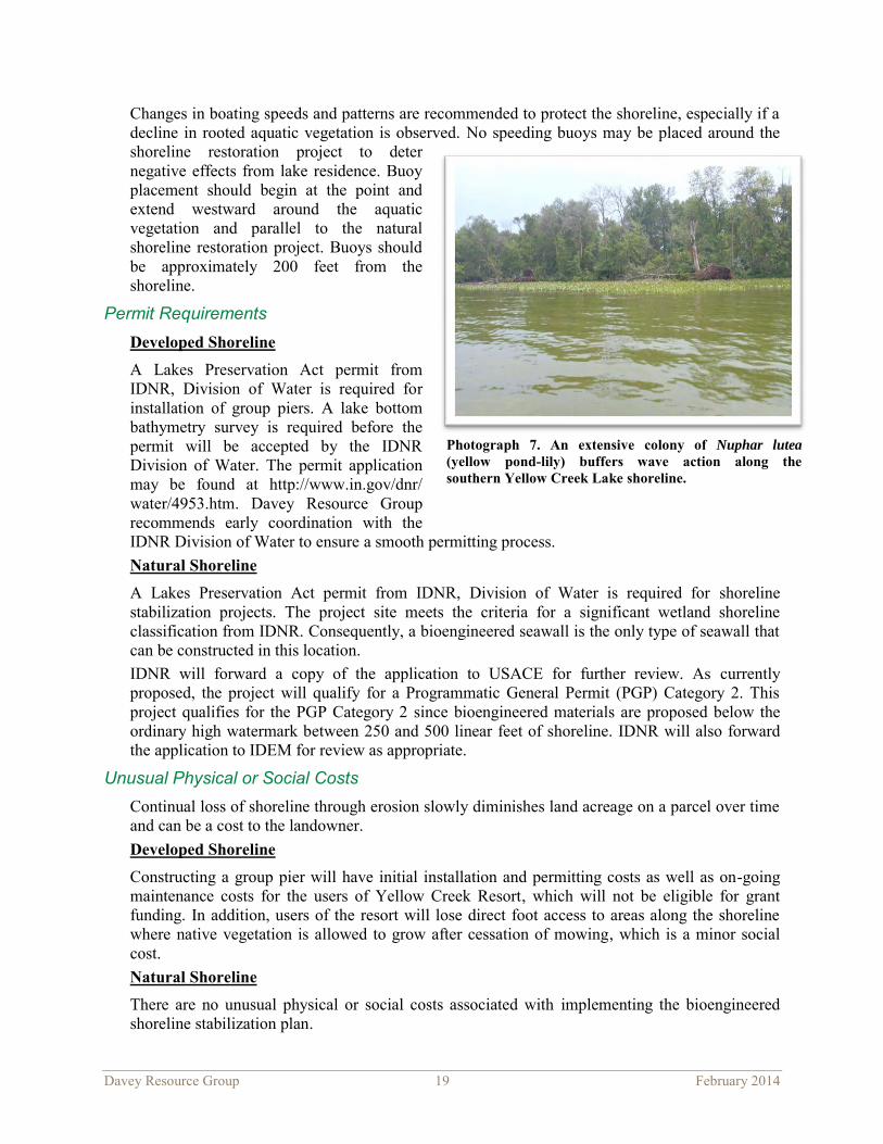
Nuphar lutea (yellow pond-lily), a rooted aquatic plant with floating leaves, is located along a significant portion of the western shoreline on the Yellow Creek Resort property and comprises approximately one acre. This rooted plant colony serves to dissipate wave energy and significantly reduce wave erosion potential during summer months (Photograph 7). Scrub-shrub and forested wetlands line the lakeshore in this location (Appendix E).
The entire shoreline is comprised of histosol soils and is dominated by Houghton muck soils.
The typical seasonal high water table for Houghton muck soils ranges from two feet above the surface to one foot below the surface between September and June in normal years (USDA 2013). The loose, unstable soils limit suitable shoreline stabilization techniques. Bioengineered practices (including brush layering, brush matting, and vegetated glacial stone), vegetated gabion walls, and mattresses are not recommended for installation in loose soils (Northwest Regional Planning Commission 2013). The loose soils in combination with a high water table resulting in a shallow rooting depth of trees along the shoreline are the suspected primary contributing factors to trees toppling over, especially when subjected to high winds due to shore orientation.
An EI score worksheet for the shoreline is included in Appendix F. The EI score of 63 indicates this is a medium erosion-intensity site. Significant contributing factors to the score include the soil type, dense natural canopy, shoreline orientation, and boating patterns.
Photograph 6. Shoreline erosion is occurring from wave action and overland flow along much of the developed shoreline at Yellow Creek Resort.
Davey Resource Group 19 February 2014
Changes in boating speeds and patterns are recommended to protect the shoreline, especially if a decline in rooted aquatic vegetation is observed. No speeding buoys may be placed around the shoreline restoration project to deter negative effects from lake residence. Buoy placement should begin at the point and extend westward around the aquatic vegetation and parallel to the natural shoreline restoration project. Buoys should be approximately 200 feet from the shoreline.
Permit Requirements Developed Shoreline
A Lakes Preservation Act permit from IDNR, Division of Water is required for installation of group piers. A lake bottom bathymetry survey is required before the permit will be accepted by the IDNR Division of Water. The permit application may be found at http://www.in.gov/dnr/ water/4953.htm. Davey Resource Group recommends early coordination with the IDNR Division of Water to ensure a smooth permitting process. Natural Shoreline
A Lakes Preservation Act permit from IDNR, Division of Water is required for shoreline stabilization projects. The project site meets the criteria for a significant wetland shoreline classification from IDNR. Consequently, a bioengineered seawall is the only type of seawall that can be constructed in this location. IDNR will forward a copy of the application to USACE for further review. As currently proposed, the project will qualify for a Programmatic General Permit (PGP) Category 2. This project qualifies for the PGP Category 2 since bioengineered materials are proposed below the ordinary high watermark between 250 and 500 linear feet of shoreline. IDNR will also forward the application to IDEM for review as appropriate.
Unusual Physical or Social Costs Continual loss of shoreline through erosion slowly diminishes land acreage on a parcel over time and can be a cost to the landowner. Developed Shoreline
Constructing a group pier will have initial installation and permitting costs as well as on-going maintenance costs for the users of Yellow Creek Resort, which will not be eligible for grant funding. In addition, users of the resort will lose direct foot access to areas along the shoreline where native vegetation is allowed to grow after cessation of mowing, which is a minor social cost. Natural Shoreline
There are no unusual physical or social costs associated with implementing the bioengineered shoreline stabilization plan.
Photograph 7. An extensive colony of Nuphar lutea (yellow pond-lily) buffers wave action along the southern Yellow Creek Lake shoreline.

Davey Resource Group 20 February 2014
Functionality of Proposed Project Bioengineered seawalls and natural shorelines protect property from eroding. They also help reduce the amount of sediment and nutrients continually stirred up within the lake by reducing wave energy. Bioengineered seawalls used in the right application can be more stable than a vertical, hard armored seawall because they dissipate wave energy instead of deflecting it. As wave energy bounces off a vertical, hard-armored seawall, it creates scour erosion at the base of the seawall disturbing the lake bottom. In addition, hard-armored seawalls negatively affect fish habitat and that of other aquatic life needed for healthy lake ecosystems.
Cost Approximations and Timeline Developed Shoreline
Constructing a group pier will have initial installation and permitting costs as well as ongoing yearly winter removal and spring installation fees. Ongoing annual maintenance fees are estimated at $6,300 for a group pier system supporting 60 watercraft. Table 4 summarizes the estimated costs for installing a group pier. It will be necessary to have a permit prior to beginning construction. Allocate approximately 6 months for permit issuance, which includes permit planning and production of a final pier design. Installation can occur during spring or summer.
Table 4. Summary of Estimated Costs for Yellow Creek Resort Group Pier
Implementation Activity Estimated Cost
Permitting process $1,500
Lake bottom survey $3,500
Group pier #1 materials and installation (20 watercraft) $14,400
Group pier #2 materials and installation (20 watercraft) $14,400
Group pier #3 materials and installation (20 watercraft) $14,400
Cease mowing along the shoreline $0
Total estimated cost $48,200 Natural Shoreline
It will be necessary to have a permit prior to beginning construction. Allocate a minimum of four months for permit issuance, which includes submitting the conceptual plans and accompanying application. Live stakes must be planted while dormant from late October through March. Davey Resource Group recommends beginning the permit application process in July the year prior to anticipated installation. Cut tree stumps and move shoreline protection logs in February after the lake begins to thaw. Plant the sedge meadow seed mix immediately upon completion of earth disturbing activities. Plant live stake cuttings as soon as they can be effectively planted following stump cutting and log placement and before bud break in spring. Table 5 summarizes the estimated costs for implementation. Table 6 indicates a recommend timeline for activities to occur.

Davey Resource Group 21 February 2014
Table 5. Summary of Estimated Costs for Yellow Creek Resort Natural Shoreline Stabilization
Table 6. Timeline for Yellow Creek Resort Natural Shoreline Stabilization
A preliminary cost estimate was made for coir log installation along the Yellow Creek natural shoreline project. Coir log installation involves many facets besides simple coir log purchase. Installation of coir logs along the entire length of the Yellow Creek natural shoreline (1,320 feet) would cost approximately $44,000 including erosion control blankets, installation, ropes, stakes, staples, and coir logs.
Institutional Resources and Potential Funding Developed Shoreline
There are no known grant funding sources for group pier installation and maintenance. Yellow Creek Resort and users of the pier would be expected to pay for group pier expenses.
Natural Shoreline
The IDNR LARE Program is the most prospective funding source for implementing shoreline restoration projects in Indiana. LARE Program grants provide 80% of the funding needed for a project. The other 20%, to be provided by the project sponsor, includes a minimum 10% cash match and a 10% in-kind service fee. The 10% cash match can come from other local or federal grant programs. The in-kind match services may include labor assistance by the property owner or other lake association volunteers for installation and maintenance.
Implementation Activity Estimated Cost
Permitting process $1,500 Stump cutting (20 trees) and shoreline stabilization tree placement $14,000
Live stake materials and installation (860 live stakes) $3,740
Sedge meadow seed mix (5.45 oz.), erosion control materials, and installation $500
Total estimated cost $19,740
Implementation Activity Date
Begin permitting process July 2014 Stump cutting (20 trees) and shoreline stabilization tree placement
February–March 2015 (after lake thaws)
Live stake materials and installation (860 live stakes)
March 2015 (following tree cutting)
Sedge meadow seed mix (5.45 oz.), erosion control materials, and installation
Immediately after earth disturbing activities

Davey Resource Group 22 February 2014
Other local funding sources that may be applicable include Kosciusko County Community Foundation funds and Kosciusko REMC Operation Round Up Grants. The Five Star Restoration Grant Program through the U.S. Environmental Protection Agency, while designed for wetland and stream restoration projects, may be another potential source of funding since this stabilization project is in a natural area.
Justification of Site Selection Shoreline erosion and recession has been occurring along the southern Yellow Creek Lake shoreline for decades. The zone of upturned trees and erosion of the natural shoreline was preselected by YCWA for the engineering feasibility study based on findings and recommendations of the previous watershed diagnostic study. Davey Resource Group chose to also include the developed eastern half of the southern Yellow Creek Lake shoreline in this study as notable shoreline erosion was observed in this location. Shoreline erosion contributes sediment and attached nutrients, such as phosphorus, into the lake year round leading to turbidity and increased algae and aquatic weed growth. Stable natural shorelines contribute to the overall health of the aquatic habitat and the lake ecosystem.
Feasibility Summary Developed Shoreline
There are no environmental or permitting constraints associated with an installation of a group pier. Initial installation costs and lack of public funding for such a project may result in resistance to the project from Yellow Creek Resort users. Ceasing mowing to let natural vegetation stabilize the developed shoreline has no cost and is a highly feasible option to provide some shoreline protection. Natural Shoreline
Other than securing funding, there were no identified factors hampering feasibility of implementing the proposed bioengineered shoreline stabilization plan.
Project 4: Amanda’s Point Shoreline Stabilization
Amanda’s Point is located on the western shore of Beaver Dam Lake south of Amanda Drive. Currently both the eastern and southwestern shoreline at Amanda’s Point is eroding and the existing glacial stone seawall is degraded (Photographs 8 and 9). The erosion of Amanda’s Point affects water quality throughout the entire lake—sediment from the shoreline is allowed to suspend itself in the water column and deposit on the lake bottom. Large amounts of deposited sediment throughout the lake will require dredging in the future if the process remains unchecked. Bioengineered shoreline stabilization techniques consisting of a combination of vegetation and glacial stone are proposed (Appendix G). Some landscape plantings including native flowers and ferns were added to the plan at the request of the landowner.
Photograph 8. The shoreline is being undercut along the southwest shore of Amanda’s Point.

Davey Resource Group 23 February 2014
Easements and Land Availability The land is owned by Amanda Pruitt. Davey Resource Group has worked with Ms. Pruitt in attempts to create a plan that is feasible, meets all requirements for adequate shoreline stabilization, and is also aesthetically pleasing. Ms. Pruitt is interested in pursuing installation of a bioengineered seawall.
Environmental Impact Assessment Approximately 875 square feet of Scirpus pungens (common threesquare), an emergent wetland species, is present along the eastern-facing shoreline of Amanda’s Point. This species serves to dissipate and significantly reduce wave energy reaching the shoreline during summer months. Extreme care should be taken not to damage this vegetation colony during restoration measures.
EI score worksheets for both sides of Amanda’s Point shoreline are included in Appendix F. Assuming limited boat traffic within 100 yards of the shoreline, the EI score for the east facing shoreline is 43, and the EI score for the southwest facing shoreline is 44 indicating a low erosion-intensity site. However, if there is intensive boat traffic within 100 yards of the east facing shoreline, the EI score would increase to 49 indicating a medium erosion-intensity site. Intensive boat traffic within 100 yards of the southwest facing shoreline is not probable due to the configuration of the shoreline. Low erosion-intensity sites can frequently be stabilized with vegetation alone; whereas, incorporation of glacial stone may be warranted for medium erosion-intensity sites.
Soils are suitable for a variety of bioengineered shoreline stabilization techniques in this area. Invasive species such as Lythrum salicaria (purple loosestrife) and Phalaris arundinancea (reed canary grass) are present along the shoreline. Post-construction maintenance measures should be put in place to ensure these species do not crowd out desirable species planted for shoreline stabilization and negatively affect the long-term success of the stabilization project.
Permit Requirements A Lakes Preservation Act permit from IDNR, Division of Water is required for shoreline stabilization projects. Amanda’s Point shoreline has been classified as an area of special concern by IDNR Division of Waters for permitting purposes because it has greater than 625 square feet of contiguous emergent vegetation (312 IAC 11-2-2). Consequently, use of glacial stone and bioengineered materials are the only acceptable shoreline stabilization methods in this location.
As proposed, this project qualifies for USACE PGP Category 1 because the new seawall will be comprised of bioengineered materials and/or glacial stone, will affect less than 300 linear feet of shoreline, the shoreline is classified as a significant wetland or natural shoreline, and the base of glacial stone does not extend more than four feet from the shoreline. Sending a permit application to USACE is unnecessary. IDNR will forward a copy to USACE should they decide the project does not meet PGP Category 1 conditions. IDNR will also forward the application to IDEM for review as appropriate.
Photograph 9. The existing glacial stone seawall along the eastern shore of Amanda’s Point is degraded.

Davey Resource Group 24 February 2014
Unusual Physical or Social Costs Implementation of the bioengineered shoreline stabilization plan will be costly for the landowner. However, addressing shoreline erosion and maintenance issues via any type of seawall installation is costly. At the request of the landowner, glacial stone was added into the plan around the entire point to safeguard against future replacement expenses.
Functionality of Proposed Project Bioengineered seawalls and natural shorelines protect property from eroding and reduce sediment and attached nutrients from entering lakes and continually being stirred up on the lake bottom. Addressing an eroding shoreline can combat soil deposition within the lake prior to the need for dredging. Bioengineered seawalls used in the right application can be more stable than a vertical, hard armored seawall because they dissipate wave energy instead of deflecting it. As wave energy bounces off a vertical, hard-armored seawall, it creates scour erosion at the base of the seawall disturbing the lake bottom. Bioengineered seawalls can also be more stable in the long term than the use of glacial stone alone. Installation of a bioengineered seawall will preserve fish habitat and that of other aquatic life needed for healthy lake ecosystems along Amanda’s Point. The increased habitat for aquatic life will help preserve recreational benefit for all residents.
Cost Approximations and Timeline It will be necessary to have a permit prior to beginning construction. A minimum of four months should be allocated from submittal of the conceptual plans and accompanying application to a permit being issued. Davey Resource Group recommends beginning the permit application process in July the year prior to anticipated installation. Live stakes must be planted while dormant from late October through March. Plant bare-root shrubs in the spring prior to bud break (or early April) or after they have gone dormant in the fall, which is approximately late October. Plant herbaceous plugs in the spring after dangers of frost have passed. Plant the plugs in the logs at the time of log installation. Table 7 summarizes estimated costs for implementation. Table 8 illustrates a recommend timeline.
Table 7. Summary of Estimated Costs for Amanda’s Point Project
Implementation Activity Estimated Cost
Permitting process $1,500
Glacial stone (14 cubic yards) and installation labor $2,600 Soft erosion control materials (erosion control mat, coir log) and installation labor $4,700
Shoreline stabilization plant materials (110 plugs, 25 live stakes, 20 bare-root shrubs, 3 containerized trees) and installation labor
$2,300
Total estimated cost for shoreline stabilization $11,100 Landscape plant material (146 plugs), mulch (6 cubic yards), and installation $2,600
Total estimated cost for project as proposed $13,700

Davey Resource Group 25 February 2014
Table 8. Timeline for Amanda’s Point Project
Implementation Activity Date
Permitting process July 2014
Glacial stone Mid-April to late September 2015 Soft erosion control materials (erosion control mat, coir log) Mid-April to late September 2015
Shoreline stabilization plant materials (110 plugs, 25 live stakes, 20 bare-root shrubs, 3 containerized trees)
Plugs and containerized trees: mid-April to late September 2015
Bare roots and live stakes: October to November 2015
Institutional Resources and Potential Funding
The IDNR LARE Program is the most prospective funding source for implementing shoreline restoration projects in Indiana. LARE Program grants provide 80% of the funding needed for a project. The other 20% is to be provided by the project sponsor and includes a minimum 10% cash match and a 10% in-kind service fee. The 10% cash match can come from other local or federal grant programs. The in-kind match services match may include volunteer labor assistance by the property owner or other lake association volunteers for installation and maintenance.
Justification of Site Selection Shoreline erosion along Amanda’s Point is evident, and the long-term stability of the point is a concern. The site was preselected by YCWA for analysis of a bioengineered shoreline as part of the engineering feasibility study based on findings and recommendations of the previous watershed diagnostic study. Shoreline erosion contributes sediment and attached nutrients, such as phosphorus, into the lake year round leading to turbidity and increased algae and aquatic weed growth. Stable, natural shorelines contribute to the overall health of the aquatic habitat and the lake ecosystem.
Feasibility Summary The landowner is concerned about the costs associated with stabilizing the shoreline. Other than determining and securing funding sources, there are no other identified factors hampering the feasibility of implementing the proposed bioengineered shoreline stabilization plan.
Project 5: Two-Stage Ditch Construction
The Yellow Creek Lake watershed includes an extensive network of regulated county drains that facilitate drainage from agricultural land, the dominant land use in the watershed. Specifically, row-crop agriculture comprises 70% of watershed land use with hay fields and pastures comprising an additional 4% (Purdue Univ. 2013). Depending on management practices, significant non-point source pollution, including sediment and nutrients,
Figure 4. Diagram of conceptual 2-stage ditch (The Nature Conservancy 2013).
Davey Resource Group 26 February 2014
can originate from agricultural land and enter the drainage network. Once in the drainage network, few BMPs can be practically implemented to prevent pollution from reaching downstream lakes. However, incorporating two-stage ditches into the drainage network is a common way to practically reduce pollutant concentrations within the drainage network.
A two-stage ditch is a drainage BMP that facilitates sediment and nutrient removal from the water column during high flow events when pollutant loads are typically higher. Traditional ditches are converted to two-stage ditches by excavating a floodplain adjacent to the original ditch channel (Figure 4).
When water levels rise after a rain event, water spills onto a vegetated floodplain. The vegetation slows water velocity, thus allowing suspended sediment and nutrients to settle out of the water column. The vegetation then uses the nutrients for growth that would have otherwise flowed to downstream waterbodies (The Nature Conservancy 2013). Slower water velocities also reduce bank shear stress allowing for greater bank stability and minimizing in-channel sediment loading to the ditch which results in lower long-term maintenance costs.
There is no minimum required length for two-stage ditches; however, it is generally accepted that, in order to be substantially effective, they should be at least 2,600 linear feet (Kent Wamsley, The Nature Conservancy, personal communication, November 18, 2013).
Specific locations throughout the watershed investigated for potential two-stage ditch construction are depicted in Figure 5. Locations were selected and evaluated by Davey Resource Group in collaboration with the Kosciusko County Surveyor and staff from NRCS, the LARE Program, and Indiana State Department of Agriculture.

Davey Resource Group 27 February 2014
Figure 5. Evaluated 2-stage ditch construction locations.

Davey Resource Group 28 February 2014
Easements and Land Availability Two-stage ditches are typically constructed within the 150-foot-wide easement on regulated county drains. No suitable construction locations were identified from an environmental standpoint; consequently, no further coordination was conducted with landowners regarding land availability and construction within the drainage easement.
Environmental Impact Assessment An assessment of environmental conditions associated with each evaluated proposed two-stage ditch construction location in the watershed resulted in no feasible project locations being identified. Unsuitable soil types were the primary factors hampering two-stage ditch construction feasibility. The soils present in many two-stage ditch proposed construction locations are mostly hydric, muck soils. Dominant soil series include Houghton muck (Ht, Hx), Palms muck (Pa), and Gilford mucky sandy loam, gravely substratum (Gm). Muck soils have been deemed not feasible for two-stage ditch construction due to instability.
Some areas with suitable soil types were deemed not feasible due to surrounding topography and the presence of a deeply incised channel that would necessitate extensive excavation to create a floodplain. Other factors influencing feasibility included insufficient lengths of suitable conditions to warrant two-stage ditch construction.
Table 9 lists each evaluated two-stage ditch construction location as they are depicted in Figure 5 along with the reason each location was determined not suitable for two-stage ditch construction.
Table 9. Two-Stage Ditch Construction Unfeasibility Summary
Location Unfeasibility Rationale
1 Muck soil, non-conducive to two-stage ditch construction
2 Muck soil, non-conducive to two-stage ditch construction
3 Forested with muck soils, not suitable for two-stage ditch construction
4 Deeply incised channel, not a cost-effective location due to topography
5 Natural two-stage ditch development occurring on site, no construction needed
6 Deeply incised channel, not a cost-effective location due to topography
7 Insufficient length of suitable soils in a deeply incised channel prior to encountering muck soil, which is non-conducive to two-stage ditch construction
8 Muck soil, non-conducive to two-stage ditch construction

Davey Resource Group 29 February 2014
Permit Requirements Two-stage ditches constructed on county drains are subject to approval by the Kosciusko County Drainage Board. It is the professional opinion of the Kosciusko County Surveyor that a suitable location for two-state ditch construction is not present in the Yellow Creek Lake watershed. Since all earthwork is typically conducted above the ordinary high watermark, other permits are usually not necessary.
Unusual Physical or Social Costs Two-stage ditches are wider than normal ditches requiring land to be removed from agricultural production in order to create a floodplain. This reduces the income earning potential of that land in perpetuity. Further analysis of land lost during two-stage ditch construction was not conducted because no suitable two-stage ditch location was identified in the watershed.
Functionality of Proposed Project Two-stage ditches have been shown to remove 74% sediment, 65% total phosphorus, and 27% nitrate that pass through during high flow events (Tank 2010).
Cost Approximations and Timeline Two-stage ditch construction and establishment typically costs between $10–$15 per linear foot based on general industry standard costs. Deeply incised channels requiring substantial earthwork can be very costly. A construction timeline was not developed due to the fact no suitable two-stage ditch construction locations were identified in the watershed.
Institutional Resources and Potential Funding Had a suitable two-stage ditch location been identified in the watershed, it could have been funded through the IDNR LARE Program and/or by EQIP through the USDA.
Feasibility Summary No suitable two-stage ditch construction locations were identified in the watershed due to a variety of environmental construction restraints.
Project 6: Reconnection of Open Drain to Floodplain
On February 12, 2013, Alicia Douglass and Jacob Bannister of Davey Resource Group along with Rod Edgell of the LARE Program walked a portion of the regulated open drain which flows from Diamond Lake to Yellow Creek Lake on the Miller property. The open drain was historically channelized and has been disconnected from the natural floodplain over time as a result of dredged soil placement along the banks (Photograph 10).
Photograph 10. A forested wetland lies within the historic floodplain to the south of the open drain connecting Diamond and Yellow Creek Lakes.

Davey Resource Group 30 February 2014
The open drain could easily be reconnected to its floodplain by excavating a portion of spoils along the south side of the drain approximately half way between Diamond and Yellow Creek Lakes. A minimal amount of excavation through the spoils would also be necessary directly east of CR 600 West to allow water from the floodplain wetland to return to the open drain.
Easements and Land Availability The Kosciusko County Drainage Board holds a 75-foot easement starting from the top of bank of the open drain and extending southward. All proposed earthwork would be conducted within the drainage easement. The purpose of the drainage board is to maintain and improve local drainage issues. Consequently, any project involving increased water retention time on a property would require the full approval of the landowner.
Land on the south side of the stream where work is proposed is owned by the Miller family. After thoughtful consideration, the Miller family declined to support further consideration of the proposed project fearing that increased water depth and duration on their property would hamper the recreational capacity of their land.
Environmental Impact Assessment Reconnecting the open drain to its natural floodplain, which includes forested wetlands, could restore the natural filtering capacity of these wetlands. In addition, bank sheer stress could be reduced by allowing storm flows to discharge to the wetland thereby reducing the erosion of mucky, sandy soils comprising the streambank in this location. Sediment eroded from the streambanks is subsequently deposited in Yellow Creek Lake creating a plume at the open drain outlet (Photograph 11).
Permit Requirements Coordination with and approval by the Kosciusko County Drainage Board would be necessary for this project since work would influence drainage within the easement of a regulated county drain.
All proposed earthwork would take place above legal lake levels for Diamond and Yellow Creek Lakes; thus, a Ditch Reconstruction Permit under the DNR’s Lowering of Ten Acres Lakes Act would not be required.
The project is located on a legal floodplain and is under jurisdiction of IDNR, Division of Water per the Flood Control Act (IC 14-28-1). This act contains exemptions for reconstruction or maintenance projects on streams and open regulated drains if the total length of the stream or drain does not exceed 10 miles. An additional exemption for wetland restoration projects is in the Flood Control Act’s Floodplain Maintenance Rules (312 IAC 10-5). A notification must be sent to IDNR for review in order for an exemption to be granted.
Photograph 11. Sediments carried by the open drain between Diamond and Yellow Creek Lakes are deposited at its inlet to Yellow Creek.

Davey Resource Group 31 February 2014
Unusual Physical or Social Costs By allowing more water to enter the property, there is potential that the recreational capacity of the land as it is currently used by the Miller family may be diminished. Specifically, it may be necessary to minimize the use of recreational vehicles on the property. This imposes a social cost on the landowner that they do not wish to incur at this time.
Functionality of Proposed Project The wetland on site would have encompassed approximately 7.23 acres (2.97 hectares). Wetlands have the ability to remove sediment and nutrients present in water. Studies have shown on average wetlands have pollutant removal efficiencies of 72% for total suspended solids, 48% total phosphorus, 24% total nitrogen, and 78% bacteria (CWP 2007).
Cost Approximations and Timeline The project is unfeasible; therefore, detailed cost and timing were not generated. However, a similar project has already taken place in northeast Indiana. Ritter Ditch, located in southwest Noble County, flows between two berms formed during channelization south of Hindman Lake. The berm on the western streambank was cut approximately two feet down to allow excess water from the stream to flow into an adjacent floodplain wetland during high flow events. The cost of the project was approximately $3,500 including minor stream clearing, earthwork, and revegetation of 0.1 of an acre (W. Stanger, personal communication, February 7, 2014). This project is very similar to the proposed project which can be estimated to be similar in cost.
Institutional Resources and Potential Funding Should this project become feasible in the future, the LARE Program and Kosciusko County Drainage Board maintenance funds are a potential funding source. Funding for the project could also come from the landowner and outside stakeholders such as the lake association.
Justification of Site Selection The sediment plume within Yellow Creek Lake provided justification for inquiry of potential BMPs that could be implemented between Diamond and Yellow Creek Lakes. Reestablishing the connection of historically channelized streams to adjacent floodplains by cutting through bank spoils piles is a simple, economical way of creating additional wetland filtering capacity in a watershed. Davey Resource Group pursued assessment of a BMP in this location per the suggestion of LARE Program Biologist Rod Edgell after the start of the engineering feasibility study.
Feasibility Summary This project is unfeasible due to insufficient landowner interest at this time.
Findings and Recommendations Engineering Feasibility Study Summary
Table 10 provides a summary of obstacles to feasibility for each BMP and other projects evaluated as a part of this study. Wetland construction east of CR 550 West and construction of a two-stage ditch in the Yellow Creek Lake watershed were determined unfeasible primarily due to environmental constraints. Insufficient landowner interest makes wetland construction west of CR 550 west and reconnection of the open drain to its floodplain between Diamond and Yellow Creek Lakes unfeasible at this time.

Davey Resource Group 32 February 2014
Table 10. Summary of Obstacles to Feasibility for Each Project.
Project Description Primary Obstacles to Project Feasibility
Land Availability
Permit Requirements Cost Environmental
Constraints
1a Wetland construction east of CR 550 West x x x
1b Wetland construction west of CR 550 West x
2 Yellow Creek Lake
Ministries waste water treatment
x
3a Yellow Creek Lake natural
southern shoreline stabilization
x
3b Yellow Creek Lake developed southern
shoreline stabilization x
4 Amanda’s Point Stabilization x
5 Two-stage ditch x x 6 Floodplain Reconnection x
Yellow Creek Lake Ministries has taken on the financial responsibility of addressing wastewater treatment needs. Other projects that are feasible with financial resources include stabilization of the developed portion of the southern Yellow Creek Lake, stabilization of the natural shoreline along the south side of Yellow Creek Lake, and stabilization of Amanda’s Point on Beaver Dam Lake. A summary of feasibility conclusions is included in Table 11.
Table 11. Feasibility Conclusions Summary
Project Description Feasible with
Financial Resources
Not Feasible at this Time
Not Technically
Feasible
1a Wetland construction east of CR 550 West x
1b Wetland construction west of CR 550 West x
2 Yellow Creek Lake Ministries wastewater treatment x
3a Yellow Creek Lake natural southern shoreline stabilization x
3b Yellow Creek Lake developed southern shoreline stabilization x
4 Amanda’s Point shoreline stabilization x
5 Two-stage ditch x
6 Floodplain reconnection x
Davey Resource Group 33 February 2014
Future Recommendations Prioritization Davey Resource Group recommends that YCWA take the following action steps moving forward. Projects are listed in order of general priority, but prioritization should be adjusted as necessary based on available resources at any given time.
● Continue to work with the NRCS district conservationist and Kosciusko County SWCD as well as talk to landowners as needed to encourage installation of buffer strips in the watershed.
● Seek funding for and implement shoreline stabilization practices along the southern Yellow Creek Lake natural shoreline.
● Encourage lake residents to either reface old seawalls or install bioengineered seawalls on their property. These can be great, inexpensive methods to combat shoreline erosion throughout the lakes in the Yellow Creek watershed. Bioengineered seawalls would be the preferred method—they allow for a decrease in wave energy throughout the lake.
● Encourage ceasing mowing along large portions of the developed southern Yellow Creek Lake shoreline on property owned by Yellow Creek Resort. The same principle should also extend to all residences of lakes within the Yellow Creek watershed. Leaving long grass in this area will help filter sediment and nutrients prior to water reaching the lake.
● Promote reduction of boating speeds along the southern Yellow Creek Lake natural shoreline. Continue to educate residents and watercraft operators that speeds should not exceed 10 miles per hour when passing within 200 feet of the shoreline according to Indiana law (IC-14-15-3-17). Placing buoys at 200 feet from the shoreline to restrict watercraft access to near shore areas may be advisable if education efforts are not enough.
● Seek funding for and implement shoreline stabilization practices on Amanda’s Point.

Davey Resource Group 34 February 2014
References Eck, K.J. 1997. “Vegetated Filter Strips for Improved Water Quality”. Agronomy Guide. AY-
285. West Lafayette, IN: Purdue University Cooperative Extension Service. pp. 1-5. http://www.extension.purdue.edu/extmedia/AY/AY-285.pdf
Environmental Laboratory. 1987. Corps of Engineers Wetlands Delineation Manual. Technical Report Y-87-1. Vicksburg MS: United States Army Engineer Waterways Experiment Station.
Center for Watershed Protection (CWP). 2007. National Pollutant Removal Performance Database. Version 3.Ellicott City, MD. 10 pp.
Dillaha, T.A., R.B. Reneau, S. Mostaghimi, and D. Lee. 1989. Vegetative filter strips for agricultural nonpoint source pollution control. Transaction of ASAE. 32(2) 513-519.
Indiana Clean Lake Program. 2009. File data. School of Public and Environmental Affairs, Indiana University, Bloomington, IN. http://www.indiana.edu/~clp/indianalakeinfo.php
IDEM. Virtual File Cabinet. Document # 58157336. http://vfc.idem.in.gov/Pages/ Member/Search.aspx. Accessed November 12, 2013.
IDNR, Division of Water. Public Freshwater Lake – Legal and Average Normal Water Levels. http://www.in.gov/dnr/water/5068.htm. Accessed October 7, 2013.
JFNew. 2009. Yellow Creek Lakes Watershed Diagnostic Study. Walkerton, IN: JFNew. 336 pp. http://www.in.gov/dnr/fishwild/files/fw-Yellow_Creek_Lakes_Watershed_Diagnostic_ Study_Kosciusko_County_June_2009.pdf. Accessed November 8, 2012.
Lesko, J. 2007. Grace College Comparative Study of Kosciusko County Lake Water Quality. Winona Lake, IN.
http://water.grace.edu/data/countyAndStateWide/GraceFinalWQreport.pdf.
Michigan State University Extension. 2010. Certified Natural Shoreline Professional Training Manual. Extension Bulletin E-3109. 138 pp.
The Nature Conservancy. 2013. Where Do We Work? Indiana. Two-Stage Ditch: How it works. http://www.nature.org/ourinitiatives/regions/northamerica/ unitedstates/indiana/howwework/two-stage-ditches.xml. Accessed October 28, 2013.
Northwest Regional Planning Commission. 2013. The Shoreline Stabilization Handbook. http://www.uvm.edu/seagrant/sites/uvm.edu.seagrant/files/ shorelinestabiliationhandbook.pdf. Accessed February 18, 2013.
Purdue University. 2013. Long Term Hydrologic Impact Analysis (L-THIA). https://engineering.purdue.edu/~lthia/.
Soil Survey Staff, Natural Resources Conservation Service, United States Department of Agriculture. Web Soil Survey. http://websoilsurvey.nrcs.usda.gov/. Accessed February 6, 2013.
Tank, J.L. 2010. “The Efficacy of Two-Stage Ditch Management for Reduction in Sediment and Nitrogen Export.” Presented at the Indiana Association of Soil and Water Conservation Districts Annual Conference, Indianapolis, Indiana, January 11-13, 2010.
Tetra Tech, Inc. 2006. Spreadsheet Tool for the Estimation of Pollutant Load (STEPL) User’s Guide, Version 4.0. Fairfax, VA. 59 pp.

Davey Resource Group 35 February 2014
U.S. Army Corps of Engineers. 2010. Regional Supplement to the Corps of Engineers Wetland Delineation Manual: Midwest Region (Version 2.0). ERDC/EL TR-10-16. Vicksburg, MS: U.S. Army Engineer Research and Development Center.
USDA, NRCS. Official Soil Series Descriptions. https://soilseries.sc.egov.usda.gov/osdname.asp. Accessed December 3, 2013.
USDA, NRCS. 1999. Soil Taxonomy: A Basic System of Soil Classification for Making and Interpreting Soil Surveys, 2nd ed. Agricultural Handbook No. 436. Washington DC: USDA. 871 pp.
USDA, Soil Conservation Service. 1989. Soil Survey of Kosciusko County, Indiana. 223 pp.

Davey Resource Group February 2014
Appendix A Public Information Brochure

YELLOW CREEK WATERSHED ALLIANCE
Lake And River Enhancement (LARE) Engineering Feasibility Study
The Yellow Creek Lakes Watershed Engineer-
ing Feasibility Study and this brochure was
made possible by funding from the Indiana
Department of Natural Resources Lake and
River Enhancement (LARE) Program and the
Yellow Creek Watershed Alliance. Davey
Resource Group managed the study.
YCWA is dedicated to improving Yellow
Creek, Hill, Diamond, McClures, Loon, and
Beaver Dam Lakes for our enjoyment today
as well as protecting and preserving our
lakes for future generations.
YCWA was awarded a LARE grant in June
2012 to conduct a study on the feasibility of
previously identified projects in the lakes’
watershed that will reduce the amount of
pollutants that reach the lakes from up-
stream sources.
Remember these laws to protect the long-term health of our lakes...
The maximum legal speed limit within 200
feet of the shore is 10 mph. A permit is required from the Indiana
Department of Natural Resources (IDNR)
for all new construction activities on the
shoreline of public freshwater lakes, including
shoreline protection projects and beach construction.
Beaches must be pea gravel, not sand.
Sand is easily displaced and can smother
aquatic organisms.
A permit is required to reface an existing
seawall. Stone and vegetation are healthier
alternatives to concrete and sheet piling sea-
walls for our lakes. A permit is not required when using vegeta-
tion alone for shoreline protection.
More information can be found at:
http://www.in.gov/dnr/water/files/seawall.pdf
and
http://www.in.gov/dnr/water/files/wa-
LakeshoreUnderwaterBeachConstruction.pdf

YOU CAN MAKE A DIFFERENCE FOR CLEAN WATER! Residential properties can be a significant source of
shoreline deterioration and water pollution. By following
a few simple steps, you can personally keep the water in
our lakes cleaner and reduce aquatic weeds!
3.) Keep Septic Systems Maintained
Incomplete treatment of wastewater by failing septic systems can result in human health
risks and water quality problems. Insufficient wastewater treatment may contaminate
drinking water wells. Bacteria, viruses, and parasites may make near shore water un-
safe for recreation if untreated wastewater is discharged into the lake. Excessive nitro-
gen and phosphorus inputs from untreated wastewater promote algae and weed growth
making lakes unfit or unpleasant for swimming and boating.
1.) Plant a natural shoreline rather than building a seawall
Natural shorelines provide many desirable benefits. They provide a buffer that
can help filter pollutants from rain water running across lawns, they stabilize
shorelines, they provide habitat for desirable wildlife, and they are less attractive
to Canada geese. Inflexible seawalls reflect wave energy instead of absorbing it,
increasing erosion in front of the seawall. They remove important habitat, de-
crease water clarity, and are more expensive than establishing a natural shoreline.
Concrete seawalls can be refaced with glacial stone to soften wave energy and reduce scour.
5.) Pick up after your pets and do not feed the geese.
The average dog can excrete 7,820,000,000 fecal coliform bacteria per day and each goose can excrete 2-3 pounds of waste daily! These bacteria and other biological agents in pet and water-fowl waste can be harmful to human health, and they are frequently found in our streams and lakes. Pet and waterfowl waste also contains nutrients such as nitrogen and phosphorus that support growth of algae and aquatic weeds.
4.) Use phosphorus free fertilizer.
Look for lawn fertilizer bags marked with a “0” as the center number. For
example, a bag marked “22-0-15” indicates that it does not contain phos-
phorus. In addition, do not use a larger quantity of fertilizer or pesticide
on your lawn than is recommended by the manufacturer. Better yet, learn
to care for your lawn naturally!
Visit: www.clearchoicescleanwater.org to learn more about how you can make a difference and sign up for a clean water pledge!
Just 1 pound of
phosphorus can sup-
port 500 pounds
of algae!
2.) Keep a proper distance from the shore when boating
Wakes generated by motorboats and personal water craft can cause extensive damage
when the waves impact the lakeshore and lake bottom. When passing within 200 feet of
the shore, a boat should not exceed 10 mph according to Indiana law (IC-14-15-3-17).
Michigan Sea Grant

Davey Resource Group February 2014
Appendix B Public Meeting Notes

Compiled 05-04-12 Page 1 of 2
Yellow Creek Watershed Alliance Engineering Feasibility Study
Public Meeting Notes
Saturday, July 20, 2013, 10:00 am Beaver Dam and Loon Lake Conservation Club, Seward, Indiana
Attendees List Beth Nicodemus, Pam Adwell, Keith Cox, Alice Cox, Jack Laurie, Don Cole, Carl Wall, Lloyd Warlich, Jerry Jones, Bud Talluy, Larry Hoffman, Deb Kammeyer, Dan Maclunis, Patty Maclunis, M. Ment, Ted Straiger, Tammy Cole, Dave Patterson (Yellow Creek), Brenda Patterson (Yellow Creek), Hal Hoffman (Yellow Creek), Caleb Asbury, Jacob Bannister Discussion Summary
The watershed alliance began the meeting by reviewing minutes of previous meetings along with the group’s expenses, news, and events surrounding the lake and watershed.
Jacob Bannister of Davey Resource Group (Davey) then made a presentation to the meeting attendees. Mr. Bannister started by illustrating why Davey was present, basics of the Lake and River Enhancement (LARE) program, and brief history of Davey.
A description of six possible projects sites were then described along with a map locating each potential project site. Mr. Bannister proceeded to update the meeting attendees as to the feasibility assessment of each potential project.
The first project assessed was a potential wetland filter at the southern end of Diamond Lake. This project is not feasible at this time due to insufficient landowner interest.
The second project included in the study was assessing wastewater treatment at Yellow Creek Ministries. Yellow Creek Ministries hired an engineering firm to do a more detailed study than would have been covered by the LARE study. The camp will begin implementing recommendations this fall. Davey will keep in contact with this group.
The third project deals with shoreline stabilization on developed and undeveloped stretches of shoreline on Yellow Creek Resort property. Development of a shoreline stabilization plan is underway including replanting of woody vegetation such as buttonbush and the creation of a group pier.
Project four also involves shoreline stabilization. Amanda’s Point located on Beaver Dam Lake can be stabilized using a combination of coconut fiber logs, vegetation, and stone. Live stakes are recommended to be planted to create a dense root system along the shoreline.
Project five investigated the feasibility of a two-stage ditch within the watershed. Non-muck soils are required to create this type of ditch. The majority of ditches within the area contain muck soils, thus this project was determined infeasible.
Project six entailed assessing the feasibility of connecting a floodplain wetland to an adjacent stream between Yellow Creek and Diamond Lake. During periods of high flow, the stream water would move into the wetland. At this time the surrounding land owners are uncomfortable with the high water levels and the project is not feasible.
Mr. Bannister then discussed next steps for the feasibility study as well as what individuals can do to help improve water quality.
Questions/Concerns List
What is a natural shoreline? o No sea wall; thicker vegetation/root system is needed in order to stabilize banks and stop erosion
from continuing into the future. How long before we see benefits of shoreline stabilization
o With trees it will take a few years; with other plants you can see benefits in the same year. But it is important to remember the benefits and aesthetics are not instantaneous.

Compiled 05-04-12 Page 2 of 2
Why not use glacial stone only? It will lead to a quicker finish. o It does not provide as much of a benefit for the fish and insect populations. Overall, it is better
over the long term to use a natural shoreline incorporating vegetation. Landowner expressed concern about the view from their house to the lake (at Amanda’s Point)
o New drawings are being produced. These are not the finalized locations for plants/trees. Concern with beaver chewing the newly planted trees (they love willows)
o That is something we will have to look more into for options of protecting them Do you see the bio-log in the water?
o Yes, but over time it does deteriorate. After a few years you will not be able to tell it was there. Can the landowner gain property back that was lost to erosion?
o No. Concern with trees taking 5 years to show aesthetic value.
o The root system does show benefits prior to the above ground aesthetics. In terms of the LARE project, this is a good thing.
Who makes the final decision about what goes where? o Mr. Bannister believes it is the watershed alliance and the land owner. They are the ones applying
for the grant. Look more into this subject. What is the cost share?
o 80/20% - land owners pay 20% Who applies for the grant?
o The watershed alliance o The DNR recommends applying for all of the grants together as one large project
When to apply? o Try to apply early in order to receive the most opportunity for acceptance (January).
Does the data collected by Grace College about the lake get used? o Not sure, Davey doesn’t use it directly. It is located on the Grace College website and on the
SPEA database. When will we hear back from Davey?
o In the progress reports we will send, but more so when cost and feasibility determined.

Davey Resource Group February 2014
Appendix C Yellow Creek Historical (1951) Aerial and Current Lake Shoreline

200
GRAPHIC SCALE
0 100
(IN FEET)
200
GRAPHIC SCALE
0 100
(IN FEET)
Prepared forPrepared by
Sheet 1
of 1
Yellow Creek Historic (1951) Aerial and Current Lake Shoreline
Prepared forData used to produce this
map were collectedon July 18 and
December 18, 2012
= Shoreline (current)
LARE Engineering Feasibility Study
forYellow Creek Lake Watershed
Kosciusko County, Indiana
Yellow CreekWatershed Alliance
Note: The location of the 1951 aerial photograph was not geo-referenced.It was scaled and aligned into position using landmarks such as roadintersections visible on the 1951 aerial and on a present day geo-referencedaerial. Due to the high degree of pixelization in the 1951 aerial photograph,alignment is not likely precise and an accurate measurement of shorelinerecession cannot be determined from the aerial.

Davey Resource Group February 2014
Appendix D Yellow Creek Lake Group Pier

Beaver
Dam Lake
Diamond
Lake
S 6
75 W
Loon
Lake
Yellow Creek Lake
McClures
Lake
State Route 14
S 7
00 W
W 900 S
5,000
GRAPHIC SCALE
0 2,500
(IN FEET)
5,000
GRAPHIC SCALE
0 2,500
(IN FEET)
Prepared forPrepared by
Yellow Creek Lake Group Pier Kosciusko County, Indiana
Sheet 1of 2
Data used to produce thismap were collected
on July 18 andDecember 18, 2012
LARE Engineering Feasibility Study
forYellow Creek Lake Watershed
Kosciusko County, Indiana
Yellow CreekWatershed Alliance
Restoration Site on 2011 Aerial
Clinton Tipton
Madison
DelawareFountain Randolph
HamiltonMontgomery Boone
Henry
Wayne
ParkeHancock
MarionHendricks
PutnamRush
Fayette Union
ShelbyJohnsonMorgan
VigoClay Franklin
OwenDecatur
BartholomewBrownMonroe
DearbornRipleySullivan
JenningsGreene
JacksonOhio
Lawrence SwitzerlandJefferson
KnoxMartinDaviess Scott
WashingtonOrange
ClarkPike
Gibson Dubois
Crawford
Harrison
Floyd
PerryWarrick
Posey Spencer
La Porte
St. Joseph ElkhartLagrange Steuben
Lake Porter
Noble De Kalb
Marshall
KosciuskoStarke
Whitley
Jasper
Allen
NewtonFultonPulaski
Wabash HuntingtonMiami
AdamsWellsCassWhite
Benton
GrantBlackford
JayHoward
Tippecanoe
Warren
200,000
GRAPHIC SCALE
0 100,000
(IN FEET)
Carroll
Yellow Creek Lake Pier Site
= Watershed
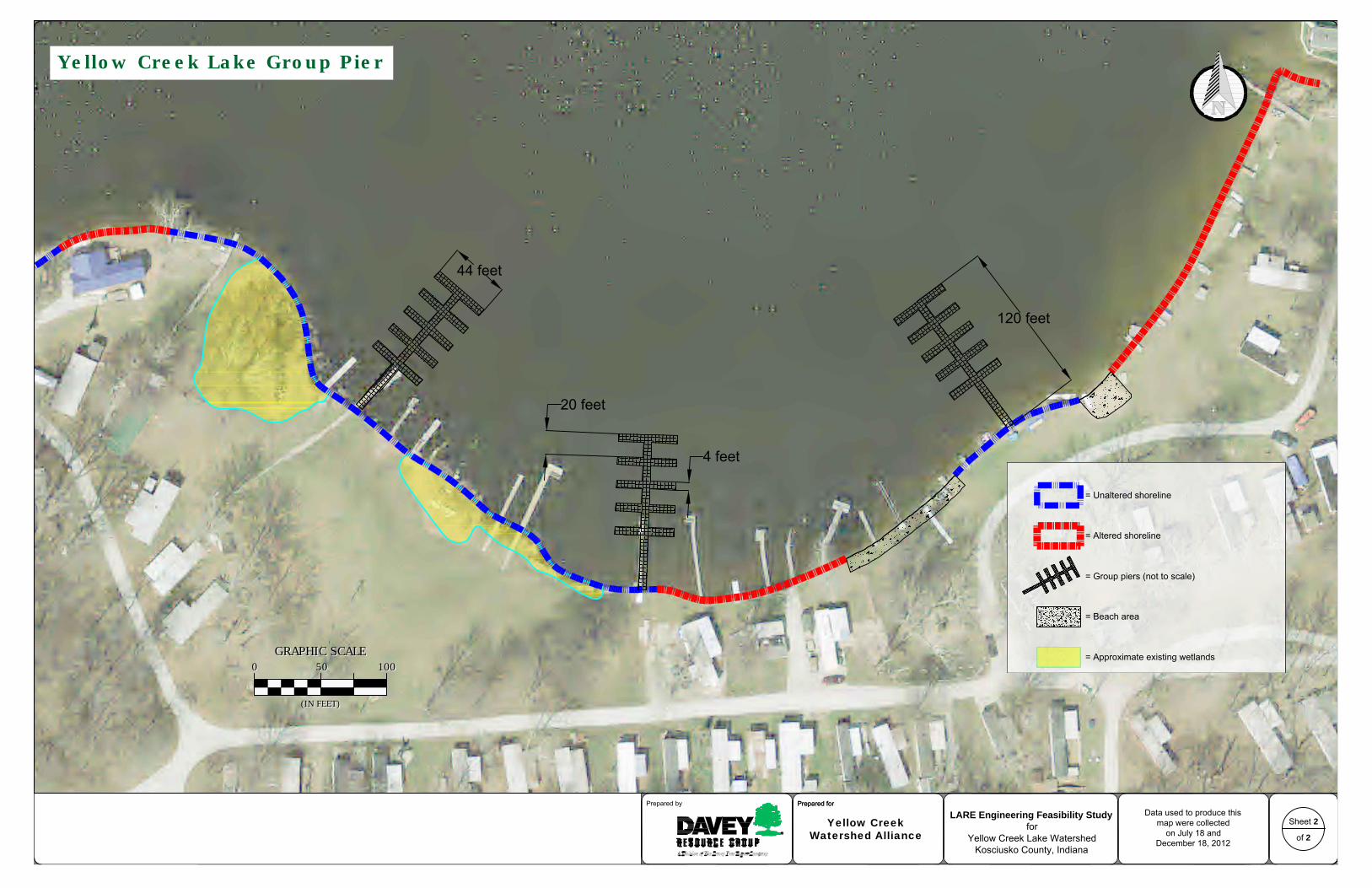
100
GRAPHIC SCALE
0 50
(IN FEET)
100
GRAPHIC SCALE
0 50
(IN FEET)
44 feet
20 feet
4 feet
120 feet
Prepared forPrepared by
Sheet 2
of 2
Yellow Creek Lake Group Pier
Prepared forData used to produce this
map were collectedon July 18 and
December 18, 2012
= Altered shoreline
= Unaltered shoreline
= Group piers (not to scale)
LARE Engineering Feasibility Study
forYellow Creek Lake Watershed
Kosciusko County, Indiana
Yellow CreekWatershed Alliance
= Beach area
= Approximate existing wetlands

Davey Resource Group February 2014
Appendix E Yellow Creek Lake Natural Shoreline Stabilization Plan
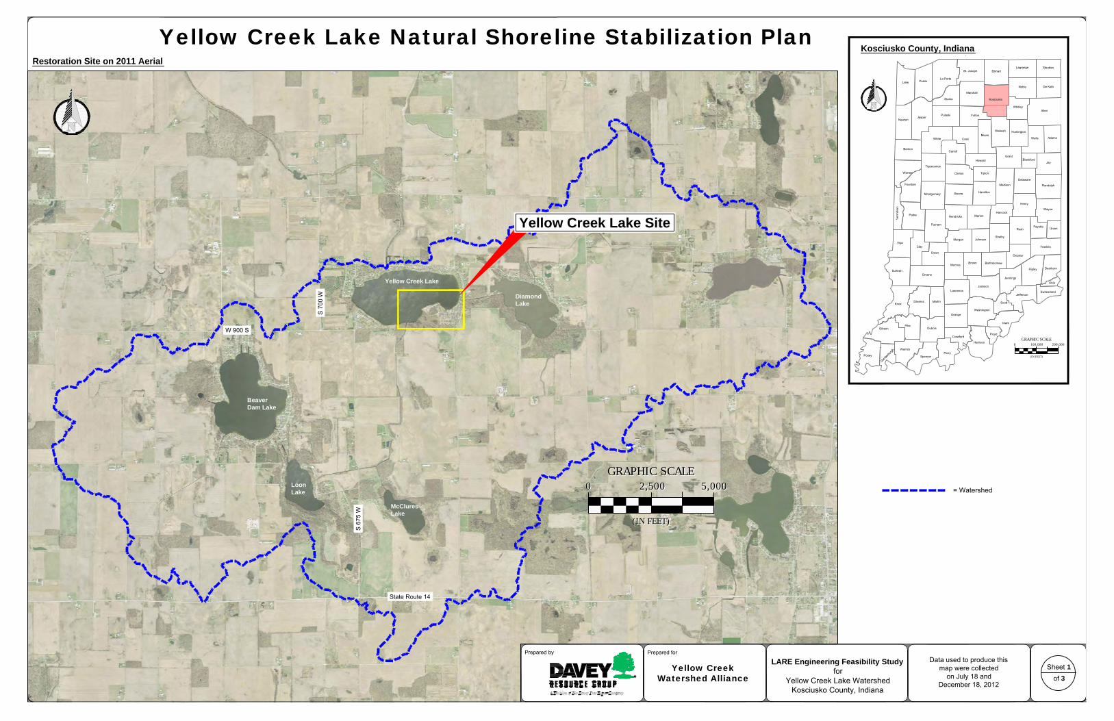
Beaver
Dam Lake
Diamond
Lake
S 6
75 W
Loon
Lake
Yellow Creek Lake
McClures
Lake
State Route 14
S 7
00 W
W 900 S
5,000
GRAPHIC SCALE
0 2,500
(IN FEET)
5,000
GRAPHIC SCALE
0 2,500
(IN FEET)
Prepared forPrepared by
Yellow Creek Lake Natural Shoreline Stabilization PlanKosciusko County, Indiana
Sheet 1of 3
Data used to produce thismap were collected
on July 18 andDecember 18, 2012
LARE Engineering Feasibility Study
forYellow Creek Lake Watershed
Kosciusko County, Indiana
Yellow CreekWatershed Alliance
Restoration Site on 2011 Aerial
Clinton Tipton
Madison
DelawareFountain Randolph
HamiltonMontgomery Boone
Henry
Wayne
ParkeHancock
MarionHendricks
PutnamRush
Fayette Union
ShelbyJohnsonMorgan
VigoClay Franklin
OwenDecatur
BartholomewBrownMonroe
DearbornRipleySullivan
JenningsGreene
JacksonOhio
Lawrence SwitzerlandJefferson
KnoxMartinDaviess Scott
WashingtonOrange
ClarkPike
Gibson Dubois
Crawford
Harrison
Floyd
PerryWarrick
Posey Spencer
La Porte
St. Joseph ElkhartLagrange Steuben
Lake Porter
Noble De Kalb
Marshall
KosciuskoStarke
Whitley
Jasper
Allen
NewtonFultonPulaski
Wabash HuntingtonMiami
AdamsWellsCassWhite
Benton
GrantBlackford
JayHoward
Tippecanoe
Warren
200,000
GRAPHIC SCALE
0 100,000
(IN FEET)
Carroll
= Watershed
Yellow Creek Lake Site

200
GRAPHIC SCALE
0 100
(IN FEET)
200
GRAPHIC SCALE
0 100
(IN FEET)
Prepared forPrepared by
Sheet 2
of 3
Yellow Creek Lake Shoreline
Prepared forData used to produce this
map were collectedon July 18 and
December 18, 2012
wetlands continue into woods
wetlands continue into woods
= Beach area (136 linear feet)
= Approximate existing wetlands
= Approximate extent of Nuphar lutea (yellowpond-lily) (1.062 acres or 46,261 square feet)
= Altered shoreline (912 linear feet)
= Unaltered shoreline
= Upturned trees (276 linear feet)
2
3
4
1
= Photograph location and direction of view1
= Proposed two-row planting area(1,025 linear feet)
= Proposed three-row planting area(295 linear feet)
= Proposed tree cutting and placement (NTS)
Typical Cut Log Wave Break
NOT TO
SCALE
at least 50% tree height no more than 15 feet
Ordinary high water mark
Live stakes of Cephalanthus
occidentalis (common buttonbush)
Lake bed
Lacustrine wetlands
LARE Engineering Feasibility Study
forYellow Creek Lake Watershed
Kosciusko County, Indiana
Yellow CreekWatershed Alliance
Trees will be anchoredwith cables and stakes tosecure trees into banks

Prepared forPrepared by
Sheet 3
of 3
Prepared for
Photograph 1. Patches of uprooted trees are present along southern Yellow Creek Lakeshoreline.
Photograph 2. Extensive uprooted woody vegetation is present along southern YellowCreek Lake shoreline.
Photograph 3. The trunk of each fallen tree should be cut at the base allowing root wadsto fall back into place.
Photograph 4. Woody debris in the lake helps to slow wave energy reaching the shoreline.This can aid the shoreline restoration process by protecting live stakes while they becomeestablished.
Yellow Creek Lake Shoreline
Data used to produce thismap were collected
on July 18 andDecember 18, 2012
LARE Engineering Feasibility Study
forYellow Creek Lake Watershed
Kosciusko County, Indiana
Yellow CreekWatershed Alliance

Davey Resource Group February 2014
Appendix F Erosion Intensity Worksheets


Davey Resource Group February 2014
Appendix G Amanda’s Point Shoreline Stabilization Plan

Beaver
Dam Lake
Diamond
Lake
S 6
75 W
Loon
Lake
Yellow Creek Lake
McClures
Lake
State Route 14
S 7
00 W
W 900 S
5,000
GRAPHIC SCALE
0 2,500
(IN FEET)
5,000
GRAPHIC SCALE
0 2,500
(IN FEET)
Prepared forPrepared by
Amanda's Point Shoreline Stabilization PlanKosciusko County, Indiana
Sheet 1of 3
Data used to produce thismap were collected
on July 18 andDecember 18, 2012
Restoration Site on 2011 Aerial
Clinton Tipton
Madison
DelawareFountain Randolph
HamiltonMontgomery Boone
Henry
Wayne
ParkeHancock
MarionHendricks
PutnamRush
Fayette Union
ShelbyJohnsonMorgan
VigoClay Franklin
OwenDecatur
BartholomewBrownMonroe
DearbornRipleySullivan
JenningsGreene
JacksonOhio
Lawrence SwitzerlandJefferson
KnoxMartinDaviess Scott
WashingtonOrange
ClarkPike
Gibson Dubois
Crawford
Harrison
Floyd
PerryWarrick
Posey Spencer
La Porte
St. Joseph ElkhartLagrange Steuben
Lake Porter
Noble De Kalb
Marshall
KosciuskoStarke
Whitley
Jasper
Allen
NewtonFultonPulaski
Wabash HuntingtonMiami
AdamsWellsCassWhite
Benton
GrantBlackford
JayHoward
Tippecanoe
Warren
200,000
GRAPHIC SCALE
0 100,000
(IN FEET)
Carroll
Beaver Dam Lake Site
= Watershed
LARE Engineering Feasibility Study
forYellow Creek Lake Watershed
Kosciusko County, Indiana
Yellow CreekWatershed Alliance

20
GRAPHIC SCALE
0 10
(IN FEET)
20
GRAPHIC SCALE
0 10
(IN FEET)
Prepared forPrepared by
Sheet 2
of 3
Beaver Dam Lake - Amanda's Point
Prepared forData used to produce this
map were collectedon July 18 and
December 18, 2012
= Beach area (existing)
= Existing Scirpus pungens colony (875 square feet or 0.02 acre)
1 = Photograph location and direction of view
Cornus stolonifera (red-osier dogwood) livestakes 2.5 feet on center. Aronia melanocarpa
(black chokeberry) bare-root shrubs 2 feet oncenter where no additional stone is added.
16-inch diameter coir log; 7poundsper cubic foot with a 9 poundbiodegradable netting. Staked asper manufacturer's specifications.
Typical Coir Log-Rock Wave Break
Carex vulpinoidea (fox sedge) andCarex lacustris (lake sedge) plugsapproximately 1.5-foot on center
= Existing trees
= Quercus bicolor (swamp white oak) plantings
= Eroding shore line with degraded glacialstone seawall (238 linear feet) to bejoint-planted with 240 native shrubs
= Block retaining wall (existing)
1
2
fallen tree
pier
4
3
NOT TO
SCALE
= Cornus stolonifera (red-osier dogwood) plantings(approximately 55 linear feet)
Dryopteris marginalis
(marginal woodfern; 70 square feet)
Pycnanthemum virginianum
(Virginia mountainmint; 45 square feet)
Rudbeckia fulgida
(Deam's coneflower; 35 square feet)
Carex vulpinoidea (fox sedge) andCarex lacustris (lake sedge) plugsapproximately 1.5-foot on center
rock and coirlog bankprotection
coir logbankprotection
= Aronia melanocarpa (black chokeberry) plantings(approximately 42 linear feet)
BioNet® C125BN™ Double NetCoconut Biodegradable ErosionControl Blanket or equivalent.
10-inch by 10-inchglacial stone will beused to create a stonewavebreak 16 incheshigh by 30 inches wide.
Iris virginica
(Virginia blueflag; 10 square feet
Iris virginica
(Virginia blueflag;30 square feet)
= Coir log, erosion control blanket, and rock bank protection approximately 110 feet by 46 inches wideand approximately 30 feet by 16 inches of coir log and erosion control blanket bank protection.
Carex vulpinoidea (fox sedge) andCarex lacustris (lake sedge)
rock and coirlog bankprotection
= Planting beds
C
o
i
r
L
o
g
-
R
o
c
k
W
a
v
e
B
r
e
a
k
c
r
o
s
s
-
s
e
c
t
i
o
n
(
t
y
p
i
c
a
l
)
LARE Engineering Feasibility Study
forYellow Creek Lake Watershed
Kosciusko County, Indiana
Yellow CreekWatershed Alliance

Prepared forPrepared by
Sheet 3
of 3
Prepared forData used to produce this
map were collectedon July 18 and
December 18, 2012
Photograph 1. East shoreline of Amanda's Point depicting existing Scirpus pungens colonyand dilapidated stone seawall.
Photograph 2. Unprotected and undercut shoreline.
Photograph 3. Only coir log installation needed for restoration from lack of undercut banks. Photograph 4. Existing Scirpus pungens colony along eastern shoreline.
Beaver Dam Lake - Amanda's Point
LARE Engineering Feasibility Study
forYellow Creek Lake Watershed
Kosciusko County, Indiana
Yellow CreekWatershed Alliance