engineering geology of surficial soils, eastern melville...
TRANSCRIPT

136 4TH CAN. PERMAFROSTCONF. (1982)
Engineering geology of surficial soils, eastern Melville Island
K.O. STANGL, W.D. ROGGENSACK, AND D.W. HAYLEY EBA Engineering Consultants Ltd., Edmonton, Alberta, Canada, T5L 2M7
The most important factors influencing the formation and behaviour of soils on Melville Island are climate and permafrost. Data collected from thermistor cables installed to depths of 10 to 18 metres show that, below a depth of 7 to 10 metres, ground temperatures typically vary by less than 05°C. Active layer depths reach 0.8 metres in dry soils but, more commonly, summer thaw penetrates only 0.5 metres in areas where higher moisture contents and vegetative cover prevail.
The geotechnical properties of the surficial soils of eastern Melville Island are closely related to bed- rock structure, age, and lithology. Using these criteria, eastern Melville Island can be divided into two regions. In the south, a folded sequence of Paleozoic strata forms part of the Parry Islands fold belt. ~ri'ihe north, gently dipping Mesozoic and younger Paleozoic strata form part of the Sverdrup basin. These bedrock formations are all sedimentary in origin, and with few exceptions, consist of clastic deposits ranging in lithology from shales to sandstones and minor conglomerates. The majority of these formations are weakly lithified. As a consequence, soil profiles are characterized by deep weathering that probably dates to the late Tertiary. In recent times, cyclic freeze-thaw action has fur- ther disintegrated the weathered bedrock to the extent that most surficial soils consist of primary clasts derived from the parent bedrock material. Textural gradations for these residual (and colluvial) soils fall into relatively narrow bands according to geological age, degree of cementation, and lithofacies.
Factors affecting the engineering design and construction of a cold buried pipeline on eastern Mel- ville Island include slope instability and erosion. Several slope failures mapped along the proposed pipeline corridors have been sampled, surveyed, instrumented, and monitored over several summer seasons. Laboratory tests have been performed to assess shear strength properties. Stability analyses conducted to investigate potential landslide mechanisms indicate that unusual circumstances are prob- ably required to precipitate failure. Hydraulic erosion initiated by man-made surface disturbance is discussed with reference to several documented sites.
Les plus importants facteurs qui influencent la formation et le comportement des sols de l'ile Mel- ville sont le climat et le perg8isol. Les donnks fournies par des clbles a thermistors installis entre 10 m et 18 m de profondeur indiquent qu'a plus de 7 a 10 m de profondeur, la temperature du sol vane en general de moins de 0,5"C. La profondeur du mollisol atteint 0,8 m mais, plus souvent, le degel estival n'atteint que 0,5 m de profondeur aux endroits plus humides et recouverts de vegetation.
Les proprietes gkotechniques des sols superficiels de l'est de l'ile Melville sont Ctroiternent liees a la structure, a l'lge, et a la lithologic du soubassernent. D'aprts ces criteres, I'est de I'ile Melville peut Otre divise en d e w regions. Au sud, une succession de strates palCozoi'ques plissees constitue une partie de la zone de plissements de Parry Island. Au nord, des strates d'lge rntsozoi'que superieur en pente douce forment une partie du bassin de Sverdrup. Ces formations faisant partie du soubassement sont toutes d'origine sedimentaire, et, a quelques exceptions prts, consistent en dipbts clastiques de litho- logic variable (argiles litks, gres et quelques conglomerats). La majorite de ces formations sont leg& rement lithifiees. De ce fait, les profils de sol sont caractkrises par une profonde alteration qui proba- blement remonte au Tertiaire superieur. A une epoque recente, les cycles de gel et de degel ont encore favoris6 la desagregation du soubassement alter& de sorte que la plupart des sols superficiels sont cons- titues de gklifracts derives de la roche-mere. Il y a une gradation texturale de ces sols rtsiduels (et col- luviaux), disposes en bandes relativement Ctroites, suivant I'Lge, le degre de cimentation, et le lithofaciks.
Les facteurs a considkrer lors de la conception technique et de la construction dans I'est de 1'Be Mel- ville, d'un gazoduc froid enfoui dans le sol, sont I'instabilite et I'erosion des pentes. On a effectui pen- dant plusieurs saisons des khantillonnages, leves, mesures, et observations prkises de plusieurs zones de glissement, survenus le long du couloir d'installation du gazoduc. On a realist des essais en labo- ratoire pour tvaluer les proprietes de resistance au cisaillement. Les analyses de stabilite faites pour demontrer les mecanismes capables de produire des glissernents de terrain, indiquent que probable- ment seuls des incidents inhabituels pourraient provoquer I'effondrernent des pentes. On discute de I'erosion hydraulique due a des perturbations de la surface du sol par I'homme, en s'appuyant sur I'in- formation relative a plusieurs sites.
Proc. 4th Can. Permafrost Conf. (1982)
Introduction (Figure 1). These studies have addressed the engineer- The discovery of substantial natural gas reserves in ing design and construction of high-pressure, buried
the Canadian High Arctic prompted the Polar Gas gas pipelines originating at Drake Point on Sabine Project and Arctic Pilot Project to undertake engi- Peninsula. This paper highlights the findings of neering and terrain studies on eastern Melville Island. various geotechnical drilling, testing, and terrain

Permafrost and Soils 137
FIGURE 1. Location map.
monitoring programs carried out under the super- vision of the authors during the past five years.
Climate and Permafrost The mean annual air temperature on eastern Mel-
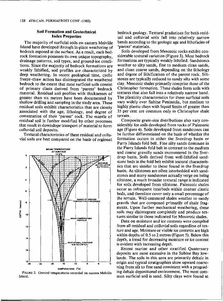
ville Island is in the order of - 17°C and sustains con- tinuous permafrost soil conditions. The mean daily air temperature rises above 0°C for a period of about 75 days each summer. During this time, soils in the active layer thaw to an average depth between 0.5 and 0.6 metres. Maximum active layer depths reach 0.8 metres in dry areas that are devoid of vegetation. A total of 13 shallow thermistor cables have been in- stalled to depths of 10 to 18 metres at various loca- tions within the study area. A composite ground tem- perature envelope developed over four years of data collection is presented in Figure 2. Below a depth of 7 to 10 metres ground temperatures typically vary by less than 0.5"C annually. The depth of zero annual amplitude appears to be between 15 and 18 metres.
Geology The geotechnical properties of surficial soils on
LEGEND: PIPELINE CORRIDORS
eastern Melville Island are closely related to the struc- ture, age, and lithology of the bedrock. The study area can be subdivided into two major regions: a folded sequence of Paleozoic strata designated the "Parry Islands Fold Belt", and the gently north- ward-dipping Mesozoic and younger Paleozoic strata of the Sverdrup basin. These bedrock formations are all sedimentary in origin, and, with few exceptions, consist of clastic deposits ranging in lithology from shales to sandstones and minor conglomerates (Tozer and Thorsteinsson 1964).
Scattered glacial landforms and erratics are evi- dence of an apparently minor and localized glaciation during the Pleistocene (Craig and Fyles 1961). There is abundant evidence that crustal depression has caused marine submergence, and features associated with subsequent postglacial rebound are widespread (Henoch 1964). However, the extent of the glaciation remains poorly defined. The inferred marine limit is in the order of 60 metres (amsl) on Sabine Peninsula and increases slightly in elevation towards the south- ern coast. The most significant Cenozoic (Quater- nary) deposits are deltaic in origin and are located at the head of Sabine Bay in the Sabine Bay lowlands.
138 4TH CAN. PERMAFROST CONF. (1982)
Soil Formation and Geotechnical Index Properties
The majority of surficial soils on eastern Melville Island have developed through in-place weathering of bedrock exposed at the surface. As a result, each bed- rock formation possesses its own unique topography, drainage patterns, soil types, and ground-ice condi- tions. Since the majority of bedrock formations are weakly lithified, soil profiles are characterized by deep weathering. In recent geological time, cyclic freeze-thaw action has disintegrated the weathered bedrock to the extent that most surficial soils consist of primary clasts derived from 'parent' bedrock material. Residual soil profiles with thicknesses of greater than six metres have been documented by shallow drilling and sampling in the study area. These residual soils exhibit characteristics that are closely associated with the age, lithology, and degree of cementation of their 'parent' rock. The mantle of residual soil is further modified by other processes that result in downslope transport of material to form colluvial soil deposits.
Textural characteristics of these residual and collu- vial soils are best compared on the basis of regional
MEANTEMPERATURE AT SURFACE
TEMPERATURE I'cI
FIGURE 2. Ground temperatures recorded on eastern Melville Island.
bedrock geology. Textural gradations for both resid- ual and colluvial soils fall into relatively narrow bands according to the geologic age and lithofacies of 'parent' materials.
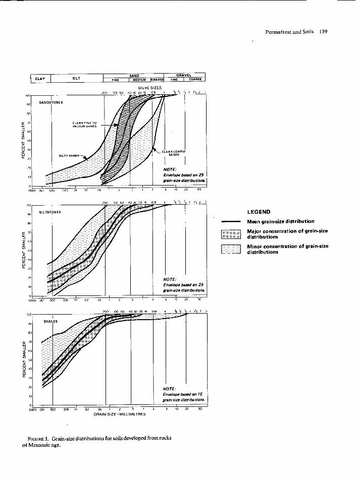
Soils developed from Mesozoic rocks exhibit con- siderable textural variation (Figure 3). Most bedrock formations are typically weakly lithified. Sandstones weather to silty sands, fine to medium clean sands, and clean coarse sands, depending on the lithology and degree of lithification of the parent rock. Silt- stones are typically reduced to sandy silts with some clay. Mesozoic shales primarily comprise those of the Christopher formation. These shales form soils with textures that also fall into a relatively narrow band. The plasticity characteristics for these surficial soils vary widely over Sabine Peninsula, but medium to highly plastic clays with liquid limits of greater than 35 per cent are common only in Christopher shale terrain.
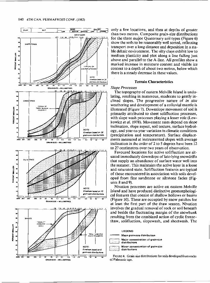
Composite grain-size distributions also vary con- siderably for soils developed from rocks of Paleozoic age (Figure 4). Soils developed from sandstones can be further differentiated on the basis of whether the formation occurs in either the Sverdrup basin or Parry Islands fold belt. Fine silty sands dominate in the Parry Islands fold belt in contrast to the medium and coarse gravelly sands encountered in the Sver- drup basin. Soils derived from well-lithified sand- stone beds in the fold belt exhibit textural characteris- tics that are similar to those found in the Sverdrup basin. As siltstones are often interbedded with sand- stones and many sandstones actually verge on being siltstone, a much broader textural range is indicated for soils developed from siltstone. Paleozoic shales occur as infrequent interbeds within coarser clastic beds, and therefore cover only a small percentage of the terrain. Well-cemented shales weather to sandy gravels that are composed primarily of shale frag- ments. Upon further mechanical weathering, these soils may disintegrate completely and produce tex- tures similar to those indicated for Mesozoic shales.
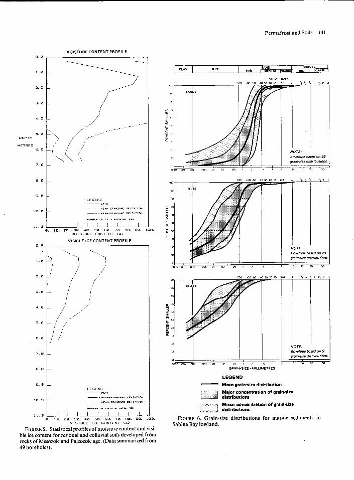
Data on moisture and ice contents were compiled from all residual and colluvial soils regardless of tex- ture and age. Moisture or visible ice contents are high within depths of 0.5 to 2 metres (Figure 5). Below this depth, a trend for decreasing moisture or ice content is evident with increasing depth.
Recent marine and other stratified Quaternary deposits are most extensive in the Sabine Bay low- lands. The soils in this area are primarily deltaic in origin and typical stratigraphies show up&d coarse- ning from silt to fine sand consistent with a prograd- ing deltaic depositional environment. The most com- mon surficial soil is sand. Silty clays were found at
Permafrost and Soils 139
SIEVE SIZES
I ..I SANDSTONES I 1
SAND I GRAVEL FINE 1 MEDIUM [ C O A R S ~ FINE I COARSE CLAY
Envelope b a d on 29 #rainsize distributionr
SILT
I NOTE: Envelope based on 29 gain-size distribu tiom
I 0005 Wl 002 ~5 07 0 2 05 1 2 5 1 2 5 10 20 50
GRAIN-SIZE -MILLIMETRES
NOTE: Envelope basad on 15 ~aimsize distributions.
LEGEND
Mean grain-size distribution
Major concentration of grain-size distributions
Minor concentration of grainmoire distributions
FIGURE 3. Grain-size distributions for soils developed from rocks of Mesozoic age.
140 4TH CAN. PERMAFROST CONF. (1982)
GRAIHSIZE -MlLLlMETRES
CLAY
GRAIN-SIZE - MILLIMETRES
SILT
0 I I I I m a m l om on 03 m os 0 1 41 o s 1 0 1 0 5 0 10 XI YI
GRAIHSIZE -MlLLlMETRES
SAND 1 G R A ~ ~ ~ ( only a few locations, and then at depths of greater rwr I UED1UY b01ftS4 F8.E I COAnSE
SIEVE s l Z ~ ~ than two metres. Composite grain-size distributions ,m :m :,m ~Ca =.ozm=m=,e =m=8 =. 3 . - 3 , - l , - , , 18"., for the three major Quaternary soil types (Figure 6 ) 80
SANDSTONE^ show the soils to be reasonably well sorted, reflecting 80 transport over a long distance and deposition in a sta- 0
a ble deltaic environment. The silty clays exhibit low to
3 ., medium plasticity and plot along a line falling just 2 So above and parallel to the A-line. All profiles show a 5 4 0
LL t" P 30
m
10 NOTE- Envelop W on 24
0 graiidze dirfribufionr
0m5mt m> ms ot m .os 0 8 0 2 or 1.0 2 0 s o to m r,
marked increase in moisture content and visible ice content to a depth of about two metres, below which there is a steady decrease in these values.
Terrain Characteristics
Slope Processes The topography of eastern Melville Island is undu-
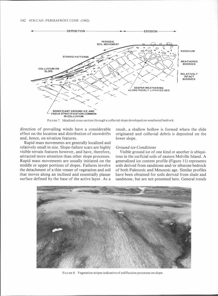
lating, resulting in numerous, moderate to gently in- clined slopes. The progressive nature of in situ weathering and development of a colluvial mantle is illustrated (Figure 7). Downslope movement of soil is primarily attributed to sheet solifluction processes, with slope wash processes playing a lesser role (Lew- kowicz et al. 1978). Movement rates depend on slope inclination, slope aspect, soil texture, surface hydrol- ogy, and year-to-year variation in climatic conditions (precipitation and temperature). Surface displace- ments measured at instrumented slopes with average inclination in the order of 2 to 5 degrees have been 12 to 27 centimetres over two years of observation.
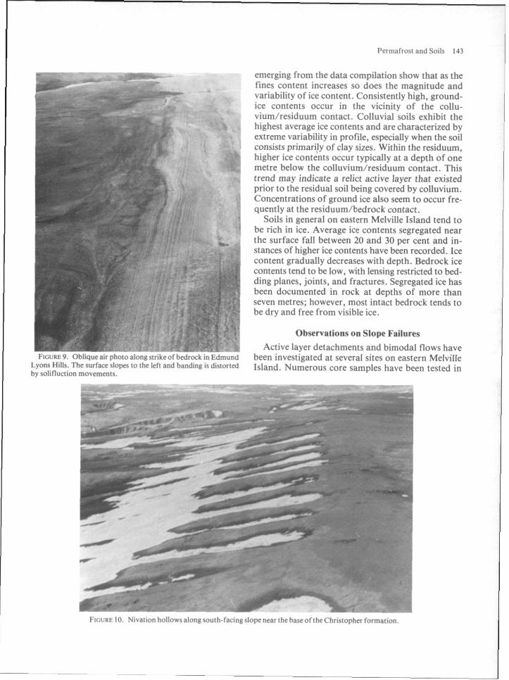
Favoured locations for active solifluction are sit- uated immediately downslope of late-lying snowdrifts that supply an abundance of surface water well into the summer. This maintains the active layer in a loose and saturated state. Solifluction features are typical of those encountered in association with soils devel- oped from fine sandstone or siltstone facies (Fig- ures 8 and 9).
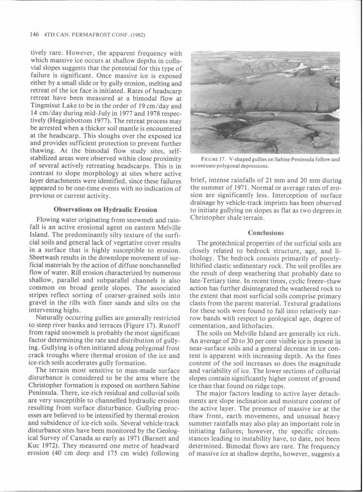
Nivation processes are active on eastern Melville Island and have produced distinctive geomorphologi- cal features that consist of shallow _hollows or basins (Figure 10). These are occupied by snow patches for at least the first part of the thaw season. Nivation involves the gradual removal of rock or soil beneath and beside the fluctuating margin of the snowbank resulting from the combined action of cyclic freeze- thaw, solifluction, slopewash, and sheetwash. The
LEGEND
Mean g r a m - s l z e d~stribution
Major concentration of gram-sire
M t n o r c o n c e n t r a t t o n of g r a n s l z e /I d ~ s t r ~ b u t ~ o n s
FIGURE 4. Grain-size distributions for soils developed from rocks of Paleozoic age.
Permafrost and Soils 141
0. 0
1. 0
2. 0
3. 0
4. 0
5. 0 D E P T H
METRES 6. 0
7 . 0
8. 0
9. 0
10. 0
11.0
MOISTURE CONTENT PROFILE
LEGEND ---- MEAN
M O I S T U R E CONTENT < X I
VISIBLE ICE CONTENT PROFILE
FIGURE 5. Statistical profiles of moisture content and visi- ble ice content for residual and colluvial soils developed from rocks of Mesozoic and Paleozoic age. (Data summarized from 49 boreholes).
SIEVE SIZES
NOTE: Envelope based on 56 graic-size distributions
100 200 IW W
90 CLAYS
.'O
r NOTE.
Enwlope bared on 29 grain<,ze distributions
E n w l o ~ based on 9
I grain-size distributions.
0 , I KO5 W! W 2 005 01 02 05 1 2 5 1 2 5 10 20 50
GRAIN-SIZE-MILLIMETRES
LEGEND - Mean grain-size distribution
Major concentration of grain-size distributions
Minor concentration of grain-size distributions
FIGURE 6. Grain-size distributions for marine sediments in Sabine Bay lowland.
142 4TH CAN. PERMAFROSTCONF. (1982)
I DEPOSITION -- EROSION ---4
RESIOUUW
WEATHERED BEDROCK
RELATIVELY INTACT
BEDROCK
. . SIGNIfICANT QROUNO ICE AND / VAGUE ' STRATIFICATION COMMON
INMLLUVlUM
FIGURE^. Idealized crass-section throughacolluvial slopedevelopedon weathered bedrock.
direction of prevailing winds have a considerable effect on the location and distribution of snowdrifts and, hence, on nivation features.
Rapid mass movements are generally localized and relatively small in size. Slope-failure scars are highly visible terrain features however, and have, therefore, attracted more attention than other slope processes. Rapid mass movements are usually initiated on the middle or upper portions of slopes. Failures involve the detachment of a thin veneer of vegetation and soil that moves along an inclined and essentially planar surface defined by the base of the active layer. As a
result, a shallow hollow is formed where the slide originated and colluvial debris is deposited on the lower slope.
Ground-ice Conditions Visible ground ice of one kind or another is ubiqui-
tous in the surficial soils of eastern Melville Island. A generalized ice content profile (Figure I I ) represents soils derived from sandstone and/or siltstone bedrock of both Paleozoic and Mesozoic age. Similar profiles have been obtained for soils derived from shale and sandstone, but are not presented here. General trends
2 FIGURE X . Vceetation stripes indicativeof solifluctian procesres on 4opc
Permafrost and Sails 143
emerging from the data compilation show that as the fines content increases so does the magnitude and variability of ice content. Consistently high, ground- ice contents occur in the vicinity of the collu- vium/residuum contact. Colluvial soils exhibit the
i highest average ice contents and are characterized by extreme variability in profile, especially when the soil consists primarijy of clay sizes. Within the residuum, higher ice contents occur typically at a depth of one metre below the colluvium/residuum contact. This trend may indicate a relict active layer that existed prior to the residual soil being covered by colluvium. Concentrations of ground ice also seem to occur fre- quently at the residuum/bedrock contact.
Soils in general on eastern Melville Island tend to be rich in ice. Average ice contents segregated near the surface fall between 20 and 30 per cent and in- stances of higher ice contents have been recorded. Ice content gradually decreases with depth. Bedrock ice contents tend to be low, with lensing restricted to bed- ding planes, joints, and fractures. Segregated ice has been documented in rock at depths of more than seven metres; however, most intact bedrock tends to be dry and free from visible ice.
Observations on Slope Failures
Active layer detachments and bimodal flows have I , 2 . I I . . t , I . ! IL , :L~;~I ,~ I IV. I : IA~L~I I M C , L ~ . 11, I CI,,,,XZ,LI been investigated at several sites on eastern Melville
Lynnr I l ~ I I \ . Ttw 1.w rlupeq t o 1111. Ic l l and h:imI!ni? 15 t i ~ i t ~ r l e d Island, Numerous core samples have been tested in by sol i l luct ian rnove~ticntr.

144 4TH CAN. PERMAFROSTCONF. (1982)
VISIBLE ICE CONTENT 1%)
Y : u
7 SANOSTONE- SILTSTONE E m
NOTE: I. Shaded area indicates the rmgs of ice conrents observed. 2. Contd~t poritionr reflect aver+ thicknesses of the units 3. Visible ice eonnnrr are shown in their rplarive position
within the units.
FIGURE I I . Generalized profileoficecontent in sailsdeveloped from weathered rocks of Mesozoic and Paleozoic age.
the laboratory to obtain soil index properties as well as data on thaw strain, consolidation, permeability, and shear strength. Typical shallow failures observed on Melville Island are illustrated in Figures 12, 13, and 14. Surface profiles were measured at the first two of these sites (Figures 15 and 16).
Stability analyses have been performed for several active layer detachments with surficial soils exhibiting a broad range of textures. The analyses assumed a fully saturated active layer, and took into account possible excess pore-water pressures associated with processes of thaw consolidation. Results indicate that these slopes should be stable, with calculated safety factors ranging from 1.5 to greater than 3. Only those landslides occurring in soils derived from Christopher shale can be explained utilizing simplistic infinite- slope analytical techniques. Other factors such as the presence of massive ice at the thaw front, ground motions associated with earthquake activity, and abnormal late-summer precipitation (Thomas and Thompson 1%2) may further decrease the overall sta- bility. To date, it has not been possible to determine the specific circumstances that have led to failures at the various landslide sites studied. However, o b s e ~ a - tions by others, including Cogley and McCann (1976)

Permafrost and Soils 145
SOUTH BH 13-3-1 LOCATED
7m WEST TERRACE
'ii HEADSCARP,SLOUGH
'. \.GULLY STARTS
11.50 \ BARE SURFACE
RIDGES JUMBLED RIDGES
0 20 40 60 80 100 120 140 160 180 200
HORIZONTAL DISTANCE (metres)
FIGURE 15. Profile through typical active-layer detachment, Christopher shale terrain.
SOUTH NORTH
102 - ANGULAR HECLA SANDSTONE RUBBLE
ON SURFACE
HEADSCARP
no \- 'BASIN' FILLED WITH
HIGHLY FLUID
LOBATE AND RIDGED
TILL LIKE DIAMICTON.
DIRTY 7 5O
MASSIVE ICE CREEK
HORIZONTAL DISTANCE (metred
FIGURE 16. Profile through typical bimodal flow east of Bridport Inlet.
and Hodgson (1977), suggest that the most frequent causative factor in initiating active layer detachments are unusually heavy or extended summer rainfalls. Slope inclination and the moisture content of active layer soils appear to be the two most important fac- tors affecting the stability at a given site. During heavy unseasonal rainfall and prolonged cloudy weather (minimizing evaporation), the active layer
may become very wet and surface ponding may occur as slopes are generally flat and permafrost prevents infiltration. This additional water reduces the avail- able shear strength and increases shear stresses. It appears that the active layer failures studied occurred as isolated events, precipitated by conditions that occur infrequently.
Bimodal flows (see Figure 13, 14, and 16) are rela-
146 4TH CAN. PERMAFROST CONF. (1982)
tively rare. However, the apparent frequency with which massive ice occurs at shallow depths in collu- vial slopes suggests that the potential for this type of failure is significant. Once massive ice is exposed either by a small slide or by gully erosion, melting and retreat of the ice face is initiated. Rates of headscarp retreat have been measured at a bimodal flow at Tingmisut Lake to be in the order of 19 cm/day and 14 cm/day during mid-July in 1977 and 1978 respec- tively (Hegginbottom 1977). The retreat process may be arrested when a thicker soil mantle is encountered at the headscarp. This sloughs over the exposed ice and provides sufficient protection to prevent further thawing. At the bimodal flow study sites, self- stabilized areas were observed within close proximity of several actively retreating headscarps. This is in contrast to slope morphology at sites where active layer detachments were identified, since these failures appeared to be one-time events with no indication of previous or current activity.
Observations on Hydraulic Erosion Flowing water originating from snowmelt and rain-
fall is an active erosional agent on eastern Melville Island. The predominantly silty texture of the surfi- cia1 soils and general lack of vegetative cover results in a surface that is highly susceptible to erosion. Sheetwash results in the downslope movement of sur- ficial materials by the action of diffuse nonchannelled flow of water. Rill erosion characterized by numerous shallow, parallel and subparallel channels is also common on broad gentle slopes. The associated stripes reflect sorting of coarser-grained soils into gravel in the rills with finer sands and silts on the intervening highs.
Naturally occurring gullies are generally restricted to steep river banks and terraces (Figure 17). Runoff from rapid snowmelt is probably the most significant factor determining the rate and distribution of gully- ing. Gullying is often initiated along polygonal frost crack troughs where thermal erosion of the ice and ice-rich soils accelerates gully formation.
The terrain most sensitive to man-made surface disturbance is considered to be the area where the Christopher formation is exposed on northern Sabine Peninsula. There. ice-rich residual and colluvial soils are very susceptible to channelled hydraulic erosion resulting from surface disturbance. Gullying proc- esses are believed to be intensified by thermal erosion and subsidence of ice-rich soils. Several vehicle-track disturbance sites have been monitored by the Geolog- ical Survey of Canada as early as 1971 (Barnett and Kuc 1972). They measured one metre of headward erosion (40 cm deep and 175 cm wide) following
brief, intense rainfalls of 21 mm and 20 mm during the summer of 1971. Normal or average rates of ero- sion are significantly less. Interception of surface drainage by vehicle-track imprints has been observed to initiate gullying on slopes as flat as two degrees in Christopher shale terrain.
Conclusions
The geotechnical properties of the surficial soils are closely related to bedrock structure, age, and li- thology. The bedrock consists primarily of poorly- lithified clastic sedimentary rock. The soil profiles are the result of deep weathering that probably date to late-Tertiary time. In recent times, cyclic freeze-thaw action has further disintegrated the weathered rock to the extent that most surficial soils comprise primary clasts from the parent material. Textural aradations for these soils were found to fall into relatively nar- row bands with respect to geological age, degree of cementation, and lithofacies.
The soils on Melville Island are generally ice rich. An average of 20 to 30 per cent visible ice is present in near-surface soils and a general decrease in ice con- tent is apparent with increasing depth. As the fines content of the soil increases so does the magnitude and variability of ice. The lower sections of colluvial slopes contain significantly higher content of ground ice than that found on ridge tops.
The major factors leading to active layer detach- ments are slope inclination and moisture content of the active layer. The presence of massive ice at the thaw front, earth movements, and unusual heavy summer rainfalls may also play an important role in initiating failures; however, the specific circum- stances leading to instability have, to date, not been determined. Bimodal flows are rare. The frequency of massive ice at shallow depths, however, suggests a

Permafrost and Soils 147
significant potential for future bimodal failures. The fine-grained nature of the soils and general
lack of vegetative cover on eastern Melville Island result in a surface that is highly susceptible to hydrau- lic erosion. Man-made disturbance of the surface can result in the channelling of surface water flow which can lead to gullying. This process can further be intensified by thermal erosion and subsidence of ice- rich soils.
Acknowledgements The authors gratefully acknowledge the support
given by Messrs. T.D. Nee1 and A.K. Jenkins of the Polar Gas Project, and Messrs. D.V. Inman and D. Babala of the Arctic Pilot Project.
References BARNETT, D.M. AND KuC, M. 1972. Terrain performance, Melville
Island, District of Franklin. Geol. Surv. Can., Paper 72-IA, pp. 137-139.
COGLEY, J.G. AND MCCANN, S.B. 1976. An exceptional storm and its effects in the Canadian High Arctic. Arct. and Alp. Res., vol. 8(1), pp. 105-110.
CRAIG, B.G. AND FYLES, J.G. 1961. Pleistocene geology of Arctic Canada. In: Volume I, Geology of the Arctic, Proc. 1st Intl. Symp. Arct. Geology, Calgary, 1960. G.O. Raasch (Ed.). Univ. of Toronto Press. pp. 403-420.
HEGGINBOTTOM, J.A. 1977. An active retrogressive thaw flow slide on eastern Melville Island, District of Franklin. Geol. Surv. Can., Paper 78-lA, pp. 525-526.
HENOCH, W .E.S. 1964. Postglacial marine submergence and emer- gence of Melville Island, N.W.T. Geogr. Bull., No. 22, pp. 105-126.
HODGSON, D.A. 1977. A preliminary account of surficial materials, geomorphological processes, terrain sensitivity, and Quaternary history of King Christian and Southern Ellef Ringnes Islands, District of Franklin. Geol. Surv. Can., Paper 77-IA, pp. 485-493.
LEWKOWICZ, A.G., DAY, T.J., AND FRENCH, H.M. 1978. Observa- tions on slopewash processes in an Arctic tundra environment, Banks Island, District of Franklin. Geol. Surv. Can., Paper 78-lA, pp. 516-520.
THOMAS, M.K. AND THOMPSON, H.A. 1962. Heavy rainfall in the Canadian Arctic during August 1960. Weatherwise, vol. 15, pp. 153-157.
TOZER, E.T. AND THORSTEINSSON, R. 1964. Western Queen Eliza- beth Islands, Arctic Archipelago. Geol. Surv. Can., Memoir 332,242 p.